
City of Rochester Zoning Ordinance and
City of Rochester Zoning Ordinance and Land Development Manual Ordinance No. 2785 Effective January 1, 1992 Updated February 5, 2014 Copies of the Rochester Zoning Ordinance and Land Development Manual may be obtained at: Rochester-Olmsted Planning Department 2122 Campus Drive SE, Suite 100 Rochester, MN 55904-4744 (507) 328-7100 The manual is also provided at the following web sites: http://www.ci.rochester.mn.us/departments/planning_zoning/index.asp http://www.co.olmsted.mn.us/planning/ordinances/Pages/COROrdinances.aspx Table of Contents CHAPTER 60 – INTRODUCTORY PROVISIONS 60.100 TITLE 60.110 AUTHORITY 60.120 ADMINISTRATIVE BODIES 60.130 ENFORCEMENT POLICY 60.140 APPLICATION AND SCOPE OF ORDINANCE 60.150 VESTING OF RIGHTS 60.160 INTERPRETATION OF THE ORDINANCE 60.170 ADMINISTRATION AND RECORD KEEPING 60.200 DEFINITIONS 60.300 DESCRIPTION OF ZONING DISTRICTS 60.310 ZONING DISTRICTS 60.320 DESCRIPTION OF DISTRICTS 60.330 AMENDMENT PROCEDURE 60.340 BOUNDARY ESTABLISHMENT 60.350 DESIGNATION OF ANNEXED PROPERTY 60.360 THE ZONING MAP 60.400 MODIFYING ORDINANCE PROVISIONS 60.410 VARIANCE 60.420 DESIGN MODIFICATIONS 60.500 PROCEDURES FOR PERMIT AND CERTIFICATE APPROVALS 60.510 TYPE I REVIEW PROCEDURE 60.520 TYPE II REVIEW PROCEDURE 60.530 TYPE III REVIEW PROCEDURE 60.600 PUBLIC DELIBERATIONS AND HEARINGS 60.605 NEIGHBORHOOD INFORMATIONAL MEETINGS 60.610 RESPONSIBILITIES OF ZONING ADMINISTRATOR 60.620 NOTICE OF HEARING 60.630 PROCEDURE FOR MAILED NOTICE 60.640 PROCEDURE FOR PUBLISHED NOTICE 60.650 RULES OF EVIDENCE 60.660 DECISION 60.670 FINDINGS AND ORDER 60.680 RECORD OF PROCEEDINGS 60.700 APPEALS 60.710 PROCEDURE TO FILE AN APPEAL 60.720 WHO MAY FILE AN APPEAL: 60.730 DESIGNATION OF APPEAL BODY: 60.740 PROCEDURE: 60.750 BOARD OF APPEALS DECISIONS: 60.760 PROCEDURE AND SCOPE OF REVIEW, PLANNING AND ZONING COMMISSION AND CITY COUNCIL: CHAPTER 61 – LOT AND SITE DEVELOPMENT APPROVAL PROCEDURES 61.110 ZONING CERTIFICATE 61.120 HOUSING CERTIFICATE 61.130 SIGN PERMIT 61.200 SUBDIVISION ACTIVITIES 61.210 GENERAL DEVELOPMENT PLAN 61.240 CONSTRUCTION PLANS 61.250 DEVELOPMENT AGREEMENTS 61.300 CONCURRENT REVIEW 61.400 PERFORMANCE DISTRICT PROCEDURES 61.410 DEVELOPING DISTRICT 61.420 CENTRAL DEVELOPMENT CORE 61.500 ACCESSORY REPORTS 61.510 DETERMINATION OF LAND USE PLAN CONFORMANCE 61.520 TRAFFIC IMPACT STUDIES 61.540 ENVIRONMENTAL REVIEW 61.550 DRAINAGE PLAN 61.560 GRADING PLAN 61.570 SITE PREPARATION 61.580 SITE DEVELOPMENT PLAN CHAPTER 62 – ZONING DISTRICT REGULATIONS 62.110 DESCRIPTION OF GENERAL ZONING DISTRICT STANDARDS 62.120 DESCRIPTION OF DEVELOPMENT STANDARDS 62.130 DESCRIPTION OF PERFORMANCE STANDARDS 62.140 USE CATEGORIES 62.200 RESIDENTIAL ZONING DISTRICT TABLES 62.210 R-Sa MIXED SINGLE FAMILY OVERLAY DISTRICT 62.220 R-1 MIXED SINGLE FAMILY DISTRICT 62.230 R-2 LOW DENSITY RESIDENTIAL DISTRICT 62.240 R-3 MEDIUM DENSITY RESIDENTIAL DISTRICT 62.250 R-4 HIGH DENSITY RESIDENTIAL DISTRICT 62.260 DETAILED USE REGULATIONS; RESIDENTIAL DISTRICTS 62.270 ACCESSORY USE - RESIDENTIAL DISTRICTS 62.280 SPECIAL RESIDENTIAL SETBACK PROVISIONS 62.300 NONRESIDENTIAL ZONING DISTRICT TABLES 62.310 B-1 RESTRICTED COMMERCIAL DISTRICT 62.317 B-2 GENERAL ZONING DISTRICT STANDARDS 62.320 B-4 GENERAL COMMERCIAL DISTRICT 62.330 B-5 RESIDENTIAL COMMERCIAL DISTRICT 62.340 M-1 MIXED COMMERCIAL-INDUSTRIAL DISTRICT 62.350 M-2 INDUSTRIAL DISTRICT 62.360 MRD #1 EDUCATION AND PUBLIC SERVICE CAMPUS 62.370 AGRICULTURAL DISTRICT 62.380 DETAILED USE REGULATIONS; NON-RESIDENTIAL DISTRICTS 62.390 ACCESSORY BUILDINGS AND STRUCTURES IN NON-RESIDENTIAL DISTRICTS 62.400 CENTRAL DEVELOPMENT CORE ZONING DISTRICT TABLES 62.410 CENTRAL DEVELOPMENT CORE – CENTRAL BUSINESS DISTRICT AREA 62.420 CENTRAL DEVELOPMENT CORE – FRINGE AREA 62.430 CENTRAL DEVELOPMENT CORE – MEDICAL AREA 62.440 CENTRAL DEVELOPMENT CORE - RESIDENTIAL AREA 62.450 DETAILED USE REGULATIONS; CENTRAL DEVELOPMENT CORE 62.460 CORE NEIGHBORHOOD ZONING DISTRICT TABLES 62.490 DETAILED USE REGULATIONS; CORE NEIGHBORHOOD AREA 62.500 DEVELOPING DISTRICT TABLES 62.510 D-LDR: DEVELOPING DISTRICT/LOW DENSITY RESIDENTIAL AREA 62.600 INCENTIVE DEVELOPMENT 62.610 APPROVAL PROCEDURE FOR INCENTIVE DEVELOPMENT 62.620 STANDARDS FOR APPROVAL, PRELIMINARY DEVELOPMENT PLAN 62.630 CRITERIA FOR INCENTIVE DEVELOPMENTS 62.640 BONUS DENSITY OR FLOOR AREA 62.650 CATEGORIES OF BONUSES 62.700 RESTRICTED DEVELOPMENT 62.710 STAGE DEVELOPMENTS 62.720 MIXED USE DEVELOPMENT 62.730 TRANSITIONAL DEVELOPMENT 62.740 ADAPTIVE REUSE, CULTURAL BUILDINGS 62.750 COMMERCIAL RECREATIONAL AREAS 62.760 ADAPTIVE REUSE, COMMERCIAL BUILDINGS 62.800 FLOOD DISTRICTS AND INTENT 62.810 DESIGNATION 62.820 PROCEDURES 62.830 USES PERMITTED 62.840 CONSTRUCTION STANDARDS, FLOOD FRINGE DISTRICT 62.850 CONSTRUCTION STANDARDS IN THE FLOODWAY DISTRICT 62.860 CONSTRUCTION STANDARDS IN THE FLOOD PRONE DISTRICT 62.870 MANUFACTURED HOMES, TRAVEL TRAILERS, AND TRAVEL VEHICLES IN THE FLOOD PLAIN 62.880 VARIANCES TO THE FLOOD DISTRICT REGULATIONS 62.900 SPECIAL DISTRICTS 62.910 COMPREHENSIVE SPECIAL DISTRICT 62.920 SINGLE PURPOSE SPECIAL DISTRICT 62.930 AREA ACCESSORY DEVELOPMENT 62.940 OFFENDER TRANSITIONAL HOUSING 62.1000 SHORELAND DISTRICT 62.1010 CONDITIONAL USE PERMITS - STANDARDS FOR APPROVAL 62.1100 EXCAVATION ACTIVITIES & SUBSTANTIAL LAND ALTERATION 62.1110 PERMITS CHAPTER 63 – LOT DEVELOPMENT STANDARDS 63.100 YARDS, SETBACKS AND OPEN SPACE REQUIREMENTS 63.110 APPLICATION OF YARD AND SETBACK REQUIREMENTS 63.120 YARD USAGE REGULATIONS 63.130 LANDSCAPE AREA 63.140 USABLE RECREATION AREA 63.150 REQUIRED PLANTINGS 63.200 APPEARANCE CONTROLS 63.210 EXTERIOR LIGHTING STANDARDS 63.220 SIGN REGULATIONS 63.230 LANDSCAPE AREA REDUCTION 63.240 EXTERIOR STORAGE STANDARDS 63.250 SITE LOCATION STANDARDS 63.260 BUFFERYARD REGULATIONS 63.270 PEDESTRIAN AND SITE DESIGN STANDARDS 63.300 MULTIPLE BUILDINGS ON A LOT 63.310 RESIDENTIAL DEVELOPMENTS 63.400 OFF-STREET PARKING AND LOADING REGULATIONS 63.410 GENERAL REQUIREMENTS 63.420 AMOUNT OF OFF-STREET PARKING 63.430 LOCATION OF OFF-STREET PARKING 63.440 SPECIAL LOCATIONAL PROVISIONS 63.450 PARKING FACILITY DESIGN PARAMETERS 63.460 OFF-STREET LOADING 63.470 COORDINATED PARKING AND LOADING MANAGEMENT PLAN 63.500 TRAFFIC VISIBILITY STANDARDS 63.520 STANDARDS 63.530 ACCESS FOR EMERGENCY VEHICLES 63.600 INDUSTRIAL PERFORMANCE STANDARDS 63.610 APPLICATION OF STANDARDS 63.620 STATE AND FEDERAL REQUIREMENTS 63.630 LOCAL INDUSTRIAL PERFORMANCE STANDARDS 63.640 VIBRATION 63.650 NOISE CHAPTER 64 – SITE DESIGN POLICIES 64.100 PURPOSE OF SITE DESIGN STANDARDS 64.110 LOT DESIGN STANDARDS 64.120 STREET LAYOUT STANDARDS 64.130 ADEQUATE PUBLIC FACILITIES STANDARDS 64.140 ACCESS MANAGEMENT STANDARDS 64.150 LOT GRADING PRINCIPLES 64.160 BOULEVARD TREE PLANTING STANDARDS 64.200 ROADWAY AND SUBDIVISION DESIGN STANDARDS 64.210 IMPROVEMENTS REQUIRED 64.220 PUBLIC ROADWAY AND TRAIL THOROUGHFARE DESIGN STANDARDS 64.230 DETERMINATION OF RIGHT-OF-WAY WIDTHS 64.240 PRIVATE ROADWAYS 64.250 STREET CLASSIFICATION 64.260 QUADRANT STREET SYSTEM 64.270 SUBDIVISION NAME 64.300 SITE ALTERATION STANDARDS 64.310 STORMWATER RUNOFF 64.320 EROSION CONTROL 64.330 LOT GRADING STANDARDS 64.340 HILLSIDE DEVELOPMENT 64.350 WETLANDS 64.400 PARKLAND DEDICATION 64.410 PURPOSE 64.420 SCOPE 64.430 NEIGHBORHOOD PARK DEFINED 64.440 AMOUNT OF LAND REQUIRED TO BE DEDICATED; MINIMUM QUANTITY 64.450 MARKETABILITY OF TITLE 64.460 CASH PAYMENT IN LIEU OF LAND DEDICATION 64.470 EFFECTIVE DATES/CREDITS CHAPTER 65 -- NONCONFORMITIES 65.100 LEGISLATIVE INTENT 65.110 DEFINITIONS 65.120 AUTHORITY TO CONTINUE 65.130 MAINTENANCE AND REPAIR OF NONCONFORMITY 65.140 BRINGING A NONCONFORMITY INTO COMPLIANCE 65.150 TRANSITIONAL DEVELOPMENT 65.160 LANDSCAPE AREA APPEARANCE AND STANDARDS 65.200 NONCONFORMING LOTS OF RECORD 65.300 NONCONFORMING USES: GENERAL POLICY 65.310 NONCONFORMING USES, PERMITTED MODIFICATIONS 65.320 NONCONFORMING USES, EXPANSION 65.330 CHANGE IN USE 65.340 CONTINUATION AND TERMINATION OF NONCONFORMITIES 65.360 NONCONFORMING USE CREATED BY FLOOD DISTRICT REGULATIONS 65.370 CONTINUED EXCAVATION 65.410 ENLARGEMENT OR ALTERATION 65.440 NONCONFORMING STRUCTURE CREATED BY FLOOD DISTRICT REGULATION 65.500 NONCONFORMING SIGNS 65.510 TERMINATION OF NONCONFORMING SIGNS 65.600 NONCONFORMING PARKING 65.700 NONCONFORMING APPEARANCE 65.710 ALTERNATIVE BUFFERYARDS 65.720 MINIMUM ACCEPTABLE BUFFERYARDS 65.800 NONCONFORMITIES WITHIN SHORELAND AREAS Contents CHAPTER 60 .............................................................................................. 1 60.100 TITLE ....................................................................................................................................... 1 60.110 AUTHORITY ............................................................................................................................ 1 60.120 ADMINISTRATIVE BODIES.................................................................................................... 2 60.130 ENFORCEMENT POLICY ...................................................................................................... 2 60.140 APPLICATION AND SCOPE OF ORDINANCE:..................................................................... 3 60.150 VESTING OF RIGHTS: ........................................................................................................... 4 60.160 INTERPRETATION OF THE ORDINANCE ............................................................................ 5 60.170 ADMINISTRATION AND RECORD KEEPING ....................................................................... 8 60.200 DEFINITIONS ........................................................................................................................ 14 60.300 DESCRIPTION OF ZONING DISTRICTS: ............................................................................ 42 60.310 ZONING DISTRICTS: ........................................................................................................... 42 60.320 DESCRIPTION OF DISTRICTS: ........................................................................................... 43 60.330 AMENDMENT PROCEDURE: .............................................................................................. 50 60.340 BOUNDARY ESTABLISHMENT: .......................................................................................... 52 60.350 DESIGNATION OF ANNEXED PROPERTY: ....................................................................... 54 60.360 THE ZONING MAP: .............................................................................................................. 55 60.400 MODIFYING ORDINANCE PROVISIONS ............................................................................ 57 60.410 VARIANCE: ........................................................................................................................... 57 60.420 DESIGN MODIFICATIONS: .................................................................................................. 59 60.500 PROCEDURES FOR PERMIT AND CERTIFICATE APPROVALS: .................................... 69 60.510 TYPE I REVIEW PROCEDURE: ........................................................................................... 73 60.520 TYPE II REVIEW PROCEDURE: .......................................................................................... 73 60.530 TYPE III REVIEW PROCEDURE: ......................................................................................... 74 60.600 PUBLIC DELIBERATIONS AND HEARINGS: ...................................................................... 77 60.605 NEIGHBORHOOD INFORMATIONAL MEETINGS: ............................................................. 77 60.610 RESPONSIBILITIES OF ZONING ADMINISTRATOR: ........................................................ 77 60.620 NOTICE OF HEARING: ........................................................................................................ 78 60.630 PROCEDURE FOR MAILED NOTICE: ................................................................................. 78 60.640 PROCEDURE FOR PUBLISHED NOTICE:.......................................................................... 79 60.650 RULES OF EVIDENCE: ........................................................................................................ 79 60.660 DECISION: ............................................................................................................................ 79 60.670 FINDINGS AND ORDER:...................................................................................................... 80 60.680 RECORD OF PROCEEDINGS: ............................................................................................ 80 60.700 APPEALS: ............................................................................................................................. 81 60.710 PROCEDURE TO FILE AN APPEAL: ................................................................................... 81 60.720 WHO MAY FILE AN APPEAL: .............................................................................................. 81 60.730 DESIGNATION OF APPEAL BODY: .................................................................................... 81 60.740 PROCEDURE:....................................................................................................................... 82 60.750 BOARD OF APPEALS DECISIONS: .................................................................................... 83 60.760 PROCEDURE AND SCOPE OF REVIEW, PLANNING AND ZONING COMMISSION AND CITY COUNCIL: ...................................................................................................................................... 83 Updated January 22, 2014 [THIS PAGE WAS INTENTIONALLY LEFT BLANK] Updated January 22, 2014 CHAPTER 60 INTRODUCTORY PROVISIONS 60.100 TITLE This ordinance shall be known and cited as the "Zoning Ordinance and Land Development Manual of the City of Rochester, Minnesota" and may be referred to herein as the "zoning ordinance" or "ordinance". 60.110 AUTHORITY The 1965 Laws of Minnesota, Chapter 462, authorizes the municipality to administer planning and zoning activities, establish a Zoning Board of Appeals, enact official controls, and provide penalties for violation thereof. Chapter 104 and 105 of the Minnesota Statutes authorize minimum standards and criteria for the management of “Shoreland” and “Floodplain” Areas within the City of Rochester. 60.111 Statement of Purpose: In order to protect the public health, safety and general welfare of the community, the Common Council adopts this ordinance: A. For the purposes identified in chapter 462 of the Minnesota Statutes which related to municipal planning (in particular, sections 462.351 through 462.365); B. For the purpose of implementing the policies set forth in Rochester’s Comprehensive Plan; C. For the purpose of encouraging innovation in land development by removing regulatory barriers to the consideration of new or unique ideas which are consistent with the purposes and policies referenced; D. For the purpose of encouraging patterns of land use that will reduce the need for personal vehicular travel and in turn reduce vehicular energy consumption and emissions by encouraging the use of alternative modes of transportation through improved public access to transit, sidewalks, trails and bicycle facilities, improved internal site design for non-motorized modes, and by locating work, home, shopping and service land uses in relation to each other such that trip consolidation is feasible and modal substitution can occur; E. For the purpose of minimizing the adverse environmental impacts of development; F. For the purpose of improving the design, quality and character of new and mixed use development to support an active living environment; and, G. To create a system of land use regulation that is designed to find equitable solutions to the land use conflicts that routinely arise as development occurs, so as to provide for the orderly development of land within Rochester and to conserve the value of land and buildings. Updated January 22, 2014 Page 1 60.112 The provisions of this ordinance shall be regarded as the minimum requirements for the protection of the public health, safety, and general welfare. 60.113 The ordinance and the various articles and paragraphs thereof are hereby declared to be severable. If any article, section, subsection, paragraph, sentence or phrase of the ordinance is adjudged unconstitutional or invalid by any court of competent jurisdiction, the remainder of the ordinance shall not be affected thereby. 60.120 ADMINISTRATIVE BODIES 60.121 Zoning Administrator: There is hereby established the office of Zoning Administrator. It shall be the duty of the zoning administrator to enforce the ordinance in accordance with its administrative provisions. The Planning Director, as provided for in RCO, Chapter 20.16, or his authorized representative shall serve as the zoning administrator. 60.122 Zoning Board of Appeals: There shall be a zoning board of appeals consisting of seven members, one of whom shall be a member of the commission. All members shall be appointed by the Mayor with the approval of the council. Members shall serve for a term of three years, except the commission representative, who shall serve for a term of one year. No member shall serve more than two consecutive terms. The board shall choose a chair from among its membership and determine its rules of proceeding, a copy of which shall be filed with the zoning administrator. 60.123 Planning and Zoning Commission: There shall be a Planning and Zoning Commission established as organized under Chapter 20 of the Rochester Code of Ordinances. The Commission shall have advisory and decision making powers relative to various administrative procedures as identified in the ordinance. 60.124 City Council: The City Council as organized under Chapter VIII of the Charter of the City of Rochester, Minnesota, which shall have various decision making powers granted to it as identified in the ordinance. 60.130 ENFORCEMENT POLICY It is the policy of the City that the purpose and intent of this section will normally be served best if the zoning administrator first seeks to have a violation brought into compliance. 60.131 Zoning Administrator to be notified of Violations: Whenever a violation of this ordinance is known or suspected to exist or expected to be committed, any person may so notify the zoning administrator. All officers and agencies of the City of Rochester shall notify the zoning administrator of any information which suggests that a violation exists or is expected to be committed. 60.132 Zoning Administrator to Investigate Violations: Upon receiving any information which suggests a violation, the zoning administrator shall conduct an investigation to determine whether a violation exists or is reasonably expected to be committed. To this end, the zoning administrator and his authorized representatives are hereby empowered to cause any building, other structure, or tract of land to be inspected and examined. Where necessary, the zoning administrator may call upon the Chief of Police for assistance. Updated January 22, 2014 Page 2 60.133 Notice of Violation: The zoning administrator shall, if he determines a violation to exist or is reasonably expected to be committed, promptly give notice by regular mail, or by personal service to the owners of record for tax purposes of the property involved. The notice shall indicate the location and nature of the violation, the provision or provisions of the ordinance which have been or are expected to be violated, and whether immediate enforcement will be sought or up to thirty days allowed to correct or remove the violation. The zoning administrator, or employees under his supervision, may issue a citation for those offenses which are listed on the local fine and bail schedule by the District Court. A defect in the notice of violation with respect to any such matters shall not prevent the enforcement of this ordinance. 60.134 Discontinuance of Work: Once the notice of violation has been served, no work shall proceed on any development covered by such orders, except in a manner consistent with those orders and this ordinance. It shall be a separate misdemeanor violation for any person to continue any development in a manner inconsistent with the orders or this ordinance. 60.135 Enforcement After Expiration of Time Period: If, after the time period provided in the notice of violation has elapsed and the alleged violation has not been corrected or brought into compliance, the zoning administrator shall consult with the city attorney, and the city attorney shall initiate any legal or equitable action which is deemed appropriate. Such action shall not be initiated if: a) an appeal of the notification of violation has been filed with the Department of Planning and Housing, or b) the City Council or court of competent jurisdiction has stayed enforcement pending the outcome of a proceeding before it concerning the violation. The zoning administrator or his designee shall act as a complaining witness when necessary to initiate a criminal action against a violation. If a civil action is required, the zoning administrator shall request that the city attorney have the matter placed on the agenda of the City Council and that the Council authorize such action. 60.136 Violation and Penalties: Any person, firm or corporation violating any of the provisions of the ordinance, or any amendment thereto, is guilty of a misdemeanor. Each and every day during which such violation continues shall be deemed to be a separate offense. Fines and imprisonment are appropriate as a penalty for violations and a deterrent against future violations. 60.140 APPLICATION AND SCOPE OF ORDINANCE: This ordinance applies within the municipal limits of the City of Rochester as now and hereafter established, along with those areas outside the established municipal limits where, through joint legislative agreement with the appropriate governing body, the ordinance shall be put into effect. 60.141 This ordinance applies to all development. No development may be approved is such approval would result in a violation of federal or state law, or city or county ordinance. No City of Rochester official or employee may knowingly issue a development permit or license if such issuance would result in a violation of federal or state law, or city or county ordinance. 60.142 Compliance Required: It shall be the responsibility of all property owners, architects, contractors, subcontractors, builders and other persons involved in any development, before beginning any development activity, to contact the zoning administrator to Updated January 22, 2014 Page 3 determine what approvals will be required, and to obtain any necessary permits or certificates. Individuals or firms doing or performing any work on behalf of the property owner are subject to any and all charges and sanctions applicable to doing work in violation of the provisions of this ordinance. This includes performing work prior to the issuance of the necessary permits or certificates, and for performing such work in violation of the conditions and standards set forth in the permit or certificate. The zoning administrator may revoke an approved permit for non-compliance with standards and conditions. The City of Rochester may seek an injunction from the District Court to gain compliance with the provisions of this ordinance. It shall not be necessary for the City to initiate criminal action or seek revocation of any permit prior to seeking injunctive relief from the District Court. 60.143 Any use or occupation of land approved prior to the effective date of this ordinance as a conditional use or as a Planned Unit Development shall be permitted to continue as a lawful use or occupancy. The approved site plan and all terms, covenants and conditions shall remain in effect and shall continue to control the use or occupation of such land. Changes or modifications to the use, occupancy or site design, or interpretations necessary to clarify detail not addressed in the approved plan, shall be made in accordance with the standards and procedures of this ordinance. Where a Conditional Use or Planned Unit Development has been approved for a site but the development has not been constructed, the approved plans remain in effect and may be used to guide the development of the site unless a revised plan is submitted and approved under this ordinance. 60.144 It is not intended by this ordinance to repeal, abrogate, annul, impair, or interfere with any existing easements, covenants, deed restrictions, agreements, rules, regulation, ordinances or permits previously adopted or issued pursuant to law. However, wherever this ordinance imposes greater restrictions, the provisions of this ordinance shall govern. 60.145 This zoning ordinance shall take effect and be enforced on January 1, 1992. 60.146 For all applications filed under the regulations of this ordinance, the burden shall be upon the applicant to provide the necessary information that will show that the proposed development will comply with the provisions of this ordinance. For applications related to zoning text or district changes, general development plans, incentive developments and restricted developments, the applicant shall also demonstrate compliance with applicable elements of the comprehensive plan. 60.147 All permits and certificates shall be processed under either a Type I, Type II, or Type III review procedure as these procedures are described in Article 60.500. 60.150 VESTING OF RIGHTS: A permit or license issued in conflict with the provision of this ordinance shall be null and void and of no effect whatsoever. Where a landowner has, in good faith and in reliance upon a permit issued in error, begun construction, the matter shall be referred to the Council for disposition. 60.151 Permits and certificates are valid only for the development specified therein. Conditions attached to an approved development permit are given the same force as if they appeared in the text of the Zoning Ordinance. A development permit is Updated January 22, 2014 Page 4 permanent in nature unless the approving body or this Ordinance limits its effective period. An approved permit or certificate is assignable, but an assignment does not discharge any assignee from any obligation owed any local governmental unit in connection with the development, unless the applicable unit of government consents to the discharge. 60.152 Applications for permits or certificates which may be affected by proposed amendments to this ordinance shall not be approved unless the zoning administrator is satisfied that the proposed development will meet the requirements of the existing ordinance as well as the proposed ordinance language. 60.153 Changes in the zoning ordinance that become effective after an application for a certificate or permit has been filed but before the certificate or permit has been issued apply to the pending application unless the amendment provides otherwise or it is determined that the former ordinance should be made applicable in a particular case in the interest of justice. The mere filing of an application for a zoning certificate, development permit, or variance confers no rights upon the applicant, petitioner, or appellant. 60.154 If this zoning ordinance is amended to prohibit or change the standards applicable to a development authorized by a certificate or permit, the permit becomes void by operation of the law on the effective date of the amendment, unless the ordinance establishing the amendment provides otherwise or the applicant, in good faith and in reliance upon the permit, within ninety (90) days, began construction subsequent to the issuance of the permit but before adoption of the amendment. 60.160 INTERPRETATION OF THE ORDINANCE 60.161 Purpose: The provisions of this section are intended to establish guidelines to follow in clarifying ambiguities that may arise regarding the meaning of text in the Ordinance, the interpretation of the zoning map it incorporates, or the application of rules and regulations adopted pursuant to the Ordinance. 60.162 Authority: Subject to the requirements set forth in this section, the zoning administrator shall render interpretations to any provision of this ordinance or any rule or regulation issued pursuant to it. 60.163 Rounding of Numeral Requirements: The application of ordinance standards resulting in fractional requirements shall be treated in the following way: Off-Street Parking Spaces: The requirement for a fractional space shall be rounded up to the next whole number, resulting in the provision of one full space. Setbacks: No rounding of fractional requirements shall occur. When checking actual on-site measurements, the zoning administrator shall recognize the inherent difficulty in providing for an exact building location and shall permit minor deviations to occur as long as the spirit and intent of the ordinance is met. Density or Floor Area: Calculations resulting in a fractional unit may be rounded up to the next whole number. Updated January 22, 2014 Page 5 Height: No rounding of fractional requirements shall occur. When checking actual on-site measurements, the zoning administrator shall recognize the inherent difficulties in establishing final grade lines during construction and shall permit minor deviations to occur as long as the spirit and intent of the ordinance is met. Plant materials: Calculations resulting in provision of a fractional plant unit shall be rounded up to the next whole number. 60.164 Meaning of Words: All words and terms used in this ordinance have their commonly accepted, dictionary meaning unless they are specifically defined in this ordinance or the context in which they are used clearly indicates to the contrary. For the purpose of the ordinance, certain terms or words used herein shall be interpreted as follows: 1) All words used in the present tense include the future tense. 2) All words used in the singular number include the plural, and words in the plural number include the singular. 3) The masculine gender shall include the female and neuter. 4) The word "shall" is mandatory, and not discretionary, and the word "may" is permissive. 5) The word "building" shall include the word "structures". 6) The phrase "used for" includes the phrases "arranged for", "designed for", "intended for", "maintained for", and "occupied for". 7) The word "land", "property", "parcel", "premise", "tract" are all interchangeable unless the context clearly indicates to the contrary. 8) The word "individual" includes a "firm" "association", "organization", "partnership", "trust", "company", or "corporation" as well as a single individual. 60.165 Diagrams, Table and Figures: Tables and illustrations labeled as figures are hereby made a part of this ordinance and given the same force and effect as if they appeared in the text of this ordinance. Illustrations labeled as diagrams are for illustrative purposes only and do not constitute a part of the official zoning ordinance. 60.166 Interpretation: The Zoning Administrator shall be responsible for the initial interpretation of ordinance provisions and requirements when a question arises regarding the meaning of specific provisions. An individual may request that the Zoning Administrator provide a written interpretation according to the following procedures. 1) Submission of Request for Interpretation: An individual requesting an interpretation shall submit a written request to the zoning administrator on a form supplied by the zoning administrator. The completed form shall include: a) The name and address of the individual requesting the interpretation, the owner of the property (if different) and any professional or paid consultants advising the applicant with respect to the proposed development. Updated January 22, 2014 Page 6 b) Identification of the specific provision to be interpreted. c) The facts on the specific situation giving rise to the request for an interpretation. d) The interpretation claimed by the applicant to be correct. e) In the case of a use interpretation, a complete description of the proposed use and a listing of permitted uses in the applicable zoning district which are most similar to the proposed use. Before rendering an interpretation, the zoning administrator may request such further facts and information as in his judgment is necessary to permit a meaningful interpretation of the provision question. 2) Preparation of Report: Within five (5) days following the receipt by the zoning administrator of a completed request or application for interpretation, the zoning officer shall mail a written copy of interpretation to the applicant. The zoning administrator shall state the specific precedent, reasons, and analysis on which such interpretation is based. The failure of the zoning administrator to render an interpretation within such time, or such longer period of time as may be agreed to by the applicant, shall be deemed to be a rejection of the applicant's proposed interpretation on file and shall make a copy of each interpretation available for public inspection during reasonable hours. 3) Guidelines for Non-Use Interpretation: For interpretations not involving a determination of which use category a proposed development most closely corresponds to, the zoning administrator shall use the following guidelines in rendering an interpretation: An interpretation shall not result in any identifiable loss of protection afforded to adjacent landowners (both present and future) and the general public by the regulation as originally drafted and previously interpreted. To this end, the public purpose of the regulation should be identified, the impact of the proposed interpretation relative to this purpose considered, and a determination made that the proposed interpretation will ensure a just balance between the rights of the landowner and all others who will be affected by the proposal and that it will not result in any identifiable loss of protection afforded to others unless the authority to impose additional conditions to protect the public exists within the framework of administering the Ordinance. 4) Guidelines For a Use Interpretation: The following guidelines shall govern the zoning administrator in determining which use category a proposed development most closely corresponds to: a) No use interpretation shall allow the establishment of any use which was previously considered and rejected by the Board of Appeals on an appeal from a zoning administrator's decision where it is determined that similar or identical circumstances exist. Updated January 22, 2014 Page 7 b) No use interpretation shall permit a use in any district when such use is specifically listed as a permitted or conditional use in another district. c) No use interpretation shall permit any use in a particular district unless such use is substantially similar to other uses permitted in such district and is more similar to other such uses than to uses permitted or conditionally permitted in a less restrictive district. d) If the proposed use is more similar to a use permitted only as a conditional use in the district in which it is proposed to be located, then any use interpretation permitting such use shall be conditioned on the issuance of a conditional use permit pursuant to this chapter. 5) Effect of an Interpretation: The effect of an interpretation shall be to 1) to permit an individual to file the appropriate permit or certificate application, requesting approval of a proposed development, which incorporates a site design consistent with the interpretation rendered, or 2) provide the basis for an appeal of the interpretation under the regulations of Article 60.700 of this ordinance. 6) Limitations of Interpretations: An interpretation shall be valid without limitation on the period of time except where the Council, following the Zoning Administrator’s submittal of the Annual Report provided for in 60.166 (7), has not affirmed the interpretation or has taken action to initiate proceedings to amend the ordinance in such a manner so as to render invalid the interpretation rendered. In such instances, if after ninety (90) days have lapsed, a proposed development which could be authorized pursuant to the initial interpretation but which is not under construction shall not be established, and the permit or certificate authorizing the development shall be void upon the date of Council auction, unless in the interest of justice, it is determined that the initial interpretation shall be made applicable to the approved development. 7) Annual Report: The zoning administrator shall keep a record of each interpretation rendered and shall make an annual report on all use interpretations to the Council and Commission. The report shall include any recommendations for ordinance amendments needed to clarify existing language within the ordinance. 60.170 ADMINISTRATION AND RECORD KEEPING 60.171 Duties of the Zoning Administrator: All forms required in the administration of this ordinance shall be available through the zoning administrator, regardless of the agency or officer responsible for determining whether an application should be approved. 60.172 Issuing Office: The Department of Planning and Housing shall be the office at which requests forms necessary in the administration of this ordinance may be obtained, permits shall be issued, and the files and records of the zoning administrator are kept. 60.173 Rules and Forms: The zoning administrator may make such rules and prescribe such forms, placards, or other material as may be necessary to perform his duties and responsibilities consistent with this ordinance or other competent authority. Such rules or forms shall be maintained separately in the nature of a public record in the issuing office. Such rules may be published and sold or distributed for their actual cost. Updated January 22, 2014 Page 8 60.174 Appendices: Appendices which are adopted by resolution of the City Council are included with the formal text of the ordinance and are designed to supplement the regulations contained herein. 60.175 Fees. Subdivision 1. The fees provided for in this Section shall apply to various land use and development applications and requests for information. The fees adopted on the last date of the schedule below will remain in effect until otherwise amended. Subd. 2. Zoning Certificate Fees: A. Residential Uses: (Values of improvement building, grading, etc., according to the following schedule) T o tal Valuatio n 2013 January 1, 2014 January 1, 2015 January 1, 2016 $1to $500 $501to $2,000 $2,001to $25,000 $25,001to $50,000 $50,001to $100,000 $100,001and up $27 per permit $27 + $1.5 per $100 $49.5 + $2.9 per $1000 $116.2 + $2.1per $1000 $168.7 + $0.7 per $1000 $203.7 + $0.25 per $1000 $28 per permit $28 + $1.6 per $100 $52 + $3 per $1000 $121+ $2.2 per $1000 $176 + $0.75 per $1000 $213.5 + $0.25 per $1000 $29 per permit $29 + $1.7 per $100 $54.5 + $3.2 per $1000 $128.1+ $2.3 per $1000 $185.6 + $0.8 per $1000 $225.6 + $0.25 per $1000 $30 per permit $30 + $1.8 per $100 $57 + $3.4 per $1000 $135.2 + $2.4 per $1000 $195.2 + $0.8 per $1000 $235.2 + $0.25 per $1000 B. Multiple Family and Non-Residential Uses: (Values of improvement building, grading, etc., according to the following schedule) T o tal Valuatio n 2013 January 1, 2014 January 1, 2015 January 1, 2016 $1to $500 $501to $2,000 $2,001to $25,000 $25,001to $50,000 $50,001to $100,000 $100,001and up $27 per permit $27 + $2 per $100 $57 + $4.2 per $1000 $153.6 + $1.8 per $1000 $198.6 + $1.1per $1000 $253.6 + $0.25 per $1000 $28 per permit $28 + $2.1per $100 $59.5 + $4.4 per $1000 $160.7 + $1.9 per $1000 $208.2 + $1.2 per $1000 $268.2 + $0.25 per $1000 $29 per permit $29 + $2.2 per $100 $62 + $4.6 per $1000 $167.8 + $2 per $1000 $217.8 + $1.3 per $1000 $282.8 + $0.25 per $1000 $30 per permit $30 + $2.3 per $100 $64.5 + $4.8 per $1000 $174.9 + $2.1per $1000 $227.4 + $1.4 per $1000 $297.4 + $0.25 per $1000 C. Updated January 22, 2014 Double Fee: When the building construction or remodeling has occurred prior to issuing of the zoning certificate, a double fee maybe imposed. Page 9 D. O t he r Z o ning P e rm it s Other Zoning Permits: 2 0 13 J a nua ry 1, 2 0 14 J a nua ry 1, 2 0 15 J a nua ry 1, 2 0 16 S t a f f A ut ho rize d Z o ning C e rt if ic a t e s $ 27 per applicatio n $ 28 per applicatio n $ 29 per applicatio n $ 30 per applicatio n M o bile H o m e Ins t a lla t io n $ 35 per applicatio n $ 37 per applicatio n $ 38 per applicatio n $ 40 per applicatio n Use No n-Residential Zo ning Certificate fee Use No n-Residential Zo ning Certificate fee Use No n-Residential Zo ning Certificate fee Use No n-Residential Zo ning Certificate fee $ 210 per applicatio n $ 220 per applicatio n $ 230 per applicatio n $ 240 per applicatio n Sign Credit $ 150 per applicatio n $ 160 per applicatio n $ 170 per applicatio n $ 180 per applicatio n M o v ing P e rm it $ 100 per applicatio n $ 110 per applicatio n $ 120 per applicatio n $ 130 per applicatio n G ra ding/ E ro s io n P e rm it $ 210 per applicatio n $ 220 per applicatio n $ 230 per applicatio n $ 240 per applicatio n Use No n-Residential Zo ning Certificate fee Use No n-Residential Zo ning Certificate fee Use No n-Residential Zo ning Certificate fee Use No n-Residential Zo ning Certificate fee H o us ing C e rt if ic a t e $ 35 per applicatio n $ 37 per applicatio n $ 38 per applicatio n $ 40 per applicatio n C o m plia nc e Le t t e r Single Family Other $ 100 per applicatio n $ 190 per applicatio n $ 110 per applicatio n $ 200 per applicatio n $ 120 per applicatio n $ 210 per applicatio n $ 130 per applicatio n $ 220 per applicatio n T e m po ra ry Us e P e rm it $ 100 per applicatio n $ 105 per applicatio n $ 110 per applicatio n $ 115 per applicatio n 2 0 13 J a nua ry 1, 2 0 14 J a nua ry 1, 2 0 15 J a nua ry 1, 2 0 16 $ 270 per applicatio n $ 280 per applicatio n $ 290 per applicatio n $ 300 per applicatio n No -Lo ss Determinatio n $ 260 per applicatio n $ 260 per applicatio n $ 260 per applicatio n $ 260 per applicatio n Delineatio n Review 1acre o r less 1- 10 acres 11+ acres $ 350 per applicatio n $ 780 per applicatio n $ 1110 per applicatio n $ 370 per applicatio n $ 820 per applicatio n $ 1170 per applicatio n $ 390 per applicatio n $ 860 per applicatio n $ 1230 per applicatio n $ 410 per applicatio n $ 900 per applicatio n $ 1290 per applicatio n Replacement P lan 1acre o r less 1- 10 acres 11+ acres $ 670 per applicatio n $ 1440 per applicatio n $ 2130 per applicatio n $ 700 per applicatio n $ 1510 per applicatio n $ 2240 per applicatio n $ 740 per applicatio n $ 1590 per applicatio n $ 2350 per applicatio n $ 780 per applicatio n $ 1670 per applicatio n $ 2470 per applicatio n Sequencing P lan $ 660 per applicatio n $ 690 per applicatio n $ 720 per applicatio n $ 760 per applicatio n A ppeal $ 400 per applicatio n $ 420 per applicatio n $ 440 per applicatio n $ 460 per applicatio n B anking P lan 1acre o r less 1- 10 acres 11+ acres $ 670 per applicatio n $ 1440 per applicatio n $ 2130 per applicatio n $ 700 per applicatio n $ 1510 per applicatio n $ 2240 per applicatio n $ 740 per applicatio n $ 1590 per applicatio n $ 2350 per applicatio n $ 780 per applicatio n $ 1670 per applicatio n $ 2470 per applicatio n $ 114 per applicatio n $ 120 per applicatio n $ 126 per applicatio n $ 132 per applicatio n S ign A dv e rt is ing S ign New Sign D e m o lit io n P e rm it Subd. 2. Wetland Fees: O t he r Z o ning P e rm it s We t la nds Exemptio n Determinatio n A nnual M o nito ring Repo rt Updated January 22, 2014 Page 10 Subd. 3. Development Application Fees: 2 0 13 J a nua ry 1, 2 0 14 J a nua ry 1, 2 0 15 J a nua ry 1, 2 0 16 $ 1910 per applicatio n $ 2010 per applicatio n $ 2110 per applicatio n $ 2220 per applicatio n $ 1540 per applicatio n $ 1690 per applicatio n $ 1860 per applicatio n $ 2050 per applicatio n T ype I Ho me Occupatio n $ 200 per applicatio n $ 220 per applicatio n $ 240 per applicatio n $ 260 per applicatio n Site Develo pment $ 460 per applicatio n $ 510 per applicatio n $ 560 per applicatio n $ 620 per applicatio n Design M o dificatio n $ 150 per applicatio n $ 170 per applicatio n $ 190 per applicatio n $ 210 per applicatio n Land Subdivisio n P ermit $ 530 per applicatio n $ 580 per applicatio n $ 640 per applicatio n $ 700 per applicatio n P UD A mendments $ 600 per applicatio n $ 660 per applicatio n $ 730 per applicatio n $ 800 per applicatio n P erfo rmance Residential $ 600 per applicatio n $ 660 per applicatio n $ 730 per applicatio n $ 800 per applicatio n Co nditio nal Use Changes $ 600 per applicatio n $ 660 per applicatio n $ 730 per applicatio n $ 800 per applicatio n A mendment to GDP $ 600 per applicatio n $ 660 per applicatio n $ 730 per applicatio n $ 800 per applicatio n $ 1060 per applicatio n $ 1170 per applicatio n $ 1290 per applicatio n $ 1420 per applicatio n $ 110 per hearing $ 120 per hearing $ 130 per hearing $ 140 per hearing T ype III - P ha s e I $ 1430 per applicatio n $ 1570 per applicatio n $ 1730 per applicatio n $ 1900 per applicatio n T ype III - P ha s e II $ 1660 per applicatio n $ 1830 per applicatio n $ 2010 per applicatio n $ 2210 per applicatio n T ype III - P ha s e III $ 1430 per applicatio n $ 1570 per applicatio n $ 1730 per applicatio n $ 1900 per applicatio n T ype III - P ha s e I - V a ria nc e Residential Use $ 540 per applicatio n $ 590 per applicatio n $ 650 per applicatio n $ 720 per applicatio n R o c he s t e r Urba n S e rv ic e A re a La nd Us e P la n A m e ndm e nt G e ne ra l D e v e lo pm e nt P la n T ype II if P ublic Hearing is requested Residential Use with M ultiple Lo ts $ 538 per applicatio n $ 190 per additio nal lo t $ 592 per applicatio n $ 210 per additio nal lo t $ 651per applicatio n $ 230 per additio nal lo t $ 716 per applicatio n $ 250 per additio nal lo t No n-Residential Use $ 1080 per applicatio n $ 1190 per applicatio n $ 1310 per applicatio n $ 1440 per applicatio n $ 270 per applicatio n $ 300 per applicatio n $ 330 per applicatio n $ 360 per applicatio n $ 1260 per applicatio n $ 23 per lo t $ 1390 per applicatio n $ 25 per lo t $ 1530 per applicatio n $ 27 per lo t $ 1680 per applicatio n $ 30 per lo t $ 1510 per applicatio n $ 23 per lo t $ 1660 per applicatio n $ 25 per lo t $ 1830 per applicatio n $ 27 per lo t $ 2010 per applicatio n $ 30 per lo t $ 1080 per applicatio n plus $ 23 per lo t $ 1190 per applicatio n $ 25 per lo t $ 1310 per applicatio n $ 27 per lo t $ 1440 per applicatio n $ 30 per lo t A ppe a ls T ype II La nd S ubdiv is io n P e rm it T ype III La nd S ubdiv is io n P e rm it T ype III F ina l P la t Updated January 22, 2014 Page 11 N e w S pe c ia l D is t ric t 1acre o r less 1- 10 acres 11- 99 acres 100 + acres 2 0 13 J a nua ry 1, 2 0 14 J a nua ry 1, 2 0 15 J a nua ry 1, 2 0 16 $ 2000 per applicatio n $ 2000 + $ 57 per acre $ 2570 + $ 18 per acre $ 2200 per applicatio n $ 2200 + $ 63 per acre $ 2830 + $ 20 per acre $ 2420 per applicatio n $ 2420 + $ 69 per acre $ 3110 + $ 22 per acre $ 2660 per applicatio n $ 2660 + $ 76 per acre $ 3420 + $ 24 per acre $ 4172 + $ 1per acre $ 4610 + $ 1per acre $ 5068 + $ 1per acre $ 5556 + $ 1per acre S pe c ia l D is t ric t P ro je c t D e v e lo pm e nt P la n, A m e ndm e nt s , o r F ina l S it e P la n 1acre o r less $ 1660 per applicatio n $ 1830 per applicatio n $ 2010 per applicatio n $ 2210 per applicatio n 1- 10 acres $ 1660 + $ 78 per acre $ 1830 + $ 86 per acre $ 2010 + $ 95 per acre $ 2210 + $ 105 per acre 11- 99 acres $ 2440 + $ 18 per acre $ 2690 + $ 20 per acre $ 2960 + $ 22 per acre $ 3260 + $ 24 per acre 100 + acres $ 4042 + $ 1per acre $ 4470 + $ 1per acre $ 4918 + $ 1per acre $ 5396 + $ 1per acre A nne xa t io n $ 1080 per applicatio n $ 1190 per applicatio n $ 1310 per applicatio n $ 1440 per applicatio n O rde rly A nne xa t io n $ 900 per applicatio n $ 990 per applicatio n $ 1090 per applicatio n $ 1200 per applicatio n V a c a t io ns Utility Easement Right o f Way, A lley & Other $ 540 per applicatio n $ 1100 per applicatio n $ 590 per applicatio n $ 1210 per applicatio n $ 650 per applicatio n $ 1330 per applicatio n $ 720 per applicatio n $ 1460 per applicatio n T ra f f ic Im pa c t S t udy Traffic A nalysis o r Traffic Impact Repo rt $ 240 per applicatio n $ 260 per applicatio n $ 290 per applicatio n $ 320 per applicatio n T ho ro ughf a re P la n A m e n $ 1080 per applicatio n $ 1190 per applicatio n $ 1310 per applicatio n $ 1440 per applicatio n E nv iro nm e nt a l Wo rk s he e $ 1600 per applicatio n $ 1760 per applicatio n $ 1940 per applicatio n $ 2130 per applicatio n To be determined o n a co ntractual basis To be determined o n a co ntractual basis To be determined o n a co ntractual basis To be determined o n a co ntractual basis M a nuf a c t ure d H o m e P a rk 1- 10 ho mes $ 1660 per applicatio n 11- 99 ho mes $ 1660 + $ 22 per ho me 100+ ho mes $ 3640 + $ 6 per ho me $ 1830 per applicatio n $ 1830 + $ 24 per ho me $ 3990 + $ 7 per ho me $ 2010 per applicatio n $ 2010 + $ 26 per ho me $ 4350 + $ 8 per ho me $ 2210 per applicatio n $ 2210 + $ 28 per ho me $ 4730 + $ 9 per ho me M a nuf a c t ure d H o m e P a rk A m e ndm e nt o r P a rk C lo s ure $ 1170 per applicatio n $ 1290 per applicatio n $ 1420 per applicatio n E nv iro nm e nt a l Im pa c t S t a t e m e nt $ 1060 per applicatio n Subd. 4. Applications Changes or Delays: Incomplete applications, application changes or delays initiated by the applicant during the review process that result in additional expenses to review the application, resubmit referrals, notices, etc. require the applicant compensate the Planning Department for these additional costs. If the application has been tabled for period of nine months or more, at the applicant request, the applicant is required to file a new application and pay the entire application fee. Updated January 22, 2014 Page 12 Subd. 5 Waiver or Reimbursement of Fees. A. An applicant required by this section to pay a filing fee may request the Council to waive the payment of that fee or to reimburse the applicant after the fee has been paid. Any such request must occur no later than the time the Council, Planning Commission, Zoning Board of Appeals or Zoning Administrator takes final action on the land use application. The Council, in its sole discretion and subject to clause C, may waive the payment of or reimburse fees required by this section to be paid if it makes at least one of the following findings. (1) The applicant is financially unable to pay the fee; (2) The applicant is a not-for-profit organization engaged in services benefitting the public’s health, safety or welfare; or (3) The applicant’s filing is the result of city staff’s inaccurate actions or omissions; or (4) The applicant’s filing addresses a substantial public matter of citywide impact and significance which can only be addressed and resolved by the Common Council. B. The cost to the County for reimbursement and any costs incurred by the County or City for publication in the newspaper or mailing notices shall be deducted from the fees prior to reimbursement or waiver. C. The Council may not waive or reimburse fees under either of the following conditions: (1) The applicant fails to submit any evidence satisfying the requirements of clause A; or (2) A city department has entered into a contract with the applicant or other entity to complete a study related directly to the development application under consideration. 60.176 Minutes: In all matters pursuant to this ordinance, the official record of such matters considered by the City Council, the Commission, and the Board of Appeals is contained in their minutes. The minutes shall be maintained as a public record. 60.177 For any purpose, any writing or map may be incorporated by reference into official minutes if the writing or map is sufficiently described therein or is a published work in general circulation. Any map or writing so referenced shall itself be maintained as a public record. Updated January 22, 2014 Page 13 60.200 DEFINITIONS For the purposes of this ordinance, the following listed specific words and terms are defined as follows: ABUT: To share a common lot line for a distance greater than a point. ACCESS: A way or means of approach to provide physical vehicular entrance to a property. ACCESS ROADWAY: A roadway, privately owned and maintained and established on an easement or common area, providing joint right of access for more than four (4) lots. ACCESSORY APARTMENT: A second dwelling unit permitted as an accessory use to a single family detached dwelling. ACCESSORY BUILDING, STRUCTURE OR USE: A building, structure or use located or conducted upon the same lot (or on a contiguous lot in the same ownership) as the principal building, structure or use to which it is related, which is 1) clearly incidental to, and customarily found in connection with, such principal building or use and 2) is operated and maintained for the benefit or convenience of the owners, occupants, employees, customers or visitors of the lot. ACTIVE LIVING: A way of life that incorporates physical activity into daily routines. ADEQUATE BUILDABLE AREA: An area that can accommodate a typical building anticipated for development on the lot after considering building setbacks, building envelopes, required parking areas and landscaping requirements. ADULT BODY PAINTING STUDIO: An establishment or business which provides the service of applying paint or other substance whether transparent or nontransparent to or on the body of a patron when such body is wholly or partially nude in terms of "specified anatomical areas." ADULT BOOKSTORE: A business engaging in the barter, rental, or sale of items consisting of printed matter, pictures, slides, records, audiotapes, videotapes or motion picture film, if such shop is not open to the public generally but only to one or more classes of the public, excluding any minor by reason of age, or if a substantial or significant portion of such items are distinguished or characterized by an emphasis on the depiction or description of "specified sexual activities" or "specified anatomical areas". The phrase “substantial or significant portion of such items” as used in the definition of an adult bookstore means at least twenty-five (25) percent of the inventory, stock and trade, or publicly displayed merchandise, or at least twenty-five (25) percent of the floor area of the business (not including storerooms, stock areas, bathrooms, basement or any portion of the business not open to the public). ADULT CABARET: An establishment which provides dancing or other live entertainment, if such establishment excludes minors by virtue of age (except any business licensed under Rochester Code of Ordinance Chapter 125A) or if such dancing or other live entertainment is distinguished or characterized by an emphasis on the performance, dedication or description of "specified sexual activities" or "specified anatomical areas." Updated January 22, 2014 Page 14 ADULT COMPANIONSHIP ESTABLISHMENT: A companionship establishment as defined in Rochester Code of Ordinances, Section 105.01 which excludes minors by reason of age, or which provides the service of engaging in or listening to conversation, talk or discussion between an employee of the characterized by an emphasis on "specified sexual activities" or "specified anatomical areas". ADULT ESTABLISHMENT: A business engaged in any of the following activities or which utilizes any of the following business procedures or practices: 1) Any business which is conducted exclusively for the patronage of adults and as to which minors are specifically excluded from patronage thereat either by law or by the operators of such business, except any business licensed under Chapter 125A of the Rochester Code of Ordinances; or 2) Any other business which offers its patrons services or entertainment characterized by an emphasis on matter depicting, exposing, describing, discussing, or relating to specified sexual activities or specified anatomical areas. Specifically included in the term, but without limitation, are adult bookstores, adult motion picture theaters, adult mini-motion picture theaters, adult massage parlors, adult saunas, adult companionship establishments, adult health clubs, adult cabarets, adult novelty businesses, adult motion picture arcades, adult modeling studios, adult hotel or motel, and adult body painting studios. ADULT HOTEL: Adult hotel means a hotel from which minors are specifically excluded from patronage and wherein material is presented which is distinguished or characterized by an emphasis on matter depicting, describing or relating to specified sexual activities or specified anatomical areas. ADULT MASSAGE PARLOR, HEALTH CLUB: A massage parlor as required to be licensed by Rochester Code of Ordinances, Chapter 115 or a health club which restricts minors by reason of age, and which provides the services of massage, if such service is distinguished or characterized by an emphasis on "specified sexual activities" or "specified anatomical areas". ADULT MINI-MOTION PICTURE THEATER: A business premises within an enclosed building with a capacity for less than 50 persons used for presenting visual media material if such business as a prevailing practice excludes minors by virtue of age, or if said material is distinguished or characterized by an emphasis on the depiction or description of "specified sexual activities" or "specified anatomical areas" for observation by patrons therein. ADULT MODELING STUDIO: An establishment whose major business is the provision, to customers, of figure models who are so provided with the intent of providing sexual stimulation or sexual gratification to such customers and who engage in specified sexual activities or display specified anatomical area while being observed, painted, painted upon, sketched, drawn, sculptured, photographed, or otherwise depicted by such customers. ADULT MOTION PICTURE ARCADE: Any place to which the public is permitted or invited wherein coin or slug-operated or electronically or mechanically controlled still or motor picture machines, projectors or other image-producing devices are maintained Updated January 22, 2014 Page 15 to show images to five or fewer persons per machine at any one time, and where the images so displayed are distinguished or characterized by an emphasis on depicting or describing specified sexual activities or specified anatomical areas. ADULT MOTION PICTURE THEATERS: A business premises within an enclosed building with a capacity of 50 or more persons used for presenting visual media material if said business as a prevailing practice excludes minors by virtue of age, or if said material is distinguished or characterized by an emphasis on the depiction or description of "specified sexual activities" or "specified anatomical areas" for observation by patrons therein. ADULT NOVELTY BUSINESS: A business which has as a principal activity the sale of devices which simulate human genitals or devices which are designed for sexual stimulation. ADULT SAUNA: A sauna as defined in Rochester Code of Ordinances, Chapter 115, which excludes minors by reason of age, or which provides a steam bath or heat bathing room used for the purpose of bathing, relaxation, or reducing, utilizing steam or hot air as a cleaning, relaxing or reducing agent, if the service provided by the sauna is distinguished or characterized by an emphasis on "specified sexual activities" or "specified anatomical areas". AFFECTED PARTY: For purposes of this ordinance, the phrase includes any applicant or petitioner, the owner or occupant of the property under consideration if different from the applicant, and any owners of adjacent properties who are entitled to receive a notice of public hearing or a notice of action for the application involved. An individual may qualify as an affected party upon showing that he owns, controls, leases, or otherwise has an interest in property which will be substantially and directly affected by a proposal and which is located within 350 feet of the boundary of the property involved in the proposal. AISLE: A traveled way in a parking lot by which cars enter and depart parking spaces. ALLEY: A public or private street primarily designed to serve as secondary access to the site or rear of those properties whose principal frontage is on some other street. ALTERATION: See Structural Alteration ANIMAL FEEDLOT: A lot or building or combination of lots and buildings intended for the confined feeding, breeding, raising or holding of animals exceeding ten (10) animal units and specifically designated as a confinement area in which manure may accumulate, or where the concentration of animals is such that a vegetative cover cannot be maintained within the enclosure. A pasture shall not be considered an animal feedlot. ANIMAL UNIT: A unit of measure used to compare differences in the production of animal manure that employs as a standard the amount of manure produced on a regular basis by different types of animals. For purposes of this zoning ordinance, the animal unit or animal unit calculation measure shall be the same unit of measure currently used by the Minnesota Pollution Control Agency in Chapter 7020 of the Minnesota Rules relating to animal feedlots and storage, transportation and utilization of animal manure. Updated January 22, 2014 Page 16 ANNEXATION: The incorporation of a land area into the City of Rochester with a resulting change in the boundaries of the City. ANTENNA: Any structure or device used for the purpose of collecting or transmitting electromagnetic waves, including but not limited to, directional antennas such as panels, microwave dishes, satellite dishes and omni-directional antennas, such a whip antennas. AO ZONE: An area of shallow flooding shown on the City of Rochester's Flood Insurance Rate Map (FIRM) with base flood depths from one (1) to three (3) feet where a clearly defined channel does not exist, where the path of flooding is unpredictable and undetermined, and where low velocity flow may be evident. APPLICABLE ZONING DISTRICT: The specific zoning district classification as delineated on the Official Zoning Map of Rochester which has been attached to a particular parcel of land. AUTO DEALERSHIP: An establishment engaged in the retail sale, leasing, repair and servicing of automobiles and light trucks, where vehicles for sale are on display in a showroom or on a lot for the traveling public. BASEMENT: Any area of a structure, including crawl spaces, having its floor or base subgrade (below ground level) on all four sides, regardless of the depth of excavation below ground level. BED & BREAKFAST: A private, owner occupied residence, with up to five (5) guest rooms, which is subordinate and incidental to the residential use of the structure. BEDROOM: In a multi-family or attached dwelling, a private room planned and intended for sleeping, separated from other rooms by a door, and accessible to a bathroom without crossing another bedroom or other living area. BLANK WALL: A wall (including building facades and retaining walls) if it meets any of the following: A. A wall or portion of a wall with a surface area of at least 400 square feet having both a length and a width of at least ten feet without a transparent window or door, building modulation at least one foot in depth, or other architectural feature; B. Any portion of a wall between three and 13 feet above ground level with a horizontal dimension longer than 15 feet without a window, door, building modulation at least one foot in depth, or other architectural feature including art work (mosaic, mural, sculpture, relief, etc.), or qualifying landscaping as described herein as: (1) A landscape planting bed at least five feet wide or a raised planter bed at least two feet high and three feet wide in front of the wall with planting materials that are sufficient to obscure or screen at least 35 percent of the wall’s surface within three Updated January 22, 2014 Page 17 years. BLOCK: A parcel or group of parcels forming a unit of land bounded on all sides by a street or other transportation routes or by physical barriers such as water, or public open space. BLUFF: A topographic feature such as a hill, cliff, or embankment having the following characteristics (an area with an average slope of less than 18 percent over a distance for 50 feet or more shall not be considered part of the bluff): 1) Part or all of the feature is located in a shoreland area; 2) The slope rises at least 25 feet above the ordinary high water level of the waterbody; 3) The grade or slope from the toe of the bluff to a point 25 feet or more above the ordinary high water level averages 30 percent or greater; and 4) The slope must drain toward the waterbody. BLUFF IMPACT ZONE: A bluff and land located within 20 feet from the top of a bluff. BOARD OF APPEALS: The zoning board of appeals of the City of Rochester, Minnesota. BOARDER: An individual who, for a consideration, is furnished a habitable room(s) for sleeping and/or living purposes, and may be furnished meals or other services as part of the consideration, in a dwelling unit or manufactured home. BOULEVARD: That portion of the street outside the roadway that may contain sidewalks, landscaped area, infrastructure, or amenities. BUFFERYARD: A unit of yard together with the plantings required thereon designed to mitigate nuisance between adjacent land uses or between a land use and a public street. BUILD-TO LINE: The line at which construction of a building, excluding porches, bay windows, covered porches, decks, and patios, is to occur on a lot. A build-to line typically runs parallel to the front property line and is established to create an even building façade line on a street. BUILDABLE AREA: The area of a lot remaining after the minimum yard or setback requirements of this ordinance have been met. BUILDING: Any structure having a roof supported by columns or walls intended for the shelter or enclosure of persons or property. Where roofed structures are separated from each other by party walls having no openings for passage, each portion so separated shall be deemed a separate building. BUILDING CODE: Chapter 50 of the Rochester Code of Ordinances. Updated January 22, 2014 Page 18 BUILDING CODE, STATE: The Minnesota State Building Code, setting forth standards for the construction, addition, modification, and repair of buildings and other structures for the purpose of protecting the health, safety, and general welfare of the public, which has been adopted by the City of Rochester. BUILDING FRONT: The wall of a building which faces the front lot line of a lot. BUILDING LINE: A line parallel to the front lot line at a distance equal to the minimum depth of the front yard required for the zoning district in which the lot is located. BUILDING PERIMETER: The horizontal distance measured along those walls from which, when viewed from above, lines drawn perpendicular to the wall will intersect a lot line without intersecting another wall of the building. BUILDING, PRINCIPAL: A building in which is conducted, or which is intended to be conducted, the main or principal use of the lot on which it is located. BUILDING, TEMPORARY: See Structure, Temporary BUSINESS CENTER: A building or group of buildings planned, constructed and managed as a total entity, with common on-site parking for a group of commercial, office or service establishments. In the Central Development Core, the requirement for common on-site parking need not be met to classify a development as a business center. BUSINESS PARK: A development planned as a total entity for a group of commercial, light industrial, office or service establishments with coordinated standards for lighting, sign, grading, landscaping and storage and with developmentlevel controls on trip generation. CALIPER: A nursery stock measurement in inches of tree trunk diameter used to standardize plant size. Trunk caliper for trees up to four inches is to be measured six inches above the soil line and trees greater than four inches in caliper are measured 12 inches above the soil line. CAPACITY: The maximum number of persons which may be accommodated by a development as determined by building code or fire code requirements. CARPORT: An open-sided shelter for an automotive vehicle, formed by a roof projecting from the side of a building or a detached structure of the same type. CHAIN-LINK FENCE: A fence of steel or aluminum posts and wires woven into a diamond pattern which may have a galvanized, painted or vinyl coated exterior finish. CHANGE OF USE: Any use which differs from the previous use of a building or land in terms of major retail product mix, services offered, production methods, type or intensity of residential use. CHILD: Any individual who has not reached his eighteenth (18) birthday. Updated January 22, 2014 Page 19 CHURCH: A building or structure, or groups of buildings or structures, which by design and construction are primarily intended for the conducting of organized religious services and associated accessory uses. CITY: The incorporated City of Rochester, Olmsted County, State of Minnesota. CITY ENGINEER: The Director of the City of Rochester, Minnesota, Public Works Department. CLINIC: An establishment engaged in the care, diagnosis and treatment of sick, ailing, infirm and injured persons and those in need of medical and surgical attention, but who are not provided with board or room, nor kept overnight on the premises. COMMERCIAL WIRELESS TELECOMMUNICATION SERVICES: Licensed commercial wireless telecommunication services including cellular, personal communication services (PCS), specialized mobilized radio (SMR), enhanced specialized mobilized radio (ESMR), paging and similar services that are marketed to the general public. COMMISSION: The Planning and Zoning Commission. COMMISSIONER: "Commissioner" means the commissioner of the Department of Natural Resources. COMMON DRIVEWAY: A driveway shared jointly and sued jointly to provide access to two residential properties or two or more non-residential properties. COMMUNITY PARKING LOT: A public or private land area designed for the off-street parking of motor vehicles which is not associated with any principal use or building on the same lot. COMPREHENSIVE PLAN: The adopted goals, policy statements, standards, programs and maps for guiding the physical, social and economic development, both public and private, of the City and its environs. Said plan includes any unit or part of such plan separately adopted and any amendment to such plans or parts thereof. CONTIGUOUS: Next to, abutting, or touching and having a boundary, or portion thereof, which is coterminous. CONTRACTOR'S YARD: An area on a lot, either unroofed or roofed but open on the side, where material, machinery or vehicles used in construction related development activity are kept on a regular basis when not stored on a job site. Overnight parking in a driveway area does not constitute a contractor's yard. CORRECTIONAL FACILITY: A building along with associated lot area designed for the confinement of individuals for the purpose of discipline or punishment or incarceration of convicted criminals. COUNCIL: The City Council of the City of Rochester, Minnesota. COUNTY: The County of Olmsted, Minnesota. Updated January 22, 2014 Page 20 CRAWL SPACE: A low space below the first story of a building, where there has not been excavation deep enough for a basement, but where there is space for installation of and service to pipes, ducts and utilities. CURB: A stone, asphalt or concrete boundary marking the edge of a roadway or paved area. DAY: Those days (as the word is commonly defined and used) when the offices of Olmsted County, Minnesota, are open to the public. DAY CARE FACILITY: A licensed private or public establishment, which, for gain or otherwise, regularly provides one or more dependents with care, training, supervision, rehabilitation or developmental guidance on a regular basis, for periods of less than 24 hours a day, in a place other than the dependent's home. DECK: A structure open to the sky which is attached to or abuts the wall of a dwelling and which is afforded access to the interior of the dwelling through one or more doors. Any such structure 30" or more above grade is considered an accessory use, while any other such structure is considered a permitted yard projection. DEDICATION: The transfer of property interests from private to public ownership for a public purpose. The transfer may be of fee-simple interest or of less than fee interest. DEPENDENT: An adult who is handicapped by reason of mental retardation, mental illness, chemical dependency or physical handicap, and a child, whether handicapped or not. DEVELOPMENT: Any man-made change to improved or unimproved real estate, including a change in use or the creation of a subdivision. DORMITORY: (1) A building in a campus setting (i.e., a contiguous collection of buildings and grounds) comprising of at least ten contiguous acres in area operated by a college or university offering an accredited course of study, which is occupied primarily by university or college students and support staff who receive lodging on the premises and whose occupants do not include offenders on supervised or conditional release. (2) A building in a campus setting (i.e., a contiguous collection of buildings and grounds) comprising of at least 20 contiguous acres in area operated by the state or a local government and providing accommodations in habitable units by prior arrangement with or without compensation and without restriction on a time period involved. Occupants may or may not include offenders on supervised or conditional release. The building may include correctional facilities. DRAINAGE PLAN: An integrated set of documents which identifies the impact of a development on drainage systems and provides pertinent data necessary for the design of drainage facilities. DRAINAGEWAY: A channel which provides for the collection and conveyance of stormwater runoff from a watershed area of over 1,200 acres in size, which is not part of a designated floodplain. The area of the drainageway shall be calculated as that area needed to convey the water of a 100 year rainfall within the watershed. Updated January 22, 2014 Page 21 DRIVEWAY: A private minor vehicular access between a street or roadway and a designated off-street parking area. DUPLEX: A building on a single lot containing two dwelling units. DWELLING, ATTACHED: A building containing not more than two (2) dwelling units, attached at the side or sides to a series of two (2) or more principal buildings, each containing not more than two (2) dwelling units, but not including one family attached dwellings. DWELLING, MULTI-FAMILY: A building containing three (3) or more dwelling units. DWELLING, ONE FAMILY ATTACHED: A building containing one dwelling unit attached to one other building containing only one dwelling, with each building on a separate lot. DWELLING, ONE FAMILY DETACHED: A building containing only one dwelling unit surrounded by landscape area or yards on all sides. The building on the first floor above grade must have a minimum dimension of at least 20 feet over at least 50% of the total first floor area, not including the area of any accessory structure of the building. The required minimum dimension is measured between the outside of nonintersecting perimeter wall sections of the building along a line perpendicular to the non-intersecting walls. The building must be anchored and attached to a permanent frost-depth foundation or foundation system constructed in conformance with the adopted building code. The building must have either a supporting perimeter wall foundation of the same perimeter dimensions of the dwelling, or if a non-perimeter foundation system is used, the supporting foundation system must be permanently screened from view along the front wall of the building and over at least 24 feet or 50% of the length (depth) of the intersecting side walls measured from the front wall facing the street toward the rear of the dwelling, whichever is greater. A perimeter screening wall system of the same perimeter dimensions of the dwelling made of finished exterior masonry or stucco construction, or a screening wall system conforming to the perimeter dimensions of the dwelling of the same exterior material as the exterior finish of the dwelling may be used. The screening wall must extend from the base of the building to or below the adjacent finished grade. If the building is not constructed in accordance with the adopted Building Code, the building as a manufactured home must meet the provisions of Minnesota Statutes, Chapter 327.31 to 327.36. Under the provisions of Minnesota Statutes, Chapter 462.357, Subd. 1, nothing herein shall prevent a manufactured home that meets the criteria in this definition from being considered a one-family detached dwelling. DWELLING UNIT: A habitable unit in a building that has a permanent foundation system, provided sleeping, cooking, eating, living and sanitation facilities for one family only; occupied by the owner or by another family on a rental or lease agreement basis for periods of occupancy exceeding one week, and which is physically separated from any other habitable unit or establishment that may be located in the same building. EARTH BERMED: Buildings constructed so that there is earth covering on above grade portion of building walls and no earth covering on the roof. The total amount of the earth covering is less than 50 percent of the walls and roof surface area. EARTH SHELTERED: Buildings constructed so that more than 50 percent of the exterior surface area of the building, excluding garages and other accessory buildings, Updated January 22, 2014 Page 22 is covered with earth and the building code standards promulgated pursuant to Minnesota Statutes 16.85 are satisfied. Partially completed buildings shall not be considered earth sheltered. EASEMENT: A grant of one or more of the property rights by the property owner to and for use by the public, a corporation, or another individual or entity. EASEMENT, DRAINAGE: An easement required for the installation of storm water sewers or surface drainage channels, or the preservation or maintenance of a natural stream or watercourse. EASEMENT, UTILITY: An easement required for the installation of overhead or underground utilities, including sanitary sewer, water, electric, gas, and audio or visual communication lines. EFFICIENCY APARTMENT: A dwelling unit in a multi-family dwelling consisting of not more than one habitable room meeting the floor area per occupant requirements of the housing code. ELDERLY: Characterizing an individual, married or single, sixty-two (62) years of age or more. EQUAL DEGREE OF ENCROACHMENT: A method of determining the location of floodway boundaries so that flood plain lands on both sides of a stream are capable of conveying a proportionate share of flood flows. EQUIPMENT STRUCTURES OR CABINETS: A cabinet, structure or building which houses telecommunications and related electrical equipment used by commercial wireless telecommunications services. EROSION, SOIL: The removal and/or loss of soil by the action or water, ice, gravity or wind, including both the detachment and transport of soil particles. ESTABLISHMENT: An economic unit, generally at a single physical location, where business is conducted, services provided, or industrial operations performed. EXCAVATION: The artificial removal of earth material. EXCAVATION ACTIVITIES: Activities involving “substantial land alteration,” “quarry,” or “sand or gravel excavation” as those terms are defined by Section 62.1101(2). EXPOSURE: A method of classifying the walls of a building based on the type of construction and the purposes which glassed areas contained within the wall serve. In this ordinance, the following five classes of exposure are defined. Class A Exposure: Walls containing twenty-five (25) percent or more of the required glassed area of any dwelling unit, or a wall containing the principal living room exposure to outdoor living areas through major windows or glassed doors. Prime consideration is direct view of and convenient access to the primary landscaped area and recreation space on the lot. In the case where two walls provide this type of exposure from a living room, either may be selected as the Class A exposure, and the other shall be considered Class C. Updated January 22, 2014 Page 23 Class B Exposure: Portions of walls containing the only windows for bedrooms, or the principal windows and/or glassed doors for bedrooms, where privacy, outlook, light and air are principal considerations. Class C Exposure: Portions of walls containing secondary windows for bedrooms, widows for living rooms, or exterior doors other than entries with Class A orientations, where such windows do not involve privacy or are so located, shielded, or are of such a nature that necessary privacy is assured. Class D Exposure: Portions of walls containing no windows, doors, or other openings, but not so constructed or safeguarded as to be suitable for attachment to other dwelling units or principal buildings. Principal concern in such cases is with fire protection. Class E Exposure: Portions of walls containing no windows, doors, or other openings, and so constructed or safeguarded as to provide the fire protection required by the Building Code when attached to other dwelling units or other principal buildings, and to meet the sound transmission limitations of the Building Code. Exterior Wood: The heartwood from species of wood having natural resistance to decay, including redwood, cedars and black locust; grades of lumber which contain sapwood from species of wood having a natural resistance to decay, including redwood and cedars; or treated wood FACADE: The exterior walls of a building exposed to public view from a public street. The wall visible from a public street or parking lot and used for the main public access or that has distinguishing architectural features will be considered the primary façade. A wall that is visible from a public street or parking lot serving the business center but not the main access to the building is considered the secondary façade. FALL ZONE: A graphically represented, geographically identified boundary that encompasses the predicted area of land identified by a registered engineer that will completely contain all the pieces of a collapsed monopole tower as a result of a structural failure. FAMILY: One or more individuals related by blood, marriage or adoption, including foster children, and excluding servants, or a group of not more than five persons, some or all of whom are not related by blood, marriage or adoption, occupying a single dwelling unit or manufactured home. FENCE: An artificially constructed barrier of any material or combination of materials erected to enclose or screen areas of land. FILL: A deposit of earth material placed by artificial means. FITNESS CENTER: A building or portion of a building designed and equipped for the conduct of exercise in a place with facilities and equipment for people to maintain or improve their physical fitness, operated for profit or not-for-profit, and which can be open only to bona fide members and guests of the organization, or open to the public Updated January 22, 2014 Page 24 for a fee with limited hours. A Fitness Center is limited to a maximum of 5,000 square feet. FLAG LOT: A lot which has only sufficient frontage on a street to comply with the required access width requirements of this ordinance, shaped in such a manner that the portion of the lot closest to the street can only be used for access purposes and not as yard or buildable area, and whose width some distance back from the right of way is sufficient to provide adequate space to meet yard or setback requirements. Only that portion of the lot of adequate width to meet lot width requirements or allow for provision of adequate yards or setback shall be counted as part of the lot area. FLOOD FRINGE: That portion of the flood plain outside of the floodway. Flood fringe is synonymous with the term "floodway fringe" used in the Flood Insurance Study. FLOOD-PROOFING: Any combination of structural and nonstructural additions, changes or adjustments to structures and properties which reduce or eliminate flood damage to real estate, water and sanitary facilities, structures and their contents. FLOOD PLAIN: The land adjacent to a body of water which has been or may be hereafter covered by flood water including that land covered by the regional flood. FLOOD PROTECTION ELEVATION: A level one (1) foot above the regional (100 year frequency) flood plus any increase in flood level adopted by DNR study that would be caused by the future flood plain development outside the floodway. FLOOD, REGIONAL: A flood which is representative of large floods known to have occurred generally in Minnesota and reasonably characteristic of what can be expected to occur on an average frequency in the magnitude of the one hundred (100) year recurrence interval. Regional flood is synonymous with the term "base flood" used in the Flood Insurance Study. FLOOD, STANDARD PROJECT: A hypothetical flood estimated and mapped by the U.S. Corps of Engineers, representing the critical flood runoff volume and peak discharge that may be expected from the most severe combination of meteorological and hydrologic conditions that are considered reasonable characteristic of the Rochester region, excluding rare combinations. FLOODWAY: The minimum channel of a watercourse and those portions of the flood plain adjoining the channel, that are reasonably required to carry or store the regional flood discharge. FLOOR AREA: A sum of the gross horizontal area of the several floors of a building measured from the outside faces of walls or the centerline of party walls separating two buildings, but not including any interior parking spaces, loading spaces, any space where the floor to ceiling height is less than six (6) feet, any space devoted to mechanical equipment, terraces, breezeways or screened porches, or basement or other subterranean area not intended for human habitation or service to the public. The floor area for enclosed space having a floor to ceiling height in excess of 20 feet shall be computed on the basis that each 15 feet of height shall be equal to one floor. FOUNDATION OR, FOUNDATION SYSTEM: A permanent foundation that provides adequate support of the building’s vertical and horizontal loads and transfers these Updated January 22, 2014 Page 25 and other imposed forces, without failure, from the building to the undisturbed ground below the frost line and constructed in accordance with the state building code as adopted by the City. FP-1, FP-2, FP-3, FP-4, FP-5: Different classifications of flood-proofing measures as defined by the state building code. FRATERNITY OR SORORITY HOUSE: A dwelling maintained exclusively for fraternity or sorority members and their guests or visitors and affiliated with a professional college, university or other institution of higher learning. FREEBOARD: A factor of safety usually expressed in feet above a design flood level for flood protective or control works. (Freeboard is intended to compensate for the many unknown factors that could contribute to flood heights greater than the height calculated for a selected flood or floodway condition such as wave action, bridge opening and floodway obstructions resulting from debris or ice, and the hydrologic effects of urbanization of the watershed). FRONTAGE: The distance for which a lot line coincides with the right of way line of a public street or the boundary of a private street. GARAGE: A detached accessory building or a portion of the principal building used for the parking and storage of vehicles, merchandise or equipment, and which is not a separate commercial establishment open to the general public. When associated with a residential use in a residential district, it shall be limited to use for parking and storage of vehicles, noncommercial trailers and household equipment. GARAGE SALE: The sale of used household belongings at a residential dwelling or residential neighborhood. The term “Garage Sale” shall include, but not limited to, “home sale”, “estate sale”, “attic sale” and “basement sale” and any other type of residential sale of tangible personal property. GARDEN CENTER: A retail business for the display and sale of products either inside or outside of a building or structure. The products for retail sale that may be displayed and stored in a greenhouse or outdoors include those products related to gardening and landscaping including, but not limited to, outdoor live plants; landscaping materials such as lawn ornaments, pavers and landscape walls; bulk materials such as mulch, topsoil, rock and gravel; gardening supplies such as fertilizer, pesticides, and small hand tools. Related retails sales may also be part of a garden center including cut flowers, indoor live plants, Christmas trees and related retail products. Landscaping services may be a part of the garden center. Greenhouses or retail buildings and offices may be part of a permanent garden center. GLARE: The effect produced by brightness sufficient to cause annoyance, discomfort or loss in visual performance and visibility. GRADE: The lowest point of elevation of the finished surface of the ground, paving or sidewalk within the area between the building and the property line, or between the building and a stabilization structure such as a retaining wall, or, where the property line or structure is more than five (5) feet from the building, between the building and a line five (5) feet from the building. Updated January 22, 2014 Page 26 GRADING: Any excavation or fill combination thereof. GRADING PLAN: An integrated set of documents which addresses how a proposed development will satisfy the requirements of part 50.01 (2) of the Building Code. GREENHOUSE: A building whose roof and sides are made largely of glass or other transparent or translucent material and in which the temperature and humidity can be regulated for the cultivation of delicate or out-of-season plants for subsequent sale, for personal enjoyment, or for the temporary storage or display of plant material. GROSS LEASABLE AREA: The total floor area designed for the occupancy and exclusive use of a tenant. HABITABLE ROOM: Any room used or intended to be used for sleeping, cooking, living or eating purposes, excluding such enclosed spaces as closets, pantries, bath or toilet facilities, service rooms, corridors, laundries, unfinished attics, foyers, storage space, utility rooms or similar spaces. HABITABLE UNIT: Any habitable room, singularly or in combination with other rooms, which provides sleeping facilities alone or in combination with required cooking, eating or living facilities. HEIGHT: The vertical distance above grade along the building front measured to the highest point of the coping of a flat roof, or to the deck line of a mansard roof, or to the average height between the eave and ridge of a gable, hip or gambrel roof. HOME OCCUPATION: Any gainful occupation or profession engaged in by the occupant of a dwelling at or from the dwelling when carried on in accordance with the provisions of this ordinance. HOTEL: A building or series of buildings operated as an establishment providing accommodations in habitable units by prior arrangements, for compensation, without restriction on the time period involved. HOUSING CODE: Chapters 32 through 38 of the Rochester Code of Ordinances. INSTITUTIONAL PROPERTY: Land used by a nonprofit, religious or educational organization, such as a church, library, public or private school, hospital or airport. Government owned or operated building, structure or land used for a public purpose shall be considered separate from institutional property. INTENSIVE VEGETATION CLEARING: Means the complete removal of trees or shrubs in a contiguous patch, strip, row or block. INTERNAL PARKING LOT LANDSCAPE AREAS: Landscaped areas within a parking lot that are surrounded on at least three sides by paved areas that are used for parking and traffic circulation. INTERSECTION: Where two or more streets cross at the same grade. Updated January 22, 2014 Page 27 ISLAND: A grassed or landscaped area located within the limits of the roadway portion of a local or limited local street or access roadway, serving both traffic control and aesthetic purpose. LANDSCAPE AREA: Land set apart for the plantings of grass, shrubs, trees or similar living plants, or other ground surface treatment such as decorative rock, bark, or stone. LANDSCAPE PLAN: An integrated set of documents which may consist of both drawn and written materials whose purpose is to identify, for a proposed development, the means of compliance with bufferyard, landscaping and screening standards of this ordinance. LAND USE PLAN: The Land Use Plan for the Rochester Urban Service Area. LETTER OF MAP AMENDMENT (LOMA): A document issued by the Federal Emergency Management Agency providing documentation for findings that have been made showing that single a lot or single structure is not located in a Special Flood Hazard Area as defined in 44 CFR 59. LIMITED ACCESS ROADWAY: A roadway, privately owned and maintained and established on an easement, providing joint right of access for up to four (4) lots. LOADING AREA: An off-street space or berth on the same lot with a building or contiguous to a group of buildings, for the temporary parking of a commercial vehicle while loading or unloading merchandise or materials, and which abuts or is connected by means of a driveway to a street or alley. LOT: The smallest unit of land division defined by plat or by metes and bounds description, which is not divided by a lot line, right of way, or other publicly owned land, and which does not include the right of way of any street upon which said lot abuts, even if ownership to such right of way lies with the owner of the lot. LOT AREA: The area contained within the lot lines of a lot, excluding any right-of-way or private street. LOT, CORNER: A lot abutting two or more streets at their intersection, or upon two parts of the same street forming an interior angle less than 135 degrees. LOT DEPTH: The mean horizontal distance between the front lot line and the rear lot line of a lot. LOT LINE: A line of record bounding a lot which divides one lot from another lot or from a public or private street or any other public space. Where any portion of a lot extends onto a public right-of-way, the lot line shall be deemed to be the boundary of said right-of-way. LOT, THROUGH: A lot which fronts upon two parallel or approximately parallel streets. LOT WIDTH: A horizontal distance measured between the side lot lines. Updated January 22, 2014 Page 28 LOT LINE, FRONT: Either a lot line separating a lot from a street or from a roadway as further defined in Section 63.110. LOT LINE, INTERIOR SIDE: A side lot line which separates a lot from another lot. LOT LINE, REAR: On a rectangular lot other than a corner lot, the lot line opposite and most distant from the front lot line; on a corner lot, an interior lot line which is designated at the time of development. Triangular shaped lots whose lot width narrows when moving away from the front lot line have no rear lot line. The rear lot line(s) on irregular shaped lots with more than four lot lines are those interior lot lines which, when the endpoints of the line(s) are connected, create a line exceeding the width at the building line. LOT LINE, SIDE: Any lot line other than a front or rear lot line. LOT LINE, SIDE STREET: A side lot line separating a lot from a street right-of-way or a private street. LOT OF RECORD: Any validly recorded lot which, at the time of its recording, complied with all applicable laws, ordinances and regulations. LOW DENSITY (RESIDENTIAL) DISTRICTS: All established residential districts in the Zoning Ordinance, including and more restrictive than the R-2 (Low Density Residential) zoning district. LUMBER YARD: An establishment engaged in the retail sale of building supplies and household equipment which is characterized by the presence of an outdoor storage area utilized for the keeping of building supplies such as lumber or masonry products. MANUFACTURED HOME: A building, fabricated in an off-site facility for installation or assembly at the building site, transportable in one or more sections, which, in the traveling mode, is eight (8) feet or more in width or forty (40) feet or more in length, or when erected is 320 or more square feet in size, and which is built on a permanent chassis and designed to be used as a dwelling for one family, with or without permanent foundation, when connected to the required utilities, and includes the plumbing, heating, air conditioning and electrical system contained therein, and is certified as constructed in compliance with the “manufactured home building code” as established under Minnesota Statutes, chapter 327. For calculations of permitted densities in this ordinance, a manufactured home shall be considered as one dwelling unit. MANUFACTURED HOME PARK: A residential development on a site which consists of two or more spaces for the placement of manufactured homes for dwelling or sleeping purposes, regardless of whether or not a fee is charged for the utilization of such space. This development is typified by a land-lease arrangement between the residents of the manufactured homes in the community and a single ownership entity or common owner(s) in a cooperative arrangement as opposed to a development that consists of individually owned lots subdivided for the placement of manufactured homes. A manufactured home park does not include real property used for the display and sale of manufactured homes, unless the manufactured homes for display or sale are permanently sited in conformance with the zoning ordinance as model homes in Updated January 22, 2014 Page 29 the park, nor does it include real property used for seasonal recreational purposes only as opposed to year-round occupancy. MANUFACTURED HOME PARK LOT: A parcel of land in a manufactured home park used for the placement of a single manufactured home for the exclusive use of the residents of said manufactured home. The area of the lot for rezoning purposes shall not include any common or community open space or required perimeter bufferyard area. The area of the lot shall not include any land devoted to the development of streets (public or private) including the required boulevard and any land used for common sidewalk or walkway area located parallel and adjacent to a private street lying adjacent to the lot. MANUFACTURED HOME STAND: The part of an individual manufactured home park lot which is reserved for the placement of the home, appurtenant structures or additions. MANUFACTURED HOME SUBDIVISION: A development which consists of individually owned lots created for the placement of manufactured homes which comply with this jurisdiction's regulations for subdivision. All uses, buildings and structures within the approved subdivision must obtain zoning certificate approval prior to their placement or construction. MIXED BUILDING TYPE DEVELOPMENT: A development which complies with this jurisdiction's regulations for subdivisions, consisting of three or more individually owned lots for either the placement of manufactured homes, subject to the design criteria contained herein, or for the placement of other dwelling types consistent with the standards of the underlying zoning district. MOBILE HOME: See Manufactured Home. MODULATION: A stepping back or projecting forward of portions of a building face within specified intervals of building width and depth, as a means of breaking up the apparent bulk of a structure’s continuous exterior walls. NURSERY: Land or greenhouses used to raise flowers, shrubs and plants for later retail or wholesale sales. OBSTRUCTION: Any dam, wall, wharf, embankment, levee, dike, pile, abutment, projection, excavation, channel modification, culvert, building, wire, fence, stockpile, refuse, fill, structure, or matter in, along, across, or projecting into any channel, watercourse, or regulatory flood plain which may impede, retard, or change the direction of the flow of water, either in itself or by catching or collecting debris carried by such water. OCCUPANCY: The residing of an individual overnight in a habitable unit, or the installation, storage or use of equipment, merchandise or machinery in any institutional, commercial or industrial building. OFFENDER TRANSITIONAL HOUSING (OTH): A dwelling unit or one or more habitable units in a rooming house or hotel designed, intended, or used principally to provide short-term housing to offenders on supervised release or conditional release who are receiving housing assistance from the Minnesota Department of Corrections Updated January 22, 2014 Page 30 or Olmsted County Community Corrections and/or who are required to live in the housing as a condition of their release. “Offender transitional housing” does not include housing declared by state law to be a permitted single-family residential use. The term “short-term” shall mean a period of time not exceeding one year. A dwelling or lodging facility owned by the offender or a member of the offender’s immediate family shall not be considered offender transitional housing. OFFICE: A room or group of rooms utilized for managing the affairs of an establishment or for the non-retail, non-production conduct of affairs of a service, professional institutional or business nature. ON-SITE OR OFF-SITE PUBLIC OR PRIVATE FACILITY IMPROVEMENT: The sizing, grading, location or improvement of lots, structures, areas accessible to the general public, streets, roads, trails, walkways, curbs and gutters, water, sewers, storm drainage, lighting, sewers, electricity, gas and other utilities, and the protection and conservation of flood plains, shore lands, soils, water, vegetation, energy, air quality, and geologic and ecologic features, and similar on-site or off-site public or private utilities and improvements that are reasonably related to the proposed subdivision and that are needed so that the facilities can adequately handle the needs created by the proposed subdivision. The term “On-Site or Off-Site Public or Private Facility Improvement” shall include the terms “required improvements,” “on-site and off-site public improvements,” “development improvements,” “off-site improvements” and “public improvements” as they may be found within the Land Development Manual portion of this Code. Outdoor Community Information and Public Events Screen: A screen mounted to the exterior of a building for the purposes of broadcasts or displays primarily of music, concerts, movies, meetings, sports events, political events, social events, government events, other programs of local consumer or social interest, public service messages, or other programs that benefit the public’s interests that are free of charge. An Outdoor Community Information and Public Events Screen may broadcast or display advertising so long as such advertising is clearly incidental to the primary community programming. OPERATIONS PLAN: a plan, including a Site Plan and Report, required to be submitted by applicants for conditional use permit approval of excavation activities which describes the area to be disturbed, required bufferyards and additional information necessary to ensure the excavation activity is safe on the particular site and is compatible with surrounding development and land uses. ORDINANCE: See Article 60.100. ORDINARY HIGH WATER LEVEL: Means the boundary of public waters and wetlands, and shall be an elevation delineating the highest water level which has been maintained for a sufficient period of time to leave evidence upon the landscape, commonly that point where the natural vegetation changes from predominantly aquatic to predominantly terrestrial. For watercourses, the ordinary high water level is the elevation of the top of the bank of the channel. For reservoirs and flowages, the ordinary high water level is the operating elevation of the normal summer pool. OUTDOOR RETAIL SALES: The display and sale of products and services primarily outside of a building or structure, including vehicles, garden supplies, gas, tires and Updated January 22, 2014 Page 31 motor oil, food and beverages, boats and aircraft, farm equipment, motor homes, burial monuments, building and landscaping materials, and lumber yards. OUTDOOR STORAGE AREA: The keeping, in an unroofed area or structure open to view on its sides, of any goods, junk, material or merchandise in the same place for more than 24 hours, and including adjacent land area improved and necessary to provide access to such goods. OWNER: The fee owner of land, or the beneficial owner of land whose interest is primarily one of possession and enjoyment in contemplation of ultimate ownership. The term includes, but is not limited to venders under a contract for deed. PARKING BAY: A portion of a site improved for the off-street parking of vehicles, where individual parking spaces are accessed directly from the street. Parking space shall not be from within the right-of-way. PARKING FACILITY: A structure or at-grade site improved for the parking of four (4) or more vehicles where individual parking spaces are accessed from a roadway by means of a driveway and circulation aisles. PARKING, OFF-STREET: Parking spaces required by this ordinance to be provided on-site for each use. These spaces are intended to serve the normal daily parking needs of the use established on the lot. PARKING SPACE: A space for the parking of a motor vehicle within a private or public parking area, of sufficient size to meet the ordinance requirements. PASTURE: An area where grass or other growing plants are used for grazing and where the concentration of animals is such that a vegetative cover is maintained during the growing season, except in the immediate vicinity of temporary supplemental feeding or watering devices. PAVEMENT: A hard, smooth surface of a parking lot, driveway or drive aisle which is made from concrete, asphalt or a paving bricks, or similar durable permanent permeable pavement. PEDESTRIAN: Any person afoot, or using a wheelchair or other mobility aid. PERIMETER: The boundaries or borders of a lot, tract, or parcel of land. PHOTOVOLTAIC DEVICE: A system of components that generates electricity from incident sunlight by means of the photovoltaic effect, whether or not the device is able to store the energy produced for later use. PLAT, FINAL: The final map on which a developer's plan of subdivision is presented to the Council for approval and which, if approved, will be submitted to the County Recorder. PLAYGROUND: All play areas designed primarily for children including, but not limited to, an outdoor area set aside for recreation and play containing playground equipment, such as climbing toys, seesaws and swings. Updated January 22, 2014 Page 32 PUBLIC UTILITY: Any person, corporation or government entity supplying gas, electric, transportation, water, sewer or land line telephone service to the general public. For the purposes of this ordinance, commercial wireless telecommunication service facilities shall not be considered as public utility uses, and are defined separately. PUBLIC WATERS: As defined by Minnesota Statutes 103G. QUARRY: See definition under Section 62.1101(2)(b)(1). REACH: A hydraulic engineering term to describe a longitudinal segment of a stream or river influenced by a natural or man-made obstruction. In an urban area, the segment of a stream or river between two consecutive bridge crossings would most typically constitute a reach. RECLAMATION PLAN: A plan, including a Final Site Plan and Report, required to be submitted by applicants for conditional use permit approval of excavation activities which describes how the site will be reclaimed for subsequent use after conclusion of the excavation activity. RECREATIONAL EQUIPMENT: Craft designed for use on water or snow, as well as motorized vehicles designed for use on surfaces other than public roadways, and including trailers used to transport such craft or vehicles. RECREATIONAL VEHICLE: A temporary structure, less than forty (40) feet in length, which can be towed, hauled or driven and is primarily designed as temporary housing accommodations for recreational, camping or travel use, including but not limited to travel trailers, truck campers, camping trailers and self propelled motor homes. RESIDENTIAL FACILITY: A public or private establishment licensed by the State of Minnesota, Commissioner of Human Services or Commissioner of Health, which for gain or otherwise, regularly provides one or more children, or one or more adults meeting the definition of “adult” in Minn. Stat §245A.02, Subd. 2 with 24 hour a day care, food, lodging, training, education, supervision, rehabilitation or treatment. RESIDENTIAL FLOOR: A story within a building wherein over fifty (50) percent of the floor area is devoted to dwelling units. RIGHT-OF-ACCESS: The legal authority providing for the right of ingress to or egress from a public street. RIGHT-OF-WAY: A strip of land acquired by dedication, reservation, prescription or condemnation occupied or intended to be occupied by a road, crosswalk, utility line, railroad, electric transmission line or other similar use. RIGHT-OF-WAY LINE: The lines that form the boundaries of a right-of-way. ROAD AUTHORITY: The unit of government having control of the right of access to a right-of-way. Updated January 22, 2014 Page 33 ROADWAY: That portion of a street, common area or easement area improved for utilization by motor vehicles, including travel lanes and parking lanes, but not including driveways. ROOMING HOUSE: A building designed as a one-family detached dwelling, containing habitable units providing sleeping and/or living accommodations but not eating or cooking accommodations, for three or more individuals who are not members of the owner's or operator's related family. Meals may or may not be provided as part of the services included for compensation. SAND OR GRAVEL EXCAVATION: See definition under Section 62.1101(2)(c). SCHOOL: A public school as defined in Minnesota Statutes, Section 120.05, or a nonpublic school as defined in Minnesota Statute 123.932. SEDIMENTATION: Sedimentation shall mean the settling out of soil particles which have been transported by water or wind. (Sedimentation occurs when the velocity of water or wind in which soil particles are suspended is slowed to a sufficient degree and for a sufficient period of time to allow the particles to settle out of suspension or when the degree of slope is lessened to achieve the same result). SELF SERVICE STORAGE FACILITY: An establishment designed and utilized for the purpose of renting or leasing individual storage spaces to tenants who have sole private access to such space for storing personal property. SEMIPUBLIC USE: Means the use of land by a private, nonprofit organization to provide a public service that is ordinarily open to some persons outside the regular constituency of the organization. SEMI-TRANSIENT ACCOMMODATIONS: Semi-transient accommodations include rooming houses, fraternity or sorority houses, and dormitories as defined by this code. SENSITIVE RESOURCE MANAGEMENT: Means the preservation and management of areas unsuitable for development in their natural state due to constraints such as shallow soils over groundwater or bedrock, highly erosive or expansive soils, steep slopes, susceptibility to flooding, or occurrence of flora or fauna in need of special protection. SETBACK: The minimum separation in linear feet, measured on a horizontal plane, required between the wall of a building and each of its lot lines at a given height. SETBACK PLANE: A theoretical plane extending over the lot and inclined upward from the horizontal by a designated number of degrees and intersecting with the ground at the lot line. SHELTER, STORM: A structure or portion of a structure intended to provide protection to human life during periods of danger to human life from nuclear fallout, blasts, air raids, storms or other emergencies. SHORE IMPACT ZONE: Land located between the ordinary high water level of a public water and a line parallel to it at a setback of 50 percent of the structure setback. Updated January 22, 2014 Page 34 SHORELAND: Means land located within the following distances from public waters: 1,000 feet from the ordinary high water level of a lake, pond, or flowage; and 300 feet from a river or stream, or the landward extent of a floodplain designated by ordinance on a river or stream, whichever is greater. The limits of shorelands may be reduced whenever the waters involved are bounded by topographic divides which extend landward from the waters for lesser distances and when approved by the commissioner. SIGN: Any object, device, display, structure or part thereof, situated outdoors or indoors, which is displayed to attract the attention of the public while on public streets, highways or walkways to an object, person, institution, organization, business, product, service, event or location by any means, including words, letters figures, designs, symbols, fixtures, colors, illumination or projected images. Signs do not include flags of any nation, state, city, religion, fraternal or civic organization, merchandise and pictures or models of products or services incorporated in a window display, works of art which in no way identify a product, scoreboards on athletic fields, sound trucks or other moving advertising media while operated on a public right-of-way, official traffic signs or symbols, banners announcing civic celebrations or events of special interest, mounted house numbers under 12 inches in height, mounted name plates or building address numbers under six square feet in area identifying the occupants or address of a building, or address or public information signs displayed for the convenience of the traveling public, when established by a public patterns which by themselves would not convey a message about a business or product without other sign elements present. SIGN, ADVERTISING: A sign, other than a sponsorship sign, that directs attention to a business service, event or location not related to or on the premises where the sign is located. An Outdoor Community Information and Public Events Screen is not an advertising sign when it is operated pursuant to the provisions of section 63.2261. SIGN, BUSINESS: A sign which directs attention to a business or profession conducted, or to a commodity or service sold, offered or manufactured, or to an entertainment offered, on the premises where the sign is located. SIGN CREDIT: A benefit granting the holder of the credit the right to erect a new advertising sign which conforms with all applicable laws upon the furnishing of proof to the Zoning Administrator that an existing legal nonconforming advertising sign and its supporting structure have been removed. SIGN, POLITICAL CAMPAIGN: A sign which carries a noncommercial message regarding a candidate for political office or an issue arising in a campaign for political office. SIGN, SPONSORSHIP: A sign that identifies a business name, logo, and/or corporate slogan displayed at the site of an educational or governmental facility that identifies a sponsor in recognition of the sponsor’s financial support of an educational or governmental facility. The display of other information including, but not limited to, identifying a product, service or business location, or the use of a neon light, a flashing, moving or intermittent light or a changeable message disqualifies the sign as a sponsorship sign. Any lighting of the sign must comply with the dark sky standards. Updated January 22, 2014 Page 35 SIGN, STACKED MULTIPLE DISPLAY FACES: Any sign structure containing signs which are placed in a vertical or horizontal row and which contain more than one sign designed to provide information to the public. SIGNIFICANT HISTORIC SITE: Means any archaeological site, standing structure, or other property that meets the criteria for eligibility to the National Register of Historic Places or is listed in the State Register of Historic Sites, or is determined to be an unplatted cemetery that falls under the provisions of Minnesota Statutes, section 307.08. A historic site meets these criteria if it is presently listed on either register or if it is determined to meet the qualifications for listing after review by the Minnesota state archaeologist or the director of the Minnesota Historical Society. All unplatted cemeteries are automatically considered to be significant historic sites. SITE: Any lot or parcel or combination of lots or parcels assembled for the purpose of development. SITE AREA: All land area within the site as defined in the deed. Area shall be from an actual site survey rather than from a deed description. SITE PLAN: An integral set of documents which may consist of both drawn and written materials whose purpose is to provide the necessary information needed for an approving authority to decide whether the proposed development will comply with the ordinance standards. SOLAR COLLECTION SYSTEM: A panel, array of panels or other solar energy device, the primary purpose of which is to provide for the collection, inversion, storage, and distribution of solar energy for electricity generation, space heating, space cooling or water heating. When a solar collection system is built to serve a principal use on a property or as a part of a development site, the system shall be considered an accessory use. SOLAR ENERGY SYSTEM: A set of devices whose primary purpose is to collect solar energy and convert and store it for useful purposes including heating and cooling buildings or other energy-using processes, or to produce generated power by means of any combination of collecting, transferring or converting solar-generated energy, and including but not limited to photovoltaic devices. When a solar energy system is built to serve a principal use on a property or as a part of a development site, the system shall be considered an accessory use. SPECIFIED ANATOMICAL AREAS: Anatomical areas consisting of: 1) Less than completely and opaquely covered human genitals, pubic region, buttock, anus, or female breast(s) below a point immediately above the top of the areola; and 2) Human male genitals in a discernibly turgid state, even if completely and opaquely covered. SPECIFIED SEXUAL ACTIVITIES: Activities consisting of the following: 1) Actual or simulated sexual intercourse, oral copulation, anal intercourse, oral-anal copulation, bestiality, direct physical stimulation of unclothed genitals, flagellation or torture in the context of a sexual relationship, or the use of excretory functions Updated January 22, 2014 Page 36 in the context of a sexual relationship, and any of the following sexually-oriented acts or conduct: anilingus, buggery, coprophagy, coprophilia, cunnilingus, fellatio, necrophilia, pederasty, pedophilia, piquerism, sapphis, zooerasty; or 2) Clearly depicted human genitals in the state of sexual stimulation, arousal or tumescence; or 3) Use of human or animal ejaculation, sodomy, oral copulation, coitus, or masturbation; or 4) Fondling or touching of nude human genitals, pubic region, buttocks, or female breasts; or 5) Situations involving a person or persons, any of whom are nude, clad in undergarments or in sexually revealing costumes, and who are engaged in activities involving the flagellation, torture, fettering, binding or other physical restraint of any such persons; or 6) Erotic or lewd touching, fondling, or other sexually-oriented contact with an animal by a human being; or 7) Human excretion, urination, menstruation, vaginal or anal irrigation. STEEP SLOPE: Means land where agricultural activity or development is either not recommended or described as poorly suited due to slope steepness and the site's soil characteristics, as mapped and described in available county soil surveys or other technical reports, unless appropriate design and construction techniques and farming practices are used in accordance with the provisions of this ordinance. Where specific information is not available, steep slopes are lands having average slopes over 12 percent over horizontal distances of 50 feet or more, that are not bluffs. STORAGE CONTAINER: An all-metal structure, or made of other construction materials, fully enclosed, used for storage purposes, and is accessory and detached from the principal building. Storage containers are individual units that are periodically removed from a property by truck and are considered a structure without any attached foundation or footings. A storage container may be a self-contained unit that includes wheels and is licensed as a vehicle or a unit that must be trucked to a site and removed from the trailer used for transport. This definition excludes warming sheds at city parks and schools, sheds and dumpsters or rolloff containers that are used for the collection of solid waste. Storage containers are also referred to as cargo containers, temporary storage containers, portable storage containers, containerized storage devices, semitrailers or truck-trailers. STORY: That portion of a building included between the upper surface of any floor and the upper surface of the floor next above, except that the topmost story shall be that portion of a building included between the upper surface of the topmost floor and the ceiling or roof above. If the finished floor level directly above a usable or unused under-floor space is more than six (6) feet above grade for more than fifty (50%) percent of the total perimeter or is more than 12 feet above grade at any point, such usable or unused under-floor space shall be considered as a story. Updated January 22, 2014 Page 37 STORY, FIRST: The lowest story in a building which qualifies as a story, as defined herein, except that a floor level in a building having only one floor level shall be classified as a first story, provided such floor level is not more that 4 feet below grade for more than 50% of the total perimeter, or not more that 8 feet below grade at any point. STREET: A strip of land used or intended to be used for the passage or travel of motor vehicles, non-motorized vehicles and pedestrians, including roadway, boulevard, medians, islands, paths, sidewalks and related facilities. STREET, PRIVATE: A street owned and maintained by one or more private property owners. STREET, PUBLIC: A street established on a right-of-way. STRUCTURAL ALTERATION: Any change in the supporting members of a building, such as the bearing walls, beams or girders, or any change in the dimension or configuration of the roof or exterior walls. STRUCTURE: A combination of materials to form construction for use, occupancy, or ornamentation, whether installed on, above or below the surface of land or water. STRUCTURE, TEMPORARY: A building or structure without foundation or footings which is designed to be transportable and which is not designed for attachment to the ground, to another structure, or to any utility system on the same premises for an undetermined length of time. SUBDIVISION: The separation of an area, parcel or tract of land into two or more parcels, tracts, lots, or into long term leasehold interests where the creation of the leasehold interests necessitates the creation of streets, roads or alleys, for residential, commercial, industrial or any other use or any combination thereof, except for those subdivisions exempted by Minnesota Statute 462.352 (sub. 12). SUBSTANTIAL LAND ALTERATION: See definition under Section 62.1101(2)(a). SURFACE WATER-ORIENTED COMMERCIAL USE: Means the use of land for commercial purposes, where access to and use of a surface water feature is an integral part of the normal conduct of business. Marinas, resorts, and restaurants with transient docking facilities are examples of such use. SWIMMING POOL: Any private recreational pool, pond, lake or open tank not located within a completely enclosed building and capable of containing water to a depth at any point greater than 24 inches. SWIMMING POOL, ABOVE GROUND: A swimming pool whose exposed sides have a height of four (4) feet or greater above the natural ground located adjacent to said swimming pool. SWIMMING POOL, IN-GROUND: A swimming pool whose sides are not exposed and are below the natural ground located adjacent to said swimming pool. Updated January 22, 2014 Page 38 SWIMMING POOL, SURFACE: A swimming pool whose exposed sides have a height of more than 24 inches, but less than four feet above the natural ground located adjacent to said swimming pool. TEMPORARY HOUSING: Any tent, recreational vehicle or other temporary structure used for human shelter which is designed to be transportable and which is not attached to the ground, to another structure, or to any utility system on the same premises for the purpose of occupancy for more than thirty (30) consecutive days. THOROUGHFARE PLAN: The Currently Held Valid Thoroughfare Plan for the City of Rochester and the Townships of Cascade, Marion, Rochester and Haverhill and a portion of High Forest. TOE OF THE BLUFF: Means the lower point of a 50 foot segment with an average slope exceeding 18 percent. TOP OF THE BLUFF: Means the higher point of a 50 foot segment with an average slope exceeding 18 percent. TOWER: Any ground or roof mounted pole, spire, structure, or combination thereof taller than 15 feet, including supporting lines, cables, wires, braces, and masts, intended primarily for the purpose of mounting an antenna, meteorological device, wind energy conversion system, or similar apparatus above grade. TOWER-GUYED: A tower that is supported, in whole or in part, by guy wires and ground anchors used to mount an antenna. TOWER-LATTICE: A guyed or self-supporting three or four sided, open, steel frame tower used to mount an antenna. TOWER-MONOPOLE (a/k/a Self Support Tower): A tower consisting of a single, enclosed pole, constructed without guy wires and ground anchors used to mount an antenna. TOWER-TRANSMISSION BROADCASTING: A tower used by establishments as defined in section 62.145 (4). TRAFFIC ENGINEER: The traffic engineer for the applicable road authority of a public street. TRANSPARENCY: The ability to see through with clarity. An opening in the building wall allowing light and views between interior and exterior. Measured as glass area for buildings, glass or screen area for porches and as open area for parking structures. TURNOUT: An area at the end of a dead-end parking lot designed to allow for the backing of vehicles at the end of the parking lot. UNDISTURBED, AREA OF: Area of special site preservation to qualify for floor area or density bonus. Undisturbed shall mean that the natural ground cover and plant or woodland growth shall not be removed except through actions 1) necessary to limit the Updated January 22, 2014 Page 39 spread of disease and noxious weeds, 2) to trim or remove dead trees or parts thereof that are a hazard, or 3) control the erosion of soil from the site. UPZONING: A change in zoning allowing more intensive development. More intensive development is indicated by an increase in density, a broadened range of authorized uses, an increased floor area ratio, a shift from residential to commercial development, or a shift from commercial to industrial development. USEABLE RECREATION SPACE: A space provided as an accessory use on the same lot or site as a principal residential use and designed for the conduct of active or passive recreation. USE: The purpose or activity for which land or buildings are designed, arranged or intended, or for which land or buildings are occupied or maintained. USE, PERMITTED: A use which conforms with the purposes, requirements, regulations and performance standards of a particular district. USE, PRINCIPAL: The primary use of land or buildings as distinguished from subordinate or accessory uses. WALL: The vertical exterior surface of a building. WATER ORIENTED ACCESSORY STRUCTURE OR FACILITY: Means a small above ground building or other improvement, except stairways, fences, docks, and retaining walls, which, because of the relationship of its use to a surface water feature, reasonably needs to be located closer to public waters than the normal structure setback. Examples of such structures and facilities include boathouses, gazebos, screen houses, fish houses, pump houses, and detached decks. WECS, LARGE (LWECS): A large wind energy conversion system (LWECS) as defined in Minnesota Statute 116C, as amended (“… any combination of WECS with a combined nameplate capacity of 5,000 kilowatts or more”) (MR 7836.0100). WECS, METEOROLOGICAL TOWER: A tower which is erected primarily to measure wind speed, density, and direction along with other data relevant to siting a WECS. WECS, SMALL NON-UTILITY: A facility consisting of a single WECS which is incidental and subordinate to a permitted use on the same parcel and that has a rated generating capacity of 100 kW or less which supplies electrical power for on-site use, except that when a parcel on which the system is installed also receives electrical power supplied by a utility company, generated electrical power may be transferred to the utility company. WECS, SMALL (SWECS): A small wind energy conversion system (SWECS) as defined in Minnesota Statute 116C (“… any combination of WECS with a combined nameplate capacity of less than 5,000 kilowatts”) (MR 7836.0100). WECS, SMALL UTILITY: A SWECS with more than one WECS; or any SWECS which is intended to produce electricity primarily for sale to a rate-regulated or nonregulated utility, or primarily for use off site; or any SWECS that has a combined generating capacity of more than 100 kW and less than an LWECS. Updated January 22, 2014 Page 40 WETLAND: Means a surface water feature classified as a wetland in the United States Fish and Wildlife Service Circular No. 39 (1971 edition). WIND ENERGY CONVERSION SYSTEMS (WECS): A wind energy conversion system as defined in Minnesota Statute 116C, as amended (“… any device such as a wind charger, windmill, or wind turbine and associated facilities that converts wind energy to electrical energy”) (MR 7836.0100). WIND TURBINE: A machine used to produce electricity by converting the kinetic energy of wind to electrical energy. A wind turbine consists of a rotor, nacelle, tower and supporting cables, and foundation. WOODLAND: An area of planted material covering one (1) acre or more with a minimum dimension of 66 feet, having a density of twenty trees or more per acre with a caliper of eight inches or more. YARD: A ground level open space that lies between a principal or accessory building and the nearest lot line. Such yard is unobstructed and open to the sky except as may be specifically provided for in this ordinance. YARD DEPTH: The shortest distance between a lot line and a wall of a building located on the lot. YARD LINE: A line drawn parallel to a lot line at a distance therefrom equal to the depth of the minimum required yard or setback which defines the required yard area. YOUTH FACILITY: A public playground, public swimming pool, public library or licensed day care facility. ZONING ADMINISTRATOR: The Planning Director as provided for in the Rochester Code of Ordinances, Chapter 20.16 or his authorized representative. ZONING MAP: The map or maps which are a part of this ordinance and delineate the boundaries of the zoning districts. Updated January 22, 2014 Page 41 60.300 DESCRIPTION OF ZONING DISTRICTS: The City of Rochester is hereby divided into zoning districts of such number and character as are necessary to achieve compatibility of uses within each district, to implement the Rochester Urban Service Area Land Use Plan and related official plans, and to serve the other purposes of this ordinance which are detailed in Chapter 60 of the Rochester Code of Ordinances. 60.310 ZONING DISTRICTS: For the purpose of this ordinance, all land and water areas in the City of Rochester are hereby classified into zoning districts which shall be designated as shown in the chart below. To differentiate those areas of the City subject to more traditional zoning controls from those areas subject to performance-oriented controls, all zoning districts are grouped under one of two umbrella classifications entitled “Performance Districts” or “Established Districts”. PERFORMANCE DISTRICTS SYMBOL D CDC CN R-Sa R-1 R-1x R-2 R-3 R-4 B-1 B-2 B-4 B-5 M-1 M-2 M-3 AG MRD FF FW FP PUD SD H I DISTRICT TITLE Developing District Central Development Core Core Neighborhood Districts ESTABLISHED DISTRICTS Mixed Single Family Overlay Mixed Single Family Mixed Single Family Extra Low Density Residential Medium Density Residential High Density Residential Restricted Commercial Pedestrian Oriented Restricted Commercial General Commercial Residential Commercial Mixed Commercial-Industrial Industrial Low Intensity Mixed Commercial Industrial Agricultural Mixed Redevelopment Flood Fringe Floodway Flood Prone Planned Unit Development Special District Holding Zone Interim Zone Where the symbol for a zoning district is used in the ordinance, it has the same meaning as the entire classification title. Updated January 22, 2014 Page 42 60.320 DESCRIPTION OF DISTRICTS: The following paragraphs specify the purpose and intent of the zoning districts established by this ordinance. 60.321 Developing District: This district is intended to accommodate the expansion of the City of Rochester into the presently undeveloped fringe areas designated for future urban development on the Land Use Plan, through the administration of regulations allowing maximum flexibility in the choice and siting of different development types. 60.322 Central Development Core: The intent of this district is to provide for the highest intensity of commercial, residential and medical/institutional development within the City of Rochester, resulting in a mixture of uses that are mutually supporting and which will optimize in-place public facilities and contribute to the creation of a sound tax base for the downtown area. The Central Development Core is composed of four subareas described as follows: 1) Medical Area: Those areas within the Central Development Core designated as "medical" on the Land Use Plan, wherein it is the intent to preserve and enhance the area primarily for medical facilities and major public and quasi-public uses, along with related supporting facilities and uses. 2) Central Business District (CBD): Consistent with the goals of the plan for the Downtown Development District, that portion of the area designated as "central business district" on the Land Use Plan, where it is the intent to develop the highest intensity of concentrated and integrated retail, financial, office, service and entertainment uses, with an emphasis on pedestrian amenities. 3) Fringe Area: That portion of the Central Development Core which lies outside the identified “central business district”, “medical”, and “high density residential” designations on the Land Use Plan, where it is the intent to provide a location for less intensive commercial and service uses which are necessary or tend to support and enhance the activities within the CBD area. 4) Residential Area: Those areas within the Central Development Core designated as "high density residential" on the Land Use Plan, where it is the intent to preserve and enhance the development of high intensity multi-family residential in conjunction with a mixture of low intensity service/retail uses. 60.3221 Core Neighborhood Districts. Subdivision 1. The Core Neighborhood Zoning Districts are Developing Districts primarily intended for application in the established neighborhoods surrounding and radiating out from the Central Development Core or in planned neighborhoods in the undeveloped urban growth area. Core Neighborhood zones are designed to reflect the planning objectives of specific adopted documents such as the Downtown Master Plan and other site specific planning documents such as the Second Street Corridor Plan. As presented when offered for amendment, the Core Neighborhood Districts may be drafted to supplant established low density, medium density, high density, commercial or mixed use established zoning districts. Updated January 22, 2014 Page 43 Subd. 2. A. Allow land use consistent with historically dense, mixed use urban neighborhoods; B. Provide flexibility in lot size, configuration, vehicular access, and parking to facilitate infill development; C. Provide urban neighborhoods with efficient land use and costeffective delivery of urban services; D. Promote development that meets current needs without compromising the ability of future generations to meet their own needs; E. Encourage development of needed housing in close proximity to employment and services; F. Provide clear development standards that promote compatibility between new and existing development and promote certainty in the marketplace; G. Encourage development and preservation of affordable housing through infill development; and H. Foster greater civic community by developing attractive streets and public spaces that promote active living through increased pedestrian activity, minimization of automobile trips, and encourage social interaction and gatherings. Subd. 3. A. 60.323 The Core Neighborhood districts are intended to: The Core Neighborhood Districts presently contain the following specific zoning district(s) and in the future other districts may be added by amendment: CN-NR – Neighborhood Residential. The CN-NR, Neighborhood Residential, district is intended to maintain and promote low density, pedestrian oriented residential area primarily composed of one-family detached dwellings. This district encourages infill development with greater flexibility in density, lot size and shape, building siting, and parking standards appropriate for compact neighborhoods that contain nearby commercial uses and public open spaces. This district is considered appropriate in areas designated “Low Density Residential” on the Land Use Plan. This district is a defined “residential” and a “Low Density Residential” district considered interchangeable with the R-1X (Mixed Single Family Extra) Established zoning district if such a interpretation is necessary to effectively administer the Zoning Ordinance and Land Development Manual. Established Districts: Subdivision 1. A set of districts, applied to lands partially or fully developed, or which become developed in the future. Lands initially in the Updated January 22, 2014 Page 44 Developing District will eventually be rezoned to an Established District once development of an area is complete. Subd. 2. R-1 Mixed Single Family District: This district is intended to maintain areas where the emphasis has historically been on the development of single-family detached dwellings. Uses supportive and in character with such a style of development can also be provided. Subd. 3. R-Sa Mixed Single Family Overlay District: This district is intended to maintain the character of existing residential areas which have been developed with single family detached dwellings on large lots with significant amounts of open space, resulting in the creation of spacious residential environments. Subd. 4. R-1x Mixed Single Family Extra District: This district is intended to maintain and promote areas of relatively low residential density where the emphasis is generally on the development of one-family dwellings of various styles designed to meet the housing needs of the complete range of one-family households. This district also provides opportunities for in-fill development in established areas through the efficient use of the existing housing stock and infrastructure. This district is established where it is compatible with the overall low density character of the area without significantly compromising the acceptable levels of traffic on the immediate local or limited local street system to the detriment of an established lower density residential area. Subd. 5. R-2 Low Density Residential District: This district is intended to maintain and promote areas with a mixture of residential dwelling types that are of an overall low density, or which are undergoing a conversion from predominantly single-family detached dwellings to low density multi-family use. Certain supportive non residential uses, and compatible infill development, consistent with the policies of the Land Use Plan, are provided for. Subd. 6. R-3 Medium Density Residential: This district is intended to maintain areas developed predominantly with multi unit residential buildings outside of the Central Development Core, or areas of existing low density development where the need to encourage redevelopment has been identified on the Land Use Plan. Certain supportive non residential uses, and compatible residential infill development, consistent with the policies of the Land Use Plan, are provided for. Subd. 7. R-4 High Density Residential: This district is intended to maintain areas for multi-family residential uses of the highest intensity, along with supportive commercial, office and service uses of similar intensity, in locations with proximity to the Central Development Core and major employment centers. Subd. 8. B-1 Restricted Commercial District: This district is intended to maintain and provide for areas of low intensity business uses that are located adjacent to residential areas, but along major thoroughfares so as not to encourage customer traffic through the adjacent residential areas. Updated January 22, 2014 Page 45 Subd. 9. B-2 Pedestrian Oriented Restricted Commercial District: This district is intended to maintain and provide for a mix of low to mid-intensity business and residential uses in areas adjacent to more traditional residential districts. Typically oriented along major thoroughfares so as to not encourage non-local customer traffic through residential districts, the B-2 District contributes to the vitality and health of the community by providing walking, biking and transit access to major employment centers and supporting pedestrian friendly uses and design. Subd. 10. B-4 General Commercial District: This district is intended to provide for areas of concentrated commercial development outside the Central Development Core, oriented towards thoroughfare locations because of the access and visibility those locations provide, and consistent with the locational criteria for such uses in the Land Use Plan. Uses in the district are generally of a type providing service to the residents of the entire region or community. Subd. 11. B-5 Residential Commercial District: This district is intended to provide for limited low intensity business uses and limited neighborhood retail and neighborhood food sales/service uses that are located within residential areas consistent with the Land Use Plan, in a manner which buffers the adjacent residential area from the effects of the commercial activities; and to provide housing and retail options that offer residents and business owners the opportunity to meet some of their daily needs by walking or bicycling and/or via reduced vehicle travel distance and time. Subd. 12. M-1 Mixed Commercial-Industrial District: This district provides an area for a mixture of commercial uses and industrial uses which do not generate significant adverse impacts, which are served by major thoroughfares providing direct access or a local street system with direct access to major thoroughfares, and which with an adequate level of buffering, could be located in reasonable proximity to residential areas. Subd. 13. M-2 Industrial District: This district is intended to accommodate those uses which are potentially incompatible with uses in other districts because of the negative impacts they generate in terms of truck traffic and nuisance characteristics, and to provide areas where different levels of infrastructure and transportation improvements can be provided in a cost effective and efficient means to serve the needs of industrial, transportation, and manufacturing uses. Subd. 14. M-3 Low Intensity Mixed Commercial-Industrial District: This district is intended to accommodate business park development with high levels of landscaping, constraints on grading and substantial land alteration, an overall park-level and individual site-level maximum rate of trip generation, restrictions on outside storage, signs and lighting; and requirements for connectivity with the intent that such development will be compatible with and connected to adjacent residential development. Subd. 15. AG Agricultural District: This district is established to accomplish the general purposes of the zoning code and for the purpose of Updated January 22, 2014 Page 46 accommodating large lot rural residential and agricultural development in recently annexed undeveloped areas. 60.324 Flood Related Districts: The flood related districts are a set of three districts established to guide envelopment within the flood plain consistent with current flood plain management practices. The specific purposes and regulations for the Flood Fringe, Floodway, and Flood Prone districts are found in Article 62.800 of the Rochester Code of Ordinances. 60.325 MRD Mixed Redevelopment District: This district is intended to recognize that the land use composition of certain areas are in transition as a result of public policy and private investment decisions which in effect are encouraging redevelopment of these areas to higher intensity or different character of use. The regulations of the district are intended to provide for an orderly conversion between existing and future use, providing a level of protection to existing viable uses while discouraging their expansion where not compatible with the long term development pattern of the area. The following mixed redevelopment zoning districts have been established: A. MRD 1 Mixed Redevelopment District – Education and Public Service Campus: The Education and Public Service Campus Mixed Redevelopment District recognizes the special needs of public educational, public recreational, and public or private institutional and medical facilities, and the benefits to be realized by concentrating such uses within close proximity to each other. The district facilitates the interaction between such uses and provides efficiency in the provision of public facilities to serve the traffic demand, utility expansion and information exchange needs of the development within the district. The district will allow related public recreational facilities and land uses that support the existing higher education institution located within the district. These land uses that support the post secondary educational campus meet the needs of students and staff while also providing for community needs. 60.326 P.U.D. Planned Unit Developments: Unique and separate zoning districts established by action of the Rochester Common Council on specific parcels of land according to the provision of the previous Rochester Zoning Code Ordinance No. 1659 as amended. The use of land and buildings within the boundaries of a Planned Unit Development District continues to be governed by unique set of development plan documents approved by a Resolution of the Common Council which may include but are not limited to site plans, grading plans, amenity/landscaping plans, architectural plans and ownership association documents. The approved P.U.D. documents are kept on file by the Zoning Administrator and continue to be used in regulating the use of land within the boundary of the P.U.D. The term Planned Unit Development shall also include all Community Development Projects and Neighborhood and Community Shopping Center Plans heretofore approved by resolution of the Rochester Common Council pursuant to the provisions of Ordinance #1296 (Zoning Ordinance of the City of Rochester prior to Ordinance #1659). Changes to Planned Unit Developments will be processed according to the regulations applicable to conditional use permits. The Zoning Administrator shall determine the conventional zoning district under the Rochester Zoning Ordinance and Land Development Manual which most closely parallels the former underlying zoning of the Planned Unit Development at the time of its adoption. Any subsequent change to a Updated January 22, 2014 Page 47 Planned Unit Development shall be evaluated based on this determination of underlying zoning. The Zoning Administrator may authorize certain minor changes to approved Planned Unit Developments guided by paragraph 61.148. Any other changes to a P.U.D. shall be processed through the Type III review procedure with the Phase II hearing process. The applicable criteria for incentive or restrictive development shall be use in the evaluation of the proposed change. 60.327 SD Special Districts: Existing Special Districts approved by Ordinance numbers 3443, 3404, 2726, 2516, 2247, 3385, 3468, 3497, 3503, 3520, 3534, 3604, 3615, 3691, 3730, 3814, and 3889, 3919, and 4003 are recognized as separate zoning districts and the plans and procedures established for each Special District will continue in force. When a Special District Ordinance does not specify the procedure or criteria to amend an approved site/development plan, the proposed amendment will be reviewed under Section 61.148. When a Special District requires a specific site/development plan review process, but does not specify the criteria by which to review the site/development plan, the development will be reviewed under Section 61.148. When a Special District Ordinance requires a two phase review, the development will be reviewed under Section 61.146 and either Section 62.708 Subd 2 (for preliminary plans) or Section 62.708 Subd 3 (for final plans). 60.328 H Holding Zone: This district is intended to provide a temporary zoning classification for certain recently annexed (consolidated) lands where the determination of the permanent zoning classification has not been made by the City at the time of annexation. This district provides a period of time after annexation when permanent development or reuse of land is not permitted and affords the City the opportunity to establish, according to the procedural requirements of Section 60.330, the appropriate zoning district for the property. The Holding Zone district will be established on property if it is determined by the City that the default designation of R-1 (Mixed Single Family Residential) for annexed property as regulated on Section 60.350 would be inappropriate because of the designation of the property on the Rochester Future Land Use Map, changing conditions applicable to the property or the general area which could result in modifications to the designation of the property on the Rochester Future Land Use Map, or the developed character of the area and the established land uses on the property suggest that the R-Sa, AG, MRD or SD districts would be more appropriate zones for the property. On land in the Holding Zone, no building or structure shall be erected, enlarged or moved and no change in the use of land or existing buildings or structures shall be made. 60.329 I Interim Zone: Subdivision 1. This district is intended to provide a zoning designation on the official zoning map for the City of Rochester that will alert the general public that the future zoning of selected, undeveloped land will be subject to change at some time in the future. The Interim Zone provides the owner of the property the time needed to analyze and organize an official request for permanent zoning district boundaries according to the procedural requirements of Section 60.330. The City may establish an Interim Zone district on undeveloped property at the time of annexation and upon the request of the property owner. The City will adopt an Interim Zone on property if it is determined that it would be in the best interest of the public and consistent with the Statement and Purpose of City of Rochester, Minnesota found in Section 60.111. The Updated January 22, 2014 Page 48 Common Council will review all Interim Zone districts at the same time it reviews urban rural service districts. Upon petition by the landowner, a public hearing will be held pursuant to Section 60.330, et. seq., and the Council will establish a zoning classification other than I for the property. Subd. 2. Except as provided in subdivision 3 of this section, no building or structure will be enlarged or moved, and no change in the use of land or existing buildings or structures will be permitted on land in the Interim Zone. Subd. 3. A building or structure may be enlarged or moved and a change in the use of land or existing buildings or structures may be made as follows: A. Any change to an existing building or structure, including maintenance and minor repair, and any erection of a new building or structure, must be limited to a total cumulative value over any consecutive five year period of 15 % of the County Assessor’s market value of buildings or $30,000, whichever is greater. Repairs not requiring a permit under the Uniform Building Code are allowed without limitation on the value of the work completed. B. The maintenance and minor repair of an existing building or structure not resulting in an increase in the number of dwelling units or the amount of floor area of the principal use may be allowed through the Type I review procedure. C. Buildings or structures accessory to residential uses and meeting the standards of the R-1 Zoning District may be erected on the same parcel of land occupied or under the same ownership on the effective date that the property was included in the Interim Zone subject to the issuance of a zoning certificate by the zoning administrator. D. The following modifications to an existing use are allowed subject to approval through the identified procedure: (1) The addition or expansion of nonstructural off-street parking facilities to serve an existing use of land in order to relieve onstreet parking or loading pressures caused by the development may be allowed through the Type II review procedure. (2) The establishment of nuisance abatement measures such as fences, screening, landscaping, drainage controls or the permanent all weather surfacing of yards or parking areas may be allowed through the Type I review procedure. (3) The addition of security features such as lighting and temporary buildings that would reduce security risks to the general area or to the nonconforming use may be allowed through the Type I review procedure. (4) The expansion of an existing residential use subject to the value limitation in Section 60.329 Subd. 1 may be permitted using a Type II review procedure. A proposal where the Commission or Updated January 22, 2014 Page 49 Council finds significant injurious impact should be denied or approved with conditions which will mitigate the impact of the proposal. In acting upon an application for expanding an existing residential use, the Commission and Council must use the following criteria to evaluate the impact of the proposed change on the existing development: (a) Consistency with the Land Use Plan, the character and history of the use and the character and history of development in the surrounding area. (b) Adverse impacts that may affect residential uses on the property or in the vicinity, including traffic noise and adjacent land use. (c) Other factors related to compatibility with the character or needs of the area. 60.330 AMENDMENT PROCEDURE: As provided for in this section, the City Council may from time to time amend the boundaries of the zoning districts established on the zoning map or amend the formal text of the zoning ordinance. 60.331 Initiation of Amendments: Amendments to this ordinance may be initiated in one of four ways, as follows: 1) The zoning administrator or Commission has the primary responsibility for identifying the need for amendments. The Commission may initiate the review of such amendments by motion. 2) The City Council may on its own motion initiate amendments by referring them to the zoning administrator and Commission for review. 3) Any owner may formally petition the Council to grant an amendment to the zoning map for land for which he is property owner. The petition shall be filed with the zoning administrator, according to the provisions in paragraph 60.332. 4) Any individual may suggest to the City Council or the Commission that it initiate an amendment on its own motion. Such suggestions are entitled to such consideration as the Council or Commission deem appropriate. 60.332 Filing of Formal Petition: In the case of amendments initiated under paragraph 60.331 (3) above, the application shall be submitted to the Zoning Administrator in accordance with the standards and procedures in paragraphs 60.504 and 60.505. 60.333 Procedure: Any proposed amendment to the Zoning Ordinance shall be processed under the Type III Review Procedure, with the Phase II Hearing process being used, as described in Paragraph 60.532. 60.334 Notification: For all amendments, notice shall be provided by publication once in the official newspaper at least 10 days before the date of the hearing scheduled by the Updated January 22, 2014 Page 50 Zoning Administrator. In addition, for any amendment initiated under paragraph 60.331 (3), mailed notice shall be sent to all owners of land situated wholly or partly within 350 feet of the outer perimeter of the subject property. Where the zoning map is to be changed or amended incidental or as part of a general revision to the zoning ordinance, whether such revision is made by repeal of the existing zoning ordinance and enactment of a new ordinance, or otherwise, notice of mail shall not be required. 60.335 Submission Criteria: Appendix B outlines the information that is to be submitted with an application for a rezoning amendment initiated under paragraph 60.331 (3). 60.336 Withdrawal of a Petition: If a formal petition is withdrawn before it is heard by the Commission, the withdrawal shall be without prejudice and shall have no effect upon any subsequent petition. If a formal petition is withdrawn after it is heard by the Commission, the withdrawal shall be with or without prejudice as the governing body shall decide. 60.337 Ordinance Adoption: where the Council wishes to proceed with an amendment it shall instruct the City Attorney to prepare an ordinance for subsequent adoption by the Council. This determination shall be made within 60 days of the final Commission action on the application. Any determination by the Council shall be supported by findings based on the policies in Paragraph 60.338 and these findings shall be reflected in the minutes of the Council proceedings. A determination to proceed shall not bind the Council to subsequently approve or approve with conditions any ordinance prepared relative to the zone change application. The second reading of the ordinance shall be considered the official action on the matter. Where the applicant or a representative of the applicant was not present when the determination was made, the applicant shall be notified by registered mail of the Council determination. 60.338 Policy for Rezoning: Subdivision 1. The Commission shall recommend for approval, and the Council shall approve, a request to amend the zoning map or the text of the zoning ordinance if the amendment satisfies the criteria provided in this section: Subd. 2. The criteria of this subdivision apply to those amendments to the zoning map filed by formal petition. An amendment need only satisfy one of the following criteria: A. the area, as presently zoned, is inconsistent with the policies and goals of the Comprehensive Plan; B. the area was originally zoned erroneously due to a technical or administrative error; C. while both the present and proposed zoning districts are consistent with the Plan, the proposed district better furthers the policies and goals of the Comprehensive Plan as found in Chapters 2 and 3 of the Rochester Updated January 22, 2014 Page 51 Urban Service Area Land Use Plan, Chapter 3 of the Housing Plan, and Chapter 10 of the ROCOG Long Range Transportation Plan; or D. The area has changed or is changing to such a degree that it is in the public interest to rezone so as to encourage development or redevelopment of the area. E. The area includes lands identified as Decorah Edge in accordance with Chapter 59 and application of the site capacity calculation pursuant to Section 61.531 would provide for beneficial development that maintains typical urban density while preserving habitat and protecting processes that maintain groundwater quality and quantity. Subd. 3. The criteria of this subdivision also apply to those amendments to the zoning map filed by formal petition. However, an amendment must satisfy all of the following criteria: A. the permitted uses allowed within the proposed zoning district will be appropriate on the subject property and compatible with adjacent properties and the neighborhood; and B. the proposed amendment does not involve spot zoning. (Spot Zoning involves the classification of a single lot or several small lots to a district which is different than that assigned to surrounding properties, for reasons inconsistent with the proposes set forth in this ordinance, the state enabling legislation, or the decisions of courts in this state.) Subd. 4. The criteria of this subdivision apply to an amendment to the text of the Zoning Ordinance. An amendment must satisfy all of the following criteria: A. whether there is a public need for the amendment; B. whether the amendment will accomplish one or more of the purposes of this ordinance, the Comprehensive Plan or other adopted plans or policies of the City of Rochester; and C. whether adoption of the amendment will be lawful. 60.340 BOUNDARY ESTABLISHMENT: The Boundary Establishment procedure is created to provide a procedure to allow the routine change from a Developing District to an Established District once permanent development has occurred in the Developing District. The purpose for providing this routine procedure is that the substantive decision about the type of development to occur in a Developing District takes place at the time a site planning permit is issued. In applying the rules for Boundary Establishment, only those lands within the Developing District shall be considered. 60.341 Administrative Boundary Establishment: Updated January 22, 2014 Page 52 1) The Zoning Administrator shall prepare a report for the Commission identifying all areas provisionally zoned which are currently eligible for classification. Such report shall be submitted to the Commission at its first meeting in February and its first meeting in August every year. Provisionally zoned areas eligible for reclassification shall include: a) those developments under construction or completed which are contiguous to land zoned in an Established District where the contiguous Established District applies to the new development; b) those developments under construction or completed which include at least 10 acres or 10 separate and contiguous properties. Phase II of the site planning permit shall serve as the hearing on the Boundary Establishment for purposes of conformance with the state statute, as long as the notice for that hearing made reference to the intent to establish zoning district boundaries. c) 2) The Commission may, where it is found necessary to protect the interests of adjacent developed properties in an Established District, forward a recommendation to the Council requesting establishment of permanent zoning district boundaries on a property after approval of the site planning permit but prior to actual development of the property. The Commission shall consider the Zoning Administrator's report and within 30 days forward a recommendation to the Council relative to the areas identified by the Zoning Administrator as being eligible for reclassification. The recommendation of the Commission shall be supported by findings based on the policies included in paragraph 60.344. 60.342 Legislative Boundary Establishment: Land without permanent development which abuts existing development for at least 75% of its perimeter may be included as part of Boundary Establishment action, providing the undeveloped area does not exceed 20% of the entire area to be classified. Where the land involved has not been included as part of an approved site planning permit, the classification may occur only after a Type III Review under a Phase II Hearing Process has been completed. 60.343 Council Action: The Council shall enact all Boundary Establishment action by ordinance. The decision of the Council shall be supported by findings based on the policies included in paragraph 60.344. No Established District shall be created through the Boundary Establishment procedure which will have the effect of causing a majority of the uses within the reclassified area to become nonconforming. 60.344 Policy for Boundary Establishment: Recommendations of the Commission and decisions of the Council shall be supported by findings addressing the relationship of the proposed action to the following policies: 1) in approving a change from a developing district to an established district, the development of the area has progressed to the point that the pattern of development is established; Updated January 22, 2014 Page 53 2) the proposed pattern of established zoning districts to be created is consistent with accepted zoning principles, the City's Comprehensive Plan and any other policies or plans that have been adopted to guide development in the area of development. 60.350 DESIGNATION OF ANNEXED PROPERTY: Zoning of land in the process of annexation may be done in conjunction with the annexation proceedings, but shall be subject to the procedure and notice requirements of section 60.330. The proposed zoning ordinance shall not be passed on final reading prior to the date when the annexation ordinance is passed on final reading but the ordinance annexing the property can also zone the property. 60.3501 Designation of Annexed Property: Flood Way and Flood Fringe: Property which is annexed to the City of Rochester by any means or process and which is located within a designated Special Flood Hazard Area inundated by the 100 year Flood on the adopted Floor Insurance Rate Map for Olmsted County, Minnesota and Incorporated Areas effective April 17, 1995, and any amendment thereto, shall be designated as the Flood Prone (FP) district except those areas designated as Flood Fringe A (FFA) under the Olmsted County Zoning Ordinance which upon annexation shall be designated as the Flood Fringe (FF) District. Property designated on the adopted Flood Insurance Rate Maps for Olmsted County, Minnesota and Incorporated Areas effective April 17, 1995, and any amendments thereto as Floodway Areas in Zone AE shall be designated as the Floodway (FW) District. 60.3502 Designation of Annexed Property: Zoning of Land: Subdivision 1. If the City initiates the annexation and the land use plan shows that the future use of the property is low density residential, or if the factual situation does not satisfy any of the provisions of this section, then the land would be zoned R-1X at the time of annexation, unless surrounded by existing development in a lower intensity district in which case the property would be zoned R-1. Subd. 2. If the City initiates the annexation and the land use plan shows that the future use of the property is low density residential but there is some question by the Council whether R-1 or R-1X zoning land usage is appropriate due to changing conditions, the land would be zoned H with a hearing to be held within sixty days of the annexation. Subd. 3. If the City initiates the annexation and the future land use plan shows that the future use of the property is something other than low density residential, the land would be annexed and zoned H with a hearing to be held within sixty days of the annexation. Subd. 4. If the land owner initiates the annexation, the land owner must identify the zoning district for the property at the time of annexation: A. If R-1X zoning is requested, it is consistent with the future land use plan and there is no question by the Council concerning the future zoning, the land would be zoned R-1X upon annexation. B. If zoning other than R-1X is requested, the hearing on the requested zoning district shall occur simultaneously with the hearing on the requested annexation. Updated January 22, 2014 Page 54 C. 60.351 If the land owner has not determined what zoning will be requested for some or all portions of the annexed property, the land would be zoned I. Zoning Administrator Report: Within thirty (30) days after the effective date of an annexation that was adopted without designating a zoning district, or within six (6) months after the passage of a joint resolution designating an area in need of orderly annexation, the zoning administrator shall prepare a report for the Commission examining the existing pattern of development in the area, the character of the property, and the land use plan recommendation for the area, and shall include a recommendation on suitable zoning designation for the property. If the City Council finds it is important to the protection or implementation of City policies, interim regulations may be applied to the annexed area until more permanent action can be taken. 60.360 THE ZONING MAP: Zoning districts established by this ordinance are bounded and defined as shown on the Official Zoning Map of Rochester which, together with all explanatory materials contained thereon, is hereby made a part of this ordinance. The Official Zoning Map shall be identified by the signature of the President of the City Council and the Mayor, attested to by the City Clerk, indicating it is the zoning map referred to in this chapter and citing the date of adoption and the effective date thereof. 60.361 Official Copy to be Maintained: The Official Map, properly attested, shall remain on file in the Office of the City Clerk of Rochester. 60.362 Amendments to the Zoning Map: Ordinances adopted by the Council amending the zoning map shall set forth by plat, metes and bounds, or other appropriate description the change made in the district boundaries, and upon final adoption, such amendments shall be recorded by reference on the zoning map and filed in the Office of the City Clerk. The Council may at such time as it deems appropriate, adopt a new Official Zoning Map incorporating all amendments thereto as of that date. Amendments to the boundaries of corporate and extraterritorial limits shall be adopted as provided by state statute and entered on the map in the same manner as amendments to the zoning district boundaries. 60.363 Zoning Administrator to Maintain Current Map: The zoning administrator shall maintain a current zoning map drawn on a base material that will provide a reproducible master so that copies may be readily made. The current zoning map shall show the current boundaries of all zoning districts and corporate and extraterritorial limits, but need not show the certifications entered on the Official Zoning Map. 60.364 Interpretation of Boundaries: The following rules shall be used to determine the precise location of any zone boundary shown on the Official Zoning Map: 1) boundaries indicated as approximately following governmental incorporation or extraterritorial jurisdiction boundaries shall be construed as following such boundaries; Updated January 22, 2014 Page 55 2) boundaries indicated as following or approximately following the center lines of streets, highways or alleys shall be construed to follow such centerlines; 3) boundaries indicated as approximately following platted lot lines shall be construed as following such lot lines; 4) boundaries shown as following or approximately following railroad lines shall be construed to lie midway between the main tracks of such railroad lines; 5) boundaries shown as following or approximately following the centerline of streams, rivers or other continuously flowing water courses shall be construed as following the channel centerline of such water courses taken at mean low water, and in the event of a natural change in the location of such streams, rivers or other water courses, the zone boundary shall be construed as moving with the channel centerline; 6) boundaries shown as following shorelines of any lake shall be construed to follow the mean high waterline of such lakes, and in the event of change in the mean high waterline, shall be construed as moving with the actual mean high waterline; 7) boundaries shown as following section lines, half-section lines, or quarter-section lines shall be construed as following such lines; 8) boundaries indicated as following the contours of certain elevations or soils of a particular type shall be construed as following the actual height or soil contour as determined by accepted surveying practice; 9) boundaries indicted as separated from, and parallel or approximately parallel to, any of the features listed in paragraphs 1 through 8 above shall be construed to be parallel to such features and at such distances there from as are shown on the map. Where uncertainties continue to exist after application of the above rules, appeals may be taken as provided in Article 60.160, Interpretations. For the purposes of that section, a zoning district boundary determination is considered a non-use interpretation. Updated January 22, 2014 Page 56 60.400 MODIFYING ORDINANCE PROVISIONS 60.410 VARIANCE: The opportunity to vary the literal provisions of the ordinance is provided for as required in Chapter 462.357 (sub. 6) of the Laws of Minnesota by the creation of the variance procedure. When practical difficulties or unnecessary hardships unique to an individual property under consideration, and not mere inconvenience, would result from strict enforcement of the literal provisions of this ordinance, application may be made to vary or modify any regulation or provision of the ordinance, subject to the findings in paragraph 60.417, so that the spirit of the ordinance is observed and substantial justice is done. A variance is one remedy available where the zoning administrator has determined that no zoning certificate or development permit may be issued without varying or modifying the regulations or provisions of the ordinance. 60.411 Filing for a Variance: An application for a variance shall be submitted to the zoning administrator and shall include the appropriate application form completed in full, a legal description of the property, a site plan, a statement on the nature of the variance requested, and such other information as may be pertinent or required for appropriate action by the reviewing body. A fee, as established in Article 60.175, shall accompany the application submittal. 60.412 Procedure: Variance requests shall be considered under the Type III Review Procedure, with the Phase I Hearing Process used. The Board of Appeals shall be the hearing body. When an application for a variance to the Boulevard Tree Planting standards of Chapters 63 and 64 is submitted the hearing body shall be the City Council. 60.413 Notice: Notice for a variance shall be sent to all owners of property who have land within 500 feet of, and to at least 50 property owners closest to, the parcel for which the proposed variance is being requested. 60.414 Decision: The Board of Appeals shall render a formal decision on an application within 21 days of the close of the public hearing on the application. The decision shall include findings of fact and conclusions based thereon, and shall include any conditions or terms to which issuance of the variance is subject. 60.415 Appeal: The procedure for appeal of a decision by the Board on a variance request shall be as set forth in Article 60.700. 60.416 Order: Within five (5) days following a decision by the Board the zoning administrator shall reduce the decision of the Board to written form, and a copy of the order shall be served upon the petitioner by first class mail. A copy of the order shall be filed with the County Recorder, and the cost of recording shall be paid by the applicant. The decision regarding a variance shall not become effective until the written order has been served upon the applicant. Approval of a variance request shall allow the zoning administrator to proceed with the processing of any permits or certificates required for development approval. 60.417 Findings for Variances: In taking action on a variance request, the approval authority shall make findings supporting the decision based on the following guidelines: Updated January 22, 2014 Page 57 Subdivision 1. The approval authority may grant a variance to the provisions of this ordinance if it finds that: A. There are extraordinary conditions or circumstances, such as irregularity, narrowness, or shallowness of the lot or exceptional topographical or physical conditions which are peculiar to the property and do not apply to other lands within the neighborhood or the same class of zoning district; B. The extraordinary conditions or circumstances are due to circumstances unique to the property not created by the landowner; C. The variance is necessary to overcome practical difficulties in complying with the zoning ordinance so that the property can be used in a reasonable manner not permitted by the ordinance; D. The variance will not be materially detrimental to the public welfare or materially injurious to other property in the area, and will not alter the essential character of the locality; E. The variance is in harmony with the general purpose and intent of this ordinance; and F. The terms of the variance are consistent with the Comprehensive Plan. The extraordinary conditions or circumstances shall be found not to be the result of an action by the applicant or property owners who have control of the property. In addition, the approval authority shall find that development of the parcel in question cannot be integrated with development of adjacent parcels under the same ownership in such a manner so as to provide for the reasonable economic use of the total site in a manner consistent with the provisions of this ordinance. Subd. 2. The Board may grant a variance to the literal provisions of this ordinance if it finds that: A. There has been substantial and detrimental reliance in good faith by an applicant who has received a permit or certificate issued in error by the administrative official charged with enforcement of this ordinance, and B. the mistaken issuance of the certificate or permit is not the result of an action on the part of the applicant, the property owner, or any other person or party who has had control of the property, to provide misleading or incorrect information, or to knowingly withhold information necessary for the administrative official to accurately review the permit or certificate request. Subd. 3. The Board shall under no circumstances grant a variance that will allow a use otherwise not permitted within the zoning district or any variance of the elevation or levels for flood protection. The Board shall not grant a variance to a numerical standard where that standard is incorporated into the definition of a use (for example, the definition of a family as including “a group of not more than five persons, some or all of whom are not related by blood, marriage or adoption,” or the definition of a duplex as “a building on a single lot containing two dwelling units”) Updated January 22, 2014 Page 58 Subd. 4. In granting a variance, the zoning administrator or the Board may impose such reasonable and appropriate conditions and safeguards as may be necessary to accomplish, to the extent possible under the circumstances, the purposes of the regulations or provisions which are to be varied or modified and to reduce or minimize potentially injurious effects of the variance upon adjoining properties, the character of the neighborhood, and the health, safety, or general welfare of the community. A variance and any conditions and safeguards which were made a part of the terms under which the variance was granted are binding upon the applicant and any subsequent purchaser, heir, or assign of the property, and any violation of a variance or its conditions and safeguards shall be a violation of this ordinance and punishable as such. 60.420 DESIGN MODIFICATIONS: It is the intent of this ordinance to recognize that in certain instances it may be in the public interest to provide an expedient method to modify the site design and public facility standards of this ordinance as applied to certain types of development. 60.421 Purpose: The purpose of the design modification is to permit relief from the strict application of ordinance standards where there is no defined hardship, the proposed modifications will not result in identifiable loss of protection to adjacent properties, or where the proposed development results in an improved design solution to a site design problem and in doing so, still meets the intent of the site design or public facility standards. Guidelines are provided for the approval authority to assess the impact of the proposed design modification. This ordinance also provides for certain types of development identified as incentive development and restricted development which, though not consistent with normal zoning district standards, will be permitted in certain instances. These developments are supported by the Land Use Plan, but may necessitate relaxation of certain design standards in order to meet site constraints. Design modifications will be considered as part of the normal review of these developments, subject to standards established in this section. 60.422 Review of Design Modifications: Design modifications will be processed through either the Type I or Type II review procedures, according to the guidelines established in this section. Where a design modification request accompanies a permit or certificate request that requires processing through a Type III review procedure, the request shall be considered by the Commission and Council as part of the Type III review. 60.423 Guidelines for Approval: The following paragraphs identify specific policies or standards for each type of design modification permitted by the Ordinance. The approval authority shall consider these policies or standards in making the findings to approve or deny a request for a design modification. In addition, the following standards shall apply to all requests for Type II Design Modifications: 1) The burden shall be upon the applicant to show the design solution will result in an improved use of land while preserving the purposes for which the original regulation was enacted. Updated January 22, 2014 Page 59 2) Any such modification shall consider the relationship of the development to its surroundings and shall avoid creating any adverse effects due to noise, traffic circulation, building height or bulk or lack of screening. 60.424 Specific Policies: The following paragraphs contain the guidelines applicable to specific types of design modifications which shall be considered by the approval authority. Subdivision 1. Yards or Setbacks Along Side or Rear Lot Lines: A. Type I Design Modification: The zoning administrator may permit as a Type I Design Modification: (1) The encroachment of an addition to an existing structure or building into a required yard when a portion of the existing structure already encroaches into that yard and the proposed addition or alteration will not exceed the existing encroachment. (2) The reduction of required side yards to 10% of the width of the lot on lots of record not meeting the minimum width at building line requirements found in this ordinance. B. Type II Design Modifications, Permitted and Conditional Uses: The Zoning Administrator may permit the encroachment of an addition to a dwelling or any accessory structure into a required yard where it can be found that; (1) The structure will not encroach on any existing easements; (2) The design of the structure or addition will not change the pattern of storm water drainage in such a way as to adversely affect adjacent properties; (3) The placement of the structure will not adversely affect the privacy afforded to uses on adjacent properties by reducing the open space provided adjacent to the primary living areas and primary windows of buildings on adjacent lots; (4) The placement of the building will not adversely affect the ability of adjacent owners to construct new structures or expand existing structures within the normal required zoning setbacks due to potential conflicts with the Building Code; (5) The addition or accessory structure will not cut off access to the rear yard of the property, particularly where the rear yard may be needed as the location for a future accessory building or storage; and (6) The placement of the new structure will not result in the need for the property owner to utilize adjacent properties for maintenance purposes, unless a written agreement between the owners is submitted along with the request for the design modification. Updated January 22, 2014 Page 60 C. Policy for Setback Modifications (Restricted and Incentive Development): The Commission and Council may permit a reduction in side and rear yards below the standards of the applicable zoning district when the proposed development is found to meet the following guidelines: (1) Privacy: One purpose of side and rear yard setbacks is to provide privacy within the dwelling unit. Where windows are placed in only one of two facing walls or there are no windows, or where the builder provides adequate screening for windows, or where the windows are at such a height or location to provide adequate privacy, the side or rear yard may be reduced. (2) Light and air: The building spacing provides one method of insuring that each room has adequate light and air. Building spacing may be reduced where there are no windows or very small window areas, and where rooms have adequate provisions for light and air from another direction, or where building orientation, layout and shapes are such that adequate light and air are available. (3) Use: Areas between buildings are often used as service yards for storage of trash, clotheslines, or other utilitarian purposes. Where this use is similar for both houses, a reduction of building space permitting effective design of a utility space shall be permitted. Kitchens and garages are suitable for rooms abutting such utility yards. Subd. 2. Front Yards: A. Type I Design Modification: The zoning administrator may permit as a Type I Design Modification: (1) The reduction of a required front yard so as to be consistent with the front yards of adjacent parcels. Where there are buildings on both abutting parcels with front yards of less than the depth required in the applicable zoning district, the front yard for the undeveloped lot need not exceed the average front yard of the adjacent lots. Where there is a building on one abutting lot with a depth less than that required in the underlying zoning district, the front yard need not exceed a depth one-half way between the depth of the adjacent front yard and the required front yard depth. (2) The reduction of front yards for all lots within a block fronting on the same street by up to 40% where existing topography limits the use of the lots without significant re-grading and where the zoning administrator determines it will not have an impact on other dwellings in the vicinity due to topography, street layout, or other subdivision design factors. (3) The reduction of front yards by up to 40% where access is provided via an alley and no access is permitted across the front lot line. Updated January 22, 2014 Page 61 B. Policy for Front Yard Modifications (Restricted and Incentive Development): The Commission and Council may permit the reduction in the front yard below that required in the underlying zoning district in a restricted or incentive development when the proposal is found to meet the following guidelines: (1) The minimum front yard is intended to provide privacy and usable yard area for residents. In practice, however, front yards are rarely used, so that only the privacy factor is important. Where the developer provides privacy by reducing traffic-flow through street layout such as cul-de-sacs, or by screening or planting, or by facing the structure toward open space or a pedestrian way, or through the arrangement of rooms so that primary windows are oriented away from the front yard of the building, it is possible to reduce the front yard requirement. Subd. 3. Percentage of Landscaped Area: A. Type I Design Modification: The Zoning Administrator may permit as a Type I Design Modification: (1) A reduction in the required amount of landscaped area by up to 50 percent where a proposed development abuts lands owned in fee title by a public entity which provides open space in amounts exceeding normal zoning district standards, such as parks, parkways, school sites, golf courses and the like. Public lands developed for specific non-open space use, such as water towers, government office buildings, or indoor recreation facilities, shall not qualify for the bonus. (2) A reduction in the required amount of landscaped area by up to 25% where a development abuts a right-of-way where excess boulevard exists. The presence of excess boulevard is determined by calculating the amount of boulevard needed for pedestrian facilities, snow storage, normal utility placement, and normal boulevard plantings, and future roadway improvements, and then comparing this amount to the actual boulevard area to see if any excess area exists. The zoning administrator shall find that the proposed development will still exhibit a similar character to adjacent developments through consistency in building heights, setbacks and floor area ratio, or through the introduction of additional landscaped treatment which will serve to mitigate the effects of increased development intensity on the site. Subd. 4. Usable Recreation Area: A. Type I Design Modification: The zoning administrator may permit as a Type I Design Modification a reduction in the usable recreation space by up to 50 percent where a development has reasonable access to an improved public facility that provides the facilities necessary to meet the Updated January 22, 2014 Page 62 daily recreation needs of the residents of the proposed development. In determining the recreation needs, the zoning administrator shall consider the demographics of the potential residents (age, presence of children, etc.). A site shall be considered to have reasonable access to a recreation facility if it is located, based on distance separation or travel time to the facility, within a distance or time equal to no more than one quarter of the accepted maximum service area radius for the facility. B. Policy on Usable Recreation Space (Incentive and Restricted Development): The Commission and Council may permit a reduction in the amount of Usable Recreation Space required by the underlying zoning district for an Incentive or Restricted Development where the proposed development meets the following guidelines: (1) The needs of the development can be met by other facilities in the proximity of the development; (2) Specially designed facilities within the development are provided which utilize a more compact space; or (3) The nature of the residents with the development will be such so as not to require the amount of useable recreation space specified by the ordinance. C. Phased Development: In issuing the zoning certificate for one phase of a multi-phase development which has been approved through a site planning or conditional use permit, the zoning administrator may permit a deviation from the required amount of usable recreation space in that phase when the development as a whole is designed to meet the standards. Subd. 5. Lot Area and Frontage: A. Type I Design Modifications: The zoning administrator may permit as a Type I Design Modification: (1) The development of single family detached dwellings on lots smaller than those required by the ordinance in an R-1, CN-NR, R-1x, or R-2 Zoning District if consistent in lot area and frontage with adjacent developed parcels. To determine the frontage or lot area requirement, the following procedure shall be used: (a) List in ascending order the lot area or frontages of all parcels lying in whole or in part within 200 feet of the boundary of the subject site. Only parcels within the same district shall be listed. (b) Determine the median parcel size or frontage, which will be the size or frontage of the parcel one-half way down the list, or in the case of an even number of parcels, the first of the middle two. Updated January 22, 2014 Page 63 (c) Determine the area or frontage required by adding the frontages or areas of the median parcel and the next parcels above and below and dividing the total by three. (2) In any zoning district where single family detached dwellings or duplexes are permitted, a site existing on the effective date of this ordinance may be subdivided into parcels with less than the minimum lot area or frontage for the proposed use (either a single family detached dwelling or duplex) when one of the following tests are met: (a) Two parcels may be permitted on a site containing the area required for one parcel and 90% of the area for a second; (b) Three parcels may be permitted on a site containing the area required for two parcels and 85% of the area for a third, or (c) Four parcels may be permitted on a site containing the area required for three parcels and 80% of the area for a fourth. The lot area or frontage of any individual lot created may not deviate by more than 10% from the minimum requirement for the district, except where a flag lot configuration is used for one of the lots, in which case the frontage may be reduced further subject to the flag lot provisions of the ordinance. (3) The frontage of lots within a block utilizing an alley for access and platted with access restrictions along the front lot line may be reduced to the amount necessary to provide only the minimum required side yards along each side lot line. Subd. 6. Height: A. Type I Design Modification: The Zoning Administrator may permit as a Type I Design Modification the following: (1) Appurtenances attached to the side of the building or free standing such as private antennas, chimneys, flagpoles, bell towers, smokestacks, steeples, spires, parapet walls, skylights, Small nonutility WECS and WECS meteorological towers. (2) Rooftop appurtenances such as fire escapes, antennas, satellite dishes, mechanical penthouses, ventilators observation or bell towers, smokestacks, steeples, elevator bulkheads, rooftop water towers or cooling towers, domes or spires, Small non-utility WECS with no limitation on height, provided they do not occupy more than 25% of the roof area and provided that all mechanical equipment is screened. (3) Freestanding structures without limitation as to height subject to the following requirements: Updated January 22, 2014 Page 64 (a) Silos, barns, grain elevators and water towers shall be setback at least 50 feet from any property line. (b) Transmission towers, and communication and wireless telecommunications towers shall be setback from property lines a distance equal to the height of the structure. Guy wires for towers shall be located no closer than ten feet to any property line and suitable protective anti-climbing fencing shall be provided around any transmission tower. (c) WECS and WECS Meteorological Towers. The structure setback – 1.1 times the combined height of the tower and rotor. B. The limited modification of height requirements may be considered as a Type II Design Modification. The zoning administrator and Commission shall investigate the effect of shadows, loss of privacy, and the closing of views resulting from the contrast created between the height and location of the proposed building with existing buildings or adjacent open spaces in making a determination to approve the proposal. In addition, fire officials and building officials shall be consulted to see if any public safety concerns will be created by the additional building height. No more than 25% increase in height in any Residential District or 50% increase in height on a parcel zoned in a non-residential district which abuts an R-Sa, R-1, CN-NR, R1x, or R-2 District may be considered as a Design Modification. In all other instances, up to 100% increase in height may be considered. Subd. 7. Off Street Parking: A. Type I Design Modification: For developments where ordinance requirements may result in the provision of excess off-street parking due to unique characteristics of the development, the zoning administrator may permit the deferral of up to 20% of the required spaces. The developer shall enter into a written agreement with the city that the additional parking spaces up to the total spaces required shall be provided at the owner's expense should the zoning administrator determine that the total required parking spaces are necessary to satisfy the actual needs of the particular use. Factors the zoning administrator shall consider in granting an off-street parking deferral are: (1) Where it can be shown that the number of cars owned by the occupants in a residential development is characteristically different from the norm, or the proximity of the development to employment, shopping, educational and transit developments is such that reduced auto usage may be anticipated. Updated January 22, 2014 Page 65 (2) That based on trip generation characteristics and time of day usage characteristics for similar uses, it can be shown for non-residential uses that the typical requirements can be reduced without causing parking to overlap into other nearby developments. (3) Immediate proximity to public transportation facilities serving a significant proportion of residents, employees, and/or customers. (4) Operation of effective private or company car pool, van pool, bus or similar transportation programs. (5) Evidence that a proportion of residents, employees, and/or customers utilize, on a regular basis, bicycle or other transportation alternatives commensurate with reduced parking requirements. Subd. 8. Bufferyards: A. The modification of bufferyard requirements may be considered as a Type II Design Modification. The zoning administrator and Commission shall consider the following guidelines in considering the Design Modification Request: (1) Where it can be shown that adequate separation is achieved by (1) exceptional topographical features, (2) the nature of the existing landscaping, (3) the introduction of special structural elements, or (4) the orientation of existing views in adjacent developments. Subd. 8. Public Facility Standards: A. Modification to the requirements of Chapter 64 may be approved as part of the review of any general development plan, land subdivision permit, or final plat where the applicant can show by reason of exceptional topography or any other physical condition that strict compliance with these regulations would cause undue hardship or that such relief would not be a detriment to the public welfare and would not impair the intent and purpose of the regulations. Subd. 9. Exterior Storage Activity: A. Type I Design Modifications: The zoning administrator may permit as a Type I Design Modification: (1) The conduct of activity associated with a non-residential use outside of a structure when the following guidelines are met; (a) The development is located in a non-residential zoning district and does not abut a residential zoning district. (b) The zoning administrator determines that the proposed activity will not affect any residential uses within the area due to the effects of noise, glare, or the potential for litter. Updated January 22, 2014 Page 66 (c) The activity will not create potential hazard to traffic by interfering with traffic visibility or by distraction to passing motorists due to glare or lighting patterns. (d) The activity is suitably screened and is protected from internal vehicular circulation areas. Subd. 10. Setback Modifications in the B-5 (Residential Commercial District): A. Type II Design Modifications: The Commission may permit a reduction in front yard setbacks up to 15 feet (maintaining a minimum ten-foot setback) in the B-5 zoning district when the development of all land within a contiguous B-5 district is master planned as an urban scale development meeting all of the following design guidelines and criteria: (1) Block Layout – where a development includes a block, the development must be configured to provide an alley or interior parking court. Pedestrian courts between buildings, as necessary to ensure reasonably safe, direct and convenient access to building entrances and off-street parking, must also be provided. (2) Off-street parking, driveways or other vehicular circulation must not be placed between a building and the street. (3) Buildings must have their primary entrances oriented to the street. Corner lot buildings must have entrances oriented to the street corner. (4) Building design/architecture includes all of the following elements: (a) (b) (c) (d) (e) (f) Detailed storefront design; Finished façade on all sides of the building; Maximum visibility and transparency of ground floor space including large display windows at the ground floor; Regularly spaced and similar shaped windows with window hoods or trim (all building stories); Decorative cornice at top of building (flat roof) or eaves provided with pitched roof; Weather protection including building canopy, awning, pergola or similar device with a minimum projection of four feet over a sidewalk or other pedestrian space, along a minimum of 50% of the building frontage, and between eight and 12 feet in height above the sidewalk or other pedestrian space. (5) The development provides pedestrian and transit amenities, and includes at least three of the following: (a) A plaza, courtyard, square or extra-wide sidewalk next to the building entrance with 50% of frontage at a minimum of 15 feet width and depth from the curb; Updated January 22, 2014 Page 67 (b) Sitting space is provided (dining area, benches, ledges between the building entrance and sidewalk) with a minimum 16 inches in height above grade, 24 inches in width and 48 inches in length; (c) Building canopy, awning, pergola or similar weather protection with a minimum projection of four feet over a sidewalk or other pedestrian space, along 75% of the building frontage, and between eight and 12 feet in height above the sidewalk or other pedestrian space; (d) Public art that incorporates seating (e.g., fountain, sculpture, etc.); (e) Transit amenity, such as a bus shelter in accordance with the City’s transportation plan; (f) Bicycle parking facility. Subd. 11. Sign Modifications in the B-5 (Residential Commercial District): A. Type I Design Modification: The zoning administrator may permit as a Type I Design Modification an increase to the size and/or height of a free standing sign in the B-5 District, as specified, if all of the following criteria are met: (1) The sign shall be oriented primarily toward an arterial or higher level roadway as identified on the Thoroughfare Plan; (2) The property on which the sign is located has a minimum of 100 feet of frontage on an arterial or higher level roadway as identified on the Thoroughfare Plan and is located at an intersection of two public roadways; (3) The sign must not be oriented to residentially developed or residentially zoned and undeveloped land on the same side of the arterial or higher level roadway as the B-5 use. B. Where the posted speed limit on the arterial or higher order is 30 or 35 mph, a maximum increase to 32 square feet may be granted. Where the posted speed limit on the arterial or higher order road is 40 mph or more, a maximum increase to 50 square feet may be granted. Where the criteria found in clause A of this subdivision are met, the zoning administrator may approve an increase to the sign height to a maximum of 15 feet in height. C. The zoning administrator may permit as a Type I Design Modification an increase to the size of a wall sign in the B-5 Zoning District, as specified, if all of the following criteria are met: (1) The sign must be oriented primarily toward an arterial or higher level roadway as identified on the Thoroughfare Plan; Updated January 22, 2014 Page 68 (2) The property on which the sign is located has a minimum of 100 feet of frontage on an arterial or higher level roadway as identified on the Thoroughfare Plan and is located at an intersection of two public roadways; and (3) The sign must not be oriented to residentially developed or residentially zoned and undeveloped land on the same side of the arterial or higher level roadway as the B-5 use. D. Where the posted speed limit on the arterial or higher road is 30 or 35 mph, a maximum increase to 32 square feet may be granted. Where the posted speed limit on the arterial or higher order road is 40 mph or more, a maximum increase to 50 square feet may be granted. E. The zoning administrator may permit as a Type I Design Modification a sign with internal lighting if all of the following are met: (1) The background of the sign must be an opaque material with light colors used for the lettering – light colored backgrounds with dark letters are prohibited. All illuminated signs must have baffle or louver lighting. (2) If it is a free-standing sign, the sign must be set back from all lot lines a minimum of four feet and be separated from an adjacent residentially zoned property by a minimum of 70 feet. No sign will be permitted to be located in a utility or drainage easement. (3) The sign must be oriented toward an arterial or higher level roadway as identified on the Thoroughfare Plan. (4) The sign must not be oriented to residentially developed or residentially zoned and undeveloped land on the same side of the arterial or higher level roadway as the B-5 use. (5) Neon light, flashing, moving or intermittently lighted signs and changeable message signs are not permitted. 60.500 PROCEDURES FOR PERMIT AND CERTIFICATE APPROVALS: Review procedures herein identified as the Type I procedure, Type II procedure and Type III procedure are established for use in processing all permit applications filed under this ordinance. References in the ordinance to Type I, Type II, or Type III refer to the procedure to be used for processing an application request. 60.501 When an application for a certificate or permit is submitted, the zoning administrator shall determine which procedure type the ordinance specifies for its processing. When there is a question as to the appropriate type procedure, the question shall be resolved in favor of the higher type number. 60.502 The zoning administrator shall be responsible for the coordination of the development application and the decision making procedures outlined within this section. Updated January 22, 2014 Page 69 60.503 Pre-Development Meeting: Subdivision 1. The City requires that applications for general development plans, zoning district and land use plan map amendments, site development plans for commercial, industrial uses and residential developments containing more than four dwelling units and Type III conditional use permits shall hold a pre-development meeting with staff prior to the submittal of a formal application. Other types of development applications are strongly encouraged to hold a pre-development meeting with staff prior to the submittal of a formal application. Subd. 2. An applicant or the applicant’s representative shall request the zoning administrator, using the “Pre-development Meeting Request Form,” to arrange a pre-development meeting. The meeting shall be held within 14 days of the request, unless a longer time is agreed to by the applicant. The purpose of this meeting is to provide feedback to the applicant or applicant’s authorized representative that will enable the applicant to better plan and prepare for the formal application submittal of the necessary documents for review. Subd. 3. The information and feedback includes: A. Identification of required development review processes; B. What public improvements may be required; C. What engineering studies may be required; and D. What public hearings may be required. Subd. 4. This meeting will also offer pertinent information regarding zoning, utility availability, and long term plans that may affect the proposal. The meeting will allow the applicant to ask questions they may have regarding these processes and requirements for their project. The meeting will also allow staff to offer comments, observations, and guidance that will enable the applicant to make informed decisions. Subd. 5. If requested by the applicant, the zoning administrator shall provide a written summary of the conference within five days of the meeting. 60.504 Contents of Application: An application for any development activity shall consist of the material specified in this section, plus other materials as required by this ordinance. 1) A completed development application on the appropriate form provided by the zoning administrator. 2) Proof, if requested, that the property affected by the application is in the ownership of the applicant, or the applicant has the consent of all partners in ownership of the affected property. 3) A complete, typed legal description of the property affected by the application. Updated January 22, 2014 Page 70 4) In the case of an application for a conditional use permit, variance, or site planning permit, an explanation of intent including a statement on the nature of the proposed development and any other information the applicant may feel will have a bearing in determining the action to be taken. 5) The submittal material indicated in Appendix B for the type of permit or certificate being requested. 6) An application fee as required in Article 60.175 of this ordinance. 7) In the case of an application for an advertising sign, the applicant must identify all existing advertising signs within 1200 feet of the proposed site. If the application’s proposed site does not satisfy the minimum distance requirements from another advertising sign, the application must contain written consent from the owner of the property upon which the existing advertising sign is located indicating the owner will not exercise those rights provided by Section 60.509 (4). 60.505 Submission of Development Permit Application: Development application materials must be submitted to the zoning administrator who must have the date of submission indicated on each copy of the material submitted. The zoning administrator must determine whether the application is complete. If the zoning administrator determines that the application is incomplete or otherwise does not conform to the provisions of this Code, the zoning administrator must send a notice to the applicant within six (6) business days of receipt of the application telling the applicant what information is missing. If an application is complete and complies with this Code, the zoning administrator shall accept it and note the date of acceptance. 60.506 Issuance of Permits and Certificates: In issuing certificates and permits, the zoning administrator shall be guided by the following provisions: Subdivision 1. Action on accepted application: Following acceptance of an application, the zoning administrator shall either issue or deny a permit or certificate within the following time frames: Zoning Certificates Sign Permits Housing Certificates For Other Applications not Requiring Approvals by Others Applications Requiring Approval or Review by Others 10 days 10 days 5 days 20 days 7 days (following approval by others) Subd. 2. The zoning administrator’s decision to either approve or deny the application shall be based on the evidence submitted with the application, its conformance with the provisions of the Rochester Code of Ordinances, comments from referral agencies, information on file with the Planning Department and approvals of other bodies as may be required. Subd. 3. The zoning administrator must issue the development permit if he finds the applicable approvals by others have been granted and the proposed development otherwise conforms to the requirements of the Rochester Code of Ordinances. Updated January 22, 2014 Page 71 Subd. 4. The zoning administrator must deny the development permit if the required approvals are not obtained or the application fails to comply with the requirements of the Rochester Code of Ordinances. Subd. 5. The zoning administrator must deny the development permit if: A. The property is subject to a pending notice of violation or legal action as a result of a violation of any federal, state, county or city land use law or administrative rule; B. The property is subject to a development agreement any provision of which remains unsatisfied. 60.507 Notice of Action: The zoning administrator shall notify the applicant as to the final disposition of the application. The notice shall indicate the date when the decision will take effect and shall describe the right of appeal pursuant to Article 60.700 of the ordinance. This notice shall be in written form. In the case of zoning certificates, housing permits and sign permits, the application form may be used to transmit the notice of action. In the case of all other permits required by this ordinance, the zoning administrator shall prepare a written Notice of Action containing findings of fact, and the conclusions based thereon, along with any conditions imposed upon the issuance of the permit, and shall transmit a copy of said notice to the applicant. 60.508 Action on Resubmission of Denied Application: An applicant may make appropriate alterations to a denied application and resubmit it, with payment of a new fee required. If a previously denied application is resubmitted within one year, previous approvals need not be reconsidered unless the zoning administrator finds that changed conditions or changes in the proposal warrant such reconsideration. 60.509 Removal of Advertising Signs Pending Permit Issuance 1) When a proposed advertising sign application satisfies all provisions of the zoning ordinance except for the minimum distance requirement between advertising signs, the zoning administrator shall not issue a zoning certificate for the proposed advertising sign until such time as the minimum distance requirement is satisfied. Instead, the zoning administrator shall issue a letter indicating preliminary approval of the proposed advertising sign application pending removal of the existing advertising sign so that the minimum distance requirement is satisfied. This letter shall reserve the location of the proposed advertising sign and shall prevent encroachment by other advertising signs, except as provided in subsection 4, for a period of not exceeding 120 days from the date of the letter. A zoning certificate for the proposed structure shall not be issued until such time as the existing advertising sign, its supporting structure and that part of the foundation above ground level are completely removed from the property. 2) If the zoning administrator receives a copy of a legal unlawful detainer action, then the 120 day time period shall be extended to coincide with the time limitations contained within the court documents. 3) If the zoning administrator concludes that poor weather conditions or other extenuating circumstances have hindered the removal of the existing advertising sign, the zoning administrator may extend the 120 day time period for no more than five working days. Updated January 22, 2014 Page 72 4) The owner of property upon which an existing advertising sign is located may arrange for the erection of a new advertising sign by a licensed sign contractor on the same lot of record within 90 days of the removal of the existing advertising sign. The owner must comply with all of the following requirements in erecting the new advertising signs: a) Either (i) an advertising sign, or (ii) an advertising sign location which was the subject of an administrative appeal at the time of the 1997 moratorium became effective, may be replaced, relocated or rebuilt upon the same zoning lot in a zoning district that allows advertising signs as a permitted use if it is located at least 500 feet from another advertising sign on the same side of the street. b) Any replacement, relocated or rebuilt advertising sign or advertising sign location must comply with all other requirements of the city ordinances, state laws and federal laws generally applicable to advertising signs. c) Any replacement sign must contain the same number or fewer faces, the same number or less square footage, lighting that contains no more lights and no more illumination, and be of the same height or shorter than the previous sign. However, the height of a replacement sign may exceed the height of the previous advertising sign but in no case shall the sign exceed 32 feet in height. 60.510 TYPE I REVIEW PROCEDURE: Following acceptance of an application subject to the Type I Procedure, the Zoning Administrator shall review the proposed development for compliance with the provisions of this ordinance and other relevant city ordinances that may be applicable. 60.511 The zoning administrator shall take action to either issue or deny the development permit pursuant to Paragraph 60.506. 60.512 A decision of the zoning administrator under a Type I procedure may be appealed by an affected party in accordance with Article 60.700 of this ordinance, except that review of a Type I decision is a review of the record supplemented by oral commentary relevant to the record presented on behalf of the applicant and the zoning administrator. 60.520 TYPE II REVIEW PROCEDURE: Following acceptance of an application subject to the Type II Procedure, the planning staff shall, within three (3) days, transmit one copy of the application, or appropriate parts of the application, to each referral agency for review and comment. If the referral agency does not comment within seven (7) days, unless an extension of up to seven (7) days is requested by the agency and granted by the zoning administrator, the referral agency shall be presumed to have no comment. The zoning administrator shall also mail a Notice of Proposed Action to all persons designated to receive notice by the relevant section of this ordinance, pursuant to the requirements of Section 60.630. The notice shall contain a synopsis of the development, instructions on where to obtain additional information, and shall advise notified persons of their right to request a public hearing before the Commission by written petition. Updated January 22, 2014 Page 73 60.521 The zoning administrator shall review any information received under paragraph 60.504 and make a decision within twenty (20) days on the application by issuing a preliminary approval or denial of the application. 60.522 Following the preliminary decision on the application, the zoning administrator shall prepare a notice of action as required by 60.507, and shall transmit a copy to the Commission at their next regularly scheduled meeting. Written requests for public hearings received from persons receiving a notice of proposed action shall also be included in the transmittal to the Commission. 60.523 Any person who has received a notice of proposed action may request a hearing to be held on the proposed development. Requests for a hearing shall be filed with the zoning administrator in writing within 10 days from the date of the notice of proposed action and shall state the reasons for requesting the hearing. Persons requesting a hearing shall pay a fee, as set by resolution of the Council, to cover the cost of said hearing. Within 5 days of receipt of the request for hearing, the zoning administrator shall schedule a hearing before the Commission pursuant to the requirements of section 60.600. 60.524 If a request for a hearing has not been submitted, the Commission may either uphold the decision of the zoning administrator without a de novo hearing, or may conduct a public hearing to consider upholding or reversing the preliminary decision of the zoning administrator. If a de novo hearing is to be held, notice shall be sent to all property owners who have land within 500 feet of, and to at least 50 property owners closest to, the parcel under consideration. In deciding whether to hold a public hearing, the Commission need not receive any oral testimony; its decision may be based solely on the written materials before it. 60.525 If a preliminary decision of the zoning administrator is not scheduled for review, or following a scheduled review by the Commission, the zoning administrator shall dispose of the development permit in the manner provided for by paragraph 60.506. If there are any changes to the preliminary notice of action, the zoning administrator shall make such change or transmit a revised copy to the applicant. 60.526 The Commission shall take action by majority vote of its members present when the hearing was held, within 25 days of the close of the hearing, unless an extension is agreed to by the applicant. 60.530 TYPE III REVIEW PROCEDURE: The Type III Procedure includes review of a proposed application at a public hearing(s). Three hearing processes are established, identified as Phase I, Phase II or Phase III Hearing Processes. Ordinance regulations for applications subject to the Type III Review Procedure will always identify which phase(s) of review will be conducted in consideration of the application. 60.531 Phase I Hearing Process: The Phase I Hearing Process shall be as set forth below: A. Following the zoning administrator’s acceptance of a completed development permit application, the zoning administrator shall, within three days, transmit one copy of the application, or appropriate parts of the application, to each referral agency for review and comment. If referral agencies do not comment within eight days, the referral agency will be presumed to have no objection. Updated January 22, 2014 Page 74 B. The zoning administrator shall schedule a public hearing pursuant to Section 60.600 before the designated review body. Notice of the hearing must be sent to those persons designed to receive notice by the requirements for each type of application in Chapter 61. The hearing must be scheduled within 16 days after acceptance of the application by the zoning administrator. C. Prior to the scheduled public hearing before the designated review body, the zoning administrator shall review the proposed application and prepare a report analyzing the advantages and disadvantages of the proposal. The zoning administrator shall recommend to the designated review body, based upon all of the facts and circumstances, the comprehensive plan (if the application involves a change in a land use ordinance or map, or if it involves a change in standards or street classification from those presented in the Thoroughfare Plan element of the comprehensive plan) and other planning information, the approval, denial or modification of the application. A copy of the report must be transmitted to the applicant and to the professional firm representing the applicant, if any. D. Following the close of the public hearing, the designated review body shall file a report within 25 days summarizing the findings of the public hearing and recommending the approval, approval with conditions or denial of the application. The designated review body shall take action by majority vote of its members present when the public hearing was held. Within ten days, the zoning administrator shall transmit a copy of the report to the Council for their information. 60.532 Phase II Hearing Process: The Phase II Procedure shall be as set forth below: 1) Following the zoning administrator's acceptance of a completed development permit application, the zoning administrator shall, within three (3) days, transmit one copy of the application, or appropriate parts of the application, to each referral agency for review and comment. If referral agencies do not comment within eight (8) days, the referral agency shall be presumed to have no objection. 2) The zoning administrator shall schedule a public hearing pursuant to the requirement of section 60.600 to be held before the Commission. Notice of hearing shall be sent to those persons designated to receive notice by the requirements for each type of application in Chapter 61. The hearing shall be scheduled within sixteen (16) days after acceptance of the application by the zoning administrator. 3) Zoning Administrator Review: Prior to the scheduled public hearing before the Commission the Zoning Administrator shall conduct a review as outlined in 60.531(3). 4) Following the public hearing, the Commission shall file a report summarizing the findings of the public hearing and recommending either approval, approval with conditions, or denial of the application, with the City Council, within ten (10) days. The zoning administrator shall also transmit a copy of his report along with the hearing report to the Council. 5) The Council, within 20 days after receiving the reports from the Commission and the zoning administrator, shall conduct a public hearing pursuant to the requirements of section 60.600. The Council shall make a decision on the application by either approving, approving with conditions, or denying the application. Updated January 22, 2014 Page 75 6) The Council shall have the power to waive subsequent review phases in a multi-phase review process if requested by the applicant upon findings that: a) The information considered during the Phase II Hearing Process is sufficient in nature to demonstrate compliance with all the requirements set forth in this ordinance. b) That waiver of the subsequent review phases will not interfere with the purposes and intent of this ordinance. c) That the applicant has provided assurance that all conditions or modifications attached to approval of the project will be met. This assurance shall include, but shall not be limited to, the filing of revised plans, the provision of necessary bonds or other surety to cover the completion of projects, or the filing of necessary legal documents. 7) The Phase II approval for a development permit requiring subsequent final development plan and the approval shall continue in force as long as the ordinance has not been amended to cause the application to be in conflict with provisions of the ordinance. 60.533 Phase III Hearing Process: The following procedure shall be followed in processing all applications required to go through Phase III of the Type III review procedure: 1) The zoning administrator, after accepting an application for a development permit (requiring review through a Type III Hearing process) and finding that it is complete, shall, within three (3) days, transmit one copy of the application to all referral agencies. The referral agencies shall have eight (8) days in which to comment; if no response is received, the referral agency shall be presumed to have no objection. 2) The zoning administrator shall within sixteen (16) days of receipt of the application schedule a review of the application before the Commission. The zoning administrator shall prepare a report of his findings and those of the referral agencies and submit his report to the Commission prior to the scheduled review. 3) Following the review, the Commission shall file a report summarizing the findings of the review and recommending either approval, approval with conditions, or denial of the application, with the City Council, within ten (10) days. The zoning administrator shall also transmit a copy of his report along with the hearing report to the Council. 4) The Council shall within 20 days of receipt of the Commission decision hold a public hearing on the proposal pursuant to section 60.600. The Council shall make a decision on the application by either approving, approving with conditions or denying the application by resolution upon majority vote of members present at the time the public hearing was held. 5) Following final action in the Phase III hearing process, the zoning administrator shall dispose of the permit in the manner provided for in Paragraph 60.507. Updated January 22, 2014 Page 76 60.600 PUBLIC DELIBERATIONS AND HEARINGS: The requirements of this section identify the general procedures applicable to all public hearings conducted in the administration of this ordinance. 60.605 NEIGHBORHOOD INFORMATIONAL MEETINGS: Subd. 1. Neighborhood Meetings Encouraged/Required. Applicants for General Development Plan approval, site planning permits and conditional use permits are strongly encouraged by the City to meet with property owners who will be affected by the proposed development, if the property is located in a Core Neighborhood Zoning District applicants shall conduct a neighborhood meeting. Applicants for land use plan map and zoning map amendments, and for conditional use permits under article 62.1100 shall conduct neighborhood meetings when the proposed amendment will allow uses projected to generate greater traffic volumes or generate greater volumes of truck traffic than the current designation would allow. Applicants for conditional use permits under article 62.940 shall conduct a neighborhood meeting under all circumstances. Subd. 2. Location and Notice. When a meeting is conducted, the applicant shall bear responsibility for providing a meeting location and for conducting the meeting. If conducted, the applicant shall provide notice of the time and place of the meeting as provided for in section 60.630 and to the City Council. If the site of the application is in a Core Neighborhood District, the President of any Neighborhood Association with boundaries within the notification area must also be notified. City staff may attend such neighborhood meetings to gather information and to highlight relevant requirements of this ordinance as needed, but shall not organize or control the meeting. City staff shall not present, evaluate or approve development proposals at Neighborhood Meetings. Following the meeting, the applicant shall submit to staff a written summary stating the time and location of the meeting, the number of attendees and the topics discussed. Subd. 3. Timing of Meeting. An applicant may propose, schedule, notice and hold a neighborhood meeting at any time during the development approval process; provided, however, that no neighborhood meeting shall be held fewer than ten days prior to a required hearing or meeting of the Planning and Zoning Commission, City Council or, when a site planning permit includes a request for a variance, the Zoning Board of Appeals. 60.610 RESPONSIBILITIES OF ZONING ADMINISTRATOR: The zoning administrator, subject to further direction of the governing body, shall perform the following duties related to public hearings resulting from the administration of this ordinance, consistent with the other provisions of this ordinance. 1) Schedule and assign the matter for review and hearing. 2) Conduct the correspondence of the hearing body. Updated January 22, 2014 Page 77 3) Give notice. 4) Maintain a record and enter into the record relevant dates such as those of giving notice, hearings, postponement and continuances and a summary of action taken by the hearing body. 5) Except in the case of the Council, prepare minutes of the hearing, which include the decision on the matter heard and the reasons for the decision. 6) Reduce the decisions of the hearing body to writing within a reasonable time. 7) Mail a copy of the decision to a party requesting the same upon payment of a reasonable fee, if a fee has been established. 60.620 NOTICE OF HEARING: 1) Notice of a hearing shall contain the following information: a) The date, time and place of the hearing. b) Where the hearing involves a development application for a specific parcel of land, a description reasonably calculated to inform a person of the location of the property for which the development permit or other action is pending, including but not limited to use of a map or postal address and a subdivision lot and block designation, a metes and bounds description or the tax map designation assigned by the County Assessor. c) The nature of the issue up for hearing. d) The interested parties that have a standing to appear and be heard. e) The sections of the ordinance that are pertinent to the hearing procedure. f) Where information regarding the application may be examined and when and how written comments addressing findings required for a decision by the hearing body may be submitted. 60.630 PROCEDURE FOR MAILED NOTICE: 1) Notice Required. Unless otherwise provided, addresses for a mailed notice required by this ordinance shall be obtained from the County's real property tax records. Mailed notice shall be sent out by the Planning Department at least ten (10) calendar days prior to the day of the hearing. Notice shall be provided to: a) All owners of property within 500 feet of the property subject to the application, provided that no fewer than 50 distinct property owners shall be notified; b) Any township included within or adjacent to the property subject to the application; and c) The City Council. Updated January 22, 2014 Page 78 Omissions. Unless the address is on the file with the zoning administrator, a person whose name is not in the tax records at the time of filing of an application, or of initiating other action not based on an application, need not be furnished mailed notice. The failure of a property owner to receive notice shall not invalidate an action if a good faith attempt was made to comply with the requirements of this ordinance for notice. If any omission or defect in the mailing is brought to the attention of the hearing body, either at or prior to the hearing, the hearing body shall consider the defect prior to proceeding on the application. If it is found the omission or defect impaired a surrounding property owner's ability to participate in a public hearing, then the hearing body shall continue the hearing on the proposed application for at least ten (10) days. Any omission or defect which is not brought to the attention of the hearing body, or which is found not to have impaired the ability of a surrounding property owner to participate, shall in no way impair the validity of the proceedings on the proposed application. 60.640 PROCEDURE FOR PUBLISHED NOTICE: When published notice is required, it shall be published in the designated newspaper of general circulation at least ten calendar days prior to the day of the hearing. 60.650 RULES OF EVIDENCE: The public hearing is neither an administrative nor an adversary proceeding. Nevertheless, it is necessary that certain rules of procedure and evidence be followed in order to preserve the issue before the hearing body and to protect the rights of interested parties. To this end, the presiding officer may make rulings as are necessary to preserve fairness, order, or proper decorum. the presiding officer, any member of the governing body, the attorney, the zoning administrator, or any interested party may object to and the presiding officer may exclude any evidence, testimony, or comment which is so incompetent, irrelevant, immaterial, or unduly repetitious as to fail in any way to preserve the issue before the governing body. The presiding officer, any member of the governing body, the attorney, and the zoning administrator may question any person giving a summation, presentation, or comment. Any affected parties may offer evidence or testimony in explanation or rebuttal only with respect to evidence or testimony which was not presented at a previous review proceeding, and the presiding officer may determine that testimony for such purposes shall be limited in duration. 60.651 Information at the Hearing: The designation review body shall afford an affected property owner the opportunity to submit written recommendations and comments in advance of the hearing and this information shall be available for public inspection. At the hearing, written recommendations and other information will be received and oral statements may be submitted. 60.660 DECISION: Following a hearing, the hearing body shall, within the time limits imposed by this ordinance, approve, approve with conditions, or deny the application or, if the hearing is in the nature of an appeal, affirm, reverse or remand the decision that is on appeal. The final decision on a matter under consideration may be extended for a reasonable period of time by agreement between the applicant and the hearing body, but not to exceed six months from the date of the first hearing on the matter. Updated January 22, 2014 Page 79 60.670 FINDINGS AND ORDER: The hearing body shall prepare findings of fact and an order which shall include: 1) A statement of the applicable criteria and standards against which the proposal was tested. 2) The reasons supporting a conclusion to approve or deny an application with or without conditions. 3) The decision to deny or approve the proposed application and any conditions which may be attached to the decision. 60.680 RECORD OF PROCEEDINGS: Minutes of the proceedings before the hearing body shall be prepared by the responsible party. 1) Testimony shall be transcribed if required for judicial review or if ordered by the hearing body. 2) The hearing body shall, where practical, retain as part of the hearing record each item of physical or documentary evidence presented and shall have the items marked to show the identity of the person offering the same and whether presented on behalf of a proponent or opponent. Exhibits received into evidence shall be retained by the zoning administrator until after the applicable appeal period has expired, at which time the exhibits may be released to the person identified thereon, or otherwise disposed of. 3) The findings and order shall be included in the record. 4) An individual shall have access to the record of the proceedings at reasonable times, places and circumstances. An individual shall be entitled to make copies of the record at the individual's own expense. Updated January 22, 2014 Page 80 60.700 APPEALS: Decisions made in the administration of this ordinance may be appealed to a higher administrative body according to the regulations of this section. An appeal shall stay all proceedings in furtherance of the action appealed from, unless the zoning administrator certifies to the Appeal Body that by reasons of acts stated in the certificate, a stay would, in his opinion, cause imminent peril to life or property. In such case, proceedings shall not be stayed otherwise than by an order of the Appeal Body or by a restraining order issued by the District Court of Olmsted County on application, with notice to the zoning administrator and for due cause shown. 60.710 PROCEDURE TO FILE AN APPEAL: All appeals shall be in writing on forms prescribed by the zoning administrator and accompanied by the fees established in paragraph 60.175 of this ordinance. All applications for an appeal shall contain: A. an identification of the decision sought to be reviewed, including the date of the decision; B. identification of the status of the person seeking review in relation to the applicant (i.e., applicant, adjacent landowner, owner of record receiving notice); and C. the specific provisions of the Rochester Code of Ordinances involved in the appeal. 60.720 WHO MAY FILE AN APPEAL: Appeals may be filed in the following circumstances: 1) Any person aggrieved, or any agency or officer of the governing body affected by any decision relating to the interpretation or application of Chapters 60 through 65 of the Rochester Code of Ordinances made by an administrative official or body charged with enforcement of these chapters may file an appeal within ten (10) days of a decision. The basis for such an appeal may be any alleged error of such an official in making a decision, including his failure to make a decision within the prescribed time limit. A decision means any decision, order, requirement or interpretation which the official or body has the power or duty to make under these chapters. 60.730 DESIGNATION OF APPEAL BODY: The provisions of this section designate the appropriate bodies to hear the various categories of appeals. 60.731 Appeals Heard by the Board of Appeals: Appeals of the following actions shall be heard by the Board of Appeals: 1) Any interpretation, made under the provisions of Section 60.160, may be appealed to the Board except for those falling under the provisions of paragraph 60.732 (3) or 60.733 (4). Updated January 22, 2014 Page 81 2) Decisions relating to the approval or denial of any zoning certificate, housing certificate or sign permit, may be appealed to the Board. 3) Any decision on a Type I or II design modification may be appealed to the Board by an affected party. 60.732 Appeals Heard by the Planning and Zoning Commission: Appeals of the following actions shall be heard by the Planning and Zoning commission: 1) Decisions on Land Use Plan conformance may be appealed to the Commission. 2) Decisions on any Type I land subdivision permit made by the zoning administrator may be appealed by an affected party. 3) Interpretations which may result in the need to amend the ordinance may be appealed to the Commission. 4) Decisions rendered by staff under 61.148. 60.733 Appeals Heard by the City Council: Appeals of the following decisions shall be heard by the City Council: 1) Decisions on any Conditional Use may be appealed by any affected party. 2) Any decision by the Board of Appeals may be appealed by an affected party. 3) Any decision of the Commission on a Type II application. 4) Interpretations to any of the provisions of Article 62.800, Flood Districts. 5) A decision on the Boulevard Tree Planting requirements of sections 63.265 or 64.160 may be appealed by an affected party. 60.734 Appeal to District Court: After all administrative remedies and local appeals have been exhausted, any person or persons jointly or severely aggrieved by a decision, may present to the District Court of Olmsted County, a petition setting forth that such a decision is illegal, in whole or in part, and specifying the grounds of the illegality. Such petition shall be presented to the District Court within thirty (30) days after the zoning administrator has served a copy of the written decision upon the applicant. 60.740 PROCEDURE: All appeals shall be handled through the Type III review procedure, with a Phase I hearing process utilized. 60.741 Notification: At least ten (10) days prior to the hearing, the zoning administrator, acting on behalf of the Appeal body, shall by certified or registered mail, return receipt requested, or by personal service, give notice of the time and place of the hearing to the appellant and/or the official whose decision is being appealed; and by inter-office delivery to the following where they are not already an interested party: 1) the City Attorney. 2) other affected officers and agencies of the City government. Updated January 22, 2014 Page 82 60.742 If the appeal is likely to result in the issuance of a permit, the zoning administrator shall also within the same period of time by first class mail give notice to an owner of record for tax purposes or an occupant of each separately owned adjoining property. Such notices shall advise that an appeal from an administrative officer is pending and direct further inquiry to the zoning administrator. 60.743 Notices required under this article are for the convenience of adjoining property owners and any defect or omission therein shall not impair the validity of the public hearing with respect to any appeal. 60.750 BOARD OF APPEALS DECISIONS: No appeal may be disposed of under this article, unless the Board of Appeals, in its minutes with respect to the specific appeal, makes a decision based on findings of fact and conclusions of law together with the reasons thereof, and based upon substantial evidence or testimony which is competent, relevant, and material. Findings as to the existence or nonexistence of crucial facts shall be based upon evidence or testimony unless the party or parties before the Board of Appeals stipulate the facts or waive these requirements. Every decision of the Board shall also include the vote, abstention from voting, or absence of each member. The burden of producing substantial evidence or testimony is upon the party who files the appeal, and if he fails to do so, the Board of Appeals shall deny the appeal. The Board of Appeals may reverse or affirm, in whole or in part, or may modify the order, requirement, decision, or determination appealed from and shall make any order, requirement, decision or determination that in its opinion ought to be made under the circumstances. To this end, the Board of Appeals has all of the powers of the official from whom the appeal is taken. 60.751 Findings Board of Appeals: In rendering a decision with respect to an appeal from any order, decision or determination, the Board of Appeals shall strictly interpret the language of the ordinance and shall find that the zoning administrator was correct in his decision or in error. However, the Board shall not render any decision which confers rights or privileges on the appellant than are otherwise permissible under the strict interpretation of the language of this ordinance. 60.760 PROCEDURE AND SCOPE OF REVIEW, PLANNING AND ZONING COMMISSION AND CITY COUNCIL: The zoning administrator, upon receiving the application, shall transmit to the appropriate body a copy of the application along with all documents constituting the appellate record as described in Section 60.761. 60.761 Standard of Review and Appellate Record: Subdivision 1. Unless otherwise provided for by the reviewing body, review of the decision on appeal shall be de novo, but supplanted with the record of the proceedings before the original hearing body. Subd. 2. The reviewing body shall base its decision upon the appellate record. The appellate record shall include: A. A factual report prepared by the zoning administrator; Updated January 22, 2014 Page 83 B. The evidence submitted by the appellant and any other person at the previous and appellate public hearings; C. All exhibits, materials, pleadings, memoranda, stipulations and motions submitted by the appellant and any other person at the previous and appellate public hearings; and D. The transcript of the previous hearing if available. Otherwise, a detailed summary of the evidence, but the details need not be set forth verbatim. Subd. 3. Notice of the public hearing shall be mailed to all property owners entitled to receive notice under the requirements applicable to the original permit application. 60.762 Appellate Decision: Subdivision 1. Following the close of the appellate public hearing, the reviewing body may affirm, reverse or modify in whole or in part the determination, requirement or decision that is under review. When the reviewing body modifies or renders a decision that reverses a decision of the zoning administrator or hearing body, the body must set forth its findings and state its reasons for its action. When the reviewing body remands the matter to the original hearing body for such consideration as it deems necessary, it must include a statement explaining the reason for the remand and the action needed. Subd. 2. The reviewing body must, within a reasonable time following the close of the appellate public hearing, adopt its findings of fact, conclusions of law and order. The body must serve a copy of the findings document upon the appellant by mail. Updated January 22, 2014 Page 84 [THIS PAGE WAS INTENTIONALLY LEFT BLANK] Updated January 22, 2014 Page 85 Contents CHAPTER 61 ............................................................................................. 88 61.110 61.120 61.130 61.200 61.210 61.240 61.250 61.300 61.400 61.410 61.420 61.500 61.510 61.520 61.540 61.550 61.560 61.570 61.580 ZONING CERTIFICATE: ....................................................................................................... 88 HOUSING CERTIFICATE: .................................................................................................... 89 SIGN PERMIT: ...................................................................................................................... 90 SUBDIVISION ACTIVITIES:.................................................................................................. 95 GENERAL DEVELOPMENT PLAN:...................................................................................... 95 CONSTRUCTION PLANS:.................................................................................................. 108 DEVELOPMENT AGREEMENTS ....................................................................................... 112 CONCURRENT REVIEW:................................................................................................... 115 PERFORMANCE DISTRICT PROCEDURES: ................................................................... 116 DEVELOPING DISTRICT: .................................................................................................. 116 CENTRAL DEVELOPMENT CORE: ................................................................................... 116 ACCESSORY REPORTS: .................................................................................................. 117 DETERMINATION OF LAND USE PLAN CONFORMANCE: ............................................ 117 TRAFFIC IMPACT STUDIES: ............................................................................................. 118 ENVIRONMENTAL REVIEW: ............................................................................................. 130 DRAINAGE PLAN: .............................................................................................................. 130 GRADING PLAN: ................................................................................................................ 131 SITE PREPARATION:......................................................................................................... 132 SITE DEVELOPMENT PLAN: ............................................................................................. 132 Updated February 5, 2014 [THIS PAGE WAS INTENTIONALLY LEFT BLANK] Updated February 5, 2014 CHAPTER 61 LOT AND SITE DEVELOPMENT APPROVAL PROCEDURES 61.100 The requirements of this section identify which permits or certificates will be required prior to the commencement of any development involving the establishment, modification or change to a use on a parcel or tract of land within the City of Rochester. 61.110 ZONING CERTIFICATE: A document issued by the Zoning Administrator authorizing a development to proceed based on information included on the application evidencing compliance with ordinance requirements. 61.111 When a Zoning Certificate is Required: Subdivision 1. A zoning certificate shall be required before (1) any new use may be established involving a change in the manner in which the exterior portion of a site is used or involving the erection, construction, reconstruction or alteration (as defined) of a building or structure; (2) an existing use is changed or modified so as to alter the character of its occupancy; (3) the reestablishment of a use involving the erection, reconstruction, construction or alteration of a building or structure; or (4) the establishment of a temporary use on a site may proceed. Subd. 2. For purposes of this Chapter, the Zoning Administrator’s signature appended to an Application for Sound Amplification Permit to be issued pursuant to Chapter 117 shall constitute zoning approval and an approved zoning certificate. 61.112 Procedure: All zoning certificates shall be processed under the Type I review procedure outlined in subsection 60.510. 61.113 Submission Criteria: Appendix B outlines the information that is to be submitted with an application for a zoning certificate. 61.114 Criteria or Approval of Zoning Certificates: It shall be the duty of the Zoning Administrator to issue the zoning certificate provided that he is satisfied that the use and layout of the development as indicated on the site plan conform with ordinance requirements. No zoning certificate authorizing a conditional use, or requiring a variance, special relief, or design modification, shall be issued until said permit has been approved under the regulations of this ordinance, and the zoning certificate evidences compliance with any conditions attached to the approval of said permit. 61.115 Approval of Temporary Uses: The zoning administrator may approve a zoning certificate for a temporary use in the form of a revocable permit for a period not to exceed 12 months subject to conditions that will safeguard the public health, safety and general welfare. Specific restrictions applying to certain types of temporary uses are: A. Carnival or Circuses: No structure or equipment shall be within 500 feet of any residential property line. Updated February 5, 2014 Page 88 B. Christmas Tree Sales: Only permitted in non-residential zoning districts for a period not to exceed 45 days. C. Contractor's Office and Construction Equipment Shed: Permitted in any district where use is incidental to a construction project. The office or shed shall not contain sleeping or cooking accommodations and shall be removed upon completion of the construction project. D. Seasonal Sales of Farm Produce: Sale areas shall be set back a minimum of 20 feet from any right-of-way. E. Public Gatherings (concerts, religious meetings, tent meetings): Unless the public gathering is the subject of an approved Sound Amplification Permit issued pursuant to Chapter 117, the organizers of such events shall present a traffic control and parking plan that has been approved by the Police Department and the City Traffic Engineer. The site shall be cleared of debris at the end of the event and all temporary structures removed within 20 days after the close of the event. F. Storage Containers: Storage containers placed as temporary uses may not block fire lanes, no-parking zones or restrict emergency vehicles, delivery or other vehicle circulation. The placement of the container shall not block the visibility for vehicles or pedestrians entering or exiting the site. No solid or hazardous waste or hazardous material is permitted in or around the storage containers. No materials may be stacked or stored on top of the storage container. 61.116 Certificate of Zoning Compliance: A document issued by the Zoning Administrator permitting the occupancy of a Type III use in a building or on a parcel of land to commence, based upon a finding that the development is consistent with the terms of the zoning certificate authorizing the development. The Zoning Administrator may approve a conditional certificate of zoning occupancy where conditions beyond the control of the applicant exist which will not permit total completion of the development for a specified period of time. 61.120 HOUSING CERTIFICATE: A document issued by the zoning administrator pursuant to Section 38.05 of the Rochester Code of Ordinances establishing that a rental unit meets all the provisions and requirements of the zoning ordinance. A housing certificate shall be issued before the City of Rochester Building Safety Department approves a registration certificate allowing an owner or operator to let for occupancy to another individual any habitable unit. 61.121 Procedure: All housing certificates shall be processed under the Type I review procedure outlined in Section 60.510. 61.122 Submission Criteria: Appendix B outlines the information that is to be submitted with an application for a housing certificate. Updated February 5, 2014 Page 89 61.123 Criteria for Issuance of a Housing Certificate: It shall be the duty of the zoning administrator to issue the housing certificate if he is satisfied that the requirements of the zoning ordinance have been met. 61.130 SIGN PERMIT: A document issued by the zoning administrator which permits the erection, alteration or replacement of any sign. Temporary signs do not require a sign permit but must comply with any applicable regulations herein. 61.131 When a Sign Permit is Required: 1) No person, corporation, organization, or institution shall be permitted to erect, alter, or replace a sign without first attaining a permit therefore. No sign shall hereafter be erected, altered or replaced within the municipal limits of the City of Rochester, Minnesota, by any individual until a sign permit has been issued by the zoning administrator which shall be affixed to the lower right hand corner of each sign. 2) A sign permit shall expire if the sign is not erected within 180 days after issuance and no permit fees or inspection fees for such sign shall be refunded. 61.132 Procedure: All sign permits shall be processed under the Type I review procedure outlined in subsection 60.510. 61.133 Submission Criteria: The submission criteria for a sign permit are listed in Appendix B. 61.134 Criteria for Issuance of a Sign Permit: The Zoning Administrator shall issue a sign permit if he is satisfied the proposed sign meets the requirements of the ordinance, particularly Section 63.220. 61.135 61.140 Erection of a Sign Without a Permit: Any person who erects, alters, structurally alters, or replaces a sign without first obtaining a required permit, or who otherwise erects a sign which does not comply with the provisions of the Zoning Ordinance and Land Development Manual, including but not limited to sections 63.220 – 63.229, is guilty of a misdemeanor. CONDITIONAL USE PERMIT: A document authorizing an applicant to proceed with application for zoning certificate approval where the development involves a use which, because of its potential impact, has been identified as a use requiring review through the Type II or Type III procedure. The intent of the Conditional Use Permit is to provide for the review of such use so that the community is assured it is compatible with its location and surrounding land uses. 61.141 When a Conditional Use is Required: A Conditional Use Permit shall be required for any use identified in the Zoning District Tables contained in Chapter 62 as a Type II or Type III Use. Issuance of a Conditional Use Permit is required as a precondition to the issuance of a zoning certificate for any development involving a Type II or Type III Use. Updated February 5, 2014 Page 90 61.142 Procedures: Uses identified in the zoning district tables as Type II uses are reviewed under the Type II Review Procedures. Uses identified as Type III are reviewed under the Type III Review Procedure with a Phase I hearing process utilized. The designated hearing body shall be the Planning Commission. Uses identified as Type III in a Core Neighborhood Zoning District shall be reviewed under the Type III Review Procedure with a Phase III hearing process. 61.144 Submission Criteria: Appendix B outlines the information that is to be submitted with an application for a Type II or Type III Conditional Use Permit. 61.145 Matters Under Consideration: The review of a conditional use is necessary to insure that it will not be of detriment to and is designed to be compatible with land uses and the area surrounding its location. It also must be consistent with the objectives and purposes of this ordinance. 61.146 Standards for Conditional Uses: Subdivision 1. The zoning administrator, Commission or Council shall approve a development permit authorizing a conditional use unless it determines one or more of the following findings can be made with respect to the proposed development: Subd. 2. Provisions for vehicular loading, unloading, parking and for vehicular and pedestrian circulation on the site and onto adjacent public streets and ways will create hazards to safety, or will impose a significant burden upon public facilities. Subd. 3. The site plan fails to provide pedestrian access to any customer/tenant ingress/egress of the building, including from a public right-of-way and off-street parking area that serves the use in a manner which minimizes non-vehicular/vehicular conflicts. Subd. 4. The intensity, location, operation, or height of proposed buildings and structures will be detrimental to other private development in the neighborhood or will impose undue burdens on the sewers, sanitary and storm drains, water or similar public facilities. Subd. 5. The provision for on site bufferyards and landscaping does not provide adequate protection to neighboring properties from detrimental features of the development. Subd. 6. The site plan fails to provide for the soil erosion and drainage problems that may be created by the development. Subd. 7. The provisions for exterior lighting create undue hazards to motorists traveling on adjacent public streets or are inadequate for the safety of occupants or users of the site or such provisions damage the value and diminish the usability of adjacent properties. Subd. 8. The proposed development will create undue fire safety hazards by not providing adequate access to the site, or to the buildings on the site, for emergency vehicles. Updated February 5, 2014 Page 91 Subd. 9. In cases where a Phase I plan has been approved, there is a substantial change in the Phase II site plan from the approved Phase I site plan, such that the revised plans will not meet the standards provided by this section. Subd. 10. The proposed conditional use does not comply with all the standards applying to permitted uses within the underlying zoning district, or with standards specifically applicable to the type of conditional use under consideration, or with specific ordinance standards dealing with matters such as signs which are part of the proposed development, and a variance to allow such deviation has not been secured by the applicant. 61.147 Conditions on Approval: In considering an application for a development permit to allow a Conditional Use, the designated hearing body shall consider and may impose modifications or conditions to the extent that such modifications or conditions are necessary to insure compliance with the criteria of Paragraph 61.146. 61.148 Staff Authorized Changes to Approved Conditional Use Permits: Subdivision 1. It is the intent to permit the zoning administrator to authorize minor, routine changes to approved conditional use permits if necessitated by engineering factors, changing economic conditions, or other circumstances unforeseen at the time the plan was approved. Such changes may include modification in building locations, building height, the amount of floor area, exterior facades, landscaping materials and placement, the design of public landscaping materials and placement, the design of public facilities, lot coverage, and the addition, deletion or change of accessory structures or uses, including mailboxes, storage areas and signs. Subd. 2. In making a determination to approve a change, the zoning administrator shall find that the proposed change will not adversely impact any adjacent property, will not result in the project exceeding any ordinance standards, and will not result in: A. A change in use of the property, or, in the case of residential development, an increase in the number of approved dwelling units; B. An increase in the floor area ratio which will result in more than ten (10%) percent increase in building coverage on the lot; C. Changes in site design that will create potential problems or conflicts associated with vehicular traffic, transit vehicle or patron, nonmotorized vehicle or pedestrian circulation on-site and at access points; D. Potential problems in the provision of public facilities and utilities; E. A reduction in off-street parking and loading spaces, unless accompanied by concurrent reduction in dwelling units or (in the case of non-residential development) floor area; or Updated February 5, 2014 Page 92 F. A change in building locations which would result in distance separations between structures in the development and on adjacent lots to fall below the normal separation that would be required under conventional zoning. Subd. 3. All changes other than those listed above shall be subject to approval by the same type procedure by which the original approval was obtained. Subd. 4. This section is not applicable to any aspect of an approved conditional use permit which is addressed in a development agreement. 61.151 Purpose: The City shall review any development project involving significant changes in land form to review impacts on drainage patterns, protect ground water supplies, to minimize risks from shifting or settling soils or rock formations, and to mitigate the visual impact of major grading. 61.153 Minor Grading Permit Required: 1) Applicability: A minor grading permit shall be required for any non-agricultural project involving the movement of 50 cubic yards or more of earth that involves a change in natural or preexisting grades of less than 10 vertical feet, except for excavation of a basement for which a building permit has been issued. 2) Approval Process: The application for a minor grading permit shall be reviewed through a Type I process. 3) Submittal Requirements: The applicant shall submit a completed application and grading plan to the City Engineer in accordance with Section 61.154. 4) Review Criteria: The City Engineer shall consider the following factors when reviewing a Minor Grading Permit: a) Restoration and stabilization of cut and fill areas; b) Impact on drainage patterns; c) Impact on groundwater quality; d) Permanent and interim erosion and sediment control plans; e) The amount and type of material being moved to or from the site; and f) Compliance with the Uniform Building Code, adopted Department of Public Works policies, and other state and federal requirements. 5) Approval: If the application is consistent with the standards established in Chapter 64 of the Rochester Code of Ordinances and adopted engineering standards, the permit shall be issued to authorize the proposed grading work. The duration of the permit shall not exceed 24 months. Updated February 5, 2014 Page 93 61.154 Contents: Refer to Section 50.01 (2) of the Rochester Code of Ordinance (also referred to as the Uniform Building Code) and the City’s grading plan checklist for identification of the information to be included in a grading plan. 61.155 Exemptions: The following activities are exempt from the grading permit requirements: 1) Agricultural operations involved in crop production; 2) Activity necessary as an emergency measure for the safety or protection of life or property; or 3) Other activities exempted under the applicable provisions of the Uniform Building Code. Updated February 5, 2014 Page 94 61.200 SUBDIVISION ACTIVITIES: The requirements of Sections 61.200 through 61.584 identify approvals that will be required to authorize any subdivision activity which is defined as a subdivision by statute or City ordinance. Any person seeking approval of subdivision activity, development activity or a conditional use permit must indicate whether there will be burning of brush, trees or debris that will be cleared as part of the subdivision activity. 61.210 GENERAL DEVELOPMENT PLAN: This document, through the use of site plans and/or written materials, serves as a guide to the on and off site capital facilities required to meet the City’s level of service standards for adequate public facilities, density, intensity, land uses, thoroughfares, pedestrian and bicycle ways, trails, parks, open space, and future lot, street and drainage patterns established for a site in the subdivision process. It is the intent of the general development plan requirement to insure that a landowner investigates the broad effects development of property will have not only on the site itself, but on adjacent properties and the on and off site public infrastructure system. Approval of a general development plan shall constitute approval of the conceptual land use mix, development intensity, general street patterns, drainage patterns, lot patterns, parks and open space lands, and the general layout of walkway easements, pedestrian ways and bicycle trail thoroughfares, provided that these are consistent with the comprehensive plan (where a change in a zoning district is contemplated or with regard to a transportation system characteristic) and zoning district requirements and may be modified in conjunction with subsequent approvals if additional information reveals development constraints that are not evident during general development plan review. Modifications to the plan may be required, based on specific information presented during land subdivision or site development plans. An amendment to the comprehensive plan may be approved concurrently with the general development plan. A general development plan may be processed simultaneously with a rezoning or plan amendment request. 61.211 When a General Development Plan is Required: Approval of a General Development Plan shall be required for any site where the eventual platting of the property involves approval of a Type III land subdivision permit. A General Development Plan also shall be required for land use plan amendments and for any upzoning to the R-1x, CN-NR ,R-2, R-3, R-4, M-1, M-2, M-3, B-1, B-2, B-4 and B-5 zoning districts and for the division of any land zoned as such, except where the General Development Plan, land use plan amendment or upzoning is initiated by the City. No Type III land subdivision permit shall be approved until a General Development Plan for the property has been approved. A General Development Plan is not required for Type I and II applications for which no TIR is required pursuant to section 61.520 and no new street connections are necessary. Subdivision 1. Subd. 2. Except within the Decorah Edge as defined in chapter 59, a General Development Plan shall not be required for any portion of an area for which a general development plan has previously been approved by the Council, or where the Updated February 5, 2014 Page 95 zoning administrator determines that new proposed streets need not continue beyond the land to be subdivided in order to complete an appropriate street system or to provide access to adjacent property. Within the Decorah Edge, any General Development Plan approved prior to October 1, 2006, that has remained in effect in accordance with the provisions of section 61.216 as of October 1, 2006, shall be exempt from the special protections afforded Edge Support Areas and Groundwater Supported Wetlands addressed in section 59.06 and from the standards applied to Substantial Land Alterations in section 62.1105 and shall remain in effect until October 1, 2011. After October 1, 2011, remaining portions of the General Development Plan and any proposed subdivision plats for the area of the General Development Plan must be brought into compliance with provisions of chapter 59 and of this ordinance applying to the Decorah Edge, Groundwater Supported Wetlands, and Edge Support Areas. The effect of this exemption shall apply to the conceptual land use mix, development intensity, street patterns, drainage patterns, lot patterns, parks and open space lands, and the general layout of walkway easements, pedestrian ways and bicycle trail thoroughfares as identified in the General Development Plan. The exemption shall also apply to grading and other construction activities only to the extent made necessary by the approved General Development Plan. Where by provisions of development agreements or other action the Council has committed to elements of a General Development Plan for a longer period of time than the five years provided above, the longer period shall apply. Subd. 3. The Council shall have the authority to initiate a General Development Plan for an area for which there is no proposal for subdivision, provided the general development plan is given consideration under the Type III procedure. Subd. 4. Except as provided in subdivision 3, a General Development Plan application may be initiated by the owner of property subject to the General Development Plan and consistent with section 61.214, subd. 2(B). Subd. 5. The Zoning Administrator may waive the requirement of a General Development Plan for an up-zoning of property, as provided in this section, when all of the following criteria are met: A. The proposed re-zoning is consistent with the land use designation on the adopted Rochester Urban Service Area Land Use Plan; B. The property is not within the Decorah Edge as defined in chapter 59; C. The property is developed with a floor area ratio of at least 0.25; and D. The proposed re-zoning includes all of the contiguous land under the ownership or control of the property owner and the total of such contiguous parcels is not more than one acre in size; and E. No new right-of-way, street or utility easement is needed to accommodate the orderly development of the subject parcel and abutting property. Subd. 6. In addition to the criteria provided in subdivision 5, the Zoning Administrator may waive the requirement of a General Development Plan for an upzoning of property, as provided in this section, when there is a potential need for street Updated February 5, 2014 Page 96 or utility easement, drainage easement, access easement or street easement, and that need has been resolved to the satisfaction of the Council. 61.212 General Development Plan Procedure: All General Development Plans shall be processed through the Type III Review procedure under a Phase II hearing process. 61.213 Notification Requirements: Notices for the required public hearing shall be sent as provided in Section 60.630. 61.214 Submission Criteria Subdivision 1. Appendix B outlines the information that must be submitted with an application of a General Development Plan. The plan must show the density, intensity, land uses, pedestrian and bicycle ways, trail thoroughfares, parks, open space and pattern of future streets within the development, and possible off-site drainage situations affecting other tracts within 500 feet surrounding and adjacent to the proposed land subdivision. The City Engineer may reduce the distance subject to a drainage analysis to 200 feet where stormwater is channeled into an existing drainage facility that is designed to carry projected runoff and is located within 200 feet of the site, or where the drainage plan is found to be consistent with the Stormwater Management Plan, or adopted drainage and stormwater policies. Subd. 2. In addition to the information required in subdivision 1 of this section, every application for a General Development Plan must show one of the following: A. The proposed development is bounded on all sides by arterial or higher level streets, streams or other topographic constraints , existing development, land already included in an approved General Development Plan, or permanent open space that limits the inclusion of other abutting lands; B. The proposed development consists of at least 80 acres in land area regardless of ownership or interest, and consists of all lands for which the applicant has ownership or interest. Subd. 3. If applicable, the applicant must provide the information required by Chapter 59. Subd. 4. Each General Development Plan must also identify the following: A. Existing bicycle, pedestrian and transit facilities within 200 feet of the site; B. Proposed internal circulation, infrastructure and safety measures for pedestrians, bicycles and transit vehicles (if applicable) and patrons; and C. Existing and proposed pedestrian destinations within one-half mile. Updated February 5, 2014 Page 97 61.215 Criteria for Approval of a General Development Plan: Subdivision 1. The Council shall approve a general development plan if it determines the plan satisfies all of the findings provided in subdivision 2. Subd. 2. The findings for the approval of a general development plan are as follows: A. The proposed land uses are generally in accord with the adopted zoning map. If the general development plan is being processed concurrently with a rezoning request, the general development plan and the rezoning request must be consistent with the comprehensive plan. If the general development plan is being processed concurrently with an amendment to the land use plan map and a rezoning request, the land use plan map amendment, rezoning request and general development plan must be consistent with the policies of the comprehensive plan. If there is inconsistency between these documents, the means for reconciling the differences must be addressed. B. The proposed development, including its lot sizes and density is compatible with the existing and permissible future use of adjacent property. C. On-site access and circulation design for pedestrians, bicyclists, transit vehicles and patrons and private vehicles, and integration of these facilities with adjacent properties will support the safe travel of persons of all ages and abilities by minimizing vehicular, pedestrian and bicycle conflicts through the use of appropriate traffic calming, pedestrian safety, and other design features appropriate to the context. D. The mix of housing is consistent with adopted Land Use and Housing Plans. E. The proposed plan makes provisions for planned capital improvements and streets reflected in the City of Rochester's current 6-Year Capital Improvement Program, adopted Thoroughfare Plan, the ROCOG Long-Range Transportation Plan, Official Maps, and any other public facilities plans adopted by the City. Street system improvements required to accommodate proposed land uses and projected background traffic are compatible with the existing uses and uses shown in the adopted Land Use Plan for the subject and adjacent properties. F. On and off-site public facilities are adequate, or will be adequate if the development is phased in, to serve the properties under consideration and will provide access to adjoining land in a manner that will allow development of those adjoining lands in accord with this ordinance. (1) Street system adequacy must be based on the street Updated February 5, 2014 Page 98 system's ability to safely accommodate trips from existing and planned land uses on the existing and proposed street system without creating safety hazards, generating auto stacking that blocks driveways or intersections, or disrupting traffic flow on any street, as identified in the traffic impact report, if required by Section 61.523 Subd. 2(C). Capacity from improvements in the first 3 years of the 6-year CIP must be included in the assessment of adequacy. (2) Utilities are now available to directly serve the area of the proposed land use, or that the City of Rochester is planning for the extension of utilities to serve the area of the proposed development and such utilities are in the first three years of the City's current 6-Year Capital Improvements Program, or that other arrangements (contractual, development agreement, performance bond, etc.) have been made to ensure that adequate utilities will be available concurrently with development. If needed utilities will not be available concurrent with the proposed development, the applicant for the development approval must stipulate to a condition that no development will occur and no further development permit will be issued until concurrency has been evidenced. (3) The adequacy of other public facilities must be based on the level of service standards in Section 64.130 and the proposed phasing plan for development. G. The drainage, erosion, and construction in the area can be handled through normal engineering and construction practices, or that, at the time of land subdivision, a more detailed investigation of these matters will be provided to solve unusual problems that have been identified. H. Wetlands and Edge Support Areas (as defined in Chapter 59) will be managed consistent with Chapter 59 and, where applicable, in such a way as to maintain the quality and quantity of groundwater recharging lower aquifers and to protect discharge, interflow, infiltration, and recharge processes taking place; provided, however, that the Council may waive this requirement under the provisions of Chapter 59. I. The lot, block, and street layout for all development and the lot density for residential development are consistent with the subdivision design standards contained in Section 64.100 and compatible with existing and planned development of adjacent parcels. J. If the eventual platting of the area involves approval of a Type III Land Subdivision Permit, the proposed development must satisfy one of the following categories of development: (1) A development bounded on all sides by arterial or higher Updated February 5, 2014 Page 99 level streets, streams or other topographic constraints, existing development, land already included in an approved General Development Plan, or permanent open space that limits the inclusion of other abutting lands; (2) A development with adequate public facilities and constituting the entire remaining service area of a major public facility improvement (such as a trunk sewer or water tower) that has been identified as a project in the Capital Improvement Program; (3) A development that consists of at least 80 acres in land area regardless of ownership or interest, and consists of all lands for which the applicant has ownership or interest; or (4) A development for which a development agreement has been executed by the owner and the city for the entire property included in the proposed general development plan. The development agreement must have been drafted based on the development of the property occurring as proposed in the general development plan. 61.216 K. The Plan is in compliance with the Comprehensive Plan, and the Complete Streets policy of the City. L. Where specific building footprint or layouts are identified on the Plan; the Plan demonstrates that pedestrian access to the customer/tenant ingress/egress locations in of the building(s), from facilities in both the public right-of-way, and off-street parking areas that serves the use are designed to minimize bicycle, pedestrian and vehicular conflicts. Approval and Filing of a General Development Plan: Except as provided in Section 61.211 for properties affected by provisions of Chapter 59 pertaining to the Decorah Edge, groundwater supported wetlands, or Edge Support Areas, the approval shall be valid so long as the applicant receives a valid subsequent development permit within two years of the General Development Plan approval. Except as provided through a subsequent development approval, development agreement, or action by the Council, the General Development Plan shall expire if no construction activity or subsequent development approval occurs for any two-year period. Upon final approval, a General Development Plan shall be made a matter of record as follows: A. The criteria for approval by the City Council shall be noted in their official minutes; B. The approved plan shall be indexed and filed by the zoning administrator in the office of the Rochester-Olmsted Planning Department. Updated February 5, 2014 Page 100 61.217 General Development Plan Amendment: Amendments to General Development Plans may be initiated by the owner of property within the General Development Plan area or by the Common Council subject to the following provisions: 1) Minor Amendments: Minor amendments may be approved by the Zoning Administrator pursuant to the Type I review procedure established in Section 60.510. a) Minor amendments shall include the following changes: 1) Changes in the internal alignment of roads that do not affect external properties; 2) Changes in internal parcel boundaries that do not abut external property lines; 3) Changes in setbacks along internal property lines; 4) Changes in the routing of trail thoroughfares and pedestrian ways; and 5) Changes in the orientation of buildings on internal parcels. b) No minor change authorized by this section may cause any of the following: 1) Change in the permitted uses or of development character; 2) Increased intensity of use (as measured by the number of dwelling units or square feet of non-residential building area) of greater than 5%, provided that no increase shall exceed zoning density limits; 3) Increased trip generation or demand for public utilities of greater than 5%, provided that no additional demands shall exceed capacities for safe operation of streets and utilities; 4) Decreased public or private open space area of greater than 5%; or 5) Increased volume or velocity of stormwater runoff from the development of greater than 5%, provided that the increases shall not exceed facility capacities and adopted stormwater management standards. 2) Major Amendments: All other changes to an approved General Development Plan, whether initiated by the Common Council or the owner of property subject to the proposed changes in the General Development Plan, shall be processed as a Type III, Phase II application pursuant to Section 61.215. For any changes proposed by the Common Council, the owner of property subject to the General Development Plan shall be notified by the City a minimum of 30 days in advance of any hearings or actions which amend an approved General Development Plan. Updated February 5, 2014 Page 101 61.220 LAND SUBDIVISION PERMIT: A land subdivision permit is the initial document authorizing the creation of a subdivision. It is recognized as the preliminary plan under state law. For Type I subdivision, it will be the only approval required to permit the subdivision of land; for Type II and Type III subdivisions, final plat approval under the requirements of Section 61.230 will also be required before subdivision activity can proceed. 61.221 When a Land Subdivision Permit is Required: A land subdivision permit shall be required before the subdivision (as defined) of a parcel can occur, except where the subdivision is exempted from regulation by Minnesota Statute Chapter 462. A subdivision in which all proposed lots front on a platted or dedicated street right-of-way and no major changes to the right-of-way are proposed may be exempted from the requirements of this paragraph by the zoning administrator. 61.222 Procedure Type: All applications for a land subdivision permit shall be processed through either a Type I, II or III review procedure according to the following requirements. Subdivision 1. Type I Land Subdivision. These land subdivisions may be processed through a Type I review procedure: A. The rearrangement of existing lot lines for either part of a platted lot or an unplatted parcel, when no additional lots or parcels are created. The need for and provision of general utility easements, drainage easements, access easements or street easements shall be resolved prior to the approval of the subdivision. B. A single re-subdivision and rearrangement of a single parcel or group of parcels in an R-Sa, R-1, R-1x or R-2 district so as to create no more than one additional lot or parcel, where the dedication of a street easement necessary to provide access is not involved. The need for general utility easements, drainage easements or access easements shall be resolved prior to subdivision approval. This procedure may be used only once per parcel. The re-subdivision of any lot or parcel which was subdivided or modified through a Type I Land Subdivision after January 1, 1992 shall be subject to the Type II land subdivision process established in Section 61.222, subd. 2; C. Where street right of way providing access currently exists, but additional right of way is needed for improvements such as interchanges, turn lanes or acceleration lanes, the application shall be referred to the City Council for action by resolution. This review shall be scheduled by the zoning administrator at the next regularly scheduled Council meeting and need not be a hearing; Subd. 2. Type II Land Subdivision: These land subdivisions may be processed through a Type II review procedure: Updated February 5, 2014 Page 102 A. The division of any land that will result in creation of up to five lots, provided the dedication of street easements is not involved. For the purposes of conformance with the state law, the Type II procedure shall constitute the preliminary approval. Subd. 3. Type III Land Subdivision: All land subdivisions that are not exempted by state statute or previously described under the Type I or II procedures shall be processed under the Phase II of the Type III review procedure, with the Phase II hearing process utilized 61.223 Notices: Notice of proposed action required by the Type II procedure shall be sent to all owners whose property directly abuts the property under consideration, or who are separated from it by only a street, alley, railroad right-of-way, trail easements, walkway, or public body of water. Notice of public hearing required under the Type III procedure shall be provided in accordance with Section 60.630. 61.224 Submission Criteria: Appendix B outlines the information that is to be submitted with an application for any type of land subdivision permit. 61.225 Findings for Land Subdivision: Subdivision 1. The Zoning Administrator, Commission or Council shall approve a development permit authorizing a land subdivision if it determines the subdivision satisfies all of the findings provided in subdivision 2. Subd. 2. The findings for the approval of a land subdivision are as follows: A. The proposed land subdivision conforms to all relevant requirements of this ordinance and variances have been granted to permit any nonconformance. B. The proposed water system and sanitary sewer system are adequate to serve the normal and fire protection demands of proposed development and to provide for the efficient and timely extension to serve future development. C. The plan for soil erosion and stormwater management meets the adopted standards of the City of Rochester and is consistent with the adopted Stormwater Management Plan or adopted drainage or stormwater policies. D. The vehicular, pedestrian, transit and non-motorized system is consistent with adopted transportation plans and is consistent with the street layout standards listed in section 64.120 and traffic service standards in section 61.526. E. The lot and block layout provide for safe and convenient pedestrian, non-motorized vehicle, transit, vehicular, service and emergency access, efficient utility service connections, and adequate buildable area in each lot for planned uses. Updated February 5, 2014 Page 103 F. The proposed land subdivision has taken into account the current six-year and other Long-Range Capital Improvements Programs and the elements listed therein in the design of the subdivision. G. The proposed subdivision, if in a residential zoning district, addresses the need for spillover parking consistent with the requirements of section 63.426. H. The right-of-ways and easements of adequate size and dimension are provided for the purpose of constructing the street, utility, and drainage facilities needed to serve the development. I. The proposed parks, trail thoroughfares and open space dedications are consistent with adopted plans, policies and regulations. J. The proposed subdivision will not have off-site impacts on the street, drainage, water or wastewater systems that exceed adopted standards. K. The proposed subdivision will not have adverse impacts on the safety or viability of permitted uses on adjacent properties. L. The proposed land subdivision is designed in such a manner as to allow for continued development in an efficient manner on adjacent undeveloped lands. M. The soils, topography and water tables have been adequately studied to ensure that all lots are developable for their designated purposes. N. The proposed land subdivision is consistent with the standards of the City’s adopted Comprehensive Plan. O. Any land located within Zone A as shown on the currently adopted Flood Boundary and Floodway Maps of Flood Insurance Study, Rochester, Minnesota, prepared by the Federal Emergency Management Agency, is determined to be suitable for its intended use and that the proposed subdivision adequately mitigates the risks of flooding, inadequate drainage, soil and rock formations with severe limitations for development, severe erosion potential, or any other floodplain related risks to the health, safety or welfare of the future residents of the proposed subdivision in a manner consistent with this ordinance. P. The proposed land subdivision, if approved, would not result in a violation of federal or state law, or city or county ordinance. Q. The proposed land subdivision permit is consistent with any approved and applicable General Development Plan, Conditional Use Permit or Traffic Impact Study. Updated February 5, 2014 Page 104 61.226 Conditions on Approvals: In considering an application for a development permit to allow a land subdivision, the approving body shall consider and may impose modifications or conditions to the extent that such modifications or conditions are necessary to insure compliance with the criteria of Section 61.225. 61.227 Changes to Approved Land Subdivision Permits: Minor changes to the lot and block pattern, street alignment and drainage facilities or proposed utilities plans, may be made by the applicant on the application for final plat approval when the zoning administrator, in consultation with the City Engineer and other necessary referral agencies, determines that the changes will: 1) not materially alter the character of the approved Type II or Type III application; 2) not interfere with the intent and purposes of this ordinance; and 3) not create undue burden or effects on adjacent properties. 61.228 Approved Land Subdivision Permits: An approved land subdivision permit shall permit a landowner to proceed to a final plat any time within a two (2) year period. The Council may approve a phasing plan extending the effective period of the land subdivision permit up to ten (10) years where it is the intent of the landowners to proceed to final plats covering only a portion of the site at any one time, provided that the landowner enters into a development agreement with the City. Beyond two (2) years or, in the case of phased development, ten (10) years, the applicant shall resubmit the land subdivision permit to the Zoning Administrator for review by staff and the referral agencies to insure that the application still is in compliance with this ordinance and any requirements of other agencies. After the expiration of two years, following approval of a land subdivision permit, changes to the final plat may be required where a change in the comprehensive plan or implementing regulations has occurred which affect compliance of the application with the ordinance. The applicant may make the necessary changes and then proceed to a final plat, or may choose to resubmit the land subdivision permit for review through the normal permit review process. 61.230 FINAL PLATS: Subdivision 1. There shall be a final plat for each subdivision that has received preliminary approval through either a Type II or Type III land subdivision or site planning permit process, unless the zoning administrator has waived the requirement for a land subdivision permit pursuant to Section 61.221. No final plat may include both conventional lots and common interest community lands. A final plat must receive approval within two years from land subdivision permit approval unless there exists a development agreement with the City which authorizes final plats of the subdivision to be phased. Phasing will be allowed up to six years for two phases, eight years for three phases and ten years for four phases. Subd. 2. The final plat process is intended to be a “mechanical” stage of the approval process designed to verify compliance with the conditions of approval imposed on the land subdivision permit. It is not intended to reconsider those initial conditions of approval. Except as provided in Section 61.237, subd. 2, new conditions of approval unrelated to the land subdivision permit should not be imposed during final plat review. This subdivision does not apply to a development for which there is no preliminary plat. Updated February 5, 2014 Page 105 Subd. 3. An applicant may request approval of a final plat that is submitted for only a portion of contiguous land holdings or one phase of a multi-phased or staged development included within a general development plan or land subdivision permit. In this case, the Council must consider the demand for adequate public facilities generated by subsequent phases of the development and must require a development agreement as to the design and construction of adequate on-site or off-site public or private facility improvements required to serve the subsequent phases. 61.231 Application for Final Plat: Subdivision 1. An applicant for a final plat must submit the materials described in this section at least two weeks prior to the Council meeting at which the applicant wishes to have the matter considered. Subd. 2. Two copies of a final plat application on the appropriate form provided by the zoning administrator. Subd. 3. Ten full size copies of the final plat on black or blue line prints and a reduced size copy of the plat on 8 ½ x 11”, 8 ½ x 14” or 11 x 17” paper. Subd. 4. Two copies of existing or proposed private deed restrictions, if any. Subd. 5. An application fee as required by Section 60.175. A new application fee must be submitted if the final plat has been tabled at the request of the applicant for nine months or more from the original date of submittal. Subd. 6. If a design modification request accompanies the final plat, the application form, processing fee and documentation supporting such a request. Subd. 7. Two copies of the documents assigning responsibility for long-term maintenance of common lands and facilities. Subd. 8. Two copies of the approved construction plans for street, sidewalk, trail, water, wastewater, grading, storm water management, and other public or private subdivision improvements. Subd. 9. Two copies of a development agreement if the applicant intends to: A. record the final plat before completion of required on-site or off-site public or private facility improvements; B. stage or phase-in on-site or off-site public or private facility improvements required as part of a multi-stage or phase development; or C. fund off-site public or private facility improvements as required by the terms and conditions of an executed contribution or development agreement, or as described in Traffic Impact Study approved by the City or applicable road authority. Subd. 10. Any supplemental information, which differs in any material respect from the information submitted and findings made at land subdivision permit approval as determined by the Zoning Administrator. A material change includes, but is not Updated February 5, 2014 Page 106 limited to a change which burdens adjacent properties or public facilities and utilities, increases the number of lots or dwelling units, increases the square footage of nonresidential development, will have a detrimental impact on public health or safety, will adversely affect the value of adjacent properties, will affect a floodplain or stream channel, will reduce the amount of neighborhood park land or open space, or will increase the potential for flooding of the subject property or adjacent properties. 61.232 Submittal of Final Plat Documents: The following materials shall be submitted following the City Council meeting at which the final plat is approved: A. One original mylar of the final plat which shall contain all of the certifications, signatures (of the City Clerk, County Auditor/Treasurer and County Recorder), and acknowledgments required to file and record the same in the office of the County Recorder. If the boundary of the final plat is not coincident with the boundaries of an existing lot or record, then a legal description and survey plat of the remnant unplatted parcel created by the recording of the final plat must be provided. B. Except for the signature of the City Clerk, County Auditor/Treasurer and County Recorder, the final plat shall be in recordable form and shall include the fee to be charged for filing and recording the plat in the office of the County Recorder and a statement from the County Recorder indicating the amount of such fee. C. Two copies of a title opinion prepared by an attorney within 60 days prior to the application or certificate of title insurance identifying the owners and persons of record having an interest in the property being subdivided. 61.233 Preparation of Final Plat: Final plats must be prepared in accordance and compliance with the provisions of the Rochester Zoning Ordinance and Land Development Manual and the laws of the State of Minnesota. Appendix B contains a list of the information that must be included on final plats. 61.234 Procedure: A Final Plat shall be processed through the Type III Review Procedure, with the Phase I Hearing Process utilized. The Council shall be designated approval body for the Phase I Hearing. 61.235 Notification: Notification shall be sent as provided in with Section 60.630. 61.236 Acceptance of Final Plat Application: In addition to the requirements of Section 60.505, the Zoning Administrator may find the application incomplete if 1) any of the information required for Final Plats in Section 61.231 or Appendix B is not provided; 2) the final plat does not conform to the conditions attached to approval of the land subdivision permit; or 3) the plat is in conflict with the provisions of the ordinance and no variance or design modification has been approved or filed. 61.237 Action on Final Plats: Subdivision 1. Following completion of the Phase I Hearing Process, the Council shall either approve, conditionally approve or disapprove the final plat. The City must take such action pursuant to the time period provided by Minnesota Statutes, Section 462.358. The reasons for disapproval shall be recorded in the minutes of the Common Council and reported to the applicant and the zoning administrator by the City Clerk. Updated February 5, 2014 Page 107 Subd. 2. In conditionally approving a final plat, the Council may introduce conditions not applied to the land subdivision permit or general development plan upon finding that new information reveals conditions that directly affect the subdivision’s ability to satisfy the criteria established in Section 61.225. Subd. 3. The final plat documents shall not be recorded until: A. there is satisfactory evidence filed with the City that all past taxes have been paid in full; B. the final plat is in a form acceptable for recording at the Office of the County Recorder; C. all required or voluntary development agreements with the City have been signed by the applicant; D. the final plat conforms and complies with all conditions of approval attached to the applicable land subdivision permit (preliminary plat); and, E. there is deposited with the City a filing fee sufficient to record those documents that are recorded. 61.238 Recording a Final Plat: Upon approval by the City Council, the City Clerk shall record the final plat in the office of the County Recorder as provided by law. The plat approval shall expire two years after acceptance of improvements by the City unless the plat is recorded or the Council has granted an extension. 61.240 CONSTRUCTION PLANS: Following approval of the Subdivision Permit, the applicant shall have prepared, by a professional engineer, registered in the State of Minnesota, construction plans, consisting of complete construction drawings and specifications of all easements, streets, traffic control devices, sanitary sewers, storm water facilities, water system facilities, sidewalks and other improvements required by this Land Development Manual. Construction plans shall be submitted to the City Engineer for review and approval. All improvements required pursuant to these regulations shall be constructed in accordance with the design standards and plan requirements of the Land Development Manual, the standards and specifications of the City, and, where applicable, the requirements and authorization of the appropriate state agency, utility company or local franchisee. 61.241 Application for Construction Plans: Application for Construction Plans shall be consistent with the engineering standards adopted by Public Works in conjunction with the development of subdivisions. Updated February 5, 2014 Page 108 61.242 Public Agency Reviews: The City Engineer shall review and act on all construction plan applications within 30 days of submittal. 61.243 Timing of Improvements: Land clearance prior to development of a parcel is prohibited. The owner of an undeveloped tract may remove not more than 10 percent of the trees or other vegetation on a site for the purpose of providing access for site survey and evaluation. This section precludes unauthorized land clearance and timber removal and is not intended to interfere with the normal management of landscaping. Except as provided in this Section no grading, removal of trees or other vegetation, land filling, construction of improvements, or other material change shall commence on the subject property without written approval of the City Engineer until the applicant has: 1) Received the approval of the Construction Plans and all necessary permits from the Zoning Administrator and City Engineer; 2) Entered into a Development Agreement with the City or otherwise arranged for completion of all required improvements; or 3) Received approval of a grading permit pursuant to Section 61.150. 61.244 Modification of Construction Plans: All installations of improvements and all construction shall conform to the approved construction plans. If the applicant chooses to make minor modifications in design and/or specifications during construction, such changes shall be made at the applicant's own risk, but only with the written approval of the City Engineer. It shall be the responsibility of the applicant to notify the City Engineer in advance of any changes to be made from the approved drawings. In the event that actual construction work deviates from that shown on the approved construction plans and such deviation was not approved in advance by the City Engineer, the applicant may be required to correct the installed improvements to conform to the approved construction plans. In addition, the City may take such other actions as may be deemed appropriate including, but not limited to, revocation of permits already issued and/or withholding of future approvals and permits. 61.245 Record Drawings Record drawings shall be consistent with the engineer’s standards adopted by Public Works in conjunction with the development of subdivisions. 61.246 Inspection and Acceptance of Improvements: 1) Inspection Required: All improvements required by these regulations shall be inspected by the City Engineer, except as agreed to pursuant to an owner contract or development improvement agreement. Improvements made under the jurisdiction of other City-approved public agencies, shall be inspected by engineers or inspectors of such agencies. Where inspections are made by other agencies, the applicant shall provide the City Engineer with written reports of each final inspection. Updated February 5, 2014 Page 109 2) Inspection Schedule: It shall be the responsibility of the applicant to notify the City Engineer of the commencement of construction of improvements twenty-four (24) hours prior thereto. Inspections shall be required at each of the following stages of construction or as otherwise determined through and owner contract or development improvement agreement: a) b) c) d) e) f) g) Site grading/erosion control completion. Underground utility installation. Subgrade preparation prior to aggregate base installation. Aggregate base compaction. Concrete curb and gutter installation. Bituminous binder placing. Final surfacing prior to seal coat 3) Compliance with Standards: Installation and construction of improvements shall be consistent with the engineering standards adopted by Public Works in conjunction with the development of subdivisions. 4) Acceptance: a) Approval of the installation and construction of improvements by the City Engineer shall constitute acceptance by the City of the improvement for dedication purposes. b) Except for the removal of snow from substantially completed streets, the City shall not have any responsibility with respect to any street, or other improvement, notwithstanding the use of the same by the public, unless the street or other improvements shall have been accepted. c) When improvements have been constructed in accordance with the requirements and conditions of these regulations and the specifications of the City, and the applicant has submitted as-built reproducibles to the City Engineer, the City Engineer shall accept the improvements for maintenance by the City, except that this shall not apply to improvements maintained by another entity. 61.247 Failure to Complete Improvements: If a Development Agreement has been executed and security has been posted and required public improvements are not installed pursuant to the terms of the Agreement, the City may: 1) Declare the Agreement to be in default and require that all public improvements be installed regardless of the extent of completion of the development at the time the agreement is declared to be in default; 2) Obtain funds pursuant to the surety and complete the public improvements by itself or through a third party; 3) Assign its right to receive funds pursuant to the surety in whole or in part to any third party, including a subsequent owner of the subdivision or addition for whom the Updated February 5, 2014 Page 110 public improvements were not constructed, in exchange for the subsequent owner's Agreement to complete the required public improvements; and/or 4) Exercise any other rights available under the law. Updated February 5, 2014 Page 111 61.250 DEVELOPMENT AGREEMENTS 61.251 Completion of Improvements: Subdivision 1. Except as provided in Section 61.252 and before the final plat is recorded, all applicants shall be required to complete, to the satisfaction of the City Engineer, and Director of Parks or designee where required, all on-site or off-side public or private facility improvements of the subdivision or addition as required by these regulations. Subd. 2. When an applicant provides all on-site or off-site public or private facility improvements prior to recording a plat for only a portion of contiguous land holdings or one phase of a multi-phase development, or any portion of a City-initiated and approved general development plan, the City, as a condition accompanying Final Plat approval, shall require the applicant to: A. deposit in escrow a deed describing by metes and bounds and conveying to the City all street rights-of-way, easements and public land required by these regulations for subsequent phases of the development; or B. execute a development agreement pursuant to Section 61.252 that guarantees the completion and performance of all required on-site and off-site private or public facility improvements for subsequent phases of the development. Subd. 3. In the event the applicant is unable or unwilling to complete the required improvements in accordance with the city/owner contract, and such improvements are deemed necessary for the preservation of the public health and safety, the City may compel the delivery of the deed and guarantees in order to complete the improvements as required. 61.252 Development Agreement and Guarantee of Completion of Public Improvements: Subdivision 1. Development Agreement: The cash escrow, surety bond or letter of credit shall be in an amount estimated by the City Engineer as reflecting 120 percent of the cost of the improvements in the approved construction plan and shall be sufficient to cover all promises and conditions contained in the Development Agreement. The City Council may waive the requirement for the completion of required improvements established in Section 61.251 if the applicant enters into a Development Agreement by which the applicant covenants and agrees to complete all required on-site and off-site public improvements no later than two years following the date upon which the final plat is recorded. Such two-year period may be extended for up to an additional two years upon its expiration at the discretion of the City Engineer. The City Engineer may require the applicant to complete and dedicate some required public improvements prior to approval of the final plat and to enter into a Development Agreement for completion of the remainder of the required improvements during such two-year period. The City Council may approve a Boulevard Tree Green Facilities Agreement for boulevard tree planting that shall determine the tree planting schedule. The City Attorney shall approve any Development Agreement as to form. Required improvements shall be reasonable related to the subdivision and the City Council shall adopt findings of fact establishing such reasonable relationship. Updated February 5, 2014 Page 112 Subd. 2. Covenants to Run with the Land: The Development Agreement shall provide that the covenants contained therein shall run with the land and bind all successors, heirs and assignees of the applicant. The Development Agreement shall be recorded by the City with the County Recorder. All existing lien holders shall be required to consent to subordinate their liens to the provisions contained in the Development Agreement. Subd. 3. Performance Security: A. Whenever the City permits an applicant to enter into Development Agreement, the applicant shall be required by the City to provide sufficient security to ensure completion of the required public improvements. The security shall be in the form of a cash escrow, a surety bond, or letter of credit. B. The cash escrow, surety bond or letter of credit shall be in an amount estimated by the City Engineer as reflecting 120 percent of the cost of the improvements in the approved construction plan and shall be sufficient to cover all promises and conditions contained in the Development Agreement. C. In addition to all other security, when the City participates in the cost of an improvement, the applicant shall provide a performance bond from the contractor, with the City as a co-obligee. D. The issuer of any surety bond or letter of credit shall be subject to the approval of the City Attorney. E. If security is provided in the form of a cash escrow or letter of credit, the applicant shall deposit with the City Director of Finance, a cash amount or certified check endorsed to the escrow agent for a face value in an amount not less than the amount specified by the City Engineer. F. The surety bond, cash escrow account or letter of credit shall accrue to the City for administering the construction, operation and maintenance of the improvements. G. Where oversized facilities are required by the City, the City and applicant shall specify a cost sharing/reimbursement procedure in the Development Agreement. 61.253 Maintenance of Improvements: The applicant shall guarantee the improvements against defects in construction and materials for a period of two (2) years from the date of City acceptance of such improvements. 61.254 Temporary Improvements: The applicant shall construct and pay for all costs of temporary improvements required by the City and shall maintain said temporary improvements for the period specified. Updated February 5, 2014 Page 113 61.255 Timing of Development Agreement: If the eventual platting of the area involves approval of a Type III Land Subdivision Permit, the Council may approve any required or voluntary development agreement concurrently with or following approval of the General Development Plan, but may not approve any development agreement prior to its approval of the General Development Plan. Updated February 5, 2014 Page 114 61.300 CONCURRENT REVIEW: Two or more applications may be reviewed concurrently. the concurrent review of various types of permits or certificates shall be subject to the same criteria and findings listed elsewhere in the ordinance that apply to each matter individually. Each application requires a separate action by the designated hearing body. 61.301 Procedure for Concurrent Review: 1) The following matters may be reviewed concurrently: a) Review of proposed provisional or permanent zoning districts; b) General development plans; c) Questions of Land Use Plan conformance that are to be decided by the Council after review; d) Review and approval of a land subdivision permit; e) Conditional Use Permit; f) Variance g) Design Modification 2) Concurrent review of the following matters shall be under the Type III review procedure with a Phase I hearing process. The Commission is the designated hearing body. a) Any Type II or Type III Conditional Use permit and; b) A request for a variance; c) A request for a Design Modification. 61.302 Notification Requirements: Notification for a public hearing shall be sent as provided in Section 60.630. 61.303 Submission Criteria: To determine the applicable submission criteria refer to those sections of the ordinance, which deal specifically with component parts of each application under consideration. Updated February 5, 2014 Page 115 61.400 PERFORMANCE DISTRICT PROCEDURES: In the Developing District and Central Development Core certain procedures will apply to development requests due to the special nature of the regulations in those districts, as identified in the following paragraphs. 61.410 DEVELOPING DISTRICT: In the Developing District, the initial development on a tract of land shall be required to obtain approval of a site planning permit through the Type III procedure prior to issuance of any zoning certificates. Exceptions to this requirement are: 1) A development consisting of only a one or two family dwelling or which is related to a farming operation may be processed as a Type I Zoning Certificate. 2) A development involving only Type I or Type II Permitted uses, or a Type I or Type II Land Subdivision Permit, where the development conforms to the Land Use Plan, may be processed as a Type II Site Planning Permit. Such development shall be restricted to a single use type with no more than three principal structures utilizing a combined land area of less than two (2) acres, with no new streets or right-of-ways needed to provide access to adjacent sites. Such development shall be consistent with any approved General Development Plans for the area and the Thoroughfare Plan. 61.420 CENTRAL DEVELOPMENT CORE: In the Central Development Core, the zoning administrator will need to determine whether a proposed development conforms to the Land Use Plan prior to the issuance of any zoning certificate authorizing a development to proceed. Land Use Plan conformance shall be established through the steps identified in Section 61.510 of the ordinance. Updated February 5, 2014 Page 116 61.500 ACCESSORY REPORTS: Certain additional determinations or reports will be required from time to time in the administration of this ordinance. This section identifies those requirements. 61.510 DETERMINATION OF LAND USE PLAN CONFORMANCE: All development occurring in Performance Districts shall be tested for Land Use Plan conformance as provided for in this section. Certain types of transitional development, as identified in Section 62.735 of the ordinance, shall also be subject to testing for land use plan conformance. 61.511 Procedure: The zoning administrator shall be responsible for determining Land Use Plan conformance. The determinations shall be made during the review of certificate or permit application for completeness as provided for in paragraph 60.505. This applies to all applications, whether they are to be processed under a Type I, II, or III procedure. In the case of a negative determination, the zoning administrator shall notify the applicant, as provided for in Paragraph 60.507. The determination shall include the findings made, the method of appeal, and other options that the applicant has in pursuit of the matter. 61.512 Appeals: In the case of a negative determination on an application that would have been processed under a Type I or Type II procedure, the applicant can appeal the decision as provided for in Article 60.700. In the case of a negative determination on an application that would have been processed under a Type III procedure, the applicant has the option of either appealing the determination separately as provided for in Article 60.700, or the applicant can notify the zoning administrator in writing that he would like to have the question of Land Use Plan conformance addressed as part of the Type II review procedure. If the applicant chooses this option, the approval body shall be bound to make the findings required in Paragraph 61.514 in determining if the use is in conformance with the Land Use Plan. 61.513 If a certificate or permit application involves a question regarding Land Use Plan conformance, the following information shall be included as part of the development permit application: 1) A map identifying all existing uses on the property under consideration and all properties wholly or partially within 150 feet of the boundaries of the property under consideration. 2) Information clearly establishing the nature of the proposed use for the property under consideration. 3) A written summary of the facts that, in the estimation of the applicant would support a positive determination of Land Use Plan conformance; including reference to applicable parts of the Land Use Plan text which outlines the criteria and policies on which this conclusion is based. Updated February 5, 2014 Page 117 61.514 In reviewing an application for conformance with the Land Use Plan, the zoning administrator shall make a positive determination if the following findings are made: 1) That the proposed use or zoning is of a type that would be compatible with the type of use indicated in the Plan for the area under consideration, taking into account the locational criteria, neighborhood analysis, applicable area wide issues, and the purposes and policies set forth in the Land Use Plan. 2) That the proposed use or zoning will not be detrimental to the general interests of the community and will not significantly interfere with the enjoyment of other land in the vicinity. 3) That the proposed use or zoning does not raise questions with policy implications that properly should be addressed by the Commission and Council and which could result in a change of Land Use Plan policy. 4) That existing or planned public infrastructure are adequate to serve the type of land use contemplated. 5) That the physical characteristics and features of the site are not of a nature so unique and of possible benefit to the community that a different type of land use should be contemplated for the site. 61.520 TRAFFIC IMPACT STUDIES: The intent of this section is to provide the information necessary to allow decision-makers to assess the transportation implications of site-generated traffic associated with a proposed development. The goal is to address the transportation-related issues associated with development proposals that may be of concern to neighboring residents, business owners and property owners, and to provide a basis for negotiation regarding improvements and funding participation in conjunction with an application for development. The isolated and cumulative impact of proposed development needs to be understood in relation to the existing and proposed capacity of the street system, to ensure that traffic congestion will be maintained at reasonable levels so as not to hinder the passage of public safety vehicles, degrade the quality of life, or contribute to hazardous traffic conditions. This section establishes requirements for the analysis and evaluation of transportation impacts associated with proposed developments. 61.521 Purpose: The purpose of the Traffic Impact Study is to identify the impacts on capacity, level of service and safety which are likely to be created by a proposed development. Traffic studies should identify what improvements, if any, are needed to: 1) ensure safe ingress to and egress from a site; 2) maintain adequate street capacity on public streets serving the development; 3) ensure safe and reasonable traffic operating conditions on streets and at intersections in the vicinity of a proposed development; 4) avoid creation of or mitigate existing hazardous traffic conditions; Updated February 5, 2014 Page 118 5) minimize the impact of non-residential traffic on residential neighborhoods in the community; and 6) protect the substantial public investment in the existing street system. 61.522 Types of Studies: Traffic Impact Studies may be required at several stages in the development process. No application for development will be accepted without an appropriate traffic study unless a waiver has been obtained from the City Engineer. The types of traffic studies required under the ordinance are: 1) A Rezoning Traffic Analysis will be required for certain Rezoning and Land Use Plan amendment requests. The purpose of these studies will be to evaluate whether adequate transportation capacity exists or will be available within a reasonable time period to safely and conveniently accommodate proposed uses permitted under the requested land use or zoning classification. For purposes of this subsection, the Analysis shall address those standards listed at Section 61.526 (1), (3) and (4), assuming the area is fully developed. 2) A Traffic Impact Report will be required for certain permitted and Conditional Uses, Land Subdivisions and General Development Plans exceeding specific trip generation thresholds. The purpose of a Traffic Impact Report will be to supplement the rezoning traffic analysis as necessary to: a) evaluate traffic operations and impacts at site access points under projected traffic loads; b) evaluate the impact of site-generated traffic on affected intersections in the vicinity of the development site; c) evaluate the impact of site-generated traffic on the quality of traffic flow on public streets located in the vicinity of the site; d) evaluate the impact of the proposed development on residential streets in the vicinity of the site; e) ensure that site access and other improvements needed to mitigate the traffic impact of the development meet commonly accepted engineering design standards and access management criteria; f) ensure that adequate facilities for pedestrians, transit users and bicyclists have been provided; g) identify transportation infrastructure needs and related costs created by the development. 3) All Land Subdivisions and General Development Plans which do not require a Traffic Impact Report will be required to complete a Traffic Design Analysis. The purpose of a Traffic Design Analysis will be to: a) ensure that the proposed street layout is consistent with the Public Roadway Design Standards of Section 64.220; Updated February 5, 2014 Page 119 b) ensure the proper design and spacing of site access points and identify where limitations on access should be established; c) ensure that potential safety problems have been properly evaluated and addressed; d) ensure that internal circulation patterns will not interfere with traffic flow on existing public streets; e) ensure that appropriate facilities for pedestrians, transit users and bicyclists have been provided in plans for the development; and f) identify the transportation infrastructure needs and related costs created by the development. 61.523 Applicability: Subdivision 1. Traffic Impact Studies shall be required for any Land Use Plan Amendment, amendment to the Zoning Map, Land Subdivision Permit, Conditional Use Permit, Zoning Certificate, General Development Plan or Site Planning Permit under the conditions described in this section: Subd. 2. A Rezoning Traffic Analysis shall be required for: A. A proposed rezoning that could generate 100 or more directional trips during the peak hour or at least 1000 more trips per day than the most intensive use that could be developed under existing zoning; or B. A proposed rezoning on a site located along, or which has the potential to take access within 500 feet of a corridor identified as a freeway or expressway on the Thoroughfare Plan; or C. A proposed amendment to the Land Use Plan involving more than one acre which would permit uses generating higher traffic than the existing Land Use Plan designation; or D. Proposed development for a 3.5-acre or larger site that is zoned B-4, M-1 or M-2. E. A proposed rezoning to the M-3 zoning district consisting of seven or more acres. Subd. 3. Where a Rezoning Traffic Analysis is required, the time deadline provision of Minn. Stat. Section 15.99 begins after the Zoning Administrator determines the Analysis is complete and satisfies the requirements of this ordinance. If the Zoning Administrator determines the Analysis is not complete or does not satisfy the requirements of this ordinance, notice of such determination and the reasons supporting it must be provided to the applicant within ten business days of the receipt of the analysis. Subd. 4. A Traffic Impact Report shall be required when a proposed conditional use, subdivision, general development plan, or site development plan is: Updated February 5, 2014 Page 120 A. Of a land use type which has an average trip generation rate of 125 trips per acre per day or greater, according to most current versions of the ITE Trip Generation Informational Report or comparable research data published by a public agency or institution, and which will generate, based on the size of the development, a 750 or more average daily trips; or B. Designed so as to concentrate 1,500 or more average daily trips through a single access point; or C. Designed so that it utilizes an at-grade access opening onto an existing or proposed freeway or expressway as indicated on the adopted Thoroughfare Plan. D. For property zoned B-4, M-1, or M-2 consisting of 3.6 acres or more. E. For property zoned M-3 consisting of seven or more acres. Subd. 5. Traffic Design Analysis shall be required for any Land Subdivision or General Development Plan for which a Traffic Impact Report is not required. Studies completed at an early stage of development may need to be updated to include more detail as development plans become more specific or approval actions result in the reformulation of plans. As part of the review for determining whether a development application is complete, proposals for which an earlier traffic analysis study has been completed will be reviewed to insure consistency with previous approvals or to identify the need for revision or refinement of previously completed studies. 61.524 Waiver: The requirements of these Sections 61.520 through 61.529 for a Traffic Impact Study shall be waived by the City Engineer when it is the City Engineer determines that such report is not necessary to determine needed road improvements or that no unsafe or hazardous conditions will be created by the development as proposed. Developments in the Central Development Core District which are not required to provide on-site off-street parking are exempt from the requirements of these sections 61.520 through 61.529. 61.525 Preparation: The applicant may choose to have a traffic study prepared by a qualified professional with experience in the preparation of such analysis, or may choose to have the Zoning Administrator prepare a report once the development application is submitted. Where the applicant chooses to have the Zoning Administrator prepare the study, the time frame for the Zoning Administrator to render a decision in the Type I or Type II Review Procedure, or to prepare a report for the designated hearing body in the Type III Review Procedure, shall be extended by 45 days to permit time to prepare the study. The applicant shall be responsible for the costs of preparation of the traffic study incurred by the Zoning Administrator, as identified in Section 60.175. 61.526 Traffic Service Standards: The standards for traffic service that shall be used to evaluate the findings of traffic impact studies are: 1) Capacity: A volume to capacity (V/C) ratio of 0.80 shall not be consistently exceeded on any freeway or expressway as designated on the Thoroughfare Plan and a V/C ratio of 0.90 shall not be consistently exceeded on any arterial or collector street as Updated February 5, 2014 Page 121 designated on the Thoroughfare Plan. Consistently means that the V/C ratios are exceeded based on average daily peak hour traffic counts, projections or estimates. 2) Level of Service: For corridors including mainline, merging areas and ramp junctions, a Level of Service C shall be maintained on any expressway, freeway or arterial and a Level of Service D on any other designated non-local street on the Thoroughfare Plan. At all intersections, a Level of Service C shall be maintained on any arterial or higher order street and a Level of Service D on any other non-residential street. Individual movements within any intersection shall be maintained at or above a Level of Service E. Where the existing Level of Service is below these standards, a traffic impact study shall identify those improvements needed to maintain the existing level of service, and what additional improvements would be needed to raise the level of service to the standards indicated. 3) Number of Access Points: The number of access points provided shall be the minimum needed to provide adequate access capacity for the site. Evidence of Level of Service F operations for individual public street movements at access locations is a primary indication of the need for additional access points. However, the spacing and geometric design of all access points shall be consistent with the access management criteria of Section 64.140. 4) Residential Street Impact: Average Daily Traffic (ADT) on residential streets shall be within the ranges spelled out in the Thoroughfare Plan for the class of street involved. No non-residential development shall increase the traffic on a residential street with at least 300 average daily trips by more than 25%, and shall contribute no more than 20% of the traffic on any street segment providing residential access. 5) Traffic Flow and Progression: The location of new traffic signals or proposed changes to cycle lengths or timing patterns of existing signals to meet Level of Service standards shall not interfere with the goal of achieving adequate traffic progression on major public streets in the vicinity of the development; 6) Vehicle Storage: The capacity of storage bays and auxiliary lanes for turning traffic shall be adequate to insure turning traffic will not interfere with through traffic flows on any public street; and 7) Internal Circulation: On-site vehicle circulation and parking patterns shall be designed so as not to interfere with the flow of traffic on any public street and shall accommodate all anticipated types of site traffic. 8) Safety: Access points shall be designed to provide for adequate sight distance and appropriate facilities to accommodate acceleration and deceleration of site traffic. Where traffic from the proposed development will impact any location with an incidence of high accident frequency, defined as one of the 5 to 10 highest accident locations in the area, the accident history should be evaluated and a determination made that the proposed site access or additional site traffic will not further aggravate the situation. It is understood that the correction of an existing off-site safety deficiency is not typically the responsibility of the developer. 61.527 Contents: A Traffic Rezoning Analysis or Traffic Impact Report shall contain information addressing the factors listed below. For a Traffic Design Analysis, the City Engineer, the ROCOG Transportation planner and the traffic engineer(s) of the applicable road Updated February 5, 2014 Page 122 authority shall be consulted to establish the scope of the study. In general, the Traffic Design Analysis should address the standards of Section 61.522(3). 1) Site Description: The report shall contain illustrations and narrative that describe the characteristics of the site and adjacent land uses as well as expected development in the vicinity which will influence future traffic conditions. For a Rezoning Traffic Analysis, a description of potential uses and traffic generation to be evaluated shall be provided. For a Traffic Impact Report, a description of the proposed development including access plans, staging plans and an indication of land use and intensity, shall be provided. 2) Study Area: The report shall identify the geographic area under study and identify the roadway segments, critical intersections and access points to be analyzed. The focus shall be on intersections and access points adjacent to the site. Roadways or intersections within ½ mile of the site, where at least 5 percent of the existing peak hour capacity will be composed of trips generated by the proposed development shall be included in the analysis. 3) Existing Traffic Conditions: The report shall contain a summary of the data utilized in the study and an analysis of existing traffic conditions, including: a) traffic count and turning movement information, including the source of and date when traffic count information was collected; b) correction factors that were used to convert collected traffic data into representative design hour traffic volumes; c) roadway characteristics, including the design configuration of existing or proposed roadways, existing traffic control measures (speed limits, traffic signals, etc.) and existing driveways and turning movement conflicts in the vicinity of the site; and d) identification of the existing Level of Service for roadways and intersections without project development traffic using methods documented in the Special Report 209: Highway Capacity Manual, published by the Transportation Research Board, or comparable accepted methods of evaluation. Level of Service should be calculated for the weekday peak hour and, in the case of uses generating high levels of weekend traffic, the Saturday peak hour. 4) Horizon Year(s) and Background Traffic Growth: The report shall identify the horizon year(s) that were analyzed in the study, the background traffic growth factors for each horizon year, and the method and assumptions used to develop the background traffic growth. Unless otherwise approved by the City Engineer, the impact of development shall be analyzed for the year after the development is completed and 10 years after the development is completed. 5) Time Periods to be Analyzed: For each defined horizon year, specific time periods are to be analyzed. For most land uses, this time period will be the weekday peak hours. However, certain uses, such as major retail centers, schools or recreational uses, will have characteristic peak hours different than that found for adjacent streets, and these unique peak hours may need to be analyzed to determine factors such as proper site access and turn lane storage requirements. The City Engineer shall be consulted for determination of what peak hours are to be studied. Updated February 5, 2014 Page 123 6) Trip Generation, Reduction and Distribution: The report shall summarize the projected peak hour and average daily generation for the proposed development and illustrate the projected distribution of trips to and from the site and should identify the basis of the trip generation, reduction and distribution factors used in the study. 7) Traffic Assignment: The report shall identify projected design hour traffic volumes for roadway segments, intersections or driveways in the study area, with and without the proposed development, for the horizon year(s) of the study. 8) Impact Analysis: The report shall address the impact of projected horizon year(s) traffic volumes relative to each of the applicable traffic service standards listed in Section 61.526 and shall identify the methodology utilized to evaluate the impact. The weekday peak hour impact shall be evaluated as well as the Saturday peak hour for those uses exhibiting high levels of weekend traffic generation. 9) Mitigation/Alternatives: In situations where the traffic level of service standards are exceeded, the report shall evaluate each of the following alternatives for achieving the traffic service standards listed in Section 61.526: a) identify where additional right of way is needed to implement mitigation strategies; b) identify suggested phasing of improvements where needed to maintain compliance with traffic service standards; and c) identify the anticipated cost of recommended improvements. 61.528 Process for the Review and Preparation of a Traffic Impact Study: This section provides an outline of the steps to be included in the preparation and review of a Traffic Impact Study: 1) The City Engineer and Zoning Administrator shall be consulted for assistance in determining whether a traffic impact study needs to be prepared for a proposed development application; 2) The City Engineer and Zoning Administrator shall meet with applicants to identify study issues, assumptions, horizon years and time periods to be analyzed, analysis procedures, available sources of data, past and related studies, report requirements and other topics relevant to study requirements; 3) Following initial completion of a traffic impact study report, it shall be submitted to the Zoning Administrator for distribution to the staff of all roadway jurisdictions involved in the construction and maintenance of public roadways serving the development; 4) Within ten working days, staff shall complete an initial review to determine the completeness of the study and shall provide a written summary to the applicant outlining the need for any supplemental study or analysis to adequately address the Traffic Service Standards of Section 61.526 and the purposes listed in Section 61.522. A meeting to discuss the contents and findings of the study and the need for additional study may be requested by the applicant; Updated February 5, 2014 Page 124 5) Following a determination that the technical analysis is complete, staff shall prepare a report outlining recommendations that have been developed to address the findings and conclusions included in the study regarding the proposed development’s access needs and impacts on the transportation system. Depending on the type of traffic study, presentation of recommendations to the Planning Commission and/or City Council may proceed as follows: a) For a Traffic Rezoning Analysis, staff recommendations will be presented as part of staff report to the Planning Commission and City Council as part of the proceedings on a rezoning or land use plan application; b) For a Traffic Impact Report, a separate report will be forwarded to the City Council for consideration of the recommendations; c) For a Traffic Design Analysis, staff recommendations will be presented as part of the staff report to the Planning Commission or City Council for any Land Subdivision or General Development Plan. 6) Negotiations based on the conclusions and finding resulting from the traffic study shall be held with the City Council. A Development Agreement, detailing the applicant’s responsibilities and the City’s responsibilities for implementing identified mitigation measures, shall be prepared following the negotiations for action by both parties. 61.529 Report Findings: 1) If staff finds that the proposed development will not meet applicable service level standards, staff shall recommend one or more of the following actions by the public or the applicant: a) Reduce the size, scale, scope or density of the development to reduce traffic generation; b) Divide the project into phases and authorize only one phase at a time until traffic capacity is adequate for the next phase of development; c) Dedicate right-of-way for street improvements; d) Construct new streets; e) Expand the capacity of existing streets; f) Redesign ingress and egress to the project to reduce traffic conflicts; g) Alter the use and type of development to reduce peak hour traffic; h) Reduce background (existing) traffic; i) Eliminate the potential for additional traffic generation from undeveloped properties in the vicinity of the proposed development; Updated February 5, 2014 Page 125 j) Integrate design components (e.g., pedestrian and bicycle paths or transit improvements) to reduce vehicular trip generation; k) Implement traffic demand management strategies (e.g. car or van pool programs, flex time, staggered work hours, tele-commuting, etc.) to reduce vehicular trip generation; l) Recommend denial of the application for development for which the traffic study is submitted. 2) The Planning Commission may recommend, and the City Council may adopt by 5/7ths vote, a statement of principle partially or fully exempting a project from meeting the Traffic Service Standards of Section 61.526, where it finds that the social and/or economic benefits of the project outweigh the adverse impacts of the project. 3) The City Council may, by 5/7ths vote, temporarily exempt certain street locations from some or all of the Traffic Service Standards of 61.526, owing to special circumstances that make it undesirable or not feasible to provide further capacity improvements at these locations. These special circumstances may include a finding that there would be significant negative fiscal, economic, social or environmental impact from further construction, or that a significant portion of the traffic is generated by development outside the control of the city. However, where these conditions exist, the City will make every effort to design alternate improvements, and development projects affecting these areas may be required to implement traffic demand management programs and other measures to reduce the impact on these locations as much as possible. 61.530 SITE CAPACITY CALCULATION: Site capacity for any proposed development is equal to the net buildable area of the site multiplied by the density factor (in the case of residential uses) or by the floor area ratio (in the case of non-residential uses). The site capacity calculation provides the mechanism by which the total site area is adjusted to account for characteristics that constrain development potential. The result is to determine the extent to which a site may be utilized given its unique physical characteristics. 61.531 Site Capacity Calculation Required: The site capacity calculation shall be completed for every type of development involving the erection of or addition to a building to determine the allowable amount of dwelling unit density (for residential use) or square footage of floor area (for all other uses). Except within the Decorah Edge, where it is required for all development, the calculation need not be completed for any residential use type controlled by a lot size standard. Site capacity calculations shall be based on the vegetation and topography of the site in 1991, as determined from 1991 USGS digital elevation model data and 1991 aerial photography or an equivalent or better source. The density factor for all residential development in the Decorah Edge shall be as specified for performance residential development in the district, except that in the R-1 zoning district, the density factor shall be 5.5 for Type I residential development, 8.71 for Type II and 15.0 for Type III. 61.532 Site Capacity Calculation Procedure: The following procedure is used to calculate the site capacity. Updated February 5, 2014 Page 126 A. Determine the Base Site Area: A. Base site area is calculated by subtracting the following areas from the gross site area as determined by an on-site survey. (1) Site area devoted to planning or existing right-of-way of arterials or higher order streets and required easements of access. (2) Land that is not contiguous, including: (3) (a) Separate parcels that do not abut, adjoin, or share common boundaries with the rest of the development; and, (b) Land that is cut off from the main parcel by features such as a railroad, other existing land uses, or a major stream, such that common use is hindered. Lands that are reserved to satisfy requirements for storm water detention, usable recreation space or other open space use in a previously approved subdivision that has been partially or completely developed. (a) Whenever a site contains land that is designated in more than two zoning districts, and the proposed development does not propose the integrated development of the site under the mixed-use provisions of the ordinance, the area zoned for non-residential purposes must be subtracted to determine the area available for residential use. (In the case of determining the area available for non-residential use, subtract the area devoted to residential uses.) Subd. 3. A. Updated February 5, 2014 Determine the Amount of Resource Protection Land (All Land Uses): All land area consisting of the natural resources or natural features listed below shall be measured. The total acreage of each resource shall be multiplied by its respective open space ratio to determine the amount of resource protection land. The resource protection ratio for lands exhibiting more than one characteristic shall be the highest single ratio applicable and not the sum of the ratios. The sum total of all resource protection land on the site equals TOTAL RESOURCE PROTECTION LAND. Page 127 RESOURCE PROTECTION LANDS Resource/Natural Feature Resource Acres of Resource Protection (All Districts) Protection Land in Land (Acres in Area Ratio Resource Resource x Resource Protection Area Ratio) Lakes, ponds, or water courses 1.00 Wetlands 1.00 Edge Support Areas (RCO 1.00 Chapter 59) Drainageways .20 Floodway 1.00 Floodway Fringe .50 Moderate Slopes (18-30%) .20 Steep Slopes (30% or Greater) .80 TOTAL LAND IN RESOURCE = TOTAL RESOURCE PROTECTION LAND = Subd. 4. A. Determination of Site Capacity/Permitted Amount of Building: The site capacity for residential density is determined by calculating the NET BUILDABLE AREA and multiplying this number by the density factor permitted in the applicable zoning district. For residential uses types for which density factors are not provided, the density factors for performance residential development shall apply. For the CN-NR, R-1 and R-Sa Districts, the density factor for performance residential developments applicable in the R-1x District shall apply. The calculation is as follows: BASE SITE AREA SUBTRACT TOTAL RESOURCE PROTECTION LAND EQUALS NET BUILDABLE AREA MULTIPLY DISTRICT DENSITY FACTOR EQUALS NUMBER OF DWELLING UNITS B. acres acres acres u/a units The permitted floor area for other uses in determined by calculating the NET BUILDABLE AREA, (adjusted to a square footage figure) and then multiplying this number by the floor area ratio permitted in the applicable zoning district. The calculation is as follows: BASE SITE AREA SUBTRACT TOTAL RESOURCE PROTECTION LAND Updated February 5, 2014 = = x = = - acres acres Page 128 EQUALS NET BUILDABLE AREA MULTIPLY BY 43,560 EQUALS NET BUILDABLE AREA IN SQ. FT. MULTIPLY BY DISTRICT FLOOR AREA RATIO EQUALS PERMITTED FLOOR AREA IN SQ. FT. = x = x = acres 43,560 Sq. ft. Sq. ft. 61.533 Density/Floor Area Bonuses: The net density or floor area achieved through the site capacity calculations may be increased through the preservation of certain natural features in the development. The approving authority must make a finding during the review process that the design features justifying the proposed intensity increase have been provided in the development plan. A. Preservation of Natural Features: In the case of undisturbed slopes, woodland preservation, or preservation or restoration of other native habitats offered to achieve a density or floor area bonus, the development agreement must provide that the subject areas are protected from disturbance as a condition to approval of the permit authorizing the development. The area to be left undisturbed on the site must be specifically identified on the plan and permit documents. The area to be undisturbed on the site must be clearly marked and identified in the field prior to any development activity to insure that persons involved in the construction phase of the development do not disturb the subject area. Protection from disturbance may be provided for through conservation easements, deed restrictions, or other mechanisms and shall provide for monitoring by a land trust or public agency. Dedication of such areas as additional parkland beyond minimal required parkland dedication, where accepted, may be applied in density bonus calculations. B. Maximum Bonus: The maximum achievable intensity must not exceed the density or floor area ratio factor for the applicable zoning district and the applicable approval process. C. Steep Slopes (slopes greater than 30 percent): The net density or floor area may be increased by multiplying the net amount by the percentage listed in the table below where steep slopes are left undisturbed. PERCENTAGE OF SITE IN STEEP SLOPES 70% OR MORE 50% TO 69% 30% TO 49% 15% TO 29% LESS THAN 15% PERMISSIBLE % INCREASE IN NET DEVELOPMENT 5% FOR EVERY 10% OF STEEP SLOPE AREA LEFT UNDISTURBED 4% FOR EVERY 10% OF STEEP SLOPE AREA LEFT UNDISTURBED 3% FOR EVERY 10% STEEP SLOPE AREA LEFT UNDISTURBED 2% FOR EVERY 10% OF STEEP SLOPE AREA LEFT UNDISTURBED 1% FOR EVERY 10% OF STEEP SLOPE AREA LEFT UNDISTURBED D. Moderate Slopes (Slopes of 18-30%): The net density or floor area may be increased by multiplying the net amount by the percentage listed in the table below where moderate slopes are left undisturbed. Updated February 5, 2014 Page 129 PERCENTAGE OF SITE IN MODERATE SLOPES 70% OR MORE 50% TO 69% 30% TO 49% 15% TO 29% LESS THAN 15% PERMISSIBLE % INCREASE IN NET DEVELOPMENT 2.5% FOR EVERY 10% OF MODERATE SLOPE AREA LEFT UNDISTURBED 2% FOR EVERY 10% OF MODERATE SLOPE AREA LEFT UNDISTURBED 1.5% FOR EVERY 10% OF MODERATE SLOPE AREA LEFT UNDISTURBED 1% FOR EVERY 10% OF MODERATE SLOPE AREA LEFT UNDISTURBED 0.5% FOR EVERY 10% OF MODERATE SLOPE AREA LEFT UNDISTURBED E. Woodlands and Other Native Habitats: The permitted number of dwelling units or permitted floor area may be increased by the percentage of the site area left as undisturbed woodlands or managed forest or as managed prairie, savanna, wetlands or other native habitats. [For example, if 50% of the site remains in undisturbed woodland after development, the permitted number of dwelling units would increase by 50%.] 61.540 ENVIRONMENTAL REVIEW: The current rules issued under the authority granted in Minnesota Statutes Chapter 116D, implementing the Environmental Policy Act, shall be followed in determining the need for preparation of Environmental Review Program documents. Necessary documents, such as Environmental Assessment Worksheets and Environmental Impact Statements, shall be prepared and the review of such documents completed prior to final local action by the City of Rochester on any development related permit or process related to the project. 61.550 DRAINAGE PLAN: A drainage plan shall be prepared to address the impact a development will have on existing drainage facilities and to provide a basis for designing the storm drainage system within the development. The plan shall be consistent with the Rochester Stormwater Management Plan or adopted drainage or stormwater policies. 61.551 Drainage Plan Required: A drainage plan shall accompany an application for: 1) A General Development Plan or Site Planning Permit involving an increase in impervious surface area. The drainage plan for a General Development Plan is conceptual in nature. 2) A Preliminary Plat of land for which no Drainage Plan has been prepared. 3) The master plan of any multi-phase development requiring only zoning certificate or conditional use approval. 4) Any lands not covered by a detailed drainage plan, including but not limited to lands subdivided through a Type I, II, or III process. 5) Other development requiring a grading plan, unless waived by the City Engineer. Updated February 5, 2014 Page 130 61.552 Modifications: Modifications to an approved drainage plan may be submitted along with a Land Subdivision Permit or the application for approval of any phase of a multi-phase development. 61.553 Waiver: The requirement for a Drainage Plan may be waived by the City Engineer where the system of drainage for an area has been defined by development of surrounding property or where a plan for the entire watershed has been prepared. In the case of the review of General Development Plans, the Zoning Administrator upon agreement by the City Engineer may allow a period of grace on the submittal of the required drainage plan. If it will create problems, review of the General Development Plan maybe allowed to proceed prior to the drainage plan submittal, but the drainage plan shall be provided before the Planning Commission hears the application for a General Development Plan. 61.554 Contents: Refer to the document Engineering Standards for Public Works in Conjunction with the Development of Subdivision, Commercial and Industrial Property to determine Drainage Plan requirements. 61.555 Approval: The City Engineer shall approve any drainage plan that complies with the requirements of Section 61.554 and the Site Design Standards in Chapter 64 of this ordinance. The drainage plan shall be valid so long as development on which the plan is based is completed within three years or within the timeframe of a valid General Development Plan. If development has not been completed within 3 years of initial approval of the drainage plan (or within the timeframe of a valid General Development Plan) or the applicant modifies the development, the City Engineer may require the plan to be modified to address changing site conditions, standards or drainage plans. 61.560 GRADING PLAN: A grading Plan shall be prepared to address the manner a proposed development will satisfy the Site Alteration Policies of Article 64.300 of the Ordinance. 61.561 Grading Plan Required: An approved grading plan shall he required: 1) As part of an application for a Final Plat; 2) As part of an application for a zoning certificate or conditional use which involves a development which was not included in a previously approved grading plan and will disturb over 10,000 square feet of area; 3) When any land disturbing activity involving the excavation or fill of earth material not associated with the development of a structure or the use of land on a site exceeds an accumulative total of 50 cubic yards of material and is left exposed for more than 45 days. 61.562 Contents: Refer to part 50.01 (2) of the Rochester Code of Ordinance (also referred to as Chapter 70 of the Uniform Building Code) for identification of the information to be included in a grading plan. 61.563 Exemptions: The following activities are exempt from the grading plan requirement: Updated February 5, 2014 Page 131 1) Agricultural operations involved in crop production or in the propagation and management of timber or landscape materials; 2) Activity necessary as an emergency measure for the safety or protection of life or property. 61.564 Violations: Any person who does any grading work when an approved grading plan is required, without first receiving such approval, is guilty of a misdemeanor. 61.570 SITE PREPARATION: Any zoning certificate application involving the initial development of a structure on a lot (except those for which a separate grading permit has been or will be completed) shall be accompanied by a copy of that portion of the approved original or revised subdivision grading plan for the lot under development and the abutting lots, along with the information identifying the approximate top of the foundation elevation, the curb elevation, the anticipated drainage pattern away from the building and any special structures proposed for use on the site (retaining walls, drains, etc.). It shall be the joint responsibility of the builder and owner to insure that final lot elevations will not interfere with planned drainage patterns within the subdivision. Modifications to approved subdivision drainage plans resulting from the development of individual lots shall be approved by the City Engineer prior to the commencement of development activity. 61.580 SITE DEVELOPMENT PLAN: The site plan review provisions and regulations are intended to promote the safe, functional and aesthetic development of property and to ensure that new structures, utilities, streets, parking, circulation systems, yards and open spaces are developed in conformance with the standards of this Code and the Comprehensive Plan. The site plan review shall consider the siting of structures and related site improvements so as to promote harmonious relationships with adjacent development, promote use of nonmotorized transportation and transit, enhance the pedestrian environment and minimize bicycle, pedestrian and motorized vehicle conflicts. 61.581 Site Development Plan Required: Site development plan review is required for all site development in the City requiring a development permit except a detached single family dwelling, duplex or two-family dwelling. Site development includes the construction or modification of structures, parking lots and the creation of impervious surfaces. Site development plan reviews also apply to any change of use on a site, as determined by the Zoning Administrator. This review shall occur prior to the issuance of a building permit. When a Site Planning Permit application is reviewed, or when the Final Plan for a Planned Development is reviewed, the site plan review is included as part of those reviews. 61.582 Contents: Refer to the document Zoning Ordinance and Land Development Manual Informational Supplement to determine site development plan requirements. Updated February 5, 2014 Page 132 61.583 Approval: The site development plan shall be reviewed under the Type I review procedure. Development must commence within one year of site development plan approval, unless approved otherwise, or the approval becomes null and void. 61.584 Review Criteria: Subdivision 1. The approving entity shall approve a site development plan if it determines the plan satisfies all of the findings provided in subdivision 2. Subd. 2. The findings for the approval of a land subdivision are as follows: A. The proposed development is consistent with the Comprehensive Plan. B. The proposed development complies with all applicable laws and ordinances. C. The site plan layout satisfies the purpose, intent and all development standards of the zoning district unless a variance is approved. D. The proposed development, wherever practical, indicates all utility service transmission systems (including, but not limited to, water, sewer, natural gas, electrical and telephone lines) are placed underground. E. The proposed development will occur in a manner that will not impede the normal and orderly development or improvement of surrounding property for uses permitted by applicable laws and ordinances. F. The proposed development is consistent with adopted policies and standards for access, grading, drainage, erosion control and stormwater management. G. The proposed development is consistent with any approved General Development Plan, Conditional Use Permit and Traffic Impact Study approved for the property. H. There has been complete compliance with all issues addressed in any applicable development agreement. I. The proposed development provides convenient access for pedestrians and transit patrons to the building entrance(s), bicycle access to designated bicycle parking and motor scooter parking, unless determined by the Zoning Administrator to be unnecessary due to the context or programmed improvements. J. The proposed development, including its size and density is compatible with the existing and planned development of adjacent property. Updated February 5, 2014 Page 133 K. On-site access and circulation design for pedestrians, bicyclists, transit vehicles and patrons and private vehicles and integration of these facilities with adjacent properties will support the safe travel of persons of all ages and abilities by minimizing vehicular, pedestrian and bicycle conflicts through the use of appropriate traffic calming, pedestrian safety, and other design features appropriate to the context. Updated February 5, 2014 Page 134 Contents CHAPTER 62 ........................................................................................... 137 62.110 62.120 62.130 62.140 62.200 62.210 62.220 62.230 62.240 62.250 62.260 62.270 62.280 62.300 62.310 62.317 62.320 62.330 62.340 62.350 62.360 62.370 62.380 62.390 62.400 62.410 62.420 62.430 62.440 62.450 62.460 62.490 62.500 62.510 62.600 62.610 62.620 62.630 62.640 62.650 62.700 62.710 62.720 62.730 62.740 62.750 62.760 62.800 62.810 62.820 62.830 62.840 62.850 62.860 DESCRIPTION OF GENERAL ZONING DISTRICT STANDARDS: .................................. 137 DESCRIPTION OF DEVELOPMENT STANDARDS: ......................................................... 138 DESCRIPTION OF PERFORMANCE STANDARDS: ........................................................ 139 USE CATEGORIES: ........................................................................................................... 139 RESIDENTIAL ZONING DISTRICT TABLES: .................................................................... 148 R-Sa MIXED SINGLE FAMILY OVERLAY DISTRICT ........................................................ 148 R-1 MIXED SINGLE FAMILY DISTRICT ............................................................................ 150 R-2 LOW DENSITY RESIDENTIAL DISTRICT .................................................................. 154 R-3 MEDIUM DENSITY RESIDENTIAL DISTRICT ............................................................ 156 R-4 HIGH DENSITY RESIDENTIAL DISTRICT.................................................................. 158 DETAILED USE REGULATIONS; RESIDENTIAL DISTRICTS:......................................... 160 ACCESSORY USE - RESIDENTIAL DISTRICTS: ............................................................. 179 SPECIAL RESIDENTIAL SETBACK PROVISIONS: .......................................................... 193 NONRESIDENTIAL ZONING DISTRICT TABLES: ............................................................ 199 B-1 RESTRICTED COMMERCIAL DISTRICT.................................................................... 199 B-2 GENERAL ZONING DISTRICT STANDARDS:............................................................ 203 B-4 GENERAL COMMERCIAL DISTRICT ......................................................................... 207 B-5 RESIDENTIAL COMMERCIAL DISTRICT ................................................................... 212 M-1 MIXED COMMERCIAL-INDUSTRIAL DISTRICT ........................................................ 214 M-2 INDUSTRIAL DISTRICT .............................................................................................. 219 MRD #1 EDUCATION AND PUBLIC SERVICE CAMPUS ................................................. 227 AGRICULTURAL DISTRICT ............................................................................................... 229 DETAILED USE REGULATIONS; NON-RESIDENTIAL DISTRICTS: ............................... 231 ACCESSORY BUILDINGS AND STRUCTURES IN NON-RESIDENTIAL DISTRICTS: ... 236 CENTRAL DEVELOPMENT CORE ZONING DISTRICT TABLES .................................... 240 CENTRAL DEVELOPMENT CORE – CENTRAL BUSINESS DISTRICT AREA ............... 240 CENTRAL DEVELOPMENT CORE – FRINGE AREA ....................................................... 242 CENTRAL DEVELOPMENT CORE – MEDICAL AREA ..................................................... 247 CENTRAL DEVELOPMENT CORE - RESIDENTIAL AREA .............................................. 250 DETAILED USE REGULATIONS; CENTRAL DEVELOPMENT CORE: ............................ 253 CORE NEIGHBORHOOD ZONING DISTRICT TABLES. .................................................. 254 DETAILED USE REGULATIONS; CORE NEIGHBORHOOD AREA.. .............................. 257 DEVELOPING DISTRICT TABLES:.................................................................................... 261 D-LDR: DEVELOPING DISTRICT/LOW DENSITY RESIDENTIAL AREA ......................... 261 INCENTIVE DEVELOPMENT: ............................................................................................ 265 APPROVAL PROCEDURE FOR INCENTIVE DEVELOPMENT:....................................... 265 STANDARDS FOR APPROVAL, PRELIMINARY DEVELOPMENT PLAN: ....................... 265 CRITERIA FOR INCENTIVE DEVELOPMENTS: ............................................................... 266 BONUS DENSITY OR FLOOR AREA: ............................................................................... 269 CATEGORIES OF BONUSES: ........................................................................................... 269 RESTRICTED DEVELOPMENT ......................................................................................... 274 STAGE DEVELOPMENTS:................................................................................................. 278 MIXED USE DEVELOPMENT ............................................................................................ 278 TRANSITIONAL DEVELOPMENT ...................................................................................... 282 ADAPTIVE REUSE, CULTURAL BUILDINGS.................................................................... 283 COMMERCIAL RECREATIONAL AREAS .......................................................................... 284 ADAPTIVE REUSE, COMMERCIAL BUILDINGS .............................................................. 284 FLOOD DISTRICTS AND INTENT: .................................................................................... 286 DESIGNATION: ................................................................................................................... 286 PROCEDURES: .................................................................................................................. 287 USES PERMITTED: ............................................................................................................ 290 CONSTRUCTION STANDARDS, FLOOD FRINGE DISTRICT: ........................................ 291 CONSTRUCTION STANDARDS IN THE FLOODWAY DISTRICT .................................... 295 CONSTRUCTION STANDARDS IN THE FLOOD PRONE DISTRICT .............................. 297 Updated February 5, 2014 62.870 MANUFACTURED HOMES, TRAVEL TRAILERS, AND TRAVEL VEHICLES IN THE FLOOD PLAIN ....................................................................................................................................... 297 62.880 VARIANCES TO THE FLOOD DISTRICT REGULATIONS ............................................... 299 62.900 SPECIAL DISTRICTS ......................................................................................................... 301 62.910 COMPREHENSIVE SPECIAL DISTRICT ........................................................................... 301 62.920 SINGLE PURPOSE SPECIAL DISTRICT ........................................................................... 302 62.930 AREA ACCESSORY DEVELOPMENT ............................................................................... 302 62.940 OFFENDER TRANSITIONAL HOUSING: .......................................................................... 315 62.1000 SHORELAND DISTRICT: ................................................................................................... 318 62.1010 CONDITIONAL USE PERMITS - STANDARDS FOR APPROVAL.................................... 326 62.1100 EXCAVATION ACTIVITIES & SUBSTANTIAL LAND ALTERATION ................................. 328 62.1110 PERMITS:............................................................................................................................ 359 Updated February 5, 2014 CHAPTER 62 ZONING DISTRICT REGULATIONS 62.100 The regulations of this Chapter shall identify the uses allowed in each district and the general standards that shall apply to the development of specific uses within each district. 62.101 Uses may be categorized as either permitted uses or conditional uses according the rules listed below in Paragraph 62.112. In addition, additional types of development beyond these may be permitted under the regulations of Article 62.600 Incentive Development, and Article 62.700, Restricted Development. 62.102 Permitted Uses and Conditional Uses shall meet the standards established within the applicable zoning district regarding intensity of building development and site design. The purpose of these regulations is to insure a consistent character and intensity of development within each district, thereby minimizing the adverse impacts of adjacent land uses upon one another, and protection to the general health, safety, and welfare. Where multiple districts apply on a lot, the standards applicable to the majority of the area shall apply. 62.103 General standards applicable to each use type are found in the zoning district tables. The categories of standards are identified in Paragraphs 62.110 through 62.130. 62.110 DESCRIPTION OF GENERAL ZONING DISTRICT STANDARDS: The zoning district tables contain requirements for the general zoning regulations described in the paragraph of this section. 62.111 List of Uses: Identifies those use categories which are either permitted or conditional in the zoning district. 62.112 Use Type: Uses identified with a (I) are considered permitted uses; if meeting all applicable standards, such uses may be processed as a zoning certificate application through the Type I procedure. Uses identified with a (II) or (III) are considered conditional uses which must first obtain approval through the conditional use permit process utilizing the Type II or III procedure respectively. Approved conditional uses must obtain zoning certificate approval prior to the commencement of any development activity as required by Paragraph 62.111. Uses identified with a VAR (Variable) are classified as either permitted uses or conditional uses within the detailed regulations of this chapter. 62.113 Applicable Detailed Regulation: For certain uses, specific standards above those imposed by the other sections of the ordinance are applied to address impacts that the specific use may have which are unique for that type of use. 62.114 Density Factor: Establishes the maximum density of dwelling units per acre for certain residential use types. The density factor is applied to the net buildable area of the lot, as determined by the site capacity calculation (See Section 61.530). The Density Factor without bonus applies to permitted and conditional uses, while the Density Factor with bonus applies to Incentive Development (See Article 62.600). Updated January 22, 2014 Page 137 62.115 Floor Area Ratio: Establishes the maximum ratio of floor area to net buildable area on a zoning lot, as determined by the site capacity calculation (See Section 61.530). The Floor Area Ratio without bonus applies to permitted uses and conditional uses, while the Floor Area Ratio with bonus applies to Incentive Development (See Article 62.600). 62.116 Lot Size (L) or Site Area (S): The lot size standard establishes the minimum size lot, in square feet, for certain types of residential development, while the site area standard establishes the minimum size of parcel or tract, in square feet, on which the development of a particular use may occur. Lot size or site area are measured on a horizontal plane. 62.117 Landscaped Area: Establishes the minimum percentage of lot area which shall be provided as landscaped area in a development. This percentage may be reduced by the integration of landscape material in the development. The allowable reduction is calculated according to the procedure outlined in Section 63.230. 62.118 Minimum Percentage of Recreation Space: Establishes the minimum amount of usable recreation space which shall be provided for certain types of residential development. 62.119 Height: Establishes the maximum height, in feet above grade, allowed for structures within a given zoning district. 62.120 DESCRIPTION OF DEVELOPMENT STANDARDS: For each type of permitted or conditional use the zoning district tables identify requirements for the category of standards listed in the following paragraphs. 62.121 Required Off-Street Parking: Establishes the number of off-street parking spaces which shall be required for the particular use type under consideration. 62.122 Setbacks: Establishes numerical requirements, in feet, or identifies appropriate reference paragraphs, for yards and setbacks. The requirements are applied according to the regulations of Section 63.110. Yards and setbacks are measured on a horizontal plane. 62.123 Minimum Width at Building Line: Establishes a numerical standard, in feet, for minimum lot width for certain types of development. This width shall be measured between non-intersecting lot lines. On lots with curvilinear front lot line, the width shall be measured as the length of the tangent to the front yard line. 62.124 Access Location: Identifies criteria (A through L) to be satisfied in terms of permitted access location for particular types of development. 62.125 Bufferyard Indicator: Identifies an assigned level of intensity (I through XI) that is utilized in Paragraph 63.262 to determine the required bufferyard that a development shall provide. 62.126 Density Determination for Multi-Family Residential Uses: Density of multi-family residential uses shall be calculated using the following conversion factors: Updated January 22, 2014 Page 138 Efficiency Units are equivalent to 0.70 units Units with three or more bedrooms are equivalent to 1.30 units All other units are calculated as 1.00 unit. 62.130 DESCRIPTION OF PERFORMANCE STANDARDS: For each type of permitted or conditional use, the zoning district tables identify requirements for the category of standards listed in the following paragraphs. 62.131 Hours of Operation: Identifies limits in terms of the earliest and latest hours when a nonresidential use can be in operation. 62.132 Exterior Lighting: Identifies the level of performance (R,A,B,C,D,E) which will apply to Exterior Lighting on a site for a particular type of development. 62.133 Sign Regulations: Identifies a level of performance (R,A,B,C,D,E) to be met on a site for a particular development in the establishment of signage. 62.134 Exterior Storage: Identifies a level of performance (R,A,B,S,T,V) to be met for exterior storage; in certain instances, a percentage may also be listed which identifies the maximum percentage of the site area which may be devoted to outdoor storage area. 62.135 Landscaping: Identifies if general landscaping is not required by the symbol (NR); or identifies a numerical landscape material point base which is used in Section 63.230 to calculate the reduction in landscape area allowed through the provision of landscape natural within the development. 62.140 USE CATEGORIES: Contained in this section are the descriptions of each category of use which may be listed as a Permitted or Conditional Use in the Zoning District Tables. For every development application determine which use category the proposed development most closely corresponds to and whether the use is permitted in the applicable zoning district. 62.141 Residential Uses: Subdivision 1. The following is a list and description of the residential use categories: Subd. 2. Single Family Detached: A one family detached dwelling as defined. Subd. 3. Single Family Attached: A one family attached dwelling as defined. Subd. 4. Duplex: A two family dwelling as defined. Subd. 5. Performance Residential Development: A development consisting of one or more types of detached or attached one and two family dwellings developed according to the standards established for performance residential use in this ordinance. In the CN-NR district, Updated January 22, 2014 Page 139 performance residential developments are referred to as “townhouses” which are a type of attached one family dwellings that must only meet selected standards established for performance residential uses in 62.261 or setbacks in sections 62.283 - 62.285. Subd. 6. Multi-Family Residential: A building containing three or more dwelling units. The term includes cooperative apartments, condominiums, and the like. For the purposes of these regulations, regardless of how rental units are equipped, any multifamily dwelling in which units are available for rental periods of one week or less shall be considered a hotel. Subd. 7. Group Residential Care: Group residential care uses include any day care facilities or residential facilities as each are defined by this Code. Subd. 8. Semi-Transient Accommodations: Semi-transient accommodations include rooming houses and fraternity or sorority houses as defined by this Code. Subd. 9. Manufactured Housing: A development consisting of manufactured homes exclusively or in combination with other dwelling units which meet the standards for manufactured housing established in this Code. Subd. 10. Congregate Housing: A dwelling providing shelter and services for the elderly, which may include meals, housekeeping, personal care assistance and minor medical services, but not intermediate, long term or extended nursing care for residents. 62.142 Office Uses: A building or portion of a building used for office purposes by a business, service, professional or institutional establishment, including medical offices or clinics, studios for those involved in art, sculpture, music and the like, and all other establishments similar in character. 62.143 Services Uses: The following is a list and description of the service use categories: A. Transient Accommodations: Hotels as defined by this ordinance. B. Personal Service: Establishments primarily engaged in providing services involving the care of a person or his or her apparel, such as barber shops, clothing rental, fitness center, photographic studios, cleaning and garment services (but not including power laundries or dry cleaning plants) or coin operated laundries. C. Business Service: Establishments primarily engaged in rendering services to business establishments on a fee or contract basis, such as advertising and mailing, building maintenance, office equipment rental and leasing, photo finishing, business supply services and computer programming/data processing services. Updated January 22, 2014 Page 140 D. Repair and Maintenance Shops: Establishments engaged in miscellaneous repair services, primarily of household oriented products such as radios, televisions, washers and dryers, furniture (including re-upholstery) small engine repair, bicycles or locksmiths. E. Educational Services: Establishments engaged in furnishing specialized academic or technical courses, normally on a fee basis, such as vocational or correspondence schools, barber college, data processing schools or secretarial schools, along with non degree granting schools such as post secondary colleges and universities, martial arts, music, art, ceramic, dramatic, charm schools, and dance instruction. F. Membership Organizations: Organizations operating on a membership basis for the promotion of the interests of the members, including such uses as trade associations, business associations, professional membership organizations, labor unions, civic or fraternal organizations, but not including churches, hospitals, golf and country clubs, or credit unions. G. Medical Facilities: Establishments engaged in providing diagnostic services, extensive medical treatment (including surgical services) and other hospital services, as well as continuous nursing service, including general medical and surgical hospitals, specialty hospitals, medical laboratories, bio medical research and development, outpatient care facilities, medical schools and associated dormitories, medical appliance sales, and similar uses, but not including animal hospitals. H. Nursing and Personal Care Facilities: Establishments primarily engaged in providing intermediate or long-term nursing and health related care to individuals, typically classified as nursing homes. I. Veterinary Services and Animal Specialties: Establishments engaged in the practice of veterinary medicine, dentistry or surgery, along with those providing animal related services such as kennels, grooming or breeding services. J. Automotive Maintenance Services: Establishments oriented towards providing warranty maintenance, parts replacement, and upkeep for automobiles and light trucks, where the service provided can usually be completed in one working day or less, which typically do not sell parts at retail for an individual's private use. An automotive maintenance establishment may have one car wash bay as an accessory use to the principal use of the property. K. Automotive Repair Services: Establishments involved in the major repair of automobiles and light trucks, where the service is non routine in nature, affecting major structural or mechanical components of the vehicles, which may involve storage of the vehicle for multiple days on the site. The repair of all other classes of trucks and motor homes is included. L. Auto Center: An establishment which is engaged in both the retail sales of a limited or full range of auto parts and fuels and the repair and maintenance of automobiles and light trucks. Self-service, automated or full service car washes as a principal use of property are included in this. Updated January 22, 2014 Page 141 M. Fast Food Restaurant: An establishment whose principal business is the sale of food and/or beverages in a ready to consume state for consumption (1) within the restaurant building, (2) within a motor vehicle parked on the premises, or (3) off the premises as a carry out order, and whose principal method of operation involves serving food and/or beverages in edible containers or in paper, plastic or other disposable containers. N. Standard Restaurant: An establishment whose principal business is the sale of food and/or beverage to customers in a ready to consume state, and whose principal method of operation includes one or both of the following characteristics: (1) customers, normally provided with an individual menu, are served their food and beverage by restaurant employees at the same table or counter at which the food and/or beverage are consumed, (2) a cafeteria type operation where food and beverage generally are consumed within the restaurant building. O. Transportation Services: Establishments furnishing services related to the arrangement of persons and goods movements, such as freight forwarding, parking services or the rental/leasing of automobiles or two axle trucks. P. Neighborhood Food Sales/Service: Establishments primarily intended to serve the local neighborhood whose principal business is the sale of food and/or nonalcoholic beverages including a standard restaurant, bakery, coffee house, ice cream parlor, deli, grocery or similar use. However, no one use may exceed 2,000 square feet of floor area. Q. Self-Service Storage Facility: A structure containing separate, individual and private storage spaces of varying sizes leased or rented on individual leases for varying periods of time for the purpose of dead storage only. Accessory uses may include vehicle storage and resident management living units. (Dead storage is storage of goods not in use and not associated with any office, retail or other business use on premises.) 62.144 Merchandising Uses: The following is a list and description of the merchandising use categories: A. Retail Trade: Establishments engaged in selling goods or merchandise to the general public for personal or household consumption and rendering services incidental to the sale of such goods. These establishments are characterized by the following: (1) They buy and receive as well as sell merchandise; (2) They may process some products, but such processing is incidental or subordinate to the selling activities; and (3) They predominantly sell to customers for their own personal or household use. B. Convenience Retail: Establishments engaged in the retailing of goods normally purchased and utilized by persons during the course of a typical week, located primarily for the convenience of residents in the area, and including the sale of automotive fuels. C. Sales and Storage Lots: Establishments engaged in the display for sale or lease of automobiles, trucks, farm machinery, recreational vehicles and manufactured homes, including auto dealerships or the commercial storage of privately owned trailers, boats, campers or similar vehicle. Updated January 22, 2014 Page 142 D. Wholesaling: Establishments engaged primarily in selling merchandise to retailers, or to industrial, commercial institutional or professional business customers, or to other wholesalers, or on a mail order basis to individuals or firms, or which serve as agents or brokers buying merchandise for, or selling merchandise to, individuals and companies. E. Neighborhood Retail: Establishments engaged in selling goods or merchandise to the general public for personal or household consumption and rendering services incidental to the sale of such goods. These establishments are characterized by the following: (1) They buy and receive as well as sell merchandise; (2) They may process some products, but such processing is incidental or subordinate to the selling activities; (3) They predominately sell to customers for their own personal or household use; and (4) no single use exceeds 2,000 square feet. 62.145 Transportation and Communication Uses: Following is a description of uses considered as transportation/communication uses: 1) Railroad Transportation: Establishments engaged in domestic freight and passenger transportation by rail, and including railroad yards, freight stations and switching yards. 2) Local Transit: Establishments primarily engaged in furnishing local and suburban passenger transportation, including taxi cabs, passenger charter services, school buses, and terminals (including service facilities) for motor vehicle passenger transportation. 3) Motor Freight and Warehousing: Establishments engaged primarily in either the storage or shipment of goods and materials, including terminal facilities for handling freight, and maintenance facilities in which the truck (including tractor trailer units) involved with the operation of the business are stored, parked and serviced. Materials within a warehouse or terminal facility may be combined, broken down, or aggregated for transshipment or storage purposes where the original material is not chemically or physically changed. 4) Communication: Establishments furnishing point to point communication services, whether by wire or radio, either aurally or visually, including radio and television broadcasting, and the exchange or recording of messages, including necessary transmitter and related equipment. 5) Emergency Services: Establishments engaged in providing ambulance services or related emergency first aid services. 6) Air Transportation: Establishments engaged in domestic, emergency, or foreign transportation of passengers or goods by air, including airports, flying fields, rotocraft terminals, as well as any associated terminal facilities. 7) Parking Facility: Any structure associated with a nonresidential use whose purpose is to provide the required off-street parking spaces for a principal use, or any site utilized for parking which constitutes the principal use on a parcel of land. This category also includes community lots which are established to meet the parking needs in a residential area. Updated January 22, 2014 Page 143 62.146 Industrial Uses: The following is a list and description of the industrial use categories: 1) Heavy Industrial: Establishments involved in the manufacture, fabrication, processing, compounding or assembling of materials from raw material or previously processed material. These uses have severe potential for adversely affecting surrounding land uses due to potential environmental impacts related to noise, smoke/particulate emissions, vibration, noxious gases, odors, glare/heat, fire/explosion hazards and waste disposal. In addition, these uses may generate large amounts of truck or auto traffic, may involve the use of large unenclosed production areas, or may require large, tall structures that are unsightly. Heavy industrial uses typically involve primary production processes in the area of paper products (pulp mills), food processing (slaughterhouse, meat packing plant), chemicals (manufacture of inorganic chemicals, resins, plastics, paints, fertilizers, explosives, ink), petroleum products (refineries, bulk storage), primary metals (blasting, smelting, rolling), machinery and equipment manufacture (auto assembly, engines, construction equipment), leather (storing, curing, tanning), gravel based products (manufacture of bricks, concrete, abrasives), and lumber products (saw mills). 2) Light Industrial: Establishments involved in the processing, fabrication, assembly or compounding of products where the process involved is relatively clean and nuisance-free, usually completely enclosed, and without adverse environmental effects. These uses can be made compatible with surrounding areas through buffering and through separation required by yard and height limitations. Typically, these uses result in the creation of finished products for sale on a wholesale basis to retailers or directly on a retail basis, and include uses in the following areas: lumber products (millwork, cabinet-making) textiles, printing and publishing services, bottling works, carpet and rug cleaning, furniture manufacture, paper (final processing of stationery, bags, etc. , from purchased bulk stock), rubber and plastics (compounding processed resins, molding plastics), gravel based products (pottery, cutting, finishing granite, firing and decorating clay products), and ice manufacturing. 3) Non-Production Industrial: Establishments that normally are considered industrial in character even though they are not involved in the manufacturing or processing of products. These uses generate negative impacts largely through their need for outside storage of equipment and materials, the large expanse of land needed for this storage, and the creation of dirt, dust and noise, along with intermittent truck traffic. These uses generally can be made compatible through screening and the imposition of limited performance standards, and thus are not objectionable in most industrial or commercial districts. The types of uses categorized here includes contractor's yards, lumber yards, utility yards, and public maintenance shops and yards. 4) Junkyards: Any lot, land, parcel, building, or structure or part thereof used for the storage, processing, or abandonment of wastepaper, rags, scrap metal or other scrap of discarded goods, materials, or machinery, or two or more unregistered, inoperable motor vehicles. 5) Research and Testing: Establishments or other facilities for carrying on investigation in the natural or physical sciences, or engineering and development as an extension of investigation with the objective of creating end products, on a contract or fee basis, and including pilot plant operation. Updated January 22, 2014 Page 144 6) Trade Shops: Any lot, land, building, or structure that serves as the headquarters for contractors involved in specialized activities such as plumbing, painting, plastering, masonry, carpentry, roofing, well drilling, and the like, where tools, equipment and materials used in the business are stored. This category also includes establishments involved in specialized trades such as sheet metal, sign painting, drapers, and exterminators. 62.147 Leisure Uses: The following is a list and description of the Leisure Use categories: 1) Campgrounds and Trailing Parks: Establishments engaged in providing overnight or short-term sites for the placement of recreational vehicles or temporary housing, with or without facilities such as water and electricity. 2) Outdoor Recreation Facility: A commercial recreation facility that is primarily an open air facility, such as baseball fields, swimming pools, skating rinks, golf driving ranges, or miniature golf facilities. 3) Restricted Recreation: Commercial recreation facilities that are of greater nuisance than conventional outdoor athletic facilities because of 1) the noise and traffic volumes they may generate; 2) the glare they produce; or 3) the potential danger they may create from flying objects or the use of weapons. This category includes such uses as amusement parks, race tracks (auto, go-cart, motorcycle) or ranges (skeet, rifle or archery). 4) Indoor Athletic Facility: A commercial recreation facility that provides completely enclosed or indoor recreation space, such as racquet clubs, indoor skating rinks or swimming pools, or gymnasiums. 5) Indoor Recreation: Establishment primarily engaged in activities intended to provide personal amusement, with the largest number of patrons typically during the evening hours or on weekends, and where food and refreshments may be provided as an incidental service, including such uses as bowling alleys, billiard, pool or bingo parlors, amusement arcades, and indoor theaters (live or motion pictures). 6) Drinking and Entertainment: Establishments primarily engaged in the selling of drinks for consumption on the premises, where entertainment may be provided and the incidental sale of prepared food for consumption on the premises is permitted. These establishments may often charge a fee or admission charge for the entertainment provided. Included in this category are bars, beer gardens, discotheques, night clubs, taverns and dance halls. 7) Outdoor Entertainment: An outdoor facility developed for entertainment, amusement or tourist purposes which typically involve sizable areas of land and concentrated traffic peaks oriented towards events at the facility, including drive-in theaters, amphitheaters, outdoor concert halls or theme parks. 8) Entertainment, Adult: Adult bookstores, adult motion pictures theaters, adult minimotion picture theaters, adult massage parlors, adult saunas, adult companionship establishments, adult health clubs, adult cabarets, adult novelty businesses, adult motion picture arcades, adult modeling studios, adult hotels or motels, adult body painting studios, and other adult establishments. Updated January 22, 2014 Page 145 62.148 Agricultural Uses: The following is a list and description of the agricultural use categories: 1) Agricultural Production: Establishments engaged in the production of crops, plants or vines, including forestry, and the incidental sale of produce raised on the premises to individuals, or establishments in existence on the effective date of the ordinance which are engaged in the keeping, grazing or feeding of livestock for sale, value increase, or livestock increase. 2) Animal Husbandry: The keeping of domestic animals, such as horses, dogs, cats, bees, etc., not primarily for produce or value increase but rather for show, sport, or as pets. 3) Agricultural Services: Establishments that perform services which support or assist the agricultural community, such as soil preparation services, crop services, farm management services, or breeding services on a fee or contract basis, along with experimental farms for research or educational purposes. This category is intended to apply where land is the location of buildings and other structures that provide office, warehouse, and storage areas for these establishments. 4) Agricultural Support: Establishments engaged in farm equipment sales and repair, farm produce sales and supply (feed grain, elevators) and small scale farm product processing, such as cidermills, dairies, poultry or meat processing. 5) Retail Agriculture: Establishments that are primarily engaged in providing services related to or conducting the sale at retail of horticulture and floriculture products, including nurseries, greenhouses, lawn and garden services, or ornamental shrub and tree services. These enterprises typically produce their own stock, unlike a garden center which imports from other establishments the products it sells at retail. 62.149 Other Uses: This section contains a list and description of other uses also classified by this ordinance. Subdivision 1. Area Accessory Development: Developments which provide facilities to meet the area needs of a social or technical nature, such as churches, institutional buildings, public parks, nursery, elementary or secondary schools, temporary shelters operated by nonprofit agencies, public emergency service facilities, utility system components, WECS, WECS Meteorological Tower, solar collection system, subject to the regulations in section 62.930 of this ordinance. Subd. 2. Temporary Uses: A use which does not conform to the regulations of the applicable zoning district established for a fixed period of time with intent to discontinue such use upon the expiration of such time. A temporary use shall not involve the construction or alteration of any permanent building or structure, and shall be regulated as provide for in section 61.115. Subd. 3. Drive-in Facilities: An establishment which by design, physical facilities, service or by packaging procedures encourages or permit customers to receive services, obtain goods, or be entertained while remaining in their motor vehicles. Updated January 22, 2014 Page 146 Subd. 4. Substantial Land Alteration: See Section 62.1101(2)(a). Subd. 5. Quarry: See Section 62.1101(2)(b). Subd. 6. Sand or Gravel Excavation: See Section 62.1101(2)(c). Subd. 7. Advertising Sign: See Section 60.00 and 63.220. Subd. 8. Outdoor Community Information and Public Events Screen: See Section 60.00 and 63.220. Updated January 22, 2014 Page 147 62.200 RESIDENTIAL ZONING DISTRICT TABLES: The Zoning District Tables in this article contain the basic lot development standards and site appearance controls applicable to uses in any of the Residential zoning districts established by this ordinance. 62.210 R-Sa MIXED SINGLE FAMILY OVERLAY DISTRICT This article lists the standards applicable to uses allowed in the R-Sa District. 62.211 R-Sa GENERAL ZONING DISTRICT STANDARDS The following table identifies the general zoning district standards applying to uses in the R-Sa Zoning District. COMMENTARY: The Row labeled PRIMARY REFERENCE at the top of the chart identifies for users of the ordinance the primary section of the ordinance where regulations for that category of standard will be found. The Row labeled NOTES identifies additional paragraphs in the ordinance that apply to the particular category of standard under which they are listed. ABBREVIATIONS/SYMBOLS in the table: % stands for “percentage” NUMBERS IN BRACKETS [ ] REFER TO FOOTNOTES AT THE BOTTOM OF THE TABLE CATEGORY OF STANDARDS List of Permitted Uses Use Type PRIMARY REFERENCE PARAGRAPH 62.111 PARAGRAPH 62.112 NOTES Description of each Use category found in Section 62.140 Single Family Detached Applicable Detailed Regulations Additional Regulations TYPE I – TYPE II – TYPE III DENSITIES PARAGRAPH 62.113 Regulations found in Sec. 62.260 I DENSITY FACTOR FLOOR AREA RATIO TYPE I PARAGRAPH 62.114 Primarily found in Par. 65.263 TYPE III DEVELOPMENT APPROVED THROUGH REQ OF SECTION 62.600 TYPE III PARAGRAPH 62.115 For Permitted Uses For Incentive Development 62.266 (2) Minimum Lot Size (L) or Site Area (S) Minimum % of Landscape Area Minimum % of Recreation Space Permitted Maximum Height (in feet) REQUIRED OFF-STREET PARKING PARAGRAPH 62.116 DEFINITION OF LANDSCAPE AREA PARAGRAPH DEFINITION OF HEIGHT SEE DEFINITION OF PARKING AND PARAGRAPH 62.121 62.118 Definition of Lot & Site in Chapter 60 General Regulations Sec. 63.130 General Regulations Sec. 63.140 Exceptions to Standard Par. 60.424 Regulations for Offstreet parking in Section 63.400 62.266(2) 70% 35 2 PER NEW DWELLING UNIT 62.266(2) 70% 35 1 SPACE/EMP LARGEST SHIFT 64.132 Group Residential Care VAR 62.263(A) 62.266(1) 64.132 II or III Substantial Land Alteration III, Phase II 30 1 PER EMPLOYEE ON LARGEST SHIFT Sand or Gravel Excavation III, Phase II 30 1 PER EMPLOYEE ON LARGEST SHIFT 35 SEE PARAGRAPH 62.935 Crop Production Area Accessory Dvlpmnt Offender Transitional Housing Updated January 22, 2014 I 62.263(B) 1 SPACE/EMP LARGEST SHIFT PLUS ONE SPACE PER SIX BEDS Nursing and Personal Care 62.932 62.264(1)(2) I or III 62.930 III, Phase I 62.940-62.945 62.933 .20 .40 62.932 40% Page 148 62.212 R-Sa SITE APPEARANCE STANDARDS The standards in this table identify the site appearance standards applying to uses in the R-Sa Zoning District. COMMENTARY: The Row labeled PRIMARY REFERENCE at the top of the chart identifies for users of the ordinance the primary section of the ordinance where regulations for that category of standard will be found. The Row labeled NOTES identifies additional paragraphs in the ordinance that apply to the particular category of standard under which they are listed. ABBREVIATIONS/SYMBOLS in the table: Stnd is the abbreviation for “Standards” CATEGORY OF STANDARDS List of Permitted Uses PRIMARY REFERENCE PARAGRAPH 62.111 NOTES Description of each category found in Section 62.140 SETBACKS AND YARDS Required Front Yard Side Yard Least Width PARAGRAPH 63.110(1) PARAGRAPH 63.110(3) Minimum Sum of Side Yards Minimum Rear Yard Minimum Width at Building Line Hours of Operation Exterior Lighting Sign Regulations Landscape Material Point Base Exterior Storage Regulations PARAGRAPH 63.110(2) PARAGRAPH 62.123 PARAGRAPH 62.131 PARAGRAPH 62.132 PARAGRAPH 62.133 PARAGRAPH 62.135 Section 63.210 Section 63.220[1] R R R A 12 General Yard Requirements in 63.100 How Yards can be used in 63.120 Single Family Detached 35 10 24 35 90 Group Residential Care 35 10 24 35 90 Nursing & Personal Care 50’ MINIMUM SETBACK FROM ALL PROPERTY LINES APPEARANCE CONTROL STANDARDS Site Location Requirement Bufferyard Indicator PARAGRAPH 62.134 PARAGRAPH 62.124 PARAGRAPH 62.125 Section 63.230 Section 63.240 Section 63.250 To Determine Req. Buffer see 63.260 NA R 12 T H I III I T D Substantial Land Alteration A,S E,F Sand or Gravel Excavation A,S E,F T 62.936 Crop Production Area Accessory Dvlpmnt 50’ MINIMUM SETBACK FROM ALL PROPERTY LINES R A 15.5 Utility Stations FOOTNOTES: [1] Refer to Section 63.226 Subd. 4 for standards of development signs. Updated January 22, 2014 III IV Page 149 62.220 R-1 MIXED SINGLE FAMILY DISTRICT This article lists the standards applicable to uses allowed in the R-1, Mixed Single Family Residential District. 62.221 R-1 GENERAL ZONING DISTRICT STANDARDS The following table identifies the general zoning district standards applying to uses in the R-1 Zoning District. COMMENTARY: The Row labeled PRIMARY REFERENCE at the top of the chart identifies for users of the ordinance the primary section of the ordinance where regulations for that category of standard will be found. The Row labeled NOTES identifies additional paragraphs in the ordinance that apply to the particular category of standard under which they are listed. ABBREVIATIONS/SYMBOLS in the table: % stands for “percentage” NUMBERS IN BRACKETS [ ] REFER TO FOOTNOTES AT THE BOTTOM OF THE TABLE CATEGORY OF STANDARDS List of Permitted Uses Use Type PRIMARY REFERENCE PARAGRAPH 62.111 PARAGRAPH 62.112 NOTES Description of each Use category found in Section 62.140 Single Family Detached Applicable Detailed Regulations Additional Regulations TYPE I – TYPE II – TYPE III DENSITIES PARAGRAPH 62.113 Regulations found in Sec. 62.260 I DENSITY FACTOR FLOOR AREA RATIO TYPE I PARAGRAPH 62.114 Primarily found in Par. 62.263 TYPE III DEVELOPMENT APPROVED THROUGH REQ OF SECTION 62.600 TYPE III PARAGRAPH 62.115 For Permitted Uses For Incentive Development 62.263(A) Minimum Lot Size (L) or Site Area (S) Minimum % of Landscape Area Minimum % of Recreation Space Permitted Maximum Height (in feet) REQUIRED OFF-STREET PARKING PARAGRAPH 62.116 DEFINITION OF LANDSCAPE AREA PARAGRAPH DEFINITION OF HEIGHT SEE DEFINITION OF PARKING AND PARAGRAPH 62.121 62.118 Definition of Lot & Site in Chapter 60 General Regulations Sec. 63.130 General Regulations Sec. 63.140 Exceptions to Standard Par. 60.424 Regulations for Offstreet parking in Section 63.400 6000(L) 50% 35 2 PER NEW DWELLING UNIT 6000(L) 50% 35 1 SPACE/EMP LARGEST SHIFT 60% 24 1 PER 200 SQ FT FLOOR AREA 64.132 Group Residential Care VAR 62.263(A) 62.263(A) 64.132 Offices Medical Facilities 62.264(3) 62.263 (B) 5 PER PRINCIPAL MEDICAL PROFESSIONAL 62.263(B) 1 SPACE/EMP LARGEST SHIFT PLUS ONE SPACE PER SIX BEDS Nursing and Personal Care II or III Funeral Homes II or III .06 .20 .080 .30 60% 24 1 PER 4 PERSONS, BASED ON MAXIMUM CAPACITY OF BUILDING Substantial Land Alteration III, Phase II 30 1 PER EMPLOYEE ON LARGEST SHIFT Sand or Gravel Excavation III, Phase II 30 1 PER EMPLOYEE ON LARGEST SHIFT 35 SEE PARAGRAPH 62.935 Agricultural Operations Area Accessory Dvlpmnt Offender Transitional Housing FOOTNOTES: VAR II or III I 62.264(1)(2) I or III 62.930 III/ Phase I 62.940-62.945 62.933 .25 .40 62.932 40% [1] ADJUSTMENTS TO PERFORMANCE RESIDENTIAL DENSITIES: DENSITIES FOR TYPE I OR II REDUCED 30% IF ACCESS VIA DEAD END LOCAL STREET DENSITIES FOR TYPE I OR II INCREASED BY 40% IF FRONTAGE ALONG ARTERIAL STREET Updated January 22, 2014 Page 150 62.222 R-1 SITE APPEARANCE STANDARDS The standards in this table identify the site appearance standards applying to uses in the R-1 Zoning District. COMMENTARY: The Row labeled PRIMARY REFERENCE at the top of the chart identifies for users of the ordinance the primary section of the ordinance where regulations for that category of standard will be found. The Row labeled NOTES identifies additional paragraphs in the ordinance that apply to the particular category of standard under which they are listed. ABBREVIATIONS/SYMBOLS in the table: Stnd is the abbreviation for “Standards” CATEGORY OF STANDARDS List of Permitted Uses PRIMARY REFERENCE PARAGRAPH 62.111 NOTES Description of each category found in Section 62.140 SETBACKS AND YARDS Required Front Yard Side Yard Least Width PARAGRAPH 63.110(1) PARAGRAPH 63.110(3) Minimum Sum of Side Yards Minimum Rear Yard Minimum Width at Building Line APPEARANCE CONTROL STANDARDS Hours of Operation Exterior Lighting Sign Regulations Landscape Material Point Base Exterior Storage Regulations PARAGRAPH 63.110(2) PARAGRAPH 62.123 PARAGRAPH 62.131 PARAGRAPH 62.132 PARAGRAPH 62.133 PARAGRAPH 62.135 Section 63.210 Section 63.220[2] R R General Yard Requirements in 63.100 How Yards can be used in 63.120 Site Location Requirement Bufferyard Indicator PARAGRAPH 62.134 PARAGRAPH 62.124 PARAGRAPH 62.125 Section 63.230 Section 63.240 Section 63.250 To Determine Req. Buffer see 63.260 NR R 12 T H I TYPE I/II:IV Single Family Detached [1] 25 6 16 25 60 Group Residential Care 25 6 16 25 60 Offices 25 10 A A 15.5 T,A A Medical Facilities MINIMUM SETBACK FROM PROPERTY LINES: 40 FEET R A 15.5 T D III Nursing & Personal Care MINIMUM SETBACK FROM PROPERTY LINES: 40 FEET R A 15.5 T D III Funeral Homes 25 A A 15.5 IV 10 15 15 6AM – 9PM 7AM – 10PM Substantial Land Alteration Sand or Gravel Excavation Agricultural Operations Area Accessory Dvlpmnt R MINIMUM SETBACK FROM PROPERTY LINES: 40 FEET A A I T,A C A,S E,F A,S E,F R 15.5 T 62.936 Utility Stations FOOTNOTES: [1] Sideyard reduction and Cluster Development Provisions may be utilized for Single Family Detached Dwellings and Duplexes. [2] Refer to Section 63.226 Subd .4 for standards of development signs. Updated January 22, 2014 III IV Page 151 62.223 R-1x MIXED SINGLE FAMILY EXTRA DISTRICT: This article lists the standards applicable to uses allowed in the R-1x, Mixed Single Family Extra Residential District. 62.224 ZONING R-1x GENERAL DISTRICT STANDARDS The following table identifies the general zoning district standards applying to uses in the R-1x Zoning District. COMMENTARY: The Row labeled PRIMARY REFERENCE at the top of the chart identifies for users of the ordinance the primary section of the ordinance where regulations for that category of standard will be found. The Row labeled NOTES identifies additional paragraphs in the ordinance that apply to the particular category of standard under which they are listed. ABBREVIATIONS/SYMBOLS in the table: % stands for “percentage” NUMBERS IN BRACKETS [ ] REFER TO FOOTNOTES AT THE BOTTOM OF THE TABLE CATEGORY OF STANDARDS List of Permitted Uses Use Type PRIMARY REFERENCE PARAGRAPH 62.111 PARAGRAPH 62.112 NOTES Description of each Use category found in Section 62.140 Single Family Detached Duplex Applicable Detailed Regulations Additional Regulations TYPE I – TYPE II – TYPE III DENSITIES PARAGRAPH 62.113 Regulations found in Sec. 62.260 DENSITY FACTOR FLOOR AREA RATIO TYPE I PARAGRAPH 62.114 Primarily found in Par. 65.263 I See Def. Dwelling 1 Fam Detached 62.266(1) I 62.266(1) TYPE III DEVELOPMENT APPROVED THROUGH REQ OF SECTION 62.600 TYPE III PARAGRAPH 62.115 For Permitted Uses For Incentive Development Minimum Lot Size (L) or Site Area (S) Minimum % of Landscape Area Minimum % of Recreation Space Permitted Maximum Height (in feet) REQUIRED OFF-STREET PARKING PARAGRAPH 62.116 DEFINITION OF LANDSCAPE AREA PARAGRAPH DEFINITION OF HEIGHT SEE DEFINITION OF PARKING AND PARAGRAPH 62.121 Definition of Lot & Site in Chapter 60 General Regulations Sec. 63.130 General Regulations Sec. 63.140 Exceptions to Standard Par. 60.424 Regulations for Offstreet parking in Section 63.400 6000(L) 50% 35 2 PER NEW DWELLING UNIT 7200(L) 40% 35 2 PER NEW DWELLING UNIT 20,000(S) 60% 22% 35 2 PER NEW DWELLING UNIT 6000 (L) 50% 62.262(3)(b) 35 2 PER MANUFACTURED HOME 50% 35 1 SPACE/EMP LARGEST SHIFT 60% 24 1 PER 200 SQ FT FLOOR AREA 62.118 64.132 64.132 Performance Residential VAR 62.261 62.266(1) 5.5 – 8.71 – 15.00[1] 64.132 Manufactured Home Park III 62.262(3) 62.266(1) 64.132 Group Residential Care VAR 62.263(A) (15)(g) 62.266(1) 6000(L) 64.132 Offices VAR 62.264(3) Medical Facilities II or III 62.263 (B) 5 PER PRINCIPAL MEDICAL PROFESSIONAL Nursing and Personal Care II or III 62.263(B) 1 SPACE/EMP LARGEST SHIFT PLUS ONE SPACE PER SIX BEDS Funeral Homes II or III .20 .080 .30 60% 24 1 PER 4 PERSONS, BASED ON MAXIMUM CAPACITY OF BUILDING Substantial Land Alteration III, Phase II 30 1 PER EMPLOYEE ON LARGEST SHIFT Sand or Gravel Excavation III, Phase II 30 1 PER EMPLOYEE ON LARGEST SHIFT 35 SEE PARAGRAPH 62.935 Agricultural Operations Area Accessory Dvlpmnt Offender Transitional Housing FOOTNOTES: .06 I 62.264(1)(2) I or III 62.930 III, Phase I 62.940-62.945 62.933 .25 .40 62.932 40% [1] ADJUSTMENTS TO PERFORMANCE RESIDENTIAL DENSITIES: DENSITIES FOR TYPE I OR II REDUCED 30% IF ACCESS VIA DEAD END LOCAL STREET DENSITIES FOR TYPE I OR II INCREASED BY 40% IF FRONTAGE ALONG ARTERIAL STREET Updated January 22, 2014 Page 152 62.225 R-1x SITE APPEARANCE STANDARDS The standards in this table identify the site appearance standards applying to uses in the R-1 Zoning District. COMMENTARY: The Row labeled PRIMARY REFERENCE at the top of the chart identifies for users of the ordinance the primary section of the ordinance where regulations for that category of standard will be found. The Row labeled NOTES identifies additional paragraphs in the ordinance that apply to the particular category of standard under which they are listed. ABBREVIATIONS/SYMBOLS in the table: Stnd is the abbreviation for “Standards” CATEGORY OF STANDARDS List of Permitted Uses PRIMARY REFERENCE PARAGRAPH 62.111 NOTES Description of each category found in Section 62.140 SETBACKS AND YARDS Required Front Yard Side Yard Least Width PARAGRAPH 63.110(1) PARAGRAPH 63.110(3) Minimum Sum of Side Yards Minimum Rear Yard Minimum Width at Building Line APPEARANCE CONTROL STANDARDS Hours of Operation Exterior Lighting Sign Regulations Landscape Material Point Base Exterior Storage Regulations PARAGRAPH 63.110(2) PARAGRAPH 62.123 PARAGRAPH 62.131 PARAGRAPH 62.132 PARAGRAPH 62.133 PARAGRAPH 62.135 Section 63.210 Section 63.220[3] General Yard Requirements in 63.100 How Yards can be used in 63.120 Site Location Requirement Bufferyard Indicator PARAGRAPH 62.134 PARAGRAPH 62.124 PARAGRAPH 62.125 Section 63.230 Section 63.240 Section 63.250 To Determine Req. Buffer see 63.260 Single Family Detached [1] 25 6 16 25 60 NR R Duplex [1] 25 6 16 25 60 NR R B I Group Residential Care 25 6 16 25 60 12 T H I 12 T Performance Residential Manufactured Home Park R (SEE PARAGRAPHS 62.283–62.285 FOR SETBACK REQ) 25 6 16 25 Offices 25 10 Medical Facilities MINIMUM SETBACK FROM PROPERTY LINES: 40 FEET Nursing & Personal Care MINIMUM SETBACK FROM PROPERTY LINES: 40 FEET Funeral Homes 25 R R 60 I TYPE I/II:II TYPE III:III Project Boundary: II R R NR R A A 15.5 T,A A R A 15.5 T D III R A 15.5 T D III A A 15.5 IV (Manufactured Home Lot) [2] 10 15 15 6AM – 9PM 7AM – 10PM Substantial Land Alteration Sand or Gravel Excavation Agricultural Operations Area Accessory Dvlpmnt R MINIMUM SETBACK FROM PROPERTY LINES: 40 FEET A A T,A C A,S E,F A,S E,F TYPE I/II:IV R 15.5 T 62.936 Utility Stations FOOTNOTES: [1] Sideyard reduction and Cluster Development Provisions may be utilized for Single Family Detached Dwellings and Duplexes. [2] See 62.262(1)(c) Lot Development Standards [3] Refer to Section 63.226 Subd. 4 for standards of development signs. Updated January 22, 2014 III IV Page 153 62.230 R-2 LOW DENSITY RESIDENTIAL DISTRICT This article lists the standards applicable to uses allowed in the R-2, Low Density Residential District. 62.231 R-2 GENERAL ZONING DISTRICT STANDARDS The following table identifies the general zoning district standards applying to uses in the R-2 Zoning District. COMMENTARY: The Row labeled PRIMARY REFERENCE at the top of the chart identifies for users of the ordinance the primary section of the ordinance where regulations for that category of standard will be found. The Row labeled NOTES identifies additional paragraphs in the ordinance that apply to the particular category of standard under which they are listed. ABBREVIATIONS/SYMBOLS in the table: % stands for “percentage” NUMBERS IN BRACKETS [ ] REFER TO FOOTNOTES AT THE BOTTOM OF THE TABLE CATEGORY OF STANDARDS List of Permitted Uses Use Type PRIMARY REFERENCE PARAGRAPH 62.111 PARAGRAPH 62.112 NOTES Description of each Use category found in Section 62.140 Applicable Detailed Regulations Additional Regulations TYPE I – TYPE II – TYPE III DENSITIES PARAGRAPH 62.113 Regulations found in Sec. 62.260 DENSITY FACTOR FLOOR AREA RATIO TYPE I PARAGRAPH 62.114 Primarily found in Par. 65.263 TYPE III DEVELOPMENT APPROVED THROUGH REQ OF SECTION 62.600 TYPE III PARAGRAPH 62.115 For Permitted Uses For Incentive Development Minimum Lot Size (L) or Site Area (S) Minimum % of Landscape Area Minimum % of Recreation Space Permitted Maximum Height (in feet) REQUIRED OFF-STREET PARKING PARAGRAPH 62.116 DEFINITION OF LANDSCAPE AREA PARAGRAPH DEFINITION OF HEIGHT SEE DEFINITION OF PARKING AND PARAGRAPH 62.121 Definition of Lot & Site in Chapter 60 General Regulations Sec. 63.130 General Regulations Sec. 63.140 Exceptions to Standard Par. 60.424 Regulations for Off-street parking in Section 63.400 Single Family Detached I 62.266(1) 5500(L) 45% 35 2 PER NEW DWELLING UNIT Single Family Attached Corner Lot I 62.266(1) 64.132 3000(L) 40% 35 2 PER NEW DWELLING UNIT 35 2 PER NEW DWELLING UNIT Duplex I Performance Residential VAR Multi-Family Residential I Group Residential Care VAR Manufactured Home Park III 3500(L) 62.266(1) 62.261 62.263(A) 62.262(3) 6000(L) 40% 62.266(1),(3) 9.00 – 16.00 – 21.78[1] 15000(S) 52% 62.266(1),(3) 64.132 62.126 3 and 4 PLEX only 8000(L) 42% 62.266(1) Offices Medical Facilities 20% 35 2 PER NEW DWELLING UNIT 35 1 PER UNIT/EFFICIENCIES & ONE BEDROOM UNITS 1 ½ PER 2 BEDROOM UNIT 2 PER 3 BEDROOM UNIT 3 PER 4 BEDROOM UNIT SAME AS REGULATION FOR PERMITTED SINGLE FAMILY OR MULTI-FAMILY (WHICHEVER IS BASIS FOR APPROVAL OF USE) 62.266(1) 5500(L) 45% 64.132 62.262(3)(b) 1 SPACE PER EMPLOYEE ON LARGEST SHIFT 35 2 PER MANUFACTURED HOME 24 1 PER 200 SQ FT FLOOR AREA (15)(g) VAR 62.264(3) II or III 62.263 (B) 5 PER PRINCIPAL MEDICAL PROFESSIONAL 62.263(B) 1 SPACE/EMP LARGEST SHIFT PLUS ONE PER SIX BEDS Nursing and Personal Care II or III Funeral Homes II or III .08 .20 .12 50% .30 50% 24 1 PER 4 PERSONS, BASED ON MAXIMUM CAPACITY OF BLDG Substantial Land Alteration III, Phase II 30 1 PER EMPLOYEE ON LARGEST SHIFT Sand or Gravel Excavation III, Phase II 30 1 PER EMPLOYEE ON LARGEST SHIFT 35 SEE PARAGRAPH 62.935 Agricultural Operations Area Accessory Dvlpmnt Offender Transitional Housing FOOTNOTES: 62.118 I 62.264(1)(2) I or III 62.930 III/ Phase I 62.940-62.945 62.933 .30 .50 62.932 40% [1] ADJUSTMENTS TO PERFORMANCE RESIDENTIAL DENSITIES: DENSITIES FOR TYPE I OR II REDUCED 25% IF SITE ADJACENT TO SIDE OR FRONT YARD OF LAND ZONED R-1 DENSITIES FOR TYPE I OR II REDUCED 30% IF ACCESS VIA DEAD END LOCAL STREET Updated January 22, 2014 Page 154 62.232 R-2 SITE APPEARANCE STANDARDS The standards in this table identify the site appearance standards applying to uses in the R-2 Zoning District. COMMENTARY: The Row labeled PRIMARY REFERENCE at the top of the chart identifies for users of the ordinance the primary section of the ordinance where regulations for that category of standard will be found. The Row labeled NOTES identifies additional paragraphs in the ordinance that apply to the particular category of standard under which they are listed. ABBREVIATIONS/SYMBOLS in the table: Stnd is the abbreviation for “Standards” CATEGORY OF STANDARDS List of Permitted Uses PRIMARY REFERENCE PARAGRAPH 62.111 NOTES Description of each category found in Section 62.140 SETBACKS AND YARDS Required Front Yard Side Yard Least Width PARAGRAPH 63.110(1) PARAGRAPH 63.110(3) Minimum Sum of Side Yards Minimum Rear Yard Minimum Width at Building Line Hours of Operation Exterior Lighting Sign Regulations Landscape Material Point Base Exterior Storage Regulations PARAGRAPH 63.110(2) PARAGRAPH 62.123 PARAGRAPH 62.131 PARAGRAPH 62.132 PARAGRAPH 62.133 PARAGRAPH 62.135 Section 63.210 Section 63.220[5] General Yard Requirements in 63.100 How Yards can be used in 63.120 Single Family Detached [3] 25 6[2] Single Family Attached 25 10[1] 16 Performance Residential Site Location Requirement Bufferyard Indicator PARAGRAPH 62.134 PARAGRAPH 62.124 PARAGRAPH 62.125 Section 63.230 Section 63.240 Section 63.250 To Determine Req. Buffer see 63.260 25 50 NA R I 25 30 NA R I (Corner Lot) Duplex[3] APPEARANCE CONTROL STANDARDS 35 25 6[2] 16 25 60 (SEE PARAGRAPHS 62.283–62.285 FOR SETBACK REQ) 12 R I R 12 R TYPE I:II R 12 T,R TYPE II/III:III Multi-Family Residential 25 6[2] 16 25 Group Residential Care 25 6[2] 16 25 Manufactured Home Park 25 6[2] 16 25 Offices 25 10 Medical Facilities MINIMUM SETBACK FROM PROPERTY LINES:40 FEET Nursing & Personal Care MINIMUM SETBACK FROM PROPERTY LINES:40 FEET Funeral Homes 25 70 II A R 12 T,R R R NA R A A 15.5 T,A A R A 15.5 T D III R A 15.5 T D III A A 15.5 T C IV Substantial Land Alteration A,S E,F Sand or Gravel Excavation A,S E,F 50 H Manufactured Home Lot [4] 10 15 15 6AM-9PM 7AM-11PM Agricultural Operations Area Accessory Dvlpmnt MINIMUM SETBACK FROM PROPERTY LINES:40 FEET A R NA R A 15.5 T I Project Boundary III 62.936 Utility Stations FOOTNOTES: III IV [1] THE SIDE YARD FOR SINGLE FAMILY ATTACHED MAY BE REDUCED TO 8 FEET WHEN GARAGE IS ATTACHED IN FRONT OF DWELLING [2] THE MINIMUM SIDE YARD SHALL BE 8 FEET FOR STRUCTURES GREATER THAN 2 STORIES IN HEIGHT [3] SIDEYARD REDUCTION AND CLUSTER DEVELOPMENT PROVISIONS MAY BE UTILIZED FOR SINGLE FAMILY DETACHED DWELLINGS AND DUPLEXES [4] SEE 62.262(1)(C)(3) LOT DEVELOPMENT STANDARDS [5] REFER TO SECTION 63.226 Subd. 4 FOR STANDARDS OF DEVELOPMENT SIGNS. Updated January 22, 2014 IV Page 155 62.240 R-3 MEDIUM DENSITY RESIDENTIAL DISTRICT This article lists the standards applicable to uses allowed in the R-3, Medium Density Residential District. 62.241 R-3 GENERAL ZONING DISTRICT STANDARDS The following table identifies the general zoning district standards applying to uses in the R-3 Zoning District. COMMENTARY: The Row labeled PRIMARY REFERENCE at the top of the chart identifies for users of the ordinance the primary section of the ordinance where regulations for that category of standard will be found. The Row labeled NOTES identifies additional paragraphs in the ordinance that apply to the particular category of standard under which they are listed. ABBREVIATIONS/SYMBOLS in the table: % stands for “percentage” NUMBERS IN BRACKETS [ ] REFER TO FOOTNOTES AT THE BOTTOM OF THE TABLE CATEGORY OF STANDARDS List of Permitted Uses Use Type Applicable Detailed Regulations PRIMARY REFERENCE PARAGRAPH 62.111 PARAGRAPH 62.112 PARAGRAPH 62.113 NOTES Description of each Use category found in Section 62.140 Single Family Attached Corner Lot Regulations found in Sec. 62.260 I Additional Regulations Minimum Lot Size (L) or Site Area (S) Minimum % of Landscape Area Minimum % of Recreation Space Permitted Maximum Height (in feet) REQUIRED OFF-STREET PARKING PARAGRAPH 62.116 PARAGRAPH 62.118 DEFINITION OF HEIGHT SEE DEFINITION OF PARKING AND PARAGRAPH 62.121 Definition of Lot & Site in Chapter 60 DEFINITION OF LANDSCAPE AREA General Regulations Sec. 63.130 General Regulations Sec. 63.140 Exceptions to Standard Par. 60.424 Regulations for Off-street parking in Section 63.400 62.266(1) 3000(L) 40% 35 2 PER NEW DWELLING UNIT 2 PER NEW DWELLING UNIT 2 PER NEW DWELLING UNIT 2 PER NEW DWELLING UNIT Primarily found in Par. 65.263 DENSITY FACTOR FLOOR AREA RATIO TYPE I – TYPE II – TYPE III DENSITIES PARAGRAPH 62.114 TYPE I TYPE III DEVELOPMENT APPROVED THROUGH REQ OF SECTION 62.600 For Permitted Uses TYPE III PARAGRAPH 62.115 For Incentive Development Single Family Detached I 62.266(1),(4) 3500(L) 5500(L) 45% 35 Duplex I 62.266(1) 6000(L) 40% 35 .63[1] 6000(S) 40% 16% .61[1] .70[1] 8000(L) 7200(S) 8000(S) 42% 40% 38% 30% 12% 10% 9% Performance Residential VAR Multi-Family Residential 3 & 4 Plex 2 Story Building 3 Story Building Maximum With Bonus I I I I III Group Residential Care Semi-Transient Accom. Manufactured Home Park 62.261 62.266(1),(3) 16.00 – 21.78 – 29.04 62.266(1),(3) 62.126 24.23 32.67 43.56 VAR 62.263(A) 62.266(1) II III 62.263(C) 62.262(3) 62.266(1) 62.266(1) .92 7 62.262(3) (b)(1) & (c)(2) I VAR 62.264(3) Personal Service VAR 62.264(3) .125 III 62.264(4) Medical Facilities II or III 62.263 (B) Nursing and Personal Care II or III 62.263(B) Funeral Homes I Parking Facilities Substantial Land Alteration I or III III, Phase II Sand or Gravel Excavation III, Phase II Agricultural Operations Area Accessory Dvlpmnt Offender Transitional Housing I I or III III/ Phase I 35 NONE 40% Congregate Housing Offices Convenience Retail 35 SAME AS FOR MULTI-FAMILY RESIDENTIAL .125 .20 40% 50% 62.262 (3)(15)(g) 35 45% 24 .20 45% 24 .10 .15 45% 24 .125 .20 45% 24 1 PER UNIT/EFFICIENCIES & ONE BEDROOM UNITS 1 ½ PER 2 BEDROOM UNIT 2 PER 3 BEDROOM UNIT 3 PER 4 BEDROOM UNIT 1 SPACE/EMP LARGEST SHIFT 1 PER SLEEPING UNIT 2 PER DWELLING UNIT 1 PER DWELLING UNIT 1 PER 200 SQ FT FLOOR AREA 1 PER 200 SQ FT FLOOR AREA 1 PER 100 SQFT FLOOR AREA 5 PER PRINCIPAL MEDICAL PROFESSIONAL 1 SPACE/EMP LARGEST SHIFT PLUS ONE PER SIX BEDS 1 PER 4 PERSONS, BASED ON MAXIMUM CAPACITY OF BLDG 62.265 30 30 62.264(1)(2) 62.930 62.940-62.945 .35 .75 62.932 35% 35 1 PER EMPLOYEE ON LARGEST SHIFT 1 PER EMPLOYEE ON LARGEST SHIFT SEE PARAGRAPH 62.935 FOOTNOTES: [1] WHERE BOTH DENSITY FACTOR AND FLOOR AREA RATIO ARE FOUND IN THE SAME ROW ON THE TABLE, THE DEVELOPMENT MUST MEET BOTH STANDARDS Updated January 22, 2014 Page 156 62.242 R-3 SITE APPEARANCE STANDARDS The standards in this table identify the site appearance standards applying to uses in the R-3 Zoning District. COMMENTARY: The Row labeled PRIMARY REFERENCE at the top of the chart identifies for users of the ordinance the primary section of the ordinance where regulations for that category of standard will be found. The Row labeled NOTES identifies additional paragraphs in the ordinance that apply to the particular category of standard under which they are listed. ABBREVIATIONS/SYMBOLS in the table: Stnd is the abbreviation for “Standards” CATEGORY OF STANDARDS List of Permitted Uses PRIMARY REFERENCE PARAGRAPH 62.111 NOTES Description of each category found in Section 62.140 Single Family Attached SETBACKS AND YARDS Minimum Sum of Side Yards APPEARANCE CONTROL STANDARDS Minimum Rear Yard Minimum Width at Building Line Hours of Operation Exterior Lighting Sign Regulations Landscape Material Point Base Exterior Storage Regulations PARAGRAPH 62.132 PARAGRAPH 62.133 PARAGRAPH 62.135 Section 63.210 Section 63.220[4] Required Front Yard Side Yard Least Width PARAGRAPH PARAGRAPH PARAGRAPH PARAGRAPH PARAGRAPH 63.110(1) 63.110(3) 63.110(2) 62.123 62.131 General Yard Requirements in 63.100 How Yards can be used in 63.120 25 10[1] 25 (Corner Lot) 30 Site Location Requirement Bufferyard Indicator PARAGRAPH 62.134 PARAGRAPH 62.124 PARAGRAPH 62.125 Section 63.230 Section 63.240 Section 63.250 To Determine Req. Buffer see 63.260 NA R I 35 Single Family Detached[3] 25 6[2] 16 25 50 NA R I Duplex[2] 25 6 16 25 60 12 R II R 12 R TYPE I & II:III TYPE III:IV R 12 T,R Performance Residential (SEE PARAGRAPHS 62.283–62.285 FOR SETBACK REQ) Multi-Family Residential 3 & 4 Plex 25 2 Story Building 6 16 25 60 II SEE PARAGRAPH 62.286 FOR REQUIREMENTS III 3 Story Building SEE PARAGRAPH 62.286 FOR REQUIREMENTS Group Residential Care SAME AS FOR COMPARABLE RESIDENTIAL USE Semi-Transient Accom. SAME AS FOR MULTI-FAMILY RESIDENTIAL R R 12 T IV PAR. 62.262(3)(c)(3 & 4) R Non-res use A Space:12 R Project Boundary III Manufactured Home Park Congregate Housing III R SEE REQUIREMENTS FOR MULTI-FAMILY RESIDENTIAL R 12 T H SEE COMPARABLE USE R R 12 T Offices 20 8 12 7AM-10PM B A 15.5 T J TYPE I:V TYPE III:VI IV Personal Service 20 8 12 7AM-9PM B A 15.5 T J TYPE I:V TYPE III:VI Medical Facilities MINIMUM SETBACK FROM PROPERTY LINES:35 FEET B A 15.5 T D IV Nursing & Personal Care MINIMUM SETBACK FROM PROPERTY LINES:35 FEET B A 15.5 T D IV 6AM-10PM B A 15.5 T,A J,E V 7AM-11PM B A 15.5 T C B R 15.5 Convenience Retail ESTABLISHED DURING SITE PLAN REVIEW Funeral Homes 20 8 12 Parking Facilities 20 8 12 Substantial Land Alteration A,S E,F Sand or Gravel Excavation A,S E,F Agricultural Operations Area Accessory Dvlpmnt MINIMUM SETBACK FROM PROPERTY LINES:35 FEET A R NA R A 12 T J Utility Stations FOOTNOTES: III IV [1] THE SIDE YARD FOR SINGLE FAMILY ATTACHED MAY BE REDUCED TO 8 FEET WHEN GARAGE IS ATTACHED IN FRONT OF DWELLING [2] CLUSTER DEVELOPMENT AND ZERO LOT LINE PROVISIONS MAY BE UTILIZED FOR DUPLEXES [3] SIDEYARD REDUCTION AND CLUSTER DEVELOPMENT PROVISIONS MAY BE UTILIZED FOR SINGLE FAMILY DETACHED DWELLINGS AND DUPLEXES [4] REFER TO SECTION 63.226 Subd. 4 FOR STANDARDS OF DEVELOPMENT SIGNS. Updated January 22, 2014 V III Page 157 62.250 R-4 HIGH DENSITY RESIDENTIAL DISTRICT This article lists the standards applicable to uses allowed in the R-4, High Density Residential District. 62.251 R-4 GENERAL ZONING DISTRICT STANDARDS The following table identifies the general zoning district standards applying to uses in the R-4 Zoning District. COMMENTARY: The Row labeled PRIMARY REFERENCE at the top of the chart identifies for users of the ordinance the primary section of the ordinance where regulations for that category of standard will be found. The Row labeled NOTES identifies additional paragraphs in the ordinance that apply to the particular category of standard under which they are listed. ABBREVIATIONS/SYMBOLS in the table: % stands for “percentage” NUMBERS IN BRACKETS [ ] REFER TO FOOTNOTES AT THE BOTTOM OF THE TABLE CATEGORY OF STANDARDS List of Permitted Uses Use Type Applicable Detailed Regulations Additional Regulations DENSITY FACTOR TYPE I – TYPE II – TYPE III DENSITIES PRIMARY REFERENCE PARAGRAPH 62.111 NOTES Description of each Use category found in Section 62.140 Single Family Detached PARAGRAPH 62.112 Regulations found in Sec. 62.260 I Multi-Family Residential PARAGRAPH 62.114 Primarily found in Par. 65.263 TYPE III PARAGRAPH 62.115 TYPE III DEVELOPMENT APPROVED THROUGH REQ OF SECTION 62.600 For Permitted Uses For Incentive Development 62.266(4) 62.263(4) 62.266(1),(3) 62.126 Minimum Lot Size (L) or Site Area (S) Minimum % of Landscape Area Minimum % of Recreation Space Permitted Maximum Height (in feet) REQUIRED OFF-STREET PARKING PARAGRAPH 62.116 DEFINITION OF LANDSCAPE AREA PARAGRAPH 62.118 DEFINITION OF HEIGHT SEE DEFINITION OF PARKING AND PARAGRAPH 62.121 Definition of Lot & Site in Chapter 60 General Regulations Sec. 63.130 General Regulations Sec. 63.140 Exceptions to Standard Par. 60.424 Regulations for Off-street parking in Section 63.400 5500(L) 45% 35 2 PER NEW DWELLING UNIT 2 Residential Floors I 24.23[1] 0.61[1] 7200(S) 40% 12% 3 Residential Floors I 32.67[1] 0.70[1] 8000(S) 38% 10% 4-6 Res Floors I 58.08[1] 1.28[1] 12000(S) 35% 8% 7-9 Res Floors I 76.25[1] 1.69[1] 16000(S) 38% 7% I 87.12[1] 2.00[1] 20000(S) 42% 6% NO MIN 20% 5% 6000(L) 40% 62.262(3)(b)(1)&(c) (2) 50% 10-12 Res Floors 13+ Res Floors iii Duplex I Manufactured Home Park III NO MAX 62.262(3) 62.266(1) VAR 62.263(1) 62.266(1) Semi-Transient Accom. I 62.263(3) 62.266(1) Congregate Housing I I or III 2.42 62.266(1) Group Residential Care Offices 7 62.262(3)(b)(15)(g) 1 PER UNIT/EFFICIENCIES & ONE BEDROOM UNITS 1 ½ PER 2 BEDROOM UNIT 2 PER 3 BEDROOM UNIT 3 PER 4+ BEDROOM UNIT 35 2 PER NEW DWELLING UNIT 35 2 PER MANUFACTURED HOME 1 SPACE/EMP LARGEST SHIFT 1 PER SLEEPING UNIT SEE REQUIREMENT FOR PERMITTED MULTI-FAMILY RESIDENTIAL DEVELOPMENT IN R-4 DISTRICT 1 PER UNIT 62.264(3) .25 .35 26% 30 .25 .35 26% 30 1 PER 200 SQ FT FLOOR AREA Personal Service I or III 62.264(3) Medical Facilities II or III 62.263 (2) 5 PER PRINCIPAL MEDICAL PROFESSIONAL Nursing and Personal Care II or III 62.263(2) 1 SPACE/EMP LARGEST SHIFT PLUS ONE PER SIX BEDS 1 PER 200 SQ FT FLOOR AREA Fast Food Restaurant III .25 26% 30 Standard Restaurant III .25 26% 30 Convenience Retail I or III .25 .35 26% 30 1 PER 100 SQFT FLOOR AREA Funeral Homes I or III .25 .35 26% 30 1 PER 4 PERSONS, BASED ON MAXIMUM CAPACITY OF BLDG .25 .35 26% 30 1 PER 300 SQ FT FLOOR AREA PAR 62.722 PAR 62.722 1 PER 150 SQ FT FLOOR AREA Indoor Recreation Facility I or III Restricted Commercial I or III 62.264(4) 62.700 62.725 PAR 62.722 1 PER 3 SEATS PLUS 1 PER 2 EMPLOYEES ON LARGEST SHIFT Substantial Land Alteration III, Phase II 30 1 PER EMPLOYEE ON LARGEST SHIFT Sand or Gravel Excavation III, Phase II 30 1 PER EMPLOYEE ON LARGEST SHIFT 50 SEE PARAGRAPH 62.935 Parking Facilities Area Accessory Dvlpmnt Offender Transitional Housing FOOTNOTES: PARAGRAPH 62.113 FLOOR AREA RATIO TYPE I I or III 62.265 I or III 62.930 III, Phase I 62.940-62.945 .40 1.0 62.932 30% [1] WHERE BOTH DENSITY FACTOR AND FLOOR AREA RATIO ARE FOUND IN THE SAME ROW ON THE TABLE, THE DEVELOPMENT MUST MEET BOTH STANDARDS Updated January 22, 2014 Page 158 62.252 R-4 SITE APPEARANCE STANDARDS The standards in this table identify the site appearance standards applying to uses in the R-4 Zoning District. COMMENTARY: The Row labeled PRIMARY REFERENCE at the top of the chart identifies for users of the ordinance the primary section of the ordinance where regulations for that category of standard will be found. The Row labeled NOTES identifies additional paragraphs in the ordinance that apply to the particular category of standard under which they are listed. ABBREVIATIONS/SYMBOLS in the table: Stnd is the abbreviation for “Standards” CATEGORY OF STANDARDS List of Permitted Uses PRIMARY REFERENCE PARAGRAPH 62.111 NOTES Description of each category found in Section 62.140 SETBACKS AND YARDS Required Front Yard Side Yard Least Width PARAGRAPH 63.110(1) PARAGRAPH 63.110(3) Minimum Sum of Side Yards Minimum Rear Yard Minimum Width at Building Line APPEARANCE CONTROL STANDARDS Hours of Operation Exterior Lighting Sign Regulations Landscape Material Point Base Exterior Storage Regulations PARAGRAPH 63.110(2) PARAGRAPH 62.123 PARAGRAPH 62.131 PARAGRAPH 62.132 PARAGRAPH 62.133 PARAGRAPH 62.135 Section 63.210 Section 63.220[3] R A General Yard Requirements in 63.100 How Yards can be used in 63.120 Multi-Family Residential 65 Site Location Requirement Bufferyard Indicator PARAGRAPH 62.134 PARAGRAPH 62.124 PARAGRAPH 62.125 Section 63.230 Section 63.240 Section 63.250 To Determine Req. Buffer see 63.260 12 T Less Than 4 Stories SEE PARAGRAPH 62.286 FOR REQUIREMENTS III 4 Stories or More SEE PARAGRAPH 62.286 FOR REQUIREMENTS IV Manufactured Home Park SEE PARAGRAPH(S) 62.262(3)(c)(3)&(4) FOR REQUIREMENTS R Non-Res Use: A Space: 12 R Project Boundary III Group Residential Care SAME AS COMPARABLE MULTI-FAMILY RESIDENTIAL 65 R A 12 T Semi-Transient Accom. SAME AS COMPARABLE MULTI-FAMILY RESIDENTIAL 65 R A 12 T H IV IV Congregate Housing SAME AS COMPARABLE MULTI-FAMILY RESIDENTIAL 65 R A 12 T IV Single Family Detached[2] 25 6[2] 16 25 50 NA R Duplex[1] 25 6 16 25 60 12 R Offices 15 10 8 7AM-10PM B A 15.5 T D V Personal Service 15 10 8 7AM-10PM B A 15.5 T D VI Medical Facilities MINIMUM SETBACK FROM PROPERTY LINES:30 FEET B A 15.5 T E IV Nursing & Personal Care MINIMUM SETBACK FROM PROPERTY LINES:30 FEET B A 15.5 T E IV II Fast Food Restaurant 15 10 8 6AM-10PM B A 15.5 T A VI Standard Restaurant 15 10 8 6AM-10PM B A 15.5 T A VI 6AM-10PM Convenience Retail 15 10 8 Funeral Homes 15 10 8 Indoor Recreation Facility 15 10 8 Restricted Commercial 15 10 8 B A 15.5 T,B A VI B A 15.5 T J V 6AM-10PM B A 15.5 T J V 6AM-10PM B A 15.5 T,A J,E V A,S E,F A,S E,F T J Substantial Land Alteration Sand or Gravel Excavation Parking Facilities 15 8 5 B R 15.5 Area Accessory Dvlpmnt MINIMUM SETBACK FROM PROPERTY LINES:30 FEET A A 12 V FOOTNOTES: [1] Cluster development and zero lot line provisions may be utilized for duplexes [2] Sideyard reduction and cluster development provisions may be utilized for single family detached dwellings and duplexes [3] Refer to Section 63.226 Subd. 4 for standards of development signs. Updated January 22, 2014 Page 159 IV 62.260 DETAILED USE REGULATIONS; RESIDENTIAL DISTRICTS: The following paragraphs identify specific requirements applicable to certain types of permitted uses identified in the Zoning District Tables contained in this Article. 62.261 PERFORMANCE RESIDENTIAL DEVELOPMENT: Subdivision 1. Performance Residential Developments (PRD), also known as “townhouses” in the CN-NR district, are approved either as zoning certificates through the Type I process or are required to go through Type II Conditional Use or Type III Incentive Development approval prior to issuance of a zoning certificate. The criteria for this determination are contained within the requirements of this section. All PRD is subject to the requirements of subdivision 1. Subd. 2. Standards Applicable to all Performance Residential Development: A. Submission Criteria: The information to be submitted with an application for approval shall be that required for Conditional Use permits, as outlined in Appendix B, along with two copies of the legal instruments providing for care and maintenance of common areas and shared facilities (such as documents establishing a homeowners association). In addition, plans for sewer, water and roadway facilities shall be submitted where buildings are not serviced solely by service connections to existing public facilities. B. Review Process: The following requirements will guide the process utilized to review a PRD: 1. 2. Updated January 22, 2014 A determination shall be made by the zoning administrator on whether platting of the site is necessary. Where it is found that an existing plat or registered land survey already exists to support the final planned lot configuration, no replatting shall be required as long as adequate access is assured and the access is adequate to meet the requirements for emergency vehicles specified in section 63.500. Where it is determined that platting is required, the process for approval of a Land Subdivision Permit and Final Plat, as outlined in Chapter 61, shall be followed. The zoning administrator may allow as-built platting as a condition of site plan approval if a bond or other sufficient surety is provided at the time of zoning certificate approval to cover the cost of platting. Submittal of building/structure and site improvement plans for any Type I or II development may be done in one of two ways. A master plan for the entire Page 160 development may be submitted, containing the information necessary to establish conformance with the basic ordinance requirements for density/floor area, recreation space, landscape area, bufferyards, communal parking and standards for private or public utilities, roadways, and runoff/erosion control improvements. In such cases, zoning certificate approval for individual buildings or building groups will be done at a reduced fee. Evidence of conformance with the remainder of the ordinance requirements must be submitted at the time of zoning certificate approval. A master plan shall be required for phased developments where the applicant wishes to exceed the density limits for the district in one phase but retain an overall site density within ordinance standards. C. Updated January 22, 2014 3. An applicant may also choose to submit complete plans for the entire development or only a portion of the site planned for eventual development initially. 4. A Type III application shall follow the procedure for Incentive Developments outlined in Article 62.600 of this Code, subject to the additional submittal requirements under subdivisions 2(A) and 2(B),(2) above. 5. Minor changes to any approved PRD may be approved by the zoning administrator under section 61.148. 6. Major changes to an approved PRD shall be processed as a new application. 7. Where the site of a completed or partially completed PRD is proposed for resubdivision, the existing development will be reviewed for continued conformance with all ordinance requirements under the proposed lot arrangement. Project Criteria: Basic criteria applicable to all PRD include: 1. Each unit shall have approved access to a public or private street by means of frontage, easement agreement, or by way of common area agreements established as part of a homeowner's association or condominium arrangement. 2. A staging plan for development of common improvements such as recreational areas shall Page 161 accompany all applications proposed for phased development. A sufficient portion of such elements shall be developed with each phase so that the completed portion of the development could meet ordinance requirements should further phases not be developed. 3. The minimum distance between walls shall be equal to the sum of the performance yards required for each wall. In the CN-NR District the distance between walls separating buildings shall be the sum of the required interior sideyards in the district. 4. Yards for dwellings which front on common parking areas may be reduced by 20 percent, while yards abutting parkways, walkways or other public open space may be reduced by 30 percent. 5. Where off-street parking is not provided on a communal basis, the plan shall indicate a garage site for all units whether or not garages are intended to be part of the initial development. 6. The maximum number of buildings which may be attached in an R-1x or R-2 District is five, and nine in any other district with the exception of the CN-NR District where the limit to the number of attached dwellings is three and cannot be increased as other districts can according to the remainder of this section. Increases to this are permitted subject to the following rules: (a) Updated January 22, 2014 The number of units attached may be increased from five to eight in Low Density Residential Districts and from nine to 14 in all other districts when the units are clustered in a configuration in which the axes of the buildings intersect with an interior angle greater than 60 degrees and less than one hundred and 135 degrees, or, when arranged in an arc, form an angle of arc exceeding 80 degrees and not exceeding 200 degrees. (See the following illustration). Page 162 b) The number of attached units may be increased from five to ten in Low Density Residential Districts and from nine to 18 in all other districts when the dwelling units are clustered into a configuration such that the axes of the buildings form at least two angles in excess of 220 degrees each or when arranged in an arc form an angle exceeding 200 degrees. (See the following illustration). c) The number of attached units may be increased from five to 13 in Low Density Residential Districts and from nine to 22 in all other districts when the units are arranged such that the interior angles formed by the intersection of the axes of the buildings is greater than 110 degrees and less than 150 degrees or where the units are arranged along two or more arcs each of which has an angle exceeding 100 degrees, and which results in at least one reverse curve. (See the following illustration). Updated January 22, 2014 Page 163 d) The number of units attached may be increased from five to 15 in Low Density Residential Districts and from nine to 27 in all other districts when the units are arranged to enclose a central park or green space which, (1) if rectilinear, shall have a minimum dimension of 40 feet and, (b) if circular, shall have a minimum radius of 40 feet and, (c) if elliptical, shall have a minimum dimension of 50 feet. (See the following illustration.) Standards Applicable to Type I or II Developments. Subd. 3. Site Planning Criteria: The Zoning Administrator shall have the authority to schedule a Type I or II application for a Type II hearing before the Planning Commission prior to referral of the application to the Commission where he finds the following site design limitations exist: A. 1) The development exhibits a monotonous repetition in building placement which is not mitigated by aesthetic building design, placement of landscape materials, open space placement, grade differences or curvilinear street layout so as to create a livable residential environment. Limitations created by the Updated January 22, 2014 Page 164 existing site characteristics (small site area, existing streets, irregular shape) shall be taken into consideration. 2) The development plan indicates major grading or alteration of the natural terrain which does not take advantage of the natural features of the site. 3) The proposed development contains more than 30 dwelling units served by only one access off of a limited local or local residential street. B. Determination of Density Levels: The Zoning District Tables identify a maximum level of density that may be permitted under the Type I, II and III processes. The procedure to determine final density for Type I and II applications is as follows: 1. The Type I density is granted as of right and may be approved through the zoning certificate process. 2. Increases above Type I density up to the maximum Type II density are achieved by inclusion of certain design features in the development plan which, by so doing, qualify the applicant to increase the density. The zoning administrator shall make a finding during the review process that the design features justifying the proposed density have been provided in the development plan. The applicable features are: a) Provision of a storm shelter meeting state guidelines shall justify an increase of one dwelling unit per net buildable acre. b) If the amount of Usable Recreation Space in the project exceeds the minimum amount required by the ordinance, a density increase calculated by multiplying the base density by the percentage by which the actual recreation space exceeds the minimum required recreation space is permitted. c) If the amount of Landscape Area in the project exceeds the minimum amount required by the ordinance, a density increase calculated by multiplying the base density by 1/2 of the percentage by which the actual landscape area exceeds the minimum required landscape area over the base density is permitted. d) A density increase of eight percent over the base density is permitted for every five acres included in the project. Updated January 22, 2014 Page 165 e) Density increases are permitted for the preservation of certain natural features according to the regulations of section 61.533. f) Where an applicant proposes payment in lieu of land dedication to meet the City of Rochester Park Dedication requirement, the base density may be increased by four percent for every $100.00 per dwelling unit above the base dedication fee invested in the parkland dedication fund. 62.262 Manufactured Housing: The placement of homes shall be regulated by the standards contained in the zoning district tables and the further regulations of this paragraph. The intent and purpose of these regulations is to assure quality development equal to that found in other residential areas throughout the municipality. Excellence of design, development, and maintenance of manufactured homes and the developments in which they are placed is the desired objective of regulations. 1) Manufactured Home Park: a) Approval Procedures: A new manufactured home park must gain approval of the project as a general development plan, under the provisions of this ordinance applicable to general development plans, prior to approval of any other required permits for the use. All lands used for a manufactured home park shall be platted, or as appropriate, replatted prior to the installation of any manufactured home(s) in the park. The use type indicated in the zoning district tables identifies the procedure required for zoning approval of a site for use as a manufactured home park as defined in this ordinance. Type III uses in the table are conditional uses reviewed under the Type III procedure with a Phase I hearing process. The Planning Commission is the designated hearing body. Individual placement of manufactured homes within a development is subject to zoning certificate approval. Licensing requirements for manufactured home parks under Minnesota Statutes 327.15, and specifically Chapter 4630 of the Rules of the Department of Health (state) must be complied with independently by the owner/applicant. b) Site Development Standards: The following improvements shall be required in a manufactured home park: 1) A manufactured home park shall contain area sufficient to accommodate and contain at least 30 manufactured home lots meeting all other standards and design requirements of the zoning ordinance applicable to manufactured home parks. 2) A manufactured home park shall have grading, drainage, erosion control and stormwater management plans designed conforming to the requirements of the ordinance and any other applicable local, state or federal regulations. Site development shall conform to the approved plans. 3) A perimeter bufferyard along the exterior property lines or along any adjacent public street(s) to a manufactured home park shall be provided. The perimeter bufferyard shall at a minimum be equal in design to a Updated January 22, 2014 Page 166 Bufferyard Class “D” as regulated in 63.265 (Table Definitions of Bufferyard Options). In Low Density Residential Districts the required Bufferyard “D” must be at least 15 feet wide and the option to substitute a structure for plantings may not be utilized. Along any exterior property line of a manufactured home park lying immediately adjacent to or across a right of way from an area planned for “Low Density Residential Use” on the Rochester Urban Service Area Land Use Plan, the required perimeter bufferyard shall be increased to a Bufferyard Class “E” with a minimum dimension of 25 feet wide and with no option to substitute a structure for any required plantings. The perimeter bufferyard shall not be part of any manufactured home lot but shall be part of the common area of the manufactured home park. The area in the perimeter bufferyard shall not be included for consideration as part of the minimum required recreation space. 4) Each manufactured home lot in a manufactured home park shall abut on a private roadway and take access therefrom to the manufactured home. The overall layout of the private roadway system and lot pattern in a manufactured home park should be designed to minimize, if not eliminate, the number of lots fronting on the major through streets in the development. The design should be structured to create enclaves, clusters and sub-neighborhoods within the manufactured home community. The plan for placement of homes on the lots within the park shall require that on lots abutting any major through street in the development that physically connects two or more roadways in the public street system or provides for the future continuation of the street system in the development to other properties outside the boundary of the manufactured home park, the homes on the lots with frontage on the described through street must be sited with the longest façade and main entry of the home facing the major through street. Any manufactured home that is sited on a lot in a manufactured home park that lies wholly or in part within 100 feet of the perimeter boundary of the park, and where the park perimeter boundary lies adjacent to or across a right of way from an area planned for “Low Density Residential Use” on the Rochester Urban Service Area Land Use Plan, is required to have an exterior wall dimension of at least 20 feet over 50% of the first floor area of the home. 5) All roadways within a manufactured home park shall be private roadways with the possible exception of a roadway within the boundaries of the park development that has the potential to connect two existing or potential public streets. The need for any such public roadway shall be determined during the adoption of the general development plan for the project. Unless specifically approved by the City Public Works Department, manufactured home lots shall avoid having direct access to a public road. 6) Private roadways in a manufactured home park shall be designed to adequately serve the anticipated traffic and provide for the safe operation of all types of licensed vehicles, including but not limited to the standards of 63.530 “Access for Emergency Vehicles”. 7) Private roadways shall be paved with a concrete or bituminous material complying with the paving specifications for the construction of a “local Updated January 22, 2014 Page 167 residential” public street. Two-way private roadways without on-street parking or one-way private roadways with on-street parking limited to only one side shall be paved to minimum of 20 feet. Two-way private roadways with on-street parking limited to one side shall be paved to a minimum width of 26 feet. Two-way private roadways with on-street parking allowed on both sides shall have a paved surface of at least 32 feet wide. 8) All parts of the roadway system shall be adequately lighted during hours of darkness to assure safe and efficient vehicular and pedestrian movement. All private roadways shall be signed with the state, or if adopted, local vehicle speed limit as found in Minnesota Statutes 327.27, Subdivision 2 or 2a. 9) All plans for a manufactured home park must include a pedestrian circulation design element that addresses how and where safe, on-street and off-street access for pedestrians of the park will be provided. The required pedestrian circulation system must connect all home sites in the park to all other home sites in the park, to all community facilities and open spaces, and to the public road entrances to the park. Common walkways or paths provided to satisfy the pedestrian circulation plan must be at least three (3) feet in width and have an all-weather surface. Private street surfaces in a manufactured home park may be considered as part of the pedestrian circulation element if the street provides access to no more than 30 home sites and pedestrian safety can be maintained with clear sight distance on the roadway. In manufactured home parks on real property located in a “Low Density Residential District”, the pedestrian circulation element and actual development must include and provide four foot wide concrete sidewalks lying parallel to both sides of all roadways, either public or private, in the park. The required parallel sidewalk to a private street must be set back from the edge of the curb of the adjacent roadway one foot for every five feet of total street width. The back edge of the sidewalk on a private street toward the manufactured home shall be considered the front lot line for the purposes of measuring required setbacks. 10) All private roadways in a manufactured home park shall be named for way finding and addressing purposes acceptable to the Public Works Department and applicable ordinances. Such private roadways shall be marked with street signs of a design, appearance and placement acceptable to the Public Works Department. 11) All manufactured home lots shall be provided with and all manufactured homes shall be connected to the municipal sewer and water system. Each manufactured home lot shall be provided with a separate water, sewer, telephone and electrical connection. If the manufactured home park is to be provided with natural gas, LP gas or fuel oil, it shall be from an underground central fuel supply system with no private fuel containers allowed. 12) Each manufactured home in a manufactured home park must be located within 400 feet of a fire hydrant. The Public Works Department and the Fire Chief shall approve the design and location of the fire protection system. Updated January 22, 2014 Page 168 13) Each manufactured home lot shall have a stand with a surface graded for positive drainage away from the stand. The stand shall be either a paved slab, or compacted gravel or crushed stone with a total depth of at least four (4) inches. The stand should conform in size to the perimeter dimensions of the walls of the manufactured home and be used as the area for the properly engineered support system for the manufactured home on the site. A permanent foundation can supplant the required stand. The remainder of the manufactured home lot shall be graded for drainage. All graded areas shall be planted with grass to prevent erosion. 14) Manufactured home parks located in the Floodway, Flood-fringe or Floodprone districts shall in addition to all other applicable regulations be subject to the provisions of 62.800 through but not including 62.900. 15) Community Facilities: The following types of community facilities shall be provided in a manufactured home park: a) A manufactured home park shall have an office for the use of the operator or manager of the park. This office shall be clearly identified and distinctly marked with a sign that is illuminated during hours of darkness. A map of the manufactured home park identifying all lot locations and unit addresses shall be displayed at the park office and also be illuminated during hours of darkness. b) A storm shelter facility for the residents of the park meeting the requirements of Chapter 1370 of the Minnesota Building Code shall be provided in a manufactured home park. The storm shelter(s) shall be of a size to accommodate the following number of people: 0.75 times the number of manufactured homes the shelter is to serve times 2.5 persons per home Storm shelters shall be reasonably located within a manufactured home park to minimize the travel distance to the shelter for the maximum number of residents. c) An area shall be set aside for the dead storage of items of the residents such as boats, boat or hauling trailers, motorcycles, snowmobiles or other equipment not normally stored in a home or in a utility building on a manufactured home lot. The storage area can be fenced for security but shall be screened with a solid fence, or an earth berm with trees and shrubs. d) There shall be a centralized mailbox location that does not disrupt or interfere with vehicular traffic flow on the roadways in the manufactured home park or with traffic on any public street. e) Within a manufactured home park, an area for spillover parking, as regulated in 63.426, shall be provided. In “Low Density Districts” spillover parking shall be provided at the rate required for Attached Updated January 22, 2014 Page 169 Dwellings and in all other districts at the rate for Multi-Family dwellings of 0-10 units. f) A plan for the proposed method of garbage collection and disposal and recycling must be provided. Community waste collection and recycling areas must be shown on the plans for the manufactured home park and conform to Exterior Storage Standard “T” in 63.240(5). g) Recreation areas for the private use of the residents of the manufactured home park shall be provided. The requirements of 63.140 “Useable Recreation Areas” through 63.147 are applicable except where superseded by the requirements of this paragraph. All recreation equipment installed shall be maintained in good repair and safe condition by the management of the park. Any required perimeter bufferyard area shall not be counted toward meeting the minimum required recreation space. The following recreation area(s) shall be provided in a manufactured home park: Play Lots Recreational Facilities Per 100 Manufactured Homes 1,200 sq. ft. Minimum Size of Single Facility 400 sq. ft. 40,000 sq. ft. 10,000 sq. ft. h) Except in manufactured home parks in “Low Density Residential” districts, a commercial or service establishment intended solely for the residents of the park may be provided if no such facilities exist within one-quarter mile and the park contains at least 100 manufactured homes. Such facility shall occupy no more than 5% of the area of the park and a bufferyard equal to Standard “E” described in 63.265 shall be provided around the site. i) No public address or loudspeaker system shall be employed in a manufactured home park, but this shall not exclude the use of an emergency warning system publicly or privately operated. 16) Signs: A manufactured home park shall be permitted a development sign (63.226 (C)) at each entrance to the park, and each community facility within a park may be permitted one sign conforming to Sign Standard “R”, as defined in 63.225. 17) Miscellaneous Provisions: In all manufactured home parks: a) The physical limits on the ground for each lot space or leased area to be used as the site of a manufactured home shall be clearly identified with permanent ground-flush stakes, markers or other suitable means. b) Each manufactured home sited on a lot in a manufactured home park shall conform to all Minnesota Statutes including, but not limited to, Chapter 327 and shall bear an installation seal as defined in MN Statutes Updated January 22, 2014 Page 170 327.31, Subdivision 12. In addition, manufactured homes sited on lots in manufactured home parks located on real property in “Low Density Residential Districts” shall conform to all the standards required of a “dwelling, one-family detached” as defined in this ordinance. c) Construction of additions to provide extra floor area for a manufactured home is prohibited in a manufactured home park, unless the addition is provided by a manufacturer and specifically designed for use or attachment to a manufactured home. Additions are subject to all other applicable provisions of this ordinance and all other applicable laws with respect to setbacks and similar matters. d) Skirting and/or permanent foundation screening shall be installed on all sides of a sited manufactured home between the ground and the underside of the manufactured home to visually screen the area, protect utility connections and control the harboring of pests and vermin below the lowest floor of the manufactured home and the manufactured home stand. The skirting must be made of a rigid weather-proof material installed and affixed to provide a solid visual barrier to the underside of the home, its stand and foundation or anchoring system. Rigid skirting must be of the same color and reflective finish as the exterior siding of the manufactured home. A solid skirting system of all-weather material may be used instead of rigid skirting siding material. Such a solid skirting system may be comprised of masonry block, stone or concrete retaining wall construction, exterior grade simulated brick, stone, stucco or permanent siding if of the same style and color of the exterior siding of the manufactured home. Such skirting must be so constructed that the underside and utility connections of the manufactured home can be reasonably subject to inspection, repair and maintenance. e) All manufactured homes sited for residency on a lot shall have an anchoring system for the purpose of securing the manufactured home to a foundation system or the ground. This anchoring or tie-down system shall be approved or accepted by the Commissioner of Administration (Building Code Division). f) No manufactured home shall remain in a manufactured home park for a period of time exceeding 15 days without connection to the permanent sanitary sewer system. g) No recreational vehicle shall occupy any lot in a manufactured home park as the principal use of the lot or as a residence. h) Towing hitches shall be removed from the outside of the manufactured home upon installation on the lot. i) Updated January 22, 2014 The operation of motor vehicles on private roadways within a manufactured home park shall be subject to the provisions of Minnesota Statutes, Chapter 169, notwithstanding therein the exclusion of operation on private roads. Page 171 j) All lots in a manufactured home park, when used as the site of a manufactured home for a residence, must have a building accessory structure for the storage of garden/landscaping utensils and recreational items. An automobile garage that is large enough to accommodate 64 square feet of storage in addition to space for the auto satisfies this requirement. If the lot has no accommodating garage, a freestanding garden/storage shed of at least 64 square feet in area must be provided. The exterior siding color of garages or garden/storage sheds must match the exterior color of the manufactured home on the same lot or be of a consistent exterior design and exterior appearance throughout the manufactured home park as established at the time of issuance of the conditional use permit. The required accessory structure storage building must be in place within three months following occupation of the manufactured home on the lot as a residence. 18) Park Management: a) The owner, manager or assigns thereof of a manufactured home park shall operate the manufactured home park in compliance with this ordinance and shall provide adequate supervision to maintain the park, its facilities, and equipment in good repair and in a clean and sanitary condition. The owner, manager or assigns shall be responsible to insure that the owners and /or tenants maintain the manufactured homes on lots in the park in good repair and in a safe and substantial manner. b) A responsible adult caretaker or attendant manager must be present and readily available at all times in a manufactured home park. c) The owner, manager or assigns of the manufactured home park shall be responsible to notify the park residents of all applicable provisions of this ordinance and inform them of their duties and responsibilities under this ordinance. d) A registry shall be maintained by the management in the office of the manufactured home park indicating the name and location of residence of each current, permanent resident of the manufactured home park and the date of beginning residence in the park. Each manufactured home lot shall be identified in the records by a unique number, letter or street address. e) The owner of the manufactured home park shall grant an open space easement to the City of Rochester and permit the City to have an easement to enter upon, as grantee of any open space, street or recreational areas provided within said manufactured home park, for the purpose of permitting the City to service structures, make repairs or maintain as is necessary and appropriate said areas in the event that the owner of said property, successors or assigns, fail to comply with the standards and requirements set forth in this ordinance. f) Updated January 22, 2014 In the event that the owner or any successor owner shall at any time fail to maintain any of the recreational areas, roadways or any of the common space areas within the manufactured home park in reasonable Page 172 order or condition, the City of Rochester may enter upon said areas pursuant to the previously referenced easement agreement to provide the necessary maintenance to establish said manufactured home park in an attractive, well-kept condition. Before the City shall make any repairs upon such areas, the City shall give written notice to the record owner shown upon the records of the County Auditor/Treasurer for Olmsted County, making demand that the specific repairs or maintenance shall be made by the owner immediately or, in alternative, that the City shall make such repairs and thereafter assess the costs to the owner thereof. If the owner fails to fully comply within 30 days of said notice, the City may perform said repairs and maintenance shall and bill the associated costs to the owner of the manufactured home park and/or the recorded property owner. Payment shall be made to the City by said owner or owners to reimburse the City immediately thereafter. In the event the owner of the manufactured home park fails to make payment to the City upon the City having so demanded payment for repairs and maintenance as set forth aforesaid, the City shall have the right without further notice to assess said costs, including administrative costs of the City, and certify said assessments to the County Auditor/Treasurer as an assessment levied to be paid with the taxes on the property on which the manufactured home park is located. g) Municipal and County employees, including particularly police, building and zoning inspectors, health inspectors, and the like, shall be permitted in the manufactured home park at all reasonable times for the purposes of making any inspections under this ordinance or other applicable ordinances or state laws. h) All applications for a required zoning certificate to install a manufactured home on a lot; make additions to a manufactured home; or erect accessory structures on a manufactured home lot in a manufactured home park shall contain a scaled site drawing showing the boundaries and dimensions of the lot and the location of all existing or planned structures on the lot seeking zoning certificate approval. In addition, the site plan shall indicate the location of the nearest structures on the adjacent lots within the park. Said site plan, upon submittal to the Zoning Administrator for approval, must be accompanied by the signature and title of the owner or authorized manager of the park indicating that the proposed action in the application has been approved by the park management. c) Lot Development Standards: The following standards shall apply to the development of individual lots within a manufactured home park. Unless otherwise specified or superseded by more restrictive specific standards of this section, the lot development standards for manufactured homes on a manufactured home lot in a manufactured home park permitted in “Low Density Residential Districts” shall conform to the conventional standards applicable to detached single family homes and accessory structures on a lot in the applicable zoning district: 1) Space Coverage: Total coverage of a manufactured home lot or space by all structures shall not exceed 50% of the total lot area. Updated January 22, 2014 Page 173 2) Lot Area: In zoning districts where no minimum lot size is specified in the applicable zoning district table for a manufactured home lot, the minimum lot area for a manufactured home lot must meet or exceed the lot area requirements of Minnesota Statutes or any other licensing rules of the state. 3) Setbacks: The shortest side of a manufactured home fronting on a roadway and any accessory structures shall be set back at least 15 feet. The setback shall be increased to 20 feet when the longest side of the manufactured home fronts on the roadway. Front setbacks, and any other separations from private roadways shall be measured from an imaginary line parallel to the edge of the private roadway at a distance from the edge of the roadway equal to one foot for every five feet of roadway surface total width. In “Low Density Residential Districts”, the imaginary manufactured home lot line adjacent to a roadway from which setbacks or separations are measured shall be established as the inside edge of the required parallel sidewalk. All manufactured homes shall be set back at least 15 feet from all exterior property lines of a manufactured home park and in no case shall a manufactured home or any part thereof intrude upon the perimeter bufferyard. 4) Manufactured Home Separation: In zoning districts where specific setbacks from manufactured home park lot lines are not prescribed in the applicable zoning district table, no manufactured home shall be located closer than 20 feet to another manufactured home in the manufactured home park or in the case of a corner lot, seven and a half (7.5) feet to a roadway in the park that is not a front setback. Unless this ordinance provides otherwise, porches, balconies, canopies, stairways, steps and necessary landings, carports and decks which are open except for reasonable supports, covered patios, enclosed courts, eaves, awnings, bay windows, fire escapes, chimneys, and steps may extend into or over no more than 33% of the depth of the required minimum front setback or separation. Open terraces or patios, uncovered porches, and other uncovered paved areas such as stoops may extend into any minimum setback or separation but not closer than ten (10) feet to any front lot line, but if they are three and one-half (3.5) feet or more above the surrounding grade level, they shall not extend into more than 20% of the depth or width of any required minimum setback or separation. 5) Off-Street Parking: Off-street parking spaces must be paved (concrete, bituminous asphalt or brick pavers) and each parking space shall have minimum dimensions of 8’4” x 17’. Parking spaces in a building (garage) qualify as off-street parking spaces. Required off-street parking spaces may be provided on the individual manufactured home lot(s) or, unless otherwise restricted by this paragraph, in parking lots or bays meeting the design standards of 63.450 – 63.454 and located within 150 feet of the manufactured home lots they are intended to serve. Any motor vehicle parked on a manufactured home lot outside a building must be at least ten (10) feet from the nearest adjacent manufactured home position not on the same lot. Off-street parking spaces shall not obstruct any vehicular roadway or pedestrian way. In addition to the requirement that any vehicle parked on a manufactured home lot must be 10 feet from the nearest Updated January 22, 2014 Page 174 adjacent manufactured home, off-street parking spaces on manufactured home lots in “Low Density Residential” districts must conform to the requirements of Section 63.430 and specifically the parking setbacks found in 63.455 for residential districts. 6) Garages: When it is the intent of the management of the manufactured home park not to prohibit the erection of carports or garages on lots within a manufactured home park, the master plan for the development shall indicate those lots on which garages will be permitted and the general relationship to be observed in locating a garage or carport and the situation of the manufactured home on the lot. Garages and carports shall be situated outside of the front setback and at least six (6) feet from another manufactured home or garage/carport. A detached garage shall also be located at least six (6) feet from the manufactured home on the lot. The wall of the garage containing the doors for vehicular entry shall be setback from a roadway at least 20 feet and no part of a garage shall be closer than seven and-a-half (7.5) feet to a roadway. These setbacks shall be measured as described in 62.262 (c)(3) for setbacks. 7) Exterior Storage: Storage or tool sheds shall not exceed a total of 150 square feet in area on any manufactured home lot. All such structures shall be of a design specifically approved by the management of the manufactured home park. Storage or tool sheds shall not be located in the front setback or closer than seven and-a-half (7.5) feet to any roadway as measured according to the provisions in 62.262 c)(3). All materials, machinery and equipment on a lot in a manufactured home park shall be stored within a building or be fully screened so as not to be visible from adjoining lots or properties, except for the following items when kept in good order: laundry drying and minor recreational equipment, construction and landscaping materials and equipment currently being used on the premises, off-street parking of licensed passenger and pickup trucks and the storage of firewood for use on the premises. 8) Accessory Building Requirements (All types): The limitations on the use of any accessory structure, such as but not limited to a garage or shed, are the same as found for such structures in a residential district in 62.273. Accessory structures are limited to a maximum height of 15 feet. As an exception to typical requirements, accessory structures may be placed on a manufactured home lot prior to the establishment of the manufactured home as the principal use when such structures are erected and provided by the management of the park as part of the lot lease arrangement. d) Existing Manufactured Home Parks: Plans for manufactured home parks on the effective date of this ordinance shall remain in effect. Any amendments to an approved plan shall be processed as a Type III Conditional Use with a Phase I hearing process and the Planning Commission as the designated hearing body. The standards for a manufactured home park shall be used a guide in reviewing amendments to an approved park plan or changes to a park for which no plan currently exists. e) Attached Types of Manufactured Housing: Any development utilizing attached or semi-detached style of manufactured housing shall be reviewed as Updated January 22, 2014 Page 175 a Performance Residential Development if allowed by the zoning district where the property is located. 62.263 Other Residential Uses: Subdivision 1. This section describes other residential uses. Subd. 2. Group Residential Care: Uses shall be licensed under the State of Minnesota Public Welfare Licensing Act and proof of such licensing shall be required prior to zoning certificate approval. A. In all districts, a day care facility serving 14 or fewer dependents or a residential facility serving six or fewer dependents is a permitted Type I use subject to meeting the requirements for single family detached dwellings. Where single family dwellings are not permitted, the applicable requirements shall be those of the R-2 District. B. A day care facility serving between 14 and 20 or a residential facility serving between seven and 16 dependents is a permitted Type I multifamily use in the R-3 and R-4 Districts, subject to the same requirements as multifamily residential dwellings. In the R-1,CN-NR, R-1X, and R-2 Districts, such development shall be a Type II conditional use. C. Day care facilities serving more than 20 and residential facilities serving more than 16 dependents are a Type III use in residential districts subject to the General Zoning District Regulations and to the Setback regulations applicable to Area Accessory Developments in the same zoning district. Subd. 3. Nursing and Personal Care Facilities and Medical Facilities: Uses in residential districts are subject to the same General Zoning District regulations and setback regulations which apply to Area Accessory Developments in the same zoning district. The Zoning Administrator may authorize additions or expansions to existing developments consistent with the standards of section 61.148 as a Type I development. Subd. 4. Semi-Transient Accommodations: Developments shall meet the standards applicable to permitted multifamily residential development, based on the computation that three rooming or sleeping units equal one dwelling unit. A semi-transient accommodation in the MRD1 District located more than 1000 feet from a residential zoning district is a permitted Type I use. Subd. 5. Multi-Family Residential Development: Multifamily residential uses exceeding permitted density or floor area standards but meeting all other standards shall be considered a Type II use; developments which exceed these standards as well as other standards shall be considered a Type III use. Updated January 22, 2014 Page 176 62.264 Nonresidential Uses: 1) Agricultural Operations: All agricultural operations in existence upon the effective date of this ordinance shall be considered a permitted use and allowed to continue in operation. This includes the raising of poultry and livestock and also existing animal feedlots, provided that the feedlot is otherwise in compliance with any Minnesota Pollution Control Agency requirements. It does not, however; include a new animal feedlot. In addition, the animal density shall not be greater than one (1) animal unit per one (1) acre of pasture; and any structure used for the housing of livestock or poultry shall be located a minimum of fifty (50) feet from any property line. Changes to the operation which have the effect of expanding or intensifying the operation shall be considered a Type III (Phase I only) use if, in the opinion of the Zoning Administrator, a) the farm is within 400 feet of any residential use and the changes are detrimental to living conditions by reason of creating safety hazards or the emittance of noise, odor, or other nuisance; b) the operations constitute an industrial type use involving the compounding, processing and packaging of products for wholesale or retail use involving more than five outside employees. 2) Farm Drainage Systems: A farm drainage system, flood control or watershed structure or erosion control device, which meets all applicable county, state, and soil conservation district requirements. 3) Office and Personal Services: Office and Personal Service developments may be considered a Type II use if they meet all standards except those for floor area and landscape area and are located on a lot at least 8,000 square feet in size with a floor area not exceeding 5,000 square feet. 4) Convenience Retail: A Convenience Retail development may be considered as a Type II use if it meets all standards except those for floor area and landscape area and is located on a lot at least 8,000 square feet in size, with a floor area of not more than 4,000 square feet and not more than eight employees on the largest shift. In addition, all new convenience retail developments shall be located at least 1/4 mile from any existing convenience retail use and 1/2 mile from any existing neighborhood shopping center. Where the applicant wishes to request a variance from this requirement, the application shall be accompanied by a market study showing that an adequate market exists within 1/2 mile of the proposed site to support such use. The information to be contained in the market study shall include: a) Identification of trade area; b) Determination of number of potential customers in the trade area; c) Determine a profile of the income levels of potential customers; Updated January 22, 2014 Page 177 d) Estimate consumer expenditures for products offered and the total retail demand for products in the trade area; e) Estimate Capture Ratio/Market Penetration; evaluate the competition; estimate market share using accepted methodology such as: fixed share method, unsatisfied demand, proportional method, total apportioning method; f) Apply Capture Ratio to Total Retail Demand to determine volume of business expected; g) Prepare a cash flow forecast to evaluate feasibility of the project. 5) Self-Service Storage Facilities: In a SSSF no storage space shall be used for any commercial activity (including for-hire transfer and storage operations), repair and maintenance activity, or any industrial operations, and the lease contract shall include language prohibiting the storage of flammable liquids, combustible or explosive material, and hazardous materials. Exterior areas for the storage of recreational vehicles are permitted. In approving an application for a SSSF, the Commission and Council shall find that the location is suitable for such use due to: a) the existence of natural buffers separating the site from surrounding residential uses which will be retained as part of the site development, or b) the property abuts an existing nonresidential district, and natural features of the site, such as shallow bedrock or poor subsoil conditions, make the development of residential uses on the site economically unfeasible. 62.265 Parking Facilities: Non-accessory community parking lots may be developed in residential districts according to the regulations contained within this paragraph and the zoning district tables. To be considered as a Type I use, the site shall have landscaped area ratio equal to 1/2 the amount of landscape area required for nonresidential uses in the applicable zoning district. All other developments are considered a Type III use. 62.266 Other Requirements: The following requirements apply to residential uses in the various residential districts: 1) Inadequate Dwelling Facilities: No garage, tent, trailer, recreational vehicle, accessory building, basement or cellar shall at any time be used as a dwelling, except as provided for within the ordinance under the accessory use provisions of this ordinance. 2) Lot Area in the R-Sa District: New lots for single family detached dwellings in the R-Sa District shall have a minimum lot size determined by using the procedure identified in 60.424 Subd. 5 (A)(1). 3) Storm Shelter Facilities: Any multifamily residential development which has a density of 16 units/acre or greater shall be required to provide storm shelter facilities meeting the following requirements: a) The storm shelter facility must meet the minimum design standards set forth in Chapter 1370 of the 1990 State Building Code. Updated January 22, 2014 Page 178 b) The shelter must be constructed to accommodate the following number of people: c) The shelter space (no. of people) = 0.75 x no. of dwelling units x 2.5 people per dwelling unit. 4) Detached Single Family Uses: In the R-3 and R-4 Districts, detached single family uses are permitted only on lots under 12,000 square feet platted prior to 1992. 5) Duplex Uses: In the R-4 District, duplex uses are permitted only on lots under 12,000 square feet platted prior to 1992. 62.270 ACCESSORY USE - RESIDENTIAL DISTRICTS: No accessory use or structure shall be established or constructed unless a zoning certificate evidencing the compliance of such use or structure with the provisions of this section and other applicable provisions of this ordinance has been issued. 62.271 Limitation on Establishment: No accessory structure shall be constructed or established on any lot prior to the time of the substantial completion of construction of the principal structure to which it is accessory. 62.2721 Limitation On Use – Non-residential and Accessory Uses: Subdivision 1. Accessory Uses in residential districts shall not include (A) the conduct of any business, trade or industry, except as provided for in this section; (B) any private way or walk giving access to such activity; or (C) the boarding of animals or the keeping of fowl or farm animals except as otherwise provided by any provision of the Rochester Code of Ordinances. Subd. 2. Accessory uses or structures to a residential principal use may include (A) garages, carports, other parking spaces, swimming pools and tool sheds for the exclusive use of residents on the premises and their guests; (B) summer houses or servant quarters of persons employed on the premises without kitchen facilities and not rented or otherwise used as a separate dwelling; (C) gardening and the keeping of a limited number of household pets exclusively for the personal enjoyment of residents of the premises; (D) solar collection systems that are used for servicing the principal residence on the lot; (E) private greenhouses for the use by residents of the premises, or (F) Small non-utility WECS and WECS Meteorological Tower, freestanding or attached to a building, for servicing the principal use and accessory uses on the lot (refer to section 62.930 for standards). 62.2722 Limitation On Use – Storage Containers: Subdivision 1. Storage containers are permitted in any zoning district, but only on public parkland or school sites for a period not to exceed six months per year. The location of the storage container shall be no closer than 50 feet to a property line adjacent to a residential zoning lot. A storage container shall be no closer than 25 feet to a public street. The storage container must be located a minimum of 50 feet from the property/right-of-way line when residential dwellings are located across the street from residential dwelling units. Updated January 22, 2014 Page 179 Subd. 2. The storage container must be an earth tone color and may have an identification sign with no more than two square feet of sign area. The storage container must be maintained as required by Section 62.396(G). 62.2723 Limitations on Use – Garage Sales: Garage sales are limited to no more than three (3) sales per calendar year at any one property. Such sale cannot exceed three (3) consecutive calendar days. 62.273 Accessory Building in Residential Districts-General: Subdivision 1. The following general regulations apply to garages, accessory buildings and structures in residential districts: Subd. 1. Location: Detached garages and accessory buildings accessory to a residential use may be located: A. In a buildable lot area; B. In the required rear yard to within 18 inches, or five feet when in the R-Sa District, of any lot line of adjoining lots, or to within five (5) feet of any lot line separating the lot from an alley, except in the case where the wall of the accessory building facing an alley contains doors which will permit the parking of vehicles or recreational vehicles within the accessory building, in which case the setback shall be 18 feet notwithstanding, in the CN-NR district even if it is the case that the doors of the accessory building face an alley only the five foot setback from the lot line separating the lot from the alley must be maintained by the accessory building (garage); C. In a side yard to within 18 inches, or five feet when in the RSa District, of the lot line where the adjacent lot is developed with a principal building and the front wall of the accessory building is located at a greater depth from the front lot line then the rear wall of the principal building on the adjacent lot, or where the side yard abuts the rear yard of an adjacent corner lot; D. In a side yard at a setback equal to one-half of the required side yard setback (for new garages) or 18 inches for additions or garages existing on the effective date of the ordinance, where the distance from the front wall of the accessory building to the front lot line is greater than 50 percent of the lot depth; E. In the CN-NR district on a lot with access to an alley, a new detached garage must be provided with vehicular access from the alley; or Updated January 22, 2014 Page 180 In the CN-NR district if a new detached garage is located closer than six feet to a side lot line in the buildable area of the lot or as otherwise permitted to be located in the required rear or side yards, any at-grade off-street parking areas accessory to the garage that are closer than six feet to the side lot line must be screened from view from the adjacent property with a solid fence at least four feet but no more than six feet in height. F. Subd. 2. Structures: Lot Development Standards for Accessory Buildings and A. Coverage: When located in the rear yard, accessory structures shall occupy no more than 35 percent of the rear yard. In the CN-NR District, accessory structures shall not occupy more than 75% of the rear yard. B. Floor Area: The sum of the individual gross floor area of each principal and accessory building on a lot should not exceed the maximum floor area ratio, if any, for the applicable zoning district. In any residential district, detached garages for residential uses shall be excluded from the floor area ratio. Detached garages for residential uses shall be included in the calculations to determine lot coverage by buildings, structures, and paved surfaces. The development must comply with the minimum percent of landscape area specified in the standards for uses in the residential zoning districts. C. Setbacks shall be measured from the wall of an accessory structure. A roof may not extend beyond the wall more than six inches where located within 18 inches of a side or rear lot line. D. Separation of accessory structures from principal structures shall be as required by the Building Code. E. No detached accessory building or structure shall exceed the following heights: 1. Updated January 22, 2014 In low density residential districts (except the CN-NR district) – 15 feet. Furthermore, no accessory building or structure may exceed a height of 18 feet measured as the vertical distance above grade along any side or rear wall measured to the highest point of the coping of a flat roof, or to the average height between the eave and ridge of a gable, hip or gambrel roof. Page 181 2. In medium and high density residential districts – 25 feet. Detached garages located in medium and high density residential districts shall not exceed 15 feet. 3. Accessory buildings located in the CN-NR District: (a) The maximum height, as described in the definition section of the Zoning Ordinance and LDM, of an accessory building may not exceed the height of the existing principal building (dwelling) on the lot. If the principal building (dwelling) on the lot is more than two residential stories in height, the height of an accessory building cannot equal the height of the principal building (dwelling) but is limited to a maximum height of two residential stories in height. Accessory buildings more than one residential story in height must be built to match the primary exterior materials and color of the primary exterior materials of the principal building, the roof pitch of the primary roof pitch of the principal structure and the width of the roof overhang(s) on the principal building. (b) An accessory building that meets the height requirements of section 62.463 may be developed as multi-story building. The upper floor is limited to no more than 785 square feet of floor area. The upper floor space is limited to an accessory use for the occupants of the principal use on the lot; as an office use developed as a home occupation (section 62.278), or as an accessory dwelling unit. F. No part of an accessory building may be located on or extend into a utility or drainage easement, including any eaves. G. The sum of the individual gross floor area (including interior parking areas) of each accessory building on a lot containing a single family dwelling, duplex or single family attached dwelling may not exceed 15 percent of the lot size or 1,500 square feet, whichever is less. On lots in the CN-NR zoning district, regardless of their lot area, the maximum ground floor footprint or any floor level above the ground floor of a single detached accessory building or the combined ground floor footprints of all accessory buildings shall be no more than 785 square feet. In the CN-NR district the allowed gross accessory building square footage is a factor of the permitted height of the building. In the CN-NR district, the maximum number of detached accessory buildings on Updated January 22, 2014 Page 182 a lot shall be limited to two. Subd. 3. Unless otherwise permitted, garages or accessory structures that are attached to and an integral part of the principal structure or building shall be located in the buildable area. However, such structures may encroach 20 percent into the minimum rear yard. Subd. 4. Accessory Buildings and Structures: Accessory buildings and structures associated with a non-residential use shall meet all setback requirements for the principal building on the lot and shall not interfere with providing the total landscape area requirements on the lot. 62.274 Location of Accessory Buildings on Corner Lots: Accessory buildings or structures on a corner lot are subject to the regulations of Section 62.273 with the following modifications: A. The minimum setback for an accessory building in a rear yard abutting the interior side yard of an adjacent lot shall be six feet from the interior lot line. B. Garages with doors providing access for vehicles or recreational vehicles on a wall facing a street shall be setback a minimum of 20 feet from the lot line separating the lot from the street right-of-way. C. On a corner lot the buildable area of a side street side yard or the usable portion of a rear yard adjacent to a side street side yard on the same lot within 25 feet of a lot line which is the interior side yard line of an adjacent lot is described by a diagonal line which at six feet from the common lot line is 20 feet back from the side street lot line, and which at 25 feet from the common lot line is setback from the side street lot line a distance equal to the minimum side street side yard setback. (Refer also to Section 63.112(2).). 62.275 Garages, carports, recreational vehicle shelters or storage facilities for adjacent lots may be located so as to attach across lot lines, provided they do not constitute undesirable impediments to view (including visibility at intersections of streets or the intersections of driveways with streets) or increase fire hazards; and further provided that the applicants record covenants and deed restrictions on all properties which will abut the common lot line (zero lot line). Said covenants and deed restrictions 1) shall provide access to the abutting property for the adjacent property owner and/or his representative for the purpose of construction, reconstruction, repair and maintenance of either side of the total property; 2) shall provide for necessary encroachments for footings and eaves for said building; 3) shall provide for restrictions to limit changes of color, material and design of the accessory building as to be compatible with the attached building. 62.276 Front Yard Garage: Subdivision 1. Garages attached to and an integral part of any dwelling unit may encroach into the front yard as provided in this section. Such garages shall maintain the required minimum side yard setback and a minimum front yard setback of 20' for all single family detached dwellings, or 30 feet if located in the R-Sa District. For other dwelling types, the front yard setback shall be 20 feet if the doors providing vehicle access face the street; and 12 feet for other walls of the garage. Updated January 22, 2014 Page 183 Subd. 2. Detached front yard garages may be permitted at the same setbacks where the natural grade of a lot within the required front yard has an average slope, to the front lot line at every point along said line, of such a degree or percent of slope that it is not practicable to provide a driveway with a grade of twelve percent or less to a private garage conforming to the requirement of the zoning ordinance. 62.277 Regulations for Solar Collection System: Subdivision 1. Ground mounted and freestanding solar collectors are permitted as accessory structures in all residential zoning districts subject to the following requirements: A. Be located in a side or rear yard only; B. Be setback at least six feet from the side and rear property line but no case shall it be located within an easement; C. Be located so as to minimize glare directed toward an adjoining property; D. Not exceed 15 feet in height with panels oriented in a vertical position; E. The total surface area of all ground-mounted and freestanding solar collectors on the lot shall not exceed 15 percent of the lot size or 1,000 square feet, whichever is less; F. All exterior electrical lines must be buried below the surface of the ground; G. Shall be considered in determining the maximum coverage of structures on the lot; H. Shall comply with all city and state building and electrical codes; I. The property owner shall notify the electrical utility where the solar system is connected to the electrical utility system; and J. If the solar collector system ceases to perform its originally intended function for more than 12 consecutive months, the property owner shall remove the collector, mount and associated equipment and facilities by no later than 90 days after the end of the 12-month period. Subd. 2. Rooftop and wall-mounted solar collectors are permitted in all residential zoning districts subject to the following requirements: A. Shall not project beyond the peak of the roof such that the solar collector is located above both the supporting roof and the roof opposite the surrounding roof; B. Shall not be more than five feet above the roof to which it is attached. If the roof is a flat roof, the unit shall be no more than nine feet above the roof; C. Shall be mounted so that the edge of the device is at least one foot in from the edge of the roof to which it is attached if mounted to the roof on the front of the building; Updated January 22, 2014 Page 184 D. If mounted to the wall of a building may extend into or over no more than 33% of the depth of a minimum yard or setback which is required along a side lot line and in no case closer than four feet to a side lot line; E. Shall not exceed the maximum height permitted in the zoning district in which it is located; F. Shall comply with all city and state building and electrical codes; G. The property owner shall notify the electrical utility where the solar collection system is connected to the electrical utility system; and H. If the solar collector system ceases to perform its originally intended function for more than 12 consecutive months, the property owner shall remove the collector, mount and associated equipment and facilities by no later than 90 days after the end of the 12-month period. 62.278 Detailed Accessory Use Regulations: : Subdivision 1. This section provides additional requirements on specific types of accessory uses or structures due to their unique nature or their potential for having possible adverse effects on surrounding properties. These specific accessory uses or structures are not allowed except under the particular requirements contained herein. [Any person who makes, or allows to be made, one of the specific accessory uses identified herein, without meeting all of the specific requirements therefore, is guilty of a misdemeanor. Additionally, any person who constructs an accessory structure identified herein without meeting all requirements identified for that type of structure is guilty of a misdemeanor.] Subd. 2. Home Occupations: Any home occupation meeting the following conditions shall be considered a permitted use for which the zoning administrator may issue a zoning certificate under the Type I process: A. The home occupation shall not occupy more than 25% of the livable area of the dwelling unit or 500 square feet, whichever is less, and it shall not involve internal or external alterations or construction features not normally found in dwellings. B. No person, other than a member of the family residing in the dwelling unit, shall be engaged in the home occupation. C. No mechanical equipment or process is used which creates noise, vibration, glare, fumes, odors, or electrical interference detectable off the premises, including that which creates visual or audible interference on any radio or television receiver located off the premises. D. No exterior storage of equipment or materials in connection Updated January 22, 2014 Page 185 with the home occupation and no display of products, goods or services which is visible from outside the dwelling unit are permitted. E. The entrance to the space devoted to such use shall be from inside the dwelling. F. Only articles made or originating on the premises shall be sold, unless such articles are incidental to a permitted commercial service. G. The traffic that may be generated by such use shall not be of such magnitude as to have a significant detrimental effect on the capacity of streets in the area, and any need for parking generated by the conduct of the home occupation shall be met off the street and not in a required yard adjacent to a street. H. Only one vehicle used in connection with the home occupation shall be stored or stopped on the premises, and such vehicle shall not be a truck, such as a dump truck, wrecker, or fuel oil delivery truck. No advertising shall be displayed on the vehicle in any manner, but it may identify the home occupation. I. Only the following uses, as each are described in the following sections of article 62.140, may be considered under the Type I process: 62.142 62.143(B) Offices Personal Services J. No permit approving a home occupation is transferable to another person. In addition, any permit approving a home occupation is deemed to be valid for only the person, the business and the location where approved. K. In the R-Sa, R-1, CN-NR, R-1x, and R-2 districts, one small, unlighted professional sign, not exceeding two square feet of display area stating merely the name and profession or occupation of the occupant is permitted. Such signs shall be attached to the front of the dwelling. In the R-3 and R-4 districts, one sign not exceeding four square feet shall be permitted, except on a lot that has public road frontage along a collector or higher level street or on a lot which directly abuts a nonresidential zoning district. In those instances one sign not exceeding 12 square feet is permitted. Updated January 22, 2014 Page 186 1. Each individual home occupation sign within a multifamily residential dwelling shall be no greater than two square feet in size, and there shall be no more than a cumulative total of 12 square feet of signage permitted for the multi-family dwelling. L. All other home occupations not meeting the above criteria shall be processed as Type II Conditional Use Permits. Any other home occupation shall meet the conditions in clauses A, C, D, F, and K listed above. M. No home occupation may be approved as a Type I if it involves the use of an accessory building or structure on the lot, except for uses utilizing recreational facilities such as swimming pools or tennis courts. No home occupation may use an accessory building or structure except for minor storage if approved under a Type II procedure. Notwithstanding the previous sentences, in any of the Core Neighborhood Zoning Districts, home occupations, as a Type I use, may occupy the second floor area, up to a maximum of 785 square feet, of a detached garage accessory building. Subd. 3. Accessory Apartments: Accessory apartments are permitted in existing one family detached dwellings not located in the RSa, or R-1, or CN-NR districts if the following requirements are met: a) The dwelling is owner occupied. b) One paved on-site parking space for the accessory apartment is provided. c) The unit shall not exceed 600 square feet in size or shall not have more than one bedroom. d) Entrances for an accessory apartment in dwellings constructed after the effective date of the ordinance shall not be placed on the building front. No new entrances shall be established along the building front of an existing dwelling to serve an accessory apartment. e) The total number of adults that may occupy an accessory apartment is two. f) An accessory apartment may not be established where a home occupation is already located on the property except through approval of a Type II Conditional Use Permit. Updated January 22, 2014 Page 187 Subd. 4. Core Neighborhood-Neighborhood Residential CNNR District Detached Accessory Apartment Standards: This subdivision is intended to regulate the creation of an accessory apartment developed as part of a detached garage by the resident owner of a principal single family detached dwelling on a lot in the CN-NR zoning district. A. Only one of either a detached accessory apartment (as regulated under this subdivision) or a rear dwelling (as regulated by subdivision 6), may be permitted on a residential lot in addition to the principal single family detached dwelling on the lot. B. For a lot to be the site of a detached accessory apartment unit, together with a single family detached dwelling, it must have a minimum lot area of 5,000 square feet. C. A detached accessory dwelling unit shall be constructed as part of and in combination with a detached garage that contains at least one automobile parking space. The detached garage/ accessory dwelling unit building must be located on the lot to the rear of the principal single family detached dwelling on the lot. D. The combination garage /accessory dwelling unit building must conform to all applicable standards and setbacks for a garage/ accessory building with the exception that the wall of any part of the building used for the accessory dwelling unit must be a minimum distance of six feet from the nearest wall of the principal single family detached dwelling on the lot and the wall of the accessory dwelling unit may not be located in the required side yard. E. The total floor area of the accessory dwelling portion of the building shall unit not exceed 900 square feet. The floor area of any portion of an accessory dwelling unit situated on the second floor of a detached garage shall not exceed 785 square feet in area. F. An accessory dwelling unit shall meet municipal housing code standards for rental housing unit; display the dwelling address number at a location and size that is visible from the street that provides access to the dwelling unit and also from the alley if the garage is accessed from an alley; and have a paved pedestrian access to the door of the accessory dwelling unit from the street and also the alley if the detached garage has access to an alley. G. One off-street parking space shall be provided on the lot for Updated January 22, 2014 Page 188 an accessory dwelling unit in addition to the off-street parking space(s) required for the principal dwelling on the lot. H. At any given time either the accessory dwelling unit or the principal single family detached dwelling unit may be rented if it complies with the Rochester Housing Code and receives approval to do so. At any time that both dwelling units on the lot are occupied, one of the residential units on the property shall be owner occupied. I. An accessory dwelling unit shall be constructed so as to be compatible in appearance with the existing principal dwelling on the lot as well as the surrounding neighborhood in terms of design, form, height, materials, and landscaping. Subd. 5. Boarders: In the R-3 and R-4 Districts a dwelling designed as a one family dwelling and utilized as a rental unit may be used to house the number of individuals approved by the housing official, with the stipulation that one additional off-street parking space is provided for each sleeping unit beyond the fourth. Subd. 6. Rear Dwellings: In the R-1, CN-NR, R-1x, and R-2 district, a building to the rear of an existing principal building may be used for residential purposes only if it conforms to all the lot area, yard, landscaping area and off-street parking requirements of the zoning ordinance. For the purpose of determining the front yard in such case, the rear line of the required rear yard for the principal building in front shall be considered the front lot line for the building in the rear. In addition, there must be provided for any such rear dwelling an unoccupied and unobstructed accessway to a public street of no less than 18 feet in width. Subd. 7. Private Swimming Pools and Tennis Courts: No swimming pool or tennis court shall be allowed in any residential district unless it complies with the following requirements: A. The pool or court is not operated as a business or private club, except when allowed as a permitted home. B. It shall not be located in any required front or required side yard and shall not be closer than ten feet to any property line of the property on which it is located. Pump and filter installations for pools shall not be closer than 20 feet to any property line. 1. Updated January 22, 2014 For an in-ground or surface swimming pool, the pool or the property upon which said pool is located shall Page 189 be enclosed by a fence of a type which effectively controls the entrance by children to the pool area. The fence must be at least five feet in height. Wooden fences with boards placed vertically shall not have any opening wider than four inches per opening and wooden fences with boards placed horizontally shall not have any opening wider than one inch per opening. For an in-ground pool, a mechanically controlled cover can be used in lieu of fencing requirements. C. 2. Gates installed for access to the property or pool area shall be equipped with an automatic closing and latching device to protect against uncontrolled access to the property. 3. For an above ground swimming pool, the pool shall be equipped with an automatically retractable type ladder, a retractable ladder, a removable ladder or shall be fenced in accordance with paragraph 1 of this clause. The ladder must be removed or retracted when the pool is not being attended. 4. If access to the pool is via a deck or porch, then no access from the ground is permitted to the deck area unless the property or the ground access to the deck is fenced in accordance with paragraph 1 of this clause. 5. It shall be the responsibility of the property owner where said pool is located to maintain all pool covers, fences, gates and closure devices in good operating condition. 6. Failure to maintain pool covers, fences, failure to have gates closed or failure to remove or retract the ladder access to the pool shall constitute a violation of this ordinance and is subject to the penalties provided therefore. Enclosed pools and courts shall be considered as structures for purposes of regulations limiting lot coverage. Subd. 8. Fuel Tanks: An accessory fuel tank may be permitted in any zoning district for the purpose of heating on-site structures. Such fuel tanks shall be located in the buildable area of the lot or the required rear yard, subject also to the fire protection regulations, and shall be screened from Updated January 22, 2014 Page 190 adjacent properties with low hedges, evergreens or other plant materials in association with a fence. Subd. 9. Recreational Vehicle Parking: The parking and storage of recreational vehicle and recreational equipment on a lot is permitted subject to the following restrictions: A. Parking and storage is permitted at all times within an enclosed building or within the rear yard. B. Recreational vehicles under 18 feet in length and seven feet in height, or recreational equipment under 18 feet in length, may be parked on an established driveway in a required front or side yard meeting the provisions of section 63.455. C. Recreational vehicles and equipment over 18 feet in length, or seven feet in height may be parked on an established driveway, provided they are set back a minimum of twenty feet from the back of the curb (where present) or the paved area of the street. D. Recreational vehicles or equipment which requires licensing must have a valid current license in order to be stored outside upon a property within a residential zoning district. E. Any person that parks or stores a recreational vehicle in a manner not specifically permitted under this section is guilty of a misdemeanor. F. Recreational vehicles may not be used as permanent accessory structures within any residential zoning district Subd. 10. Related Service Facilities: "Related service facilities" are accessory uses which include: snack bars, restaurants, cafeterias, and other eating establishments; barbershops, beauty shops, gift shops, newsstands, office supply sales, duplicating services, and similar retail stores and services; swimming pools, tennis courts, playgrounds, playfields, meeting rooms, exercise rooms, saunas, gymnasiums, and similar recreational facilities; dispensaries and similar health care facilities; and self-service laundry and dry cleaning drop-off facilities. It does not include adult entertainment or uses which are allowed as a general use in the district. No permit shall be issued for a related service facility unless: A. Updated January 22, 2014 The facility is accessory to a principal use which provides living facilities, employment, or overnight accommodations for a significant number of persons, such as a multifamily dwelling, office or institutional building, manufacturing plant or research facility, or hotel. Page 191 B. The gross floor area of all retail and service facilities within a multifamily dwelling shall not be greater than 25% of the gross floor area of all the dwelling units therein or 4,000 square feet, whichever is the lesser. All facilities located within a dwelling in the R-4 District or Central Development Core are exempt from this requirement. C. The facility shall be operated only for the residents, employees, or guests of the principal use and their guests. When provided in the R-4 District or Central Development Core, such facilities are exempted from this requirement and may be open to the public on a fee or other basis. D. In the R-1, CN-NR, R-1x, R-2 and R-3 Districts, the facility shall not have direct outside access through a wall by way of a door. No storage, or display shall be visible from outside the building. When provided under the density bonus provisions of the high density residential districts, retail sales and service uses, indoor recreational facilities, restaurants, theaters, nightclubs, and similar entertainment uses, and health care facilities are exempted from this requirement. E. Permitted signage shall not exceed Standard R in the R-1, CN-NR, R-1x, or R-2 Districts, or Standard A in the R-3 or R-4 Districts, as defined in section 63.220. Subd. 11. Management and Sales Office: In any Performance Residential, Multi-Family Residential, or Manufactured Housing development one dwelling unit may be devoted to use as an office for management of the development or as a headquarters for sales of other dwelling units in the development. One freestanding sign not to exceed six square feet in size shall be permitted for identification purposes. Off-street parking equal to that required for office uses shall be provided. Subd. 12. Bed & Breakfasts: In the CN-NR, R-2, R-3 and R-4 zoning districts, a bed and breakfast may be established as a Type III Conditional Use subject to the following criteria: A. The proprietor of a bed and breakfast must also be the owner and occupant of the property. B. In the CN-NR and R-2 zoning districts, bed and breakfast facilities will be limited to a maximum of three double occupancy guest rooms, except in instances where the proposed bed and breakfast is on a lot 20,000 square feet or larger in area. In those instances a maximum of five double occupancy guest rooms may be permitted. In the R-3 and Updated January 22, 2014 Page 192 R-4 zoning districts, the maximum number of double occupancy guest rooms will be limited to five. C. Breakfast is provided by the host to the guests only, and no other meals are to be served to guests and individual rooms that are rented shall not contain cooking facilities. D. Signage shall be limited to that permitted under the home occupation provisions of subdivision 2(K). E. One off-street parking space plus one parking space for each guest room shall be provided, in the CN-NR district only one-half of a parking space shall be provided for each guest room, and shall meet the provisions of section 63.455. F. The dwelling proposed for a bed and breakfast facility must consist of at least 1,500 square feet of habitable floor area. G. Guest stays are limited to no more than fourteen consecutive days. H. A distance separation of at least five hundred feet must be maintained between bed and breakfast uses in the R-2 zoning district. No distance separation is required in the CNNR, R-3 and R-4 districts. I. Bed and Breakfast facilities must meet applicable health, building and fire code requirements prior to establishing the use on the property. J. Bed and Breakfast facilities in existence prior to August 1, 1997, may be transferred to new owners provided all other conditions are met. K. No Bed and Breakfast facility shall be permitted on a lot which is less than 10,000 square feet in size except in the CN-NR district where the minimum lot size for a Bed and Breakfast is 4,000 square feet. This clause, however, shall not apply to any Bed and Breakfast facility which is in existence at the time this ordinance takes effect. 62.279 Smoke Houses: Accessory buildings used for the smoking of meats and other foods shall not be permitted within a residential zoning district. 62.280 SPECIAL RESIDENTIAL SETBACK PROVISIONS: This section identifies unique yard or setback regulations applicable to certain types of residential development. Updated January 22, 2014 Page 193 62.281 Side Yard Reduction: One side yard for a single family detached dwelling or duplex may be reduced below the requirement for side yard, least width, specified in the zoning district tables when the following conditions are met: 1) The sum of the reduced side yard and the opposite side yard shall meet or exceed the requirement for side yard, sum of least width, specified in the zoning district table for the applicable zoning district. 2) Where an existing dwelling on the lot adjacent to the reduced side yard is located closer than the requirement for side yard, sum of least width, specified for that use a minimum building separation of 12 feet must be maintained between dwellings. 3) Where an applicant is developing multiple adjacent lots under the regulations of this paragraph, the minimum building separation between dwellings on adjacent lots under the applicants control shall be 10 feet. 4) No dwelling developed under the regulations of this section shall be located closer than five feet to an existing accessory structure or garage on the lot adjacent to the reduced side yard. 5) The applicant shall record or cause to have recorded a covenant or deed restriction on all properties which abut the reduced side yard which provide for the establishment of an easement four feet in width adjacent to the structure (which may be split between the adjacent properties), which shall provide 1) rights of access to the abutting property for the purpose of construction, reconstruction, repair and maintenance of the building with the reduced side yard; 2) provides for necessary encroachments of footings and eaves onto the adjacent property within the easement area. 6) No garage or other accessory structure shall be placed upon the easement area once established and recorded. 62.282 Cluster Development: The Cluster Development provisions are intended to provide an optional set of development regulations for owners who wish to create a subdivision utilizing common areas of land while retaining the overall density that would have been realized if the site had been subdivided into conventional size lots. The purpose of these regulations is to permit the preservation of natural drainage systems or significant natural features, in their natural state, or to permit the creation of common, usable open spaces which are accessible to all residents of the development. The following regulations shall apply to cluster developments: 1) Type of Buildings: The cluster development provision may be used in subdivisions intended for single family detached dwellings or duplexes. 2) Minimum Site Area: The minimum site area for a cluster development shall be equal to the square footage figure obtained by multiplying the minimum lot size for the type of unit contemplated by a factor of three. 3) The maximum number of units permitted in a cluster development shall not exceed the number resulting from dividing the total area of the site by the minimum lot size required in the applicable zoning district for the dwelling unit type to be used. Updated January 22, 2014 Page 194 4) Individual lot areas and frontages may be reduced by up to 50 percent from normal ordinance standards in a cluster development. 5) Common area shall be equivalent in size to the total reduction in lot areas. 6) Spacing between buildings will be determined by using the performance residential setback requirements of Paragraph 62.283. 7) Lot coverage on individual lots within a cluster development by all structures may not exceed 75 percent; total coverage within the development shall not exceed normal zoning district requirements. 8) A minimum of 240 square feet of private open space in one consolidated area shall be provided for personal use on each individual lot. 9) A coordinated front yard landscaping plan shall be developed for all lots within a cluster development. 10) Yards along the perimeter of the development shall meet the requirements for non-clustered developments. 11) Cluster Developments will require approval of a Type II Conditional Use Permit in addition to the applicable platting procedure required for the creation of new lots within the subdivision. 62.283 Performance Residential Setbacks: Performance residential setbacks utilize the concept of exposure to determine the separation that is to be maintained between the wall of a building and a lot line or another building. To determine the required setback from a wall, the following procedure should be followed: A. The exposure rating of the wall should be determined (Class A, B, C, D, or E as defined). B. Refer to Paragraph 62.284, Table of Performance Setbacks, to determine the setbacks based on the applicable zoning district. C. Where performance setbacks are used, they must meet the minimum yard requirements identified in Section 62.284 or the R-2 Zoning District yard requirements for single family detached dwellings (both side yard and sum of side yards), whichever is lower. D. The use of setback areas is governed by the same regulations applicable to yards found in this ordinance. E. The setback shall be measured on a horizontal plane at grade. F. Where courts are created by facing walls of the same building or different buildings on the same lot, the minimum separation between walls shall be equal to the sum of the performance standards. Updated January 22, 2014 Page 195 PARAGRAPH 62.284 TABLE OF PERFORMANCE SETBACK REQUIREMENTS[1] CATEGORY OF REQUIREMENT Minimum Front Yard Minimum Side and Rear Yard, Exposures A–D ESTABLISHED DISTRICTS R-Sa R-1 & R-1x R-2 R-3 DEVELOPING LOW DENSITY DESIGNATION R-4 MIXED REDEVELOPMENT MRD 35’ 25’ 20’ 20’ 15’ 20’ 20’ 10’ 8’ 6’ 6’ 6’ 5’ 6’ Same as R-2 Same as R-2 Same as R-2 Same as R-2 8’ 8’ 5’ 0’ 6’ 0’ PERFORMANCE SETBACK REQUIREMENTS Class A Exposure Class C Exposure 18’ plus 2’ for each story plus 1’ for each 15’ of building length 12’ plus 1’ for each story plus 1’ for each 20’ of building length 12’ 15’ plus 2’ for each story plus 1’ for each 15’ of building length 10’ plus 1’ for each story plus 1’ for each 20’ of building length 10’ 12’ plus 2’ for each story plus 1’ for each 15’ of building length 6’ plus 1’ for each story plus 1’ for each 20’ of building length 8’ 8’ Class D Exposure Class E Exposure 10’ 0’ 8’ 0’ 6’ 0’ 6’ 0’ Class B Exposure Same as R-2 Same as R-2 10’ plus 2’ for each story plus 1’ for each 15’ of building length 4’ plus 1’ for each story plus 1’ for each 20’ of building length 3’ plus 1’ for each story plus ½’ for each 20’ of building length 6’ 0’ [1] To determine the class of exposure, refer to Section 60.200 Definitions. Updated August 26, 2013 Page 196 62.285 Modifications to Performance Setback Requirements: The following paragraphs identify permissible modifications to basic performance setback requirements: 1) Where a wall is not a Class A Exposure and contains less than 25 percent of the total required glass area of a dwelling unit, up to one-half (1/2) of the minimum required performance setback may be in the adjacent half of an abutting street or alley right-of-way. 2) Where a wall contains 25 percent or more of the total required glass area of a dwelling unit, up to one-half (1/2) of a minimum required performances setback may be provided for by adjacent public open space. 3) Equivalent Spacing Alternative: As an alternative to providing the required yard or setback for each exposure on its own lot, owners of adjoining property may agree (and shall make such agreement in the form of deed restrictions and covenants) to an arrangement of buildings on their respective lots which accomplishes the same or greater separation between such buildings then would have been accomplished by the requirements of Paragraph 62.284. Buildings constructed in accordance with such agreement shall be considered to satisfy the requirements for performance setbacks, and the normal side and rear yards shall not be required. Such agreements shall provide access for servicing and maintenance of dwelling units, and for the safe conduction of stormwater drainage off the site to the stormwater drainage system in place. The provisions of this paragraph shall be restricted only with respect to Class A exposures, which in all cases shall be located on the same lot as the dwelling unit. 4) Side Yard Access: When setbacks functioning as side yards are utilized to provide an access drive for a principal building or structure in the rear or on another lot, the access drive shall be treated similar to an alley in that up to one-half (1/2) of a minimum required performance setback may be located in the access drive width. This shall only apply to walls containing less than twenty-five (25%) percent of the total required glass area of any dwelling. 62.286 Yard and Setbacks for Multifamily Residential Uses Over Three Stories: Multifamily dwellings over three stories in height shall be required to provide a minimum yard area at grade and, in addition, shall meet designated setback requirements at any given height based on the regulations of the paragraph. The yard and setback requirements are as follows: 1) Minimum Yard Requirements: Height Front Yard Rear Yard Side Yard R-3 District Up To 30’ Over 30’ 20’ 25’ 6’ 12’ 6’ 8’ Up to 30’ 15’ 6’ 6’ R-4 District 30’-65’ 66’-100’ 15’ 20’ 8’ 10’ 8’ 10’ Over 100’ 25’ 12’ 12’ 2) Setback Requirements: At any given height a setback shall be provided as determined by the following formula: X = Y divided by (tangent >), where X = Required Setback Updated January 22, 2014 Page 197 Y = Height > = Required Setback Plane Angle The required setback plane angles are as follows: Front Lot Line Rear Lot Line Side Lot Lines R-3 District Tangent 65 degrees 60 degrees 65 degrees 2.144 1.732 2.144 CDC -R R-4 District 70 degrees 68 degrees 65 degrees Tangent 2.747 2.475 2.144 3) Setback Plane Modification: The Zoning Administrator may permit a structure to penetrate a required setback plane if the penetration is compensated for by increasing the setback plane along the opposite lot line. The amount of compensation shall be a reduction in the setback plane along the opposite lot line equal to two times the degree of penetration. Updated January 22, 2014 Page 198 62.300 NONRESIDENTIAL ZONING DISTRICT TABLES: The Zoning District Tables within this article contain the basic lot development standards and site appearance controls applicable uses in any of the Nonresidential zoning districts established by this ordinance. 62.310 B-1 RESTRICTED COMMERCIAL DISTRICT This Article lists the standards applicable to uses allowed in the B-1, Restricted Commercial District. 62.311 B-1 GENERAL ZONING DISTRICT STANDARDS The following table identifies the general zoning district standards applying to uses in the B-1 Zoning District. Maximum Floor Area Ratio: Type I Development: 0.50 Under Incentive Development Provisions of 62.600: 2.00 Minimum Percentage of Landscape Area: 12%; Maximum Permitted Height: 30 Feet Exceptions to Height Regulation Found in Par. 60.424 Subd. 6 Setbacks: Maximum Front Yard: 15 Feet Minimum Required Side Yard: 0 Feet Minimum Sum of Side Yards: 0 Feet Minimum Rear Yard: 0 Feet Transitional Front Yards: A front yard or side street side yard equal to 1/2 the front yard required in the adjacent residential zoning district shall be provided on any transitional lot. Minimum Lot Size: None Pedestrian and Site Design Standards: Minimum Width at Building Line: None Development is subject to Sections 63.273 and 63.274 of this Ordinance as specified. Updated August 26, 2013 Page 199 to 62.312 B-1 SITE APPEARANCE STANDARDS The standards in this table identify the site appearance standards applying to uses in the B-1 Zoning District. COMMENTARY: The Row labeled PRIMARY REFERENCE at the top of the chart identifies for users of the ordinance the primary section of the ordinance where regulations for that category of standard will be found. The Row labeled NOTES identifies additional paragraphs in the ordinance that apply to the particular category of standard under which they are listed. ABBREVIATIONS/SYMBOLS in the table: 1) Stnd is the abbreviation for “Standards” 4) EMP. stands for “Employee” 2) % is the symbol for “Percentage” 5) F.A. stands for “Floor Area” 3) BDR. Stands for “Bedroom” 6) SQFT stands for “Square Feet” CATEGORY List Use Applicable Additional APPEARANCE CONTROL STANDARDS OF of Type Detailed Regulations STANDARDS Permitted Regulations Hours of Exterior Sign Landscape Exterior Site Uses Operation Lighting Regulations Material Point Storage Location PRIMARY REFERENCE NOTES PARAGRAPH 62.111 Description of each Use category found in Section 62.140 PARAGRAPH 62.112 PARAGRAPH 62.113 Regulations found in Sec. 62.380 PARAGRAPH 62.132 PARAGRAPH 62.133 Base PARAGRAPH 62.135 Regulations PARAGRAPH 62.134 Requirement PARAGRAPH 62.124 Primarily found in Par. 62.263 Section 63.210 Section 63.220 Section 63.230 Section 63.240 Section 63.250 PARAGRAPH 62.131 REQUIRED OFF-STREET PARKING Bufferyard Indicator PARAGRAPH 62.125 To Determine Req. Buffer see 63.260 Duplexes Multi-Family Residential I I 62.381(1) 62.381(1) 62.126 62.263(A) 62.263(A),(C) R R R R 12 12 R T III III Manufactured Home Park III 62.381(2) 62.263(A) R A 12 T III Offices Medical Office/Clinic I I 6AM-10PM 6AM-10PM B B B B 8.5 8.6 T T VI VI Transient Accommodations Personal Service Business Service Repair & Maintenance Education Service I I I I I 6AM-10PM 6AM-10PM 6AM-10PM 6AM-10PM B B B B B B B B B B 8.5 8.5 8.5 8.5 8.5 T T T T,A T V VI VI VI VI Day Care Facility I B B 8.5 T VI Medical Facility I B B 8.5 T V Funeral Homes I B B 8.5 T VI Veterinary Service II 62.383(C) B B 8.5 T V Auto Maintenance Services Auto Center I II 62.383(A) B B B B 8.5 8.5 T,S,25% T,S,25% VII VII Updated August 26, 2013 62.263(A) 62.387(A) 6AM-10PM 6AM-10PM SEE DEFINITION OF PARKING AND PARAGRAPH 62.121 Regulations for Off-street parking in Section 63.400 2 PER NEW UNIT 1 PER UNIT FOR EFFICIENCIES & 1 BDR UNITS 1 ½ PER 2 BDR UNIT 2 PER 3 BDR UNIT 3 PER 4+ BDR UNIT 2 PER MANUFACTURED HOME 1 PER 400 SQFT F.A. 5 PER MEDICAL PROFESSIONAL 1 PER SLEEPING UNIT 1 PER 200 SQFT F.A. 1 PER 200 SQFT F.A. 1 PER 300 SQFT F.A. 1 PER 3 STUDENTS PLUS 1 PER EMP. PRESENT DURING LARGEST CLASS ATTENDANCE PERIOD 1 PER EMP. ON LARGEST SHIFT 1 PER 4 PLANNED BED SITES 1 PER 4 PERSONS BASED ON MAXIMUM CAPACITY OF BUILDING 3 PER MEDICAL PROFESSIONAL 5 PER SERVICE BAY 5 PER SERVICE BAY 1 PER 100 SQFT RETAIL AREA Page 200 62.312 B-1 SITE APPEARANCE STANDARDS The standards in this table identify the site appearance standards applying to uses in the B-1 Zoning District. COMMENTARY: The Row labeled PRIMARY REFERENCE at the top of the chart identifies for users of the ordinance the primary section of the ordinance where regulations for that category of standard will be found. The Row labeled NOTES identifies additional paragraphs in the ordinance that apply to the particular category of standard under which they are listed. ABBREVIATIONS/SYMBOLS in the table: 1) Stnd is the abbreviation for “Standards” 4) EMP. stands for “Employee” 2) % is the symbol for “Percentage” 5) F.A. stands for “Floor Area” 3) BDR. Stands for “Bedroom” 6) SQFT stands for “Square Feet” CATEGORY OF STANDARDS List of Permitted Uses Use Type PRIMARY REFERENCE PARAGRAPH 62.111 PARAGRAPH 62.112 NOTES Description of each Use category found in Section 62.140 Applicable Detailed Regulations Additional Regulations PARAGRAPH 62.113 Regulations found in Sec. 62.380 APPEARANCE CONTROL STANDARDS Hours of Operation Exterior Lighting Sign Regulations Landscape Material Point Base Exterior Storage Regulations Site Location Requirement Bufferyard Indicator PARAGRAPH 62.131 PARAGRAPH 62.132 PARAGRAPH 62.133 PARAGRAPH 62.135 PARAGRAPH 62.134 PARAGRAPH 62.124 PARAGRAPH 62.125 Section 63.210 Section 63.220 Section 63.230 Section 63.240 Section 63.250 To Determine Req. Buffer see 63.260 B B 8.5 T,S,25% Primarily found in Par. 62.266 Car Washes II 62.383(A) Parking Facility I 62.385 B B 8.5 Fast Food Restaurant I 6AM-11PM B B 8.5 T Standard Restaurant I 6AM-11PM B B 8.5 Transportation Services I 6AM-10PM B B Retail Trade I 6AM-10PM B I 6AM-10PM B Furniture & Appliance Sales REQUIRED OFF-STREET PARKING 6AM-10PM VII SEE DEFINITION OF PARKING AND PARAGRAPH 62.121 Regulations for Off-street parking in Section 63.400 (SEE DRIVE-IN FACILITIES) V VII 1 PER 3 SEATS PLUS 1 PER EMP. ON LARGEST SHIFT T VI 1 PER 4 SEATS PLUS 1 PER EMP. ON LARGEST SHIFT 8.5 T,S,40% VI 1 PER 150 SQFT F.A. DEVOTED TO CUSTOMER SERVICE PLUS 1 PER RENTAL/COMPANY VEHICLE B 8.5 T,A VI 1 PER 150 SQFT F.A. B 8.6 T,A VI 1 PER 600 SQFT F.A. 8.7 Business Center I 6AM-10PM B 63.227 Garden Center I 7 AM-9 PM B B E VI SEE PAR. 62.383(D) T, B 50% T,A E VII 1 PER 2 EMPLOYEES ON LARGEST SHIFT, 1 PER 1,000 SQUARE FEET FLOOR AREA USED FOR INTERIOR SALES, 1 PER 5,000 SQUARE FEET EXTERIOR DISPLAY AREA Convenience Retail I 62.383(A) 6AM-11PM B B 8.5 T,B E VII 1 PER 100 SQFT F.A. Wholesaling I 62.383(G) 6AM-10PM B B 8.5 T E VII 1 PER 2 EMP. ON LARGEST WORK SHIFT OR 1200 SQFT F.A. WHICHEVER IS GREATER PLUS 1 FOR EACH COMPANY VEHICLE NORMALLY STORED OR PARKED ON THE SITE Communication I B B 8.5 T VI 1 PER EMP. LARGEST SHIFT Emergency Services II B B 8.5 T VI 1 PER EMP. LARGEST SHIFT Updated August 26, 2013 E Page 201 62.312 B-1 SITE APPEARANCE STANDARDS The standards in this table identify the site appearance standards applying to uses in the B-1 Zoning District. COMMENTARY: The Row labeled PRIMARY REFERENCE at the top of the chart identifies for users of the ordinance the primary section of the ordinance where regulations for that category of standard will be found. The Row labeled NOTES identifies additional paragraphs in the ordinance that apply to the particular category of standard under which they are listed. ABBREVIATIONS/SYMBOLS in the table: 1) Stnd is the abbreviation for “Standards” 2) % is the symbol for “Percentage” 3) BDR. Stands for “Bedroom” CATEGORY OF STANDARDS List of Permitted Uses Use Type PRIMARY REFERENCE PARAGRAPH 62.111 PARAGRAPH 62.112 NOTES Description of each Use category found in Section 62.140 4) 5) 6) Applicable Detailed Regulations EMP. stands for “Employee” F.A. stands for “Floor Area” SQFT stands for “Square Feet” Additional Regulations PARAGRAPH 62.113 Regulations found in Sec. 62.380 APPEARANCE CONTROL STANDARDS REQUIRED OFF-STREET PARKING Hours of Operation Exterior Lighting Sign Regulations Landscape Material Point Base Exterior Storage Regulations Site Location Requirement Bufferyard Indicator PARAGRAPH 62.131 PARAGRAPH 62.132 PARAGRAPH 62.133 PARAGRAPH 62.135 PARAGRAPH 62.134 PARAGRAPH 62.124 PARAGRAPH 62.125 Section 63.210 Section 63.220 Section 63.230 Section 63.240 Section 63.250 To Determine Req. Buffer see 63.260 T,A E VI Primarily found in Par. 62.263 SEE DEFINITION OF PARKING AND PARAGRAPH 62.121 Regulations for Off-street parking in Section 63.400 Trade Shop II 6AM-10PM B B 8.5 1 PER EMP. ON LARGEST WORK SHIFT PLUS 1 PER 200 SQFT F.A. DEVOTED TO CUSTOMER SALES/SERVICE Indoor Athletic Facility I 6AM-10PM B B 8.5 T VI 1 PER 100 SQFT F.A. Retail Agriculture I B B NA T,A,70% V 1 PER EMP. ON LARGEST WORK SHIFT PLUS 1 PER 200 SQFT F.A. DEVOTED TO CUSTOMER SALES/SERVICE Substantial Land Alteration III, Phase II A,S E,F 1 PER EMPLOYEE ON LARGEST SHIFT Sand or Gravel Excavation III, Phase II A,S E,F 1 PER EMPLOYEE ON LARGEST SHIFT Offender Transitional Housing III/ Phase I T 62.936 62.940-62.945 62.263(C) 62.933 Area Accessory Dvlpmnt I 62.930 Drive-In Facilities II 62.383(B) APPEARANCE CONTROLS, BUFFERYARDS, AND OTHER SITE DESIGN REQUIREMENTS FOR DRIVE-IN USES CONTROLLED BY UNDERLYING LAND USE CATEGORY Updated August 26, 2013 B B 8.5 VI SEE PAR. 62.935 STACKING REQUIREMENTS: FINANCIAL INSTITUTIONS: 8 INBOUND & 1 OUTBOUND SPACE/LANE RESTAURANTS (FAST FOOD): SAME AS FINANCIAL INSTITUTIONS CAR WASH (MANUAL): 5 INBOUND & 2 OUTBOUND SPACES PER BAY CAR WASH (MACHINE): 10 INBOUND & 1 OUTBOUND SPACE/BAY OTHER USES: 3 INBOUND & 1 OUTBOUND SPACE PER SERVICE LANE Page 202 62.316 B-2 PEDESTRIAN ORIENTED RESTRICTED COMMERCIAL DISTRICT: This article lists the standards applicable to uses allowed in the B-2 Pedestrian Commercial District. 62.317 B-2 GENERAL ZONING DISTRICT STANDARDS: The following table identifies the general zoning district standards applying to uses in the B-2 Zoning District. Maximum Floor Area Ratio: Type I Development: 1.50 Under Incentive Development Provisions of 62.600: 3.00 Minimum Percentage of Landscape Area: 15%; Maximum Permitted Height: 35 Feet Exceptions to Height Regulation Found in Par. 60.424 Subd. 6 Setbacks: Maximum Front Yard: 15 Feet Minimum Required Side Yard: 0 Feet Minimum Sum of Side Yards: 0 Feet Minimum Rear Yard: 0 Feet Transitional Front Yards: A front yard or side street side yard equal to 1/2 the front yard required in the adjacent residential zoning district shall be provided on any transitional lot. Minimum Lot Size: None Pedestrian and Site Design Standards: Minimum Width at Building Line: None Updated August 26, 2013 All Development is subject to Sec. 63.271 (et. Seq.) Pedestrian and Site Designs Standards. Page 203 62.318 B-2 SITE APPEARANCE STANDARDS The standards in this table identify the site appearance standards applying to uses in the B-2 Zoning District. COMMENTARY: The Row labeled PRIMARY REFERENCE at the top of the chart identifies for users of the ordinance the primary section of the ordinance where regulations for that category of standard will be found. The Row labeled NOTES identifies additional paragraphs in the ordinance that apply to the particular category of standard under which they are listed. ABBREVIATIONS/SYMBOLS in the table: 1) Stnd is the abbreviation for “Standards” 4) EMP. stands for “Employee” 2) % is the symbol for “Percentage” 5) F.A. stands for “Floor Area” 3) BDR. Stands for “Bedroom” 6) SQFT stands for “Square Feet” CATEGORY List Use Applicable Additional APPEARANCE CONTROL STANDARDS OF of Type Detailed Regulations STANDARDS Permitted Regulations Hours of Exterior Sign Landscape Exterior Site Uses Operation Lighting Regulations Material Point Storage Location PRIMARY REFERENCE NOTES PARAGRAPH 62.111 Description of each Use category found in Section 62.140 PARAGRAPH 62.112 REQUIRED OFF-STREET PARKING Bufferyard Indicator PARAGRAPH 62.132 PARAGRAPH 62.133 Base PARAGRAPH 62.135 Regulations PARAGRAPH 62.134 Requirement PARAGRAPH 62.124 Primarily found in Par. 62.263 Section 63.210 Section 63.220 Section 63.230 Section 63.240 Section 63.250 62.381(1) 62.263(1) R R 12 T III Same as for Multi-Family Residential PARAGRAPH 62.113 Regulations found in Sec. 62.380 PARAGRAPH 62.131 PARAGRAPH 62.125 To Determine Req. Buffer see 63.260 SEE DEFINITION OF PARKING AND PARAGRAPH 62.121 Regulations for Off-street parking in Section 63.400 Single Family and Duplex residential above ground floor non-resiential uses. Multi-Family Residential I 62.381(1) 62.126 62.263(1),(3) R R 12 T III 1 PER UNIT FOR EFFICIENCIES & 1 BDR UNITS 1 ½ PER 2 BDR UNIT 2 PER 3 + BDR UNIT Manufactured Home Park III 62.381(2) 62.263(1) R A 12 T III Offices Medical Office/Clinic I I 6AM-10PM 6AM-10PM B B B B 8.5 8.6 T T VI VI Transient Accommodations Personal Service Business Service Repair & Maintenance Education Service I I I I I 6AM-10PM 6AM-10PM 6AM-10PM 6AM-10PM B B B B B B B B B B 8.5 8.5 8.5 8.5 8.5 T T T T,A T V VI VI VI VI Day Care Facility I B B 8.5 T VI Medical Facility I B B 8.5 T V Funeral Homes I B B 8.5 T VI Veterinary Service II B B 8.5 T V Auto Maintenance Services I B B 8.5 T,S,25% VII 2 PER MANUFACTURED HOME 1 PER 400 SQFT F.A. 5 PER MEDICAL PROFESSIONAL 1 PER SLEEPING UNIT 1 PER 200 SQFT F.A. 1 PER 200 SQFT F.A. 1 PER 300 SQFT F.A. 1 PER 3 STUDENTS PLUS 1 PER EMP. PRESENT DURING LARGEST CLASS ATTENDANCE PERIOD 1 PER EMP. ON LARGEST SHIFT 1 PER 4 PLANNED BED SITES 1 PER 4 PERSONS BASED ON MAXIMUM CAPACITY OF BUILDING 3 PER MEDICAL PROFESSIONAL 5 PER SERVICE BAY Updated August 26, 2013 62.263(1) 62.383(C) 6AM-10PM Page 204 62.318 B-2 SITE APPEARANCE STANDARDS The standards in this table identify the site appearance standards applying to uses in the B-2 Zoning District. COMMENTARY: The Row labeled PRIMARY REFERENCE at the top of the chart identifies for users of the ordinance the primary section of the ordinance where regulations for that category of standard will be found. The Row labeled NOTES identifies additional paragraphs in the ordinance that apply to the particular category of standard under which they are listed. ABBREVIATIONS/SYMBOLS in the table: 1) Stnd is the abbreviation for “Standards” 4) EMP. stands for “Employee” 2) % is the symbol for “Percentage” 5) F.A. stands for “Floor Area” 3) BDR. Stands for “Bedroom” 6) SQFT stands for “Square Feet” CATEGORY OF STANDARDS List of Permitted Uses Use Type PRIMARY REFERENCE PARAGRAPH 62.111 PARAGRAPH 62.112 NOTES Description of each Use category found in Section 62.140 Applicable Detailed Regulations Additional Regulations PARAGRAPH 62.113 Regulations found in Sec. 62.380 APPEARANCE CONTROL STANDARDS REQUIRED OFF-STREET PARKING Hours of Operation Exterior Lighting Sign Regulations Landscape Material Point Base Exterior Storage Regulations Site Location Requirement Bufferyard Indicator PARAGRAPH 62.131 PARAGRAPH 62.132 PARAGRAPH 62.133 PARAGRAPH 62.135 PARAGRAPH 62.134 PARAGRAPH 62.124 PARAGRAPH 62.125 Section 63.210 Section 63.220 Section 63.230 Section 63.240 Section 63.250 To Determine Req. Buffer see 63.260 L V E VII 1 PER 3 SEATS PLUS 1 PER EMP. ON LARGEST SHIFT Primarily found in Par. 62.266 Regulations for Off-street parking in Section 63.400 Parking Facility II B B 8.5 Fast Food Restaurant II 6AM-11PM B B 8.5 T Standard Restaurant I 6AM-11PM B B 8.5 T VI 1 PER 4 SEATS PLUS 1 PER EMP. ON LARGEST SHIFT Retail Trade I 6AM-10PM B B 8.5 T,A VI 1 PER 150 SQFT F.A. I 6AM-10PM B B 8.6 T,A VI 1 PER 600 SQFT F.A. 8.7 Furniture & Appliance Sales 62.385 SEE DEFINITION OF PARKING AND PARAGRAPH 62.121 Business Center I 6AM-10PM B 63.227 Garden Center I 7 AM-9 PM B B 6AM-11PM T,A SEE PAR. 62.383(D) E VII 1 PER 2 EMPLOYEES ON LARGEST SHIFT, 1 PER 1,000 SQUARE FEET FLOOR AREA USED FOR INTERIOR SALES, 1 PER 5,000 SQUARE FEET EXTERIOR DISPLAY AREA E VII 1 PER 100 SQFT F.A. VI 1 PER EMP. LARGEST SHIFT VI 1 PER EMP. LARGEST SHIFT Convenience Retail I B B 8.5 T,B Communication I B B 8.5 T Emergency Services II B B 8.5 T Updated August 26, 2013 62.383(A) VI T, B 50% E Page 205 62.318 B-2 SITE APPEARANCE STANDARDS The standards in this table identify the site appearance standards applying to uses in the B-2 Zoning District. COMMENTARY: The Row labeled PRIMARY REFERENCE at the top of the chart identifies for users of the ordinance the primary section of the ordinance where regulations for that category of standard will be found. The Row labeled NOTES identifies additional paragraphs in the ordinance that apply to the particular category of standard under which they are listed. ABBREVIATIONS/SYMBOLS in the table: 1) Stnd is the abbreviation for “Standards” 2) % is the symbol for “Percentage” 3) BDR. Stands for “Bedroom” CATEGORY OF STANDARDS List of Permitted Uses Use Type PRIMARY REFERENCE PARAGRAPH 62.111 PARAGRAPH 62.112 NOTES Description of each Use category found in Section 62.140 4) 5) 6) Applicable Detailed Regulations EMP. stands for “Employee” F.A. stands for “Floor Area” SQFT stands for “Square Feet” Additional Regulations PARAGRAPH 62.113 Regulations found in Sec. 62.380 APPEARANCE CONTROL STANDARDS REQUIRED OFF-STREET PARKING Hours of Operation Exterior Lighting Sign Regulations Landscape Material Point Base Exterior Storage Regulations Site Location Requirement Bufferyard Indicator PARAGRAPH 62.131 PARAGRAPH 62.132 PARAGRAPH 62.133 PARAGRAPH 62.135 PARAGRAPH 62.134 PARAGRAPH 62.124 PARAGRAPH 62.125 Section 63.210 Section 63.220 Section 63.230 Section 63.240 Section 63.250 To Determine Req. Buffer see 63.260 T,A E VI Primarily found in Par. 62.263 SEE DEFINITION OF PARKING AND PARAGRAPH 62.121 Regulations for Off-street parking in Section 63.400 Trade Shop II 6AM-10PM B B 8.5 1 PER EMP. ON LARGEST WORK SHIFT PLUS 1 PER 200 SQFT F.A. DEVOTED TO CUSTOMER SALES/SERVICE Indoor Athletic Facility I 6AM-10PM B B 8.5 T VI 1 PER 100 SQFT F.A. Retail Agriculture I B B NA T,A,70% V 1 PER EMP. ON LARGEST WORK SHIFT PLUS 1 PER 200 SQFT F.A. DEVOTED TO CUSTOMER SALES/SERVICE Substantial Land Alteration III, Phase II A,S E,F 1 PER EMPLOYEE ON LARGEST SHIFT Sand or Gravel Excavation III, Phase II A,S E,F 1 PER EMPLOYEE ON LARGEST SHIFT Offender Transitional Housing III/ Phase I T 62.936 62.940-62.945 62.263(3) 62.933 Area Accessory Dvlpmnt I 62.930 Drive-In Facilities III 62.383(B) APPEARANCE CONTROLS, BUFFERYARDS, AND OTHER SITE DESIGN REQUIREMENTS FOR DRIVE-IN USES CONTROLLED BY UNDERLYING LAND USE CATEGORY Updated August 26, 2013 B B 8.5 VI SEE PAR. 62.935 FINANCIAL INSTITUTIONS: 8 INBOUND & 1 OUTBOUND SPACE/LANE RESTAURANTS (FAST FOOD): SAME AS FINANCIAL INSTITUTIONS CAR WASH (MANUAL): 5 INBOUND & 2 OUTBOUND SPACES PER BAY CAR WASH (MACHINE): 10 INBOUND & 1 OUTBOUND SPACE/BAY OTHER USES: 3 INBOUND & 1 OUTBOUND SPACE PER SERVICE LANE Page 206 62.320 B-4 GENERAL COMMERCIAL DISTRICT This article lists the standards applicable to uses allowed in the B-4, General Commercial District. 62.321 B-4 GENERAL ZONING DISTRICT STANDARDS The following table identifies the general zoning district standards applying to uses in the B-4 Zoning District Maximum Floor Area Ratio: Minimum Setbacks: Type I Development: 0.50 Under Incentive Development Provisions of 62.600: 4.00 Required Front Yard: 15 Feet Minimum Required Side Yard: 0 Feet Minimum Sum of Side Yards: 0 Feet Minimum Rear Yard: 0 Feet Transitional Yards: Minimum Percentage of Landscape Area: 10% Maximum Permitted Height: 40 Feet Exceptions to Height Regulation Found in Par. 60.424 Subd. 6 (A) Permitted Design Modification found in Par. 60.424 Subd. 6 A front yard or side street side yard equal in width to the front yard required in the adjacent residential zoning district shall be provided on any transitional lot. Pedestrian and Site Design Standards: Development is subject to Sections 63.273 and 63.274 of this Ordinance as specified. Night Operation: Minimum Lot Size: None Minimum Width at Building Line: None Updated August 26, 2013 Buildings customarily used for night operations, such as bakeries or milk bottling, shall not have any openings other than stationary windows or required fire exits within 200 feet of an R-district. Page 207 62.322 B-4 SITE APPEARANCE STANDARDS The standards in this table identify the site appearance standards applying to uses in the B-4 Zoning District. COMMENTARY: The Row labeled PRIMARY REFERENCE at the top of the chart identifies for users of the ordinance the primary section of the ordinance where regulations for that category of standard will be found. The Row labeled NOTES identifies additional paragraphs in the ordinance that apply to the particular category of standard under which they are listed. ABBREVIATIONS/SYMBOLS in the table: 7) Stnd is the abbreviation for “Standards” 10) EMP. stands for “Employee” 8) % is the symbol for “Percentage” 11) F.A. stands for “Floor Area” 9) BDR. Stands for “Bedroom” 12) SQFT stands for “Square Feet” CATEGORY List Use Applicable Additional APPEARANCE CONTROL STANDARDS OF of Type Detailed Regulations STANDARDS Permitted Regulations Hours of Exterior Sign Landscape Exterior Site Uses Operation Lighting Regulations Material Point Storage Location PRIMARY REFERENCE NOTES PARAGRAPH 62.111 Description of each Use category found in Section 62.140 PARAGRAPH 62.112 PARAGRAPH 62.113 Regulations found in Sec. 62.380 62.381(2) PARAGRAP H 62.132 PARAGRAPH 62.133 Base PARAGRAPH 62.135 Regulations PARAGRAPH 62.134 Requirement PARAGRAPH 62.124 Primarily found in Par. 65.263 Section 63.210 Section 63.220 Section 63.230 Section 63.240 Section 63.250 62.266(1) R A On a space: 10 R PARAGRAPH 62.131 REQUIRED OFF-STREET PARKING Bufferyard Indicator PARAGRAPH 62.125 To Determine Req. Buffer see 63.260 Manufactured Home Park III Offices Medical Office/Clinic I I C C C C 5 6 T T Existing: V Proposed: IV VI VI Transient Accommodations Personal Service Business Service Repair & Maintenance Shop Educational Services I I I I I C C C C C D C C C C 5 5 5 5 5 T T T T T VI VI VI VI VI Day Care Facility I C C 5 T VI Membership Services I C C 5 T VII Medical Facilities I C C 5 T VI Funeral Homes I C C 5 T VI Veterinary Service I 62.383(C) C C 5 T VI Auto Maintenance Services Automotive Repair Services Auto Center I I I 62.383(A) C C C C C D 5 5 5 T,S,40% T,S,40% T,B,S,40% VIII VII VII Self Service Storage Facility I 62.383(H) R if adjacent to a residential zoning district or City Park, B in all other locations. Lights with no cut off not permitted. B III, Phase I 62.381(1) 62.940-62.945 Offender Transitional Housing Updated August 26, 2013 6 AM to 11 PM where use is adjacent to a residential zoning district R where abutting residential zoning district, S Elsewhere E VII Require a G bufferyard between the use and major road providing access to the site SEE DEFINITION OF PARKING AND PARAGRAPH 62.121 Regulations for Off-street parking in Section 63.400 2 PER NEW DWELLING UNIT 1 PER 400 SQFT F.A. 5 PER MEDICAL PROFESSIONAL 1 PER SLEEPING UNIT 1 PER 200 SQFT F.A. 1 PER 200 SQFT F.A. 1 PER 300 SQFT F.A. 1 PER 3 STUDENTS PLUS 1 PER EMP. PRESENT DURING LARGEST CLASS ATTENDANCE PERIOD 1 PER EMP. ON LARGEST SHIFT 1 PER 4 PERSONS BASED ON MAXIMUM CAPACITY OF BUILDING 1 PER 4 BEDS OR 300 SQFT F.A. 1 PER 4 PERSONS BASED ON MAXIMUM CAPACITY OF BUILDING 3 PER PRINCIPAL MEDICAL PROFESSIONAL 5 PER REPAIR BAY 5 PER REPAIR BAY 5 PER REPAIR BAY PLUS 1 PER 100 SQFT RETAIL AREA 1 PER EMPLOYEE ON LARGEST WORK SHIFT PLUS 1 PER 200 STORAGE UNITS, 2 FOR RESIDENT MANAGER DWELLING, 1 PER 3,000 SQUARE FEET OF EXTERIOR STORAGE 62.263(C) Page 208 62.322 B-4 SITE APPEARANCE STANDARDS The standards in this table identify the site appearance standards applying to uses in the B-4 Zoning District. COMMENTARY: The Row labeled PRIMARY REFERENCE at the top of the chart identifies for users of the ordinance the primary section of the ordinance where regulations for that category of standard will be found. The Row labeled NOTES identifies additional paragraphs in the ordinance that apply to the particular category of standard under which they are listed. ABBREVIATIONS/SYMBOLS in the table: 1) Stnd is the abbreviation for “Standards” 4) EMP. stands for “Employee” 2) % is the symbol for “Percentage” 5) F.A. stands for “Floor Area” 3) BDR. Stands for “Bedroom” 6) SQFT stands for “Square Feet” CATEGORY List Use Applicable Additional APPEARANCE CONTROL STANDARDS OF of Type Detailed Regulations STANDARDS Permitted Regulations Hours of Exterior Sign Landscape Exterior Site Uses Operation Lighting Regulations Material Point Storage Location PRIMARY REFERENCE NOTES PARAGRAPH 62.111 Description of each Use category found in Section 62.140 Car Washes PARAGRAPH 62.112 PARAGRAPH 62.131 Primarily found in Par. 62.266 62.383(A) PARAGRAPH 62.132 PARAGRAPH 62.133 Base PARAGRAPH 62.135 Regulations PARAGRAPH 62.134 Requirement PARAGRAPH 62.124 Section 63.210 Section 63.220 Section 63.230 Section 63.240 Section 63.250 Bufferyard Indicator PARAGRAPH 62.125 To Determine Req. Buffer see 63.260 C D 5 T,B,S,40% Fast Food Restaurant I C D 5 T Standard Restaurant I C C 5 T VII Transportation Services I C C 5 T,S,80% VI Retail Trade Furniture & Appliance Sales Business Centers Garden Center I I C C D D 5 6 T,B T,B VII VII I I C B 63.227 C 7 T,B T, B, S 80% VII VII Sales and Storage Lots I C D 5 T,V,S,80% VII Convenience Retail Wholesaling I I C C D D 5 5 T,B T,A E E VII VII Local Transit I D C 5 T,S,50% E VII Motor Freight & Warehousing I D D 5 T,S,50% E VIII Updated August 26, 2013 I PARAGRAPH 62.113 Regulations found in Sec. 62.380 REQUIRED OFF-STREET PARKING 7AM-9PM 62.383(A) VII E VII SEE DEFINITION OF PARKING AND PARAGRAPH 62.121 Regulations for Off-street parking in Section 63.400 (SEE DRIVE-IN FACILITIES) 1 PER 3 SEATS PLUS 1 PER EMP. ON LARGEST SHIFT 1 PER 4 SEATS PLUS 1 PER EMP. ON LARGEST SHIFT 1 PER 150 SQFT F.A. DEVOTED TO CUSTOMER SERVICE PLUS 1 PER RENTAL/COMPANY VEHICLE 1 PER 150 SQFT F.A. 1 PER 600 SQFT F.A. SEE PAR. 62.383(D) 1 PER 2 EMPLOYEES ON LARGEST SHIFT, 1 PER 1,000 SQUARE FEET FLOOR AREA USED FOR INTERIOR SALES, 1 PER 5,000 SQUARE FEET EXTERIOR DISPLAY AREA 1 PER 1500 SQFT OF LOT AREA 1 PER 100 SQFT F.A. 1 PER 2 EMP. ON LARGEST WORK SHIFT OR 1200 SQFT F.A. WHICHEVER IS GREATER PLUS 1 FOR EACH COMPANY VEHICLE NORMALLY STORED OR PARKED ON THE SITE SAME AS FOR WHOLESALING SAME AS FOR WHOLESALING Page 209 62.322 B-4 SITE APPEARANCE STANDARDS The standards in this table identify the site appearance standards applying to uses in the B-4 Zoning District. COMMENTARY: The Row labeled PRIMARY REFERENCE at the top of the chart identifies for users of the ordinance the primary section of the ordinance where regulations for that category of standard will be found. The Row labeled NOTES identifies additional paragraphs in the ordinance that apply to the particular category of standard under which they are listed. ABBREVIATIONS/SYMBOLS in the table: 1) Stnd is the abbreviation for “Standards” 4) EMP. stands for “Employee” 2) % is the symbol for “Percentage” 5) F.A. stands for “Floor Area” 3) BDR. Stands for “Bedroom” 6) SQFT stands for “Square Feet” CATEGORY List Use Applicable Additional APPEARANCE CONTROL STANDARDS OF of Type Detailed Regulations STANDARDS Permitted Regulations Hours of Exterior Sign Landscape Exterior Site Uses Operation Lighting Regulations Material Point Storage Location PRIMARY REFERENCE NOTES PARAGRAPH 62.111 Description of each Use category found in Section 62.140 PARAGRAPH 62.112 PARAGRAPH 62.113 Regulations found in Sec. 62.380 PARAGRAPH 62.131 Primarily found in Par. 62.266 REQUIRED OFF-STREET PARKING Bufferyard Indicator PARAGRAPH 62.132 PARAGRAPH 62.133 Base PARAGRAPH 62.135 Regulations PARAGRAPH 62.134 Requirement PARAGRAPH 62.124 Section 63.210 Section 63.220 Section 63.230 Section 63.240 Section 63.250 PARAGRAPH 62.125 To Determine Req. Buffer see 63.260 C C C C 5 5 T T,A E VI VI E X Communications Emergency Services I I Air Transportation Parking Facility III I 62.383(F) 62.385 D C C B NA 5 T,S,80% Light Industrial II 62.384(3) C C 5 T,A VII Non-Production Industrial I D C 5 T,S,50% VIII Research & Testing Trade Shops II I C D C C 5 5 T,A T,S,50% E VII VIII Campgrounds & Trailering Outdoor Recreation Facility II II C C 63.214 C C NA NA T T E VI VI Indoor Athletic Facility Indoor Recreation I I C C C D 5 5 T T VI VII I C D 5 T VII C D NA T Bowling Alleys Outdoor Entertainment Updated August 26, 2013 III 62.386(1) 62.386(2) 62.383(E) 6AM-11PM E VIII SEE DEFINITION OF PARKING AND PARAGRAPH 62.121 Regulations for Off-street parking in Section 63.400 1 PER 200 SQFT F.A. 1 PER EMP. LARGEST SHIFT PRIVATE:NONE FOR A STRUCTURE:VIII FOR A LOT: VII SAME AS FOR WHOLESALING SAME AS FOR WHOLESALING 1 PER 200 SQFT F.A. 1 PER EMP. ON LARGEST WORK SHIFT PLUS 1 PER 200 SQFT F.A. DEVOTED TO CUSTOMER SALES/SERVICE 1 PER OVERNIGHT SITE 1 FOR EVERY 3 EXPECTED PATRONS AT CAPACITY; GOLF COURSE:1.5/HOLE 1 PER 100 SQFT F.A. 1 PER 3 PERSONS BASED ON MAXIMUM CAPACITY OF BUILDING 4 PER LANE PLUS 1 PER EMP. ON LARGEST SHIFT 1 PER 4 PATRONS AT EXPECTED MAXIMUM CAPACITY Page 210 62.322 B-4 SITE APPEARANCE STANDARDS The standards in this table identify the site appearance standards applying to uses in the B-4 Zoning District. COMMENTARY: The Row labeled PRIMARY REFERENCE at the top of the chart identifies for users of the ordinance the primary section of the ordinance where regulations for that category of standard will be found. The Row labeled NOTES identifies additional paragraphs in the ordinance that apply to the particular category of standard under which they are listed. ABBREVIATIONS/SYMBOLS in the table: 1) Stnd is the abbreviation for “Standards” 2) % is the symbol for “Percentage” 3) BDR. Stands for “Bedroom” CATEGORY OF STANDARDS List of Permitted Uses Use Type PRIMARY REFERENCE PARAGRAPH 62.111 PARAGRAPH 62.112 NOTES Description of each Use category found in Section 62.140 4) 5) 6) Applicable Detailed Regulations EMP. stands for “Employee” F.A. stands for “Floor Area” SQFT stands for “Square Feet” Additional Regulations PARAGRAPH 62.113 Regulations found in Sec. 62.380 Primarily found in Par. 62.266 APPEARANCE CONTROL STANDARDS REQUIRED OFF-STREET PARKING Hours of Operation Exterior Lighting Sign Regulations Landscape Material Point Base Exterior Storage Regulations Site Location Requirement Bufferyard Indicator PARAGRAPH 62.131 PARAGRAPH 62.132 PARAGRAPH 62.133 PARAGRAPH 62.135 PARAGRAPH 62.134 PARAGRAPH 62.124 PARAGRAPH 62.125 Section 63.210 Section 63.220 Section 63.230 Section 63.240 Section 63.250 To Determine Req. Buffer see 63.260 C D 5 T E VII 1 PER 3 PERSONS BASED ON MAXIMUM CAPACITY OF BUILDING T,A I,E VII 1 PER 200 SQFT F.A. SEE DEFINITION OF PARKING AND PARAGRAPH 62.121 Regulations for Off-street parking in Section 63.400 Drinking & Entertainment II Adult Establishment I C C 5 Agricultural Production I 62.384(2) C C NA Animal Husbandry I 62.383(C) C C 5 T,A VI 1 PER EMP. Agricultural Services I C C 5 T,S,50% VII 1 PER EMP. ON LARGEST SHIFT PLUS 1 PER 200 SQFT F.A. DEVOTED TO CUSTOMER SALES/SERVICE Agricultural Support I C C 5 T,S,40% VII SAME AS AGRICULTURAL SERVICES Retail Agricultural II C C NA T,S,80% VI SAME AS AGRICULTURAL SERVICES C C 5 Area Accessory Dvlpmnt T 62.936 Substantial Land Alteration III, Phase II I 62.930 A,S E,F 1 PER EMPLOYEE ON LARGEST SHIFT Quarry III, Phase II A,S E,F 1 PER EMPLOYEE ON LARGEST SHIFT Sand or Gravel Excavation III, Phase II A,S E,F 1 PER EMPLOYEE ON LARGEST SHIFT Advertising Signs I 63.224 Subd. 1 (E) Drive-In Facilities Based on underlying use type 62.383(B) Updated August 26, 2013 62.933 65.510 APPEARANCE CONTROLS FOR DRIVE-IN USES CONTROLLED BY UNDERLYING USE TYPE VI SEE PAR. 62.935 D STACKING REQUIREMENTS: FINANCIAL INSTITUTIONS: 8 INBOUND & 1 OUTBOUND SPACE/LANE RESTAURANTS (FAST FOOD): SAME AS FINANCIAL INSTITUTIONS CAR WASH (MANUAL): 5 INBOUND & 2 OUTBOUND SPACES PER BAY CAR WASH (MACHINE): 10 INBOUND & 1 OUTBOUND SPACE/BAY OTHER USES: 3 INBOUND & 1 OUTBOUND SPACE PER SERVICE LANE Page 211 62.330 B-5 RESIDENTIAL COMMERCIAL DISTRICT This article lists the standards applicable to uses allowed in the B-5, Residential Commercial District. 62.331 B-5 GENERAL ZONING DISTRICT STANDARDS The following table identifies the general zoning district standards applying to uses in the B-5 Zoning District Maximum Floor Area Ratio: Type I or II Development: 0.25 Under Incentive Development Provisions of 62.600: 0.50 Minimum Percentage of Landscape Area: 15% Maximum Permitted Height: 24 Feet; or 35’ for structures with residential above ground level non-residential uses Exceptions to Height Regulation Found in Par. 60.424 Subd. 6 Setbacks: Maximum Front Yard: 15 Feet Minimum Required Side Yard: 10 Feet Minimum Sum of Side Yards: Not Applicable Minimum Rear Yard: 10 Feet Transitional Front Yards: A front yard or side street side yard equal to ½ the front yard required in the adjacent residential zoning district shall be provided on any transitional lot. Minimum Lot Size: None Minimum Width at Building Line: None Updated August 26, 2013 Page 212 62.332 B-5 SITE APPEARANCE STANDARDS The standards in this table identify the site appearance standards applying to uses in the B-5 Zoning District. COMMENTARY: The Row labeled PRIMARY REFERENCE at the top of the chart identifies for users of the ordinance the primary section of the ordinance where regulations for that category of standard will be found. The Row labeled NOTES identifies additional paragraphs in the ordinance that apply to the particular category of standard under which they are listed. ABBREVIATIONS/SYMBOLS in the table: 13) Stnd is the abbreviation for “Standards” 14) % is the symbol for “Percentage” 15) BDR. Stands for “Bedroom” CATEGORY OF STANDARDS List of Permitted Uses Use Type PRIMARY REFERENCE PARAGRAPH 62.111 PARAGRAPH 62.112 NOTES Description of each Use category found in Section 62.140 16) 17) 18) Applicable Detailed Regulations EMP. stands for “Employee” F.A. stands for “Floor Area” SQFT stands for “Square Feet” Additional Regulations PARAGRAPH 62.113 Regulations found in Sec. 62.380 APPEARANCE CONTROL STANDARDS REQUIRED OFF-STREET PARKING Hours of Operation Exterior Lighting Sign Regulations Landscape Material Point Base Exterior Storage Regulations Site Location Requirement Bufferyard Indicator PARAGRAPH 62.131 PARAGRAPH 62.132 PARAGRAPH 62.133 PARAGRAPH 62.135 PARAGRAPH 62.134 PARAGRAPH 62.124 PARAGRAPH 62.125 Section 63.210 Section 63.220 Section 63.230 Section 63.240 Section 63.250 To Determine Req. Buffer see 63.260 Primarily found in Par. 65.263 SEE DEFINITION OF PARKING AND PARAGRAPH 62.121 Regulations for Off-street parking in Section 63.400 Office II 6AM-10PM R A 15.5 T,A E V 1 PER 400 SQFT F.A. Personal Service II 6AM-10PM R R 15.5 T,A E III 1 PER 200 SQFT F.A. Medical Facility II R A 15.5 T J III 5 PER PRINCIPAL MEDICAL PROFESSIONAL Neighborhood Retail* II 6AM-10PM R A 15.5 T E V 1 PER 150 SQ FT F. A. Neighborhood Food Sales/Service* II 6AM-10PM R A 15.5 T E V 1 PER 3 SEATS Business Center* II 6AM-10PM R A 15.5 T E V See Section 62.383(D) Multi-Family Residentialabove ground floor nonresidential uses II R R 15.5 T 1 PER UNIT/EFFICIENCIES & 1 BEDROOM UNITS 1 ½ PER 2 BEDROOM UNIT 2 PER 3+ BEDROOM UNIT Nursing and Personal Care II R R 15.5 T Day Care Facility I R R 15.5 Funeral Homes II R A 15.5 J III 1 PER 6 BEDS R I 1 PER EMPLOYEE ON LARGEST SHIFT T III 1 PER 4 PERSONS BASED ON MAXIMUM CAPACITY OF BUILDING Substantial Land Alteration III, Phase II A,S E,F 1 PER EMP. ON LARGEST SHIFT Sand or Gravel Excavation III, Phase II A,S E,F 1 PER EMP. ON LARGEST SHIFT T 62.936 Area Accessory Use Offender Transitional Housing – above ground floor non-residential uses II 62.930 62.933 III, Phase I 62.381(1), 62.940-62.945 62.263(C) R A 15.5 III SEE PAR. 62.935 * Maximum Floor Area is 2,000 s.f. for any single space or single use * Maximum Total Combine Floor Area for Neighborhood Retail or Neighborhood Food Sales/Service uses in any contiguous B-5 District is 6,000 s.f. Updated August 26, 2013 Page 213 62.340 M-1 MIXED COMMERCIAL-INDUSTRIAL DISTRICT This article lists the standards applicable to uses allowed in the M-1, Mixed Commercial-Industrial District. 62.341 M-1 GENERAL ZONING DISTRICT STANDARDS The following table identifies the general zoning district standards applying to uses in the M-1 Zoning District Maximum Floor Area Ratio: Type I Development: 0.50 Under Incentive Development Provisions of 62.600: 4.00 Minimum Setbacks: Required Front Yard: 25 Feet Minimum Required Side Yard: 0 Feet Minimum Sum of Side Yards: 0 Feet Minimum Rear Yard: 10 Feet Minimum Percentage of Landscape Area: 8% Maximum Permitted Height: 50’ within 200 feet of Residential District; Elsewhere – No Limit Exceptions to Height Regulation Found in Par. 60.424 Subd. 6 (A) Permitted Design Modification found in Par. 60.424 Subd. 6 Minimum Lot Size: None Minimum Width at Building Line: None Transitional Front Yards: A front yard or side street yard equal in width to the front yard required in the adjacent residential zoning district shall be provided on any transitional lot. Pedestrian and Site Design Standards: Development is subject to Sections 63.273 and 63.274 of this Ordinance as specified. Night Operation: Buildings customarily used for night operations, such as bakeries or milk bottling, shall not have any openings other than stationary windows or required fire exits within 200’ of an R-district. Updated August 26, 2013 Page 214 62.342 M-1 SITE APPEARANCE STANDARDS The standards in this table identify the site appearance standards applying to uses in the M-1 Zoning District. COMMENTARY: The Row labeled PRIMARY REFERENCE at the top of the chart identifies for users of the ordinance the primary section of the ordinance where regulations for that category of standard will be found. The Row labeled NOTES identifies additional paragraphs in the ordinance that apply to the particular category of standard under which they are listed. ABBREVIATIONS/SYMBOLS in the table: 19) Stnd is the abbreviation for “Standards” 22) EMP. stands for “Employee” 20) % is the symbol for “Percentage” 23) F.A. stands for “Floor Area” 21) BDR. Stands for “Bedroom” 24) SQFT stands for “Square Feet” CATEGORY List Use Applicable Additional APPEARANCE CONTROL STANDARDS OF of Type Detailed Regulations STANDARDS Permitted Regulations Hours of Exterior Sign Landscape Exterior Site Uses Operation Lighting Regulations Material Point Storage Location PRIMARY REFERENCE NOTES REQUIRED OFF-STREET PARKING Bufferyard Indicator PARAGRAPH 62.132 PARAGRAPH 62.133 Base PARAGRAPH 62.135 Regulations PARAGRAPH 62.134 Requirement PARAGRAPH 62.124 Section 63.210 Section 63.220 Section 63.230 Section 63.240 Section 63.250 I I I I I D D D D D C D C C C 5 5 5 5 5 T T T T,A T Day Care Facility II D D 5 T Funeral Homes I D C 5 T VI Membership Org. I D C 5 T VII Veterinary Service I 62.383(C) D C 5 T VI Auto Maintenance Services Automotive Repair Services Auto Center I I I 62.383(A) D D D C C D 5 5 5 T,S,70% T,S,70% T,B,S,70% VII VIII VII I 62.383(A) D D 5 T,B,S,70% VII PARAGRAPH 62.111 Description of each Use category found in Section 62.140 PARAGRAPH 62.112 Offices Transient Accommodations Business Service Repair & Maintenance Educational Services Car Washes PARAGRAPH 62.113 Regulations found in Sec. 62.380 PARAGRAPH 62.131 Primarily found in Par. 65.263 Fast Food Restaurant I D D 5 T Standard Restaurant I D C 5 T Offender Transitional Housing – must meet standards of transient accommodations III, Phase I Updated August 26, 2013 62.381(1), 62.940-62.945 PARAGRAPH 62.125 To Determine Req. Buffer see 63.260 VI VI VI VI VI K E VI VII VII SEE DEFINITION OF PARKING AND PARAGRAPH 62.121 Regulations for Off-street parking in Section 63.400 1 PER 400 SQFT F.A. 1 PER SLEEPING UNIT 1 PER 200 SQFT F.A. 1 PER 300 SQFT F.A. 1 PER 3 STUDENTS PLUS 1 PER EMP. PRESENT DURING LARGEST CLASS ATTENDANCE PERIOD 1 PER EMP. ON LARGEST SHIFT 1 PER 4 PERSONS BASED ON MAXIMUM CAPACITY OF BUILDING 1 PER 4 PERSONS BASED ON MAXIMUM CAPACITY OF BUILDING 3 PER PRINCIPAL MEDICAL PROFESSIONAL 5 PER REPAIR BAY 5 PER REPAIR BAY 5 PER REPAIR BAY PLUS 1 PER 100 SQFT RETAIL AREA (SEE DRIVE-IN FACILITIES) 1 PER 3 SEATS PLUS 1 PER EMP. ON LARGEST SHIFT 1 PER 4 SEATS PLUS 1 PER EMP. ON LARGEST SHIFT 62.263(C) Page 215 62.342 M-1 SITE APPEARANCE STANDARDS The standards in this table identify the site appearance standards applying to uses in the M-1 Zoning District. COMMENTARY: The Row labeled PRIMARY REFERENCE at the top of the chart identifies for users of the ordinance the primary section of the ordinance where regulations for that category of standard will be found. The Row labeled NOTES identifies additional paragraphs in the ordinance that apply to the particular category of standard under which they are listed. ABBREVIATIONS/SYMBOLS in the table: 1) Stnd is the abbreviation for “Standards” 4) EMP. stands for “Employee” 2) % is the symbol for “Percentage” 5) F.A. stands for “Floor Area” 3) BDR. Stands for “Bedroom” 6) SQFT stands for “Square Feet” CATEGORY List Use Applicable Additional APPEARANCE CONTROL STANDARDS OF of Type Detailed Regulations STANDARDS Permitted Regulations Hours of Exterior Sign Landscape Exterior Site Uses Operation Lighting Regulations Material Point Storage Location PRIMARY REFERENCE NOTES PARAGRAPH 62.111 Description of each Use category found in Section 62.140 PARAGRAPH 62.112 PARAGRAPH 62.113 Regulations found in Sec. 62.380 PARAGRAPH 62.131 Primarily found in Par. 62.266 PARAGRAPH 62.132 PARAGRAPH 62.133 Base PARAGRAPH 62.135 Regulations PARAGRAPH 62.134 Requirement PARAGRAPH 62.124 Section 63.210 Section 63.220 Section 63.230 Section 63.240 Section 63.250 REQUIRED OFF-STREET PARKING Bufferyard Indicator PARAGRAPH 62.125 To Determine Req. Buffer see 63.260 Transportation Services I D C 5 T,S,90% VI Retail Trade Furniture & Appliance Sales Business Centers Garden Center I I D D D D 5 5 T,B T,B VII VII I I D B 63.227 C 5 T,B T, B, S 80 % VII VII Sales and Storage Lots I D D 5 T,V,S,90% VII Convenience Retail Wholesaling I I D D D D 5 5 T,B T,A E E VII VII Local Transit I E C NA T,S,90% E VII Motor Freight /Warehousing I E D 5 T,S,90% E VIII Communications Emergency Services I I D D C C 5 5 T T,A E VI VI Private Air Transportation Public Air Transportation Parking Facility III I I E E D C C B NA NA 5 T,S,80% T,S,80% E E X X Light Industrial I D C 5 T,A Updated August 26, 2013 7AM-9PM 62.383(A) 62.383(F) 62.383(F) 62.385 VIII SEE DEFINITION OF PARKING AND PARAGRAPH 62.121 Regulations for Off-street parking in Section 63.400 1 PER 150 SQFT F.A. DEVOTED TO CUSTOMER SERVICE PLUS 1 PER RENTAL/COMPANY VEHICLE 1 PER 150 SQFT F.A. 1 PER 600 SQFT F.A. SEE PAR. 62.383(D) 1 PER 2 EMPLOYEES ON THE LARGEST SHIFT, 1 PER 1,000 SQUARE FEET FLOOR AREA USED FOR INTERIOR SALES, 1 PER 5,000 SQUARE FEET EXTERIOR DISPLAY AREA 1 PER 1500 SQFT OF LOT AREA 1 PER 100 SQFT F.A. 1 PER 2 EMP. ON LARGEST WORK SHIFT OR 1200 SQFT F.A. WHICHEVER IS GREATER PLUS 1 FOR EACH COMPANY VEHICLE NORMALLY STORED OR PARKED ON THE SITE SEE WHOLESALING REQUIREMENTS SEE WHOLESALING REQUIREMENTS 1 PER 200 SQFT F.A. 1 PER EMP. LARGEST SHIFT PRIVATE USE: NONE PRIVATE USE: NONE FOR A STRUCTURE:VIII FOR A LOT: VII SEE WHOLESALING REQUIREMENTS Page 216 62.342 M-1 SITE APPEARANCE STANDARDS The standards in this table identify the site appearance standards applying to uses in the M-1 Zoning District. COMMENTARY: The Row labeled PRIMARY REFERENCE at the top of the chart identifies for users of the ordinance the primary section of the ordinance where regulations for that category of standard will be found. The Row labeled NOTES identifies additional paragraphs in the ordinance that apply to the particular category of standard under which they are listed. ABBREVIATIONS/SYMBOLS in the table: 1) Stnd is the abbreviation for “Standards” 4) EMP. stands for “Employee” 2) % is the symbol for “Percentage” 5) F.A. stands for “Floor Area” 3) BDR. Stands for “Bedroom” 6) SQFT stands for “Square Feet” CATEGORY List Use Applicable Additional APPEARANCE CONTROL STANDARDS OF of Type Detailed Regulations STANDARDS Permitted Regulations Hours of Exterior Sign Landscape Exterior Site Uses Operation Lighting Regulations Material Point Storage Location PRIMARY REFERENCE NOTES PARAGRAPH 62.111 Description of each Use category found in Section 62.140 PARAGRAPH 62.112 PARAGRAPH 62.113 Regulations found in Sec. 62.380 PARAGRAPH 62.131 Primarily found in Par. 62.266 PARAGRAPH 62.132 PARAGRAPH 62.133 Base PARAGRAPH 62.135 Regulations PARAGRAPH 62.134 Requirement PARAGRAPH 62.124 Section 63.210 Section 63.220 Section 63.230 Section 63.240 Section 63.250 REQUIRED OFF-STREET PARKING Bufferyard Indicator PARAGRAPH 62.125 To Determine Req. Buffer see 63.260 SEE DEFINITION OF PARKING AND PARAGRAPH 62.121 Regulations for Off-street parking in Section 63.400 Non-Production Industrial I E D 5 T,S,70% VIII Research & Testing I D C 5 T,S,40% VII Trade Shops I E C 5 T,S,70% VIII Outdoor Recreation Facility II D, 63.214 C NA T Indoor Athletic Facility Indoor Recreation I I D D C D 5 5 T T VI VII I D D 5 T VII D D NA T E VIII D D 5 T E VII D D D R if adjacent to a residential zoning district B in all other locations. Lights with no cut off not permitted. C C C C 5 NA 5 T,A I,E VII SEE WHOLESALING REQUIREMENTS SEE WHOLESALING REQUIREMENTS 1 PER EMP. ON LARGEST WORK SHIFT PLUS 1 PER 200 SQFT F.A. DEVOTED TO CUSTOMER SALES/SERVICE 1 FOR EVERY 3 EXPECTED PATRONS AT CAPACITY; GOLF COURSE:1.5/HOLE 1 PER 100 SQFT F.A. 1 PER 3 PERSONS BASED ON MAXIMUM CAPACITY OF BUILDING 4 PER LANE PLUS 1 PER EMP. AT PEAK ACTIVITY TIME 1 PER 4 PATRONS AT EXPECTED MAXIMUM CAPACITY 1 PER 3 SEATS PLUS 1 PER EMP. ON LARGEST SHIFT 1 PER 200 SQFT F.A. VI VII, require a G bufferyard between the use and the major road providing access to the site PER EMP. 1 PER EMPLOYEE ON LARGEST WORK SHIFT PLUS 1 PER 200 STORAGE UNITS, 2 FOR RESIDENT MANAGER DWELLING, 1 PER 3,000 SQUARE FEET OF EXTERIOR STORAGE Bowling Alleys Outdoor Entertainment III Drinking & Entertainment II Adult Establishment Agricultural Production Animal Husbandry Self Service Storage Facility I I I I Updated August 26, 2013 62.386(2) 6AM-11PM 62.383(E) 62.264(1) 62.383(C) 62.383(H) 6 AM-11 PM where use is adjacent to a residential zoning district T,S,40% R where abutting residential zoning district, S elsewhere E E VI Page 217 62.342 M-1 SITE APPEARANCE STANDARDS The standards in this table identify the site appearance standards applying to uses in the M-1 Zoning District. COMMENTARY: The Row labeled PRIMARY REFERENCE at the top of the chart identifies for users of the ordinance the primary section of the ordinance where regulations for that category of standard will be found. The Row labeled NOTES identifies additional paragraphs in the ordinance that apply to the particular category of standard under which they are listed. ABBREVIATIONS/SYMBOLS in the table: 1) Stnd is the abbreviation for “Standards” 2) % is the symbol for “Percentage” 3) BDR. Stands for “Bedroom” CATEGORY OF STANDARDS List of Permitted Uses Use Type PRIMARY REFERENCE PARAGRAPH 62.111 PARAGRAPH 62.112 NOTES Description of each Use category found in Section 62.140 4) 5) 6) Applicable Detailed Regulations EMP. stands for “Employee” F.A. stands for “Floor Area” SQFT stands for “Square Feet” Additional Regulations PARAGRAPH 62.113 Regulations found in Sec. 62.380 Primarily found in Par. 62.266 APPEARANCE CONTROL STANDARDS REQUIRED OFF-STREET PARKING Hours of Operation Exterior Lighting Sign Regulations Landscape Material Point Base Exterior Storage Regulations Site Location Requirement Bufferyard Indicator PARAGRAPH 62.131 PARAGRAPH 62.132 PARAGRAPH 62.133 PARAGRAPH 62.135 PARAGRAPH 62.134 PARAGRAPH 62.124 PARAGRAPH 62.125 Section 63.210 Section 63.220 Section 63.230 Section 63.240 Section 63.250 To Determine Req. Buffer see 63.260 SEE DEFINITION OF PARKING AND PARAGRAPH 62.121 Regulations for Off-street parking in Section 63.400 Agricultural Services I D C 5 T,S,70% VII 1 PER EMP. ON LARGEST SHIFT PLUS 1 PER 200 SQFT F.A. DEVOTED TO CUSTOMER SALES/SERVICE Agricultural Support I D C 5 T,S,70% VII SAME AS AGRICULTURAL SERVICES Retail Agricultural I D C NA T,S,80% VI SAME AS AGRICULTURAL SERVICES D C 5 Area Accessory Dvlpmnt T 62.936 Substantial Land Alteration III, Phase II I 62.930 S E,F 1 PER EMPLOYEE ON LARGEST SHIFT Quarry III, Phase II S E,F 1 PER EMPLOYEE ON LARGEST SHIFT Sand or Gravel Excavation III, Phase II S E,F 1 PER EMPLOYEE ON LARGEST SHIFT Advertising Signs I 63.224 Subd. 1 (E) Drive-In Facilities Based on underlying use type 62.383(B) Updated August 26, 2013 62.933 65.510 APPEARANCE CONTROLS FOR DRIVE-IN USES CONTROLLED BY UNDERLYING USE TYPE VI SEE PAR. 62.935 D STACKING REQUIREMENTS: FINANCIAL INSTITUTIONS: 8 INBOUND & 1 OUTBOUND SPACE/LANE RESTAURANTS (FAST FOOD): SAME AS FINANCIAL INSTITUTIONS CAR WASH (MANUAL): 5 INBOUND & 2 OUTBOUND SPACES PER BAY CAR WASH (MACHINE): 10 INBOUND & 1 OUTBOUND SPACE/BAY OTHER USES: 3 INBOUND & 1 OUTBOUND SPACE PER SERVICE LANE Page 218 62.350 M-2 INDUSTRIAL DISTRICT This article lists the standards applicable to uses allowed in the M-1, Mixed Commercial-Industrial District. 62.351 M-2 GENERAL ZONING DISTRICT STANDARDS The following table identifies the general zoning district standards applying to uses in the M-2 Zoning District Maximum Floor Area Ratio: Type I Development: 1.00 Under Incentive Development Provisions of 62.600: 3.00 Minimum Setbacks: Required Front Yard: 25 Feet Minimum Required Side Yard: 0 Feet Minimum Rear Yard: 0 Feet Minimum Percentage of Landscape Area: 5% Maximum Permitted Height: 50’ within 200 feet of Residential District; Elsewhere – No Limit Exceptions to Height Regulation Found in Par. 60.424 Subd. 6 (A) Permitted Design Modification found in Par. 60.424 Subd. 6 Transitional Yards: A front yard or side street side yard equal in width to the front yard required in the adjacent residential zoning district shall be provided on any transitional lot. Minimum Lot Size: None Minimum Width at Building Line: None Updated August 26, 2013 Page 219 62.352 M-2 SITE APPEARANCE STANDARDS The standards in this table identify the site appearance standards applying to uses in the M-2 Zoning District. COMMENTARY: The Row labeled PRIMARY REFERENCE at the top of the chart identifies for users of the ordinance the primary section of the ordinance where regulations for that category of standard will be found. The Row labeled NOTES identifies additional paragraphs in the ordinance that apply to the particular category of standard under which they are listed. ABBREVIATIONS/SYMBOLS in the table: 25) Stnd is the abbreviation for “Standards” 28) EMP. stands for “Employee” 26) % is the symbol for “Percentage” 29) F.A. stands for “Floor Area” 27) BDR. Stands for “Bedroom” 30) SQFT stands for “Square Feet” CATEGORY List Use Applicable Additional APPEARANCE CONTROL STANDARDS OF of Type Detailed Regulations STANDARDS Permitted Regulations Hours of Exterior Sign Landscape Exterior Site Uses Operation Lighting Regulations Material Point Storage Location PRIMARY REFERENCE NOTES PARAGRAPH 62.111 Description of each Use category found in Section 62.140 PARAGRAPH 62.112 PARAGRAPH 62.113 Regulations found in Sec. 62.380 PARAGRAPH 62.131 Primarily found in Par. 62.266 PARAGRAPH 62.132 PARAGRAPH 62.133 Base PARAGRAPH 62.135 Regulations PARAGRAPH 62.134 Requirement PARAGRAPH 62.124 Section 63.210 Section 63.220 Section 63.230 Section 63.240 Section 63.250 REQUIRED OFF-STREET PARKING Bufferyard Indicator PARAGRAPH 62.125 To Determine Req. Buffer see 63.260 Offices Business Service Repair & Maintenance Educational Services I I I I E E E E C C C C 5 5 5 5 T T T,S,40% T Day Care Facility II E C 5 T Membership Org. I E C 5 T Veterinary Service I 62.383(C) E C 5 T VI Auto Maintenance Services Automotive Repair Services Auto Center I I I 62.383(A) E E E D D D 5 5 5 T,S,90% T,S,90% T,S,90% VII VIII VII I 62.383(A) E D 5 T,S,90% VII Car Washes VI VI VI VI K VI VII Fast Food Restaurant I E C 5 T Standard Restaurant I E C 5 T VII Transportation Services I E C 5 T,S,90% VI Updated August 26, 2013 E VII SEE DEFINITION OF PARKING AND PARAGRAPH 62.121 Regulations for Off-street parking in Section 63.400 1 PER 400 SQFT F.A. 1 PER 200 SQFT F.A. 1 PER 300 SQFT F.A. 1 PER 3 STUDENTS PLUS 1 PER EMP. PRESENT DURING LARGEST CLASS ATTENDANCE PERIOD 1 PER EMP. ON LARGEST SHIFT 1 PER 4 PERSONS BASED ON MAXIMUM CAPACITY OF BUILDING 3 PER PRINCIPAL MEDICAL PROFESSIONAL 5 PER REPAIR BAY 5 PER REPAIR BAY 5 PER REPAIR BAY PLUS 1 PER 100 SQFT RETAIL AREA (SEE DRIVE-IN FACILITIES) 1 PER 3 SEATS PLUS 1 PER EMP. ON LARGEST SHIFT 1 PER 4 SEATS PLUS 1 PER EMP. ON LARGEST SHIFT 1 PER 150 SQFT F.A. DEVOTED TO CUSTOMER SERVICE PLUS 1 PER RENTAL/COMPANY VEHICLE Page 220 62.352 M-2 SITE APPEARANCE STANDARDS The standards in this table identify the site appearance standards applying to uses in the M-2 Zoning District. COMMENTARY: The Row labeled PRIMARY REFERENCE at the top of the chart identifies for users of the ordinance the primary section of the ordinance where regulations for that category of standard will be found. The Row labeled NOTES identifies additional paragraphs in the ordinance that apply to the particular category of standard under which they are listed. ABBREVIATIONS/SYMBOLS in the table: 1) Stnd is the abbreviation for “Standards” 4) EMP. stands for “Employee” 2) % is the symbol for “Percentage” 5) F.A. stands for “Floor Area” 3) BDR. Stands for “Bedroom” 6) SQFT stands for “Square Feet” CATEGORY List Use Applicable Additional APPEARANCE CONTROL STANDARDS OF of Type Detailed Regulations STANDARDS Permitted Regulations Hours of Exterior Sign Landscape Exterior Site Uses Operation Lighting Regulations Material Point Storage Location PRIMARY REFERENCE NOTES PARAGRAPH 62.111 Description of each Use category found in Section 62.140 PARAGRAPH 62.112 PARAGRAPH 62.113 Regulations found in Sec. 62.380 PARAGRAPH 62.131 Primarily found in Par. 62.266 PARAGRAPH 62.133 Base PARAGRAPH 62.135 Regulations PARAGRAPH 62.134 Requirement PARAGRAPH 62.124 Section 63.210 Section 63.220 Section 63.230 Section 63.240 Section 63.250 PARAGRAPH 62.125 To Determine Req. Buffer see 63.260 VII I E D 5 T,A E Railroad Transportation I E D NA T,S,90% E Local Transit I E D 5 T,S,90% E Motor Freight /Warehousing I E D 5 T,S,90% E Communications Emergency Services I I E E D D 5 5 T T E Private Air Transportation Public Air Transportation Parking Facility III I I E E E D D B NA NA 5 T,S,90% T,S,90% Heavy Industrial I E D 5 T,S,90% Light Industrial I E D 5 T,S,90% Non-Production Industrial I E D 5 T,S,90% E Substantial Land Alteration III, Phase II S E,F Quarry III, Phase II S E,F Sand or Gravel Excavation III, Phase II S E,F T,S,90% E,F Junkyards Updated August 26, 2013 III 62.384(1) 5AM-11PM Bufferyard Indicator PARAGRAPH 62.132 Wholesaling 62.383(F) 62.383(F) 62.385 REQUIRED OFF-STREET PARKING E D NA SEE DEFINITION OF PARKING AND PARAGRAPH 62.121 Regulations for Off-street parking in Section 63.400 1 PER 2 EMP. ON LARGEST WORK SHIFT OR 1200 SQFT F.A. WHICHEVER IS GREATER PLUS 1 FOR EACH COMPANY VEHICLE NORMALLY STORED OR PARKED ON THE SITE X 1 PER 2 EMP. ON LARGEST SHIFT VII SEE WHOLESALING REQUIREMENTS VIII SEE WHOLESALING REQUIREMENTS VI 1 PER 200 SQFT F.A. VI 1 PER EMP. LARGEST SHIFT X PRIVATE USE: NONE X PRIVATE USE: NONE FOR A STRUCTURE:VIII FOR A LOT: VII XI SEE WHOLESALING REQUIREMENTS X SEE WHOLESALING REQUIREMENTS VIII SEE WHOLESALING REQUIREMENTS 1 PER EMPLOYEE ON LARGEST SHIFT 1 PER EMPLOYEE ON LARGEST SHIFT 1 PER EMPLOYEE ON LARGEST SHIFT X 1 PER EMP. ON LARGEST SHIFT PLUS 1 PER 10,000 SQFT LOT AREA Page 221 62.352 M-2 SITE APPEARANCE STANDARDS The standards in this table identify the site appearance standards applying to uses in the M-2 Zoning District. COMMENTARY: The Row labeled PRIMARY REFERENCE at the top of the chart identifies for users of the ordinance the primary section of the ordinance where regulations for that category of standard will be found. The Row labeled NOTES identifies additional paragraphs in the ordinance that apply to the particular category of standard under which they are listed. ABBREVIATIONS/SYMBOLS in the table: 1) Stnd is the abbreviation for “Standards” 4) EMP. stands for “Employee” 2) % is the symbol for “Percentage” 5) F.A. stands for “Floor Area” 3) BDR. Stands for “Bedroom” 6) SQFT stands for “Square Feet” CATEGORY List Use Applicable Additional APPEARANCE CONTROL STANDARDS OF of Type Detailed Regulations STANDARDS Permitted Regulations Hours of Exterior Sign Landscape Exterior Site Uses Operation Lighting Regulations Material Point Storage Location PRIMARY REFERENCE NOTES PARAGRAPH 62.111 Description of each Use category found in Section 62.140 PARAGRAPH 62.112 PARAGRAPH 62.113 Regulations found in Sec. 62.380 PARAGRAPH 62.131 Primarily found in Par. 62.266 PARAGRAPH 62.132 PARAGRAPH 62.133 Base PARAGRAPH 62.135 Regulations PARAGRAPH 62.134 Requirement PARAGRAPH 62.124 Section 63.210 Section 63.220 Section 63.230 Section 63.240 Section 63.250 REQUIRED OFF-STREET PARKING Bufferyard Indicator PARAGRAPH 62.125 To Determine Req. Buffer see 63.260 Research & Testing I E D 5 T,S,70% VII Trade Shops I E D 5 T,S,90% VIII Restricted Recreation III 62.386(2) E D NA T J XI Indoor Athletic Facility Outdoor Entertainment I III 62.383(E) E E C D 5 NA T T E VI VIII Agricultural Production Animal Husbandry I I E D C NA T,S,70% VI Agricultural Services I E D 5 T,S,90% VII Agricultural Support I E D 5 T,S,90% VII Retail Agricultural I E D NA T,S,90% VI Area Accessory Dvlpmnt Advertising Signs I I E C D 5 T Drive-In Facilities Updated August 26, 2013 Based on underlying use type 6AM-11PM 62.264(1) 62.930 63.224 Subd. 1 (E) 62.383(B) 62.933 65.510 APPEARANCE CONTROLS FOR DRIVE-IN USES CONTROLLED BY UNDERLYING USE TYPE 62.936 VI SEE DEFINITION OF PARKING AND PARAGRAPH 62.121 Regulations for Off-street parking in Section 63.400 SEE WHOLESALING REQUIREMENTS 1 PER EMP. ON LARGEST WORK SHIFT PLUS 1 PER 200 SQFT F.A. DEVOTED TO CUSTOMER SALES/SERVICE 1 PER EVERY 3 PATRONS EXPECTED AT PEAK USAGE TIME 1 PER 100 SQFT F.A. 1 PER 4 PATRONS AT EXPECTED MAXIMUM CAPACITY 1 PER EMP. ON LARGEST SHIFT PLUS 1 PER 200 SQFT F.A. DEVOTED TO CUSTOMER SALES/SERVICE SAME AS FOR ANIMAL HUSBANDRY SAME AS FOR ANIMAL HUSBANDRY SAME AS FOR ANIMAL HUSBANDRY SEE PAR. 62.935 STACKING REQUIREMENTS: FINANCIAL INSTITUTIONS: 8 INBOUND & 1 OUTBOUND SPACE/LANE RESTAURANTS (FAST FOOD): SAME AS FINANCIAL INSTITUTIONS CAR WASH (MANUAL): 5 INBOUND & 2 OUTBOUND SPACES PER BAY CAR WASH (MACHINE): 10 INBOUND & 1 OUTBOUND SPACE/BAY OTHER USES: 3 INBOUND & 1 OUTBOUND SPACE PER SERVICE LANE Page 222 62.3550 M-3 LOW INTENSITY MIXED COMMERCIAL-INDUSTRIAL DISTRICT This article lists the standards applicable to uses allowed in the M-3, Low Intensity Mixed Commercial-Industrial District. 62.3551 M-3 GENERAL ZONING DISTRICT STANDARDS The following table identifies the general zoning district standards applying to uses in the M-3 Zoning District Maximum Floor Area Ratio: Type I Development: 0.50 Under Incentive Development Provisions of 62.600: 2.00 Minimum Percentage of Landscape Area: 15% (business park); 10% (individual use) Maximum Permitted Height: 29’ within 200 feet of Residential District; Elsewhere – No Limit Exceptions to Height Regulation Found in Par. 60.424 Subd. 6 (A) Permitted Design Modification found in Par. 60.424 Subd. 6 Minimum Lot Size: None Minimum Width at Building Line: None Updated August 26, 2013 Minimum Setbacks: Required Front Yard: 25 Feet Minimum Required Side Yard: 0 Feet Minimum Sum of Side Yards: 0 Feet Minimum Rear Yard: 10 Feet NOTE: Rear Yard may be reduced to 0 feet when abutting a railroad Transitional Front Yards: A front yard or side street side yard equal in width to the front yard required in the adjacent residential zoning district shall be provided on any transitional lot. Night Operation: Buildings customarily used for night operations, such as bakeries or milk bottling, shall not have any openings other than stationary windows or required fire exits within 200’ of an R-district. Page 223 62.3552 M-3 LOW SITE APPEARANCE STANDARDS The standards in this table identify the site appearance standards applying to uses in the M-3 Zoning District. COMMENTARY: The Row labeled PRIMARY REFERENCE at the top of the chart identifies for users of the ordinance the primary section of the ordinance where regulations for that category of standard will be found. The Row labeled NOTES identifies additional paragraphs in the ordinance that apply to the particular category of standard under which they are listed. ABBREVIATIONS/SYMBOLS in the table: 1) Stnd is the abbreviation for “Standards” 4) EMP. stands for “Employee” 2) % is the symbol for “Percentage” 5) F.A. stands for “Floor Area” 3) BDR. Stands for “Bedroom” 6) SQFT stands for “Square Feet” CATEGORY List Use Applicable Additional APPEARANCE CONTROL STANDARDS OF of Type Detailed Regulations STANDARDS Permitted Regulations Hours of Exterior Lighting Sign Landscape Exterior Site Uses Operation Regulations Material Point Storage Location PRIMARY REFERENCE NOTES PARAGRAPH 62.111 Description of each Use category found in Section 62.140 Offices PARAGRAPH 62.112 I Business Park Business Service I Repair & Maintenance I Educational Services I Day Care Facility II Funeral Homes I Updated August 26, 2013 PARAGRAPH 62.113 Regulations found in Sec. 62.380 PARAGRAPH 62.131 Primarily found in Par. 65.263 PARAGRAPH 62.132 PARAGRAPH 62.133 Base PARAGRAPH 62.135 Regulations PARAGRAPH 62.134 Requirement PARAGRAPH 62.124 Section 63.210 Section 63.220 Section 63.230 Section 63.240 Section 63.250 R if adjacent to a residential zoning district D In all other locations Lights with no cut off not permitted. R if adjacent to a residential zoning district D In all other locations Lights with no cut off not permitted. R if adjacent to a residential zoning district D In all other locations Lights with no cut off not permitted. R if adjacent to a residential zoning district D In all other locations Lights with no cut off not permitted. R if adjacent to a residential zoning district D In all other locations Lights with no cut off not permitted. R if adjacent to a residential zoning district D In all other locations Lights with no cut off not permitted. R if adjacent to a residential zoning district D In all other locations Lights with no cut off not permitted. C 5 T REQUIRED OFF-STREET PARKING Bufferyard Indicator PARAGRAPH 62.125 To Determine Req. Buffer see 63.260 SEE DEFINITION OF PARKING AND PARAGRAPH 62.121 VI 1 PER 400 SQFT F.A. Regulations for Offstreet parking in Section 63.400 1 PER 400 SQFT F.A. C 5 T VI 1 PER 200 SQFT F.A. C 5 T,A VI 1 PER 300 SQFT F.A. C 5 T VI 1 PER 3 STUDENTS PLUS 1 PER EMP. PRESENT DURING LARGEST CLASS ATTENDANCE PERIOD D 5 T VI 1 PER EMP. ON LARGEST SHIFT C 5 T VI 1 PER 4 PERSONS BASED ON MAXIMUM CAPACITY OF BUILDING K Page 224 62.3552 M-3 LOW SITE APPEARANCE STANDARDS The standards in this table identify the site appearance standards applying to uses in the M-3 Zoning District. COMMENTARY: The Row labeled PRIMARY REFERENCE at the top of the chart identifies for users of the ordinance the primary section of the ordinance where regulations for that category of standard will be found. The Row labeled NOTES identifies additional paragraphs in the ordinance that apply to the particular category of standard under which they are listed. ABBREVIATIONS/SYMBOLS in the table: 1) Stnd is the abbreviation for “Standards” 4) EMP. stands for “Employee” 2) % is the symbol for “Percentage” 5) F.A. stands for “Floor Area” 3) BDR. Stands for “Bedroom” 6) SQFT stands for “Square Feet” CATEGORY List Use Applicable Additional APPEARANCE CONTROL STANDARDS OF of Type Detailed Regulations STANDARDS Permitted Regulations Hours of Exterior Lighting Sign Landscape Exterior Site Uses Operation Regulations Material Point Storage Location PRIMARY REFERENCE NOTES PARAGRAPH 62.111 Description of each Use category found in Section 62.140 PARAGRAPH 62.112 Veterinary Service I Auto Maintenance Services I Offender Transitional Housing – must meet standards of transient accommodations Transportation Services III, Phase I I Wholesaling I Communications I Emergency Services I Updated August 26, 2013 PARAGRAPH 62.113 Regulations found in Sec. 62.380 PARAGRAPH 62.131 Primarily found in Par. 62.266 62.383(C) 62.381(1), 62.94062.945 62.263(C) PARAGRAPH 62.132 PARAGRAPH 62.133 Base PARAGRAPH 62.135 Regulations PARAGRAPH 62.134 Requirement PARAGRAPH 62.124 Section 63.210 Section 63.220 Section 63.230 Section 63.240 Section 63.250 R if adjacent to a residential zoning district D In all other locations Lights with no cut off not permitted. R if adjacent to a residential zoning district D In all other locations Lights with no cut off not permitted. R C 5 C REQUIRED OFF-STREET PARKING Bufferyard Indicator PARAGRAPH 62.125 To Determine Req. Buffer see 63.260 SEE DEFINITION OF PARKING AND PARAGRAPH 62.121 T VI 3 PER PRINCIPAL MEDICAL PROFESSIONAL 5 T,S,70% VII 5 PER REPAIR BAY C 5 T VI 1 PER SLEEPING UNIT R if adjacent to a residential zoning district D In all other locations Lights with no cut off not permitted. R if adjacent to a residential zoning district D In all other locations Lights with no cut off not permitted. C 5 T,S,90% VI 1 PER 150 SQFT F.A. DEVOTED TO CUSTOMER SERVICE PLUS 1 PER RENTAL/COMPANY VEHICLE C 5 T,A VII R if adjacent to a residential zoning district D In all other locations Lights with no cut off not permitted. R if adjacent to a residential zoning district D In all other locations Lights with no cut off not permitted. C 5 T 1 PER 2 EMP. ON LARGEST WORK SHIFT OR 1200 SQFT F.A. WHICHEVER IS GREATER PLUS 1 FOR EACH COMPANY VEHICLE NORMALLY STORED OR PARKED ON THE SITE 1 PER 200 SQFT F.A. C 5 T,A E VI E VI Regulations for Offstreet parking in Section 63.400 1 PER EMP. LARGEST SHIFT Page 225 62.3552 M-3 LOW SITE APPEARANCE STANDARDS The standards in this table identify the site appearance standards applying to uses in the M-3 Zoning District. COMMENTARY: The Row labeled PRIMARY REFERENCE at the top of the chart identifies for users of the ordinance the primary section of the ordinance where regulations for that category of standard will be found. The Row labeled NOTES identifies additional paragraphs in the ordinance that apply to the particular category of standard under which they are listed. ABBREVIATIONS/SYMBOLS in the table: 1) Stnd is the abbreviation for “Standards” 4) EMP. stands for “Employee” 2) % is the symbol for “Percentage” 5) F.A. stands for “Floor Area” 3) BDR. Stands for “Bedroom” 6) SQFT stands for “Square Feet” CATEGORY List Use Applicable Additional APPEARANCE CONTROL STANDARDS OF of Type Detailed Regulations STANDARDS Permitted Regulations Hours of Exterior Lighting Sign Landscape Exterior Site Uses Operation Regulations Material Point Storage Location PRIMARY REFERENCE NOTES PARAGRAPH 62.111 Description of each Use category found in Section 62.140 PARAGRAPH 62.112 Parking Facility I Light Industrial I Research & Testing I Trade Shops I Indoor Athletic Facility I Self Service Storage Facility I PARAGRAPH 62.113 Regulations found in Sec. 62.380 PARAGRAPH 62.131 Primarily found in Par. 62.266 62.385 62.384 (4) 62.383(H) 6 AM-11 PM where use is adjacent to a residential zoning district REQUIRED OFF-STREET PARKING Bufferyard Indicator PARAGRAPH 62.132 PARAGRAPH 62.133 Base PARAGRAPH 62.135 Regulations PARAGRAPH 62.134 Requirement PARAGRAPH 62.124 Section 63.210 Section 63.220 Section 63.230 Section 63.240 Section 63.250 R if adjacent to a residential zoning district D In all other locations Lights with no cut off not permitted. R if adjacent to a residential zoning district D In all other locations Lights with no cut off not permitted. R if adjacent to a residential zoning district D In all other locations Lights with no cut off not permitted. R if adjacent to a residential zoning district E In all other locations Lights with no cut off not permitted. R if adjacent to a residential zoning district D In all other locations Lights with no cut off not permitted. R if adjacent to a residential zoning district B in all other locations. Lights with no cut off not permitted. B 5 C 5 T,A VIII SEE WHOLESALING REQUIREMENTS C 5 T,S,40% VII SEE WHOLESALING REQUIREMENTS C 5 T,S,70% VIII 1 PER EMP. ON LARGEST WORK SHIFT PLUS 1 PER 200 SQFT F.A. DEVOTED TO CUSTOMER SALES/SERVICE C 5 T VI 1 PER 100 SQFT F.A. VII, require a G bufferyard between the use and the major road providing access to the site 1 PER EMPLOYEE ON LARGEST WORK SHIFT PLUS 1 PER 200 STORAGE UNITS, 2 FOR RESIDENT MANAGER DWELLING, 1 PER 3,000 SQUARE FEET OF EXTERIOR STORAGE C PARAGRAPH 62.125 To Determine Req. Buffer see 63.260 SEE DEFINITION OF PARKING AND PARAGRAPH 62.121 Regulations for Offstreet parking in Section 63.400 FOR A STRUCTURE:VIII FOR A LOT: VII R where abutting residential zoning district, S elsewhere E 62.384 (4) Light Industrial Uses in the M-3 District: Only those light industrial uses which are not required by federal regulations to obtain federal level air quality permits are permitted uses in the M-3 District. Updated August 26, 2013 Page 226 62.360 MRD #1 EDUCATION AND PUBLIC SERVICE CAMPUS This chapter lists the standards applicable to uses allowed in the MRD #1, Education and Public Service Campus Mixed Redevelopment District. 62.361 MRD #1 GENERAL ZONING DISTRICT STANDARDS The following table identifies the general zoning district standards applying to uses in the MRD #1 Zoning District. COMMENTARY: The Row labeled PRIMARY REFERENCE at the top of the chart identifies for users of the ordinance the primary section of the ordinance where regulations for that category of standard will be found. The Row labeled NOTES identifies additional paragraphs in the ordinance that apply to the particular category of standard under which they are listed. ABBREVIATIONS/SYMBOLS in the table: % stands for “percentage” CATEGORY OF STANDARDS List of Permitted Uses Use Type PRIMARY REFERENCE PAR. 62.111 SECTION 62.140 PARAGRAPH 62.112 NOTES Description of each Use category found in Section 62.140 Applicable Detailed Regulations Additional Regulations TYPE I – TYPE II – TYPE III DENSITIES PARAGRAPH 62.113 Regulations found in Sec. 62.264 PARAGRAPH 62.114 Primarily found in Par. 65.263 TYPE III DEVELOPMENT APPROVED THROUGH REQ OF SECTION 62.600 10.00 – 16.00 – 21.78 Performance Residential VAR 62.261 65.263(1) Manufactured Home Park III 62.381(2) Reference 62.262(3) 65.263(1) Multi-Family Residential II or III Group Residential Care VAR DENSITY FACTOR TYPE I TYPE III PARAGRAPH 62.115 For Permitted Uses For Incentive Development 7 Minimum Lot Size (L) or Site Area (S) Minimum % of Landscape Area Minimum % of Recreation Space Permitted Maximum Height (in feet) REQUIRED OFF-STREET PARKING PARAGRAPH 62.116 DEFINITION OF LANDSCAPE AREA PARAGRAPH 62.118 DEFINITION OF HEIGHT SEE DEFINITION OF PARKING AND PARAGRAPH 62.121 Definition of Lot & Site in Chapter 60 General Regulations Sec. 63.130 General Regulations Sec. 63.140 Exceptions to Standard Par. 60.424 Regulations for Offstreet parking in Section 63.400 15000(S) 40% 16% @ 2 PER NEW DWELLING UNIT 62.262(3)(b) 50% @ 2 PER MANUFACTURED HOME @ 1 PER UNIT/EFFICIENCIES & ONE BEDROOM UNITS 1 ½ PER 2 BEDROOM UNIT 2 PER 3 BEDROOM UNIT 3 PER 4 BEDROOM UNIT @ 1 SPACE/EMP LARGEST SHIFT PLUS 1 PER 6 BEDS (1)&(c)(2) 65.263(1) 62.126 62.263(A) FLOOR AREA RATIO 16 (II) 24 (III) 65.263(1) 15000(S) 40% 6000(L) 40% 14% Offices I or III 0.35 1.00 20% @ 1 PER 400 SQ FT FLOOR AREA Business Service I or III 0.35 1.00 20% @ 1 PER 400 SQ FT FLOOR AREA Educational Service I or III 0.40 1.00 20% @ 1 PER 3 STUDENTS PLUS 1 PER EMP. PRESENT DURING LARGEST CLASS ATTENDANCE PERIOD I 0.40 1.00 @ 5 PER PRINCIPAL MEDICAL PROFESSIONAL Medical Facilities Neighborhood Food Sales/Service* I or III 62.727 0.25 0.50 20% 35 1 PER 3 SEATS PLUS 1 PER EMP ON LARGEST SHIFT Neighborhood Retail* I or III 62.727 0.25 0.50 20% 35 1 PER 150 SQ FT F.A. Business Center* I or III 62.727 0.25 0.50 20% 35 1 PER 250 SQ FT F.A. Communications I or III 0.35 1.00 20% @ 1 PER 400 SQ FT FLOOR AREA 40% @ 1 per sleeping unit Research & Testing Ii or III 0.35(II) 1.00 25% @ SAME AS FOR LIGHT INDUSTRIAL Indoor Recreation I or III 0.40 1.00 20% @ 1 PER 300 SQFT F.A. I 1.00 20% @ 1 PER 100 SQ FT F.A. I or III 0.25 0.50 20% @ 1 PER EMP. OM LARGEST SHIFT PLUS 1 PER 200 SQFT F.A. DEVOTED TO CUSTOMER SALES AND SERVICE 0.50 20% @ 1 PER 2 EMP. ON LARGEST SHIFT OR 1200 SQFT F.A. WHICHEVER IS GREATER PLUS 1 FOR EACH COMPANY VEHICLE PARKED OR STORED ON THE PREMISES 20% @ SEE PARAGRAPH 62.935 Semi-Transient Accomm. Indoor Athletic Facility Agricultural Services II Non-Production Industrial III Area Accessory Dvlpmnt I or III 62.263(C) 62.930 62.933 0.40 1.00 62.932 @ For any Use within 200 feet of a developed R-1 district where the use is residential, the height shall be limited to 35 feet. Elsewhere, there is no limit. Updated August 26, 2013 Page 227 62.362 MRD #1 SITE APPEARANCE STANDARDS The standards in this table identify the site appearance standards applying to uses in the MRD #1 Zoning District. COMMENTARY: The Row labeled PRIMARY REFERENCE at the top of the chart identifies for users of the ordinance the primary section of the ordinance where regulations for that category of standard will be found. The Row labeled NOTES identifies additional paragraphs in the ordinance that apply to the particular category of standard under which they are listed. ABBREVIATIONS/SYMBOLS in the table: Stnd is the abbreviation for “Standards” CATEGORY OF STANDARDS List of Permitted Uses PRIMARY REFERENCE PARAGRAPH 62.111 NOTES Description of each category found in Section 62.140 SETBACKS AND YARDS Required Front Yard Side Yard Least Width PARAGRAPH 63.110(1) PARAGRAPH 63.110(3) Minimum Sum of Side Yards Minimum Rear Yard Minimum Width at Building Line Hours of Operation Exterior Lighting Sign Regulations Landscape Material Point Base Exterior Storage Regulations PARAGRAPH 63.110(2) PARAGRAPH 62.123 PARAGRAPH 62.131 PARAGRAPH 62.132 PARAGRAPH 62.133 PARAGRAPH 62.135 Section 63.210 Section 63.220 General Yard Requirements in 63.100 How Yards can be used in 63.120 APPEARANCE CONTROL STANDARDS Site Location Requirement Bufferyard Indicator PARAGRAPH 62.134 PARAGRAPH 62.124 PARAGRAPH 62.125 Section 63.230 Section 63.240 Section 63.250 To Determine Req. Buffer see 63.260 When structure height exceeds 35’ refer to Section 62.286(1 and 2) Performance Residential SEE PARAGRAPHS 62.283–62.285 FOR REQUIREMENTS R R 15.5 R III Manufactured Home Park SEE SUBSECTION 62.262(3)(c), Lot Development Standards R A 15.5 T IV Multi-Family Residential SEE PARAGRAPHS 62.284–62.286 FOR REQUIREMENTS R R 15.5 T IV Group Residential Care Semi-Transient Accomm. SAME AS FOR COMPARABLE RESIDENTIAL USE R R 15.5 R III SEE PARAGRAPHS 62.286 FOR REQUIREMENTS (R-3 standards) R R 15.5 T IV Offices 15 10 8 B B 12 T V Business Service 15 10 8 B B 12 T V Educational Service 15 10 8 B B 12 T V Medical Facilities 15 10 8 B B 12 T V Neighborhood Food Sales/Service 15 10 8 B B 12 T V Neighborhood Retail 15 10 8 B B 12 T V Business Center 15 10 8 B B 12 T V Communications 15 10 8 B B 12 T V Non-Production Industrial 20 10 12 B B 12 T, S 25% VI Research & Testing 20 10 12 B B 12 T,A VI Indoor Athletic Facility 20 10 12 B B 12 T IV Indoor Recreation 15 10 8 B B 12 T IV Agricultural Services 15 10 8 C B 8.5 T,S,80% Area Accessory Dvlpmnt 20 10 12 B B 12 T,A Updated August 26, 2013 V 62.936 Page 228 IV 62.370 AGRICULTURAL DISTRICT This article lists the standards applicable to uses allowed in the AG District. 62.371 The following table identifies the general zoning district standards applying to uses in the AG Zoning District. COMMENTARY: The Row labeled PRIMARY REFERENCE at the top of the chart identifies for users of the ordinance the primary section of the ordinance where regulations for that category of standard will be found. The Row labeled NOTES identifies additional paragraphs in the ordinance that apply to the particular category of standard under which they are listed. ABBREVIATIONS/SYMBOLS in the table: % stands for “percentage” CATEGORY OF STANDARDS List of Permitted Uses Use Type PRIMARY REFERENCE PARAGRAPH 62.111 PARAGRAPH 62.112 NOTES Description of each Use category found in Section 62.140 Applicable Detailed Regulations Single Family Detached I Agricultural Uses I 62.264(1,2) Public or Private Park I 62.386(2) Commercial Stable II II Cemetery II Essential Services DENSITY FACTOR TYPE I – TYPE II – TYPE III DENSITIES PARAGRAPH 62.113 Regulations found in Sec. 62.260 Riding Academy Additional Regulations PARAGRAPH 62.114 Primarily found in Par. 62.266 TYPE III DEVELOPMENT APPROVED THROUGH REQ OF SECTION 62.600 FLOOR AREA RATIO TYPE I TYPE III PARAGRAPH 62.115 For Permitted Uses For Incentive Development 62.266(1) Minimum Lot Size (L) or Site Area (S) Minimum % of Landscape Area Minimum % of Recreation Space Permitted Maximum Height (in feet) REQUIRED OFF-STREET PARKING PARAGRAPH 62.116 DEFINITION OF LANDSCAPE AREA PARAGRAPH 62.118 DEFINITION OF HEIGHT SEE DEFINITION OF PARKING AND PARAGRAPH 62.121 Definition of Lot & Site in Chapter 60 General Regulations Sec. 63.130 General Regulations Sec. 63.140 Exceptions to Standard Par. 60.444 Regulations for Offstreet parking in Section 63.400 35 2 PER NEW DWELLING UNIT 35 ACRES PARKING TO BE DETERMINED DURING TYPE II REVIEW PROCESS II Substantial Land Alteration III, Phase II 25 1 PER EMPLOYEE ON LARGEST SHIFT Quarry III, Phase II 25 1 PER EMPLOYEE ON LARGEST SHIFT Sand or Gravel Excavation III, Phase II 25 1 PER EMPLOYEE ON LARGEST SHIFT 25 SEE PARAGRAPH 62.935 Area Accessory Dvlpmnt Updated August 26, 2013 I or III 62.930 62.933 0.20 0.40 62.932 40% Page 229 62.372 AG SITE APPEARANCE STANDARDS The standards in this table identify the site appearance standards applying to uses in the AG Zoning District. COMMENTARY: The Row labeled PRIMARY REFERENCE at the top of the chart identifies for users of the ordinance the primary section of the ordinance where regulations for that category of standard will be found. The Row labeled NOTES identifies additional paragraphs in the ordinance that apply to the particular category of standard under which they are listed. ABBREVIATIONS/SYMBOLS in the table: Stnd is the abbreviation for “Standards” NUMBERS IN BRACKETS [ ] REFER TO FOOTNOTES AT THE BOTTOM OF THE TABLE. CATEGORY OF STANDARDS List of Permitted Uses PRIMARY REFERENCE PARAGRAPH 62.111 NOTES Description of each category found in Section 62.140 Single Family Detached SETBACKS AND YARDS Required Front Yard Side Yard Least Width PARAGRAPH 63.110(1) PARAGRAPH 63.110(3) Minimum Sum of Side Yards Minimum Rear Yard Minimum Width at Building Line Hours of Operation Exterior Lighting Sign Regulations Landscape Material Point Base Exterior Storage Regulations PARAGRAPH 63.110(2) PARAGRAPH 62.123 PARAGRAPH 62.131 PARAGRAPH 62.132 PARAGRAPH 62.133 PARAGRAPH 62.135 Section 63.210 Section 63.220 APPEARANCE CONTROL STANDARDS General Yard Requirements in 63.100 How Yards can be used in 63.120 25 6 16 25 60 Site Location Requirement Bufferyard Indicator PARAGRAPH 62.134 PARAGRAPH 62.124 PARAGRAPH 62.125 Section 63.230 Section 63.240 Section 63.250 To Determine Req. Buffer see 63.260 NR R I Agricultural Uses [1] Public/Private Park MINIMUM 40 FOOT SETBACK FOR ALL STRUCTURES Commercial Stable MINIMUM 50 FOOT SETBACK FOR ALL BUILDINGS HOUSING LIVESTOCK OR POULTRY (SEE PAR. 62.264(1)) R R [1] [1] Riding Academy MINIMUM 50 FOOT SETBACK FOR ALL BUILDINGS HOUSING LIVESTOCK OR POULTRY (SEE PAR. 62.264(1)) R R [1] R R [1] MINIMUM 40 FOOT SETBACK FOR ALL STRUCTURES R R [1] Cemetery Essential Services Substantial Land Alteration A,S E,F Quarry A,S E,F Sand or Gravel Excavation A,S E,F Area Accessory Dvlpmnt Utility Stations MINIMUM 50 FOOT SETBACK FROM ALL PROPERTY LINES A A 15.5 T 62.936 III MINIMUM 50 FOOT SETBACK FROM ALL PROPERTY LINES A A 15.5 T 62.936 IV FOOTNOTES: [1] THE BUFFERYARD INDICATOR IS BASED ON THE LAND USE PLAN DESIGNATION FOR VACANT, UNDEVELOPED LAND. Updated August 26, 2013 Page 230 62.380 DETAILED USE REGULATIONS; NON-RESIDENTIAL DISTRICTS: The following paragraphs identify specific requirements applicable to certain types of permitted uses identified in the Zoning District Tables contained in this Article. 62.381 Residential Uses: 1) Multi-Family Residential Use: Residential Uses are permitted according to the requirements of the least restrictive residential zoning district adjoining the area zoned B-1 which is within 750 feet of the property boundary. In the case of no adjoining residential district within this distance, the regulations of the R-4 District shall be used. 2) Manufactured Home Park: Refer to Paragraph 62.262 (3) for regulations applicable to Manufactured Home Parks. The General Zoning District and Site Appearance Standards for Manufactured Home Parks as found in the R-3 Zoning District shall be utilized in the development of a manufactured home park unless otherwise superseded by specific zoning district or site appearance standards found in the applicable zoning district table(s)for the property. 62.383 Commercial and Service Uses: A. Fuel Sales: Site area improvements devoted to the dispensing of fuels are permitted to encroach within any required yard, but no closer than 5 feet from any property line. Fuel pumps shall be no closer than 15 feet from any right of way line or property line. B. Drive-In Facilities: That portion of the site area utilized for vehicle circulation and parking shall be hard-surfaced to control dust. Waste receptacles shall be provided at all exits where readily disposable goods or materials are offered for sale and pick-up through the drive-through. Devices such as speakers shall be designed so that the noise level at the property line does not exceed the maximum decibel level permitted in the zoning district applicable to the adjacent property or the existing ambient noise level as measured at the property line (whichever is greater). C. Boarding of Animals: In the B-1 District animals shall be kept in a completely enclosed building at all times. In other districts, outdoor exercise runs are permitted provided they are enclosed on four sides by a sight obscuring fence or wall at least 6 feet in height, and that animals are kept indoors from 9 p.m. until 7 a.m. D. Parking Requirements for Business Centers: Off-street parking required for business centers shall be calculated as follows: BASE RATE: 4 spaces per 1,000 square feet of gross leasable area (GLA) in centers with up to 600,000 square feet GLA. 5 spaces per 1,000 square feet of gross leasable area (GLA) in centers with over 600,000 square feet GLA. Updated August 26, 2013 Page 231 ADJUSTMENTS TO BASE RATE: Where offices comprise over 10 percent of the GLA, one additional space per 750 square feet of office area shall be provided. Where cinemas are included in the center, additional parking at the following rates shall be provided: a) In centers under 100,000 GLA, 3 spaces per 100 cinema seats. b) In centers between 100,000 and 200,000 GLA, 3 spaces per 100 seats over an initial level of 450 seats. c) In centers over 200, 000 GLA, 3 spaces per 100 seats over an initial level of 750 seats. Restaurants and other food service tenants shall require the following additional parking: a) In centers with less than 100,000 GLA, 10 spaces per 1,000 square feet of floor area devoted to food service tenants. b) In centers between 100,000 and 200,000 GLA, 6 spaces per 1,000 square feet of floor area devoted to food service tenants. E. Outdoor Entertainment Uses: The site design for uses such as drive-in theaters, stadiums and the like with on-site parking shall provide stacking space for inbound vehicles equal to the area needed to handle 10 percent of the number of vehicles anticipated at full capacity of the seating area (assuming four persons per vehicle), unless the road authority has agreed that use of streets in the area for stacking is suitable. An access plan for the development shall be designed with the goal of a) limiting direct access to major streets, b) discouraging the use of residential streets as means of access to the site. Sound amplification systems shall be designed so that the noise level at the property line does not exceed the maximum decibel level permitted in the zoning district applicable to the adjacent property. The development shall be designed so that no ground level light sources are visible from any public right-of-way or adjacent residential properties. F. Air Transportation: Air transportation facilities shall be designed so as to discourage trespassing by unauthorized personnel. The use shall not include any retail, service or advertisement activity which is not directly related to the operation of the facility unless the underlying land is zoned to permit such use. Proof of airspace clearance from the FAA shall be provided. Landing strips shall have clear zone of 1,000 or more feet provided at the end of the runway which shall be controlled and maintained by the owner of the facility and kept free of uses or structures not associated with operation of the landing facility. Landing pads shall Updated August 26, 2013 Page 232 have a planted area maintained around the perimeter of the pad by the owner of the facility to minimize noise, dust and other hazards where necessary to protect surrounding residential properties. G. Wholesaling: The Zoning Administrator shall be provided with a summary of proposed shipping practices, including vehicle types. Sufficient off-street loading space to handle anticipated vehicles shall be provided, along with the sufficient room on-site to allow maneuvering of vehicles so as to preclude the need to utilize the public right-of-way for backing movements. H. Self-Service Storage Facility: Parking by customers is permitted adjacent to the rental unit in a drive aisle. Drive aisles between structures must be a minimum of 18 feet between the nearest points of buildings. In addition to the main access one emergency access must be provided on the site. The emergency access must consist of a gate and driveover curb. Where access to the facility is provided by a card reader or otherwise controlled two stacking spaces must be provided between the card reader and the lot line. A minimum setback of ten feet from the nearest point of the building to the lot line is required to allow for emergency vehicle access. Accessory uses permitted include only outdoor vehicle storage and resident manager dwelling as is covered in Section 62.395 Subd. 2. No hazardous materials or waste shall be permitted to be stored within any storage unit. Hazardous materials consist of liquids or solids that are inflammable, corrosive, explosive, or radioactive. 62.384 Industrial Uses: A. B. C. D. Junkyards: The junkyard operation shall be conducted within a building or within a yard enclosed on all sides by a wall or solid fence at least eight feet in height. Openings equipped with a gate or door not exceeding 24 feet in width are permitted to allow vehicle access into the site. Such openings shall be closed when the establishment is not open for business. Openings of such width as necessary may also be permitted where access to railroad trackage adjacent to the site is proposed. Agricultural Production: See section 62.264(1). Industrial Uses in Commercial Districts: The use shall not occupy the ground floor street frontage of any building and no more than 50 percent of the gross floor area of any building shall be occupied by mechanical equipment or machinery engaged in manufacturing, finishing or assembling activities (including space occupied by the machine operators). Retail, wholesale or office activities which are part of the business operation are acceptable uses in that area of the building occupying the street level frontage. Uses in the M-3 District: (1) Only those light industrial uses which are not required by state or federal regulations to obtain state or federal level air quality permits are permitted uses in the M-3 District. (2) PM peak hour trip generation rates from business parks or similar Updated August 26, 2013 Page 233 coordinated developments in the M-3 District are limited to nine trips per hour per acre for the development as a whole and 20 trips per hour per acre for any individual use. Available trip generation capacity will be allocated at the time of site plan review. The sole source for trip generation estimates shall be the most current edition of the Trip Generation Manual of the Institute of Transportation Engineers (ITE Manual). If the ITE Manual does not include an estimate for a proposed use, the Zoning Administrator shall base the trip generation rate on the most similar use included in the ITE Manual. (3) Bufferyards and boulevard plantings may be used to meet the required business park landscaping requirement. (4) Exterior storage areas must be screened from view from adjacent streets and residential areas and shall not be located within 200 feet of a residential district. (5) Properties with self service storage facilities shall not be located within 200 feet of a residential district. (6) The minimum size for a business park or other coordinated development shall be 20 acres except for sites that are bounded on all sites by arterial or higher level streets, streams or other topographic constraints, existing development, land already included in an approved General Development Plan or permanent open space that limits the inclusion of other abutting lands. (7) Grading shall be limited (a) such that, if more than five percent of the land area of the site exceeds an 18 percent grade, no more than 15 percent of the land area having slopes over 18 percent shall be disturbed, and (b) such that no more than 20 percent of the remaining site area may meet the definition of substantial land alteration in section 62.1101(2)(a). (8) In the M-3 District, individual uses shall provide a minimum driveway stacking length from the right-of-way to the nearest parking lot access of 18 feet for uses with a trip generation up to nine trips per hour in the PM peak hour and 36 feet for uses with a trip generation over nine trips per hour in the PM peak hour. (9) Unless otherwise specified in section 62.342, lighting in the M-3 District shall meet the R standard if adjacent to a residential zoning district and the D standard in all other locations. Lights with no cut off are not permitted. 62.385 Parking Facilities: Subdivision 1. In the B-1 District, the only type of parking facility permitted is a community parking lot. Structures are considered a Type I use if they meet the FAR and Landscape Area requirement for the underlying zoning district. All other developments are considered a Type II use. In determining floor area, all area devoted to parking spaces and aisles shall be counted (but not driveways, stairs, Updated August 26, 2013 Page 234 elevators, mechanical equipment and the like). Parking lot landscaping requirements shall be applied to the average number of stalls per level, not the total number of stalls. Subd 2. In the B-2 District, the only type of parking facility permitted is a community parking lot which is considered a Type II use. The street frontage of a parking lot in the B-2 District shall not exceed 60 feet and shall be screened from public view by a solid wall three feet in height constructed of durable maintenance free material or a dense evergreen hedge three feet in height. 62.386 Recreational Uses: 1) Campgrounds and Trailering Parks: The density of proposed developments shall not exceed 20 sites per acre. Spaces for trailers shall be at least 25 feet wide, and a 30 foot separation between any designated site and a residential zoning district boundary shall be maintained. Recreational space equal to 10 percent of the site area shall be provided, with no single area smaller than 800 square feet in size. Submittal information shall include plans for utilities, sanitary facilities, bathing facilities and the waste disposal system. Trailer parks located in the Flood Fringe, Flood Prone and Floodway Districts are subject to the provisions of 62.800. 2) Outdoor Recreation: Incidental commercial facilities, such as refreshment stands or pro shops, are permitted subject to the condition they are operated primarily for the patrons of the facility and no outdoor advertising of business or products is maintained. Parking areas and other areas of intense activity, such as bleachers or rides, shall be setback at least 30 feet from any other property line, and parking surfaces shall have an all-weather surface. In the case of an open range or gun club involving the use of firearms, all shooting stations shall be at least 1,000 feet from property lines unless designed so as to baffle noise and provide protection from accidental or stray ammunition discharge for surrounding properties. 62.387 Personal Service Uses: A. Fitness Center: In the B-1 (Restricted Commercial) Zoning District, Fitness Centers are considered a Type I Use. An extension in the hours of operation under the site appearance Standards can be considered as a Type II if the following conditions are met: (1) The front door of the Fitness Center is not facing any residential dwelling; (2) Entry by members into the Fitness Center is by membership keycard only and through the front door; (3) Fitness Center is only open to the public by appointment or during regular hours of operation as specified in section 62.312, Hours of Operation; (4) There is 24-hour camera surveillance inside the Fitness Center; and (5) All business signs must comply with section 62.312, Hours of Operation. Updated August 26, 2013 Page 235 62.390 ACCESSORY BUILDINGS AND STRUCTURES IN NON-RESIDENTIAL DISTRICTS: In the case of all commercial and industrial uses, accessory buildings and structures shall maintain the same front, side and rear yards as are required for the principal structure. 62.391 No accessory building in a nonresidential district shall exceed the height of the principal building except as permitted by the provisions of Paragraph 60.444(6). 62.392 The combined lot coverage of accessory buildings or structures and the principal building or structure located on the same lot or site shall not exceed the permitted lot coverage for the district. 62.393 Separation of accessory structures from principal structures shall be as required by the Building Code. 62.394 The sum of the individual gross floor areas of each principal and accessory building on a lot shall not exceed that allowed by the maximum floor area ratio, if any, for the zoning district where located. 62.395 Detailed Accessory Use Regulations: Subdivision 1. This section details additional requirements that are placed on specific types of accessory uses or structures due to their unique nature or their potential for having possible adverse effects on surrounding properties. Subd. 2. Residence for Caretaker or Watchman: One apartment unit or manufactured home for a caretaker, owner, operator, manager or watchman and his related family is permitted for any commercial or industrial use, kennel, or veterinary clinic for the purpose of security. The residence may be either an integral part of the principal building or detached from it. Such residence shall meet the setbacks established for a one family detached dwelling in the R-1 District, and a usable recreation space of 400 square feet shall be provided for the residence in one consolidated area with a minimum dimension of 15 feet. Subd. 3. Related Service Facilities: See Section 62.278 (8). Subd. 4. Accessory Fuel Tanks: See Section 62.278 (6). Subd. 5. Seasonal Garden Centers: Annual temporary garden centers are permitted and processed as a Type I use in the B-1, B-4 and M-1 districts. Temporary greenhouses are permitted and must be shown on the site plan. Fertilizer, pesticides and related gardening materials shall be displayed and stored within an enclosed structure. Topsoil, mulch and rocks must be stored to contain any movement of the material from the site. When a seasonal garden center is a free standing business not associated with other business, then (a) sign standard “A” shall apply; (b) banners are not permitted; (c) required parking for the principal use shall not be reduced by more than ten percent; and (d) the center’s time of operation shall be limited in time as dictated by the weather and so that the use does not become a permanent garden center. The area established for the garden center shall not block drive aisles and fire lanes. Seasonal garden centers must meet the setback Updated August 26, 2013 Page 236 requirements for exterior storage and structures of the underlying zoning district. Subd. 6. WECS and WECS Meteorological Towers: WECS and WECS Meteorological Tower as accessory uses in a non-residential district are regulated by the standards found in section 62.938 and by the applicable Design Modification found in section 60.424. Subd. 7. SOLAR COLLECTION SYSTEM: A. Ground mounted and freestanding solar collectors are permitted as accessory structure in all non-residential zoning districts subject to the following requirements: (1) Shall be setback at least six feet from the property line if adjacent to a residential zoning district. Otherwise, the setback shall be as permitted in the zoning district; (2) Shall not exceed 25 feet when oriented at maximum tilt; (3) All exterior electrical lines must be buried below the surface of the ground; (4) If located in the front yard, the solar collection system shall not cover more than thirty (30%) percent of the front yard and be setback at least 15 feet from the front property line and adequately screened from view from the public right of way and be located so as to minimize glare directed toward an adjoining property; (5) Shall be considered in determining the maximum coverage of structures on the lot; (6) Shall comply with all city and state building and electrical codes; (7) The property owner shall notify the electrical utility where the solar collection system is connected to the electrical utility system; and (8) If the solar collector ceases to perform its originally intended function for more than 12 consecutive months, the property owner shall remove the collector, mount and associated equipment and facilities by no later than 90 days after the end of the twelve- month period. B. Rooftop and wall-mounted solar collectors are permitted in all nonresidential zoning districts subject to the following requirements: (1) Shall not project over the peak of the roof if installed on a sloped roof; Updated August 26, 2013 Page 237 (2) Shall not be more than ten feet above the roof to which it is attached; (3) Wall mounted solar collectors shall not extend over property lines; (4) Shall not exceed the maximum height permitted in the zoning district in which it is located; (5) Shall comply with all city and state building and electrical codes; (6) The property owner shall notify the electrical utility where the solar collection system is connected to the electrical utility system; and (7) If the solar collector cease to perform its originally intended function for more than 12 consecutive months, the property owner shall remove the collector, mount and associated equipment and facilities by no later than 90 days after the end of the twelve- month period. 62.396 Storage Containers in Non-Residential Districts: Container storage of merchandise is permitted only when incidental to the permitted use located on the same lot, and provided that the container storage area meets the following requirements. These standards do not apply to truck trailers or semi-trailers that are actively being used for the transportation of merchandise and are temporarily located adjacent to loading docks of a principal structure. A. Storage Container Lots: The exterior storage of storage containers by a lease agent or storage container leasing business shall be permitted only in the M-1 and M-2 districts. This use shall be classified as a “Non-Production Industrial” use and must meet the requirements established for that use in the M-1 and M-2 districts. Storage containers shall not be stacked for storage on such lots. A Site Development Plan review and zoning certificate is required for this use. B. Accessory Use in a Non-residential District: Storage containers are a permitted accessory use only within the B-4, M-1 and M-2 districts for those use categories that permit exterior storage or display as specified by the applicable zoning district standards and site appearance standards, and Section 63.240. A Site Development Plan review and zoning certificate is required for the placement of any storage container in any zoning district so long as the storage container is not part of an approved Site Development Plan. C. Storage container location: Storage containers must meet Exterior Storage Standard “S” as specified in Section 63.242(4). Storage containers may be located within the buildable area of a lot and setback from any public right-ofway 25 feet. Storage containers and the container storage area shall not be located on any part of a yard between the front or side street lot line and the principle structure or building. Storage containers may not be located on utility or drainage easements. The area of a lot designated for storage containers shall be located immediately adjacent to the principal structure. Updated August 26, 2013 Page 238 D. Maximum permitted heights: The maximum height permitted shall be nine and one-half feet above the finished grade in any district. Storage containers shall not be stacked. E. Site impact: The area of a lot designated for storage containers shall be included as a part of the floor area and all related calculations including floor area ratio and landscape area. In no case shall the area on a property designated for storage containers exceed the outer dimensions of the principal structure or 10% of the gross floor area, whichever is less. Where a home center or lumber yard which is classified as a Non-Production Industrial Use proposes to use storage containers, the containers shall be located within the permitted exterior storage area and must be calculated as part of the exterior storage area as regulated by the district and Sections 63.250, 63.260. F. Site improvements: The storage containers shall be located on a paved level surface to prevent shifting, rolling, or other movement. In the B-4 and M-1 districts: (1) the area designated for storage containers shall be required to provide a bufferyard that meets the standard established for the Non-Production Industrial use category; (2) the storage container shall be completely enclosed by a solid wall made of the same material and the same appearance as the principal structure, and a gate that blocks the view of the storage area. The wall shall be ten feet in height. The gate shall be securable. A wall will not be required where a home center or lumber yard classified as a Non-Production Industrial Use proposes to use storage containers and the containers are located within the exterior storage area as regulated by the district, and by Sections 63.240, 63.260. (3) In the M-2 district, the area designated for storage containers shall be required to provide a bufferyard that meets the standard established for the Non-Production Industrial use category. G. Maintenance: The storage containers must be free of graffiti, posters, bills or advertising signs. All containers must be free of corrosion, rust, rot, holes or leaks. The containers must be painted. Graffiti and other vandalism must be repaired within two weeks of the incident. A company identification sign no more than 2 square feet in area shall be attached to the storage container. H. General standards: (1) storage containers shall not be connected to utility services; (2) storage containers may not be used to store mixed municipal waste or other solid waste or hazardous, flammable, explosive, corrosive or biologically infectious or contagious materials; (3) the area used to park the storage containers shall be located on a lot that allows the units to be moveable; (4) no object may be stacked or stored on top of a storage container. Updated August 26, 2013 Page 239 62.400 CENTRAL DEVELOPMENT CORE ZONING DISTRICT TABLES The Zoning District Tables contained in this article contain the basic lot development standards and site appearance controls applicable to uses in the Central Development Core. 62.410 CENTRAL DEVELOPMENT CORE – CENTRAL BUSINESS DISTRICT AREA This section lists the standards applicable to uses permitted in the Central Business District Area of the Central Development Core. 62.411 GENERAL ZONING DISTRICT REGULATIONS – CENTRAL BUSINESS DISTRICT AREA/CENTRAL DEVELOPMENT CORE The following table identifies the general zoning district standards applying to uses in the Central Business District area of the Central Development Core. STANDARDS Maximum Floor Area Ratio: Type I Development: 6.00 Under Incentive Development Provisions of Section 62.600: No Upper Limit REFERENCE: Paragraph 62.115 Minimum Percentage of Landscape Area: 0% REFERENCE: Definition of Landscape Area & Section 63.130 Maximum Permitted Height: No Limit REFERENCE: Definition of Height/Exceptions in Paragraph 60.424 Minimum Lot Size: None REFERENCE: Paragraph 62.116 & Definitions of Lot, Site Minimum Setbacks: Required Front Yard: 0 Feet Minimum Required Side Yard: 0 Feet Minimum Sum of Side Yards: 0 Feet Minimum Rear Yard: 0 Feet REFERENCE: General Yard Requirements in Section 63.100 Paragraph 63.110(1) & Definition of Front Yard Paragraph 63.110(3) & Definition of Side Yard Paragraph 63.110(2) & Definition of Rear Yard Transitional Yards: A front yard or side street side yard equal in width to the front yard required in the adjacent residential zoning districts shall be provided on any lot abutting a side lot line of any lot in the R-1 or R-2 Zoning District. Off-Street Parking Requirements: Uses in the Central Business District area of the Central Development Core are exempt from the requirement of providing off-street parking. REFERENCE: Paragraph 63.423 Appearance Controls: Hours of Operation: No Limit Signs: Residential & Industrial Uses: C All Other Uses: D Exterior Lighting: Residential & Industrial Uses: D All Other Uses: E Updated August 26, 2013 Page 240 62.412 SITE APPEARANCE STANDARDS – CENTRAL BUSINESS DISTRICT AREA/CENTRAL DEVELOPMENT CORE The standards in this table identify the permitted uses and applicable standards applying to the uses permitted in the Central Business District Area of the Central Development Core. COMMENTARY: The Row labeled PRIMARY REFERENCE at the top of the chart identifies for users of the ordinance the primary section of the ordinance where regulations for that category of standard will be found. The Row labeled NOTES identifies additional paragraphs in the ordinance that apply to the particular category of standard under which they are listed. ABBREVIATIONS/SYMBOLS in the table: Stnd is the abbreviation for “Standards” CATEGORY List Applicable Exterior Site OF Of Use Detailed Additional Storage Location Bufferyard STANDARDS Permitted Uses Type Regulations Regulations Regulations Requirement Indicator PRIMARY PAR. 62.111 PAR. 62.112 PAR. 62.113 PAR. 62.134 PAR. 62.124 PAR. 62.125 REFERENCE NOTES Description of each use Regulations Primarily Sec. 63.240 Sec. 63.250 Sec. 63.260 category found in Section found in found in Par. 62.140 Sec. 62.380 65.263 Multi-Family Residential I 62.727(1) 62.727(4) Manufactured Home Park Semi-Transient Accom. III II 62.381(2) 62.263(C) Congregate Housing Offices I I or III Transient Accom. I or III Personal Service Business Service Repair & Maintenance Educational Service Membership Org. Medical Facilities Nursing & Personal Care Fast Food Restaurant Standard Restaurant Transportation Services Retail Trade I I I I I I or III I I I I I or III Convenience Retail Wholesaling Communication Air Transportation Parking Facility Light Industrial Research & Testing Indoor Athletic Facility Indoor Recreation Drinking & Entertainment Adult Establishment Area Accessory Devlpmnt Day Care Facility Offender Transitional Housing – must meet standards of congregate housing, if single family detached structure or semi-transient or transient accommodations, depending on structure Outdoor Community Information and Public Events Screen I I II III III II II I I I I I I III, Phase I Updated August 26, 2013 II 65.263(1),(3), 64.132, 62.126 65.263(1) 65.263(1), 64.132, 62.126 T VII T T VII VII 62.451 T T 62.451 T 62.451 T T, A T, A T T T T T T T T, A VII TYPE I/II: VIII TYPE III: IX TYPE I/II: VIII TYPE III: IX VIII VIII VIII VIII VIII VII VII VIII VIII VIII TYPE I/II: VIII TYPE III: IX VIII VIII VII 62.451 T, A T, A T T 62.383(F) 62.385 62.452 62.452 62.930 62.933 62.381(1), 62.94062.945 62.263(C) T, A T, A T T T T, A T T I 62.936 IX VIII VIII VII VII IX VIII VIII VII 63.2261 Page 241 62.420 CENTRAL DEVELOPMENT CORE – FRINGE AREA This section lists the standards applicable to uses permitted in the Fringe Area of the Central Development Core. 62.421 GENERAL ZONING DISTRICT REGULATIONS – FRINGE AREA/CENTRAL DEVELOPMENT CORE The following table identifies the general zoning district standards applying to uses in the Fringe Area of the Central Development Core. STANDARDS Maximum Floor Area Ratio: Type I Development: 4.00 Under Incentive Development Provisions of Section 62.600: No Upper Limit REFERENCE: Paragraph 62.115 Minimum Percentage of Landscape Area: 5% REFERENCE: Definition of Landscape Area & Section 63.130 Maximum Permitted Height: No Limit REFERENCE: Definition of Height/Exceptions in Paragraph 60.424 Minimum Lot Size: None REFERENCE: Paragraph 62.116 & Definitions of Lot, Site Minimum Setbacks: Required Front Yard: 0 Feet Minimum Required Side Yard: 0 Feet Minimum Sum of Side Yards: 0 Feet Minimum Rear Yard: 0 Feet REFERENCE: General Yard Requirements in Section 63.100 Paragraph 63.110(1) & Definition of Front Yard Paragraph 63.110(3) & Definition of Side Yard Paragraph 63.110(2) & Definition of Rear Yard Transitional Yards: A front yard or side street side yard equal in width to the front yard required in the adjacent residential zoning districts shall be provided on any lot abutting a side lot line of any lot in the R-1 or R-2 Zoning District. Updated August 26, 2013 Page 242 62.422 SITE APPEARANCE STANDARDS – FRINGE AREA/CENTRAL DEVELOPMENT CORE The standards in this table identify the site appearance standards applying to uses in the Fringe Area of the Central Development Core. COMMENTARY: The Row labeled PRIMARY REFERENCE at the top of the chart identifies for users of the ordinance the primary section of the ordinance where regulations for that category of standard will be found. The Row labeled NOTES identifies additional paragraphs in the ordinance that apply to the particular category of standard under which they are listed. ABBREVIATIONS/SYMBOLS in the table: Stnd is the abbreviation for “Standards” CATEGORY List Use Applicable Additional APPEARANCE CONTROL STANDARDS OF of Type Detailed Regulations STANDARDS Permitted Regulations Hours of Exterior Sign Landscape Exterior Uses Operation Lighting Regulations Material Point Storage PRIMARY REFERENCE NOTES PARAGRAPH 62.111 Description of each Use category found in Section 62.140 Multi-Family Residential PARAGRAPH 62.112 PARAGRAPH 62.113 Regulations found in Sec. 62.380 I or III 62.727(1) III 62.381(2) Semi-Transient Accom. I or III 62.263(C) 62.727(1) Congregate Housing I or III 62.727(1) Manufactured Home Park PARAGRAPH 62.123 Primarily found in Par. 65.263 62.263(A),(C), 62.126, 64.132 62.263(A) 62.263(A)(C), 62.126, 64.132 62.263(A)(C), 62.126, 64.132 REQUIRED OFF-STREET PARKING PARAGRAPH 62.132 PARAGRAPH 62.133 Base PARAGRAPH 62.135 Regulations PARAGRAPH 62.134 Site Location Requirement PARAGRAPH 62.124 Section 63.210 Section 63.220 Section 63.230 Section 63.240 Section 63.250 C R 12 C A C Bufferyard Indicator Regulations for Off-street parking in Section 63.400 T VII SAME AS R-4 DISTRICT 12 T VII R 12 T VII 2 PER MANUFACTURED HOME 1 PER UNIT C R 12 T VII SAME AS R-4 DISTRICT 1 PER 400 SQFT F.A. 1 PER UNIT 1 PER 400 SQFT F.A. 1 PER 300 SQFT F.A. 1 PER EMP. ON LARGEST SHIFT PLUS 1 PER 200 SQFT OF F.A. DEVOTED TO CUSTOMER SALES AND SERVICE 1 PER 3 STUDENTS PLUS 1 PER EMP. PRESENT DURING LARGEST CLASS ATTENDANCE PERIOD 1 PER 4 PERSONS BASED ON MAXIMUM CAPACITY OF BUILDING 1 PER EMP. ON LARGEST SHIFT 5 PER PRINCIPAL MEDICAL PROFESSIONAL 1 PER 4 PERSONS BASED ON MAXIMUM CAPACITY OF BUILDING Offices Transient Accommodations Business Service Personal Service Repair & Maintenance I I I I I D D D D D C D C C C 5 5 5 5 5 T,A T,A T,A T,A T,A VIII VIII VIII VIII VIII Educational Services I D C 5 T,A VIII Membership Organizations I D C 5 T,A IX Day Care Facility I D C 5 T VII Medical Facilities I C C 5 T VII Funeral Homes I D C 5 T VIII Offender Transitional Housing - must meet standards of congregate housing, if single family detached structure, or multifamily housing, depending on structure Updated August 26, 2013 III, Phase I 62.381(1), 62.940-62.945 SEE DEFINITION OF PARKING AND PARAGRAPH 62.121 PARAGRAPH 62.125 To Determine Req. Buffer see 63.260 62.263(C) Page 243 62.422 SITE APPEARANCE STANDARDS – FRINGE AREA/CENTRAL DEVELOPMENT CORE The standards in this table identify the site appearance standards applying to uses in the Fringe Area of the Central Development Core. COMMENTARY: The Row labeled PRIMARY REFERENCE at the top of the chart identifies for users of the ordinance the primary section of the ordinance where regulations for that category of standard will be found. The Row labeled NOTES identifies additional paragraphs in the ordinance that apply to the particular category of standard under which they are listed. ABBREVIATIONS/SYMBOLS in the table: Stnd is the abbreviation for “Standards” CATEGORY List Use Applicable Additional APPEARANCE CONTROL STANDARDS OF of Type Detailed Regulations STANDARDS Permitted Regulations Hours of Exterior Sign Landscape Exterior Uses Operation Lighting Regulations Material Point Storage PRIMARY REFERENCE NOTES PARAGRAPH 62.111 Description of each Use category found in Section 62.140 PARAGRAPH 62.112 REQUIRED OFF-STREET PARKING PARAGRAPH 62.132 PARAGRAPH 62.133 Base PARAGRAPH 62.135 Regulations PARAGRAPH 62.134 Site Location Requirement PARAGRAPH 62.124 Section 63.210 Section 63.220 Section 63.230 Section 63.240 Section 63.250 C A 12 T VII 62.383(C) D C 5 T,A VIII 62.383(A) 62.383(A) E E E E C C C C 5 5 5 6 T,S,50% T,S,50% T,S,50% T,S,50% IX IX IX IX PARAGRAPH 62.113 Regulations found in Sec. 62.380 PARAGRAPH 62.123 Primarily found in Par. 62.266 Bufferyard Indicator PARAGRAPH 62.125 To Determine Req. Buffer see 63.260 Nursing & Personal Care I Veterinary Service II Auto Maintenance Services Automotive Repair Services Auto Center Car Washes I II II II Fast Food Restaurant I D C 5 T,A IX Standard Restaurant I D C 5 T,A VIII Transportation Services I E C 5 T,S,50% VIII Retail Trade Sales and Storage Lots I I D E D C 5 5 T,B T,V,S,50% VIII VIII Convenience Retail Wholesaling I I D D C C 5 5 T,B T,B IX VIII Updated August 26, 2013 62.383(G) SEE DEFINITION OF PARKING AND PARAGRAPH 62.121 Regulations for Off-street parking in Section 63.400 1 PER EMP. ON LARGEST SHIFT PLUS 1 PER 6 BEDS 3 PER PRINCIPAL MEDICAL PROFESSIONAL 5 PER REPAIR BAY 5 PER REPAIR BAY 5 PER REPAIR BAY (SEE DRIVE-IN FACILITIES) 1 PER 3 SEATS PLUS 1 PER EMP. ON LARGEST SHIFT 1 PER 4 SEATS PLUS 1 PER EMP. ON LARGEST SHIFT 1 PER 150 SQFT F.A. DEVOTED TO CUSTOMER SERVICE PLUS 1 PER RENTAL/COMPANY VEHICLE 1 PER 150 SQFT F.A. 1 PER 1500 SQFT OF LOT AREA 1 PER 100 SQFT F.A. 1 PER 2 EMP. ON LARGEST WORK SHIFT OR 1200 SQFT F.A. WHICHEVER IS GREATER PLUS 1 FOR EACH COMPANY VEHICLE NORMALLY STORED OR PARKED ON THE SITE Page 244 62.422 SITE APPEARANCE STANDARDS – FRINGE AREA/CENTRAL DEVELOPMENT CORE The standards in this table identify the site appearance standards applying to uses in the Fringe Area of the Central Development Core. COMMENTARY: The Row labeled PRIMARY REFERENCE at the top of the chart identifies for users of the ordinance the primary section of the ordinance where regulations for that category of standard will be found. The Row labeled NOTES identifies additional paragraphs in the ordinance that apply to the particular category of standard under which they are listed. ABBREVIATIONS/SYMBOLS in the table: Stnd is the abbreviation for “Standards” CATEGORY List Use Applicable Additional APPEARANCE CONTROL STANDARDS OF of Type Detailed Regulations STANDARDS Permitted Regulations Hours of Exterior Sign Landscape Exterior Uses Operation Lighting Regulations Material Point Storage PRIMARY REFERENCE NOTES PARAGRAPH 62.111 Description of each Use category found in Section 62.140 PARAGRAPH 62.112 Local Transit I Motor Freight /Warehousing II Communications Emergency Services Air Transportation Parking Facility Light Industrial PARAGRAPH 62.113 Regulations found in Sec. 62.380 PARAGRAPH 62.123 Primarily found in Par. 62.266 REQUIRED OFF-STREET PARKING PARAGRAPH 62.132 PARAGRAPH 62.133 Base PARAGRAPH 62.135 Regulations PARAGRAPH 62.134 Site Location Requirement PARAGRAPH 62.124 Section 63.210 Section 63.220 Section 63.230 Section 63.240 Section 63.250 Bufferyard Indicator PARAGRAPH 62.125 To Determine Req. Buffer see 63.260 E B 5 T,S,80% VIII 62.383(G) E C 5 T,S,80% IX I II III III II 62.383(F) 62.385 62.452 D D E E D C B C B B 5 5 5 8.5 5 T,A T,S,50% T,S,50% T,A T,A VIII VIII IX VIII VIII Research & Testing II 62.452 D B 5 T,A VIII Trade Shops I D C 5 T,S,50% IX Indoor Athletic Facility Indoor Recreation I I D D C C 5 5 T,A T,A VIII III Drinking & Entertainment I E D 5 T,A IX Adult Establishment Area Accessory Dvlpmnt Advertising Signs I I I D D B A D 5 8.5 T,A T,A Updated August 26, 2013 62.930 63.224 Subd. 1 (E) 62.933 65.510 I 62.936 VIII VIII SEE DEFINITION OF PARKING AND PARAGRAPH 62.121 Regulations for Off-street parking in Section 63.400 SEE WHOLESALING REQUIREMENTS SEE WHOLESALING REQUIREMENTS 1 PER 200 SQFT F.A. 1 PER EMPLOYEE 1 PER EMPLOYEE SEE WHOLESALING REQUIREMENTS SEE WHOLESALING REQUIREMENTS 1 PER EMP. ON LARGEST WORK SHIFT PLUS 1 PER 200 SQFT F.A. DEVOTED TO CUSTOMER SALES/SERVICE 1 PER 100 SQFT F.A. 1 PER 4 PERSONS BASED ON MAXIMUM CAPACITY OF BUILDING 1 PER 4 PERSONS BASED ON MAXIMUM CAPACITY OF BUILDING 1 PER 200 SQFT F.A. SEE PAR. 62.935 Page 245 62.422 SITE APPEARANCE STANDARDS – FRINGE AREA/CENTRAL DEVELOPMENT CORE The standards in this table identify the site appearance standards applying to uses in the Fringe Area of the Central Development Core. COMMENTARY: The Row labeled PRIMARY REFERENCE at the top of the chart identifies for users of the ordinance the primary section of the ordinance where regulations for that category of standard will be found. The Row labeled NOTES identifies additional paragraphs in the ordinance that apply to the particular category of standard under which they are listed. ABBREVIATIONS/SYMBOLS in the table: Stnd is the abbreviation for “Standards” CATEGORY OF STANDARDS List of Permitted Uses Use Type PRIMARY REFERENCE PARAGRAPH 62.111 PARAGRAPH 62.112 NOTES Description of each Use category found in Section 62.140 Drive-In Facilities Updated August 26, 2013 Applicable Detailed Regulations PARAGRAPH 62.113 Regulations found in Sec. 62.380 I Additional Regulations 62.383(B) Primarily found in Par. 62.266 APPEARANCE CONTROL STANDARDS REQUIRED OFF-STREET PARKING Hours of Operation Exterior Lighting Sign Regulations Landscape Material Point Base Exterior Storage Regulations Site Location Requirement Bufferyard Indicator PARAGRAPH 62.123 PARAGRAPH 62.132 PARAGRAPH 62.133 PARAGRAPH 62.135 PARAGRAPH 62.134 PARAGRAPH 62.124 PARAGRAPH 62.125 Section 63.210 Section 63.220 Section 63.230 Section 63.240 Section 63.250 To Determine Req. Buffer see 63.260 E Based on underlying use type 5 T,A SEE DEFINITION OF PARKING AND PARAGRAPH 62.121 Regulations for Off-street parking in Section 63.400 VIII STACKING REQUIREMENTS: FINANCIAL INSTITUTIONS: 8 INBOUND & 1 OUTBOUND SPACE/LANE RESTAURANTS (FAST FOOD): SAME AS FINANCIAL INSTITUTIONS CAR WASH (MANUAL): 5 INBOUND & 2 OUTBOUND SPACES PER BAY CAR WASH (MACHINE): 10 INBOUND & 1 OUTBOUND SPACE/BAY OTHER USES: 3 INBOUND & 1 OUTBOUND SPACE PER SERVICE LANE Page 246 62.430 CENTRAL DEVELOPMENT CORE – MEDICAL AREA This section lists the standards applicable to uses permitted in the Medical Area of the Central Development Core. 62.431 GENERAL ZONING DISTRICT REGULATIONS – MEDICAL AREA/CENTRAL DEVELOPMENT CORE The following table identifies the general zoning district standards applying to uses in the Medical Area of the Central Development Core. STANDARDS Maximum Floor Area Ratio: Type I Development: 1.50 Under Incentive Development Provisions of Section 62.600: No Upper Limit REFERENCE: Paragraph 62.115 Minimum Percentage of Landscape Area: 8% REFERENCE: Definition of Landscape Area & Section 63.130 Maximum Permitted Height: No Limit REFERENCE: Definition of Height/Exceptions in Paragraph 60.424 Minimum Lot Size: None REFERENCE: Paragraph 62.116 & Definitions of Lot, Site Minimum Setbacks: Required Front Yard: 0 Feet Minimum Required Side Yard: 0 Feet Minimum Sum of Side Yards: 0 Feet Minimum Rear Yard: 0 Feet REFERENCE: General Yard Requirements in Section 63.100 Paragraph 63.110(1) & Definition of Front Yard Paragraph 63.110(3) & Definition of Side Yard Paragraph 63.110(2) & Definition of Rear Yard Transitional Yards: A front yard or side street side yard equal in width to the front yard required in the adjacent residential zoning districts shall be provided on any lot abutting a side lot line of any lot in the R-1 or R-2 Zoning District. Updated August 26, 2013 Page 247 62.432 SITE APPEARANCE STANDARDS – MEDICAL AREA/CENTRAL DEVELOPMENT CORE The standards in this table identify the site appearance standards applying to uses in the Medical Area of the Central Development Core. COMMENTARY: The Row labeled PRIMARY REFERENCE at the top of the chart identifies for users of the ordinance the primary section of the ordinance where regulations for that category of standard will be found. The Row labeled NOTES identifies additional paragraphs in the ordinance that apply to the particular category of standard under which they are listed. ABBREVIATIONS/SYMBOLS in the table: Stnd is the abbreviation for “Standards” CATEGORY List Use OF of Type STANDARDS Permitted Uses PRIMARY REFERENCE NOTES PARAGRAPH 62.111 Description of each Use category found in Section 62.140 Multi-Family Residential PARAGRAPH 62.112 Applicable Detailed Regulations PARAGRAPH 62.113 Regulations found in Sec. 62.380 I or III 62.727(1) III 62.381(2) Semi-Transient Accom. I or III 62.263(C) 62.727(1) Congregate Housing I or III 62.727(1) Manufactured Home Park Additional Regulations Primarily found in Par. 65.263 62.263(A),(C), 62.126, 64.132 62.263(A) 62.263(A), 62.126, 64.132 62.263(A)(C), 62.126, 64.132 APPEARANCE CONTROL STANDARDS Hours of Operation Exterior Lighting Sign Regulations PARAGRAPH 62.123 PARAGRAPH 62.132 REQUIRED OFF-STREET PARKING PARAGRAPH 62.133 Landscape Material Point Base PARAGRAPH 62.135 Exterior Storage Regulations PARAGRAPH 62.134 Site Location Requirement PARAGRAPH 62.124 Section 63.210 Section 63.220 Section 63.230 Section 63.240 Section 63.250 C R 12 C A C Bufferyard Indicator Regulations for Off-street parking in Section 63.400 T VI SAME AS R-4 DISTRICT 12 T VI A 8.5 T VI 2 PER MANUFACTURED HOME 1 PER UNIT C R 12 T VI SAME AS R-4 DISTRICT 1 PER 400 SQFT F.A. 1 PER UNIT 1 PER 300 SQFT F.A. 1 PER EMP. ON LARGEST SHIFT 5 PER PRINCIPAL MEDICAL PROFESSIONAL 1 PER 4 PERSONS BASED ON MAXIMUM CAPACITY OF BUILDING 1 PER EMP. ON LARGEST SHIFT PLUS 1 PER 6 BEDS 1 PER 4 SEATS PLUS 1 PER EMP. ON LARGEST SHIFT 1 PER 150 SQFT F.A. DEVOTED TO CUSTOMER SERVICE PLUS 1 PER RENTAL/COMPANY VEHICLE 1 PER EMPLOYEE Offices Transient Accommodations Personal Service Day Care Facility I I I I D D D D B C B B 8.5 8.5 8.5 8.5 T T T T VII VII VII VI Medical Facilities I D B 8.5 T VII Funeral Homes I D B 8.5 T VII Nursing & Personal Care I C A 12 T VI Standard Restaurant II D B 8.5 T VII Transportation Services I D B 8.5 T,S,50% VIII D D B A 8.5 8.5 T,S,50% VIII VIII Air Transportation Parking Facility Offender Transitional Housing - must meet standards of congregate housing, if single family detached structure, or multifamily housing, depending on structure Updated August 26, 2013 III III III, Phase I 62.453 62.383(F) 62.385 62.381(1), 62.940-62.945 SEE DEFINITION OF PARKING AND PARAGRAPH 62.121 PARAGRAPH 62.125 To Determine Req. Buffer see 63.260 62.263(C) Page 248 62.432 SITE APPEARANCE STANDARDS – MEDICAL AREA/CENTRAL DEVELOPMENT CORE The standards in this table identify the site appearance standards applying to uses in the Medical Area of the Central Development Core. COMMENTARY: The Row labeled PRIMARY REFERENCE at the top of the chart identifies for users of the ordinance the primary section of the ordinance where regulations for that category of standard will be found. The Row labeled NOTES identifies additional paragraphs in the ordinance that apply to the particular category of standard under which they are listed. ABBREVIATIONS/SYMBOLS in the table: Stnd is the abbreviation for “Standards” CATEGORY OF STANDARDS List of Permitted Uses Use Type PRIMARY REFERENCE PARAGRAPH 62.111 PARAGRAPH 62.112 NOTES Description of each Use category found in Section 62.140 Applicable Detailed Regulations PARAGRAPH 62.113 Regulations found in Sec. 62.380 Research & Testing I 62.454 Area Accessory Dvlpmnt I 62.930 Updated August 26, 2013 Additional Regulations Primarily found in Par. 62.266 62.933 APPEARANCE CONTROL STANDARDS REQUIRED OFF-STREET PARKING Hours of Operation Exterior Lighting Sign Regulations Landscape Material Point Base Exterior Storage Regulations Site Location Requirement Bufferyard Indicator PARAGRAPH 62.123 PARAGRAPH 62.132 PARAGRAPH 62.133 PARAGRAPH 62.135 PARAGRAPH 62.134 PARAGRAPH 62.124 PARAGRAPH 62.125 Section 63.210 Section 63.220 Section 63.230 Section 63.240 Section 63.250 To Determine Req. Buffer see 63.260 D B 8.5 T C A 8.5 T 62.936 SEE DEFINITION OF PARKING AND PARAGRAPH 62.121 Regulations for Off-street parking in Section 63.400 VII 1 PER 2 EMP. ON LARGEST SHIFT OR 1200 SQFT F.A., WHICHEVER IS GREATER, PLUS 1 FOR EACH COMPANY VEHICLE PARKED OR STORED ON THE PREMISES VII SEE PAR. 62.935 Page 249 62.440 CENTRAL DEVELOPMENT CORE - RESIDENTIAL AREA This article lists the standards applicable to uses allowed in the Residential Area of the Central Development Core. 62.441 GENERAL ZONING DISTRICT STANDARDS – RESIDENTIAL AREA/CENTRAL DEVELOPMENT CORE The following table identifies the general zoning district standards applying to uses in the Residential Area of the Central Development Core. COMMENTARY: The Row labeled PRIMARY REFERENCE at the top of the chart identifies for users of the ordinance the primary section of the ordinance where regulations for that category of standard will be found. The Row labeled NOTES identifies additional paragraphs in the ordinance that apply to the particular category of standard under which they are listed. ABBREVIATIONS/SYMBOLS in the table: % stands for “percentage” NUMBERS IN BRACKETS [ ] REFER TO FOOTNOTES AT THE BOTTOM OF THE TABLE CATEGORY OF STANDARDS List of Permitted Uses Use Type PRIMARY REFERENCE PARAGRAPH 62.111 PARAGRAPH 62.112 NOTES Description of each Use category found in Section 62.140 Additional Regulations DENSITY FACTOR TYPE I – TYPE II – TYPE III DENSITIES PARAGRAPH 62.113 Regulations found in Sec. 62.260 Multi-Family Residential FLOOR AREA RATIO TYPE I PARAGRAPH 62.114 Primarily found in Par. 65.263 TYPE III DEVELOPMENT APPROVED THROUGH REQ OF SECTION 62.600 TYPE III PARAGRAPH 62.115 For Permitted Uses For Incentive Development Minimum Lot Size (L) or Site Area (S) Minimum % of Landscape Area Minimum % of Recreation Space Permitted Maximum Height (in feet) REQUIRED OFF-STREET PARKING PARAGRAPH 62.116 DEFINITION OF LANDSCAPE AREA PARAGRAPH 62.118 DEFINITION OF HEIGHT SEE DEFINITION OF PARKING AND PARAGRAPH 62.121 Definition of Lot & Site in Chapter 60 General Regulations Sec. 63.130 General Regulations Sec. 63.140 Exceptions to Standard Par. 60.424 Regulations for Offstreet parking in Section 63.400 7200(S) 40% 12% 62.263(D) 2 Residential Floors I 3 Residential Floors I 4-6 Res Floors I 7-9 Res Floors 24.23[1] 62.263(A),(C), 64.132, 62.126 0.61[1] 32.67[1] 0.70[1] 8000(S) 38% 10% 58.08[1] 1.28[1] 12000(S) 35% 8% I 76.25[1] 1.69[1] 16000(S) 38% 7% 10-12 Res Floors I 87.12[1] 2.00[1] 20000(S) 42% 6% 13+ Res Floors III NO MIN 20% 5% Group Residential Care Semi-Transient Accom. Congregate Housing FOOTNOTES: Applicable Detailed Regulations VAR I NO MAX 62.263(A) 62.263(C) 2.42 62.263(A), 64.132, 62.126 SAME AS FOR MULTIFAMILY RESIDENTIAL DEVELOPMENT 62.263(A), 64.132, 62.126 SAME AS FOR MULTIFAMILY RESIDENTIAL DEVELOPMENT I FOR ALL NEW DWELLINGS: 1 PER UNIT/EFFICIENCIES & ONE BEDROOM UNITS 1 ½ PER 2 BEDROOM UNIT 2 PER 3 BEDROOM UNIT 3 PER 4+ BEDROOM UNIT 1 SPACE/EMP LARGEST SHIFT 1 PER SLEEPING UNIT 1 PER UNIT SEE REQUIREMENT FOR PERMITTED MULTI-FAMILY RESIDENTIAL DEVELOPMENT IN R-4 DISTRICT 1 PER 200 SQ FT FLOOR AREA Offices I or III .25 .35 26% 30 Transient Accommodations I or III 1.0 2.0 26% 30 1 PER UNIT Personal Service I or III .25 .35 26% 30 1 PER 200 SQ FT FLOOR AREA .25 .35 26% 30 1 PER 200 SQ FT FLOOR AREA Educational Service I or III Medical Facilities II or III 62.263(B) 5 PER PRINCIPAL MEDICAL PROFESSIONAL Nursing and Personal Care II or III 62.263(B) 1 SPACE/EMP LARGEST SHIFT PLUS ONE SPACE PER SIX BEDS Offender Transitional Housing - must meet standards of group residential care, if single family detached structure, or multi-family housing, depending on structure III, Phase I 62.381(1), 62.940-62.945 62.263(C) [1] WHERE BOTH DENSITY FACTOR AND FLOOR AREA RATIO ARE FOUND IN THE SAME ROW ON THE TABLE, THE DEVELOPMENT MUST MEET BOTH STANDARDS Updated August 26, 2013 Page 250 62.441 GENERAL ZONING DISTRICT STANDARDS – RESIDENTIAL AREA/CENTRAL DEVELOPMENT CORE The following table identifies the general zoning district standards applying to uses in the Residential Area of the Central Development Core. COMMENTARY: The Row labeled PRIMARY REFERENCE at the top of the chart identifies for users of the ordinance the primary section of the ordinance where regulations for that category of standard will be found. The Row labeled NOTES identifies additional paragraphs in the ordinance that apply to the particular category of standard under which they are listed. ABBREVIATIONS/SYMBOLS in the table: % stands for “percentage” NUMBERS IN BRACKETS [ ] REFER TO FOOTNOTES AT THE BOTTOM OF THE TABLE CATEGORY OF STANDARDS List of Permitted Uses Use Type PRIMARY REFERENCE PARAGRAPH 62.111 PARAGRAPH 62.112 NOTES Description of each Use category found in Section 62.140 Manufactured Home Park III Applicable Detailed Regulations Additional Regulations DENSITY FACTOR TYPE I – TYPE II – TYPE III DENSITIES PARAGRAPH 62.113 FLOOR AREA RATIO TYPE I PARAGRAPH 62.114 Regulations found in Sec. 62.260 Primarily found in Par. 65.263 62.262(3) 65.263(1) TYPE III DEVELOPMENT APPROVED THROUGH REQ OF SECTION 62.600 TYPE III PARAGRAPH 62.115 For Permitted Uses For Incentive Development 7 Minimum Lot Size (L) or Site Area (S) Minimum % of Landscape Area Minimum % of Recreation Space Permitted Maximum Height (in feet) REQUIRED OFF-STREET PARKING PARAGRAPH 62.116 DEFINITION OF LANDSCAPE AREA PARAGRAPH 62.118 DEFINITION OF HEIGHT SEE DEFINITION OF PARKING AND PARAGRAPH 62.121 Definition of Lot & Site in Chapter 60 General Regulations Sec. 63.130 General Regulations Sec. 63.140 Exceptions to Standard Par. 60.444 Regulations for Offstreet parking in Section 63.400 62.262(3)(b) 50% 62.262(3)(c) 35 2 PER MANUFACTURED HOME (1)&(c)(2) Standard Restaurant Transportation Service .25 III 26% .25 26% 30 1 PER 3 SEATS PLUS 1 PER EMP ON LARGEST SHIFT 30 1 PER 150 SQFT F.A. DEVOTED TO CUSTOMER SERVICE PLUS 1 PER RENTAL/COMPANY VEHICLE Convenience Retail I or III .25 .35 26% 30 1 PER 100 SQFT FLOOR AREAS Funeral Homes I or III .25 .35 26% 30 1 PER 4 PERSONS, BASED ON MAXIMUM CAPACITY OF BUILDING Indoor Athletic Facility I or III .25 .35 26% 30 1 PER 300 SQ FT FLOOR AREA Parking Facilities I or III 62.265 I 62.930 .40 1.0 30% 50 SEE PARAGRAPH 62.935 Area Accessory Dvlpmnt FOOTNOTES: III (15)(g) 62.264(4) 62.933 62.932 [1] WHERE BOTH DENSITY FACTOR AND FLOOR AREA RATIO ARE FOUND IN THE SAME ROW ON THE TABLE, THE DEVELOPMENT MUST MEET BOTH STANDARDS Updated August 26, 2013 Page 251 62.442 SITE APPEARANCE STANDARDS – RESIDENTIAL AREA/CENTRAL DEVELOPMENT CORE The standards in this table identify the site appearance standards applying to uses in the Residential Area of the Central Development Core. COMMENTARY: The Row labeled PRIMARY REFERENCE at the top of the chart identifies for users of the ordinance the primary section of the ordinance where regulations for that category of standard will be found. The Row labeled NOTES identifies additional paragraphs in the ordinance that apply to the particular category of standard under which they are listed. ABBREVIATIONS/SYMBOLS in the table: Stnd is the abbreviation for “Standards” CATEGORY OF STANDARDS List of Permitted Uses PRIMARY REFERENCE PARAGRAPH NOTES Description of each category found in Section 62.140 62.111 SETBACKS AND YARDS Required Front Yard Side Yard Least Width PARAGRAPH 63.110(1) PARAGRAPH 63.110(3) Minimum Sum of Side Yards Minimum Rear Yard Minimum Width at Building Line Hours of Operation Exterior Lighting Sign Regulations Landscape Material Point Base Exterior Storage Regulations PARAGRAPH 63.110(2) PARAGRAPH 62.123 PARAGRAPH 62.131 PARAGRAPH 62.132 PARAGRAPH 62.133 PARAGRAPH 62.135 Section 63.210 Section 63.220 R A APPEARANCE CONTROL STANDARDS General Yard Requirements in 63.100 How Yards can be used in 63.120 Site Location Requirement Bufferyard Indicator PARAGRAPH 62.134 PARAGRAPH 62.124 PARAGRAPH 62.125 Section 63.230 Section 63.240 Section 63.250 To Determine Req. Buffer see 63.260 12 T Multi-Family Residential Less Than 4 Stories SEE PARAGRAPH 62.284 FOR REQUIREMENTS 4 Stories or More SEE PARAGRAPH 62.286 FOR REQUIREMENTS 65 Group Residential Care SAME AS COMPARABLE MULTI-FAMILY RESIDENTIAL III IV 65 R A 12 T H IV Semi-Transient Accom. SAME AS COMPARABLE MULTI-FAMILY RESIDENTIAL 65 R A 12 T IV Congregate Housing SAME AS COMPARABLE MULTI-FAMILY RESIDENTIAL 65 R A 12 T IV Offices 15 10 8 Transient Accommodations 15 10 8 Personal Service 15 10 8 Educational Service 15 10 8 Medical Facilities 7AM-10PM B A 15.5 T D V B A 15.5 T D IV 7AM-10PM B A 15.5 T D VI 7AM-10PM B A 15.5 T D VI E IV MINIMUM SETBACK FROM PROPERTY LINES:30 FEET B A 15.5 T Manufactured Home Park SEE SUBSECTION 62.262(3)-LOT DEV. STANDARDS R A 12 T Nursing & Personal Care MINIMUM SETBACK FROM PROPERTY LINES:30 FEET B A 15.5 T E IV Transportation Services 15 10 8 6AM-10PM b a 15.5 T A VI Standard Restaurant 15 10 8 6AM-10PM B A 15.5 T A VI Convenience Retail 15 10 8 6AM-10PM B A 15.5 T,B A VI Funeral Homes 15 10 8 B A 15.5 T J V Indoor Athletic Facility 15 10 8 B A 15.5 T J Parking Facilities 15 5 5 B R 15.5 Area Accessory Dvlpmnt MINIMUM SETBACK FROM PROPERTY LINES:30 FEET A A 12 Updated August 26, 2013 6AM-10PM III V V T 62.936 Page 252 IV 62.450 DETAILED USE REGULATIONS; CENTRAL DEVELOPMENT CORE: The following paragraphs identify specific requirements applicable to certain types of permitted uses identified in the Zoning District Tables contained in this Article. 62.451 Determining Type III Reviews in the Central Development Core: Uses in the Central Development Core will be processed as Type III uses when the following conditions are found to exist: 1) The proposed use involves a designated Type III use. 2) The proposed development will exceed the maximum floor area ratio established for the CDC subarea (6 in the CBD, 4 in the Fringe, 1.5 in the Medical area) where the project is located. 3) The development involves major changes in the existing public infrastructure, including such items as street closings, trunk sewer/water/steam line relocations, or new access points on any arterial or expressway. 4) The off-street parking requirements for the development, when calculated at the rates applicable to be used in the CDC-Fringe, would equal or exceed five (5) percent of the existing supply of off-street parking spaces in the district. 5) Any expansion in floor area totaling more than fifty (50) percent of the existing floor area of the building which results in the entire development exceeding the floor area limits for the district. 6) Any development adjacent to publicly owned land or facilities (other than right-ofway) which involves changes to these facilities in order to allow for completion of the project. 62.452 Light Industrial Uses in the Central Development Core: Such uses shall not occupy the ground floor street frontage of any building in the district. The street frontage of the building may be used by the same business but activities shall be devoted to non-industrial types of uses such as offices or customer showroom. 62.453 Nursing Homes in the Central Development Core: In the Central Development Core Nursing and Personal Care Facilities are subject to the same intensity and site appearance controls as are applicable to other permitted uses in the district, such as offices. 62.454 Research and Testing in the Medical Subarea of the Central Development Core: In the Medical Subarea of the Central Development Core uses permitted under the category of Research and Testing shall be related to the medical community/industry either by providing support services to existing institutions within the subdistrict or by providing research in the field of medicine on an independent basis. 62.455 Manufactured Home Parks in the Central Development Core: Refer to Paragraph 62.262 (3) for the regulations applicable to Manufactured Home Parks. The General Zoning District Standards in the R-3 Zoning District for Manufactured Home Parks are applicable to Manufactured Home Parks in any of the sub-areas of the Central Development Core. There are specific Site Appearance Standards for the various sub- Updated January 22, 2014 Page 253 areas of the Central Development Core applicable to Manufactured Home Parks with the exception of the Central Business District sub-area. The Site Appearance Standards for Manufactured Home Parks in the Fringe Area of the Central Development Core are applicable to Manufactured Home Parks in the Central Business District sub-area. 62.460 CORE NEIGHBORHOOD ZONING DISTRICT TABLES. The zoning district tables contained in this article contain the basic lot development standards and site appearance controls applicable to uses in the Core Neighborhood Area surrounding the Central Development Core. 62.461 CORE NEIGHBORHOOD – NEIGHBORHOOD RESIDENTIAL DISTRICT. This article lists the standards applicable to uses permitted in the Neighborhood Residential District of the Core Neighborhood Area, the “CNNR District.” Updated January 22, 2014 Page 254 62.462 CN-NR GENERAL DISTRICT STANDARDS The following table identifies the general zoning district standards applying to uses in the CN-NR Zoning District. COMMENTARY: The Row labeled PRIMARY REFERENCE at the top of the chart identifies for users of the ordinance the primary section of the ordinance where regulations for that category of standard will be found. The Row labeled NOTES identifies additional paragraphs in the ordinance that apply to the particular category of standard under which they are listed. ABBREVIATIONS/SYMBOLS in the table: % stands for “percentage” The CN-NR District is a residential zone that will also be regulated by Sections 62.260 and 62.270 as amended. NUMBERS IN BRACKETS [ ] REFER TO FOOTNOTES AT THE BOTTOM OF THE TABLE CATEGORY OF STANDARDS List of Permitted Uses Use Type PRIMARY REFERENCE PARAGRAPH 62.111 PARAGRAPH 62.112 NOTES Description of each Use category found in Section 62.140 Single Family Detached Duplex Applicable Detailed Regulations I See Def. Dwelling 1 Fam Detached DENSITY FACTOR TYPE I – TYPE II – TYPE III DENSITIES PARAGRAPH 62.113 Regulations found in Sec. 62.260 I (New Building) Additional Regulations FLOOR AREA RATIO TYPE I PARAGRAPH 62.114 Primarily found in Par. 65.263 TYPE III DEVELOPMENT APPROVED THROUGH REQ OF SECTION 62.600 TYPE III PARAGRAPH 62.115 For Permitted Uses For Incentive Development 62.266(1) Minimum Lot Size (L) or Site Area (S) Minimum % of Landscape Area Minimum % of Recreation Space Permitted Maximum Height (in feet) REQUIRED OFF-STREET PARKING PARAGRAPH 62.116 DEFINITION OF LANDSCAPE AREA PARAGRAPH 62.118 DEFINITION OF HEIGHT SEE DEFINITION OF PARKING AND PARAGRAPH 62.121 Definition of Lot & Site in Chapter 60 General Regulations Sec. 63.130 General Regulations Sec. 63.140 Exceptions to Standard Par. 60.424 Regulations for Offstreet parking in Section 63.400 4000(L) 20% 35 1 PER NEW DWELLING UNIT 5000 (L) 20% 35 1 PER NEW DWELLING UNIT 2500 SF per unit for 2 unit buildings; 2000 SF per unit in a 3 unit building (S) 20% 22% 35 1 PER NEW DWELLING UNIT 6000 (L) 50% 62.262(3)(b) 35 2 PER MANUFACTURED HOME 35 1 SPACE/EMP LARGEST SHIFT 64.132 62.491 62.266(1) 64.132 III (Conversion) Performance Residential/Townhouse I 62.261 64.132 Manufactured Home Park 62.262(3) III Group Residential Care 62.266(1) Density based on lot area per unit. 2500 SF per Unit for 2_Unit townhouse buildings. 2000 SF per Unit for Attached townhouse Buildings with 3 units 62.266(1) 64.132 VAR 62.263(A) (15)(g) 62.266(1) 6000(L) 50% 64.132 Substantial Land Alteration III, Phase II 30 1 PER EMPLOYEE ON LARGEST SHIFT Sand or Gravel Excavation III, Phase II 30 1 PER EMPLOYEE ON LARGEST SHIFT 35 SEE PARAGRAPH 62.935 Agricultural Operations Area Accessory Dvlpmnt Offender Transitional Housing Updated January 22, 2014 I 62.264(1)(2) I or III 62.930 III, Phase I 62.940-62.945 62.933 .25 .40 Page 255 62.932 40% 62.463 CN-NR SITE APPEARANCE STANDARDS The standards in this table identify the site appearance standards applying to uses in the CN-NR Zoning District. COMMENTARY: The Row labeled PRIMARY REFERENCE at the top of the chart identifies for users of the ordinance the primary section of the ordinance where regulations for that category of standard will be found. The Row labeled NOTES identifies additional paragraphs in the ordinance that apply to the particular category of standard under which they are listed. The CN-NR District is a residential zone that will also be regulated by Sections 62.260 and 62.270 as amended ABBREVIATIONS/SYMBOLS in the table: Stnd is the abbreviation for “Standards” CATEGORY OF STANDARD S List of Permitted Uses PRIMARY REFERENC E PARAGRAPH 62.111 NOTES Description of each category found in Section 62.140 SETBACKS AND YARDS Required Front Yard Side Yard Least Width PARAGRAPH6 3.110(1) PARAGRAPH 63.110(3) Minimum Sum of Side Yards Minimum Rear Yard PARAGRAPH63.1 10(2) Minimum Width at Building Line APPEARANCE CONTROL STANDARDS PARAGRAPH62. 123 Site Location Requirement Bufferyard Indicator Hours of Operation Exterior Lighting Sign Regulations Landscape Material Point Base Exterior Storage Regulations PARAGRAP H62.131 PARAGRAP H 62.132 PARAGRAP H 62.133 PARAGRAP H 62.135 PARAGRAP H 62.134 PARAGRAP H 62.124 PARAGRAP H 62.125 Section 63.210 Section 63.220[3] Section 63.230 Section 63.240 Section 63.250 To Determine Req. Buffer see 63.260 General Yard Requirements in 63.100 How Yards can be used in 63.120 Single Family Detached [1] 16-24 Build-to line [4] 5 10 16 30 NR R Duplex [1] 16-24 Build-to Line [4] 5 10 16 30 NR R B I Group Residential Care 16-24 Build-to Line [4] 5 10 16 30 12 T H I 12 T I R R Project Boundary: II R Performance Residential R R I (E Exposure 0); Same as Single Family Detached Setbacks and Yards for required distance from other property lines or building separation on the same lot Manufactured Home Park 25 6 16 25 60 R (Manufactured Home Lot) [2] R Substantial Land Alteration Sand or Gravel Excavation Agricultural Operations Area Accessory Dvlpmnt R MINIMUM SETBACK FROM PROPERTY LINES: 40 FEET A Utility Stations E,F A,S E,F R 15.5 T 62.936 III IV FOOTNOTES: [1] Sideyard reduction and Cluster Development Provisions may be utilized for Single Family Detached Dwellings and Duplexes. [2] See 62.262(1)(c) Lot Development Standards [3] Refer to Section 63.226 Subd. 4 for standards of development signs. [4] Refer to 63.112 6.) for build-to-line requirements Updated January 22, 2014 A A,S Page 256 62.490 DETAILED USE REGULATIONS; CORE NEIGHBORHOOD AREA. The following sections identify specific requirements applicable to certain types of permitted uses identified in the zoning district tables contained in this article. 62.491 Conversion of an Existing Single Family Detached Dwelling. Subdivision 1. The conversion of an existing detached single-family dwelling to a higher density use on the same lot is prohibited except as permitted by subdivision 2 as a Type III Use (Conditional Use Permit.) Subd. 2. Type III Use: Where an existing detached single-family dwelling exceeds 4,000 square feet in Gross Floor Area and is situated on a lot that meets or exceeds the minimum lot area required for the proposed use and all other applicable zoning standards can be met, a conversion of the existing dwelling may be considered for approval if it is determined that: 62.492 A. the existing home is either presently out-of-character with the with other single family detached dwellings on the block (both sides of the street) because of its overall mass or appearance or in character with other existing converted dwellings on the same block; B. the existing house is presently designed so that the conversion can be made without greatly modifying the exterior appearance of the dwelling and specifically that the entry door to the new unit can share the existing front entrance to the existing dwelling or if a new ground floor entry door is necessary it can be situated on the side of the dwelling or the new entry door is taken from the rear wall of the dwelling; and C. fire exiting requirements can be met without altering the appearance of the dwelling from the street. CN-NR Design Requirements. Subdivision 1. Design requirements must be met for a new principal structure or building (dwelling). In certain instances, when an addition or modification to an existing structure or building has a building permit value that exceeds by 50% the present Olmsted County assessor’s estimated market building value, the entire building or structure may be required to conform to all of the design requirements of the district. Certain modifications may be required to meet a specific design requirement without all other design requirements being met. Subd. 2. Any structures or buildings legally established prior to these design requirements are not considered non-conforming. However, alterations or changes shall not further reduce the current level of compliance with the design requirements. Updated January 22, 2014 Page 257 Subd. 3. All new dwellings or existing dwellings modified to an extent greater than 50% of the present assessor’s market building value must have an entry door on the wall or façade of the dwelling that faces the public street with at a minimum a covered, stoop, porch, patio/landing at least 3’ by 3’ in size in front of the entry door. The covering roof must be at least four feet wide, extend out from the wall at least three feet, be centered on the stoop/porch/patio-landing and made of similar materials found on the exterior of the home. Subd. 4. An enclosed porch part of a new dwelling, a new enclosed porch added to an existing dwelling or an existing open porch to be enclosed with walls, screened walls or windows must have a minimum depth from the front façade of the dwelling of six feet, the minimum dimension of any visible supporting columns, posts or pillars must be six inches and the front or side walls enclosing the porch must be 50% transparent with either clear glazing, screens or a combination thereof. If the porch is enclosed only by a railing, the railing must have a bottom horizontal rail that is at least three inches above and parallel to the porch floor or deck. Subd. 5. All new dwellings or existing dwellings modified to an extent greater than 50% of the present assessor’s market value must have a paved sidewalk at least 3 feet in width from the public sidewalk, or from the curb of the street if no sidewalk is present, to the front stoop, porch, patio or landing of the dwelling leading to the front door of the dwelling. Subd. 6. At least 20% of the front façade of a dwelling must be windows or doors and at least 10% of all other walls of a dwelling must be made up of windows or doors. All front façades or walls of a new dwelling must conform to these minimum standards upon initial construction; additions to a dwelling that would result in the area of a single front façade or other wall(s) of an existing dwelling to increase in area by 50% or more must be designed and built so the entire modified façade or wall conforms to the design standards but not the entire dwelling; additions that result in an increase in façade or wall area of less than 50% are not required to meet the minimum window or door opening standard; if an existing window or door is removed, the minimum requirement of door and window openings for the existing façade or existing wall cannot be reduced below the required percentage. Subd. 7. All new single family detached dwellings must have a minimum of 750 square feet of habitable floor area and no level of modification to an existing dwelling of less than 750 square feet shall require conformance with this standard. Updated January 22, 2014 Page 258 Subd. 8. Poured concrete, flat (non-textured) concrete masonry units (blocks), asphalt shingles or rolled asphalt siding are prohibited as the final exterior finish of the portion of any façade or wall of a dwelling that is three (3) feet or more above the adjacent grade on a new dwelling or whenever the exterior siding material of an existing dwelling is changed; all exposed, exterior wood surfaces on a façade or wall must be painted or stained; all exterior doors and windows must be surrounded by finish trim with a minimum dimension of at least 2 and onehalf inches when installed on new dwelling, or when the exterior siding material on an existing dwelling is changed. Subd. 9. Any newly installed horizontally oriented lap siding shall have an exposure width of no more than six inches unless it is matching existing siding that is remaining in place on the dwelling. Subd. 10. New fire-escape facilities shall not be attached to the front façade of a dwelling. Subd. 11. All rain downspouts attached to buildings must be exited and directed to a rain barrel or cistern, a rain garden or a noneroding pervious surface. Subd. 12. On lots where an alley is present to provide access, additional curb cuts on the public street shall be prohibited. An Administrative Departure may be requested from the Director of Public Works where, due to special conditions, this requirement cannot be satisfied. Subd. 13. For new dwellings, any portion of a street-facing facade that contains an attached garage door may occupy no more than fifty percent (50%) of the width of that building facade, measured at grade. The portion of the street-facing façade that contains the garage door may not extend forward or toward the street any more than the rest of the façade for the dwelling. Subd. 14. New residential projects must provide on the site at least one 2 inch diameter canopy tree meeting the plant material standards of the LDM per new dwelling unit on the site. Subd. 15. Every existing subdivided lot abutting a public street with a boulevard should have at least one boulevard tree. If an existing lot does not have a boulevard tree and there is adequate room to plant a tree according to the City Arborist, a boulevard tree meeting City of Rochester standards must be planted when a new dwelling is built or when an addition or modification to an existing structure or building (dwelling) has a building permit value that exceeds by 50% the present Olmsted County Updated January 22, 2014 Page 259 assessor’s estimated market building value. All other boulevard tree requirements would meet present City policies. Subd. 16. One foundation plant for every four (4) feet of front façade of a dwelling shall be required whenever a new dwelling or porch is built. The plantings shall conform to the minimum plant sizes of 63.154 and be situated along the front of the dwelling or porch foundation to screen the visibility of the foundation from the street. Subd. 17. All new ground mounted air conditioning/heating units; gas meters; electric meters, transformers or panels; television/computer cable boxes; or other similar utility service connection that are visible from the public sidewalk adjacent to the property must be screened to the extent legal and practical with shrubs, ornamental grasses or perennial plants. Subd. 18. The perennial grass-cover of the front yard of all new development must be established by the installation of perennial sod. Updated January 22, 2014 Page 260 62.500 DEVELOPING DISTRICT TABLES: The Zoning District Tables contained in this article contain the basic lot development standards and site appearance controls applicable to uses in any of the Developing Zoning districts. 62.510 D-LDR: DEVELOPING DISTRICT/LOW DENSITY RESIDENTIAL AREA This section lists the standards applicable to uses allowed in the D-LDR District. 62.511 DEVELOPING DISTRICT/LOW DENSITY RESIDENTIAL AREA – PERMITTED USE TABLE The following table identifies the permitted uses allowed within the Developing Low Density Residential District. The location of permitted uses is controlled by the zoning or existing land use on adjacent lands. To use the table, identify the proposed use in the left column, the adjacent use in the row across the top, and match the two entries within the matrix of the table to determine if the proposed use is permitted at the location under consideration, and under what process (Type I, II, or III Review Procedure). The permitted use is controlled by the most restrictive use column, except where the location meets the definition of a transitional lot (located next to an Established or Provisionally zoned nonresidential district). In the case of a Transitional lot, refer to Section 62.730 for guidance on which column within the table to use. Numbers in brackets [ ] refer to FOOTNOTES at the bottom of the table. CATEGORY OF STANDARDS List of Potential Uses Permitted Under the Developing District Regulations PRIMARY REFERENCE PARAGRAPH 62.111 SECTION 62.140 NOTES Description of each Use category found in Section 62.140 EXISTING ZONING OR USE OF ADJACENT PROPERTY DEVELOPING DISTRICT ESTABLISHED ZONING DISTRICTS R-1 UNDEVELOPED LOW DENSITY DEVELOPED LOW DENSITY MEDIUM DENSITY COMMERCIAL AREA INDUSTRIAL AREA SINGLE FAMILY DETACHED OTHER R-1 USES OTHER DISTRICTS R-1 USE ACROSS LOCAL STREET R-2 ZONING R-3 ZONING B-1. B-5 OR B-4 ZONING M-1, M-3 OR M-2 ZONING Single Family Detached I I I I I I I I I I I I Single Family Attached [1] I I I I I I or II I I I I I I Duplex I I I I I I or II I I I I I I Performance Residential [1] I I I I I I or II I I I I I I Multi-Family Residential [2] I I I I I I I I I Group Residential Care I I I I I I I I I I I I Manufactured Home Park III III III III III III III III III III III III Offices I II I I I II II II I I I III III III III III III III III III I I I Medical Facilities Nursing & Personal Care [3] Convenience Retail I II I II II Funeral Home Agricultural Operations Area Accessory Development I I I I I II or III II or III II or III II or III II or III I I II or III I I I III III I I I I II or III II or III II or III II or III FOOTNOTES: [1] See Paragraph 62.514(1) for detailed regulations. [2] See Paragraph 62.514(2) for detailed regulations. [3] See Paragraph 62.514(3) for detailed regulations. Updated January 22, 2014 Page 261 62.512 DEVELOPING DISTRICT/LOW DENSITY RESIDENTIAL AREA – PERMITTED LAND INTENSITY The following table identifies the permitted land intensity for Type I and Type II uses permitted in the Low Density Residential area of the Developing District. The unit of measurement is identified for each use type by the following symbols: (L): Minimum Lot Size (D): Maximum Density Factor (F): Maximum Floor Area Ratio EXISTING ZONING OR USE OF ADJACENT PROPERTY DEVELOPING DISTRICT ESTABLISHED ZONING DISTRICTS R-1 OTHER DISTRICTS UNDEVELOPED LOW DENSITY DEVELOPED LOW DENSITY MEDIUM DENSITY COMMERCIAL AREA INDUSTRIAL AREA SINGLE FAMILY DETACHED OTHER R-1 USES R-1 USE ACROSS LOCAL STREET R-2 ZONING R-3 ZONING B-1, B5 OR B-4 ZONING M-1, M-3 OR M-2 ZONING Single Family Detached 5500(L) 5500(L) 5500(L) 5500(L) 5500(L) 6000(L) 6000(L) 6000(L) 5500(L) 5500(L) 5500(L) 5500(L) Single Family Attached 3000(L) 3000(L) 3000(L) 3000(L) 3000(L) 3000(L) 3000(L) 3000(L) 3000(L) 3000(L) 3000(L) 3000(L) Corner Lots 3500(L) 3500(L) 3500(L) 3500(L) 3500(L) 3500(L) 3500(L) 3500(L) 3500(L) 3500(L) 3500(L) 3500(L) Duplex 7200(L) 7200(L) 6000(L) 6000(L) 6000(L) 8000(L) 7200(L) 7200(L) 6000(L) 6000(L) 6000(L) 6000(L) Performance Residential 12.00(D) 9.00(D) 16.00(D) 16.00(D) 16.00(D) 5.5(D) 7.5(D) 5.5(D) 7.5(D) 12.00(D) 12.00(D) 16.00(D) Multi-Family Residential 8000(L) 8000(L) 8000(L) 8000(L) 8000(L) 8000(L) 8000(L) 8000(L) 8000(L) 0.25(F) 0.30(F) 0.30(F) PERMITTED USES Group Residential Care Offices 0.20(F) 0.20(F) 0.25(F) 0.30(F) 0.30(F) 0.30(F) 0.30(F) 0.30(F) 0.30(F) 9.00(D) 12.00(D) 12.00(D) 12.00(D) 12.00(D) 0.20(F) 0.25(F) 0.25(F) 0.25(F) 0.25(F) 0.30(F) 0.30(F) 0.35(F) 0.35(F) Medical Facilities Nursing & Personal Care Convenience Retail 8000(L) (Minimum Lot Size requirements are the same as those of Residential use type used to approve development) 0.15(F) 0.15(F) 0.20(F) 0.20(F) 0.20(F) 0.15(F) 0.20(F) Funeral Home Agricultural Operations Area Accessory Development Updated January 22, 2014 0.25(F) 0.25(F) 0.30(F) 0.35(F) 0.35(F) 0.25(F) 0.25(F) 0.30(F) Page 262 62.513 DEVELOPING DISTRICT/LOW DENSITY RESIDENTIAL AREA: APPEARANCE AND SITE DEVELOPMENT STANDARDS The following table identifies the applicable appearance and site design standards which apply to permitted uses in the Low Density Area of the Developing District. Reference to appropriate sections of this ordinance defining the standards are included at the top of the table in rows labeled PRIMARY REFERENCE and NOTES. Numbers in brackets [ ] refer to FOOTNOTES at the bottom of the table. Minimum % of Landscape Area Minimum % of Recreation Space PARAGRAPH 62.113 DEFINITION OF LANDSCAPE AREA PARAGRAPH 62.118 Regulations found in Sec. 62.260 General Regulations Sec. 63.130 General Regulations Sec. 63.140 Single Family Detached 62.266(1) 45% NR 25 6 [2] Single Family Attached 62.266(1) 40% NR 25 10 [1] Duplex 62.266(1) 40% NR 25 6 [2] 50% 20% List of Permitted Uses PRIMARY REFERENCE PARAGRAPH 62.111 NOTES SETBACKS AND YARDS Applicable Detailed Regulations CATEGORY OF STANDARDS Description of each Use Category found in Section 62.140 Required Front Yard Side Yard Least Width PARAGRAPH 63.110(1) PARAGRAPH 63.110(3) REQUIRED OFF-STREET PARKING PARAGRAPH 62.134 PARAGRAPH 62.124 PARAGRAPH 62.125 SEE DEFINITION OF OFF-STREET PARKING & PARAGRAPH 62.121 Section 63.230 Section 63.240 Section 63.250 Section 63.260 Regulations for Off-street Parking in Section 63.400 R NA R I 2 PER NEW DWELLING UNIT R NA R I 2 PER NEW DWELLING UNIT R NA R I 2 PER NEW DWELLING UNIT Maximum Permitted Height Exterior Lighting Sign Regulations Landscape Material Point Base Exterior Storage Regulations PARAGRAPH 63.110(2) DEFINITION OF HEIGHT PARAGRAPH 62.132 PARAGRAPH 62.133 PARAGRAPH 62.135 Exceptions Listed Par. 60.444 Section 63.210 Section 63.220 25 35 R 25 35 R 25 24 R 24 R How Yards can be used in 63.120 16 Bufferyard Indicator Minimum Rear Yard General Yard Requirements in 63.100 16 Site Location Requirement APPEARANCE CONTROL STANDARDS Minimum Sum of Side Yards 62.514(1) Performance Residential 62.261 See Par 62.283-62.285 for Yard Requirements T 0-4 d.u. per acres 2 PER NEW DWELLING UNIT 8.5 II >4-8 d.u. per acre 62.514(1) 12 II >8-12 d.u. per acre 62.514(1) 15.5 III >12-16 d.u. per acre 62.514(1) Multi-Family Residential 62.514(2) 18 40% NR 25 6 [2] 16 25 24 R R 15.5 III T III 62.126 1 PER UNIT FOR EFFICIENCIES & ONE BEDROOM UNITS 1 ½ PER 2 BEDROOM UNIT 62.266(1) 2 PER 3 BEDROOM UNIT 3 PER 4+ BEDROOM UNIT Group Residential Care 62.263(A) 45% NR Manufactured Home Park 62.262(3) 50% 62.262(3)(b) 62.266(1) Offices 25 6 [2] 16 25 62.262(3) (15)(g) 24 R R NA T 24 R R 12 R H II 1 PER EMPLOYEE 2 PER MANUFACTURED HOME (c)(3)&(4) 10 NA 15 16 A A 15.5 T, A A IV 1 PER 200 SQFT FLOOR AREA Medical Facilities 62.263(B) 50% NA 40 10 NA 15 24 A A 15.5 T D III 5 PER PRINCIPAL MEDICAL PROFESSIONAL Nursing & Personal Care 62.514(3) 45% NA 40 10 NA 15 24 A A 15.5 T D III 1 PER EMP ON LARGEST SHIFT PLUS 1 PER 6 BEDS Convenience Retail 62.264(4) Funeral Home Agricultural Operations Area Accessory Dvlpmnt 50% NA 25 50% NA 30 10 NA 15 16 A A 15.5 T, A A V 1 PER 150 SQFT FLOOR AREA 45% NA 25 10 NA 15 16 A A 15.5 T C III 1 PER 4 PERSONS BASED ON MAXIMUM CAPACITY OF BUILDING 40% NA 40 20 NA 20 24 A A 15.5 T 62.936 IV 62.264(1) 62.930 NA NA 2 PER NEW DWELLING UNIT SEE PARAGRAPH 62.935 FOOTNOTES: [1] The yard for single family attached dwellings may be reduced to 8 feet when the garage is attached in front of the dwelling. [2] The minimum side yard shall be 8 feet for structures greater than 2 stories in height. Updated January 22, 2014 Page 263 62.514 Developing Low Density Residential District Table Footnotes: The following special requirements apply to certain uses in the D-LDR District: 1) Attached dwellings and duplexes are permitted under the Type I Review Procedure at a net density of less than 7.5 dwelling units per acre when adjacent to Single Family detached dwellings in the R-1 District. Performance residential development is permitted under the Type I Review Procedure at a density factor of less than 5.5 dwelling units per acre when adjacent to single family detached dwellings in the R-1 district. Transitional lot regulations supersede this paragraph when applicable. 2) The only style of multifamily residential use permitted in the low density residential area of a developing district is a 3 or 4 plex. 3) Nursing and personal care facilities are calculated at the equivalent of six residents for each dwelling unit permitted in Table 62.512. Updated January 22, 2014 Page 264 62.600 INCENTIVE DEVELOPMENT: This section of the ordinance establishes standards for permitted uses in each zoning district to insure that the public health, safety, and welfare are protected. Certain actions by landowners, however, can make higher intensity development on tracts more attractive and publicly acceptable. Such actions include those which enhance the environment (additional open space amenities), which improve public safety (traffic and pedestrian amenities), which lead to more efficient and lower cost development (design features), or which promote desirable social objectives (such as the provision of low and moderate income housing). It is the purpose of this section to define those features which the City of Rochester finds are of public benefit and which go beyond meeting the minimum public health, safety and welfare standards, and to provide applicants who provide these additional features additional density or floor area as a trade-off. 62.610 APPROVAL PROCEDURE FOR INCENTIVE DEVELOPMENT: The Incentive Development approval procedure shall be a two step process consisting of a Preliminary Development Plan and a Final Development Plan. The Preliminary Development Plan shall be reviewed under the Type III Review Procedure, with a Phase II Hearing Process utilized. The Final Development Plan shall be reviewed under the Type III Review Procedure, with a Phase III Hearing Process utilized. 62.611 Notifications: Notice of public hearing required under the Type III procedure shall be sent to all property owners within 350 feet of the boundaries of the site. 62.612 Submission Criteria: The submission criteria for an Incentive Development shall be the same as for a Conditional Use Permit, as outlined in Appendix B and Paragraph 60.504. 62.613 Staff Report: It shall be the responsibility of the Planning Department to prepare a report on the preliminary and final development plan for each Incentive Development application. The report shall contain at a minimum a summary of the applicable criteria in Paragraph 62.630 and the staff's opinion on whether each of the criteria have been satisfied. 62.614 Changes to Approved Incentive Developments: The Zoning Administrator may authorize certain changes to approved developments. He shall be guided by the language of Paragraph 61.148 in approving such changes. Any other changes shall be processed through the Type III review procedure, with the Phase I hearing process utilized. The Commission shall be the designated hearing body. 62.620 STANDARDS FOR APPROVAL, PRELIMINARY DEVELOPMENT PLAN: The Council shall approve a preliminary development plan if it finds that the development has addressed and satisfied all the criteria listed in section 62.630, subds. 1 and 2, or that a practical solution consistent with the public interest can be incorporated into the final development plans. 62.621 Standards for Approval, Final Development Plan: The Council shall approve or approve with conditions a final development plan if it finds that the development has satisfied all the criteria listed in section 62.630, subds. 1 and 3. Updated January 22, 2014 Page 265 62.630 CRITERIA FOR INCENTIVE DEVELOPMENTS: Subdivision 1. The Commission and Council shall approve an incentive development plan if it is determined the plan warrants the bonus density and floor area applied for, as determined in accordance with section 62.640, and the plan satisfies all of the Preliminary Development Plan findings provided in subdivision 2 and all of the Final Development Plan findings provided in subdivision 3: Subd 2. The findings for the approval of a Preliminary Incentive Development Plan are as follow: A. Suitability of the Plan: The Commission and Council shall find that the proposed development plan is suitable as the location for an Incentive Development based on consideration of the following factors: (1) The proposed development plan is compatible with the existing land uses in the area or the pattern of zoning within 1,000 feet of the property boundaries; and (2) The natural characteristics of the site under consideration, including topography and soil characteristics, necessitate increased density to allow for economic development of the site. B. Site Design Criteria: The Commission and Council shall find that the preliminary development plan design is consistent with the following guidelines: (1) Capacity of Public Facilities: The existing or future planned utilities in the area are adequate to serve the proposed development. (2) Geologic Hazards: The existence of areas of natural or geologic hazard, such as unstable slopes, sinkholes, floodplain, etc., has been identified and the development of these areas has been taken into account or will be addressed in the final development plan. (3) Natural Features: For developments involving new construction, the arrangement of buildings, paved areas and open space has, to the extent practical, utilized the existing topography and existing desirable vegetation of the site. (4) Traffic Generation Impact: Anticipated traffic generated by the development will not cause the capacity of adjacent streets to be exceeded, and conceptual improvements or the need for improvements to reduce the impact of access points on the traffic flow of adjacent streets have been identified where needed. (5) Height Impacts: For developments involving new construction, the heights and placement of proposed structures are compatible with the surrounding development in the following manner: (a) The structures will not deny adequate sunlight to surrounding properties; and Updated January 22, 2014 Page 266 (b) The siting of the structures will not destroy views from the primary exposures of adjacent residential dwellings. (6) Setbacks: For developments involving new construction, proposed setbacks are related to building height and bulk in a manner consistent with that required for permitted uses in the underlying zoning district. (7) Internal Site Design: For developments involving new construction, the preliminary site layout indicates adequate building separation and desirable orientation of the buildings to open spaces, street frontages or other focal points. (8) Screening and Buffering: The conceptual screening and bufferyards proposed are adequate to protect the privacy of residents in the development or surrounding residential areas from the impact of interior traffic circulation and parking areas, utility areas such as refuse storage, unwanted pedestrian/bicycle access, or to subdue differences in architecture and bulk between adjacent land uses. (9) Ordinance Requirements: The proposed development includes adequate amounts of off-street parking and loading areas and, in the case of new construction, there is adequate landscaped area to meet ordinance requirements. (10) Non-Vehicular and Alternate Modes of Travel: The proposed development incorporates pedestrian oriented-space, provides direct and convenient pedestrian access to the building entrance(s) from public trails, public sidewalks, and on or off-site parking areas, incorporates appropriated pedestrian safety features, provides convenient pedestrian access for transit patrons, or, if appropriate, access for transit vehicles, and provides adequate bicycle access. Consideration shall also be given, to providing designated motorized scooter parking if appropriate to the context of the development (the use, location, type of individuals served). (11) For properties located in a corridor or planning area for which a detailed Master Plan has been adopted by the Council as an element of the Comprehensive Plan (including but not limited to the Second Street Corridor Plan), the proposed development is consistent with the matters detailed in the plan, such as the design framework, land use pattern, circulation pattern, streetscape improvements, and other plan elements. Subd 3. The findings for the approval of a Final Incentive Development Plan are as follows: A. Public Facility Design: The design of private and public utility facilities meet the requirements and specifications which the applicable utility has adopted. B. Geologic Hazard: Engineering means to deal with areas of geologic hazard have been incorporated into the development plan or such areas have been set aside from development. Updated January 22, 2014 Page 267 C. Access Effect: Ingress and egress points have been designed and located so as to address concerns identified in Phase I regarding the operation of access points, and plans for private improvements or evidence of planned public improvements which will alleviate the problems have been provided. D. Pedestrian Circulation: The plan includes elements to assure that pedestrians can move safely both within the site and across the site between properties and activities within the neighborhood area, and, where appropriate, accommodations for transit access are provided. E. Foundation and Site Plantings: A landscape plan for the site has been prepared which indicates the finished site will be consistent with the landscape character of the surrounding area. F. Site Status: Adequate measures have been taken to insure the future maintenance and ownership pattern of the project, including common areas, the completion of any platting activities, and the provision of adequate assurance to guarantee the installation of required public improvements, screening and landscaping. G. Screening and Bufferyards: The final screening and bufferyard design contains earth forms, structures and plant materials which are adequate to satisfy the needs identified in preliminary development plan for the project. H. Final Building Design: The final building design is consistent with the principles identified in preliminary development plan relative to Height Impact, Setbacks, and Internal Site Design. I. Internal Circulation Areas: Plans for off-street parking and loading areas and circulation aisles to serve these areas meet ordinance requirements in terms of design. J. Ordinance Requirements: The proposed development is consistent with the requirements of the underlying zoning district for similar uses in regards to signage and other appearance controls, and with general standards such as traffic visibility and emergency access. K. Non-Vehicular and Alternate Travel Modes: The proposed development incorporates pedestrian oriented-space, provides direct and convenient pedestrian access to the building entrance(s) from public trails, public sidewalks, and on or off-site parking areas, incorporates appropriated pedestrian safety features, provides convenient pedestrian access for transit patrons, or, if appropriate, access for transit vehicles, and provides adequate bicycle access. Consideration shall also be given, to providing designated motorized scooter parking if appropriate to the context of the development (the use, location, type of individuals served). L. For properties located in a corridor or planning area for which a detailed Master Plan has been adopted by the Council as an element of the Comprehensive Plan (including but not limited to the Second Street Corridor Plan), the proposed development is consistent with the matters detailed in the plan, such as the design framework, land use pattern, circulation pattern, streetscape improvements, and other plan elements. Updated January 22, 2014 Page 268 62.640 BONUS DENSITY OR FLOOR AREA: The amount of bonus density will be negotiated with the Commission and Council during the Type III review process. Density bonuses are granted in exchange for the incorporation of features determined to be of public benefit. The features to be considered are listed in Paragraphs 62.651 through 62.659. The features to be used can be chosen at the option of the applicant. 62.650 CATEGORIES OF BONUSES: Eight categories of incentive features are established. Each category is designed to address a different, development character or level of development intensity. 62.651 Low Density Residential Development: Subdivision 1. The criteria listed in this section will be considered in granting bonus density in the R-1, CN-NR, R-1x, R-2, and Developing (Low Density Residential) Districts. Subd. 2. Energy Conservation: The design of the site and building layout is such as to reduce or provide for the potential reduction in energy consumption. Features to be considered are: A. Building orientation to take maximum advantage of the sun; B. Higher densities on south facing slope; C. The use of innovative housing styles, such as underground housing, that have a demonstrated effect for saving energy; D. Demonstrated protection of solar access through the use of solar access covenants; and E. The use of landscape forms and plantings to provide shading in summer, but sunlight in the winter, and to provide windbreaks against the prevailing winter winds. Subd. 3. The criteria listed in section 62.657. Subd. 4. The criteria listed in section 62.658. 62.652 Medium Density Residential Development: The criteria listed in this paragraph will be considered in granting bonus density in the R-3 zoning districts: 1) Making provisions in the development for integration of double wide or other types of manufactured housing with site built dwellings. 2) Energy Conservation: Site design and building orientation laid out in such a manner so as to reduce or provide for the potential reduction in energy consumption. Features to be considered are: Updated January 22, 2014 Page 269 a) The placement of higher densities on south facing slopes; b) Taller buildings sighted towards the north portion of the site, but with sufficient setback so as not to shade properties to the north. 3) The criteria listed in Paragraph 62.657. 4) The criteria listed in Paragraph 62.658. 62.653 High Density Residential Development: The criteria listed in this will be considered in granting bonus density in the R-4 and CDC-Residential zoning districts: 1) A minimum of one parking space per unit is enclosed within a structure on the site or is located within 100 feet of the site and linked to the building by means of an enclosed walkway or other enclosed passage. 2) Architectural features designed to enhance the livability and amenity of the dwelling units, either individually or collectively, are included in the building design. Features to be considered are: a) The use of increased setbacks, above the minimum ordinance requirement, along at least sixty (60%) percent of the walls; b) The provision of observation decks or rooftop terraces; c) The provision of balconies or other private outdoor spaces for the use of individual residences; or d) The design of common open space on the lot in such a manner that direct sunlight reaches the space during the majority of the daylight hours. 3) Inclusion in the project of pedestrian oriented amenities such as designated offstreet loading zones, heated or covered sidewalks, and multiple building entrances. 4) Provision of streetscape improvements by the developer, including boulevard landscaping, street lighting, or sitting areas where appropriate. 5) Security conscious design incorporating features such as elevators that are visible from adjacent public spaces, outdoor spaces that are visible from the lobby or the dwelling units, and the lighting of parking areas. 6) The criteria listed in Paragraph 62.657. 7) The criteria listed in Paragraph 62.658. 62.654 Low Intensity Commercial Development: The criteria listed in this paragraph will be considered in granting bonus floor area in the B-1 Districts: 1) The provision of off-street parking spaces in excess of that required by this ordinance when the development is located on a street classified as a collector or an arterial. Updated January 22, 2014 Page 270 2) The provisions of off-street areas for freight unloading, deliveries, refuse pickup, and other services, provided such features are oriented away from adjacent residential areas or adequately screened from such areas. 3) The criteria listed in Paragraph 62.658. 62.655 Nonresidential Development: The criteria listed in Paragraph 62.658 will be considered in granting bonus floor area in the B-4, M-1, and M-2 zoning districts. 62.656 Central Development Core: The criteria listed in this paragraph will be considered in granting bonus floor area in the Central Development Core (CDC) District. 1) Architectural treatment that involves the restoration or enhancement of significant historical, architectural or cultural features of existing buildings, or new construction which is harmonious with existing development in that: a) it avoids abrupt changes in scale, or b) it incorporates increased setbacks at floors above the second story. 2) Buildings adjacent to or across the street from public open spaces located to the north are designed in such a manner so as to allow sunlight to enter such spaces over sixty (60%) percent of the daylight hours for up to nine months of the year. 3) The design of the development incorporates features which provide protection to pedestrian traffic from adverse climatic conditions. Such features include: a) Skyway or subway connections to adjacent buildings across right-of-way; b) Canopies or other exterior coverings over sidewalks; c) Heated sidewalks; d) Enclosed connections to public parking ramps, and e) Provision of off-street or protected passenger loading zones. 4) Provision of streetscape improvements which enhance the visual appearance and create a feeling of openness on the site as perceived at street level. Such amenities shall include boulevard plantings, street lighting, sitting areas equipped with benches, or other open space such as plazas or vest-pocket parks. 5) Making available space for small retail or business uses that have been displaced as a result of redevelopment occurring within the Central Development Core district. 6) When the development does not abut an alley, the provision of other means for offstreet loading and deliveries. 62.657 All Residential Development: The criteria in this paragraph may be considered for granting bonus density in all residential developments districts. 1) Proximity to Neighborhood Facilities: The development is designed with a minimum of two bedrooms per unit and meets three of the following locational criteria in relation to neighborhood facilities. Updated January 22, 2014 Page 271 a) it is within 1/4 mile of a nursery school b) within 1/2 mile of an elementary school c) within 3/4 mile of a junior high school d) within 1/4 mile of a neighborhood playground e) within 1/2 mile of a neighborhood shopping center or 1/4 mile of a convenience retail use. 2) Dedication of land for public recreation use which is in excess of any ordinance requirements for usable recreation space. Facilities to be considered include playlots, neighborhood parks, community parks, special use parks, city squares or triangles, parkways or trail systems providing access to major public facilities or along environmental corridors. 3) Development within one-quarter mile of a bus shelter or the provision of a new bus shelter along an existing transit route. 4) Installation of noise buffers where the development is exposed to traffic-generated or industrially-generated noise exceeding the permitted residential noise level of this ordinance. The buffer shall reduce the level of noise to a level no more than five decibels above the permitted noise level. 5) Site Planning: Integrated design of the site, individual lots and floor plans so as to provide 1) a varied streetscape (through varying garage and dwelling unit entrance location, landscaped front yards designed as part of initial project, or building variations that create identity through the use of features such as setback variation, archways, chimneys or recessed areas) and 2) individual unit privacy, (through orientation of major indoor areas to private outdoor spaces or window placement in such a manner so as not to create sightlines into neighboring units or private outdoor areas). 6) Housing for Low Income Households: Aside from the other provisions of this section, any unit constructed for low income families shall earn a bonus of one (1) additional dwelling unit, up to the maximum density with bonus permitted. The units shall meet one of the following three requirements: a) They are provided under a contract with a governmental housing authority which provides assurance that the units will be made available to low income families for at least twenty-five (25) years; b) The units are subsidized by either the federal, state or local government; c) The development application is accompanied by covenant documents or other adequate documents guaranteeing the use of those dwellings for low income families. The documents shall not be accepted until approval by the City as to legal form and effect, providing that the use restriction be for at least 25 years. In no event shall this bonus be permitted where subsidized or guaranteed units constitute more than thirty (30%) percent of a development, except where the development consists of less than ten (10) dwelling units. Updated January 22, 2014 Page 272 7) Storm Shelter: The providing of storm shelter space in accordance with the provisions of Paragraph 62.266(3). 62.658 All Development: The criteria in this paragraph may be considered for granting bonus density in all developments: 1) Storm Water Management: The developer provides on-site or off-site improvements to stormwater facilities that will minimize existing flooding, erosion or siltation problems resulting from obsolete or non-existing stormwater facilities up or downstream from the tract in question; or the developer provides improvements such as over-sized retention basins, channel improvements, or recharge facilities which reduce or eliminate existing flooding, erosion or siltation caused by urban development either up or downstream. The City Council shall determine that the existing problems are sufficient to grant the bonus, based upon the recommendation of the City Engineer. 2) The development proposes to integrate the reuse of an existing structure which has been vacant for 24 consecutive months. 3) Easements consistent with the flood control project are provided, or other bank treatment or river beautification which will result in increased usage of the area along existing streams for walking, sitting, or other means of passive recreation are developed. 4) Street improvements normally provided by the City of Rochester are constructed, dedicated or paid for by the developer. Examples include the provision of right-ofway for arterial streets beyond that normally required to be dedicated, or the construction or payment for turn lanes, signal lights, increased pavement depths, etc. 5) Utility Service: The development of the site will lead to increased efficiency in the existing public utility delivery system or the more efficient use of already existing utilities. This means, a) that the necessary utilities already exist on the property to be served, or b) the development of the property will provide a necessary link or connection to complete the system or improve service. 6) Integrated Planning: The proposed development involves the integrated development of a site which is a minimum of one acre in size and located in an established district. 7) Each four (4) percent increase in the landscape area ratio above the minimum required shall be considered as meeting the criteria for bonus density/floor area or an increase in plant materials so as to exceed minimum requirements. 8) The proposed development minimizes access points by utilizing shared access points with adjacent developments, resulting in a reduction in the number of driveway openings on a collector or higher level street. 9) Parking lot landscaping for the purpose of screening residential areas and/or rightof-way areas from concentration of vehicles. Updated January 22, 2014 Page 273 62.700 RESTRICTED DEVELOPMENT Certain mixtures of land uses which are not allowed within a given zoning district on a permitted or conditional basis can, if regulated, serve both the public interest and allow a more equitable balancing of private interests than that achieved by strict adherence to standard zoning regulations. The regulations of this article recognize and provide encouragement for innovation and experimentation in the development of land that would otherwise not be possible under the zoning district regulations established by this ordinance. 62.701 Approval Procedures for Restricted Developments: All types of Restricted Development are identified as Type I, II or III uses in Sections 62.720 through 62.760, and are processed according to the Type I, II or III Review Procedures accordingly. For Type III Restricted Developments, a two step review process consisting of a Preliminary Development Plan and a Final Development Plan shall be utilized. The Preliminary Development Plan shall be reviewed under the Type III Review Procedure, with a Phase II Hearing Process utilized. The Final Development Plan shall be reviewed under the Type III Review Procedure, with a Phase III Hearing Process utilized. 62.702 Notifications: Notice of Proposed Action required under the Type II procedure shall be sent to all owners of property directly abutting the site under consideration, or who are separated from it only by a street, alley, railroad right-of-way, walkway or watercourse. Notice of Public Hearing required under the Type III Procedure shall be sent to all property owners within 350 feet of the boundaries of the site. 62.703 Submission Criteria: The submission criteria for a Type I Restricted Development shall be the same as for a Zoning Certificate, as outlined in Appendix B and Paragraph 60.504. The submission criteria for a Type II or III Restricted Development shall be the same as for a Conditional Use Permit, as outlined in Appendix B and Paragraph 60.504. 62.704 Criteria for Type I and Type II Developments: In reviewing applications for Type I or II Restricted Developments, the Zoning Administrator will review the proposal to determine if it is in conformance with the regulations of the applicable sections in this Article and that it is consistent with other ordinance criteria that may apply. If the Zoning Administrator is satisfied that the proposal meets all criteria, he may issue a zoning certificate for a Type I development, or he may grant preliminary approval for a Type II development subject to notifying the Commission of his decision as required in the Type II process. 62.705 Staff Report for Type III Restricted Developments: It shall be the responsibility of the Planning Department to prepare a report containing, at a minimum, a summary of the applicable criteria listed in Paragraph 62.708 and the staff's opinion on whether each of the criteria have been satisfied. 62.706 Standards for Approval, Preliminary Development Plan: The Council shall approve a preliminary development plan if it finds that the development has addressed and satisfied all the criteria listed in Paragraph 62.708 Subd 2, or that a practical solution consistent with the public interest can be incorporated into the final development plan, or a modification for unmet criteria has been granted as provided for in Paragraph 62.712. Updated January 22, 2014 Page 274 62.707 Standards for Approval, Final Development Plan: The Council shall grant final approval to a Type III Restricted Development if it finds (a) the development satisfies the Preliminary Development Plan Standards for Approval listed in Section 62.706; (b) the development satisfies the applicable criteria listed in Paragraph 62.708 Subd 3, or a modification for any unmet criteria has been granted as provided in Section 62.712; and (c) there is an executed development agreement which identifies, and commits the developer to complete, those aspects of the site plan specified by the Council. 62.708 Criteria for Type III Developments: Subdivision 1. The Commission and Council shall approve a type III incentive development plan if it determines the plan satisfies all of the Preliminary Development Plan findings provided in subdivision 2 and all of the Final Development Plan findings provided in subdivision 3. Subd 2. The findings for the approval of a Preliminary Type III Development Plan are as follows: A. Capacity of Public Facilities: The existing or future planned utilities in the area are adequate to serve the proposed development. B. Geologic Hazards: The existence of areas of natural or geologic hazard, such as unstable slopes, sinkholes, floodplain, etc., have been identified and the development of these areas has been taken into account or will be addressed in the Phase II plans. C. Natural Features: For developments involving new construction, the arrangement of buildings, paved areas and open space has, to the extent practical, utilized the existing topography and existing desirable vegetation of the site. D. Residential Traffic Impact: When located in a residential area, the proposed development: (1) Will not cause traffic volumes to exceed planned capacities on local residential streets; (2) Will not generate frequent truck traffic on local residential streets; and (3) Will not create additional traffic during evening and nighttime hours on local residential streets. E. Traffic Generation Impact: : Anticipated traffic generated by the development will not cause the capacity of adjacent streets to be exceeded, and conceptual improvements to reduce the impact of access points on the traffic flow of adjacent streets have been identified where needed.. F. Height Impacts: For developments involving new construction, the heights and placement of proposed structures are compatible with the surrounding development. Factors to consider include: (1) Will the structure block sunlight from reaching adjacent properties during a majority of the day for over four months out of the year; and; Updated January 22, 2014 Page 275 (2) Will siting of the structure substantially block vistas from the primary exposures of adjacent residential dwellings created due to differences in elevation. G. Setbacks: For developments involving new construction, proposed setbacks are related to building height and bulk in a manner consistent with that required for permitted uses in the underlying zoning district. H. Internal Site Design: For developments involving new construction, the preliminary site layout indicates adequate building separation and desirable orientation of the buildings to open spaces, street frontages or other focal points. I. Screening and Buffering: The conceptual screening and bufferyards proposed are adequate to protect the privacy of residents in the development or surrounding residential areas from the impact of interior traffic circulation and parking areas, utility areas such as refuse storage, noise or glare exceeding permissible standards, potential safety hazards, unwanted pedestrian/bicycle access, or to subdue differences in architecture and bulk between adjacent land uses. J. Ordinance Requirements: The proposed development includes adequate amounts of off-street parking and loading areas and, in the case of new construction, there is adequate landscaped area to meet ordinance requirements. K. General Compatibility: The relationship of the actual appearance, general density and overall site design of the proposed development should be compared to the established pattern of zoning, the character of the surrounding neighborhood and the existing land forms of the area to determine the general compatibility of the development with its surroundings. L. Non-Vehicular and Alternate Modes of Travel: The proposed development incorporates pedestrian oriented-space, provides direct and convenient pedestrian access to the building entrance(s) from public trails, public sidewalks, and on or off-site parking areas, incorporates appropriated pedestrian safety features, provides convenient pedestrian access for transit patrons, or, if appropriate, access for transit vehicles, and provides adequate bicycle access. Consideration shall also be given, to providing designated motorized scooter parking if appropriate to the context of the development (the use, location, type of individuals served). Subd. 3. The findings for the approval of a Final Type III Development Plan are as follows: A. Public Facility Design: The design of private and public utility facilities meet the requirements and specifications which the applicable utility has adopted. B. Geologic Hazard: Engineering means to deal with areas of geologic hazard have been incorporated into the development plan or such areas have been set aside from development. Updated January 22, 2014 Page 276 C. Access Effect: Ingress and egress points have been designed and located so as to: (1) Provide adequate separation from existing street intersections and adjacent private driveways so that traffic circulation problems in public right-of-ways are minimized; and (2) Not adversely impact adjacent residential properties with factors such as noise from accelerating or idling vehicles or the glare of headlights from vehicles entering or leaving the site. In addition, where the preliminary development plan identified potential problems in the operation of access points, plans for private improvements or evidence of planned public improvements which will alleviate the problems have been provided. D. Pedestrian Circulation: The plan includes elements to assure that pedestrians can move safely both within the site and across the site between properties and activities within the neighborhood area, and, where appropriate, accommodations for transit access are provided. E. Foundation and Site Plantings: A landscape plan for the site has been prepared which indicates the finished site will be consistent with the landscape character of the surrounding area. F. Site Status: Adequate measures have been taken to insure the future maintenance and ownership pattern of the project, including common areas, the completion of any platting activities, and the provision of adequate assurance to guarantee the installation of required public improvements, screening and landscaping. G. Screening and Bufferyards: The final screening and bufferyard design contains earth forms, structures and plant materials which are adequate to satisfy the needs identified in preliminary development plan for the project. H. Final Building Design: The final building design is consistent with the principles identified in preliminary development plan relative to Height Impact, Setbacks, and Internal Site Design. I. Internal Circulation Areas: Plans for off-street parking and loading areas and circulation aisles to serve these areas meet ordinance requirements in terms of design. J. Ordinance Requirements: The proposed development is consistent with the requirements of the underlying zoning district for similar uses in regards to signage and other appearance controls, and with general standards such as traffic visibility and emergency access. K. Non-Vehicular and Alternate Travel Modes: The proposed development incorporates pedestrian oriented-space, provides direct and convenient pedestrian access to the building entrance(s) from public trails, public sidewalks, and on or off-site parking areas, incorporates appropriated Updated January 22, 2014 Page 277 pedestrian safety features, provides convenient pedestrian access for transit patrons, or, if appropriate, access for transit vehicles, and provides adequate bicycle access. Consideration shall also be given, to providing designated motorized scooter parking if appropriate to the context of the development (the use, location, type of individuals served). 62.709 Status of Approved Type III Restricted Development: Following Council approval of a final development plan, the zoning administrator may issue a zoning certificate for the development consistent with the approved plan. Except for issues addressed by a development agreement, the procedure for handling changes to an approved plan shall be the same as for conditional uses, which is identified in Paragraph 61.148. 62.710 STAGE DEVELOPMENTS: Where a development is to be constructed in stages, landscape area and usable recreation area shall be developed during the initial stages or during construction of each stage in proportion to the amount of intensity (density or floor area) proposed for the stage relative to the overall intensity. 62.711 Annual Report: The zoning administrator shall prepare an annual report for the Commission and Council regarding the status of all incomplete Restricted Developments. If development is not progressing, the owner shall be required to submit a statement stating the reasons for lack of progress and indicating a tentative schedule of completion. After a minimum period of two years from the initial date of approval the Council may, if it finds the development is not progressing and the lack of progress is not substantiated by reasonable facts, revoke approval of the project. 62.712 Modifications: The Council may waive the need to satisfy certain approval criteria during the Type III review if it finds: 1) The applicant has demonstrated that the plan as submitted adequately compensates for failing to address the criterion in question. 2) The strict application of any provision would result in exceptional practical difficulties to, or exceptional and undue hardship upon, the owner of such property, provided the modification may be granted without substantial detriment to the public good and without substantially impairing the purposes of this ordinance or the policies of the Land Use Plan. 62.720 MIXED USE DEVELOPMENT This section contains the regulations applicable to a development on a tract of land involving the establishment of at least one use which is not permitted in the applicable zoning district. 62.721 Application of Approval Criteria: In reviewing a mixed use development, only those uses not permitted by the underlying zoning district shall be reviewed against the criteria contained in this Article. Other uses in a mixed use development shall be reviewed in light of the applicable zoning district criteria for those uses. 62.722 Mixed Use Developments, Residential Districts: The criteria in this paragraph established intensity guidelines for Mixed Use Developments in Residential Districts: Updated January 22, 2014 Page 278 FLOOR AREA RATIO (1) ZONING DISTRICT R-1, CN-NR & R1x District R-2 & Low Density Residential Areas R-3 & Medium Density Residential Areas R-4 District 5+ Acre 4% MINIMUM PERCENTAGE LANDSCAPE AREA (2) 50% MAXIMUM HEIGHT 20’ 7% 6% 40% 20’ 12% 11% 10% 35% 30’ 16% 15% 14% 25% 30’ MINIMUM SITE AREA 12,500 1st Acre 8% 2nd Acre 7% 3rd Acre 6% 4th Acre 5% 10,000 10% 9% 8% 8,000 14% 13% 6,000 18% 17% 1) The Floor Area Ratio shall be applied against the base site area of the entire development under consideration. 2) The Landscape Area percentage shall be applied to all uses in the development, superseding percentages listed elsewhere for separate residential or nonresidential uses. These guidelines may be exceeded when approving a mixed use development when the Council, in addition to the criteria in Paragraph 62.708, finds that: a) the unique nature of the proposed development is such that the spirit and objectives of the ordinance will not be violated; b) the development will not be materially detrimental to the public welfare or injurious to other property in the area; c) the development will not adversely affect the implementation of the comprehensive plan. 62.723 Mixed Use Development, R-1 R-1x, and R-2: Subdivision 1. In an R-1, CN-NR, R-1x, or R-2 District or upon any lot which is adjacent to an R-1, R-1x or R-2 District, a mixed use development may be approved as a Type II use if it satisfies the following criteria: Subd. 2. Permitted Use Types: Office Repair & Maintenance Shops Retail Subd. 3. section 62.722. Day Care Personal Services Agricultural The development meets the district standards listed in Subd. 4. The development is located along a major local or higher order street. Updated January 22, 2014 Page 279 Subd. 5. The appearance standards applicable to nonresidential uses permitted in the underlying district are satisfied. Subd. 6. The nonresidential buildings and parking are: A. separated from existing one family dwellings by a distance of 200' or by residential buildings in the proposed development; B. separated from existing one family dwellings by a freeway or expressway; C. adjacent to uses on the same block or across the street which are nonresidential, institutional, or multifamily, or land which is vacant and zoned for such use; or D. isolated from adjacent one family dwellings by significant topographical features such as elevation changes, ravines or water courses. Subd. 7. Other uses not listed in this section, with the exception of a manufactured home park, may be considered for approval as Type III uses, excluding uses requiring conditional use permit under the provisions of section 62.1100. 62.724 Mixed Use Development In R-3 Districts: Subdivision 1. In an R-3 District, a mixed use development is subject to the provisions and approval procedures of 62.723. If not abutting a lot zoned R-1, CN-NR, R-1x, or R-2, the mixed use development may be approved as Type I development if it meets the following criteria: Office Retail Trade Convenience Retail Self Service Storage Subd. 2. section 62.722. Personal Service Day Care Retail Agricultural The development meets the district standards listed in Subd. 3. The development is located along a major local or higher order street. Subd. 4. Bufferyards for the nonresidential use are provided which are equal in magnitude to those which would be required if the land was zoned B-1. Subd. 5. The development meets the Appearance Controls for permitted nonresidential uses in the R-3 District. Updated January 22, 2014 Page 280 Subd. 6. Nonresidential buildings are separated from one family dwellings located in an R-1, CN-NR, R-1x, or R-2 District by: A. A minimum distance of 200 feet; B. By residential buildings in the proposed development; C. By an expressway or freeway; D. By adjacent land uses which are non-residential, institutional or multifamily or vacant land zoned for such purposes; or By significant topographical features which serve to separate the uses, such as elevation changes. E. 62.725 Mixed Use Development in an R-4 District: In an R-4 District, a mixed use development is subject to the provisions and approval procedures of 62.723. If not abutting a lot zoned R-1, CN-NR, R-1x, or R-2, a mixed use development may be approved as a Type I use if it meets the criteria listed in Paragraph 62.724. Additional uses which may be considered are Restaurants and Indoor Athletic Facilities. 62.726 Mixed Use in a Developing District Residential Area: In the Developing District a mixed use development may be approved as a Type I use if it meets criteria 2 through 6 in Paragraph 62.724 and involves any of the following uses: Office Convenience Retail Personal Service Day Care Retail Agriculture Repair and Maintenance Shops 62.727 Mixed Use Development, Other Districts: The following criteria shall apply to mixed use developments in nonresidential districts: 1) Residential uses in nonresidential areas of the Central Development Core meeting the standards for permitted residential uses in the R-4 District may be approved as a Type I use subject to the provision that the residential use shall not be located on the ground level of such a development in the Central Business District or Fringe area of the Central Development Core. In addition, landscape area need only meet the requirements for permitted nonresidential uses in the district, and the required usable recreation area can be reduced by 75 percent if the development is within 1/4 mile of a city park or recreational area. 2) The standards of the R-3 District shall be used as a guide for any residential use in a Mixed Use Development in any Nonresidential District outside of the Central Development Core. 3) Nonresidential uses not normally permitted in the underlying district shall use as guidelines the standards for permitted uses in the underlying zoning district. Updated January 22, 2014 Page 281 4) Other uses in any development district created pursuant to Minnesota Statutes Chapter 472A may be considered by the Commission and Council subject to the approval criteria applicable to Mixed Use Development. Projects under subparagraphs (2), (3), and (4) shall be processed under a Type III Review Procedure, with the Phase III Hearing Process utilized. 62.730 TRANSITIONAL DEVELOPMENT This section contains the regulations applicable to development on a parcel of land in a residential district which abuts a nonresidential district, where it has been determined that modified use regulations should be applied in the interest of creating a buffer or transition between the uses in the two districts. 62.731 Definitions: For the purposes of this section the following definition shall apply: 1) Transitional Lot: A zoning lot other than a corner lot which has a side lot line abutting directly or across an alley any Established or Provisionally zoned Nonresidential District. 62.732 Type I Transitional Developments: Subdivision 1. The following types of transitional development are permitted through the Type I procedure: A. In the R-1x and CN-NR Districts, a transitional lot may be developed according to the regulations of the R-2 district; in the R-2 District any transitional lot may be developed according to the regulations of the R-3 District. B. In the R-1x and CN-NR Districts, any lot abutting on the side a permitted nonresidential use such as convenience retail use may be developed according to the regulations in the R-2 district. 62.733 Type II Transitional Developments: Development on a transitional lot involving the reuse or renovation of an existing structure shall be permitted for any of the uses listed in 62.723 (1) through the Type II procedure. Notice of proposed action shall be sent to all property owners abutting the site directly or across any right-of-way. The Zoning Administrator shall find that all applicable ordinance requirements will be met, with the modification that the Landscape Area requirement of the adjacent non-residential district shall be used as a guide to test conformance. 62.734 Type III Transitional Development: Any development permitted in the adjacent nonresidential district may be considered for approval on a transitional lot through the Type III procedure, subject to the criteria in Paragraph 62.708. 62.735 Transitional Development in Developing District: Where land adjacent to a transitional lot in the Developing Low Density Residential District is zoned R-1, CN-NR or R-1x, the permitted uses shall be those indicated in the table in Paragraph 62.511 for Established R-2 zoning; where the lot adjacent to a transitional lot is zoned R-2, the permitted uses shall be those indicated in the table in Paragraph 62.511 for Established R-3 zoning. 62.736 Transitional Area Development: The ordinance recognizes that the Land Use Plan designation for certain areas of the City may not coincide with the current zoning Updated January 22, 2014 Page 282 designation of the property. This may occur where the City, in adopting the plan, has acknowledged those first transitional uses to invade an area and has determined that the future pattern should be to encourage the continued succession of the existing uses with this new pattern of development. Often, however, the initial developments are of such scattered or infrequent nature so as not to justify the rezoning of an area in accord with the Plan while the majority of existing uses live out their useful economic life. To cope with those first uses that represent this initial change, the ordinance allows consideration of uses that are determined by the Council to be consistent with the findings of Paragraph 61.514, but inconsistent with the present zoning as a Type III Restricted Development. 62.740 ADAPTIVE REUSE, CULTURAL BUILDINGS The development of any building, structure or area listed on the National Register of Historic Places, or any locally established register of historic sites or buildings, or the development of any building originally constructed for educational or religious purposes, where the reuse of the property involves uses not normally permitted in the underlying zoning district or permitted uses at an intensity exceeding the standards of the underlying district. Special regulations are applied to this type of reuse because of the difficulty present in adapting these structures to allow economic and efficient use of the property. 62.741 Type I Adaptive Reuse Development: The following types of Adaptive Reuse are permitted through the Type I procedure: 1) In any residential district, the adaptation of a structure for use as residential dwelling units or the development of a social service such as a day care, or senior citizens center, where the development does not involve any expansion to the existing structure and the zoning administrator determines that parking needs can be met by the existing off-street parking area provided. The zoning administrator may impose conditions related to landscaping and bufferyards similar to those required for new Area Accessory uses, as described in Section 62.930. 2) In any nonresidential district, the adaptation of the structure for any Type I use permitted in the underlying zoning district. 62.742 Type II Adaptive Reuse Development: The following types of Adaptive Reuse are permitted through the Type II procedure: 1) In any residential district, adaptation of a structure for any of the uses listed and as regulated by Paragraph 62.723 may be considered through the Type II procedure where the development does not involve any expansion to the existing structure, it is located along a major local or higher order street, and other applicable ordinance requirements, such as appearance controls and parking requirements, are satisfied. 2) In any nonresidential district, adaptation of the structure for any Type II use permitted in the underlying zoning district. 62.743 Type III Adaptive Reuse Development: All other Adaptive Reuse developments are considered Type III developments. In addition to the criteria in Paragraph 62.708, the Council shall also find that: Updated January 22, 2014 Page 283 1) The proposed adaptive use of the building or site will lead to its continued preservation and improvement in an appropriate manner while retaining the integrity of the neighborhood. 2) Any new structures will be in keeping with the character of the building or site. 62.750 COMMERCIAL RECREATIONAL AREAS A development designed and equipped for the conduct or sport of leisure activities which is operated as a private business and open to the public for a fee, characterized by a low intensity of use relative to the land area involved (such as ski hills, golf courses or campgrounds), and which is proposed for location outside of a commercially zoned area. The location of such uses outside of commercial areas may in certain instances be in the public interest, since it will allow the economic use of land that otherwise exhibits serious constraints for development due to its unique topography or the nature of its vegetative cover. 62.751 Procedure: All requests for a commercial recreation area under the provisions of Restricted Development shall be processed under the Type III procedure, with the Phase II hearing process utilized. 62.752 Submission Criteria: The criteria for commercial recreation area shall be the same as for a Conditional Use Permit, as outlined in Appendix B. The Zoning Administrator is not required to make findings of Land Use Plan conformance before accepting the application. 62.753 Criteria for Approval: In taking action on a request for a commercial recreation area, the Council shall make the following findings before approving the application: 1) The application conforms to the Land Use Plan (See Paragraph 61.514 for findings). 2) The criteria for approval of Conditional Use Permits contained in Paragraph 61.146 is satisfied. These criteria shall be substituted for the normal approval criteria applicable to Type III Restricted Developments. 62.760 ADAPTIVE REUSE, COMMERCIAL BUILDINGS A development involving the reuse of a building constructed after the effective date of the ordinance in an R-1, CN-NR, R-1x, and R-2 District for occupancy by a Convenience Retail or Office use, or a building in existence on the effective date of the ordinance presently in a Residential District which was a conforming non-residential use under the previous ordinance. 62.761 List of Acceptable Use Types: In addition to reuse of a structure for Convenience Retail or Office use, the following uses may be established: Updated January 22, 2014 Page 284 Day Care Facilities Multi-Family Residential Personal Services 62.762 Procedures for Approval: Approval of the adaptive reuse of a commercial building may be processed under: 1) The Type I procedure where the proposed development involves a Convenience Retail use meeting Type I standards or any of the other uses listed in Paragraph 62.761, and no expansion of the existing structure is involved and the zoning administrator finds the development will meet other applicable ordinance requirements; 2) The Type II procedure if the original occupancy of the building was a Convenience Retail use requiring Type II and III approval; 3) The Type III procedure for all other proposed developments. Updated January 22, 2014 Page 285 62.800 FLOOD DISTRICTS AND INTENT: The intent of the flood district regulations is to guide development in the flood plain consistent with the flood threat, in order to minimize loss of life and property, disruption of commerce and governmental services, extraordinary public expenditure for public protection and relief, and interruption of transportation and communication, all of which adversely affect the public health, safety and general welfare. 62.801 Flood Fringe District Purpose: The purpose of the flood fringe district is to insure that uses and structures within the district are properly flood protected, consistent with accepted principles and standards for flood protection, resulting in developments which will suffer minimal damage from flooding and are of such a nature so as to have a minimal effect on the ability of the flood plain to discharge flood waters. 62.802 Floodway District Purpose: The purpose of the floodway district is to assure that adequate space is retained within the channel and adjoining flood plain to carry and discharge the regional flood, and to restrict or prohibit uses which are dangerous to health or safety, or result in economic loss, in times of flood. 62.803 Flood Prone District Purpose: The purpose of the flood prone district is to guide development in generally undeveloped areas of the flood plain in such a manner so as to reduce the loss of flood storage volume in the flood plain, and to avoid increases in downstream flood levels and in the velocity of flood waters. 62.810 DESIGNATION: Each individual flood district represents a set of regulations superimposed upon the existing zoning districts, superseding existing underlying regulations only to the extent that developments must meet the additional standards of this chapter as well as those of the underlying district in order to be in compliance with this ordinance. The Flood Fringe District (FF), the Floodway District (FW), and the Flood Prone District (FP) are identified upon the zoning map, and reference to the status of any property located in one of the flood related districts is made by the District symbol (FF, FW, or FP) being postfixed to a use district symbol (examples R-l/FF, B-4/FW, M-2/FP). (Refer to 60.350, Designation of Annexed Property: Floodway and Flood Fringe, regarding floodplain in newly annexed areas.) To aid in the identification and designation of properties in the flood related districts, certain materials are attached and hereby adopted by reference and declared to be part of this ordinance. These materials include the most current Flood Insurance Study for the City Rochester, Minnesota, prepared by the Federal Emergency Management Agency, and adopted by the City of Rochester and the Flood Boundary and Floodway Maps (FBFM) and Flood Insurance Rate Maps (FIRM) therein. The provisions of the flood related districts apply to all lands within the City of Rochester along the Zumbro River, Bear Creek, Cascade Creek, Silver Creek, and Willow Creek. 62.811 Designation of Floodway District (FW): The provisions in this chapter relating to the floodway district shall apply to all lands identified as floodway on the Floodway Boundary and Floodway Maps described in 62.810. The designation of the floodway Updated January 22, 2014 Page 286 district is based on engineering and hydraulic studies consistent with flood plain management standards in Minnesota Regulations NR 86 and 87. 62.812 Designation of Flood Fringe District: The provisions of this chapter relating to the flood fringe district shall apply to all lands as shown on the zoning map lying outside of the floodway district, but within the area encompassed by the regional flood elevation as shown on the attached FIRM and FBFM maps. The designation of the flood fringe district is based on engineering and hydraulic studies consistent with flood plain management standards in Minnesota Regulations NR 86 and 87. 62.813 Designation of Flood Prone District (FP): The provisions of chapter relating to the flood prone district shall apply to all lands annexed to the City after November 3, 1980, which are outside of the floodway district but within the area encompassed by the regional flood elevations as shown on the attached FIRM and FBFM maps. 62.814 Warning and Disclaimer of Liability: The degree of flood protection intended to be provided by the zoning code is considered reasonable for regulatory purposes and is based on engineering and other specific methods of study. Larger floods may occur on rare occasions or the flood height may be increased by man-made or natural causes, such as. ice jams or bridge openings restricted by debris. The zoning code does not imply that areas outside of designated flood plain districts or land uses permitted within such districts will always be totally free from flooding or flood damages. Nor shall the zoning code create a liability on the part of, or be a cause of action against the City of Rochester or any employee thereof for any flooding or flood damages that may result from reliance on the zoning code. 62.815 Reclamation: Nothing herein shall be so construed as to prohibit the lawful rehabilitation or reclamation of any lands outside of the floodway, provided that no filling, draining, construction of levees or other improvements intended to eliminate or reduce the danger of the flood or erosion shall be commenced until first reviewed and authorized by the zoning administrator. 62.816 Right of Passage: No person may obstruct the passage of water and watercraft nor restrict the lawfully permitted use by the public of the bed, banks, water and floodway of any stream within the City of Rochester. 62.820 PROCEDURES: The requirements in this section shall supplement the procedural requirements of the underlying zoning district in any flood district. Conditional Use Permits shall be processed under the Type III Review, with a Phase III hearing process utilized. 62.821 Amendments to a Flood District Designation: The Council may initiate an amendment to a flood district boundary upon request from a property owner. The procedures for processing an amendment to this ordinance, as defined in 60.332, shall be followed. The applicant shall submit all necessary technical documentation to assist the Council in their review of the petition. The flood plain designation on the official zoning map shall not be removed from flood plain areas unless it can be shown that the designation is in error or that the area has been filled to or above the elevation of the regional flood and is contiguous to lands outside the flood plain. Special exceptions to this rule may be permitted by the Commissioner of Natural Resources if Updated January 22, 2014 Page 287 the commissioner determines that, through other measures, lands are adequately protected for the intended use. All amendments to the flood plain provisions of this zoning code, including amendments to the official zoning map, must be submitted to and approved by the Commissioner of Natural Resources prior to adoption. Changes in the official zoning map must meet the Federal Emergency Management Agency's (FEMA) Technical Conditions and Criteria and must receive prior FEMA approval before adoption. The Commissioner of Natural Resources must be given 10-days written notice of all hearings to consider an amendment to the zoning code and said notice shall include a draft of the amendment or technical study under consideration. 62.822 Conditional Use Permits - Submission Requirements: Applications for Conditional Use Permits required by this chapter shall include the information required by Paragraph 61.144 and the following information: 1) Plans in triplicate drawn to scale showing the nature, location, dimensions and elevations of the lots, existing or proposed structures, fill, storage of materials, flood-proofing measures, and the relationship of the above to the locations of the stream channel. One set of plans shall be transmitted to a designated engineer or other expert person or agency for technical assistance, where necessary, in evaluating the proposed project in relation to flood heights and velocities, the seriousness of flood damage to the use, the adequacy of the plans for protection, and other technical matters. 2) Specifications for building construction and materials, flood-proofing, filling, dredging, grading, channel improvement, storage of materials, water supply and sanitary facilities. 3) Any additional information deemed necessary by the Commission to determine the suitability of the particular site for the proposed use. 62.823 Notifications: Notification procedures for conditional uses, defined in 61.143, shall also be followed for conditional uses in the Flood Districts. In addition, a copy of the application and written notice shall be mailed to the Commissioner of Natural Resources sufficiently in advance so that the Commissioner will receive at least ten (10) days notice of the hearing. 62.824 Conditional Use Permits – Standards for Approval. When deciding on conditional use permits in any flood district, the following factors, in addition to the standards in Section 61.146, must be considered: A. The danger to life and property due to increased flood heights or velocities caused by encroachments. B. The danger that materials may be swept onto other lands or downstream to the injury of others. C. The proposed water supply and sanitation systems and the ability of these systems to prevent disease, contamination and unsanitary condition. Updated January 22, 2014 Page 288 D. The susceptibility of the proposed facility and its contents to flood damage and the effect of such damage on the individual owner. E. The importance of the services provided by the proposed facility to the community. F. The need for a waterfront location for the facility. G. The availability of alternative locations not subject to flooding for the proposed use. H. The compatibility of the proposed use with existing development and development anticipated in the foreseeable future. I. The relationship of the proposed use to the comprehensive flood plain plan and management program for the area. J. The safety of access to the property in times of flood for ordinary and emergency vehicles. K. The expected heights, velocity, duration, rate of rise, and sediment transport of the flood waters expected at the site. L. Such other factors which are relevant to the purposes of Section 62.800. 62.825 Decisions: A copy of all decisions granting conditional use permits in the Flood Districts shall be forwarded by mail to the Commissioner of Natural Resources within ten (10) days of such action. 62.826 Submission Requirements, Lands Removed from Special Flood Hazard Area: Where an applicant can provide documentation that a Letter of Map Amendment (LOMA) has been issued by the Federal Emergency Management Agency relative to a lot identified on the FBFM or FIRM as being in a flood district, the submission requirements shall be those applicable in the underlying zoning district. 62.827 Flood-Proofing Certification: The applicant shall be required to submit certification by a registered professional engineer, registered architect, or registered land surveyor that the finished fill, and building elevations were accomplished in compliance with the provisions of this ordinance. A registered professional engineer or architect shall certify that the flood-proofing methods are adequate to withstand the flood depth, pressures, velocities, impact and uplift forces. Where a nonconforming structure is extended or substantially altered the certificate of zoning compliance shall specifically state the manner in which the nonconforming use or structure differs from the provisions of this ordinance. 62.828 Records: The zoning administrator shall maintain a record of the lowest floor (including basement) elevation of all new structures and alterations or additions to existing structures in any of the flood districts. A record of the flood-proofing measures utilized shall also be maintained. 62.829 State and Federal Permits: Prior to granting a zoning certificate or processing an application for a conditional use permit or variance required by this Article, the zoning administrator shall determine that the applicant has obtained all necessary state and federal permits pertaining to flood-proofing and flood protection measures. Updated January 22, 2014 Page 289 62.830 USES PERMITTED: The regulations within this article establish those uses which are permitted in each of the flood districts, subject to the further restriction that any use contemplated shall also be permitted in the underlying zoning district. It shall be a misdemeanor for any person to establish a use in a flood district which is not otherwise permitted in that district by the following sections, or which is not permitted in the underlying zoning district, and for any person to do any grading or filling in the flood district without first obtaining all necessary permits and approvals. 62.831 Permitted Uses, Floodway and Flood Prone Districts: Permitted uses are the following uses which have a low flood damage potential and do not obstruct flood flows. These uses are permitted within the Floodway and Flood Prone Districts to the extent that they are not prohibited by the underlying zoning district or any other ordinance and provided they do not require structures, fill, or storage of materials or equipment. In addition, no use shall adversely affect the capacity of the channel or floodways of any tributary to the main stream, or of any drainage ditch or other drainage facility. 1) Agricultural uses such as: general farming, pasture, grazing, outdoor plant nurseries, horticulture, truck farming, forestry, sod farming, and wild crop harvesting. 2) Industrial-commercial uses such as: loading areas, parking areas, billboards, airport landing strips. 3) Private and public recreational uses such as: golf courses, tennis courts, driving ranges, picnic grounds, boat launching ramps, swimming area, parks, wildlife and nature preserves, fishing areas, recreational trails. 4) Residential uses such as: lawns, gardens, parking areas, and recreation areas. 62.832 Uses in the Flood Fringe District: Uses permitted in the Food Fringe District are the same as those permitted by the underlying zoning district, subject to meeting the construction standards established for the Flood Fringe District in Section 62.840. 62.833 Conditional Uses, Floodway District: The following uses involving structures (temporary or permanent), fill, or the storage of materials or equipment, are permitted in the Floodway District only after the issuance of Type III Conditional Use permit as provided for in Section 62.820. 1) Structures accessory to open space or conditional uses, in accordance with Paragraph 62.852. 2) Placement of fill in accordance with Paragraph 62.851. 3) Extraction of sand, gravel, and other minerals. 4) Marinas, boat rentals, docks, and water control structures. 5) Railroads, streets, bridges, utility transmission lines and pipelines. Updated January 22, 2014 Page 290 6) Storage yards for equipment, machinery or materials, in accordance with Paragraph 62.854. 7) Other uses similar in nature to uses described in Paragraph 62.831 or this paragraph which are consistent with the provisions set out in 62.802. 62.834 Conditional Uses, Flood Prone Districts: In the Flood Prone Districts, uses permitted in the underlying zoning district are allowed subject to the issuance of a Type III Conditional Use Permit as provided for in Section 62.820 and, in addition, are subject to the following provisions: 1) All developments are subject to the applicable provisions of Section 62.840, except those uses established subject to the alternate construction standards of Paragraph 62.844 and shall also meet the further regulations of Section 62.860 before a permit may be issued. 62.840 CONSTRUCTION STANDARDS, FLOOD FRINGE DISTRICT: Uses located in the Flood Fringe District, to the extent that they are not prohibited by any other portion of this ordinance, shall be constructed as regulated by the following paragraphs and in such a manner so as to not adversely affect the capacity of any public water or any other drainage facility or system. 62.841 Standard for Principal Buildings: The following standards shall apply to the construction of principal buildings in the Flood Fringe District: 1) Dwellings: New dwellings shall be constructed on fill so that the lowest floor (including basement) is at or above the flood protection elevation. The finished fill elevation shall be no lower than one (1) foot below the flood protection elevation and shall extend at such elevation at least fifteen (15) feet beyond the limits of any structure or building thereon. Residential additions which constitute less than twenty-five (25) percent of the square footage of the first floor may construct the addition at or above the regional flood elevation. Residences that do not have vehicular access at or above an elevation not more than two (2) feet below the flood protection elevation shall not be permitted. If a variance to the access requirement is granted, the Board of Appeals must specify limitations on the period of use or occupancy of the structure for times of flooding and only after determining that adequate flood warning time and local flood emergency response procedures exist. 2) Dwellings in the AO Zone: New dwellings shall be constructed on fill so that the lowest floor (including basement) is elevated above the highest adjacent grade at least as high as the depth number specified in feet on the Rochester Flood Insurance Rate Map. 3) Non-Residential Uses: New structures shall be elevated so that their first floor (including basement) is at or above the flood protection elevation. The finished fill elevation shall be no lower than one (1) foot below the flood protection elevation. 4) Non-Residential Uses in the AO Zone: New structures shall be constructed on fill so that the lowest floor (including basement) is elevated above the highest Updated January 22, 2014 Page 291 adjacent grade at least as high as the depth number specified in feet on the Rochester Flood Insurance Rate Maps, or together with attendant utility and sanitary facilities be completely flood-proofed in accordance with the State Building Code to the FP-l or FP-2 classification without the utilization of dikes, dams or levee. 62.842 Standards for Public Works: The following standards shall apply to the construction of new public works in the Flood Fringe District: 1) Waste Treatment, Waste Disposal and Flood Control Structures: No new construction, addition or modification to existing waste treatment facilities shall be permitted within the flood fringe unless emergency plans and procedures for action to be taken in the event of flooding are prepared, filed with, and approved by the Minnesota Pollution Control Agency. The emergency plans and procedures must provide for measures to prevent introduction of any pollutant or toxic material in to the flood waters. There shall be no disposal of garbage or solid waste materials within Flood Fringe areas except upon issuance of a permit approved by the Minnesota Pollution Control Agency and subject to the construction standards of Paragraphs 62.851, 62.852, and 62.854. 2) Utilities, Railroad Tracks, Streets and Bridges: Public utility facilities, roads, railroad tracks, and bridges within the Flood Fringe District shall be designed to minimize increase in flood elevations and shall be compatible with local comprehensive flood plain development plans. Protection to the flood protection elevation shall be provided where failure or interruption of these public facilities would result in danger to the public health or safety or where such facilities are essential to the orderly functioning of the area. Where failure or interruption of services would not endanger life or health, a lesser degree of protection may be provided for minor or auxiliary roads, railroads, or utilities. 62.843 Standards for Accessory Uses and Structures: The following standards shall apply to the construction of accessory structures and the use of land for accessory purposes: 1) Accessory Structures: Such structures shall be constructed on fill so that the lowest floor is at or above the flood protection elevation or may be permitted below the flood protection elevation provided that such structures are: a) not designed for human habitation; b) constructed and placed on the building site so as to offer the minimum resistance to the flood or floodwaters; and c) As an alternative to elevation on fill, accessory structures that constitute a minimal investment and that do not exceed 500 square feet for the outside dimension at ground level may be internally flood proofed to the FP-3 or FP-4 standards in accordance with the State Building Code. To meet this requirement, detached garages must be used solely for parking of vehicles and Updated January 22, 2014 Page 292 limited storage. All flood proofed accessory structures must meet the following additional standards as appropriate: 1) The structure must be adequately anchored to prevent flotation, collapse or lateral movement of the structure and shall be designed to equalize hydrostatic flood forces on exterior walls. 2) Any mechanical and utility equipment in a structure must be elevated to or above the Regulatory Flood Protection Elevation or properly flood proofed. 2) Storage of Materials: The storage or processing of materials that are, in time of flooding, flammable, explosive, or potentially injurious to human, animal or plant life is prohibited. Storage of other materials or equipment may be allowed if readily removable from the area within the time available after a flood warning and in accordance with a plan approved by the zoning administrator. 3) Accessory Land Uses: Accessory land uses for non-residential uses, such as storage yards and parking lots, that are at elevations below the flood protection elevation and are subject to flood velocities greater than four (4) feet per second or would be inundated t o a depth greater than two (2) feet shall not be permitted without a flood warning system that provides adequate time for evacuation of the area. 62.844 Alternate Construction Standards: Alternate standards for the construction of residential and non-residential uses is permitted as follows: 1) Residential Uses: Where existing streets, utilities, or small lot size preclude the use of fill, other methods of elevating the first flood (including basement) above the flood protection elevation may be authorized by the issuance of a Type III Conditional Use Permit in accordance with Sections 61.140 and 62.820. These alternative methods may include the use of stilts, pilings, parallel walls, etc., or above-grade enclosed areas such as crawl spaces or tuck-under garages. The base or floor of an enclosed area shall be considered above-grade and not a structure’s basement or lowest floor if: 1) the enclosed area is above-grade on at least one side of the structure; 2) it is designed to internally flood and is constructed with flood resistant materials; and 3) it is used solely for parking of vehicles, building access or storage. The above-noted alternative elevation methods are subject to the following additional standards: a) The structure’s design and as-built condition must be certified by a registered professional engineer or architect as being in compliance with the general design standards of the State Building Code and, specifically, that all electrical, heating, ventilation, plumbing and air-conditioning equipment and other service facilities must be at or above the Regulatory Flood Protection Elevation or be designed to prevent flood water from entering or accumulating within these components during times of flooding. b) Above-grade, fully enclosed areas such as crawl spaces or tuck-under garages must be designed to internally flood and the design must stipulate: 1) The minimum area of openings in the walls where internal flooding is to be used as a flood proofing technique. When openings are placed in a Updated January 22, 2014 Page 293 structure’s walls to provide for entry of flood waters to equalize pressures, the bottom of all openings shall be no higher than one food above grade. Openings may be equipped with screens, louvers, valves, or other coverings or devises provided that they permit the automatic entry and exit of flood waters. 2) That the enclosed area will be designed of flood resistant materials in accordance with FP-3 or FP-4 classifications in the State Building Code and shall be used solely for building access, parking of vehicles or storage. 2) Non-Residential Uses: All areas of non-residential structures, including basements, to be placed below the Regulatory Flood Protection Elevation shall be flood proofed in accordance with the structurally dry flood proofing classifications in the State Building Code. Structurally dry flood proofing must meet the FP-1 or FP2 flood proofing classification in the State Building Code, without the use of dikes, dams or levees, and this shall require making the structure watertight with the walls substantially impermeable to the passage of water and with structural components having the capability of resisting hydrostatic and hydrodynamic loads and the effects of buoyancy. Structures flood proofed to the FP-3 or FP-4 standards shall not be permitted. Whenever the zoning administrator determines that a particular use may constitute an unusual hazard in the flood fringe, he may require the issuance of a Type III conditional use permit as provided in Section 62.820. 62.845 Basements: Basements, as defined by Section 60.200, shall be subject to the following: 1) Residential basement construction shall not be allowed below the Regulatory Flood Protection Elevation. 2) Non-residential basements may be allowed below the Regulatory Flood Protection Elevation provided the basement is structurally dry flood proofed in accordance with Section 62.844(2). 62.846 Additional Development Standards: The standards in this subsection shall apply to the uses indicated. These standards are imposed in addition to any other applicable standards in Section 62.840. 1) Manufacturing and Industrial Uses: Manufacturing and industrial buildings, structures and appurtenant works shall be protected to the flood protection elevation. Measures shall be taken to minimize interference with normal plant operations, especially for streams having prolonged flood durations. In considering permit applications, due consideration shall be given to needs of an industry whose business requires that it be located in flood plain areas. 2) Fill: Fill shall be properly compacted and the slopes shall be properly protected by the use of riprap, vegetative cover or other acceptable method. The Federal Emergency Management Agency (FEMA) has established criteria for removing the special flood hazard designation for certain structures properly elevated on fill above the 100 year flood elevation. FEMA’s requirements incorporate specific fill compaction and side slope protection standards for multi-structure or multi-lot developments. These standards should be investigated prior to the initiation of site preparation if a change of special flood hazard area designation will be requested. Updated January 22, 2014 Page 294 The cumulative placement of fill where at any one time in excess of one-thousand (1000) cubic yards of fill is located on the parcel shall be allowable only as a conditional use, unless said fill is specifically intended to elevate a structure in accordance with Section 62.840 of the zoning code. a) When at any time more than 1,000 cubic yards of fill or other similar material is located on a parcel for such activities as on-site storage, landscaping, sand and gravel operations, landfills, roads, dredge spoil disposal or construction of flood control works, an erosion/sedimentation control plan must be submitted unless the community is enforcing a state approved shoreland management ordinance. In the absence of a state approved shoreland management ordinance, the plan must clearly specify methods to be used to stabilize the fill on site for a flood event at a minimum of the 100 year or regional flood event. The plan must be prepared and certified by a registered professional engineer or other qualified individual acceptable to the zoning administrator. The plan may incorporate alternative procedures for removal of the material from the flood plain if adequate flood warning time exists. 62.847 Adverse Affect on Unspecified Floodway: Flood plain development should not adversely affect the hydraulic capacity of the channel and adjoining flood plain of any tributary watercourse or drainage system where a floodway or other encroachment limit has not been specified on the Official Zoning Map. 62.850 CONSTRUCTION STANDARDS IN THE FLOODWAY DISTRICT No structures (temporary or permanent); fill, including fill for roads and levees; deposits, obstructions, storage of materials or equipment; or other uses allowed as Type III Conditional Uses which, acting alone or in combination with existing or future uses, unduly affect the capacity of the floodway or unduly increases flood heights shall be permitted. Consideration of the effects of a proposed use shall be based on a reasonable assumption that there will be an equal degree of encroachment extending for a significant reach on both sides of the stream. In addition, all floodway conditional uses shall be subject to the regulations in the following paragraphs. 62.851 Fill: Any fill deposited in the floodway shall be no more than the minimum amount necessary to conduct a Type III Conditional Use listed in Paragraph 62.833. Generally, fill shall be limited to that needed to grade or landscape for that use and shall not in any way obstruct the flow of flood waters. Such fill or other material shall be protected against erosion by rip-rap, vegetative cover or bulkheading. Dredge spoil sites and sand and gravel operations shall not be allowed in the floodway unless a long term site development plan is submitted which includes an erosion/sedimentation prevention element to the plan. 62.852 Structures: Accessory structures (temporary or permanent) permitted as conditional uses by Paragraph 62.833 shall be subject to the following standards: 1) Not designed for human habitation; 2) Designed to have low flood damage potential; 3) Constructed and placed on the building site so as to offer the minimum resistance to the flood or floodwaters; Updated January 22, 2014 Page 295 a) Whenever possible, structures shall be constructed with the longitudinal axis parallel to the direction of flood flow; and b) So far as practicable, structures shall be placed approximately on the same flood flow lines as those of adjoining structures. 4) Accessory structures shall be elevated on fill or structurally dry flood proofed in accordance with the FP-1 or FP-2 flood proofing classifications in the State Building Code. As an alternative to elevation on fill, accessory structures that constitute a minimal investment and that do not exceed 500 square feet for the outside dimension at ground level may be internally flood proofed to the FP-3 or FP-4 standards in accordance with the State Building Code. To meet this requirement, detached garages must be used solely for parking of vehicles and limited storage. All flood proofed accessory structures must meet the following additional standards as appropriate: a) The structure must be adequately anchored to prevent flotation, collapse or lateral movement of the structure and shall be designed to equalize hydrostatic flood forces on exterior walls. b) Any mechanical and utility equipment in a structure must be elevated to or above the Regulatory Flood Protection Elevation or properly flood proofed. 62.853 Utilities, Railroad Tracks, Streets, and Bridges: Public utility facilities, roads, railroad tracks, and bridges within the floodway district shall be designed to minimize increases in flood elevations and shall be compatible with local comprehensive flood plain development plans. Protection to the flood protection elevation shall be provided where failure or interruption of these public facilities are essential to the orderly functioning of the area. Where failures or interruption of service would not endanger life or health, a lesser degree of protection may be provided for minor or auxiliary roads, railroads or utilities. 62.854 Storage of Material and Equipment: The storage or processing of materials that are in time of flooding buoyant, flammable, explosive or which could be injurious to human, animal or plant life, or that are likely to cause pollution of waters, as defined by Minnesota Statutes, Section 115.01, if subject to floating, is prohibited. Storage of other material or equipment may be allowed if not subject to major damage by floods and firmly anchored to prevent flotation or readily removable from the area within the time available after flood warning. 62.855 Garbage and Solid Waste Disposal: No conditional use permits for garbage and waste disposal sites shall be issued for floodway areas. There shall be no further encroachment upon the floodway at existing sites. 62.856 Structural Works for Flood Control: Structural works for flood control such as levees, dikes, floodwalls, and reservoirs shall be allowed only upon issuance of a Type III Conditional Use Permit, and compliance with the following: 1) Any proposed structural work in the beds of public waters as defined in Minnesota Statutes, Chapter 105, which will change the course, current, or cross-section of Updated January 22, 2014 Page 296 the waters shall be subject to the provisions of Minnesota Statutes, Chapter 105, and other applicable statutes. 2) When necessary, a permit from the Army Corps of Engineers certifying compliance with Section 404 of the Clean Waters Act shall be obtained, along with any other necessary permits. 62.860 CONSTRUCTION STANDARDS IN THE FLOOD PRONE DISTRICT The requirements applicable in the Flood Fringe District, as defined in Section 62.840 shall apply in the Flood Prone District and, in addition, the deposition of any fill or spoil from dredging of sand and gravel operations, the construction of any structure, or the grading or paving of any areas shall require certification by a registered professional engineer or hydrologist that the following conditions have been met: 1) Fill deposited in the Flood Prone area shall be no more than the minimum amount necessary to conduct the use. 2) No net loss of capacity for surface storage of flood waters shall result from the activity. 3) The effect of such activities in the Flood Prone area shall not result in an increase in erosion potential on the site. 62.870 MANUFACTURED HOMES, TRAVEL TRAILERS, AND TRAVEL VEHICLES IN THE FLOOD PLAIN Manufactured homes and manufactured home parks and the placement of travel trailers and travel vehicles in flood plain areas must meet the following requirements: 62.871 Parks and Subdivisions: New manufactured home parks and expansions to existing mobile manufactured home parks shall be subject to the provisions placed on subdivisions by this ordinance. 62.872 Placement: The placement of new or replacement manufactured homes in existing manufactured home parks or on individual lots of record that are located in flood plain districts will be treated as a new structure and may be placed only if in compliance with Section 62.800. If vehicular road access for preexisting manufactured home parks is not provided in accordance with Section 64.123, then replacement manufactured homes will not be allowed until the property owner(s) develops a flood warning emergency plan acceptable to the zoning administrator. 1) All manufactured homes must be securely anchored to an adequately anchored foundation system that resist flotation, collapse and lateral movement. Methods of anchoring may include, but are not to be limited to, use of over-the-top or frame ties to ground anchors. This requirement is in addition to applicable state or local anchoring requirements for resisting wind forces. 62.873 Travel Trailers and Travel Vehicles: Travel trailers and travel vehicles that do not meet the exemption criteria specified in Section 62.873(1) below shall be subject to the provisions of this code and as specifically spelled out in Section 62.874. Updated January 22, 2014 Page 297 1) Exemption: Travel trailers and travel vehicles are exempt from the provisions of this code if they are placed in any of the areas listed in Section 62.873(2) below and, further, they meet the following criteria: a) Have current licenses required for highway use. b) Are highway ready meaning on wheels or the internal jacking system are attached to the site only by quick disconnect type utilities commonly used in campgrounds and trailer parks, and the travel trailer/travel vehicle has no permanent structural type additions attached to it. c) The travel trailer or travel vehicle and associated use must be permissible in any preexisting, underlying zoning district. 2) Areas Exempted: Areas exempted for placement of travel/recreational vehicles include: a) Individual lots or parcels of record. b) Existing commercial recreational vehicle parks or campgrounds. c) Existing condominium type associations. 62.874 Additional Development: Travel trailers and travel vehicles exempted in Section 62.873 lose this exemption when development occurs on the parcel exceeding $500 dollars for a structural addition to the travel trailer/travel vehicle or an accessory structure such as a garage or storage building. The travel trailer/travel vehicle and all additions and accessory structures will then be treated as a new structure and shall be subject to the elevation/flood proofing requirements and the use of land restrictions specified in Section 62.800 of this ordinance. 62.875 New Travel Trailer Parks: New commercial travel trailer or travel vehicle parks or campgrounds and new residential type subdivisions and condominium associations and the expansion of any similar use exceeding five (5) units or dwelling sites shall be subject to the following: 1) Any new or replacement travel trailer or travel vehicle will be allowed in the Floodway or Flood Fringe districts provided said trailer or vehicle and its contents are placed on fill above the Regulatory Flood Protection Elevation and proper elevated road access to the site exists in accordance with Section 62.841 of the zoning code. Any fill placed in a floodway for the purpose of elevating a travel trailer shall be subject to the requirements of Section 62.851. 2) All new or replacement travel trailers or travel vehicles not meeting the criteria of Section 62.875(1) above may, as an alternative, be allowed as a conditional use if in accordance with the following provisions and the provisions of Sections 61.140 and 62.800 of the zoning ordinance. The applicant must submit an emergency plan for the safe evacuation of all vehicles and people during the 100 year flood. Said plan shall be prepared by a registered engineer or other qualified individual and shall demonstrate that adequate time and personnel exist to carry out the evacuation. Updated January 22, 2014 Page 298 3) All attendant sewage and water facilities for new or replacement travel trailers or other recreational vehicles must be protected or constructed so as not to be impaired or contaminated during times of flooding in accordance with the following: a) On-site water supply systems must be designed to minimize or eliminate infiltration of flood waters into the system. b) New or replacement on-site sewage treatment systems must be designed to minimize or eliminate infiltration of flood waters into the systems and discharges from the systems into flood waters and they shall not be subject to impairment or contamination during times of flooding. Any sewage treatment system designed in accordance with the State's current statewide standards for on-site sewage treatment systems shall be determined to be in compliance with this section. 62.880 VARIANCES TO THE FLOOD DISTRICT REGULATIONS Variances shall be processed according to the Type III review procedure, with the Phase III hearing process utilized. The Board of Appeals shall substitute for the Commission in the Phase III process. 62.881 Consideration: No variance under this article shall be authorized unless all of the following facts and conditions are considered: 1) That there are no practical alternatives available without the granting of a variance; 2) That the literal interpretation of the zoning code would result in exceptional hardship to the applicant, not mere inconvenience; 3) That the granting of such variance will not increase flood heights, create additional threats to public safety, necessitate extraordinary public expense, create nuisances, cause fraud on or victimization of the public, or conflict with existing local laws or ordinance. 4) No variance shall have the effect of allowing in any district uses prohibited in that district, permit a lower degree of flood protection than the Regulatory Flood Protection Elevation for the particular area, or permit standards lower than those required by State law. 62.882 Upon filing of an application for a variance to the provisions of this article, the zoning administrator shall notify the applicant in writing of the following: 1) That the issuance of a variance to construct a structure below the flood protection elevation will result in increased premium rates for flood insurance up to amounts as high as $25 for $100 of insurance coverage; and 2) Such construction below the flood protection elevation increases risks to life and property. 62.883 Following approval of a variance to the provisions of this article, the zoning administrator shall: Updated January 22, 2014 Page 299 1) Maintain a record of the variance action, including the justification for its issuance, and report such variances issued in his annual report to the Federal Insurance Administration. 2) Submit a copy of the decision and its justification for issuance to the Commissioner of Natural Resources within ten (10) days of such action. Updated January 22, 2014 Page 300 62.900 SPECIAL DISTRICTS In order to permit a more flexible means of new land development and redevelopment, the City of Rochester finds that regulations are necessary to permit the creation of special districts. Such regulations shall promote the public health, safety and general welfare and shall be substantially in accord with and promote the purposes and policies of the Comprehensive Plan. 62.901 Purposes: The further specific purposes and conditions supporting the establishment of a special district are: A. The existence of a special and substantial public interest in protecting the existing or proposed character of an area or unique geological, ecological, archeological or social characteristics of an area; or B. The existence of a special and substantial public interest in protecting areas surrounding an individual building, group of buildings or man-made features and their environs; and C. The need to establish modifications to or to supplement existing zoning regulations to accomplish a special public purpose that is supported by the goals and policies of the Comprehensive Plan and that support pedestrian, bicycle, and transit friendly design. 62.902 Effect: The effect of a special district designation shall be as an overlay district. The regulations established in special district legislation shall supersede the regulations of the underlying zoning district. To the extend they are not inconsistent with the special district regulations, the underlying zoning district requirements shall remain in effect. 62.903 Submission Criteria: The petition for establishment of a Special District shall be accompanied by two (2) copies of the proposed ordinance language, a summary of the intent and effect of the proposed modification, and a map indicating the boundary of the district and the boundary of the underlying zoning districts. An application fee as required in Paragraph 60.175 shall accompany the petition. 62.904 Procedure: An application for a Special District shall be processed under the Type III Review Procedure, with a Phase II Hearing Process utilized. 62.905 Notifications: Notifications for Comprehensive Special Districts shall be sent to all owners within the area proposed for rezoning and all owners owning land wholly or partially within 350 feet of the exterior boundaries of the area proposed for rezoning. For Single Purpose Special Districts, notifications shall be sent to all owners of land within the defined area of the proposed Single Purpose Special District. 62.906 The ordinance establishing a particular Special District shall contain a statement of intent setting forth the nature of the special and substantial public interest involved and the objectives to be promoted by special regulations or procedures within the district. 62.910 COMPREHENSIVE SPECIAL DISTRICT A comprehensive Special District may be initiated in the following manner: Updated January 22, 2014 Page 301 1) One or more landowners may petition the Council to adopt Special District Regulations when all lands are under the ownership of the applicant(s); 2) One or more landowners shall request the Council or Commission to initiate a Special District proposal where all properties within the proposed zoning district are not under the sole ownership of those requesting the initiating action. 62.911 A Comprehensive Special District may include regulations modifying any or all of the general zoning district, lot development, or site development standards applicable in the underlying zoning district. 62.920 SINGLE PURPOSE SPECIAL DISTRICT Owners of sixty percent (60%) or more of the land within any defined area may petition the Council for creation of a single purpose Special District. 62.921 The proposed Special District may be established for the purpose of modifying any of the Lot Development Standards found in Chapter 63 of the ordinance on an area-wide basis. 62.930 AREA ACCESSORY DEVELOPMENT Subdivision1. Public or cultural facilities developed to meet the social or physical needs of a neighborhood or of the City as a whole are permitted according to the regulations contained in this section. Subd. 2. Area accessory developments include: A. The erection, construction, alteration or maintenance by a public or private utility, or by a governmental agency, of an underground or overhead gas, electrical, steam, water or communication distribution system, including commercial wireless telecommunication service towers, or a waste or runoff disposal systems, or public safety system, including poles, wire, mains, drains, sewers, pipe, conduits, cables, fire alarm boxes, police call boxes, traffic signals, hydrants, solid waste collection stations, WECS, WECS Meteorological Tower, Solar Collection System and other similar equipment and accessories in connection therewith, necessary for the furnishing of adequate service by such public utilities or governmental agencies or for the public health or safety or general welfare. B. Utility stations, such as static transformer stations, booster stations, transmitters, water or sewage pump stations, storage reservoirs, provided that there is no yard or garage for service or storage. C. Major water and sewer facilities, such as treatment plants, and public waste to energy plants. D. Public emergency service facilities or other public service facilities needing location in the area to permit effective service within the area, such as branch post offices. E. Public park or recreation areas, non-profit community centers, and centers for neighborhood social services. Updated January 22, 2014 Page 302 F. Nursery, elementary and secondary schools. G. Churches, convents, monasteries. H. Major governmental or non-profit organization office buildings. I. Publicly owned cultural facilities, such as museums, libraries, art galleries, auditoriums, civic centers, or advanced education facilities. J. Structures used for the collection of recyclable materials such as paper, glass or aluminum. This does not include containers utilized in the recycling of such materials. K. Cemeteries, columbariums or mausoleums. L. Social service center providing meals/sleeping or other without trained personnel on a volunteer basis. M. Post secondary degree granting public or private colleges and universities. Subd. 3. Certain other public uses, such as landfills, correctional facilities, or hazardous waste facilities, are approved under the regulations of section 62.700. 62.931 Zoning Certificate Required: No area accessory development shall be established or constructed unless a zoning certificate evidencing compliance with the provisions of this ordinance has been issued. Facilities listed in Paragraph 62.930 (1) do not require zoning certificates if reviewed as part of a Land Subdivision, Site Planning or Conditional Use Permit, or as part of a public improvement project sponsored by a governmental agency. 62.932 Lot Size Requirements: All area accessory developments shall be located on sites of sufficient size for the development intended so that all requirements for bufferyards, setbacks, access, and other criteria specified by this ordinance may be met. 62.933 Permitted Zoning Districts: Area accessory developments which may be permitted in R-Sa, R-1, CN-NR, R-1x, R-2, R-3, R-4 or the Developing District Residentially Planned Areas and CDC-Residential Areas are limited to Section 62.930, Subd. 2 (A), (B), (D), (E), (F), (G), (J), (K) and (L). The area accessory development described in Section 62.930, Subd. 2(M) is permitted in the CDCResidential District. WECS and WECS Meteorological Towers may be permitted as a Type III, Phase I conditional use permit in the CDC zoning districts. The Common Council shall be the hearing body. All uses listed in section 62.930 may be permitted in any nonresidential district. Applicable general zoning district and site appearance standards are found in the appropriate zoning district tables. Updated January 22, 2014 Page 303 62.934 Miscellaneous Standards: 1) Public Bus Shelters: Public bus shelters used for the temporary sheltering of passengers using public buses, may be exempted by the City Council from any or all of the requirements contained in this ordinance provided, however, that no public bus shelter shall be constructed without prior review and approval by the City Council of the design and location of such shelter. A variance shall not be required for the granting of such exemption. 2) Recycling Drop Boxes: Such structures may be located anywhere on a lot except in a required traffic visibility area or a required bufferyard. 3) Storage reservoirs shall be setback from all property lines a distance equal to the height of structure. 62.935 Off Street Parking Required: Off-street parking spaces shall be required for all area accessory uses according to the following schedule. All parking areas shall conform to the design requirements of chapter 63.400. USE Churches, Auditoriums & Other places of Assembly Elementary & Nursery Schools Middle & Senior High Schools Public Libraries, Art Galleries, Museums, etc. Offices Colleges and Universities Other Uses Other Uses PARKING SPACES REQUIRED 1 space per 4 seats 1 space per employee 1 space per every two employees plus 1 space for every ten students or 1 space for every four seats in the largest assembly hall (whichever is greater) 1 space per 500 square feet floor area 1 space per 400 square feet floor area Parking study must be submitted, but not less than 1 space per classroom and other rooms used by students and faculty plus 1 space per 5 students based on the maximum number of students attending classes at any one time. 1 space per two employees on the largest work shift. 62.936 Accessory Site Location Standards: Site location standards shall be met for all area accessory uses according to the following table. 62.936 AREA ACCESSORY DEVELOPMENTS SITE LOCATION STANDARDS The standards in this table identify the Site Location Requirements for Area Accessory Developments in all Zoning Districts. The Site Location Requirements are described in section 63.250. The permitted uses are described in section 62.930, subd. 2 (A) – (M). LIST OF PERMITTED USES Utilities (A) Utility Stations (B) Major Water and Sewer Facilities (C) Updated January 22, 2014 ZONING DISTRICTS Residential All Other Uses B-5 Districts J E Page 304 Public Emergency Facilities (D) Parks and Recreation Facilities (E) Neighborhood Regional Schools (F) Nursery Elementary Secondary Churches (G) Government/Non-Profit Offices (H) Cultural Facilities (I) Bus Shelters Recycling Containers (J) Cemeteries (K) Social Services Centers (L) Colleges and Universities (M) NOTES: J J J E D E D E D E D J E E D J E D D E D J E D,F E E E A *except in * the CDC Res. Where E required “Residential” includes R-Sa, CN-NR, R-1, R-1x, R-2, R-3, R-4, AG, Developing District Residential and CDC-Residential means that the use is not permitted in the district A blank means that there is not a Site Location Requirement 62.937 Commercial Wireless Telecommunication Services and Towers: Subdivision 1. Purpose. The City of Rochester acknowledges the legal right of wireless telecommunications providers to do business within the City. The City further acknowledges that, pursuant to federal law, the City’s regulations must be nondiscriminatory, must not be based on the health effects of radio frequency emissions and must not prohibit the delivery of telecommunications services. Accordingly, in order to establish uniform, nondiscriminatory, and competitively-neutral regulations that protect the public health, safety and general welfare of the community, these regulations are intended to: A. facilitate the provision of commercial wireless telecommunication services in City of Rochester and surrounding area; B. minimize adverse visual effects of towers through careful design and siting standards; C. avoid potential damage to adjacent properties from tower or antenna failure and weather related occurrences through structural standards, careful siting and setback requirements; D. encourage the placement of commercial wireless telecommunication service towers in non-residential zoning districts or alternatively on commercial, industrial, or institutional property and large publicly-owned parcels as is specified in the Locational Priorities section; and E. minimize the total number of existing and new towers needed to serve the community, and maximize the use of existing towers and buildings to accommodate commercial wireless telecommunication service antennas. Subd. 2. Requirements: Updated January 22, 2014 Locational Priorities and Zoning District Procedural Page 305 A. The suitability of sites for commercial wireless telecommunications facilities must be determined based on location and facilities needs. The table below establishes priorities for location. The table proceeds from those sites and facilities that the city identifies as having the least impact designated as #1 (the most attractive settings for new commercial wireless telecommunications facilities) to settings that have the most impact on surrounding residential neighborhoods designated as #9 (considered the least attractive settings). B. The table specifies the zoning procedure that will be required. The procedure is dependent on the zoning district, location, and type of commercial wireless telecommunications facility that is proposed by an applicant. (Within this table the term “facility” shall apply to any portion of a commercial wireless telecommunications service and related facilities.) Table 62.937 Zoning District and location Telecommunications Facility Construction of a facility on an existing tower, building, or structure (new service location) Construction of a facility on an existing tower, building, or structure where no facility is currently located Construction of a tower for a facility Property located in a non-residential zoning district Property located in a residential zoning district and on an institutional or public property over two (2) acres in size and greater than 200’ from a residential dwelling Property located in a residential zoning district and on property that is less than two (2) acres in size; or located on any property zoned residential that is within 200 feet of a residential dwelling Procedure: Type I Priority location: 1 Procedure: Type I Priority location: 2 Procedure: Type I Priority location: 3 Procedure: Type II conditional use Priority location: 4 Procedure: Type II conditional use* Priority location: 5 Procedure: Type III, Phase I conditional use* Priority location: 6 Procedure: Type I, unless located within 200’ of a dwelling then the procedure shall be a Type III, Phase I conditional use Procedure: Type II conditional use Priority location: 8 Procedure: Type III, Phase I conditional use Priority location: 9 *NOTE: Installations of accessory equipment within the base of a Rochester Public Utilities water tower shall be processed as a Type I permit. Subd. 3. Tower and Accessory Structure Height: In residential zoning districts telecommunications towers shall not exceed 199 feet in height including the tower and attached antennas. All proposed towers and all accessory structures or buildings shall meet the maximum height provisions of the underlying zoning district and section 60.424, subd. 6 (A)(3). The height of towers shall be determined by measuring the vertical distance from the tower’s point of contact with the ground or rooftop to the highest point of the tower, including all antennas or other attachments. When towers are mounted on top of other structures or buildings, the combined height of the structure or building and tower must meet the height requirements of the applicable zoning district. Antennas placed on non-telecommunications related structures or buildings shall have a height of not more than 25 feet. Subd. 4a. Tower and Accessory Structure Setback: Towers shall conform to the setback requirements of the underlying zoning district as determined for area accessory development. Where a tower exceeds maximum height limitations in the zoning district the minimum setback shall be established by subsection C of this section and section 60.424, subd. 6 (A)(3), Design Modification - Height. Towers Updated January 22, 2014 Page 306 located in districts with no height restriction shall be required to meet the setback requirements of section 60.424, subd. 6 (A)(3). Subd. 4b. Setback Reduction: The setback for a proposed monopole tower located in a non-residential zoning district may be reduced in distance from the requirements described in subd. 4a under the following circumstance: The monopole tower setbacks may be reduced to the dimensions of the defined “fall zone” of the tower if the applicant for the permit so requests and provides an engineering report to the Zoning Administrator that includes a written and illustrative analysis of how and where the tower will collapse upon itself and a scale drawing of the “fall zone.” However, in all cases in which the monopole tower is proposed to be built adjacent to a residential district, the setback of the tower shall be the height of the tower. Subd. 5. Equipment, Structure or Cabinet Setback: A. All structures or cabinets shall conform to the setback requirements of the underlying zoning district as specified for area accessory development. B. Under a conditional use permit the Commission must determine, by means of a Design Modification (sections 60.422-60.423) as part of the conditional use application, the structure or cabinet setback and buffering. The Commission must consider the lot size, surrounding land uses, site characteristics such as topography and existing vegetation, and proximity of dwellings to the proposed accessory structures. The Commission must determine the most appropriate method for buffering structures or cabinets by applying the requirements of subsection 11. C. Where fences are used to control unauthorized climbing of towers, the site plan shall conform to the requirements for fence setbacks in Section 63.126. Fences or walls shall be located between the bufferyards and tower based on the standards of section 63.265, subd. 2. Subd. 6. Towers and Services as the Principal Use: In any residential district, a commercial wireless telecommunications tower shall be the only principal use permitted on a lot, except where located on institutional or publicly owned property where it may be an accessory use. Equipment structures or cabinets serving the telecommunications tower on a property may be permitted as regulated by this section of the ordinance. Equipment structures or cabinets separate from a tower or antennas may be permitted as specified in subsection 2. Subd. 7. Tower Design Requirements: A. Towers and antennas shall blend in to the surrounding environment through the use of color and camouflaging architectural treatment except where color is dictated by federal or state authorities. Tower color shall be a solid color, not multi-colored, and shall be light blue, light beige or rust colored. Rust color on towers shall be used only on sites where there is a predominance of woodland. B. New towers shall be a monopole design. Existing towers may be used for the placement of antennas and will not be required to be of a monopole design. Updated January 22, 2014 Page 307 C. No tower shall have constructed thereon, or attached thereto, in any way, any platform, catwalk, crow’s nest, or like structure, except during periods of construction or repair when the tower is located in any residential zoning district or located on a lot that is within 200 feet of a residential zoning district, a designated residential area on the land use plan, or where residential uses currently exist. Subd. 8. Antenna Co-location: A. All commercial wireless telecommunication towers or antennas erected, constructed or located within the City shall comply with the following requirements: (1) A proposal for a new tower or antennas shall not be approved unless the City finds that the telecommunications equipment planned for the proposed structure cannot be accommodated on an existing or approved tower or structure within a one mile search radius of the proposed tower due to one or more of the following reasons: (a) the planned equipment would exceed the structural capacity of the existing or approved tower or structure, as documented by a qualified and licensed professional engineer, and the existing or approved tower or structure cannot be reinforced, modified, or replaced to accommodate planned equipment at a reasonable cost; (b) the planned equipment would cause interference materially impacting the usability of other existing or planned equipment at the tower or structure as documented by a qualified and licensed professional engineer or qualified radio frequency engineer and the interference cannot be prevented at a reasonable cost; (c) existing or approved towers and structures within the search radius that are 60 feet or over in height that cannot accommodate the planned equipment at a height necessary to function reasonably as documented by a qualified and licensed professional engineer; (d) other unforeseen reasons that make it infeasible to locate the planned telecommunications equipment upon an existing or approved tower or structure. (2) Any proposed tower shall be designed (structurally, electrically and in all other respects) to accommodate both the applicant antennas and comparable antennas for at least two additional users if the tower is over 100 feet in height, or for at least one additional user if the tower is over 60 feet in height. Towers must be designed to allow for future rearrangement of antennas upon the tower and to accept antennas mounted at varying heights. (3) Zoning certificate or conditional use permit applicants must submit in writing a response to Section 62.937(8)(A)(1),(2). Where an applicant is proposing to locate commercial wireless telecommunications equipment on an existing telecommunications tower this information is not required as part of the application. Where an applicant is proposing to locate commercial wireless Updated January 22, 2014 Page 308 telecommunications services on a structure where services now exist this information is not However, if a proposed location is within 200’ of a residential dwelling the applicant shall be required to submit the written information. Subd. 9. Antennas Mounted on Existing Structures or Towers: The placement of wireless telecommunication antennas on existing buildings, structures, or towers, and placement of equipment structures or cabinets shall meet the standards of the underlying zoning district as specified for an area accessory development and the procedural requirements and standards of this section. A site plan and building plan shall be submitted to the City as part of the zoning certificate. Subd. 10. Equipment Buildings or Cabinets: A. All buildings, excluding cabinets, accessory to a tower or antenna, or separate from a tower or antenna location shall be: (1) Constructed of material on the exterior of the building walls and roof similar to the surrounding residential area when located on property in or within 200 feet of a residential zoning district; (2) Buffered and screened from adjoining uses as established in subsection 11. B. Equipment buildings or cabinets shall meet the height limitations as stated in Section 62.273. C. Equipment buildings or cabinets equipped with exterior lighting shall meet the lighting requirements of Section 63.210. No more than one light located on the equipment structure shall be permitted when the facility is located within a residential zoning district. The light shall be controlled such that the light is on only during nighttime hours. The light shall illuminate only the equipment structure to which it is attached. Subd. 11. Buffering and Screening: A. Towers and equipment structures and cabinets shall be buffered and screened from adjoining uses as established in the requirements of the underlying zoning district for Area Accessory Development and Section 63.260 Bufferyard Regulations. B. In a residential zoning district all cabinets located on the ground shall be surrounded by a wood stockade fence that is the same height or higher than the cabinet or related electrical connections, but no more than 6 feet in height. A fence will not be required where a cabinet is located with one or more other buildings or structures housing telecommunications equipment or located within another structure. C. In residential zoning districts equipment structures and towers shall be required to meet minimum requirements for landscaping as specified in one of the following options: Updated January 22, 2014 Page 309 (1) Location of a new telecommunications service in an existing developed residential neighborhood: the minimum landscaping required for all property or lease boundaries of a new telecommunications service location shall be the applicable bufferyard requirement of the most restrictive bufferyard required for the property as specified in Section 63.260. (a) Additional landscaping may be required by the Commission as part of a conditional use permit as specified in this subsection. The added landscaping may be in response to the size of the property used for the telecommunications towers, equipment structures and cabinets, surrounding land uses, proximity of dwellings on adjacent properties to the lot lines, topography, and existing woody vegetation on the property. (b) The commission may require that plant material be up to twice the size of the minimum required in Section 63.154. (2) Location of a new telecommunications service in an undeveloped residential neighborhood: The minimum landscaping required of a new telecommunications service location shall consist of the applicable bufferyard requirements as specified in Section 63.260. (3) Location of a new telecommunications service in a non-residential zoning district: The minimum landscaping required of a new telecommunications service location shall consist of the applicable bufferyard requirements as specified in Section 63.260. (4) Location of a new telecommunications service at an existing telecommunications service location: Where a proposed site is found to be non-conforming for bufferyard requirements the applicant shall be required to bring the site into conformance with Section 63.260 where located within a residential zoning district. D. All landscaping shall be maintained by the property owner or a designated company or public agency. All plant material that dies must be replaced within one growing season. Subd. 12. Signs and Advertising: The use of any portion of a tower for signs other than warning or equipment information signs is prohibited. Subd. 13. Tower Lighting: A. A tower shall not be illuminated by artificial means and shall not have affixed or attached to it in any way, except during time of repair or installation, any lights, reflectors, flashers or other illuminating device, except as required by the Federal Aviation Administration, Federal Communications Commission or any state agency. Strobe lights will not be permitted for night time tower lighting. The applicant shall choose from alternative lighting standards supplied by the Federal Aviation Administration, Federal Communications Commission or state agency. The applicant shall submit with their application the required lighting standards specified by these agencies. Updated January 22, 2014 Page 310 B. When incorporated into the approved design of the tower, light fixtures used to illuminate ball fields, parking lots or similar areas may be attached to the tower. Subd. 14. Abandoned or Unused Towers: Abandoned or unused towers and associated facilities shall be removed within 12 months of the cessation of operations at the site unless a time extension is approved by the zoning administrator. In the event that a tower is not removed within 12 months of the cessation of operations at a site, the tower and associated facilities may be removed by the City and the costs of removal may be assessed against the property. Subd. 15. Public Safety Telecommunications Interference: Commercial wireless telecommunications services shall not interfere with public safety telecommunications. All zoning certificate applications shall include adequate information that will be reviewed by the City and County public safety communications system before a certificate may be issued. Before the introduction of new service or changes in existing service, telecommunication providers shall notify the City and County at least ten calendar days in advance of changes and allow the City and County to monitor interference levels during the testing process. Subd. 16. Additional Submittal Requirements: In addition to the information required elsewhere, applications shall include the following information: A. A report from a licensed professional engineer that describes the tower’s capacity, including the number and type of antennas that it can accommodate; B. A letter of intent from the commercial wireless telecommunication service tower owner committing the tower owner and successors to allow the shared use of tower if an additional user agrees in writing to meet reasonable terms and conditions for shared use; and C. Information specifically indicating how a tower affixed to the ground shall be protected to discourage climbing of the tower by unauthorized persons. Subd. 17. Registration of Commercial Wireless Telecommunication Services and Towers: A. Purpose. The purpose of registration under this ordinance is to provide the city with accurate and current information concerning commercial wireless telecommunications services and to assist the city in the administration of this section of the ordinance. This requirement shall apply to companies that offer or provide services within the City or that own or operate facilities, including but not limited to antennas and towers, within the city. B. Registration and Application Requirements. Commercial wireless telecommunications services and tower companies that offer or provide any telecommunications services for a fee directly to the public or have facilities within the city shall register and provide to the city, pursuant to this ordinance the following information: (1) the identity and legal status of the registrant, including affiliates; Updated January 22, 2014 Page 311 (2) the name, address and telephone number of the officer, agent or employee responsible for the accuracy of the registration statement; (3) a narrative and map description of registrants existing telecommunications facilities with the city and adjacent townships; and (4) such other information as the city may reasonably require. C. This information shall be updated on an annual basis by the companies. The City may request updates of the list whenever a tower or facility is added or removed from service by a company. 62.938 Wind Energy Conversion Systems: Subdivision 1. All WECS and WECS Meteorological Towers shall meet all of the requirements of this section. Subd. 2. Location and Setback Requirements A. Setback from property lines: (1) For freestanding WECS, unless a project site includes multiple properties the setback shall be 1.1 times the total height of the WECS. Where WECS are proposed that include multiple properties, wind turbine setbacks shall be from the project area boundaries as described in the application. WECS Meteorological Towers shall be setback 1.1 times the total height. (2) WECS that are placed on principal or accessory structures and do not exceed the maximum height must meet the minimum setback permitted in the applicable zoning district. WECS placed on principal buildings must not extend beyond the property line in any operational position. WECS attached to principal or accessory structures that exceed the maximum height standard and that are reviewed through the Design Modification process (section 60.424) shall meet the minimum setback of 1.1 times the total height of the WECS. B. Separation Distance: (1) Freestanding WECS with a height of more than 100 feet must be a minimum distance of 600 feet from state wildlife management areas and other MNDNR lands, Types 3-5 wetlands, and from the flood control reservoirs. This separation distance does not apply to vertical axis WECS. (2) For freestanding Small Utility WECS the separation distance from on-site dwelling units shall be 1.1 times the total height of the WECS. (3) All components of a WECS must be located at least ten feet from any power line. C. Setbacks for accessory structures and facilities: Substations, facility buildings and other structures that are part of the WECS shall meet the setback requirements for the zoning district in which the project is located. Updated January 22, 2014 Page 312 Subd. 3 Aesthetic and Environmental Requirements: A. Tower type: For Small Utility WECS, the wind turbine towers shall be freestanding and of tubular construction. Guyed towers are not a permitted structure in any zoning district. B. Color and finish: All wind turbines and towers that are part of a WECS shall be a neutral color including white, grey, light blue, or other non-obtrusive color. Blades may be black in order to facilitate deicing. Finishes shall be non-reflective. C. Lighting: There must be no illumination of WECS unless required by the FAA. The site shall comply with all FAA lighting requirements. White strobe lights are not permitted unless required by the FAA. White strobe lights shall not be used between dusk and dawn. Red strobe lights are required for all towers located on the perimeter of the site for nighttime illumination to reduce impacts of migrating birds. Interior towers shall not be lit unless required by the FAA standards. Simultaneously pulsing lights are required for the perimeter lights. D. Signage: The manufacturers or owner’s company name and/or logo may be placed upon the nacelle of the WECS. Warning signs shall be placed on the tower for safety purposes. No other signs may be permitted on the WECS. E. Location: Wind energy conversion systems shall not be located within floodplain districts as regulated in section 62.800, the Shoreland district as regulated in section 62.1000, or wetlands as regulated under Minnesota Rules Chapter 8420. F. Waste: All previously used parts and equipment shall be removed from the site and properly disposed. All hazardous waste generated by the operation and maintenance of the WECS shall be removed from the site and recycled or disposed of properly as required under Minnesota statutes and rules. G. Height: Height shall be as specified in the zoning district within which the WECS is located. WECS that are placed on principal structures may not exceed the height permitted in the applicable zoning district. Section 60.424 Design Modifications establishes additional height standards for freestanding WECS. H. Number of WECS: No more than one freestanding WECS is permissible per development site within the R-Sa, R-1, CN-NR, R-1x and R-2 districts. Subd. 4 Noise and Safety Standards: A. Noise: A WECS shall be designed, installed and operated so that the noise generated at the property line does not exceed that allowed by section 63.650. During short-term events including utility outages and severe wind events, the noise level may not exceed 65 dBA as measured at the property line. Updated January 22, 2014 Page 313 B. Overspeed Controls: All wind turbines shall be equipped with manual and automatic overspeed controls to limit the blade rotation speed to within unit design limits. A professional engineer must certify that the wind turbine is equipped with rotor and overspeed controls. C. Blade Clearance: No portion of a blade on a horizontal axis Small utility WECS shall extend closer to the ground than 50 feet. Blade clearance for Small Non-utility WECS shall be no less than 30 feet. This provision does not apply to a vertical axis WECS or those attached to the roof of a building. D. Climbing Apparatus: To avoid unauthorized climbing all climbing apparatus located outside of the tower shall be located at least 12 feet above the ground and shall have controlled access. E. Intra-project Power and Communication Lines: All power lines used to collect power from individual WECS and all communication lines shall be buried underground, except for the connections to a public utility company transmission system. F. Code Compliance: WECS and WECS Meteorological Towers shall be grounded. WECS shall comply with all city and state building and electrical codes. Subd. 5. Utility Notification and Interconnection. Property owners shall be required to notify the electrical utility where the WECS is connected to the electrical utility system. Subd. 6. Decommissioning of WECS. The owners of Small utility WECS shall ensure that facilities are decommissioned upon the end of project life or upon facility abandonment. A decommissioning plan shall be submitted with the project application. Decommissioning shall include: removal of all structures and electrical transmission components, to a depth of 4 feet, restoration of the soil and vegetation that complies with the city grading requirements. WECS shall be removed if not in use continuously for any twelve month period of time. Updated January 22, 2014 Page 314 62.940 OFFENDER TRANSITIONAL HOUSING: In order to reduce the likelihood of recidivism; provide for the public safety; provide protection and security for crime victims; maintain neighborhood stability; re-integrate former offenders into the mainstream, law-abiding community; prevent homelessness among returning offenders; and facilitate support and supervision for offenders, the City of Rochester finds it desirable to provide for locations within the City where offender transitional housing can be established subject to the limitations of this Code. 62.941 Separation and Concentration in Residential Zones: Subdivision 1. Separation in Residential Zones. Offender Transitional Housing may be established in a residential zone only on a parcel that is at least as far as the distances indicated in the table below from another existing, or approved but not yet constructed, Offender Transitional Housing use in any zoning district: Zoning Designation R-Sa, R-1, CN-NR, R-1x, and special districts and PUD’s with underlying R-Sa, R1, or R-1x zoning R-2 and special districts and PUD’s with underlying R-2 zoning R-3 and special districts and PUD’s with underlying R-3 zoning R-4, CDC Residential, and special districts and PUD’s with underlying R-4 zoning Separation Required >= 1,000 feet >= 600 feet >= 400 feet no minimum separation Subd. 2. Concentration in Residential Zones. In residentially zoned areas (R-Sa, R-1 through R-4, CDC Residential, and special districts and PUDs with underlying residential zoning), a proposed Offender Transitional Housing use may not cause the number of Offender Transitional Housing uses within a radius of 1.5 times the required separation distance of the proposed Offender Transitional Housing use to exceed 0.5% of the total number of dwellings for developed neighborhoods within that radius, or 0.5% of the planned dwellings or permissible dwellings under Type I review within that radius for partly undeveloped or undeveloped neighborhoods. 62.942 Offender Transitional Housing in Non-Residential Zones: In any non-residential zoning district in which duplexes, multi-family residential, semi-transient accommodations, transient accommodations, congregate housing, or group residential care are permitted, Offender Transitional Housing may also be permitted as a conditional use subject to the provisions of section 62.945. For the purposes of sections 62.940 through 62.945, CDC-Residential is considered a residential zone. In non-residential zones, a proposed Offender Transitional Housing use that is within 500 feet of a residential zone may not cause the sum of the population capacity (beds or lodging units) of Offender Transitional Housing to exceed 10% of the sum of dwelling units and lodging units in parcels within a radius of 500 feet of a proposed Offender Transitional Housing use, except that where the sum of dwelling and lodging units within 500 feet is fewer than 100, the population capacity of offender transitional housing units shall not exceed 10 persons. There shall be no required minimum separation distance between Offender Transitional Housing uses in Non-Residential Zones. Updated January 22, 2014 Page 315 62.943 Offender Transitional Housing for Sex Offenders: Subdivision 1. Any Offender Transitional Housing providing or intending to provide housing to a designated sex offender as defined by state law or administrative rule must meet the separation requirements provided in this section. Except where otherwise specified, the separation distances shall be measured from the property lines of both the offender housing and the facility from which it shall be separated. Subdivision 2. Separation by a distance of not less than 1,000 feet is required from the following facilities. A. Outdoor youth facilities in existence or included in approved general development plans. B. Public active recreation parks under ten acres in size in existence or planned. C. The playground area of any existing or planned public active recreation park over ten acres in size that is equipped with one or more playgrounds. D. A licensed child day care facility except for a family day care facility. E. Existing public or private nursery schools, elementary schools and secondary schools. F. Quarry Hill Park in its entirety. Subdivision 3. Separation by a distance of not less than 500 feet is required from a family day care or a residential facility licensed to operate as of the date of conditional use permit application for the offender transitional housing use. 62.944 Offender Transitional Housing Conditional Use Permit: An Offender Transitional Housing Use shall be considered as a Type III Phase I permit with the Council as the hearing review body. The permit shall be subject to revocation if conditions of approval are violated or if it is determined in accordance with sections 38.150 - 38.153 that the use is a Disorderly Use. If an Offender Transitional Housing Use is discontinued for a period of twelve consecutive months or if a use permit is revoked, there shall be no presumed right to reinstatement and any use at the location shall be considered in the same manner as a new use. 62.945 Density Factor, Floor Area Ratio, Lot, Structure Height, Off-Street Parking and Appearance Standards for Offender Transitional Housing: Subdivision 1. An Offender Transitional Housing use operating as a detached single family dwelling unit shall meet the lot size, landscape area, recreation space, permitted maximum height, required off-street parking, and appearance standards applicable to Group Residential Care uses in the district where located, except that an existing detached single family dwelling that is non-conforming with regard to height or lot size may be used for an Offender Transitional Housing use without bringing the structure into conformity with height and lot size standards. Subd. 2. An Offender Transitional Housing use occupying all or a portion of a type of residential structure other than a detached single family dwelling shall meet the density, floor area ratio, lot size, landscape area, recreation Updated January 22, 2014 Page 316 space, height, off-street parking, and appearance standards applicable to the type of structure being occupied, except that an existing residential structure that is non-conforming with regard to density, floor area ratio, height, or lot size may be used for an Offender Transitional Housing use without bringing the structure into conformity with density, floor area ratio, height, and lot size standards. Subd. 3. An Offender Transitional Housing use in a non-residential district permitting residential uses shall meet the standards for the residential use corresponding to the structure type being used, except that an existing structure that is non-conforming with regard to density, floor area ratio, height, or lot size may be used for an Offender Transitional Housing use without bringing the structure into conformity with density, floor area ratio, height, and lot size standards. Subd. 4. An Offender Transitional Housing Use in a non-residential district permitting transient accommodations and using all or a portion of a structure used or designed for transient accommodations shall meet the standards for transient accommodations Updated January 22, 2014 Page 317 62.1000 SHORELAND DISTRICT: The uncontrolled use of shorelands within the City of Rochester, Minnesota, affects the public health, safety, and general welfare not only by contributing to the pollution of public waters, but also by impairing the local tax base. Therefore, it is in the best interests of the public health, safety and welfare to provide for the wise subdivision, use and development of public waters. The Legislature of Minnesota has delegated this responsibility to local governments within the state. This responsibility is hereby recognized by the City of Rochester. 62.1001 JURISDICTION: The shoreland provisions of this ordinance shall apply to the shorelands of the public water bodies as classified in Section 62.1002 of this ordinance. Pursuant to Minnesota Regulations 6120.2500 - 6120.3900, no lake, pond, or flowage less than 10 acres in municipalities need be regulated by the local government's shoreland regulations. A body of water created by a private user where there was no previous shoreland may, at the discretion of the governing body, be exempt from the shoreland provisions. In addition, the following reaches of stream are exempt from the shoreland management standards of Section 62.1000 as follows: 1) South Fork Zumbro River from the centerline of the T.H. 52 bridge to the centerline of the 37th Street NW bridge. 2) Silver Creek corridor from the eastern boundary of Quarry Hill park to its confluence with the South Fork Zumbro River. 3) Bear Creek from the centerline of the T.H. 14 bridge downstream to its confluence with the South Fork Zumbro River. 4) Cascade Creek from the centerline of the T.H. 52 bridge downstream to its confluence with the South Fork Zumbro River. 5) Willow Creek from the centerline of 40th Street SW, downstream to the western boundary of Section 24, T106N, R14W, Rochester Township. 6) North Run of the North Fork Cascade Creek from the centerline of 7th Street NW to its confluence with Cascade Creek. 62.1002 SHORELAND CLASSIFICATION SYSTEM The public waters of the City of Rochester have been classified below consistent with the criteria found in Minnesota Regulations, Part 6120.3300, and the Protected Waters Inventory Map for Olmsted County, Minnesota. 1) The shoreland area for the waterbodies listed below shall be as defined in section 60.200 and as shown on the Official Zoning Map. a) Urban Rivers: South Fork Zumbro River - From T.H. 52 bridge to North City Limit Boundary Updated January 22, 2014 Page 318 b) Agricultural Rivers: South Fork Zumbro River - From T.H. 52 bridge westerly to West City Limit Boundary c) Tributary Streams: All protected watercourses in the City of Rochester shown on the Protected Waters Inventory Map for Olmsted County, a copy of which is hereby adopted by reference, not given a classification as listed above shall be classified as Tributary Streams. 62.1003 NOTIFICATIONS TO THE DEPARTMENT OF NATURAL RESOURCES 1) Copies of all notices of any public hearings to consider variances, amendments, or conditional uses under local shoreland management controls must be sent to the Commissioner, or the Commissioner's designated representative, and postmarked at least ten (10) days before the hearings. Notices of hearings to consider proposed subdivisions/plats must include copies of the subdivision/plat. 2) A copy of approved amendments and subdivisions/plats, and final decisions granting variances or conditional uses under local shoreland management controls must be sent to the Commissioner, or the Commissioner's designated representative, and postmarked within ten (10) days of final action. 62.1004 PHYSICAL LIMITATIONS 1) Lot Area and Width Regulations: a) The use of private sewage disposal systems and private water supply to serve any new development within the City of Rochester is subject to the requirements of Paragraph 64.132 of the Rochester Land Development Manual. In addition, the lot width requirements in Paragraph 62.1004(1,b) must be met. b) River/Stream segments must meet the underlying zoning district lot area requirements. In addition, the following lot width standards must be met: Dwelling Type Single Duplex Triplex Quad Agricultural 150’ 225’ 300’ 375’ Urban/Tributary (sewered) 75’ 115’ 150’ 190’ Urban/Tributary (unsewered) 100’ 150’ 200’ 250’ 2) Additional Special Provisions: a) Residential developments located within 300 feet of the Ordinary High Water Level of a lake or stream shall not exceed a base density of 4 units/acre of land within the development (this is to include any portion of a proposed lot). Lands located beyond 300 feet of the Ordinary High Water Level will be subject to the underlying zoning district density requirements of the Land Development Manual. b) Lots intended as controlled accesses to public waters or as recreation areas for use by owners of non-riparian lots may be platted as outlots. These lots do not Updated January 22, 2014 Page 319 need to meet the applicable lot area requirements, however, they must meet the minimum lot width standards set forth in this ordinance. 62.1005 PLACEMENT, DESIGN, AND HEIGHT OF STRUCTURES 1) Placement of Structures on Lots: When more than one setback applies to a site, structures and facilities must be located to meet all setbacks. Where structures exist on the adjoining lots on both sides of a proposed building site, structure setbacks may be altered without a variance to conform to the adjoining setbacks from the ordinary high water level, provided the proposed building site is not located in a shore impact zone or in a bluff impact zone. Structures shall be located as follows: a) Structure and On-Site Sewage System Setbacks (in feet) from Ordinary High Water Level: RIVER TYPE Agricultural Urban Tributary SETBACK 100’ 50’ 75’ CASCADE LAKE FLEXIBILITY AREA: The public waters bounded by T.H. 14 along the north side, CSAH 34 along the south side, T.H. 52 along the east side, and CSAH 22 along the west side (known as future Cascade Lake) have been granted flexibility to the shoreland setback requirements to reduce the required structure setbacks to 40 feet from the Ordinary High Water Level of the public water bodies. One water oriented accessory structure designed in accordance with the provisions of Section 62.1005(2) of this ordinance may be set back a minimum distance of ten (10) feet from the Ordinary High Water Level. b) Additional Structure Setbacks: The following additional structure setbacks apply, regardless of the classification of the waterbody. SETBACK FROM: Top of Bluff Unplatted Cemetery SETBACK (IN FEET) 30’ 50’ c) Bluff Impact Zones: Structures and accessory facilities, except stairways and landings, must not be placed within bluff impact zones. d) The height of all structures must meet the underlying zoning district height requirements. 2) Design Criteria for Structures: a) High Water Elevations: Structures must be placed in accordance with any floodplain regulations applicable to the site. Where these controls do not exist, the elevation to which the lowest floor, including basement, is placed or flood-proofed must be determined as follows: Updated January 22, 2014 Page 320 1) For lakes, by placing the lowest floor at a level at least three (3) feet above the highest known water level, or three (3) feet above the Ordinary High Water Level, whichever is higher; 2) For rivers and streams, by placing the lowest floor at least three (3) feet above the flood of record, if data is available. If data is not available, by placing the lowest floor at least three (3) feet above the Ordinary High Water Level, or by conducting a technical evaluation to determine effects of proposed construction upon flood stages and flood flows and to establish a flood protection elevation. Under all three approaches, technical evaluations must be done by a qualified engineer or hydrologist consistent with parts 6120.5000 to 6120.6200 governing the management of flood plain areas. If more than one approach is used, the highest flood protection elevation determined must be used for placing structures and other facilities; and 3) Water oriented accessory structures may have the lowest floor placed lower than the elevation determined in this item if the structure is constructed of flood resistant materials to the elevation, electrical and mechanical equipment is placed above the elevation, and if long duration flooding is anticipated, the structure is built to withstand ice action and wind driven waves and debris. b) Water oriented accessory structures: Each lot may have one water oriented accessory structure not meeting the normal structure setback in Section 62.1005 (1) of this ordinance if this water oriented accessory structure complies with the following provisions: 1) The structure or facility must not exceed ten (10) feet in height, exclusive of safety rails, and cannot occupy an area greater than 250 square feet. Detached decks must not exceed eight (8) feet above grade at any point; 2) The setback of the structure or facility from the Ordinary High Water Level must be at least ten (10) feet; 3) The structure or facility must be treated to reduce visibility as viewed from public waters and adjacent shorelands by vegetation, topography, increased setbacks or color, assuming summer, leaf on conditions; 4) The roof may be used as a deck with safety rails, but must not be enclosed or used as a storage area; 5) The structure or facility must not be designed or used for human habitation and must not contain water supply or sewage treatment facilities; and 6) As an alternative for general development and recreational development waterbodies, water oriented accessory structures used solely for watercraft storage, and including storage of related boating and water oriented sporting equipment, may occupy an area up to 400 square feet provided the maximum width of the structure is twenty (20) feet as measured parallel to the configuration of the shoreline. Updated January 22, 2014 Page 321 c) Stairways, Lifts, and Landings: Stairways and lifts are the preferred alternative to major topographic alterations for achieving access up and down bluffs and steep slopes to shore areas. Stairways and lifts must meet the following design requirements: 1) Stairways and lifts must not exceed four (4) feet in width on residential lots. Wider stairways may be used for commercial properties or public open space recreational properties; 2) Landings for stairways and lifts on residential lots must not exceed 32 square feet in area. Landings larger than 32 square feet may be used for commercial properties or public open space recreational properties; 3) Canopies or roofs are not allowed on stairways, lifts, or landings; 4) Stairways, lifts, and landings may be either constructed above the ground on posts or pilings, or placed into the ground, provided they are designed and built in a manner that ensures control of soil erosion; 5) Stairways, lifts, and landings must be located in the most visually inconspicuous portions of lots, as viewed from the surface of the public water assuming summer leaf on conditions, whenever practical; and 6) Facilities such as ramps, lifts, or mobility paths for physically handicapped persons are also allowed for achieving access to shore areas, provided that the dimensional and performance standards of subitems (1) to (5) are complied with in addition to the requirements of Minnesota Regulations, Chapter 1340. d) Significant Historic Sites: No structure may be placed on a significant historic site in a manner that affects the values of the site unless adequate information about the site has been removed and documented in a public repository. e) Steep Slopes: The zoning administrator must evaluate possible soil erosion impacts and development visibility from public waters before issuing a permit for construction of sewage treatment systems, roads, driveways, structures, or other improvements on steep slopes. When determined necessary, conditions must be attached to issued permits to prevent erosion and to preserve existing vegetation screening of structures, vehicles, and other facilities as viewed from the surface of public waters, assuming summer leaf on vegetation. 62.1006 SHORELAND ALTERATIONS 1) Vegetation Alterations: a) Vegetation alteration necessary for the construction of structures and sewage treatment systems and the construction of roads and parking areas regulated by Section 62.1007 of this ordinance are exempt from the vegetation alteration standards that follow. b) Removal or alteration of vegetation is allowed subject to the following standards: Updated January 22, 2014 Page 322 1) Intensive vegetation clearing within the shore and bluff impact zones and on steep slopes is not allowed. Intensive vegetation clearing for forest land conversion to another use outside of these areas is allowable as a conditional use if an erosion control and sedimentation plan is developed and approved by the soil and water conservation district in which the property is located. 2) In shore and bluff impact zones and on steep slopes, limited clearing of trees and shrubs and cutting, pruning, and trimming of trees is allowed to provide a view to the water from the principal dwelling site and to accommodate the placement of stairways and landings, picnic areas, access paths, livestock watering areas, beach and watercraft access areas, and permitted water oriented accessory structures or facilities, provided that: a) The screening of structures, vehicles, or other facilities as viewed from the water, assuming summer leaf on conditions, is not substantially reduced; b) Along rivers, existing shading of water surfaces is preserved, and c) The above provisions are not applicable to the removal of tree limbs, or branches that are dead, diseased, or pose safety hazards. 2) Topographic Alterations/Grading and Filling: a) Grading and filling and excavations necessary for the construction of structures, sewage treatment systems, and driveways under validly issued construction permits for these facilities do not require the issuance of a separate grading and filling permit. However, the grading and filling standards in this section must be incorporated into the issuance of permits for construction of the above mentioned items. b) Public roads and parking areas are regulated by Section 62.1007 of this ordinance. c) Notwithstanding items a and b above, a grading and filling permit will be required for: 1) The movement of more than ten (10) cubic yards of material on steep slopes and shore and bluff impact zones; and 2) The movement of more than fifty (50) cubic yards of material outside of steep slopes and shore and bluff impact zones. d) The following considerations and conditions must be adhered to during the issuance of construction permits, grading and filling permits, conditional use permits, variances and subdivision approvals: 1) Grading or filling within any wetland area must meet the applicable requirements of the Minnesota Wetlands Conservation Act. Updated January 22, 2014 Page 323 2) Alterations must be designed and conducted in a manner that ensures only the smallest amount of bare ground is exposed for the shortest time possible; 3) Mulches or similar materials must be used, where necessary, for temporary bare soil coverage, and a permanent vegetation cover must be established as soon as possible; 4) Methods to minimize erosion and to trap sediments before they reach any surface water feature must be used; 5) Altered areas must be stabilized to meet the erosion control policies in Section 64.321 of the Land Development Manual. 6) Fill or excavated material must not be placed in a manner that creates an unstable slope; 7) Plans to place fill or excavated material on steep slopes must be reviewed by qualified professionals for continued slope stability and must not create finished slopes of thirty (30) percent or greater; 8) Fill or excavated materials must not be placed in bluff impact zones; 9) Any alterations below the Ordinary High Water Level of public waters must first be authorized by the Commissioner under Minnesota Statutes, Section 103 G.245 10) Alterations of topography must only be allowed if they are accessory to permitted or conditional uses and do not adversely affect adjacent or nearby properties; and 11) Placement of natural rock riprap, including associated grading of the shoreline and placement of a filter blanket, is permitted if the finished slope does not exceed three (3) feet horizontal to one (1) foot vertical, the landward extent of the riprap is within ten (10) feet of the Ordinary High Water Level, and the height of the riprap above the Ordinary High Water Level does not exceed three (3) feet. e) Connections to Public Waters: Excavations where the intended purpose is connection to a public water, such as boat slips, canals, lagoons, and harbors, must be controlled by local shoreland controls. Permission for excavations may be given only after the Commissioner has approved the proposed connection to public waters. 62.1007 PLACEMENT AND DESIGN OF ROAD, DRIVEWAYS, AND PARKING AREAS 1) Public and private roads and parking areas must be designed to take advantage of natural vegetation and topography to achieve maximum screening from view from public waters. Construction of roads and parking areas must be designed and constructed to minimize and control erosion to public waters. Updated January 22, 2014 Page 324 2) Roads, driveways, and parking areas must meet structure setbacks and must not be placed within bluff and shore impact zones, when other reasonable and feasible placement alternatives exist. If no alternatives exist, they may be placed within these areas, and must be designed to minimize adverse impacts. 3) Public and private watercraft access ramps, approach roads, and access related parking areas may be placed within shore impact zones provided the vegetative screening and erosion control conditions of this ordinance are met. 62.1008 STORMWATER MANAGEMENT 1) General Standards a) When possible, existing natural drainageways, wetlands, and vegetated soil surfaces must be used to convey, store, filter, and retain stormwater runoff before discharge to public waters. b) Development must be planned and conducted in a manner that will minimize the extent of disturbed areas, runoff velocities, erosion potential, and reduce and delay runoff volumes. Disturbed areas must be stabilized and protected as soon as possible. c) When development density, topographic features, and soil and vegetation conditions are not sufficient to adequately handle stormwater runoff using natural features and vegetation, various types of constructed facilities such as dikes, diversion, settling basins, and ponds may be used. Preference must be given to designs using surface drainage, vegetation, and infiltration rather than buried pipes and manmade materials and facilities. d) Public utility projects located within shoreland areas will be processed through the Type II review process, and stormwater management standards will be considered in the review process. 2) Specific Standards a) Impervious surface coverage of lots must not exceed twenty-five (25) percent of the lot area. b) When constructed facilities are used for stormwater management, documentation must be provided by a qualified individual that they are designed and installed consistent with the local soil and water conservation district guidelines. c) New constructed stormwater outfalls to public waters must provide for filtering or settling of suspended solids and skimming of surface debris before discharge. 62.1009 LAND SUITABILITY 1) Each lot created through subdivision must be suitable in its natural state for the proposed use with minimum alteration. Suitability analysis by the local unit of government shall consider susceptibility to flooding, existence of wetlands, soil and rock formations with severe limitations for development, severe erosion potential, Updated January 22, 2014 Page 325 steep topography, inadequate water supply or sewage treatment capabilities, near shore aquatic conditions unsuitable for water based recreation, important fish and wildlife habitat, presence of significant historic sites, or any other feature of the natural land likely to be harmful to the health, safety, or welfare of future residents of the subdivision. 2) Subdivisions must conform to all official controls of the community. A subdivision will not be approved where a later variance from one or more standards in the official controls would be needed to use the lots for their intended purpose. 3) Sufficient information must be submitted by the applicant for the local unit of government to make a determination of land suitability. The information should include at a minimum: a) The surface water features required in Minnesota Statutes, Section 505.02, Subdivision 1, to be shown on plats, obtained from United States Geological Survey quadrangle topographic maps or more accurate sources; b) Extent of anticipated vegetation and topographic alterations; near shore aquatic conditions, including depths, types of bottom sediments, and aquatic vegetation; and proposed methods for controlling stormwater runoff and erosion, both during and after construction activities; c) Location of 100 year flood plain areas and floodway districts from existing adopted maps or data; and d) A line or contour representing the Ordinary High Water Level, the "toe" and "top" of bluffs, and the minimum building setback distances from the top of the bluff and the lake or stream. 62.1010 CONDITIONAL USE PERMITS - STANDARDS FOR APPROVAL 1) When deciding on a conditional use permit within the shoreland district, the following factors, in addition to the standards in Paragraph 61.146 shall also be considered: a) A thorough evaluation of the waterbody and topographic, vegetation, and soils conditions on the site must be made to ensure: 1) The prevention of soil erosion or other possible pollution of public waters, both during and after construction; 2) The visibility of structures and other facilities as viewed from public waters is limited; 3) The site is adequate for water supply and on-site sewage treatment; and 4) The types, uses, and numbers of watercraft that the project will generate are compatible in relation to the suitability of public waters to safely accommodate these watercraft. Updated January 22, 2014 Page 326 2) Additional Conditions: a) Increased setbacks from the Ordinary High Water Level. b) Limitations on the natural vegetation to be removed or the requirement that additional vegetation be planted. c) Special provisions for the location, design, and use of structures, sewage treatment systems, watercraft launching and docking areas, and vehicle parking areas. Updated January 22, 2014 Page 327 62.1100 EXCAVATION ACTIVITIES & SUBSTANTIAL LAND ALTERATION 62.1101 APPLICABILITY Subdivision 1. This section applies to certain specific, intensive land use activities that have unique impacts both on- and off-site, and which, therefore, require special regulations and approval processes to ensure their short- and long-term compatibility with adjacent properties and neighborhoods. The ordinance applies to quarries, sand or gravel excavation, and substantial land alteration activities, herein defined below. For purposes of simplicity, all three activities are sometimes collectively referred to herein as “excavation activities. Subd. 2. Definition of Activities. A. Substantial Land Alteration: 1. A development activity that meets or exceeds any of the following thresholds and exceeds practices allowed through a minor grading permit as defined by section 61.153: (a) Grading activities designed to occur for more than 24 months and less than 48 months; (b) The removal from a site of more than 10,000 cubic yards of earth material per acre (gross) and less than 20,000 cubic yards of earth material per acre (gross); (c) An exposed bedrock slope steeper than 3:1 that is over ten feet and less than 25 feet in height occurring at any time during or following excavation; (d) A movement of 500 cubic yards or more of earth that involves a change in natural or pre-existing grades of ten or more vertical feet for any portion of a parcel; or (e) Any movement of earth on the entire parcel in excess of 100,000 cubic yards. 2. A substantial land alteration activity shall only be permitted in the following zoning districts pursuant to the Type III, Phase II conditional use permit process and standards, and the site location criteria, exterior storage regulations and reclamation standards as set forth in this code: (a) Residential Districts (b) B-1 Restricted Commercial (c) B-4 General Commercial (d) B-5 Neighborhood Commercial (e) M-1 Mixed Commercial – Industrial Updated January 22, 2014 Page 328 (f) M-2 Industrial (g) M-3 Light Industrial (h) Agricultural pursuant to the Type III, Phase II conditional use permit (CUP) process and standards and the site location criteria, exterior storage regulations and reclamation standards as set forth in this Code. B. Quarry: 1. A development activity that meets or exceeds any of the following thresholds and exceeds practices allowed through a minor grading permit as defined by section 61.153: (a) Activities principally designed to mine, extract or remove bedrock materials for commercial purposes; (b) An exposed bedrock slope steeper than 3:1 that is over 25 feet in height occurring at any time during or following excavation. (c) The temporary or permanent exposure of rock face made as part of or following excavation in excess of 25 feet in height. The measurement of height of the exposed rock face shall be the vertical measurement from the lowest elevation of the excavation to the top of the exposed face. Multiple faces shall be added together to determine height; (d) Removal from a site of more than 20,000 cubic yards of earth material per acre of land being excavated or 100,000 cubic yards of earth for the entire site; (e) An excavation activity utilizing a crusher; or (f) A substantial land alteration (see above) meeting any of the above characteristics. 2. A quarry shall only be permitted in the following zoning districts pursuant to the Type III, Phase II conditional use permit process and standards, and the site location criteria, exterior storage regulations and reclamation standards as set forth in this code: (a) B-4 General Commercial (b) M-1 Mixed Commercial – Industrial Updated January 22, 2014 Page 329 (c) M-2 Industrial (d) Agricultural pursuant to the Type III, Phase II conditional use permit (CUP) process and standards and the site location criteria, exterior storage regulations and reclamation standards as set forth in this Code. C. Sand or Gravel Excavation: 1. An excavation or unconsolidated sediments that meets or exceeds any of the following thresholds and exceeds practices allowed through a minor grading permit as defined by section 61.153: (a) Activities principally designed to mine, extract or remove unconsolidated sediments for commercial purposes; (b) Removal from the site of more than 20,000 cubic yards of unconsolidated sediments per acre of land being excavated or more than 100,000 cubic yards from a single site; or (c) A substantial land alteration (see above) designed to occur for more than 48 months. 2. Sand and gravel excavation activities shall be permitted only in the following zoning districts pursuant to the Type III, Phase II conditional use permit process and standards, and the site location criteria, exterior storage regulations and reclamation standards as set forth in this code: (a) Residential Districts (b) B-1 Restricted Commercial (c) B-4 General Commercial (d) B-5 Neighborhood Commercial (e) M-1 Mixed Commercial – Industrial (f) M-2 Industrial (g) Agricultural pursuant to the Type III, Phase II conditional use permit (CUP) process and standards and the site location criteria, exterior Updated January 22, 2014 Page 330 storage regulations and reclamation standards as set forth in this Code. 62.1102 EXEMPT ACTIVITIES: 1) Except as required for a reclamation plan, which may be imposed on any of the following activities as part of any required City permit or approval process, the provisions of these Sections 62.1100 through 62.1113 shall not apply to the following activities: a) The land area included within 15' or as reasonably defined by the City Engineer to allow soil stabilization of the identified boundaries of a building submitted for a building footing and foundation permit. b) Stormwater management facilities or other public infrastructure approved by the City. c) Excavations or blasting for wells, tunnels or utilities that have received all necessary governmental approvals. d) Refuse disposal sites controlled by other applicable City, State or federal regulations. e) On-going cemetery (burial) operations. f) Development activity for which a general development plan, subdivision permit or other Type III approval has resulted in the review of the proposed cut and fill work and for which a grading permit is required. To qualify for this exemption, the Council shall have made the findings established in Section 62.1105. g) Uses in the Central Development Core (CDC) District. 62.1103 PURPOSE AND INTENT: 1) To protect the health, safety and welfare of the citizens of Rochester and to preserve the quality of life, the economy, infrastructure, environment, natural resources and natural landscapes; 2) To protect the environment of Rochester and to protect its residents from the harmful or hazardous effects of, or nuisances resulting from, substantial land alteration activities, quarrying, and sand or gravel excavation including, but not limited to, degradation of air quality, ground water quality, and/or visual quality; erosion of soils; adverse noise and vibration; explosive hazards; adverse traffic and road conditions; and any adverse effects of processing materials; 3) To protect the scenic quality of Rochester, its natural landscapes, environment, wildlife and wildlife habitat and to protect its residents from significant adverse effects of excavation activities; Updated January 22, 2014 Page 331 4) To ensure the compatibility of the proposed excavation activities with existing development and development anticipated in the future pursuant to the City’s adopted Comprehensive Plan; 5) To assure that the required reclamation of affected areas which are disturbed by excavation activities is sufficient to provide for short term and long term environmental and aesthetic benefits to the City and to the surrounding properties and neighborhoods; 6) To assure that necessary off-site maintenance and improvements to public roads or utilities required as a result of the on-site effects of excavation activities are adequately and fully funded and implemented; 7) To provide for a fair and efficient system for the regulation and monitoring of excavation activities; 8) To protect the long term usefulness of adjacent properties for the permitted purposes as identified in the City’s adopted, current Land Use Plan; 9) To protect the tax base of the community; 10) To protect the use and enjoyment of adjacent properties; 11) To protect and make reasonable use of the sand and gravel and other mineral resources excavated or extracted from the site of the excavation activities; 12) To establish regulations and performance standards for the excavation, processing, use and transport of earth materials, mined materials, quarried materials and unconsolidated sediments in such a manner as to ensure maximum protection to surrounding properties and to the physical environment through proper siting of activities and structures, and through the use of buffering, setbacks, visual screening, height limitations, proper access routing, and appropriate noise, vibration, air quality and water quality controls; 13) To ensure that all permitted excavation activities are compatible with the South Zumbro Water Quality Plan and the Stormwater Management Plan or adopted City drainage or stormwater policies; and 14) To ensure that all permitted excavation activities are compatible with all current and applicable neighborhood plans, area or regional plans, public facility master plans, City policies and the City’s budget and Capital Improvements Program. 62.1104 PROCEDURES: Updated January 22, 2014 Page 332 1) Conditional Use Permit Required All excavation activities as defined herein shall be considered “Conditional Uses” in all of the zoning districts in which they are listed, and requests for approval of such activities shall be processed pursuant to the Type III, Phase II hearing process (public hearing with both the Planning & Zoning Commission and City Council) as set forth in Section 61.140 et seq. 2) Other Required Permits Excavation activities, as defined herein, include a broad range of landdisturbance activities, some of which may require additional City permits and many of which require other local, State and federal permits. It is the sole responsibility of the Applicant to secure any additional permits required by other governmental entities for the proposed use. The City may, at its sole discretion, require that the Applicant obtain all other required permits prior to applying for the required City conditional use permit and to require the Applicant to submit evidence of such other permits to the City as part of the conditional use permit application. 3) Other Requirements Applicants are not required to submit subdivision plans/plats for “excavation activities” nor are they required to obtain preliminary or final plat approval; provided, however, that if “development” is proposed, subdivision and platting shall be required in accordance with City regulations. [See § 62.1110, Permits, infra.] 62.1105 FINDINGS NECESSARY FOR ISSUANCE OF CONDITIONAL USE PERMITS: The City shall approve a conditional use permit authorizing an excavation activity only if all of the following findings with respect to the proposed activity are made, in addition to those listed in Section 61.146: A. The activity will not result in a danger to life or property due to (1) steep or unstable slopes, (2) unsafe access to the property, (3) excessive traffic, or (4) proximity to existing or planned residential areas, parks and roadways; B. Visual, noise, dust, and/or excessive on- or off-site environmental impacts on public parks, roadways and residential areas can be adequately mitigated by the Applicant and a fully detailed plan is submitted by the Applicant to demonstrate the mitigation methods to be used, the cost of such mitigation, the source of funds for such mitigation, and adequate legal assurance that all of such mitigation activities are carried out; C. The use of trucks and heavy equipment will not adversely impact the safety and maintenance of public roads providing access to the site, or such impacts will be mitigated; D. The proposed use will not adversely affect air quality or ground water or surface water quality; Updated January 22, 2014 Page 333 E. The proposed use will not adversely affect the scenic quality of Rochester or the natural landscapes, environment, wildlife and wildlife habitat; or if such effects are anticipated to occur, the reclamation plan provides for adequate restoration of the site following completion of the excavation activity; F. The activity will be compatible with existing development and development anticipated in the future, including other uses as shown in the Comprehensive Plan, including but not limited to: patterns of land use, recreational uses, existing or planned development, public facilities, open space resources and other natural resources; G. The activity will not unduly affect the use and enjoyment of adjacent properties; H. The site plan provides for adequate buffers and screening year-round from unsightly features of the excavation operation; I. The reclamation plan provides for adequate and appropriate restoration and stabilization of cut and fill areas; J. The excavation activity will not result in negative impacts on drainage patterns or stormwater management facilities; K. The proposed activity will minimize impacts on sinkholes, wetlands and other natural features affecting ground water or surface water quality; L. The intensity and the anticipated duration of the proposed excavation activity is appropriate for the size and location of the activity; M. Permanent and interim erosion and sediment control plans have been approved by the City; N. Surety has been provided that guarantees the site will be fully restored, after completion of the excavation activity, to a safe condition, and one that permits reuse of the site in a manner compatible with the Comprehensive Plan, neighborhood plans, the Land Use Plan and applicable City policies. O. The proposed activity complies with the requirements of the adopted building code. P. For areas of the Decorah Edge or the Cummingsville Formation that are within 1,000 feet of Edge Support Areas, groundwater supported wetlands, or wellhead protection emergency response area and delineated by Rochester Public Utilities for municipal wells, the land alteration is the minimum amount necessary to develop at the site capacity determined in accordance with Section 61.532. Updated January 22, 2014 Page 334 Q. For any areas in which groundwater flows may be intercepted by excavation, provision is made to direct such flows to managed wetlands for treatment and re-infiltration, if feasible. 62.1106 Required Plans and Information: An application for a Conditional Use Permit for an excavation activity shall include the following information, in addition to that required by Section 61.140 (information required for Conditional Use Permits). Information shall be submitted in proper written and/or graphic form. The Zoning Administrator may waive informational requirements for required plans subject to a recommendation from the City Engineer that such information is redundant or unnecessary to evaluate compliance with the findings and standards established herein. 1) Required Plans: a) All Applicants for a conditional use permit for an excavation activity must, in addition to all other requirements for conditional use permits as set forth in Section 61.140 et seq., submit the following plans: 1) 2) 3) 4) 5) 6 7) 8) 9) Site/Grading Plan Permanent and Interim Erosion and Sediment Control Plan Traffic Plan Operational Plan Reclamation Plan Phasing Plan Drainage Plan Completed Wetland Delineation Other plans and/or information, as may be reasonably requested by Staff, the Planning Commission or the City Council. 2) Assessment of Existing/Pre-Alteration Conditions: The Assessment shall be submitted at the time of submission of the conditional use permit application pursuant to Section 61.140, and shall include the following additional information: a) Soil types - including soil borings and soils report, depth of overburden, and area to be disturbed; b) Existing topography (at 2 ft. contours) of the property and 200 ft. beyond the property lines of the site; where there is an existing water body, 2 ft. contours for a distance of 20 ft. from the waters edge into the water body shall be included; c) Existing roads and rights-of-way, proposed roads as identified in the Long Range Transportation Plan, including adopted Official Map boundaries; d) An assessment of existing roadway conditions adjacent to the site and proposed to be used for hauling. This assessment is to be prepared in coordination with, and approved by, the City Engineer; Updated January 22, 2014 Page 335 e) Existing land use, land cover and structures, including fences and abandoned structures on the site and properties abutting the subject site; identification of the distance to the nearest habitable dwelling; f) Boundaries of any previous excavations or excavation activities on the site or on adjacent properties; g) Wells, abandoned or active, on the subject property. Where blasting is proposed, all wells, abandoned or active, within ½ mile of the property; where open water bodies will be created, active or abandoned wells within ¼ mile of the property; h) Location of any Floodway, 100 yr. flood fringe, shoreland areas and Wetland Delineation; i) The existence and location of any historic sites on the property; j) Existing Water and/or Sanitary sewer lines crossing the site and any existing water or sanitary sewer facilities on the site or on property adjacent to the site; k) Existing public facilities on the site or on property adjacent to the site; l) Any schools within 1,000 feet of the outer boundaries of any portion of the site; m) Existing land use on all adjacent properties and on properties within 1,000 feet of the site; n) If adjacent and nearby properties are undeveloped, the current zoning of such parcels and the land use description of such parcels as shown on the adopted City Comprehensive Plan; o) Any adopted area or specific plans which include the site and surrounding areas; p) Any public facility master plans which indicate the probable future expenditure of public funds for facilities on or adjacent to the site; q) Any proposed or future public improvements on the site or adjacent to the site as indicated in the City’s Annual Budget or current Capital Improvements Program; r) Any traffic studies including the site, areas adjacent to the site, or existing or future roads serving the site or adjacent parcels, including traffic counts, levels of service, demand/capacity ratios and other relevant traffic information or analyses. s) The present use of the site, if any; Updated January 22, 2014 Page 336 t) Any previous uses of the site, including a description of the use and when the site was utilized for such use; why the previous use was stopped, if known; u) Existing zoning of the site and any previous rezonings; v) Other information as may be deemed relevant by the City staff, the Planning Commission or the City Council. 3) Grading Plan: The Grading Plan shall be consistent with the Engineering Standards adopted by the Public Works Department in Conjunction with the Development of Subdivisions. The Grading Plan shall be submitted at the time of submission of the conditional use permit application pursuant to Section 61.140. The staff, the Planning Commission and/or the City Council may recommend and the City Council may impose reasonable conditions to mitigate the potential impacts of extensive grading, if deemed to be necessary. The City shall consider the following factors in its review of the Grading Plan: a) Restoration and stabilization of cut and fill areas; b) Impact on drainage patterns and stormwater management facilities, as well as the consistency with the Stormwater Management Plan or adopted drainage or stormwater policies; c) Potential impacts on sinkholes, wells and other features affecting groundwater quality; d) Impact on wetlands and compliance with the Wetlands Conservation Act; e) The duration of the proposed grading activity; f) The amount and type of material being removed from, or imported to, the site; g) Compliance with erosion and sediment control standards as set forth in Section 64.321; h) Adequate and appropriate surety, approved by the City Engineer and City Attorney, provided to ensure that the site will be restored to a safe condition; i) Visual, noise and dust impact upon public parks, major roadways and residential areas; j) Impacts of trucks and heavy equipment on the safety and maintenance of roads providing access to the site and adjacent properties; k) Compliance with the Uniform Building code, adopted City policies and other state and federal requirements. Updated January 22, 2014 Page 337 4) Operations Plan: The Operations Plan shall be submitted at the time of submission of the conditional use permit application pursuant to Section 61.140, and shall include the following information in the form of a Site Plan and an attached Report. The scale of the overall Operations Plan should be consistent with that required generally for conditional use permits. However, if the Operations Plan also shows grading, then the required scale for Grading Plans shall apply. a) Site Plan: The site plan shall show the following: 1) The area of the site to be disturbed or used as part of an excavation activity; 2) The area of the site to be used for ancillary purposes, but not specifically the area to be disturbed, e.g., roads, buildings, structures, storage areas, etc.; 3) The area of the site to remain completely in open space, including bufferyards, with no man-made structures or activities (see subsection (2), Required Bufferyards, infra); 4) The location and types of buffering and screening to be used; 5) The location of access roads, haul roads, storage areas, structures, buildings and any other man-made structures; b) Required Bufferyards: 1) During the excavation activity, a minimum bufferyard of 50 feet shall be maintained adjacent to all property boundaries and all existing rights of way and any proposed rights of way for roadways included in the Long Range Transportation Plan or for which an official map has been prepared. Upon completion of the excavation activity, the bufferyard may be discontinued and the bufferyard land area may be used for development purposes. 2) If the duration of an excavation activity will not exceed 24 months from the date of conditional use permit issuance to the date of completion of all activities, bufferyard plantings shall not be required. In all other cases, bufferyard plantings are required to be installed within the first planting season. 3) No excavation shall occur within the bufferyard and no storage of equipment or materials may be located within the bufferyard. 4) A vegetated earthen berm for erosion control purposes pursuant to the required stormwater runoff, erosion and sedimentation control plan, may be placed in the bufferyard, where approved. 5) An excavation activity shall have a bufferyard indicator of VIII and shall include bufferyard plantings as required in Section 63.260 within the 50' bufferyard. If bufferyard plantings are not required by Updated January 22, 2014 Page 338 Section 63.260, the bufferyard shall be maintained in grass or other permanent vegetation. Where bufferyard plantings are required by Section 63.260, plantings within the 50' bufferyard may be concentrated along the property boundary in accordance with the requirements of Section 63.265, with the balance of the bufferyard maintained in grass or other permanent vegetation. The Council may require additional screening, including berms, to protect the adjacent property owners from the visual and operational impacts of the excavation activity. 6) An excavation activity may be conducted closer than 50' from an adjacent platted or planned road right-of-way as identified on the Long Range Transportation Plan, only if approved by the City Engineer and by the appropriate road authority. 7) The location of storage areas, proposed stockpiles, processing and loading areas and any other areas or portions of the site not kept permanently in open space. 8) A signage plan, both on-site and immediately off-site, if necessary. 9) A traffic plan showing the movement of the trucks on to the site, within the site, and from the site. The off-site portion of this plan shall show the vehicle movement to the nearest arterial street, the identification of truck movement on collector and local streets, and the land uses along the routes, paying special attention to residential land uses, schools, churches, public parks and other places where the public may gather; 10) Such other information as the City staff, the Planning Commission or the City Council deems relevant and necessary. c) Report: The report shall include a complete description of the following: 1) All materials intended to be excavated, quarried, mined or otherwise removed from the site; 2) The method of removal of these materials including the type of all equipment to be used; 3) The nature, type, use and hazards posed by any chemicals to be used or stored on the site or used in the excavation activity, processing or other activity on the site; 4) The nature, type, use and hazards posed by any toxic materials of any kind to be used or stored on the site or used in the excavation activity, processing or other activity on the site; 5) The phases (and associated timetable) for excavation of the site; Updated January 22, 2014 Page 339 6) The method of removal and disposal of vegetation from the site, including the types of vegetation to be removed, plant communities to be removed or affected, and habitat loss; 7) The amount of overburden to be removed and total per phase; 8) The amount of mineral to be removed and total per phase; 9) The method of land alteration activity and sequence of progression, including phasing and progressive reclamation and site stabilization; 10) The proposed hours and days of operation on the site, including hauling and ancillary activities in addition to the excavation activity; 11) A dust control plan; 12) A noise control plan, including a map showing the decibel range at various distances from the site, in all directions from the site; 13) A stormwater runoff, erosion and sedimentation control plan pursuant to Sections 64.300 et seq.; 14) A drainage plan in accordance with Sections 61.550 et seq.; 15) A safety plan including, but not limited to, the location and type of all site security and safety features, including signs, gates and fences; 16) An emergency evacuation plan; 17) A lighting plan; 18) An emergency lighting plan; 19) The quantity of material anticipated to be removed per day; 20) The method of hauling the material to be removed, including the number and types of trucks to be used each day; 21) A traffic impact analysis in accordance with Sections 61.520 et seq., to the extent applicable; 22) A description of any effects of the excavation activity off site; 23) A maintenance schedule and plan for cleaning vehicles, equipment and adjacent off-site public roadways; 24) A description of the total anticipated duration (in months or years) of excavation activities on the site; Updated January 22, 2014 Page 340 25) A description of the anticipated extent of use of City sewer, water, gas, electricity and other utilities on a monthly basis; 26) The proximity of the nearest police and fire stations to the site and insurance of access for emergency vehicles pursuant to Sections 63.530 et seq. In all respects, the Operations Plan shall be consistent with, and fulfill all of the standards and requirements of the Operation/Performance Standards for Quarries, Section 62.1107(1); for Sand or Gravel Excavation, Section 62.1108(1); and for Substantial Land Alteration Activities, Section 62.1109(1). 5) Reclamation Plan: The Reclamation Plan shall be submitted at the time of submission of the conditional use permit application pursuant to Section 61.140 and shall include the following information in the form of a Final Site Plan and an attached Report. The scale of the overall Reclamation Plan should be consistent with that required generally for conditional use permits. However, if the Reclamation Plan also shows grading, then the required scale for Grading Plans should apply. a) Final Site Plan (Reclaimed Land) The final site plan shall clearly and effectively show the condition of the site after all excavation activities have been completed and after the Applicant has undertaken and completed full reclamation of the site in accordance with State statutes and regulations, and the standards, requirements and conditions set forth herein. If reclamation is proposed to be done in phases, a final post-reclamation site plan shall be submitted for the reclaimed portion of the site after the completion of each phase. The Final Site Plan shall include the following information: provided, however, that reclamation standards shall be consistent with all information and exhibits attached hereto including, but not limited to, consistency with the Engineering Standards adopted by the City Public Works Department in conjunction with the development of subdivisions. 1) The area of the site reclaimed; 2) Grading plan, including finished grades of all disturbed areas at 2 ft. interval contours. Where a water body is created, 2 ft. contours to the bottom of the water body; 3) The proposed use of the reclaimed area of the site, including any structures proposed to be built on the site as part of, or subsequent to, reclamation; 4) The grade of the reclaimed area and of the entire site; 5) Public services which need to be provided to the proposed use of the reclaimed area, including the size of water and sewer lines, and the demand for other public facilities and services; Updated January 22, 2014 Page 341 6) The compatibility of the proposed use with adjacent properties, with the existing zoning in the area and with the neighborhood as a whole; 7) The buffering or screening of the site after reclamation; 8) The elimination of haul roads, storage facilities and other site features no longer needed after the excavation activity has been completed; 9) A new access at a location to be approved by the Public Works Department and internal/external roadway system for the site, based on its proposed use after reclamation; 10) The demolition of any buildings on the site; 11) A vegetation plan for the site after reclamation; 12) The timetable for development of the site for the proposed use; 13) A noise assessment of the proposed use, at a level of detail to be determined by the City Engineer. b) Report: The Report shall include the following: 1) Phasing and schedule of reclamation; 2) Methods and process of reclamation; 3) Erosion control plan; 4) Planting/re-vegetation plan including number and size of plants to be used and placement; 5) Maintenance and replacement plan for monitoring and ensuring survival of reclamation efforts; 6) Conformance with future roadways and ultimate land use as reflected in the City’s Comprehensive Plans for Land Use, Transportation, Stormwater Management (or adopted drainage or stormwater policies) and The Olmsted County Water Quality Plan; 7) Lighting and/or signage plan; 8) Schedule for the removal of stockpiles, unneeded signage or lighting, or erosion control devices when excavation or substantial land alteration activities are complete; 9) Where open water bodies are created: a) The normal depth of water bodies at 2 foot contour intervals; b) Cross section views of reclaimed area showing grading of shoreline, depth of lake, sub-surface lake shoreline grading, anticipated design Updated January 22, 2014 Page 342 normal pool elevation, anticipated 2-year storm event lake level bounce elevation, depth of soil cover on reclaimed areas and floodplain elevations; c) Maintenance plan. 10) Where surface alternatives are proposed, above the water table, method of stabilization of the disturbed areas; 11) A narrative report must be provided examining possible hydrogeologic effects on any existing or proposed bodies of surface water, wetlands and on groundwater, including public and private wells. The report shall also include a description of the controls needed to assure compliance with Federal, State and Local surface water quality, erosion controls, sediment control, stormwater management and other standards applicable to surface waters; 12) A description of any proposed uses to be conducted on the site; 13) A description of any proposed structures to be built on the site, including the size, scale, height, building footprint and location of such structures and a description including all other requirements necessary for Site Plan Approval and Building Permit Issuance. 62.1107 STANDARDS FOR QUARRIES 1) Operations/Performance Standards: The following minimum operation/performance standards shall apply to quarries unless otherwise specified: a) Any topsoil removed from the surface and retained on the site shall be removed carefully and stockpiled in a manner to prevent erosion, for reapplication to disturbed areas during reclamation. b) Hours of operation for quarries shall be limited to the hours of 7 a.m. through 10 p.m. for operational activities including blasting, excavation, processing and hauling. Hours and days of operation may be restricted by the Council for operations within 1,000 feet of any residential uses or operations that rely on residential roadways for access. c) To the extent possible, designated truck routes shall be used for all hauling as well as for all access to the site. All other routes and access shall be approved by the City Engineer prior to Conditional Use Permit approval. d) Stormwater runoff, erosion and sedimentation shall be controlled by a plan submitted to the City by the Applicant and approved by the City Engineer, pursuant to Section 64.300 et seq. The Plan shall address the compatibility of the proposed use with the County Water Quality Plan and the City Stormwater Management Plan or adopted City drainage or stormwater policies applicable to the area. e) The Applicant shall provide signs on the property and along haul routes where deemed necessary to promote the safety and general welfare of Updated January 22, 2014 Page 343 the neighborhood and general area. Required signs may include, but shall not be limited to, “No Trespassing,” “Trucks Hauling,” “Blasting,” “Danger,” etc. Other signs may be required if necessary. f) Operations shall maintain compliance with local and state standards for noise, dust and vibration. All equipment and machinery shall be operated and maintained in such a manner as to minimize dust, noise, and vibration. Access roads shall be maintained in a dust-free condition by surfacing or other treatment on a regular basis as may be specified by the City Engineer. A water truck for the purposes of dust control may be required on site. g) Adequate dust control methods shall be implemented. Roadways adjacent to the property shall be swept and cleaned on a regular basis and, in addition, when directed by the City Engineer as being necessary. h) A performance bond or other financial security in an amount satisfactory to the City Engineer, and in a form approved by the City Attorney shall be secured from the Applicant to ensure that all standards are fully met during operation and to ensure that proper reclamation of the site is completed in a timely manner. i) A 6' continuous security fence shall be provided around the entire perimeter of the property on which the quarrying activity will take place. Additional fencing requirements may be imposed on portions of the site abutting residentially zoned or planned areas, parks, playgrounds, sidewalks, trails, schools, churches and other public facilities and gathering places. j) Required minimum distance of specific on-site activities from adjacent property zoned residential, commercial and industrial shall be as shown on the following table: Required minimum distance from adjacent property zoned: excavation area with an elevation change of greater than 10 feet to vegetated stockpiles Residential Commercial Industrial 500' 100' 50' 500' 100' 50' to any non-vegetated stockpiles or loading points to any crushing or processing 750' 200' 50' 1000' 500' 100' 1000' 500' 400' to any blasting - from a developed property Provided, however, that if a 6' vegetated berm is constructed meeting all applicable City standards to screen the activity, the required distance of specific on-site activities from adjacent property zoned residential, commercial and industrial shall be as shown on the following table: Updated January 22, 2014 Page 344 Required minimum distance from adjacent property zoned: excavation area with an elevation change of greater than 10 feet to vegetated stockpiles Residential Commercial Industrial 250' 50' 50' 250' 50' 50' to any non-vegetated stockpiles or loading points to any crushing or processing 300' 100' 50' 1000' 500' 100' to any blasting - from a developed property 1000' 500' 400' If a sound barrier is constructed that is capable of reducing sound levels at the nearest residential lot line to a level meeting the performance standards of Section 63.650, the required distance from residential zones for crushing, processing, and blasting may be reduced to 500 feet. k) Where a stockpile is visible from an arterial roadway or residential district, the height of a stockpile may be limited by the Council. In any case, the height of a stockpile may not exceed 50 feet for permanent stockpiles and 75 feet for temporary stockpiles. l) Any lighting or signage, other than security signage, on the property shall meet the standards for the zoning district in which the activity is located. m) A Blasting Plan shall be submitted to the City Fire, Public Works and Planning Departments with proof of insurance in an amount and form as approved by the City Attorney. Such activity shall be conducted only by licensed, insured individuals or entities and in conformance with all applicable federal, state and local regulations. n) No quarry activity shall be conducted in such a manner as to permanently lower the water table of surrounding properties, except in quaternary deposits, nor shall such excavation activity cause the drainage of a Wetland without the applicant first obtaining an approved Wetland replacement plan. o) A weight scale may be required to be located at the site and, if necessary, other restrictions may be imposed if roadways adjacent to the site and operations are not suitable for heavy truck traffic. A record of all truck load weights exiting the site must be maintained for no less than two (2) years as evidence of weight limit compliance and such records shall be available for inspection by the City Engineer. p) Where applicable, no excavation shall occur within 100 feet of a protected water body, unless otherwise permitted by the MnDNR. Where excavation occurs on more than one side of a protected water body, a setback of 50' may be maintained on one side when a setback of 200' or more is maintained on the other, if approved by MnDNR and the City Engineer. Updated January 22, 2014 Page 345 q) A traffic analysis may be required by the City Engineer to determine the impacts of the proposed activity on the traffic flows and service levels of area roadways and intersections in the vicinity of the site. 2) Reclamation Standards: The following minimum reclamation standards shall apply to quarries unless otherwise specified: a) Topsoil. Topsoil capable of sustaining vegetative growth shall be provided and evenly spread on all disturbed areas. b) Timing. Disturbed areas shall be stabilized and seeded at the earliest possible time or as specified, and any permits issued for the proposed use shall establish a schedule for stabilization and temporary and permanent seeding for the site. Seeding and planting shall occur during the appropriate seasons and times of year in accordance with published guidelines for this climate and region (MnDOT, DNR, SWCD guidelines). c) Drainage. Any alteration of the natural drainage system or public waters or jurisdictional Wetlands shall not adversely affect any other adjacent properties or public facilities. d) Erosion Control. 1) Erosion control shall conform with the standards, criteria and requirements of Sections 64.300 et seq. 2) Use of silt fences, bale checks, sediment basins, and other similar structures and methods that require ongoing maintenance will generally not be acceptable for long-term reclamation. The intent of final reclamation is to leave the site in a maintenance free and stable condition. 3) Seeding shall be done in accordance with NRCS technical standards. 4) Erosion control measures shall be kept in place until permanent vegetation has been established on site and erosion is controlled. e) Revegetation. In addition to required seeding, the reclaimed site shall be landscaped. The applicant shall have the flexibility to arrange plant material to best suit the ultimate proposed use and design of the property, provided that: f) 1) At least 8 deciduous and 8 evergreen trees from the City’s approved plant list, and consistent with the requirements of Section 63.150, are planted for each disturbed acre; and 2) At least 25 percent of required trees are planted within 30 feet of the perimeter of the site. All equipment, stockpiles, debris, signs, silt fence and other erosion control structures shall be removed from the site after completion of the activity. Updated January 22, 2014 Page 346 g) Adjacent roadways shall be swept and cleared of loose or foreign materials resulting from the reclamation operation. h) A permanent 6' security fence shall be provided along the perimeter of the entire site to protect adjacent residentially zoned or planned areas, parks, playgrounds, sidewalks, trails, schools, churches and other public facilities and gathering places. i) Final reclamation of each phase of the operation shall be completed within six (6) months of completion of each phase of the operation. Extensions may be granted by the Zoning Administrator should the activity cease after September of any given year. No building permits shall be issued on the property prior to completion of reclamation of the site. j) Slope: 1) No site shall exceed 3 feet horizontal to 1 foot vertical incline over a distance of 30 feet. This angle of repose shall be modified to a flatter angle, but not steeper angle, if it is shown that the site will be unstable at 3:1 ratio or that vegetation cannot be established on the 3:1 slope. This provision may be waived or modified by the Council upon the recommendation of the City Engineer. 2) For all locations where water bodies are created, the slope of the bottom of the lake from water’s edge shall not exceed 4:1 for a distance of 20' from waters edge and shall not exceed a depth of 10 ft. beyond that point for a distance of 20 ft. The slope above the water’s edge shall not exceed 3:1 for a distance of 20 feet from the water’s edge. k) Water Bodies - Shaping and Enhancement: 1) Where water bodies are created in commercial and residential zones, only freeform and natural form water bodies will be allowed. All water bodies shall include variation in shoreline and depth and shall include curvilinear shorelines. 2) Where practical, the minimum size of water bodies fed by groundwater and not connected to streams shall be five (5) acres, with a minimum average depth of 24-30 feet. Shallow water bodies may be considered where the Applicant can provide evidence that such water body will not result in poor water quality and that it will not result in a nuisance to the area. l) Post-Reclamation Land Use: 1) If the owner proposes to construct structures on the site as part of the post-reclamation land use activities, all of such uses shall be specified. 2) The owner shall submit all necessary documentation for such proposed uses including, but not limited to, a Site Plan, an application for rezoning, an application for a building permit, or other required documentation necessary for approval of the proposed use on the reclaimed site. Updated January 22, 2014 Page 347 3) Where a development is proposed as part of a post-reclamation plan, all applicable City permits and approvals will be required including, but not limited to, Site Capacity Calculation (§ 61.530), Driveway Permit (§§ 61.140 and 61.141) and others. 62.1108 STANDARDS FOR SAND AND GRAVEL EXCAVATION 1) Operation/Performance Standards: The following minimum operation/performance standards shall apply to Sand & Gravel Excavation activities unless otherwise specified: a) Any topsoil removed from the surface and retained on the site shall be removed carefully and stockpiled in a manner to prevent erosion, for reapplication to disturbed areas during reclamation. b) Hours of operation shall be limited to the hours of 7 a.m. - 10 p.m. for operational activities including blasting, excavation, dredging, processing and hauling. Hours and days of operation may be restricted by the Council for operations within 1,000 feet of any residential areas or operations that rely on residential roadways for access. c) To the extent possible, designated truck routes shall be used for all hauling as well as for all access to the site. All other routes and access shall be approved by the City Engineer prior to conditional use permit approval. The Plan shall address the compatibility of the proposed use with the County Water Quality Plan and the City Stormwater Management Plan or adopted City drainage or stormwater policies applicable to the area. d) Stormwater runoff, erosion and sedimentation shall be controlled by a plan submitted to the City by the Applicant and approved by the City Engineer, pursuant to Section 64.300 et seq. The Plan shall address the compatibility of the proposed use with the County Water Quality Plan and the City Stormwater Management Plan or adopted City drainage or stormwater policies applicable to the area. e) The Applicant shall provide signs on the property and along haul routes where deemed necessary to promote the safety and general welfare of the neighborhood and general area. Required signs may include, but shall not be limited to, “No Trespassing,” “Danger - No Swimming,” and “Trucks Hauling.” Other signs may be required if necessary. f) Activities shall be phased to identify the sequence of operation. A new phase shall not begin until at least 50% of an active/current phase is reclaimed as per the reclamation plan, and the City has verified the completion of the reclamation of the phase to the extent that it can be reclaimed. g) Operations shall maintain compliance with local and state standards for noise, dust and vibration. All equipment and machinery shall be operated and maintained in such a manner as to minimize dust, noise, and vibration. Access roads shall be maintained in a dust-free condition by surfacing or other treatment on a regular basis as may be specified by the City Updated January 22, 2014 Page 348 Engineer. A water truck for the purpose of dust control may be required onsite. h) Adequate dust control methods shall be implemented. Roadways adjacent to the property shall be swept and cleaned on a regular basis and, in addition, when directed by the City Engineer as being necessary. i) A performance bond or other financial security in an amount satisfactory to the City Engineer and in a form approved by the City Attorney shall be secured from the Applicant to ensure that all applicable standards are fully met during operation and to ensure that proper reclamation of the site is completed in a timely manner. j) A 6' continuous security fence shall be provided around the entire perimeter of the property on which the sand or gravel excavation activity will take place. Additional fencing requirements may be imposed on portions of the site abutting residentially zoned or planned areas, parks, playgrounds, sidewalks, trails, schools, churches and other public facilities and gathering places. k) Required minimum distance of specific on-site activities from adjacent property zoned residential, commercial and industrial, when the proposed activity will exceed 24 months: Required minimum distance from adjacent property zoned: Excavation area with an elevation change of greater than 10 feet to vegetated stockpiles to any non-vegetated stockpiles or loading points to any processing – from a developed property Residential Commercial Industrial 500' 100' 50' 500' 100' 50' 750' 200' 50' 1000' 500' 100' Provided, however, that if a 6' vegetated berm is constructed to screen the activity, which meets all applicable City standards and is approved by the City Engineer, the required minimum distance of specific on-site activities from adjacent property zoned residential, commercial and industrial, when the proposed activity will exceed 24 months shall be as follows: Required minimum distance from adjacent property zoned: Excavation area with an elevation change of greater than 10 feet to vegetated stockpiles to any non-vegetated stockpiles or loading points to any processing - from a developed property Updated January 22, 2014 Residential Commercial Industrial 250' 50' 50' 250' 50' 50' 300' 100' 50' 1000' 200' 100' Page 349 If a sound barrier is constructed that is capable of reducing sound levels at the nearest residential lot line to a level meeting the performance standards of Section 63.650, the required distance from residential zones for crushing, processing, and blasting may be reduced to 500 feet. l) Required minimum distance of specific on-site activities from adjacent property zoned residential, commercial and industrial, when the proposed activity will not exceed 24 months: Required minimum distance from adjacent property zoned: excavation area with an elevation change of greater than 10 feet to vegetated stockpiles to any non-vegetated stockpiles or loading points to any processing – from a developed property Residential Commercial Industrial 200' 50' 50' 200' 50' 50' 400' 100' 50' 750' 250’ 100' Provided, however, that if a 6' vegetated berm is constructed to screen the activity, which meets all applicable City standards and is approved by the City Engineer, the required minimum distance of specific on-site activities from adjacent property zoned residential, commercial and industrial, when the proposed activity will not exceed 24 months shall be as follows: Required minimum distance from adjacent property zoned: excavation area with an elevation change of greater than 10 feet to vegetated stockpiles to any non-vegetated stockpiles or loading points to any processing – from a developed property Residential Commercial Industrial 100' 50' 50' 100' 50' 50' 200' 100' 50' 750' 100' 100' If a sound barrier is constructed that is capable of reducing sound levels at the nearest residential lot line to a level meeting the performance standards of Section 63.650, the required distance from residential zones for crushing, processing, and blasting may be reduced to 300 feet. m) Where a stockpile is visible from an arterial roadway or residential district, the height of a stockpile may be limited by the Council. In any case, the height of a stockpile may not exceed 50 feet for permanent stockpiles and 75 feet for temporary stockpiles in a non-residential district. n) Any lighting or signage, other than security signage, on the property shall meet the standards for the zoning district in which the activity is located. o) No excavation operation shall be conducted in such a manner as to permanently lower the water table of surrounding properties, except in Updated January 22, 2014 Page 350 quaternary deposits, nor shall such excavation activity cause the drainage of a Wetland without the applicant first obtaining an approved Wetland replacement plan. p) A weight scale may be required to be located at the site and, if necessary, other restrictions may be imposed if roadways adjacent to the site and operations are not suitable for heavy truck traffic. A record of all truck load weights exiting the site must be maintained for no less than two (2) years as evidence of weight limit compliance and such records shall be available for inspection by the City Engineer or the agents of other applicable road authorities. q) Where applicable, no excavation shall occur within 100 feet of a protected water body unless otherwise permitted by the MnDNR. Where excavation occurs on more than one side of a protected water body, a setback or 50' may be maintained on one side when a setback of 200' or more is maintained on the other, if approved by the MnDNR and the City Engineer. r) A traffic analysis may be required by the City Engineer to determine the impacts of the proposed activity on the traffic flows and service levels of area roadways and intersections in the vicinity of the site. 2) Reclamation Standards: The following minimum reclamation standards shall apply to sand or gravel excavation activities unless otherwise specified. However, the reclamation standards must be consistent with all the Grading Plan Checklist specified by the Public Works Department. a) Topsoil. Topsoil capable of sustaining vegetative growth shall be provided and evenly spread on all disturbed areas. b) Timing. Disturbed areas shall be stabilized and seeded at the earliest possible time or, as specified, and any permits issued for the proposed use shall establish a schedule for stabilization and temporary and permanent seeding for the site. Progressive reclamation practices shall be utilized to continue to reclaim and stabilize disturbed areas prior to moving to a new phase. Seeding and planting shall occur during the appropriate seasons and times of year in accordance with published guidelines for this climate and region (MnDOT, DNR, SWCD guidelines). c) Drainage. Any alteration of the natural drainage system or public waters or jurisdictional Wetlands shall not adversely affect any other adjacent properties or public facilities. d) Slope. 1) No site shall exceed 3 feet horizontal to 1 foot vertical incline over a distance of 30 feet. This angle of repose shall be modified to a flatter angle, but not steeper angle, if it is shown that the site will be unstable at 3:1 ratio or that vegetation cannot be established on the 3:1 slope. This provision may be Updated January 22, 2014 Page 351 waived or modified by the Council upon the recommendation of the City Engineer. 2) e) f) For all locations where water bodies are created, the slope of the bottom of the lake from water’s edge shall not exceed 4:1 for a distance of 20' from waters edge and shall not exceed a depth of 10 ft. beyond that point for a distance of 20 ft. The slope above the water’s edge shall not exceed 3:1 for a distance of 20 feet from the water’s edge. Water Bodies - Shaping and Enhancement. 1) Where water bodies are created in commercial and residential zones, only freeform and natural form water bodies will be allowed. All water bodies shall include variation in shoreline and depth and shall include curvilinear shorelines. 2) Where practical, the minimum size of water bodies fed by groundwater and not connected to streams shall be five (5) acres, with a minimum average depth of 24-30 feet. Shallow water bodies may be considered where the Applicant can provide evidence that such water body will not result in poor water quality and that it will not result in a nuisance to the area. Erosion Control. 1) Use of silt fences, bale checks, sediment basins, and other similar structures and methods which require ongoing maintenance will generally not be acceptable for long-term reclamation. The intent of final reclamation is to leave the site in a maintenance free and stable condition. 2) Seeding shall be done in accordance with NRCS technical standards. 3) All exposed area shall be seeded and stabilized with an appropriate seeding mixture so as to prevent erosion. Sodding or other erosion control methods or materials approved by the City Engineer may be required for highly erodible areas or in areas where seed growth cannot be established in a reasonable time period. 4) All equipment, stockpiles, debris, signs, silt fence and other erosion control structures shall be removed from the site after completion of the activity. 5) Adjacent roadways shall be swept and cleared of loose or foreign materials resulting from the reclamation operation. 6) Erosion control measures shall be kept in place until permanent vegetation has been established on site and erosion is controlled. g) Revegetation. In addition to required seeding, the reclaimed site shall be landscaped. The applicant shall have the flexibility to arrange plant material to best suit the ultimate proposed use and design of the property, provided that: Updated January 22, 2014 Page 352 1) At least 8 deciduous and 8 evergreen trees from the City’s approved plant list, and consistent with the requirements of Section 63.150, are planted for each disturbed acre; and 2) At least 25 percent of required trees are planted within 30 feet of the perimeter of the site. h) Final reclamation of each phase of the operation shall be completed within six (6) months of completion of each phase of the operation. Extensions may be granted by the Zoning Administrator should the activity cease after September of any given year. No building permits shall be issued on the property prior to completion of reclamation of the site. i) Post-Reclamation Land Use 1) If the owner proposes to construct structures on the site as part of the postreclamation land use activities, all of such uses shall be specified. 2) The owner shall submit all necessary documentation for such proposed uses including, but not limited to, a Site Plan, an application for rezoning, an application for a building permit, or other required documentation necessary for approval of the proposed use on the reclaimed site. 3) Where a development is proposed as part of a post-reclamation plan, all applicable City permits and approvals will be required including, but not limited to, Site Capacity Calculation (§ 61.530), Driveway Permit (§§ 61.140 and 61.141) and others. 62.1109 STANDARDS FOR SUBSTANTIAL LAND ALTERATION ACTIVITIES 1) Operations/Performance Standards: The following minimum operation/performance standards shall apply to all other substantial land alteration activities unless otherwise specified: a) Any topsoil removed from the surface and retained on the site shall be removed carefully and stockpiled in a manner to prevent erosion, for reapplication to disturbed areas during reclamation. b) Hours of operation shall be limited to the hours of 7 a.m. - 10 p.m. for operational activities including blasting, dredging, excavation, processing and hauling. Hours and days of operation may be restricted by the Council for operations within 1,000 feet of any residential areas or operations that rely on residential roadways for access. c) To the extent possible, designated truck routes shall be used for all hauling as well as for all access to the site. All other routes and access shall be approved by the City Engineer. d) Stormwater runoff, erosion and sedimentation shall be controlled by a plan submitted to the City by the Applicant and approved by the City Engineer pursuant to Section 64.300 et seq. The Plan shall address the compatibility of the proposed use with the County Water Quality Plan and Updated January 22, 2014 Page 353 the City Stormwater Management Plan or adopted City drainage or stormwater policies applicable to the area. e) The Applicant shall provide signs on the property and along haul routes where deemed necessary to promote the safety and general welfare of the neighborhood and general area. Required signs may include, but shall not be limited to, “No Trespassing,” “Trucks Hauling,” “Danger,” “Blasting” and others. Other signs may be required if necessary. f) Activities shall be phased to identify the sequence of operation. A new phase shall not begin until at least 50% of an active/current phase is reclaimed as per the reclamation plan and the City has verified the completion of the reclamation of the phase to the extent that it can be reclaimed. g) Operations shall maintain compliance with local and state standards for noise, dust and vibration. All equipment and machinery shall be operated and maintained in such a manner as to minimize dust, noise, and vibration. Access roads shall be maintained in a dust-free condition by surfacing or other treatment on a regular basis and as may be specified by the City Engineer. A water truck for the purposes of dust control may be required on-site. h) Adequate dust control methods shall be implemented. Roadways adjacent to the property shall be swept and cleaned on a regular basis and, in addition, when directed by the City Engineer as being necessary. i) A performance bond or other financial security in an amount satisfactory to the City Engineer and in a form approved by the City Attorney shall be secured from the Applicant to ensure that all applicable standards are fully met during operation and to ensure proper reclamation of the site is completed in a timely manner. j) A 6' continuous security fence shall be provided around the entire perimeter of the property on which the substantial land alteration activity will take place. Additional fencing requirements may be imposed on portions of the site abutting residentially zoned or planned areas, parks, playgrounds, sidewalks, trails, schools, churches and other public facilities and gathering places. k) Required minimum distance of specific on-site activities from adjacent property zoned residential, commercial and industrial, when the proposed activity will exceed 24 months. Updated January 22, 2014 Page 354 Required minimum distance from adjacent property zoned: Excavation area with an elevation change of greater than 10 feet to vegetated stockpiles to any non-vegetated stockpiles or loading points to any processing to any blasting - from a developed property Residential Commercial Industrial 500' 100' 50' 500' 100' 50' 750' 200' 50' 1000' 500' 100' 1000' 500' 400' Provided, however, that if a 6' vegetated berm is constructed to screen the activity, which meets all applicable City standards and is approved by the City Engineer, the required minimum distance of specific on-site activities from adjacent property zoned residential, commercial and industrial when the proposed activity will exceed 24 months shall be as follows: Required minimum distance from Residential adjacent property zoned: excavation area with an elevation change 250' of greater than 10 feet to vegetated stockpiles 250' Commercial Industrial 50' 50' 50' 50' to any non-vegetated stockpiles or loading points to any processing 300' 100' 50' 1000' 200' 100' 1000' 400' 400' to any blasting - from a developed property If a sound barrier is constructed that is capable of reducing sound levels at the nearest residential lot line to a level meeting the performance standards of Section 63.650, the required distance from residential zones for crushing, processing, and blasting may be reduced to 500 feet. l) Required minimum distance of specific on-site activities from adjacent property zoned residential, commercial and industrial, when the proposed activity will not exceed 24 months: Updated January 22, 2014 Page 355 Required minimum distance from adjacent property zoned: Excavation area with an elevation change of greater than 10 feet to vegetated stockpiles to any non-vegetated stockpiles or loading points to any processing to any blasting - from a developed property Residential Commercial Industrial 200' 50' 50' 200' 50' 50' 400' 100' 50' 750' 250' 100' 750' 250' 400' Provided, however, that if a 6' vegetated berm is constructed to screen the activity, which meets all applicable City standards, the required minimum distance of specific on-site activities from adjacent property zoned residential, commercial and industrial when the proposed activity will not exceed 24 months shall be as follows: Required minimum distance from adjacent property zoned: Excavation area with an elevation change of greater than 10 feet to vegetated stockpiles to any non-vegetated stockpiles or loading points to any processing to any blasting - from a developed property Residential Commercial Industrial 100' 50' 50' 100' 50' 50' 200' 100' 50' 300' 100' 100' 750' 400' 400' If a sound barrier is constructed that is capable of reducing sound levels at the nearest residential lot line to a level meeting the performance standards of Section 63.650, the required distance from residential zones for crushing, processing, and blasting may be reduced to 500 feet. m) Where a stockpile is visible from an arterial roadway or residential district, the height of a stockpile may be limited by the Council. In any case, the height of a stockpile may not exceed 50 feet for permanent stockpiles and 75 feet for temporary stockpiles in a non-residential district. n) Any lighting or signage, other than security signage, on the property shall meet the standards for the zoning district in which the activity is located. o) A Blasting Plan shall be submitted to the City Fire, Public Works and Planning Departments with proof of insurance in an amount as approved by the City Engineer and in a form as approved by the City Attorney. Such activity shall be conducted only by licensed, insured individuals or entities and in conformance with all applicable federal, state and local regulations. Updated January 22, 2014 Page 356 p) No excavation operation shall be conducted in such a manner as to permanently lower the water table of surrounding properties, except in quaternary deposits, nor shall such excavation activity cause the drainage of a Wetland without the applicant first obtaining an approved Wetland replacement plan. q) A weight scale may be required to be located at the site, and, if necessary, other restrictions may be imposed if roadways adjacent to the operations are not suitable for heavy truck traffic. A record of all truck load weights exiting the site must be maintained for no less than two (2) years as evidence of weight limit compliance and such records shall be available for inspection by the City Engineer. r) Where applicable, no excavation shall occur within 100 feet of a protected water body unless otherwise permitted by the MnDNR. Where excavation occurs on more than one side of a protected water body, a setback of 50' may be maintained on one side when a setback of 200' or more is maintained on the other, if approved by MnDNR and the City Engineer. s) A traffic analysis may be required by the City Engineer to determine the impacts of the truck traffic generated by the land alteration activity on the traffic safety and service levels of area roads and intersections in the vicinity of the site. 2) Reclamation Standards: The following minimum reclamation standards shall apply to substantial land alteration activities unless otherwise provided. However, the reclamation standards shall be consistent with the Grading Plan Checklist specified by the Public Works Department. a) Topsoil. Topsoil capable of sustaining vegetative growth shall be provided and evenly spread on all disturbed areas. b) Timing. Disturbed areas shall be stabilized and seeded at the earliest possible time or, as specified, and any permits issued for the proposed use shall establish a schedule for stabilization and temporary and permanent seeding for the site. Progressive reclamation practices shall be utilized to continue to reclaim and stabilize disturbed areas prior to moving to a new phase. Seeding and planting shall occur during the appropriate seasons and times of year in accordance with published guidelines for this climate and region (MnDOT, DNR, SWCD guidelines). c) Drainage. Any alteration of the natural drainage system or public waters or jurisdictional Wetlands shall not adversely affect any other adjacent properties or public facilities. d) Slope. 1) No site shall exceed 3 feet horizontal to 1 foot vertical incline over a distance of 30 feet The angle of repose shall be modified to a flatter angle, but not steeper angle, if it is shown that the site will be unstable at 3:1 ratio or that vegetation cannot be established on the 3:1 slope. Updated January 22, 2014 Page 357 This provision may be waived or modified by the Council upon the recommendation of the City Engineer. 2) For all locations where water bodies are created, the slope of the bottom of the lake from water’s edge shall not exceed 4:1 for a distance of 20' from waters edge and shall not exceed a depth of 10 ft. beyond that point for a distance of 20 ft. . The slope above the water’s edge shall not exceed 3:1 for a distance of 20 feet from the water’s edge. e) Water Bodies - Shaping and Enhancement. f) 1) Where water bodies are created, only freeform and natural form lakes will be allowed. in commercial and residential zones. All water bodies shall include variation of shoreline and depth and shall include curvilinear shorelines. 2) Where practical, the minimum size of water bodies fed by groundwater and not connected to streams shall be 5 acres, with a minimum average depth of 24 feet. Shallow water bodies may be considered where the Applicant can provide evidence that such water body will not result in poor water quality and that it will not result in a nuisance to the area. Erosion Control. 1) Use of silt fences, bale checks, sediment basins, and other similar structures and methods that require ongoing maintenance will generally not be accepted for long-term reclamation. The intent of final reclamation is to leave the site in a maintenance-free and stable condition. 2) Seeding shall be done in accordance with NRCS technical standards. 3) All exposed areas shall be seeded and stabilized with an appropriate seeding mixture so as to prevent erosion. Sodding or other erosion control methods or materials approved by the City Engineer may be required for highly erodible areas or in areas where seed growth cannot be established in a reasonable time period. 4) All equipment, stockpiles, debris, signs, silt fence and other erosion control structures shall be removed from the site after completion of the activity. 5) Adjacent roadways shall be swept and cleared of loose or foreign materials resulting from the reclamation operations. 6) Erosion control measures shall be kept in place until permanent vegetation has been established on site and erosion is controlled. g) Revegetation. In addition to required seeding, the reclaimed site shall be landscaped. The applicant shall have the flexibility to arrange plant material Updated January 22, 2014 Page 358 to best suit the ultimate proposed use and design of the property, provided that: 1) At least 8 deciduous and 8 evergreen trees from the City’s approved plant list, and consistent with the requirements of Section 63.150, are planted for each disturbed acre; and 2) At least 25 percent of required trees are planted within 30 feet of the perimeter of the site. h) Final reclamation of each phase of the operation shall be completed within six (6) months of completion of each phase of the operation. Extensions may be granted by the Zoning Administrator should the activity cease after September of any given year. No building permits shall be issued on the property prior to completion of reclamation of the site. i) Post-Reclamation Land Use 1) If the owner proposes to construct structures on the site as part of the post-reclamation land use activities, all of such uses shall be specified. 2) The owner shall submit all necessary documentation for such proposed uses, including but not limited to a Site Plan, an application for rezoning, an application for a building permit, or other required documentation necessary for approval of the proposed use on the reclaimed site. 3) If an exposed bedrock slope steeper than 3:1 is proposed postreclamation in a Residential District, the Council may waive the otherwise applicable height and steepness standards (i) if the slope will be screened by a structure, permitted pursuant to subsections (a) and (b) above, (ii) if safety features will be incorporated into the site to minimize risk and (iii) if sufficient financial assurances are provided by the owner/developer in an amount as determined by the City Engineer, and in a form approved by the City Attorney and the Finance Director, and provided to the City concurrently with the required Reclamation Plan. 4) Financial assurances shall be in the form of surety bonds, irrevocable letters of credit or cash bonds. Other alternatives providing adequate assurances may be considered by the City Attorney and Finance Director and, if approved, may be recommended to the City Council. 62.1110 PERMITS: 1) Permits Required to be Obtained a) A grading permit pursuant to all requirements of the Land Development Manual, Section 61.150 et seq. b) A land subdivision permit, when applicable, pursuant to all requirements of the Land Development Manual, Section 61.220 et seq. Updated January 22, 2014 Page 359 c) A final plat, when applicable, pursuant to all requirements of the Land Development Manual, Section 61.230 et seq. d) A site planning permit pursuant to all requirements of the Land Development Manual, Section 61.300 et seq.; provided, however, that the site planning permit may be reviewed concurrently with a required conditional use permit, pursuant to the Land Development Manual, Section 61.140 et seq. e) Conditional Use Permit pursuant to all requirements of the Land Development Manual, Section 61.140 et seq., for a Type III use, Type III Review Procedure, pursuant to Section 60.530 et seq. of the Land Development Manual. f) Building Permit, where necessary, pursuant to Chapter 50 of the Rochester Code of Ordinances. g) A proposed “excavation activity,” as herein defined, shall be subject to appropriate Environmental Review pursuant to Section 61.540 and, where determined to be necessary, Environmental Review Program documents shall be prepared by the Applicant. These may include, inter alia, Environmental Assessment worksheets and Environmental Impact Statements. These documents shall be reviewed prior to final local action by the City on any development related permit needed for the proposed excavation activity. h) A driveway permit. 2) Effect of Permit Approval a) The original permit shall not be approved for more than nine (9) years. Extension of a permit may be considered in accordance with subsection G, Extension of Permit, below. b) Approvals of activities shall be valid for the length of time specified in the approval so long as all standards of the Ordinance and all conditions of approval are fully complied with. c) Any permit extension pursuant to subsection G, below, shall be required to conform to regulations and codes adopted by the Local, State and Federal Government, which may be applicable at the time of the application for the permit extension. d) The Applicant is responsible to ensure that all persons using the site, whether operators, lessors or others, comply with the standards of the Ordinance and all conditions of approval. Updated January 22, 2014 Page 360 3) 4) Permit Revocation or Suspension a) Any permit issued by the City pursuant to the provisions of this chapter may be suspended or revoked upon a finding that the permittee has failed or is failing to comply with any applicable statute, rule or ordinance relating to the “excavation activity” or “substantial land alteration activity” or to any provision, standard or requirement of any permit or approval issued by the City to allow the “excavation activity” to occur. b) The Zoning Administrator, in consultation with the City Engineer shall make an initial determination as to whether there is a sufficient basis for the suspension or revocation of a permit. Upon such a determination, the Zoning Administrator shall prepare and issue a Notice of Default which shall be duly served by certified mail, return receipt requested, upon the permittee. Notification of such default shall also be given to the appropriate City officials. Upon receipt of the Notice of Default, the aggrieved permittee shall have ten (10) days to appeal the Zoning Administrator of City Engineer ’s decision to the City Council by filing said appeal with the City Clerk within ten (10) days following receipt of the Zoning Administrator’s determination of suspension or revocation. c) Upon receipt of an appeal, the Council shall make a preliminary inquiry into the matter to determine whether there is cause to proceed to a public hearing. Whenever it appears to the Council that adequate grounds may exist for the suspension or revocation of a permit, the Council shall by resolution specify the nature of the basis for the suspension or revocation and order that a hearing on the matter occur at the Council’s next regularly-scheduled meeting. d) No suspension or revocation appealed to the Council shall be effective until the permittee has been afforded an opportunity for a hearing pursuant to sections 14.57 to 14.70 of the Minnesota Administrative Procedure Act. e) Upon a finding that the permittee has violated any applicable statute, rule or ordinance, the Council may either: 1) suspend the permit for up to 60 days for each violation; or 2) revoke the permit; and/or 3) issue a “Stop Work Order.” Project Site Expansion or Modification a) Changes to the conditional use permit for the “excavation activity” on the site shall be applied for and reviewed in accordance with Section 61.148. b) Changes other than changes to the phasing plan and those expressly specified in section 61.148 shall be reviewed and approved in accordance with the process by which the original conditional use permit was Updated January 22, 2014 Page 361 approved, i.e., Section 61.140 et seq. for a Type III use and the Phase II Review Procedure pursuant to Section 61.530 et seq. Changes to the phasing plan shall be processed as a Type II review procedure pursuant to Section 60.520. c) An expansion of the site on which an “excavation activity” has previously been approved will require a complete review of the proposed new (expanded) site, as if an original application was being made, as well as a review of the relationship and coordination of activities between the original site and the expanded portion of the site. Of principal concern during this review shall be the additional and cumulative impacts that will be caused by the combined operations on environmental factors, traffic, safety, noise, air pollution, neighborhoods, adjacent land uses, etc. d) Contraction of the site on which the “excavation activity” has been approved will require a review in order to (a) understand how the loss of a portion of the site will affect buffers, land use compatibility, noise, reclamation and reuse of the site and related factors, and (b) determine what will be done on the excised portion of the site. For example, if another land use is proposed, a complete, original review may be required. 5) Transfer of Permits a) No transfer of a conditional use permit by the original Applicant to another party nor a transfer of any other permit or approval issued by the City which was necessary to authorize or allow the “excavation activity” shall be permitted unless the City is notified not less than ninety (90) days prior to such transfer and has an opportunity to assure (a) that all conditions, standards and requirements imposed on the original Applicant will continue to be met, and (b) that all security instruments remain in full effect, and, if also transferred, that the new permit holder agrees to comply in full and has the necessary financial security to hold the City harmless. b) If the subject property is sold, the permits and all of the conditions, standards and requirements run with the land, and the new property owner is fully bound as if he were the original owner. c) When an operator succeeds to the interest of another on an uncompleted site, the Zoning Administrator shall release the first operator of the responsibilities imposed by the permit only if: 1) Both operators are in full compliance with the requirements and standards of this Ordinance and all permits and approvals; 2) The new operator assumes all responsibilities of the former operator including operations, maintenance and reclamation and provides a written, witnessed, notarized document asserting, inter alia, that reclamation of the entire site will be completed as planned; and Updated January 22, 2014 Page 362 3) 6) The new operator provides the City with all appropriate financial assurances, approved by the City Attorney, to ensure completion of the project. Extension of Permit a) Requests for permit extensions must be submitted in writing to the Planning Department at least three (3) months prior to the expiration date of the existing permit. Extension of a permit shall be a Type III, Phase I process with the City Council as the designated hearing body. b) The City Council may grant a permit extension for not more than one-half the duration of the original permit approval. c) No permit extension shall be granted unless the project is in full compliance with the terms of the existing permit or a compliance plan and schedule has been submitted and approved by the City Council. If there have been any Notices of Default issued by the City, these shall be reviewed and may be taken into consideration by the City on the extension request. d) Permit extension may include the addition of conditions to address conflicts with adjacent properties or other circumstances unforeseen at the time of original permit approval. e) The extension of the permit shall not be unreasonably denied, provided that the permittee has complied with all of the conditions of the permit and the standards and requirements for “excavation activities” and has not been issued a Notice of Default nor cited for a violation of the City Code or state or federal regulations. 62.1111 FINANCIAL ASSURANCES 1) Financial assurances shall be required in an amount as determined by the City Engineer, but in no event to be less than $10,000, and in a form approved by the City Attorney and the Finance Director, prior to commencement of any Substantial Land Alteration, Quarry or Sand or Gravel Excavation activity. 2) Financial assurances may be in the form of Surety Bonds, irrevocable Letters of Credit or Cash Bonds. Other alternatives providing adequate assurance may be considered by the City Attorney and Finance Director and, if approved by them, may be recommended to the City Council. 3) Failure to stabilize the site, to make necessary corrections and improvements to roadways caused by the excavation activity, failure to reclaim the property as specified in the approved reclamation plan and other inconsistencies between the approved Operations and Reclamation Plans and actual activities shall, at the discretion of the City, be cause for the City to redeem the financial assurance to make the necessary corrections. Updated January 22, 2014 Page 363 62.1112 ANNUAL INSPECTION REPORT AND MONITORING GUIDELINES 1) Annual Inspection and Report a) At the discretion of the Zoning Administrator, not less frequently than once per year, the appropriate City officials may undertake and conduct a detailed inspection of the site, using the Required Plans and Information, the appropriate Standards for the Activity, the Permits Approved, with or without conditions and other relevant information and commitments as the compliance checklist. b) Based on the annual inspection and the compliance checklist, the City may identify any and all violations of the terms and conditions of the plans and permit approvals. c) In addition to the annual inspection, the City may make “spot” inspections at any time during the year, and multiple times as may be deemed appropriate utilizing the compliance checklist, and shall report such findings to the appropriate City officials. d) City staff may prepare a “Project Compliance Sheet” for each Quarry, Sand or Gravel Excavation and Substantial Land Alteration Activity as defined herein and may compile the individual Project Compliance Sheets into an Annual Report for presentation to the City Administrator. 2) Monitoring a) At the discretion of the Zoning Administrator, the City may, in addition to site inspections, monitor the issuance of permits for the above-described “excavation activities” on a broader level, considering such issues as: the concentration of such activities and the effect of such concentration on particular neighborhoods and areas of the City; the effect of such activities on the transportation system and the provision of other required public facilities and services; the effect of numerous “excavation activities” on air and water quality and the environment; the effect of such activities on the land values of adjacent and nearby properties; the extra expenses incurred by the City relative to the operation and/or reclamation of such activities; the actual usability of the sites after reclamation; the average duration of “excavation activities”; the average time it takes to fully reclaim a site and make it available for an alternative use; etc. b) Based on the information collected, the Zoning Administrator may prepare an annual Monitoring Report for review by the City Administrator and, at the City Administrator’s discretion, by the Planning and Zoning Commission and/or the City Council. Updated January 22, 2014 Page 364 [THIS PAGE WAS INTENTIONALLY LEFT BLANK] Updated January 22, 2014 Page 365 Contents CHAPTER 63 .......................................................................................... 368 63.100 63.110 63.120 63.130 63.140 63.150 63.200 63.210 63.220 63.230 63.240 63.250 63.260 63.270 63.300 63.310 63.400 63.410 63.420 63.430 63.440 63.450 63.460 63.470 63.500 63.520 63.530 63.600 63.610 63.620 63.630 63.640 63.650 YARDS, SETBACKS AND OPEN SPACE REQUIREMENTS .............................. 368 APPLICATION OF YARD AND SETBACK REQUIREMENTS ............................. 368 YARD USAGE REGULATIONS ............................................................................ 370 LANDSCAPE AREA .............................................................................................. 373 USABLE RECREATION AREA ............................................................................. 375 REQUIRED PLANTINGS ...................................................................................... 377 APPEARANCE CONTROLS ................................................................................. 380 EXTERIOR LIGHTING STANDARDS ................................................................... 380 SIGN REGULATIONS ........................................................................................... 382 LANDSCAPE AREA REDUCTION ....................................................................... 403 EXTERIOR STORAGE STANDARDS .................................................................. 404 SITE LOCATION STANDARDS ............................................................................ 406 BUFFERYARD REGULATIONS ........................................................................... 408 PEDESTRIAN AND SITE DESIGN STANDARDS ................................................ 419 MULTIPLE BUILDINGS ON A LOT ....................................................................... 425 RESIDENTIAL DEVELOPMENTS ........................................................................ 425 OFF-STREET PARKING AND LOADING REGULATIONS .................................. 426 GENERAL REQUIREMENTS ............................................................................... 426 AMOUNT OF OFF-STREET PARKING ................................................................ 427 LOCATION OF OFF-STREET PARKING ............................................................. 450 SPECIAL LOCATIONAL PROVISIONS ................................................................ 451 PARKING FACILITY DESIGN PARAMETERS ..................................................... 452 OFF-STREET LOADING....................................................................................... 460 COORDINATED PARKING AND LOADING MANAGEMENT PLAN .................... 462 TRAFFIC VISIBILITY STANDARDS ..................................................................... 463 STANDARDS ........................................................................................................ 466 ACCESS FOR EMERGENCY VEHICLES ............................................................ 466 INDUSTRIAL PERFORMANCE STANDARDS ..................................................... 468 APPLICATION OF STANDARDS ......................................................................... 468 STATE AND FEDERAL REQUIREMENTS ........................................................... 469 LOCAL INDUSTRIAL PERFORMANCE STANDARDS ........................................ 469 VIBRATION ........................................................................................................... 470 NOISE ................................................................................................................... 471 Updated February 3, 2014 [THIS PAGE WAS INTENTIONALLY LEFT BLANK] Updated February 3, 2014 CHAPTER 63 LOT DEVELOPMENT STANDARDS 63.100 YARDS, SETBACKS AND OPEN SPACE REQUIREMENTS Yards and setbacks define the minimum open space to be provided along the perimeter of a lot. Yards are measured from the lot line; setbacks define the minimum separation required between a lot line and the wall of a building. The Zoning District Tables define the minimum yard or setback to be maintained for each type of use. The yard depth for yards created after the effective date of the ordinance shall equal or exceed the minimum requirements established herein. 63.101 The principal building or principal use on a lot shall be located in the buildable area of the lot. 63.102 Every part of a required yard or setback shall be open to the sky except where: 1) Accessory buildings or structures are permitted to encroach; 2) Ordinary encroachments as regulated in Section 63.120 are permitted; 3) Off-Street parking is permitted as regulated in Article 63.400; 4) Exterior storage, display or customer service is permitted according to the regulations found in the Zoning District Tables for the applicable zoning district. 63.103 Yards for lots where the existing right-of-way width of an adjacent street is not consistent with the planned right-of-way width as shown on an adopted Official Street Map or on the Currently Held Valid Thoroughfare Plan shall be measured from the right-of-way line of such street as designated on said thoroughfare plan or official map. 63.104 Yards for lots where all adjacent streets have not yet been platted but are shown in an approved General Development Plan shall be measured from the future right-of-way lines of lines shown in the General Development Plan. 63.105 For earth sheltered and earth bermed buildings, yards shall be measured from the exterior surface of the building regardless of whether it is above or below grade. 63.110 APPLICATION OF YARD AND SETBACK REQUIREMENTS Front, side and rear yards or setbacks are provided on a lot or site according to the following rules: 1) The minimum front yard or setback is provided on a lot or site between the front lot line and a front yard line established at a distance equal to the required front yard or setback. On a corner lot, one frontage shall be designated as the front lot line and all other frontages shall be designated as side street lot line. On a flag lot or a lot with no frontage, the zoning administrator shall designate a front lot line by reference to the following design features: Updated February 3, 2014 Page 368 a) The location of the structure's primary entrances. b) The orientation of the primary windows required by the Building Code or the structure. c) The location of the longest side of the building. 2) The minimum rear yard or setback is provided on a lot or site between the rear lot line and a rear yard line established at a distance equal to the required rear yard or setback. On a triangular-shaped lot, the rear yard line is established by points located on the intersecting lot lines (or which would intersect if extended to form a true triangle) which are equidistant from the apex (or imaginary apex if nonintersecting lot line were extended to intersect) and which, when connected, create a line equal in width to the minimum width at the building line. 3) The minimum side yard or setback is provided on a lot or site, between all side lot lines and a side yard line established at a distance equal to the required side yard or setback, and extending from the front yard line to the rear yard line. 4) On corner lots where potential front and side lot lines create a continuous curve, a radial line intersecting the midpoint of the curve shall be deemed the boundary between the yards. 5) Establishing the Front Lot Line on Private Roadways: Where a development utilizes private roadways to provide access to individual buildings within the development, the front lot line shall be considered to be: a) In the case of an access roadway, a line parallel to the edge of the roadway at a distance from the roadway equal to one foot for every five feet of roadway surface width; b) In the case of a limited access roadway, a line established at the edge of the roadway surface; c) In the case of a common driveway, the lot line if one is established or the centerline of the driveway. In the case where a building is bounded on two or more sides by an access roadway or limited access roadway, one side shall be considered a front yard and the remaining side shall be considered a side street yard. 63.112 Special Yard and Setback Requirements: Subdivision 1. The following special yard and setback requirements are established: Subd. 2. Front Yards on Cul-de-Sacs: On lots fronting a cul-desac or curvilinear street, the front yard setback may be established a) as a straight line which at no point is closer to the front lot line than a distance calculated as 80 percent of the required front yard, or b) as a line which is parallel to the front lot line at the required setback distance. In no instance shall a setback greater than that established for the district be required. Updated February 3, 2014 Page 369 Subd. 3. Side Street Side Yard: The side street side yard shall have a depth equal to the 1/2 of the required front yard in the applicable zoning district. That portion of a side street side yard within 25 feet of a lot line separating the side street side yard from the front yard on an adjacent lot shall have an increased depth defined by a line where one endpoint is 25 feet from the common lot line and located on the side street side yard line and where second point is located six feet from the common lot line and 20 feet from the side street side lot line. In CN-NR district that requires a front yard setback or build-to-line, the side street side yard setback shall be 11 feet in width. Subd. 4. Through Lots: On through lots the lot line across which access is provided and towards which the primary windows and entrances are oriented shall be considered the front lot line. The opposite frontage shall be treated as a side street lot line. Subd. 5. Existing Small Lots: On any residential lot of record in existence on the effective date of this ordinance with a depth of less than 100 feet, the depth of the minimum rear yard may be reduced one percent for each one foot such lot is less than 100 feet in depth, but the reduction shall not exceed one-half of the required minimum rear yard. Subd. 6. Alleys: When a side yard or rear yard on a lot abuts an alley, one-half of the width of the alley may be counted towards meeting the side or rear yard requirement, but in no case shall this result in a building or structure being erected closer to the alley than 1/2 the distance of the minimum required yard or, in the case of a rear yard, closer than five feet from the right-of-way line. Subd. 7. In the CN-NR district, the front build-to-line is a line between a minimum of 16 feet and a maximum of 24 feet from the front lot line, dependent upon whether there are any existing dwellings within 20 feet of the side lot line of the subject property. When a dwelling is located within the referenced 20 feet of the subject property that fronts the same street as the proposed building, a build-to line “similar” to that dwelling shall be used. If there are two adjacent dwellings within 20 feet fronting the same street, then an average setback shall be calculated using the depth of the front yard of the two adjacent residences to determine the build-to-line. “Similar” in this case means the build-to line selected is no more than three feet in front of or more than ten feet behind the build-to line provided by the nearest dwelling, but shall never be greater than the maximum build-to line dimension. For example, if the adjacent, existing single family residence has a front yard setback of 20 feet, then the new building shall have a build-to line between 17 feet and 24 feet (the maximum). 63.120 YARD USAGE REGULATIONS The following paragraphs define the permitted yard and setback encroachments allowed under the regulations of this ordinance. Updated February 3, 2014 Page 370 63.121 Off-street parking is permitted in the driveway of a one family detached dwelling, one family attached dwelling, attached dwelling, or duplex. Off-street parking for other dwellings shall be permitted as regulated in Article 63.400. 63.122 Except as otherwise provided by this Code, porches, balconies, canopies, stairways, steps and necessary landings and decks which are open (except for reasonable supports, covered patios, enclosed courts, eaves, awnings, bay windows, fire escapes, chimneys, and steps) may extend into or over no more than 33% of the depth of a minimum yard or setback which is required along a front or side lot line, and in no case closer than four feet to a side lot line. In the CN-NR district porches, balconies, canopies, stairways, steps and necessary landings and decks which are open (except for reasonable supports, covered patios, enclosed courts, eaves, awnings, bay windows, fire escapes, chimneys, and steps) or have walls with at least a 50% transparency may extend into or over the required front or rear yard setback by as much as eight feet or in required side or side street yards by as much as two feet. 63.123 Customary yard accessories, ornaments and furniture, such as freestanding flag poles, statues, fountains, swings, picnic benches, lawn tables, chairs and seats, are allowed in any yard or setback area. Where permitted under the applicable zoning district, signs and gasoline pump islands are allowed in the minimum front and side street side yards. 63.124 Appurtenant structures that do no generate noise, such as submerged pumps, television and radio antennas, satellite dishes, underground fallout and blast shelters, or clothes lines may be located in any required yard or setback along a side or rear lot line, provided they are not located closer than three (3) feet to any side lot line. 63.125 Open terraces or patios, uncovered porches, and other uncovered paved areas such as stoops may extend into any minimum yard or setback but not closer than 10 feet to any front lot line, and if they are three and one-half (3 1/2) feet or more above the surrounding grade level, they shall not extend into more than twenty percent (20%) of the depth or width of any minimum yard or setback. 63.126 Fences, Walls, and Hedges: Subdivision 1. A fence, wall, column, pier, post or any similar type structure, or any combination of such structures, may be permitted in any required yard or setback subject to the following requirements: A. It shall be the responsibility of the property owner to locate all property lines. B. No fence, wall, or hedge may extend beyond or across a property line unless in joint agreement with the abutting property owner. Updated February 3, 2014 Page 371 C. No fence, hedge or wall shall be placed closer than 18 inches to any public sidewalk or within five feet of any alley right of way. D. Fences and walls shall not exceed six feet in height above the elevation of the surface of the ground at any point, (see clause H for additional restrictions) except (1) in instances where public safety or security necessitate, the zoning administrator may authorize fences and walls to have a maximum height not to exceed ten feet above the elevation of the surface of the ground at any point; or (2) when the grade of buildings on adjacent lots is greater than that of buildings on the applicant's lot, the fence may exceed the height limitations, but in no case will the fence exceed the grade of the adjacent building by more than five feet. E. No fence, wall or hedge shall be placed closer than ten feet to the intersection of a driveway with any right of way used for vehicular or pedestrian traffic, including alleys. F. Fences, walls and hedges located within the traffic visibility zone are subject to the provisions of section 63.500. G. Previous references to walls shall apply to freestanding walls only. Walls erected for the purpose of landscaping or protecting slopes shall be permitted as regulated within the Building Code. H. In the CN-NR District, fences located within the required front yard or side street side yard shall not exceed four (4) feet in height, shall not be of the chain-link style and must be must be erected following permanent construction practices using typical outdoor suitable fencing materials such as wood, brick, stone, masonry, wrought iron, aluminum, vinyl or PVC. Subd. 2. Any person who constructs, installs, alters or maintains a fence, wall, column, pier, post or any similar type structure, or any combination of such structures, in a manner which is not specifically permitted under this section is guilty of a misdemeanor. 63.127 Appurtenant structures that may generate noise, such as air conditioning units, air exchangers or heating units may be located at grade in a yard or setback required along a front or rear lot line. Where located in a yard or setback required along a front lot line, they shall be screened from the view of adjacent properties Updated February 3, 2014 Page 372 and public rights-of-way by a fence of solid appearance or evergreen shrubs that at maturity will provide total screening. In no instance shall these structures extend into a required side or front yard to a point closer than four (4) feet from any property line. 63.128 Private easement areas providing access for lots with no frontage or where multiple buildings are located on one lot, shall not be located in a required yard or setback abutting a residential side lot line except by agreement with the adjacent property owner, and shall cross required front yards at right angles to the longest dimension of the required yard unless part of an approved off-street parking area. 63.130 LANDSCAPE AREA The landscape area ratio identified in the Zoning District Tables shall be applied to the site area or lot area to determine the total amount of landscape area to be provided. All area on a lot or site intended to contribute to the landscape area requirement must meet the further regulations of this section. In the CN-NR District the minimum ratio of landscape area must be met and in addition one contiguous landscape area of at least 200 square feet in area with a minimum dimension of at least eight feet must be provided on a lot the site of a residential use. Where the lot is less than 40 feet in width, the minimum dimension of the 200 square feet of landscape area may be reduced to six feet. 63.131 Ownership of Landscape Area: Landscape area ownership, for the purposes of this ordinance, may take one of three forms: private, common, or public: 1) Private Ownership of Landscape Area: Private landscape area is land located on the same zoning lot as the principal use under the control of the owners of the principal structure or use on the lot. 2) Common Landscape Area: Common landscape area is land within a development not individually owned or dedicated for public use, which is designed and intended for the common use or enjoyment of the occupants of the development. 3) Public Landscape Area: Public landscaped area is a form of common landscaped area which has been dedicated in fee to the local governing body or one of its agencies. While maintained for the use and enjoyment of the general public, such area is designed primarily for the residents of the particular development in which it has been utilized to meet the landscape area requirement. 63.132 Preservation of Common and Public Landscape Area: Landscape area shall be maintained so that use and enjoyment as open space is not diminished or destroyed. Common or public landscape area may be owned, preserved and maintained by any of the following mechanisms: 1) Condominium: The landscaped area may be controlled through the use of condominium agreements. All landscaped area shall be held as a "common element". 2) Dedication of open space to the City of Rochester or an appropriate public agency, if either is willing to accept the dedication. Updated February 3, 2014 Page 373 3) Common ownership of the open space by a homeowner's association which assumes full responsibility for its maintenance. 4) Dedication of development rights of open space may be made to an appropriate public agency with ownership and maintenance responsibility remaining with the developer or homeowner's association. 5) Deed-restricted private ownership which shall prevent development and/or subsequent subdivision of the open-space land and provide for maintenance responsibility. 6) Land designated as the required landscape area for a development shall not be sold, subdivided or developed unless adequate landscape area remains for the original development to meet ordinance requirements. Landscape area for one development may not be used to meet the requirements for another development. 63.134 An application for a development permit shall indicate the boundaries of the area utilized to meet landscape area requirements and, in the case of common or proposed public landscape area, the application shall be accompanied by proposed documents specifying ownership and maintenance responsibilities. 63.135 Private or common landscape areas shall be developed in a manner which serves one or more of the following purposes: 1) to separate use areas on the development, such as circulation from recreation 2) to provide aesthetic benefits by providing a feeling of openness to the development when viewed from the adjacent right-of-way or adjacent residential properties 3) for passive or active recreational purposes 4) to enhance the livability of interior building areas by providing open space adjacent to window 63.136 When landscaped area is provided through either common or public means, assurances shall be provided that the area will be accessible to all residents of the development. Such access may be provided either through adjacency of the private lots or buildings to the common space, the use of walkways or accessways leading to the common or public areas, or public rights-of-way which have frontage on the common or public open space for a distance of at least 40 feet. 63.137 Permissible Types of Landscaped Areas: Subdivision 1. Landscaped areas include required yards, courts and bufferyards which are free of buildings, structures and other substantial improvements (except structures or improvements qualifying as usable recreational area), driveways which serve parking areas providing off street parking for residential buildings with four or less units except in the CN-NR district where the driveways that serve parking areas are not permissible landscape areas; ground surface areas located above underground facilities which meet the other requirements of this section; pedestrian and bicycle paths, plazas within a building which are directly oriented to the major pedestrian entrance of the Updated February 3, 2014 Page 374 building and are open to view and use by the public, areas developed for either passive of active recreation at ground level and natural areas such as lakes, ponds, wetlands or grassed waterways. Subd. 2. In the CN-NR district pervious pavement designed for outdoor recreation use or useable open space is a permissible type of landscape area. 63.138 The following examples are listed by way of illustration to indicate what may not be counted as landscaped area within the meaning of this section: 1) Public or private right-of-way for streets; 2) Roofs; 3) Open parking areas or parking garages; 4) Driveways which serve four (4) or more parking spaces; except as provided for in 63.137; 5) Non-recreational buildings, including storage sheds and carports. 6) Balconies, screened porches, terraces or similar passive recreation areas that are an integral part of the building. 63.139 Permitted Obstructions over Landscaped Areas: The following shall not be considered obstructions when located over any landscaped area: 1) Unenclosed terraces, fire escapes, planting boxes or air conditioning units, provided no such items projects more than six (6) feet into or over the landscaped area. 2) Unenclosed balconies. 3) Eaves, gutters or downspouts. 63.140 USABLE RECREATION AREA The usable recreation area provided for any multi-family residential use or performance residential development utilizing common or public landscaped areas shall be considered an accessory use to the development and shall be designed primarily for the use of the residents of that development. Usable recreation area may be developed for either active or passive recreation purposes, subject to the further regulations of this article. 63.141 Any development application involving a use requiring usable recreation area shall identify the boundaries of the areas and the types of improvements to be provided in the recreation areas. 63.142 Land designated as the required usable recreation area for a development shall not be sold, subdivided or otherwise developed unless adequate recreation area remains to meet ordinance requirements. Usable recreation area required to Updated February 3, 2014 Page 375 meet ordinance requirements for one development may not be used to meet the requirements for another development. 63.143 For the purpose of determining the actual amount of usable recreation space to be provided, the percentage specified in the Zoning District Tables shall be multiplied by the actual floor area of the residential use, resulting in the square footage of space to be provided. 63.144 The ownership and maintenance of useable recreation area shall meet the requirements for Landscape Area in Section 63.120. 63.145 Permissible Improvements to Usable Recreation Areas: Usable recreation areas shall be improved so that they may be utilized for either passive or active recreation. outside, ground level recreation areas shall, at a minimum, be improved with grass, either through seeding or sodding, or it may be left in its natural state if pathways and/or sitting and observation areas are developed to provide access to the natural area. Ground level, outdoor recreation areas may also be improved for use as active recreation areas through the installation of play apparatus such as swings, slides or sandboxes, basketball hoops, tennis courts, ballfields, swimming pools and similar uses. Paved or grassed areas used for picnic tables, lawn furniture or barbecue stands and the like are suitable uses for passive recreation areas. In addition, the following types of spaces which are integrally designed as part of the principal building may be counted towards the usable recreation space requirement: 1) Exterior balconies at least 70 square feet in size that are provided for individual dwelling units. 2) The following areas if they are accessible to all residents in a development: a) Terrace areas that are open to the sky. b) Roof areas that have been improved for either passive or active recreational use. At least a portion of the roof area should be designed for all weather use through enclosure. c) Indoor spaces devoted to active recreational use, such as swimming pools, racquetball courts, jogging tracks, or similar uses. 63.146 Useable Recreation Area Design: Areas designated for use as usable recreation area shall meet the following requirements: 1) Surface Characteristics: Up to one-half (1/2) of the required recreation area provided at ground level or in an adjacent public space may consist of water surfaces such as ponds, lakes or stream. Separate, accessory recreational buildings at ground level may be counted as usable recreation space to the extent that the total impervious surfaces of such structure does not exceed ten (10%) percent of the total required landscape area for the development. Updated February 3, 2014 Page 376 2) Dimensions: Ground level landscaped areas and adjacent public open space areas intended to meet the usable recreation area requirement shall meet the following dimensional requirement. a) If the required recreation area is less than 10,000 square feet, all of it shall be located in a contiguous portion of the site or lot and no dimension shall be less than thirty (30) feet, except that inner block play areas for small children (improved with suitable apparatus) shall have a minimum dimension of twenty (20) feet and a minimum size of 1,000 square feet. If the required area is less than 900 square feet, the minimum dimension may be reduced to fifteen (15) feet, and in no case shall the area be less than 240 square feet in size. b) For every 20,000 square feet of required usable recreation space, at least one area of not less than 10,000 square feet with a minimum dimension of fifty (50) feet shall be provided. c) Pedestrian or bicycle paths located in the interior of a block, paved or otherwise surfaced in a dust-free manner, may be counted towards the usable recreation requirement if the way is at least ten (10) feet in width and is part of an integrated system leading to principal destinations such as a park, school, or major recreation area over 10,000 square feet in size. 3) Slope: Ground level landscaped areas and adjacent public spaces intended to meet the usable recreation requirement shall meet the following requirement: a) Up to one-half (1/2) of the required recreation area shall have a finished slope of less than ten (10%) percent. b) The remainder of the area may have a slope of up to twenty-five (25%) percent if devoted and improved for passive recreational use. 63.147 Location and Access: Usable recreation areas should be centrally located in large developments (sites of over 5 acres) or distributed throughout the development so as to be readily accessible to the largest number of residents. Access should be available to usable recreation areas utilizing common landscaped area or adjacent public space either through the sharing of common lot lines, linkage by way of walkways or bicycle paths, or access by means of a public or private street right-of-way with a frontage of at least twenty (20) feet on the usable recreation area. 63.150 REQUIRED PLANTINGS Updated February 3, 2014 Page 377 The requirements of this Section specify the standards for plant materials which must be met in order to satisfy the provisions set forth for bufferyards and landscaping in this ordinance. 63.151 Landscape Plan Required: Any application for a zoning certificate or Conditional Use Permit involving the installation of required plantings shall be accompanied by a landscape plan containing the following information: 1) The location of all driveways, parking areas, islands, sidewalks, structures, utilities, and other features, existing or proposed, affecting the landscaping and screening of the site. 2) Location and identification of all existing trees, shrubbery and other vegetation intended for use in meeting the plantings requirement of this ordinance. 3) A planting schedule consisting of a key, common name, quantity, size, and planting instructions. 4) Proposed plantings shall be shown on the plan at the normal mature spread for this hardiness zone. Typical sections of planting beds and landscaped islands with identification of materials shall be provided. 5) Proposed seeding or sodding plans for all disturbed areas shall be provided, indicating the type of ground cover to be used, and the method of application. 63.152 All plant materials must meet specifications of the American Association of Nurseryman (AAN) for the number and grade. 63.153 Plant materials that may be utilized to meet the requirement of this article are contained in Appendix D. The zoning administrator may permit other types of plant materials if they are hardy to the area, are not subject to blight or disease, and are of the same general character and growth habit as those listed in Appendix D. 63.154 Minimum Plant Size: Unless otherwise specifically indicated elsewhere in this ordinance, all plant materials shall meet the following minimum size standards: Plant Material Type Canopy Tree Single Stem Multi-Stem Clump Understory Tree Evergreen Tree Shrub Deciduous Evergreen Updated February 3, 2014 Minimum Size of Plantings 1 1/2" caliper 6’ (height) 4’ 3’ 15” 12" Page 378 63.155 Existing Plant Material: Existing, healthy plant material may be utilized to meet landscaping or bufferyard requirements provided they meet the minimum plant size specified in paragraph 63.154. 63.156 Installation of Plantings: All plantings required by this ordinance shall be installed prior to final building inspection unless the zoning administrator waives such requirement in lieu of planting at such time of the year, such as in the spring or early fall, which will optimize the chances of success for growth of the plant materials. When the zoning administrator extends the time within which required plantings can be installed, the applicant shall provide a letter of credit, a paid in full receipt of reputable landscape firm, a performance bond or an escrow deposit to insure that all plantings are installed. All financial guarantees shall be equal to the sum of one hundred (100%) percent of the total cost, including materials and labor, of installation of the required plantings. The city shall be entitled to reimburse itself out of said funds for any cost and expense incurred by the city for completion of the work in case of default. Where financial guarantees are required for such improvements under other governmental authority, such as FHA Approval Requirements, and these conditions of approval meet or exceed the ordinance requirements, no additional guarantee is required. Updated February 3, 2014 Page 379 63.200 APPEARANCE CONTROLS This Article describes the appearance control standards found in the Zoning District Tables for each of the various uses listed therein. 63.210 EXTERIOR LIGHTING STANDARDS This section describes the exterior lighting standards (R,A,B,C,D,E) identified in the Zoning District Tables of Chapter 62 for each type of permitted or conditional use. 63.211 Purposes: The purpose of these regulations is to regulate the spillover of light and glare from private developments onto the operators of motor vehicles in the public and private roadways, and on land uses in the vicinity of the light source. With respect to motor vehicles in particular, safety is the prime consideration for the regulations contained herein. 63.212 Definitions: For the purpose of applying the regulations of this section, the following definitions shall apply: 1) Cutoff: The point at which all light rays emitted by a lamp, light source or luminaire are completely eliminated (cutoff) at a specific angle above the ground. 2) Cutoff Angle: The maximum angle formed by a line drawn in the direction of emitted light rays at the light source and a line perpendicular to the ground from the light source. 3) Cutoff-Type Luminaire: A luminaire with elements such as shields, reflector, or refractor panels which direct and cut off the light at a cutoff angle that is less than 90 degrees. 4) Foot-candle: A unit of illumination produced on a surface, all points of which are one foot from a uniform point source of one candle. 5) Glare: The brightness of light source which causes eye discomfort. 6) Luminaire: A complete lighting unit consisting of a light source and all necessary mechanical, electrical and decorative parts. 63.213 Standards: The following paragraphs describe the criteria for maximum permitted illumination (in foot-candles) and for maximum permitted height of luminaire for each standard (R,A,B,C,D, or E) for luminaires with different cutoff angles. Updated February 3, 2014 Page 380 1) The standards for a light source or luminaire with no cutoff are: Standard R A B,C,D,E Maximum Permitted Illumination 0.20 0.20 0.30 Maximum Permitted Height of Luminaire 10’ 15' 20' 2) The standards for a luminaire which has a total cutoff angle greater than 90 degrees are: Standard R A B C D E Maximum Permitted Illumination 0.3 0.5 0.75 1.0 1.5 2.0 Maximum Permitted Height of Luminaire 15’ 20' 25' 30’ 35’ 40’ 3) Luminaires with a total cutoff of light of less than 90 degree shall be designed so that the bare light bulb, lamp or source is completely shielded from the direct view of an observer standing at the property line at a point five feet above grade. The maximum permitted design requirements for cutoff luminaires are: Standard R A B C D E Maximum Permitted Illumination 0.5 1.0 2.0 3.0 4.0 5.0 Updated February 3, 2014 Maximum Permitted Height of Luminaire 20’ 25' 30' 40’ 50’ 60’ Page 381 63.214 Exception for Outdoor Recreation Uses: Because of their unique requirement for nighttime visibility and their limited hours of operation, ball diamonds, playing fields and tennis courts are exempted from the general standards of this section. Lighting for these outdoor recreational uses shall be shielded to prevent light and glare from spilling over onto adjacent residential properties. The maximum permitted illumination at the property line shall not exceed two foot-candles. 63.215 Additional Regulations: In addition to the above regulations, the following provisions shall apply: 1) No flickering or flashing light shall be permitted. 2) Light sources or luminaires shall not be located within bufferyards except along pedestrian walkways. 3) The use of exterior lighting for nonresidential uses shall observe the same hours of operation as the use itself, except that a minimum level of lighting for security purposes may be left on beyond the normal hours of operation. 63.216 Method of Measurement: Lighting levels shall be measured in foot candles with a meter sensor mounted not more than six inches above ground level in a horizontal position a the property line. Readings shall be taken only after the cell as been exposed long enough to provide a constant reading. Measurements shall be made after dark with the light sources in question on, then with the same sources off. The difference between the two readings shall be compared to the maximum permitted illumination specified in this section for the type of luminaire used. 63.220 SIGN REGULATIONS This section describes the signage standards (R,A,B,C, or D) identified in the Zoning District Tables of Chapter 62 for each type of permitted or conditional use. Specific additional regulations are established for signs which are unique in purpose and not easily addressed by regulations of a general nature. 63.221 Purpose and Intent: The purpose of the provisions of this ordinance addressing signs is to promote the public welfare, health and safety within the City by the establishment of comprehensive standards, regulations and procedures governing the erection, use and display of devices serving as visual communications media; to provide a procedure for the orderly transfer of advertising sign erection rights when a sign company’s ability to maintain a sign has ended; to promote and preserve aesthetics and to allow citizens to enjoy the natural scenic beauty of the City; to protect the motoring public from damage or injury caused or partially attributable to distractions or obstructions from improperly designed or situated signs; to preserve property values within the City and to allow signs appropriate to the planned character of each zoning district. The regulations of this section attempt to balance the need for signage with the Updated February 3, 2014 Page 382 impact of such signage by establishing minimum standards related to the use, location and intensity of particular land uses. 63.222 Types of Signs: Signs are classified as one of the following types for the purpose of regulation. Where a sign contains information that is both advertising and business related in nature, the zoning administrator shall make a determination on the area of sign devoted to each purpose, and shall apply the regulations of this section as if the entire sign was of the same nature as the majority of the sign. 1) Primary Sign Types: a) Freestanding signs: A self supporting sign resting on or supported by means of poles, standards of any other type of base anchored to the ground. b) Graphics: A sign which is an integral part of the building facade. The sign is painted directly on, carved in or otherwise permanently imbedded in the facade. Signs in shop windows are included unless they qualify as auxiliary signs. c) Projecting signs: A sign, other than a wall sign, which attaches to and projects from a structure or building facade. d) Roof sign: A sign mounted on the roof of a building or which depends upon a parapet wall for support. e) Wall sign: A sign mounted parallel to a building facade or other vertical building surface. These signs shall not be mounted more than 18 inches from the wall surface they are attached to. 2) Detailed Sign Types: In addition to the primary sign types there are an additional class of signs whose purpose and application is more narrow and limited in nature. Signs in this class include: a) Auxiliary Sign: A sign providing information of a special or general nature which does not include information on names, brands or product lines, such as hours of operation, length of special sales, security warnings, directions for parking or entry or general pricing information (such as gas prices at service stations). b) Church Sign: A free standing or wall sign that is not over 24 square feet in area and located on the same lot as the church it identifies. c) Development Signs: A sign which by symbol or name identifies a completed development consisting of multiple individual uses and/or phases, such as an industrial park or subdivision, or which provides an index or directory of tenants in the development is a DEVELOPMENT Updated February 3, 2014 Page 383 IDENTIFICATION SIGN. A sign intended to inform the public of a development under construction or lots for sale in a development is a CONSTRUCTION SIGN. d) Marquee: A structure attached to and projecting from a wall of a building, located above an entrance, which is designed to identify a business or use located on the premises or to advertise present or scheduled events on the premises. e) Portable Sign: Any sign not permanently attached to the ground or other permanent structure, or a sign designed to be transported, including but not limited to: signs designed to be transported by means of wheels; signs converted to A- or T-frames; menu and sandwich board signs; balloons used as signs; flags advertising hours of operation, products or sales; umbrellas used for advertising, except advertising umbrellas used in conjunction with the operation of a restaurant; and signs attached to or painted on vehicles parked and visible from the public right-of-way, unless said vehicle is used for normal day-today operations of a business. A banner is not a portable sign. A portable sign cannot be made permanent. f) Changeable Message Sign: A sign or portion thereof with characters, letters, or illustrations that can be changed or rearranged without altering the face or surface of the sign. A sign on which the message changes more than eight (8) times per day or on which the only copy that changes is an electronic indication of time or temperature shall not be a changeable message sign under this ordinance. g) Service Canopy: A roof like structure attached to or detached from the principal building which provides only overhead protection to outside customer service areas. h) Sun Canopy: An awning made of cloth or permanent construction, attached to the wall of a building, for the purpose of shielding windows or doorways from the elements. 63.223 Rules for Applying Sign Standards: The following rules shall be used in applying the sign standards to a specific use: A. Measuring the Area of a Sign: The area of a sign shall be determined as follows: 1. In the case of free standing, projecting, roof and marquee signs, the area is the entire surface area on which copy could be placed. Support structures or bracing are not counted as part of the sign area unless an integral part of the sign's message. Where a sign has two display faces back to back, the area of only one face shall be considered the sign area. Where a sign has more than one Updated February 3, 2014 Page 384 display face, all areas which could be viewed simultaneously shall be considered the sign area. 2. In the case of a sign whose message is fabricated together with the background which borders or frames that message, the sign area shall be the total area of the entire background. 3. In the case of a sign whose message is applied to a background which provides no border or frame, the sign area shall be the area of the smallest rectangle which can encompass all words, letters, figures, emblems and other elements of the sign message. B. Measuring the Height of a Sign: The height of a sign shall be measured as follows: 1. The height of a free standing sign shall be measured from the grade at the base of the sign to the top of the sign face. 2. The height of a projecting sign shall be measured from the grade below the sign to the top of the sign face. The base of any projecting sign must be at least eight (8) feet above the grade. 3. The height of a wall sign shall be measured from the grade adjacent to the building to the top of the sign face. The sign height shall not exceed the permitted maximum height allowed in the underlying district, and in no case shall extend more than four feet above the top of the wall it is attached to. In the B-5 district, the sign must not extend above the top of the wall it is attached to. 4. The height of a graphic sign shall be measured from the grade adjacent to the wall to the top of the sign area. 5. The height of roof signs shall be measured from the top of the outside building wall to the top of the sign area. C. Lighting of Signs: Methods of illuminating signs may be divided into several types: 1. General: The sign itself is neither lighted internally nor has a specific source of light directed at it. The sign depends on the general illumination of the area for its lighting. 2. Internal: The sign is illuminated by a light source located inside of the sign structure. This category includes neon lighting. 3. Back Light: The sign message is raised off of the sign's background and illuminated by a light source located behind the message which illuminates the background. Updated February 3, 2014 Page 385 4. Spot Light: The sign is illuminated by spotlights directed specifically at the sign area. 5. Message Board: The sign face consists of individual miniature light sources which may be programmed to recreate images of letters or shapes which form words or images creating the sign's message. Such lighting patterns may change to modify the sign's message on a regular basis. 63.224 General Regulations: The following provisions apply to all signs regulated by this ordinance: Subd. 1. Permitted Number of Signs: The number of signs permitted on a site is as follows: A. In residential districts, any permitted nonresidential use shall be permitted one free standing sign and one other primary sign. If the use has frontage on more than one street, an additional primary sign may be permitted. Each sign may have an area equal to the maximum sign area permitted in the district. B. In nonresidential districts each use shall be permitted one free standing sign. In addition, one other primary sign is permitted for each 20 feet of frontage, subject to the regulation that the total area for all signs of a given sign type shall not exceed the maximum area for that sign type listed in the table in paragraph 63.225. C. Lots with no frontage or flag lots are subject to the same general regulations listed above, with the modification that the width of the lot at the building line shall be used instead of the frontage for determining the number of signs permitted. Signs for such lots may be placed on adjacent lots having frontage along a street. D. Advertising signs shall not count against the number of permitted signs, except if classified as a roof sign. E. There is established a limit on the number of advertising signs in existence in the City of Rochester. The limit shall be known as a cap. That cap shall equal the total number of advertising signs in existence at the time this ordinance is enacted, the seven issued but unused sign credits in existence at the time this ordinance is enacted and the fifteen sign permit applications pending but not yet acted upon at the time this ordinance is enacted. The cap may be changed by resolution of the City Council. No new advertising signs shall be erected within the City of Rochester if such new sign(s) would cause the cap on the number of advertising signs to be exceeded. Updated February 3, 2014 Page 386 F. In addition to the restrictions outlined above, advertising signs which contain stacked multiple display faces are prohibited. Subd. 2. Construction Criteria for Signs: A. All permanent signs shall be constructed to meet Building Code standards for wind resistance and wind loads. Signs shall be rigidly suspended by means of fastening or support so as not to be free swinging nor a menace to persons or property. B. No sign shall be placed so as to obstruct or interfere with a window, doorway or fire escape, or with the traffic visibility zone requirements of this ordinance. C. No signs shall be erected that closely resemble or approximate the size, shape, form and color of official traffic regulation signs and markers that are erected by proper government authority. D. Signs illuminated by electricity or equipped in any way with electrical devices shall conform to the provisions of the electrical code. E. Adequate provisions shall be made for grounding metallic parts of roof signs exposed to lightening. F. All signs, together with their supports, braces, guys and anchors shall be kept in repair and in proper state of preservation. The display surfaces of all signs shall be kept neatly painted or posted at all times. Every sign and the immediate surrounding premises shall be maintained by the owner, lessee or manager of the property in a clean, sanitary and inoffensive condition and free and clear of all obnoxious substances, rubbish and weeds. The repainting, changing of parts and maintenance of signs shall not be deemed as alterations requiring a sign permit. G. The source of light for any sign shall be shielded so that the source of light is not visible in any residential district or to any oncoming vehicular traffic, and the light shall not be directed into such area. H. The exposed uprights, superstructure and/or backside of all signs shall be painted a neutral color such as light blue, gray, or white unless it can be demonstrated that such part of the sign designed or painted in another manner is integral to the overall design of the sign. I. No signs shall be painted on, attached to, or affixed to any trees, rocks, or similar organic or inorganic natural matter, or on any power line or telephone pole. J. Signs that advertise uses that are no longer in operation shall be removed by the sign owner within 60 days from the date the use ceased operation. Updated February 3, 2014 Page 387 K. No signs except those of a duly constituted governing body shall be erected or allowed to extend over a public right-of-way. However, in the Central Development Core District, such signs are permitted where a revocable permit is secured prior to issuance of a sign permit. All other signs, except advertising signs, shall be setback from lot lines so that no portion of the sign is closer than two (2) feet from any lot line or the vertical extension thereof. The location of advertising signs shall be governed by 63.224 Subd. 5. L. Flashing, moving or intermittently lighted signs are not permitted 1) in the Medical Area of the Central Development Core or 2) in any residential district, or 3) on any nonresidential lot abutting directly or across any street a residential district. Subd. 3. Permitted Increase in Sign Area: In the B-1 District, the maximum area for free standing and wall signs under Standard B may be increased for sites with large frontages according to the following rules: A. Along a freeway or expressway, 0.33 square feet for every one foot of frontage beyond the first 80 feet. B. Along an arterial, 0.25 square feet for every one foot of frontage beyond the first 80 feet. C. Along a collector, 0.15 square feet for every one foot of frontage beyond the first 80 feet. Subd. 4. Exempt Signs: The following signs shall be exempt from regulation under this ordinance: A. Any public notice or warning required by a valid and applicable federal, state or local law, regulation or ordinance. B. Any sign inside a building not attached to a window or door that is not legible from a distance of more than 3 feet beyond the lot line of the zone lot or parcel on which the sign is located. C. Works of art that do not include a commercial message. D. Traffic control signs on private property, such as Stop, Yield, and similar signs, the face of which meet Department of Transportation standards and which contain no commercial message of any sort. E. Any sign, display or device allowed under this ordinance may contain, in lieu of any other copy, any otherwise lawful noncommercial message that does not direct attention to a business operated for profit, or to a commodity or Updated February 3, 2014 Page 388 service for sale and that complies with size, lighting and spacing requirements of this ordinance. F. Any For Sale or For Rent sign which advertises either the sale or rental of the premises upon which the sign is located as long as the sign does not exceed twenty-four square feet in area or four feet in height. G. Any political campaign sign in light of Minnesota Statute 211B.045. H. For any educational institution in the MRD #1 District, any sponsorship sign(s) affixed to an athletic facility structure (excluding fencing) with no more than 10,000 square feet in total sign area per campus and with no sign larger than 2,400 square feet. Subd. 5. Advertising Sign Location: The following guidelines shall govern spacing of such signs: A. No advertising sign shall be located within 1000 feet of another sign located on the same side of the street. Distances between advertising signs shall be measured along the adjacent right of way line of the street or highway to which the advertising sign is directed as set forth in Figure 1a. B. No advertising sign shall be located within a radius of 100 feet from the point of intersection of the right of ways of two or more streets or highways as set forth in Figure 1b. C. No advertising sign shall be located within 200 feet of the intersection of a street and a railroad right of way. Distance shall be measured from the centerpoint of the street-railroad intersection to the nearest edge of the advertising sign as set forth in Figure 1c. D. No advertising sign shall be located within 300 feet of a playground, church, school or medical facility. This distance shall be measured from the nearest edge of the advertising sign to the playground, church, school or medical facility to the closest point on any boundary line of the playground, church school or medical facility property as set forth in Figure 1d. This restriction only applies to playground, church, school or medical facility properties which abut the same right of way an advertising sign is oriented toward. However, it also specifically applies to playground, church, school or medical facility properties located on the opposite side of a right of way an advertising sign is oriented toward. E. No advertising sign shall be located within 250 feet of a boundary of a district which is zoned residential. This distance shall be measured from the nearest edge of the advertising sign to the residential district to the closest point on any boundary of the residential district as set forth in Figure 1e. Updated February 3, 2014 Page 389 F. No advertising sign shall be located closer to a property line than the building setback for the zoning district where that sign is located. In districts where the zoning setback is zero (0), advertising signs shall be setback at least two (2) feet from the edge of the right of way line as set forth in Figure 1f. G. No advertising signs shall be allowed along the portions of the following streets and highways located within the limits of the City of Rochester: County State Aid Highway 22 from trunk Highway 52 at Apache Mall westerly and northerly to Trunk Highway 52 at 55th Street NW, along County State Aid Highway 22 from Trunk Highway 14 at the University Center northerly and westerly to Trunk Highway 63 at 37th Street NW and along 55th Street NW from Trunk Highway 52 easterly to County Road 133 (West River Road). This prohibition means that advertising signs shall not be located within 300 feet of the rights of way of these streets and highways and shall not be oriented toward them. H. No advertising sign shall be placed in a wetland. 63.2241 Banners: Subdivision 1. For purposes of this section, the term “banner” shall mean a strip of cloth-like, vinyl, lightweight or other woven material on which a sign appears. Subd. 2. Notwithstanding any provision in this Code to the contrary, no person may install or maintain a banner unless the banner is mounted parallel to a building façade or other vertical building surface. A banner may not be mounted more than 18 inches from the wall surface to which it is attached. Subd. 3. Banners in residential districts shall be subject to the following limitations: Non-Residential Uses (i.e. office, personal service, area accessory – church, school, etc) Multi-Family Residential developments with 4 units or more Updated February 3, 2014 No more than one banner shall be permitted per use or per tenant. No banners are permitted on any wall abutting a residential use of less than 4 units or adjacent to a RS-a, R-1, CN-NR, or R-1x District. One banner shall be permitted per multi-family development with 4 units or more, when the banner is oriented toward an abutting primary collector road, or higher order roadway or adjacent to a R-2, R-3, B-5, B-1, B-4, M-1, M-2 or M-3 Zoning District. No banners are permitted on any wall abutting a residential use of less than 4 units or adjacent to a RS-a, R-1, CN-NR, Page 390 or R-1x District. All other uses in Residential Districts Banners are prohibited. Subd. 4. For purposes of this section, a residential district includes all residential zoning districts, the B-5 (Residential Commercial) zoning district and any special district used for residential purposes. Updated February 3, 2014 Page 391 Figure 1b Required Distance Between Advertising Signs Required Setback From Street Intersection 63.224 (5,a) 63.224 (5,b) Road Right-ofWay Lines 1000 Feet Along Same Side of Right-of-Way Figure 1a Billboard 1 Road Right-ofWay Lines 100 Feet Billboard 2 Point of Intersection No Advertising Signs Permitted in Shaded Area Updated February 3, 2014 Page 392 Figure 1c Figure 1d Required Setback from Street and Railroad Intersection Required Setback From Church, School, Medical Facility, or Playground 63.224 (5,c) 63.224 (5,d) Church Property Boundary Right-of-Way Lines of Street that Sign is Oriented to Street Right-ofWay Lines 300 Feet 200 Feet Advertising Sign 300 Feet 300 Feet Railroad Rightof-Way Lines Point of Intersection School Property Boundary Medical Facilities Boundary No Advertising Signs Permitted in Shaded Area Updated February 3, 2014 Page 393 Figure Figure 1f Required Setback from Residential Required Setbacks for Advertising 63.224 Subd. 5 (E) Right-ofWay Lines of Street that Sign Oriented to 63.224 Subd. 5 (F) Residential Boundar 250 Feet 250 Feet 250 Feet Advertising Sign – 250 feet from a Residential District Boundary Advertising Si Required S b k Residential Boundar Residential Boundar Updated February 3, 2014 Required Setback is Equal to Required Building Setback or Feet, Whichever is Page 394 63.225 TABLE OF SIGN STANDARDS - PRIMARY SIGN TYPES ABBREVIATIONS/SYMBOLS: MAXIMUM AREA: (See Paragraph 63.223(A) for guide on determining area of a sign) MAXIMUM HEIGHT: (See Paragraph 63.223(B) for guidance on determining height of a sign) PERMITTED LIGHTING (See Paragraph 63.223(C) for a description of each type of lighting) G – General S - Spot light I – Internal M - Message Board B - Backlight PURPOSE (See Paragraph 60.200 for definitions of each type) BS - Business Sign AD - Advertising Sign SIGN TYPE R FREE STANDING SIGN A B C D Maximum Area Maximum Height 12 SQ.FT. 6' 24 SQ.FT. 10'[4] 50 SQ.FT. 25' 350 SQ.FT. 40' 600 SQ.FT. 50' [1] 600 or 400 SQ. FT. [2] 50' with minimum 20' clearance under sign [1] S,I,B,M AD [3] Permitted Lighting Purpose G BS G,S BS S,I,B BS S,I,B,M BS S,I,B,M BS NOT PERMITTED 12 SQ.FT. 12' G,I BS 32 SQ.FT. 14' G,I BS 32 SQ.FT. 16' G,I,B BS Maximum Area Maximum Height 12 SQ.FT. 8' 50 SQ.FT. 350 SQ.FT. 600 SQ.FT. SEE PARAGRAPH 63.223(B)(3) Permitted Lighting Purpose G BS 24 SQ.FT. See Section 63.223(B)(3) G,B BS G,B,S BS S,I,B,M BS S,I,B,M BS 6 SQ.FT. 10% OF WALL 25% OF WALL 40% OF WALL 50% OF WALL 8' G BS NA G BS NA G,S BS NA G,S BS NA G,S BS NOT PERMITTED NOT PERMITTED NOT PERMITTED 150 SQ.FT. 15' S,I BS 250 SQ.FT. 25' S,I BS PROJECTING SIGN Maximum Area Maximum Height Permitted Lighting Purpose 40 SQ.FT. 18' G,I,B BS WALL SIGN GRAPHICS SIGN Maximum Area Maximum Height Permitted Lighting Purpose ROOF SIGNS Maximum Area Maximum Height Permitted Lighting Purpose AUXILIARY SIGNS (See Paragraph 63.222(2) for Definition of Auxiliary Signs) Maximum Area Free Standing Auxiliary Sign 2 SQ.FT. 10 SQ.FT. 25 SQ.FT. 50 SQ.FT. 75 SQ.FT. 6' 7' 8' 8' 10' 2 SQ.FT. 10 SQ.FT. 25 SQ.FT. 32 SQ.FT. 40 SQ.FT. 5% OF WINDOW 7% OF WINDOW 10% OF WINDOW 20% OF WINDOW 30% OF WINDOW Maximum Height Free Standing Auxiliary Sign Maximum Area Maximum Area of any single Auxiliary Wall Sign Maximum Area Maximum Area of Window Display devoted to Auxiliary Sign FOOTNOTES: [1] [2] [3] [4] In sign type "D", height in excess of 50' above grade may be permitted with the issuance of a Type II Conditional Use Permit, according to the procedures established in Paragraph 60.520. A maximum sign area of 600 sq. ft. is permitted for those advertising signs which are oriented toward freeways, expressways, and arterials as designated on the ROCOG Thoroughfare Plan. Advertising signs oriented toward all other roadways have a maximum sign area of 400 sq. ft. See 63.224 Subd. 5 (G) for restrictions on the location of advertising signs. See 63.226 Subd. 6 for specific standards covering church and school signs. Updated February 3, 2014 Page 395 63.226 Detailed Sign Regulations: Subdivision 1. This section contains the regulations applicable to the detailed sign types identified in section 63.222(2). Subd. 2. Auxiliary Signs: The table in section 63.225 specifies the amount of area which may be devoted to auxiliary signs in any development. This amount of sign area is in addition to the primary sign area permitted for a development. Subd. 3. Development: Development Signs for Non-Residential A. One development identification sign is permitted along each collector or higher-level street on which a development has frontage. If the development has more than 600 feet of frontage on an arterial or higher level street, a development identification sign is permitted at each point of public street access into the area or at each major private access. Where a development has frontage only on local streets, one development identification sign is permitted for the project. B. A development identification sign shall be limited to no more than eight feet in height above the natural grade, with the exception that when the width of the sign is less than 20 percent of its height, the sign may be up to 25 feet in height. C. The maximum permitted area of a development identification sign is determined by the following table: Updated February 3, 2014 Page 396 TYPE OF LIGHTING General BASE AREA 60 sq. ft. ADDITIONAL PERMITTED AREA 10 sq. ft. For every 50' of freeway or expressway frontage, 75’ of arterial frontage, or 100' of collector frontage over 500 feet. Backlight or Spot Light 50 sq. ft. 8 sq.ft. For every 50' of freeway or expressway frontage, 75' of arterial frontage, or 100' of collector frontage . Internal 32 sq. ft. 5 sq. ft. For every 50' of freeway or expressway frontage, 75' of arterial frontage, or 100' of collector frontage over 500 feet. D. Subd. 4. A. Updated February 3, 2014 Each sign and each supporting structure must be located on a private easement, joint or otherwise, that is recorded unless the sign is placed on land that is part of a common interest community and on an outlot. A copy of the recorded easement must be provided to the zoning administrator with the zoning certificate application. A long-term maintenance document must be presented with the zoning certificate application. This document must be recorded. The document must identify the person, organization, corporation, business or property owner that will be responsible for the care and maintenance of the signs and for the cost of electricity if the signs are lighted. The zoning certificate application must be denied when the applicant does not submit a signed long-term maintenance document. Development Signs for Residential Development: Development signs for development in residential zoning districts must meet the requirements of this section. The development sign must meet the sign size requirement as specified in the applicable zoning district standards. Where no Sign Type standard is identified for the use in the district, a Sign Type “A” Page 397 must be used to establish the sign size, height, and lighting standards applicable in a residential zoning district. Where a Sign Type is identified in the applicable district for the development the standards for sign size, height, and lighting must be adhered to. Updated February 3, 2014 B. If a residential development has frontage on more than one collector or higher level street, as identified on the Thoroughfare Plan, one development sign is permitted along each collector or higher level street on which a development has frontage. Where a development has frontage only on local streets, one development identification sign is permitted for the project. At each permitted development sign location, two signs may be permitted, one on each side of the street accessing the development. The two signs combined must not exceed the sign size permitted by the Sign Type. Sign height must not exceed that allowable for the Sign Type. C. Each sign and each supporting structure must be located on a private easement, joint or otherwise, that is recorded unless the sign is placed on land that is part of a common interest community and on an outlot. A copy of the recorded easement must be provided to the zoning administrator with the zoning certificate application. A long-term maintenance document must be presented with the zoning certificate application. This document must be recorded. The document must identify the person, organization, corporation, business or property owner that will be responsible for the care and maintenance of the signs and for the cost of electricity if the signs are lighted. The zoning certificate application must be denied when the applicant does not submit a signed long-term maintenance document. D. Development signs must not be constructed in a utility or drainage easement or traffic visibility zone. Development signs must meet all other requirements of this ordinance. E. Development signs shall be constructed of low maintenance, durable materials that maintain appearance over a long period of time. Construction materials may include concrete, colored concrete, brick, stone, unpainted or uncoated naturally weatherresistant metals such as stainless or oxidized steel, Page 398 titanium, copper, bronze, pewter, etc., structural glass, weather-resistant exterior rated solid wood product or a combination of these or similar materials. Subd. 5. Construction Signs: Construction signs for residential developments are permitted according to the same regulation as development identification signs. Construction signs for nonresidential development shall conform to the regulations for free standing signs applicable to the use under construction. Construction signs are considered temporary signs and do not require a sign permit. Subd. 6. School and Church Signs: All standards in this section must be met to permit a sign with internal lighting. A. Signs shall have a maximum area of no more than 24 square feet. The sign area shall be calculated as specified in section 63.223(A). B. The permitted maximum height shall be no more than six feet. C. Light standard “R”, under luminaire with no cutoff, section 63.213(1) shall be applied to all internally lighted signs. D. The sign must be set back from all lot lines a minimum of four feet. No sign shall be permitted to be located in a utility or drainage easement. E. The sign must be located adjacent to the main vehicle entrance or building entrance. The sign must be set back from side lot lines the same distance required for the principal building. F. Neon light shall not be permitted lighting for schools or churches. G. Flashing signs shall not be permitted. Subd. 7. A. Updated February 3, 2014 Marquee or Sun Canopy: No sign affixed to or an integral part of a marquee shall be less than eight feet above any sidewalk level or its equivalent in the absence of sidewalk installation. Marquees shall be permitted an area up to double that permitted for free standing signs, provided that the increase in area above that allowed Page 399 for free standing signs is matched by a reduction in the area of other permitted primary signs. B. Only that portion of a sun canopy which is utilized for the purpose of transmitting a message by way of words, letters, figures or logo/symbols instead of designs shall be counted as sign area, according to the rules in section 63.223(A)(3). The area shall count against permitted wall sign area, but the sun canopy shall not count against the permitted number of primary signs. Subd. 8. Service Canopy: A service canopy is permitted where outdoor customer service areas are provided. Fifty percent of the facade may be used for signage devoted to business advertising; product advertising is not permitted. Subd. 9. Portable Signs and Changeable Message Signs Which Are Portable: Portable signs as defined in section 63.222 (2), (e) and changeable message signs as defined in Section 63.222 (2), (f) which are portable, are permitted in the B-4, M-1, M-2, Central Development Core/Central Business District and Central Development Core/ Fringe District. These signs may take the form of a wall sign or free standing sign and require a sign permit. The signs shall also comply with the regulations listed below: A. Such signs shall not exceed twenty-four square feet in area and four feet in height. B. Such signs, when authorized by a sign permit, shall be allowed for a period not to exceed fourteen days in any twelve-month period. The signs shall be removed within two days of the completion of the event or sale they are advertising. Once the sign permit expires, no additional permits for such signs will be issued for the property in the twelve-month period. C. Portable signs shall not be located in any public rightof-way, shall not block any traffic visibility zone, and shall meet all other applicable criteria listed in section 63.224. Subd. 10. NOVELTY SIGN: Any portable sign with a structure designed, in whole, to resemble an animal or other character figure and which includes a changeable message sign, either as an integral part of the structure or attached to the structure in some manner. Such signs are usually transported by means of a trailer. Such signs may not exceed an overall height of twelve feet, measured from the adjacent Updated February 3, 2014 Page 400 grade and including the transporting structure. The message area on the sign may not exceed twenty-four square feet in area. Such signs are also subject to the provisions in section 63.226 (H), (2), (3), except that novelty signs may also be permitted in the public right-of-way upon written approval of the City Engineer. 63.2261 Outdoor Community Information and Public Events Screen: Subdivision 1. The intent of this section is to establish standards for the use of an Outdoor Community Information and Public Events Screen. Subd. 2. The Outdoor Community Information and Public Events Screen will not be included in the calculations of maximum sign area for wall signs allowed by Section 63.224. Subd. 3. Display and Operating Standards. The Outdoor Community Information and Public Events Screen: A. shall be attached only to the wall of a building located adjacent to a public park, open space, or plaza under the ownership and management of the City of Rochester or State of Minnesota; B. shall not exceed the a size of 300 square feet or 20 percent of the façade, whichever is smaller; C. shall have a height limit of 40 feet, shall not extend above the wall of the building to which it is attached and shall not exceed the height of the adjacent buildings; D. shall not be oriented perpendicular to and located closer than 100 feet to the adjacent streets, and be visible primarily from the public park, open space, or plaza; E. shall only operate between the hours of 7 a.m. to 9 p.m., with the exception of scheduled public events; F. shall receive sound amplification permits from the city council for events requiring the use of the sound system; G. shall be equipped with a dimmer control that automatically adjusts day/night brightness. The applicant shall provide written certification from the equipment manufacturer that the sign is so equipped; H. shall be used primarily for community events. No more than 15 minutes per hour of operation may be used for commercial messages of businesses located within the building to which the screen is attached or for off-premise business messages; and Updated February 3, 2014 Page 401 I. shall remain in a proper state of repair and operational. If the screen is abandoned, inoperable or unused for a period of 90 days or more, the owner of the property to which the sign affixed shall return the screen to its intended use or remove the screen from the building. 63.227 Business Centers: Subdivision 1. With the exception of uses in the B-5 Residential Commercial Zoning District, each individual tenant within a business center is permitted one wall business sign per primary façade not to exceed 20% of the area of the façade and meeting the requirements of the zoning district and Section 63.225. One wall business sign per secondary façade is permitted not to exceed 20% of the area of the façade and meeting the following requirements: A. Wall signs are not permitted on secondary walls that face a residential zoning district unless separated by an existing expressway or freeway according to the adopted Thoroughfare Plan; B. The wall sign must face and be visible from a commercial collector or higher level street or the parking lot serving the business center; and C. A total of two wall business signs may be permitted per tenant within a business center. Subd. 2. In addition, one freestanding sign meeting the regulations of the underlying zoning district is permitted at each entrance to the center. In the B-5 Residential Commercial Zoning District, each tenant is permitted one wall sign meeting the sign standard of the use type in that district. In addition, one freestanding sign meeting the regulations of the underlying zoning district is permitted at each entrance to the center. 63.228 Scope: These sign regulations shall govern all signs located in the city to the extent no preempted by the requirements set forth in the Minnesota Outdoor Advertising Control Act, Minn. Stat. 173.01 et. seq. and the Federal Highway Beautification Act, 23 U.S.C. 131 et. seq. governing the control and regulation of outdoor advertising signs along state and federal highways. 63.229 Business Parks: Subdivision 1. Each individual business within a business park is permitted one wall business sign per structure side, the total area of which shall not exceed 200 square feet and of which no individual sign shall exceed 100 square feet. Wall signs are not permitted on secondary walls that face a residential zoning district unless separated by an existing expressway or freeway according to the adopted Thoroughfare Plan. The wall sign must face and be visible from a commercial collector, a higher level street or a shared parking lot serving the business park. Subd. 2. In addition to the sign permitted by subdivision 1, one freestanding sign not exceeding eight feet in height and 50 square feet in Updated February 3, 2014 Page 402 area located outside of the traffic visibility zone is permitted for each business within a business park. The sign may have general, internal or backlit illumination. Subd. 3. In addition to the signs permitted by subdivisions 1 and 2, one freestanding sign of up to 50 square feet in area and up to 25 feet in height is permitted at each entrance to the center accessing a collector or higher level street. 63.230 LANDSCAPE AREA REDUCTION This ordinance permits the satisfaction of Landscape standards by the provision of Landscape Area, Landscape Material, or a combination of area and materials. The basic ordinance requirement is the minimum percentage of Landscape Area identified in the Zoning District Tables; this percentage may be reduced by the amount calculated in paragraph 63.232 through the introduction of landscape materials in the development. 63.231 Landscape Policy: The purpose of Landscape Area and Landscape Material is to provide aesthetic relief from on-site areas used for buildings or vehicle movement and parking. It is the policy of the City that Landscape Area and materials shall be used to provide separation or visual relief for the primary living areas or primary views of adjacent residential uses and for users of the public right-of-ways from on-site parking areas and building foundations and walls. 63.232 Calculation of Landscape Area Reduction: The minimum required Landscape Area on a site may be reduced by the provision of Landscape Materials according to the following formula: 1) Identify Base Information: a) What is minimum required % of landscape area for development (from Zoning District Tables)? _________ b) What is landscape material point base standard (Found in Zoning District Table)? _________ c) What is the building perimeter? _________ d) Determine landscape area reduction factor (factor is 3% for first 300 feet of building perimeter plus 0.1% for each additional 50 feet of perimeter over 300 feet up to a maximum of 5%) _________ 2) Determine Landscape Material Factor a) Take building perimeter (from item 1-c) __________ b) Divide by 300 divided by 300 Updated February 3, 2014 Page 403 c) Equals perimeter factor = ___________ d) Take Landscape Material Point Base Standard (From Item 1-b) ___________ e) Multiply by Perimeter Factor (From Item 2-c) ___________ f) ___________ Landscape Material Factor 3) Determine Number of Proposed Landscape Material Points a) Canopy Trees to be Provided by Development Multiply (proposed # of canopy trees) x 1.5 =___________ b) Understory Trees to be Provided by Development Multiply (proposed # of understory trees) x 1.0 =___________ c) Shrubs to be Provided by Development Multiply (proposed # of shrubs) x 0.5 =___________ d) Determine Total Proposed Landscape Material Points Add (3a) + (3b) + (3c) =___________ 4) Determine Landscape Area Reduction Multiplier Take Total Landscape Material Points (from item 3-d) ___________ a) Divide by Landscape Material Factor (from item 2-f) ___________ b) Equals Landscape Area Reduction Multiplier ___________ 5) Determine Permissible Reduction in Landscape Area a) Take Landscape Area Reduction Multiplier (from item 4-c)___________ b) Multiply by Landscape Area Reduction Factor (from item I-d) ___________ c) Equals Allowable Reduction in Landscape Area with Proposed Materials ___________ Note: Subtract (5-c) from (1-a) to determine minimum percentage of landscaping area required. 63.233 Landscape materials may be planted within the public right-of-way if permission is obtained from the road authority. Materials which are part of a required bufferyard may not be applied to Landscape Area Reduction calculation. Landscape area may be partially within a public right of way as provided for in paragraph 60.424 Subd. 3. 63.240 EXTERIOR STORAGE STANDARDS Updated February 3, 2014 Page 404 This section describes the exterior storage standards (R,A,B,S,T,V) identified in the Zoning District Tables of Chapter 62 for each type of permitted or conditional use. (Additional exterior storage regulations for certain uses may be found in the detailed use regulations of each zoning district, and regulations for recreational vehicles are found in paragraph 62.278(7). 63.241 Purpose: The purpose of these regulations is to regulate the visual effect that uncontrolled storage of trash, merchandise, materials or equipment can have when viewed from adjacent properties or adjacent public right-of-ways. 63.242 Standards: The exterior storage standards are as follows: 1) Exterior Storage Standard “R”: All materials, machinery and equipment shall be stored within a building or be fully screened so as not to be visible from adjoining properties, except for the following when kept in good order; laundry drying and minor recreational equipment, construction and landscaping materials and equipment currently being used on the premises, agricultural materials and equipment, if intended for use on the property; offstreet parking of passenger vehicles and pickup trucks, and the storage of firewood. All waste, debris or garbage shall be kept in an enclosed building or closed container designed for such purpose. 2) Exterior Storage Standard “A”: There shall be no external storage or display of any goods, vehicles or equipment, except for construction or landscaping equipment and materials currently being used on the premises. 3) Exterior Storage Standard “B”: All activities shall be within a completely enclosed building, except that display of merchandise, vehicles or equipment in the buildable area or extending five feet into the required front yard is permitted. Displays of merchandise shall be housed in racks or containers designed for such purpose. Displays extending more than five feet in front of the building or into any setback area are permitted only upon the issuance of a Type II Conditional Use Permit. 4) Exterior Storage Standard “S”: Storage of materials, vehicles and other equipment associated with the operation of a business may be accommodated outside of a building or structure. The amount of area devoted to exterior storage shall not exceed the percentage listed in the Zoning District Tables of Chapter 62, and such storage shall only be permitted in the side or rear yards, outside of any required bufferyard area, and controlled by bumper stops or other means so as not to cross over the lot line. 5) Exterior Storage Standard “T”: Trash Storage shall be accommodated within structure, or adequate outside area shall be set aside for such trash storage and indicated as such on the site plan. All outdoor storage or containers shall be placed on a hard surface such as concrete and shall be Updated February 3, 2014 Page 405 aesthetically screened by a permanent fence, wall or landscaping from adjacent properties and right-of-ways. 6) Exterior Storage Standard “V”: The display of vehicles and implements for sale is permitted within the front yard or side street side yard and within five feet of all other lot lines. The display shall not interfere with the clear vision requirements of Section 63.500, and bumper stops or other measures shall be provided to keep the vehicles from encroaching into the public rightof-way. 63.250 SITE LOCATION STANDARDS This section describes the site location criteria identified in the Zoning District Tables of Chapter 62 for specific types of permitted or conditional use. 63.251 Purpose: Certain types of uses are found to be acceptable within given zoning districts only at certain sites which exhibit locational characteristics unique to the needs of the given use or site which are less desirable to develop and thus are granted more latitude in development options, or which, while being compatible with the predominant land uses permitted in the underlying zoning district, have traffic generation characteristics of a different nature which require special consideration in locating the use. The purpose of this section is to identify those locational restrictions necessary for certain types of permitted or conditional uses which will insure their compatibility with surrounding land uses. 63.252 Standards: Subdivision 1. The Site Location Standards are provided in subdivision 2 of this section. Subd. 2. Site location standards A. Site Location “A”: In an Established Zoning District, uses may locate at the intersection of a collector street and a higher order street (street classifications are based on the Thoroughfare Plan) or at the intersection of two higher order streets. In the Developing District, uses may locate at the intersection of a major local street and a higher order street or at the intersection of two higher order streets. B. Site Location “B”: A single family detached dwelling may be converted to a duplex in the R-2 or R-1x Districts in any of the following circumstance: 1. Where the dwelling is 40 years or older, in excess of 1, 500 square feet in size and on a lot over 7,200 square feet in size. (Not applicable in the CN-NR district. See section 62.491 for regulations on the potential conversion of a single family dwelling to a duplex.) Updated February 3, 2014 Page 406 2. Where each of the lots adjoining an existing lot on the side (or in the case of a corner lot the side and rear) is occupied by a duplex, multifamily dwelling or other use not permitted in the underlying zoning district. 3. Where the lot has direct access to a freeway, expressway or arterial as designated on the Thoroughfare Plan, or to a frontage road contiguous to a freeway, expressway or arterial. A new duplex on an existing lot of record that may or may not meet the minimum area and width requirements may also be constructed in the R-2, R-1x, or CN-NR District where the site satisfies either paragraph (2) or (3) above. C. Site Location “C”: The use shall be located at the intersection of two arterial or higher order streets in an R-Sa, R-1, CN-NR, R-1x, R-2, or R-3 District. D. Site Location “D”: Uses shall only be permitted to take access off of a major local or higher order streets. E. Site Location “E”: Uses shall be located so as not to take access from or channel a majority of the traffic generated by the use onto a limited local or local residential street. If access to the site is to be provided from a frontage road, the frontage road must be a through road, or, if a dead end, its intersection must be with a nonresidential street or a collector or higher order street as defined by the Thoroughfare Plan. F. Site Location “F”: Uses shall not take access to any major local or collector street where access to the site from the primary street system (arterials, expressways and freeways) by way of the collector or major local results in traffic passing through a residential area. G. Site Location “G”: Nonresidential uses shall be permitted only under the following conditions (1) when the proposed use abuts an existing nonresidential use along a side property line, or (2) the side yard of the proposed use abuts the rear yard o


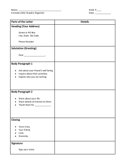
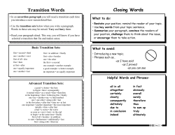
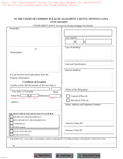
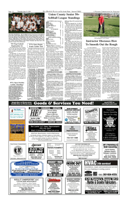


© Copyright 2026