
Package 'oce'
Package ‘oce’
January 27, 2015
Version 0.9-14
Date 2014-05-19
Title Analysis of Oceanographic data
Author Dan Kelley <[email protected]>
Maintainer Dan Kelley <[email protected]>
Depends R (>= 2.15), utils, methods, mapproj
Suggests ocedata, foreign, ncdf4, tiff
BugReports https:
//github.com/dankelley/oce/issues?sort=created&direction=desc&state=open
Description Supports the analysis of Oceanographic data,
including ADP measurements, CTD measurements, sectional
data, sea-level time series, coastline files, etc.
Provides functions for calculating seawater properties
such as potential temperature and density, as well as
derived properties such as buoyancy frequency and
dynamic height.
License GPL (>= 2)
URL http://dankelley.github.com/oce/
LazyLoad yes
LazyData no
NeedsCompilation yes
Repository CRAN
Date/Publication 2014-05-19 14:26:07
R topics documented:
abbreviateTimeLabels
accessors . . . . . .
addColumn . . . . .
adp . . . . . . . . . .
.
.
.
.
.
.
.
.
.
.
.
.
.
.
.
.
.
.
.
.
.
.
.
.
.
.
.
.
.
.
.
.
.
.
.
.
.
.
.
.
.
.
.
.
1
.
.
.
.
.
.
.
.
.
.
.
.
.
.
.
.
.
.
.
.
.
.
.
.
.
.
.
.
.
.
.
.
.
.
.
.
.
.
.
.
.
.
.
.
.
.
.
.
.
.
.
.
.
.
.
.
.
.
.
.
.
.
.
.
.
.
.
.
.
.
.
.
.
.
.
.
.
.
.
.
.
.
.
.
.
.
.
.
.
.
.
.
.
.
.
.
. 8
. 9
. 10
. 11
R topics documented:
2
adp-class . . . . . . . . .
adv . . . . . . . . . . . . .
adv-class . . . . . . . . .
airRho . . . . . . . . . . .
angleRemap . . . . . . . .
applyMagneticDeclination
approx3d . . . . . . . . .
as.coastline . . . . . . . .
as.ctd . . . . . . . . . . .
as.drifter . . . . . . . . . .
as.echosounder . . . . . .
as.gps . . . . . . . . . . .
as.lisst . . . . . . . . . . .
as.lobo . . . . . . . . . . .
as.met . . . . . . . . . . .
as.sealevel . . . . . . . . .
as.section . . . . . . . . .
as.tdr . . . . . . . . . . . .
as.topo . . . . . . . . . . .
as.windrose . . . . . . . .
bcdToInteger . . . . . . .
beamName . . . . . . . .
beamToXyz . . . . . . . .
beamToXyzAdp . . . . . .
beamToXyzAdv . . . . . .
beamUnspreadAdp . . . .
binApply . . . . . . . . .
binAverage . . . . . . . .
binmapAdp . . . . . . . .
binMean . . . . . . . . . .
byteToBinary . . . . . . .
cm . . . . . . . . . . . . .
cm-class . . . . . . . . . .
coastline-class . . . . . . .
coastlineBest . . . . . . .
coastlineWorld . . . . . .
colormap . . . . . . . . .
coriolis . . . . . . . . . .
ctd . . . . . . . . . . . . .
ctd-class . . . . . . . . . .
ctdAddColumn . . . . . .
ctdDecimate . . . . . . . .
ctdFindProfiles . . . . . .
ctdRaw . . . . . . . . . .
ctdTrim . . . . . . . . . .
ctdUpdateHeader . . . . .
ctimeToSeconds . . . . . .
decimate . . . . . . . . . .
.
.
.
.
.
.
.
.
.
.
.
.
.
.
.
.
.
.
.
.
.
.
.
.
.
.
.
.
.
.
.
.
.
.
.
.
.
.
.
.
.
.
.
.
.
.
.
.
.
.
.
.
.
.
.
.
.
.
.
.
.
.
.
.
.
.
.
.
.
.
.
.
.
.
.
.
.
.
.
.
.
.
.
.
.
.
.
.
.
.
.
.
.
.
.
.
.
.
.
.
.
.
.
.
.
.
.
.
.
.
.
.
.
.
.
.
.
.
.
.
.
.
.
.
.
.
.
.
.
.
.
.
.
.
.
.
.
.
.
.
.
.
.
.
.
.
.
.
.
.
.
.
.
.
.
.
.
.
.
.
.
.
.
.
.
.
.
.
.
.
.
.
.
.
.
.
.
.
.
.
.
.
.
.
.
.
.
.
.
.
.
.
.
.
.
.
.
.
.
.
.
.
.
.
.
.
.
.
.
.
.
.
.
.
.
.
.
.
.
.
.
.
.
.
.
.
.
.
.
.
.
.
.
.
.
.
.
.
.
.
.
.
.
.
.
.
.
.
.
.
.
.
.
.
.
.
.
.
.
.
.
.
.
.
.
.
.
.
.
.
.
.
.
.
.
.
.
.
.
.
.
.
.
.
.
.
.
.
.
.
.
.
.
.
.
.
.
.
.
.
.
.
.
.
.
.
.
.
.
.
.
.
.
.
.
.
.
.
.
.
.
.
.
.
.
.
.
.
.
.
.
.
.
.
.
.
.
.
.
.
.
.
.
.
.
.
.
.
.
.
.
.
.
.
.
.
.
.
.
.
.
.
.
.
.
.
.
.
.
.
.
.
.
.
.
.
.
.
.
.
.
.
.
.
.
.
.
.
.
.
.
.
.
.
.
.
.
.
.
.
.
.
.
.
.
.
.
.
.
.
.
.
.
.
.
.
.
.
.
.
.
.
.
.
.
.
.
.
.
.
.
.
.
.
.
.
.
.
.
.
.
.
.
.
.
.
.
.
.
.
.
.
.
.
.
.
.
.
.
.
.
.
.
.
.
.
.
.
.
.
.
.
.
.
.
.
.
.
.
.
.
.
.
.
.
.
.
.
.
.
.
.
.
.
.
.
.
.
.
.
.
.
.
.
.
.
.
.
.
.
.
.
.
.
.
.
.
.
.
.
.
.
.
.
.
.
.
.
.
.
.
.
.
.
.
.
.
.
.
.
.
.
.
.
.
.
.
.
.
.
.
.
.
.
.
.
.
.
.
.
.
.
.
.
.
.
.
.
.
.
.
.
.
.
.
.
.
.
.
.
.
.
.
.
.
.
.
.
.
.
.
.
.
.
.
.
.
.
.
.
.
.
.
.
.
.
.
.
.
.
.
.
.
.
.
.
.
.
.
.
.
.
.
.
.
.
.
.
.
.
.
.
.
.
.
.
.
.
.
.
.
.
.
.
.
.
.
.
.
.
.
.
.
.
.
.
.
.
.
.
.
.
.
.
.
.
.
.
.
.
.
.
.
.
.
.
.
.
.
.
.
.
.
.
.
.
.
.
.
.
.
.
.
.
.
.
.
.
.
.
.
.
.
.
.
.
.
.
.
.
.
.
.
.
.
.
.
.
.
.
.
.
.
.
.
.
.
.
.
.
.
.
.
.
.
.
.
.
.
.
.
.
.
.
.
.
.
.
.
.
.
.
.
.
.
.
.
.
.
.
.
.
.
.
.
.
.
.
.
.
.
.
.
.
.
.
.
.
.
.
.
.
.
.
.
.
.
.
.
.
.
.
.
.
.
.
.
.
.
.
.
.
.
.
.
.
.
.
.
.
.
.
.
.
.
.
.
.
.
.
.
.
.
.
.
.
.
.
.
.
.
.
.
.
.
.
.
.
.
.
.
.
.
.
.
.
.
.
.
.
.
.
.
.
.
.
.
.
.
.
.
.
.
.
.
.
.
.
.
.
.
.
.
.
.
.
.
.
.
.
.
.
.
.
.
.
.
.
.
.
.
.
.
.
.
.
.
.
.
.
.
.
.
.
.
.
.
.
.
.
.
.
.
.
.
.
.
.
.
.
.
.
.
.
.
.
.
.
.
.
.
.
.
.
.
.
.
.
.
.
.
.
.
.
.
.
.
.
.
.
.
.
.
.
.
.
.
.
.
.
.
.
.
.
.
.
.
.
.
.
.
.
.
.
.
.
.
.
.
.
.
.
.
.
.
.
.
.
.
.
.
.
.
.
.
.
.
.
.
.
.
.
.
.
.
.
.
.
.
.
.
.
.
.
.
.
.
.
.
.
.
.
.
.
.
.
.
.
.
.
.
.
.
.
.
.
.
.
.
.
.
.
.
.
.
.
.
.
.
.
.
.
.
.
.
.
.
.
.
.
.
.
.
.
.
.
.
.
.
.
.
.
.
.
.
.
.
.
.
.
.
.
.
.
.
.
.
.
.
.
.
.
.
.
.
.
.
.
.
.
.
.
.
.
.
.
.
.
.
.
.
.
.
.
.
.
.
.
.
.
.
.
.
.
.
.
.
.
.
.
.
.
.
.
.
.
.
.
.
.
.
.
.
.
.
.
.
.
.
.
.
.
.
.
.
.
.
.
.
.
.
.
.
.
.
.
.
.
.
.
.
.
.
.
.
.
.
.
.
.
.
.
.
.
.
.
.
.
.
.
.
.
.
.
.
.
.
.
.
.
.
.
.
.
.
.
.
.
.
.
.
.
.
.
.
.
.
.
.
.
.
.
.
.
.
.
.
.
.
.
.
.
.
.
.
.
.
.
.
.
.
.
.
.
.
.
.
.
.
.
.
.
.
.
.
.
.
.
.
.
.
.
.
.
.
.
.
.
.
.
.
.
.
.
.
.
.
.
.
.
.
.
.
.
.
.
.
.
.
.
.
.
.
.
.
.
.
.
.
.
.
.
.
.
.
.
.
.
.
.
.
.
.
.
.
.
.
.
.
.
.
.
.
.
.
.
.
.
.
.
.
.
.
.
.
.
.
.
.
.
.
.
.
.
.
.
.
.
.
.
.
.
.
.
.
.
.
.
.
.
.
.
.
.
.
.
.
.
.
.
.
.
.
.
.
.
.
.
.
.
.
.
.
.
.
.
.
.
.
.
.
.
.
.
.
.
.
.
.
.
.
.
.
.
.
.
.
.
.
.
.
.
.
.
.
.
.
.
.
.
.
.
.
.
.
.
.
.
.
.
.
.
.
.
.
.
.
.
.
.
.
.
.
.
.
.
.
.
.
.
.
.
.
.
.
.
.
.
.
.
.
.
.
.
.
.
.
.
.
.
.
.
.
.
.
.
.
.
.
.
.
.
.
.
.
.
.
.
.
.
.
.
.
.
.
.
.
.
.
.
.
.
.
.
.
.
.
.
.
.
.
.
.
.
.
.
.
.
.
.
.
.
.
.
.
.
.
.
.
.
.
.
.
.
.
.
.
.
.
.
.
.
.
.
.
.
.
.
.
.
.
.
.
.
.
.
.
.
.
.
.
.
.
.
.
.
.
.
.
.
.
.
.
.
.
.
.
.
.
.
.
.
.
.
12
14
15
16
17
18
19
20
21
24
25
26
27
28
29
30
31
32
34
34
36
36
37
38
39
40
41
42
44
45
46
47
48
48
49
50
51
54
55
56
57
58
60
61
62
64
65
66
R topics documented:
decodeHeader . . . . . . . .
decodeTime . . . . . . . . .
despike . . . . . . . . . . .
detrend . . . . . . . . . . .
drawDirectionField . . . . .
drawIsopycnals . . . . . . .
drawPalette . . . . . . . . .
drifter . . . . . . . . . . . .
drifter-class . . . . . . . . .
echosounder . . . . . . . . .
echosounder-class . . . . . .
eclipticalToEquatorial . . . .
enuToOtherAdp . . . . . . .
enuToOtherAdv . . . . . . .
equatorialToLocalHorizontal
errorbars . . . . . . . . . . .
extract . . . . . . . . . . . .
fillGap . . . . . . . . . . . .
findBottom . . . . . . . . .
findInOrdered . . . . . . . .
formatCI . . . . . . . . . . .
formatPosition . . . . . . . .
fullFilename . . . . . . . . .
geodDist . . . . . . . . . . .
geodGc . . . . . . . . . . .
geodXy . . . . . . . . . . .
GMTOffsetFromTz . . . . .
gps-class . . . . . . . . . . .
grad . . . . . . . . . . . . .
gravity . . . . . . . . . . . .
head . . . . . . . . . . . . .
header . . . . . . . . . . . .
imagep . . . . . . . . . . . .
integerToAscii . . . . . . . .
integrateTrapezoid . . . . .
interpBarnes . . . . . . . . .
is.beam . . . . . . . . . . .
julianCenturyAnomaly . . .
julianDay . . . . . . . . . .
landsat-class . . . . . . . . .
landsatTrim . . . . . . . . .
latFormat . . . . . . . . . .
latlonFormat . . . . . . . . .
lisst . . . . . . . . . . . . .
lisst-class . . . . . . . . . .
lobo . . . . . . . . . . . . .
lobo-class . . . . . . . . . .
loggerToc . . . . . . . . . .
3
.
.
.
.
.
.
.
.
.
.
.
.
.
.
.
.
.
.
.
.
.
.
.
.
.
.
.
.
.
.
.
.
.
.
.
.
.
.
.
.
.
.
.
.
.
.
.
.
.
.
.
.
.
.
.
.
.
.
.
.
.
.
.
.
.
.
.
.
.
.
.
.
.
.
.
.
.
.
.
.
.
.
.
.
.
.
.
.
.
.
.
.
.
.
.
.
.
.
.
.
.
.
.
.
.
.
.
.
.
.
.
.
.
.
.
.
.
.
.
.
.
.
.
.
.
.
.
.
.
.
.
.
.
.
.
.
.
.
.
.
.
.
.
.
.
.
.
.
.
.
.
.
.
.
.
.
.
.
.
.
.
.
.
.
.
.
.
.
.
.
.
.
.
.
.
.
.
.
.
.
.
.
.
.
.
.
.
.
.
.
.
.
.
.
.
.
.
.
.
.
.
.
.
.
.
.
.
.
.
.
.
.
.
.
.
.
.
.
.
.
.
.
.
.
.
.
.
.
.
.
.
.
.
.
.
.
.
.
.
.
.
.
.
.
.
.
.
.
.
.
.
.
.
.
.
.
.
.
.
.
.
.
.
.
.
.
.
.
.
.
.
.
.
.
.
.
.
.
.
.
.
.
.
.
.
.
.
.
.
.
.
.
.
.
.
.
.
.
.
.
.
.
.
.
.
.
.
.
.
.
.
.
.
.
.
.
.
.
.
.
.
.
.
.
.
.
.
.
.
.
.
.
.
.
.
.
.
.
.
.
.
.
.
.
.
.
.
.
.
.
.
.
.
.
.
.
.
.
.
.
.
.
.
.
.
.
.
.
.
.
.
.
.
.
.
.
.
.
.
.
.
.
.
.
.
.
.
.
.
.
.
.
.
.
.
.
.
.
.
.
.
.
.
.
.
.
.
.
.
.
.
.
.
.
.
.
.
.
.
.
.
.
.
.
.
.
.
.
.
.
.
.
.
.
.
.
.
.
.
.
.
.
.
.
.
.
.
.
.
.
.
.
.
.
.
.
.
.
.
.
.
.
.
.
.
.
.
.
.
.
.
.
.
.
.
.
.
.
.
.
.
.
.
.
.
.
.
.
.
.
.
.
.
.
.
.
.
.
.
.
.
.
.
.
.
.
.
.
.
.
.
.
.
.
.
.
.
.
.
.
.
.
.
.
.
.
.
.
.
.
.
.
.
.
.
.
.
.
.
.
.
.
.
.
.
.
.
.
.
.
.
.
.
.
.
.
.
.
.
.
.
.
.
.
.
.
.
.
.
.
.
.
.
.
.
.
.
.
.
.
.
.
.
.
.
.
.
.
.
.
.
.
.
.
.
.
.
.
.
.
.
.
.
.
.
.
.
.
.
.
.
.
.
.
.
.
.
.
.
.
.
.
.
.
.
.
.
.
.
.
.
.
.
.
.
.
.
.
.
.
.
.
.
.
.
.
.
.
.
.
.
.
.
.
.
.
.
.
.
.
.
.
.
.
.
.
.
.
.
.
.
.
.
.
.
.
.
.
.
.
.
.
.
.
.
.
.
.
.
.
.
.
.
.
.
.
.
.
.
.
.
.
.
.
.
.
.
.
.
.
.
.
.
.
.
.
.
.
.
.
.
.
.
.
.
.
.
.
.
.
.
.
.
.
.
.
.
.
.
.
.
.
.
.
.
.
.
.
.
.
.
.
.
.
.
.
.
.
.
.
.
.
.
.
.
.
.
.
.
.
.
.
.
.
.
.
.
.
.
.
.
.
.
.
.
.
.
.
.
.
.
.
.
.
.
.
.
.
.
.
.
.
.
.
.
.
.
.
.
.
.
.
.
.
.
.
.
.
.
.
.
.
.
.
.
.
.
.
.
.
.
.
.
.
.
.
.
.
.
.
.
.
.
.
.
.
.
.
.
.
.
.
.
.
.
.
.
.
.
.
.
.
.
.
.
.
.
.
.
.
.
.
.
.
.
.
.
.
.
.
.
.
.
.
.
.
.
.
.
.
.
.
.
.
.
.
.
.
.
.
.
.
.
.
.
.
.
.
.
.
.
.
.
.
.
.
.
.
.
.
.
.
.
.
.
.
.
.
.
.
.
.
.
.
.
.
.
.
.
.
.
.
.
.
.
.
.
.
.
.
.
.
.
.
.
.
.
.
.
.
.
.
.
.
.
.
.
.
.
.
.
.
.
.
.
.
.
.
.
.
.
.
.
.
.
.
.
.
.
.
.
.
.
.
.
.
.
.
.
.
.
.
.
.
.
.
.
.
.
.
.
.
.
.
.
.
.
.
.
.
.
.
.
.
.
.
.
.
.
.
.
.
.
.
.
.
.
.
.
.
.
.
.
.
.
.
.
.
.
.
.
.
.
.
.
.
.
.
.
.
.
.
.
.
.
.
.
.
.
.
.
.
.
.
.
.
.
.
.
.
.
.
.
.
.
.
.
.
.
.
.
.
.
.
.
.
.
.
.
.
.
.
.
.
.
.
.
.
.
.
.
.
.
.
.
.
.
.
.
.
.
.
.
.
.
.
.
.
.
.
.
.
.
.
.
.
.
.
.
.
.
.
.
.
.
.
.
.
.
.
.
.
.
.
.
.
.
.
.
.
.
.
.
.
.
.
.
.
.
.
.
.
.
.
.
.
.
.
.
.
.
.
.
.
.
.
.
.
.
.
.
.
.
.
.
.
.
.
.
.
.
.
.
.
.
.
.
.
.
.
.
.
.
.
.
.
.
.
.
.
.
.
.
.
.
.
.
.
.
.
.
.
.
.
.
.
.
.
.
.
.
.
.
.
.
.
.
.
.
.
.
.
.
.
.
.
.
.
.
.
.
.
.
.
.
.
.
.
.
.
.
.
.
.
.
.
.
.
.
.
.
.
.
.
.
.
.
.
.
.
.
.
.
.
.
.
.
.
.
.
.
.
.
.
.
.
.
.
.
.
.
.
.
.
.
.
.
.
.
.
.
.
.
.
.
.
.
.
.
.
.
.
.
.
.
.
.
.
.
.
.
.
.
.
.
.
.
.
.
.
.
.
.
.
.
.
.
.
.
.
.
.
.
.
.
.
.
.
.
.
.
.
.
.
.
.
.
.
.
.
.
.
.
.
.
.
.
.
.
.
.
.
.
.
.
.
.
.
.
.
.
.
.
.
.
.
.
.
.
.
.
.
.
.
.
.
.
.
.
.
.
.
.
.
.
.
.
.
.
.
.
.
.
.
.
.
.
.
.
.
.
.
.
.
.
.
.
.
.
.
.
.
.
.
.
.
.
.
.
.
.
.
.
.
.
.
.
.
.
.
.
.
.
.
.
.
.
.
.
.
.
.
.
.
.
.
.
.
.
.
.
.
.
.
.
.
.
.
.
.
.
.
.
.
.
.
.
.
.
.
.
.
.
.
.
.
.
.
.
.
.
.
.
.
.
.
.
.
.
.
.
.
.
.
.
.
67
68
69
71
72
73
74
76
77
78
79
80
81
82
83
84
85
86
87
88
88
90
91
91
93
94
95
96
96
97
98
99
100
103
104
105
107
108
109
110
111
112
112
113
114
115
115
116
R topics documented:
4
lonFormat . . . . . . . . .
magneticField . . . . . . .
makeFilter . . . . . . . . .
makeSection . . . . . . . .
map2lonlat . . . . . . . .
mapContour . . . . . . . .
mapImage . . . . . . . . .
mapLines . . . . . . . . .
mapLocator . . . . . . . .
mapLongitudeLatitudeXY
mapMeridians . . . . . . .
mapPlot . . . . . . . . . .
mapPoints . . . . . . . . .
mapPolygon . . . . . . . .
mapScalebar . . . . . . . .
mapText . . . . . . . . . .
mapZones . . . . . . . . .
matchBytes . . . . . . . .
matrixSmooth . . . . . . .
met . . . . . . . . . . . .
met-class . . . . . . . . .
moonAngle . . . . . . . .
nao . . . . . . . . . . . . .
numberAsHMS . . . . . .
numberAsPOSIXct . . . .
oce-class . . . . . . . . . .
oce.as.POSIXlt . . . . . .
oce.as.raw . . . . . . . . .
oce.axis.POSIXct . . . . .
oce.plot.ts . . . . . . . . .
oce.write.table . . . . . . .
oceApprox . . . . . . . . .
oceColors . . . . . . . . .
oceContour . . . . . . . .
oceConvolve . . . . . . .
oceDebug . . . . . . . . .
oceEdit . . . . . . . . . .
oceFilter . . . . . . . . . .
oceMagic . . . . . . . . .
ocePmatch . . . . . . . . .
oceSmooth . . . . . . . .
oceSpectrum . . . . . . .
parseLatLon . . . . . . . .
plot.adp . . . . . . . . . .
plot.adv . . . . . . . . . .
plot.cm . . . . . . . . . .
plot.coastline . . . . . . .
plot.ctd . . . . . . . . . .
.
.
.
.
.
.
.
.
.
.
.
.
.
.
.
.
.
.
.
.
.
.
.
.
.
.
.
.
.
.
.
.
.
.
.
.
.
.
.
.
.
.
.
.
.
.
.
.
.
.
.
.
.
.
.
.
.
.
.
.
.
.
.
.
.
.
.
.
.
.
.
.
.
.
.
.
.
.
.
.
.
.
.
.
.
.
.
.
.
.
.
.
.
.
.
.
.
.
.
.
.
.
.
.
.
.
.
.
.
.
.
.
.
.
.
.
.
.
.
.
.
.
.
.
.
.
.
.
.
.
.
.
.
.
.
.
.
.
.
.
.
.
.
.
.
.
.
.
.
.
.
.
.
.
.
.
.
.
.
.
.
.
.
.
.
.
.
.
.
.
.
.
.
.
.
.
.
.
.
.
.
.
.
.
.
.
.
.
.
.
.
.
.
.
.
.
.
.
.
.
.
.
.
.
.
.
.
.
.
.
.
.
.
.
.
.
.
.
.
.
.
.
.
.
.
.
.
.
.
.
.
.
.
.
.
.
.
.
.
.
.
.
.
.
.
.
.
.
.
.
.
.
.
.
.
.
.
.
.
.
.
.
.
.
.
.
.
.
.
.
.
.
.
.
.
.
.
.
.
.
.
.
.
.
.
.
.
.
.
.
.
.
.
.
.
.
.
.
.
.
.
.
.
.
.
.
.
.
.
.
.
.
.
.
.
.
.
.
.
.
.
.
.
.
.
.
.
.
.
.
.
.
.
.
.
.
.
.
.
.
.
.
.
.
.
.
.
.
.
.
.
.
.
.
.
.
.
.
.
.
.
.
.
.
.
.
.
.
.
.
.
.
.
.
.
.
.
.
.
.
.
.
.
.
.
.
.
.
.
.
.
.
.
.
.
.
.
.
.
.
.
.
.
.
.
.
.
.
.
.
.
.
.
.
.
.
.
.
.
.
.
.
.
.
.
.
.
.
.
.
.
.
.
.
.
.
.
.
.
.
.
.
.
.
.
.
.
.
.
.
.
.
.
.
.
.
.
.
.
.
.
.
.
.
.
.
.
.
.
.
.
.
.
.
.
.
.
.
.
.
.
.
.
.
.
.
.
.
.
.
.
.
.
.
.
.
.
.
.
.
.
.
.
.
.
.
.
.
.
.
.
.
.
.
.
.
.
.
.
.
.
.
.
.
.
.
.
.
.
.
.
.
.
.
.
.
.
.
.
.
.
.
.
.
.
.
.
.
.
.
.
.
.
.
.
.
.
.
.
.
.
.
.
.
.
.
.
.
.
.
.
.
.
.
.
.
.
.
.
.
.
.
.
.
.
.
.
.
.
.
.
.
.
.
.
.
.
.
.
.
.
.
.
.
.
.
.
.
.
.
.
.
.
.
.
.
.
.
.
.
.
.
.
.
.
.
.
.
.
.
.
.
.
.
.
.
.
.
.
.
.
.
.
.
.
.
.
.
.
.
.
.
.
.
.
.
.
.
.
.
.
.
.
.
.
.
.
.
.
.
.
.
.
.
.
.
.
.
.
.
.
.
.
.
.
.
.
.
.
.
.
.
.
.
.
.
.
.
.
.
.
.
.
.
.
.
.
.
.
.
.
.
.
.
.
.
.
.
.
.
.
.
.
.
.
.
.
.
.
.
.
.
.
.
.
.
.
.
.
.
.
.
.
.
.
.
.
.
.
.
.
.
.
.
.
.
.
.
.
.
.
.
.
.
.
.
.
.
.
.
.
.
.
.
.
.
.
.
.
.
.
.
.
.
.
.
.
.
.
.
.
.
.
.
.
.
.
.
.
.
.
.
.
.
.
.
.
.
.
.
.
.
.
.
.
.
.
.
.
.
.
.
.
.
.
.
.
.
.
.
.
.
.
.
.
.
.
.
.
.
.
.
.
.
.
.
.
.
.
.
.
.
.
.
.
.
.
.
.
.
.
.
.
.
.
.
.
.
.
.
.
.
.
.
.
.
.
.
.
.
.
.
.
.
.
.
.
.
.
.
.
.
.
.
.
.
.
.
.
.
.
.
.
.
.
.
.
.
.
.
.
.
.
.
.
.
.
.
.
.
.
.
.
.
.
.
.
.
.
.
.
.
.
.
.
.
.
.
.
.
.
.
.
.
.
.
.
.
.
.
.
.
.
.
.
.
.
.
.
.
.
.
.
.
.
.
.
.
.
.
.
.
.
.
.
.
.
.
.
.
.
.
.
.
.
.
.
.
.
.
.
.
.
.
.
.
.
.
.
.
.
.
.
.
.
.
.
.
.
.
.
.
.
.
.
.
.
.
.
.
.
.
.
.
.
.
.
.
.
.
.
.
.
.
.
.
.
.
.
.
.
.
.
.
.
.
.
.
.
.
.
.
.
.
.
.
.
.
.
.
.
.
.
.
.
.
.
.
.
.
.
.
.
.
.
.
.
.
.
.
.
.
.
.
.
.
.
.
.
.
.
.
.
.
.
.
.
.
.
.
.
.
.
.
.
.
.
.
.
.
.
.
.
.
.
.
.
.
.
.
.
.
.
.
.
.
.
.
.
.
.
.
.
.
.
.
.
.
.
.
.
.
.
.
.
.
.
.
.
.
.
.
.
.
.
.
.
.
.
.
.
.
.
.
.
.
.
.
.
.
.
.
.
.
.
.
.
.
.
.
.
.
.
.
.
.
.
.
.
.
.
.
.
.
.
.
.
.
.
.
.
.
.
.
.
.
.
.
.
.
.
.
.
.
.
.
.
.
.
.
.
.
.
.
.
.
.
.
.
.
.
.
.
.
.
.
.
.
.
.
.
.
.
.
.
.
.
.
.
.
.
.
.
.
.
.
.
.
.
.
.
.
.
.
.
.
.
.
.
.
.
.
.
.
.
.
.
.
.
.
.
.
.
.
.
.
.
.
.
.
.
.
.
.
.
.
.
.
.
.
.
.
.
.
.
.
.
.
.
.
.
.
.
.
.
.
.
.
.
.
.
.
.
.
.
.
.
.
.
.
.
.
.
.
.
.
.
.
.
.
.
.
.
.
.
.
.
.
.
.
.
.
.
.
.
.
.
.
.
.
.
.
.
.
.
.
.
.
.
.
.
.
.
.
.
.
.
.
.
.
.
.
.
.
.
.
.
.
.
.
.
.
.
.
.
.
.
.
.
.
.
.
.
.
.
.
.
.
.
.
.
.
.
.
.
.
.
.
.
.
.
.
.
.
.
.
.
.
.
.
.
.
.
.
.
.
.
.
.
.
.
.
.
.
.
.
.
.
.
.
.
.
.
.
.
.
.
.
.
.
.
.
.
.
.
.
.
.
.
.
.
.
.
.
.
.
.
.
.
.
.
.
.
.
.
.
.
.
.
.
.
.
.
.
.
.
.
.
.
.
.
.
.
.
.
.
.
.
.
.
.
.
.
.
.
.
.
.
.
.
.
.
.
.
.
.
.
.
.
.
.
.
.
.
.
.
.
.
.
.
.
.
.
.
.
.
.
.
.
.
.
.
.
.
.
.
.
.
.
.
.
.
.
.
.
.
.
.
.
.
.
.
.
.
.
.
.
.
.
.
.
.
.
.
117
118
119
121
122
123
124
126
127
128
129
130
132
133
135
136
137
138
139
140
140
141
143
144
145
146
147
148
148
150
152
153
155
156
158
159
160
161
162
163
164
165
166
167
172
175
177
180
R topics documented:
plot.drifter . . . .
plot.echosounder
plot.gps . . . . .
plot.landsat . . .
plot.lisst . . . . .
plot.lobo . . . . .
plot.met . . . . .
plot.sealevel . . .
plot.section . . .
plot.tdr . . . . . .
plot.tidem . . . .
plot.topo . . . . .
plot.windrose . .
plotInset . . . . .
plotPolar . . . . .
plotProfile . . . .
plotScan . . . . .
plotSticks . . . .
plotTaylor . . . .
plotTS . . . . . .
predict.tidem . .
prettyPosition . .
processingLog . .
pwelch . . . . . .
rangeExtended .
rangeLimit . . . .
read.adp . . . . .
read.adv . . . . .
read.cm . . . . .
read.coastline . .
read.ctd . . . . .
read.drifter . . .
read.echosounder
read.gps . . . . .
read.landsat . . .
read.lisst . . . . .
read.lobo . . . .
read.met . . . . .
read.observatory .
read.oce . . . . .
read.sealevel . . .
read.section . . .
read.tdr . . . . .
read.topo . . . .
rescale . . . . . .
resizableLabel . .
retime . . . . . .
runlm . . . . . .
5
.
.
.
.
.
.
.
.
.
.
.
.
.
.
.
.
.
.
.
.
.
.
.
.
.
.
.
.
.
.
.
.
.
.
.
.
.
.
.
.
.
.
.
.
.
.
.
.
.
.
.
.
.
.
.
.
.
.
.
.
.
.
.
.
.
.
.
.
.
.
.
.
.
.
.
.
.
.
.
.
.
.
.
.
.
.
.
.
.
.
.
.
.
.
.
.
.
.
.
.
.
.
.
.
.
.
.
.
.
.
.
.
.
.
.
.
.
.
.
.
.
.
.
.
.
.
.
.
.
.
.
.
.
.
.
.
.
.
.
.
.
.
.
.
.
.
.
.
.
.
.
.
.
.
.
.
.
.
.
.
.
.
.
.
.
.
.
.
.
.
.
.
.
.
.
.
.
.
.
.
.
.
.
.
.
.
.
.
.
.
.
.
.
.
.
.
.
.
.
.
.
.
.
.
.
.
.
.
.
.
.
.
.
.
.
.
.
.
.
.
.
.
.
.
.
.
.
.
.
.
.
.
.
.
.
.
.
.
.
.
.
.
.
.
.
.
.
.
.
.
.
.
.
.
.
.
.
.
.
.
.
.
.
.
.
.
.
.
.
.
.
.
.
.
.
.
.
.
.
.
.
.
.
.
.
.
.
.
.
.
.
.
.
.
.
.
.
.
.
.
.
.
.
.
.
.
.
.
.
.
.
.
.
.
.
.
.
.
.
.
.
.
.
.
.
.
.
.
.
.
.
.
.
.
.
.
.
.
.
.
.
.
.
.
.
.
.
.
.
.
.
.
.
.
.
.
.
.
.
.
.
.
.
.
.
.
.
.
.
.
.
.
.
.
.
.
.
.
.
.
.
.
.
.
.
.
.
.
.
.
.
.
.
.
.
.
.
.
.
.
.
.
.
.
.
.
.
.
.
.
.
.
.
.
.
.
.
.
.
.
.
.
.
.
.
.
.
.
.
.
.
.
.
.
.
.
.
.
.
.
.
.
.
.
.
.
.
.
.
.
.
.
.
.
.
.
.
.
.
.
.
.
.
.
.
.
.
.
.
.
.
.
.
.
.
.
.
.
.
.
.
.
.
.
.
.
.
.
.
.
.
.
.
.
.
.
.
.
.
.
.
.
.
.
.
.
.
.
.
.
.
.
.
.
.
.
.
.
.
.
.
.
.
.
.
.
.
.
.
.
.
.
.
.
.
.
.
.
.
.
.
.
.
.
.
.
.
.
.
.
.
.
.
.
.
.
.
.
.
.
.
.
.
.
.
.
.
.
.
.
.
.
.
.
.
.
.
.
.
.
.
.
.
.
.
.
.
.
.
.
.
.
.
.
.
.
.
.
.
.
.
.
.
.
.
.
.
.
.
.
.
.
.
.
.
.
.
.
.
.
.
.
.
.
.
.
.
.
.
.
.
.
.
.
.
.
.
.
.
.
.
.
.
.
.
.
.
.
.
.
.
.
.
.
.
.
.
.
.
.
.
.
.
.
.
.
.
.
.
.
.
.
.
.
.
.
.
.
.
.
.
.
.
.
.
.
.
.
.
.
.
.
.
.
.
.
.
.
.
.
.
.
.
.
.
.
.
.
.
.
.
.
.
.
.
.
.
.
.
.
.
.
.
.
.
.
.
.
.
.
.
.
.
.
.
.
.
.
.
.
.
.
.
.
.
.
.
.
.
.
.
.
.
.
.
.
.
.
.
.
.
.
.
.
.
.
.
.
.
.
.
.
.
.
.
.
.
.
.
.
.
.
.
.
.
.
.
.
.
.
.
.
.
.
.
.
.
.
.
.
.
.
.
.
.
.
.
.
.
.
.
.
.
.
.
.
.
.
.
.
.
.
.
.
.
.
.
.
.
.
.
.
.
.
.
.
.
.
.
.
.
.
.
.
.
.
.
.
.
.
.
.
.
.
.
.
.
.
.
.
.
.
.
.
.
.
.
.
.
.
.
.
.
.
.
.
.
.
.
.
.
.
.
.
.
.
.
.
.
.
.
.
.
.
.
.
.
.
.
.
.
.
.
.
.
.
.
.
.
.
.
.
.
.
.
.
.
.
.
.
.
.
.
.
.
.
.
.
.
.
.
.
.
.
.
.
.
.
.
.
.
.
.
.
.
.
.
.
.
.
.
.
.
.
.
.
.
.
.
.
.
.
.
.
.
.
.
.
.
.
.
.
.
.
.
.
.
.
.
.
.
.
.
.
.
.
.
.
.
.
.
.
.
.
.
.
.
.
.
.
.
.
.
.
.
.
.
.
.
.
.
.
.
.
.
.
.
.
.
.
.
.
.
.
.
.
.
.
.
.
.
.
.
.
.
.
.
.
.
.
.
.
.
.
.
.
.
.
.
.
.
.
.
.
.
.
.
.
.
.
.
.
.
.
.
.
.
.
.
.
.
.
.
.
.
.
.
.
.
.
.
.
.
.
.
.
.
.
.
.
.
.
.
.
.
.
.
.
.
.
.
.
.
.
.
.
.
.
.
.
.
.
.
.
.
.
.
.
.
.
.
.
.
.
.
.
.
.
.
.
.
.
.
.
.
.
.
.
.
.
.
.
.
.
.
.
.
.
.
.
.
.
.
.
.
.
.
.
.
.
.
.
.
.
.
.
.
.
.
.
.
.
.
.
.
.
.
.
.
.
.
.
.
.
.
.
.
.
.
.
.
.
.
.
.
.
.
.
.
.
.
.
.
.
.
.
.
.
.
.
.
.
.
.
.
.
.
.
.
.
.
.
.
.
.
.
.
.
.
.
.
.
.
.
.
.
.
.
.
.
.
.
.
.
.
.
.
.
.
.
.
.
.
.
.
.
.
.
.
.
.
.
.
.
.
.
.
.
.
.
.
.
.
.
.
.
.
.
.
.
.
.
.
.
.
.
.
.
.
.
.
.
.
.
.
.
.
.
.
.
.
.
.
.
.
.
.
.
.
.
.
.
.
.
.
.
.
.
.
.
.
.
.
.
.
.
.
.
.
.
.
.
.
.
.
.
.
.
.
.
.
.
.
.
.
.
.
.
.
.
.
.
.
.
.
.
.
.
.
.
.
.
.
.
.
.
.
.
.
.
.
.
.
.
.
.
.
.
.
.
.
.
.
.
.
.
.
.
.
.
.
.
.
.
.
.
.
.
.
.
.
.
.
.
.
.
.
.
.
.
.
.
.
.
.
.
.
.
.
.
.
.
.
.
.
.
.
.
.
.
.
.
.
.
.
.
.
.
.
.
.
.
.
.
.
.
.
.
.
.
.
.
.
.
.
.
.
.
.
.
.
.
.
.
.
.
.
.
.
.
.
.
.
.
.
.
.
.
.
.
.
.
.
.
.
.
.
.
.
.
.
.
.
.
.
.
.
.
.
.
.
.
.
.
.
.
.
.
.
.
.
.
.
.
.
.
.
.
.
.
.
.
.
.
.
.
.
.
.
.
.
.
.
.
.
.
.
.
.
.
.
.
.
.
.
.
.
.
.
.
.
.
.
.
.
.
.
.
.
.
.
.
.
.
.
.
.
.
.
.
.
.
.
.
.
.
.
.
.
.
.
.
.
.
.
.
.
.
.
.
.
.
.
.
.
.
.
.
.
.
.
.
.
.
.
.
.
.
.
.
.
.
.
.
.
.
.
.
.
.
.
.
.
.
.
.
.
.
.
.
.
.
.
.
.
.
.
.
.
.
.
.
.
.
.
.
.
.
.
.
.
.
.
.
.
.
.
.
.
.
.
.
.
.
.
.
.
.
.
.
.
.
.
.
.
.
.
.
.
.
.
.
.
.
.
.
.
.
.
.
.
.
.
.
.
.
.
.
.
.
.
.
.
.
.
.
.
.
.
.
.
.
.
.
.
.
.
.
.
.
.
.
.
.
.
.
.
.
.
.
.
.
.
.
.
.
.
.
.
.
.
.
.
.
.
.
.
.
.
.
.
.
.
.
.
.
.
.
.
.
.
.
.
.
.
.
.
.
.
.
.
.
.
.
.
.
.
.
.
.
.
.
.
.
.
.
.
.
.
.
.
.
.
.
.
.
.
.
.
.
.
.
.
.
.
.
.
.
.
.
.
.
.
.
.
.
.
.
.
.
.
.
.
.
183
185
187
190
191
192
194
195
197
201
203
204
206
207
209
209
213
214
215
216
219
220
221
222
224
224
225
229
234
236
238
242
244
245
246
247
249
251
252
253
254
256
258
259
260
261
262
263
R topics documented:
6
sealevel . . . . . . . .
sealevel-class . . . . .
sealevelTuktoyaktuk .
secondsToCtime . . . .
section . . . . . . . . .
section-class . . . . . .
sectionGrid . . . . . .
sectionSmooth . . . . .
sectionSort . . . . . .
showMetadataItem . .
siderealTime . . . . . .
soi . . . . . . . . . . .
standardDepths . . . .
subset.adp . . . . . . .
subset.adv . . . . . . .
subset.cm . . . . . . .
subset.coastline . . . .
subset.ctd . . . . . . .
subset.echosounder . .
subset.lisst . . . . . . .
subset.oce . . . . . . .
subset.sealevel . . . . .
subset.section . . . . .
subset.tdr . . . . . . .
subset.topo . . . . . .
subtractBottomVelocity
summary.adp . . . . .
summary.adv . . . . .
summary.cm . . . . . .
summary.coastline . .
summary.ctd . . . . . .
summary.drifter . . . .
summary.echosounder
summary.gps . . . . .
summary.landsat . . .
summary.lisst . . . . .
summary.lobo . . . . .
summary.met . . . . .
summary.sealevel . . .
summary.section . . .
summary.tdr . . . . . .
summary.tidem . . . .
summary.topo . . . . .
summary.windrose . .
sunAngle . . . . . . .
swAbsoluteSalinity . .
swAlpha . . . . . . . .
swAlphaOverBeta . . .
.
.
.
.
.
.
.
.
.
.
.
.
.
.
.
.
.
.
.
.
.
.
.
.
.
.
.
.
.
.
.
.
.
.
.
.
.
.
.
.
.
.
.
.
.
.
.
.
.
.
.
.
.
.
.
.
.
.
.
.
.
.
.
.
.
.
.
.
.
.
.
.
.
.
.
.
.
.
.
.
.
.
.
.
.
.
.
.
.
.
.
.
.
.
.
.
.
.
.
.
.
.
.
.
.
.
.
.
.
.
.
.
.
.
.
.
.
.
.
.
.
.
.
.
.
.
.
.
.
.
.
.
.
.
.
.
.
.
.
.
.
.
.
.
.
.
.
.
.
.
.
.
.
.
.
.
.
.
.
.
.
.
.
.
.
.
.
.
.
.
.
.
.
.
.
.
.
.
.
.
.
.
.
.
.
.
.
.
.
.
.
.
.
.
.
.
.
.
.
.
.
.
.
.
.
.
.
.
.
.
.
.
.
.
.
.
.
.
.
.
.
.
.
.
.
.
.
.
.
.
.
.
.
.
.
.
.
.
.
.
.
.
.
.
.
.
.
.
.
.
.
.
.
.
.
.
.
.
.
.
.
.
.
.
.
.
.
.
.
.
.
.
.
.
.
.
.
.
.
.
.
.
.
.
.
.
.
.
.
.
.
.
.
.
.
.
.
.
.
.
.
.
.
.
.
.
.
.
.
.
.
.
.
.
.
.
.
.
.
.
.
.
.
.
.
.
.
.
.
.
.
.
.
.
.
.
.
.
.
.
.
.
.
.
.
.
.
.
.
.
.
.
.
.
.
.
.
.
.
.
.
.
.
.
.
.
.
.
.
.
.
.
.
.
.
.
.
.
.
.
.
.
.
.
.
.
.
.
.
.
.
.
.
.
.
.
.
.
.
.
.
.
.
.
.
.
.
.
.
.
.
.
.
.
.
.
.
.
.
.
.
.
.
.
.
.
.
.
.
.
.
.
.
.
.
.
.
.
.
.
.
.
.
.
.
.
.
.
.
.
.
.
.
.
.
.
.
.
.
.
.
.
.
.
.
.
.
.
.
.
.
.
.
.
.
.
.
.
.
.
.
.
.
.
.
.
.
.
.
.
.
.
.
.
.
.
.
.
.
.
.
.
.
.
.
.
.
.
.
.
.
.
.
.
.
.
.
.
.
.
.
.
.
.
.
.
.
.
.
.
.
.
.
.
.
.
.
.
.
.
.
.
.
.
.
.
.
.
.
.
.
.
.
.
.
.
.
.
.
.
.
.
.
.
.
.
.
.
.
.
.
.
.
.
.
.
.
.
.
.
.
.
.
.
.
.
.
.
.
.
.
.
.
.
.
.
.
.
.
.
.
.
.
.
.
.
.
.
.
.
.
.
.
.
.
.
.
.
.
.
.
.
.
.
.
.
.
.
.
.
.
.
.
.
.
.
.
.
.
.
.
.
.
.
.
.
.
.
.
.
.
.
.
.
.
.
.
.
.
.
.
.
.
.
.
.
.
.
.
.
.
.
.
.
.
.
.
.
.
.
.
.
.
.
.
.
.
.
.
.
.
.
.
.
.
.
.
.
.
.
.
.
.
.
.
.
.
.
.
.
.
.
.
.
.
.
.
.
.
.
.
.
.
.
.
.
.
.
.
.
.
.
.
.
.
.
.
.
.
.
.
.
.
.
.
.
.
.
.
.
.
.
.
.
.
.
.
.
.
.
.
.
.
.
.
.
.
.
.
.
.
.
.
.
.
.
.
.
.
.
.
.
.
.
.
.
.
.
.
.
.
.
.
.
.
.
.
.
.
.
.
.
.
.
.
.
.
.
.
.
.
.
.
.
.
.
.
.
.
.
.
.
.
.
.
.
.
.
.
.
.
.
.
.
.
.
.
.
.
.
.
.
.
.
.
.
.
.
.
.
.
.
.
.
.
.
.
.
.
.
.
.
.
.
.
.
.
.
.
.
.
.
.
.
.
.
.
.
.
.
.
.
.
.
.
.
.
.
.
.
.
.
.
.
.
.
.
.
.
.
.
.
.
.
.
.
.
.
.
.
.
.
.
.
.
.
.
.
.
.
.
.
.
.
.
.
.
.
.
.
.
.
.
.
.
.
.
.
.
.
.
.
.
.
.
.
.
.
.
.
.
.
.
.
.
.
.
.
.
.
.
.
.
.
.
.
.
.
.
.
.
.
.
.
.
.
.
.
.
.
.
.
.
.
.
.
.
.
.
.
.
.
.
.
.
.
.
.
.
.
.
.
.
.
.
.
.
.
.
.
.
.
.
.
.
.
.
.
.
.
.
.
.
.
.
.
.
.
.
.
.
.
.
.
.
.
.
.
.
.
.
.
.
.
.
.
.
.
.
.
.
.
.
.
.
.
.
.
.
.
.
.
.
.
.
.
.
.
.
.
.
.
.
.
.
.
.
.
.
.
.
.
.
.
.
.
.
.
.
.
.
.
.
.
.
.
.
.
.
.
.
.
.
.
.
.
.
.
.
.
.
.
.
.
.
.
.
.
.
.
.
.
.
.
.
.
.
.
.
.
.
.
.
.
.
.
.
.
.
.
.
.
.
.
.
.
.
.
.
.
.
.
.
.
.
.
.
.
.
.
.
.
.
.
.
.
.
.
.
.
.
.
.
.
.
.
.
.
.
.
.
.
.
.
.
.
.
.
.
.
.
.
.
.
.
.
.
.
.
.
.
.
.
.
.
.
.
.
.
.
.
.
.
.
.
.
.
.
.
.
.
.
.
.
.
.
.
.
.
.
.
.
.
.
.
.
.
.
.
.
.
.
.
.
.
.
.
.
.
.
.
.
.
.
.
.
.
.
.
.
.
.
.
.
.
.
.
.
.
.
.
.
.
.
.
.
.
.
.
.
.
.
.
.
.
.
.
.
.
.
.
.
.
.
.
.
.
.
.
.
.
.
.
.
.
.
.
.
.
.
.
.
.
.
.
.
.
.
.
.
.
.
.
.
.
.
.
.
.
.
.
.
.
.
.
.
.
.
.
.
.
.
.
.
.
.
.
.
.
.
.
.
.
.
.
.
.
.
.
.
.
.
.
.
.
.
.
.
.
.
.
.
.
.
.
.
.
.
.
.
.
.
.
.
.
.
.
.
.
.
.
.
.
.
.
.
.
.
.
.
.
.
.
.
.
.
.
.
.
.
.
.
.
.
.
.
.
.
.
.
.
.
.
.
.
.
.
.
.
.
.
.
.
.
.
.
.
.
.
.
.
.
.
.
.
.
.
.
.
.
.
.
.
.
.
.
.
.
.
.
.
.
.
.
.
.
.
.
.
.
.
.
.
.
.
.
.
.
.
.
.
.
.
.
.
.
.
.
.
.
.
.
.
.
.
.
.
.
.
.
.
.
.
.
.
.
.
.
.
.
.
.
.
.
.
.
.
.
.
.
.
.
.
.
.
.
.
.
.
.
.
.
.
.
.
.
.
.
.
.
.
.
.
.
.
.
.
.
.
.
.
.
.
.
.
.
.
.
.
.
.
.
.
.
.
.
.
.
.
.
.
.
.
.
.
.
.
.
.
.
.
.
.
.
.
.
.
.
.
.
.
.
.
.
.
.
.
.
.
.
.
.
.
.
.
.
.
.
.
.
.
.
.
.
.
.
.
.
.
.
.
.
.
.
.
.
.
.
.
.
.
.
.
.
.
.
.
.
.
.
.
.
.
.
.
.
.
.
.
.
.
.
.
.
.
.
.
.
.
.
.
.
.
.
.
.
.
.
.
.
.
.
.
.
.
.
.
.
.
.
265
266
267
268
269
270
271
272
273
274
275
276
277
278
279
280
281
282
283
284
285
285
286
287
288
289
289
290
291
292
293
294
295
296
296
297
298
299
300
301
302
303
304
305
306
307
309
310
R topics documented:
swBeta . . . . . . . . . . . .
swConductivity . . . . . . .
swConservativeTemperature
swDepth . . . . . . . . . . .
swDynamicHeight . . . . .
swLapseRate . . . . . . . .
swN2 . . . . . . . . . . . .
swPressure . . . . . . . . .
swRho . . . . . . . . . . . .
swRrho . . . . . . . . . . .
swSCTp . . . . . . . . . . .
swSigma . . . . . . . . . . .
swSigmaT . . . . . . . . . .
swSigmaTheta . . . . . . . .
swSoundAbsorption . . . . .
swSoundSpeed . . . . . . .
swSpecificHeat . . . . . . .
swSpice . . . . . . . . . . .
swSTrho . . . . . . . . . . .
swTFreeze . . . . . . . . . .
swTheta . . . . . . . . . . .
swTSrho . . . . . . . . . . .
swViscosity . . . . . . . . .
tdr . . . . . . . . . . . . . .
tdr-class . . . . . . . . . . .
tdrPatm . . . . . . . . . . .
tdrTrim . . . . . . . . . . .
teos . . . . . . . . . . . . .
teosSetLibrary . . . . . . . .
threenum . . . . . . . . . .
tidedata . . . . . . . . . . .
tidem . . . . . . . . . . . .
tidem-class . . . . . . . . .
tidemAstron . . . . . . . . .
tidemVuf . . . . . . . . . .
time.oce . . . . . . . . . . .
toEnuAdp . . . . . . . . . .
toEnuAdv . . . . . . . . . .
topo-class . . . . . . . . . .
topoInterpolate . . . . . . .
topoWorld . . . . . . . . . .
unabbreviateYear . . . . . .
undriftTime . . . . . . . . .
ungrid . . . . . . . . . . . .
unwrapAngle . . . . . . . .
useHeading . . . . . . . . .
vectorShow . . . . . . . . .
velocityStatistics . . . . . .
7
.
.
.
.
.
.
.
.
.
.
.
.
.
.
.
.
.
.
.
.
.
.
.
.
.
.
.
.
.
.
.
.
.
.
.
.
.
.
.
.
.
.
.
.
.
.
.
.
.
.
.
.
.
.
.
.
.
.
.
.
.
.
.
.
.
.
.
.
.
.
.
.
.
.
.
.
.
.
.
.
.
.
.
.
.
.
.
.
.
.
.
.
.
.
.
.
.
.
.
.
.
.
.
.
.
.
.
.
.
.
.
.
.
.
.
.
.
.
.
.
.
.
.
.
.
.
.
.
.
.
.
.
.
.
.
.
.
.
.
.
.
.
.
.
.
.
.
.
.
.
.
.
.
.
.
.
.
.
.
.
.
.
.
.
.
.
.
.
.
.
.
.
.
.
.
.
.
.
.
.
.
.
.
.
.
.
.
.
.
.
.
.
.
.
.
.
.
.
.
.
.
.
.
.
.
.
.
.
.
.
.
.
.
.
.
.
.
.
.
.
.
.
.
.
.
.
.
.
.
.
.
.
.
.
.
.
.
.
.
.
.
.
.
.
.
.
.
.
.
.
.
.
.
.
.
.
.
.
.
.
.
.
.
.
.
.
.
.
.
.
.
.
.
.
.
.
.
.
.
.
.
.
.
.
.
.
.
.
.
.
.
.
.
.
.
.
.
.
.
.
.
.
.
.
.
.
.
.
.
.
.
.
.
.
.
.
.
.
.
.
.
.
.
.
.
.
.
.
.
.
.
.
.
.
.
.
.
.
.
.
.
.
.
.
.
.
.
.
.
.
.
.
.
.
.
.
.
.
.
.
.
.
.
.
.
.
.
.
.
.
.
.
.
.
.
.
.
.
.
.
.
.
.
.
.
.
.
.
.
.
.
.
.
.
.
.
.
.
.
.
.
.
.
.
.
.
.
.
.
.
.
.
.
.
.
.
.
.
.
.
.
.
.
.
.
.
.
.
.
.
.
.
.
.
.
.
.
.
.
.
.
.
.
.
.
.
.
.
.
.
.
.
.
.
.
.
.
.
.
.
.
.
.
.
.
.
.
.
.
.
.
.
.
.
.
.
.
.
.
.
.
.
.
.
.
.
.
.
.
.
.
.
.
.
.
.
.
.
.
.
.
.
.
.
.
.
.
.
.
.
.
.
.
.
.
.
.
.
.
.
.
.
.
.
.
.
.
.
.
.
.
.
.
.
.
.
.
.
.
.
.
.
.
.
.
.
.
.
.
.
.
.
.
.
.
.
.
.
.
.
.
.
.
.
.
.
.
.
.
.
.
.
.
.
.
.
.
.
.
.
.
.
.
.
.
.
.
.
.
.
.
.
.
.
.
.
.
.
.
.
.
.
.
.
.
.
.
.
.
.
.
.
.
.
.
.
.
.
.
.
.
.
.
.
.
.
.
.
.
.
.
.
.
.
.
.
.
.
.
.
.
.
.
.
.
.
.
.
.
.
.
.
.
.
.
.
.
.
.
.
.
.
.
.
.
.
.
.
.
.
.
.
.
.
.
.
.
.
.
.
.
.
.
.
.
.
.
.
.
.
.
.
.
.
.
.
.
.
.
.
.
.
.
.
.
.
.
.
.
.
.
.
.
.
.
.
.
.
.
.
.
.
.
.
.
.
.
.
.
.
.
.
.
.
.
.
.
.
.
.
.
.
.
.
.
.
.
.
.
.
.
.
.
.
.
.
.
.
.
.
.
.
.
.
.
.
.
.
.
.
.
.
.
.
.
.
.
.
.
.
.
.
.
.
.
.
.
.
.
.
.
.
.
.
.
.
.
.
.
.
.
.
.
.
.
.
.
.
.
.
.
.
.
.
.
.
.
.
.
.
.
.
.
.
.
.
.
.
.
.
.
.
.
.
.
.
.
.
.
.
.
.
.
.
.
.
.
.
.
.
.
.
.
.
.
.
.
.
.
.
.
.
.
.
.
.
.
.
.
.
.
.
.
.
.
.
.
.
.
.
.
.
.
.
.
.
.
.
.
.
.
.
.
.
.
.
.
.
.
.
.
.
.
.
.
.
.
.
.
.
.
.
.
.
.
.
.
.
.
.
.
.
.
.
.
.
.
.
.
.
.
.
.
.
.
.
.
.
.
.
.
.
.
.
.
.
.
.
.
.
.
.
.
.
.
.
.
.
.
.
.
.
.
.
.
.
.
.
.
.
.
.
.
.
.
.
.
.
.
.
.
.
.
.
.
.
.
.
.
.
.
.
.
.
.
.
.
.
.
.
.
.
.
.
.
.
.
.
.
.
.
.
.
.
.
.
.
.
.
.
.
.
.
.
.
.
.
.
.
.
.
.
.
.
.
.
.
.
.
.
.
.
.
.
.
.
.
.
.
.
.
.
.
.
.
.
.
.
.
.
.
.
.
.
.
.
.
.
.
.
.
.
.
.
.
.
.
.
.
.
.
.
.
.
.
.
.
.
.
.
.
.
.
.
.
.
.
.
.
.
.
.
.
.
.
.
.
.
.
.
.
.
.
.
.
.
.
.
.
.
.
.
.
.
.
.
.
.
.
.
.
.
.
.
.
.
.
.
.
.
.
.
.
.
.
.
.
.
.
.
.
.
.
.
.
.
.
.
.
.
.
.
.
.
.
.
.
.
.
.
.
.
.
.
.
.
.
.
.
.
.
.
.
.
.
.
.
.
.
.
.
.
.
.
.
.
.
.
.
.
.
.
.
.
.
.
.
.
.
.
.
.
.
.
.
.
.
.
.
.
.
.
.
.
.
.
.
.
.
.
.
.
.
.
.
.
.
.
.
.
.
.
.
.
.
.
.
.
.
.
.
.
.
.
.
.
.
.
.
.
.
.
.
.
.
.
.
.
.
.
.
.
.
.
.
.
.
.
.
.
.
.
.
.
.
.
.
.
.
.
.
.
.
.
.
.
.
.
.
.
.
.
.
.
.
.
.
.
.
.
.
.
.
.
.
.
.
.
.
.
.
.
.
.
.
.
.
.
.
.
.
.
.
.
.
.
.
.
.
.
.
.
.
.
.
.
.
.
.
.
.
.
.
.
.
.
.
.
.
.
.
.
.
.
.
.
.
.
.
.
.
.
.
.
.
.
.
.
.
.
.
.
.
.
.
.
.
.
.
.
.
.
.
.
.
.
.
.
.
.
.
.
.
.
.
.
.
.
.
.
.
.
.
.
.
.
.
.
.
.
.
.
.
.
.
.
.
.
.
.
.
.
.
.
.
.
.
.
.
.
.
.
.
.
.
.
.
.
.
.
.
.
.
.
.
.
.
.
.
.
.
.
.
.
.
.
.
.
.
.
.
.
.
.
.
.
.
.
.
.
.
.
.
.
.
.
.
.
.
.
.
.
.
.
.
.
.
.
.
.
.
.
.
.
.
.
.
.
.
.
.
.
.
.
.
.
.
.
.
.
.
.
.
.
.
.
.
.
.
.
.
.
.
.
.
.
311
312
313
314
315
316
317
319
320
321
322
323
324
325
326
327
328
329
330
331
332
333
334
335
336
337
338
339
341
342
343
344
347
347
348
349
350
351
352
352
353
354
354
355
356
357
358
358
8
abbreviateTimeLabels
webtide . . . .
wind . . . . . .
window.oce . .
windrose-class .
write.ctd . . . .
xyzToEnuAdp .
xyzToEnuAdv .
.
.
.
.
.
.
.
.
.
.
.
.
.
.
.
.
.
.
.
.
.
.
.
.
.
.
.
.
.
.
.
.
.
.
.
.
.
.
.
.
.
.
.
.
.
.
.
.
.
.
.
.
.
.
.
.
.
.
.
.
.
.
.
.
.
.
.
.
.
.
.
.
.
.
.
.
.
.
.
.
.
.
.
.
.
.
.
.
.
.
.
.
.
.
.
.
.
.
.
.
.
.
.
.
.
.
.
.
.
.
.
.
.
.
.
.
.
.
.
.
.
.
.
.
.
.
.
.
.
.
.
.
.
.
.
.
.
.
.
.
.
.
.
.
.
.
.
.
.
.
.
.
.
.
.
.
.
.
.
.
.
.
.
.
.
.
.
.
.
.
.
.
.
.
.
.
.
.
.
.
.
.
.
.
.
.
.
.
.
.
.
.
.
.
.
.
.
.
.
.
.
.
.
.
.
.
.
.
.
.
.
.
.
.
.
.
.
.
.
.
.
.
.
.
.
.
.
.
.
.
.
.
.
.
.
.
.
.
.
.
.
.
.
.
.
.
.
.
.
.
.
.
.
.
.
.
.
.
.
Index
.
.
.
.
.
.
.
.
.
.
.
.
.
.
359
361
362
363
364
365
366
369
abbreviateTimeLabels
Abbreviate a list of times by removing commonalities (e.g. year)
Description
Abbreviate a list of times by removing commonalities (e.g. year)
Usage
abbreviateTimeLabels(t, ...)
Arguments
t
vector of times.
...
optional arguments passed to the format, e.g. format.
Details
Abbreviates time labels for purposes such as saving repetition on axes.
Value
None.
Author(s)
Dan Kelley, with help from Clark Richards
See Also
This is used by various functions that draw time labels on axes, e.g. plot.adp.
accessors
accessors
9
Access or modify part of an Oce object
Description
Access or modify part of an Oce object
Usage
elevation(x, time)
distance(x, time)
heading(x, time)
heading(x) <- value
latitude(x, time, byDepth=TRUE)
latitude(x) <- value
longitude(x, time, byDepth=TRUE)
longitude(x) <- value
pitch(x, time)
pitch(x) <- value
pressure(x, time)
pressure(x) <- value
roll(x, time)
roll(x) <- value
salinity(x, time)
salinity(x) <- value
sigmaTheta(x, time)
sigmaTheta(x) <- value
temperature(x, time)
temperature(x) <- value
oxygen(x, time)
oxygen(x) <- value
nitrate(x, time)
nitrate(x) <- value
nitrite(x, time)
nitrite(x) <- value
phosphate(x, time)
phosphate(x) <- value
silicate(x, time)
silicate(x) <- value
spice(x, time)
tritium(x, time)
time(x)
velocity(x)
Arguments
x
an oce object.
10
addColumn
time
optional vector of POSIX times, or object the data slot of which contains times
in a field named time or timeSlow. (If this argument is not provided, missing,
values at all the times in x are returned.)
byDepth
flag usd only for "section" objects, which indicates whether to repeat the
longitude or latitude values so that there is a value for each depth in each
profile.
value
value to assign to the relevant item in the x object.
Details
These accessor functions provide a convenient way to discover, or set, data within oce objects. This
prevents the user from having to know the details of storage, e.g. that Nortek Vector velocimeters
record angles on slow timescales compared with velocities (stored within the data slot in entries
named timeSlow, headingSlow, etc), whereas Sontek ADV velocimeters record them on the same
timescale as velocity (stored in time, heading, etc.)
Value
Value of indicated portion of x.
Author(s)
Dan Kelley
See Also
Similar accessor functions are time, and velocity.
Examples
library(oce)
data(adp)
print(heading(adp))
heading(adp) <- 5 + heading(adp) # add 5 degrees to the heading
print(heading(adp))
addColumn
Add a column to an oce object
Description
Add a column to an oce object’s data.
Usage
addColumn(x, data, name)
adp
11
Arguments
x
A ctd object, e.g. as read by read.ctd.
data
the data. The length of this item must match that of the existing data entries in
the data slot).
name
the name of the column.
Details
If there is already a column with the given name, its contents are replaced by the new value.
Value
An object of class oce, with a new column.
Author(s)
Dan Kelley
See Also
ctdAddColumn does a similar thing for ctd objects, and is in fact called, if x is of class ctd.
Examples
library(oce)
data(ctd)
st <- swSigmaTheta(salinity(ctd), temperature(ctd), pressure(ctd))
new <- addColumn(ctd, st, "sigmaTheta")
adp
ADP (acoustic-doppler profiler) dataset
Description
This is degraded subsample of measurements that were made with an upward-pointing ADP manufactured by Teledyne-RDI, as part of the St Lawrence Internal Wave Experiment (SLEIWEX).
Usage
data(adp)
Author(s)
Dan Kelley
Source
This file came from the SLEIWEX-2008 experiment.
12
adp-class
See Also
The Oce documentation for adp-class explains the structure of ADP objects, and also outlines the
other functions dealing with them.
Examples
## Not run:
library(oce)
data(adp)
# Velocity components.
plot(adp)
(Note: we should probably trim some bins at top.)
# Note that tides have moved the mooring.
plot(adp, which=15:18)
## End(Not run)
adp-class
Class to store acoustic Doppler profiler data
Description
Class to store acoustic Doppler profiler data, holding the three slots used in all objects in Oce.
The processingLog is in standard form and needs little comment. The rest of this section discusses
the metadata and data slots, and the notation used assumes an object of class adp that is named
“adp.”
The metadata slot contains various items relating to the dataset, including source file name, sampling rate, velocity resolution, velocity maximum value, and so on. Some of these are particular to
particular instrument types, and prudent researchers will take a moment to examine the whole contents of the metdata, either in summary form (with str(adp[["metadata"]])) or in detail (with
adp[["metadata"]]). Perhaps the most useful general properties are adp[["bin1Distance"]]
(the distance, in metres, from the sensor to the bottom of the first bin), adp[["cellSize"]] (the
cell height, in metres, in the vertical direction, not along the beam), and adp[["beamAngle"]] (the
angle, in degrees, between beams and an imaginary centre line that bisects all beam pairs).
The diagram provided below indicates the coordinate-axis and beam-numbering conventions for
three- and four-beam ADP devices, viewed as though the reader were looking towards the beams
being emitted from the tranducers.
The bin geometry of a four-beam profiler is illustrated below, for adp[["beamAngle"]] equal to
20 degrees, adp[["bin1Distance"]] equal to 2m, and adp[["cellSize"]] equal to 1m. In the
diagram, the viewer is in the plane containing two beams that are not shown, so the two visible
beams are separated by 40 degrees. Circles indicate the centres of the range-gated bins within the
beams. The lines enclosing those circles indicate the coverage of beams that spread plus and minus
2.5 degrees from their centreline.
adp-class
13
Note that adp[["oceCoordinate"]] stores the present coordinate system of the object, and it has
possible values "beam", "xyz" or "enu". (This should not be confused with adp[["originalCoordinate"]],
which stores the coordinate system used in the original data file.)
In contrast to the metadata slot, which holds many items that are instrument-specific, the data slot
enforces a single pattern on all instrument types. To begin with, adp[["v"]] is a three-dimensional
numeric matrix of velocities in m/s. In this matrix, the first index indicates time, the second bin
number, and the third beam number. The meanings of the beams depends on whether the object is
in beam coordinates, frame coordinates, or earth coordinates.
Corresponding to the velocity matrix are two matrices of type raw, and identical dimension, accessed by adp[["a"]] and adp[["q"]], holding measures of signal strength and data quality quality, respectively. (The exact meanings of these depend on the particular type of instrument, and it is
assumed that users will be familiar enough with instruments to know both the meanings and their
practical consequences in terms of data-quality assessment, etc.)
In addition to the matrices, there are time-based vectors. The vector adp[["time"]] (of length
equal to the first index of adp[["v"]], etc.) holds POSIXt times of observation. Depending on
type of instrument and its configuration, there may also be corresponding vectors for sound speed
(adp[["soundSpeed"]]), pressure (adp[["pressure"]]), temperature (adp[["temperature"]]),
heading (adp[["heading"]]) pitch (adp[["pitch"]]), and roll (adp[["roll"]]), depending on
the setup of the instrument.
The precise meanings of the data items depend on the instrument type. All instruments have v (for
velocity), q (for a measure of data quality) and a (for a measure of backscatter amplitude). Devices
from Teledyne-RDI profilers have an additional item g (for percent-good).
For RDI profilers, there are four three-dimensional arrays holding beamwise data. In these, the first
index indicates time, the second bin number, and the third beam number (or coordinate number, for
data in xyz, enu or other coordiante systems). In the list below, the quoted phrases are quantities
as defined in Figure 9 of reference 1.
• v is “velocity” in m/s, inferred from two-byte signed integer values (multiplied by the scale
factor that is stored in velocityScale in the metadata).
• q is “correlation magnitude” a one-byte quantity stored as type raw in the object. The values
may range from 0 to 255.
• a is “echo intensity” a one-byte quantity stored as type raw in the object. The values may
range from 0 to 255.
• g is “percent good” a one-byte quantity stored as raw in the object. The values may range
from 0 to 100.
Finally, there is a vector adp[["distance"]] that indicates the bin distances from the sensor, meaasured in metres along an imaginary centre line bisecting beam pairs. The length of this vector equals
dim(adp[["v"]])[2].
Methods
Extracting values: Matrix data may be accessed as illustrated above, e.g. or an adp object
named adv, the data are provided by adp[["v"]], adp[["a"]], and adp[["q"]]. As a convenience, the last two of these can be accessed as numeric (as opposed to raw) values by e.g.
adp[["a", "numeric"]]. The vectors are accessed in a similar way, e.g. adp[["heading"]],
etc. Quantities in the metadata slot are also available by name, e.g. adp[["velocityResolution"]],
etc.
14
adv
Assigning values: This follows the standard form, e.g. to increase all velocity data by 1 cm/s,
use adp[["v"]] <- 0.01 +
adp[["v"]].
Overview of contents: The show method (e.g. show(d)) displays information about an ADP
object named d.
Dealing with suspect data
There are many possibilities for confusion with adp devices, owing partly to the flexibility that
manufacturers provide in the setup. Prudent users will undertake many tests before trusting the
details of the data. Are mean currents in the expected direction, and of the expected magnitude,
based on other observations or physical constraints? Is the phasing of currents as expected? If
the signals are suspect, could an incorrect scale account for it? Could the transformation matrix
be incorrect? Might the data have exceeded the maximum value, and then “wrapped around” to
smaller values? Time spent on building confidence in data quality is seldom time wasted.
Author(s)
Dan Kelley
References
1. Teledyne-RDI, 2007. WorkHorse commands and output data format. P/N 957-6156-00 (November 2007).
See Also
A file containing ADP data is usually recognized by Oce, and so read.oce will usually read the
data. If not, one may use the general ADP function read.adp or specialized variants read.adp.rdi,
read.adp.nortek or read.adp.sontek or read.adp.sontek.serial.
ADP data may be plotted with plot.adp function, which is a generic function so it may be called
simply as plot.
Statistical summaries of ADP data are provided by the generic function summary, while briefer
overviews are provided with show.
Conversion from beam to xyz coordinates may be done with beamToXyzAdp, and from xyz to enu
(east north up) may be done with xyzToEnuAdp. toEnuAdp may be used to transfer either beam
or xyz to enu. Enu may be converted to other coordinates (e.g. aligned with a coastline) with
enuToOtherAdp.
adv
ADV (acoustic-doppler velocimeter) dataset
Description
This is a sampling of measurements made with a Nortek Vector acoustic Doppler velocimeter deployed as part of the St Lawrence Internal Wave Experiment (SLEIWEX). Various identifying features have been redacted, and velocities have modified by adding random numbers chosen from a
normal distribution with standard deviation of 2 percent of signal.
adv-class
15
Usage
data(adv)
Author(s)
Dan Kelley
Source
This file came from the SLEIWEX-2008 experiment.
See Also
The documentation for adv-class in the Oce package explains the structure of ADV objects, and
also outlines the other functions dealing with them.
Examples
## Not run:
library(oce)
data(adv)
# Velocity time-series
plot(adv)
# Spectrum of upward component of velocity, with ``turbulent'' reference line
s <- spectrum(adv[["v"]][,3],plot=FALSE)
plot(log10(s$freq), log10(s$spec), type='l')
for (a in seq(-20, 20, by=1))
abline(a=a, b=-5/3, col='gray', lty='dotted')
## End(Not run)
adv-class
Class to store acoustic Doppler velocimeter data
Description
Class to store acoustic Doppler velocimeter data, holding the three standard slots used in all objects
in Oce. The metadata slot contains various items relating to the dataset, including source file name,
sampling rate, velocity resolution and scale, etc. The processingLog is in standard form and needs
little comment. The data slot holds a numeric matrix v of velocities in m/s, with the first index
indicating time and the second indicating beam number. The meanings of the beams depends on
whether the object is in beam coordinates, frame coordinates, or earth coordinates. The data slot
also contains identically-dimensioned raw matrices a and q, holding measures of signal strength and
data quality quality, respectively. It also contains a series of vectors, e.g. time, temperature and
pressure, etc., depending on what sensors are included in the package. For all of these quantities,
the details can be different for different instrument types, and it is assumed that the user will be
familiar with the details.
16
airRho
Methods
Extracting values: Data may be accessed as e.g. for an object named d, the velocity matrix is retrieved by d[["v"]], the amplitude matrix by d[["a"]], the data-quality matrix by
d[["q"]], etc. (The last two can be retrieved in numerical form, as opposed to raw form, by
e.g. d[["a", "numeric"]].) Similarly, the vector quantities can be retrieved by name, e.g.
d[["heading"]] (or "headingSlow", if appropriate), etc.
Assigning values: This follows the standard form, e.g. to increase all velocity data by 1 cm/s,
use d[["v"]] <- 0.01 +
d[["v"]].
Overview of contents: The show method (e.g. show(d)) displays information about an ADV
object named d.
Author(s)
Dan Kelley
See Also
A file containing ADV data is usually recognized by Oce, and so read.oce will usually read the
data. If not, one may use the general ADV function read.adv or specialized variants read.adv.nortek,
read.adv.sontek.adr or read.adv.sontek.text.
ADV data may be plotted with plot.adv function, which is a generic function so it may be called
simply as plot.
Statistical summaries of ADV data are provided by the generic function summary, while briefer
overviews are provided with show.
Conversion from beam to xyz coordinates may be done with beamToXyzAdv, and from xyz to enu
(east north up) may be done with xyzToEnuAdv. toEnuAdv may be used to transfer either beam
or xyz to enu. Enu may be converted to other coordinates (e.g. aligned with a coastline) with
enuToOtherAdv.
airRho
Air density
Description
Compute, ρ, the in-situ density of air.
Usage
airRho(temperature, pressure, humidity)
Arguments
temperature
in-situ temperature [◦ C]
pressure
pressure in Pa (NOT kPa) – ignored at present
humidity
ignored at present
angleRemap
17
Details
This will eventually be a proper equation of state, but for now it’s just returns something from
wikipedia (i.e. not trustworthy), and not using humidity.
Value
In-situ air density [kg/m3 ].
Author(s)
Dan Kelley
References
National Oceanographic and Atmospheric Agency, 1976. U.S. Standard Atmosphere, 1976. NOAAS/T 76-1562. (Available as of 2010-09-30 at http://ntrs.nasa.gov/archive/nasa/casi.ntrs.
nasa.gov/19770009539_1977009539.pdf).
Examples
degC <- seq(0,30,length.out=100)
p <- seq(98,102,length.out=100) * 1e3
contour(x=degC, y=p, z=outer(degC,p,airRho), labcex=1)
angleRemap
Convert angles from 0:360 to -180:180
Description
Convert an angle from the 0:360 range to -180:180
Usage
angleRemap(theta)
Arguments
theta
an angle (in degrees) that is in the range from 0 to 360 degrees
Details
This is mostly used for instrument heading angles, in cases where the instrument is aligned nearly
northward, so that small variations in heading (e.g. due to mooring motion) can yield values that
swing from small angles to large angles, because of the modulo-360 cut point.
The method is to use the cosine and sine of the angle in order to find "x" and "y" values on a unit
circle, and then to use atan2 to infer the angles.
18
applyMagneticDeclination
Value
A vector of angles, in the range -180 to 180.
Author(s)
Dan Kelley
Examples
library(oce)
## fake some heading data that lie near due-north (0 degrees)
n <- 20
heading <- 360 + rnorm(n, sd=10)
heading <- ifelse(heading > 360, heading - 360, heading)
x <- 1:n
plot(x, heading, ylim=c(-10, 360), type='l', col='lightgray', lwd=10)
lines(x, angleRemap(heading))
applyMagneticDeclination
Earth magnetic declination
Description
Earth applyMagneticDeclination
Usage
applyMagneticDeclination(x, declination=0, debug=getOption("oceDebug"))
Arguments
x
an oce object.
declination
magnetic declination (to be added to the heading)
debug
a debugging flag, set to a positive value to get debugging.
Details
Instruments that use magnetic compasses to determine current direction need to have corrections
applied for magnetic declination, to get currents with the y component oriented to geographic,
not magnetic, north. Sometimes, and for some instruments, the declination is specified when the
instrument is set up, so that the velocities as recorded are already. Other times, the data need to be
adjusted. This function is for the latter case.
Value
Object, with velocity components ajusted to be aligned with geographic north and east.
approx3d
19
Author(s)
Dan Kelley
References
http://www.ngdc.noaa.gov/IAGA/vmod/igrf.html
See Also
Use magneticField to determine the declination, inclination and intensity at a given spot on the
world, at a given time.
Examples
library(oce)
approx3d
Trilinear interpolation in a 3D array
Description
Interpolate within a 3D array, using the trilinear approximation.
Usage
approx3d(x, y, z, f, xout, yout, zout)
Arguments
x
vector of x values for grid (must be equi-spaced)
y
vector of y values for grid (must be equi-spaced)
z
vector of z values for grid (must be equi-spaced)
f
matrix of rank 3, with the gridd values mapping to the x values (first index of f),
etc.
xout
vector of x values for output.
yout
vector of y values for output (length must match that of xout).
zout
vector of z values for output (length must match that of xout).
Details
Trilinear interpolation is used to interpolate within the f array, for those (xout, yout and zout)
triplets that are inside the region specified by x, y and z. Triplets that lie outside the range of x, y or
z result in NA values.
20
as.coastline
Value
A vector of interpolated values (or NA values), with length matching that of xout.
Author(s)
Dan Kelley and Clark Richards
Examples
## set up a grid
library(oce)
n <- 5
x <- seq(0, 1, length.out=n)
y <- seq(0, 1, length.out=n)
z <- seq(0, 1, length.out=n)
f <- array(1:n^3, dim=c(length(x), length(y), length(z)))
## interpolate along a diagonal line
m <- 100
xout <- seq(0, 1, length.out=m)
yout <- seq(0, 1, length.out=m)
zout <- seq(0, 1, length.out=m)
approx <- approx3d(x, y, z, f, xout, yout, zout)
## graph the results
plot(xout, approx, type='l')
points(xout[1], f[1,1,1])
points(xout[m], f[n,n,n])
as.coastline
Coerce data into coastline dataset
Description
Coerces a sequence of longitudes and latitudes into a coastline dataset.
Usage
as.coastline(longitude, latitude, fillable)
Arguments
longitude
the longitude in decimal degrees, positive east of Greenwich, or a data frame
with columns named latitude and longitude, in which case these values are
extracted from the data frame and the second argument is ignored.
latitude
the latitude in decimal degrees, positive north of the Equator.
fillable
boolean indicating whether the coastline can be drawn as a filled polygon.
as.ctd
21
Details
This may be used when read.coastline cannot read a file, or when the data have been manipulated.
Value
An object of class "coastline" (for details, see read.coastline).
Author(s)
Dan Kelley
References
The NOAA site http://www.ngdc.noaa.gov/mgg/shorelines/shorelines.html is a good source
for coastline data files.
See Also
The documentation for coastline-class explains the structure of coastline objects, and also outlines the other functions dealing with them.
as.ctd
Coerce data into ctd dataset
Description
Coerces a dataset into a ctd dataset.
Usage
as.ctd(salinity, temperature, pressure,
SA, CT,
oxygen, nitrate, nitrite, phosphate, silicate,
scan, other,
missingValue,
quality,
filename="", type="", model="", serialNumber="",
ship="", scientist="", institute="", address="", cruise="", station="",
date="", startTime="", recovery="",
longitude=NA, latitude=NA,
waterDepth=NA, sampleInterval=NA, src="")
22
as.ctd
Arguments
salinity
Salinity through the water column, or a data frame containing columns named
salinity, temperature, and pressure, in which case these values are extracted from the data frame, and the next two arguments are ignored. Otherwise,
if it is numeric, it is first converted to a vector before proceeding.
temperature
Temperature through the water column. (This is converted to a vector, if it is not
one already.
pressure
pressure through the water column. (If just a single value is given, then it is
repeated to match the length of the temperature and salinity.
SA
absolute salinity (as in TEOS-10). If given, the supplied absolute salinity is
converted internally to UNESCO-defined practical salinity.
CT
conservative temperature (as in TEOS-10). If given, the supplied conservative
temperature is converted internally to UNESCO-defined in-situ temperature.
oxygen
optional oxygen concentration
nitrate
optional nitrate concentration [micromole/kg]
nitrite
optional nitrite concentration [micromole/kg]
phosphate
optional phosphate concentration [micromole/kg]
silicate
optional silicate concentration [micromole/kg]
scan
optional scan number. If not provided, this will be set to 1:length(salinity).
other
optional list of other data columns that are not in the standard list
missingValue
optional missing value, indicating data that should be taken as NA.
quality
quality flag, e.g. from the salinity quality flag in WOCE data. (In WOCE,
quality=2 indicates good data, quality=3 means questionable data, and quality=4
means bad data.
filename
filename to be stored in the object
type
type of CTD, e.g. "SBE"
model
model of instrument
serialNumber
serial number of instrument
ship
optional string containing the ship from which the observations were made.
scientist
optional string containing the chief scientist on the cruise.
institute
optional string containing the institute behind the work.
address
optional string containing the address of the institute.
cruise
optional string containing a cruise identifier.
station
optional string containing a station identifier.
date
optional string containing the date at which the profile was started.
startTime
optional string containing the start time.
recovery
optional string indicating the recovery time.
longitude
optional numerical value containing longitude in decimal degrees, positive in
the eastern hemisphere.
as.ctd
23
latitude
optional numerical value containing the latitude in decimal degrees, positive in
the northern hemisphere.
waterDepth
optional numerical value indicating the water depth in metres.
sampleInterval optional numerical value indicating the time between samples in the profile.
src
optional string indicating data source
Details
This function assembles vectors of salinity, temperature, and pressure, to create a ctd object, e.g. so
that plot.ctd can be used to make a standard four-panel plot, or so that a section can be constructed
with makeSection. Normally, the input vectors will be of the same length, but as.ctd can also
handle cases in which one or two of these is of unit length. For example, if only a temperature
profile is available, as.ctd(35, T, p) could be used to construct a ctd object with constant
salinity.
Value
An object of class "ctd" (for details, see read.ctd).
Author(s)
Dan Kelley
References
http://cchdo.ucsd.edu/CCHDO_DataSubmitGuide.pdf http://cchdo.ucsd.edu/manuals/pdf/
90_1/chap4.pdf
See Also
The documentation for ctd-class explains the structure of CTD objects, and also outlines the other
functions dealing with them.
Examples
library(oce)
pressure <- 1:50
temperature <- 10 - tanh((pressure - 20) / 5) + 0.02*rnorm(50)
salinity <- 34 + 0.5*tanh((pressure - 20) / 5) + 0.01*rnorm(50)
ctd <- as.ctd(salinity, temperature, pressure)
summary(ctd)
plot(ctd)
24
as.drifter
as.drifter
Coerce data into drifter dataset
Description
Coerces a dataset into a drifter dataset.
Usage
as.drifter(time, longitude, latitude, salinity, temperature, pressure,
id, filename="", missingValue)
Arguments
time
time of observation
longitude
longitude of observation
latitude
latitude of observation
salinity
salinity of observation
temperature
temperature of observation
pressure
pressure of observation
id
drifter identifier
filename
source filename
missingValue
optional missing value, indicating data that should be taken as NA.
Details
This function assembles vectors into a drifter object, e.g. so that plot.drifter can be used.
Value
An object of class "drifter".
Author(s)
Dan Kelley
See Also
The documentation for drifter-class explains the structure of drifter objects, and also outlines
the other functions dealing with them.
as.echosounder
as.echosounder
25
Coerce data into echosounder dataset
Description
Coerces a dataset into a echosounder dataset.
Usage
as.echosounder(time, depth, a, src="",
sourceLevel=220,
receiverSensitivity=-55.4,
transmitPower=0,
pulseDuration=400,
beamwidthX=6.5, beamwidthY=6.5,
frequency=41800,
correction=0)
Arguments
time
times of pings
depth
depths of samples within pings
a
matrix of amplitudes
src
optional string indicating data source
sourceLevel
source level, in dB(uPa@1m), denoted sl in [1 p15], where it is in units 0.1dB(uPa@1m)
receiverSensitivity
receiver sensivity of the main element, in dB(counts/uPa), denoted rs in [1 p15],
where it is in units of 0.1dB(counts/uPa)
transmitPower
transmit power reduction factor, in dB, denoted tpow in [1 p10], where it is in
units 0.1 dB.
pulseDuration
duration of transmited pulse in us
beamwidthX
x-axis -3dB one-way beamwidth in deg, denoted bwx in [1 p16], where the unit
is 0.2 deg
beamwidthY
y-axis -3dB one-way beamwidth in deg, denoted bwx in [1 p16], where the unit
is 0.2 deg
frequency
transducer frequency in Hz, denoted fq in [1 p16]
correction
user-defined calibration correction in dB, denoted corr in [1 p14], where the
unit is 0.01dB.
Details
Creates an echosounder file. The defaults for e.g. transmitPower are taken from the echosounder
dataset, and they are unlikely to make sense generally.
26
as.gps
Value
An object of class "echosounder"; for details of this data type, see echosounder-class).
Author(s)
Dan Kelley
See Also
The documentation for echosounder-class explains the structure of echosounder objects, and
also outlines the other functions dealing with them.
as.gps
Coerce data into a GPS dataset
Description
Coerces a sequence of longitudes and latitudes into a GPS dataset.
Usage
as.gps(longitude, latitude, filename="")
Arguments
longitude
the longitude in decimal degrees, positive east of Greenwich, or a data frame
with columns named latitude and longitude, in which case these values are
extracted from the data frame and the second argument is ignored.
latitude
the latitude in decimal degrees, positive north of the Equator.
filename
name of file containing data (if applicable).
Details
This may be used when read.gps cannot read a file, or when the data have been manipulated.
Value
An object of class "gps" (for details, see read.gps).
Author(s)
Dan Kelley
References
The GPX format is described at http://www.topografix.com/GPX/1/1/.
as.lisst
27
See Also
The documentation for gps-class explains the structure of gps objects, and also outlines the other
functions dealing with them.
as.lisst
Coerce data into a lisst object
Description
Coerce data into a lisst object
Usage
as.lisst(data, filename="", year=0, tz="UTC", longitude=NA, latitude=NA)
Arguments
data
A table (or matrix) containing 42 columns, as in a LISST data file.
filename
Name of file containing the data.
year
Year in which the first observation was made. This is necessary because LISST
timestamps do not indicate the year of observation. The default value is odd
enough to remind users to include this argument.
tz
Timezone of observations. This is necessary because LISST timestamps do not
indicate the timezone.
longitude
Longitude of observation.
latitude
Latitude of observation.
Details
If data contains fewer than 42 columns, an error is reported. If it contains more than 42 columns,
only the first 42 are used. This is used by read.lisst, the documentation on which explains the
meanings of the columns.
Value
An object of class "lisst" (for details, see read.lisst).
Author(s)
Dan Kelley
References
The LIST-100 users guide (version 4.65), which provided the information for this function, was
downloaded in late May 2012, from http://www.sequoiasci.com/products/fam_LISST_100.
aspx.
28
as.lobo
See Also
The documentation for lisst-class explains the structure of LISSTobjects, and also outlines the
other functions dealing with them.
Examples
library(oce)
as.lobo
Coerce data into lobo dataset
Description
Coerce a dataset into a lobo dataset.
Usage
as.lobo(time, u, v, salinity, temperature, pressure, nitrate, fluorescence, filename="")
Arguments
time
u
v
salinity
temperature
pressure
nitrate
fluorescence
filename
vector of times of observation
vector of x velocity component observations
vector of y velocity component observations
vector of salinity observations
vector of temperature observations
vector of pressure observationss
vector of nitrate observationss
vector of fluoresence observations
source filename
Details
This function assembles vectors into a lobo object.
Value
An object of class "lobo".
Author(s)
Dan Kelley
See Also
The documentation for lobo-class explains the structure of lobo objects, and also outlines the
other functions dealing with them.
as.met
as.met
29
Coerce data into met dataset
Description
Coerces a dataset into a met dataset.
Usage
as.met(time, temperature, pressure, u, v, filename="(constructed from data)")
Arguments
time
Vector of obseration times (or character strings that can be coerced into times).
temperature
vector of temperatures.
pressure
vector of pressures.
u
vector of eastward wind speed in m/s.
v
vector of northward wind speed in m/s.
filename
optional string indicating data source
Details
This function is used by read.met, and may be used to construct objects that behave as though read
by that function.
Value
An object of class "met" (for details, see met-class).
Author(s)
Dan Kelley
See Also
The documentation for met-class explains the structure of met objects, and also outlines the other
functions dealing with them.
30
as.sealevel
as.sealevel
Coerce data into sea-level dataset
Description
Coerces a dataset (minimally, a sequence of times and heights) into a sealevel dataset.
Usage
as.sealevel(elevation, time, header=NULL,
stationNumber=NA, stationVersion=NA, stationName=NULL,
region=NULL, year=NA, longitude=NA, latitude=NA, GMTOffset=NA,
decimationMethod=NA, referenceOffset=NA, referenceCode=NA, deltat)
Arguments
elevation
a list of sea-level heights in metres, in an hourly sequence.
time
optional list of times, in POSIXct format. If missing, the list will be constructed
assuming hourly samples, starting at 0000-01-01 00:00:00.
header
a character string as read from first line of a standard data file.
stationNumber
three-character string giving station number.
stationVersion single character for version of station.
stationName
the name of station (at most 18 characters).
region
the name of the region or country of station (at most 19 characters).
year
the year of observation.
longitude
the longitude in decimal degrees, positive east of Greenwich.
latitude
the latitude in decimal degrees, positive north of the equator.
GMTOffset
offset from GMT, in hours.
decimationMethod
a coded value, with 1 meaning filtered, 2 meaning a simple average of all samples, 3 meaning spot readings, and 4 meaning some other method.
referenceOffset
?
referenceCode
?
deltat
optional interval between samples, in hours (as for the ts timeseries function).
If this is not provided, and t can be understood as a time, then the difference
between the first two times is used. If this is not provided, and t cannot be
understood as a time, then 1 hour is assumed.
Details
The arguments are based on the standard data format, as described at ftp://ilikai.soest.
hawaii.edu/rqds/hourly.fmt.
as.section
31
Value
An object of class "sealevel" (for details, see read.sealevel).
Author(s)
Dan Kelley
References
ftp://ilikai.soest.hawaii.edu/rqds/hourly.fmt.
See Also
The documentation for sealevel-class explains the structure of sealevel objects, and also outlines
the other functions dealing with them.
Examples
library(oce)
# Construct a year of M2 tide, starting at the default time
# 0000-01-01T00:00:00.
h <- seq(0, 24*365)
elevation <- 2.0 * sin(2*pi*h/12.4172)
sl <- as.sealevel(elevation)
summary(sl)
# As above, but start at the Y2K time.
time <- as.POSIXct("2000-01-01") + h * 3600
sl <- as.sealevel(elevation, time)
summary(sl)
as.section
Coerce ctd data into section dataset
Description
Coerces a ctd dataset into a section dataset.
Usage
as.section(salinity, temperature, pressure, longitude, latitude,
station)
32
as.tdr
Arguments
salinity
Salinity, in a vector holding values for all stations.
temperature
Temperature, in a vector holding values for all stations.
pressure
Pressure, in a vector holding values for all stations.
longitude
Longitude, in a vector holding values for all stations.
latitude
Latitude, in a vector holding values for all stations.
station
Station identifier.
Details
Sometimes the data from an entire cruise will be combined into a single set. This function isolates
individual stations from such data sets, and combines them into a section.
Value
An object of class "section" (for details, see read.section).
Author(s)
Dan Kelley
See Also
The documentation for section-class explains the structure of CTD objects, and also outlines the
other functions dealing with them.
as.tdr
Create a TDR object
Description
Create a TDR (temperature-depth recorder) object.
Usage
as.tdr(time, temperature, pressure,
filename="", instrumentType="rbr", serialNumber="", model="",
pressureAtmospheric=NA, processingLog, debug=getOption("oceDebug"))
as.tdr
33
Arguments
time
a vector of times for the data.
temperature
temperatures at the give times.
pressure
pressures at the give times.
filename
optional name of file containing the data
instrumentType type of instrument
serialNumber
serial number for instrument
model
instrument model type, e.g. "RBRduo"
pressureAtmospheric
optional atmospheric pressure, in the same unit as seawater pressure
processingLog
if provided, the action item to be stored in the log. (Typically only provided for
internal calls; the default that it provides is better for normal calls by a user.)
debug
a flag that can be set to TRUE to turn on debugging.
Details
This is used by read.tdr to create tdr objects.
Value
An object of class "tdr", which is a list with elements detailed below.
data
a data table containing the time, temperature, and pressure data.
metadata
a list containing the following items
header the header itself, as read from the input file.
serialNumber serial number of instrument, inferred from first line of the header.
loggingStart start time for logging, inferred from the header. Caution: this is
often not the first time in the data, because the data may have been subsetted.
samplePeriod seconds between samples, inferred from the header. Caution:
this is often not the sampling period in the data, because the data may have
been decimated.
processingLog
a processingLog of processing, in the standard oce format.
Author(s)
Dan Kelley
See Also
The documentation for tdr-class explains the structure of tdr objects, and also outlines the other
functions dealing with them.
34
as.windrose
as.topo
Coerce data into topo dataset
Description
Coerces a dataset into a topo (topographic) dataset.
Usage
as.topo(longitude, latitude, z, filename="")
Arguments
longitude
a vector of longitudes
latitude
a vector of latitudes
z
a matrix of heights (positive over land)
filename
name of data (used when called by read.topo)
Details
Mainly used by read.topo.
Value
An object of class "topo".
Author(s)
Dan Kelley
See Also
read.topo, which calls this.
as.windrose
Create a windrose object
Description
Create a wind-rose object, typically for plotting with plot.windrose().
Usage
as.windrose(x, y, dtheta = 15, debug=getOption("oceDebug"))
as.windrose
35
Arguments
x
the x component of wind speed (or stress) or an object of class met (see metclass), in which case the u and v components of that object are used for the
components of wind speed, and y here is ignored.
y
the y component of wind speed (or stress).
dtheta
the angle increment (in degrees) within which to classify the data
debug
a flag that turns on debugging. Set to 1 to get a moderate amount of debugging
information, or to 2 to get more.
Details
This is analagous to a histogram, but with breaks being angles.
Value
An object of class "windrose", which contains the standard oce slots named data, metadata and
proxessingLog. The data slot contains
n the number of x values
x.mean the mean of the x values
y.mean the mean of the y values
theta the central angle (in degrees) for the class
count the number of observations in this class
mean the mean of the observations in this class
fivenum the fivenum vector for observations in this class (the min, the lower hinge, the median,
the upper hinge, and the max)
Author(s)
Dan Kelley, with considerable help from Alex Deckmyn.
See Also
Use plot.windrose to produce a summary plot, and summary.windrose to produce a numerical
summary.
Examples
library(oce)
xcomp <- rnorm(360) + 1
ycomp <- rnorm(360)
wr <- as.windrose(xcomp, ycomp)
summary(wr)
plot(wr)
36
beamName
bcdToInteger
Decode BCD to integer
Description
Decode binary-coded-decimal to integer
Usage
bcdToInteger(x, endian=c("little", "big"))
Arguments
x
a raw value, or vector of raw values, coded in binary-coded decimal.
endian
character string indicating the endian-ness ("big" or "little"). The PC/intel convention is to use "little", and so most data files are in that format.
Value
An integer, or list of integers.
Author(s)
Dan Kelley
Examples
library(oce)
twenty.five <- bcdToInteger(as.raw(0x25))
thirty.seven <- as.integer(as.raw(0x25))
beamName
Name an acoustic-doppler beam.
Description
Name a beam for an acoustic-doppler device, adjusting for beam number and for coordinate system.
Usage
beamName(x, which)
Arguments
x
an acoustic-doppler object, inheriting from class "adp" or "adv".
which
an integer indicating beam number.
beamToXyz
37
Value
A character string containing a reasonable name for the beam, of the form "beam 1", etc., for
beam coordinates, "east", etc. for enu coordinates, "u", etc. for "xyz", or "u'", etc., for "other"
coordinates. The coordinate is determined by x@metadata$oce.coordinate.
Author(s)
Dan Kelley
See Also
This is used by read.oce.
beamToXyz
Change ADV or ADP coordinate systems
Description
Convert velocity data from an acoustic-doppler velocimeter or acoustic-doppler profiler from one
coordinate system to another.
Usage
beamToXyz(x, ...)
xyzToEnu(x, ...)
enuToOther(x, ...)
toEnu(x, ...)
Arguments
x
an object of class "adv" or "adp".
...
extra arguments that are passed on to the called function.
Details
Each of these functions checks the type of object, and calls the corresponding function, as appropriate. For example, beamToXyz calls beamToXyzAdp for an object that inhertis from "adp" or
beamToXyzAdv for an object that inhertis from "adv".
Value
An object of the same type as x, but with x[["v"]] converted from beam coordinates to xyz coordinates, and with x[["oceCoordinate"]] changed from "beam" to "xyz".
Author(s)
Dan Kelley
38
beamToXyzAdp
See Also
The real work is done with specialized routines, beamToXyzAdp, beamToXyzAdv, xyzToEnuAdp,
xyzToEnuAdv, enuToOtherAdp, enuToOtherAdv, toEnuAdp, and toEnuAdv.
beamToXyzAdp
Change ADP coordinate system
Description
Convert ADP velocity components from a beam-based coordinate system to a xyz-based coordinate
system.
Usage
beamToXyzAdp(x, debug=getOption("oceDebug"))
Arguments
x
an object of class "adp".
debug
a debugging flag, 0 for no debugging, and higher values for more and more
debugging.
Details
The action depends on the type of object.
For a 3-beam aquadopp object, the beams are transformed into velocities using the matrix stored in
the header.
For 4-beam rdi object, the beams are converted to velocity components using formulae from section
5.5 of RD Instruments (1998), viz. the along-beam velocity components B1 , B2 , B3 , and B4 are
used to calculate velocity components in a cartesian system referenced to the instrument using the
following formulae: u = ca(B1 − B2 ), v = ca(B4 − B3 ), w = −b(B1 + B2 + B3 + B4 ), and an
estimate of the error in velocity is calculated using e = d(B1 + B2 − B3 − B4 )
(Note that the multiplier on e is subject to discussion; RDI suggests one multiplier, but some
oceanographers favour another.)
In the above, c = 1 if the beam geometry is convex,
√ and c = −1 if the beam geometry is concave,
a = 1/(2 sin θ), b = 1/(4 cos θ) and d = a/ 2, where θ is the angle the beams make to the
instrument “vertical”.
Value
An object with the first 3 velocitiy indices having been altered to represent velocity components in
xyz (or instrument) coordinates. (For rdi data, the values at the 4th velocity index are changed to
represent the "error" velocity.)
To indicate the change, the value of metadata$oce.orientation is changed from beam to xyz.
beamToXyzAdv
39
Author(s)
Dan Kelley
References
1. R D Instruments, 1998. ADP Coordinate Transformation, formulas and calculations. P/N 9516079-00 (July 1998).
2. WHOI/USGS-provided Matlab code for beam-enu transformation http://woodshole.er.usgs.
gov/pubs/of2005-1429/MFILES/AQDPTOOLS/beam2enu.m
See Also
See read.adp for other functions that relate to objects of class "adp".
beamToXyzAdv
Convert ADV from beam coordinates to xyz coordinates
Description
Convert ADV velocity components from a beam-based coordinate system to a xyz-based coordinate
system.
Usage
beamToXyzAdv(x, debug=getOption("oceDebug"))
Arguments
x
an object of class "adv".
debug
a flag that, if non-zero, turns on debugging. Higher values yield more extensive
debugging.
Details
The coordinate transformation is done using the transformation matrix contained in x@metadata$transformation.matrix,
which is normally inferred from the header in the binary file. If there is no such matrix (e.g. if the
data were streamed through a data logger that did not capture the header), beamToXyzAdv the user
will need to store one in x, e.g. by doing something like the following: x@metadata$transformation.matrix <- rbind(c(1
291, 9716, -10002), c( 1409, 1409, 1409)) / 4096 .
Author(s)
Dan Kelley
References
http://www.nortek-as.com/lib/forum-attachments/coordinate-transformation
40
beamUnspreadAdp
See Also
See read.adv for notes on functions relating to "adv" objects.
beamUnspreadAdp
Adjust ADP signal for spherical spreading
Description
Compensate ADP signal strength for spherical spreading
Usage
beamUnspreadAdp(x, count2db=c(0.45, 0.45, 0.45, 0.45),
asMatrix=FALSE, debug=getOption("oceDebug"))
Arguments
x
an object of class "adp"
count2db
a set of coefficients, one per beam, to convert from beam echo intensity to decibels.
asMatrix
a boolean that indicates whether to return a numeric matrix, as opposed to returning an updated object (in which the matrix is cast to a raw value).
debug
a flag that turns on debugging. Set to 1 to get a moderate amount of debugging
information, or to 2 to get more.
Details
First, beam echo intensity is converted from counts to decibels, by multiplying by count2db. Then,
the signal decrease owing to spherical spreading is compensated for by adding the term 20 log 10(r),
where r is the distance from the sensor head to the water from which scattering is occuring. r is
given by x[["distance"]].
Value
An object of class "adp".
Author(s)
Dan Kelley
References
The coefficient to convert to decibels is a personal communication. The logarithmic term is explained in textbooks on acoustics, optics, etc.
binApply
41
See Also
See read.adp for other functions that relate to objects of class "adp".
Examples
library(oce)
data(adp)
plot(adp, which=5) # beam 1 echo intensity
adp.att <- beamUnspreadAdp(adp)
plot(adp.att, which=5) # beam 1 echo intensity
## Profiles
par(mar=c(4, 4, 1, 1))
a <- adp[["a", "numeric"]]
# second arg yields matrix return value
distance <- adp[["distance"]]
plot(apply(a,2,mean), distance, type='l', xlim=c(0,256))
lines(apply(a,2,median), distance, type='l',col='red')
legend("topright",lwd=1,col=c("black","red"),legend=c("original","attenuated"))
## Image
plot(adp.att, which="amplitude",col=oceColorsJet(100))
binApply
Apply a function to binned matrix data
Description
Apply a function to binned matrix data
Usage
binApply1D(x, f, xbreaks, FUN)
binApply2D(x, y, f, xbreaks, ybreaks, FUN)
Arguments
x
a vector of numerical values.
y
a vector of numerical values.
f
a vector of data to which the elements of FUN may be supplied
xbreaks
values of x at the boundaries between bins; calculated using pretty if not supplied.
ybreaks
values of y at the boundaries between bins; calculated using pretty if not supplied.
FUN
function to apply to the data
Details
The function FUN is applied to f in bins specified by xbreaks and ybreaks. (If FUN is mean, consider
using binMean2D instead, since it should be faster.)
42
binAverage
Value
A list with the following elements: the breaks in x and y (xbreaks and ybreaks), the break midpoints (xmids and ymids), and a matrix containing the result of applying function FUN to f subsetted
by these breaks.
Author(s)
Dan Kelley
Examples
library(oce)
## (a) 1D: salinity profile with median and quartile 1 and 3
data(ctd)
p <- ctd[["pressure"]]
S <- ctd[["salinity"]]
q1 <- binApply1D(p, S, pretty(p, 30), function(x) quantile(x, 1/4))
q3 <- binApply1D(p, S, pretty(p, 30), function(x) quantile(x, 3/4))
plotProfile(ctd, "salinity", col='gray', type='n')
polygon(c(q1$result, rev(q3$result)),
c(q1$xmids, rev(q1$xmids)), col='gray')
points(S, p, pch=20)
## (b) 2D: secchi depths in lat and lon bins
if (require(ocedata)) {
data(secchi)
col <- rev(oceColorsJet(100))[rescale(secchi$depth,
xlow=0, xhigh=20,
rlow=1, rhigh=100)]
zlim <- c(0, 20)
breaksPalette <- seq(min(zlim), max(zlim), 1)
colPalette <- rev(oceColorsJet(length(breaksPalette)-1))
drawPalette(zlim, "Secchi Depth", breaksPalette, colPalette)
data(coastlineWorld)
mapPlot(coastlineWorld, longitudelim=c(-5,20), latitudelim=c(50,66),
grid=5, fill='gray', proj="lambert",
parameters=c(lat0=50, lat1=65))
bc <- binApply2D(secchi$longitude, secchi$latitude,
pretty(secchi$longitude, 80),
pretty(secchi$latitude, 40),
f=secchi$depth, FUN=mean)
mapImage(bc$xmids, bc$ymids, bc$result, zlim=zlim, col=colPalette)
mapPolygon(coastlineWorld, col='gray')
}
binAverage
Bin-average a vector y, based on x values
binAverage
43
Description
Bin-average a vector y, based on x values
Usage
binAverage(x, y, xmin, xmax, xinc)
Arguments
x
a vector of numerical values.
y
a vector of numerical values.
xmin
x value at the lower limit of first bin; the minimum x will be used if this is not
provided.
xmax
x value at the upper limit of last bin; the maximum x will be used if this is not
provided.
xinc
width of bins, in terms of x value; 1/10th of xmax-xmin will be used if this is
not provided.
Details
The y vector is averaged in bins defined for x. Missing values in y are ignored.
Value
A list with two elements: x, the mid-points of the bins, and y, the average y value in the bins.
Author(s)
Dan Kelley
Examples
library(oce)
## A. fake linear data
x <- seq(0, 100, 1)
y <- 1 + 2 * x
plot(x, y, pch=1)
ba <- binAverage(x, y)
points(ba$x, ba$y, pch=3, col='red', cex=3)
## B. fake quadratic data
y <- 1 + x ^2
plot(x, y, pch=1)
ba <- binAverage(x, y)
points(ba$x, ba$y, pch=3, col='red', cex=3)
## C. natural data
data(co2)
plot(co2)
44
binmapAdp
avg <- binAverage(time(co2), co2, 1950, 2000, 2)
points(avg$x, avg$y, col='red')
binmapAdp
Bin-map an ADP object
Description
Bin-map an ADP object, by interpolating velocities, backscatter amplitudes, etc., to uniform depth
bins, thus compensating for the pitch and roll of the instrument. This only makes sense for ADP
objects that are in beam coordinates.
Usage
binmapAdp(x, debug=getOption("oceDebug"))
Arguments
x
an object of class "adp"
debug
a flag that turns on debugging. Set to 1 to get a moderate amount of debugging
information, or to 2 to get more.
Details
This is a preliminary function that is still undergoing testing. Once the methods have been tested
more, efforts may be made to speed up the processing, either by vectorizing in R or by doing some
of the calculation in C.
Value
An object of class "adp".
Bugs
This only works for 4-beam RDI ADP objects.
Author(s)
Dan Kelley and Clark Richards
References
The method was devised by Clark Richards for use in his PhD work at Department of Oceanography
at Dalhousie University.
See Also
See adp-class for a discussion of adp objects and notes on the many functions dealing with them.
binMean
45
Examples
## Not run:
library(oce)
beam <- read.oce("adp_rdi_2615.000",
from=as.POSIXct("2008-06-26", tz="UTC"),
to=as.POSIXct("2008-06-26 00:10:00", tz="UTC"),
longitude=-69.73433, latitude=47.88126)
beam2 <- binmapAdp(beam)
plot(enuToOther(toEnu(beam), heading=-31.5))
plot(enuToOther(toEnu(beam2), heading=-31.5))
plot(beam, which=5:8) # backscatter amplitude
plot(beam2, which=5:8)
## End(Not run)
binMean
Bin-count or bin-average f=f(x) or f=f(x,y), based on x or (x,y) values
Description
Bin-count or bin-average f=f(x) or f=f(x,y), based on x or (x,y) values
Usage
binCount1D(x, xbreaks)
binCount2D(x, y, xbreaks, ybreaks)
binMean1D(x, f, xbreaks)
binMean2D(x, y, f, xbreaks, ybreaks)
Arguments
x
a vector of numerical values.
y
a vector of numerical values.
f
a vector of numerical values, f=f(x) for the 1D function and f=f(x,y) for the
2D function. If missing, the value component of the return value will consist
entirely of NA values.
xbreaks
values of x at the boundaries between bins; calculated using pretty if not supplied.
ybreaks
values of y at the boundaries between bins; calculated using pretty if not supplied.
Details
The f vector is averaged in bins defined for x. Missing values in f are ignored.
46
byteToBinary
Value
A list with the following elements: the breaks (xbreaks, along with ybreaks for the 2D case), the
break mid-points (xmids along with ymids for the 2D case), the number of data points in each bin,
number, and (for the “mean” case) the mean value of f value in the bins, value. For the 1D case,
number and mean are vectors, whereas they are matrices for the 2D case. For plotting, the midpoints
are more useful than the breaks, as shown in the examples.
Author(s)
Dan Kelley
Examples
library(oce)
## A. fake linear data
x <- seq(0, 100, 1)
f <- 1 + 2 * x
plot(x, f, pch=1)
m <- binMean1D(x, f)
points(m$xmids, m$result, pch=3, col='red', cex=3)
## B. fake quadratic data
f <- 1 + x ^2
plot(x, f, pch=1)
m <- binMean1D(x, f)
points(m$xmids, m$result, pch=3, col='red', cex=3)
## C. natural data
data(co2)
plot(co2, col='gray')
m <- binMean1D(time(co2), co2)
lines(m$xmids, m$result, type='o')
## D. 2D
x <- runif(500)
y <- runif(500)
f <- x - y
m <- binMean2D(x, y, f)
plot(x, y)
grid()
contour(m$xmids, m$ymids, m$result, add=TRUE)
byteToBinary
Description
Format bytes as binary
Format bytes as binary
cm
47
Usage
byteToBinary(x, endian=c("little", "big"))
Arguments
x
an integer to be interpreted as a byte.
endian
character string indicating the endian-ness ("big" or "little"). The PC/intel convention is to use "little", and so most data files are in that format.
Value
A character string representing the bit strings for the elements of x.
Author(s)
Dan Kelley
Examples
library(oce)
x <- 0:16
print(byteToBinary(x))
cm
Current-meter record
Description
This is sample current meter record from an InterOcean S4 devide.
Usage
data(cm)
Source
This is a snippet from a time series recorded as part of the SLEIWEX experiment (http://myweb.
dal.ca/kelley/SLEIWEX/index.php.
See Also
The documentation for cm-class in the Oce package explains the structure of cm objects, and also
outlines the other functions dealing with them.
48
coastline-class
Examples
## Not run:
library(oce)
data(cm)
summary(cm)
plot(cm)
## End(Not run)
cm-class
Class to store current meter data
Description
Class to store current meter data, with standard slots metadata, data and processingLog.
Methods
Extracting values: Data may be accessed as e.g. codecm[["time"]], where the string could also
be e.g. "u" or "v" for column data, or "longitude" or "latitude" for scalars. (The names of
the columns are displayed with show(). The name of the source file is found with "filename".
Assigning values: Everything that may be accessed may also be assigned, e.g. cm[["u"]] <- rep(35,100).
Overview of contents: The show method (e.g. show(cm)) displays information about the object.
Author(s)
Dan Kelley
See Also
A file containing CM profile data may be read with read.cm. Statistical summaries are provided
with summary.cm, while overviews are provided by show. Plots are provided with plot.cm.
coastline-class
Class to store coastline data
Description
Class to store coastline data, with standard slots metadata (containing fillable and filename),
data (containing longitude and latitude) and processingLog.
coastlineBest
49
Methods
Extracting values: Data may be accessed as e.g. coastline[["longitude"]] or coastline[["latitude"]].
Assigning values: Latitude may be changed with e.g. coastline[["longitude"]] <- value,
and of course the same can be done for latitude.
Overview of contents: The show method (e.g. show(coastline)) displays information about
the object.
Author(s)
Dan Kelley
See Also
Use as.coastline to convert data to this form, read.coastline to read data in various formats,
and plot.coastline to plot coastlines.
coastlineBest
Find the name of the best coastline file
Description
Find the name of the most appropriate coastline for a given locale
Usage
coastlineBest(lonRange, latRange, span,
debug=getOption("oceDebug"))
Arguments
lonRange
latRange
span
debug
range of longitude for locale
range of latitude for locale
span of domain in km (if provided, previous two arguments are ignored).
set to a positive value to get debugging information during processing.
Details
Checks coastlineWorld, coastlineWorldFine and coastlineWorldCoarse, in that order, to
find the one most appropriate for the locale.
Value
The name of a coastline that can be loaded with data().
Author(s)
Dan Kelley
50
coastlineWorld
coastlineWorld
World coastline
Description
World coastline, in any of three resolutions
Usage
data(coastlineWorld)
Details
In each case, the longitudes are in the range from -180 to 180 degrees, i.e. western longitudes have
negative values. Large lakes (particularly the Great Lakes) are missing from these datasets, since
the intention is for use in ocean mapping. The resolutions of the three coastlines are listed below,
along with typical applications.
• coastlineWorld is a coarse resolution 1:110M (with 10,696 points), suitable for world-scale
plots plotted at a small size, e.g. inset diagrams
• coastlineWorldMedium resolution 1:50M (with 100,954 points), suitable for world- or basinscale plots
• coastlineWorldFine resolution 1:10M (with 552,670 points), suitable for shelf-scale plots
Author(s)
Dan Kelley
Source
Downloaded from http://www.naturalearthdata.com, in ne_110m_admin_0_countries.shp.
See Also
The ocedata package provides two more coastlines with better resolution: coastlineWorldMedium
and coastlineWorldFine.
The documentation for coastline-class explains the structure of coastline objects and discusses
functions that deal with them.
The maps package provides a database named world that has 27221 points.
colormap
colormap
51
Calculate color map
Description
Map values to colors, for use in palettes and plots.
Usage
colormap(z,
zlim, zclip=FALSE,
breaks, col=oceColorsJet,
name, x0, x1, col0, col1, blend=0,
missingColor,
debug=getOption("oceDebug"))
Arguments
z
an optional vector or other set of numerical values to be examined. If z is given,
the return value will contain an item named zcol that will be a vector of the
same length as z, containing a color for each point. If z is not given, zcol will
contain just one item, the color "black".
zlim
optional vector containing two numbers that specify the z limits for the colorscale. If not given, this will be determined from the other arguments, as follows. If name is given, then the range of numerical values contained therein will
be used for zlim. Otherwise, if z is given, then its rangeExtended sets zlim.
Otherwise, if x0 and x1 are given, then their range sets zlim. Otherwise, there
is no way to infer zlim and indeed there is no way to construct a colormap, so
an error is reported. It is an error to specify both zlim and breaks, if the length
of the latter does not equal 1.
zclip
logical, indicating whether to clip the colors to those corresponding to zlim, if
the latter is provided. Clipped regions will be colored with missingColor.
breaks
an optional indication of break points between color levels (see image). If
this is provided, the arguments name through blend are all ignored (see “Details”). If it is provided, then it may either be a vector of break points, or a
single number indicating the desired number of break points to be computed
with pretty(z, breaks). In either case of non-missing breaks, the resultant
break points must number 1 plus the number of colors (see col).
col
either a vector of colors or a function taking a numerical value as its single
argument and returning a vector of colors. The value of col is ignored if name
is provided, or if x0 through col1 are provided.
name
an optional string naming a built-in colormap (one of "gmt_relief", "gmt_ocean",
"gmt_globe" or "gmt_gebco") or the name of a file or URL that contains a color
map specification in GMT format, e.g. "http://www.beamreach.org/maps/gmt/share/cpt/GMT_glob
If name is provided, then x0, x1, col0 and col1 are all ignored.
52
colormap
x0, x1, col0, col1
Vectors that specify a color map. They must all be the same length, with x0 and
x1 being numerical values, and col0 and col1 being colors. The colors may be
strings (e.g. "red") or colors as defined by rgb or hsv.
blend
a number indicating how to blend colors within each band. This is ignored except when x0 through col1 are supplied. A value of 0 means to use col0[i]
through the interval x0[i] to x1[i]. A value of 1 means to use col1[i] in that
interval. A value between 0 and 1 means to blend between the two colors according to the stated fraction. Values exceeding 1 mean to break up the domain
into blend sub-intervals; making this a large number yields a palette that blends
smoothly between the fixed colors specified in col0 and col1.
missingColor
color to use for missing values. If not provided, this will be "gray", unless name
is given, in which case it comes from that color table.
debug
a flag that turns on debugging. Set to 1 to get a moderate amount of debugging
information, or to 2 to get more.
Details
This is a multi-purpose function that generally links (“maps”) numerical values to colors. The return
value can specify colors for points on a graph, or breaks and col vectors that are suitable for use
by drawPalette, imagep or image.
There are three ways of specifying color schemes, and colormap works by checking for each condition in turn.
• Case A. Supply z but nothing else. In this case, breaks will be set to pretty(z, 10) and
things are otherwise as in case 2.
• Case B. Supply breaks. In this case, breaks and col are used together to specify a color
scheme. If col is a function, then it is expected to take a single numerical argument that
specifies the number of colors, and this number will be set to length(breaks)-1. Otherwise,
col may be a vector of colors, and its length must be one less than the number of breaks. (NB.
if breaks is given, then all other arguments except col and missingColor are ignored.)
• Case C. Do not supply breaks, but supply name instead. This name may be the name of a
pre-defined color palette ("gmt_relief", "gmt_ocean", "gmt_globe" or "gmt_gebco"), or
it may be the name of a file (including a URL) containing a color map in the GMT format (see
“References”). (NB. if name is given, then all other arguments except z and missingColor
are ignored.)
• Case D. Do not supply either breaks or name, but instead supply each of x0, x1, col0, and
col1. These values are specify a value-color mapping that is similar to that used for GMT
color maps. The method works by using seq to interpolate between the elements of the x0
vector. The same is done for x1. Similarly, colorRampPalette is used to interpolate between
the colors in the col0 vector, and the same is done for col1.
Value
A list containing the following (not necessarily in this order)
• zcol, a vector of colors for z, if z was provided, otherwise "black"
colormap
53
• zlim, a two-element vector suitable as the argument of the same name supplied to image or
imagep
• breaks and col, vectors of breakpoints and colors, suitable as the same-named arguments to
image or imagep
• x0 and x1, numerical vectors of the sides of color intervals, and col0 and col1, vectors of
corresponding colors. The meaning is the same as on input. The purpose of returning these
four vectors is to permit users to alter color mapping, as in example 3 in “Examples”.
• missingColor, a color that could be used to specify missing values, e.g. as the same-named
argument to imagep. If this is supplied as an argument, its value is repeated in the return value.
Otherwise, its value is either "gray" or, in the case of name being given, the value in the GMT
color map specification.
Author(s)
Dan Kelley
References
Information on GMT software is given at http://gmt.soest.hawaii.edu. Diagrams showing the
GMT color schemes are at http://www.geos.ed.ac.uk/it/howto/GMT/CPT/palettes.html,
and numerical specifications for some color maps are at http://www.beamreach.org/maps/gmt/
share/cpt, http://soliton.vm.bytemark.co.uk/pub/cpt-city, and other sources.
Examples
library(oce)
## Example 1. color scheme for points on xy plot
x <- seq(0, 1, length.out=40)
y <- sin(2 * pi * x)
par(mar=c(3, 3, 1, 1))
mar <- par('mar') # prevent margin creep by drawPalette()
## First, default breaks
c <- colormap(y)
drawPalette(c$zlim, col=c$col, breaks=c$breaks)
plot(x, y, bg=c$zcol, pch=21, cex=1)
grid()
par(mar=mar)
## Second, 100 breaks, yielding a smoother palette
c <- colormap(y, breaks=100)
drawPalette(c$zlim, col=c$col, breaks=c$breaks)
plot(x, y, bg=c$zcol, pch=21, cex=1)
grid()
par(mar=mar)
## Example 2. topographic image with a standard color scheme
par(mfrow=c(1,1))
data(topoWorld)
cm <- colormap(name="gmt_globe")
imagep(topoWorld, breaks=cm$breaks, col=cm$col)
54
coriolis
## visualize color map
# plot(seq_along(cm$x0), cm$x0, pch=21, bg=cm$col0)
# grid()
# points(seq_along(cm$x1), cm$x1, pch=21, bg=cm$col1)
## Example 3. topographic image with modified colors
cm <- colormap(name="gmt_globe")
deep <- cm$x0 < -4000
cm$col0[deep] <- 'black'
cm$col1[deep] <- 'black'
cm <- colormap(x0=cm$x0, x1=cm$x1, col0=cm$col0, col1=cm$col1)
imagep(topoWorld, breaks=cm$breaks, col=cm$col)
## Example 4. image of world topography with water colorized
##
smoothly from violet at 8km depth to blue
##
at 4km depth, then blending in 0.5km increments
##
to white at the coast, with tan for land.
cm <- colormap(x0=c(-8000, -4000, 0, 100),
x1=c(-8000, -4000, 0, 100),
col0=c("violet","blue","white","tan"),
col1=c("violet","blue","white","tan"),
blend=c(100, 8, 0))
lon <- topoWorld[['longitude']]
lat <- topoWorld[['latitude']]
z <- topoWorld[['z']]
imagep(lon, lat, z, breaks=cm$breaks, col=cm$col)
contour(lon, lat, z, levels=0, add=TRUE)
coriolis
Coriolis parameter on rotating earth
Description
Compute f , the Coriolis parameter as a function of latitude.
Usage
coriolis(lat, degrees=TRUE)
Arguments
lat
Latitude in ◦ N or radians north of the equator.
degrees
Flag indicating whether degrees are used for latitude; if set to FALSE, radians are
used.
Value
Coriolis parameter [radian/s].
ctd
55
Author(s)
Dan Kelley
References
Gill, A.E., 1982. Atmosphere-ocean Dynamics, Academic Press, New York, 662 pp.
Examples
C <- coriolis(45) # 1e-4
ctd
A CTD profile in Halifax Harbour
Description
A CTD profile measured in Halifax Harbour in 2003, by students enrolled in the author’s Physical
Oceanography class at Dalhousie University.
Usage
data(ctd)
Source
This is a station within the section dataset, and details are provided in the documentation for the
latter.
See Also
The documentation for ctd-class in the Oce package explains the structure of CTD objects, and
also outlines the other functions dealing with them.
Examples
## Not run:
library(oce)
data(ctd)
plot(ctd, which=c(1,2,3,5), coastline="coastlineWorldFine")
## End(Not run)
56
ctd-class
ctd-class
Class to store hydrographic data
Description
Class to store hydrographic data, with standard slots metadata, data and processingLog.
Methods
Consider a CTD object named ctd.
Accessing column values.
Column data may be accessed as e.g. ctd[["salinity"]], ctd[["temperature"]], ctd[["pressure"]],
etc. There may be other columns also, depending on the CTD configuration.
Depth is accessed with e.g. ctd[["depth"]], while its negative, the vertical coordinate, is accessed
with e.g. ctd[["z"]]; note that these are calculated using swDepth and swZ, and that any values
that may have been read in a data file are ignored.
Potential temperature is calculated with ctd[["potential
temperature"]]. The TEOS10 defined quantity called “absolute salinity” is retrieved with ctd[["absolute salinity"]],
ctd[["absoluteSalinity"]], or ctd[["SA"]], while “conservative temperature” is retrieved
with ctd[["conservative
temperature"]], ctd[["conservativeTemperature"]],
or ctd[["CT"]]. (None of the TEOS-10 quantities are stored in the data; rather, they are computed
if requested.)
Accessing scalar values.
Various scalar quantities are also available, e.g. ctd[["longitude"]], etc.
Accessing derived values.
The square of buoyancy frequency N is retrieved with ctd[["N2"]] or swN2, density ratio with
ctd[["Rrho"]] and spiciness with ctd[["spice"]].
Assigning values.
Items stored in the object may be altered with e.g. ctd[["salinity"]] <- rep(35,10). Note
that this method will not work with derived quantities such as conservative temperature, etc.
Overview of contents.
The show method (e.g. show(ctd)) displays information about the object.
Author(s)
Dan Kelley
See Also
A file containing CTD profile data may be read with read.ctd, and a CTD object can also be
created with as.ctd. See read.ctd for references on data formats used in CTD files.
Statistical summaries are provided by summary.ctd, while show displays an overview.
ctdAddColumn
57
CTD objects may be plotted with plot.ctd, which does much of its work by calling plotProfile
or plotTS, both of which can also be called by the user, to get fine control over the plots.
A CTD profile can be isolated from a larger record with ctdTrim, a task made easier when plotScan
is used to examine the results. Towyow data can be split up into sets of profiles (ascending or descending) with ctdFindProfiles. CTD data may be smoothed and/or cast onto specified pressure
levels with ctdDecimate.
Low-level manipulation may be done with functions such as ctdAddColumn and ctdUpdateHeader.
Additionally, many of the contents of CTD objects may be altered with the [[]] scheme discussed
above, and skilled uses may also manipulate the contents directly.
ctdAddColumn
Add a column to a CTD file
Description
Add a column to a ctd file, updating the header as appropriate.
Usage
ctdAddColumn(x, column, name, label, unit, debug=getOption("oceDebug"))
Arguments
x
A ctd object, e.g. as read by read.ctd.
column
A column of data to be inserted, in the form of a numeric vector, whose length
matches that of columns in the objecct.
name
Character string indicating the name this column is to have in the data slot of x.
label
Optional character string or expression indicating the name of the column, as it
will appear in plot labels. (If not given, name will be used.)
unit
Optional character string indicating unit.
debug
set to a positive value to get debugging information during processing.
Details
This function adds a column to the object’s data slot.
Value
An object of class "ctd", with a new column.
Author(s)
Dan Kelley
58
ctdDecimate
See Also
The documentation for ctd-class explains the structure of CTD objects, and also outlines the other
functions dealing with them.
Examples
library(oce)
data(ctd)
SS <- ctd[["salinity"]]^2
ctdNew <- ctdAddColumn(ctd, SS, "ss",
expression(paste(S^2, " [", PSU^2, " ]")))
plotProfile(ctdNew, "ss")
ctdDecimate
Decimate a CTD profile
Description
Interpolate a CTD profile to specified pressure values.
Usage
ctdDecimate(x, p=1, method="approx", e=1.5, debug=getOption("oceDebug"))
Arguments
x
p
method
e
debug
a ctd object, e.g. as read by read.ctd.
pressure increment, or vector of pressures. In the first case, pressures from 0dbar
to the rounded maximum pressure are used, incrementing by p dbars. If a vector
of pressures is given, interpolation is done to these pressures.
the method to be used for calculating decimated values. This may be a function
or a string naming a built-in method. The built-in methods are "boxcar" (the
default method, based on a local average), "approx" (based on linear interpolation between neighboring points), "lm" (based on local regression, with e setting
the size of the local region), "rr" (for the Reineger and Ross method, carried
out with oceApprox) and "unesco" (for the UNESCO method, carried out with.
oceApprox. If method is a function, then it must take three arguments, the first
being pressure, the second being an arbitrary variable in another column of the
data, and the third being a vector of target pressures at which the calculation is
carried out, and the return value must be a vector. See “Examples”.
is an expansion coefficient used to calculate the local neighbourhoods for the
"boxcar" and "lm" methods. If e=1, then the neighbourhood for the i-th pressure extends from the (i-1)-th pressure to the (i+1)-th pressure. At the endpoints it is assumed that the outside bin is of the same pressure range as the
first inside bin. For other values of e, the neighbourhood is expanded linearly in
each direction. If the "lm" method produces warnings about "prediction from a
rank-deficient fit", a larger value of "e" should be used.
a Boolean, set to TRUE to debug the reading process.
ctdDecimate
59
Details
The "approx" method is best for bottle data, in which the usual task is to interpolate from a coarse
sampling grid to a finer one. For CTD data, the "boxcar" method may be the best choice, because
the task is normally to sub-sample, and some degree of smoothing is usually desired. (The "lm"
method is quite slow, and the results are similar to those of the boxcar method.)
NB. A sort of numerical cabeling effect can result from this procedure, but it can be avoided as
follows
xd <- ctdDecimate(x)
xd[["sigmaTheta"]] <- swSigmaTheta(xd[["salinity"]],xd[["temperature"]],xd[["pressure"]])
Value
An object of class "ctd", with pressures that are as set by the "p" parameter and all other properties modified appropriately.
Author(s)
Dan Kelley
References
R.F. Reiniger and C.K. Ross, 1968. A method of interpolation with application to oceanographic
data. Deep Sea Research, 15, 185-193.
See Also
The documentation for ctd-class explains the structure of CTD objects, and also outlines the other
functions dealing with them.
Examples
library(oce)
data(ctd)
plotProfile(ctd, "salinity", ylim=c(10, 0))
p <- seq(0, 45, 1)
ctd2 <- ctdDecimate(ctd, p=p)
lines(ctd2[["salinity"]], ctd2[["pressure"]], col="blue")
p <- seq(0, 45, 1)
ctd3 <- ctdDecimate(ctd, p=p, method=function(x,y,xout)
predict(smooth.spline(x, y, df=30), p)$y)
lines(ctd3[["salinity"]], ctd3[["pressure"]], col="red")
60
ctdFindProfiles
ctdFindProfiles
Find profiles within a towyow CTD record
Description
Examine the pressure record looking for extended periods of either ascent or descent, and return
either indices to these events or a vector of CTD records containing the events.
Usage
ctdFindProfiles(x,
cutoff=0.5, minLength=10, minHeight=0.1*diff(range(x[["pressure"]])),
direction=c("descending", "ascending"), arr.ind=FALSE,
debug=getOption("oceDebug"), ...)
Arguments
x
A ctd object, as read by read.ctd or created by as.ctd.
cutoff
criterion on pressure difference; see “Details”.
minLength
lower limit on number of points in candidate profiles.
minHeight
lower limit on height of candidate profiles.
direction
string indicating the travel direction to be selected
arr.ind
should array indices be returned, or a vector of ctd objects?
debug
a flag that turns on debugging. Set to 1 to get a moderate amount of debugging
information, or to 2 to get more.
...
extra arguments that are passed to smooth.spline.
Details
The method works by examining the pressure record. First, this is smoothed using smooth.spline,
which is provided with any extra arguments as supplied to the present function, e.g. ctdFindProfiles(..., df=10)
uses a spline with 10 degrees of freedom. The spline is then first differenced with diff. Median
values of the positive and negative first-difference values are then multiplied by cutoff. This establishes criteria for any given point to be in an ascending profile, a descending profile, or a non-profile.
Contiguous regions are then found, and those that have fewer than minLength points are discarded.
Then, those that have pressure ranges less than minHeight are discarded.
It is often necessary to pass the resultant profiles through ctdTrim, to remove artifacts such as an
equilibration phase, etc.
Value
If arr.ind=TRUE, a data frame with columns start and end, the indices of the downcasts. Otherwise, a vector of ctd objects.
ctdRaw
61
Author(s)
Dan Kelley
See Also
The documentation for ctd-class explains the structure of CTD objects, and also outlines the other
functions dealing with them.
Examples
## Not run:
library(oce)
d <- read.csv("towyow.csv", header=TRUE)
towyow <- as.ctd(d$salinity, d$temperature, d$pressure)
casts <- ctdFindProfiles(towyow)
par(mfrow=c(length(casts), 3))
for (cast in casts) {
plotProfile(cast, "salinity")
plotProfile(cast, "temperature")
plotTS(cast, type='o')
}
## End(Not run)
ctdRaw
Seawater CTD profile, without trimming of extraneous data
Description
This is sample CTD profile provided for testing. It includes not just the (useful) portion of the
dataset during which the instrument was being lowered, but also data from the upcast and from time
spent near the surface. Spikes are also clearly evident in the pressure record. With such real-world
wrinkles, this dataset provides a good example of data that need trimming with the Oce function
ctdTrim.
Usage
data(ctdRaw)
Author(s)
Dan Kelley
Source
The data were acquired near the centre of the Bedford Basin of the Halifax Harbour, during an
October 2003 field trip of Dalhousie University’s Oceanography 4120/5120 class.
62
ctdTrim
See Also
The documentation for ctd-class in the Oce package explains the structure of CTD objects, and
also outlines the other functions dealing with them.
ctdTrim
Trim start/end portions of a CTD cast
Description
Trim start/end portions of a CTD cast.
Usage
ctdTrim(x, method=c("downcast","index","range"),
inferWaterDepth=TRUE, removeDepthInversions=FALSE,
parameters, debug=getOption("oceDebug"))
Arguments
x
A ctd object, e.g. as read by read.ctd.
method
Various methods exist, some of which use parameters:
"downcast" Select only data for which the CTD is descending (or ascending,
if that is the overall trend). This is done in stages.
1. Step 1.The pressure data are despiked with a smooth() filter with method
"3R". This removes wild spikes that arise from poor instrument connections, etc.
2. Step 2.If no parameters are given, then any data with negative pressures are deleted. If there is a parameter named pmin, then that pressure
(in decibars) is used instead as the lower limit. This is a commonlyused setup, e.g. ctdTrim(ctd,
parameters=list(pmin=1))
removes the top decibar (roughly 1m) from the data.
3. Step 3.The maximum pressure is determined, and data acquired subsequent to that point are deleted. This removes the upcast and any
subsequent data.
4. Step 4.An initial equilibrium phase is removed by a regression of pressure on scan number. The model has zero pressure for some initial
portion, and then a constant increase with scan number. Then this initial zero-pressure portion is deleted. (The regression may fail, and if
so, a warning is printed, and this step is skipped.)
"index" Select values only in the list of indices specified in parameters. The
indices may be integers, e.g. parameters=10:30 selects data points with
indices 10, 11, ... 30, or logicals, e.g. parameters=c(TRUE,TRUE, ...).
ctdTrim
63
"range" Select data based on the value of the column named parameters$item.
This may be by range or by critical value. By range: select values between
parameters$from (the lower limit) and parameters$to (the upper limit)
By critical value: select if the named column exceeds the value. For example, ctd2 <ctdTrim(ctd, "range", parameters=list(item="scan", from=5))
starts at scan number 5 and continues to the end, while ctdTrim(ctd,"range",parameters=list(i
also starts at scan 5, but extends only to scan 100.
inferWaterDepth
boolean, set to TRUE if the water depth (metadata$water.depth) is to be determined from the maximum of the trimmed pressure. (This is ignored if the
original data file contained the water depth in the header.)
removeDepthInversions
Boolean value indicating whether to remove any levels at which depth is less
than, or equal to, a depth above. (This is needed if the object is to be assembled into a section, unless ctdDecimate will be used, which will remove the
inversions.
parameters
A list whose elements depend on the method; see above.
debug
a flag that turns on debugging. Set to 1 to get a moderate amount of debugging
information, or to 2 to get more.
Details
For normal CTD profiling, the goal is to isolate only the downcast, discarding measurements made
in the air, in an equilibration phase in which the device is held below the water surface, and then
the upcast phase that follows the downcast. This is handled reasonably well by ctdTrim with
method="downcast". (The datasets provided with oce were produced this way.)
However, for detailed work it makes sense to do things semi-manually. The eye is simply better
at handling exceptional cases. The process is simple: use plotScan() to get an idea of the scan
indices of the downacast, and then use ctdTrim with method="index". A few trials will normally
identify the downcast very well.
Value
An object of class "ctd", with data having been trimmed in some way.
Author(s)
Dan Kelley
References
The Seabird CTD instrument is described at http://www.seabird.com/products/spec_sheets/
19plusdata.htm.
See Also
The documentation for ctd-class explains the structure of CTD objects, and also outlines the other
functions dealing with them.
64
ctdUpdateHeader
Examples
library(oce)
data(ctdRaw)
plot(ctdRaw) # barely recognizable, due to pre- and post-cast junk
plot(ctdTrim(ctdRaw)) # looks like a real profile ...
plot(ctdDecimate(ctdTrim(ctdRaw),method="boxcar")) # ... smoothed
ctdUpdateHeader
Update a CTD header
Description
Update the header of a ctd object
Usage
ctdUpdateHeader(x, debug=FALSE)
Arguments
x
A ctd object, e.g. as read by read.ctd.
debug
Set to TRUE for debugging.
Details
Update the header of a ctd object, e.g. adjusting nvalues and the span of each column. This is
done automatically by ctdTrim, for example.
Value
A new ctd object.
Author(s)
Dan Kelley
References
The Seabird CTD instrument is described at http://www.seabird.com/products/spec_sheets/
19plusdata.htm.
See Also
The documentation for ctd-class explains the structure of CTD objects, and also outlines the other
functions dealing with them.
ctimeToSeconds
65
Examples
library(oce)
data(ctd)
ctd[["pressure"]] <- ctd[["pressure"]] + 3
ctdNew <- ctdUpdateHeader(ctd)
ctimeToSeconds
Interpret a character string as a time interval
Description
Interpret a character string as a time interval
Usage
ctimeToSeconds(ctime)
Arguments
ctime
a character string (see ‘Details’.
Details
Strings are of the form MM:SS or HH:MM:SS.
Value
A numeric value, the number of seconds represented by the string.
Author(s)
Dan Kelley
See Also
See secondsToCtime, the inverse of this.
Examples
library(oce)
cat("10
= ", ctimeToSeconds("10"), "s\n", sep="")
cat("01:04
= ", ctimeToSeconds("01:04"), "s\n", sep="")
cat("1:00:00 = ", ctimeToSeconds("1:00:00"), "s\n", sep="")
66
decimate
decimate
Smooth and decimate an oce object
Description
Smooth and decimate, or subsample, an oce object.
Usage
decimate(x, by=10, to, filter, debug=getOption("oceDebug"))
Arguments
x
an oce object containing a data element.
by
an indication of the subsampling. If this is a single number, then it indicates the
spacing between elements of x that are selected. If it is two numbers (a condition
only applicabile if x is an echosounder object, at present), then the first number
indicates the time spacing and the second indicates the depth spacing.
to
Indices at which to subsample. If given, this over-rides by.
filter
optional list of numbers representing a digital filter to be applied to each variable in the data slot of x, before decimation is done. If not supplied, then the
decimation is done strictly by sub-sampling.
debug
a flag that turns on debugging. Set to 1 to get a moderate amount of debugging
information, or to 2 to get more.
Details
Later on, other methods will be added, and ctdDecimate will be retired in favour of this, a more
general, function. The filtering is done with the filter function of the stats package.
Value
An object of class "oce" that has been subsampled appropriately.
Bugs
Only a preliminary version of this function is provided in the present package. It only works for
objects of class echosounder, for which the decmation is done after applying a running median
filter and then a boxcar filter, each of length equal to the corresponding component of by.
Author(s)
Dan Kelley
decodeHeader
67
See Also
Filter coefficients may be calculated using makeFilter. (Note that ctdDecimate will be retired
when the present function gains equivalent functionality.)
Examples
library(oce)
data(adp)
plot(adp)
adp.dec <- decimate(adp,by=2,filter=c(1/4,1/2,1/4))
plot(adp.dec)
decodeHeader
Decode a Nortek header
Description
Decode data in a Nortek ADV or ADP header.
Usage
decodeHeaderNortek(buf,
type=c("aquadoppHR", "aquadoppProfiler", "aquadopp", "vector"),
debug=getOption("oceDebug"), ...)
Arguments
buf
a “raw” buffer containing the header
type
type of device
debug
a flag that turns on debugging. Set to 1 to get a moderate amount of debugging
information, or to 2 to get more.
...
additional arguments, passed to called routines.
Details
Decodes the header in a binary-format Nortek ADV/ADP file. This function is designed to be
used by read.adp and read.adv, but can be used directly as well. The code is based on information in the Nortek System Integrator Guide (2008) and on postings on the Nortek “knowledge
center” discussion board. One might assume that the latter is less authorative than the former.
For example, the inference of cell size follows advice found at http://www.nortekusa.com/en/
knowledge-center/forum/hr-profilers/736804717 (downloaded June 2012)), which contains
a typo in an early posting that is corrected later on.
Value
A list containing elements hardware, head, user and offset. The easiest way to find the contents
of these is to run this function with debug=3.
68
decodeTime
Author(s)
Dan Kelley and Clark Richards
References
1. Information on Nortek profilers (including the System Integrator Guide, which explains the data
format byte-by-byte) is available at http://www.nortekusa.com/. (One must join the site to see
the manuals.)
2. The Nortek Knowledge Center http://www.nortekusa.com/en/knowledge-center may be
of help if problems arise in dealing with data from Nortek instruments.
See Also
Most users should employ the functions read.adp and read.adv instead of this one.
decodeTime
Decode a time, similar to as.POSIXct()
Description
Decode a time, similar to as.POSIXct()
Usage
decodeTime(time, timeFormats, tz="UTC")
Arguments
time
a character string with an indication of the time
timeFormats
optional vector of time formats to use, as for as.POSIXct
tz
time zone
Details
Each format in timeFormats is used in turn as the format argument to as.POSIXct, and the first
that produces a non-NA result is used. If timeFormats is missing, the following formats are tried,
in the stated order:
• "%b %d %Y %H:%M:%S" (e.g. "Jul 1 2013 01:02:03") and "%b %d %Y" (e.g. "Jul 1 2013")
• "%B %d %Y %H:%M:%S" (e.g. "July 1 2013 01:02:03") and "%B %d %Y" (e.g. "July 1 2013")
• "%d %b %Y %H:%M:%S" (e.g. "1 Jul 2013 01:02:03") and "%d %b %Y" (e.g. "1 Jul 2013")
• "%d %B %Y %H:%M:%S" (e.g. "1 July 2013 01:02:03") and "%d %B %Y" (e.g. "1 July 2013")
• "%Y-%m-%d %H:%M:%S" (e.g. "2013-07-01 01:02:03") and "%Y-%m-%d" (e.g. "2013-07-01")
• "%Y-%b-%d %H:%M:%S" (e.g. "2013-July-01 01:02:03") and "%Y-%b-%d" (e.g. "2013-Jul-01")
• "%Y-%B-%d %H:%M:%S" (e.g. "2013-July-01 01:02:03") and "%Y-%B-%d" (e.g. "2013-July-01")
despike
69
• "%d-%b-%Y %H:%M:%S" (e.g. "01-Jul-2013 01:02:03") and "%d-%b-%Y" (e.g. "01-Jul-2013")
• "%d-%B-%Y %H:%M:%S" (e.g. "01-July-2013 01:02:03") and "%d-%B-%Y" (e.g. "01-July-2013")
• "%Y/%b/%d %H:%M:%S" (e.g. "2013/Jul/01 01:02:03") and "%Y/%b/%d" (e.g. "2013/Jul/01")
• "%Y/%B/%d %H:%M:%S" (e.g. "2013/July/01 01:02:03") and "%Y/%B/%d" (e.g. "2013/July/01")
• "%Y/%m/%d %H:%M:%S" (e.g. "2013/07/01 01:02:03") and "%Y/%m/%d" (e.g. "2013/07/01")
Value
A time as returned by as.POSIXct.
Author(s)
Dan Kelley
Examples
decodeTime("July 1 2013 01:02:03")
decodeTime("Jul 1 2013 01:02:03")
decodeTime("1 July 2013 01:02:03")
decodeTime("1 Jul 2013 01:02:03")
decodeTime("2013-07-01 01:02:03")
decodeTime("2013/07/01 01:02:03")
decodeTime("2013/07/01")
despike
Remove spikes from a time series
Description
Remove spikes from a time series
Usage
despike(x, reference=c("median","smooth", "trim"), n=4, k=7, min, max,
replace=c("reference", "NA"))
Arguments
x
a vector of values, interpreted as a time series
reference
indication of the type of reference time series to be used in the detection of
spikes; see ‘Details’.
n
an indication of the limit to differences between x and the reference time series,
used for reference="median" or reference="smooth"; see ‘Details.’
k
length of running median used with reference="median", and ignored for
other values of reference.
min
minimum non-spike value of x, used with reference="trim".
70
despike
max
maximum non-spike value of x, used with reference="trim".
replace
an indication of what to do with spike values, with "reference" indicating to
replace them with the reference time series, and "NA" indicating to replace them
with NA.
Details
The method identifies spikes with respect to a "reference" time-series, and replaces these spikes
with the reference value, or with NA according to the value of action.
For reference="median", the first step is to linearly interpolate across any gaps, in which x==NA.
Then the reference time series is constructed using runmed as a running median of k elements.
Then, the standard deviation of the difference between x and the reference is calculated. Any x
values that differ from the reference by more than n times this standard deviation are considered to
be spikes. If replace="reference", these x values are replaced with the reference series, and the
resultant time series is returned. If replace="NA", the spikes are replaced with NA in the returned
time series.
For reference="smooth", the processing is the same as for "median", except that smooth is used
to calculate the reference time series.
For reference="trim", the reference time series is constructed by linear interpolation across any
regions in which x<min or x>max. In this case, the value of n is ignored, and the return value either
uses the reference time series for spikes, or NA, according to the value of replace.
Value
A new vector in which spikes are replaced as described above.
Author(s)
Dan Kelley
Examples
n <- 50
x <- 1:n
y <- rnorm(n=n)
y[n/2] <- 10
# 10 standard deviations
plot(x, y, type='l')
lines(x, despike(y), col='red')
lines(x, despike(y, reference="smooth"), col='darkgreen')
lines(x, despike(y, reference="trim", min=-3, max=3), col='blue')
legend("topright", lwd=1, col=c("black", "red", "darkgreen", "blue"),
legend=c("raw", "median", "smooth", "trim"))
detrend
detrend
71
Detrend a set of observations
Description
Detrend a set of observations, which can be useful in operations that are thrown off by endpoints,
e.g. digital filtering.
Usage
detrend(x, y)
Arguments
x
a vector of numerical values. If y is not given, then x is taken for y.
y
an optional vector
Details
Detrends y by subtracting a linear trend in x, to create Y that has Y[1]=0 and Y[length(Y)]=0. If y
is not given, then y is taken from x, and x is set to the series of integers from 1 to length{x}.
Value
A list containing Y, the detrended version of y, and the intercept a and slope b of the linear function
of x that is subtracted from y to yield Y.
Author(s)
Dan Kelley
Examples
x <- seq(0, 0.9 * pi, length.out=50)
y <- sin(x)
plot(x, y)
d <- detrend(x, y)
points(x, d$Y, pch=20)
abline(h=0, lty='dotted')
abline(d$a, d$b, col='red')
points(x, d$Y + d$a + d$b * x, col='blue', pch='+')
72
drawDirectionField
drawDirectionField
Draw a direction field
Description
Draw a direction field
Usage
drawDirectionField(x, y, u, v, scalex, scaley, add=FALSE, type=1,
debug=getOption("oceDebug"), ...)
Arguments
x,y
coordinates at which velocities are specified
u,v
velocity components in the x and y directions
scalex,scaley
scale to be used for the velocity arrows. Exactly one of these must be specified. Arrows that have u^2+v^2=1 will have length scalex along the x axis, or
scaley along the y axis, according to which argument is given.
add
if TRUE, the arrows are added to an existing plot; otherwise, a new plot is started,
with asp set to 1.
type
type of the arrow-like indication of the direction.
debug
debugging value; set to a positive integer to get debugging information.
...
extra graphical parameters, supplied to functions called by drawDirectionField.
Try adjusting cex, pch, and lwd, and col.
Details
The direction field is indicated variously, depending on the value of type.
For type=1, each indicator is drawn with a symbol, according to the value of pch (either supplied
globally, or as an element of the ... list) and of size cex, and colour col. Then, a line segment is
drawn for each, and for this lwd and col may be set globally or in the ... list.
For type=2, the points are not drawn, but arrows are drawn instead of the line segments. Again,
lwd and col control the type of the line.
Value
None.
Author(s)
Dan Kelley
drawIsopycnals
73
Examples
library(oce)
plot(c(-1.5, 1.5), c(-1.5, 1.5), xlab="", ylab="", type='n')
drawDirectionField(x=rep(0, 2), y=rep(0, 2), u=c(1,1), v=c(1, -1), scalex=0.5, add=TRUE)
plot(c(-1.5, 1.5), c(-1.5, 1.5), xlab="", ylab="", type='n')
drawDirectionField(x=rep(0, 2), y=rep(0, 2), u=c(1,1), v=c(1, -1), scalex=0.5, add=TRUE,
type=2)
plot(c(-1.5, 1.5), c(-1.5, 1.5), xlab="", ylab="", type='n')
drawDirectionField(x=rep(0, 2), y=rep(0, 2), u=c(1,1), v=c(1, -1), scalex=0.5, add=TRUE,
type=2, length=0.1)
drawIsopycnals
Add isopycnal curves to TS plot
Description
Draw isopycnal curves on an existing temperature-salinity plot
Usage
drawIsopycnals(nlevels=6, levels, rotate=TRUE, rho1000=FALSE, digits=2,
eos=getOption("eos", default="unesco"),
cex=0.75*par('cex'), col="darkgray", lwd=par("lwd"), lty=par("lty"))
Arguments
nlevels
suggested number of density levels (i.e. isopycnal curves); ignored if levels is
supplied.
levels
optional density levels to draw.
rotate
boolean, set to TRUE to write all density labels horizontally.
rho1000
boolean, set to TRUE to write isopycnal labels as e.g. 1024 instead of 24.
digits
number of decimal digits to use in label (supplied to round).
eos
name of equation of state to be used, either "unesco" or "teos". If the latter,
then the computer must have the TEOS library installed; see teos.
cex
size for labels.
col
colour for lines and labels.
lwd
line width for isopcynal curves
lty
line type for isopcynal curves
Details
Adds isopycnal lines to an existing temperature-salinity plot. This is called by plotTS, and may be
called by the user also, e.g. if an image plot is used to show TS data density.
74
drawPalette
Value
None.
Author(s)
Dan Kelley
See Also
plotTS, which calls this.
drawPalette
Draw palette on RHS of plot device
Description
Draw a palette on the right-hand side of plot device
Usage
drawPalette(zlim, zlab="",
breaks, col, colormap,
mai, cex.axis=par("cex.axis"), pos=4,
labels=NULL, at=NULL,
levels, drawContours=FALSE,
plot=TRUE, fullpage=FALSE, drawTriangles=FALSE,
axisPalette, tformat,
debug=getOption("oceDebug"), ...)
Arguments
zlim
two-element vector containing the lower and upper limits of z. This may also be
a vector of any length exceeding 1, in which case its range is used.
zlab
label for the palette scale.
breaks
the z values for breaks in the colour scheme.
col
either a vector of colours corresponding to the breaks, of length 1 plus the number of breaks, or a function specifying colours, e.g. oceColorsJet for a rainbow.
colormap
a color map as created by colormap. If provided, this takes precedence over
breaks and col.
mai
margins for palette, as defined in the usual way; see par. If not given, reasonable
values are inferred from the existence of a non-blank zlab.
cex.axis
character-expansion value for text labels
drawPalette
75
pos
an integer indicating the location of the palette within the plotting area, 1 for
near the bottom, 2 for near the left-hand side, 3 for near the top side, and 4 (the
default) for near the right-hand side.
labels
optional vector of labels for ticks on palette axis (must correspond with at)
at
optional vector of positions for the labels
levels
optional contour levels, in preference to breaks values, to be added to the image
if drawContours is TRUE.
drawContours
logical value indicating whether to draw contours on the palette, at the colour
breaks.
plot
logical value indicating whether to plot the palette, the default, or whether to
just alter the margins to make space for where the palette would have gone. The
latter case may be useful in lining up plots, as in example 1 of “Examples”.
fullpage
logical value indicating whether to draw the palette filling the whole plot width
(apart from mai, of course). This can be helpful if the palette panel is to be
created with layout, as illustrated in the “Examples”.
drawTriangles
logical value indicating whether to draw triangles on the top and bottom of the
palette. If a single value is provide, it applies to both ends of the palette. If a
pair is provided, the first refers to the lower range of the palette, and the second
to the upper range.
axisPalette
optional replacement function for axis(), e.g. for exponential notation on large
or small values.
tformat
optional format for axis labels, if the variable is a time type (ignored otherwise).
debug
a flag that turns on debugging. Set to 1 to get a moderate amount of debugging
information, or to 2 to get more.
...
optional arguments passed to plotting functions.
Details
In the normal use, drawPalette draws an image palette near the right-hand side of the plotting
device, and then adjusts the global margin settings in such a way as to cause the next plot to appear
(with much larger width) to the left of the palette. The function can also be used, if zlim is not
provided, to adjust the margin without drawing anything; this is useful in lining up the x axes of a
stack of plots, some some of which will have palettes and others not.
The plot positioning is done entirely with margins, not with par(mfrow) or other R schemes for
multi-panel plots. This means that the user is free to use those schemes without worrying about
nesting or conflicts.
Value
None.
Use with multi-panel plots
An important consequence of the margin adjustment is that multi-panel plots require that the initial
margin be stored prior to the first call to drawPalette, and reset after each palette-plot pair. This
method is illustrated in “Examples”.
76
drifter
Author(s)
Dan Kelley, with help from Clark Richards
See Also
This is used by imagep.
Examples
library(oce)
par(mgp=getOption("oceMgp"))
## 1. A three-panel plot
par(mfrow=c(3,1), mar=c(3, 3, 1, 1))
omar <- par('mar')
# save initial margin
## 1a. top panel: simple case
drawPalette(zlim=c(0,1), col=oceColorsJet(10))
plot(1:10, 1:10, col=oceColorsJet(10)[1:10],pch=20,cex=3,xlab='x', ylab='y')
par(mar=omar)
# reset margin
## 1b. middle panel: colormap
cm <- colormap(name="gmt_globe")
drawPalette(colormap=cm)
icol <- seq_along(cm$col)
plot(icol, cm$breaks[icol], pch=20, cex=2, col=cm$col,
xlab="Palette index", ylab="Palette breaks")
par(mar=omar)
# reset margin
## 1c. bottom panel: space for palette (to line up graphs)
drawPalette(plot=FALSE)
plot(1:10, 1:10, col=oceColorsJet(10)[1:10],pch=20,cex=3,xlab='x', ylab='y')
par(mar=omar)
# reset margin
# 2. Use layout to mimic the action of imagep(), with the width
# of the palette region being 14 percent of figure width.
d <- 0.14
layout(matrix(1:2,nrow=1), widths=c(1-d,d))
image(volcano, col=oceColorsJet(100), zlim=c(90, 200))
contour(volcano, add=TRUE)
drawPalette(c(90, 200), fullpage=TRUE, col=oceColorsJet)
drifter
ARGO drifter dataset
Description
This is an ARGO drifter data object, for drifter 6900388, downloaded in July 2011. These data
were collected and made freely available by the International Argo Program and the national programs that contribute to it. Salinity, temperature and pressure are each matrices with first index
corresponding to depth, e.g. drifter[["temperature"]][1,] is the surface temperature.
drifter-class
77
Usage
data(drifter)
Author(s)
Dan Kelley
Source
http://www.usgodae.org/ftp/outgoing/argo/dac/bodc/6900388/6900388_prof.nc
See Also
See drifter-class in the Oce package for notes on the contents of drifter objects, and for
functions to work with them.
Examples
## Not run:
library(oce)
data(drifter)
summary(drifter)
data(coastlineWorld)
plot(drifter, which="trajectory", coastline=coastlineWorld)
## End(Not run)
drifter-class
Class for drifter data
Description
Class to store drifter data, with standard slots metadata, data and processingLog.
Methods
Data may be accessed as e.g. pt[["time"]], where the string could also be "longitude" or
"latitude". The profile data are available in "salinity", "temperature" and "pressure", each
of which is a matrix with first index corresponding to depth and second index corresponding to
profile number. Assignment to these can be made with e.g. drifter[["latitude"]] <- value,
etc. Indeed, any quantity in the metadata slot or the data slot can be retrieved or updated in this
way.
Author(s)
Dan Kelley
78
echosounder
See Also
A drifter object may be read with read.drifter or created with as.drifter. Plots can be made
with plot.drifter, while summary.drifter produces statistical summaries and show produces
overviews.
echosounder
echosounder dataset
Description
This is degraded subsample of measurements that were made with a Biosonics scientific echousounder,
as part of the St Lawrence Internal Wave Experiment (SLEIWEX).
Usage
data(echosounder)
Author(s)
Dan Kelley
Source
This file came from the SLEIWEX-2008 experiment.
See Also
The documentation for echosounder-class in the Oce package explains the structure of echosounder
objects, and also outlines the other functions dealing with them.
Examples
## Not run:
library(oce)
data(echosounder)
plot(echosounder)
plot(echosounder, drawBottom=TRUE)
plot(echosounder, which=2, drawBottom=TRUE, atTop=pretty(echosounder[["time"]]))
## End(Not run)
echosounder-class
echosounder-class
79
Class to store echosounder data
Description
Class to store echosounder data, with standard slots metadata, data and processingLog. The
data slot is a list containing
• An infrequently updated record of the intrument position, in timeSlow, longitudeSlow and
latitudeSlow. These are used in plotting maps with plot.echosounder.
• An interpolated record of the instrument position, in time, longitude, and latitude. Linear
interpolation is used to infer the longitude and latitude from the variables listed above.
• depth, vector of depths of echo samples (measured positive downwards in the water column).
This is calculated from the inter-sample time interval and the sound speed provided as the
soundSpeed argument to read.echosounder, so altering the value of the latter will alter the
echosounder plots provided by plot.echosounder.
• The echosounder signal amplitude a, a matrix whose number of rows matches the length of
time, etc., and number of columns equal to the length of depth. Thus, for example, a[100,]
represents the depth-dependent amplitude at the time of the 100th ping.
• A matrix named b exists for dual-beam and split-beam cases. For dual-beam data, this is the
wide-beam data, whereas a is the narrow-beam data. For split-beam data, this is the x-angle
data.
• A matrix named c exists for split-beam data, containing the y-angle data.
• In addition to these matrices, ad-hoc calculated matrices named Sv and TS may be accessed as
explained in the next section.
Methods
Accessing values. Data may be accessed as e.g. echosounder[["time"]], where the string could
also be e.g. FIXME (add more). The names of the columns are displayed with show(). The name
of the source file is found with "filename".
Derived data are also available: "distance" calls geodDist to compute locations, and calculates
distance along the ship track, "Sv" returns a matrix of backscatter strength in DB, and "TS" returns
a matrix of target strength in dB.
Assigning values. Everything that may be accessed may also be assigned, e.g. echosounder[["time"]] <- 3600 +
echosounder[["time"]] adds an hour to time.
Overview of contents. The show method (e.g. show(echosounder)) displays information about the
object.
Author(s)
Dan Kelley
80
eclipticalToEquatorial
See Also
A file containing echosounder data may be read with read.echosounder, and a echosounder object
can also be created with as.echosounder.
Statistical summaries are provided by summary.echosounder, while show displays an overview.
The findBottom function infers the ocean bottom from tracing the strongest reflector from ping to
ping.
Echosounder objects may be plotted with plot.echosounder.
The contents of echosounder objects may be altered with subset.echosounder, or with the the
[[]] scheme discussed in the previous section; skilled users may also manipulate the contents
directly, but this is not recommended because it is brittle to changes in the data structure.
eclipticalToEquatorial
Convert ecliptical to equatorial coordinate
Description
Convert from ecliptical to equatorial coordinates
Usage
eclipticalToEquatorial(lambda, beta, epsilon)
Arguments
lambda
longitude, in degrees, or a data frame containing lambda, beta, and epsilon, in
which case the next to arguments are ignored.
beta
geocentric latitude, in degrees
epsilon
obliquity of the ecliptic, in degrees
Details
The method is taken from equations 8.3 and 8.4 of [1], or, equivalently, from equations 12.3 and
12.4 of [2].
Value
A data frame containing columns rightAscension and declination both in degrees.
Author(s)
Dan Kelley, based on formulae in [1] and [2].
enuToOtherAdp
81
References
1. Meeus, Jean, 1982. Astronomical formuae for Calculators. Willmann-Bell. Richmond VA, USA.
201 pages.
2. Meeus, Jean, 1991. Astronomical algorithms. Willmann-Bell, Richmond VA, USA. 429 pages.
enuToOtherAdp
Convert east-north-up to other coordinate
Description
Convert ADP velocity components from an enu-based coordinate system to another system, perhaps
to align axes with the coastline.
Usage
enuToOtherAdp(x, heading=0, pitch=0, roll=0)
Arguments
x
an object of class "adp".
heading
number or vector of numbers, giving the angle, in degrees, to be added to the
heading. See “Details”.
pitch
as heading but for pitch.
roll
as heading but for roll.
Details
The supplied angles specify rotations to be made around the axes for which heading, pitch, and roll
are defined. For example, an eastward current will point southeast if heading=45 is used.
The returned value has heading, pitch, and roll matching those of x, so these angles retain their
meaning as the instrument orientation.
NOTE: this function works similarly to xyzToEnuAdp, except that in the present function, it makes
no difference whether the instrument points up or down, etc.
Value
An object with data$v[,1:3,] altered appropriately, and metadata$oce.coordinate changed
from enu to other.
Author(s)
Dan Kelley
82
enuToOtherAdv
References
RD Instruments, 1998. ADP Coordinate Transformation, formulas and calculations. P/N 9516079-00 (July 1998)
See Also
See read.adp for other functions that relate to objects of class "adp".
Examples
library(oce)
data(adp)
o <- enuToOtherAdp(adp, heading=-31.5)
plot(o, which=1:3)
enuToOtherAdv
Convert east-north-up to other coordinate
Description
Convert ADV velocity components from an enu-based coordinate system to another system, perhaps
to align axes with the coastline.
Usage
enuToOtherAdv(x, heading=0, pitch=0, roll=0, debug=getOption("oceDebug"))
Arguments
x
an object of class "adv".
heading
number or vector of numbers, giving the angle, in degrees, to be added to the
heading. See “Details”.
pitch
as heading but for pitch.
roll
as heading but for roll.
debug
a flag that turns on debugging. Set to 1 to get a debugging information.
Details
The supplied angles specify rotations to be made around the axes for which heading, pitch, and roll
are defined. For example, an eastward current will point southeast if heading=45 is used.
The returned value has heading, pitch, and roll matching those of x, so these angles retain their
meaning as the instrument orientation.
NOTE: this function works similarly to xyzToEnuAdv, except that in the present function, it makes
no difference whether the instrument points up or down, etc.
equatorialToLocalHorizontal
83
Author(s)
Dan Kelley
See Also
See read.adv for other functions that relate to objects of class "adv"
equatorialToLocalHorizontal
Convert equatorial to local horizontal coordinate
Description
Convert from equatorial coordinates to local horizontal coordinates, i.e. azimuth and altitude.
Usage
equatorialToLocalHorizontal(rightAscension, declination, t, longitude, latitude)
Arguments
rightAscension right ascension, e.g. calculated with eclipticalToEquatorial.
declination
declination, e.g. calculated with eclipticalToEquatorial.
t
time of observation.
longitude
longitude of observation, positive in eastern hemisphere.
latitude
latitude of observation, positive in northern hemisphere.
Details
The method is taken from equations 8.5 and 8.6 of [1], or, equivalently, from equations 12.5 and
12.6 of [2].
Value
A data frame containing columns altitude (angle above horizon, in degrees) and azimuth (angle
anticlockwise from south, in degrees).
Author(s)
Dan Kelley, based on formulae in [1] and [2].
References
1. Meeus, Jean, 1982. Astronomical formuae for Calculators. Willmann-Bell. Richmond VA, USA.
201 pages.
2. Meeus, Jean, 1991. Astronomical algorithms. Willmann-Bell, Richmond VA, USA. 429 pages.
84
errorbars
errorbars
Draw error bars on an existing xy diagram
Description
Draw error bars on an existing xy diagram
Usage
errorbars(x, y, xe, ye, percent=FALSE, style=0, length=0.025, ...)
Arguments
x
x coordinates of points on the existing plot.
y
y coordinates of points on the existing plot.
xe
error on x coordinates of points on the existing plot, either a single number or a
vector of length identical to that of y.
ye
as xe but for y coordinate.
percent
boolean flag indicating whether xe and ye are in terms of percent of the corresponding x and y values.
style
indication of the style of error bar. Using style=0 yields simple line segments
(drawn with segments) and style=1 yields line segments with short perpendicular endcaps.
length
length of endcaps, for style=1 only; it is passed to arrows, which is used to
draw that style of error bars.
...
graphical parameters passed to the code that produces the error bars, e.g. to
segments for style=0.
Author(s)
Dan Kelley
Examples
library(oce)
data(ctd)
S <- ctd[["salinity"]]
T <- ctd[["temperature"]]
plot(S, T)
errorbars(S, T, 0.05, 0.5)
extract
85
extract
Extract data from an oce object
Description
Extract data from an oce object
Usage
extract(x, names)
Arguments
x
an oce object.
names
a vector of character values, indicating names of items to be extracted.
Details
This is a convenience function that extracts data from an oce object, providing the user with isolation from the internal storage scheme used in oce objects.
Value
A list of the values found.
Author(s)
Dan Kelley
Examples
library(oce)
## ctd cast
data(ctd)
TS <- extract(ctd, c("temperature", "salinity"))
print(summary(lm(temperature~salinity, data=TS)))
## section
data(section)
TSlon <- extract(section, c("temperature","salinity","longitude"))
med <- factor(-20 > TSlon$longitude, labels=c("med","other"))
plotTS(TSlon, col=c("black","gray")[med])
86
fillGap
fillGap
Fill a gap in an oce object
Description
Fill a gap in an oce object
Usage
fillGap(x, method=c("linear"), rule=1)
Arguments
x
an oce object.
method
to use; see “Details”.
rule
integer controlling behaviour at start and end of x. If rule=1, NA values at the
ends are left in the return value. If rule=2, they are replaced with the nearest
non-NA point.
Details
Sequences of NA values, are filled by linear interpolation between the non-NA values that bound the
gap.
Value
A new oc object, with gaps removed.
Bugs
1. Eventually, this will be expanded to work with any oce object. But, for now, it only works for
vectors that can be coerced to numeric.
2. If the first or last point is NA, then x is returned unaltered.
3. Only method linear works now, and that argument is ignored at present.
Author(s)
Dan Kelley
Examples
library(oce)
# Integers
x <- c(1:2, NA, NA, 5:6)
y <- fillGap(x)
print(data.frame(x,y))
# Floats
findBottom
87
x <- x + 0.1
y <- fillGap(x)
print(data.frame(x,y))
findBottom
Find the ocean bottom in an echosounder object
Description
Find the ocean bottom in an echosounder object
Usage
findBottom(x, ignore=5, clean=despike)
Arguments
x
an object of class echosounder
ignore
number of metres of data to ignore, near the surface
clean
a function to clean the inferred depth of spikes
Details
Finds the depth in a Biosonics echosounder file, by finding the strongest reflector and smoothing its
trace.
Value
A list with elements: the time of a ping, the depth of the inferred depth in metres, and the index
of the inferred bottom location, referenced to the object’s depth vector.
Author(s)
Dan Kelley
See Also
The documentation for echosounder-class explains the structure of echosounder objects, and
also outlines the other functions dealing with them.
88
formatCI
findInOrdered
Find indices of tiems in an ordered vector
Description
Find indices of tiems in an ordered vector
Usage
findInOrdered(x, f)
Arguments
x
a numeric vector, in increasing order by value.
f
a numeric vector of items whose indices are sought.
Details
The indices point to the largest items in x that are less than or equal the values in f. The method
uses a bisection search, so the time taken is proportional to length(f) * log2(length(x)).
Value
A numerical vector indicating the indices of left-sided neighbors.
Author(s)
Dan Kelley
Examples
findInOrdered(seq(0,10,1), c(1.2,7.3))
formatCI
Confidence interval in parenthetic notation
Description
Format a confidence interval in parenthetic notation
Usage
formatCI(ci, style=c("+/-", "parentheses"), model, digits=NULL)
formatCI
89
Arguments
ci
optional vector of length 2 or 3.
style
string indicating notation to be used.
model
optional regression model, e.g. returned by lm or nls.
digits
optional number of digits to use; if not supplied, getOption("digits") is used.
Details
If a model is given, then ci is ignored, and a confidence interval is calculated using confint with
level set to 0.6914619. This level corresponds to a range of plus or minus one standard deviation,
for the t distribution and a large number of degrees of freedom (since qt(0.6914619,
100000)
is 0.5).
If model is missing, ci must be provided. If it contains 3 elements, then first and third elements are
taken as the range of the confidence interval (which by convention should use the level stated in
the previous paragraph), and the second element is taken as the central value. Alternatively, if ci
has 2 elements, they are taken to be bounds of the confidence interval and their mean is taken to be
the central value.
In the +/- notation, e.g. a ± b means that the true value lies between a − b and a + b with a high
degree of certainty. Mills et al. (1993, section 4.1 on page 83) suggest that b should be set equal
to 2 times the standard uncertainty or standard deviation. JCGM (2008, section 7.2.2 on pages 25
and 26), however, suggest that b should be set to the standard uncertainty, while also recommending
that the ± notation be avoided altogether.
The parentheses notation is often called the compact notation. In it, the digits in parenthese
indicate the uncertainty in the corresponding digits to their left, e.g. 12.34(3) means that the last
digit (4) has an uncertainty of 3. However, as with the ± notation, different authorities offer different
advice on defining this uncertainty; Mills et al. (1993, section 4.1 on page 83) provide an example
in which the parenthetic notation has the same value as the ± notation, while JCM (2008, section
7.2.2 on pages 25 and 26) suggest halving the number put in parentheses.
The foramtci function is based on the JCM (2008) notation, i.e. formatCI(ci=c(8,12), style="+/-")
yields "10+-2", and formatCI(ci=c(8,12), style="parentheses") yields "10(2)".
Note: if the confidence range exceeds the value, the parentheses format reverts to +/- format.
Value
If ci is given, the result is a character string with the estimate and its uncertainty, in plus/minus or
parenthetic notation. If model is given, the result is a 1-column matrix holding character strings,
with row names corresponding to the parameters of the model.
Author(s)
Dan Kelley
References
JCGM, 2008. Evaluation of measurement data - Guide to the expression of uncertainty in measurement (JCGM 100:2008), published by the Joint Committee for Guides in Metrology. [http:
90
formatPosition
//www.bipm.org/en/publications/guides/gum.html] (See section 7.2.2 for a summary of notation, which shows equal values to the right of a +- sign and in parentheses.)
I. Mills, T. Cvitas, K. Homann, N. Kallay, and K. Kuchitsu, 1993. Quantities, Units and Symbols in Physical Chemistry, published Blackwell Science for the International Union of Pure and
Applied Chemistry. [http://old.iupac.org/publications/books/gbook/index.html] (See
section 4.1, page 83, for a summary of notation, which shows that a value to the right of a +- sign
is to be halved if put in parentheses.)
Examples
x <- seq(0, 1, length.out=300)
y <- rnorm(n=300, mean=10, sd=1) * x
m <- lm(y~x)
print(formatCI(model=m))
formatPosition
Geographical position in degrees and minutes
Description
Format geographical positions to degrees, minutes, and hemispheres
Usage
formatPosition(latlon, isLat=TRUE, type=c("list", "string", "expression"), showHemi=TRUE)
Arguments
latlon
a vector of latitudes or longitudes
isLat
a boolean that indicates whether the quantity is latitude or longitude
type
a string indicating the type of return value (see below)
showHemi
a boolean that indicates whether to indicate the hemisphere
Details
This function is in an early stage of development.
Value
A list containing degrees, minutes, seconds, and hemispheres, or a vector of strings or (broken)
a vector of expressions.
Author(s)
Dan Kelley
fullFilename
91
Examples
library(oce)
formatPosition(10+1:10/60+2.8/3600)
formatPosition(10+1:10/60+2.8/3600, type="string")
fullFilename
full name of file, including path
Description
Return full name of file, including path
Usage
fullFilename(filename)
Arguments
filename
name of file
Details
Determines the full name of a file, including the path. Used by many read.X routines, where X is
the name of a class of object.
Value
Full file name
Author(s)
Dan Kelley
geodDist
Geodesic distance on earth
Description
Compute geodesic distance on surface of earth.
Usage
geodDist(lon1, lat1=NULL, lon2=NULL, lat2=NULL, alongPath=FALSE)
92
geodDist
Arguments
lon1
longitude or a vector of longitudes, or a section object, from which longitude
and latitude are extracted and used instead of the next three arguments
lat1
latitude or vector of latitudes (ignored if lon1 is a section object)
lon2
optional longitude or vector of longitudes (ignored if alongPath=TRUE
lat2
optional latitude or vector of latitudes (ignored if alongPath=TRUE
alongPath
boolean indicating whether to compute distance along the path, as opposed to
distance from the reference point. If alongPath=TRUE, any values provided for
lat2 and lon2 will be ignored.
Details
This calculates distance between points on the earth, measured along the surface. The method involves the solution of the geodetic inverse problem, using T. Vincenty’s modification of Rainsford’s
method with Helmert’s elliptical terms.
The function may be used in several different ways.
Case 1: lon1 is a section object. The values of lat1, lon2, and lat2 arguments are ignored, and
the behaviour depends on the value of the alongPath argument. If alongPath=FALSE, the return
value contains the geodetic distances of each station from the first one. If alongPath=TRUE, the
return value is the geodetic distance along the path connecting the stations, in the order in which
they are stored in the section.
Case 2: lon1 is a vector. If lon2 and lat2 are not given, then the return value is a vector containing
the distances of each point from the first one, or the distancce along the path connecting the points,
according to the value of alongPath. On the other hand, if both lon2 and lat2 are specified, then
the return result depends on the length of these arguments. If they are each of length 1, then they
are taken as a reference point, from which the distances to lon1 and lat1 are calculated (ignoring
the value of alongPath). However, if they are of the same length as lon1 and lat1, then the return
value is the distance between corresponding (lon1,lat1) and (lon2,lat2) values.
Value
Vector of distances in kilometres.
Author(s)
Dan Kelley based this on R code sent to him by Darren Gillis, who in 2003 had modified Fortran
code that, according to comments in the source, had been written in 1974 by L. Pfeifer and J. G.
Gergen.
References
T. Vincenty, "Direct and Inverse Solutions of Ellipsoid on the Ellipsoid with Application of Nested
Equations", Survey Review, April 1975. (As of early 2009, this document is available at http:
//www.ngs.noaa.gov/PUBS_LIB/inverse.pdf.)
geodGc
93
See Also
geodXy
Examples
library(oce)
km <- geodDist(100, 45, 100, 46)
data(section)
geodDist(section)
geodDist(section, alongPath=TRUE)
geodGc
Great-circle segments between points on earth
Description
Find great-circle segments between two points on earth
Usage
geodGc(longitude, latitude, dmax)
Arguments
longitude
vector of longitudes, in degrees east
latitude
vector of latitudes, in degrees north
dmax
maximum angular separation to tolerate between sub-segments, in degrees.
Details
Each pair in the longitude and latitude vectors is considered in turn. For long vectors, this may
be slow.
Value
Data frame of longitude and latitude.
Author(s)
Dan Kelley, based on code from Clark Richards, in turn based on formulae provided by Ed Williams.
Source
http://williams.best.vwh.net/avform.htm#Intermediate
See Also
geodDist and geodXy
94
geodXy
Examples
library(oce)
data(coastlineWorld)
mapPlot(coastlineWorld, type='l',
longitudelim=c(-80,10), latitudelim=c(35,80),
projection="orthographic", orientation=c(35, -35, 0))
## Great circle from New York to Paris (Lindberg's flight)
l <- geodGc(c(-73.94,2.35), c(40.67,48.86), 1)
mapLines(l$longitude, l$latitude, col='red', lwd=2)
geodXy
Convert lon/lat to x/y on earth
Description
Convert lon/lat to x/y on earth
Usage
geodXy(lon, lat, lon.ref, lat.ref, rotate=0)
Arguments
lon
vector of longitudes
lat
vector of latitudes
lon.ref
numeric, reference longitude
lat.ref
numeric, reference latitude
rotate
numeric, counterclockwise angle, in degrees, by which to rotate the (x, y) coordinates about the reference point. This is useful in rotating the coordinate system
to align with a coastline, a mean current, etc.
Details
This is based on the same geodesic calculations used in geodDist, the documentation of which
explains the method and provides literature citations.
Value
Data frame of x and y, measured in metres.
Author(s)
Dan Kelley
See Also
geodDist
GMTOffsetFromTz
95
Examples
library(oce)
lat <- c(0, 1/60,
0, 1/60)
lon <- c(0,
0, 1/60, 1/60)
plot(geodXy(lat, lon, 0, 0, 0) / 1852)
points(geodXy(lat, lon, 0, 0, 1) / 1852, col='red')
GMTOffsetFromTz
Determine time offset from timezone
Description
Determine time offset from timezone
Usage
GMTOffsetFromTz(tz)
Arguments
tz
a timezone, e.g. UTC.
Details
The data are from http://www.timeanddate.com/library/abbreviations/timezones/ and
were hand-edited to develop this code, so there may be errors. Also, note that some of these contradict; if you examine the code, you’ll see some commented-out portions that represent solving
conflicting definitions by choosing the more common timezone abbreviation over a the less common one.
Value
Number of hours in offset, e.g. AST yields 4.
Author(s)
Dan Kelley
Examples
library(oce)
cat("Atlantic Standard Time is ", GMTOffsetFromTz("AST"), "hours after UTC")
96
grad
gps-class
Class to store gps data
Description
Class to store gps data, with standard slots metadata (filename), data (a list containing longitude
and latitude) and processingLog.
Methods
Extracting values: Data may be accessed as e.g. gps[["longitude"]] or gps[["latitude"]].
Assigning values: Latitude may be changed with e.g. gps[["longitude"]] <- value, and of
course the same can be done for latitude.
The show method (e.g. show(gps)) displays information about the
Overview of contents:
object.
Author(s)
Dan Kelley
See Also
Use as.gps to convert data to this form, read.gps to read GPX-format data, and plot.gps to plot
data.
grad
Gradient of a matrix
Description
Calculate the grad of a matrix by first differences
Usage
grad(h, x, y)
Arguments
h
a matrix
x
x values
y
y values
gravity
97
Details
In the interior of the matrix, centred second-order differences are used to infer the components of
the grad. Along the edges, first-order differences are used.
Value
A list containing gx and gy, matrices of the same dimension as h.
Author(s)
Dan Kelley, based on advice of Clark Richards, and mimicking a matlab function.
Examples
## Geostrophic flow around an eddy
library(oce)
dx <- 5e3
dy <- 10e3
x <- seq(-200e3, 200e3, dx)
y <- seq(-200e3, 200e3, dy)
R <- 100e3
h <- outer(x, y, function(x, y) 500*exp(-(x^2+y^2)/R^2))
grad <- grad(h, x, y)
par(mfrow=c(2,2), mar=c(3, 3, 1, 1), mgp=c(2, 0.7, 0))
contour(x,y,h,asp=1, main=expression(h))
f <- 1e-4
gprime <- 9.8 * 1 / 1024
u <- -(gprime / f) * grad$gy
v <- (gprime / f) * grad$gx
contour(x, y, u, asp=1, main=expression(u))
contour(x, y, v, asp=1, main=expression(v))
contour(x, y, sqrt(u^2+v^2), asp=1, main=expression(speed))
gravity
Acceleration due to earth gravity
Description
Compute g, the acceleration due to gravity, as a function of latitude.
Usage
gravity(latitude=45, degrees=TRUE)
Arguments
latitude
Latitude in ◦ N or radians north of the equator.
degrees
Flag indicating whether degrees are used for latitude; if set to FALSE, radians are
used.
98
head
Details
Value not verified yet, except roughly.
Value
Acceleration due to gravity [m2 /s].
Author(s)
Dan Kelley
References
Gill, A.E., 1982. Atmosphere-ocean Dynamics, Academic Press, New York, 662 pp.
Caution: Fofonoff and Millard (1983 UNESCO) use a different formula.
Examples
g <- gravity(45) # 9.8
head
Ends of oce objects.
Description
Returns the first or last parts of an oce object.
Usage
## S3 method for class 'adp'
head(x, n = 6L, ...)
## S3 method for class 'adp'
tail(x, n = 6L, ...)
Arguments
x
an object
n
a single integer. If positive, size for the resulting object: number of elements for
a vector (including lists), rows for a matrix or data frame or lines for a function.
If negative, all but the n last/first number of elements of x.
...
arguments to be passed to or from other methods.
Details
For adp objects, returns first or last profiles, as indicated.
header
99
Value
An object like x but generally smaller.
Author(s)
Dan Kelley
Examples
library(oce)
data(adp)
start <- head(adp)
plot(start)
header
Return the header for an Oce data object
Description
Return the header for an oce data object.
Usage
header(x)
Arguments
x
an oce object.
Details
Returns header, taken from the metadata of x.
Value
The header, often as a list of character strings.
Author(s)
Dan Kelley
Examples
library(oce)
data(ctd)
header(ctd)
100
imagep
imagep
Plot an image with a color palette
Description
Plot an image with a color palette
Usage
imagep(x, y, z,
xlim, ylim, zlim,
zclip=FALSE,
flipy=FALSE,
xlab="", ylab="", zlab="", zlabPosition=c("top", "side"),
breaks, col, colormap,
labels=NULL, at=NULL,
drawContours=FALSE,
drawPalette=TRUE,
drawTriangles=FALSE,
tformat,
drawTimeRange=getOption("oceDrawTimeRange"),
filledContour=FALSE,
missingColor=NULL,
mgp=getOption("oceMgp"),
mar, mai.palette,
xaxs="i", yaxs="i",
cex=par("cex"),
adorn,
axes=TRUE,
main="",
axisPalette,
debug=getOption("oceDebug"),
...)
Arguments
x,y
optional locations of grid lines along which values of z are measured. The values
must be finite and distinct. If they are out of order, they will be ordered (and the
z data will be ordered in a matching way). If x and y are not provided, they are
constructed to indicate the indices of the matrix, in contrast to the range of 0 to
1, as is the case for image. If x is a list, its components x$x and x$y are used
for x and y, respectively. If the list has component z this is used for z. (NOTE:
these arguments are meant to mimic those of image, which explains the same
description here.) There are also some special cases, e.g. if x is a topographic
object such as can be created with read.topo or as.topo, then longitude and
latitude are used for axes, and topographic height is drawn.
imagep
101
z
a matrix containing the values to be plotted (NAs are allowed). Note that x can
be used instead of z for convenience. (NOTE: these arguments are meant to
mimic those of image, which explains the same description here.)
xlim
limits on x axis.
ylim
limits on y axis.
zlim
either a pair of numbers giving the limits for the colorscale, or "histogram" to
have a flattened histogram (i.e. to maximally increase contrast throughout the
domain.)
zclip
logical, indicating whether to clip the colors to those corresponding to zlim, if
the latter is provided. Clipped regions will be colored with missingColor.
flipy
logical, with TRUE indicating that the image should be flipped top to bottom (e.g.
to produce a profile image for a downward-looking acoustic-doppler profile).
xlab,ylab,zlab names for x axis, y axis, and the image values.
zlabPosition
string indicating where to put the label for the z axis, either at the top-right of
the main image, or on the side, in the axis for the palette.
breaks
the z values for breaks in the color scheme. If this is of length 1, the value indicates the desired number of breaks, which is supplied to pretty, in determining
clean break points.
col
either a vector of colors corresponding to the breaks, of length 1 plus the number
of breaks, or a function specifying colors, e.g. oceColorsJet for a rainbow.
colormap
a color map as created by colormap. If provided, this takes precedence over
breaks and col.
labels
optional vector of labels for ticks on palette axis (must correspond with at)
at
optional vector of positions for the labels
drawContours
logical value indicating whether to draw contours on the image, and palette, at
the color breaks. Images with a great deal of high-wavenumber variation look
poor with contours.
tformat
optional argument passed to oce.plot.ts, for plot types that call that function.
(See strptime for the format used.)
drawTimeRange
logical, only used if the x axis is a time. If TRUE, then an indication of the time
range of the data (not the axis) is indicated at the top-left margin of the graph.
This is useful because the labels on time axes only indicate hours if the range is
less than a day, etc.
drawPalette
indication of the type of palette to draw, if any. If drawPalette=TRUE, a palette
is drawn at the right-hand side of the main image. If drawPalette=FALSE,
no palette is drawn, and the right-hand side of the plot has a thin margin. If
drawPalette="space", then no palette is drawn, but space is put in the righthand margin to occupy the region in which the palette would have been drawn.
This last form is useful for producing stacked plots with uniform left and right
margins, but with palettes on only some of the images.
drawTriangles
logical value indicating whether to draw triangles on the top and bottom of the
palette. This is passed to drawPalette.
filledContour
boolean value indicating whether to use filled contours to plot the image.
102
imagep
missingColor
mgp
mar
mai.palette
xaxs
yaxs
cex
adorn
axes
main
axisPalette
debug
...
a color to be used to indicate missing data, or NULL to avoid making the indication.
3-element numerical vector to use for par(mgp), and also for par(mar), computed from this. The default is tighter than the R default, in order to use more
space for the data and less for the axes.
value to be used with par("mar"). If not given, a reasonable value is calculated
based on whether xlab and ylab are empty strings.
palette margin corrections (in inches), added to the mai value used for the palette.
Use with care.
character indicating whether image should extend to edge of x axis (with value
"i") or not; see par("xaxs").
as xaxs but for y axis.
size of labels on axes and palette; see par("cex").
optional expression to be performed immediately after drawing the data panel.
logical, set TRUE to get axes on the main image.
title for plot.
optional replacement function for axis(), passed to drawPalette.
a flag that turns on debugging. Set to 1 to get a moderate amount of debugging
information, or to 2 to get more.
optional arguments passed to plotting functions.
Details
Creates an image with a color palette to the right. The effect is similar to filled.contour except
that with imagep it is possible to set the layout outside the function, which enables the creation of
plots with many image-palette panels. Note that the contour lines may not coincide with the color
transitions, in the case of coarse images.
Note that this does not use layout or any of the other screen splitting methods. It simply manipulates margins, and draws two plots together. This lets users employ their favourite layout schemes.
The palette is drawn before the image, so that further drawing can be done on the image if desired,
if the user prefers not to use the adorn argument.
NOTE: imagep is an analogue of image, and so it borrows a somewhat odd convention: the number
of rows in the matrix corresponds to the x axis, not the y axis. (Actually, image permits the length
of x to match either nrow(z) or 1+nrow(z), but here only the first is permitted.)
Value
None.
Author(s)
Dan Kelley, with help from Clark Richards
See Also
This uses drawPalette.
integerToAscii
103
Examples
library(oce)
## 1. simplest use
imagep(volcano)
## 2. something oceanographic (internal-wave speed)
h <- seq(0, 50, length.out=100)
drho <- seq(1, 3, length.out=200)
speed <- outer(h, drho, function(drho, h) sqrt(9.8 * drho * h / 1024))
imagep(h, drho, speed, xlab="Equivalent depth [m]",
ylab=expression(paste(Delta*rho, " [kg/m^3]")),
zlab="Internal-wave speed [m/s]")
## 3. fancy labelling on atan() function
x <- seq(0, 1, 0.01)
y <- seq(0, 1, 0.01)
angle <- outer(x,y,function(x,y) atan2(y,x))
imagep(x, y, angle, filledContour=TRUE, breaks=c(0, pi/4, pi/2),
col=c("lightgray", "darkgray"),
at=c(0, pi/4, pi/2),
labels=c(0, expression(pi/4), expression(pi/2)))
## 4. a colormap case
data(topoWorld)
cm <- colormap(name="gmt_globe")
imagep(topoWorld, colormap=cm)
integerToAscii
Decode integer to corresponding ASCII code
Description
Decode integer to corresponding ASCII code
Usage
integerToAscii(i)
Arguments
i
an integer, or integer vector.
Value
A character, or character vector.
Author(s)
Dan Kelley
104
integrateTrapezoid
Examples
library(oce)
A <- integerToAscii(65)
cat("A=", A, "\n")
integrateTrapezoid
Use trapezoidal integration
Description
Estimate the integral of one-dimensional function using the trapezoidal rule.
Usage
integrateTrapezoid(x, y, type=c("A", "dA", "cA"))
Arguments
x
x values, or a single value that is taken as the (constant) difference between x
values.
y
y values, with length (n, say) that must match that of x. If y is not given, the
integration is done with the x values taken to be y, and dx taken to be 1.
type
Flag indicating the desired return value (see “Value”).
Value
If type="A" (the default), a single value is returned, containing the estimate of the integral of
y=y(x). If type="dA", a numeric vector of the same length as x, of which the first element is
zer0, the second element is the integral between x[1] and x[2], etc. If type="cA", the result
is the cumulative sum (as in cumsum) of the values that would be returned for type="dA". See
“Examples”.
Bugs
There is no handling of NA values.
Author(s)
Dan Kelley
interpBarnes
105
Examples
x <- seq(0, 1, length.out=10) # try larger length.out to see if area approaches 2
y <- 2*x + 3*x^2
A <- integrateTrapezoid(x, y)
dA <- integrateTrapezoid(x, y, "dA")
cA <- integrateTrapezoid(x, y, "cA")
print(A)
print(sum(dA))
print(tail(cA, 1))
print(integrateTrapezoid(diff(x[1:2]), y))
print(integrateTrapezoid(y))
interpBarnes
Grid data using Barnes algorithm
Description
Grid data using Barnes algorithm.
Usage
interpBarnes(x, y, z, w,
xg, yg, xgl, ygl,
xr, yr, gamma=0.5, iterations=2, trim=0,
debug=getOption("oceDebug"))
Arguments
x, y
a vector of x and ylocations.
z
a vector of z values, one at each (x,y) location.
w
a optional vector of weights at the (x,y) location. If not supplied, then a weight
of 1 is used for each point, which means equal weighting. Higher weights give
data points more influence.
xg, yg
optional vectors defining the x and y grids. If not supplied, these values are
inferred from the data, using e.g. pretty(x,
n=50).
xgl, ygl
optional lengths of the x and y grids, to be constructed with seq spanning the
data range. These values xgl are only examined if xg and yg are not supplied.
xr,yr
optional values defining the width of the radius ellipse in the x and y directions.
If not supplied, these are calculated as the span of x and y over the square root
of the number of data.
gamma
grid-focussing parameter. At each iteration, xr and yr are reduced by a factor
of sqrt(gamma).
iterations
number of iterations.
106
interpBarnes
trim
a number between 0 and 1, indicating the quantile of data weight to be used as
a criterion for blanking out the gridded value (using NA). If 0, the whole zg grid
is returned. If >0, any spots on the grid where the data weight is less than the
trim-th quantile are set to NA. See examples.
debug
a flag that turns on debugging. Set to 0 for no debugging information, to 1 for
more, etc; the value is reduced by 1 for each descendent function call.
Details
The algorithm follows that described by Koch et al. (1983), with the addition of the ability to blank
out the grid in spots where data are sparse, using the trim argument.
Value
A list containing: xg, a vector holding the x-grid); yg, a vector holding the y-grid; zg, a matrix
holding the gridded values; wg, a matrix holding the weights used in the interpolation at its final
iteration; and zd, a vector of the same length as x, which holds the interpolated values at the data
points.
Author(s)
Dan Kelley
References
S. E. Koch and M. DesJardins and P. J. Kocin, 1983. “An interactive Barnes objective map anlaysis
scheme for use with satellite and conventional data,” J. Climate Appl. Met., vol 22, p. 1487-1503.
See Also
See wind.
Examples
library(oce)
# 1. contouring example, with wind-speed data from Koch et al. (1983)
data(wind)
u <- interpBarnes(wind$x, wind$y, wind$z)
contour(u$xg, u$yg, u$zg, labcex=1)
text(wind$x, wind$y, wind$z, cex=0.7, col="blue")
title("Numbers are the data")
# 2. As 1, but blank out spots where data are sparse
u <- interpBarnes(wind$x, wind$y, wind$z, trim=0.1)
contour(u$xg, u$yg, u$zg, level=seq(0, 30, 1))
points(wind$x, wind$y, cex=1.5, pch=20, col="blue")
# 3. As 1, but interpolate back to points, and display the percent mismatch
u <- interpBarnes(wind$x, wind$y, wind$z)
contour(u$xg, u$yg, u$zg, labcex=1)
is.beam
107
mismatch <- 100 * (wind$z - u$zd) / wind$z
text(wind$x, wind$y, round(mismatch), col="blue")
title("Numbers are percent mismatch between grid and data")
# 4. As 3, but contour the mismatch
mismatchGrid <- interpBarnes(wind$x, wind$y, mismatch)
contour(mismatchGrid$xg, mismatchGrid$yg, mismatchGrid$zg, labcex=1)
# 5. One-dimensional example, smoothing a salinity profile
data(ctd)
p <- pressure(ctd)
y <- rep(1, length(p)) # fake y data, with arbitrary value
S <- salinity(ctd)
pg <- pretty(p, n=100)
g <- interpBarnes(p, y, S, xg=pg, xr=1)
plot(S, p, cex=0.5, col="blue", ylim=rev(range(p)))
lines(g$zg, g$xg, col="red")
is.beam
Determine coordinate system
Description
Determine coordinate system for acoustic-doppler device
Usage
is.beam(x)
is.xyz(x)
is.enu(x)
coordinate(x)
Arguments
x
an oce object that inherits from either adp or adv.
Details
These functions work by checking the value of x@metadata$oce.coordinate, the main purpose
being to prevent users from having to know the difference between that item and others of similar
names.
Value
The is. functions return TRUE if the object inherits from adv or adp, and is of the stated coordinate type, or FALSE otherwise. coordinate return a string indicating the coordinate system, beam
(velocities oriented along acoustic beams), xyz (velocities in a cartesian coordinate system tied to
the instrument, or its pressure case), or enu (a cartesian coordinate system with one component
pointing east, the second north, and the third up.
108
julianCenturyAnomaly
Author(s)
Dan Kelley
See Also
read.adp and read.adv read such files; consult their documentation for information about other
related functions.
Examples
data(adp)
print(is.beam(adp))
print(is.xyz(adp))
print(is.enu(adp))
print(coordinate(adp))
julianCenturyAnomaly
Julian-Day number to Julian century
Description
Convert a Julian-Day number to a time in julian centuries since noon on January 1, 1900.
Usage
julianCenturyAnomaly(jd)
Arguments
jd
a julian day number, e.g. as given by julianDay.
Details
The method follows Meese (1982 equation 15.1). The example reproduces the example provided
by Meeuse (1982 example 15.a), with fractional error 3e-8.
Value
Julian century since noon on January 1, 1900.
Author(s)
Dan Kelley
References
Meeus, Jean, 1982. Astronomical formuae for Calculators. Willmann-Bell. Richmond VA, USA.
201 pages
julianDay
109
Examples
t <- ISOdatetime(1978, 11, 13, 4, 35, 0, tz="UTC")
jca <- julianCenturyAnomaly(julianDay(t))
cat(format(t), "is Julian Century anomaly", format(jca, digits=8), "\n")
julianDay
Convert a POSIXt time to a Julian day
Description
Convert a POSIXt time to a Julian day
Usage
julianDay(t, year, month, day, hour, min, sec, tz="UTC")
Arguments
t
a time, in POSIXt format, e.g. as created by as.POSIXct, as.POSIXlt, or
numberAsPOSIXct. If this is provided, the other arguments are ignored.
year
year, to be provided along with month, etc., if t is not provided.
month
month, numbered with January being 1.
day
day in month, starting at 1.
hour
hour of day.
min
minute of hour
sec
second of hour
tz
timezone
Details
The method is taken from Chapter 3 of Meeus (1982). It should be noted that Meeus and other
astronomical treatments use fractional days, whereas the present code follows the R convention of
specifying days in whole numbers, with hours, minutes, and seconds also provided as necessary.
Conversion is simple, as illustrated in the example for 1977 April 26.4, for which Meeus calculates
julian day 2443259.9. Note that the R documentation for julian suggests another formula, but the
point of the present function is to match the other Meeus formulae, so that suggestion is ignored
here.
Value
A Julian-Day number, in astronomical convention as explained in Meeus.
Author(s)
Dan Kelley
110
landsat-class
References
Meeus, Jean, 1982. Astronomical formuae for Calculators. Willmann-Bell. Richmond VA, USA.
201 pages
Examples
t <- ISOdatetime(1977, 4, 26, hour=0, min=0, sec=0, tz="ET")+0.4*86400
jd <- julianDay(t)
cat(format(t), "is Julian Day", format(jd, digits=14), "\n")
landsat-class
Class to store landsat data
Description
Class to store landsat data, with standard slots metadata, data and processingLog.
Methods
Consider a landsat object named landsat.
Accessing data values. The data may be accessed with e.g. landsat[["band", 8]], for band
number 8, or e.g. landsat[["time"]] for the time at which the image was acquired.
Accessing metadata. Anything in the metadata can be accessed by name, e.g. landsat[["time"]].
Note that some items are simply copied over from the source data file and are not altered by e.g.
decimation. An exception is the lat-lon box, which is altered by landsatTrim.
Overview of contents. The summary method displays information about the object.
Author(s)
Dan Kelley
References
1. http://glovis.usgs.gov
2. http://landsat.gsfc.nasa.gov/?page_id=5377
See Also
A file containing Landsat data may be read with read.landsat or read.oce, and one such file is
provided by the ocedata package as a dataset named landsat.
Plots may be made with plot.landsat. Since plotting can be quite slow, decimation is available both in the plotting function and as the separate function link{decimate}. Images may be
subsetted with landsatTrim.
Landsat data are available at several websites; see e.g. [1].
See [2] for information on the bands for Landsat 8, paying particular attention to the resolutions
and wavelengths. Band 8 is panchromatic, and has the highest resolution, so this is the default used
in plot.landsat.
landsatTrim
landsatTrim
111
Trim a landsat image to a lat-lon box
Description
Trim a landsat image to a lat-lon box.
Usage
landsatTrim(x, ll, ur, debug=getOption("oceDebug"))
Arguments
x
A landsat object, e.g. as read by read.landsat.
ll
A list containing longitude and latitude, for the lower-left corner of the portion of the image to retain.
ur
A list containing longitude and latitude, for the upper-right corner of the
portion of the image to retain.
debug
a flag that turns on debugging. Set to 1 to get a moderate amount of debugging
information, or to 2 to get more.
Details
An error results if there is no intersection between the trimming box and the image box. Note that
since the image is not bounded by a rectangular box, this method is only approximate.
Value
An object of class "landsat", with data having been trimmed in some way.
Author(s)
Dan Kelley
See Also
The documentation for landsat-class explains the structure of landsat objects, and also outlines
the other functions dealing with them.
112
latlonFormat
latFormat
Format a latitude
Description
Format a latitude, using "S" for negative latitude.
Usage
latFormat(lat, digits=max(6, getOption("digits") - 1))
Arguments
lat
latitude in ◦ N north of the equator.
digits
the number of significant digits to use when printing.
Value
A character string.
Author(s)
Dan Kelley
See Also
lonFormat and latlonFormat.
latlonFormat
Format a latitude-longitude pair
Description
Format a latitude-longitude pair, using "S" for negative latitudes, etc.
Usage
latlonFormat(lat, lon, digits=max(6, getOption("digits") - 1))
Arguments
lat
latitude in ◦ N north of the equator.
lon
longitude in ◦ N east of Greenwich.
digits
the number of significant digits to use when printing.
lisst
113
Value
A character string.
Author(s)
Dan Kelley
See Also
latFormat and lonFormat.
lisst
LISST dataset
Description
LISST (Laser in-situ scattering and transmissometry) dataset, constructed artificially.
Usage
data(lisst)
Author(s)
Dan Kelley
Source
This was constructed artifically, to roughly match the sort of values that might be measured in the
field.
See Also
The documentation for lisst-class in the Oce package explains the structure of LISST objects,
and also outlines the other functions dealing with them.
Examples
## Not run:
library(oce)
data(lisst)
plot(lisst)
## End(Not run)
114
lisst-class
lisst-class
Class to store LISST data
Description
Class to store LISST data.
Methods
The sections below assume a LISST object named d. Generally, these are created by as.lisst or
by read.lisst, and the documentation for the latter should be consulted for information on the
object contents.
Extracting values: The time-series data may be accessed as e.g. d[["c1"]] for size-class numbrer 1. There are 32 size classes. Also available are d[["temperature"]] and d[["pressure"]]
and d[["time"]]. See read.lisst for further details.
Assigning values: This follows the standard form, e.g. to smooth data in size class 1 over time,
do d[["c1"]] <- smooth(d[["c1"]].
Overview of contents: The show method (e.g. show(d)) displays information about a lisst object
named d.
Author(s)
Dan Kelley
References
The LIST-100 users guide (version 4.65), which provided the information for this function, was
downloaded in late May 2012, from http://www.sequoiasci.com/products/fam_LISST_100.
aspx.
See Also
One may read lisst objets with read.lisst, plot them with plot.lisst, and summarize them with
summary.
lobo
115
lobo
lobo dataset
Description
This is sample lobo dataset obtained in the Northwest Arm of Halifax by Satlantic.
Usage
data(ctd)
Author(s)
Dan Kelley
Source
The data were downloaded from a web interface at Satlantic LOBO web server and then read with
read.lobo in the Oce package.
See Also
The documentation for lobo-class in the Oce package explains the structure of LOBO objects,
and also outlines the other functions dealing with them.
Examples
## Not run:
library(oce)
data(lobo)
summary(lobo)
plot(lobo)
## End(Not run)
lobo-class
Class to store LOBO data
Description
Class to store LOBO data, with standard slots metadata, data and processingLog.
Methods
Data may be accessed as e.g. pt[["time"]], where the string could also be "pressure" or
"temperature". Assignment to these can be made with e.g. pt[["pressure"]] <- value,
etc. Indeed, any quantity in the metadata slot or the data slot can be retrieved or updated in this
way.
116
loggerToc
Author(s)
Dan Kelley
See Also
A lobo object may be read with read.lobo or created with as.lobo. Plots can be made with
plot.lobo, while summary.lobo produces statistical summaries and show produces overviews.
loggerToc
Decode table-of-contents file from a datalogger
Description
Decode table-of-contents file from a datalogger, of the sort used by some researchers at Dalhousie
University.
Usage
loggerToc(dir, from, to, debug=getOption("oceDebug"))
Arguments
dir
name of a directory containing a single table-of-contents file, with .TBL at the
end of its file name.
from
optional POSIXct time, indicating the beginning of a data interval of interest.
This must have timezone "UTC".
to
optional POSIXct time, indicating the end of a data interval of interest. This
must have timezone "UTC".
debug
optional integer to control debugging, with positive values indicating to print
information about the processing.
Details
It is assumed that the .TBL file contains lines of the form "File \day179\SL08A179.023 started at Fri Jun 27 22:00:00
2008" The first step is to parse these lines to get day and hour information, i.e. 179 and 023 in the
line above. Then, recognizing that it is common to change the names of such files, the rest of the
file-name information in the line is ignored, and instead a new file name is constructed based on the
data files that are found in the directory. (In other words, the "\day179\SL08A" portion of the line
is replaced.) Once the file list is complete, with all times put into R format, then (optionally) the list
is trimmed to the time interval indicated by from and to. It is important that from and to be in the
UTC time zone, because that time zone is used in decoding the lines in the .TBL file.
Value
A list with two elements: filename, a vector of file names, and startTime, a vector of POSIXct
times indicating the (real) times of the first datum in the corresponding files.
lonFormat
117
Author(s)
Dan Kelley
Examples
## Not run:
table <- loggerToc("/data/archive/sleiwex/2008/moorings/m05/adv/sontek_202h/raw",
from=as.POSIXct("2008-07-01 00:00:00", tz="UTC"),
to=as.POSIXct("2008-07-01 12:00:00", tz="UTC"))
print(table)
## End(Not run)
lonFormat
Format a longitude
Description
Format a longitude, using "W" for west longitude.
Usage
lonFormat(lon, digits=max(6, getOption("digits") - 1))
Arguments
lon
longitude in ◦ N east of Greenwich.
digits
the number of significant digits to use when printing.
Value
A character string.
Author(s)
Dan Kelley
See Also
latFormat and latlonFormat.
118
magneticField
magneticField
Earth magnetic declination, inclination, and intensity
Description
Earth magnetic declination, inclination, and intensity
Usage
magneticField(longitude, latitude, time)
Arguments
longitude
longitude in degrees east (negative for degrees west). The dimensions must
conform to lat.
latitude
latitude in degrees north, a number, vector, or matrix.
time
either a decimal year or a POSIX time corresponding to the longitude and
latitude values, or a vector or matrix matching these location values.
Details
Implements the International geomagnetic reference field, based on a reworked version of a Fortran program downloaded from a NOAA website. The code seems to have been written by Susan
Macmillon of the British Geological Survey. Comments in the code indicate that it employs coefficients agreed to in December 2009 by the IAGA Working Group V-MOD. The code also suggests
that the valid time interval is 1900.0 to 2015.0, with values up to 2020 having reduced accuracy.
And, finally, values for dates 1945 to 2005.0 are said to be “non-definitative,” with other values in
the range being declared “definitative.”
Value
A list containing declination, inclination, and intensity.
Caution
This code has not been adequately checked. The hope is to get some independent test values sometime in Oct 2013.
Author(s)
Dan Kelley
makeFilter
119
References
1. The underlying Fortran code is from a NOAA website (http://www.ngdc.noaa.gov/IAGA/
vmod/igrf.html).
2. A website with a calculator for these fields is at http://www.geomag.bgs.ac.uk/data_service/
models_compass/wmm_calc.html, and, as of October 7 2013, this site produces values that agree
with those calculated by the present function to three digits after the decimal.
Examples
library(oce)
# Halifax NS
magneticField(-(63+36/60), 44+39/60, 2013)
## map of North American values
data(coastlineWorld)
mapPlot(coastlineWorld, longitudelim=c(-130,-55), latitudelim=c(35,60),
proj="lambert", parameters=c(lat0=40,lat1=60), orientation=c(90,-100,0))
lon <- seq(-180, 180, 1)
lat <- seq(-90, 90)
lonm <- rep(lon, each=length(lat))
latm <- rep(lat, times=length(lon))
## Note the counter-intuitive nrow argument
decl <- matrix(magneticField(lonm, latm, 2013)$declination,
nrow=length(lon), byrow=TRUE)
mapContour(lon, lat, decl, col='red', levels=seq(-90, 90, 5))
incl <- matrix(magneticField(lonm, latm, 2013)$inclination,
nrow=length(lon), byrow=TRUE)
mapContour(lon, lat, incl, col='blue', levels=seq(-90, 90, 5))
makeFilter
Make a digital filter
Description
make a digital filter
Usage
makeFilter(type=c("blackman-harris","rectangular", "hamming", "hann"),
m, asKernel=TRUE)
Arguments
type
a string indicating the type of filter to use. (See Harris (1978) for a comparison
of these and similar filters.)
120
makeFilter
• "blackman-harris" yields a modified raised-cosine filter designated as
"4-Term (-92 dB) Blackman-Harris" by Harris (1978; coefficients given in
the table on page 65). This is also called "minimum 4-sample Blackman
Harris" by that author, in his Table 1, which lists figures of merit as follows:
highest side lobe level -92dB; side lobe fall off -6 db/octave; coherent gain
0.36; equivalent noise bandwidth 2.00 bins; 3.0-dB bandwidth 1.90 bins;
scallop loss 0.83 dB; worst case process loss 3.85 dB; 6.0-db bandwidth
2.72 bins; overlap correlation 46 percent for 75% overlap and 3.8 for 50%
overlap. Note that the equivalent noise bandwidth is the width of a spectral
peak, so that a value of 2 indicates a cutoff frequency of 1/m, where m is as
given below.
• "rectangular" for a flat filter. (This is just for convenience. Note that
kernel("daniell",....) gives the same result, in kernel form.) "hamming"
for a Hamming filter (a raised-cosine that does not taper to zero at the ends)
• "hann" (a raised cosine that tapers to zero at the ends).
m
length of filter. This should be an odd number, for any non-rectangular filter.
asKernel
boolean, set to TRUE to get a smoothing kernel for the return value.
Details
The filter is suitable for use by filter, convolve or (for the asKernal=TRUE case) with kernapply.
Note that convolve should be faster than filter, but it cannot be used if the time series has missing
values. For the Blackman-Harris filter, the half-power frequency is at 1/m cycles per time unit,
as shown in the “Examples” section. When using filter or kernapply with these filters, use
circular=TRUE.
Value
If asKernel is FALSE, this returns a list of filter coefficients, symmetric about the midpoint and summing to 1. These may be used with filter, which should be provided with argument circular=TRUE
to avoid phase offsets. If asKernel is TRUE, the return value is a smoothing kernel, which can be applied to a timeseries with kernapply, whose bandwidth can be determined with bandwidth.kernel,
and which has both print and plot methods.
Author(s)
Dan Kelley
References
F. J. Harris, 1978. On the use of windows for harmonic analysis with the discrete Fourier Transform.
Proceedings of the IEEE, 66(1), 51-83 (http://web.mit.edu/xiphmont/Public/windows.pdf.)
Examples
library(oce)
y <- c(rep(1,10), rep(-1,10))
x <- seq_along(y)
plot(x, y, type='o', ylim=c(-1.05, 1.05))
makeSection
121
BH <- makeFilter("blackman-harris", 11, asKernel=FALSE)
H <- makeFilter("hamming", 11, asKernel=FALSE)
yBH <- stats::filter(y, BH)
points(x, yBH, col=2, type='o')
yH <- stats::filter(y, H)
points(yH, col=3, type='o')
legend("topright", col=1:3, cex=2/3, pch=1,
legend=c("input", "Blackman Harris", "Hamming"))
makeSection
Bind CTD profiles together into a cross section
Description
Combine a series of CTD profiles together to create a section.
Usage
makeSection(item, ...)
section + station
Arguments
item
either (1) a ctd object, in which case the rest of the arguments are other ctd
objects, (2) a list of ctd objects, (3) a list of names of ctd objects, or (4) a list
of names of files containing ctd data.
...
one or more ctd objects, either given as separate arguments, or a list of such
objects.
section
a section to which a station is to be added.
station
a station to be added to a section.
Details
The stations are stored in order of the station identification number (stored as metadata$station in
the ctd object), if possible. The ctd stations must share identical pressure values; use sectionGrid
to do that.
Value
An object of class "section" (for details, see read.section).
Author(s)
Dan Kelley
See Also
read.ctd reads CTD data. section is a sample data set.
122
map2lonlat
Examples
library(oce)
data(ctd)
ctdWarmed <- ctd
ctdWarmed[["temperature"]] <- ctdWarmed[["temperature"]] + 0.5
ctdWarmed[["latitude"]] <- ctdWarmed[["latitude"]] + 0.1
section <- makeSection(ctd, ctdWarmed)
summary(section)
s2 <- makeSection(ctd)
s2 <- s2 + ctdWarmed
plot(s2)
# Below is how to create a section from well-named CSV files
# that contain consecutive stations
## Not run:
plot(sectionSmooth(sectionGrid(makeSection(dir("*.csv")))))
## End(Not run)
map2lonlat
Find lon-lat coordinates of a point on a map
Description
Find lon-lat coordinates of a point on a map
Usage
map2lonlat(xusr, yusr, tolerance=1e-4)
Arguments
xusr, yusr
coordinates of points on the map.
tolerance
tolerance for misfit.
Details
The location is inferred by trying to invert the results of the mapproject function. The inversion is
done by using optim to find the best match between a point in geographical space and plot space,
and this match is not always good, being dependent on a starting guess.
Value
A list containing longitude and latitdue.
Author(s)
Dan Kelley
mapContour
123
See Also
See mapPlot for general information on plotting maps, including other functions.
mapContour
Plot contours on a existing map
Description
Plot contours on an existing map
Usage
mapContour(longitude=seq(0, 1, length.out=nrow(z)),
latitude=seq(0, 1, length.out=ncol(z)),
z,
nlevels=10, levels=pretty(range(z, na.rm=TRUE), nlevels),
col=par("fg"), lty=par("lty"), lwd=par("lwd"))
Arguments
longitude
longitudes of points to be plotted, or an object of class topo (see topo-class),
in which case longitude, latitude and z are inferred from that object.
latitude
latitudes of points to be plotted
z
matrix to be contoured
nlevels
number of contour levels, if and only if levels is not supplied
levels
list of contour levels
col
colour of lines
lty
type of lines
lwd
width of lines
Details
Adds contour lines to an existing map, using mapLines. The arguments are based on those to
contour and contourLines.
Bugs
As with mapLines, long lines should be subdivided into multiple segments so that e.g. great circle
lines will be curved.
Author(s)
Dan Kelley
124
mapImage
See Also
See mapPlot for general information on plotting maps, including other functions.
Examples
## Not run:
library(oce)
data(coastlineWorld)
par(mar=rep(1, 4))
## Arctic 100m, 2km, 3km isobaths, showing shelves and ridges.
mapPlot(coastlineWorld,
latitudelim=c(60,120), longitudelim=c(-130,-50),
proj="stereographic", orientation=c(90, -90, 0),
axes=FALSE, fill='lightgray')
data(topoWorld)
lon <- topoWorld[['longitude']]
lat <- topoWorld[['latitude']]
z <- topoWorld[['z']]
mapContour(lon, lat, z, levels=c(-100, -2000, -3000),col=1:3,lwd=2)
## End(Not run)
mapImage
Plot an image on a existing map
Description
Plot an image on an existing map
Usage
mapImage(longitude, latitude, z, zlim, zclip=FALSE,
breaks, col, colormap, border=NA,
lwd=par("lwd"), lty=par("lty"),
filledContour=FALSE, missingColor=NA, debug=getOption("oceDebug"))
Arguments
longitude
longitudes of grid lines
latitude
latitudes of grid lines
z
matrix for image
zlim
limit for z (colour)
zclip
logical, indicating whether to clip the colours to those corresponding to zlim, if
the latter is provided. Clipped regions will be coloured with missingColor.
breaks
the z values for breaks in the colour scheme. If this is of length 1, the value indicates the desired number of breaks, which is supplied to pretty, in determining
clean break points.
mapImage
125
col
either a vector of colours corresponding to the breaks, of length 1 plus the number of breaks, or a function specifying colours, e.g. oceColorsJet for a rainbow.
colormap
optional colormap, as created by colormap. If provided, this takes precedence
over breaks, codecol and missingColor.
border
colour used for borders of patches (passed to polygon); the default NA means no
border.
lwd
line width, used if borders are drawn
lty
line type, used if borders are drawn
filledContour
boolean value indicating whether to use filled contours to plot the image. This
is ignored at present.
missingColor
a color to be used to indicate missing data, or NA to skip the drawing of such
regions (which will retain whatever material has already been drawn at the regions).
debug
a flag that turns on debugging. Set to 1 to get a moderate amount of debugging
information, or to 2 to get more. (Temporary note: setting this to 99 forces the
use of a drawing method that draws polygons one by one, which is possibly less
error prone in terms of pruning data, but is much slower than the default method.
This 99 option will be removed without notice, as it is really to be used mainly
by the developers and testers.)
Details
Adds an image to an existing map, by analogy to image.
Author(s)
Dan Kelley
See Also
See mapPlot for general information on plotting maps, including other functions.
Examples
## Not run:
library(oce)
data(coastlineWorld)
mapPlot(coastlineWorld, type='l',
longitudelim=c(-70,-50), latitudelim=c(40,50),
proj="polyconic", orientation=c(90, -60,0), grid=TRUE)
data(topoWorld)
mapImage(topoWorld, col=oceColorsGebco)
mapMeridians(10, lty='dotted', col='darkgray')
mapZones(10, lty='dotted', col='darkgray')
mapLines(coastlineWorld)
## Northern polar region, with colour-coded bathymetry
126
mapLines
drawPalette(c(-5000,0), zlim=c(-5000, 0), col=oceColorsJet)
mapPlot(coastlineWorld, type='l',
longitudelim=c(-180,180), latitudelim=c(60,120),
proj="stereographic", grid=TRUE)
data(topoWorld)
mapImage(topoWorld, zlim=c(-5000, 0), col=oceColorsJet)
mapMeridians()
mapZones()
mapLines(coastlineWorld[['longitude']], coastlineWorld[['latitude']])
# Levitus SST (requires dataset from http://www.esrl.noaa.gov)
con <- open.ncdf("/data/oar/levitus/temperature_annual_1deg.nc")
##con <- open.ncdf("/data/oar/levitus/temperature_annual_5deg.nc")
lon <- get.var.ncdf(con, "lon")
lat <- get.var.ncdf(con, "lat")
SST <- get.var.ncdf(con, "t_an")[,,1]
##SST <- get.var.ncdf(con, "t_mn")[,,1]
par(mar=rep(1, 4))
Tlim <- c(-2, 30)
drawPalette(Tlim, col=oceColorsJet)
mapPlot(coastlineWorld, projection='mollweide', grid=FALSE)
mapImage(lon, lat, SST, col=oceColorsJet, zlim=Tlim, debug=99)
mapPolygon(coastlineWorld, col='gray')
## End(Not run)
mapLines
Plot lines on a existing map
Description
Plot lines on an existing map
Usage
mapLines(longitude, latitude, greatCircle=FALSE, ...)
Arguments
longitude
longitudes of points to be plotted, or an object from which longitude and latitude
can be inferred (e.g. a coastline file, or the return value from mapLocator), in
which case the following two arguments are ignored.
latitude
latitudes of points to be plotted
greatCircle
boolean indicating whether to render line segments as great circles. (Ignored at
present.)
...
optional arguments passed to lines.
mapLocator
127
Details
Adds lines to an existing map, by analogy to lines.
Author(s)
Dan Kelley
See Also
See mapPlot for general information on plotting maps, including other functions.
Examples
## Not run:
library(oce)
data(coastlineWorld)
longitude <- coastlineWorld[['longitude']]
latitude <- coastlineWorld[['latitude']]
mapPlot(longitude, latitude, type='l',
longitudelim=c(-80,10), latitudelim=c(0,120),
projection="orthographic", orientation=c(45,-100,0))
lon <- c(-63.5744, 0.1062)
# Halifax CA to London UK
lat <- c(44.6479, 51.5171)
mapLines(lon, lat, col='red')
## End(Not run)
mapLocator
Locate points on a existing map
Description
Locate points on an existing map
Usage
mapLocator(n=512, type='n', ...)
Arguments
n
number of points to locate; see locator.
type
type of connector for the points; see locator.
...
extra arguments passed to locator (and either mapPoints or mapLines, if appropriate) if type is not 'n'.
Details
This uses map2lonlat to infer the location in geographical space; see the documentation for that
function on its limitations.
128
mapLongitudeLatitudeXY
Author(s)
Dan Kelley
See Also
See mapPlot for general information on plotting maps, including other functions.
mapLongitudeLatitudeXY
Convert from longitude and latitude to x and y
Description
Find (x,y) values corresponding to (longitude, latitude) values, using the present projection.
Usage
mapLongitudeLatitudeXY(longitude, latitude)
Arguments
longitude
longitudes of points, or an object from which latitude and longitude can be inferred (e.g. a coastline file, or the return value from mapLocator), in which case
the following two arguments are ignored.
latitude
latitudes of points, needed only if they cannot be inferred from from the first
argument
Details
This is mainly a wrapper around mapproject.
Value
A list containing x and y.
Author(s)
Dan Kelley
See Also
See mapPlot for general information on plotting maps, including other functions.
mapMeridians
129
Examples
## Not run:
library(oce)
data(coastlineWorld)
xy <- mapLongitudeLatitudeXY(coastlineWorld)
plot(xy, type='l', asp=1)
## End(Not run)
mapMeridians
Plot meridians on an existing map
Description
Plot meridians (lines of constant latitude) on a existing map
Usage
mapMeridians(latitude, lty='solid', lwd=0.5*par('lwd'), col='darkgray', ...)
Arguments
latitude
either a boolean indicating whether to draw a meridian grid, or a vector of latitudes at which to draw meridians.
lty
line type
lwd
line width
col
colour
...
optional arguments passed to lines.
Details
Meridians that will not fit in the plotting space are ignored.
Bugs
This should use approx to fill in multiple segments within the line, so that e.g. great circle lines
will be curved.
Author(s)
Dan Kelley
See Also
See mapPlot for general information on plotting maps, including other functions.
130
mapPlot
Examples
## Not run:
library(oce)
data(coastlineWorld)
longitude <- coastlineWorld[['longitude']]
latitude <- coastlineWorld[['latitude']]
mapPlot(longitude, latitude, type='l',
longitudelim=c(-130,-50), latitudelim=c(30,60),
proj="polyconic", orientation=c(90, -90, 0))
mapMeridians()
## End(Not run)
mapPlot
Plot a map
Description
Plot a map
Usage
mapPlot(longitude, latitude, longitudelim, latitudelim, grid=TRUE,
bg, fill=NULL, type='l', axes=TRUE, drawBox=TRUE, showHemi=TRUE,
polarCircle=0,
projection="mollweide", parameters=NULL, orientation=NULL,
debug=getOption("oceDebug"),
...)
Arguments
longitude
longitudes of points to be plotted, or an object with a slot named data that
contains items named longitude and latitude (e.g. of class coastline; see
coastline-class), in which case position is inferred from the object and the
second argument to this function is ignored. If longitude is missing, it is set to
coastlineWorld.
latitude
latitudes of points to be plotted
longitudelim
optional limit of longitudes to plot
latitudelim
optional limit of latitudes to plot
grid
either a number (or pair of numbers) indicating the spacing of longitude and
latitude lines, in degrees, or a logical value indicating whether to draw a default
grid with 15 degree spacing.
bg
background colour for plot (ignored at present).
fill
colour to be used to fill land regions, or NULL to avoid filling. For some map projections (particularly if the view includes the dateline), the filled region may not
line up with coastlines, making it sensible to set fill=NULL; see “Examples”.
mapPlot
131
type
value to indicate type of plot, as with par("plot").
axes
logical value indicating whether to draw longitude and latitude values in the
lower and left margin, respectively. This may not work well for some projections
or scales.
drawBox
logical value indicating whether to draw a box around the plot. This is helpful
for many projections at sub-global scale.
showHemi
logical value indicating whether to show the hemisphere in axis tick labels.
polarCircle
a number indicating the number of degrees of latitude extending from the poles,
within which zones are not drawn.
projection
projection; see mapproject.
parameters
parameters for projection; see mapproject.
orientation
orientation for projection; see mapproject.
debug
a flag that turns on debugging. Set to 1 to get a moderate amount of debugging
information, or to 2 to get more.
...
optional arguments passed to plotting functions.
Details
Creates a map using the indicated projection. The available projections can be found in the documentation for mapproject, which also provides information on the arguments named parameters
and orientation. Further details on these and other projections are provided by Snyder (1987), an
exhaustive treatment that includes many illustrations, an overview of the history of the topic, and
some notes on the strengths and weaknesses of the various formulations. See especially pages 2
through 7, which define terms and provide recommendations.
Author(s)
Dan Kelley
References
Snyder, John P., 1987. Map Projections: A Working Manual. USGS Professional Paper: 1395
(available at pubs.usgs.gov/pp/1395/report.pdf).
Jenny, B., 2012. Adaptive composite map projections. IEEE Transactions on Visualization and
Computer Graphics (Proceedings Scientific Visualization / Information Visualization 2012), 18-22,
p 2575-2582.
XKCD guide to map projections (http://xkcd.com/977/).
See Also
Points may be added to a map with mapPoints, lines with mapLines, and text with mapText. Points
on a map may be found with mapLocator. Great circle paths can be calculated with geodGc. Scale
bars may be added with mapScalebar.
132
mapPoints
Examples
## Not run:
library(oce)
data(coastlineWorld)
## Mollweide is an equal-area projection that works well for
## whole-globe views, below shown in default and Pacific-focus
## views. See Snyder (1987 page 54).
mapPlot(coastlineWorld, proj="mollweide")
mapPlot(coastlineWorld, proj="mollweide", orientation=c(90,-180,0))
## Orthographic projections resemble a globe, making them
## attractive for non-technical use, but they are neither conformal
## nor equal-area, so they are somewhat limited for serious
## use on large scales. See Snyder (1987 section 20). The
## examples given below illustrate use for low-latitude
## Pacific and high-latitude Atlantic/Arctic.
mapPlot(coastlineWorld, projection="orthographic",
orientation=c(0,-180,0))
mapPlot(coastlineWorld, projection="orthographic",
orientation=c(60,-40,0))
## The Lambert conformal conic projection is an equal-area
## projection recommended by Snyder for regions of large
## east-west extent away from the equator, here illustrated
## for the USA and Canada. Readers should compare the results
## with those with a polygonic projection, which is also popular.
mapPlot(coastlineWorld, longitudelim=c(-130,-55), latitudelim=c(35,60),
proj="lambert", parameters=c(lat0=40,lat1=60),
orientation=c(90,-100,0))
## The stereographic projection (Snyder 1987 page 120) is conformal,
## used below for an Arctic view with a Canadian focus.
mapPlot(coastlineWorld, longitudelim=c(-130,-50), latitudelim=c(70,110),
proj="stereographic", orientation=c(90, -135, 0), fill='gray')
## End(Not run)
mapPoints
Plot points on a existing map
Description
Plot points on an existing map
Usage
mapPoints(longitude, latitude, ...)
mapPolygon
133
Arguments
longitude
longitudes of points to be plotted, or an object from which longitude and latitude
can be inferred (e.g. a coastline file, or the return value from mapLocator), in
which case the following two arguments are ignored.
latitude
latitudes of points to be plotted
...
optional arguments passed to points.
Details
Adds points to an existing map, by analogy to points.
Author(s)
Dan Kelley
See Also
See mapPlot for general information on plotting maps, including other functions.
Examples
## Not run:
library(oce)
data(coastlineWorld)
mapPlot(coastlineWorld, type='l', grid=TRUE,
longitudelim=c(-80,0), latitudelim=c(20,50),
projection="mercator", orientation=c(90,-40,0))
lon <- section[["longitude", 'byStation']]
lat <- section[["latitude", 'byStation']]
mapPoints(lon, lat, pch=20, col='red')
## End(Not run)
mapPolygon
Plot a polygon on a existing map
Description
Plot a polygon on an existing map
Usage
mapPolygon(longitude, latitude, density=NULL, angle=45,
border=NULL, col=NA, lty=par('lty'), ..., fillOddEven=FALSE)
134
mapPolygon
Arguments
longitude
longitudes of points to be plotted, or an object from which longitude and latitude
can be inferred (e.g. a coastline file, or the return value from mapLocator), in
which case the following two arguments are ignored.
latitude
latitudes of points to be plotted
density
as for polygon
angle
as for polygon
border
as for polygon
col
as for polygon
lty
as for polygon
...
as for polygon
fillOddEven
as for polygon
Details
Adds a polygon to an existing map, by analogy to polygon. Used by mapImage.
Author(s)
Dan Kelley
See Also
See mapPlot for general information on plotting maps, including other functions.
Examples
## Not run:
library(oce)
data(coastlineWorld)
mapPlot(coastlineWorld, type='l',
longitudelim=c(-70,-50), latitudelim=c(40,50),
proj="polyconic", orientation=c(90, -90,0), grid=TRUE)
data(topoWorld)
tlon <- topoWorld[['longitude']][550:650]
tlat <- topoWorld[['latitude']][240:300]
z <- topoWorld[['z']][550:650, 240:300]
mapImage(tlon, tlat, z)
mapLines(coastlineWorld[['longitude']], coastlineWorld[['latitude']])
## End(Not run)
mapScalebar
135
mapScalebar
Draw a scalebar on an existing map
Description
Draw a scalebar on an existing map
Usage
mapScalebar(x, y=NULL, length,
lwd=4*par("lwd"), cex=1.2*par("cex"), col="black")
Arguments
x, y
position of the scalebar. Eventually this should be similar to the corresponding arguments in legend, but at the moment y must be NULL and x must be
"topleft".
length
length to indicate, in kilometres. If not provided, a possibly reasonable choice
is made.
lwd
scalebar line width
col
colour
cex
character size for label
Details
The scale is appropriate to the centre of the plot, and will become increasingly inaccurate away from
that spot, with the error depending on the projection and the fraction of the earth that is shown.
Author(s)
Dan Kelley
See Also
See mapPlot for general information on plotting maps, including other functions.
Examples
## Not run:
library(oce)
## Arctic Ocean
data(coastlineWorld)
latlim <- 90 + 25 * c(-1, 1)
lonlim <- c(-130, -50)
orientation <- c(90, -90, 0)
proj <- "stereographic"
fill <- "lightgray"
136
mapText
mapPlot(coastlineWorld, latitudelim=latlim, longitudelim=lonlim,
proj=proj, orientation=orientation,
axes=FALSE, fill=fill)
mapScalebar()
## End(Not run)
mapText
Plot text on a existing map
Description
Plot text on an existing map
Usage
mapText(longitude, latitude, labels, ...)
Arguments
longitude
latitude
labels
...
longitudes of text to be plotted
latitudes of text to be plotted
labels of text to be plotted
optional arguments passed to text, e.g. adj, pos, etc.
Details
Adds text to an existing map, by analogy to text.
Author(s)
Dan Kelley
See Also
See mapPlot for general information on plotting maps, including other functions.
Examples
library(oce)
data(coastlineWorld)
longitude <- coastlineWorld[['longitude']]
latitude <- coastlineWorld[['latitude']]
mapPlot(longitude, latitude, type='l',
longitudelim=c(-70,-50), latitudelim=c(45,50),
projection="mercator", grid=1)
lon <- -63.5744 # Halifax
lat <- 44.6479
mapPoints(lon, lat, pch=20, col="red")
mapText(lon, lat, "Halifax", col="red", pos=1, offset=1)
mapZones
137
mapZones
Plot zones on an existing map
Description
Plot zones (lines of constant longitude) on a existing map
Usage
mapZones(longitude, polarCircle=0, lty='solid', lwd=0.5*par('lwd'), col='darkgray', ...)
Arguments
longitude
either a boolean indicating whether to draw a zonal grid, or a vector of longitudes
at which to draw zones.
polarCircle
a number indicating the number of degrees of latitude extending from the poles,
within which zones are not drawn.
lty
line type
lwd
line width
col
colour
...
optional arguments passed to lines.
Details
Zones that will not fit in the plotting space are ignored.
Bugs
This should use approx to fill in multiple segments within the line, so that e.g. great circle lines
will be curved.
Author(s)
Dan Kelley
See Also
See mapPlot for general information on plotting maps, including other functions.
138
matchBytes
Examples
## Not run:
library(oce)
data(coastlineWorld)
longitude <- coastlineWorld[['longitude']]
latitude <- coastlineWorld[['latitude']]
mapPlot(longitude, latitude, type='l', grid=FALSE,
longitudelim=c(-80,10), latitudelim=c(0,120),
projection="orthographic", orientation=c(45,-100,0))
mapZones()
## End(Not run)
matchBytes
Locate byte sequences in a raw vector
Description
Find spots in a raw vector that match a given byte sequence.
Usage
matchBytes(input, b1, ...)
Arguments
input
a vector of raw (byte) values.
b1
a vector of bytes to match (must be of length 2 or 3 at present; for 1-byte, use
which).
...
additional bytes to match for (up to 2 permitted)
Value
List of the indices of input that match the start of the bytes sequence (see example).
Author(s)
Dan Kelley
Examples
buf <- as.raw(c(0xa5, 0x11, 0xaa, 0xa5, 0x11, 0x00))
match <- matchBytes(buf, 0xa5, 0x11)
print(buf)
print(match)
matrixSmooth
139
matrixSmooth
Smooth a matrix.
Description
Smooth a matrix.
Usage
matrixSmooth(m, passes=1)
Arguments
m
a matrix to be smoothed.
passes
an integer specifying the number of times the smoothing is to be applied.
Details
The values on the edge of the matrix are unaltered. For interior points, the result is defined in terms
in terms of the original as follows. ri,j = (2mi,j + mi−1,j + mi+1,j + mi,j−1 + mi,j+1 )/6. Note
that missing values propagate to neighbours.
Value
A smoothed matrix.
Author(s)
Dan Kelley
Examples
library(oce)
opar <- par(no.readonly = TRUE)
m <- matrix(rep(seq(0, 1, length.out=5),
m[3,3] <- 2
m1 <- matrixSmooth(m)
m2 <- matrixSmooth(m1)
m3 <- matrixSmooth(m2)
par(mfrow=c(2,2))
image(m, col=rainbow(100), zlim=c(0,4),
image(m1, col=rainbow(100), zlim=c(0,4),
image(m2, col=rainbow(100), zlim=c(0,4),
image(m3, col=rainbow(100), zlim=c(0,4),
par(opar)
5), nrow=5, byrow=TRUE)
main="original
main="smoothed
main="smoothed
main="smoothed
image")
1 time")
2 times")
3 times")
140
met-class
met
Sample meteorological object
Description
This is sample met object, provided for testing, created by the code given in “Examples”.
Usage
data(met)
Source
Downloaded from the Environment Canada website http://climate.weatheroffice.gc.ca/
climateData/bulkdata_e.html?timeframe=1&Prov=XX&StationID=6358&Year=2011&Month=7&Day=
15&format=csv on November 17, 2011.
See Also
The documentation for met-class in the Oce package explains the structure of met objects, and
also outlines the other functions dealing with them.
Examples
## Not run:
library(oce)
data(met)
plot(met)
## End(Not run)
met-class
Class to store meteorological data
Description
Class to store meteorological data, with standard slots metadata, data and processingLog.
Methods
Accessing values. For an object named m, temperature may be accessed as m[["time"]], which
yields a vector. Similarly pressure is m[["pressure"]]. The components of wind are stored in
oceanographic convention, i.e. the eastward component is available as m[["u"]] and the northward
component is m[["v"]]. m[["u"]], and wind direction is m[["direction"]]. The filename from
which the data came (if any) may be found with m[["filename"]].
Assigning values. Everything that may be accessed may also be assigned, e.g. m[["temperature"]] <- 1 + m[["temperatu
increases temperature by 1C.
Overview of contents. The show method (e.g. show(met)) displays information about the object.
moonAngle
141
Author(s)
Dan Kelley
See Also
A file containing CTD profile data may be read with read.met, and a CTD object can also be created
with as.met. A sample object is available with data(met). Statistical summaries are provided by
summary.met, while show displays an overview. Plotting may be handled with plot.met.
moonAngle
Lunar angle as function of space and time.
Description
Lunar angle as function of space and time.
Usage
moonAngle(t, longitude=0, latitude=0, useRefraction=TRUE)
Arguments
t
time, a POSIXt object (must be in timezone UTC), or a numeric value that corresponds to such a time.
longitude
observer longitude in degrees east
latitude
observer latitude in degrees north
useRefraction
boolean, set to TRUE to apply a correction for atmospheric refraction. (Ignored
at present.)
Details
The calculations are based on formulae provided by Meeus [1982], primarily in chapters 6, 18,
and 30. The first step is to compute sidereal time as formulated in Meeus [1982] chapter 7,
which in turn uses Julian day computed according to as formulae in Meeus [1982] chapter 3.
Using these quantities, formulae in Meeus [1982] chapter 30 are then used to compute geocentric longitude (lambda, in the Meeus notation), geocentric latitude (beta), and parallax. Then the
obliquity of the ecliptic is computed with Meeus [1982] equation 18.4. Equatorial coordinates
(right ascension and declination) are computed with equations 8.3 and 8.4 from Meeus [1982], using eclipticalToEquatorial. The hour angle (H) is computed using the unnumbered equation
preceding Meeus’s [1982] equation 8.1. Finally, Meeus [1982] equations 8.5 and 8.6 are used to
calculate the local azimuth and altitude of the moon, using equatorialToLocalHorizontal.
142
moonAngle
Value
A list containing the following.
time
time
azimuth
moon azimuth, in degrees eastward of north, from 0 to 360. Note: this is not the
convention used by Meeus, who uses degrees westward of South. (See diagram
below.)
altitude
moon altitude, in degrees from -90 to 90. (See diagram below.)
rightAscension right ascension, in degrees
declination
declination, in degrees
lambda
geocentric longitude, in degrees
beta
geocentric latitude, in degrees
diameter
lunar diameter, in degrees.
distance
earth-moon distance, in kilometers)
illuminatedFraction
fraction of moon’s visible disk that is illuminated
phase
phase of the moon, defined in equation 32.3 of Meeus [1982]. The fractional
part of which is 0 for new moon, 1/4 for first quarter, 1/2 for full moon, and 3/4
for last quarter.
Alternate formulations
Formulae provide by Meeus [1982] are used for all calculations here. Meeus [1991] provides formulae that are similar, but that differ in the 5th or 6th digits. For example, the formula for ephemeris
time in Meeus [1991] differs from that in Meeus [1992] at the 5th digit, and almost all of the approximately 200 coefficients in the relevant formulae also differ in the 5th and 6th digits. Discussion of
the changing formulations is best left to members of the astronomical community. For the present
purpose, it may be sufficient to note that moonAngle, based on Meeus [1982], reproduces the values
provided in example 45.a of Meeus [1991] to 4 significant digits, e.g. with all angles matching to
under 2 minutes of arc.
Author(s)
Dan Kelley, based on formulae in Meeus [1982].
References
Meeus, Jean, 1982. Astronomical formulae for calculators. Willmann-Bell. Richmond VA, USA.
201 pages.
Meeus, Jean, 1991. Astronomical algorithms. Willmann-Bell, Richmond VA, USA. 429 pages.
See Also
The equivalent function for the sun is sunAngle.
nao
143
Examples
library(oce)
par(mfrow=c(3,2))
y <- 2012
m <- 4
days <- 1:3
## Halifax sunrise/sunset (see e.g. http://www.timeanddate.com/worldclock)
rises <- ISOdatetime(y, m, days,c(13,15,16), c(55, 04, 16),0,tz="UTC") + 3 * 3600 # ADT
sets <- ISOdatetime(y, m,days,c(3,4,4), c(42, 15, 45),0,tz="UTC") + 3 * 3600
azrises <- c(69, 75, 82)
azsets <- c(293, 288, 281)
latitude <- 44.65
longitude <- -63.6
for (i in 1:3) {
t <- ISOdatetime(y, m, days[i],0,0,0,tz="UTC") + seq(0, 24*3600, 3600/4)
ma <- moonAngle(t, longitude, latitude)
oce.plot.ts(t, ma$altitude, type='l', mar=c(2, 3, 1, 1), cex=1/2, ylab="Altitude")
abline(h=0)
points(rises[i], 0, col='red', pch=3, lwd=2, cex=1.5)
points(sets[i], 0, col='blue', pch=3, lwd=2, cex=1.5)
oce.plot.ts(t, ma$azimuth, type='l', mar=c(2, 3, 1, 1), cex=1/2, ylab="Azimuth")
points(rises[i], -180+azrises[i], col='red', pch=3, lwd=2, cex=1.5)
points(sets[i], -180+azsets[i], col='blue', pch=3, lwd=2, cex=1.5)
}
nao
North Atlantic Oscillation Index
Description
This is the North Oscillation Index, downloaded in May 2014 and processed as follows.
d <- scan("http://www.cpc.ncep.noaa.gov/products/precip/CWlink/pna/norm.nao.monthly.b5001.current.as
isYear <- d > 1900
index <- d[!isYear]
year <- 1/24 + seq(d[isYear][1], by=1/12, length.out=length(index))
nao <- data.frame(year=year, index=index)
Usage
data(nao)
Author(s)
Dan Kelley
Source
http://www.cpc.ncep.noaa.gov/products/precip/CWlink/pna/norm.nao.monthly.b5001.current.
ascii.table
144
numberAsHMS
Examples
## Not run:
library(oce)
data(nao)
plot(nao$year, nao$index, type='l')
## End(Not run)
numberAsHMS
Convert a numeric time to hour, minute, and second
Description
Convert a numeric time to hour, minute, and second
Usage
numberAsHMS(t, default=0)
Arguments
t
a vector of factors or character strings, in the format 1200 for 12:00, 0900 for
09:00, etc.
default
value to be used for the returned hour, minute and second if there is something
wrong with the input value (e.g. its length exceeds 4 characters, or it contains
non-numeric characters)
Value
A list containing hour, minute, and second, the last of which is always zero.
Author(s)
Dan Kelley
See Also
numberAsHMS
Examples
t <- c("0900", "1234")
numberAsHMS(t)
numberAsPOSIXct
numberAsPOSIXct
145
Convert a numeric time to a POSIXct time
Description
Convert a numeric time to a POSIXct time
Usage
numberAsPOSIXct(t, type=c("unix", "matlab", "gps", "argo",
"sas", "spss", "yearday"), tz="UTC")
Arguments
t
an integer corresponding to a time, in a way that depends on type (see “Details”).
type
the type of time (see “Details”).
tz
a string indicating the time zone, used only for unix and matlab times, since GPS
times are always referenced to the UTC timezone.
Details
Unix times, indicated by type="unix", are measured in seconds since the start of the year 1970.
Matlab times, indicated by type="matlab", are measured in years since the start of the year 1899.
Argo times, indicated by type="argo", are measured in days since the start of the twentieth century.
SAS times, indicated by type="sas", have origin at the start of 1960. SPSS times, indicated by
type="spss", have origin at 1582-10-14.
Note that in these cases, t is a vector. In the yearday and GPS cases, however, t must be a twocolumn matrix. For type="gps", the first column is the GPS "week" (referenced to 1999-08-22)
and the second column is GPS "second" (i.e. the second within the week). For type="yearday",
the first column is the year, and the second is the yearday (starting at 1 for the first second of January
1, to match the convention used by Sea-Bird CTD software).
Value
A POSIXct time.
Author(s)
Dan Kelley
See Also
numberAsHMS
146
oce-class
Examples
numberAsPOSIXct(0)
# unix time 0
numberAsPOSIXct(1, type="matlab")
# matlab time 1
numberAsPOSIXct(cbind(566,345615), type="gps") # Canada Day
numberAsPOSIXct(cbind(2013, 0), type="yearday") # start of 2013
oce-class
base class of oce package
Description
This is class from which all objects in the oce package inherit.
Slots
metadata List containing metadata, such as file names, instrument configurations, etc.
data List containing the actual data.
processingLog List containing a time-stamped record of changes that have been made to the object, either automatically recorded by functions in the package, or added by the user with
oceEdit.
Methods
All classes in the Oce package inherit from this base class, so they all possess the following methods.
Note that some classes extend the methods, and these extensions are discusssed in the detailed
documentation files. For example, see section-class to see how latitudes of sections may be
extracted either with one value per station, or with a value for each of the pressures within each of
the stations.
[[ Provides read-only access to an item in the object’s metadata or data. The item is sought first
in the meta-data, then in the data. For example, ctd[["filename"]] yields the name of the
file from which a CTD object named ctd had been read.
[[<- Alters the named item in the object’s metadata or data, the former being examined before the
latter. For example, to add 0.005 to the salinity of a CTD object named ctd, one might write
ctd[["salinity"]] <- 0.005 +
ctd[["salinity"]].
show Displays brief information about the object named as an argument. For example, show(ctd)
would provide such an overview for a CTD object as discussed above.
Author(s)
Dan Kelley
See Also
Information on the classes that derive from this base class are found at the following links: adp-class,
adv-class, cm-class, coastline-class, ctd-class, drifter-class, echosounder-class, lisst-class,
lobo-class, met-class, sealevel-class, section-class, tdr-class, tidem-class, topo-class,
and windrose-class.
oce.as.POSIXlt
oce.as.POSIXlt
147
More general form of as.POSIXlt
Description
A more general form of as.POSIXlt.
Usage
oce.as.POSIXlt(x, tz = "")
Arguments
x
a date, as for as.POSIXlt, but also including forms in which the month name
appears.
tz
the timezone, as for as.POSIXlt
Details
Used in parsing headers, this function is built on the standard as.POSIXlt function. the only
difference is that this also recognizes dates of forms such as "2002 100 1430" (year day hhmm),
"Aug 23 2002", "August 23 2002", "2002 Aug 23", and "2002 23 Aug". (The month may
appear in abbreviated form or written in full, and may be capitalized or not.)
Value
A POSIXlt object.
Author(s)
Dan Kelley
See Also
as.POSIXlt, from which this is derived.
148
oce.axis.POSIXct
oce.as.raw
Version of as.raw() that clips data
Description
A version of as.raw() that clips data to prevent warnings
Usage
oce.as.raw(x)
Arguments
x
values to be converted to raw
Details
Negative values are clipped to 0, while values above 255 are clipped to 255; the result is passed to
as.raw and returned.
Value
Raw values corresponding to x.
Author(s)
Dan Kelley
Examples
x <- c(-0.1, 0, 1, 255, 255.1)
data.frame(x, oce.as.raw(x))
oce.axis.POSIXct
Modified version of axis.POSIXct
Description
Modified version of axis.POSIXct
Usage
oce.axis.POSIXct(side, x, at, tformat, labels = TRUE,
drawTimeRange=TRUE, abbreviateTimeRange=FALSE, drawFrequency=FALSE,
cex=par("cex"), cex.axis=par("cex.axis"), cex.main=par("cex.main"),
mar=par("mar"), mgp=par("mgp"),
main="", debug=getOption("oceDebug"), ...)
oce.axis.POSIXct
149
Arguments
side
as for axis.POSIXct.
x
as for axis.POSIXct.
at
as for axis.POSIXct.
tformat
as format for axis.POSIXct for now, but eventually will have new features for
multiline labels, e.g. day on one line and month on another.
labels
as for axis.POSIXct.
drawTimeRange
boolean, TRUE to draw a time range on the opposite side of the plot.
drawFrequency
boolean, TRUE to show the frequency of sampling in the data
abbreviateTimeRange
boolean, TRUE to abbreviate the second number in the time range, e.g. dropping
the year if it is the same in the first number.
cex
size of labels on axes; see par("cex").
cex.axis
see par("cex.axis").
cex.main
see par("cex.main").
mar
value for par(mar) for axis
mgp
value for par(mgp) for axis
main
title of plot
debug
a flag that turns on debugging. Set to 1 to get a moderate amount of debugging
information, or to 2 to get more.
...
as for axis.POSIXct.
Details
As axis.POSIXct but with axis labels obeying the timezone of x. This will not be needed for R 2.9
and later, but is included so that oce will work even with earlier versions.
Value
The locations on the axis scale at which tick marks were drawn.
Author(s)
Dan Kelley
See Also
This is used mainly by oce.plot.ts.
150
oce.plot.ts
oce.plot.ts
Plot a time-series, obeying the timezone
Description
Plot a time-series, obeying the timezone and possibly drawing the range in the top-left margin
Usage
oce.plot.ts(x, y, type="l", xlim, ylim, xlab, ylab,
drawTimeRange=TRUE, adorn=NULL, fill=FALSE,
cex=par("cex"), cex.axis=par("cex.axis"), cex.main=par("cex.main"),
mgp=getOption("oceMgp"),
mar=c(mgp[1]+if(nchar(xlab)>0) 1.5 else 1, mgp[1]+1.5, mgp[2]+1, mgp[2]+3/4),
main="",
despike=FALSE,
axes=TRUE, tformat,
marginsAsImage=FALSE,
grid=FALSE, grid.col="darkgray", grid.lty="dotted", grid.lwd=1,
debug=getOption("oceDebug"),
...)
Arguments
x
the times of observations.
y
the observations.
type
plot type, "l" for lines, "p" for points.
xlim
optional limit for x axis.
ylim
optional limit for y axis.
drawTimeRange
a boolean, set to TRUE to indicate the range of times in the top-left margin.
adorn
optional expression to be performed immediately after drawing the panel. (See
plot.adp for an example.)
fill
boolean, set TRUE to fill the curve to zero (which it does incorrectly if there are
missing values in y).
xlab
name for x axis; defaults to "".
ylab
name for y axis; defaults to the plotted item.
cex
size of labels on axes; see par("cex").
cex.axis
see par("cex.axis").
cex.main
see par("cex.main").
mgp
3-element numerical vector to use for par(mgp), and also for par(mar), computed from this. The default is tighter than the R default, in order to use more
space for the data and less for the axes.
oce.plot.ts
151
mar
value to be used with par("mar") to set margins. THe default value uses significantly tighter margins than is the norm in R, which gives more space for the
data. However, in doing this, the existing par("mar") value is ignored, which
contradicts values that may have been set by a previous call to drawPalette.
To get plot with a palette, first call drawPalette, then call oce.plot.ts with
mar=par("mar").
main
title of plot.
despike
boolean flag that can turn on despiking with despike.
axes
boolean, set to TRUE to get axes plotted
tformat
optional format for labels on the time axis
marginsAsImage boolean indicatingn whether to set the right-hand margin to the width normally
taken by an image drawn with imagep.
grid
if TRUE, a grid will be drawn for each panel. (This argument is needed, because
calling grid after doing a sequence of plots will not result in useful results for
the individual panels.
grid.col
color of grid
grid.lty
line type of grid
grid.lwd
line width of grid
debug
a flag that turns on debugging. Set to 1 to get a moderate amount of debugging
information, or to 2 to get more.
...
graphical parameters passed down to plot.
Details
Depending on the version of R, the standard plot and plot.ts routines will not obey the time zone
of the data. This routine gets around that problem. It can also plot the time range in the top-left
margin, if desired; this string includes the timezone, to remove any possible confusion.
The time axis is drawn with oce.axis.POSIXct.
Author(s)
Dan Kelley
Examples
library(oce)
t.start <- as.POSIXct("2008-01-01", tz="UTC")
t <- seq(t.start, length.out=48, by="30 min")
y <- sin(as.numeric(t - t.start) * 2 * pi / (12 * 3600))
oce.plot.ts(t, y, type='l', xaxs='i')
## Not run:
weatherplot <- function(id=6358, time=as.POSIXlt(Sys.Date()))
{
## The default stationID is Halifax, NS, Canada
site <- "http://www.climate.weatheroffice.gc.ca/climateData/bulkdata_e.html"
152
oce.write.table
time <- as.POSIXlt(time)
f <- paste(site,
"?timeframe=1&StationID=", id,
"&&Year=", time$year+1900,
"&Month=", time$mon+1,
"&Day=", time$mday,
"&format=csv", sep="")
## Read lines first, to see where header ends. Cannot parse header, owing
## to multi-byte strings there.
ll <- readLines(f)
skip <- which(grepl("Date", ll, perl=TRUE))
d <- read.csv(f, skip=skip, header=FALSE)
t <- as.POSIXct(d[,1])
p <- d[,19]
oce.plot.ts(t, p, type='l', ylab="Pressure [dbar]", cex=2/3, main=paste("Station", id))
}
weatherplot()
## End(Not run)
oce.write.table
Write the data portion of object to a file
Description
Write the data portion of object to a file
Usage
oce.write.table(x, file="", ...)
Arguments
x
an oce object that contains a data table.
file
file name, as passed to write.table. Use "" to get a listing in the terminal
window.
...
optional arguments passed to write.table.
Details
The output has a line containing the names of the columns in x$data, each enclosed in double
quotes. After that line are lines for the data themselves. The default is to separate data items
by a single space character, but this can be altered by using a sep argument in the ... list (see
write.table).
This function is little more than a thin wrapper around write.table, the only difference being that
row names are ommitted here, making for a file format that is more conventional in Oceanography.
oceApprox
153
Value
The value of write.table is returned.
Author(s)
Dan Kelley
See Also
write.table, which does the actual work.
oceApprox
Interpolate 1D data with Unesco or Reiniger-Ross algorithm
Description
Interpolate one-dimensional data using schemes that permit curvature but tends minimize extrema
that are not well-indicated by the data.
Usage
oceApprox(x, y, xout, method=c("rr", "unesco"))
Arguments
x
the independent variable (z or p, usually).
y
the dependent variable.
xout
the values of the independent variable at which interpolation is to be done.
method
method to use. See “Details”.
Details
Setting method="rr" yields the weighted-parabola algorithm of Reiniger and Ross (1968). For
procedure is as follows. First, the interpolant for any xout value that is outside the range of x is set
to NA. Next, linear interpolation is used for any xout value that has only one smaller neighboring x
value, or one larger neighboring value. For all other values of xout, the 4 neighboring points x are
sought, two smaller and two larger. Then two parabolas are determined, one from the two smaller
points plus the nearest larger point, and the other from the nearest smaller point and the two larger
points. A weighted sum of these two parabolas provides the interpolated value. Note that, in the
notation of Reiniger and Ross (1968), this algorithm uses m=2 and n=1. (A future version of this
routine might provide the ability to modify these values.)
Setting method="unesco" yields the method that is used by the U.S. National Oceanographic Data
Center. It is described in pages 48-50 of reference 2; reference 3 presumably contains the same
information but it is not as easily accessible. The method works as follows.
• If there are data above 5m depth, then the surface value is taken to equal to the shallowest
recorded value.
154
oceApprox
• Distance bounds are put on the four neighboring points, and the Reiniger-Ross method is used
for interpolated points with sufficiently four close neighbors. The bounds are described in
table 15 of reference 2 only for so-called standard depths; in the present instance they are
transformed to the following rules. Inner neighbors must be within 5m for data above 10m,
50m above 250m 100m above 900m, 200m above 2000m, or within 1000m otherwise. Outer
neighbors must be within 200m above 500m, 400m above 1300m, or 1000m otherwise. If two
or more points meet these criteria, Lagrangian interpolation is used. If not, NA is used as the
interpolant.
After these rules are applied, the interpolated value is compared with the values immediately above
and below it, and if it is outside the range, simple linear interpolation is used.
Value
A vector of interplated values, corresponding to the xout values and equal in number.
Author(s)
Dan Kelley
References
1. R.F. Reiniger and C.K. Ross, 1968. A method of interpolation with application to oceanographic data. Deep Sea Research, 15, 185-193.
2. Daphne R. Johnson, Tim P. Boyer, Hernan E. Garcia, Ricardo A. Locarnini, Olga K. Baranova,
and Melissa M. Zweng, 2011. World Ocean Database 2009 Documentation. NODC Internal
report 20. Ocean Climate Laboratory, National Oceanographic Data Center. Silver Spring,
Maryland.
3. UNESCO, 1991. Processing of oceanographic station data, 138 pp., Imprimerie des Presses
Universitaires de France, United Nations Educational, Scientific and Cultural Organization,
France.
Examples
library(oce)
if (require(ocedata)) {
data(RRprofile)
zz <- seq(0,2000,5)
plot(RRprofile$temperature, RRprofile$depth, ylim=c(500,0), xlim=c(2,11))
## Contrast two methods
a1 <- oceApprox(RRprofile$depth, RRprofile$temperature, zz)
a2 <- oceApprox(RRprofile$depth, RRprofile$temperature, zz, 'rr')
lines(a1, zz)
lines(a2, zz, col='red')
legend("bottomright", lwd=1, col=1:2,
legend=c("Unesco", "Reiniger-Ross"), cex=3/4)
}
oceColors
155
oceColors
Create a palette of colours
Description
Create a palette of colours
Usage
oceColorsPalette(n, which=1)
oceColorsGebco(n=9, region=c("water", "land", "both"),
type=c("fill","line"))
oceColorsJet(n)
oceColors9A(n)
oceColors9B(n)
oceColorsTwo(n, low=2/3, high=0, smax=1, alpha = 1)
Arguments
n
the number of colors (≥ 1) to be in the palette.
which
an identifier for the palette (see “Details”).
region
the region characteristic, for oceColorsGebco.
type
the type of item drawn, for oceColorsGebco.
low
the hue, in [0,1], for the low end of a oceColorsTwo scale.
high
the hue, in [0,1], for the high end of a oceColorsTwo scale.
smax
the maximum saturation, in [0,1], for the colors of oceColorsTwo.
alpha
the alpha value, in [0,1], for the colors of oceColorsTwo.
Details
oceColorsPalette provides a variety of pre-defined palettes. which=1 yields the ColorBrewer
diverging red/blue scheme while which=2 yields the ColorBrewer diverging RYB scheme. (Each is
interpolated from the 11-class schemes provided on this site.)
A family of nine-color schemes is as follows: which="jet" (or which="9A" or which=9.01 for
the Jet scheme; which="9B" or which=9.02 for a scheme similar to Jet but omitting the green, and
somewhat desaturating the yellow and cyane.
oceColorsGebco provides palettes that mimic the GEBCO altas colours, with shades of blue for
water and of brown for land. The blue values go from dark to light, and the brown ones from light
156
oceContour
to dark; in this way, topographic images have light values near sea-level, and get darker in either
deeper water or higher terrain.
oceColorsJet provides a palette similar to the Matlab “jet” palette.
oceColorsTwo provides a two-tone palette that fades to white at central values.
Author(s)
Dan Kelley
References
Color Brewer. http://colorbrewer2.org/
Light, A., and P. J. Bartlein, 2004. The End of the Rainbow? Color Schemes for Improved Data
Graphics. Eos Trans. AGU, 85(40), doi:10.1029/2004EO400002.
Martin Jakobsson, Ron Macnab, and Members of the Editorial Board, IBCAO. Selective comparisons of GEBCO (1979) and IBCAO (2000) maps. http://www.ngdc.noaa.gov/mgg/bathymetry/
arctic/ibcao_gebco_comp.html
Stephenson, David B., 2005. Comment on “Color schemes for improved data graphics,” by A.
Light and P. J. Bartlein. Eos Trans. AGU, 86(20). (See also http://geography.uoregon.edu/
datagraphics/color_scales.htm)
Examples
library(oce)
opar <- par(no.readonly = TRUE)
x <- array(1:1000, dim=c(1,1000))
par(mfrow=c(1,4))
image(x, col=oceColorsTwo(200), main="oceColorsTwo")
image(x, col=oceColorsJet(200), main="oceColorsJet")
image(x, col=oceColorsGebco(200), main="oceColorsGebco")
image(x, col=oceColorsPalette(200), main="oceColorsPalette")
par(opar)
# real-world example, with acoustic-doppler profiler data
data(adp)
par(mfrow=c(3,1))
plot(adp, which='u1')
plot(adp, which='u1', col=oceColorsJet)
plot(adp, which='u1', col=oceColors9B)
oceContour
Contour with ability to flip x and y
Description
This provides something analagous to contour, but with the ability to flip x and y.
oceContour
157
Usage
oceContour(x, y, z, revx=FALSE, revy=FALSE, add=FALSE,
tformat, drawTimeRange=getOption("oceDrawTimeRange"),
debug=getOption("oceDebug"), ...)
Arguments
x
values for x grid.
y
values for y grid.
z
matrix for values to be contoured. The first dimension of z must equal the number of items in x, etc.
revx
set to TRUE to reverse the order in which the labels on the x axis are drawn
revy
set to TRUE to reverse the order in which the labels on the y axis are drawn
add
logical value indicating whether the contours should be added to a pre-existing
plot.
tformat
time format; if not supplied, a reasonable choice will be made by oce.axis.POSIXct,
which draws time axes.
drawTimeRange
logical, only used if the x axis is a time. If TRUE, then an indication of the time
range of the data (not the axis) is indicated at the top-left margin of the graph.
This is useful because the labels on time axes only indicate hours if the range is
less than a day, etc.
debug
a flag that turns on debugging; set to 1 to information about the processing.
...
optional arguments passed to plotting functions.
Details
Setting revy=TRUE can be helpful if the y data represent pressure or depth below the surface.
Author(s)
Dan Kelley
Examples
library(oce)
data(topoWorld)
## coastline now, and in last glacial maximum
lon <- topoWorld[["longitude"]]
lat <- topoWorld[["latitude"]]
z <- topoWorld[["z"]]
oceContour(lon, lat, z, levels=0, drawlabels=FALSE)
oceContour(lon, lat, z, levels=-130, drawlabels=FALSE, col='blue', add=TRUE)
158
oceConvolve
oceConvolve
Convolve two time series
Description
Convolve two time series, using a backward-looking method
Usage
oceConvolve(x, f, end=2)
Arguments
x
a numerical vector of observations.
f
a numerical vector of filter coefficients.
end
a flag that controls how to handle the points of the x series that have indices less
than the length of f. If end=0, the values are set to 0. If end=1, the original x
values are used there. If end=2, that fraction of the f values that overlap with x
are used.
Details
This function provides a straightforward convolution, which may be useful to those who prefer not
to use convolve and filter in the stats package.
Value
A vector of the convolution output.
Author(s)
Dan Kelley
Examples
library(oce)
t <- 0:1027
n <- length(t)
signal <- ifelse(sin(t * 2 * pi / 128) > 0, 1, 0)
tau <- 10
filter <- exp(-seq(5*tau, 0) / tau)
filter <- filter / sum(filter)
observation <- oceConvolve(signal, filter)
plot(t, signal, type='l')
lines(t, observation, lty='dotted')
oceDebug
oceDebug
159
Print a debugging message
Description
Print a debugging message
Usage
oceDebug(debug=0, ..., unindent=0)
Arguments
debug
an integer, less than or equal to zero for no message, and greater than zero for
increasing levels of debugging. Values greater than 4 are treated like 4.
...
items to be supplied to cat, which does the printing. Almost always, this should
include a trailing newline.
unindent
Number of levels to un-indent, e.g. for start and end lines from a called function.
Details
Indentation is used, with 8 spaces for debug=4 or higher, 6 for debug=3, 4 for debug=2, and 2 for
debug=1. Normally, functions decrease the debug level by 1 when they call other functions, so the
effect is a nesting, with more space for deeper function level.
Author(s)
Dan Kelley
Examples
foo <- function(debug)
{
oceDebug(debug, "in function foo\n")
}
debug <- 1
oceDebug(debug, "in main")
foo(debug=debug-1)
160
oceEdit
oceEdit
Edit an oce object
Description
Edit an element of a oce object
Usage
oceEdit(x, item, value, action,
reason="", person="", debug=getOption("oceDebug"))
Arguments
x
an oce object. The exact action of oceEdit depends on the class of x; see
“Details”.
item
if supplied, a character string naming an item in the object’s metadata (see “Details”).
value
new value for item, if both supplied.
action
optional character string containing R code to carry out some action on the object.
reason
character string giving the reason for the change.
person
character string giving the name of person making the change.
debug
an integer that specifies a level of debugging, with 0 or less indicating no debugging, and 1 or more indicating debugging.
Details
There are two ways to use this function.
1. If both an item and value are supplied, then the object’s metadata entry named item is updated
to the supplied value.
2. If item and value are not supplied, then action must be supplied. This is a character string
specifying some action to be performed on the object, e.g. a manipulation of a column. The action
must refer to the object as x; see Examples.
3. Applied to an adv object (i.e. data from an acoustic velocimeter), oceEdit treats items named
heading, pitch, roll appropriately, depending on the type of adv instrument used. (This is necessary because different manufacturers produce different forms of these items, i.e. Nortek reports
them on a time base that is different from the velocity reporting, while Sontek reports them on the
same time base.)
In each case, a log entry is stored in the object, to document the change. Indeed, this is the main
benefit to using this function, instead of altering the object directly. The log entry will be most
useful if it contains a brief note on the reason for the change, and the name of the person doing
the work.
oceFilter
161
Value
An object of class "oce", altered appropriately, and with a log item indicating the nature of the
alteration.
Author(s)
Dan Kelley
Examples
library(oce)
data(ctd)
ctd2 <- oceEdit(ctd, item="latitude", value=47.8879,
reason="illustration", person="Dan Kelley")
ctd3 <- oceEdit(ctd,action="x@data$pressure<-x@data$pressure-1")
oceFilter
Filter a time-series, possibly recursively
Description
Filter a time-series, possibly recursively
Usage
oceFilter(x, a=1, b, zero.phase=FALSE)
Arguments
x
a vector of numeric values, to be filtered as a time series.
a
a vector of numeric values, giving the a coefficients (see “Details”).
b
a vector of numeric values, giving the b coefficients (see “Details”).
zero.phase
boolean, set to TRUE to run the filter forwards, and then backwards, thus removing any phase shifts associated with the filter.
Details
The filter is defined as e.g. y[i] = b[1] ∗ x[i] + b[2] ∗ x[i − 1] + b[3] ∗ x[i − 2] + ... − a[2] ∗ y[i −
1] − a[3] ∗ y[i − 2] − a[4] ∗ y[i − 3] − ..., where some of the illustrated terms will be omitted if
the lengths of a and b are too small, and terms are dropped at the start of the time series where the
index on x would be less than 1.
By contrast with the filter function of R, oceFilter lacks the option to do a circular filter. As
a consequence, oceFilter introduces a phase lag. One way to remove this lag is to run the filter
forwards and then backwards, as in the “Examples”. However, the result is still problematic, in the
sense that applying it in the reverse order would yield a different result. (Matlab’s filtfilt shares
this problem.)
162
oceMagic
Value
A numeric vector of the filtered results, y, as denoted in “Details”.
Note
The first value in the a vector is ignored, and if length(a) equals 1, a non-recursive filter results.
Author(s)
Dan Kelley
Examples
library(oce)
par(mar=c(4,4,1,1))
b <- rep(1,5)/5
a <- 1
x <- seq(0, 10)
y <- ifelse(x == 5, 1, 0)
f1 <- oceFilter(y, a, b)
plot(x, y, ylim=c(-0, 1.5), pch="o", type='b')
points(x, f1, pch="x", col="red")
# remove the phase lag
f2 <- oceFilter(y, a, b, TRUE)
points(x, f2, pch="+", col="blue")
legend("topleft", col=c("black","red","blue"), pch=c("o","x","+"),
legend=c("data","normal filter", "zero-phase filter"))
mtext("note that normal filter rolls off at end")
oceMagic
Find the type of an oceanographic data file
Description
Find the type of an oceanographic data file.
Usage
oceMagic(file, debug=getOption("oceDebug"))
Arguments
file
a connection or a character string giving the name of the file to be checked.
debug
an integer, set non-zero to turn on debugging. Higher values indicate more debugging.
ocePmatch
163
Details
This function tries to infer the file type, based on either the data within the file or, more rarely, based
on the file name.
Value
A character string indicating the file type, or "unknown", if the type cannot be determined. If the
result contains "/" characters, these separate a list describing the file type, with the first element
being the general type, the second element being the manufacturer, and the third element being
the manufacturer’s name for the instrument. For example, "adp/nortek/aquadopp" indicates a
acoustic-doppler profiler made by NorTek, of the model type called AquaDopp.
Author(s)
Dan Kelley
See Also
This is used mainly by read.oce.
ocePmatch
Partial matching of strings or numbers
Description
An extended version of pmatch that allows x to be numeric or string-based. As with pmatch, partial
string matches are handled.
Usage
ocePmatch(x, table, nomatch=NA_integer_, duplicates.ok=FALSE)
Arguments
x
a code, or vector of codes. This may be numeric, in which case it is simply
returned without further analysis of the other arguments, or it may be stringbased, in which case pmatch is used to find numeric matches.
table
a list that maps strings to numbers; pmatch is used on names(table). If the
name contains characters that are normally not permitted in a variable name, use
quotes, e.g. list(salinity=1, temperature=2, "salinity+temperature"=3).
nomatch
value to be returned for cases of no match (passed to pmatch.
duplicates.ok
code for the handling of duplicates (passed to pmatch).
Details
This is a wrapper that is useful mainly for which arguments to plotting functions.
164
oceSmooth
Value
A number, or vector of numbers, corresponding to the matches. Non-matches are indicated with NA
values, or whatever value is given by the NA argument.
Author(s)
Dan Kelley
See Also
Since pmatch is used for the actual matching, its documentation should be consulted.
Examples
library(oce)
ocePmatch(c("s", "at", "te"), list(salinity=1, temperature=3.1))
oceSmooth
Smooth an oce object
Description
Smooth an oce object.
Usage
oceSmooth(x, ...)
Arguments
x
an oce object.
...
parameters to be supplied to smooth, which does the actual work.
Details
Each data element is smoothed as a timeseries. For ADP data, this is done along time, not distance.
Time vectors, if any, are not smoothed. A good use of oceSmooth is for despiking noisy data.
Value
An object of class "oce" that has been smoothed appropriately.
Author(s)
Dan Kelley
oceSpectrum
165
See Also
The work is done with smooth, and the ... arguments are handed to it directly by oceSmooth.
Examples
library(oce)
data(ctd)
d <- oceSmooth(ctd)
plot(d)
oceSpectrum
Wrapper to give normalized spectrum
Description
This is a wrapper around the R spectrum function, which returns spectral values that are adjusted
so that the integral of those values equals the variance of the input x.
Usage
oceSpectrum(x, ...)
Arguments
x
As for spectrum, a univariate or multivariate time series.
...
extra arguments passed on to spectrum.
Value
A spectrum that has values that integrate to the variance.
Author(s)
Dan Kelley
See Also
spectrum.
Examples
x <- rnorm(1e3)
s <- spectrum(x, plot=FALSE)
ss <- oceSpectrum(x, plot=FALSE)
cat("variance of x=", var(x), "\n")
cat("integral of
spectrum=", sum(s$spec)*diff(s$freq[1:2]), "\n")
cat("integral of oceSpectrum=", sum(ss$spec)*diff(ss$freq[1:2]), "\n")
166
parseLatLon
parseLatLon
Parse a latitude or longitude string
Description
Parse a latitude or longitude string, e.g. as in the header of a CTD file
Usage
parseLatLon(line, debug=getOption("oceDebug"))
Arguments
line
a character string containing an indication of latitude or longitude.
debug
a flag that turns on debugging. Set to 1 to get a moderate amount of debugging
information, or to 2 to get more.
Details
The following formats are understood (for, e.g. latitude)
* NMEA Latitude = 47 54.760 N
** Latitude:
47 53.27 N
Value
A numerical value of latitude or longitude.
Author(s)
Dan Kelley
See Also
Used by read.ctd.
plot.adp
plot.adp
167
Plot ADP data
Description
Plot ADP data
Usage
## S4 method for signature 'adp'
plot(x, which=1:dim(x@data$v)[3],
mode=c("normal", "diagnostic"),
col, breaks,
zlim,
titles,
lwd=par('lwd'),
type='l',
ytype=c("profile", "distance"),
adorn=NULL,
drawTimeRange=getOption("oceDrawTimeRange"),
useSmoothScatter,
missingColor="gray",
mgp=getOption("oceMgp"),
mar=c(mgp[1]+1.5,mgp[1]+1.5,1.5,1.5),
mai.palette=rep(0, 4),
tformat,
marginsAsImage=FALSE,
cex=par("cex"), cex.axis=par("cex.axis"), cex.main=par("cex.main"),
xlim, ylim,
control,
useLayout=FALSE,
coastline="coastlineWorld",
main="",
grid=FALSE, grid.col="darkgray", grid.lty="dotted", grid.lwd=1,
debug=getOption("oceDebug"),
...)
Arguments
x
an adp object, e.g. as read by read.adp.
which
list of desired plot types. These are graphed in panels running down from the
top of the page. See “Details” for the meanings of various values of which.
mode
a string indicating whether to plot the conventional signal (normal) or or, in the
special case of Aquadopp single-bin profilers, possibly the diagnostic signal.
This argument is ignored except in the case of Aquadopp instruments. Perhaps
a third option will become available in the future, for the burst mode that some
instruments provide.
168
plot.adp
col
optional indication of colour(s) to use. If not provided, the default for images is
oceColorsPalette(128,1), and for lines and points is black.
breaks
optional breaks for color scheme
zlim
a range to be used as the zlim parameter to the imagep call that is used to create
the image. If omitted, zlim is set for each panel individually, to encompass the
data of the panel and to be centred around zero. If provided as a two-element
vector, then that is used for each panel. If provided as a two-column matrix,
then each panel of the graph uses the corresponding row of the matrix; for example, setting zlim=rbind(c(-1,1),c(-1,1),c(-.1,.1)) might make sense
for which=1:3, so that the two horizontal velocities have one scale, and the
smaller vertical velocity has another.
titles
optional vector of character strings to be used as labels for the plot panels. For
images, these strings will be placed in the right hand side of the top margin. For
timeseries, these strings are ignored. If this is provided, its length must equal
that of which.
lwd
if the plot is of a time-series or scattergraph format with lines, this is used in the
usual way; otherwise, e.g. for image formats, this is ignored.
type
if the plot is of a time-series or scattergraph format, this is used in the usual way,
e.g. "l" for lines, etc.; otherwise, as for image formats, this is ignored.
ytype
character string controlling the type of the y axis for images (ignored for time
series). If "distance", then the y axis will be distance from the sensor head,
with smaller distances nearer the bottom of the graph. If "profile", then this
will still be true for upward-looking instruments, but the y axis will be flipped
for downward-looking instruments, so that in either case, the top of the graph
will represent the sample nearest the sea surface.
adorn
list of expressions to be executed for the panels in turn, e.g. to adorn the plots.
If the number matches the number of panels, then the strings are applied to the
appropriate panels, as they are drawn from top-left to bottom-right. If only a
single expression is provided, it is used for all panels. (See “Examples”.)
drawTimeRange
boolean that applies to panels with time as the horizontal axis, indicating whether
to draw the time range in the top-left margin of the plot.
useSmoothScatter
boolean that indicates whether to use smoothScatter in various plots, such as
which="uv". If not provided a default is used, with smoothScatter being used
if there are more than 2000 points to plot.
missingColor
colour used to indicate NA values in images (see imagep); set to NULL to avoid
this indication.
mgp
3-element numerical vector to use for par(mgp), and also for par(mar), computed from this. The default is tighter than the R default, in order to use more
space for the data and less for the axes.
mar
value to be used with par("mar").
mai.palette
margins, in inches, to be added to those calculated for the palette; alter from the
default only with caution
tformat
optional argument passed to oce.plot.ts, for plot types that call that function.
(See strptime for the format used.)
plot.adp
169
marginsAsImage boolean, TRUE to put a wide margin to the right of time-series plots, even if there
are no images in the which list. (The margin is made wide if there are some
images in the sequence.)
cex
size of labels on axes; see par("cex").
cex.axis
see par("cex.axis").
cex.main
see par("cex.main").
xlim
optional 2-element list for xlim, or 2-column matrix, in which case the rows are
used, in order, for the panels of the graph.
ylim
optional 2-element list for ylim, or 2-column matrix, in which case the rows are
used, in order, for the panels of the graph.
control
optional list of parameters that may be used for different plot types. Possibilities
are drawBottom (a boolean that indicates whether to draw the bottom) and bin
(a numeric giving the index of the bin on which to act, as explained in “Details”).
useLayout
set to FALSE to prevent using layout to set up the plot. This is needed if the call
is to be part of a sequence set up by e.g. par(mfrow).
coastline
a coastline object, or a character string naming one. This is used only for
which="map". See notes at plot.ctd for more information on built-in coastlines.
main
main title for plot, used just on the top panel, if there are several panels.
grid
if TRUE, a grid will be drawn for each panel. (This argument is needed, because
calling grid after doing a sequence of plots will not result in useful results for
the individual panels.
grid.col
color of grid
grid.lty
line type of grid
grid.lwd
line width of grid
debug
a flag that turns on debugging. Set to 1 to get a moderate amount of debugging
information, or to 2 to get more.
...
optional arguments passed to plotting functions. For example, supplying despike=TRUE
will cause time-series panels to be de-spiked with despike. Another common
action is to set the colour for missing values on image plots, with the argument
missingColor (see imagep). Note that it is an error to give breaks in . . . , if the
formal argument zlim was also given, because they could contradict each other.
Details
Creates a summary plot of data measured by an acoustic doppler profiler. This may have one or
more panels, with the content being controlled by the which argument.
• which=1:4 (or which="u1" to "u4") yield a distance-time image plot of a velocity component. If x is in beam coordinates (signalled by x@metadata$oce.coordinate=="beam"), this
will be the beam velocity, labelled b[1] etc. If x is in xyz coordinates (sometimes called frame
coordinates, or ship coordinates), it will be the velocity component to the right of the frame or
ship (labelled u etc). Finally, if x is in "enu" coordinates, the image will show the the eastward
component (labelled east). If x is in "other" coordinates, it will be component corresponding to east, after rotation (labelled u\'). Note that the coordinate is set by read.adp, or by
beamToXyzAdp, xyzToEnuAdp, or enuToOtherAdp.
170
plot.adp
• which=5:8 (or which="a1" to "a4") yield distance-time images of backscatter intensity of
the respective beams. (For data derived from Teledyn-RDI instruments, this is the item called
“echo intensity.”)
• which=9:12 (or which="q1" to "q4") yield distance-time images of signal quality for the
respective beams. (For RDI data derived from instruments, this is the item called “correlation
magnitude.”)
• which=70:73 (or which="g1" to "g4") yield distance-time images of percent-good for the
respective beams. (For data derived from Teledyne-RDI instruments, which are the only instruments that yield this item, it is called “percent good.”)
• which=13 (or which="salinity") yields a time-series plot of salinity.
• which=14 (or which="temperature") yields a time-series plot of temperature.
• which=15 (or which="pressure") yields a time-series plot of pressure.
• which=16 (or which="heading") yields a time-series plot of instrument heading.
• which=17 (or which="pitch") yields a time-series plot of instrument pitch.
• which=18 (or which="roll") yields a time-series plot of instrument roll.
• which=19 yields a time-series plot of distance-averaged velocity for beam 1, rightward velocity, eastward velocity, or rotated-eastward velocity, depending on the coordinate system.
• which=20 yields a time-series of distance-averaged velocity for beam 2, foreward velocity,
northward velocity, or rotated-northward velocity, depending on the coordinate system.
• which=21 yields a time-series of distance-averaged velocity for beam 3, up-frame velocity,
upward velocity, or rotated-upward velocity, depending on the coordinate system.
• which=22 yields a time-series of distance-averaged velocity for beam 4, for beam coordinates,
or velocity estimate, for other coordinates. (This is ignored for 3-beam data.)
• which=23 yields a progressive-vector diagram in the horizontal plane, plotted with asp=1.
Normally, the depth-averaged velocity components are used, but if the control list contains
an item named bin, then the depth bin will be used (with an error resulting if the bin is out of
range).
• which=24 yields a time-averaged profile of the first component of velocity (see which=19 for
the meaning of the component, in various coordinate systems).
• which=25 as for 24, but the second component.
• which=26 as for 24, but the third component.
• which=27 as for 24, but the fourth component (if that makes sense, for the given instrument).
• which=28 or "uv" yields velocity plot in the horizontal plane, i.e. u[2] versus u[1]. If the
number of data points is small, a scattergraph is used, but if it is large, smoothScatter is
used.
• which=29 or "uv+ellipse" as the "uv" case, but with an added indication of the tidal ellipse,
calculated from the eigen vectors of the covariance matrix.
• which=30 or "uv+ellipse+arrow" as the "uv+ellipse" case, but with an added arrow indicating the mean current.
• which=40 or "bottom range" for average bottom range from all beams of the instrument.
• which=41 to 44 (or "bottom range1" to "bottom range1") for bottom range from beams 1
to 4.
plot.adp
171
• which=50 or "bottom velocity" for average bottom velocity from all beams of the instrument.
• which=51 to 54 (or "bottom velocity1" to "bottom velocity4") for bottom velocity from
beams 1 to 4.
• which=55 (or "heaving") for time-integrated, depth-averaged, vertical velocity, i.e. a time
series of heaving.
• which=100 (or "soundSpeed") for a time series of sound speed.
In addition to the above, there are some groupings defined:
•
•
•
•
•
which="velocity" equivalent to which=1:3 (velocity components)
which="amplitude" equivalent to which=5:7 (backscatter intensity components)
which="quality" equivalent to which=9:11 (quality components)
which="hydrography" equivalent to which=14:15 (temperature and pressure)
which="angles" equivalent to which=16:18 (heading, pitch and roll)
The color scheme for image plots (which in 1:12) is provided by the col argument, which is passed
to image to do the actual plotting. See “Examples” for some comparisons.
A common quick-look plot to assess mooring movement is to use which=15:18 (pressure being
included to signal the tide, and tidal currents may dislodge a mooring or cause it to settle).
By default, plot.adp uses a zlim value for the image that is constructed to contain all the data,
but to be symmetric about zero. This is done on a per-panel basis, and the scale is plotted at the
top-right corner, along with the name of the variable being plotted. You may also supply zlim as
one of the . . . arguments, but be aware that a reasonable limit on horizontal velocity components is
unlikely to be of much use for the vertical component.
A good first step in the analysis of measurements made from a moored device (stored in d, say) is to
do plot(d,
which=14:18). This shows time series of water properties and sensor orientation,
which is helpful in deciding which data to trim at the start and end of the deployment, because they
were measured on the dock or on the ship as it travelled to the mooring site.
Author(s)
Dan Kelley
See Also
The documentation for adp-class explains the structure of ADP objects, and also outlines the other
functions dealing with them.
Examples
library(oce)
data(adp)
plot(adp, which=1:3)
plot(adp, which=5, missingColor='gray',
adorn=expression({
lines(x[["time"]], x[["pressure"]], lwd=3, col='blue')
}))
plot(adp, which='temperature', tformat='%H:%M')
172
plot.adv
plot.adv
Plot ADV data
Description
Plot ADV data
Usage
## S4 method for signature 'adv'
plot(x,
which=c(1:3,14,15),
col,
titles,
type="l",
lwd=par('lwd'),
adorn=NULL,
drawTimeRange=getOption("oceDrawTimeRange"),
drawZeroLine=FALSE,
useSmoothScatter,
mgp=getOption("oceMgp"),
mar=c(mgp[1]+1.5,mgp[1]+1.5,1.5,1.5),
tformat,
marginsAsImage=FALSE,
cex=par("cex"), cex.axis=par("cex.axis"), cex.main=par("cex.main"),
xlim, ylim,
brushCorrelation, colBrush="red",
main="",
debug=getOption("oceDebug"),
...)
Arguments
x
an adv object, e.g. as read by read.adv.
which
list of desired plot types. These are graphed in panels running down from the
top of the page. See “Details” for the meanings of various values of which.
col
optional indication of colour(s) to use. If not provided, the default for images is
oceColorsPalette(128,1), and for lines and points is black.
titles
optional vector of character strings to be used as labels for the plot panels. For
images, these strings will be placed in the right hand side of the top margin. For
timeseries, these strings are ignored. If this is provided, its length must equal
that of which.
lwd
if the plot is of a time-series or scattergraph format with lines, this is used in the
usual way; otherwise, e.g. for image formats, this is ignored.
type
type of plot, as for plot.
plot.adv
173
adorn
optional list of expressions to be performed immediately after drawing the
panels. (See plot.adp for an example.)
drawTimeRange
boolean that applies to panels with time as the horizontal axis, indicating whether
to draw the time range in the top-left margin of the plot.
drawZeroLine
boolean that indicates whether to draw zero lines on velocities.
useSmoothScatter
boolean that indicates whether to use smoothScatter in various plots, such as
which="uv". If not provided a default is used, with smoothScatter being used
if there are more than 2000 points to plot.,
mgp
3-element numerical vector to use for par(mgp), and also for par(mar), computed from this. The default is tighter than the R default, in order to use more
space for the data and less for the axes.
mar
value to be used with par("mar").
tformat
optional argument passed to oce.plot.ts, for plot types that call that function.
(See strptime for the format used.)
marginsAsImage boolean, TRUE to put a wide margin to the right of time-series plots, matching
the space used up by a palette in an imagep plot.
cex
size of labels on axes; see par("cex").
cex.axis
see par("cex.axis").
cex.main
see par("cex.main").
xlim
optional 2-element list for xlim, or 2-column matrix, in which case the rows are
used, in order, for the panels of the graph.
ylim
optional 2-element list for ylim, or 2-column matrix, in which case the rows are
used, in order, for the panels of the graph.
brushCorrelation
optional number between 0 and 100, indicating a per-beam correlation threshhold below which data are to be considered suspect. If the plot type is p, the
suspect points (velocity, backscatter amplitude, or correlation) will be coloured
red; otherwise, this argument is ignored.
colBrush
colour to use for brushed (bad) data, if brushCorrelation is active.
main
main title for plot, used just on the top panel, if there are several panels.
debug
a flag that turns on debugging. Set to 1 to get a moderate amount of debugging
information, or to 2 to get more.
...
optional arguments passed to plotting functions.
Details
Creates a multi-panel summary plot of data measured by an ADV. The panels are controlled by the
which argument. (Note the gaps in the sequence, e.g. 4 and 8 are not used.)
• which=1 to 3 (or "u1" to "u3")
yield timeseries of the first, second, and third components of velocity (in beam, xyz or enu
coordinates).
• which=4 is not permitted (since ADV are 3-beam devices)
174
plot.adv
• which=5 to 7 (or "a1" to "a3") yield timeseries of the amplitudes of beams 1 to 3. (Note that
the data are called data$a[,1], data$a[,2] and data$a[,3], for these three timeseries.)
• which=8 is not permitted (since ADV are 3-beam devices)
• which=9 to 11 (or "q1" to "q3") yield timeseries of correlation for beams 1 to 3. (Note that
the data are called data$c[,1], data$c[,2] and data$c[,3], for these three timeseries.)
• which=12 is not permitted (since ADVs are 3-beam devices)
• which=13 is not permitted (since ADVs do not measure salinity)
• which=14 or which="temperature" yields a timeseries of temperature.
• which=15 or which="pressure" yields a timeseries of pressure.
• which=16 or which="heading" yields a timeseries of heading.
• which=17 or which="pitch"yields a timeseries of pitch.
• which=18 or which="roll"yields a timeseries of roll.
• which=19 to 21 yields plots of correlation versus amplitude, for beams 1 through 3, using
smoothScatter.
• which=22 is not permitted (since ADVs are 3-beam devices)
• which=23 or "progressive vector" yields a progressive-vector diagram in the horizontal plane, plotted with asp=1, and taking beam1 and beam2 as the eastward and northward
components of velocity, respectively.
• which=28 or "uv" yields velocity plot in the horizontal plane, i.e. u[2] versus u[1]. If the
number of data points is small, a scattergraph is used, but if it is large, smoothScatter is
used.
• which=29 or "uv+ellipse" as the "uv" case, but with an added indication of the tidal ellipse,
calculated from the eigen vectors of the covariance matrix.
• which=30 or "uv+ellipse+arrow" as the "uv+ellipse" case, but with an added arrow indicating the mean current.
• which=50 or "analog1" plots a time series of the analog1 signal, if there is one.
• which=51 or "analog2" plots a time series of the analog2 signal, if there is one.
• which=100 or "voltage" plots the voltage as a timeseries, if voltage exists in the dataset.
In addition to the above, there are some groupings defined:
• which="velocity" equivalent to which=1:3 (three velocity components)
• which="amplitude" equivalent to which=5:7 (three amplitude components)
• which="backscatter" equivalent to which=9:11 (three backscatter components)
• which="hydrography" equivalent to which=14:15 (temperature and pressure)
• which="angles" equivalent to which=16:18 (heading, pitch and roll)
Author(s)
Dan Kelley
plot.cm
175
See Also
The documentation for adv-class explains the structure of ADV objects, and also outlines the
other functions dealing with them.
Examples
library(oce)
data(adv)
plot(adv)
plot.cm
Plot cm (current meter) data
Description
Plot cm (current meter) data
Usage
## S4 method for signature 'cm'
plot(x,
which=c(1, 2, 7, 9),
type="l",
adorn=NULL,
drawTimeRange=getOption("oceDrawTimeRange"),
drawZeroLine=FALSE,
mgp=getOption("oceMgp"),
mar=c(mgp[1]+1.5,mgp[1]+1.5,1.5,1.5),
small=2000,
main="",
tformat,
debug=getOption("oceDebug"),
...)
Arguments
x
an cm object, e.g. as read by read.cm.
which
list of desired plot types. These are graphed in panels running down from the
top of the page. See “Details” for the meanings of various values of which.
type
type of plot, as for plot.
adorn
optional list of expressions to be performed immediately after drawing the
panels. (See plot.adp for an example.)
drawTimeRange
boolean that applies to panels with time as the horizontal axis, indicating whether
to draw the time range in the top-left margin of the plot.
drawZeroLine
boolean that indicates whether to draw zero lines on velocities.
176
plot.cm
mgp
3-element numerical vector to use for par(mgp), and also for par(mar), computed from this. The default is tighter than the R default, in order to use more
space for the data and less for the axes.
mar
value to be used with par("mar").
small
an integer indicating the size of data set to be considered "small", to be plotted
with points or lines using the standard plot function. Data sets with more than
small points will be plotted with smoothScatter instead.
main
main title for plot, used just on the top panel, if there are several panels.
tformat
optional argument passed to oce.plot.ts, for plot types that call that function.
(See strptime for the format used.)
debug
a flag that turns on debugging. Set to 1 to get a moderate amount of debugging
information, or to 2 to get more.
...
optional arguments passed to plotting functions.
Details
Creates a multi-panel summary plot of data measured by a current meter. The panels are controlled
by the which argument, as follows.
• which=1 or which="u" for a time-series graph of eastward velocity, u, as a function of time.
• which=2 or which="v" for a time-series graph of northward velocity, u, as a function of time.
• which=3 or "progressive vector" for progressive-vector plot
• which=4 or "uv" for a plot of v versus u. (Dots are used for small datasets, and smoothScatter
for large ones.)
• which=5 or "uv+ellipse" as the "uv" case, but with an added indication of the tidal ellipse,
calculated from the eigen vectors of the covariance matrix.
• which=6 or "uv+ellipse+arrow" as the "uv+ellipse" case, but with an added arrow indicating the mean current.
• which=7 or "depth" for depth
• which=8 or "salinity" for salinity
• which=9 or "temperature" for temperature
• which=10 or "heading" for heading
• which=11 or "TS" for a TS diagram
Author(s)
Dan Kelley
See Also
The documentation for cm-class explains the structure of CM objects, and also outlines the other
functions dealing with them.
plot.coastline
177
Examples
library(oce)
data(cm)
summary(cm)
plot(cm)
plot.coastline
Plot a coastline
Description
Plot a coastline
Usage
## S4 method for signature 'coastline'
plot(x,
xlab="", ylab="", showHemi=TRUE,
asp,
clongitude, clatitude, span,
projection=NULL, parameters=NULL, orientation=NULL,
expand=1,
mgp=getOption("oceMgp"),
mar=c(mgp[1]+1,mgp[1]+1,1,1),
bg,
fill='lightgray',
axes=TRUE, cex.axis=par('cex.axis'),
add=FALSE, inset=FALSE,
geographical=0,
debug=getOption("oceDebug"),
...)
Arguments
x
A coastline object, as read by read.coastline or created by as.coastline,
or a list containing items named longitude and latitude.
xlab
label for x axis
ylab
label for y axis
showHemi
logical indicating whether to show the hemisphere in axis tick labels.
asp
Aspect ratio for plot. The default is for plot.coastline to set the aspect ratio
to give natural latitude-longitude scaling somewhere near the centre latitude on
the plot. Often, it makes sense to set asp yourself, e.g. to get correct shapes
at 45N, use asp=1/cos(45*pi/180). Note that the land mass is not symmetric
about the equator, so to get good world views you should set asp=1 or set ylim
to be symmetric about zero. Any given value of asp is ignored, if clongitude
and clatitude are given.
178
plot.coastline
clongitude,clatitude
optional center latitude of map, in decimal degrees. If both clongitude and
clatitude are provided, then any provided value of asp is ignored, and instead
the plot aspect ratio is computed based on the center latitude. If clongitude
and clatitude are provided, then span must also be provided.
span
optional suggested span of plot, in kilometers. The suggestion is an upper limit
on the scale; depending on the aspect ratio of the plotting device, the radius may
be smaller than span. A value for span must be supplied, if clongitude and
clatitude are supplied.
projection
optional map projection to use (see mapPlot); if not given, a cartesian frame is
used, scaled so that coastline shapes near the centre of the plot are preserved. If
a projection is provided, the coordinate system will bear an indirect relationship
to longitude and longitude, and further adornment of the plot must be done with
e.g. mapPoints instead of points.
parameters
optional parameters to map projection (see mapPlot.
orientation
optional orientation of map projection (see mapPlot.
expand
numerical factor for the expansion of plot limits, showing area outside the plot,
e.g. if showing a ship track as a coastline, and then an actual coastline to show
the ocean boundary. The value of expand is ignored if either xlim or ylim is
given.
mgp
3-element numerical vector to use for par(mgp), and also for par(mar), computed from this. The default is tighter than the R default, in order to use more
space for the data and less for the axes.
mar
value to be used with par("mar").
bg
optional colour to be used for the background of the map. This comes in handy
for drawing insets (see “details”).
fill
colour to be used to fill land regions. This is ignored unless the coastline object
is fillable (e.g. for a "shapefile" read by read.coastline). Set to NULL to turn
off filling.
axes
boolean, set to TRUE to plot axes.
cex.axis
value for axis font size factor.
add
boolean, set to TRUE to draw the coastline on an existing plot. Note that this
retains the aspect ratio of that existing plot, so it is important to set that correctly,
e.g. with asp=1/cos(lat * pi
/ 180), where clat is the central
latitude of the plot.
inset
set to TRUE for use within plotInset. The effect is to prevent the present function from adjusting margins, which is necessary because margin adjustment is
the basis for the method used by plotInset.
geographical
flag indicating the style of axes. If geographical=0, the axes are conventional,
with decimal degrees as the unit, and negative signs indicating the southern and
western hemispheres. If geographical=1, the signs are dropped, with axis values being in decreasing order within the southern and western hemispheres. If
geographical=2, the signs are dropped and the axes are labelled with degrees,
minutes and seconds, as appropriate.
plot.coastline
179
debug
set to TRUE to get debugging information during processing.
...
optional arguments passed to plotting functions. For example, set yaxp=c(-90,90,4)
for a plot extending from pole to pole.
Details
This function plots a coastline. An attempt is made to fill the space of the plot, and this is done by
limiting either the longitude range or the latitude range, as appropriate, by modifying the eastern or
northern limit, as appropriate.
To get an inset map inside another map, draw the first map, do par(new=TRUE), and then call
plot.coastline with a value of mar that moves the inset plot to a desired location on the existing
plot, and with bg="white".
Value
None.
Author(s)
Dan Kelley
See Also
The documentation for coastline-class explains the structure of coastline objects, and also outlines the other functions dealing with them.
Examples
## Not run:
library(oce)
data(coastlineWorld)
plot(coastlineWorld)
plot(coastlineWorld, clongitude=-63.6, clatitude=44.6, span=1000)
## Canada in Lambert projection
plot(coastlineWorld, clongitude=-90, clatitude=60, span=3000,
fill=NULL, grid=10,
projection='lambert', parameters=c(lat0=50,lat1=70),
orientation=c(90,-90,0))
## End(Not run)
180
plot.ctd
plot.ctd
Plot seawater CTD data
Description
Plot CTD data, by default in a four-panel display showing (a) profiles of salinity and temperature,
(b) profiles of density and the square of buoyancy frequency, (c) a TS diagram and (d) a coastline
diagram indicating the station location.
Usage
## S4 method for signature 'ctd'
plot(x, which=c(1, 2, 3, 5), col=par("fg"),
eos=getOption("eos", default='unesco'),
ref.lat=NaN, ref.lon=NaN,
grid=TRUE,
coastline="best",
Slim, Tlim, plim, densitylim, N2lim, Rrholim,
dpdtlim, timelim,
lonlim, latlim,
clongitude, clatitude, span, showHemi=TRUE,
projection=NULL, parameters=NULL, orientation=NULL,
latlon.pch=20, latlon.cex=1.5, latlon.col="red",
cex=1, cex.axis=par('cex.axis'),
pch=1,
useSmoothScatter=FALSE,
df,
keepNA=FALSE,
type='l',
adorn=NULL,
mgp=getOption("oceMgp"),
mar=c(mgp[1]+1.5,mgp[1]+1.5,mgp[1]+1.5,mgp[1]+1),
inset=FALSE,
add=FALSE,
debug=getOption("oceDebug"),
...)
Arguments
x
A ctd object, e.g. as read by read.ctd, or a list containing items named
salinity and temperature.
which
list of desired plot types.
• which=1 or which="salinity+temperature" gives a combined profile of
temperature and salinity
• which=2 or which="density+N2" gives a combined profile of σθ and N 2
• which=3 or which="TS" gives a TS plot
plot.ctd
181
• which=4 or which="text" gives a textual summary of some aspects of the
data
• which=5 or which="map" gives a map, with a dot for the station location.
Notes near the top boundary of the map give the station number, the sampling date, and the name of the chief scientist, if these are known.
• which=5.1 as for which=5, except that the file name is drawn above the
map
• which=6 or which="density+dpdt" gives a profile of density and dP/dt,
which is useful for evaluating whether the instrument is dropping properly
through the water column
• which=7 or which="density+time" gives a profile of density and time
• which=8 or which="index" gives a profile of index number (especially
useful for ctdTrim)
• which=9 or which="salinity" gives a salinity profile
• which=10 or which="temperature" gives a temperature profile
• which=11 or which="density" gives a density profile
• which=12 or which="N2" gives an N 2 profile
• which=13 or which="spice" gives a spiciness profile
• which=14 or which="tritium" gives a tritium profile
col
colour of lines or symbols
eos
either "unesco" or "teos". If the latter, then the computer must have the TEOS
library installed; see teos. The effect of using "teos" is to us “absolute salinity” on the x axis and “conservative temperature” on the y axis. Typically, the
temperature values will be very similar to those with unesco, but the salinities
will be increased by 0.1 to 0.2 units. The isopycnals will still run through the
same points as for the unesco style. See teos for more information.
ref.lat
Latitude of reference point for distance calculation
ref.lon
Longitude of reference point for distance calculation
grid
Set TRUE to get a grid on all plots.
coastline
a specification of the coastline to be used for which="map". This may be a
coastline object, whether built-in or supplied by the user, or a character string.
If the later, it may be the name of a built-in coastline ("coastlineWorld",
"coastlineWorldFine", or "coastlineWorldCoarse"), or "best", to choose
a suitable coastline for the locale, or "none" to prevent the drawing of a coastline. There is a speed penalty for providing coastline as a character string, because it forces plot.coastline to load it on every call. So, if plot.coastline
is to be called several times for a given coastline, it makes sense to load it in
before the first call, and to supply the object as an argument, as opposed to the
name of the object.
Slim
optional limits of salinity axes
Tlim
optional limits of temperature axes
plim
optional limits of pressure axes
densitylim
optional limits of density axis
N2lim
optional limits of N 2 axis
182
plot.ctd
Rrholim
optional limits of Rr ho axis
dpdtlim
optional limits of dP/dt axis
timelim
optional limits of delta-time axis
lonlim
optional limits of longitude axis of map (ignored if no map plotted) DEPRECATED 2014-01-07
latlim
optional limits of latitude axis of map (ignored if no map plotted) DEPRECATED 2014-01-07
clongitude
center longitude
clatitude
center latitude
span
optional span of map, in km. If not given, the map scale is chosen to include
some points on the nearby coastline.
showHemi
logical indicating whether to show hemisphere in axis tick labels.
projection
projection for map, passed to mapproject by plot with a coastline object;
NULL for none.
parameters
parameters for map, as for projection.
orientation
orientation for map, as for projection.
latlon.pch
pch for sample location (ignored if no map plotted)
latlon.cex
cex for sample location (ignored if no map plotted)
latlon.col
col for sample location (ignored if no map plotted)
cex
size to be used for plot symbols (see par)
cex.axis
size factor for axis labels (see par)
pch
code for plotting symbol (see par).
useSmoothScatter
boolean, set to TRUE to use smoothScatter instead of plot to draw the plot.
df
optional argument that is ignored except for plotting buoyancy frequency; in that
case, it is passed to swN2 as the argument named df.
keepNA
flag indicating whether to keep NA values in linegraphs, which will yield breaks
in the lines.
type
type of plot to draw, using the same scheme as plot.
adorn
list of expressions to be executed for the panels in turn, e.g. to adorn the plots.
If the number matches the number of panels, then the strings are applied to the
appropriate panels, as they are drawn from top-left to bottom-right. If only a
single expression is provided, it is used for all panels. (See “Examples”.)
mgp
3-element numerical vector to use for par(mgp), and also for par(mar), computed from this. The default is tighter than the R default, in order to use more
space for the data and less for the axes.
mar
value to be used with par("mar").
inset
set to TRUE for use within plotInset. The effect is to prevent the present function from adjusting margins, which is necessary because margin adjustment is
the basis for the method used by plotInset.
plot.drifter
183
add
add to an existing plot. This only works if length(which)=1, and it will yield
odd results if the value of which does not match that in the previous plots.
debug
set to a positive value to get debugging information during processing.
...
optional arguments passed to plotting functions. A common example is to set
df, for use in swN2 calculations.
Details
Creates a multi-panel summary plot of data measured in a CTD cast. The panels are controlled by
the which argument. Normally, 4 panels are specified with the which, but it can also be useful to
specify less than 4 panels, and then to draw other panels after this call.
If only 2 panels are requested, they will be drawn side by side.
If more than one panel is drawn, then on exit from plot.ctd, the value of par will be reset to the
value it had before the function call. However, if only one panel is drawn, the adjustments to par
made within plot.ctd are left in place, so that further additions may be made to the plot.
Author(s)
Dan Kelley
See Also
The documentation for ctd-class explains the structure of CTD objects, and also outlines the other
functions dealing with them.
Examples
library(oce)
data(ctd)
plot(ctd)
plot.drifter
Plot drifter data
Description
Plot a summary diagram for drifter data.
Usage
## S4 method for signature 'drifter'
plot(x, which = 1, level,
coastline=c("best", "coastlineWorld", "coastlineWorldMedium",
"coastlineWorldFine", "none"),
cex=1, pch=1, type='p', col,
adorn=NULL,
mgp=getOption("oceMgp"),
184
plot.drifter
mar=c(mgp[1]+1.5, mgp[1]+1.5, 1.5, 1.5),
tformat,
debug=getOption("oceDebug"), ...)
Arguments
x
A drifter object, e.g. as read by read.drifter.
which
list of desired plot types.
• which=1 or which="trajectory" gives a plot of the drifter trajectory, with
the coastline, if one is provided.
• which=2 or "salinity ts" gives a time series of salinity at the indicated
level(s)
• which=3 or "temperature ts" gives a time series of temperature at the
indicated level(s)
• which=4 or "TS" gives a TS diagram at the indicated level(s)
• which=5 or "salinity profile" gives a salinity profile of all the data
(with S and p trimmed to the 1 and 99 percentiles)
• which=6 or "temperature profile" gives a temperature profile (with T
and p trimmed to the 1 and 99 percentiles)
level
level to plot, for e.g. which=2 and higher. May be an integer, in which case it
refers to an index of depth (1 being the top) or it may be the string "all" which
means to plot all data.
coastline
string giving the coastline to be used in a drifter-location map, or "best" to pick
the one with highest resolution, or "none" to avoid drawing the coastline.
cex
size of plotting symbols to be used if type='p'.
pch
type of plotting symbols to be used if type='p'.
type
plot type, either "l" or "p".
col
optional list of colours for plotting.
adorn
list of expressions to be executed for the panels in turn, e.g. to adorn the plots.
If the number matches the number of panels, then the strings are applied to the
appropriate panels, as they are drawn from top-left to bottom-right. If only a
single expression is provided, it is used for all panels. (See “Examples”.)
mgp
3-element numerical vector to use for par(mgp), and also for par(mar), computed from this. The default is tighter than the R default, in order to use more
space for the data and less for the axes.
mar
value to be used with par("mar").
tformat
optional argument passed to oce.plot.ts, for plot types that call that function.
(See strptime for the format used.)
debug
debugging flag
...
optional arguments passed to plotting functions.
Details
Creates a summary plot for a drifter dataset.
plot.echosounder
185
Value
None.
Author(s)
Dan Kelley
References
http://www.argo.ucsd.edu/
See Also
The documentation for drifter-class explains the structure of drifter objects, and also outlines
the other functions dealing with them.
Examples
library(oce)
data(drifter)
plot(drifter, which="trajectory")
plot.echosounder
Plot echosounder data
Description
Plot echosounder data
Usage
## S4 method for signature 'echosounder'
plot(x,
which=1, beam="a",
newx,
xlab, ylab,
xlim, ylim, zlim,
type="l", col=oceColorsJet, lwd=2,
despike=FALSE,
drawBottom, ignore=5,
drawTimeRange=FALSE,
radius, coastline,
adorn=NULL,
mgp=getOption("oceMgp"),
mar=c(mgp[1]+1,mgp[1]+1,mgp[1]+1,mgp[1]+1),
atTop, labelsTop,
tformat,
debug=getOption("oceDebug"),
...)
186
plot.echosounder
Arguments
x
An echosounder object, e.g. as read by read.echosounder, or created by
as.echosounder.
which
list of desired plot types: which=1 or which="zt
image" gives a
z-time image, which=2 or which="zx
image" gives a z-distance
image, and which=3 or which="map" gives a map showing the cruise track. In
the image plots, the display is of log10 of amplitude, trimmed to zero for any
amplitude values less than 1 (including missing values, which equal 0). Add
10 to the numeric codes to get the secondary data (non-existent for single-beam
files,
beam
a more detailed specification of the data to be plotted. For single-beam data,
this may only be "a". For dual-beam data, this may be "a" for the narrow-beam
signal, or "b" for the wide-beam signal. For split-beam data, this may be "a"
for amplitude, "b" for x-angle data, or "c" for y-angle data.
newx
optional vector of values to appear on the horizontal axis if which=1, instead of
time. This must be of the same length as the time vector, because the image is
remapped from time to newx using approx.
xlab, ylab
optional labels for the horizontal and vertical axes; if not provided, the labels
depend on the value of which.
xlim
optional range for x axis.
ylim
optional range for y axis.
zlim
optional range for colorscale.
type
type of graph, "l" for line, "p" for points, or "b" for both.
col
colorscale for image, a function
lwd
line width (ignored if type="p")
atTop
optional vector of time values, for labels at the top of the plot produced with
which=2. If labelsTop is provided, then it will hold the labels. If labelsTop is
not provided, the labels will be constructed with the format function, and these
may be customized by supplying a format in the . . . arguments.
labelsTop
optional vector of character strings to be plotted above the atTop times. Ignored
unless atTop was provided.
tformat
optional argument passed to imagep, for plot types that call that function. (See
strptime for the format used.)
despike
remove vertical banding by using smooth to smooth across image columns, row
by row.
drawBottom
optional flag used for section images. If TRUE, then the bottom is inferred as a
smoothed version of the ridge of highest image value, and data below that are
grayed out after the image is drawn. If drawBottom is a colour, then that colour
is used, instead of white. The bottom is detected with findBottom, using the
ignore value described next.
ignore
optional flag specifying the thickness in metres of a surface region to be ignored
during the bottom-detection process. This is ignored unless drawBottom=TRUE.
plot.gps
187
drawTimeRange
if TRUE, the time range will be drawn at the top. Ignored except for which=2,
i.e. distance-depth plots.
radius
radius to use for maps; ignored unless which=3 or which="map".
coastline
coastline to use for maps; ignored unless which=3 or which="map".
adorn
list of expressions to be executed for the panels in turn, e.g. to adorn the plots.
If the number matches the number of panels, then the strings are applied to the
appropriate panels, as they are drawn from top-left to bottom-right. If only a
single expression is provided, it is used for all panels. (See “Examples”.)
mgp
3-element numerical vector to use for par(mgp), and also for par(mar), computed from this. The default is tighter than the R default, in order to use more
space for the data and less for the axes.
mar
value to be used with par("mar").
debug
set to an integer exceeding zero, to get debugging information during processing.
...
optional arguments passed to plotting functions. For example, for maps, it is
possible to specify the radius of the view in kilometres, with radius.
Details
Simple linear approximation is used when a newx value is specifie with the which=2 method, but
arguably a gridding method should be used, and this may be added in the future.
Author(s)
Dan Kelley, with extensive help from Clark Richards
See Also
The documentation for echosounder-class explains the structure of echosounder objects, and also
outlines the other functions dealing with them.
Examples
library(oce)
data(echosounder)
plot(echosounder, which=c(1,2), drawBottom=TRUE)
plot.gps
Description
Plot a gps object
Plot a gps object
188
plot.gps
Usage
## S4 method for signature 'gps'
plot(x,
xlab="", ylab="",
asp,
clongitude, clatitude, span,
projection, parameters=NULL, orientation=NULL,
expand=1,
mgp=getOption("oceMgp"),
mar=c(mgp[1]+1,mgp[1]+1,1,1),
bg,
axes=TRUE, cex.axis=par('cex.axis'),
add=FALSE, inset=FALSE,
geographical=0,
debug=getOption("oceDebug"),
...)
Arguments
x
A gps object, as read by read.gps or created by as.gps, or a list containing
items named longitude and latitude.
xlab
label for x axis
ylab
label for y axis
asp
Aspect ratio for plot. The default is for plot.gps to set the aspect ratio to give
natural latitude-longitude scaling somewhere near the centre latitude on the plot.
Often, it makes sense to set asp yourself, e.g. to get correct shapes at 45N, use
asp=1/cos(45*pi/180). Note that the land mass is not symmetric about the
equator, so to get good world views you should set asp=1 or set ylim to be
symmetric about zero. Any given value of asp is ignored, if clongitude and
clatitude are given.
clongitude,clatitude
optional center latitude of map, in decimal degrees. If both clongitude and
clatitude are provided, then any provided value of asp is ignored, and instead
the plot aspect ratio is computed based on the center latitude. If clongitude
and clatitude are provided, then span must also be provided.
span
optional suggested span of plot, in kilometers. The suggestion is an upper limit
on the scale; depending on the aspect ratio of the plotting device, the radius may
be smaller than span. A value for span must be supplied, if clongitude and
clatitude are supplied.
projection
optional map projection to use (see mapPlot); if not given, a cartesian frame is
used, scaled so that gps shapes near the centre of the plot are preserved. If a
projection is provided, the coordinate system will bear an indirect relationship
to longitude and longitude, and further adornment of the plot must be done with
e.g. mapPoints instead of points.
parameters
optional parameters to map projection (see mapPlot.
orientation
optional orientation of map projection (see mapPlot.
plot.gps
189
expand
numerical factor for the expansion of plot limits, showing area outside the plot,
e.g. if showing a ship track as a gps, and then an actual gps to show the ocean
boundary. The value of expand is ignored if either xlim or ylim is given.
mgp
3-element numerical vector to use for par(mgp), and also for par(mar), computed from this. The default is tighter than the R default, in order to use more
space for the data and less for the axes.
mar
value to be used with par("mar").
bg
optional colour to be used for the background of the map. This comes in handy
for drawing insets (see “details”).
axes
boolean, set to TRUE to plot axes.
cex.axis
value for axis font size factor.
add
boolean, set to TRUE to draw the gps on an existing plot. Note that this retains
the aspect ratio of that existing plot, so it is important to set that correctly, e.g.
with asp=1/cos(lat * pi
/ 180), where clat is the central
latitude of the plot.
inset
set to TRUE for use within plotInset. The effect is to prevent the present function from adjusting margins, which is necessary because margin adjustment is
the basis for the method used by plotInset.
geographical
flag indicating the style of axes. If geographical=0, the axes are conventional,
with decimal degrees as the unit, and negative signs indicating the southern and
western hemispheres. If geographical=1, the signs are dropped, with axis values being in decreasing order within the southern and western hemispheres. If
geographical=2, the signs are dropped and the axes are labelled with degrees,
minutes and seconds, as appropriate.
debug
set to TRUE to get debugging information during processing.
...
optional arguments passed to plotting functions. For example, set yaxp=c(-90,90,4)
for a plot extending from pole to pole.
Details
This function plots a gps object. An attempt is made to use the whole space of the plot, and this is
done by limiting either the longitude range or the latitude range, as appropriate, by modifying the
eastern or northern limit, as appropriate.
To get an inset map inside another map, draw the first map, do par(new=TRUE), and then call
plot.gps with a value of mar that moves the inset plot to a desired location on the existing plot,
and with bg="white".
Value
None.
Author(s)
Dan Kelley
190
plot.landsat
See Also
The documentation for gps-class explains the structure of gps objects, and also outlines the other
functions dealing with them.
Examples
## Not run:
library(oce)
gps <- read.oce("~/Dropbox/dalwhoi.gpx")
plot(gps)
lines(coastlineWorld[["longitude"]], coastlineWorld[["latitude"]])
## End(Not run)
plot.landsat
Plot landsat data
Description
Plot landsat data.
Usage
## S4 method for signature 'landsat'
plot(x, which=1, band, decimate=1, zlim, col=oceColorsPalette,
debug=getOption("oceDebug"), ...)
Arguments
x
A landsat object, e.g. as read by read.landsat.
which
desired plot type; 1=image, 2=histogram.
zlim
either a pair of numbers giving the limits for the colourscale, or "histogram"
to have a flattened histogram (i.e. to maximally increase contrast throughout the
domain.) If not given, the 1 and 99 percent quantiles are calculated and used as
limits.
col
a function yielding colours, taking a single integer argument with the desired
number of colours.
band
if given, the number of the band to plot (between 1 and 11 for Landsat-8). If
not given, 8 will be used if band8 exists in the object data, or otherwise the first
band will be used.
decimate
decimation interval for images plots; e.g. setting to 10 means to show only
every 10-th point in both directions, for a plot simplification by a factor 100.
The purpose is mainly to speed up plotting, which can be slow on large landsat
images.
debug
set to a positive value to get debugging information during processing.
...
optional arguments passed to plotting functions.
plot.lisst
191
Details
Since landsat images are very detailed, it is sensible to use a fast plotting device, e.g. x11, and to
use perhaps decimate=10 for initial images. The histogram plot can be handy in setting scales, e.g.
when an image has a fair bit of land, the histogram will be double-lobed, and so quick examination
can help in setting a good value for zlim. Using zlim="histogram" is probably the fastest way to
explore an image for detail, but it is important to bear in mind that it yields a nonlinear colourscale.
Author(s)
Dan Kelley
See Also
The documentation for landsat-class explains the structure of landsat objects, and also outlines
the other functions dealing with them. The ocedata package provides a dataset named landsat.
Examples
## Not run:
library(oce)
library(ocedata)
data(landsat)
plot(landsat, which=1, band=8, xlim=c(0.10, 0.15), breaks=200) # suggests z limits
plot(landsat, which=2)
plot(landsat, which=2, zlim=c(0.105, 0.130))
plot(landsat, which=2, zlim="histogram") # ugly but shows details best
## End(Not run)
plot.lisst
Plot LISST data
Description
Plot LISST data
Usage
## S4 method for signature 'lisst'
plot(x, which=c(16, 37, 38), tformat, debug=getOption("oceDebug"), ...)
Arguments
x
a lisst object, e.g. as read by read.lisst.
which
list of desired plot types. These are graphed in panels running down from the
top of the page. See “Details” for the meanings of various values of which.
tformat
optional argument passed to oce.plot.ts, for plot types that call that function.
(See strptime for the format used.)
192
plot.lobo
debug
a flag that turns on debugging. The value indicates the depth within the call
stack to which debugging applies.
...
optional arguments passed to plotting functions.
Details
Creates a multi-panel summary plot of data measured by LISST instrument. The panels are controlled by the which argument, as follows.
• which=1 to 32, or which="C1" to "C32" for a time-series graph of the named column (a size
class).
• which=33 or which="lts" for a time-series plot of laser transmission sensor.
• which=34 or which="voltage" for a time-series plot of instrument voltage.
• which=35 or which="aux" for a time-series plot of the external auxiliary input.
• which=36 or which="lrs" for a time-series plot of the laser reference sensor.
• which=37 or which="pressure" for a time-series plot of pressure.
• which=38 or which="temperature" for a time-series plot of temperature.
• which=41 or which="transmission" for a time-series plot of transmission, in percent.
• which=42 or which="beam" for a time-series plot of beam-C, in 1/metre.
Author(s)
Dan Kelley
See Also
The documentation for lisst-class explains the structure of lisst objects, and also outlines the
other functions dealing with them.
Examples
library(oce)
data(lisst)
plot(lisst)
plot.lobo
Plot lobo data
Description
Plot a summary diagram for lobo data.
plot.lobo
193
Usage
## S4 method for signature 'lobo'
plot(x,
which=c(1,2,3),
adorn=NULL,
mgp=getOption("oceMgp"),
mar=c(mgp[2]+1, mgp[1]+1, 1, mgp[1]+1.25),
debug=getOption("oceDebug"),
...)
Arguments
x
A lobo object, e.g. as read by read.lobo.
which
A vector of numbers or character strings, indicating the quantities to plot. These
are stacked in a single column. The possible values for which are as follows: 1 or
"temperature" for a time series of temperature; 2 or "salinity" for salinity;
3 or "TS" for a TS diagram; 4 or "u" for a timeseries of the u component of velocity; 5 or "v" for a timeseries of the v component of velocity; 6 or "nitrate"
for a timeseries of nitrate concentration; 7 or "fluorescence" for a timeseries
of fluorescence value.
adorn
list of expressions to be executed for the panels in turn, e.g. to adorn the plots.
If the number matches the number of panels, then the strings are applied to the
appropriate panels, as they are drawn from top-left to bottom-right. If only a
single expression is provided, it is used for all panels. (See “Examples”.)
mgp
3-element numerical vector to use for par(mgp), and also for par(mar), computed from this. The default is tighter than the R default, in order to use more
space for the data and less for the axes.
mar
value to be used with par("mar").
debug
a flag that turns on debugging. Set to 1 to get a moderate amount of debugging
information, or to 2 to get more.
...
optional arguments passed to plotting functions.
Details
Creates a summary plot for a lobo dataset.
Value
None.
Author(s)
Dan Kelley
References
http://lobo.satlantic.com/ and http://www.mbari.org/lobo/
194
plot.met
See Also
The documentation for lobo-class explains the structure of LOBO objects, and also outlines the
other functions dealing with them.
Examples
library(oce)
data(lobo)
plot(lobo)
plot.met
Plot meteorological data
Description
Plot meteorological data
Usage
## S4 method for signature 'met'
plot(x,
which=1:4,
mgp=getOption("oceMgp"),
mar=c(mgp[1]+1,mgp[1]+1,mgp[1]+1,mgp[1]+1),
tformat,
debug=getOption("oceDebug"),
...)
Arguments
x
which
mgp
mar
tformat
debug
...
A cdt object, e.g. as read by read.met, or a list containing items named
salinity and temperature.
list of desired plot types.
• which=1 gives a time-series plot of temperature
• which=2 gives a time-series plot of pressure
• which=3 gives a time-series plot of the x (eastward) component of velocity
• which=4 gives a time-series plot of the y (northward) component of velocity
3-element numerical vector to use for par(mgp), and also for par(mar), computed from this. The default is tighter than the R default, in order to use more
space for the data and less for the axes.
value to be used with par("mar").
optional argument passed to oce.plot.ts, for plot types that call that function.
(See strptime for the format used.)
set to TRUE to get debugging information during processing.
optional arguments passed to plotting functions. A common example is to set
df, for use in swN2 calculations.
plot.sealevel
195
Details
Creates a multi-panel summary plot of data measured in a meteorological data set. cast. The panels
are controlled by the which argument. Normally, 4 panels are specified with the which, but it can
also be useful to specify less than 4 panels, and then to draw other panels after this call.
If more than one panel is drawn, then on exit from plot.met, the value of par will be reset to the
value it had before the function call. However, if only one panel is drawn, the adjustments to par
made within plot.met are left in place, so that further additions may be made to the plot.
Author(s)
Dan Kelley
See Also
The documentation for met-class explains the structure of met objects, and also outlines the other
functions dealing with them.
Examples
library(oce)
data(met)
plot(met, which=3:4)
plot.sealevel
Plot sealevel data
Description
Plot a summary diagram for sealevel data.
Usage
## S4 method for signature 'sealevel'
plot(x, which=1:3, adorn=NULL,
drawTimeRange=getOption("oceDrawTimeRange"),
mgp=getOption("oceMgp"),
mar=c(mgp[1]+0.5,mgp[1]+1.5,mgp[2]+1,mgp[2]+3/4),
marginsAsImage=FALSE,
debug=getOption("oceDebug"),
...)
196
plot.sealevel
Arguments
x
an object of class "sealevel", e.g. as read by read.sealevel.
which
a numerical or string vector indicating desired plot types, with possibilities 1 or
"all" for a time-series of all the data, 2 or "month" for a time-series of just
the first month, 3 or "spectrum" for a power spectrum (truncated to frequencies
below 0.1 cycles per hour, or 4 or "cumulativespectrum" for a cumulative
integral of the power spectrum.
adorn
vector of expressions to be executed for the panels in turn, e.g. to adorn the
plots. If the number matches the number of panels, then the strings are applied
to the appropriate panels, as they are drawn from top-left to bottom-right. If
only a single expression is provided, it is used for all panels. (See “Examples”.)
drawTimeRange
boolean that applies to panels with time as the horizontal axis, indicating whether
to draw the time range in the top-left margin of the plot.
mgp
3-element numerical vector to use for par(mgp), and also for par(mar), computed from this. The default is tighter than the R default, in order to use more
space for the data and less for the axes.
mar
value to be used with par("mar").
marginsAsImage boolean, TRUE to put a wide margin to the right of time-series plots, matching
the space used up by a palette in an imagep plot.
debug
a flag that turns on debugging, if it exceeds 0.
...
optional arguments passed to plotting functions.
Details
Creates a plot for a sea-level dataset, in one of two varieties. Depending on the length of which,
either a single-panel or multi-panel plot is drawn. If there is just one panel, then the value of par
used in plot.sealevel is retained upon exit, making it convenient to add to the plot. For multipanel plots, par is returned to the value it had before the call, and so adorn must be used to add to
individual panels.
Value
None.
Author(s)
Dan Kelley
References
The example refers to Hurricane Juan, which caused a great deal of damage to Halifax in 2003.
Since this was in the era of the digital photo, a casual web search will uncover some spectacular
images of damage, from both wind and storm surge. The wikipedia entry http://en.wikipedia.
org/wiki/Hurricane_Juan provides a good entry to the topic, with the Canadian Hurricane Centre’s http://www.atl.ec.gc.ca/weather/hurricane/juan/summary_e.html filling in some more
technical details.
plot.section
197
See Also
The documentation for sealevel-class explains the structure of sealevel objects, and also outlines
the other functions dealing with them.
Examples
library(oce)
data(sealevel)
plot(sealevel)
plot(sealevel, which=1,
xlim=as.POSIXct(c("2003-09-24","2003-10-05"), tz="UTC"))
juan <- as.POSIXct("2003-09-29 04:00:00", tz="UTC")
abline(v=juan, col="red")
mtext("Hurricane\nJuan", juan, col="red")
plot.section
Plot a CTD section
Description
Plot a CTD section.
Usage
## S4 method for signature 'section'
plot(x,
which=c(1, 2, 3, 99),
eos=getOption("eos", default='unesco'),
at=NULL,
labels=TRUE,
grid=FALSE,
contourLevels=NULL,
contourLabels=NULL,
stationIndices,
coastline=c("best", "coastlineWorld", "coastlineWorldMedium",
"coastlineWorldFine", "none"),
xlim=NULL,
ylim=NULL,
map.xlim=NULL,
map.ylim=NULL,
xtype=c("distance", "track", "longitude", "latitude"),
ytype=c("depth", "pressure"),
ztype=c("contour", "image", "points"),
zbreaks=NULL, zcol=NULL,
legend.loc="bottomright",
adorn=NULL,
showStations=FALSE,
198
plot.section
showBottom=TRUE,
mgp=getOption("oceMgp"),
mar=c(mgp[1]+1, mgp[1]+1, mgp[2], mgp[2] + 0.5),
col=par("col"), cex=par("cex"), pch=par("pch"),
debug=getOption("oceDebug"),
...)
Arguments
x
a section object, e.g. as created by makeSection.
which
a list of desired plot types, as explained in “Details”. There may be up to four
panels in total, and the desired plots are placed in these panels, in reading order.
If only one panel is plotted, par is not adjusted, which makes it easy to add to
the plot with subsequent plotting commands.
eos
either "unesco" or "teos". If the latter, then the computer must have the TEOS
library installed; see teos. The effect of using "teos" is to plot “absolute salinity” instead of practical salinity, and conservative temperature instead of in-situ
temperature. Typically, the temperature values will be very similar to those with
unesco, but the salinities will be increased by 0.1 to 0.2 units. See teos for
more information.
at
if NULL (the default), the x axis will indicate the distance of the stations from
the first in the section. (This may give errors in the contouring routine, if the
stations are not present in a geographical order.) If a list, then it indicates the
values at which stations will be plotted.
labels
either a logical, indicating whether to put labels on the x axis, or a vector that is
a list of labels to be placed at the x positions indicated by at.
grid
if TRUE, points are drawn at data locations.
contourLevels
optional contour levels
contourLabels
optional contour labels
stationIndices optional list of the indices of stations to use. Note that an index is not a station
number, e.g. to show the first 4 stations, use station.indices=1:4.
coastline
string giving the coastline to be used in a station map, or "best" to pick the one
with highest resolution, or "none" to avoid drawing the coastline.
xlim
optional limit for x axis (only in sections, not map)
ylim
optional limit for y axis (only in sections, not map)
map.xlim
optional xlim for station location, which can be helpful in ensuring that a recognizable coastline can be seen. (This value is used instead of map.ylim, if both
are supplied.)
map.ylim
optional ylim for station location, which can be helpful in ensuring that a recognizable coastline can be seen
xtype
type of x axis, for contour plots, either "distance" for distance (in km) to
the first point in the section, "track" for distance along the cruise track, or
"longitude" or "latitude". Note that if the x values are not in order, they
will be put in order (which may make no sense) and a warning will be printed.
plot.section
199
ytype
type of y axis for contour plots, either "pressure" for pressure (in dbar, with
zero at the surface) or "depth" for depth (in m below the surface, calculated
from pressure with swDepth).
ztype
string indicating whether to use contours, an image, or points. In the first two
cases, the data must be gridded, with identical pressures at each station.
zbreaks, zcol
breaks and colours to be used if ztype="points" or "image". If not provided,
a reasonable default is chosen. If zcol is a function, it will be invoked with an
argument equal to 1+length(zbreaks). If zbreaks is not given, it defaults to a
vector of length 200, with values spanning the data range.
legend.loc
location of legend, as supplied to legend.
adorn
list of expressions to be executed for the panels in turn, e.g. to adorn the plots.
If the number matches the number of panels, then the strings are applied to the
appropriate panels, as they are drawn from top-left to bottom-right. If only a
single expression is provided, it is used for all panels. (See “Examples”.)
showStations
logical indicating whether to draw station numbers on maps.
showBottom
logical indicating whether to draw the bottom, or a character string indicating
the method for plotting the bottom. The allowed methods are: polygon, which
fills the space to the bottom, or lines, which draws lines from stations to the
bottom, or points, which draws points at the bottom.
mgp
3-element numerical vector to use for par(mgp), and also for par(mar), computed from this. The default is tighter than the R default, in order to use more
space for the data and less for the axes.
mar
value to be used with par("mar").
col
colour, as in par("col").
cex
value to be used with par("cex"), for any use of points, e.g. for which="data".
pch
value to be used with par("pch") (see cex, above.)
debug
a flag that turns on debugging. Set to 1 to get a moderate amount of debugging
information, or to 2 to get more.
...
optional arguments passed to the contouring function, e.g. using labcex=1 will
increase the size of contour labels.
Details
Creates a summary plot for a CTD section, with one panel for each value of which. The codes are
as follows.
• which=1 or "temperature" for temperature contours (the default)
• which=2 or "salinity" for salinity contours
• which=3 or "sigmaTheta" for sigma-theta contours
• which=4 or "nitrate" for nitrate concentration contours
• which=5 or "nitrite" for nitrite concentration contours
• which=6 or "oxygen" for oxygen concentration contours
• which=7 or "phosphate" for phosphate concentration contours
200
plot.section
• which=8 or "silicate" for silicate concentration contours
• which=20 or "data" for a dot for each data location
• which=99 or "map" for a location map
The y-axis for the contours is pressure, plotted in the conventional reversed form, so that the water
surface appears at the top of the plot. The x-axis is more complicated. If at is not supplied, then
the routine calculates x as the distance between the first station in the section and each of the other
stations. (This will produce an error if the stations are not ordered geographically, because the
contour routine cannot handle non-increasing axis coordinates.) If at is specified, then it is taken
to be the location, in arbitrary units, along the x-axis of labels specified by labels; the way this
works is designed to be the same as for axis.
Value
None.
Author(s)
Dan Kelley
See Also
The documentation for section-class explains the structure of section objects, and also outlines
the other functions dealing with them.
Examples
library(oce)
data(section)
sg <- sectionGrid(section)
## AO3 section
plot(sg, which="salinity", ztype="points", pch=20, cex=1.5)
## Gulf Stream
GS <- subset(section, 109<=stationId&stationId<=129)
GSg <- sectionGrid(GS, p=seq(0,2000,100))
plot(GSg, which=c(1,99), map.ylim=c(34,42))
par(mfrow=c(2,1))
plot(GS, which=1, ylim=c(2000, 0), ztype='points',
zbreaks=seq(0,30,2), pch=20, cex=3)
plot(GSg, which=1, ztype='image', zbreaks=seq(0,30,2))
## image, with coloured dots to show if grid smoothing was OK
plot(GSg, which=1, ztype='image')
T <- GS[['temperature']]
col <- oceColorsJet(100)[rescale(T, rlow=1, rhigh=100)]
points(GS[['distance']],GS[['depth']],pch=20,cex=3,col='white')
points(GS[['distance']],GS[['depth']],pch=20,cex=2.5,col=col)
plot.tdr
plot.tdr
201
Plot tdr (temperature-depth recorder) data
Description
Plot tdr (temperature-depth recorder) data
Usage
## S4 method for signature 'tdr'
plot(x,
which=1:4, title="", adorn=NULL,
tlim, plim, Tlim,
xlab, ylab,
tformat,
drawTimeRange=getOption("oceDrawTimeRange"),
abbreviateTimeRange=getOption("oceAbbreviateTimeRange"),
useSmoothScatter=FALSE,
mgp=getOption("oceMgp"),
mar=c(mgp[1]+1.5,mgp[1]+1.5,1.5,1.5),
main="",
debug=getOption("oceDebug"),
...)
Arguments
x
tdr object, typically result of read.tdr.
which
list of desired plot types. These are graphed in panels running down from the
top of the page. See “Details” for the meanings of various values of which.
title
character string to be used in the text-summary panel (which=2)
adorn
list of expressions to be executed for the panels in turn, e.g. to adorn the plots.
If the number matches the number of panels, then the strings are applied to the
appropriate panels, as they are drawn from top-left to bottom-right. If only a
single expression is provided, it is used for all panels. (See “Examples”.)
tlim
optional limits for time axis. If not provided, the value will be inferred from the
data.
plim
optional limits for pressure axis. If not provided, the value will be inferred
from the data. (It is helpful to specify this, if the auto-scaled value will be
inappropriate, e.g. if more lines are to be added later.)
Tlim
optional limits for temperature axis. If not provided, the value will be inferred
from the data. (It is helpful to specify this, if the auto-scaled value will be
inappropriate, e.g. if more lines are to be added later.)
xlab
optional label for x axis.
ylab
optional label for y axis.
202
plot.tdr
tformat
optional argument passed to oce.plot.ts, for plot types that call that function.
(See strptime for the format used.)
drawTimeRange
boolean that applies to panels with time as the horizontal axis, indicating whether
to draw the time range in the top-left margin of the plot.
abbreviateTimeRange
boolean that applies to panels with time as the horizontal axis, indicating whether
to abbreviate the second time in the time range (e.g. skipping the year, month,
day, etc. if it’s the same as the start time).
useSmoothScatter
a boolean to cause smoothScatter to be used for profile plots, instead of plot.
mgp
3-element numerical vector to use for par(mgp), and also for par(mar), computed from this. The default is tighter than the R default, in order to use more
space for the data and less for the axes.
mar
value to be used with par("mar").
main
main title for plot, used just on the top panel, if there are several panels.
debug
a flag that turns on debugging, if it exceeds 0.
...
optional arguments passed to plotting functions.
Details
Several plots are available.
• which=1 or "temperature" for a time-series plot of temperature
• which=2 or "text" for textual information about the dataset
• which=3 or "pressure" for a time-series plot of pressure
• which=4 or "profile" for a temperature “profile”
Author(s)
Dan Kelley
See Also
The documentation for tdr-class explains the structure of PT objects, and also outlines the other
functions dealing with them.
Examples
library(oce)
data(tdr)
t <- as.POSIXct('2008-07-04 20:00:00',tz='UTC')
plot(tdr, which=c(1,3), adorn=expression({abline(v=t)}))
plot.tidem
plot.tidem
203
Plot a tidal fit
Description
Plot a summary diagram for a tidal fit.
Usage
## S4 method for signature 'tidem'
plot(x,
which=1,
labelIf=NULL,
log="",
mgp=getOption("oceMgp"),
mar=c(mgp[1]+1,mgp[1]+1,mgp[2]+0.25,mgp[2]+1),
...)
Arguments
x
a tidem object, as created by tidem.
which
integer flag indicating plot type, 1 for stair-case spectral, 2 for spike spectral.
labelIf
if NULL, the function will indicate some particular tidal constituents; if a value
is provided, labels will be given for any constituent with amplitude exceeding
the value provided.
log
if set to "x", the frequency axis will be logarithmic.
mgp
3-element numerical vector to use for par(mgp), and also for par(mar), computed from this. The default is tighter than the R default, in order to use more
space for the data and less for the axes.
mar
value to be used with par("mar").
...
optional arguments passed to plotting functions.
Details
Creates a plot for a "tidem" object. See tidem for examples.
Author(s)
Dan Kelley
See Also
tidem fits a "tidem" object, and summary.tidem summarizes such an object.
204
plot.topo
Examples
## Not run:
library(oce)
data(sealevel)
tide <- tidem(sealevel)
plot(tide)
## End(Not run)
plot.topo
Plot topography data
Description
Plot contours of topographic data.
Usage
## S4 method for signature 'topo'
plot(x,
xlab="", ylab="",
asp,
clongitude, clatitude, span,
expand=1.5,
water.z,
col.water,
lty.water,
lwd.water,
land.z,
col.land,
lty.land,
lwd.land,
geographical=FALSE,
location="topright",
mgp=getOption("oceMgp"),
mar=c(mgp[1]+1,mgp[1]+1,1,1),
debug=getOption("oceDebug"),
...)
Arguments
x
an topo object, e.g. as read by read.topo.
xlab
label for x axis
ylab
label for y axis
plot.topo
205
asp
Aspect ratio for plot. The default is for plot.coastline to set the aspect ratio
to give natural latitude-longitude scaling somewhere near the centre latitude on
the plot. Often, it makes sense to set asp yourself, e.g. to get correct shapes
at 45N, use asp=1/cos(45*pi/180). Note that the land mass is not symmetric
about the equator, so to get good world views you should set asp=1 or set ylim
to be symmetric about zero. Any given value of asp is ignored, if clongitude
and clatitude are given.
clatitude
optional center latitude of map, in degrees north. If this and clongitude are
provided, then any provided value of asp is ignored, and instead the plot aspect ratio is computed based on the center latitude. Also, if clongitude and
clatitude are provided, then span must be, also.
clongitude
optional center longitude of map, in degrees east; see clatitude.
span
optional suggested span of plot, in kilometers (must be supplied, if clongitude
and clatitude are supplied).
expand
numerical factor for the expansion of plot limits, showing area outside the plot,
e.g. if showing a ship track as a coastline, and then an actual coastline to show
the ocean boundary. The value of expand is ignored if either xlim or ylim is
given.
water.z
depths at which to plot water contours. If not provided, these are inferred from
the data.
col.water
colors corresponding to water.z values. If not provided, these will be "fill"
colors from oceColorsGebco.
lty.water
line type(s) for water contours
lwd.water
line width(s) for water contours
land.z
depths at which to plot land contours. If not provided, these are inferred from
the data. If set to NULL, no land contours will be plotted.
col.land
colors corresponding to land.z values. If not provided, these will be "fill"
colors from oceColorsGebco.
lty.land
line type(s) for land contours
lwd.land
line width(s) for land contours
geographical
set to TRUE to get latitudes and longitudes without minus signs.
location
location for a legend (or "none", for no legend).
mgp
3-element numerical vector to use for par(mgp), and also for par(mar), computed from this. The default is tighter than the R default, in order to use more
space for the data and less for the axes.
mar
value to be used with par("mar").
debug
boolean value, set to TRUE to get some debugging information.
...
additional arguments passed on to plotting functions
Details
The plot aspect ratio is set based on the middle latitude in the plot. Be aware that the ETOPO2
data are on a 2-minute (roughly 2-mile) spacing, and coastlines created with such data can be quite
inaccurate on scales of 100km or less.
206
plot.windrose
The line properties, such as land.lwd, may either be a single item, or a vector; in the latter case,
the length must match the length of the corresponding properties, e.g. land.z.
Author(s)
Dan Kelley
See Also
TOPO data can be created with read.topo and summarized with summary.topo.
Examples
library(oce)
data(topoWorld)
plot(topoWorld)
plot(topoWorld, clongitude=300, clatitude=45, span=10000)
plot.windrose
Plot a wind rose diagram
Description
Plot a wind-rose diagram
Usage
## S4 method for signature 'windrose'
plot(x, type=c("count","mean","median","fivenum"),
convention=c("meteorological", "oceanographic"),
mgp=getOption("oceMgp"),
mar=c(mgp[1], mgp[1], 1+mgp[1], mgp[1]), col, ...)
Arguments
x
a windrose object, e.g. as created by as.windrose.
type
the thing to be plotted, either the number of counts in the angle interval, the
mean of the values in the interval, the median of the values, or a fivenum representation of the values.
convention
string indicating whether to use meteorological convention or oceanographic
convention for the arrows that emanate from the centre of the rose. In meteorological convenction, an arrow emanates towards the right on the diagram if
the wind is from the east; in oceanographic convention, such an arrow indicates
flow to the east.
mgp
3-element numerical vector to use for par(mgp), and also for par(mar), computed from this. The default is tighter than the R default, in order to use more
space for the data and less for the axes.
plotInset
207
mar
value to be used with par("mar").
col
an optional list of colours to use. If not set, the colours will be c("red", "pink", "blue", "lightgray"
For the first three types of plot, the first colour in this list is used to fill in the rose,
the third is used for the petals of the rose, and the fourth is used for grid lines.
For the "fivenum" type, the first colour is used for the inter-quartile range, the
second is used outside this range, the third is used for the median, and the fourth
is, again, used for the grid lines.
...
optional arguments passed to plotting functions.
Details
Creates a wind-rose diagram.
Author(s)
Dan Kelley
See Also
as.windrose creates a wind-rose object, and summary.windrose produces a numerical summary.
Examples
library(oce)
opar <- par(no.readonly = TRUE)
xcomp <- rnorm(360) + 1
ycomp <- rnorm(360)
wr <- as.windrose(xcomp, ycomp)
par(mfrow=c(1,2))
plot(wr)
plot(wr, "fivenum")
par(opar)
plotInset
Plot an inset diagram
Description
Plot an inset diagram
Usage
plotInset(xleft, ybottom, xright, ytop, expr,
mar=c(2, 2, 1, 1),
debug=getOption("oceDebug"))
208
plotInset
Arguments
xleft
location of left-hand of the inset diagram, in the existing plot units. (PROVISIONAL FEATURE: this may also be "bottomleft", to put the inset there.
Eventually, other positions may be added.)
ybottom
location of bottom side of the inset diagram, in the existing plot units.
xright
location of right-hand side of the inset diagram, in the existing plot units.
ytop
location of top side of the inset diagram, in the existing plot units.
expr
An expression that draws the inset plot. This may be a single plot command, or
a sequence of commands enclosed in curly braces.
mar
margins, in line heights, to be used at the four sides of the inset diagram. (This
is often helpful to save space.)
debug
a flag that turns on debugging. Set to 1 to get a moderate amount of debugging
information, or to 2 to get more.
Details
Adds an inset diagram to an existing plot. Note that if the inset is a map or coastline, it will be
necessary to supply inset=TRUE to prevent the inset diagram from occupying the whole device
width. After plotInset() has been called, any further plotting will take place within the inset, so
it is essential to finish a plot before drawing an inset.
Author(s)
Dan Kelley
Examples
library(oce)
## power law in linear and log form
x <- 1:10
y <- x^2
plot(x, y, log='xy',type='l')
plotInset(3, 1, 10, 8,
expr=plot(x,y,type='l',cex.axis=3/4,mgp=c(3/2,1/2,0)),
mar=c(2.5,2.5,1,1))
## CTD data with location
data(ctd)
plot(ctd, which="TS")
plotInset(29.9, 2.7, 31, 10,
expr=plot(ctd, which='map',
coastline="coastlineWorld",
span=5000, mar=NULL, cex.axis=3/4))
plotPolar
209
plotPolar
Draw a polar plot.
Description
Draw a polar plot.
Usage
plotPolar(r, theta, debug=getOption("oceDebug"), ...)
Arguments
r
radii of points to plot.
theta
angles of points to plot, in degrees.
debug
a flag that turns on debugging. Set to 1 to get a moderate amount of debugging
information, or to 2 to get more.
...
optional arguments passed to the lower-level plotting functions.
Details
Creates a crude polar plot.
Author(s)
Dan Kelley
Examples
library(oce)
r <- rnorm(50, mean=2, sd=0.1)
theta <- runif(50, 0, 360)
plotPolar(r, theta)
plotProfile
Plot a CTD profile of various quantities
Description
Plot a CTD profile, in any of several common formats.
210
plotProfile
Usage
plotProfile(x,
xtype="salinity+temperature",
ytype=c("pressure", "z", "depth", "sigmaTheta"),
eos=getOption("eos", default='unesco'),
xlab=NULL, ylab=NULL,
col="black",
col.salinity="darkgreen",
col.temperature="red",
col.rho="blue",
col.N2="brown",
col.dpdt="darkgreen",
col.time="darkgreen",
pt.bg="transparent",
grid=TRUE,
col.grid="lightgray",
lty.grid="dotted",
Slim, Tlim, densitylim, N2lim, Rrholim, dpdtlim, timelim, ylim,
lwd=par("lwd"),
xaxs="r", yaxs="r",
cex=1, pch=1,
useSmoothScatter=FALSE,
df,
keepNA=FALSE,
type='l',
mgp=getOption("oceMgp"),
mar=c(1 + if (length(grep('\\+', xtype))) mgp[1] else 0, mgp[1]+2, mgp[1] + 2, 2),
add=FALSE, inset=FALSE,
debug=getOption("oceDebug"),
...)
Arguments
x
A cdt object, e.g. as read by read.ctd.
xtype
Item(s) plotted on the x axis, either a vector of length equal to that of x@data$pressure
or a text code from the list below.
"salinity" Profile of salinity.
"temperature" Profile of in-situ temperature.
"theta" Profile of potential temperature.
"density" Profile of density (expressed as σθ ).
"index" Index of sample (very useful for working with ctdTrim).
"salinity+temperature" Profile of salinity and temperature within a single
axis frame.
"N2" Profile of square of buoyancy frequency N 2 , calculated with swN2 with an
optional argument setting of df=length(x[["pressure"]])/4 to do some
smoothing.
plotProfile
211
"density+N2" Profile of sigma-theta and the square of buoyancy frequency
within a single axis frame.
"density+dpdt" Profile of sigma-theta and dP/dt for the sensor. The latter is
useful in indicating problems with the deployment. It is calculated by first
differencing pressure and then using a smoothing spline on the result (to
avoid grid-point wiggles that result because the SBE software only writes
3 decimal places in pressure). Note that dP/dt may be off by a scale factor;
this should not be a problem if there is a time column in the data slot, or a
sample.rate in the metadata slot.
"spice" Profile of spice
"Rrho" Profile of Rrho, defined in the diffusive sense
"RrhoSF" Profile of Rrho, defined in the salt-finger sense
an expression an expression to be evaluated, in the calling environment, for
some quantity; in this case, it makes sense to specify also xlab.
ytype
variable to use on y axis; note that z is the negative of depth.
eos
name of equation of state to be used, either "unesco" or "teos". If the latter,
then the computer must have the TEOS library installed; see teos.
xlab
optional label for x axis (at top of plot).
ylab
optional label for y axis. Set to "" to prevent labelling the axis.
col
colour for a general profile.
col.salinity
color for salinity profile (see “Details”).
col.temperature
color for temperature (see “Details”).
col.rho
color for density (see “Details”).
col.N2
color for square of buoyancy frequency (see “Details”).
col.dpdt
color for dP/dt.
col.time
color for delta-time.
pt.bg
inside color for symbols with pch in 21:25
grid
logical, set to TRUE to get a grid.
col.grid
colour for grid.
lty.grid
line type for grid.
Slim
Optional limit for S axis
Tlim
Optional limit for T axis
densitylim
Optional limit for density axis
N2lim
Optional limit for N2 axis
Rrholim
Optional limit for Rrho axis
dpdtlim
Optional limit for dp/dt axis
timelim
Optional limit for delta-time axis
ylim
Optional limit for y axis
lwd
lwd value for data line
212
plotProfile
xaxs
value of par xaxs to use
yaxs
value of par yaxs to use
cex
size to be used for plot symbols (see par)
pch
code for plotting symbol (see par).
useSmoothScatter
boolean, set to TRUE to use smoothScatter instead of plot to draw the plot.
df
optional argument, passed to swN2 if provided, and if a plot using N 2 is requested.
keepNA
FALSE
type
type of plot to draw, using the same scheme as plot.
mgp
3-element numerical vector to use for par(mgp), and also for par(mar), computed from this. The default is tighter than the R default, in order to use more
space for the data and less for the axes.
mar
value to be used with par("mar").
add
a flag that controls whether to add to an existing plot. (It makes sense to use
add=TRUE in the panel argument of a coplot, for example.)
inset
set to TRUE for use within plotInset. The effect is to prevent the present function from adjusting margins, which is necessary because margin adjustment is
the basis for the method used by plotInset.
debug
a flag that turns on debugging. Set to 1 to get a moderate amount of debugging
information, or to 2 to get more.
...
optional arguments passed to other functions. A common example is to set df,
for use in swN2 calculations.
Details
The colours (col.salinity, etc.) are ony used if two profiles appear on a plot.
Value
None.
Author(s)
Dan Kelley
See Also
read.ctd scans ctd information from a file, and plotTS plots a temperature-salinity diagram.
Examples
library(oce)
data(ctd)
plotProfile(ctd, xtype="temperature")
plotScan
plotScan
213
Plot seawater data in a low-level fashion
Description
Plot CTD data as time-series against scan number, to help with trimming extraneous data from a
CTD cast.
Usage
plotScan(x, name = "scan", adorn=NULL, mgp=getOption("oceMgp"), type='l', ...)
Arguments
x
name
adorn
mgp
type
...
A cdt object, e.g. as read by read.ctd.
name of variable for x axis
list of character strings containing commands to be executed for the panels. If
the number matches the number of panels, then the strings are applied to the
appropriate panels, as they are drawn from top-left to bottom-right. If only a
single string is provided, it is used for all panels. (See “Examples”.)
3-element numerical vector to use for par(mgp), and also for par(mar), computed from this. The default is tighter than the R default, in order to use more
space for the data and less for the axes.
line type
optional arguments passed to plotting functions.
Details
Plots ctd data as time-series against the scan number, as an aide to trimming to downcasts, etc.
Author(s)
Dan Kelley
See Also
summary.ctd summarizes a ctd object plot.ctd plot summary diagram of ctd object. read.ctd
scans ctd object from a file.
Examples
library(oce)
data(ctd)
plotScan(ctd)
# demonstrate adding elements to plots, e.g. to narrow
# down on good start end points
plotScan(ctd, adorn="abline(v=240,col='red')")
214
plotSticks
plotSticks
Draw a stick-plot diagram
Description
Draw a stick-plot diagram
Usage
plotSticks(x, y, u, v, yscale=1, add=FALSE, length=1/20,
mgp=getOption("oceMgp"),
mar=c(mgp[1]+1,mgp[1]+1,1,1+par("cex")),
...)
Arguments
x
x coordinates of stick origins.
y
y coordinates of stick origins. If not supplied, 0 will be used; if length is less
than that of x, the first number is repeated and the rest are ignored.
u
x component of stick length.
v
y component of stick length.
yscale
scale from u and v to y (see “Details”).
add
boolean, set TRUE to add to an existing plot.
length
value to be provided to arrows; here, we set a default that is smaller than normally used, because these plots tend to be crowded in oceanographic applications.
mgp
3-element numerical vector to use for par(mgp), and also for par(mar), computed from this. The default is tighter than the R default, in order to use more
space for the data and less for the axes.
mar
value to be used with par("mar").
...
graphical parameters passed down to arrows. It is common, for example, to use
smaller arrow heads than arrows uses; see “Examples”.
Details
The arrows are drawn with directions on the graph that match the directions indicated by the u and
v components. The arrow size is set relative to the units of the y axis, according to the value of
yscale, which has the unit of v divided by the unit of y.
The interpretation of diagrams produced by plotSticks can be difficult, owing to overlap in the
arrows. For this reason, it It is often a good idea to smooth u and v before using this function.
Author(s)
Dan Kelley
plotTaylor
215
Examples
library(oce)
# Flow from a point source
n <- 16
x <- rep(0, n)
y <- rep(0, n)
theta <- seq(0, 2*pi, length.out=n)
u <- sin(theta)
v <- cos(theta)
plotSticks(x, y, u, v, xlim=c(-2, 2), ylim=c(-2, 2))
rm(n, x, y, theta, u, v)
# Oceanographic example
if (require(ocedata)) {
data(airHalifax)
t <- airHalifax$t
u <- airHalifax$u
v <- airHalifax$v
temperature <- airHalifax$temperature
oce.plot.ts(t, temperature, type='l', ylim=c(0,25))
plotSticks(t, 5, u, v, yscale=2, add=TRUE)
}
plotTaylor
Plot a model-data comparison diagram.
Description
Plot a model-data comparison diagram as described by Taylor (2001).
Usage
plotTaylor(x, y, scale, pch, col, labels, pos, ...)
Arguments
x
a vector of reference values of some quantity, e.g. measured over time or space.
y
a matrix whose columns hold values of values to be compared with those in x.
(If y is a vector, it is converted first to a one-column matrix).
scale
optional scale, interpreted as the maximum value of standard deviation.
pch
list of characters to plot, one for each column of y.
col
list of colours for points on the plot, one for each column of y.
labels
optional vector of strings to use for labelling the points.
pos
optional vector of positions for labelling strings. If not provided, labels will be
to the left of the symbols.
...
optional arguments passed by plotTaylor to more child functions.
216
plotTS
Details
Creates a diagram as described by Taylor (2001). The graph is in the form of a semicircle, with
radial lines and spokes connecting at a focus point on the flat (lower) edge. The radius of a point
on the graph indicates the standard deviation of the corresponding quantity, i.e. x and the columns
in y. The angle connecting a point on the graph to the focus provides an indication of correlation
coefficient with respect to x. The “east” side of the graph indicates R = 1, while R = 0 is at the
“north edge” and R = −1 is at the “west” side. The x data are indicated with a bullet on the graph,
appearing on the lower edge to the right of the focus at a distance indicating the standard deviation
of x. The other points on the graph represent the columns of y, coded automatically or with the
supplied values of pch and col.
The example shows two tidal models of the Halifax sealevel data, computed with tidem with just
the M2 component and the S2 component; the graph indicates that the M2 model is much better
than the S2 model.
Author(s)
Dan Kelley
References
Taylor, Karl E., 2001. Summarizing multiple aspects of model performance in a single diagram, J.
Geophys. Res., 106:D7, 7183–7192.
Examples
library(oce)
data(sealevel)
x <- elevation(sealevel)
M2 <- predict(tidem(sealevel, constituents="M2"))
S2 <- predict(tidem(sealevel, constituents=c("S2")))
plotTaylor(x, cbind(M2, S2))
plotTS
Plot temperature-salinity diagram
Description
Plot temperature-salinity diagram for seawater (CTD) data.
Usage
plotTS(x,
inSitu=FALSE,
type="p",
referencePressure=0,
nlevels=6, levels,
grid=TRUE,
plotTS
217
col.grid="lightgray",
lty.grid="dotted",
rho1000=FALSE,
eos=getOption("eos", default='unesco'),
cex=par("cex"), col=par("col"), pch=par("pch"),
bg, pt.bg="transparent",
col.rho="darkgray",
cex.rho=3/4*par("cex"),
rotate=FALSE,
useSmoothScatter=FALSE,
xlab,
ylab,
Slim,
Tlim,
mgp=getOption("oceMgp"),
mar=c(mgp[1]+1.5,mgp[1]+1.5,mgp[1],mgp[1]),
lwd=par('lwd'), lty=par('lty'),
lwd.rho=par("lwd"), lty.rho=par("lty"),
add=FALSE, inset=FALSE,
debug=getOption("oceDebug"),
...)
Arguments
x
An object containing salinity and temperature data, typically a cdt object or
section object.
inSitu
A boolean indicating whether to use in-situ temperature or (the default) potential
temperature, calculated with reference pressure given by referencePressure.
This is ignored if eos="teos", because in that case the y axis is necessarily the
conservative formulation of temperature.
type
representation of data, "p" for points, "l" for connecting lines, or "n" for no
indication.
referencePressure
reference pressure, to be used in calculating potential temperature, if inSitu is
FALSE.
nlevels
Number of automatically-selected isopycnal levels (ignored if levels is supplied).
levels
Optional vector of desired isopycnal levels.
grid
a flag that can be set to TRUE to get a grid.
col.grid
colour for grid.
lty.grid
line type for grid.
rho1000
if TRUE, label isopycnals as e.g. 1024; if FALSE, label as e.g. 24
eos
either "unesco" or "teos". If the latter, then the computer must have the TEOS
library installed; see teos. The effect of using "teos" is to us “absolute salinity” on the x axis and “conservative temperature” on the y axis. Typically, the
temperature values will be very similar to those with unesco, but the salinities
218
plotTS
will be increased by 0.1 to 0.2 units. The isopycnals will still run through the
same points as for the unesco style. See teos for more information.
cex
character-expansion factor for symbols, as in par("cex").
pch
symbol type, as in par("pch").
bg
optional colour to be painted under plotting area, before plotting. (This is useful
for cases in which inset=TRUE.)
pt.bg
inside color for symbols with pch in 21:25
col
colour for symbols.
col.rho
colour for isopycnal lines.
cex.rho
size of isopycnal labels.
rotate
if TRUE, labels in right-hand margin are written vertically
useSmoothScatter
if TRUE, use smoothScatter to plot the points.
xlab
optional label for the x axis, with default "Salinity [PSU]".
ylab
optional label for the y axis, with default "Temperature [C]".
Slim
optional limits for salinity axis, otherwise inferred from data.
Tlim
optional limits for temperature axis, otherwise inferred from data.
mgp
3-element numerical vector to use for par(mgp), and also for par(mar), computed from this. The default is tighter than the R default, in order to use more
space for the data and less for the axes.
mar
value to be used with par("mar"). If set to NULL, then par("mar") is used. A
good choice for a TS diagram with a palette to the right is mar=par("mar")+c(0, 0, 0,
lwd
line width of lines or symbols.
lty
line type of lines or symbols.
lwd.rho
line width for density curves.
lty.rho
line type for density curves.
add
a flag that controls whether to add to an existing plot. (It makes sense to use
add=TRUE in the panel argument of a coplot, for example.)
inset
set to TRUE for use within plotInset. The effect is to prevent the present function from adjusting margins, which is necessary because margin adjustment is
the basis for the method used by plotInset.
debug
a flag that turns on debugging. Set to 1 to get a moderate amount of debugging
information, or to 2 to get more.
...
optional arguments passed to plotting functions.
Details
Creates a temperature-salinity plot for a CTD cast, with labeled isopycnals.
Value
None.
1)).
predict.tidem
219
Author(s)
Dan Kelley
See Also
summary.ctd summarizes the information, while read.ctd scans it from a file.
Examples
library(oce)
data(ctd)
plotTS(ctd)
predict.tidem
Predict a time series from a tidal model
Description
Predict a time series from a tidal model.
Usage
## S3 method for class 'tidem'
predict(object, newdata, ...)
Arguments
object
a tidem object.
newdata
optional vector of POSIXt times at which to make the prediction. If not present,
predict.tidem uses the times that were provided in the original call to tidem.
...
optional arguments passed on to children.
Details
This is a wrapper around the predict method for object$model.
Value
A vector of predictions.
Author(s)
Dan Kelley
See Also
tidem fits a tidal model.
220
prettyPosition
Examples
## Not run:
library(oce)
# 1. tidal anomaly
data(sealevelTuktoyaktuk)
time <- sealevelTuktoyaktuk[["time"]]
elevation <- sealevelTuktoyaktuk[["elevation"]]
oce.plot.ts(time, elevation, type='l', ylab="Height [m]", ylim=c(-2,6))
tide <- tidem(sealevelTuktoyaktuk)
lines(time, elevation - predict(tide), col="red")
abline(h=0, col="red")
# 2. prediction at specified times
data(sealevel)
m <- tidem(sealevel)
## Check fit over 2 days (interpolating to finer timescale)
look <- 1:48
time <- sealevel[["time"]]
elevation <- sealevel[["elevation"]]
oce.plot.ts(time[look], elevation[look])
# 360s = 10 minute timescale
t <- seq(from=time[1], to=time[max(look)], by=360)
lines(t, predict(m,newdata=t), col='red')
legend("topright", col=c("black","red"),
legend=c("data","model"),lwd=1)
## End(Not run)
prettyPosition
Pretty lat/lon in deg, min, sec
Description
Round a geographical positions in degrees, minutes, and seconds
Usage
prettyPosition(x, debug=getOption("oceDebug"))
Arguments
x
a series of one or more values of a latitude or longitude, in decimal degrees
debug
set to a positive value to get debugging information during processing.
Details
Depending on the range of values in x, rounding is done to degrees, half-degrees, minutes, etc.
processingLog
221
Value
A vector of numbers that will yield good axis labels if formatPosition is used.
Author(s)
Dan Kelley
Examples
library(oce)
formatPosition(prettyPosition(10+1:10/60+2.8/3600))
processingLog
Add an item to object processingLog
Description
Add an item to object processingLog
Usage
processingLog(x) <- value
processingLog(h, value="")
processingLogItem(value="")
processingLogShow(x)
Arguments
h
an oce object, a processingLog, or NULL. If h is an oce object, then processingLog
returns a summary of the processing log, and value is ignored. If h is a processing log, then value is added to it. If h is NULL, then a new processing log is
created, with value as the single item.
value
a character string describing the action.
x
an oce object.
Details
The processingLog function is designed for the user to alter the processingLog of an object. The
processingLogItem function is used internally within the package.
Value
The updated processingLog.
Author(s)
Dan Kelley
222
pwelch
Examples
library(oce)
data(ctd)
ctd@metadata$latitude <- ctd@metadata$latitude + 1
processingLog(ctd) <- "correct the latitude"
pwelch
Welch periodogram
Description
Compute periodogram using the Welch (1967) method
Usage
pwelch(x, window, noverlap, nfft, fs, spectrumtype, esttype,
plot=TRUE, debug=getOption("oceDebug"), ...)
Arguments
x
a vector or timeseries to be analyzed. If a timeseries, then there is no need to
specify fs.
window
window specification, either a single value giving the number of windows to use,
or a vector of window coefficients. If not specified, then 8 windows are used,
each with a Hamming (raised half-cosine) window.
noverlap
number of points to overlap between windows. If not specified, this will be set
to half the window length.
nfft
length of FFT. This cannot be given if window is given, and the latter is a single
integer.
fs
frequency of time-series. If x is a time-series, and if fs is supplied, then timeseries is altered to have frequency fs.
spectrumtype
not used (yet)
esttype
not used (yet)
plot
logical, set to TRUE to plot the spectrum.
debug
a flag that turns on debugging. Set to 1 to get a moderate amount of debugging
information, or to 2 to get more.
...
optional extra arguments to be passed to spectrum. Unless specified in this
list, spectrum is called with plot=FALSE to prevent plotting the separate spectra, and with taper=0, which is not needed with the default Hanning window.
However, the other defaults of spectrum are used, e.g. detrend=TRUE.
pwelch
223
Details
The Welch (1967) method is used. First, x is broken up into chunks, overlapping as specified by
noverlap. These chunks are then detrended with detrend, multiplied by the window, and then
passed to spectrum. The resulting spectra are then averaged, with the results being stored in spec
of the return value. Other entries of the return value mimic those returned by spectrum.
Value
List mimicking the return value from spectrum, containing frequency freq, spectral power spec,
degrees of freedom df, bandwidth bandwidth, etc.
Bugs
Both bandwidth and degrees of freedom are just copied from the values for one of the chunk spectra,
and are thus incorrect. That means the cross indicated on the graph is also incorrect.
Author(s)
Dan Kelley
References
Welch, P. D., 1967. The Use of Fast Fourier Transform for the Estimation of Power Spectra: A
Method Based on Time Averaging Over Short, Modified Periodograms. IEEE Transactions on
Audio Electroacoustics, AU-15, 70–73.
Examples
library(oce)
Fs <- 1000
t <- seq(0, 0.296, 1/Fs)
x <- cos(2 * pi * t * 200) + rnorm(n=length(t))
xts <- ts(x, frequency=Fs)
s <- spectrum(xts, spans=c(3,2), main="random + 200 Hz", log='no')
w <- pwelch(xts, plot=FALSE)
lines(w$freq, w$spec, col="red")
w2 <- pwelch(xts, nfft=75, plot=FALSE)
lines(w2$freq, w2$spec, col='green')
abline(v=200, col="blue", lty="dotted")
cat("Checking spectral levels with Parseval's theorem:\n")
cat("var(x)
= ", var(x), "\n")
cat("2 * sum(s$spec) * diff(s$freq[1:2]) = ", 2 * sum(s$spec) * diff(s$freq[1:2]), "\n")
cat("sum(w$spec) * diff(s$freq[1:2])
= ", sum(w$spec) * diff(w$freq[1:2]), "\n")
cat("sum(w2$spec) * diff(s$freq[1:2])
= ", sum(w2$spec) * diff(w2$freq[1:2]), "\n")
## co2
par(mar=c(3,3,2,1), mgp=c(2,0.7,0))
s <- spectrum(co2, plot=FALSE)
plot(log10(s$freq), s$spec * s$freq,
xlab=expression(log[10]*Frequency), ylab="Power*Frequency", type='l')
title("Variance-preserving spectrum")
pw <- pwelch(co2, nfft=256, plot=FALSE)
224
rangeLimit
lines(log10(pw$freq), pw$spec * pw$freq, col='red')
rangeExtended
Calculate range, extended a little
Description
Calculate range, extended a little, as is done for axes.
Usage
rangeExtended(x, extend=0.04)
Arguments
x
extend
a numeric vector.
fraction to extend on either end
Details
This is analogous to what is done as part of the R axis range calculation, in the case where xaxs="r".
Value
A two-element vector with the extended range of x.
Author(s)
Dan Kelley
rangeLimit
Substitute NA for data outside a range
Description
Substitute NA for data outside a range, e.g. to remove wild spikes in data.
Usage
rangeLimit(x, min, max)
Arguments
x
min
max
vector of values
minimum acceptable value. If not supplied, and if max is also not supplied, a
min of the 0.5 percentile will be used.
maximum acceptable value. If not supplied, and if min is also not supplied, a
min of the 0.995 percentile will be used.
read.adp
225
Author(s)
Dan Kelley
Examples
ten.to.twenty <- rangeLimit(1:100, 10, 20)
read.adp
Read an ADP data file
Description
Read an ADP data file, producing an object of type adp.
Usage
read.adp(file, from=1, to, by=1, tz=getOption("oceTz"),
longitude=NA, latitude=NA,
manufacturer=c("rdi", "nortek", "sontek"),
monitor=FALSE, despike=FALSE, processingLog,
debug=getOption("oceDebug"),
...)
read.adp.rdi(file, from=1, to, by=1, tz=getOption("oceTz"),
longitude=NA, latitude=NA,
type=c("workhorse"),
monitor=FALSE, despike=FALSE, processingLog,
testing=FALSE,
debug=getOption("oceDebug"),
...)
read.aquadopp(file, from=1, to, by=1, tz=getOption("oceTz"),
longitude=NA, latitude=NA,
orientation, distance,
monitor=FALSE, despike=FALSE, processingLog,
debug=getOption("oceDebug"),
...)
read.aquadoppHR(file, from=1, to, by=1, tz=getOption("oceTz"),
longitude=NA, latitude=NA,
orientation, distance,
monitor=FALSE, despike=FALSE, processingLog,
debug=getOption("oceDebug"),
...)
read.aquadoppProfiler(file, from=1, to, by=1, tz=getOption("oceTz"),
longitude=NA, latitude=NA,
orientation, distance,
monitor=FALSE, despike=FALSE, processingLog,
226
read.adp
debug=getOption("oceDebug"),
...)
read.adp.nortek(file, from=1, to, by=1, tz=getOption("oceTz"),
longitude=NA, latitude=NA,
type=c("aquadoppHR", "aquadoppProfiler", "aquadopp"),
orientation, distance,
monitor=FALSE, despike=FALSE, processingLog,
debug=getOption("oceDebug"),
...)
read.adp.sontek(file, from=1, to, by=1, tz=getOption("oceTz"),
longitude=NA, latitude=NA,
type=c("adp","pcadp"),
monitor=FALSE, despike=FALSE, processingLog,
debug=getOption("oceDebug"),
...)
read.adp.sontek.serial(file, from=1, to, by=1, tz=getOption("oceTz"),
longitude=NA, latitude=NA,
type=c("adp", "pcadp"),
beamAngle=25, orientation,
monitor=FALSE, processingLog,
debug=getOption("oceDebug"))
Arguments
file
from
to
by
manufacturer
type
orientation
a connection or a character string giving the name of the file to load. (For
read.adp.sontek.serial, this is generally a list of files, which will be concatenated.
indication of the first profile to read. This can be an integer, the sequence number of the first profile to read, or a POSIXt time before which profiles should
be skipped, or a character string that converts to a POSIXt time (assuming UTC
timezone). See “Examples”, and make careful note of the use of the tz argument.
if supplied, an indication of the last profile to read, in a format as described for
from. If not supplied, the whole file will be read.
an indication of the stride length to use while walking through the file. If this
is an integer, then by-1 profiles are skipped between each pair of profiles that
is read. If this is a string representing a time interval, in colon-separated format
(MM:SS), then this interval is divided by the sampling interval, to get the stride
length.
a character string indicating the manufacturer, used by the general function
read.adp to select a subsidiary function to use, such as read.adp.nortek.
a character string indicating the type of instrument.
optional character string specifying the orientation of the sensor, provided for
those cases in which it cannot be inferred from the data file. The valid choices
are "upward", "downward", and "sideward".
read.adp
227
distance
optional vector holding the distances of bin centres from the sensor. This argument is ignored except for Nortek profilers, and need not be given if the function determines the distances correctly from the data. The problem is that the
distance is poorly documented in the Nortek System Integrator Guide (2008 edition, page 31), so the function must rely on word-of-mouth formulae that do not
work in all cases.
tz
character string indicating time zone to be assumed in the data.
longitude
optional signed number indicating the longitude in degrees East.
latitude
optional signed number indicating the latitude in degrees North.
beamAngle
angle between instrument axis and beams, in degrees.
monitor
boolean, set to TRUE to provide an indication (with numbers and dots) of every
profile read.
despike
if TRUE, despike will be used to clean anomalous spikes in heading, etc.
processingLog
if provided, the action item to be stored in the log. (Typically only provided for
internal calls; the default that it provides is better for normal calls by a user.)
testing
a flag that applies only to RDI units. If this is TRUE, then the time-varying device
orientation is inferred from the per-profile header information, and the boolean
result is stored in an integer vector named upward within the data slot.
debug
a flag that turns on debugging. Set to 1 to get a moderate amount of debugging
information, or to 2 to get more.
...
additional arguments, passed to called routines.
Details
Reads a binary-format ADP file. Several file types can be handled. Some of these functions
are wrappers that map to device names, e.g. read.aquadoppProfiler does its work by calling
read.adp.nortek; in this context, it is worth noting that the “aquadopp” instrument is a one-cell
profiler that might just as well have been documented under the heading read.adv.
Value
An object of class "adp", which contains measurements made with an ADP device. The value
of metadata$coordinate is set to "beam", a fact that is used in other steps in processing. For
information on data stored in the object, see “Details”.
There are three types of element stored in the result’s data, namely space-series, time-series, and
matrix. These are contained within a list named data, as follows:
distance A space-series that stores the distance of cells from the transducer head, in the vertical
(not slant-wise) direction.
time Times of the profiles, in POSIXct format.
pressure Pressure, in decibars.
temperature The temperature, in deg C.
salinity The salinity, in PSU. (This may be measured, or just a repeated constant value specified
when the equipment was set up.)
228
read.adp
depth.of.transducer The depth of the transducer.
heading The heading of the instrument, in degrees.
pitch The pitch of the instrument, in degrees.
roll The roll of the instrument, in degrees.
v A 3-D matrix of velocity. The first index corresponds to profile number, the second to cell
number, and the third to beam number.
a A 3-D matrix of backscatter amplitude, corresponding to v.
q A 3-D matrix of a measure of the quality of the data, corresponding to v.
br Depth to bottom in each of 4 beams (only for Teledyne-RDI devices that have bottom tracking.
bv Bottom velocity in each of 4 beams (only for Teledyne-RDI devices that have bottom tracking.
In ADP data files, velocities are coded to signed 2-byte integers, with a scale factor being used
to convert to velocity in metres per second. These two facts control the maximum recordable velocity and the velocity resolution, values that may be retrieved for an ADP object name d with
d[["velocityMaximum"]] and d[["velocityResolution"]].
Implementation notes
• Teledyne-RDI files. If a heading bias had been set with the EB command during the setup
for the deployment, then a heading bias will have been stored in the file’s header. This value
is stored in the object’s metadata as metadata$heading.bias. Importantly, this value is
subtracted from the headings stored in the file, and the result of this subtraction is stored in
the objects heading value (in data$heading). It should be noted that read.adp.rdi() was
tested for firmware version 16.30. For other versions, there may be problems. For example,
the serial number is not recognized properly for version 16.28.
• Nortek Aquadopp files. The R code is based on information in the Nortek System Integrator
Guide (2008) and on postings on the Nortek “knowledge center” discussion board. One might
assume that the latter is less authorative than the former. For example, the inference of cell
size follows advice found at http://www.nortekusa.com/en/knowledge-center/forum/
hr-profilers/736804717 (downloaded June 2012)), which contains a typo in an early posting that is corrected later on.
A warning for RDI files
The upward/downward orientation is inferred from the “fixed” header of the first profile in the data
file, so it will be incorrect if the deployment orientation is different. This poses a problem for data
recorded in beam coordinates, because the orientation is used by e.g. beamToXyz in converting to
xyz coordinates. The solution is to alter the value of @metadata$orientation prior to doing any
such coordinate transformation.
Author(s)
Dan Kelley and Clark Richards
read.adv
229
References
1. Teledyne-RDI, 2007. WorkHorse commands and output data format. P/N 957-6156-00 (November 2007). (Section 5.3 h details the binary format, e.g. the file should start with the byte 0x7f
repeated twice, and each profile starts with the bytes 0x80, followed by 0x00, followed by the sequence number of the profile, represented as a little-endian two-byte short integer. read.adp.rdi()
uses these sequences to interpret data files.)
2. Information on Nortek profilers (including the System Integrator Guide, which explains the data
format byte-by-byte) is available at http://www.nortekusa.com/. (One must join the site to see
the manuals.)
3. Information about Sontek profilers is available at http://www.sontek.com.
4. The Nortek Knowledge Center http://www.nortekusa.com/en/knowledge-center may be
of help if problems arise in dealing with data from Nortek instruments.
See Also
The documentation for adp-class explains the structure of ADP objects, and also outlines the other
functions dealing with them.
Examples
## Not run:
library(oce)
# A day sampled at 1/2 hour interval. Note the timezone.
dir <- "/data/archive/sleiwex/2008/moorings/"
f <- paste(dir, "m09/adp/rdi_2615/raw/adp_rdi_2615.000", sep="")
d <- read.oce(f, from=as.POSIXct("2008-06-26", tz="UTC"),
to=as.POSIXct("2008-06-27", tz="UTC"), by="30:00")
summary(d)
plot(d)
## End(Not run)
read.adv
Read an ADV data file
Description
Read an ADV data file, producing an object of type adv.
Usage
read.adv(file, from=1, to, by=1, tz=getOption("oceTz"),
type=c("nortek", "sontek", "sontek.adr", "sontek.text"),
header=TRUE,
longitude=NA, latitude=NA,
start, deltat,
debug=getOption("oceDebug"), monitor=FALSE, processingLog)
230
read.adv
read.adv.nortek(file, from=1, to, by=1, tz=getOption("oceTz"),
header=TRUE,
longitude=NA, latitude=NA,
type=c("vector", "aquadopp"),
haveAnalog1=FALSE, haveAnalog2=FALSE,
debug=getOption("oceDebug"), monitor=FALSE, processingLog)
read.adv.sontek.serial(file, from=1, to, by=1, tz=getOption("oceTz"),
longitude=NA, latitude=NA,
start, deltat,
debug=getOption("oceDebug"), monitor=FALSE, processingLog)
read.adv.sontek.adr(file, from=1, to, by=1, tz=getOption("oceTz"),
header=TRUE,
longitude=NA, latitude=NA,
debug=getOption("oceDebug"), monitor=FALSE, processingLog)
read.adv.sontek.text(basefile, from=1, to, by=1, tz=getOption("oceTz"),
originalCoordinate="xyz",
transformationMatrix,
longitude=NA, latitude=NA,
debug=getOption("oceDebug"), monitor=FALSE, processingLog)
Arguments
file
a connection or a character string giving the name of the file to load. It is also
possible to give file as a vector of filenames, to handle the case of data split
into files by a data logger. In the multi-file case, header must be FALSE, start
must be a vector of times, and deltat must be provided.
basefile
character string naming the base of filenames to load (used only by read.adv.sontek.text).
The actual filenames are constructed by appending ".hd1" and ".ts1" to the
base name.
from
index number of the first profile to be read, or the time of that profile, as created
with as.POSIXct (hint: use tz="UTC"). This argument is ignored if header==FALSE.
See “Examples”.
haveAnalog1
optional argument, only for Nortek devices: indicates whether to extract the
“analog1” (8-bit) data.
haveAnalog2
optional argument, only for Nortek devices: indicates whether to extract the
“analog2” (16-bit) data.
to
indication of the last profile to read, in a format matching that of from. This is
ignored if header==FALSE.
by
an indication of the stride length to use while walking through the file. This is
ignored if header==FALSE. Otherwise, if this is an integer, then by-1 profiles
are skipped between each pair of profiles that is read. This may not make much
sense, if the data are not equi-spaced in time. If by is a string representing a time
interval, in colon-separated format, then this interval is divided by the sampling
read.adv
231
interval, to get the stride length. BUG: by only partially works; see the “Bugs”
section below.
header
a boolean indicating whether the file contains a header at the start. (This will
not be the case for files that are created by data loggers that chop the raw data
up into a series of sub-files, e.g. once per hour.)
longitude
optional signed number indicating the longitude in degrees East.
latitude
optional signed number indicating the latitude in degrees North.
start
the time of the first sample, typically created with as.POSIXct. This is mandatory if header is FALSE. This may be a vector of times, if filename is a vector
of file names.
deltat
the time between samples. (This is mandatory if header=FALSE.)
originalCoordinate
character string indicating coordinate system, one of "beam", "xyz", "enu" or
"other". (This is needed for the case of multiple files that were created by a
data logger, because the header information is normally lost in such instances.)
transformationMatrix
transformation matrix to use in converting beam coordinates to xyz coordinates.
This will over-ride the matrix in the file header, if there is one. An example is
rbind(c(2.710, -1.409, -1.299), c(0.071, 2.372, -2.442), c(0.344, 0.344, 0.344)).
type
character string indicating type of file, and used by read.adv to dispatch to one
of the speciality functions.
tz
character string indicating time zone to be assumed in the data.
debug
a flag that turns on debugging. The value indicates the depth within the call
stack to which debugging applies. For example, read.adv.nortek() calls
read.header.nortek(), so that read.adv.nortek(...,debug=2) provides
information about not just the main body of the data file, but also the details
of the header.
monitor
boolean, set to TRUE to provide an indication of every data burst read.
processingLog
if provided, the action item to be stored in the log. This parameter is typically
only provided for internal calls; the default that it provides is better for normal
calls by a user.
Details
Reads a binary-format ADV file. This is straightforward for files with headers, since the headers
contain all the information required for further processing.
Files without headers may be created in experiments in which a data logger was set up to monitor the
serial data stream from an instrument. The lack of header information places a burden on the user,
who must supply such basic information as the times of observations, the instrument orientation,
the instrument coordinate system, etc. Example 3 below shows how to deal with such files. Three
things should be noted.
1. The use must choose the appropriate read.adv variant corresponding to the instrument in
question. (This is necessary because oceMagic, which is used by the generic read.oce routine, cannot determine the type of instrument by examining a file that lacks a header.)
232
read.adv
2. The call to the read function must include a start time (start) and the number of seconds
between data (deltat), again, because the instrument data stream may lack those things when
the device is set to a serial mode. Also, of course, it is necessary to set header=FALSE in the
function call.
3. Once the file has been read in, the user will be obliged to specify other information, for the
object to be well-formed. For example, the read function will have no way of knowing the
instrument orientation, the coordinate system being used, the transformation matrix to go from
"beam" to "xyz" coordinates, or the instrument heading, pitch, and roll, to go from "xyz"
coordinates to "enu" coordinates. Such things are illustrated in example 3 below.
In ADV data files, velocities are coded to signed 2-byte integers, with a scale factor being used
to convert to velocity in metres per second. These two facts control the maximum recordable velocity and the velocity resolution, values that may be retrieved for an ADV object name d with
d[["velocityMaximum"]] and d[["velocityResolution"]].
Value
An object of class "adv", which contains measurements made with an ADV device. This is a list
containing lists named metadata, data, and processingLog.
The metadata contains information as given in the following table. The “Nortek name” is the name
used in the Nortek System Integrator Guide [reference 1] and the “Sontek name” is the name used
in the relevant Sontek documentation. References are given in square brackets.
metadata name
manufacturer
instrumentType
filename
latitude
longitude
numberOfSamples
numberOfBeams
numberOfBeamSequencesPerBurst
measurementInterval
samplingRate
Nortek name
NBeams [1 p18]
NPings
MeasInterval [1 p31]
512/(AvgInterval) [1 p30; 4]
Sontek name
-
Meaning
Either "nortek" or "sontek"
Either "vector" or "adv"
Name of data file(s)
Latitude of mooring (if applicable)
Longitude of mooring (if applicable)
Number of data samples in file
Number of beams (always 3)
number of beam sequences per burst
The data list contains items with names corresponding to adp objects, with an exception for
Nortek data. Nortek instruments report some things at a time interval that is longer than the velocity sampling, and these are stored in data as timeSlow, headingSlow, pitchSlow, rollSlow,
and temperatureSlow; if burst sampling was used, there will also be items recordsBurst and
timeBurst.
The processingLog is in the standard format.
Special considerations for NorTek files
The data format is inferred from the System Integrator Guide [1]. This document lacks clarity in
spots, and so read.adv.nortek contains some assumptions that are noted here, so that users will
be aware of possible problems.
read.adv
233
A prominent example is the specification of the sampling rate, stored in metadata$sampingRate in
the return value. Repeated examination of the System Integrator Guide [1] failed to indicate where
this value is stored in the various headers contained in Vector datasets. After some experimentation with a few data files, read.adv.nortek was set up to calculate metadata$samplingRate as
512/AvgInterval where AvgInterval is a part of the “User Configuration” header [1 p30], where
the explanation is “average interval in seconds”). This formula was developed through trial and
error, but it was confirmed later on the Nortek discussion group, and it should appear in upcoming
versions of [1].
Another basic issue is the determination of whether an instrument had recorded in continuous mode
or burst mode. One might infer that TimCtrlReg in the “User Configuration” header [1 p30] determines this, in bits 1 and 2. However, this was the case in test files available to the author. For this
reason, read.adv.nortek infers the mode by reverse engineering of data files of known configuration. The present version of read.adv.nortek determines the sampling mode from the “NRecords”
item of the “Vector Velocity Data” header, which seems to be 0 for data collected continuously, and
non-zero for data collected in bursts.
Taking these things together, we come upon the issue of how to infer sampling times for Nortek
instruments. There do not seem to be definitive documents on this, and so read.adv.nortek is
based partly on information (of unknown quality) found on Nortek discusson boards. The present
version of read.adv.nortek infers the times of velocity observations differently, depending on
whether the instrument was set to record in burst mode or continuous mode. For burst mode, times
stated in the burst headers are used, but for continous mode, times stated in the “vector system data”
are used. On the advice found on a Nortek discussion board, the burst-mode times are offset by 2
seconds to allow for the instrument warm-up period.
Special considerations for Sontek files
The binary format is inferred from Appendix 2.2.3 of the Sontek ADV operation Manual [3], with
the following exceptions and notes.
1. The documentation says sampling rate is in units of 0.1Hz, but a test file indicates that it is in
0.01 Hz.
2. Bursts are recognized by byte sequences [2 p95]. In each case, a signalling byte is to be
followed by a certain number of bytes, and so this code checks for two-byte sequences. The
are as follows:
• c(0x81,0x12) for an ADV with no optional sensors installed.
• c(0x83,0x18) if a compass/tilt sensor is installed, but no temperature or pressure sensors.
• c(0x85,0x16) if temperature and/or pressure sensors are installed, but no compass/tilt
sensor.
• c(0x87,0x1c) if a compass/tilt sensor is installed in addition to temperature and/or pressure sensors.
Bug: only the second-last of these is handled in the present version of the package.
Bugs
The by argument only has an effect on quickly-varying variables, such as the fast timescale, velocity, backscatter, and amplitude It has no effect on slowly-varying variables, such as heading,
234
read.cm
temperature, etc. And, for the Nortek case, it also has no effect on the burst information. The reason for all of this is that it is not altogether clear what by should mean, for those variables. Indeed,
this is an argument for deleting by from the argument list, and this may be done in a future version
of read.adv.
Author(s)
Dan Kelley
References
1. Nortek AS. System Integrator Guide (paradopp family of products). June 2008. (Doc No:
PSI00-0101-0608). (Users may find it helpful to also examine newer versions of the guide.)
2. SonTek/YSI ADVField/Hydra Acoustic Doppler Velocimeter (Field) Technical Documentation
(Sept 1, 2001).
3. Appendix 2.2.3 of the Sontek ADV operation Manual, Firmware Version 4.0 (Oct 1997).
4. Nortek Knowledge Center http://www.nortekusa.com/en/knowledge-center
See Also
The documentation for adv-class explains the structure of ADV objects, and also outlines the
other functions dealing with them.
Examples
## Not run:
library(oce)
# A nortek Vector file
d <- read.oce("/data/archive/sleiwex/2008/moorings/m05/adv/nortek_1943/raw/adv_nortek_1943.vec",
from=as.POSIXct("2008-06-26 00:00:00", tz="UTC"),
to=as.POSIXct("2008-06-26 00:00:10", tz="UTC"))
plot(d, which=c(1:3,15))
## End(Not run)
read.cm
Read a current-meter data file
Description
Read a current-meter data file, producing an object of type cm.
Usage
read.cm(file, from=1, to, by=1, tz=getOption("oceTz"),
type=c("s4"),
longitude=NA, latitude=NA,
debug=getOption("oceDebug"), monitor=FALSE, processingLog, ...)
read.cm
235
Arguments
file
a connection or a character string giving the name of the file to load.
from
index number of the first measurement to be read, or the time of that measurement, as created with as.POSIXct (hint: use tz="UTC").
to
indication of the last measurement to read, in a format matching that of from.
by
an indication of the stride length to use while walking through the file. If this
is an integer, then by-1 measurements are skipped between each pair of profiles
that is read. This may not make much sense, if the data are not equi-spaced in
time. If by is a string representing a time interval, in colon-separated format,
then this interval is divided by the sampling interval, to get the stride length.
BUG: if the data are not equi-spaced, then odd results will occur.
longitude
optional signed number indicating the longitude in degrees East.
latitude
optional signed number indicating the latitude in degrees North.
type
character string indicating type of file (ignored at present).
tz
character string indicating time zone to be assumed in the data.
debug
a flag that turns on debugging. The value indicates the depth within the call
stack to which debugging applies.
monitor
ignored at present.
processingLog
if provided, the action item to be stored in the log. This parameter is typically
only provided for internal calls; the default that it provides is better for normal
calls by a user.
...
optional arguments passed to plotting functions.
Details
This function has been tested on only a single file, and the data-scanning algorithm was based on
visual inspection of that file. Whether it will work generally is an open question.
Value
An object of class "cm", which contains measurements made with a current-meter device. For
information on data stored in the object, see “Details”.
Author(s)
Dan Kelley
See Also
The documentation for cm-class explains the structure of CM objects, and also outlines the other
functions dealing with them.
236
read.coastline
Examples
## Not run:
library(oce)
cm <- read.oce("cm_interocean_0811786.s4a.tab")
summary(cm)
plot(cm)
## End(Not run)
read.coastline
Scan a coastline data file
Description
Read a coastline file in mapgen, matlab, Splus, or shapefile format.
Usage
read.coastline(file, type=c("R","S","mapgen","shapefile","openstreetmap"),
debug=getOption("oceDebug"), monitor=FALSE, processingLog)
read.coastline.shapefile(file, lonlim=c(-180,180), latlim=c(-90,90),
debug=getOption("oceDebug"), monitor=FALSE, processingLog)
read.coastline.openstreetmap(file, lonlim=c(-180,180), latlim=c(-90,90),
debug=getOption("oceDebug"), monitor=FALSE, processingLog)
Arguments
file
name of file containing coastline data.
type
type of file, one of "R", "S", "mapgen", "shapefile" or "openstreetmap".
debug
set to TRUE to print information about the header, etc.
latlim
range of (signed) latitudes, used only for shapefiles. Regions that do not intersect
this range are skipped.
lonlim
as latlim, but a signed longitude.
monitor
print a dot for every coastline segment read (ignored except for reading "shapefile" type)
processingLog
if provided, the action item to be stored in the log. (Typically only provided for
internal calls; the default that it provides is better for normal calls by a user.)
Details
The S and R formats are identical, and consist of two columns, lon and lat, with land-jump segments
separated by lines with two NAs.
The MapGen format is of the form
read.coastline
237
# -b
-16.179081 28.553943
-16.244793 28.563330
BUG: the ’arc/info ungenerate’ format is not yet understood.
Value
An object of class "coastline", which is a list containing
data
a list containing
longitude the longitude in decimal degrees positive east of Greenwich.
latitude the latitude in decimal degrees positive north of the equator.
metadata
a NULL item that may be used in a future version.
processingLog
A processingLog of processing, in the standard oce format.
A hack for depth contours
The following demonstrates that this code is getting close to working with depth contours. But this
should be handled more internally, and a new object for depth contours should be constructed, of
which coastlines could be a subset.
library(oce)
d <- read.coastline.shapefile("~/Dropbox/DepthContours/DepthContours.shp")
isna <- is.na(d[["latitude"]])
idx<-1+cumsum(isna)
lat<-split(d[["latitude"]][!isna], idx[!isna])
lon<-split(d[["longitude"]][!isna], idx[!isna])
depths <- d[["depths"]]
n <- length(depths)
D<-200
plot(c(-180,180),c(-90,90), xlab="", ylab="", asp=1, type='n')
for (i in 1:n) {
if (depths[i]==D)
lines(lon[[i]],lat[[i]])
}
Author(s)
Dan Kelley
References
The NOAA site http://www.ngdc.noaa.gov/mgg/coast/ is a popular source for coastline data
files.
Information about Canadian coastlines in “shapefile” format is provided at http://coastalmap.
marine.usgs.gov/GISdata/basemaps/canada/shoreline/canada_wvs_geo_wgs84.htm (link tested
238
read.ctd
Dec 2011 and Sep 2012). Data may be downloaded, after registration, from http://www.geobase.
ca/geobase/en/search.do?produit=nrn&language=en (link tested December 2011). The “shapefile” format is described in ESRI Shapefile Technical Description, March 1998, available at http:
//www.esri.com/library/whitepapers/pdfs/shapefile.pdf (link tested Dec 2011 and Sep
2012).
See Also
The documentation for coastline-class explains the structure of coastline objects, and also outlines the other functions dealing with them.
Examples
## Not run:
library(oce)
cl <- read.coastline("7404.dat")
# If no plot yet:
plot(cl)
# To add to an existing plot:
lon <- longitude(cl)
lat <- latitude(cl)
lines(lon, lat)
# Note: another trick is to do something like the following,
# to get issues of whether longitude is defined in (-180,180)
# or (0,360)
lines(lon, lat)
lines(lon-360, lat)
## End(Not run)
read.ctd
Read a CTD data file
Description
Read a CTD data file, producing an object of type ctd.
Usage
read.ctd(file, type=NULL, columns=NULL, station=NULL,
monitor=FALSE, debug=getOption("oceDebug"), processingLog, ...)
read.ctd.sbe(file, columns=NULL, station=NULL, missing.value,
monitor=FALSE, debug=getOption("oceDebug"), processingLog, ...)
read.ctd.woce(file, columns=NULL, station=NULL, missing.value=-999,
monitor=FALSE, debug=getOption("oceDebug"), processingLog, ...)
read.ctd.woce.other(file, columns=NULL, station=NULL, missing.value=-999,
monitor=FALSE, debug=getOption("oceDebug"), processingLog, ...)
read.ctd.odf(file, columns=NULL, station=NULL, missing.value=-999,
monitor=FALSE, debug=getOption("oceDebug"), processingLog, ...)
read.ctd
239
read.ctd.itp(file, columns=NULL, station=NULL, missing.value=-999,
monitor=FALSE, debug=getOption("oceDebug"), processingLog, ...)
Arguments
file
a connection or a character string giving the name of the file to load. For
read.ctd.sbe() and read.ctd.woce(), this may be a wildcard (e.g. "*.cnv"
or "*.csv") in which case the return value is a vector containing CTD objects
created by reading the files from list.files with pattern set to the specified
wildcard pattern.
type
if NULL, then the first line is studied, in order to determine the file type. If
type="SBE19", then a Seabird 19 (or similar) CTD format is assumed. If type="WOCE"
then a WOCE-exchange file is assumed. If type="ITP" then an ice-tethered
profiler file is assumed.
debug
a flag that turns on debugging. Set to 1 to get a moderate amount of debugging
information, or to 2 to get more.
columns
if NULL, then read.ctd tries to infer column names from the header. For SBE
files only, the column argument can control the column selection. It is a list that
names data types and the columns containing them, starting at 1. The list must
include "pressure", "temperature" and "salinity", with any other values
being ignored (in this version of the function). Note that SBE headers count the
"name" from zero, e.g. if the header line says # name 1 = prDM: Pressure, Digiquartz [db]
then the correct specification to get this pressure would be columns=list(pressure=2, ...).
station
optional character string containing an identifying name (or number) for the station. (This can be useful if the routine cannot determine the name automatically,
or if another name is preferred.)
missing.value
optional missing-value flag; data matching this value will be set to NA upon
reading.
monitor
boolean, set to TRUE to provide an indication of progress. This is useful if
filename is a wildcard.
processingLog
if provided, the action item to be stored in the log. (Typically only provided for
internal calls; the default that it provides is better for normal calls by a user.)
...
additional arguments, passed to called routines.
Details
These functions read CTD datasets that have been stored in common formats, and could be extended
to accommodate other formats if needed. The basic function is read.ctd, which analyzes some of
the file contents, and then calls one of the following, any of which can be called directly.
• read.ctd.sbe() reads files files created by Seabird CTD instruments. These are recognized
by a first line with first ten characters “* Sea-Bird.”
• read.ctd.woce() reads files stored in the exchange format used by the World Ocean Circulation Experiment (WOCE) (first 4 characters of the first line being “CTD,”), and also in a rarer
format with the first 3 characters being “CTD” followed by a blank or the end of the line).
240
read.ctd
• read.ctd.woce.other() reads the format called “CTD” in the section of the archive websites
named “Other formats.” These data are stored in filenames ending .WCT, and they do not have
a great deal of metadata (e.g. longitude), so the user is forced to infer such things from a
separate file. Support for this data type is limited, e.g. requiring a header of a certain length
and data columns in a certain order. Improvements are unlikely to be added to the function,
since this data type seems to offer no advantages over the type handled by read.ctd.woce().
• read.ctd.odf() reads files stored in Ocean Data Format, used in some Canadian hydrographic databases.
Different file types provide different meta-information. For example, the WOCE exchange format binds together the institute name and the initials of the chief scientist into a single string that
read.ctd cannot parse, so both object@metadata$institute and object@metadata$scientist
are left blank for WOCE files.
Value
An object of class "ctd", which is a list with elements detailed below. The most important elements are the station name and position, along with the profile data that are contained in the data
frame named data. (Other elements in the list may be deleted in future versions of the package, if
they prove to be of little use in practice, or if they prove to have been idiosyncratic features of the
particular files used in early development of oce.)
data
a data table containing the profile data. The column names are discovered
from the header, and may differ from file to file. For example, some CTD
instruments may have a fluorometer connected, others may not. The order of
the columns may vary from case to case, and so it is important to refer to
them by name. The following vectors are normally present: data$pressure,
data$salinity, data$temperature, and data$sigmatheta. (σθ is calculated
using swSigmaTheta.)
metadata
a list containing the following items
header the header itself, normally containing several dozen lines of information.
filename name of the file passed to read.ctd.
filename.orig name of the original file saved by the instrument (normally a
hex file).
system.upload.time system upload time.
ship name of vessel from which the CTD was deployed.
scientist name of the scientist leading the work at sea.
institute name of the institute behind the work.
address the address of the institute where the scientist works.
cruise name of cruise.
station station number or name.
date date of lowering of CTD into the water.
startTime time when instrument started recording data.
latitude latitude, in decimal degrees, positive north of equator.
longitude longitude, in decimal degrees, positive if east of Greenwich and
west of dateline.
read.ctd
241
recovery date of recovery of CTD.
waterDepth the water depth at the site.
sampleInterval time interval between samples, in seconds.
processingLog
a processingLog of processing, in the standard oce format.
Implementation and extension
The functions attempt to infer a wide range of meta-information from file headers, but variations in
these headers limit general application. For example, read.ctd.sbe handles water depths in any
of the following forms, but ostensibly similar forms may not work.
• "** DEPTH = 100"
• "** Water Depth:
40 m"
• "** Depth (m): 3447 "
• "** Depth: 16"
• "** Profondeur: 92"
If water depth cannot be inferred from the header, read.ctd sets it to the maximum recorded
pressure, and issues a warning to that effect.
Similar issues come up for essentially everything stored in CTD headers, and so if odd values are
found (e.g. a station in the wrong hemisphere), there is a good chance that the format is not being
handled correctly. Given the expense of collecting data, users are well-advised to check inferred
values against the values in the data files, for at least on profile within a given cruise. Modifying the
read.ctd code is not particularly difficult, and users are encouraged to examine the source code
(in R/ctd.R) to see whether modification can help. Some experience with regular expressions and
string manipulation may be needed; see regexpr and sub. Three sample files are provided with the
package, in
• system.file("extdata", "ctd.cnv", package="oce")
• system.file("extdata", "d200321-001.ctd", package="oce")
• system.file("extdata", "CTD_BCD2010666_01_01_DN.ODF", package="oce")
and an examination of these in relationship with the existing code should help users to understand
the present implementation, providing insights on extending it for their own data.
In many cases, CTD instruments are set up to report dates in English. This can cause a problem for
users running in different locales, since e.g month names differ. Therefore, if you know your datafile
is written in American-English notation, you might want to do Sys.setlocale("LC_TIME", "en_US")
before you try to read the data.
Author(s)
Dan Kelley
242
read.drifter
References
The Sea-Bird SBE 19plus profiler is described at http://www.seabird.com/products/spec_
sheets/19plusdata.htm. The company recommends the use of their own software, and perhaps
for this reason it is difficult to find a specification for the data files. Inspection of data files led to
most of the code used in Oce. If the company ever publishes standards for the data formats, of
course Oce will be adjusted. In the meantime, it does a reasonable job in many instances.
The WOCE-exchange format is described at http://woce.nodc.noaa.gov/woce_v3/wocedata_
1/whp/exchange/exchange_format_desc.htm, and a sample file is at http://woce.nodc.noaa.
gov/woce_v3/wocedata_1/whp/exchange/example_ct1.csv
The ODF format, used by the Canadian Department of Fisheries and Oceans, is described at http:
//slgo.ca/app-sgdo/en/docs_reference/documents.html, and this was used as a base for
read.ctd.odf. However, it was only a starting point, for examination of data files revealed many
variants in the names of the data columns. If anything odd happens with ODF files (e.g. if they
cannot be plotted), the first thing to do is to reread the files with debug=1, to see if column names
were converted properly.
Ice-tethered profile (ITF) data are available at www.whoi.edu/itf; note that the present version
only handles data in profiler-mode, not fixed-depth mode.
See Also
The documentation for ctd-class explains the structure of ctd objects, and also outlines the other
functions dealing with them.
Examples
library(oce)
## Not run:
## Labrador Sea data, file 0001919.tar.gz from website
## http://www.nodc.noaa.gov/cgi-bin/OAS/prd/accession/download
d <- read.ctd.woce("*.csv")
data(coastlineWorld)
plot(coastlineWorld, clat=55, clon=-50, span=5000)
longitude <- sapply(d, function(stn) stn[['longitude']])
latitude <- sapply(d, function(stn) stn[['latitude']])
points(longitude, latitude, col='red')
## End(Not run)
read.drifter
Read a drifter data file
Description
Read a drifter file, producing an object of type drifter.
Usage
read.drifter(file, debug=getOption("oceDebug"), processingLog, ...)
read.drifter
243
Arguments
file
a connection or a character string giving the name of the file to load.
debug
a flag that turns on debugging. Set to 1 to get a moderate amount of debugging
information, or to 2 to get more.
processingLog
if provided, the action item to be stored in the log. (Typically only provided for
internal calls; the default that it provides is better for normal calls by a user.)
...
additional arguments, passed to called routines.
Details
This reads netCDF formatted ARGO data.
Value
An object of class "drifter".
Author(s)
Dan Kelley
References
http://www.argo.ucsd.edu/
See Also
The documentation for drifter-class explains the structure of drifter objects, and also outlines
the other functions dealing with them.
Examples
## Not run:
library(oce)
d <- read.drifter("/data/OAR/6900388_prof.nc")
summary(d)
plot(d)
## End(Not run)
244
read.echosounder
read.echosounder
Read an echosounder data file
Description
Read an echosounder data file, producing an object of type echosounder.
Usage
read.echosounder(file, channel=1, soundSpeed=swSoundSpeed(35,10,50),
tz=getOption("oceTz"), debug=getOption("oceDebug"),
processingLog)
Arguments
file
a connection or a character string giving the name of the file to load.
channel
sequence number of channel to extract, for multi-channel files.
soundSpeed
sound speed, in m/s. (The documents on Biosonics instruments suggest that this
could be inferred from values in the file header, but test files proved this to be
false.)
tz
character string indicating time zone to be assumed in the data.
debug
a flag that turns on debugging. Set to 1 to get a moderate amount of debugging
information, or to 2 to get more.
processingLog
if provided, the action item to be stored in the log, typically only provided for
internal calls.
Details
Reads a biosonics echosounder file. This function was written for and tested with single-beam,
dual-beam, and split-beam Biosonics files of type V3, and may not work properly with other file
formats.
Value
An object of class "echosounder" with standard slots metadata, data and processingLog that
are described in the documentation for the object echosounder-class.
Bugs
Only the amplitude information (in counts) is determined. A future version of this funciton may
provide conversion to dB, etc. The handling of dual-beam and split-beam files is limited. In the
dual-beam cse, only the wide beam signal is processed (I think ... it could be the narrow beam,
actually, given the confusing endian tricks being played). In the split-beam case, only amplitude is
read, with the x-axis and y-axis angle data being ignored.
read.gps
245
Author(s)
Dan Kelley, with help from Clark Richards
References
Various echousounder instruments provided by BioSonics are described at the company website,
http://www.biosonicsinc.com/. The document listed as [1] below was provided to the author
of this function in November 2011, which suggests that the data format was not changed since July
2010.
[1] Biosonics, 2010. DT4 Data File Format Specification. BioSonics Advanced Digital Hydroacoustics. July, 2010. SOFTWARE AND ENGINEERING LIBRARY REPORT BS&E-2004-070009-2.0.
See Also
The documentation for echosounder-class explains the structure of ctd objects, and also outlines
the other functions dealing with them.
Examples
library(oce)
## Not run:
e <- read.echosounder('data.dt4')
plot(e)
## End(Not run)
read.gps
Scan a gps data file
Description
Read a gps file in gpx format format.
Usage
read.gps(file, type, debug=getOption("oceDebug"), processingLog)
Arguments
file
name of file containing gps data.
type
type of file, which will be inferred from examination of the data if not supplied.
In the present version, the only choice for type is "gpx".
debug
set to TRUE to print information about the header, etc.
processingLog
if provided, the action item to be stored in the log. (Typically only provided for
internal calls; the default that it provides is better for normal calls by a user.)
246
read.landsat
Details
Reads GPX format files by simply finding all longitudes and latitudes; in other words, information
on separate tracks, or waypoints, etc., is lost.
Value
An object of class "gps".
Author(s)
Dan Kelley
References
The GPX format is described at http://www.topografix.com/GPX/1/1/.
See Also
The documentation for gps-class explains the structure of gps objects, and also outlines the other
functions dealing with them.
Examples
## Not run:
library(oce)
gps <- read.gps("~/Dropbox/dalwhoi.gpx")
## End(Not run)
read.landsat
Read a landsat data file
Description
Read a landsat data file, producing an object of type landsat.
Usage
read.landsat(file, band=1:11, debug=getOption("oceDebug"))
Arguments
file
a connection or a character string giving the name of the file to load. This is a
directory name containing the data.
band
the bands to read, by default all of the Landsat-8 bands. See ‘Value’ for the
names of the bands.
debug
a flag that turns on debugging. Set to 1 to get a moderate amount of debugging
information, or to 2 to get more.
read.lisst
247
Details
The tiff package must be installed for this to work.
The function follows a strict file naming code that works for Landsat-8 datasets but may fail otherwise. Also, it only works for detailed data (in TIF format), not for preview data (in JPG format).
Landsat data are provided on several websites, e.g. [1]. Reference [2] provides information on the
bands.
The bands are stored in the object with names "aerosol" (band 1), "blue" (band 2), "green" (band 3),
"red" (band 4), "nir" (band 5), "swir1" (band 6), "swir2" (band 7), "panchromatic" (band 8), "cirrus"
(band 9), "tirs1" (band 10), and "tirs2" (band 11). See [2] for information on these bands and their
typical uses.
Value
An object of class landsat, with the conventional Oce slots metadata, data and processingLog.
The data slot holds matrices of the data in the requested bands.
Author(s)
Dan Kelley
References
1. http://glovis.usgs.gov
2. http://landsat.gsfc.nasa.gov/?page_id=5377
See Also
See landsat-class for more information on landsat objects. A sample dataset named landsat
is available in the ocedata package.
read.lisst
Read a LISST data file
Description
Read a LISST data file, producing an object of type lisst.
Usage
read.lisst(file, year=0, tz="UTC", longitude=NA, latitude=NA)
248
read.lisst
Arguments
file
a connection or a character string giving the name of the file to load.
year
year in which the measurement of the series was made.
tz
time zone.
longitude
longitude of observation (stored in metadata)
latitude
latitude of observation (stored in metadata)
Details
The file should contain 42 columns, with no header. If there are fewer than 42 columns, an error
results. If there are more, only the first 42 are used. Note that read.oce can recognize LISST files
by their having a name ending in ".asc" and by having 42 elements on the first line. Even so,
it is preferred to use the present function, because it gives the opportunity to specify the year and
timezone, so that times can be calculated properly.
Value
An object of class "lisst", which is a list with slots as detailed below.
data
a data frame containing columns named C1 to C32, which are volume concentrations (in microliters per liter) for size classes 1 through 32, along with lts
(laser transmission sensor, column 33), voltage (battery voltage in calibrated
units, column 34), aux (external auxiliary input 1 in calibrated units, column 35),
lrs (laster reference sensor in calibrated units, column 36), pressure (pressure in dbar, column 37), temperature (in degrees C, column 38), dayhour
(day*100 +hour, column 39), minutesecond (minute*100+second, column 40),
transmission (computed percent optical transmission over path, column 41),
beam (computed beam-C in units of 1/m, column 42), and timea POSIXct time
calculated from dayhour and minuteseconds, using the year specified as an
argument, or the present year, if the year was not given, and using timezone tz.
metadata
a list containing the following items filename, the name of the file holding the
data, latitude, the latitude of the observations, and longitude, the longitude
of the observations.
processingLog
a processingLog of processing, in the standard oce format.
Author(s)
Dan Kelley
References
The LIST-100 users guide (version 4.65), which provided the information for this function, was
downloaded in late May 2012, from http://www.sequoiasci.com/products/fam_LISST_100.
aspx.
read.lobo
249
See Also
The documentation for lisst-class explains the structure of lisst objects, and also outlines the
other functions dealing with them. In particular, read.lisst uses as.lisst to create the LISST
object that is returned.
read.lobo
Read a lobo data file
Description
Read a data file created by a LOBO instrument.
Usage
read.lobo(file, cols=7, processingLog)
Arguments
file
a connection or a character string giving the name of the file to load.
cols
number of columns in dataset.
processingLog
if provided, the action item to be stored in the log. (Typically only provided for
internal calls; the default that it provides is better for normal calls by a user.)
Details
This version of read.lobo is really quite crude, having been developed mainly for a “predict the
Spring bloom” contest at Dalhousie University. In particular, the function assumes that the data
columns are exactly as specified in the Examples section; if you reorder the columns or add new
ones, this function is unlikely to work correctly. Furthermore, it should be noted that the file format
was inferred simply by downloading files; the supplier makes no claims that the format will be fixed
in time.
It is also worth noting that there is no read.oce equivalent to read.lobo, because the file format
has no recognizable header.
Value
An object of class "lobo", which has the following slots:
data
a list containing the following vectors:
time the times of observation
u one horizontal component of velocity (necessarily eastward) [m/s]
v an orthogonal component of horizontal velocity [m/s]
salinity the salinity [PSU]
temperature the in-situ temperature [degC]
p the pressure [dbar]
250
read.lobo
nitrate the nitrate concentration [unit?]
fluorescence [unit?]
metadata
a list containing header, the header from the data file.
processingLog
a processingLog of processing, in the standard oce format.
Note
The oce author was unable to find a description of the data format, and so read.lobo makes some
restrictive assumptions about the data format, e.g. trying to find columns whose names contain the
following strings "date", "current across", "current along", "nitrate", "fluorescence",
"salinity", "temperature" and "Air temperature". The data slot in the return value will be
filled in with these data, or with vectors with NA values, for unfound columns.
Author(s)
Dan Kelley
Source
The file was created as given in the example.
References
http://lobo.satlantic.com and http://www.mbari.org/lobo/
See Also
The documentation for lobo-class explains the structure of LOBO objects, and also outlines the
other functions dealing with them.
Examples
## Not run:
library(oce)
uri <- paste("http://lobo.satlantic.com/cgi-bin/nph-data.cgi?",
"min_date=20070220&max_date=20070305",
"&x=date&",
"y=current_across1,current_along1,nitrate,fluorescence,salinity,temperature&",
"data_format=text",sep="")
lobo <- read.lobo(uri)
## End(Not run)
read.met
read.met
251
Read a meteorological data file
Description
Read a meteorological data file
Usage
read.met(file, type=NULL, skip, tz=getOption("oceTz"),
debug=getOption("oceDebug"), processingLog, ...)
Arguments
file
a connection or a character string giving the name of the file to load.
type
if NULL, then the first line is studied, in order to determine the file type. If
type="msc", then a file as formatted by the Meteorological Service of Canada
is assumed.
skip
optional number of lines of header that occur before the actual data. If this is not
supplied, read.met scans the file until it finds a line starting with "Date/Time",
and considers all lines above that to be header.
tz
timezone assumed for time data
debug
a flag that turns on debugging. Set to 1 to get a moderate amount of debugging
information, or to 2 to get more.
processingLog
if provided, the action item to be stored in the log. (Typically only provided for
internal calls; the default that it provides is better for normal calls by a user.)
...
additional arguments, passed to called routines.
Details
Reads a comma-separated value file in the format used by the Meterological Service of Canada
(MSC). The agency does not publish a format for these files, so this function was based on a study
of a few sample files, and it may fail for other files, if MSC changes the format.
Value
An object of class "met", of which the data slot contains vectors time, temperature, pressure,
u, and v.
Note
There seem to be several similar formats in use, so this function may not work in all cases.
Author(s)
Dan Kelley
252
read.observatory
See Also
The documentation for met-class explains the structure of meteorological objects, and also outlines the other functions dealing with them.
Examples
## Not run:
library(oce)
met <- read.met("ile-rouge-eng-hourly-06012008-06302008.csv")
plot(met, which=3:4)
## End(Not run)
read.observatory
Read observatory data file
Description
Read observatory data file, e.g. produced by VENUS
Usage
read.observatory(file, type=c("ctd"),
debug=getOption("oceDebug"), processingLog, ...)
read.observatory.ctd(file,
debug=getOption("oceDebug"), processingLog, ...)
Arguments
file
a connection or a character string giving the name of the file to load.
type
type of data; must be "ctd", the only type handled at present.
debug
a flag that turns on debugging. Set to 1 to get a moderate amount of debugging
information, or to 2 to get more.
processingLog
if provided, the action item to be stored in the log. (Typically only provided for
internal calls; the default that it provides is better for normal calls by a user.)
...
additional arguments, passed to called routines.
Details
These are a preliminary versions of functions that may be extended or deleted in a future version
of Oce. Part of the uncertainty is that the format was inferred from inspection of files, and this is
always a dangerous path (compared to following lear documentation on file formats) because the
data archiver might alter formats in future.
Value
An object of class "ctd".
read.oce
253
Author(s)
Dan Kelley
References
http://venus.uvic.ca/data/data-archive/
See Also
The documentation for ctd-class explains the structure of ctd objects, and also outlines the other
functions dealing with them.
Examples
library(oce)
## Not run:
ctd <- read.oce("data.txt")
## mooring data are not profiles, so show timeseries
par(mfrow=c(3,1))
oce.plot.ts(ctd[["time"]], ctd[["pressure"]])
oce.plot.ts(ctd[["time"]], ctd[["salinity"]])
oce.plot.ts(ctd[["time"]], ctd[["temperature"]])
## End(Not run)
read.oce
Read an oceanographic data file
Description
Read an oceanographic data file, auto-discovering the file type from the first line of the file.
Usage
read.oce(file, ...)
Arguments
file
a connection or a character string giving the name of the file to load.
...
arguments to be handed to whichever instrument-specific reading function is
selected, based on the header.
Details
This function tries to infer the file type from the first line, using oceMagic. If it can be discovered,
then an instrument-specific file reading function is called, with the file and with any additional
arguments being supplied.
254
read.sealevel
Value
An object of base class "oce", and also with a class that signifies the type of data, e.g. "ctd",
"sealevel", etc.
Author(s)
Dan Kelley
See Also
The file type is determined by oceMagic. If the file type can be determined, then one of the following is called: read.ctd, read.coastline read.lobo, read.tdr, read.sealevel, etc.
Examples
library(oce)
x <- read.oce(system.file("extdata", "ctd.cnv", package="oce"))
plot(x) # summary with TS and profiles
plotTS(x) # just the TS
read.sealevel
Read a sea-level data file
Description
Read a data file holding sea level data. BUG: the time vector assumes GMT, regardless of the
GMT.offset value.
Usage
read.sealevel(file, tz=getOption("oceTz"),
processingLog, debug=getOption("oceDebug"))
Arguments
file
a connection or a character string giving the name of the file to load. See Details
for the types of files that are recognized.
tz
time zone. The default value, oceTz, is set to UTC at setup. (If a time zone is
present in the file header, this will supercede the value given here.)
processingLog
if provided, the action item to be stored in the log. (Typically only provided for
internal calls; the default that it provides is better for normal calls by a user.)
debug
set to TRUE to get debugging information during processing.
read.sealevel
255
Details
This function starts by scanning the first line of the file, from which it determines whether the file
is in one of two known formats: type 1, the format used at the Hawaii archive centre, and type 2,
the comma-separated-value format used by the Marine Environmental Data Service. (The file type
is inferred by checking for the existence of the string Station_Name on the first line of the file,
indicating type 2.) If the file is in neither of these formats, the user might wish to scan it directly,
and then to use as.sealevel to create a sealevel object.
Value
An object of class "sealevel", which is a list containing
data
A data.frame containing
time time
eta sea level [m]
metadata
A list containing
header the header line or lines. (This may prove helpful if detail extraction
fails.)
year year in which the observations were made.
station.number identifier for the station.
station.version see online docs at site mentioned in References.
station.name name of station
region a region code.
latitude latitude, decimal degrees, positive north of equator.
longitude longitude, decimal degrees, positive east of Greenwich.
GMT.offset offset from GMT time. This is read directly from files of type 1.
For files of type 2, the offset is inferred from the timezone, but this is a
somewhat risky business, since timezone names are not standard.
decimation.method see online docs at sites mentioned in References.
reference.offset a reference offset; see online docs at sites mentioned in
References.
reference.code a reference code; see online docs at site mentioned in References.
units unit of observations in the original file (normally "MM")
n number of observations.
sampling.interval hours between samples in the timeseries.
processingLog
Author(s)
Dan Kelley
a processingLog of processing, in the standard oce format.
256
read.section
References
The Hawaii archive site at http://ilikai.soest.hawaii.edu/uhslc/datai.html provides a
graphical interface for downloading sealevel data in Type 1 (the format is described at ftp://
ilikai.soest.hawaii.edu/rqds/hourly.fmt). The MEDS repository provides Type 2 data, at
http://www.meds-sdmm.dfo-mpo.gc.ca/meds/Databases/TWL/TWL_inventory_e.htm.
See Also
The documentation for sealevel-class explains the structure of sealevel objects, and also outlines
the other functions dealing with them.
Examples
## Not run:
library(oce)
# this yields the sealevel dataset
sl <- read.oce("h275a96.dat")
summary(sl)
plot(sl)
m <- tidem(sl)
plot(m)
## End(Not run)
read.section
Read a section containing multiple CTD profiles
Description
Read a file that contains a series of ctd profiles that make up an oceanographic section.
Usage
read.section(file, directory, sectionId="", flags,
ship="", scientist="", institute="",
missingValue=-999,
debug=getOption("oceDebug"),
processingLog)
Arguments
file
a file containing a set of CTD observations. At present, only the exchange BOT
format is accepted (see Details).
directory
a directory that contains a set of CTD files that hold individual stations in the
section.
sectionId
optional string indicating the name for the section. If not provided, the section
ID is determined by examination of the file header.
read.section
257
ship
name of the ship carrying out the sampling
scientist
name of chief scientist aboard ship
institute
name of chief scientist’s institute
flags
optional list of salinity-quality flags that will be demanded of the salinity data.
If not given, an appropriate flag will be chosen based on the data type. For
example, for WOCE data, any data with salinity flag not equal to 2 will be
rejected. read.section tries to use the salinity from the CTD (with WOCE
header name CTDSAL), but if its flag is unacceptable, the function tries SALNTY
(yes, that is the spelling!) instead. But if neither has an acceptable flag, the
datum will not be read.
missingValue
numerical value used to indicate missing data
debug
logical. If TRUE, print some information that might be helpful during debugging.
processingLog
if provided, the action item to be stored in the log. (Typically only provided for
internal calls; the default that it provides is better for normal calls by a user.)
Details
Only exchange BOT comma-separated value format is permitted at this time, but other formats may
be added later. It should also be noted that the parsing scheme was developed after inspection of the
A03 data set (see Examples). This may cause problems if the format is not universal. For example,
the header must name the salinity column "CTDSAL"; if not, salinity values will not be read from the
file.
Value
An object of class "section", which is a list containing
data
a list containing just one item, station, which is a list of ctd objects, one per
station.
metadata
a list containing: header, the header from the data file; sectionId, a name
for the section; stationId, a vector of station IDs, one per station; latitude,
a vector of station latitudes, decimal and positive in northern hemisphere; and
longitude, a vector of station latitudes, decimal and positive in eastern hemisphere.
processingLog
a processingLog of processing, in the standard oce format.
Author(s)
Dan Kelley
References
Several repository sites provide section data. An example that is perhaps likely to exist for years is
http://cchdo.ucsd.edu, but a search on "WOCE bottle data" should turn up other sites, if this
one ceases to exist. Only the so-called exchange BOT data format can be processed by read.section()
at this time.
258
read.tdr
See Also
The documentation for section-class explains the structure of section objects, and also outlines
the other functions dealing with them.
read.tdr
Read temperature-depth recorder file
Description
Read an tdr temperature-depth recorder file, producing an object of type tdr.
Usage
read.tdr(file, from=1, to, by=1, type, tz=getOption("oceTz"),
processingLog, debug=getOption("oceDebug"))
Arguments
file
a connection or a character string giving the name of the file to load.
from
indication of the first datum to read. This can a positive integer to indicate
sequence number, the POSIX time of the first datum, or a character string that
can be converted to a POSIX time. (For POSIX times, be careful about the tz
argument.)
to
an indication of the last datum to be read, in the same format as from. If to is
missing, data will be read to the end of the file.
by
an indication of the stride length to use while walking through the file. If this
is an integer, then by-1 profiles are skipped between each pair of profiles that
is read. If this is a string representing a time interval, in colon-separated format
(HH:MM:SS or MM:SS), then this interval is divided by the sampling interval,
to get the stride length.
type
optional file type, presently only permitted to be rsk.
tz
time zone. The default value, oceTz, is set to UTC at setup.
processingLog
if provided, the action item to be stored in the log. (Typically only provided for
internal calls; the default that it provides is better for normal calls by a user.)
debug
a flag that can be set to TRUE to turn on debugging.
Details
Read a TDR (temperature-depth recorder) file. At the moment, four styles are understood: (1) text
file with columns for temperature and pressure (with sampling times indicated in the header); (2)
text file with four columns, in which the date the time of day are given in the first two columns,
followed by the temperature, and pressure; (3) text file with five columns, in which depth in the
water column is given after the pressure; (4) a new (and possibly still changeable) SQLite-based
database format.
read.topo
259
Value
An object of class "tdr", which is a list with elements detailed below.
data
a data table containing the time, temperature, and pressure data.
metadata
a list containing the following items
header the header itself, as read from the input file.
serial.number serial number of instrument, inferred from first line of the
header.
loggingStart start time for logging, inferred from the header. Caution: this is
often not the first time in the data, because the data may have been subsetted.
sample.period seconds between samples, inferred from the header. Caution:
this is often not the sampling period in the data, because the data may have
been decimated.
processingLog
a processingLog of processing, in the standard oce format.
Implementation notes
The end time for measurement (metadata$measurement.start) is inferred from the Logger time
field in the header, not from Logging end. The datasets available to the author suggest this is the
proper scheme when the recorders are turned off manually before the end time that was programmed
in. In other cases, the assumption may or may not be correct. Still, the end time for subsampling
(metdata$subsample.end) should be correct.
Author(s)
Dan Kelley
See Also
The documentation for tdr-class explains the structure of PT objects, and also outlines the other
functions dealing with them.
read.topo
Read an topography file
Description
Read a file that contains topographic data in the ETOPO2 dataset, as provided by the NOAA website.
Usage
read.topo(file, ...)
260
rescale
Arguments
file
name of a file containing an ETOPO2 dataset.
...
additional arguments, passed to called routines.
Value
An object of type class "topo", which is a list containing the following items.
data
a data frame containing lat, lon, and z
metadata
a list containing the source filename
processingLog
a processingLog, in the standard oce format.
Author(s)
Dan Kelley
References
http://www.ngdc.noaa.gov/mgg/gdas/gd_designagrid.html
Examples
## Not run:
library(oce)
topoMaritimes <- read.topo("topoMaritimes.asc")
plot(topographyMaritimes)
## End(Not run)
rescale
Rescale values to lie in a given range
Description
Rescale values to lie in a given range
Usage
rescale(x, xlow, xhigh, rlow=0, rhigh=1, clip=TRUE)
resizableLabel
261
Arguments
x
a numeric vector.
xlow
x value to correspond to rlow. If not given, it will be calculated as the minimum
value of x
xhigh
x value to correspond to rhigh. If not given, it will be calculated as the maximum value of x
rlow
value of the result corresponding to x equal to xlow.
rhigh
value of the result corresponding to x equal to xhigh.
clip
logical, set to TRUE to clip the result to the range spanned by rlow and rhigh.
Details
This is helpful in e.g. developing a color scale for an image plot. It is not necessary that rlow be
less than rhigh, and in fact reversing them is a good way to get a reversed colorscale for a plot.
Value
A new vector, which has minimum lim[1] and maximum lim[2].
Author(s)
Dan Kelley
Examples
library(oce)
# Fake tow-yow data
t <- seq(0, 600, 5)
x <- 0.5 * t
z <- 50 * (-1 + sin(2 * pi * t / 360))
T <- 5 + 10 * exp(z / 100)
palette <- oceColorsJet(100)
zlim <- range(T)
drawPalette(zlim=zlim, col=palette)
plot(x, z, type='p', pch=20, cex=3,
col=palette[rescale(T, xlow=zlim[1], xhigh=zlim[2], rlow=1, rhigh=100)])
resizableLabel
Provide axis names in adjustable sizes
Description
Provide axis names in adjustable sizes, e.g. using T instead of Temperature, and including units as
appropriate.
262
retime
Usage
resizableLabel(item=c("S", "T", "theta", "sigmaTheta",
"conservative temperature", "absolute salinity",
"nitrate", "nitrite", "oxygen", "phosphate", "silicate",
"tritium", "spice", "fluorescence",
"p", "z",
"distance", "distance km", "along-track distance km",
"heading", "pitch", "roll",
"u", "v", "w", "speed", "direction",
"eastward", "northward", "depth", "elevation",
"latitude", "longitude",
"frequency cph", "spectral density m2/cph"),
axis=c("x", "y"))
Arguments
item
code for the label.
axis
which axis to use.
Details
Used by e.g. plot.ctd.
Value
A character string or expression, in either a long or a shorter format, for use in the indicated axis at
the present plot size. Whether the unit is enclosed in parentheses or square brackets is determined
by the value of getOption("oceUnitBracket"), which may be "[" or "(".
Author(s)
Dan Kelley
retime
Adjust the time within Oce object
Description
Adjust the time within Oce object
Usage
retime(x, a, b, t0, debug=getOption("oceDebug"))
runlm
263
Arguments
x
an oce object (presently, this must be of class adv)
a
intercept [in seconds] in linear model of time drift (see “Details”).
b
slope [unitless] in linear model of time drift [unitless] (see “Details”).
t0
reference time [in POSIXct format] used in linear model of time drift (see “Details”).
debug
a flag that, if nonzero, turns on debugging.
Details
This function compensates for drifting instrument clocks, according to t0 = t + a + b(t − t0), where
t0 is the true time and t is the time stored in the object. A single check on time mismatch can be
described by a simple time offset, with a non-zero value of a, a zero value of b, and an arbitrary
value of t0. Checking the mismatch before and after an experiment yields sufficient information to
specify a linear drift, via a, b, and t0. Note that t0 is just a convenience parameter, which avoids the
user having to know the "zero time" used in R and clarifies the values of the other two parameters.
It makes sense for t0 to have the same timezone as the time within x.
The returned object is computed by linear interpolation, using approx with rule=2, to avoid NA
values at the start or end. The new time will be as given by the formula above. Note that if the drift
is large enough, the sampling rate will be changed. It is a good idea to start with an object that has
an extended time range, so that, after this is called, subset can be used to trim to a desired time
range.
Value
A new object, with time and other data adjusted.
Author(s)
Dan Kelley
Examples
library(oce)
data(adv)
adv2 <- retime(adv,0,1e-4,as.POSIXct("2008-07-01 00:00:00",tz="UTC"))
plot(adv[["time"]], adv2[["time"]]-adv[["time"]], type='l')
runlm
Calculate running linear models
Description
Fit linear models y=y(x) in local regions of x space, possibly with distance-based Hanning weightings.
264
runlm
Usage
runlm(x, y, xout, window=c("hanning", "boxcar"), L, deriv)
Arguments
x
a vector holding x values.
y
a vector holding y values.
xout
optional vector of x values at which the derivative is to be found. If not provided,
x is used.
window
type of weighting function used to weight data within the window; see ‘Details’.
L
width of running window, in x units. If not provided, a reasonable default will
be used.
deriv
an optional indicator of the desired return value; see ‘Examples’.
Details
The linear model is calculated from the slope of a localized least-squares regression model y=y(x).
The localization is defined by the x difference from the point in question, with data at distance
exceeding L/2 being ignored. With a boxcar window, all data within the local domain are treated
equally, while with a hanning window, a raised-cosine weighting function is used; the latter produces smoother derivatives, which can be useful for noisy data. The function is based on internal
calculation, not on lm.
Value
If deriv is not specified, a list containing vectors of output values y and y, derivative (dydx), along
with the scalar length scale L. If deriv=0, a vector of values is returned, and if deriv=1, a vector
of derivatives is returned.
Author(s)
Dan Kelley
Examples
library(oce)
# Case 1: smooth a noisy signal
x <- 1:100
y <- 1 + x/100 + sin(x/5)
yn <- y + rnorm(100, sd=0.1)
L <- 4
calc <- runlm(x, y, L=L)
plot(x, y, type='l', lwd=7, col='gray')
points(x, yn, pch=20, col='blue')
lines(x, calc$y, lwd=2, col='red')
# Case 2: square of buoyancy frequency
data(ctd)
sealevel
265
par(mfrow=c(1,1))
plot(ctd, which="N2")
rho <- swRho(ctd)
z <- swZ(ctd)
zz <- seq(min(z), max(z), 0.1)
N2 <- -9.8 / mean(rho) * runlm(z, rho, zz, deriv=1)
lines(N2, -zz, col='red')
legend("bottomright", lwd=2, bg="white",
col=c("black", "red"),
legend=c("swN2()", "using runlm()"))
sealevel
Sea-level data set, from Halifax Harbour
Description
This sample sea-level dataset is the 2003 record from Halifax Harbour in Nova Scotia, Canada. Note
that Hurricane Juan hit Halifax a half hour before midnight on September 28th of 2003, causing a
strong storm surge; see example at plot.sealevel in the Oce package. For reasons that are not
mentioned on the data archive website, the record ends on the 8th of October.
Usage
data(sealevel)
Author(s)
Dan Kelley
Source
The data were downloaded from MEDS, and read with read.oce in the Oce package. The sign of
the longitude was flipped before storing.
References
The MEDS archive is at http://www.meds-sdmm.dfo-mpo.gc.ca/meds/Databases/TWL/TWL_
inventory_e.htm. An entry to the literature about Hurricane Juan is at http://www.atl.ec.gc.
ca/weather/hurricane/juan/.
See Also
The documentation for sealevel-class in the Oce package explains the structure of sealevel objects, and also outlines the other functions dealing with them. Data for Tuktoyaktuk are stored in
sealevelTuktoyaktuk.
266
sealevel-class
Examples
## Not run:
library(oce)
data(sealevel)
plot(sealevel)
plot(sealevel, which=1, xlim=as.POSIXct(c("2003-01-01","2003-02-01")))
## End(Not run)
sealevel-class
Class to store sealevel data
Description
Class to store sealevel data, e.g. from a tide gauge, with standard slots metadata, data and
processingLog.
Methods
Data may be accessed as e.g. sealevel[["time"]], where the string could also be e.g. "elevation"
for the corresponding sea-level elevation, or e.g. "longitude" or "latitude" for scalars. (The
names of the columns are displayed with show().) The name of the source file is found with
"filename".
Everything that may be accessed may also be assigned, e.g. sealevel[["elevation"]] <- value.
The show method displays information about the object, while summary.sealevel provides a statistical summary.
Author(s)
Dan Kelley
See Also
The documentation for sealevel-class explains the structure of sealevel objects, and also outlines
the other functions dealing with them.
Examples
library(oce)
data(sealevel)
show(sealevel)
plot(sealevel)
sealevelTuktoyaktuk
sealevelTuktoyaktuk
267
Sea-level data set acquired in 1975 at Tuktoyaktuk
Description
This sea-level dataset is provided with in Appendix 7.2 of Foreman (1977) and also with the T_TIDE
package (Pawlowicz et al., 2002). It results from measurements made in 1975 at Tuktoyaktuk,
Northwest Territories, Canada.
The data set contains 1584 points, some of which have NA for sea-level height.
Although Foreman’s Appendix 7.2 states that times are in Mountain standard time, the timezone is
set to UTC in the present case, so that the results will be similar to those he provides in his Appendix
7.3.
Usage
data(sealevelTuktoyaktuk)
Source
The data were based on the T_TIDE dataset, which in turn seems to be based on Appendix 7.2 of
Foreman (1977). Minor editing was on file format, and then the sealevelTuktoyaktuk object was
created using as.sealevel in the Oce package.
References
Foreman, M. G. G., 1977. Manual for tidal heights analysis and prediction. Pacific Marine Science
Report 77-10, Institute of Ocean Sciences, Patricia Bay, Sidney, BC, 58pp.
Pawlowicz, Rich, Bob Beardsley, and Steve Lentz, 2002. Classical tidal harmonic analysis including error estimates in MATLAB using T_TIDE. Computers and Geosciences, 28, 929-937.
See Also
The documentation for sealevel-class in the Oce package explains the structure of sea-level
objects, and also outlines the other functions dealing with them. Data for Halifax harbour are stored
in sealevel.
Examples
## Not run:
library(oce)
data(sealevelTuktoyaktuk)
time <- sealevelTuktoyaktuk[["time"]]
elevation <- sealevelTuktoyaktuk[["elevation"]]
oce.plot.ts(time, elevation, type='l', ylab="Height [m]", ylim=c(-2,6))
legend("topleft", legend=c("Tuktoyaktuk (1975)","Detided"),
col=c("black","red"),lwd=1)
tide <- tidem(sealevelTuktoyaktuk)
268
secondsToCtime
detided <- elevation - predict(tide)
lines(time, detided, col="red")
## End(Not run)
secondsToCtime
Time interval as colon-separated string
Description
Convert a time interval to a colon-separated string
Usage
secondsToCtime(sec)
Arguments
sec
length of time interval in seconds.
Details
Strings are
Value
A string with a colon-separated time interval.
Author(s)
Dan Kelley
See Also
See ctimeToSeconds, the inverse of this.
Examples
library(oce)
cat("
10 s = ", secondsToCtime(10), "\n", sep="")
cat("
61 s = ", secondsToCtime(61), "\n", sep="")
cat("86400 s = ", secondsToCtime(86400), "\n", sep="")
section
section
269
Hydrographic section
Description
This is line A03 (ExpoCode 90CT40_1, with nominal sampling date 1993-09-11). The chief scientist was Tereschenkov of SOI, working aboard the Russian ship Multanovsky, undertaking a westward transect from the Mediterranean outflow region across to North America, with a change of
heading in the last few dozen stations to run across the nominal Gulf Stream axis.
Usage
data(section)
Author(s)
Dan Kelley
Source
This is based on a WOCE file downloaded from http://cchdo.ucsd.edu/data/onetime/atlantic/
a03/a03_hy1.csv.
See Also
The documentation for section-class in the Oce package explains the structure of section objects,
and also outlines the functions dealing with them.
Examples
## Not run:
library(oce)
# Gulf Stream
data(section)
GS <- subset(section, 109<=stationId&stationId<=129)
GSg <- sectionGrid(GS, p=seq(0, 5000, 100))
plot(GSg, map.xlim=c(-80,-60))
## End(Not run)
270
section-class
section-class
Class to store hydrographic section data
Description
Class to store hydrographic section data, with standard slots metadata, data and processingLog.
Methods
The examples given below use s to represent the name of a section.
Extracting values: A list of stations is retrieved by s[["station"]]. Individual stations are
retrieved by providing a station number as a second argument in the index, e.g. the first station is
s[["station", 1]] (which is a ctd-class object).
Aggregated values of the quantities measured at each level of the CTD profiles contained within
the section may be accessed as e.g. section[["salinity"]]. This works for any quantity whose
name is present in the constituent profiles.
Since it is often useful to pair such quantities with locations, section[["longitude"]] and
section[["latitude"]] return vectors with values repeated for each level in each CTD (see the
pairs() call in the example section). If just one latitude or longitude is desired per station, e.g.
section[["latitude",
"byStation"]] may be used. Station-by-station values
of dynamic height are provided by e.g. section[["dynamic height"]]. The depths (actually
pressures) of all data are obtained from e.g. section[["depth"]], and the distances along the
transect (measured from the first station) are obtained from e.g. section[["distance"]].
Assigning values: (This feature has yet to be added.)
Overview of contents: The show method (e.g. show(section)) displays information about the
object.
Author(s)
Dan Kelley
See Also
Sections can be read with read.section or created with read.section or created from CTD
objects by using makeSection or by combining an existing section with a CTD object with the +
operator.
Sections may be sorted with sectionSort, subsetted with subset.section, smoothed with sectionSmooth,
and gridded with sectionGrid. Gridded sections may be plotted with plot.section.
Statistical summaries are provided by summary.section, while overviews are provided by show.section.
The sample dataset section contains data along WOCE line A03.
sectionGrid
271
Examples
library(oce)
data(section)
plot(section[['station', 1]])
pairs(cbind(z=-section[["pressure"]],T=section[["temperature"]],S=section[["salinity"]]))
## T profiles for first few stations in section, at common scale
par(mfrow=c(3,3))
Tlim <- range(section[["temperature"]])
ylim <- rev(range(section[["pressure"]]))
for (stn in section[["station",1:9]])
plotProfile(stn, xtype='temperature', ylim=ylim, Tlim=Tlim)
sectionGrid
Grid a section
Description
Grid a section, by interpolating to fixed pressure levels.
Usage
sectionGrid(section, p, method="approx", debug=getOption("oceDebug"), ...)
Arguments
section
a section object containing the section to be gridded.
p
optional indication of the pressure levels to which interpolation should be done.
If this is not supplied, the pressure levels will be calculated based on the typical
spacing in the ctd profiles stored within section. If a single numerical value
is provided, it is taken as a step for a seq() running from 0 to the maximum
pressure (rounded to that step). If p="levitus", then the levels are set to be
those of Levitus atlas, given by standardDepths, trimmed to the maximum
pressure in section. If a list of numerical values is provided, then it is used as
is.
method
the method to use to decimate data within the stations; see ctdDecimate, which
is used for the decimation.
debug
a flag that turns on debugging. The value indicates the depth within the call
stack to which debugging applies. For example, read.adv.nortek() calls
read.header.nortek(), so that read.adv.nortek(...,debug=2) provides
information about not just the main body of the data file, but also the details
of the header.
...
optional arguments to be supplied to ctdDecimate.
272
sectionSmooth
Details
The "approx", "boxcar" and "lm" methods are described in the documentation for ctdDecimate,
which is used to do this processing. The default "approx" method is best for bottle data, the
"boxcar" is best for ctd data, and the "lm" method is probably too slow to recommend for exploratory work, in which it is common to do trials with a variety of "p" values.
Value
An object of class "section" that contains stations whose pressure values match identically.
Author(s)
Dan Kelley
See Also
The documentation for section-class explains the structure of section objects, and also outlines
the other functions dealing with them.
Examples
# Gulf Stream
library(oce)
data(section)
GS <- subset(section, 109<=stationId&stationId<=129)
GSg <- sectionGrid(GS, p=seq(0, 5000, 100))
plot(GSg, map.xlim=c(-80,-60))
sectionSmooth
Smooth a section
Description
Smooth a section in the lateral (alpha version that may change)
Usage
sectionSmooth(section, method=c("spline", "barnes"), debug=getOption("oceDebug"), ...)
Arguments
section
a section object containing the section to be smoothed. For method="spline",
the pressure levels must match for each station in the section.
method
specifies the method to use; see ‘Details’.
debug
a flag that turns on debugging. Set to 1 to get a moderate amount of debugging
information, or to 2 to get more.
...
optional extra arguments, passed to either smooth.spline or interpBarnes.
sectionSort
273
Details
This function should be used with caution, as should any operation that changes data. Although
smoothing may be desirable to produce aesthetically-pleasing plots, it can also introduce artifacts
that can lead to erroneous conclusions. The prudent analyst starts by comparing plots of the raw
data with plots of the smoothed data.
For method="spline", the section is smoothed using smooth.spline on individual pressure levels,
with any parameters listed in parameters being passed to that function. If df is not present in
parameters, then this function sets it to the number of stations divided by 5. Smoothing is done
separately for temperature, salinity, and sigma-theta.
For the (much slower) method="barnes" method, smoothing is done across both horizontal and
vertical coordinates, using interpBarnes. Any arguments in ... being passed to that function; see
‘Examples’.
Value
An object of class "section" that is smoother than the input section.
Author(s)
Dan Kelley
See Also
The documentation for section-class explains the structure of section objects, and also outlines
the other functions dealing with them.
Examples
library(oce)
data(section)
gs <- subset(section, 109<=stationId&stationId<=129)
gsg <- sectionGrid(gs, p=seq(0, 5000, 150))
gss1 <- sectionSmooth(gsg, "spline", df=16)
plot(gss1)
gss2 <- sectionSmooth(gsg, "barnes", xr=24, yr=100)
plot(gss2)
sectionSort
Sort a section
Description
Sort a section
Usage
sectionSort(section, by=c("stationId", "distance"))
274
showMetadataItem
Arguments
section
a section object containing the section whose stations are to be sorted
by
a string indicating how to reorder. Note that the "distance" method does not
yet work ... also, eventually there will be other possibilities, e.g. "latitude".
Details
Sections created with makeSection have "stations" that are in the order of the CTD objects (or
filenames for such objects) provided. Sometimes, this is not the desired order, e.g. if file names
discovered with dir are in an order that makes no sense. (For example, a practioner might name
stations "stn1", "stn2", etc., not realizing that this will yield an unhelpful ordering, by file name,
if there are more than 9 stations.)
The purpose of sectionSort is to permit reordering the constituent stations in sensible ways.
Value
An object of class "section" that has less lateral variation than the input section.
Author(s)
Dan Kelley
See Also
The documentation for section-class explains the structure of section objects, and also outlines
the other functions dealing with them.
Examples
## Not run:
# Eastern North Atlantic, showing Mediterranean water.
library(oce)
s <- subset(section, 1<=stationId&stationId<=60)
ss <- sectionGrid(s, p=seq(00, 5000, 100))
ss <- sectionSort(ss, by="stationId")
plot(ss, which=c(2,99), map.xlim=c(-75,0))
## End(Not run)
showMetadataItem
Description
Show metadata item
Show metadata item
siderealTime
275
Usage
showMetadataItem(object, name, label="", postlabel="", isdate=FALSE, quote=FALSE)
Arguments
object
an object inheriting from the base oce class.
name
name of item
label
label to print before item
postlabel
label to print after item
isdate
boolean indicating whether the item is a time
quote
boolean indicating whether to enclose the item in quotes
Details
This is a helper function for various summary functions.
Value
None.
Author(s)
Dan Kelley
Examples
library(oce)
data(ctd)
showMetadataItem(ctd, "ship", "ship")
siderealTime
Convert a POSIXt time to a sidereal time
Description
Convert a POSIXt time to a sidereal time
Usage
siderealTime(t)
Arguments
t
a time, in POSIXt format, e.g. as created by as.POSIXct, as.POSIXlt, or
numberAsPOSIXct. If this is provided, the other arguments are ignored.
276
soi
Details
The method is taken from Chapter 7 of Meeus (1982). The small correction that he discusses after
his equation 7.1 is not applied here.
Value
A sidereal time, in hours in the range from 0 to 24.
Author(s)
Dan Kelley
References
Meeus, Jean, 1982. Astronomical formuae for Calculators. Willmann-Bell. Richmond VA, USA.
201 pages
Examples
t <- ISOdatetime(1978, 11, 13, 0, 0, 0, tz="UTC")
print(siderealTime(t))
soi
Southern Oscillation Index
Description
This is the Southern Oscillation Index, downloaded in May 2014 and processed as follows.
d <- scan("http://www.cgd.ucar.edu/cas/catalog/climind/SOI.signal.annstd.ascii")
isYear <- d > 1800
index <- d[!isYear]
year <- 1/24 + seq(d[isYear][1], by=1/12, length.out=length(index))
## Trim -99.99 values
missing <- index < -90
year <- year[!missing]
index <- index[!missing]
soi <- data.frame(year=year, index=index)
Usage
data(soi)
Author(s)
Dan Kelley
standardDepths
277
Source
http://www.cgd.ucar.edu/cas/catalog/climind/SOI.signal.annstd.ascii
Examples
## Not run:
library(oce)
data(soi)
plot(soi$year, soi$index, type='l')
## End(Not run)
standardDepths
Standard oceanographic depths
Description
Standard oceanographic depths
Usage
standardDepths()
Details
This returns so-called standard deptsh 0m, 10m, etc. below the sea surface.
Value
A vector of depths, c(0, 10, ...).
Author(s)
Dan Kelley
278
subset.adp
subset.adp
Subset an adp object
Description
Subset an adp (acoustic Doppler profile) object
Usage
## S4 method for signature 'adp'
subset(x, subset, ...)
Arguments
x
a adp object.
subset
a condition to be applied to the data portion of x. See ‘Details’.
...
ignored.
Details
This function is somewhat analogous to subset.data.frame. Subsetting can be by time or distance,
but these may not be combined; use a sequence of calls to subset by both.
Value
A new adp object.
Author(s)
Dan Kelley
Examples
library(oce)
data(adp)
plot(adp)
#plot(subset(adp, distance < 10))
#plot(subset(adp, time < mean(range(adp[['time']]))))
subset.adv
subset.adv
279
Subset an adv object
Description
Subset an adv (acoustic Doppler profile) object
Usage
## S4 method for signature 'adv'
subset(x, subset, ...)
Arguments
x
a adv object.
subset
a condition to be applied to the data portion of x. See ‘Details’.
...
ignored.
Details
This function is somewhat analogous to subset.data.frame, except that subsets can only be specified in terms of time.
Value
A new adv object.
Author(s)
Dan Kelley
Examples
library(oce)
data(adv)
plot(adv)
plot(subset(adv, time < mean(range(adv[['time']]))))
280
subset.cm
subset.cm
Subset a cm object
Description
Subset a cm (current meter) object
Usage
## S4 method for signature 'cm'
subset(x, subset, ...)
Arguments
x
a cm object.
subset
a condition to be applied to the data portion of x. See ‘Details’.
...
ignored.
Details
This function is somewhat analogous to subset.data.frame.
Value
A new cm object.
Author(s)
Dan Kelley
Examples
library(oce)
data(cm)
plot(cm)
plot(subset(cm, time < mean(range(cm[['time']]))))
subset.coastline
281
subset.coastline
Subset a coastline object
Description
Subset a coastline object
Usage
## S4 method for signature 'coastline'
subset(x, subset, ...)
Arguments
x
a coastline object.
subset
a condition to be applied to the data portion of x. See ‘Details’.
...
ignored.
Details
This function is somewhat analogous to subset.data.frame. Points on the coastline that are
outside the subset region are set to NA. If the results are to be plotted with plot.coastline, it will
be necessary to set the argument fill=NULL to avoid filling land areas.
Value
A new coastline object.
Author(s)
Dan Kelley
Examples
library(oce)
data(coastlineWorld)
plot(coastlineWorld)
a <- subset(coastlineWorld, longitude < 0)
points(a[['longitude']], a[['latitude']], col='red', pch=20, cex=1/2)
282
subset.ctd
subset.ctd
Subset a ctd object
Description
Subset a ctd object
Usage
## S4 method for signature 'ctd'
subset(x, subset, ...)
Arguments
x
a ctd object.
subset
a condition to be applied to the data portion of x. See ‘Details’.
...
ignored.
Details
This function is somewhat analogous to subset.data.frame, but only one independent variable
may be used in subset in any call to the function, which means that repeated calls will be necessary
to, subset based on more than one independent variable (e.g. time and distance).
Value
A new ctd object.
Author(s)
Dan Kelley
Examples
library(oce)
data(ctd)
plot(ctd)
plot(subset(ctd, pressure<10))
subset.echosounder
283
subset.echosounder
Subset an echosounder object
Description
Subset an echosounder object
Usage
## S4 method for signature 'echosounder'
subset(x, subset, ...)
Arguments
x
a echosounder object.
subset
a condition to be applied to the data portion of x. See ‘Details’.
...
ignored.
Details
This function is somewhat analogous to subset.data.frame. Subsetting can be by time or depth,
but these may not be combined; use a sequence of calls to subset by both.
Value
A new echosounder object.
Author(s)
Dan Kelley
Examples
library(oce)
data(echosounder)
plot(echosounder)
plot(subset(echosounder, depth < 10))
plot(subset(echosounder, time < mean(range(echosounder[['time']]))))
284
subset.lisst
subset.lisst
Subset a lisst object
Description
Subset a lisst object
Usage
## S4 method for signature 'lisst'
subset(x, subset, ...)
Arguments
x
a lisst object.
subset
a condition to be applied to the data portion of x. See ‘Details’.
...
ignored.
Details
This function is somewhat analogous to subset.data.frame, but subsetting is only permitted by
time.
Value
A new lisst object.
Author(s)
Dan Kelley
Examples
library(oce)
data(lisst)
plot(lisst)
plot(subset(lisst, time < mean(range(lisst[['time']]))))
subset.oce
285
subset.oce
Subset an oce object
Description
Subset an oce object
Usage
## S4 method for signature 'oce'
subset(x, subset, ...)
Arguments
x
a oce object.
subset
a condition to be applied to the data portion of x. See ‘Details’.
...
ignored.
Details
This function is somewhat analogous to subset.data.frame.
Value
A new oce object.
Author(s)
Dan Kelley
subset.sealevel
Subset a sealevel object
Description
Subset a sealevel object
Usage
## S4 method for signature 'sealevel'
subset(x, subset, ...)
286
subset.section
Arguments
x
a sealevel object.
subset
a condition to be applied to the data portion of x. See ‘Details’.
...
ignored.
Details
This function is somewhat analogous to subset.data.frame, but subsetting is only permitted by
time.
Value
A new sealevel object.
Author(s)
Dan Kelley
Examples
library(oce)
data(sealevel)
plot(sealevel)
plot(subset(sealevel, time < mean(range(sealevel[['time']]))))
subset.section
Subset a section object
Description
Subset a section object
Usage
## S4 method for signature 'section'
subset(x, subset, ...)
Arguments
x
a section object.
subset
a condition to be applied to the data portion of x. See ‘Details’.
...
may include debug, to set a debugging level.
subset.tdr
287
Details
This function is somewhat analogous to subset.data.frame. The condition set by subset may
be in terms of stationId or any combination of longitude, latitude and time. However,
stationId may not be combined with the others; to get that effect, call this function more than
once.
Value
A new section object.
Author(s)
Dan Kelley
Examples
library(oce)
data(section)
GS <- subset(section, 109<=stationId&stationId<=129)
subset.tdr
Subset a tdr object
Description
Subset a tdr (temperature-depth recorder) object
Usage
## S4 method for signature 'tdr'
subset(x, subset, ...)
Arguments
x
a tdr object.
subset
a condition to be applied to the data portion of x. See ‘Details’.
...
ignored.
Details
This function is somewhat analogous to subset.data.frame, but subsetting is only permitted by
time.
Value
A new tdr object.
288
subset.topo
Author(s)
Dan Kelley
Examples
library(oce)
data(tdr)
plot(tdr)
plot(subset(tdr, time < mean(range(tdr[['time']]))))
subset.topo
Subset a topo object
Description
Subset a topo (topography) object
Usage
## S4 method for signature 'topo'
subset(x, subset, ...)
Arguments
x
a topo object.
subset
a condition to be applied to the data portion of x. See ‘Details’.
...
ignored.
Details
This function is somewhat analogous to subset.data.frame. Subsetting can be by time or distance,
but these may not be combined; use a sequence of calls to subset by both.
Value
A new topo object.
Author(s)
Dan Kelley
Examples
## northern hemisphere
library(oce)
data(topoWorld)
plot(subset(topoWorld, latitude > 0))
subtractBottomVelocity
289
subtractBottomVelocity
Subtract bottom velocity from ADP velocity
Description
Subtract bottom velocity from ADP velocity
Usage
subtractBottomVelocity(x, debug=getOption("oceDebug"))
Arguments
x
an object of class "adp", which is in beam coordinates.
debug
a flag that, if non-zero, turns on debugging. Higher values yield more extensive
debugging. This is passed to called functions, after subtracting 1.
Details
For now, the data must be in beam coordinates. This will be changed when requests are made for
other coordinate systems.
Author(s)
Dan Kelley
See Also
See read.adp for notes on functions relating to "adp" objects, and adp-class for notes on the
ADP object class.
summary.adp
Summarize an ADP object
Description
Summarize data in an adp object.
Usage
## S4 method for signature 'adp'
summary(object, ...)
290
summary.adv
Arguments
object
an object of class "adp", usually, a result of a call to read.oce, read.adp.rdi,
or read.adp.nortek.
...
further arguments passed to or from other methods.
Details
Pertinent summary information is presented.
Value
An object of class "summary.adp", which contains pertinent information about the ADP record and
its processing.
Author(s)
Dan Kelley
See Also
The documentation for adp-class explains the structure of ADP objects, and also outlines the other
functions dealing with them.
Examples
library(oce)
data(adp)
summary(adp)
summary.adv
Summarize an ADV object
Description
Summarize data in an adv object.
Usage
## S4 method for signature 'adv'
summary(object, ...)
Arguments
object
an object of class "adv", usually, a result of a call to read.adv.
...
further arguments passed to or from other methods.
summary.cm
291
Details
Pertinent summary information is presented.
Value
An object of class "summary.adv", which contains pertinent information about the ADV record
and its processing.
Author(s)
Dan Kelley
See Also
The documentation for adv-class explains the structure of ADV objects, and also outlines the
other functions dealing with them.
Examples
library(oce)
data(adv)
summary(adv)
summary.cm
Summarize a cm (current meter) object
Description
Summarize a cm (current meter) object
Usage
## S4 method for signature 'cm'
summary(object, ...)
Arguments
object
an object of class "cm", as read by read.cm.s4, perhaps called automatically
by read.cm or read.oce.
...
further arguments passed to or from other methods.
Details
Pertinent summary information is presented.
292
summary.coastline
Value
summary.cm returns an object of class "summary.cm", containing pertinent information about the
cm object and its processing.
Author(s)
Dan Kelley
See Also
The documentation for cm-class explains the structure of CM objects, and also outlines the other
functions dealing with them.
Examples
library(oce)
data(cm)
summary(cm)
summary.coastline
Summarize a coastline data object
Description
Summarizes coastline length, bounding box, etc.
Usage
## S4 method for signature 'coastline'
summary(object, ...)
Arguments
object
an object of class "coastline", usually, a result of a call to read.coastline
or read.oce.
...
further arguments passed to or from other methods.
Value
An object of class "summary.coastline", which contains pertinent information about the Lobo
record and its processing.
Author(s)
Dan Kelley
summary.ctd
293
References
http://www.ngdc.noaa.gov/mgg/shorelines/shorelines.html
See Also
The documentation for coastline-class explains the structure of coastline objects, and also outlines the other functions dealing with them.
Examples
library(oce)
data(coastlineWorld)
plot(coastlineWorld)
summary.ctd
Summarize a CTD object
Description
Summarizes some of the data in a ctd object.
Usage
## S4 method for signature 'ctd'
summary(object, ...)
Arguments
object
an object of class "ctd", usually, a result of a call to read.ctd, read.oce, or
as.ctd.
...
further arguments passed to or from other methods.
Details
Pertinent summary information is presented, including the station name, sampling location, data
ranges, etc.
Value
An object of class "summary.ctd", which when printed shows pertinent information about the CTD
record and its processing.
Author(s)
Dan Kelley
294
summary.drifter
See Also
The documentation for ctd-class explains the structure of CTD objects, and also outlines the other
functions dealing with them.
Examples
library(oce)
data(ctd)
summary(ctd)
summary.drifter
Summarize a drifter object
Description
Summarizes some of the data in a drifter object.
Usage
## S4 method for signature 'drifter'
summary(object, ...)
Arguments
object
an object of class "drifter", usually, a result of a call to read.drifter.
...
further arguments passed to or from other methods.
Details
Pertinent summary information is presented.
Value
An object of class "summary.drifter", which contains pertinent information about the CTD
record and its processing.
Author(s)
Dan Kelley
References
http://www.argo.ucsd.edu/
See Also
The documentation for drifter-class explains the structure of drifter objects, and also outlines
the other functions dealing with them.
summary.echosounder
295
Examples
library(oce)
data(drifter)
summary(drifter)
summary.echosounder
Summarize an echosounder object
Description
Summarizes some of the data in an echosounder object.
Usage
## S4 method for signature 'echosounder'
summary(object, ...)
Arguments
object
an object of class "echosounder", usually, a result of a call to read.echosounder,
read.oce, or as.echosounder.
...
further arguments passed to or from other methods.
Details
Pertinent summary information is presented, including the sampling location, data ranges, etc.
Value
NULL
Author(s)
Dan Kelley
See Also
The documentation for echosounder-class explains the structure of echosounder objects, and also
outlines the other functions dealing with them.
Examples
library(oce)
data(echosounder)
summary(echosounder)
296
summary.landsat
summary.gps
Summarize a gps object
Description
Summarize a gps object
Usage
## S4 method for signature 'gps'
summary(object, ...)
Arguments
object
an object of class "gps"
...
further arguments passed to or from other methods.
Details
Pertinent summary information is presented.
Value
NULL
Author(s)
Dan Kelley
See Also
The documentation for gps-class explains the structure of GPS objects, and also outlines the other
functions dealing with them.
summary.landsat
Summarize a landsat object
Description
Summarizes some of the data in a landsat object.
Usage
## S4 method for signature 'landsat'
summary(object, ...)
summary.lisst
297
Arguments
object
an object of class "landsat", usually, a result of a call to read.landsat.
...
further arguments passed to or from other methods.
Details
Pertinent summary information is presented, including the station name, sampling location, data
ranges, etc.
Value
An object of class "summary.landsat", which when printed shows pertinent information about the
landsat record and its processing.
Author(s)
Dan Kelley
See Also
The documentation for landsat-class explains the structure of landsat objects, and also outlines
the other functions dealing with them.
summary.lisst
Summarize a LISST object
Description
Summarizes some of the data in a lisst object.
Usage
## S4 method for signature 'lisst'
summary(object, ...)
Arguments
object
an object of class "lisst", usually, a result of a call to read.lisst, read.oce,
or as.lisst.
...
further arguments passed to or from other methods.
Details
Pertinent summary information is presented, including the sampling times, data ranges, etc.
Value
NULL
298
summary.lobo
Author(s)
Dan Kelley
References
The LIST-100 users guide (version 4.65), which provided the information for this function, was
downloaded in late May 2012, from http://www.sequoiasci.com/products/fam_LISST_100.
aspx.
See Also
The documentation for lisst-class explains the structure of LISST objects, and also outlines the
other functions dealing with them.
Examples
library(oce)
data(lisst)
summary(lisst)
summary.lobo
Summarize a lobo data object
Description
Summarizes some of the data in a lobo object.
Usage
## S4 method for signature 'lobo'
summary(object, ...)
Arguments
object
an object of class "lobo", usually, a result of a call to read.lobo or read.oce.
...
further arguments passed to or from other methods.
Details
Pertinent summary information is presented, including the sampling interval, data ranges, etc.
Value
NULL
Author(s)
Dan Kelley
summary.met
299
References
http://lobo.satlantic.com http://www.mbari.org/lobo/
See Also
The documentation for lobo-class explains the structure of LOBO objects, and also outlines the
other functions dealing with them.
Examples
library(oce)
data(lobo)
summary(lobo)
summary.met
Summarize a met object
Description
Summarizes some of the data in a met object.
Usage
## S4 method for signature 'met'
summary(object, ...)
Arguments
object
an object of class "met", usually, a result of a call to read.met, or as.met.
...
further arguments passed to or from other methods.
Details
Pertinent summary information is presented, including the sampling location, data ranges, etc.
Value
NULL
Author(s)
Dan Kelley
See Also
The documentation for met-class explains the structure of met objects, and also outlines the other
functions dealing with them.
300
summary.sealevel
Examples
library(oce)
data(met)
summary(met)
summary.sealevel
Summarize a sealevel object
Description
Summarizes some of the data in a sealevel object.
Usage
## S4 method for signature 'sealevel'
summary(object, ...)
Arguments
object
an object of class "sealevel", usually, a result of a call to read.sealevel,
read.oce, or as.sealevel.
...
further arguments passed to or from other methods.
Details
Pertinent summary information is presented.
Value
An object of class "summary.sealevel", which contains pertinent information about the sealevel
record and its processing.
Author(s)
Dan Kelley
See Also
The documentation for sealevel-class explains the structure of sealevel objects, and also outlines
the other functions dealing with them.
Examples
library(oce)
data(sealevel)
summary(sealevel)
summary.section
summary.section
301
Summarize a CTD section
Description
Summarize a CTD section.
Usage
## S4 method for signature 'section'
summary(object, ...)
Arguments
object
an object of class "section", usually, a result of a call to read.section, read.oce,
or makeSection.
...
further arguments passed to or from other methods.
Details
Pertinent summary information is presented, including station locations, distance along track, etc.
Author(s)
Dan Kelley
See Also
The documentation for section-class explains the structure of section objects, and also outlines
the other functions dealing with them.
Examples
library(oce)
data(section)
summary(section)
302
summary.tdr
summary.tdr
Summarize a tdr object
Description
Summarize a tdr object
Usage
## S4 method for signature 'tdr'
summary(object, ...)
Arguments
object
an object of class "tdr", usually, a result of a call to read.tdr.
...
further arguments passed to or from other methods.
Details
Pertinent summary information is presented, including the start and stop times, as well as statistics
of temperature and pressure.
Value
NULL
Author(s)
Dan Kelley
See Also
The documentation for tdr-class explains the structure of PT objects, and also outlines the other
functions dealing with them.
Examples
library(oce)
data(tdr)
summary(tdr)
summary.tidem
summary.tidem
303
Summarize a tide-model object
Description
summary method for class "tidem".
Usage
## S4 method for signature 'tidem'
summary(object, p, constituent, ...)
Arguments
object
an object of class "tidem", usually, a result of a call to tidem.
p
optional value of the maximum p value for the display of an individual coefficient. If not given, all coefficients are shown.
constituent
optional name of constituent on which to focus.
...
further arguments passed to or from other methods.
Details
By default, all fitted constituents are plotted, but it is quite useful to set e.g. p=0.05 To see just those
constituents that are significant at the 5 percent level.
Note that the p values are estimated as the average of the p values for the sine and cosine components
at a given frequency.
Value
NULL
Author(s)
Dan Kelley
See Also
tidem fits a tidal model to data (and describes the nature of tide objects), and plot.tidem plots a
tide object.
304
summary.topo
Examples
## Not run:
library(oce)
data(sealevel)
tide <- tidem(sealevel)
summary(tide)
## End(Not run)
summary.topo
Summarize a topography data object
Description
Summarizes some of the data in an topo object.
Usage
## S4 method for signature 'topo'
summary(object, ...)
Arguments
object
an object of class "topo", usually, a result of a call to read.topo or read.oce.
...
further arguments passed to or from other methods.
Details
Pertinent summary information is presented, including the longitude and latitude range, and the
range of elevation.
Value
NULL
Author(s)
Dan Kelley
See Also
A topo object may be read with read.topo.
Examples
library(oce)
data(topoWorld)
summary(topoWorld)
summary.windrose
summary.windrose
305
Summarize a windrose data object
Description
Summarizes some of the data in a windrose object.
Usage
## S4 method for signature 'windrose'
summary(object, ...)
Arguments
object
an object of class "windrose", usually, a result of a call to as.windrose.
...
further arguments passed to or from other methods.
Details
Pertinent summary information is presented.
Value
NULL
Author(s)
Dan Kelley
See Also
A windrose object may be created with as.windrose or plotted with plot.windrose.
Examples
library(oce)
xcomp <- rnorm(360) + 1
ycomp <- rnorm(360)
wr <- as.windrose(xcomp, ycomp)
summary(wr)
306
sunAngle
sunAngle
Solar angle as function of space and time.
Description
Solar angle as function of space and time.
Usage
sunAngle(t, longitude=0, latitude=0, useRefraction=FALSE)
Arguments
t
Time, a POSIXt object (must be in timezone UTC), or a numeric value that
corresponds to such a time.
longitude
observer longitude in degrees east
latitude
observer latitude in degrees north
useRefraction
boolean, set to TRUE to apply a correction for atmospheric refraction
Details
Based on NASA-provided Fortran program, in turn (according to comments in the code) based on
"The Astronomical Almanac".
Value
A list containing the following.
time
time
azimuth
azimuth, in degrees eastward of north, from 0 to 360. (See diagram below.)
altitude
altitude, in degrees above the horizon, ranging from -90 to 90. (See diagram
below.)
diameter
solar diameter, in degrees
distance
distance to sun, in astronomical units
Author(s)
Dan Kelley
swAbsoluteSalinity
307
References
Based on Fortran code retrieved from ftp://climate1.gsfc.nasa.gov/wiscombe/Solar_Rad/SunAngles/sunae.f
on 2009-11-1. Comments in that code list as references:
Michalsky, J., 1988: The Astronomical Almanac’s algorithm for approximate solar position (19502050), Solar Energy 40, 227-235
The Astronomical Almanac, U.S. Gov’t Printing Office, Washington, D.C. (published every year).
The code comments suggest that the appendix in Michalsky (1988) contains errors, and declares the
use of the following formulae in the 1995 version the Almanac:
• p. A12: approximation to sunrise/set times;
• p. B61: solar altitude (AKA elevation) and azimuth;
• p. B62: refraction correction;
• p. C24: mean longitude, mean anomaly, ecliptic longitude, obliquity of ecliptic, right ascension, declination, Earth-Sun distance, angular diameter of Sun;
• p. L2: Greenwich mean sidereal time (ignoring T^2, T^3 terms).
The code lists authors as Dr. Joe Michalsky and Dr. Lee Harrison (State University of New York),
with modifications by Dr. Warren Wiscombe (NASA Goddard Space Flight Center).
See Also
The equivalent function for the moon is moonAngle.
Examples
rise <- as.POSIXct("2011-03-03 06:49:00", tz="UTC") + 4*3600
set <- as.POSIXct("2011-03-03 18:04:00", tz="UTC") + 4*3600
mismatch <- function(lonlat)
{
sunAngle(rise, lonlat[1], lonlat[2])$altitude^2 + sunAngle(set, lonlat[1], lonlat[2])$altitude^2
}
result <- optim(c(1,1), mismatch)
lon.hfx <- (-63.55274)
lat.hfx <- 44.65
dist <- geodDist(result$par[1], result$par[2], lon.hfx, lat.hfx)
cat(sprintf("Infer Halifax latitude %.2f and longitude %.2f; distance mismatch %.0f km",
result$par[2], result$par[1], dist))
swAbsoluteSalinity
Seawater absolute salinity, in TEOS-10
Description
Compute seawater absolute salinity, according to TEOS-10.
308
swAbsoluteSalinity
Usage
swAbsoluteSalinity(salinity, pressure, longitude, latitude)
Arguments
salinity
either salinity (in which case pressure, etc. must be provided) or a ctd object
(in which case salinity, etc. are determined from the object, and must not be
provided in the argument list).
pressure
pressure in dbar.
longitude
longitude of observation.
latitude
latitude of observation.
Details
If the first argument is a ctd object, then values of salinity, etc, are extracted from it, and used for
the calculation.
The absolute salinity is calculated using the TEOS-10 function gsw_sa_from_sp. Typically, this
is a fraction of a unit higher than practical salinity as defined in the UNESCO formulae from the
1980s.
Value
Absolute salinity in g/kg.
Author(s)
Dan Kelley
References
[1] McDougall, T.J. and P.M. Barker, 2011: Getting started with TEOS-10 and the Gibbs Seawater
(GSW) Oceanographic Toolbox, 28pp., SCOR/IAPSO WG127, ISBN 978-0-646-55621-5.
[2] The TEOS-10 library is provided at www.teos-10.org.
[3] A programming interface to the matlab version of the TEOS library is provided at http://www.
teos-10.org/pubs/gsw/html/gsw_contents.html.
See Also
The related TEOS-10 quantity “conservative temperature” may be computed with swConservativeTemperature.
For a ctd object, absolute salinity may also be recovered by indexing as e.g. ctd[["absoluteSalinity"]]
or ctd[["SA"]].
swAlpha
309
Examples
## Not run:
sa <- swAbsoluteSalinity(35.5, 300, 260, 16)
stopifnot(abs(35.671358392019094 - sa) < 00.000000000000010)
## End(Not run)
swAlpha
Seawater thermal expansion coefficient
Description
Compute α, the seawater thermal expansion coefficient, as the product of α/β and β, each calculated from McDougall’s (1987) algorithm.
Usage
swAlpha(salinity, temperature=NULL, pressure=NULL, isTheta=FALSE)
Arguments
salinity
either salinity [PSU] (in which case temperature and pressure must be provided) or a ctd object (in which case salinity, temperature and pressure
are determined from the object, and must not be provided in the argument list).
temperature
in-situ temperature [◦ C]
pressure
pressure [dbar]
isTheta
Set TRUE if t is theta or FALSE if t is in-situ
Details
If the first argument is a ctd object, then salinity, temperature and pressure values are extracted
from it, and used for the calculation.
Value
Value in 1/degC.
Author(s)
Dan Kelley
References
McDougall, T.J. 1987. "Neutral Surfaces" Journal of Physical Oceanography vol 17 pages 19501964
310
swAlphaOverBeta
Examples
# 2.5060e-4 (inferred from p1964 of McDougall 1987)
a <- swAlpha(40, 10, 4000)
swAlphaOverBeta
Ratio of seawater thermal expansion coefficient to haline contraction
coefficient
Description
Compute α/β using McDougall’s (1987) algorithm.
Usage
swAlphaOverBeta(salinity, temperature=NULL, pressure=NULL,
isTheta=FALSE)
Arguments
salinity
temperature
pressure
isTheta
either salinity [PSU] (in which case temperature and pressure must be provided) or a ctd object (in which case salinity, temperature and pressure
are determined from the object, and must not be provided in the argument list).
in-situ temperature [◦ C]
pressure [dbar]
Set TRUE if the temperature a potential temperature, FALSE otherwise.
Details
If the first argument is a ctd object, then salinity, temperature and pressure values are extracted
from it, and used for the calculation.
Value
Value in psu/◦ C.
Author(s)
Dan Kelley
References
McDougall, T.J. 1987. "Neutral Surfaces" Journal of Physical Oceanography vol 17 pages 19501964
Examples
# 0.3476 (from p1964 of McDougall 1987)
ab <- swAlphaOverBeta(40, 10, 4000, isTheta=TRUE)
swBeta
swBeta
311
Seawater haline contraction coefficient
Description
Compute β using McDougall’s (1987) algorithm. NOTE: this conflicts with base::beta, so be sure
to prefix as swBeta().
Usage
swBeta(salinity, temperature, pressure, isTheta=FALSE)
Arguments
salinity
either salinity [PSU] (in which case temperature and pressure must be provided) or a ctd object (in which case salinity, temperature and pressure
are determined from the object, and must not be provided in the argument list).
temperature
in-situ temperature [◦ C]
pressure
seawater pressure [dbar]
isTheta
Set TRUE if temperature is theta or FALSE if temperature is in-situ
Details
If the first argument is a ctd object, then salinity, temperature and pressure values are extracted
from it, and used for the calculation.
Value
Value in 1/psu.
Author(s)
Dan Kelley
References
McDougall, T.J. 1987. "Neutral Surfaces" Journal of Physical Oceanography vol 17 pages 19501964
Examples
# 0.72088e-3 (from p1964 of McDougall 1987)
swBeta(40, 10, 4000, isTheta=TRUE)
312
swConductivity
swConductivity
Seawater thermal conductivity
Description
Compute seawater thermal conductivity, in W m−1◦ C −1
Usage
swConductivity(salinity, temperature=NULL, pressure=NULL)
Arguments
salinity
salinity [PSU], or a ctd object, in which case temperature and pressure will
be ignored.
temperature
in-situ temperature [◦ C]
pressure
pressure [dbar]
Details
If the first item is ctd object, then the salinity, temperature and pressure values will be extracted
from it, and used in the calculation.
Note that this is provisional code only!
To do: Fill in a summary of Caldwell’s technique.
To do: Compare this with Caldwell’s stated uncertainty.
Caution. The results differ from Fofonoff’s (1962) table 5 by 0.1 percent at 35PSU, and by under
1 percent for fresh water.
Value
Conductivity of seawater in W m−1 ◦ C −1 .
To calculate thermal diffusivity in m2 /s, divide by the product of density and specific heat, as in
the example.
Author(s)
Dan Kelley
References
Caldwell, Douglas R., 1974. Thermal conductivity of seawater, Deep-sea Research, 21, 131-137.
Fofonoff, N. P., 1962. Physical properties of sea-water, The Sea, 1, 3-30.
swConservativeTemperature
313
Examples
library(oce)
cond <- swConductivity(10,35,100); # 0.618569
diffusivity <- cond / (swRho(10,35,100) * swSpecificHeat(10,35,100))
swConservativeTemperature
Seawater conservative temperature, in TEOS-10.
Description
Compute seawater conservative temperature, according to TEOS-10.
Usage
swConservativeTemperature(salinity, temperature, pressure)
Arguments
salinity
either salinity (in which case temperature and pressure must be provided) or
a ctd object (in which case salinity, etc. are determined from the object, and
must not be provided in the argument list).
temperature
in-situ temperature [◦ C]
pressure
pressure [dbar]
Details
If the first argument is a ctd object, then values of salinity, etc, are extracted from it, and used for
the calculation.
The conservative temperature is calculated using the TEOS-10 function gsw_ct_from_t.
Value
Conservative temperature in degrees Celcius.
Author(s)
Dan Kelley
References
[1] McDougall, T.J. and P.M. Barker, 2011: Getting started with TEOS-10 and the Gibbs Seawater
(GSW) Oceanographic Toolbox, 28pp., SCOR/IAPSO WG127, ISBN 978-0-646-55621-5.
[2] The TEOS-10 library is provided at www.teos-10.org.
[3] A programming interface to the matlab version of the TEOS library is provided at http://www.
teos-10.org/pubs/gsw/html/gsw_contents.html.
314
swDepth
See Also
The related TEOS-10 quantity “absolute salinity” may be computed with swAbsoluteSalinity.
For a ctd object, conservative temperature may also be recovered by indexing as e.g. ctd[["conservativeTemperature"]]
or ctd[["CT"]].
Examples
## Not run:
ct <- swConservativeTemperature(35.7, 15, 300)
stopifnot(abs(14.930280459895560 - ct) < 00.000000000000010)
## End(Not run)
swDepth
Water depth
Description
Compute depth from pressure and latitude.
Usage
swDepth(pressure, latitude=45, degrees=TRUE)
swZ(pressure, latitude=45, degrees=TRUE)
Arguments
pressure
either pressure [dbar], in which case lat must also be given, or a ctd object, in
which case lat will be inferred from the object.
latitude
Latitude in ◦ N or radians north of the equator.
degrees
Flag indicating whether degrees are used for latitude; if set to FALSE, radians are
used.
Details
Depth is calculated from pressure using Saunders and Fofonoff’s method, with the formula refitted
for 1980 UNESCO equation of state (UNESCO, 1983).
Check value: 9712.653 m for 10,000 dbar at 30 deg latitude.
Value
For swDepth, depth below the ocean surface, in metres. For swZ, the negative of the depth, i.e. the
distance above the surface.
Author(s)
Dan Kelley
swDynamicHeight
315
References
Unesco 1983. Algorithms for computation of fundamental properties of seawater, 1983. Unesco
Tech. Pap. in Mar. Sci., No. 44, 53 pp.
Examples
d <- swDepth(10, 45)
swDynamicHeight
Dynamic height of seawater profile
Description
Compute the dynamic height of a column of seawater.
Usage
swDynamicHeight(x, referencePressure=2000)
Arguments
x
a section object, or a ctd object.
referencePressure
reference pressure [dbar]
Details
If the first argument is a section, then dynamic height is calculated for each station within a section,
and returns a list containing distance along the section along with dynamic height.
If the first argument is a ctd, then this returns just a single value, the dynamic height.
Stations are analysed in steps. First, a piecewise-linear model of the density variation with pressure
is developed using approxfun. (The option rule=2 is used to extrapolate the uppermost density
up to the surface, preventing a possible a bias for bottle data, in which the first depth may be a few
metres below the surface.) A second function is constructed as the density of water with salinity
35PSU, temperature of 0◦ C, and pressure as in the ctd. The reciprocal difference of these densities
is then integrated using integrate with pressure limits 0 to referencePressure, and divided by
the acceleration due to gravity, to calculate the dynamic height.
If the water column is too short to have bottom pressure exceeding referencePressure, a missing
value is reported.
Value
In the first form, a list containing distance, the distance [km] from the first station in the section
and height, the dynamic height [m].
In the second form, a single value, containing the dynamic height [m].
316
swLapseRate
Author(s)
Dan Kelley
References
Gill, A.E., 1982. Atmosphere-ocean Dynamics, Academic Press, New York, 662 pp.
Examples
## Not run:
library(oce)
# Dynamic height and geostrophy
par(mfcol=c(2,2))
par(mar=c(4.5,4.5,2,1))
# Left-hand column: whole section
# (The smoothing lowers Gulf Stream speed greatly)
westToEast <- subset(section, 1<=stationId&stationId<=123)
dh <- swDynamicHeight(westToEast)
plot(dh$distance, dh$height, type='p', xlab="", ylab="dyn. height [m]")
ok <- !is.na(dh$height)
smu <- supsmu(dh$distance, dh$height)
lines(smu, col="blue")
f <- coriolis(section[["station", 1]][["latitude"]])
g <- gravity(section[["station", 1]][["latitude"]])
v <- diff(smu$y)/diff(smu$x) * g / f / 1e3 # 1e3 converts to m
plot(smu$x[-1], v, type='l', col="blue", xlab="distance [km]", ylab="velocity [m/s]")
# right-hand column: gulf stream region, unsmoothed
gs <- subset(section, 102<=stationId&stationId<=124)
dh.gs <- swDynamicHeight(gs)
plot(dh.gs$distance, dh.gs$height, type='b', xlab="", ylab="dyn. height [m]")
v <- diff(dh.gs$height)/diff(dh.gs$distance) * g / f / 1e3
plot(dh.gs$distance[-1], v, type='l', col="blue",
xlab="distance [km]", ylab="velocity [m/s]")
## End(Not run)
swLapseRate
Seawater lapse rate
Description
Compute adiabatic lapse rate
Usage
swLapseRate(salinity, temperature=NULL, pressure=NULL)
swN2
317
Arguments
salinity
either salinity [PSU] (in which case temperature and pressure must be provided) or a ctd object (in which case salinity, temperature and pressure
are determined from the object, and must not be provided in the argument list).
temperature
in-situ temperature [◦ C]
pressure
pressure [dbar]
Details
If the first argument is a ctd object, then salinity, temperature and pressure values are extracted
from it, and used for the calculation.
Compute lapse rate using Fofonoff and Millard’s (1983) formula.
Value
Lapse rate [degC/m].
Author(s)
Dan Kelley
References
Fofonoff, P. and R. C. Millard Jr, 1983. Algorithms for computation of fundamental properties of
seawater. Unesco Technical Papers in Marine Science, 44, 53 pp. (Section 7, pages 38-40)
Examples
lr <- swLapseRate(40, 40, 10000) # 3.255976e-4
swN2
Squared buoyancy frequency for seawater
Description
Compute N 2 , the square of the buoyancy frequency for a seawater profile.
Usage
swN2(pressure, sigmaTheta=NULL, derivs, df, ...)
318
swN2
Arguments
pressure
either pressure [dbar] (in which case sigmaTheta must be provided) or an object
of class ctd object (in which case sigmaTheta is inferred from the object.
sigmaTheta
Surface-referenced potential density minus 1000 [kg/m3 ]
derivs
optional argument to control how the derivative dσθ /dp is calculated. This may
be a character string or a function of two arguments. See “Details”.
df
optional argument, passed to smooth.spline if this function is used for smoothing.
...
additional argument, passed to smooth.spline, in the case that derivs="smoothing".
See “Details”.
Details
If the first argument is a ctd object, then density is is inferred from it, and the sigmaTheta argument
is ignored.
The core of the method involves differentiating density with respect to pressure, and the derivs
argument is used to control how this is done, as follows.
• if derivs is not supplied, the action is as though it were given as the string "smoothing"
• if derivs equals "simple", then the derivative of density with respect to pressure is calculated
as the ratio of first-order derivatives of density and pressure, each calculated using diff. (A
zero is appended at the top level.)
• if derivs equals "smoothing", then the processing depends on the number of data in the
profile, and on whether df is given as an optional argument. When the number of points
exceeds 4, and when df exceeds 1, smooth.spline is used to calculate smoothing spline
representation the variation of density as a function of pressure, and derivatives are extracted
from the spline using predict. Otherwise, density is smoothed using smooth, and derivatives
are calculated as with the "simple" method.
• if derivs is a function taking two arguments (first pressure, then density) then that function is
called directly to calculate the derivative, and no smoothing is done before or after that call.
Given the derivative, the square of the buoyancy frequency is calculated as 10−4 g 2 dσθ /dp.
Value
Square of buoyancy frequency [radian2 /s2 ].
Author(s)
Dan Kelley
Examples
library(oce)
data(ctd)
# Illustrate effect of changing df
p <- pressure(ctd)
swPressure
319
plot(swN2(ctd), p, ylim=rev(range(p)), xlab="N2",ylab="p", type='l')
lines(swN2(ctd, df=3), p, col="blue")
grid()
swPressure
Water pressure
Description
Compute seawater pressure from depth by inverting swDepth using uniroot.
Usage
swPressure(depth , latitude=45)
Arguments
depth
distance below the surface in metres.
latitude
Latitude in ◦ N or radians north of the equator.
Details
Numerical inversion of swDepth is done using uniroot.
Value
Pressure in dbar.
Author(s)
Dan Kelley
References
Unesco 1983. Algorithms for computation of fundamental properties of seawater, 1983. Unesco
Tech. Pap. in Mar. Sci., No. 44, 53 pp.
Examples
swPressure(9712.653, 30) # should be 10km (check value in UNESCO 1983).
320
swRho
swRho
Seawater density
Description
Compute, ρ, the in-situ density of seawater.
Usage
swRho(salinity, temperature=NULL, pressure=NULL, eos=c("unesco", "teos"),
longitude, latitude)
Arguments
salinity
temperature
pressure
eos
longitude
latitude
either salinity (in which case temperature and pressure must be provided) or
a ctd object (in which case salinity, temperature and pressure are determined from the object, and must not be provided in the argument list).
in-situ temperature [◦ C]
pressure [dbar]
equation of state to use, either unesco for the UNESCO formulation [1,2], or
teos for the TEOS-10 formulation [3].
longitude of observation (only used if eos="teos").
latitude of observation (only used if eos="teos").
Details
If the first argument is a ctd object, then salinity, temperature and pressure values are extracted
from it, and used for the calculation.
The density is calculated using the UNESCO equation of state for seawater, assuming that input
variables are defined according to modern calibrations. In conventional Oceanographic notation,
the calculated quantity is ρ(S, t, p)
Value
In-situ density [kg/m3 ].
Author(s)
Dan Kelley
References
[1] Fofonoff, P. and R. C. Millard Jr, 1983. Algorithms for computation of fundamental properties
of seawater. Unesco Technical Papers in Marine Science, 44, 53 pp
[2] Gill, A.E., 1982. Atmosphere-ocean Dynamics, Academic Press, New York, 662 pp.
[3] McDougall, T.J. and P.M. Barker, 2011: Getting started with TEOS-10 and the Gibbs Seawater
(GSW) Oceanographic Toolbox, 28pp., SCOR/IAPSO WG127, ISBN 978-0-646-55621-5.
swRrho
321
See Also
Related density routines include swSigma, swSigmaT, and swSigmaTheta.
Examples
library(oce)
rho <- swRho(35, 13, 1000)
swRrho
Density ratio
Description
Compute density ratio
Usage
swRrho(ctd, sense=c("diffusive", "finger"), smoothingLength=10, df)
Arguments
ctd
an object of class ctd
sense
an indication of the sense of double diffusion under study and therefore of the
definition of Rrho; see ‘Details’
smoothingLength
df
ignored if df supplied, but otherwise the latter is calculated as the number of
data points, divided by the number within a depth interval of smoothingLength
metres.
if given, this is provided to smooth.spline.
Details
This computes Rrho (density ratio) from a ctd object, calculating derivatives from smoothing
splines whose properties are governed by smoothingLength or df. If sense="diffusive" the
definition is (beta ∗ dS/dz)/(alpha ∗ d(theta)/dz) and the reciprocal for "finger".
If the default arguments are acceptable, ctd[["Rrho"]] may be used instead of swRrho(ctd).
The function returns NA if there are fewer than 4 depths in the profile, because it is not reasonable
to fit a spline to such short profiles of salinity and temperature.
Value
Density ratio defined in either the "diffusive" or "finger" sense.
Author(s)
Dan Kelley and Chantelle Layton
322
swSCTp
Examples
library(oce)
data(section)
stn <- section[["station"]][[20]]
par(mfrow=c(1,3))
plotProfile(stn,"salinity")
plotProfile(stn,"temperature")
plotProfile(stn, "RrhoSF")
swSCTp
Salinity from electrical conductivity, temperature and pressure
Description
Compute salinity based on electrical conductivity, temperature, and pressure.
Usage
swSCTp(conductivity, temperature, pressure, conductivityUnit=c("ratio", "mS/cm", "S/m"))
Arguments
conductivity
conductivity ratio [unitless]
temperature
in-situ temperature [◦ C]
pressure
pressure [dbar]
conductivityUnit
string indicating the unit used for conductivity; ratio means actual conductivity
divided by 4.2914 S/m.
Details
Calculate salinity from what is actually measured by the CTD, i.e. conductivity, the in-situ temperature and pressure. Often this is done by the CTD processing software, but sometimes it is helpful
to do this directly, e.g. when there is a concern about mismatches in sensor response times. Salinity
is calculated using the UNESCO algorithm described by Fofonoff and Millard (1983).
Value
Practical salinity [PSU].
Author(s)
Dan Kelley
References
Fofonoff, P. and R. C. Millard Jr, 1983. Algorithms for computation of fundamental properties of
seawater. Unesco Technical Papers in Marine Science, 44, 53 pp
swSigma
323
See Also
For thermal (as opposed to electrical) conductivity, see swConductivity.
Examples
print(swSCTp(1,15,2000))
# 34.25045
print(swSCTp(1.2,20,2000)) # 37.24563
print(swSCTp(0.65,5,1500)) # 27.99535
swSigma
Seawater density anomaly
Description
Compute σ, the in-situ density of seawater, minus 1000 kg/m3 .
Usage
swSigma(salinity, temperature=NULL, pressure=NULL)
Arguments
salinity
either salinity [PSU] (in which case temperature and pressure must be provided) or a ctd object (in which case salinity, temperature and pressure
are determined from the object, and must not be provided in the argument list).
temperature
in-situ temperature [◦ C]
pressure
pressure [dbar]
Details
If the first argument is a ctd object, then salinity, temperature and pressure values are extracted
from it, and used for the calculation.
Definition: ρ(S, t, p) - 1000 kg/m3 .
Value
In-situ density anomaly [kg/m3 ].
Author(s)
Dan Kelley
References
Fofonoff, P. and R. C. Millard Jr, 1983. Algorithms for computation of fundamental properties of
seawater. Unesco Technical Papers in Marine Science, 44, 53 pp
Gill, A.E., 1982. Atmosphere-ocean Dynamics, Academic Press, New York, 662 pp.
324
swSigmaT
See Also
Related density routines include: swRho to calculate in-situ density, swSigmaT to calculate an archaic quantity found in old textbooks, and swSigmaTheta to calculate potential density anomaly relative to the surface pressure. If you are thinking of using swSigma, you probably want swSigmaTheta.
Examples
sig <- swSigma(35, 13, 1000) # 30.818
swSigmaT
Seawater quasi-potential density anomaly
Description
Compute σt , a rough estimate of potential density of seawater, minus 1000 kg/m3 .
Usage
swSigmaT(salinity, temperature=NULL, pressure=NULL)
Arguments
salinity
either salinity [PSU] (in which case temperature and pressure must be provided) or a ctd object (in which case salinity, temperature and pressure
are determined from the object, and must not be provided in the argument list).
temperature
in-situ temperature [◦ C]
pressure
pressure [dbar]
Details
If the first argument is a ctd object, then salinity, temperature and pressure values are extracted
from it, and used for the calculation.
Definition: σt = ρ(S, t, 0) - 1000 kg/m3 .
Value
Quasi-potential density anomaly [kg/m3 ].
Author(s)
Dan Kelley
References
Fofonoff, P. and R. C. Millard Jr, 1983. Algorithms for computation of fundamental properties of
seawater. Unesco Technical Papers in Marine Science, 44, 53 pp
Gill, A.E., 1982. Atmosphere-ocean Dynamics, Academic Press, New York, 662 pp.
swSigmaTheta
325
See Also
Related density routines include: swRho, swSigma, and swSigmaTheta.
Examples
sigmat <- swSigmaT(35, 13, 1000)
swSigmaTheta
Seawater potential density anomaly
Description
Compute σθ , the potential density of seawater, minus 1000 kg/m3 .
Usage
swSigmaTheta(salinity, temperature=NULL, pressure=NULL)
Arguments
salinity
either salinity [PSU] (in which case temperature and pressure must be provided) or a ctd object (in which case salinity, temperature and pressure
are determined from the object, and must not be provided in the argument list).
temperature
in-situ temperature [◦ C]
pressure
pressure [dbar]
Details
If the first argument is a ctd object, then salinity, temperature and pressure values are extracted
from it, and used for the calculation.
Definition: σθ = ρ(S, θ(S, t, p), 0 - 1000 kg/m3 .
Value
Potential density anomaly [kg/m3 ].
Author(s)
Dan Kelley
References
Fofonoff, P. and R. C. Millard Jr, 1983. Algorithms for computation of fundamental properties of
seawater. Unesco Technical Papers in Marine Science, 44, 53 pp
Gill, A.E., 1982. Atmosphere-ocean Dynamics, Academic Press, New York, 662 pp.
326
swSoundAbsorption
See Also
Related density routines include: swRho, swSigma, and swSigmaT.
Examples
sigmaTheta <- swSigmaTheta(35, 13, 1000) #
swSoundAbsorption
Seawater sound absorption in dB/m
Description
Compute the sound absorption of seawater, in dB/m
Usage
swSoundAbsorption(frequency, salinity, temperature, pressure, pH=8,
formulation=c("fisher-simmons", "francois-garrison"))
Arguments
frequency
frequency of sound in Hz
salinity
salinity in PSU
temperature
in-situ temperature [◦ C]
pressure
water pressure in dbar
pH
seawater pH
formulation
specify the formulation to use; see references
Details
Salinity and pH are ignored in this formulation. Several formulae may be found in the literature,
and they give results differing by 10 percent, as shown at [3] for example. For this reason, it is
likely that more formulations will be added to this function, and entirely possible that the default
may change.
Value
Sound absorption in dB/m.
Author(s)
Dan Kelley
swSoundSpeed
327
References
[1] F. H. Fisher and V. P. Simmons, 1977. Sound absorption in sea water. J. Acoust. Soc. Am.,
62(3), 558-564.
[2] R. E. Francois and G. R. Garrison, 1982. Sound absorption based on ocean measurements. Part
II: Boric acid contribution and equation for total absorption. J. Acoust. Soc. Am., 72(6):1879-1890.
[3] http://resource.npl.co.uk/acoustics/techguides/seaabsorption/
Examples
## Fisher & Simmons (1977 table IV) gives 0.52 dB/km for 35 PSU, 5 degC, 500 atm
## (4990 dbar of water)a and 10 kHz
alpha <- swSoundAbsorption(35, 4, 4990, 10e3)
## reproduce part of Fig 8 of Francois and Garrison (1982 Fig 8)
f <- 1e3 * 10^(seq(-1,3,0.1)) # in KHz
plot(f/1000, 1e3*swSoundAbsorption(f, 35, 10, 0, formulation='fr'),
xlab=" Freq [kHz]", ylab=" dB/km", type='l', log='xy')
lines(f/1000, 1e3*swSoundAbsorption(f, 0, 10, 0, formulation='fr'), lty='dashed')
legend("topleft", lty=c("solid", "dashed"), legend=c("S=35", "S=0"))
swSoundSpeed
Seawater sound speed
Description
Compute the seawater speed of sound.
Usage
swSoundSpeed(salinity, temperature=NULL, pressure=NULL)
Arguments
salinity
either salinity [PSU] (in which case temperature and pressure must be provided) or a ctd object (in which case salinity, temperature and pressure
are determined from the object, and must not be provided in the argument list).
temperature
in-situ temperature [◦ C]
pressure
pressure [dbar]
Details
If the first argument is a ctd object, then salinity, temperature and pressure values are extracted
from it, and used for the calculation.
The sound speed is calculated using the formulation in section 9 of Fofonoff and Millard (1983).
328
swSpecificHeat
Value
Sound speed [m/s].
Author(s)
Dan Kelley
References
Fofonoff, P. and R. C. Millard Jr, 1983. Algorithms for computation of fundamental properties of
seawater. Unesco Technical Papers in Marine Science, 44, 53 pp. (See section 9.)
Examples
s <- swSoundSpeed(40, 40, 10000) # 1731.995 (p48 of Fofonoff + Millard 1983)
swSpecificHeat
Seawater specific heat
Description
Compute specific heat of seawater.
Usage
swSpecificHeat(salinity, temperature=NULL, pressure=NULL)
Arguments
salinity
either salinity [PSU] (in which case temperature and pressure must be provided) or a ctd object (in which case salinity, temperature and pressure
are determined from the object, and must not be provided in the argument list).
temperature
in-situ temperature [◦ C]
pressure
seawater pressure [dbar]
Details
If the first argument is a ctd object, then salinity, temperature and pressure values are extracted
from it, and used for the calculation.
Based on matlab code on ftp://acoustics.whoi.edu/pub/Matlab/oceans, which was in turn
based on Millero et al (1973, 1981).
Value
Specific heat Jkg −1 ◦ C −1
swSpice
329
Author(s)
Dan Kelley
References
Millero et. al., J. Geophys. Res. 78 (1973), 4499-4507
Millero et. al., UNESCO report 38 (1981), 99-188.
Examples
CP <- swSpecificHeat(40, 40, 10000) # 3949.500
swSpice
Seawater spiciness
Description
Compute seawater "spice" (a variable orthogonal to density in TS space)
Usage
swSpice(salinity, temperature=NULL, pressure=NULL)
Arguments
salinity
either salinity [PSU] (in which case temperature and pressure must be provided) or a ctd object (in which case salinity, temperature and pressure
are determined from the object, and must not be provided in the argument list).
temperature
in-situ temperature [◦ C]
pressure
seawater pressure [dbar]
Details
If the first argument is a ctd object, then salinity, temperature and pressure values are extracted
from it, and used for the calculation.
Roughly speaking, seawater with a high spiciness is relatively warm and salty compared with less
spicy water. Another interpretation is that spice is a variable measuring distance orthogonal to
isopycnal lines on TS diagrams (if the diagrams are scaled to make the isopycnals run at 45 degres).
The definition used here is that of Pierre Flament. (Other formulations exist.) Note that pressure is
ignored in the definition. Spiceness is sometimes denoted π(S, t, p).
Value
Spice [kg/m3 ].
330
swSTrho
Author(s)
Dan Kelley
References
P. Flament, 2002. A state variable for characterizing water masses and their diffusive stability:
spiciness. Progr. Oceanog., 54, 493-501.
Examples
spice <- swSpice(35, 10, 0) # 1.1 by eye, from Flament's fig2
swSTrho
Seawater salinity from temperature and density
Description
Compute in-situ salinity, given temperature, density, and pressure.
Usage
swSTrho(temperature, density, pressure, eos=getOption("eos", default="unesco"))
Arguments
temperature
in-situ temperature [◦ C]
density
in-situ density or sigma value [kg/m3 ]
pressure
in-situ pressure [dbar]
eos
either "unesco" or "teos". If the latter, then the computer must have the TEOS
library installed; see teos.
Details
Finds the salinity that yields the given density, with the given temperature and pressure. The method
is a bisection search with a salinity tolerance of 0.001. The isopycnal lines on temperature-salinity
diagrams (plotTS) are computed with this function.
Value
In-situ salinity [PSU].
Author(s)
Dan Kelley
swTFreeze
331
References
Fofonoff, P. and R. C. Millard Jr, 1983. Algorithms for computation of fundamental properties of
seawater. Unesco Technical Papers in Marine Science, 44, 53 pp
Gill, A.E., 1982. Atmosphere-ocean Dynamics, Academic Press, New York, 662 pp.
See Also
swTSrho
Examples
S <- swSTrho(10, 22, 0) # 28.651
swTFreeze
Seawater freezing temperature
Description
Compute freezing temperature of seawater.
Usage
swTFreeze(salinity, pressure=NULL)
Arguments
salinity
either salinity [PSU] or a ctd object from which salinity will be inferred.
pressure
seawater pressure [dbar]
Details
In the first form, the argument is a ctd object, from which the salinity and pressure values are
extracted and used to for the calculation.
Value
Temperature [◦ C]
Author(s)
Dan Kelley
References
UNESCO tech. papers in the marine science no. 28. 1978 eighth report JPOTS Annex 6 freezing
point of seawater F.J. Millero pp.29-35.
332
swTheta
Examples
Tf <- swTFreeze(40, 500) # -2.588567 degC
swTheta
Seawater potential temperature
Description
Compute θ, the potential temperature of seawater.
Usage
swTheta(salinity, temperature=NULL, pressure=NULL, referencePressure=0,
method=c("unesco","bryden"))
Arguments
salinity
either salinity [PSU] (in which case temperature and pressure must be provided) or a ctd object (in which case salinity, temperature and pressure
are determined from the object, and must not be provided in the argument list).
temperature
in-situ temperature [◦ C]
pressure
pressure [dbar]
referencePressure
reference pressure [dbar]
method
algorithm to be used (see details)
Details
If the first argument is a ctd object, then salinity, temperature and pressure values are extracted
from it, and used for the calculation.
The potential temperature is defined to be the temperature that a water parcel of salinity S, in-situ
temperature t and pressure p would have if were to be moved adiabatically to a location with pressure referencePressure. This quantity is commonly denoted θ in the oceanographic literature.
The "bryden" method, based on Bryden (1973), calculates potential temperature referenced to the
surface, ignoring the reference pressure. The "unesco" method, based on Fofonoff et al. (1983),
generalizes Bryden’s method, permitting calculation for arbitrary reference pressure. For normal
use, the "unesco" method is preferred. (The example given below illustrates that the two methods
yield similar results for surface-referenced calculations.)
Value
Potential temperature [◦ C] of seawater.
Author(s)
Dan Kelley
swTSrho
333
References
Bryden, H. L., 1973. New polynomials for thermal expansion, adiabatic temperature gradient and
potential temperature of seawater, Deep-Sea Res., 20, 401-408.
Fofonoff, P. and R. C. Millard Jr, 1983. Algorithms for computation of fundamental properties of
seawater. Unesco Technical Papers in Marine Science, 44, 53 pp.
See Also
The corresponding potential density anomaly σθ can be calculated with swSigmaTheta.
Examples
library(oce)
cat("unesco example:",swTheta(35, 13, 1000),"\n")
cat("bryden example:",swTheta(35, 13, 1000, "bryden"),"\n")
print(swTheta(40,40,10000,0,"unesco")) # 36.89073 (Fofonoff et al., 1983)
# Demonstrate that the methods agree to a couple of
# millidegrees over a typical span of values
S <- c(30,30,38,38)
T <- c(-2,-2,30,30)
p <- 1000 * runif(n=4)
print(max(abs(swTheta(S,T,p) - swTheta(S,T,p,0,"bryden"))))
# Example from a cross-Atlantic section
data(section)
stn <- section[['station', 70]]
plotProfile(stn, 'theta', ylim=c(6000, 1000))
lines(stn[['temperature']], stn[['pressure']], lty=2)
legend("topleft", lty=1:2,
legend=c("potential", "in-situ"),
bg='white', title="Station 70")
swTSrho
Seawater temperature from salinity and density
Description
Compute in-situ temperature, given salinity, density, and pressure.
Usage
swTSrho(salinity, density, pressure, eos=getOption("eos", default='unesco'))
334
swViscosity
Arguments
salinity
in-situ salinity [PSU]
density
in-situ density or sigma value [kg/m3 ]
pressure
in-situ pressure [dbar]
eos
name of equation of state to be used, either "unesco" or "teos". If the latter,
then the computer must have the TEOS library installed; see teos.
Details
Finds the temperature that yields the given density, with the given salinity and pressure. The method
is a bisection search with temperature tolerance 0.001 ◦ C.
Value
In-situ temperature [◦ C].
Author(s)
Dan Kelley
References
Fofonoff, P. and R. C. Millard Jr, 1983. Algorithms for computation of fundamental properties of
seawater. Unesco Technical Papers in Marine Science, 44, 53 pp
Gill, A.E., 1982. Atmosphere-ocean Dynamics, Academic Press, New York, 662 pp.
See Also
swSTrho
Examples
temperature <- swTSrho(35, 23, 0)
swViscosity
Seawater viscosity
Description
Compute viscosity of seawater, in P a · s
Usage
swViscosity(salinity, temperature=NULL)
tdr
335
Arguments
salinity
either salinity [PSU] (in which case temperature and pressure must be provided) or a ctd object (in which case salinity, temperature and pressure
are determined from the object, and must not be provided in the argument list).
temperature
in-situ temperature [◦ C]
Details
If the first argument is a ctd object, then salinity, temperature and pressure values are extracted
from it, and used for the calculation.
The result is determined from a regression of the data provided in Table 87 of Dorsey (1940). The
fit matches the table to within 0.2 percent at worst, and with average absolute error of 0.07 percent.
The maximum deviation from the table is one unit in the last decimal place.
No pressure dependence was reported by Dorsey (1940).
Value
Viscosity of seawater in P a · s. Divide by density to get kinematic viscosity in m2 /s.
Author(s)
Dan Kelley
References
N. Ernest Dorsey (1940), Properties of ordinary Water-substance, American Chemical Society
Monograph Series. Reinhold Publishing.
Examples
v <- swViscosity(30,10); # 0.001383779
tdr
tdr (temperature-data recorder) dataset
Description
A sample object of Oce class tdr-class.
Usage
data(tdr)
Author(s)
Dan Kelley
336
tdr-class
Source
The SLEIWEX experiment.
References
http://myweb.dal.ca/kelley/SLEIWEX/index.php
See Also
The documentation for tdr-class in the Oce package explains the structure of tdr objects, and
also outlines the other functions dealing with them.
Examples
## Not run:
library(oce)
data(tdr)
plot(tdr)
## End(Not run)
tdr-class
Class to store temperature-depth recorder data
Description
Class to store temperature-depth recorder data, with standard slots metadata, data and processingLog.
Methods
Data may be accessed as e.g. tdr[["time"]], where the string could also be "pressure" or
"temperature". Assignment to these can be made with e.g. tdr[["pressure"]] <- value, etc.
Indeed, any quantity in the metadata slot or the data slot can be retrieved or updated in this way.
Author(s)
Dan Kelley
See Also
A tdr object may be read with read.tdr or created with as.tdr. Plots can be made with plot.tdr,
while summary.tdr produces statistical summaries and show produces overviews. If atmospheric
pressure has not been removed from the data, the functions tdrPatm may provide guidance as to its
value. Similarly, if the record contains periods when the instrument was in the air, tdrTrim may
prove useful in isolating the times when it was in the water. However, these last two functions are
no equal to decent record-keeping at sea.
tdrPatm
337
tdrPatm
Estimate atmospheric pressure in tdr record
Description
Estimate atmospheric pressure in tdr record
Usage
tdrPatm(x, dp=0.5)
Arguments
x
A tdr object, or a list of pressures (in decibars).
dp
Half-width of pressure window to be examined (in decibars).
Details
Pressures must be in decibars for this to work. First, a subset of pressures is created, in which the
range is sap-dp to sap+dp. Here, sap=10.1325 dbar is standard sealevel atmospheric pressure.
Within this window, three measures of central tendency are calculated: the median, the mean, and
a weighted mean that has weight given by exp(−2 ∗ ((p − sap)/dp)2 ).
Value
A list of four estimates: sap, the median, the mean, and the weighted mean.
Author(s)
Dan Kelley
See Also
The documentation for tdr-class explains the structure of PT objects, and also outlines the other
functions dealing with them.
Examples
library(oce)
data(tdr)
print(tdrPatm(tdr))
338
tdrTrim
tdrTrim
Trim start/end portions of a tdr cast
Description
Trim start/end portions of a tdr cast.
Usage
tdrTrim(x, method="water", parameters=NULL, debug=getOption("oceDebug"))
Arguments
x
A tdr object, e.g. as read by read.tdr.
method
Various methods exist, some of which use parameters:
"water" Trim data at start and end that seem to be in air (i.e. that have pressure
very near 10db, i.e 100kPa.
"time" Select values only in indicated range of times, provided in POSIX format.
"index" Select data only if the range of indices given in the two-element parameters list
parameters
Depends on method; see above.
debug
a flag that turns on debugging. The value indicates the depth within the call
stack to which debugging applies. For example, read.adv.nortek() calls
read.header.nortek(), so that read.adv.nortek(...,debug=2) provides
information about not just the main body of the data file, but also the details
of the header.
Details
The "water" method is mainly for quick and dirty work. In many cases, the user will be working
with several files, and so it will make sense to use the "time" method, to synchronize the time
series. Normally, notes will have been taken in the field, so no guessing need be done about the
time the instruments went in the water. In some cases, though, the time will have to be inferred
from the data, and so it might make sense to start by trimming with the "water" method, after
which summary.tdr is used to find the probably time when the instrument was put into the water.
After the data are trimmed in time, the pressure record is modified by subtracting 10.1325~dbar, the
average sea-level pressure.
Value
An object of class "tdr", with data having been trimmed in some way, and with the pressure being
reduced by mean sea-level pressure.
teos
339
Author(s)
Dan Kelley
See Also
The documentation for tdr-class explains the structure of PT objects, and also outlines the other
functions dealing with them.
Examples
library(oce)
data(tdr)
tdrTrimmed <- tdrTrim(tdr)
plot(tdrTrimmed)
teos
Interface to TEOS-10 library
Description
Interface to TEOS-10 library
Usage
teos(name, a1, a2, a3, a4, lib=getOption("libteos"))
Arguments
name
the name of a TEOS-10 function. Note that the function names in the TEOS-10
documentation are in mixed case, but those in the actual TEOS-10 library are
lower case. Thus, for example, the function to computer absolute salinity must
be named as "gsw_sa_from_sp", not "gsw_SA_from_SP", as the documentation
specifies.
a1
the first argument to the TEOS-10 function
a2
the second argument to the TEOS-10 function
a3
the third argument to the TEOS-10 function
a4
the fourth argument to the TEOS-10 function
lib
the name of the shared library that provides TEOS-10.
340
teos
Details
For teos to work, the user must download the C version of TEOS-10 from the website listed
in the references, then type make install at the command line, and finally copy the resultant
libgswteos-10.so file to the directory /usr/local/lib. For example, the steps listed below
were used on the author’s (OSX-based) machine.
curl -OL http://www.teos-10.org/software/gsw_c_v3_0.zip
unzip gsw_c_v3_0.zip
cd gsw-_v3.0
make library
sudo mv libgswteos-10.so /usr/local/lib
If the library is installed elsewhere ("/opt/lib/libgswteos-10.so", to take an example), it will be
necessary to note that fact, by performing two actions:
option(libteos="/opt/lib/libgswteos10.so")
.C("set_libteos", "/opt/lib/libgswteos10.so")
Value
Whatever the TEOS-10 function returns, with dimensions matching those of a1. TEOS-10 functions
use the value 9e15 to indicate invalid conditions (e.g. latitude exceeding 90 degrees), and these are
converted by teos() to NA.
Author(s)
Dan Kelley
References
[1] McDougall, T.J. and P.M. Barker, 2011: Getting started with TEOS-10 and the Gibbs Seawater
(GSW) Oceanographic Toolbox, 28pp., SCOR/IAPSO WG127, ISBN 978-0-646-55621-5.
[2] The TEOS-10 library is provided at www.teos-10.org.
[3] A programming interface to the matlab version of the TEOS library is provided at http://www.
teos-10.org/pubs/gsw/html/gsw_contents.html.
See Also
swAbsoluteSalinity may be used to compute absolute salinity, and swConservativeTemperature
may be used to compute conservative temperature. These values are used by plotTS if the eos argument is set to "teos".
Examples
## Not run:
## do not run this in checks, because it will fail unless TEOS-10 is installed
library(oce)
data(ctd)
sp <- ctd[["salinity"]]
teosSetLibrary
341
temperature <- ctd[["temperature"]]
n <- length(sp)
p <- ctd[["pressure"]]
lat <- rep(ctd[["latitude"]], n)
lon <- rep(ctd[["longitude"]], n)
sa <- teos("gsw_sa_from_sp", sp, p, lon, lat)
par(mfrow=c(1,2))
plot(ctd, which="salinity")
lines(sa, p, col='red')
plot(ctd, which="density")
rhopot <- teos("gsw_pot_rho_t_exact", sa, temperature, p, rep(0,length(p)))
lines(rhopot - 1000, p, col='red')
##
##
##
##
The following demonstrations are from test values from the TEOS-10 supplied
program "gsw_check_functions.c". (These, with more digits, are part of the
test sequence that is run when Oce is built; see the tests/eos.R in the source
code.)
# Absolute salinity is sa=35.671 g/kg, for practical salinity 35.5 PSU, pressure
# 300 dbar, long 300 degE, and lat 16 degN.
teos("gsw_sa_from_sp", 35.5, 300, 260, 16)
# Conservative temperature is ct=14.930, for abs sal=35.7 g/kg, in-situ temp 15
# degC, and press 300 dbar.
teos("gsw_ct_from_t", 35.7, 15, 300)
# Density is 1026.456 kg/m^3 for sa=35.7 g/kg, ct = 20 degC and p=300
teos("gsw_rho", 35.7, 20, 300)
## End(Not run)
teosSetLibrary
Set location of TEOS-10 library
Description
Set location of TEOS-10 library
Usage
teosSetLibrary(path)
Arguments
path
full path to the TEOS-10 shared library.
342
threenum
Details
This need not be called if the library is in the file /usr/local/lib/libgswteos-10.so, which is
set by default when Oce starts up.
Value
None.
Author(s)
Dan Kelley
See Also
See teos for more information on the TEOS-10 library.
threenum
Calculate min, mean, and max values
Description
Calculate min, mean, and max values
Usage
threenum(x)
Arguments
x
a vector or matrix of numerical values.
Details
This is a faster cousin of the standard fivenum function.
Value
A vector of three values, the minimum, the mean, and the maximum.
Author(s)
Dan Kelley
Examples
library(oce)
threenum(1:10)
tidedata
343
tidedata
Tidal constituent information
Description
The tidedata dataset contains Tide-constituent information that is use by tidem in the Oce package
to fit tidal models. tidedata is a list containing
const a list containing vectors
name a string with constituent name
freq the frequency, in cycles per hour
kmpr a string naming the comparison constituent, blank if there is none
ikmpr index of comparison constituent, or 0 if there is none
df frequency difference betwee constituent and its comparison, used in the Rayleigh criterion
d1 first Doodson number
d2 second Doodson number
d3 third Doodson number
d4 fourth Doodson number
d5 fifth Doodson number
d6 sixth Doodson number
semi (fill in some info later)
nsat number of satellite constituents
ishallow (fill in some info later)
nshallow (fill in some info later)
doodsonamp (fill in some info later)
doodsonspecies (fill in some info later)
sat a list containing vectors
deldood (fill in some info later)
phcorr (fill in some info later)
amprat (fill in some info later)
ilatfac (fill in some info later)
iconst (fill in some info later)
shallow a list containing vectors
iconst (fill in some info later)
coef (fill in some info later)
iname (fill in some info later)
Apart from the use of d1 through d6, the naming and content follows T_TIDE. All of this is based
on Foreman (1977), to which the reader is referred for details.
Usage
data(tidedata)
344
tidem
Author(s)
Dan Kelley
Source
The data come from the tide3.dat file of the T_TIDE package (Pawlowicz et al., 2002), and derive
from Appendices provided by Foreman (1977). The data are scanned using ‘tests/tide.R’ in this
package, which also performs some tests using T_TIDE values as a reference.
References
Foreman, M. G. G., 1977. Manual for tidal heights analysis and prediction. Pacific Marine Science
Report 77-10, Institute of Ocean Sciences, Patricia Bay, Sidney, BC, 58pp.
Pawlowicz, Rich, Bob Beardsley, and Steve Lentz, 2002. Classical tidal harmonic analysis including error estimates in MATLAB using T_TIDE. Computers and Geosciences, 28, 929-937.
See Also
tidem in the Oce package is used to fit tidal models using tidedata.
tidem
Fit a tidal model to a timeseries
Description
Fit a tidal model to a timeseries.
Usage
tidem(x, t, constituents, latitude=NULL, rc=1, regress=lm,
debug =getOption("oceDebug"))
Arguments
x
Either a sealevel object (e.g. produced by read.sealevel or as.sealevel)
or a list of numbers. In the former case, time is part of the object, so t may not
be given here. In the latter case, tidem needs a way to determine time, so t must
be given.
t
An indication of times, to be given only if x is numeric. There are two styles:
t may be a POSIXt vector of times at which the x observations were made, or
t may be a single number indicating the number of seconds between those observations. (In the latter case, a sealevel object is created, starting at as.POSIXct("2000-01-01
00:00:00", tz="UTC"). The starting time is irrelevant to the fitted coefficients,
but it does matter if predict.tidem is to be used.)
constituents
an optional list of tidal constituents to which the fit is done (see “Details”.)
tidem
345
latitude
if provided, the latitude of the observations. If not provided, tidem will try to
infer this from sl.
rc
the value of the coefficient in the Rayleigh criterion.
regress
function to be used for regression, by default lm, but could be for example rlm
from the MASS package.
debug
a flag that turns on debugging. Set to 1 to get a moderate amount of debugging
information, or to 2 to get more.
Details
The fit is done in terms of sine and cosine components at the indicated tidal frequencies, with the
amplitude and phase being calculated from the resultant coefficients on the sine and cosine terms.
The tidal constituents to be used in the analysis are specified as follows.
1. Case 1.If constituents is not provided, then the constituent list will be made up of the
69 constituents regarded by Foreman as standard. These include astronomical frequencies and
some shallow-water frequencies, and are as follows: c("Z0", "SA", "SSA", "MSM", "MM", "MSF", "MF", "ALP1",
2. Case 2.If the first item in constituents is the string "standard", then a provisional list
is set up as in Case 1, and then the (optional) rest of the elements of constituents are
examined, in order. Each of these constituents is based on the name of a tidal constituent
in the Foreman (1977) notation. (To get the list, execute data(tideData) and then execute
cat(tideData$name).) Each named constituent is added to the existing list, if it is not already
there. But, if the constituent is preceeded by a minus sign, then it is removed from the list (if
it is already there). Thus, for example, constituents=c("standard", "-M2", "ST32")
would remove the M2 constituent and add the ST32 constituent.
3. Case 3.If the first item is not "standard", then the list of constituents is processed as in Case 2,
but without starting with the standard list. As an example, constituents=c("K1", "M2")
would fit for just the K1 and M2 components. (It would be strange to use a minus sign to
remove items from the list, but the function allows that.)
In each of the above cases, the list is reordered in frequency prior to the analysis, so that the
results of summary.tidem will be in a familiar form.
Once the constituent list is determined, tidem prunes the elements of the list by using the
Rayleigh criterion, according to which two constituents of frequencies f1 and f2 cannot be
resolved unless the time series spans a time interval of at least rc/(f1 − f2 ). The value rc=1
yields nominal resolution.
A list of constituent names is created by the following:
data(tidedata)
print(tidedata$const$name)
The text should include discussion of the (not yet performed) nodal correction treatement.
Value
An object of class "tide", consisting of
346
tidem
const
constituent number, e.g. 1 for Z0, 1 for SA, etc.
model
the regression model
name
a vector of constituent names, in non-subscript format, e.g. "M2".
frequency
a vector of constituent frequencies, in inverse hours.
amplitude
a vector of fitted constituent amplitudes, in metres.
phase
a vector of fitted constituent phase. NOTE: The definition of phase is likely to
change as this function evolves. For now, it is phase with respect to the first data
sample.
p
a vector containing a sort of p value for each constituent. This is calculated as
the average of the p values for the sine() and cosine() portions used in fitting;
whether it makes any sense is an open question.
Bugs
1. 1.This function is not fully developed yet, and both the form of the call and the results of the
calculation may change.
2. 2.Nodal correction is not done.
3. 3.The reported p value may make no sense at all, and it might be removed in a future version
of this function. Perhaps a significance level should be presented, as in the software developed
by both Foreman and Pawlowicz.
Author(s)
Dan Kelley
References
Foreman, M. G. G., 1977. Manual for tidal heights analysis and prediction. Pacific Marine Science
Report 77-10, Institute of Ocean Sciences, Patricia Bay, Sidney, BC, 58pp.
Foreman, M. G. G., Neufeld, E. T., 1991. Harmonic tidal analyses of long time series. International
Hydrographic Review, 68 (1), 95-108.
Leffler, K. E. and D. A. Jay, 2009. Enhancing tidal harmonic analysis: Robust (hybrid) solutions.
Continental Shelf Research, 29(1):78-88.
Pawlowicz, Rich, Bob Beardsley, and Steve Lentz, 2002. Classical tidal harmonic analysis including error estimates in MATLAB using T_TIDE. Computers and Geosciences, 28, 929-937.
See Also
summary.tidem summarizes a "tide" object, plot.tidem plots one, and predict.tidem makes
predictions from one. As for the input, sealevel objects may be created with as.sealevel or
read.sealevel. See notes at sealevelTuktoyaktuk, which is test data set.
tidem-class
347
Examples
library(oce)
# The demonstration time series from Foreman (1977),
# also used in T_TIDE (Pawlowicz, 2002).
data(sealevelTuktoyaktuk)
tide <- tidem(sealevelTuktoyaktuk)
summary(tide)
# AIC analysis
extractAIC(tide[["model"]])
# Fake data at M2
t <- seq(0, 10*86400, 3600)
eta <- sin(0.080511401 * t * 2 * pi / 3600)
sl <- as.sealevel(eta)
m <- tidem(sl)
summary(m)
tidem-class
Class to store tidal-constituent models
Description
Class to store tidal-constituent models, with standard slots metadata, data and processingLog.
Author(s)
Dan Kelley
tidemAstron
Do ephemeris calculations for tidem
Description
Do ephemeris calculations for tidem.
Usage
tidemAstron(t)
Arguments
t
time in POSIXct format. (It is very important to use tz="GMT" in constructing
t.)
348
tidemVuf
Details
Based directly on t_astron, from the T_TIDE package.
Value
A data.frame containing
astro
(fill in later)
ader
(fill in later)
Author(s)
Dan Kelley, based directly on t_astron from the T_TIDE package.
See Also
tidem, which uses this.
Examples
tidemAstron(as.POSIXct("2008-01-22 18:50:24"))
tidemVuf
Do ephemeris calculations for tidem
Description
Do ephemeris calculations for tidem.
Usage
tidemVuf(t, j, lat=NULL)
Arguments
t
time in POSIXct format. (It is very important to use tz="GMT" in constructing
t.)
j
indices of tidal constituents to use
lat
latitude (if missing, something is done for that)
Details
Based directly on t_vuf, from the T_TIDE package.
time.oce
349
Value
A data.frame containing
astro
(fill in later)
ader
(fill in later)
Author(s)
Dan Kelley, based directly on t_vuf from the T_TIDE package.
See Also
tidem, which uses this.
Examples
tidemVuf(as.POSIXct("2008-01-22 18:50:24"), 43, 45.0)
time.oce
Extract time from an oce object
Description
Extract time from an oce object
Usage
## S3 method for class 'oce'
time(x, ...)
Arguments
x
an oce object.
...
possibly contains an argument named which, as explained in “Details”.
Details
This is a convenience function that isolates the user from the details of details of storage. The
behaviour depends on the type of object.
• adv objects: the times for the velocity observations are returned as a vector of POSIX times.
• adp objects: by default, the times of velocity observations are returned. This is also the
case if which=1 is supplied in the . . . list. If which=2 is supplied in the . . . list, the times at
which heading was measured are returned; for some instruments, these are not the same as the
velocity times.
350
toEnuAdp
Value
A vector of times.
Author(s)
Dan Kelley
See Also
Similar accessor functions are heading, pitch, roll, and velocity.
Examples
library(oce)
data(adp)
cat("the first time is:", format(time(adp)[1]), "\n")
toEnuAdp
Convert from ENU coordinates
Description
Convert ADP velocities to enu coordinates, from any other coordinates
Usage
toEnuAdp(x, declination=0, debug=getOption("oceDebug"))
Arguments
x
an object of class "adp".
declination
magnetic declination to be added to the heading, to get ENU with N as "true"
north.
debug
a flag that, if non-zero, turns on debugging. Higher values yield more extensive
debugging. This is passed to called functions, after subtracting 1.
Details
This is mostly a wrapper that calls beamToXyzAdp if needed, and then calls xyzToEnuAdp.
Author(s)
Dan Kelley
References
http://www.nortek-as.com/lib/forum-attachments/coordinate-transformation
toEnuAdv
351
See Also
See read.adp for notes on functions relating to "adp" objects. Also, see beamToXyzAdp and
xyzToEnuAdp.
toEnuAdv
Convert from ENU coordinates
Description
Convert ADV velocities to enu coordinates, from any other coordinates
Usage
toEnuAdv(x, declination=0, debug=getOption("oceDebug"))
Arguments
x
an object of class "adv".
declination
magnetic declination to be added to the heading, to get ENU with N as "true"
north.
debug
a flag that, if non-zero, turns on debugging. Higher values yield more extensive
debugging. This is passed to called functions, after subtracting 1.
Details
This is mostly a wrapper that calls beamToXyzAdv if needed, and then calls xyzToEnuAdv.
Author(s)
Dan Kelley
References
http://www.nortek-as.com/lib/forum-attachments/coordinate-transformation
See Also
See read.adv for notes on functions relating to "adv" objects. Also, see beamToXyzAdv and
xyzToEnuAdv.
352
topoInterpolate
topo-class
Class to store topographic data
Description
Class to store topographic data, with standard slots metadata, data and processingLog.
Methods
Data may be accessed as e.g. topo[["latitude"]], where the string could also be "longitude"
or "z", or abbreviations matching uniquely to any of these.
Author(s)
Dan Kelley
topoInterpolate
Interpolate within a topography dataset
Description
Interpolate within a topography dataset
Usage
topoInterpolate(longitude, latitude, topo)
Arguments
longitude
longitude, or vector of longitudes (in the same sign convention as used in topo).
latitude
latitude, or vector of latitudes (in the same sign convention as used in topo).
topo
topography object, as e.g. loaded with data(topoWorld).
Details
Bilinear interpolation is used so that values will vary smoothly within a longitude-latitude grid cell.
Note that the sign convention for longitude and latitude must match that in topo.
Value
A height (or vector of heights) giving the elevation of the earth above means sea level at the indicated
location on the earth.
Author(s)
Dan Kelley
topoWorld
353
See Also
A topo object may be read with read.topo.
Examples
library(oce)
data(topoWorld)
# "The Gully", approx. 400m deep, connects Gulf of St Lawrence with North Atlantic
topoInterpolate(45, -57, topoWorld)
topoWorld
Global topographic dataset at half-degree resolution
Description
Global topographic dataset at half-degree resolution, created by decimating the ETOPO5 dataset.
Usage
data(topoWorld)
Author(s)
Dan Kelley
Source
The ETOPO5 dataset was downloaded in late 2009 from the NOAA website, and decimated from
1/12th degree resolution to 1/2 degree resolution.
References
http://www.ngdc.noaa.gov/mgg/global/relief/ETOPO5/TOPO/ETOPO5/
See Also
Created with as.topo in the Oce package.
Examples
## Not run:
library(oce)
data(topoWorld)
plot(topoWorld, location=NULL)
## End(Not run)
354
undriftTime
unabbreviateYear
Determine year from various abbreviations
Description
Determine year from various abbreviations
Usage
unabbreviateYear(year)
Arguments
year
a year, or vector of years, possibly abbreviated
Details
Various data files may contain various abbreviations for years. For example, 99 refers to 1999, and
8 refers to 2008. Sometimes, even 108 refers to 2008 (the idea being that the "zero" year was 1900).
This function deals with the three cases mentioned. It will fail if someone supplies 60, meaning
year 2060 as opposed to 1960.
Author(s)
Dan Kelley
Examples
fullYear <- unabbreviateYear(c(99, 8, 108))
undriftTime
Correct for drift in instrument clock
Description
Correct for drift in instrument clock
Usage
undriftTime(x, slowEnd=0, tname="time")
Arguments
x
an object of class "oce".
slowEnd
number of seconds to add to final instrument time, to get the correct time of the
final sample. This will be a positive number, for a "slow" instrument clock.
tname
name of time column.
ungrid
355
Details
It is assumed that the instrument clock matches the real time at the start of the sampling, and that the
clock drifts linearly (i.e. is uniformly fast or slow) over the sampling interval. Linear interpolation
is used to infer the values of all variables in the data slot. The data length is altered in this process,
e.g. a slow instrument clock (positive slowEnd) takes too few samples in a given time interval, so
undriftTime will increase the number of data.
Value
An object of the same class as x, with the data slot adjusted appropriately.
Author(s)
Dan Kelley
Examples
## Not run:
library(oce)
rbr011855 <- read.oce(
"/data/archive/sleiwex/2008/moorings/m08/pt/rbr_011855/raw/pt_rbr_011855.dat")
d <- subset(rbr011855, time < as.POSIXct("2008-06-25 10:05:00"))
x <- undriftTime(d, 1)
# clock lost 1 second over whole experiment
summary(d)
summary(x)
## End(Not run)
ungrid
Extract (x, y, z) from (x, y, grid)
Description
Extract the grid points from a grid, returning columns.
Usage
ungrid(x, y, grid)
Arguments
x
a vector holding the x coordinates of grid.
y
a vector holding the y coordinates of grid.
grid
a matrix holding the grid.
356
unwrapAngle
Details
This is useful for e.g. gridding large datasets, in which the first step might be to use binMean2D,
followed by interpBarnes.
Value
A list containing three vectors: x, the grid x values, y, the grid y values, and grid, the grid values.
Author(s)
Dan Kelley
Examples
library(oce)
data(wind)
u <- interpBarnes(wind$x, wind$y, wind$z)
contour(u$xg, u$yg, u$zg)
U <- ungrid(u$xg, u$yg, u$zg)
points(U$x, U$y, col=oceColorsJet(100)[rescale(U$grid, rlow=1, rhigh=100)], pch=20)
unwrapAngle
Unwrap an angle that suffers modulo-360 problems
Description
Unwrap an angle that suffers modulo-360 problems
Usage
unwrapAngle(angle)
Arguments
angle
an angle (in degrees) that is thought be near 360 degrees, with added noise
Details
This is mostly used for instrument heading angles, in cases where the instrument is aligned nearly
northward, so that small variations in heading (e.g. due to mooring motion) can yield values that
swing from small angles to large angles, because of the modulo-360 cut point.
The method is to use the cosine and sine of the angle, to construct "x" and "y" values on a unit
circle, then to find means and medians of x and y respectively, and finally to use atan2 to infer the
angles.
Value
A list with two estimates: mean is based on an arithmetic mean, and median is based on the median.
Both are mapped to the range 0 to 360.
useHeading
357
Author(s)
Dan Kelley
Examples
library(oce)
true <- 355
a <- true + rnorm(100, sd=10)
a <- ifelse(a > 360, a - 360, a)
a2 <- unwrapAngle(a)
par(mar=c(3,3,5,3))
hist(a, breaks=360)
abline(v=a2$mean, col="blue", lty="dashed")
abline(v=true, col="blue")
mtext("true (solid)\n estimate (dashed)", at=true, side=3, col="blue")
abline(v=mean(a), col="red")
mtext("mean", at=mean(a), side=3, col="red")
useHeading
Replace the heading for one instrument with the heading for another
Description
Replace the heading for one instrument with the heading for another.
Usage
useHeading(b, g, add=0)
Arguments
b
object holding data from an instrument whose heading is bad, but whose other
data are good.
g
object holding data from an instrument whose heading is good, and should be
interpolated to the time base of b.
add
an angle, in degrees counterclockwise, to be added to the heading.
Value
A copy of b, but with b$data$heading replaced with an angle that result from linear interpolation
of the headings in g, and then adding the angle add.
Author(s)
Dan Kelley
358
velocityStatistics
vectorShow
Show some values from a vector
Description
Show some values from a vector
Usage
vectorShow(v, msg, digits=5)
Arguments
v
the vector.
msg
a message to show, introducing the vector. If not provided, then a label is created
from v.
digits
for numerical values of v, this is the number of digits to use, in formatting the
numbers with format; otherwise, digits is ignored.
Details
This is similar to str, but it shows data at the first and last of the vector, which is quite helpful in
debugging.
Value
A string, suitable for using in cat or oceDebug.
Author(s)
Dan Kelley
velocityStatistics
Report statistics of ADP or ADV velocities.
Description
Report statistics of ADP or ADV velocities, such as means and variance ellipses.
Usage
velocityStatistics(x, control, ...)
webtide
359
Arguments
x
an ADV or ADP object.
control
an optional list used to specify more information. In this version, this is ignored
for ADV objects. For ADP objects, if control$bin is an integer, it is taken as
the bin to be selected (otherwise, an average across bins is used).
...
additional arguments that are used in the call to mean.
Details
This function has been tested on only a single file, and the data-scanning algorithm was based on
visual inspection of that file. Whether it will work generally is an open question.
Value
A list containing items the major and minor axes of the covariance ellipse (ellipseMajor and
ellipseMinor), the angle of the major axis anticlockwise of the horizontal axis (ellipseAngle),
and the x and y components of the mean velocity (uMean and vMean).
Author(s)
Dan Kelley
Examples
library(oce)
data(adp)
a <- velocityStatistics(adp)
print(a)
t <- seq(0, 2*pi, length.out=100)
theta <- a$ellipseAngle * pi / 180
y <- a$ellipseMajor * cos(t) * sin(theta) + a$ellipseMinor * sin(t) * cos(theta)
x <- a$ellipseMajor * cos(t) * cos(theta) - a$ellipseMinor * sin(t) * sin(theta)
plot(adp, which="uv+ellipse+arrow")
lines(x, y, col='blue', lty="dashed", lwd=5)
arrows(0, 0, a$uMean, a$vMean, lwd=5, length=1/10, col='blue', lty="dashed")
webtide
Get a tidal prediction from a WebTide database
Description
Get a tidal prediction from a WebTide database
360
webtide
Usage
webtide(action=c("map", "predict"),
longitude, latitude, node, time,
basedir=getOption("webtide"),
region="nwatl", plot=TRUE,
tformat, ...)
Arguments
action
An indication of the action, either action="map" to draw a map or actoin="predict"
to get a prediction; see ‘Details’.
longitude
longitude at which prediction is required (ignored if node is given).
latitude
latitude at which prediction is required (ignored if node is given).
node
node to look up; only needed if longitude and latitude are not given.
time
times at which prediction is to be made. If not supplied, this will be the week
starting at the present time, incrementing by 15 minutes.
basedir
directory containing the WebTide application.
region
database region, given as a directory name in the WebTide directory. For example, h3o is for Halifax Harbour, nwatl is for the northwest Atlantic, and sshelf
is for the Scotian Shelf and Gulf of Maine.
plot
boolean indicating whether to plot.
tformat
optional argument passed to oce.plot.ts, for plot types that call that function.
(See strptime for the format used.)
...
optional arguments passed to plotting functions. A common example is to set
xlim and ylim, to focus a map region.
Details
If action="map" then a map is drawn, with a dot for the lower-left corner of each triangle used in
the finite-element tidal simulation upon which WebTide predictions are based. If node is missing,
then locator is called, so that the user can indicate a spot of interest on the map, and this point is
indicated on the map (and in the return value). If node is provided, however, the point is indicated
but locator is not called. (This second style is of use in documenting interactive work after the
fact.)
If action="predict" then either a node number or the longitude and latitude must be specified.
If plot=TRUE (the default) then a plot is drawn, but no plot is produced otherwise. In either case,
the (silent) return value is a list as described in the next section. The times used for prediction are
specified with the time argument, and if this is not specified then a week following the present time
is used.
Naturally, webtide will not work unless WebTide has been installed on the computer.
Value
If action="map" and plot=TRUE, the return value is a list containing the index of the nearest node,
along with the latitude and longitude of that node. If action="map" and plot=FALSE, the
return value is a list of all nodes, longitude, and latitudes.
wind
361
If action="predict", the return value is a list containing a vector of times (time), as well as
vectors of the predicted elevation in metres and the predicted horizontal components of velocity,
u and v, along with the node number, and the basedir and region as supplied to this function.
Author(s)
Dan Kelley
References
The WebTide software may be downloaded for free at http://www.bio.gc.ca/science/research-recherche/
ocean/webtide/index-eng.php, along with a suite of databases for various geographical regions.
Note that WebTide is not an open-source application, as it consists mainly of compiled Java code,
which precludes examination of the source.
Examples
## Not run:
library(oce)
prediction <- webtide("predict", lon=-69.61, lat=48.14)
## End(Not run)
wind
Wind dataset
Description
Wind data.
Usage
data(wind)
Format
Columns wind$x and wind$y are location, while wind$z is the wind speed, in m/s.
Author(s)
Dan Kelley
Source
The data are taken from Figure 5 of Koch et al. (1983).
References
S. E. Koch and M. DesJardins and P. J. Kocin, 1983. “An interactive Barnes objective map anlaysis
scheme for use with satellite and conventional data,” J. Climate Appl. Met., vol 22, p. 1487-1503.
362
window.oce
See Also
See interpBarnes in the Oce package.
window.oce
Window an oce object by time or distance
Description
Window an oce object by time or distance
Usage
## S3 method for class 'oce'
window(x, start = NULL, end = NULL,
frequency = NULL, deltat = NULL, extend = FALSE,
which=c("time","distance"), indexReturn=FALSE,
debug=getOption("oceDebug"), ...)
Arguments
x
an oce object.
start
the start time (or distance) of the time (or space) region of interest. This may be
a single value or a vector.
end
the end time (or distance) of the time (or space) region of interest. This may be
a single value or a vector.
frequency
not permitted yet.
deltat
not permitted yet
extend
not permitted yet
which
string containing the name of the quantity on which sampling is done. Possibilities are "time", which applies the windowing on the time entry of the data
slot, and "distance", for the distance entry (for those objects, such as adp,
that have this entry).
indexReturn
boolean flag indicating whether to return a list of the "kept" indices for the time
entry of the data slot, as well as the timeSlow entry, if there is one.. Either of
these lists will be NULL, if the object lacks the relevant items.
debug
a flag that turns on debugging.
...
ignored
Details
Windows x on either time or distance, depending on the value of which. In each case, values of
start and end may be integers, to indicate a portion of the time or distance range. If which is
"time", then the start and end values may also be provided as POSIX times, or character strings
indicating times (in time zone given by the value of getOption("oceTz")).
windrose-class
363
Value
Normally, this is new oce object. However, if indexReturn=TRUE, the return value is two-element
list containing items named index and indexSlow, which are the indices for the time entry of the
data slot (and the timeSlow, if it exists).
Author(s)
Dan Kelley
See Also
subset provides more flexible selection of subsets.
Examples
library(oce)
data(adp)
plot(adp)
early <- window(adp,
start="2008-06-26 00:00:00",
end="2008-06-26 12:00:00")
plot(early)
bottom <- window(adp, start=0, end=20, which="distance")
plot(bottom)
windrose-class
Class to store windrose data
Description
Class to store windrose data, with standard slots metadata, data and processingLog.
Methods
Data may be accessed as e.g. windrose[["theta"]], where the string could also be "count", or
"fives", or abbreviations matching uniquely to any of these.
Author(s)
Dan Kelley
364
write.ctd
write.ctd
Write a CTD data object as a .csv file
Description
Write a CTD data object as a .csv file.
Usage
write.ctd(object, file=stop("'file' must be specified"))
Arguments
object
A ctd object, e.g. as read by read.ctd.
file
Either a character string (the file name) or a connection. This is a mandatory
argument.
Details
Writes a comma-separated file containing the data frame stored in object@data. The file is suitable
for reading with a spreadsheet, or with read.csv. Note that the output file will retain none of the
meta-data stored in object.
Author(s)
Dan Kelley
See Also
The documentation for ctd-class explains the structure of CTD objects, and also outlines the other
functions dealing with them.
Examples
library(oce)
data(ctd)
write.ctd(ctd, "ctd.csv")
d <- read.csv("ctd.csv")
plot(as.ctd(d$salinity, d$temperature, d$pressure))
xyzToEnuAdp
xyzToEnuAdp
365
Convert XYZ to ENU coordinates
Description
Convert ADP or ADV velocity components from a xyz-based coordinate system to an enu-based
coordinate system, by using the instrument’s recording of heading, pitch, and roll.
Usage
xyzToEnuAdp(x, declination=0, debug=getOption("oceDebug"))
Arguments
x
an object of class "adp".
declination
magnetic declination to be added to the heading after "righting" (see below), to
get ENU with N as "true" north.
debug
a flag that turns on debugging. Set to 1 to get a moderate amount of debugging
information, or to 2 to get more.
Details
The first step is to convert the (x,y,z) velocity components (stored in the three columns of x[["v"]][,,1:3])
into what RDI [1, pages 11 and 12] calls "ship" (or "righted") components. For example, the z coordinate, which may point upwards or downwards depending on instrument orientation, is mapped
onto a "mast" coordinate that points more nearly upwards than downward. The other ship coordinates are called "starboard" and "forward", the meanings of which will be clear to mariners. Once
the (x,y,z) velocities are converted to ship velocities, the orientation of the instrument is extracted
from heading, pitch, and roll vectors stored in the object. These angles are defined differently for
RDI and Sontek profilers.
The code handles every case individually, based on the table given below. The table comes from
Clark Richards, a former PhD student at Dalhousie University [2], who developed it based on
instrument documentation, discussion on user groups, and analysis of measurements acquired with
RDI and Sontek acoustic current profilers in the SLEIWEX experiment [3]. In the table, (X, Y, Z)
denote instrument-coordinate velocities, (S, F, M) denote ship-coordinate velocities, and (H, P, R)
denote heading, pitch, and roll.
Case
1
2
3
4
5
6
7
8
Mfr.
RDI
RDI
Nortek
Nortek
Sontek
Sontek
Sontek
Sontek
Instr. Orient.
ADCP
ADCP
ADP
ADP
ADP
ADP
PCADP
PCADP
H
up
down
up
down
up
down
up
down
P
H
H
H-90
H-90
H-90
H-90
H-90
H-90
R
arctan(tan(P)*cos(R))
arctan(tan(P)*cos(R))
R
R
-P
-P
R
R
S
R
-R
-P
-P
-R
-R
-P
-P
F
-X
X
X
X
X
X
X
X
M
Y
Y
Y
-Y
Y
Y
Y
Y
-Z
Z
Z
-Z
Z
Z
Z
Z
366
xyzToEnuAdv
Finally, a standardized rotation matrix is used to convert from ship coordinates to earth coordinates.
As described in the RDI coordinate transformation manual [1, pages 13 and 14], this matrix is based
on sines and cosines of heading, pitch, and roll If CH and SH denote cosine and sine of heading (after
adjusting for declination), with similar terms for pitch and roll using second letters P and R, the
rotation matrix is
rbind(c( CH*CR + SH*SP*SR,
c(-SH*CR + CH*SP*SR,
c(
-CP*SR,
SH*CP,
CH*CP,
SP,
CH*SR - SH*SP*CR),
-SH*SR - CH*SP*CR),
CP*CR))
This matrix is left-multiplied by a matrix with three rows, the top a vector of "starboard" values, the
middle a vector of "forward" values, and the bottom a vector of "mast" values. Finally, the columns
of data$v[,,1:3] are filled in with the result of the matrix multiplication.
Value
An object with data$v[,,1:3] altered appropriately, and metadata$oce.orientation changed
from xyz to enu.
Author(s)
Dan Kelley
References
1. RD Instruments, 1998. ADCP Coordinate Transformation, formulas and calculations. P/N
951-6079-00 (July 1998).
2. Clark Richards, 2012, PhD Dalhousie University Department of Oceanography.
3. The SLEIWEX experiment (http://myweb.dal.ca/kelley/SLEIWEX/index.php).
See Also
See read.adp for other functions that relate to objects of class "adp".
xyzToEnuAdv
Convert XYZ to ENU coordinates
Description
Convert ADP or ADV velocity components from a xyz-based coordinate system to an enu-based
coordinate system.
Usage
xyzToEnuAdv(x, declination=0,
cabled=FALSE, horizontalCase, sensorOrientation,
debug=getOption("oceDebug"))
xyzToEnuAdv
367
Arguments
x
an object of class "adv".
declination
magnetic declination to be added to the heading, to get ENU with N as "true"
north.
cabled
boolean value indicating whether the sensor head is connected to the pressure
case with a cable. If cabled=FALSE, then horizontalCase is ignored. See
“Details”.
horizontalCase optional boolean value indicating whether the sensor case is oriented horizontally. Ignored unless cabled is TRUE. See “Details”.
sensorOrientation
optional string indicating the direction in which the sensor points. The value,
which must be "upward" or "downward", over-rides the value of x@metadata$orientation,
which will have been set by read.adv, provided that the data file contained the
full header. See “Details”.
debug
a flag that, if non-zero, turns on debugging. Higher values yield more extensive
debugging.
Details
The coordinate transformation is done using the heading, pitch, and roll information contained
within x. The algorithm is similar to that used for Teledyne/RDI ADCP units, taking into account
the different definitions of heading, pitch, and roll as they are defined for the velocimeters.
Generally, the transformation must be done on a time-by-time basis, which is a slow operation.
However, this function checks whether the vectors for heading, pitch and roll, are all of unit length,
and in that case, the calculation is altered, resulting in shorter executation times. Note that the angles
are held in (data$timeSlow, data$headingSlow, ...) for Nortek instruments and (data$time,
data$heading, ...) for Sontek instruments.
Since the documentation provided by instrument manufacturers can be vague on the coordinate
transformations, the method used here had to be developed indirectly. (This is in contrast to the
RDI ADCP instruments, for which there are clear instructions.) documents that manufacturers
provide. If results seem incorrect (e.g. if currents go east instead of west), users should examine the
code in detail for the case at hand. The first step is to set debug to 1, so that the processing will print
a trail of processing steps. The next step should be to consult the table below, to see if it matches the
understanding (or empirical tests) of the user. It should not be difficult to tailor the code, if needed.
The code handles every case individually, based on the table given below. The table comes from
Clark Richards, a former PhD student at Dalhousie University [2], who developed it based on
instrument documentation, discussion on user groups, and analysis of measurements acquired with
Nortek and Sontek velocimeters in the SLEIWEX experiment [3].
The column labelled “Cabled” indicates whether the sensor and the pressure case are connected with
a flexible cable, and the column labelled “H.case” indicates whether the pressure case is oriented
horizontally. These two properties are not discoverable in the headers of the data files, and so they
must be supplied with the arguments cabled and horizontalCase. The source code refers to the
information in this table by case numbers. (Cases 5 and 6 are not handled.) Angles are abbreviated
as follows:: heading “H,” pitch “P,” and roll “R”. Entries X, Y and Z refer to instrument coordinates
of the same names. Entries S, F and M refer to so-called ship coordinates starboard, forward, and
368
xyzToEnuAdv
mast; it is these that are used together with a rotation matrix to get velocity components in the east,
north, and upward directions.
Case
1
2
3
4
5
6
7
8
Mfr.
Nortek
Nortek
Nortek
Nortek
Nortek
Nortek
Sontek
Sontek
Instr.
vector
vector
vector
vector
vector
vector
adv
adv
Cabled
no
no
yes
yes
yes
yes
-
H. case
yes
yes
no
no
-
Orient.
up
down
up
down
up
down
up
down
H
H-90
H-90
H-90
H-90
H-90
H-90
P
R
R
R
R
R
R
R
-P
-P
-P
P
-P
-P
S
X
X
X
X
X
X
F
-Y
Y
Y
-Y
-Y
Y
M
-Z
Z
Z
-Z
-Z
Z
Author(s)
Dan Kelley, in collaboration with Clark Richards
References
1. http://www.nortek-as.com/lib/forum-attachments/coordinate-transformation
2. Clark Richards, 2012, PhD Dalhousie University Department of Oceanography.
3. The SLEIWEX experiment (http://myweb.dal.ca/kelley/SLEIWEX/index.php).
See Also
See read.adv for notes on functions relating to "adv" objects.
Index
tdr, 335
tidedata, 343
topoWorld, 353
wind, 361
∗Topic hplot
errorbars, 84
mapContour, 123
mapImage, 124
mapLines, 126
mapLocator, 127
mapLongitudeLatitudeXY, 128
mapMeridians, 129
mapPlot, 130
mapPoints, 132
mapPolygon, 133
mapScalebar, 135
mapText, 136
mapZones, 137
oce.plot.ts, 150
plot.adp, 167
plot.adv, 172
plot.cm, 175
plot.coastline, 177
plot.ctd, 180
plot.drifter, 183
plot.echosounder, 185
plot.gps, 187
plot.landsat, 190
plot.lisst, 191
plot.lobo, 192
plot.met, 194
plot.sealevel, 195
plot.section, 197
plot.tdr, 201
plot.tidem, 203
plot.topo, 204
plot.windrose, 206
plotInset, 207
plotPolar, 209
∗Topic classes
adp-class, 12
adv-class, 15
cm-class, 48
coastline-class, 48
ctd-class, 56
drifter-class, 77
echosounder-class, 79
gps-class, 96
landsat-class, 110
lisst-class, 114
lobo-class, 115
met-class, 140
oce-class, 146
sealevel-class, 266
section-class, 270
tdr-class, 336
tidem-class, 347
topo-class, 352
windrose-class, 363
∗Topic color
oceColors, 155
∗Topic datasets
adp, 11
adv, 14
cm, 47
coastlineWorld, 50
ctd, 55
ctdRaw, 61
drifter, 76
echosounder, 78
lisst, 113
lobo, 115
met, 140
nao, 143
sealevel, 265
sealevelTuktoyaktuk, 267
section, 269
soi, 276
369
370
plotProfile, 209
plotScan, 213
plotSticks, 214
plotTaylor, 215
plotTS, 216
∗Topic manip
head, 98
∗Topic misc
abbreviateTimeLabels, 8
accessors, 9
addColumn, 10
airRho, 16
angleRemap, 17
applyMagneticDeclination, 18
approx3d, 19
as.coastline, 20
as.ctd, 21
as.drifter, 24
as.echosounder, 25
as.gps, 26
as.lisst, 27
as.lobo, 28
as.met, 29
as.sealevel, 30
as.section, 31
as.tdr, 32
as.topo, 34
as.windrose, 34
bcdToInteger, 36
beamName, 36
beamToXyz, 37
beamToXyzAdp, 38
beamToXyzAdv, 39
beamUnspreadAdp, 40
binApply, 41
binAverage, 42
binmapAdp, 44
binMean, 45
byteToBinary, 46
coastlineBest, 49
colormap, 51
coriolis, 54
ctdAddColumn, 57
ctdDecimate, 58
ctdFindProfiles, 60
ctdTrim, 62
ctdUpdateHeader, 64
ctimeToSeconds, 65
INDEX
decimate, 66
decodeHeader, 67
decodeTime, 68
despike, 69
detrend, 71
drawDirectionField, 72
drawIsopycnals, 73
drawPalette, 74
eclipticalToEquatorial, 80
enuToOtherAdp, 81
enuToOtherAdv, 82
equatorialToLocalHorizontal, 83
extract, 85
fillGap, 86
findBottom, 87
findInOrdered, 88
formatCI, 88
formatPosition, 90
fullFilename, 91
geodDist, 91
geodGc, 93
geodXy, 94
GMTOffsetFromTz, 95
grad, 96
gravity, 97
header, 99
imagep, 100
integerToAscii, 103
integrateTrapezoid, 104
interpBarnes, 105
is.beam, 107
julianCenturyAnomaly, 108
julianDay, 109
landsatTrim, 111
latFormat, 112
latlonFormat, 112
loggerToc, 116
lonFormat, 117
magneticField, 118
makeFilter, 119
makeSection, 121
matchBytes, 138
matrixSmooth, 139
moonAngle, 141
numberAsHMS, 144
numberAsPOSIXct, 145
oce.as.POSIXlt, 147
oce.as.raw, 148
INDEX
oce.axis.POSIXct, 148
oce.write.table, 152
oceApprox, 153
oceContour, 156
oceConvolve, 158
oceDebug, 159
oceEdit, 160
oceFilter, 161
oceMagic, 162
ocePmatch, 163
oceSmooth, 164
oceSpectrum, 165
parseLatLon, 166
predict.tidem, 219
prettyPosition, 220
processingLog, 221
pwelch, 222
rangeExtended, 224
rangeLimit, 224
read.adp, 225
read.adv, 229
read.cm, 234
read.coastline, 236
read.ctd, 238
read.drifter, 242
read.echosounder, 244
read.gps, 245
read.landsat, 246
read.lisst, 247
read.lobo, 249
read.met, 251
read.observatory, 252
read.oce, 253
read.sealevel, 254
read.section, 256
read.tdr, 258
read.topo, 259
rescale, 260
resizableLabel, 261
retime, 262
runlm, 263
secondsToCtime, 268
sectionGrid, 271
sectionSmooth, 272
sectionSort, 273
showMetadataItem, 274
siderealTime, 275
standardDepths, 277
371
subset.adp, 278
subset.adv, 279
subset.cm, 280
subset.coastline, 281
subset.ctd, 282
subset.echosounder, 283
subset.lisst, 284
subset.oce, 285
subset.sealevel, 285
subset.section, 286
subset.tdr, 287
subset.topo, 288
subtractBottomVelocity, 289
summary.adp, 289
summary.adv, 290
summary.cm, 291
summary.coastline, 292
summary.ctd, 293
summary.drifter, 294
summary.echosounder, 295
summary.gps, 296
summary.landsat, 296
summary.lisst, 297
summary.lobo, 298
summary.met, 299
summary.sealevel, 300
summary.section, 301
summary.tdr, 302
summary.tidem, 303
summary.topo, 304
summary.windrose, 305
sunAngle, 306
swAbsoluteSalinity, 307
swAlpha, 309
swAlphaOverBeta, 310
swBeta, 311
swConductivity, 312
swConservativeTemperature, 313
swDepth, 314
swDynamicHeight, 315
swLapseRate, 316
swN2, 317
swPressure, 319
swRho, 320
swRrho, 321
swSCTp, 322
swSigma, 323
swSigmaT, 324
372
swSigmaTheta, 325
swSoundAbsorption, 326
swSoundSpeed, 327
swSpecificHeat, 328
swSpice, 329
swSTrho, 330
swTFreeze, 331
swTheta, 332
swTSrho, 333
swViscosity, 334
tdrPatm, 337
tdrTrim, 338
teos, 339
teosSetLibrary, 341
threenum, 342
tidem, 344
tidemAstron, 347
tidemVuf, 348
time.oce, 349
toEnuAdp, 350
toEnuAdv, 351
topoInterpolate, 352
unabbreviateYear, 354
undriftTime, 354
ungrid, 355
unwrapAngle, 356
useHeading, 357
vectorShow, 358
velocityStatistics, 358
webtide, 359
window.oce, 362
write.ctd, 364
xyzToEnuAdp, 365
xyzToEnuAdv, 366
∗Topic oce
adp-class, 12
adv-class, 15
cm-class, 48
coastline-class, 48
ctd-class, 56
drifter-class, 77
echosounder-class, 79
gps-class, 96
landsat-class, 110
lisst-class, 114
lobo-class, 115
met-class, 140
oce-class, 146
INDEX
sealevel-class, 266
section-class, 270
tdr-class, 336
tidem-class, 347
topo-class, 352
windrose-class, 363
+.section (makeSection), 121
[[,adp-method (adp-class), 12
[[,adv-method (adv-class), 15
[[,cm-method (cm-class), 48
[[,coastline,string,missing,ANY-method
(accessors), 9
[[,coastline-method (coastline-class),
48
[[,ctd-method (ctd-class), 56
[[,drifter-method (drifter-class), 77
[[,echosounder-method
(echosounder-class), 79
[[,gps-method (gps-class), 96
[[,landsat-method (landsat-class), 110
[[,lisst-method (lisst-class), 114
[[,lobo-method (lobo-class), 115
[[,met-method (met-class), 140
[[,oce-method (oce-class), 146
[[,sealevel-method (sealevel-class), 266
[[,section-method (section-class), 270
[[,tdr-method (tdr-class), 336
[[,tidem-method (tidem-class), 347
[[,topo-method (topo-class), 352
[[,windrose-method (windrose-class), 363
[[<-,adp-method (adp-class), 12
[[<-,adv-method (adv-class), 15
[[<-,cm-method (cm-class), 48
[[<-,coastline-method
(coastline-class), 48
[[<-,ctd-method (ctd-class), 56
[[<-,echosounder-method
(echosounder-class), 79
[[<-,gps-method (gps-class), 96
[[<-,landsat-method (landsat-class), 110
[[<-,lisst-method (lisst-class), 114
[[<-,lobo-method (lobo-class), 115
[[<-,met-method (met-class), 140
[[<-,oce-method (oce-class), 146
[[<-,sealevel-method (sealevel-class),
266
[[<-,section-method (section-class), 270
[[<-,tdr-method (tdr-class), 336
INDEX
abbreviateTimeLabels, 8
accessors, 9
addColumn, 10
adp, 11
adp-class, 12
adv, 14
adv-class, 15
airRho, 16
angleRemap, 17
applyMagneticDeclination, 18
approx, 129, 137, 186, 263
approx3d, 19
approxfun, 315
arrows, 84, 214
as.coastline, 20, 49, 177
as.ctd, 21, 56, 60, 293
as.drifter, 24, 78
as.echosounder, 25, 80, 186, 295
as.gps, 26, 96, 188
as.lisst, 27, 114, 249, 297
as.lobo, 28, 116
as.met, 29, 141, 299
as.POSIXct, 68, 69, 109, 230, 231, 235, 275
as.POSIXlt, 109, 147, 275
as.raw, 148
as.sealevel, 30, 255, 300, 344, 346
as.section, 31
as.tdr, 32, 336
as.topo, 34, 100
as.windrose, 34, 206, 207, 305
atan2, 17, 356
axis, 200
axis.POSIXct, 149
bandwidth.kernel, 120
bcdToInteger, 36
beamName, 36
beamToXyz, 37, 228
beamToXyzAdp, 14, 37, 38, 38, 169, 350, 351
beamToXyzAdv, 16, 37, 38, 39, 351
beamUnspreadAdp, 40
binApply, 41
binApply1D (binApply), 41
binApply2D (binApply), 41
binAverage, 42
binCount (binMean), 45
binCount1D (binMean), 45
binCount2D (binMean), 45
binmapAdp, 44
373
binMean, 45
binMean1D (binMean), 45
binMean2D, 41, 356
binMean2D (binMean), 45
byteToBinary, 46
cat, 159, 358
class, 11, 21, 23, 24, 26–29, 31–35, 40, 44,
57, 59, 63, 66, 111, 121, 160, 161,
164, 227, 232, 235, 237, 240, 243,
244, 246, 248, 249, 251, 252, 254,
255, 257, 259, 260, 272–274, 338,
345, 354
cm, 47
cm-class, 48
coastline-class, 48
coastlineBest, 49
coastlineWorld, 50, 130
colormap, 51, 74, 101, 125
colorRampPalette, 52
confint, 89
contour, 123, 156, 200
contourLines, 123
convolve, 120, 158
coordinate (is.beam), 107
coplot, 212, 218
coriolis, 54
ctd, 55
ctd-class, 56
ctdAddColumn, 11, 57, 57
ctdDecimate, 57, 58, 63, 66, 67, 271, 272
ctdFindProfiles, 57, 60
ctdRaw, 61
ctdTrim, 57, 60, 62, 181, 210
ctdUpdateHeader, 57, 64
ctimeToSeconds, 65, 268
cumsum, 104
data.frame, 255, 348, 349
decimate, 66
decodeHeader, 67
decodeHeaderNortek (decodeHeader), 67
decodeTime, 68
despike, 69, 151, 169, 227
detrend, 71, 223
diff, 60, 318
dir, 274
distance (accessors), 9
drawDirectionField, 72
374
drawIsopycnals, 73
drawPalette, 52, 74, 101, 102, 151
drifter, 76
drifter-class, 77
echosounder, 78
echosounder-class, 79
eclipticalToEquatorial, 80, 83, 141
elevation (accessors), 9
enuToOther (beamToXyz), 37
enuToOtherAdp, 14, 38, 81, 169
enuToOtherAdv, 16, 38, 82
equatorialToLocalHorizontal, 83, 141
errorbars, 84
expression, 102, 150, 173, 175
extract, 85
filled.contour, 102
fillGap, 86
filter, 66, 120, 161
findBottom, 80, 87, 186
findInOrdered, 88
fivenum, 35, 206, 342
format, 8, 186, 358
formatCI, 88
formatPosition, 90, 221
fullFilename, 91
geodDist, 79, 91, 93, 94
geodGc, 93, 131
geodXy, 93, 94
getOption, 89
GMTOffsetFromTz, 95
gps-class, 96
grad, 96
gravity, 97
grid, 151, 169
head, 98
header, 99
heading, 350
heading (accessors), 9
heading<- (accessors), 9
hsv, 52
image, 51–53, 100–102, 125, 171
imagep, 52, 53, 76, 100, 151, 168, 169, 173,
186, 196
integerToAscii, 103
INDEX
integrate, 315
integrateTrapezoid, 104
interpBarnes, 105, 272, 273, 356
is.beam, 107
is.enu (is.beam), 107
is.xyz (is.beam), 107
julian, 109
julianCenturyAnomaly, 108
julianDay, 108, 109
kernapply, 120
kernel, 120
landsat-class, 110
landsatTrim, 110, 111
latFormat, 112, 113, 117
latitude (accessors), 9
latitude<- (accessors), 9
latlonFormat, 112, 112, 117
layout, 75, 102, 169
legend, 135, 199
lines, 126, 127, 129, 137
lisst, 113
lisst-class, 114
list, 237, 249, 255, 257, 270
list.files, 239
lm, 89, 264, 345
lobo, 115
lobo-class, 115
locator, 127, 360
log10, 186
loggerToc, 116
lonFormat, 112, 113, 117
longitude (accessors), 9
longitude<- (accessors), 9
magneticField, 19, 118
makeFilter, 67, 119
makeSection, 23, 121, 198, 270, 274, 301
map2lonlat, 122, 127
mapContour, 123
mapImage, 124, 134
mapLines, 123, 126, 127, 131
mapLocator, 126, 127, 128, 131, 133, 134
mapLongitudeLatitudeXY, 128
mapMeridians, 129
mapPlot, 123–125, 127–129, 130, 133–137,
178, 188
INDEX
mapPoints, 127, 131, 132, 178, 188
mapPolygon, 133
mapproject, 122, 128, 131, 182
mapScalebar, 131, 135
mapText, 131, 136
mapZones, 137
matchBytes, 138
matrixSmooth, 139
mean, 41, 359
met, 140, 141
met-class, 35, 140
moonAngle, 141, 307
nao, 143
nitrate (accessors), 9
nitrate<- (accessors), 9
nitrite (accessors), 9
nitrite<- (accessors), 9
nls, 89
numberAsHMS, 144, 144, 145
numberAsPOSIXct, 109, 145, 275
oce (oce-class), 146
oce-class, 146
oce.as.POSIXlt, 147
oce.as.raw, 148
oce.axis.POSIXct, 148, 151, 157
oce.plot.ts, 101, 149, 150, 168, 173, 176,
184, 191, 194, 202, 360
oce.write.table, 152
oceApprox, 58, 153
oceColors, 155
oceColors9A (oceColors), 155
oceColors9B (oceColors), 155
oceColorsGebco, 205
oceColorsGebco (oceColors), 155
oceColorsJet, 74, 101, 125
oceColorsJet (oceColors), 155
oceColorsPalette (oceColors), 155
oceColorsTwo (oceColors), 155
oceContour, 156
oceConvolve, 158
oceDebug, 159, 358
oceEdit, 146, 160
oceFilter, 161
oceMagic, 162, 231, 253, 254
ocePmatch, 163
oceSmooth, 164
oceSpectrum, 165
375
optim, 122
oxygen (accessors), 9
oxygen<- (accessors), 9
par, 74, 102, 131, 149–151, 168, 169, 173,
176, 178, 182, 184, 187, 189, 193,
194, 196, 199, 202, 203, 205, 207,
212, 214, 218
parseLatLon, 166
phosphate (accessors), 9
phosphate<- (accessors), 9
pitch, 350
pitch (accessors), 9
pitch<- (accessors), 9
plot, 151, 172, 175, 176, 182, 202, 212
plot,adp,missing-method (plot.adp), 167
plot,adp-method (plot.adp), 167
plot,adv,missing-method (plot.adv), 172
plot,adv-method (plot.adv), 172
plot,cm,missing-method (plot.cm), 175
plot,cm-method (plot.cm), 175
plot,coastline,missing-method
(plot.coastline), 177
plot,coastline-method (plot.coastline),
177
plot,ctd,missing-method (plot.ctd), 180
plot,ctd-method (plot.ctd), 180
plot,drifter,missing-method
(plot.drifter), 183
plot,drifter-method (plot.drifter), 183
plot,echosounder,missing-method
(plot.echosounder), 185
plot,echosounder-method
(plot.echosounder), 185
plot,gps,missing-method (plot.gps), 187
plot,gps-method (plot.gps), 187
plot,landsat,missing-method
(plot.landsat), 190
plot,landsat-method (plot.landsat), 190
plot,lisst,missing-method (plot.lisst),
191
plot,lisst-method (plot.lisst), 191
plot,lobo,missing-method (plot.lobo),
192
plot,lobo-method (plot.lobo), 192
plot,met,missing-method (plot.met), 194
plot,met-method (plot.met), 194
plot,sealevel,missing-method
(plot.sealevel), 195
376
plot,sealevel-method (plot.sealevel),
195
plot,section,missing-method
(plot.section), 197
plot,section-method (plot.section), 197
plot,tdr,missing-method (plot.tdr), 201
plot,tdr-method (plot.tdr), 201
plot,tidem,missing-method (plot.tidem),
203
plot,tidem-method (plot.tidem), 203
plot,topo,missing-method (plot.topo),
204
plot,topo-method (plot.topo), 204
plot,windrose,missing-method
(plot.windrose), 206
plot,windrose-method (plot.windrose),
206
plot.adp, 8, 14, 150, 167, 173, 175
plot.adv, 16, 172
plot.cm, 48, 175
plot.coastline, 49, 177, 181, 281
plot.ctd, 23, 57, 169, 180, 213, 262
plot.drifter, 24, 78, 183
plot.echosounder, 79, 80, 185
plot.gps, 96, 187
plot.landsat, 110, 190
plot.lisst, 114, 191
plot.lobo, 116, 192
plot.met, 141, 194
plot.sealevel, 195
plot.section, 197, 270
plot.tdr, 201, 336
plot.tidem, 203, 303, 346
plot.topo, 204
plot.ts, 151
plot.windrose, 35, 206, 305
plotInset, 178, 182, 189, 207, 212, 218
plotPolar, 209
plotProfile, 57, 209
plotScan, 57, 213
plotSticks, 214
plotTaylor, 215
plotTS, 57, 73, 74, 212, 216, 330, 340
pmatch, 163, 164
points, 133, 178, 188, 199
polygon, 125, 134
POSIXct, 116, 145
predict.tidem, 219, 344, 346
INDEX
pressure (accessors), 9
pressure<- (accessors), 9
pretty, 41, 45, 51, 52, 101, 124
prettyPosition, 220
processingLog, 221
processingLog<- (processingLog), 221
processingLogItem (processingLog), 221
processingLogShow (processingLog), 221
pwelch, 222
quantile, 106
range, 51
rangeExtended, 51, 224
rangeLimit, 224
read.adp, 14, 39, 41, 67, 68, 82, 108, 167,
169, 225, 289, 351, 366
read.adp.nortek, 14, 290
read.adp.rdi, 14, 290
read.adp.sontek, 14
read.adp.sontek.serial, 14
read.adv, 16, 40, 67, 68, 83, 108, 172, 227,
229, 290, 351, 367, 368
read.adv.nortek, 16
read.adv.sontek.adr, 16
read.adv.sontek.text, 16
read.aquadopp (read.adp), 225
read.aquadoppHR (read.adp), 225
read.aquadoppProfiler (read.adp), 225
read.cm, 48, 175, 234, 291
read.cm.s4, 291
read.coastline, 21, 49, 177, 178, 236, 254,
292
read.csv, 364
read.ctd, 11, 23, 56–58, 60, 62, 64, 121, 166,
180, 210, 212, 213, 219, 238, 254,
293, 364
read.drifter, 78, 184, 242, 294
read.echosounder, 79, 80, 186, 244, 295
read.gps, 26, 96, 188, 245
read.landsat, 110, 111, 190, 246, 297
read.lisst, 27, 114, 191, 247, 297
read.lobo, 116, 193, 249, 254, 298
read.met, 29, 141, 194, 251, 299
read.observatory, 252
read.oce, 14, 16, 37, 110, 163, 231, 248, 249,
253, 290–293, 295, 297, 298, 300,
301, 304
INDEX
read.sealevel, 31, 196, 254, 254, 300, 344,
346
read.section, 32, 121, 256, 270, 301
read.tdr, 33, 201, 254, 258, 336, 338
read.topo, 34, 100, 204, 206, 259, 304, 353
regexpr, 241
rescale, 260
resizableLabel, 261
retime, 262
rgb, 52
roll, 350
roll (accessors), 9
roll<- (accessors), 9
round, 73
runlm, 263
runmed, 70
salinity (accessors), 9
salinity<- (accessors), 9
sealevel, 265, 267
sealevel-class, 266
sealevelTuktoyaktuk, 265, 267, 346
secondsToCtime, 65, 268
section, 55, 121, 269, 270
section-class, 270
sectionGrid, 121, 270, 271
sectionSmooth, 270, 272
sectionSort, 270, 273
segments, 84
seq, 52, 105
show, 56, 80, 141
show,adp-method (adp-class), 12
show,adv-method (adv-class), 15
show,cm-method (cm-class), 48
show,coastline-method
(coastline-class), 48
show,ctd-method (ctd-class), 56
show,echosounder-method
(echosounder-class), 79
show,gps-method (gps-class), 96
show,landsat-method (landsat-class), 110
show,lisst-method (lisst-class), 114
show,lobo-method (lobo-class), 115
show,met-method (met-class), 140
show,oce-method (oce-class), 146
show,sealevel-method (sealevel-class),
266
show,section-method (section-class), 270
show,tdr-method (tdr-class), 336
377
showMetadataItem, 274
siderealTime, 275
sigmaTheta (accessors), 9
sigmaTheta<- (accessors), 9
silicate (accessors), 9
silicate<- (accessors), 9
smooth, 70, 164, 165, 186, 318
smooth.spline, 60, 272, 273, 318, 321
smoothScatter, 168, 170, 173, 174, 176, 182,
202, 212, 218
soi, 276
spectrum, 165, 222, 223
spice (accessors), 9
standardDepths, 271, 277
str, 358
strptime, 101, 168, 173, 176, 184, 186, 191,
194, 202, 360
sub, 241
subset, 263, 363
subset,adp,missing-method (subset.adp),
278
subset,adp-method (subset.adp), 278
subset,adv,missing-method (subset.adv),
279
subset,adv-method (subset.adv), 279
subset,cm,missing-method (subset.cm),
280
subset,cm-method (subset.cm), 280
subset,coastline,missing-method
(subset.coastline), 281
subset,coastline-method
(subset.coastline), 281
subset,ctd,missing-method (subset.ctd),
282
subset,ctd-method (subset.ctd), 282
subset,echosounder,missing-method
(subset.echosounder), 283
subset,echosounder-method
(subset.echosounder), 283
subset,lisst,missing-method
(subset.lisst), 284
subset,lisst-method (subset.lisst), 284
subset,oce,missing-method (subset.oce),
285
subset,oce-method (subset.oce), 285
subset,sealevel,missing-method
(subset.sealevel), 285
subset,sealevel-method
378
(subset.sealevel), 285
subset,section,missing-method
(subset.section), 286
subset,section-method (subset.section),
286
subset,tdr,missing-method (subset.tdr),
287
subset,tdr-method (subset.tdr), 287
subset,topo,missing-method
(subset.topo), 288
subset,topo-method (subset.topo), 288
subset.adp, 278
subset.adv, 279
subset.cm, 280
subset.coastline, 281
subset.ctd, 282
subset.data.frame, 278–288
subset.echosounder, 80, 283
subset.lisst, 284
subset.oce, 285
subset.sealevel, 285
subset.section, 270, 286
subset.tdr, 287
subset.topo, 288
subtractBottomVelocity, 289
summary, 114
summary,adp,missing-method
(summary.adp), 289
summary,adp-method (summary.adp), 289
summary,adv,missing-method
(summary.adv), 290
summary,adv-method (summary.adv), 290
summary,cm,missing-method (summary.cm),
291
summary,cm-method (summary.cm), 291
summary,coastline,missing-method
(summary.coastline), 292
summary,coastline-method
(summary.coastline), 292
summary,ctd,missing-method
(summary.ctd), 293
summary,ctd-method (summary.ctd), 293
summary,drifter,missing-method
(summary.drifter), 294
summary,drifter-method
(summary.drifter), 294
summary,echosounder,missing-method
(summary.echosounder), 295
INDEX
summary,echosounder-method
(summary.echosounder), 295
summary,gps,missing-method
(summary.gps), 296
summary,gps-method (summary.gps), 296
summary,landsat,missing-method
(summary.landsat), 296
summary,landsat-method
(summary.landsat), 296
summary,lisst,missing-method
(summary.lisst), 297
summary,lisst-method (summary.lisst),
297
summary,lobo,missing-method
(summary.lobo), 298
summary,lobo-method (summary.lobo), 298
summary,met,missing-method
(summary.met), 299
summary,met-method (summary.met), 299
summary,sealevel,missing-method
(summary.sealevel), 300
summary,sealevel-method
(summary.sealevel), 300
summary,section,missing-method
(summary.section), 301
summary,section-method
(summary.section), 301
summary,tdr,missing-method
(summary.tdr), 302
summary,tdr-method (summary.tdr), 302
summary,tidem,missing-method
(summary.tidem), 303
summary,tidem-method (summary.tidem),
303
summary,topo,missing-method
(summary.topo), 304
summary,topo-method (summary.topo), 304
summary,windrose,missing-method
(summary.windrose), 305
summary,windrose-method
(summary.windrose), 305
summary.adp, 289
summary.adv, 290
summary.cm, 48, 291
summary.coastline, 292
summary.ctd, 56, 213, 219, 293
summary.drifter, 78, 294
summary.echosounder, 80, 295
INDEX
379
summary.gps, 296
summary.landsat, 296
summary.lisst, 297
summary.lobo, 116, 298
summary.met, 141, 299
summary.sealevel, 266, 300
summary.section, 270, 301
summary.tdr, 302, 336, 338
summary.tidem, 203, 303, 345, 346
summary.topo, 206, 304
summary.windrose, 35, 207, 305
sunAngle, 142, 306
swAbsoluteSalinity, 307, 314, 340
swAlpha, 309
swAlphaOverBeta, 310
swBeta, 311
swConductivity, 312, 323
swConservativeTemperature, 308, 313, 340
swDepth, 56, 199, 314, 319
swDynamicHeight, 315
swLapseRate, 316
swN2, 56, 182, 183, 194, 210, 212, 317
swPressure, 319
swRho, 320, 324–326
swRrho, 321
swSCTp, 322
swSigma, 321, 323, 325, 326
swSigmaT, 321, 324, 324, 326
swSigmaTheta, 240, 321, 324, 325, 325, 333
swSoundAbsorption, 326
swSoundSpeed, 327
swSpecificHeat, 328
swSpice, 329
swSTrho, 330, 334
swTFreeze, 331
swTheta, 332
swTSrho, 331, 333
swViscosity, 334
swZ, 56
swZ (swDepth), 314
teos, 73, 181, 198, 211, 217, 218, 330, 334,
339, 342
teosSetLibrary, 341
text, 136
threenum, 342
tidedata, 343
tidem, 203, 216, 219, 303, 344, 348, 349
tidem-class, 347
tidemAstron, 347
tidemVuf, 348
time, 10
time (accessors), 9
time.oce, 349
toEnu (beamToXyz), 37
toEnuAdp, 14, 38, 350
toEnuAdv, 16, 38, 351
topo-class, 352
topoInterpolate, 352
topoWorld, 353
tritium (accessors), 9
ts, 30
tail (head), 98
tdr, 335
tdr-class, 336
tdrPatm, 336, 337
tdrTrim, 336, 338
temperature (accessors), 9
temperature<- (accessors), 9
x11, 191
xyzToEnu (beamToXyz), 37
xyzToEnuAdp, 14, 38, 81, 169, 350, 351, 365
xyzToEnuAdv, 16, 38, 82, 351, 366
unabbreviateYear, 354
undriftTime, 354
ungrid, 355
uniroot, 319
unwrapAngle, 356
useHeading, 357
vectorShow, 358
velocity, 10, 350
velocity (accessors), 9
velocityStatistics, 358
webtide, 359
which, 138
wind, 106, 361
window.oce, 362
windrose-class, 363
write.ctd, 364
write.table, 152, 153

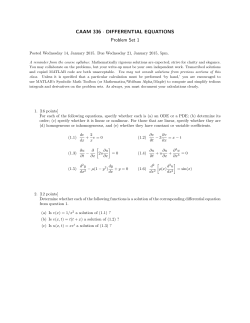

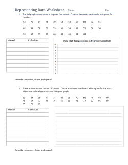
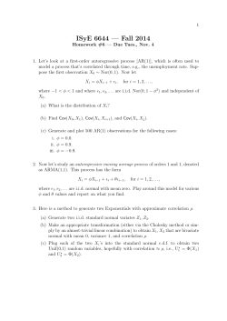


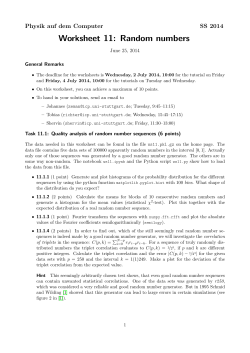
© Copyright 2026