
Walk 1: Black Hill
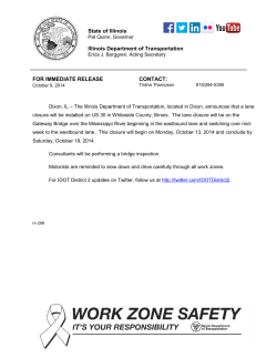
Clun is one of the stops on Castle Connect, a weekend Shuttle
bus, which runs between Easter and September.
www.shropshirehillsshuttles.co.uk
Key to map
Clun Castle
Clun
Walk Route
68
B43
Rights of Way
Other paths
Woodland
START
88
A4
Clun
Walk 1: Black Hill
Sowdley Wood
A 5½ mile circular walk over Black Hill starting
and finishing at St George’s Church, Clun.
The route follows quiet lanes and forestry paths
so it is suitable for dog walkers.
Woodside
Woodside Farm
Churchbank
Communication
Mast
Church Bank
Farm
Upper Riddings
Little
Pen-y-wern
A488
Clun
Pen-y-wern
L LAN
STREE
P I TA
FORD
E
T
Fire
Station
LANE
D ST
ANE
HOS
T
E LL S
KI
B4368
HIGH ST REET
BRID
B4368
HO
School
KN
IG
O
HT
OL
NR
R OA
OA
D
D
C HURCH ST
A488
L LW Y N R O A D
http://www.macreative.co.uk
RE E
Cemetery
ST
GE
SC
© Crown Copyright. All rights reserved. Shropshire Council 100049049.2013
DL
T
RT S
POW
PO
NEW
E N FI E L
Important information for visitors
about the Country Code:
•Take your litter home
•Close gates behind you
•Keep dogs under control at all times
Playing
Field
Pen-y-Cwm
CASTLE STREE T
River
River Clun
Post Office
VICAR
AG E R OA D
START
We hope you enjoy this series of walks
to discover some of the quietest spots in
the Shropshire Hills Area of Outstanding
Natural Beauty.
Walk 1: Black Hill
6
When you
see a way marker
for a footpath;
turn left.
7
1
With the church lych gate ahead of you,
continue on the main road and bear left on
to Hand Causeway which runs alongside the
churchyard.
Ahead is a fine view of the Caer Caradoc hill fort
above Chapel Lawn. The lane you are now on is
probably an ancient drover’s track coming down
from the Kerry Ridgeway, over Black Hill into
Herefordshire.
At the
communications
mast turn right.
The track soon
opens out with
glorious views
to the North and
East.
9
Continue on the lovely wooded track.
Follow the track to the end of the wood where
you will come out at Pooh Hall… Clun’s answer
to Portmerion!
!
At the junction with the next track, bear left
until you reach a lane. Turn right into Woodside.
Keep straight on passing The Old Farmhouse
and Woodside Farm on your right.
2
There is a
steep climb up
Church Bank
along which
you will see
a lane to the
left signed
‘Woodside
½ mile’. If you want a short version of this walk,
turn left and at Woodside turn left again back
down to Clun, otherwise continue on the same
lane up the hill.
Drop down until the lane takes a slight incline;
at the junction turn left onto Vicarage Lane. St
George’s Church is at the end of the lane.
4
You will pass Rhos Cottage on your right
with fine views down over Clun on your left.
Also on the right are three distinctive scots pines
which mark a stone circle. Not a right of way.
5
At the next
cross roads carry
straight on following
the byway up to the
forested area in front
of you.
3
When you reach the Pen Y Wern cross roads,
turn left, signed ‘Obley’.
If clear, Bury Ditches can be seen on the other
side of the Clun Valley with the Stiperstones in
the distance. The track forks; take the right hand
track down to a junction.
8
At the junction, turn left. Keep straight on
past the bridleway waymarker on your right.
Do not turn
right. You are
now walking
parallel to the
River Clun
in the valley
below.
If you want a shorter
version of this walk
turn left; and follow
the wooded lane
back down to Clun via Woodside, otherwise
continue up the forest track.
If you have enjoyed
this walk, look out for
this book, available
locally (£5.95). Walks
range from 2 – 14
miles and are graded
leisurely to strenuous. It includes local
points of interest –
history, archaeology,
wildlife and more.
To buy direct see https://sites.google.
com/site/clunwalkinggroup


© Copyright 2026