
Chapter 5 - Amazon Web Services
CJMT EIS/OEIS April 2015 Draft Chapter 5 Table of Contents CHAPTER 5 CUMULATIVE IMPACTS TABLE OF CONTENTS CHAPTER 5 CUMULATIVE IMPACTS .............................................................................................. I ACRONYMS AND ABBREVIATIONS ..................................................................................................... II 5.1 METHODOLOGY ................................................................................................................5-1 5.2 PRESENT AND REASONABLY FORESEEABLE ACTIONS ..........................................................5-3 5.3 CUMULATIVE IMPACTS ANALYSIS .................................................................................... 5-13 5.4 NEED FOR MITIGATION.................................................................................................... 5-86 List of Figures 5.2-1 Tinian and Pagan Present and Reasonably Foreseeable Actions .............................................. 5-12 List of Tables 5.2-1 5.2-2 5.2-3 5.2-4 5.2-5 5.3-1 5.3-2 5.3-3 Mariana Islands Training and Testing EIS/OEIS Proposed Training Activities that Could Occur on Tinian ................................................................................................................. 5-5 Warning Area 13 Proposed Use and Characteristics................................................................... 5-6 CNMI: Present and Reasonably Foreseeable Actions ................................................................. 5-7 Tinian: Present and Reasonably Foreseeable Actions................................................................. 5-8 Pagan: Present and Reasonably Foreseeable Actions............................................................... 5-11 Tinian: Potential for Cumulative Impact ................................................................................... 5-15 Pagan: Potential for Cumulative Impact ................................................................................... 5-16 Existing CNMI Airspace Available for U.S. Military Training...................................................... 5-31 i CJMT EIS/OEIS April 2015 Chapter 5 Acronyms and Abbreviations Draft Acronyms and Abbreviations % CFR CIP percent Code of Federal Regulations Capital Improvements Projects Commonwealth of the Northern Mariana Islands Joint Military Training CNMI Commonwealth of the Northern Mariana Islands Divert Divert Activities and Exercises DoN Environmental Assessment EIS Environmental Impact Statement MSL Program Office CJMT EA NEPA ii National Environmental Policy Act OEA Overseas Environmental Assessment OEIS Overseas Environmental Impact Statement R Department of the Navy mean sea level Restricted Area RTA Range and Training Area U.S. United States W Warning Area CJMT EIS/OEIS April 2015 Draft Chapter 5 Cumulative Impacts CHAPTER 5 CUMULATIVE IMPACTS Chapter 5 identifies present and reasonably foreseeable projects, programs, actions, and activities (“present and reasonably foreseeable actions”) and provides an analysis of the cumulative impacts of these actions combined with the proposed action. This chapter presents the following: (1) the methodology used to conduct the cumulative impact analysis; (2) study area and current health of resources; (3) present and reasonably foreseeable actions; (4) potential long-term impact of present and reasonably foreseeable actions; (5) direct and indirect impacts of the proposed action and cumulative impact analysis; and (6) assessment of the need for mitigation. 5.1 METHODOLOGY The Council on Environmental Quality regulations (40 Code of Federal Regulations [CFR] § 1508.7) define cumulative effects as follows: “the impact [to] the environment which results from the incremental impact of the action when added to other past, present, and reasonably foreseeable future actions...Cumulative impacts can result from individually minor but collectively significant actions taking place over a period of time.” This Environmental Impact Statement/Overseas Environmental Impact Statement (EIS/OEIS) uses methodology as suggested in Guidance for Preparers of Cumulative Impact Analysis (California Department of Transportation 2005). Using methodology from this document as the approach to cumulative impact analysis was recommended by the United States (U.S.) Environmental Protection Agency in their scoping comments on the proposed Commonwealth of the Northern Mariana Islands (CNMI) Joint Military Training (CJMT) Environmental Impact Statement (EIS)/Overseas Environmental Impact Statement (OEIS). The following is a list of eight steps from this methodology used to perform the cumulative effects analysis: 1. Identify resources to consider in the cumulative effect analysis (see Section 5.1.1, Resources Considered in the Cumulative Impact Analysis). 2. Define the study area for each resource (Section 5.3, Cumulative Impacts Analysis). 3. Describe the current health and historical context for each resource (see Section 5.1.2, Study Area and Health of Resources Considered, and Section 5.3, Cumulative Impacts Analysis). 4. Describe direct and indirect impacts of the proposed project that might contribute to a cumulative effect (see Section 5.3, Cumulative Impacts Analysis). 5. Identify other reasonably foreseeable future actions that affect each resource (see Section 5.2, Present and Reasonably Foreseeable Actions). 6. Assess potential cumulative effects (see Section 5.3, Cumulative Impacts Analysis). 7. Report the results (see Section 5.3, Cumulative Impacts Analysis). 8. Assess the need for mitigation (see Section 5.4, Need for Mitigation). 5-1 CJMT EIS/OEIS April 2015 5.1.1 Draft Chapter 5 Cumulative Impacts Resources Considered in the Cumulative Impact Analysis All resources analyzed in Chapter 4, Environmental Consequences, of this EIS/OEIS were considered in the cumulative impact analysis for the proposed action on Tinian and Pagan. These resources are as follows: geology and soils, water resources, air quality, noise, airspace, land and submerged land use, recreation, terrestrial biology, marine biology, cultural resources, visual resources, transportation, utilities, socioeconomics and environmental justice, hazardous materials and waste, and public health and safety. 5.1.2 Study Area and Health of Resources Considered The study area and health of resources considered is described in the respective subsections of Section 5.3, Cumulative Impacts Analysis. The study area for each resource‐specific cumulative impact analysis is typically Tinian, Pagan, and surrounding areas. “Resource health” refers to the overall condition, stability, or vitality of a resource and is influenced by both human activities and natural historical events, as described in the Guidance for Preparers of Cumulative Impact Analysis. “Resource health” is a broad picture of the vulnerability of the resource to new stressors and, as such, helps provide a basis for assessing cumulative impacts. For instance, a vulnerable resource that is declining in health could be greatly impacted by a new stressor while a healthy, stable, resource may not be impacted at all. Resources that are on the threshold of being depleted are more vulnerable; however, if there are new policies or regulations that guard against future degradation, then the future trend of that resource’s health could be described as stable or potentially improving in the future. Ideally, there would be a quantitative analysis of each resource to demonstrate its vulnerability; however, most resources do not have regulatory thresholds or sufficient quantitative historical data and, as such, this analysis of resource health is qualitative. 5.1.3 Conceptual Approach to Assessing Cumulative Impacts Related to Present and Reasonably Foreseeable Actions The long‐term impacts of past actions are captured in the current baseline described for each resource in Chapter 3, Affected Environment. The historical context and current baselines are used as the basis for assessing cumulative impacts. Potential cumulative impacts could occur when a) both the proposed action and present and reasonably foreseeable actions are anticipated to have a long‐term impact to various resources, and b) the impact of the proposed action could be additive to the impacts of the present and reasonably foreseeable actions. The potential for cumulative impacts also takes into account present and historical context and health of the resource, the severity of the proposed action and present and reasonably foreseeable actions, and the geographic range of the impact. Cumulative impacts can be adverse even when individual impacts – related to the proposed action and present and reasonably foreseeable actions – are minor. This is because the sum of all impacts, collectively, may be significant over a period of time (40 CFR § 1508.7). There would be no cumulative impact to a resource if there is no impact associated with the proposed action, or if there were no present and reasonably foreseeable action impacts, or neither. 5‐2 CJMT EIS/OEIS April 2015 5.2 Draft Chapter 5 Cumulative Impacts PRESENT AND REASONABLY FORESEEABLE ACTIONS This section describes the methods for identifying present and reasonably foreseeable actions, and concludes with the lists of present and reasonably foreseeable actions. 5.2.1 Non-federal Actions A list of actions was identified through media searches, land use plans, capital improvement plans, National Environmental Policy Act (NEPA) documents, and interviews with public and private organizations, including government agencies. There are numerous future development proposals, expansion proposals, and notional activities that have been discussed in the media or have been presented to government officials. The status of these proposals ranges from being conceptual to having all requisite government approvals. Best available information was used to determine which future actions would reasonably be expected to be constructed or implemented. The following are proposed actions on Tinian and Pagan that were identified but are not considered reasonably foreseeable, in part, for the reasons noted: Neo Gold Wings Paradise Resort and Matua Bay Resort and Golf Course – land leases were terminated and casino licenses revoked New Hotel (Suicide Cliffs area) – conceptual plans only Puntan Kastiyu Resort – conceptual plans only Kachona Beach improvements – conceptual plans only American Memorial Park, Tinian Historical Interpretative Center at North Field – conceptual plans only Pozzolan mining on Pagan – project has a permit but no evidence that it is economically viable (Appendix Q, Section 4.2.10) There are numerous actions identified in capital improvement program documents and some actions have been built. The following were identified as funding priorities, but are not considered reasonably foreseeable at this time because of their development status or lack of funding. These include the following: Tinian International Airport Improvements – Proposed airport improvements include high speed Taxiway B, security access system, perimeter security fence replacement, instrument landing system improvements, and a jet fuel farm. Tinian Seaport Rehabilitation, U.S. Army Corps of Engineers funded Breakwater and Dredging – The engineering feasibility and environmental studies are underway to develop a project design. Wastewater Treatment Plant – The future wastewater treatment plant was originally to be colocated with the proposed landfill; however, the location of the landfill and the wastewater treatment plant are being revisited. New Tinian Solid Waste Facility – Location has not been determined. Funding commitment and design are pending. 5-3 CJMT EIS/OEIS April 2015 Draft Chapter 5 Cumulative Impacts During the 3 years that this EIS/OEIS is being processed, the status of reasonably foreseeable actions is likely to change, and the present and reasonably foreseeable list and cumulative impact analysis will be updated for the Final EIS/OEIS. 5.2.2 5.2.2.1 Federal Actions Divert Activities and Exercises (Divert) Air Force/Headquarters, Pacific Air Forces proposes to improve an existing airport or airports in the Mariana Islands to support strategic requirements of U.S. forces around the globe, including humanitarian airlifts during natural disasters. The Divert Draft EIS was published June 2012; however, the Final EIS and Record of Decision have not yet been issued. As a cooperating agency on the CJMT EIS/OEIS, the Air Force informed the Marine Corps in January 2015 that engagement with the Commonwealth Ports Authority, the controlling authority for all of the CNMI airports, has resulted in the Air Force conducting additional environmental impact analyses for a variation of the alternatives associated with establishing Divert capabilities at the Tinian International Airport. This variation consists of siting necessary airport facilities on property located north of the runway on Tinian airport adjacent to the Military Lease Area. To that end, it is possible that should the Air Force select Tinian for all or some of its Divert mission, its supporting infrastructure may be located on the north side of Tinian airport along with the CJMT project. If that occurs, additional Department of Defense development could include runway improvements, parking apron, a temporary munitions area, aircraft hangar, and maintenance facility, and jet fuel receiving, storage and delivery infrastructure. Therefore, the CJMT EIS/OEIS cumulative impact analysis takes into account this variation of the Divert requirement on Tinian because there is greater potential for cumulative impacts under this scenario when considered in conjunction with the proposed CJMT action. 5.2.2.2 Mariana Islands Training and Testing The Mariana Islands Training and Testing EIS/OEIS is being prepared by the U.S Pacific Fleet to assess the impacts of U.S. military readiness training and research, development, testing, and evaluation activities conducted in the Mariana Islands Training and Testing study area. The Draft EIS/OEIS was published in September 2013 (Department of the Navy [DoN] 2013a). The Final EIS/OEIS is anticipated in the Spring of 2015. The Mariana Islands Training and Testing region of influence encompasses that of the CJMT EIS/OEIS and includes Guam and the CNMI submerged lands and airspace. The Mariana Islands Training and Testing EIS/OEIS preferred alternative does not introduce training capabilities on Pagan. The proposed action relevant to the Tinian Military Lease Area are shown in Table 5.2-1, by alternative (DoN 2013a). Seven training activities would occur more frequently within the study area than the baseline tempo established under the Mariana Islands Range Complex EIS/OEIS (DoN 2010). Tinian is not the only island where these events could occur. The actual annual tempo on Tinian would vary, but would not exceed the number of events proposed under Alternative 1 and 2, as listed in Table 5.2-1. 5-4 CJMT EIS/OEIS April 2015 Chapter 5 Cumulative Impacts Draft Table 5.2-1. Mariana Islands Training and Testing EIS/OEIS Proposed Training Activities that Could Occur on Tinian Range Activity Proposed changes to training tempo: Amphibious Assault Amphibious Raid Non-combatant Evacuation Humanitarian Assistance/Disaster Relief Operations Urban Warfare Training (Blanks/Simulations) Personnel Insertion/Extraction Parachute Insertion Training tempo unchanged: Embassy Reinforcement Marine Air Ground Task Force Exercise (Amphibious) Battalion) Special Purpose Marine Air Ground Task Force Exercise Urban Warfare Exercise Intelligence, Surveillance, Reconnaissance Maneuver (Convoy, Land Navigation) Field Training Exercise Force Protection Anti-Terrorism Seize Airfield Airfield Expeditionary Baseline (activities per year)* Alternative 1 (activities per year)* Alternative 2 (activities per year)* 4 2 2 2 8 150 12 6 6 5 5 18 240 20 6 6 5 5 18 240 20 50 50 50 4 4 4 2 5 16 16 100 75 80 12 12 2 5 16 16 100 75 80 12 12 2 5 16 16 100 75 80 12 12 Legend: * = Number of activities per year is not limited to Tinian, but the maximum number of annual events that could potentially occur on Tinian is listed. Most of the training activities proposed in the Mariana Islands Training and Testing EIS/OEIS occur in the open ocean and most of the impacts identified are to marine resources. The EIS/OEIS categorizes resources differently from the CJMT EIS/OEIS. For example, the socioeconomics analysis includes marine transportation, recreation, and land use. Noise impacts are addressed under the numerous marine resources sections. 5.2.2.3 Mariana Islands Range Complex Airspace The Mariana Islands Range Complex Airspace Final Environmental Assessment (EA)/Overseas Environmental Assessment (OEA) was published in June 2013 (DoN 2013b). The document was prepared specifically to address proposed modifications to airspace and sea space within the Mariana Islands Range Complex, as described in the Mariana Islands Range Complex EIS/OEIS (DoN 2010a). The EA/OEA tiers from the Mariana Islands Range Complex EIS/OEIS. The action alternatives propose expansion of the danger zone and restricted airspace around Farallon de Medinilla, and the establishment of new warning areas south of Guam and northeast of Saipan. The change in airspace northeast of Saipan includes the removal of existing Air Traffic Control Assigned Airspaces 3A, 3B, and 3C (see Figure 3.6-7) and the establishment of Warning Areas 13A high and low, 13B high and low, and 13C high and low, respectively. 5-5 CJMT EIS/OEIS April 2015 Chapter 5 Cumulative Impacts Draft Warning Area 13 would be within 40 nautical miles (74 kilometers) of Tinian and would be used 4 to 5 days each week, for 3 to 6 hours per day. Detailed information regarding the proposed use of Warning Area 13 is in the Mariana Islands Range Complex Airspace Environmental Assessment /Overseas Environmental Assessment. Table 5.2-2 presents the proposed use, area and altitudes of Warning Area 13. Similar to Air Traffic Control Assigned Airspace 3A, Warning Area 13A would overlay land, Farallon de Medinilla, Anatahan, and Sarigan Islands. Table 5.2-2. Warning Area 13 Proposed Use and Characteristics Warning Area 13 Days Used Per Year A 160 B 157 C 111 Area (square nautical miles) Altitude Lower Limit (Floor) Upper Limit (Ceiling) Low Surface FL300 High FL300 FL600 Low Surface FL300 High FL300 FL600 Low Surface FL300 High FL300 FL600 5,942 7,727 5,069 Changes from Air Traffic Control Assigned Airspace 3 Upper Limit changes from FL300 to FL600 Increase of 1,183 square nautical miles airspace Upper Limit changes from FL300 to FL600 Decrease of 95 square nautical miles airspace Upper Limit changes from FL300 to FL600 Decrease of 2,209 square nautical miles airspace Source: DoN 2013b. When Warning Area 13 is in use, civilian aircraft would be routed either east or west of the airspace. A Notice to Airmen is issued by the Federal Aviation Administration at least 72 hours prior to the U.S. military activity. The frequency of use of Warning Area 13 (see Table 5.2-2) would remain as described in Chapter 3, Affected Environment, for Air Traffic Control Assigned Airspace 3 (Table 3.6-1). Additionally, Restricted Area 7201 was proposed to be extended from 3 nautical miles (5 kilometers) to 12 nautical miles (22 kilometers), and would lie within Warning Area 3A. No changes in operations were proposed. If approved by the Federal Aviation Administration, the amount of charted controlled airspace would increase by 18,738 square nautical miles (64,269 square kilometers). The alternatives would not have a direct impact to Tinian, Saipan, or Pagan or submerged lands. A Finding of No Significant Impact was published June 15, 2013. The Federal Aviation Administration is completing their NEPA and aeronautical processes for approving the change. 5.2.3 Summary The present and reasonably foreseeable actions for the CNMI, Tinian, and Pagan are listed in Tables 5.23, 5.2-4, and 5.2-5, respectively. Figure 5.2-1 shows the approximate locations of present and reasonably foreseeable actions on Tinian and Pagan. 5-6 CJMT EIS/OEIS April 2015 Chapter 5 Cumulative Impacts Draft Table 5.2-3. CNMI: Present and Reasonably Foreseeable Actions Lead Agency or Proponent Name Department of Defense Divert Department of Defense Mariana Islands Training and Testing Department of Defense Mariana Islands Range Complex Airspace Implementation Year(s) Location Status Description Tinian or Saipan Record of Decision International Airport unknown See Section 5.2.2.1 pending (not Pagan) Guam, the CNMI 2015 Draft EIS/OEIS published surrounding (pending Record See Section 5.2.2.2 September 2013 airspace/land/ocean areas of Decision) Airspace in vicinity of Finding of No Significant 2015 Farallon de Medinilla, north Impact issued, Federal (pending airspace See Section 5.2.2.3 of Saipan Aviation Administration modifications) (not on Figure 5.2-1) decision pending 5-7 CJMT EIS/OEIS April 2015 Chapter 5 Cumulative Impacts Draft Table 5.2-4. Tinian: Present and Reasonably Foreseeable Actions Proponent Name Location Construction Year(s) Commonwealth Ports Authority Tinian Airport Improvements Airport 2014-2015 Commonwealth Ports Authority Tinian Airport Terminal Renovations Airport 2015 Department of Public Lands West San Jose Village Homesteads San Jose Village 2013-2016 CNMI Tinian Slaughterhouse: Phase 1 Outside Military Lease Area. Public Land, possibly mobile unit (not mapped) 2015-2016 Outside Military Lease Area. Across from the Commonwealth Utilities Corporation power plant. 2015 Capital Improvements Solid Waste Transfer Projects Program Station Office (CIP) 5-8 Status Description The project includes: (1) Relocation of the Aircraft Rescue and Fire Fighting Facility building; (2) Terminal improvements; (3) Acquisition of a 1,500-gallon Aircraft Funded Rescue and Fire Fighting Facility vehicle; (4) New water line; (5) Tinian Airport West Terminal: ADA compliant upgrades. Office of Internal Affairs funded a $2.9 million project that combines three Capital Improvement Projects for the Tinian Airport: (1) renovations of existing terminal, (2) Funded, renovations to departure terminal and (3) structural contractor retrofitting. Improvements will include renovations to selected doors and windows, painting, roof repairs, and installation of a baggage handling system. Funded separately, is the construction of a 40 foot by 40 foot brown treesnake containment facility. San Jose Village is a residential subdivision. This phase Infrastructure includes lots for 189 homes. Includes ponding basin and and roadways approximately 12,000 linear feet of roadways. Recipients begun have 3 years to build their homes. Create U.S. Department of Agriculture sanctioned Request for slaughterhouse "kill unit". Facility includes corral, kill unit, proposal by the and septic system. Animal would be brought to unit for end of 2014. slaughter and returned to owner for personal consumption or package for resale. Solid Waste Transfer Station (3 acres) provides a more convenient method for people to take their solid waste Engineering for processing prior to disposal because it is closer to design: 2014 their homes and provides dumpsters for collection of trash, sorting bins for separation of recyclables, and collection areas for green waste and appliances. CJMT EIS/OEIS April 2015 Chapter 5 Cumulative Impacts Draft Table 5.2-4. Tinian: Present and Reasonably Foreseeable Actions Proponent Name Location Construction Year(s) Status Grant 1: site specific hazardous substance assessment for Pina, Tinian, and totaling $350,000. Grant 2: worth $200,000, is for community-wide hazardous substance assessment. Grants received Grant 3: $200,000 was awarded for community-wide petroleum assessment. These grants will assist Department of Public Lands in performing the necessary environmental assessments on public properties that are suspected to be contaminated. New hardware store with lumber yard, appliances and a Completed small grocery section. Approximately 4,800 square feet of retail. CNMI Division of Environmental Quality Brownfields Grants Various (not on Figure 5.2-1) 2013-2016 Joeten Tinian Ace Hardware Joeten Tinian Ace Hardware San Jose Village 2013 San Jose Village 2014 Construction South of Tinian International Airport 2014 Funded Tinian Dynasty Hotel, San Jose Village 2014 Renovation Tinian Harbor 2015 Planning 2014-2015 Work plan, public outreach 2015 Construction request for proposal issued 2014 CIP CIP Mega Stars Overseas Limited Dynasty Hotel DoN CNMI Health Center Interior Improvements Tinian Solid Waste Facility Improvements Tinian Dynasty Renovation Dynasty Hotel Ferry Service Chiget Mortar Range Chiget Mortar Range, Cleanup within Military Lease Area 0.5-Million Gallon Reservoir Carolinas Heights 5-9 Description Upgrades to Health Center to address Americans with Disabilities Act compliance and maintenance. Upgrades planned for the existing solid waste facility. Includes fence delineating extent, proper equipment, operator training, and some other minor upgrades. Renovation of hotel guest rooms. ($15 Million waterpark is not reasonably foreseeable). Dynasty Hotel is proposing ferry service between Tinian and Saipan. This would be smaller than that proposed by the CNMI and would not include a terminal building. The Chiget Mortar Range was used from World War II to 1994. It has been designated a restricted area, pending cleanup of explosives. A remedial investigation/feasibility study is ongoing. The Final Work Plan for the current phase of work was prepared in 2014 for work that would be completed in 2015. Office of Insular Affairs approved funding and NEPA categorical exclusion for the construction of the 0.5Million Gallon Reservoir in Carolina Heights. CJMT EIS/OEIS April 2015 Chapter 5 Cumulative Impacts Draft Table 5.2-4. Tinian: Present and Reasonably Foreseeable Actions Proponent Name Location Construction Year(s) CNMI/U.S. Environmental Protection Agency Masalog Depot Cleanup Pina 2015-2016 CIP, Federal Highway Administration Tinian Hazard Elimination Action San Jose Village (Route 21, Route 24, and Route 27) 2017 CIP Health Center Expansion Health Center, San Jose Village 2017 Bridge Investment Group, LLC Tinian Ocean View Resort Tinian Harbor 2015 - 2020 CNMI Department of Public Works Tinian Solid Waste Facility Closure Existing Tinian Solid Waste Facility, South of Tinian Airport Beyond 2016 5-10 Status Description Environmental site assessments are proposed at the Masalog Ammunition Depot. The site is approximately Request for 237 acres. The munitions stored at the depot supported proposal for site the World War II B-59 airfields. Subsequent clean-up investigation actions are anticipated. The Unexploded ordnance cleanup is being funded by U.S. Environmental Protection Agency-Brownfields program. Road safety improvements, including; installing pavement and shoulder delineation, traffic signage, and Design safety barriers at locations that have steep slopes or may pose hazards to motorists. New addition planned with CIP funds for a second building to house administrative and public health Planning services. There will be a covered walkway connecting the two buildings. A hotel replica of the Titanic would be built at Tinian Harbor. It would be part of a larger resort complex with 300 guest rooms, restaurants, shopping arcades and a Conditional Use wedding chapel. The project would be constructed in Lease issued increments and the initial construction includes two June 2014 stevedore warehouses to replace the existing dilapidated structures, a new Customs, Immigration and Quarantine building, and a new Brown Treesnake Containment Area. The existing Tinian Solid Waste Facility will be closed, in accordance with federal regulations, after a new landfill is developed. The new landfill site has not been Closure Plan determined. There is insufficient site information available to include it on the reasonably foreseeable actions list. CJMT EIS/OEIS April 2015 Chapter 5 Cumulative Impacts Draft Table 5.2-5. Pagan: Present and Reasonably Foreseeable Actions Proponent Name Area of Interest Construction Year U.S. Geological Survey Volcanic Activity Monitoring Various (not on Figure 5.2-1) 2015 Konferensian Chamorro Steering Committee Chamorro Conference Harbor area 2015 Discover Pagan 2014 Working Group Silver Explorer Cruise Ship Visit Harbor area 2014 Various private entities Ecotourism various (not on Figure 5.2-1) N/A 5-11 Status Description Ground-based digital instrumentation and telemetry. Equipment installed in 2013 to provide Installed, monitoring of volcanic activities and a live camera service feed of the volcanic activity on Pagan. Equipment suspended is no longer streaming real time data due to lack of funding for satellite uplinks. The CNMI and agencies are pursuing funding to restart uplink. Chamorro conference on Pagan in 2014. Approximately, 100 delegates anticipated. “... their goal is to promote, preserve and apply cultural Planned knowledge, innovations, expressions and practices of Chamoru culture as well as inspire, motivate and empower the Chamoru community.” Silver Explorer, a 132-passenger capacity cruise ship, visited Pagan on September 28, 2014. A Visit completed temporary authorization to use public land issued by Department of Public Lands in 2013. The ship used zodiacs to visit the island. Temporary permits could be obtained from the CNMI Homeland Security and Emergency Temporary use Management Office for various ecotourism authorization activities. It is anticipated these activities would occur in the future. Tinian Philippine Sea North Field ! ( & - ' & . & # ' ! #' & ## # ' (# .* & ( ! ( & # ( * .# # & %$ & ( "%& $ * " #( ' .# # & %$ & ( & "# ! #$ * ( $#' .# # $ ! ' ( ! ( - "%& $* " # ( ' .! ( & ( - ' $& ( .# # $ ! ' ( # ! ! ! ( ! $ ' ) & Tinian International Airport ' ( # $' ! ! $" ' ( ' $ ! ' ( & #' & ( ( $# $ ( # # # & + & San Jose # # & $& Pagan ! ! $ # ! ! $# ( & ' & * $& - # ' ( - $( ! & & - & * 0 0 1 1 - # ' ( - $( ! #$* ($ # , % # '$# # # # + ' $ & ( Mount Pagan . "$ & & $ $ # & # .! * & , %! $ & & & )' % '( ( $& ( & # ! #) % Pacific Ocean # # ! ( #( & #( &$& "%& $ * " #( ' , % # '$# 0 2 Miles Kilometers 2 0 1 1 2 2 Miles Kilometers Figure 5.2-1 Present and Reasonably Foreseeable Projects 5-12 Submerged Lands (CNMI) Submerged Lands (US) Military Lease Area N CJMT EIS/OEIS April 2015 5.3 Draft Chapter 5 Cumulative Impacts CUMULATIVE IMPACTS ANALYSIS This section contains the results of the various steps of the cumulative effect analysis summarized in Section 5.1, Methodology. Section 5.3.1 presents impact summary tables that are used as the basis for this analysis. These include tables summarizing impacts of present and reasonably foreseeable actions and tables summarizing each resource’s potential for cumulative impact. An analysis for each resource is presented in the same order they appear in Chapters 3 and 4 of this EIS/OEIS. Each resource contains the following subsections for Tinian and for Pagan: 1. Study Area and Health of Resources Considered 2. Impacts of Present and Reasonably Foreseeable Actions 3. Impacts of the Proposed Action That May Contribute to a Cumulative Impact 4. Potential Cumulative Impacts 5.3.1 5.3.1.1 Impact Summaries Impacts of Present and Reasonably Foreseeable Actions Each of the present and reasonably foreseeable actions (see Tables 5.2-3, 5.2-4, and 5.2-5) were assessed to determine whether they would have a long-term adverse or beneficial impact to each resource. If a NEPA document was available for an action, then the results of the NEPA document were reviewed to help analyze cumulative effects, although the NEPA documents for other actions did not necessarily look at the same resources as this CJMT EIS/OEIS. In addition, the definition of the resources varies among NEPA documents. For example, the impacts of impervious surface is considered a water resources impact in Divert, and a geology and soils impact in this CJMT EIS/OEIS. To the extent practical, the other NEPA document significance levels were matched to the CJMT EIS/OEIS resource definitions. Where there is no NEPA document, assumptions on impacts for those actions were made based on the best available information. Similar to the methodology applied in Chapter 4, for direct and indirect impacts, it is assumed that present and future actions would also incorporate resource management measures, which would minimize significant impacts. In other words, resource management measures are part of the present and reasonably foreseeable actions. This does not mean that analysis assumed that potential impacts would necessarily be reduced to less than significant. 5.3.1.2 Impacts of the Proposed Action (Chapter 4) The direct and indirect impact analyses of the CJMT proposed action alternatives are in Chapter 4, Environmental Consequences, of this EIS/OEIS. This section summarizes the key findings from Chapter 4 and discusses the potential for cumulative impacts when considered in conjunction with present and reasonably foreseeable actions. 5-13 CJMT EIS/OEIS April 2015 Draft Chapter 5 Cumulative Impacts Summary tables (Tables 5.3-1 [Tinian] and 5.3-2 [Pagan]) provide a summary of the cumulative impact analysis. The first row is the highest level of significance identified for the proposed action alternatives for any criteria under each resource and sub-resource as described in Chapter 4. The highest level of significance for each resource was determined to be the same for all three Tinian action alternatives and both Pagan action alternatives. The second row summarizes the impact conclusions for present and reasonably foreseeable actions. The third row indicates whether there is potential for a cumulative impact, based on the based on the impacts of Present and Reasonably Foreseeable Actions described in in Section 5.2. For a cumulative impact to occur, there must be a resource impact identified for both the present and reasonably foreseeable actions and the CJMT proposed action alternatives. The last rows summarize the cumulative impact analysis. The assessment of cumulative impacts includes consideration of both adverse and beneficial impacts. 5-14 CJMT EIS/OEIS April 2015 Chapter 5 Cumulative Impacts Draft Y Y Y Y Y Y Y Y Y Y Y Y Y Y N N N Y M 4 LSI Y Y Y Y Y Y Y N N N N LSI SI Y Y Y Y Y Y Y N Y 7 SI 5 Legend: LSI = less than significant impact; N = no; SI = significant impact; SI = less than significant impact with proposed mitigation; Y= yes. 1 Notes: SI due to airfield and airspace-based operations. 2 Impacts are both beneficial and adverse. LSI/SI due to community character and cohesion. SI related to a portion of community. 3 SI due to impacts to prime farmland soils. 4 SI due to new public access restrictions. 5 SI due to impact to Ushi Cross Point B (Key Observation Point #6) and Mount Lasso Lookout A (Key Observation Point #8). 6 There would be an overall beneficial cumulative impact to socioeconomics. 7 Impact identified for air transportation only. 5-15 LSI LSI M Visual Resources Y Airspace Y SI Public Health & Safety Y Y M Hazardous Materials and Waste Cultural Resources Y Y SI Socioeconomics and Environmental Justice Marine Biology Y Y Present and reasonably foreseeable action impacts identified? yes[Y]/no[N] 1 Utilities Terrestrial Biology Y SI 3 Transportation (Air, Ground, Marine) Recreational Resources Y LSI SI Land and Submerged Land Use SI Noise SI Air Quality SI LSI Proposed Action Alternatives 1, 2, and 3 highest level of significant impact (Chapter 4) Is there a proposed action impact (Chapter 4) and a present and reasonably foreseeable impact? i.e., Is there potential for a cumulative impact? yes[Y]/no[N] Is there a potential cumulative impact? yes[Y]/no[N] SI Water Resources Cumulative Impact Analysis Summary Geology and Soils Table 5.3-1. Tinian: Potential for Cumulative Impact 2 CJMT EIS/OEIS April 2015 Chapter 5 Cumulative Impacts Draft N Y Y Y Y N N N N N Public Health & Safety Y Hazardous Materials and Waste Y LSI B3 LSI LSI 1 /SI LSI LSI Y N N N Y N Y Y Y N N N Y N Y Y Y N N N N N N LSI SI SI SI Y Y N Y Y Y Y N N Y N N 2 M Socioeconomics and Environmental Justice Y Utilities SI Transportation (Air, Ground, Marine) LSI Visual Resources NI Cultural Resources LSI Marine Biology Land and Submerged Land Use LSI Terrestrial Biology Airspace LSI Recreational Resources Noise Is there a potential cumulative impact? yes[Y]/no[N] Air Quality Proposed Action Alternative 1 and 2 highest level of significant impact (Chapter 4) Present and Reasonably Foreseeable Action impacts identified? yes[Y]/no[N]/beneficial impact only [B] Is there a proposed action impact (Chapter 4) and a present and reasonably foreseeable impact? i.e., Is there a potential cumulative impact? yes[Y]/no[N] Water Resources Cumulative Impact Analysis Summary Geology and Soils Table 5.3-2. Pagan: Potential for Cumulative Impact Legend: B = beneficial impact; LSI = less than significant impact; N= no; NC = no cumulative impact because (1) no present and reasonably foreseeable action impacts were identified or M (2) no proposed action impacts were identified; SI = significant impact; SI = less than significant impact with proposed mitigation; Y= yes. 1 Note: LSI/SI due to community character and cohesion. The decreased opportunity to engage in cultural and recreational activities on Pagan affects the Northern Islands community residing elsewhere in the CNMI. There would be an adverse impact to community cohesion. 2 SI due to change in jurisdictional control. 3 B impact to air transportation and NI to ground and marine transportation. 4 LSI to stormwater and solid waste management. Other utilities would be NI. 5-16 CJMT EIS/OEIS April 2015 5.3.2 Draft Chapter 5 Cumulative Impacts Geology and Soils 5.3.2.1 Tinian 5.3.2.1.1 Study Area and Health of Resources Considered The study area for the geology and soils cumulative impact analysis is Tinian. The resiliency of geology and soils on Tinian, to future stress, is expected to improve over time. The anticipated improvement is due to building codes, construction permit conditions, and associated best management practices that are stricter, and work to better control erosion, than they have been historically. There are geologic hazards and unpredicted natural events that could interrupt the positive trend in erosion control; however, the overall positive trend in erosion control is expected to continue. Section 3.2.5, Tinian, provides a detailed discussion of the current health of geology and soils on Tinian. World War II and sugarcane production resulted in widespread disturbance of surface soils, excavation, filling, and paving. Limestone and coral were removed from numerous quarries and “borrow pits” across the island, as well. Overall, the impacts to geology and soils have tended to be associated with commercial, industrial, and residential development that have involved earthmoving, paving, and largescale removal of earth materials associated with mining and quarrying. Industrial sugarcane production has also led to substantial soil loss. After World War II, the rapid growth of tangantangan cover reduced the soil erosion. Small-scale and subsistence agriculture on Tinian has been a mix of grazing and small, multi-crop fields that do not leave large areas of bare soil vulnerable to erosion. Impacts to geology and soils are largely related to human activities, but natural events such as typhoons and earthquakes have resulted in severe erosion and landslides. The most notable construction within the Military Lease Area since World War II was the building of the International Broadcasting Bureau. Recent more stringent construction permit conditions and best management practices minimized the impacts to the geology and soils associated with that construction. Continued greater awareness of erosion control principles in construction has led to the trend in erosion potential declining. The CNMI Earthmoving and Erosion Control Regulations established in the 1980s to 2000s, reduce erosion associated with construction earthmoving activities. The potential geologic hazards have not been altered for Tinian in recent history and are not expected to change in the near-future. However, modern building codes and engineering practices include requirements for seismic safety. Recent large-scale actions (e.g., the Tinian Dynasty Casino) were constructed in accordance with these regulations and building codes. Future actions, including the proposed action, would also be required to comply with these regulations and building codes. Soils classified as prime farmland soils by the U.S. Department of Agriculture are present within and outside of the Military Lease Area. The amount of acreage considered prime farmland is not expected to change over time but other land uses would preclude agricultural use of prime farmlands, such as those located within the Exclusive Military Use Area that would not be available for agricultural use until the end of the U.S. military lease terms. Overall, the land use on Tinian has not changed substantially in recent years. 5-17 CJMT EIS/OEIS April 2015 5.3.2.1.2 Draft Chapter 5 Cumulative Impacts Impacts of Present and Reasonably Foreseeable Actions Impacts of eight present and reasonably foreseeable actions (Tinian Airport Improvements, Divert, West San Jose Village Homesteads, Joeten Tinian Ace Hardware, New 0.5 Million Gallon Reservoir, Health Center Expansion, Alter City Resort, and Tinian Ocean View Resort) were identified on Tinian that would potentially have an impact to geology and soils due to soil disturbance during construction. The impacts are likely to be less than significant for most of the actions with implementation of resource management measures and because of the relatively flat topography and small areas of disturbance. All new construction would likely result in an increase in impervious surface area, unless they are replacement facilities. The larger projects such as the resorts and homestead developments require more ground disturbance with potential for impacts to geology and soils. The resorts (Alter City Resort, and Tinian Ocean View Resort) would increase the area of impervious surface on Tinian and may require grading and fill activities that could substantially alter the landscape, reduce slope stability, or alter surface drainage patterns. There would be impacts to topography and slope stability. The present and reasonably foreseeable actions are geographically distinct and most would occur outside of the Military Lease Area, except Divert. The CNMI government reviews and approves building permits, inclusive of grading plans, for actions outside of the Military Lease Area. Permit conditions include mitigation measures for controlling erosion and protecting soils; however, impacts may not be avoided entirely. The CNMI permit approval process ensures that land development is consistent with the CNMI long-range master planning, including agricultural use of prime farmland soils. Five present and reasonably foreseeable actions (Tinian Solid Waste Facility Improvements, Brownfields Grants, Chiget Mortar Range Cleanup, Masalog Ammunition Depot Cleanup, and Tinian Solid Waste Facility Closure) would likely have beneficial long-term impacts because they would improve or remediate soil conditions. The remainder of the cumulative actions would not have long-term impacts to this resource. There is potential for the present and reasonably foreseeable actions to contribute to a cumulative impact to geology and soils on Tinian. 5.3.2.1.3 Impacts of the Proposed Action That May Contribute to a Cumulative Impact Direct and indirect impacts of the proposed action are detailed in Section 4.2.3, Tinian. All three Tinian alternatives would result in similar significant direct impacts to prime farmland soils, but less than significant impacts related to topography, geology (geologic units and geologic hazards), and soils (see Table 5.3-1). There would be significant impacts to prime farmland soils within the Military Lease Area. All of the Tinian proposed action alternatives would preclude the agricultural use of between 220 acres (89 hectares) to 230 acres (93 hectares) during operations, representing approximately 16% of the Tinian prime farmland soils. No mitigation is proposed for the impacts to prime farmland soils. There are other prime farmland soils available on Tinian, but 72% are within the Military Lease Area. The impacts to topography and soils would be due to excavation, filling, and soil disturbance. The impacts would be less than significant with implementation of best management practices and standard operating procedures to minimize the potential for soil erosion and slope instability associated with 5-18 CJMT EIS/OEIS April 2015 Draft Chapter 5 Cumulative Impacts earthmoving. The facilities would be constructed in accordance with Unified Facilities Criteria that specifically reduce the potential hazards associated with seismic activity. Although there are some differences in the amount of ground disturbance, all Tinian action alternatives would have similar impacts to geology and soils. 5.3.2.1.4 Potential Cumulative Impacts There would be permanent loss of prime farmland soils within the Military Lease Area under the proposed action. Most of the present and reasonably foreseeable actions do not affect prime farmland soils, would not be constructed at the same time, and are geographically distinct from the proposed action. Thus, there would be no additive effects to prime farmland soils. In addition, the resource is resilient to stress with continued implementation of best management practices and compliance with permit conditions. Existing environmental laws and regulations require that earthmoving and construction activities minimize the potential for soil erosion and slope instability. Building codes would be followed to minimize the potential for impacts from seismic hazards. Therefore, there would be no cumulative impact to geology and soils. 5.3.2.2 Pagan 5.3.2.2.1 Study Area and Health of Resources Considered The study area for the geology and soils cumulative impact analysis is Pagan. The health trend of Pagan soil and geological resources can be described as being gradually declining due to the ongoing seismic hazards, recent typhoons, and recent erosion related to overgrazing of feral animals. The trend is expected to continue as the potential for these factors to continue over time is high. Section 3.2.5, Tinian, provides a detailed discussion of the current health of geology and soils on Pagan. The historical influences of World War II and agricultural production on Pagan have resulted in soil disturbance and erosion. Erosion has been observed originating at the western upper flank of Mount Pagan and extending southwest to the former Somushon Village location. The soil cover tends to be thin; however the best-developed soils are in the inner basin south of Lake Sanhalom and the area north the central plateau, as described in Chapter 3. Pagan continues to be volcanically active. The 1981 eruption of Mount Pagan spread lava rock and ash deposits over the north and south slopes of Mount Pagan, covered part of the grass airfield, and created pozzolan deposits that have been investigated for their economic potential. The most recent Mount Pagan lava flow was in 1981, but there have been numerous eruptions of ash, gas, and steam since then. The 1981 lava flow led to the evacuation of the remaining on-island population and there has been no agricultural, commercial, or industrial activity on Pagan since. Therefore, human behavior has not directly contributed to the gradually declining trend in resource health. Feral ungulate populations resulted in island vegetation being severely overgrazed, particularly in the north, creating areas of soil erosion. Other soil disturbing activities have included establishment of trails and exploratory drilling into the pozzolan deposits. 5-19 CJMT EIS/OEIS April 2015 5.3.2.2.2 Draft Chapter 5 Cumulative Impacts Impacts of Present and Reasonably Foreseeable Actions No present and reasonably foreseeable actions would have a potential impact to geology and soils on Pagan. Therefore, there is no potential for the present and reasonably foreseeable actions to contribute to a cumulative impact to geology and soils. 5.3.2.2.3 Impacts of the Proposed Action That May Contribute to a Cumulative Impact Direct and indirect impacts of the proposed action are detailed in Section 4.2.4, Pagan. The Pagan alternatives would result in less than significant impacts to topography, geology (geologic units and geologic hazards), and soils. There are no prime farmland soils on Pagan. The impacts to topography, geologic units, and soils would be due to excavation, filling, and other soil disturbance. There would be approximately 355 acres (144 hectares) of impervious surface created under the proposed action, which would be 45% of the proposed action disturbed area (764 acres [310 hectares]). The impacts would be less than significant with implementation of resource management measures to minimize the potential for soil erosion and slope instability associated with earthmoving. Pagan is an active seismic and volcanic zone, where geologic hazards include earthquakes, fault ruptures, volcanic eruptions, slope instability (i.e., landslides), and tsunami inundation. The facilities would be constructed in accordance with Unified Facilities Criteria that specifically reduce the potential hazards associated with seismic activity. Construction and operation activities would not increase the risk of volcanic activity. Although there are some differences in the amount of ground disturbance, both Pagan action alternatives would have similar impacts to geology and soils. 5.3.2.2.4 Potential Cumulative Impacts No present and reasonably foreseeable actions would have a potential impact to geology and soils on Pagan. These actions are infrequent, transient, and geographically distinct. Therefore, there would be no cumulative impact to geology and soils on Pagan. 5.3.3 Water Resources 5.3.3.1 Tinian 5.3.3.1.1 Study Area and Health of Resources Considered The study area for the water resources cumulative impact analysis is Tinian and nearshore waters. In general, the water resources are recovering from historical land use influences. While there is an increasing potential for saltwater intrusion into the groundwater supply, with the implementation of resource management measures and regulatory controls on land uses, the positive trend in resource health is likely to continue to improve. Water resources are expected to be resilient to future stresses, with the possible exception of surface waters at Makpo Swamp that are sensitive to rainfall or water withdrawal from the sub-watershed. Section 3.3.4, Tinian, provides a detailed discussion of the current health of water resources on Tinian. Historically, World War II and intensive sugarcane production were the primary events impacting water resources on Tinian. Both involved vegetation removal that likely increased the potential for erosion and 5-20 CJMT EIS/OEIS April 2015 Draft Chapter 5 Cumulative Impacts stormwater runoff entering into nearshore waters. After World War II, vegetation has grown over most of the exposed soil areas, reducing runoff into nearshore waters. Nearshore waters and surface waters have been impacted by sewage outfalls, agricultural land uses, stormwater runoff, and possibly the unlined Tinian Solid Waste Facility. There are also areas of overgrazing, with evidence of stormwater runoff into nearshore waters during heavy rains. Surface activities (e.g., unlined Tinian Solid Waste Facility, agricultural chemicals, fuel storage, and munitions) also have potential to impact groundwater resources, but to date the groundwater supply does not appear to be affected. Saltwater intrusion due to excessive water pumping has potential to affect drinking water quality, but the water quality to date has met the secondary drinking water standards. Water resources are subject to a higher level of regulatory protection than they historically were. In recent history, water resource health has benefited from these controls. Nearshore waters around Tinian are designated Class AA by the CNMI Bureau of Environmental and Coastal Quality, except for the nearshore waters of Tinian Harbor that are designated Class A. Class AA designation means these waters should remain in their natural pristine state with an absolute minimum of pollution or alteration of water quality from human related sources or actions. However, periodic water quality assessments between 2004 and 2012 have indicated that nearshore waters are impaired at Unai Chulu, which does not support its designated Class AA classification due to exceedances in enterococci bacteria from an unknown source. This beach is classified as being only partially supportive of its designated uses. Appropriate regulatory action has and would continue to be taken to improve nearshore water quality. Because the entire shoreline is composed of limestone cliffs, rocky outcrops, or sand beach, there are no mangroves or coastal wetlands; however, there are three inland water features within the Military Lease Area: (1) Lake Hagoi; (2) Mahalang Complex; and (3) Bateha Isolated Wetlands. Lake Hagoi is a permanent partially-open-water complex that is dependent on rainfall and subject to sediment infill. Mahalang Complex is comprised of a cluster of craters and depressions, and it contains several ephemeral surface waters and an isolated wetland (see Appendix L, Wetland Survey Report). The Bateha Isolated Wetlands consist of two shallow depressional areas that contain water during wet periods. Information on the acreage of historical wetland loss is not readily available. Currently, the health of the surface waters is dependent on rainfall. They are also subject to overgrowth of non-native vegetation. The health of these surface waters is likely to remain on a gradual decline. Makpo Swamp is located outside the Military Lease Area and the associated sub-watershed has been the primary potable water supply for Tinian. Over time the drawdown has reduced the open water and the area is more swamplike. The drawdown of water is influenced by population growth (increased demand). The health of Makpo Swamp is likely in gradual decline with increased potable water demand. 5.3.3.1.2 Impacts of Present and Reasonably Foreseeable Actions There are two reasonably foreseeable actions (Alter City Resort and Tinian Ocean View Resort) and one present action (New 0.5 Million Gallon Reservoir) that would affect water resources. The present and reasonably foreseeable actions have potential to affect groundwater resources due to increased water withdrawal and an increased risk of saltwater intrusion. 5-21 CJMT EIS/OEIS April 2015 Draft Chapter 5 Cumulative Impacts The Tinian Ocean View Resort has a planned location at the harbor. Impacts to nearshore surface waters would be mitigated by the U.S. Army Corps of Engineers permitting process under the Clean Water Act; thereby reducing those impacts to less than significant. Five present actions and one reasonably foreseeable action may have a beneficial impact to water resources: Solid Waste Transfer Station, Brownfield Grants, Tinian Solid Waste Facility Improvements, Chiget Mortar Range Cleanup, Masalog Ammunition Depot Clean-up, and Tinian Solid Waste Facility Closure. The benefit to water resources is indirectly related to the remediation or protection of soils proposed in these actions. Only the Chiget Mortar Range Cleanup is within the Military Lease Area. There is potential for the present and reasonably foreseeable actions to generate both beneficial and adverse cumulative impacts on Tinian’s water resources. 5.3.3.1.3 Impacts of the Proposed Action That May Contribute to a Cumulative Impact Direct and indirect impacts of the proposed action are detailed in Section 4.3.3, Tinian. The proposed action alternatives would similarly result in no impacts to Lake Hagoi and Bateha Isolated Wetlands and less than significant impacts to groundwater resources and nearshore waters (see Table 5.3-1). Although Tinian Alternative 1 construction activities would result in direct impacts to 0.5 acre (0.2 hectare) of the Mahalang Complex, the remainder of the Mahalang Complex would not be impacted by construction; therefore, construction would result in less than significant direct impacts to the Mahalang Complex. Training operations in the High Hazard Impact Area, including controlled burning of vegetation and use of high explosives and other munitions, may result in indirect impacts to the remaining surface water features of the Mahalang Complex because half of the potential stormwater runoff from the High Hazard Impact Area would flow in a northwesterly direction toward the Mahalang Complex. Stormwater runoff can erode and transport contaminated soil and leachable munition constituents. The pumping of groundwater from the proposed new military wells to support military operations could potentially cause saltwater intrusion. However, this impact is not expected to be significant because the pumping would be limited to periods when training exercises occur and because of the size and recharge characteristics of the freshwater basal lens (i.e., availability of groundwater). Proper range management and implementation of the Range Environmental Vulnerability Assessment program would reduce operation impacts of Tinian Range Training Area and result in less than significant indirect impacts to water resources. Re-evaluations would occur at a minimum every 5 years. 5.3.3.1.4 Potential Cumulative Impacts There are potential impacts to water resources associated with the proposed action, the two resort projects (Alter City Resort and Tinian Ocean View Resort) and the new 0.5 Million Gallon Reservoir which would all draw down the island groundwater resources and could increase the potential for saltwater intrusion. This increase in demand would be limited to the duration of construction of the proposed action because once new potable extraction wells are established, they would be utilized by the proposed action and prevent overextending the existing Makpo Valley well (i.e., Maui Well #2). None of the actions would affect the Lake Hagoi and Bateha Isolated Wetlands. The present and reasonably foreseeable projects would not affect the Mahalang Complex. Therefore, there would be no additive effects to these surface water resources. 5-22 CJMT EIS/OEIS April 2015 Draft Chapter 5 Cumulative Impacts The civilian projects would not affect the same groundwater resources affected by the proposed action because of geographic separation (new potable extraction wells utilized in the Military Lease Area would not impact the same freshwater aquifers, as they are located in different sub watersheds). Use of new potable well sites would be in the Military Lease Area to prevent overextending the existing Makpo Valley Well (Maui Well #2). This separation would result in no impacts to the municipal water supply. In addition, the pumping of water for the proposed action would occur during periods when training exercises occur, and the size and recharge characteristics of the freshwater basal lens (i.e., availability of groundwater) are sufficient. Some of the present and reasonably foreseeable projects would have a beneficial impact to water resources. Water resources are subject to a higher level of regulatory protection than they historically were because they are vulnerable to stress. The projects would comply with regulatory requirements including the implementation of resource management measures. Therefore, there would be no cumulative impacts to water resources. 5.3.3.2 Pagan 5.3.3.2.1 Study Area and Health of Resources Considered The study area for the water resources cumulative impact analysis is Pagan and nearshore waters. The health and resiliency of Pagan’s surface waters and nearshore waters is generally good; however, groundwater resources have been affected by natural events. The trend of water resources being occasionally affected by natural events is expected to continue. Section 3.3.5, Pagan, provides a detailed discussion of the current health of water resources on Pagan. The historical influences of World War II and agricultural production are likely to have resulted in soil disturbance and erosion on Pagan. Feral ungulate populations resulted in island vegetation being severely overgrazed, particularly in the north, creating areas of soil erosion. There is minimal contribution of stormwater runoff to surface waters. Additionally, there have not been direct impacts associated with human influences in recent history, since the residents were evacuated in 1981. There are two lakes on Pagan and neither meets the requirements for potable water due to high chloride content. The mixing of saltwater with the freshwater lakes may occur through vents, faults, and the bedrock substrate. It is believed that only a small part of water infiltration is recoverable due to geologic and terrain conditions, and mixing of freshwater and saltwater. The groundwater wells that supported historical land uses are subject to saltwater intrusion. Although a fresh groundwater lens was likely to have developed, the 1981 eruption and subsequent temperature convection currents have likely mixed saltwater with portions of the fresh groundwater lens to an extent that the presence of a fresh groundwater lens is questionable. Pagan has approximately 39 miles (63 kilometers) of undeveloped coastline that features diverse intertidal systems with tide pools formed in basalt and limestone headlands exposed along the coast (Polhemus 2010). During coral surveys, it was noted that visibility and apparent water quality was lower along Green Beach relative to the other leeward beaches. The degraded condition along Green Beach is potentially from anthropogenic sources – kitchen scraps were found in shallow areas of the bay during coral surveys (Polhemus 2010) suggesting that use of the area by visitors has influenced nearshore water quality (DoN 2014a). 5-23 CJMT EIS/OEIS April 2015 5.3.3.2.2 Draft Chapter 5 Cumulative Impacts Impacts of Present and Reasonably Foreseeable Actions It is assumed that the potential ecotourism activities would be temporary in nature. Ecotourism is listed as a present action, but it would not require potable water infrastructure. Ecotourism would not be expected to result in impacts to water resources. There is no potential for the present and reasonably foreseeable actions to contribute to a cumulative impact to Pagan’s water resources. 5.3.3.2.3 Impacts of the Proposed Action That May Contribute to a Cumulative Impact Direct and indirect impacts of the proposed action are detailed in Section 4.3.4, Pagan. Both Pagan proposed action alternatives would result in similar impacts. Permanent erosion/sedimentation control practices would be utilized to minimize impacts to surface waters resulting from operation activities. Monitoring and adaptive management plans would identify if conditions change and concerns arise, allowing early intervention to reduce potential impacts to the surface water resources. The lakes would be designated “no training areas” to avoid impacts. As a result of the target placement up gradient of the surface waters and U.S. military trail adjacent to Laguna Sanhiyon, impacts to surface waters from leachable compounds from munitions constituents would be less than significant with implementation of resource management measures, including the Range Environmental Vulnerability Assessment program. Resource management measures for stormwater management would be utilized to minimize impacts to surface waters resulting from operation activities. There would be less than significant impacts related to groundwater and to nearshore waters. Munitions constituents would not have significant impacts to nearshore water quality due to corrosion of materials in water, slow release of constituents, and dilution through mixing and diffusion. As described in Section 4.3.4, Pagan, the alternatives would result in no impacts from flooding hazards. 5.3.3.2.4 Potential Cumulative Impacts No present and reasonably foreseeable actions would have a potential impact to water resources on Pagan. Potential ecotourism activities would be infrequent, transient, geographically distinct, would not require potable water infrastructure, and would not adversely affect water quality. There would be sufficient water for all potential uses. Therefore, there would be no cumulative impact to water resources on Pagan. 5.3.4 Air Quality Appendix G, Air Quality Technical Memo, provides background information on criteria pollutants for which the National Ambient Air Quality Standards have been established to protect public health and reduce greenhouse emissions that contribute to climate change. Greenhouse gases trap heat within the surface and the lowest portion of the earth’s atmosphere, causing heating at the surface of the earth. Scientific evidence indicates a trend of increasing global temperature over the past century due to increasing greenhouse gas emissions from human activities. The heating effect from these gases is considered the probable cause of the rising temperatures observed over the last 50 years. The climate change associated with this increase in global temperatures 5-24 CJMT EIS/OEIS April 2015 Draft Chapter 5 Cumulative Impacts is predicted to produce negative economic and social consequences across the globe. Although greenhouse gas emissions occur locally, the potential effects of greenhouse gas emissions are by nature global in scale, and accumulate geographically and over time. Coral bleaching, ocean acidification, changes in weather patterns, and rising sea level and associated potential for coastal inundation are attributed to greenhouse gas emissions. The region’s sea levels have risen at a rate of over 0.4 inch (10 millimeters) per year between 1993 and 2010. There have been increasing trends in surface air temperature since the 1950s and the projection is for an increase of 1.1 degrees Fahrenheit (0.6 degree Celsius) by 2030. There is potential for the present and reasonably foreseeable actions to incrementally contribute to an impact to regional and global air quality conditions from criteria pollutant emissions and climate change on a regional and global scale due to greenhouse gas emissions. 5.3.4.1 Tinian 5.3.4.1.1 Study Area and Health of Resources Considered The study area for the air quality cumulative impact analysis is the airshed of Tinian with consideration to the influence that the Tinian airshed has on air quality on a regional and global scale. The Tinian airshed air quality is based on compliance with the Clean Air Act, which is based on the location of the emission sources and their proximity to sensitive receptors (e.g., residences, schools). Because human activities involving fossil fuel combustion in the Tinian airshed have been limited, the resultant air emissions appear to have caused negligible air quality effects within the regional airshed (which consists of Guam, Saipan, Tinian, and other CNMI islands). For the same reason, these combustion activities have had minimal global air quality effects including greenhouse gas emissions effects that could contribute to global climate change with rising global temperatures. It is expected that this trend would continue and the Tinian airshed air quality would continue to have a negligible effect on a regional and global scale. Historically, the road and air traffic during World War II had a temporary impact to air quality. As described in Section 3.4.4, Tinian, Tinian is in an unclassified/attainment area for all criteria pollutants and the current air quality is considered good and resilient to additional stress. The existing ambient air quality conditions in sensitive land areas (e.g., residences, schools, hospitals, hotels) on Tinian are affected primarily by proximity to mobile or stationary sources, including roadway, marine and aircraft traffic, and the power generating facility. Declines in air quality would be related to increases in population or new industry that would result in increased use of fossil fuels for energy generation or transportation. Although the CNMI government has goals to increase the tourism traffic that would increase the demand on fossil fuels, the CNMI government is also considering opportunities to reduce its dependence on fossil fuels for energy production. 5.3.4.1.2 Impacts of Present and Reasonably Foreseeable Actions Four present or reasonably foreseeable actions (Divert, Dynasty Ferry service, Alter City Resort and Tinian Ocean View Resort) would marginally contribute to impacts on the quality of air in the Tinian airshed due to potential increases in aircraft and marine vessel traffic and related air emissions. 5-25 CJMT EIS/OEIS April 2015 Draft Chapter 5 Cumulative Impacts The Dynasty Hotel Ferry and the two new resorts (Alter City Resort and Tinian Ocean View Resort) would increase civilian air and ferry traffic. There would be intermittent and short‐term air emissions associated with the traffic. The Department of Defense action, Divert, would contribute to impacts to air quality. There would be an increase in aircraft operations at the Tinian International Airport during the periodic Divert emergency response training. The training would be short‐term, and would be scheduled to avoid the Tinian proposed training schedule. There is potential for the present and reasonably foreseeable actions to result in a cumulative impact to Tinian airshed air quality. 5.3.4.1.3 Impacts of the Proposed Action That May Contribute to a Cumulative Impact Direct and indirect impacts of the proposed action are detailed in Section 4.4.3, Tinian. The three Tinian proposed action alternatives would result in similar less than significant impacts to Tinian’s air quality (see Table 5.3‐1). No air quality impacts due to stationary sources (i.e., new or modified fixed or immobile facilities) would occur. Annual U.S. military training activities in Tinian would increase under the proposed action. Therefore, annual emissions for criteria pollutants would increase relative to the existing conditions. These emissions would originate from mobile sources during both the construction period and training exercises and contribute to the air quality impact. The majority of total carbon monoxide and nitrogen oxide emissions that exceed the comparative impact threshold of 250 tons (227 metric tons) would be generated by aircraft and seafaring vessels and would not result in impacts to air quality at ground level on land where human exposure would occur. Furthermore, the dominant trade winds in the region blowing from the east and northeast would quickly disperse emissions towards the ocean. Consequently, the emissions generated on Tinian would have less than significant impacts to air quality. 5.3.4.1.4 Potential Cumulative Impacts There is a potential for impacts to air quality in the Tinian airshed for the proposed action and the present and reasonably foreseeable actions (Alter City Resort, Tinian Ocean View Resort, and the new 0.5 Million Gallon Reservoir). The actions would increase emissions mostly related to air and marine transportation. However, the cumulative impact at the island, regional, and global study areas would not appreciably impact the quality of the ambient air condition. Average annual emissions of most criteria pollutants would remain below the 250 tons (227 metric tons) per year threshold established in the Clean Air Act’s Prevention of Significant Deterioration program. In addition, the total ground level carbon monoxide and nitrogen oxide emissions would be well below the 250 tons (227 metric tons) per year comparative impact threshold. Furthermore, the dominant trade winds in the region blowing from the east and northeast would quickly disperse emissions towards the ocean. Also, the resource is resilient to future stresses on a regional and global scale. Impacts to greenhouse gas emissions from the proposed construction and training activities measured on a global scale would be negligible based on the predicted fraction of the U.S. emission inventory as discussed in Appendix G, Air Quality Technical Memo. Therefore, there would be no cumulative impact to the air quality of the Tinian airshed on a regional and global scale. 5‐26 CJMT EIS/OEIS April 2015 Draft 5.3.4.2 Pagan 5.3.4.2.1 Study Area and Health of Resources Considered Chapter 5 Cumulative Impacts The study area for the air quality cumulative impact analysis is the airshed of Pagan. The analysis considered that actions within the Pagan airshed could influence air quality on a regional and global scale. During World War II and historical agricultural production there were air emissions associated with the use of fossil fuels. The impacts on air quality were temporary. As described in Section 3.4.5, Pagan, Pagan is in an unclassified/attainment area for all criteria pollutants and the current air quality condition can be identified as good on a regional and global scale due to limited human activities on the island. However, periodic eruptions of existing volcanoes on Pagan have caused elevated sulfur dioxide emission levels with potentially high short-term ambient sulfur dioxide conditions resulting in shortterm impacts to health and environment. The trend of good quality air with occasional heavy emissions related to periodic volcano eruptions is expected to continue. 5.3.4.2.2 Impacts of Present and Reasonably Foreseeable Actions No present and reasonably foreseeable actions would have a potential impact to air quality. Therefore, there is no potential for the present and reasonably foreseeable actions to contribute to a cumulative impact to Pagan airshed air quality. 5.3.4.2.3 Impacts of the Proposed Action That May Contribute to a Cumulative Impact Direct and indirect impacts of the proposed action are detailed in Section 4.4.4, Pagan. The Pagan proposed action alternatives would result in similar less than significant impacts to Pagan’s air quality, as summarized in Table 5.3-2. Air pollutant emissions would originate from mobile sources during both the construction period and training exercises. These emissions would originate from mobile sources during both the construction period and training exercises but would be well below the comparative impact threshold of 250 tons (227 metric tons) per year for all criteria pollutants, except for nitrogen oxide. However, because no sensitive land uses are located close to the proposed Range and Training Area (RTA) and the dominant trade winds in the region would quickly disperse all emissions (including nitrogen oxide or particulates from rock detonations) towards the ocean, operations would result in less than significant direct or indirect impacts to air quality. 5.3.4.2.4 Potential Cumulative Impacts Present and reasonably foreseeable actions are not anticipated to impact air quality of the Pagan airshed. These actions are infrequent, transient, and geographically distinct. Furthermore, the dominant trade winds in the region blowing from the east and northeast would quickly disperse emissions towards the ocean. Impacts to greenhouse gas emissions from the proposed construction and training activities measured on a global scale would be negligible based on the predicted fraction of the U.S. emission inventory as discussed in Appendix G, Air Quality Technical Memo. Also, the resource is resilient to future stresses on a regional and global scale. Therefore, there would be no cumulative impact to air quality of the Pagan airshed on a regional or global scale. 5-27 CJMT EIS/OEIS April 2015 5.3.5 Draft Chapter 5 Cumulative Impacts Noise 5.3.5.1 Tinian 5.3.5.1.1 Study Area and Health of Resources Considered The study area for the noise cumulative impact analysis is the land, submerged land, and airspace around Tinian and the southwestern half of Saipan. Section 3.5.4, Tinian, provides a detailed discussion of the current health of the Tinian noise environment. Ambient noise is unique in the discussion of historical trends in resource health, in that past events that have been discontinued (such as World War II) no longer have an impact to ambient noise. In this case, discussion of ambient noise at a point in time is also an assessment of resource health. The resource health of ambient noise is currently stable and mimics a rural or suburban town with minimal sleep or speech interfering events caused by noise. Because Tinian sensitive receptors are not burdened with high levels of ambient noise there is a potential for minor increases in ambient noise to continue to meet thresholds for land use compatibility and health effects. For this reason, the ambient noise levels are anticipated to remain relatively stable and very resilient to increases in future noise stressors. The Tinian International Airport traffic and the infrequent U.S. military exercises in the Military Lease Area are the stressors that affect ambient noise levels; however, these stressors have not resulted in land use compatibility issues on Tinian or the southwestern half of Saipan. 5.3.5.1.2 Impacts of Present and Reasonably Foreseeable Actions Reasonably foreseeable projects include Divert and two resorts (Tinian Ocean View Resort and Alter City), each of which could induce air traffic that would impact noise levels. The Divert training exercises would include increased air traffic at the Tinian International Airport and would potentially impact nearby residential populations. The exercises would occur at a maximum of 8 weeks per year and be of short duration. The impacts would not extend to Saipan. There is potential for the present action to contribute to a cumulative impact to noise receptors. 5.3.5.1.3 Impacts of the Proposed Action That May Contribute to a Cumulative Impact Direct and indirect impacts of the proposed action are detailed in Section 4.5.3, Tinian. Construction noise impacts would be compatible with residential areas, and would not affect schools, places of worship, or hospitals (i.e., sensitive receptors). Aviation activities under all three proposed action alternatives would expose approximately 40 residents to noise levels greater than 65 decibels in the Marpo Heights area. Noise levels would be just over 66 decibels, but the increase over existing conditions would be about 19 decibels creating a significant impact from noise associated with aviation activities. Less than significant impacts would be associated with ground-based operations and traffic. No impact was identified for water operations or occupational noise. Refer to Section 5.3-9, Terrestrial Biology, for the potential impact to terrestrial biological resources from increased noise. 5-28 CJMT EIS/OEIS April 2015 5.3.5.1.4 Draft Chapter 5 Cumulative Impacts Potential Cumulative Impacts The two resort projects would result in increased traffic and related noise at the Tinian International Airport. The Mariana Island Training and Testing and Divert training activities would increase the noise associated with aviation and may be concurrent with the proposed action aviation training. The Divert training would only be a maximum of 8 weeks per year and of short duration, and the impacts would not extend to Saipan. The impacts are limited to periods when Mariana Island Training and Testing and Divert training activities are occurring. However, if activities for the proposed action, Mariana Island Training and Testing and/or Divert occur at the same time, these impacts would be additive to the impacts identified for the proposed action as the same sensitive receptors would be affected by both actions. In addition, the proposed action would create noise audible to the same receptors during livefire training. Therefore, there would be cumulative impacts to noise levels related to Tinian International Airport operations. 5.3.5.2 Pagan 5.3.5.2.1 Study Area and Health of Resources Considered The study area for noise cumulative impact analysis is Pagan land, submerged land, and local airspace. Section 3.5.5, Pagan, provides a detailed discussion of the current health of Pagan noise. Therefore, the trend in ambient noise is anticipated to remain stable and very resilient to increases in future noise stressors. Currently, and since 1981, the noise environment on Pagan would be considered rural or wilderness with the occasional aircraft or marine vessel visits. The ambient noise levels are compatible with the minimal land use and visiting population. There are visitors to the island but they do not impact the noise levels. There are no human activities on Pagan that generate noise at nuisance levels. 5.3.5.2.2 Impacts of Present and Reasonably Foreseeable Actions No present and reasonably foreseeable actions would have a potential impact to the ambient noise environment on Pagan. There is no permanent residential population or sensitive land use, such as schools or medical facilities on Pagan that could be affected by any present or reasonably foreseeable action. Therefore, there is no potential for the present and reasonably foreseeable actions to contribute to a cumulative impact to noise receptors. 5.3.5.2.3 Impacts of the Proposed Action That May Contribute to a Cumulative Impact Direct and indirect impacts of the proposed action are detailed in Section 4.5.4, Pagan. No long term noise impacts were identified for the proposed action on Pagan. Refer to Section 5.3.9, Terrestrial Biology, for the potential impact to terrestrial biological resources from increased noise. Supersonic activities would be infrequent, occurring about 30 times per year, for approximately 1 minute each time, and above 10,000 feet (3,048 meters) mean sea level (MSL). During training periods, the public would be restricted from accessing the Pagan RTA encumbered by surface danger zones for safety reasons. Depending on the type of training and training scenario, other portions of the island and surrounding waterways may be used for training and public access would be restricted in those areas. While there 5-29 CJMT EIS/OEIS April 2015 Draft Chapter 5 Cumulative Impacts may be visitors on Pagan, the number of visitors is unknown, they would be present for short periods of time, and they are not present outside of southern Pagan during training events. No sensitive receptors would be exposed to elevated noise levels. 5.3.5.2.4 Potential Cumulative Impacts No present and reasonably foreseeable actions would have a potential impact to the ambient noise environment on Pagan. These actions are infrequent, transient, and short-term in duration. Furthermore, while there may be visitors on Pagan, the number of visitors is unknown, they would be present for short periods of time, and they are not present outside of southern Pagan during training events. Therefore, there would be no cumulative impact to the ambient noise environment on Pagan. 5.3.6 Airspace 5.3.6.1 Tinian 5.3.6.1.1 Study Area and Health of Resources Considered The study area for airspace cumulative impact analysis associated with the airspace supporting arrivals and departures to Tinian International Airport and Saipan International Airport is the 12-nautical mile (22-kilometer) radius of Tinian (i.e., the Military Operations Area) from the surface up to 18,000 feet (5,486 meters) MSL. Additionally, the airspace outside of the 12-nautical mile (22 kilometer) radius, where other airspace used by the U.S. military exists forms the study area for the cumulative impact analysis for commercial air traffic transiting the area on published aviation routes. The airspace within the study area is somewhat constrained from current uses; however, there is opportunity for increased use of and changes in airspace use. The trend is likely to be an increase in airspace constraints; however, airspace is anticipated to be resilient to increases in constraints because it will be managed and regulated by Federal Aviation Administration to ensure safe and efficient use of the airspace by all users. Section 3.6.4, Tinian, provides a detailed discussion of the current condition of Tinian airspace. The airspace surrounding Tinian and Saipan includes Class E and Class G. Tinian International Airport lies with Class G airspace with Class E airspace beginning at 700 feet (210 meters) above ground level. Saipan International Airport lies within Class D airspace with Class E transition airspace needed to support instrument flight rule arrivals and departures by commercial airlines, charter aircraft, and U.S. military transport. The current fleet of single engine airplanes operating between Tinian and Saipan are required to use the shortest distance between land masses and remain within glide distance to shore. The current primary flight route between Tinian and Saipan International Airports is directly over the Military Lease Area; however, this is not a published route. The existing airspace available for U.S. military training in the Mariana Islands consists of one military training route (IR-983), one warning area (W-517), one restricted area (R-7201), and seven Air Traffic Control Assigned Airspaces (see Appendix I, Airspace Technical Memo, Figure 4). Civilian aircraft transiting the area on federal airways are either routed around the active airspace or allowed to transit the airspace by the controlling agency. As can be seen in Table 5.3-3, there are currently 82,375 square 5-30 CJMT EIS/OEIS April 2015 Draft Chapter 5 Cumulative Impacts nautical miles (282,541 square kilometers) of airspace available for U.S. military training purposes in the CNMI. Table 5.3-3. Existing CNMI Airspace Available for U.S. Military Training Airspace W-517 Total Warning Area R-7201 Total Restricted Airspace Air Traffic Control Assigned Airspace 1 Air Traffic Control Assigned Airspace 2 Air Traffic Control Assigned Airspace 3A Air Traffic Control Assigned Airspace 3B Air Traffic Control Assigned Airspace 3C Air Traffic Control Assigned Airspace 5 Air Traffic Control Assigned Airspace 6 Total Air Traffic Control Assigned Airspace Total Airspace Available for U.S. Military Use Square Nautical Miles 8,704 8,704 29 29 10,601 13,524 5,000 7,750 8,000 10,216 18,551 73,642 82,375 Air Traffic Control Assigned Airspace 6 lies directly over the islands of Tinian and Saipan. It has a floor of 40,000 feet (12,200 meters) and a ceiling of 60,000 feet (18,300 meters) and covers approximately 18,551 square nautical miles (63,628 square kilometers). The airspace between 30,000 feet (9,100 meters) and 40,000 feet (12,200 meters) MSL lies between the proposed Tinian Air Traffic Control Assigned Airspace and Air Traffic Control Assigned Airspace 6. This 10,000 feet (3,000 meters) of airspace would remain available for commercial airliners transiting the area at higher altitudes. Special Use Airspace lies to the east of Tinian and Saipan. Restricted Area 7201 surrounds the Island of Farallon de Medinilla. Three Air Traffic Control Assigned Airspace areas (3A, 3B, and 3C) are requested when needed in support of aircraft and ship-to-shore training operations. When in use, commercial air traffic is routed around the airspace or allowed to transit the area by the controlling agency. Air Traffic Control Assigned Airspace 1, 2, and 5 and W-517 are located to the south and west of Guam and would not be expected to result in cumulative impacts with the proposed action. Tinian North Field is a U.S. military operated World War II-era airfield that is currently used by the U.S. military to support fixed wing and helicopter training activities such as airlift of personnel, cargo drops, firefighting, and search-and-rescue. Tinian North Field lies beneath Saipan International Airport’s approach corridor and is within Saipan International Airport’s Class E airspace. Procedures are in place to ensure aircraft operating at Tinian North Field do not impact civilian aircraft operations or the arrivals to Saipan International Airport. Airspace designated for U.S. military use is coordinated by Joint Region Marianas with the Federal Aviation Administration. Military Training Route Instrument Route 983 is aligned 8 nautical miles (15 kilometers) west of Tinian and historically only used 4-6 times per year. Air Traffic Control Assigned Airspace 6 lies directly over Tinian and Saipan and Air Traffic Control Assigned Airspace 3A, 3B, and 3C lies within 30 nautical miles (56 kilometers) of Tinian. Restricted Area 7201 is located within 50 nautical miles (93 kilometers) of Tinian. All U.S. military airspace is activated by a Notice to Airmen. 5-31 CJMT EIS/OEIS April 2015 5.3.6.1.2 Draft Chapter 5 Cumulative Impacts Impacts of Present and Reasonably Foreseeable Actions Four present and reasonably foreseeable projects would affect air traffic leading to an impact to airspace. For an action to contribute to a cumulative impact to airspace, the action must directly affect the airspace by causing a change to air navigation routes or creating new or altering existing airspace restrictions that impact civilian air traffic. An increase in the use of a specific class of airspace or creation of new Special Use Airspace would not necessarily have an impact to airspace as a whole. New Special Use Airspace requests are subject to Federal Aviation Administration analysis and approval and are only granted if the proposed new airspace will not interfere with the safe and efficient use of airspace by all users. Air traffic and airport facility impacts are addressed under air transportation sections throughout this EIS/OEIS. There are two proposed Department of Defense projects: Divert (see Section 5.2.2.1, Divert Activities and Exercises (Divert)) and Mariana Islands Range Complex Airspace (see Section 5.2.2.3, Mariana Islands Range Complex Airspace). The Divert EIS analyzes proposed improvements to an existing airport or airports and associated infrastructure by constructing facilities to support a combination of cargo, fighter, and tanker aircraft and associated support personnel for Divert landings, periodic training exercises, and humanitarian assistance and disaster relief. The Divert action would have short-term, periodic, moderate, direct, impacts to the immediate airspace and airfield operations due to implementation of joint U.S. military exercises. No new airspace restrictions would be required. The Divert training exercises are within the training levels proposed in the Mariana Islands Range Complex EIS/OEIS that was completed in 2010 (DoN 2010a). The action would not contribute to a cumulative impact because there would be no change to air navigation routes or new airspace restrictions imposed. The proposed Alter City Resort and Tinian Ocean View Resort would require an increase in civilian air traffic, but they would not require a change to air navigation routes and would not contribute to an impact to airspace. The Dynasty Hotel’s proposed ferry service between Tinian and Saipan would reduce the need for charter flights to and from Saipan. If implemented, there is a potential for reduced requirement for commuter air traffic needing to use the Commuter Flight Route and a beneficial impact to airspace. This present action could have a beneficial impact to airspace. There is potential for the present and reasonably foreseeable actions to contribute to both beneficial and adverse cumulative impacts to Tinian airspace. 5.3.6.1.3 Impacts of the Proposed Action That May Contribute to a Cumulative Impact Direct and indirect impacts of the proposed action are detailed in Section 4.6.3, Tinian. The airspace impacts would be the same among all three Tinian alternatives. Activation of the proposed restricted airspace and a Tinian Military Operations Area to support U.S. military training on Tinian would directly impact arriving and departing flights at both Tinian and Saipan International Airports, as well as flights commuting between the islands within the CNMI. No direct impacts would be expected for international flights transiting commercial airways. There would be direct impacts to aircraft arriving and departing Saipan and Tinian International airports. Commuter flights between islands would be rerouted when restricted areas are activated for training. If rerouted to the west around the Restricted Area, there 5-32 CJMT EIS/OEIS April 2015 Draft Chapter 5 Cumulative Impacts would be indirect impacts, such as longer flights and increased fuel consumption. However, this would only occur up to two hours per day for up to 135 days per year. Activation of the Tinian Military Operations Area independent of the restricted airspace would not be expected to impact commuter flight routes as commuter air traffic would be expected to remain below 3,000 feet (914 meters) MSL. The proposed action would not include operations at Saipan International Airport; however, it would involve use of the same airspace. U.S. military personnel would engage in air and ground activities that could have an effect on aircraft operations, published approaches, and current airspace procedures up to 140 days per year that the Restricted Area 7203A/B/C/W and the Tinian Military Operations Area are scheduled and activated for use. Published times of use, Notices to Airmen, proper range scheduling and aircraft notification procedures (i.e., real-time voice advisories) would be in place to ensure no significant disruption of large commercial jet operations at Saipan International Airport. The existing airspace available for U.S. military training in the Mariana Islands consists of one military training route (IR-983), one Warning Area, one Restricted Area, and eight Air Traffic Control Assigned Airspaces (see Figure 4 in Appendix I, Airspace Technical Memo). The proposed action would have no impact to the military training route. Civilian aircraft transiting the area on federal airways are either routed around the active airspace or allowed to transit the airspace by the controlling agency. Determination of the extent of the impact, as well as any additional mitigation required, is pending completion of the U.S. military’s coordination with the Federal Aviation Administration. When coordination is complete, less than significant impacts to airspace management and airport operations would be expected. Additional mitigations developed during the coordination process would ensure safe and timely access to Saipan International Airport. 5.3.6.1.4 Potential Cumulative Impacts There would be potential for the proposed action and present and reasonably foreseeable actions to result in impacts to airspace for aircraft operating to and from the Tinian and Saipan International Airports. All actions increase the use of airspace proposed for U.S. military training purposes. The resort projects would increase the use of airspace for commercial aircraft operations. The Divert action would result in an increase of U.S. military operations. It would have short-term, periodic, moderate, direct impacts to the immediate airspace and airfield operations due to implementation of joint U.S. military exercises. No new airspace restrictions would be required. These training exercises are within the training levels proposed in the Mariana Islands Range Complex EIS that was completed in 2010 (DoN 2010a). If Divert exercises were conducted at the same time as the proposed CJMT activities, additional effects on airspace use could occur. The Federal Aviation Administration manages the cumulative impact of air traffic and Special Use Airspace to ensure there are no significant impacts to users of the airspace. The Federal Aviation Administration consultation and decision is considered mitigation for the impacts to airspace. Completion of coordination with the Federal Aviation Administration and Commonwealth Ports Authority is pending. Assuming acceptable mitigation measures are developed in coordination with Federal Aviation Administration and Commonwealth Ports Authority, there would not be a cumulative impact to Tinian airspace. 5-33 CJMT EIS/OEIS April 2015 Draft 5.3.6.2 Pagan 5.3.6.2.1 Study Area and Health of Resources Considered Chapter 5 Cumulative Impacts The study area for the airspace cumulative impact analysis is the 60 by 80 nautical mile (110 by 150 kilometer) quadrilateral area from the center of Pagan (i.e., dimensions of proposed Warning Area 14) from the surface up to 60,000 feet (18,300 kilometers) MSL and the airspace associated with commercial airliners. There are two commercial airways within 60 nautical miles (110 kilometers) of Pagan (see Figure 3.6-8). A337 lies about 23 nautical miles (43 kilometers) to the east and G205 is located approximately 40 nautical miles (70 kilometers) to the west. Aircraft utilizing these airways would be expected to be at altitudes at or above 30,000 feet (9,200 kilometers) or at altitudes directed by Air Traffic Control. Air traffic and airport facility impacts are addressed under Air Transportation sections throughout this EIS/OEIS. The airspace within the Pagan study area is unconstrained due to limited current use and there is opportunity for future restrictions on airspace and increased use of existing airspace. However, airspace is anticipated to be resilient to increases in constraints because it will be managed and regulated by the Federal Aviation Administration to ensure safe and efficient use of the airspace by all users. Section 3.6.5, Pagan provides a detailed discussion of the current condition of Pagan airspace. The Pagan airfield is located within Class G airspace and pilots use visual flight rules. Pagan supports one unimproved (turf and gravel) public airfield (designated Runway 11/29) that was closed in 1981. There were 240 annual operations reported at Pagan Airport from September 1979 to September 1980. In contrast, 10 to 24 annual operations were reported between 2004 and 2007. The 1981 lava flows truncated the runway and the population was evacuated. Only rotary-wing aircraft (helicopters), tiltrotor aircraft (i.e., MV-22 Osprey), and small planes can use the truncated airfield. Injured persons from the Northern Islands may travel by boat to Pagan and fly to Saipan. Similarly, cargo is flown to Pagan and is shipped to the Northern Islands and vice versa. The airspace surrounding Pagan is uncontrolled Class E airspace with no radar coverage. Aircraft transiting airways near Pagan are tracked/monitored using procedural control methods by Oakland Center Air Route Traffic Control Center. Currently, there is no Special Use Airspace associated with Pagan. 5.3.6.2.2 Impacts of Present and Reasonably Foreseeable Actions For an action to contribute to a cumulative impact to Pagan’s airspace and airfield, an action must directly affect the airspace or airfield by creating new or altering existing airspace that would impact civilian air traffic. Of the present and reasonably foreseeable actions, only the Mariana Islands Range Complex Airspace EA/OEA (see Section 5.2.2.3, Mariana Islands Range Complex Airspace) would contribute to an airspace impact. No reasonably foreseeable actions would impact airspace. The creation of new airspace would result in a potential impact to commercial air traffic due to an increase in the distance and time en route for air traffic traversing airway A337 and G205 as they both transect the proposed W-14. This action would contribute to an impact to airspace. Mariana Islands Range Complex Airspace action’s potential impacts to airspace are summarized in Section 5.2.2.3, Mariana Islands Range Complex Airspace. Mariana Islands Range Complex Airspace 5-34 CJMT EIS/OEIS April 2015 Draft Chapter 5 Cumulative Impacts EA/OEA proposed changes to airspace would result in a 2,012 square nautical miles (6,900 square kilometers) reduction in the amount of airspace available for U.S. military training. The proposed Warning Area 13A would form the lower boundary of proposed Warning Area 14. Both warning areas activated at the same time would contribute to an impact to airspace. Activation of each area simultaneously could cause civilian aircraft transiting on commercial aviation route A337 to points northwest to travel additional distances, increasing fuel consumption and travel time. A Federal Aviation Administration-completed air traffic analysis found 10 civilian/commercial tracks on or parallel to aviation route A337 during a 7-day period (DoN 2013b). There is potential for one present action to contribute to cumulative impacts to Pagan airspace. 5.3.6.2.3 Impacts of the Proposed Action That May Contribute to a Cumulative Impact Direct and indirect impacts of the proposed action for the 16 weeks of annual training on Pagan are detailed in Section 4.6.4, Pagan. Both Pagan proposed action alternatives would have similar impacts to airspace. The establishment of new Special Use Airspace to support U.S. military training on Pagan would impact air traffic traversing airway A337 and G205 as they both transect the proposed Warning Area 14 (see Figure 4.6-1). When Warning Area 14 is active aircraft using these airways would have to be re-routed. Pagan Airfield lies within Restricted Area 7204A, and access to the airfield is through Warning Area 14 and Restricted Area 7204D. During the days when aviation training activities occur, access to the Pagan airfield by non-participating aircraft would be allowed through coordination with the Marine Corps Range controllers. Determination of the extent of the impact, as well as any additional mitigation required, is pending completion of the U.S. military’s coordination with the Federal Aviation Administration. When coordination is complete, less than significant impacts to airspace management would be expected. 5.3.6.2.4 Potential Cumulative Impacts There would be potential for airspace impacts due to the proposed action and the Mariana Islands Range Complex Airspace modifications. However, the airspace has capacity for increased use. The Federal Aviation Administration manages the cumulative impact of air traffic and Special Use Airspace to ensure there are no significant impacts to users of the airspace. The Federal Aviation Administration consultation and decision is considered mitigation for the impacts to airspace. None of the other present and reasonably foreseeable actions would have a potential impact to Pagan airspace. Therefore, there would be no cumulative impact to Pagan airspace. 5.3.7 Land and Submerged Land Use 5.3.7.1 Tinian 5.3.7.1.1 Study Area and Health of Resources Considered The study area for the land and submerged land use cumulative impact analysis includes the entire land area of Tinian and submerged land within 3 miles (5 kilometers) of the Tinian shoreline. The land and submerged land use is resilient to increases in future land and submerged land use changes due to the CNMI government control over changes in land use. This trend is likely to continue. 5-35 CJMT EIS/OEIS April 2015 Draft Chapter 5 Cumulative Impacts As described in Section 3.7.4, Tinian, land use on Tinian has seen drastic changes over the past century. In the 1920s when the Japanese controlled Tinian, approximately 95% of Tinian’s native limestone forests were converted to sugarcane fields. During World War II, the fortified island was a battleground, and when the U.S. gained control, Tinian was developed as a major U.S. military airbase. In the postWorld War II-era, Tinian has been characterized as being rural with subsistence land uses. In the 1990s, Tinian’s economy was tourism-based and the land and submerged land were viewed as a resource to support tourism. There was a decline in the tourism industry in the late 2000s, and the planned construction of multiple resorts did not materialize. Currently, major land uses include U.S. military use of the northern two-thirds of the island, grazing and agricultural use in the middle portion of the island (excluding the airport area), homestead development and urban use in San Jose, a resort in south San Jose, and homestead and agricultural use in the southern portion of the island. The CNMI government manages land use compatibilities outside the Military Lease Area; therefore, future land uses in this area would likely be compatible with existing land uses. As summarized in Appendix K, Summary of Historical Land Use Agreements Between the U.S. and the CNMI, the U.S. leased 17,798 acres (7,203 hectares) on Tinian in the 1965 agreement and currently leases 15,148 acres (6,130 hectares) on Tinian. The U.S. has a significant influence on land uses, especially in the Military Lease Area. Since the 1990s, the trend has been for the U.S. to identify surplus land and return control to the CNMI government. This trend to return control to the CNMI has been perceived as a positive trend in land ownership. Under the current 50-year lease, the ownership is considered to be in a plateau. The submerged land adjacent to U.S. leased lands is federal submerged land. The federal submerged land has not changed appreciably since the original lease. The submerged lands are used for fishing and anchoring the occasional visiting ship. Training exercises on Tinian have resulted in periodic restrictions on public access to the Military Lease Area land and submerged lands. The type, frequency, and duration of these exercises have been consistent with those described under the 2010 Mariana Islands Range Complex EIS/OEIS Record of Decision. Changes to the type, frequency, and duration of U.S. military training would require NEPA compliance. Land use and management control is subject to the CNMI government approval. The CNMI government is responsible for analyzing the potential benefits and impacts of proposed land uses on behalf of the community. This requires a balance of various land uses and economic considerations that are consistent with prevailing community values. The CNMI issued a land lease to the U.S. military for most of Tinian (see Appendix K, Summary of Historical Land Use Agreements between the U.S. and the CNMI), which is likely to remain consistent through the terms of the lease. Outside of the Military Lease Area, the CNMI government approves leases and issues building permits. There is capacity on Tinian outside the Military Lease Area for land use development. 5.3.7.1.2 Impacts of Present and Reasonably Foreseeable Actions There are eight present and reasonably foreseeable actions that would have adverse or beneficial impacts to land and submerged land use. Four of the actions would have a potential beneficial impact 5-36 CJMT EIS/OEIS April 2015 Draft Chapter 5 Cumulative Impacts because they would support the CNMI land use planning (West San Jose Village Homesteads) or improve/remediate lands for future use (Brownfields Grants, Masalog Ammunition Depot Cleanup, and Chiget Mortar Range Cleanup). The two resort projects (Alter City Resort and Tinian Ocean View Resort) represent major development projects that alter existing land use with a potential for impact; however, the land uses are subject to CNMI government approval. The assumption is that, given government approval, the resorts would be compatible with surrounding land uses and long range master planning. One present action (Mariana Island Training and Testing) would have an impact to land use because of an increase in the frequency of U.S. military training on Tinian. The training affects the land use at the Tinian International Airport, increases the public access restrictions to the Military Lease Area, and affects the ambient noise levels. There is potential for the present and reasonably foreseeable actions to contribute to both beneficial and adverse cumulative impacts to land and submerged land use. 5.3.7.1.3 Impacts of the Proposed Action That May Contribute to a Cumulative Impact Direct and indirect impacts of the proposed action are detailed in Section 4.7.3, Tinian. All three Tinian proposed action alternatives would result in a minor increase the acreage under federal jurisdictional control. This is considered a less than significant impact. Tinian Alternative 2 would result in the elimination of an existing land use (International Broadcasting Bureau), which is considered a significant impact. There would be significant impacts associated with public access restrictions to Military Lease Area and associated submerged lands during training events. The public and visitors to Tinian use the Military Lease Area for recreation, tourism, fishing, agriculture, cattle grazing, and cultural activities. Areas within the Military Lease Area that would be restricted, including North Field, historic and cultural sites, and beaches, are areas that are valued by the community. The impacts to these specific activities are addressed under other resource areas (e.g., recreation, socioeconomics and environmental justice). Under all three Tinian proposed action alternatives, there would be significant land use incompatibilities associated with the Tinian Military Retention Land for Wildlife Conservation and the agricultural and cattle grazing activities in the Lease Back Area. There are competing uses for land and agriculture/grazing land is one use that requires a lot of land area. The reduction in land available for agriculture/grazing contributes to the impact of limited land availability for those uses as well as other uses, such as conservation, recreation, homestead development, etc. Table 4.20-3, Summary of Potential Mitigation Measures lists potential mitigation for the impacts to the Tinian Military Retention Land for Wildlife Conservation and grazing areas. Training noise generated by the proposed action would have a less than significant impact to nearby land uses outside the Military Lease Area on Tinian and the southwestern portion of Saipan. The impact would be compatible with the existing land uses, but the noise would be detectable. 5-37 CJMT EIS/OEIS April 2015 5.3.7.1.4 Draft Chapter 5 Cumulative Impacts Potential Cumulative Impacts The two resort projects would be geographically distinct the U.S. military actions. These actions would be sited outside of the Military Lease Area. This would add visitors that would potentially visit accessible areas within the Military Lease Area. This would add to the public access restriction impacts associated with proposed military training. There would be a potential impact to land use due to the present and reasonably foreseeable actions and the proposed action, primarily due to other U.S. military actions (the Mariana Island Training and Testing, and Divert) as they would impact some of the same geographic areas. All U.S. military training activities would be coordinated by range management, and the assumption is that there would be some overlap in military training in order to maximize the number of days per year that the public would have access to land and submerged land. Training schedule management would minimize but not eliminate the additive effect. Therefore, there would be cumulative impacts to land and submerged land use, primarily due to public access restrictions to land and submerged land. 5.3.7.2 Pagan 5.3.7.2.1 Study Area and Health of Resources Considered The study area for the land and submerged land use cumulative impact analysis includes the entire land area of Pagan and submerged land within 3 miles (5 kilometers) of the Pagan shoreline. The land use resource is considered resilient to future land use changes due to the development approval processes. This trend is likely to continue. As described in Section 3.7.5, Pagan, land and submerged land use on Pagan has largely been affected by the volcanic eruption and associated constraints that have prevented resettlement and development of Pagan. The few visitors to the island use the land for camping, fishing, hunting, and other recreational activities as well as cultural activities. The submerged lands are used for fishing and anchoring the occasional visiting ship. Land use and management control is subject to the CNMI government approval (see Appendix K, Summary of Historical Land Use Agreements between the U.S. and the CNMI). The lack of infrastructure and health and safety support would need to be addressed prior to authorizing residential land use. It is anticipated that land use changes and future development would continue to be consistent with approved land use plans. 5.3.7.2.2 Impacts of Present and Reasonably Foreseeable Actions There are three present and reasonably foreseeable actions that could have a beneficial impact to land use (Chamorro Conference, Silver Explorer Cruise Ship Visit, and Ecotourism) if they are realized. There would be no permanent infrastructure, and the uses would be temporary. The uses are approved by CNMI and determined to be compatible land uses. There are no changes to jurisdictional control of Pagan or submerged lands under the present and reasonably foreseeable action. There is potential for the present and reasonably foreseeable actions to contribute to cumulative impacts to land and submerged land use. 5-38 CJMT EIS/OEIS April 2015 5.3.7.2.3 Draft Chapter 5 Cumulative Impacts Impacts of the Proposed Action That May Contribute to a Cumulative Impact Direct and indirect impacts of the proposed action are detailed in Section 4.7.4, Pagan. The proposed action would change the jurisdictional control of Pagan to the federal government, likely through a longterm real estate agreement. This change would be a significant impact. The submerged lands would remain under CNMI jurisdictional control; however, the federal government would be able to restrict public access to submerged lands during training for safety reasons. There is no CNMI land use designation for Pagan, so it is therefore assumed to be conservation. Training activities are not compatible with this designation. The impact would be significant. The CNMI government issues temporary use permits for visitors to Pagan, but there is no permanent resident population due, in part, to the CNMI government’s evacuation of the island, ongoing volcanic risks, travel distance, and lack of infrastructure. However, access to the island is valued by the Northern Islands community. During training periods, the public would be restricted from accessing the Pagan RTA encumbered by surface danger zones for safety reasons. Depending on the type of training and training scenario, other portions of the island and surrounding waterways may be used for training and public access would be restricted in those areas during training events. The intent is to provide public access to Pagan to the extent practical. The real estate agreement would restrict public access to specific areas of Pagan for safety reasons. This proposed limited public access is considered a less than significant impact, based, in part, on the lack of a permanent population. Members of the Northern Islands community have cultural ties to the island and an interest to create homesteads, as described in Section 4.15, Socioeconomics and Environmental Justice. Resettlement would be precluded by the proposed action; therefore, this would contribute to a cumulative impact. 5.3.7.2.4 Potential Cumulative Impacts These actions are infrequent, transient, and geographically distinct. Under the proposed action, the isthmus and northern portion of Pagan would be placed off limits to the public during live-fire training events 16 weeks per year. The remainder of the year all areas of the island, except the High Hazard Impact Areas, would be accessible to the public. Prior scheduling would allow the reasonably foreseeable actions to occur when proposed military training is not occurring. In addition, resettlement would be precluded by the proposed action. Therefore, there would be cumulative impacts to land and submerged land use, and some impacts would be beneficial. 5.3.8 Recreation 5.3.8.1 Tinian 5.3.8.1.1 Study Area and Health of Resources Considered The study area for the recreation cumulative impact analysis is the island of Tinian and submerged land. While the capacity of existing resources to meet current demand is stable, the trend for recreational opportunity is in a gradual decline due to the limited ability to maintain existing resources. 5-39 CJMT EIS/OEIS April 2015 Draft Chapter 5 Cumulative Impacts As described in Section 3.8.4, Tinian, tourism and its associated recreational components are relatively new pursuits on Tinian. While there have been recreational activities, events, and cultural destinations on Tinian for generations, the economic and cultural role and value of recreational opportunities have become a focus of attention with the advent of commercial tourism on the island. With approval of casino gambling and the construction of the Tinian Dynasty Hotel and Casino in 1998, tourism, access to the island, and the designation and maintenance of recreational, cultural, and historical sites for visitor enjoyment have become more important. The most popular activities for visitors include historical island tours, snorkeling, and water sports on the beach. However, there is a concern that the growth of Tinian’s tourism industry is hindered by the lack of attractions, nightlife, and children’s activities. There are currently limited options for recreation and few planned new recreation experiences. Current options include packaged tours provided by the Tinian Dynasty and Star Marianas to see the historic and cultural sites and beaches; private charter boats for sight-seeing, diving, and recreational fishing; and beach rentals of snorkel equipment, personal watercraft, and banana boats at Tachogna Beach. These limitations influence the visitors’ average length of stay on the island, the number of repeat visitors, and the overall value that visitors provide in spreading economic benefit through the community (Mariana Visitors Authority 2012). The Mariana Visitors Authority and the Tinian Dynasty Hotel and Casino actively market visitor experiences, services, and specific events on Tinian. However, there is no formal agency or agencies (aside from the limited role of the CNMI Divisions of Parks and Recreation and Sports and Recreation) tasked to maintain, enhance or develop recreational, historical, or cultural resources on the island. As a result, many of the recreational resources on Tinian suffer from disrepair, vegetation overgrowth, and lack of adequate signage. The recreational opportunities have great potential for expansion with favorable economic trends. Recreational opportunities are a primary driver for tourism on Tinian. Increased economic growth would likely result in improved management of recreational resources, but there are some critical infrastructure requirements that need to be addressed before the tourism industry can grow. 5.3.8.1.2 Impacts of Present and Reasonably Foreseeable Actions There are four present and reasonably foreseeable actions that contribute to cumulative impacts on Tinian recreational resources (Divert, Mariana Islands Training and Testing, Alter City Resort, and Tinian Ocean View Resort). Recreational impacts were addressed under the socioeconomics section of the Mariana Islands Training and Testing EIS/OEIS. Most of the training activities would occur in the open ocean and most of the impacts identified are to marine resources. No impacts to tourism or recreational activities were identified. Divert would have minor impacts on recreation due to limits on public access to recreational activities. The two resort projects, Alter City Resort and Tinian Ocean View Resort, would provide new recreational opportunities for their guests, but may increase the demand on existing public recreational resources outside of the resorts. There is potential for the present and reasonably foreseeable actions to contribute to both beneficial and adverse cumulative impacts to recreational opportunities on Tinian. 5-40 CJMT EIS/OEIS April 2015 5.3.8.1.3 Draft Chapter 5 Cumulative Impacts Impacts of the Proposed Action That May Contribute to a Cumulative Impact Similar significant impacts to recreational resources were identified for all three Tinian proposed action alternatives that are described in Section 4.8.3, Tinian. The impacts would be a result of the new public access restrictions to the Military Lease Area during training events. The proposed action includes an access plan that would address many of the impacts related to limited access, but the access plan would not necessarily reduce impacts to less than significant. Limited access to cultural sites is considered a significant impact because 10 out of 12 historic sites are within the Military Lease Area. Similarly, the limited visitor access to the Blow Hole would be a significant impact. There are annual festivals that would be significantly impacted by the training events. Proposed mitigation would be, to the extent possible, schedule training events to avoid predictable peak visitor periods such as annual festivals. The proposed action would result in significant impacts to ocean-based recreational resources, including four of the five most popular snorkeling/dive sites and popular fishing sites due to limited access. There would be less than significant noise impacts to ocean-based recreational use. Roadways within the Military Lease Area would be improved and result in a beneficial impact to public access to recreational resources. Part of Broadway Avenue would be closed, but an improved 8th Avenue would provide an alternative route to recreational sites. Although there would be some beneficial impacts, the overall impact would be significant to recreational resources. 5.3.8.1.4 Potential Cumulative Impacts There would be potential impacts to recreational resources resulting from the increase in baseline training activities under Mariana Islands Training and Testing EIS/OEIS and the proposed action. All U.S. military training activities would be coordinated by range management, and the assumption is there would be some overlap in order to maximize the number of days per year that the public would have access to recreational resources in the Military Lease Area. The impacts would be as described for the proposed action. In conjunction with the two reasonably foreseeable resort projects, there would be increased demand on the recreational resources outside of the Military Lease Area because of restricted access to the recreational resources within the Military Lease Area. The condition of the existing recreational resources island-wide is generally declining due to lack of maintenance. The potential increased demand on recreational resources outside the Military Lease Area during U.S. military training would contribute to the poor condition. The Mariana Island Training and Testing plus the proposed action would impact the same geographic area, but training schedule management would minimize the cumulative effect. For these reasons, there would be cumulative impacts to the availability of recreational opportunities, the condition of recreational resources, and user experience. 5-41 CJMT EIS/OEIS April 2015 Draft 5.3.8.2 Pagan 5.3.8.2.1 Study Area and Health of Resources Considered Chapter 5 Cumulative Impacts The study area for the recreation cumulative impact analysis is Pagan land and submerged land. The recreational opportunities would be resilient to future recreational pressure due to the great potential for expansion and low demand. This trend is likely to continue. Section 3.8.5, Pagan, provides a discussion of the current health of recreation on Pagan. Currently, the only anticipated recreational resource development on Pagan is associated with ecotourism. However, there have been discussions about developing Pagan as an ecotourism destination and a staging area for visitors to the Marianas Trench Marine National Monument, and the CNMI Mayor’s Office has a plan for the socioeconomic development of Pagan. This development includes ecotourism, heritage tourism, geo-tourism, the construction of replicas of ancient Chamorro structures, aquaculture, agriculture, fishing, fishery, cultivation of black pearls and black coral, diving, a scientific research laboratory, and geothermal energy production (Todiño 2014). However, these discussions have not resulted in the establishment of Pagan as a destination for official tourism or recreational activities. One obvious drawback to recreational use of Pagan is the volcanic volatility of Mount Pagan and the possibility of future eruptions. Other constraints to recreational opportunity development include the long distance from Pagan to Saipan (173 nautical miles [320 kilometers]), the lack of seaport or airport facilities (other than the truncated, grass airfield), the lack of developed freshwater sources and infrastructure, and the possible presence of unexploded ordnance dating from World War II battles. There are occasional ecotourism visits to the island that have had negligible impacts on the recreational resources. 5.3.8.2.2 Impacts of Present and Reasonably Foreseeable Actions There are two present and reasonably foreseeable actions that would have beneficial impacts to recreational resources on Pagan (Ecotourism and the Silver Explorer Cruise Ship Visit). The Silver Explorer Cruise Ship Visit occurred in 2014 with no long term impact to recreational resources. But it does set a precedent for future cruise ship visits. The excursion did not involve overnight stays on Pagan. Similarly, the potential for reasonably foreseeable temporary permits authorizing ecotourism or cultural activities would have a beneficial impact to recreational opportunities on Pagan. There is potential for the present and reasonably foreseeable actions to contribute to beneficial cumulative impacts to recreational resources on Pagan. 5.3.8.2.3 Impacts of the Proposed Action That May Contribute to a Cumulative Impact Direct and indirect impacts of the proposed action are detailed in Section 4.8.4, Pagan. There are similar less than significant impacts to recreational resources anticipated with either of the two Pagan proposed action alternatives. Both alternatives propose permanent closure of the High Hazard Impact Area, restricted access and intermittent closure of the northern portion of the island, and establishment of a perimeter danger zone offshore of the island during 16 weeks of training per year. During training periods, the public would be restricted from accessing those areas of Pagan encumbered by surface danger zones for safety reasons. Depending on the type of training and training scenario, areas of the 5-42 CJMT EIS/OEIS April 2015 Draft Chapter 5 Cumulative Impacts island and surrounding waterways may be available for public access while training is occurring. The intent would be to provide public access to Pagan to the greatest extent practical. The public restriction on Pagan access during training events may preclude some recreational opportunities. Although there are no established and authorized long-term recreational uses on the island or in the submerged lands that would be impacted by this action, there have been visits to Pagan for ecotourism and cultural practices, and the natural resources provide recreational opportunities. The impacts are considered less than significant impacts to recreational resources. 5.3.8.2.4 Potential Cumulative Impacts The present and reasonably foreseeable actions (Chamorro Conference, Silver Explorer Cruise Ship Visit, and Ecotourism) would impact access to recreational opportunities. However, there would be a balance of beneficial and adverse impacts. There are no formally identified recreational facilities on Pagan, and Pagan hosts occasional recreational visitors. Under the proposed action, the isthmus and northern portion of Pagan would be placed off limits to the public during live-fire training events 16 weeks per year. The remainder of the year all areas of the island, except the High Hazard Impact Area, would be accessible to the public. Prior scheduling would allow the reasonably foreseeable actions to occur when proposed military training is not occurring. The proposed action would not substantially limit or prohibit access to recreational resources, nor would it substantially reduce the number of recreational opportunities. In addition, advance coordination would allow scheduling of visits to Pagan to happen at times when training is not scheduled to occur. There would be no cumulative impact to recreational resources due to the limited population affected and lack of established recreational resources on island. 5.3.9 Terrestrial Biology 5.3.9.1 Tinian 5.3.9.1.1 Study Area and Health of Resources Considered The study area for the terrestrial biology cumulative impact analysis is the island of Tinian. The health of the terrestrial biology on Tinian has been compromised due to the impacts of historical crop production, World War II, and post-war activities. In recent history, recovery plans for individual species that are at critically low population levels have been developed and local regulations were drafted to protect species from hunting. Some stresses have had a lasting impact but some impacts appear to be of short duration. In general the resource is slowly recovering from historical impacts; however, it is not resilient to future stress. Overall, the trend in terrestrial biological resources is likely to continue. As described in Section 3.9.4, Tinian, the vegetation communities on Tinian were altered by historical agricultural use prior to World War II and activities during and after World War II. The native limestone forest that once dominated the island currently represents about 5% of the vegetation community. The non-native tangantangan dominates the vegetation cover. The loss of this limestone forest has contributed to the decline of native bird species, including those protected under the Migratory Bird Treaty Act. 5-43 CJMT EIS/OEIS April 2015 Draft Chapter 5 Cumulative Impacts Non-native species are common on Tinian and can negatively impact native wildlife and vegetation. The non-native species on Tinian currently include at least 5 birds, 10 mammals, 6 reptiles, 1 amphibian, and 3 invertebrates. Rat densities on Tinian are higher than on many other tropical Pacific islands and are likely detrimental to native flora and fauna, including Tinian’s bird species. Rodents and shrews are predators of native birds, lizards, insects, and snails. The marine toad is the only known amphibian on Tinian and is possibly a threat to native reptiles on Tinian. The predatory manokar flatworm was introduced to Tinian to help control the introduced giant African snail. The flatworm poses a serious threat to native tree snails, including the humped tree snail that is proposed for listing under the federal Endangered Species Act (discussed below). The Tinian monarch is a native bird species found only on Tinian that was delisted under the Endangered Species Act in 2004 and by the CNMI government in 2009. The overall trend for Tinian monarch abundance and density since 1982 is considered stable despite the fluctuations that have occurred over time. Due to a survey in 2008 that indicated a significant decrease in the population, a petition to relist the Tinian monarch as a threatened or endangered species under the federal Endangered Species Act was submitted in 2013. To date, the species has not been relisted. Nine federally listed threatened, endangered, or proposed species are found on Tinian and all have been observed in the Military Lease Area. Depredation by rats and mangrove monitor lizards may impact the federally endangered Mariana common moorhen. Its preferred habitat includes freshwater lakes, marshes, and swamps. Lake Hagoi in the Military Lease Area was identified as a primary habitat. The populations have varied since 1998 and declines are related to years of low rainfall. The federally endangered Micronesian megapode is a ground-dwelling bird. In 1902, the Micronesian megapode was noted as common on Tinian but by 1949 they were difficult to locate. The numbers have been low (0 to 3) in surveys from 1985 through 2014. There is no resident breeding population on Tinian at this time and individuals detected on Tinian are thought to be transient visitors from Saipan. The federally threatened Mariana fruit bat was prevalent on Tinian prior to World War II. The species has not been observed during recent surveys but there have been some anecdotal sightings. The population decline is attributed to the loss of native forest and illegal hunting. The federally threatened green turtle and the endangered hawksbill turtle are known to nest on Tinian beaches especially Unai Dankulo and Unai Babui, both of which are in the Military Lease Area. The populations of both species are in decline in the CNMI. On Tinian, the sea turtles are threatened by increased human presence, coastal construction, habitat degradation, and illegal hunting. The humped tree snail is a species proposed for listing under the federal Endangered Species Act. It was historically present on Tinian but was thought to no longer occur on the island because of the presence of a predatory manokar flatworm and the predatory rosy wolf snail; the severe loss of native limestone forest habitat; and because it had not been observed on Tinian since 1970. It was observed during 2013 surveys of the Military Lease Area within native limestone forest along the west coast above Laminobot Bay. 5.3.9.1.2 Impacts of Present and Reasonably Foreseeable Actions There is potential for seven reasonably foreseeable actions (Divert, Mariana Islands Training and Testing, Chiget Mortar Range Cleanup, Masalog Ammunition Depot Cleanup, New 0.5 Million Gallon Reservoir, 5-44 CJMT EIS/OEIS April 2015 Draft Chapter 5 Cumulative Impacts Tinian Ocean View Resort, and Alter City Resort) to have impacts on terrestrial biological resources. The actions would cause ground disturbance and possible loss of terrestrial biology or habitats. Although terrestrial biological surveys are not available for all of these actions, the impact is assumed because of the large areas of ground disturbance required. No limestone forest would be affected by these actions. The Divert EIS identifies long-term, direct minor impacts to wildlife due to noise generated by proposed project operations. The Mariana Islands Training and Testing EIS/OEIS study area covers a much larger area than this EIS/OEIS, but the conclusions are relevant to Tinian. Although potential impacts to certain terrestrial species from the training activities that occur on land within the study area may include injury or mortality, impacts are not expected to decrease the overall fitness of any given population (DoN 2013a). There is potential for the present and reasonably foreseeable actions to contribute to a cumulative impact to terrestrial biological resources. 5.3.9.1.3 Impacts of the Proposed Action That May Contribute to a Cumulative Impact Direct and indirect impacts of the proposed action are detailed in Section 4.9.3, Tinian. Impacts were identified and Endangered Species Act determinations are pending. The CJMT Final EIS/OEIS will be updated with consultation effects determinations. During construction, the maximum impact to vegetation would occur under Alternative 2 (for details on Alternative 1 and Alternative 3 refer to Section 4.9.3.1, Tinian Alternative 1, and Section 4.9.3.3, Tinian Alternative 3, respectively). The habitat removed under Alternative 2 would be spread across the Military Lease Area and would affect a maximum of 0.5% of the island’s native limestone forest, 10.1% of the island’s mixed introduced forest, 9.7% of the island’s tangantangan, and 9.8% of the island’s Casuarina forest. The permanent loss of habitat represents a maximum of approximately 8.7% of the island’s vegetation. The loss of habitat would result in significant impacts to vegetation communities, native wildlife, and species protected under the Migratory Bird Treaty Act. Forest enhancement measures are proposed as mitigation for impacts to limestone forest, mixed introduced forest, tangantangan, and herbaceous scrub habitats. There would be temporary significant impacts to nesting sea turtles from proposed construction activities at Unai Chulu. Impacts to vegetation from operations include increased risk of fire. Fire breaks are incorporated into the Tinian proposed action site plan, and a range control plan would include protocols for preventing and responding to fires. There would be impacts due to weapons training noise. The noise generated by small arms and large caliber training would result in significant impacts to Mariana common moorhens at the Mahalang sites and to nesting sea turtles at Unai Dankulo. 5.3.9.1.4 Potential Cumulative Impacts There would be potential cumulative impacts to terrestrial biological resources associated with the proposed action. The present and reasonably foreseeable actions could impact special-status species that would be additive to the proposed action. Although terrestrial biological surveys are not available for all of the present and reasonably foreseeable actions, the impact is assumed because of the large areas of ground disturbance required. The health of the terrestrial biological resources is generally stable in the study area; however, there are some species that are listed under the Endangered Species 5-45 CJMT EIS/OEIS April 2015 Draft Chapter 5 Cumulative Impacts Act or protected by other regulation that are more susceptible to stress and would be impacted by the proposed action and present and reasonably foreseeable actions. Therefore, there would be cumulative impacts to terrestrial biological resources. 5.3.9.2 Pagan 5.3.9.2.1 Study Area and Health of Resources Considered The study area for the terrestrial biology cumulative impact analysis is the island of Pagan. The health of the terrestrial biology on Pagan is compromised due to the impacts of historical crop production, World War II, lava flows, and overgrazing by feral ungulates. In recent history, recovery plans for individual species that are at critically low population levels have been developed and local regulations were drafted to protect species from stressors. Some stresses have had a lasting impact and some impacts appear to be of short duration. Feral ungulates continue to stress the resource and the resource is not resilient to future stress. Overall, the trend in terrestrial biological resources is likely to continue. As summarized in Section 3.9.5, Pagan, the terrestrial biological health on Pagan is declining. It is assumed that the pigs and goats were first introduced in the 1600s with the Spanish and during later attempts to colonize Pagan in the 1800s. Cattle were brought to the island during German and Japanese administration when the island was developed for copra production. All livestock were abandoned in 1981 following the volcanic eruption. As a result of the feral ungulate populations, the island vegetation has a long history of being severely overgrazed, particularly in the north. The presence of other non-native species on the island has posed a threat to native species on Pagan. Non-native reptiles (e.g., mutilating gecko, oceanic gecko) pose a threat to native geckos. Evidence of three non-native snail species that would potentially pose a threat to native snails was found during the 2010 surveys. The highly non-native crazy ant is abundant on Pagan. When they occur in high densities they can devastate plant and invertebrate organisms. The Micronesian megapode was reported common on Pagan in the 1950s and 1960s; however, populations have been reported low since the 1981 volcanic eruption of Mount Pagan which buried at least one nesting area. During surveys in 2010, megapodes were observed only within the southern portion of Pagan within Casuarina, coconut, and mixed native-introduced forests. The main threats affecting this species are habitat loss and degradation mainly due to forest clearing and browsing by feral goats, pigs, and cattle, and predation by introduced species, including monitor lizards, pigs, dogs, and cats (all of which occur on Pagan). Heavy grazing by feral livestock is believed to limit megapode distribution on the northern half of the island. It is thought that the Mariana fruit bat population continues to be impacted by habitat degradation or loss from feral animals, as well as from illegal hunting. During surveys in 2010, three fruit bat colonies were observed on Pagan. The native humped tree snail is currently found on southern Pagan only in forests of mixed native vegetation with relatively dense understory and ground cover. The humped tree snail was not found during the 2010 surveys in forests around Mount Pagan where the snail had been collected in 1949. Their absence in the north is most likely due to the impacts from the 1981 eruption and the intense grazing from feral cattle. 5-46 CJMT EIS/OEIS April 2015 Draft Chapter 5 Cumulative Impacts The nightingale reed-warbler and the Mariana common moorhen were present on Pagan in the past in association with the two lakes on the island (Upper Lake and Lower Lake); however, they are currently believed to have been extirpated by the 1970s. The potential wetland habitat was drastically altered and reduced in the last century due to development by the Japanese prior to and during World War II, as well as the presence of feral goats, pigs, and cows, and volcanic eruptions. The vegetation around Upper Lake was virtually eliminated during the 1981 and later eruptions. Sea turtles are not known to nest on Pagan beaches. 5.3.9.2.2 Impacts of Present and Reasonably Foreseeable Actions No present and reasonably foreseeable actions would have a potential impact to terrestrial biological resources on Pagan. Therefore, there is no potential for the present and reasonably foreseeable actions to contribute to a cumulative impact to terrestrial biological resources. 5.3.9.2.3 Impacts of the Proposed Action That May Contribute to a Cumulative Impact Direct and indirect impacts of the proposed action are detailed in Section 4.9.4, Pagan. Impacts were identified and Endangered Species Act determinations are pending. The CJMT Final EIS/OEIS will be updated with effects determinations from Endangered Species Act section 7 consultation with the U.S. Fish and Wildlife Service. During construction, the maximum impact to vegetation would occur under Alternative 1 (for details on Alternative 2 refer to Section 4.9.4.2, Pagan Alternative 2). The habitat removed under Alternative 1 would affect a maximum 4% of the island’s native forest, 7% of the island’s herbaceous scrub, and 5% of the island’s Casuarina forest. The permanent loss of habitat represents a maximum of approximately 7% of the island vegetation. This loss of vegetation would result in mitigable impacts to the vegetation community. There would be less than significant impacts from construction to the following special-status species: Micronesian megapode, nesting sea turtles, humped tree snail, Slevin’s skink, Cycas micronesica, Bulbophyllum guamense, Mariana fruit bats, and species protected under the Migratory Bird Treaty Act. Impacts from operations to vegetation would be less than significant and would be due to ground maneuvers compacting, crushing, removing the vegetation, and increased risk of fire. The range control plan would include protocols for preventing and responding to fires. Fire breaks are incorporated into the site plan. Training on Pagan would not be continuous, and some wildlife species have been shown to habituate to noise associated with training activities. However, due to the noise levels, time of day, and large geographic extent of noise that would be generated by live-fire training, there would be impacts to native wildlife species due to noise associated with Pagan Alternative 1. Overall, impacts to the Mariana fruit bat population resulting from large-caliber munitions noise would be unavoidable and unmitigable under Pagan Alternative 1. Because the majority of the training would occur in the northern part of the island, the impacts to Micronesian megapodes would not be significant. In addition, as aircraft overflights would avoid the known fruit bat colonies, the impacts to fruit bats from aircraft overflights would not be significant. U.S. military training activities would not 5-47 CJMT EIS/OEIS April 2015 Draft Chapter 5 Cumulative Impacts significantly impact nesting green or hawksbill sea turtles. Training activities would not significantly impact humped tree snail, Slevin’s skink, Cycas micronesica, and Bulbophyllum guamense. 5.3.9.2.4 Potential Cumulative Impacts No present and reasonably foreseeable actions would have a potential impact to terrestrial biological resources on Pagan. These actions are infrequent, transient, and geographically distinct. Therefore, there would be no cumulative impact to terrestrial biological resources on Pagan. 5.3.10 Marine Biology 5.3.10.1 Tinian 5.3.10.1.1 Study Area and Health of Resources Considered The study area for the marine biology cumulative impact analysis includes the nearshore waters surrounding Tinian to 3.0 nautical miles (5.6 kilometers) offshore. While the analysis of cumulative effects is confined to the study area, the vulnerability of individuals and populations of wide-ranging marine species to stresses originating within the study area will be influenced by actions occurring elsewhere. The health and vulnerability of marine biological resources in Tinian’s nearshore waters is a function of natural and man-induced circumstances, with short- and long-term consequences that can be positive or negative. In the absence of the proposed action, trends in the health and vulnerability of protected and/or managed species are presumed to continue along their recent trajectories for the foreseeable future; this is the baseline condition described in Section 3.10.4, Tinian. Those species that are protected by local and federal regulations are considered to be in declining health or recovering from population reduction, and are thereby vulnerable to additional stress. The key stressors to marine biological resources have included sedimentation of nearshore waters due to poor erosion control and vegetation removal on land (e.g., World War II), harbor dredging, commercial fishing and bycatch, marine transportation, and natural disasters. In addition, climate change and U.S. military training have the potential to impact marine resources. This section summarizes information on the resources that, based on recent declines or incomplete recovery from previous population reduction, are most vulnerable to cumulative impacts in the study area. 5.3.10.1.1.1 Invertebrates As described in Section 3.10.4.5.1, Marine Invertebrates, there are 17 marine invertebrates that have been designated by the CNMI Division of Fish and Wildlife as Species of Special Conservation Need and the following 5 have been reported in Tinian waters: Spiny lobster Surf redfish (sea cucumber) Black teatfish (sea cucumber) Giant clam Triton’s trumpet shell 5-48 CJMT EIS/OEIS April 2015 Draft Chapter 5 Cumulative Impacts Four coral species that were recently listed under the federal Endangered Species Act have the potential to occur in the study area: Acropora globiceps, Acropora retusa, Pavona diffluens, and Seriatopora aculeata. Acropora globiceps was the only coral species listed under the federal Endangered Species Act that was confirmed in Tinian nearshore waters during the 2013 survey. Acropora globiceps shows a decreasing population trend and has experienced estimated habitat losses of 35% over 30 years (Brown and Wolf 2009). Like other members of the genus Acropora, Acropora globiceps is highly susceptible to bleaching, disease, crown-of-thorns starfish predation, harvest and trade, and habitat degradation. These threats apply throughout the species’ range and contribute to its overall vulnerability. It is slow to recover from disturbance events. Although the occurrence of Acropora globiceps is characterized as “uncommon,” the absolute abundance of this species is likely at least tens of millions of colonies (National Marine Fisheries Service 2014a). Globally, coral health has been in decline due to human-caused stressors, and these same stressors are active in the Mariana Islands. The major existing threats to coral species include ocean warming, disease, and ocean acidification (reduced pH and reduced availability of carbonate ions caused by an increase of carbon dioxide in the atmosphere). Corals can also be impacted by natural disasters, such as typhoons. 5.3.10.1.1.2 Fish Fish species that potentially occur in the CNMI and are listed under the Endangered Species Act, or are listed as Species of Concern by the National Marine Fisheries Service include the scalloped hammerhead shark, humphead wrasse, and gray reef shark. Humphead wrasse and the gray reef shark are designated as Species of Special Conservation Need by the CNMI Division of Fish and Wildlife (Berger et al. 2005), and the Indo-West Pacific The Indo-West Pacific Distinct Population Segment of the scalloped hammerhead shark is listed as threatened under the Endangered Species Act. The scalloped hammerhead shark is highly sought within the fishing industry, due to its size and high fin ray count. Across their range, scalloped hammerhead sharks are fished recreationally and commercially using a variety of techniques, including trawls, purse-seines, gillnets, fixed bottom longlines, pelagic longlines, and inshore artisanal methods. Adult scalloped hammerhead sharks are primarily taken in gillnets and longlines along the shelf and offshore in oceanic waters (Baum et al. 2007). There are no targeted commercial shark fisheries or longline fisheries in the CNMI, but recreational fishing and incidental capture in gillnets are serious threats to scalloped hammerhead sharks in the CNMI (National Marine Fisheries Service 2014b). The most serious threats to the humphead wrasse are from commercial and subsistence fishing, including directed live capture for food, spearfishing with scuba gear, and fishing techniques that employ destructive methods such as the use of dynamite or cyanide. This species is particularly vulnerable to overfishing due to slow growth, long lifespan, late age of sexual maturity, and a preference for immature fish by consumers. General habitat loss and degradation are also major threats to this species (National Oceanic and Atmospheric Administration 2007). No official population size estimates are available for the humphead wrasse; however, it is known that this species is uncommon to rare throughout most of its range. In the CNMI, humphead wrasses appear to be more prevalent in the southern populated islands, as compared to the mostly uninhabited or lightly populated islands north of Saipan. The conservation efforts of the CNMI Division of Fish and 5-49 CJMT EIS/OEIS April 2015 Draft Chapter 5 Cumulative Impacts Wildlife as described above have helped conserve the species. In addition, there have been increased public awareness efforts through communication and education on the long-term effects of over exploitation of sensitive reef fish stocks (Berger et al. 2005). Gray reef sharks are impacted by fishing and are vulnerable due to small litter size, restricted habitat (coral reefs) which is also threatened, late onset of maturity, inshore distribution, and prevalence for being fished. Bottom fishermen consider this species a nuisance as they will often attack catch. Gray reef sharks population level estimates are unknown; however, the Mariana Archipelago Reef Assessment and Monitoring Program 2003 survey reported that sharks occurred in relatively higher densities (biomass/numbers) around the northernmost islands (Berger et al. 2005). As of March 13, 2002, the Magnuson-Stevens Fishery Conservation and Management Act prohibits the consumptive practice of shark finning (removing shark fins for subsequent sale and consumption while discarding the rest of the animal) in the U.S. Exclusive Economic Zone and through U.S. ports. The CNMI Division of Fish and Wildlife have also implemented actions that function to conserve gray reef sharks, as well as other reef fishes. Spear-fishing while scuba diving has been banned, along with the use of poisons, dynamite, and gill/surround nets. 5.3.10.1.1.3 Sea Turtles The green turtle is listed as threatened under the Endangered Species Act, while the hawksbill and leatherback turtles are listed as endangered. The green and hawksbill turtles are found in the Tinian study area. While the leatherback turtle was not observed during the July 2013 Sea Turtle Marine Resource Survey conducted in support of this EIS/OEIS (DoN 2014b), the species may occur in Tinian waters. The major threats to the green sea turtle include alteration or loss of nesting habitat, decreased quality of sensitive marine habitats such as seagrass, vessel strikes, hunting for commercial or subsistence use, take of eggs, incidental take in fisheries (bycatch), and diseases such as fibropapillomatosis, which results in internal and/or external tumors (National Oceanic and Atmospheric Administration and U.S. Fish and Wildlife Service 2007). Similarly, the major threats to the green turtle are alteration or loss of nesting or marine habitat, overutilization for commercial or subsistence use, take of eggs, incidental take in fisheries (bycatch), and climate change (National Oceanic and Atmospheric Administration and U.S. Fish and Wildlife Service 2013). 5.3.10.1.1.4 Marine Mammals All marine mammals are protected under the Marine Mammal Protection Act; however, the sperm whale and the humpback whale are the marine mammals listed as endangered under the Endangered Species Act that occur in Tinian waters. Other marine mammal species that have been observed in Tinian waters include the melon-headed, sei, fin, and blue whales, common bottlenose dolphin, pantropical spotted dolphin, and spinner dolphin. Threats to marine mammals include entanglement in fishing gear, ship strikes, habitat impacts and whaling. Oleson (2013) reported that in 2010 and 2011 humpback whales were acoustically detected by autonomous recording devices off Saipan, but specific whales could not be identified and it is unknown how close they were to the recording devices. Estimates indicate that marine mammal density is 0.00089 animals/square kilometers in the Mariana Islands Training Complex (DoN 2013c). Based on the 5-50 CJMT EIS/OEIS April 2015 Draft Chapter 5 Cumulative Impacts relatively few sightings and acoustic detections, humpback whale presence in the vicinity of Tinian is likely transitory in nature. Little is known about the stock structure of sperm whales around Tinian. Density estimates for the region include 0.00123 animals/square kilometers in the CNMI (DoN 2007), 0.00123 animals/square kilometers in the Mariana Islands Training Complex (DoN 2013c), and 0.0030333 animals/square kilometers (outer Exclusive Economic Zone only). The sperm whale was the most frequently cited cetacean during the Navy’s 2007 survey (DoN 2007), with acoustic detections three times higher than visual detections (Fulling et al. 2011). Sperm whales are probably regularly present in the waters around Tinian, although they are usually associated with deep waters. 5.3.10.1.2 Impacts of Present and Reasonably Foreseeable Actions There is potential for three present and reasonably foreseeable projects to impact marine biological resources (Mariana Islands Training and Testing, Dynasty Hotel Ferry Service, and Tinian Ocean View Resort). The Draft Mariana Islands Training and Testing EIS/OEIS impacts to marine biological resources are summarized below: Marine habitats: The combined impact area would not diminish the ability of soft shores, soft bottoms, hard shores, hard bottoms, or artificial substrates to function as habitat. As such the ability of these resources to provide critical habitat would not be impacted. The total area impacted by underwater explosions and U.S. military expended materials is less than 1% of the Mariana Islands Training and Testing study area. Marine mammals: Although potential impacts to certain marine mammal species from the Mariana Islands Training and Testing action may include injury or mortality, impacts are not expected to decrease the overall fitness of any given population. There is no Endangered Species Act-designated critical habitat in the study area. Sea turtles: Although potential impacts to certain sea turtle species from the Mariana Islands Training and Testing action may include injury or mortality, impacts are not expected to decrease the overall fitness of any given population or affect designated sea turtle critical habitat. Marine birds: Although potential impacts on certain bird species from the Mariana Islands Training and Testing proposed action could include injury or mortality, impacts are not expected to decrease the overall fitness or result in long-term population-level impacts of any given population. There are no critical habitat designations for Endangered Species Act-listed marine bird species within the Mariana Islands Training and Testing study area. Marine vegetation: Impacts would not be expected to affect marine vegetation populations and the aggregate effect on marine vegetation would not observably differ from existing conditions. As such the ability of marine vegetation to provide critical habitat would not be impacted. Marine invertebrates: The DoN is including 22 species of corals recently listed under the Endangered Species Act in the section 7 consultation with National Marine Fisheries Service. No other Endangered Species Act-listed invertebrate species or species in currently proposed for 5-51 CJMT EIS/OEIS April 2015 Draft Chapter 5 Cumulative Impacts Endangered Species Act listing occurs within the Mariana Islands Training and Testing study area. Fish: Although potential impacts to certain fish species from the Mariana Islands Training and Testing action may include injury or mortality, impacts are not expected to decrease the overall fitness of any given population. No critical habitat for fish was identified (DoN 2013a). The Dynasty Hotel Ferry Service would require some harbor improvements that would impact the existing harbor area. There would likely be short-term construction-related impacts to the marine resources in the vicinity due to noise, direct physical impacts, and degraded water quality. In addition, there would be potential operational impacts to marine mammals and sea turtles associated with the increase in vessel traffic between Tinian and Saipan. The Tinian Ocean View Resort is proposed at the Tinian Harbor and would require in-water construction. There would likely be short-term construction-related impacts to the marine biology in the vicinity due to noise, direct physical impacts, and degraded water quality. The operational impacts would be less because the facility would be stationary and operate in accordance with relevant environmental regulations to mitigate releases to the marine environment. There may be an increase in marine recreational vessels associated with the resort. The project would contribute to an impact to marine biological resources primarily because it would permanently cover and remove some benthic resources in the project area. There is potential for the present and reasonably foreseeable actions to contribute to a cumulative impact to marine biological resources. 5.3.10.1.3 Impacts of the Proposed Action That May Contribute to a Cumulative Impact Direct and indirect impacts of the proposed action are detailed in Section 4.10.3, Tinian. In-water construction at Unai Chulu and operations at Unai Babui, Unai Lam Lam, and Unai Masalok would result in significant impacts to Marine Habitat and Essential Fish Habitat and special-status coral species. The impacts to marine biology would be similar among the Tinian proposed action alternatives. In-water construction for Amphibious Assault Vehicle landing areas at Unai Chulu would result in permanent direct loss of coral (including special-status coral species) and habitat loss for fish and sea turtles species resulting in impacts. Construction activities would also result in impacts to fish and Essential Fish Habitat as the seafloor within this area would be modified, which are all designated as Essential Fish Habitat Area for bottomfish, crustaceans, and coral reef ecosystems. Underwater noise during in-water construction would result in disturbance to sea turtles and marine mammals; however, some impacts to would be lessened with best management practices during construction. Operational impacts to marine biology would be related to in-water training, increased vessel traffic, landings of amphibious and small craft vehicles, operation of vessels in nearshore waters, and landbased activities. Operational activities would also result in impacts to Essential Fish Habitat by disturbing or altering the seafloor, water quality, or physical environment (e.g., underwater noise) within the approach zone or indirect effect area at the proposed tactical amphibious landing beaches. 5-52 CJMT EIS/OEIS April 2015 Draft Chapter 5 Cumulative Impacts The actions that would potentially impact sea turtles during operations include in-water training, increased vessel traffic, increased noise levels, landings of amphibious and small craft vehicles, and operation of vessels in nearshore waters. There would be a risk of vessel strikes to sea turtles, which would be minimized although not completely eliminated through monitoring and the standing watch procedure as described in Appendix D, Best Management Practices. Overall, the proposed action impacts to marine biological resources would be significant. 5.3.10.1.4 Potential Cumulative Impacts The proposed action and present and reasonably foreseeable actions could impact marine biological resources. The Mariana Island Training and Testing EIS/OEIS covers a much broader area than the proposed action, but there is potential for a cumulative impact to marine mammals and sea turtles due to in-water training, noise, and vessel traffic because the same populations would be affected by both projects. The construction of the Dynasty Hotel Ferry Service and the Ocean View Resort would have additive impacts to the in-water construction impacts to coral reef habitat and its associated species that were identified for the proposed action. In addition, there would be cumulative operational impacts associated with the increase in vessel traffic which would add to the risk of vessel strikes to sea turtles and marine mammals, although the latter is considered negligible for the proposed action. The health of the marine biological resources is generally stable in the study area; however, there are some species that are listed under the Endangered Species Act or protected by other regulation that are more susceptible to stress and would be impacted by the proposed action and present and reasonably foreseeable actions. Therefore, there would be cumulative impacts to marine biological resources. 5.3.10.2 Pagan 5.3.10.2.1 Study Area and Health of Resources Considered The study area for marine biological resources cumulative impact analysis includes the waters surrounding Pagan from the shoreline to 3.0 nautical miles (5.6 kilometers) offshore. However, as marine mammals, turtles, and some fish are highly migratory animals, individuals and entire populations could be affected by actions at multiple locations. Members of the populations that frequent Pagan may be exposed to stress from actions occurring elsewhere in the CNMI, which impacts the ability of the species to resist stresses originating within the study area. The marine biological resources have been and continue to be stressed by natural and man-induced activities. Some stresses have lasting impact and some appear to be of short duration. Protected species are presumed to be vulnerable until they are no longer protected. The stresses on listed species are not eliminated through management plans and recovery plans, but the intent of these measures is for population health to improve or remain stable. Section 3.10.5, Pagan, provides a detailed discussion of the current health of marine biological resources for Pagan. Those species that are protected by local and federal regulations are in declining health or recovering from population reduction and are vulnerable to additional stress. 5-53 CJMT EIS/OEIS April 2015 Draft Chapter 5 Cumulative Impacts 5.3.10.2.1.1 Invertebrates Of the 17 marine invertebrates that are Species of Special Conservation Need (Section 3.10.5.5.1, Marine Invertebrates), 10 have been observed in the waters surrounding Pagan: Ghost crab Surf redfish (sea cucumber) Black teatfish (sea cucumber) Giant clam Pectinate venus Horned helmet shell Tapestry turban shell Rough turban Silver-mouth turban Octopus One coral species listed under the Endangered Species Act, Acropora globiceps, was observed in Pagan waters in the 2013 study. Special-status fish species for Pagan are the same as described for Tinian (see Section 5.3.9.1, Tinian). 5.3.10.2.1.2 Sea Turtles Green and hawksbill sea turtles have been observed around Pagan. As described in the Terrestrial biology sections, sea turtles are not known to nest on Pagan beaches. While the leatherback sea turtle was not observed during the July 2013 Sea Turtle Marine Resource Survey conducted in support of this EIS/OEIS (DoN 2014b), the species may occur in Pagan waters. Refer to Section 5.3.9.1, Tinian, for a discussion of these species. 5.3.10.2.1.3 Marine Mammals The sperm whale is the only marine mammal listed under the Endangered Species Act that is known to occur in Pagan waters. Four other marine mammal species have been observed in Pagan waters including the common bottlenose dolphin, spinner dolphin, Blainville’s beaked whale, and Cuvier’s beaked whale. Refer to Section 5.3.9.1, Tinian, for a discussion of these species. 5.3.10.2.2 Impacts of Present and Reasonably Foreseeable Actions No present and reasonably foreseeable actions would have a potential impact to marine biology on Pagan. Therefore, there is no potential for the present and reasonably foreseeable actions to contribute to a cumulative impact to marine biological resources. 5.3.10.2.3 Impacts of the Proposed Action That May Contribute to a Cumulative Impact The impacts to marine biology are similar for both Pagan proposed action alternatives. Operations would result in significant impacts to special-status coral species at Green Beach and South Beach. The CJMT Final EIS/OEIS will be updated with consultation effects determinations. There is no in-water construction proposed. 5-54 CJMT EIS/OEIS April 2015 Draft Chapter 5 Cumulative Impacts Direct and indirect impacts of the proposed action are detailed in Section 4.10.4, Pagan. Operational impacts to marine biology would be related to in-water training, increased vessel traffic, landings of amphibious and small craft vehicles, sea-based live-fire training and munitions and explosives of concern, operation of vessels in nearshore waters, and land-based activities. There would impacts to marine flora, marine invertebrates, and fish during in-water training. Operational activities would result in impacts to sea turtles particularly due to habitat disturbance and vessel strikes. Additional impacts would occur from disturbing or altering the seafloor, water quality, or physical environment (e.g., underwater noise) within the approach zone at the proposed tactical amphibious landing beaches. Impacts from vessel strikes could be minimized through regular surveys prior to the onset of training, as well as adherence to other resource management measures as described in Appendix D, Best Management Practices. Operational activities that would potentially impact marine mammals during operations from in-water training, increased vessel traffic, increased noise levels, landings of amphibious and small craft vehicles, and operation of vessels in nearshore waters. Impacts would be lessened with best management practices during operations including regular surveys prior to the onset of training, as well as adherence to other resource management measures as described in Appendix D, Best Management Practices. Overall, the proposed action would impact marine biological resources. 5.3.10.2.4 Potential Cumulative Impacts No present and reasonably foreseeable actions would have a potential impact to marine biological resources on Pagan. These actions are infrequent, transient, and geographically distinct. Therefore, there would be no cumulative impact to marine biological resources on Pagan. 5.3.11 Cultural Resources 5.3.11.1 Tinian 5.3.11.1.1 Study Area and Health of Resources Considered The study area for the cultural resources cumulative impact analysis is Tinian. The direct impacts to cultural resources are collective over time because the physical impacts on resources are generally not recoverable. There are regulatory protections for cultural resources, which emphasize avoiding and or minimizing impacts. However, with competing land uses, there could be cultural resources that may continue to be impacted. Therefore, trend in cultural resource health is expected to remain in a gradual decline. Section 3.11.4, Tinian, provides a detailed discussion of the current health of cultural resources on Tinian. As discussed in Appendix N, Cultural Resources Technical Memo, cultural resources on Tinian are declining in numbers due to grazing, construction related to tourism, and residential and commercial development. The main Mariana Islands were settled more than 3,500 years ago. The Pre-Latte period was from 3,500 to 1,000 years ago. Evidence of historical residency and community composition is difficult to identify. The Latte Period (1,000 to 700 years ago) is distinguished by the presence of latte stone structures. The 5-55 CJMT EIS/OEIS April 2015 Draft Chapter 5 Cumulative Impacts post‐Contact period begins in 1521 with Magellan’s landing. Afterward, disease and war decimated the local population. By 1698, the remaining inhabitants on Tinian were moved to Guam. Tinian was probably depopulated by 1700 and was not re‐inhabited on a large scale by the Chamorro until after World War II, although limited settlement did occur intermittently. Settlement by Carolinian populations began in the 1800s. At the end of the Spanish period (Spain relinquished all its Pacific colonies at the end of the Spanish‐American War in 1899), the population had dwindled to 95, of whom 59 were reported to be Carolinians (Bowers 1950). Following the Spanish occupation, the Mariana Islands, with the exception of Guam, were sold to Germany. Germany’s primary interest was the development of a cash‐based agricultural economy based on copra (dried coconut meat used for coconut oil) production. German authority over the islands ended in 1914, when a Japanese naval squadron seized control of Saipan along with other German possessions in Micronesia. The Japanese developed large‐scale sugarcane production for trade. Large tracts of lands were leased and sublet to tenant farmers, most of whom were colonists from Japan, and Korea. The pattern of Japanese occupation was most developed on Tinian, with sugarcane fields occupying 80% of arable land. By 1944, the civilian population of Tinian was 17,900 with only 26 of those being Chamorro; most of the population was Japanese, or Korean (Bowers 1950). Construction by the Japanese of airfields and later construction by U.S. forces at North Field, West Field, and the creation of roads, housing, and other construction actions cleared and leveled much of the northern portion of the island. By the end of 1946, the Japanese, and Korean were returned to their homelands. Soon after approximately 500 Chamorro moved to Tinian from Yap. Since 1950, agriculture in the north, limited development around San Jose and the port area, and deterioration of resources through weathering and land clearing have resulted in declining numbers of archaeological sites and remnant historic structures. Since 1966, most potential impacts to cultural resources from U.S. federal actions are addressed under National Historic Preservation Act and the Criteria of Adverse Effect set forth in 36 CFR § 800.5. Laws related to management and preservation of cultural resources in the CNMI include the following: Public Law 3‐39; the Commonwealth Historic Preservation Act of 1982, promoting preservation of the historic and cultural heritage of the Northern Islands and prohibits the removal of historic properties and artifacts from the Island Public Law 3‐33, establishing a permit and penalty process for the excavation and removal of human remains Public Law 10‐71 amending the Commonwealth Historic Preservation Act of 1982 to increase the membership of the Review Board and increasing the monetary penalty for violations of the Act. An earthmoving permit is required for all actions involving ground disturbance. This permit is reviewed by the CNMI Historic Preservation Office and may require archaeological monitoring during excavations. These laws have provided some protection or required mitigation for adverse effects to cultural resources on Tinian and Pagan. 5‐56 CJMT EIS/OEIS April 2015 Draft Chapter 5 Cumulative Impacts 5.3.11.1.2 Impacts of Present and Reasonably Foreseeable Actions There is potential for five present actions (West San Jose Village Homesteads, Tinian Airport Improvements, New 0.5 Million Gallon Reservoir, Chiget Mortar Range Cleanup, and Masalog Ammunition Depot Cleanup) and four reasonably foreseeable actions (Divert, Health Center Expansion, Alter City Resort, and Tinian Ocean View Resort) to have impacts to cultural resources on Tinian. These actions are likely to involve extensive ground disturbance that would increase the potential for disturbance and loss of cultural resources on Tinian. These impacts would have a long-term impact to Tinian’s cultural resources. Cultural impact surveys have not been conducted at most of the present and reasonably foreseeable action sites, but impacts to cultural resources are assumed for the actions identified in this section due, in part, to the large area of ground disturbance. The Divert EIS identified long-term, direct and indirect, adverse, cumulative impacts to historic and archeological resources would occur due to vibrations from increased heavy vehicle traffic, depending on the proximity of the supply truck routes to historic structures. In addition, long-term, minor cumulative impacts to unrecorded archaeological sites and historic structures would occur due to U.S. military use of Tinian International Airport. The Chiget Mortar Range Cleanup is also within the Military Lease Area and will involve ground disturbance that could impact cultural resources. The remaining projects would be outside of the Military Lease Area and would likely require ground disturbance over large areas, such as the two resorts. The site planning is not complete for either development but the Alter City Resort alone could result in the disturbance of over 386 acres (152 hectares) of generally vacant land. There is potential for present and reasonably foreseeable actions to contribute to a cumulative impact to cultural resources on Tinian. 5.3.11.1.3 Impacts of the Proposed Action That May Contribute to a Cumulative Impact Direct and indirect impacts of the proposed action are detailed in Section 4.11.3, Tinian. Significant mitigable to less than significant impacts to historic properties and resources of cultural importance were identified for all Tinian proposed action alternatives with respect to construction and operations impacts to historic properties within the Military Lease Area, immediately north of Tinian International Airport runways, and at the Port of Tinian. Significant impacts would primarily be related to the direct disturbance of historic properties resulting from construction activities or by operations relating to the use of the High Hazard Impact Area and tactical amphibious training. The impacted historic properties include: North Field National Historic Landmark; Pre-Contact latte sites, pottery scatters, and rock shelters; pre-World War II Japanese farms and shrines; and World War II-era Japanese and American military sites. There would be less than significant impacts due to most visual intrusions and noise. Construction of a Surface Radar site at Unai Babui and near Unai Dankulo would have a significant visual impact to a latte site and a potential traditional cultural property by permanently changing the setting. Disturbance or destruction of these cultural resources would further diminish the regional historic record, thus decreasing the potential of its overall research contribution. 5-57 CJMT EIS/OEIS April 2015 Draft Chapter 5 Cumulative Impacts Reduced access to cultural sites, whether for cultural practices, recreation, tourism, or academic study would be temporary and intermittent for construction, but would be permanent for resources within Range Complex A, the base camp, and the munitions storage area. The landing beach associated with North Field National Historic Landmark (Unai Chulu), which is also a potential traditional cultural property and a latte site, would be impacted by amphibious training operations and construction of an in-water ramp and access roads. Construction of the amphibious landing ramp could also impact submerged historic properties. With the exception of amphibious training at Unai Chulu, effects to historic properties from ground maneuver activities would be minimal because activities are done on foot and by vehicles driving on established roads. Public access to the Military Lease Area, and thus to historic properties and the Tinian Landing Beaches, Ushi Point Field, and North Field National Historic Landmark, would also be restricted, but the resulting impact would be less than significant as it would be intermittent and temporary. Audible and most visual setting effects to historic properties would be less than significant because they would be temporary and not occur when these areas are accessible by the public. A portion of Broadway Avenue, which is an entrance to North Field National Historic Landmark and a contributing feature to the cultural landscape, would be closed permanently by the use of the High Hazard Impact Area of Range Complex A. This closure would be a significant indirect impact to the landmark. Measures to mitigate significant impacts to historic properties would be identified through consultation with the CNMI Historic Preservation Officer, Advisory Council on Historic Preservation, National Park Service, and other interested parties representing the interests of the local government and the public. These measures, which may include data recovery excavations, archaeological monitoring, documentation, public education, and/or other appropriate measures, will be formalized in an agreement document. 5.3.11.1.4 Potential Cumulative Impacts There would be impacts on Tinian cultural resources associated with the proposed action and some present and reasonably foreseeable actions. All U.S. military training activities would be coordinated by range management, and it is assumed there would be some overlap in order to maximize the number of days per year that the public would have access to cultural resources. The civilian projects located outside of the Military Lease Area are not considered a federal undertaking and are not subject to the same level of regulatory review under the National Historic Preservation Act. However, any ground disturbance could impact cultural resources. The two resort projects: Alter City Resort and Tinian Ocean View Resort would disturb large areas, and there would be potential for disturbance and loss of cultural resources. Potential impacts to historic properties would be long-term. Therefore, there would be cumulative impacts to cultural resources. 5-58 CJMT EIS/OEIS April 2015 Draft Chapter 5 Cumulative Impacts 5.3.11.2 Pagan 5.3.11.2.1 Study Area and Health of Resources Considered The study area for the cultural resources cumulative impact analysis is Pagan. Other than ground disturbance by erosion and feral animals, cultural resource health on Pagan is stable due to historical lack of land use development on Pagan. This trend would likely continue. Section 3.11.5, Pagan, provides a detailed discussion of the current health of cultural resources on Pagan. Cultural resources include pre- and post-Contact archaeological resources, architectural resources, and traditional cultural properties. As discussed for Tinian, the main Mariana Islands were settled more than 3,500 years ago. However, Pagan was probably inhabited beginning approximately 700 years ago. Pre-Contact sites include large habitation sites with latte, pottery and artifact scatters, and rockshelters. The post-Contact period began in 1521 with Magellan’s landing and continues through the twentieth century. After European contact, disease and war decimated the local populations. Between 1698 and 1721, the survivors of disease on Pagan were moved to Guam. During the 1860s, the Spanish imported laborers from the Caroline Islands to settle on Pagan and produce copra. The first German census of Pagan, taken in 1899, reported a Chamorro population of 23 and a Carolinian population of 52. During the Japanese administration (1914 to 1944), Pagan was placed under the Saipan Branch of the South Seas Bureau. In 1935, there were 121 Chamorro and 244 Carolinians recorded on Pagan. By the late 1930s, the Japanese population exceeded 200. Construction of an airfield by the Japanese was first initiated in early 1933 to support naval maneuvers. In 1939, a pier for loading and unloading ships was built, as was a barracks near the airfield. By August 1941, a hangar and several water systems, including a concrete water storage tank, pond, water supply pond, a filtration plant, the runway, oil tank, and bomb storage area were completed or under construction. In early 1944, Japanese defenses included anti-aircraft gun positions in the areas above the airfield. American forces occupied Pagan from 1945 to the early 1950s, with U.S. Marines occupying a camp at the north end of lower Lake Laguna. However, very little construction took place during this period. Between 1951 and 1981, Pagan was inhabited by Chamorro and Carolinians from Saipan and Aguigan. Island residents continued to harvest copra and engage in a largely subsistence style of living until 1981 when they were evacuated after Mount Pagan’s eruption. Deposition of lava from the eruption covered much of north Pagan and certainly covered many historic properties and resources of cultural importance. Since 1966, most potential impacts to cultural resources from U.S. federal projects are addressed under National Historic Preservation Act and the Criteria of Adverse Effect set forth at 36 CFR § 800.5. Other protective laws are listed in Section 5.3.11.1, Tinian. These laws have provided some protection or required mitigation for effects to cultural resources on Pagan. Primarily, it is the lack of land use development on Pagan that has protected cultural resources. 5.3.11.2.2 Impacts of Present and Reasonably Foreseeable Actions One present project (Volcanic Activity Monitoring) has the potential to contribute to a cumulative impact to cultural resources. The Volcanic Activity Monitoring project uncovered four archaeological 5-59 CJMT EIS/OEIS April 2015 Draft Chapter 5 Cumulative Impacts sites that were recommended to be made eligible for listing in the National Register of Historic Places. There is potential for present and reasonably foreseeable actions to contribute to a cumulative impact to cultural resources on Pagan. 5.3.11.2.3 Impacts of the Proposed Action That May Contribute to a Cumulative Impact Direct and indirect impacts of the proposed action are detailed in Section 4.11.4, Pagan. Significant mitigable to less than significant impacts were identified for both action alternatives with respect to Pagan cultural resources, including Pre-Contact latte complexes, pre-World War II Japanese Administration sites, World War II-era Japanese defensive sites, and potential traditional cultural properties. Significant impacts would primarily be related to the direct disturbance of historic properties resulting from construction activities or by operations relating to the use of the High Hazard Impact Area and off-trail maneuvers by wheeled and tracked vehicles. Indirect impacts due to training operations occur by restricting access, changing the visual setting, and increasing the noise environment of potential traditional cultural properties. In general, these impacts would be less than significant. The mitigation would be as described in for the Tinian proposed action impacts. An agreement document will be developed through the Section 106 process with the CNMI Historic Preservation Officer, Advisory Council on Historic Preservation, and other consulting parties to mitigate significant impacts to historic properties and resources of cultural importance. 5.3.11.2.4 Potential Cumulative Impacts There would be cultural resource impacts related to one reasonably foreseeable action, Volcanic Activity Monitoring. This project uncovered four archaeological sites that were recommended to be made eligible for listing in the National Register of Historic Places. These would be additive impacts to the proposed action because they are long-term, although potential mitigation measures can reduce the impact. Disturbance or destruction of cultural resources would further diminish the regional historic record, thus decreasing the potential of its overall contribution to research. Reduced access to cultural sites, whether for cultural practices, recreation, tourism, or academic study would also diminish the cultural resources of Pagan. The federal actions are subject to the National Historic Preservation Act and NEPA compliance documents, which describe the potential mitigation measures to address impacts. Although individual project impacts may be mitigated, there is potential for cumulative impacts because there could be permanent loss of resources under each project. Therefore, there would be cumulative impacts to cultural resources on Pagan. 5.3.12 Visual Resources 5.3.12.1 Tinian 5.3.12.1.1 Study Area and Health of Resources Considered The study area for the visual resources (natural and man-made) cumulative impact analysis is Tinian. The natural visual resources on Tinian have declined overall due historical land uses (e.g., large scale agricultural production and World War II) but are currently stable with respect to resiliency to future 5-60 CJMT EIS/OEIS April 2015 Draft Chapter 5 Cumulative Impacts stress. Man-made visual resources, especially historic sites are subject to vandalism, weathering, and other factors but are considered resilient to future stress and stable if they continue to be maintained. Health and resiliency of visual resources is expected to continue. As described in Section 3.12.4, Tinian, scenic qualities of Tinian are appreciated by both residents and visitors. Community values regarding visual resources have changed over time, with an increasing interest in preserving and fostering visual resources for overall quality of life and as an important feature of the tourism industry. Visual resources on Tinian can generally be categorized into natural and man-made features. Critical man-induced events on Tinian that affected the visual resources include the removal of much of the native limestone forest in the 1920s for sugarcane cultivation and World War II. These events changed the visual landscape of Tinian. There are World War II-era generated visual resources that are cultural in nature, such as the memorials at Ushi “Cross” Point. Aside from the resources located within North Field National Historic Landmark, man-made visual resources on Tinian have not been extensively inventoried or catalogued and suffer from poor maintenance. Natural visual resources on Tinian tend to be associated with beaches and the shoreline, such as Unai Chulu and the Blow Hole. Large, expansive views are available at certain locations on the island due to substantial areas of relatively flat topography. The lack of development outside San Jose ensures that most of these natural visual resources and view corridors remain unspoiled. Frequently found together, visual resources compliment and provide a backdrop for recreational, historical, and cultural activities on Tinian. 5.3.12.1.2 Impacts of Present and Reasonably Foreseeable Actions One present action (New 0.5 Million Gallon Reservoir) and two reasonably foreseeable projects (Alter City Resort and Tinian Ocean View Resort) could potentially impact visual resources. These actions are not likely to impact the visual resources in the Military Lease Area, but they would dominate the landscape and result in a loss of open space outside of the Military Lease Area. The site planning for the two resort projects is not complete and it is assumed they would have an impact to visual resources based on the magnitude of the development and location along the coasts. The reservoir would be constructed near an existing reservoir and would be consistent with adjacent visual landscape and the impact would be considered less than significant. There is potential for present and reasonably foreseeable actions to contribute to a cumulative impact to visual resources on Tinian. 5.3.12.1.3 Impacts of the Proposed Action That May Contribute to a Cumulative Impact Direct and indirect impacts to visual resources were identified in Section 4.12.3, Tinian. Impacts to key observation points from all of the alternatives were generally the same. Operation impacts would result from light pollution and landscape changes as visible from the key observation points. The impacts were assessed based on the degree of visual contrast from existing conditions and the overall visual impact. Most of the key observation points would be subject to less than significant or no impacts from the 5-61 CJMT EIS/OEIS April 2015 Draft Chapter 5 Cumulative Impacts proposed action alternatives. However, there would be significant impacts to visual contrast and overall visual impact from key observation points at Mount Lasso Lookout A and Ushi “Cross” Point B. Mount Lasso Lookout (Key Observation Point #8) provides an expansive pristine view encompassing almost half of Tinian. There would be significant impacts to the north/northeast view from Mount Lasso Lookout due to the significant clearing of the High Hazard Impact Area, peripheral firebreak road, convoy course, range control Observation Posts, and mortar firing points. Ushi “Cross” Point B (Key Observation Point #6) has a southern view orientation towards North Field. The Surface Radar site would be in the foreground of the key observation point and would cause a significant visual contrast and change from what is currently visible looking south from Ushi “Cross” Point. No mitigation is proposed for the significant impacts to visual resources. Mitigation for impacts to visual resources associated with cultural resources would be established through the Section 106 consultation process. 5.3.12.1.4 Potential Cumulative Impacts Alter City Resort and Tinian Ocean View Resort and the proposed action could potentially impact visual resources. The civilian actions would result in a loss of open space and change the visual landscape outside of the Military Lease Area. Visual impact analyses have not been prepared for the two largescale projects, but it is unlikely that they would impact the same key observation points impacted under the proposed action. Therefore, there would be no cumulative impact to visual resources on Tinian. 5.3.12.2 Pagan 5.3.12.2.1 Study Area and Health of Resources Considered The study area for the visual resources cumulative impact analysis is Pagan. There are no key observation points on Pagan. Visual resources are recovering from historical stresses such as World War II and lava flows. This trend is expected to continue. Pagan offers dramatic, unspoiled views unique to this remote, undeveloped island. Man-made features on Pagan are associated with World War II and include an airstrip, abandoned Japanese military equipment, and remnants of former military structures. Natural features that dominate the visual landscape include Mount Pagan, South Pagan Volcano, shorelines, and two lakes. These views can be appreciated from view corridors on the island and from ocean vessels. Pagan has been officially uninhabited since its last major volcanic eruption in 1981 resulted in the evacuation of its residents. This volcanic eruption changed the landscape of northern Pagan from dense, green vegetation to large areas of barren lava surrounded by vegetation. While there are scenic views and scenery on Pagan, there are no resident populations to enjoy them since the evacuation associated with the volcano eruption in 1981. There are abandoned buildings associated with the former homesteads, as well as dirt/grass vehicle pathways between the north Pagan beach areas, inland lakes, and the former landing strip. There is a desire among former Pagan residents to return to Pagan and the CNMI government has taken steps to facilitate this through legislation and homestead provisions. There have also been discussions about developing Pagan as an ecotourism destination and a staging area for visitors to the Marianas Trench Marine National Monument area. However, these homesteading and tourism discussions have 5-62 CJMT EIS/OEIS April 2015 Draft Chapter 5 Cumulative Impacts not resulted in the establishment of a resident or visitor population base on Pagan. Any new developments would be subject to government review. 5.3.12.2.2 Impacts of Present and Reasonably Foreseeable Actions None of the present or reasonably foreseeable actions would diminish the scenic quality of the landscape. Therefore, there is no potential for present and reasonably foreseeable actions to contribute to cumulative impacts to visual resources on Pagan. 5.3.12.2.3 Impacts of the Proposed Action That May Contribute to a Cumulative Impact Direct and indirect impacts to visual resources are identified in Section 4.12.4, Pagan. Training on Pagan would be expeditionary and would include minimal construction of permanent facilities. The existing dark barren landscape of the lava fields would remain the same; however, craters caused by U.S. military training operations (i.e., impact craters from naval gunfire, aviation, artillery, mortar ordnance) would modify the topography of the barren lava fields over time. There would be minimal visual impacts to the southern portion of Pagan associated with vegetation removal. In the absence of a permanent human population base to act as visual “receptors,” there would be less than significant impacts of the proposed action alternatives that might contribute to a cumulative visual impact. 5.3.12.2.4 Potential Cumulative Impacts No present and reasonably foreseeable actions would have a potential impact to visual resources on Pagan. These actions are infrequent, transient, and geographically distinct. Therefore, there would be no cumulative impact to visual resources on Pagan. 5.3.13 Transportation 5.3.13.1 Air Transportation 5.3.13.1.1 Tinian 5.3.13.1.1.1 Study Area and Health of Resources Considered The study area for air transportation cumulative impact analysis is Tinian. The air transportation infrastructure is operational and meets current capacity. There continue to be maintenance and infrastructure improvements that are required to maintain the facilities and meet new regulatory requirements. There are physical limits to the resiliency of the resource to meet additional demand. This trend is expected to continue. Section 3.13.4, Tinian, provides a detailed discussion of the current health of transportation resources on Tinian. Island environments are particularly vulnerable to limited transportation for people and goods. Air transportation infrastructure that was critical during World War II, such as North Field, was developed to meet the U.S. military requirements. Currently, Tinian has one public airport, Tinian International Airport, and one expeditionary U.S. military airfield, North Field. In addition, there are three heliports that are for private or commercial use. Only North Field is within the Military Lease Area. 5-63 CJMT EIS/OEIS April 2015 Draft Chapter 5 Cumulative Impacts North Field is in poor condition and is used for U.S. military expeditionary exercises only. The Tinian International Airport is currently undergoing maintenance and compliance upgrades as well as other improvements that are planned, subject to funding. The traffic at the Tinian International Airport fluctuates with the tourism and U.S. military use. It presently operates within its current traffic capacity. 5.3.13.1.1.2 Impacts of Present and Reasonably Foreseeable Actions Four present and reasonably foreseeable actions could impact air transportation (Divert, Mariana Islands Training and Testing, Alter City Resort, and Tinian Ocean View Resort). The Divert action would require construction of new facilities at the Tinian International Airport to include a runway extension, new pavement markings, taxiway, billet, hangar, storage areas (fuel and munitions), maintenance facility, and fuel receiving and distribution infrastructure. The airport improvements would have a potential beneficial impact to non-U.S. military air traffic. The Mariana Islands Training and Testing EIS/OEIS does not propose new or improved infrastructure but does propose three additional Humanitarian Assistance/Disaster Relief Operations per year (see Table 5.2-1). The training events would have a potential impact to air traffic, but the impacts would be temporary, limited to three operations per year. The two reasonably foreseeable resort projects (Alter City Resort and Tinian Ocean View Resort) would increase the commercial air traffic and contribute to an impact to air transportation. Airport improvements would be required to accommodate the new demand in traffic and would mitigate the impacts. There are two present projects that would have a beneficial impact to air transportation (Tinian Airport Improvements and Tinian Airport Renovations). The improvements would address some operational deficiencies, maintenance requirements, and improve the comfort, safety, and efficiency of the airport. There is potential for present and reasonably foreseeable actions to contribute to beneficial and adverse cumulative impacts to Tinian air transportation. 5.3.13.1.1.3 Impacts of the Proposed Action That May Contribute to a Cumulative Impact Direct and indirect impacts of the proposed action are detailed in Section 4.13.3, Tinian. The impacts are the same for all Tinian proposed action alternatives. Transportation of construction equipment, materials and personnel to the existing airport facilities for the construction of the Tinian alternatives would result in less than significant direct and indirect impacts to air transportation. Periodic impacts to the existing airport facilities (mainly Runway 08/26) would be expected due to the implementation of the proposed action. Coordination with the Commonwealth Ports Authority and commercial aviation would minimize these impacts. The training event timing could be coordinated with the civil and commercial usage of the existing airport facilities. Intermittent delays would likely result periodically when the U.S. military training occupies the runway. Increase in maintenance requirements for Runway 08/26 are anticipated as a result of the increase in usage for the U.S. military training exercises. However, these impacts would be less than significant. 5-64 CJMT EIS/OEIS April 2015 Draft Chapter 5 Cumulative Impacts 5.3.13.1.1.4 Potential Cumulative Impacts Impacts to Tinian International Airport use were identified for the proposed action, as well as present and reasonably foreseeable projects. The level of additive impact is subject to a number of variables, including the economy. Coordination with the Commonwealth Ports Authority and commercial aviation would minimize these impacts. The same airport would be affected by all projects; however, infrastructure modifications could address capacity deficiencies. The increase in air traffic associated with the civilian projects would be indicative of a healthier economy that could support the requisite infrastructure improvements. There would be a cumulative impact to air transportation due to an increase in direct and induced air traffic. 5.3.13.1.2 Pagan 5.3.13.1.2.1 Study Area and Health of Resources Considered The study area for air transportation cumulative impact analysis is Pagan. The condition and resiliency of the air transportation facilities is declining due to lava flows and lack of maintenance, but there is little demand except for emergency evacuations and supply for other Northern Islands. The trend in air transportation facilities is expected to continue. Section 3.13.5, Pagan, provides a detailed discussion of the current health of Pagan transportation. Pagan has one public airport, Pagan airfield. The Pagan airfield runway was severely compromised by a lava flow, but is able to accommodate the limited visitor traffic. There are no CNMI government plans to improve the airfield. The facilities are poor but there is no regularly scheduled traffic. 5.3.13.1.2.2 Impacts of Present and Reasonably Foreseeable Actions None of the present or reasonably foreseeable actions would impact the air transportation facilities of Pagan. There would be no new airfield construction or air traffic associated with any present or reasonably foreseeable projects. Therefore, there is no potential for present and reasonably foreseeable actions to contribute to cumulative impacts to Pagan air transportation. 5.3.13.1.2.3 Impacts of the Proposed Action That May Contribute to a Cumulative Impact Direct and indirect impacts of the proposed action are detailed in Section 4.13.4, Pagan. The impacts are the same for all Pagan proposed action alternatives. As part of the proposed action, the lava flow would be removed from the existing Runway 11/19 and the runway would be extended, re-graded, and strengthened. A new aircraft parking apron would be provided. These improvements would be beneficial long-term impacts to air transportation on Pagan. 5.3.13.1.2.4 Potential Cumulative Impacts No present and reasonably foreseeable actions would have a potential impact to air transportation facilities on Pagan. These actions are infrequent, transient, and geographically distinct. Therefore, there would be no cumulative impact to air transportation on Pagan. 5-65 CJMT EIS/OEIS April 2015 Draft Chapter 5 Cumulative Impacts 5.3.13.2 Ground Transportation 5.3.13.2.1 Tinian 5.3.13.2.1.1 Study Area and Health of Resources Considered The study area for the ground transportation cumulative impact analysis is Tinian. The condition of Tinian ground transportation infrastructure has been in decline. Without future improvements and continued maintenance, it will not be resilient to additional stresses and the declining trend is likely to continue. Tinian has approximately 68 total miles (110 kilometers) of existing roadways, most of which were designed, developed, and constructed in 1944 to accommodate constant volumes of heavy vehicle traffic when the island’s U.S. military population was approximately 150,000. Other roads were constructed prior to and during World War II when the island’s sugarcane industry was being developed by the Japanese. The population of Tinian in 2010 was 3,136. All Tinian roadways currently operate under capacity at acceptable level of service (Level of Service A), as evidenced by free-flowing traffic and no traffic delays. However, many of the existing roads throughout Tinian are in poor condition due to lack of maintenance. 5.3.13.2.1.2 Impacts of Present and Reasonably Foreseeable Actions Five present and reasonably foreseeable actions (Joeten Tinian Ace Hardware, Health Center Expansion, Divert, Alter City Resort, and Tinian Ocean View Resort) would have potential to contribute to an impact to ground transportation on Tinian. Joeten Tinian Ace Hardware and the Health Center Expansion would generate an increase in traffic in the projects’ vicinity; however, the roadways in the two areas have adequate level of service and no significant impact has been identified for the existing hardware store and no significant impact is anticipated near the health center. Additionally, the proposed pedestrian walkway associated with the Health Center Expansion would benefit pedestrians. Divert would potentially result in temporary, short-term increases in traffic, roadway closures, and altered circulation patterns. The two resorts (Alter City and Tinian Ocean View Resort) would be outside of the Military Lease Area and would increase the amount of traffic on Tinian’s roadways. The impact of the resorts on traffic has not been assessed and it is assumed the increase in transient populations on Tinian would contribute to an impact to Tinian roadway traffic. Two present actions (Solid Waste Transfer Station and West San Jose Village Homesteads) and one reasonably foreseeable action (Tinian Hazard Elimination Action) would be beneficial to ground transportation. The Solid Waste Transfer Station action would locate the station closer to homes and provide dumpsters to consolidate trash collection, effectively reducing the travel distance required to transport solid waste for processing and resulting in benefits to traffic circulation and roadway level of service. Additionally, construction of new roads (approximately 12,000 linear feet [3,700 linear meters]) would improve traffic circulation near the West San Jose Village Homesteads residential subdivision (170 5-66 CJMT EIS/OEIS April 2015 Draft Chapter 5 Cumulative Impacts families). The Tinian Hazard Elimination Action, which includes installing pavement and shoulder delineation improvements, traffic signage improvements, as well as safety barriers, would benefit traffic circulation, pedestrians, and roadway safety. There is potential for present and reasonably foreseeable actions to contribute to adverse and beneficial cumulative impacts to Tinian ground transportation. 5.3.13.2.1.3 Impacts of the Proposed Action That May Contribute to a Cumulative Impact Direct and indirect impacts of the proposed action are detailed in Section 4.13.3, Tinian. The impacts are the same for all Tinian proposed action alternatives. New road construction and existing roadway improvements are planned as part of the proposed action, to support tactical vehicles and U.S. military training activities on Tinian, as well as to improve access to areas within the Military Lease Area for civilians. Improvements may include, but would not be limited to, clearing, grading, resurfacing, and reinforcing/strengthening existing roads that are currently in poor condition. These improvements would result in beneficial impacts to ground transportation. There would be less than significant impacts to ground transportation due to: Temporary and permanent road closures increase in on-island permanent personnel (approximately 95) U.S. military personnel on leave Transportation of hazardous materials and other supplies Training arrivals and departures The expected primary route for personnel traveling between Tinian International Airport and base camp is less than 0.5 mile (0.8 kilometer) in length and does not require travel on roadways outside the Military Lease Area. Outside of the Military Lease Area there would be improvements to general use roadways. There would also be new roadways and improvements that would not benefit the public and would be for U.S. military use only. The U.S. military training activities would be coordinated by range management to maximize the number of days per year that the public would have access to roadways and minimize the potential impact of roadway closures and altered circulation patterns. 5.3.13.2.1.4 Potential Cumulative Impacts There would be impacts to ground transportation associated with the two large resort projects that would increase traffic outside of the Military Lease Area and the proposed action. However, the traffic routes would not necessarily coincide with the tourist traffic. The expected primary route for personnel traveling between Tinian International Airport and base camp would not require travel on roadways outside the Military Lease Area. The improvements to general use roadways and improvements that would benefit the public. The U.S. military training activities would be coordinated by range management to maximize the number of days per year that the public would have access to roadways and minimize the potential impact of roadway closures and altered circulation patterns in the Military Lease Area. In addition, the health of the resource (i.e., existing traffic levels) are within the capacity of current level of service. Therefore, there would be no cumulative impact to ground transportation on Tinian. 5-67 CJMT EIS/OEIS April 2015 Draft Chapter 5 Cumulative Impacts 5.3.13.2.2 Pagan 5.3.13.2.2.1 Study Area and Health of Resources Considered The study area for cumulative impact analysis is Pagan. This trend of limited use is likely to continue as no infrastructure is planned. 5.3.13.2.2.2 Impacts of Present and Reasonably Foreseeable Actions No present and reasonably foreseeable actions would have a potential impact to ground transportation on Pagan. Therefore, there is no potential for the present and reasonably foreseeable actions to contribute to a cumulative impact to Pagan ground transportation. 5.3.13.2.2.3 Impacts of the Proposed Action That May Contribute to a Cumulative Impact The proposed action alternatives would not have an impact to ground transportation; therefore, there would be no cumulative impact. 5.3.13.2.2.4 Potential Cumulative Impacts No present and reasonably foreseeable actions would have a potential impact to ground transportation on Pagan. These actions are infrequent, transient, and geographically distinct. There is no traffic or maintained roadways on the island. There are dirt tracks and trails that have supported limited historical and current use. Therefore, there would be no cumulative impact to ground transportation on Pagan. 5.3.13.3 Marine Transportation 5.3.13.3.1 Tinian 5.3.13.3.1.1 Study Area and Health of Resources Considered The study area for the marine transportation cumulative impact analysis is the Port of Tinian, the Tinian Harbor, and the shipping routes to Tinian. Tinian marine transportation infrastructure has declined in health over the years. Without future improvements and continued maintenance, this trend would continue and marine transportation infrastructure would not be resilient to additional stresses and would continue to decline in health. Tinian Port and Harbor was built in 1944 to accommodate up to eight Liberty Ship cargo vessels. The few harbor improvements made since 1944 include additional finger piers and a biosecurity facility. It is the principal point of entry for goods to the island. The main wharf, breakwater, and finger piers are severely deteriorated; therefore, the harbor operates at diminished capacity. The port has a single mobile crane with a capacity of 50 tons (45 metric tons), and facilities for biosecurity and bulk fuel storage. The harbor is currently used by commercial and supply barges, as well as U.S. Coast Guard vessels and U.S. military supply shipments on Joint High Speed Vessels. Historically, there was a Saipan-Tinian ferry service that provided a convenient alternative to air travel, but it was discontinued in 2012. The CNMI government and the community continue to seek opportunities to resume ferry service. Shipment of cargo to and from Saipan typically occurs to the west of Tinian. Vessels maintain a distance from 1 mile (2 kilometers) to 100 feet (30 meters) offshore of Tinian depending on the size of the vessel. 5-68 CJMT EIS/OEIS April 2015 Draft Chapter 5 Cumulative Impacts The current harbor infrastructure is in need of improvements and repairs. The CNMI government is assessing the use and priorities of the port and the harbor, examining options for rehabilitating the piers, and conducting fieldwork (topographic and hydrographic studies) to support a basis of design and dredging requirements. 5.3.13.3.1.2 Impacts of Present and Reasonably Foreseeable Actions One present (Dynasty Ferry Service) action would impact marine transportation resources on Tinian. The Dynasty Ferry Service would have a beneficial impact to marine transportation through the proposed infrastructure improvements. There would be an increase in harbor traffic but it would not exceed the existing marine traffic capacity. There is potential for the present and reasonably foreseeable action to contribute to beneficial cumulative impacts to Tinian marine transportation. 5.3.13.3.1.3 Impacts of the Proposed Action That May Contribute to a Cumulative Impact The proposed action would have less than significant impacts to commercial marine transportation during the training range use, because of restrictions to marine traffic within the danger zones for health and safety reasons. There would be increased traffic at the harbor but there would be no impact to harbor capacity. There would be an improved boat ramp in the Tinian Harbor that would have a beneficial impact to harbor facilities. 5.3.13.3.1.4 Potential Cumulative Impacts There would be impacts associated with the Tinian proposed action alternatives and the reasonably foreseeable actions. The present and reasonably foreseeable actions that provide ferry service infrastructure and induce an increase in visitor arrivals by sea are considered beneficial impacts to marine transportation. However, ferry service between Saipan and Tinian would be subject to the same marine access restrictions as other marine traffic during the proposed action training events. There would be minimal additive impact because the activities are intermittent and there is adequate capacity for more marine traffic. Therefore, would be no cumulative impact to marine transportation. 5.3.13.3.2 Pagan 5.3.13.3.2.1 Study Area and Health of Resources Considered The study area for the marine transportation cumulative impact analysis is Pagan pier and shipping routes to Pagan. The Pagan pier was built in the 1940s but is severely degraded and no longer in usable condition. When the island was permanently inhabited, cargo and passengers had to be transferred to smaller vessels that could come ashore. Current visitors to the island anchor in bays offshore and use smaller vessels to go ashore. 5.3.13.3.2.2 Impacts of Present and Reasonably Foreseeable Actions No CNMI harbor infrastructure is proposed for the present and reasonably foreseeable actions. The impacts of ecotourism, future cruise visits, and maintenance of the volcanic activity monitoring station to marine traffic would be negligible. 5-69 CJMT EIS/OEIS April 2015 Draft Chapter 5 Cumulative Impacts There is potential for present and reasonably foreseeable actions to contribute to beneficial cumulative impacts to Pagan marine transportation. 5.3.13.3.2.3 Impacts of the Proposed Action That May Contribute to a Cumulative Impact No direct or indirect impacts to marine transportation were identified in Section 4.13.4, Pagan. Construction of range facilities and support structures, as well as transport of personnel, would require transfer of cargo and passengers from vessels to Pagan through amphibious vehicles or rubber raiding craft. During use of the training ranges, the proposed action would restrict marine traffic from the danger zones during training for health and safety reasons. No waterfront improvements are proposed for either of the Pagan proposed action alternatives. 5.3.13.3.2.4 Potential Cumulative Impacts Neither the proposed action nor the present or reasonably foreseeable actions would have an impact to marine transportation. These actions are infrequent, transient, and geographically distinct. Therefore, there would be no cumulative impact to marine transportation on Pagan. 5.3.14 Utilities 5.3.14.1 Tinian 5.3.14.1.1 Study Area and Health of Resources Considered The study area for the utilities cumulative impact analysis is Tinian for the following: electrical, potable water, wastewater, and information technology/communications. The solid waste management study area extends to the entire CNMI due to proposed shipping/disposal of solid waste off-island to a U.S. Environmental Protection Agency-compliant landfill. As summarized in Section 3.14.4, Tinian, the trends in utility demand are tied to population growth and constructed facility growth, which has generally remained constant over the past several years. Electrical power demand is typically estimated based on the square footage of constructed facilities. Potable water and wastewater demand and loading are forecast using population and industrial uses. Solid waste quantities are estimated using population, commercial/industrial operations, and construction activity for construction and demolition debris and green waste. 5.3.14.1.1.1 Electrical Electrical would be resilient to increased demand because there is existing excess electrical energy production capacity. The trend of adequate electrical production capacity is projected to continue. In the utility studies prepared for this EIS/OEIS, the forecast electrical power demand was based on planned U.S. military actions and their square footage/type of facility. The current health of this utility is very good for capacity and reliability. The generating capacity was expanded around the year 2000 when there was interest in resort development. Population and tourism declines and a reduction in peak power demand have caused the current generating capacity to have a substantial surplus. 5-70 CJMT EIS/OEIS April 2015 Draft Chapter 5 Cumulative Impacts 5.3.14.1.1.2 Potable Water The potable water infrastructure would not be resilient to additional stresses in its current state due to lack of funding for infrastructure and maintenance. The trend in declining capacity due to lack of funding for maintenance and upgrades is expected to continue. As of November 2013, the Commonwealth Utilities Corporation provides the potable water for a total of 833 metered accounts, which includes residential, commercial, and government customers (Commonwealth Utilities Corporation 2013a). Unaccounted for water is the result of leaks, unmetered uses, and unplanned overflows within the system. The typical unaccounted for water from efficient systems should be less than 25% of the water produced. The Commonwealth Utilities Corporation has indicated that unaccounted for water (water pumped from the supply well but not billed to customers) is estimated to be approximately 75% to 80% of the water produced (Commonwealth Utilities Corporation 2013b. 5.3.14.1.1.3 Wastewater Wastewater would be resilient to additional stresses due to the CNMI Bureau of Environmental and Coastal Quality regulations. The trend of meeting the requirements of these regulations is expected to continue. Currently, there is no centralized wastewater collection, treatment, or disposal system. Requirements for wastewater treatment and disposal are provided by each entity for their own needs. The CNMI Bureau of Environmental and Coastal Quality administers a Wastewater Treatment and Disposal program that ensures proper design, construction and application of approved on-site wastewater disposal systems. The approved systems would minimize impacts to water resources. There are currently no plans for a centralized wastewater treatment system. The existing U.S. military septic and leaching field system on Tinian is not currently being used due to poor condition of the leach field. The Dynasty Hotel operates a wastewater treatment plant and currently there is excess capacity. 5.3.14.1.1.4 Solid Waste The only current solid waste facility on Tinian is non-U.S. Environmental Protection Agency-compliant and its ability to accommodate additional stresses has been in decline. There are plans to close the existing Tinian Solid Waste Facility and replace it, therefore, the health and resiliency of solid waste management on island is expected to improve in the future. The CNMI Department of Public Works is required to maintain the Tinian Solid Waste Facility in accordance with a CNMI Bureau of Environmental and Coastal Quality, Division of Environmental Quality issued Administrative Order (DoN 2014c) stipulating operations and maintenance measures designed to protect public health and safety. 5.3.14.1.1.5 Information Technology/Communications There is sufficient capacity on existing information technology/communications infrastructure. This trend is expected to continue as the health and resiliency of this resource is expected continue to have sufficient capacity and remain stable. 5-71 CJMT EIS/OEIS April 2015 Draft Chapter 5 Cumulative Impacts Tinian currently does not have U.S. military information technology infrastructure. Commercial information/technology services exist outside of the Military Lease Area and include phone, internet, cable television, and cellular phone services. The information technology/communications service is currently adequate and reliable. 5.3.14.1.2 Impacts of Present and Reasonably Foreseeable Actions Eight present and reasonably foreseeable actions might increase demand on utility infrastructure (construction and demolition solid waste facilities, Divert, West San Jose Village Homesteads, Health Center Interior Improvements, Tinian Dynasty Renovation/Expansion, Health Center Expansion, Alter City Resort, and Tinian Ocean View Resort). Divert would have long-term, direct and indirect, negligible to minor impacts to utilities assessed in the NEPA document (e.g., electrical, water supply, solid waste). No impact to wastewater was identified in the Divert NEPA document. A beneficial impact to communications systems was identified in the Divert NEPA document. The homestead development and the two resort development actions have the greatest potential to impact utilities. The CNMI government would review all development plans and would ensure that there is adequate utility capacity to meet current and reasonably foreseeable demand. Infrastructure improvements would be required as necessary under each project to meet the new demand. Five present and reasonably foreseeable projects are likely to have beneficial impact to utilities because they improve existing infrastructure. Tinian Solid Waste Facility Improvements and Solid Waste Transfer Station would benefit solid waste management. The closure of the unlined Tinian Solid Waste Facility would improve solid waste management and would be accompanied by the development of a new landfill. The Tinian Airport Improvement Projects include upgrades to utilities. The New 0.5 Million Gallon Reservoir would provide reserve water capacity. There is potential for present and reasonably foreseeable actions to contribute to adverse and beneficial cumulative impacts to utilities on Tinian. 5.3.14.1.3 Impacts of the Proposed Action That May Contribute to a Cumulative Impact Direct and indirect impacts of the proposed action are detailed in Section 4.14.3, Tinian. All three Tinian proposed action alternatives would have similar less than significant impacts to utilities. 5.3.14.1.3.1 Electrical Power Impacts during construction of the proposed facilities may include temporary power outages to facilitate connection of the new and rerouted power lines. These would be of short duration, scheduled to allow for advance notification to users, and timed to be least disruptive (e.g., late in the evening), thereby minimizing the effect of any potential outages. Therefore, construction of the Tinian alternatives would result in less than significant direct and indirect impacts to the existing electrical utility. A study of the existing electrical utility was performed and documents that both Tinian’s generating system and distribution system are reliable and in good condition. The total power demand for the Tinian proposed action is less than the current excess capacity of the existing power plant. The existing 5-72 CJMT EIS/OEIS April 2015 Draft Chapter 5 Cumulative Impacts island-wide power generation facility is capable of meeting the increased power demand during operation. Therefore, operation of the Tinian alternatives would result in less than significant direct and indirect impacts to the existing electric utility generation capability and electrical distribution system. 5.3.14.1.3.2 Potable Water There is currently no existing potable water system within or leading to the Military Lease Area. The proposed water system would be constructed early in the site development process to support the remainder of the construction activities. The base camp, Munitions Storage Area, and proposed facility improvements at the Port of Tinian would require potable water and fire protection systems. Approximately three to six new supply wells, plus one backup, located to the north and east of the Tinian International Airport within the Military Lease Area would be installed to support the proposed action. The operation and maintenance of this new system, including supply, treatment, transmission, and distribution, would be independent of the Commonwealth Utilities Corporation’s water system. The proposed action would rely on Commonwealth Utilities Corporation’s potable water system to support activities outside of the Military Lease Area; however, there is potential to produce and deliver the required amount of water to support these actions. 5.3.14.1.3.3 Wastewater Temporary toilet facilities would be used during construction and the wastewater generated during the construction period would be pumped and transported to the existing U.S. military septic tank and leaching field system for treatment and disposal. The existing system may require rehabilitation of the septic tank or leaching field depending on its condition at the time of the construction. The use of the existing system for the proposed action would also require inspection and permit compliance verification prior to use. Due to the magnitude of estimated the flows associated with the proposed action, the existing U.S. military septic tank and leaching field system would not have adequate capacity. A new wastewater collection and treatment system is included in the proposed action and would be located at the base camp. The wastewater treatment system would require a minimum of secondary level of treatment, as defined by the CNMI regulations. The individual wastewater disposal systems for the Munitions Storage Area would be designed, permitted, constructed, certified for use, operated, and maintained in accordance with the CNMI regulations. Wastewater generated on the ranges would be collected in temporary portable toilet facilities and emptied at the base camp wastewater treatment and disposal system periodically by a licensed contractor. The wastewater from the vehicle wash-down area at the Port of Tinian associated with the proposed action would be treated by a sedimentation basin followed by an intermittent sand filtration system prior to discharge to an adjacent stormwater retention pond. Impacts to wastewater management would be less than significant. 5.3.14.1.3.4 Stormwater Management During construction, the contractor would be expected to follow the CNMI regulations for erosion control with the development and management of a Stormwater Pollution Prevention Plan. This plan would minimize silt and sediment from being transported either offsite or to receiving surface waters. 5-73 CJMT EIS/OEIS April 2015 Draft Chapter 5 Cumulative Impacts However, with implementation of the plan and other resource management measures, it is anticipated that construction of Tinian alternatives would result in less than significant direct and indirect impacts to stormwater management. The primary stormwater improvements would consist of temporary surface conveyance and control via vegetated swales, pipe culverts, and retention ponds. Construction of permanent stormwater management facilities would occur at the base camp, training areas, Munitions Storage Area, the Port of Tinian, the Tinian International Airport, and at other areas with proposed site improvements. There would be new impervious surfaces at the port improvements, base camp, airport improvements, Munitions Storage Area, roadways, and some of the training facilities. A Low Impact Development approach to stormwater management would be utilized to maintain existing hydrology conditions to the maximum extent technically feasible. The impacts to stormwater management would be less than significant. 5.3.14.1.3.5 Solid Waste Management Municipal solid waste generated by the construction contractors would be disposed of at a regulatory compliant facility. The existing solid waste facilities on Tinian are not in compliance with regulatory requirements; therefore, construction solid waste generated would be transferred off‐island to an U.S. Environmental Protection Agency‐compliant landfill. During operation of the proposed action, processed (i.e., separated, shredded, compacted, baled) waste would be shipped to a facility in compliance with U.S. Environmental Protection Agency/Resource Conservation and Recovery Act requirements. There would be less than significant impacts to solid waste management. 5.3.14.1.3.6 Information Technology/Communications Impacts to existing commercial telephone, television, and internet services during construction would be limited to potential brief outages that would be necessary to facilitate new connections to the existing systems. With resource management measures, such as scheduling outages in low use periods, construction of the Tinian alternatives would result in less than significant direct and indirect impacts to the existing information technology/communications utilities. The current commercial information technology/communications facilities have adequate capacity to serve the proposed new facilities. New service lines to the new facilities would be routed via a combination of aerial cables and underground cables in concrete encased duct banks. Therefore, operation of the Tinian alternatives would result in less than significant direct and indirect impacts to the current information technology/communications utilities. 5.3.14.1.4 Potential Cumulative Impacts There would be an additive increase in demand on utilities associated with the proposed action and the reasonably foreseeable actions. The West San Jose Village Homestead development and the two new resort developments would also increase the demand on utilities. Utility infrastructure improvements, such as the new water reservoir, would have a beneficial impact to utilities. There are pre‐existing utility deficiencies (i.e., solid waste management, potable water, wastewater management) that can 5‐74 CJMT EIS/OEIS April 2015 Draft Chapter 5 Cumulative Impacts contribute to the impacts; however, the U.S. military would operate those utilities independently of the CNMI government in a way that would not cumulatively impact those utilities. The U.S. military projects incorporate infrastructure improvements into each project as needed. The CNMI building permit review process manages the approval of new developments to prevent system failures, and deficiencies in utility service could be corrected by infrastructure improvements. Therefore, there would be no cumulative impact to utilities on Tinian. 5.3.14.2 Pagan 5.3.14.2.1 Study Area and Health of Resources Considered There is no current electrical power utility, potable water utility, wastewater infrastructure, or information technology/communications infrastructure on Pagan. This trend is expected to continue as no utilities infrastructure is expected to be constructed. 5.3.14.2.2 Impacts of Present and Reasonably Foreseeable Actions No present and reasonably foreseeable actions would have a potential impact to utilities on Pagan. Therefore, there is no potential for the present and reasonably foreseeable actions to contribute to a cumulative impact to utilities on Pagan. 5.3.14.2.3 Impacts of the Proposed Action That May Contribute to a Cumulative Impact Direct and indirect impacts of the proposed action are detailed in Section 4.14.4, Pagan. Both Pagan proposed action alternatives would have similar impacts to utilities. There is no current electrical power utility, potable water utility, wastewater infrastructure, or information technology/communications infrastructure on Pagan. All requirements for these utilities during construction would be provided by bivouac style systems. Because there are currently no utilities on Pagan, there would be no impact to these existing utilities. Temporary portable devices would supply the power. No permanent potable water system is proposed and potable water would be brought in or provided by the use of portable de-salinization units. Information technology/communications systems would be portable. Wastewater would be managed with field sanitation devices and expeditionary procedures would be followed. Stormwater would be managed through vegetated systems. Solid waste would be shipped to an approved off-island facility. Construction and operation of the Pagan alternatives would result in no impacts to the electrical power utility, potable water utility, wastewater infrastructure, or information technology/communications infrastructure; and less than significant impacts to stormwater management and existing solid waste infrastructure during construction. 5.3.14.2.4 Potential Cumulative Impacts There is no current electrical power utility, potable water utility, wastewater infrastructure, or information technology/communications infrastructure on Pagan. No present and reasonably foreseeable actions would have a potential impact to utilities on Pagan. These actions are infrequent, 5-75 CJMT EIS/OEIS April 2015 Draft Chapter 5 Cumulative Impacts transient, and geographically distinct. Therefore, there would be no cumulative impact to utilities on Pagan. 5.3.15 Socioeconomics and Environmental Justice 5.3.15.1 Tinian 5.3.15.1.1 Study Area and Health of Resources Considered The study area for the socioeconomic cumulative impact analysis is Tinian, but the CNMI provides regional context. The socioeconomic health of Tinian is considered stable. While population and economic data over the past decade have shown declines, these conditions have improved in recent years due to improved tourism activity (primarily related to an increased number of Chinese and Korean visitors). The health of Tinian public services would be considered resilient to future stresses, such as population growth, as capacity has shown to be great enough to support a larger population as was present on the island during the latter part of the 1990s and early part of the 2000s. The demographics of minority populations and children are likely to remain static with changes mainly due to fluctuations in the number of foreign workers from Asia. Section 3.15.4, Socioeconomic Context, provides information on the socioeconomic historical context for the study area. In addition, a Socioeconomic Impact Assessment Study (Appendix Q) (DoN 2014d) was prepared to support this EIS/OEIS and contains baseline information. The late 1980s and early 1990s were a boom period for the CNMI economy, in large part due to Japanese investments that were geared towards making the CNMI a tourist destination. Also contributing to the boom was growth in Chinese investments in the garment manufacturing industry. The Tinian Dynasty Hotel and Casino, which opened on April 25, 1998, currently draws visitors to Tinian, primarily from China. The boom was followed by a prolonged contraction of the economy between 2002 and 2007, due to changing international trade conditions that were unfavorable to the garment industry and the decline of the Japanese tourism market. There have been challenges to tourism growth, namely the decline in passenger air traffic and the loss of the Saipan-Tinian ferry service. Tinian International Airport improvements are required to accommodate international direct flights. In recent history (20112012), there has been some economic improvement due to an increase in Korean and Chinese tourists. The CNMI population increased by 730% between 1958 and 2000 (from 8,290 to 69,221) but decreased from 2000 to 2010 by 22% (from 69,221 to 53,883). The projected population in the CNMI is a function of economic prosperity and the recent increases in tourism suggest the population could increase. In 1983, the CNMI government leased the northern two-thirds of Tinian to the U.S. military. There have been subsequent modifications to the lease over the years and certain areas were leased back to the people of Tinian for agricultural use. There are subsistence agricultural (i.e., crops and cattle) and fishing activities on and around Tinian. Although Tinian is an agricultural community the trend appears to be toward consumption of processed store bought products rather than locally grown foods. There is adequate facility capacity for health care and education. As of 2014, 29 lots in the Military Lease Area were permitted for noncommercial, subsistence agriculture and grazing; these lots constituted 2,390 acres (967 hectares). An estimated 1,010 acres (409 hectares) was actually being used for cattle grazing. Subsistence farming/farming is primarily for personal 5-76 CJMT EIS/OEIS April 2015 Draft Chapter 5 Cumulative Impacts consumption but excess is available for sale or barter. “Farming” is a term used to describe annual agricultural sales of greater than $1,000. Between 2002 and 2007, the farming acreage doubled on Tinian. There is no commercial fleet stationed at Tinian but there is some commercial fishing in the waters around Tinian done by the fishing fleet on Saipan. On Tinian, the fish caught are primarily consumed for subsistence or given as gifts but are also bartered or sold to cover fishing vessel operation expenses. As of the 2010 census the population of Tinian was comprised of 47% Asian and 39% Pacific Islander with a total minority population of 98.2%. The unemployment rate on Tinian in the 2010 census was reported at 6.7%. Since the 1990s, Tinian’s economy has been led by tourism and local government employment. Forty-six percent of the Tinian population is characterized as low income. With respect to environmental justice, the Tinian population is both a minority and low income population. Children comprise 29.9% of the population and 43% of the children are in low income households. 5.3.15.1.2 Impacts of Present and Reasonably Foreseeable Actions There are 12 present and reasonably foreseeable actions that would impact socioeconomics. All actions would have a beneficial impact, as follows: Divert Tinian Airport Improvement Actions Tinian Airport Terminal Renovations West San Jose Village Homesteads Tinian Slaughterhouse Joeten Tinian Ace Hardware Health Center Improvements Health Center Expansion Tinian Dynasty Renovations Tinian Dynasty Ferry Service Tinian Ocean View Resort Alter City Resort There is potential for present and reasonably foreseeable actions to result in beneficial cumulative impacts to the socioeconomics of Tinian. 5.3.15.1.3 Impacts of the Proposed Action That May Contribute to a Cumulative Impact Direct and indirect impacts of the proposed action are detailed in Section 4.15.3, Tinian and are the same for all alternatives. With the proposed action on Tinian, population would increase and economic impacts would be beneficial overall; however, there would be less than significant impacts associated with tourism and housing. The population change would increase demands on Tinian public services, but not to a level that would exceed capacity of public services agencies. Access restrictions on Tinian would reduce the opportunities for Tinian residents to participate in recreational and cultural activities such as fishing, hunting, and gathering, potentially altering the way some perceive their relationships with the land and 5-77 CJMT EIS/OEIS April 2015 Draft Chapter 5 Cumulative Impacts affecting the interaction within social networks. While this impact would be less than significant for the overall population it could be significant for some; hence, the dual level of significance in Table 5.3-1. There would be beneficial and adverse impacts on socioeconomics and environmental justice. 5.3.15.1.4 Potential Cumulative Impacts The present and reasonably foreseeable actions would all have beneficial impacts such as the Tinian Dynasty Expansion, development of Ocean View Resort, Alter City Resort, the Tinian Dynasty Ferry Service, and the new housing provided in the homestead development. Socioeconomics is an islandwide resource, so civilian and U.S. military projects have an additive impact. The impact identified for the proposed action in conjunction with present and reasonably foreseeable actions would be beneficial from an economic perspective, as resort development would lead to higher levels of economic activity on the island. The government and commercial actions tend to have a beneficial impact to socioeconomics. No disproportionate impacts to environmental justice populations are anticipated with either the proposed action or present and reasonably foreseeable actions; therefore, there would be no cumulative impacts to environmental justice populations. For these reasons, there would be no cumulative impact to socioeconomic resources or environmental justice populations on Tinian. 5.3.15.2 Pagan 5.3.15.2.1 Study Area and Health of Resources Considered The study area for the socioeconomic impact analysis is Pagan. The socioeconomic health of Pagan is basically non-existent. There is potential for the return of resident population and development of economic activities such as ecotourism and aquaculture; however, there are many obstacles. The trend in socioeconomic health is anticipated to remain unchanged in the near future. Section 3.15.5, Population Characteristics, provides information on the socioeconomic historical context for the study area. In addition, a Socioeconomic Impact Assessment Study (Appendix Q) (DoN 2014d) was prepared to support this EIS/OEIS and contains baseline information. After World War II, the Mariana Islands were part of the United Nations Trust Territory of the Pacific Islands administered by the U.S. Pagan residents were relocated to Saipan and a small U.S. military contingent remained on the island to maintain the airfield. Northern Islands Development Company brought people to Pagan to collect and market copra. In 1976, about 75 tons (83 metric tons) of copra was produced on Pagan, generating sales of about $13,000. Income in the 1970s was derived from farming and fishing, and the sale of fruit bat and coconut crab to Saipan. As of 1978, there were no stores on Pagan or evidence of cash exchanges among residents for goods or services. There was “limited potential for development” on Pagan due to lack of comparative advantage over other islands in the region, relative inaccessibility, and lack of modern infrastructure necessary to make potentially productive operations (e.g., basalt mining) feasible. Inhabitants were forced to evacuate during the 1981 eruption of Mount Pagan, and again relocate to Saipan. The island is still considered a safety risk, but people do visit for fishing, hunting, and camping. 5-78 CJMT EIS/OEIS April 2015 Draft Chapter 5 Cumulative Impacts There is no modern infrastructure on Pagan and the structures remaining on the island are historic Japanese military installations from World War II. There is no 2010 census data for Pagan. Pagan has no economy or resident environmental justice population; however, people periodically visit the island and some may stay for extended periods. Subsistence hunting and fishing activities could sustain the visitors. In 2010, the CNMI enacted Public Law 16-50, a homesteading law to establish the Northern Islands Village and Agricultural Homesteading program for current or former residents of the Northern Islands or any qualified person interested in residing on the Northern Islands. The law, however, requires extensive municipal planning and infrastructure development prior to homesteading deeds being issued. To date the CNMI has not deeded any land on Pagan nor has it lifted the emergency evacuation order for Pagan related to the hazards of volcanic eruptions. Mineral resources have been identified on Pagan, including basalt and pozzolan (a substance used as an additive for producing cement). Economic use of pozzolan is to mix it with Portland cement to create blended cement. The price of pozzolan in 2012 was $35 per metric ton, which is lower than the cost it would be to extract and ship pozzolan to market. Although a permit to mine pozzolan was provided by the CNMI Department of Public Lands to a private mining company, a pozzolan mine on Pagan may not be economically feasible and no pozzolan mining occurs at present. Ecotourism is also an area of potential economic growth; however, the revenue would not remain on Pagan. Emergency response and other infrastructure would need to be provided to sustain a viable ecotourism industry or permanent population. 5.3.15.2.2 Impacts of Present and Reasonably Foreseeable Actions There is no economic activity, public services, or permanent population on Pagan. There are three present and reasonably foreseeable actions on Pagan that would impact socioeconomics (Chamorro Conference, Silver Explorer Cruise Ship Visit, and Ecotourism). The Chamorro Conference and tourism visits could be beneficial through providing additional cultural awareness about Pagan and recreational use. The socioeconomic benefits of these actions would be to the CNMI government and individuals or organizations located elsewhere in the CNMI. All of these actions are transient and would not result in a permanent population, public services, or economic base on Pagan. There is a potential for present and reasonably foreseeable actions to contribute to beneficial cumulative impacts to the socioeconomics of Pagan. 5.3.15.2.3 Impacts of the Proposed Action That May Contribute to a Cumulative Impact Direct and indirect impacts of the proposed action are detailed in Section 4.15.4, Pagan, and would be the same for all alternatives. There is no Pagan economy, public service, or permanent population. The Pagan proposed alternatives would not introduce any significant impacts in terms of population, economic conditions, environmental justice, and public services because there is no resident population or economic base. Due to their infrequent occurrences, with appropriate scheduling, the proposed 5-79 CJMT EIS/OEIS April 2015 Draft Chapter 5 Cumulative Impacts action would not have an effect on future ecotourism endeavors. The increase from federal lease revenue would improve the CNMI government’s financial position. Potential impacts include decreased opportunity to access recreational and cultural sites on Pagan, and decreased opportunity for former Pagan residents or their descendants to be able to re-settle or homestead the island. The proposed action could affect community character by replacing some recreational and cultural opportunities on Pagan with U.S. military training. The decreased opportunity to engage in cultural and recreational activities on Pagan could affect community character and cohesion within the northern islands community residing elsewhere in the CNMI. 5.3.15.2.4 Potential Cumulative Impacts The ecotourism and cultural events would have a beneficial impact to socioeconomics and sociocultural resources. However, there is no economic base, resident population, or public services on Pagan. These actions are infrequent, transient, and geographically distinct. With appropriate scheduling, the proposed action would not have an effect on future ecotourism endeavors. Therefore, there would be no cumulative impact to socioeconomics or environmental justice populations on Pagan. 5.3.16 Hazardous Materials and Waste 5.3.16.1 Tinian 5.3.16.1.1 Study Area and Health of Resources Considered The study area for the hazardous materials and waste cumulative impact analysis is Tinian. The volume of hazardous materials and waste that is managed under capacity is stable and expected to continue to be stable or become more resilient. Natural degradation of some released materials and the active clean-up efforts proposed for other areas suggest that, while the volume would fluctuate with changes in human activity, the overall trend is a reduction in volume of hazardous materials and waste and an improved capacity to manage it, over time. The volume of hazardous materials and waste is largely due to human activities, but natural events such as typhoons and earthquakes can result in inadvertent releases of regulated hazardous materials and waste. The regulations that were developed in the 1970s continue to evolve to protect the environment from future accidental releases. As described in Section 3.16.4, Tinian, World War II and historical agricultural activities resulted in releases of hazardous materials and waste to the environment. These materials included munitions and explosives of concern, petroleum products, insecticides, and herbicides. Since World War II the impacts associated with hazardous materials and waste have been associated with increases in residential and commercial development, agricultural activity, and industrial activity. During the 1970s, there were numerous local and federal environmental regulations enacted to protect human health and the environment through mandates that control and regulate the transport, storage, use, and disposal of hazardous materials, hazardous waste, and toxic substances. The trend in the volume of hazardous materials and waste managed on Tinian is expected to fluctuate over time, consistent with the economy and population. The regulations currently in place minimize the risk of release to the environment as 5-80 CJMT EIS/OEIS April 2015 Draft Chapter 5 Cumulative Impacts well as the risk to human health. Sites of potential environmental concern have been identified and are in various stages of cleanup (see Section 3.16.4.4, Potential and Confirmed Contaminated Sites). Access to the Military Lease Area is largely unrestricted; therefore, there is the potential for unpermitted dumping of hazardous materials and unreported releases of petroleum products from vehicles using the area in association with tourism or simply passing through. 5.3.16.1.2 Impacts of Present and Reasonably Foreseeable Actions There are six present and reasonably foreseeable actions that would increase the storage, distribution, and use of hazardous materials and waste (Divert, Mariana Islands Training and Testing, Joeten Tinian Ace Hardware, Health Center Improvements and Expansion, Alter City Resort, and Tinian Ocean View Resort). The hardware store, health center improvements and expansion, and the two resort developments would increase the volume of hazardous materials brought on island. Development activities would also temporarily increase the amounts of hazardous waste generated on Tinian. The management of these materials and the waste is regulated to protect the environment but the negligible increased risk of a release for each action would contribute to an impact. Three actions would have a beneficial impact (Chiget Mortar Range Cleanup, Brownfields Grants, and Masalog Ammunition Depot Cleanup) because they address existing hazardous materials and waste impacts. Chiget Mortar Range Cleanup is within the Military Lease Area and access to the area continues to be limited to authorized personnel. The Masalog Cleanup and Brownfields project are outside of the Military Lease Area. These actions would address hazardous materials that have already been released to the environment. There is potential for present and reasonably foreseeable actions to contribute to adverse and beneficial cumulative impacts to hazardous materials and waste on Tinian. 5.3.16.1.3 Impacts of the Proposed Action That May Contribute to a Cumulative Impact Direct and indirect impacts of the proposed action are detailed in Section 4.16.3, Tinian. The Tinian proposed action alternatives would result in less than significant impacts to human health and the natural environment due to hazardous materials, toxic substances, hazardous waste, and contaminated sites. The affected areas vary slightly among alternatives, but the overall impacts would be similar. The impacts would be associated with an increase in the volume of hazardous materials and waste managed. Hazardous materials would be managed (i.e., stored, used, and transported) according to applicable resource management measures that would minimize the potential for accidental spills and releases that would result in such impacts. The impacts would be similar for all of the alternatives. The transportation, storage, handling, use, and disposal of these substances would be heavily documented, controlled, and regulated at the federal and local level. Residual amounts of munitions and explosives constituents associated with live-fire training would be minimal. Ultimately, the hazardous waste would be managed on Guam, which has sufficient capacity to handle the additional volume. There are existing contaminated (e.g., contaminated soil) sites within the areas affected by the Tinian proposed action alternatives. Disturbance of these sites would be avoided to the maximum extent 5-81 CJMT EIS/OEIS April 2015 Draft Chapter 5 Cumulative Impacts practical. Where avoidance is not possible, these sites would be characterized and remediated to the appropriate level for construction activity and for the intended use. With the implementation of resource management measures and the identification and removal of munitions and explosives of concern, impacts to contaminated sites would be minimized. 5.3.16.1.4 Potential Cumulative Impacts The present and reasonably foreseeable actions outside the Military Lease Area would require minimal handling of hazardous materials and waste, which would also be subject to federal and local regulations that are applicable to the proposed action. The Chiget Mortar Range Cleanup, Brownfields Grants, and Masalog Ammunition Depot Cleanup actions would have beneficial impacts because they address existing hazardous materials and waste issues. Hazardous materials, toxic substances, and hazardous waste transportation, handling, storage, use, and disposal procedures and protocols would be properly implemented and modified as appropriate to address the increased hazardous substances demand. Therefore, there would be no cumulative impact to hazardous materials and waste. 5.3.16.2 Pagan 5.3.16.2.1 Study Area and Health of Resources Considered The study area for the hazardous materials and waste cumulative impact analysis is Pagan. There are no hazardous materials and waste currently managed on Pagan. Due to the expectation of continued limited human activity on the island, that trend is expected to continue. Historically, there were hazardous materials managed and used on Pagan. Natural degradation of some released materials suggests the trend is for a reduction in volume of hazardous materials and waste over time. As described in Section 3.16.5, Pagan, the historical influences of World War II and agricultural production on Pagan are likely to have resulted in hazardous materials and waste releases. There are areas of high probability of munitions and explosives of concern and there are areas in vicinity of the Japanese Imperial Army infrastructure that were likely to result in hazardous releases to the environment. After the 1981 volcanic eruption and evacuation, many potentially contaminated sites may have been covered by ash and lava. Since that time there has been no industrial activity and minimal residential activity on Pagan; therefore, the volume of hazardous materials being handled in recent history is negligible and associated with camping, fishing, and airfield activities. The regulations that were developed in the 1970s continue to evolve to protect the environment from future accidental releases. 5.3.16.2.2 Impacts of Present and Reasonably Foreseeable Actions No present and reasonably foreseeable actions would have a potential impact to hazardous materials and waste management on Pagan. Therefore, there is no potential for the present and reasonably foreseeable actions to contribute to a cumulative impact to hazardous materials and waste on Pagan. 5.3.16.2.3 Impacts of the Proposed Action That May Contribute to a Cumulative Impact Direct and indirect impacts of the proposed action are detailed in Section 4.16.4, Pagan. Both Pagan proposed action alternatives would result in less than significant direct and indirect impacts to human 5-82 CJMT EIS/OEIS April 2015 Draft Chapter 5 Cumulative Impacts health and the natural environment due to hazardous materials, toxic substances, hazardous waste, and contaminated sites. The affected areas vary among alternatives, but the overall impacts would be similar. Most of the ordnance used for combined level training exercises on Pagan would be similar to those used on Tinian, though annual quantities of the various types of munitions would be greater than from the Tinian proposed action. The main difference is that ordnance used on Pagan would also include airto-ground missiles, sea surface-to-ground gunfire, and high-explosive bombs (inert aviation ordnance would also be used on Pagan). The High Hazard Impact Area(s) would be managed according to range management policies designed to protect the environment. Other hazardous materials and waste would be managed to comply with applicable federal and local regulations. 5.3.16.2.4 Potential Cumulative Impacts No present and reasonably foreseeable actions would have a potential impact to hazardous materials and waste on Pagan. These actions are infrequent, transient, and geographically distinct. Therefore, there would be no cumulative impact to hazardous materials and waste on Pagan. 5.3.17 Public Health and Safety 5.3.17.1 Tinian 5.3.17.1.1 Study Area and Health of Resources Considered The study area for public health and safety cumulative impact analysis is the airspace, land areas, and marine waters (sea space) of Tinian. Long term public health and safety impacts can result from historic activities, such as World War II unexploded ordnance and historical use of pesticides in large-scale agricultural production. Current U.S. military training has created potential risk to public health and safety, reducing resiliency; however, there are management controls to limit these risks. In addition, there are current impacts associated with increases in population. It is anticipated that without future improvements to island infrastructure, resiliency to additional stress would continue to decline. World War II is the most damaging recent event in Tinian’s history that affected public health and safety. Health and safety issues addressed in this EIS/OEIS include the following: risks of public exposure to U.S. military operations and local/regional emergency response matters. Risks related to current U.S. military operations may be related to flight safety, ground training, munitions-related hazards, energy hazards, and marine safety. U.S. military personnel and construction workers on federal contracts are subject to U.S. military-specific and other federal occupational safety regulations. There are no homes within the Military Lease Area. Coordination of flight and ground taxi is accomplished through the Saipan control tower and via a common traffic advisory frequency. Airport lighting and aircraft rescue and firefighting capabilities are available at Tinian International Airport during field operating hours. U.S. military aircrews currently use both the Tinian International Airport and Tinian’s North Field for training. As described in Section 3.17.4, Tinian, ground transportation facilities on Tinian include the existing road network (primarily developed in 1944 to accommodate the U.S. military), with limited designated bicycle paths, and isolated sidewalks along roads within San Jose. All Tinian roadways currently operate 5-83 CJMT EIS/OEIS April 2015 Draft Chapter 5 Cumulative Impacts under capacity at acceptable level of service (Level of Service A), as evidenced by free-flowing traffic and no traffic delays. However, many of the existing roads throughout Tinian are in poor condition due to lack of maintenance. There are currently no plans by the CNMI government to improve roads and reduce risk. U.S. military operations and training have occurred in the Military Lease Area since the 1940s. Due to the historic use of Tinian during World War II, it is likely that unexploded ordnance and/or historically discarded munitions still exist. Unexploded ordnance includes munitions (i.e., ordnance) components that were fired from a weapon and failed to function properly (i.e., explode). Historically discarded munitions include munitions that were not fired but abandoned or not disposed of properly. The risk varies throughout the island. The Port of Tinian is used by the public, commercial and supply barges, as well as U.S. Coast Guard vessels. The current harbor infrastructure is in need of improvements and repairs to ensure its continued safe use. The CNMI government is assessing the use and priorities of the port and the harbor, examining options for rehabilitating the piers, and conducting fieldwork (topographic and hydrographic studies) to support a basis of design and dredging requirements. 5.3.17.1.2 Impacts of Present and Reasonably Foreseeable Actions One reasonably foreseeable action would potentially impact public health and safety (Mariana Islands Training and Testing) because of the increased training. However, through the implementation of Navy safety procedures, the impacts were determined to be unlikely in the EIS/OEIS. Chiget Mortar Range Cleanup and Masalog Ammunition Depot Cleanup would have beneficial impacts because they address existing public health and safety issues. There is potential for present and reasonably foreseeable actions to contribute to adverse and beneficial cumulative impacts to public health and safety on Tinian. 5.3.17.1.3 Impacts of the Proposed Action That May Contribute to a Cumulative Impact Direct and indirect impacts of the proposed action are detailed in Section 4.17.3, Tinian. There would be the same less than significant impacts to public health and safety for all three Tinian proposed action alternatives. There would be an increased risk of accidents associated with proposed live-fire range activities and public exposure to unexploded ordnance. A permanent range control facility would be maintained in the Military Lease Area. The Marine Corps Guam Range Management office would be responsible for implementing access control, and safety and fire prevention/response protocols to minimize and avoid impacts to public health and safety. Similarly, there are management policies and procedures to ensure the safe, efficient, effective, and environmentally sustainable use of the range area, which includes periodic range clearance to identify and destroy unexploded ordnance. The implementation of these standard protocols and policies reduces the potentially significant impact to less than significant. 5.3.17.1.4 Potential Cumulative Impacts The Chiget Mortar Range Cleanup, Brownfields Grants, and Masalog Ammunition Depot Cleanup would have beneficial impacts because they address existing public health risks. Under the proposed action, 5-84 CJMT EIS/OEIS April 2015 Draft Chapter 5 Cumulative Impacts implementation of range safety and access control procedures would prevent the public from accessing the Military Lease Area during live-fire training events. The High Hazard Impact Area and certain training areas would be fenced and gated to restrict the public from entering during non-training periods. Danger zones over water would be closed to the public on a full-time or intermittent basis during training and open to the public when no training is occurring in that area. Public access would be prohibited or limited in certain areas, and range control would monitor and control access. The U.S. military training activities including the proposed action would increase the risk to public health and safety. The same populations would be impacted for all U.S. military actions. However, implementation of Navy safety procedures and best management practices for range clearing and fire prevention would minimize the impacts. Therefore, there would be no cumulative impact to public health and safety on Tinian. 5.3.17.2 Pagan 5.3.17.2.1 Study Area and Health of Resources Considered The study area for the public health and safety cumulative impact analysis is airspace, land areas, and marine waters (sea space) of Pagan. Public health and safety risks include volcanic activity and the unexploded ordnance from World War II. These factors have not changed in the recent past and are not expected to change. As such, the trend in public health and safety status on Pagan is expected to remain stable. As described in Section 3.17.5, Pagan, the most prevalent health and safety risks on Pagan are the active volcano and the potential for unexploded ordnance from World War II. The active volcano located on Northern Pagan is monitored by the U.S. Geological Survey by satellite imagery. There is no resident population on Pagan but people visit Pagan for recreation and resource gathering. Visitors have been observed using temporary encampments. No U.S. military ranges exist on Pagan. Temporary visitors to Pagan on approved visits are required to have the ability to contact the CNMI Homeland Security and Emergency Management Office, normally by using a satellite phone. Pagan airfield is an unattended/uncontrolled World War II-era, grass field, truncated at one end by 30-foot (9meter) lava flow. The Pagan airfield is used as an evacuation airfield for medical emergencies in the Northern Islands, coordinated via satellite phone. Pagan was a Japanese Imperial Army stronghold that was continuously bombed from June 1944 through September 1945. There is the likelihood that unexploded ordnance and/or historically discarded munitions would be encountered throughout Pagan. Areas identified by historical records indicating locations of military importance have a higher probability of unexploded ordnance than others. There are no existing training ranges on Pagan. There is no operable pier or port facilities on Pagan and there are no regularly scheduled marine operations. However, as described in Section 3.8, Recreation, there are currently limited ecotourism activities that occur on the island. 5.3.17.2.2 Impacts of Present and Reasonably Foreseeable Actions There are three present and reasonably foreseeable actions that would potentially impact public health and safety (Ecotourism, Silver Explorer Cruise Ship Visit, and cultural events such as the Chamorro 5-85 CJMT EIS/OEIS April 2015 Draft Chapter 5 Cumulative Impacts Conference). A fourth action is the U.S. Geological Survey volcanic activity monitoring station that was installed in 2013, but service was discontinued due to lack of funding for satellite uplink. This project could be considered to have a beneficial impact to human health and safety because it provides the infrastructure to collect data that allows advance notice of pending volcanic hazards and the need for evacuation. The various short-term ecotourism and cultural actions would result in additional visitors to the island, possibly during training. In addition, there are pre-existing conditions on Pagan that would impact the health and safety of a visiting population, such as: volcanic eruptions, lack of safe waterfront or airfield access, lack of medical care facilities, and low to high probability of unexploded ordnance. There is potential for present and reasonably foreseeable actions to contribute to adverse and beneficial cumulative impacts to public health and safety on Pagan. 5.3.17.2.3 Impacts of the Proposed Action That May Contribute to a Cumulative Impact Direct and indirect impacts of the proposed action are detailed in Section 4.17.4, Pagan. With implementation of safety and access control procedures, operation of the proposed Pagan proposed action alternatives would result in a less than significant impact to public health and safety. During training periods, the public would be restricted from accessing the Pagan RTA encumbered by surface danger zones for safety reasons. Depending on the type of training and training scenario, other portions of the island and surrounding waterways may be used for training and public access would be restricted in those areas. The intent is to provide public access to Pagan to the extent practical. 5.3.17.2.4 Potential Cumulative Impacts The potential increase in visitors to the island would increase the risk to public health and safety during training events. However, access to Pagan would be managed to protect the public health and safety of the visiting population. The proposed action includes implementation of safety and access control procedures. The volcanic activity monitoring station project could be considered to have a beneficial impact to human health and safety because it provides the infrastructure to collect data that allows advance notice of pending volcanic hazards and the need for evacuation. Therefore, there would be no cumulative impact to public health and safety. 5.4 NEED FOR MITIGATION No additional potential mitigation measures beyond those described for the proposed action in Chapter 4, Environmental Consequences, are proposed for potential cumulative impacts on Tinian or Pagan. 5-86


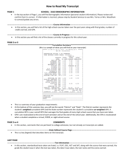
© Copyright 2026