
Volume 31, Number 2, Fall 2014 - Council of Virginia Archaeologists
Fall 2014 Vi r g i n i a Archaeol ogi st VOLUME 31 NUMBER 2 COUNCIL OF VIRGINIA ARCHAEOLOGISTS NEWSLETTER President’s Comments Jack Gary Greetings COVA members. Some of you are probably hunkering down for a winter in the lab, others are waist deep in student’s papers, while some of us are gearing up for winter survey work while the ticks and snakes snooze through the winter. Regardless of what you’re up to this winter I would appreciate everybody’s vigilance on the issue of Dominion Virginia Power’s proposal to construct a powerline across the James River between Surry and James City County adjacent to the National Historic Landmark Carter’s Grove. The proposal is currently going through the 106 consultation process and COVA is now a consulting party. If this powerline is constructed it will place 300 foot tall steel towers in the middle of the James River, impacting and industrializing one of the most significant historic viewsheds and landscapes in North America. Views from the south end of Jamestown Island, the Colonial Parkway, Carter’s Grove, and the James River will be negatively impacted by these towers, forever altering a view that is largely unchanged in character from 1607. This is ground zero for us as archaeologists and whether you are studying the Commonwealth’s prehistory, the intersection of Virginia Indians and Europeans, or the aftermath of colonization and nationhood, there is likely a site or sites that got you hooked in this area. A precedent must not be set that would allow this landscape to be impacted by such an intrusion. If this landscape is not important enough to save, what hope is there for many of the sites we work on across the Commonwealth? There is a significant coalition of consulting parties that are part of this proposal, including the National Trust for Historic Preservation, Preservation Virginia, Colonial Williamsburg, and the National Park Service. This coalition is pushing for an open public forum to be held where members of the public can voice their concerns about this proposal to the Army Corps of Engineers, the agency who will ultimately grant or deny the 404 permit to allow the impact to the river. If this forum is held I would hope that as many of you as can possibly attend will do so, adding your own concerns over this project. When a date is set for this IN THIS ISSUE: forum I will get that to you as soon as I know it. More From the State Archaeologist information is available at the links below if you would like to educate yourself further on the proposed Committee Reports transmission lines. I look forward to seeing everybody on COVA Awards February 27th in Manassas. Jack Gary President Dominion Virginia Power: https://www.dom.com/about/ electric-transmission/skiffes/index.jsp US Army Corps of Engineers: http:// www.nao.usace.army.mil/Media/PublicNotices/ tabid/3060/Article/489026/nao-2012-00080-13v0408.aspx Save the James Alliance: http://www.savethejames.com/ Obituaries Current Research: DHR & NPS News Hails and Farewells COVA Grants Publications Events & Calls for Papers Calendar The C OUNCIL OF V IRGINIA ARCHAEOLOGISTS is organized to protect, preserve and disseminate information on Virginia’s archaeological resources. COVA - INC. ORG Page 1 VOLUME 31 NUMBER 2 VIRGINIA ARCHAEOLOGIST Fall 2014 FROM THE DESK OF THE STATE ARCHAEOLOGIST October, 2014 Michael B. Barber, Ph.D., RPA State Archaeologist, Virginia Department of Historic Resources (DHR) Fall 2014: DHR Report Threatened Sites - The Threatened Sites Program for 2014-2015 has obligated funding for this fiscal year. Funded projects included the assessment of the Cabellsville complex in Nelson County, ground-truthing the Church Point site in Virginia Beach, survey of York River Islands in Gloucester County, survey of Back Bay in Virginia Beach, stable isotope analysis for material recovered in Prince George and Surry Counties, and continued research into shipwrecks in Virginia waters. Two projects, the Shoreline Survey of Back Bay, Virginia Beach, and the Shoreline Survey of Catlett Islands, Carmines Islands, and Mumfort Island on the York River were put on hold due to state budget considerations but were released in September. In addition, three archaeological projects will be supported from a NPS Hurricane Sandy Grant (see below). 2014 Cooperative Field School - The partnership of DHR, ASV, USDAForest Service, and JMU held a volunteer field school during May 2014. On the bayside of the Eastern Shore in Northampton County, the Nassawadox #5 site (44NH0431), an eroding Woodland shell midden, was tested along with a flanking hillock. Recovered artifacts attest to a long history of occupation from Early Archaic through Late Woodland. With a professional crew of five, the average daily volunteers numbered 22 with many enrolled in or graduates of Virginia’s Certification Program for Archaeology. The shell midden is interpreted as an ephemeral occupation area over time, probably exploited during late winter/early spring. When compared to other recently examined shell middens, the site varies in duration of use, shellfish focus, and overall function. Prehistoric ceramics (above) recovered during the 2014 Cooperative Field School at Site 44NH0431 (below). Hurricane Sandy - In February 2014, NPS announced that funding would be available for second-tier states for the rehabilitation, assessment, and, potentially, survey of historic structures and, possibly, impacted archaeological resources. Virginia applied and was awarded $1.5 million. FEMA designated particular Virginia counties as eligible for award. Proposals were requested and subsequently evaluated. Standing structures which had been impacted by Hurricane Sandy received top priority (with any needed archaeology), architectural survey for damaged sites ranked second, and survey of archaeological resources last. Three archaeological projects were funded: shoreline survey of the Eastern Shore, survey of Mathews County damage, and impacts associated with repair of Slave Quarters at Clermont Farm in Clarke County. Funding remains available and a second round of proposals and/or projects will be forthcoming. Archaeological survey to locate sites impacted by Hurricane Sandy will prove highly competitive. Werowocomoco - In partnership with DHR, VIMS was awarded a design grant through National Fish and Wildlife Foundation for establishing a living shoreline and shoreline stabilization at Werowocomoco. On another front, DHR’s Randy Jones, in cooperation with numerous parties (property owners, VA Indian Advisory Board, Werowocomoco Research Group, etc.) is spearheading the NPS production of a popular publication on Werowocomoco which should be available in spring 2015. Finally, DHR installed an exhibit on Werowocomoco at VHS which is now open to the (continued on page 3) COVA - INC. ORG Page 2 VOLUME 31 NUMBER 2 VIRGINIA ARCHAEOLOGIST Fall 2014 OBITUARIES Margaret Long Stephenson, Murfreesboro, NC Margaret “Peggy” Long Stephenson, 72, of Murfreesboro, died September 2. She was born in Richmond, Virginia on August 27, 1942. She was the daughter of Lucille Long Bowles, originally of Severn, NC and later of Como, NC. She was raised in Richmond, VA, and was particularly fond of her aunt Dorothy Long, who helped raise her, and her aunt Mary Long Whitt and uncle Joe Mack Long. After graduating from Highland Springs High School in 1960, she married E. Frank Stephenson, Jr. of Como, NC and attended Chowan College before earning her bachelor’s degree in Mathematics from North Carolina State University. She subsequently earned a Masters in Architectural History from the University of Virginia. While her children were young, Mrs. Stephenson taught art at Chowan College and Paul D. Camp Community College. She subsequently worked for the City of Raleigh’s Planning Department and the Virginia Department of Transportation’s Environmental Division. She is survived by her husband of 54 years, E. Frank Stephenson, Jr. of Murfreesboro, NC; her children Eugene (Jennifer) of Rome, GA, John of Whiteville, NC, and Caroline (Jochen Kunstler) of Como, NC; and her grandchildren Will Stephenson, Marlon Kunstler, and Lucye Kunstler. Other survivors include several beloved first cousins. Memorial donations may be made to the Art Department at Chowan University, Murfreesboro, NC. A graveside service will be held at Buckhorn Baptist Church, Como, NC on Saturday September 6 at 2:00 PM. Dr. Jay Brabban of Chowan University will conduct the service. The family will receive visitors afterward at the Buckhorn Church Fellowship Hall. Submitted by Kay Simpson (continued from page 2) public (due to recent renovations, it is the only exhibit in the museum). Conveyed by a series of images, scale models (from JYF), and text, the exhibit highlights the discovery and significance of the site in terms of archaeology, Algonkian landscape, and Powhatan/Jamestown contact and conflict. Cemetery Workshops - DHR continues its series of cemetery workshops for the public. Most recently, workshops were held in Harrisonburg and Warsaw, the latter with the Menokin Foundation. The workshops are 1.5 days long with the first given to lectures and the second held in a local cemetery for hands-on participation. Subject matter includes general history, iconography, recordation, conservation, laws, and cemetery archaeology. Attendance is limited to ca. 25-30 people. The next workshop will be in Pocahontas in the spring with other locations added in 2015. Archaeology Month and Underwater Archaeology - Events were held and listed on the DHR webpage. Posters were printed and distributed. The theme this year is underwater archaeology which fits the state’s concerns with sea level rise and catastrophic storm surge. Collections - Collections are always available for research although this may be muted for the short-term. Dee DeRoche, Chief Curator, will be out on medical leave for a minimum of 4 weeks so please bear with us. We will continue to function but it may take a little more time to access targeted collections. COVA - INC. ORG Page 3 VOLUME 31 VIRGINIA ARCHAEOLOGIST NUMBER 2 Fall 2014 COMMITTEE LIST President Vice-President Past President Secretary Treasurer Newsletter Editor EXECUTIVE BOARD Jack Gary [email protected] Eleanor Breen [email protected] Elizabeth Crowell [email protected] Jolene Smith [email protected] Carole Nash [email protected] David Brown [email protected] MEMBERSHIP Garrett Fesler, Chair, [email protected] Cliff Boyd, Justin Patton, Jamie May CERTIFICATION Carol Nash, Chair, [email protected] Dave Brown, Thane Harpole, Esther White, Kay McCarron ETHICS Randy Lichtenberger, Chair, [email protected] Clarence Geier, Randy Turner PUBLIC EDUCATION Carol Nash, Chair, [email protected] Mike Barber, Mark Wiffkofski COLLECTIONS MANAGEMENT Esther White & Eleanor Breen, co-Chairs, [email protected] Kerry Gonzalez, Kimberly Trickett, Elizabeth Moore, Bernard, Means, Lori Lee, Dee DeRoche. THREATENED SITES David Brown, Chair, [email protected] Clarence Geier, Mike Madden, Randy Turner AWARDS Mike Carmody & Kerri Berille, co-Chairs, [email protected] STATE PLAN Cliff Boyd, Chair, [email protected] Keith Egloff, Laura Galke, Clarence Geier, Tom Klatka, Mike Madden, Bernard Means, Carole Nash, Chris Stevenson, Randy Turner, Mike Barber LEGISLATIVE AFFAIRS Christopher Parr, Chair, [email protected] Randy Lichtenberger, Steve Thompson, Carole Nash BUDGET Derek Wheeler, Chair, [email protected] Mike Barber, Keith Egloff, Laura Galke PUBLIC OUTREACH Eric Proebsting, Chair, [email protected] David Brown, Lauren McMillan, Bernard Means, Matt Reeves, Jolene Smith, Esther White COVA - INC. ORG Page 4 VOLUME 31 NUMBER 2 VIRGINIA ARCHAEOLOGIST Fall 2014 COMMITTEE REPORTS Ethics Committee Randy Lichtenberger, Chairman The Note: The Bylaws and Grievance Procedures are conveniently located on the COVA website at http://covainc.org/about/bylaws.html. Collections Management Committee Esther White & Eleanor Breen, co-Chairs Please contact Eleanor Breen or Esther White to learn more or join the Collections Management Committee – we’re always looking for additional members! Threatened Sites Committee David Brown, Chair Applications for Threatened Sites grants and guidelines for their review are available from the DHR website: http:// www.dhr.virginia.gov/arch_DHR/threatened.htm. Also, please see Mike Barber’s summary of recent actions by the Threatened Sites program at DHR on Page 2. Awards Committee Mike Carmody & Kerri Berille, co-Chairs - See Page 6 & 7 - Legislative Affairs Committee Christopher Parr, Chair The Legislative Affairs Committee is composed of Christopher Parr (chair), Randy Lichtenberger, Steve Thompson, Justin Patton, and Carole Nash. While this is in no way a “new” committee, we want to improve how we monitor the legislature for issues impacting the administration of archaeology in the Commonwealth and communicate these to our membership. As we prepare for the upcoming legislative session, we encourage you to provide us with any feedback: Should we focus exclusively on the state legislature, or include federal and/or local issues as well? As many of us work for the state or federal government, would you also like to hear about issues impacting Virginia’s Tribes? The success of this committee is largely dependent on your support, and there are two ways that you can choose to participate. The first is to actually join with us, and so if you have an energetic disposition and an interest in the legislative process, please contact Christopher Parr ([email protected]). The other way is to simply pay attention and stay informed, so that you can pass along any news to the committee. The diverse nature of COVA’s membership is an asset: we live throughout the state, work in various industries, interact with our elected representatives in different ways, and move in diverse social circles. We have limitless opportunities to advocate for our chosen vocation – we just need to know how best we can apply these. COVA has included some resources for tracking state legislation on its website (http://cova-inc.org/resources/ legislature.htm). The next session of the Virginia General Assembly is in mid-January 2015. You can view delegate information and current/proposed legislation online with Virginia’s Legislative Information System (LIS, http:// lis.virginia.gov/lis.htm). Please keep in mind that the next General Election is November 4, and so take some time to familiarize yourself with the candidates and remember to vote! COVA - INC. ORG Page 5 VOLUME 31 NUMBER 2 VIRGINIA ARCHAEOLOGIST Fall 2014 COVA AWARDS CONGRATULATIONS TO THE RECIPIENTS OF THE 2014 COVA AWARDS Michael A. Hoffman Award winner Central Virginia History Researchers (CVHR), Charlottesville, VA [Compiled from the Nomination] The CVHR is an organization comprised of volunteers, including local historians, anthropologists, database designers, and community residents. Their purpose is to connect African-American families to their antebellum roots and to trace patterns of community formation in the post-bellum period. As it turns out, one of the CVHR researchers had been one of Dr. Michael A. Hoffman’s first Anthropology graduate students at UVA and saw his early professional career greatly influenced by the Award’s namesake. The CVHR has undertaken several important projects in Central Virginia. The collaboration of people with diverse skills and interests, generously willing to share their knowledge, has led to exciting new insights, and notably so in connection with the Sammons homestead and the surrounding Hydraulic Mills-Union Ridge community in Albemarle County. Individuals provided years of local research, organized contributors and integrated their contributions into thoroughly researched biographies and a compelling historical narrative of the African American community. A cultural resources survey identified the Sammons Farmstead and Sammons and Ferguson family cemetery within the proposed Charlottesville Western Bypass project. The consultant working for the Virginia Department of Transportation (VDOT) had recommended that neither the house nor the site was potentially eligible for listing in the National Register of Historic Places. VDOT concurred with their consultants finding and planned to relocate the interments as is typical for non-significant cemeteries. New research by CVHR and others found the graves to be associated with several important local African American individuals. These researchers and family descendants had only a few months to organize their research to build a case for the preservation of these historic resources. CVHR played an important role in this process, both by publicizing the many years of coordinated research of its members but also through its insistence that preservation of the Sammons site was locally desired and for the common good. Researchers assembled maps of the African American communities and land ownership in the Hydraulic Mills area, as well as records from in the Albemarle Real Estate office, 1937 aerial photographs and other data to create a 1940s base map of African American land ownership in the Hydraulic Mills area. Awareness of the importance of these historic resources became heightened through public education and consultation. In addition, the resources were placed on Preservation Virginia’s 2013 list of endangered sites. The Keeper of the National Register reviewed the documentation and declared both the house and cemetery to be significant and eligible under Criteria B and D for listing in the National Register of Historic Places. The CVHR volunteer effort deserves recognition by the Council of Virginia Archaeologists for its efforts to help preserve significant archaeological and historical resources. This informal group represents an excellent example of the importance of local participation and resource knowledge for improving our understanding of cultural history. The Central Virginia History Researchers organization qualifies for consideration of the Hoffman Award for their advocacy and public education efforts as well as efforts to help preserve these significant resources. NOTE: Electronic submissions are encouraged. Please contact Mike Carmody or Kerri Barile at 540-899-9170 or at the email address above with questions. COVA - INC. ORG Page 6 VOLUME 31 NUMBER 2 VIRGINIA ARCHAEOLOGIST Fall 2014 COVA AWARDS Virginia Sherman Award winner Ms. Hanna Brooks Burruss, Lynchburg, VA Ms. Hanna Burruss is nominated for COVA’s Sherman Award in acknowledgement of her conservation, stewardship and preservation efforts in permanently preserving the Prince Edward Soapstone Quarry located outside of Farmville, Virginia. The Prince Edward Soapstone Quarry is considered the largest and most intact documented soapstone quarry in the state of Virginia. In addition to assuring the safety of the site while in her possession, Ms. Burruss donated the property containing the Prince Edward Soapstone Quarry to The Archaeological Conservancy to assure its continued conservation. The site is now managed as one of the Conservancy’s permanent archaeological research preserves and was the subject of an American Archaeology article which documented the process of acquisition. The Prince Edward Soapstone Quarry site, located near Farmville, Virginia, is a prehistoric soapstone quarry site that contains the remains of over 150 piles of soapstone boulders and preforms. The site represents a transitional period when Native Americans were still manufacturing vessels out of soapstone, prior the introduction of pottery in the area. It is believed that the piles present on the property are in situ deposits and likely represent resource stockpiling. The Prince Edward Soapstone Quarry has been declared by archaeologists at Virginia’s DHR to be the largest and most intact quarry of its kind yet found in the state. As a child, Hanna was always interested in local history. Her father, Mr. Robert Burruss, owned the Pamplin Pipe Factory and as a result there were always pieces of pipe bowls and stems around the house. This interest persisted and many years later when her father’s large property holdings were being sold, she insisted on keeping a 13-acre parcel containing the soapstone quarry site. By the time the Conservancy learned of the site, it was surrounded by mining and timber operations and a municipal landfill. It was only through Hanna’s foresight that the narrow strip of land containing this important piece of Virginia’s history remained undisturbed. Many of the other prehistoric quarries found in the state have been destroyed or significantly impacted by mining, development, looting, and other activities. Prior to the Conservancy’s involvement, Hanna generously allowed Longwood College [now Longwood University] to run a field school at the site under the direction of archaeologist Jim Jordan. These investigations uncovered stone axes and possible soapstone vessel fragments. This is when the site was officially documented, and the only time it has been explored archaeologically. This limited amount of disturbance promises that there is significant potential for future archaeologists to conduct research at the site. The Conservancy contacted Hanna and her husband, Hugh Whaley, about their interest in preserving the site. Hanna and Hugh realized that it would be prudent to address the property’s future now, and they decided to donate the site to The Archaeological Conservancy to preserve it for future generations. The Archaeological Conservancy is the only national organization dedicated to the preservation of these valuable archaeological resources. As an avid history and archaeology buff, Hanna felt that this donation was the best way she could contribute to the permanent preservation of Virginia prehistory. We feel that her generosity and years of safeguarding the site should be honored with the Virginia Sherman award. COVA Awards Committee Dovetail Cultural Resource Group 300 Central Road, Suite 200 Fredericksburg, Virginia [email protected] COVA - INC. ORG Page 7 VOLUME 31 VIRGINIA ARCHAEOLOGIST NUMBER 2 Fall 2014 CURRENT RESEARCH POPLAR FOREST Eric Proebsting Recent Excavations and Research This summer’s field school was spent exploring several final areas of interest before completing the Carriage Turnaround excavations. One of our main goals was to define two more boundaries of the Jefferson-era paving (Figure 1). As reported in the previous issue of Virginia Archaeologist, our task was made easier by the removal of the 1850s boxwoods, which had obscured earlier evidence of the ornamental landscape. One of these boundaries—the northeast shoulder of the carriage turnaround—revealed a gradual fan of stone that linked the straight approach road with its curved interior. The second boundary—the central apex of the carriage turnaround—revealed a series of bricks outlining the edge of the Jefferson-era surface (Figure 2). These bricks included several column bricks, which were made onsite by enslaved laborers who created many of the materials needed to build Jefferson’s retreat. Even more Figure 1. Two new portions of the Jefferson-era surface intriguing is the fact that these excavations revealed that discovered last summer. the turnaround is not a circle after all, but rather an oval or tear-drop shape, slightly off-center with the front doors of the main house. After finishing this summer’s excavations, research has continued in the lab as we analyze the artifacts and environmental remains related to the Carriage Turnaround. As part of our study, we chose several cross-sections of the Jefferson-era paving for a closer look. Working with geoarchaeologist Howard Cyr at the University of Tennessee, plaster of paris and packing tape was used to carefully remove a portion of the surface last May to better understand how it was constructed over time (Figure 3). Several weeks ago, the completed sample arrived back home (Figure 4). Filled with a special non-toxic epoxy, and cut smooth with a diamond-edged circular saw blade, you can now hold a portion of the road in the palm of your hand. Starting with the modern gravel at the top, and moving down through the different road layers until reaching the Jefferson-era cobblestones resting on red clay subsoil, reveals over 200 years of history in an eight-inch span. For a closer look, thin sections have been examined by Cyr (2014) under a petrographic microscope to see exactly how each of these layers was created. These new discoveries are giving us fresh insights into the appearance of Jefferson’s Carriage Turnaround, which we will draw on for its future restoration. References Cyr, Howard J. 2014 Micromorphological Study of the Carriage Turnaround Stratigraphy at Thomas Jefferson’s Poplar Forest, Forest, Virginia. Report to Department of Archaeology and Landscapes, Corporation for Jefferson’s Poplar Forest, Forest, VA, from Archaeological Research Laboratory, Department of Anthropology, University of Tennessee, Knoxville. Figure 2. The apex of the carriage turnaround, including two column bricks (3 and 4). COVA - INC. ORG Page 8 VOLUME 31 NUMBER 2 VIRGINIA ARCHAEOLOGIST Figure 3. Howard Cyr taking a micromorphology sample from the carriage turnaround in May 2013. Fall 2014 Figure 4. The finished micromorphology column sample recently returned to Poplar Forest. DOVETAIL CULTURAL RESOURCE GROUP Submitted by Kerri Barile—Editors apology for publishing this after the deadline, but please review and note this important pending publication. COVA - INC. ORG Page 9 VOLUME 31 NUMBER 2 VIRGINIA ARCHAEOLOGIST Fall 2014 Mount Vernon Eleanor Breen, Deputy Director for Archaeology Kitchens’ Backyard We kicked off this season’s excavation by welcoming 10 field school students through the collaborative University of Maryland/Mount Vernon Field School in Historic Preservation. This year, undergrads and graduate students came from across the country for a 6-week, hands-on course in methods in archaeological and architectural field work. Students assisted in excavations behind George Washington’s standing kitchen, the Slave Cemetery Survey, and documentation of two nineteenthcentury buildings that frame the west gate entrance to Mount Vernon. Students and staff trowel the area behind the kitchen (note the location of the eighteenth century well and fenceline). We opened test units behind the kitchen encompassing a 17 by 30 foot area. This project builds upon our research last year identifying the pre-1775 kitchen and dairy outbuildings and features associated with the standing 1775 kitchen to aid in our understanding of the use of space behind Mount Vernon’s two kitchens – including activities like refuse disposal and architectural features like drains to direct water away from the kitchens. Additionally, the test units connect previous excavations including the eighteenth-century kitchen well and nineteenth-century well house (since removed), the path of a ca. 1775 fence line that ran behind the kitchen and down the south lane, and the south grove midden (www.mountvernonmidden.org). Massive amounts of rubble representing the destruction of the early kitchen and dairy outbuilding were uncovered, including hundreds of compass brick from an unknown masonry feature. These rubble layers were intruded by an eighteenth-century brick drain running from inside the kitchen down the south grove. At some point in the late nineteenth or early twentieth century, the drain went into disuse as the vaulted top was removed and the channel filled. Beneath the rubble layers, other deposits associated with the construction of the kitchen were encountered including a thin, contiguous mortar layer and a thick layer of redeposited red clay subsoil. Archaeologist Leah Stricker stands on a rubble-filled destruction layer while troweling the brick drain running south from Mount Vernon’s kitchen. COVA - INC. ORG Excavations next season will continue in the area south of the kitchen as we more broadly investigate the transition of the space from a work yard to a formal landscaped grove. Page 10 VOLUME 31 NUMBER 2 VIRGINIA ARCHAEOLOGIST Fall 2014 Glass inlays from a linked buttons excavated from the cemetery (left) and House for Families slave quarter (right). Slave Cemetery Survey Excavations commenced at the site of Mount Vernon’s Slave Cemetery (44FX116) in June with the field season ending in October. The project was initiated to better understand and manage this significant resource. The multi-year project has three primary goals: 1) to delineate the boundaries of the cemetery; 2) to determine the number of individuals interred within these boundaries; and 3) to document the spatial organization of the individual internments. Joe Downer, MA student at George Washington University and graduate of Mount Vernon’s field school, supervised the field work with the assistance of Mount Vernon’s archaeology staff and many students and volunteers. Working Fridays and Saturdays, the crew excavated 60 5x5’ test units on the southeasternmost section of the narrow ridge. Nineteen burials have been uncovered to date, with eight forming a regular row and generally oriented with heads to the east and feet to the west. Most of the burials appear to be adults with the exception of one – a small 3 by 1.5 foot internment, probably a child’s grave. Three of the burials intrude each other suggesting that enough time had passed between internments that exact locations were forgotten. Bruce Bevan conducted a geophysical survey of Mount Vernon in 1985, including two areas within the slave cemetery. In the area we have been testing, his results appear to be about 60 percent accurate (identifying 11 of 19 burials). We plan to support additional geophysical work in untested areas in the 2015 field season. We have yet to encounter indications of grave markers and have been finding few historic period artifacts. The site is rich in late Archaic and possibly early Woodland materials, suggesting a temporary base camp. One of our few yet most exciting artifact finds from the cemetery is a small intaglio glass disk molded with an image of a branch of coral. This glass was originally set in a copper alloy frame and used as a linked set of buttons to close a sleeve or collar. A nearly identical one was excavated from the cellar underneath the House for Families, the primary dwelling for slaves during George Washington’s lifetime assigned to Mansion House Farm. The connection between the House for Families and the cemetery through these two artifacts is intriguing. Burials marked with bouquets for the annual Slave Memorial Wreath Laying ceremony, October (facing southeast). COVA - INC. ORG Page 11 VOLUME 31 NUMBER 2 VIRGINIA ARCHAEOLOGIST Fall 2014 Colonial Williamsburg Archaeology Mark Kostro and Andy Edwards, Department of Architectural and Archaeological Research The Bray School Archaeological Project, 2012-2014 Between 2012 and 2014 Colonial Williamsburg archaeologists, in conjunction with faculty from the College of William and Mary, conducted an archaeological field school on the site of the eighteenth-century Bray School. Named for English philanthropist, Rev. Thomas Bray, Williamsburg’s Bray school was established in 1760 “for the instruction of Negro Children in the Principles of the Christian religion.” Both male and female, enslaved and free black students attended the school, and were taught Anglican catechism in addition skills such as reading, writing and possibly sewing. Williamsburg’s Bray School operated for fourteen years, closing in 1774 at the death of its school mistress, Ann Wager. For the first five years of that existence, classes were conducted in a house near the corner of present day Prince George and Boundary Streets, a site now occupied by William and Mary’s Brown Hall. The recent archaeological investigations were focused on locating the Bray School period outbuilding foundations. architectural footings for the Bray School, and evidence of the lives, daily routine, and perhaps even the curriculum offered to its students. Three summers of excavation permitted archaeologists to look closely at the evolution of this property. The 1930 construction of Brown Hall, a 3-story cellared dormitory, had the most significant impact on that evolution, consuming much of the block and threatening the survival of any eighteenth-century evidence. The first season of excavation proved, however, the disturbance was limited to the footprint of Brown Hall. Clay removed in cellar construction had been spread across the property, ultimately protecting a rich early twentieth-century plowzone layer containing artifacts spanning the late seventeenth through the twentieth centuries. The plowzone was subdivided into one-meter squares and painstakingly excavated from over a broad area to the south of the dormitory to reveal several generations of building remains, fencelines and pit features. Ultimately, however, architectural remains of the Bray School proved elusive as the dorm’s footprint very closely matched the locations of the lot’s principal eighteenth-century structures. Nevertheless, the archaeologists and field school students did discover at least two eighteenth-century outbuildings poking out from behind Brown Hall: a detached kitchen (identified by a brick hearth and footings), and a square brick foundation for either a smokehouse or dairy. These were likely service buildings that stood behind the structure in which the Bray School was conducted. If so, it argues strongly that the eighteenth-century Bray School once sat where Brown dormitory does today. Not all traces of the school were destroyed, however. Over the course of three summers, archaeologists recovered approximately 50 slate pencil fragments from the site… more than on any site in Williamsburg to date. Their presence hints that instruction at the Bray School may have included writing in addition to practical skills and Biblical recitation. As tens of thousands of artifacts: ceramic and glass fragments, animal bones, oyster shells, and small finds such as clay marbles and doll parts, are washed and analyzed, they may contribute additional details to the story of the Bray School and its students. Some of the archaeological features discovered between 2012 and 2014 belong to the eighteenth century and, like the outbuildings mentioned above, would have been familiar to Ann Wager and her student. Others had long been forgotten, or date to later periods when the house on the corner was a private residence. Among the latter was a bricklined well discovered by archaeologists in 2012, and explored more fully in 2014. Located at the front of the property, this well may have served as a communal water source and a familiar gathering spot for those living up and down Prince George Street late in the eighteenth century. Dug after the Bray School’s relocation to an unknown spot, the well remained in use until early in the twentieth century. It has been only partially excavated. COVA - INC. ORG Page 12 VOLUME 31 NUMBER 2 VIRGINIA ARCHAEOLOGIST Fall 2014 One of the most interesting and as yet unexplained set of features on the site likewise belongs to the postRevolutionary War period. A 16’ x 6’ earthfast building with a subfloor pit or root cellar, and a related 8’ x 8’ earthfast storage building were uncovered behind Brown Hall in 2012 and 2013. The first building is considered a possible “quarter” for the enslaved not unlike the house found ‘behind the big house’ on countless plantation sites throughout the Chesapeake. Although its narrow dimensions seem uninhabitable to our 21st-century sensibilities, these proportions may reflect the cramped nature of Williamsburg’s urban lots in the late eighteenth century. As earthfast buildings, both (the quarter and the storage building) were identified by postholes that supported vertical framing members. Fragments of handLate Eighteenth Century Earthfast Slave Quarter. painted pearlware were recovered from the posthole features indicating the posts’ were not set into place until the 1780s at the earliest. Archaeological evidence pre-dating the survey of Williamsburg’s lots and streets was also identified in 2013. The site’s seventeenth-century occupation was evidenced by the discovery of a rectangular subfloor pit dug into the clay beneath a structure to provide storage. In this instance, however, no postholes or hearth survive to help delineate a surrounding building. The pit’s orientation matches the arrangement of other seventeenth-century features when the area was known as Middle Plantation. The pit contained no artifacts in its lower layers, and appears to have been abandoned and filled in the second quarter of the eighteenth century, based on a few fragments of white salt-glazed stoneware in its upper fill. Research into the Bray School’s short tenure on Prince George Street continues, carried forward by the work of archaeologists, historians, and students and faculty committed to the College of William and Mary’s Lemon Project. Along the way we have learned a great deal about the early development of lots along Prince George Street, as well as their redevelopment after the Revolution. As is so often the case with archaeology, we began the project with one question, but the results answered many others. Archaeology of the Wren South Yard - 2014 Background— In the summer of 2011 the William and Mary Center for Archaeological Research (WMCAR) conducted test excavations along the brick walkway south of the Wren Building prior to plans for its removal and replacement. WMCAR discovered previously unknown brick foundations likely dating to the eighteenth century. More detailed excavation was delayed due to both monetary and temporal constraints. In the spring of 2014, work recommenced with the CWF Department of Architectural and Archaeological Research undertaking a full investigation of the structural remains found by WMCAR along with a previously unknown, very large saw pit directly east and adjacent to the building foundations. The Structure—Using the drawings and photographs from the 2011 testing, CWF archaeologists removed considerable Project area, Wren Building, College of William and Mary. overburden and backfill from atop the footprint of the building. The modern brick path and concrete “rat slab” was removed since much of the foundation was located under the walkway. The overburden consisted of mixed soils created by construction, utility and landscaping activities in the twentieth and 21st centuries. The first intact layer encountered was what appeared to be rubble deposited as a result of the destruction of the building in the fourth quarter of the eighteenth century. This layer was deposited directly atop the foundation walls and in the interior of the structure. The recovery of Wedgwood creamware indicated that the building was destroyed after 1762. COVA - INC. ORG Page 13 VOLUME 31 NUMBER 2 VIRGINIA ARCHAEOLOGIST Fall 2014 Along with the destruction debris that covered much of the building, a concentration of rubble was uncovered in the approximate center of the interior. While initially thought to be a fallen central chimney, characteristic of a small dwelling or a kitchen/quarter and potentially matching Robert Beverley’s History and Present State of Virginia in which he describes the kitchen, bakehouse and brewhouse being situated in the cellar of the College’s Great Hall [Beverley 1722:231-232; see also Goodwin (1967) below] it was not to be. Instead, the brick bats covered two large pits, both filled primarily with wood ash, and their latest artifact was again creamware. Complete excavation of the pits showed that a round pit (16JA-197) was dug through a squarish pit (16JA-199). The later of the two contained a circular arrangement of brickbats in the bottom and the older, square pit exhibited a small amount of burning. Lack of any kind of chimney Brewhouse, overall destruction layer. base in the house ruled out three of the possibilities for the function of the structure suggesting that the little building may have functioned as a brew-house. From Mary Goodwin’s 1967 History of the College: The Kitchen was beneath the Hall, with " all Conveniences of Cooking, Brewing, Baking, &c.," in the building of 1695-1705, although the oven was moved to an outside building before the fire of 1705 (Beverly 1722:231232) It was in the same location, with an outside Bake-house, and Brew-house, as rebuilt after the fire. The rebuilding had progressed far enough by June, 1716, for the Visitors and Governors to send to Micajah and Richard Perry, merchants in London, for "Standing furniture for the Colledge Kitchen, Brewhouse, and Laundry," (Historical Notes 1897). Supporting the brew-house notion is the fact that brewing can range in sophistication from a kettle over a fire pit in the yard to a fairly complex system of tuns, cooling troughs and drains. What was thought to have been a “chimney fall” may have well been a brick support for a kettle or “tun” used to boil water for brewing. The pits would have been dug to contain the wood for the fire and the resultant ash. After the building outlived its usefulness and was demolished, the brick support walls were simply pushed over, falling in place. Less easily explained in the brewhouse interpretation are the ditches founds within the interior of the building. The ditches were dug after the building was constructed, are about a foot wide and a foot deep on average, against the interior of the foundation wall although they extend at least six inches below the bottom course of foundation brick. The ditches are continuous around the south, west and east walls, but not along the north. There appears to have been a board (?) or some vertical construction about an inch or two wide placed against the interior brick and covered over with soil. How far up the interior wall the board extended can only be speculated, as can its purpose. Saw pit (top) and brewhouse foundation. At some time during the life of the building, an addition or lean-to was added to the south side. This addition does not appear to have been constructed simultaneously with the main structure although the west side is joined or “keyed-in” with the existing foundation. The eastern junction of the addition and main structure, however, was destroyed by an electric cable in the first half of the twentieth century. Construction of the addition cut through a diagonal walkway uncovered in the southeastern section of the excavation area, suggesting the walkway and building are unrelated. The elevation of the top of the walkway suggests the ground surface elevation at some time in the first half of the eighteenth century. The top surviving course of brick on the eastern side of the addition contains a brick COVA - INC. ORG Page 14 VOLUME 31 NUMBER 2 VIRGINIA ARCHAEOLOGIST Fall 2014 configuration indicating an “air hole” or vent for a crawl space. The existence of a vent suggests a raised floor in the addition as well as indicating that the top course was above the ground surface. An amorphous feature that cuts through the south wall of the main structure between it and the addition may be the remnants of a stair from one room into the other. Located just to the east of the structure was a large, previously unknown pit filled with discarded material dating to the first quarter of the eighteenth century. Excavations towards the south revealed a lozenge-shaped pit 23 feet long and about 8 feet wide. Excavation suggested that the entire pit had been filled with debris primarily associated with food preparation. Eighteen five-gallon buckets of oyster shell were recovered in addition to hundreds of animal bones, thousands of wine bottle fragments and a moderate number of ceramic fragments. The ceramics included English “Persan” tinenameled earthenware, delft, Fulham, Chinese porcelain, and some lead-glazed earthenwares, all of which were manufactured in the late seventeenth to the first quarter of the eighteenth centuries. Upon reaching the bottom of the pit, it became evident that it was originally dug as a saw pit, probably related to the re-building of the Wren Building in the 1710s after the devastating fire of 1705. The Saw pit section and CWF archaeology crew. pit was somewhat larger than the saw pits excavated by Colonial Williamsburg at the Kendall-Gardener and Wray sites, not surprising since the lumber needed for the Wren reconstruction was larger than most domestic buildings. The very bottom of the pit contained several large stone pavers that were likely part of the original loggia on the rear of the Wren that were damaged by the 1705 fire and subsequently discarded when replaced by new imported stone. After the section was recorded, the remaining portion of the saw pit fill was removed in the area that would be affected by the construction of the new brick walkway. There seems to be little differential in time between the many layers suggesting that the pit was filled in a very short period. References: Beverley, Robert 1722 History and Present State of Virginia. Reprint, 1947 University of North Carolina Press, Chapel Hill. Goodwin, Mary 1967 THE COLLEGE OF WILLIAM AND MARY: A BRIEF SKETCH OF THE MAIN BUILDING OF THE COLLEGE, AND OF THE ROOMS TO BE RESTORED TO THEIR EIGHTEENTH-CENTURY APPEARANCE. The Colonial Williamsburg Foundation, Research Report. Delft fragment with camel. COVA - INC. ORG Page 15 VOLUME 31 NUMBER 2 VIRGINIA ARCHAEOLOGIST Fall 2014 Ferry Farm Laura Galke, Site Director/Small Finds Analyst, George Washington Foundation Archaeologists Discover Colonial-era Hair Powder on Washington Curlers A collaborative venture between the George Washington Foundation (GWF), in Fredericksburg, and Virginia Commonwealth University (VCU), in Richmond, has uncovered evidence for mid-eighteenth-century hair powder preserved on wig hair curlers unearthed at Ferry Farm, the boyhood home of George Washington, Stafford County, Virginia. Members of the Washington family lived here between 1738 and 1772. During the eighteenth-century, wigs or ‘perukes’ were an essential component of stylish male attire. The most fashionable of these hairpieces featured curls. These curls required maintenance by a gentleman’s hairdresser, which included periodically re-setting the curls and applying a lard-based pomatum followed by a dusting of hair powder. Hair powder was the finishing touch for many hairdos and Detail of a curler with a residue that analysis demonstrated was also worn by non-wig wearers, such as George consisted of wheat flour and crushed shell (likely oyster shell). Washington. Historical documents demonstrate that wigs were worn by at least one of George’s three brothers at Ferry Farm: Samuel Washington. Archaeologists at Ferry Farm have recovered over 200 earthenware wig hair curlers to date and believe that these curlers were tools used for wig maintenance: to re-set a wig’s curls. GWF archaeologist Laura Galke noted that a few of the curlers retained visible black, white and translucent residues and wondered whether they reflected materials used for wig hair care during the middle 1700s. VCU anthropology professor Dr. Christopher Stevenson became aware of Galke’s hypothesis and agreed to form a research partnership to scientifically analyze the residues. Stevenson invited a team of material scientists from the Jefferson Laboratory Surface Characterization Facility, Newport News, Virginia, to participate. One of the great challenges facing the team was how to analyze such minute traces of material. The incredibly small size of the residues, consisting of a few milligrams of material, required a sampling method technique appropriate for such tiny deposits. Drawing on the resources of the Applied Research Center, a scanning electron microscope with an energy dispersive X-ray fluorescence attachment (SEM-EDAX) and infrared spectroscopy were used to analyze the deposits. The SEMEDAX analysis provided an elemental analysis of the residue while infrared spectroscopy resulted in spectra that identified organic compounds. The results suggest that a few of the Washington family curlers retained hair powder made from either wheat flour or white kaolin clay, each traditional hair powder constituents. Notably, pulverized shell was also mixed in with the clay and powder deposits, respectively: a recipe A volunteer excavates at Ferry Farm. not popular amongst surviving historical recipes from the 1700s. Galke and Stevenson believe that such an adulteration was perhaps added at the Washington home, to stretch a tight hair care budget. This is the first time that residues on historical wig hair curlers have been analyzed in a systematic scientific fashion. The preservation of 250-year old residues on curlers has never before been documented. The use of curlers as part of COVA - INC. ORG Page 16 VOLUME 31 NUMBER 2 VIRGINIA ARCHAEOLOGIST Fall 2014 a home-based wig hair maintenance regimen at George Washington’s boyhood home represents a new discovery about our first President’s home, where he lived between 1738 and early 1754. The team plan to present their findings at this year’s Archeological Society of Virginia meetings in Richmond and at the upcoming Middle Atlantic Archaeological Conference. They hope to inspire similar collaborative projects and analyses using other curated collections. Residue types found at Ferry Farm. Fairfield Foundation Anna Hayden, Staff Archaeologist, and Dr. David Brown, Co-Director, The Fairfield Foundation Metal Detecting Expedition at Montpelier In early November, Fairfield Foundation staff joined Montpelier's Archaeology Department as they hosted a week-long "Metal-Detecting Expedition," part of a series of expeditions which utilize metal detecting technology to locate sites or activity areas on the grounds of the home of James and Dolley Madison. This program in particular united professional archaeologists with both professional and avocational metal detectorists in order to refine metal detecting methodologies with an archaeological and anthropological grounding. Fairfield staff had a positive experience participating in this expedition - becoming Fairfield Foundation co-Director Thane Harpole (right) much more familiar with the metal detecting process and documents metal hits with Montpelier workshop participant. its advantages in certain contexts. The week was focused on using metal detecting to pinpoint the location of James Madison's primary stable - which meant we spent a lot of time exploring metal detecting hits that turned out to be nails - cut nails, wrought nails, horsehoe nails, etc., and then mapping those hits to create a very detailed map of metal artifacts in the area. We left the workshop feeling that mutual respect had been exchanged between our archaeological community and the metal detectorist community. North End Plantation, Mathews County Through a collaborative project between the Fairfield Foundation and the Middle Peninsula Chapter of the Archeological Society of Virginia (MPCASV) we are documenting the archaeological remains of North End plantation, the long-vanished estate of John Page. This once grand and vast eighteenth-century plantation complex survives today only in street names, with no above-ground evidence to mark the location of the main house or any of the many outbuildings that once defined this landscape. Over the past two years we have been conducting historical research (with much assistance from Becky Barnhardt at the Mathews Memorial Library) as well as archaeological survey to help identify the location of the main house complex and answer some initial questions about the appearance, date, and size of the buildings. Many local volunteers have helped with the survey, which succeeded in defining the likely site of the main house. We recently finished our first test unit as well, and have possible evidence for either the main house or one of the primary outbuildings. Public Archaeology at New Quarter Park, York County Our seasonal public archaeology days at New Quarter Park continued recently with a two day excavation on September 26th and 27th. Over 35 participants spent part of their day working under the supervision of staff archaeologists and archaeology certification students (ASV) uncovering evidence of everyday life at this eighteenth-century domestic site. COVA - INC. ORG Page 17 VOLUME 31 NUMBER 2 VIRGINIA ARCHAEOLOGIST Fall 2014 Our intrepid team of archaeology enthusiasts opened five new 2.5' square test units and several shovel tests, further delineating the site boundaries and recovering a greater sample of the trash deposited by the site occupants. The rather small test units revealed several features, but the real emphasis was continuing to test the hypothesis of whether (and what part) of the site was plowed and how did the site change from its earlier seventeenth-century occupation to its mid-eighteenth-century occupation. The most surprising artifact recovered from the site was a tin-glazed spout, possibly from a tea caddy or flower vase, and a large copper-alloy finial, likely part of an andiron. These artifacts are commonly seen as reflections of higher status, although they come from a site thought to be associated with enslaved Africans. Together these artifacts are beginning to reveal a more detailed picture of the lives of people living here three centuries ago. Our excavations will continue in the spring and we welcome your help in addressing these questions and rewriting the history of this important site. Adventures in Preservation participant Evelyn Ayala Fairfield Plantation, Gloucester County uncovers brick porch pier for the Fairfield manor house. We had many wonderful guests over the summer, from a Montessori School preschool group who wanted to get their hands dirty, to several families visiting from Hampton and Chesapeake to help us excavate during our Public Dig Days. We also spent much of the summer wrapping up test unit excavations from our NIAHD and Boy Scout dig days. Our most exciting summer dig, though, covered two weeks with our partners at Adventures in Preservation (www.adventuresinpreservation.org) in August. Ten participants from across the country helped us excavate, document and evaluate portions of the manor house foundation, while our collaborators from Colonial Williamsburg's brickyard (brick makers and masons, Jason Whitehead and Bill Neff), taught them about period mortars and brickwork, and worked alongside them to stabilize small sections of fragile masonry. As an archaeological adventure, we made great strides excavating some of the layers of rubble that accumulated after Fairfield burned in 1897 and was subsequently demolished. Carefully removing these layers allowed us to recover decorative bricks and distinctive artifacts that tell us more about the building and people who lived there. Artifacts such as ceramic door knobs tell of interior remodeling that occurred in the early nineteenth century, while a fragment of a blue painted delft chamber pot speaks to the personal habits of some of Fairfield's earliest residents in the beginning of the eighteenth century. Part of the excitement this year was uncovering the base to a brick pier for the east porch. We have been waiting for a decade to see whether any of this structure remained, and luckily the lowest course of brick is still in the ground. The porch appears in several of the surviving photos of Fairfield taken in the 1880s and 90s, but this discovery finally allows us to better measure this porch, and then figure out when it was added and what entrance preceded it. In the course of this work we removed hundreds of pounds of brick and mortar, carefully logging the quantities so we know how much material has been taken away. We also spent time excavating a small portion of the burn layer, which accumulated in the drip line of the house during the 1897 fire. This layer, and the old topsoil immediately below it, contains a profusion of artifacts from the latter part of the nineteenth century, including shattered window glass, crab claws, clothing buttons, and 120 year old iron food cans that were left to be crushed and covered by falling sections of walls. In addition to all of this great archaeology, we were grateful for the assistance of Jason and Bill for teaching the workshop participants about making and laying lime mortar, and helping to stabilize and repoint failing brickwork so that Fairfield's 1694 foundation may last for many more years. Intrigued? Check out our blogs on this and last year's work here and here, and consider enrolling in next year's program. Better yet, tell a friend and bring them with you - make a vacation of it - and help us preserve Fairfield Plantation. Remnants of a brick foundation, Beyond the manor house our summer excavations focused on a large block area possibly predating the 1694 manor with the goal to expose more of a recently discovered brick foundation east of the house at Fairfield Plantation. COVA - INC. ORG Page 18 VOLUME 31 NUMBER 2 VIRGINIA ARCHAEOLOGIST Fall 2014 manor house. We succeeded in finding the entire east wall, including both corners, and a small section of the west wall, confirming the foundation’s dimensions. The east wall is much more intact to the north than the south, but we were lucky to find any of the foundation after a century or more of plowing as part of the south wall appears to have been completely plowed away. The use of fragmented bricks throughout much of the foundation suggests that these may have been recycled from an even earlier building, or leftovers from the construction of a nearby building, but not necessarily the 1694 manor, given the differences in brick size. Since the building’s orientation differs from the manor house (and other post-1694 landscape features) by about 10 degrees, we believe it was built earlier. On most contemporary plantations, outbuildings, fences and other features are usually built to match the orientation of the main house, as it brought a formal ordered arrangement to the landscape. The layout of this brick bat foundation suggests that it may relate to an earlier landscape scheme. The artifacts found in the plowed soils above include predominantly brick, wine bottle glass, tobacco pipe fragments, and ceramics dating to the early eighteenth century, which could be indicative of the destruction of this structure. With a length of about 44 feet (exterior), and a width of 22 feet, this building fits within the average house dimensions for the majority of residences with masonry foundations in late seventeenth-century Virginia. Our priority for early 2015 is to locate a fire place or heat source (most domestic buildings have one), and examine the interesting linear features (perhaps slot trenches) that extend east from the exterior of the building, and several large post holes near the south gable, all of which align with this foundation. Center for Archaeology, Preservation and Education We are very excited to be making progress with the design phase of the Transportation Enhancement grant from VDOT which is enabling us to continue our restoration work on the CAPE and the surrounding landscape. We've embarked upon a series of meetings with Carlton Abbott and Associates to hash out the details of the construction, and anticipate finalizing the design early in 2015 (with construction to begin this summer!). Stay tuned to our Facebook page for regular field updates! Data Investigations Dr. David Brown, Co-Owner Kenwood, Gloucester County DATA Investigations included Criterion D (Archaeology) in its nomination of Kenwood to the state and federal registers of historic places. The archaeological site encompasses much of the nominated acreage and includes clay borrow pits once used for the extraction of clay to make bricks on site, the remains of a brick kiln/clamp, a nineteenthcentury cemetery for the Cary family, the foundations for a substantial ca. 1848 brick barn and later early twentiethcentury silo, and the general late eighteenth-century through early twentieth-century domestic debris associated with the lives of the plantation’s everyday residents. While no systematic excavations were undertaken as part of the nomination, the argument was made that these resources show both integrity and significance through what remains visible today, their link with extant documents, and their historical association with specific locations within the property. While the markers for the cemetery were removed in the early twentieth century and their current location is unknown, acknowledgement of the visible cemetery depressions brings attention to this understudied resource. The brick barn foundation, still visible at the ground surface, has measurements closely matching those found for a 60’ by 30’ barn floor plan drawing in John R. Cary's papers and dated to the period 1848-1860. The brick kiln/clamp remnants may be associated with the construction of Kenwood (ca. 1800) but are more likely connected to its subsequent raising of the original section to two stories (ca. 1840) or wing construction (ca. 1860). COVA - INC. ORG Page 19 VOLUME 31 NUMBER 2 VIRGINIA ARCHAEOLOGIST Fall 2014 Mathews County Archaeological Assessment Efforts continued with the documenting of more archaeological sites across Mathews County. Alongside efforts to update information on previously inventoried sites, we are working with property owners, collecting information on dozens of new sites in order to better understand and plan for the archaeological heritage of this under-surveyed county. Mathews County has a very rich history, and an even richer record of archaeological sites that have not been given much attention. Once completed, we will have a much better understanding of approximately 125 sites across the county. The report draft, anticipated in late January 2015, will include a full discussion of the known archaeological sites within the context of Mathews County’s history and an evaluation of our current understanding of the county’s historic and prehistoric periods. While predictive models, which are commonly associated with count-wide assessments, are anticipated in a future study, this project will serve as a significant planning tool for evaluating the significance of these sites and helping plan for preservation initiatives. DATA Investigations Co-Owner Thane Harpole excavates a Saratoga Kitchen and Quarter, Lancaster County test unit adjacent the Saratoga Kitchen/Slave Quarter. This winter we ventured north and excavated two test units adjacent an antebellum kitchen/slave quarter at Saratoga, the early nineteenth-century plantation of the Ball family. The small 16.5’ by 16’ building includes an intact, bricklined cellar (measuring 9.5’ x 4.35’ x 4’) and is an intriguing and rare survivor of this period in central Lancaster County. The property owners are interested in the restoration of the building and potentially nominating this registereligible complex. One test unit investigated the building piers and immediate yard area adjacent the primary entrance while a second unit on the west gable exposed a portion of the foundation of the no longer extant chimney. Artifacts recovered from both units add credence to the interpretation of the building as a survivor from the antebellum period and confirmed the presence of intact cultural deposits, including a potential fencepost at the building’s corner and a second post in close proximity to the chimney, in addition to substantial architectural debris and domestic artifacts recovered from the occupation layers. St. Paul’s Cemetery, Norfolk Our fall excavation season at St. Paul’s Cemetery focused on the continued search for the seventeenth-century church and for unmarked burials and lost burial markers. While we did not recover another tombstone with complete inscription (see Spring 2014 COVA Newsletter) we did expand on the excavations near this discovery. The increasingly public excavations, with support from both the church and the Norfolk Historical Society, involved several ASV certification graduates and included the recovery of additional material from a substantial fill layer covering much of this section of the churchyard. Deposited primarily in the first half of the nineteenth century, the fill soils include architectural and domestic debris that also spans the eighteenth century, as well as tombstone fragments. Several “clean up” events are recorded in the vestry book for the eighteenth century and this likely continued in the subsequent century, alongside landscaping that created a more level and well-drained churchyard. The substantial fill layer both preserves and, alongside many, many, burial shafts, obscures evidence for the earlier church, but a handful of artifacts and a potential robber’s trench suggest that the church is not far from the Anna Hayden and Thane Harpole work with ASV certification graduates and volunteers at St. Paul’s churchyard. excavations. Fieldwork is anticipated again in the spring. COVA - INC. ORG Page 20 VOLUME 31 NUMBER 2 VIRGINIA ARCHAEOLOGIST Fall 2014 Virtual Curation Laboratory @ Virginia Commonwealth University Bernard K. Means, Director Co-Creation in Archaeology: Empowering Student Engagement through the Virtual Curation Laboratory Our mission in the Virtual Curation Laboratory is to use digital means to preserve and protect the past, and printed replicas of our digital models to promote education and outreach. Most of this work is done by undergraduate students at Virginia Commonwealth University (VCU). However, the interns, volunteers, and the stray independent study students are not simply here to help scan artifacts, but are also encouraged to conduct their own research. One of the unintended consequences of my founding the Virtual Curation Laboratory in August 2011 is that it has become a “campus innovation center” that promotes undergraduate research—and research that provides the students with real world material to present and publish to further their professional development. Digitally scanned and printed objects from student research. Just over two weeks ago, seven VCU students and two recent VCU alumni presented their research in the Virtual Curation Laboratory at the annual meeting of the Archeological Society of Virginia (ASV). The Archeological Society of Virginia very kindly provided the students with free registration and a free banquet ticket—this kind of support for student engagement in a professional setting really needs to be commended. Some of the research presented involved a cooperative arrangement made with Katherine Ridgway, the archaeological conservator at the Virginia Department of Historic Resources. At the ASV meeting, VCU student Ivana Adzic talked about her work on shipwreck conservation and public archaeology looking at DHR collections, while VCU student Rebecca Bowman discussed ways of mending (and unmending) pottery at DHR versus digital means in the Virtual Curation Laboratory. Virginia Commonwealth University students John Bush and Brenna Gerahty focused on lithic tools, with John considering experimental archaeology and Brenna focusing on pre-Paleoindian and Paleoindian materials. Virginia Commonwealth University alumni Lauren Volkers and Vivian Hite both talked about using printed and painted replicas for public archaeology, with Lauren focusing on our work with Jamestown Rediscovery and Vivian recounting her summer as the Public Archaeologist at George Washington’s Ferry Farm. Virginia Commonwealth University students Lauren Hogg and Carson Collier also looked at public archaeology and printed artifact replicas, with Lauren discussing the challenges of the large volume of material from Jordan’s Journey and Carson presenting classroom activities that she created related to teaching zooarchaeology. The Virtual Curation Laboratory also maintained two tables in the exhibits hall to highlight our public outreach efforts. Virginia Commonwealth University student Kaitie Lyford joined all the other VCU students in discussing how virtual curation and 3D printing can help bring the past alive. VCU Virtual Curation Laboratory students (from left to right), Kaitie Lyford, Lauren Hogg, Rebecca Bowman, Ivana Adzic, John Bush, and Brenna Geraghty. COVA - INC. ORG Page 21 VOLUME 31 NUMBER 2 VIRGINIA ARCHAEOLOGIST Fall 2014 Monticello Department of Archaeology Excavations at Thomas Jefferson’s Joiner’s Shop This summer and fall, the Monticello Department of Archaeology examined the Joiner’s Shop located near the western end of Mulberry Row, the center of work and domestic life at Thomas Jefferson’s plantation in Charlottesville, Virginia. The space was used by highlyskilled free and enslaved craftsmen, where they manufactured neo-classical decorative woodwork and furniture for Jefferson’s mansion during the late eighteenth and early nineteenth centuries. While the Joiner’s Shop is the largest structure on Mulberry Row, little is known regarding its construction history, whether the space was divided based on work and domestic activities, or how the building was used after Jefferson’s death in 1826. Previous excavations in 1957 by Oriel Pi-Sunyer sought to Figure 1. Overview of the Joiner’s Shop on Mulberry Row. explore the structure’s foundation. Most interested in the building’s architecture, Pi-Sunyer excavated a narrow test trench along the north, east, and west foundation walls to locate the buildings foundations and collect associated artifacts. Subsequent excavations near the Joiner’s Shop conducted by William Kelso in 1979 intercepted the southwest corner of the foundation while tracing a Jefferson-period fence line. Susan Kern also encountered the north edge of the Shop during her exploration for Mulberry Row tree planting holes in 1994. This season’s excavation serves as the first comprehensive exploration of the structure, both its interior and exterior. Twenty-three 5’x5’ quadrats and one 2.5’x5’ quadrat were placed in and around the Joiner’s Shop’s foundation and chimney as part of a reconnaissance prior to the chimney’s restoration and to better understand the structure’s use and history (Figure 1). The exact date of construction of the Joiner’s Shop remains unknown; however, a conjectured drawing by Jefferson suggests that a Shop was envisioned as part of the Mountaintop as early as 1776 (Jefferson:N85). A measured drawing of a Joiner’s Shop from 1776-1778 places the Shop as part of a row of structures near the garden located on the east end of Mulberry Row, opposite of the Shop’s current location (Jefferson:N87-88). To date, no archaeological evidence substantiates this location; however, Jefferson’s 1796 Mutual Assurance Declaration locates “a joiner’s shop 57. feet by 18. feet, the underpinning and chimney of stone, the walls and roof of wood” on the western end of Mulberry Row (Jefferson:N133), where current excavations are underway. While the existing foundation of the Shop measures only 51 feet by 18 feet, Jefferson’s drawing likely included a six foot shed used for storage. Figure 2. Archaeological Field Assistant Catrina Cuadra carefully removing sediment from around the original wood sill. COVA - INC. ORG Excavations within the structure revealed a number of interesting features which provide insight into the building’s construction and use. A brick Rumford fireplace had been inserted into a larger firebox. The insert must postdate Count Rumford’s design, first published in 1796. The elevation of the Rumford hearth floor indicates that the Joiner’s Shop had a wood floor. Page 22 VOLUME 31 NUMBER 2 VIRGINIA ARCHAEOLOGIST Fall 2014 We currently think the Rumford insertion represents the third and final construction episode for the building. Excavations revealed a pad of flat greenstone boulders located along the back and between the cheek walls of the fireplace. Removal of the boulders and fine-grained sediment below them revealed a shallow basin in front of the fireplace, extending to the back fireplace wall. This cut represents an earlier episode of construction, attested by small greenstone flakes scattered across the bottom of the cut. The flakes are the waste products of mason's shaping greenstone cobbles for use in the older firebox and stack above. We conclude that the firebox stack was rebuilt during this episode. Figure 3. Fragments of a hog-scraper, or a push-up candle The cut truncated the original builder's trench for the fireplace cheek walls. In elevation, the cheek walls narrow holder dating to the late 1700s to mid-1800s. as they go down, suggesting the original chimney stack was narrower. Excavation of the Joiner’s Shop will continue in an effort to further elucidate this unusual construction sequence. In the construction-related deposits, datable artifacts have been rare. So our current best hope for independent chronological evidence to evaluate stratigraphic sequence is pollen. A gap measuring five-and-a-half feet in the mortared cobbles of the exterior northern wall opposite the chimney served as the door. While excavations revealed the original Pi-Sunyer trench and the associated disturbed sediment, we recovered the remains of the original wooden door sill, complete with nail holes to which the flooring was once attached. Such a large entrance would have allowed joiners to move finished furniture and architectural elements from the Shop to the main house. Although relatively few domestic artifacts were found within the Shop, several historic artifacts were found just east and south of the Shop below where Jefferson's plan drawings show windows. The assemblage includes window glass with finished edges, a hog scraper candle stick, English stoneware, and metal coat buttons (Figures 3 and 4). The differences in the assemblages from the interior and exterior are the result of a raised wood floor in the Joiner’s Shop and repeated cleaning episodes. Based on the artifact assemblage, it appears as if the Shop was used primarily as a work space through the eighteenth century and was reoccupied as a domestic space after Jefferson’s death in 1826. One of the most interesting characteristics of the current excavation is that we have been unable to locate subsoil as identified in other locations on the Mountaintop. One hypothesis suggests that the site was leveled with B-horizonsourced fill prior to the construction of the Joiner’s Shop. A more likely alternative hypothesis to a leveling episode could be that the underlying bedrock, typically greenstone on the Mountaintop, could rather be a quartzite vein near the Joiner’s Shop, resulting in a siltier B horizon than is typical of decomposing and weathered greenstone. Evidence from sediment chemistry, grain size, and pollen should resolve this ambiguity. Our investigation of the landscape also included excavations around the structure. Two five-by-five foot quadrats were placed just north of the Joiner’s Shop across Mulberry Row as limited archaeological investigations had been undertaken in this area. None of Jefferson’s maps show structures here, but our excavations revealed a two-foot wide ditch, which we interpreted as part of the ha-ha constructed in 1814. William Kelso excavated a few trenches on the north side of Mulberry Row in 1979 and the 1980s in search of the Jefferson-period fence line and located the ha-ha further to the east and projected it encircling the West Lawn. Jefferson’s ha-ha was a cheap wooden cattle grate (split rails laid across a ditch) inspired by the costly masonry-faced trenches popular among Figure 4. Tombac button with star English elites. and leaf border. Analysis will continue into the winter, and we hope to further elucidate when the Shop was initially constructed and subsequently abandoned. We will discuss the temporal trends and site-specific variation in our upcoming paper entitled, “Evaluating the Chronology of the Joiner’s Shop on Mulberry Row” to be presented at the Society of Historical Archaeology Annual Conference in Seattle, Washington. COVA - INC. ORG Page 23 VOLUME 31 NUMBER 2 VIRGINIA ARCHAEOLOGIST Fall 2014 James River Institute for Archaeology Dr. Matthew Laird, Historian/Principal Investigator Searching for “Slabtown”: A Preliminary Archaeological Investigation of the Grand Contraband Camp Site (44HT0119) in Hampton, Virginia Detail of “Hampton, Virginia. ‘Slabtown’” (Library of Congress, LC-B817-7029). From May through July 2014, the James River Institute for Archaeology, Inc. (JRIA) conducted a preliminary archaeological investigation on property owned by the Hampton Redevelopment and Housing Authority, located northeast of the intersection of Armistead Avenue and Lincoln Street in the City of Hampton. The goal of the investigation, which JRIA conducted on behalf of the City of Hampton, and in partnership with the Hampton History Museum, was to determine whether intact archaeological evidence of the Grand Contraband Camp, a settlement of formerly enslaved African Americans occupied between 1861 and 1865, was present within the testing area. In the course of the investigation, JRIA mechanically excavated four test trench areas encompassing approximately 2,068 square feet. These test locations were selected based on comprehensive background research, and were specifically chosen to avoid known areas of later activity and disturbance, particularly from the recently demolished Harbor Square apartment complex. In total, JRIA identified and documented more than 170 archaeological features within the testing areas, partially excavating 14 of them to determine their potential date and historical association with the Grand Contraband Camp period. These features included wells, privy pits, trash pits, post holes, and fence lines—all of which were representative of the types of features expected to be associated with the 1860s settlement. The dateable artifacts retrieved from the excavated features also were consistent with occupation during the Civil War era, and included a significant quantity of animal bone (bird, raccoon, dog, cow, and pig); ceramics; bottle and window glass; nails and other iron hardware; and assorted personal items, such as spoons, scissors, buckles, and buttons, including a Civil War-era U.S. Navy uniform button. Intensive documentary research indicated that, at the outset of the Civil War, the project area was included within a largely undeveloped parcel owned by prominent local landowner Jefferson Bonapart Sinclair. As a result of a post-war chancery suit, Sinclair’s Lincoln Street property was subdivided into numerous 55-foot-wide lots in 1871 and sold at public auction. The lot encompassing the testing area was purchased by Merritt Thomas, an African American laborer who evidently had arrived in Hampton with his family during the Civil War, and who may already have been living on or near this property. The neighboring lots were also purchased and occupied by working class families, churches, and businesses in the early 1870s, forming the basis of the African American community which persists in this area today. In the course of the project, JRIA interviewed several Merritt Thomas descendants who still live in Hampton, and whose relatives occupied the site until the 1960s. JRIA presented the results of the investigation to Hampton’s Mayor and City Council, and hosted a site “open house” in conjunction with the Hampton History Museum on 18 July 2014. The City of Hampton is now preparing for an expanded investigation of the site. Excavations, artifacts, features, and public interaction. COVA - INC. ORG Page 24 VOLUME 31 NUMBER 2 VIRGINIA ARCHAEOLOGIST Fall 2014 Historic Jamestowne David Givens, Senior Staff Archaeologist A New Exhibit on the “New World” An exhibit now open at Historic Jamestowne reveals new details about the material world of Virginia Indians and their interaction with the English settlers. "The World of Pocahontas, Unearthed" draws from thousands of artifacts found at James Fort that have illuminated the lifeways of the Chesapeake's Indian peoples in the period of 1607-1614 at Jamestown. Mussel shell bead blanks recovered during Twenty years of excavations by the Jamestown Rediscovery archaeologists excavations. have not only brought the story of the English community at James Fort to life but also the story of Virginia Indians through the discovery of thousands of Native artifacts. A trove of Indian-made clay pipes, pots, shell beads, projectile points, and bone and stone tools have been found in the earliest living areas and trash deposits of the fort. James Fort has proven to be one of the richest sites of contact-period Virginia Indian artifacts in the Chesapeake region. "The World of Pocahontas, Unearthed" showcases the extensive collection of Native artifacts emphasizing the adaptations and interdependence of the Powhatans and English as they negotiated a new world. One of the most sophisticated and powerful peoples on the eastern seaboard of North America, the Powhatan polity was the dominant force in the region. It had a profound effect on the English colony planted in its midst. The wealth of material featured in the exhibit enriches the story of the Powhatan polity in which English America took root. Featured artifacts reveal that there was more interaction and familiarity between the Powhatans and English within the fort during this early period of European settlement than is reflected in the historic record. A display of more than 2,000 mussel shell bead blanks and two stone drills used to make them demonstrates bead production and the presence of Powhatan women working and living in the fort. Bone needles are displayed alongside stone celts, highlighting the range of traditional Indian tools found and used in the fort. Celts were used by Indian women to prepare fibrous plant material for mats and baskets, both highly prized by the English. The close contact between the Powhatans and English colonists created a "third space," where objects, materials, and techniques were exchanged and modified. Originally ballast in the holds of European ships, English flint proved to be a suitable material for the manufacture of Indian tools and projectile points. The exhibit features English flint arrowheads displayed alongside a unique clay pot likely produced by Robert Cotton, an English pipe-maker who arrived in Jamestown in 1608. This pot was made by pressing clay into the interior of a Virginia Indian basket. Once fired, it clearly captured the finely woven details of the basket. While the artifacts displayed relate tangentially to Pocahontas, the exhibit uses the celebration of the marriage between John Rolfe and Pocahontas to reify the impact that the Virginia Indians had on the story of James Fort. The new exhibit is in keeping with the theme of the Archaearium – the artifacts tell the story – but the narrative deviates from the Euro-centric perspective that has dominated the Jamestown story thus far. A sample of the many Powhatan artifacts recovered to date. COVA - INC. ORG "The World of Pocahontas, Unearthed" is on view at the Nathalie P. and Alan M. Voorhees Archaearium, located at Historic Jamestowne. Admission to the Voorhees Archaearium is included with the purchase of an admission ticket to Historic Jamestowne. The Archaearium is open to the public from 9:30 a.m. - 5:00 p.m. daily. Page 25 VOLUME 31 NUMBER 2 VIRGINIA ARCHAEOLOGIST Fall 2014 University of Mississippi: Archaeology in Virginia Maureen S. Meyers, University of Mississippi Research at the Carter Robinson Mound Site (44LE10) Excavations at the Carter Robinson mound site were undertaken in 2007, 2008 (University of Kentucky), and 2013 (Radford University) (Figure 1), and will continue in the Summer of 2014, under the direction of Maureen Meyers, University of Mississippi. The site contains one of two known Mississippian-period mounds in the state of Virginia. Work by Meyers in 2007 and 2008 identified village remains around the mound, as well as a plaza, and radiocarbon dates from those excavations date the site to the thirteenth century; it was occupied for approximately Figure 1. Carter Robinson Site Excavations, June 2013. 125 years (Meyers 2011:232). The site itself consists of a mound, plaza, and surrounding houses. The plaza and houses were identified through a combination of geophysical testing in 2007 by Eddie Henry, then of the University of Mississippi, and in 2013 by Cameron Wesson of LeHigh University, as well as close -interval (10-meter) shovel testing across the site. Analysis of ceramics from this shovel testing (Figure 2) shows a plaza area maintained over time, and probable locations of structures in the village. Figure 2. Contour Maps of Ceramic Types from 2007 and 2008 Shovel Tests. Remains of four structures were identified at the site (Figure 3). All are Mississippian style house, including one wall trench house and three single-set post houses, a typical style for later Mississippian sites in northeast Tennessee. Structure 4 is a typical Mississippian house with a central hearth. Structure 2 (Figure 4) is an earlier wall trench house with a central post; this structure, only partially excavated, was swept clean upon abandonment. Structure 3 is located on a rise about 70 meters east of the mound. Its upper layer was fully excavated, and one test unit was excavated to subsoil. Remains of three COVA - INC. ORG Figure 3. Plan View of 2007 and 2008 Excavations at Carter Robinson, showing location of Structures. Page 26 VOLUME 31 NUMBER 2 VIRGINIA ARCHAEOLOGIST Fall 2014 structures, built atop each other and separated by sterile yellow clay layers, were uncovered. The fourth structure, Structure 1, is different from the others. Also a single-set post style, but it is larger and located closer to the mounds than the other structures. It also may be open on one side. It lacks a hearth, but does have features present with evidence of craft production. Ceramic analysis of the over 10,000 sherds recovered at the site show that they are mostly shell-tempered (73%) (Meyers 2011:261) or shell mixed with grit, grog, or limestone, or some combination of shell with these secondary tempers. At the beginning of site occupation, shell tempering was predominant, sometimes mixed with grit; over time, shell remained dominant, but was more likely to be mixed with limestone, the local Radford Figure 4. West Wall of Structure 2 with central excavated culture preferred temper. Surface decoration was mostly post. plain and cordmarked, although incising and netimpression was present in a small amount of sherds. Overall, the ceramic assemblage represents a Mississippian rather than a Radford tradition. Vessel analysis shows a typical household assemblage present in Structure 4, consisting of jars, bowls, and cooking vessels, and also in Structure 3; however, Structure 1 contains some jars, no cooking vessels, and a significant amount (over 25) bowls (Meyers 2011:308). Together, the site layout, structure design, and ceramic analysis suggest the site was inhabited by a Mississippian group that entered the region around A.D. 1250 (Meyers 2011:232). Similarities in material culture to groups in northeastern Tennessee, specifically the Norris Basin, suggest they originated there. Excavation at the base of the mound (see Figure 3) identified structural remains south of the mound which were quickly replaced by one large mound building episode. Geophysical survey atop the mound suggests a structure with an east-facing ramp were present. Reasons for movement to the area were also identified through excavations. There is evidence of at least two types of craft production at the sites. Structure 1 contains evidence of shell bead production in all stages of production, along with shell debris and over 75 drills in association with the shell materials and other drilled objects (Figure 5). Cannel coal materials, including a partial pendant and waste, were also recovered from Structures 1 and primarily 2, suggesting it may have been an earlier craft production item. More recent excavations from the 2013 field school identified chunky stones in all stages of production on the far southern part of the site. The study is an example of the identification of frontier groups archaeologically, specifically on issues of kinship and identity (Meyers, in press). Analysis of the work in 2013, which included additional excavations north of Structure 1, is underway. A University of Mississippi fieldschool is planned for Summer of 2014 to identify more houses in the village, continue excavations of Structures 1 and 3, and finish geophysical survey of the site. Students from other universities who are interested in this field school should contact Maureen Meyers at [email protected]. The University of Mississippi master’s degree program is also accepting students interested in pursing degrees focused on Southeastern prehistory, including at this and related sites. References Meyers, Maureen S. 2011 Political Economy of Exotic Trade on the Mississippian Frontier: A Figure 5. Shell Beads and other drilled Case Study of a Fourteenth Century Chiefdom in Southwestern Virginia. objects recovered from Carter Robinson. University of Kentucky Doctoral Dissertations, Paper 126. http:// uknowledge.uky.edu/gradschool_diss/126. In press The Role of the Southern Appalachian Frontier in the Creation and Maintenance of Chiefly Power. In Multiscalar Archaeological Perspectives of the Southern Appalachians, edited by Ramie A. Gougeon and Maureen S. Meyers. University of Tennessee Press, Knoxville. COVA - INC. ORG Page 27 VOLUME 31 NUMBER 2 VIRGINIA ARCHAEOLOGIST Fall 2014 Fort A.P. Hill Christopher Parr, Cultural Resource Manager Fort A.P. Hill NPLD Event, Caroline County, VA On September 27th, more than a dozen volunteers from Fort A.P. Hill, Historic Port Royal, the Caroline Historical Society, and the Boy Scouts of America joined together to clear brush, invasive plants, and fallen trees from the Garrett Farm site on Route 301 and the Port Royal Museum of American History. The event was part of National Public Lands Day, an annual event when volunteers build trails, remove trash and invasive plants, and conduct numerous other conservation projects focused on public lands. Created in 1994, National Public Lands Day brings approximately 175,000 volunteers to more than 2,000 public land sites in all 50 states, the District of Columbia, Guam and Puerto Rico, according to the National Public Lands Day website: http://www.publiclandsday.org/about. Fort A.P. Hill’s Directorate of Public Works Environmental and Natural Resources Division led the efforts at both the Garrett Farm and the Port Royal Museum. The Garrett Farm, now an archaeological site located in the median of U.S. Route 301 on Fort A.P. Hill, was the site of the capture of John Wilkes Booth, on April 26, 1865, after the assassination of President Abraham Lincoln. The Port Royal Museum of American History, dedicated to preserving the history of the Port Royal area, is located on U.S. Route 301 roughly 2.5 miles northeast of the Garrett Farm site and houses a number of items related to John Wilkes Booth and the Garrett Farm site. The Fort A.P. Hill National Public Lands Day project was originally planned as a one-day event on Saturday, September 27th at the Garrett Farm site and the Port Royal Museum. Faced with the task of safely cutting dead and fallen trees at the Garrett Farm site, the Environmental and Natural Resources Division added another day, September 25th, to allow volunteers with chainsaws to cut trees into manageable pieces for the Saturday clean-up project. Events on September 27th began at the Port Royal Museum with an Archaeological Resources Protection Act training session to raise awareness of preservation laws that affect Federal lands. The training was conducted by the Fort A.P. Hill Cultural Resource Manager and included a video presentation distributed by the Federal Law Enforcement Training Center, U.S. Department of Homeland Security. After the training, several attendees commented that they had known there were restrictions on federal land, but that they had never really thought about the legal implications or conservation loss created by taking a "small" souvenir from an old house site on Army land. Volunteers at the Port Royal Museum cleaned the area and cleared vegetation to allow clearance for tour buses that had previously been stopping at the Garrett Farm site. The volunteers collected four bags of branches, leaves and other debris at the museum. At the Garrett Farm site volunteers removed more than one ton of cut wood and cleared approximately 80 pounds of invasive and nuisance vegetation from about 200 feet of the walking trail. During the vegetation clearing, volunteers identified and protected native plant species. The volunteers also cleared vegetation from the site boundary and from protective signs, to prevent inadvertent trespassing and vandalism in protected areas. They also collected one bag of roadside trash for disposal off-site. Finally, they documented the site with photographs and video recordings to allow for the creation of video and photographic displays for use at the Port Royal Museum and other off-site venues in the future. Overall the National Public Lands Day event fostered a growing historic preservation partnership and was a good example of how the Army and local community can work together to promote both conservation and tourism in Caroline County, Virginia. Volunteers clear cut logs from the Garrett Farm site. Shown from left are Terry Banks, Cassie Mullin, Joseph Mullin, and John Mullin from Fort A.P. Hill, and Cleo Coleman and David Taylor of Historic Port Royal. COVA - INC. ORG Fort A.P. Hill Command Sergeant Major Weiquan Alex Ho (left); Garrison Commander, Lieutenant Colonel David Meyer (center); and Boy Scout Nicholas Meyer (Troop 1421) clear vegetation at the Port Royal Museum of American History. Page 28 VOLUME 31 NUMBER 2 VIRGINIA ARCHAEOLOGIST Fall 2014 University of Tennessee: Historical Archaeology in Virginia Dr. Barbara Heath, University of Tennessee, Knoxville Site 44PO157, Indian Camp From May 12th to July 18th, 2014, archaeology field school participants from the University of Tennessee, Knoxville (UTK), under supervision of Barbara Heath, continued work at the French’s Tavern part of the historic Indian Camp plantation in Powhatan County. The work is being conducted by UTK with funding provided by the National Endowment for the Humanities. A brief history of the project, excavation photographs, and educational content (still under development as part of this project) can be found at web.utk.edu/~bheath2/. In 2014, our team conducted the final season of excavation at 44PO157. The site, which dates from circa 1770 to 1870, consists of a fairly deep (1.0-1.25 ft) plow zone overlying numerous historic features. The remains of a brick chimney base, laid in English bond, found at Site 44PO157. In 2014, we opened up two small block excavations in the vicinity of structures located during previous seasons of work. While we did not find any additional buildings, we uncovered a large rectangular feature that appears to be a planting bed. It was intruded by numerous small planting holes. Two small post holes were found to be aligned perpendicular to the length of the bed. This complex of features is located just southwest of an ornamental octagonal post-in-ground structure uncovered in 2012 and 2013 dating to the early nineteenth-century (see COVA Newsletter Spring 2014 for a site plan). We also traced a fence line, with posts set at 10.25 ft. intervals, that ran roughly north-south approximately 40 to 45 ft. west of the octagonal structure. Behind the standing historic tavern, the team also uncovered the remains of a brick chimney base laid in English bond, a burned hearth surface, and a possible builder’s trench. Artifacts associated with the chimney suggest an early nineteenth-century date for construction. A final site report for Indian Camp will be completed by March 31, 2015. 44NB11, Coan Hall In the 1960s, Stephen Potter located a site, known historically as Coan Hall, in a field adjacent to the Coan River near the town of Heathsville on Virginia’s Northern Neck. He conducted a pedestrian survey of the site in the 1970s and identified three principal areas of deposition. The survey was part of a broader study of Northern Neck archaeological sites that he used in his 1982 dissertation research on proto-historic settlement of the Potomac River Valley. At Coan Hall, Potter collected a variety of domestic and architectural artifacts dating from the seventeenth, eighteenth and nineteenth centuries. In 2011, he gave the collection to UTK for identification and analysis. Graduate students taking a course on the historical archaeology of the Chesapeake conducted research on a portion of the collection in the fall semester. Following the completion of the course, several student volunteers and Heath conducted test excavations of the field that Potter had surveyed, looking for evidence of subsurface features. Shovel tests yielded thousands of domestic artifacts and several significant features. In December 2012 and 2013, UTK students and faculty, as well as faculty, staff, and volunteers from Mary Washington College, Mount Vernon, Monticello, the Archeological Society of Virginia, St. Mary’s College of Maryland, and the University of Maryland returned to the site and excavated several units where shovel testing predicted the likelihood of encountering cultural features. Staff from St. Mary’s City also visited the site in 2013 and shared their expertise. Two areas, separated by about 100 feet, have been found to contain significant features. At Area 1, testing revealed a pit and a portion of a large feature filled with domestic trash. This may be a cellar or may be another, larger pit. In addition to faunal remains, North Devon gravel-tempered milk pans dominate the assemblage recovered from plow zone in association with this area of the site. At Area 2, excavators uncovered the remains of the manor house. The brick and stone chimney base (made of imported stone) measures approximately 15 ft. north-south and 10 ft. east west. Several post holes define a room east COVA - INC. ORG Page 29 VOLUME 31 NUMBER 2 VIRGINIA ARCHAEOLOGIST Fall 2014 of the chimney. A robbed-out trench running east-west and in-situ bricks in the northeast corner of the structure indicate that the north wall of the house had been underpinned with a brick foundation sometime after construction. To the west of the chimney base, a deposit of brick rubble, oyster shell, and domestic trash extends approximately 27 ft. and may be the top layer of cellar fill, suggesting a house with overall dimensions of 20 ft. by 55 ft. Because of the short duration of field work each year, excavators have concentrated on removing plow zone and mapping and photographing features. Artifacts recovered to date suggest that the manor house dates from the 1660s to the 1720s. Documentary evidence indicates that John Mottrom, his family, and a small group of indentured and enslaved people lived on the site beginning in the 1640s. While small amounts of lead-backed, tin-glazed earthenware, Mérida, North Italian slipware, Frechen stoneware, Venetian glass and tobacco pipes that predate 1650 have been recovered in the vicinity of the manor house, the majority of artifacts date to the next generation of landowners. All of these materials have been recovered from plow zone however, and firm dating awaits the excavation of feature fill. Further excavations at the site, and targeted remote sensing, are planned for the week of December 14, 2014. Funding is currently being sought to return to the site in the summer of 2015 to begin more intensive excavations, with a field school planned for June to July. Research Request The brick and imported stone chimney base at Coan Hall. I continue to collect information about cowrie shells found on archaeological sites, with a primary focus on Virginia. The evidence that I’ve collected so far, consisting of 347 Indo-Pacific shells (Monetaria moneta and Monetaria annulus) from across the state, indicates that these shells are mostly associated with contexts predating 1775, that they concentrate in towns (primarily Yorktown, Williamsburg and Hampton), and that they are most often found in association with merchant’s houses, warehouses, and commercial establishments such as taverns. Historical documents record that many ships carried cowries from England to Africa for trade, with hundreds of pounds of surplus shells being returned to England via various New World ports. Ships arriving from African ports where cowries were accepted as currency entered Virginia primarily through the York and Upper James Naval districts, and conducted slave sales along the York and James Rivers. These are the areas where the majority of cowries have been found archaeologically; however I am still seeking data from the Rappahannock and Potomac drainages to confirm this pattern. If you are interested in sharing information about cowries found during excavations anywhere in Virginia, please contact me at [email protected]. I appreciate all the help that people have offered so far in pointing me to sources, emailing photos, allowing me access to collections, and answering questions. Thanks! William and Mary Center for Archaeological Research (WMCAR) Joe Jones, Director Site 44JC1140 at the Kingsmill Resort, James City County, VA The WMCAR conducted archaeological data recovery at Site 44JC1140 at the Kingsmill Resort in James City County, Virginia during September and October, 2014. Site 44JC1140 was identified during survey in 2005, and following evaluation of the site in 2006 and 2007, it was determined to be eligible for the National Register of Historic Places (NRHP). Site 44JC1140 is a multicomponent site, containing both prehistoric and historic resources. A historic component of the site represents a late eighteenth- through early-to-mid-nineteenth-century domestic occupation comprising subsurface structural remains and relatively dense artifact deposits. The site was likely occupied by slaves and/or tenants prior to the Civil War, freedmen and/or tenants following the Civil War, and by soldiers during the Union Army occupation of the region during the Civil War, all of which occurred during a period that has not been well-documented in archival records nor archaeologically at Kingsmill. COVA - INC. ORG Page 30 VOLUME 31 NUMBER 2 VIRGINIA ARCHAEOLOGIST Fall 2014 Systematic controlled excavation of deposits yielded over 6,500 eighteenth- and nineteenth-century artifacts. In most instances, these items came from cultural deposits that showed little, if any, evidence of intensive plowing or other post-occupational ground disturbance. Recovered items include ceramics (i.e., colonoware, creamware, pearlware, whiteware, American stoneware), bottle glass, animal bone, fish scales, charred corn kernels, tobacco pipe bowls, civilian and military buttons, bullets, lead shot, nails/spikes, and window glass, among a host of other objects. Most of these items date to the early-to-mid-nineteenth-century/Civil War period. Subsequent to the completion of systematic unit excavations, topsoil was mechanically removed from the portions of the site in between previously excavated test units and large trees. This resulted in the identification of dozens of subsurface archaeological features, including features representative of four spatially discrete, subfloor pits that may have been associated with relatively impermanent domestic structures in the southern part of the site; and two partially intact brick foundations and brick piers for what may have been a more substantial frame building in the northern portion of the site. In addition, archaeologists identified at least two refuse pits, one of which may have served as a privy, and numerous small postholes that most likely represent traces of fence lines that once extended across the site area. The sampled cultural features identified in test units and following mechanical stripping yielded hundreds of artifacts, including diagnostic Civil War items (e.g., uniform buttons, a company cap badge, bullets). The most notable, artifactrich feature was a relatively large subterranean pit located in the northeast corner of the project area, adjacent to one of the identified brick foundation structures. This feature measured 7.25 x 5.25 ft.(2.22 x 1.62 m) and 3.92 ft. (1.20 m) deep, and, as the data suggests, was once lined with wood planks. Preliminary analysis of the artifacts recovered from its deposits suggests that it was filled around the mid-nineteenth century. These items represent a vast array of nineteenth-century ceramics, bottle and table glass, tobacco pipe bowls, buttons, fish scales, and animal bone, among other objects. Figure 1. An 1870s nautical chart of the James River shows a number of buildings on and around the location of Site 44JC1140 at that time, many of which may have been built or modified during military occupation of the area in the 1860s. COVA - INC. ORG The site appears to be characterized by two distinctive construction types: one, leaving very ephemeral evidence (i.e., impermanent wood frame structures lacking foundations) and the other, more substantial as indicated by the brick foundation remains. Although it remains to be determined through further analysis, this assortment of buildings may have been roughly contemporaneous, or perhaps stood and were occupied at different periods by different occupants during the site’s overall occupational span. Preliminary analyses of feature associations and artifact deposits suggest that Site 44JC1140 was a slave quarter comprising a cluster of small, relatively impermanent domestic structures, though at some point it included the construction of more substantial frame buildings that rested on brick foundations and/or brick piers. At least some of the structures represented by archaeological features were likely part of a complex of structures depicted on 1870s navigation maps showing the Kingsmill wharf and its environs (Figure 1). These structures may represent farm-related buildings that were built at the quarter just prior to the Civil War, or were perhaps constructed by Union forces during their occupation of Kingsmill in the aftermath of the Peninsula Campaign and/or during the subsequent military occupation of the region that occurred until at least the end of the war. Preliminary documentary research on Civil War activity at Kingsmill indicates the strategic importance of the Kingsmill wharf and environs, including the use of several farmhouses in the vicinity as hospitals following the Battle of Williamsburg on May 5, 1862, all of which serves as indirect evidence in support of otherwise undocumented military investment in occupation of Site 44JC1140. Page 31 VOLUME 31 NUMBER 2 VIRGINIA ARCHAEOLOGIST Fall 2014 Fairfax County Park Authority Christopher Sperling, Senior Archaeologist Excavations at the Ash Grove Historic Site Figure 1. Ash Grove Manor House. Figure 2. Ash Grove Meathouse and Kitchen. The manor house that stands on the property today was first constructed in the 1790s during the “Mister Tommy” Fairfax occupation. It partially burned in the 1960s and was rebuilt using Historic American Buildings Survey (HABS) drawings. The construction dates of the adjacent meathouse and kitchen were less well understood. The varied widths of the meathouse plank siding and use of wire, machine cut, and wrought nails attests to multiple repair attempts across a long time span. As is often the case, moisture caused the need for repeated repair. Specifically, the buildup of soils on the exterior of the structure and the current floor, a likely replacement, on the interior placed the wooden sill in contact with occasionally wet earth and brick, resulting in rot. In order to preserve the structure, it was deemed necessary to first remedy the cause by lowering the exterior grade and removing and leveling the interior floor. COVA - INC. ORG The Fairfax County Park Authority has recently begun archaeological investigations at the Ash Grove Historic Site in Tysons Corner. The project represents a collaboration of Park Authority archaeologists, historic preservationists, and park operations staff. Hours of volunteer time have been donated towards the archaeological and preservation efforts. The centerpiece of the historic site is a late eighteenth-century manor house (Figure 1). To the east of the house is a brick kitchen that historically also served as slave housing. Between the two is the least auspicious structure at the site, a wood frame, sill on stone founded meathouse with a brick floor (Figure 2). The meathouse is the focus of the current investigation. Ash Grove is significant to the history of Fairfax County. Throughout its entire recorded history, ownership of Ash Grove has passed only three times. The land on which Ash Grove is situated had been part of the 5.2 million acre Northern Neck Proprietary granted to Henry, fourth Lord Fairfax by King Charles II upon his restoration in 1660. The land passed to and was administered by his grandson, Thomas sixth Lord Fairfax. The property would have passed to Robert, seventh Lord Fairfax; however, it was confiscated during the American Revolution. Bryan Fairfax regained the property after the Revolution, passing it to his son, Thomas Fairfax who reportedly preferred to be called “Mister Tommy” after the Revolution. The property then passed to his son, Henry Fairfax who died in the Mexican American War. His widow sold the property to the Sherman family, who then sold the property to the Park Authority in 1997. Figure 3. Meathouse Foundation. Page 32 VOLUME 31 NUMBER 2 VIRGINIA ARCHAEOLOGIST Figure 4. Blue Painted Pearlware from Builder's Trench. Fall 2014 Because both remedies could result in the disturbance of intact deposits, archaeological investigations have been initiated. To date, efforts have focused on the exterior. Excavations revealed a shallow builder’s trench. Construction appears to have consisted of placing a mortar layer at the base of the small builder’s trench, presumably for leveling purposes. One course of brick stretchers was then placed atop the mortar; local stone, including some roughly shaped quartz blocks, completed the foundation (Figure 3). Though few, temporally diagnostic artifacts offer some insight into the construction date of the meathouse and, by extrapolation, the evolution of the Ash Grove property. The recovery of a blue printed, early whiteware sherd, decorated in suspected Chinese or chinoiserie motif, from feature context suggest an early nineteenth-century context (Figure 4). Accordingly, the meathouse is assumed to have been an improvement to the property, possibly when acquired by Henry Fairfax. With exterior excavations nearing completion, efforts are shifting to the interior. Because the installation date of the current brick floor is unknown and could have occurred within the period of significance for the Ash Grove Historic Site, the pattern is being thoroughly photo-documented prior to removal (Figure 5). Initial probing between the brick encountered a solid return in places. This leaves open the possibility that the current floor is at least partially underlain by an older use surface. The Ash Grove Historic Site is a gem within the Fairfax County park system. The manor house serves as tangible link to the county’s colonial founding family, its Revolutionary progeny, and their successors. It is a green space nestled within a highly developed portion of Northern Virginia, offering residents and visitors a glimpse into the county’s past in a quiet setting. However, the site also yields data of the everyday life of its former inhabitants. Though a manor house for the wealthy, skilled, semi-skilled, and unskilled labor, both free and bound, were necessary for its operation. Only through archaeology are we able to get a more holistic picture of Fairfax County’s cultural heritage. Figure 5. Meathouse Floor. Hails and Farewells Alexandria Archaeology The Office of Historic Alexandria (OHA) is pleased to announce the appointment of Francine W. Bromberg as City Archaeologist for the City of Alexandria. Ms. Bromberg, who has worked as an archaeologist for the City for over two decades, has been serving in an acting role for that position since the retirement of Dr. Pamela Cressey in December 2012. After a nationwide search, 12 candidates were deemed qualified for the position, but the four-person interview panel chose Ms. Bromberg based on her extensive knowledge, depth of experience and unusual skillsets associated with cultural resource management and museum administration. Of all those reviewed for the post, only Ms. Bromberg had directed both a comprehensive community/urban archaeology program as well as a museum accredited by the American Alliance of Museums. Ms. Bromberg is a well-recognized scholar in her field, and has coordinated several major archaeological investigations during her tenure with OHA, including the Freedmen's Cemetery and Fort Ward projects occurring over the past several years. Ms. Bromberg begins her new position immediately and may be reached at 703.746.4399 or [email protected]. Please join OHA in welcoming Fran Bromberg to her important new role with City government! COVA - INC. ORG Page 33 VOLUME 31 VIRGINIA ARCHAEOLOGIST NUMBER 2 Fall 2014 Virginia Museum of Natural History Dr. Elizabeth Moore Site 44WR0005, Flint Run Complex Over the past two years the Virginia Museum of Natural History was fortunate to receive the donation of two large assemblages that were excavated approximately 30 years ago under the supervision of Drs. Joan Walker and Bill Gardner. One of these assemblages is 44WR5, one of the sites in the Flint Run Complex. As with any older assemblage, there is some work to be done before it can be made ready for long-term curation and made accessible to researchers. The first step is simply removing the artifacts from their paper bags, saving all labels and tags, removing any loose dirt, and rehousing the artifacts using archival materials. Students and interns are busily rehousing this material making it ready for inventory and accessible storage. Here you can see some of the jasper material that the Flint Run Complex is so well-known for. If you are interested in accessing this assemblage or any of the other materials in the VMNH collections for research purposes contact Elizabeth Moore at [email protected]. DHR AND NPS NEWS Virginia Comprehensive Preservation Plan DHR needs public input. That means they need to hear from you — and other citizens and organizations throughout the commonwealth: What are the major issues facing the preservation community and use of historic resources over the next decade? What values and vision should shape our collective formal preservation plans and goals? How should Virginia’s preservation community (including this agency and a wide range of public and private partners) address these issues as we preserve and care for Virginia’s historic resources during the next decade? They invite you, as part of this public input process, to complete a survey located at the following link: http:// survey.constantcontact.com/survey/a07e97lruhjhua54md2/start. Your feedback is vital to the Department of Historic Resources in developing a meaningful statewide Virginia Comprehensive Preservation Plan. If you care about preservation and your community’s historic resources and assets, the estimated 15 minutes it takes to complete the survey will be time well spent. For more about the Comprehensive Plan, see under "Background" on the DHR webpage. New NPS Regional Archeology Program Website The Regional Archeology Program of the National Park Service, National Capital Region has a new website, which they hope you'll visit and let others know about, too. It targets four audiences: the general public, kids, teachers, and historic preservation professionals. Professionals interested in receiving any of the various reports can request them online by going to the menu on the left of the home page and selecting "For Professinoals" and then "Publications." Their newest, color publication (2014) in the Occasional Report series is "Archeological Investigation of the L'Hermitage Slave Village," at Monocacy National Battlefield, in Frederick County, MD. The link is www.nps.gov/ rap. COVA - INC. ORG Page 34 VOLUME 31 NUMBER 2 VIRGINIA ARCHAEOLOGIST Fall 2014 COVA GRANTS COVA Grants for Preservation, Public Education, and Research We are soliciting members to submit proposals for projects to be considered for funding under the COVA grant program. Project topics must fall within one of the three main categories that traditionally have made up the core of COVA’s mandate: Preservation, Public Education, and Research. Projects that have as broad a reach as possible (ie. are aimed more at state-wide issues rather than focusing on site-specific activities) are strongly encouraged. The membership has authorized the expenditure of up to $500 per proposal ($1000 total). The review process is competitive, and COVA reserves the right to award less than the allotted amount. To apply, submit a 2-3 page prospectus, to include the names and specific qualifications of the project participants, a complete budget, proposed work schedule, and detailed portrayal of the final product and its value to Virginia archaeology. To qualify, the project must be led by a full COVA member in good standing at the time the application is submitted. COVA grant monies need not be the sole source of funding for projects. The deadline for receiving proposals will be announced in the winter and typically falls prior to our spring meeting. The successful applicant(s) will be announced via the COVA email list soon after the spring meeting. Attach the proposal to an e-mail addressed to: Derek Wheeler, Chair COVA Budget Committee, [email protected] PUBLICATIONS HISTORICAL ARCHAEOLOGY OF THE CHESAPEAKE With a New Introduction by the Editors Edited by Paul A. Shackel and Barbara J. Little, University of Maryland, College Park, Maryland From the reviews . . . “The case-studies found in [this book] manifest the vigour and maturation of historical archaeology in the region as scholars bring fresh perspectives to museum- and preservationoriented excavations, using evidence from historical sites to address a broad range of issues of concern to contemporary archaeologists.” Mary Beaudry in Antiquity “This is a significant book worthy of close attention by colonial and federal American researchers. No longer can historians ignore historical archaeology as irrelevant to archival research and scholarship. The earth and its material culture evidence is an archive which is unbiased and invites accurate and exhaustive use.” John Cotter in Pennsylvania Magazine of History and Biography “[Brings] historical archaeological research to archaeologists and to a broad audience of historians and material culture scholars. The volume’s . . . breadth and representativeness offer readers a solid introduction to the field and its contributions to the study of historical American culture and material culture.” LuAnn DeCunzo in Winterthur Portfolio “Shackel and Little’s goal is ‘to provide a representative collection of current substantive and theoretical contributions to historical archaeology in the Chesapeake Bay region’ . . . and they have succeeded brilliantly. . . . This collection represents the best tradition of today’s historical archaeology. . . . [I]t will be years before anyone supersedes their work in this volume.” Charles E. Orser, Jr., in American Antiquity ISBN 978-0-9898249-1-8/paperback/320 pp./illus./$45.00 COVA - INC. ORG Page 35 VOLUME 31 NUMBER 2 VIRGINIA ARCHAEOLOGIST Fall 2014 EDITOR’S SOAPBOX A Call for Newsletters! And some Baby Photos! David A. Brown, Ph.D. The Fairfield Foundation So—after several months of delay, you have this newsletter in your, er, hands...and as you can see it is absolutely full of really good research, great photos, and updates on all the work we are doing as an organization. It is a major goal of COVA’s Executive Board to not only have an active and collaborative membership, but one that also makes a difference in our communities. I hope that this newsletter highlights our collective value and reminds all of us that we have the ability to do great things, and that our responsibilities, when performed well, can have great influence on our peers and on our many publics. For most of us, this is old news. COVA began with these intentions several decades ago and its contributions are innumerable. Some of the current membership were there at its origins, understood the need to have a professional organization of archaeologists who would embrace these responsibilities. Many of us, though, do not know the history of our organization or the significant debates which have come to define who we are and how we operate. I had planned a very different article for this newsletter, one that dealt with my recent very positive experiences working with the archaeology department at Montpelier and their metal detecting workshop. But that article will have to wait until the spring as I continue to grapple with my own conflicted opinions on that subject. Instead, a recent visit to Special Collections at Swem Library at the College of William and Mary led me to the papers of long-time COVA member Dr. Ted Reinhart. I pulled out a near complete archive of COVA newsletters, including Dan Mouer’s first issue (Vol. 0, No. 0) dated May 11th, 1981. This issue called for current research and, if you think this newsletter was delayed, the next issue in the file (Vol. 2, No. 1) was dated “Spring 1985.” Ted’s collection includes a nearly unbroken string of issues from 1985 to 2002 (about 35). More important, though, these newsletters represent an invaluable record of our organization’s history, the debates that challenged us, and the decisions which continue to define us. My hope is to make these issues accessible and searchable via the COVA website. Not only do they include notes on research projects that may never have appeared beyond their pages, but they represent the primary method of disseminating the most important information for professional archaeologists, at least during the pre-internet era and the emergence of list serves and email updates. By making them accessible, perhaps with short summaries and maybe an index, it would be easier for all of us to engage with our past, learning from where we have been and acknowledging the successes, the struggles, and the contributions we make to our communities. I hope to begin digitizing the issues this spring and coordinating with Web Site Administrator Eric Proebsting the best method for providing on-line access. If you have any issues from 1981 through 1984, the Fall 1987 (Vol. 4, No. 2), or issues from 2003 onwards (especially those in digital form) please contact me at [email protected]. Aron Augstus Brown 11/21/14. COVA - INC. ORG Page 36 VOLUME 31 NUMBER 2 VIRGINIA ARCHAEOLOGIST Fall 2014 Attend CoVA’s Meetings! The Winter meeting will be held at Old Manassas Courthouse in Manassas on February 27th. Please mark your calendars and check cova-inc.org for information on the details. CALENDAR October 16, 2015 May 15, 2015 January 6-11, 2015 March 12-15, 2015 April 15-19, 2015 October 16-18, 2015 October 16-18, 2015 November 6-8, 2015 November 18-21, 2015 November 18-22, 2015 COVA FALL MEETING—Manassas, VA cova-inc.org COVA SPRING MEETING—Jamestown, VA cova-inc.org SHA ANNUAL MEETING—Seattle, Washington sha.org MAAC ANNUAL MEETING— Ocean City, MD midatlantic archaeology.org SAA ANNUAL MEETING— San Francisco, CA saa.org ASV ANNUAL MEETING—Manassas, VA asv-archeology.org ESAF ANNUAL MEETING—Midland, Ontario, Canada esaf-archeology.org CNEHA ANNUAL MEETING— Fredericksburg, VA Cneha.org SEAC ANNUAL MEETING—Nashville, TN southeasternarchaeology.org AAA ANNUAL MEETING— Denver, CO [email protected] Virginia Archaeologist is published twice a year in the spring and fall. The success of this publication depends on contributions from Virginia’s archaeological community. Deadline for submissions for the Fall issue is September 30 and the Spring issue is April 30. Please send news items, announcements, publications/book reviews or current research to: [email protected] Thank You COVA - INC. ORG Page 37
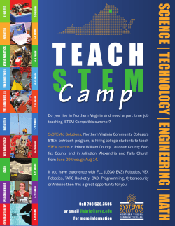


© Copyright 2026