
2015 Presentation Scenario
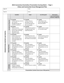
Connecticut Envirothon 2015 Current Issue Problem: Urban and Community Forestry For complete coverage of the current issue: http://ctenvirothon.org/competition/currentissue.asp Urban and Community Forestry Urban and community forests are an essential component of our cities and towns. These forests, which consist of trees in our parks, along our streets, in our yards and parking lots – anywhere trees and people get together – provide a host of benefits that contribute to making our cities and towns what they are. The trees of our urban forests clean the air, produce oxygen, reduce the heat of hot summer days, block the cold winter winds, help direct water into the soil, reduce storm water runoff, provide health benefits in several different ways – the list just goes on. Without trees, we would not experience the same quality of life that we do now, and would be less well‐off for it. The Challenges However, to keep the urban forest together as a functional whole – healthy, sustainable and as a real asset to our communities – these forests and the individual trees within this forest need to be managed. We need to be aware of whether individual trees are healthy and safe, what insects or diseases might be threatening these trees, and when individual trees might need to be removed and replaced with new trees. We also need to be aware of the impacts that other decisions we make – such as the construction of new buildings or the use of materials such as road salt – have on these trees. These are among the challenges of urban forestry. 1 The Assignment: Your school’s Board of Education has come to your Envirothon team for help. They’ve asked you to develop an Urban Forest Management Plan for a piece of property that is currently being used by the community for a variety of activities. The main goal of the management plan is to maintain a healthy urban forest that provides a range of benefits for the public while also allowing for other uses of the property. Listed below are the required elements of the project. For a more detailed explanation of each step and guided brainstorming questions, see the STEPS FOR SUCCESS. Required Elements: 1. Choose a parcel of land in your town to use as the project site. 2. Prepare an urban forest management plan. a. Complete an inventory of 10‐15 trees b. Discuss the benefits of the trees present c. Discuss any changes you want to make – planting new trees, maintenance, etc. d. Discuss how the site’s topographic features and the dominant soil types may influence the management plan 3. Develop specific management goals for your site – choose three of the six listed goals and discuss how you propose to manage your site to meet those goals. The six goals are a) Wildlife habitat, b) Biodiversity, c) Water Quality, d) Air Quality, e) Forest Health, and f) Community Benefits. 2 STEPS FOR SUCCESS: 1. Locate a parcel of land of at least one acre in your town to use as the project site. Choose your school campus or a wooded section in a town park.1 Use i‐Tree Canopy to determine the percentage of canopy cover, as well as area covered by lawn, gardens, water, buildings, and impervious surfaces, like a parking lot. See the attachment Instructions for using i‐Tree Canopy for a step‐by‐step guide. Also, identify areas, if any, as potential tree planting sites. Using the results from step 1, create an attractive table using Microsoft Excel showing the ecosystem benefits that currently exist on your site. 2. Prepare an Urban Forest Management Plan: A. Inventory & Analysis: In order to develop a plan and make recommendations, each team must conduct an urban tree inventory and analysis. Start by scheduling a field visit to your site. Take a quick walk around before you conduct the inventory. What do you like about the property? Not like? Quickly jot down some initial thoughts on what you consider to be the key features as well as the major current uses. As you work through your site, consider other issues such as i) wildlife habitat, ii) biodiversity, iii) water quality, iv) air quality, v) forest health, and vi) and community uses (recreational use, social benefits, and educational opportunities). Then, choose a minimum of 10‐15 trees that best represent the different types of trees on the property.2 Use the attached Inventory Template Excel sheet to collect the data. (See directions below). The data you collect from the inventory will be used to create the Urban Forest Management Plan. At this point, stop and think about what you would recommend for this property. Are the trees healthy? Could more trees be planted? Should more trees planted? If so, what type of trees, and where? What are the other uses for this property? Do the trees interfere with these other uses? If so, what might you change? Determine the items you wish to focus on in the Management Plan you will be creating. At this point, do you need to take additional field data? For example, if you have decided that you might like to plant trees, are the areas you would like to plant, compatible with the trees that you would like to plant. If you see a conflict in the way the property is being used (for instance, a parking lot too close to a stream), what changes might you propose? 1 No not use the actual name of your school or park. Create a fictitious name, such as Anytown or something else, for the presentation. 2 Depending upon your site, you may record only one species, like red maple. Simply record a general sample of the sizes, species, and condition of trees on your site. The results from this sample size will not be statistically significant, but merely represent a snapshot of the work involved in conducting a tree inventory. 3 B. Back in the Classroom: Using your inventory, create a chart in Microsoft Excel showing the species composition of your urban forest. Include descriptions of the overall diversity in terms of species, size, health, and benefits of the trees (use i‐Tree Design), based on your data and observations. Use Google Earth to create a map of the property (it might be better without the image). Identify areas in which you would like to plant new trees. Check out the Native Plant Database to help you choose the best plant for the site. Note other features that you observed in the field, such as important wildlife habitat or important water features, and include them on the map. Be sure all buildings, parking lots, sidewalks, paths and wooded areas are on the map as well. C. Topographic Map: Identify the project site on a topographic map. Find your site by visiting the University of Connecticut's topographic map directory and type in the address. Click on the quadrangle to download the topographic map that best matches your site. What information does the topographic map provide? D. Soils Map: Determine the different soil types on the property. What is the dominant soil type? What are the characteristics of this soil type? Do you think this soil type would limit your management goals in any way? How many acres is your property? Directions: go to USDA Natural Resources Conservation Services Web Soil Survey site: http://websoilsurvey.sc.egov.usda.gov/App/HomePage.htm. Click on the big green WSS button; go to the column on the left under the heading Quick Navigation and click on Address. Type in your address and choose the best match in the pop‐up window. Click on the Area of Interest (AOI) by polygon button to create a polygon around the property. Drag the mouse for the first boundary line, click once to stop, and then continue this method until you’ve captured your property. Click twice to close the polygon. Wait for the program to create a light blue border around your property. You are now ready to create a soils report. Go to the tab labeled Shopping Cart (free) and create a soils report for your forest. 4 3. Specific Management Goals: Now that the basic inventory is complete, choose three of the following six topics as the main goals for your property. a. Wildlife habitat ‐ What kind of wildlife is present on the site? What about quality of habitat? Mention two ways you could enhance the wildlife habitat on the property. How could you improve the experience for the recreational user? To begin, review the Schoolyard Habitat How‐to Guide from the National Wildlife Federation in your attachments folder. b. Biodiversity– In order to promote biodiversity, no more than 10% of one kind of tree species should be present on your property. If more than 10% of one kind of tree exists, what changes could you make in a planting strategy to build a more diversified population? Why is this important? c. Water Quality ‐ Identify any water features, such as a pond, stream, wetland, or watercourse. Use the topographic map to determine the direction of stream flow. Are the water features protected by a vegetative buffer such as native, understory shrubs? Vegetative cover can control soil erosion and protect water quality. Or does lawn grow to the edge of the water feature? What path does stormwater take on the property? Use i‐Tree Design to estimate the percentage of lawn or forest to that of impervious surfaces, like a parking lot or sidewalk. Stormwater runoff is a significant source of pollution. Come up with a few simple ways to modify the design of your urban forest site to reduce the storm water runoff. Using vegetation, soils, and landscape elements to manage storm water is referred to as green infrastructure. See the US Environmental Protection Agency’s website for some ideas: What is green infrastructure? d. Air Quality – Use i‐Tree Canopy to determine how the existing urban forest affects the air quality in your community. Using i‐Tree Design, determine the benefits of the new trees you are recommending for planting. Do you think there is a direct correlation between forest health and community health? Provide a few examples to support your claim. e. Forest Health – A forest community is a dynamic system consisting of biotic and abiotic interactions. A healthy forest can sustain itself in the advent of intermittent attacks from pests and diseases. Go back to your forest inventory. How many trees did you label as being in fair or poor health? What do you think could be causing the stress? Did you notice any non‐native plant species during the inventory? Japanese barberry, winged euonymus, Oriental bittersweet, and multiflora rose are four of the most common invasive plants found in suburban and fragmented forests. Learn more about how invasive plants affect wild bird populations: http://www.nrs.fs.fed.us/disturbance/invasive_species/nonnative_plants_birds/ Is the white ash tree (Fraxinus americana) part of your species mix? Name the invasive pest decimating this tree and causing serious management concerns. Refer to the Connecticut 5 Forest Health Highlights and Hartford’s Urban Forest‐the Challenge to help you identify the health concerns in your forest. Is there one that stands out? List three steps your team could take towards solving this problem. f. Community Benefits ‐ Imagine that the panel of judges consists of members of the community – council members, elected officials, average citizens. How will you manage the different needs and pressures such as economics, safety, recreation, and environmental health? Include the economic, social, recreational, and environmental benefits of your urban forest in your presentation. Use i‐Tree Canopy to determine the ecosystem services. Research the costs associated with basic tree care and maintenance. Find a local arborist (see references) who could provide some cost data on your priority trees. How could the answers from the ecosystem services inquiry help your team secure more funding to get the job done? Which individuals, citizen groups, government agencies should be involved in finalizing your plan? How would you educate the public about the benefits your urban forest provides to the community? 6 Attachments A Guide: Developing a street and park tree management plan Inventory template Excel spreadsheet (ignore the trees/mile column) Inventory template instructions Urban tree inventory example Hartford’s Urban Forest CT Forest Health Highlights Schoolyard wildlife habitat how‐to guide Instructions for i_Tree Canopy and design Instructions for i_Tree Design References CT Department of Energy and Environmental Protection: Connecticut Urban Forestry Program USDA Forest Service Urban and Community Forestry Web Page USDA Forest Service Northeast Center for Urban & Community Forestry Web Site Connecticut Urban Forest Council What is Green Infrastructure? The International Society of Arborists (ISA) provides a list of certified arborist by state: http://www.isa‐ arbor.com/findanarborist/arboristsearch.aspx. Hartford's Urban Forest Nowak, David J. and John F. Dwyer. Understanding the Benefits and Costs of Urban Forest Ecosystems. USDA Forest Service, Northeastern Research Station. Netherlands: Springer. 2007 7 Community Wildlife Forest Health Water Quality Air Quality Biodiversity Goal Identification Tools and References for Urban and Community Forestry Current Issue Scenario Tool iTree Canopy iTree Design Description Output generated Percent cover of tree canopy http://www.itreetools.org/canopy and other cover types, calculations of air pollution reductions. http://www.itreetools.org/design.php Suggests appropriate tree species to List of tree species. Arbor Day Tree Finder plant based on site conditions and goals. Electronic copies of topographic maps UConn MAGIC Topo map directory throughout the state. Forest Inventory Spreadsheet Fact sheets regarding habitat suitability Habitat requirements for CT DEEP Wildlife for native wildlife. wildlife across Connecticut. Webpage Outdoor recreation information is Information regarding American Trails provided, including benefits, planning, recreation opportunities. Resources and Library impacts, and management. Schoolyard Habitats How‐To Guide How to recognize hazardous defects in trees CT Forest Health Highlights 2013 Native Plant Database. What is Green Infrastructure? Where to find it http://arborday.org/shopping/trees/treewizar d/intro.cfm http://magic.lib.uconn.edu/topographic_maps .html http://www.ct.gov/deep/cwp/view.asp?a=272 3&q=325718&deepNav_GID=1655 http://www.americantrails.org/resources/inde x.html http://www.nwf.org/pdf/Eco‐ schools/SchoolyardHabitatsHowToGuide_Part 2.pdf http://na.fs.fed.us/spfo/pubs/howtos/ht_haz/h t_haz.pdf http://fhm.fs.fed.us/fhh/fhh_13/CT_FHH_201 3.pdf http://www.wildflower.org/plants/ http://water.epa.gov/infrastructure/green infrastructure/gi_what.cfm 8


© Copyright 2026