
2011 Superbloom Report: Evaluating Effects and Possible Causes
2011 Superbloom Report:
Evaluating Effects and Possible Causes
with Available Data
April 2015
Indian River Lagoon 2011 Consortium
Executive summary
A major phytoplankton bloom in 2011 prompted the formation of the Indian River Lagoon 2011
Consortium, which comprised at least 26 scientists from 10 organizations. These scientists evaluated
available data and observations, with the goal of elucidating the scope of the unprecedented event that
was named the “superbloom,” impacts from the bloom, possible causes or controls of the bloom, and
important gaps in available data. This report and its appendices document the analyses, results and
interpretations generated by the consortium.
In 2011, the Indian River Lagoon experienced two phytoplankton blooms. The major bloom of green and
blue-green algae was first observed in Banana River in March 2011, and within 1–2 months, it had spread
westward through the Barge Canal into the northern portion of the Indian River Lagoon near Cocoa
(Figure 2). Eventually, this superbloom expanded northward through Haulover Canal and into southern
Mosquito Lagoon to cover 132,500 acres. This bloom was preceded and accompanied by a less intense
bloom that began in late 2010 and eventually covered 47,500 acres from southern Banana River Lagoon
to just north of Fort Pierce Inlet.
The two blooms were composed of different species. The less intense, secondary bloom comprised a mix
of cyanobacteria, diatoms and dinoflagellates in the Melbourne reach and was co-dominated by diatoms
and dinoflagellates in the Sebastian and Vero Beach reaches. The superbloom was dominated by a mix of
extremely small, single-celled algae belonging to two major groups: picoplanktonic blue-green bacteria
(picocyanobacteria) and a green microflagellate in the class Pedinophyceae. Both species were found in
archived samples, neither alga was known to produce harmful toxins, and neither species had bloomed
previously.
Although the biology and physiology of the pedinophyte and picocyanobacteria that comprised the 2011
superbloom were not known in detail, related small phytoplankton have been shown to take up nutrients
and reproduce more rapidly and efficiently than larger phytoplankton due, in part, to their higher surface
area-to-volume ratios. In addition, many similar small phytoplankton utilize nitrogen and phosphorus
attached to carbon, which enabled them to 1) outcompete other phytoplankton when dissolved inorganic
nutrients were limiting, 2) rapidly recycle organic nutrients to support persistent blooms, and 3) restrict
the flow of nutrients and carbon to higher trophic levels by shunting these elements into the “microbial
loop” where they were utilized by bacteria. Pedinophytes and picocyanobacteria also survived in low
ambient light due to their high chlorophyll a content and in high salinity, which were the prevailing
conditions during the superbloom.
Unusual and potentially influential conditions preceded and persisted during the superbloom. In
particular, higher light attenuation coefficients (Kd; m-1) due to higher chlorophyll a concentrations
(µg l-1), higher salinities and lower water temperatures potentially influenced seagrasses, phytoplankton
and other organisms. In addition, increased salinity due to evaporation indicated that residence times had
increased, which would have promoted accumulation of phytoplankton. Prior to the superbloom, ambient
concentrations of dissolved orthophosphate or dissolved Kjeldahl nitrogen did not increase, but increased
concentrations of total dissolved phosphorus suggested an increased loading of some compound(s)
containing this nutrient. As expected, concentrations of total phosphorus, total nitrogen and total carbon
increased as these elements were sequestered in phytoplankton. Furthermore, an absence of diatoms may
have led to decreased uptake of dissolved silicon dioxide and a subsequent increase in its ambient
concentration. Overall, the superbloom period and location accounted for the longest duration of stress
due to reduced light penetration in the period of record.
One substantial effect of the superbloom was a loss of seagrasses. Transect lengths (the distance that
seagrasses extended offshore) decreased during and following the superbloom, and along some transects,
1
seagrasses disappeared. Mapping of seagrass from aerial photography indicated that seagrass acreage
decreased even before the superbloom reached its peak, with the greatest loss in the Banana River
Lagoon, where approximately 24,000 acres was reduced by 87% to approximately 3,000 acres.
The large losses in seagrass during the superbloom event correlated with changes in concentrations of
chlorophyll a and volatile suspended solids, which was expected given the effect of these parameters on
turbidity and light attenuation (Kd). In contrast, non-organic suspended particles and color contributed
relatively little to the increase in light attenuation. Reduced light penetration represented the primary
stressor on seagrasses, but its effects probably were mediated through sulfide stress because seagrasses
could not protect their roots and rhizomes by generating oxygen through photosynthesis. Although
reduced light penetration was likely the dominant stressor on seagrasses, high salinity and previous low
water temperatures may have contributed to the observed losses.
Phytoplankton blooms can be driven from the “bottom-up” via increased nutrient inputs, especially
nitrogen and phosphorus. Three sources of these macronutrients were examined: external nutrient loads
carried in freshwater inputs, internal loads from submarine groundwater and diffusive flux from
sediments comprising “muck,” and loads or increased availability associated with changes in the biomass
of drift macroalgae. Drier than average conditions preceded the superbloom, which translated into little
evidence of increased external loads of nitrogen or phosphorus immediately preceding or during the
superbloom. The surficial aquifer was considered the primary source of meteoric groundwater discharge
and nutrient loads to the system, and available data suggested that nitrogen and phosphorus loads to the
Banana River Lagoon were at least 2× higher than loads to other regions on a consistent basis. Thus, these
loads may represent a bottom-up influence that helped initiate and sustain the superbloom, which began in
Banana River Lagoon. Muck sediment has a high percentage of fine-grain clays and silts (> 60% dry
weight), which inhibits the passage of water and makes diffusion a key process. Ammonium and
phosphate diffuse from muck and carry nitrogen and phosphorus into the lagoon. Although surrounded by
considerable uncertainty, nutrient loads estimated by multiplying rates of flux multiplied by the aerial
coverage of muck approached or exceeded estimated loads from the watershed. Analyses also indicated
significant decreases in quantities of drift algae, and nutrients released from decomposing drift algae or
made available due to reduced uptake could have promoted the superbloom.
“Top-down” control of phytoplankton blooms occurs when animals consume the algae. In an effort to
assess top-down control of the superbloom, the phytoplankton assemblage was compared to previous
blooms, and abundances of small zooplankton, primarily bacterioplankton and microzooplankton, larger
zooplankton, infauna and fish were analyzed to identify significant variation in primary consumption. The
small size of Pedinophyceae and picocyanobacteria may have increased the importance of grazing by
protozoa and rotifers because these small zooplankton were better equipped to handle small algal cells. In
addition, grazing may have been reduced because mucus and toxins produced by picocyanobacteria can
deter grazers. High bacterial abundances during the superbloom (after March 2011) suggested that these
organisms were responding to the availability of organic compounds, and abundant bacteria would have
enhanced cycling of nutrients and prolonged the superbloom. During the superbloom, the assemblage of
small zooplankton appeared to shift toward fewer arthropods and higher numbers of protozoa and rotifers.
These grazers may have been better equipped to handle the small phytoplankton that comprised the
superbloom, but their abundances decreased and became variable during the superbloom, which would
have reduced top-down control. Available evidence from a site south of the superbloom region indicated
that densities of larger zooplankton were relatively low preceding and during the superbloom for
unknown reasons. Reduced grazing pressure would have enhanced accumulation of larger numbers of
phytoplankton cells during the superbloom, but the potential impact of larger zooplankton on small
phytoplankton species remains uncertain. At sites south of the superbloom region, abundances of 90 out
of 187 infaunal taxa decreased prior to the superbloom, but the level of grazing pressure exerted on small
phytoplankton by clams and other infauna remains uncertain. Additionally, abundances of fishes,
2
including menhaden (Brevoortia spp.) and other species that can consume phytoplankton, did not
decrease significantly immediately before and during the superbloom. Thus, evidence of reduced topdown control remained equivocal.
In summary, attempts to explain the initiation and persistence of the 2011 superbloom using available
data highlighted some key gaps in our understanding. The following recommendations point to ways to
improve our evaluation of the superbloom, our ability to predict future events, and our capacity to develop
and assess potential management actions.
1. Garner an improved understanding of the biology and physiology of picocyanobacteria and
Pedinophyceae, including their ability to use organic forms of nutrients, their nutrient uptake rates,
their reproductive rates and their defenses against grazers.
2. Maintain or expand water quality sampling to ensure spatiotemporal variations are captured
adequately, which could include continuous monitoring of various parameters to fill gaps between
monthly samples.
3. Develop an improved understanding of the physiological tolerances of drift algae and seagrasses.
4. Maintain or expand surveys of drift algae and seagrasses to improve our capacity to evaluate their
role in nutrient cycles.
5. Improve our ability to model bottom-up influences from external and internal nutrient loads,
including atmospheric deposition, surface water runoff, groundwater inputs, diffusive flux from
muck, and decomposition of drift algae.
6. Enhance surveys of bacterioplankton to improve our understanding of nutrient cycling.
7. Improve surveys of potential zooplanktonic, infaunal, epifaunal and fish grazers to enhance our
understanding of spatiotemporal variation in top-down control of phytoplankton blooms.
8. Evaluate grazing pressure exerted by common species to enhance our understanding of top-down
control of phytoplankton blooms.
3
Why create this report?
A major phytoplankton bloom in 2011 led to the formation of the Indian River Lagoon 2011 Consortium
(Table 1). This group of at least 26 scientists from 10 organizations evaluated available data and
observations to elucidate the scope of the unprecedented event that was named the “superbloom,” its
impacts, possible causes or controls of the bloom, and important gaps in available data. This report
summarizes analyses, results and interpretations, with details provided in appendices.
Table 1. Members of the Indian River Lagoon 2011 Consortium.
Organization
Bethune-Cookman University
Florida Fish and Wildlife Conservation Commission
Florida Institute of Technology
Guana-Tolomato-Matanzas National Estuarine Research Reserve
Harbor Branch Oceanographic Institute, Florida Atlantic University
Nova Southeastern University
Seagrass Ecosystems Analysts
Smithsonian Marine Station at Fort Pierce
University of Florida
St. Johns River Water Management District
St. Johns River Water Management District (retired)
Volunteer
Hyun Jung Cho
Andrew Kamerosky
Paul Carlson
Rich Paperno
Steve Jachec
Kevin Johnson
Ashok Pandit
John Trefry
John Windsor
Gary Zarillo
Nikki Dix
Dennis Hanisak
Paul Hargraves
Bernhard Riegl
Robert Virnstein
Bjorn Tunberg
Ed Phlips
Jon Martin
Ron Brockmeyer
Robert Chamberlain
Lauren Hall
Charles Jacoby
Margaret Lasi
Lori Morris
Whitney Green
Joel Steward
The process of assembling, analyzing and interpreting the information in this report and its appendices
provided the scientific foundation for a more intensive investigation of the “superbloom” and its potential
causes that was launched by the St. Johns River Water Management District in 2012. The Indian River
Lagoon Algal Blooms Investigation is a component of the District’s Indian River Lagoon Protection
Initiative. The investigation builds on the information in this report, and it will advance the existing
scientific understanding of the lagoon system through monitoring, data collection, field and lab analyses,
and model development with the aim of providing knowledge to guide management actions designed to
restore and sustain the health of the lagoon.
4
What is the Indian River Lagoon system?
Within the jurisdictional boundaries of the St. Johns River Water Management District, the Indian River
Lagoon system can be subdivided into five sublagoons, each comprising two or more segments
containing at least one water quality station (Figure 1). These delineations are consistent with those used
to develop seagrass restoration targets and related limits for nutrient loading (Steward et al. 2005; Steward
and Green 2007). The northern portion of the system, comprising the Mosquito Lagoon, Banana River
Lagoon, and northern Indian River Lagoon (Figure 1), was affected by the 2011 superbloom.
Figure 1. The Indian River Lagoon (IRL) system within the jurisdictional boundaries of the St. Johns River Water
Management District. The superbloom region is circled in red, sublagoons are color-coded (ML = Mosquito Lagoon,
NIRL = northern Indian River Lagoon, BR = Banana River Lagoon, NCIRL = north central Indian River Lagoon
and SCIRL = south central Indian River Lagoon), lagoon segments are separated by black lines and labeled with
blue font, and water quality stations are indicated by black dots.
5
What occurred during the 2011 superbloom and associated secondary bloom?
In 2011, the Indian River Lagoon experienced two phytoplankton blooms. The major bloom of green and
blue-green algae was first observed in Banana River in March 2011, and within 1–2 months, it had spread
westward through the Barge Canal into the northern portion of the Indian River Lagoon near Cocoa
(Figure 2). Eventually, this superbloom expanded northward through Haulover Canal and into southern
Mosquito Lagoon to cover 132,500 acres. This bloom was preceded and accompanied by a less intense
secondary bloom that began in late 2010 and eventually covered 47,500 acres from southern Banana
River Lagoon to just north of Ft. Pierce Inlet (Figure 2).
Apr 1
2011
Sep 14
2011
Dec 8
2011
Mar 18
2012
Relative chlorophyll a concentration
Dec 24
2010
Figure 2. Time series of satellite images from the medium resolution imaging spectrometer (MERIS) showing the
intensification, spread and waning of the phytoplankton bloom, with higher relative chlorophyll a concentrations
indicated by the red tint. Note: narrow, nearshore bands of red represent chlorophyll a in seagrasses rather than
phytoplankton.
In August and October 2011, concentrations of chlorophyll a in the northern Banana River and Indian
River lagoons surpassed 130 µg chlorophyll a L-1 (Figure 3). During the peak of the bloom, chlorophyll a
concentrations rivaled levels reported from highly impacted, inland water bodies, such as Lake Apopka.
Concentrations of chlorophyll a in the northern Banana River and Indian River lagoons dropped
precipitously following the passage of a subtropical depression in early October 2011, and the bloom in
southern Mosquito Lagoon finally dissipated in February 2012 (Figure 3). The southern bloom was not as
intense, yielding samples with 20–30 µg chlorophyll a L-1, but samples with > 10 µg chlorophyll a L-1
were collected in 57% of the months between October 2008 and March 2012 (Figure 3).
6
140
140
IRLB02
IRLI02
Chlorophyll a (µg L-1)
130.3 µg L-1
120
120
100
100
80
80
60
60
40
40
20
20
0
0
140
140
IRLML02
Chlorophyll a (µg L-1)
120
136.1 µg L-1
IRLI23
120
100
100
86.3 µg L-1
80
80
60
60
40
40
20
20
0
0
Secondary
bloom
Figure 3. Time series for chlorophyll a concentrations showing the magnitude and waning of the phytoplankton
bloom at water quality stations in the Banana River (IRLB02), Indian River (IRLI02 and IRLI23) and Mosquito
(IRLML02) lagoons.
The two blooms had different species compositions. The secondary bloom comprised a mix of
cyanobacteria, diatoms and dinoflagellates in the Melbourne reach and was co-dominated by diatoms and
dinoflagellates in the Sebastian and Vero Beach reaches. The 2011 superbloom was dominated by a mix
of extremely small, single-celled algae belonging to two major groups: picoplanktonic blue-green bacteria
(picocyanobacteria) and a green microflagellate in the class Pedinophyceae. These phytoplankters were
1–4 µm in diameter or about 1/100th the size of a grain of salt (Figure 4). During September and October
2011, densities of the pedinophyte ranged from 700 million to 1 billion cells L-1, comprising more than
50% of the total biomass for these two groups (measured as carbon; Figure 5). Picocyanobacteria are
common inhabitants of the IRL, but pedinophytes had never been documented to reach bloom conditions
in over 14 years of sampling. Fortunately, neither alga is known to produce harmful toxins, unlike the
dinoflagellate Pyrodinium bahamense, which bloomed in the past (Figure 5). In 2002 and 2004, P.
bahamense was implicated in more than two dozen cases of human poisoning due to consumption of
pufferfish that accumulated saxitoxin (Landsberg et al. 2006).
7
Pedinophyceae
Picocyanobacteria
Figure 4. Scanning electron micrographs of the pedinophyte and picocyanobacteria found in the 2011 bloom.
Phytoplankton carbon (µg ml-1)
Phytoplankton carbon (µg ml-1)
Central Banana River
Titusville
6
6
Pedinophyceae
5
Dino
Diatom
Cyano
Other
Dino
Diatom
Cyano
2011
2012
2010
2009
2008
2007
2006
2005
2004
2003
2002
2011
2012
2010
2009
2008
2007
2006
2005
2004
2003
2002
2001
0
2000
0
1999
1
1998
1
2001
2
2000
2
3
1999
3
4
1998
4
1997
Carbon (µg ml-1)
Pedinophyceae
1997
Carbon (µg ml-1)
5
Other
Figure 5. Time series for biomass (expressed as µg of carbon ml-1) for groups of phytoplankton in the central
Banana River Lagoon and the northern Indian River Lagoon (Titusville). Dino = dinoflagellates, Diatom = diatoms,
Cyano = cyanobacteria, Other = other phytoplankton, including Pedinophyceae during 2011
Although the biology and physiology of the pedinophyte and picocyanobacteria that comprised the 2011
superbloom have not been studied in detail, general characteristics of small and related phytoplankton can
help explain their success. Numerous studies indicate that small phytoplankton take up nutrients more
rapidly and efficiently than larger phytoplankton due to their higher surface area-to-volume ratios
(Reynolds 2006; Behrenfeld et al. 2008). Small sizes and rapid reproductive rates may allow
8
pedinophytes and picocyanobacteria to escape from primary consumers or reproduce more rapidly than
they are consumed (Nugraha et al. 2010; Smayda 2008). In addition, many photosynthetic
microflagellates, picocyanobacteria and small pelagophytes utilize organic forms of nutrients (nitrogen
and phosphorus attached to carbon; Burkholder et al. 2008; Gobler and Sunda 2012; DeYoe et al. 2007;
Sun et al. 2012). This plasticity (known as mixotrophy) enables these organisms to 1) outcompete other
phytoplankton when dissolved inorganic nutrients are limiting, 2) rapidly recycle organic nutrients to
support persistent blooms, and 3) restrict the flow of nutrients and carbon to higher trophic levels by
shunting these elements into the “microbial loop” (Fenchel 2008).
Pedinophytes and picocyanobacteria also are equipped to survive in low ambient light and high salinity.
Pedinophytes and picocyanobacteria collected during the 2011 bloom yielded higher amounts of
chlorophyll a per unit biovolume (3.65 µg chlorophyll a per 109 µm3 and 2.58 µg chlorophyll a per 109
µm3, respectively) than chain-forming, centric diatoms (0.88 µg chlorophyll a per 109 µm3) and
Pyrodinium bahamense (1.45 µg chlorophyll a per 109 µm3) from past blooms (Ed Phlips, unpublished
data). Concentrated chlorophyll allows more efficient harvesting of light to support photosynthesis under
the self-shading conditions typical of blooms (Reynolds 2006). The exceptionally high salinity that
prevailed during the superbloom (reaching up to 50 psu during June and July) is evidence that these taxa
tolerate extreme conditions. Furthermore, limited laboratory tests have documented survival of
pedinophytes and picocyanobacteria at salinities up to 70 psu, with peak growth rates recorded at 35–45
psu (Ed Phlips, unpublished data). Similarly, a wide salinity tolerance (4–38+ psu) has been reported for
another estuarine pedinophyte, Marsupiomonas pelliculata (Jones et al. 1994).
What environmental conditions potentially influenced the superbloom?
Where appropriate, available data were grouped into six periods (Figure 6). Four distal antecedent periods
spanned March 1996 through January 2010 (DAP 1–4), one proximal antecedent period (PAP) covered
February 2010 through February 2011, and the superbloom event period (SEP) ran from March 2011 to
March 2012. In part, these periods were characterized by variation in average annual rainfall relative to
the 30-year average, as measured by gauges or radar. Thus, each period was categorized as normal, wet or
dry (Figure 6).
DAP-1
DAP-2
DAP-3
DAP-4
Mar’96– Aug’99
Sep’99– Jan’03
Feb’03– Jan’06
Feb’06–Jan’10
3 yrs + 6 mos
3 yrs + 5 mos
3 yrs
NORMAL
WET
WET
PAP
Feb’10–
Feb’11
SEP
Mar’11–
Mar’12
4 yrs
13 mos
13 mos
DRY
DRY
DRY
Figure 6. The four distal antecedent periods (DAPs), proximal antecedent period (PAP), and the superbloom event
period (SEP) with their beginning and end dates, total durations, and hydrologic conditions.
The superbloom was preceded by exceptionally cold water temperatures (5–8°C) in December 2009–
January 2010 and December 2010–January 2011 (Figure 7), and by an intense, short-lived diatom bloom
in January 2010 (Figure 8). In fact, the winter of 2009–2010 and December 2010 were the coldest air
temperatures recorded since records began to be kept in 1937 (Florida Today newspaper, 20 March 2010
and 12 January 2011).
9
Haulover Canal
35
Mean water temperautre (°C)
30
25
20
15
10
8.90°C; 1/5/2001
7.65°C; 12/15/2010
5
4.95°C; 1/10 &
1/11/2010
Jan-13
Jan-12
Jan-11
Jan-10
Jan-09
Jan-08
Jan-07
Jan-06
Jan-05
Jan-04
Jan-03
Jan-02
Jan-01
Jan-00
Jan-99
Jan-98
0
Figure 7. Water temperatures measured at Haulover Canal.
Phytoplankton carbon (µg ml-1)
Central Banana River
6
Carbon (µg ml-1)
5
Pedinophyceae
Diatoms
4
3
2
1
Dino
Diatom
Cyano
2012
2011
2010
2009
2008
2007
2006
2005
2004
2003
2002
2001
2000
1999
1998
1997
0
Other
Figure 8. Time series for biomass (expressed as µg of carbon ml-1) showing a bloom of diatoms in the central
Banana River Lagoon during 2010–2011, which is prior to initiation of the superbloom and secondary bloom.
Dino = dinoflagellates, Diatom = diatoms, Cyano = cyanobacteria, Other = other phytoplankton, including
Pedinophyceae during 2011
Was the 2011 bloom actually a superbloom?
Placing the phytoplankton or algal bloom of 2011 and the events preceding it in an historical context
represents a potentially valuable approach to understanding its causes and effects, with due regard for a
relatively short period of record. To achieve that goal, six key characteristics were categorized. Light
attenuation directly affected the health of seagrasses, and three water quality parameters primarily
determined light attenuation in the Indian River Lagoon, i.e., color, turbidity, and concentrations of
chlorophyll a. In addition, unusual salinities and water temperatures potentially contributed to the
formation of the superbloom and likely determined the microalgal species that proliferated.
10
Boundaries for categories primarily were derived from statistical metrics applied to “seagrass centric”
datasets representing “acceptable” conditions defined as years when seagrasses extended near their depth
limits (Steward et al. 2005). The key metrics were the median (50th percentile) and either the 10th, 5th and
1st or 90th, 95th and 99th percentiles (Table 2). Values for parameters of interest that equaled or exceeded
the relevant boundaries were tallied using a cumulative approach that paralleled the way water quality is
integrated by seagrasses, drift algae and animals. In this approach, months generating moderate stress
added to totals for months generating low stress, months generating high stress added to totals for months
generating moderate stress, and months generating severe stress added to totals for four categories. In
addition, each month was allocated to a single category, and the resulting tallies were compared to
expected values derived from the statistical metrics. In total, 4,371 records from 25 stations spanning the
Banana River and Indian River lagoons and 102–191 consecutive months were tallied.
Table 2. Percentile limits and associated categories of stress for key parameters. Kd = light attenuation coefficient
Range if low values are of concern
(e.g., water temperature)
median ≤ value
10th percentile ≤ value < median
5th percentile ≤ value < 10th percentile
1st percentile ≤ value < 5th percentile
value < 1st percentile
Range if high values are of concern
(e.g., chlorophyll a, Kd, color, turbidity, salinity)
value ≤ median
median < value ≤ 90th percentile
90th percentile < value ≤ 95th percentile
95th percentile < value ≤ 99th percentile
99th percentile < value
Stress
Absent
Low or weak
Moderate
High or strong
Severe
Given an average target depth for the deep edge of seagrasses of 1.4 m, light reaching the bottom drops
below the estimated minimum light requirement for seagrasses (20% of ambient light at the water’s
surface; Steward et al. 2005) when light attenuation coefficients (Kd) reach 1.15. Cumulative frequency
distributions for different combinations of water clarity and duration indicated that seagrasses could have
been stressed by low light for up to 29 consecutive months and severely stressed for up to 21 months,
with 10 out of 17 periods of severe light stress occurring at stations affected by the 2011 bloom (Table 3).
Months with strong and severe light stress were 1.4× and 13.5× more common than expected based on
reference distributions.
Table 3. Locations, months of occurrence and durations of severe light stress. Yellow highlights indicate locations
and times in the superbloom; NIRL = Northern Indian River Lagoon
Sublagoon
NIRL
NIRL
NIRL
NIRL
NIRL
NIRL
NIRL
NIRL
NIRL
NIRL
NIRL
NIRL
NIRL
NIRL
NIRL
NIRL
NIRL
Station
IRLI15
IRLI18
IRLI21
IRLI06
IRLI10
IRLI13
IRLI07
IRLI02
IRLI13
IRLI15
IRLI13
IRLI13
IRLI10
IRLI10
IRLI18
IRLI15
IRLI06
Year
2010
2010
2010
2011
2011
2011
2011
2011
2010
2003
1999
1998
2010
2003
2003
2006
2003
Start
Month
4
5
7
2
2
2
4
7
5
5
6
3
4
5
7
5
5
Year
2011
2011
2011
2012
2011
2011
2012
2012
2010
2003
2000
1998
2010
2003
2004
2006
2003
End
Month
12
11
9
1
12
12
1
2
12
12
1
10
10
11
1
10
10
Span
21
19
15
12
11
11
10
8
8
8
8
8
7
7
7
6
6
Overall, periods of high color did not contribute to the long duration of high Kd values (Table 4). In fact,
the most stressful levels of color persisted for more than one month in only nine instances, and only one
of those occurred at a station affected by the 2011 bloom. On its own, color was not a key factor in
reducing light penetration and shading seagrasses.
11
Table 4. Locations, months of occurrence and durations of high color. Yellow highlights indicate locations and times
in the superbloom; NIRL = Northern Indian River Lagoon; NCIRL = North Central Indian River Lagoon
Sublagoon
NIRL
NIRL
NIRL
NIRL
NIRL
NCIRL
NIRL
Station
IRLI02
IRLI06
IRLI07
IRLI06
IRLI21
IRLI27
IRLI02
Year
2004
2011
2005
2004
2004
2004
1998
Start
Month
9
9
11
9
9
9
3
Year
2004
2011
2005
2004
2004
2004
1998
End
Month
12
10
12
10
10
10
4
Span
4
2
2
2
2
2
2
Higher turbidity did contribute to some of the moderately long periods of high light attenuation at stations
affected by the 2011 bloom (Table 5). Turbidity that generated severe stress occurred 14.2× more
frequently than expected, but it only persisted for only 6 months. Therefore, another factor must have
been primarily responsible for low light regimes spanning up to 21 consecutive months.
Table 5. Locations, months of occurrence and durations of high turbidity. Yellow highlights indicate locations and
times in the superbloom; BR = Banana River Lagoon; NIRL = Northern Indian River Lagoon;
NCIRL = North Central Indian River Lagoon; SCIRL = South Central Indian River Lagoon
Sublagoon
BR
NIRL
NIRL
BR
BR
BR
NIRL
NCIRL
NIRL
NIRL
NIRL
BR
NIRL
NIRL
NCIRL
NIRL
NIRL
BR
SCIRL
BR
NIRL
BR
NIRL
BR
NIRL
NIRL
Station
IRLB02
IRLI02
IRLI07
IRLNFH01
IRLB06
IRLB04
IRLI18
IRLI27
IRLI06
IRLI13
IRLI15
IRLB04
IRLI06
IRLI06
IRLI27
IRLI02
IRLI02
IRLB04
IRLIRJ10
IRLNFH01
IRLI13
IRLB02
IRLI02
IRLB02
IRLI13
IRLI02
Year
2011
2011
2011
2011
2004
2011
2003
2011
2011
2011
2011
2011
2011
2011
2010
2009
2006
2004
2003
2003
2003
2003
2000
1999
1999
1998
Start
Month
2
9
8
4
1
5
10
1
3
4
4
9
9
12
7
4
3
1
8
8
10
11
12
3
3
2
Year
2011
2012
2011
2011
2004
2011
2003
2011
2011
2011
2011
2011
2011
2012
2010
2009
2006
2004
2003
2003
2003
2003
2001
1999
1999
1998
End
Month
7
1
12
7
4
7
12
2
4
5
5
10
10
1
8
5
4
2
9
9
11
12
1
4
4
3
Span
6
5
5
4
4
3
3
2
2
2
2
2
2
2
2
2
2
2
2
2
2
2
2
2
2
2
Chlorophyll a concentrations played a major role in generating periods of high light attenuation spanning
up to 21 consecutive months (Table 6). Phytoplankton blooms characterized as severe, strong or moderate
persisted for 11–24 months. Strong and severe blooms were 2.5× and 8.0× more common than expected.
From February 2010 to March 2012, severe blooms of long duration were observed in the Banana River
Lagoon and Northern IRL, with the longest severe blooms (2–11 months) occurring at IRLB04,
IRLNFH01, IRLB02, IRLB09, IRLI06, IRLB06, IRLI07, IRLI10, IRLI02, IRLI13, and IRLI15 (Table 6).
In addition, weak to strong blooms persisted from May 2010 through January 2012 at IRLI18 and from
April 2010 through March 2012 at IRLI21. The data indicated that the algal bloom of 2011 was unusual
because of the magnitudes and durations of chlorophyll a concentrations at multiple stations in the
Banana River Lagoon and Northern IRL.
12
Table 6. Locations, months of occurrence and durations of high chlorophyll a concentrations. Yellow highlights
indicate locations and times in the superbloom; BR = Banana River Lagoon; NIRL = Northern Indian River Lagoon;
NCIRL = North Central Indian River Lagoon; SCIRL = South Central Indian River Lagoon
Sublagoon
BR
BR
BR
BR
NIRL
BR
NIRL
NIRL
BR
NIRL
NIRL
BR
BR
BR
BR
NCIRL
BR
BR
BR
SCIRL
SCIRL
SCIRL
SCIRL
NIRL
BR
BR
BR
NIRL
BR
BR
SCIRL
SCIRL
BR
NIRL
SCIRL
BR
BR
NIRL
BR
BR
BR
BR
NIRL
BR
BR
NIRL
NIRL
NIRL
NIRL
NIRL
NCIRL
NCIRL
BR
BR
BR
NCIRL
SCIRL
NIRL
Station
IRLB04
IRLNFH01
IRLB02
IRLB09
IRLI06
IRLB06
IRLI07
IRLI10
IRLB09
IRLI02
IRLI13
IRLB09
IRLB06
IRLB09
IRLNFH01
IRLI27
IRLB02
IRLB04
IRLB06
IRLIRJ10
IRLIRJ05
IRLIRJ07
IRLIRJ08
IRLI15
IRLB04
IRLB06
IRLB04
IRLI13
IRLB09
IRLB06
IRLIRJ04
IRLIRJ12
IRLB06
IRLI15
IRLIRJ08
IRLB04
IRLNFH01
IRLI13
IRLB02
IRLB06
IRLB06
IRLB09
IRLI07
IRLB06
IRLB06
IRLI18
IRLI21
IRLI07
IRLI15
IRLI18
IRLI23
IRLI23
IRLB02
IRLB02
IRLB04
IRLI27
IRLIRJ07
IRLI13
Year
2011
2011
2011
2010
2011
2011
2011
2011
2011
2011
2011
2001
2010
2009
2001
2001
2010
2001
2001
2001
2001
2001
2001
2011
2010
2010
2009
2009
2002
2001
2001
2001
2011
2011
2011
2010
2010
2010
2009
2009
2005
2005
2005
2004
2003
2002
2002
2001
2001
2001
2001
2001
2000
1999
1999
1999
1999
1998
Start
Month
2
1
3
6
6
4
6
5
6
8
5
7
6
7
8
7
7
9
6
9
9
9
9
5
5
12
11
8
8
11
10
9
12
9
9
9
6
9
8
9
11
8
9
2
8
8
8
8
7
8
8
11
9
3
3
11
9
7
Year
2011
2011
2011
2011
2012
2011
2011
2011
2011
2012
2011
2001
2010
2009
2001
2001
2010
2001
2001
2001
2001
2001
2001
2011
2010
2011
2010
2009
2002
2002
2001
2001
2012
2011
2011
2010
2010
2010
2009
2009
2005
2005
2005
2004
2003
2002
2002
2001
2001
2001
2001
2001
2000
1999
1999
1999
1999
1998
End
Month
12
11
12
2
1
10
12
11
11
1
10
12
10
11
12
11
10
12
9
12
12
12
12
7
7
2
1
10
10
1
12
11
1
10
10
10
7
10
9
10
12
9
10
3
9
9
9
9
8
9
9
12
10
4
4
12
10
8
Span
11
11
10
9
8
7
7
7
6
6
6
6
5
5
5
5
4
4
4
4
4
4
4
3
3
3
3
3
3
3
3
3
2
2
2
2
2
2
2
2
2
2
2
2
2
2
2
2
2
2
2
2
2
2
2
2
2
2
13
Salinities were atypically high for 23 consecutive months three times in the period of record (Table 7).
Typical salinities were observed for up to 49 months, and slightly elevated salinities were recorded for up
to 75 consecutive months. High salinity characterized 15.7× more months than expected. Approximately
34% of the very high salinities lasted for only 1–2 months, and approximately 21% of the periods with
very high salinities spanned a year or longer. From February 2010 to March 2012, very high salinities
spanning long durations were observed in the Banana River Lagoon and Northern IRL, with the longest
periods (16–23 months) occurring at IRLI06, IRLI07, IRLI02, IRLB02, IRLB04, IRLNFH01, IRLB09,
IRLB06, IRLI18, IRLI10, IRLI13, IRLI15 and IRLI21 (Table 7). The data indicated that the algal bloom
of 2011 occurred during a period of unusually high salinities in the Banana River Lagoon and Northern
IRL, which indicated reduced exchange of water, limited dilution of nutrients and dispersion of
phytoplankton, and a probable effect on the species composition of the superbloom.
Table 7. Locations, months of occurrence and durations of high salinities lasting at least 12 months. Yellow
highlights indicate locations and times associated with the superbloom; BR = Banana River Lagoon;
NIRL = Northern Indian River Lagoon
Sublagoon
NIRL
NIRL
NIRL
NIRL
BR
BR
NIRL
BR
BR
BR
NIRL
NIRL
NIRL
NIRL
NIRL
NIRL
NIRL
Station
IRLI06
IRLI07
IRLI02
IRLI02
IRLB02
IRLB04
IRLI06
IRLNFH01
IRLB09
IRLB06
IRLI18
IRLI07
IRLI10
IRLI13
IRLI15
IRLI21
IRLI02
Year
2010
2010
2006
2010
2010
2010
2006
2010
2010
2010
2010
2007
2010
2010
2010
2010
1997
Start
Month
5
5
10
6
7
7
12
8
8
9
8
2
11
11
11
8
1
Year
2012
2012
2008
2012
2012
2012
2008
2012
2012
2012
2012
2008
2012
2012
2012
2011
1997
End
Month
3
3
8
3
3
3
8
3
3
3
2
8
3
3
3
11
12
Span
23
23
23
22
21
21
21
20
20
19
19
19
17
17
17
16
12
Water temperatures were atypically low for a maximum of only 4 consecutive months, with this event
occurring in the Northern IRL during 1996. Nevertheless, the coldest water temperatures were recorded in
3.0× more months than expected based on data from years when seagrasses were “happy.” During the
winters of 2009 and 2010, low water temperatures were observed for 2–3 months in all sublagoons (Table
8). The data indicated that water temperatures were unusually low for two consecutive winters, especially
in the Northern IRL, which may have stressed seagrasses and caused mortality of other cold sensitive
species, including key primary consumers that could have competed for nutrients that fueled the
superbloom.
14
Table 8. Locations, months of occurrence and durations for cold water lasting at least 2 months.
Yellow highlights indicate locations and times associated with the superbloom; NIRL = Northern Indian River
Lagoon; NCIRL = North Central Indian River Lagoon; Seb = Sebastian; SCIRL = South Central Indian River
Lagoon
Category
Severe stress
Strong stress
Sublagoon
NIRL
NIRL
NIRL
NIRL
NIRL
NIRL
NIRL
NIRL
NIRL
NIRL
NIRL
NIRL
NIRL
NIRL
NIRL
NIRL
NIRL
NIRL
NIRL
NIRL
NIRL
NIRL
NCIRL
NCIRL
Seb
NIRL
NIRL
NIRL
NIRL
NIRL
NIRL
NCIRL
NCIRL
NCIRL
Seb
Seb
SCIRL
Station
IRLI02
IRLI18
IRLI21
IRLI02
IRLI06
IRLI02
IRLI06
IRLI07
IRLI10
IRLI13
IRLI15
IRLI18
IRLI02
IRLI06
IRLI02
IRLI06
IRLI07
IRLI10
IRLI13
IRLI15
IRLI18
IRLI21
IRLI23
IRLI24
IRLI28
IRLI07
IRLI10
IRLI13
IRLI15
IRLI18
IRLI21
IRLI23
IRLI24
IRLI26
IRLI28
IRLIRJ01
IRLIRJ04
Year
2010
2010
2010
2009
2009
2010
2010
2010
2010
2010
2010
2010
2009
2009
2010
2010
2010
2010
2010
2010
2010
2010
2010
2010
2010
2009
2009
2009
2009
2009
2009
2009
2009
2009
2009
2009
2009
Start
Month
12
12
12
2
2
1
1
1
1
1
1
1
2
2
12
12
12
12
12
12
12
12
12
12
12
2
2
2
2
2
2
2
2
2
2
2
2
Year
2011
2011
2011
2009
2009
2010
2010
2010
2010
2010
2010
2010
2009
2009
2011
2011
2011
2011
2011
2011
2011
2011
2011
2011
2011
2009
2009
2009
2009
2009
2009
2009
2009
2009
2009
2009
2009
End
Month
1
1
1
3
3
3
3
3
3
3
3
3
4
4
1
1
1
1
1
1
1
1
1
1
1
3
3
3
3
3
3
3
3
3
3
3
3
Span
2
2
2
2
2
3
3
3
3
3
3
3
3
3
2
2
2
2
2
2
2
2
2
2
2
2
2
2
2
2
2
2
2
2
2
2
2
Several conditions preceding and during the period of the superbloom were unusual. In particular, higher
light attenuation coefficients (Kd; m-1) due to higher chlorophyll a concentrations (µg l-1), higher salinities
and lower water temperatures were important influences on seagrasses, phytoplankton and other
organisms. Overall, the superbloom period and location accounted for the longest durations of stress due
to reduced light penetration (Table 9), which represents strong evidence that this unusual event deserves
its moniker.
15
Table 9. Frequency of occurrence for unique combinations of light attenuation (Kd, m-1) and chlorophyll a
concentrations (µg L-1). Yellow highlights indicate locations and times in the superbloom; BR = Banana River
Lagoon; NIRL = Northern Indian River Lagoon; NCIRL = North Central Indian River Lagoon; Seb = Sebastian;
SCIRL = South Central Indian River Lagoon
Sublagoon
BR
NIRL
NCIRL
Seb
SCIRL
Duration (months)
1
2
3
4
5
6
7
8
9
10
11
12
13
14
15
16
17
18
19
20
21
99th percentiles of data
from years when seagrass was “happy”
Kd (m-1)
Chlorophyll a (µg L-1)
> 1.91
> 15.14
> 1.07
> 27.65
> 2.53
> 22.88
> 1.93
> 28.08
> 3.76
> 21.05
Number of unique runs
285
187
108
58
58
32
35
23
21
16
17
12
15
8
12
5
7
4
7
3
6
2
4
3
3
3
2
2
2
2
1
1
Did spatiotemporal variations in water quality exhibit ecologically significant consistency?
In order to test for consistent (i.e., statistically significant) variation in water quality parameters, a dataset
was created by setting values at or below minimum detection limits to 0.1 times the relevant limit and by
replacing missing values in the middle of time series with i) results of regressions between parameters,
including between parameters related to each other through the Redfield ratio; ii) calculations from an
optical model; iii) results of linear interpolation; and iv) values selected from stations displaying similar
time series as determined by non-metric multidimensional scaling (an ordination method), hierarchical
agglomerative clustering and a permutation test to identify groups. In total, less than 2% of data were
adjusted. The resulting dataset comprised time series for a set of water quality parameters measured at
stations within hydrodynamically distinct segments of the lagoon.
This dataset contained seventeen (17) parameters representing variables in multivariate analyses, i.e.:
• water temperature (°C),
• pH (standard units),
-1
• conductivity (μmhos cm ),
• salinity (psu),
-1
• color (platinum-cobalt units),
• total suspended solids (mg L ),
-1
• turbidity (ntu),
• volatile suspended solids (mg L ),
-1
• chlorophyll a (µg L-1),
• total organic carbon (mg L ),
-1
-1
• dissolved silicon dioxide (mg L ),
• total phosphorus (mg L ),
-1
• total dissolved phosphorus (mg L-1),
• dissolved orthophosphate (mg L ),
-1
-1
• total Kjeldahl nitrogen (mg L ),
• total dissolved Kjeldahl nitrogen (mg L ), and
-1
• light attenuation coefficient corrected for sun angle, Kd (m ).
16
The dataset contained values for each parameter across 4011 sampling events comprising:
• combinations of five (5) time periods, i.e., distal antecedent period 1 (DAP1; March 1996–August
1999; 3 years and 3 months), distal antecedent period 2 (DAP2; September 1999–January 2003; 3
years and 5 months), distal antecedent period 3 (DAP3; February 2003–January 2006; 3 years),
distal antecedent period 4 (DAP4; February 2006–January 2010; 4 years), proximal antecedent
period (PAP; February 2010–February 2011; 13 months) and the superbloom event period (SEP;
March 2011–March 2012; 13 months);
• two (2) seasons nested within each time period, i.e., wet (May, June, July, August, September and
October) and dry (November, December, January, February, March and April,); and
• five (5) sublagoons with two (2) to seven (7) stations nested within them, i.e., Mosquito Lagoon
(ML; IRLV05, IRLV11, IRLV17, and IRLML02); Banana River Lagoon (BR; IRLB02, IRLB04,
IRLB06, and IRLB09); Northern Indian River Lagoon (NIRL; IRLI02, IRLI07, IRLI10, IRLI13,
IRLI15, IRLI18, and IRLI21); North Central Indian River Lagoon (NCIRL; IRLI23 and IRLI27);
and South Central Indian River Lagoon with Sebastian station IRLIRJ01 included to avoid a
sublagoon with only one station (SCIRL; IRLIRJ01, IRLIRJ04, IRLIRJ05, and IRLIRJ07).
Data were range standardized within a parameter across all sampling events (i.e., [value – minimum
across sampling events]/[maximum across sampling events – minimum across sampling events]). This
standardization scaled all parameters to values between 0 and 1, which reduced undue influence related to
measurements with differing scales, e.g., pH values ranged from 6.18 to 9.55 and conductivities ranged
from 14261 to 69400.
The permutation analysis of variance indicated that water quality in the sublagoons followed statistically
different temporal trajectories among seasons within periods. Overall, the results confirm interpretations
from the categorization of water quality, i.e., the superbloom generated unusual and potentially stressful
conditions.
The light attenuation coefficient (Kd) rose 0.33–0.46 m-1 above historical levels from DAP4 onward in BR
and NIRL (Figure 9), which would have reduced light reaching seagrasses. Light attenuation coefficients
decreased by 0.11–0.32 m-1 from PAP to SEP in NCIRL and SCIRL, and Kd in ML rose from DAP4 to
0.12 m-1 above the level recorded in DAP1. Overall, the largest and most unusual changes in Kd occurred
in BR and NIRL.
ML
BR
NIRL
NCIRL
SCIRL
2.5
Kd ± SE (m-1)
2.0
1.5
1.0
0.5
0.0
Dry Wet Dry Wet Dry Wet Dry Wet Dry Wet Dry Wet
DAP1
DAP2
DAP3
DAP4
PAP
SEP
Figure 9. Mean light attenuation coefficients (Kd) ± standard errors (SE).
This reduction in light penetration can be attributed to increased turbidity that was due to increased
concentrations of volatile suspended solids (organic matter) and chlorophyll a (indicator of phytoplankton
biomass), with concentrations of total suspended solids and color exhibiting no corresponding increase
17
(Figure 10). Thus, the increased attenuation of light primarily was due to organic matter in the form of
phytoplankton rather than increases in non-organic suspended solids or color.
ML
BR
NIRL
NCIRL
SCIRL
Turbidity ± SE (ntu)
15
10
5
0
Dry Wet Dry Wet Dry Wet Dry Wet Dry Wet Dry Wet
DAP1
ML
BR
NIRL
NCIRL
DAP2
DAP3
SEP
BR
NIRL
NCIRL
SCIRL
Chlorophyll a ± SE (µg L-1)
80
10
5
0
60
40
20
0
Dry Wet Dry Wet Dry Wet Dry Wet Dry Wet Dry Wet
DAP1
ML
DAP2
BR
DAP3
NIRL
DAP4
NCIRL
PAP
Dry Wet Dry Wet Dry Wet Dry Wet Dry Wet Dry Wet
SEP
DAP1
SCIRL
ML
DAP2
BR
DAP3
NIRL
DAP4
NCIRL
PAP
SEP
SCIRL
40
Color ± SE (Pt-Co units)
40
TSS ± SE (mg L-1)
PAP
ML
SCIRL
15
VSS ± SE (mg L-1)
DAP4
30
20
10
0
30
20
10
0
Dry Wet Dry Wet Dry Wet Dry Wet Dry Wet Dry Wet
DAP1
DAP2
DAP3
DAP4
PAP
SEP
Dry Wet Dry Wet Dry Wet Dry Wet Dry Wet Dry Wet
DAP1
DAP2
DAP3
DAP4
PAP
SEP
Figure 10. Mean turbidity and mean concentrations of volatile suspended solids (VSS), chlorophyll a, total
suspended solids (TSS) and color ± standard errors (SE).
The increase in phytoplankton biomass corresponded with increases in concentrations of total
phosphorus, total Kjeldahl nitrogen and total organic carbon, which included nutrients assimilated into the
phytoplankton (Figure 11). In contrast, concentrations of total dissolved Kjeldahl nitrogen and dissolved
orthophosphate did not increase, which suggested no exceptional loadings of inorganic nutrients (Figure
12). Total dissolved phosphorus and dissolved silicon dioxide concentrations did increase (Figure 13).
18
These data suggested an increased load of phosphorus from some source and an increase in available
silicon, potentially related to relatively low abundances of diatoms leading to decreased uptake.
BR
NIRL
NCIRL
ML
SCIRL
BR
NIRL
NCIRL
SCIRL
2.0
TKN ± SE (mg L-1)
Total phosphorus ± SE (mg L-1)
ML
0.15
0.10
0.05
0.00
1.5
1.0
0.5
0.0
Dry Wet Dry Wet Dry Wet Dry Wet Dry Wet Dry Wet
DAP1
DAP2
DAP3
DAP4
PAP
Total organic carbon ± SE (mg L-1)
ML
Dry Wet Dry Wet Dry Wet Dry Wet Dry Wet Dry Wet
SEP
BR
DAP1
NIRL
NCIRL
DAP2
DAP3
DAP4
PAP
SEP
SCIRL
25
20
15
10
5
0
Dry Wet Dry Wet Dry Wet Dry Wet Dry Wet Dry Wet
DAP1
DAP2
DAP3
DAP4
PAP
SEP
Figure 11. Mean concentrations of total phosphorus, total Kjeldahl nitrogen (TKN) and total organic carbon ±
standard errors (SE).
ML
BR
NIRL
NCIRL
SCIRL
ML
BR
NIRL
NCIRL
SCIRL
0.15
Dissolved PO4 ± SE (mg L-1)
TKND ± SE (mg L-1)
2.0
1.5
0.10
1.0
0.05
0.5
0.0
0.00
Dry Wet Dry Wet Dry Wet Dry Wet Dry Wet Dry Wet
DAP1
DAP2
DAP3
DAP4
PAP
SEP
Dry Wet Dry Wet Dry Wet Dry Wet Dry Wet Dry Wet
DAP1
DAP2
DAP3
DAP4
PAP
SEP
Figure 12. Mean concentrations of total dissolved Kjeldahl nitrogen (TKND) and dissolved orthophosphate (PO4) ±
standard errors (SE).
19
ML
BR
NIRL
NCIRL
SCIRL
ML
BR
NIRL
NCIRL
SCIRL
10
Dissolved SiO2 ± SE (mg L-1)
TPD ± SE (mg L-1)
0.15
0.10
0.05
0.00
8
6
4
2
0
Dry Wet Dry Wet Dry Wet Dry Wet Dry Wet Dry Wet
DAP1
DAP2
DAP3
DAP4
PAP
Dry Wet Dry Wet Dry Wet Dry Wet Dry Wet Dry Wet
DAP1
SEP
DAP2
DAP3
DAP4
PAP
SEP
Figure 13. Mean concentrations of total dissolved phosphorus (TPD) and total dissolved silicon dioxide (SiO2) ±
standard errors (SE).
Conductivity increased in all segments from DAP3 onward, as did salinity (Figure 14). These increases,
especially the 17020–19594 μmhos cm-1 increases in conductivity and 12.4–14.0 psu increases in salinity
in BR and NIRL, suggested less inflow of freshwater, more evaporation, less mixing and an increased
residence time for water, nutrients and phytoplankton.
BR
NIRL
NCIRL
SCIRL
ML
BR
NIRL
NCIRL
SCIRL
40
50000
Salinity ± SE (psu)
Conductivity ± SE (µmhos cm-1)
ML
60000
40000
30000
20000
30
20
10
10000
0
0
Dry Wet Dry Wet Dry Wet Dry Wet Dry Wet Dry Wet
DAP1
DAP2
DAP3
DAP4
PAP
SEP
Dry Wet Dry Wet Dry Wet Dry Wet Dry Wet Dry Wet
DAP1
DAP2
DAP3
DAP4
PAP
SEP
Figure 14. Mean conductivities and salinities ± standard errors (SE).
In contrast, there was little to no change or difference in pH among the segments and periods and
a 1–2°C decrease in mean water temperature in all segments during PAP (Figure 15). Although relatively
minor, a widespread 1–2°C decrease in water temperature over months may represent a significant stress
on cold sensitive organisms.
20
ML
BR
NIRL
NCIRL
SCIRL
ML
8
pH ± SE
BR
NIRL
NCIRL
SCIRL
30
Tenmperature ± SE (°C)
10
6
4
2
0
20
10
0
Dry Wet Dry Wet Dry Wet Dry Wet Dry Wet Dry Wet
DAP1
DAP2
DAP3
DAP4
PAP
SEP
Dry Wet Dry Wet Dry Wet Dry Wet Dry Wet Dry Wet
DAP1
DAP2
DAP3
DAP4
PAP
SEP
Figure 15. Mean pH values and water temperatures ± standard errors (SE).
In combination, the results indicated significant and historically unprecedented changes in water quality
in BR and NIRL before and during the superbloom. Based on changes in conductivity and salinity,
residence times increased. Increased concentrations of chlorophyll a and volatile suspended solids, both
related to high phytoplankton abundances, led to an increase in turbidity and light attenuation, which
stressed seagrasses. Non-organic suspended particles and color contributed relatively little to the increase
in light attenuation. As the biomass of phytoplankton increased, so did the concentrations of phosphorus,
nitrogen and carbon sequestered in these biological particles. There was no evidence of increased
loadings of dissolved orthophosphate or dissolved Kjeldahl nitrogen, but total dissolved phosphorus
concentrations did increase, which suggested an increased loading of some compound(s) containing this
nutrient. In addition, the absence of diatoms may have led to decreased uptake of dissolved silicon
dioxide and a subsequent increase in its ambient concentration. Differences in pH were unlikely to be
biologically significant, but the cold winters of 2010 and 2011 decreased mean water temperatures in all
segments by 1–2°C, which could have led to mortality of key plants and animals. Overall, the superbloom
lived up to its moniker.
What were the effects from the 2011 superbloom?
One substantial effect of the superbloom was a loss of seagrasses in the superbloom region (Figure 16).
Overall, transect lengths (the distance that seagrasses extended offshore) decreased during and following
the superbloom (Figure 17). Seagrasses disappeared from the transect in segment IR8, but they were less
affected at transects in segments IR1-3, IR4 and IR5, which may relate to the delayed arrival of the
superbloom in these segments (Figure 17).
21
Figure 16. The sublagoons, segments, and locations of seagrass transects within the superbloom area, with green
depicting seagrass coverage before the superbloom event and blue representing open water.
Mean transect lenghth (m) ± SE
BR1-2
600
BR3-5
BR7
IR1-3
IR4
IR5
IR6-7
IR8
400
200
0
DAP-2
DAP-3
DAP-4
PAP
SEP
PEP
Figure 17. Changes in transect lengths (m) within segments of the Indian River Lagoon during the four distal
antecedent periods (DAP-2 to DAP-4), the proximal antecedent period (PAP), the superbloom event period (SEP),
and the post-event period (PEP).
Mapping of seagrass from aerial photography indicates that seagrass coverage in the superbloom area had
generally increased during mapping years prior to the superbloom event (Figure 18). In 2009, there were
approximately 57,000 acres of seagrass within the superbloom area (Figure 18). Photography for the 2011
map was taken two months before peak bloom conditions, but it still detected loss of seagrass in most
segments except IR1-3 and ML3-4 (Figure 19). The greatest loss occurred in the Banana River Lagoon
(BRL), where approximately 24,000 acres mapped in 2009 was reduced by 87% to approximately 3,000
acres (Figure 19).
22
70000
Seagrass cover (acres)
60000
50000
40000
30000
20000
10000
0
1992
1994
1996
1999
2003
2005
2007
2009
Figure 18. Changes in seagrass cover (acres) within the superbloom region.
Figure 19. Seagrass coverage in 2011 (green) and 2009 (red crosshatch) for segments IR4, IR5, IR6-7, IR8, BR1-2,
BR3-5 and BR7.
23
The large losses in seagrass during the superbloom event correlated with changes in chlorophyll a
concentrations (Figure 20), which was expected given the effect of chlorophyll a on light attenuation
(Kd). Results of sampling at Transect 17 in the southern Banana River Lagoon (BR-7) illustrated the
cumulative effect of high chlorophyll a concentrations on mean percentage cover within the median
length of the transect, depth at the edge of the seagrass canopy, and transect length. Based on the
categorization of chlorophyll a concentrations for Banana River Lagoon, seagrasses along Transect 17
were subjected to strong to severe bloom conditions consistently from July 2010 onward (chlorophyll a >
10.26 µgl-1). During these 15 months, all metrics of seagrass health declined to zero.
Transect 17
Figure 20. Three-month average chlorophyll a concentrations from May 1996 to October 2011 compared to mean
seagrass cover within the median transect length (top panel), depth at the edge of the seagrass canopy (middle
panel), and transect length to the edge of the seagrass canopy (bottom panel) along Transect 17. Green dots
represent values prior to 2010, red dots represent values in 2010–2011, blue arrows link consecutive dates in 2010,
and red arrows link consecutive dates in 2011
24
Although reduced light penetration caused the expected detrimental effect on seagrasses, high salinity and
low water temperature may have contributed to the loss of seagrasses. To address these possibilities,
Habitat Suitability Indices (HSIs) were developed to identify responses of seagrasses to a range of
salinities, temperatures, and light levels. The approach relied on optimum values for temperatures and
salinities, i.e., high and low values represented less suitable conditions, and an increase in suitability with
increasing light availability that leveled off at high light levels (Mazzotti et al. 2007). All indices varied
from 0 to 1, with lower values being less suitable for seagrasses. For each month from January 2010 to
December 2011, Temperature Suitability Indices (TSIs), Salinity Suitability Indices (SSIs), and Light
Suitability Indices (LSIs) were calculated from monthly data obtained at relevant water quality stations.
In addition, mean monthly indices were calculated from data for all months in 1999–2009. Furthermore,
the combined influence of all three parameters was evaluated using relative condition indices (RCIs)
calculated as the products of the other three suitability indices (RCI = TSI × SSI × LSI).
The duration of stressful RCIs varied among stations, with the most northern station in the Indian River
Lagoon (in segment IR1-3) receiving stress only during the last months of 2011. In contrast, water quality
near the epicenter of the superbloom in the Banana River Lagoon (IRLB02) translated to persistent stress
(RCI < 0.5) at depths > 1.0 m through much of 2010 and 2011 (Figure 21, Table 10). Both the monthly
and long-term average TSIs indicated low temperature was a potential source of stress for two to three
months during winters (Table 10). In contrast, the monthly SSIs during 2010–2011 ranged from 0.87 to
1.00, which suggested less stressful conditions than those recorded from 1999–2009 (0.64 ≤ SSI ≤ 0.82;
Table 10). During wet seasons, low salinity in water shallower than 1.0 m can be a significant stressor,
but rainfall was scarce so salinities remained suitable in 2010 and 2011. Overall, light represented the
most persistent and critical stress, with many LSIs at 1.0 and 1.5 m being substantially less than their
long-term averages (Table 10). Nevertheless, low water temperatures during the winters of 2009–2010
and 2010–2011 may have exacerbated light stress.
Banana River Lagoon, segment BR1-2, water quality station IRLB02, near Transect 12
Figure 21. Relative Condition Indices (RCIs) for seagrasses based on temperature suitability indices (TSIs), salinity
suitability indices (SSIs) and light suitability indices (LSIs). Suitable conditions exist when the blue dotted line (RCI
based on LSI at 1.0 m, TSI and SSI) exceeds 0.5 or the colored band (range of RCI from 0.5 m to 1.5 m based on
variation in LSIs and constant TSIs and SSIs) is narrow and exceeds 0.5.
25
Table 10. Habitat Suitability Indices for seagrasses, with mean monthly averages for 1999–2009 in parentheses.
Bold numbers indicate the largest value in each cell, red indicates monthly indices < 0.01, orange indicates monthly
indices < 0.2, and yellow indicates monthly indices < 0.3
Month–Year
Jan 2010
Feb 2010
Mar 2010
Apr 2010
May 2010
June 2010
July 2010
Aug 2010
Sept 2010
Oct 2010
Nov 2010
Dec 2010
TSI
0.03 (0.28)
0.27 (0.31)
0.09 (0.46)
0.68 (0.59)
0.95 (0.87)
1.00 (1.00)
1.00 (0.98)
0.79 (0.88)
1.00 (1.00)
0.84 (0.90)
0.80 (0.58)
0.14 (0.43)
Monthly indices and mean indices for 1999–2009
SSI
LSI @ 0.5 m LSI @ 1.0 m LSI @ 1.5 m
0.92 (0.64) 0.85 (0.71) 0.68 (0.44) 0.52 (0.27)
0.90 (0.69) 1.00 (0.93) 0.85 (0.62) 0.63 (0.34)
0.90 (0.71) 1.00 (0.99) 1.00 (0.71) 1.00 (0.42)
0.87 (0.76) 1.00 (0.95) 1.00 (0.78) 0.73 (0.62)
0.89 (0.82) 1.00 (1.00) 0.90 (0.93) 0.16 (0.68)
0.91 (0.82) 1.00 (1.00) 0.20 (0.93) 0.00 (0.61)
0.93 (0.79) 1.00 (1.00) 0.44 (0.85) 0.00 (0.42)
0.96 (0.79) 1.00 (1.00) 0.34 (0.87) 0.00 (0.54)
0.95 (0.69) 0.87 (0.96) 0.21 (0.64) 0.00 (0.31)
0.96 (0.68) 1.00 (0.87) 0.43 (0.45) 0.01 (0.19)
0.97 (0.66) 0.62 (0.74) 0.26 (0.45) 0.01 (0.26)
0.97 (0.69) 0.60 (0.56) 0.25 (0.29) 0.00 (0.13)
RCI @ 1.0 m
0.02 (0.08)
0.20 (0.14)
0.08 (0.24)
0.59 (0.36)
0.76 (0.66)
0.19 (0.77)
0.41 (0.66)
0.26 (0.60)
0.20 (0.46)
0.35 (0.26)
0.20 (0.17)
0.03 (0.09)
Jan 2011
Feb 2011
Mar 2011
Apr 2011
May 2011
June 2011
July 2011
Aug 2011
Sept 2011
Oct 2011
Nov 2011
Dec 2011
0.16
0.40
0.40
0.48
0.93
1.00
1.00
0.68
1.00
0.85
0.73
0.44
0.97
0.97
0.98
0.98
0.99
0.99
1.00
0.99
0.99
0.99
0.96
0.96
0.08
0.05
0.00
0.00
0.07
0.00
0.00
0.00
0.00
0.00
0.09
0.08
(0.28)
(0.31)
(0.46)
(0.59)
(0.87)
(1.00)
(0.98)
(0.88)
(1.00)
(0.90)
(0.58)
(0.43)
(0.64)
(0.69)
(0.71)
(0.76)
(0.82)
(0.82)
(0.79)
(0.79)
(0.69)
(0.68)
(0.66)
(0.69)
0.75
0.73
0.53
0.51
1.00
0.78
0.76
0.57
0.61
0.40
0.58
0.58
(0.71)
(0.93)
(0.99)
(0.95)
(1.00)
(1.00)
(1.00)
(1.00)
(0.96)
(0.87)
(0.74)
(0.56)
0.49
0.13
0.00
0.00
0.08
0.00
0.00
0.00
0.00
0.00
0.13
0.19
(0.44)
(0.62)
(0.71)
(0.78)
(0.93)
(0.93)
(0.85)
(0.87)
(0.64)
(0.45)
(0.45)
(0.29)
0.27
0.00
0.00
0.00
0.00
0.00
0.00
0.00
0.00
0.00
0.00
0.00
(0.27)
(0.34)
(0.42)
(0.62)
(0.68)
(0.61)
(0.42)
(0.54)
(0.31)
(0.19)
(0.26)
(0.13)
(0.08)
(0.14)
(0.24)
(0.36)
(0.66)
(0.77)
(0.66)
(0.60)
(0.46)
(0.26)
(0.17)
(0.09)
In addition to stress associated with temperature, salinity and light, stress in many estuaries subject to
eutrophication (increased amounts of organic matter) arises when sulfate reducing bacteria decompose
organic matter on or in the sediment and generate sulfide (H2S) as a byproduct of their metabolism
(Jorgensen 1982; Holmer et al. 2003). Sulfide can be toxic to seagrasses and other plants (Terrados et al.
1999). When seagrasses are healthy and receiving sufficient light, oxygen produced during photosynthesis
diffuses to and through the rhizomes to form a microshield that prevents sulfide intrusion (Calleja et al.
2007). If the rate of sulfide production is too high or the rate of photosynthesis is too low, this oxygen
microshield breaks down or disappears, and sulfide diffuses from the porewater into the tissues of
seagrasses causing damage to meristems, the sites of growth (Borum et al. 2005).
Generally, conditions in the sediments of the IRL effectively preclude high concentrations of sulfide
because they contain relatively little organic material, contain moderate to high levels of iron (Fe), and
generally remain oxic within and below the seagrass rhizosphere, particularly when seagrasses are healthy
and dense. Although fine sediments with moderately high organic matter (i.e., muck) can be found,
sediments in the IRL seagrass usually comprise a mixture of quartz sands, siliceous sands and silts, and
biogenic calcium carbonate (shell hash), with a very low percentage of organic material that can be
metabolized by sulfate reducing bacteria. In fact, it is very common to see sediments with a light coating
of seagrass or algal detritus, and less common to see sediments with a heavy layer of fine-grained or
flocculent organic detritus except in a few, relatively small embayments that are protected from the wind
or hydrodynamically restricted (personal observations of J. Steward). Furthermore, as seagrass
disappeared during the 2011 superbloom, it exposed dark-grey sands to bone-white sands and shell hash.
Sediments in the IRL also have relatively high concentrations of Fe (J. Trefry, personal communication, 7
December 2013; Moutusi et al. 2010), which mitigates the build-up of H2S by binding the sulfur as
26
insoluble iron sulfide (FeS). In addition, the non-muck sediments throughout the IRL generally exhibit
the presence of oxygen to depths of tens of centimeters, which is facilitated by vertical recirculation of
water. In such situations, sulfides, including FeS, undergo oxidation to sulfate, and this oxidation can be
rapid at the sediment-water interface and around burrows of animals (Jorgensen and Revsbech 1983).
Among the seven species of seagrass found in the Indian River Lagoon, Thalassia testudinum may be
more sensitive to sulfide because field experiments documented mortality of all T. testudinum, most
Syringodium filiforme, and almost no Halodule wrightii (email from P. Carlson, Florida Fish and Wildlife
Conservation Commission to J. Steward, L. Morris and R. Chamberlain, 27 June 2012). In another
instance, T. testudinum grew or maintained high shoot densities when exposed to 2–10 mM of sulfides
(Koch et al. 2007a), but high temperatures (≥ 35oC) and high salinities (55–65 psu) led to a die-back at
sulfide concentrations of 6 mM (Koch et al. 2007b). Both S. filiforme and H. wrightii exhibit greater
resistance to sulfide toxicity, with sulfide concentrations needing to be much higher than 2 mM to cause
mortality (Pulich 1983; Koch et al. 2007b). Given these physiological tolerances, loss of seagrass due to
sulfide toxicity in the superbloom region was unlikely because Halodule wrightii is the dominant seagrass
in the Indian River Lagoon, with S. filiforme being next most common and T. testudinum found south of
Sebastian Inlet and not in the superbloom region.
Sulfide toxicity was explored as the cause of seagrass loss in western Turnbull Bay, an embayment in the
uppermost reach of the northern IRL (Morris and Virnstein 2004). The sediments became covered with
10–15 cm of organic ooze and flocculent material primarily created from seagrass detritus. Within the
year before the summer of 1997, all seagrasses in this bay disappeared (> 100 hectares). However, the
seagrass bed had been stressed for years prior to this loss. In the early 1990s, there were “…almost as
many dead [leaf blades] as alive.” By the summer of 1994, the bed was very patchy, and by 1995, Ruppia
maritima had superceded H. wrightii as the dominant plant, which suggested stress from low salinity
because R. maritima is more tolerant of such conditions. Additionally, the seagrasses were not firmly
attached to the accumulated organic floc. Sulfide concentrations in the sediment were measured after the
die-off, with concentrations < 2.5 mM at a shallow site and just above 1.5 mM at a deeper site. The ability
of R. maritima to tolerate such conditions is not known, but H. wrightii to should have survived unless
subject to additional stress, like light limitation. It is possible that a storm swept away the weakly attached
seagrasses and the organic floc leaving behind a sandy substrate.
Overall, sulfide stress was unlikely to be the sole cause of seagrass loss during the 2011 superbloom. P.
Carlson surmised that “… sulfide toxicity could [have been] the proximal cause of [seagrass] death, but it
[was] not the ecologically-relevant cause of death. In this case [referring to the 2011 superbloom event],
sulfide intrusion could result from light stress which alters the redox balance of the roots. While it [may
be] true that the final blow to the plant was sulfide intrusion, the cause of mortality was light stress.
Furthermore, once roots and rhizomes begin to die, the decomposition of dead belowground tissue can
add stress to surviving seagrasses.” (email from P. Carlson, Florida Fish and Wildlife Conservation
Commission, to J. Steward, L. Morris and R. Chamberlain, 27 June 2012).
Regardless of the causes, the expansive loss of seagrasses could ultimately generate economic effects,
especially on fisheries. For example, the harvest of seatrout is influenced by seagrass coverage (Figure
22). In fact, seagrasses are reported to generate $5,000–$10,000 of fishery production acre-1 year-1 (Hazen
and Sawyer 2008; SJRWMD unpublished data). Thus, the loss of seagrass in 2011 represented a potential
reduction of $150–$320 million in 2011–2012.
27
Figure 22. Relationship between harvest of spotted seatrout (Cynoscion nebulosus) and seagrass coverage. Seatrout
data from the Florida Fish and Wildlife Conservation Commission; seagrass data from SJRWMD
Did the “bottom-up” influence of nutrient inputs contribute to the 2011 superbloom?
Phytoplankton blooms can be driven from the “bottom-up” via increased nutrient inputs. Three sources of
nutrients were examined: external nutrient loads carried in freshwater inputs, loads from submarine
groundwater and diffusive flux from sediments comprising “muck,” and loads and lack of uptake
associated with changes in the biomass of drift macroalgae.
External nutrient loads typically reach the lagoon during and after rainfall. Drier than average conditions
preceded the superbloom as shown by departures of average monthly rainfall measured by radar from the
30-year average rainfall measured by rain gauges (Figure 23), which meant external loads were less likely
to be a major factor driving the bloom. In fact, statistical analysis showed that although external loads of
nitrogen did vary significantly among seasons within periods and segments (Figure 24), there was no
evidence of increased loading in the proximal antecedent period (PAP) or superbloom event period (SEP).
Nitrogen loads were consistently higher in segments BR1-2 and IR8. Another statistical analysis showed
that external loads of phosphorus exhibited a more complex pattern, with significant variation among
periods that differed among segments (Figure 25). In particular, increases in external phosphorus load
during the superbloom event period (SEP) were noted in BR6, BR7, IR4, IR7 and IR8. These increases
paralleled increases in total dissolved phosphorus noted in the permutation analysis of variance (Figure
13), and they may have contributed to initiation of the superbloom.
28
Rainfall departure (inches)
from 30-year mean
Figure 23. The fourth distal antecedent period (DAP4), proximal antecedent period (PAP), and the superbloom event
period (SEP) with their beginning and end dates and departures from long-term mean rainfall.
29
0.20
Total nitrogen load (g m-2) ± SE
Total nitrogen load (g m-2) ± SE
0.4
0.3
0.2
0.1
0.15
0.10
0.05
0.0
Wet
Dry
DAP-2
Wet
Dry
Wet
DAP-3
Dry
Wet
DAP-4
Dry
PAP
Wet
Dry
0.00
BR1-2 BR3-5 BR6
SEP
BR7 IR1-3
IR4
IR5
IR6-7
IR8
Figure 24. Variation in external nitrogen loads among seasons within periods and segments. Red bars are means for
the superbloom
0.04
0.03
0.02
0.01
0.00
DAP-2
DAP-3
DAP-4
PAP
SEP
DAP-2
DAP-3
DAP-4
PAP
SEP
DAP-2
DAP-3
DAP-4
PAP
SEP
DAP-2
DAP-3
DAP-4
PAP
SEP
DAP-2
DAP-3
DAP-4
PAP
SEP
DAP-2
DAP-3
DAP-4
PAP
SEP
DAP-2
DAP-3
DAP-4
PAP
SEP
DAP-2
DAP-3
DAP-4
PAP
SEP
DAP-2
DAP-3
DAP-4
PAP
SEP
Total phosphorus load (g m-2) ± SE
0.05
BR1-2
BR3-5
BR6
BR7
IR1-3
IR4
IR5
IR6-7
IR8
Figure 25. Variation in external phosphorus loads among seasons within periods and segments. Red bars are means
for the superbloom
In order to assess nutrient inputs from submarine groundwater and diffusive flux from sediments
comprising “muck,” relevant data, literature and other information were collated and synthesized (e.g.,
Martin et al. 2007; Martin and Cable 2008; Pandit et al. 2009; Trefry et al. 1990; Trefry et al. 1992; Riegl
et al. 2009). In general, sparse data supported only rough estimates of nitrogen (N) and phosphorus (P)
loads delivered by meteoric groundwater and fluxes generated in sediments, particularly in muck.
Water is advected downward and upward through the natural sandy sediments of the lagoon to a depth of
~70 cm (Figure 26). This process is driven by pumping associated with waves and tides, seasonal
variations in the elevations of water in the lagoon and the water table, and bio-irrigation by animals that
pump water into their burrows (Martin et al. 2004). Water is recirculated at rates of ~10–100 cm d-1,
which are 100–1000× greater than rates of movement for meteoric groundwater (Martin et al. 2007).
Consequently, the concentrations of nutrients and salts in the porewater within the re-circulation zone are
equivalent to or in equilibrium with water in the lagoon. Thus, recirculated lagoon water typically
represents a means of rapidly cycling nutrients through the sediments rather than a source of new
nutrients.
30
Submarine processes that regulate nutrient loading to the IRL System
nearshore
seepage face(see Fig. 2 for
West
strong
advection
recirculation
recirculation
recirculation
diffusion
diffusion
Terrestrial SGD
strong
advection
Terrestrial SGD
muck
ICW
East
nearshore
seepage face
Lagoon
more detail on
this area)
weak advection
weak advection
Meteoric Groundwater Discharge (a.k.a. terrestrial submarine groundwater discharge): produces flow rates of 0.02 – 0.9 m 3/d/m at seepage face (the
sediment/water interface near shorelines). The upward advection of MGWD weakens toward center of Lagoon and becomes overwhelmed by Lagoon re-circulation
(see below) in top layer (upper 70 cm) of sandy sediments.
Re-circulated Lagoon water: exists where natural sandy sediments are present and was measured to ~70 cm sediment depth, may possibly go deeper in some
areas. Bio-irrigation is a significant component of this process in the Lagoon. No new internal loading by this process – just recycling (nutrient burial is negligible
in re-circulation zones).
Diffusion from muck sediment: exists where muck is present; it’s the major process regulating nutrient loading from these fine-grain sediments (intermittent resuspension loading occurs but not measured). Advective loading via MGWD is precluded in muck areas because of muck’s low hydraulic conductivity. Muck
appears to be the greatest benthic source of nutrients in many segments.
The sources of information that was used to develop this schematic of submarine processes are Martin et al. (2007); Martin and Cable
(2008); Martin et al. (2004); Pandit et al. (2009); Trefry et al. (1990); and Trefry et al. (1992).
Figure 26. Conceptual model of submarine nutrient inputs to the Indian River Lagoon.
Muck sediment has a high percentage of fine-grain clays and silts (> 60% dry weight; Trefry et al. 1990)
and, thus, a low hydraulic conductivity, effectively precluding re-circulation of lagoon water and seepage
of meteoric groundwater (A. Pandit and J. Martin, personal communication, August 2012). Without these
advective processes, diffusion becomes a key process, with N and P released to the water column as
ammonium and phosphate 1 (Figure 26). Muck represents a relatively new source of nutrients because it is
actually a displaced watershed source comprising eroded terrestrial soils and organic matter, such as grass
clippings, carried to the lagoon within the past 50 years (Trefry et al. 1990). Diffusive flux increases
during the warm months of June–September to reach 730 kg N km-2 mo-1 and 231 kg P km-2 mo-1, with
rates of 484 kg N km-2 mo-1 and 98 kg P km-2 mo-1 recorded during the cool months of December–March
(Trefry et al. 1992). These fluxes can be converted to loads by scaling them to the area of muck found in
each segment of the lagoon where the superbloom occurred. The areal coverage of muck that is ≥ 5 cm
thick was delineated as the union coverage from two complementary surveys (Trefry et al. 1990; Riegl et
al. 2009; Figure 27). Although the union coverage represents the best estimate to date, it likely
underestimates the total area covered by muck in the superbloom region because the northern, restricted
segments (BR1-2) and the extremely shallow BR6 segment were not surveyed.
1
Although intermittent and not measured in the Indian River Lagoon, flux associated with resuspension of muck
may be important.
31
A
B
Figure 27. Muck deposits (tan) in the northern portion of the Indian River Lagoon (A) and in a more southern
portion of the Indian River Lagoon and Banana R. Lagoon (B). Segment BR1 was not surveyed, and segment IR11
is outside the superbloom region
The surficial aquifer probably represents the primary source of meteoric groundwater discharge (MGWD)
and nutrient loads to the IRL system (Martin et al. 2007; Martin and Cable 2008; Pandit et al. 2009;
Figure 26), because the deeper Floridan aquifer probably influences only the extreme northern portion of
the system where the Hawthorn confining layer is comparatively shallow and thin (Toth 1987). Meteoric
groundwater inputs from the western or mainland coast of the IRL are larger than those coming from
Merritt Island or the barrier islands on the eastern shore due to a larger watershed and greater
potentiometric gradient or hydraulic head (Figure 26; Pandit et al. 2009). For example, discharge rates
near Palm Bay ranged from 1.45 to 1.69 m3 d-1 m-1 along the western shoreline and 0.001 to 0.100 m3 d-1
m-1 along the eastern shoreline, and seepage rates along the western and eastern shorelines at Titusville
were ~0.40 to 0.42 m3 d-1 m-1 and 0.001 to 0.002 m3 d-1 m-1, respectively (Pandit et al. 2009). In addition,
nearshore seepage faces 2 can vary in width among places and times depending on hydraulic conductivity
and hydraulic head (Martin et al. 2007). For example, inputs of 0.02–0.90 m-3 d-1 m-1 were recorded from
a seepage face that ran 22–25 m out from the shore at Eau Gallie (Martin et al. 2007). Furthermore,
seepage faces are virtually nonexistent adjacent to wetlands because subsurface flow is stymied by the
wetland’s sluggish hydraulic conductivity and nearly flat hydraulic gradient (A. Pandit, email 2 August
2012; Pandit et al. 2009). Meteoric groundwater does pass under the nearshore seepage faces, with flows
2
A seepage face is defined as the sediment-water interface extending waterward from the lagoon shoreline where
meteoric groundwater discharge is measurable.
32
into the lagoon passing upward through sediments with high hydraulic conductivities and flows gradually
weakening toward the center of the lagoon (Figure 26).
Calculations of nitrogen (N) loads from MGWD originating on the mainland were based on fluxes of 44.8
mg NH4-N m-2 d-1 or 1.036 g NH4-N m-1 d-1 of non-wetland shoreline and a 23-m seepage face (Martin
and Cable 2008 and Martin et al. 2007). Results were converted to an annual areal loading of 16,352 kg N
km-2 yr-1, which was scaled to the total area of the seepage face in each segment to obtain total mass
loading as kg N segment-1 yr-1, with monthly loads estimated as 1/12th of the annual load. Although the
width of the seepage face likely varies along the length of the IRL, this variability has not been
documented, so a constant width of 23 m was assumed.
Phosphorus (P) loads from the mainland were based on a model of groundwater flow and shoreline length
(Pandit et al. 2009), with phosphorus concentrations obtained from wells distributed from Titusville to
Palm Bay (source file from G. Belaineh, SJRWMD). The resulting annual load per km of mainland
shoreline (12.97 kg P km-1 yr-1) was scaled to shoreline length for each segment to yield kg of P load
segment-1 yr-1, with monthly loads taken as 1/12th of the annual load.
Loads of N and P delivered from MGWD originating on the barrier islands and Merritt Island were
derived from concentrations and flows (Pandit et al. 2009). The resulting values, 0.339 kg N km-1 of
shoreline yr-1 and 0.034 kg P km-1 of shoreline yr-1, were scaled to shoreline length for each segment to
generate kg of N or P segment-1 yr-1, with monthly loads estimated as 1/12th of the annual loads.
For all calculations of loads, shoreline lengths or seepage-face areas abutting wetlands were removed
before loads were scaled to segments (Pandit et al. 2009). Moreover, loads of N and P in MGWD
originating from all shorelines were assumed to be zero during the December–May dry season (Pandit et
al. 2009).
Based on these calculations, total loads of N and P per segment from MGWD and muck generally
increased from north to south in concert with the north-to-south increases in muck (Table 11; Figure 27);
high-density, urban land cover; and non-wetland shorelines (Table 11; Figure 27). Nutrient loads from
muck range from 84% to nearly 100% of all N loads and 97% to nearly 100% of all P loads (Table 11).
For some segments, loads of N and P from muck equal or exceed loads delivered in surface water leaving
the watershed. For example, the annual N load from muck in segment IR6-7 (~48,400 kg) nearly equals
the nonpoint loading of ~53,000 kg (Gao 2009); and the annual N loads from muck in IR8 and IR9-11
(~21,000 kg and 156,000 kg, respectively) are approximately twice the nonpoint loads (~11,000 kg and
~70,150 kg, respectively; Gao 2009).
Table 11. Loads of nitrogen (N) and phosphorus (P) from meteoric groundwater discharge (MGWD) and muck.
Segment
BR1-2
BR3-5
BR7
IR1-3
IR4
IR5
IR6-7
IR8
IR9-11
Sum
MGWD
2
27
3
1
763
4046
8747
4025
9455
27069
N (kg yr-1)
Muck
4888
117466
6539
5329
9671
30441
48424
20562
155768
399087
Total
4890
117493
6542
5330
10434
34487
57171
24587
165223
426156
Muck
(% of total)
99.95
99.98
99.96
99.98
92.69
88.27
84.70
83.63
94.28
93.65
MGWD
0.2
2.7
0.3
0.1
29.0
155.1
291.9
142.3
336.2
957.9
P (kg yr-1)
Muck
Total
1280.5
1280.8
30772.4
30775.1
1713.0
1713.3
1396.1
1396.2
2533.4
2562.4
7974.6
8129.6
12685.5
12977.5
5386.5
5528.9
40806.4
41142.6
104548.4 105506.3
Muck
(% of total)
99.98
99.99
99.98
99.99
98.87
98.09
97.75
97.43
99.18
99.09
33
Nutrient loads from muck and MGWD are lowest in BR1-2 because vast wetlands lining the segment’s
shoreline preclude inputs of MGWD and surveys have revealed comparatively little muck (Table 10;
Figure 27). Restricted access obviated surveys in a large portion of the segment, and the presence of
dredged areas suggests that muck may be more prevalent than what has been documented. Similarly,
undocumented muck may contribute to nutrient loads in segment BR6, because that shallow segment has
not been surveyed.
Estimated monthly loads of N and P from MGWD and muck indicate that nutrient inputs in the wet,
summer months of June–September can be ~2× higher than inputs during the dry, winter months of
January–March (~1.5× higher for N and 2.4× higher for P). Unfortunately, the simple models of seasonal
and annual loads do not generate estimates that vary among years (Figures 28 and 29); therefore, the
estimates are most useful for documenting that N and P loads in Banana River Lagoon are at least 2×
higher than loads to other regions. Thus, these loads may represent a bottom-up influence that helped
initiate and sustain the superbloom, which began in Banana River Lagoon. Additional data with higher
temporal and spatial resolution would support a more robust model of nutrient loads from muck and
MGWD.
34
IR8
8,000
6,000
4,000
8,000
6,000
4,000
BR3-5
14,000
BR6
12,000
12,000
10,000
8,000
6,000
4,000
2,000
2,000
0
0
2012
2009
2008
2007
2011
14,000
2011
0
2012
0
2011
2,000
2012
2,000
2010
4,000
2010
6,000
2009
8,000
2010
10,000
2009
12,000
2008
12,000
2007
BR1-2
2008
14,000
2007
14,000
2006
0
2005
0
2006
2,000
2005
2,000
2006
4,000
2012
2011
2010
2009
2008
2007
2006
2005
2004
2003
2002
IR1-3
2005
6,000
2004
12,000
2004
IR5
2004
12,000
2003
14,000
2002
14,000
2003
0
2002
0
2003
2,000
2001
2,000
2002
8,000
2000
4,000
2001
6,000
2000
8,000
Nitrogen load (kg month-1)
12,000
2001
10,000
Nitrogen load (kg month-1)
2012
2011
2010
2009
2008
2007
2006
2005
2004
2003
2002
2001
2000
Nitrogen load (kg month-1)
10,000
2000
10,000
Nitrogen load (kg month-1)
2012
2011
2010
2009
2008
2007
2006
2005
2004
2003
2002
2001
2000
Nitrogen load (kg month-1)
12,000
2001
10,000
Nitrogen load (kg month-1)
2012
2011
2010
2009
2008
2007
2006
2005
2004
2003
2002
2001
2000
Nitrogen load (kg month-1)
14,000
2000
2012
2011
2010
2009
2008
2007
2006
2005
2004
2003
2002
2001
2000
Nitrogen load (kg month-1)
14,000
IR4
10,000
8,000
6,000
4,000
IR6-7
10,000
8,000
6,000
4,000
Figure 28. Estimates of nitrogen loads in groundwater and diffusing from muck for stations in the Indian River
(IRL1-3, IRL4, IRL5, IRL6-7 and IRL8) and Banana River (BR1-2, BR3-5 and BR6) lagoons.
35
200
0
0
1,800
BR3-5
1,800
BR6
1,600
1,600
1,200
800
600
400
1,400
1,200
1,000
800
600
200
400
200
0
0
2012
200
2012
400
2011
600
2011
800
2010
1,200
2009
1,600
2010
1,600
2009
1,800
2008
IR8
2007
1,800
2008
2012
2011
2010
2009
2008
2007
0
2007
200
0
2006
200
2006
400
2006
600
2005
800
2004
1,200
2004
IR5
2005
1,600
2012
2011
2010
2009
2008
2007
2006
2005
2004
2003
2002
IR1-3
2005
1,600
2004
1,800
2003
1,800
2002
0
2003
0
2002
200
2003
200
2001
400
2001
600
Phosphorus load (kg month-1)
800
2000
2012
1,000
2001
1,000
Phosphorus load (kg
1,400
month-1)
1,200
2000
2012
2011
2010
2009
2008
2007
2006
2005
2004
2003
2002
1,600
2002
1,000
Phosphorus load (kg
1,400
month-1)
2011
2010
2009
2008
2007
2006
2005
2004
2003
2002
2000
2001
Phosphorus load (kg month-1)
1,400
2000
2012
2000
2001
Phosphorus load (kg month-1)
1,600
2001
1,000
Phosphorus load (kg
1,400
month-1)
2011
2010
2009
2008
2007
2006
2005
2004
2003
2002
2001
2000
Phosphorus load (kg month-1)
1,800
2000
2012
2011
2010
2009
2008
2007
2006
2005
2004
2003
2002
2001
2000
Phosphorus load (kg month-1)
1,800
IR4
1,400
1,200
1,000
800
600
400
IR6-7
1,400
1,200
1,000
800
600
400
BR1-2
1,400
1,200
1,000
800
600
400
Figure 29. Estimates of phosphorus loads in groundwater and diffusing from muck for stations in the Indian River
(IRL1-3, IRL4, IRL5, IRL6-7 and IRL8) and Banana River (BR1-2, BR3-5 and BR6) lagoons.
36
A third potential source of nutrients arises from changes in the abundance of drift macroalgae. The
nitrogen and phosphorus bound in drift algae was calculated using biomass estimates (g m-2) from surveys
of seagrass transects, biomass estimates for areas beyond the seagrass canopy derived from hydroacoustic
mapping conducted by Nova Southeastern University, and a ratio of those two estimates to calculate
biomass outside the canopy from biomass inside the canopy during years when mapping was not
undertaken. Biomass was converted to nitrogen and phosphorus content using percentages from the
literature (nitrogen content = 1.0% of dry biomass in September–January, 1.5% of dry biomass in
February and August, 2.0% of dry biomass in March and July, 2.5% of dry biomass in April and June,
and 3.0% of dry biomass in May; phosphorus content = 0.2 % of dry biomass in all months).
Analyses of nitrogen and phosphorus in drift algae indicated that the quantities of bound nutrients varied
significantly among places and times. Nitrogen bound in drift algae varied among segments of the lagoon
and among years, with more nitrogen consistently bound in segments BR1-2, BR3-5 and IR1-3 and less
nitrogen bound in 2011 and 2012 (Figure 30). Phosphorus content displayed a different pattern, which
was linked more directly to the abundance of drift algae because only one conversion factor was used.
Phosphorus content varied among combinations of segments and years, with less phosphorus bound in
2010 and 2011 in all segments where drift algae was common (Figure 31). Thus, nutrients released from
decomposing drift algae and increased availability of nutrients due to reduced competition by drift algae
could have helped initiate and sustain the superbloom.
120
Mean nitrogen content (g m-2) ± SE
Mean nitrogen content (g m-2) ± SE
120
100
80
60
40
20
100
80
60
40
20
2011
2012
2010
2009
2008
2007
2006
2005
2004
2003
IR8
2002
IR6-7
2001
IR5
2000
IR4
1999
IR1-3
1998
BR3-5
1997
BR1-2
1996
1995
0
0
Figure 30. Nitrogen bound in drift algae.
40
30
20
BR1-2
BR3-5
IR1-3
2011
2009
2007
2005
2003
2001
1999
1997
2011
1995
2009
2007
2005
2003
2001
1999
2011
1997
1995
2009
2007
2005
2003
2001
1999
0
1997
10
40
30
20
10
0
1995
1997
1999
2001
2003
2005
2007
2009
2011
1995
1997
1999
2001
2003
2005
2007
2009
2011
1995
1997
1999
2001
2003
2005
2007
2009
2011
1995
1997
1999
2001
2003
2005
2007
2009
2011
Mean phosphorus content (g m-2) ± SE
50
1995
Mean phosphorus content (g m-2 ) ± SE
50
IR4
IR5
IR6-7
IR8
Figure 31. Phosphorus bound in drift algae. Red bars are means for 2010 and 2011
37
Red drift algae (Rhodophyta) were most abundant prior to the superbloom event. To evaluate stresses that
could lead to changes in biomass, Habitat Suitability Indices were calculated in a manner similar to those
applied to seagrasses (Table 12). Throughout 2009–2011, Salinity Suitability Indices (SSIs) and
Temperature Suitability Indices (TSIs) did not appear to fall substantially below their long-term averages
(Table 12); therefore, there was little evidence of salinity or temperature stress on drift algae. The analysis
of temperature stress was based on monthly records, but continuous monitoring of water temperature in
Haulover Canal indicated that extreme temperatures may have been missed, which would lead to an
underestimate of temperature stress. Light Suitability Indices (LSIs) varied among segments, but LSIs
were consistently below 0.2 from late spring in 2010 through much of 2011 (Table 12). These LSIs often
were below long-term averages, which is consistent with the onset of the superbloom.
Table 12. Habitat Suitability Indices for drift algae (Rhodophyta), with mean monthly averages for 1999–2009 in
parentheses. Bold numbers indicate the largest value in each cell, red indicates monthly indices < 0.01, orange
indicates monthly indices < 0.2, and yellow indicates monthly indices < 0.3
Month–Year
Monthly indices and mean indices for 1999–2009
LSI @ 1.5 m LSI @ 2.0 m LSI @2.5 m
(0.94) 0.82 (0.78) 0.70 (0.66) 0.57 (0.56)
(0.96) 0.94 (0.82) 0.89 (0.71) 0.81 (0.58)
(0.97) 0.83 (0.84) 0.66 (0.71) 0.48 (0.58)
(0.98) 0.87 (0.82) 0.72 (0.73) 0.54 (0.64)
(0.95) 0.94 (0.89) 0.88 (0.78) 0.78 (0.66)
(0.79) 0.96 (0.88) 0.93 (0.77) 0.86 (0.65)
(0.72) 0.96 (0.83) 0.93 (0.69) 0.88 (0.55)
(0.56) 0.95 (0.90) 0.88 (0.80) 0.79 (0.67)
(0.75) 0.79 (0.81) 0.61 (0.67) 0.42 (0.53)
(0.87) 0.48 (0.72) 0.25 (0.56) 0.11 (0.42)
(0.93) 0.84 (0.78) 0.74 (0.66) 0.62 (0.54)
(0.96) 0.84 (0.69) 0.77 (0.55) 0.68 (0.43)
Jan 2009
Feb 2009
Mar 2009
Apr 2009
May 2009
June 2009
July 2009
Aug 2009
Sept 2009
Oct 2009
Nov 2009
Dec 2009
TSI
1.00
1.00
1.00
0.99
0.96
0.82
0.80
0.46
0.69
0.75
0.94
1.00
(0.99)
(1.00)
(1.00)
(1.00)
(0.96)
(0.80)
(0.73)
(0.56)
(0.80)
(0.91)
(0.99)
(1.00)
SSI
0.98
0.99
1.00
1.00
1.00
1.00
1.00
1.00
1.00
1.00
1.00
1.00
RCI @2.0 m
0.69 (0.62)
0.88 (0.68)
0.66 (0.69)
0.71 (0.72)
0.85 (0.75)
0.76 (0.61)
0.75 (0.50)
0.40 (0.43)
0.42 (0.51)
0.19 (0.49)
0.69 (0.62)
0.77 (0.53)
Jan 2010
Feb 2010
Mar 2010
Apr 2010
May 2010
June 2010
July 2010
Aug 2010
Sept 2010
Oct 2010
Nov 2010
Dec 2010
0.95
1.00
1.00
1.00
0.95
0.66
0.84
0.41
0.82
0.97
0.98
1.00
(0.99)
(1.00)
(1.00)
(1.00)
(0.96)
(0.80)
(0.73)
(0.56)
(0.80)
(0.91)
(0.99)
(1.00)
1.00
1.00
1.00
1.00
1.00
1.00
1.00
1.00
1.00
1.00
1.00
1.00
(0.94)
(0.96)
(0.97)
(0.98)
(0.95)
(0.79)
(0.72)
(0.56)
(0.75)
(0.87)
(0.93)
(0.96)
0.93
0.93
0.97
0.95
0.80
0.50
0.63
0.63
0.55
0.71
0.66
0.65
(0.78)
(0.82)
(0.84)
(0.82)
(0.89)
(0.88)
(0.83)
(0.90)
(0.81)
(0.72)
(0.78)
(0.69)
0.89
0.89
0.96
0.88
0.59
0.24
0.37
0.38
0.30
0.49
0.47
0.46
(0.66)
(0.71)
(0.71)
(0.73)
(0.78)
(0.77)
(0.69)
(0.80)
(0.67)
(0.56)
(0.66)
(0.55)
0.83
0.82
0.94
0.78
0.39
0.09
0.19
0.20
0.14
0.30
0.30
0.30
(0.56)
(0.58)
(0.58)
(0.64)
(0.66)
(0.65)
(0.55)
(0.67)
(0.53)
(0.42)
(0.54)
(0.43)
0.84
0.89
0.96
0.88
0.56
0.16
0.31
0.16
0.25
0.48
0.46
0.46
(0.62)
(0.68)
(0.69)
(0.72)
(0.75)
(0.61)
(0.50)
(0.43)
(0.51)
(0.49)
(0.62)
(0.53)
Jan 2011
Feb 2011
Mar 2011
Apr 2011
May 2011
June 2011
July 2011
Aug 2011
Sept 2011
Oct 2011
Nov 2011
Dec 2011
1.00
1.00
1.00
1.00
0.95
0.81
0.67
0.28
0.76
0.97
0.99
1.00
(0.99)
(1.00)
(1.00)
(1.00)
(0.96)
(0.80)
(0.73)
(0.56)
(0.80)
(0.91)
(0.99)
(1.00)
1.00
1.00
1.00
1.00
1.00
0.99
0.99
0.99
1.00
1.00
1.00
1.00
(0.94)
(0.96)
(0.97)
(0.98)
(0.95)
(0.79)
(0.72)
(0.56)
(0.75)
(0.87)
(0.93)
(0.96)
0.84
0.52
0.25
0.18
0.46
0.23
0.24
0.25
0.31
0.22
0.50
0.59
(0.78)
(0.82)
(0.84)
(0.82)
(0.89)
(0.88)
(0.83)
(0.90)
(0.81)
(0.72)
(0.78)
(0.69)
0.74
0.29
0.08
0.04
0.22
0.06
0.07
0.08
0.11
0.06
0.28
0.38
(0.66)
(0.71)
(0.71)
(0.73)
(0.78)
(0.77)
(0.69)
(0.80)
(0.67)
(0.56)
(0.66)
(0.55)
0.62
0.14
0.01
0.00
0.08
0.00
0.00
0.01
0.03
0.00
0.13
0.23
(0.56)
(0.58)
(0.58)
(0.64)
(0.66)
(0.65)
(0.55)
(0.67)
(0.53)
(0.42)
(0.54)
(0.43)
0.74
0.29
0.08
0.04
0.21
0.05
0.04
0.02
0.09
0.06
0.27
0.38
(0.62)
(0.68)
(0.69)
(0.72)
(0.75)
(0.61)
(0.50)
(0.43)
(0.51)
(0.49)
(0.62)
(0.53)
38
Relative Condition Indices (RCIs) calculated for Segment BR1-2 also indicated that drift algae were
stressed between May and September 2010 and in most months between January and September 2011
(Figure 32). These patterns held for drift algae at depths of 1.5–2.5 m. In fact, the duration of such stress
may have exceeded the resilience of drift algae, although such considerations could not be factored into
these initial assessments.
Banana River Lagoon, segment BR1-2, water quality station IRLB02
Figure 32. Relative Condition Indices (RCIs) for drift algae. Suitable conditions exist when the red dashed line (RCI
based on LSI at 2.0 m, TSI and SSI) exceeds 0.5 or the colored band (range of RCI from 1.5 m to 2.5 m based on
variation in LSIs and constant TSIs and SSIs) is narrow and exceeds 0.5. As a reference, the solid red line represents
the RCI at the 2.0 m depth averaged over all months in 1999–2009.
Did a lack of “top-down” control by animals foster the 2011 superbloom?
“Top-down” control of phytoplankton blooms occurs when animals consume the algae. Changes in
phytoplankton assemblages that alter susceptibility to grazing or palatability and changes in populations
of primary consumers may alter top-down control. In an effort to assess top-down control of the
superbloom, the phytoplankton assemblage was compared to previous blooms, and abundances of
zooplankton captured using an integrated tube (primarily bacterioplankton and microzooplankton),
zooplankton captured using a net (primarily mesozooplankton and meroplankton), infauna and fish were
analyzed to identify significant variation in primary consumption.
As part of an ongoing program, phytoplankton were collected with a vertical integrating tube that
extended from the surface to 0.1 m above the bottom. Data documenting the phytoplankton assemblage
before and during the superbloom of 2010–2011 were derived from samples collected at 9 sites between
February 2007 and March 2012 (Figure 33).
39
Figure 33. Locations for samples analyzed in this study.
Biomass (expressed as carbon concentrations in pg ml-1) was summed for eleven groups of common
phytoplankton. Due to their prominent role in the superbloom, Pedinophyceae and picocyanobacteria
(small cyanobacteria) were treated separately from Bacillariophyceae (diatoms), Chlorophyceae (green
algae), Chrysophyceae (golden algae), Cryptophyceae (cryptomonads), Cyanophyceae (cyanobacteria),
Dinophyceae (dinoflagellates), Euglenophyceae (euglenoids), microflagellates and Raphidiophyceae
(raphids). Analysis indicated significant differences in the composition of the phytoplankton assemblage
among combinations of sites and times, with diatoms, cyanobacteria, dinoflagellates, Pedinophyceae and
small cyanobacteria accounting for 90% of the dissimilarity among replicate samples. A diatom bloom
preceded the superbloom, and the superbloom event period was distinguished by relatively high
biomasses of cyanobacteria, picocyanobacteria, and Pedinophyceae (Figure 34).
Cyanophyceae
Picocyanobacteria
Pedinophyceae
Bacillariophyceae
2.0
1.5
1.0
0.5
0.0
1
1.5
3.5
3
2
4
5
6
8
1
1.5
3.5
3
2
4
5
6
8
1
1.5
3.5
3
2
4
5
6
8
1
1.5
3.5
3
2
4
5
6
8
1
1.5
3.5
3
2
4
5
6
8
Mean carbon concentration (pg l -1)
Dinophyceae
ML BR
IRL
Feb 07-Jan 08
ML BR
IRL
Feb 08-Jan 09
ML BR
IRL
Feb 09-Jan 10
ML BR
IRL
Feb 10-Feb 11
ML BR
IRL
Mar 11-Mar 12
Figure 34. Mean biomass of phytoplankton for combinations of sites and periods.
ML =Mosquito Lagoon; BR = Banana River Lagoon; IRL = Indian River Lagoon
40
The diatom bloom that preceded the superbloom likely generated organic compounds containing nitrogen
and carbon. Some picocyanobacteria can utilize organic compounds, i.e., dissociate nitrogen and
phosphorus from carbon (Scanlan et al. 2009). In addition, many picocyanobacteria can adjust their
photosynthetic pigments to adapt to local light regimes. In combination, these ecological adaptations
would provide them with a competitive advantage relative to diatoms and, potentially dinoflagellates, as
well as an ability to sustain bloom concentrations by adapting to self-shading and cycling nutrients
efficiently. Furthermore, replacing the diatoms and dinoflagellates that characterized previous blooms
with Pedinophyceae and picocyanobacteria (Phlips et al. 2002) may have generated several important
ecological consequences. Effective grazing pressure may have shifted toward protozoa and rotifers
because these small zooplankton are better equipped to handle small algal cells (Rassoulzadegan et al.
1988; Buskey et al. 1997; Quinlan et al. 2009). In addition, grazing may have been reduced because
picocyanobacteria can produce mucus and toxins that deter grazers (Scanlan et al. 2009; Sorokin and
Zakuskina 2010). Finally, the ecological adaptations of picocyanobacteria may have allowed them to
adapt to self-shading and increased the pace at which nutrients were cycled (Scanlan et al. 2009).
During the superbloom, bacterioplankton could have contributed to cycling of nutrients, and
microzooplankton could have exerted “top-down” control on phytoplankton through grazing. As part of
an ongoing program, samples of microzooplankton and bacterioplankton were collected with a vertical
integrating tube that extends from the surface to 0.1 m above the bottom. Bacteria and zooplankton were
enumerated in samples from two sites affected by the 2011 superbloom: site 2 near Titusville in the
Indian River Lagoon and site 3 in Banana River Lagoon (Figure 35). Archived samples documented
conditions from several months before the superbloom (August 2010) through its decline (November
2011). In addition, samples from other periods characterized bacterioplankton and zooplankton during a
non-bloom period (May–September and November 2007 at site 2), during a major bloom of
dinoflagellates (August–November 2006 at site 3), during a modest bloom of diatoms and dinoflagellates
(May–September and November 2007 at site 3), and during a modest dinoflagellate bloom (August–
November 2009 at site 2). Bacterioplankton abundances were expressed as 106 cells ml-1, and
zooplankton abundances in four broad taxa were standardized to numbers L-1.
1. Mosquito Lagoon
1.5. S. Mosquito Lagoon
(Core 1)
2. Titusville (Core 2)
3.5. N. Banana River
(Core 3)
4.1. Cocoa
3. Banana River (Core 5)
4. Eau Gallie
5. Melbourne (Core 6)
Sebastian Inlet
6. Sebastian
Florida
8. Vero
0
Sampled monthly by UF
Sampled monthly by SJRWMD
20km
Sampled bi-weekly by UF/SJRWMD
Figure 35. Locations for samples analyzed in this study circled in red.
41
Data on the composition of the bacterioplankton assemblage were not collected, but bacterial abundances
at site 2 were slightly more variable than abundances at site 3 during all periods (Figure 36). From
November 2010 through March 2011, densities at site 3 decreased from ~4 × 10⁶ cells ml-1 to ~2 × 10⁶
cells ml-1. Although bacterial abundances at site 2 were slightly higher in January 2011, densities
generally remained below 4 × 10⁶ cells ml-1 from November 2010 through April 2011. At both sites,
bacterial abundances were relatively high, typically > 4 × 10⁶ cells ml-1, during the superbloom (after
March 2011).
(a)
(b)
Site 2
12
Bacterial density (cells × 106 ml-1)
Bacterial density (cells × 106 ml-1)
12
10
8
6
4
2
0
Site 3
10
8
6
4
2
0
Month/Year
Month/Year
(c)
(d)
Site 2
12
Bacterial density (cells × 106 ml-1)
Bacterial density (cells × 106 ml-1)
12
10
8
6
4
2
0
Site 2
10
8
6
4
2
0
5/07
6/07
7/07
8/07
Month/Year
9/07
11/07
(e)
8/09
9/09
10/09
Month/Year
11/09
(f)
12
Site 3
Bacterial density (cells × 106 ml-1)
Bacterial density (cells × 106 ml-1)
12
10
8
6
4
2
0
Site 3
10
8
6
4
2
0
5/07
6/07
7/07
8/07
Month/Year
9/07
11/07
8/06
9/06
10/06
Month/Year
11/06
Figure 36. Density of bacterioplankton during (a) and (b) the superbloom, (c) a non-bloom period, (d) and
(e) moderate blooms, and (f) a major bloom.
42
Bacterioplankton were not abundant during the winter of 2010 when water temperatures were low, which
suggested a potential limiting influence. High bacterial abundances during the superbloom (after March
2011) suggested that these organisms were responding to the availability of organic compounds (Malone
et al. 1991; Wetz and Wheeler 2004; Apple et al. 2008). Abundant bacteria would have enhanced cycling
of organically bound nutrients released by dying phytoplankton into inorganic forms that could be used
by living cells. Such cycling could have prolonged the superbloom and led to its gradual decline.
Immediately preceding and at the beginning of the superbloom, large numbers of protozoa were recorded
at both sites, and large numbers of rotifers were found at site 3 (Figure 37). Overall, the assemblage
seemed to shift before and during the superbloom, with relatively few arthropods and higher numbers of
protozoa and rotifers recorded. Abundances of all zooplankton became variable during the superbloom.
(a) Site 2
(b) Site 3
Other
Rotifer
Arthropod
Protozoa
Other
Rotifer
Arthropod
Protozoa
7000
Zooplankton density (numbers l-1)
Zooplankton density (numbers l-1)
7000
6000
5000
4000
3000
2000
1000
0
6000
5000
4000
3000
2000
1000
0
Month/Year
Month/Year
(c) Site 2
(d) Site 2
Other
Rotifer
Arthropod
Protozoa
Other
Rotifer
Arthropod
Protozoa
7000
Zooplankton density (numbers l-1)
Zooplankton density (numbers l-1)
7000
6000
5000
4000
3000
2000
1000
0
6000
5000
4000
3000
2000
1000
0
05/07
06/07
07/07
08/07
Month/Year
09/07
11/07
(e) Site 3
08/09
09/09
10/09
Month/Year
11/09
(f) Site 3
Other
Rotifer
Arthropod
Protozoa
Other
Zooplankton density (numbers l-1)
Zooplankton density (numbers l-1)
Rotifer
Arthropod
Protozoa
7000
7000
6000
5000
4000
3000
2000
1000
0
6000
5000
4000
3000
2000
1000
0
05/07
06/07
07/07
08/07
Month/Year
09/07
11/07
08/06
09/06
10/06
Month/Year
11/06
Figure 37. Density of zooplankton during (a) and (b) the superbloom, (c) a non-bloom period, (d) and
(e) moderate blooms, and (f) a major bloom.
43
Data from months were pooled to yield replicates in four categories, i.e., absence of a bloom, presence of
a bloom, the period preceding the superbloom and during the superbloom (Table 13). Densities for the
periods were significantly different, with the superbloom differing from all other periods and presuperbloom period differing from the bloom period. Means and standard errors showed that the presuperbloom period had high and variable densities of protozoa and the superbloom was characterized by
relatively low densities of arthropods (Figure 38).
Table 13. Pooling of density data.
Category
No bloom
Bloom
Total number
of replicate samples
6
14
Pre-superbloom
14
Superbloom
18
Site
Months
2
2
3
3
2
3
2
3
May–September & November 2007
August–November 2009
August–November 2006
May–September & November 2007
August–December 2010 & January–February 2011
August–December 2010 & January–February 2011
March–November 2011
March–November 2011
Protozoa
Rotifer
Arthropod
Number of
replicate samples
6
4
4
6
7
7
9
9
Other
Mean density ± SE (numbers l-1)
2500
2000
1500
1000
500
0
No bloom
Bloom
Pre-superbloom Superbloom
Figure 38. Mean density of zooplankton ± standard error (SE).
Similarly, abundances of protozoa and rotifers increased as the superbloom began, which probably
reflected a response to increased food availability (Burkhill et al. 1987; Bernard and Rassoulzadegan
1990; Quinlan et al. 2009). Notably, abundances of these grazers decreased and became variable during
the superbloom, which may be an effect of increased salinity (Godhantaraman and Uye 2003; Strom et al.
2013) or an effect linked to picocyanobacteria that may be poor food for grazers or produce toxins that
deter grazers (Sorokin and Zakuskina 2010). It is possible that the abundances of protozoa and rotifers
represented the best estimator of grazing pressure because these grazers were better equipped to handle
the small phytoplankton that comprised the superbloom (Rassoulzadegan et al. 1988; Buskey et al. 1997;
Quinlan et al. 2009).
Larger zooplankton could have exerted “top-down” control on phytoplankton during the superbloom, but
data characterizing the net zooplankton assemblage at sites affected by the superbloom was lacking.
Therefore, the focus shifted to changes in abundance at a site near Melbourne. In addition to zooplankton
sampled with the integrating tube, data for zooplankton sampled with nets was evaluated. Nets were
towed at a site in the Indian River Lagoon, between Crane Creek and the Melbourne causeway (Figure
39). The sampling site was positioned in water representative of the Indian River Lagoon by avoiding
plumes of low salinity water exiting Crane Creek.
44
Figure 39. General location of sampling.
Data from 72 sampling events were pooled to create periods characterized by different water
temperatures, i.e., warm periods (March–October) and cold periods (November–February). Data from
2008 were excluded due to lack of sampling during colder months.
In general, the data were highly variable, which reflected the spatial and temporal patchiness that
characterizes zooplankton assemblages. Densities of gastropod veligers did not vary significantly among
the samples. In contrast, densities of barnacle nauplii and trochophores varied significantly among
combinations of years and periods, and densities of flatworms, crustacean nauplii, metatrochophores and
total zooplankton varied significantly among years. The most robust and reliable data were counts of total
zooplankton, and means and confidence limits indicated that densities were relatively high during 2006
and 2007 and relatively low during 2009–2011 (Figure 40). Thus, available evidence indicates that
zooplankton abundances may have been reduced preceding and during the superbloom.
Mean density (numbers m-3) ± 95% CL
8000
6000
4000
2000
0
2004
2005
2006
2007
2009
2010
2011
Figure 40. Back-transformed mean density of total zooplankton and 95% confidence limits (CL).
Available evidence indicated that densities of larger zooplankton were relatively low preceding and
during the superbloom. Reduced grazing pressure would have enhanced accumulation of larger numbers
of phytoplankton cells during the superbloom, but the potential impact of larger zooplankton on the small
45
(1–4 µm diameter) phytoplankton comprising the superbloom remains uncertain. In experiments with the
calanoid copepod Acartia tonsa, densities of < 50 individuals m-3 could remove 20–34% of available
phytoplankton that were > 7 μm in diameter (Rhyther and Sanders 1980). In contrast, abundances of
smaller phytoplankton increased during grazing experiments (Rhyther and Sanders 1980), and evidence
that such copepods can graze efficiently on small particles is inconsistent (Turner 1984). Based on the
available evidence, the possibility of reduced grazing pressure immediately preceding and during the
superbloom cannot be rejected, but further directed research would help characterize grazing pressure
from common zooplankton caught in nets.
The cause of a reduction in zooplankton abundance remains uncertain. For example, data from sampling
during 1976–1978 indicated that the calanoid copepod Acartia tonsa represented approximately 90% of
all copepods in parts of the Indian River Lagoon away from inlets (M. Youngbluth unpub. data). This
species has been characterized as being eurythermal and euryhaline, i.e., tolerating a wide range of
temperatures and salinities (Conover 1956; Gaudy et al. 2000). Therefore, temperatures of 8°C and
salinities of 45 recorded before and during the superbloom, were unlikely to have caused significant
mortality, but further directed research would help identify potential stressors, especially high salinity.
The fate of dead zooplankton was not followed in detail; therefore, there were no data related to increased
deposition of organic matter and nutrients.
Filter feeding infauna represented a potential source of grazing pressure and “top-down” control of
phytoplankton abundances, but data characterizing the infaunal assemblage at sites affected by the
superbloom was lacking. Therefore, the focus shifted to changes in abundance at sites running north from
Vero Beach to Eau Gallie. Quantitative sampling of benthic infauna was performed in 17 quarters (4
quarters in 2008, 2009, 2010 and 2011, along with 1 quarter in 2011) at 6 fixed stations (Figure 41).
Sediment at the stations differed, with V1, V3, V4 and V6 having fine sand as compared to muddier
sediments at V2 and coarser sediment at V5. At each station, three replicate samples were collected
quarterly (in January, April, July and October) using a 0.02 m2 ponar grab. Individuals were identified to
the lowest possible taxon and enumerated in the laboratory.
Figure 41. Stations where infauna was sampled.
In total, numbers of individuals per 0.02 m2 were recorded for 187 taxa. Filter feeders represented a
primary focus because they graze on phytoplankton, and bivalves represented the most common and
abundant filter feeders. Six species found at multiple sites in reasonable numbers illustrated key patterns
46
(Figure 42). Abundances of Macoma tenta, Mulinia lateralis and Tagelus divisus decreased in 2010,
which preceded the superbloom. Only M. lateralis increased in abundance in 2012. In contrast,
abundances of Nucula proxima, Parastarte triquetra and Anomalocardia auberiana did not decrease
during 2009–2010, and abundances of P. triquetra and A. auberiana increased during 2012.
(a) Macoma tenta
(b) Mulinia lateralis
V1
V2
V3
V4
V5
V6
V1
3
2
1
V4
V5
V6
200
100
0
2008
2009
2010
2011
2012
(c) Tagelus divisus
2008
2009
2010
2011
2012
(d) Nucula proxima
V1
V2
V3
V4
V5
V1
V6
V2
V3
V4
V5
V6
12
Mean abundance (number 0.02 m-2) ± SE
3
Mean abundance (number 0.02 m-2) ± SE
V3
300
0
2
1
9
6
3
0
0
2008
2009
2010
2011
V1
V2
2008
2012
(e) Parastarte triquetra
2009
2010
2011
2012
(f) Anomalocardia auberiania
V3
V4
V5
V6
V1
16
V2
V3
V4
V5
V6
25
Mean abundance (numbers 0.02 m-2) ± SE
Mean abundance (number 0.02 m-2) ± SE
V2
400
Mean abundance (number 0.02 m-2) ± SE
Mean abundance (number 0.02 m-2) ± SE
4
12
8
4
0
20
15
10
5
0
2008
2009
2010
2011
2012
2008
2009
2010
2011
2012
Figure 42. Mean abundance ± standard error (SE).
47
If decreases in abundance of three common bivalves (including Mulinia lateralis, the most abundant
species) translated to the region affected by the superbloom, then reduced grazing pressure on
phytoplankton was likely. In addition to uncertainty regarding spatial heterogeneity, three other taxa did
not decrease in abundance during the same period; therefore, the overall level of grazing pressure remains
uncertain. In fact, abundances of only 90 taxa out of the 187 recorded during 2008–2012 decreased from
2008 to 2009–2010.
Decreases in abundance of some bivalves may have been the consequence of water temperatures or
salinities that exceeded their physiological tolerances. Unfortunately, physiological tolerances have not
been determined experimentally for these species; therefore, water temperatures and salinities associated
with collections provided the best available data (Table 14; Encyclopedia of Life at eol.org). All species
survive in full seawater, and available data did not support any conclusion about the effects of salinities
above 35. Available data provided some evidence for mortality due to water temperatures that dropped to
7.8°C prior to the superbloom. Macoma tenta, Mulinia lateralis and Tagelus divisus exhibited decreased
abundances, and they had not been collected at temperatures that low. In addition, abundances of Nucula
proxima did not decrease, and evidence suggested they tolerate lower water temperatures than those
recorded in the Indian River Lagoon. Data for Anomalocardia auberiana and Parastarte triquetra did not
support any conclusions regarding the effects of low water temperatures. The fate of dead infauna was not
followed in detail; therefore, there were no data related to increased deposition of organic matter and
nutrients.
Table 14. Water temperature and salinity records for common bivalves (from the Encyclopedia of Life, eol.org).
– = no available data
Species
Anomalocardia auberiana
Macoma tenta
Mulinia lateralis
Nucula proxima
Parastarte triquetra
Tagelus divisus
Water temperature (°C)
Minimum Maximum
26.6
–
8.4
27.2
9.2
24.7
5.3
26.3
–
–
23.6
27.7
Salinity (psu)
Minimum Maximum
36.1
–
32.4
36.3
32.4
35.8
32.3
36.3
–
–
35.2
35.8
As part of an ongoing fisheries independent monitoring program, fish and macroinvertebrates were
collected with a 21.3 m long seine made of 3 mm nylon mesh (Florida Fish and Wildlife Conservation
Commission Florida Marine Research Institute 2012). Fish in particular could have interacted with the
superbloom in multiple ways. For example, fish feeding on phytoplankton could have exerted “top-down”
control on phytoplankton and fish feeding on zooplankton could have released phytoplankton from
grazing pressure. Data documenting the fish and macroinvertebrate assemblage before and during the
initial months of the superbloom of 2010–2011 were derived from samples collected at randomly selected
sites stratified to account for habitat differences in two zones (C and D) between January 2007 and
December 2011 (Figure 43).
48
Figure 43. Zones and the universe of potential sites for samples analyzed in this study.
Fish and invertebrates were identified to the lowest possible taxonomic level, and size classes were
distinguished for key species according to a standardized suite of measures. Counts were treated as catch
per unit effort (numbers set-1). The samples from each zone were grouped into three time spans according
to their relationship with the superbloom, i.e., distal antecedent period 4 (January 2007–January 2010),
proximal antecedent period (February 2010–February 2011), and the superbloom event period (March
2011–December 2011).
Analysis indicated significant differences among combinations of zones and periods. Further analysis
indicated that 41 combinations of size class and taxon accounted for approximately 90% of the
dissimilarity among combinations of zone and period, with all taxa being fish. For each size class and
taxon combination in each zone, differences in mean numbers set-1 were calculated for consecutive
periods. In terms of filter feeding and zooplanktivorous fish, mean numbers of bay anchovies and
silversides were lower during the superbloom event period in both zones, whereas mean numbers of
menhaden increased (Figure 44). In general, mean numbers of other fish and macroinvertebrates taken in
the seine differed by < 1 individual set-1 (Figure 45). In addition, there were fewer large decreases in
mean numbers between the proximal antecedent period and the superbloom event period in both zones
(Figure 45). Overall, there was little evidence of a consistent change in the composition of the fish and
macroinvertebrate assemblages or the abundances of common fish and macroinvertebrates in zones C and
D before and during the initial months of the superbloom.
49
Bay anchovy 0-30
Bay anchovy 31-50
DAP4 - PAP
DAP4 - PAP
Bay anchovy 0-30
Bay anchovy 31-50
Bay anchovy 51-100
Menhaden 0-30
Silverside 0-30
Silverside 31-50
Menhaden 0-30
Silverside 0-30
Silverside 31-50
Silverside 51-100
Silverside 51-100
Bay anchovy 0-30
Bay anchovy 0-30
Bay anchovy 31-50
PAP - SEP
Bay anchovy 31-50
PAP - SEP
Bay anchovy 51-100
Bay anchovy 51-100
Menhaden 0-30
Silverside 0-30
Silverside 31-50
Bay anchovy 51-100
Menhaden 0-30
Silverside 0-30
Silverside 31-50
Silverside 51-100
Silverside 51-100
-2
-1
0
1
Difference in mean number per set Zone C
2
-2
-1
0
1
Difference in mean number per set Zone D
2
Figure 44. Difference in mean numbers set-1 between consecutive periods for filter feeding and zooplanktivorous
fish from each zone. DAP4 = distal antecedent period 4 (January 2007–January 2010); PAP = proximal antecedent
period (February 2010–February 2011); SEP = the superbloom event period (March 2011–December 2011)
Atlantic stingray >100
Clown goby 0-30
Clown goby 31-50
Code goby 0-30
Goby 0-30
Goldspotted killifish 0-30
Goldspotted killifish 31-50
Gulf pipefish 51-100
Hardhead catfish >100
Irish pompano 31-50
Mojarra 0-30
Mojarra 31-50
Pinfish 0-30
Pinfish 31-50
Pinfish 51-100
Pinfish >100
Rainwater killifish 0-30
Rainwater killifish 31-50
Redfin needlefish 51-100
Redfin needlefish >100
Sheepshead minnow 0-30
Sheepshead minnow 31-50
Shrimp 0-30
Silver perch 0-30
Silver perch 31-50
Silver perch 51-100
Spot 0-30
Spot 31-50
Spot 51-100
Spotted seatrout 0-30
Spotted seatrout 31-50
Striped mullet 0-30
Tidewater mojarra 31-50
Tidewater mojarra 51-100
-2
-1
0
1
Difference in mean number per set for Zone C DAP4 - PAP
2
Atlantic stingray >100
Clown goby 0-30
Clown goby 31-50
Code goby 0-30
Goby 0-30
Goldspotted killifish 0-30
Goldspotted killifish 31-50
Gulf pipefish 51-100
Hardhead catfish >100
Irish pompano 31-50
Mojarra 0-30
Mojarra 31-50
Pinfish 0-30
Pinfish 31-50
Pinfish 51-100
Pinfish >100
Rainwater killifish 0-30
Rainwater killifish 31-50
Redfin needlefish 51-100
Redfin needlefish >100
Sheepshead minnow 0-30
Sheepshead minnow 31-50
Shrimp 0-30
Silver perch 0-30
Silver perch 31-50
Silver perch 51-100
Spot 0-30
Spot 31-50
Spot 51-100
Spotted seatrout 0-30
Spotted seatrout 31-50
Striped mullet 0-30
Tidewater mojarra 31-50
Tidewater mojarra 51-100
-2
-1
0
1
Difference in mean number per set for Zone C PAP - SEP
2
-2
-1
0
1
Difference in mean number per set for Zone D PAP - SEP
2
Atlantic stingray >100
Clown goby 0-30
Clown goby 31-50
Code goby 0-30
Goby 0-30
Goldspotted killifish 0-30
Goldspotted killifish 31-50
Gulf pipefish 51-100
Hardhead catfish >100
Irish pompano 31-50
Mojarra 0-30
Mojarra 31-50
Pinfish 0-30
Pinfish 31-50
Pinfish 51-100
Pinfish >100
Rainwater killifish 0-30
Rainwater killifish 31-50
Redfin needlefish 51-100
Redfin needlefish >100
Sheepshead minnow 0-30
Sheepshead minnow 31-50
Shrimp 0-30
Silver perch 0-30
Silver perch 31-50
Silver perch 51-100
Spot 0-30
Spot 31-50
Spot 51-100
Spotted seatrout 0-30
Spotted seatrout 31-50
Striped mullet 0-30
Tidewater mojarra 31-50
Tidewater mojarra 51-100
-2
-1
0
1
Difference in mean number per set for Zone D DAP4 - PAP
2
Figure 45. Difference in mean number set-1 between consecutive periods for fish and macroinvertebrates from each
zone. DAP4 = distal antecedent period 4 (January 2007–January 2010); PAP = proximal antecedent period
(February 2010–February 2011); SEP = the superbloom event period (March 2011–December 2011)
50
Overall, fish and macroinvertebrates did not appear to respond to events leading up to the superbloom or
to the superbloom itself. One exception appeared to be an increase in mean numbers of menhaden, which
possibly reflected a response to increased food availability for larvae and young juveniles (Stoecker and
Govoni 1984; Friedland et al. 2006; Friedland et al. 2011). An increase in mean numbers of menhaden
potentially led to increased grazing on phytoplankton (Stoecker and Govoni 1984; Friedland et al. 2006;
Friedland et al. 2011). Otherwise, there was little evidence of a change in trophic dynamics due to a
change in the fish and macroinvertebrate assemblage. Again, there was no fish kill reported in association
with the superbloom, which did not “crash” and cause a decrease in dissolved oxygen concentrations;
therefore, fish mortality was unlikely to contribute to an increase in organic matter and nutrients.
Recommendations
Attempts to explain the initiation and persistence of the 2011 superbloom using available data highlighted
some key gaps in our understanding. The following recommendations point to ways to improve our
evaluation of the superbloom, our ability to predict future events, and our capacity to develop and assess
potential management actions.
1. Garner an improved understanding of the biology and physiology of picocyanobacteria and
Pedinophyceae, including their ability to use organic forms of nutrients, their nutrient uptake
rates, their reproductive rates and their defenses against grazers.
2. Maintain or expand water quality sampling to ensure spatiotemporal variations are captured
adequately, which could include continuous monitoring of various parameters to fill gaps
between monthly samples.
3. Develop an improved understanding of the physiological tolerances of drift algae and seagrasses.
4. Maintain or expand surveys of drift algae and seagrasses to improve our capacity to evaluate their
role in nutrient cycles.
5. Improve our ability to model bottom-up influences from external and internal nutrient loads,
including atmospheric deposition, surface water runoff, groundwater inputs, diffusive flux from
muck, and decomposition of drift algae.
6. Enhance surveys of bacterioplankton to improve our understanding of nutrient cycling.
7. Improve surveys of potential zooplanktonic, infaunal, epifaunal and fish grazers to enhance our
understanding of spatiotemporal variation in top-down control of phytoplankton blooms.
8. Evaluate grazing pressure exerted by common species to enhance our understanding of top-down
control of phytoplankton blooms.
51
Bibliography
Apple, J.K., E.M. Smith and T.J. Boyd. 2008. Temperature, salinity, nutrients, and the covariation of
bacterial production and chlorophyll-a in estuarine ecosystems. Journal of Coastal Research 10055:
59–75.
Behrenfeld, M.J., K.H. Halsey and A.J. Milligan, A. J. 2008. Evolved physiological responses of
phytoplankton to their integrated growth environment. Philosophical Transactions of the Royal
Society B 363: 2687–2703.
Bernard, C. and F. Rassoulzadegan. 1990. Bacteria or microflagellates as a major food source for marine
ciliates: possible implications for the microzooplankton. Marine Ecology Progress Series 64: 147–155.
Biber, P.D. 2002. The effects of environmental stressors on the dynamics of three functional groups of
algae in Thalassia testudinum habitats of Biscayne Bay, Florida: a modeling approach. Ph.D.
Dissertation, University of Miami, Coral Gables, Florida. 367 pp.
Biber, P.D., M.A. Harwell and P.C. Wendell, Jr. 2004. Modeling the dynamics of three functional groups
of macroalgae in tropical seagrass habitats. Ecological Modeling 175: 25–54.
Borum, J., O. Pedersen, T.M. Greve, T.A. Frankovich, J.C. Zieman, J.S. Fourqurean and C.J. Madden.
2005. The potential role of plant oxygen and sulphide dynamics in die-off events of the tropical
seagrass, Thalassia testudinum. Journal of Ecology 93: 148–158.
Burkhill, P.H., R.F.C. Mantoura, C.A. Llwellyn and N.J.P. Owens. 1987. Microzooplankton grazing and
selectivity of phytoplankton in coastal waters. Marine Biology 93: 581–590.
Burkholder, J.M., P.M. Glibert and H.M. Skelton. 2008. Mixotrophy, a major mode of nutrition for
harmful algal species in eutrophic waters. Harmful Algae 8: 77–93.
Buskey, E.J., P.A. Montagna, A.F. Amos and T.E. Whitledge. 1997. Disruption of grazer populations as a
contributing factor to the initiation of the Texas brown tide algal bloom. Limnology and
Oceanography 42: 1215–1222.
Calleja, M., N. Marbà and C.M. Duarte. 2007. The relationship between seagrass (Posidonia oceanica)
decline and sulfide porewater concentration in carbonate sediments. Estuarine Coastal and Shelf
Science 73: 583-588.
Christian, D. and Y.P. Sheng. 2003. Relative influence of various water quality parameters on light
attenuation in the Indian River Lagoon. Estuarine Coastal and Shelf Science 57: 961–971.
Conover, R.J. 1956. Oceanography of Long Island Sound, 1952–1954. VI. Biology of Acartia clausi and
A. tonsa. Bulletin of the Bingham Oceanographic Collection 15: 156–233.
DeYoe, H.R., E.J. Buskey and F.J. Jochem. 2007. Physiological responses of Aureoumbra lagunensis and
Synechococcus sp. to nitrogen addition in a mesocosm study. Harmful Algae 6: 48–55.
Fenchel, T. 2008. The microbial loop–25 years later. Journal of Experimental Marine Biology and
Ecology 366: 99–103.
52
Florida Fish and Wildlife Conservation Commission Florida Marine Research Institute. 2012. Fisheriesindependent monitoring program 2011 annual data summary report. Florida Marine Research Institute,
St. Petersburg, Florida. 334 pp.
Friedland, K.D., D.W. Ahrenholz, J.W. Smith, M. Manning and J. Ryan. 2006. Sieving functional
morphology of the gill raker feeding apparatus of Atlantic menhaden. Journal of Experimental
Zoology 305A: 974–985.
Friedland, K.D., P.D. Lynch and C.J. Gobler. 2011. Time series mesoscale response of Atlantic
menhaden Brevoortia tyrannus to variation in plankton abundances. Journal of Coastal Research 27:
1148–1158.
Gao, X. 2009. Nutrient and dissolved oxygen TMDLs for the Indian River Lagoon and Banana River
Lagoon. Florida Department of Environmental Protection, Division of Environmental Assessment and
Restoration, Tallahassee, Florida.
Gaudy, R., G. Cervetto and M. Pagano. 2000. Comparison of the metabolism of Acartia clausi and A.
tonsa: influence of temperature and salinity. Journal of Experimental Marine Biology and Ecology
247: 51–65.
Gobler, C.J. and W.G. Sunda. 2012. Ecosystem disruptive algal blooms of the brown tide species
Aureococcus anophagefferens and Aureoumbra lagunensis. Harmful Algae 14: 36–45.
Godhantaraman, N. and S. Uye. 2003. Geographical and seasonal variations in taxonomic composition,
abundance and biomass of microzooplankton across a brackish-water lagoonal system of Japan.
Journal of Plankton Research 25: 465–482.
Hanisak, D.M. 1987. Cultivation of Gracilaria and other macroalgae in Florida for energy production. In
Bird, K. T. and Benson, P. H. (eds). Seaweed cultivation for renewable resources. Elsevier, New York,
191–218.
Hanisak, D.M. 1990. The use of Gracilaria tikvahiae (Gigartinales: Rhodophyta) as a model system to
understand the nitrogen nutrition of cultured seaweeds. Hydrobiologia: 204/205: 79–87.
Hanisak, D.M. 1993. Nitrogen release from decomposing seaweed: species and temperature effects.
Journal of Applied Phycology 5: 175–181.
Hazen and Sawyer. 2008. Indian River Lagoon economic assessment and analysis update. Report to the
St. Johns River Water Management District, Palm Bay, Florida. 210 pp.
Holmer, M., C.M. Duarte and N. Marbà. 2003. Sulfur cycling and seagrass (Posidonia oceanica) status in
carbonate sediments. Biogeochemistry 66: 223–239.
Indian River Lagoon 2011 Superbloom Plan of Investigation. 2012. Prepared by St. Johns River Water
Management District, Bethune-Cookman University, Florida Atlantic University-Harbor Branch
Oceanographic Institution, Florida Fish and Wildlife Conservation Commission, Florida Institute of
Technology, Nova Southeastern University, Smithsonian Marine Station at Ft. Pierce, University of
Florida, and Seagrass Ecosystems Analysts. Copy available at St. Johns River Water Management
District, Bureau of Environmental Sciences, Estuaries Section. Palatka, Florida.
53
Jones, H.L.J., B.S.C. Leadbeater and J.C. Green. 1994. An ultrastructural study of Marsupiomonas
pelliculata gen. et sp. nov., a new member of the Pedinophyceae. European Journal of Phycology 29:
171–181.
Jorgensen, B.B. 1982. The sulfur cycle of a coastal marine sediment (Limfjorden, Denmark). Limnology
and Oceanography 22: 814–832.
Jorgensen, B.B. and N.P. Revsbech. 1983. Colorless sulfur bacteria, Beggiatoa spp. and Thiovulum spp.
in O2 and H2S microgradients. Applied Environmental Microbiology 45: 1261–1270.
Koch, M.S., S.A. Schopmeyer, M. Holmer, C.J. Madden, C. Kyhn-Hansen. 2007a. Thalassia testudinum
response to the interactive stressors hypersalinity, sulfide and hypoxia. Aquatic Botany 87: 104–110.
Koch, M.S., S.A. Schopmeyer, C. Kyhn-Hansen and C.J. Madden. 2007b. Synergistic effects of high
temperature and sulfide on tropical seagrasses. Journal of Experimental Marine Biology and Ecology
341: 91–101.
Landsberg, J.H., H. Sherwood, J.N. Johannessen, K.D. White, S.M. Conrad, J.P. Abbott, L.J. Flewelling,
R.W. Richardson, R.W. Dickey, E.L.E. Jester, S.M. Etheridge, J.R. Deeds, F.M. Van Dolah, T.A.
Leighfield, Y. Zou, C.G. Beaudry, R.A. Benner, P.L. Rogers, P.S. Scott, K. Kawabata, J.L. Wolny and
K.A. Steidinger. 2006. Saxitoxin puffer fish poisoning in the United States, with the first report of
Pyrodinium bahamense as the putative toxin source. Environmental Health Perspectives 114: 1502–
1507.
Lapointe, B.E. and C.S. Duke. 1984. Biochemical strategies for growth of Gracilaria tikvahiae
(Rhodophyta) in relation to light intensity and nitrogen availability. Journal of Phycology, 20: 488–
495.
Lapointe, B.E. and J.H. Rhyther. 1978. Some aspects of the growth and yield of Gracilaria tikvahiae in
culture. Aquaculture, 15: 185–193.
Lapointe, B.E., K.R. Tenor and C. J. Dawes. 1984. Interaction between light and temperature on the
physiological ecology of Gracilaria tikvahiae (Gigartinales: Rhodophyta). Marine Biology 80: 161–
170.
Malone, T.C., H.W. Ducklow, E.R. Peele and S.E. Pike. 1991. Picoplankton carbon flux in Chesapeake
Bay. Marine Ecology Progress Series 78: 11–22.
Martin, J.B. and J. Cable. 2008. Analysis of UF groundwater data from the IRL to quantify nutrient
loadings from two sources: fresh groundwater and recirculated lagoon water. Final Report to St. Johns
River Water Management District. University of Florida, Dept. of Geology, Gainesville, Florida, and
Louisiana State University, Department of Oceanography and Coastal Sciences, Baton Rouge,
Louisiana.
Martin, J.B., J. Cable, C. Smith, M. Roy and J. Cherrier. 2007. Magnitudes of submarine groundwater
discharge from marine and terrestrial sources: Indian River Lagoon, Florida. Water Resources
Research 43: W05440, 1–15.
Martin, J.B., J. Cable, P. Swarzenski and M. Lindenberg. 2004. Mixing of ground and estuary waters:
influences on ground water discharge and contaminant transport. Ground Water 42, 1000–1010.
54
Mazzotti, F.J., L.G. Pearlstine, R. Chamberlain, T. Barnes, K. Chartier and D. DeAngelis. 2007. Stressor
response model for the seagrasses, Halodule wrightii and Thalassia testudinum: final report for
technical assistance for an ecological evaluation of the Southwest Florida Feasibility Study. 19 pp.
Miller-Myers, R. and R. Virnstein. 2000. Development and use of an epiphyte photo-index (EPI) for
assessing epiphyte loadings on the seagrass Halodule wrightii. In: Seagrasses: Monitoring, Ecology,
Physiology, and Management (S.A. Bortone, ed.). CRC Press, Boca Raton, Florida.
Morris, L., L. Hall and R. Virnstein. 2001. Field guide for fixed seagrass transect monitoring in the Indian
River Lagoon. St. Johns River Water Management District, Palatka, Florida.
Morris, L.J. and R.W. Virnstein. 2004. The demise and recovery of seagrass in the northern Indian River
Lagoon, Florida. Estuaries 27: 915–922.
Moutusi, R., J.B. Martin, J. Cherrier, J.E. Cable and C.G. Smith. 2010. Influence of sea level rise on iron
diagenesis in an east Florida subterranean estuary. Geochimica et Cosmochimica Acta 74: 5560–5573.
Nugraha, A., P. Pondaven and P. Tréguer. 2010. Influence of consumer-driven nutrient recycling on
primary production and the distribution of N and P in the ocean. Biogeosciences 7: 1285–2010.
Pandit, A., H. Heck and N. Ali. 2009. Cross-sectional groundwater modeling in the Indian River Lagoon
(2007–08). Draft Final Report to St. Johns River Water Management District. Florida Institute of
Technology, Department of Civil Engineering, Melbourne, Florida.
Phlips, E.J. and S. Badylak. 2011. Phytoplankton abundance and composition in the Indian River Lagoon:
July 2010-July 2011. Annual report submitted to the St. Johns River Water Management District,
September 23, 2011. 59 pp.
Phlips, E.J. and S. Badylak. 2012. Phytoplankton abundance and composition in the Indian River
Lagoon–2011-2012. Annual report submitted to the St. Johns River Water Management District. SP
2013–SP3.
Phlips, E.J., S. Badylak and T. Grosskopf. 2002. Factors affecting the abundance of phytoplankton in a
restricted subtropical lagoon, the Indian River Lagoon, Florida, USA. Estuarine, Coastal and Shelf
Science 55: 385–402.
Pulich, W.M. 1983. Growth responses of Halophila engelmannii Ascherson to sulfide, copper, and
organic nitrogen in marine sediments. Plant Physiology 71: 975–978.
Quinlan, E.L., C.H. Jett and E.J. Phlips. 2009. Microzooplankton grazing and the control of
phytoplankton biomass in the Suwannee River estuary, USA. Hydrobiologia 632: 127–137.
Rassoulzadegan, F., M. Laval-Peuto and R.W. Sheldon. 1988. Partitioning of the food ration of marine
ciliates between pico- and nanoplankton. Hydrobiologia 159: 75–88.
Reynolds, C.S. 2006. Ecology of Phytoplankton. Cambridge University Press, Cambridge, United
Kingdom. 535 pp.
Rhyther, J.H. and J.G. Sanders. 1980. Experimental evidence of zooplankton control of the species
composition and size distribution of marine phytoplankton. Marine Ecology Progress Series 3: 279–
283.
55
Riegl, B., G. Foster and K. Foster. 2009. Mapping the distribution and vertical extent of muck in the
Indian River Lagoon. Final Report to St. Johns River Water Management District. Nova Southeastern
University, Oceanographic Center, Dania Beach, Florida.
Riegl, B., R.P. Moyer, L. Morris, R. Virnstein and R.E. Dodge. 2005. Determination of the distribution of
shallow-water seagrass and drift algae communities with acoustic seafloor discrimination.
International Journal of Tropical Biology 3: 165–174.
Scanlan, D.J., M. Ostrowski, S. Mazard, A. Dufresne, L. Garczarek, W.R. Hess, A.F. Post, M. Hagemann,
I. Paulsen and F. Partensky. 2009. Ecological genomics of marine picocyanobacteria. Microbiology
and Molecular Biology Reviews 73: 249–299.
Sigua, G.C., J.S. Steward and W.A. Tweedale. 1996. Indian River Lagoon Water Quality Monitoring
Network: Proposed Modifications. SJRWMD Technical Memorandum # 12.
Sigua, G.C., J.S. Steward and W.A. Tweedale. 2000. Water-quality monitoring and biological integrity
assessment in the Indian River Lagoon, Florida: status, trends, and loadings (1988–1994).
Environmental Management 25: 199–209.
Sigua, G.C., W.A. Tweedale, J.D. Miller and J.S. Steward. 1996. Inter-agency implementation of a
modified water quality monitoring program for the Indian River Lagoon, “methods and QA/QC
issues”. St. Johns River Water Management District Technical Memorandum # 19.
Smayda, T.J. 2008. Complexity in the eutrophication-harmful algal bloom relationship, with comment on
the importance of grazing. Harmful Algae 8: 140–151.
Sorokin, Y.I. and O.Y. Zakuskina. 2010. Features of the Comacchio ecosystem transformed during
persistent bloom of picocyanobacteria. Journal of Oceanography 66: 373–387.
Steward, J.S., R. Brockmeyer, R. Virnstein, P. Gostel, P. Sime and J. VanArman. 2003. Indian River
Lagoon Surface Water Improvement and Management (SWIM) Plan, 2002 Update. St. Johns and
South Florida Water Management Districts. Palatka and West Palm Beach, Florida.
Steward, J.S. and W.C. Green. 2007. Setting load limits for nutrients and suspended solids based upon
seagrass depth-limit targets. Estuaries 30: 657–570.
Steward, J.S., W. Green and J. Miller. 2010. Using multiple lines of evidence for developing numeric
nutrient criteria for Halifax River Estuary, Florida. Final report to Florida Department of
Environmental Protection, Tallahassee, Florida. St. Johns River Water Management District, Palatka,
Florida.
Steward, J.S., R.W. Virnstein, L.J. Morris and E.F. Lowe. 2005. Setting seagrass depth, coverage, and
light targets for the Indian River Lagoon system, Florida. Estuaries 28: 923–935.
Stoecker, D.K. and J.J. Govoni. 1984. Food selection by young larval gulf menhaden (Brevoortia
patronus). Marine Biology 80: 299–306.
Strom, S.L., E.L. Harvey, K.A. Fredrickson and S. Menden-Deuer. 2013. Broad salinity tolerance as a
refuge from predation in the harmful raphidophyte alga Heterosigma akashiwo (Raphidophyceae).
Journal of Phycology 49: 20–31.
56
Sun, M., J. Sun, J. Qiu, H. Jing and H. Liu. 2012. Characterization of the proteomic profiles of the brown
tide Aureoumbra lagunensis under phosphate- and nitrogen-limiting conditions and of its phosphate
limitation-specific protein with alkaline phosphatase activity. Applied and Environmental
Microbiology 78: 2025–2033.
Terrados, J., C.M. Duarte, L. Kamp-Nielsen, N.S.R. Agawin, E. Gacia, D. Lacap, M.D. Fortes, J. Borum,
M. Lubanski and T. Greve. 1999. Are seagrass growth and survival affected by reducing conditions in
the sediment? Aquatic Botany. 65: 175–197.
Toth, D. 1987. Chapter 4. Hydrogeology. In: Steward, J. and VanArman, J. (eds.), Indian River Lagoon
joint reconnaissance report. St. Johns River Water Management District and South Florida Water
Management District, Palatka and West Palm Beach, Florida.
Trefry, J., H. Feng, R. Trocine, S. Metz, G. Grguric, R. Vereecke and S. Cleveland. 1992. Concentrations
and benthic fluxes of nutrients from sediments in the Indian River Lagoon, Florida (Project MUCK,
Phase II). Final Report to St. Johns River Water Management District. Florida Institute of Technology,
Department of Oceanography, Ocean Engineering and Environmental Science, Melbourne, Florida.
Trefry, J., S. Metz, R. Trocine, N. Iricanin, D. Burnside, N. Chen and B. Webb. 1990. Design and
Operation of a Muck Sediment Survey. Final Report to St. Johns River Water Management District.
Florida Institute of Technology, Department of Oceanography and Ocean Engineering, Melbourne,
Florida.
Trefry, J.H., R.P. Trocine and D.W. Woodall. 2007. Composition and sources of suspended matter in the
Indian River Lagoon, Florida. Florida Scientist 70: 363–382.
Turner, J.T. 1984. The feeding ecology of some zooplankters that are important prey items of larval fish.
National Oceanic and Atmospheric Administration Technical Report National Marine Fisheries
Service 7. 28 pp.
Vlaming, L.N.A. 2013. Comparative ecophysiology of bloom-forming macroalgae in the Indian River
Lagoon, Florida: Ulva lactuca (Chlorophyta), Hypnea musciformis, and Gracilaria tikvahiae
(Gigartinales: Rhodophyta). M.S. Thesis, Florida Atlantic University, Boca Raton, FL. 71 pp.
Wetz, M.S. and P.A. Wheeler. 2004. Response of bacteria to simulated upwelling phytoplankton blooms.
Marine Ecology Progress Series 272: 49–57.
57


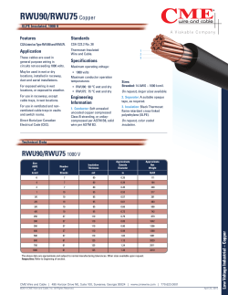


© Copyright 2026