
VIRGINIA EARTH SCIENCE COLLABORATIVE
VIRGINIA EARTH SCIENCE COLLABORATIVE: DEVELOPING HIGHLY QUALIFIED EARTH SCIENCE TEACHERS J. COTHRON MathScience Innovation Center Richmond, VA 23223 Abstract A collaborative of seven institutes of higher education and two non-profit organizations developed and implemented five earth science courses totaling eighteen credits that enabled secondary teachers to acquire an add-on earth science endorsement: Geology I: Physical Geology (4), Geology II: Geology of Virginia (4), Oceanography (4), Astronomy (Space Science for Teachers) (3), and Meteorology (3). These courses were collaboratively developed and included rigorous academic content, research-based instructional strategies, and intense field experiences. The thirty-three sections offered statewide served 499 participants. Three courses were offered to strengthen the skills of earth science teachers: Teaching Earth Science Topics to Special Education Students (3), Integrating New Technologies in the Earth Sciences (3), and GeoVirginia: Creating Virtual Field Trips (non-college credit). In these six sections, seventy-four people participated. Outcomes included an increased pool of endorsed earth science teachers and teachers with coursework in the earth sciences, a website with virtual field trips, and a statewide network. Partners included the College of William & Mary and its Virginia Institute of Marine Sciences, George Mason University, James Madison University, Longwood University, the MathScience Innovation Center (formerly the Mathematics & Science Center), Radford University, Science Museum of Virginia, University of Virginia Southwest Center, Virginia Commonwealth University, and eighty-three school divisions. The Need In Fall 2004, the Virginia Department of Education issued a Request For Proposals (RFP) to increase the number of endorsed earth science teachers in the Commonwealth, with funding to come from the Mathematics and Science Partnership (MSP) grant funded through the federal No Child Left Behind legislation of 2001 [1]. In Virginia, earth science is a high school course typically taught at the ninth grade level. In addition, many middle schools teach the subject as part of an acceleration option. At the time of the RFP, earth science teachers were the highest shortage area in the Commonwealth and student scores on the statewide, End-of-Course Earth Science Tests were the lowest among the sciences. In response to the RFP, a collaborative of institutions of higher education and non-profit organizations was formed to determine the need and to develop an appropriate proposal. 1 The Journal of Mathematics and Science: Collaborative Explorations Volume 10 (2008) 1 - 27 2 J. COTHRON The three methodologies outlined below were used to assess the needs of the 134 divisions within the Commonwealth. 1) Educational Leaders —Personal conversations and small focus groups were held with educational leaders to determine general needs and to provide input on the development of the Earth Science Needs Assessment Survey. 2) Divisions — Each responding division completed the Earth Science Needs Assessment Survey and provided information on student achievement, endorsement status of teachers, financial support willing to provide, and greatest needs in earth science. 3) Teachers — On the Teacher Survey, potential participants provided information about the following: 1) certification and endorsement, 2) teaching assignment, 3) academic background, 4) self-perceptions of earth science knowledge and skills, 5) courses needed, 6) course delivery, and 7) open-ended questions related to the teaching of earth science. Survey items were based upon I.R. Weiss’ Status of Secondary School Earth Science Teaching (a component of the 2000 National Survey of Science and Mathematics Education) [2]. Of the 134 Virginia divisions, seventy-one indicated they would participate. The remainder did not respond (41), did not want to participate (17), or were part of another grant (5). The Need—Divisions’ Report The seventy-one divisions reported 565 earth science teachers, with 146 of them not fully endorsed. This represented 26.7% of the teaching force. Annually, divisions tended to employ 139 novice teachers with 49% of them not fully endorsed in earth science. Obtaining endorsed teachers was a major issue for middle schools that taught earth science as an acceleration option. The divisions projected 191 teacher participants, including unendorsed teachers and endorsed teachers, that wanted to improve their academic background or teaching skills in earth science. Within the seventy-one divisions, 182 middle and high schools taught earth science. Of these schools, fifty-six had fewer than 70% of their students passing the statewide, End-of-Course Earth Science Test, which is based upon Virginia’s Standards of Learning for K-12 Science [3]. The Need—Teachers’ Self-Report Of the 324 teachers submitting surveys of intent to participate, 227 were endorsed in high school science subjects and ninety-seven were endorsed in middle school or special education. At the time of the RFP, Virginia Licensure Regulations for School Personnel provided an option for teachers endorsed in biology, chemistry, or physics to obtain an “add-on earth science VIRGINIA EARTH SCIENCE COLLABORATIVE… 3 endorsement” by taking eighteen semester credits in the earth sciences, including preparation in geology, oceanography, meteorology, and astronomy [4]. Other teachers, including those endorsed in middle school science or special education, had to meet the requirements of the full earth science endorsement which included a total of thirty-two hours of oceanography, meteorology, astronomy and geology (eighteen credits required). Generally, teachers preferred summer courses and weekend courses combined with websites. Teachers rated their conceptual understanding and teaching skills on thirty-one dimensions using the following scale: 1 (not well qualified), 2 (adequately qualified), and 3 (very well qualified). On the six content dimensions included in the RFP, typical ratings were 1 and 2, with the order of confidence, least to greatest, in the following order: petrology and minerals, paleontology and historical geology, physical oceanography, astronomy, structural/tectonics, and meteorology. Teachers considered themselves “adequately qualified” to “very well qualified” to teach terms and facts, concepts, and process skills and to engage students in understanding the nature of science; this confidence may have been derived, in part, from their experience in teaching other scientific disciplines. Teachers typically considered themselves “not well qualified” to help students learn applications and to use technology including GIS, GPS, calculator- and computer-based labs, Internet collaborative projects, and computer simulations. Over 140 teachers expressed an interest in a course on effective strategies for integrating new technologies into the earth sciences. Another need, expressed on an open-ended question, was assistance with collaborative education, including improved content understanding for special education teachers and improved differentiation strategies for regular earth science teachers. Project Goals and Funding Based upon the needs assessment, the Virginia Earth Science Collaborative (VESC) developed four project goals: 1) Increase the pool of endorsed earth science teachers by offering the coursework needed for the add-on earth science endorsement in various geographic areas of Virginia; 2) Increase teachers’ conceptual understanding of the earth sciences and their ability to deliver inquiry-oriented instruction by developing and offering earth science courses appropriate for teachers; 3) Increase the number of highly qualified earth science teachers by piloting courses in three identified areas of need—use of effective strategies including new technologies, improved collaborative teaching of earth science, and a targeted course for sixth grade teachers; and, 4 J. COTHRON 4) Establish a statewide collaborative that can be used to continuously lead and inform decisions and programs related to the teaching and learning of earth science. A proposal based upon these goals was submitted to the Virginia Department of Education and funding of $920,848 was awarded for the period of March 2005 to September 2006. Based upon the success of the project, a second award of $351,649 was made between March 2006 and September 2007. Finally, a special award of $35,017 enabled development and funding of this Special Issue of The Journal of Mathematics and Science: Collaborative Explorations. A total of $1,307,514 in MSP funding was matched by $237, 000 from the VESC partners. Implementation Goal 1: Increase the Pool of Endorsed Earth Science Teachers — Before admission to classes, all teachers completed the Teacher Survey, which included their reason for participation. When necessary, these reasons were used to establish priorities for enrollment. Demographics on participants reflect the following priorities: • Secondary science teacher completing an earth science or add-on earth science endorsement, with priority given to those currently teaching earth science (53% of participants); • Middle or special education teacher taking eighteen credit hours toward the full earth science endorsement (16% of participants); • Middle or special education teacher taking earth science courses to strengthen their background (13% of participants); • Endorsed earth science teacher taking courses to strengthen their background, especially Geology of Virginia and courses which they may have taken in a non-laboratory setting (10% of participants); and, • Other participants included pre-service or career switchers in degree programs and upper elementary teachers whose curriculum included earth science topics (8% of participants). Because large numbers of elementary, middle, and special education teachers were applying to take the courses, these priorities were established in cooperation with the Virginia Department of Education. Although the primary purpose of the grant was to increase the number of endorsed earth science teachers, strengthening the academic background of teachers in the feeder curriculum was perceived as a critical way to improve the overall quality of the earth science 5 VIRGINIA EARTH SCIENCE COLLABORATIVE… curriculum. Initially, professors at the universities were hesitant to enroll teachers outside the target population, and their advice was asked regarding the best courses for students to take, with the recommendations being Astronomy (Space Science for Teachers), Meteorology and Geology I: Physical Geology. Of these courses, Astronomy and Meteorology had the greatest application to Virginia’s upper elementary and middle school science curricula. Five courses were developed and delivered statewide (see Table 1). Table 1 Participation in Courses for Add-on Earth Science Certification Information Astronomy Meteorology Oceanography Geology I: Physical Geology Number of different locations taught Number of course sections Number of participants 4 3 4 7 6 134 Percentage (%) of participants Participants’ reasons for taking course (%) Secondary science teachers completing or adding an earth science endorsement (%) Middle or special education teachers completing 18 credit hours (%) Middle school or special education teachers strengthening background (%) Endorsed earth science teachers strengthening background (%) Other – pre-service teachers, elementary teachers, etc. (%) Total 4 Geology II: Geology of Virginia 5 6 5 9 33 115 79 64 107 499 27 23 16 13 21 100 38 52 71 66 50 53 13 18 13 22 17 16 20 16 8 8 9 13 16 5 6 1 18 10 13 9 2 3 6 8 --- 6 J. COTHRON Courses were taught at seven different locations within the state: Abingdon, Charlottesville, Fairfax, Harrisonburg, Radford, Richmond, and Williamsburg. The seven institutions of higher education delivering courses at the various locations were: • College of William & Mary (Williamsburg and Richmond); • George Mason University (Fairfax); • James Madison University (Harrisonburg); • Longwood University (off-site campus in Richmond area); • Radford University (Radford); • University of Virginia Southwest Center (Abingdon, Charlottesville, and Richmond); and, • Virginia Commonwealth University ( Richmond). Thirty-three course sections were offered by these institutions: Physical Geology (5), Geology of Virginia (9), Astronomy (7), Meteorology (6), and Oceanography (6). In the sections, there were 499 participants (duplicated count), with the largest percentages enrolled in Astronomy (27%), Meteorology (23%), and Geology of Virginia (21%). Several factors contributed to the higher enrollment in these courses: the contents of Astronomy (Space Science for Teachers) and Meteorology are major components of the elementary and middle school curricula, Geology I and II and its applications to Virginia comprise over 50% of the earth science curriculum, and Meteorology was a web-based class. Enrollment was much smaller in Oceanography (16%) and Physical Geology (13%), with the classes taken primarily by teachers pursuing the earth science endorsement. For example, 88% of the Physical Geology participants and 84% of the Oceanography participants were secondary teachers pursuing the endorsement, or middle and special education teachers pursing eighteen hours toward the endorsement. In addition, many participants had taken physical geology as an undergraduate. Goal 2: Increase Teachers’ Conceptual Understanding of the Earth Sciences — In response to the RFP, five graduate courses specifically designed for teachers were targeted for development: Astronomy (Space Science for Teachers), Meteorology, Oceanography, Geology I: Physical Geology and Geology II: Geology of Virginia. With the exception of the geology sequence, courses could be taken in any order. Guidelines for development included addressing the areas of earth science required in the RFP, emphasizing inquiry and the nature of science, and providing extensive opportunities for teachers to engage in field studies. For example, Oceanography included a two- to three-day intense experience at the Virginia Institute of Marine Science VIRGINIA EARTH SCIENCE COLLABORATIVE… (VIMS) field station (Eastern Shore Laboratory), experiences in the geologic provinces. 7 and Geology of Virginia included field Five course development teams were formed to develop each of the designated courses, with each team led by a professor charged with appointing team members, scheduling meetings and discussions, compiling products for review and dissemination, and managing the course development budget. The composition of the various teams is provided below. As an initial step, each team developed general information about the course including the curriculum framework concepts, related Virginia Standards of Learning objectives, and examples of how inquiry and the nature of science would be addressed (see Table 2). Because the two geology courses were sequential and many professors were teaching both courses, the group met collectively to determine the scope and sequence of each course. Heather MacDonald, Professor at the College of William & Mary led the initial discussions with the assistance of Gerald Johnson and Brent Owens of the College of William & Mary, Rick Diecchio of George Mason University, Eric Pyle of James Madison University, Joyce Watson of the MathScience Innovation Center, and Jonathan Tso of Radford University. • Geology I: Physical Geology — Eric Pyle provided leadership for course development with the assistance of Rick Diecchio, Joyce Watson, Jonathan Tso, and two professors at James Madison University, Roddy Amenta and Lynn Fichter. • Geology II: Geology of Virginia — Heather MacDonald provided leadership for the team, which consisted of Gerald Johnson, Brent Owens, Rick Diecchio, Eric Pyle, Joyce Watson, and Jonathan Tso. • Astronomy (Space Science for Teachers) — Edward Murphy, Assistant Professor at the University of Virginia led the team whose members included Harold Geller of George Mason University, Randy Bell of the University of Virginia, David Hagan of the Science Museum of Virginia, and Michael Bentley of the University of Virginia School of Continuing Education (Southwest Center). • Meteorology — Juanita Jo Matkins, Associate Professor at the College of William & Mary led the team whose members included Eric Pyle of James Madison University, Jo Ann Mulvaney, Adjunct Professor at Virginia Commonwealth University, and Michael Bentley, Adjunct Professor at the University of Virginia School of Continuing Education. • Oceanography — Kristen St. John, Associate Professor at James Madison University led a team comprised of Mark Krekeler of George Mason University, Vicki Clark of the Virginia Institute of Marine Science, Steve Oden, Adjunct Professor at Virginia Commonwealth University and educator at the MathScience Innovation Center, and Chris Lundberg, educator at the MathScience Innovation Center. 8 J. COTHRON Table 2 Overview of Courses for Earth Science Endorsement Geology I: Physical Geology (4 credits) Curriculum Framework Concepts: Identification and use of minerals, rock cycle processes, (weathering, erosion, deposition, metamorphism, melting, crystallization) and products (igneous, metamorphic, sedimentary rock identification), plate tectonic processes (subduction, rifting, continental collision) and their relationship to the rock cycle, influence of surficial process on soil development and local geomorphology, age of Earth, basic stratigraphic principles and relative time. Related SOL: ES 1c; ES 3; ES 5; ES 6; ES 8 b, c; ES 9 a, b, c, d; ES 10 a, b, c. Examples of Inquiry Skills & Nature of Science. Classification of minerals and rocks, interpretation of rock cycle diagram, development of concept maps relating rock cycle and plate tectonics, interpretation of topographic maps. Geology II: Geology of Virginia (4 credits) Pre-requisite: Geology I: Physical Geology Curriculum Framework Concepts: Relationship between plate tectonic processes and geologic hazards (earthquakes, volcanic eruptions), structure geology (faults, folds), paleomagnetism and the geologic time scale, fossil identification and use, geologic history and the resulting physiographic provinces and resources of Virginia. Related SOL: ES 1 b, c, e: ES 2: ES 3, ES 7 c, d, e; ES 8, ES 9 f; ES 10. Examples of Inquiry Skills & Nature of Science. Local and regional field studies of Virginia’s physiographic provinces and resources, fossil identification, interpretation of geologic maps, development of field guides by teachers for teachers. Oceanography (4 credits) Curriculum Framework Concepts: Tectonic evolution of the ocean basins, physiography of the sea floor, heat capacity of the ocean and influence on maritime climates, waves, tides, influence of winds on surface currents, upwelling, relationships between sea level change and climate and tectonics changes, influence of temperature and salinity on density and deep water circulation, coastal geology, marine ecosystems, controls on marine sedimentation, microfossils and ancient oceans, marine resources. Related SOL: ES 1; ES 2; ES 3; ES 4b; Es 7 a, d, e; ES 8 b, c; ES 10 a; ES 11; ES 13 d. Examples of Inquiry Skills & Nature of Science. Intense field experiences at VIMS Field Station including shipboard physical, chemical, and biological analyses of saltwater ecosystems, marine depositional environments, currents and tides, long shore transport, barrier island dynamics, and fisheries. Meteorology (3 credits) Curriculum Framework Concepts: Earth’s heat budget and global wind patterns, weather vs. climate, radiation, convection, cloud formation, the hydrologic cycle, vertical structure of the atmosphere, orographic effects on weather, severe weather, the influence of life (microbial, human) and geologic processes on atmospheric composition and temperature through geologic time, comparison of the atmospheres of Earth, Mars, and Venus. Related SOL: ES.1, ES.3 a, b, c, d; ES 9 d; ES.11 c, ES.12 a, b, c, d, e; ES 13 a, b, c, d. Examples of Inquiry Skills & Nature of Science. Through the use of Internet-accessed, real-time and near real-time data, hands-on activities, lab experiences and field experience, the course will focus on inquirybased learning and the applications of experimental design in meteorology. The course will feature an examination of current understandings of climate change and how these understandings reveal the nature of the scientific enterprise and scientific knowledge. VIRGINIA EARTH SCIENCE COLLABORATIVE… 9 Astronomy (3 credits) Curriculum Framework Concepts: Position and motion of Earth in space, sun-Earth-moon relationships and the resulting seasons, tides, and eclipses; characterization of solar system bodies (sun, planets, meteors, and asteroids), formation and evolution of the universe (big bang theory) and solar system (solar nebular theory), life cycle of stars, nature of space exploration and study (ground-based observations vs. spacebased observations), major contributions of the space program. Related SOL: ES 1; ES 2; ES 3; ES 4; ES 14. Examples of Inquiry Skills & Nature of Science. Computer-based labs and simulations, such as Starry Night®, planetarium work, night sky observations. Goal 3: Increase the Number of Highly Qualified Earth Science Teachers — As previously described, teachers recommended three major ways to improve their capabilities in the earth sciences and to improve student achievement. First, 146 teachers requested a course on effective strategies utilizing the following: good hands-on labs (not paper-and-pencil worksheets); effective computer software and simulations; and, the use of global positioning systems, geographic information systems, imaging software, and calculator-based labs. A recurring theme was the use of materials that helped students see the relevance of earth science in their community. To meet this need, Integrating New Technologies in the Earth Sciences was developed and piloted in Fall 2005 in the Richmond area; development included a web-based collaborative student project relevant to Virginia. Drew Keller, an educator at the MathScience Innovation Center, led development of this course, which built upon the Center’s expertise in GIS, GPS, and web-based instruction. Jackie McDonough, Adjunct Professor at Virginia Commonwealth University, six outstanding earth science educators, and three members of the Virginia Department of Mineral Resources assisted with course design. The course was a blend of face-to-face and web instruction through Moodle™, a web-based instructional system used by the Center. The 3-credit graduate course was offered through Virginia Commonwealth University’s School of Education, and was offered a second time in Spring 2006. Second, numerous divisions and teachers from high needs schools expressed a need for more effective collaboration involving special needs students. Comments were that special education teachers needed a greater understanding of earth science concepts and that the regular classroom teacher needed a greater understanding of appropriate differentiation strategies for various special education students, slow learners, and poor readers. To meet this need, Effective Collaboration in the Earth Science Classroom was developed and piloted in Summer 2006 at Longwood University’s off-campus site in Powhatan County, which is located west of Richmond. Teachers from schools with less than a 70% pass rate Earth Science SOL Test were given priority 10 J. COTHRON for enrollment. Enza McCauley (Science Education) and Peggy Tarpley (Special Education) combined their expertise to develop the course, which was offered as a 3-credit graduate course through Longwood University’s School of Education. Third, sixth grade teachers expressed a need for a general earth science course focusing on the major concepts included in the sixth grade curriculum. When advertised in Spring 2006, the course was insufficiently enrolled. An informal survey of participants who had originally expressed an interest revealed that many had enrolled in Astronomy or Meteorology and preferred to take these in-depth courses, rather than a general survey. For this reason, course development was cancelled. Finally, a non-college credit course was developed by the MathScience Innovation Center to enable earth science teachers, and their students, to develop and implement virtual field trips to various geologic sites within their community. As part of Integrating New Technologies in the Earth Sciences, creation of virtual field trips was introduced; however, the resulting products were of poor quality and the instructor recommended that a separate course be developed. Three members of the MathScience Innovation staff combined their expertise to develop a new course, GeoVirginia: Creating Virtual Field Trips, which was offered for forty-five, non-college credits. While John Sylvester provided leadership in developing the content management system and initial course, Joyce Watson provided expertise in earth science and Echol Marshall provided expertise in videography and development of a web-based course. The course was piloted in Summer 2007 and offered a second time in Fall 2007. Five sections of the pilot courses were offered with seventy-four teachers enrolled (see Table 3). Although the pilot courses were offered in the Richmond area, the fact that two of the courses were web-based enabled statewide participation. Participants in Integrating New Technologies in the Earth Sciences attended two face-to-face sessions on Saturday and completed the remaining work via the website. In the first offering of GeoVirginia, participants attended a two-day, face-to-face session and then spent a month completing projects, with ongoing followup provided via the web (Moodle™) or individual sessions with instructors. In the second offering of GeoVirginia, only one Saturday face-to-face session was held, with the remaining work occurring via the Center’s videoconferencing system (ElluminateLive!), Moodle™, or individual videoconferences. 11 VIRGINIA EARTH SCIENCE COLLABORATIVE… Table 3 Participation in Special Topics Earth Science Courses Information Number of different locations taught Number of course sections Number of participants Percentage of participants (%) Participants’ reasons for taking course (%) Secondary science teachers completing or adding an earth science endorsement (%) Middle or special education teachers completing 18 credit hours (%) Middle school or special education teachers strengthening background (%) Endorsed earth science teachers strengthening background (%) Other – pre-service teachers, elementary teachers, technology specialists, etc. (%) Integrating New Technologies 1 2 35 47 Effective Collaboration 1 1 13 18 GeoVirginia: Virtual Field Trips 1 2 26 35 Total 43 0 23 19 6 0 8 6 0 54 4 10 31 15 65 50 20 31 0 15 5 74 100 In the pilot classes, the majority of participants were enrolled in Integrating New Technologies in the Earth Sciences (47%). Although the target audience was endorsed earth science teachers, they comprised only 31% of the population. Even though it did not count toward the endorsement, some middle and secondary teachers enrolled to immediately improve their ability to use technology with their students (49%). Unexpectedly, technology resource teachers also enrolled (20%). Again, although the target audience for GeoVirginia: Creating Virtual Field Trips was endorsed earth science teachers, they comprised only 65% of the population. Because examples of virtual field trips were posted on the website, students in the Summer 2007 Geology of Virginia classes learned about the site and wanted to immediately begin making products. These motivated teachers made up 31% of the class and created virtual field trips based upon their summer experiences. Enrollment in Effective Collaboration in the Earth Science Classroom was disappointing. Beginning with an over-subscribed class of thirty-five students in the spring, the class dropped to thirteen participants by the August 2006 class. The class consisted primarily of special education and elementary teachers, with few endorsed earth science teachers electing to participate. During the time that the course was developed and implemented, the Virginia Department of Education 12 J. COTHRON was refining requirements for content coursework by special education teachers. Initially, many teachers saw the course as a way to meet the state requirements and enrolled; however, as school divisions developed local options for meeting the requirement, they dropped out, with many being no-shows on the first day of class. Goal 4: Establish a Statewide Collaborative — The collaborative of seven institutes of higher education and two non-profit organizations involved in the Virginia Earth Science Collaborative (VESC) included major institutions from all geographic areas of Virginia. All participants had representatives on the staff and board of the Virginia Mathematics and Science Coalition. In addition, various subsets of the institutions had partnered previously on National Science Foundation (NSF) and Mathematics and Science Partnership (MSP) grants that focused on teacher preparation and licensure, an inter-institutional master’s degree for middle school mathematics and science teachers, and various programs related to licensure and the Statewide Master’s Degrees Program for K-8 Mathematics Specialists. Because none of these grants had fostered development of strong partnerships in the sciences, the partners viewed establishment of a statewide network in the sciences as a major objective. Goal 4: Steering Committee — The Virginia Earth Science Collaborative Steering Committee provided overall leadership and guidance for the grant. Led by Project Director Dr. Julia Cothron, the committee consisted of twenty-six active members, including twelve professors from arts and sciences, six professors from schools of education, five educators from the K-12 community, and three members from higher education administration and museums. To facilitate implementation, a site leader was appointed for each of the major institutions: College of William & Mary, George Mason University, James Madison University, MathScience Innovation Center, Radford University, and the University of Virginia Southwest Center. Each site leader was responsible for achieving site objectives for course development and implementation, developing liaisons with area schools, interacting with the external evaluator, and administering the subcontract budget. The project director and site directors interacted regularly through teleconferences and electronic mail. During the first eighteen months of the grant, the group met four times. The grant was funded in March 2005, with Steering Committee meetings occurring in March and June 2005. Because members were most concerned about course implementation in Summer 2005, the two initial meetings focused on course development, assessment, teacher recruitment and registration, and information about the variety of resources available through the Virginia Department of Education, including the Standards of Learning for K-12 Science, test blueprints, and released test VIRGINIA EARTH SCIENCE COLLABORATIVE… 13 items [3,5,6]. In January 2006, the Committee met to discuss concerns that had emerged during the first year of the grant, to develop appropriate modifications for future coursework, and to develop a sequence of courses for the second phase of the grant, from September 2006 to September 2007. Major concerns included developing quality tools for assessing participants’ achievement of course objectives, developing effective ways to support classroom implementation, and improving recruitment in specific areas of the state. Because these concerns varied among institutions, various subgroups of the Steering Committee assumed responsibility for addressing them. In September 2006, the Steering Committee met as part of the “Spotlight on Earth Science” conference and began the transition to an Earth Science Committee under the leadership of the Virginia Mathematics and Science Coalition. During the last year, the grant leadership interacted through teleconferences and e-mail, and the various course development leaders met face-to-face or electronically with team members. In addition, a web-based Moodle™ site was established for ongoing posting of materials and dialogue among members. Goal 4: Coalition Committee — In October 2006, the Virginia Mathematics and Science Coalition approved establishment of an Earth Science Committee to provide leadership on issues related to teacher licensure and training, state standards and their assessment, and other policy issues. Dr. Eric Pyle of James Madison University and Dr. Edward Murphy of the University of Virginia agreed to co-chair this committee; both of these individuals were site leaders for the Virginia Earth Science Collaborative. Under their leadership, an active committee was established and regular reports provided at the Coalition’s meetings, which occur three to four times annually. Goal 4: Website — In Spring 2005, a project website was launched to provide information about the goals and objectives of the grant, requirements for the full and add-on earth science endorsements, course development, teacher eligibility, course schedules and registration. As needed, this site was updated throughout the grant. In Summer 2007, the site was expanded to include electronic articles about courses offered throughout Virginia. In Fall 2007, the site was modified to include a section entitled “GeoVirginia” which includes virtual field trips to various sites across Virginia. Impact Project quality and impact were judged through a combination of quantitative and qualitative procedures focused on each project goal. Dr. George Bass, Associate Professor at the College of William & Mary, was the project’s external evaluator. 14 J. COTHRON Goal 1: Increase the Pool of Endorsed Earth Science Teachers — A total of 303 different teachers participated in the grant. Of these, seventy-seven were endorsed prior to the grant, fiftytwo completed credentials through the grant, and nineteen obtained eighteen credits toward the endorsement. Within the 154 non-endorsed participants, there were twenty-seven individuals who stated on the initial survey that they were currently teaching earth science (non-endorsed) and thirty-eight who stated that they were a secondary science teacher planning to add the endorsement. An analysis of course enrollment revealed the distribution of these sixty-five individuals (see Table 4). Table 4 Distribution of Course Enrollment Number of courses taken 1 2 3 4 5 Number of people 34 15 11 4 1 Given the commitment needed to take three or more courses, one can reasonably hypothesize that an additional sixteen teachers will complete the endorsement through coursework offered outside the grant. For those taking only one or two courses, possible explanations include leaving the profession (especially for first-year earth science teachers), finding a position in their area of endorsement, taking additional coursework for the endorsement outside the grant, or using the grant to obtain the six college credits needed for certificate renewal and having no intention of completing the endorsement within the specified period. Goal 2: Increase Teachers’ Conceptual Understanding of the Earth Sciences — The evaluation of the courses focused on the impact of the course experience on the participants’ learning. Instructors agreed to administer the pre-test/post-test measure of the course subject matter. The course development team was responsible for the selection or construction of a suitable paperand-pencil test on appropriate course content. A synopsis of pre-/post-data for the various courses is summarized in Table 5. 15 VIRGINIA EARTH SCIENCE COLLABORATIVE… Table 5 Pre-/Post-Data on Participants’ Learning Course Instrument Astronomy - 1 Astronomy - 2 Astronomy - 3 Astronomy - 4 Astronomy - 5 Astronomy - 6 Astronomy - 7 Astronomy Diagnostic Test Astronomy Diagnostic Test Astronomy Diagnostic Test Astronomy Diagnostic Test Astronomy Diagnostic Test Astronomy Diagnostic Test Individual Instructor Astronomy Means Items from AMS Test Items from AMS Test Items from AMS Test Items from AMS Test Items from AMS Test Items from AMS Test Meteorology Means Team Made – Version 1 Team Made – Version 1 Team Made – Version 2 Team Made – Version 2 Team Made – Version 2 Individual Instructor Oceanography Means GCI + Team Made – Version 1 GCI + Team Made – Version 1 GCI + Team Made – Version 1 GCI + Team Made – Version 2 GCI + Team Made – Version 2 Physical Geology Means Instructor – Preliminary Items Team Made Team Made Team Made Team Made Team Made Team Made Team Made Individual Instructor Geology of Virginia Means Meteorology - 1 Meteorology - 2 Meteorology - 3 Meteorology - 4 Meteorology - 5 Meteorology - 6 Oceanography - 1 Oceanography - 2 Oceanography - 3 Oceanography - 4 Oceanography - 5 Oceanography - 6 Physical Geology -1 Physical Geology -2 Physical Geology -3 Physical Geology -4 Physical Geology- 5 Geology VA - 1 Geology VA - 2 Geology VA - 3 Geology VA - 4 Geology VA - 5 Geology VA - 6 Geology VA - 7 Geology VA - 8 Geology VA - 9 Number Participants Mean Pre-Test (%) 24 29 28 17 19 9 NA 126 34 25 10 19 8 14 110 14 11 20 9 12 NA 66 22 8 12 6 16 64 8 9 6 15 16 14 19 9 N/A 96 55.80 44.80 61.00 54.00 47.40 48.20 NA 56.6 35.00 78.00 43.00 61.50 74.00 41.00 53.70 29.60 44.00 45.00 44.00 58.50 NA 43.86 64.59 55.00 72.50 60.00 75.30 67.12 43.00 48.00 60.00 45.00 59.00 51.00 52.20 46.60 N/A 50.83 Mean PostTest (%) 71.40 64.50 81.00 71.00 66.40 59.80 NA 71.9 53.00 86.00 51.00 81.10 91.00 58.60 68.60 91.20 76.50 63.00 88.00 91.50 NA 79.82 75.04 93.00 80.50 98.00 84.10 82.73 69.00 76.00 75.00 66.00 95.00 80.00 84.90 70.50 N/A 78.78 Difference (%) 15.60 19.70 20.00 17.00 19.00 11.60 Gain 15.3 18.00 8.00 8.00 19.60 17.00 17.60 14.90 61.60 32.50 18.00 44.00 33.00 Gain 35.96 10.45 38.00 8.00 38.00 8.80 15.61 26.00 28.00 15.00 21.00 36.00 29.00 32.70 23.90 N/A 27.95 Note 1: AMS = American Meteorological Society and GCI = Geoscience Concept Inventory. Note 2: For Astronomy (Space Science for Teachers)-7, N = 10, Pre = 72.9%, Post = 79.3%, Gain = 6.40%. Note 3: For Oceanography-6, N= 16, Pre = 60.10%, Post = 98.70%, Gain = 38.70%. Note 4: For Geology of Virginia-9, N= 12, data not available. 16 J. COTHRON Goal 2: Astronomy — The instructors chose to use the nationally developed Astronomy Diagnostic Test (ADTv2.0) in six of the seven sections; one instructor who taught an on-line course used his own instrument [7-9]. The ADTv2.0 is a 21-item, multiple-choice test developed by the Collaboration for Astronomy Education Research in 1999. During 2000 and 2001, the Astronomy Diagnostic Test National project investigated the validity and reliability of the test. The ADTv2.0 was administered as a pre-test to 5,346 students and as a post-test to 3,842 students in ninety-seven classes at various universities, and at four-year and two-year colleges in thirty states. Student results showed an average pre-test score of 32.4% and an average post-test score of 47.3% out of the maximum perfect score of all twenty-one correct. Data on participants’ achievement in the Astronomy courses are summarized in Table 5. As shown in Table 5, the ADT was administered as a pre-/post-test in six of the seven sections taught. In each of these sections, as well as the one in which the instructor administered a different test, positive achievement gains occurred. Across sections, the mean percentage correct increased from 56.6% to 71.9% for a gain of 15.3%. The mean pre-test scores ranged from 44.80% to 61.0%, with all exceeding the undergraduate pre-score of 32.4%. All sections also exhibited a higher post-score than the undergraduate-level students (47.3%). Some differences in performance could be expected because all teachers were college graduates (some were science majors) and not undergraduates as in the national norm group. With the exception of section six, all sections showed a greater gain score than the norm group (14.90%). In this section, 66% of the participants were elementary or middle school teachers strengthening their background. Goal 2: Meteorology — The instructors teaching the meteorology course developed the assessment by choosing items from the American Meteorological Society’s Online Weather Studies program materials that reflected both the content covered in the course and the high school Standards of Learning items testing meteorological knowledge and understanding [10,11]. There were eighteen multiple-choice items and three short-answer items (each worth four). For the 110 participants completing the pre-/post-tests, there was a 14.9% mean achievement gain, from a mean pre-test of 53.7% to a mean post-test of 68.6% (see Table 5). With the exceptions of sections two and three, which had a gain of 8% each, all scores were clustered between a 17.00% and 19.60% gain. No obvious demographic differences exist to explain the lower achievement. VIRGINIA EARTH SCIENCE COLLABORATIVE… 17 Goal 2: Oceanography — Because there was not a nationally developed, standardized instrument assessing basic oceanography knowledge, the instructors were forced to construct their own instrument during the first set of courses in 2005. After sharing items and sample items among themselves, a preliminary version was constructed consisting of twenty-five, short-answer and multiple-choice items. For the 2006 and 2007 courses, the Oceanography pre-test/post-test was revised to reflect lessons learned in 2005. The revised assessment instrument was based on the foundational concepts of oceanography that the instructional team collaboratively identified. These concepts all related to the content learning goals of the course as identified in the course syllabus and to the ten Essential Knowledge and Skills (EKS) for oceanography from the Science Standards of Learning Sample Scope and Sequence—Earth Science [12]. While nearly all of the content addressed in the 2005 assessment instrument was the same in 2006, the assessment instrument was modified to contain entirely multiple-choice items for the 2006 and 2007 courses. Although the instructors believed that the short-answer questions used in 2005 provided more information on student understanding of the oceanography concepts, they recognized that there was instructor variability when grading these items. To retain some of the benefits of written short answers, participants were asked to justify their selected answer in the pre-assessment. These justifications helped instructors identify incoming misconceptions of content. Across the five Oceanography sections reported, the mean increase was a high 35.96% (see Table 5). Both the pre-test and post-test scores showed a range of about thirty percentage points, with pre-test scores ranging from 29.60% to 58.50% and post-test scores from 63.0% to 91.50%. As previously noted, modifications were made in the test format from Summer 2005 (sections one and two) to Summer 2006 and 2007. The unusually high increase in section one partly reflects that the instrument development process for the pre-test served more as a “pilot” of the instrument than a valid pre-test. Of all the courses, Oceanography had the most consistent instruction team, with three of the five sections taught at one university. In addition, 84% of the participants were middle school or senior high school teachers seeking an endorsement. Goal 2: Physical Geology — The course development team chose to design their own content test using their own constructed items and items selected from the “Geoscience Concept Test,” a multiple-choice assessment instrument with seventy-three, multiple-choice items validated for earth science courses [13]. The course leader developed the test and circulated it to the instructors of the other sections for review. In January 2006, the Physical Geology team met with Dr. George Bass, External Evaluator, and discussed ways to improve questions on the pre-/postcontent tests and to expand the range of questions so that “ceiling effect” did not occur. The 18 J. COTHRON course leader revised the instrument for use in future sections of Physical Geology. The final version of the instrument consisted of twenty multiple-choice and three short-answer items. Physical Geology participants showed a mean increase of 15.61 percentage points, with scores increasing from a mean pre-score of 67.12% to a mean post-score of 82.73%. Pre-test scores tended to be high and reflected the fact that many participants were already teaching earth science and had learned geologic concepts through the teaching process. Eighty-eight percent of the participants were middle school or senior high school teachers seeking an endorsement. The development team perceived that the first version was “too easy,” and that the items selected from the Geoscience Concept Test were ambiguous. Modifications were made in the first version to address these concerns. Goal 2: Geology of Virginia — During Fall 2005, a pilot section of Geology of Virginia was taught to eight teachers. The two instructors chose to design their own content test using their own constructed items to assess both students’ background knowledge in geology and students’ knowledge of the geology of Virginia. Approximately 80% of the pre-test/post-test focused on the geology of Virginia and 20% focused on background knowledge. Based on that experience, the team of instructors for the 2006 and 2007 courses redesigned the assessment test. They created a thirty-item exam that incorporated eighteen multiple-choice items, seven matching items, and five multiple-answer application items (often involving the interpretation of geological diagrams). The total number of points on this exam was seventy. Beginning with a mean pre-test score of 50.83%, participants showed an impressive 27.95% gain, to end with a post-test mean of 78.78%. Achievement gains ranged from 15.00% to 36.00%. Because some of the sections were very small, six to nine participants, the performance of a single individual greatly impacted the scores. Given that it was the second course in a sequence, this course also had a high percentage of endorsed teachers strengthening their background (18%) and of secondary teachers seeking an endorsement (67%). Goal 3: Increase the Number of Highly Qualified Earth Science Teachers — To assess participants’ learning, a variety of pre-/post-administered instruments including content tests and surveys were used. Dr. George Bass assisted with the design and analysis of these measures. Goal 3: Integrating New Technologies in the Earth Sciences — For this combination web-based and face-to-face course, a pre-/post-administered questionnaire was given in which participants rated their expertise in five content domains: 1) remote sensing and image processing; 2) real- VIRGINIA EARTH SCIENCE COLLABORATIVE… 19 time and real-world data; 3) computer simulations and 3-dimensional modeling; 4) global positioning systems and geographic information systems; and, 5) graphing calculators and probes. Using a 5-point Likert Scale (0 = “None” and 4 = “Expert”), they rated themselves as having “little knowledge” (1.16) before the course and “some knowledge” (2.17) after the course. Increases were greatest in the areas of remote sensing and imaging, computer simulations and 3dimensional modeling, and global positioning and geographic information systems. Less change was shown in the area of graphing calculators and probes, where many schools had done inservice, and in real-time and real-world data, where many earth science teachers already had access to meteorological and oceanographic data. When asked about their skill in using the various technologies, the ratings were slightly different, with participants rating themselves as having “some knowledge” at the beginning and “much knowledge” at the end. Skill increase was greatest in the area of GPS and GIS, followed closely by use of real-time and real-world data. When asked about strengths of the course, participants mentioned the range of resources and websites, learning about technology that they did not realize was available, interacting with colleagues, and the modular format of the class. Suggestions for improvement included more face-to-face time for sharing and more dialogue through the web. As in most web-based courses, the drop rate was higher than in a face-to-face course. Of the original twenty-one participants, two received a WF and two received an F. When the course was repeated a second time, the pre/post-data were similar. Again, participants tended to do well (eight A’s, two B’s) or not perform (three F’s), with failing students not completing assignments despite extensions. Goal 3: Teaching Earth Science Topics to Special Education Students — The instructors used a twenty-item exam for the pre-test and post-test. This exam consisted of twenty, 4-option multiple-choice items on earth science knowledge and understanding. Half of the items required the student to interpret a drawing, diagram, or table of earth science concepts and principles. Beginning with a mean pre-test score of 70%, the thirteen participants showed a gain of 9% to end, with a mean post-test score of 79%. Because the overall class average on the pre-test was reasonably high—70% with one teacher achieving a perfect 100%—participants entered this course with good background knowledge of basic earth science concepts and did not have much opportunity for growth. For future offerings of this course, the difficulty level of the test needs to be increased and items need to be added that assess participants’ understanding of how to differentiate and modify earth science instruction for students with disabilities. In the pilot course, differentiation skills were demonstrated through products that included lesson plans based upon trade books and various areas of earth science. Other recommendations for improvement included increased time for teaching science content, and requiring a pair of earth science and special education teachers from a school to attend. 20 J. COTHRON Goal 3: GeoVirginia: Creating Virtual Field Trips — This professional development course was taught to twelve teachers in Summer 2007 over six consecutive days with two follow-up sessions. The class had three instructional goals: 1) to reinforce and broaden teachers’ knowledge of geology in Virginia and their ability to teach it; 2) to train the teachers to use a number of technology tools to record a field trip for public posting on a website; and, 3) to train teachers to plan, conduct, and record data from geology field trips. The class culminated with a final product in which each teacher created a virtual field trip for posting on the “GeoVirginia” component of the Virginia Earth Science Collaborative website [14]. For a pre-/post-assessment, the instructors constructed an instrument in which approximately 33% of the questions focused on the teachers’ knowledge and use of field trips, and 66% focused on technological skills. Each question offered a Likert scale response from “None” (scored as 0) to “Expert” (scored as 4). Regarding their expertise with field trips, participants rated themselves at the lower end of the “much knowledge” category at the beginning of the course (2.17) and at the higher end of the category at the conclusion of the course (2.71). More growth was shown on technology skills, with ratings increasing from “some knowledge” (1.69) to “much knowledge” (2.52). The post-assessment form also included a robust course evaluation survey. Seven questions required that each teacher respond to queries on course structure, teaching expertise, and content relevance using a 5-point Likert Scale (0 = “None” and 4 = “Expert”). All responses averaged 3.87, with the highest response, an average of 3.93, given for the question, “value of instructional materials provided.” These materials included geology teaching tools: electronic reference materials, maps, rock samples, and technology-enabling tools, such as digital cameras and high-capacity memory sticks. Each teacher was asked to project a likely number of students and peer-teachers with whom he or she expected to share the newfound knowledge and materials. The teachers projected that they would share materials with seventy-eight peer teachers and 1,109 students. Although one teacher failed to create a web page that fully employed all the instructional strategies taught in the class, eleven detailed pages were created, each with a unique and fresh perspective on a particular site of Virginia geologic interest. All twelve teachers left with the intention to create a new and different field trip web page with their students during the 2007-08 term. VIRGINIA EARTH SCIENCE COLLABORATIVE… 21 In Fall 2007, a second course with fourteen participants was taught. To facilitate statewide participation during the school year, the distance-learning component was increased. Participants attended one Saturday face-to-face session, completed coursework on Moodle™, and interacted with instructors through the videoconferencing system, ElluminateLive! As compared with the first class, participants showed a greater increase on both the content (.79) and the technology skill (1.13) components of the pre-/post-tests and better quality virtual field trips. Potential factors were the more direct focus on technology and additional support through the videoconferencing system. Participants of the second course projected that they would share materials with ninety-five peer teachers and 855 students. Goal 4: Establish a Statewide Collaborative — The Collaborative was successful in achieving its major goal—creation of a statewide network in the earth sciences. During the three years of the grant, eighty-three local education agencies, 178 schools, seven institutes of higher education, and two non-profit organizations participated. Professors from the arts and sciences (25) and schools of education (9) interacted with experienced K-12 educators (24) to develop and deliver the five core courses and three pilot courses. Goal 4: “Spotlight on Earth Science” Symposium— Under the leadership of Dr. Eric Pyle, Associate Professor at James Madison University, a symposium was held on September 18-19, 2006 with approximately one hundred participants. On the first day, instructors from the Tidewater (ITEST) and VESC MSP grants presented sessions on the Geology, Astronomy, Meteorology, and Oceanography courses taught through the two MSP grants. Presentations were also made on special courses including the technology and special education courses. On the second day, participants discussed needs in the areas of teacher education, best practices, and curriculum. Goal 4: Coalition Committee — In October 2006, Professors Eric Pyle and Edward Murphy reported the recommendations from the “Spotlight on Earth Science” symposium to the Virginia Mathematics and Science Coalition. A formal Earth Science Committee, co-chaired by these professors, was established by the Coalition to address issues related to teacher licensure and training, state standards and their assessment, and other policy issues. Since its formation, the Committee has been instrumental in clarifying licensure requirements for the add-on earth science endorsement and is organizing to address state standards for earth science when they are available for public review in 2009. Courses developed by the VESC are included in two MSP proposals submitted by the Coalition for 2008 funding, with one focusing on elementary teachers and the second focusing on teachers of Pre-Advanced Placement (Pre-AP), Advanced Placement (AP), 22 J. COTHRON and dual enrollment courses. Several VESC institutions are actively exploring implementation of a statewide master’s degree that includes coursework in the earth sciences. Goal 4: Website — Since its inception in Spring 2005, the Collaborative’s website has had 57,617 visitor sessions, with the sessions representing 13,948 unique IP addresses [15]. The site is a repository of information on the project including information about partners, course development and implementation, and assessment of impact. In addition, professors and educators have authored seventeen electronic articles describing their experiences in developing and implementing courses. One component of the site, “GeoVirginia,” enables people from across Virginia to develop, post, and access virtual field trips [14]. Discussion and Recommendations Goal 1: Increase Pool of Endorsed Earth Science Teachers — The Collaborative offered thirtythree sections of the five earth science courses required for the add-on endorsement at seven different locations around Virginia. Through these offerings, fifty-two teachers completed the coursework for the endorsement, nineteen teachers obtained eighteen credits toward the endorsement, and sixteen teachers completed three or more courses with the expectation of completing the endorsement outside the grant. Completion of the endorsement requirements was made easier by changes in licensure requirements whereby individuals with a degree in the environmental sciences could add the endorsement with four courses, one in each area of earth science [16]. Throughout the grant, strong enrollment occurred in courses offered in central Virginia (Richmond and Charlottesville). Enrollment was lower in Northern Virginia, Harrisonburg, and Radford, and several course cancellations occurred in these areas. In southwestern Virginia, the University of Virginia Southwest Center (Abingdon, Virginia) was successful in getting a cohort of teachers to complete requirements over a five-semester period. The RFP required that teachers commit to completing the eighteen credits for the add-on endorsement in eighteen months, and the grant was developed for two, all-day, multiweek institutes to be taken each summer and one web-based course during the academic year. This rapid pace proved impossible for teachers in many urban and rural areas to sustain because of large summer school programs in which they were expected to teach. These teachers could participate in only one all-day, multiweek institute each summer, typically the first two weeks in August. In future, alternative course delivery models are needed, including “after school” coursework during the summer and academic year and combinations of web and face-to-face sessions, as were held for the pilot courses. Such models will also enable teachers in more rural parts of Virginia to access courses. VIRGINIA EARTH SCIENCE COLLABORATIVE… 23 Goal 2: Increase Teachers’ Conceptual Understanding of the Earth Sciences — The Collaborative developed five graduate courses that would enable participants to obtain an add-on earth science endorsement: Astronomy (Space Science for Teachers), Oceanography, Meteorology, Physical Geology and Geology of Virginia. The 499 teachers participating in the thirty-three sections offered statewide demonstrated an increase in conceptual understanding of the course topics. The achievement gains were greatest in Geology of Virginia (27.95%) and Oceanography (35.96%) where over 90% of the participants were secondary science teachers, strong collaborative work had occurred among the course developers, and multiple sections were taught which enabled instructors to learn and improve future offerings. For Astronomy and Meteorology, participants showed strong achievement gains of 15.3% and 14.9%, respectively. These courses were developed and taught by strong teams of instructors who had the most varied populations from class to class. For example, 13% of Astronomy and 9% of Meteorology participants were elementary school teachers. In addition, both Astronomy (20%) and Meteorology (16%) had a high percentage of middle school teachers who were taking the class to strengthen their background. Although Physical Geology participants also showed comparable gains of 15.61%, this course was impacted by being the first course offered (Summer 2005), by course cancellations because of insufficient enrollment, and by changing instructional teams. Different teams taught each of the five sections, with three of them not including the original course developers. Throughout the grant, all course instructors struggled to improve the quality of the pre-/post-assessments, and improved instruments are needed. In addition, more standard methods of administering instruments and including the appropriate ones in participants’ final grades are needed. All instructors agreed that the instruments did not reflect the rich learning experiences provided students, including the lab and field experiences that were assessed by endof-course projects. Also, all instructors agreed that the rapid pace of course offerings did not maximize the opportunity for teachers to learn. For the 4-credit courses—Oceanography, Physical Geology, and Geology of Virginia—instructors recommended that the multiweek institutes be a minimum of three weeks and that opportunities for post-course implementation support be strengthened. Even though Meteorology was successful as an on-line course with three face-to-face sessions, the instructors recommended additional face-to-face sessions because the teachers struggled with some concepts on-line that could have been explained easily with classroom demonstrations and labs. Overall, the two-week institute in Astronomy was the most successful for the adult learner, the major reason being that teachers attended for ten days (eighty hours), even though the requirement was only forty-five hours. They had ample opportunity within this time frame to work individually and in small groups to apply their newfound learning and skills to their 24 J. COTHRON teaching responsibilities. In the future, new delivery systems for all courses are needed, including combinations of virtual and face-to-face sessions that retain the rich inquiry and field components. Goal 3: Increase the Number of Highly Qualified Earth Science Teachers — The Collaborative developed three pilot courses that enabled teachers to learn about successful collaboration between special education and earth science teachers, integration of new technologies in the earth sciences, and implementation of real and virtual field trips that expand the learners’ understanding of Virginia geology. Although the special education course had a small number of participants (thirteen), it was a successful pilot; recommendations for increased effectiveness include more time for teaching earth science content and enrolling only teams of special education and earth science teachers. Integrating New Technologies in the Earth Sciences proved a successful model for using web-based learning (Moodle™) and face-to-face sessions to reach a statewide audience. Unfortunately, the primary course developer and instructor left the state before dissemination to other institutions, and transfer of materials from the MathScience Innovation Center to other institutions will be more difficult. The course’s primary contribution will probably be modeling effective use of face-to-face and web instruction to meet a statewide audience. The GeoVirginia: Creating Virtual Field Trips course has proven successful in enabling teachers to gather information about local geology and present it through a virtual field trip format. When this article was written, the Google™-based site, “GeoVirginia,” included three virtual field trips created by the MathScience Innovation Center staff, twenty-three virtual field trips created by participants in GeoVirginia, and ten products created by teachers in the geology classes. Because implementation in classrooms is just beginning, the impact of students using and developing virtual field trips is yet to be determined. The MathScience Innovation Center is committed to supporting implementation of other field trips by participating teachers and their students, and will continue to disseminate information about the project through statewide conferences. Goal 4: Establish a Statewide Collaborative — The Collaborative was successful in developing a statewide partnership and institutionalizing the partnership as an Earth Science Committee under the Virginia Mathematics and Science Coalition. New science partnerships that build upon relationships established during the project have emerged, including statewide initiatives for elementary teachers, teachers of advanced high school courses, and potential master’s degrees in VIRGINIA EARTH SCIENCE COLLABORATIVE… 25 the earth sciences. As with all externally funded projects, the challenge will be to maintain the programs through local resources. Conclusion The Virginia Earth Science Collaborative sought to increase the number of endorsed earth science teachers, increase teachers’ conceptual understanding of the earth sciences, increase the number of highly qualified earth science teachers, and establish a statewide collaborative. Through the grant, fifty-two teachers met requirements for the add-on earth science endorsement, nineteen teachers completed eighteen credits toward the full endorsement, and sixteen teachers completed 75% or more of the requirements for the add-on endorsement. In 2004-05, earth science was the number one critical teaching shortage area in Virginia; by 2007-08, it did not make the Top Ten List [17, 18]. Through the Collaborative, five core courses required for the endorsement were developed, as well as courses to strengthen teachers’ ability to differentiate instruction for special education learners, integrate modern technologies into the earth sciences, and increase teachers’ understanding of Virginia’s geology and its integration into the curriculum through virtual field trips. The 573 students in the classes showed increased understanding of targeted earth science concepts as measured by pre-/post-tests and surveys. Through the classes, many elementary and middle school teachers strengthened their understanding of meteorology and astronomy concepts. In addition, endorsed earth science teachers gravitated toward courses that strengthened their understanding of Virginia’s geology, astronomy, and the use of newer technologies, such as GPS and GIS. Most important, during this interval, the statewide percentage of students passing the End-of-Course Earth Science assessment increased from 80% in 2004-05 to 84% in 2006-07 [19]. The Collaborative was successful in building a statewide network to provide leadership in the earth sciences, with future work now institutionalized through an Earth Science Committee under the Virginia Mathematics and Science Coalition. Recommendations for improvement include the following: 1) offering courses throughout the academic year, not just in the summer, and increasing the number of classes that are a blend of web-based and face-to-face instruction; 2) lengthening 4-credit summer institutes from two weeks to three weeks; and, 3) strengthening the pre-/post-assessments and standardizing procedures for administration. Next steps include integrating these earth science courses into new programs for elementary teachers and teachers of AP environmental science, developing statewide master’s degrees that include earth science coursework, and continuing to work on policy issues related to state standards and their assessment and teacher licensure. 26 J. COTHRON References [1] J. DeMary, Mathematics and Science Partnership Competitive Grant Programs for 2004-05, Virginia Department of Education, Richmond, VA, 2004; Internet: http://www.pen.k12.va.us./VDOE/suptsmemos/2004/infl88.html. [2] I.R. Weiss, Status of Secondary Earth Science Teaching, Horizon Research, Inc, NC, 2002; Internet: http://www.horizon-research.com/reports/2002/2000survey/earth_sci.php. [3] Standards of Learning for K-12 Science, Virginia Department of Education, Richmond, VA, 2003; Internet: http://www.doe.virginia.gov/VDOE/Instruction/sol.html#sciencesuperintendent/sols/sicencesol.pdf. [4] Virginia Licensure Regulations for School Personnel, Virginia Department of Education, Richmond, VA, 1998. [5] Virginia Standards of Learning Assessment—A Blueprint for End-of-Course Earth Science Test for the 2003 Science Standards of Learning, Virginia Department of Education, Richmond, VA, 2005; Internet: http://www.doe.virginia.gov/VDOE/Assessment/ScienceBlueprints03/EARTHSCIENCEblueprint03.pdf. [6] Standards of Learning Released Items—Earth Science, Virginia Department of Education, Richmond, VA, 2004; Internet: http://www.doe.virginia.gov/VDOE/Assessment/releasedtests.html. [7] Astronomy Diagnostic Test, Montana State University; Internet: http://solar.physics.montana.edu/aae/adt/. [8] B. Hufnagel, “Development of the Astronomy Diagnostic Test,” Astronomy Education Review, 1 (2002) 47-51; Internet: http://aer.noao.edu/cgi-bin/article.pl?id=4. [9] G. Deming, “Results from the Astronomy Diagnostic Test National Project,” Astronomy Education Review, 1 (2002) 52-57; Internet: http://aer.naoa.edu/cgi-bin/article.pl?ide=5. [10] Online Weather Studies Investigations Manual, American Meteorological Society, Boston, MA, 2005. [11] J.M. Moran, Weather Studies: Introduction to Atmospheric Science, American Meteorological Society, Boston, MA, 2002. [12] Science Standards of Learning Sample Scope and Sequence—Earth Science, Virginia Department of Education, Richmond, VA, 2003; Internet: http://www.doe.virginia.gov/VDOE/Instruction/Solscope/esss.doe. [13] J.C. Libarkin, S.W. Anderson, W.J. Boone, M. Beilfuss, and J. Dahl, “The Geoscience Concept Test: A New Tool Based on Student Misconceptions,” EOS, Transactions of the American Geophysical Union, 83, Abstract ED11b-0047, 2002. VIRGINIA EARTH SCIENCE COLLABORATIVE… 27 [14] “GeoVirginia,” Virginia Earth Science Collaborative; Internet: http://virginiaearthscience.info/geova.htm. [15] Virginia Earth Science Collaborative website, Internet: http://virginiaearthscience.info/. [16] Licensure Regulations for School Personnel Effective September 21, 2007, Virginia Department of Education, Richmond, VA, 2007; Internet: http://www.doe.Virginia.gov/VDOE/Compliance/TeacherED/nulicvr.pdf. [17] State of Virginia Teacher Shortage Areas for 2004-2005 School Year, Virginia Department of Education, Richmond, VA, 2004; Internet: http://www.doe.virginia.gov/VDOE/newdoc/teaced.html. [18] State of Virginia Critical Teaching Endorsement Areas for 2007-08 School Year, Virginia Department of Education, Richmond, VA, 2007; Internet: http://www.doe.virginia.gov/VDOE/newvdoe/critical-shortageareas2007-2008.pdf. [19] Virginia School Report Card: State Report Card, Virginia Department of Education, Richmond, VA, 2007; Internet: https://plpe.doc.virginia.gov/reportcard/report.do?division=AllSchoolName=All. OCEANOGRAPHY PROFESSIONAL DEVELOPMENT IN VIRGINIA VIA COLLABORATION, FIELD INTEGRATION, AND INQUIRY K. ST. JOHN Dept. of Geology and Environmental Science, James Madison University Harrisonburg, VA 22807 [email protected] Abstract Seventy-nine in-service teachers completed one of six sections of a grant-funded, graduate-level, summer course entitled, Oceanography, that was offered at four different locations in Virginia between 2005 and 2007. The majority of the teachers enrolled with the objective of obtaining their add-on earth science endorsement through the Virginia Earth Science Collaborative (VESC). Oceanography was designed to integrate the following: 1) the ocean science disciplines of geology, chemistry, physics, and biology; 2) inquiry-based learning strategies, quantitative activities, and technology; and, 3) Virginia Institute of Marine Science (VIMS) field experience with classroom experiences. These design themes were informed by ocean science content standards and science education best practices, and supported the goal that, upon completion of the course, teachers would be confident and competent in their abilities to teach oceanography concepts to grades 6-12 [1-3]. Learning outcomes, instructor feedback, and participant feedback suggest that the VESC’s Oceanography can serve as an instructional model for teacher professional development in oceanography. A collaborative instructional framework (marine educators, master teacher, and university faculty), small class size, and end-of-course field synthesis projects are additional elements that contributed to positive learning outcomes in course sections. The primary challenge in the course was the compressed, two-week time frame of face-to-face instruction. Introduction The Virginia Earth Science Collaborative (VESC) is a partnership of nine institutions of higher education, non-profit organizations, and more than seventy school divisions. It was funded through a 2005 competitive Mathematics and Science Partnership (MSP) grant [4]. The overarching goal of the VESC was to develop and implement five earth science courses, totaling eighteen credits, to enable secondary teachers to acquire an add-on earth science endorsement. A 4-credit, two-week, graduate-level summer course, entitled Oceanography, was among those developed and was offered a total of six times between 2005 and 2007 at four institutions as part of the VESC (see Table 1). The objective of this article is to provide a description of the oceanography course design themes and instructional elements, a participant profile, and a summary of assessment data on learning outcomes and on instructor and participant feedback. 29 The Journal of Mathematics and Science: Collaborative Explorations Volume 10 (2008) 29 - 42 30 K. ST. JOHN Course Design The Virginia Department of Education (VDOE) characterizes intensive professional development by continuous, rigorous, and concentrated learning activities. The VDOE states that intensive professional development should: …involve participants in more than basic lecture-style learning experiences. Complex experiences, including problem solving issue analysis, research, and systematic investigation should be a core component in the overall program. The rigor of the activity should demand more of participants than simple comprehension of the concepts presented. Teachers should be involved in applying the content and skills [5]. The VESC course, Oceanography, was designed after this model and informed by content standards and by pedagogical best practices that emphasize learning by doing, guidedinquiry, and collaborative learning. The recent publication by the National Research Council entitled, How People Learn, recognizes that people construct a view of the natural world through their experiences and observations [2]. To explain phenomena and make predictions, people (including teachers) need to draw from their own authentic experiences and observations—they need to engage in deliberate practice in order to promote a conceptual change of prior knowledge. Authentic data collection and analysis is designed for participant inquiry, thus fostering the development of the skills of observation, data interpretation, and synthesis; this, in turn, exemplifies theoretical and empirical best practices for student learning. It models how scientists acquire conceptual knowledge, since scientific practice is itself inquiry [2, 3]. Collaborative working groups, or scientific “sense-making” communities, also model the nature of science: discoveries and scientific connections are rarely made in isolation, but are the fruits of collaboration [6, 7]. Within this framework, faculty and staff at James Madison University (JMU), George Mason University (GMU), the MathScience Innovation Center (MSiC) , and the Virginia Institute of Marine Science (VIMS) collaboratively developed the VESC course, Oceanography, around the following three central design themes: 1) Integration of the ocean science disciplines of geology, chemistry, physics, and biology; 2) Integration of inquiry-based learning strategies, quantitative activities, and technology; and, 3) Integration of VIMS field experience with classroom experience. The goals of the collective design themes were to model the nature of ocean science and ocean science education and to serve as a scaffold for specific elements of the course—elements that OCEANOGRAPHY PROFESSIONAL DEVELOPMENT IN VIRGINIA … 31 may differ slightly from location to location given the background, interests, and teaching styles of the oceanography instructors in the VESC. It was hypothesized that, by staying true to these common design themes, participating teachers would be enabled and empowered as teachers of ocean science content: enabled because the teachers would become competent in the subject area and would become familiar with resources and strategies for teaching it; and, empowered because their confidence level would increase as they took ownership over topics and resources through their inquiry-based field and lab experiences. Embedded content, and pedagogical and technological learning goals for the participating teachers drew on Virginia SOL expectations for secondary earth science teachers. The course content learning goals were for participating teachers to learn the oceanography content identified in the specific Science Standards of Learning 1, 2, 3, 4b, 7ade, 8bc, 10a, 11, 13d and the related Curriculum Framework, and the ten Essential Knowledge and Skills (EKS) for oceanography from the Science Standards of Learning Sample Scope and Sequence—Earth Science [1, 8]. The pedagogical learning goal was for teachers to be able to identify inquiry-based learning strategies appropriate for oceanography content and aligned with National Science Education Standards A, B, and E [9]. The technology learning goal was for teachers to identify technology tools appropriate for oceanography content and integrate technology with content instruction. The course design themes and goals were outlined for the participants in the course syllabi. As a result, the participants knew not only what we were going to do in the course, but also why it was important. Course Instruction Course instruction in each of the Oceanography sections was largely a team effort (see Table 1). While on campus, the instructional team typically included Ph.D. university geoscience or general science faculty as the primary instructor, assisted by a Teacher-in-Residence (TIR) or master teacher. During the field component, the instructional team expanded to include VIMS marine educators and researchers. The collaboration of university faculty, Teachers-inResidence, and marine educators typically provided a well balanced mix of content and pedagogical expertise with the additional benefit of maintaining high instructor-to-participant ratios. The importance of including either a Teacher–in-Residence (GMU and JMU) or coteaching with a science educational specialist (MSiC) was consistently identified as a key element in the JMU, GMU, and MSiC course sections [12]. The Teacher-in-Residence filled both the roles of a liaison between university faculty and teacher participants, and that of a mentor to the 32 K. ST. JOHN teacher participants. In these roles, s/he simultaneously could assist the primary instructor in keeping the learning bar high, yet realistically grounded. The collaboration and continuum of VIMS field instructors in Oceanography served to standardize course instruction in the field, and drew on the expertise of the VIMS faculty and staff who are most familiar with the Eastern Shore field setting. This also brought in a significant biological oceanography perspective, as the VIMS researchers and educators are primarily marine biologists. In addition to the formal instructional team, informal instructional collaboration via shortterm guest lecturers is noteworthy as well. One of the benefits of hosting a course (or part of a course) on a university or research campus is that discipline specific research experts are accessible and are often amenable to sharing their research with educators. By tapping this informal instructional pool at GMU, JMU, and at the VIMS field station, the teaching and learning experience expanded in both breadth and depth. Year 2005 Table 1 VESC Oceanography Course Offerings and Instructional Team Course Location1 Instructional Team Primary Faculty Instructor Dr. Kristen St. John Secondary Instructor/Assistant VIMS Marine Educators James Madison Univ. George Mason Dr. Randy McBride Ms. Marty Lindeman Univ. Dr. Rick Diecchio Dr. Donald Kelso Ms. Vicki Clark 2006 James Madison Dr. Kristen St. John Ms. Debbie Faulkner Ms. Carol HopperUniv. Brill Mr. Steve Oden Mr. Chris Lundberg MathScience Dr. Rochelle Seitz Innovation Center (formerly Mathematics & Science Center) 2007 James Madison Dr. Shelley Ms. Debbie Faulkner Ms. Vicki Clark Univ. Whitmeyer Ms. Carol HopperBrill UVA Southwest Dr. Mary Quinlin Center 1 All courses also included three-day field component at VIMS Eastern Shore Laboratory in Wachapreague, VA. OCEANOGRAPHY PROFESSIONAL DEVELOPMENT IN VIRGINIA … 33 Instructional Resources and Materials The course materials used were section specific, but typically included a combination of undergraduate oceanography text(s), on-line public access materials, and password-protected, online course support, such as Blackboard® (JMU) or Moodle™ (MSiC). Realistically, participating teachers could not read a complete text in two weeks; however, the text served as a reference during the course, and continues to do so now that the participants are teaching oceanographic material to their own students. Public access materials generally focused on authentic data sets for lab and field activities, such as the tide tables for Wachapreague and NOAA estuary physical property data, or accessing classroom-tested oceanography activities [1315]. Password-protected, on-line support systems allowed participants to access lecture materials, activities, discussion boards, field trip data sets, links to useful websites, and to post their own contributions (e.g., homework, field trip digital photos). Daily Schedule A representative daily schedule for Oceanography is shown in Table 2. The day-to-day progression of the content focus followed the logic of first building the ocean basins (geological oceanography), filling the oceans with water (chemical oceanography), and then allowing the water to move (physical oceanography). Next, the ocean waters were populated with life (biological oceanography), followed by an exploration of sediment archive of past oceans (a return to geological oceanography). Each of these topics addressed middle school and high school Virginia Standards of Learning (SOL) [16]. Depending on scheduling constraints (dorm availability and instructor availability) at the VIMS field station, the field experience for each section could fall anywhere within the two-week meeting time. Content-related active learning strategies were employed every class meeting day. Table 2 Expanded Daily Schedule, Example from JMU 2006 Date Content Topics Thurs. Pre-assessment of content knowledge July 6 Build the Ocean Basins: physiography and plate tectonics Secondary and Middle School (Grade 6) SOL ES1bce, ES2, ES3, ES8c, ES11d; Sci 6.1. Active Learning Strategies Standardized pre-test Gallery Walk; Shoebox bathymetry activity; Our Dynamic Planet (CD); Contouring exercise; Plate tectonics (DSDP 3) exercise. 34 K. ST. JOHN Fri. July 7 Fill the Oceans with Water: navigation, physics, and chemistry of sea water Mon. Field Lab at VIMS, July 10 Wachapreague, VA; depart JMU at 9 A.M. Tue. Field Lab at VIMS, July 11 Wachapreague, VA Wed. Field Lab at VIMS, July 12 Wachapreague, VA ES1, ES2, ES3ad, ES11abc; Sci 6.1, 6.4g, 6.5, 6.7eg. Navigation exercise, differential heating experiment; NOAA activity (T,S, DO – estuaries), intro to probe ware. ES1, ES2, ES3, ES4b, ES7, Comprehensive field observation ES9f, ES13a; Sci 6.1, 6.3, 6.5, and data collection (e.g., depth, 6.7, 6.8h, 6.9. salinity, temperature, DO data collection, secchi disk, dredge and trawl; classify collected marine organisms; sediment collecting, measure tidal range and observe longshore current; barrier island field trip, beach profiling; marine ecosystem exploration), laboratory work, lectures and activities. Thurs. Return to JMU; depart VIMS July 13 at ~11 A.M. Fri. Motion in the Ocean: surface ES1c, ES3ab, ES11ac, ES13d; July 14 water and deep water currents, Sci 6.1, 6.3abc, 6.5 upwelling & downwelling, monsoons Mon. More Motion in the Ocean: July 17 waves, tsunamis, tides, and coastal erosion Begin Life in the Sea (see below) Overlay of winds and currents demo; Coriolis demo; thermohaline circulation activity; continents and currents activity. ES1ac, ES4b, ES8b, The Beaches are Moving; ES11abce; Sci 6.1, 6.3abc, 6.5, Wachapreague tide activity. 6.8h Tue. Life in the Sea: general ES1b, ES11ab; Sci 6.1, 6.7eg Aurora, N.C. marine fossil activity July 18 controls, marine habitats, ES1be, ES2, ES8b, ES10a, (regional sea level change); productivity ES11ac; Sci 6.1 introduction to SOR resources. The Archives of the Oceans: marine sediments, depositional provenances; sea level, paleoclimates Wed. Post-assessment of content July 19 knowledge Review time; standardized test. OCEANOGRAPHY PROFESSIONAL DEVELOPMENT IN VIRGINIA … 35 In-Class Laboratory Experiences Oceanography laboratory experiences were integrated into the daily schedule of the course. These included a mix of exercises that help develop conceptual models of ocean conditions or processes (e.g., modeling of thermohaline circulation) and exercises that develop analytical skills and/or integrate real data (e.g., Dynamic Planet exercise, NOAA estuary exercise [17-19]). To model practices that could be replicated by the teachers, the exercises used required materials that could be obtained at discount retail stores, or data sets from on-line resources. In addition, instructor-developed or instructor-adapted paper-and-pencil exercises were frequently included, and in some course sections, lab activity books (e.g., Leckie and Yuretich’s Investigating the Ocean) supplemented the text [20]. Such exercises were particularly appropriate for quick engagement into a new topic [10-12, 20]. All exercises could be directly translated or adapted for used in a secondary earth science classroom. Field Experiences A three-day, shore-based, and offshore (small boats) field trip to the Virginia Institute of Marine Science’s Eastern Shore Laboratory was central to all sections of this course [21]. This was not a “show-and-tell” field experience, but essentially a collective research project for the team of teachers. Each section required some form of field-related follow-up project, such as the production of a virtual field trip guide, by each of the teachers as a capstone assignment after the face-to-face meeting time was completed. During the field experience, teachers were responsible for collecting the minimum following data from three to four sites in a transect from the tributaries feeding the estuary, to the middle of the estuary, and ending in the coastal Atlantic Ocean: latitude and longitude (GPS coordinates), surface current direction and estimated speed, water depth, photic zone depth, dissolved oxygen profile data, temperature profile data, salinity profile data, pH profile data, nutrient data, descriptions of the planktonic, nektonic, and benthic life, and a description of the sea floor sediment texture and composition (see Figure 1). Such data were collected using a combination of oceanographic sampling tools: dredges, trawls, plankton nets, electronic probes, weighed lines, secchi disks, Niskin bottles, and baby box corers. Data collection was a team effort, and the suite of data was compiled by the teachers for use in their individual follow-up projects. 36 K. ST. JOHN Atlantic Ocean Cedar Island Parramore Island Wachapreague Inlet Club House Point Nikawampus creek VIMS, ESL Figure 1. Overview of field location (photo courtesy of VIMS and Steve Oden, MSiC). In addition to the marine transect sites, visits were made to an exposed mudflat and two strikingly different barrier islands. In 2006, the geologic component of the field experience was expanded to include a detailed transect across Cedar Island, during which teachers collected data to create a scaled profile of this barrier island showing elevation changes, and sediment and vegetation changes from the estuary to the open ocean side of the island. While at the VIMS Eastern Shore Laboratory (ESL), the teachers also had access to the laboratory facilities. The biological specimens that they collected at the field sites were examined further in the lab to observe their form and function in aquariums and under microscopes. Photomicrographs of the specimens were taken which many teachers included in their field guides. Water samples brought to the lab underwent phosphate and nitrate analyses by the teachers, and sediment samples were sieved and examined under microscopes for textural and compositional categorization. Tours of the VIMS facilities and interactions with visiting researchers completed the field experience and provided the teachers with an appreciation of the ongoing scientific studies on the coast of Virginia, complimenting their own investigation into the nature of the near shore marine environment. OCEANOGRAPHY PROFESSIONAL DEVELOPMENT IN VIRGINIA … 37 Participant Demographics The 2005-2007 registration data provide information on the demographics of the teachers enrolled in sections of Oceanography (see Table 3). This is supplemented with pre-course survey data from two sections (JMU in 2006 and MSiC in 2006) [11,12]. Given the data available, the majority of the teachers that registered for Oceanography were within the first five years of teaching, although some were older adults who had come to the teaching profession as second careers. While 30-43% were currently teaching earth science, they were not endorsed or certified to teach in the subject area. Most teachers were certified to teach another high school science (usually biology) and were taking the courses for their add-on earth science endorsement. There was a second population of teachers registered who taught middle school science and were either also seeking endorsement in high school earth science, or were taking Oceanography in particular because ocean science content is part of the sixth grade curriculum. Table 3 Participant Demographics for Oceanography Course Sections 2005-2007 Course Section JMU 2005 1 Number of Participants (Male: Female) 14 (5:9) GMU 2005 11 (5:6) JMU 2006 9 (4:5) MSiC 2006 20 (5:15) JMU 2007 12 (2:10) SW VA 2007 13 (6:7) Grade Level Currently Teaching 14% middle 86% high school 36% middle 64% high school 33% middle 67% high school 40% middle 60% high school 17% middle 83% high school 54% middle 46% high school Current Licensure Area1 35% biology 65% other 36% biology 54% other 09% none 56% biology 44% other 50% biology 45% other 5% none 67% biology 33% other 54% biology 46% other Current Primary Subject2 43% earth science 36% other sciences or math 21% other non science 36% earth science 54% other sciences or math 10% other non science 33% earth science 67% other sciences or math 30% earth science 55% other sciences or math 15% other 42% earth science 50% other sciences or math 5% other non science 38% earth science 54% other sciences or math 8% other non science Other licensure areas included: earth science, chemistry, counseling, physics, elementary education, special education, social studies, and international studies. 2 Other non science includes: special education, English, not teaching, or not provided. 38 K. ST. JOHN Evaluating the Impact Assessment of learning gains was multifaceted. A common pre-/post-test of content knowledge was developed for all VESC oceanography courses by the course development team, and in-class and homework assignments were also used for learning and assessment. The assessment instrument was developed based on the foundational concepts of oceanography that the instructional team collaboratively identified. These concepts all related to the content learning goals of the course and to the ten Essential Knowledge and Skills (EKS) for oceanography from the Science Standards of Learning Sample Scope and Sequence—Earth Science [8]. Content areas assessed were largely unchanged from 2005 to 2007, and reflected the stated content learning goals. For five of the six sections, the programwide mean pre-test score was 43.86%, whereas the programwide mean post-test score was 79.82%. These sections showed gains in participants’ oceanography content knowledge; mean pre-test to post-test gains ranged from 18.00 % to 61.60%, depending on the course section. It should be noted that, in one of the course sections, the instructor used a different pre-/post-test and these scores are not included in the aggregate; however, positive achievement gains occurred in this section. Synthesis endof-course projects were additional measures of teacher learning. Such projects typically required the integrated content knowledge with technology rich field experience. One example is the teacher-generated Field Guide Report required of all sections in 2005-2006 [11]. The inclusion of tables and/or graphs of the data collected during the field experience were expected, as were digital images documenting the field trip. Due to the teamwork nature of data collection during the field experience, each participant had access to the same suite of data (and digital images), but the reports are not identical because each teacher had to individually synthesize, interpret, discuss, and present. Another follow–up assignment had the goal of integrating content knowledge, inquiry learning, real-world data sets, and technology. Such projects involved the creation of new and/or assessment of existing Oceanography activity lesson plans. The rationale behind this type of project was that learning where and how to identify good, already available resources for teaching oceanography concepts is essential for teachers new to the subject. Such projects help participants develop a resource base of grade-appropriate activities, which was augmented by participant posting of these resources on electronic classroom support programs, such as Blackboard® and Moodle™. Collectively, the content pre-/post-tests, and the follow-up projects and activities were the tools to measure whether the Oceanography course objective was met. It is hypothesized that the OCEANOGRAPHY PROFESSIONAL DEVELOPMENT IN VIRGINIA … 39 outcomes of the synthesis projects also forecast the teachers’ potential for translating the knowledge and skills gained for teaching oceanography in their own classrooms. However, while these may be used to predict the impact on student learning in their classrooms, it does not assess it. Determining the long-term outcomes for the teachers and their students should be a long-term goal of the VESC instructional and evaluation team. While content pre-/post-test assessment was standardized across the course sections, participant perception (attitude) surveys were administrated only on a section-by-section initiative. The sections taught in 2006 paid particular attention to pre-/post-participant perceptions, and the data from these can be found on-line at the VESC website [11, 12]. Overall, these 2006 perception responses indicate teachers were pleased with their own performance, that of the instructor, and the course sections as a whole. Particularly valued by the participants were the integration of field experiences in the course design and the inclusion of inquiry-based teaching strategies, as evidenced by the following representative comments by participants: • “The field experience: I have never had and may not have again the hands-on, practical, real-world experience with an estuary where there is so much contrast in all areas of oceanography over such a small geographic area.” • “The lasting value of this class is that it gave me a better understanding of what to condense, expand, or replace in my classroom curriculum. Also, I learned how enjoyable and effective discovery-based learning can be for the students. I intend to change the focus of my teaching methods to one based more on discovery. This will improve the interest level of my students while increasing their confidence in their ability to understand/solve problems.” The Greatest Challenge Based on instructor, and formal and informal participant feedback, the primary challenge of the course was its compressed time frame [10-12]. A two-week summer course, with approximately eight hours per day of face-to-face contact, is fast paced and highly demanding. By comparison, Oceanography was a sprint rather than a marathon. This intense academic experience can lead to some intellectual saturation and fatigue among instructors and participants alike. The potential impact of this on learning outcomes is difficult to assess, but it was at least partially alleviated by the synthesis projects (e.g., virtual field trip reports, lesson plan development), with the deadlines typically placed three to four weeks after the primary face-toface meeting block was completed. This lag time allowed participants the time to reflect on, apply, and demonstrate what they learned to themselves and to the instructors. The compressed time frame had some benefit: it provided teachers with the opportunity to take multiple summer 40 K. ST. JOHN courses for the add-on endorsement in the same summer. Of the seventy-nine VESC Oceanography participants, 58% were also enrolled in other VESC courses. In addition, the compressed time frame also enabled participants to limit their time away from home and family, should they be residing on campus during the course. Application to the Secondary Classroom Applications of Oceanography to the secondary classroom are fivefold. The content material transfers directly to Virginia SOL for oceanography as well as other earth science SOL. Second, all classroom activities can be used either in the classroom without any modification, (e.g., thermohaline circulation lab) or they can be adapted for high school classroom use (e.g., NOAA physical properties of estuaries exercise). Third, the outcomes of the field activities applies to the secondary classroom, in that the synthesis field guides developed by the teachers provide images—a virtual field trip—that their students can explore, as well as authentic data sets that can be used in teacher-generated exercises on topics such as tides, temperatures, and salinity distributions. Fourth, teachers made independent steps toward integrating their new content background in oceanography with secondary education through capstone projects involving lesson plan development and assessment. By identifying, reviewing and sharing existing on-line activities that they would use in their classroom, the teachers have begun to build their classroom resource base. Finally, the pedagogy and teaching strategies employed by the instructor aimed to model best practices for the participating teachers, which should in turn, be transferred to the secondary classroom. Conclusion Teachers in Virginia have the advantage of living in a state with diverse geology, from the Appalachian Mountains in the west to the shore of the Atlantic Ocean in the east. Facilitators of professional development earth science programs may best serve educators and their students when these facilitators model best practices and integrate data-rich, inquiry-based field experiences into our teacher programs. The VESC’s Oceanography is but one example of this approach. In addition, by raising the bar on the types of field experience—moving away from show-and-tell toward direct inquiry, data collection, teamwork, interpretation, and synthesis— science teachers are no longer only teaching about science, they are themselves doing science. In the end, this achievement of active teacher learning now becomes the goal for their own classrooms. OCEANOGRAPHY PROFESSIONAL DEVELOPMENT IN VIRGINIA … 41 Acknowledgments I would like to thank the following enthusiastic scientists and educators for contributing to the VESC’s Oceanography: Vicki Clark, Carol Hopper-Brill, Rochelle Seitz, Christopher Petrone, Rick Diecchio, Randy McBride, Donald Kelso, Marty Lindemann, Chris Lundberg, Steve Oden, Shelley Whitmeyer, Debbie Faulkner, and Dr. Julia Cothron for her leadership of the Virginia Earth Science Collaborative. References [1] Science Standards of Learning for Virginia Public Schools, Board of Education, Commonwealth of Virginia, Richmond, VA, 2003; Internet: http://www.pen.k12.va.us/VDOE/Instruction/Science/sciCF.html. [2] J.D. Bransford, et al. (eds.), How People Learn—Brain, Mind, Experience, and School, National Research Council, Washington, DC, 2000. [3] J.D. Bransford and M.S. Donovan, “Scientific Inquiry and How People Learn,” in M.S. Donovan and J.D. Bransford (eds.), How Students Learn: Science in the Classroom, National Research Council, Washington, DC, 2005. [4] Virginia Earth Science Collaborative website, Internet: http://virginiaearthscience.info/. [5] High Quality Professional Development Criteria, Virginia Department of Education, Richmond, VA, 2004; Internet: http://www.doe.virginia.gov/VDOE/nclb/HQPDcriteria4-04.pdf. [6] A.L. Brown and A.S. Palinscar, “Guided, Cooperative Learning and Individual Knowledge Acquisition,” in L.B. Resnick (ed.), Knowing, Learning, and Instruction: Essays in Honor of Robert Glaser, Erlbaum Associates, Hillsdale, NJ, 1989. [7] D.A. McConnell, D.N. Steer, K. Owens, and C. Knight, “How Students Think: Implications for Learning in Introductory Geoscience Courses,” Journal of Geoscience Education, 53(4) (2005) 462-470. [8] Science Standards of Learning Sample Scope and Sequence—Earth Science, Virginia Department of Education, Richmond, VA, 2003; Internet: http://www.pen.k12.va.us/VDOE/Instruction/solscope/esss.doc. [9] National Science Education Standards, National Committee on Science Education Standards and Assessment, National Research Council, Washington, DC, 1996. [10] R.A. McBride, Teaching Oceanography at George Mason University in Summer 2005, Virginia Earth Science Collaborative, 2005; Internet: http://virginiaearthscience.info/faculty_dev.htm. [11] K. St. John, Virginia Earth Science Collaborative Oceanography for Teachers at James Madison University, Virginia Earth Science Collaborative, 2005, 2006; Internet: http://virginiaearthscience.info/faculty_dev.htm. [12] C. Lundberg and S. Oden, Enhancing Teacher Content Background in Oceanography, Virginia Earth Science Collaborative, 2006; Internet: http://virginiaearthscience.info/faculty_dev.htm. [13] “Online Databases,” Virginia Institute of Marine Science; Internet: http://www.vims.edu/resources/databases.html. 42 K. ST. JOHN [14] The Centralized Data Management Office website, Internet: http://cdmo.baruch.sc.edu/. [15] JOI Learning website, Internet: http://www.joiscience.org/learning/teachers. [16] Standards of Learning for Virginia Public Schools, Board of Education, Commonwealth of Virginia, Richmond, VA, 1995. [17] “Exploring Convection Currents Lab Activity,” Ward’s Natural Science; Internet: http://wardsci.com/. [18] “Our Dynamic Planet,” Earth Education Online; Internet: http://earthednet.org/ODP_Advert/odp_onepage.htm. [19] “Education,” NOAA Ocean Service Education; Internet: http://oceanservice.noaa.gov/education/kits/estuaries/supp_estuaries_lessons.html. [20] R.M. Leckie and R. Yuretich, Investigating the Ocean: An Interactive Guide to the Science of Oceanography, McGraw-Hill/Primis Custom Publishing, Dubuque, IA, 2000. [21] V. Clark, C. Hopper-Brill, C. Petrone, Oceanography Beyond the Classroom Walls—Field Workshops, Virginia Earth Science Collaborative, 2005, 2006; Internet: http://virginiaearthscience.info/faculty_dev.htm. TWO BOATS, THREE SUMMERS, FIVE UNIVERSITIES, ONE DOZEN INSTRUCTORS, AND SIXTY-FIVE TEACHERS: A COLLABORATIVE OCEANOGRAPHY FIELD PROGRAM FOR EARTH SCIENCE V. CLARK, C. HOPPER-BRILL, and C. PETRONE Virginia Sea Grant Marine Advisory Program, Virginia Institute of Marine Science, School of Marine Science, College of William & Mary Gloucester Point, VA 23062 Abstract A three-day field workshop was an integral component of the graduate-level course entitled, Oceanography, that was offered by Virginia Earth Science Collaborative Project (VESC) to help Virginia educators earn the earth science teaching endorsement. The VESC partner institutions that offered Oceanography—George Mason University, James Madison University, the University of Virginia Southwest Center, and Virginia Commonwealth University—lacked direct access to research and education facilities on the coast. The College of William & Mary, another VESC partner, provided this resource through the Virginia Institute of Marine Science’s (VIMS) Eastern Shore Laboratory in Wachapreague, Virginia. The field program agenda and activities were developed and conducted by a team comprised of VESC oceanography faculty, Virginia Sea Grant educators, and a scientist from VIMS. This collaboration resulted in a program design used as the basis for six workshops conducted over three summers. Seventy-nine Virginia middle school and high school science teachers took part in the six workshops, conducted in July of 2005, 2006, and 2007. This article describes the workshop activities and provides perspectives on its design and implementation from the viewpoints of Virginia Sea Grant educators who served as field instructors. Description of the Oceanography Field Workshop The importance of authentic research in the professional development of science teachers has been recognized for some time [1]. Studies of the preparation of earth science teachers in particular suggest that field experiences provide a foundation for learning concepts that cannot be taught adequately in a classroom-only environment [2]. In addition, earth science teachers report that they believe they can teach a concept better when they have had first-hand experience, and are able to see how it relates to teaching standards [3]. In multidisciplinary earth sciences like oceanography, it is particularly important that teachers engage in field inquiry in order to experience the real-world connections among concepts, research methods, and data. 43 The Journal of Mathematics and Science: Collaborative Explorations Volume 10 (2008) 43 - 53 44 V. CLARK, C. HOPPER-BRILL, and C. PETRONE The field workshop which is the focus of this article was a component of the 4-credit, graduate-level Oceanography course designed to provide Virginia teachers with one of the science courses required for endorsement to teach earth science. Oceanography was one element of a larger project (“Developing Highly Qualified Earth Science Teachers”) designed and conducted by the Virginia Earth Science Collaborative (VESC), a partnership of nine institutes of higher education, non-profit organizations, and more than seventy school divisions. Funding was provided through a competitive Mathematics and Science Partnership (MSP) grant funded through the federal No Child Left Behind legislation of 2001. Oceanography was taught at George Mason University (2005), James Madison University (2005–2007), the MathScience Innovation Center (formerly the Mathematics & Science Center) through Virginia Commonwealth University (2006), and the University of Virginia Southwest Center in Abingdon, Virginia (2007). The Virginia Institute of Marine Science (VIMS) held an oceanography field workshop for each course. The instructional team for the field workshops was comprised of three marine science educators (Vicki Clark, Dr. Carol Hopper-Brill, and Christopher Petrone) from the VIMS-Virginia Sea Grant Marine Advisory Program. During the first and second years, the VIMS team also included a scientist from the VIMS Department of Biological Oceanography, Dr. Rochelle Seitz. The field workshop was developed by this team, collaborating with the faculty instructors from the VESC universities and staff at the VIMS Eastern Shore Laboratory (ESL). Each workshop took place at the VIMS Eastern Shore Laboratory. Goals and Objectives The primary goal of the field workshops was to support and extend the Oceanography lecture and classroom activities that were conducted at each of the partner university sites. The field component provided additional oceanography content, introduction to current scientific research in the Chesapeake Bay, and practice in field data collection methods in the unique surroundings of Virginia’s Eastern Shore. The major objectives of the field workshop, in order of emphasis, were the following: • Increase participants' content knowledge of selected oceanography concepts and topics (currents and tides, barrier island geology, ocean beach and tidal marsh habitats, marine invertebrate and fish ecology, human impact, and current environmental issues on Virginia’s Eastern Shore); • Provide Virginia science standards-based models of field, lab, and classroom activities that teachers could adapt and implement with their own students; and, TWO BOATS, THREE SUMMERS, FIVE UNIVERSITIES… • 45 Introduce teachers to on-line and other resources for teaching oceanography concepts with scientific data. Description of Facilities The Virginia Institute of Marine Science (VIMS) is the School of Marine Science of the College of William & Mary. VIMS is a research and teaching facility providing research, education, and advisory services related to Virginia’s marine and estuarine resources. The Virginia Sea Grant (VSG) program, one of the National Oceanic and Atmospheric Administration’s National Sea Grant programs, is located at VIMS. The VSG education team currently conducts ocean research-based educational programs for grades 6-12 educators and students, develops and disseminates teaching materials, and provides a liaison between the research and education communities. VIMS’s Eastern Shore Laboratory (ESL), the site of the Oceanography field workshops, is located on approximately four acres in the coastal fishing village of Wachapreague, Virginia. The campus includes a small residence lodge and a 3,200-square foot building which supports visiting researchers and students with a classroom and a teaching laboratory. The ESL has a fleet of small, shallow-draft vessels which provide access to estuarine and near-shore ocean habitats along the seaside and bayside of the Eastern Shore. The ESL vessel operators have extensive knowledge of local waters, field sites, and regional flora and fauna. They serve not only as boat captains, but as guides, teachers, and safety personnel. Field Workshop Activities—Data Collection and Observations The field experiences were designed to provide an overview of the Eastern Shore coastal environment, with a focus on the basic physical, chemical, geological, and biological parameters that define each habitat (see Table 1). Field trips were scheduled around low tides, as some habitats, such as mud flats and barrier island beaches, are inaccessible at high tide. 46 V. CLARK, C. HOPPER-BRILL, and C. PETRONE Table 1 Brief Overview of Six Field Sites, Including the Activities Conducted and Rationale Location Nickawampus Creek East Wye Mudflat Clubhouse Point Field Activity Dredge, trawl, measure phys. & chem. water quality Sediment sampling, measure phys. & chem. water quality Trawl survey of lagoon, measure water quality Focus of Exploration Benthic (bottom) and mid-water fauna; dynamics of tidal marsh creek Mudflat (surface and below) and associated organisms Lagoon channel, sediments, water quality, organisms; comparisons with ocean and creek Variation in elevation, habitats, and organisms across a barrier island; comparisons with Parramore Island Variation in elevation, habitats, and organisms across barrier island; comparisons with Cedar Island Cedar Island Barrier island transect and beach seining Parramore Island Barrier island transect Wachapreague Inlet Depth transect, measure current and phys. & chem. water quality Variation in inlet depth; currents and tides Trawl survey of nearshore open ocean, measure water quality, and currents Coastal ocean organisms and currents Coastal Atlantic Ocean Teachers were divided into two research teams and assigned to different boats. Each vessel held ten to twelve people with gear. The crew included a boat captain and instructors. The boats carried similar instrumentation and equipment, including a YSI (Yellow Springs Incorporated) electronic water quality meter, water sample bottles, refractometer, thermometers, binoculars, trays and acrylic “view boxes” for observing live organisms, and shovels, rakes and core samplers for mud flat exploration. In addition, each boat was equipped with some gear not found on the other (plankton net versus trawl net; benthic grab versus oyster dredge). Teachers rotated between boats to ensure they had the opportunity to use all types of equipment available. Both boats visited the same collection sites simultaneously. Teams from TWO BOATS, THREE SUMMERS, FIVE UNIVERSITIES… 47 the two boats recorded data on waterproof data sheets. At the end of each field day, they shared their findings, producing a daily data report. Field Workshop Activities—Observations and Sampling It is widely accepted that the use of authentic marine life specimens, whether live, preserved or prepared, is vital to effective teaching of marine biology and ecology topics. Teachers and students need to be exposed to actual specimens as a means to accurately identify species, to build familiarity and respect for biodiversity, and to study marine life anatomy, form and function, lifestyle and behavior. However, indiscriminate collection, stressful handling, and poor maintenance of living specimens should not be modeled as professional behavior. The workshop orientation activities included a discussion of the importance of environmentally responsible collection and handling techniques, emphasizing respect for the organisms used as teaching tools. The goal was to promote awareness of the ecological services these organisms perform in their natural environments. These techniques were practiced throughout the field collection and laboratory activities. Field Workshop Activities—Laboratory The laboratory was used as headquarters for sorting and identifying samples collected in the field. In addition to standard teaching lab equipment that included microscopes, dissecting kits, field guides and dichotomous keys to organisms, the lab was equipped with several computer workstations with Internet access to assist in research. Each teacher also had a wireless laptop computer, loaned for the workshop by VIMS. LaMotte brand water chemistry test kits were used to analyze water samples. Dockside flowing seawater tables and small, ten- to twenty-gallon aquaria in the lab held live samples for temporary observation. Live organisms were released at the end of the workshop. A major activity was the compilation and comparison of data from the two different field teams. Computers greatly facilitated this activity, and at the end of the day, each participant was provided with a digital copy of a summary data report and an image bank of field photos. Practicing Laboratory Protocol The field course offered an ideal venue for introducing or validating professional behavior in both the laboratory and field settings. Course instructors explained and modeled responsible scientific practices, and encouraged the teachers to promote similar skills and ethics with their students. In their classrooms, teachers often struggle to teach students how to take care of shared scientific equipment and clean up after lab activities. The roles are reversed when the teachers become the students. At the ESL, teachers shared the lab space with several ongoing 48 V. CLARK, C. HOPPER-BRILL, and C. PETRONE research projects. Workshop instructors described the research projects and explained lab protocols designed to prevent use conflicts between the researchers and the teachers. Working daily in close proximity naturally resulted in numerous conversations among teachers and researchers about the scientists’ (and teachers’) ongoing work. This was a small, but valuable part of the workshop activities. Three Summers Later: Lessons Learned The Oceanography field workshops validated and reinforced the field instructors’ experiences regarding what science teachers appreciate in professional development programs. • Experiences in the natural environments related to the subject they teach. • Time spent with experts in the field. • Workshops that are conducted in an authentic scientific setting. • Workshops that provide resources for their classroom instruction. • Workshops that allow opportunities for interaction with other teachers. During the course of this three-year collaboration, the field instructors modified several areas of the field workshop based on direct observations, discussions with the university faculty, and interviews with and written feedback from participants. These “lessons learned” inform three components of the program: 1) Collaborative planning, organization, and communication; 2) Fieldwork and other instructional activities; and, 3) Participants’ overall experience. Lessons Learned: Collaborative Planning, Organization, and Communication One of the challenges of team-taught and collaborative courses is assuring continuity and articulation between classroom content and field exercises in the professional development experience. After the first year of the oceanography collaboration, greater articulation between faculty and field instructors’ instructional planning was established from experience and the identification of gaps and issues through the program evaluation. We found that the following practices strengthened the collaboration and provided a more optimal experience for participants. Early planning, in addition to frequent and detailed communication between university and field instructors, led to a more coherent integration of science content, and field research and observation. For example, when faculty instructors wanted to emphasize particular oceanographic concepts or personal research topics in the field, communicating these objectives TWO BOATS, THREE SUMMERS, FIVE UNIVERSITIES… 49 to the field instructors and lab staff early in the planning process allowed the field staff time to incorporate them in a more cohesive manner. During the first summer, much of the field trip information for the teachers consisted of handouts and e-mail passed from the field instructors through the faculty instructors. Based on the teachers’ comments after the first summer, field instructors and faculty set up a more open and interactive system of communication. A combination of direct e-mail messages, face-to-face meetings when time and distance allowed, and individual communications as needed between field instructors and the participants contributed to better teacher preparation for the fieldwork. In particular, the on-line interactive course management system, Moodle™, (maintained by the MathScience Innovation Center instructors for their course in 2006) provided a useful tool for advance planning and communications. The proportion of participants who felt they had received adequate advance communications about preparing for the workshop improved from 50% in 2005 to nearly 80% in 2006. During university classroom instruction, teachers received background on scientific methods and protocols for collecting and analyzing observations and data. This helped prepare them for the field experience, building familiarity with instrumentation, types of data to be collected, and how the data reveal basic concepts covered in class. Faculty clearly communicated the course evaluation metrics, especially the relative weight of the field experience and the final reports in the final course grade. Participants’ final reports and projects based on the field experience were presented and discussed in the university classroom. This gave the teachers time after the field trip to reflect on and discuss what they learned, and how it applied to their classroom instruction. Lessons Learned: Field Instruction and Workshop Activities As with any scientific expedition, appropriate preparation and outfitting have a significant impact on the success of the venture. For many teachers, the field workshop was a novel experience not just from a scientific standpoint, but from a logistical one as well. Helping teachers anticipate and prepare for a novel experience in the field by providing plenty of detailed information in advance is critical to the confidence, safety, and comfort level of the participants. Instructors must recognize that many teachers have limited experience working outdoors, and they may not know what clothing and supplies are appropriate. Teachers received information and photos via e-mail about accommodations, fieldwork conditions (weather, insects, water, safety, etc.), and the regional environments. A PowerPoint presentation made during the first 50 V. CLARK, C. HOPPER-BRILL, and C. PETRONE year’s workshops was used to introduce the second- and third-year teachers to the experience. Many teachers noted that this visual instruction was particularly helpful. The packing checklist provided to them weeks before the field event was also mentioned many times as a very helpful resource. Instructors should be aware of confidentiality laws regarding personal medical information, but participants should be encouraged to communicate with instructors about physical limitations, allergies, or other medical circumstances that require advance preparation and diligence by the ESL staff and field instructors. For example, several participants in the Oceanography workshops had somewhat limited mobility, but the boat captains were able to make minor changes in operations, such as arranging for the use of a floating dock for boarding and unloading passengers, which made their participation possible. The novel outdoor working environment presented not only physical, but mental challenges. Instructors soon recognized that teachers, like younger students, were somewhat overwhelmed by the barrage of stimulating sights, sounds, and activity inherent in a field experience. It is difficult to process and retain new, detailed content while in the field. The schedule was adjusted to increase time for laboratory analysis and classroom discussion each day. Group discussions to review content, and discuss meaning and classroom applications helped teachers build context for new experiences and new knowledge. One of the most difficult continuing challenges for the field workshop instructors is distilling the field experience into the limited time frame of three days. Instructors were originally somewhat unrealistic about what could be physically accomplished each day. The field time was subsequently shortened by reducing the number of field sites, choosing only those that provided distinct habitat contrasts. Many teachers seemed more interested in the living organisms as opposed to the physical and geological features which are emphasized in the “Earth Science” section of Virginia’s Standards of Learning [4]. Instructors used this interest in the biological elements by frequently framing the study of the physical, chemical, and geological factors as important impacts on the biological community composition. Over the course of the three years of workshops, instructors moved from time consuming laboratory analysis that involved detailed identification and cataloging of all species, to a simple biodiversity index activity. This activity required the teachers to sort and identify organisms only to phylum and class level, indicating the number of different kinds observed in each group. This index provides a framework that can be used for a TWO BOATS, THREE SUMMERS, FIVE UNIVERSITIES… 51 variety of comparisons from habitat to habitat, including applications to data collected in the schoolyard by students. Demonstration of how the teachers could apply their new science skills and data sets in their own classrooms became a bigger part of the field workshop during the second and third years. Although the original design of most of the Oceanography courses in this project emphasized science content over pedagogy, teachers expected more than facts and fieldwork from the course. They wanted to see the basic principles they learned in class illustrated through the fieldwork, and they asked for specific examples of lesson plans incorporating oceanography concepts and their field experiences and field data. After the first year, faculty and field instructors allotted more time in the syllabus to demonstrate and discuss lesson plans and activities that the teachers could use or adapt. For future courses, if the desired goal is to focus strongly on science content to improve the teachers’ basic knowledge rather than to demonstrate teaching applications, course marketing materials will specifically note this emphasis. Otherwise, many teachers will assume that professional development courses will include pedagogical applications (i.e., “lesson plans”) and most university science faculty are not prepared to provide this approach. The teachers sometimes needed guidance in translating the content, methods, and data from the field experience to teaching activities relevant for use in their classrooms. After the first summer, instructors increased the number of examples of lesson plans, case studies, field trip ideas for the teachers’ local area, and classroom activities using field data and methods. The field workshop provided the participants with a large body of scientific data, including many digital images. In several of the classes, the teachers developed “virtual field trips” for their students, using these data and other resources from the field experience. Follow-up reports from the teachers indicated that these digital field trips were extremely motivating and attractive for their students. Lessons Learned: Participant Experience and Feedback The statements in the following section reflect comments received from the teachers on post-field workshop questionnaires administered to all participants, and in focus group interviews conducted by a VSG educator who was not otherwise involved in the project. Teachers clearly enjoyed the range of experiences offered in the field workshop, but they consistently noted that they needed more time to absorb content, process data, or just rest. Teachers had the following recommendations: decreasing the number of field sampling sites; 52 V. CLARK, C. HOPPER-BRILL, and C. PETRONE simplifying the biological classifications; eliminating classroom lectures; and, practicing better time management through a division of labor by assigning different data analyses to different teams. Other teachers, however, strongly preferred to be involved in the collection and analysis of all data. While many teachers clearly appreciated the discovery-learning aspects of field science, several wished for an increase in overall structure, including more direct and detailed assignments of duties to the field data teams, and more advance discussion of how the data would be collected. Some even suggested checklists of what they would see in the field and what they were expected to learn. Some of these requests reflect the teachers’ anxiety about how the field experience would be included in the final course exam. After the first year, the teachers’ concerns were somewhat alleviated by a clearer definition of how fieldwork would be graded. Teachers also requested specific information on the relationship of field activities with the Virginia Standards of Learning (SOL) [5]. This suggests that some teachers perceived the field workshop less as a scientific discovery experience for their own personal knowledge than as a potential pedagogical model for their classroom teaching. This expectation was also expressed in the teachers’ requests for more classroom-ready, hands-on, SOL-aligned activities. Teachers’ expectations that classroom pedagogy and instructional resources would be included in what was largely a content-based field experience indicates that they would benefit from additional guidance on making connections between oceanographic concepts and Virginia’s oceanography curriculum and related Standards of Learning. As noted in the previous section, the instructors responded during the second and third summers by including more specific examples of oceanic, data-based lesson plans and activities, such as “The Bridge,” a marine education center cosponsored by Sea Grant and the National Marine Educators Association [6]. Additionally, if future Oceanography courses could include a follow-up workshop focusing specifically on oceanography teaching methods and resources, this would improve the likelihood that teachers will apply the knowledge, data, and other resources they gained from the field experience to their own classrooms. Summary The field workshop provided an immersion experience for the teachers, field instructors, and university faculty. Teachers and faculty were involved directly with the oceanography concepts, scientific instrumentation, data collection, and the coastal habitats they had been learning and teaching about in class. TWO BOATS, THREE SUMMERS, FIVE UNIVERSITIES… 53 Participating teachers overwhelmingly valued the access to diverse coastal environments. They appreciated the opportunity to practice hands-on science in an authentic setting, to develop familiarity with oceanography equipment and use it to collect data, and to examine samples firsthand in the laboratory setting. They also valued highly the access to marine scientists and their expertise, and the “insider’s” view of marine scientists’ passion and process. Field instructors were challenged in some instances with introducing the faculty as well as the science teachers to the complexities of the Eastern Shore coastal environment. As both faculty and field instructors gained experience and got to know one another, their increased collaborative planning and teaching efforts began to yield very positive results. This project has led to a more integrated and instructionally rigorous syllabus for future Oceanography field workshops. References [1] National Science Education Standards, National Research Council, Washington, DC, 1996. [2] C.A. Tretinjak, Enhancement of Pre-Service Teachers’ Geological Content Knowledge as a Result of Fieldwork, San Diego State University, San Diego, CA, (Master’s Thesis, 2004). [3] K. Johnson, “The Role of Field Paleontology on Teachers’ Attitudes toward Inquiry Science,” NOVAtions Journal, 2004(2f) 2002. [4] “Earth Science, “ Standards of Learning for Virginia Public Schools, Virginia Department of Education, Richmond, VA, 2003; Internet: http://www.doe.virginia.gov/VDOE/Superintendent/Sols/scienceearthscience.pdf. [5] Standards of Learning for Virginia Public Schools, Board of Education, Commonwealth of Virginia, Richmond, VA, 1995. [6] “The Bridge,” National Marine Educators Association; Internet: www.marine-ed.org. METEOROLOGY AND CLIMATOLOGY: ON-LINE WEATHER STUDIES J. A. MULVANY MathScience Innovation Center Richmond, VA 23223 M. BENTLEY Science Education, University of Tennessee, Knoxville Knoxville, TN 37996-4561 E. PYLE Dept. of Geology and Environmental Science, James Madison University Harrisonburg, VA 22807 Abstract Through the Virginia Earth Science Collaborative (VESC), a partnership of nine institutes of higher education, non-profit organizations, and eighty-three school divisions, a 3-credit, graduate-level meteorology course was offered six times between Spring 2006 and Fall 2007. The course, entitled Meteorology, was offered at three locations (Richmond, Abingdon, and Harrisonburg), and a local instructor facilitated each section. Funding for the course development, instructor stipends, and participant expenses (including travel, meals, and tuition) was provided through a competitive Mathematics and Science Partnership (MSP) grant funded through the federal No Child Left Behind legislation of 2001. The framework of the course was the American Meteorological Society's Online Weather Studies program, which provides meteorological content and laboratory investigations, and relies heavily on the use of Internet-accessed, real-time weather data to teach meteorological topics in a distance learning format. The 115 teacher participants were required to complete text readings and written assignments, conduct laboratory investigations, design projects using real-time meteorological data, complete exams, and attend three face-to-face meetings. For the purpose of the VESC grant evaluation, pre-test and post-test data were collected on 110 of the participants which indicated an average 14.7% increase in participants’ content knowledge and use of real-time meteorological products (weather maps, satellite images, station models, etc.) in their instructional delivery. Introduction In order to achieve the Virginia Earth Science Collaborative’s (VESC) goal of increasing the number of certified teachers with earth science endorsements in the state, a 3-credit, graduatelevel course, Meteorology, was developed and implemented six times at three statewide locations by local instructors (see Table 1). Teachers participating in the VESC enrolled in the course at a location and time most convenient for their schedule. 55 The Journal of Mathematics and Science: Collaborative Explorations Volume 10 (2008) 55 - 65 56 J.A. MULVANY, M. BENTLEY, and E. PYLE Tuition was paid by the VESC grant, in addition to the travel expenses of teachers living more than ninety minutes from the course location. Table 1 VESC Meteorology Course Offerings Date Spring 2006 Spring-Summer 2006 Summer 2006 Fall 2006 Spring 2007 Fall 2007 Location Mathematics & Science Center Richmond, Virginia James Madison University Harrisonburg, Virginia Academic Credit VCU* University of Virginia Southwest Center Abingdon, Virginia Mathematics & Science Center Richmond, Virginia James Madison University Harrisonburg, Virginia UVA MathScience Innovation Center** Richmond, Virginia VCU JMU Instructor(s) Ms. Beth Jewell Mrs. Jo Ann Mulvany Eric J. Pyle, Ph.D. Elizabeth Alford, M.S. Michael Bentley, Ed.D. VCU Mrs. Jo Ann Mulvany JMU Eric J. Pyle, Ph.D. Elizabeth Alford, M.S. Mrs. Jo Ann Mulvany * Virginia Commonwealth University ** Formerly the “Mathematics & Science Center.” Course Development Juanita J. Matkins, Ed.D. of the College of William & Mary served as the lead instructor for the development of Meteorology. Recognizing that different instructors with varying degrees of experience would be teaching Meteorology at three separate locations, it was important to provide a course framework that would ensure content continuity. The American Meteorological Society's (AMS) Online Weather Studies program (2005) was selected as the backbone of the VESC’s Meteorology [1]. This AMS program was designed for use by experienced meteorology instructors, as well as those with no formal training in the atmospheric sciences. The AMS Online Weather Studies (OWS) program can be used to offer a twelve- or fifteen-week distance learning course, and is built around studying weather as it happens by using current meteorological data delivered via the Internet. Archived data is used for studying historical weather events. Archived data of previous semesters are available for those using the AMS METEOROLOGY AND CLIMATOLOGY: ON LINE WEATHER STUDIES 57 materials during a summer or interim semester. When using the OWS program, the AMS sells the textbook and laboratory manual as a package [2-3]. Access to the course website is through a login and password provided for a licensure fee. Once it was decided to use the OWS program as the framework of the VESC Meteorology offering, the instructors collaborated to adapt the AMS coursework for use in the VESC offering. It was decided that there would be three face-to-face meetings of approximately six hours each over the time period of the course. All instructors required the development of an investigative, meteorology-based lesson plan. For the purpose of uniform grant assessment data, all instructors administered the same pre-test/post-test (see Table 4). Once these commonalities were established, each instructor incorporated additional requirements to his/her syllabus. Course Description and Objectives Each instructor held three face-to-face meetings spaced evenly over the time frame of their course. In between these meetings, participants were required to work independently using text materials and Internet-accessed, real-time and near real-time data. Each course featured applications of experimental design to meteorology. The content topics of all VESC Meteorology offerings related to the Science Standards of Learning in the “Earth Science” section (ES 3, 9, 11, 12, 13) and Grade Six (6.3, 6.6) [4]. All of the Meteorology course offerings included the following major objectives: • Develop understanding of atmospheric dynamics; • Increase proficiency in accessing and interpreting real-time and archived weather data for instructional use; and, • Develop SOL meteorology lessons and investigations incorporating real-time weather data. Demographics of Participants The Meteorology courses were completed by a total of 115 teachers representing forty Virginia county and city school divisions extending from Russell and Washington counties in the southwest, to Frederick and Fairfax in the north, to Westmoreland and Lancaster counties in the east, and to Pittsylvania and Mecklenburg in the south. The highest concentration came from the central Virginia area. Each of the teachers held a license in one or more of the following areas: biology, chemistry, earth science, middle school science, general science, middle school math, special education, elementary education, agriculture technology, geography, and physical 58 J.A. MULVANY, M. BENTLEY, and E. PYLE education. Three had provisional certificates and two had no license. The teachers were currently teaching in one or more of the following disciplines: high school science, middle school science, middle school mathematics, special education, and/or geography. Materials Used in the Course The AMS OWS program includes a textbook, the laboratory Investigations Manual and access to the Online Weather Studies component of the American Meteorological Society’s website [1-3]. Users of the OWS program pay a licensure fee which gives participants access to the password-protected website for the course duration [1]. The hardcover textbook, Weather Studies: Introduction to Atmospheric Science, was written by Dr. Joseph M. Moran, Associate Director of the AMS Education Program and of the University of Wisconsin - Green Bay [2]. Each of its fifteen chapters cover a major meteorological topic. This includes: weather tracking, the origin, composition and structure of the atmosphere, solar and terrestrial radiation, atmospheric heat, temperature and circulation, air pressure, humidity, saturation, stability, clouds, precipitation, radar planetary circulation, middle latitude weather systems, thunderstorms, tornadoes, tropical weather systems, the analysis of weather events using real-time satellite imagery (visible, infrared, water vapor), weather forecasting, light and sound in the atmosphere, and climate and climate change. The laboratory Investigations Manual contains a set of student learning investigations and is coordinated with the textbook chapters [3]. Each investigation (two per week) is complete in the Manual, but may be reinforced by Current Weather Studies accessed via the program website. Investigations lead the student through analysis and interpretation of real-world weather. The OWS program website includes the delivery of Current Weather Studies which reinforce key concepts in the textbook and printed Investigations Manual by using current weather data. Description of Face-to-Face Meetings Each of the three face-to-face meetings was held at the course site on the advertised dates from 10 A.M. to 3 P.M. The instructors each planned the agenda for their classes based upon the needs of the participants and the available resources. Commonalities and variations are shown in Table 2. METEOROLOGY AND CLIMATOLOGY: ON LINE WEATHER STUDIES 59 Table 2 Synopsis of Face-to-Face Meeting Agendas Face-to-Face Meetings One M. Bentley—University of Virginia Southwest Center *Introductions •Pre-Test •Syllabus •Investigations—1A and 2B •Content discussion—structure of the atmosphere and climatology B. Jewell and J. Mulvany— MathScience Innovation Center •Introductions •Pre-Test •Syllabus •Investigations—1A and 1B •Content discussions—weather systems Two •Investigations—Atmospheric moisture •Content discussions—NASA cloud data project, S’COOL, Globe, history of meteorology •Investigations—Atmospheric moisture •Content discussions—Atmospheric stability, instability •Midterm exam Three •Content discussions—climate, climate change, and climate dissidents •Video—An Inconvenient Truth •Project presentations •Post-Test/exam •Investigations—Hurricanes •Project presentations •Content discussions of Chapters 712 •Post-Test •Final exam Description of Laboratory Experiences Weather data contained in the laboratory Investigations Manual and the real-time or archived data accessed from the Online Weather Studies website provided the basis for most of the laboratory investigations. Laboratory Investigation Manual topics are shown in Table 3, and a complete archived sample of the Activities 1A and 1B can be found on-line [5]. When users of the OWS materials conduct their course in the same time frame as the AMS program, the accessed data is in near real time. Investigations with real-time data are posted Mondays (Chapter Investigation A) and Wednesdays (Chapter Investigation B) for a twelve-week college semester. The investigations are then archived for users operating on varying schedules. All of the VESC’s Meteorology classes operated on semesters that varied from the AMS schedule, and therefore relied on the most recent archived data for use in the online investigations component. In addition to the OWS investigations, each instructor provided additional hands-on activities at the three face-to-face meetings. 60 J.A. MULVANY, M. BENTLEY, and E. PYLE Table 3 Online Weather Studies Investigations Listing 1A: Air Pressure and Wind 2A: Surface Weather Maps 3A: Weather Satellite Imagery 4A: Temperature and Air Mass Advection 5A: Air Pressure Change 6A: Clouds, Temperature, and Air Pressure 7A: Precipitation Patterns 8A: Surface Weather Maps and Forces 9A: Westerlies and the Jet Stream 10A: The Extra-Tropical Cyclone 11A: Thunderstorms 12A: Hurricanes 13A: Weather Instruments and Observations 14A: Optical Phenomena 15A: Visualizing Climate 1B: Surface Air Pressure Patterns 2B: The Atmosphere in the Vertical 3B: Sunlight Throughout the Year 4B: Heating Degree-Days and Wind Chill 5B: Air Pressure in the Vertical 6B: Rising and Sinking Air 7B: Doppler Radar 8B: Upper-Air Weather Maps 9B: El Niño! 10B: Extra-Tropical Cyclone Track Weather 11B: Tornadoes 12B: Hurricane Wind Speeds and Pressure Changes 13B: Weather Forecasts 14B: Atmospheric Refraction 15B: Local Climatic Data Role of Instructor During the Course Primarily a distance learning course, communications between instructor and participants were a key factor. These communications came in the form of individual and group e-mails, phone calls, postings and chats using Blackboard®, and assessments via WebSurveyor®. For their three course meetings, instructors planned and delivered the instructional agenda. This included lectures, PowerPoint presentations, handouts, laboratory investigations, discussions, and exams. In between the meetings and at times established by each instructor, participants electronically submitted chapter progress and critical thinking questions, laboratory investigations, and on-line investigations answers to their instructor. Subsequently, the instructors graded the work for completion and accuracy, and electronic feedback was provided to participants. Methods of Evaluating Participants At the initial course meeting, participants were administered a pre-test developed by Dr. Juanita Jo Matkins (College of William & Mary). This pre-test consisted of a combination of multiple-choice and discussion questions addressing meteorology content, instructional strategies, and the use of current on-line weather data. Representative items from the pre-/post-test are METEOROLOGY AND CLIMATOLOGY: ON LINE WEATHER STUDIES 61 shown in Table 4. Participants were told that the scores on the pre-test would not be used to determine their grade, but would be scored for grant evaluation and, at most, would configure into their grade as a component of the participation grade. At the final course meeting, the same instrument was administered as the post-test and counted as a part of the participation grade or the exam grade at the discretion of the instructor. Dr. Matkins and Dr. George Bass (External Evaluator, Associate Professor, College of William & Mary) scored the pre-tests and post-tests and did the subsequent data analysis. Table 4 Sample Pre-/Post-Test Items for VESC’s Meteorology General (one point each) How would you gauge your current ability to: 1) use weather-related content (meteorology) to meet your needs in daily life? Minimal Rudimentary Adequate Superior Exemplary 3) access current weather data and information from the Internet to learn science? Minimal Rudimentary Adequate Superior Exemplary Content (One point each) 7) At Northern Hemisphere, mid-latitude locations, assuming clear skies, the daily amounts of incoming solar radiation in late September are _____________ the amounts at the same location in late March. a) less than b) about equal to c) greater than 13) Immediately after a warm front has passed your location, you usually can expect precipitation to ______ and temperatures to ______. a) begin .. drop. b) end .. rise. c) end .. drop. d) begin .. rise. Discussion (four points each) 23) Mountaintops are closer to the Sun than lowlands, and yet mountaintops are colder than lowlands. Why? 25) The Virginia Standards of Learning, ES.1 states, “The student will plan and conduct investigations in which technologies, including computers, probeware, and global positioning systems (GPS), are used to collect, analyze, and report data and to demonstrate concepts and simulate experimental conditions; scales, diagrams, maps, charts, graphs, tables, and profiles are constructed and interpreted; and, a scientific viewpoint is constructed and defended (the nature of science).” [6] Describe how you could use available on-line weather data in lessons culminating in student investigations of meteorology topics. 62 J.A. MULVANY, M. BENTLEY, and E. PYLE Individually, the course instructors established the guidelines for determining the participants' academic grades in their course by weighting and averaging the required assignments of their syllabus. Variations in the syllabi are shown in Table 5. Table 5 Evaluation Components M. Bentley B. Jewell and J. Mulvany E. Pyle 25%=Final exam 30%=Average of midterm and final exams 40%=Completion and accuracy of chapter questions, laboratory investigations and on-line investigations 15%=Scoring of post-test in lieu of a final exam 35%=Completeness and accuracy of laboratory investigations and on-line investigations 12.5%=Creation of WebQuest Activity 20%=Lesson plan development 20%=On-line quizzes submitted via Websurveyor every 2-3 weeks 25%=Completion of meteorology project 10%=Attendance 20%=Project/Investigative Plan 37.5%=Completion of chapter questions, laboratory investigations, on-line investigations, weekly postings to Discussion Board and participation in on-line class and chat meetings 10%=Attendance Performance of Participants The academic grades submitted by the instructors to their respective registrars were mostly A’s and B’s with an occasional C (based on a 10-point grading scale) or incomplete. Most participants found that instructor expectations were reasonable, the workload manageable, and the OWS materials challenging, but written at a level that developed meteorological understanding without extensive scientific background. Participants who encountered difficulties generally did so due to time management challenges. For participants who completed both the pre- and post-tests, the analysis of data provided by Dr. George Bass, External Evaluator, is shown in Table 6. The combined data analysis provided by Dr. Bass showed a mean increase of 14.7% in the Meteorology sections. In his report, Dr. Bass identified a weighting bias toward the short-answer questions, as each short- 63 METEOROLOGY AND CLIMATOLOGY: ON LINE WEATHER STUDIES answer question counted four points, whereas the multiple-choice answers had an assigned onepoint value. Dr. Bass indicated that the participants performed poorly on the three short-answer questions which contributed to the small mean gain. A possible explanation for weak participant performance on the three short-answer questions resides in the post-test arrangement. The posttest was given as one of the last agenda items at the final course meeting. As indicated previously, the instructions given by Dr. Matkins stated that the data would not factor into the academic grade, but as a participation grade at the instructors’ discretion. The incentive to invest time in writing quality answers was low. Table 6 Summary of Pre-/Post-Test Achievement Data of Participants in VESC’s Meteorology Meteorology Combined Data Number of Participants 110 Mean Pre-Test (%) 53.7 Mean Post-Test (%) 68.6 Difference (%) 14.9 Lessons Learned Participants from the MathScience Innovation Center-VCU Fall 2006 class completed a course evaluation for the MathScience Innovation Center (MSiC). Their responses indicated that 85.6% agreed or strongly agreed that the course had increased their academic understanding of the concepts. With respect to the instructional materials, 85.1% agreed or strongly agreed that they were useful, and 88.5 % agreed or strongly agreed that they would integrate the ideas into their teaching. Favorable comments were made about the distance learning aspect of the course. Participants liked being able to work at home when it was convenient for them. Several commented that the labs were excellent and had good hands-on practice with both the Investigations Manual and the on-line materials as guides. They indicated that the information was easy to use, current, and valuable for teacher knowledge and resources. Most found the coursework challenging, but appropriate for a graduate-level course. Several participants, however, found the content to be intense, and indicated that they would have enjoyed weekly face-to-face interactions with an instructor. They indicated that they spent copious amounts of time figuring out concepts that could have been quickly explained by an instructor. 64 J.A. MULVANY, M. BENTLEY, and E. PYLE From the instructors’ perspective, the AMS Online Weather Studies program and materials gave needed continuity to the meteorological instruction. Though each instructor approached the topics differently, the use of the OWS materials provided a uniform backbone for the coursework, and required very little modification to the needs of VESC’s Meteorology. The materials were well written for graduate-level students with minimal meteorological content knowledge. The website operated dependably, and the investigations provided the participants with numerous examples in the use of real-time or near real-time data as an instructional delivery tool. In addition, the distance learning approach greatly diminishes schedule interruptions caused by conference travel, vacations, sickness, and family emergencies. With Internet connectivity, an instructor can manage their course responsibilities efficiently. The University of Virginia Southwest Center instructor in Abingdon, Virginia used Blackboard®, and found it to have both strengths and weaknesses. It did allow for content reflection, feedback to questions, and a method for the exchange of materials. However, “bugs” in the system—inability to copy/paste URL’s, ability of participants to see or not see URL’s— diminished its effectiveness. Recommendations Continued use of the AMS OWS is highly recommended. The purchase of WeatherCyclers (weather system tracking and forecasting educational devices) and a NOAA weather radio for each participant is suggested. These materials could be distributed at the final meeting to those who had successfully completed the course. The addition of another face-to-face meeting would alleviate the concerns of those who indicated difficulty with learning independently. This additional meeting (between the first and second meetings) would provide an opportunity to discuss several of the more challenging topics (specific heat calculations and adiabatic lapse rates), to preview upcoming topics of difficulty (stability and instability), and to provide exam review and data interpretation practice. Incorporating the post-test questions into the final exam and having the post-test data uniformly impact the final grade calculation of all participants should be considered for future coursework. This modification would increase the likelihood that the post-test data would accurately reflect the gain in meteorological knowledge and the use of Internet accessed data for the development of instructional materials. The motivation for writing strong, short-answer questions would be increased if the outcome affected the participants' final grade. METEOROLOGY AND CLIMATOLOGY: ON LINE WEATHER STUDIES 65 Conclusion Overall, participants reacted positively to the course materials, the course format, and the paradigm of teaching weather using current weather data. Submersion in meteorological content and Internet-accessed weather products (air pressure data, temperature data, climatograms, etc.) resulted in an increased confidence in participants' abilities to teach meteorology and to adequately prepare their students for SOL meteorology questions. While participant access to the Online Weather Studies website ended at the conclusion of the course, those who wanted to continue to develop and use real-time weather data in their instruction were able to access the same products used in the course laboratory Investigations Manual at the American Meteorological Society's “DataStreme Atmosphere” component of the website [7]. Participants indicated an interest in having additional courses delivered using the format of the AMS Online Weather Studies program. References [1] Online Weather Studies, American Meteorological Society; Internet: http://www.ametsoc.org/amsedu/online/index.html. [2] J.M. Moran, Weather Studies: Introduction to Atmospheric Science, American Meteorological Society, Boston, MA, 2002. [3] Online Weather Studies Investigations Manual, American Meteorological Society, Boston, MA, 2005. [4] Science Standards of Learning for Virginia Public Schools, Board of Education, Commonwealth of Virginia, Richmond, VA, 1995. [5] Weather Studies Investigations Manual, American Meteorological Society; Internet: www.ametsoc.org/amsedu/online/info/invmanual.html. [6] Standards of Learning for Virginia Public Schools, Board of Education, Commonwealth of Virginia, Richmond, VA, 1995. [7] “DataStreme Atmosphere,”American Meteorological Society; Internet: www.ametsoc.org/amsedu/dstreme/. VIRGINIA EARTH SCIENCE COLLABORATIVE ASTRONOMY COURSE FOR TEACHERS E. M. MURPHY Dept. of Astronomy, University of Virginia Charlottesville, VA 22904 H. GELLER Dept. of Physics and Astronomy, George Mason University, Fairfax, VA 22030 M. BENTLEY Science Education, University of Tennessee, Knoxville Knoxville, TN 37996-4561 Abstract We describe the development and implementation of a professional development course for teachers of grades 4-12 designed to increase their content knowledge in astronomy, space science, and the nature of science using interactive presentations, and hands-on and inquiry-based lessons. The course, Space Science for Teachers, encompasses the astronomy and nature of science components of the Virginia Standards of Learning for grades 4-12 [1]. In addition to increasing their content knowledge, teachers gain experience using innovative teaching technologies, such as an inflatable planetarium, planetarium computer software, and computer controlled telescopes. The courses included evening laboratory sessions where teachers learned the constellations, how to find specific celestial objects, and how to use a variety of small telescopes. Participants received three graduate credit hours in science after completing the course requirements. Space Science for Teachers was taught at the University of Virginia in Summer 2005 and 2006, at George Mason University in Summer 2006 and 2007, at the University of Virginia Southwest Center in Abingdon, Virginia in Fall 2006, and at the MathScience Innovation Center in Richmond during Summer 2005 and 2007. A total of 135 teachers participated in the courses. Introduction In the 2004-2005 and 2005-2006 school years, the shortage of ninth grade earth science teachers was the top critical teacher shortage area in the Commonwealth of Virginia [2]. In an effort to produce highly qualified earth science teachers and to improve teacher content knowledge about astronomy and the nature of science, the Virginia Earth Science Collaborative (VESC) developed and implemented a series of professional development courses in the content areas of astronomy and space science, meteorology, oceanography, and geology. Funding was provided by a Mathematics and Science Partnership (MSP) grant to the Virginia Earth Science 67 The Journal of Mathematics and Science: Collaborative Explorations Volume 10 (2008) 67 - 84 68 E.M. MURPHY, H. GELLER, and M. BENTLEY Collaborative (VESC) under the direction of Principal Investigator Dr. Julia Cothron, Executive Director of the MathScience Innovation Center. Classes were offered between Summer 2005 and Summer 2007. For the benefit of the science education community, we will discuss the format of the courses addressing astronomy and space science, hereafter called Space Science for Teachers (SST), including the significance of the program assessment tools utilized, participant comments, successes, failures, and recommendations for future programs. Description of Course Space Science for Teachers was designed to improve teachers’ astronomy and space science content knowledge using activities and lessons that can be adopted in grades 4-12 classrooms. Teachers not only received instruction in the nature of science, but gained experience using instructional technology to teach the astronomy and space science content and received many resources for use in their classrooms. Space Science for Teachers consisted of approximately eighty hours of instruction which included lectures, discussions, hands-on activities, computer activities, and evening observing sessions. Most courses were conducted as eight to ten summer courses with one or two follow-up sessions during the following fall. One exception was the Fall 2006 course at UVA Southwest Center in Abingdon, Virginia that was conducted during the school year and delivered using a combination of on-line and face-to-face sessions, in order to reduce the traveling time for teacher participants. Upon completing all course requirements, teachers earned three graduate credit hours in science from the respective higher education institutions. Local school divisions were required to provide $150 toward tuition. The remaining costs were covered by a Virginia Department of Education (VDOE) Mathematics and Science Partnership (MSP) grant to the Virginia Earth Science Collaborative (VESC). The grading rubrics and specific assignments were left to the discretion of the individual instructors. Final grades were based upon student performance on activities completed during the course, a final project, and the post-test results. The final project required teachers to prepare lesson plans with activities for teaching space science and astronomy in their classrooms, or in the classroom of a colleague for those who were not currently involved in teaching of the related subject matter. Course Sections Offered Space Science for Teachers was offered seven times as part of the VESC from Summer 2005 to Summer 2007 (see Table 1). 69 VIRGINIA EARTH SCIENCE COLLABORATIVE ASTRONOMY COURSE FOR TEACHERS Table 1 Course Dates, Locations, Instructors, and Number of Participating Teachers Number of Acronym Dates Location Instructors Teachers S05A June 20, 2005 to July 1, 2005 University of Virginia, Charlottesville Edward Murphy, Randy Bell 24 S05B August 1, 2005 to August 12, 2005 MathScience Innovation Center, Richmond Edward Murphy, Ian Binns 29 S06A June 21, 2006 to June 30, 2006 University of Virginia, Charlottesville Edward Murphy, Randy Bell 28 S06B August 7, 2006 to August 18, 2006 George Mason University, Fairfax Harold Geller, Lee Ann Hennig 16 F06 September 21, 2006 to December 14, 2006 University of Virginia, Abingdon Center Michael Bentley 10 S07A August 6, 2007 to August 17, 2007 George Mason University, Fairfax Harold Geller, Lee Ann Hennig 9 S07B August 6 to August 17, 2007 MathScience Innovation Center, Richmond Edward Murphy, Ian Binns 19 Typical Course Schedule The course was designed to address all Virginia Standards of Learning (SOL) for space science and astronomy in grades 4-12 [1]. Table 2 provides a listing of the typical sequence of content topics including specific lessons and their correlation with the SOL. 70 E.M. MURPHY, H. GELLER, and M. BENTLEY Day Table 2 Typical Course Schedule SOL Addressed Description of Lesson • 1 4.7a, 6.8d, 6.8e • • 2 ES.1e, ES.2b 4.7a, 6.8d, 6.8e • • • • 3 4.7b, 6.8g, ES.4b 4.7b, 6.8e, ES.4b 4 4.7b 4.7c, 4.7d, 6.8a, 6.8b, 6.8c, 6.8f, ES.4a, ES.4c 5 6.8i, ES.4d 4.7c, 6.8f, ES.4c 6 ES.2b, ES.4d 6.8h, ES.2d PS.9a, PS.9c Course Administration o Distribute and discuss syllabus o Discussion of course goals and expectations o Administer pre-test assessments o Course registration Introduction to the Sky and Celestial Sphere o Diurnal motion o Celestial sphere activity o Introduction to planispheres and activity Nature of Science I o What is science o Introduction to observation and inference Introduction to the Constellations Using an Inflatable StarLab Planetarium Introduction to Starry Night® Planetarium Program The Seasons Phases of the Moon o Observing and drawing the phases of the Moon with Starry Night® o Psychomotor activity and “Simon Says” assessment • • Eclipses The Solar System o Scale model solar system o Characteristics of the planets • • • Space Exploration Lunar Geology Inquiry Lesson Build a Comet Activity • Nature of Science II o The roles of observation and inference in science The Tides o Tidal table activity o The boxer-short model of the tides The Electromagnetic Spectrum • • VIRGINIA EARTH SCIENCE COLLABORATIVE ASTRONOMY COURSE FOR TEACHERS 7 PS.9b • • • • 8 9 10 Fall Follow-up Sessions 4.7c, 6.8a, ES.4c ES.2b, ES.4d ES.14a, ES.14b ES.14a, ES.14c ES.14c ES.14d • • • • • • 71 Telescopes Blackbodies Spectroscopy o Spectroscope activity Safe Solar Observing The Sun Nature of Science III o Scientific experiments, theories and laws The Stars and Their Births Stellar Evolution Black Holes, Neutron Stars Galaxies • • The Big Bang Course Administration o Administer post-test assessment o Hand out course evaluation forms o Review post-test assessment • Presentations by Teachers of the Lesson Plans and Activities Developed for their Teaching Presentations of Pre-Test and Post-Test Results from Their Implementation of the above Lesson Plans and Activities ES.14e • The following sections provide examples of individual exemplary lessons taught during the course. Example “Phases of the Moon” Activity The “Phases of the Moon” lessons taught in the S05A, S05B, S06B, and S07A courses began with teachers using the Starry Night® software to observe and sketch the phase and orientation of the moon for a one-month period beginning on the date of the class. After using Starry Night® to explore the relation between the phases of the moon and the position of the Sun, the teachers participated in a psychomotor activity in which they developed a working model of the Sun-Earth-moon system. During the psychomotor activity, the participants are assessed using a “Simon says” activity in which the instructor calls out a phase of the moon (“Simon says first quarter”) which teachers must correctly model. The speed and accuracy with which teachers can model the stated phase is used to judge their understanding of the concept. Written pre- and postlesson assessments on the causes for the phases of the moon were used as a measure of their learning for the unit and as a model of how they could use similar activities and assessments in their own instruction. 72 E.M. MURPHY, H. GELLER, and M. BENTLEY Using a Personal Response System In the S07A course conducted at GMU, the instructors utilized the iClicker personal response system (PRS) [3]. There were three main reasons for the use of a PRS in the course, independent of the research by Hake about their utility [4]. The classroom for both the S06B and S07A courses contained a computer at every participant’s desk. During the S06B course, the instructors observed some teachers, especially those already familiar with the material, ignoring the presentation and working on other tasks on the computers in front of them. By using a PRS in the S07A course, the instructors were able to keep the participants’ attention focused on the presentation by interspersing questions throughout the lesson. Another advantage of the iClicker PRS was the ability to quickly discern if the participants comprehended the material presented. Usually, the participants were able to handle easily the questions presented. On some occasions, however, it was apparent that a number of the participants did not comprehend the material just reviewed. Finally, the use of the iClicker PRS was a demonstration of how teachers could use a PRS in their own classroom environment. Thus, in addition to addressing the space science content, the course modeled good pedagogical technique that teachers could use in their classrooms. Guest Lecturers In both the S07A course and the S06B course conducted at GMU, instructors made use of guest speakers. The best guest speakers are those whom have already been observed by the instructors to be passionate about their work and provide relevant information to participants. An added benefit is when the guest speaker can also provide resources for the teachers which can be utilized in their respective classroom environments. The instructors have often been asked by K12 teachers as to how to find guest speakers. Aside from faculty at the institutions of higher education, one excellent resource for guest speakers in astronomy is the “Solar System Ambassadors Program” run by NASA's Jet Propulsion Laboratory (JPL) [5]. The JPL website also displays a directory of the ambassadors available in every state of the nation. Greg Redfern, a NASA JPL Solar System Ambassador, was a guest speaker in the GMU courses. NASA also maintains a “Speakers Bureau” which sends out speakers from NASA field offices around the country [6]. Final Projects In the S05A, S05B, S06A, and S07B courses, the final project was an activity roundup. Past experience had taught the instructors that it is very difficult to get teachers to complete VIRGINIA EARTH SCIENCE COLLABORATIVE ASTRONOMY COURSE FOR TEACHERS 73 assignments in a timely manner after the end of the course. Therefore, the summer course instructors developed the “activity roundup” as a major assignment for teachers to complete during the two weeks of the course. Teachers worked in groups of four or five to come up with a set of twelve to fifteen hands-on activities that addressed all the astronomy and space science components of the Virginia Standards of Learning. Each teacher was responsible for compiling, describing, and evaluating three activities. The activities were gathered from the Internet, textbooks, resource materials distributed to the teachers, resource materials provided by the instructors, and resource materials that teachers brought to the course. Activities from all the teachers were gathered onto a CD for some of the courses and distributed to the entire class. Thus, each teacher received a CD with seventy-five to ninety hands-on activities for addressing the Virginia Standards of Learning. Description of Field and Laboratory Experiences In addition to the daily classroom lessons, the teachers were required to attend at least one evening observing session that introduced them to the night sky, gave them practice identifying the constellations, introduced them to using a small telescope, and allowed them to practice finding objects in the night sky. The evening sessions were weather dependent. Some examples of evening activities are described. Constellation Activity —During the S05A, and S06B courses, a number of evening sessions were offered at the Leander McCormick Observatory at the University of Virginia. The first evening lesson focused on finding and identifying the constellations in the night sky using a worksheet and peer instruction. It began with a review of the celestial sphere and the use of a planisphere. The instructors distributed the Edmund Mag 5 Star Atlas and showed the participants how to use it to find objects in the night sky [7]. The class proceeded outdoors where the instructors discussed outdoor evening observing sessions, dark adaptation, and safety with green laser pointers. The teachers were divided into (approximately) five groups of five teachers each. Each group was assigned two constellations which they had to find in the night sky using their planisphere or Edmund Mag 5 Star Atlas. The instructors circulated among the groups and assisted them in finding their assigned constellations. They also shared stories about one or both of their constellations. Once all the groups were able to identify their two constellations, the teachers were then rearranged into new groups of approximately five teachers. These new groups had one teacher from each of the previous five groups. Each teacher taught his or her two 74 E.M. MURPHY, H. GELLER, and M. BENTLEY constellations to the new partners. At the end of the session, the teachers had learned to identify ten constellations and practiced teaching two constellations. Each group was then assigned a worksheet that reviewed basic concepts of the celestial sphere and constellations, and required teachers to apply their classroom knowledge to the actual sky (e.g., measuring angular distances in the sky, locating the celestial poles and equator). If sufficient time remained, the teachers used a pair of binoculars to find objects in the night sky using the Edmund Mag 5 Star Atlas. Evening Observing Session — During the S06B and S07A courses at George Mason University, participants were able to view the night sky using the University’s 12-inch Meade SchmidtCassegrain telescope. Participants were able to view the moon, Jupiter and its moons, the Ring Nebula, M-57, and star clusters in Cygnus. Three evening observation sessions were conducted during the Fall 2006 course at UVA Southwest Center (Abingdon, Virginia). Teachers used planispheres and the Edmund Mag 5 Star Atlas to locate celestial objects, and had the use of an 8inch Meade Schmidt-Cassegrain telescope, as well as binoculars. Telescope Activity — The second evening lesson in the S05A and S06B courses focused on using a small telescope to find objects in the night sky. The session began with a discussion of the different types of telescopes and the advantages and disadvantages of each type, a discussion of telescope accessories, and the techniques of finding objects in the night sky. The University of Virginia Department of Astronomy offered eight, 8-inch Schmidt-Cassegrain telescopes for the teachers to use. While there was still daylight, the instructors demonstrated how to set up and use one of the 8-inch telescopes. Just before dark, the teachers were assigned to groups and loaned a telescope. They were responsible for setting up the telescope, using it to find at least five objects in the night sky, and then taking it down. The five objects typically included the moon, one or two planets, one or two stars, and at least one deep sky object (nebula, galaxy, or star cluster). Each of the objects was progressively harder to find. The instructors circulated among the groups, answered questions, and helped them find their assigned targets. Distance Learning The Fall 2006 course in Abingdon, Virginia (F06) was taught in a hybrid fashion: seven face-to-face meetings alternating weeks with on-line meetings through the “Virtual Classroom” chat feature of Blackboard®. Other vehicles for course delivery were weekly e-mails of VIRGINIA EARTH SCIENCE COLLABORATIVE ASTRONOMY COURSE FOR TEACHERS 75 “instructor’s notes,” weekly threads on the “Discussion Board” (a password-protected, on-line message forum), and twice-weekly chat sessions via the course Blackboard® site. The instructor regularly provided documents (handouts) and other resources, such as PowerPoint presentations, graphics, images and animations in the Blackboard® “Course Materials” folder. Each week, there were one or two threads posted to Blackboard’s® Discussion Board and students were able to post their own threads as well. Students were required to respond to two posts by their classmates for each thread. Using Blackboard’s® Virtual Classroom feature, students gathered on-line twice during weeks with no face-to-face class, once per week in an assigned small group, and once for a whole-class meeting. Students also interacted with the instructor and their peers by e-mail. Three of the ten students had never used an on-line course interface previously. Example Follow-up Session In both the S07A course and the S06B course conducted at GMU, follow-up sessions were conducted on weekends in the fall semesters immediately following the summer courses. During the first follow-up session, participants had about ten minutes to present a lesson plan that they developed, and which they would be using in an actual classroom environment. Their presentations included the following: the concept they were going to cover in the lesson plan; the approach they were taking to do a pre-testing of the students regarding the concept; a demonstration of how they were conducting the active learning in the classroom environment; the approach taken in the conduct of a post-test to verify student learning; and, a summary of how the lesson plan fit into the overall teaching strategy within the curriculum. Participants were then allowed about five minutes to take questions and suggestions from the other participants for improvements to the lesson plans. During the second follow-up session, participants were given about ten minutes to present the results of the implementation of the lesson plan that they developed and utilized in a classroom environment. In addition to a presentation, teachers prepared a written report detailing the following aspects: the results of the pre-tests given to the students; a summary of all activities included in the implementation of the lesson plan; a description of how the lesson plan was implemented in the specified classroom environment; the results of the post-tests given to the students; a list of lessons learned from the implementation of the lesson plan; a description of how the lesson plan could be modified for enhanced student learning; other evidence of student or teacher learning from the implementation; and, a description of future plans for implementing the lesson plan. Course participants then had about five minutes for questions and comments from their peers. 76 E.M. MURPHY, H. GELLER, and M. BENTLEY Participant Demographics Courses were open to grades 4-12 teachers; however, priority was given to secondary earth science teachers working toward an endorsement to teach earth science. Applications to enroll in Space Science for Teachers were handled through the VESC website. Statistics of teacher participants by grade level and subject area were also calculated. Approximately 36% of the participating teachers were middle school teachers and 64% were high school teachers. Roughly 90% of the participants were science teachers in either middle school or high school. About 6% of the teachers were special education teachers. Table 3 lists the geographic distribution of teachers by Superintendents’ Region. Table 3 Distribution of Participants by Superintendent’s Region 1 2 3 4 5 6 7 Percentage 35% 2% 7% 27% 13% 8% 5% 8 Total 3% 100% Table 4 lists the reasons that teachers participated in the course as reported by the teachers on surveys completed prior to course admission. The three primary reasons for taking the course were the following: 1) complete requirements for certification in earth science by unendorsed teacher; 2) complete requirements for add-on earth science endorsement by teacher endorsed in another science; and, 3) update background of earth science certified teacher. Table 4 Reason for Course Participation Category 1 – Unendorsed teacher currently teaching earth science that will complete requirements by September 2007 2 – Teacher endorsed in biology, chemistry, or physics that will complete the add-on earth science endorsement by September 2007 (also includes some individuals with other endorsements that will complete full endorsement) 3 – Middle school science or special education teacher committed to beginning requirements for the earth science endorsement (can complete 18 of 32 hours through this grant) 4 – Special education teacher that works collaboratively with students in high school earth science 5 – Middle school or special education teacher that teaches earth science topics as part of the middle school curriculum 6 – Endorsed earth science teacher taking coursework to update background 7 – Other (includes those with incomplete surveys at time of report) Percentage 20% 23% 12% 4% 14% 22% 5% VIRGINIA EARTH SCIENCE COLLABORATIVE ASTRONOMY COURSE FOR TEACHERS 77 Course Materials One objective of the course was to teach the material in a hands-on and inquiry-based manner in an effort to demonstrate good pedagogy. A critical component of this strategy is to ensure that teachers have access to, and experience using, hands-on resource materials. Funding from the VESC grant was used to purchase the items in Table 5 for each teacher, budget permitting. Table 5 Teacher Resources Distributed to Participants Item Textbook: Foundations of Astronomy, by Michael Seeds, 8th Edition Starry Night High School® The Universe at Your Fingertips (BO122), Summer 2005 classes only Solar Motion Demo Kit (OA170) Cycles Book by Jay Ryan (KT 111) Miller Planisphere Model 40 Project Star Celestial Sphere Kit (PS-02) Project Star Cardboard Spectrometer Kit (PS-14) Scale Model Solar System Kit (PS-05) Holographic Diffraction Grating Film (PS-08b) Edmund Mag 5 Star Atlas (3009118) Publisher/Source More Information Thomson/Brooks Cole http://www.thomsonedu.com Imaginova Canada, Ltd. Astronomical Society of the Pacific http://store.starrynightstore.com Astronomical Society of the Pacific Astronomical Society of the Pacific Celestial Products Learning Technologies, Inc. Learning Technologies, Inc. Learning Technologies, Inc. Learning Technologies, Inc. Edmund Scientifics http://www.astrosociety.org http://www.astrosociety.org http://www.astrosociety.org http://www.celestialproducts.com http://www.starlab.com http://www.starlab.com http://www.starlab.com http://www.starlab.com http://scientificsonline.com Content Knowledge Assessment To assess the content knowledge of the teachers both before and after Space Science for Teachers (SST), the course employed the Astronomy Diagnostic Test version 2.0 (ADTv2.0) [8]. The ADTv2.0 was developed by the Collaboration for Astronomy Education Research with funding from the National Science Foundation (NSF), and consists of twenty-one multiple-choice questions in content areas that are stressed in the National Science Education Standards (NSES) 78 E.M. MURPHY, H. GELLER, and M. BENTLEY for space science and astronomy [9]. The questions on the ADTv2.0 are designed to assess students’ conceptual understanding of space science and astronomy. They require students to apply learned astronomy facts and concepts in contexts and situations beyond those that they were introduced to in class. They are therefore more difficult than simple fact-based questions requiring only rote learning. Many questions include distracters that address common misconceptions. Since the Virginia Standards of Learning are closely aligned with the NSES in space science and astronomy, the test should give a good indication of a teacher’s content knowledge as related to the Virginia Standards of Learning. The reliability and validity of the ADT has been nationally tested in undergraduate, introductory astronomy classes [10]. In the national test of undergraduate students, the average pre-course score was 32.4% and the average post-course score was 47.3%. The averaged preand post-course scores for six of the seven sessions of Space Science for Teachers (SST) are listed in Table 6. Because one of the instructors gave a different pre-/post-test, it is not included; however, positive achievement gains were shown by the participants. Note that the SST teachers’ pre-course scores were similar to, or higher than, the national average score of post-course undergraduate students. This implies that the average teacher attending the course enters with a conceptual understanding of astronomy and space science that is equivalent to or better than a single semester, undergraduate astronomy course. Course Weighted Mean Table 6 Astronomy Diagnostic Test Pre- and Post-Course Results Mean Mean PostDifference Normalized Mean Pre-Course Course Score (%) Gain Score (Post-Pre)/(100Pre) 52.5% 70.6% 18.1% 38.1% In the national test, it was found that undergraduate students’ scores increased by 14.9% after a one-semester, introductory astronomy course. This is a normalized gain of 22% (normalized gain is the realized gain divided by the maximum possible gain (or [POSTPRE]/[100-PRE]). In Space Science for Teachers, the weighted mean pre-course score was 52.5% and the post-course score was 70.6%, for a gain of 18.1%. The gain realized in the twoweek Space Science for Teachers was higher than the average gain in a full-semester, introductory astronomy class. In addition, the normalized gain of 38.1% was larger than the normalized gain in the national sample of introductory astronomy courses. Furthermore, in each VIRGINIA EARTH SCIENCE COLLABORATIVE ASTRONOMY COURSE FOR TEACHERS 79 course, the post-course scores of the vast majority of teachers were higher than the pre-course scores (see Table 7). Table 7 Comparison of Pre- and Post-Course ADT Scores Number of Number of Teachers Number of Teachers Whose Teachers Whose Whose ADT Scores ADT Scores ADT Scores Increased after the Decreased after Remained the Course the Course Same after the Course Percentage 90% 7% 3% One disadvantage of the ADT is that it consists of only twenty-one astronomy and space science content questions. A significant fraction of the teachers score very high on their pre-course test, which leaves little or no room for improvement during the course. During the S06A, S06B, and S07A sessions, the instructors also administered, pre- and post-course, a test containing all the released astronomy and space science questions from the Virginia Standards of Learning (SOL) tests over the last five years. A priori, it was expected that teachers would score well on this test because the released test items are often used by teachers to prepare their students for the SOL. Therefore, it was not surprising that the pre-course score was 86% which improved to 91% after the course (see Table 8). At the end of the course, each of the released test items was discussed in turn. In spite of the high scores both pre- and post-course, there was a significant amount of discussion and debate about the reasoning behind the correct or incorrect answers. The authors feel that it is worth updating and administering this test in the future, though only at the end of the course as a way to promote discussion of the SOL rather than as an assessment of teachers’ content knowledge. 80 E.M. MURPHY, H. GELLER, and M. BENTLEY Course S06A, S06B, S07A Table 8 Virginia SOL Released Test Items Mean PostDifference Mean Course Score (%) Pre-Course Score 86% 91% Normalized Mean Gain (Post-Pre)/(100Pre) 5% 36% Course Evaluations On the last day of the course, the University of Virginia School of Continuing and Professional Studies required that the instructors distribute a standard, “Course Evaluation Form.” The form consists of eight multiple-choice questions and two open-ended questions. The multiple-choice answers use a 5-point Likert scale: 5 (strongly agree), 4 (agree), 3 (no opinion or neutral), 2 (disagree), 1 (strongly disagree), and 0 (not applicable). There were twenty-four evaluations completed for the S05A course and twenty-nine completed for the S05B course. Overall, the results were excellent (see Table 9). Table 9 Summary of Course Evaluation Data Using UVA Course Evaluation Forms @UVA 1. The objectives of this course were clearly stated. 4.84 2. The instructor was effective in teaching the course 4.91 objectives. 3. Course materials were appropriate to the subject matter. 4.93 4. Course requirements were relevant to course goals. 4.88 5. Feedback was timely and given at appropriate intervals. 4.78 6. The instructor demonstrated openness and receptivity to student needs and opinions. 4.91 7. Facilities and equipment (e.g., audiovisual equipment) were adequate. 4.67 8. Overall, this course met my expectations. 4.89 The second half of the evaluation form consists of the open-ended questions, “What I like best about this course was,” and “To strengthen this course I would suggest.” The instructors carefully reviewed all the evaluation forms and will use the suggestions to improve the course in VIRGINIA EARTH SCIENCE COLLABORATIVE ASTRONOMY COURSE FOR TEACHERS 81 the future. A representative sample of the responses for each question is listed below. In response to “What I like best about this course was,” participants had the following comments: • “Instructors were excellent team teachers. Tremendous resources: Starry Night®, telescopes, activities, projects.” • “The moon phase activity, observing at night.” • “It was geared to teach not only content, but also teaching strategies.” • “Updated material, activities for the classroom, materials for the classroom.” • “The introduction of new and exciting ways to engage students with visual cues and activities.” • “Tons of hands-on materials—CD-ROM with PowerPoint materials, etc.” • “The practicality. The instructor is extremely knowledgeable and showed us several demonstrations that we can use in our teaching.” • “I felt like I could present most of what I learned to my students and that they would enjoy learning the material.” • “Demos, labs/projects—especially nature of science.” • “The classroom activities are engaging and useful.” In response to “To strengthen this course, I would suggest,” course participants offered the following suggestions: • “There was a very good mix of pedagogic discussion and content. I thoroughly enjoyed both. There may have been a couple of times when the length of the lectures was taxing.” • “Possibly some pre-reading information.” • “Use of tables would be easier to take notes.” 82 E.M. MURPHY, H. GELLER, and M. BENTLEY • “If you had better connections with the ‘powers above’ then we would have had numerous nights for viewing the night sky. Please see if you can work on making this improvement.” • “More activities and small projects that the student constructs to help visualize difficult topics.” • “I would like to have been able to download the PowerPoint presentations before the class started (I like to follow along and make notes on them.) Avoid days that require students to sit at McCormick [Observatory] the entire day.” • “Assign specific readings in the textbook associated with the lecture the next day.” • “Better explain project. Have written directions.” • “Having the course in a room that had better computers, especially since we needed them for working on our projects.” • “Begin class with ‘top ten’ list of big astronomy questions we and our students have.” Based upon the results of the course evaluation forms from the George Mason University 2006 course (2007 course evaluation forms not available at the time of this writing), teacher participants also seemed to be pleased with the course. Utilizing a 5-point Likert scale, instructor preparation scored a mean of 4.93. On the same scale, course organization scored a mean of 4.81, instructor motivation scored a mean of 4.69, intellectual challenge scored a mean of 4.2, instructor fairness scored a mean of 4.94, and the overall course rating scored a mean of 4.75. Written comments from the George Mason University course participants are summarized below. • Great guest speakers. • Great teacher resources provided. • Target audience kept in mind. • Excellent organization of learning. • Great visualizations and hands-on learning. • Good activities to demonstrate concepts. VIRGINIA EARTH SCIENCE COLLABORATIVE ASTRONOMY COURSE FOR TEACHERS • Excellent team teaching approach. • Provided hands-on materials that could be used in classroom. 83 Suggested improvements from the George Mason University course participants included the following: • Preference for starting later in the day, and not be required to return for observing sessions; • Preference for having more night time observing sessions; • Desire for it to be more intellectually challenging; • Desire to have a review, specifically for the final post-test examination; and, • Preference for better questions on the post-test. Recommendations Opportunities for grades 4-12 teachers for in-service professional development in the areas of astronomy and space science should be made available at regular intervals in all areas of Virginia. The models presented here for such in-service opportunities are worth emulating: some tuition support is provided; and, teachers receive appropriate materials and technologies for use in their own classrooms, along with instruction in how to use them. The ten-day summer course has advantages of intensity and strong daily instructor-to-teacher and teacher-to-teacher interaction. The hybrid model represented by the Abingdon course is suited to circumstances where the teachers are widely dispersed in rural areas. The use of on-line technologies such as Blackboard’s® Discussion Board and chat function served also to build participant and instructor-student rapport. A follow-up study of changes in participants’ classroom instruction might also look for differences in the effectiveness of the summer versus hybrid delivery models. Acknowledgments The authors wish to acknowledge the assistance of the following persons in the successful implementation of the Astronomy courses for teachers: Randy Bell, Ian Binns, Dr. Julia Cothron, Rick Diecchio, Robert Ehrlich, Wendy Frazier, Tawana Gilyard, Lee Ann Hennig, Fred Kourmadas, Steven Peters, Art Poland, Mary Quillen, Greg Redfern, Donna Sterling, Joe Weingartner, and Heather Weir. 84 E.M. MURPHY, H. GELLER, and M. BENTLEY References [1] Standards of Learning for Virginia Public Schools, Board of Education, Commonwealth of Virginia, Richmond, VA, 1995. [2] State of Virginia Critical Shortage Teaching Endorsement Areas for 2005-2006 School Year, Virginia Department of Education, Richmond, VA; Internet: http://www.doe.virginia.gov/VDOE/newvdoe/critical-shortage-areas2005-2006.pdf. [3] iClicker website, Internet: http://www.iClicker.com. [4] R.R. Hake, “Interactive-Engagement versus Traditional Methods: A Six-Thousand-Student Survey of Mechanics Test Data for Introductory Physics Courses,” American Journal of Physics, 66(1) (1998) 64–74. [5] “Solar System Ambassadors Program,” http://www2.jpl.nasa.gov/ambassador. [6] “Speakers Bureau,” NASA; Internet: http://www.nasa.gov/about/speakers/nasa-speakers-howto.html. [7] Edmund Mag 5 Star Atlas, Edmund Scientific, Tonawanda, NY, 1975. [8] Astronomy Diagnostic Test, Montana State University; Internet: http://solar.physics.montana.edu/aae/adt/. [9] B. Hufnagel, “Development of the Astronomy Diagnostic Test,” Astronomy Education Review, 1 (2002) 4751; Internet: http://aer.noao.edu/cgi-bin/article.pl?id=4. [10] G. Deming, “Results from the Astronomy Diagnostic Test National Project,” Astronomy Education Review, 1 (2002) 52-57; Internet: http://aer.noao.edu/cgi-bin/article.pl?id=5. NASA Jet Propulsion Laboratory; Internet: MAXIMIZING THE IMPACT OF PROFESSIONAL DEVELOPMENT FOR EARTH SCIENCE TEACHERS W.M. FRAZIER and D.R. STERLING College of Education and Human Development, George Mason University Fairfax, VA 22030 [email protected]; [email protected] Abstract This study examines the extent to which follow-up sessions can provide support for earth science teachers as they apply what they learn from professional development coursework during the academic year with their own students. Data include direct observation of follow-up sessions of courses for teachers; interviews with course co-instructors and teacher participants; and, document analysis of teacher products with a focus on the lesson plans, laboratory/activity sheets for students, and virtual field trips that teacher participants submitted and shared during follow-up sessions. Strategies are recommended to assist earth science content faculty in increasing the impact of their work with teachers and hence, student instruction. Introduction The federal No Child Left Behind legislation of 2001 and funding is primarily concerned with K-12 student academic achievement and emphasizes the need for teachers to be adequately prepared in the particular content area they teach. As a result, this funding source is regularly used by states to conduct professional development for in-service teachers in the form of courses and seminars designed to help them become more effective in the classroom. While the federal No Child Left Behind legislation of 2001 emphasizes content knowledge preparation for teachers, teacher effectiveness research is firmly grounded in the need for both subject matter knowledge and instructional skills. Through an intensive study of achievement scores of students, Ferguson found that teacher content knowledge is positively correlated with student achievement [1]. Darling-Hammond found that well-prepared teachers have the largest positive impact on high student achievement, and that teacher preparation needs to include both subject area knowledge and pedagogical training [2,3]. Particular types of pedagogical training have been researched to determine their effectiveness. In the study, How Teaching Matters, the Educational Testing Service found that student achievement increases over 40% of a grade level when teachers are skilled in utilizing hands-on activities with students and by over 40% of a grade level when teachers receive training in laboratory skills [4]. Interestingly, a comprehensive study of teacher development programs offered through Eisenhower grant funds found that teacher training in content, or pedagogy alone, does not necessarily result in improved student performance when 85 The Journal of Mathematics and Science: Collaborative Explorations Volume 10 (2008) 85 - 98 86 W.M. FRAIZER and D.R. STERLING the teacher re-enters the classroom [5]. However, positive gains in student achievement occur when professional development blends content preparation and instructional strategies for how to teach that content to students. Additionally, the study found that if the true goal of the professional development is to produce tangible change in teacher practice in order to positively influence student achievement, then professional development efforts need to have extended contact hours occurring over several months. Each summer, teachers participate in professional development designed to make them more effective in the classroom. Based on a review of the literature, follow-up sessions during the academic year are needed to support teachers’ use during the academic year of what they learned during the summer. Follow-up sessions can be crafted in such as way as to document teachers’ use of their training in their own classrooms while providing continuing training and support. Through the requirements and activities of these follow-up sessions, middle and high school students’ work can be examined using ongoing student assessment and reflection to determine the impact of the training on student learning and the continued learning needs of the teachers and their students. Not only does this data benefit those responsible for the design and implementation of teacher professional development programs by providing valuable feedback on their effectiveness, but teachers also can utilize the data to improve their own practice to better enhance student learning. The Educational Testing Service found that student achievement increases by 92% of a grade level when teachers effectively use research-based assessment strategies [4]. The National Board for Professional Teaching Standards (NBPTS), which serves as the primary licensing board for the field of teacher education, recognizes the positive association between reflective practice and student achievement [6]. Standards for Earth Science Instruction Research indicates that coherent programs of teacher professional development align with national, state, and local standards, thus facilitating efforts to improve practice [5]. In these times of accountability, teachers will ignore training they perceive as disconnected from the standards that they have to implement. The National Science Education Standards highlight expectations for “Earth and Space Science” content and skills at all grade levels [7]. While identifying concepts and skills appropriate for instruction, the National Science Education Standards provide standards for how to teach, and how both students and teachers should be assessed. Teachers are mandated to use a hands-on, inquiry-based approach in their teaching through a purposeful mix of guided discovery, direct instruction tied to guided discovery experiences, and student-generated investigation. Hands-on experience is viewed as the foundation for student learning at all grade levels and integral to students’ construction of scientific understanding. In terms of how science MAXIMIZING THE IMPACT OF PROFESSIONAL DEVELOPMENT FOR EARTH SCIENCE TEACHERS 87 teachers and students should be assessed, the National Science Education Standards identify a set of standards for the assessment of students, teachers, schools, and school districts that is solidly grounded in using a variety of assessments of student performance to inform decision making at the classroom, school, and district levels. More important to most teachers are state standards and, if their school division has them, local standards. The Science Standards of Learning for Virginia Public Schools were developed by a team of scientists and science educators to determine what the students of Virginia need to know and be able to do at each grade level, K-12 [8]. While earth science content is found in each of the K-6 grade levels, the science for grades 7-12 is divided into courses by domain specific areas (life science, physical science, earth science, biology, chemistry, and physics). School divisions may adjust the order of these subject area domains to best meet the needs of their student and teacher populations and community needs. In Virginia, earth science includes geology, oceanography, meteorology, and astronomy concepts and skills. The science standards in Virginia are aligned with the national science standards. To complicate matters for teacher educators while simplifying matters for practicing teachers, school divisions have developed curriculum guides which further describe which concepts and skills in earth science should be taught and when. Teachers’ adherence to the division’s curriculum guide varies from school division to school division, and even from school to school, with some forced to follow the curriculum guide explicitly. Some schools and school divisions mandate classroom activities while others allow flexibility in adapting the guide to their particular students’ needs, their own interests and strengths as teachers, and more frequently, to the extent to which particular topics are “covered” on Standards of Learning (SOL) tests. The coherence of professional development programs with state and local teaching, and assessment standards facilitate extensions and improvement of teaching practices as well as teacher buy-in. Professional Development Needs in Context of Teacher Shortage The professional development needs of in-service science teachers have changed in response to the hiring and retention practices of school districts during the current science teacher shortage. Training for fully licensed science teachers has historically included training in content. For example, the National Science Foundation (NSF) has a long history of funding content training for science teachers in various science disciplines. The emphasis of these programs was to support practicing teachers’ understanding of science as a growing and changing field so that the science they taught would be current. This approach assumes the participating teachers have 88 W.M. FRAIZER and D.R. STERLING the time and expertise in pedagogy and can easily translate their learning from these programs back into the classroom as effective experiences for students. However, the science teacher turnover rate has increased to approximately 15% annually. Coupled with a shortage of teachers prepared for these positions, this necessitates hiring uncertified and ill-prepared teachers [9]. For example, in 2003-2004 over half of the secondary schools in the United States reported science teacher vacancies, with 31% finding it very difficult or impossible to fill science positions in the non-life sciences. As a result, 26% of secondary schools hire teachers that do not meet their state requirements for licensure and 34% use substitute teachers to fill vacancies [10]. Existing adjustments in licensure regulations and school hiring practices aimed at getting science teachers into the classroom more quickly almost ensure that new science teachers are not prepared in teaching strategies. Today, it is common for practicing science teachers to lack pedagogy training in how to effectively teach science. For example, current licensure regulations in Virginia require that teachers have pedagogy training for the grade levels that they will teach, but they are not required to have training in how to specifically teach science. In high needs science areas, such as earth science, teachers have varying degrees of content training and professional experience in earth science and training in how to teach students. The worst case scenario is that they have inadequate or no content training in any of the earth science disciplines, and have absolutely no training in how to teach students at an appropriate level. Earth science teachers need professional development in both content knowledge and pedagogical strategies. Even teachers who have extensive coursework in all of the earth science disciplines may lack the content fluency and flexibility required to create appropriate, meaningful learning experiences for students. Teaching requires thinking about science content differently. In this case, the teacher possesses content knowledge, but needs to develop what is referred to as “pedagogical content knowledge.” [11] This type of content knowledge includes earth science facts and skills, as well as an understanding of the overall structure of how the facts and skills fit together in a meaningful way for learners. Additionally, teachers need to develop pedagogical knowledge of how to teach students. The earth science content knowledge of teachers can be measured during the summer portion of the professional development training; but, determining whether this knowledge is actually extended to students during the academic year requires continued assessment by the teachers. Since the ultimate goal is student learning, teacher training needs to include implementation into the classroom of science content and skills learned during the summer and MAXIMIZING THE IMPACT OF PROFESSIONAL DEVELOPMENT FOR EARTH SCIENCE TEACHERS 89 taught during the academic year in an effective manner. High-stakes testing is a reality for Virginia’s teachers, but teachers cannot wait for the SOL test results to ascertain their effectiveness. As a result, teachers must be trained in how to improve their teaching based on their ongoing assessment of student work. Virginia Earth Science Collaborative A set of five professional development courses for in-service teachers is offered statewide that addresses each of the major disciplines in earth science: Astronomy, Geology, Meteorology, and Oceanography. Also included is an advanced geology course that is specific to the Geology of Virginia. Each course was developed by a team of secondary earth science teachers, along with university faculty with expertise in the specific earth science. These courses are not simply content courses commonly offered at each participating institution. Instead, an emphasis is placed on ensuring that each course addresses specific content that is pertinent to teachers in an effort to support their content and pedagogical content knowledge growth. A common syllabus is utilized across Virginia for each of the five courses. Courses include common field trips designed to support teachers’ understanding of course content, as well as increase their knowledge and use of resources in Virginia with their own middle and high school students. With an emphasis on both training in pedagogical content and pedagogical skills, university faculty co-teach each course with an in-service earth science teacher with extensive experience teaching earth science in middle and/or high school. In some cases, the university content faculty member also has experience in teaching earth science to middle and high school students. Professional development courses are offered primarily in the summer with follow-up during the academic year. Purpose of Follow-up Sessions During the summer portion of the course, emphasis is placed on improving teachers’ personal content knowledge in earth science. However, the purpose of teacher training is to improve middle and high school student performance. This means that assessing and supporting teachers’ pedagogical content knowledge is even more important since this is the type of knowledge that will directly impact students. While multiple-choice tests can determine the extent to which the teachers increase their personal content knowledge, pedagogical content knowledge must be measured differently. Instead, pedagogical content knowledge can be assessed via their creation of products for use with students; such as, lesson plans, laboratory activities, virtual field trips (a series of PowerPoint slides illustrating a geographic locale that the students are unable to physically visit), assignments, and PowerPoint lecture slides. It can also be assessed by directly observing them teach or through videotaping. During follow-up sessions, 90 W.M. FRAIZER and D.R. STERLING teachers document and share with their course instructors and peers the implementation of their learning into their classroom instruction and the results of their efforts to improve student learning. The follow-up sessions also provide opportunities for course instructors to measure the impact of their efforts on teachers’ pedagogical content knowledge. These sessions also give professional educators a structured opportunity to reflect and improve upon their teaching practices in light of their impact on student learning, and to do so with the support of their teaching peers enrolled in the professional development course. Follow-up Session Assignments Appropriate assignments for teachers to complete, share, and discuss at follow-up sessions include lesson planning, unit planning, designing inquiry-based laboratory activities for students, creating PowerPoint slides for lectures, and creating virtual field trips to create a diverse set of opportunities to assess student learning. These can be critiqued by peers and course instructors. Additionally, teachers should be required to gather, analyze, and reflect on their students’ performance on these products when implemented in the middle and high school classrooms [12]. These assignments are grounded in experiences that allow teachers to use their content knowledge and pedagogical knowledge while reflecting on the impact of their efforts on student learning. Additionally, these assignments can provide a way for the co-instructors of the course to identify teachers’ science misconceptions. Exposed to new content during the summer portion of the course, teachers need opportunities to practice applying what they have learned in a manner consistent with standards-based instruction, which specifies that students should be taught science concepts through hands-on, inquiry-based experiences. Sometimes while trying to create hands-on, inquiry-based learning situations for students, teachers have to link concepts together or formulate them in different ways other than how they were originally exposed to them during the summer portion of the course. Course instructors can provide meaningful feedback to teachers on their application of course content to the middle and high school classrooms so that the content taught in schools is accurate while consistent with a hands-on, inquiry-based approach to middle and/or high school earth science instruction. As experts in content, co-instructors can work together to help teachers identify additional ways in which their products, shared during follow-up sessions, can be grounded in a meaningful, real-world context for students that is consistent with the way in which science is practiced by scientists in the field. Teachers may not be as adept at making connections between the course content that is new to them and real-world applications even though this is desperately needed in order to provide a meaningful experience for students. At follow-up sessions, when teachers share their classroom implementation experiences, co-instructors can highlight real- MAXIMIZING THE IMPACT OF PROFESSIONAL DEVELOPMENT FOR EARTH SCIENCE TEACHERS 91 world connections that teachers have shared, or brainstorm with teachers the connections that they could make while teaching. Additionally, the state and national science education standards identify the need for teachers to teach students in a manner such that they learn about the nature of science as it is practiced by scientists. As with real-world connections, earth scientists serving as co-instructors can use follow-up experiences and assignments in their course as a way to help teachers better represent the nature of science as an investigative field of study to their students. Looking at Students’ Work to Improve Teaching Each of the previous follow-up tasks assists teachers in examining their practices in terms of their impact on student learning. In an age of accountability, teachers must look to student performance as an indicator of their success in teaching as well as use it to drive future instruction efforts. Through analyzing the various lesson plans, unit plans, inquiry-based activity sheets for students, PowerPoint presentations for lectures, and virtual field trips that teachers create, coinstructors can determine weaknesses and misconceptions in teachers’ content knowledge. As misconceptions in teachers’ knowledge are identified, they can be discussed in terms of also being likely for students. Additionally, teachers can be asked to provide and analyze student performance on these from their classrooms. This can be embedded easily into the follow-up sessions if teachers are provided guidance for this task during the summer. Teachers will need to create at least two lesson plans with all student activities and teaching support materials that they will implement in their classrooms. They also need to design pre- and post-assessments to determine if their students have learned the earth science concepts they are attempting to teach. Teachers not specifically assigned to teach earth science, or who are teaching with an earth science pacing guide that does not allow for the topic of the course to be taught during the time in which the follow-up sessions occur, must consult with the instructor to find a way in which to link what they have learned during the summer to their curriculum. This flexibility is key to adapting assignments to the teachers’ actual teaching situations and in some cases, learning about science connections that are unfamiliar to the teachers. This same flexibility also requires teachers to be held accountable for implementing what they have learned, hence updating instruction. In addition to turning in all teaching materials to conduct the lessons, teachers should be instructed to turn in samples of student work. Consider having one lesson planned in small groups (two to three teachers) who teach similar (hopefully identical) grade levels. They plan every aspect of the lesson together and plan to implement it identically in their classes. In this way, they can compare and share samples of student work in their analyses. The other lesson they may do individually. During the followup sessions, teachers present actual samples of student work and the findings of their analyses in 92 W.M. FRAIZER and D.R. STERLING terms of what worked, what didn’t, and suggestions for future teaching efforts in light of their impact on student learning. Since instruction for all students is important, showing samples of work for students who show understanding and those who are struggling can prompt lively discussions and brainstorming. During these sessions, teachers expand their teaching ideas to help all students learn. Instructions for teachers are provided in Table 1. Table 1 Reflecting and Growing from Student Work Task Reflect on your teaching by writing an approximately 300-word reflection on the student assignment you developed. Analyze student learning by collecting samples of student work. Collect three samples of student work, one from the top third, one from the middle third, and one from the bottom third of the class. Write directly on each work sample (photocopy or original) pointing out what the student understands, doesn’t understand, and as appropriate what else you might try to do to help the student learn. In addition, you will write a short summary (300-500 words) of your analysis and compare the three students. Considerations • What did you do and how did you do it? • What worked well (from your perspective as the teacher)? • What needs to be changed? • How would you change it? • What SOL concept did you target? • What did your students understand about the concept? • What did your students not understand about the concept? • How can you prove what your students understand of the SOL from the student work you brought? Donna R. Sterling, Center for Restructuring Education in Science and Technology, George Mason University Sources of Data Data collection included the following: direct observation of follow-up sessions of Geology and Oceanography; interviews with course co-instructors of Geology, Oceanography, and Astronomy; interviews with teacher participants from Geology and Oceanography; and, document analysis of teacher products with a focus on lesson plans, laboratory/activity sheets for students, and virtual field trips from Geology and Oceanography. All courses examined were offered as part of the Virginia Earth Science Collaborative (VESC) and were held at a suburban university in northern Virginia. MAXIMIZING THE IMPACT OF PROFESSIONAL DEVELOPMENT FOR EARTH SCIENCE TEACHERS 93 Findings and Recommendations Teachers produced an abundance of products related to their experiences in the professional development courses. Careful planning and scheduling of follow-up support encourages teachers’ continued progress to positively impact student learning. Quality of Products: Inquiry-Based and Relevant Lesson plans and other products submitted by teachers varied greatly with respect to the extent to which they were inquiry-based and relevant. When teachers enrolled in content courses submit lesson plans and other materials to document the application of their learning to their classroom instruction, the work should be examined carefully to determine if the lessons and other materials are inquiry-based or just traditional, teacher-directed instruction. Lesson plans frequently consisted of a laboratory experience validating what the students were told by the teacher during prior instruction. This is not inquiry-based science. Also, lesson plans should be examined to determine the extent to which the connections are being made between what the students are learning and real-world importance. Among the lesson plans analyzed, it was noted that the clarity of these connections varied. Virtual field trips were much more likely to make explicit connections between real-world relevance and earth science knowledge than lesson plans and laboratory experiences. Teachers need to be supported in designing products that create relevant, hands-on, inquiry-based learning experiences for students. As potential novices in their content area, it is difficult for many teachers to creatively develop situations that structure students’ learning in this way. Pedagogical content knowledge is the type of content knowledge teachers use when they create a laboratory activity or virtual field trip experience for students. This requires that teachers not only be able to think of ways in which concepts and ideas can be concretely modeled, but also be familiar with the ways in which the concepts and ideas relate to the students’ real world and interests. Based on our findings, creating a virtual field trip is an appropriate and effective task for supporting teachers as they apply their new content knowledge to the classroom setting. Even creating a PowerPoint presentation requires that the teacher think about the logical order in which ideas should be presented, the way in which these ideas are related, and the real-world significance of the topic. However, teachers need explicit instruction in how to make virtual field trips and lecture presentations more student-centered through visually stimulating graphics and images by using discussion questions, relating ideas to previous experiences in class, and relating content to the lives and interests of students. Teachers also need instruction on how to use lectures to support student inquiry by using them as an instructional technique after exploratory hands-on activities. 94 W.M. FRAIZER and D.R. STERLING While findings illustrate that lesson planning (and unit planning) tasks were less effective in helping teachers apply their new content knowledge in an inquiry-based and relevant fashion, the reality is that lesson and unit planning are the foundations of teaching. As novices in their content, it may be less frightening for the teacher to lecture on a topic and then do a follow-up lab activity. In this manner, the lab experience is meant to have students validate what they learned from the teacher and textbook. The problem with this approach is that it is in direct conflict with the way in which teachers are encouraged to teach according to the national and state science education standards. Ideally, teachers are supposed to provide experiences in their classrooms from which students construct their knowledge by asking questions and then exploring topics within the context of their questions. Through our work, we have found a simple strategy for supporting teachers new to science teaching and/or new to their content area who are struggling with creating inquiry-based experiences for students: give the students the lab activity before the lecture with just enough direction to keep them safe! As students perform the activity, they should keep a log of the questions that arise. The lab activity becomes an engagement/exploratory activity. The lecture can then be grounded in the context of the students’ experiences and the questions they generated during the lab. After the lecture and class discussion, students need opportunities to apply what they have learned through further teacher-generated and student-generated investigations. Often lab activities provided in teacher resources and on-line are “cookbook” labs where the student is instructed to follow a set of steps to get a particular outcome so that they can answer a particular set of questions. The cookbook lab can be modified to better support an inquiry-based learning experience rather than a validation-type experience. An easy solution is to remove parts of cookbook lab directions for students. For example, students might receive a set of laboratory directions that gives them the research question, hypothesis, data table, and analysis questions, but students have to generate the procedure. In another more complex assignment, students might receive the research question, data table, and analysis questions, but they have to generate the hypothesis and procedure. A third option is to provide only the research and analysis questions—the students must construct their own hypotheses, procedures, and data tables—thus increasing not only the degree of difficulty, but intensifying the inquiry-based learning method. As novices in their content, the best the teacher may be able to do is locate “cool” and relevant laboratory activities from the Internet, their fellow teachers, or their teaching resources. Often, these laboratory activities will be cookbook labs that may or may not fit perfectly. As MAXIMIZING THE IMPACT OF PROFESSIONAL DEVELOPMENT FOR EARTH SCIENCE TEACHERS 95 experts in the content area, the course instructors can be instrumental in helping the teachers understand ways in which labs can be modified to fit topics of study more appropriately and support a student-generated investigative experience. Scope of Teachers’ Products: Broad versus Focused Interviews with co-instructors reveal that frequently, teachers requested that they work on assignments so that the outcome would be a set of teaching materials that spanned the entire course curriculum. For example, when teachers were assigned to write a lesson plan, they requested that each teacher in the class sign up for a different topic so that they could then have a set of lesson plans at the end of the course that would reflect the breadth of topics taught in the course. This decision had an impact on the extent to which the teachers’ lessons were implemented in their classrooms. While in theory it may seem like a good idea for the class of teachers to create lesson plans or PowerPoint lectures or virtual field trips that span the entire set of course topics, this decision needs to be reconsidered. From observations during follow-up sessions and interviews with teachers, too many of the teachers in the courses were teaching in school divisions where they were not able to choose the time of year that they would be able to teach topics in their curriculum. As a result, teachers were bringing to the follow-up sessions lesson plans that they had not taught or might not ever teach. Even teachers teaching biology can document the ways in which they tie astronomy, geology, meteorology, and oceanography curricula into their daily instruction. We encourage content faculty to require that their participating teachers bring in documentation and lesson plans that they have already used to teach their students, along with at least three samples of student work. This way, the teachers have an opportunity to have a practicing earth scientist examine their lesson planning efforts and their students’ work in terms of content structure and accuracy. For example, when the teachers presented their lesson plans to the rest of the teachers enrolled in the class, direct observation of follow-up sessions revealed that earth science co-instructors would frequently comment and make suggestions for teachers to consider in terms of content accuracy. Occasionally, re-teaching was needed and performed by one or both co-instructors, usually the science content faculty member. Verifying accuracy or clarifying nuances is an important role for scientists to play in teacher development. As content specialists, earth scientists are in a unique position to provide guidance to teachers on how to improve their lessons so that they can teach more effectively and their students can learn more efficiently. Continued Content Preparation: Making Content Meaningful Not only do the standards for earth science classroom instruction identify the necessity for presenting science concepts in a real-world context, but research on student motivation 96 W.M. FRAIZER and D.R. STERLING indicates that students learn more efficiently when they are exposed to exciting, real-world applications of what they are learning—when the science they are learning feels real and relevant to them [13]. As content specialists, earth scientists are at the forefront of keeping tabs on new and exciting findings within their field. Direct observation of follow-up sessions revealed that content faculty used follow-up sessions for further content knowledge, but the emphasis was more on real-world application as opposed to foundational understanding. In a follow-up session, one earth science content faculty member made a presentation on the landfalls of Hurricanes Katrina and Rita only weeks after they occurred in 2005, and included information on oceanography, weather conditions of the storms, and the coastal geology of Louisiana. Afterward, informal interviews with teachers revealed their appreciation of the instructor’s content knowledge expertise and ability to teach them about current weather-related events in such a thrilling manner that it invoked their own sense of awe and wonder. Learning about events as they occur or are being uncovered brings an excitement to learners regardless of age. Interviews with teachers revealed that they were inspired by this experience and intended to work toward creating this same level of excitement among their own students. “School Science” versus “Real Science” Since the earth science curriculum is so broad (geology, astronomy, oceanography, and meteorology), interviews revealed that among the middle and high school earth science teachers in this study, the teachers were weak in at least one area of their curriculum. Faced with this weakness, teachers learn only the bare minimum of the content in this area before they teach it to students. Worse, they may only have time to grab the students’ textbook and read it before they have to talk about it in class. Sometimes the only earth science resources available to teachers at the middle and high school levels are lacking in content accuracy; i.e., ideas have become so simplified during the “watering down” process that they are no longer accurate. A review of lesson plans and laboratory activity sheets submitted and shared during follow-up sessions revealed several such inaccuracies. The co-instructors addressed these as they came up during the follow-up sessions. Additionally, teachers may not have an adequate understanding of how practicing earth scientists actually use the information they are trying to teach their students. As a result, the content gets presented in a way that does not reflect the nature of the earth science discipline and therefore, it becomes inaccurate. In an interview with one content faculty member serving as co-instructor for an astronomy course for teachers, the instructor revealed that followup sessions provide an opportunity to assist teachers in presenting science in the classroom that is more representative of how it is used by practicing astronomers. An example cited by the instructor relates to the phases of the moon. The instructor explained that students may learn the phases of the moon out of order because the teacher fails to understand the underlying scientific MAXIMIZING THE IMPACT OF PROFESSIONAL DEVELOPMENT FOR EARTH SCIENCE TEACHERS 97 principles. The teacher is merely doing what the Standards of Learning has mandated: teach the students the phases of the moon. Beyond memorizing information, knowledge of the processes that cause the apparent changes in the phases of the moon is necessary for teachers and students to achieve real understanding. Positive Impact of Experienced Earth Science Teacher as Co-Instructor Each of the courses included in this study included an experienced earth science teacher as co-instructor in addition to a university scientist. One co-instructor explained that the role is to ensure that the activities of the course are relevant to the lives, interests, and needs of teachers enrolled in the courses. In an age of high-stakes testing, the co-instructor with expertise in K-12 teaching understands first hand how important it is for professional development experiences to be directly translatable into classroom practice. During both the summer and follow-up sessions, the K-12 co-instructor is in a position to present the ways in which science content can be reshaped, reformulated, and flipped upside down to create meaningful, standards-based learning experiences for students. During follow-up sessions, the high school earth science teacher coteaching with Geology and Oceanography content faculty was observed performing demonstrations that the teachers could easily conduct in their own classrooms to illustrate an abstract science concept. Relying on their teaching experience, the K-12 co-instructor was able to identify ways in which middle and high school students could potentially become confused by content. These alternative conceptions were explored so that the teachers in the class would be better prepared to prevent and/or address alternative conceptions in their own classroom. The K12 co-instructor’s role in the courses was frequently cited by the teacher participants as one of the most effective components of the professional development program. Implications for Future Earth Science Teacher Professional Development Follow-up sessions provide an ideal means for stakeholders to determine the extent to which professional development for teachers positively impacts the teachers’ classrooms and their students’ achievement. Findings from this study illustrated how follow-up sessions can provide support for teachers to extend what they learned from professional development training, but the follow-up assignments and activities must be carefully planned to provide meaningful, continued learning opportunities for teachers. To truly make a difference on student achievement, the findings from these follow-up sessions reveal that these sessions need to do the following: provide an opportunity for teachers to share and discuss with co-instructors and fellow teachers enrolled in the course what they implemented in their teaching from the summer; examine with their teaching peers and co-instructors the scientific accuracy of their products and 98 W.M. FRAIZER and D.R. STERLING how these support their students’ learning; and, critically analyze their students’ work in order to inform their own future planning and teaching efforts. References [1] R.F. Ferguson, “Paying for Public Education: New Evidence on How and Why Money Matters,” Harvard Journal on Legislation, 28 (1991) 465-498. [2] L. Darling-Hammond, “Teacher Quality and Student Achievement: A Review of State Policy Evidence,” Educational Policy Analysis Archives, 8(1) (2000). [3] L. Darling-Hammond, “Keeping Good Teachers: Why It Matters, What Leaders Can Do,” Educational Leadership, 60(8) (2003) 6-13. [4] H. Wenglinsky, How Teaching Matters: Bringing the Classroom Back into Discussions of Teacher Quality, Educational Testing Service, Princeton, NJ, 2000; Internet: http://www.ets.org/research/pic/teamat.pdf. [5] Designing Effective Professional Development: Lessons from the Eisenhower Program, US Department of Education, Office of the Under Secretary (No. 99-3), Washington, DC, 1999. [6] What Teachers Should Know and Be Able to Do, National Board for Professional Teaching Standards, 2002; Internet: http://www.nbpts.org/UserFiles/File/what_teachers.pdf. [7] National Science Education Standards, National Research Council, Washington, DC, 1996. [8] Science Standards of Learning for Virginia Public Schools, Virginia Department of Education, Richmond, VA, 2003; Internet: http://www.pen.k12.va.us/VDOE/Superintendent/Sols/sciencesol.pdf. [9] Teacher Attrition and Mobility Results from the Teacher Follow-up Survey, 2000–01, NCES 301, US Department of Education, Washington, DC, 2004. [10] Characteristics of Schools, Districts, Teachers, Principals, and School Libraries in the United States: 200304 Schools and Staffing Survey, NCES 313 revised, US Department of Education, Washington, DC, 2006. [11] L. Shulman, “Those Who Understand: Knowledge Growth in Teaching,” Educational Researcher, 15(2) (1986) 4-14. [12] W.M. Frazier and D.R. Sterling, Taking It into the Classroom: They Loved Your Earth Science Class, but Did They Do Anything with It? MathScience Innovation Center, 2007; Internet: http://www.virginiaearthscience.info/geoprodev/Classroom/TakingItIntotheClassroom.doc. [13] A.C. Barton, J.L. Ermer, T.A. Burkett, and M.D. Osborne, Teaching Science for Social Justice, Teachers College Press, New York, 2003. GEOLOGY OF VIRGINIA FOR TEACHERS AT RADFORD UNIVERSITY J. TSO Dept. of Geology, Radford University Radford, VA 24141 Abstract The Radford University version of the Virginia Earth Science Collaborative’s Geology of Virginia was taught during Summer 2006 and 2007, and was entitled, Geology of Virginia for Teachers (GEOL 691). A total of eighteen teachers, primarily from southside and southwestern Virginia, attended the class. The goal of the course was to provide essential knowledge and advanced skills in geology in general, and the geology of Virginia in particular. The course had a strong field emphasis, using Virginia as a natural teaching laboratory to illustrate such concepts as plate tectonics, rock interpretation, and Steno’s Laws. Lectures and lab activities were used to guide and inform the field trips, and to provide an overall “big picture” of the time and scale of geology. Maps and materials provided in the course, plus samples and pictures collected by the teachers, created a wealth of materials that can be used in teaching. Teachers developed final projects that highlighted the geology of their home counties. The course featured the experimental use of “podcasts” as a way to deliver content to geographically dispersed teachers. Evaluation results show that teachers gained substantial geologic knowledge, and felt better prepared and more confident in their own teaching. Introduction Geology of Virginia for Teachers was developed and taught in conjunction with the Virginia Earth Science Collaborative (VESC) as part of the grant entitled, “Virginia Earth Science Collaborative: Developing Qualified Teachers” and was administered by the MathScience Innovation Center (formerly the Mathematics & Science Center) for the Virginia Department of Education as part of the federal No Child Left Behind legislation of 2001. The primary purpose of the grant was to deliver the core courses in earth science (Astronomy, Oceanography, Meteorology, Physical Geology, and Geology of Virginia) at multiple sites throughout the state to teachers seeking endorsement in earth science. The primary population of teachers served was teachers who had an original endorsement in a science other than earth science, but who are now seeking add-on endorsements in earth science. A consortium of universities—Radford University, University of Virginia, James Madison University, George Mason University, and the College of William & Mary—collectively know as the Virginia Earth Science Collaborative (VESC) partnered with the MathScience Innovation Center of Richmond to deliver the course at multiple sites throughout Virginia during Summer 2006 and 2007. Radford University was responsible primarily for the southwest and southside Virginia regions. 99 The Journal of Mathematics and Science: Collaborative Explorations Volume 10 (2008) 99 - 113 100 J. TSO Although most of the courses were designed for teachers new to earth science, Geology of Virginia for Teachers (GEOL 691) was slightly different from the other courses offered in that it is an advanced course. Thus, many teachers accepted for enrollment were already endorsed in earth science, and were using the course for recertification or to advance their own knowledge. In 2006, nine teachers were enrolled, while in 2007 an additional nine teachers were enrolled. Course Development The course was developed through a long process of collaboration with geologists from the geology faculties from Radford University, James Madison University, George Mason University, the College of William & Mary, and the MathScience Innovation Center. Both Physical Geology and Geology of Virginia were conceived as a sequence, having a common origin, and with many of the same geologists developing both courses. Physical Geology was the introductory course for teachers with little background in geology, and Geology of Virginia was the advanced follow-up course that built on the skills and knowledge of the first course. The group felt it was desirable to have a common syllabus for the sections of the courses taught at different sites across the state for several reasons. It allowed teachers who took Physical Geology at one university to take the Geology of Virginia at a different university with minimal disruption. It also created the same baseline of knowledge and experience for all teachers and thus made the assessment of the program much easier to administer. Considerable flexibility, however, was built into the syllabi since the courses were designed to take advantage of the local field geology surrounding the teaching locations, which varied within Virginia. The courses also needed to fit within a certain time frame so teachers could schedule two or three VESC courses over a summer without time conflicts. It was decided that the geology courses would have to be taught in a ten-class, day format for seven hours per day (9 A.M. to approximately 4 P.M.), including a lunch hour. The daily activities included a mix of lecture, indoor lab activities, and outdoor field trips so that the day was very intense, but the time passed very quickly. It was decided that an overall concept for both courses should be worked on first (early Spring 2005), with detailed planning for the individual courses to follow (Physical Geology in late Spring 2005; and, Geology of Virginia in Spring 2006). The collaborating geologists met periodically either in person (often at the MathScience Innovation Center) or by teleconference. Over approximately eighteen months of development for both geology courses, professional GEOLOGY OF VIRGINIA FOR TEACHERS AT RADFORD UNIVERSITY 101 relationships and friendships were established, and the collaborating group proved to be quite effective in creating common syllabi. The process began with an examination of the “Earth Science” section in the Virginia Standards of Learning (SOL) [1]. The geology content of the Standards was carefully parsed and arranged in logical sequences. Some of the more elementary concepts (rocks, minerals, and processes, etc.) served as foundation material that logically went into the Physical Geology course. Concepts from the Standards that are explicitly Virginia specific (geological provinces, economic resources of Virginia, fossils of Virginia, etc.) were placed in the Geology of Virginia course. Although the SOL were taken as a guide to the courses’ contents, it was felt by the collaborators that teachers need to understand information in far greater depth if they are to teach, explain, and design materials for their students. Complicating the matter is the fact that Virginia’s geology is highly complex, and to truly understand it requires a deep knowledge of geologic time, plate tectonics, and skills in interpretation of geologic information. Much of the geologic history of Virginia is also a history of the Appalachian Mountains, the history of two supercontinents (Rodinia and Pangaea), and two oceans (Iapetus and Atlantic). We wanted teachers to develop skills in geologic interpretation: how to squeeze all the information possible out of rocks and structures, and how to dig down to find the “unwritten” information from geologic maps. It was felt that it was important for teachers to develop these skills, as these are what professional geologists use to critically think through scientific information to draw conclusions. The thinking skills translate very well to teaching, in that teachers can use the rocks and maps of their home areas to tell the geologic history of their regions, and it raises their level of expertise above that of a conveyor of information to that of an “expert.” Teachers could use the familiar surroundings of their home counties to illustrate the complexities of Virginia geology. It was also strongly felt among the group that the Geology of Virginia course should have as strong a field focus as possible. Even though it is often not possible to take high school students out for extended field trips, it was felt that teachers would benefit greatly from this experience. Only in the field does one get the feel for geologic scale and geologic time. The correlation between what is listed on paper in the Standards of Learning and what is actually there in the real world is often transformational for teachers. It generates enthusiasm and confidence in the teachers which in turn creates enthusiasm and respect in their own classrooms. 102 J. TSO The course was clearly geological in focus, designed and built by geologists. However, to work in pedagogical aspects for the teachers, the group decided to require a final project that teachers would design based on their own needs in the classroom or local geology around their schools. The project would build on knowledge gained in the class and would be completed at home in the month or two after the conclusion of the campus part of the course. The course itself offered many opportunities to collect samples, take photographs, and adapt easily converted laboratory exercises to high school use. Most importantly, there was to be a second instructor with K-12 experience that would serve as the bridge between the geological course content and classroom. With this in mind, the collaborating geologists decided on the following ambitious course objectives: • Identify common rocks and explain their origin in terms of the rock cycle, concentrating on major sediment and rock types in Virginia; • Describe the distribution, origin, and economic and environmental importance of renewable and non renewable resources in Virginia (ES 6abc, ES 7); • Analyze geologic maps, cross-sections, and outcrops for the purpose of describing rock sequences and geologic structure, and interpreting geologic history using topographic, structural, petrologic, and historical relationships; • Explain basic plate tectonic processes, infer past tectonic settings from relationships in the geologic record, and analyze evidence for specific plate tectonic processes in Virginia (ES 8a); • Synthesize the sequence of geologic events from geologic maps, cross-sections, and/or outcrops applying information from both relative and absolute dating methods; • Describe the origin, development, and relationships of the physiographic and geologic provinces in Virginia and synthesize the geologic development of Virginia from the geologic, paleontologic, climatic, and marine records (E8a); • Utilize the tools and techniques of geologists in an authentic way (e.g., record notes in field notebook, make detailed observations and give interpretations that are based on the observations, and read topographic and geologic maps); and, GEOLOGY OF VIRGINIA FOR TEACHERS AT RADFORD UNIVERSITY • 103 Develop and implement inquiry-based lessons that reflect an increased capacity to engage and stimulate students in a confident and reflexive manner. In May 2006, the collaborating group met to discuss a common syllabus for Geology of Virginia. Since we all hail from different parts of Virginia, we all had our unique perspectives of Virginia geology. Unfortunately, there is no standard textbook on Virginia geology nor is there a standardized curriculum for college courses. All of the most recent information is available only in the professional literature. It was evident that the different versions of the course taught at the different sites across Virginia would have their own unique perspectives, stressing the local geology and the expertise of the instructor. However, no matter where or how the course would be taught, the group agreed on a basic list of topics: geologic time, geologic methods in dating rocks, rock interpretation, plate tectonics as applied to Virginia, economic and environmental geology of Virginia, and a province-by-province look at Virginia’s geology with a grand summary at the end. The first half of the course would incorporate aspects of an historical geology course applied to Virginia with numerous local field trips to illustrate points, building on the knowledge the teachers gained in the previous course, Physical Geology. The second half of the course would concentrate more on the geological provinces, and would feature an extended trip to visit more distant parts of the state. The group freely shared classroom activities, syllabi, and teaching philosophies. After the instructors agreed to the general course outline, the Radford University (RU) instructors began to construct their version. Southwest Virginia poses some special problems and advantages. Teachers were spread out over a wide geographic area, with teachers from as far away as southwest Virginia, southside Virginia, the Roanoke Valley, and to the northwest in the Covington area, thus necessitating long drives to campus. The bulk of the teachers chose to take advantage of the RU residence hall facilities and dining services. On the other hand, opportunities to view local rocks and structures in the field are outstanding and abundant. The all-day class format worked in the schedule’s favor; the class could go on extended field trips for a half-day or a full day, and could, in theory, be scheduled to follow-up and reinforce lecture and classroom activities. However, a trip to the Coastal Plain is a two-day, overnight affair, a disadvantage compared to a course based in Northern Virginia, for example, where one can drive from the RoanokeValley and the Blue Ridge to the Coastal Plain in less than two hours. The issue of compressing the course into a ten-class, day format time frame was the most difficult to overcome. In 2006, the course was taught in two calendar weeks, beginning on Monday and ending on Friday of the following week with one break for a weekend. The 104 J. TSO disadvantages of this kind of scheduling are the following: 1) it is physically and mentally demanding of everyone; 2) there is little time for study and reflection of the complicated course material during the two weeks; 3) there is little time for grading and returning assignments to provide important feedback; 4) the ideal of having field trips following lecture and classroom activities was not always possible; and, 5) unlike a standard semester where students have the option to work on assignments on their own time over a week or more, this class required that most activities be completed during class time. Reacting to feedback from the teachers and the instructors from the previous year, it was decided in 2007 to begin the class on a Wednesday, and finish the course on a Tuesday, thus taking advantage of two weekends within the course schedule. This schedule change, in the view of the instructors, was greatly beneficial. First, having two weekends allowed for more classwork to be graded, returned, and reviewed promptly. The new schedule allowed better sequencing of the material. For example, the Blue Ridge geology was covered in class before we studied the Blue Ridge at Mount Rogers, unlike in 2006. Overall, the course was more streamlined and tighter, with the material flowing better between the classroom activities and the field trips. Podcasts Unlike Physical Geology, where all teachers were presumed to possess little geology background, Geology of Virginia course also included some veteran endorsed earth science teachers. However, from the teacher profiles collected by the MathScience Innovation Center, it was evident that many of the veterans had taken their Physical Geology course many years prior. To address the issue of uneven geology background knowledge, it was decided to incorporate a distance learning component to the course. The purpose was to provide the teachers with content modules that they could study before arriving on campus, thereby providing both refresher material and important background information to them. This would help level the field between experienced and inexperienced teachers, and between those who had more current knowledge of geologic concepts and those who did not. Radford University (RU) had recently teamed with Apple® computer to make RU an “iTunes® University,” featuring “podcasting” as an educational tool. Podcasting has the following advantages: 1) it is asynchronous, so that teachers are not tied to a specific time and place they need to be in order to participate; 2) it is very portable, so that sound files in the MP3 format could be played on any computer, on a handheld device such as an iPod®, or burned onto a CD as audio files to play in a car; 3) it is easy for teachers to download the files provided they have a fast connection; and, 4) if teachers have iTunes® (a free program from Apple® computer that runs on both PC’s and Mac’s®) installed on GEOLOGY OF VIRGINIA FOR TEACHERS AT RADFORD UNIVERSITY 105 their computers, they can view the “enhanced” versions of the podcasts which include photos and graphics. A script was written for each podcast, and a voice track was recorded based on the script with music and sound effects sparingly added for humor and drama. Graphics were included in the form of photos or line drawings. The mixing of voice, background music, sound effects, and the visuals was done by GarageBand® software from Apple® run on a Macintosh® computer. Each podcast was approximately twenty to thirty minutes long. Three podcasts were created for 2006: Geologic Time, Geologic Principles (Steno’s Laws), and Rock Interpretation. Three additional podcasts were created for 2007: Structural Geology, Plate Tectonics, and “Road Trip.” This last podcast was a simulated drive westward on Interstate 64 from the Coastal Plain in Virginia Beach to the Appalachian Plateau in West Virginia complete with maps, air photos, and honking horns. Materials Used Unlike the other courses offered through the grant, Geology of Virginia is rather specialized, and the materials available depend on the instructor of the course and the location of the course in Virginia. There is no currently available textbook that is up-to-date or organized in a way that is useful for coursework. It was agreed by the collaborating group that the best substitute for a textbook would be the Geologic Map of Virginia, published by the Virginia Division of Mineral Resources [2]. It is a large map that is suitable for mounting on the wall of a classroom, and contains enough detail that it takes considerable skill in interpreting the fine points of the geological information. Since 1993, new information, particularly about the Piedmont province, has become available and it was up to the instructors to fill in those gaps. As a complement to the geologic map, we also supplied a shaded relief map (available from the U.S. Geological Survey) of the same scale as the geologic map showing topography. In 2006, we also supplied an historical geology lab manual [3]. Classroom Activities To address the issue of having a more teacher-friendly approach to classroom activities, many of the activities were designed specifically for this course. Other exercises were based on regular undergraduate courses. Lab activities included the following: relative dating (using basic geologic principles to unravel the order of events as depicted in cross-sections); the Geologic and Topographic Map of 106 J. TSO Virginia (identifying province boundaries, structures, and geologic history as seen on maps); rock identification (using mostly rocks from Virginia, with the rocks arranged according to chemical composition and origin); color cards (each teacher was in charge of the geologic events of a geologic period, with the events written on colored index cards which were assembled to form a geologic column and served as the grand summary of the course); and, indoor geologic mapping (using colored index cards and holders to simulate rock outcrops, a classroom was transformed into a model of the crust from which structures could be mapped). Field Experiences Field trips were considered to be the main attraction of the course. Focusing on the geology of Virginia, the routes were chosen to illustrate the classroom material. Typically, for each stop on the field trip, there was some free time for teachers to look around, then the instructor gathered the class together to point out and focus on certain features. This was followed by a question-and-answer exchange among the teachers using the field guide. At most stops, there was a “big picture” spiel to provide important background not obvious from the outcrop itself, and to explain why geologists think this particular place is important. Many stops featured activities: identifying and describing rocks, analyzing the structures to decipher geologic history, or thinking exercises where teachers had to work out the answers to geologic questions based on what they saw at the site. Picture taking and specimen collecting were encouraged, and many teachers took full advantage of this to stock up on classroom samples. Each field trip included a detailed field trip guide that contained background information, maps, directions to stops, and activities and questions to answer at each stop. Considerable time and effort went into creating the guides. The field guides collected information that is not readily obtainable from books or the Internet, and provided a detailed record of what the teachers did and saw, an important resource considering the lack of a textbook. The field trips included the following locations: Floyd County (a follow-up on the rock identification lab where teachers examined rocks from all major classifications); Mount Rogers (a full day trip to study the unique volcanic and glacial history of that part of the Blue Ridge and to take in the views from Whitetop Mountain, the second highest peak in Virginia); Giles County (the stratigraphic history of the Valley and Ridge); Price Mountain (structural geology of the folding and faulting of the Valley and Blue Ridge near Blacksburg, Virginia); Blue RidgePiedmont-Coastal Plain in 2006 (a two-day trip across Virginia with stops in Roanoke, Lynchburg, Willis Mountain, Arvonia, Richmond, and Williamsburg); Piedmont-Coastal Plain in GEOLOGY OF VIRGINIA FOR TEACHERS AT RADFORD UNIVERSITY 107 2007 (a two-day trip across Virginia with stops in Fairy Stone Park, Martinsville area, Danville, South Boston, Petersburg, and Richmond); and Giles County again (karst geology). Applications to the Classroom and the Role of K-12 Faculty The Radford course was fortunate to have had, as the K-12 faculty member for both 2006 and 2007, Cheryl Rowland from Blacksburg High School, a veteran teacher with more than twenty-five years’ experience. Ms. Rowland was a tremendous addition to the class. She was instrumental to the planning process and provided feedback for the Radford version of the course. While the podcasts were being developed, she served as a “guinea pig”; Ms. Rowland provided valuable input by using the prototype instructions and critiquing the podcasts in advance of the course. It was her approval that encouraged us to continue using the podcasts. During the course, she lent her considerable expertise by supplying the class with her “A list” of tried-and-true activities. She was able to speak to the class on such topics as the SOL, high school textbooks, and dealing with problem students. Because she had different responsibilities from the course professor, she was able to watch the teachers and provide individual help for those who seemed to struggle. The teachers saw her more as a peer than as an instructor. At the end of every day, there was a short conference about how the day went, what worked and what didn't, and what to do the next day. She was also of invaluable assistance by seeing to the many day-to-day small details and tasks required by a course this complicated. One of the major assignments of the course was the “final project.” In 2006, each teacher was asked to reflect on the course material and write a half-page proposal of how they would develop an experience for their classes that reflected the geology of their home counties. The proposals were reviewed by the two instructors, then returned to the teachers with suggestions and comments. The teachers continued to work on the projects at home during July and August, then mailed them back to Radford where they were evaluated and returned with more suggestions for improvement. We encouraged field-based activities, and many of the projects took advantage of their local geology. Some examples of the projects were the following: a guided field trip to Wasena Park in Roanoke; a scavenger hunt at Buffalo Mountain in Floyd County; collecting rocks along the Jackson River to evaluate how far the rocks had traveled and from where they had eroded; and, having students who live throughout Pittsylvania County collect one or two rocks from their area to bring to class. During the Fall Follow-up session, each teacher did a ten-minute presentation on their project in class. This proved to be one of the highlights of the session. Teachers eagerly collected handouts and ideas, and provided enthusiastic and constructive feedback to strengthen the projects. 108 J. TSO In 2007, in keeping with the emphasis on virtual field trips by the MathScience Innovation Center, we asked the teachers to pick a site within their home counties and build a digital presentation complete with photos, maps, and geologic information in the form of a web page or PowerPoint presentation that could be submitted to the MathScience Innovation Center website. Alternatively, we also allowed the teachers to submit a lesson plan or a classroom activity if they felt that this would be more beneficial to their teaching. Teachers submitted their work electronically, and the instructors provided feedback in the form of supplemental geologic information, and suggestions for clarity. Most teachers incorporated the suggestions for their presentations during the Fall Follow-up. The virtual field trips were generally of high quality and included the following destinations: the geology of the Danville area, The Breaks Interstate Park, Natural Tunnel State Park, and James River Park in Richmond. Classroom activities included model building of geologic features, a classroom PowerPoint presentation of Blue Ridge geology, and a series of posters showing photos and actual rock samples of Virginia rocks of different ages. Evaluation Methods Several evaluation methods were used for different aspects of the class. numerous assignments that were included as part of the course grade. These following: certain parts of the field trip handouts where the teachers answered completed an activity; lab activities (relative dating, the Geologic Map of Virginia final project, and the post-test. There were included the questions or activity), the There was a systemwide evaluation tool developed by the collaborating geologists in the form of a pre-/post-test. The questions sought to gauge teachers’ knowledge both in general geology (to provide a baseline of data of prior geologic knowledge), and in Virginia-specific geology. This assessment included some activities and puzzles to see how well teachers could do certain things (e.g., rock identification) or think logically (interpret maps and interpret a relative dating block diagram). The pre-test was the same as the post-test, and the grade of the post-test was included as part of the final course grade. The same pre-/post-test was used in 2006 and 2007. There was also a course evaluation form that was administered during the Fall Follow-up session. The course evaluation was based on what was used at JMU with additional Radford specific questions. Also, there was a more free form general discussion during the Fall Follow-up GEOLOGY OF VIRGINIA FOR TEACHERS AT RADFORD UNIVERSITY 109 where the class discussed some of the basic issues they faced in finding endorsement and recertification courses to take in southwest Virginia, and what improvements they would like to see in future versions of the course. Performance of Participants and Instructors Overall, the class performed very well and evaluated the course highly. The pre-test average in 2006 was 48% (high of 76%, low of 0%—someone handed in a blank or didn't hand it in at all, so the 48% excludes the 0% score), and in 2007 the pre-test average was 47% (high of 68%, low of 37%). Some observations about the pre-test: overall scores were low on all aspects of the test including both Virginia specific questions (which was expected) and the more general geology questions regardless of past teaching experience. Teachers performed particularly poorly on the thinking/process oriented questions, such as calculating a plate tectonic rate, making sense out of a grain size distribution map, and most distressingly, the rock identification part. Considering that many of the teachers were experienced at handling rock samples during their own teaching, we concluded that teachers probably knew their own teaching samples, but they couldn’t identify samples they hadn’t seen before; hence, their actual rock identification skills were rather low. The post-test average was 75.5% in 2006 (high of 97%, low of 39%), with everyone improving, some dramatically so; and in 2007, the average was 70% (high of 91.4%, low of 52.1%), with again, everyone improving, some substantially so. Since there were only nine teachers in each class, the scores reflect not only overall improvement, but also some of the quirks of the individual teachers. For example, in 2006 one teacher who had little geology background, but was working toward endorsement and had not taught earth science yet, scored 19% on the pre-test and 75% on the post-test—an astounding improvement. The teacher with the 39% post-test grade in 2006 (whose grade was anomalously low) was the same previously mentioned person who didn't hand in the pre-test. It was also our impression that there was a larger subset of academically weaker teachers in 2007 than in 2006, and this was proven by the grades on the post-test. There was a distinct cluster of three grades at the bottom of the class in 2007 (in the 50% range) that all belonged to experienced teachers, while the inexperienced teachers had better grades, a reverse of what one would normally expect if one simply correlated experience level with grades. 110 J. TSO The biggest improvements on the post-test came on the Virginia specific questions, especially in the multiple-choice part of the test. The general geology questions, the rock identification section, and the block diagram were substantially better, showing an overall improvement in background geology and basic knowledge. The results of the course evaluation administered during the Fall Follow-up session were overall very positive and reflected the nature of the course—it was a fast-moving, and mentally and physically challenging class, with complex material that was presented along with the latest data and theories. In 2006, of the seven responses to the course evaluation to the question, “I understand more about the nature of geology and the geology of Virginia,” five answered “very true of me,” two answered “somewhat true,” and no one used the negative or neutral choices. The breakdown of this same question in 2007 from six responses was the following: three “very true,” two “somewhat true,” and one “somewhat untrue.” In 2006, to the question “this course made me think,” four answered “very true,” three answered “somewhat true,” and no one chose the neutral or negative options. In 2007, four answered “very true” and two answered “somewhat true.” For choice of material, teachers overwhelmingly felt that topics chosen in the course were “very correct” or “quite correct,” so we conclude that the teachers received the geology knowledge they desired. As previously mentioned, in 2006 the two-week time frame caused scheduling compromises, and we were rated less highly on the sequencing of the topics, with “somewhat clear” as the most common choice—a positive answer, but not the highest. In 2007, when the ten days of the course were spread over three weeks, we improved our evaluation results with “somewhat clear” and “very clear and logical” as the most common answers. In 2006, participants were asked to respond to the statement, “I believe the information I learned from this course will be useful in making future instructional decisions.” Six teachers answered positively, “very true” or “somewhat true” (some teachers teach middle school where this material is less relevant). In 2007, the response breakdown was as follows: one “very true,” three “somewhat true,” one neutral response, and one “not true of me” (this will be explained in more detail below). In both 2006 and 2007, an overwhelming majority answered, “very true” or “somewhat true” to the question, “I feel more confident discussing the geology of Virginia with my students.” On a scale of 1-5 (5 being the highest), the course was rated a 4.6 in 2006, and a 3.8 in 2007; the instructors’ rating was 4.7 in 2006 and 4.2 in 2007. GEOLOGY OF VIRGINIA FOR TEACHERS AT RADFORD UNIVERSITY 111 Lessons Learned and Recommendations for Improvement The two-week time frame of the 2006 course was considered by the instructors to be the toughest aspect of the course, and feedback from the teachers reflected this as well. Despite having rearranged the schedule in 2007 to incorporate two weekends within the course and resequencing the topics and activities, there were still a number of problems. In particular, it was difficult to satisfactorily schedule the two-day trip to the Coastal Plain; it is a large block of time that needs to occur late in the course. In 2006, the trip ended on the day before the last day of class, with exhausted teachers having to take the final exam the next day. In 2007, we decided to run the trip on the Thursday and Friday before the final weekend. This allowed teachers to rest and recover over the weekend, then return for the final two days of classes. Although it made sense from an educational standpoint, most of the teachers intensely disliked this change because it meant immediately driving home at the end of the two-day trip. During the free form discussions during the Fall Follow-up in 2006, several remedies were discussed. One suggestion was to spread the course out over three weeks to allow for threeor four-day weekends. Some teachers wanted a few extra days on top of what was already scheduled to relax the pace of the course, to create more flexibility in the order of material, and to provide even more time for field trips. Some of the teachers, however, especially the ones who were athletic coaches, adamantly preferred the two-week schedule, indicating that two weeks was all the time they could devote. The second problem was finding the right level of difficulty for the course. This was a very complex issue that involved the academic goals set by the collaborating geologists and the expectations of the teachers, which didn’t always mesh. As previously discussed, the 2006 group evaluated the course very highly. As we got to know the teachers, it was evident that this was a mature group, and they more closely followed the “model teacher” envisioned by the collaborating geologists—the ones that desired to be the Lead Teacher in their school division. In 2007, we intended to follow the successful blueprint from the previous year, but the 2007 group had a different personality. This group was comprised of more teachers who simply wanted to learn techniques that would help them teach the SOL, and they didn’t see the need to acquire an in-depth knowledge of geology. While one teacher in 2007 commented on the course evaluation that s/he would have preferred a class taught closer to the high school level with activities that could be done in class, this was an atypical comment. As previously discussed, it is also telling that the 2007 group underperformed the 2006 group on the post-test despite improvements to the course. 112 J. TSO It is difficult to predict what type of personality a class will have. We have observed that year-to-year variations in the class make-up can make a difference in the course evaluations. What works well one year may not work the next, even if the instructors think the course instruction has improved. In terms of performance in the course, the data also suggest that the initial experience level, both in terms of geology knowledge and teaching experience, is less relevant than overall academic fitness and motivation. Teachers rated the classroom activities and field trips very highly, and this part of the course was its most successful aspect. The ability to experience geology in the field and to get a sense of time and space is an intangible that we hope the teachers will find a way to convey to their own students. The podcasts were a big hit, and were positively reviewed by everyone who had a chance to experience them. Teachers felt that they were “neat,” a pleasant way to learn, and fulfilled the objective of providing background material. We envision that, over time, an expanded series of podcasts can be made and, together with other delivery methods, may serve to cut down on the amount of time people have to travel to class at Radford University, and thus, better serve the teachers of southwest Virginia. The emphasis on virtual field trips for the class projects in 2007 was very positive. In order to create them, teachers had to get outside their home areas, do some geological thinking on their own, and come up with a product that was informative, creative, and useful. The best of the projects, in particular “The Breaks Interstate Park” and “Geology of Danville,” were outstanding. Conclusion The evaluation results lead to the conclusion that Geology of Virginia fulfilled its stated objectives of boosting the geological knowledge of teachers, filling a gap in the teachers’ knowledge of the geology of Virginia, and increasing teachers’ skill at analyzing maps and geology in the field, and in critical thinking using “geology-logic.” Teachers have expressed increased confidence in their knowledge of geology, and this will translate to changes in how they present geology to their students. They collected many samples and photos that could be used in the field, and have the course materials and activities at their disposal to use in their own teaching. In addition, teachers created projects based on the local geology of their home counties that could be used in their own classrooms. The use of technology in the form of podcasts holds promise as a means to help overcome the challenges of reaching widely dispersed teachers. GEOLOGY OF VIRGINIA FOR TEACHERS AT RADFORD UNIVERSITY 113 References [1] “Earth Science, “ Standards of Learning for Virginia Public Schools, Virginia Department of Education, Richmond, VA, 2003; Internet: http://www.doe.virginia.gov/VDOE/Superintendent/Sols/scienceearthscience.pdf [2] Geologic Map of Virginia, Virginia Division of Mineral Resources, 1993. [3] J.C. Brice, H.L. Levin, and M.S. Smith, Laboratory Studies in Earth History, McGraw Hill, New York, 2004. “SPOTLIGHT ON EARTH SCIENCE” SYMPOSIUM: AN OVERVIEW E. PYLE Dept. of Geology and Environmental Science, James Madison University Harrisonburg, VA 22807 Abstract On September 18-19, 2006, James Madison University (JMU) hosted a one and half day symposium entitled, “Spotlight on Earth Science,” highlighting current resources and technology available for earth science teachers, and invited teachers to share effective practices learned in their program coursework through the two Mathematics and Science Partnerships (MSP) funded by the Virginia Department of Education. The symposium supported a pooling of expertise among participants to initiate the definition and resolution of the persistent issues in earth science education in Virginia. A total of ninety-six teachers, university faculty, curriculum supervisors, policymakers, and business/government/industrial representatives participated. Three themes were addressed: 1) Best Practices in Earth Science Teaching, 2) Curricular and Assessment Issues in Earth Science, and 3) Earth Science Teacher Education. The two MSP projects, Virginia Earth Science Collaborative (VESC) and Innovative Teachers in Earth Science in Tidewater (ITEST), addressed only one aspect of the earth science issues in Virginia: the shortage of qualified earth science teachers. Building on the successes of these projects and the symposium, the Virginia Mathematics and Science Coalition commissioned a task force to explore the problems and potential solutions raised by participants in symposium. Future anticipated outcomes include the development of graduate programs in geoscience education and engagement in funded projects in geoscience education to suit the needs of students, teachers, and school divisions. Introduction In light of the range of curricular demands in science education, from the expansion of life science content to the foundations of physical sciences content, one might ask, “What is the need for an earth science education?” The simple answer is perhaps, “none,” in that the earth sciences represent a synthesis of other sciences, applied to the physical world around us. However, given that many students will not continue in science learning beyond compulsory requirements in high school or college, the vital need to include this synthesis should not be overlooked. For example, understanding where, in fact, the basic materials of the economy originate is fundamental to basic living. This applies to gas, coal, and petroleum, metals, aggregates, dimension stone, fertilizers, and water. Access to these materials is a requirement, at the most fundamental level, of our civilization. Disruption of the supplies of these materials has historically proven to have deep negative impacts on society as a whole. Wars have been won and lost over such resources, and famines have resulted for the lack of one resource or another. By the same token, the extraction of these basic materials has both short- and long-term environmental implications. Any disruption of a natural system creates the 115 The Journal of Mathematics and Science: Collaborative Explorations Volume 10 (2008) 115 - 129 116 E. PYLE prospect of negative consequences or feedback, resulting in an erosion of quality of life. As these implications have a broad impact on society as a whole, they typically fall under the purview of policymakers and elected officials. Thus, having an electorate knowledgeable of these impacts is vital if policymakers are to be guided in making appropriate decisions, particularly for the long term, for the health of the environment. Virginia is in a paradoxical position with respect to earth science. While earth science is not required for high school graduation, roughly 70% of Virginia students take earth science, one of the highest rates in the nation. At the same time, the need for qualified earth science teachers has exceeded the need for mathematics, special education, and foreign language teachers. In order to help increase the pool of qualified earth science teachers in Virginia, the Mathematics and Science Partnership (MSP) grant program, funded by the U.S. Department of Education and managed by the Virginia Department of Education, supplied funding to two projects. In order to disseminate results of these projects, a symposium entitled, “Spotlight on Earth Science,” was planned to highlight current resources and technology available for earth science teachers, and invite teachers to share effective practices learned in their program coursework. Over the course of a day and a half, the symposium allowed for a pooling of expertise among participants to begin defining and resolving the persistent issues in earth science education in Virginia. This article summarizes the planning, execution, and outcomes, both immediate and projected, of this symposium. Rationale and Planning for the Symposium Over the last few years, several issues have emerged in earth science education at the middle and high school levels in Virginia. While the population of Virginia continues to grow and schools are expanded or built, the number of new teachers receiving a certification in earth science has remained in the single digits on an annual basis. As a result, many schools have been forced to use underqualified teachers in earth science classes. Furthermore, there is some correlation between students placed in earth science and those students with weak mathematics skills. Earth science is perceived as “easy,” as ostensibly lower cognitive demands are placed on students. Little quantification or application of scientific methodology is expected or, in fact, used. Some school divisions opt not to use earth science for lab science credit for graduation requirements; or, they even allow their students to bypass earth science completely, enabling them to take more “real” science in the form of Advanced Placement (AP) science classes later in their high school career. In addition, many colleges do not recognize earth science as a lab science in admission decisions, decreasing the desirability of earth science among more capable or advanced students. “SPOTLIGHT ON EARTH SCIENCE” SYMPOSIUM: AN OVERVIEW 117 These issues have not gone unnoticed by education policymakers, curriculum supervisors, and teachers. In order to help increase the pool of qualified earth science teachers in Virginia, the Mathematics and Science Partnership (MSP) grant program funded two projects in the second year of the program. The first project, “Virginia Earth Science Collaborative (VESC)” is directed by the MathScience Innovation Center (formerly Mathematics & Science Center) in Richmond, Virginia and was a statewide initiative with eight partner institutions, non-profit organizations, and eighty-three school division partners. A suite of five courses was offered by the participating higher education institutions in the VESC that included the following: Physical Geology, Geology of Virginia, Oceanography, Meteorology, and Astronomy. Additional coursework was offered on integrating instructional technologies in earth science and inclusion strategies in earth science [1]. The second project, “Innovative Teachers in Earth Science in Tidewater” (ITEST), is under the direction of Portsmouth City Public Schools with the Virginia Space Grant Consortium providing a key role in the partnership. This project was more regional and partners included six school divisions in Superintendents’ Region II. Through area higher education institutions, coursework in geology, oceanography, and meteorology was offered. Specialized experiences were developed to assist in addressing the needs of the local schools, including the enhancement of reading strategies in earth science classrooms. In furthering support of earth science education in Virginia, a dissemination symposium was planned to share the successes of these two programs, and to help teachers and administrators be aware of the need that still exists for qualified earth science. Rather than serving as a “dog and pony show” for the projects by showing off simple classroom activities, the symposium was structured to support dialogue among experts and stakeholders, such that a consensus on curricular, assessment, and policy issues, and professional development specific to earth science education in Virginia, could be at least initiated. This symposium was also intended to highlight current resources and technology available for earth science teachers, and invited leaders in earth science education to share effective practices learned in their program coursework. In planning the symposium in a manner that would support the two missions, three themes were adopted: 1) Best Practices and Effective Strategies — What are some innovative or effective practices for teaching earth science in grades 6-16? 2) Curricular and Assessment Issues — What is the structure of earth science learning experiences in grades 6-16 in Virginia? 118 E. PYLE 3) Earth Science Teacher Preparation and Development — What are the persistent issues in recruiting and providing professional development for earth science teachers? In order to articulate responses to these thematic questions, the symposium was organized around concurrent and general sessions. Once the general structure of the symposium was provided to participants on the first day, they would then be free to participate in concurrent sessions highlighting the individual courses offered by both VESC and ITEST, concentrating on the Geology, Oceanography, Meteorology, and Astronomy course offerings. After the context of the courses was established, teachers that had participated in the courses would be given the opportunity to share how they have utilized their experiences in their own classrooms. The first day was to be capped off by a general speaker, who would provide a sense of mission, building on the discussion of what worked and had so far been learned as a result of the MSP funding. The second day would utilize participants’ experiences, either as part of the projects or outside them, to refine the sense of mission of what the next steps for earth science education in Virginia should be. A panel of leaders, including representatives of business and government interests, was to be formed to provide additional perspective to the discussions. Participants would then be invited to articulate regional problems, responses, and solutions to the issues raised by the panelists, along the lines of the symposium themes. With these discussions fresh in their minds, a “jigsaw puzzle” model could be employed, as these now regional “experts” could tackle directly the thematic questions, refining their parameters and potentially offering solutions. A final general session would summarize the findings of the thematic group discussions. With such an ambitious agenda and only a limited time in which to fully flesh out responses to the thematic questions, the projected outcomes of the symposium were of short- and long-term scope. Certainly, the basic goal of information dissemination about the two MSP projects was expected, from sharing the scope and sequence of current classes to informing participants of future offerings. While long-term outcomes were not expected to emerge from these meetings, it was hoped that the following goals would be achieved: • Define general concepts and action plan for a white paper on policy recommendations related to earth science education in Virginia — This mission has subsequently been adopted by the Virginia Mathematics and Science Coalition in the formation of the Earth Science Task Force; • Create opportunities for the promotion of a recognized earth science education community in “SPOTLIGHT ON EARTH SCIENCE” SYMPOSIUM: AN OVERVIEW 119 Virginia — The Earth Science Committee of the Virginia Association of Science Teachers has begun work in this area by generating a communications database of earth science teachers in Virginia; • Inform planning for the Statewide Master’s Degree in Earth/Environmental Sciences (based upon MSP and other expansions) — The MathScience Innovation Center and Virginia Commonwealth University, as well as James Madison University, are in advanced planning stages for such degrees; and, • Map out and write an article for the Special Issue of The Journal of Mathematics and Science: Collaborative Explorations, which would share best practices in earth science teaching and professional preparation — This article is part of this Special Issue. Once the dates for the symposium at James Madison University (JMU) were established, invitations were circulated. A Principal’s Memo was issued by the Virginia Department of Education (VDOE) and circulated by the Virginia Association of Science Teachers (VAST) and the Virginia Science Education Leadership Association (VSELA). Both VESC and ITEST staff encouraged members to attend. A total of ninety-six people indicated that they would be able to attend the symposium. These attendees included teachers, curriculum supervisors, higher education faculty, principals, and representatives from the business community and government agencies (see Table 1). Each attendee received a notebook with an agenda, curricular references, session overviews and instructions, and VESC and ITEST project descriptions. Table 1 Breakdown of Participant Demographics Role Number Earth Science Teacher 39 Teacher 17 Higher Education 17 Administration (school or division) 12 Other (state administration, government, business) 7 120 E. PYLE Symposium Session One: Overview and Welcome This general session was intended for the host institution, James Madison University (JMU), to welcome participants, provide a purpose for the overall meeting, share the themes of the meeting and layout of the sessions, and give a brief overview of funded earth science Mathematics and Science Partnerships. Presenters and session leaders included representatives from JMU, VDOE, the Virginia Earth Science Collaborative (VESC), and Innovative Teachers of Earth Science in Tidewater (ITEST). Welcoming remarks were presented by Eric Pyle (JMU), Phillip Wishon (JMU College of Education), David Brakke (JMU College of Science & Mathematics), Paula Klonowski (VDOE), Julia Cothron (VESC/MathScience Innovation Center), and Dan Lewandowski (ITEST/Portsmouth City Schools). Specific directions for each session were explained and desired outcomes delineated. General themes for the meeting (outlined below) were shared. Best Practices and Effective Strategies — What are some innovative or effective practices for teaching earth science in grades 6-12? For the content preparation of teachers? What characterizes these as “best practices?” What elements are exportable or disseminative? What new technologies are available to enhance earth science teaching? How can diverse populations (e.g., special education students) be best served by these practices? Curricular and Assessment Issues — What is the structure of earth science learning experiences in grades 6-12 in Virginia? How does the content preparation of teachers integrate with this structure? How does this structure reflect current understanding of earth processes and systems? How are these experiences supported by best practices? To what extent does the assessment of student learning inform us? Are the assessments reflective of classroom learning? How can earth science be developed into a “lab science” in high school to become a “core” science in the curriculum? Earth Science Teacher Preparation and Development — What is the status of the earth science teacher shortage? What are the persistent issues in recruiting and providing professional development for earth science teachers? What structural barriers exist to restrict the numbers of available earth science teachers? What are potential solutions? To what extent will graduate programs in geoscience education impact these issues? Symposium Sessions Two and Three: VESC and ITEST Course Highlights These concurrent sessions allowed the courses in VESC and ITEST to be shared. Faculty involved in the design and/or delivery of these courses provided an overview of the courses in each domain of earth science (geology, meteorology, astronomy, oceanography). This overview included “SPOTLIGHT ON EARTH SCIENCE” SYMPOSIUM: AN OVERVIEW 121 descriptions of materials, lessons, activities, field trips, and teacher products. Presentations of each project’s courses lasted approximately fifteen to twenty minutes, and were followed by five to ten minutes of discussion and questions. A final ten minutes in each session was allowed for session leaders to solicit information from participants on the need for future course offerings, as well as delivery options for these courses. Symposium Session Four: Teacher Applications from MSP Course In this set of concurrent sessions, teachers who benefited from their participation in the MSP classes shared activities they have used in their own classrooms, including hands-on activities, laboratory-based lessons, and field trips. This was a chance for the real “stars” from each project to shine and show others what they have learned, gained, had confirmed, or otherwise been able to use to advance their students’ knowledge of earth science. The schedule for these concurrent sessions mirrored the other course sessions, with one session in each course area: Geology, Meteorology, Astronomy, and Oceanography. Symposium Session Five: Promise and Challenge of Specialized MSP Courses Both VESC and ITEST had courses designed to serve the needs of their respective populations. These courses were designed to integrate earth science content with effective strategies in reading, special education, and instructional/science-based technology. Like the content course sessions, these three concurrent sessions were presented by faculty responsible for their design and/or delivery, as well as by invited experts. This session was designed to showcase their particular structure, outcomes, and impact on the intended audiences. Symposium Session Six: Practical Aspects of Statewide Changes in Earth Science Education The dinner session had, as an invited speaker, Dr. Geoffrey Feiss, the Provost of the College of William & Mary. Dr. Feiss has experience in the reorganization of earth science education in North Carolina, and was asked to speak about this experience from the perspective of state-level changes (opportunities, barriers, facilitation, etc.) in earth science education (see Appendix A). The content of this presentation served as a bridge between Monday’s “showcase” of the MSP projects and the projection of the lessons learned into Tuesday’s work sessions on best practice, curriculum and assessment, and teacher education. 122 E. PYLE Symposium Session Seven: Building on the MSP’s—Panel Discussion of Central Issues in Virginia Earth Science Education The Day 2 sessions were intended to synthesize the information learned from the Day 1 sessions (e.g., what works/worked in courses and with students, reconciliation of work with the SOL, relationship of courses to earth science teacher education, etc.), and to generate the basis for policy recommendation documents along the lines of the three themes of the meeting. Session Seven started with an overview of the tasks and outcomes to be attended to during Tuesday’s sessions, followed quickly by a panel discussion with panelists from VESC, ITEST, VDOE, the Virginia Mathematics and Science Coalition, and other parties interested in earth science education. Panelists summarized their perspectives in light of the first day’s sessions and offered their views on the theme-related questions (and others), describing current, pending, or considered policies and programs that address central problems in earth science education. Pending events (SOL and testing changes) and potential solutions (teacher preparation curricula and the Statewide Master’s Degrees Program in [Geo] Science Education) were all shared. Participants were then charged with drafting specific responses to the theme-based questions in the subsequent sessions. Symposium Session Eight: Regional Issues in Earth Science Education In order to categorize and determine general (statewide) and regional challenges and interests in earth science education, participants worked in VDOE Superintendents’ Regional groups, with the participants articulating and prioritizing these issues. In expanding upon them, they drew particular attention to challenges and successes in their home regions. The regional focus allowed more direct ownership by participants of the subsequent discussions. Individual participants in this session subsequently took the summarization of regional parameters to the theme working groups in Sessions Nine and Ten. Symposium Session Nine: Dimensions of Earth Science Education—Articulating Issues, Problems, and Solutions This concurrent session featured smaller groups suggesting responses to specific questions for each theme. In answering these questions, participants first presented their regional issues/responses to the initial theme questions, then provided additional questions as needed, informed by group members’ own experiences and regional priorities. This was then followed by a discussion of the specific barriers that exist to resolving the questions/problems, what funding could/should exist to support solving the issues, and how state agencies could assist with their final resolution. The product of Session Nine was a set of three brainstorming lists for each strand, informed by the previous day’s presentations and panel discussions. “SPOTLIGHT ON EARTH SCIENCE” SYMPOSIUM: AN OVERVIEW 123 In order to facilitate each theme session, a single individual was named to coordinate the work of the theme group, distributing instructions, providing charge clarification, maintaining master “brainstorming” lists, and drafting the text of Session Nine consensus statements. They were aided by “table” leaders, who carried the conversations forward for “role-alike” sub-groups (higher education table, curriculum coordinator table, teacher table, other table). Each table leader also served as the spokesperson for the table in support of the theme group leader’s efforts to synthesize responses and solutions. Symposium Session Ten: Dimensions of Earth Science Education—Reaching Consensus Session Ten was used to synthesize the solutions offered in Session 9, first by prioritizing each of these lists, and then building consensus on how to present them in specific statements to teachers, curriculum supervisors, higher education content faculty, teacher education faculty, state policymakers, and others that wish to support geoscience education. The outcome of Session Ten was a series of statements by each breakout (themed) group that could be used to define funding priorities for professional development, frameworks for teacher education, working drafts of potential SOL changes, and templates for the evaluation and support of high quality earth science teaching. The leader of each group provided one to two PowerPoint slides of their group’s discussion summarizing these statements. Symposium Session Eleven: Final Sharing Lunch This final session allowed each theme group coordinator to share the consensus statements of their respective groups with the group as a whole through the PowerPoint slides developed in Session Ten. A brief discussion followed, drawing connections across each set of consensus statements. After lunch, the meeting leadership and Session Seven panelists discussed how these group findings would be parsed and placed in policy statements, white papers, and published work, especially through the VMSC journal. Outcomes of the Sessions Per the instructions for Sessions Nine and Ten, each of the theme-related breakout groups brainstormed and compiled a list of what they saw as priority issues and potential responses to the questions posed for each theme. Not all of the sessions progressed smoothly, however, as some participants held strong and passionate views about some of the questions, and this prevented smooth brainstorming activities. In other cases, the scope of the questions raised responses that were so broad as to be overwhelming and defied simple solutions. Nevertheless, there was some consensus 124 E. PYLE within each of the themes, to the point that it was now possible to develop more refined questions that would lead to solutions. As intended, however, the responses of each group were overlapping, such that issues of best practice had relationships to curriculum and assessment, and teacher education issues related to best practices. A preliminary analysis of the responses by each thematic group is presented below. Best Practices in Earth Science Teaching — A fundamental consideration for this group was the need for any instruction in earth science to be as student centered as possible. To fully know one’s students was seen as the basis for differentiation of instruction. One key to supporting this as a best practice was through sharing effective strategies within instructional communities, such that teachers themselves are not isolated, but are able to communicate on a variety of levels (school, division, and region). Participants also stated that building an earth science-related skill set in students, particularly through experiential learning, would allow students to build better general science habits. A possible avenue would be to more fully utilize instructional technologies that can be related to earth phenomena, such as Google Earth™, and implementing these in the classroom through Internet technologies and podcasting. Curricular and Assessment Issues — A central issue that arose from this group was the need for the SOL to better reflect real earth phenomena through data analysis and technological applications so that instructional materials could be selected or developed to capture these elements. A central concern was that the scope and sequence of earth science, as currently reflected in the SOL, was too much for students in the ninth grade to fully appreciate or learn. Instead, suggestions were made to either move earth science to a junior-/senior-level course, or to split the earth science curriculum to provide a basic as well as an advanced experience for students—an “Earth Science I” and “Earth Science II.” Special enmity was reserved for the current SOL as having too little depth to have meaning for students, with participants urging a reconsideration of the Earth Science SOL to provide more integration of concepts through linkages with other science content, as well as building an earth systems mindset. Assessments should subsequently focus more on the relationships between concepts rather than on a vocabulary-based list without context. A prototype model for recasting the Earth Science SOL in a national standards-based manner that captures earth systems is presented (see Figure 1). “SPOTLIGHT ON EARTH SCIENCE” SYMPOSIUM: AN OVERVIEW Figure 1. Prototype for standards-based earth systems SOL. 125 126 E. PYLE Earth Science Teacher Education — In order to strengthen earth science teacher education, in both pre-service and in-service settings, this group offered a number of central considerations. A central concern was over information on the guidelines for certification, with teachers having been supplied with either confusing or conflicting information. It was apparent to participants that there was no clear shared understanding of requirements at either the school division or the university level. With little clear understanding of Virginia Department of Education (VDOE) requirements, or for that matter, the federal No Child Left Behind legislation requirements, the current framework does not appear to support teachers pursuing an earth science endorsement. Furthermore, there is no incentive for higher education institutions to even provide the relevant coursework, whether prospective earth science teachers used traditional or non-traditional entries into teacher education. Another central element in this discussion were the PRAXIS requirements. Where requirements were understood, the amount of work required of teachers was out of proportion with the recognition. Many participants felt that a master’s degree in geoscience education would provide this recognition. The availability of such a degree should also consider the mode of delivery of coursework, with distance options being considered when the course content was compatible, such as with the on-line meteorology studies. However, coursework alone would be insufficient without appropriate support at the division level through earth science specialists. Supply issues could also be addressed through curricular approaches, utilizing dual enrollment courses between high school and college so that students might see earth science teaching as an option upon entering college. A far-reaching outcome of the symposium was the formation of the Earth Science Task Force by the Virginia Mathematics and Science Coalition, whose main charge was to refine the findings and concerns generated in the symposium. This Task Force was composed of leading participants in the symposium, as well as members of VMSC. This group met twice in 2007, and has meetings projected for 2008. Currently, tasks have been defined for which data will be collected. These data collection tasks are centered on policies, practices, and needs (see Table 3). It is anticipated that the summarization of the results of these data collection activities will be used to better inform changes to earth science in Virginia by matching concerns, data, and possible solutions in a manner that speaks equally to policymakers and educators. “SPOTLIGHT ON EARTH SCIENCE” SYMPOSIUM: AN OVERVIEW 127 Table 3 Data Collection Tasks for VMSC Earth Science Task Force Task Area Policies Practices Needs Specific Tasks Policies at the school division Policies at the college admissions office Structure and implementation of earth science curricula in classrooms Distribution and background of qualified/ underqualified ES teachers Perceived need for and placement of earth science education Need for advanced degrees/credentials in earth science Building for the Future Clearly, only in the most wildly optimistic dreams could the “Spotlight on Earth Science” symposium provide answers to the issues facing earth science education in Virginia. The two MSP projects, VESC and ITEST, were designed to address only one aspect of the growing earth science issues in Virginia: namely, the shortage of qualified earth science teachers. The successes of both projects have been won by hard work by many parties, but the quality of the coursework provided has also served to make additional issues in earth science education apparent, going beyond the symptoms of the problems and allowing educators to articulate the problems more clearly. The themes of the “Spotlight on Earth Science” symposium and the related sessions were well positioned to do just that. Building on these questions and issues, the Virginia Mathematics and Science Coalition has organized two task forces to more fully explicate the problems and potential solutions in Virginia earth science education, as well as to take the MSP projects to the next level, that of devising graduate programs in geoscience education to suit the needs of students, teachers, and school divisions. In the long term, we must define an agenda and timetable for action on the themes, developing task force teams for gathering additional information to inform possible actions. In support of these long-term steps, we as an earth science community must cultivate policy links that are based on team-generated data, as well as developing external funding proposals. The symposium was never intended as an answer, but it certainly produced a clearer definition of issues, acting as initial firm footing for the 128 E. PYLE solution of what promises to be a very large problem for the future of the Commonwealth of Virginia. Acknowledgments This work was supported by the Virginia Department of Education through a Mathematics and Science Partnership grant. Planning and presentation support came from the Virginia Earth Science Collaborative (VESC) and Innovative Teachers of Earth Science in the Tidewater (ITEST). Thanks go to the symposium planning group which included: Dr. Julia Cothron (MathScience Innovation Center, previously Mathematics & Science Center), Paula Klonowski (Virginia Department of Education), Heather MacDonald (College of William & Mary), John Tso (Radford University), Rick Decchio (George Mason University), Laura Nelson (Portsmouth City Schools), Chris Carter (Virginia Space Grant Consortium), and Dan Lewandowski (Portsmouth City Schools). Reference [1] Virginia Earth Science Collaborative website, http://www.virginiaearthscience.info. “SPOTLIGHT ON EARTH SCIENCE” SYMPOSIUM: AN OVERVIEW 129 Appendix A Synopsis of Remarks by Dr. Geoffrey Feiss at the Evening General Session Synopsis of Remarks: At a congenial moment in the late 1980s, the interests of K-12 educators, university-level earth scientists, the state’s minerals industry, and professional geologists aligned with the realization that earth science was dropping like a stone from the curriculum of many of North Carolina’s public schools. This was seriously impacting enrollments in freshman geoscience courses at the state universities. Practicing geologists were finding that the deep ignorance of matters geological was hampering their ability to get their work done, whether that be work with local zoning boards, dealing with well-intentioned, but regressive, legislation or sounding reasonable warnings and changing behaviors relating to natural hazards. With leadership from the chief lobbyist (!) for the North Carolina Aggregates Association, a group of business and academic (K-16) geoscientists formed an alliance to increase the presence of earth science in the high school curriculum. The prior existence of cooperative programs among the state’s universities, the presence of a strong cohort of well-trained and committed secondary school earth scientists, and some monetary resources provided by the North Carolina Aggregates Association resulted in the successful implementation of a high school earth science requirement for graduation. This, in turn, led several of us to obtain a multi-year, multi-million dollar implementation grant from the National Science Foundation (NSF) that resulted in the creation of a robust network of well-trained and creative earth science teachers across the state; significant content and curriculum development; and, in expansion of models and materials for field-based work in secondary-level courses. I believe as well that this has infused earth science into the North Carolina Department of Education in terms of curriculum and standards. SCHOOL DIVISION LEADERS KEEN ON IN-SCHOOL MATHEMATICS EXPERTS D. BLOUNT and J. SINGLETON Commonwealth Educational Policy Institute L. Douglas Wilder School of Government and Public Affairs College of Humanities and Sciences, Virginia Commonwealth University Richmond, Virginia 23284-2020 Introduction The twelve school division policy leaders interviewed as part of the National Science Foundation (NSF) Teacher Professional Continuum (TPC) grant were well aware that their students’ mathematics achievement was unsatisfactory in a number of areas. They also realized that significant improvement in their classroom teachers’ knowledge of mathematics content, as well as in their instructional delivery capabilities, was critical to realizing higher student performance. The policy leaders saw potential for such improvement in signing on as partner divisions with the NSF-TPC grant which has as its overall goal determining the effectiveness of a schoolbased Mathematics Specialists program. In a series of interviews conducted after grantsponsored Mathematics Specialists had been deployed in selected elementary schools for two years, the policy leaders affirmed their decisions. For their participating schools, they consistently reported stronger mathematics achievement, improved classroom teacher confidence, and noticeable school satisfaction. Background The NSF–TPC grant, now in its fourth year, is structured to prepare and support two cohorts of twelve teachers each as elementary school Mathematics Specialists for two years each in partner division schools. Together, the NSF and the five partner divisions fund the two-year placements for each cohort of Specialists. The Cohort I Specialists began their school assignments with the 2005-2006 school year and continued for the 2006-2007 school year, after which time according to the grant provisions, NSF funding for this first cohort ceased. Notably, the Virginia General Assembly replaced half of the NSF funding for the 2007-2008 school year with the proviso that the partner divisions replace the remainder—which all five divisions did. That state legislators and local school boards 133 The Journal of Mathematics and Science: Collaborative Explorations Volume 10 (2008) 133 - 142 134 D. BLOUNT and J. SINGLETON provided this unplanned third-year funding during difficult budget times is testimony to the widespread positive perception of the Mathematics Specialists’ work. This volunteer funding has had the additional benefit of providing an unanticipated third year of Cohort I program implementation data for research analysis. The Cohort II Specialists, supported by NSF and local division funds, began their two-year placements with the 2007-2008 school year. The policy leader interviews were conducted in August and September 2007 at the conclusion of the Cohort I Specialists’ second year. This round of interviews represents the second phase of the TPC grant’s parallel utilization study which focuses on local school and division implementation of the grant’s elementary school Mathematics Specialists program. The first round of interviews had been carried out in July and August 2006 at the conclusion of the Cohort I Specialists’ first year. The grant’s two policy associates interviewed the principals of the twelve Cohort I schools regarding their decisions about the assignment, responsibilities, integration, and support of their Specialists [1]. Methodology The five partner divisions include three cities, Portsmouth (four Specialists), Richmond (eight Specialists), and Virginia Beach (four Specialists), and two counties, Spotsylvania (two Specialists) and Stafford (six Specialists). The divisions vary in size, ranging in enrollment (as of 9/30/2007) from 15,000 to 72,000 students. They also vary in the percentage of students enrolled in free and reduced lunch programs, from 17% to 71%. The passing rate for all students in the five partner divisions on state standardized testing in mathematics for the 2004-2005 school year showed this range: 76, 77, 81, 85, 88. The superintendents were asked to identify two or more policy leaders to discuss division-level decisions and implementation issues regarding Mathematics Specialists. A total of twelve people participated in the interviews. These individuals included one school board member, three division superintendents, four superintendents (or deputies or directors) for instruction, three mathematics supervisors, and one grants manager. The policy associates traveled to the school divisions to conduct the interviews in person. The prospective interviewees were sent an outline of discussion items a few weeks prior to the meeting, and this outline served as an informal structure for the actual interviews. The four major areas of discussion related to the division’s decision to participate in the grant, local implementation decisions, state government support, and perceptions of the Mathematics Specialists’ impact. Additional comments and concerns were welcomed. SCHOOL DIVISION LEADERS KEEN ON IN-SCHOOL MATHEMATICS EXPERTS 135 Interview participants were prepared for the discussion and appeared pleased to have the opportunity to speak about division involvement, results, and plans. They received summaries of the notes taken by the interviewers during discussion so that they had opportunities to approve, correct, and add to their remarks. Summaries and Observations—Partner Divisions’ Decisions to Participate Achievement Levels — Policy leaders’ explanations of their decisions to become grant partners unsurprisingly reflected the desire to raise math achievement. A division superintendent bluntly stated, “Participation in this effort was a no-brainer—just common sense. Our math scores were not good.” An assistant superintendent for curriculum and instruction observed that, while the division mathematics scores were not satisfactory, “There is also the need and desire to improve the mathematical abilities of average students to prepare them for advanced courses. Employing Mathematics Specialists is not seen as just a remedial program.” Accountability Programs — The motivation of federal legislation (No Child Left Behind Act) and state regulations (Regulations Establishing Standards for Accrediting Public Schools in Virginia) enacted over the last decade was acknowledged [2, 3]. These two accountability programs provide data sources for planning instructional strategy and accelerate the drive for improvements. Compatibility with Local Efforts — All those interviewed spoke at length about their existing local efforts to improve mathematics instruction. These included dedicated personnel such as Title I teachers, locally funded math coaches, Lead Teachers, mathematics program supervisors, and Mathematics Specialists. At least two divisions had operating Mathematics Specialist programs prior to their grant participation. Professional development through such initiatives as a math and science center, supervisor introduction of new lesson plans and instructional strategies, and a math academy providing annual training to elementary school classroom mathematics teachers are examples of teacher education efforts in one or more partner divisions. The NSFTPC grant was perceived as a welcome extension or enhancement of ongoing efforts. Attractiveness of Grant Model — With this experience in retooling curriculum and retraining teachers, the policy leaders stressed the usefulness of the grant model. They saw the rigorous mathematics content courses, the focus on classroom teacher education, and the daily imbedded on-site assistance as crucial components and as drivers of their individual decisions to participate. 136 D. BLOUNT and J. SINGLETON They praised the several strong content and leadership courses in the Mathematics Specialist preparation program. After all, said a superintendent, “Teaching content is what schools are about; our main job is academic instruction.” They appreciated the focus on Specialists educating the classroom teachers in mathematics content areas and in becoming comfortable teaching math. Their enthusiasm for a school-based program was evident: “Having ‘resident expertise’ among the teacher corps is a big positive for teachers, for instruction, and ultimately for the children”; and, “We recognize the direct benefit to schools of one wellqualified teacher with no classroom responsibilities; staff buys into this in-building model because classroom teachers need help.” Summaries and Observations—Implementation Decisions The NSF-TPC grant design required each of the five participating divisions to identify a total of twelve triples of schools with comparable student demographics and student performance on Virginia’s Standards of Learning examinations. One school from each triple was randomly selected to receive a Cohort I Specialist beginning with the 2005-2006 school year; a second school was randomly selected two years later to receive a Cohort II Specialist beginning with the 2007-2008 school year; the third school year was the control. The participating divisions also selected the individuals to receive Specialist training and support, and to be assigned as Mathematics Specialists at the randomly selected schools for the duration of the grant. School Selections — The primary factors division leaders used in choosing the triples were student achievement data and school leadership/climate. The strong need for improved mathematics instruction evidenced by low test scores was an important consideration for school selection. However, at least one policy leader expressed the need to have “middle of the road” schools represented, apparently apprehensive that a very academically troubled school would be an unsuitable location for this research initiative. According to an assistant superintendent for curriculum and instruction, the schools that were selected in that division had stable faculties and student populations. She considered these important attributes as the newly minted Specialists “begin to deal with the challenges of interacting with established veteran teachers.” Division leaders were aware of “local politics” in selecting the lucky receiving schools. The Specialists also have proven popular with parents and principals. One division leader observed, “Other schools are jealous that they were not selected.” Divisions used varied methods to place their Specialists. In one division, the mathematics director made the assignments. Another division used a formal selection process that included a SCHOOL DIVISION LEADERS KEEN ON IN-SCHOOL MATHEMATICS EXPERTS 137 review panel. A third allowed each of the schools to choose its grant-sponsored Specialist from among those in the division pool. Third-Year Cohort I Mathematics Specialist Retention — Division leaders were queried about the unanimous decision to continue the Cohort I Specialists for the unexpected third year. The opinion of one division superintendent, “This NSF grant Mathematics Specialist program is one of those things that really works, a very effective program,” was shared by personnel in other divisions. This superintendent noted that the grant program is a perfect fit with the local mathematics program which includes building teaching capacity: “We are adding specialists in content areas to help our classroom teachers even though it means taking the very best ones out of the classroom.” All divisions are filling the gap between the General Assembly appropriations and the actual cost with a combination of local and federal funds. Projection for Continuing Mathematics Specialists Post Grant — None of the interviewees responded “no” when asked if the division was likely to continue employing the Mathematics Specialists after the grant funding ceased. However, while the desire to continue is evident, the funding is not. A division superintendent affirmed his intention to continue “given the results we have seen and the focus on mathematics divisionwide that the Specialists have generated.” However, all were realistic and cognizant of budget pressures and competing needs. A deputy superintendent for instruction promised only to look at continuing on a yearly basis, observing that her school division really had “stepped up” financially in order to participate in the Mathematics Specialist program to the extent it has while faced with trimming an already flat budget. Summaries and Observations—State Government Support Preparation and Training — Most of those interviewed spoke positively of current levels of support from institutions of higher learning and were pleased at the number of institutions offering graduate programs for Mathematics Specialists. Mention was made of helpful relationships with specific local teacher training programs. The grant-sponsored preparation program was appreciated for content rigor, leadership and coaching skill development, interaction with other Mathematics Specialists in training, and raising awareness of the importance of strong mathematics instruction. At the same time, there was agreement that even more rigorous classroom teacher preparation programs are essential, particularly in mathematics content. Some held the opinion that the current Virginia preK-6 licensure requirement for twelve semester hours of mathematics is insufficient. 138 D. BLOUNT and J. SINGLETON Most policy leaders expressed approval of the recent adoption of Virginia endorsement standards for K-8 Mathematics Specialists. They stated that these standards set requirements that help human resources personnel evaluate applicant qualifications and skills during the local hiring process, and demonstrate the value of the Mathematics Specialist position. State Financial Assistance — Only those educational positions mandated by state law receive a measure of direct state funding, proportional to the calculated wealth of the local government [4]. Currently, the “Virginia Standards of Quality” require, and the state government provides, some financial assistance for such positions as building principals, classroom teachers at set student-toteacher ratios, guidance counselors, instructional technology resource teachers, and others. The Virginia Board of Education did recommend to the 2007 General Assembly that it amend the “Standards of Quality” to mandate that divisions employ one Mathematics Specialist per 1,000 students in grades K-8. This requirement was introduced for consideration during the session, but it was not enacted. Therefore, local divisions continue to bear the full expense of employing Mathematics Specialists should they choose to employ them—and should they be able to find them. A key factor in the legislature’s failure to adopt the mandate is its high cost to both state and local government under the current funding methodology whereby state and local governments share the costs of mandated positions. The Virginia Department of Planning and Budget estimated the cost to the state to implement the Mathematics Specialist initiative at $27.2 million for FY08 [5]. The proposed change would have generated a significant cost to local school divisions as well, a cost approximately equal to the state’s contribution. Competition for personnel with mathematics credentials is fierce throughout today’s economy. A division superintendent reported continuing difficulty recruiting mathematics teachers even though the division has begun offering a $1,000 bonus for each of three years in an attempt to attract mathematics teachers at the secondary level. An assistant superintendent for curriculum and instruction pointed out that Mathematics Specialists are expensive teachers as they have credits and/or degrees beyond a bachelor’s, more years of teaching experience than new hires, and are in much shorter supply than the typical elementary school teacher. It was not surprising that local policy leaders were equivocal about the imposition of a state mandate while at the same time identifying financial assistance as critical to the maintenance and expansion of the current Mathematics Specialist program. As noted earlier, the funds SCHOOL DIVISION LEADERS KEEN ON IN-SCHOOL MATHEMATICS EXPERTS 139 provided by the NSF and the Commonwealth of Virginia for grant-sponsored Specialists require a significant local supplement and expire before (Cohort I) or at the end (Cohort II) of the 20082009 school year. The divisions would welcome some form of state assistance, perhaps using the largely discontinued incentive funding model that Virginia utilized frequently in past years. Under the incentive funding model, local school divisions who chose to employ specified educational positions received a set sum from the Commonwealth, which had to be supplemented locally, as encouragement to exceed the “Standards of Quality.” One policy leader was of the opinion that a measure of state funding for a Mathematics Specialist might influence the local school board to make up the remaining cost, which would still be considerable. Wary of the big local cost of a state mandate, another division superintendent suggested exploring a model in which local divisions could choose among a menu of state mandated positions. Perhaps, he mused, one division might choose a Mathematics Specialist rather than a guidance counselor for School A, but make the opposite choice for School B, depending on the different challenges facing the two schools. State financial assistance for elementary teachers taking additional coursework to improve their understanding of mathematics and delivery of instruction also was recommended as an indirect method of state support. Advocacy Efforts — The policy leaders were satisfied that their division staff kept them wellinformed of legislative proposals and advocacy opportunities relating to Mathematics Specialists, and they maintained contact with legislators and communicated their local needs when encouraged to do so. Grateful for the third-year payment for the Cohort I Specialists, they were not at all optimistic that future funding—other than the possibility of local sources—was likely. Two superintendents reported using staff to update the school board on statewide initiatives related to Mathematics Specialists and/or to provide in-depth reviews of local, state, and national efforts in this area at board retreats. Two divisions reported media attention such as newspaper articles and radio interviews; one division wished the local business and technology community showed more concern and involvement with mathematics in the schools. Local publicity, it was observed, is akin to walking on a political tightrope. Good news about the “haves” is apt to lead to dissatisfaction among the “have-nots.” 140 D. BLOUNT and J. SINGLETON Summaries and Observations—Perceptions of Mathematics Specialists’ Impact Effectiveness by Formal and Informal Measures — All of the division representatives interviewed were firmly convinced of the effectiveness of their Mathematics Specialists and the program model. They reported both informal observations and assessment data to support their responses. Scores on assessments, such as those used in the division’s math series and the number of students scoring “pass-advanced” on the Virginia Standards of Learning assessment, were reported improved in half of one partner division’s participating schools. Informally, an instructional leader reported that schools with Specialists showed differentiated instruction to a much greater degree than is typical in schools without Specialists. Moreover, administrators believed one could tell which classroom teachers in a school “took advantage of the Mathematics Specialist’s service” and which did not. Administrators from another division reported that all feedback from principals and others involved with the grant schools had been positive. Teachers appreciated the support they received, particularly help with implementing the division’s new math series, and valued the relationships they developed with their Mathematics Specialists. In yet another division, the Specialists themselves had reported that they were pleased with the progress made by their assigned schools. The interviewees stressed the criticality of having the “right” Specialist with the knowledge and personality to boost their school’s classroom teachers’ confidence in their own abilities to teach math. A division superintendent was convinced that coaching is the best way to achieve improvement in the classroom. The schools that have Mathematics Specialists have increased the level of student mathematics achievement. The division’s program evaluation department reported that pass rates in schools having a Specialist for two years increased by fourteen points; schools without a Specialist saw a one-point increase. The evaluation report recommended that additional professional development about peer coaching models and the roles of Mathematics Specialists be provided, and that the Specialist program be expanded to all elementary and middle schools. School Interest in Program Expansion — Everyone reported great interest among elementary school staff in expanding the program. The instructional gains and teacher satisfaction observed in the participating schools were obvious to non-participating schools. A division superintendent mentioned that two additional elementary schools were considering how to use their local staffing SCHOOL DIVISION LEADERS KEEN ON IN-SCHOOL MATHEMATICS EXPERTS 141 allocation creatively to get Mathematics Specialists in the coming year. An instructional leader noted that the new focus on teaching numerous algebraic concepts at the elementary level was another motivator for schools to request Specialists. Everyone noted that mathematics achievement in middle schools is a concern across Virginia and predictably reported great interest in expanding the program to their middle schools in order to prepare students for high school mathematics courses. Some divisions have one or more locally funded middle school Specialist(s). One division partnered with a nearby university on a math project which supported one part-time, middle school Mathematics Specialist for the 2007-2008 school year. Another division, also with low middle school mathematics scores, reported that some of its middle school teachers are taking K-8 mathematics education programs provided by a local university. One superintendent, impressed with the potential of the program to work at the middle school level, said, “We simply must find other sources of funding.” Conclusion The policy leaders representing the partner divisions agreed on the need for improved mathematics instruction as the path to improved student achievement, and on the effectiveness of the NSF-TPC grant program model in this regard. They shared the goals of their students becoming better at mathematics and their teachers becoming better at teaching it. They were alike in their dedication to crafting local initiatives to boost mathematics achievement. However, they all jointly viewed present local efforts as insufficient for meeting the needs of all students and schools, and believe the prospects of state financial support for mathematics improvement programs are dim. Most gratifyingly, they were unanimous in their confidence about the effectiveness of the grant’s in-school coaching model and their desire to implement it in all elementary and middle schools. Next Phase of the Study Following the 2007-2008 school year, the policy associates will interview the principals of the Cohort II schools, again focusing on local school implementation of the Mathematics Specialist program during the first year. The interview items will be similar to those used during the 2006 interviews of the Cohort I principals. In addition, the policy associates will compile data regarding the retention of Cohort I Specialists in 2008-2009, their fourth year and the grant’s final year. They will also inquire as to the intentions of the partner divisions to employ Mathematics Specialists originally placed through the NSF grant after the grant has ended. 142 D. BLOUNT and J. SINGLETON References [1] “The Role and Impact of the Mathematics Specialist from the Principals’ Perspective,” The Journal of Mathematics and Science: Collaborative Explorations, 9 (2007) 69-77. [2] No Child Left Behind Act, Public Law No. 107-110, House of Representatives, 2001; Internet: http://www.NoChildLeftBehind.gov/next/faqs/teachers.html Regulations Establishing Standards for Accrediting Public Schools in Virginia, Board of Education, Commonwealth of Virginia, Richmond, VA, 2006. [3] [4] “Virginia Standards of Quality,” Code of Virginia, §22.1-253.13:2; Internet: bin/legp504.exe?000=cod=22.1-253.13C2. http://leg1.state.va.us/cgi- [5] “Standards of Quality; Changes in Provisions,” 2007 Fiscal Impact Statement, Virginia Department of Planning and Budget; Internet: http://leg1.state.va.us/cgi-bin/legp504.exe?071+oth+SB795F122+PDF. THE KAPREKAR ROUTINE AND OTHER DIGIT GAMES FOR UNDERGRADUATE EXPLORATION K. PETERSON Dept. of Mathematics, Lynchburg College Lynchburg, VA 24501 peterson @ lynchburg.edu H. PULAPAKA Dept. of Mathematics and Computer Science, Stetson University DeLand, FL 32723 hpulapak @ stetson.edu Abstract The Kaprekar Routine is a famous mathematical procedure involving the digits of a positive integer. This paper offers natural generalizations of the routine, states and proves related results, and presents many open problems that are suitable for mathematical research at the undergraduate level. In the process, we shed light on some interesting facts about digit games. Introduction Undergraduate senior research is a typical capstone experience. Additionally, it is usually an integral part of the assessment cycle of any undergraduate Mathematics curriculum. The Supporting Assessment of Undergraduate Mathematics (SAUM) initiative of the Mathematical Association of America (MAA) is an invaluable resource for mathematics departments looking for guidance in this regard. Of course, there is great variability in the degree to which departments make this requirement comprehensive. Furthermore, it is often difficult to find good and reasonable problems suitable for undergraduate research. These problems need to be clearly posed, and it must be easy to generate useful examples. Most of all, they must be solvable (in a semester or a year). There is a body of problems that satisfy the above criteria in an area of number theory that we will call “digit games.” These are problems that involve the properties of some arithmetical function or manipulation of the digits of a whole number. In studying them, students are afforded the opportunity to experience many of the important aspects of mathematical research: • Read and Understand the Problem — These problems are typically comprehensible with a knowledge of arithmetic and exponents; • Pose Problems — Students are given a chance to pose their own problems either by extending known results to a more general setting or solving an open problem in a special case; and, 143 The Journal of Mathematics and Science: Collaborative Explorations Volume 10 (2008) 143 - 156 144 • K. PETERSON and H. PULAPAKA Learn from Empirical Data — It is easy to generate many examples using a computer or calculator that students can subsequently use to formulate conjectures. Elizabeth N. Chaille’s senior thesis, Kaprekar Type Routines For Arbitrary Bases is a wonderful case study of just this type of exploration [1]. Many of these problems have wellknown names with rich histories. The following is a short list of classes of integers defined by special properties involving their digits: • Narcissistic Numbers — An n -digit number is said to be n -narcissistic if it is equal to the sum of the n th power of its digits (e.g., 153 = 13 + 53 + 33 ). • Niven ( n -Harshad) Numbers — A positive integer is an n -Harshad (or Niven) number if it is divisible by the sum of its digits in base n ≥ 2 (examples: 1, 2, 3, 4, 5, 6, 7, 8, 9,10,12,18, 20, 21, 24,... are 10 -Harshad numbers). • Vampire Numbers — A number v is said to be a vampire number if v has an even number n of digits and v = ab where a and b are both n 2 -digit numbers and made up of the original digits of v in any order. Pairs of trailing zeros are not allowed (examples: 1260,1395,1435,... ) This paper is motivated by a digit game called the Kaprekar Routine. In 1949, the Indian mathematician D. R. Kaprekar discovered a procedure that, when applied to any positive 4-digit integer, not all of whose digits are the same, converges to the fixed point 6174 in at most seven iterations [2-3]. Now known as the “Kaprekar Routine,” the procedure is described below. 1) Pick any 4-digit (base 10) number, not all of whose digits are the same. 2) Rearrange the digits in decreasing order to obtain a new 4-digit number B . 3) Rearrange the digits in increasing order to obtain a new 4-digit number A . 4) Find the difference B − A . 5) Repeat the process with B − A with leading zeros added when necessary. The first questions a student might ask are: 1) what is special about the three or four digits? and, 2) what is special about base 10? We can describe the Kaprekar Routine more generally as follows: for any positive m − digit integer N in base r , not all of whose digits are the same, arrange its digits in descending order yielding the integer N d and ascending THE KAPREKAR ROUTINE AND OTHER DIGIT GAMES… 145 order yielding the integer N a , treating the results as m − digit integers by adding leading zeros if necessary. Now continue to perform the above routine on the result of the difference ( Nd − Na ) . It is well known that when applied to decadic (base 10) 3-digit integers, the Kaprekar Routine converges to the unique fixed point 495 in at most six iterations. In fact, Klaus and Seok showed exactly what happens using the Kaprekar Routine on any 3-digit integer in an arbitrary base in their paper entitled, “The Determination of Kaprekar Convergence and Loop Convergence of All Three-Digit Numbers” [4-5]. While variations to the Kaprekar Routine have been studied in the past, we extend the results found in Klaus and Seok’s paper to fourteen other natural variations of the Kaprekar Routine for 3-digit integers in an arbitrary base [4, 6]. We shall see that two such variations yield analogous results to the Kaprekar Routine and interestingly, all three routines share a nice property that the other twelve routines fail to possess. In a later section, we have provided different and less complicated proofs of the results on the Classical Kaprekar Routine found in Klaus and Seok’s paper [4]. Not surprisingly, the Kaprekar Routine has long been a source of open problems. We continue this tradition by providing several problems, together with a few simple proofs for possible exploration by undergraduate students. Terminology and Notation Let abc be a 3-digit positive integer in base r and without loss of generality assume that a ≥ b ≥ c . Further assume that a, b, c are not all the same. Thus, a > c for otherwise, a =b = c. Let S = (α , β ) , where α and β are distinct permutations of the set { 1, 2, 3 }. A Kaprekar Routine of Type S is one in which at each stage the digits of a positive integer are rearranged in the order α and β , respectively, and the integer corresponding to the rearrangement β is subtracted from the integer corresponding to the rearrangement α , adding leading zeros when necessary. For some routines, it is possible that this subtraction will produce a negative result. In such cases, we will use the absolute value of the result when reordering the integer to use in the next iteration. For example, in the classical routine, each iterate is obtained by reordering the digits in descending order minus the integer obtained by reordering the digits in ascending order, so the classical routine is of Type (123, 321) . Note that our notation implies that 1 corresponds to the digit a , 2 corresponds to the digit b , and 3 corresponds to the digit c. 146 K. PETERSON and H. PULAPAKA There are fifteen possible Kaprekar type routines for 3-digit integers. Table 1 shows the routines, as well as the result of the first iteration for each of them. It is easy to see that for m − digit integers, there are [1 + 2 + 3 + " + (m!− 1)] possible Kaprekar type routines. Observe that the routine of Type (123, 321) is the Classical Kaprekar Routine. For a given positive integer m , base r and subtraction routine A , a positive m − digit integer K in base r is called the m-digit, r-adic Kaprekar constant of Type A if all m − digit integers, not all of whose digits are the same, in base r converge to K after a finite number of iterations of routine A . Thus, 495 is the 3-digit, decadic Kaprekar constant of Type (123, 321) while 6174 is the 4-digit, decadic Kaprekar constant of Type (1234, 4321). In fact, it is known that in the decadic case, 495 and 6174 are the only Kaprekar constants [7-8]. When referring to the Classical Kaprekar Routine, we will omit mention of its type. Here, we will study the Kaprekar type routines on all positive, 3-digit integers, and will denote the integer abc by the ordered triple (a, b, c) . Table 1 All Possible Kaprekar Type Routines and the Result of the First Iteration Type Subtraction Order Result After First Iteration (123,132) abc − acb (123, 213) abc − bac (b − c)r − (b − c) (123, 231) abc − bca (a − b)r 2 + (b − c)r − (a − c) (123, 312) abc − cab (a − c)r 2 − (a − b)r − (b − c) ( a − b) r 2 − ( a − b) r (123, 321) abc − cba (Classical) (a − c)r 2 − (a − c) (132, 213) acb − bac (a − b)r 2 − (a − c)r + (b − c) (132, 231) acb − bca ( a − b) r 2 − ( a − b) (132, 312) acb − cab (a − c)r 2 − (a − c)r (132, 321) acb − cba (a − c)r 2 − (b − c)r − (a − b) (a − c)r − (a − c) (213, 231) bac − bca (213, 312) bac − cab (b − c)r 2 − (b − c) (213, 321) bac − cba (b − c)r 2 + (a − b)r − (a − c) (231, 312) bca − cab (b − c)r 2 − (a − c)r + (a − b) (231, 321) bca − cba (b − c)r 2 − (b − c)r ( a − b) r − ( a − b) (312, 321) cab − cba 147 THE KAPREKAR ROUTINE AND OTHER DIGIT GAMES… Routines With Kaprekar Constants It is easy to see that when applying a Kaprekar type routine to a positive 3-digit integer in a fixed base r , there are only three possible outcomes: the routine converges to 0 , a non-trivial fixed point, or a cycle. The routines that are especially interesting are those for which Kaprekar constants exist. Type (132, 312) Routine Theorem 1. If r > 1 is an even integer, then all positive 3-digit integers in base r , not all of whose digits are equal, converge to the unique fixed point given by ( r −2 2 , 2r , 0) in at most ( 2r + 1) iterations of the Kaprekar Routine of Type (132, 312). Proof. Let abc be a positive 3-digit integer in base r . Without loss of generality, assume that a ≥ b ≥ c with a > c . According to Table 1, the result of the first iteration of the Kaprekar Routine of Type (132, 312) is (a − c)(r 2 − r ) . We may also express the result of the first iteration as the triple (a − c − 1, r − a + c, 0) . Since a > c , the possible values of a−c are 1, 2, 3,..., r − 1. Therefore, the possible values of the triples are (0, r − 1, 0), (1, r − 2, 0)", (r − 1, 0, 0) . We will show that each of the first iterates converge to ( r −2 2 , 2r , 0) in at most ( 2r + 1) iterations by calculating the sequence of iterates for each possibility. Table 2 shows these results. For 0 ≤ n ≤ 2r , we have r − n ≥ n . Hence, it is easy to check that, in this situation, if a − c = n , the first iteration of the Type (132, 312) routine yields (n − 1, r − n, 0) . The next iterate is always (r − n − 1, n, 0) . In general, for k > 1 the (k + 1)th iterate is found by reordering the triple (r − [k + n − 1], k + n − 2, 0) and subtracting to obtain (r − [k + n − 1], 0, k + n − 2) − (0, r − [k + n − 1], k + n − 2) = (r − [k + n], k + n − 1, 0) . This continues until r − [k + n − 1] = r −2 2 and k +n−2= r 2 which occurs, for the first time, when k = 2r + 2 − n . Note that this value of k is a solution to the previous system of equations. 148 K. PETERSON and H. PULAPAKA Table 2 Sequences of Iterates after k Type (132, 312); Iterations for r Even r … 1 2 3 n\ k 2 +1 1 2 … (0, r − 1, 0) (r − 2,1, 0) (r − 3, 2, 0) ( r −2 2 , 2r , 0) … (1, r − 2, 0) (r − 3, 2, 0) ( r −2 2 , 2r , 0) # r 2 ( r −2 2 # , 2r , 0) # # # # # r − 2 (r − 2,1, 0) (r − 3, 2, 0) # # … ( r −2 2 r − 1 (r − 1, 0, 0) (r − 2,1, 0) (r − 3, 2, 0) # # # r , 2 , 0) … ( r −2 2 , 2r , 0) Note the symmetry in the cases ( 2r + 1), ( 2r + 2)," , (r − 1) and 1, 2," ( 2r − 1) . Let r 2 < m ≤ r − 1 ; it is clear that in this case we have m ≥ r − m . If we let a − c = m , then the second iteration of the Type (132, 312) routine yields (m − 1, r − m, 0) . Letting n = r − m + 1 , we have 0 < n ≤ 2r . Solving for m , we find that the triple (m − 1, r − m, 0) becomes (r − n, n − 1, 0) one of the second iterates already listed. Hence, in every case, the iterates must converge to ( r −2 2 , 2r , 0) . Thus, substituting n = r − m + 1 in the expression k = 2r + 1 − n , we see that the number of iterations required in this case is given by k = m + 1 − 2r . Finally, we show that ( r −2 2 , 2r , 0) is a fixed point under the Kaprekar Routine of Type (132, 312). Performing a Type (132, 312) iteration on ( r −2 2 , 2r , 0) gives This completes the proof. + r r−2 r r −2 r −2 r ( , 0, ) − (0, , )=( , , 0). 2 2 2 2 2 2 Example 1. For r = 14 (i.e., base 14), the integer (3, 4, 7) converges to the Kaprekar type constant (6, 7, 0) in at most convergence occurs 14 2 + 1 = 8 iterations of Type (132, 312). In fact, we see that in exactly (3, 4, 7) → (3,10, 0) → (9, 4, 0) → (8, 5, 0) → (7, 6, 0) → (6, 7, 0) . five iterations: Corollary 1. Let c(132,312) be the smallest number of iterations necessary for a three-digit integer in an even base r to converge to ( 2r , 0, r −2 2 ) − (0, 2r , r −2 2 ) = ( r −2 2 , 2r , 0) , the Kaprekar constant of Type (132, 312), then 149 THE KAPREKAR ROUTINE AND OTHER DIGIT GAMES… c(132,312) r ⎧r ⎪ 2 + 2 − (a − c) if (a − c) < 2 , ⎪ r ⎪ =⎨ 1 if (a − c) = , 2 ⎪ r r ⎪ ⎪ (a − c) + 1 − 2 if (a − c) > 2 . ⎩ Theorem 2. If r > 1 is an odd integer, then all positive 3-digit integers in base r , not all of whose digits are equal, converge to ( r 2−1 , r 2−1 , 0) ↔ ( r −2 3 , r 2+1 , 0) in at most r +1 2 an element of the 2-cycle given by iterations of the Kaprekar Routine of Type (132, 312). Proof. The beginning of this proof is identical to the proof of Theorem 1. In fact, for 0 ≤ n ≤ 2r , we also have the k th iteration, for k > 1 to be (r − [k + n − 1], k + n − 2, 0) where n = a − c . As in Theorem 1, this continues until r − [k + n − 1] = which occurs at k = r 2 r +3 2 −n. r −1 2 and k + n − 2 = r −1 2 , The symmetry found in Theorem 1, for the cases with < m ≤ r − 1 , is also the same. Here, we find the number of iterations required in this case by replacing n with r − m + 1 in the equation k = r +3 2 − n to obtain k = m − r 2−1 . Finally, we show that ( r 2−1 , r 2−1 , 0) ↔ ( r −2 3 , r 2+1 , 0) is in fact a 2-cycle. Performing the Type (132, 312) routine on ( r 2−1 , r 2−1 , 0) yields ( r 2−1 , 0, r 2−1 ) − (0, r 2−1 , r 2−1 ) = ( r −2 3 , r 2+1 , 0) and now performing the Type (132, 312) routine on ( r −2 3 , r 2+1 , 0) yields ( r −2 3 , 0, r 2+1 ) − (0, r −2 3 , r 2+1 ) = ( r 2−1 , r 2−1 , 0) . This completes the proof. Table 3 illustrates what we have just shown. + 150 K. PETERSON and H. PULAPAKA Table 3 Sequences of Iterates after k Type (132, 312); Iterations for r Odd r +1 … 1 2 3 n\ k 2 1 2 … (0, r − 1, 0) (r − 2,1, 0) (r − 3, 2, 0) ( r 2−1 , r 2−1 , 0) … (1, r − 2, 0) (r − 3, 2, 0) ( r 2−1 , r 2−1 , 0) # r −1 2 r +1 2 ( r −1 2 , ( r −1 2 , # r −1 2 , 0) r −1 2 , 0) # # # # r − 2 (r − 2,1, 0) (r − 3, 2, 0) # # # # … # # ( r 2−1 , r 2−1 , 0) … r − 1 (r − 1, 0, 0) (r − 2,1, 0) (r − 3, 2, 0) ( r 2−1 , r 2−1 , 0) Example 2. For r = 13 , the integer (3, 4, 7) converges to the 2-cycle (6, 6, 0) ↔ (5, 7, 0) in at most 13+1 2 = 8 iterations of Type (132, 312). In fact, we see that convergence occurs in exactly five iterations: (3, 4, 7) → (3, 9, 0) → (8, 4, 0) → (7, 5, 0) → (6, 6, 0) → (5, 7, 0) . Corollary 2. Let l(132,312) be the smallest number of iterations of Type (132, 312) necessary for a three-digit integer in an odd base r to converge to an element of the 2-cycle ( r −2 3 , r 2+1 , 0) ↔ ( r 2−1 , r 2−1 , 0) , then l(132,312) r −1 ⎧r + 3 ( a c ) if ( a c ) − − − < , ⎪ 2 2 ⎪ r −1 ⎪ 1 if (a − c) = =⎨ , 2 ⎪ r −1 r −1 ⎪ . if (a − c) > ⎪ (a − c) − 2 2 ⎩ Type (213, 231) Routine Theorem 3. If r > 1 is an even integer, then all positive 3-digit integers in base r , not all of whose digits are equal, converge to the unique fixed point given by (0, r −2 2 , 2r ) in at most ( 2r + 1) iterations of the Kaprekar Routine of Type (213, 231). Proof. As expected, the proof is identical in strategy to that of Theorem 1. Once the reader generates the table of first iterates, the remainder of the proof follows from an easy emulation THE KAPREKAR ROUTINE AND OTHER DIGIT GAMES… 151 of the arguments in Theorem 1. Example 3. For r = 14 , the integer (2,11, 7) converges to the constant (0, 6, 7) in at most 14 2 + 1 = 8 iterations of Type (213, 231). In fact, we see that convergence occurs in exactly three iterations: (2,11, 7) → (0, 8, 5) → (0, 7, 6) → (0, 6, 7) . Corollary 3. Let c(213,231) be the smallest number of iterations of Type (213, 231), necessary for a three-digit integer in an even base r to converge to the Kaprekar constant (0, r −2 2 , 2r ) . Then, c(213, 231) r ⎧r ⎪ 2 + 2 − (a − c) if (a − c) < 2 , ⎪ r ⎪ =⎨ 1 if (a − c) = , 2 ⎪ r r ⎪ ⎪ (a − c) + 1 − 2 if (a − c) > 2 . ⎩ Theorem 4. If r > 1 is an odd integer, then all positive 3-digit integers in base r , not all of whose digits are equal, converge to an element of 2-cycle given by (0, r 2−1 , r 2−1 ) ↔ (0, r −2 3 , r 2+1 ) in at most r +1 2 iterations of the Kaprekar Routine of Type (213, 231). Proof. This time, as expected, the proof is similar to that of Theorem 2. Example 4. For r = 13 , the integer (2,11, 7) converges to the 2-cycle (0, 6, 6) ↔ (0, 5, 7) in at most 13+1 2 = 7 iterations of Type (213, 231). In fact, we see that convergence occurs in exactly four iterations: (2,11, 7) → (0, 8, 4) → (0, 7, 5) → (0, 6, 6) → (0, 5, 7) . Corollary 4. Let l213,231) be the smallest number of iterations of Type (213, 231) necessary for a three-digit integer in an odd base r to converge to an element of the 2-cycle (0, r −2 3 , r 2+1 ) ↔ (0, r 2−1 , r 2−1 ) , then 152 K. PETERSON and H. PULAPAKA l213,231) r −1 ⎧r + 3 ⎪ 2 − (a − c) if (a − c) < 2 , ⎪ r −1 ⎪ 1 if (a − c) = =⎨ , 2 ⎪ r −1 r −1 ⎪ . if (a − c) > ⎪ (a − c) − 2 2 ⎩ Type (123, 321) Routine—Classical Kaprekar In this section, we present proofs of the main results in Klaus and Seok’s paper using the techniques already outlined [4]. Theorem 5. If r > 1 is an even integer, then all positive 3-digit integers in base r , not all of whose digits are equal, converge to the unique fixed point given by ( r −2 2 , r − 1, 2r ) in at most ( 2r + 1) iterations of the Kaprekar Routine [4]. Proof. As before, the technique used to prove Theorem 1 works perfectly for the Classical Kaprekar Routine. From Table 1, in this case, the possibilities for the first iterates when expressed as a triple are (a − c − 1, r − 1, r − a + c) . Since a > c , the possible first iterates are (0, r − 1, r − 1), (1, r − 1, r − 2),", (r − 2, r − 1,1) . Table 4 shows the iterates. Notice that we can obtain this table by simply making the second digit r − 1 and removing the trailing zero digit from the table found in Theorem 1. + Table 4 Sequences of Iterates after k Classical Kaprekar; Iterations for r Even 1 n\ k 1 2 … 3 r 2 +1 … (0, r − 1, r − 1) (r − 2, r − 1,1) (r − 3, r − 1, 2) ( r −2 2 , r − 1, 2r ) … (1, r − 1, r − 2) (r − 3, r − 1, 2) ( r −2 2 , r − 1, 2r ) # r 2 2 ( r −2 2 # , r − 1, 2r ) # # # # r − 2 (r − 2, r − 1,1) (r − 3, r − 1, 2) # # … r − 1 (r − 1, r − 1, 0) (r − 2, r − 1,1) (r − 3, r − 1, 2) # ( r −2 2 # # # r , r − 1, 2 ) … ( r −2 2 , r − 1, 2r ) Example 5. For r = 14 , the integer (1, 9,11) converges to the constant (6,13, 7) in at most 14 2 + 1 = 8 iterations of the Kaprekar Routine. In fact, we see that convergence occurs in 153 THE KAPREKAR ROUTINE AND OTHER DIGIT GAMES… exactly four iterations: (1, 9,11) → (9,13, 4) → (8,13, 4) → (7,13, 6) → (6,13, 7) . Corollary 5. Let c be the smallest number of iterations of the Kaprekar Routine necessary for a three-digit integer in an even base r to converge to the Kaprekar constant ( r −2 2 , r − 1, 2r ) , then r ⎧r + 2 − ( a − c ) if ( a − c ) < , ⎪2 2 ⎪ r ⎪ c=⎨ 1 if (a − c) = , 2 ⎪ r r ⎪ ⎪ (a − c) + 1 − 2 if (a − c) > 2 . ⎩ See Klaus and Seok [4]. Theorem 6. If r > 1 is an odd integer, then all positive 3-digit integers in base r , not all of whose digits are equal, converge to an element of the 2-cycle given by ( r 2−1 , r − 1, r 2−1 ) ↔ ( r −2 3 , r − 1, r 2+1 ) in at most r +1 2 iterations of the Kaprekar Routine [4]. Proof. Finally, we exhibit the table of iterates for the Classical Kaprekar Routine for odd bases. Again notice the similarities to Table 4. In this case, the possibilities for the first iterates are (0, r − 1, r − 1), (1, r − 1, r − 2),", (r − 2, r − 1,1) . Table 5 shows the iterates. Again, it is easy to check that ( r 2−1 , r − 1, r 2−1 ) ↔ ( r −2 3 , r − 1, r 2+1 ) is, in fact, a 2cycle. + Table 5 Sequences of Iterates after k Classical Kaprekar; Iterations for r Odd 1 n\ k 1 2 2 … 3 r +1 2 … (0, r − 1, r − 1) (r − 2, r − 1,1) (r − 3, r − 1, 2) ( r 2−1 , r − 1, r 2−1 ) … (1, r − 1, r − 2) (r − 3, r − 1, 2) ( r 2−1 , r − 1, r 2−1 ) # r −1 2 # , r − 1, r 2−1 ) r −1 2 ( r +1 2 ( r 2−1 , r − 1, r 2−1 ) # # # # r − 2 (r − 2, r − 1,1) (r − 3, r − 1, 2) # # … r − 1 (r − 1, r − 1, 0) (r − 2, r − 1,1) (r − 1, r − 1, 2) # ( r −1 2 # # # r −1 , r − 1, 2 ) … ( r 2−1 , r − 1, 2r ) 154 K. PETERSON and H. PULAPAKA Example 6. For r = 13 , the integer (1, 9,11) converges to the 2-cycle (6,12, 6) ↔ (5,12, 7) in at most 13+1 2 = 7 iterations of the Kaprekar Routine. In fact, we see that convergence occurs in exactly five iterations: (1, 9,11) → (9,12, 3) → (8,12, 4) → (7,12, 5) → (6,12, 6) → (5,12, 7) . Corollary 6. Let l be the smallest number of iterations of the Kaprekar Routine necessary for a three-digit integer in an odd base r to converge to an element of the 2-cycle ( r 2−1 , r − 1, r 2−1 ) ↔ ( r −2 3 , r − 1, r 2+1 ) , then r −1 ⎧r + 3 ⎪ 2 − (a − c) if (a − c) < 2 , ⎪ r −1 ⎪ l=⎨ 1 if (a − c) = , 2 ⎪ r −1 r −1 ⎪ if (a − c) > . ⎪ (a − c) − 2 2 ⎩ See Klaus and Seok [4]. The Decadic Story At this point the obvious question is, "do any of the other Kaprekar type routines yield similar results?" Table 6 lists all fixed points and cycles for each of the Kaprekar type routines in base 10. This table was generated using information from a MATLAB® program that simply checked every possibility. This is a great opportunity to use technology for generating a variety of examples that may help identify interesting patterns. We see that Types (123, 321) , (132, 312) , and (213, 231) are the most interesting routines and all demonstrate similar properties. That is to say, they exhibit Kaprekar constants. It is not known whether the other results in Table 6 may be generalized to other bases. THE KAPREKAR ROUTINE AND OTHER DIGIT GAMES… 155 Table 6 All Possible Kaprekar Type Routines for Base 10 with Resulting Fixed Points and Cycles Type (123,132) (123, 213) (123, 231) (123, 312) (123, 321) (132, 213) (132, 231) (132, 312) (132, 321) (213, 231) (213, 312) (213, 321) (231, 312) (231, 321) (312, 321) Subtraction Order abc − acb abc − bac abc − bca abc − cab abc − cba (Classical) acb − bac acb − bca acb − cab acb − cba bac − bca bac − cab bac − cba bca − cab bca − cba cab − cba Fixed Points Cycles none (0, 0, 0) (0, 0, 0) none (4, 5, 9) (4, 9, 5) (0, 5, 4) (0, 0, 0) (4, 5, 0) (8,1, 0)(6, 3, 0)(2, 7, 0)(4, 5, 0)(0, 9, 0) (4, 0, 5)(1, 3, 5)(2,1, 6) (3, 7, 8)(4, 8, 6) none (1, 6, 2)(3, 5,1) none none none (4, 8, 6)(3, 7, 8)(4, 5, 9) (0, 4, 5) (0, 0, 0) none none (4, 0, 5) (0, 0, 0) (0, 0, 0) (8, 9,1)(6, 9, 3)(2, 9, 7)(4, 9, 5)(0, 9, 9) (3, 5,1)(1, 6, 2)(0, 5, 4) (2,1, 6)(1, 3, 5) none (0, 8,1)(0, 6, 3)(0, 2, 7)(0, 4, 5)(0, 0, 9) Open Problems Note that in Chaille’s Kaprekar Type Routines For Arbitrary Bases, the student obtained many partial results toward a complete exploration of all Kaprekar type routines for 4-digit integers in an arbitrary base [1]. However, as is customary of any good research, Chaille’s thesis also poses many new interesting open problems. As promised, this branch of recreational mathematics offers a plethora of accessible open problems for student exploration. We present six such problems. 1) 2) Complete the analysis of the fifteen Kaprekar type routines for 3-digit integers in all bases. Classify what happens in an arbitrary base for the Classical Kaprekar Routine (i.e., of Type (1234, 4321) for 4-digit integers. 3) Complete the analysis of the 275 other Kaprekar type routines for 4-digit integers in all bases. 4) If possible, generalize Problems 1 and 2 to arbitrary m − digit integers where 5) m ≥5. Define and explore other reorder-subtract routines that are not of the 156 K. PETERSON and H. PULAPAKA 6) Kaprekar type. Study the connections between the properties of the symmetric group Sn and Kaprekar type “digit games” on n − digit integers in an arbitrary base. Concluding Remarks In conclusion, we observe that Types (123, 321) , (132, 312) , and (213, 231) offer interesting results since they are the only three Kaprekar type routines for 3-digit integers for which the first iterates depend solely on the difference between the largest( a ) and smallest( c ) digits. Since we require that a > c , this difference is guaranteed to be positive. However, in the 4-digit case, the existence of 6174 as a Kaprekar constant is a seemingly perplexing phenomenon because the Type (1423, 4123) routine (the 4-digit version of the Type [132, 312] yields the 5-cycle 4527 → 4509 → 8109 → 8163 → 6327 . It would be nice to be able to discover the properties that guarantee Kaprekar constants for the other 275 Kaprekar type routines for 4-digit integers and to determine if there are some, other than the obvious ones like Type (1234, 3214) . Digit games are a truly wonderful source of problems for undergraduate research that often lead to surprising results. References [1] N.E. Chaille, Kaprekar Type Routines For Arbitrary Bases, Stetson University, DeLand, FL, (Senior Thesis, 2006). [2] D.R. Kaprekar, “An Interesting Property of the Number 6174,” Scripta Mathematica, 21 (1955) 304. [3] S.P. Mohanty and D.R. Kaprekar, “A Life-Long Devotee of Mathematics,” Bulletin Mathematical Association of India, 10(1-4) (1978) 61-73. [4] E.E. Klaus and S. Seok, “The Determination of Kaprekar Convergence and Loop Convergence of All Three-Digit Numbers,” American Mathematical Monthly, 95(2) (1988) 105-112. [5] C.W. Trigg, “All Three-Digit Integers Lead to...,” The Mathematics Teacher 67 (1974) 41-45. [6] A.L. Young, “Variation On the Two-Digit Kaprekar Routine,” Fibonacci Quarterly, 31 (1993) 138-145. [7] H. Hasse and G.D. Prichett, “The Determination of All Four-Digit Kaprekar Constants,” Journal für die Reine Angewandte Mathematik, 299/300 (1978) 113-124. [8] J.F. Lapenta, G.D. Prichett, and A.L. Young, “The Determination of All Decadic Kaprekar Constants,” Fibonacci Quarterly, 19 (1981) 45-52.


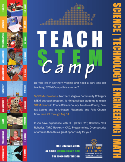


© Copyright 2026