
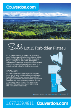
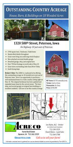
Future Land Use Map
COASTAL RURAL
PINE ISLAND
MAIN ST
30
A Summary of the Coastal Rural Land Use
Category by Tony Palermo, Senior Planner,
Lee County
35
The Coastal Rural Future Land Use
category is a policy in the Lee Plan to help us
implement the vision of Greater Pine Island.
FUTURE URBAN AREAS
Urban Community
Suburban
Outlying Suburban
OW
ELL
INGF
STR
Public Facilities
W
RD N
26
RD
NON-URBAN AREAS
ND
ISLA
PINE
Rural
Coastal Rural
Outer Island
Conservation Lands - Upland
ENVIRONMENTALLY CRITICAL AREAS
(WETLANDS)
21
Wetlands
Conservation Lands - Wetland
1
0.5
0
1
2
Miles
3
4
OLEANDER ST
Future Land Use Map
Pine Island includes Greater Pine Island
with surrounding smaller islands and some
unincorporated enclaves near Cape Coral.
Its future, as seen by Pine Islanders, will be a
matter of maintaining an equilibrium
between modest growth, a fragile ecology,
and a viable and productive agricultural
community. Pine Island will continue to be a
haven between urban sprawl approaching
from the mainland and the wealth of the
outer islands; a quiet place of family
businesses, school children, farmers, and
retirees enjoying the bounties of nature; a
place devoid of high-rises, strip malls, and
gated communities.....Pine Island will
continue to be a place where people, nature
and agriculture exist in harmony, a place not
very different from what it is today, an island
as state-of-mind as much as a physical entity,
its best features preserved and enhanced.
Pine Islanders are historically vigilant about
protecting their community and will work to
ensure that their plans are carried out.
Goal 14 of the Lee Plan is to "manage
future growth on and around Greater Pine
Island so as to maintain the island's unique
natural resources, character and its viable
and productive agricultural community and
to insure that island residents and visitors
have a reasonable opportunity to evacuate
when a hurricane strike is imminent.”
Z
By: Tony Palermo (cont.)
Policy 1.4.7 of the Lee Plan applies to land formerly classified as Rural - and is now
called "Coastal Rural."
It states: "The Coastal Rural areas will
remain rural except for portions of
properties where residential lots are
permitted in exchange for permanent
preservation or restoration of native upland
habitats or a commitment, in the form of a
perpetual easement, to preserve agricultural
activity on existing farmland, on the
remainder of the property. The standard
maximum density is one dwelling unit per
ten acres (1DU/10 acres).
Maximum densities may increase as
higher percentages of native habitat are
permanently preserved or restored on the
uplands portions of the site, or a
commitment, in the form of a perpetual
easement, to preserve agricultural activity
on existing farmland, in accordance with the
chart below. Permitted land uses include
agriculture, fill-dirt extraction,
conservation uses, and residential uses."
Table 33-1052. LEE COUNTY LAND DEVELOPMENT CODE
Percentage of the on-site uplands
that are: preserved or restored
native habitat; -or- for continued
agricultural use on existing
farmland.
0% to 4.99%
5% to 9.99%
10% to 14.99%
15% to 19.99%
20% to 29.99%
30% to 39.99%
40% to 49.99%
50% to 59.99%
60% to 69.99%
70% or more
Adjusted Maximum Densities
If undeveloped land will be
permanently preserved or
restored as native habitat:
1 DU/ 17 acres
1 DU/ 15 acres
1 DU/ 13 acres
1 DU/ 12 acres
1 DU/ 10 acres
1 DU/ 8 acres
1 DU/ 7 acres
1 DU/ 5 acres
1 DU/ 4 acres
1 DU/ 2.7 acres
The Pine Island Plan does not restrict the
building of homes on previously approved
housing lots. It restricts the use of walls around
housing developments. It sets “Old Florida”
building designs as the standard for new
commercial construction. The building height
limit of 38 feet remains.
If undeveloped land will be
continued in agricultural use
on existing farmland:
1 DU/ 17 acres
1 DU/ 15 acres
1 DU/ 15 acres
1 DU/ 15 acres
1 DU/ 13 acres
1 DU/ 12 acres
1 DU/ 10 acres
1 DU/ 8 acres
1 DU/ 5 acres
1 DU/ 4 acres
To calculate the total allowable dwelling units,
divide the gross development acres by the
number of acres allowed per dwelling unit (DU)
for percentage (%) of area conserved. Example
for 100 acres, 70% preserved; 100ac./2.7units
per acre = 37 DU on 30 acres.
Tony Palermo, Senior Planner, AICP
Lee County Department of
Community Development
P.O. Box 398
Fort Myers, FL 33902
(239) 533-8325
[email protected]
Greater
Pine Island
Civic INCORPORATED
Association
PROTECTING THE SAFETY, HEALTH, WELFARE AND
QUALITY OF LIFE OF THE GREATER PINE ISLAND COMMUNITY
“To work diligently for the betterment of
the area represented by the Association”
from the bylaws of the Greater Pine Island Civic Association
www.gpica.org
(OVER for MAP)

© Copyright 2026