
Developing Mountain Biking in Queensland: Regional
Developing Mountain
Biking in Queensland:
Regional Solutions
Developing Mountain Biking in Queensland:
Regional Solutions
17 December 2014
Lead Author
Donna Little
Way to Be – waytobe.com.au
Contributing Authors
Gillian Duncan
Gap Creek Trails Alliance (GCTA)
Leasie Felderhof
Tablelands Integrated Mountain Bike Alliance (TIMBA)
Rob Macdonald
Sunshine Coast Trails Alliance (SCTA)
Murray Stewart
Queensland Outdoor Recreation Federation (QORF)
Howard Taylor
City of Gold Coast (CoGC)
Andrew Wilson
South East Queensland Trails Alliance (SEQTA)
While reasonable care has been taken in preparing this document, the authors provide no warranties and
make no representations that the information contained in the document is correct, complete, or reliable. The
authors expressly disclaim liability for any loss, however caused, whether due to negligence or otherwise
arising from the use of or reliance on the information contained in this document by any person.
i
TABLE OF CONTENTS
1.0 Overview......................................................................................................................... iii
2.1 What is mountain biking? .............................................................................................. 2
2.2 Background to proposal ................................................................................................ 2
2.3 The vision for MTB in Queensland ............................................................................... 3
2.4 Mountain biking in Queensland .................................................................................... 4
2.5 Why invest in Regional MTB Solutions ........................................................................ 5
2.6 MTB trail network success markers ............................................................................. 6
3.1 Regional opportunities .................................................................................................. 8
3.2 Nerang Trail Centre ................................................................................................ 11
3.3 Koala Coast Trail Centre ....................................................................................... 15
3.4 Walkabout Creek Trail Centre ............................................................................... 19
3.5 Parklands Trail Network ........................................................................................ 23
3.6 Townsville & Region Trail Centre ......................................................................... 27
3.7 TNQ Regional Trail Centre .................................................................................... 30
4.0 References .................................................................................................................... 34
4.1 Image credits .......................................................................................................... 35
5.0 Risk management considerations .............................................................................. 36
5.1 Trail planning & construction principles ............................................................. 36
5.2 Essential elements of sustainable trails .............................................................. 37
5.3 Smart signage ........................................................................................................ 37
5.4 Trail etiquette.......................................................................................................... 39
6.0 Regional considerations ....................................................................................... 40
7.0 Resourcing solutions ................................................................................................... 42
7.1 Potential funding sources for QPWS ................................................................... 42
7.2 Progressive capital expenditure ........................................................................... 43
7.3 Community resourcing .......................................................................................... 43
7.4 Potential funding for MTB groups & councils ..................................................... 44
8.0 Trails for the regions .................................................................................................... 45
ii
1.0 OVERVIEW
Mountain biking is a popular and growing sport and recreation pursuit. It is also an emerging force in
tourism, with more opportunities being created for people to experience their environment in different
and deeper ways.
To reap the potential social, economic and health benefits of mountain biking throughout
Queensland this document outlines proposals for 6 regional mountain bike resources along the east
coast that can:
!
Provide access to unique experiences in the Queensland landscape
!
Support the delivery of a range of special events
!
Disperse pressure on existing heavily used sites
!
Establish Queensland as a world class mountain bike destination, and
!
Support regional communities through economic diversification.
Why?
!
Over 54% of QLD households have at least one working bicycle
!
Growth in mountain biking as tourism has been in excess of 20% since 2008
!
Multiple competitive mountain bike events happen every weekend throughout Queensland
!
Hallmark mountain bike events feed millions of dollars into local and state economies
To leverage these opportunities, Queensland needs high quality and sufficient mountain bike trails to
meet consumer recreational needs and enable event and tourism development. This document
outlines six Regional Mountain Bike proposals for safe, engaging, well designed and desirable
destinations. Addressing the need for destinations that meet tourism and rider demands, four ride
centres are proposed from the Gold Coast to Sunshine Coast. These include:
1. Nerang National Park - 70+ km ride destination in the proposed GC cycle precinct
Close proximity to major population; expanded tourism product; allows riders to experience the
‘green’ behind the ‘gold’; offers a central location for world class mountain bike events; large enough
to attract international visitation.
2. Koala Coast, Daisy Hill Forest Reserve – ride centre
Existing usage is high; site remediation and connecting trails will expand ride experiences for
families, experienced riders, sport training and touring visitors. With the development of network links,
3 days+ of riding will be available (e.g. Daisy Hill, Venmans, Cornubia, Karingal, Bayview)
3. Walkabout Creek, D’Aguilar National Park – trail centre
Expands and formalises family ride adventures at Walkabout Creek, connects trails to Gap Creek,
Mt Coot-tha Forest Trail network, Mt Nebo, Samford and Bunyaville Regional Parks. These will meet
growing needs for sport training rides, family / recreational riding, long distance routes, and skill
development, all on the doorstep of central Brisbane.
4. Parklands Regional Park, Sunshine Coast – 50km singletrack trail network
15 minutes to beach and hinterland. Diversity of trail grades, rider development, a challenging venue
for advanced riders, suitable for racers and multi-sport events.
iii
Individually and collectively, these offer a variety of substantive destinations to cater for:
!
Families and beginners,
!
The fit cross country racer,
!
Youth development,
!
Social and competitive events, and
!
Skills areas and technical trail features to allow riders to practice and build capacity.
Regional trail networks in the Far North and Townsville extend the Queensland mountain bike
experience, providing people with trails that carry people into World Heritage terrain. These trails
variously offer ocean views, the opportunity to explore dormant volcanos, or the chance to touch the
wilderness through backcountry trails. Regional trail networks enable extended rides as people take
long touring journeys through an ever-changing landscape.
5. Townsville and Region – trail centre
A stepping stone to explore west to Charters Towers, east to Magnetic Island, north to Wallaman
Falls, south to the Burdekin, and onto the Whitsundays. Touring rides, mountain bike events, looping
trails.
6. Tropical North Queensland – regional trail centre
Already growing as a MTB destination and recent host of a UCI World Cup, Tropical North
Queensland has demonstrated the opportunity that comes from world-class trails. The foundation is
laid to attract world MTB competition and festivals, provide access to unique landscapes and enable
3-5 day touring networks by connecting small towns.
Combined, the suite of Ride Destinations have the potential to provide communities and visitors alike
with healthy lifestyle experiences that can provide a boost to local economies and enhance social
capital. These outcomes require investment to reap the return: in trail building and infrastructure, and
also in smart design and development. This will ensure mountain bike trails are attractive, interesting,
playful, and world leading; and enable a desirable and positive return on investment for Queensland.
The following document presents an overview of opportunities, and a proposed way forward that is
readily actionable to maximise the social, economic and health benefits of mountain bike resources
to Queensland. While the focus in on lands in the Protected Area Estate, a partnership approach
with other land managers is vital to take advantage of the opportunities available. Already, local/
regional councils, water authorities, tourism and mountain bike riders have demonstrated their
readiness to contribute to coordinated planning and delivery of MTB trails. With a leading role
provided by State Government, that enthusiasm can be harnessed and the returns realised.
iv
2. INTRODUCTION &
BACKGROUND
"
"
"
Page | 1
2.1 What is mountain biking?
Mountain biking is a popular outdoor activity that involves the riding of dedicated bikes off road.
Mountain biking is not a singular experience. It is pursued in a range of styles, but has been
demonstrated to be an activity that can be accessed by most people with a mountain bike – whether
their bike is a $150 outlet store special or a $10,000+ wonder bike.
Mountain bike (MTB) riding provides people with a chance to connect with nature, escape the
everyday, have fun, get fit, be part of a community, go somewhere or nowhere, be challenged, be
alone or to spend time with friends. When communities have well designed and located trails,
mountain biking has proven to be a healthy, outdoor activity for children and families, friends and
colleagues, men and women, casual riders, serious enthusiasts and competitive riders.
2.2 Background to proposal
Since 2006 MTB riders, land managers and other stakeholders have met to discuss issues,
opportunities and development for mountain bike riding throughout Queensland. The Qld MTB
Forum has recognised that whilst the activity has grown organically, supply does not match demand;
and nor does it cater for community, event, sport or tourism growth. As a group the members of the
MTB Forum has realised the relevance of a coordinated approach to MTB development; and the
opportunities that can be accessed through investment in key regional mountain bike developments.
The following proposal is the result of the efforts of the State Wide MTB Regional Solution and
Advocacy Working Group and the Qld MTB Forum1 who have consulted with their networks to
identify pre-eminent MTB development opportunities on the Protected Area Estate, managed by
QPWS.
The aim of this Regional Solution document is to present a selection of MTB trail development
priorities in Queensland that are viable community assets and are economically and environmentally
sustainable. It is our intention to reinforce that not only can MTB trails contribute to healthy and
active communities; but that well designed, constructed and supported trails also contribute to
regional development and the enrichment of people’s lives as they move through nature and interact
with our diverse landscapes.
""""""""""""""""""""""""""""""""""""""""""""""""""""""""
1
The Working Group and Qld MTB Forum are coordinated by QORF. Through these networks the project has coordinated
advice and support from representative riders, QPWS staff, local government authorities, Mountain Bike Australia,
commercial service providers, event managers and other land managers.
"
"
Page | 2
2.3 The vision for MTB in Queensland
“To contribute to vibrant and healthy Queensland communities
through the development of a network of regional world-class
mountain biking resources that enhance Queensland’s
recreational, social, environmental and economic opportunities.”
What do the Regions of Queensland offer?
!
Engaging landscapes from native forest to world heritage settings to ocean vistas;
!
Diverse experiences through the variety of culture, heritage and experience from city to
country, beach to bush;
!
Tourism and business infrastructure that can support development and increased visitor
numbers;
!
Fine, cool winter days. Warm summer mornings and evenings;
!
Geographic and environmental choice that accommodates seasonal variation and different
riding experiences;
!
Complementary activities within and without the protected area estate (PAE) that suit a wide
range of visitors and travellers including trail running, rock climbing, canoeing, fishing, hiking
and camping;
!
Established MTB events and supportive MTB Clubs and trail care groups;
!
The genesis of world class routes, trails and reputation (e.g. Smithfield Regional Park,
Atherton Tablelands, Daisy Hill Regional Park, D’Aguilar National Park)
To achieve these outcomes and realise Queensland’s MTB potential our key principles of planning
for this proposal include:
!
applying a regional focus to identify opportunities that align with the conservation and
environmental values of the landscape;
!
developing sustainable, well designed and constructed world class MTB trails that fit with
IMBA2 Guidelines;
!
enabling efficient and effective trail maintenance models for asset management of trails and
related infrastructure;
!
prioritising mountain bike development in areas with existing demand, close to population
bases, that hold scenic amenity and/ or demonstrate economic development opportunities,
and have local support;
!
taking a partnership approach that draws on the expertise, resources and capacity of land
managers, trail care groups, MTB clubs and commercial enterprises;
!
extending opportunities for visitation, spend and length of stay.
""""""""""""""""""""""""""""""""""""""""""""""""""""""""
2
"
IMBA - International Mountain Bicycling Association
"
Page | 3
2.4 Mountain biking in Queensland
Contrary to some perceptions, mountain biking is not singularly the realm of the young or the
masculine. Across the range of styles of mountain biking, the activity offers the chance for young and
old, male and female, the intrepid and the sedate to experience the natural environment on mountain
bike trails.
While mountain bike riding is growing in popularity, sections of the population are not well
represented. The opportunities for growth and development remain widespread as more people
recognise the health, financial and social advantages of riding their mountain bike for holidays,
exploration and pleasure.
MTB in QLD – What do we know?3
Over 54% of all QLD households have
at least one working bicycle
Import sales of adult bikes increased by 21%
from 2009/10 to 2011/12
Recreational cycling (such as mountain biking) is
more than twice as popular than cycling for transport purposes
Cycling participation is
higher for males than females
Queensland children cycle at higher rates
than adults
Cycling as a holiday activity has increased in popularity
by 25% for domestic visitors and 17% for international visitors
Growth in mountain biking for tourism
has been in excess of 20% since 2008
More people in Australia are
cycling than ever before
""""""""""""""""""""""""""""""""""""""""""""""""""""""""
3
Sources: Tourism Research Australia (2013); Australian Bicycle Council, Australian Cycling Participation 2013; Bicycle
Industries Australia, 2013.
Page | 4
"
"
2.5 Why invest in Regional MTB Solutions
!
Effectively leverage world class mountain bike events held in Queensland to build
participation and tourism potential (e.g. UCI World Cup series 2014, 2016; Commonwealth
Games, 2018)
!
Develop the appeal, accessibility and desirability of mountain biking for the Queensland
tourism market
!
Encourage healthy and active lifestyles
!
Develop tourism for regional communities through economic diversification and increased
visitation
!
Expand Queensland’s diversity as a year round destination for outdoor recreation
!
Provide spaces and experiences that increase community stewardship and a sense of
connection with the environment
!
Decrease health costs through healthy physical activity
!
Meet community demand, reduce the potential for user conflict
!
Boost opportunity for local and regional business provision of cycling goods and services
Economic Benefits: Recreational Trails
Trail and mountain bike tourism have been
found to provide economic stimulus for local
regions. For example:
Oregon, USA (2013)
! 17.4m people visited Oregon
! 4.5 m rode a bike while visiting
! Overnight cycling visitors spend 8x more
than day travellers
! $6.6m pulled into state’s economy by
MTB events and tours (McNamee et al,
2013; Travel Oregon, 2013)
7Stanes, Scotland
! $214m contribution of MTB to Scottish
economy
! 400,000+ riders visit 7 Stanes each year
! $36m return to local community (EKOS,
2007)
Rotorua, New Zealand
! Cycle tourism contributes $15m to the
local economy
! Value is 5x the return on timber revenue
! $2.5m spend per day during 2006 UCI
MTB World Championships in Rotorua
(Cycling News, 2006; NZ Herald, 2012)
Cairns, Qld
! 10, 000+ spectators to the 2014 UCI MTB
World Cup
! Estimated $10m contribution to Qld
economy (Cairns Post, 2014)
Regional planning is
needed to identify &
prioritise areas for high
quality, sustainable &
accessible mountain bike
trails. !
Events engage diverse
participation in different
regions & boost financial
returns. These need
coordination to reduce
overlap.!
State, national &
international events
increase exposure. Quality
local services encourage
welcome & visitor spend.!
""
"
"
Page | 5
2.6 MTB trail network success markers
To reap the potential of positive returns from investment in mountain bike trails, networks and hubs
requires a targeted and planned approach. Lessons learned from successful models throughout the
world, including Rotorua and the New Zealand Cycle Trail project; 7Stanes, Scotland; and the
successful mountain bike trail networks of Fruitia, Colorado and Moab, Utah all indicate that
economic and social success stems not just from developing quality, sustainable trail, but also
investing in infrastructure, signage, promotion and long term maintenance.
In overview, successful MTB trail networks:
"
Provide diversity of experience.
There is a variety of riding difficulty, duration
and scenery to captivate and engage riders
of all levels and abilities.
Offer skill-building opportunities.
At least a third of all trails are green to cater for the
sedate or novice rider; and skills parks form part of
the MTB riding network.
Commit to consistent, informative and
correct signage and mapping of trails.
Are actively supported by the land manager.
Trails and trail infrastructure are seen as integral
land assets that are managed, maintained,
developed and enhanced through ongoing land
manager commitments and relationships with
community volunteers and supporters.
Are informed by coordinated and clear
plans for mountain biking that ensures
management, promotion and trail care are
prioritised for rider benefit.
Are purposefully planned, designed and
constructed to meet user needs, engage the public
and take best sustainable advantage of the
landscapes features.
Allocate resources to invest in a process of
ongoing trail review to adjust trail alignment
as heavy use, unseasonal weather or
unanticipated change informs amendments.
Have the support of local community – riders,
business, land managers, service providers. (Note:
the extent and nature of support needed can vary
across land tenure & purpose)
"
Page | 6
3. REGIONAL
SOLUTIONS
"
"
"
Page | 7
3.1 Regional opportunities
Drawing on the expertise of the Working Group, mountain bike clubs, and industry networks, a broad
range of potential mountain bike developments and refinements have been determined. Each would
provide valuable service to local communities and riders. Here, six indicative key regional solutions
for mountain biking are presented. These are intentionally limited to the protected area estate and
offer just some of the many opportunities that exist across the Queensland landscape.
International experience has demonstrated that with commitment of vision and resources it is
possible to create networks of mountain bike hotspots that can:
•
•
•
•
Right Trails, Right Places!
•
provide people with a way of experiencing, exploring and connecting with Queensland’s
outdoors;
deliver health benefits from physical activity;
enhance the tourism opportunities on offer in different regions;
support regional economic development through spending on tourism, events, bike care,
accommodation, food and drink; and
further Queensland’s reputation as an adventurous, outdoor, welcoming and diverse
residential and tourism destination.
MTB Ride Centres!
Regional. Wide range of trails, invite multi
day trips. May include multiple trail heads
across a region!
MTB Bike Parks!
Local trails parks that cater for a large
community. Include MTB skills area &
networked loops!
MTB Trails!
Confined trails that offer riders a space to
ride bikes legally. Tend to offer small scale
experience!
Regional Solutions are representative of areas that have been identified by MTB riders as desirable,
proximal places to ride. This is indicated by the existing use, range and rate of illegal trail use that
has been conducted, and the ongoing growth at each location. Each area is also supported by
proactive MTB clubs and trail care groups who wish to not only ride, but expand opportunities for
others, and make a contribution to the development and maintenance of high quality, well designed
and located MTB trails.
In essence the overarching regional proposal for MTB in Queensland posits the ideal of a series of
Ride Centres throughout the state. These would serve to meet current and latent local demand, yet
importantly also provide a network of trails, touring networks and distinct destinations for riders to
experience a breadth of riding experiences throughout the state.
"
"
Page | 8
Figure 3.1: Qld MTB Ride Centres & Regional Trail Networks
While the ride centres remain heavily centred in South East Queensland, this is an artefact of
Queensland’s population, known current demand and the lack of an extensive network of trails in the
area. Regional networks and connecting trails are proposed for Townsville and the Tropical North,
but in the South East, a series of Ride Centres is identified as the most practical solution, with each
providing a hub for quality riding, supplemented by surrounding resources across a range of
jurisdictions.
"
"
Page | 9
MTB Trails
Nerang
Trail Centre
Koala Coast
Trail Centre
Walkabout
Creek Trail
Centre
A gateway for MTB with connections to
Brisbane’s green perimeter – Mt Nebo,
Samford, Gap Creek. With a Junior Skills Park
already under development, this area offers a
fantastic venue for beginner riders, families and
long distance rides all within the confines of
Brisbane City.
Parklands
Regional
Mountain
Bike Park
Existing intermediate level riding facilities
providing challenging and technical trails.
TNQ
Regional
Trail Centre
Green
Blue
Black
70km Ride Centre as part of a cycling precinct.
Supported by a cycling centre at the Trailhead,
this is a MTB destination in itself.
Creating connections across different land
managers, the Koala Coast trails open up the
recreational opportunities for regional residents
in this desirable bushland setting.
Townsville
& Region
Trail Centre
Trail
Grades
Features
Forest
road
Green
Blue
Forest
Road
‘White’
Green
Blue
Forest
road
Green
Blue
Black
Regional mountain bike centre
Situated on the edge of the outback, the reef
and the wet tropics, Townsville offers a series
of MTB routes to choose from that allow people
to explore, test their skills, or have a fabulous
family adventure.
Green
Blue
Black
Forest
road
Recreational mountain bike destination.
Offering a unique mix for Qld of forest and
ocean & supported by a range of regional
towns, TNQ offers riders the chance to
experience rainforest, mountains, coast &
billabong across an accessible landscape.
Green
Blue
Black
Forest
road
Facilities
√ Trailhead
√ Café
√ Toilets
√ Public Transport
√ Skills Park
√ Trailhead
√ Toilets
√ Shelter
√ Trailhead
√ Café
√ Toilets
√ Public Transport
√ Jnr Skills Park
√ Play Area
√ Parking (limited)
√ Mapped & signed
× No trailhead
× No toilet
√ In Towns:
√ Cafes
Toilets
√ Bike Shops
√ Accommodation
√ In Towns:
√ Cafes
√ Toilets
√ Bike Shops
√ Accommodation
Opportunities exist to build additional infrastructure and services around quality trails including:
o
o
o
o
"
Bike hire
Shuttle services
Bike wash down facilities
Tuition – how to ride
o
o
o
o
Play Areas
Showers
Cafes
Shelters
"
Page | 10
3.2 Nerang Trail Centre
The Nerang National Park is situated 15km due west of Surfers Paradise
and lies almost at the geographical centre of the City. The park’s eastern,
southern and western boundaries are neighboured by urban / rural
residential properties in the suburbs of Gaven, Nerang & Maudsland. The
northern boundary of the park is adjacent to the densely populated urban
residential suburb of Pacific Pines.
Such a proximal location offers clear opportunities to develop Nerang
National Park as a world class cross county (XC) trail destination. The
cycling precinct is adjacent to Nerang National Park in the south eastern
corner of the park and is the current and most used entry point into the
park by riders. The cycling precinct is approximately 8 Ha and is managed
by the City of Gold Coast (CoGC) which also provides other cycling related
recreational opportunities, track cycling and road racing on a closed
criterium circuit.
Development of the Nerang Trail Centre would provide opportunities for
the local Queensland community to ride in a world class venue; and could
attract and extend the visit of domestic and international tourists drawn to
the experiences available in the surrounding area. In addition to MTB, from
the Nerang Trail Centre people could readily experience the best the Gold
Coast has to offer – beaches, theme parks, riding, shopping, swimming,
walking, dining, exploring and staying.
By using the leverage of the Commonwealth Games and investing in
Nerang National Park world class MTB trails, Queensland could showcase
not only the sports in competition, but establish and embed a benchmark
destination that offers recreation solutions and provides economic returns
to the wider community.
The Vision
The Nerang MTB trail centre would offer a valuable resource for people
keen to explore their environment on trails close to amenities. Already
used by numerous riders, trail runners and orienteering groups, the current
trails are considered to be raw and challenging. Lacking in managed
development, and built to meet the needs (and skills) of experienced riders,
there are limited opportunities for new riders, beginners and families.
The proposal for Nerang NP is to create a high quality, proximal trail centre
with an appealing mix of well-planned and located IMBA standard trails
that provide riders of all levels with interesting, engaging and enjoyable
ride experiences. With a long term target of 100km, and a Stage 1
proposal for 70km of trail, riders will have numerous opportunities to cycle
different routes, enhance their skills, ride for leisure, pleasure,
development or challenge; and have enough variety to support endless
new, day riding opportunities on a mix of managed trails that include
quality one way single track.
The vision is to build high quality, world class trails designed to:
•
provide interesting rider experiences,
•
meet local conditions to enable sustainable riding all year round;
•
attract riders to the design features and encourage the local
community to pursue an active, healthy lifestyle;
•
offer the best of scenic amenity available.
“What’s a great MTB destination? Somewhere that is easily
accessible. It has good car parking and other resources
close to hand - like cafes and bike shops. It can easily stage
an event, but still handle social rides at the same time. It
has a variety of riding that can be ridden in any weather;
and it’s rewarding. It’s scenic, there are good descending
sections and the ‘ups’ are tough, but not soul destroying.”
- Ian Harwood, Event Manager & MTB rider
!
!
Page | 11
Partners
QPWS/ DNPRSR; CoGC; local MTB Clubs/ Trailcare; Commonwealth
Games Organising Committee (CoGC).
Opportunities
Problems Solved
!
lack of MTB facilities in GC region (Hinze - 5.4k Green/ Blue; Eagle
Heights 3.3km Black Diamond; Upper Coomera 1.4km Green;
Burleigh Heads 1.25km Green)
!
substantive illegal building of MTB trail (over 60km)
!
enhanced & extended quality of trail - attracts riders, improves
safety, increases access for beginner riders and families
A Partnership with the City of Gold Coast (CoGC)
QPWS/ DNPRSR
Provide 70km of all weather,
sustainably designed & built XC
trail catering for breadth of XC
rider ability.
CoGC
Create a world class ‘Trail Head’
at the cycling precinct
Build to IMBA standards
Masterplan for the precinct – in
play
Stacked Loop Approach with
Technical Trail Features (TTF)
incorporated into design with ‘B
Lines’ provided.
Provision of trail head amenities:
• Toilets, showers
• Skills/ Jump park
• Event staging
16km Green rated trail
46km Blue rated trail
8km Black rated trail
Vehicular parking
Commercial space for lease e.g.
Bike shop/ Café or other
commercial entities.
Transport available
!
2 minutes off the M1 at exit 69
!
Nerang Trail Station only 2.5km away. Allows for train commute
followed by ride on back streets, through parkland & on footpath.
!
Allows youth & those without private transport (including tourists) to
visit
Existing Opportunities
! CoGC support for building adventure tourism market
!
Visitors can experience the 'Green behind the Gold'
!
Accommodation, cafes, bike shops, tourism infrastructure already
in place
!
Event Ready - with legal trail, MTB events could be staged now
!
Commonwealth Games MTB Racing traversing the NP
Success Factors
!
!
Natural Beauty
!
Climate
!
Quality - well built trail, open year round, caters for events and
social riders, variety of rides in the same space, clear signage,
support infrastructure, coffee shop - sense of welcome
!
Page | 12
Concept Map of MTB Trails for Nerang National Park
Map: Rich Berry Design
!
!
Page | 13
Indicative costs
Trail Upgrade & Construction
Upgrade existing
trail
Construct new
trail
28km Blue
$336,000
2.5km Black
$33,750
16km Green
$560,000
18km Blue
$720,000
5.5km Black
$247,500
TOTAL – Upgrade & Construction
$1,897,250*
Other Costs
Network alignment & scoping
$50,000
Signage
$125,000
Project Management
$155,000
Decommission illegal trail
$147,500
TOTAL – Other Costs
$477,500
Maintenance
Year 1 – covered by defects liability
Ongoing
$Nil
$95,000/yr
*It is expected costs can be reduced through economies of scale
Future Opportunities
Develop Secondary Trail Head at Pacific Pines with Trail Extension to link
to the network in the southern section of the park. Utilise existing fire trail
of acceptable gradient with inclusion of bypass single track (Green rated)
to avoid steep and dangerous fire trail.
!
!
Page | 14
3.3 Koala Coast Trail Centre
The Koala Coast region lies approximately 20km south east of the
Brisbane central business district and includes growing population areas
crossing the boundaries of Brisbane City (BCC), Logan City (LCC) and
Redlands City Councils (RCC). Both state and local government hold
significant resources in this region, with Redland and Logan City Councils
proactively recognising the social and economic value of mountain bike
riding, and enhancing the trail product available.
As an area undergoing ongoing rapid urban expansion and offering the
largest range of trails to the south of the Brisbane River, the existing
mountain bike trails are experiencing heavy use. In Daisy Hill Forest
Reserve, trail counters demonstrate in excess of 1,000 MTB ride passes
are made on key trails in any given week. While the numbers are indicative
only, this pattern has been consistent, with new trails achieving immediate
success within Daisy Hill and Logan City developments (e.g. Cornubia;
Daisy Hill Jumping Ant – 1,000 ride passes on opening weekend).
The Vision
To address the demand for current and future provision of mountain bike
trails, and to grow the potential for social and economic returns consistent
with the environmental values of the land, two development goals need to
be addressed:
Actions
Infrastructure"
Trail Revision"
Regional
Connections"
• Renovate, realign"
• New singletrack to build connections, create
loops & enhance access from trailheads"
• From Daisy Hill through Venmans to Cornubia
to Karingal to Bayview"
• From Daisy Hill to Underwood Park and KBCP"
Opportunities! Better trails, safer trails, more desirable trails."
Current use & growth are significant. Intervention is needed to relieve
pressure on existing trails particularly within DH Forest Reserve."
Cross tenure, well managed and planned recreational trail networks
that seamlessly link existing and new community developments (e.g.
Underwood Park to Daisy Hill Forest Reserve to KBCP to Venmans, to
LCC Cornubia & RCC Bayview/ Eastern Escarpment)."
1. Conduct remedial work on existing trails and management trails to
make these safer and more rideable (Daisy Hill).
Increased accessiblity for beginners and young families through the
provision of one way, green singletrack trail experiences."
2. Develop the connections between the various land managers’
estates to create a network of trails that cater for families,
experienced riders, sport training, and touring visitors.
Reduced accidents and incidents by re routing riders off dangerous
sections of management roads which involve water bars and have
steep descents. Well designed singletrack slows the rider, AND
increases the experience and sense of speed."
Partners
QPWS/ DNPRSR; Logan City Council, Redlands City Council; local MTB
Clubs/ Trailcare
!
• Trailhead facilities"
• Car Parking"
• Signage"
• Event Staging Area"
!
Page | 15
Koala Coast MTB Trail Proposal – regional context
Map: Rich Berry Design
!
!
Page | 16
Koala Coast MTB Trail Proposal –
detailed plan
!
!
Page | 17
Indicative Costs
“I really like riding with my
friends and family every
weekend at Daisy Hill”
Trail Upgrade & Construction
Upgrade existing
trails
- Sophie Winkcup, age 7
Turning Japanese trail – 1.8km
Tunnel of Love trail – 0.5km
$57,500
Carpark to Five Ways link – 0.6km
Turning Japanese to Snake – 3.2km
Snake to Nirvana – 1.7km
Construct new
trail
!
!
!
!
!
!
Venman Bushland can offer an intermediate riding experience and
provide the opportunity to develop quality XC race venue.
Stay and Play. A range of services are embedded in the
communities of the Koala Coast, with strong potential for bike hire,
bike shops, cafes, accommodation and training enterprises to
develop.
There is community commitment. More than 1,500 hours have
been contributed to volunteer trail building and trail care in the
Daisy Hill/ Cornubia area in the last 3 years.
Venman North-South trail – 5.7km
$610,000
Leo Lindo – Venman link – 1.3km
This area is already a regional destination and it has the potential
to be a hub for multi-day riding with the development of loops
into neighbouring jurisdictions.
The trails at Daisy Hill provide a fantastic resource for beginner
riders. Cornubia caters to the skilled to advanced rider.
Underwood Skills Park will provide a training venue for riders to
develop and practice their skills.
Ford Rd block trail – 7.5km
West Mt Cotton carpark link – 3.3km
Venman – Cornubia link – 1.1km
TOTAL – Upgrade & Construction
$667,500
Infrastructure
Signage upgrade
$24,000
Five Ways skills features & seating
$40,000
Trail head parking upgrade
TOTAL - Infrastructure
TBC
$64,000
Other expenses
Project management
Maintenance
!
$50,000
$33,800/yr
Page | 18
3.4 Walkabout Creek Trail Centre
Walkabout Creek Visitor Centre is 12km from the Brisbane CBD and the
recreation gateway for D’Aguilar National Park; the closest and largest
national park to a capital city in Australia. The construction of the new
Activity Centre through 2015 will add exciting outdoor experiences to
Walkabout Creek, including a Junior Mountain Bike Skills Park.
Neither of these projects can progress unless Seqwater agree to open
access to the parkland and management road below the dam wall. This
missing link below the dam wall prevents completion of the circuit and
easy access to Walkabout Creek. In discussions relating to this proposal,
Seqwater has indicated that public access is possible.
Partners
QPWS/ DNPRSR; Seqwater; BCC; local MTB Clubs/ Trailcare
Walkabout Creek is the gateway to D'Aguilar NP for 2 mill. Brisbane residents"
400,000 visitors per year to D'Aguilar NP"
55% of users of the Horse Trail Network are MTB riders"
1,000+ mountain bike visits per week on Gap Creek MTB singletrack"
1 in 4 of all tourism trips has an adventure component"
The Vision
In order to the enhance mountain bike experiences for a wider audience,
two specific projects are proposed.
1. New mountain bike singletrack is proposed to link Walkabout Creek
to the popular trails at Gap Creek managed by Brisbane City
Council. This link provides a conduit for residents in The Gap to
ride on purpose-built singletrack from Walkabout Creek; forms an
attractive circuit for events; and draws riders from over-crowded
trails at Gap Creek. Additional singletrack to the north of Walkabout
Creek provide contoured, narrow trails for novice and experienced
riders and form circuits for recreational riding, training and events.
2. To enhance the management road around Enoggera Dam by
rerouting three steep sections to create easier climbs. Currently
this multiuse circuit is very scenic and enjoyable except for three
steep ascents which preclude the majority of riders and create
difficulties for fire management vehicles.
!
“The inclusion of MTB trails at Walkabout Creek will
provide a venue for MTBskills to teach skills that develop
riders so they can ride their mountain bike safely and
responsibly. It will help us to enable people to have more
fun, enjoyment and confidence when mountain biking and
will directly help support a local small business.”
- Rowan Lamont, MTB Skills coach
!
Page | 19
Opportunities
Walkabout Creek Trail Centre: MTB
!
Enhances Walkabout Creek as a Trail Centre;
!
Draws more mountain bikers, trail runners and
others;
!
Provides facilities for mountain bike and trailbased events;
!
Provides for school based mountain bike
programs at The Gap SHS and Kenmore SHS;
!
Enhances opportunities for bike clubs, shops
and coaches to use purpose-built trails.
In addition to mountain biking in the near vicinity,
Walkabout Creek Visitor Centre can easily be marketed
as the gateway to long distance epic rides in D’Aguilar
National Park. The 25km ride along South Boundary
Road to Mt Nebo is currently the most popular epic
mountain bike ride in Brisbane. Used for endurance
riding and training, the trail passes through open
Eucalypt forest which gradually changes to rainforest as
the trail climbs. These qualities offer attractive pull
factors for overseas visitors.
An additional long distance route could be marketed as
the Singletrack Experience. It is easy to ride north from
Walkabout Creek on management trails to mountain
bike singletrack in Samford and Bunyaville Regional
Parks. To achieve this merely requires signage and
promotion. The trails are already there (refer to following
map).
Map: Rich Berry Design
!
!
Page | 20
Walkabout Creek Trail Centre Long Distance Trails
Map: Rich Berry Design
!
!
Page | 21
Experiences Available
!
Event Staging
!
Social riding
!
Family recreation
!
From 30 min to three day ride experiences. For example, interstate
and overseas visitors will have three days of mountain bike riding
on offer from Walkabout Creek Trail Centre:
Day 1: Purpose-built skills park, singletrack and scenic
Enoggera Dam Circuit
Day 2: Mt Nebo Epic
Day 3: Singletrack Experience in Samford and Bunyaville
Regional Parks
Indicative Costs
Project 1 – new singletrack
Mt Coot-tha link – 4km
Trail construction
Jeep Break trail – 1.5km
$200,000
Duck Creek link – 2.5km
Project management
$15,000
Maintenance
$10,000/yr
Project 2 - Enoggera Dam Circuit
Linkages Walkabout Creek to below Dam Wall
undertaken with Activity Centre work
Linkage below Dam Wall to South Boundary already
exists on Seqwater land
Enhancement work on existing management road to
re-route three steep inclines is difficult to cost consideration needs to be given to the best alignment.
The labour to achieve this outcome is therefore costed
on a daily basis following consultation with local staff
$Nil
$Minimal
$2,500/day
“I can’t wait to ride out of my gate through Bunyaville,
Samford Range, Upper Kedron to Gap Creek. Awesome!
That ride would have lots of highlights: singletrack,
views to the city and bay, character building climbs,
long coasting descents, open eucalypt forest & dams.
Sounds like a great day out to me.”
- Steve Schuhmacher, local rider
!
!
Page | 22
Partners
QPWS/ DNPRSR; SCRC; local MTB Clubs/ Trailcare
direct Highway
access"
close to airport"
close to
population
centres"
multiple access
location"
durable soil types"
excellent all
weather riding"
preserves more
sensitive regional
trails"
low maintenance"
Challenging!
Opportunities
Accessible!
Parklands Regional Park is located north east of Nambour on the
Sunshine Coast. A 650ha Regional Park, Parklands consists of a mix of
dry sclerophyll forest and subtropical rainforest gullies. Located just 15
minutes from the coast, it is readily accessible to the 280,000 local
Sunshine Coast residents and can add a new element to the experiences
available for visitors to this region.
Accessible by road, Parklands prominent location on the junction of the
Bruce Highway and the Nambour - Bli Bli Road provides the site with very
efficient access for the local population and enables day trip visitation from
the whole South East Queensland region.
Sustainable!
3.5 Parklands Trail Network
incorporate all
riding abilities"
accepts diverse
riding groups"
promotes
challenge &
progression"
tests advanced
riders, racers &
multi sport"
“Parklands has got so much potential, it’s just missing
the variety of trails needed to be world class. We have so
many school and tourist groups that would be able to
use the trails if they catered for a wider skill range.”
- John Searston, Have Fun Tours
Map: Rich Berry Design
!
!
Page | 23
Vision
Development of the Parklands Trail Network would provide a valuable
facility central to the Sunshine Coast Region and complementary with
existing trail riding opportunities available from the Glasshouse Mountains
to Noosa. Parklands is unique in providing a significant variety of terrain,
very sustainable soils conditions and a low ecological rating due to past
resource operations. With a vision as a central, skill developing MTB Park,
when complete, this site will create a drawcard ride centre, expanding on
other regional facilities (e.g. Tewantin, Dularcha, Glass House Mountains,
Hennessey Hill, Bellthorpe) to create a genuine multi day ride destination.
These outcomes can be achieved by:
!
Being accessible 24 hours a day. Current mid-week utilisation of
the trails is high, with night riding particularly popular throughout the
year. Proximity allows regular after work riding and the affordability
of lights have led to a dramatic uptake in night time riding.
!
An additional 35km of constructed singletrack. This would
create a destination for riding, expand the user base, and diversify
the trail grades - proven to be successful elements for trail centres.
!
!
Green – Beginner – 10km /13.9km total
Proposed
Enhancing facilities. Formalise and expand car parking, create a
trail head, establish an event staging area to create a sense of
place and promote improved sense of security and social
interaction for participants.
1km access track from the carpark to skills area
0.5km Skills Area
5km beginners loop
2km beginner ‘flow’ trail
1.5km total length of side tracks to bypass steep
sections of fire trail and improve usability of existing
multi-use trails
Blue – Intermediate - 18km new / 43km total
Managing the environment. Parklands terrain provides an ideal
base for MTB trail construction. Expanding and consolidating trails
on the weathered stone and ridge gravels provides the potential for
all weather riding.
!
!
Summary of proposed trails
9km ‘Progressive’ trail loops, transition up from
Beginner standard, all weather, easy access
Proposed
9km (4km+5km) ‘Flow’ trails – one way, all weather,
required for training & hosting ‘Gravity Enduro’
format racing events. Potential training trails for the
Commonwealth Games teams. Suitable for a broad
range of fitness levels while still providing a
rewarding riding experience
Black – Advanced - 7km new
3km technical trail, one way, utilising iconic rock
slabs and features for a memorable challenge
Proposed
Multi sport, junior races, enduro events. Parklands is close to
the Maroochy River, accessed by a 1.6km gravel road to the north,
and opens up opportunities for multi-sport events. With an internal
trail head and staging area utilising the old gravel carpark, event
organisers would have a central location for spectators, supporters
and vendors.
!
4km (2x2km) Freeride lines, single direction, variety
of features to promote creative line choices. Feature
trails for promotion of the venue and challenges in
the sport
Page | 24
Parklands Trail Centre Proposal
Map: Rich Berry Design
!
!
Page | 25
Indicative costs
Trail Construction
Beginner (Green) – 10km
$250,000
Intermediate (Blue) – 18km
$450,000
Advanced (Black) – 7km
$175,000
TOTAL - Construction
$875,000
Infrastructure
12 space extension to primary car park
$54,000
Landscaping and formalisation of event staging area
$21,000
TOTAL - Infrastructure
$75,000
Other Expenses
Project management
$65,625
Maintenance
$43,750/yr
2
2
*Car park costs based on allocation of 30m per vehicle at $150/m for an AC
surfaced car park including spoon drains, bollards and mulch/landscape around the
edge. Excludes retaining walls or cut/fill.
2
**Landscaping costs include mulching/garden bed at $25/m and timber bollards
installed at $140 each.
!
!
Page | 26
3.6 Townsville & Region Trail Centre
Townsville and region offer a diverse taste of riding in Queensland.
Located in the Tropics and adjacent to the Great Barrier Reef and Tropical
Rainforest, Townsville offers a central point for exploring west to the gold
town of Charters Towers, east to Magnetic Island, north to Wallaman Falls,
and south to the Burdekin and onto the Whitsundays.
The Vision
Home to Australia’s 3rd largest mountain bike club (and Queensland’s
largest), and with local MTB events selling out, Townsville is a hotspot of
MTB activity. To reap the potential of the trails and to expand opportunities,
the area needs support to connect existing and potential, sustainable
regional MTB venues. This would lift Townsville onto the world stage of
international mountain biking destinations.
Currently the region offers a range of riding opportunities. Each area offers
distinct riding experiences, but all would benefit from the development of
linkage trails and signage, the introduction of key infrastructure, promotion
and expansion of trail options such as looping tracks. For example:
Douglas Mountain Bike Reserve
Unallocated State Land, currently under Permit to Occupy held by
Rockwheelers MTB Club
This venue is 15 minutes from Townsville CBD, adjacent to residential
housing estates, nearby shops, tavern and cafes. The area would benefit
from additional linking trails to join existing trails at the site, increasing both
the number and variety of riding loops.
Pallarenda
Cape Pallarenda Conservation Reserve – Many Peaks Range
Under the Radar is located 10km north of Townsville City centre and
20mins from the trails at Douglas. The 44ha park borders the Town
Common creating an expanse of coastal woodlands, vine thickets, deep
water lagoons, seasonal wetlands and sheltered beaches. Offering scenic
cross country riding, the existing 17 km point to point trail could be
extended, opening up opportunities for beginner riders. Shorter loop trails
would be advantageous to create a 30minute taster experience, not just a
one hour, or two hour return ride. Where Smedley’s Hill Trail provides a
steep technical climb and long flowing down hill, opportunities for
beginners would expand the network and visitor appeal.
!
!
Page | 27
Mt Stuart
Townsville City Council, State Quarry Reserve
Paluma
Paluma Range National Park, Paluma State Forest (Rockwheelers)
Mt Stuart has an existing downhill MTB network that provides a gravity
riding location along with two existing downhill MTB tracks in the adjoining
road reserve. Successful Townsville racing series is held in both downhill
and Gravity. This area is also adjacent to residential suburbs.
In and around Paluma offers a variety of landscape and MTB opportunity.
Currently the home of the Paluma Push MTB event, fire trails offer an
extensive opportunity for riding through rainforest, to coast. Two potential
opportunities of signage and connection are proposed. The first is fire trail
development of 20km connecting Paluma to Jourama Falls. The second, a
30 km extension of the Bluewater Forestry track to Paluma, including
upgrade of Mount Spec Road. Combined, this area could accommodate
multi-day bike packing adventure rides and tours.
Charters Towers
Private Property, NPRSR
Charters Towers provides a centre for riding in the Burdekin. Forest roads
are available for shared use in the Dalrymple National Park offering an
easy riding experience from Fletcher Creek Camping Reserve to the
Burdekin River. Currently, while local riders are aware of the ride
opportunities in and around Charters Towers and Ravenswood, visitors
and beginners need the ride opportunities packaged and cross promoted.
Townsville Region Trail Opportunities – Existing/ Proposed
Magnetic Island
Council, NPRSR
Off the coast of Townsville lies Magnetic Island. Though dotted with short
taxing climbs, the island provides a mix of clear turquoise water and sandy
beaches, surrounded by tropical forest and wildlife. Whilst riders can brave
the roads, the development of linking trails and refinement of existing fire
trails would provide the opportunity to circumnavigate the island. Just a 25
mins ferry ride from Townsville CBD, overnight or day rides would be
possible.
!
!
Page | 28
Partners
QPWS/ DNPRSR; Townsville CC; Charters Towers RC; local MTB Clubs/
Trailcare
Opportunities
!
Local community support – Rockwheeler MTB with 470+ members
who deliver:
o
Club race series – 100 people
o
Monthly social rides – 40 to 80 people
o
Night rides – 20 people
o
Ride clinics – 25 people
o
Trail maintenance – 25 to 30 people
!
There is existing potential to leverage
!
Expansive new opportunity to be realised
!
Significant MTB & multi-sport event popularity, including:
o
Paluma Push – 650 riders
o
Hot Rock 8 hour enduro – 330 riders
o
Damn Dark 12hr – 250 riders
o
Gravity Enduro series – 140 riders
Connect"
Permit!
Construct!
Inform!
• existing venues"
• e.g. Bluewater
to Paluma;
Paluma to
Jourama Falls,
Ross Dam to
Douglas"
• grant access
for MTB - e.g.
Great Walks"
• fire trail"
• Singletrack
(e.g. Magnetic
Island, Cape
Cleveland
Lighthouse"
• epic trails"
• signage"
• online/
smartphone
navigation aids"
• promote
opportunities"
Actions
The existing regional MTB venues require investment to expand the
variety of riding loops and facility upgrades. This can fuel the local
Townsville MTB culture and complement other ride opportunities
throughout Queensland. Together, the mix will service visitors with diverse
riding interests and skills from all over the world. Importantly it will also
appeal to event promoters who require world class venues with close
proximity to a major population centre for nationally recognised events (e.g.
multi-day event, 24 hour race).
!
!
Page | 29
3.7 TNQ Regional Trail Centre
Active desire to
increase
visitation to the
region "
Tropical North Queensland (TNQ) offers a number of advantages as a
MTB destination. Across the region is a mix of topography, climate, world
heritage landscapes and scenic attractions, including the tablelands of the
Great Dividing Range, coastal beaches, rainforests, waterfalls, ocean
views, woodlands, historic mining towns, the tourism city of Cairns and
access to the Great Barrier Reef Marine Park. Added to this, Tropical
North Queensland has a growing number of riders living in, and visiting,
the area for MTB riding following the success of local lobbying and land
manager cooperation to establish and maintain quality MTB trails and
networks in the area.
This Regional Solution highlights the need to expand on these initial steps
to:
• take advantage of the extensive network of existing tracks that
link regional towns and turn the region into a true riding destination;
• finalise implementation of developed concept plans at the three
existing ride centres; and
• assess second tier priorities (e.g. Mission Beach) to develop a
well-considered concept plan for these areas.
These priorities are integral to help the area reach its potential and expand
engagement.
The Vision
Currently, the wider TNQ community is actively engaged with mountain
biking for its recreation, business and cycle tourism potential. The likely
economic benefits are well recognised, but a quality product needs to be
finalised to ensure excellent visitor experiences that cater for elite
competition, epic multi-day rides, social riders and holiday makers.
Already in Tropical North Queensland there are well defined and
conceived supporting plans for trail networks; and clear goals to amplify
the existing resources available. Some of these include:
!
Realise the
emerging cycle
touring potential
connecting
riders to regional
towns offering
accomomdation
& services"
Project
underway to
deliver FNQ
Regional MTB
Strategy"
Establish
connections
between existing
300km of fire
trail & forestry
linkages to
make these
accessible"
Opportunities
The connection of linkages and consolidation of existing trail is not only a
resolution for National Parks, Recreation, Sport and Racing (NPRSR),
even though the extent of trail linkages is largely in the protected area
estate. Rather, the regional solution is one that requires the coordinated
efforts, communication and investment of the range of regional land
managers. Already in play, Atherton Forest Mountain Bike Park offer 60km
of XC singletrack on the parks estate. In addition there are 25km of trails at
Mareeba and 45 km in Cairns. All three mountain bike parks have a mix of
green and blue trail, with additional trail planned and required to
consolidate the bike parks as distinct and repeat day destinations. Dirt
roads provide a further extensive network of potential riding, but for these
to be part of the community solution and tourist product they need
mapping, on the ground signage and the support infrastructure that makes
the user experience desirable.
!
Page | 30
Smithfield MTB Park
Purpose built, UCI World Cup facility. Further trail development would
enable negotiations for a regular Enduro World Series event on the World
Series calendar AND increase capacity for other style events such as
12/24 hour events, MTB Festivals. Larger trail network is needed.
Atherton Forest MTB Park
Quality design and construction has made this a world class destination.
Additional singletrack development would enable delivery of original
concept plan & increase usage, provide completion of alignments &
harden seepage areas to give all weather access.
Davies Creek MTB Park
Trails work is being done to IMBA standards. Additional trails are needed
to increase trail length and ride options. Davies Creek complements the
regional riding experiences and is centrally located between Cairns and
Atherton.
Currently undefined and developed trail linkages
Between: Cairns, Kuranda, Port Douglas, Mission Beach, Innisfail,
Mareeba, Atherton, Herberton, Ravenshoe, Millaa Millaa.
Coast to Coast (Mission
Beach to Port Douglas)"
Country Climbs to Urban
Fringe (Tablelands to
Cairns)"
Historic Mining Adventure
(Herberton, Urbanbank, Mt
Garnet)"
Tall Timbers Territory
(Milanda, Ravenshoe,
Millaa Millaa)"
Partners
QPWS/ DNPRSR; FNQCOM; Sunwater; Ride Cairns; local MTB Clubs/
Trailcare
!
!
Page | 31
Actions
Indicative Costs
!
1. Consolidate. Make the connections available – this allows wet
season rides and diverse multi day touring experiences. To achieve
quality outcomes also requires ensuring mapping and signage are
completed and promoted.
2. Complete. Implement and refine site hardening and deliver on
existing concept plans.
3. Promote the destination for its diversity and range of experiences
in an engaging and world renowned location.
4. Benefit from increased visitation and opportunity for regional
towns; engage the community in healthy physical activity and
tourism interactions; diversify the potential quality experiences
accessible for visitors and locals alike.
Consolidate"
Complete
current trail
developments"
Audit existing
regional trail
network &
potential linking
connections"
Conduct
remediation
work for linking
trails"
Phase one:
Trails"
Phase two:
signage,
mapping "
Phase three:"
infrastructure
(e.g. water,
toilets, bike
wash"
Package &
Promote"
Inform & Invite"
Diversity of
experience &
duration: single
track 2 -3 days
Atherton; 2
days Cairns, 1
day Mareeba"
Touring
Networks e.g.
3- 5 day rides
through small
towns"
Benefit"
Delivery of offroad
linkages that draw
visitation to small
towns"
Social &
economic ROI community
engagement,
business
development"
Expanded tourism
product"
o
Detailed information on costings is included in the Concept Plan.
o
This is a critical linkage so that all three MTB hubs in the
northern region are connected by off road tracks or dirt roads.
!
$200,000 for Sunny Savanna for remediation of degraded areas on
key link tracks in the northern Tablelands (Mareeba)
!
$200,000 for Atherton to progress implementation of the Concept Plan
for AFMBP.
o
!
Complete"
$480,000 for a link between Black Mountain Road and the Smithfield
MTB Park as per the Concept Plan
This includes one new descending track and site hardening in
key locations.
$350,000 for a trail audit and mapping of the linkage areas proposed
between Mission Beach, Tablelands, Cairns and Port Douglas, and
preparation and installation of signage.
Detailed Concept Plans are available for the Sunny Savanna project
promoted by Mareeba Mountain Goats, Smithfield MTB Park extensions
promoted by Cairns MTB Club, and the AFMBP trail network promoted by
Tableland Cycle Sports. The broader linkages throughout the region have
been previously outlined in a Vision Document being promoted by TiMBa
(Tablelands Integrated Mountain Bike Alliance) since 2009.
“Tropical North Queensland has it all for mountain-bike
riding! You can pick from multi-day cross-country epics to
downhill racing, easy trails for families and beginners, or
participate in local to international-level events. You can’t
beat mountain-biking for exploring the FNQ environment!”
- Mark Knowles, Tableland Cycle Sports
!
!
Page | 32
REFERENCES &
ADDITIONAL
CONSIDERATIONS
!
!
Page | 33
4.0 References
ADTI (2012). ADTI 2011 Adventure Tourism Development Index Report. USA
Australian Bicycle Council (2014) National Cycling Strategy 2011-16. Implementation Report 2013.
Austroads Ltd, Sydney, NSW.
Bicycle Industries Australia (2013). Bicycle sales hit new high as children get left behind. 24 July 2013.
Downloaded from http://bikeoz.com.au/index.php/news/67-bicycle-sales-hits-new-high-as-children-getleft-behind
Cairns Post (April, 2014). Cairns pushes hard for consecutive mountain bike world cups. Cairns Post
News. Available at: http://www.cairnspost.com.au/news/cairns/cairns-pushes-hard-for-consecutivemountain-bike-world-cups/story-fnjpusyw-1226899375940
Cycling News (2009). Mountain bike worlds worth $33.5 million to the economy. Available at:
http://www.cyclingnews.com/news/mountain-bike-worlds-worth-dollar-33-5-million-to-the-economy
EKOS Limited and Tourism Resources Company (2007). 7 Stanes phase 2 evaluation. Glasgow, UK.
Forestry Commission Scotland.
Fairfax, R. J., Dowling, R. D. & Neldner, V. J. (2012). The use of infra-red sensors and digital cameras for
documenting visitor use patters: a case study from D’Aguilar National Park, south-east Queensland,
Australia. Preprint article submitted for consideration Current Issues in Tourism 2012.
IMBA (2007). Managing mountain biking. International Mountain Bicycling Association, Boulder, Colorado.
IMBA (2014). Managing risk with trail design. Available from: https://www.imba.com/resources/riskmanagement/trail-design.
McNamee, J., Main, K. & Hashimoto, K. (2013). The economic impact of mountain bike events in Oregon.
McMinnville, Oregon, USA. Linsfield College. Available at http://bikeportland.org/wpcontent/uploads/2013/05/mcnamee_mtb_report.pdf
Nga Haerenga, The New Zealand Cycle Trail (2010). Biking etiquette. Downloaded on September 19,
2014. Available from: http://www.nzcycletrail.com/plan-your-ride/biking-etiquette
The New Zealand Herald (2012). Bikes bring more money than wood from Rotorua forest. Available at
http://www.nzherald.co.nz/business/news/article.cfm?c_id=3&objectid=10779299
Tourism and Transport Forum (2014). Conceptualising the value of protected areas: A literature review of
the value, financing and tourism potential of Australia’s protected areas. Research undertaken by Victoria
University, Melbourne. Sydney, NSW.
Tourism Research Australia (2013). Tourism Update YE 2012. Austrade, Australian Government.
Travel Oregon (2013). The economic significance of bicycle related travel in Oregon: Detailed state and
travel region estimates, 2012. Dean Runyan Associates, Oregon. Available from:
https://www.imba.com/sites/default/files/bicycletravel.pdf
West Coast Wilderness Trail (2014). Trail Code. Downloaded on September 19, 2014. Available from
http://www.westcoastnz.com/newzealand/west-coast-wilderness-trail/
!
!
Page | 34
4.1 Image credits
Cover page (left to right)
! Top row
o Tourism Tropical North Queensland
o Andrew Wilson
o QORF
! Middle row
o Andrew Wilson
o JJ Pictures (https://www.facebook.com/justinjamespictures)
o Michael Boswell
! Bottom row
o Gillian Duncan
o FNQ Independent
o Andrew Wilson
Page iv
! South Molle Island
! Photo by JJ Pictures (https://www.facebook.com/justinjamespictures)
Page 2
! Daisy Hill Regional Park
! Photo by Andrew Wilson
Page 6, Page 9
! Parklands Regional Park
! Photos by James Ray (http://jamesrayphoto.com)
Page 12 & Page 14
! Nerang National Park
! Photos by Louis Fenlon
Page 18
! Daisy Hill Regional Park
! Photo by Andrew Wilson
Page 19
! South Boundary Rd
! Photo courtesy of QORF
Page 22
! Enoggera Reservoir
! Photo by Gillian Duncan
Page 26
! Parklands Regional Park
! Photos by James Ray (http://jamesrayphoto.com)
Page 28
! Photos courtesy of Townsville Rockwheelers Outback Challenge
Page 29
! South Molle Island
! Photo by JJ Pictures (https://www.facebook.com/justinjamespictures)
!
!
Page | 35
5.0 Risk management considerations
To manage risk and develop quality destinations, land managers need a clear vision; an
understanding of the desired outcomes; and excellence in planning, design and delivery.
For mountain biking, underlying elements of risk management can be achieved through:
!
implementing universal standards for design, construction and maintenance;
!
establishing and maintaining clear and informative signage; and
!
undertaking education of trail users to build awareness of their rights and responsibilities as
riders and shared users of space.
Part of effective Risk Management involves building quality trail that suits the environment, provides
the desired experience for MTB riders, and withstands use and environmental pressures over time
with moderate grooming and care. These principles help minimise the financial risk of trail building,
and enhance the safety of the trails in general. To develop meaningful regional solutions for
mountain biking in Queensland a combination of upgrading and revision work; as well as purpose
built trails will be required. The following extracts from IMBA help to highlight how planning, design
and building of sustainable MTB single track should occur, on any estate.
5.1 Trail planning & construction principles
Many risks associated with MTB trails can be managed through good trail design:
!
Determine trail users
o
What experience do they want?
o
What length of trail will appeal to them?
o
What level of fitness and ability do they have?
o
How often will they use the trail?
!
Identify control points.
!
Scenic views; unique vegetation; escarpments; rock outcrops and boulders?
!
Configure loops.
!
Create easy trail loops close to the trail head and more challenging trails further away.
!
Plan a contour route.
!
Connect control points with a contoured trail.
!
Determine type of trail flow.
!
Mountain bikers enjoy a trail with flow and rhythm; one turn flows into the next, a descent is
followed by a rise.
!
Develop protocol for trail inspection.
!
Provide good sight lines.
!
Include skills areas/ challenge parks for riders to learn skills.
!
Provide optional lines so there are easier, alternate routes for different abilities.
(IMBA, 2007; IMBA, 2014)
!
!
Page | 36
5.2 Essential elements of sustainable trails
!
Locate trail on side slope.
•
On flat terrain water collects and can’t be drained away. Side slope makes it easier to keep
users on the trail.
!
Avoid the fall line.
!
Water follows the path of least resistance, channels down the trail, creates an erosion scar
and potentially dumps sediment in the creek system.
!
The trail gradient should never be more than half the side slope. This is most difficult to apply
when the side slope is flat.
!
Average sustainable gradient should be 10% or less. In south-east QLD, the average
sustainable gradient is closer to 5%.
!
Maximum sustainable gradient is determined by soil type.
o
Rocky soils can have gradients up to 15%;
o
Loamy soils can have gradients up to 10%;
o
Sandy or fragile soils can only have gradients of 5%.
!
The best drainage is provided by grade reversals.
•
Roll the trail up and down the side slope, never going up or down for long e.g. no more than
5-10m in one direction.
!
Outslope the tread to sheet water off.
!
Adapt trail design to soil texture. Mixed soils are the most durable.
o
!
Uniform soils dominated by one particle type, such as sand, are the most erosion
prone.
Minimise user-caused soil displacement.
o
Design consistent flowing trails (no sudden sharp turns), provide bermed turns
and hardened tread where necessary.
!
Prevent user-created trails.
!
Provide a sought-after experience to appealing destinations.
(IMBA, 2007)
5.3 Smart signage
To keep people safe on trails and to encourage a sense of welcome and quality, good directional
signage and maps are essential. With many people carrying smartphones or at least a digital
camera, signage needs to accommodate the reader at a location; as well as offer effective
information for those who capture data and go.
!
!
Page | 37
1.3.1 Mapping
Maps are used for two purposes; a) to plan a trip, and b) to navigate a trip. To accommodate to
these different needs it is worth considering the following:
1. Information required to plan a trip
o
o
o
o
o
o
o
Recommended loops
Distance conveyed by scale bar
Recommended loop distance conveyed in text
Sources of water, shelter, toilets, services
Technical difficulty of trails
Physical difficulty of trails (climb, conveyed by contours or trail profiles)
Points of access/ egress
2. Information required to navigate
o
o
o
Accurate representation of track junctions
Terrain conveyed by contours, hachures or shading
Recording of notable features
1.3.2 Photograph the Map
Trailhead maps need to be designed to be photographed. This means they should:
o
o
o
o
o
o
o
Use bold colours and be designed to be usable on a small screen
Protected by non-glare glazing which is easy to clean
Well-lit, not partially shaded nor silhouetted by the sun
Created for the needs of the recreational trail user
Oriented to north
Offer simple topology of the trail network and access points.
Be complemented by trail information signed on the ground.
On the ground navigation, and online and hard copy mapping, need to be clear, sufficient and visible.
Examples of good trail signage and mapping on sites managed by government can be found at:
!
!
You Yangs - Vic
o http://parkweb.vic.gov.au/explore/parks/you-yangs-r.p.
!
Stromlo Bike Park - ACT
o http://www.stromloforestpark.com.au/facilities/bike-park
!
Lysterfield MTB Park - Vic
o http://parkweb.vic.gov.au/explore/parks/lysterfield-park/things-to-do/mountain-biking
!
Glenrock, Newcastle - NSW
o http://www.nationalparks.nsw.gov.au/glenrock-state-conservation-area/mountainbiking-trails/cycling
!
Eagle MTB Park, Adelaide - SA
o http://www.recsport.sa.gov.au/whats-on-where/eagle-mountain-bike-park.html
!
Page | 38
5.4 Trail etiquette
Risk is also managed by education for riders and other users to help them understand the
responsibilities of riding in National Parks. We recommend the following as an inclusion for MTB
riders wherever trails are promoted. For example, on websites, information boards at trail heads, in
brochures and through MTB clubs, events and tourism providers.
Protect yourself
Respect others
Protect the environment
Control your speed
Ride according to the conditions
Ride within your ability
Develop your skills
Slow to approach others
Pass with care
Ride only where permitted
Train when trails are not busy
Stay on the trail
Avoid riding on muddy trails
Avoid skidding
Contribute to trail care
Other jurisdictions have embraced this practice and offer good models. For example, the New
Zealand Mountain bikers’ code encourages riders to: Respect others; Respect the rules; Respect the
track. To ensure people understand the practical aspects of what this means the following signage
helps to promote good practice in mountain biking in direct and meaningful ways:
Source: Nga Haerenga, The New Zealand Cycle Trail
Ultimately we want people to:
Be invited – Come and experience the Trails
Be responsible - Use the Trail Wisely
Have fun - Enjoy the Trail
Respect others - Share the Trail
Respect the environment - Leave the Trail as you found it
(Adapted from West Coast Wilderness Trail, Trail Code)
!
!
Page | 39
6.0 Regional considerations
Each region in Queensland offers diversity of experience and riding. Whilst this proposal highlights
some suggested MTB Regional Solutions, it is just the first step in determining the specific
possibilities for each region, and the riding experiences that can be developed. In essence we have
identified the potential for some regions – there are more opportunities within each region; and more
regions within Queensland.
To kickstart regional decision making the following overview questions can inform MTB and
recreational trail development. We recommend that each region in Queensland work collaboratively
to determine their priorities across different land tenure to reap the greatest rewards that suit local
and regional needs.
Concept
Questions
Identify Need
Who is already riding?
Where are they riding?
What is the appeal of these environments?
What are your hotspots?
Why are these areas popular?
MTB now
What types of riding are catered for?
How well?
What type of demand is current, latent, potential?
What do neighbouring regions offer and how can you leverage each other?
User Groups
Are you seeking to:
1.
Meet local riders’ needs?
2.
Build people’s skills?
3.
Cater for short break / weekend escapes?
4.
Attract cycle tourists?
Outcomes
Are you wanting to:
1. build participation?
2. Support high performance MTB?
3. establish desirable cycle touring routes?
4. develop a trail hub?
5. host international events?
6. establish a skills park …?
Trail Readiness
How resilient is the landscape?
Do you have pull factor scenic amenity?
Can trails be built that can be open through different weather?
How accommodating is the community?
Do you have complementary services in the region to support MTB riders?
!
!
Page | 40
Sharing Trails
To get people of diverse abilities involved, green trail is integral. To keep
people coming back they need variety and development.
1. Are there existing trails that can be safely shared with MTB riders?
2. Can you expand opportunity without building substantially more trail?
3. Where can you build single track that brings the greatest return?
Partners
Will all land managers cooperate?
What incentives need to be determined?
What barriers exist to MTB trails?
How can local business & tourism assist?
What support can you offer trail care groups?
How can industry contribute?
Finances
(See below also)
User pays?
Community service?
Lease/ rental agreements?
Commercial opportunities?
!
!
Page | 41
7.0 Resourcing solutions
A range of options are available to offset the resourcing, development and maintenance of MTB
trails – and to ensure appropriate use and respect for trails.
7.1 Potential funding sources for QPWS
User fees, licensing fees and tourism investments can contribute to affordable and strategic parks
management (see Tourism and Transport Forum, 2014). While fees for users are not always well
regarded or well administered, leverage of fees can offset the costs of maintenance and
contribution to preservation. This is not the only solution however.
Whakarewarewa Forest MTB trails in Rotorua New Zealand provide more than 100km of free trails
to riders and the trails have reaped substantial reward for the community through the local and visitor
appeal of this destination. The building and maintenance of the MTB trails are managed by a
consortium of informal contributions including:
!
volunteer efforts by the Rotorua Mountain Bike Club and committed individuals;
!
contributions from charitable trust funding to trail development;
!
work crews from the Department of Corrections;
!
permission from Te Arawa who own the forest lands; and
!
staff with Rotorua District Council.
Good local examples of cooperative trail development and maintenance can be found in the
MTB trail development relationship for Atherton Tableland Trail Networks and for trails in Daisy Hill
Regional Park. Both locations have relied on cooperative and consensual activities between various
stakeholders. For example Daisy Hill has seen recent partnering between:
!
local QPWS rangers,
!
Logan Community Trail Care Alliance (Logan City Council),
!
South East Queensland Trails Alliance, the Brisbane South Mountain Bike Club (BSMC), and
!
the Qld Government Department NPRSR, Friends of Parks grant program.
In this instance volunteers worked with rangers, a commercial trail builder and council
representatives to undertake trail construction, revegetate, refurbish existing trail and install signage
totems in an act of cooperative goodwill and shared responsibility. See
http://www.seqta.net.au/logan-community-trail-care-alliance-lcta/daisy-hill-friends-of-parks-projectwrap-up for further information.
Other jurisdictions similarly utilise diverse techniques to enable income to support the maintenance
and management of quality MTB trails. These include:
!
!
Event Fees – commercial rates or percentage of profit from for profit events
!
Trail Adoption – Formal relationship and recognition for volunteer trail care
!
Corporate sponsorship – contributing to community and corporate social principles
!
Page | 42
7.2 Progressive capital expenditure
In addition to offsetting and partnership arrangements, and the identification and administration of
external funding sources, mountain bike trails can be funded through ongoing capital works
programs that progressively deliver the quality and diversity of trail required. More substantive
projects can be scaled for delivery over a 2 -3 year period to final completion, which provides
community with progressive benefits; can enable positive marketing and engagement by community,
events and local business; and serves to soften the budget impacts.
7.3 Community resourcing
Mountain bike riders, clubs and trail care groups are proactive contributors to the development of
MTB trails and MTB Ride Centres. Throughout Queensland, cooperative groups of MTB riders can
work with other stakeholders including land managers, tourism entities, local business and regional
councils to identify, scope, plan and deliver on regional opportunities for MTB. Successful outcomes
have already evolved through this commitment, most specifically for the Tablelands Integrated
Mountain Bike Alliance (TiMBA), Tableland Sport and Recreation Association and Tablelands Cycle
Sports who, over time, have secured funding to investigate, plan and develop with their partners the
Atherton Forest Mountain Bike Park.
Lessons learned from these, and similar, MTB community leaders include:
!
!
The power of networks. Work collectively with other stakeholders in the region to identify
shared outcomes and benefits allowing each to leverage from the success of others. E.g.
Local/ Regional Council; Futures Corporation; Chamber of Commerce; Regional Tourism
Organisation; other Recreation Groups etc.
!
Well run and organised events can draw in business income and local stakeholder interest,
especially when evaluation is done to demonstrate number of additional visitors, duration of
stay and spend. This adds to building compelling argument for further development.
!
There is no need to reinvent. Mountain biking is a popular and successful contributor to
small and large towns and regions throughout the world. There is value in copying, and
modifying to draw out the core attractions of each local area.
!
Trail care groups contribute key community support for the ongoing maintenance and
preservation of mountain bike networks. Log the hours of volunteer labour contributed by trail
care workers to demonstrate the community’s fiscal contribution to MTB trails.
!
Establish a Foundation. Long term trail care, governance and support can be managed
through establishing a foundation that assists in maintaining and marketing the trails/ ride
centre. This puts emphasis on the tourism potential of substantive and quality MTB trails, and
allows for coordinated management of trail assets with the support of volunteer programmes
(see Munda Biddi Trail Foundation WA, as a successful Australian example).
!
Page | 43
7.4 Potential funding for MTB groups & councils
!
Current programmes will need to be sought as names change and programmes evolve.
Please note, some grant funding requires dollar for dollar matching:
!
Department of State Development, Infrastructure and Planning. See Grants and Funding
webpage for information on current funding opportunities http://www.dsdip.qld.gov.au/grants-and-funding/
!
Tourism and Event Queensland. Regional Development Program for applicable events that
demonstrate future growth and sustainability potential and increase local economic activity
and development. Round currently closed: http://teq.queensland.com/Events/RegionalDevelopment-Program
!
Department of National Parks, Recreation, Sport and Racing. Get Playing Plus – assists
councils and community not for profit sport and recreation organisations to identify, develop
and deliver infrastructure projects: http://www.nprsr.qld.gov.au/funding/get-playing-plus.html
!
Department of National Parks, Recreation, Sport and Racing. Friends of Parks Small Grant
Funding. Closed: http://www.nprsr.qld.gov.au/about/employment/volunteering/friends-ofparks.html
!
Department of National Parks, Recreation, Sport and Racing. Infrastructure Progamme. See:
http://www.nprsr.qld.gov.au/funding/overview/infrastructure-program.html
To review current funding opportunities refer to:
!
!
Australian Government Department of Infrastructure and Regional Development. E.g.
Community Development Grants Programme. See
http://investment.infrastructure.gov.au/funding/ for list of current funding programmes.
!
Philanthropic Funding may be possible. Review grant programmes from ANZ, for example:
http://www.anz.com/personal/private-bank/products-services/philanthropy/granting/grantingprograms/
!
Page | 44
8.0 Trails for the regions
The proposed Regional Solutions presented in this report offer indicative and viable solutions to
developing effective and quality mountain bike opportunities in Queensland. We believe these
priorities can deliver substantive and appealing networks for locals and visitors alike but equally, can
be supplemented by other regional trail developments. In addition to the priorities presented in the
report, and existing capital works already underway, are other regional trail opportunities, some of
which are presented in the table below.
Site / Location
Proposal
South East
Plunkett RP
Ride Centre.
Develop a trail network in the regional park to provide formal
recreational space for the high density urban development occurring
on its borders. Unique sandstone trail surface for riding and located
in corridor between Gold Coast and Brisbane.
A comprehensive and well -built MTB trail network would alleviate
some of the current incompatible use of the park; and meet the
recreational needs of expected, local population growth.
Samford RP/ Bunyaville
RP/ D’Aguilar NP
Ride Centre.
Establish linkages between popular MTB riding sites at Bunyaville,
Samford and D’Aguilar NP.
Close to major population base & existing networks. Linkages off
each park through collaboration with Brisbane City Council and
Moreton Bay Regional Council would extend available trails and
establish a core, repeat use network of interconnecting trails.
South West
Carnarvon NP
(Goodliffe/ Wilderness
Way)
MTB Trails - Tourism.
Formalise 27.5km of existing fire break & 15km of council maintained
public road (Wilderness Way) to form a loop track. The track and
road network are established therefore no significant construction
costs, and MTB signage and maintenance would extend the tourism
potential and diversity for the area.
Barakula SF
MTB Trails – Tourism.
Develop the firebreak East/ West along the range traverse to create
a 75km Trail through relatively remote country. 40km north of
Chinchilla.
!
!
Page | 45
Sunshine / Fraser Coast
Mapleton NP
MTB Trails - Tourism.
Current MTB use in area with high scenic amenity. Value in
formalising multi-use trail to facilitate MTB use/ linkages in the
Mapleton area & providing MTB access through Delicia Road to
Sunshine Coast Hinterland Great Walk. This ride would be further
extended by opening the Great Walk to shared MTB and walkers.
Desirable tourism potential, modest grade trail, camping facilities
already established. Mapleton – Gheerulla, with some additional
singletrack could create a desirable ride destination for families.
Curra SF, Gympie NP,
Woondum NP,
Goomboorian NP
Community MTB Linking Trails.
Formalise 30km of existing fire trails to meet high demand from
locals & build visitor appeal. With minimal infrastructure, signage,
track work & drainage, existing tracks could expand existing trail
network with local council land (e.g. Victory Heights). Concept
complements Gympie Base recreational zone plan 2013.
Corella State Forest
(North Deep Creek
Gympie)
Recreation Hub including substantive MTB Trails
Located 10km north of Gympie, Corella SF has 70km of trail in the
8000ha forest. The trail surface is hard, providing good traction with
little erosion from wet weather. This is unmaintained back country
riding offering a different experience for those looking for long rides,
big climbs and some technically challenging riding.
At this time there is no signage, but the area has the potential to
attract riders and play host to endurance events.
Neighbouring Victory Heights has an additional 8.5km of single track,
and with a management overlay, the area could sustain expansive
riding along with other recreational pursuits.
Cordalba SF
Ride Centre.
Extend the existing trail network constructed in partnership with
Mountain Biking Bundaberg from 23km to 120km, including some
constructed features.
The Promised Land Mountain Bike Trail Network in Cordalba SF was
established in 2013 to meet local demand. Expansion would allow
for major event hosting bringing significant benefits for local tourism
and hospitality. Potential exists to establish MTB touring link to
National Horse Trail Network in the Goodnight Scrub NP; and to
provide a regional venue for a range of other complementary
recreational uses.
!
!
Page | 46
Central
Mount Maurice SF/ Briffney
Creek Bushland Reserve
Community MTB Linking Trails.
Development of MTB trail network connecting adjacent urban areas.
Located close to residential Gladstone there are existing tracks and
powerline corridors that could be formalised and linked to create
shared recreational networks.
Mount Archer NP
Moores Creek/ Frenchville
Rd
Community Trail Network.
Develop a trail network that connects Frenchville Rd and German St,
partly on PAE and partly on adjoining local government tenure. A
20km trail network could be developed on heavily disturbed Council
sites (ex -quarry) & the fringe of Mount Archer NP, connecting to
local residential allotments. The area is already used for recreation.
Crediton SF/ Eungella NP
Ride Centre – Events, Tourism.
The Mackay Highlands offer excellent opportunities for local and
tourism MTB riding, utilising existing fire roads &/or old logging
tracks, linked with new singletrack to create a genuine XC MTB trail
network. New track would divert MTB riders away from existing
walking tracks in Eungella NP, with some dual use trail viable.
Existing, successful events already on MTB calendar.
Conway NP
Flame Tree Creek
Ridgeline
MTB Trails – Community, Tourism.
Conway Circuit is an existing 30km shared use trail popular with
MTB and trail runners. A new linking trail between Conway Circuit
and Shute Harbour Rd, on the eastern side of Airlie Beach would
provide alternative access, taking riders off the difficult final section
and opening up usage to beginner/ intermediate riders.
North
Bowling Green Bay NP,
Cape Cleveland Section
Epic Trail
Potential exists to create a 40km round trip to/ from the
decommissioned light house. Located in an area only 30km from
Townsville CBD, the ride would provide a distinctly attractive and
unique riding experience.
Girringun NP, Abergowrie
SF
Herbert River Region,
Ingham
MTB Trails - Tourism, Community
This area includes 50km Wet Tropics Great Walk and linked trails
which are suitable for MTB riding. The area features Australia’s
highest waterfall, Wallaman Falls and is within 2.5km drive from
Townsville & 60mins from Ingham. Existing facilities for campers and
walkers can serve MTB riders if signage can be upgraded to
designate MTB riding.
!
!
Page | 47
Kuranda NP, Speewah RP,
Davies Creek NP, Dinden
West Forest Reserve,
Bilwon SF
!
Ride Centre - Sunny Savannah Touring Trail
As part of the FNQ MTB Trail Network, ‘Sunny Savannah’ trail
connections would connect the towns of the new Mareeba Shire
Council. A mix of public dirt roads, forestry maintenance roads and
singletrack the Sunny Savannah network would provide 195km of
rideable and signposted track across QPWS, local government and
private land, with accommodation provided in towns along the ride.
This initiative makes use of existing tracks but needs some purpose
built trails and signage.
!
Page | 48


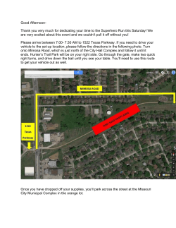


© Copyright 2026