
The January 2010
The Master Plan January 2010 Contents 1 2 3 4 5 6 7 8 9 10 11 Introducing our Plan Forecasts: the basis of our Plan Our contribution to the region’s economy Our plan for the airfield Our plan for the terminal precinct Ensuring access to our airport Enabling commercial development Ensuring effective land use Protecting our environment Implementing our Master Plan Glossary and abbreviations 2 8 16 18 24 28 30 32 38 42 51 Page 2 From the Chief Executive Our airport is the Wellington region’s link to the world, sharing the common goals of economic opportunity and a vision for growth. Welcome to our future! I am delighted to present Wellington Airport’s Master Plan – our vision for development between now and the year 2030. Wellington Airport has a vital role to play in Wellington’s success as a modern economy. It’s a gateway to our region for millions of residents, visitors and businesses every year, connecting our capital city to all parts of New Zealand and to Australia, the Pacific and the rest of the world. The airport is also a generator of economic growth, providing business and employment opportunities on site as well as in the city and the wider Wellington region. It’s a role we’re proud to play – and we’re passionate about continuing, and growing, our contribution for many years to come. Wellington Airport has a great future. By 2030 we expect to see more than 10 million passengers every year – that’s double the current number of five million. We’ll also generate about 11,500 new jobs in the region, sustaining 21,000 full-time-equivalent positions. This growth will require further investment of more than $450 million in aviation and community infrastructure in the next 20 years. Through that investment, we’ll increase our contribution to the regional economy to $1.6 billion a year, with flow-on impacts of $3.1 billion. We’re committed to working with councils and other organisations in our region to improve public and other transport links to and from the airport. We will provide a public transport hub which visitors and airport workers will be encouraged to use to get to and from the airport. Travellers will benefit immensely from this investment, with a passenger terminal and other facilities that will continue to offer them an efficient, friendly and innovative airport experience. The airport’s owners, Infratil Limited and Wellington City Council, support Wellington Airport’s development. In developing this plan, we’ve been fully aware of its potential impacts on our environment. We are committed to reducing the impact of greenhouse gas emissions from the airport. We’ve also focused on managing our impact on our neighbourhood, with a thoughtful approach to using our own site that means we won’t need to undertake extensive land purchases. And we will work with our partners, Wellington City Council and the airlines, to introduce measures to better protect our neighbours against air noise. The airport is a generator of economic growth, providing business and employment opportunities on site as well as in the city and the wider Wellington region. It’s a role we’re proud to play – and we’re passionate about continuing, and growing, our contribution for many years to come. Steven Fitzgerald Chief Executive January 2010 Page 1 1 Introducing our Plan Our commitment • By 2030 we predict the number of passengers using our airport each year will more than double, from five million to over 10 million, at an average growth rate of 3.4% per year • Our airport will make a direct contribution of $1.6 billion per year to our regional economy, with a flowon impact of $3.1 billion per year • We will generate around 11,500 new jobs in the region, with the airport sustaining a total of 21,000 full-time-equivalent jobs • New-generation aircraft will be able to fly further from our runway, opening new horizons for Wellington travellers and businesses • We will invest more than $450 million in infrastructure including runway improvements, aircraft parking stands and additional terminal space and car parks, and we will also continue to invest in commercial projects • We are committed to improving public transport access and transport links to and from the airport • We will continue to prioritise our customers’ experience when designing and operating an efficient, friendly and innovative airport. Page 2 Page 3 1.1 Welcome This Master Plan for Wellington Airport looks ahead to the next 20 years and beyond. It provides a framework for our future, building on the dramatic improvements we’ve already achieved since the early 1990s and since our previous Master Plan, which was completed in 1994. The Plan provides us, our investors and other stakeholders with a view of potential development and investment opportunities, and is a basis for dialogue and consultation with the wider community and our business partners and associates. It: • enables us to accommodate more aircraft as well as forecast growth in passenger numbers and freight volumes • enables us to allocate land for new business and growth opportunities • enables (and timetables) significant infrastructural developments • is flexible to allow actual development to be matched to actual growth in demand – it will remain a ‘living’ document that is regularly updated • provides information that stakeholders, such as airlines and local authorities, can use to make informed investment decisions • provides information for regulatory authorities and local and regional planners, especially those responsible for delivering land transport infrastructure in our region • supports our strategy for potential longdistance (‘long-haul’) air services, enabled by the development of new, larger, quieter, longerrange and more fuel-efficient aircraft • positions the airport as a strategic regional asset by ensuring ongoing business, travel and trade opportunities for the Wellington region. As a vital part of our strategic and business planning, The Plan provides: • forecasts of demand for airport services • a strategy for efficiently using and upgrading the existing runway and taxiway infrastructure, to provide for larger aircraft and increased runway capacity • a flexible, staged approach to developing the airport, covering aircraft parking aprons1, the terminal building and car parking areas • proposed locations for commercial development that will be compatible with aeronautical requirements 1 An ‘apron’ is a defined area on an aerodrome intended to accommodate aircraft for the purposes of loading or unloading passengers or cargo, refuelling, parking or maintenance. • indications of where, and approximately when, we may need to acquire additional land on the airport’s periphery • an integrated land-use plan to guide us, our aviation industry partners and the wider community. 1.2 Our place in Wellington As one of New Zealand’s three major international airports and the hub of New Zealand’s domestic aviation network, Wellington Airport has a vital economic role as the gateway to the capital city and the surrounding region. We help to enable freight, business and government activities and are a dynamic hub in our own right, employing about 1,500 people and, through our activities, sustaining nearly 9,900 full-time-equivalent jobs in the region. As a key enabler of tourism activity, we’re building on the knowledge that, for some tourists, their airport experience is their first impression of Wellington. Our ‘Wild at Heart’ attitude is designed to enhance the travel experience – and as we develop the infrastructure initiatives in this Master Plan, we’ll capture Wellington’s individuality, creativity and innovation to deliver a truly memorable visitor experience. We’re proud to make a significant contribution to the Wellington region’s economy, contributing around $1.45 billion per year. Our GDP Page 4 contribution of almost $670 million in 2008 was 3.2% of the Wellington region’s 2007 total – a substantial share for a single enterprise. Through this Master Plan, we expect to meet forecast growth and create more business and industry opportunities – ensuring we remain an efficient, flexible, cost-effective and environmentally considerate business while continuing to deliver a unique ‘Wellington’ experience. 1.3 Addressing important issues The Plan addresses a number of issues for the airport and its owners, users and neighbours. These include: Managing growth in passengers, aircraft and freight Passenger numbers are forecast to double between now and 2030, from five million to more than 10 million per year. In addition, annual aircraft movements2 are likely to increase from 114,000 today to 126,000 in 2030, and freight processing will increase to more than 28,000 tonnes. We need to plan for and accommodate this growth, while also considering its impacts on our environment and the wider community. 2 An ‘aircraft movement’ is either a take-off or a landing by an aircraft. For airport traffic purposes, one arrival and one departure of an aircraft count as two movements. Maximising our site Wellington Airport occupies a site that is extremely small, by international standards, for an airport with more than five million passengers. However, Rongotai is the only practical longterm location for the airport, so we must use our space efficiently and to its full potential while retaining the flexibility to adapt to changing needs. We also need to consider whether our and our community’s long-term interests would be better served by acquiring and developing more land. Meeting district and regional planning requirements The Wellington City Council District Plan has a key influence on Wellington Airport and its use and development as a strategic asset for the city and wider region. A set of rules enables us to respond to worldwide trends and requirements in airport development and offer a range of complementary activities, such as retailing in the terminal, vehicle hire and other commercial services. These rules also seek to protect the amenity values of surrounding areas through controls on building setbacks, aircraft noise, screening and lighting. Providing parking for aircraft It’s vitally important that we have enough parking stands for the aircraft that use our airport at peak times. Our small site requires a smart, efficient and flexible approach that meets forecast demand for the increasing number, and size, of aircraft. Providing easy access for travellers and other users We need to provide for the estimated 15 million travellers and friends who’ll visit the airport each year by 2030. The issue of regional transport has already been considered as part of the ‘Ngauranga to Wellington Airport Corridor Study’3, undertaken by the Greater Wellington Regional Council, the New Zealand Transport Agency and Wellington City Council. We support the study and its resulting plan: good airports need good access. Enabling public transport and car parking Our small site poses a challenge in providing enough space for efficient vehicle access and parking. 3 For more on the study, visit www.gw.govt.nz. Page 5 We support initiatives that promote public transport and we welcome the increasing patronage of the ‘Airport Flyer’ bus service. We’re also committed to accommodating cyclists, pedestrians and taxis, and providing car drivers with services such as premium short-stay, valet and long-term parking. The Plan provides access for the existing mix of vehicles, but has the flexibility to change if the mix of travel modes to and from the airport changes. This includes accommodating light rail, although it’s unlikely to be introduced during this plan’s timeframe. Managing airport noise and our environment The airport’s closeness to residential areas and the local terrain creates unique challenges in managing aircraft noise. These challenges need to be balanced with one of the keys to the airport’s success: its position as a genuine ‘city airport’ that’s quickly and easily accessible. Providing an environmentally sustainable airport is a fundamental aim for the airport. We are committed to reducing the impact of greenhouse gas emissions from the airport as well as making improvements to the efficiency of the airport asset. Enabling long-haul services The imminent introduction of new long-range aircraft types (such as the proposed Boeing 787 and Airbus 350) will offer fresh opportunities for Wellington to join the global air travel network with direct connections to new markets. These aircraft bring more than extended range; they also offer improved fuel efficiency. Their arrival in Wellington for long-haul and trans-Tasman routes will have a major influence on our future development. Managing the costs of development In the next 20 years we plan to invest more than $450 million in infrastructure, including runway improvements, aircraft parking stands, additional terminal space and car parks. Table 1‑1 Wellington Airport Investment in Infrastructure to 2030 Terminal $195,000,000 Car Parking $140,000,000 Apron, Airside and Runway $115,000,000 1.4 Consultation and review We’re committed to consulting our community and other stakeholders as we develop our plans for the future. We’ve already talked to a number of people and organisations while developing this plan, including airlines, government and non-government agencies, general aviation (GA) businesses, freight companies, transport providers, neighbours and the community. Now that The Plan has been finalised we will look to working with these organisations and people as we implement it. If you would like to be involved in our future, please contact the Airport Planner via post to: Airport Planner Wellington International Airport Ltd Main Terminal PO Box 14175 Wellington 6241 Or e-mail to: [email protected]. $450,000,000 Page 6 1.5 Explaining the terminology The Plan uses a number of terms specific to airports and the airport industry. You’ll find explanations of these terms in the Glossary on page 51. 1.6 Reviewing our Plan This master plan, together with the forecasts and assumptions on which it’s based, will be reviewed about every five years. We’ll publish the updated plans on our website at www.wellingtonairport.co.nz. 1.7 Acknowledgement We’d like to acknowledge and thank consultants Beca and Airbiz for their invaluable contribution to the development of this plan. Page 7 2 Forecasts: the basis of our Plan 2.1 Independent forecasting expertise This plan is based on a number of forecasts developed by Booz and Company (Booz) – an independent management consulting firm with a specialist aviation practice and offices around the world. Booz developed forecasts for annual passenger movements4, aircraft movements and freight tonnage5 between 2009 and 2030 for three possible business activity levels: High, Central and Low. For this master plan, and considering the current and potential future economic environment, we’ve adopted the ‘Central’ case forecasts. 2.2 Annual passenger and aircraft movement forecasts Booz prepared its forecasts for annual passenger and aircraft movements using a two-phase model that involved: • long-term econometric (mechanistic) modelling • short-term, supply-led scenarios. 4 A ‘passenger movement’ is a departure, arrival or transit event by a passenger. For airport traffic purposes, one arrival and one departure of a passenger counts as two movements. 5 Freight tonnage is the aggregate of departing (export) and arriving (import) freight. Together, these methods generated passenger forecasts, which were then combined with expected trends in aircraft size and load factors6, to produce the aircraft movement forecasts. Long-term econometric model The long-term econometric model was based on the relationships between demand for air travel and the drivers of demand, such as real income, real exchange rates (for international travel) and real air fares. Given the impracticalities of forecasting exchange rates in the medium and long term, Booz excluded this aspect from its international forecast models. However, it did make some allowance for the New Zealand dollar exchange rate in the short term. Short-term, supply-led scenarios Booz developed the short-term, supply-led scenarios by considering market intelligence and other factors not necessarily captured in the econometric approach, such as changes in aviation policy and the regulatory environment, airport competition, airline route development plans and fuel prices. The scenarios covered all our key business areas: • domestic • Tasman • Pacific islands • long-haul international. 2.3 Freight tonnage forecasts Booz forecast our annual freight levels using information on aircraft movement growth and changes in aircraft fleet make-up, while also considering: • the amount of freight carried on passenger aircraft versus freighters • the international freight markets that Wellington could serve and the freight volumes to these markets • future trends in freight load factors • airline information on the relative levels of domestic and international freight. 2.4 Historic passenger, aircraft and freight movements Table 2-1 shows the annual passenger and air traffic movements for Wellington Airport between 1997 and 2008. 6 ‘Load factor’ is the proportion of passenger seats occupied, expressed as a percentage of the total seat capacity of an aircraft. Page 8 Page 9 Table 2‑1 Wellington Airport Traffic Passengers Aircraft Movements 1 Year 2 2.5 Passenger, aircraft and freight forecasts Figures 2-1 to 2-3 summarise the annual forecasts for passengers, air traffic movements and freight tonnage. International Domestic Total International Domestic Total 1997 344,314 2,961,528 3,305,842 3,900 131,800 135,700 They show: 1998 372,886 3,123,204 3,496,090 5,100 127,500 132,600 1999 436,246 3,119,843 3,556,089 5,700 127,300 133,000 2000 444,553 3,168,398 3,612,951 5,900 124,400 130,300 • a forecast doubling of annual passenger numbers, from five million to about 10.5 million in 2030, at an average growth rate of 3.4% per year 2001 470,194 3,205,459 3,675,653 6,000 112,200 118,200 2002 468,750 3,234,772 3,703,522 5,600 109,600 115,200 2003 445,642 3,454,387 3,900,029 5,500 115,000 120,500 2004 456,279 3,867,358 4,323,637 6,100 110,200 116,300 2005 586,613 4,016,101 4,602,714 6,400 107,900 114,300 2006 564,990 4,006,576 4,571,566 6,100 111,000 117,100 2007 575,398 4,060,313 4,635,711 5,800 112,700 118,500 2008 603,344 4,418,381 5,021,725 5,300 109,100 114,400 Average Annual Growth Rates – 1997-2008 97-08 5.2% 3.7% • a forecast 10% increase in air movements, from 114,400 today to 126,100 in 2030. This largely reflects the arrival of larger, new-generation aircraft carrying more passengers and freight, and is below the movement numbers in the mid to late 1990s • an increase in annual freight volumes from 5,000 tonnes to more than 28,000 tonnes. Figure 2-1 Figure 2-1 Annual Passenger Movements Forecast Annual Passenger Movements Forecast 12 10 3.9% 2.8% -1.7% Notes: 1. Based on financial years. 2. Based on calendar years. -1.5% 8 6 Sources: Passenger movements: WIAL Operational Statistics to December 2008 4 Aircraft movements (1997–2007): Airways New Zealand data. Minor adjustments to remove non-airport Wellington vicinity movements 2 Aircraft movements (2008): Booz forecast. Minor adjustments to remove non-airport Wellington vicinity movements Passenger Movements (Million) 0 1997 2000 ‘03 Total ‘06 International ‘09 ‘12 ‘15 ‘18 ‘21 ‘24 ‘27 ‘30 Domestic Source: Booz forecasts Page 10 Fewer aircraft, more seats The forecast of aircraft movements reflects a worldwide trend among airlines to ‘up-gauge’ their respective fleets (ie, use aircraft with more seating capacity) in response to: Figure 2-2 Figure 2-2Aircraft Movements Forecast Annual Annual Aircraft Movements Forecast 140 120 Aircraft Movements (000’s) 100 • limited additional airport capacity to accommodate growth in traffic 80 60 • the larger carrying capacity of new-generation aircraft. 40 20 0 2010 Total ‘12 ‘14 ‘16 International ‘18 ‘20 ‘22 ‘24 ‘26 ‘28 ‘30 Domestic Figure 2-3 Figure 2-3Freight Tonnage Forecast Annual In forecasting changes to the fleet mix for Wellington, Booz considered: Annual Freight Tonnage Forecast 30 25 Changes to aircraft mix rely on announced fleet plans in the short term, the replacement of older-series aircraft with newer ones, and the introduction of progressively larger aircraft types. Annual Freight Tonnage (000’s) • airlines’ current plans for fleet upgrades • the assumption that Air New Zealand, Qantas, Pacific Blue, Jetstar and new entrants will continue to up-gauge their fleets in the next 20 years to cater for growing demand 20 15 10 5 0 2008 Total ‘11 ‘14 International ‘17 ‘20 ‘23 ‘26 ‘29 • the constrained runway capacity at Wellington Airport. 2.6 ‘Busy-day’ and ‘busy-hour’ demand forecasts Airports and airlines around the world accept that it’s simply impractical and uneconomic to plan and design terminals and other airport facilities for the potential peak in demand. Instead, they use measures of historical ‘busyday’ and ‘busy-hour’ demand to estimate future demand and design the optimum terminal facilities. This plan uses the International Air Transport Association’s (IATA’s) method for assessing a typical busy-day and busy-hour: • The historical ‘busy-day’ is defined as the second-busiest day in an average week (excluding special events such as religious festivals, trade fairs and conventions, and sport events) during the peak month of the year. • The historical ‘busy-hour’ is defined as the busiest hour (on a rolling 60-minute basis) for the particular segment of interest that occurred on the busy-day for each year. Domestic Note: Freight tonnage is the aggregate of departing (export) and arriving (import) freight. Source: Booz forecasts Page 11 Current busy-hour demand In establishing current busy-hour demand, the IATA process revealed that our busy day for the 2008 financial year was Friday 7 March 2008, while the domestic busy-hour and international busyhour were at different times of the day. However, the combined busy-hour usually corresponded to the domestic busy-hour. Figures 2-4 and 2-5 illustrate these results, showing the current busy-hour demand levels for passengers arriving at and departing the airport during the busy week. Figure 2‑6 Combined Busy-Hour Passenger Forecasts – Figure 2-6 Arrivals Busy Hour Passenger Forecasts – Arrivals Combined 1,200 2,500 Number of Passengers Number of Passengers 2,000 1,000 800 1,500 600 1,000 400 500 200 0 Mon Tue Wed International Thu Fri Sat Sun The busy-hour determines the size of the terminal and associated facilities (such as the apron and car park), so the almost doubling in arrival and departure numbers will have significant effects on our airport planning and design in the Master Plan timeframe. 1,000 800 600 400 200 0 Tue Domestic Wed International Thu Combined Fri Sat 2010 ‘12 ‘14 ‘16 ‘18 ‘20 ‘22 ‘24 ‘26 ‘28 ‘30 Combined Figures 2-6 and 2-7 presents our busy-hour passenger forecasts. Number of Passengers Mon 0 Figure 2‑7 Combined Busy-Hour Passenger Forecasts – Figure 2-7 Departures Combined Busy Hour Passenger Forecasts – Departures Forecast busy-hour demand Current Arriving Passenger Demand (2008 Busy Week) 1,200 1,400 Domestic Figure 2‑4 Current Arriving Passenger Demand Figure 2-4 (2008 Busy-Week) 1,400 Figure 2‑5 Current Departing Passenger Demand Figure 2-5 (2008 Busy-Week) Current Departing Passenger Demand (2008 Busy Week) 2,500 Number of Passengers 2,000 1,500 1,000 500 Sun 0 2010 ‘12 ‘14 ‘16 ‘18 ‘20 ‘22 ‘24 ‘26 ‘28 ‘30 Page 12 Page 13 2.7 Aircraft stand forecasts The airport’s Eastern Apron areas, which serve the passenger terminal area, currently provide 28 marked parking stands for a range of aircraft sizes. We’re committed to ensuring stand availability for all aircraft arriving at the airport. With a forecast requirement of 12 additional stands by 2030, we aim to: • increase the total number of current stands at the same rate as annual passenger numbers are expected to grow • adjust the figures to take into account the expected increase in aircraft size (with the move to more and larger domestic jets and fewer turboprops) • adjust the international stand requirement to reflect the fact that peak times are different for long-haul and Tasman services, and for international and domestic services. This means we can, for example, maximise our efficiency by using swing gates7 to meet this fluctuating demand. 7 ‘Swing gates’ are gates that can be shared between international and domestic use. 2.8 Airport vehicle demand forecast Forecasts for airport-associated road traffic in the next 20 years are based on: Figure 2-8 Figure 2-8 Aircraft Stand Requirements Forecast Forecast Aircraft Stand Requirements 30 Number of Stands • the busy-hour projections for passenger arrivals and departures (see Figures 2-6 and 2-7) 25 20 • growth on the State Highway network of 2% per year to 20308. 15 10 They estimate: 5 0 2008 Existing International 2015 Domestic 2020 Remote 2030 • a 60% increase in total traffic between 2008 and 2030 • an increase (from 31% to 38%) in the proportion of Wellington Airport traffic on Cobham Drive and Calabar Road as a percentage of total traffic. Table 2-2 illustrates these increases, along with forecasts of peak-hour demand, which are based on existing vehicle traffic information combined with busy-hour passenger forecasts. 8 Source: New Zealand Transport Agency’s Economic Evaluation Manual Volume 1 – Forecast for the Urban Arterial Routes in the Wellington Region, 30 Sept 2008. Page 14 Table 2‑2 Wellington Airport Vehicle Forecasts1 Current Forecast 2008 2015 2020 2030 36,900 42,000 46,000 59,000 31% 32% 32% 38% Peak-Hour Northbound Vehicles 2,000 1,800-2,300 2,000-2,500 2,600-3,300 Peak-Hour Southbound Vehicles 2,100 2,000-2,500 2,200-2,700 2,800-3,500 Average Daily Vehicles Airport Traffic as a % of Total Traffic Notes: 1 Vehicle traffic based on Cobham Drive flows. 2 Low end of range assumptions are based on an increase in vehicle occupancy to 1.5 passengers each per vehicle, a redefined modal split (an increase of 5% for public transport users, not including taxis) and a lower passenger number forecast (by 10%). 3 High end of range assumptions are based on a minimum vehicle occupancy of one passenger each per vehicle, the existing modal split, higher passenger numbers (by 10%) and more-than-anticipated service vehicles. 2.9 Car parking forecasts In calculating the airport’s future car parking requirements, we’ve taken into account the many different services that should be available, such as premium short-stay, valet, coach and long-term parking options. We’ve also used the existing proportions of cars, taxis and public transport. However, we’re aware that the situation could well change in the future, so we’ve ensured that the airport and this master plan retains the flexibility to adapt. For example, we can accommodate continued increases in the use of bus services such as the Airport Flyer. Table 2-3 shows the forecast car parks required. Table 2‑3 Total Required Car Parks Current Total Car Parks Forecast 2008 2015 2020 2030 2,960 3,570 4,030 5,270 Page 15 3 Our contribution to the region’s economy 3.1 Independent analysis In 2008 we commissioned BERL Economics (BERL) to provide an independent analysis of: • our economic impacts on the Wellington region, both now and by 2030 • the economic impacts of a daily long-haul air service from Wellington to Europe via Asia. 3.2 Our economic impacts on the region As a result of its investigation, BERL reported that our economic impacts derive mainly from: Tourism spend We don’t just service the tourism industry, we propel it. Much of the activity generated by the expenditure of overseas and domestic tourists results from their travel through the airport. Our day-to-day operations Our operating expenditure is dedicated to running the airport – servicing passengers and to a smaller extent freight movement. Many types of business are needed to supply these services, including the airport, airlines, hospitality and rental car businesses, duty-free stores; and customs, security, biosecurity, freight forwarding, cargo, taxi, postal and aircraft maintenance services. Our investments in infrastructure While our day-to-day operation regularly requires capital expenditure on smaller-scale, routine capital projects, we occasionally undertake far larger projects that generate more significant impacts in a shorter timeframe, such as building a new terminal or a car park complex. Table 3-1 Wellington Airport Regional Economic Contribution, 2008 We also undertake some large-scale ongoing capital expenditure projects, such as the current international terminal upgrade and the runway overlay. These have cost more than $200 million in recent years. Employment (FTEs1) Our current economic impacts BERL’s findings on our economic impacts in 2008, taking into account flow-on effects, are outlined in Table 3-1. Direct Impact Total Impact Tourism Spend (Domestic) Output ($m) Regional GDP ($m) 147 280 67 132 1,247 1,941 365 707 Tourism Spend (International) Output ($m) Regional GDP ($m) Employment (FTEs) 169 331 3,420 5,150 219 420 Airport Complex Operations Output ($m) Regional GDP ($m) 91 192 1,361 2,575 Output ($m) 20 39.6 Regional GDP ($m) 5.8 13.9 Employment (FTEs) 98 200 Employment (FTEs) Airport Complex Capital Expenditure Total Airport Regional Economic Contribution 2008 Output ($m) 751 1,446 Regional GDP ($m) 333 669 Employment (FTEs) 6,126 9,866 Note: 1. FTE = full-time equivalent Source: BERL Page 16 To provide some perspective, our GDP contribution is greater than that of the entire Wellington agriculture and food and beverage processing and manufacturing industries combined, and slightly smaller than that of the education industry in the region (which includes all schools, universities, polytechnics and private training establishments). The scale of our importance is best understood by the additional employment we create – not only in the people we employ but also in the numbers generated by the flow-on effects of tourism and our activities through suppliers. The BERL report estimates that we currently support the equivalent of 9,870 full-timeequivalent employees (FTEs) or 4.5% of the 220,280 FTEs employed in the region. That’s more than the FTEs employed in the general construction, finance and insurance industries combined, or in personal and household goods retailing across the region. Our forecast economic impacts BERL’s assessment shows that by 2030 the airport’s direct impact on regional output will be $1.6 billion per year, with a total impact of $3.1 billion on the regional economy. A forecast total regional GDP impact of $1.4 billion a year by 2030, and the maintenance of around 21,400 FTEs, will be a substantial contribution for a single facility like ours. This employment in 2030 is equal to employment in the region in 2008 in all retail activities, or in government administration. It’s more than the 2008 employment in manufacturing and processing, or in health and community services. Economic Impact 2030 Direct Impact Total Impact Direct Impact Total Impact Output ($m) 751 1,446 1,608 3,098 Regional GDP ($m) 333 669 719 1,436 6,126 9,866 13,436 21,375 Employment (FTEs) • initially, there would be enough demand for 100,000 passenger movements per year (significantly more than the 65,000 to 85,000 necessary to start such a service) • within two or three years of service start-up, a move to a daily service would increase the flows to between 140,000 and 150,000 passengers per year. Table 3-2 Wellington Airport Regional Economic Contribution, 2030 2008 BERL estimated that: Source: BERL The economic impacts of a long-haul air service Together with Wellington businesses and tourism organisations, we’re working to encourage airlines to provide long-haul services, initially between Wellington and Europe via Asia. This would provide obvious benefits of increased connectivity as well as significant economic gains for the region. The economic impacts of a daily long-haul service are significant for a single air service, with direct spending by the 35,000 projected overseas visitors estimated at $28.8 million a year. The total effect of this expenditure would be $52.7 million generated in the regional economy, $24.2 million in GDP and the creation of 383 FTEs. Table 3-3 Impact of Long-haul1 on the Wellington Region Direct Effect Total Effect Output ($m) 28.8 52.7 Regional GDP ($m) 12.4 24.2 Employment (FTEs) 254 383 Note: 1. B ased on a daily long-haul service from Wellington to Asia and Europe within three years. Source: BERL Page 17 4 Our plan for the airfield 4.1 The current situation Figure 4-1 illustrates the Wellington Airport airfield. Its single north-south-oriented runway (Runways 16 and 34) has a 45-metre-wide central paved section and 7.5-metre-wide paved shoulders each side, providing a total paved width of 60 metres. Its length and ability to accommodate large aircraft mean the airport has a ‘4E’ Aerodrome Reference Code in the International Civil Aviation Organization (ICAO) Regional Air Navigation Plan9. Table 4‑1 Wellington Airport Current Declared Distances (metres) Runway TORA ASDA TODA LDA 16 1,945 1,945 2,081 1,814 34 1,921 1,921 2,081 1,814 The airfield also features 11 stub taxiway links on the eastern side of the runway (between the runway and parallel taxiway) and two taxiway links directly from the runway to the Western Apron. These provide all aircraft types with numerous options for vacating the runway and help in achieving relatively low runway occupancy times. Notes:TORA = Take-off run available. ASDA= Accelerate-stop distance available. TODA= Take-off distance available. LDA = Landing distance available. In response to recent changes to New Zealand Civil Aviation Rules, the runway ends have been modified to provide 90-metre runway end safety areas (RESAs) at each end. The current operational lengths are: 9 ICAO Annex 14, Vol 1, Aerodrome Design and Operations. ICAO Air Navigation Plan, Asia and Pacific Regions, Doc 9673. Page 18 Figure 4-1: Wellington Airport Airfield Broadway Terminal Eastern Apron Calabar Road Taxiway Runway ham Cob e Driv Western Apron Retail Park Page 19 4.2 Safeguarding airport operations Our plans for the future rely on safeguarding the airport’s ‘obstacle limitation surface’ (OLS) – that is, the land and airspace around the airport that facilitate safe aircraft departures and arrivals. The Civil Aviation Rules specify the dimensions and requirements to maintain the OLS, and they are safeguarded through the Resource Management Act 1991 (RMA) and Wellington’s District Plans. The airport is already surrounded by terrain that compromises our OLS, including: • the terrain at Wexford Hill, Tirangi Road, Bridge Street and Palmer Head • minor terrain infringements within the runway strip10 • buildings on Tirangi Road (including the control tower) • large aircraft at stands 23 and 26 and on the apron and taxiways • some vessels docking at Miramar Wharf • the radio transmitter on Mount Victoria. Our planning for the next 20 years includes preventing any further OLS obstructions that could impinge on the airport’s 300-metre-wide runway strip and the OLS – thus ensuring effective and efficient airport operations. 4.3 Improving runway capacity Aircraft movements are forecast to increase by 10% by 2030. With just one runway (and no room for another), we must ensure that it operates efficiently and that we maximise its practical capacity, especially during peak times. Runway capacity currently ranges from 25 to 40 aircraft movements per hour, depending on the runway in use and prevailing weather conditions. While we won’t be able to increase this capacity significantly owing to surrounding terrain, there are a number of opportunities to increase it incrementally. These include: • reducing runway occupancy time by enabling some aircraft to vacate the runway more quickly. This is achievable through widening two existing taxiways and adding two new ones to the Western Apron, a move that will also reduce the number of aircraft having to cross the runway (refer to Figure 4-2) • harnessing new technology in the form of satellite navigation systems to enable more aircraft movements in poor weather conditions. We’re likely to do this towards the end of the Master Plan period • continuing to work with our partners, the airlines and Airways New Zealand, on improving operational procedures. 4.4 Planning for large aircraft operations We have New Zealand Civil Aviation Authority (NZCAA) approval to continue operating large aircraft (such as the A330 and the proposed B787) using our existing infrastructure, subject to approved operating procedures. This is important, as Wellington is an integral part of New Zealand’s air traffic system and can provide an alternative location when, for example, these aircraft need to divert from other destinations, as well as facilities for occasional unscheduled visits (for example, by visiting foreign dignitaries). However, the next generation of larger aircraft types offers us exciting opportunities for growth. With capabilities for an improved range and payload performance from shorter runways such as Wellington’s, they’ll provide better performance on Tasman routes and be able to make direct flights to Asian destinations and beyond. 10 A ‘runway strip’ is a defined rectangular area surrounding a runway intended to reduce the risk of damage to aircraft running off a runway and to protect aircraft flying over it during take-off or landing operations. Page 20 Figure 4-2: New Taxiways New Taxiways Parking 5 Existing Tunnel Upgraded 6 7 16/34 Runway W2 Code C Taxiway Page 21 Enabling regular scheduled large aircraft operations would require more infrastructure. In particular, we’ll need to: • increase the separation between the main taxiway and runway centrelines • widen the taxiway on the eastern side of the runway, which will require (among other changes) realigning Calabar Road • relocate the Airport Fire Service (AFS) to a new aviation support area to the south of the airport. • Install jet-blast deflectors to protect the northern and southern ends of the runway. This would probably involve buying a limited number of properties to the east of Calabar Road. Where necessary, our fair valuation and purchase agreement for acquiring properties on the western boundary will be extended to residents in these locations. 4.5 Expanding the Eastern Apron The forecast increase in passenger numbers and freight volumes will demand an expanded and more efficient Eastern Apron (the main terminal area). The Master Plan proposes expanding the apron from 28 to 42 gates, with a flexible, stageable design that accommodates different aircraft types and airline operations. Most of the expansion will take place east of the terminal (on the existing car park) and south on the existing freight and maintenance areas. 4.6 Expanding the Western Apron The expanded Eastern Apron will place more demand on, and require an expansion of, the Western Apron (the GA area). In addition to adding the two new taxiways (see 4.3), this Plan proposes: • expanding the apron to accommodate more and larger aircraft • providing space for a GA maintenance hangar and a terminal. Many of the Western Apron’s existing facilities and infrastructure will be able to stay where they are. Any that need relocating are likely to move elsewhere on the Apron. These works are likely to involve buying a limited number of properties on Coutts Street. The fair valuation and purchase agreement for acquiring properties on the western boundary will be also extended to these properties. 4.7 Enhancing tunnel access Wellington Airport owns a tunnel under the runway and taxiway that enables members of the public to walk or cycle between Coutts Street on the western side of the airport to Miro Street on the east. We propose maximising the tunnel’s use by dividing it in two, providing both continued public access and secure access for small (up to a maximum of golf-cart size) airport vehicles. This will improve our operational efficiency by enabling us to access both sides of the apron quickly and enable greater use of the Western Apron. 4.8 Enabling a runway extension Regulatory or operational imperatives may require us to consider extending the runway in future. Practical options for achieving this (considering the physical environment, engineering and aeronautical requirements, and RMA considerations) include: • a 100-metre extension at the northern runway end • a 500-metre extension at the southern runway end. While these extensions are not expected to be needed in the next 20 years, given current regulation, forecasts and aircraft performance expectations, it is prudent to allow for them by establishing areas for potential future extension. Page 22 Page 23 5 Our plan for the terminal precinct 5.1 The current situation Figure 5-1 illustrates the current Wellington Airport Eastern Apron, which accommodates all our international and domestic passenger operations in the terminal precinct and provides 28 aircraft parking stands. Figure 5‑1 Existing Apron Layout The terminal precinct consists of: • a central terminal housing check-in facilities, retail concessions, lounges, baggage handling services and arrivals • a north-west pier housing mainly international operations, with some domestic gates using a swing gate corridor. It has eight ‘contact stands’11 and can accommodate two large aircraft Existing Car park Existing MultiLevel Car park Existing Car park South Pier Central Terminal North West Pier Existing Car park South West Pier • a south-west pier for domestic and regional operations, which has stands for four domestic jet and four turboprop aircraft 16 There are also three turboprop stands between the north-west and south-west piers, and three remote positions at the southern side of the Eastern Apron. 34 • a ground-level south pier for regional operations, which provides access to six turboprop stands. 11 A ‘contact stand’ is an aircraft stand next to the passenger terminal that passengers can access by an airbridge or walkway. Page 24 5.2 Planning for aircraft parking Figure 5-2 indicates the potential apron layout in 2030, showing 42 aircraft stands. Figure 5-2 2030 Apron Layout Bus Gates Car park expanded (new levels added) New multi-level car park & future terminal reserve Airport access gate JUHI vehicle and admin compound/ future reserve for storage & pumps Airport access gate JUHI Storage & Pump Station Main airport access gate Existing Terminal Aviation support AFS Remote car parking The southern side of the terminal has room for more intensive use, with the key change proposed being an extended south-west pier. Contact positions on both sides of the extension will be able to handle smaller jets and turboprop aircraft, while a new ground-level walkway will provide access to turboprop stands further east of the current walkway. To be completed in stages, this project would involve: • by 2015, reconfiguring the parking in current airside12 areas (see Figure 10-2 on page 45) 34 Parking The layout of the north-west (international) pier and the northern side of the south-west pier would remain largely unchanged, as we expect parking for international aircraft to grow progressively southwards. • by 2020, expanding the apron eastward to the current public parking area (see Figure 10-4 on page 47) • by 2030, extending the apron to the freight precinct, which will involve moving aviation support areas further south (see Figure 10-6 on page 49). 12 ‘Airside’ is the movement area of an aerodrome and its adjacent terrain and buildings or portions, to which access is controlled. Page 25 We anticipate keeping small commuter airline operations close to the main passenger terminal. However, if this doesn’t prove possible, there will be room for them on the Western Apron. The plans also include: • providing dual taxiways in an east-west direction (at all stages), which will provide a passing loop to minimise delays for aircraft entering and exiting the aprons to the east of the south-west pier extension • creating a taxi lane13 and push-back14 zone, separate from the current taxiway (Zulu) on the western side of the south-west pier extension. This will reduce congestion on Zulu. 5.3 Planning terminal facilities Our plans for the terminal are all designed to cope with forecast increases in passenger numbers, and therefore baggage and other services. We aim to achieve IATA’s ‘C’ service level during our busy hour, which is “a good level of service, conditions of stable flow, acceptable delays and good levels of comfort”. Our busy-hour forecasts have been used to establish the terminal floor area required. Between now and 2030, we plan to increase the current 42,000 square metres to 75,000 square metres (see Figure 5-3), which will enable us to undertake customer processing, meet increasing security, customs, immigration and quarantine requirements, and provide food and beverage and retail facilities. Our plans ensure we have the space and flexibility to accommodate a dynamic terminal environment. For example, it’s possible that security standards and requirements will increase in the future, while the space required for processing transTasman passengers may reduce if New Zealand and Australia implement joint programmes to streamline and harmonise these processes. Figure 5-3 Terminal Area Requirements – Gross Floor Area Figure 5-3 (square metres) Terminal Area Requirements – Gross Floor Area (square metres) 80,000 70,000 Area (m2) 60,000 50,000 40,000 30,000 20,000 10,000 0 2008 ‘10 Existing ‘12 ‘14 ‘16 ‘18 ‘20 ‘22 ‘24 ‘26 ‘30 Any changes will happen progressively to meet demand while ensuring business as usual – providing a professional, efficient and comfortable experience for the people who visit and use the airport. You can read more about this staged approach in Section 10. 13 A ‘taxi lane’ is a portion of an apron designated as a taxiway and intended to provide access to aircraft stands only. 14 ‘Push-back’ is the process in which an aircraft, usually a larger jet type, is pushed back by a tug or tractor off a stand prior to starting engines and taxiing away from the apron. Page 26 Page 27 6 Ensuring access to our airport 6.1 The current situation Wellington Airport is located at the end of a busy urban road network with heavy traffic during peak times. Any increases in the demand for transport to and from the airport will have significant impacts on (and be affected by) existing and future constraints in the Wellington region’s transport network. They’re also likely to affect the airport and its ability to operate as an efficient commercial enterprise. This Master Plan aims to integrate with Wellington’s regional transport strategy, incorporating public transport development and a staged growth in facilities while ensuring we provide an efficient, clear and flexible traffic flow around the airport, adequate car parking and effective pick-up and drop-off services. 6.2 Addressing access to the airport Most of the region’s roading network that provides access to the airport has enough capacity to meet forecast demand until 2030, including growth at the airport. However, there are some areas of localised congestion that, if not addressed, would severely compromise the performance of the whole network. We believe it’s vitally important to retain the integrity of the Ngauranga to Airport Corridor – the subject of a recent study by the Greater Wellington Regional Council, the New Zealand Transport Agency and Wellington City Council, on which we made a number of submissions. The study led to the adoption of the Ngauranga to Airport Corridor Plan in October 2008. The Plan identifies a number of short- and long-term priorities and initiatives for the corridor, which include: • improving the route from Ngauranga to the airport • undertaking a light-rail feasibility study • improving public transport services. This Master Plan is most concerned with the effect of these initiatives on travel-time reliability to and from Wellington Airport, particularly in terms of: • the availability and range of parking facilities in response to changes in travel modes (see Section 6.3) • the public transport options, acceptable capacity and travel times. The number of passengers using public transport (buses) to access the airport is increasing, a trend that’s expected to continue in response to public transport initiatives in the Ngauranga to Airport Corridor Plan. While we believe a light-rail system is unlikely within the Master Plan timeframe, we could accommodate its introduction. Our planning for 2030 is largely based on the current mix of vehicles using the airport, with ample room for change and movement to meet different travel modes. We will encourage airport employers to use Traffic Demand Management measures to enable their staff to use the most efficient method of getting to and from the airport. 6.3 Access to landside services In planning for traffic flow and parking at the airport, we’ve used ‘a hierarchy of proximities’, locating services key to our business close to the airport and other, less essential activities further away. This approach enables us to provide off-site facilities for services such as long-term parking, rental and valet storage and non-premium staff parking that, while essential to our commercial operations, consume large amounts of space. Figure 10-5 shows an alternative location for these services on the western side of Wellington Airport (adjacent to Bridge Street). We propose developing this area over the next two decades, providing up to 25,000 square metres of car parking by 2030. The most suitable land available for car parking closer to the airport remains the area to the east of the existing terminal building (which is currently used for car parking and other vehicle-related activities). The Master Plan proposes building a multi-level car parking facility close to the terminal; this will increase the number of car parks in the building from 13% of the total of all parks to 75% by 2030. The car parking building would include a public transport interchange and facilities for all groundtransport modes. Page 28 Page 29 7 Enabling commercial development 7.1 Enabling enterprise We’ll continue to invest in commercial projects using airport land not earmarked for aeronautical use. In determining future development, we’ll apply the principle of ‘highest and best use’. This investment in commercial projects is in addition to the $450m required for infrastructure. 7.2 Airport Retail Park The popular Airport Retail Park on the Western Apron remains in the 2030 Master Plan. We also expect to progressively develop commercial activities on airport-owned sites on the western side of Tirangi Road and on the small site to the south of the New Zealand Defence Force (NZDF) terminal. These may include bulk or trade retail businesses, light industrial enterprises, long-term car parking and other services. 7.3 The Airport Gateway We propose developing a substantial commercial precinct (the Airport Gateway) on land not required for aeronautical use to the north of the terminal precinct, to support airport activities. This may include hotels, conference facilities, car parks, vehicle service centres and ancillary office buildings for aviation service providers. While remote from the terminal, it will still be accessible by foot. 7.4 Using the terminal reserve We’ve also identified another site to the south of the current car park building as a long-term future ‘terminal reserve’ for potential expansion beyond 2030. Until then, this substantial site would be available for uses such as premium car parking, passenger terminal and ramp functions, car rental support facilities and commercial development. 7.5 Acquiring land We may need to buy a small amount of land during the Master Plan period to enable airport operations, such as widening our main taxiway by realigning Calabar Road. We will extend, our fair valuation and purchase agreement for acquiring land on the western boundary to property owners in these locations. Page 30 Page 31 8 Ensuring effective land use 8.1 The current situation As well as the aeronautical businesses, Wellington Airport is home to a diverse property portfolio of commercial, industrial, specialty retail and bulk retail enterprises and residential properties. We need to ensure that we continue to provide for these entities, while growing our own business and meeting the needs of travellers, visitors and other stakeholders. Our plans for the future – particularly those that relate to developments on the airport site – will also need to meet the requirements and plans of the Wellington City Council and Greater Wellington Regional Council. 8.2 Working with the District Plan The Wellington City District Plan has a major influence on our plans for the ongoing use and development of airport land. A set of rules enables us to respond to worldwide trends and requirements in airport development and incorporate complementary uses such as retailing in the terminal, vehicle hire and other commercial services typically associated with airports. At the same time, the rules seek to protect the amenity values of surrounding areas through controls on construction, aircraft noise, screening and lighting. 8.3 Working with the Regional Coastal Plan We need approval under the Greater Wellington Regional Council’s Regional Coastal Plan for any land reclamation we undertake, such as for a runway extension. Other plans that could affect us include the Regional Plan for Discharges to Land, Regional Freshwater Plan and the Regional Air Quality Management Plan. Permits for Restricted Coastal Activities are allocated by the Minister of Conservation, rather than the Regional Council. 8.4 Assessing contaminated sites We’ve identified the places in our airport where contamination from the past may have occurred – see Figure 8‑1. If we want to develop these areas, we need to gain resource consent to confirm the presence of contamination and, if so, establish acceptable ways of mitigating its effects. Wellington’s air cargo throughput forecast for 2030 is 28,200 tonnes per annum, which means our air cargo terminal facilities should have a total floor area of 2,800 square metres, together with an allowance for: • landside loading docks, manoeuvring and parking • airside staging (for parking container dollies waiting to be loaded onto aircraft). This means we need to make sure we have around 6,000 to 7,000 square metres for cargo space by 2030. We expect to cope with cargo volumes until well after 2020, but by 2030 we may have to move or reconfigure the current cargo-related leases to cope with anticipated growth in cargo volumes and apron area. 8.5 Air cargo Airport master planning worldwide typically calculates the area required for cargo facilities using a throughput of 10 tonnes a year for each square metre of cargo terminal floor area. Page 32 Figure 8‑1 Potentially Contaminated Airport Sites 34 Potentially Contaminated Sites Source: Wellington City District Plan, Chapter 11, Appendix 5 Page 33 8.6 Aircraft maintenance We don’t currently provide heavy aircraft maintenance at Wellington Airport. Instead, maintenance facilities are provided for: • GA aircraft in three hangars on the Western Apron • small GA aircraft in a Wellington Aero Club hangar. Major aircraft maintenance (up to A320/B737-sized aircraft) has historically been undertaken in the Air New Zealand hangar on the eastern side of the runway south of the passenger terminal. This hangar is currently used for car parking, but Air New Zealand has indicated it may use it for aircraft maintenance in future. Our Master Plan enables us to retain the Air New Zealand hangar lease area until well after 2020. Subject to airline or operator demand, we expect to develop a new site on the Western Apron towards the end of the Master Plan term. 8.7 General aviation (GA) Currently: • GA and charter operations are provided from three hangars on the Western Apron and an additional GA facility is generally used for storage • Some charter operations are also provided for on the Eastern Apron • the Wellington Aero Club is located at the northern side of the western GA precinct • the NZDF terminal is used by the military, government VIPs and visiting heads of state. This terminal stays where it is for the Master Plan term, although the parking stands for large aircraft will need to be reconfigured. Booz forecasts moderate declines in GA activity in the next 20 years. The Plan allows for most of the existing GA leases to stay on the Western Apron, and an area designated as a civil GA terminal identifies potential locations for: • the current Aero Club • a ‘fixed based operation’ (FBO), which provides facilities to home-based or itinerant business aviation operations. These facilities typically include a terminal, waiting area, hangar, apron, and staff and visitor parking. 8.8 Catering/cabin servicing The demand for full-service catering is reducing with the increasing use of operations where off-site organisations pre-package and deliver catering supplies to catering/cabin service facilities for placing on board aircraft. There is little, if any, requirement to clean and store catering equipment. Catering and cabin service facilities are forecast to require 15,000 square metres in 2030. These are likely to be located in a purpose-built ‘Aviation Support Zone’, which we plan to establish after 2020 when the apron will need to expand over the current catering lease area. Note that while we’ve assumed that one or more catering organisations may wish to be based at Wellington Airport, catering providers may in fact prefer to be located off site. 8.9 Fuel storage Jet aircraft fuel is distributed to aircraft on the Eastern Apron from a joint Exxon-Mobil/BP facility at the northern edge of the international apron. In 2008 about 100 million litres of fuel were distributed, a figure forecast to almost double to 190 million litres a year by 2030. Because fuel is imported to Wellington by sea tanker, a minimum of seven days’ on-site storage is normally recommended. However, other factors mitigate this, such as: • Wellington’s closeness to Auckland, Christchurch, Pacific Island and east-coast Australian airports, which enables aircraft to load enough fuel for the return journey in case of a fuel shortage • the availability of a long-term (44-day) storage facility about a kilometre away from the airport, which could easily supply fuel via tanker trucks if there were a connection problem. Page 34 With this capacity, the existing 800,000-litre onsite airport storage facility should be enough for the Master Plan’s timeframe – providing about 1.5 days’ storage by 2030 based on an analysis of the routes served by various aircraft types, the average flight times and fuel-burn rates. We have discussed with Exxon-Mobil/BP the relocation of their current on-site facilities to the south by about 2030 to provide space for two remote stands to the north of the international apron area. Given existing infrastructure constraints it may be necessary to retain a pumping station at the present location to supply fuel to the new southern facility. Fuel services for piston-engine GA aircraft will need to be reviewed as the Western Apron is progressively reconfigured. 8.10Airport Fire Service (AFS) The AFS is located on the eastern side of the runway, north of the passenger terminal. ICAO and NZCAA standards require us to have at least two rescue and fire-fighting vehicles. However, we may have to upgrade this service to a minimum of three rescue and fire-fighting vehicles in response to the advent of larger aircraft and changes to NZCAA rules to align with ICAO requirements. This would mean a larger AFS building to accommodate more vehicle bays as well as administration offices, an observation tower, workshops, equipment stores, amenities and parking areas. As the current AFS location doesn’t fit with our plans for a wider runway strip and main taxiway clearance, we propose relocating the facility, if required, by about 2020. 8.11Airport facilities maintenance We don’t currently have a centralised compound for airport facilities maintenance. Instead, it’s undertaken in various areas around the apron area or by outsourced providers. Recognising that maintenance is vital in maintaining our infrastructure in optimum condition, we propose establishing a maintenance compound in the Aviation Support Zone to the south of the Eastern Apron. A current civil works depot area for storing and staging bulk construction materials will stay where it is, to the west of the engine test bay. 8.13Ground service equipment storage We need to ensure that we allocate enough space next to the aprons for storing ground service equipment (GSE) when it’s not being used for aircraft turnaround services. This space typically occupies about 20% of the apron area required for modern jet aircraft. GSE includes: • equipment that ground handlers use for loading and unloading baggage and cargo, cleaning aircraft, servicing lavatories, supplying potable water supply etc • equipment that ramp engineers use for aircraft line maintenance, ground power, preconditioned air, aircraft push-backs etc • aircraft containers and unit load devices15 (ULDs). The airlines’ storage areas (for mechanical equipment, spares etc) are typically leased to individual airlines and are not included in areas allocated for GSE storage. 8.12Engine test bay (ETB) We propose keeping the ETB on the Western Apron area in its current location throughout the Master Plan period. From 2015 the ETB will also be used for AFS training. 15 A ‘unit load device’ is a standardised container used to load luggage, freight and mail onto aircraft, enabling a large quantity of cargo to be bundled into a single unit. Page 35 Table 8-1 shows the estimated GSE storage requirements for the Master Plan timeframe. Table 8-1 GSE and ULD Storage Area Requirement (square metres) 2015 2020 2030 GSE 10,000 11,000 12,800 ULD 300 300 400 Notes: Assumed 50/50 split of containerised and noncontainerised smaller aircraft. Assumed 50% of remote stands are operational and require GSE and ULD support. GSE maintenance GSE maintenance is usually undertaken within aircraft maintenance facilities or by specialist GSE maintenance organisations. We propose setting aside a small reserve of 1,200 square metres for equipment servicing that must be done on-airport, probably within the Aviation Support Zone. 8.14Utilities Figure 8-2 provides a composite view of all the trunk services including water, power, communications etc. Telecommunications Currently all telecommunications into the airport are provided by Telecom New Zealand. Discussions with Telecom indicate that the network should be sufficient to meet our future requirements for telecommunications and information technology services. TelstraClear is a potential alternative service provider. While it doesn’t have a link to the terminal area and has no current plans to provide one, its network runs through the tunnel under the runway so is close enough for access. Power Based on ‘normal’ growth rates, our power supply system should have the capacity to meet demand in 2030. However, major new developments and expansion products may drive this growth higher, which may mean we need to upgrade or augment the system. Potable water Our current water supply has the capacity to sustain our current demand and the expected increases to 2030. Stormwater Our system has the capacity required to remove stormwater from the airside apron and landside terminal and parking areas for the entire Master Plan period. The only work required may be pipe renewals and new connections into the main trunk lines. Sanitary sewers The existing sewer main should continue to meet our needs until 2030, although we may need another major sewer line to the Moa Point Treatment Plant. Gas We use gas mainly for heating and cooking, and supplies are forecast to cope well with our future plans. If the load increases significantly, we may need a new service and gas measurement system. 8.15Utility service corridor Our plans mean that many utilities will end up in areas used for aircraft operations, so will be difficult to access for maintenance. To address this, we propose relocating the telecommunications, power, gas and water services to a landside service corridor. Owing to relocation costs and its relatively maintenance-free operation, the sewer won’t be relocated. Page 36 Figure 8‑2 Alignment of Individual Trunk Reticulation Systems Trunk Water Mains Trunk Storm Water Trunk Sewer Mains Trunk Power Cables Trunk Comms Cables Trunk Gas Mains Trunk Fuel Mains Trolley Bus Cables Page 37 9 Protecting our environment 9.1 Our commitment to environmental sustainability We are committed to ‘sustainable business’ in everything we do, from the way we work every day to our initiatives to protect the environment for future generations. Figure 9‑2 Noise Footprint Comparison B737-200 vs B737-600 85 Decibel (dBa) Exposure 6 5 4 st ce an 0m 00 ) • reducing energy consumption *926km mission. 70% load factor Figure 9‑3 Figure 9-3 Trend in Aircraft Noise Levels Figure 9‑1 Passenger Figure 9-1 Growth vs Noise Levels Trend in Aircraft Noise Levels Passenger Growth vs Noise Levels 6 70 120 65 110 60 100 55 90 50 80 Turbojet and early turbofans 5 First generation turbofan 4 3 • protecting our coastal marine environment by managing stormwater 1 • improving the airport environment through considerate landscaping design. Dista ) 000m se (1 relea nce fr 0 1.5 rake om b Source: Boeing Commercial Aircraft • managing and where possible recycling our waste • promoting sustainable land transport options 1 1.0 (1 • maintaining and protecting air, water, soil and groundwater quality 2 0.5 • actioning our commitments to the 2008 Aviation and Environment Summit agreement • minimising construction noise 3 0 di • incorporating low-energy and sustainability initiatives in designing new buildings and infrastructure High-speed train 1.5 1.0 0.5 e lin de Si That means we work hard to minimise the impact of our airport operations and expansion plans on our environment – with a focus on: • working with airlines and Airways New Zealand to improve aircraft emission and noise profiles B737-200* 9.06km2 B737-600* 1.29km2 Second generation turbofan 2 Noise Level (dBA Ldn) Passenger Numbers (million pa) 0 1980 ‘85 ‘90 Noise ‘95 2000 Passenger Source: Wellington International Airport Ltd Prepared by Marshall Day & Associates ‘05 ‘08 Sound Level* 1950 1960 FUTURE? 1970 1980 1990 2000 2010 2020 Year of Initial Service *Effective Perceived Noise Level EPNOB (460m sideline) Source: Boeing Commercial Aircraft Page 38 9.2 Aircraft noise The noise generated by aircraft operations at Wellington Airport has reduced markedly since its peak in the late 1980s – despite passenger numbers more than doubling (see Figure 9.1). This improvement reflects a number of noisemitigation initiatives and airlines’ substantial investment in new technology by replacing older, noisier aircraft with newer, quieter types (see Figure 9.2). We don’t expect the total noise generated at the airport to increase significantly in the next 20 years – the forecast re-doubling of passenger numbers will, to a large extent, be offset by larger and newer aircraft types rather than by a significant increase in aircraft movements. At the same time, advances in technology will further reduce aircraft noise (see Figure 9‑3). We will be looking to implementing the recommendations of the LUMINS (Land Use Management and Insulation for airport Noise Study) within the first 5 year Master Plan period. Once implemented, these recommendations will see our existing neighbouring communities better protected against air noise. 9.3 Protecting air quality Every airport must address issues of air quality given the widespread combustion of fossil fuels by aircraft, vehicles and fuel-burning equipment. We’re committed to working with airlines and other airport-related organisations to minimise the effects on air quality of larger aircraft types, more aircraft movements, higher passenger numbers and increased freight business. • joining the global aviation industry in signing the 2008 Aviation and Environment Summit agreement, which aims to achieve carbonneutral growth by 2020 and eventually become carbon free. We’ll also work with local authorities on traffic and land transport issues, with a goal of reducing traffic congestion and queues and improving options for public transport to and from the airport. In addition, new aircraft types are progressively becoming more energy efficient, reducing the energy use per travelling passenger. For example, current generation passenger aircraft are 70% more fuel efficient than those of 40 years ago. 9.4 Using energy efficiently Our initiatives to promote energy efficiency at the airport include: • working with Airways New Zealand and airlines to explore ways to reduce carbon emissions • hosting the Traffic Capacity Forum to reduce airport delays and maximise runway capacity. The Forum is chaired by Airways New Zealand and includes representatives of the airlines and three major international airports • working to reduce our energy consumption. (We’ve already achieved a significant reduction in kilowatt hours per passenger – see Figure 9.4) • investigating alternative energy options, including wind energy and solar water heating or photovoltaic cells • incorporating environmentally sustainable design into new developments such as ‘The Rock’, our new international terminal currently under construction Figure 9‑4 Comparison of Total Passenger Numbers vs Figure 9-4Energy Use Total Comparison of Total Passenger Numbers vs Total Energy Use 4.0 3.5 3.0 2.5 2.0 1.5 1.0 0.5 0.0 kWh per Passenger 2000 2001 2002 2003 2004 2005 2006 2007 2008 9.5 Addressing climate change issues We’re committed to reducing the impacts of greenhouse gas emissions from burning fossil fuels. Page 39 We recognise that this is one of the greatest sustainability challenges facing the aviation industry globally – in the way we do business, and in its impacts on passengers and their decisions to travel to and from New Zealand. We plan to measure the airport’s carbon emissions, which will provide a baseline for comparing design and construction options in the future and identify opportunities to reduce our carbon footprint. We will periodically re-measure the airport’s carbon emissions to monitor the progress of reducing our carbon footprint. We’ll also consider a price for carbon in our investment plans and prepare for the impacts of climate change on future developments, particularly the predicted likelihood of more intense and frequent storm events and flooding. 9.6 Protecting stormwater quality Wellington Airport has large impervious surface areas that collect rainwater and is close to the sensitive environments of Evans Bay and Lyall Bay. We’re well aware of, and are striving to manage, the potential sources of stormwater contaminants, such as: • vehicle and aircraft washing, refuelling and maintenance activities • storage of fuel and other hazardous substances • waste and freight handling We’ll also work with local authorities and other organisations to manage stormwater run-off in our developments, while noting that some of the catchment areas draining stormwater to airport outlets are outside our boundaries and therefore beyond our control. We do anticipate an increase in impervious surfaces through to 2030 due to the expansion of taxiways and apron areas; however these increases will be inconsequential on a catchmentwide basis. Adoption of best-practice techniques will further limit the impact of such an increase on stormwater. In preparation for likely changes in our regulatory environment, we’ve established a policy of progressively installing (where practicable) stormwater interceptors in redeveloped airport areas. 9.7 Protecting our coastal marine environment While our future plans are unlikely to affect our coastal environment, we’re aware of our role in protecting it for future generations. Should land reclamation projects become a reality, we’ll work with local authorities, our community and interested individuals to ensure we manage their effects on the coastal marine ecology and address issues of public access, recreation and land-based and marine transport. Any developments would be subject to a scrupulous planning approach, including environmental impact and marine erosion assessments, modelling and consultation. 9.8 Managing soil and groundwater contamination As part of our Master Planning process, we’ve reviewed the reports of a number of contaminantfocused environmental investigations undertaken at the airport. We understand that current and historical land uses have the potential to contaminate our soil and groundwater, whether they relate to the current use and storage of fuel and hazardous substances or past landfilling, land reclamation, fuel storage and metal treatment. We’re committed to identifying, managing and disposing of contaminants according to the highest-quality standards and regulations. In future, this will include conducting comprehensive assessments of the level and extent of contamination in potential redevelopment areas. 9.9 Maori cultural and heritage considerations We’ve discussed this Draft Master Plan with the Port Nicholson Block Settlement Trust. We will continue to seek input from the mana whenua of Wellington. 9.10Managing environmental issues Table 9-1 lists the airport’s key environmental issues and their potential mitigating strategies. Page 40 Table 9‑1 Summary of Environmental Issues Environmental Issue Risks Possible Mitigation Noise Potential increases in noise impacts owing to passenger numbers doubling. Increase in passengers will be offset by the use of larger aircraft to maintain aircraft activity near to current levels and new-generation/quieter aircraft types. WIAL will work with the Wellington Airport Air Noise Management Committee to ensure continued engagement with the community regarding noise. Air quality Increased airport-related emissions from vehicular traffic and ground operations owing to increased passenger and freight volumes. Future development to consider the wider air-quality impacts of traffic and land transport. Water quality Impacts of stormwater run-off on coastal marine ecology. Potential changes in regulations for stormwater management. Expansion of the taxiways, aprons and airport terminal buildings will consider stormwater treatment systems, such as swales. Energy and carbon sensitivities Increased operating costs (electricity and fuel) owing to the New Zealand Emissions Trading Scheme. Concerns for the tourism sector. Low-energy design for new airport buildings and infrastructure. Prepare an assessment of the carbon footprint for airport with appropriate re-assessments to monitor change. Include a carbon cost in development cost estimates. Work with airlines to encourage early adoption of next generation and more fuel efficient aircraft. Climate change Predicted changes in temperature, sea level and rainfall patterns, increased frequency and intensity of storm events and flooding. Future development of airport infrastructure to assess potential risks of climate change. Coastal marine environment Reclamation requirements for runway extension. Construction impacts on coastal marine ecology. Resource consents, consultation and management of construction impacts. Soil and groundwater contamination Contaminated soil/groundwater encountered during future development. Further investigation as required to assess the extent. Management and safe disposal of material. Maori culture and heritage Adverse effects of reclamation on spiritual and cultural values. Community consultation and sensitive design of runway extension. Page 41 10Implementing our Master Plan 10.1Key features of our Plan Figure 10-5 shows the key features of the airport in 2030. As discussed in preceding sections, it covers: • keeping Runways 16 and 34 at the core of the airport infrastructure • the likely need to upgrade and realign the main parallel taxiway, with implications for works on Calabar Road and adjoining properties • a staged reconfiguration and expansion of the Eastern Apron aircraft parking areas, particularly on the southern side of the passenger terminal building. Note that as the size and complexity of the Eastern Apron grows, a dedicated apron management service may be required from a tower on the Eastern Apron complex • a staged expansion of the passenger terminal building, mainly to the south. It includes a southward expansion of the south-west pier by approximately 2015 • a significant expansion of car parking buildings next to the passenger terminal building • a consolidation of aviation support facilities, including cargo and some refuelling facilities, into a zone to the south of the terminal precinct • a consolidation of GA activities and the development of an FBO facility on the Western Apron • providing enough land in appropriate locations to cater for existing operational areas and for future expansion during the Master Plan term, with the exception of possible peripheral boundary adjustments for taxiway upgrading and the FBO facility • reserving the opportunity for a runway extension if required by regulatory, operational and commercial imperatives. 10.2Acquiring land for development As an ‘Airport Authority’ under the Airport Authorities Act 1966, we have the same ability to acquire land as a local authority under the Public Works Act 1981. As this document shows, we aim to meet the future by utilising our existing site to its maximum potential, confining much of our proposed development to existing boundaries. However, to deliver an airport with the capabilities it requires, we’ll probably need to acquire a number of relatively small areas that we don’t currently own or lease. Table 10-1 describes the properties concerned and the proposed land uses. Table 10-1 Possible Land Acquisition Master Plan Project Approximate Master Plan Timing Calabar Road Calabar Rd realignment for the parallel taxiway upgrade 2020 Coutts Street Western Apron – general aviation and development of an FBO facility 2020 Bridge Street (East Side) Remote car parking area 2030 We propose: • extending the current fair valuation and purchase agreement for acquiring properties at the airport’s western boundary to the areas on Coutts Street and Calabar Road that will potentially be affected by new developments • renegotiating any long-term leases on land we own when they expire. Note that although the Miramar Golf Course is zoned for possible future airport uses, we don’t intend to acquire any of this land during this Master Plan period. Page 42 In every case of land acquisition, we’ll conduct a thorough research and consultation process, including undertaking detailed engineering design and commercial analyses and considering public amenity issues. • extending the south-west pier for domestic jet stands • extending the terminal precinct southwards for baggage handling, check-in and core retail • expanding the car parking building northwards. 10.3A staged approach We propose a staged approached to implementing the Plan, with three general stages: • Stage 1: current to 2015 • Stage 2: 2016 to 2020 • Stage 3: 2021 to 2030. Note that the duration and requirements of each stage are flexible. However, the three stages are useful for our business planning and for providing general guidance on when key infrastructure developments may be needed. The table on page 50 summarises the different stages. Stage 1: Current to 2015 Figure 10-2 show plans of the airport, Eastern Apron aircraft parking and terminal building principal functions at Stage 1. The major steps likely at this stage include: • reconfiguring the Southern Apron to achieve additional stands Stage 2: 2016 to 2020 Figure 10-4 show plans of the airport, Eastern Apron aircraft parking and terminal building principal functions at Stage 2. The major steps likely at this stage include: • works adjacent to Calabar Road to achieve the required northern end taxiway strip width and separation • resetting the parallel taxiway separation • widening the taxiway • a possible runway extension, subject to regulatory commercial and operational imperatives • expanding the Southern Apron into landside to provide additional stands • extending the terminal precinct southwards for regional departures and arrivals • relocating the AFS station • establishing the ‘Airport Gateway’ commercial development • reconfiguring, subject to demand, the Aero Club area in conjunction with a new civil FBO terminal. Stage 3: 2021 to 2030 Figure 10-6 show plans of the airport, Eastern Apron aircraft parking and terminal building principal functions at Stage 3. The major steps likely at this stage include: • further expanding the Southern Apron to provide additional stands • developing remote stands on the Northern Apron • extending the terminal precinct southwards for baggage handling and retail • expanding the car parking building • relocating the fuel facilities • reconfiguring and consolidating the Aviation Support Zone • possibly relocating aircraft maintenance. • expanding the car parking building Page 43 2015 Airport Layout Figure 10-1 4 1 3 2 16 16 16 34 16 16/34 Runway 11 10 14 Engine Test Bay AFS Training Area 1 Passenger Terminal 9 Fixed Base Operation Terminal 2 Eastern Apron 10 Engine Test Bay/AFS Training Area 3 Passenger Walkway 11 General Aviation Apron Aviation Support 4 Car Parking 12 Fuel Compound Commercial 5 Ground Service Equipment 13 JUHI Pump Station 6 Equipment Storage 14 Control Tower Aircraft Maintenance 15 Freight and Catering 7 Civil Works Depot 16 Jet Blast Protection 8 Airport Fire Service Terminal ( expansion) General Aviation Car Parking ( expansion) Page 44 2015 Apron Layout Figure 10-2 Required Code E 1 1 Code C 13 13 Large Turboprop 8 8 Small Turboprop 6 6 Remote Total Existing stand Provided 3 3 31 31 New or realigned stand Terminal Expansion Car park Expansion New Multi-Level Car park Existing Multi-Level Car park Existing Car park Rental Cars Air NZ Hangar Existing Terminal Caterair Cargo Buildings JUHI AFS 34 Aircraft Page 45 2020 Airport Layout Figure 10-3 4 3 1 2 3 Aviation Support/ GNSS facilities OLS Constrained Area 5 Calabar Road (realigned) 16 8 2 4 16 Approach lights Potential future runway extension area 16 16 34 Tunnel 16/34 Runway Approach lights Potential future runway extension area General Aviation 11 10 9 13 14 1 Passenger Terminal 9 Fixed Base Operation Terminal 2 Eastern Apron 10 Engine Test Bay/AFS Training Area 3 Passenger Walkway 11 General Aviation Apron Aviation Support 4 Car Parking 12 Fuel Compound Commercial 5 6 7 Ground Service Equipment Equipment Storage Aircraft Maintenance Civil Works Depot 13 JUHI Pump Station 14 Control Tower 15 Freight and Catering 8 Airport Fire Service 16 Jet Blast Protection Terminal ( expansion) General Aviation Car Parking ( expansion) Airport Access Gate Page 46 2020 Apron Layout Figure 10-4 Aircraft Required Code E 1 1 Code C 15 15 Large Turboprop 8 8 Small Turboprop 6 8 Remote 4 3 34 35 Total Existing stand Provided New or realigned stand Terminal Expansion Car park Expanded (new levels added) Car park Expansion Commercial Aviation Support Existing Car park Rental Cars Air NZ Hangar Caterair Existing Terminal Airport Access Gate GSE storage AFS JUHI Cargo Buildings Parking 34 16/34 Runway Page 47 2030 Airport Layout Figure 10-5 4 3 1 12 2 5 13 Aviation Support/ GNSS facilities OLS Constrained Area 15 5 Calabar Road (realigned) 16 8 2 4 4 16 16 16 16/34 Runway Potential future runway extension area 4 Potential future runway extension area General Aviation Remote Car parking Approach lights 34 Tunnel 11 10 7 9 14 6 1 Passenger Terminal 9 Fixed Base Operation Terminal 2 Eastern Apron 10 Engine Test Bay/AFS Training Area 3 Passenger Walkway 11 General Aviation Apron Aviation Support 4 Car Parking 12 Fuel Compound Commercial 5 Ground Service Equipment 13 JUHI Pump Station 6 Equipment Storage Aircraft Maintenance 14 Control Tower 15 Freight and Catering 7 Civil Works Depot 16 Jet Blast Protection 8 Airport Fire Service Terminal ( expansion) General Aviation Car Parking ( expansion) Airport Access Gate Page 48 2030 Apron Layout Figure 10-6 Aircraft Required Code E 1 1 Code C 18 18 Large Turboprop 10 10 Small Turboprop 6 7 Remote 5 6 40 Total JUHI Storage & Pump Station GSE Storage Existing stand Provided New or realigned stand Terminal Expansion JUHI vehicle and admin compound/ future reserve for storage & pumps New multi-level car park & future terminal reserve Car park expanded (new levels added) Airport access gate 42 Airport access gate Existing Terminal Car park Expansion Commercial Aviation Support Main airport access gate Bus Gates GSE Storage Aviation support AFS Parking Remote car parking 34 16/34 Runway Page 49 Our Staging Wellington Airport Infrastructure Staging Infrastructure 2015 2020 2030 Terminal Pier extended for jet stands Terminal extended for regional departures and arrivals Terminal extension for baggage handling and retail International Terminal Stage 2 completed Possible eastern landside expansion for check-in operations and landside food and beverage Terminal extended for baggage handling, check-in and retail Possible international arrivals extension for secondary screening processes Bus gates Main taxiways No change Northern end taxiway strip width compliance (Calabar Rd realignment) No change Taxiway widened and separations reset Other taxiways No change Western runway link taxiways for 1200m take-off length Rapid exit taxiway works Increasing curves for large aircraft Eastern Apron Southern apron reconfigured Southern apron expanded east into landside and existing car park Southern apron expanded further south into freight precinct and hangar Minor airside boundary adjustments Airport Fire Service relocated Refuelling compound relocated further south Western Apron No change Western Apron reconfigured Further reconfiguration of Western Apron Car parking 2-3 levels over existing car parking building expanded to the north 4-5 levels over 2015 car parking building footprint 6-7 levels over 2020 car parking building footprint expanded to the south Major commercial No change Airport Gateway development Airport Gateway development Access roads No change Calabar Rd realigned for taxiway upgrade No change Coutts/Miro St tunnel upgraded Stewart Duff Dr and terminal return road reconfigured for apron expansion to the east Page 50 Glossary Glossary and Abbreviations Aerodrome A defined area of land used wholly or partly for aircraft landing, departure and surface movement, including any buildings, installations and equipment on or adjacent to the area used in connection with the aerodrome or its administration. AFS Airport Fire Service Airbridge (or aerobridge) Passenger loading bridge for accessing aircraft from the terminal. Aircraft A machine or device, such as an airplane, helicopter, glider or dirigible, that is capable of atmospheric flight. Aircraft movement Either a take-off or a landing by an aircraft. For airport traffic purposes, one arrival and one departure of an aircraft count as two movements. Aircraft stand A designated area on an apron intended to be used for parking an aircraft. Airfield The network of runways and taxiways at an airport. Airport The broader environs of an aerodrome and its associated non-aviation commercial and industrial activities. Airside The movement area of an aerodrome and its adjacent terrain and buildings or portions, to which access is controlled. Apron A defined area on an aerodrome intended to accommodate aircraft for the purposes of loading or unloading passengers or cargo, refuelling, parking or maintenance. Busy day A selected day-long period of activity that is appropriate for representing a reasonable level of peak demand for the purposes of assessing a busy hour. This is unlikely to be the absolute peak daily demand in a particular timeframe (for example, it may be the 30th busiest day in a year or an alternative measure such as the second busiest day in an average week during the peak month). Busy hour A selected hour-long period of activity that is appropriate for representing a reasonable level of peak demand for the purposes of sizing the capacity of airport and terminal systems. This is unlikely to be the absolute peak hourly demand in a particular timeframe (for example, it may be the 30th busiest hour in a year). Capacity The measure of an airport system’s capability to accommodate a designated level of demand. Cargo terminal A purpose-built facility for the loading, unloading, consolidation and break-down, handling and distribution of air freight goods to be carried as cargo in the holds of passenger aircraft or in dedicated cargo freighters, including the associated aprons and landside handling areas. Contact stand An aircraft stand immediately next to the passenger terminal that passengers can access via an airbridge or walkway. Control tower A facility for air traffic control in the vicinity of an airport, elevated so that controllers can view the extremities of the airfield. Page 51 Glossary and Abbreviations Demand The measure of current or future required throughput for an airport system or sub-system for the purposes of assessing the necessary capacity of that system. FBO Fixed based operation. GA General aviation. Gate The point where an aircraft is parked for enplaning and deplaning passengers. IATA International Air Transport Association. ICAO International Civil Aviation Organization. Jet An aircraft powered by an engine that develops thrust by a turbofan that bypasses air around the core of the engine or ejecting a jet of gaseous combustion products. Kerbside The area of a passenger terminal precinct used for safely and efficiently transferring passengers and their friends to and from cars, buses and taxis etc. Landside Area of an airport to which the non-travelling public has free access. Load factor The proportion of passenger seats occupied expressed as a percentage of the total seat capacity of an aircraft. Long haul Operations by aircraft usually for non-stop distances greater than approximately 4,000 kilometres. Master Plan A presentation of the plan for the ultimate development capacity of an airport, such that all landside, airside and airport support facilities can develop and expand in a structured, balanced and orderly way. Movement area The part of the aerodrome used for the take-off, landing and taxiing of aircraft, consisting of the movement area and the aprons. Non-contact stand An aircraft parking position to which passengers can’t directly walk. NZCAA New Zealand Civil Aviation Authority. NZDF New Zealand Defence Force. OLS Obstacle limitation surface – a defined area about and above an aerodrome intended for the protection of aircraft in the vicinity of an aerodrome. Page 52 Glossary and Abbreviations Passenger movement A departure, arrival or transit event by a passenger. For airport traffic purposes, one arrival and one departure of a passenger or passengers count as two movements. Passenger terminal The building and its immediate surrounds in which facilities are provided for processing the departure, arrival or transit of passengers and their baggage. Pier Linear airside concourse, primarily for providing passenger with access between the main terminal building processor and airbridges. Push-back The process in which an aircraft, usually a larger jet type, is pushed back by a tug or tractor off a stand prior to starting engines and taxiing away from the apron. Remote stand Non-contact stand. RESA Runway end safety area – a cleared and graded area off the end of the runway strip intended to minimise damage to aircraft in the event of the aircraft undershooting or overrunning the runway. RMA Resource Management Act 1991. Runway A defined rectangular area on an aerodrome prepared for the landing and take-off of aircraft. Runway strip A defined rectangular area surrounding a runway intended to reduce the risk of damage to aircraft running off a runway and to protect aircraft flying over it during take-off or landing operations. Swing gates Gates that can be shared between international and domestic use. Taxi lane A portion of an apron designated as a taxiway and intended to provide access to aircraft stands only. Taxiway A defined path on an aerodrome for the taxiing of aircraft, intended to provide a link between one part of the aerodrome and another. Terminal precinct The wider environs surrounding and including the passenger terminal, including aircraft aprons, kerbside, car parking, road circulation and hotels and commercial facilities drawing business from being in close proximity to the passenger terminal. Turboprop An aircraft powered by thrust from a propeller that is turned by a gas turbine engine. ULD Unit load device – a standardised container used to load luggage, freight and mail on aircraft. It allows a large quantity of cargo to be bundled into a single unit – and since this leads to fewer units to load, it saves ground crews time and effort and helps to ensure flights leave on time. Up-gauge Use aircraft with greater seating capacity. Page 53 Wellington International Airport Limited Main Terminal PO Box 14175 Wellington 6241 E-mail: [email protected] Website: www.wellingtonairport.co.nz
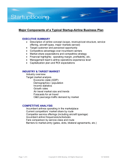
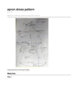


© Copyright 2026