
TABLE OF CONTENTS - City of Winter Park
TABLE OF CONTENTS
1. Introduction..................................................................................................................1-1
1.1 Purpose of Report
1.2 Geographic Setting
2. Lake Management Program..........................................................................................2-1
2.1 Aquatic Plant Management
2.2 Water Quality Monitoring Program
2.3 Stormwater Management
3. Water Quality Update...................................................................................................3-1
3.1 Evaluating Water Quality
3.2 Water Quality Trends and Fact Summaries for Winter Park Lakes
4. Resident’s Guide to Lake Use and Protection..............................................................4-1
4.1 Public Use and Access
4.2 Health and Safety
4.3 Lake protection
Appendix..........................................................................................................................A-1
Definitions
Section 1.
INTRODUCTION
1.1 Purpose
The City of Winter Park has 23 lakes and ponds under active management, 21 natural
water bodies and two large retention ponds
at Lake Island Park that also provide
recreational functions. These water bodies
range in size from less than an acre to over
450 acres, and from isolated sinkhole ponds
to the Winter Park chain of Lakes, an
interconnected system made up of six lakes
in Winter Park and Maitland that are joined
by navigable canals. Depending on their
size, and location, recreational opportunities
on the lakes can be as intensive as water
At 224 acres Lake Virginia is the largest lake
skiing and wakeboarding, or as relaxing as
entirely within Winter Park.
bird watching.
The City’s lakes are
essential to the ecological integrity of the area, and have a significant impact on the value
of nearby properties and the quality of life in the surrounding community.
The purpose of this report is to provide an overview of condition of the City’s aquatic
resources, to update water quality information that has been presented in previous reports,
and to provide information on management efforts that have been undertaken to date.
The report also provides information related to public access, and a guide for all residents
to help protect the health and natural beauty of the City’s lakes.
1.2 Geographic Setting
Most of the City of Winter Park lies within what is known as the Howell Branch
Drainage Basin. Howell Branch Creek (also known as Howell Creek) is a tributary of the
St. Johns River. All of the land area that contributes runoff to Howell Branch is referred
to as its drainage basin. A map of the City showing major water features and drainage
basin boundaries is contained in Figure 1-1. There are approximately 17 square miles of
land that drain to Howell Branch before it leaves Winter Park. Winter Park alone has
over 2,300 stormwater inlets and 46 miles of stormwater pipes.
The headwaters of the Howell Branch system are
near the Amway Arena in downtown Orlando. The
creek flows through numerous Orlando lakes,
connected by open channels or culverts, as it makes
its way to Lake Sue, which lies partially within
Winter Park. Lake Sue flows into a natural section
of the creek that meanders through Mead Garden on
its way to Lake Virginia. Lake Virginia and the rest
of the Winter Park Chain of Lakes are essentially
wide spots in Howell Branch Creek. After leaving
Venetian Canal connects Lakes Osceola
and Maitland
LAKE FAIRVIEW
LAKE DANIEL
LAKE SARAH
CULVERT
LAKE HARVEST
LAKE KING
LAKE FAIR
LAKE SILVER
LITTLE LAKE FAIRVIEW
EMERALD SPRINGDS BASIN
LAKE JACKSON
LAKE IVANHOE
LAKE WILDERNESS LAKE BELL
LAKE HUNGERFORD
WEKIVA
BASIN
LAKE SUMERSET
LAKE SHADOW
LAKE LUCIEN
LAKE LOVE LAKE CHARITY
LAKE ROWENA
LAKE MIDGET
LAKE ROSE
LAKE MENDSEN
LAKE ESTELLE
LAKE WINYAH
LAKE FORMOSA
LAKE KILARNEY
LAKE NINA
LAKE FRANCIS
LAKE LILY
LAKE GEM
PARK LAKE
LAKE EULALIA
LAKE CATHERINE
LAKE SYBELIA
LAKE SUE
LAKE CAY DEE
LAKE FOREST
LAKE VIRGINIA
LAKE WAUMPI
LAKE WILBAR
LAKE VELLA
LAKE COMPTON
LAKE SPIER
LAKE BERRY
LAKE SYLVAN
LAKE KNOWLES
LAKE MIZELL
LAKE OSCEOLA
HOWELL BRANCH CREEK
LAKE CHELTON
MARSH
HOWELL
BRANCH
BASIN
LAKE MAITLAND
ISLAND
LAKE MINNEHAHA
LAKE BALDWIN
POND
STREAM
LAKE SUANNE
WHISPER LAKE
DRAINAGE DITCH
F
Orange County
Seminole County
Maitland
Orlando
Winter Park
Eatonville
Jurisdictions
Drainage Basin Lines
City Limit Line
ECONLOCKHATCHEE
BASIN
FIGURE 1-1
Basin and
City Limit Lines
Winter Park, via Lake Maitland, the creek flows under Howell Branch Road, through
Lake Howell and eventually to Lake Jessup. Lake Jessup, which is fed by several other
tributaries, empties into the St. Johns River
east of Osteen.
A portion of the City drains to another St.
Johns River Tributary, the Econlockhatchee
River. Some areas east of Lakemont Avenue,
Lake Spier and Lake Baldwin lie within the
Econlockhatchee River drainage basin, and
flow out of the City through a series of
culverts and open channels.
Chain of lakes outfall weir at Howell Branch
Road.
Section 2.
LAKES MANAGEMENT PROGRAM
2.1 Aquatic Plant Management
Overview: Plants are an important part of
our environment. They provide us with
food, building products, medicine, shade
and beauty. Aquatic environments rely on
plants as much as we do to remain healthy
and vibrant. Just like on land though,
aquatic plants can grow in areas or ways
that impede the use and enjoyment of our
resources. Exotic (non-native) plants can
even be detrimental to the ecology of a
water body. How we balance human
interests with the ecological needs of the
lakes and streams will determine the long- Hydrilla infestation on Lake Osceola in the late
1960’s.
term health and usefulness of our
waterways. The two questions that are frequently asked of lake managers are: “Why
don’t you just kill all the weeds in the lake?” and “Why don’t you stop poisoning the lake
and let nature take its course?” These two questions point up the competing interests of
lake users, and the difficulty in developing a management plan that satisfies all parties.
Aquatic plants provide food and shelter for a wide range of aquatic organisms. They also
protect water quality by producing oxygen and absorbing nutrients from the water
column. Emergent plants that grow along the shoreline and shallows of a lake provide
essential erosion control that can save our valuable lakefront land, and reduce turbidity in
the lake. These plants also provide feeding areas for many native bird species. For these
reasons, killing all the plants in a lake is unwise. We would end up with poor fish and
wildlife populations, frequent and severe algae blooms (rapid, massive growths of algae
due to excessive nutrients) and eroded banks.
Airboat rake used to remove floating
plants.
Although vegetation in general is good for a lake,
we also cannot leave nature to its own devices in
urban lakes. There are two main reasons for this.
First, a number of non-native aquatic plants have
been introduced to Florida. These plants have no
natural enemies here, and grow out of control if
left alone. Plants like hydrilla and water hyacinth
can completely cover the surface of a lake,
preventing any recreational uses.
When
infestations reach this level, the plants also can
cause massive fish kills due to oxygen depletion
(caused by decaying plant material, and the
isolation of the lake from the light and air above).
Second, large inputs of nutrients from stormwater runoff (which carries sediment, leaves
and fertilizers) have enriched our lakes to the point that even native plant species can
grow out of control. Plants like cattail or even pickerelweed can form dense
monocultures that reduce wildlife diversity and create huge muck deposits in shallow
areas of the lake. An effective plant management program is needed to prevent rapid
degradation of our lakes.
Herbicide Program: The City routinely treats the lakes and city owned shorelines to
control invasive, exotic plants such as
hydrilla, torpedo grass and water hyacinth,
and noxious native plants like cattails. We
also perform treatments to manage
populations of certain beneficial native plants
such as pondweed so that boating access can
be maintained. All of the herbicides used are
approved by the state, and federal
governments for use in aquatic environments.
Modern aquatic herbicides breakdown
rapidly into natural compounds, and have no
residual effect on the lake. The toxicity of
Triploid Grass Carp have been stocked in
these compounds to fish and wildlife is very some lakes to help reduce herbicide costs.
low, and no adverse effects occur when used
according to the approved label instructions. All herbicide applications in Winter Park
are performed by state licensed pesticide applicators, with aquatic pesticide certification.
Some of the herbicides have use restrictions related to swimming and irrigation. When
treatments are performed in your area, City crews will place a notice on your door
detailing when the treatment will occur, and any restrictions associated with the herbicide
being used. When the treatment is performed an orange bicycle type flag will be placed
on your beachfront. You should refrain from swimming (keep pets out of the lake as
well) or using lake water for irrigation while the flag is in place. Use restrictions vary for
different herbicides, but generally are from 3 to 14 days. Restrictions for swimming are
often shorter than restrictions for irrigation. In these cases, notice flags will be left up for
the longer restriction period.
Hydrilla, an invasive exotic plant
forms dense underwater stands.
The City’s plant management permits allow for the
spraying of 50 foot wide access corridors for residents
to access open water from their boathouse or dock.
The permit conditions require that residents request
this service before it can be performed. The service is
limited to submersed aquatic plants such as
pondweed, and does not include emergent shoreline
vegetation such as torpedo grass, cattail or pickerel
weed. Call the lakes division at (407) 599-3599 to
request treatment.
2.2 Water Quality Monitoring Program
The City monitors 22 permanent ambient water quality stations on 21 lakes and the
outfall canal. These stations are monitored monthly for a wide range of water quality
parameters. The following parameters are measured in the field:
Secchi Disk Transparency
Water Temperature
pH
Dissolved Oxygen
Conductivity (an indirect measurement of dissolved solids in water)
Oxidation Reduction Potential (ORP)
Lake samples are then collected and transported to the City’s laboratory to be analyzed
for the following parameters:
Turbidity
Chlorophyl a (an indirect measurement of algae in the water column)
Nitrate and Nitrite (NOx)
Total Kjedahl Nitrogen (TKN – when combined with NOx gives Total N)
Total Phosphorus
Fecal Coliform Bacteria
In addition to these stations, six stations at two parks (Dinky Dock on Lake Virginia, and
Fleet Peeples Park on Lake Baldwin) are monitored bi-weekly for bacterial
contamination. Additional temporary stations, or
parameters, are added as needed to facilitate specific
studies, or to determine the cause of unusual
conditions that may be observed.
Data collected since 1998 is stored in an electronic
database. This format allows easy access to any
combination of stored information and facilitates rapid
analysis of conditions and trends in the lakes’ water
quality. Information from the City’s monitoring
program is included on Orange County’s water atlas
website:
Secchi disk used to measure water
clarity.
http://www.orange.wateratlas.usf.edu/
2.3 Stormwater Management
In the late 1960’s, Winter Park citizens began to observe a decline in the water quality of
our lakes. The Lakes and Waterways Advisory Board was formed in 1967 in part to
develop solutions to the deterioration of our lakes. Stormwater discharges into our lakes
were recognized as a major source of pollution, leading to a City ordinance in the late
1970’s requiring on-site stormwater
retention ponds for new commercial
developments. Later, zoning regulations
were modified to require on-site stormwater
retention for new and redeveloped
residential properties as well. Beginning in
1987 the City of Winter Park began an
aggressive program to keep leaves, litter and
other large debris out of the lakes. More
frequent street sweeping was instituted,
especially during the springtime leaf fall
Stormdrain leaf traps prevent debris from
entering our lakes
season. In addition, about 130 leaf traps were
installed over a period of several years on
most large stormwater outfalls, which prevent leaves, grass, litter and other large debris
from entering the lakes. While it is recognized that these leaf traps did not remove small
particles or dissolved pollution in stormwater, they could be installed quickly and
cheaply. They exclude tremendous quantities of contamination from the lakes and are
making a significant long-term beneficial impact on lake water quality.
In 1989, the City of Winter Park passed a Stormwater Ordinance, which became the
centerpiece of the effort for the recovery of our lakes. Perhaps the most important aspect
of this ordinance was the establishment of a stormwater utility; a funding mechanism
intended to pay for the construction and operation of
new lakes cleanup projects. Every residential and
commercial property in the City pays a stormwater
utility fee, which is related to the amount of
impervious (paved) surface area. This fee currently
averages about $10 per home per month, which
raises Citywide about $2 million per year. By
direction of the City Commission, 41% of these
funds are designated for the construction of new
capital projects and the remainder for the operation
and maintenance of existing stormwater treatment The Vacuum truck is used to
projects. This funding mechanism is essential to the maintain stormwater treatment
recovery of our lakes, providing a dedicated funding systems.
source that cannot be used for other purposes. Capital projects that have been and will be
funded by the stormwater utility are described later in this report.
Project Selection Criteria: Winter Park has been actively planning and constructing
stormwater treatment projects since 1989. During that time, the following general
priorities have been followed in evaluating and selecting potential projects:
Treat stormwater inflows to the lakes rather than lake water itself, since
pollutant concentrations are higher in stormwater and treatment systems are
simpler to install in a confined area, making treatment easier and more cost
effective;
Focus on large stormwater outfall pipes, which are generally the greatest
source of pollution;
Emphasize projects on the Chain of Lakes, which are Winter Park’s largest
lakes with the highest visibility, the most extensive recreational use, and the
greatest number of lakefront homes;
Concentrate on the “headwaters” to the Chain of Lakes, especially Lake
Virginia, since through normal flow patterns, cleaned-up water from this lake
will flow downstream to the rest of the Chain;
Concentrate on stormwater runoff from commercial areas which typically
have a very high percentage of impervious area and proportionally higher
pollutant loads.
Over the years, we have adjusted these priorities as conditions have changed and we have
learned from experience. As we complete more projects, these priorities will continue to
be modified. We have already begun moving toward treating Non-chain Lakes and
smaller outfalls. The current five year plan has focuses in part on looking at alternatives
to the stormdrain traps on most of the small landlocked lakes in the city. Once the
majority of the stormwater runoff is treated in some manner, the City may shift focus to
projects that treat in-lake pollution: lake water itself and/or lake sediments.
Retrofit Options: If Winter Park were to be developed from scratch today, significant
acreage (as much as 10% of the total land area) would be dedicated to stormwater
retention ponds. Unfortunately, stormwater pollution issues were not understood many
years ago, and most existing development in the area does not have allowances for
stormwater management.
With little
undeveloped land available, Winter Park
often cannot use systems like retention
ponds that require large plots of land,
forcing us to employ less land intensive
technologies, such as alum injection or
underground systems. As more experience
is gained in the cleanup of urban lakes in
Florida and around the United States,
promising new technologies will emerge.
We will continue to look for new, more
Mead Garden alum injection station
efficient and cost-effective systems to
improve our lakes.
There are many different technologies available now for treating stormwater pollution
before it enters our lakes including the following:
Alum (or other chemical) Injection - Alum is a flocking agent. When
injected into stormwater it binds with phosphorus and sediments as it forms a
heavier than water floc. The floc then settles to the bottom taking the
pollutants out of the water column. Some stations have floc collection
systems to remove the floc from the environment.
Traditional Retention or Detention
Ponds - Retention ponds hold all
stormwater that enters. Water can
only leave through percolation or
evaporation. Detention ponds slow
down water so that sediments can
settle out, and algae and bacteria can
breakdown
other
pollutants.
Retention/Detention systems retain
storms up to a certain volume, and
then act as detention systems for
volumes above the design amount.
Traditional wet retention/detention pond
Exfiltration Systems - Stormwater is allowed to percolate into the ground
through large perforated pipes buried beneath the street. Weirs built into the
system contain the water to be treated.
Centrifugal or Vortex Type Water-Solids Separators - Water enters a
circular chamber, and must pass trough a screen before discharging. The
circular motion of the water helps pull sediments to a sump in the center.
Smaller and lighter particles are trapped by the screen. The circular action of
the water helps clean the screen, and keep the system from clogging.
Baffle Boxes – Underground chambers with vertical walls, or baffles, that trap
sediment as stormwater passes through. Water must build up behind the
baffle until it is high enough to flow over. This slows the flow and allows
sediments to settle.
Existing Stormwater Retrofits: Since the creation of the stormwater utility in 1989,
numerous capital projects have been funded; many of which have been completed and
others that are currently being designed or are under construction. Table 2-1 lists the
location and type of existing retrofits constructed under the stormwater utility program.
Table 2-1.
Completed stormwater utility retrofit projects
Retrofit Name/Description
Mead Garden Alum Injection Station
Virginia North Alum Injection Station (2 Outfalls)
Morse Blvd. Alum Injection Station (3 Outfalls)
Webster Ave. Alum Injection Station
Courtland Ave. Alum Injection Station (5 Outfalls)
9th Grade Center Retention/Detention Pond
Lake/Water Body Treated
Howell Creek/Lk.Virginia
Lk. Virginia
Lake Osceola
Lake Osceola
Lake Mizell
Lake Virginia
Table 2.1 (continued)
North Park Avenue CDS Liquid/Solid Separator
Lake Island Park Detention Pond
Lake Island Interconnect Retention/Detention Pond
Laurel Road Dry Retention/Detention Pond
Elizabeth Drive CDS Liquid/Solid Separator
Sunnyside Exfiltration System
Trismen/Lakewood Exfiltration & CDS Separator
Public Safety Building CDS Liquid/Solid Separator
Chelton Circle Baffle Boxes (4 outfalls)
Via Tuscany/Via Lugano Exfiltration System
City Hall Retention/Detention Pond
City/Windsong Joint Retention Pond
Lake Sue Ave./Winter Park Rd. CDS
Green Cove Road Retrofit (2 CDS units)
McKean Circle Retrofit
Pine Tree Outfall (Via Lombardi) CDS
Lakeview Drive Retrofits (1 CDS, 2 Baffle Boxes)
Banchory Road Exfiltration
Mead Garden Clay Pit Retention Ponds
Osceola Ct. Baffle Box
North Park Avenue Exfiltration
Lake Sylvan Aeration
New York Ave Exfiltration
Elizabeth Drive Baffle Box
WP Racquet Club Pond Aeration
Lake Wilbar Aeration
Lake Island Aeration (Funded by Florida FWCC)
Lake Forrest Aeration
Lake Virginia Sediment P Deactivation
Palmer Avenue Baffle Box
Moss Ln./Venetian Way Baffle Box
Tuscany Oaks Baffle Box
Central Utilities Compound Retention Ponds
Pennsylvania New England Exfiltration
Lake Island Stormwater Reuse
Glencoe Road Baffle Box
WP Welcome Center Exfiltration
Bryan Ave./Sylvan Dr. CDS
Lake Maitland
Drainage Well/Aquifer
Lake Killarney
Lake Virginia
Lake Osceola
Lake Maitland
Lake Osceola
Lake Virginia
Lake Chelton
Lake Maitland
Lake Virginia
Lake Mizell
Lake Virginia
Lake Maitland
Lake Mtlnd./Venetian Canal
Lake Maitland
Lake Virginia
Lake Berry
Lake Virginia/Howell Creek
Lake Osceola
Lake Maitland
Lake Sylvan
Lake Maitland
Lake Osceola
WP Racquet Club Pond
Lake Wilbar
Lake Island
Lake Forrest
Lake Virginia
Lake Osceola
Howell Creek
Lake Tuscany
Howell Creek
Lake Virginia
Lake Killarney
Howell Creek/Lake Virginia
Lake Virginia
Lake Osceola
Planned Retrofits: Table 2-2 lists projects that are currently under design, under
construction, or listed in the current Five Year Plan. Projects that are listed in the Five
Year Plan, but are not currently funded, and underway may be shifted, canceled or
modified. Projects could be delayed or cancelled based on funding constraints, or
logistical problems discovered during study or design phases. Projects may also be
accelerated if outside funding (grants) becomes available, or other circumstances favor
early construction.
Table 2-2.
Stormwater projects that are currently underway or are planned.
Project Name
Alexander Pl. Baffle Box
Lake Temple Aeration
Balmoral Road Baffle Boxes (2)
Howard Drive Baffle Box
Lk. Bell Baffle Box/Inlet Baskets
Virginia Drive Retrofits
Minnesota/Clay Retention Pond
Dixie Parkway Retrofit
Lake Sue Baffle Boxes
North New York Phase II
Lake Sylvan Baffle Box(es)
Alum Station Upgrades
Golf Course Exfiltration
Water Body Treated
Lake Osceola
Lake Temple
Lake Berry
Lake Forrest
Lake Bell
Lake Virginia
Lake Killarney
Lake Maitland
Lake Sue
Lake Maitland
Lake Sylvan
TBD
Maitland/Osceola
Status
Under Construction
Under Construction
Funded - In Design
Funded – In Design
Funded – In Design
Funded – In Design
Funded- In Planning
Planned - 2010
Planned - 2010
Planned - 2010
Planned - 2012
Planned - 2012
Planned - 2013
2.4 Public Outreach Program
The city’s lake and stormwater management programs cannot succeed without the
assistance of residents and business owners in Winter Park. In order to increase
awareness about the problems caused by stormwater runoff, and to educate residents on
ways they can help protect the lakes, the City has developed a public outreach program
that includes the following components:
Inlet Signing Program – Installs signs on stormdrain inlets advising people
that the system drains to our lakes.
A bi-annual newsletter “The Winter Park Waterways” that is dedicated to
lake, stormwater and environmental protection issues.
Public Event Attendance – Lakes or Stormwater Division staff man booths for
public events or attend meetings of various interest groups to disseminate
information.
The “Winter Park Update” newsletter carries information on proper waste
disposal and other important environmental information.
Section 3
WATER QUALITY UPDATE
3.1 Evaluating Water Quality
Trophic State and Eutrophication: Trophic state is a measure of lake productivity
based on the amount of algal biomass in the water column. While it may sound like a
good thing, too much productivity in a lake leads to poor water quality and
eutrophication. Eutrophication is the process in which a lake becomes nutrient enriched
and the chemical, physical and biological characteristic of the lake change. Over long
periods of time, this process will change a lake from open water to a bog or marsh.
While eutrophication occurs naturally, urbanization and the effects of stormwater runoff
can greatly accelerate the process. Most of the changes in the lakes characteristics are a
result of increased plant production which in turn is caused by increased levels of
nutrients.
The Trophic State Index (TSI) is a calculation that can be performed to represent the
trophic state of a lake. The index is useful for comparing the trophic condition of a lake
over time, and to a limited extent, in comparing the conditions of different lakes. The
trophic state of a lake is broken down into four classifications, oligotrophic, mesotrphic,
eutrophic and hypereutrophic. Lakes that are oligotrophic have very low productivity
and are usually characterized by clear water and minimal growth of aquatic plants.
Mesotrophic lakes have moderate productivity and increased populations of fish and
aquatic plants. Eutrophic and hypereutrophic lakes have very high productivity and
typically experience frequent or chronic, heavy algae blooms.
Interpreting the importance of TSI values is somewhat subjective. The State of Florida
uses a general guideline to estimate the quality of a lake based on TSI. Under this
guideline, TSI values under 60 represent good water quality, values between 60 and 70
represent fair water quality, and values 70 and above represent poor water quality. Other
rating systems are based on evaluating the trophic condition based on TSI. Under one of
these systems TSI values less than 50 indicate oligotrophic conditions, values between 50
and 60 indicate mesoeutrophic conditions, values 61 to 70 indicate eutrophic conditions
and values over 70 indicate hypereutrophic conditions.
---Oligotrophic--- -----Mesotrophic----- ----Eutrophic---- ----Hypereutrophic---->
TSI 0
50
60
70
------------------Good------------------------ --------Fair------- ----------Poor--------->
One factor that the Trophic State Index does not use in determining the condition of a
lake is the biomass of aquatic macrophytes (vascular plants and large nonplanktonic
algae). This is a missing feature since the trophic state of a lake is meant to express
overall productivity and aquatic macrophytes can comprise a substantial amount of the
productivity in a lake. For this reason the trophic state index values should only be used
as an indicator of water quality, not the overall trophic condition in lakes which have
abundant aquatic macrophytes.
Current Lake Conditions: TSI can be calculated using chlorophyll a, secchi disk
transparency, nitrogen, phosphorous, or a combination of two or more of these
parameters. For this report TSI was estimated using either chlorophyll a, or secchi disk
transparency. Chlorophyll a TSI values for the chain of lakes from 1995, 2003 (last
report update) and 2008 are shown in Table 3-1. TSI values for the other lakes in Winter
Park, based on Secchi Disk values, are shown in Table 3-2. It should be noted that while
the TSI of many of our lakes indicates oligotrophic conditions, most of these lakes have
an abundance of native, aquatic plants and are actually more productive than the water
quality indicators may show. Having healthy, native plant populations provides a good
balance between having clear, safe water for swimming and boating, providing abundant
wildlife habitat and maintaining healthy, sustainable fisheries.
Table 3-1. W.P. Chain of Lakes Chlorophyll a TSI values for 2008.
Water Body
Lake Maitland
Lake Mizell
Lake Osceola
Lake Virginia
1995 TSI 2003 TSI 2008 TSI
50
62
45
55
54
22
58
58
47
61
56
48
Current Trophic State
Oligotrophic
Oligotrophic
Oligotrophic
Oligotrophic
Table 3-2. Lake TSI (Secchi Disk) values for 1995, 2003 and 2008.
Water Body
Lake Baldwin
Lake Bell
Lake Berry
Lake Chelton
Lake Forrest
Lake Grace
Lake Killarney
Lake Knowles
Lake Midget
Lake Rose
Lake Spier
Lake Sue
Lake Sylvan
Lake Temple
Lake Tuscany
Lake Wilbar
W.P.R.C. Pond
1995 TSI 2003 TSI 2008 TSI
46
39
28
N/A
N/A
38
46
49
46
28
33
39
51
41
55
36
55
60
51
46
48
39
29
26
68
60
63
43
50
26
45
38
30
63
61
50
52
49
52
52
39
44
49
36
42
56
57
60
44
36
36
Current Trophic State
Oligotrophic
Oligotrophic
Oligotrophic
Oligotrophic
Mesotrophic
Mesotrophic
Oligotrophic
Oligotrophic
Eutrophic
Oligotrophic
Oligotrophic
Mesotrophic
Mesotrophic
Oligotrophic
Oligotrophic
Mesotrophic
Oligotrophic
3.2 Water Clarity Trends and Fact Summaries for Winter Park Lakes
The following pages contain informational summaries for each lake in Winter Park, and
graphs that indicate water quality trends in those lakes. The graphs indicate annual
average clarity based on monthly Secchi disk readings. A Secchi disk is a standard 8
inch black and white disk that is lowered into the water column of a lake to measure
clarity. The Secchi depth, or secchi disk transparency, is the depth at which the disk just
disappears from sight. The graphs show how far down in the water column the disk can
be seen. The lower the bar (higher value), the clearer the water column. Important
features on the graphs are explained below. This data is taken from the City’s data base
back through 1998. Any earlier data shown may have come from a variety of sources.
Collection and analysis methods for earlier data are not known. This data, if available, is
still useful for looking at trends over longer periods of time
Trend lines are shown on each graph. This line represents a statistical analysis called
linear regression. This calculation determines the probability that the observed data are
due to random variations, or represent a valid trend. In traditional population statistics,
R2 values of 0.9 or higher represent valid trends; lower values are considered to be due to
random variations. Environmental data frequently contain high variances, and scientists
looking at water quality data often accept lower R2 values as representing actual trends in
water quality data. The actual cut off for accepting the validity of a trend is somewhat
subjective. For purposes of this report R2 values under 0.4 are considered to be due to
random variation, and do not represent a valid trend. Values between 0.4 and 0.7 are
considered to represent moderate trends, and values above 0.7 are considered to represent
strong water quality trends.
LAKE BALDWIN
Surface Area:
188 acres
Drainage Basin:
522 acres
Average Depth:
11 feet (approx.)
OHW Elevation:
91.5 feet
Figure 3-1. Lake Baldwin water clarity trend (meters)
General Information: Most of Lake Baldwin lies within the City of Orlando. Less than ten
percent of the lake’s surface area lies within Winter Park. Lake Baldwin is one of two Winter
Park Lakes that lie outside of the Howell Branch Creek drainage basin (Lake Spier is the other).
Water flows to Lake Baldwin from groundwater seepage, and from numerous outfalls outside of
the City of Winter Park. Water flows from Lake Baldwin to the Econlockhatchee River system
through a series of ditches, canals, and the Little Econlockhatchee River. There is a large park,
Fleet Peeples Park, located on the shore of the Winter Park portion of the lake. The park has a
boat ramp for accessing the lake. Winter Park does not allow the use of internal combustion
engines on the lake, but fishing boats may be launched as long as oars or electric motors are used.
The City of Orlando has not set any use restrictions for Lake Baldwin, but currently the only
access point is through the Winter Park’s ramp.
Water Quality: Water quality in Lake Baldwin is primarily affected by stormwater runoff.
Statistical analysis of annual average Secchi disk transparency data (Fig. 3-1) from 1997 through
2008 shows a strong improvement in water clarity. Improvements may be attributed to the
Baldwin Park stormwater treatment systems and the re-establishment of aquatic plants in the lake.
Management Efforts: As most of Lake Baldwin lies within the City of Orlando, Winter Park’s
management efforts have been limited to aquatic plant management and bacterial monitoring of
the beach area at Fleet Peeples Park. Most of the lake’s drainage basin lies within Baldwin Park
(the former Orlando Naval Training Center property). During the redevelopment of this property,
the owners will have to meet current state and local standards for stormwater management. Since
the old navy base was built prior to any stormwater management rules, it is possible that future
discharges to Lake Baldwin will be cleaner than in the past.
LAKE BELL
Size:
35 acres
Drainage Basin:
Not Determined
Average Depth:
12 feet (approx.)
OHW Elevation:
89.4 feet
Figure 3-2. Lake Bell Secchi Disk Transparency (meters)
General Information: Lake Bell is a water table lake. The water level is dependent on the
elevation of ground water in the area. Ground water elevations are ultimately dependent on
rainfall. There are no permanent surface inflows to Lake Bell, however it does receive flow from
an adjacent borrow pit during high water conditions. When the water elevation is high, water
flows out through a ditch and culvert system, into Lake Killarney to the south. The normal
elevation of Lake Killarney is 82.8, nearly six feet below Lake Bell. The lake is shared with the
Town of Eatonville with approximately 90% of the surface area lying within Winter Park.
Water Quality: Water quality in Lake Bell is primarily affected by stormwater runoff. In the
late 90’s the lake was experiencing a noticeable decline in water clarity (Fig. 3-2). Since 2004,
however, the clarity of Lake Bell has been improving. Trend analysis for the period of record
(1997 through 2008) shows no significant change in water clarity over that time.
Management Efforts: The City is in the process of installing baffle boxes and inlet baskets on
all of the outfalls to the lake that lie within Winter Park. It is hoped that these new treatment
systems will result in continued improvements in water clarity on the lake. Other activities on the
lake include exotic plant control. The lake has had problems with hydrilla infestations in the past,
periodic control is needed. Recently a small number of triploid grass carp were released into the
lake to assist with the control of hydrilla re-growth. Residents around the Lake have formed the
Friends of Lake Bell organization to help protect the lake. In addition to providing a voice of
advocacy on public issues that could affect the lake, the group also performed a very successful
re-vegetation of the lake which has help to improve water clarity conditions
LAKE BERRY
Size:
68 acres
Drainage Basin:
441 acres
Average Depth:
10 feet (approx.)
OHW Elevation:
70.2 feet
Figure 3-3. Lake Berry water clarity trend (meters)
General Information: Lake Berry has no permanent inflows and the water level is dependent on
the elevation of ground water in the area. Water enters through ground water seepage and rainfall
runoff. When the water elevation is high, water flows out through a ditched wetland system, into
Lake Virginia. The normal elevation of Lake Virginia is 66.5, nearly four feet below Lake Berry.
Recent development within the basin (the Windsong sub-division) was required to meet state and
city stormwater treatment requirements. A portion of the basin, along the western shore of the
lake, remains undeveloped. Approximately 30 percent of Lake Berry’s drainage basin either
meets current stormwater treatment requirements, or is undeveloped.
Water Quality: Water quality in Lake Berry is primarily affected by stormwater runoff. Annual
average Secchi disk transparency data (Fig. 3-3) from 1997 through 2008 show a positive
statistical trend toward improving water clarity.
Management Efforts: The City has installed leaf traps in the past to help slow the amount of
organic material entering the lake. Due to the large size of the outfalls, only one of the four traps
has worked very well. The City has recently begun replacing the traps with more efficient
retrofits. A large exfiltration system under Banchory Road (between Lakemont and Langholm)
was constructed in 2008 and two additional treatment systems for Balmoral Road drainage are
currently in design. Construction is tentatively scheduled for 2009. In the intervening period, the
Lake Berry basin has been identified as a high priority basin for street sweeping activities. Other
activities on the lake include exotic plant control. Water hyacinth and hydrilla are two noxious,
non-native plants that occur in Lake Berry. Left untreated, these plants can render entire lakes
impassable to boats. The lake is surveyed quarterly, and plants are sprayed as needed. The lakes
division also responds to resident reports of nuisance plants in the lake.
LAKE CHELTON
Size:
4.6 acres
Drainage Basin:
10 acres
Average Depth:
12 feet (approx.)
OHW Elevation:
80 feet (approx.)
Figure 3-4. Lake Chelton water clarity trend (meters)
General Information: Lake Chelton is a sinkhole lake. The water level in the lake is dependent
on groundwater levels, which are ultimately dependent on rainfall. Four stormwater outfalls
convey runoff to Lake Chelton. There are no permanent surface inflows to, or outfalls from, the
lake. The land between the lake and Lake Chelton Circle is a city park, and offers passive
recreational opportunities for residents of the surrounding neighborhood.
Water Quality: Water quality in Lake Chelton is primarily affected by stormwater runoff.
Annual average Secchi disk transparency data (Fig. 3-4) from 1997 through 2008 show no
statistical trend. While water quality has remained good, there has been a measured decline in
clarity over the period of record.
Management Efforts: Until recently, the city maintained leaf traps on all four outfalls to help
slow the amount of organic material entering the lake. Due to the size of the outfalls, and the
steep slopes, only one of the four traps worked very well. The traps were replaced with
underground baffle boxes, which catch the leaves at the top of the bank, where velocities are
much lower than at the lake. It is hoped the new systems will help improve water clarity in the
lake over the next few years. Other management efforts conducted on the lake focus on the
maintenance of shoreline vegetation, including the spraying and removal of exotic species, and
the planting of native plants.
LAKE FORREST
Size:
3.8 acres
Drainage Basin:
35 acres
Average Depth:
10 feet (approx.)
OHW Elevation:
100.8 feet
Figure 3-5. Lake Forrest water clarity trend (meters)
General Information: Lake Forrest appears to be a geologically older, sinkhole lake. The water
level in the lake is dependent on groundwater levels, which are ultimately dependent on rainfall.
Four stormwater outfalls convey runoff to Lake Forrest. There are no permanent surface inflows
to the lake. High water levels are controlled by a drainage well on the eastern side of the lake that
conveys water to the aquifer once the lake level exceeds the control elevation (100.8 feet above
sea level). There is no public access to Lake Forrest, and access for management purposes is over
private property.
Water Quality: Water quality in Lake Forrest is primarily affected by stormwater runoff,
although the timing of algae blooms indicate that internal cycling of phosphorus may be
contributing significant loads during part of the year. Annual average Secchi disk transparency
data (Fig. 3-5) from 1997 through 2008 show a positive statistical trend toward improving water
clarity.
Management Efforts: The city maintains leaf traps on all four outfalls to help slow the amount
of organic material entering the lake. Due to the size of the outfalls, and the steep slopes, the
traps are only marginally effective, removing 20 to 70 percent of the leaf load. The efficiency of
the traps is significantly affected by the size of the rainfall event (volume of runoff), and the
amount of leaves on the ground at the time of the storm.
Other management activities include the installation of an aeration system in 2000 to reduce
filamentous algae blooms, and infestations of floating plants such as floating fern (Salvinia
rotundifolia) and duckweed (Lemna minor).
LAKE GRACE
Size:
1.3 acres
Drainage Basin:
7 acres
Average Depth:
9 feet (approx.)
OHW Elevation:
101.6 feet
Figure 3-6 Lake Grace water clarity trend (meters)
General Information: Like nearby Lake Forrest, Lake Grace appears to be a geologically older,
sinkhole lake. The water level in the lake is dependent on groundwater levels, which are
ultimately dependent on rainfall. Three stormwater outfalls convey runoff to Lake Forrest. There
are no permanent surface inflows to the lake. Lake Grace is connected to Lake Forrest by a
culvert, and high water levels are controlled by a drainage well on the eastern side of Lake Forrest
that conveys water to the aquifer once the lake level exceeds the control elevation (101.6 feet
above sea level).
Water Quality: Water quality in Lake Grace is heavily affected by stormwater runoff from
within its own 7 acre drainage basin. Even though the basin seems small compared to some of
the larger lakes, it is over five times the area of the lake. Statistical analysis of monthly Secchi
disk data from 1998 through 2008 indicates no apparent trend in water clarity.
Management Efforts: The city maintains leaf traps on the two of the stormwater outfalls to help
slow the amount of organic material entering the lake. Due to the size of the outfalls, and the
steep slopes, the traps are only marginally effective, removing 20 to 70 percent of the leaf load
(depending on the magnitude of the rain event). The third outfall receives treated runoff from a
newer subdivision, and does not need a trap. The underground depth of the stormwater system in
the Quail Hollow subdivision prevents the installation of cost effective stormwater treatment
systems. The City has been experimenting with inlet baskets for leaf and debris removal, and
may consider them for the Lake Grace basin if an efficient maintenance program can be
developed for them.
Other management activities include the installation of an aeration system in 2000 to reduce
infestations of floating plants, primarily the floating fern (Salvinia rotundifolia). Prior to the
installation of the aeration system, it was common for 50 to 75 percent of the surface of Lake
Grace to be covered with the small, floating plants. Controlling the plants required numerous
herbicide treatments every year.
LAKE KILLARNEY
Size:
234 acres
Drainage Basin:
1,070 acres
Average Depth:
9 feet (approx.)
OHW Elevation:
82.8 feet
Figure 3-7. Lake Killarney water clarity trend (meters)
General Information: Approximately 60 percent of the surface area of Lake Killarney lies
within Winter Park. The remainder is in unincorporated Orange County, and management efforts
are split between the county and the city. Water levels in the lake appear to be dependent on
groundwater levels, but there may be undocumented, small magnitude springs in the lake. The
water level in the lake does not fluctuate drastically during droughts, as other lakes in the area do.
High water levels are controlled by drainage well in the southwest corner of the lake, and an
outfall structure located in a cove off of the north side of the lake. Water leaving Lake Killarney
flows through pipes to Lake Gem in Maitland. From there the water flows through open channels
to Park Lake and then to Lake Maitland.
Water Quality: Water quality in Lake Killarney is primarily affected by stormwater runoff.
Annual average Secchi disk transparency data (Fig. 3-7) from 1998 through 2008 show a positive
statistical trend toward improving water clarity.
Management Efforts: Ten of 13 stormwater outfalls on Winter Park side of Lake Killarney
have leaf/debris traps to reduce the amount of organic material and sediments entering the lake.
Two of the three large outfalls to the lake have additional treatment systems installed. The Gay
Road outfall has a large baffle box structure to remove sediments, and the City of Winter Park
recently completed a stormwater project that directs, dirty, first flush runoff water from a section
of 17-92 into the ponds at Lake Island Park. This water previously ran, untreated, into Lake
Killarney through the Beachview Avenue outfall. Winter Park is currently working with Orange
County to design a treatment system in the area around Minnesota Avenue and Clay Street that
will provide treatment for a large commercial area that drains to Lake Killarney through an
outfall at the end of Shoreview Avenue.
LAKE KNOWLES
Size:
7.7 acres
Drainage Basin:
51 acres
Average Depth:
15 feet (approx.)
OHW Elevation:
76.7 feet
Figure 3-8. Lake Knowles water clarity trend (meters)
General Information: Lake Knowles is a small deep lake with consistently clear water. The
nearly round shape and deep water of the lake indicate that it was most likely formed by a
sinkhole. The fact that the water is generally very clear indicates that it is probably younger (in
geological terms) than other sinkhole lakes in the area. Lake Knowles is a water table lake.
Water levels in the lake are dependent on groundwater levels, which are ultimately dependent on
rainfall. Recent droughts have resulted in extreme drops in the level of water in Lake Knowles.
While the low water conditions are inconvenient, and sometimes unsightly, drought does help the
lake cleanse itself of organic material. The wide water level fluctuations in Lake Knowles help to
maintain the lake’s exceptional water quality.
Water Quality: Water quality in Lake Knowles is primarily affected by stormwater runoff.
Annual average Secchi disk transparency data (Fig. 3-8) from 1998 through 2008 show a
consistent condition of good water quality over the ten year period.
Management Efforts: The city maintains leaf traps on all eight outfalls to help slow the amount
of organic material entering the lake. Because none of the outfalls are very large, and the slopes
around the lake are not steep, the leaf traps on this lake work relatively well. The traps may
eventually be replaced, but it is currently not a high priority.
The land between Lake Knowles and the surrounding streets is a city park, providing tranquil
recreational opportunities to the surrounding areas. Lakes division crews maintain extensive
stands of native aquatic plants around the lake. These plants add the natural beauty of the park,
and attract wildlife, particularly birds, to the park. Periodic, drastic fluctuations in water levels
significantly change the plant stand and affect wildlife viewing opportunities.
LAKE MAITLAND
Surface Area:
451 acres
Drainage Basin:
1374 acres
Average Depth:
13 feet (approx.)
OHW Elevation:
66.5 feet
Figure 3-9. Lake Maitland water clarity trend (meters)
General Information: Part of the Howell Branch Creek system, Lake Maitland is the lower
most lake in the Winter Park chain of lakes. Approximately 75 percent of the surface area of Lake
Maitland lies within Winter Park. The remainder of the lake is in the City of Maitland. Lake
Osceola is the most immediate upstream lake in Winter Park, but Lake Maitland also receives
surface flow from Lake Minnehaha and Park Lake, both of which are in Maitland. Water leaves
Lake Maitland via Howell Branch Creek, and flows over a control weir at Howell Branch Road.
As with most lakes in this area, Lake Maitland is a water table lake, and its level is dependent on
rainfall, surface flow and groundwater levels. Lakes Osceola and Minnehaha are accessible from
Lake Maitland by navigable canal.
Water Quality: Water quality in Lake Maitland is strongly affected by two sources, stormwater
runoff and flow from the three upstream lakes. Annual average Secchi disk transparency data
(Fig. 3-9) from 1997 through 2008 show a positive statistical trend toward improving water
clarity.
Management Efforts: A coordinated plant management program has been established between
the City of Winter Park and the City of Maitland. Under this program the City of Winter Park
performs plant management activities on the entire lake, and bills Maitland for work performed in
their areas of the lake. Major plant control efforts focus on controlling exotic plants such as
hydrilla and water hyacinth. Occasional control of native plants like pondweed is required to
maintain boating access.
Stormwater retrofits currently in place on Lake Maitland include exfiltration systems at North
Park Avenue, Sunnyside Drive and North New York Avenue. There are also CDS structures
installed at McKean Circle and Green Cove Road (2 outfalls), Via Lombardi and North Park
Avenue. Additional retrofits that are in the current five year plan include treatment systems for
the outfalls draining the Dixie Parkway and Summerland Avenue areas.
LAKE MIDGET
Size:
1.0 acres
Drainage Basin:
40 acres
Average Depth:
5 feet (approx.)
OHW Elevation:
85.1 feet
Figure 3-10. Lake Midget water clarity trend (meters)
General Information: Lake Midget appears to be a small, geologically older sinkhole pond.
The lake receives stormwater runoff from a basin 70 times its surface area. The runoff enters the
lake through five outfalls, including one large system off Denning Drive. Because of the size of
the drainage basin, large amounts of leaves and debris are deposited in the lake. The land
between the lake and the surrounding streets is a city park.
Water Quality: Water quality in Lake Midget is primarily affected by stormwater runoff.
Annual average Secchi disk transparency data (Fig. 3-10) from 1998 through 2008 show no
changes in water clarity over the period of record.
Management Efforts: Due to the large drainage basin, frequent trash removal is required.
Lakes division crews clean the shoreline every two weeks. Leaf traps are maintained on four of
the outfalls, but the large system off Denning Drive is too big for a trap to be effective. The lakes
crews also maintain extensive stands of native aquatic plants around the lake. These plants add
the natural beauty of the park, and attract wildlife, particularly birds. The lake was enlarged to
reduce flooding on Denning Drive, and to improve the aesthetics of the lake, and recently a
significant portion of the drainage basin was diverted to Howell Creek through a new treatment
system at Mead Garden. Even with the reduction in the drainage basin, a large area still drains to
the lake and due to the frequent input of stormwater, algae blooms are a problem on the lake
during the warmer months. Algae are currently treated as needed. An aerating fountain installed
in 2000 seems to have reduced the frequency of algae blooms.
LAKE MIZELL
Surface Area:
60.5 acres
Drainage Basin:
258 acres
Average Depth:
14 feet (approx.)
OHW Elevation:
66.5 feet
Figure 3-11. Lake Mizell water clarity trend (meters)
General Information: Part of the Howell Branch Creek system, Lake Mizell is offline of the
main creek system, connected to Lake Virginia by the Genius Canal, a short navigable channel.
Water enters Lake Mizell from six stormwater outfalls, groundwater seepage and, under certain
low water conditions, through the canal from Lake Virginia. Water leaves Lake Mizell via the
canal and flows to Lake Virginia, then to the lower lakes in the chain. As with most lakes in this
area, Lake Mizell is a water table lake, and its level is dependent on rainfall, surface flow and
groundwater levels.
Water Quality: Water quality in Lake Mizell is primarily affected by stormwater runoff.
Annual average Secchi disk transparency data (Fig. 3-11) from 1997 through 2008 show a
positive statistical trend toward improving water clarity.
Management Efforts: Stormwater retrofits currently in place on Lake Mizell include leaf traps
on four of the six outfalls, and an alum station that treats five of the six lines. The City of Winter
Park worked with the developer of the Windsong subdivision to provide treatment on the sixth
outfall by runoff water through one of their retention ponds.
Additional management efforts on the lake include the treatment of nuisance aquatic plants, and
the maintenance of a system of buoys that demarcate the no wake zone established for shoreline
protection.
LAKE OSCEOLA
Surface Area:
156 acres
Drainage Basin:
567 acres
Average Depth:
14 feet (approx.)
OHW Elevation:
66.5 feet
Figure 3-12. Lake Osceola water clarity trend (meters)
General Information: Part of the Howell Branch Creek system, Lake Osceola is the middle lake
in the Winter Park chain of lakes. The lake receives water from stormwater runoff, groundwater
seepage and flow from Lake Virginia via the Fern Canal. Water leaves Lake Osceola through the
Venetian Canal, which flows to Lake Maitland. The canals to Lakes Virginia and Maitland are
both navigable, and provide access to a total of five lakes in Winter Park and Maitland. A
prominent City landmark, and eco-tourism business, the Scenic Boat Tour, is based on Lake
Osceola, at the east end of Morse Boulevard.
Water Quality: Water quality in Lake Osceola is influenced primarily by stormwater runoff and
flow received from Lake Virginia. Statistical analysis of annual average Secchi disk transparency
values from 1997 through 2008 (Fig. 3-12) shows a positive trend toward improving water
clarity.
Management Efforts: Stormwater retrofits currently in place on Lake Osceola include two alum
stations, one at Morse Boulevard that treats three outfalls, and the other at Webster Avenue that
that includes a large in-line baffle box for debris removal. There is also a CDS unit at Elizabeth
Drive, and a large exfiltration system at Trismen Terrace and Lakewood Drive. A new baffle box
on Palmer Avenue was recently constructed and baffle box system is currently being designed for
the outfalls at Alexander Place.
Additional management efforts on the lake include the treatment of nuisance aquatic plants, and
the maintenance of a system of buoys that demarcate the no wake zone established for shoreline
protection.
LAKE ROSE
Size:
1.1 acres
Drainage Basin:
4.3 acres
Average Depth:
30+ feet (approx.)
OHW Elevation:
88.6 feet
Figure 3-13. Lake Rose water clarity trend (meters)
General Information: Lake Rose is a recent sinkhole pond formed in 1981. The sinkhole
destroyed a home, several businesses and part of Denning Drive. The road was repaired, but the
remainder of the pond was left to fill with groundwater, and become Winter Park’s newest lake.
The lake is now located in the southeast corner of Lake Island Park.
Water Quality: Water quality in Lake Rose is primarily affected by stormwater runoff, but may
also be influenced by groundwater sources since the lake is very deep. From 2002 to 2004, Lake
Rose experienced a significant reduction in water clarity (Fig. 3-13). Diagnostic tests were run,
but the cause of the decline was not determined. In 2005, the water clarity recovered, and
continued to improve through 2008. Trend analysis for the period of record (1998 through 2008)
shows no significant change in water clarity over that time.
Management Efforts: Currently management activities on Lake Rose are limited to aquatic
plant management activities, including control of exotic species, and the installation of native
shoreline plants.
LAKE SPIER
Size:
26 acres
Drainage Basin:
35 acres
Average Depth:
10 feet (approx.)
OHW Elevation:
90.5 feet
Figure 3-14. Lake Spier water clarity trend (meters)
General Information: Lake Spier is one of two Winter Park lakes that are not in the Howell
Branch Creek Basin. Lake Spier (and Lake Baldwin) lie within the Econlockhatchee River
drainage basin. Water enters the lake through stormwater runoff and groundwater seepage.
Water leaves Lake Spier through a drainage well located on the south shore of the lake, and
possibly through a culvert connection to Lake Baldwin.
Water Quality: Stormwater runoff is the biggest factor affecting water quality in Lake Spier.
Annual average Secchi disk transparency data (Fig. 3-14) from 1998 through 2008 show a
positive statistical trend toward improving water clarity.
Management Efforts: Lake Spier’s small drainage basin, relative to the lake’s surface area,
probably helps to protect the lake from excessive nutrient enrichment. A small swale and debris
screen on Glenridge Way helps to treat runoff from the largest outfall to the lake. Other
Management activities include periodic aquatic plant control treatments.
LAKE SUE
Surface Area:
142 acres
Drainage Basin:
450 acres
Average Depth:
10 feet
OHW Elevation:
71.5 feet
Figure 3-15 Lake Sue water clarity trend (meters)
General Information: Lake Sue is the uppermost lake in the Winter Park chain of lakes.
Approximately 30 percent of the surface area of Lake Sue lies within Winter Park. The
remainder of the lake is split between Orange County and the City of Orlando. Lake Sue is part
of the Howell Branch Creek system, and receives water from Lake Rowena, the most immediate
upstream lake. Water leaves Lake Sue via the creek, and flows through Mead Garden, and into
Lake Virginia. Lake Sue is a water table lake, and its level is dependent on rainfall, surface flow
and groundwater levels. Lake Sue does not have deepwater access to other lakes. Lake Rowena
upstream is accessible by small boats, and Lake Virginia only by canoe or kayak (portages may
be required during low water periods).
Water Quality: Water quality in Lake Sue is heavily affected by flow from upstream lakes and
stormwater runoff from within its own 450 acre drainage basin. Statistical analysis of monthly
Secchi disk data from 1997 through 2008 indicates a moderate trend toward improved water
clarity.
Management Efforts: A coordinated plant management program has been established between
the City of Winter Park, The City of Orlando and Orange County. Under this program the City of
Winter Park performs plant management activities on the entire lake, and bills Orlando and
Orange County for work performed in their areas of the lake. Major plant control efforts focus on
controlling exotic plants such as hydrilla and water hyacinth. Occasional control of native plants
like pondweed is required to maintain boating access. Stormwater management within the Winter
Park portion of the drainage basin consists of leaf and sediment traps at all of the outfalls from
Winter Park, and street sweeping to prevent materials from entering the stormwater system. The
City of Orlando is in the process of installing several stormwater treatment systems in this basin,
upstream of Lake Sue. These projects should help the improving water quality trend in Lake Sue
to continue.
LAKE SYLVAN
Size:
16.3 acres
Drainage Basin:
87 acres
Average Depth:
20 feet (approx.)
OHW Elevation:
72.0 feet
Figure 3-16. Lake Sylvan water clarity trend (meters)
General Information: The shape and depth of Lake Sylvan indicate that it was likely formed by
a sinkhole. The lake has no permanent inflows, and water levels are dependent on rainfall and
groundwater seepage. There are no surface outflows from the lake.
Water Quality: Water quality in Lake Sylvan is influenced by two sources, stormwater runoff
and internal loading. Annual average Secchi disk transparency data (Fig. 3-16) from 1998
through 2008 show a slight trend toward improving water clarity.
Management Efforts: An aeration system was installed in Lake Sylvan to help reduce internal
phosphorus cycling. The city maintains leaf traps on all six stormwater outfalls that discharge to
Lake Sylvan. The effectiveness of these traps varies depending on the size of the outfall pipes
and the velocity of the runoff as it reaches the trap/lake. The Five Year Plan contains projects to
replace the larger traps with more efficient treatment devices where possible.
LAKE TEMPLE
Size:
3.1 acres
Drainage Basin:
10 acres
Average Depth:
6 feet (approx.)
OHW Elevation:
Not determined
Figure 3-17. Lake Temple water clarity trend (meters)
General Information: Lake Temple is a small muck bottom pond near Howell Branch Road.
The lake receives water from groundwater seepage, overflow from Lake Tuscany and a single
stormwater outfall. Water leaves the lake during high water conditions through a culvert to
Howell Branch Creek. Due to the fact that the lake is relatively shallow, and the bottom is gently
sloped, small drops in water level result in large areas of lake bottom being exposed.
Water Quality: Water quality in Lake Temple is primarily affected by stormwater runoff, but
may also be influenced by internal nutrient cycling from the highly organic sediments. Although
annual average Secchi disk transparency data (Fig. 3-17) from 1998 through 2008 show a slight
improvement in water clarity, there is no statistically valid trend on the lake.
Management Efforts: The city maintains a recently installed a leaf trap on the single outfall to
Lake Temple. The lake’s muck bottom, and the tendency for water levels to fluctuate
significantly, results in periodic infestations of floating aquatic plants. These plants generally
include floating fern (Salvinia rotundifolia) and duckweed (Lemna minor), and are treated as
needed. At the time this report was written, repairs to the trap and outfall, and the installation of
an aeration system were underway. The project was hindered by high water conditions that had
persisted since Tropical Storm Fay in 2008.
LAKE TUSCANY
Size:
2.2 acres
Drainage Basin:
10 acres
Average Depth:
12+ feet (approx.)
OHW Elevation:
Not determined
Figure 3-18. Lake Tuscany water clarity trend (meters)
General Information: Lake Tuscany is a small, organic muck bottom, sinkhole pond. The lake
receives water from groundwater seepage, and two stormwater outfalls. Water leaves the lake
during high water conditions through a culvert to Lake Temple.
Water Quality: Stormwater runoff is the primary factor affecting water quality in Lake Tuscany
but at certain times of the year (fall turnover and spring warm up), water clarity may also be
influenced by internal nutrient cycling from the highly organic sediments. Although annual
average Secchi disk transparency data (Fig. 3-18) from 1998 through 2008 show a slight
improvement in water clarity, there is no statistically significant trend on the lake over that time
period.
Management Efforts: A baffle box has been constructed on one of the two outfalls treating a
significant portion of the runoff to the lake. The city maintains a leaf trap on the other
stormwater outfall to Lake Tuscany. The lake’s muck bottom, occasionally leads to some aquatic
plant problems. The tendency for water levels to fluctuate significantly can cause lily pads
(Nymphea odorata) to pull out of the bottom and float during high water conditions. A nonnative plant, the burhead sedge (Scirpus cubensis) occurs on the lake and has a tendency to form
floating tussocks that can become quite large, and can be blown around the lake by wind. The
City assists with these issues when possible, but the homeowners are primarily responsible for
aquatic plant maintenance on private shorelines (permits may be required), and the City has little
access to the lake for bringing in equipment.
LAKE VIRGINIA
Surface Area:
224 acres
Drainage Basin:
944 acres
Average Depth:
14 feet (approx.)
OHW Elevation:
66.5 feet
Figure 3-19. Lake Virginia water clarity trend (meters)
General Information: Part of the Howell Branch Creek system, Lake Virginia receives stream
flow from Lake Sue, upstream, and flows to Lake Osceola down stream via the Fern Canal.
Rollins College is located on the north shore of Lake Virginia, as is Dinky Dock Park. The Dinky
Dock facilities include a health department permitted swimming beach, a boat ramp, trailer
parking and restrooms. Lake Virginia is a popular fishing and water skiing lake.
Water Quality:
Water Quality in Lake Virginia is influenced by three sources, flow from
upstream lakes, stormwater runoff and internal nutrient recycling. Statistical analysis of annual
average Secchi disk data from 1997 through 2008 indicates a positive trend of improving water
quality.
Management Efforts: Stormwater retrofits currently in place on Lake Virginia include an alum
station at Rollins College that treats two outfalls from the downtown area, and a large wet
detention pond behind the 9th Grade Center School on Pennsylvania Avenue. A retention pond at
Dinky Dock Park was recently modified to improve treatment, new leaf, sediment and debris
traps were added along Lakeview Drive to treat water from the areas at Oxford, French and
Antoinette Avenues. A whole lake alum application was performed in early 2007 to deactivate
phosphorus in the lake’s sediments, which account for over 30% of the total phosphorus load to
the lake. This project will be funded in part by a grant from the State of Florida.
Additional management efforts on the lake include the treatment of nuisance aquatic plants,
maintenance of a system of buoys that demarcate the no wake zone established for shoreline
protection and maintenance of the boat ramp and swimming beach at Dinky Dock Park.
LAKE WILBAR
Size:
1.1 acres
Drainage Basin:
14 Acres
Average Depth:
5 feet (approx.)
OHW Elevation:
88.5 feet
Figure 3-20. Lake Wilbar water clarity trend (meters)
General Information: Lake Wilbar is a small, organic muck bottom, sinkhole pond. The lake
receives water from groundwater seepage, and three stormwater outfalls. Water leaves the lake
during high water conditions through a culvert to Lake Knowles. The land between the lake and
Wilbar Circle is a city park.
Water Quality: Water quality in Lake Wilbar is primarily affected by stormwater runoff.
Annual average Secchi disk transparency data (Fig. 3-20) from 1997 through 2008 show a slight
apparent trend toward lower water clarity.
Management Efforts: The city maintains leaf traps on all four stormwater outfalls to Lake
Wilbar. An aeration system has been installed to reduce the frequency of filamentous algae
blooms. Lakes division crews also maintain native plant stands around the shoreline to enhance
water quality and wildlife value.
W. P. RACQUET CLUB POND
Size:
1.4 acres
Drainage Basin:
4.3 acres
Average Depth:
6 feet (approx.)
OHW Elevation:
not determined
Figure 3-21. WPRC Pond water clarity trend (meters)
General Information: The unnamed pond north of the entrance to the Winter Park Racquet
Club has two stormwater outfalls discharging to it. One drains water from the racquet club’s
retention pond, and the other from the neighborhoods to the east of Via Tuscany. Water is
automatically pumped from the pond during high water condition to Howell Branch Creek by a
permanent underground pump station.
Water Quality: The largest factor affecting water quality in this pond is stormwater runoff.
Annual average Secchi disk transparency data (Fig. 3-21) from 1998 through 2008 show a
positive statistical trend toward improving water clarity.
Management Efforts: The city maintains leaf traps on the two stormwater outfalls to the pond.
An aeration system has been installed to reduce the frequency of filamentous algae blooms. Street
improvements included curbing to help channel water to the trap structures rather than flowing
over the banks of the pond. This was done to reduce bank erosion and turbidity and
sedimentation within the pond. Lakes division crews also maintain native plant stands on the
eastern shore along Via Tuscany.
Section 4.
RESIDENTS’ GUIDE TO LAKE USE AND
PROTECTION
4.1 Public Use and Access
The City of Winter Park encourages all residents to use and enjoy our aquatic resources.
No matter what your idea of recreation on a lake is, the waters in and around Winter Park
can offer what you seek. The chain of lakes is a
popular boating and skiing destination for residents
who prefer active recreational activities. The chain
is also popular among area anglers, most of whom
ply the waters of the chain early in the morning, or
during the week, when boat traffic is lighter. The
chain, as well as many of our smaller lakes, offer
excellent fishing for largemouth bass, black
crappie, bluegill, redbreast sunfish and catfish.
Figure 4-1 shows public access points on the chain
of lakes, and the locations of the canals connecting
the lakes. Remember that a Winter Park boat
sticker or day pass is required before launching motorboats in any City lake.
Boat ramp at Dinky Dock Park
provides access to the Chain of Lakes.
Fishermen who prefer quieter surroundings can try
their luck at Lake Baldwin. The ramp at Fleet
Peeples Park on Lakemont Avenue can
accommodate most fishing boats.
The City
Commission has designated the lake a “no motor
boat lake” so you’ll have to use your electric
motors, or oars (fishing boats with gas engines
may be launched but only electric, sail or manual
power may be used). The status as a no motor lake
is somewhat tentative since most of the lake is
within the City of Orlando, and they have not made
any decisions on the future use of the lake. For the
Swimming beach and dock at Dinky
Dock Park on Lake Virginia
time being, however, Lake Baldwin offers a
peaceful alternative. People who like to sail,
canoe and kayak will also enjoy the quiet
surroundings.
Walkers, joggers and wildlife enthusiasts
also have many of opportunities to enjoy our
lakes.
Lake Island Park features a
recreational trail around a scenic five acre
pond system. The shoreline plantings attract
Lake Island Park provides recreational and
wildlife viewing opportunities.
ORLANDO AVE
MAITLAND AVE
LAKE
MINNEHAHA
CITY OF
MAITLAND
HOWELL BRANCH ROAD
ORANGE COUNTY
FORT MAITLAND
BOAT RAMP
LAKE AVE
CITY OF
WINTER PARK
LAKE
MAITLAND
PARK AVE
VENETIAN
CANAL
LEE ROAD
CITY OF
WINTER PARK
LAKE
OSCEOLA
INTERLACHEN AVE
PARK AVE
ORLANDO AVE
WEBSTER AVE
ALOMA AVE
MORSE BLVD
NEW ENGLAND AVE
FERN
CANAL
OLLIE
AVE
FAIRBANKS AVE
LAKE
MIZELL
DINKY DOCK
BOAT RAMP
E
G
AN
R
O
E
AV
LAKE
VIRGINIA
F
GENIUS
CANAL
1 inch = 1500 feet
Figure 4-1 - Boat Ramp Locations on the Winter Park Chain of Lakes
SEMINOLE COUNTY
LAKE
NINA
numerous species of birds. The City
maintains parks around lakes, Chelton,
Knowles, Wilbar and Midget. Residents
from the surrounding neighborhoods can
enjoy walking around the lakes or sitting in
the parks taking in the views. For those not
within walking distance of these parks,
Dinky Dock Park on Lake Virginia (shown
in Figure 4-1), and Kraft Azalea Garden on
Lake Maitland (on Alabama Drive off of
Palmer Avenue) offer parking and
Observation deck on Lake Maitland at Kraft
Azalea Gardens
numerous viewing opportunities. Kraft
Azalea Garden is home to a rookery of
numerous aquatic bird species that nest there every spring. From the park’s pedestrian
dock, visitors may catch a glimpse of great blue herons, snowy egrets, river otters and
American alligators.
4.2 Health and Safety
Periodically, the news media report on cases of primary amoebic meningoencephalitis
(PAM), bacteriological infections, toxic algae
and attacks by wildlife. While these reports
are often sensationalized, they remind us that
there are always risks associated with
recreational use of natural water bodies.
Infections and illnesses caused by swimming
in area lakes are not frequent, but there is a
potential for them to occur. The following
information will provide you with the facts
about these potential health threats so you can
minimize your risks, and continue to enjoy the
area’s incredible water resources.
Health and safety warnings are posted at
beaches as conditions warrant.
Amoebas: The amoeba that causes PAM is a
naturally occurring organism in most freshwaters worldwide. It is a microscopic
protozoan that lives in the sediment/water interface and feeds mostly on detritus (decayed
organic material). When water temperatures are below 80 degrees (F), the organism
exists in a cyst form that does not pose any risk to swimmers. As the water warms above
that mark, the amoeba changes into a free swimming form that is capable of causing the
infection. Even in warm waters, infection is rare, but there are ways to further safeguard
your health while using the local waterways. Swim in deeper clear water when possible,
wear ear and nose plugs and do not allow children to dive or play roughly in warm,
shallow water areas. Although weather patterns can cause variations in water
temperatures, our lakes are typically above 80 degrees from early June until early
October. The City posts the beaches at Dinky Dock and Fleet Peeples Park with
informational signs whenever water temperatures exceed 80 degrees.
Algae: Toxic algae refers to a group of single celled organisms known as cyanobacteria
(formerly called blue-green algae). As reported in the news some of these organisms are
capable of producing a wide range of toxins ranging from liver and neurological toxins to
agents that cause eye, skin or sinus irritations. Cyanobacteria levels in a lake are often
tied to nutrient concentrations. These are the same organisms responsible for green
looking water in most cases. While there currently are no standards for cyanobacteria
levels in place in the U.S., Winter Park’s lakes usually have levels below what is
considered potentially harmful. Swimmers should avoid water that looks excessively
murky or that has a visible scum on the surface.
Bacteria and Other Microscopic Pests: Bacterial infections ranging from ear
infections, to gastrointestinal discomfort to skin infections can occur in almost any
aquatic environment, even in poorly maintained pools and hot tubs. Ear infections seem
to affect some people more than others. If you are prone to these infections ask your
doctor to recommend an after swim ear wash and use it each time you get out of the
water. Gastrointestinal problems are usually related to ingestion of lake water, and can
be caused by bacteria or protozoans such as giardia. Most people know not to
intentionally drink lake water, but accidentally swallowing a mouthful is not an
uncommon occurrence. Generally these small amounts do not cause problems, and
stomach discomfort might just as likely be from the picnic lunch as from the lake water
but if you experience discomfort after swimming, a trip to the doctor may be the prudent
thing to do. Skin infections from contact with natural waters are fairly uncommon, but
can be severe in some cases. Do not swim if you have open cuts or scrapes, as these
wounds can provide easier access to microscopic bacteria. Rinsing, or showering with
potable water after a trip to the lake can also help to reduce the potential for infection.
Alligators and Other Wildlife: Wild animals can be very beautiful and intriguing, and
the desire to interact with them is often strong, and can be enhanced if the animals appear
to be interested in, or unafraid of people. Intentionally interacting with wildlife,
however, can be dangerous to humans and to the animals and in many cases, is against
State law. Never feed wild animals of any kind. Feeding encourages them to lose their
fear of humans which often leads to bites, scratches or other potentially dangerous
injuries to people. Animals that become dependent on easy handouts can end up with
serious health problems because the human food that replaces their natural diet rarely
contains the specific nutritional content they need to remain healthy. Animals that
become a nuisance or threat to humans usually end up being destroyed, so if you love
animals and wildlife, it best to observe from a distance.
In lakes, alligators are of particular concern to many residents. To avoid confrontations
always be aware of your surroundings when on or near waterways, and avoid densely
overgrown areas. If you come across an alligator in the wild, you should calmly move
away from the area. Feeding alligators any time of the year is illegal and dangerous.
Feeding causes the animals to lose their natural fear of humans, and increases the
frequency and severity of aggressive behavior.
During the months of spring, residents should be aware that alligators will become more
active in area lakes as they begin mating and nesting. Alligators typically breed from
April through June, and can become more aggressive during this period than they are the
rest of the year. Males become increasingly territorial as the breeding season approaches,
and often travel from lake to lake in search of mates. A large alligator can cover as much
as twenty miles over land in a night, showing up unexpectedly in lakes that did not
previously have any alligators. Most alligator aggression is channeled into threat
displays intended to scare away potential rivals rather than into physical attacks. Male
threat displays include raising their tail out of the water and/or bellowing (a low
frequency growl that often causes the water around them to vibrate vigorously). Female
alligators that are guarding nests or young often will open their mouths to warn off
anyone who gets too close, and may even run out of the water with their mouths open to
scare off intruders. Alligators that are cornered, or feel physically threatened, may hiss
loudly. This hissing often precedes a defensive attack.
Alligators that threaten humans or pets, or do not exhibit fear of people (do not leave an
area when people approach, or actually come closer) should be reported to the Florida
Fish and Wildlife Conservation Commission. The nuisance alligator hotline number is
866-392-4286. Please be aware that alligators removed under this program are typically
destroyed, and that larger animals may be killed on site for safety reasons.
4.3 Protecting Our Lakes
All of the land area that contributes runoff to a lake is referred to as its drainage basin.
There are approximately 17 square miles of land that drain to the Winter Park Chain of
Lakes, through Howell Branch Creek and the
City’s own drainage system. Winter Park alone
has over 2,300 stormwater inlets and 46 miles of
stormwater pipes. Even properties that are many
miles away from a water body can have an impact
on that water body. As you can imagine what
happens in the 17 square miles draining to our
lakes can have serious impacts on our water
quality. What we put on our lawns and in our
streets can make its way to our waterways very
quickly. The City’s management programs can go
Shoreline vegetation protects against
only so far without the help of our residents.
erosion and provides habitat to aquatic
organisms.
Lake Shore Management: Residents who live
along our lakes and streams can have a direct impact on the quality of these systems and
can also be greatly affected by changes to them. To help minimize adverse impacts and
promote healthy shoreline and near shore areas, the City has enacted rules related to
shoreline management that cover aquatic plant removal, revetment construction and the
placement of structures such as docks and boathouses. Additionally the State of Florida
regulates these activities within Winter Park to varying degrees. A summary of the rules
covering shorelines is provided below. Questions related to lakeshore protection and
permitting may be directed to the Lakes Division at (407) 599-3599, or by e-mail to
[email protected]
Aquatic Vegetation - City rules related to shoreline vegetation removal are now identical
to the State of Florida’s regulations. Under both City and State rules, homeowners may
clear limited access corridors from their shore out to open water without a permit. The
width of the access corridor may be 50 feet or 50% of the lake frontage, whichever is
less. No additional allowance for docks or boathouses is provided, so any clearing for
these structures must be included in this allowance. Under City rules, the exempted
access corridor may be cleared by any legal method without any permitting required
(note that turbidity curtains are required for jetting and other mechanical removal). The
State does require a permit for the access corridor if herbicides are used, but not for other
methods of clearing. One other change that has occurred is at the State level. The job of
regulating shorelines has been transferred from the Department of Environmental
Protection to the Florida Fish and Wildlife Conservation Commission. All of the FDEP
staff and equipment involved in invasive plant management was transferred as well, so
the contacts and procedures for obtaining and complying with your state permits have not
changed.
Revetments and Seawalls Two recent changes were
made to the seawall section
of the Waterways Code.
First the minimum slope has
been changed from 2:1 to 3:1
(horizontal to vertical). This
means that for every foot of
height, the revetment must
extend three feet
Shoreline revetments must have slopes no steeper than 3:1.
horizontally. The second
change requires that all
properties requesting permits to construct or repair seawalls or revetments must meet the
current shoreline vegetation requirements as a condition of the permit. Vertical seawalls
are not permitted, and property owners must demonstrate that an existing erosion
problem is present before any revetment will be authorized.
Docks and Boathouses - Docks and boathouses require a site plan approval and a building
permit before any construction may begin. The purpose of the City’s dock ordinance is
to protect traditional views and shoreline aesthetics. With that goal, docks and
boathouses are allowed within the guidelines shown in Table 4-1. The Lakes and
Waterways Advisory Board has the authority to further restrict dock construction to meet
the stated goal of the ordinance.
Table 4-1. Current dock/boathouse allowances and restrictions.
Dock Parameter
Total Area
Length
Allowed
600 square feet (max.), includes boat slip(s).
30 feet (max.) from ordinary high water line (OHW)*,
50 feet (max.) from OHW on Lake Killarney
Height of Roof
11(max.) above the deck.
Height of Deck
1.0 foot (min.) above OHW, 2.0 feet (max.) above OHW
Side Yard Setback(s) **
10 feet (min.)
*
OHW elevations can be found in the lake profiles in Section 3.
**
Side yard setback may be reduced to 5 feet without a variance if a signed letter of
no objection is obtained from the affected, adjacent property owner.
Lawn Maintenance: Every year in February
and March our beautiful canopy of oak trees
shed their leaves to make way for new growth.
Once on the ground many leaves find their way
to our stormwater systems where they are
eventually carried to our lakes. These leaves
contain nutrients such as nitrogen and
phosphorus, which are good for the trees, but
can cause serious problems in our lakes. Excessive nutrient loads can lead to unwanted
Although leaves are natural, and a certain algae growth
percentage of them would make it to the lakes
under any conditions, our system of road, sidewalks, driveways and drainage facilities act
as conduits carrying huge volumes of leaves directly into the area lakes.
During rest of the year, lawn mowing, and vegetation trimming activities contribute to
the load of organic material. When clippings are left on paved surfaces, they will, like
the oak leaves, wind up in our stormwater system, and eventually in our lakes. This
excess of organic material releases large amounts of phosphorus very quickly, fueling
unwanted algae growth. Residents can help protect the area’s lakes in the following
ways.
Never blow grass clippings, leaves or other debris into the streets or storm drains.
If you use a lawn service, it is very important to make sure they do not blow
debris off your property.
Sweep leaves, lawn clippings and other debris off of sidewalks and driveways.
Bag leaves, or place in flower beds as mulch, so that they are not easily washed or
blown back onto the paved surfaces.
Keep the curb/gutter area of the street in front of your house clean. The City has
street sweepers, but they can’t hit every street every day. During the leaf fall
period, a large number of leaves can collect in just one day. If a rainstorm
happens before the street sweeper comes by, those leaves will be carried to the
nearest lake.
Fertilizer and Pesticide Use: Natural materials like leaves and grass clippings are not
the only threats to water quality in our lakes. Lawn care and home pest control products
can enter our lakes if they are not used properly and carefully. Many weed killers and
insecticides are extremely toxic to aquatic life. Always follow the label directions when
using any pesticide, and never use pesticides within thirty feet of a lake, ditch or stream.
Check weather forecasts before applying any outdoor pesticides, and refrain from using
them if windy conditions exist, or if rain is expected within 24 to 48 hours. Clean up any
spills immediately, and always dispose of unwanted pesticides at an approved household
hazardous waste facility (see additional information below).
Orange County’s 12100 Young Pine Road Facility during normal operation
hours (Mon. through Sat. 9-4)
Or you can check for periodic amnesty days that are held in various locations
around the County
More information is available at the County’s website:
http://www.orangecountyfl.net/cms/DEPT/utilities/household_hazardous_waste_d
isposal.htm
Fertilizers are used to help our lawns and shrubs grow, but the very compounds that help
our landscapes, can cause excessive plant and algae growth in our lakes. Florida soils
hold phosphorus very well, and rarely need any to be added. Homeowners in Winter
Park should insist on phosphorus free fertilizers from their retailers and lawn care
companies (most large commercial lawn care companies already use phosphorus free
fertilizers, but many smaller companies do not). More is not better, and extra fertilizer
often washes away before it can be used by your plants. Keep fertilizer off of all paved
surfaces, and sweep or wash off any that ends up on your sidewalk or driveway.
Exotic Birds: Feeding the ducks on a sunny afternoon can be a fun and relaxing way to
pass the time, but feeding these exotic birds
can contribute to significant pollution
problems on your lake. Domestic birds that
are released into a lake spend their entire
lives on the lake, and all of their wastes end
up in the water column. Waste from these
birds contains high levels of fecal coliform
Feeding exotic birds can lead to serious lake
problems.
bacteria that pose human health risks, and nutrients (such as nitrogen and phosphorus)
that can fuel unwanted algae growth. When people feed bread or grain to the ducks, they
are effectively importing nutrients into the lake basin, and because the birds are often
overfed, they produce many times more waste than native birds. Non-native species also
displace native wildlife by destroying feeding areas, competing for nesting space and
spreading disease. Introducing exotic wildlife into any area is against state law. There
are many beautiful, native birds in Winter Park. They won’t always be where you are,
waiting to be viewed, but catching a glimpse of a stately great blue heron or a colorful
wood duck can be much more rewarding than looking at farm birds. Please resist the
urge to feed the birds, get a field guide and enjoy our native wildlife.
Reporting Non-Stormwater Discharges: Non-stormwater discharges are anything
other than rainwater that is entering our stormwater system (streets, inlets and pipes).
Many non-stormwater discharges are harmless. Sprinkler over-spray and groundwater
seepage are common in Florida. Some discharges, on the other hand, can be very
harmful to our lakes. Oil or antifreeze from car maintenance, dumping of unwanted
household hazardous waste and even blowing yard debris into an inlet are examples of
potentially harmful non-stormwater discharges. If you suspect a non-stormwater
discharge is occurring, call the Lakes Division at (407) 599-3599. If you see nonstormwater discharges of a serious nature (oil or other potentially toxic material being
dumped) during evening or weekend hours call (407) 644-1212.
New Environmental Hotlines: In addition to the City contacts above, Floridians now
have a new tool for protecting the state’s natural resources. The Florida Department of
Environmental Protection (DEP) recently announced that most cell phone customers in
Florida can dial #DEP to report environmental crimes, including illegal dumping of
hazardous materials, construction debris, oil drums and biological waste.
“We need all citizens to help protect Florida’s environment by reporting environmental
crimes, such as illegal dumping of wastewater, to the proper authorities,” said DEP
Division of Law Enforcement Director Henry Barnet. Callers can also report
environmental crimes to the Environmental Crimes Hotline at the State Warning Point by
calling 1 (877) 272-8335 or 1 (877) 2-SAVE-FL. General environmental inquiries should
be directed to DEP district offices during business hours (local office # (407) 894-7555.
For more information on DEP’s Division of Law Enforcement, visit
www.dep.state.fl.us/law
Car Care and Lakes: Most people wouldn’t automatically associate their car with our
lakes, but there are several aspects of automobile use and maintenance that can affect our
waterways. Keeping your car in good working order reduces the amount of oil, coolant
and fuels that end up on our streets, where they are easily carried away by stormwater.
Even parking can have an impact on stormwater management. In order to facilitate
efficient street sweeping, parked cars, trashcans, etc. should be removed from the curb
lines to allow street sweepers to pass as scheduled.
Car washing is an activity that must be performed from time to time, but one that can add
an unnecessary load of nutrients, chemicals and sediment to our stormwater system. To
avoid this potential impact to our lakes, pull your car onto your own lawn for washing.
You will be helping the area lakes, and watering you lawn at the same time. If you don’t
have an accessible lawn area, consider taking your vehicle to a commercial car wash.
These facilities recycle water and send waste products to the sanitary sewer system for
treatment.
The City appreciates your cooperation and we believe that by working together, the high
level of water quality in our lakes can be maintained.
Lake Berry
DEFINITIONS
Algae: Algae are simple photosynthetic organisms that do not have all of the distinct
organs that land plants have. Algae may be single celled plankton, or large multi-cellular
structures like seaweed.
Biomass: Living and recently dead biological material. In lakes the term is often used to
refer to the total amount of plant material in the water column.
BMP (Best Management Practice): The most appropriate retrofit available for the
particular system.
Chlorophyll a: A plant pigment used in photosynthesis. When measured in the water
column, chlorophyll a gives an indirect measure of the amount of algae in, and the
productivity of a lake.
Drainage Basin: The area surrounding a lake from which stormwater flows to the lake.
Flow may be overland or through conveyance systems such as pipes or ditches.
Eutrophication: The natural process by which lakes become nutrient enriched and over
long periods of time may change from open water to marsh systems. This process may
be greatly accelerated by urbanization and stormwater runoff.
Exotic: Not native or indigenous to the area.
Fecal Coliform Bacteria: Type of bacteria found in the digestive tract of warm blooded
animals. These bacteria are potential human pathogens, and can be an indicator of sewer
or septic tank contamination
Nitrogen: An element common in plant fertilizers. Nitrogen is one of the components of
stormwater runoff that promote excessive plant and algae growth in lakes.
OHW (Ordinary High Water) Elevation: The elevation to which a lake rises during a
normal rainfall year. The OHW is statistically determined over time if stage is available.
The OHW can also be estimated using plant and soil indicators.
Outfall: A stormwater outfall is the lake end of a pipe or ditch that carries stormwater
runoff. An outfall from a lake or pond is a structure that allows water to flow out of that
lake to a downstream water body, or to the aquifer in the case of a drainage well.
Oxidation Reduction Potential (ORP): A measure of the reactive potential (reducing
or oxidizing) of the water column. Negative ORP conditions are favorable for the release
of phosphorus from the sediments into the water column.
pH: A measure of the acidity of the water column.
Phosphorus: An element common in plant fertilizers. Phosphorus is one of the
components of stormwater runoff that promote excessive plant and algae growth in lakes.
Retrofit: An improvement to an existing system. Usually used in this report to refer to a
treatment system added to an existing stormwater conveyance.
Revetment: Any type of shoreline armoring intended to provide erosion protection
and/or wave energy dissipation.
Secchi Disk/Secchi Depth: A secchi disk is a standard 8 inch black and white disk that
is lowered into the water column of a lake to measure clarity. The Secchi depth, or
secchi disk transparency, is the depth at which the disk just disappears from sight.
Stormdrain Trap/Leaf Trap: An enclosure constructed at the lake end of an outfall pipe
for the purpose of stopping leaves, trash or other debris from entering the lake.
Stormwater/Stormwater Runoff: Rainfall of sufficient volume that it runs off of the
surface where it fell. Stormwater runoff is usually greater from paved (impervious)
surfaces like rooftops and driveways than it is from unpaved (pervious) surfaces like
lawns.
Stormwater Utility: A fee charged to property owners to manage stormwater runoff that
is generated on their property, and enters a City maintained treatment or conveyance
system.
TKN: Total Kjeldhal Nitrogen is a measure of the combined organic forms of nitrogen
in the water column. Combining the TKN results with the amount of inorganic nitrogen
gives the total nitrogen value.
Trophic State and TSI: Trophic State is a measure of the biological productivity in a
lake. The Trophic State Index or TSI is a calculation used to set a numeric value to the
trophic state for comparison.


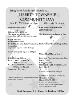
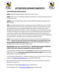

© Copyright 2026