
HOW TO CHANGE LEGAL LAND USE CLASSIFICATIONS TO SUPPORT MORE SUSTAINABLE
ISSUE BRIEF
HOW TO CHANGE LEGAL LAND
USE CLASSIFICATIONS TO
SUPPORT MORE SUSTAINABLE
PALM OIL IN INDONESIA
ANNE ROSENBARGER, BETH GINGOLD, RAUF PRASODJO, ARIANA ALISJAHBANA,
ANDIKA PUTRADITAMA, DEWI TRESYA
Indonesia is the world’s leading producer of palm oil. Industry and government
leaders have announced goals to expand production while avoiding forest
loss and social conflict. Achieving those goals depends on establishing new
plantations on suitable, non-forested land and respecting local rights. Land
classification in Indonesia does not necessarily allow this, as many suitable
areas are legally unavailable for development. This issue brief examines
methods to change legal classification of land to support sustainable palm oil.
WRI.ORG
CONTENTS
2
Executive Summary
3
Introduction
5
Methods for Changing
Legally Allowable
Land Uses
10
Application: Testing
Methods in the Field
12
Discussion of Findings
16
Recommendations
18
Endnotes
21
References
22
Acknowledgments
EXECUTIVE SUMMARY
Indonesia is the world’s leading
producer and exporter of palm oil,
with roughly 18 million metric tons
of crude palm oil exports valued at
US $21.6 billion in 2012.1 The commodity plays a crucial role in the
country’s economy. However, palm
oil production is also closely linked
to deforestation, social conflicts, and
other environmental impacts, as
large areas of Indonesia’s forests and
peatlands are cleared for conversion
to oil palm plantations.2
Palm oil industry and government
leaders in Indonesia have announced
goals to expand palm oil production while avoiding forest loss and
social conflicts. Achieving these goals
largely depends on where new oil
palm plantations are established and
whether local rights and interests
are respected during site selection
processes. Site selection, in turn,
depends on government spatial
planning and permitting processes
that determine where companies can
legally establish plantations.
As of 2011, approximately 70 percent
of Indonesia’s total land area was
classified as “forest estate” (kawasan
hutan) by the Ministry of Forestry.3
However, this and other classifications may not conform to the physical reality of the land cover: many
forest estate lands are settled or
degraded, and many nonforest estate
lands host rich primary forests and
extensive peatlands. A study by the
World Resources Institute found
that 5.3 million hectares of suitable
land are part of the forest estate, and
are therefore legally unavailable for
agricultural development.4
Based on a desktop legal review, this
issue brief found multiple methods
2 |
for changing legal land classifications
in Indonesian law. Companies could
use these methods to expand certified sustainable palm oil production
in areas that were previously legally
unavailable. The methods could also
be used to facilitate the conservation
of forested areas currently legally
available for agricultural uses.
This study identifies three types of
methods for legally reclassifying land:
1. S
ingle reclassifications: Procedures that change the land-use
classification of a single area.
2. M
ultiple reclassifications: Procedures that change (or “swap”) the
land-use classifications of multiple areas simultaneously.
3. L
ocal/special designations: Procedures that change the allowable
land uses in a designated local
area, without changing the land
use classifications.
In addition to the legal review,
WRI carried out a land swap through
a pilot project with Indonesian
partner Sekala and PT Smart, one of
the largest publically listed palm oil
companies. PT Smart, which has committed to the standards of the Roundtable on Sustainable Palm Oil,5 held
a license for forested peatland that
was classified as “nonforest estate”
and was willing to seek an alternative
site on degraded land. In 2009, WRI
and Sekala identified nearby suitable
degraded land, where the local community had a strong interest in palm
oil development. However, despite
this interest, the plan has not been
approved by the national government,
and has stalled because of the complexity and cost of the legal process.
How to Change Legal Land Use Classifications to Support More Sustainable Palm Oil in Indonesia
Companies, project developers, and
communities seeking to change legal
classifications in a manner that is
consistent with sustainability standards face substantial legal challenges, namely the length and costs
of the processes, lack of legal clarity,
and lack of consistency with goals to
avoid forest loss and social conflicts.
This study offers several recommendations for palm oil companies to
help address these challenges, such
as understanding the legal reclassification procedure options and sharing
implementation experience, going
beyond legal compliance to follow
best practices, and engaging with
initiatives such as the Roundtable on
Sustainable Palm Oil and Indonesian Sustainable Palm Oil to support land-use classification policies.
Recommendations are also outlined
for Indonesian policymakers, including clarifying the objectives and
definitions associated with land swap
policies, simplifying procedures,
incorporating biophysical and social
factors into legal classifications, and
making data and procedures publically available and easily accessible.
Addressing these challenges will help
Indonesian companies, governments,
and communities use land more
efficiently, preserve valuable forests,
and expand business prospects. With
global demand for sustainable palm
oil and other commodities on the
rise, land swaps can help position
Indonesia to meet market demands
while using land sustainably.
INTRODUCTION
Indonesia has rapidly expanded its
palm oil production over the past
several decades to become the top
producer of palm oil worldwide, with
crude palm oil exports valued at US$
21.6 billion in 2012.6 However, the
growth of the palm oil industry has
not been without consequences. Conversion of forests to oil palm plantations is a major driver of forest loss,
affecting biodiversity, greenhouse gas
emissions, and local livelihoods.7
To address these concerns, industry and government leaders have
announced goals to expand palm
oil production while avoiding forest
loss and social conflicts.8 Realizing these goals could contribute to
economic growth and job creation,
enhance the competiveness of the
Indonesian palm oil industry in the
growing global market for more sustainable palm oil, and contribute to
national ambitions to reduce greenhouse gas emissions.9
Whether these goals are achieved
will depend largely on where new
oil palm plantations are established
and how local rights and interests are
respected during site selection processes.10 Site selection in turn is highly
dependent on government spatial
planning and permitting processes,
which determine where companies
can legally establish plantations.
Both industry and Indonesian
government standards for certified
sustainable palm oil include provisions designed to contribute to these
goals. The Roundtable on Sustainable Palm Oil (RSPO), a multistakeholder organization, has developed a
voluntary, market-based certification
standard that includes requirements
to maintain “high conservation
value” areas and to obtain the “free,
prior, and informed consent” (FPIC)
of local people.11
Industry and government leaders have
announced goals to expand palm oil
production while avoiding forest loss
and social conflict. Whether these goals
are achieved will depend on where new
plantations are established and how
local rights and interests are respected
during site selection.
ISSUE BRIEF | October 2013 | 3
The Indonesian Sustainable Palm
Oil certification system, a recently
developed legal standard, includes
provisions for avoiding social conflicts
and loss of natural forest and biodiversity. These provisions are based on
concepts in Indonesian regulations.12
Companies can get a head start on
meeting these standards by identifying potentially suitable areas
for expansion using an approach
developed by the World Resources
Institute (WRI) and Sekala13 under
the Sustainable Palm on Low Carbon
Degraded Land or POTICO Project
(Box 1). This approach14 consists of a
desktop study and field assessments
and includes economic, environmental, social, and legal considerations.
The approach and spatial data are
available at an interactive website.15
BOX 1
However, companies face the
remaining challenge of ensuring that
Meanwhile, 8.6 million hectares
found not suitable by the Project
POTICO desktop study—including
forested areas—were legally classified to allow for conversion to
oil palm plantations (Table 1).18 In
some instances, the government has
already issued permits to companies
to begin plantation development in
these areas. For example, in the Project POTICO pilot field site in West
Kalimantan, a palm oil company was
issued a permit in a heavily forested
peat swamp on land legally classified
for plantation development. Conversely, a nearby area of degraded
land that met Project POTICO
suitability criteria was legally offlimits for plantation development.19
This Project POTICO pilot site is
described in “Application: Testing
Methods in the Field,” below.
The government has recognized this
problem and in June 2012 proposed
a “land swap” policy to help address
inconsistencies in land classification.
The policy is part of a draft national
“REDD+ Strategy” aimed at reducing
emissions from deforestation and for-
PROJECT POTICO: SUSTAINABLE PALM OIL ON LOW CARBON DEGRADED LAND
The World Resources Institute’s Project
POTICO supports sustainable palm oil
production and improved forest management in Indonesia. Our pilot project in West
Kalimantan links the expansion of oil palm
cultivation on degraded land with sustainable forest management, while respecting
local rights and interests. Our research
and outreach activities support market and
policy incentives for sustainable palm oil
production and improved forest management in Indonesia.
Palm oil has potential to contribute to
Indonesia’s development goals in line with
Indonesia’s emissions-reduction strategy
if expansion follows sustainable practices
4 |
an area identified as suitable for a
plantation under sustainability standards is also legally eligible for the
permits required for the proposed
new land use.16 In Kalimantan, the
Indonesian portion of the island of
Borneo, a Project POTICO desktop
study identified 14.6 million hectares
as potentially suitable for palm oil
expansion, but 5.3 million hectares
of this total were not legally classified to allow for plantation development (Table 1).17 Although field
assessments are necessary to reject
or confirm the suitability of each
site, this analysis suggests that large
potentially suitable areas are not
eligible for development because of
their legal classification.
such as respecting local people’s rights
and avoiding deforestation. Sustainable
palm oil refers to palm oil produced in
accordance with established standards such
as those of the Roundtable on Sustainable
Palm Oil (RSPO).
Web Tools to Support Sustainable
Palm Oil
WRI has developed two web applications
to enable key stakeholders such as palm
oil producers , investors, and government
decisionmakers to make improved land-use
decisions concerning sustainable palm oil.
Building off WRI’s Interactive Atlases, these
web tools will provide land use and land
cover data for the Indonesian island of Kalimantan. The Forest Cover Analyzera enables
users to assess forest cover change and
deforestation risks related to sustainable
palm oil production in areas of their choice
in Kalimantan. The Suitability Mapperb enables users to prioritize potentially suitable
sites for sustainable palm oil production for
further investigation in the field.
Notes:
a. See http://www.wri.org/applications/maps/forestcover-analyzer/.
b. See http://www.wri.org/applications/maps/suitability-mapper/.
TABLE 1
How to Change Legal Land Use Classifications to Support More Sustainable Palm Oil in Indonesia
POTENTIAL SUITABILITY VERSUS LEGAL AVAILABILITY
IN KALIMANTAN INDONESIA
LEGAL AVAILABILITY
POTENTIAL SUITABILITY FOR OIL PALM BASED ON POTICO ANALYSIS
(MILLION HA)
POTENTIALLY SUITABLE
NOT SUITABLE
Legally available for oil palm
(nonforest estate or convertible
production forest)
9.3
8.6
Not available for oil palm (all other
legal land use classifications)
5.3
30
Source: POTICO Suitability Mapper. Available online at http://www.wri.org/project/potico/about-suitability-mapper.
est degradation. However the details
of the draft policy are undefined. For
example, it is unclear whether “land
swap” refers to changes in legal landuse classifications or permits, or both,
and what criteria would be used to
determine whether a land swap can
be implemented.
As the government continues to
refine its policies, companies seeking
to develop new plantations in suitable areas need to understand the
existing options for changing legal
land-use classifications. This brief
summarizes the existing legal methods for changing current land-use
classifications, which were identified
through a desktop legal review. It
offers a Project POTICO case study
of the application of these methods,
and discusses challenges to their
implementation. Finally, it sets out
recommendations for palm oil companies and Indonesian policymakers
grappling with land-use classification
challenges. A detailed legal appendix
is included for reference.
WRI recognizes that the proposed
methods for changing legal classifications were not designed to support
local interests and land-use rights.
This brief references some of the
important social issues and challenges associated with changing legal
land classification; however it does
not attempt to provide a comprehensive analysis of social issues related
to Indonesian land use.
Although this brief focuses on palm
oil production, its findings are relevant to any developer or community
group seeking legal recognition for a
project aiming to pursue more sus-
tainable land management, whether
for oil palm cultivation, forestry
activities, or other land uses.
METHODS FOR
CHANGING LEGALLY
ALLOWABLE LAND USES
This section summarizes existing
legal methods for changing allowable land uses, including methods for
changing land-use classifications to
allow nonforestry uses (e.g., oil palm
plantations) where they were previously disallowed, as well as methods for changing classifications to
disallow nonforestry uses where they
were previously allowed. Details on
each method, as well as background
on the Indonesian legal context
relevant to land-use classifications
and land rights, are in Appendixes A
and C.
ISSUE BRIEF | October 2013 | 5
In Indonesia, all land is legally classified according to its allowable uses.
An area’s land-use classification
determines its eligibility for rights
and permits defining its allowable
uses. Appendix A2 describes the history and legal context of the current
classification system.
All land in Indonesia is classified as
either forest estate (kawasan hutan)
or nonforest estate (areal penggunaan lain, or APL). Forest estate is
further classified into three functional
categories that determine allowable
land uses, from the most restrictive
category of “conservation forest,”
through “protection forest,” which
allows use of forest products, to “production forest,” which allows commercial timber harvesting.20 Table 2
summarizes these legal classifications
and their allowable land uses. For
more detailed information on forest
classifications, see Appendix B.
In 2011, about 70 percent of Indonesia’s total land area (187.6 million hectares) was classified by the
Ministry of Forestry as forest estate
(131 million hectares).21 By convention, nonforest estate is outside the
jurisdiction of the Ministry of Forestry and generally under the control
of the district in which it is situated.22
In nonforest estate areas—as for
other land classes—the legal basis
for governing land use is the Basic
Agrarian Law (Law 5 of 1960).23
A desktop review of Indonesia’s laws
and regulations identified three types
of methods to legally change allowable land uses:
1. Single reclassifications:
Methods that change the land-use
classification of a single area.
6 |
2. Multiple reclassifications:
Methods that change (or “swap”)
the land-use classifications of
multiple areas simultaneously.
3. L
ocal/special designations:
Methods that change the allowable land uses in a designated
local area, without changing the
land-use classifications.
The following sections describe the
mechanisms, laws, and regulations
governing these types of methods.
The procedures applicable in any
situation depend on initial land
classifications, intended uses, and
project goals. It is important to note
that changing legally allowable land
uses is not the same as changing
existing usage rights (i.e., permits);
additional processes are required to
change usage rights, which must be
followed for specific development or
conservation projects. Table 3 summarizes the legal processes available
to reclassify land use.
Single Reclassifications Several legal methods can be used
to change the land-use classification
of a single area. These methods can
be used either to allow nonforestry
uses (e.g., oil palm plantations) that
were previously disallowed, or to
disallow nonforestry uses that were
previously allowed. Note that two or
more single reclassifications pursued
independently but simultaneously
could achieve the goals of a multiple
reclassification or “land swap.”
Appendix C1 provides additional
details about the methods discussed
in this section.
The most common single reclassification method used to date is the
“forest estate release mechanism” (pelepasan kawasan
hutan) which allows the conversion of convertible production forest
to nonforest estate.24 This method
applies only to provinces with at least
30 percent of their area classified as
forest estate.25 As of 2007, 4.6 million hectares of land formerly classified as convertible production forest
had been reclassified as nonforest
estate for nonforestry uses such as
oil palm plantations.26
A second single reclassification
method, “forest estate review”
(penilaian ulang kawasan
hutan) allows for the reclassification
of land in the forest estate category.
When an area that is potentially suitable for a particular crop is classified
as a functional category within a forest estate other than convertible production forest, this method can be
used to reclassify the area as convertible production forest, which makes
it eligible for reclassification to
nonforest estate.27 The forest estate
review method also allows a single
reclassification of a forested area
classified as convertible production
forest to one of the classifications
that is not eligible for removal from
the forest estate category using the
forest estate release mechanism.28
The forest estate review process
involves re-evaluating the legal classification of the area based on a scoring
system that includes slope, soil type,
and rainfall intensity.29 Current land
cover (forested or nonforested), peat
depth, and land-use information are
not included in the scoring system.
Nonforest estate areas can be reclassified to become part of the forest
estate through a “forest estate
gazettement” process (pengukuhan kawasan hutan) conducted
by the Ministry of Forestry. This
four-step process is based on a forest
TABLE 2
How to Change Legal Land Use Classifications to Support More Sustainable Palm Oil in Indonesia
LAND-USE CLASSIFICATIONS BY FUNCTION
MAIN CLASSIFICATION
SUBCLASSIFICATION
PERMITTED
ACTIVITIES
FUNCTION
CRITERIA
Natural Reserve
(Hutan Suaka)
Preserve animal and plant biodiversity as well as its ecosystem,
also functions as an area for
life-supporting systems.
Varies according to its
subclassification (natural
reserve, wildlife reserve)
Research, science, education,
and limited tourism
Nature Conservation Area
(Hutan Pelestarian Alam)
Protect life-supporting
systems, preserve biodiversity
and sustainable utilization of
natural resources and their
ecosystems.
Varies according to its
subclassification (national
park, grand forest park,
nature recreational park,
hunting park)
Research, science, education,
cultivation activities, cultural
activities, and limited tourism
-----
Forest estate with main
function of protecting
life-supporting systems for
hydrology, preventing floods,
controlling erosion, preventing
sea water intrusion, and maintaining soil fertility.
Weighted scorea of >175
or, (1) slope class of 40%
or more; (2) 2000+ m
above sea level; (3) soil
is extremely vulnerable to
erosion with slope class
of 15% or more; (4) water
catchment area; (5) coastal
protection area
Forest area utilization activities
(cultivating medicinal/decorative
plants, fungi, apiculture, swiftlet
nests, capturing wildlife, cattle feed)
Forest Estate (Kawasan Hutan)
Conservation
Forest (Hutan
Konservasi; HK)
Protection
Forest (Hutan
Lindung; HL)
Utilization of environmental
services (water flow, ecotourism,
biodiversity, environmental protection, carbon absorption and storage)
Extraction of nontimber forest
products (rattan, bamboo, honey,
resin, fruits, fungi)
Production
Forest (Hutan
Produksi; HP)
Limited Production Forest
(Hutan Produksi
Terbatas; HPT)
Forest estate with main
function of generating forest
products via selective/limited
logging scheme
Weighted score 125–174.
Must be outside of protection forest, conservation
forest, and hunting areas
Timber extraction through selective logging
Permanent
Production Forest
(Hutan Produksi
Tetap; HP)
Forest estate with main
function of generating forest
products.
Weighted score <125.
Located outside of protection forest, conservation
forest and hunting areas
Clear cutting forests and industrial timber plantations
Convertible
Production Forest
(Hutan Produksi
Konversi; HPK)
Forest estate with main function
of generating forest products
but spatially reserved for use of
development other than forestry
Forest estate area that has
been spatially designated
for nonforest development
purposes
Clear cutting and industrial
timber plantations, can also be
released to be nonforest land
(areal penggunaan lain – APL).
Nonforest Estate (Areal Penggunaan Lain; APL)
Land outside the forest estate designated for nonforestry use such as agriculture,
settlement, etc.
Source: Compiled from Law 41 of 1999 on Forestry, Minister of Forestry Regulation P.50 of 2009, Minister of Forestry Regulation 37 of 2007, and Government Regulation 68 of 1998
“Weighted score” refers to the calculation of an “erosion sensitivity factor” based on a combination of slope, soil type, and rainfall intensity. A higher “weighted score” equates to a
higher “erosion sensitivity factor.”
a
ISSUE BRIEF | October 2013 | 7
inventory and involves the review
of national, provincial, and district spatial plans.30 A forest estate
gazettement process can be either
“partial” or “provincial.” The process
for a partial forest estate gazettement
is detailed in a Ministry of Forestry
regulation.31 As of July 2013, there
was no implementing regulation to
explain how to conduct provincial
forest estate gazettement process.32
Multiple Reclassifications
Several legal methods exist for simultaneously changing the land-use classifications of two or more areas. In
general, increasing the number and
size of the areas involved increases
the complexity of the procedures
and decreases the likelihood that
site- or community-specific concerns
about land rights will be adequately
addressed. Appendix C2 provides
additional details about the methods
described in this section.
The legal procedure that allows for
the simultaneous reclassification of
two areas is known as the “forest
exchange mechanism” (tukarmenular kawasan hutan). The
Ministry of Forestry describes the
procedure as a “land swap.”33 In this
usage, land swap refers purely to
changing classifications, not moving
existing permits. The forest exchange
mechanism can be applied to the
reclassification of nonforest estate to
permanent production forest or limited production forest, and vice versa.34
The forest exchange mechanism is
applicable in provinces where the
forest estate is less than 30 percent
of the land area and the forest estate
release mechanism does not apply.
In these provinces, the minimum
exchange ratio of forest estate to
nonforest estate is 1:2, meaning that
8 |
at least two times more nonforest
estate land must be reclassified as
forest estate than forest estate land
reclassified as nonforest estate. In
provinces where the forest estate is
more than 30 percent of the land
area, the minimum exchange ratio
is 1:1.35 Very few precedents for the
application of this procedure exist.36
A spatial planning revision
process under Spacial Planning
Law 26 of 2007 can change many
classifications at once.37 Spatial plans
are made at district and provincial
levels through multiple processes
and incorporated into national plans.
Spatial plans made under this law
are valid for 20 years and should
be reviewed every five years by the
district and provincial government.
Associated processes, laws, and regulations are described in Appendix C2.
A July 2012 amendment to the
forest exchange mechanism regulations creates an expedited forest
exchange for companies that were
issued permits prior to the 2007
spatial planning law , which now
conflicts with the current legal classifications.38 For instance, a palm
oil company with a permit for land
classified as nonforest estate prior to
2007, but reclassified as forest estate
under the spatial planning law, could
use the expedited process to reclassify the permitted area as nonforest
estate. This process, which involves
a legal classification change linked
to changing permits, could also be
considered a “land swap.”
An alternative method for changing multiple classifications at once
is through a government-initiated
forest audit mechanism, in which
the Ministry of Forestry conducts a
rescoring exercise applicable to
many areas.39
Local/Special Designations
There are also procedures for designating localized special areas to
change allowable land uses without
changing their legal land-use classifications. Appendix C3 provides
additional details about the methods
described in this section. A “forest
with rights” (hutan hak) process
is available in forested areas of a
nonforest estate with demonstrable40
local rights. The local regent/mayor
can request a hutan hak designation
for an eligible area. If the forested
area serves a conservation or protection function, an additional process
can be used to reclassify the area as
forest estate after compensating local
rights holders.41
An “enclave solution” allows
for the creation of relatively small
enclaves within forest estate areas
where local people can legally conduct nonforest activities.42 In nonforest estate areas, regents and mayors
can issue a local conservation
area stipulation to restrict uses, for
example, to uses allowed in areas
classified as “conservation forest.”43
Areas that are legally stipulated as
“village forest” (hutan desa)
or “community forest” (hutan
kemasyarakatan) are also within
the forest estate. These lands have
Ministry of Forestry functional classifications, but their use is limited
to communities.44
TABLE 3
How to Change Legal Land Use Classifications to Support More Sustainable Palm Oil in Indonesia
SUMMARY OF PROCEDURES FOR CHANGING ALLOWABLE LAND AREAS
IN INDONESIA
PROCEDURE
INITIAL CLASSIFICATION
FINAL CLASSIFICATION
COMMENTS
Single Reclassification
Forest estate release
(pelepasan kawasan
hutan)
Convertible production forest
Nonforest estate
Most common method for reclassifying land to date. Initiated by a
minister-level government official,
regent, mayor, governor, head of
corporation, or head of a foundation
Forest estate review
(penilaian ulang
kawasan hutan)
Conservation forest, protection
forest, limited production forest,
permanent production forest, or
convertible production forest
Conservation forest, protection
forest, limited production forest,
permanent production forest, or
convertible production forest
Can be used in combination with forest
estate release mechanisms. Initiated by
regent or mayor if area is within one
district or city, or by governor if area is
within multiple districts
Forest estate
gazettement
(pengukuhan
kawasan hutan)
Nonforest estate
Conservation forest, limited
production forest, permanent
production forest, convertible
production forest, protection forest
Four -step process to designate
nonforest estate into forest estate.
Conducted by the Ministry of
Forestry.
Multiple Reclassification
Forest exchange
mechanism (tukarmenukar kawasan
hutan)
Limited production forest or
permanent production forest and
nonforest estate
Nonforest estate and limited
production forest or permanent
production forest
Simultaneous reclassification of two
areas. Initiated by the Minister of
Forestry, or a government official
equivalent to a minister, governor,
regent, mayor, head of governmental or private business entity or
head of a foundation
Expedited forest
exchange (tukarmenukar kawasan
hutan yang
dipercepat)
Limited production forest or permanent production forest and nonforest
estate
Nonforest estate and limited
production forest or permanent
production forest
Existing permit required
Spatial planning
revision process
(revisi rancangan
tata ruang dan
wilayah)
Conservation forest, protection
forest, limited production forest,
permanent production forest,
convertible production forest and/or
nonforest estate
Conservation forest, protection
forest, limited production forest,
permanent production forest,
convertible production forest and/or
nonforest estate
Plans created for district, province, and national spatial plans.
Multiple decisionmakers involved in
process. Revised every five years.
Forest audit mechanism (mekanisme
audit kawasan
hutan)
Conservation forest, protection
forest, limited production forest,
permanent production forest, or
convertible production forest
Conservation forest, protection
forest, limited production forest,
permanent production forest, or
convertible production forest
Initiative led by Ministry of Forestry
in which forest estate rescoring is
conducted for many areas.
ISSUE BRIEF | October 2013 | 9
TABLE 3
SUMMARY OF PROCEDURES FOR CHANGING ALLOWABLE LAND AREAS
IN INDONESIA (CONT.)
PROCEDURE
INITIAL CLASSIFICATION
FINAL CLASSIFICATION
COMMENTS
Local/Special Designation
Forest with rights
(hutan hak)
Nonforest estate
No change
Allows forest uses in APL; can be used
as first step to reclassify APL as forest
estate. Initiated by regent/mayor.
Enclave solution
Limited production forest, permanent production forest, or convertible production forest
No change
Allows nonforestry uses within
forest estates. Initiated by regent or
mayor.
Local conservation
area (area konservasi lokal)
Nonforest estate
No change
Restricts uses of APL to
conservation
Village forest
or community
forest (hutan
desa or hutan
kemasyarakatan)
Limited production forest, permanent production forest, or convertible production forest
No change
Restricts uses within forest estate to
communities
APPLICATION: TESTING
METHODS IN THE FIELD
In 2009, under Project POTICO,
WRI and Indonesian partner organization Sekala initiated a pilot
project to facilitate a “land swap.” In
the original conception of the pilot,
Project POTICO considered a “land
swap” a change in legally permitted
management rather than a change
in legal land classifications. In other
words, a company with a permit on
forested land would agree to not
develop the area and instead, develop
a similarly sized area that was not
forested, but rather was considered
“degraded”45 in accordance with the
Roundtable on Sustainable Palm Oil
(RSPO) certification requirements.
10 |
Developing the degraded land would
require obtaining a permit, as well as
the free, prior, and informed consent
of local people.46 At the same time,
the company would work with local
communities and government to
develop a sustainable management
plan for the original permitted area.
A successful swap would require a
method for changing legal classifications if the initial legal classifications
were inconsistent with the desired
final land uses (e.g., oil palm on the
degraded land, sustainably managed
community forestry on the forested
land) (Figure 1).
In the pilot site, PT Smart, one of the
world’s largest publicly listed palm
oil producers, held a location permit
(izin lokasi) on forested peatland that
was classified as nonforest estate.47 PT
Smart was willing to forego developing that area for oil palm and to
investigate alternative management
options for maintaining the forest.
PT Smart had publicly committed
to fulfilling the RSPO principles and
criteria in new plantation developments; it has since announced specific
forest conservation measures that go
beyond these requirements.48
WRI and Sekala worked with PT
Smart to identify a potentially suitable degraded area nearby where
communities had expressed interest
in oil palm plantation development.
The partners identified the area
through a method that included both
How to Change Legal Land Use Classifications to Support More Sustainable Palm Oil in Indonesia
a desktop analysis and rapid field
assessments, followed by more in
depth surveys and discussions with
local community members, government officials, and nongovernmental
organizations (NGOs) once priority sites had been identified.49 Even
before WRI and Sekala’s involvement, local community representatives had, on multiple occasions,
approached PT Smart to inquire
about development in the area.
INITIAL INTENDED
LAND USE
POTICO “LAND SWAP” CONCEPT
FOREST, PEATLAND & OTHER HCV AREAS
DEGRADED LAND
PALM OIL PRODUCTION
NOT COMMERCIALLY UTILIZED
“LAND SWAP”
L egal land use classifications
U
se rights (permits, local claims)
M
anagement plans
REVISED
LAND USE
FIGURE 1
Despite community interest and
the potential suitability of the
area, existing legal land-use classification complications had dissuaded
PT Smart from pursuing development plans prior to WRI and
Sekala’s involvement.
Project POTICO considered a “land
swap” a change in legally permitted
management. A company with a permit on forested land would agree to not
develop the area and instead, develop a
similarly sized area that was not forested.
CONSERVATION OR SUSTAINABLE USE
PALM OIL PRODUCTION
ISSUE BRIEF | October 2013 | 11
INITIAL LEGAL
CLASSIFICATION
FIGURE 2
PROPOSED LEGAL LAND-USE CLASSIFICATION CHANGES FOR POTICO
PILOT SITE IN KAPUAS HULU, WEST KALIMANTAN
FOREST, PEATLAND & OTHER HCV AREAS
DEGRADED LAND
NONFOREST ESTATE
PRODUCTION FOREST
REVISED LEGAL
CLASSIFICATION
“LAND SWAP”
L egal land use classifications
PROTECTED FOREST
The site was legally classified as limited production forest and production forest and therefore would need
to be reclassified to nonforest estate
to allow for legal oil palm cultivation
(Figure 2).
To facilitate the pilot “land swap”
that would change the legally permitted management of both the forested
and degraded sites, WRI and Sekala
investigated each of the methods for
changing legal land classifications
identified in the desktop review.
Initially, single reclassifications were
not considered attractive. The forest
estate release mechanism did not
12 |
NONFOREST ESTATE
apply because the degraded area was
not classified as convertible production forest. WRI / Sekala considered
a multiple reclassification more consistent with the project goals, which
included maintaining the forested
area as forest.
WRI and Sekala first considered
using the forest exchange mechanism, but PT Smart and the POTICO
field team determined the process
would be too long, complicated,
and expensive. The spatial planning
process was in its five-year review
period (see process in “Multiple
Reclassifications,” above),50 and the
team opted to take advantage of the
short-lived opportunity to reclassify
the area through this larger district,
province, and nationwide spatial
planning review process. The team
also viewed the provisional spatial
planning process as an opportunity
to increase community participation
in the government process.51 WRI
and Sekala engaged district, provincial, and national decisionmakers
by providing detailed recommendations that reflected current land
cover, land use, and conservation
values, as well as perspectives from
the local communities and palm oil
companies. This engagement process included facilitating discussions
among elected representatives of
How to Change Legal Land Use Classifications to Support More Sustainable Palm Oil in Indonesia
local communities, PT Smart, and
local government officials.
WRI and Sekala’s recommendations
were incorporated into the 2010 drafts
of district and provincial spatial plans,
largely because of the engagement of
other stakeholders, including NGOs
working to improve spatial planning
in the area. PT Smart’s assurance that
it would support reclassification of the
forested area despite holding a use
permit was critical to the incorporation
of WRI and Sekala’s recommendations
in the draft plans.
Despite this initial success, the
national government had not yet
approved the provincial plan when
this issue brief was finalized (July
2013) and it was unclear when or
whether it will do so. Since the
national process includes review of
all provincial maps, the timeline is
long, unclear, and prone to delay
because of politics unrelated to the
specifics of any given field project.
The POTICO team has found it difficult to determine where the plan
is in the process, and who in the
government is responsible for taking
the next steps. See Appendix C2 for
additional details.
While the spatial planning process
stalled, the project team conducted
several workshops with community
members, government officials, and
PT Smart to discuss potential development opportunities, both for oil
palm and other options. Workshop
participants reviewed a sample cooperation agreement provided by PT
Smart outlining the development and
management details of a plantation
partnership.52 The team also facilitated a detailed community mapping
process in both the forested and
degraded areas with local facilitators
to help prepare for possible future
development negotiations guided
by the principle of free, prior, and
informed consent.
Over three years—with approval of
the provincial spatial plan uncertain—the team gradually shifted its
approach from trying to implement
a land “swap” through a multiple
reclassification, to using local/special designations, which could be
pursued simultaneously to achieve
the pilot project’s original goals.
The POTICO team has recently
begun to investigate an enclave solution suggested by the local government. As described in “Methods for
Changing Legally Allowable Land
Use,” above, this option creates
small enclaves within forest estate
areas where local people can legally
conduct nonforestry activities.53 This
change could allow communities to
cultivate oil palm while maintaining
their permanent production forest
and limited production forest legal
classifications in the “degraded” area.
The creation of enclaves also aligns
with recent discussions (December
2011) with local communities that
reflect a growing interest in smallholder development. With sufficient
local political and community will,
enclaves may be a viable solution.
Whether it is financially viable for
the communities to become smallholder developers depends largely on
the provision of extension services
by larger palm oil companies in the
area, as is the case with most smallholder development scenarios.
Furthermore, work remains to
identify a legal and financially viable
management plan for the forested
area within the existing oil palm
concession that will effectively maintain its conservation values.54 There
is little risk that PT Smart, which
holds the concession for the area, will
convert the forest in the near term:
the company is committed to avoiding
deforestation and is open to alternative management options. However,
this is only the case while PT Smart
retains the permit. As long as the
forested area remains part of the
nonforest estate, there is a risk that
PT Smart’s permit for oil palm will be
revoked and reissued to a company
with no interest in conservation.55
Although the pilot project is ongoing,
it has informed WRI’s analysis of the
existing legal reclassification methods identified in the desktop legal
review. Findings from this analysis
are discussed in the next section.
DISCUSSION
OF FINDINGS
WRI’s analysis found multiple
methods in Indonesian law for
changing legal land-use classifications. Companies could, in theory,
use many of these methods to
expand certified sustainable palm
oil production in areas that were
previously legally off limits. These
methods could be used to conserve
forested areas that are currently
legally available for agriculture.
However, in practice, companies
face many challenges to changing
legal land-use classifications. These
challenges are problematic both
for project developers interested in
ecosystem restoration concessions56
in forested areas and for local people
interested in strengthening their
land management rights.
Overall, companies, project developers, and communities face substantial legal challenges in implementing
financially viable, clear procedures
for changing legal classifications
ISSUE BRIEF | October 2013 | 13
consistent with sustainability standards for avoiding forest loss and
social conflicts.
Three categories of major legal challenges are described below. Although
the Indonesian government has recognized many of these challenges and
has begun to take steps to address
them (for example, through proposed
national REDD+ strategies), these
challenges continue to hinder companies and other stakeholders.57
Challenge 1: Length and Cost
of Procedures
All the processes identified require
many steps to attain approvals from
multiple government agencies at
different levels, adding substantial
time and cost to the already lengthy
bureaucratic procedures for acquiring a land-use permit.
For example, according to the law
governing the forest exchange
mechanism, the Ministry of Forestry’s
bureaucratic process can take up to
2,273 days—over six years—from the
time the application is submitted.58
This does not include time that the
National Parliament might take to
consider the application. A combination of changing classifications within
the forest estate followed by the forest
estate relinquishment mechanism
could take two and a half years within
the Ministry of Forestry alone.
In both cases, the applicant bears the
majority of the cost, including the
cost of the government-appointed
research team and the cost of delineation. The cost of implementing the
forest exchange mechanism procedures in the POTICO field project was
estimated at more than US$200,000
—and amount that PT Smart determined to be prohibitively expensive.59
14 |
Challenge 2: Lack of
Legal Clarity
Uncertainty regarding the legality of
existing procedures, classifications,
permits, and customary rights is a
major hindrance to implementing
procedures to change legal classifications. Other challenges include:
No single legal classification
map. A prerequisite for implementing a clear process for
changing legal classifications
is clear information and agreement on the initial legal classifications. However, there is
currently no single governmentapproved map that clearly
defines which areas are forest
estates. Although the Ministry
of Forestry has produced a single
map, it is not harmonized with
the many spatial planning maps
created by various jurisdictional
levels, which are already being
used at a local level to guide
permitting decisions.60
In addition, as of 2010 about
89.2 percent of the land classified as forest estate by the
Ministry of Forestry had not yet
been “stipulated” following the
full delineation process required
by law.61 A Constitutional Court
decision in February 2012 cast
uncertainty on the legal status of
these areas, but the implications
of the decision remain unclear.62
In response to the decision,
the Ministry of Forestry issued
a memo to governors, district
heads, and local forestry agencies stating that all designation
of forest area prior to the Constitutional Court’s decision and the
legal implications are still valid.63
Overall, companies, project
developers, and
communities
face substantial
legal challenges
in implementing
financially viable,
clear procedures
for changing
legal classifications consistent
with sustainability standards for
avoiding forest
loss and social
conflicts.
Lack of publicly available, easily
accessible data on legal classifications, permits, and rights.
Without publicly available, easily
accessible data on legal classifications, permits, and rights,
companies and individuals are
disadvantaged when making
planning decisions, and government officials can profit by selectively sharing information. Many
district-, province-, island-, and
How to Change Legal Land Use Classifications to Support More Sustainable Palm Oil in Indonesia
national-level spatial planning
maps are not publicly available.
Although the Ministry of Forestry has made legal classification and permit data available
on a public website, these maps
are sometimes difficult to access
and are often inconsistent with
provincial and district maps
of permits.64 None of the maps
provides information on local or
customary rights to land.
Convoluted, frequently changing procedures and missing
instructions for implementation.
Convoluted procedures with
many bureaucratic steps, often
with undefined approval criteria,
provide rent-seeking opportunities.65 This situation is particularly problematic when combined
with ongoing jurisdictional political wrangling at multiple levels of
government. Constant changes to
procedures through amendments
contribute to ongoing confusion and lack of long-term legal
certainty.66 Meanwhile, some
procedures lack instructions
for implementation.67
Inconsistent treatment of customary land rights and lack of
mechanisms for resolving land
disputes. Ongoing, costly social
conflicts resulting from a lack of
mechanisms to recognize customary land rights and resolve
land-use claims continue to
plague the palm oil industry. A
study by Sawit Watch, an Indonesian NGO, noted 660 ongoing
land conflicts related to the palm
oil industry in Indonesia.68 There
remains a lack of clarity regarding jurisdictions and land rights,
and different laws treat traditional land rights in contradictory ways.69 In general, Indo-
nesian laws concentrate control
over land, water, and natural
resources in the government.70
Little or no information on
successful legal precedents.
With the exception of the forest
release mechanism, most of
the methods identified in the
review have not been widely
implemented.71 Few documented
“success” stories of legal classification changes following many
of the procedures are available to the public. Of the legal
precedents that do exist, many
are small scale or appear to be
special cases whose outcomes
depended on local political will
and/or civil society support.72
Challenge 3: Inconsistent
Goals to Avoid Forest Loss
and Social Conflicts
In general, the methods for changing
legal classifications identified have
not been specifically designed to
support efforts to both maintain high
conservation value areas and respect
local land use rights and interests.73
As a result, diligently following existing legal procedures can fail to contribute to, or even detract from, best
management practices for meeting
the twin goals of maintaining high
conservation values and avoiding
social conflicts.
Regarding conservation values, procedures for determining land-use classifications within the forest estate do not
include important biophysical characteristics such as current land cover and
depth of peat soils. Therefore, there is
no legal mechanism for ensuring that
these factors are taken into account
when allocating land-use categories
relevant to achieving goals regarding
reducing greenhouse gas emissions
from deforestation or maintaining
biodiversity conservation.
Likewise, land-use reclassification procedures do not adequately
address the involvement of local
communities and do not allow communities or individuals to initiate the
reclassification process. Although
some procedures mention either
compensation to communities or
require public participation, these
provisions are usually vague and
often ignored in practice. When
communities are not involved in
legal classification decisions, and are
subsequently not involved in permitting decisions, costly ongoing social
conflicts are likely to arise. Although
some of these problems can be
avoided when companies follow their
own due diligence procedures, the
lack of legal clarity regarding local
land use rights is a fundamental
challenge facing companies intent on
following the principle of free, prior,
and informed consent.
As long as these environmental and
social factors remain unaddressed
in legal classification and reclassification procedures, companies will
continue to receive permits that are
likely to be inconsistent with the goal
of achieving more sustainable palm
oil production without forest loss
and social conflicts.
RECOMMENDATIONS
Fully addressing the challenges identified above will require broad policy
and legal reforms targeting spatial
planning and land use permitting.
Nonetheless, companies and policymakers can take immediate steps
regarding legal classification challenges to more sustainable implementation of palm oil projects. Based
on the analysis in this brief, WRI
ISSUE BRIEF | October 2013 | 15
recommends the following actions:
Recommendations for Palm
Oil Companies
Understand legal reclassification procedure options and
share implementation experience. By implementing relevant
options and documenting and
sharing experiences, companies
can help provide positive legal
precedents and pave the way for
replication. Likewise, challenges
and unsuccessful attempts to
pursue reclassification can provide insights regarding potential
need for procedural reforms.
Companies can share their
experiences by publishing case
studies with the help of research
institutions like WRI or through
platforms such as the RSPO.
Go beyond legal compliance
and follow best practices. This
legal analysis demonstrates that
following legal procedures to
the letter does not necessarily
guarantee—and may sometimes
interfere with—achieving goals
such as maintaining high conservation values and avoiding social
conflicts. Therefore, companies
should take steps that are not
required in the law to assess
risks. Such due diligence should
start as early as the preliminary
site selection process, when
deciding whether or not to accept
a location permit (izin lokasi). To
do this, companies should seek
additional guidance from initiatives such as the RSPO, social
organizations,74 and research
institutions such as WRI.75
16 |
Engage with initiatives like
the RSPO and the Indonesian
Sustainable Palm Oil to support
improved land-use classification policies. Multistakeholder
initiatives provide opportunities for companies to share and
learn best practices as well as to
contribute to efforts to influence
government policies in ways that
are consistent with these best
practices.
Recommendations for
Indonesian Policymakers
When designing “land swap”
policies, clarify objectives and
definitions, address existing
laws and regulations, and simplify procedures. The term “land
swap” has been used in different
ways to refer variously to changing legal classifications, changing
permits, or changing both. New
policies using this term should
employ clear definitions that are
consistent with policy objectives.
In addition, to avoid creating
further confusion, new policies
should account for existing laws
and regulations such as those
described in this brief, and consider the need for simple, timely,
and coherent procedures.
Consider redesigning legal
classification and reclassification procedures to incorporate
appropriate biophysical and
social factors relevant to maintaining high conservation values
and avoiding social conflicts. To
ensure that new policies are consistent with the Indonesian government’s stated goals related
to reducing greenhouse gas
emissions, conserving biodiversity, and poverty reduction, the
redesign of legal classification
and reclassification procedures
should ensure that relevant
biophysical factors (such as land
cover and peat) and social factors (such as current land uses
and claims) are incorporated
into legal procedures.
Make data and procedural
information publicly available
and easily accessible. Publicly
available and easily accessible
data on biophysical factors such
Companies and policymakers can take
immediate steps regarding legal classification challenges to more sustainable
implementation of palm oil projects.
How to Change Legal Land Use Classifications to Support More Sustainable Palm Oil in Indonesia
as land cover and peat as well as
legal factors such as classifications, permits, and rights can
help companies, government
officials, and communities make
better decisions about more
sustainable palm oil production.
Government initiatives such as
OneMap76 are already making
progress and should be strengthened. In addition to providing
maps, Indonesian policymakers
can make information about
procedures more accessible.
For example, policymakers can
provide regular public updates
about the spatial planning processes and legal status of each
of the spatial planning maps
created at the district, provincial,
island, and national levels. Information about the status of legal
classification procedures should
be made readily available when
requested using Indonesia’s
freedom of information act. The
government should also publish
and make publically available
guidance documents summarizing legal procedures, including
logistical information such as
timelines and relevant contacts.
Through these actions, companies
and policymakers can substantially
contribute to achieving clearer legal
reclassification procedures to support
sustainable palm oil in Indonesia.
ISSUE BRIEF | October 2013 | 17
ENDNOTES
1.
2.
3.
4.
5.
6.
7.
8.
18 |
Indonesia Investments Website. Table:
“Indonesia’s Palm Oil Production and Export
2007–13.” http://www.indonesia-investments.com/doing-business/commodities/
palm-oil/item166
A recent study in Nature Climate Change
indicates that 90 percent of lands converted
to oil palm from 1990 to 2010 in Kalimantan
were forested. Carlson et al. 2012.
Ministry of Forestry. Indonesian Forestry
Statistics 2012. http://www.dephut.go.id/
files/BUku%20Statistik%20Juli%20
2012_terbaru.pdf
“Suitability” in this calculation is in terms
of environmental and crop productivity
considerations only. Additional social and
legal considerations must also be included
in assessing suitability.
Greenpeace’s scorecard lists major oil palm
producer’s commitments to environmental and social responsibility. http://www.
greenpeace.org/international/en/publications/Campaign-reports/Forests-Reports/
Palm-Oil-Scorecard/
Indonesia Investments Website. Table:
“Indonesia’s Palm Oil Production and
Export,” and “Indonesia’s Crude Palm Oil
Sector.” http://www.indonesia-investments.
com/news/news-columns/indonesiascrude-palm-oil-sector-cpo-price-expectedto-rebound/item836
A recent study in Nature Climate Change
indicates that 90 percent of lands converted
to oil palm from 1990 to 2010 in Kalimantan
were forested. Carlson et al. 2012.
For example, the Roundtable on Sustainable
Palm Oil has established Principals and
Criteria: Criterion 5.2 on the identification
of rare, threatened, or endangered species
and high conservation value habitats, Criterion 6.1 on identification of social impacts
of plantation in plantation and mill management, Criterion 7.1 on comprehensive
and participatory independent social and
environmental impact assessment, Criterion
7.3 on requirement of new plantation to
maintain or enhance and high conservation
values, Criterion 7.5 and 7.6 on requirement
of new plantations to address local people’s
rights and interests in FPIC; Golden Agri
Resources (GAR) has initiatives in its Forest
Conservation Policy aiming to achieve
no-deforestation footprint on its products.
See http://www.rspo.org/blog/topic/33/
rspo_pandc_specific_by_principle for complete RSPO P&C and http://goo.gl/iooVz for
9.
10.
11.
12.
13.
GAR’s Forest Conservation Policy.
Indonesia’s government sets target to
reduce its greenhouse gas emissions by
26 percent—or 41 percent with international assistance—while maintaining 7
percent economic growth and 8-10 percent
poverty reduction as stated by Presidential
Decree 61 of 2011 (National Action Plan
on Greenhouse Gas Emission Reduction)
and National Medium-Term Development
Plan See http://www.sekretariat-rangrk.org/
and <http://bappenas.go.id/get-file-server/
node/8943/>
See Gingold. 2011. World Bank Group,
“Palm Oil and Poverty.” World Resources
Institute webstory. http://www.wri.org/
stories/2011/03/world-bank-group-palmoil-and-poverty
The Roundtable on Sustainable Palm Oil
(RSPO) was established in 2004 to “promote the production and use of sustainable
palm oil for People, Planet, and Prosperity”
(www.rspo.org). The “high conservation
value” approach refers to six high conservation values, “which cover the range of
conservation priorities shared by a wide
range of stakeholder groups, and include
social values as well as ecological values”
(www.hcvnetwork.org). According to the
RSPO’s guidance document for companies,
developed by the Forest People’s Program,
free, prior, and informed consent (FPIC)
“ implies informed, noncoercive negotiations between investors and companies or
the government and indigenous peoples
/ customary law communities prior to oil
palm estates, timber plantations or other
enterprises being established and developed
on their customary lands” (http://www.rspo.
org/en/document_fpic).
Indonesian Sustainable Palm Oil Principles
& Criteria refers to Minister of Agriculture
19/2011, second attachment. http://www.
deptan.go.id/Permentan2011/5.Permentan%20No.19%20Tahun%202011/Lampiran%20II%20Permentan%20No.19%20
Tahun%202011.pdf. FPIC is not part of
Indonesian government regulations and
therefore not part of the Indonesian Sustainable Palm Oil certification system.
Sekala aims to develop realistic, tangible,
and innovative solutions for environmental
problems to generate benefits for local
people and the environment. Established
in Bali in 2005, Sekala works at local,
provincial, and national levels across
14.
15.
16.
17.
18.
19.
Indonesia, focusing on land-use planning,
forest governance, community mapping,
capacity building, conflict resolution, remote
sensing, and spatial analysis.
Gingold 2012. “How to Identify Degraded
Land for Sustainable Palm Oil in Indonesia” by WRI and Sekala describes a quick
and cost-effective method for identifying
potentially suitable “degraded land” for
sustainable palm oil production in Indonesia
and presents results from the application of
the method in West Kalimantan and Central
Kalimantan. The method consists of a desktop analysis as well as field assessments.
Access the Suitability Mapper at http://www.
wri.org/project/potico/about-suitabilitymapper. The POTICO method and associated interactive website are intended as a
first step in a site selection process. Additional analyses beyond the scope of this
method, such as social and environmental
impact assessments and comprehensive
FPIC procedures, are fundamental to bestpractice site selection procedures.
Details regarding land-use classifications
and corresponding allowable land uses are
provided later in this brief. For full details
on land tenure and legal status of lands in
Indonesia see Appendix A2. For details on
forest estate and permit classifications see
Appendix B.
In Indonesia, all land is legally classified
according to its allowable uses. An area’s
land-use classification determines which
rights and permits for which allowable
uses can be recognized or issued. In this
example, the 5.3 million hectares that were
identified as potentially suitable by the
POTICO desktop study but not legally classified to allow plantation development were
classified as anything other than nonforest
estate (area penggunaan lain; APL) or convertible production forest (hutan produksi
konversi; HPK). POTICO suitability criteria
for desktop analysis include environmental
criteria (land cover, peat, conservation areas
with buffer zones, water resource buffers)
and crop productivity criteria (topography,
climate, soil). See http://www.wri.org/
project/potico/about-suitability-mapper.
Areas legally classified as either nonforest
estate (areal penggunaan lain; APL) or convertible production forest (hutan produksi
konversi; HPK)
POTICO suitability criteria for desktop
analysis include environmental criteria (land
How to Change Legal Land Use Classifications to Support More Sustainable Palm Oil in Indonesia
20.
21.
22.
23.
24.
25.
26.
cover, peat, conservation areas with buffer
zones, water resource buffers) and crop productivity criteria (topography, climate, soil).
See http://www.wri.org/project/potico/
about-suitability-mapper.
The three main functional categories of
forest estate codified in Law 41 of 1999 on
forestry are conservation forest, protection
forest, and production forest. Each of these
categories has subcategories, which further
define the specific function of each forest.
For more information on legal categorization, see: http://www3.bkpm.go.id/
file_uploaded/Law_4199.htm.
Despite this number, only 10.8 percent
of the area has been formally stipulated
(ditetapkan) as forest estate and inserted
into the state gazette (dikukuhkan). The rest
of the nonstipulated forest estate was merely
designated (ditunjuk) by the Ministry of
Forestry. See Indonesia Forestry Statistics,
http://www.dephut.go.id/files/BUku%20
Statistik%20Juli%202012_terbaru.pdf and
National Forestry Plan, http://www.dephut.
go.id/files/DitRenHut_RKTN_2011.pdf.
In urban areas, nonforest estate lands may
be under the jurisdiction of mayors.
Accessible at http://portal.djmbp.esdm.
go.id/sijh/UU%205%20Tahun%20
1960_%20UUPA.pdf. It should be noted
that by content, the Agrarian Law applies to
all land, not only to nonforest estates. There
is no law or regulation that stipulates that
the Agrarian Law should be applied only to
nonforest estates.
The mechanism is recognized by Government Regulation 10 of 2010 on Procedures
of Changing the Allocation and Functions of
Forest Estate, paragraph 3, Article 19. See
http://www.dephut.go.id/files/pp10_10.pdf.
Minister of Forestry Regulation 33 of 2010
for further details of this process.
Most of the provinces meet the 30 percent
minimum requirement of forest estate to
change its forest estate function classification into convertible production forest and/
or to conduct forest estate relinquishment
mechanism. Only 7 out of 33 provinces
(DKI Jakarta, West Java, Central Java, East
Java, DIY Yogyakarta, Banten, and Bali) are
unable to meet the 30 percent forest estate
requirement. Of these seven provinces,
only two (Central Java and East Java) have
significant forested area.
Total area reclassified is before the spatial
planning revision process. Through this
27.
28.
29.
30.
31.
32.
33.
34.
35.
revision process, about 15.7 million
hectares of forest have been suggested to
be converted to nonforest estate in 2010.
By the end of December 2010, there were
already 520 forests estate relinquishment
applications at the Ministry of Forestry
with an average area of 200,000 hectares
per applicant. See Kesatuan Pengelolaan
Hutan pp. 17-18 at http://www.dephut.go.id/
files/Buku%20Pembangunan%20KPH%20
16%20Des%202011.pdf.
For forest to be relinquished to nonforest estate, the area must fulfill the scoring
requirement of convertible production
forest. According to Ministry of Agriculture Decree 837/Kpts/Um/11/1980, the
convertible production forest score must be
less than 125 and reserved for nonforestry
purposes. See http://www.satgasreddplus.
org/download/Forest%20Lands%20Suitability001.pdf.
This method could facilitate the development of community forestry or ecosystem
restoration projects. If a forested area is
classified as convertible production forest,
it can be reclassified within the forest estate,
for example to permanent production forest,
using the forest estate review method.
Government Regulation 44 of 2004 on
Forestry Planning stated the scoring of a
forest’s biophysical variables is required to
determine forest function. See http://www.
jkpp.org/downloads/PP_No44-2004.pdf.
See Appendix C1.1. There is no legal
requirement for the Ministry of Forestry
to stipulate according to national, provincial, or district spatial plans (Article 16 of
Government Regulation 44 of 2004). As
little as 10.8 percent classified as forest
estate by maps from the Ministry of Forestry
have actually gone through the steps in this
stipulation process.
Ministry of Forestry Regulation 32 of 2001.
See Appendix C1 for more information
See Appendix C1. Processes explained in
Government Regulation 44 of 2004 and
Minister of Forestry Decree 32/Kpts-II/2001.
See Article 10 of Government Regulation
10 of 2010 on Procedures of Changing the
Allocation and Functions of Forest Estate at
http://www.dephut.go.id/files/pp10_10.pdf.
Ibid.
See Article 12 of Government Regulation
10 of 2010 on Procedures of Changing the
Allocation and Functions of Forest Estate at
http://www.dephut.go.id/files/pp10_10.pdf.
36. One example of the forest exchange mechanism is Surat Menteri Kehutanan No.S.13/
Menhut-II/2005, which was used to change
the status of Baloi Dam Forest Estate in
Batam.
37. See “Revision of spatial planning” in Article
16 of Law 26 of 2007 on spatial planning
at http://hukum.jogjakota.go.id/upload/
UU%20No.26-2007ttg%20Penataan%20
Ruang.pdf.
38. Government Regulation 10 of 2010 was
amended with Government Regulation 60
of 2012. http://www.depdagri.go.id/media/
documents/2012/08/27/p/p/pp_no.602012.pdf.
39. According to Minister of Forestry Regulation P-10/Menhut-II/2010 on Mechanism &
Procedure of Forest Estate Audit, the audit
is conducted through updating the audited
forest estate data according to its designation status, rescoring the forest estate and
analyzing the overlay of spatial data. See:
http://kehutanan.kalbarprov.go.id/joomla15/
images/peraturan/P10_2010.pdf
40. Land rights can be evidenced by recht title/
land ownership in the form of (1) Certificate
of Ownership or quotation from Letter C
Book or Girik Letter (Surat Girik) from local
authorities (issued by the head of the relevant subdistrict/village to the “landowner”
evidencing payment of local land taxes)
or other information that is recognized by
National Land Agency; (2) Certificate of
Right to Use (Sertifikat Hak Pakai); and
(3) other letters/documents admitted as
evidence of land acquisition or other proof
of land ownership. See “Procedures on
Community Based Development of Forest
Management Program,” p. 32 at http://
www.redd-indonesia.org/pdf/Buku_Saku_
PHBM_web.pdf.
41. See Article 19 of Minister of Forestry Regulation P.26/Menhut-II/2005 on Guideline for
the Use of Forest with Rights.
42. A five-step procedure, conducted by the
district-level Ministry of Forestry official,
determines enclave eligibility. First, the
social and biophysical features of the area
are assessed through a site verification.
Second, a feasibility study evaluates the
physical feasibility; social feasibility; and
economic, cultural and legal and settlement
history. Third, a variable measurement of
the enclave candidate area is made using a
scoring mechanism. Fourth, the determination of settlement (whether the area can be
ISSUE BRIEF | October 2013 | 19
43.
44.
45.
46.
47.
48.
49.
50.
51.
20 |
stipulated as enclave area or to be resettled)
is made. Fifth, the area is designated an
enclave. See http://bpkh8.net/pemolaankawasan-hutan/identifikasi-calon-enclave/
for detail of the procedures.
Presidential Decree 32 of 1990 on Management of Protected Areas serves as the
legal grounds to enact a local conservation area with the authority of the governor
and district head (Bupati), stipulated by
provincial government regulation (peraturan
daerah tingkat I – Perda). See Article 34 of
Presidential Decree 32 of 1990 for details of
the procedure at http://www.jkpp.org/downloads/Keppres_32_1990.pdf
See Appendix B “Categories of Forests.”
In the context of Project POTICO, the term
“degraded” refers to an area with low carbon
stocks and low biodiversity levels. The
degraded area identified for this application
was selected as “potentially suitable” based
on a full range of environmental, economic,
social, and legal criteria developed under
Project POTICO. Details on this method
can be found in the working paper, “How to
Identify Degraded Land for Sustainable Palm
Oil in Indonesia,” at http://pdf.wri.org/working_papers/how_to_identify_degraded_
land_for_sustainable_palm_oil_in_indonesia.pdf
Obtaining the free, prior, and informed
consent of local people is a requirement
of the RSPO’s Principles and Criteria. The
RSPO provides a guidance document to
companies at http://www.rspo.org/en/document_fpic
Location permit (izin lokasi) is a permit
given to company to acquire the land
needed for investment and it also serves
as permit to transfer rights and to utilize
the land for business purposes. The permit
is given by the National Land Agency. For
more information on location permit, refer
to Head of National Land Agency (BPN)
Regulation 2 of 1999 at http://hukum.unsrat.
ac.id/men/menagraria_2_1999.pdf
See Greenpeace Scorecard on Palm Oil
Producers http://www.greenpeace.org/international/en/publications/Campaign-reports/
Forests-Reports/Palm-Oil-Scorecard/
Gingold et al. 2012.
This process had just begun, according
to Spatial Planning Law of 2007. This law
states that national, provincial, and district
spatial plans must be constructed and
approved.
Comprehensive procedures for obtaining
free, prior, and informed consent of local
communities with regard to potential legal
52.
53.
54.
55.
56.
57.
land-use classification changes are not
included as part of existing legislation
related to the spatial plan revision process.
However, WRI and Sekala were able to
introduce perspectives from the local community that might have otherwise not been
considered, facilitate discussions between
decisionmakers and local community
members, and inform communities of the
process and its potential implications.
Plantation partnership refers to an inti/
plasma scheme. Under Article 11 of Minister of Agriculture Regulation 26 of 2007, at
least 20 percent of an area permitted for oil
palm development (hak guna usaha) must
be “plasma,” which is owned by the local
community, although frequently developed
and managed by the palm oil company. An
inti is the rest of the plantation (at most 80
percent) owned and managed by the palm
oil company. The cooperation agreement
provides details of how the development
and management of the plasma area would
occur.
See Appendix C , “Enclave Area Designation.”
Including both social and environmental
values.
RSPO 2012, 33.
The concession is given under the Business License for the Utilisation of Forest
Timber Products through Restoration of the
Ecosystem (Izin Usaha Pemanfaatan Hasil
Hutan Kayu-Restorasi Ekosistem - IUPHHKRE). This type of concession can be given
by the Ministry of Forestry as a business
license to develop a zone in natural forest
categorized as production forest that has
critical ecosystem functions that need to be
preserved through maintenance, protection,
and restoration of the forest ecosystem.
Activities allowed by this permit include
assisted regeneration and enrichment planting of local species, breeding of fauna, and
releasing of flora and fauna to their natural
habitat to restore biotic elements (flora and
fauna) and abiotic elements (soil and water)
to a region with native species to achieve
biological and ecosystem balance. For more
detailed information on this permit, refer to
Minister of Forestry Regulation 50 of 2010,
http://lpp.dephut.go.id/SFile/peraturan/
p1.pdf, and Procedures for Requesting
IUPHHK-RE, http://www.dephut.go.id/
files/Tata%20Cara%20Permohononan%20
Dan%20Pemberian%20%20IUPHHK-RE.
pdf
For example, proposed REDD+ policies and
the Ministry of Forestry plans have called
58.
59.
60.
61.
62.
63.
64.
65.
66.
for fast-tracking the forest estate delineation
process and developing dispute resolution
mechanisms. Amendments to the forest
exchange mechanism in 2012 to allow fast
tracking for areas that have permits issued
before the Spatial Planning Law of 2007
, which are inconsistent with Ministry of
Forestry classifications under the 1999 law.
This number is the sum of all the time
frames detailed in the regulations related to
this process.
For the 12,000 hectare pilot project area,
cost estimates for technical assistance and
boundary delineation were US$26,000
and US$208,000, respectively. This does
not include over US$50,000 in costs for
facilitating workshops as a precursor to a
negotiation process with the communities
in the area.
Many maps are created, including district
level, province level, and island level, all of
which in theory are approved at a national
level including by the Ministry of Forestry.
In theory these maps should be completed
and harmonized as per Spatial Planning
Law 26 of 2007. For a legal history see
Appendix B. In practice, map harmonization
has been difficult to achieve and inconsistencies continue between maps, leading to
confusion regarding who has jurisdiction
over which areas. Since the enactment of the
Spatial Planning Law in 2007, only 8 out
of 33 provincial spatial plans and 19 out of
398 district spatial plans have been passed
by law.
See National Forestry Plan p. 8, at http://
www.dephut.go.id/files/DitRenHut_
RKTN_2011.pdf and Appendix B for details
on forest gazettement process.
See Wells et al. 2012. The “MK Court
decision” in 2012 resulted in a Supreme
Court decision that forest estate must be
“stipulated” and not simply “designated” –
but it is unclear what the implications of this
are in practice.
See Note from Minister of Forestry 2012 at
http://www.dephut.go.id/files/SE.3_Menhut_II_2012_Putusan%20Mahkamah%20
Konstitusi_edited_0.pdf.
Direktorat Jenderal Planologi Kehutanan
website, http://appgis.dephut.go.id/appgis/
Or that have implementing instructions
that are vague and highly dependent on
individual politician decisions without clear
criteria and therefore potential for arbitrary
decisions (e.g., get a letter of recommendation from regent).
Amendments to the forest exchange mechanism in 2012 to allow fast track for areas
How to Change Legal Land Use Classifications to Support More Sustainable Palm Oil in Indonesia
67.
68.
69.
70.
71.
72.
73.
74.
75.
76.
that have permits that were issued before
the Spatial Planning Law of 2007, which
are inconsistent with Ministry of Forestry
classifications under the 1999 law. However
much confusion remains and rapidly changing amendments, policies, etc., are hard to
follow.
For example, Government Regulation 2010
has a whole option that is not described in
detail by ministerial decree.
Kompas.com News. “8.000 Konflik Agraria
Belum Diselesaikan.” http://nasional.kompas.com/read/2013/02/08/01585120/8.000.
Konflik.Agraria.Belum.Diselesaikan.
Colchester et al. 2006.
There are laws that acknowledge private
property rights and customary rights to
land, however, these rights come after “public and state interest” (kepentingan umum
dan negara) in which the state is given
authority to determine what constitutes
public and state interest. For more information about the hierarchy of laws, traditional
rights issues, etc., see Appendix A.
The official data on forest estate release
are accessible at http://www.dephut.go.id/
index.php?q=id/node/7604 and http://
www.dephut.go.id/files/Statistik%20
2011Ditjen%20Planologi%20Kehutanan.
pdf.
Hutan Desa in Lubuk Beringin, Jambi, is an
example of the first Hutan Desa case recognized by the Ministry of Forestry. For more
information see Akiefnawati et al. 2010.
There are no specific references to “high
conservation values” or “free, prior, and
informed consent” in existing Indonesian
law. For more information on FPIC and
palm oil in Indonesia, refer to http://www.
forestpeoples.org/topics/palm-oil-rspo/publication/2012/conference-paper-free-priorand-informed-consent-and-oil-palm-.
Such as Sawit Watch (www.sawitwatch.
or.id/) and Forest Peoples Program (www.
forestpeoples.org)
WRI provides online tools to help assess
such risks: The Suitability Mapper at http://
www.wri.org/applications/maps/suitabilitymapper/, and Forest Cover Analyzer at
http://www.wri.org/applications/maps/
forest-cover-analyzer/ .
Currently under development and scheduled
to be released by the end of 2013. For more
information, see http://www.satgasreddplus.
org/download/120905%20ONEMAP%20
Midway%20Workshop%202012.pdf
REFERENCES
Akiefnawati, R., G. B. Villamor, F. Zulfikar, I.
Budisetiawan, E. Mulyoutami, A. Ayat, and M.
Van Noordwijk. 2010. “Stewardship Agreement to
Reduce Emissions from Deforestation and Degradation (REDD): Case Study from Lubuk Beringin’s
Hutan Desa, Jambi Province, Sumatra, Indonesia.” International Forestry Review 12(4):349–60.
http://www.bioone.org/doi/abs/10.1505/
ifor.12.4.349.
Carlson, K., L. Curran, , G. Asner, , A. Pittman, ,
S. Trigg, , and J. Adeney. 2012. “Carbon Emissions from Forest Conversion by Kalimantan Oil
Palm Plantations.” Nature Climate Change 3:
283–87. http://www.nature.com/nclimate/journal/
v3/n3/full/nclimate1702.html#/ref-link-10.
Colchester, Marcus, Norman Jiwan, Andiko,
Martua Sirait, Asep Yunan Firdaus, A. Surambo,
and Herbert Pane. 2006. Promised Land: Palm
Oil and Land Acquisition in Indonesia: Implications for Local Communities and Indigenous
Peoples. Forest Peoples Programme and Sawit
Watch, Indonesia. http://www.forestpeoples.org/
topics/palm-oil-rspo/publication/2010/promisedland-palm-oil-and-land-acquisition-indonesiaimplicat.
Gingold, Beth, Anne Rosenbarger, Yohanes I Ketut
Deddy Muliastra, Fred Stolle, I Made Sudana,
Masita Dwi Mandini Manessa, Ari Murdimanto,
Sebastianus Bagas Tiangga, Cicilia Cicik Madusari, and Pascal Douard. 2012. “How to Identify
Degraded Land for Sustainable Palm Oil in Indonesia.” Working Paper, April, World Resources
Institute and Sekala, Washington DC. http://www.
wri.org/publication/identifying-degraded-landsustainable-palm-oil-indonesia.
RSPO (Roundtable on Sustainable Palm Oil).
2012. “Report of the Field Investigation in Central
Kalimantan of the RSPO Ad Hoc Working Group
on High Conservation Values in Indonesia.”
http://www.forestpeoples.org/sites/fpp/files/publication/2012/08/final-report-field-investigationrspo-ad-hoc-wg-hcv-indo-july-20113.pdf.
Wells, Philip, Neil Franklin, Petrus Gunarso,
Gary Paoli,Tiza Mafira, Dimas Riyo, Kusumo
Ben Clanchy. 2012. “Indonesian Constitutional
Court Ruling No. 45/PUU–IX/2011 in Relation to Forest Lands, Implications for Forests,
Development and REDD+.” Daemeter Consulting. http://www.daemeter.org/wp-content/files/
Policy_Brief_Constitutional_Court_Decision_
No_45_PUUIX_2011.pdf.
ISSUE BRIEF | October 2013 | 21
ABOUT THE AUTHORS
ACKNOWLEDGMENTS
Anne Rosenbarger is a Fellow with WRI’s
Project POTICO, based in Bali, Indonesia. She
coordinates field activities and engagement with
the Roundtable on Sustainable Palm Oil and
contributes to publication and product development. Her work focuses on issues related to the
utilization of degraded lands, land- use planning,
community rights, and conservation of forests
and high conservation value areas.
The authors are grateful to the following colleagues and peers who provided critical reviews
and other valuable contributions to this publication: Andhyta Utami (WRI), Patrick Anderson
(Forest Peoples Program), Kemen Austin (WRI),
Crystal Davis (WRI), Chip Fay (CLUA), Craig
Hanson (WRI), Lisa Johnston (WRI), Moray
Mcleish (PWC), Sophie Persey (REAKaltim), Janet Ranganathan (WRI), Nigel Sizer (WRI), Alfred
Stolle (WRI), Peter Veit (WRI).
We would like to thank WRI’s experienced
publication team, particularly Ashleigh Rich. The
authors are also grateful to Emily Schabacker for
editing and proofreading and Mary Paden for
copyediting. Special thanks to Nick Price for the
publication layout. Thanks also to WRI’s external
relations team for promoting this work, specifically James Anderson for putting together a web
story for the release of this paper and for his
contributions to the executive summary.
The authors are extremely grateful to Sekala ,
whose partnership made this work possible.
In particular we thank Yohanes I Ketut Deddy
Muliastra, Sekala’s director, and Made Sudana who
managed the implementation of the POTICO pilot
site activities in Kapuas Hulu, West Kalimantan. We
also thank Julius Lawata and Ari Murdimanto of
Sekala for facilitating community engagement and
participatory mapping in and around the pilot site.
The authors thank the following for their generous
financial support: the NewPage Corporation,
Walmart, the Netherlands Ministry of Foreign
Affairs, the Swedish International Development
Cooperation Agency, the International Finance
Corporation’s Biodiversity and Agricultural
Commodities Program (the International Finance
Corporation is not responsible for the implementation or administration of this project), and the
UK Climate Change Unit of Indonesia (UKCCU).
Contact: [email protected].
Beth Gingold, Schools Conservation Coordinator
for the District of Columbia Department of General
Services, currently leads the recycling program in
D.C. Public Schools. While a Research Associate
at WRI, she managed Project POTICO’s research
team and the production of the Forest Cover Analyzer and Suitability Mapper websites.
Contact: [email protected].
Rauf Prosodjo is a former a Research Analyst
with WRI’s Project POTICO and the Governance
of Forest Initiative. While at WRI, his primary research focused on policies related to oil palm expansion, land use, land-use change, and forestry
(LULUCF) spatial planning and forest governance
in Indonesia. He is currently a graduate student
at the Yale School of Forestry and Environmental
Studies, New Haven.
We extend a special thanks to the Indonesian
Center of Environmental Law (ICEL) for providing
its time and expertise.
Contact: [email protected].
The authors would like to express their gratitude to
the local officials from the offices of Dinas Perkebunan dan Kehutanan, Bappeda, and the Bupati of
Kapuas Hulu as well as the Camat and subdistrict
government staff of Badau for their support and
participation in POTICO activities at the pilot site.
We also thank the Ministry of Forestry national office and Baplan provincial office of West Kalimantan for their feedback regarding implementation of
the methods described in this brief.
Ariana Alisjahbana is a Research Analyst with
WRI’s Forests Initiative, focusing on land-use
challenges in forested tropical countries, including
forest governance, forest monitoring, sustainable
agriculture, and commodities. She coordinates all
Indonesia-related work across the Institute.
Contact: [email protected].
Andika Putraditama is the Outreach Officer for
WRI’s Project POTICO, based in Jakarta, Indonesia. His work focuses on engaging Indonesian
and international stakeholders on agriculture,
forestry, and land use issues in Indonesia.
Contact: [email protected].
Dewi Tresya is a legal researcher in Indonesia.
She focuses on environmental law, especially
in forestry, peat land, and climate change. She
has extensive experience in the regions of Riau,
Central Kalimantan, East Kalimantan, and West
Nusa Tenggara. Currently, she works as legal
researcher for the Indonesian REDD+ Task Force.
Contact: [email protected].
22 |
The authors would like to thank PT Smart for its
partnership at the POTICO pilot site, in particular
Jean Pierre Caliman, Yap Jia Jiun, Susanto, and
the plantation staff in Badau, Kapuas Hulu.
We are grateful to the NGOs active in the Kapuas
Hulu area, particularly Pancurkasih, People
Resources and Conservation Foundation (PRCF),
Flora and Fauna International (FFI), and Gesellschaft für Internationale Zusammenarbeit (GIZ),
for their participation in POTICO workshops and
for collaboration on influencing the spatial planning revision process in the region.
The authors would also like to thank the local communities in the Kapuas Hulu area, particularly those
in Badau and Batang Lupar subdistricts for their
feedback regarding land use and development issues
and for their participation in Project POTICO.
This report is released in the name of the World
Resources Institute (WRI) and represents the
perspectives and research of its authors alone. It
does not necessarily represent the views of WRI,
the publication reviewers, Sekala, PT Smart, the
NewPage Corporation, Walmart, the Netherlands
Ministry of Foreign Affairs, the Swedish International Development Cooperation Agency, Johnson
& Johnson, the International Finance Corporation’s Biodiversity and Agricultural Commodities
Program or the UK Commission
on Climate Change.
ABOUT WRI
WRI focuses on the intersection of the environment and socio-economic
development. We go beyond research to put ideas into action, working globally
with governments, business, and civil society to build transformative solutions
that protect the earth and improve people’s lives.
Solutions to Urgent Sustainability Challenges
WRI’s transformative ideas protect the earth, promote development, and advance
social equity because sustainability is essential to meeting human needs today,
and fulfilling human aspirations tomorrow.
Practical Strategies for Change
WRI spurs progress by providing practical strategies for change and effective tools
to implement them. We measure our success in the form of new policies, products,
and practices that shift the ways governments work, businesses operate, and
people act.
Global Action
We operate globally because today’s problems know no boundaries. We
are avid communicators because people everywhere are inspired by ideas,
empowered by knowledge, and moved to change by greater understanding. We
provide innovative paths to a sustainable planet through work that is accurate,
fair, and independent.
Each World Resources Institute issue brief represents a timely, scholarly treatment of a subject of public concern. WRI takes responsibility for choosing
the study topics and guaranteeing its authors and researchers freedom of inquiry. It also solicits and responds to the guidance of advisory panels and
expert reviewers. Unless otherwise stated, however, all the interpretation and findings set forth in WRI publications are those of the authors.
Copyright 2013 World Resources Institute. This work is licensed under the Creative Commons Attribution-NonCommercial-NoDerivative
Works 3.0 License. To view a copy of the license, visit http://creativecommons. org/licenses/by-nc-nd/3.0/
10 G STREET NE
SUITE 800
WASHINGTON, DC 20002, USA
+1 (202) 729-7600
WWW.WRI.ORG
978-1-56973-808-5

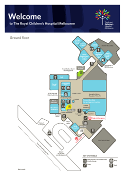
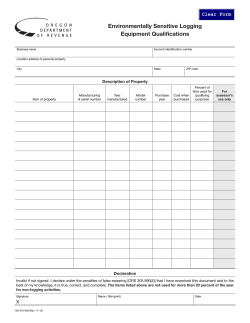


© Copyright 2026