
1 Introduction and interpretation 1.1 User’s guide to the District Plan
Proposed Kāpiti Coast District Plan 1 Introduction & Interpretation Introduction and interpretation 1.1 User’s guide to the District Plan Introduction The following guide outlines the structure of the District Plan (“the Plan”), and is provided to assist in finding the information you want within the Plan. For example, you may wish to know whether or not you require a resource consent for a particular land use activity on a particular site. The guide will help you navigate the applicable sections of the Plan to make that determination. The Plan has been prepared in accordance with the Council’s obligations under the Resource Management Act 1991 (“the RMA”) and is contained within 3 volumes, as follows: Volume 1 Chapter 1 includes a dictionary to clarify the wide range of technical terminology, legalese and other language which is otherwise open to interpretation within the Plan. While every effort is made to present the Plan in a ‘Plain English’ format, the Plan is a legal document and so an element of formality is often required to ensure efficient implementation. Chapter 1 also sets out the significant resource management issues (and the approach to managing these issues) that are applicable across boundaries with neighbouring local authorities. In addition, it outlines the Council’s monitoring requirements and expectations, including ‘state of the environment’ monitoring, and Plan efficiency monitoring. Finally, Chapter 1 provides useful reference material on the resource consent process and the information requirements the Council expects with any consent application. Chapter 2 provides a narrative of the significant resource management issues facing the District. In response, the chapter also sets out the 20 Objectives proposed by the Council to manage or overcome the many issues identified. Collectively, these Objectives are the primary means by which the sustainable management purpose of the RMA (section 5) is to be achieved in the District. Chapters 3 through 12 contain Policies, Rules and other Methods which implement the 20 Objectives. The chapters are broadly divided into two categories: those applying to specific environments (Chapters 3 through 8) and those applying to matters that are relevant throughout the District (Chapters 9 through 12). While the former are focused on ‘environments,’ it is important to note that these chapters also contain Policies and Methods that apply District-wide. To that end, it should not be assumed, for example, that the provisions of the Rural Environment Chapter are the only relevant considerations for a proposed activity on a site in a Rural Zone – nor should it necessarily be assumed that the Rural Environment Chapter is irrelevant to a proposed application in the Living Environment. Figure 1.1 diagrammatically represents the way in which the zone-based and District-wide provisions are allocated to the various chapters in Volume 1. Notified 29 November 2012 - [1-1] - Proposed Kāpiti Coast District Plan Introduction & Interpretation River Corridor Zone (Chapter 9) Designations (Chapter 11) Noise, Signage, & Temporary Events (Chapter 12) Private Recreation & Leisure Zone (Chapter 8) Infrastructure, Utilities and Transport (Chapter 11) Open Space Zones (Chapter 8) Historic Heritage (Chapter 10) Rural Zones (Chapter 7) Natural and Man-Made Hazards (Chapter 9) Working Zones (Chapter 6) Coastal Environment & Coastal Hazards (Chapter 4) Living Zones (Chapter 5) Ecology, Biodiversity & Landscape (Chapter 3) Subdivision, land use & development Figure 1.1: Navigation of Zones and Features in Volume 1 Volume 2 Volume 2 contains appendices to Chapters 3 through 12 in Volume 1. These include design guides, development structure plans and other similar tools and are to work in conjunction with the relevant policies and other methods in Volume 1. Volume 3 District Plan Maps project the provisions of Volume 1 within a spatial context. The information displayed on the District Plan Maps is essential to understanding the nature and scale of use and development that may be undertaken as of right on a given site – and likewise to understanding the many considerations which need to be taken into account before development can proceed. Status of Activities The overall approach of the RMA, and in turn the Plan, is to manage the scale and nature of environmental effects generated by activities. The District’s natural and physical characteristics vary dramatically from alpine to coastal, urban to rural, and so on. Given this variation, certain effects of certain activities will be less appropriate in some areas than in others. The District Plan recognises this through enabling activities which can achieve explicit minimum environmental standards for a given area, whilst requiring resource consent for (or in some cases prohibiting) those activities which fail to achieve standards or for those activities which are inherently intensive in some manner(s) and therefore require careful scrutiny to ensure sustainable management. In other words, the Plan categorises different activities based on the nature of effects associated with them, and on how the activities align (or fail to align) with the Plan’s high order Objectives and Policies. Specifically, the Plan uses the following activity categories: Permitted Controlled Restricted Discretionary Notified 29 November 2012 - [1-2] - Proposed Kāpiti Coast District Plan Introduction & Interpretation Discretionary Non-Complying Prohibited In general, this hierarchy is arranged to reflect those activities which anticipate the most minimal of environmental impact (permitted) to those which anticipate the most significant environmental impact (prohibited). Permitted and controlled activities cannot be refused; however the Council may require specific conditions to be adhered to for the latter. Restricted discretionary and discretionary activities may be declined, and/or the Council may impose conditions on such applications; however these activity types differ insofar as restricted discretionary matters only allow for specified effects associated with a given activity to be considered. A non-complying activity may only be granted if the adverse environmental effects of the activity are minor, or if the activity is not contrary to the Plan’s Objectives and Policies. Prohibited activities are those activities which are neither permitted, nor able to obtain resource consent. Notice: Rules to have immediate legal effect Section 86B of the Resource Management Act states that: “A rule in a proposed plan has legal effect only once a decision on submissions relating to the rule is made and publicly notified under clause 10(4) of Schedule 1, except if… the rule— (a) protects or relates to water, air, or soil (for soil conservation); or (b) protects areas of significant indigenous vegetation; or (c) protects areas of significant habitats of indigenous fauna; or (d) protects historic heritage; or (e) provides for or relates to aquaculture activities.” And “(5) For the purposes of subsection (3), immediate legal effect means legal effect on and from the date on which the proposed plan containing the rule is publicly notified under clause 5 of Schedule 1.” This section also includes options for the Council to seek earlier legal effect from the Environment Court or to resolve that rules only have legal effect once the proposed Plan has been made operative. The Kāpiti Coast District Council has not exercised either of these options in relation to this plan This means that rules in Chapter 3 relating to indigenous vegetation, Chapter 9 relating to contaminated sites, Chapter 10 relating to Historic Heritage and any consequential references to provisions in these chapters have legal effect at the date of notification of this plan. In section 86E the RMA makes it clear that this notice about the rules to have immediate effect does not form part of the District Plan and can be removed without formality once the District Plan is Operative. The following rules shall have immediate legal effect under section 86B(3): Rule 3A.1.5.2 Rule 3A.2.3 Rule 3A.3.4 in relation to ecological sites and historic heritage only Rule 3A.3.1 (a) and (d) Rule 3A.3.2 Rule 3A.3.3 in relation to areas only Rule 3A.3.5 in relation to ecological sites only Rule 3A.3.7 in relation to ecological sites only Notified 29 November 2012 - [1-3] - Proposed Kāpiti Coast District Plan Introduction & Interpretation Rule 3A.3.8 in relation to ecological sites and historic heritage only Rule 3A.3.10 in relation to ecological sites only Rule 3A.3.11 in relation to ecological sites only Rule 3A.4.2 (a), (d) and (f) Rule 3A.4.5 Rule 3A.1.1 Rule 3A.5.2 Rule 5C.3.1 Rule 7A.1.10 Rule 7A.2.2 in relation to ecological sites and historic heritage only Rule 7A.3.6 in relation to ecological sites only Rule 7A.3.7 in relation to ecological sites only Rule 7A.5.4 in relation to ecological sites only Rule 7A.5.9 in relation to ecological sites and historic heritage only Rule 8.1.8 in relation to historic heritage only Rule 8.4.2 in relation to historic heritage only Rule 9E.1.2 in relation to water and soil protection Rule 9E.1.3 in relation to water and soil protection Rule 9E.1.6 in relation to water and soil protection Rule 9E.2.1 in relation to water and soil protection Rule 9E.3.2 in relation to water and soil protection Rule 9E.4.1 in relation to water and soil protection Rule 10A.1.1 to Rule 10A.1.8 in relation to historic heritage Rule 10A.2.1 in relation to historic heritage Rule 10A.2.2 in relation to historic heritage Rule 10A.3.2 to Rule 10A.3.8 in relation to historic heritage Rule 10A.4.1 to Rule 10A.4.3 in relation to historic heritage Rule 10A.5.1 to Rule 10A.5.5 in relation to historic heritage Rule 11A.1.8 to Rule 11A.1.12 in relation to ecological sites and historic heritage only Rule 11A.3.6 in relation to ecological sites and historic heritage only Rule 11A.3.7 and Rule 11A.3.7 in relation to ecological sites only Rule 11A.4.1 to Rule 11A.4.4 in relation to ecological sites and historic heritage only Rule 11B.1.2 in relation to historic heritage only Rule 11B.1.3 to Rule 11B.1.5 in relation to ecological sites and historic heritage only Rule 11B.3.1 in relation to historic heritage Rule 11B.3.2 to Rule 11B.3.4 in relation to ecological sites and historic heritage Rule 11B.4.1 and Rule 11B.4.2 in relation to ecological sites and historic heritage Rule 11B.5.1 in relation to ecological sites and historic heritage Rule 12C.1.1 in relation to historic heritage only Rule 12C.2.2 in relation to historic heritage only Rule 12C.3.2 in relation to historic heritage only Notified 29 November 2012 - [1-4] - Proposed Kāpiti Coast District Plan Introduction & Interpretation Determining whether resource consent is required Step 1 - Check District Plan Maps When using this plan, the starting point is to identify the site or area in which the activity is to be considered on the District Plan Maps. As alluded to above, the District Plan Maps are divided into Plan Zones and Plan Features Maps, Natural Hazards and Natural Features Maps, Transport Network Hierarchy and Freight Network Hierarchy Maps and Kāpiti Coast Airport Aerodrome Designation Maps. The following steps should be followed: [A] Identify the subject property on the District Plan Maps. A road index has been provided at the back of Volume 3 for reference. [B] Identify the zone(s) applying to the property on the Plan Zone Maps using the legend. In cases where a given site is comprised of more than one zone both zones are applicable. [C] Check for any notations (such as historic heritage sites or ecological sites) or designations applying to the property these can be found on the Plan Features and Natural Features Maps. The District Plan Map reference corresponds with a schedule located in the relevant chapter in the Plan. The schedule will provide a description of the notation or designation, its location and the legal description of the property and other relevant information. [D] Check the Natural Hazard Maps to confirm if the land is affected by any identified natural hazard. The Natural Hazard Maps illustrate fault avoidance zones, liquefaction susceptibility, slope stability, coastal hazard zones and flood hazard zones. [E] Check whether the land is within the Archaeological Alert area identified in the District Plan Features Maps. If you are intending to undertake earthworks or construct buildings on land in the Archaeological Alert area you are advised to seek an Archaeological Authority under the Historic Places Act 1993 prior to undertaking any work on-site. Step 2 - Refer to the specific zone rules and standards that apply to the activity The next step is to determine the rules and standards that apply to the activity being considered, as follows: [A] The zone rules fall within different environments: Coastal Environment; Living Environment; Working Environment; Rural Environment and Open Space Environment. Using the table of contents, you will need to identify the relevant sub-chapters within the Environment Chapter(s) that apply to the activity being considered. The Plan also includes chapters for district-wide topics such as network utilities, historic heritage, hazards, the natural environment and transport. Where a given activity is related to a district-wide topic, these chapters should also be referred to. [B] Identify the activity being considered in the rules and standards table. By referring to the activity rules in the rules and standards table you will identify whether the activity you are considering is permitted, controlled, restricted discretionary, discretionary, non-complying or prohibited. It may be necessary to check the definition of an activity in Chapter 1. Throughout the Plan, terms defined in Chapter 1 or mapped in the District Plan maps are shown in italics. [C] Compare your proposed activity with the standards listed in the activity table for the particular activity you wish to undertake. Note whether any standards will (or are likely to) be breached by your proposal. Notified 29 November 2012 - [1-5] - Proposed Kāpiti Coast District Plan [D] Introduction & Interpretation In some cases, a standard may be different if the adjoining zone is different from your own. The standards in your zone will tell you whether this is the case e.g. Local Centre Zone adjoining a Residential Zone. Step 3 - Check the rules and standards for any special notation applying to the property Check the rules and standards applying to any notation or designation relating to the property as these will affect the status for a proposed activity. If, for example, the subject property is subject to a designation, you will need to seek the prior written consent of the authority which is responsible for the designation before undertaking any activity that would prevent or hinder the public work or work to which the designation applies. Likewise, where the subject property is identified on the District Plan Maps as being subject to a natural hazard, Chapter 9: Hazards should be referred to so as to determine whether the activity requires consent. Step 4 - Determine whether resource consent is required If the activity is listed as permitted and it meets all the permitted activity standards for the relevant zone and feature rule categories, resource consent is not required. If the activity you propose to undertake is specified under a different activity category (controlled, discretionary, etc), or if it is listed as permitted but fails to meet the relevant permitted standard(s), you will require resource consent before proceeding with the activity. Seek advice or confirmation if necessary. It should also be noted that: Most subdivisions will require a financial contribution. Check Chapter 12.1 to see whether you meet the standards and whether you will have to make any financial contributions. The provisions of Regional Plans prepared by the Greater Wellington Regional Council may also apply to many activities, and reference should therefore be made to those documents prior to carrying out activities. Figure 1.2 below sets out the steps to determine whether consent is required for an activity diagrammatically. Notified 29 November 2012 - [1-6] - Proposed Kāpiti Coast District Plan Introduction & Interpretation Identify the subject property on the District Plan Maps (Volume 2) Is the subject property located within a natural hazard area? (check the District Plan Natural Hazard Maps) Identify the zone(s) applying to the subject property using the legend on the District Plan Maps. Are there any other notations or designations on the subject property? Heritage, ecological, etc… Using the Table of Contents, identify the relevant chapter(s) within the Plan Find the proposed activity in the activity table and source the applicable rule reference. Check definitions in Chapter 1 if necessary Check the proposed activity against any rules and standards applying to any notations on the subject property. Check any rules and standards applying to the proposed activity within any natural hazard zones covering some or all of the subject property. Check your proposed activity against any rules in other chapters that are relevant to the activity, for example, the minimum number of parking spaces you need to provide in a new development is specified in Chapter 11.6: Access and Transport. Seek advice or confirmation if necessary Will your proposed activity meet all the permitted activity standards? Yes Consent not required No Apply to the Council for the necessary consent(s). If you are considering subdividing your land, subdivision consent is required. Figure 1.2: How to use this Plan Notified 29 November 2012 - [1-7] - Proposed Kāpiti Coast District Plan 1.2 Introduction & Interpretation Resource Consent Process 1.2.1 Applying for Consent The procedures for applying for a resource consent are described in Part 6 of the Resource Management Act 1991 (and summarised in Figure 1.3 below). Section 88 of the Resource Management Act 1991 refers to the matters to be included in an application and Section 104 outlines the matters which must be considered by Council before any consent can be granted. Section 1.3 below specifies the information that must be provided with an application to satisfy Council’s requirements before an application will be accepted for processing. Information is also available from Council to explain the process in more detail to help the application go smoothly. Figure 1.3: Resource Consent Process. Source: Ministry for the Environment, Consultation for Resource Consent Applications, accessed from www.mfe.govt.nz, June 2012. Note – figure is indicative only; for more information, refer directly to the Resource Management Act 1991. The amount of detailed information needed depends upon the type of resource consent. For example, subdivision consent applications require a high level of detail, whereas a resource consent application to put up a sign may not. To have the application processed, payment of a fee is required. This will include planning and engineering administration fees where appropriate. The amount of the fee depends on what the activity is, the type of resource consent needed and whether it is to be publicly or limited notified. Refer to the Council’s Annual/Long Term Plan for the Council's schedule of fees. Notified 29 November 2012 - [1-8] - Proposed Kāpiti Coast District Plan Introduction & Interpretation In some cases, the activity that is the subject of the consent application may also require a resource consent from the Wellington Regional Council. Where it is considered necessary to publicly notify such a proposal a joint hearing on behalf of both authorities will probably be required. 1.2.2 Consultation Consultation with and/or the consent of affected parties – for example tāngata whenua, adjoining landowners, residents groups or environmental groups – may be encouraged by the Council. The level and extent of community consultation depends on the impacts that the proposal will have, or is likely to have. In general, the greater the effects the more extensively consultation is encouraged. The process of consulting interested and/or affected parties allows them to understand the nature of the proposal and let their views be known. Done effectively, consultation reduces time and costs later on in the resource consent process. Special consultation procedures may be encouraged for activities near identified sites of significance to tāngata whenua or where activities will have, or is likely to have major adverse environmental effects. 1.2.3 Notification The resource consent application may be required to be processed as a publicly notified or limited notified consent. Sections 95-95G of the Resource Management Act 1991 outline the notification procedure (also illustrated by Figure 1.4 below), which starts with a requirement on the timeframe for making a notification decision. Specifically, the Council must decide whether or not the application will be publicly notified or limited notified, and if so, notify the application within 10 working days of lodgement. If it is to be notified, the Council will also inform the applicant as such within that time frame. The Council has discretion whether or not to publicly notify an application; except that the application must be publicly notified if: the Council deems the activity to have (or is likely to have) adverse effects on the environment that are more than minor, or if the applicant requests it, or if a rule or national environmental standard requires it. Likewise, the Council must not publicly notify an application if a rule or national environmental standard precludes it and the applicant has not requested it. The exception to this is that the Council may publicly notify an application if it deems that special circumstances exist and warrant notification despite non-notification being otherwise required. In considering the scale of actual and potential effects on the environment, the Council must first disregard the effects on people who own or occupy the application site(s) or land adjacent to that land. The Council must disregard trade competition and the effects of trade competition. If Council does not publicly notify an application, it must decide if there are any affected persons or affected customary rights order holders. A person is considered affected if adverse effects on them are minor or more than minor; however a person may not be deemed as affected if they Notified 29 November 2012 - [1-9] - Proposed Kāpiti Coast District Plan Introduction & Interpretation have provided written approval to the proposed activity. Any affected persons identified would receive limited notification (unless precluded by a rule or national environmental standard). In determining the scale of effects for the purposes of notification of a controlled or restricted discretionary activity, the Council must disregard any adverse effect of the activity that does not relate to a matter for which a rule or national environmental standard reserves control or restricts discretion. Notified 29 November 2012 - [1-10] - Proposed Kāpiti Coast District Plan Introduction & Interpretation APPLICATION Notification Assessment under s95D concludes effects are or are likely to be more than minor Notification requested by applicant Non-Notification Notification required by rule or National Environmental Standard Rule or National Environmental Standard precludes notification Special circumstances exist in relation to the activity that warrant notification Limited Notification Must Notify May Notify Any affected persons? No Yes Written approvals from ALL affected persons obtained? Application Publicly Notified No Service on ALL affected persons Anyone may submit Submissions received? Is a hearing required? Yes Hearing Consideration Figure 1.4– Notification process Notified 29 November 2012 Decision - [1-11] - No Optional Non-notified hearing Yes Proposed Kāpiti Coast District Plan 1.3 Introduction & Interpretation Information to be submitted with an application for resource consent 1.3.1 Requirements for information For the Council to be able to process an application for a resource consent, an applicant must provide adequate information (in accordance with Section 88 of the Resource Management Act 1991) to enable the environmental effects of the activity to be assessed. Applications should be in the same or similar format as Form 9 of the Resource Management (Forms, Fees, and Procedure) Regulations 2003. Copies of this form can be obtained from Council’s offices. Where the Council considers that insufficient information has been supplied to enable an appropriate decision to be made under Section 104 of the Resource Management Act 1991, the applicant will be informed and the resource consent or plan change will not be advanced. Where the Council determines that an application is incomplete the application will be returned to the applicant within five working days with written reasons for the determination in accordance with Section 88 of the Resource Management Act 1991. It is to an applicant's advantage to discuss their application proposals with the Council staff and where appropriate the Department of Conservation, the Wellington Regional Council, tāngata whenua and other interested groups before they are formally lodged. This enables any minor difficulties to be resolved in an informal way and will avoid, remedy or mitigate delay caused by formal requests for more information. 1.3.2 Land use consent An application for a land use consent must include: [A] A description of the activity for which consent is sought and its location. [B] An assessment of any actual or potential effects that the activity may have on the environment. This includes wetlands, locally indigenous vegetation (as defined in Part 1.4 of the Plan), landscapes and natural features, cultural and historic heritage sites and on any of the features listed in the Schedule of Historic Heritage in Chapter 10 (Schedule 10.1) and on people and communities, and how any adverse effects will be avoided, remedied or mitigated through provisions such as preservation and covenants on the title. NOTE: Section 88(2)(b) of the Resource Management Act 1991 requires assessments to be in such detail as corresponds with the scale and significance of the actual and potential effects that the activity may have on the environment, and shall be prepared in accordance with Schedule 4 of the Resource Management Act 1991. [C] Any information required to be included in the application by the District Plan or the Resource Management Act 1991’s regulations. [D] A statement specifying all other resource consents that the applicant may require from any consent authority in respect of the activity to which the application relates and whether or not the applicant has applied for such consents. Notified 29 November 2012 - [1-12] - Proposed Kāpiti Coast District Plan Introduction & Interpretation [E] SITE INFORMATION The following must be supplied: The correct street address. The legal description(s) of the site. A current copy of the certificate of title for the property (no more than 3 months old). [F] SITE PLANS Plans must be supplied and drawn to an appropriate metric scale to show sufficient detail of the proposal to enable Council to determine its effects. If the plans are larger than A3 size, copies reduced to A3 must also be provided. The site plans must show: A north point accurately orientated. A unique plan number and title describing the proposal and the site. The date, name of the company and locality plan where appropriate. Two plans are required (unless all of the relevant information can be shown on one plan): [1] A site plan detailing the existing situation including: - Topography (noting significant landforms and natural features). - Watercourses and catchment orientation. - All vegetation over 3 metres in height (including any vegetation location on or adjacent to the legal road or surrounding properties). - All certificate of title boundaries. - Road frontages. - Existing buildings (indicating those to be retained). - Buildings on adjacent sites. - Any existing heritage features (including archaeological sites, cultural sites, geological features, ecological sites, listed trees and buildings). - Existing high voltage electricity and high pressure gas transmission lines. [2] A site plan detailing the proposed development including: - The design of earthworks including cut and fill volumes, depths and final levels and contours of the site. - The layout and location of proposed structures and buildings or alterations to existing structures and buildings. - The location of proposed activities, vehicle parking, servicing, circulation and manoeuvring, pedestrian and vehicular access. - Floor plans. - A calculation of site coverage. - All landscape designs, site planting details and fencing - If the site has been identified as being subject to one or more hazards, a report from a suitably qualified and experienced person may be required on the extent of the existing and potential natural hazard. The report may be required to address the implication of the hazard on the proposed development or activity, and the actions required to mitigate any adverse effect. [G] The applicant must provide, where relevant, elevation drawings, numbered and drawn to a metric scale of 1:100 (or as otherwise agreed) showing: The relationship of buildings to existing and finished ground levels. The extent of compliance with relevant plan rules including solar access and maximum building height. Notified 29 November 2012 - [1-13] - Proposed Kāpiti Coast District Plan Introduction & Interpretation Elevations from the street showing the relationship of proposed structures to structures on adjacent sites, including the location of existing private outdoor spaces and main living area windows (where these have outlook over the development). Shade diagrams for mid winter for medium density housing applications. [H] Where applications involve or are likely to affect historic heritage items listed in the Schedule of Historic Heritage (Schedule 10.1 of this Plan) the following information will be required: Applications affecting archaeological sites Applicants should first check with the NZ Archaeological Association filekeeper for information on recorded sites, previous surveys or additional sites and with iwi for information on cultural sites. Where no archaeological survey has been conducted for a particular property/area a survey should be done by the applicant to determine the effects of the proposal and provide for the avoidance, remediation and mitigation of effects. Applicants should note that if an archaeological site is to be modified, an application must be made to the New Zealand Historic Places Trust (NZHPT) for an authority to destroy, damage or modify the site. Applications affecting Historic places and areas Applicants should consult with the NZHPT. A full description of the historic heritage value of the place is required. Applicants may also be required to prepare a building report or heritage inventory for the building or structure or a conservation plan for the site or area. In preparing a conservation plan, applicants should be guided by reference to the Trust’s document “Guidelines for Preparing a Conservation Plan” prepared by Greg Bowron and Jan Harris – refer NZHPT website (www.historic.org.nz). Assessments of effects on historic heritage In respect historic heritage, an assessment of effects shall contain: - a detailed description of the proposal; - an explanation of the nature of the historic heritage affected, i.e. historic heritage building/places/site/area/waahi tapu including existing plan, elevations and annotated photographs; - the specific location of the historic heritage (preferably a map showing the location of the resource and area of impact the proposal has or is likely to have on the resource); - a statement as to whether the activity will affect the whole/part of the historic heritage; - an indication as to how adverse effects on historic heritage values will be mitigated; - where it is likely a significant adverse effect will result, a description of any possible alternative location or methods of undertaking the activity; - the preferred option for protecting the historic heritage values; - what consultation (if any) has occurred with the relevant iwi authority and/or NZHPT; and - a statement of the actual and potential effects of the proposal on historic heritage values. Note: All applications will be considered with regard to the Objectives and Policies of the District Plan in Chapter 10 – Historic Heritage. [I] Where trimming of any vegetation is to be undertaken where the vegetation: is within an ecological site (Schedule 3.1); is a key indigenous tree species (Schedule 3.2); is a rare and threatened vegetation species (Schedule 3. 3); is listed in the Schedule of Historic Heritage (Schedule 10.1); or is in or within 20 metres of a waterbody or the coastal marine area where it not within the urban environment, Notified 29 November 2012 - [1-14] - Proposed Kāpiti Coast District Plan Introduction & Interpretation a plan must be provided which outlines any measures required to minimise (or avoid): damage to any root systems; and sediment/debris entering any waterway. [J] Any other information necessary to determine the effects of the proposal or which is specifically requested in the District Plan rules. This could include noise assessment, ecological assessment, visual or landscape assessment, transport assessment or travel plan. [K] IN RESPECT OF CONTROLLED AND RESTRICTED DISCRETIONARY ACTIVITIES For controlled activities and restricted discretionary activities, applications will only be assessed with regard to those matters specifically identified in the District Plan rules. The information to be supplied must include an assessment of any likely effects on the environment. This can be limited to that which is necessary to address the matters under consideration. [L] IN RESPECT OF DISCRETIONARY AND NON-COMPLYING ACTIVITIES For discretionary and non complying activities, applications will be assessed with regard to their effects on the environment as well as the New Zealand Coastal Policy Statement, National Policy Statements, Regional Policy Statement and any relevant objectives, policies, rules or standards. The information to be supplied must include an assessment of compliance with these matters. Notified 29 November 2012 - [1-15] - Proposed Kāpiti Coast District Plan Introduction & Interpretation 1.3.3 Subdivision consents An application for a subdivision consent shall include: [A] An assessment of any actual or potential effects that the activity may have on the environment, including wetlands, significant native vegetation (as defined in Chapter 1.4 of the Plan), land form features, cultural and heritage sites and on any of the features listed in the Schedule of Historic Heritage (Schedule 10.1 of the Plan) and on people and communities and how any adverse effects will be avoided, remedied or mitigated through provisions such as preservation and covenants on the title. NOTE: Section 88 of the Resource Management Act 1991 requires assessments to be in such detail as corresponds with the scale and significance of the actual and potential effects that the activity may have on the environment and shall be prepared in accordance with Schedule 4 to the Resource Management Act 1991. [B] Any information required to be included in the application by the District Plan or the Resource Management Act 1991’s regulations. [C] A statement specifying all other resource consents that the applicant may require from any consent authority in respect of the activity to which the application relates, and whether or not the applicant has applied for such consents. [D] SITE INFORMATION The following information must be supplied: A legal description of the site. Current copies of all certificates of title (no more than 3 months old). Where relevant, an assessment, including diagrams, of the significant views onto and off the development site. [E] SITE PLANS Plans must be supplied and must be drawn to an appropriate stated metric scale to show sufficient detail of the proposal to enable Council to determine its effects. If the plans are larger than A3 size, copies reduced to A3 must also be provided. The site plans must show: A north point accurately orientated. A unique plan number and title describing the proposal and the site. The date, name of the company and locality plan. Two plans are required (unless all of the relevant information can be adequately shown on one plan): [1] A plan detailing the existing situation including: - Topographical information, in terms of DOSLI Datum, together with a certificate as to its origin and accuracy. - The design of earthworks, including cut and fill volume, depths and final levels and contours of the site. - Details of hazardous areas (for example uncompacted filling or flood prone areas or areas subject to earthquake or geological hazards.). - If the site has been identified as being subject to one or more hazards, a report from a suitably qualified and experienced person may be required on the extent of the existing and potential natural hazard. The report may be required to address the implication of the hazard on the proposed development or activity, and the actions required to mitigate any adverse effect. Notified 29 November 2012 - [1-16] - Proposed Kāpiti Coast District Plan Introduction & Interpretation - Existing buildings and structures and buildings and structures on adjacent sites. - Landforms and landscape elements. - Location of watercourses, drainage channels and water table with comment on their condition, including identification of areas known to be subject to inundation, subsidence, slippage or erosion. Measures to be taken to overcome any of these limiting factors must be elaborated on (a flood free building site must be provided). - The location and areas of any existing esplanade reserves, esplanade strips or access strips. - All vegetation over 3 metres in height, including individual specimens. - Existing street names and numbers. - Existing easements and covenant areas. - Any existing heritage features (including archaeological sites, cultural sites, geological features, ecological sites, listed trees and buildings). - Existing high voltage electricity and high pressure gas transmission lines. [2] A plan detailing the proposed subdivision development including: - The position of all proposed lots and certificate of title boundaries. - The areas of all new lots. - Indicative building positions and indicative vehicle access points and driveways on street edges. - Location and type of all proposed trees and other vegetation, including all existing vegetation to be retained. - A report from a suitably qualified and experienced person to demonstrate that: A water supply of sufficient quality and quantity can be provided for the activities proposed for the subdivision and that there will be no adverse effects on other users and the water resource itself or on natural and physical resources. The disposal of wastes generated by the activity proposed for the subdivision will have no adverse effects on ground or surface water quality, and that there will be no adverse effects on consumptive water users or on natural and physical resources. - For lots in the Rural Water Collection area to be used for plantation forestry, information detailing proposed species and the extent of planted areas together with an assessment of the impact on long-term water resources. - Three names of any new road shall be provided for consideration for the approval of Council. - All applications for subdivisions fronting a Strategic Arterial Route shall be accompanied by evidence of consultation with NZTA confirming compliance with NZTA’s requirements. - The road reserve proposed to be set aside as new road, including all areas of public open space intended for recreational purposes, together with drawing sufficient to describe the plan and three dimensional qualities of typical and unique or special areas of the development. - Formation widths and grades of proposed roads and rights of way, parking bays, bus stops and speed control devices. - Proposed easement and covenant areas. - The location and widths of new reserves to be created, including any esplanade reserves to be set aside on the survey plan under Section 231 of the Resource Management Act 1991. Notified 29 November 2012 - [1-17] - Proposed Kāpiti Coast District Plan Introduction & Interpretation - The location and areas of esplanade strips proposed to be created under Section 232 of the Resource Management Act 1991to meet the requirements of the District Plan. - The location and areas of any land below mean high water springs of the sea, or of any part of the bed of a river or lake, which is required under Section 237A are to be shown on a survey plan as land to be vested in the Crown. - Information to show compliance with any other District Plan rules and standards. - Plans and/or details which demonstrate how the subdivision and development will meet the Kāpiti Coast District Council Subdivision and Development Principles and Requirements 2012. [F] For residential subdivision, the applicant may be required to provide an annotated print from the most recent acceptable aerial photograph. [G] Where an item listed in the Schedule of Historic Heritage (Schedule 10.1) will be affected as a result of or is the subject of a subdivision consent application, the information in Part 1.3.2. [H] may be required. Notified 29 November 2012 - [1-18] - Proposed Kāpiti Coast District Plan 1.4 Introduction & Interpretation Definitions 1 in 100 year flood event means the one percent annual exceedance probability flood event. This event has a one in one hundred (1%) chance of being equalled or exceeded in any one year. The flood categories (except residual ponding and residual overflow areas) on the District Planning Natural Hazard Maps are a representation of this event, based on information currently available. 1 in 50 year flood event means the two percent annual exceedance probability flood event. This event has a one in fifty (2%) chance of being equalled or exceeded in any one year. This is not mapped in the District Plan. 85 percentile speed means the speed found by surveying the speeds of passing vehicles and establishing the speed value of which 85% of the traffic travels at an equal or slower speed. Accessory building means any building on a site, whether attached or detached to a residential building, the use of which is incidental to the permitted activities and consented activities occurring on that site. Attached in this case shall mean physically attached. This includes but is not limited to garages, carports, tool sheds, playrooms, recreation rooms, glasshouses, sleep outs and buildings used for permitted and consented home occupations. For the avoidance of doubt minor flats shall not be regarded as accessory buildings. Access leg means provides access to a public road for a rear lot e.g. a driveway to a rear lot as shown in the diagram below: Access strip shall have the same meaning as in the Resource Management Act 1991. Act means the Resource Management Act 1991. Active fault means a fault that has ruptured within the last 125,000 years, and whose history indicates that it is likely to rupture again. Active retail frontage and active frontage means building facades where the ground floor level features display windows which allow views of the activities occurring in the premises. In order to allow views into the premises the majority of the window space between 1 metre and 2 metres Notified 29 November 2012 - [1-19] - Proposed Kāpiti Coast District Plan Introduction & Interpretation above the street level shall be transparent and allow unobstructed views into the main retail space. The use of blinds, shutters, frosted glass or curtains during normal business hours will not provide an active retail frontage or active frontage. Interior security screens may be used after normal retail hours if necessary (exterior screens/shutters are not suitable for frontages to pedestrian areas). Active retail frontage are associated with retail activities, where as active frontages are associated with non-retail activities such as commercial activities. Addition means an extension or increase in floor area, number of stories, or height of a building or structure. It includes the construction of new floors, walls, ceilings, and roofs, but does not include alterations or minor work. Adjusted quantity is calculated for each Effect Type: Base Quantity x Adjustment Factors (as applicable). Adjustment factors cover a number of aspects for each Effect Type to account for site specific circumstances influencing the severity of the potential off-site effect. Adjustment Factors take into consideration the following: 1. the physical state of the substance 2. the temperature at which the substances is stored 3. type of storage 4. type of activity 5. separation distance to the site boundary 6. environment sensitivity of the site location Within each Effect Type, the Adjustment Factors are multiplied to obtain a single value which is then used to calculate the Adjusted Quantity. Aerodrome means any defined area of land or water intended or designed to be used either wholly or partly for the landing, departure, and surface movement of aircraft; and includes any buildings, installations, and equipment on or adjacent to any such area used in connection with the aerodrome or its administration. For the avoidance of doubt, an aerodrome includes a heliport. Civil Aviation Rules means rules made under the Civil Aviation Act 1990. Air noise boundary means the boundary as identified on the District Plan Maps Aircraft operations means the engine run-up, taxiing, take-off or landing at an airport of an aircraft, and “operate” has a corresponding meaning. Airport noise effects advisory overlay means the boundary shown as such on the District Plan Maps and which encompasses land that is subject to higher than usual levels of aircraft noise. Airport Road means carriageways, footpaths and berms within the Airport Zone. Allotment means the same as in the Resource Management Act 1991. Alteration means any changes to the fabric or characteristics of a building involving (but not limited to) the removal and replacement of walls, windows, ceilings, floors or roofs, either internally or externally. It does not include additions or minor works. Amenity values means the same as in the Resource Management Act 1991. Notified 29 November 2012 - [1-20] - Proposed Kāpiti Coast District Plan Introduction & Interpretation Ancillary means 1. supportive; 2. subordinate; and 3. allied in characteristics, nature or type. Animal means any animate being, other than that of the human species, bees, fish, insects, cage birds, poultry and pigeons. Antenna(s) means any device, including any aerial, dish or panel that receives or transmits radio communication or telecommunication signals. This includes that antenna’s mountings (including any support structure or head arrangement) and radio frequency unit or similar device, but excludes any mast. The diameter or area of an antenna means: 1. in relation to any panel antenna or any other type of antenna that has a length and a width, the area measured by calculating the largest surface area; 2. in relation to any other antenna, the diameter measured by taking the cross-section of the widest part of the antenna. The mountings of any antenna and any radiofrequency equipment or similar device shall not be included in the measurement of area or diameter of each antenna, provided that the radiofrequency unit or similar device is smaller in area or diameter than the antenna itself. An antenna does not include: 1. devices used in amateur radio configurations; 2. devices only used for television reception; and 3. any other device less than 1.5m2 in area. Note: any antenna only need meet the area or diameter measurement, as appropriate to the type of antenna. The measurement of each individual antenna is not a cumulative measurement. Approved concept plan means a plan approved by the Council showing at a conceptual level how the precinct will be developed, including provision for: proposed new public roads; accessways; use of reserves for walkways, cycleways and open space; stormwater storage areas and drainage channels; and view corridors. Archaeological site means the same as in the Historic Places Act 1993. Atua means deity; god; child of Ranginui and Papatūānuku. Automotive and marine supplier means a business primarily engaged in selling automotive vehicles, marine craft, and associated parts and accessories for such vehicles and craft. Aviary means a fixed, permanent structure designed for the keeping of cage birds and excludes any structure used to house poultry or pigeons. Aviation activity means any activity undertaken in the Airport Zone which is directly related to the use of the site for aviation purposes. This includes the physical infrastructure of the Airport (such as runways, terminal and control towers) and the storage, maintenance and use of aircraft. Aviation heritage means any ancillary aviation activity undertaken within the Aviation and Heritage Precinct of the Airport Zone and includes any aviation and aerospace museum together with workshops and storage for the assembly and restoration of items for display, outdoor static display, picnic and playground facilities, retailing ancillary to the museum's display material; community service and cultural facilities and activities. Notified 29 November 2012 - [1-21] - Proposed Kāpiti Coast District Plan Introduction & Interpretation Base threshold (B) means the amount (mass in tonnes or volume in cubic metres for compressed gases) of a substance that has been assessed as generating no or minor off-site effects when released, before taking into account site and substance specific considerations. Bathroom means rooms, a room or part of a room which together provide personal ablution and sanitary facilities including a bath or shower, wash basin and toilet. Beach or the Beach means the area between the vegetated dunes or hard protection structures and mean high water springs, (generally indicated on the ground as the high tide mark). This is the usually dry sand area which is not formed into dunes. For the avoidance of doubt, the beach is not equivalent to the Beach Residential Zone. Beach character setback margin means the area for any site in the Beach Character Zone in which the front façade of a proposed primary residential building is to be located in order to maintain streetscape rhythm. The beach character setback margin for any site is calculated by: [1] deriving the average setback distance (x) from the road boundary for the primary residential building on the two adjacent lots located either side of the application site and on the same side of the road, where: ROAD a b x d c application s i te x = (a + b + c + d) 4 ROAD Where any of the four immediately adjacent lots are rear lots, the rear lots shall not be considered and the next most adjacent lot shall be included in the average calculation. [2] starting with a line that runs parallel to the road and across the site distance ‘x’, and extending a plane 2 metres closer to the road and 2 metres further from the road. Notified 29 November 2012 - [1-22] - b c x d application s i te not included ROAD a b x c application appsliicte a ti o n s i te x (x - 2m) (x + 2m) Beach character setback m argin application s i te not included ROAD Where any of the four immediately adjacent lots are corner lots, the corner lot shall not be considered and the remaining three lots (or two where the application site directly adjoins the corner lot) shall be included in the average calculation. a Proposed Kāpiti Coast District Plan Introduction & Interpretation Bird Management Plan means a plan that sets out how a grower manages bird populations while also managing adverse effects (including noise) on the surrounding environment adopting integrated bird scaring and management strategies. Block length means the distance along any road between two consecutive intersections. Length shall be measured from the centre point of each intersection along the centre line of the road connecting the two centre points. For the purposes of this definition, no cul-de-sac, private road, crescent or access way shall be considered a road for the purposes of identifying an intersection. Boarding house means a building in which board and live-in health care or support is provided (including women’s refuges and halfway houses), or a building, which is not operated as a licensed hotel, in which board and lodging is provided or is intended to be provided for reward or payment. This definition does not include family homes where foster parents receive payment for children in their care which are included in the definition of “residential activities”. A boarding house is a type of supported living accommodation. Boundary means the perimeter of an area of land capable of being disposed of separately, including a legal or cross lease boundary. Boundary adjustment is the subdivision of a lot where the following requirements are met: 1. The number of existing certificates of title will not be increased. 2. Each of the adjusted lots shall be of generally the same area as the lots prior to the boundary adjustment. 3. The adjustment of boundaries is for the rationalisation of existing boundaries to improve the practicality of existing lots. Building means any temporary or permanent or moveable or immoveable structure; and includes any structure intended for use or occupation by people or animals or machinery or chattels but does not include any of the following: 1. A fence or wall of 2 metres or less in height above ground level, and tennis court fences of any height above ground level, where the fence is not used for advertising or for any purpose other than a fence or a wall. 2. A fence for the containment of stock. 3. Residential chimneys and television aerials associated with a residential building, not exceeding 1.5 metres above the permitted height rule and height in relation to boundary rule for the zone in which the building is located. 4. Detached structures (including temporary structures) not exceeding 2.4 metres in height and not exceeding 8m2 in gross floor area where they are located at least 1 metre from any adjoining property boundary. 5. Underground water tanks, and any aboveground water tank not exceeding 30,000 litres in volume that complies with the permitted height and height in relation to boundary rules and is no less than 1 metre from any property boundary for the zone in which it is located. 6. Patios and decks (including their handrails) with a finished floor level not exceeding 1 metre in height above ground level and at least 1 metre from any adjoining property boundary. 7. Any vehicle, trailer, tent, caravan or boat, whether fixed or movable unless it is used for residential activities, business or storage purposes. 8. Any scaffolding or falsework erected temporarily for maintenance and construction purposes 9. Any road, driveway, footpath, boardwalk or other paved surface. 10. Domestic swimming pools not exceeding 1.2 metres above ground level. 11. Fire hose drying towers not exceeding 15 metres in height on New Zealand Fire Service property. Notified 29 November 2012 - [1-23] - Proposed Kāpiti Coast District Plan Introduction & Interpretation Building floor level in relation to flood inundation means the underside of floor joists for wooden structures or for concrete slabs shall be 150 millimetres below the finished top of the slab. Building importance categories (BIC) means the building importance categories set out in the building importance categories in section 9.3 (Earthquake Hazards) of chapter 9 of this Plan. Building mass plane is the relationship between the height of the building and the street front boundary. Building mass plane Building removal means the removal of a building from a site, being removed either out of the District or to a building removal company’s yard. Building supplier means a business and associated premises primarily used for the display and sale of goods and materials used in the construction, repair, alteration and renovation of buildings, including plumbing, electrical and landscaping. Cabinet(s) means a box-shaped structure which houses radio and telecommunication equipment, electrical equipment, equipment associated with the continued operation of network utilities and includes single transformer and associated switching gear distributing electricity at a voltage up to, and including, 100kV. Carpark includes an area of land available for the parking of vehicles off-street. It is available for use by visitors to or occupants of a site and is accessory to the principal use of the site. o This excludes vehicle parking as an activity, for example car yards, parking buildings and depots. These are activities in their own right and are covered by the relevant rules and standards. o Refer to chapter 11.6, for technical information on the design and layout requirements for carparks. Notified 29 November 2012 - [1-24] - Proposed Kāpiti Coast District Plan Introduction & Interpretation Carriageway includes the portion of the legal road which is useable by vehicles. It includes traffic lanes and any metal shoulder, or parking lanes, but not footpaths or grass verges Centres Routes - see transport network hierarchy and Schedule 11.2. Centres Zones means the part of the district comprising the District Centre Zone, Outer Business Centre Zone, Town Centre Zone and Local Centre Zone and shown as such on the District Plan Maps. Cleaner production means the use of techniques to reduce the amount of raw materials and/or energy used in the production process and the amount of wastes generated in the production process. These techniques may include the use of recyclable materials or renewable resources, the use of fewer hazardous substances or the reduction in quantity used, and carbon accounting. Cluster (clustered) means a group of buildings in close proximity to each other whether they are on the same site or adjacent sites. Coastal environment means the area mapped in the District Plan Maps to which the objectives and policies of the New Zealand Coastal Policy Statement is relevant. This includes all areas of sand dunes (and interdune wetlands) and coastal escarpments. Coastal hazards means coastal processes that have the potential to adversely affect human life, property or infrastructure including erosion, sedimentation, storm surge, inundation, tsunami. Coastal processes means dynamic natural, physical and ecological relationships and events, that are characteristically coastal in their occurrence, nature and effects, that act to shape a coastline, its landforms and features - such as, beaches, wave cut platforms – and including processes of: wave formation, breaking and dissipation; swash run-up; nearshore currents; sediment transport, erosion and deposition. Coastal Protection Structure means a structure that would modify the seabed, foreshore or land within 30 metres of the Coastal Marine Area, which has the purpose or effect of protecting land above Mean High Water Springs from a coastal hazard, including erosion and includes a seawall, rock revetment, groyne, stop bank, retaining wall or comparable structure within 30 m of the shoreline that could act as sea walls should they become exposed to wave action (e.g. any wall or structure which extends below an elevation of RL 0.75 m above MSL along all or most of its length). Code of Practice means any document for the purpose of specifying procedures and practices, or equipment and facilities for the management of hazardous substances, including documents issued and approved in accordance with the Hazardous Substances and New Organisms Act 1996. Comparison goods means higher order goods which are usually expensive, non-perishable or specialty goods which are bought infrequently. Comparison goods include furniture, jewellery, clothing and electrical equipment. Commercial activity means any activity involving commercial transactions, or providing commercial or administrative services, and includes non-school activities, offices, and banks; but excludes premises or activities involving retail activities and industrial manufacture or production. Notified 29 November 2012 - [1-25] - Proposed Kāpiti Coast District Plan Introduction & Interpretation Commercial Scale in relation to renewable energy generation means energy projects producing over 5 megawatts and which export electricity directly into the distribution network or National Grid. Commercial services within the Waikanae North Development Zone means household, personal, finance, insurance, real estate, travel, repair, post, courier, health, veterinary, and other such similar services but not including general or professional office activities above ground floor. Common boundary means either the boundary between adjoining sites, any party wall dividing adjoining household units in a residential building or any party wall dividing a building from accessory buildings. Community facility means: the use of land and buildings by the public for the purposes of welfare, care, safety and culture. Community facilities include: 1. Multi-purpose community halls; 2. Places of worship; 3. Civic offices; 4. Community centres; 5. Community Libraries; 6. Display of information to the public; 7. Community Museums; 8. Community Galleries; 9. Courthouses; 10. Emergency service facilities; 11. Hospitals; 12. Marae and other cultural facilities. 13. Public toilets; 14. Plunket rooms and rooms where information, counselling advice or similar assistance conducive to welfare is provided; For the avoidance of doubt, any offices and storage areas required to operate the facility form part of the community facility but the community facility does not include any other retail, industrial or commercial activities. A community facility does not include probation or detention centres or prisons. Community facilities signs mean any sign pertaining to a community facility. Community purpose event/charity event signs mean any sign pertaining to a temporary event or an event that: 1. Is for general public admission; and 2. Occurs for 3 consecutive days or less in duration; and 3. Occurs no more than once in any three month period; and 4. Is held within licensed premises; and 5. The purpose of the event is to: a. fundraise for a recognised charity; or b. accommodate the proceedings of a publicly notified meeting or hearing. Community (or neighbourhood) scale means renewable energy generation for the purpose of supplying electricity to a whole community which is not connected to the distribution network (‘off grid’); or to supplying the immediate neighbourhood in an urban area with some export back into the distribution network. Convenience goods means lower order and usually inexpensive goods that vary little in price, quality or other features that are frequently purchased and often include perishable goods. Notified 29 November 2012 - [1-26] - Proposed Kāpiti Coast District Plan Introduction & Interpretation Conditions means the same as in the Resource Management Act 1991. Contaminant means the same as in section 2 of the Resource Management Act 1991 Contaminated land shall have the same meaning as in the Resource Management Act 1991. Controlled activity shall have the same meaning as in the Resource Management Act 1991. Council means the Kāpiti Coast District Council. Coverage means the percentage area of a site occupied by buildings, where the building area is measured by the total area of the footprint of the buildings on the ground (i.e. excluding eaves) and the site area excludes any right of ways/access-ways Covered outdoor living area means a roofed area attached to a residential building used for private recreation and living space to provide a high level of amenity for residents. At least 50% of the combined area of all elevations of the area (from the floor of the deck to the eaves level of the attached building) should be open to the elements. Crossing point means a length of the road boundary available for the ingress or egress of vehicles from the site. Crosslease means the same as in the Resource Management Act 1991. Cumulative risk means the risk posed by a hazardous facility added to or multiplied by risks from other facilities. Curtilage within the Airport Zone means the area of land held within an individual lease. Demolition means to damage and demolish a building or structure. Department store means an activity within one building, engaged in retailing a wide variety of goods, other than food or groceries, but the variety is such that no predominant activity can be determined. Department Stores have predominant retail sales in at least four of the following six product groups: 1. Clothing 2. Furniture 3. Kitchenware, china, glassware and other housewares 4. Textile goods 5. Electrical, electronic and gas appliances 6. Perfumes, cosmetics and toiletries The products primary to these headings, as well as other products, are normally sold by or displayed in separate departments or sections supervised by managers (with specialised product knowledge) within the store, and, generally merchandising, advertising, customer service, accounting and budgetary control functions are undertaken on a departmentalised basis. For the avoidance of doubt, this definition excludes those activities falling within the definition of Large Format Retail Designation means the same as in the Resource Management Act 1991. Destruction means to cause substantial harm or damage to a place or area of significance to Māori or a historic site (including archaeological sites). It may be caused by activities including earthworks, tunnelling, disposal, cutting, construction works, induced vibration, removal of Notified 29 November 2012 - [1-27] - Proposed Kāpiti Coast District Plan Introduction & Interpretation structures, reclamation or drainage, subsidence, gravel, water or soil extraction, dredging, diverting, taking or damming water and discharge of contaminants. Development means (except in relation to the Airport Mixed Use Precinct) the construction or alteration of buildings; the erection of fences/walls and detached structures; network utilities, excavation of land; any land disturbance or land filling or reclamation of land or the construction of earth retaining structures; and any construction of artificial surfaces or platforms( eg roads, decks or patios, driveways). Development (within the Airport Mixed Use Precinct) means, for the purposes of chapter 6 of this Plan, the total gross floor area of any Commercial Activity or Industrial Activity development within the Airport Mixed Use Precinct provided that any Retailing or Retail Outlets shall be restricted to the following activities: 1. Aviation activities and aviation service activities. 2. One hotel/motel activity. 3. lndustrial activities 4. Trade/Wholesale 5. Commercial activity, (including logistics or distribution uses) provided that retail activity shall be limited to: a. Retail activity ancillary to lndustrial or Warehousing activities within the Precinct. b. Large Format Retail activity. c. Home Improvement Retail activity. d. Automotive and Marine Equipment Retail activity e. Small Scale Convenience Retail activity. f. Small Scale Commercial Services activity. g. Retail activity permitted by the definition of "Service Station". and includes any buildings used for any such activities. Discretionary activity means the same as in the Resource Management Act 1991. Disposal of hazardous substances means the systematic control of the collection, storage, processing, treatment, recovery and disposal of hazardous substances at a facility that can accept such waste, or alternatively treating it to reduce the level or mobility of the contaminants to acceptable levels. Distributed (fault complexity) means areas where fault rupture deformation is distributed over a relatively broad, but defined, geographic width (e.g. tens to hundreds of metres wide), typically as multiple fault traces and/or folds. Domestic Scale (Renewable Energy Generation) means small scale renewable energy generation development for the purpose of using or generating electricity on a particular site (single household or business premise) with or without exporting back into the distribution network. Dominant ridgelines and Dominant dunes means mapped features shown on a structure plan for a specific area (eg ecohamlets or Ngarara zone) or shown on the District Plan natural environment maps. Dripline means the area beneath the canopy of a tree, measured at ground level from any part of the surface of the trunk, with a radius of 5 metres or to the outermost extent of the spread of its branches, whichever is the greater. Driveway means the same as crossing point. Notified 29 November 2012 - [1-28] - Proposed Kāpiti Coast District Plan Introduction & Interpretation Dust nuisance means if there is visible evidence of suspended matter in the air beyond the site boundary and/or there is visible evidence of suspended matter traceable from the source of the nuisance settling on the water, land or structure of a neighbouring site. Earthworks means any alteration to the land contour or disturbance of land including the deposition of cleanfill and the excavation and backfilling or recompaction of existing natural ground, but excludes cultivation and domestic gardening. The limits on earthworks in the standards apply to any earthworks within any 5 year period except in relation to overflow paths, ponding areas and the River Corridor. Eastern intersection means the new signalised intersection proposed on the Kāpiti Road frontage of the Airport as shown on the Roading Layout Plan for the Kāpiti Coast Airport. Ecological domain(s) means mapped areas of land which share broad vegetation types in the District, these are identified as being the salt zone, dunelands, lowland alluvial terraces, and lowland hills. Ecological site(s) means ecological features or areas which have been mapped in the natural features maps of this plan with the description and significance of the sites included in Schedule 3. 1 Ecosystem service(s) means the services provided by finite natural and physical resources, such as clean air, water and soil, that are provided by healthy natural systems. Ecosystem services are grouped into four broad categories: 1. provisioning, such as the production of food and water; 2. regulating, such as the control of climate and disease; 3. supporting, such as nutrient cycles and crop pollination; and 4. cultural, such as spiritual and recreational benefits. Educational facilities means land and/or buildings used to provide regular instruction, teaching, learning or training and includes pre schools, schools, tertiary education institutions, work skills training centres, and facilities for the care of children under the age of five, such as daycare facilities. Effect means the same as in section 3 of the Resource Management Act 1991. Effects type (in relation to hazardous substances) means the group into which any hazardous substances can be categorised. The three groups are: 1. Fire/Explosion: concerned with damage to property, the built environment and safety of people; 2. Human Health: concerned with the wellbeing, health and safety of people; and 3. Environment: concerned with damage to ecosystems and natural resources and systems. Each Effects Type is divided into levels (high, medium or low) reflecting the severity of the effect potentially associated with a hazardous substance. The Hazard Level for each hazardous substance is based on the hazard classification system established under the Hazardous Substances and New Organisms Act 1996. Effect’s ratio means a dimensionless number calculated from the following equation for each Effect Type: Effects ratio = proposed quantity / adjusted threshold The Effects ratio is used to define the consent status of the facility by comparing against the aggregated Effects Ratio stated in the relevant sections of the District Plan for the most important hazardous substances present on the site (either by hazard or quantity). Notified 29 November 2012 - [1-29] - Proposed Kāpiti Coast District Plan Introduction & Interpretation Effects ratio trigger level means the value of the Effects ratio which is used in the Consents Status Matrix (table 9.1) to define whether a proposed hazardous facility requires a land use resource consent. Entertainment activity means premises providing public and private entertainment and includes cinemas, theatres and licensed premises. Environment means the same as in the Resource Management Act 1991. Environmentally damaging substances means any substance (for example, milk or oil) which when spilled or released into the environment in sufficient quantity, by effects other than toxicity, is able to damage an aquatic ecosystem. Esplanade Reserve means the same as in the Resource Management Act 1991. Esplanade strip means the same as in the Resource Management Act 1991. Excessive noise routes means the existing alignment of State Highway 1 through the district, and includes any future route(s) within the Plan as an alternative route for this highway. Existing - in relation to buildings and uses means lawfully in existence: 1. Before the rule became operative or the Plan was notified. 2. The effects of the use are the same or similar in character, intensity and scale to those which existed before the rule became operative or the Plan was notified, or 1. The use was lawfully established by way of a designation, and 2. The effects of the use are the same or similar in character, intensity and scale to those that existed before the designation was removed Existing urban area means the spatial area that includes the District’s commercial centres, industrial areas, and suburban areas existing at the date of notification of this Plan. These areas are identified on the District Plan Maps as comprising one (or more) of the following zoning classifications: 1. Airport Zone; 2. Civic and Community Zone; 3. District Centre Zone; 4. Industrial Zone; 5. Local Centre Zone; 6. Outer Business Centre Zone; 7. Residential and Beach Residential Zones; and 8. Town Centre Zone. External sound insulation level (DnT,w + Ctr) means the standardised level difference (outdoor to indoor) and is a measure of the airborne sound insulation provided by the external building envelope (including windows, walls, ceilings and floors where appropriate) described using DnT,w + Ctr as defined in the following Standards: 1. ISO717-1:1996 Acoustics – Rating of Sound Insulation in Buildings & Building Elements using spectrum No.2 (A-weighted traffic noise spectrum). Note – this standard is also known as AS/NZS1276.1:1999 Acoustics-Rating of sound insulation in buildings and of building elements Part 1: Airborne sound insulation. 2. ISO 140-5:1998 Acoustics - Measurement Of Sound Insulation In Buildings And Of Building Elements Part 5: Field Measurements Of Airborne Sound Insulation Of Facade Elements And Facades. Notified 29 November 2012 - [1-30] - Proposed Kāpiti Coast District Plan Introduction & Interpretation The term “external sound insulation level” is used in this Plan primarily as a calculated value to demonstrate compliance with the stated minimum standard of acoustic isolation against sounds arising from outside the building. If field testing of built structures is employed to verify predictions, these tests shall be carried out using ISO 140-5:1998 Acoustics - Measurement Of Sound Insulation In Buildings And Of Building Elements Part 5: Field Measurements Of Airborne Sound Insulation Of Facade Elements And Facades. Extractive industries means any activity where open or surface excavation of rock or other material deposits including gravel, rock, soil, clay, sand or peat is undertaken and removed from the site. The removal of soil (including topsoil, sand and peat) from the site which is less than 100m3 in volume within any 10 year period is not included within the definition of extractive industries. Refer to the definition of earthworks for more detail. Farming means land based activity, having as its primary purpose the commercial production of any livestock or vegetative matter, except as excluded below, and, unless the context otherwise requires, includes cultivation. For the purposes of this Plan, farming does not include the processing of farm produce beyond cutting, cleaning, grading, chilling, freezing, packaging and storage of produce grown on the land. Farming and agricultural supplier means a business primarily engaged in selling goods for consumption or use in the business operations of primary producers or in animal husbandry. Farm Tracks include any ways, formations or access tracks located on private land, the use of which is restricted to the owner of the land, or such other persons who may be authorised by the owner to use them and which are suitable for conventional or special purpose vehicles. [Farm tracks shall be restricted to those activities defined as Farming. Fault Avoidance Area (FAA) means a buffer area either side of a known active fault trace and are identified on the District Plan Maps. Fault complexity means the width and distribution of the deformed land around the fault trace. The fault complexity categories are well-defined, well-defined extension, distributed, uncertainpoorly constrained, and uncertain-constrained. Financial contribution means the same as in section 108(9) of the Resource Management Act 1991. Fixed plant means any swimming pool pump, heat pump, ventilation fan, air extract or exhaust unit or stationary motor. Flood Hazard categories means the areas based on the 1 in 100-yr extent shown on the District Plan Maps. The flood hazard categories are river corridor, stream corridor, flood storage, flood erosion, fill control, over flow path, residual overflow path, ponding and residual ponding. The purpose of the flood hazard categories is to describe the varying hazard risk across the floodplain. The flood hazard categories have determined by taking the following into account: 1. The depth and speed of flood waters; 2. The threat to life; 3. The difficulty and danger of evacuating people and their property; and 4. The potential for damage to property and social disruption. There are two types of flood risk identified in the Natural Hazard Maps: 1. Direct Flood Risk Notified 29 November 2012 - [1-31] - Proposed Kāpiti Coast District Plan Introduction & Interpretation The direct flood risk affects areas that are not protected from flooding by flood protection structures (such as stopbanks or floodwalls) built to the 1 in 100-yr flood event standard. A direct flood risk can also occur where existing structural protection, built to less than the 1 in 100-yr standard, is vulnerable and likely to fail in a 1 in 100-yr flood event. 2. Residual Flood Risk The residual flood risk is the additional or ‘left over’ risk due to possible breaching and overtopping of flood protection structures (such as stopbanks or flood works) built to the 1 in 100-yr flood event standard. Flood storage area means the defined areas on the District Plan Maps within which ponding of flood waters is expected to occur in significant flood events and which are necessary for the management of the associated flood risk. Food and beverage outlet means land and buildings used for the sale of prepared food and / or beverages to the general public prepared for immediate consumption. It includes restaurants, taverns, cafes and takeaway restaurants, and excludes supermarkets. Formed vehicle access means hard surfaced, stable access from the formed road across the berm and or footpath to a property, this includes any vehicle crossing (cut down kerb) or other structures in the legal road. Freight Hierarchy means the mapped hierarchy for freight routes to and from working environments in the District. This hierarchy highlights the most suitable routes for new heavy traffic generating activities to use. Gable is the triangular section of a wall at the end of a pitched roof, occupying the space between the two slopes of the roof. Gable Garden and landscaping supplies means a business primarily engaged in selling goods for permanent exterior installation or planting and includes: landscaping suppliers; and suppliers of bark, compost, firewood, and paving and domestic paving aggregates. Gated community is a form of residential community or housing estate containing strictlycontrolled entrances for pedestrians, bicycles, and automobiles, and often characterised by a closed perimeter of walls and fences. Notified 29 November 2012 - [1-32] - Proposed Kāpiti Coast District Plan Introduction & Interpretation General residential areas means land in the Residential Zone which is not subject to a specific precinct, area or other site or locality specific rule or standard. Greywater means wastewater generated from domestic activities, such as clothes washing machines, showers, bathtubs, and hand washing. It excludes toilets, laundry sinks and kitchen wastewater. Greywater re-use system means a device that disperses greywater for outdoor irrigation purposes in a manner that does not endanger public health. Gross floor area is the sum of the gross area of all floors of all buildings on a site, measured from the exterior faces of the exterior walls or from the centre lines of walls separating two buildings. Gross floor area also includes covered yards and areas covered by a roof but not enclosed by walls. The gross floor area of a building shall not include: 1. Uncovered stairways. 2. Floor space in terraces (open or roofed), external balconies, breezeways or porches. 3. Roof carparking, lift towers and machinery rooms on the roof having a floor area of not more than 200m². 4. Car parking areas. 5. Floor space of interior balconies and mezzanines not used by the public. Habitable building means a built structure used for activities normally associated with residential activities. Habitable room means a space within a building that is commonly associated with residential activities, teaching or hospital recovery, but excludes any bathroom, laundry, toilet, pantry, walk-in wardrobe, corridor, hallway, lobby, clothes-drying room, or other space of a specialised nature occupied neither frequently nor for extended periods of time. Hamlet means a development of at least three but no more than twelve rural allotments or household units that provide residential building sites in the inter-dune hollows (being the area between dune formations) of the Rural Dunes zone where the allotments are grouped in a cluster Hapū means sub-tribe. Hard protection structure means the same as in New Zealand Coastal Policy Statement 2010. Hazardous activity means an activity which poses a risk to people, the environment, or physical assets due to a physical or biological hazard (for example, earthworks, electromagnetic radiation or genetically modified organisms) but does not include the use, storage or otherwise handling of a hazardous substances.. Hazardous facility means activities involving hazardous and environmentally damaging substances and sites at which these hazardous substances are used, stored, handled and disposed of. In the context of chapter 9.2, hazardous substances do not include: 1. The incidental use and storage of hazardous and environmentally damaging substances in minimal domestic scale quantities 2. Hazardous activities. 3. Pipelines used for the transfer of hazardous substances such as gas, oil and sewage active substances, which are covered by other legislation Hazardous substances include, unless expressly provided otherwise by regulation, any substances:- Notified 29 November 2012 - [1-33] - Proposed Kāpiti Coast District Plan Introduction & Interpretation 1. with one or more of the following intrinsic properties: a. b. c. d. e. f. explosiveness flammability a capacity to oxidise corrosiveness toxicity (including chronic toxicity) eco-toxicity, with or without bioaccumulation 2. which on contact with air or water (other than air or water where the temperature or pressure has been artificially increased or decreased) generates a substance with any one or more of the properties specified in paragraph (a) of this definition. Heavy trade vehicle means a motor vehicle that: 1. is of Vehicle Class MD3, MD4, ME, NB, NC, TC or TD (as defined by the New Zealand Transport Agency); or 2. has a gross vehicle mass that exceeds 3500 kg Height in relation to any building means the lesser of either – (a) the vertical distance between the topmost point of the building and the ground level immediately below that point; or (b) the vertical distance between the topmost point of the building and the lowest point of the building immediately below that point. In the measurement of height, the following shall be excluded: chimneys, ventilator shafts, water tanks, stairways or elevators, aerials, telecommunication antennas, steeples, turrets and such other finials and similar parts of the building that are only decorative fixtures, provided that the maximum dimension thereof parallel to any boundary of the site shall not exceed 3 metres. Height in relation to any object that is not a building or sign means the vertical distance between the topmost point of the object and a point at ground level immediately below. Height in relation to any sign means the measurement from the original ground level of where the sign is to be located to the topmost part of the sign immediately above that point, unless specifically stated otherwise in an activity standard pertaining to signage. Notified 29 November 2012 - [1-34] - Proposed Kāpiti Coast District Plan Introduction & Interpretation Height envelope means an envelope extending at an angle into the site from a point above the actual ground level at the boundary (including restrictive covenant areas of cross lease properties). A building must fit within this envelope for all of the boundaries of the site. Notwithstanding the definition of “building”, for the purposes of measuring the height envelope the term building excludes residential chimneys, electricity transmission towers, masts, radio, television and telecommunication aerials. Where there is a right-of-way or an access strip/leg immediately adjacent to and on the other side of the property boundary, the recession plane shall be measured from a point 2.1 metres above a point midway across the right-of-way or access strip/leg. Highly versatile soils means soils that have a land use class of 1-111 of the NZ Land Resources Inventory Land Use Capability, DSIR. These soils are considered to be capable of growing a wide range of crops suited to the particular climate. Historic heritage means the same as in the Resource Management Act 1991. Historic heritage feature means any item listed in the schedule of historic heritage (Schedule 10.1) in chapter 10. Hoardings means the same as in the Kāpiti Coast District Council Public Places Bylaw 2010. Home improvement retail means the sale of building materials and home improvement goods for domestic use, including for example; timber plumbing, paint, electrical, tiling, floor coverings and garden supplies. Home occupation means an occupation, business, trade, craft or profession performed entirely within a residential building by a member of the household unit residing permanently on the site, which occupation, business, trade, craft or profession is a secondary and lesser use of the site after the primary residential activities. Home occupation shall not include any activity involving any panel beating, spray painting, motor vehicle repairs, fibre glassing, heavy trade vehicles sheet metal work, wrecking of motor vehicles, bottle or scrap metal storage, rubbish collection service (except that empty, clean drums may be stored in a suitably screened area), wrought iron work or manufacture, motor body building, fish processing, breeding or boarding of dogs or cats, visitor accommodation or any process which Notified 29 November 2012 - [1-35] - Proposed Kāpiti Coast District Plan Introduction & Interpretation involves continual use of power tools, drills or hammering or any other occupation, business, trade, craft or profession which could detract from the amenities of the adjoining landowner. Household includes every household unit whether of one or more persons. Household 2007 summer average water use means the amount of water used in the 2007 in summer months averaged between November and April per person and assuming a 3 person household. This means that the household 2007 summer average water use is 1560 litres per household per day. Household unit means a building, part of a building, or residence whether temporary or permanent, including a mobile home (e.g. caravan, motor home, house truck and camper) that is capable of, or is, being used as a self contained unit for a residential activity. For the purposes of this definition: 1. one household unit has one kitchen and at least one bathroom. If two kitchens and more than one bathroom are present, there will be two household units; 2. a household unit may consist of 1 primary residential building and any accessory buildings and 3. a household unit does not include a minor flat. 4. a building used for emergency or refuge accommodation shall be deemed to be one household unit so long as the above requirements are met Note: For further clarification refer to the definition of residential activity. Household Unit Equivalent or one “HUE” means: 1. Residential activities: One household unit except for one-bedroom units, including 1 bedroom minor flats, which is ½ a HUE; or 2. Non-residential development (retail, commercial, industrial, service, community land uses): 500m² of building gross floor area (GFA). For the avoidance of doubt, a 2 bedroom or greater minor flat or papakainga unit will be 1 HUE. Hurley Road intersection means the new signalised intersection proposed on the Kāpiti Road frontage of the Airport as shown on the Roading Layout Plan. Hydraulic Neutrality means a nil increase in the peak stormwater runoff discharged from new subdivision, new buildings and/or new land use activities undertaken on the site. Identified Growth Areas means the areas shown on the District Plan Maps as Ngarara Zone, Waikanae North Development Zone, and Future Urban Development Zone. Ihakara Street east means the proposed extension of Ihakara Street so as to connect the Western Link Road to Rimu Road. Ihakara Street west means the proposed section of road from the Western Link Road to the Hurley Road / Kāpiti Road Intersection as shown on the Roading Layout Plan. Industrial activity includes any activity where people use materials and physical effort to: 1. 2. 3. 4. Extract or convert natural resources. Produce goods or energy from natural or converted resources. Repair goods. Store goods (ensuing from an industrial process). Industrial Zone is the part of the District shown as such on the District Plan Maps. Notified 29 November 2012 - [1-36] - Proposed Kāpiti Coast District Plan Introduction & Interpretation Infill means subdivision or development of lot less than 3,000m² in area. Infrastructure has the same meaning as the Resource Management Act 1991. In-stream hydro generation means the generation of electricity using the natural run of the river, in which the water diversion is less than 1.5m3/second and which allows fish, water and materials to bypass the hydro generation intake and continue down the original in-stream path. Intensive farming (activities) means the confinement of pigs, poultry, cattle, sheep, ferrets and other animals in yards, pens, feed lots, bars or similar enclosures or buildings for periods in excess of 48 hours in any week and being sustained on supplementary feed while so confined. Intensive farming includes intensive pig farming. Important degraded environments and habitats means the same as priority areas for restoration Iwi means tribe. Iwi Authority means the same as in the Resource Management Act 1991. Kaimoana means food from the sea. Kaitiaki means a person or agent who cares for taonga; may be spiritual or physical. Guardian, steward, but the meaning of kaitiaki in practical application may vary between different hapū and iwi. Kaitiakitanga means the same as in the Resource Management Act 1991. Kawanatanga means governorship, government. Kerb crossing means the length of the kerb-line along the edge of the carriageway, which is depressed or bridged to allow vehicles to proceed to or from the driveway. Key indigenous tree species means significant locally indigenous vegetation as identified in schedule 3. 2. Kitchen means a room or part of a room capable of use for food preparation and contains a cooking appliance and a sink unit. Note: for clarity, rooms solely used for toilets, bathrooms and laundries, do not constitute a kitchen. Kōhanga reo means Māori language preschool. LAE means the “Sound Exposure Level” and shall have the same meaning as described with Section 3 of NZS6802:2008 Acoustics – Environmental Noise. Land disturbance means the disturbance and damage of land by any means including earthworks; blading, trenching, side-cutting, surface excavation, explosives, overburden and spoil disposal, reclamation, drainage, ground levelling, works associated with the construction or removal of buildings, earth dams, permanent inundation and the construction, maintenance, realignment or widening of roads or tracks. Land disturbance includes: (a) Any new fencing, tree planting or tree removal. (b) Repair of any place or area of significance to Māori and any historic site. (c) Maintenance work that does not comply with the standards outlined above. Notified 29 November 2012 - [1-37] - Proposed Kāpiti Coast District Plan Introduction & Interpretation Landscaping means live planting of trees, shrubs and ground cover for amenity purposes and may include provision of physical features such as paving, walls, art and seating. Land Use Capability means in relation to soils a rating system which Rates land on scale from I –VIII where Arable land is rated I – IV. Class I is the most versatile multiple-use land with virtually no limitations to arable use (deep, well drained, fine textured, naturally fertile and flood free). Class II is very good land with slight limitations to arable use. Slight limitations include texture, structure, potential erosion, potential flooding). Langdale Intersection means the new signalised intersection proposed on the Kāpiti Road frontage of the Airport located opposite Langdale Avenue. Large Format Retail means an activity of at least 500m² in gross floor area, and within the Airport Zone Airport Mixed Use Precinct it is restricted to the following activities defined by Australian and New Zealand Standard Industrial Classification (ANZSIC): (a) Fabrics and other Soft Good Retailing (b) Furniture Retailing (c) Domestic Hardware and Houseware Retailing (d) Domestic Appliance Retailing Legal Road see definition of Road. Line means the same as in section 2(1A) of the Telecommunications Act 1987 and Section 2 of the Electricity Act 1992. Liquefaction means the process by which water saturated sediment temporarily loses strength because of strong shaking caused by seismic activity. Limited Access Road (LAR) means any road or part of a road which has been declared a “limited access road” under the Government Roading Powers Act 1989. Living Zones means the part of the district comprising the Residential Zone, Beach Residential Zone, Ngarara Zone and Waikanae North Development Zone and shown as such on the District Plan Maps. Loading in relation to a vehicle includes the fuelling and loading of it, and the adjustment or covering or tying of its load, and the loading, unloading or adjustment of any part of its load and “load”, in relation to a vehicle, has a corresponding meaning. Locally indigenous vegetation means vegetation that is located within the ecological domain in which it naturally occurs. This includes vegetation which has been planted or has established naturally, including plants spread by birds. A subset of locally indigenous vegetation is key indigenous tree species which are identified in Schedule 3.2. In the Kāpiti Coast, the four ecological domains are: 1. Salt zone 2. Dunelands 3. Lowland alluvial terraces 4. Lowland hills Local Centre and Local Centre Zone means the Local Centre Zone as identified in the District Plan Maps. Local convenience retail outlet means a small scale shop or dairy providing day-to-day convenience retail products to serve a local neighbourhood. Local convenience retail outlets do not include supermarkets, large-format retail activities, clothing outlets, trade or wholesale Notified 29 November 2012 - [1-38] - Proposed Kāpiti Coast District Plan Introduction & Interpretation centres, yard based retail, restaurants, pubs, cafes, commercial offices, home occupations, or service stations. Lookout points means publicly accessible viewing points including trig points and selected rest areas identified on the District Plan Maps. Lot shall have the same meaning as “allotment” in the Resource Management Act 1991. Mātaitai shall have the same meaning as “maataitai” and “mahinga mātaitai” in the Resource Management Act 1991. Main airport terminal building means the principal building in the Airport Core used for the handling of baggage and freight and the embarkation and disembarkation of passengers and aircrew, and for ancillary retail, office and eating facilities. Major Community Connector Routes – see Transport Hierarchy. Major traffic activities means any activity which generates or attracts more than 90 vehicle movements per day in the Centres Zones or Industrial Zone, or more than 30 vehicle movements per day in any other zone. Manaakitanga means the practice of caring for others. Mana means prestige, power, authority. Mana atua means authority derived from the gods. Mana whenua means the same as in the Resource Management Act 1991. Management of contaminated land means the various methods and / or procedures used to control access and limit the exposure of people, environmental receptors or physical assets to a hazardous substance. Management Plan means, for the purpose of a temporary events or activities, a plan that shall set out the following: 1. The name and address of the Event Organiser; 2. The location of the event; 3. The location, size and detail of signs (may require written approval from Council’s Roading Engineer or NZTA); 4. The plan is to identify all potential noise sources and the means by which noise LEVELS will be controlled to reasonable levels. 5. Shall identify affected residential buildings or noise sensitive activities located in the area and indicate a description of the method(s) for informing occupants of these buildings at least 10 working days prior to the event that noise will be experienced at levels in excess of the normally applying District Plan noise limits. 6. The plan shall describe the proposed procedures for responding promptly to any noise complaints received including describing a method for recording the complaint, together with a description of the action taken to avoid or mitigate the nuisance. Mast includes any pole, tower or similar structure which is fixed to the ground specifically designed to carry antenna to facilitate the transmission of telecommunication and radio communication signals. Mauri means life principle present in all things. Notified 29 November 2012 - [1-39] - Proposed Kāpiti Coast District Plan Introduction & Interpretation Medium Density Housing refers to any housing type (detached, semi-detached, or terraced) falling within a gross average density range of 350m² – 250m² per unit with a minimum site area of 200m² and capable of containing an 8 metre diameter circle, involving four or more units. It does not include conventional ‘infill’ where a household unit is placed on a single lot with an existing household unit. Minimum Floor Level (MFL) means the minimum floor level specified for habitable buildings within flood prone areas. Minor Flat means a building used for small scale self contained residential activities which are ancillary to an existing household unit. In order to be self contained a minor flat must contain a kitchen and bathroom. A minor flat has a gross floor area which is no greater than 54m2 (excluding decks and covered outdoor living areas). Minor upgrading means an increase in the carrying capacity, efficiency or security of electricity and telecommunication lines, which utilise the existing or replacement support structures, and includes: 1. The re-conductoring of the line with higher capacity conductors; 2. The re-sagging of conductors; 3. The addition of longer and more efficient insulators; 4. A support structure placement within a similar location as the support structure that is to be replaces; 5. The addition of earthwire, which may contain telecommunication lines, earthpeaks and lightning rods; 6. The addition of electrical or telecommunication fittings; 7. Tower replacement in the same location or within the existing alignment of the transmission line corridor; 8. The replacement of existing cross arms, including with cross arms of an alternative design of a similar scale; or 9. An increase in tower height to achieve compliance with the clearance distances specified in NZECP34:2001; 10. The addition of overhead lines to provide individual service connects to a site (including any connection to a building within that site) from an existing overhead network, provided no more than one new support structure is required. Minor upgrading shall not include: 1. Increasing the carrying capacity of existing structures; 2. Any increase in the voltage of the line unless the line was originally constructed to operate at the higher voltage but has been operating at a reduced voltage; 3. Any increase in any individual wire, cable, or other similar conductor to a diameter that exceeds 30 millimetres; 4. The bundling together of any wire, cable, or other similar conductor so that the bundle exceeds 30 millimetres in diameter; or 5. The addition of any new circuits, lines or utility structures. Note: The Resource Management (National Environmental Standards for Electricity Transmission Activities) Regulations 2009 applies to the existing national electricity grid, and applies to all transmission lines that were operational, or able to be operated, on 14 January 2010. Minor work means the minor repair of buildings. Minor repair means the repair of materials by patching, piecing-in, splicing and consolidating existing materials and includes minor replacement of minor components such as individual bricks, cut-stone, timber sections, tiles and slates where these have been damaged beyond reasonable repair or are missing. The replacement should be of the original or similar material, colour, texture, form and design as the original it replaces and Notified 29 November 2012 - [1-40] - Proposed Kāpiti Coast District Plan Introduction & Interpretation the number of components replaced should be substantially less than existing. For historic heritage, minor work also includes the maintenance and repair of a historic place (building or structure) through the restoration to good or sound condition of any existing building (or any part of an existing building) for the purpose of the protective care of a place. Modification of vegetation means disturbance, removal, damage or destruction of the vegetation and the following activities within the vegetation drip line: (a) work that involves compaction, sealing or removal of soil; (b) drilling or excavation; and (c) discharge of toxic substances. but excludes trimming. National Grid means the same as in the National Policy Statement for Renewable Electricity Generation 2011. Natural and Physical Resources means the same as in the Resource Management Act 1991. Natural character means the degree of naturalness of land and vegetation. Areas of “high natural character” in the coastal environment are mapped in the District Plan Maps. The degree or level of natural character within an area depends on: (1) the extent to which natural elements, patterns and processes occur (2) the nature and extent of modifications to the ecosystems and landscape/seascape. The highest degree of natural character (greatest naturalness) occurs where there is least modification. The effects of different types of modification upon the natural character of an area vary with the context. Natural hazard means any natural process that can adversely affect human life, property or valued aspects of the natural environment including: earthquake, tsunami, erosion, volcanic and geothermal activity, landslip, subsidence, sedimentation, wind, drought, fire or flooding. Network Utility Operator means the same as in section 166 of the Resource Management Act 1991. Network Utility means any service provided by a network utility operator as defined under Section 166 of the Resource Management Act 1991 and includes: 1. distribution or transmission by pipeline of natural or manufactured gas, petroleum, biofuel or geothermal energy; 2. telecommunication as defined in section 5 of the Telecommunications Act 2001; or radio communications as defined in section 2(1) of the Radio Communications Act 1989; 3. the provision, operation and maintenance of works for the conveyance of electricity, as defined in section 2 of the Electricity Act 1992; 4. the distribution of water for supply including irrigation; 5. sewerage or drainage system, including pumping stations and open drains; 6. construction, operation and maintenance of railway lines and roads; 7. Construction and operation of roads and railway lines; 8. The operation of an airport as defined by the Airport Authorities Act 1966; 9. The provision of any approach control service within the meaning of the Civil Aviation Act 1990; or 10. undertaking a project or work described as a “network utility operation” by regulations made under the Resource Management Act 1991; and includes the following, which may (or may not) be provided by a network utility operator: 1. light houses, navigation aids, beacons, signal and trig stations and natural hazard emergency warning devices; 2. meteorological services; and Notified 29 November 2012 - [1-41] - Proposed Kāpiti Coast District Plan Introduction & Interpretation 3. all associated buildings and structures. Noa means free from tapu or any other restriction. Noise Emission Level means noise measured and assessed in accordance with NZS6801:2008 Acoustics-Measurement of Environmental Sound, and NZS6802:2008 Acoustics-Environmental Noise. Noise event means a noise event is a cumulative maximum period of up to seven hours on any day, during which time the noise generated by a temporary event exceeds the normally applying District Plan noise limits. Noise sensitive activities means: 1. Buildings used for residential activities including: (i) Boarding establishments (ii) Homes for elderly persons (iii) Retirement villages (iv) In-house aged-care facilities, and (v) Buildings used as temporary accommodation in residentially zoned areas, including hotels, motels, and camping grounds; 2. Marae buildings; 3. Spaces within buildings used for overnight patient medical care; and 4. Teaching areas and sleeping rooms in buildings used as educational facilities including tertiary institutions and schools, and premises licensed under the Education (Early Childhood Services) Regulations 2008 and playgrounds which are part of such facilities and located within 20 m of buildings used for teaching purposes. Noise Sensitive Activities do not include: 1. Residential accommodation in buildings which predominantly have other uses such as commercial or industrial premises; 2. Garages and ancillary buildings; and 3. Premises and facilities which are not yet built, other than premises and facilities for which a building consent has been obtained which has not yet lapsed. Non-contributory buildings are buildings that are within the setting of historic buildings or within historic areas that have been assessed to have minimal heritage value or are intrusive. Generally, non-contributory buildings do not make a positive contribution towards the historic place or historic area. Non-contributory buildings are also known as non-heritage buildings. Non-complying activity means the same as in the Resource Management Act 1991. Non-industrial activities means activities which do not fall within the meaning of an industrial activity as defined in this Plan. Non-potable uses means uses of water which do not require treatment to Ministry of Health drinking water standards. This includes outdoor uses and some indoor uses, where there is no risk of this source being ingested, such as toilet flushing. Non-potable water sources include untreated rainwater, greywater and bore water. Non-Residential Activities means any activity on any site or in any building in the Living Environment other than a residential activity which is not otherwise defined in this Plan. For the avoidance of doubt, non-residential activities do not include community facilities, retail, commercial, service or industrial activities. Non-Residential Building means a building used for the purpose of non-residential activities. Notified 29 November 2012 - [1-42] - Proposed Kāpiti Coast District Plan Introduction & Interpretation Notable tree(s) means any tree listed as a notable tree in the Schedule of Historic Heritage (Schedule 10.1) and includes the area within the dripline. For a group of trees it includes the land between the trees not within the dripline. Notional Boundary means a line 20 metres from the side of a residential building, or the legal boundary where this line is closer to the residential building. Nuisance (effects) means any types of pollution, or contaminants which are not subject to a discharge consent and which are temporary or intermittent in nature including but not limited to: 1. Dust 2. Offensive or objectionable odour 3. Spray residues 4. Light 5. Noise 6. Contaminated fluids 7. Thermal Pollution (extreme heat) Obstacle limitation surfaces means an airspace designation which limits the height of buildings and vegetation in order to retain a safe operation area for flights associated with the Kāpiti Coast Airport Offensive Odour means an odour which can be detected and defined as intrusive by the olfactory systems of a panel of four healthy observers, including two Council officers and two independent persons. Offensive Trades includes any trade, business or manufacturer undertaking the following: 1. Blood or offal treating. 2. Bone boiling or crushing. 3. Dag crushing. 4. Fellmongering. 5. Fish cleaning and curing. 6. Flax pulping. 7. Flock manufacturing or teasing of textile materials for any purpose. 8. Gut scraping and treating. 9. Solid waste disposal. 10. Storage, drying or preserving of bones, hides, hoofs or skins. 11. Tallow melting. 12. Tanning. 13. Wood pulping. 14. Wool scouring. Office means an activity including associated buildings or part of a building where people are engaged in the administration of an organisation whether trading or non trading, and includes but is not restricted to professional offices and professional services where otherwise not defined as retailing. An office may be ancillary to another activity. Office furniture, equipment and systems suppliers means a business primarily engaged in selling goods for office-type use or consumption, and includes suppliers of computers, copiers, printers, office furniture and other related equipment. Notified 29 November 2012 - [1-43] - Proposed Kāpiti Coast District Plan Introduction & Interpretation Open space means any area of outdoor open space and includes public and private parks, sportsgrounds, waterways, gardens, scenic reserves, conservation areas, playgrounds, cemeteries and utility and other reserves. In general, open spaces are recognised as areas in which people can move through without fear of challenge, though there may be a level of restriction on what they can do in those areas. For the purposes of this definition, Open space does not include outdoor living courts. Open Space Zones mean the areas shown on the District Plan Maps as being zoned Open Space (Recreation), Open Space (Local Parks) and Open Space (Conservation & Scenic) Zones. For the avoidance of doubt, Open Space Zones do not include the Private Recreation and Leisure Zone. Original ground level means the level, measured above sea level of land on any site prior to modification by earthworks in relation to activity proposed the original ground level shall be identified on plans as part of any application for building consent or resource consent in relation to height encroachments or earthworks to enable building height and depth of earthworks to be determined. Outdoor (extensive) pig farming means pig farming where all stock is in paddocks with groundcover maintained and only relocatable shelters are used. Outdoor living court means an outdoor area (whether covered in grass or not) used for private recreation and living space to provide a high level of amenity for residents. An outdoor living court may be covered but may not be enclosed (as this would be defined as a building). An outdoor living court does not include vehicle parking area, driveways, service and delivery areas, rubbish bin storage, sites for rainwater tanks, effluent drainage areas and other utility areas or group residential building communal open space. Outdoor storage means any area of land used for storing goods, machinery, vehicles and other equipment outside of a building for a period longer than 1 month Outer control boundary means the boundary shown as such on the District Plan Maps and which encompasses land that is subject to planning controls for noise sensitive activities. The Outer Control Boundary is derived from the predicted future noise contours of 58 dBA Ldn for general aircraft operations and 53 dBA Ldn for helicopter operations. Outstanding natural features and /or outstanding natural landscapes means areas of land which have been identified in the District Plan Maps as having outstanding natural values. A schedule of outstanding natural landscapes (Schedule 3.4) which describes the reasons for listing these sites is included in chapter 3. Papakāinga and papakāinga housing means communal housing, which occurs on Māori land, often based around a marae and providing housing for members of an extended family. Paraparaumu Sub-Regional Centre means the District Centre Zone and the Outer Business Centre Zone as identified in the District Plan Maps. Partial demolition means to demolish a substantial part of any building or structure. Partial demolition includes façade retention which normally involves the demolition of the rear or a substantial part of a building or structure and the retention of the front or main façade and the construction of a new building or structure behind the preserved façade. Permitted activity means the same as in the Resource Management Act 1991. Notified 29 November 2012 - [1-44] - Proposed Kāpiti Coast District Plan Introduction & Interpretation Place(s) of recreation means, in relation to Chapter 12, any site located within any Open Space Zone or the Private Recreation and Leisure Zone as defined on the District Plan Maps, or a site where a public swimming pool or public sports facility is located in any zone. Places or areas of significance to Māori means places and areas of significance to Māori, including iwi, hapū and whānau, including any waahi tapu or waahi tapu area registered under the Historic Places Act 1993. It may include any archaeological site of significance to Māori. Plantation forestry means land planted and managed for commercial wood production, the preparation of land for planting and the extraction of timber, but does not include the milling or processing of timber. For the avoidance of doubt this definition includes land already planted. Plantation forestry includes exotic, or intensively managed, planted indigenous species. Plantation reserve means an area of land to be covered in trees and other landscaping as a means of providing mitigation between potentially conflicting land use activities, or as a method to improve terrestrial and/or aquatic ecological values. Plantation reserves may also include ancillary passive recreation facilities, such as footpaths, boardwalks, lighting, benches and other street furniture. Plot Ratio means the relationship derived from dividing the total gross floor area (“GFA”) by the total site area (“SA”); expressed rationally as (GFA : SA). Plot Ratio = area + area area Pole(s) means the same as in the Resource Management (National Environmental Standards for Electricity Transmission Activities) Regulations 2009. Poster means the same as signs. Potable public water supply means potable public water supply and refers to the treated public reticulated water supply provided by Council. This supply is treated to meet Ministry of Health Drinking Water standards. Potable Water has the following meanings according to usage: Notified 29 November 2012 - [1-45] - Proposed Kāpiti Coast District Plan o o Introduction & Interpretation For community drinking water supplies (water supplies for 25 people or greater) it means water suitable for human consumption and which complies with the Drinking Water Standards for New Zealand 1995. For other drinking water supplies (i.e. water supplies for less than 25 people) it means water suitable for human consumption and which complies with the maximum acceptable values listed in the Drinking Water Standards for New Zealand 2005 (Revised 2008). Potentially contaminated land means land that by virtue of its historical use and the types of activities previously undertaken upon it may be contaminated land. It includes land uses identified in the Ministry for the Environment’s hazardous activities and industries list (HAIL) or land that is classified on the Wellington Regional Council’s Selected Land Use Register (SLUR) as having a verified or unverified history on the HAIL. Poultry includes fowls, ducks, geese, turkeys, parrots, canaries and pigeons. Precinct A means the part of the District Centre Zone located within District Centre Zone Structure Plan, (Appendix 6.7) comprising Precinct A1 and Precinct A2 shown on the District Plan Maps. Precinct B means the part of the District Centre and Open Space zones located within District Centre Zone Structure Plan, (Appendix 6.7) comprising Precinct B shown on the District Plan Maps. Precinct C means the part of the District Centre Zone located within District Centre Zone Structure Plan, (Appendix 6.7) comprising Precinct C shown on the District Plan Maps. Productive Potential (of land) means the suitability of the land to carry out agricultural and horticultural activities. Primary Production activities means the same as farming with the addition of plantation forestry and extractive industries. Primary production extracts or harvests products from the earth including raw materials and basic foods. Primary production activities include agriculture (both subsistence and commercial), mining, forestry, farming, grazing, hunting and gathering, fishing, and quarrying. Primary residential building means a building or residence whether temporary or permanent, including a mobile home (e.g. caravan, motor home, house truck and camper) that is capable of, or is, being used for the purposes of residential activities, and is the primary or largest habitable building on any site. Note: For further clarification refer to the definitions of household unit and residential activity. Priority areas for restoration means mapped areas which link ecological sites and other sensitive natural features and areas. These areas are located within the coastal environment and restoration of these areas would enhance the biodiversity and restore degraded environments in the coastal environment. Prohibited activity shall have the same meaning as in the Resource Management Act 1991. Public footpath(s) means any road or any part of a road which is constructed for the use of pedestrians. Rāhui means temporary prohibition; a set of restrictions or controls; a conservation measure. Notified 29 November 2012 - [1-46] - Proposed Kāpiti Coast District Plan Introduction & Interpretation Rare and threatened vegetation species means nationally and regionally rare and threatened indigenous vegetation identified in Schedule 3.3 and habitats of indigenous rare and threatened species. Recessive in relation to colours and materials means that the colour or material is earth toned and not visually prominent (with a reflective value of 60% or less) when viewed from a distance. For paint this includes colours on the British Paint Standard 5252 A01 to C40 inclusive. Unpainted natural materials such as wood and stone are also included. Recreation activity(ies) means premises providing active recreation pursuits and includes sports ground, stadium, gymnasium or hall. Registered drinking-water supply(ies) has the same meaning as in the Resource Management (National Environmental Standards for Sources of Human Drinking Water) Regulations 2007 Regionally significant infrastructure includes: 1. pipelines for the distribution or transmission of natural or manufactured gas or petroleum; 2. strategic telecommunications facilities, as defined in section 5 of the Telecommunications Act 2001; 3. strategic radio communications facilities, as defined in section 2(1) of the Radio Communications Act 1989; 4. the national grid, as defined by the Electricity Governance Rules 2003; 5. facilities for the generation and transmission of electricity where it is supplied to the network, as defined by the Electricity Governance Rules 2003; 6. the local authority water supply network and water treatment plants; 7. the local authority wastewater and stormwater networks, systems and wastewater treatment plants; 8. the Strategic Transport Network, as defined in the Wellington Regional Land Transport Strategy 2010-2040; and 9. the Paraparaumu Aerodrome. Relocatable area means that area between the Coastal Yard and the line parallel to and 30 metres eastward of the Coastal Yard and extending from the intersection of Wharemauku Road and Marine Parade at Paraparaumu Beach to the southern boundary of the District, more particularly delineated on Paraparaumu Urban Zone Maps 11, 16, 21 and 26 and Paekākāriki Urban Zone Maps 1-3 and shown as “30 metres Relocatable Area”. Relocatable building means any building, generally of timber framing, but excludes any structures that have cast in situ concrete walls, concrete block walls, brick and stone walls (including brick veneer). It includes structures certified by a qualified structural engineer to be of a specific design which would enable at least the greater part of the building to be relocated if required. Relocation means to physically shift the location of a building within a property or to another property. Relocation may include raising a building or structure. Remediation of contaminated and potentially contaminated land means the process of removing, dispersing, destroying, or reducing the concentrations of hazardous substances to such low levels as to be considered acceptable for the intended land use Residential activity means the use of premises for any domestic or related residential purpose by persons living in the premises alone or in family or non-family groups, including emergency and refuge accommodation (whether any person is subject to care, supervision or not), but does not include work from home, hotels, motels, camping grounds, motor camps or other premises Notified 29 November 2012 - [1-47] - Proposed Kāpiti Coast District Plan Introduction & Interpretation where residential accommodation for six or more travellers is offered at a daily tariff or similarly specified time. Residential building means a building, part of a building, or residence whether temporary or permanent, including a mobile home (e.g. caravan, motor home, house truck and camper) that is capable of, or is, being used as one household unit for the purposes of residential activities, and which includes kitchen and bathroom facilities. Note: For further clarification refer to the definitions of household unit and residential activity. Resource consent means the same as in the Resource Management Act 1991. Retailing, retail activities or retail outlets means the use of land or buildings where goods and services are offered or exposed to the general public for sale, hire or utilisation, and includes but is not limited to food and beverage outlets, trade suppliers, yard based activity and service stations. Retail floor space means the floor space used for retail purposes and excludes the floor space used for ancillary non-retail purposes (for example office space, storage, areas not accessible to the public etc). Retirement accommodation means premises (including any land and associated buildings) within a complex of premises for occupation as residences predominantly by persons who are retired and any spouses or partners of such persons. Reverse Sensitivity means the effects of the existence of sensitive activities on other lawfully existing activities in their vicinity, particularly by leading to restraints in the carrying on of those other activities. Risk means a combination of the probability of a natural hazard and the consequences that would result from an event of a given magnitude. Commonly expressed by the formula: risk = hazard x vulnerability. River Corridor means the River Corridor Zone as identified in the District Plan Maps and the River Corridor flood hazard category as identified in the District Plan Maps. RMA means the Resource Management Act 1991. Road means the whole of any land which is within a district and which is laid out by the Council as a road or street, or which is vested in the Council as a road or street, or as otherwise defined by section 315 of the Local Government Act 1974 and includes footpaths, berms, bridges and culverts. Road boundary means the legal boundary between the site and the legal road. Road hierarchy means a mapped hierarchy of roads within the district. See transport network hierarchy (Schedule 11.2). Roadside stall or shop means a building or part of a building where market garden or orchard produce grown on the property is displayed for sale. Rohe means a territory or boundary which defines that area within which a tāngata whenua group claims traditional association and mana whenua. Runanga means iwi representative and administrative body. Notified 29 November 2012 - [1-48] - Proposed Kāpiti Coast District Plan Introduction & Interpretation Rural residential development or lot means a plot of land suitable for a residential building, for occupation by people who wish to live in the country and enjoy a rural environment, but do not wish to be involved with management responsibility for a substantial area of land and the development is not intended to be for primary production activities. Seismic Hazard is ground shaking, liquefaction or fault rupture caused by the release of energy during an earthquake. Sensitive activities mean activities which are more sensitive to noise, dust, odour or visual effects of activities on adjacent land. This includes residential activities, education activities and medical facilities. Sensitive natural features and Sensitive natural areas means areas or sites which have been identified as having ecological, geological or landscape significance which require careful consideration of their values. This includes features and areas in the District Plan Maps and/or schedules as: 1. ecological sites; 2. geological features; 3. outstanding natural features and landscapes; 4. areas of high natural character; 5. significant amenity landscapes; 6. rare and threatened vegetation species; 7. key Indigenous tree species; 8. notable trees. Service Station means a business engaged in fuelling motor vehicles, selling petroleum products (including diesel, oil, kerosene, liquid petroleum gas and natural gas) and other accessories normally associated with motor vehicles, and includes truck stops. In addition, a service station may include ancillary retail sales, washing of vehicles, mechanical repairs and servicing of motor vehicles provided that the repairs undertaken on the premises shall be confined to the mechanical repair of motor vehicles (other than heavy diesel fuel vehicles) and domestic garden equipment and shall exclude panel beating, spray painting and heavy engineering such as engine reboring and crankshaft grinding, and provided further that the area devoted to retail sales and associated activities does not exceed 150m² of gross floor area. Setting means the area of land associated with an item listed within the Schedule of Historic Heritage. For a building or structure, setting is commonly up to 20 metres from the item or the adjacent lot (whichever is the lesser). Shared and group accommodation means residential activities where household units share facilities on the same site. Shared facilities excludes sharing accessways, driveway, parking areas, letter boxes and other service areas are not considered to be sufficient sharing of facilities. This definition does not include visitor accommodation. Shelter belt means a plantation of vegetation made up of one or more rows and planted in such a manner as to provide shelter and protection from the wind on adjoining land. Shelter belts are typically planted around the edges of fields. Vegetation becomes a shelterbelt when it is more than 20 metres in length and which is capable of attaining a height of more than 6 metres above ground level. Shop means any activity which entails the use of a building or buildings for the direct sale of goods to the public. Sign means anything visible from a public place which is intended to attract the attention of passer-bys for the purpose of directing, identifying, informing or advertising. It includes any frame, Notified 29 November 2012 - [1-49] - Proposed Kāpiti Coast District Plan Introduction & Interpretation board or other supporting structure, disseminating device and/or associated illumination of any sign. It includes flags or banners which do not contain any text and/or graphics but are positioned to attract the attention of passer-bys. The sign may be manufactured, painted, written, drawn, projected or disseminated, inflated or carved, in an aerial display, free-standing, or projecting from or attached to a building or other structure, vehicle or object. A sign may include advertising by sound so as to be discernible from a public place. Note: A sign that has more than 3 sides or surface areas shall be considered a three-dimensional sign. The above definition of sign does not include: 1. The use of corporate colours painted on buildings as a means of identifying a premise, unless subject to a design guide or design standards; 2. Signs that may be erected under the Resource Management Act and Regulations for the purpose of public notification; and 3. Any text, symbols or graphics painted on or attached to any vehicle or trailer with a current registration and warrant of fitness, provided that it is not parked for the primary purpose of directing attention to any site, business premise, person, company, activity, political/topical issue or vehicle sale. In determining the area of a sign, in accordance with the activity standards for signs in chapter 12 of this Plan, the following shall apply: 1. In relation to 2-sided/double sided or 3-sided signs; the area of the sign is the combined total surface area of all sides/surfaces of the sign. 2. Flags and banners that have lettering on one side only (with the other side of the material being plain/blank) shall be regarded as a single-sided sign. 3. Flags and banners that have lettering on both sides of the flag/banner or contain no text shall be regarded as a 2-sided/double sided sign. 4. Where the lettering, symbols and/or graphics are to be located on a surface such as a building, wall, fence or similar, the sign area is calculated by measuring the rectangular area which encloses all letters, symbols and/or graphics that make up the sign. Significant amenity landscapes (SAL) means areas of land which have been identified on natural environment maps as having significant amenity values. These areas are highly visible landscapes but are not entirely natural with some structures and modifications present. A schedule of SAL (Schedule 3.5) which describes the reasons for listing these sites is included in chapter 3. Significant habitats of indigenous fauna means areas where rare and threatened native fauna are found or likely to be found. Significant indigenous vegetation means vegetation which achieves a suitable score when assessed by a suitably qualified ecologist against the following criteria: 1. Representativeness; 2. Rarity; 3. Diversity; 4. Distinctiveness; 5. Ecological context of an area; 6. Tāngata whenua values and knowledge; and 7. Sustainability and Resilience. Site means an area of land capable of being disposed of separately. Site coverage refer to definition of Coverage. Notified 29 November 2012 - [1-50] - Proposed Kāpiti Coast District Plan Introduction & Interpretation Sleep out means an accessory building typically used for sleeping accommodation purposes which may include a bathroom but does not contain a kitchen. Small scale commercial services means a commercial service within the “Airport Mixed-Use Precinct” of the Airport Zone with a publicly accessible area not exceeding 150m² and limited to household, personal, finance, insurance, real estate, travel, repair, post, courier, health, veterinary and other such similar services. Small scale convenience retail means an activity within the “Airport Mixed Use Precinct” or the “Airport Core Precinct” of the Airport Zone for retailing, provided that the publicly accessible display and retail floor area for each small scale retail activity does not exceed 150m². Bars, cafes and restaurants are included in this definition provided the publicly accessible area for each individual such activity shall not exceed 200m². Soft engineering means works such as beach nourishment and dune rebuilding that use nonstructural materials (e.g. sand, gravel, native plants) to mimic natural coastal features that can act to mitigate the impacts from natural hazards. Space extensive retailing means retail activities in the ‘Ōtaki South Precinct’ which are limited to retailing of: 1. building supplies and equipment, 2. garden supplies, 3. vehicles including marine and agricultural, 4. plumbing supplies and equipment, 5. automotive supplies and parts, 6. rural farm equipment and supplies (including animal health). Space Extensive Retailing does not include any of the following activities even when combined with “space extensive retailing” as identified above: 1. any activity selling a range of general goods that does not form part of Space Extensive Retailing; 2. any activity involving retailing of groceries, indoor furniture, fabric goods, giftware, art and/or electronics (e.g. electronics includes TVs, phones, stereos, cameras, computers and portable electronic devices); 3. Department Stores; and 4. any activity selling clothing (other than safety apparel). Specialised soils means soils suited to growing specific horticultural crops such as grapes or olives which require stony soils less suited to other horticultural crops (for example grapes or olives). State Highway means the same as in the Land Transport Management Act 2003. Storage of hazardous substance means the keeping of a hazardous substance or mixture of hazardous substances in a container, either above ground or underground. Strategic Arterial Routes – see transport network hierarchy and Schedule 11.2. Structure plan means a framework to guide the development or redevelopment of a particular area by defining the future development and land use patterns, areas of open space, the layout and nature of infrastructure (including transportation links), and other key features for managing the effects of development. Structure plans comprise one or more maps, plans or diagrammatic representations of the proposed layout, features, character and links for areas being developed or redeveloped. The Notified 29 November 2012 - [1-51] - Proposed Kāpiti Coast District Plan Introduction & Interpretation maps or plans do not define individual lot boundaries or the physical form of buildings and structures. The maps, plans or representations are supported by text explaining the background to the issues which initiated the structure plan and the management approaches to be used to deal with those issues. The process for determining what to include in the structure plan starts with an analysis of the site. Typically this commences with a site visit prior to consideration of structure plan design issues. A sieve mapping process is used to identify and display constraints and opportunities. This includes considering the: 1. Landform and topography 2. Geology (as relevant) 3. Vegetation and Ecology 4. Hydrology/natural drainage systems 5. Historic heritage including waahi tapu and archaeological sites 6. Solar access and shading 7. Amenity values and special characteristics 8. Connectivity opportunities 9. Existing physical resources 10. Existing infrastructure This must include the site and the neighbouring properties. The assessment of existing physical and cultural features will largely determine the type, location and density of development. Features that are represented in, and managed through, a structure plan, include: 1. the type and location of land uses that will be provided for, including development type, density and staging 2. multi-modal transport links and connectivity, including cycleways, bridleways and walkways networks, and public transport routes 3. the location, type, scale and staging of infrastructure required to service an area, including stormwater, water and sewerage 4. landscape character and amenity 5. natural hazards 6. the provision of community facilities and reserves 7. the protection of sites, features or values (cultural, ecological, historical or amenity related) 8. areas of contamination and the rehabilitation standards required 9. protection, safety and access requirements of existing Network Utility infrastructure. Subdivision (of land) and subdivide means the same as in the Resource Management Act 1991, and includes boundary adjustments. Sunlight means direct light from the rays of the sun and does not include light reflected from objects or diffuse general daylight. Sunlight is the absence of shadow from buildings and vegetation when viewed in full sun (not cloudy conditions). The ability of an area to be capable of receiving sunlight can be shown through the use of shadow diagrams calibrated to the local azimuth (latitude and time of year specific path of the sun) angle. Supported living accommodation means accommodation where live-in health or pastoral care/support is provided on-site, and includes boarding houses. This definition does not include tourist accommodation or family homes where foster parents receive payment for children in their care. (Note: these are covered by the definition of “residential activities”.) Surroundings associated with the natural and physical resources means an area of land (including land covered by water) surrounding a place, site or area of heritage significance which is essential for retaining and interpreting its heritage significance. It can apply either to land which is integral to the heritage significance of items or an area which includes buildings, sites, trees, Notified 29 November 2012 - [1-52] - Proposed Kāpiti Coast District Plan Introduction & Interpretation and place/area of significance to Māori. The term surroundings is adopted to include curtilage and setting. Survey monuments include trig stations and beacons. Supermarket means an activity of more than 1,500m² gross floor area within a single building mainly engaged in retailing groceries or non-specific food lines, whether or not the selling is organised on a self-service basis. Tāngata whenua in relation to a particular area, means the iwi or hapū that holds mana whenua over that area. Taonga means treasure, property. Taonga are prized and protected as sacred possessions of the tribe. Taonga raranga means plants which produce material highly prized for use in weaving (such as pingao or flax). Tapu means sacred, restricted. Tauranga waka means canoe landing sites. Te Roto Drive Link means the proposed connection between Te Roto Drive and the Western Link Road. Temporary event means an event for general public admission which occurs for 3 consecutive days or less in duration (excluding time needed for set up and pack down) and occurs no more than once in any three month period. A temporary event includes structures and construction associated with the event, but excludes permanently licensed premises. Temporary Military Training means an activity which is of a temporary nature and is undertaken by the New Zealand Defence Force in order to train military personnel in keeping with the purposes of the Defence Act 1990. Access to an area used for such training purposes may be restricted for the duration of that exercise. Territorial Local Authority means a city council or a district council. Three dimensional sign means a type of sign and means the display of an image, model of a logo, or the thing being advertised in a form that is not a flat surface but is defined by its contours. A three dimensional sign has length, breadth and depth or appears to have length, breadth and depth. A three-dimensional sign also includes signs that have more than 3 sides or surface areas. Tikanga Māori means Māori customary values and practices. Tino rangatiratanga means chieftainship, chiefly authority, full authority. Tourist activity facilities and services includes recreational, conference facilities, restaurants, travellers’ accommodation, entertainment activities, museums, theatres, art galleries, cabarets, halls, buildings and land for or connected with indoor or outdoor recreations (excluding motor sports), workshops and storage for the assembly and restoration of items for display, picnic and playground facilities, including miniature railway and campervan/caravan facilities. Town Centre and Town Centre Zone means the Town Centre Zone as identified in the District Plan Maps. Notified 29 November 2012 - [1-53] - Proposed Kāpiti Coast District Plan Introduction & Interpretation Trade / Wholesale means an activity within the Airport Mixed Use Precinct used primarily for the sale or resale of new or used goods to businesses or to institutional (including Government) users. Wholesaling, including the sale of building materials and home improvement goods, including plumbing, paint, electrical, tiling, floor coverings, and garden supplies. Transmission line means as defined in the Resource Management (National Environmental Standards for Electricity Transmission Activities) Regulations, 2009. Transport assessments means a detailed consideration of the proposed effects of a development or activity on the transport network, including the proposed methods/incentives to avoid, mitigate or remedy any adverse effects. Transport network hierarchy see transport network hierarchy and schedule 11.2. Transport Network means all parts of the District used as a means of transport (eg. roads as well as the Cycling Walking Bridleway network). Transport Orientated Development means a mixed-use residential or commercial area designed to maximise access to public transport, and often incorporates features to encourage public transport ridership. A Transport Orientated Development in a neighbourhood typically has a centre with a public transport station or stop, surrounded by relatively high-density development with progressively lower-density development spreading outward from the centre. Transport Orientated Development generally are located within a radius 400 to 800 m from a public transport station or stop. Travel Plan means a plan that includes: 1. Details of employees/workers/suppliers/contractors/visitors travel methods to and from the subject site. 2. Details of site accesses. 3. Hours of operation including details of any peaks/busy periods. 4. Methods/incentives to reduce impacts of travel (including provision of cycle parking). 5. Details about methods of monitoring including any proposed resource consent conditions. Transport statements means the same as transport assessments. Trimming means: 1. the removal of broken branches, deadwood or diseased vegetation; 2. the removal of branches which do not form part of the main structure of the tree, that are interfering with or overhanging buildings, but only up to a maximum of one metre or the closest branch junction point beyond that distance from the external walls or roof of that building; or 3. the removal of branches which do not form part of the main structure of the tree to maintain access along existing vehicle access ways. Uncertain–Constrained (fault complexity) means areas where the location of fault rupture is uncertain because evidence of the fault rupture has been either buried or eroded by natural processes but where the location of fault rupture can be defined as being with a geographic extent (≤300 metres). Uncertain- Poorly Constrained (fault complexity) means the location of fault rupture deformation is uncertain and cannot be constrained to lie within a zone less than 300 metres wide, usually because evidence of deformation has been either buried or eroded away, or the features used to define the fault’s location are widely spaced and/or very broad in nature. Notified 29 November 2012 - [1-54] - Proposed Kāpiti Coast District Plan Introduction & Interpretation Urban Environment in relation to trees means the same as in section 76(4B) of the Resource Management Act 1991. Urupā means (Māori) burial ground. Use, development and subdivision of contaminated or potentially contaminated land means the use, development (including redevelopment) and subdivision of contaminated and potentially contaminated land and excludes: Any ongoing activities or occupation of the land of an existing use; Subdivision which is not associated with a change in use or a disturbance of the ground; Landscaping, fencing (but not retaining walls), and other minor actions where the activities involve a minimum level of soil disturbance; and Internal and external additions and alterations to existing buildings that occur above ground level and do not disturb the ground Use of Hazardous Substance means the manufacturing, processing or handling of a hazardous substance or mixture of hazardous substances for a particular process or activity without necessarily changing the physical state or chemical structure of the substance involved. Vehicle access means the same as formed vehicle access. Vehicle Movement means a movement of a vehicle between a road and any site, with the number of movements per day being calculated over a 24 hour period as follows: 1 car moving to and from a site comprises two vehicle movements. 1 truck moving to and from a site comprises six vehicle movements. 1 truck and trailer moving to and from a site comprises ten vehicle movements. Vehicle Yard means is the storage or sale of vehicles from a property but does not include a carpark (see definition for carpark above) and shall include but not be limited to depots, truck stops, car sale yards and rental car lots. Visitor accommodation means residential accommodation for six or more travellers, offered at a daily (or similarly specified time) tariff. Vulnerability means the exposure or susceptibility of a development, building, business or community to the effects from a natural hazard event. Waahi Tapu means a site or an area which is sacred or spiritually meaningful to tāngata whenua. Waahi tapu may be associated with creation stories of tāngata whenua, a particular event (such as a battle or ceremony); it may be where the whenua (placenta) was returned to the earth, or where a certain type of valued resource was found. Waste (including Hazardous Waste) includes any contaminant, whether liquid, solid, gaseous or radioactive, which is discharged, emitted or deposited in the environment in such volume, constituency or manner as to cause an adverse effect on the environment and which includes all unwanted and economically unusable by-products at any given place and time and any other matter which may be discharged, accidentally or otherwise, to the environment. Notified 29 November 2012 - [1-55] - Proposed Kāpiti Coast District Plan Introduction & Interpretation Wastewater means any water that has been adversely affected in quality by human activity and consists of liquid waste discharged by domestic residences, commercial properties, or industrial processes. It does not include natural runoff and surface water. Water Body means the same as in the Resource Management Act 1991, and Waterbodies shall have a corresponding meaning. Water saving devices means a range of water demand management tools which reduce reliance on public potable water supply and ensure that household water use from potable public supply does not exceed 1000 litres per day. Well-Defined and Well Defined Extension (fault complexity) means fault rupture deformation is well defined and of limited geographic width (e.g. metres to tens of metres wide), including areas where fault rupture deformation has been either buried or eroded over short distances but its position is tightly constrained by the presence of nearby distinct fault features. Western Link Road (Stages 1 and 3) means the sections of the proposed 16km road currently proposed to be between State Highway 1, at Poplar Avenue in the south, and at Peka Peka Road in the north. The current design of that road (which may change in future) could consist of the following stages: 1. Stage 1: the central section of the road from Raumati Road in the south to Te Moana Road in the north; and 2. Stage 3: the southern part of the Western Link Road which runs south from Raumati Road to a new intersection with State Highway 1. Western Link Road (Stage 2) means the northern section of the proposed 16km road currently proposed to be between Te Moana Road and State Highway 1 at a point south of the Peka Peka Road intersection. Wetland means the same as in the Resource Management Act 1991. Whakapapa means genealogy. Whenua means land; placenta. Wholesaler means a business engaged in the storage and distribution of goods to businesses (including retail activities) and institutional customers. Wind energy facility means the land, building, substation, turbines, structures, earthworks, access tracks and roads associated with the generation of electricity by wind force and the operation of the wind energy facility. It does not include: 1. Small scale turbines of less than 5kW 2. Any transmission lines required to link the wind energy facility to the point of entry into the electricity network Wind monitoring mast means a mast and supporting sensors for the purpose of wind resource measurement. This includes guy wires and various meteorological instruments to be erected at varying heights, including: 1. Anemometers to measure the average wind speed, wind gust speeds, turbulence intensity and wind shear; 2. wind vanes to measure wind direction; and 3. other meteorological instruments to measure temperature, air pressure, humidity and rainfall. A building consent may be required. Notified 29 November 2012 - [1-56] - Proposed Kāpiti Coast District Plan Introduction & Interpretation Working Zones means the part of the district comprising the Centre Zones, Industrial Zone, Civic and Community Zone, Waikanae North Development Zone Precinct 6 – Mixed Use Zone and Airport Zone and are shown as such on the District Plan Maps. Yard means a part of a site which is required by this Plan to be unoccupied and unobstructed by buildings from the ground upwards, except as otherwise provided by this Plan. 1. Coastal Yard means a yard between the seaward title boundary or the toe of the foredune, seaward edge of the vegetation line or foreshore protection works where these are within the title and a line parallel extending across the full width of the site. 2. Front Yard means a yard between the street line and a line parallel and extending across the full width of the site. 3. Rear Yard means a yard between the rear boundary of the site and a line extending parallel thereto extending across the full width of the site. 4. Side Yard means a yard between a side boundary of the site and a line parallel, extending: I. From the front yard to the rear yard. II. If there is no front yard, from the front boundary of the site to the rear yard. III. If there is no rear yard, from the front yard or boundary as the case may be to the rear boundary of the site. Yard based retail means any retail activity with the primary function of the supply of goods, for sale or hire, from a yard area and includes building supplies (DIY or Trade), garden and landscaping supplies, automotive and marine yards, farming and agricultural supplies and heavy machinery or plant. More than 50% of the area devoted to sales or display must be located in covered or uncovered external yard as distinct from within a secure and weatherproofed building where trade, business and general public customers are able to view items for sale and load, pick up or retrieve the goods, but does not include site access and parking. Zone means an area for which rules and standards set out in the Plan apply across the stated zone. The District Plan Maps show the extent of the zones. A zone comprises geographic parts of the district which are of similar character and are indicative of the activities that occur within that part of the district. Notified 29 November 2012 - [1-57] - Proposed Kāpiti Coast District Plan 1.5 Introduction & Interpretation Cross Boundary Issues The Resource Management Act 1991 allows the Plan to state the process to be used to deal with issues which cross territorial boundaries (Section 75(2)(f)). The district has boundaries with Horowhenua, Masterton, Carterton and South Wairarapa District Councils, Upper Hutt and Porirua City Councils and the Wellington Regional Council with respect to the seaward side of mean high water springs. Other than the coast, shared environmental boundaries include those between land and fresh water and between land and air. Cross-boundary issues refer to situations in which activities take place on or near a territorial boundary (for example, a rural subdivision) or where the effects of an activity are largely in the territory of an adjacent authority (for example, the effects resulting from traffic generation, noise or stormwater run-off in an adjoining authority). Particular cross-boundary issues are likely to include: Land use activities and development strategies which may give rise to adverse environmental effects in a neighbouring jurisdiction. Roading and transportation matters (e.g. traffic generation) which start in one jurisdiction and cross over into other jurisdictions. Resource consent matters primarily the concern of the Regional Council which may concern sites in two or more territorial authority districts. Monitoring of resource consents including ecological connections, both between districts and between the Regional Council and the Council. Specific Regional Council issues such as air emissions and activities that occur on the seaward side of the line of mean high water springs Noise Water quality from run-off and stormwater discharge Natural hazards Hazardous substances and contaminated sites Economic vitality of centres In considering these issues, Council will be guided by the contents of the Regional Policy Statement and any Regional Plan and the objectives and policies of this Plan. Council will consider proposed changes to District and Regional Plans arising in the district of any adjacent local authority which affect the Kāpiti Coast. In appropriate cases, submissions will be prepared and lodged with that local authority in relation to such changes. Where Council receives an application for a land use consent which is to be notified and the activity may give rise to adverse environmental effects in a neighbouring jurisdiction, affected landowners in that jurisdiction and the appropriate local authority will be notified. Notified 29 November 2012 - [1-58] - Proposed Kāpiti Coast District Plan Introduction & Interpretation Council will, where appropriate, participate in joint hearings with other territorial authorities as is provided for by Section 102 of the Act. Notified 29 November 2012 - [1-59] - Proposed Kāpiti Coast District Plan 1.6 Introduction & Interpretation Monitoring Introduction Under section 35 of the Resource Management Act 1991 the Council is required to gather information, monitor and maintain records on resource management matters. Monitoring and review of the District Plan is carried out in accordance with Sections 35 and 75 of the Resource Management Act 1991 to ensure that Council is promoting the sustainable management of natural and physical resources. Information from monitoring: enables Council to carry out its functions under the Act; identifies where appropriate action should be taken to ensure compliance with the intent of the Act; allows Council to consider refinements to the contents of the Plan; and enables the community to be informed about how the Plan’s provisions are performing. The monitoring programme of the Council has three components: Compliance monitoring; State of the environment monitoring; Monitoring the suitability and effectiveness of the provisions of the Plan. Compliance monitoring Compliance monitoring involves: (a) checking whether provisions of the Plan are being complied with; (b) regularly reviewing compliance with conditions of resource consents; (c) determining whether environmental effects as a result of the exercise of a consent are at anticipated levels and not causing unexpected problems; and (d) noting whether permitted activities are creating adverse environmental effects. Compliance Monitoring Programme (a) Monitoring whether resource consents issued are in compliance with rules in the Plan; (b) Monitoring whether conditions of resource consents are complied with, including any enforcement action; (c) Monitoring whether activities comply with the Plan; and (d) Monitoring the effects of the exercise of resource consents and permitted activities on natural and physical resources. The environmental effects of granting some resource consents can be uncertain. It is therefore sensible, in assessing and granting resource consents, to adopt a precautionary approach (especially when information about potential effects is limited). The Council will, therefore, adopt a precautionary approach to compliance monitoring. Consent holders may be required to take corrective actions to rehabilitate or protect damaged resources where the results of monitoring show that this is necessary. State of the environment Section 35(2) of the Resource Management Act 1991 places a duty on local authorities to monitor the state of the environment in their district. Note: This requirement to monitor is no less stringent than the requirements to provide a Long Term Plan or Annual Plan and Report under the Local Government Act 2002. Notified 29 November 2012 - [1-60] - Proposed Kāpiti Coast District Plan Introduction & Interpretation Council’s annual programme for monitoring the state of the district’s natural and physical resources will be set out in the Long Term Plan or Annual Plan and the documents accompanying that plan. While some additional programmes will require developing, a wide range of information is already collected by Council which will form the basis of state of the environment monitoring. A state of the environment programme includes the following: o o o o o o o o Analysing and regularly reporting on ecological, social and economic trends of significance to the district’s environment; Establishing and monitoring bottom line environmental conditions (i.e. the limits of environmental systems). Identifying where and how environmental change is occurring - distinguishing between natural and human-related activity. Understanding and trying to anticipate adverse environmental effects as a result of human activities; Assessing and reporting on social and economic implications resulting from environmental change; Identifying future environmental effects that may arise from social and economic trends; Establishing community expectations and standards for environmental quality; Indicating priorities for monitoring and management - because resources are limited, and all aspects of the district’s environment cannot be monitored at once. Review of the suitability and effectiveness of the plan The Act establishes a general duty for the Council to monitor the suitability and effectiveness of the Plan (Section 35(2)(b)). In addition, the Council is required to state in the Plan the procedures to be used to review the matters set out in Section 75(2)(a)-(h) and to monitor the effectiveness of the Plan as a means of achieving its objectives and policies. Council’s Annual Report provides interim measures of the suitability and effectiveness of the Plan (e.g. number of resource consents processed, results of major investigations). Any person may request the Council to make a change to the Plan. Changes to the Plan provide an indication of its suitability and effectiveness. A report will be provided five years after the Plan becomes operative, which will include: 1. An assessment of the issues and objectives in the light of feedback from community boards, interest groups, the media and the community. 2. An assessment of the degree to which the Plan has guided decision making on individual resource consent applications and the degree to which they have been accepted by the community. 3. An assessment of the degree to which anticipated environmental outcomes have been achieved. 4. Recommendations for any changes to the Plan. The Plan will be reviewed 10 years from the time it becomes operative, as required under the Act and in accordance with the provisions of the First Schedule. Notified 29 November 2012 - [1-61] - Proposed Kāpiti Coast District Plan Introduction & Interpretation Reporting A District Plan monitoring report will be prepared each year after the Plan becomes operative. The report will contain results of compliance monitoring carried out, results of other monitoring programmes carried out and recommendations for monitoring to be carried out or Plan changes. A State of the District Environment Report will be produced once every five years. Notified 29 November 2012 - [1-62] -
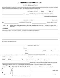


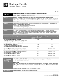


© Copyright 2026