
What is Integrated Land Management?
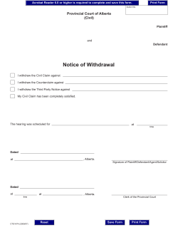
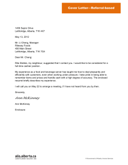
What is Integrated Land
Management?
What is ILM?
• ILM is the strategic, planned way of
doing business
• ILM is the approach
• ILM promotes the responsible use of
public land
ILM is about managing the
impact of human use on …
social
environmental
economic
… values.
ILM is:
A cross-industry, cross-sector, cross-ministry
effort to reduce/manage the human-caused
footprint on government-owned land and
related natural resources.
Linkage Between Government Initiatives
Government of Alberta
Business Plan
Land-use Framework
Cumulative Effects Management
Integrated Land
Management Program
Land and resource use activities
What Does Footprint Look Like?
Source: Aerial Photography, Government of Alberta (10 x 10 kms)
1.5 km/km2 of Human-Made Footprint
What Does Footprint Look Like?
Source: Aerial Photography, Government of Alberta (10 x 10 kms)
3.0 km/km2 of Human-Made Footprint
What Does Footprint Look Like?
Source: Aerial Photography, Government of Alberta (10 x 10 kms)
4.0 km/km2 of Human-Made Footprint
Outcomes
We want to achieve these outcomes:
• Human-caused disturbance on the land is less
than the disturbance that would have
occurred without integration.
• A stewardship ethic is demonstrated by all
land users.
Operating Principles
Land managers and land users should:
1.
2.
3.
4.
5.
6.
7.
8.
Be comprehensive and balanced
Be collaborative and inclusive
Be responsible and accountable
Be consistent with the direction
Be informed by knowledge and science
Use adaptive management
Know the roles and responsibilities
Respect other land users
Who is responsible for ILM?
Land managers and land users both contribute to ILM.
• Managers apply ILM when they evaluate and
approve land uses.
• Land users apply ILM when they conduct activities on
the landscape.
Types of Land Managers
Public land used for industrial,
commercial or other operations
are managed under the Public
Lands Act and the Forests Act
by Alberta Sustainable Resource
Development
Provincial highways, corridors
and related infrastructure
are managed by Alberta
Transportation under the
Alberta Public Highways
Development Act
Provincial parks are
managed under
Provincial Parks Act by
Alberta Tourism, Parks
and Recreation
Numerous other departments also are
responsible for public land
management
Types of Land Users
• Government has a responsibility to uphold ILM
principles.
• Commercial and industrial users are responsible for
using ILM principles while looking for ways to share
their footprint.
• The public can contribute by practicing good land
stewardship and by getting involved.
What Triggers the Need to Integrate?
Whenever a land-related use overlaps or
intersects another use on the same landscape.
For example:
– A commercial trail riding operation needs access through a
grazing lease.
– The landscape used by a forest harvesting operation is also used
by recreationists, and the land may also have ecologically
sensitive areas.
– Two or more industrial land users (e.g. forest harvesting and gas
extraction) need the same surface land base to access their
allocated resources.
The Desired Behavior Shift
Awareness
Understanding
Acceptance
Internalization
Tools on the Web
• Stakeholder Engagement Guide
• Description of Provincial DecisionMaking Systems
• Communication tools
• Business rules for land users and land
managers
ILM in Action
In northeast Alberta, forestry company Alberta Pacific
combined efforts with oil and gas companies OptiCanada and Nexen to create a shared access road.
AlPac-Opti/Nexen Integrated Planning
(runs 2 min, 53 sec)
ILM in Action
In the Ghost Waiparous Forest Land Use Zone,
government, industry and recreation groups are
working together to create a sustainable trail system
for recreational use. That’s ILM in action.
Ghost Waiparous: Working Together to Share the
Land
(runs 5 min, 19 sec)
ILM in Action
In Fort Assiniboine, Trident Exploration Company
worked with the community when developing coal
bed methane resources in the area. That’s ILM in
action.
Early Engagement for Coal Bed Methane
Development
(runs 5 min, 16 sec)
ILM in Action
At Buffalo Lake, 55 km northeast of Red Deer,
Sustainable Resource Development and lakeshore
property owners and residents worked together to
develop a shoreland management plan.
Buffalo Lake Integrated Shoreland Management
Plan
(runs 3 min, 14 sec)
ILM in Action
In the Kakwa River watershed in northwest Alberta,
13 companies cooperated on building a shared access
route, reducing their collective footprint by 45 per
cent.
Kakwa Copton Industrial Corridor Plan
(runs 3 min)
ILM in Action
In Alberta’s forested regions, seismic operators are
using GPS technology and other low-impact
techniques to reduce the footprint of seismic
exploration.
Reducing the Impact of Seismic Exploration
(runs 5 min, 22 sec)
Questions?
Visit:
www.srd.alberta.ca/ilm
Email:
[email protected]


© Copyright 2026