
FOR557
FOR557
Command Line
• No choices (menus, clicking). YOU
have to remember what to type!
• Strange stuff like
– Arc: &workspace e:\yourname\ugis\data
Command Line
Arc: &workspace e:\yourname\ugis\data
Arc prompt
(you are supposed to type
something)
Command Line
Arc: &workspace e:\yourname\ugis\data
& tells ARC that the
following command is an
AML
Command Line
Arc: &workspace e:\yourname\ugis\data
The command:
Name of a program to
execute
Command Line
Arc: &workspace e:\yourname\ugis\data
The argument to this AML is the path to
a workspace
e: is the drive letter
The rest is a hierarchy of folders
Path
e:\yourname\ugis\data
Local disk (E:)
yourname
ugis
data
In chapter 4 these cmds are used
•
•
•
•
•
•
•
•
&workspace
&station
Create
Drawenvironment
Draw
Coordinate digitizer
Mapextent
Editfeature
•
•
•
•
•
•
•
•
Usage
Kill
Quit
Listcoverages
Describe
Select
Arc
Arcedit
A Incantation of Cmds
ARC: &workspace e:\lpherrrin\land
ARC: listcoverages
ARC: station 9999
ARC: arcedit
ARCEDIT: editco stuff
ARCEDIT: drawenvironment tics arcs nodes
ARCEDIT: draw
A Mantra of Cmds
ARC: &workspace e:\lpherrrin\land
ARC: listcoverages
&WORKSAPCE
Allows you to change the
ARC: station 9999
directory at which ARC is
ARC: arcedit
pointing (or using).
And it can only point to
ARCEDIT: edit stuff
1(one) directory
ARCEDIT: drawenvironment tics
arcs
BUT you
can nodes
run multiple
Arc sessions.
ARCEDIT: draw
A Mantra of Cmds
ARC: &workspace e:\lpherrrin\land
ARC: listcoverages
LISTCOVERAGE
Lists all the coverages in
ARC: station 9999
the current workspace.
ARC: arcedit
If there are no coverages
then the current workspace
ARCEDIT: edit stuff
is NOT a workspace!
ARCEDIT: drawenvironment tics arcs
nodes
OR use
&SYS DIR
ARCEDIT: draw
Too see all contents
ARCEDIT
Launches the arc editor,
one of the most used
programs in ARC
A Mantra of Cmds
ARC: &workspace e:\lpherrrin\land
The following 3 are arcedit
commands – they do not
ARC: listcoverages
work in ARC!
Or may do something you
ARC: station 9999
don’t expect!
ARC: arcedit
ARCEDIT: edit stuff
ARCEDIT: drawenvironment tics arcs nodes
ARCEDIT: draw
Abbreviated Cmds
ARC: &workspace e:\lpherrrin\land
ARC: listcoverages
&works
lc
ARC: station 9999
ARC: arcedit
ARCEDIT: edit stuff
ARCEDIT: drawenvironment tics arcs nodes
ARCEDIT: draw
drawe works for above
Cmd help structure
•
•
•
•
•
•
•
BUILD <cover> {POLY | LINE | POINT}
<
> enclose required argument
lower case arguments replaced by a name
{ } enclose options in upper case
| means OR
# is a place holder
BUILD mymap POLY
Navigation
• A/I has this neat little trick:
The horizontal
arrow keys will
allow you to
scroll through
the current
command and
edit it by
backspacing
over characters
and typing new
ones.
These will allow
scrolling through
last n commands
Try it – it is a great time saver
when you screw up a command!
Creating digital data
or
How to be a dig-grunt
OUTLINE
•
•
•
•
Digitizing
Why we are doing it?
What are we going to do?
How are we going to do it?
Data structures
• There are only three data types
– point
• user id in a poly cov
• point data ( i. e... wells)
– line
– poly
Warning: You can’t mix poly and point data!
Because A/I can’t tell the difference between labels and
points
Coverages
• The data structure you will be making is
called a coverage
• A coverage contains geographic and
attribute data
• Part of the coverage is a folder called
INFO.
• A workspace contains both coverages
and an INFO folder
INFO files
• The INFO folder is the key to a
workspace.
• If a folder contains an INFO folder it
is a Workspace
• Workspaces can be moved using
DOS or Windows explorer operations
• Coverages CANNOT be moved
except by the use of COPY in ARC
File Structure
root
F:
F:/Jones
F:/Jane
F:/Harry
F:/Jones/H20
F:/Jane/build
F:/Harry/Srp
F:/Jones/dock
F:/Jane/street
F:/Harry/tfd
F:/Jones/shore
F:/Jones/Info
F:/Jane/street/A2
F:/Harry/ejst
F:/Jane/street/A2
F:/Jane/street/info
F:/Harry/stuff
File Structure
root
F:
F:/Jones
F:/Jane
F:/Harry
F:/Jones/H20
F:/Jane/build
F:/Harry/Srp
F:/Jones/dock
F:/Jane/street
F:/Harry/tfd
F:/Jones/shore
F:/Jones/Info
F:/Jane/street/A2
F:/Harry/ejst
F:/Jane/street/A2
F:/Jane/street/info
F:/Harry/stuff
The book “problem”
• Find site for laboratory
• Criteria
–
–
–
–
–
suitable soil
suitable landuse
>20m from streams
<= 300m of sewer
area >=2,000m2
Data layers for the “book problem”
• Find site for laboratory
• Criteria
–
–
–
–
–
suitable soil
suitable landuse
>20m from streams
<= 300m of sewer
area >=2,000m2
soil cover
landuse cover
hydro cover
sewer cover
final product
poly
poly
arc
arc
poly
Sources of this data
–
–
–
–
soil cover
poly
landuse cover poly
hydro cover
arc
sewer cover
arc
NRCS?
Planning? NRCS?
USGS
City engineering
Simplified Book Process
landuse
soil
hydro
I
n
t
e
r
s
e
c
t
soil & use OK
Simplified Book Process
landuse
soil
hydro
I
n
t
e
r
s
e
c
t
Buffer
stream
soil & use OK
Erasecov
Select
>= 2000
Getting ready
• Format ZIP disk if necessary
• Follow the directions to move the “book” data from
CD to your zip drive –move the data directory from
the CD to the root of your zip
• Start Lesson 4
– Prepare paper map
– Tape map down on digitizer near the center
Prepare the manuscript
•
•
•
•
Tics numbered
Start/stop points on all island polys
Nodes marked on long arcs
Boundary extended by 1/16”
Why: Because what you digitize
will be clipped to fit within a
surrounding coverage!
Your boundary will be clipped off
Your
Map
Existing data
Map on the digitizer
• Some digitizers in the lab have a plastic sheet over the active
surface. Tape your map on top of the plastic sheet or you will
not be able to mark the “done” arcs are you go.
• Not marking as you go is a MAJOR BOO BOO!!!
• NOTE: You DO NOT have to put the map back in the same
place every time - A/I will adjust for map placement. That is
what registering TIC’s is all about.
Putting the map on the digitizer
• Orientation does not matter
• Make it flat and tight
• BUT you must be within active zone of
tablet
• Experiment to see where active zone is by
watching the light on the digitizer as you
move the cursor around.
Starting Arc/Info
• Always start any of the arc programs
(arcedit, arcplot, etc.) from ARC
• ARC is started from the icon on the left side
of the screen or from Start Menu
• Can only be seen after you login
– userid: FOR557
– password: lagis
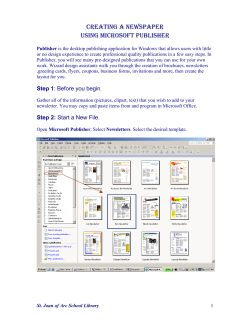
First Incantation
• Launch Arc
• Go to folder: &WORKSPACE path
• Create a new workspace in that folder
CREATEWORKSPACE name
• Move into the new workspace
&WORKSPACE name
Fire up ARCEDIT
• When you start ArcInfo you will have a prompt like
– Arc:
• Type arcedit
• Specify which digitizer is hooked to your computer
– Digitizer 3400 Com1
– Digitizer ALTEK32
– Digitizer 9100 Com1
----
for Calcomp digitizers
for LUCY
for RERUN
• Follow book in creating a TICCOV
• Use CREATE to make a new cover from the TICCOV into
which you are going to digitize data
• NEVER, EVER digitize data into your TICCOV!!!
Input from digitizer
• Start arcedit to edit the new coverage
– Arcedit: edit [cover]
– Arcedit: drawe all
– Arcedit: draw
• You have to tell A/I where data is coming from
– Type COORDINATE DIGITIZER
(or COO DIG) to tell arcedit data is coming from
digitizer
– Use COO MOUSE | CURSOR for mouse input
– Use COO KEYBOARD for keyboard input
What is a TICCOV?
• A TICCOV is a special coverage which contains
only TICs
• TICs are the spatial locators for the coverage
• TICs have x,y coordinates
– table inches
– real world coordinates
• Note: the name TICCOV is not Holy but is sort of standard. You
can use any name you want for a TICCOV - note the two uses of
the word: a coverage name and a type of coverage!
Creating a new coverage
• Now you have to create a new coverage of TICs
only
• After creating a workspace and doing
–
–
–
–
arc: &Station 9999
arc: arcedit
arcedit: coo dig
arcedit: CREATE TICCOV1
– digitize a minimum of 4 tics
– Signal the end of tic input with TIC-ID = 0
1:
CREATE will create a TICCOV out of whole cloth OR it will
create a new coverage from an existing coverage (TICCOV)
Inputting tics
• Always hold puck same way and approach
the tics from same direction
• You are going to
– enter the TIC-ID from the PUCK!!!
– WAIT FOR THE ID TO APPEAR ON THE
SCREEN!!!!
– if ID is wrong enter a B or a # to redo
– IF OK enter an A or an *
– NOW Pput the PUCK X-HAIRS over the tic
– Then press ANY KEY on the PUCK
Done with tics?
• Enter tic id 0 (zero) then press A or *
• Now you will be asked to enter corners of
the data boundary or EXTENT
– Click on upper right and lower left corners of
box (imaginary) enclosing data
– This is called the BND or EXTENT of the
cover
• SAVE the coverage
BND? EXTENT?
Paper
TIC
Extent of
total book
data
Extent of
your book
data
Your data goes
in here
Setting the drawing environment
• DRAWENVIRONMENT TIC IDS
(DRAWE TIC IDS)
• DRAW
• Yup! two commands
– DRAWE sets the draw environment (tics, arcs,
label points, etc. {or all})
– DRAW draws that environment
Create a real coverage
• Type CREATE LANDDG01 TICCOV
– CREATE make new coverage from another
•
•
•
•
– DON’T digitize data into your TICCOV!
Re-enter tics (why?)
Accuracy! What if initial tics had error???
ARCEDIT will give RMS error - a comparison
of the two tic sets
If =< 0.005 you are OK
– if not OK do it again
– if still not OK then error is in original, redo ORIG!!
Editing environment
• NODESNAP --- sets distance over which
nodes will be snapped and how they will be
snapped
– NODESNAP CLOSEST
.05
• set features to be edited
– EDITFEATURE ARC
(EF ARC)
• set drawing environment
– DRAWE ARC NODE LABELS IDS
Now add the arcs
• What to do to with the arcs?????
– ADD
–
–
–
–
–
1) vertex
4) del vertex
7)
2) node
3)
5)del arc 6)
8)
9) QUIT
On each NODE press 2
On each vertex press 1
Pattern is 2 1 1 1 1 2, 2 1 1 1 2, 22,212
NOT 21111211122212
Press 9 on the puck when you are done.
TRICKS
• BE CAREFUL!!!!!!!!!!!!!!!!!!!!!!!!!!!!
• MARK ARCS AS YOU DO THEM
– duplicate arcs are a real PAIN to remove
• Use only enough vertices to define curves
• DO NOT use stream digitizing!!!
More tricks
• How to digitize - 2 methods
– Overshoot method
• overshoot each arc intersection a wee bit
• use CLEAN to clean up the coveage
– make intersections, delete dangles
– but this moves stuff around on you - ‘puter decides
– Node method
• put a node at every arc intersection
• count on the snap distance to snap the nodes together
If you do
it carefully
then clean
will
remove
the
overshoots
also!
Using Clean
• If you have data that
looks like this then the
best technique is to
digitize the straight
lines and let CLEAN
put in the nodes
• Why? Because you
cannot digitize a
straight line if putting
in nodes!
Another technique
• Digitize the long
straight lines and then
split the arcs at the
intersection points to
put in nodes
• Now digitize the other
lines and let the snap
distance work to snap
the nodes
More tricks
• Don’t wait to delete arc if you see it is
wrong!
• Use the 5 option on the puck if just added
• If is an old arc then quit ADD (9)
• You are still in edit feature arc (STATUS)
– : SELECT
– put x-hair on offending arc to select it (yellow)
– : DELETE
• Do a few arcs and check, DELETE ALL if
you are not happy and restart
More tricks yet
• Use the STATUS cmd to find out where you are
(try it, you’ll like it!)
• To see if you have dangles
– drawe node dangle ; DRAW
• To move a node
– EF NODE
– MOVE
– May have to set EDITDIST AND SNAPDIST
Warning
• If you are careful you can do this in 3
hours
• If you are
– sloppy and don’t pay attention to directions
– didn’t read lesson before coming to lab
• It will take more than 3 hours
• In any case: get it done before next lab!!!


© Copyright 2026