
COUNCILLORS PORTFOLIOS AND ASSOCIATED COMMITTEES Refer Item 11.2.1.2
Wangaratta Rural City Council – Ordinary Meeting 21 February 2012 ATTACHMENT COUNCILLORS PORTFOLIOS AND ASSOCIATED COMMITTEES Refer Item 11.2.1.2 Councillor Portfolios - February 2012 Portfolio Focus Mayoral • • • • • • • Governance Municipal Association of Victoria (MAV) Regional Cities Victoria Major Projects Communication Community Leadership Friendship Relations with other Districts/Cities Climate change Water security and supply River Health Waste Management Environment Protection • • • • • • • • • • • • • • Jobs Growth Economic Activity/production Industry Support Tourism Events & Festivals Visitation (VIC’s) Agribusiness & Agritourism Libraries Art Centres/Galleries Performing Arts Community Events & Festivals Multiculturalism History & Museums Heritage & Cemeteries • • • • • Environmental Sustainability Economic Development and Tourism Arts, Culture and Heritage Advisory and Section 86 Committees • Audit Advisory Committee • Wangaratta Unlimited Board (Advisory Committee) Associated Committees • • • North East Local Government Network Regional Cities Victoria Municipal Association of Victoria • North East Victoria Regional Waste Management Authority (NevRwaste) North East Greenhouse Alliance MAV Strategic Environment Advisory Group Wangaratta Community Pride Committee Victoria Livestock Saleyards Association Wangaratta Festival of Jazz • • • • • • Agriculture and Agribusiness Advisory Committee Wangaratta Unlimited Board Arts, Culture and Heritage Advisory Committee Friends of Lacluta Special Committee • • • • • • North East Multicultural Association (NEMA) The Standing Committee on Local Government and Cultural Diversity High Country Library Corporation Portfolio Focus Sport and Recreation • • • Community Wellbeing Infrastructure and Planning • • • • • • • • • • • • • • • • • • • • • Recreational Cycling Passive Recreation (Parks & Gardens, Walking paths Active Recreation (grounds & reserves) Playgrounds Aquatics Equestrian Clubs & leisure pursuits Health Education Youth Volunteerism Aged Care Child Care Social Inclusion Law, Order & Public Safety Drought Transport and logistics Infrastructure renewal Telecommunications Land Use Planning Affordable housing Population Planning Community Facilities Advisory and Section 86 Associated Committees Committees • Sport and Recreation Advisory Committee • Murray to the Mountains Rail Trail Committee of Management • Youth Council Advisory Committee • • • • • • Place Naming Committee Audit Advisory Committee (immediate past Mayor) • • • • • • • • Municipal Emergency Management Planning Committee Municipal Fire Prevention Committee Region 23 Fire Prevention Committee Liquor Accord Forum Traffic Liaison Group Timber Towns Victoria North East Community Road Safety Council Drought Response Sub-Committee Victorian Murray Darling Basin Plan Community Advisory committee MAV Planning Advisory committee a MAV Planning Forum DSE Ovens Catchment Public Roundtable Wangaratta Rural City Council – Ordinary Meeting 21 February 2012 ATTACHMENT FULL SUBMISSION – PROPOSED MURRAY DARLING BASIN PLAN Refer Item 11.2.1.3 PROPOSED MURRAY DARLING BASIN PLAN SUBMISSION BY THE RURAL CITY OF WANGARATTA Overview 1. The Rural City of Wangaratta is one of seven councils that comprise the North East Victorian catchment of the Murray Darling Basin. It includes the Ovens system and is vitally interested in its future. 2. We support the proposed Basin Plan outcomes as far as they are known. The unknown is the proposed review of the Basin Plan in 2015. 3. The current proposals support the Rural City of Wangaratta’s attempt to: • provide security of water supply for agriculture; • expand the Alpine Valleys Agri-Food concept; • provide for efficient use of water closest to its source; and • protect the natural flow and heritage status of the Ovens River. 4. Importantly, the proposed Basin Plan corrects the perverse outcomes for the Oven system as identified and acknowledged with the original Basin Plan. 5. We acknowledge and support the adaptive management approach rather than a strict water volume target being taken in the proposed Plan for meeting the Murray’s sustainable needs. We believe this fits with the Windsor Enquiry recommendations and the Rural City of Wangaratta’s view previously expressed that there may be alternative ways to achieve environmental flows for the Murray from the Ovens catchment based on water management rather water volume. 6. While we support the 2015 review in order to give meaning to the adaptive management approach, it does leave an unknown which conditions our support to what is known or intended now. Page 1 of 10 Introduction The proposed Murray Darling Basin Plan recently released reveals that the Ovens system will not be adversely affected by measures to improve sustainable water flows in the Murray River. With submissions now being called, the Rural City of Wangaratta is taking this opportunity to reinforce the arguments that have led to this positive outcome. About Us Located in North East Victoria, the Rural City of Wangaratta encompasses the valleys of the lower Ovens and the King River. In 2010, the municipality had an estimated population of 28,900 residents, and with continuing growth in industrial, retail and tourism sectors, is one of Victoria’s most progressive provincial centres. Wangaratta is the principal urban centre at the confluence of the Ovens and King rivers. It is a leading regional city providing a range of education, health, recreation and welfare services for all ages. It is the regional headquarters for several government agencies and its diverse industry provides a range of employment. Other townships and villages in the municipality include Everton, Glenrowan, Oxley, Milawa, Moyhu, Peechelba, Springhurst, Whitfield, Whorouly and Eldorado. The Rural City of Wangaratta’s scenic location, its gourmet food and wine and heritage areas make it a popular tourism destination. By virtue of its location, the Rural City of Wangaratta contains some of the richest agricultural land in the country, a highly secure source of water supply and population growth of 1.5% - 2.0% per annum. The Rural City of Wangaratta is one of seven councils that comprise the North East Victorian catchment to the Murray Darling Basin. The table below shows their catchment connection. Council Catchment • City of Wodonga • Shire of Indigo • Shire of Towong Upper Murray, Mitta, Kiewa • Rural City of Wangaratta • Alpine Shire Ovens, Kiewa • Benalla Rural City • Mansfield Shire Broken, Upper Goulburn Page 2 of 10 Background The original Murray Darling Basin Guide released in October 2010 determined that current diversions would have to be reduced by 3000 to 4000 gigalitres per year to provide for sustainable diversion limits (SDLs) and meet the health needs of the Murray River. For the Ovens system this was identified as a reduction in diversions of 40 to 45% to achieve the required SDLs. The formula for imposing reductions meant that the cut to the Ovens system would come from the modest amount of water used for irrigation, resulting in an effective reduction of 70% to irrigation. The table below gives a snapshot of how the guide would have affected the Ovens system. GL % Total Inflows 1,804 100 Total Outflows 1,708 95 Retained 96 5 Interceptors 58 3 Environmental Flows 13 0.7 Diversions 25 1.3 Township Supplies, etc 11 0.6 Irrigation 14 0.7 Proposed MDBG Take (off irrigation) 10 Retained for Irrigation 4 0.2 The Rural City of Wangaratta formed an alliance with six other Upper North East Victorian Councils to argue that the proposals as they affected the upper north east catchments provided perverse outcomes and would destroy irrigation closest to the water source. The Ovens system was used as the case study. The Rural City of Wangaratta challenged the science associated with the perverse outcomes for the Ovens catchment contained in the guide. In doing so we argued that the relatively minute amount of water gained for the Murray River by these moves was completely outweighed by the adverse impacts it would have on this catchment. These included socio economic impacts on jobs, flow on effects on the wider economy, community health and wellbeing, value of land use and protection of agriculture. Page 3 of 10 We suggested that there may be alternative ways to achieve environmental outcomes for the Murray River from North East Victoria catchments based on improving water management rather than increasing water volume. The proposed Basin Plan establishes baseline diversion limits (BDLs) which are the benchmark based on current levels of take against which reductions are made to achieve the sustainable diversion limits (SDLs). The proposed Basin Plan looks at available water in the Murray Darling Basin in two parts; surface water and ground water. The proposed Basin Plan provides for the following: • A reduction of 2,750 gigalitres per year from the BDLs to achieve environmentally sustainable levels of water use; • No reduction to the BDLs relating to the Ovens system for surface water to achieve the required SDLs; • An increase in SDLs for ground water in respect to the Ovens system by 2 gigalitres per year; and • No change for surface extractions for both the Kiewa and Broken systems. Based on these proposals, the arguments put forward by the Rural City of Wangaratta in respect to the Ovens system have been positively responded to by the Murray Darling Basin Authority (MDBA). Indeed in its explanatory notes it reports that: “The communities of the Ovens and Kiewa Rivers have healthy and diverse economies, supported by tourism, retail and agriculture. The 2008 Sustainable Rivers Audit found both the Ovens and Kiewa had near natural flows… given the low levels the authority is proposing that no water needs to be recovered to meet local environmental needs”. The proposed Basin Plan therefore corrects the perverse outcomes for the Ovens system as identified and acknowledged with the original Basin Guide. Rural City of Wangaratta Position The Rural City of Wangaratta supports the proposed Basin Plan outcomes as far as they are known. The unknown is the proposed review of the Basin Plan in 2015 “at which point the SDLs can be re-examined in the light of works and measures, changes to river management and advances in scientific knowledge”. Page 4 of 10 The current proposals support the Rural City of Wangaratta’s attempts to: • Provide security of water supply for agriculture; • Expand the Alpine Valleys Agri-Food concept; • Provide for the efficient use of water closest to its source; and • Protect the natural flow and heritage status of the Ovens River. The final outcome of the MDBA Plan has serious implications for the Ovens system and for those who depend on it and use it. The case for no change as now proposed is worth reiterating. North East Victorian Catchment Perspective The North East Victorian catchments bring a different perspective to that of broader irrigation districts. While not questioning the value of these other areas, the North East Victorian catchments are about maximising the use of fertile river valleys and flood plains where water can be used closest to its source. A diverse range of agricultural products are currently supported including viticulture, horticulture, dairying, beef, lamb and crop production. It is a nationally renowned food and wine centre for these reasons. The value of agriculture in North East Victoria in 2008/2009 was estimated at $360– 380 million. Our circumstances are unique and our needs are different. The case common to all North East Victorian catchments can be summarised as follows: 1. Regional planning for the Hume Region, adopted by the Victorian State Government, provide for: • water being used at its most efficient; • a move toward more intensive and varied agriculture, underpinned by a secure water supply; and • a sustainable environment built around healthy rivers 2. Efficiency of using water closest to the source 3. Benefits of sustainable water use in a drying climate 4. Importance of agriculture to the regional economy and for food production Page 5 of 10 The Regional Plan for the Hume Region, known as the Hume Strategy, contains specific measures in support of the above: Continue to support the protected status of the Ovens River System, having regard to the unregulated nature of the system; its heritage status; and sustainable use of water closest to the source. Develop key opportunities for sustainable use of water at the source through Alpine Agribusiness projects. Develop the Alpine Valleys Agrifood Project as a means of supporting sustainable agriculture. Working in partnership to support agribusiness development, transition, diversification and change including value adding of primary products, food processing, niche markets, uptake of farm technology, business skill development and alternative crops. In terms of the Ovens Catchment, it has natural environmental advantages that ensure irrigation will be more effective than most catchments: • High elevation with cooler temperatures reduces evaporation • Higher natural rainfall A background paper prepared for The Basin Plan demonstrates this advantage. Marsden Jacob Associates in “Ovens community profile” drew on ABS data (2005-06) to compare the agricultural performance of the Ovens region with the Murray Darling Basin overall. Figure 5 from the MJA profile shows an outstanding performance for grape production in the Ovens region. The Ovens grow value of agricultural production (GVAP) for grapes is approximately three times more per ML of applied irrigation water. Irrigation for dairy in the Ovens region also is clearly more effective than the MDB generally. The Ovens region can deliver sustainable use of irrigation water. Page 6 of 10 The sustainability advantages for water use in the Ovens Catchment will offer an opportunity for adaptation as the climate becomes drier. Agricultural businesses are already seeking to relocate to the region to take advantage of this, particularly in the dairy and horticulture industries. This geographic movement is an adaptation option that will buffer the Victorian agricultural economy as the climate dries. If water supply in the Ovens catchment is decreased, effective and efficient adaptation options will be compromised. The importance of agriculture to the economy of the Rural City of Wangaratta Catchment Councils cannot be overstated. Based on current ABS data, 1,034 people or 9.09% of the population are employed in agriculture. It is also noted that manufacturing is a major employer and economic driver of the region and the majority of manufacturers are strategically located so as to add value to primary production. Drawing again on ABS data, manufacturing within the Rural City of Wangaratta employs 1,644 people or 14.45% of the workforce. Irrigated agriculture in the Ovens region has developed in the areas that take advantage of sustainable irrigated water use – dairy, fruit and nuts and grapes as shown in figure 4 from the Ovens community profile. The strength of the agricultural industry in the Ovens region is shown by the comment by Marsden Jacob “the Agriculture, Forestry and Fishing industry was the fourth largest employer, but, unusually for the Basin, grew between 2001 and 2006 (by 2.9% to 2091 persons employed).” Page 7 of 10 These irrigated agriculture sectors in the Ovens region make a key contribution to the local economy. The following figures from the Marsden Jacob’s economic and social analysis (“Economic and social profiles and impacts for MDB Plan”, 2010) show that the perennial horticulture – fruit and nuts and grapes – and dairy have intensive expenditure in the local area. A local study shows that the dairy industry in the region generates $2.5 in the local economy for every $1 at the farm gate. Perennial horticulture is an intensive employer. Page 8 of 10 The intensive contribution means the local economy will be severely impacted by reduced diversion volumes. As these sectors are already highly efficient water users, efficiency measures to adapt to reduced water are not an option. In its narrative, the Hume Strategy states that: “Agriculture is one of the main economic contributors in the Hume Region. Agricultural land is a limited resource that should be protected against inappropriate development.” Already, there is a significant demand for rural lifestyle land in the rich valleys of the Ovens Catchment. If irrigation is lost the pressure to turn high yield, agricultural land over to this type of development will be overwhelming and completely at odds with the Strategy. Management Over Volume The Rural City of Wangaratta acknowledges and supports the adaptive management approach rather than a strict water volume target being taken in the proposed Plan for meeting the Murray’s sustainable needs. In our previous submission to the Guide, the Rural City of Wangaratta suggested that there may be alternative ways to achieve environmental flows for the Murray from the Ovens catchment based on water management rather than water volume. In other words, timing and delivery methods provide more environmental impact for the Murray than just sheer volume. The adaptive management approach, through learning by doing, fits with this view. It acknowledges the Windsor Inquiry recommendations on improving out-dated system operating rules and embraces the notion of utilising innovative ways of recovering water for the environment. 2015 Review Council notes that the Murray Darling Basin Plan will be reviewed in 2015 in order to give meaning and life to the adaptive management approach being taken. While this approach is supported, it does leave an unknown. Council’s support of the proposed basin plan can therefore only be given to what is known or intended now. It is however buoyed by the treatment of the Ovens system in the proposed plan and the accompanying acknowledgement of the health of the system. We appreciate your consideration of our position. Page 9 of 10 Prepared by: Mr Doug Sharp Chief Executive Officer Rural City of Wangaratta (03) 5722 0812 [email protected] Wangaratta Government Centre 62-68 Ovens Street Wangaratta VIC 3677 PO Box 238 Wangaratta VIC 3676 Phone: 03 5722 0888 Fax: 03 5721 9526 Email: [email protected] Web: www.wangaratta.vic.gov.au 30 January 2012 Page 10 of 10 Wangaratta Rural City Council – Ordinary Meeting 21 February 2011 ATTACHMENT COUNCIL PLAN – PROGRESS REPORT Refer Item 11.2.1.4 Quarterlyy Reportt to Cou uncil - October to Dece ember 2011 v3.2.1 1 Rural City ty of Wangaratta QUARTERLY REPORT T TO COUNCIL (O October to Decem mber 2011) Coun ncil Plan Ac ctions Strategy y: ACT TION PROGR RESS COMMENTS S DEPART TMENT CO OMP DATE 1.1.1 To eng gage the commun nity in a strategic a approach to decis sion-making and the developmentt of the Rural City y of Wangaratta. 1.1.1.1 C CP - Implement th he Community Engagement Strategy focusing on greate er involvement by the t o the communiity in decision-makking and planning of Rural Cityy of Wangaratta. Community We ellbeing The Community Planning program continues a focus on implementing the Commu unity Engagement Strategy S across Councill Units. Commu unity Engagement S Strategy continues s to be implemented as part of the process for the draft Rural Lan nd Strategy. ouncil website has been launched. Functionality F New Co includess a feedback form on each webpage. Consulttation undertaken o on Gallery Logo de evelopment and Gallery Upgrade Conceptt Plan with Arts, Cu ulture and Heritage e Committtee and Friends off the Gallery. Commu unity engagement p plans utilised in the e development of the King g Valley Masterplan. The project cha ampions have been engage ed with and assisted in the developme ent of the plan. Public ccomment sought fo or 2011/2012 draft Budget and revised 2011/12 2 draft budget Strategyy is employed on a all business plannin ng projects. Youth ssurvey conducted tto determine prime e issues, needs and d activitie es of young people. Urban & Rural Communityy Planning program m continues to link directly to the community on emerging issue es and determine local priorities. Ongoing 2 January 24, 2012 Rural City ty of Wangaratta Strategy y: QUARTERLY REPORT T TO COUNCIL (O October to Decem mber 2011) ACT TION PROGR RESS COMMENTS S DEPART TMENT CO OMP DATE 1.1.1 To eng gage the commun nity in a strategic a approach to decis sion-making and the developmentt of the Rural City y of Wangaratta. 1.1.1.1 C CP - Integrate the outcomes of the Commun nity Planning Progrram within Council’’s planning process and otherr agencies and leve els of government. Community We ellbeing Contactt being maintained d with external agen ncies and opportu unities being pursued to integrate use e of community planning. Stronger links are being developed between internall ves. Greater businesss units and community representativ involvem ment in the Community Planning Pro ocess in being encoura aged which is resu ulting in the inclusio on of community priorities in council projectt planning. elopment of the Co ommunity Grants Program has Redeve provided an opportunity to o strengthen the lin nk of community anning process. Th his has increased planning with Council's pla olvement and awarreness of the whole e of the organisation the invo with com mmunity planning. Discusssions undertaken w with the CFA to incorporate the develop pment of all future T Town Protection Plans P with Commu unity Planning. 1.1.1.1 C CP - Implement Sttage 1 of the action n plan for Stage 1 of the 2030 Comm munity Vision has been incorporated the 2030 Community Vision n. into the 2009-2013 Counccil Plan (Adjusted 2011) 2 and is being actioned where appropriate. 1.1.1.1 C CP - Continue the p practice of holding Council meetingss across the Rural City of Wangaratta a on a rotational basis. Sustainability Meeting g timetable establisshed for 2010/11 in ncluding four rural meeting gs. Meeting g program including g four rural meetings set at Novembe er 2011 Council meeting Strategy y: 0/06/2013 30 Ongoing Community We ellbeing 30 0/12/2011 Community We ellbeing A review w of the Communitty Grants process has been underta aken and implemen nted. The revised program p has required d a stronger link to o Community Plans s. This reviewed processs will also provide g greater opportunity y for each community to progress the eir plans by achieving priority projects s. A numb ber of applications received for the minor and major categorry of Community grrants were directly linked to actions from Co ommunity Plans. T The assessment pa anel considered this s link as p part of the criteria ffor funding. 30 0/12/2012 Oxley h CP - Complete the C Community Planning has completed their plan and is still to o be presented to 1.1.1.2 C Program while encouraging g groups and indiviiduals Councill. Springhurst, Wh hitfield, Everton an nd Milawa are e not as yet becom me involved in the process p to planning their reviews. who have be engag ged. 1.1.1.2 C CP - Review the community grants process to link to the e outcomes of Com mmunity Planning and a / or take into account recovery needs. Executive Serv vices 0/12/2014 30 1.1.2 To take e a whole-of-gove ernment approach h to the developm ment and wellbein ng of the Rural Citty of Wangaratta. 3 January 24, 2012 Rural City ty of Wangaratta Strategy y: QUARTERLY REPORT T TO COUNCIL (O October to Decem mber 2011) ACT TION PROGR RESS COMMENTS S DEPART TMENT 1.1.2 To take e a whole-of-gove ernment approach h to the developm ment and wellbein ng of the Rural Citty of Wangaratta. CO OMP DATE 1.1.2.1 C CP - Advocate for ccontinued investme ent into hospitals, government servvices, education, arrts and culture, recreation facilities.. ellbeing Community We Ongoing involvement as a Board member with w the Borinya Educatiion Centre. Partnerrships maintained w with health provide ers through the Primaryy Care Partnership and Medicare Loc cals platform, Educatiion, Sport and Recreation providers and a others to ensure Councill is aware of the ind dustry needs and how h to effectively advocatte for services. Work co ontinuing with the Y Yarrunga Primary School and other primaryy health providers o on new infrastructu ure development and Yarrrunga Hub projectt. Local ca atchment primary h health forum estab blished. This has strength hened the relationsship and link with other o agencies and d sectors. pation as a Steering g Committee member to develop the Particip Ovens a and King Commun nity Health Service Plan. Further engagement will b be provided as Med dicare Locals mode el is imple emented for the Hu ume region. 1.1.2.1 C CP - Participate acctively in Regional Cities Victoria. Particip pated in developme ent of submission on o guidelines and criteria for the new Region nal Growth Fund. Developing D an Essential Economics Report on the update to the successful E benefitss of Regional Citiess. vices Executive Serv Ongoing CP - Ensure the Wa angaratta Governm ment 1.1.2.1 C Centre co ontinues to provide e access to a range e of informatio on and services for our community. Provisio on of information fo or a range of servic ces continues. Sustainability Ongoing Sustainability 30 0/12/2012 1.1.2.1 C CP - Investigate the e feasibility of incre easing the Architecctural and financial assessment of bu uilding expansion range of services available from the Wangara atta has dettermined that furthe er investment the project p would not Governm ment Centre. achieve e current financial rreturns. No furth her investigation is proposed Ongoing 1.1.2.2 C CP - Maintain strong external links witth all spheres o of Government and d respective Departments and authorities. vices Continu ual meetings with G Government at all le evels on issues and Executive Serv projectss of interest. Rece ent deputations witth Government include: an * Murray Darling Basin Pla utcome * Ovenss Aquifer Study Ou * Rural Land Study * Ovenss Riverside * Regional Growth Plan Ongoing CP - Facilitate invesstigations into a lon ng term 1.1.2.3 C secure w water supply for Wa angaratta and district. vices Study in nto understanding the scale and sustainable yield for the Executive Serv Ovens A Aquifer finalised. Involvement in esttablishing manage ement rules now a priority. 0/12/2012 30 4 January 24, 2012 Rural City ty of Wangaratta Strategy y: QUARTERLY REPORT T TO COUNCIL (O October to Decem mber 2011) ACT TION PROGR RESS COMMENTS S DEPART TMENT 1.1.2 To take e a whole-of-gove ernment approach h to the developm ment and wellbein ng of the Rural Citty of Wangaratta. 1.1.2.4 C CP - Actively particiipate in the implem mentation Mayor a and Chief Executivve Officer represen nting region on of the Hume Strategy for Su ustainable Commun nities and Co-ordinating Committee.. Priorities now established for pursue th implementing Strategy an he opportunities arising from it. nd being pursued. 1.1.2.5 C CP - Promote the re egional partnership ps model as a wayy of engaging Wholle-of-Government participattion in issues and p projects affecting the Rural City of W Wangaratta. vices Executive Serv vices Regiona al Planning Model forms basis of poliicy development fo or Executive Serv Whole o of Government in V Victoria and is know wn as Hume Strategyy for Sustainable C Communities. Coordinating Committtee consists of Ch hair of North East Local L Government Networkk, Chair and Execu utive Officer of Reg gional Developmen nt Australiia and Executive O Officer of Regional Management Forum. CO OMP DATE 30 0/12/2013 Ongoing 5 January 24, 2012 Rural City ty of Wangaratta Strategy y: QUARTERLY REPORT T TO COUNCIL (O October to Decem mber 2011) ACT TION PROGR RESS COMMENTS S 1.2.1 a) To fo ocus on core-bus siness and non-co ore business as d defined in Append dix 2. b) To act as an advocate and d facilitator in othe er functions. DEPART TMENT CO OMP DATE vices 1.2.1.1 C CP - Apply organisa ational resources directly d to Councill has adopted the 2 2011-2012 Annual Budget as required Executive Serv Local Government Act. service delivery in areas of core business and non-core by the L business. Ongoing Executive Serv vices Ongoing 1.2.1.3 C CP - Continue facilittatory role in waterr security Active rrole in all areas. and re-usse projects, provisiion of community health, h youth, eth hnic and education n services, river managem ment and the like . Executive Serv vices Ongoing 1.2.1.4 C CP - Lobby for regio onalisation of gove ernment services. Through h Regional Cities V Victoria a plan is be eing pursued in supportt of positioning regional centres as the liveable alternattive to metropolitan n Melbourne. Reg gionalisation of servicess through the deve elopment and expa ansion of governm ment centres such as the Wangaratta a Government Centre is being promoted as vehicle for achieving this. Executive Serv vices 30 0/06/2013 1.2.1.5 C CP - Give priority to o post flood recovery works in the allo ocation of resource es and advocate fo or improved d funding outcomess. Executive Serv vices Through h North East Locall Government Netw work improved funding outcomes achieve ed and now endors sed at Council of Australiian Governments (COAG) level. Capital works program m revised to give priority to fflood recovery. Contract works continuing. 30 0/12/2012 1.2.1.2 C CP - Deliver service es according to Bes st Value (value forr money) principless and legislated sta andards. Strategy y: alue principles conttinue to be applied d to the provision off Best Va servicess and projects. 1.2.2 To min nimise risk as a way w of providing a safer public and work place envirronment. Sustainability Ongoing 1.2.2.1 C CP - Implement whe ere appropriate or review where ne eeded Council’s Intternal Audit Work Program P and Risk Management Stra ategy. Internall Audit Work progra am reviewed by Au udit Advisory Committtee quarterly. Intternal audit recomm mendations now assigne ed accountabilities and require regula ar updates from responssible officers. CP - Implement whe ere appropriate or review 1.2.2.1 C where ne eeded Council’s Mu unicipal Emergenc cy Managem ment Plan. ellbeing Municip pal Emergency Man nagement Plan (MEMP) reviewed and Community We adopted d by Council and th hree yearly audit process completed.. Further review to be unde ertaken in next 12 months m once advice of addittional legislative an nd regulative chang ges are received. 1.2.2.1 C CP - Develop a riskk management app proach to identify th he impacts of clima ate change on core e and non-core Council business.. Councill operations being assessed against risks identified in Climate e Change Adaption n Actions for Local Government develop ped by Departmentt of Climate Chang ge and Energy Efficiency. Sustainability 0/12/2011 30 CP - Implement whe ere appropriate or review 1.2.2.2 C where ne eeded Council’s Ro oad Management Plan. P C 2009 Road Management Plan adopted by Council. Sustainability 30 0/06/2013 31/12/2014 6 January 24, 2012 Rural City ty of Wangaratta Strategy y: QUARTERLY REPORT T TO COUNCIL (O October to Decem mber 2011) ACT TION PROGR RESS COMMENTS S 1.2.2 To min nimise risk as a way w of providing a safer public and work place envirronment. DEPART TMENT Community We ellbeing 1.2.2.2 C CP - Review Counccil’s Local Law Num mber 1 “Commun nity Amenity.” Local Law being reworked d with updated draft due at the end of o ber 2011. This wiill require public co onsultation due to a Decemb numberr of proposed chan nges. 1.2.2.3 C CP - Implement whe ere appropriate or review where ne eeded Council’s Orrganisational Occu upational Health an nd Safety Plan. Sustainability OHS manual review comm menced. OHS management system m compliance auditt by 3rd party completted. OHS po olicies are being up pdated to bring the em in line with the new Mo odel OHS Act whicch will be in force frrom January 2012. Evacua ation plans completted for all work are eas. Physiottherapy providers h have been engaged to assist return to o work prrocesses, manual h handling training and ergonomic assessm ments. 1.2.2.3 C CP - Implement whe ere appropriate or review where ne eeded Council’s Firre Prevention Plan n ellbeing pal Fire Prevention Strategy reviewed d and signed off by y Community We Municip CEO. A Audit process to be undertaken as part of CFA bi-yearly y review. The updated plan sed by the Municipa al n has been endors Fire Pre evention Committe ee. Strategy y: CO OMP DATE 30 0/12/2012 Ongoing 30 0/12/2014 1.2.3 To inve est in and deploy proven Informatiion Management Systems to ensurre effective acces ss to information and services. 1.2.3.1 C CP - Continue the d deployment of Tech hnology One Systtem. Plannin ng system impleme ented Human Resources 90% ccomplete. g complete. Building Base syystem upgraded. Cemete ery service module e configured. Configu uration of request m management has commenced. c Sustainability 0/12/2011 30 1.2.3.1 C CP - Investigate opportunities to prov vide improved d telecommunicatio ons into the Rural City C of Wangara atta, comparable w with metropolitan ac ccess. al Development Au ustralia Committee e are currently Regiona preparin ng a consultants brief for the develop pment of the Hume e Region ICT strategy. vices Executive Serv 30 0/12/2012 1.2.3.1 C CP - Develop an e-B Business Strategy. ed at SMT, with intterested parties forr Initial diiscussion conducte cross-fu unctional engagem ment identified. Drraft strategy to be completted by April 2012 IT strate egy in process of b being refreshed. Th hese two strategies s will be a aligned and support the Council Plan n Sustainability 0/12/2012 30 Strategy y: 1.2.4 To ope erate specific und dertakings on a bu usiness basis with h sufficient funding to meet agreed d community ben nefit. 1.2.4.1 C CP - Establish and maintain the follow wing specific b business undertakings as self-contain ned units and clearrly identify Council’s required contribu utions for the next 5 years: Wangarattta Livestock Excha ange blished. Strategic objectives estab g development prio orities & business case. c Refining Prelimin nary design and bu udget costings dev veloped for major capital p priorities. Rubberr soft stand productt under trial. Sustainability Ongoing 7 January 24, 2012 Rural City ty of Wangaratta Strategy y: QUARTERLY REPORT T TO COUNCIL (O October to Decem mber 2011) ACT TION PROGR RESS COMMENTS S DEPART TMENT 1.2.4 To ope erate specific und dertakings on a bu usiness basis with h sufficient funding to meet agreed d community ben nefit. CO OMP DATE Community We ellbeing 0/12/2013 30 1.2.4.1 C CP - Establish the fo following specific business undertakings as self-contained units and clea arly Council’s required ccontributions for the next 5 identify C years: W Wangaratta Child Ca are Service. Community We ellbeing Wangarratta Childcare ope erating within resou urce revenue. Further work to be underta aken to ensure all amenities a are being usiness plan in drafft to provide 5 yearr approprriately charged. Bu planning tool. 0/12/2012 30 1.2.4.1 C CP - Establish and maintain the follow wing specific b business undertakings as self-contain ned units and clearrly identify Council’s required contribu utions for the next 5 years: Wangarattta Performing Arts s Centre. Y 11/12 budget wass approved and the e Wangaratta The FY Perform ming Arts Centre is on track to meet key k performance indicato ors specified for this financial year. Fu urther work to be underta aken to ensure all a amenities are being g appropriately charged d. ellbeing Community We 30 0/12/2014 Work ha 1.2.4.1 C CP - Establish and maintain the follow wing as commenced on n the development of a Waste ement strategy for the Rural City of Wangaratta. W specific b business undertakings as self-contain ned units Manage and clearrly identify Council’s required contribu utions for the next 5 years: Waste ma anagement. Infrastructure Services S 0/12/2014 30 Plant & fleet managementt policy & replacem 1.2.4.2 C CP - Establish and maintain the follow wing ment plan specific b business undertakings as self-contain ned units implemented. and clearrly identify Council’s required contribu utions for the next 5 years: Plant and Fleet Sustainability 0/12/2014 30 1.2.4.1 C CP - Establish and maintain the follow wing e delivery contract rreviewed in May 2011 and extended Service specific b business undertakings as self-contain ned units for a furrther two years within existing agreem ment. Budget and perations functionin ng within allocation n of resources. and clearrly identify Council’s required contribu utions for daily op the next 5 years: Wangarattta Aquatic Facilitie es 1.2.4.2 C CP - Establish and d maintain the following specific b business undertakings as self-contain ned units and clearrly identify Council’s required contribu utions for the next 5 years: Wangarattta Public Cemeterry Community We ellbeing angaratta Public Ce emetery continues s to operate under The Wa the Wan ngaratta Cemeteryy Trust as a self-su ustaining, self-con ntained business unit. Further work to be undertaken to ensure all amenities are b being appropriately y charged. Business Plan to be developed. 30 0/12/2011 1.2.4.2 C CP - Establish and maintain the follow wing specific b business undertakings as self-contain ned units and clearrly identify Council’s required contribu utions for the next 5 years: Community Support North East. E unity Support North h East is a viable business b venture. A Commu Businesss Plan has been ccompleted. A 5 yea ar financial plan is being developed to identiffy Council's future contribution to HACC sservices. ellbeing Community We 0/12/2014 30 1.2.4.3 C CP - Investigate the e establishment of a crematorrium at the Wangarratta Public Cemettery. gation will be underrtaken during 2011 1/2012 financial Investig year. P Policy direction being monitored. Da ata on need for cremato orium being collectted. ellbeing Community We 0/06/2013 30 8 January 24, 2012 Rural City ty of Wangaratta Strategy y: ACT TION PROGR RESS COMMENTS S 1.3.1 To prov es ensuring Coun ncil’s ongoing fina ancial viability. vide responsible financial practice 1.3.1.1 C CP - Maintain a 10 Y Year Financial Pla an predicate ed on the following: · Ma aintaining service d delivery at current standardss; · Ra ate income at rate growth plus a costt index factor; ent and renewal of assets as · Acchieving replaceme programm med; · Prrovision of new asssets as identified; · Ma aintaining the healtth and functional requirements of the organissation. Strategy y: QUARTERLY REPORT T TO COUNCIL (O October to Decem mber 2011) DEPART TMENT Sustainability Councill's 10 Year Financial Plan updated fo or the 2011/12 revised budget in accord dance with required d conditions. The was subjected to an independent aud dit review in Feb model w 2011. Asset re enewal modelling a assumptions have been workshopped with sta akeholders prior to updating 10 year financial f plan with renewal demand. CO OMP DATE Ongoing 1.3.2 To app ply a triple bottom m line approach to o the assessment of new initiatives s. 1.3.2.1 C CP - Undertake a ra ating review to ens sure that the rating g strategy is consisstent with Council Plan P objectives. Not com mmenced. To be co ompleted early in 2012/2013 2 budget processs. 1.3.2.1 C CP - Develop a triplle bottom line meth hodology Draft model, appropriate tto Council's circum mstances, has been n that conssiders social, enviro onmental and finan ncial incorporated into project a assessment proces ss for 2012/13 sustainab bility. budget.. Further consideration bein ng given to incorpo oration of TBL into ement policy procure Sustainability 30 0/12/2012 Sustainability 30 0/12/2011 9 January 24, 2012 Rural City ty of Wangaratta Strategy y: QUARTERLY REPORT T TO COUNCIL (O October to Decem mber 2011) ACT TION PROGR RESS COMMENTS S DEPART TMENT CO OMP DATE 2.1.1 To prov vide a diverse vis sual arts experien nce and opportunities for local and d regional commu unities and visitorrs by the Wangara atta exhibitions Gallery. G 2.1.1.1 C CP - Operate within Arts Industry Stan ndards for Work on n Wangaratta Art G Gallery collection storage s for specific Regional Art Galleries. items has been implemen nted. This involves the making of and construction of acid free sstorage boxes and designing and e works in the constructing correct storage items for textile collectio on. 2.1.1.2 C CP - Provide a diverse program of cha anging exhibition ns for the benefit of the public. ons installed in the Exhibitio e Gallery, Worksho op Space and Wangarratta Performing A Arts Centre foyers during d October, Novemb ber and Decemberr included: Community We ellbeing Ongoing ellbeing Community We Ongoing ng Our Tomorrow' b by GANEAA - Gou ulburn and North 'Creatin East Arrts Alliance, JazzAR RT and JazzART Next N Awards and exhibitio on, EXIT '11 GOTA AFE (Goulburn Ovens Institute of TAFE)g graduating studentss annual exhibition, 'One Step Further' Victoria an Quilters Award e exhibition coincidin ng with 'Collections s', Works ffrom the Gallery co ollection. 'My Coun ntry indigenous works o of art on loan from tthe Ron and Ross Aldridge collection n, Paul Te emple + Ian Hood p photographic images 'On Stage: Roc ck in Oz', A Anita Laurence 'Prrints and Paintings'', Susan Mathews: Textile a art quilts. 2.1.1.3 C CP - Deliver visual a arts programs acro oss the Rural Cityy of Wangaratta th hrough the Local Partnersh hips Program funding and provide inc creased opportunities to create linkss with the Rural Citty of Benalla a and Indigo and Alpine Shires. Strategy y: ellbeing Gallery staff are continuing g to plan for and de evelop a local artistts Community We touring exhibition scheduled for 2012. This exhibition e will tour across tthe region. 0/12/2012 30 2.1.2 To prom mote the benefits s of a culturally, liinguistically and rreligiously diverse society and the e social, cultural and a economic opp portunities this prrovides. ellbeing 2.1.2.1 C CP - Work in partne ership with key stak keholders Research continuing to identify appropriate method to develop p Community We to develo op a Multicultural S Strategic Plan. ernal working group a Multiccultural Strategic Plan. Meeting of inte scheduled to commence p planning. Strategy y: 2.1.3 To faciilitate arts and cultural events and festivals. 30 0/12/2012 ellbeing 2.1.3.1 C CP - Continue the ob bjectives of the Generations Develop pment of Arts activvities for the Christm mas Program in the Community We Project by seeking opportun nities to maintain the Central Business District. engagem ment of older people. ation's resources be eing well utilised. Ongoing O Genera involvem ment of key stakeh holders including U3A U and schools in joint acttivities. Opportu unities identified an nd pursued to enga age older people in n perform mances, for examplle morning melodie es. WPAC is made e to be acccessible and enco ourage attendance e from all age groups.. 30 0/12/2013 January 24, 2012 10 Rural City ty of Wangaratta Strategy y: QUARTERLY REPORT T TO COUNCIL (O October to Decem mber 2011) ACT TION PROGR RESS COMMENTS S 2.1.3 To faciilitate arts and cultural events and festivals. 2.1.3.1 C CP - Develop a plan n to enhance Wang garatta’s status ass the Jazz Capital o of Australia. DEPART TMENT Executive Serv vices With the e assistance of the e Economic Develo opment Unit, the Wangarratta Jazz Festival Board was succes ssful in obtaining funding to undertake a Bu usiness Plan for the e festival moving d. This Business Plan will develop strategies to ensure forward the susttainability, viability and feasibility of th he festival. Through this process, and with the assistance of the Economic pment and Tourism m Department, the Wangaratta Jazz Develop Festival will be able to furtther enhance Wan ngaratta's status as s alia. the Jazzz Capital of Austra CO OMP DATE 30 0/12/2011 sm Department sits s In addittion, a representative from the Touris on the O Operational Comm mittee to provide rec commendation and d advice. This also looks to further leverage on opportunities to atus moving forwarrd. enhancce Wangaratta's sta 2.1.3.1 C CP - Increase com mmunity arts and cu ulture delivery in townships across the Rural City off Wangara atta. Melbourne Writers Festiva al workshops held in Wangaratta. ural locations, Heritage Festival conductted in urban and ru g participants from Heritage Idol competition finalised engaging eveloped for across tthe municipality. Working Group de Indigenous story telling Prroject. Art and Craft activities offered through hout the Christmas Program. Ongoing g discussions and networkking with relevant ccouncil units and community stakeho olders. ellbeing Community We Ongoing 2.1.3.2 C CP - Capture the hisstory of migration through t time within the Rural City off Wangaratta. ellbeing Community We Project captured through short film in the Cu ulture Victoria on, ongoing work being b undertaken Project,, Stories of Migratio through h education and pub blicity, film shown at a Bonegilla Migran nt Camp. Ongoing CP - Explore opporttunities for a speciffic 2.1.3.3 C Indigenou us art or cultural evvent. ellbeing Partnerrship with Dirrawarra Network for the delivery of Nationa al Community We Aborigin nes and Islanders Day Observance Committee C event at a Avian P Park achieved in 20 011. Ongoing work k with Dirrawarra fo or the reco ording of Indigenou us elders stories. 30 0/12/2012 2.1.3.4 C CP - Participate in C Cultural Diversity Week. W akeholders broughtt together to look at a funding Key sta opportu unities and partnersships for 2012. Pla anning commenced d for a Ha armony Day Event in 2012. ellbeing Community We 0/06/2013 30 11 January 24, 2012 Rural City ty of Wangaratta Strategy y: QUARTERLY REPORT T TO COUNCIL (O October to Decem mber 2011) ACT TION PROGR RESS COMMENTS S 2.2.1 To esta ablish the Wangaratta Performing Arts Centre as a high quality, and accessible facilitty. DEPART TMENT CO OMP DATE ellbeing Community We In the first quarter of this ffinancial year many y events were run ery low cost in orde er to ensure that the that were either free or ve venue iss accessible to all community members. The September school ho oliday program was s well received and d milies to activities within the Performing introducced many new fam Arts Ce entre. Collabo oration amongst co ommunity groups to o value-add to perform mances and events was well received d . Both the Wangarratta Ukulele Band d and the North East Health Auxiliary both be enefited from joining with the venue to o showcase their talents as well as the prog gramming at the ve enue. ng for the Small Tow wns Tour progress sed during the first Plannin quarter of FY 11/12 and m much interest and excitement has been munities involved. generatted within the comm Local scchools took advanttage of the events at the Performing Arts Ce entre resulting in tw wo sold out perform mances of The Gruffalo o's Child and My G Grandma Lived in Gooligulch G (iconic children n's books) and the Melbourne Writers s Festival - a free literary event for schools. Ongoing ellbeing Community We 2.2.1.2 C CP - Establish the W Wangaratta Perform ming Arts Commu unity usage of the W Wangaratta Perforrming Arts Centre Centre ass a community bassed venue for meetings and remainss strong and manyy high profile comm munity focussed local events. events are held at the ven nue. d to the venue and New ussers are constantly being introduced whilst th he costs to use the venue are higher than t in the previous Town H Hall the hirer satisfa action is much grea ater. Events of note e that havve taken place in th he first quarter of FY Y 11/12 are Seniorrs Week e events, Victorian M Multicultural Commission information seminar held on 25 Augusst 2011 and 2010 Youth Y Council farewell event held on 6 JJuly 2011. Ongoing 2.2.1.1 C CP - Deliver a high quality and diverse e performin ng arts program. 12 January 24, 2012 Rural City ty of Wangaratta Strategy y: ACT TION PROGR RESS COMMENTS S 2.2.1 To esta ablish the Wangaratta Performing Arts Centre as a high quality, and accessible facilitty. 2.2.1.3 C CP - Maximise the o opportunities of the e Wangara atta Performing Artss Centre to attract conferences and events. y: Strategy QUARTERLY REPORT T TO COUNCIL (O October to Decem mber 2011) DEPART TMENT ellbeing The Ma arketing Coordinato or attended a confe erence in Melbourne Community We conductted by Business Evvents Victoria . The main topic discusssed was developing g conferencing in regional r Victoria. The Ma arketing Coordinato or has been workin ng with the Tourism m Manage er to develop a Bussiness Events strategy for the Rural City of W Wangaratta. Plann ning is underway fo or a seminar to be held at tthe Performing Artss Centre to meet with w business eventts related organisations to develop a strategy and a marketing mber 2011. collateral. This event is sccheduled for Novem CO OMP DATE Ongoing 2.2.2 To inte egrate public art, design d and culturral features into th he planning of ca apital works proje ects and public sp pace developments throughout the e Rural City of Wang garatta. ellbeing 2.2.2.1 C CP - Continue to present the biennial sculpture Review w of this event has b been undertaken, th he Arts, Culture and Community We event and d place sculpture a acquisitions in sele ected Heritage Advisory Commiittee has been consulted. Artists Forum/C sites. Consultation condu ucted 3/11/11 Ongoing 2.2.2.1 C CP - Plan for the in nclusion of public art, a design Develop ping a Public Art priorities list for Pub blic Art and cultu ural features throug ghout the Rural Citty of Commisssions. Approval re eceived from Coun ncil to proceed with h Wangara atta. utilising g the Sculpture Eve ent to increase spe ecific public art. Community We ellbeing Ongoing 2.2.2.2 C CP - Develop a prog gram to bring the co ommunity The Rivverside Civic Square is one site being g considered for a together to enjoy public spa aces, commencing g with the central and significant Christmas tree this will include other Ovens Riverside Precinct. Additional opportun nities are being related festive activities. A explored. ellbeing Community We Ongoing 2.2.2.2 C Projectss identified in ten yyear financial plan and those CP - Identify and pla an for priority publiic art ered appropriate identified. Funding to be pursued. commissions for capital worrks projects and inc corporate conside into capittal works funding a allocations. Community We ellbeing Ongoing 2.2.2.3 C CP - Review Counccil’s Public Art Strattegic Plan. y: Strategy Community We ellbeing A Draft Public Art Strategyy has been developed to reflect e Sculpture Event review process and changes required after the subsequent report. To be presented to Coun ncil in early 2012. 30 0/12/2011 2.2.3 To esta ablish a preservattion program for cultural and builtt heritage. 13 January 24, 2012 Rural City ty of Wangaratta Strategy y: QUARTERLY REPORT T TO COUNCIL (O October to Decem mber 2011) ACT TION PROGR RESS COMMENTS S 2.2.3 To esta ablish a preservattion program for cultural and builtt heritage. 2.2.3.1 C CP - Work with the ccommunities in tow wnships to Every ccommunity plan hass an element of the e community identify a and preserve local character. identifyiing its local characcter. King Valley Masterplan M underw way and awaiting re eport from consulta ants. Working g with the Eldorado o Tourism Busines ss Group on updating the Gunbower P Park and Main Street area of the townshiip by erecting visito or information / inte erpretive signage. Working g with communitiess to preserve local character infrastru ucture like heritage e type 'pedestrian 'swing bridges'. DEPART TMENT Community We ellbeing 2.2.3.1 C CP - Explore the co oncept of a new heritage facility / m museum. Community We ellbeing Discusssions progressing w with stakeholders and a potential funding bodies. Some ve ery preliminary ske etches developed, work on concept and space capacity undertaken. further w Forum rreport to be provide ed on the progress s to January Counc cil Forum ffor discussion 2.2.3.1 C CP - Review and up pdate Council’s exiisting Heritage Overlay. Funding g obtained from He eritage Victoria; project p brief is written a and posted on "He eritage Chat" for ex xpressions of interestt. CO OMP DATE Ongoing 0/06/2012 30 Sustainability 30 0/12/2010 2.2.3.2 C CP - Complete Heriitage Overlay in rural areas. The 200 04 Heritage Study identified 204 item ms in the rural areas Sustainability of the m municipality. 30 0/12/2011 nly had the ability to o review 26 of these The currrent project has on items. A reporrt to Council on the e remaining items, their t level of significa ance and how the remainder of the project p can be underta aken was discussed at the Novemberr forum, 2011. ot be possible to m meet the project by December, 2011 It will no and dep pending on budgett commitments and d the review of the list, the project may take a another 2-3 years to t complete. g with Council's He eritage Advisor to look at options for Working ways to o continue to meet this action having regard to current thresho olds for inclusion in planning scheme,, heritage inventory y list and work required to ccomplete the items. Discussing options for completion witth Heritage Victoria a e ongoing. 2.2.3.3 C CP - Provide advice e and assistance in regard to Heritage Advisory service heritage buildings and places. January 24, 2012 Sustainability Ongoing 14 Rural City ty of Wangaratta Strategy y: QUARTERLY REPORT T TO COUNCIL (O October to Decem mber 2011) ACT TION PROGR RESS COMMENTS S DEPART TMENT CO OMP DATE 2.2.4 To prom mote the library service s as a comm munity informatio on resource that is s accessible and responsive to co ommunity need. Community We ellbeing 2.2.4.1 C CP - Provide facilityy based and outrea ach library Particip pation in library programs: services that can be accesssed by all residents s through Adult prrograms – Oct-Decc 2011 - 17 programs with 489 in n the High Country Library Co orporation. attenda ance. Junior p programs – Oct-De ec 2011 – 77 progrrams with 912 in n attenda ance. There w were 13 external programs conduc cted with a total of 241 in a attendance. Outreacch service to rural a areas and specific venues v maintained d. Ongoing Community We ellbeing Extemp pore launch Wangarratta Library in con njunction with Miria am Zolin from Extemp pore hosted the launch of A sudden se entence in the air: a collectio on of jazz poems b by Geoff Page. Ap pproximately 60 people enjoyed the evenin ng, which was one e of the first events for the W Wangaratta Jazz F Festival. This is th he second year tha at an even nt of this nature has been held at the library. Ongoing 2.2.4.2 C CP - Advocate for library programs to engage disadvan ntaged in the comm munity. h the community th hrough attendance e The librrary connected with at the a annual Children’s D Day in the Park and d the first anniverrsary celebration fo or the new owners of KidzRus. Stories were read to captiive audiences. 15 January 24, 2012 Rural City ty of Wangaratta Strategy y: QUARTERLY REPORT T TO COUNCIL (O October to Decem mber 2011) ACT TION 3.1.1 To sup pport our commun nity to be resilient. PROGR RESS COMMENTS S DEPART TMENT CO OMP DATE 3.1.1.1 C CP - Expand the ran nge of festive community events to o enhance the livea ability of the Rural City of Wangara atta and create opportunities for the co ommunity to come ttogether. Australiia Day awards ope en, and event prepa arations underway y. A very ssuccessful Seniorss Festival, was held d in October 2011 with ove er 50 events being g held over 2 weeks s, and over 1000 people attending the Coun ncil run events. 11/2012 Summer in the Parks progra am commenced in The 201 Decemb ber with an expand ded program of eve ents. Executive Serv vices Ongoing 3.1.1.1 C CP - Support a Com mmunity Raffle or similar s concept tto provide the oppo ortunity for commu unity groups to o raise funds. 2011 Community Raffle co omplete, with $795 5000 raised by 88 local co ommunity groups. Community We ellbeing Ongoing ellbeing The devvelopment of a five 3.1.1.1 C CP - Continue to up pgrade facilities to ensure e year plan of work ks to address the up Community We communiities have access tto a place to meet for f social, keep an nd maintenance off community halls has h commenced, in n recreational and learning op pportunities. conjuncction with the Infrasstructure departme ent. Funding has been identified for the refu urbishment of the AC A Swinburne Pavilion n in Whitfield to devvelop as a community centre. Ongoing 3.1.1.2 C CP - Work with othe er agencies to deve elop and implemen nt approaches to e enhance and streng gthen communiity resilience. Community We ellbeing A comm munity champions d data base has bee en established, agencie es such as SES an nd CFA have made e use of this data base. T Training identified b by communities to increase resilience e, for exam mple Mental Health h First Aid and Firs st Aid. Ongoing 3.1.1.3 C CP - Celebrate with h the community by y supportin ng and enhancing e existing events inc cluding Australia Day, Community P Pride and specific youth events. ellbeing Australiia Day Survey com mplete, event planniing underway for 14 4 Community We Australiia Day Celebration ns throughout the Rural R City. Creative e Youth Festival he eld during Wangarratta Jazz Festival was a h huge success. Plan nning for Rock Poo ol and Jamuary underw way, as well as scho ool holiday program m for January. Ongoing ellbeing 3.1.1.4 C CP - Consider Com mmunity Planning outcomes 2011 - 2 2012 Community G Grants align with Community C Planning Community We when dellivering the Commu unity Grants Progrram. outcomes as per the criteria in the guideline es. Ongoing Strategy y: 3.1.2 To fostter and encourage e: • community y spirit; • volunteeris sm; and • community y leadership. 3.1.2.1 C CP - Support cultura al groups to celebrrate their heritage. Community We ellbeing Liaison with a range of gro oups in relation to heritage / cultural ebrations including.. Ongoing work with events, activities and cele the Dirrrawarra Network on n collaborative projjects. Ongoing 16 January 24, 2012 Rural City ty of Wangaratta Strategy y: ACT TION 3.1.2 To fostter and encourage e: • community y spirit; • volunteeris sm; and • community y leadership. QUARTERLY REPORT T TO COUNCIL (O October to Decem mber 2011) PROGR RESS COMMENTS S DEPART TMENT CO OMP DATE 3.1.2.1 C CP - Resolve positio on on the Wangara atta and District C Community Founda ation. Community We ellbeing Due diliigence report comp pleted and provide ed to Council with responsses to issues. Deputation to Council in July 2010 provided by representative of Philanthropy Australia. A Councill nistrative support fo or the establishmen nt resolved to provide admin Wangaratta & District Community Fou undation. of the W Discusssions held with representative of the Foundation and awaiting g response. 3.1.2.2 C CP - Facilitate comm munity think tanks on significan nt community issue es. Develop pment of an urban community planning process underw way. ellbeing Community We Ongoing 3.1.2.3 C CP - Identify and su upport potential com mmunity leaders a and encourage their development. ellbeing A Comm munity Planning co ommunity champion was sponsored to Community We go to the Communities in Control Conferenc ce and to participate in the A Alpine Valleys Lead dership program. Ongoing Community We ellbeing Ongoing Community We ellbeing Urban C Community Plannin ng has identified new community groups representing youn ng families and you uth. nclusion Group has been supported Wangarratta Access and In with the e accessibility expo o and disability cha allenge. Commu unity champions prrovided with suppo ort to progress projectss through the Community Planning Program. Commu unity Pride Committtee recognised forr achievements in Keep A Australia Beautiful T Tidy Towns Awards s. Continu ue to provide strong g support and advo ocacy for the Alpine Valleys Community Leade ership Program. ommunity projects Techniccal Services contiinues to support co which in nvolve volunteerism m and community leadership. Ongoing support provided d to Youth Council events and es. activitie Financial services provide ed in relation to transactional z Festival, processsing, reporting and acquittals for Jazz community programs, library and rail trail. Ongoing 3.1.2.4 C CP - Celebrate community champions including Australiia Day Award nomination process is complete. Judging g Citizens o of the Year. panel currently presiding o over them. Planning for Australia Day Ce elebrations currently underway. 3.1.2.5 C CP - Support existin ng forums and lead dership developm ment. 30 0/12/2011 17 January 24, 2012 Rural City ty of Wangaratta Strategy y: ACT TION 3.1.2 To fostter and encourage e: • community y spirit; • volunteeris sm; and • community y leadership. QUARTERLY REPORT T TO COUNCIL (O October to Decem mber 2011) PROGR RESS COMMENTS S DEPART TMENT CO OMP DATE ellbeing The We 3.1.2.6 C CP - Promote beneffits of volunteering g and est End Communityy Meeting Place ha as provided a space Community We alternativve ways to voluntee er which are consis stent with for the W West End Community Group to creatte new volunteer contempo orary lifestyles. roles in the neighbourhoo od. These new roles include, ping and maintainin ng garden beds; ho osting a Xmas develop decorattion craft workshop p; and hosting a co ommunity Xmas celebration to launch theirr community plan. volved with the aim m The South Wangaratta Acction Group has ev activities for youth. The group are of supporting recreation a ders in the currentlly building relationsship with stakehold Yarrung ga/South Wangara atta locality. They plan to meet regularlly at the Yarrunga Hub in 2012. Ongoing ellbeing Community We 3.1.2.7 C CP - Continue to su upport volunteer recognition Australiia Day awards ope ened and promoted d. activities.. The Artt Gallery has been allocated tickets by b the Wangaratta Perform ming Arts Centre fo or one performing arts a program per month tto go into a draw fo or volunteer Gallery y 'sitters'. Certifica ates of Recognition n organised for Volunteers when retiring, at other significan nt anniversaries, an nd for wledgement of speccial events/activity.. acknow The Ma ayor and/or anotherr Councillor have represented Counc cil at a num mber of functions a acknowledging volu unteer activities includin ng Tidy Towns Susstainable Communiities presentations, Access & Inclusion Disability Expo. Ongoing 3.1.2.8 C CP - Advocate to m minimise barriers to volunteerring. The We est End Communityy Group have been n supported by Councill to develop leaderrship within the gro oup so they can become e more resilient and sustainable throu ugh establishing a community plan. Community We ellbeing Ongoing 3.1.2.9 C CP - Communicate volunteer opportun nities in partnersh hip with agencies ssuch as the Community Skills Ban nk and Communityy Learning Centre. The We est End Communityy Group (WECG) with w support from Councill have developed a partnership with Pangerang P Commu unity House. Theyy have jointly hoste ed a Xmas Decorattion Workshop that was attended by 35 young people and adu ults. The WE ECG have also devveloped a relations ship with the Wangarratta Police to help p inform their comm munity safety objectivves and actions. The South Wangaratta Acction Group have established e a unga Primary Scho ool's Parents' relationship with the Yarru Councill to support their yo outh recreation pla an. Community We ellbeing Ongoing January 24, 2012 18 Rural City ty of Wangaratta Strategy y: QUARTERLY REPORT T TO COUNCIL (O October to Decem mber 2011) ACT TION 3.1.3 To prom mote a high levell of community sa afety. 3.1.3.1 C CP - Participate in a and promote comm munity safety forrums such as Neig ghbourhood Watch and the Commun nity Safety Committtee. PROGR RESS COMMENTS S DEPART TMENT Community We ellbeing Vic Poliice member attend ds Community Wellbeing committee where ssafety issues are d discussed and actio ons identified. Currenttly selected Techniical Services staff are a members of the Traffic L Liaison Group. Councill has also introduce ed Road Safety Prrograms such as 'Making g Motorcycling Safe er'. Comple eted online survey - Inquiry into locally based approacches to communityy safety and crime prevention. CO OMP DATE Ongoing . Community We ellbeing Ongoing Community We ellbeing Supportt for Ovens & King 3.1.3.3 C CP - Identify and en nhance the core ele ements g Community Health Service in which contribute to community safety and live eability in applying g for program fund ding to reduce harm mful effects of binge the Rurall City of Wangarattta. drinking g by young people.. Regularr inspections of the e road and path ne etworks Techno ologyOne works & a assets module imp plementation includin ng asset registers & recurring risk inspection processes proceed ding Young d driver education - L L2P Program has achieved good numberr of young learner d drivers being menttored by volunteers s. Ongoing 3.1.3.2 C CP - Partner with th he police and otherr allied agenciess in preventing anti-social behaviour. Strategy y: Consulttation with Police in n relation to graffiti issues and other acts of vvandalism. Local P Police involvement with specific areas s of Urban Commu unity Planning whe ere police/community relationships need to o be bridged. Liaison and involvement o of the police is occurring with youth es - L2P Learner D Driver Program, Blue Light Discos. activitie 3.1.4 To sup pport communities s in times of crisiis. 19 January 24, 2012 Rural City ty of Wangaratta Strategy y: QUARTERLY REPORT T TO COUNCIL (O October to Decem mber 2011) ACT TION 3.1.4 To sup pport communities s in times of crisiis. PROGR RESS COMMENTS S DEPART TMENT CO OMP DATE 3.1.4.1 C CP - Support comm munities in identifyin ng their needs to achieve recovery from crisis situations. Community We ellbeing Supportt for community du uring the Nuplex incident - Relief Centre, representation on Emergency Mana agement Team, ICC C ECC. and ME Municip pal Association of V Victoria Flood Reco overy Fund being utilised to build communityy resilience in time es of crisis. Merriwa a Park project in initial stages (flood recovery r funding). Councill continues its role in supporting peop ple affected by crisis situation ns by liaising with a appropriate agencies and authorities s to provide support to assisst the community in their recovery. orating with NE Vicctoria Tourism to im mplement flood Collabo recoverry marketing strategy. Ongoing CP - Review Counccil’s Drought Respo onse 3.1.4.1 C Strategy in conjunction with h a review of Council’s response e to previous emerg gency events. ellbeing Action o on drought activitie es in recess due to weather conditions s. Community We 0/06/2012 30 3.1.4.2 C CP - Work with eme ergency services and a other agenciess to develop a proa active approach to planning for crisis situations. Community We ellbeing The Mu unicipal Emergencyy Planning Committtee, meeting resolved to form a sub-ccommittee, with rep presentation of each of the emergency service organisations, to look at risks across nicipality. This sub-committee held an a initial meeting the mun with em mergency services a and community de evelopment represe entatives of Counciil to consider how best b to involve the community in emergency planning. Further discussions aken with the CFA a and SES on the de evelopment of Town underta Protectiion Plans for prioritty areas of the municipality. Ongoing 20 January 24, 2012 Rural City ty of Wangaratta Strategy y: QUARTERLY REPORT T TO COUNCIL (O October to Decem mber 2011) ACT TION PROGR RESS COMMENTS S 3.2.1 To ens sure the provision n of affordable, ac ccessible and high h quality children n’s services. DEPART TMENT ellbeing 3.2.1.1 C CP - Pursue the esta ablishment of Stag ge 2 of the Application for funding to the State Governm ment Department of o Community We new Child dren’s Services Ce entre. dhood Developmen nt has been Educatiion and Early Child successsful, an allocation o of $200,000 has be een provided with a matchin ng $200,000 in Cou uncil's 2010/2011 budget. b Works ttendered and targe eted for completion in December 2011 1. Work prrogressing to estab blish kindergarten for 2012 to be auspice ed by Council for th he first 12 months. Twenty enrolmentts alreadyy received. Further application for fun nding being explore ed to complete this s pment. Initial design and costing deve eloped. This will develop provide office and therapyy space for specialist services and toy librariess. 3.2.1.1 C CP - Work in partne ership with other ch hildren’s service p providers to better iintegrate service delivery. ellbeing Maintained involvement in n state, regional an nd local interagenc cy Community We groups.. ga Community Hub b project provided further f opportunity y Yarrung to work closely with this se ector. A project gro oup has been ated to manage the e operations of the Community Hub formula building gs and to progress Community Renew wal Project. Work be eing undertaken to o progress complettion of integration at a the Wan ngaratta Children'ss Services Centre. 3.2.1.2 C CP - Implement a planned approach to t the identified d pre-school service e needs (Universal Access Strategy.) Further planning project b being undertaken with w the pre-school as part of the Unive ersal Access Imple ementation. sector a Commu unity consultation ssessions undertake en to develop a community steering group p for the new kinde ergarten. y: Strategy ellbeing Community We CO OMP DATE 30 0/12/2012 Ongoing 0/12/2012 30 3.2.2 To sup pport the developm ment of integrated health provision to maximise the e health and wellb being outcomes for f the community y. 3.2.2.1 C CP - Actively particiipate in the Central Hume Primary C Care Partnership. ellbeing Staff invvolved with the Hume Region review of Municipal Public Community We Health & Wellbeing Plans. Staff are active in many groups within the Primary Care Partnerrship framework, in ncluding the Healtth Promotions, Leadersship and Executive e Group. An Early Years Education n Sector Network has developed with entation from Coun ncil. represe Local H Health & Wellbeing Partnership - Wan ngaratta meets regularlly with broad repre esentation of servic ce provision and agencie es. Ongoing 21 January 24, 2012 Rural City ty of Wangaratta Strategy y: QUARTERLY REPORT T TO COUNCIL (O October to Decem mber 2011) ACT TION PROGR RESS COMMENTS S DEPART TMENT CO OMP DATE 3.2.2 To sup pport the developm ment of integrated health provision to maximise the e health and wellb being outcomes for f the community y. 3.2.2.1 C CP - Work with the health service sec ctor in developin ng an integrated ap pproach to service delivery and healtth planning. ellbeing Ongoing planning with the e Kindergarten secttor continuing which Community We es for stronger integ gration across the has identified opportunitie hildren's services ssector. These will be addressed early ch through h the development of a new sector ne etwork by the education sector of which Council Officers are a involved. The local catchment Prima ary Health Care Co ommittee is working togethe er to identify common issues and tren nds to be acted upon. Youth providers me eet regularly with Council C staff to Local Y conside er issues for action. A Steerring Committee witth representatives from f a number of Primaryy health and Local Government secto ors has been establisshed to oversee the e development of a service plan for the Ovens a and King Commun nity Health Service. Work iss being undertaken n with the Victoria Police P to develop a Commu unity Safety group, this will provide an nother avenue for an integ grated approach. Ongoing 3.2.2.2 C CP - Develop and m maintain demograp phic data to inform the current and fu uture service needs s of the communiity. ellbeing Community We Local H Health & Wellbeing Committee works collaboratively to identify current and future e service needs. e of profile ID has been b provided, nex xt Further training in the use ext census. New version of Remplan update will be following ne installed d along with the tourism module. Ongoing ellbeing Community We 3.2.2.3 C CP - Maintain involvvement in local and d regional Continu ued involvement wiith the Wangaratta a Youth Service youth nettworks, in health, e education and othe er Provide ers Network, North East Regional You uth Affairs Network k, interventiional service areass. Wangarratta Blue Light Yo outh Group and Big g Brothers Big Sisters. Ongoing 3.2.2.4 C CP - In partnership with other agencie es develop, implement and evvaluate a Communiity g Plan (Municipal P Public Health Plan) and Wellbeing review M Municipal Early Yea ars Plan. ellbeing The Loccal Health & Wellbeing Partnership is s meeting regularly y Community We and is g guided by the Municcipal Public Health Plan. The Plan has underta aken a minor review w to ensure it is up p to date. The Hume Region Departtment of Health is undergoing u a review w of the status of Municipal Public Health Plan ns. 30 0/12/2014 22 January 24, 2012 Rural City ty of Wangaratta Strategy y: ACT TION PROGR RESS COMMENTS S DEPART TMENT CO OMP DATE 3.2.2 To sup pport the developm ment of integrated health provision to maximise the e health and wellb being outcomes for f the community y. 3.2.2.5 C CP - Partner with ne eighbouring munic cipalities and other agencies to advo ocate for flexible tra ansport options to o support identified d need. Strategy y: QUARTERLY REPORT T TO COUNCIL (O October to Decem mber 2011) Councill is a partner in the e North East Transp port Connections project phase three. Continuing with the NE Transport ort Action Plan. Connecctions to implement the local Transpo A pilot o of a Wangaratta Trravellers Aid projec ct has been submitted for funding. Councill is investigating ho ow to enhance bus s utilisation and effective eness, initial meetiing has occurred. Local bus operators appro oached to extend existing e services to o wns. rural tow Community We ellbeing Ongoing 3.2.3 To sup pport families, old der people and pe eople with disabiliities to actively en ngage and particiipate in their com mmunity. Community We ellbeing Ongoing Community We ellbeing 3.2.3.1 C CP - Implement Cou uncil’s Access and Inclusion The Acccess and Inclusion n Plan was adopted d at April 2010 Plan. Councill meeting and implementation has co ommenced. Respon nsibility for actions being monitored across a Council. An n Access and Inclusion Poliicy has been develloped and public feedbacck sought prior to cconsideration by Council. Advice received that the MAV is b being funded to pro ovide additional prove access and inclusion supportt to Councils to imp opportu unities. Ongoing ellbeing Community We Ongoing 3.2.3.1 C CP - Actively particiipate in the interag gency working g group reviewing ho ousing issues in the e Rural City of W Wangaratta. Housing g network involvem ment in Local Healtth and Wellbeing Committtee where updatess on current needs s and issues is discusssed. CP - Ensure the pro ovision of services reflects 3.2.3.1 C the follow wing principles: · ba ased on individual sstrengths and abilitties; · en ncourages self-mottivation; and · en ncourages indepen ndence. All stafff have undertaken strength based tra aining and are implementing as part of th heir daily practise. and Community Ca are staff are operatting a self-support Home a program m with clients to ma aintain their indepe endence. Funding g has bee en provided throug gh Sustainability Victoria to implemen nt an enerrgy and water savin ng program with Home and Commu unity Care (HACC) clients. 3.2.3.2 C CP - Explore the cre eation of more com mmunity gardens in the Rural City off Wangaratta. ellbeing The Community Pride Committee, Urban Co ommunity Planning g Community We est End residents group are exploring the development of o and We a comm munity garden in co onjunction with the West End Commu unity rotunda. 30 0/12/2012 23 January 24, 2012 Rural City ty of Wangaratta Strategy y: QUARTERLY REPORT T TO COUNCIL (O October to Decem mber 2011) ACT TION PROGR RESS COMMENTS S DEPART TMENT CO OMP DATE 3.3.1 To prom mote and supporrt youth leadershiip by engaging yo oung people and strengthening s the eir involvement in n the community. Community We ellbeing Ongoing 3.3.1.2 C CP - Support the Crreative Youth Com mmittee to Creative e Youth ran a succcessful Youth Festival as part of the design, p promote and delive er a program of eve ents, 2011 Ja azz Festival. The fe estival was free forr young people and d funded th hrough the FReeZA A program. the wide er community and feedback of the ev vent has been very y positive e. Community We ellbeing Ongoing Youth C Council have imple emented a Youth Survey S which saw 135 you ung people take pa art. The Youth Surv vey will be used by y Youth C Council to raise issues with Council and a address issues s that were raised. Community We ellbeing Ongoing 3.3.1.1 C CP - Support the Yo outh Council to dev velop skills in a areas of leadership p, civic service, com mmunity service a and advocacy for yo outh issues. 3.3.1.3 C CP - Create opportu unities and encourage young pe eople to have inputt into decision mak king on issues afffecting them. Youth C Councillors have be een involved in varrious civic service activitie es including Blue Liight Discos, Creative Youth Events, Seniorss Week celebration ns, Christmas Carn nival celebrations, Children n's Week as well a as undertaking the 2011 Wangaratta Youth S Survey. 24 January 24, 2012 Rural City ty of Wangaratta Strategy y: QUARTERLY REPORT T TO COUNCIL (O October to Decem mber 2011) ACT TION PROGR RESS COMMENTS S 3.4.1 To worrk with education providers to enh hance opportunitie es for life-long lea arning. DEPART TMENT CO OMP DATE ellbeing 3.4.1.1 C CP - Review and up pdate Council’s Ed ducation The Education Strategy iss incorporated into the implementation Community We Strategy to ensure future re egional education needs n are of the C Community Wellbeiing Plan. Further re eview will be met. underta aken over the next 2 years. Ongoing Community We ellbeing 3.4.1.1 C CP - Facilitate invesstigations into niche models Ongoing discussions with the Borinya Board d (inclusive of for the prrovision of tertiary e education. D representation) in n response to chan nging needs of DEECD school sstudents. Meeting gs continuing with local Steering Com mmittee, Federal and Sta ate Government representation regarrding the establisshment of the Wangaratta Medical Ce entre of Excellence e. Ongoing ellbeing Community We Ongoing 3.4.1.2 C CP - Promote the co oncept of life-long learning in partnership with educatio on providers. Initial diiscussions underta aken with The Centtre to consider join nt training and education opportunities. U3A and opportunities identified for Contactt maintained with U inclusio on in the development of a positive ag geing strategy. 25 January 24, 2012 Rural City ty of Wangaratta Strategy y: QUARTERLY REPORT T TO COUNCIL (O October to Decem mber 2011) ACT TION PROGR RESS COMMENTS S DEPART TMENT 4.1.1 To imp plement asset man nagement system ms that ensure the e sustainability off our community assets. a CO OMP DATE 4.1.1.1 C CP - Refine the man nagement of Coun ncil’s pating in the new assset management best practice Particip infrastruccture assets throug gh participation in the t program m - Regional Assett Management Program. Management Impro ovement Strategy developed. d Municipa al Association of Victoria’s STEP prog gram and Asset M through improved modelling g and supporting data. d Sustainability 4.1.1.1 C CP - Develop and im mplement manage ement plans; inccorporating rolling capital works and cyclic maintena ance programs for Council’s infrastructure. Councill is participating in the North East Regional Asset manage ement group. Assset management plans are being develop ped in conjunction with this group. The T region is expectin ng to have these p plans ready for imp plementation in Decemb ber 2012. S Infrastructure Services 30 0/12/2011 4.1.1.2 C CP - Review Counccil’s Asset Management Plan. Asset M Management Plan p priorities, resource es and timelines establisshed. Asset Manag gement Plan template in place. Sustainability 0/12/2012 30 Infrastructure Services S 30 0/12/2012 4.1.1.2 C CP - Develop and im mplement landscap pe The pla an for the Yarrawon nga entry is comple ete and works d for last quarter off 2011-12 financial year. strategiess for main roads, kkey township entrances and planned Council b buildings. Ongoing 26 January 24, 2012 Rural City ty of Wangaratta Strategy y: QUARTERLY REPORT T TO COUNCIL (O October to Decem mber 2011) ACT TION PROGR RESS COMMENTS S 4.2.1 To inve estigate and imple ement infrastructture opportunities s that support com mmunity aspiratio ons. DEPART TMENT CO OMP DATE 4.2.1.1 C CP - Continue to wo ork with the Transp port Connections Project to devvelop a Transport Action A d public and community Plan and address identified transportt gaps. ellbeing Transpo ort Action Plan com mmenced impleme entation of phase 3 Community We of North h East Transport C Connections Group. Finalisa ation of project plan nning for a 'Travel Station'. Councill Officers currently working through an a implementation strategyy developed from tthe recommendatio ons of the Wangarratta Transport Stu udy. Councill is developing conccepts and strategie es to improve freigh ht movement within and arou und Wangaratta. A pilot o of a Wangaratta Trravellers Aid projec ct has been submitted for funding. ow to enhance bus s utilisation and Councill is investigating ho effective eness, initial meetiing has occurred. Local bus operators appro oached to extend existing e services to o wns. rural tow 4.2.1.1 C CP - Advocate for a an ultra-fast train se ervice between Melbourne and Syydney with a stop in Wangara atta. Incorpo orated as a regiona al priority in the Hum me Strategy for Sustain nable Communitiess. An interim step of business transitt carriage es is being promoted for immediate action. a vices Executive Serv 4.2.1.1 C CP - Investigate opportunities to hav ve co-ordina ated and co-located d depot facilities with w other agenciess. Draft Masterplan presente ed for comment, wa aiting for final presenttation of plan. Infrastructure Services S 30 0/12/2011 4.2.1.1 C CP - Implement the Ovens Riverside Project. P A grant application has be een lodged with the e Federal Government and Council should be informed of the outcome sometim me in March. Infrastructure Services S 30 0/12/2012 Works h 4.2.1.1 C CP - Plan a networkk of shared paths designed d have commenced on the Ovens Rive erside to Showgrrounds shared path h. to provide e walking and cycling access betwee en townships and community ffacilities. Infrastructure Services S 30 0/12/2011 4.2.1.2 C CP - Implement the Wangaratta Centrral Activities Area Car Parking Strategy. Infrastructure Services S Ongoing A reporrt on the progress o on the implementation of the car parking strategy was pressented to the Janua ary 2012 Council meeting g. Ongoing Ongoing 27 January 24, 2012 Rural City ty of Wangaratta Strategy y: QUARTERLY REPORT T TO COUNCIL (O October to Decem mber 2011) ACT TION PROGR RESS COMMENTS S DEPART TMENT CO OMP DATE 4.3.1 To und dertake a strategic c approach to lan nd use planning to o provide balance ed outcomes for growth, g existing la and use, environm ment, heritage an nd community a aspirations. This ma 4.3.1.1 C CP - Explore / invesstigate a strategic approach a atter referred to Wa angaratta Unlimited Board for input bruary 2012. to develo oping a precinct ma aximising the bene efits of the and dettermination by Feb new Rura al Industries campu us including: Equin ne, Agrifood, Livestock, Racing g, Accommodation Executive Serv vices S 4.3.1.1 C CP - Develop option ns for overcoming drainage Under tthe North East Gre eenhouse Alliance project ‘Adapting to o Infrastructure Services deficienccies within the urba an areas. a low w water future’ funding g has been made available a for a case e study tittled Water Sensitivve Urban Design (W WSUD) Options for South W Wangaratta area w which aims to develop concepts for drainag ge of this area that will achieve WSUD D best practice objectivves and targets. 30 0/12/2011 0/12/2011 30 4.3.1.1 C CP - Implement the Rural Land Strate egy. Public cconsultation processs in progress. Councill has appointed Ag gricultural Agribusin ness Advisory Committtee to assist in pro oviding advice for refinement r of draft strategyy. Propose ed timetable is to h have 2nd draft of strategy considered d at January, 2012 meeting of Council. Sustainability 30 0/12/2012 4.3.1.2 C CP - Develop an ovverall housing/popu ulation strategy tto include appropriiate zoning, density y and service p provision to accomm modate population n growth within Wa angaratta and surrrounding townships s. Sustainability ment of Planning a and Community De evelopment have Departm commenced its Urban Gro owth Planning project for Wangaratta a. A current situation deman nd and supply analy ysis and provide figures for land supply forecast. quire report from DP PCD before further work can continue Still req on this project. 30 0/12/2012 4.3.1.3 C CP - Implement the outcomes of the Planning Scheme Review to update the Municipal Strategic nt to reflect the Rural City of Wangaratta 2030 Statemen Commun nity Vision. Councill Plan will be review wed in first half of 2013 2 which may result in n other amendmen nts to MSS. As a result r time conside eration is being given to other means of updating MSS with the e recommendationss of the review suc ch as part of other strategic planning projectss. Sustainability 30 0/06/2013 4.3.1.4 C CP - As part of the ccommunity plannin ng process, develop structure plans for individua al townships. Sustainability Priority townships for structure planning will be Milawa, Oxley and Gle enrowan due to the e towns being serviced with sewerage e and the e resultant demand d for land and subdivision that may occur. 30 0/12/2011 u this work k Project plans currently being developed to undertake with an aim to complete p project by 31 Augus st, 2012 28 January 24, 2012 Rural City ty of Wangaratta Strategy y: QUARTERLY REPORT T TO COUNCIL (O October to Decem mber 2011) ACT TION PROGR RESS COMMENTS S DEPART TMENT CO OMP DATE 4.3.1 To und dertake a strategic c approach to lan nd use planning to o provide balance ed outcomes for growth, g existing la and use, environm ment, heritage an nd community a aspirations. ed. 4.3.1.5 C CP - Undertake a place-based approa ach to the Project not yet commence developm ment of the Wangaratta Central Activities Area incorpora ating: · Review of existing plannin ng arrangements · Review the Wangaratta Urban Design Framework, ns River / Faithfull S Street Masterplan and the the Oven Ovens River / Faithfull Street Precinct Structu ure Plan, a Central Activities Area to enhance the Wangaratta including landscaping, treesscaping, street furn niture and public artt. Sustainability 30 0/06/2013 Sustainability 30 0/12/2011 4.3.1.7 C CP - Investigate the e impacts of climate e change This isssue will be addresssed in each strategic planning projectt Sustainability on land u use and how the ou utcomes may be underta aken. This may be e a more pragmatic c approach rather incorpora ated into the Planning Scheme. than a sstandalone project which due to envisaged State and Federall policy changes may be out of date before such a projec ct is imple emented. 30 0/12/2011 Sustainability 30 0/12/2011 4.3.1.6 C CP - Examine the flexibility of the Plan nning Scheme to accommodate n neighbourhood serrvicing facilities iin an as of right ca apacity. 4.3.1.8 C CP - Evaluate the in ntroduction of Deve eloper Contributtion Plans for infrasstructure across th he Rural City of W Wangaratta. Report presented to Coun ncil forum in Novem mber, 2012. Residen ntial 1 zone provides flexibility for a range of neighbo ourhood business u uses subject to a permit p which is conside ered appropriate, ra ather than as of rig ght. In Houssing and Population n Strategy can con nsider at what growth level such servicess are required and have discussions ers about this but not n necessary to with devvelopers/subdivide provide a specific businesss zoning. This pro oject has not comm menced. State rev view occurring into o role and d effectiveness of D Developer Contribu ution Plans and options available. Once this review is finalised it then that Councill can consider its o options. 29 January 24, 2012 Rural City ty of Wangaratta Strategy y: QUARTERLY REPORT T TO COUNCIL (O October to Decem mber 2011) ACT TION PROGR RESS COMMENTS S DEPART TMENT CO OMP DATE 5.1.1 To defiine and market th he liveability and llifestyle attributes s of the Rural City y of Wangaratta as a a preferred loca ation to live, work k and invest. 5.1.1.1 C CP - Facilitate the p provision of settlem ment support ffor new residents. "New R Resident's Guide" d developed, printed and published on Councill's website. Printe ed copies available e from Customer Service e and Visitor Inform mation Centre. Community We ellbeing 30 0/06/2013 5.1.1.1 C CP - Utilise the findings of the 2009 Regional R Cities Livveability and Lifestyyle report to inform m marketing g activities. Findings inform all marketting activities. Executive Serv vices 30 0/12/2014 5.1.1.1 C CP - Advocate with relevant authoritie es for: · wa ater security and quality for Wangara atta; and · retticulation of water a and sewerage prov vision in rural town nships. North E East Water has agrreed to enter into th he funding arrange ement with DSE forr the Moyhu Waste e Water project in Councill’s place and are in n negotiation with DSE D over the terms s and con nditions of the agre eement. Infrastructure Services S 5.1.1.2 C CP - Maintain an acctive involvement in n the “Make It Happen in Provinccial Victoria” marke eting initiativess. Plannin ng underway for the e Regional Living Expo E in Melbourne May 2012 vices Executive Serv 0/06/2013 30 5.1.1.3 C CP - Leverage med dia marketing opportunities from land dmark developmen nts i.e. Wangaratta Performin ng Arts Centre, Ovvens Riverside Precinct, Technica al Education Centre e and National Cen ntre for Equine E Education. Ongoing media opportunitties being progress sed. MICE marketing strategy underw way to continue ma arketing opportu unities with Wangaratta Performing Arts A Centre. Executive Serv vices 30 0/06/2013 Strategy y: Ongoing 5.1.2 To rein nvigorate the inne er urban areas of Wangaratta to ma aximize their pote ential. 5.1.2.1 C CP - Develop and re efine the concept of o neighbou urhood renewal for the “East End” pre ecinct focusing on: Aquatic; Educa ation; Recreation; Employm ment; Infrastructurre; Community serv vices; and Public Amenity ellbeing d. Community We Project proposal for discussion with State Government drafted nuing with State Government Further discussions contin ments. Local Comm munity group being g established which h departm will provvide input into this development. Feasibility study commenced for South Wan ngaratta including e and Avian Park. the old Ovens College site 30 0/06/2013 CP - Develop a Massterplan for the an East-end Consulttants engaged and d conceptual plan has h been produced d 5.1.2.1 C as a ressult of stakeholder consultation urban ren newal program to rrevitalise of the Ne ewman Street an nd Vincent Road prrecinct incorporatin ng: · The fo ormer Ovens Colleg ge site; · Newm man Street, includin ng Avian Park; and nt Road, including the former landfill site. s · Vincen Executive Serv vices 0/12/2012 30 5.1.2.2 C CP - Investigate devvelopmental opporttunities of Ongoing larger site es in the Central A Activities Area. Executive Serv vices 30 0/12/2012 30 January 24, 2012 Rural City ty of Wangaratta Strategy y: QUARTERLY REPORT T TO COUNCIL (O October to Decem mber 2011) ACT TION PROGR RESS COMMENTS S DEPART TMENT CO OMP DATE 5.2.1 To prom mote a strong and vibrant busines ss community con nsisting of a diverse range of small, medium and la arge enterprises capitalizing c on the e key competitive strengths of our region. vices 30 0/12/2011 Strategic workshops to review the Economic 5.2.1.1 C CP - Review the 2008-2011 Wangaratta c Development and d Executive Serv Tourism m Strategies being held in January 20 012 Unlimited d Economic Develo opment Strategy an nd develop a new strategy. 5.2.2 In conjjunction with relevant stakeholders s, to realise the sustainable agricu ultural production n potential of the Ovens O and King Valleys V region as a future Strategy y: food bowl. 5.2.2.1 C CP - Advocate to prreserve the currentt protection n of the Ovens and d King River system ms with respect to o the trading of wa ater. Revised d MDBP preservess the current protec ction of the Ovens and Kin ng River systems trrading practices Executive Serv vices Ongoing 5.2.2.2 C CP - Utilise the findings of the Ovens Aquifer evelop and promotte a Water Se ecurity Project to de business case for the estab blishment of a susttainable agriculturre industry in the O Ovens and King Va alleys. Ongoing Executive Serv vices 30 0/12/2012 5.2.2.3 C CP - Facilitate the e establishment of a market driven, su upply chain model to support an inno ovative and susta ainable agricultural sector within the Ovens and King Valley’s region. vices Growerrs have visited with the Yarra Valley Growers G Association Executive Serv and had d an industry visit tto Caboolture to inv vestigate other models for supply chain in ntegration. 0/12/2011 30 vices Executive Serv 30 0/06/2013 Berry growers study tour tto Caboolture and Bundaberg to further iinvestigate the pottential for the Alpine Valleys region was succcessful. 5.2.3 To sup pport and encoura age a sustainable e, innovative and rresilient tourism sector. s CP - Pursue the opp portunities identifie ed in the 5.2.2.4 C Alpine Va alleys Agrifood pro oject. Strategy y: 31 January 24, 2012 Rural City ty of Wangaratta Strategy y: QUARTERLY REPORT T TO COUNCIL (O October to Decem mber 2011) ACT TION PROGR RESS COMMENTS S 5.2.3 To sup pport and encoura age a sustainable e, innovative and rresilient tourism sector. s 5.2.3.1 C CP - Build on the ke ey brand strengths of Food and Wine e, Cycling, Ned Kelly and Jazz by implemen nting the Yarra Vallley – High Country y Touring Route Strategic Plan which h links through to th he King Valley. DEPART TMENT Executive Serv vices North E East Valleys Food a and Wine 3 year sttrategic plan and regiona al plan now comple ete. New North Eas st Victoria Tourism Board Inc. CEO has been n appointed. North East Valley's Food d ne will dissolve and d the portfolio of Food and Wine shall and Win be incorporated into the n new RTB. CO OMP DATE 30 0/06/2013 The ma anagement of the Y Yarra Valley to High Country touring route ha as been incorporatted into the scope of works of the new w RTB. To ourism Officer rem mains on this comm mittee. A re-sco oping study for a w world class Interpre etive Centre in Glenrow wan to feature the Ned Kelly Gang ha as secured funding g. Consulttants have been ap ppointed to begin th he re-scoping study y. Further development of th he Ned Kelly Tourin ng Route has also begun. with journalists is co ontinuing following the launch of King g Work w Valley P Prosecco Road in M Melbourne during early November 2011. 5.2.3.1 C CP - Participate in tthe North East Reg gional Tourism Board. vices Board h has adopted a strattegic plan and has secured funding fo or Executive Serv a gap a analysis of the regio on. 30 0/12/2011 5.2.3.2 C CP - Build on the ke ey brand strengths of Food and Wine e, Cycling, Ned Kelly and Jazz by re--scoping the Ned K Kelly Interpretive C Centre proposal; vices Executive Serv A brief tto undertake the re escoping of the orig ginal Interpretive Centre Proposal has been n prepared. Funding has been secured h Tourism Victoria a and RDA Hume. Consultants C have through been ap ppointed to begin w works on the re-sco ope. 0/12/2012 30 5.2.3.3 C CP - Build on the ke ey brand strengths of Food Draft Cyycle Tourism Strategy is complete. A committee is being fo ormed to finalise th he new strategy. and Wine e, Cycling, Ned Kelly and Jazz by implemen nting the key action ns of the Cycle Tourism Strategy in collaboration witth Alpine and Indig go Shires. vices Executive Serv 0/06/2013 30 5.2.3.4 C CP - Build on the ke ey brand strengths of Food Develop pment Officer and VIC Coordinator attend a fortnightly and Wine e, Cycling, Ned Kelly and Jazz by collaborating Jazz Su ub Committee Mee etings to provide input, direction and with the interim Jazz Festiva al Board to ensure longevity supportt. and contiinued success of th he Event. Executive Serv vices 0/12/2012 30 32 January 24, 2012 Rural City ty of Wangaratta Strategy y: QUARTERLY REPORT T TO COUNCIL (O October to Decem mber 2011) ACT TION PROGR RESS COMMENTS S 5.2.3 To sup pport and encoura age a sustainable e, innovative and rresilient tourism sector. s DEPART TMENT CO OMP DATE Executive Serv vices 30 0/06/2013 vices 5.2.3.6 C CP - Develop enviro onmental tourism Looking g to work with all LT TAs including Warrby Range Network k Executive Serv opportunities including the W Warby Range / Ovens River for Succcess to develop Sttrategic Plans with measurable National Park. outcomes for each LTA which will be aligned d with the Rural Citty garatta Tourism Sttrategic Plan and th he new RTB of Wang Strategic Plan. This will occcur during 2012/2 2013. 0/06/2013 30 5.2.3.7 C CP - Renew the Kin ng Valley Masterpla an. vices uitted. Further work of Cheshunt to be Executive Serv Project funding grant acqu aken underta 0/12/2011 30 5.2.3.8 C CP - Implement the 2010-2013 Rural City of Wangara atta Tourism Industtry Strategic Plan. Implementation is ongoing g. vices Executive Serv 0/06/2013 30 5.2.3.5 C CP - Facilitate indusstry standard e-com mmerce uptake byy tourism operatorss Ongoing through encoura aging uptake of Boo okeasy online ations system opera ated from the Wan ngaratta Visitor reserva Informa ation Centre. Severral new customisattions have been completted to the site with the aim of making g the site more user-frie endly for operatorss. Further system upgrades u will be underta aken to Bookeasy in 2011/2012. VIC Staff are hosting a Regiona al Bookeasy Worksshop with other reg gional VICs to look k at furthe er ways to increase e e-commerce uptake. A review w of the strategic p plan will be undertaken during Feb/Ma ar 2012. Strategy y: 5.2.4 To prep pare for a carbon n constrained economy through de eveloping greenho ouse friendly eco onomic initiatives and capitalising on related opporttunities. 5.2.4.1 C CP - Identify and e evaluate options fo or renewablle energy generatio on within the Rural City of Wangara atta. No activvity this quarter vices Executive Serv 0/12/2012 30 5.2.4.2 C CP - Advocate for a and identify financia al incentives to allow businessses to develop ren newable energy ca apacity. North E East Solar Project launched. Executive Serv vices Ongoing Executive Serv vices 30 0/06/2013 Executive Serv vices Ongoing Executive Serv vices Ongoing Project on hold due to em 5.2.4.3 C CP - Investigate, in n collaboration with h other mphasis on Alpine Valleys V Agrifood initiative e. agenciess, impacts and alterrnative options for achieving a carbon neutral agriculture. Strategy y: 5.2.5 To enh hance the sustaina ability of the Wan ngaratta workforc ce. 5.2.5.1 C CP - Deliver the Glo obal Skills for Prov vincial Victoria P Project. Global S Skills for Provincia al Victoria complete ed and acquitted. Strategyy implemented. 5.2.5.2 C CP - Participate in tthe North East Indu ustry Workforcce Development Stteering Group to prroduce a strategy d document addresssing attraction and retention 33 January 24, 2012 Rural City ty of Wangaratta Strategy y: QUARTERLY REPORT T TO COUNCIL (O October to Decem mber 2011) ACT TION PROGR RESS COMMENTS S 5.2.5 To enh hance the sustaina ability of the Wan ngaratta workforc ce. DEPART TMENT 5.2.5.3 C CP - Ensure all loccal initiatives suppo orting workforce e sustainability are e consistent with th he Hume Strategy for Sustainable Co ommunities. Executive Serv vices Funding g for Hume Region n Workforce Develo opment Network has bee en gained. An envvironmental scan across a Hume region to explo ore workforce deve elopment weaknesses. 5.2.5.4 C CP - Capitalise on n the findings of the e feasibilityy study to develop a Centre for Medic cal Excellencce. In progrress Executive Serv vices CO OMP DATE Ongoing 30 0/12/2012 34 January 24, 2012 Rural City ty of Wangaratta Strategy y: QUARTERLY REPORT T TO COUNCIL (O October to Decem mber 2011) ACT TION PROGR RESS COMMENTS S 5.3.1 To furtther progress Wan ngaratta as the le eading retail and s service centre in North N East Victorria. DEPART TMENT CO OMP DATE mmenced 5.3.1.1 C CP - Implement keyy actions of the 200 08 Retail Co-storre development com Audit and d Development Pla an including realisin ng the potential of a regional bulkyy goods/home mak ker centre to clusterr around Tone Roa ad or Parfitt Road precincts. p vices Executive Serv 30 0/06/2013 Final logo and templates n now developed 5.3.1.2 C CP - In conjunction n with key stakeho olders continue to consider a colle ective marketing strategy ess of Wangaratta within w the that creattes brand awarene retail catcchment. Executive Serv vices 0/12/2011 30 35 January 24, 2012 Rural City ty of Wangaratta Strategy y: QUARTERLY REPORT T TO COUNCIL (O October to Decem mber 2011) ACT TION 6.1.1 To resp ponsibly manage the local environ nment. PROGR RESS COMMENTS S DEPART TMENT CO OMP DATE 6.1.1.1 C CP - Encourage the e development of th he Regional Catchment Strate egy and link to Cou uncil programss. State g guidelines for the R Regional Catchmen nt Strategy were develop ped in May 2011. T The North East Cattchment Manage ement Authority is developing a detailed framework for the nexxt Regional Catchm ment Strategy. Sustainability 30 0/06/2013 6.1.1.1 C CP - Develop local w wastewater solutio ons that control po ollution in small tow wns. North E East Water has agrreed to enter into th he funding arrange ement with DSE forr the Moyhu Waste e Water project in Councill’s place and are in n negotiation with DSE D over the terms s and con nditions of the agre eement. Infrastructure Services S 30 0/06/2013 6.1.1.2 C CP - Reduce stormw water and waste water w pollution impact from urban n areas on waterwa ays. ubdivisions include Water Sensitive Urban U Design to New su control stormwater pollutio on within limits. Sustainability 30 0/12/2012 6.1.1.2 C CP - Continue to ma aintain, develop an nd link treescape es in streets, parkss and waterways in n urban areas. S Infrastructure Services Tree ma aintenance and po owerline clearance programmes are continuing according to pllan. Plans and worrks to address a progressing in replacement needs on strreets and in parks are h the budget. line with Facilitie es arboricultural tea am and bush regen neration team activelyy engaged in tree p planting and weed control. Tree ma aintenance on pow wer lines are contin nuing with the auditt on both h east and west secctor completed. Pruning works for the e east secctor are also complete with works und der way for the wes st sector. Replace ement planting with hin residential streets section 3a now w complette Follow up mainttenance will now co ontinue throughoutt summer CP - Implement guid delines and actions s from the 6.1.1.3 C Roadside e Conservation Ma anagement Strateg gy in Council o operations and asssist community to work w to these guiidelines. Draft Ro oadside Conservattion Management Plan on hold pending g greater certainty around future arra angement for Fire protection and roadside pest plant and anim mal control. ed by Agriculture and Agribusiness Draft plan to be considere Advisorry Committee when n available. Sustainability 6.1.1.3 C CP - Develop and im mplement actions that t identify a and protect trees th hat have environme ental, heritage and aesthetic values. An asse essment of street ttrees within the Wa angaratta Urban area is being undertaken. Infrastructure Services S 0/12/2011 30 6.1.1.4 C CP - Review Counccil’s Stormwater Managem ment Plan and implement the recomme endations. Not yet commenced. Sustainability 30 0/12/2011 6.1.1.4 C CP - Continue and e enhance programs s in litter control an nd dumping preven ntion. This acttion is now part of the environment portfolio p S Infrastructure Services Ongoing Ongoing Ongoing 36 January 24, 2012 Rural City ty of Wangaratta Strategy y: ACT TION 6.1.1 To resp ponsibly manage the local environ nment. QUARTERLY REPORT T TO COUNCIL (O October to Decem mber 2011) PROGR RESS COMMENTS S DEPART TMENT New fire 6.1.1.5 C CP - Implement worrks and strategies resourced r ewood permit syste em has been imple emented for RCOW W Sustainability by Counccil in the North Easst Victorian Firewoo od to issue e permits, for both roadside collection n and firewood Strategy. depots. Currently working on a process for rural agents to issue firewood d permits on behalf of RCOW* CO OMP DATE Ongoing 37 January 24, 2012 Rural City ty of Wangaratta Strategy y: QUARTERLY REPORT T TO COUNCIL (O October to Decem mber 2011) ACT TION PROGR RESS COMMENTS S DEPART TMENT CO OMP DATE 6.2.1 To enh hance community y understanding o of conservation va alues and provide e opportunities to o experience and contribute c to the environment. 6.2.1.1 C CP - Work with Parkks Victoria to enha ance access to o facilities and expe eriences in the Wa arby Ranges/L Lower Ovens Natio onal Park. Community We ellbeing Discusssions continue with h Parks Victoria and other land manage ement agencies ass part of the develo opment of the Open n Space S Strategy and imple ementing the National Park. 6.2.1.1 C CP - Improve accesss to and enjoymen nt of Council’ss bushland and watterway reserves th hrough informatio on, education and improved infrastru ucture. Sustainability ast quarter of 2011, the Environment unit staff In the la - joined with Landcare at T The Wangaratta Show to provide a ent display on Council's workss in the environme ed with a stormwatter demonstration during Waterweek k - assiste - conducted 'My Backyard d Rules' sustainability expo with TAFE E, attractin ng more than 500 p people to engage with w sustainability displayss by local agenciess and businesses - held a waste/recycling education session and a landfill tour during R Recycling Week - held a nature walk for 2 local cub groups Ongoing 6.2.1.2 C CP - Promote susta ainability and conse ervation through C Council education a and public events such as Clean Up p Australia Day and d the like. Sustainability My Bacckyard Rules - Susttainable Living Exp po was held on Saturda ay 15 October, attracting over 500 pe eople. The expo provided local residents w with the opportunity y to engage with gencies and supplie ers on sustainable living practises. On local ag the 8th of November a "Trravelling Waste Se eminar" was held as part of N National Recycling g Week. The sessio on commenced with a bus to our of Bowser Land dfill, allowing comm munity members to o see the importance of red ducing waste first hand. Ongoing Sustainability Ongoing 6.2.1.3 C CP - Support comm munity based climatte change The Wa angaratta Sustaina ability Network (WS SN), Restore our and susta ainability initiativess. Waterw ways (ROW) and L Landcare have bee en assisted. Staff assisted d ROW with a com mmunity event in Waterweek W and respond ded to dumping isssues raised by ROW W on the One Mile e Creek.. 0/12/2012 30 38 January 24, 2012 Rural City ty of Wangaratta Strategy y: QUARTERLY REPORT T TO COUNCIL (O October to Decem mber 2011) ACT TION PROGR RESS COMMENTS S DEPART TMENT 6.3.1 To redu uce impact of Cou uncil’s activities a and provide leade ership in sustaina ability by demons strating best prac ctice. CO OMP DATE 6.3.1.1 C CP - Develop a bussiness case for the conversio on of street lights to energy efficient lights l d pending outcome e of Municipal Asso ociation of Victoria On hold project. Sustainability 0/12/2011 30 6.3.1.1 C CP - Develop an inttegrated Natural Environm ment Strategy which includes: • curre ent Council Plans a and Planning provisions; • prote ection for threatene ed remnant native vegetatio on; and • resto oration of habitat va alues for wildlife on n bushland d reserves and watterway reserves ma anaged by Counccil through control of pest plants and animals A frame ework for this suite of Strategies has been developed. Sustainability 30 0/06/2013 6.3.1.1 C CP - Explore opporttunities for the intro oduction of alterna ative fuels to Council’s fleet. S Work ha as been undertake en by Council’s dep pot workshop staff in Infrastructure Services reducing the amount of fu uel used by Council’s Garbage truck c will save fleet. It is estimated that the impact of the changes quivalent to 43.2 16,000 litres of diesel per annum which is eq tonnes of CO2. 6.3.1.1 C CP - Develop a Corrporate Sustainabillity Strategy to achieve Council targets in greenhouse gas er use reduction an nd thereby promote e and wate environm mental sustainabilityy in all operational areas of Council. Definitio on, principles and iindicators all adoptted by Council. Sustain nability section of A Annual Report repo orted on sustaina ability indicators Financial payments system being modified to t collect details off energy purchases at pointt of purchase Actions for work unit imple ementation being developed d Sustainability 0/06/2012 30 6.3.1.2 C CP - Assist the com mmunity to adapt to o challenge es such as, climate e change and resource constrain nts, including peak oil, through the developm ment of a strategy tto achieve a sustaiinable living cultture. The Eco oliving Centre at th he Barr Reserve wa as opened for fourr drop-in sessions for the public. The EcoLivin ng education trailerr was dessigned and fabrica ation commenced. Sustainability 30 0/06/2013 30 0/12/2011 39 January 24, 2012 Rural City ty of Wangaratta Strategy y: QUARTERLY REPORT T TO COUNCIL (O October to Decem mber 2011) ACT TION PROGR RESS COMMENTS S DEPART TMENT 6.4.1 To dev velop initiatives fo or the community y to reduce resourrce use and waste e to achieve susta ainable living. CO OMP DATE 6.4.1.1 C CP - Provide inform mation and active education on sustaiinable building devvelopment, waste disposal, d energy and water use within the community. Ecolivin ng Centre Sustaina able Communities project p has commenced : es have been installed within the -Educattional display boxe Wangarratta Sports and Aquatic Centre. Disp plays are rotated monthlyy to demonstrate household sustaina ability. Sustainability 6.4.1.1 C CP - Identify opporttunities to reduce waste w to landfill including: Organic W Waste; Electronic Waste W aste management sstrategy under pre eparation should The Wa identify further opportunities for the reduction of waste going to o landfill. S Infrastructure Services 30 0/12/2011 6.4.1.2 C Work ha CP - Develop a wasste management sttrategy as commenced on n the development of a Waste ement strategy for the Rural City of Wangaratta. W that provides for short term waste manageme ent issues Manage owser landfill and cclear direction for waste w at the Bo managem ment for the next 30 years. Infrastructure Services S 30 0/06/2013 6.4.1.3 C CP - Engage with re egional authorities and place North East Victoria Regional Discusssions have taken p neighbou uring Councils to de evelop a regional approach a Waste rrepresentatives du uring work on the development of to waste management to co omplement Counciil’s Waste Councill’s waste managem ment strategy. Infrastructure Services S 30 0/06/2013 Waste e Management Stra ategy is currently under u developmentt CP - Work with the Environment Prote ection 6.4.1.4 C Authorityy in the implementa ation of Council’s Waste W Managem ment Strategy. Strategy y: 6.4.2 Assis st the community to proactively res spond to climate change Infrastructure Services S Ongoing Community We ellbeing 6.4.2.1 C CP - Advocate for a appropriate supportt and A numb ber of community a activities have been n held which response e to the social need ds related to climate e change. encoura aged people to talkk about their needs s. Council has been pa arty to a communitty consultative project on climate change called Deliberative e Democracy. This s process involved a munity to provide in nput to Council's broad ssection of the comm Environ nment Strategy and d Framework. Impactss of floods and othe er emergencies su upported through recoverry activities. Work be eing undertaken w with the Early Years s Education providers to consider issu ues of impact on ch hildren. 6.4.2.1 C CP - Investigate opttions to maximise environm mentally sustainable e design for new and retro fitted resiidential, industrial a and commercial developm ments. Environ nment and Planning g Units are liaising with Moreland Energy Foundation (MEFL L) to provide local case studies of a ability assessmentt tool during the de esign of commercia al sustaina and ressidential developme ents. MEFL finishe ed these case studies and ran a worksho op for planning, bu uilding environmentt gineering staff on ssustainable design principles for and eng building gs. Sustainability Ongoing 0/12/2012 30 30 0/06/2013 40 January 24, 2012 Rural City ty of Wangaratta Strategy y: QUARTERLY REPORT T TO COUNCIL (O October to Decem mber 2011) ACT TION PROGR RESS COMMENTS S 6.4.2 Assis st the community to proactively res spond to climate change DEPART TMENT 6.4.2.1 C CP - Advocate to increase sustainable e standardss in state planning and building proviisions. Sustainability g in a range of forums in which the Discusssions are occurring organisation is represente ed and such views can be put forward d. 6.4.2.2 C CP - Review the pro ogress towards ach hieving the outco omes of the Deliberative Democracy Process with resu ults reported to the Citizens’ Jury. No furth her work this quarter Sustainability CO OMP DATE Ongoing 30 0/12/2012 41 January 24, 2012 Rural City ty of Wangaratta Strategy y: QUARTERLY REPORT T TO COUNCIL (O October to Decem mber 2011) ACT TION PROGR RESS COMMENTS S DEPART TMENT CO OMP DATE 7.1.1 To und dertake a planned d approach to maiintaining and imp proving quality and accessible recrreation and sportiing facilities and programs. p 7.1.1.1 C CP - Implement the Wangaratta Recre eation and Traffic m management workks commenced including plans to Parklands Precinct Masterp plan and strategies s to reconsttruct Golf Links Lan ne and Evans Street intersection. achieve tthe priority recomm owgrounds redeve mendations. Works p progressing on Sho elopment. Community We ellbeing 30 0/12/2012 7.1.1.2 C CP - Review Counccil’s Cycling to the Future - B Bicycle Path Strate egy. The Op pen Space Strategyy and Recreation Strategy S are currentlly being developed d. The review of Co ouncil's cycling strategyy will be undertake en in consideration of these two strategies once they are ccompleted. Community We ellbeing 30 0/12/2012 7.1.1.3 C CP - Complete the rredevelopment of the t Wangara atta Showgrounds ffor broad community use and as an n elite facility for fo ootball. Working g with Showground ds Management Committee to determiine best means of managing the upgraded facilities. Works ccommenced on Sh howgrounds Comm munity & Football Facility . upgrade and lightt towers complete. Power u Civil Wo orks with the sealin ng of the access ro oads and embankkment improvemen nt finalised. Constru uction of new paviliion progressing. Surroun nds being maintain ned as works progrress. Facilitie es & open spaces tteams providing su upport to redevelopment. Community We ellbeing 30 0/12/2011 7.1.1.4 C CP - Develop an Op pen Space Strateg gy and review th he Recreation Strattegy. Sykes C Consulting underta aking the developm ment of Council's Recreattion and Open Spa ace Strategies. Draft Strategies progresssing. Community We ellbeing 0/12/2011 30 42 January 24, 2012 Rural City ty of Wangaratta Strategy y: QUARTERLY REPORT T TO COUNCIL (O October to Decem mber 2011) ACT TION PROGR RESS COMMENTS S DEPART TMENT CO OMP DATE 7.2.1 To enc courage the greate er use of recreatio on facilities inclu uding formal sportts facilities, open spaces, shared paths p and aquatic c centres. 7.2.1.1 C CP - Encourage colllaborative use of co ommunity Conside ered in the develop pment of the Open Space/Recreation n and educcation facilities. Strategyy. Working g with Showground ds Committee of Management M to determiine best means of managing the upgraded facilities. Yarrung ga Community Hub b Project provides a newly built Departm ment of Education and Early Childhood Development building g for broad community service use. The Department of Educa ation and Early Childhood pment is working o on a suitable protoc col for the shared Develop use of e education facilities. Community We ellbeing Ongoing 7.2.1.1 C CP - Resolve the fu uture of a regional playgroun nd. Concep pt of a Regional Pla ayground being considered as part of the drafft Aquatic Strategyy. The development of a concept design is being worked on n to discuss with Council. C Community We ellbeing 30 0/12/2011 7.2.1.1 C CP - Complete a co ontinuous shared path p from the Wang garatta central bussiness district to the e Wangara atta Recreations Pa arklands along the Ovens River. Works h have commenced on the Ovens Rive erside to Showgrrounds shared path h. Infrastructure Services S 30 0/12/2012 CP - Assist with the e development of sttrategic 7.2.1.2 C plans for recreation reserve e Committees of Managem ment. Ongoing support being prrovided to review th he status of plans, h issues as they seek funding opportunitiess and work through arise. Community We ellbeing Ongoing Community We ellbeing 7.2.1.2 C CP - Pursue funding g to undertake An Aquatic Strategy has b been developed an nd accepted by recomme ended works and re edevelopment related to the Councill. Works are to progress in 2011/2012 to undertake a Aquatic S Strategy. technica al assessment of the outdoor pools and a a design of a hydroth herapy pool at WISA AC. Discussions co ommenced with the State G Government to purssue funding for futu ure developments. An appllication for a planning grant has been n submitted in October 2011 to undertakke the technical ass sessment and entified in the conceptt planning for the rredevelopments ide Aquaticc Strategy. 30 0/06/2013 Community We ellbeing Develop pment of the Open n Space Strategy and a Recreation Strategyy underway. Funding g application succe essful and planning g works progressed d for the O Ovens Riverside to o HP Barr Reserve e shared path. Ovens R Riverside Precinct - linked places application for funding has bee en submitted to RD DV. 0/06/2013 30 7.2.1.3 C CP - Develop a long g term strategy for enhancin ng the passive recrreational use of wa aterways, including the Ovens and King Rivers, as a ma ajor attraction n and focus. 43 January 24, 2012 Rural City ty of Wangaratta Strategy y: QUARTERLY REPORT T TO COUNCIL (O October to Decem mber 2011) ACT TION PROGR RESS COMMENTS S DEPART TMENT CO OMP DATE 7.2.1 To enc courage the greate er use of recreatio on facilities inclu uding formal sportts facilities, open spaces, shared paths p and aquatic c centres. Community We ellbeing 30 0/12/2011 Community We ellbeing Ongoing 7.2.1.6 C CP - Strengthen the e capacity of sportin ng groups Sporting g groups involved with providing information about through a advice, advocacy a and targeted fundin ng. capacityy to host major spo orting events. Sporting g groups consulted d in the developme ent of the Open Space a and Recreation Strrategies. Two spo orting groups are a applicants to the 20 012/13 Country Footballl Netball Program and Community Facilities Programs.. Community We ellbeing Ongoing 7.2.1.7 C CP - Promote opportunities for nature based recreational activities. Propose ed projects were in nvestigated for the State Government Fishing Initiatives Grants. eration given wherre possible regardin ng opportunities Conside around nature based recreational activities in the development of the O Open Space and R Recreation Strategie es. Community We ellbeing Ongoing 7.2.1.8 C CP - Review and im mplement Council’s s Public Playground Facilities Conso olidation Strategy Develop pment of a Playgro ound Strategy to be e considered upon complettion of the Recreattion and Open Spa ace Strategies. Playgro ounds renewed in K King George V Garrdens & Bachelors s Green. unity Plans identifyy a number of playg grounds requested Commu for rural areas. ellbeing Community We 0/12/2012 30 7.2.1.4 C CP - Develop an acction plan to promote cycling Councill has lodged submissions for funding a 'Travel Hub'. and walkking as an alternativve to vehicle use, including: i Collatin ng existing and plan nned walking/cyclin ng paths to provide e input in to the Hume Region Tracks & Trails s Project. · bikke stations; · bikke racks; and · sig gnage. 7.2.1.5 C CP - Explore creativve initiatives and programs to maxim mise the use of aquatic facilities. no actio ons this quarter 44 January 24, 2012 45 Wangaratta Rural City Council – Ordinary Meeting 21 February 2012 ATTACHMENT DIRECTORATE ACTIVITY REPORTS Refer Item 11.2.1.5 Directorate Activity Reports October – December 2011 EXECUTIVE SERVICES REPORT ............................................................................ 2 Executive Services Management ............................................................................ 2 Communications, Marketing and Events ................................................................. 3 Economic Development and Tourism ..................................................................... 4 COMMUNITY WELLBEING REPORT ....................................................................... 7 Community Wellbeing Management ....................................................................... 7 Community and Recreation..................................................................................... 7 Visual Arts ............................................................................................................... 8 Performing Arts Centre ........................................................................................... 9 Human Services .................................................................................................... 10 Community Health and Amenity............................................................................ 11 INFRASTRUCTURE SERVICES REPORT.............................................................. 12 Works and Operations .......................................................................................... 12 Facilities and Open Spaces .................................................................................. 12 Technical Services ................................................................................................ 13 Projects and Contracts .......................................................................................... 13 SUSTAINABILITY REPORT .................................................................................... 15 Business Planning and Systems ........................................................................... 15 Environment .......................................................................................................... 15 Finance ................................................................................................................. 17 Human Resources Report..................................................................................... 17 Planning & Customer Service ............................................................................... 18 1 EXECUTIVE SERVICES REPORT Wangaratta Rural City Council’s Executive Services comprises the business units of Executive Services Management, Communications and Marketing and Economic Development and Tourism. Following is a summary of the activities of the Department during the last financial quarter. Executive Services Management Regional Growth Plan Regional Growth Plans will assess the growth potential, land supply, employment precincts and housing needs in identified regional growth areas. Council commenced working together with the State Government and other North East Councils in the development of the Hume Regional Growth Plan. Chief Executive Officer is Chairing the Regional Steering Committee. Ovens Riverside Council has submitted the Ovens Riverside Project for funding under the Commonwealth’s Regional Development Australia Fund. North East Local Government Network (NELGN) NELGN continues to meet on a regular basis to consider matters relevant to the region and to advocate to the State and Federal governments as necessary. Rural City of Wangaratta is the current Chair. Issues under attention include implementation of the Hume Strategy and improving regional outcome from Regional Development Australia Fund funding. Hume Strategy for Sustainable Communities In late 2011 a formal Partnership for Hume Strategy implementation was established by the North East Local Government Network (NELGN), the Hume Region Management Forum (HRMF) and Hume Regional Development Australia (RDA) Committee, with funding contributions from local, state and commonwealth governments. This resulted in creation of a formal Hume Strategy governance structure which will enable the Partnership to engage a small team for two years from early 2012 to provide high level advice and support for Hume Strategy implementation. The Rural City of Wangaratta is the fund holder and will provide day to day management on behalf of the Partnership. Murray Darling Basin Plan The release of the revised Murray Darling Basin Plan was well received by Council, who had advocated strongly to preserve entitlements and preserve the health of the north east catchments. The revised Plan looks at the Ovens River system in two parts: surface water and ground water. In regard to surface water, there was no change to current entitlements. In regard to groundwater, which previously was not included in the Murray Darling Basin Plan, it increases by 2 gigalitres per annum. Council has since made a submission reinforcing its position and is seeking local consultation. 2 Multi-Deck Car park Council continues to investigate opportunities to realise the aims of the Wangaratta Central Activities Area (CAA) Car Parking Strategy including the provision of a multideck car park for Wangaratta. Civic Recognition In October the Rural City of Wangaratta played host to the Lions District 201V6 Convention and 55 delegates were welcomed with a Civic Reception in the Council Chamber at the Wangaratta Government Centre. The winners of the 2011 National Jazz Awards were congratulated at a reception following the finals on Sunday 30 October in a fitting finale to the successful 2011 Wangaratta Festival of Jazz weekend. The Mayor and Councillors hosted a morning tea to honour the 2011 Keep Australia Beautiful Awards for the Pam Keating Environmental Sustainability Award and the Young Leader Award. Father and son duo Mal and Travis Robinson prove that respect for our environment begins at home. “Wangaratta’s Own” 2/24 AIF Battalion Association returned to Wangaratta in November for their 2011 Reunion weekend. One hundred and fifty guests attended a reception in the Foyer of the Wangaratta Government Centre prior to their annual dinner in the Memorial Hall at the Wangaratta Performing Arts Centre. Timor Leste Program For two weeks the Rural City of Wangaratta hosted two representatives from Timor Leste, Deolinda da Costa and Clara de Carvalho Ximenes, who were participating in a Ministry of State Administration and Territorial Management Training Program. At the end of their stay Clara and Deolinda presented their main areas of learning to a morning tea held to farewell them, which was attended by members of the Friends of Lacluta, their English tutor, and Rural City of Wangaratta staff. Communications, Marketing and Events Wangaratta Showgrounds Redevelopment The public information campaign on the progress of the Wangaratta Showgrounds Redevelopment continued throughout the second quarter of 2011/12. Project updates were distributed via the local media and through the Wangaratta Showground Redevelopment Newsletter that is being distributed to all Showground user groups. Wangaratta Matters Community Newsletter The summer edition of the Wangaratta Matters community newsletter was distributed during the second week of December 2011. Municipal Boundary Signage Installation of newly designed Municipal Boundary signage commenced in June 2011 and continued through this quarter. The Town Entry signage phase is currently being planned and the Municipal Boundary signage rollout reviewed. 3 Senior’s Festival Seniors Festival 2011 ran during early October and incorporated 53 free and low cost events. Council created and ran eight major events, which were attended by more than 1000 guests. A post-Festival briefing was held with service providers, attendees and a representative from the Access & Inclusion Group. The feedback has been wonderful and those who attended are looking forward to 2012. Christmas Program The Christmas Program has delivered with three well attended events run in the weeks leading up to Christmas. Sunday 11 December Saturday 17 December Friday 23 December Lions Club Carols by Candlelight CBD Christmas Festivities Moonlight Christmas Movie 1000 people 500 people 300 people Summer in the Parks A raft of events for all ages and interests is being prepared for the 2011-2012 Summer in the Parks season. The brochure was distributed late November and was developed with the input of Youth Development and Cultural Development. Economic Development and Tourism Economic Development South Wangaratta Urban Renewal Strategy The project is on schedule with a background paper issued, strategic options workshops completed and initial stakeholder consultation complete. The draft concept plan will be presented to the project steering committee in late January 2012 for feedback. King Valley Master Plan Following the presentation of the draft Master Plan to Councillors, it was determined to expand the study area to include the township of Cheshunt. Consulting team, Urban Enterprise and Planisphere will undertake this additional element of the study and incorporate into the draft Master Plan which will then to go on public exhibition in February/March 2012. Skilled Migration The Regional Skilled Migration Program will not be funded beyond June 2012. Currently the first milestone and second milestones have been achieved, this will trigger a further $11,700 in addition to the $18,000 already secured. 18 Migrants and their families are currently being assisted through the program. There is continuing strong demand from employers in the engineering and hospitality sectors for support from the program. Industry Health Most companies are still experiencing a flat outlook, Bruck Textiles are waiting results on several defence material tenders along with the police shirting tender for Victorian Police, Australian Country Spinners declared 49 redundancies in December 2011, 20 of which were effected in December, support was given via the 4 North East Employment Response Network by facilitating meetings between affected workers and all support agencies. Nuplex were affected by a chemical incident, Alpine Truss and Alpine MDF both continue at reduced volumes. By contrast Burder Industries are busy as are North East Glass and the smaller engineering companies. Workforce Development The Hume Workforce Development Network has gained funding from Regional Development Australia to conduct an audit across the region to identify the current and future demands of the requirements of are for the future workforce of the region so this can be linked to the establish strategy which was a result of the North East Victoria Industry Workforce Development strategy. Previous work with the aged care sector has resulted in our concerns being reflected in the productivity commission report around the question of adequate training. Sports Tourism A series of one-on-one capability assessments was conducted by Complete Sports Marketing to identify those sports which have the capacity and capabilities host state or national events. The report is due mid-January 2012. Work has progressed on Baseball Victoria’s Under 16 Winter Championships in August 2012. A press release has been issued; an information flyer developed in conjunction with the Visitor Information Centre directing all accommodation bookings to the centre’s accommodation service and meetings with the host organisation have been undertaken. The Cost Mitigation Program briefing sessions are planned for February 2012. Economic Development and Tourism Strategy Review Consultancy group, Emotional Intelligence Worldwide have been appointed to undertake the review of the Tourism Development and Economic Development Strategies. The Board of Wangaratta Unlimited will participate in the two workshop sessions facilitated by the consultants to undertake the strategic review in February/March 2012. 2012 Regional Living Victoria Expo This State Government sponsored consumer expo focuses on “Live, Work and Invest in Regional Victoria”. Preliminary work with the 5 councils in the Hume region has been undertaken. The event takes place 27 – 29 April 2012 and it is anticipated that 10,000 people will attend. Agriculture and Agribusiness Advisory Committee Following the inception meeting on 29 August 2011, the focus of the Agriculture and Agribusiness Advisory Committee has largely been on providing input into the development of the Draft 2 Rural Land Strategy to go on exhibition in the first quarter of 2012. This input has been provided following the evaluation of consultation activities – draft Rural Land Strategy, a tour of the farming regions with the Rural City of Wangaratta and consideration of the Draft Rural Land Strategy Action Plan. 5 The advice and recommendations from the committee will assist Council in determining the Draft 2 Strategy. Tourism Ned Kelly Interpretive Centre Re-scoping Study A project steering committee including Cr. Anthony Griffiths, Nick Byrne from Tourism Victoria and representatives of Wangaratta Unlimited has been appointed to work with the appointed consultancy Terroir, Thylacine and Hurst. Two steering committee workshops have been undertaken and extensive one-on-one consultation is being progressed with relevant stakeholders. Conferences / Business Events - Seminar A seminar was held on 17 November 2011 aimed to educate local businesses on the value of conference / business events and ways they can benefit from them being held in the region. A prospectus for businesses to participate in the Conference and Events Planners Guide was distributed at the seminar. Conferences / Business Events – Planner’s Guide Sales commenced on 17 November 2011 and closed in December. The prospectus and booking form was distributed via email, in person and at the seminar held on 17 November. This sales process was a great success considering the lead-time, busy Christmas period and with buy-in for the guide exceeding Councils contribution Conferences / Business Events – Visitors Pass (Z-Card) Quotes were obtained to produce a Visitor’s Pass to compliment the suite of collateral and services surrounding the Conference and Events project moving forward. The Visitor Pass will provide offers to delegates attending conferences and events within the region. It will be developed in-house and printed externally in Feb/Mar 2012. Festival of Jazz and Blues This year’s event was highly successful. The interim Wangaratta Festival of Jazz Board working together with the operational committee ensured that all elements of the festival were . Cycle Tourism Website The Member for Murray Valley, Tim McCurdy, launched the Murray to the Mountains Rail Trail website 15 December 2011 at Lindenwarrah Country House Hotel, Milawa. Cycle Tourism Social Media Murray to Mountains has increased it’s online presence with the introduction of a Facebook Page, You Tube Chanel, Twitter Page and registration of the Murray to Mountains Rail Trial as an attraction with Trip Advisor. Cycle Tourism Business Development High Country Bike Adventures, a bike tour operator based in Milawa, is continuing to grow at a rapid rate. Now with a second mini bus purchased, a fleet of 30 bikes for hire and international product listings. The Pedal to Produce Ride around the Milawa Gourmet Region is proving to be very popular with visitors and with the media. 6 COMMUNITY WELLBEING REPORT Wangaratta Rural City Council’s Community Wellbeing Directorate comprises the business units of Community and Recreation, Human Services, Visual Arts, Performing Arts and Community Health and Amenity. The following is a summary of the activities of the Directorate during the last financial quarter. Community Wellbeing Management Ovens Riverside Project An Expression of Interest submission to the Regional Development Australia Fund has been selected to be part of an application submission process. The application must be completed by 15 February 2012. Children’s Services Centre Final Stage An Expression of Interest submission to the Department of Education and Early Childhood Development Integrated Children’s Services Centre Program has been selected to be part of an application submission process. The application must be completed by 27 February 2012. Regional Tracks and Trails Project The Rural City of Wangaratta has agreed to be the auspice agency of funding to undertake a study to determine tracks and trails across the Central Hume region and develop a plan for future development. This project will involve a partnership approach with other neighbouring Councils and the Department of Planning and Community Development. Community and Recreation Recreation Planning A Council working group has been established to collate walking/cycle path mapping information to inform the Regional Tracks and Trails Project. The Open Space and Recreation Strategies are in draft form and will be presented to Council in April 2012. Community The Seniors Week Festival was a great success and included 53 events held over 2 weeks from 1 October to 13 October 2011. It is estimated that up to 1000 seniors participated in the eight Council organised events. Australia Day Awards nominations closed on 9 December 2011 for the Rural City of Wangaratta’s 2012 Australia Day Awards. Eight Citizen of the Year, nine Young Citizen of the Year and three Community Event of the Year nominations were received. The New Residents Guide has been developed, printed and distributed to relevant locations as well as being available on Council’s website. 7 Youth The Youth Council Survey received 135 responses from young people. The responses from the survey questions will be formulated into a report which will go to Council in March 2012. Cultural Development An Indigenous story telling project is being developed in partnership with the Dirrawarra Network. A working group has now been developed to work with elder Mr Freddie Dowling’s Creation stories. This project has received funding via a Willam Naling small grant from the Public Record Office of Victoria. A presentation of the Culture Victoria Project was undertaken at the North East Multicultural Association Annual General Meeting. The presentation gave a summary of the project and focussed on ‘Wangaratta a Textile Town- Bruck Post War Migration’ including a screening of the film. The Culture Victoria Project was nominated for a Victorian Community History Award. Community Planning Graffiti removal The Department of Justice's Correctional Services have been working with Council to undertake graffiti removal and clean up in Wangaratta's urban area. Community Support Training Beyond Blue, King Valley Learning Exchange and the Rural City of Wangaratta worked together to deliver Community Support Training (CST) as a flood recovery initiative for the King Valley community champions on Wednesday 7 December 2011. The CST training provided seven local leaders with a free mental health session to develop skills and confidence in how to start a conversation with someone they’re concerned about and how to assist them to seek the help they need. Visual Arts Gallery The Wangaratta Art Gallery exhibitions attracted 10,024 visitors over the past three months – October to December 2011. Exhibitions installed for the period included: ‘JazzArt’ and ‘JazzArt Next’ Awards, ‘EXIT ’11’ the Goulburn Ovens Institute of TAFE graduating visual arts and graphic design/multimedia student exhibition, and ‘One Step Further’ a Victorian Quilters textile award exhibition. Paul Temple and Ian Hood’s photographic images of iconic rock stars, Anita Laurence’s lino-cut prints and paintings of NE Victoria and other locations, and Susan Mathews’ quilts were installed in the Wangaratta Performing Arts Centre over past three months. ‘Flights of Fancy’ an exhibition of works by six North East Victorian artists was installed in the Workshop Space from 8 – 23 October 2011. Collector’s Ron and Ross Aldridge loaned indigenous artworks from their extensive art collection for their ‘My Country’ contemporary indigenous art exhibition which opened in November and continues into February 2012, also in the Workshop Space. 8 An exciting new acquisition created by Australian and international artist Dani Marti was purchased with grant funds received through the Robert Salzer Foundation and the Gallery acquisitions budget. The textile based work titled ‘Book of Miracles (Take 3)’ is made from highly industrialised steel and broken weave. Library Participation in library programs: Adult programs – Oct-Dec 2011 - 17 programs with 489 in attendance. Junior programs – Oct-Dec 2011 – 77 programs with 912 in attendance. There were 13 external programs conducted with a total of 241 in attendance. Wangaratta Library in conjunction with Miriam Zolin from Extempore hosted the launch of A sudden sentence in the air: a collection of jazz poems by Geoff Page. Approximately 60 people enjoyed the evening, which was one of the first events for the Wangaratta Jazz Festival. This is the second year that an event of this nature has been held at the library. Performing Arts Centre The Wangaratta Performing Arts Centre hosted over 28 performances and more than 8,400 patrons to the 22nd Wangaratta Festival of Jazz and Blues events. This year’s event was very successful and many compliments were received from patrons. Successful events held in the last quarter of 2011 included: • • • The Lions Convention (230 delegates over 3 days) Worksafe Week 2011 (a state wide event) which attracted 150 delegates to the centre. The 2nd / 24th Infantry Battalion Dinner took place in November and despite the increasing age of members of this organisation was exceptionally well attended. Many community events also took place in the centre utilising both the Memorial Hall including the Wangaratta Access and Inclusion Group Expo, Community Support North East Client Forum, and the Alpine MDF Theatre the Wangaratta High School, GOTAFE student awards, Northern Rivers Academy of Music , all Wangaratta’s dance schools (3 schools , 6 performances) and Wangaratta Drama Studio to name a few. Feedback from the communities who hosted ‘The Weather and Your Health’ in October 2011 was very positive. The performance was toured to Edi Upper, Greta, Whorouly and Myrrhee. A total of 248 patrons attended the four venues. Moyhu cancelled due to lack of numbers but the performance was able to be adapted to fit into the community space at St John’s Aged Care Facility. Residents of other aged care facilities were invited to St John’s and the performance was well received with over 60 people attending at St John’s. Regional Arts Victoria will be developing a case study from the tour and the model has been presented at the Victorian Association of Performing Arts Centres (VAPAC) Managers’ meeting and a touring forum hosted by Arts Victoria. 9 Human Services Home and Community Care HACC is currently sitting at 93.3% of its overall total funded target. Service provision has again been successful in tendering for the Veteran Home Care contract and are now contracted to provide services until 2014. The Sustainability Project has assisted 170 households with audits and retrofits of equipment and practises to increase the sustainable use of energy and water. The Yarrunga Meals program which has involved HACC clients attending meal preparation sessions with Yarrunga Primary School students continues to be a major success with all stakeholders providing positive feedback about this active service initiative and it’s benefits HACC has implemented a text messaging system for staff communication which has been well received by staff. Over 200 messages have been sent in just over 4 weeks. The SMS messaging benefits include, reliable, low-cost communication for distribution of concise information (i.e. written not verbal), guaranteed message delivery, improved productivity, delivery of messages to multiple users simultaneously, and delivery of weather warnings and emergency alerts. Child Care Centre Over the past 3 months the centres occupancy level has fluctuated between 73.28% to 97.42% with the average being 92.31% which is similar to the previous quarter. Weekly fluctuations are due to casual bookings needed by families and community agencies such Coorinya House, Child First and the Department of Human Services. In the past 18 months staff have received training on brain development and the Trauma affected child. This training has assisted in the development and implementation of the Behaviour Guidance Document which focuses on Time-in as opposed to Time-out. This training has allowed staff to have a greater understanding of the children’s needs and further meet the needs of the Early Years frameworks. The training along with the guidance document has help to give staff a greater insight and ease stress when a traumatised child comes to the service. Enrolments for 2012 have been received with expected occupancies at 85.75% for the start of the year. This is reflective of previous years that commence with a lower rate and then increase as the year proceeds. Family Day Care FDC continues to have a long waiting list of families to access this service but unfortunately there is still a shortage of educators (carers) to be able to respond to this demand. Utilisation has been 87 EFT for the quarter which is well below last years equivalent this is reflective of the difficulty in maintaining and recruiting educators. 10 Community Health and Amenity Environmental Health Ongoing maintenance of high immunisation rate; with 95% of residents immunised in target age groups Emergency Management Neighbourhood Safer Places – Whitfield still awaiting CFA reassessment, work is continuing with the Department of Sustainability and Environment to develop a process for Cheshunt and Glenrowan. Council Officers were involved in a response and recovery process for a chemical spill that occurred on 19 December 2011. A process of evacuation was undertaken for an area immediately impacted by the spill which resulted in the opening of a relief centre at the old Ovens College Hall. This matter has been the subject of an investigation by the Environmental Protection Authority and Worksafe Victoria. Halls and Reserves Showgrounds – work underway to establish formal agreement with user/s of the new Showgrounds facility . 11 INFRASTRUCTURE SERVICES REPORT Wangaratta Rural City Council’s Infrastructure Department comprises the business units of Technical Services, Facilities and Open Spaces, Works and Operations and Projects and Contracts. Following is a summary of the activities of the Department during the last financial quarter. Works and Operations The Works and Operations Unit progressed well with both routine and periodic maintenance activities for the reporting period. Limited maintenance grading was completed due to the dry climatic conditions. A table drain cleaning programme was commenced which will target sealed link and collector roads for 2011/2012. The internal Construction Crew commenced road sealing works along Thomas Street, Wangaratta and Shadforth Street, Oxley, with these projects anticipated to be completed by the end of January 2012. Another project underway is the road reconstruction works on sections of the Moyhu - Hansonville Road. Ground conditions encountered saw the project stalled for the month of January to allow further "dry back" and the Crew will return in mid to late February to place the final layers of road pavement and arrange sealing. Facilities and Open Spaces Facilities Renovations at Aerodrome Terminal were commenced; toilets have been tiled and painted. Swimming pools were prepared for opening and Christmas decorations were installed. Depot renovations at Newman Street Depot commenced and the majority of the work in the lunchroom was completed. Works include air-conditioning, painting and kitchen refurbishment. Workshop office renovations commenced. Plant replacement The 11/12 plant replacement program continued with the delivery of an Iseki Outfront mower and two Calais, an order for a replacement water truck has been issued. Trials on improving fuel consumption with the waste compaction units were conducted, by turning off the throttle advances on the units. It is anticipated that $24,000 in fuel costs will be saved annually. Parks and Gardens Slashing programs for fire prevention were completed and road shoulder spraying for Works and Operations unit. Playground and shade sail were installed at Whorouly and shade sails were installed over playgrounds at King George V Memorial Gardens and Batchelors Green. 12 Transfer Station The Wangaratta Transfer Station is operating well. Data from November and December shows increased income of $12,000.00 and 30 tonne less material being taken to the landfill for the same period compared to 2010. It should be noted that $3,300.00 of the income is from E-Waste previously taken to the landfill and charged as general waste. The reduction in material being taken to the landfill is an indication of improved monitoring by the attendant and compliance with recycling by customers. There has been approximately 15 Tonne of E-Waste removed from the waste stream for November December. Technical Services Flood Restoration The Flood Restoration works are now almost complete with works around the reinstatement of landslips still outstanding. Capital Works All of Councils Capital Works projects have now commenced with some projects already completed. Development Update Updates on current Residential Developments within the municipality are as follows: • • • • • King Fisher Estate – Final Stage – Nearing Completion Wonga Park Drive – 14 Lots – Nearing Completion Waldara Estate – Stage 4 – Completed White Post Road, Everton – Stage 2 – Commenced Laceby Grange Estate – Stage 2 – Completed Projects and Contracts Showgrounds Project Construction of the community building progressing with completion scheduled by mid February 2012. Orkney Street, Kerb and Channel renewal Works by Gordon Gibson have been completed to a ‘Practical Completion’ stage. Road Reseal Project Sprayline have been appointed as the contractor for the resealing contract. Contact consists of resealing of 24km of rural roads, 12km of urban street, 4km of rural bike paths and 3km of Rail Trail. Roads to Recovery Quarterly report completed and submitted to Department of Infrastructure and Transport. Kerb Ramps and missing Sections Works progressed including Norton Street, Phillipson Street and Swan Street. Wangaratta Children Centre –stage 2 Construction completed. 13 Ovens River Bike Path • Cultural Heritage Management Plan has been approved by Yorta Yorta on 14 October. • The contract for design and construction of the pedestrian bridges was awarded on 18 October 2011. • Site work for foundation investigation was carried out on 27-28 October in the presence of Yorta Yorta. • Meeting and site visit with representative of the Department of Sustainability and Environment (DSE). Planning permit application for native vegetation removal (8 trees) submitted. • Due to the change of one bridge tower location, Council has applied for another cultural heritage management plan to cover the area. Field survey with Yorta Yorta and cultural heritage advisor took place on 8 December. • Submitted all the required documents and plans to DSE to be appointed as the Committee of Management in order to build the path on Crown Land. Glenrowan Bike Path Requested for quote to carry out title search for all properties along the proposed path and locate their eastern title boundary on site. Bowser Cell 8 Earthworks commenced on 13 October 2011. Preparation of subgrade and compacted clay liner complete. The Contractor has covered over 90% of the cell surface with geomembrane under full time supervision of the independent QA officer. Waste Management Strategy Commenced the revision of the waste management strategy. Public Safety infrastructure Fund Application to the Public Safety infrastructure Fund to provide grants for the lighting of car parks and shared paths in public areas. Results of application anticipated to be announced late February 2012. Tenders The following tenders have been advertised/ awarded during the December Quarter: Tender No C1112-009 C1112-010 C1112-012 C1112-014 C1112/015 Description Supply of Waste Transfer Truck Dual axle truck Kerr St industrial upgrade Executive & Admin functions of Hume Region Wangandary Rd – patching & sealing 14 SUSTAINABILITY REPORT Wangaratta Rural City Council’s Sustainability Directorate comprises the business units of Business Planning and Systems, Environment, Finance, Human Resources and Planning and Customer Services. Following is a summary of the activities of the Directorate during the last financial quarter. Business Planning and Systems Asset Management The Municipal Association of Victoria and Department of Planning and community Development asset management data returns were submitted. Asset renewal assumption were workshops held and assumptions agreed and updated in modelling software. Asset Renewal Long Term Financial Plan wasupdated. Asset Capitalisation Policy workshop was held and policy finalised. Purchasing 2011 purchasing spend analysis data was reviewed with Projects and Contracts team and improvement actions agreed. Health, Safety and Risk 52 Local Government Inspectorate audit items were completed internally in Assembly of Councillors (Sections 76AA and 80A), Budget (Sections 127 & 130), Council Plan (Sections 125 & 126), Councillor and Mayoral Allowances (Section 74), Election of Mayor (Section 71), Oath of Office (Sections 63 and 64) and Local Laws (Sections 111 & 119). Information Technology Planning module completed and in use. Contracts module introductory workshop held with Projects and Contracts team. Saleyards Operations review meeting held with Wangaratta Associated Stock Agents. Quarterly saleyards newsletter published. 11,800 cattle sold through the yards. Environment Current Programs and Grants Assist the community to live sustainably within the environment 1. Strengthening Basin Communities - North East Greenhouse Alliance (NEGHA) projects 15 NEGHA is conducting two linked projects funded by this Commonwealth program. These projects examine the impacts of climate change and water variability on the local environment, economy and community. The studies will propose measures to better prepare for these impacts. Project One, ‘Adapting to a Low Water Future’, concentrates on Council and agency services, and has produced several studies : • • • • • • Background studies on the impact of climate change in the north east A regional climate change risk assessment and adaptation actions, focussing on water issues Practical policy and planning actions for local Councils Water efficiency assessments and case studies of small to medium enterprises (including Council’s Livestock Exchange) A regional Training Skills Analysis A case study climate change action plan (based on Alpine Shire) Currently, Bonacci Water is conducting studies examining water use and security options and also examining sewer and sullage options for small towns. This project is expected to finish by March, for finalisation by the NEGHA Executive Committee. Project Two - ‘Socioeconomic Adaptation Planning’, examines the socioeconomic impacts of climate change, community vulnerability and possible adaptation actions. A discussion paper about the social impacts of climate change was used in public discussion across the region. 2. Eco Living Sustainable Communities Project Four ‘open’ events were held at the EcoLiving Centre, including a Council staff tour. The EcoLiving trailer was designed and fabricated, ready for fitout with demonstration energy and water saving devices. 3. Solar North East Project The solar contractor, ZEN Home Energy Systems, was selected. ZEN displayed at the ‘My Backyard Rules’ local event and conducted a local public information session. The Wangaratta Solar Ambassador commenced in December. 4. Development of Sustainable Households (DOSH) Low Income Household Sustainability Project Interest in this program to assist Home and Community Care clients with household sustainability has been slowing. Through their personal contact, Home and Community Care (HACC) staff have raised awareness of the program. To December 2011, 200 households have received audits and fitting of weatherproofing items, low energy light bulbs, and water saving devices, as needed. Support our community to experience and appreciate a healthy, divers and exciting natural environment 1. Cooperation with Landcare, environment groups and the community The Environment unit conducted a number of public events this quarter. 16 The key sustainability event for the year was the ‘My Backyard Rules’ sustainability expo held in conjunction with GOTAFE at the Wangaratta Equine Centre in Tone Road, on 15 October.. More than 500 people viewed 20 exhibits on all aspect of home and garden sustainability. Council exhibitions in native gardens, waterwise gardens, Council’s street tree program and home sustainability received a lot of interest. Council worked with the Wangaratta Sustainability Network in a public exhibition for National Water Week in October. In November, during National Recycling Week, Council conducted a recycling information session with a bus visit to the new works at the Bowser landfill, to help about 20 residents understand how to improve recycling, and its importance. Finance Revised Budget For the December quarter the Finance units focus has been the Revised Budget. This has been finalised and the report went to the January Council meeting. Monthly reports Works is being done to streamline monthly reports. External Auditors The external auditors conducted their interim visit on the 17th & 18th November. Human Resources Report Timor- Leste Program Rural City of Wangaratta hosted two Timor-Leste Local Government Officers for 3 ½ weeks as a part of a training program with Department Planning and Community Development (DPCD) and Local Government Professionals (LG Pro). The aim of the program was to strengthen and build the capacity of the Timor-Leste Local Government Officers. The training focussed on leadership development in a community context and provided the officers with exposure to knowledge and expertise focusing on leadership principles, governance, ethics and project management. As a part of this program, the Mentor from Rural City of Wangaratta will travel to Timor-Leste for two weeks to assist the officers in implementing the action plans which were developed during their placement at Rural City of Wangaratta. 17 TechnologyOne HR Module All staff Position Descriptions (PDs) have been loaded onto TechOne (approximately 196 in total). One PD now exists for each role regardless of the role being fulltime, part time or casual. All qualifications and experience and Key Selection Criteria’s have been loaded onto TechOne against each individual PD. Loading of each employee’s qualifications and completed training has also commenced. With this information loaded for the position and the employee this will enable a gap analysis of any outstanding qualification or training needs required. Currently all PDs are now generated and retained on TechOne. Preparation is now underway for the implementation of the Annual Review document to also be generated in TechOne, utilising all the information loaded for the position and the employee. Planning & Customer Service Customer Service have fielded many calls over the last few months relating to garbage and recycling queries, with a large portion of calls relating to cost and disposal of analogue televisions and what arrangements are in place for the Christmas and New Year period. The building department experienced a pre-Christmas rush for building permits for sheds, pergolas and swimming pools. Council continues to secure building permit work occurring in neighbouring municipalities as a substantial component of permits issued, particularly in Yarrawonga, Myrtleford and Beechworth. Statutory planning saw a decline in applications in October, but this did not last for long. A range of subdivision, unit, heritage and commercial applications have been received and are generally being processed within the 60 day statutory time limit Building Permits Issued by Private & Municipal Building Surveyor Construction Type Residential Shops Commercial Industrial Community Alt. & Additions 3 Month Total 3 Month Value No. Issued $ Value No. Issued $ Value No. Issued $ Value No. Issued $ Value No. Issued $ Value No. Issued $ Value No. Issued $ Value October December 2010 42 9,893,119 0 0 20 4,764,232 *1 0 0 10 846,362 111 2,937,482 183 18,441,195 October - December 2011 38 14,020,777 0 0 6 2,406,650 2 155,000 5 125,600 108 3,293,795 159 20,001,822 18 Breakdown of Building Permits Issued (October - December 2011) Building Permits Issued by Council (Rural City of Wangaratta) Building Permits Issued by Private Building Surveyor Permits issued Out of Municipality by RCOW Building Surveyor No. Of Permits Total Cost of Works $ No. 64 63 October - December October - December 2010 2011 35 3,524,237 32 2,219,099 MAJOR PROJECTS: *1 Includes $391,402 for Alterations to Building (Council office’s), 62-68 Ovens Street, Wangaratta. 19 Wangaratta Rural City Council – Ordinary Meeting 21 February 2012 ATTACHMENT SHOWGROUNDS REDEVELOPMENT: AFL NAB CUP GAME Refer Item 11.2.1.6 Wangaratta Showgrounds Essendon v St Kilda Gates open 4pm Tickets available from 03 5722 8105 or wangarattapac.com.au Pre purchasing encouraged - gate sales will only be available if not sold out prior. LIVE radio broadcast from the Wangaratta Performing Arts Centre – be there to win great prizes and be part of the program! $45 per person lunch experience: two course lunch glass of Prosecco Prosecco Road glass Participating Venues: Brown Brothers 5720 5500 Dal Zotto Winery 5729 8321(Sunday) Mountain View Hotel 5729 8270 Sam Miranda 5727 3888 Book direct with venues Take in Wangaratta’s premier race day, highlighted by the $60,000 Wangaratta Cup and celebrity comedian Russell Gilbert. Enjoy the live entertainment, free kids’ activities and fashions on the field (with over $5000 worth of prizes). Free regional bus service to and from the track. For more details or bookings visit wangaratta.countryracing.com.au The total weekend package is up for grabs! Prosecco Road lunch experience for two at Sam Miranda Wines on Saturday 3rd Two VIP passes to NAB Cup Rooftop Function Two Wangaratta Cup Sam Miranda Ultimate Dining Packages NAME: __________________________________________________________________________________________________________________________________ POSTCODE: __________________________________________________________________________________________________________________________________ Prize will be drawn on Friday 2 March at 3.45pm during the live broadcast from the Wangaratta Performing Arts Centre. Winner must be present to claim the prize and be over the age of 18. NOT REDEEMABLE FOR CASH. Entry must be placed in the entry box at the Wangaratta Performing Arts Centre prior to 3.30pm on Friday 2 March. Wangaratta Rural City Council – Ordinary Meeting 21 February 2012 ATTACHMENT DRAFT 2 RURAL LAND STRATEGY Refer Item 11.2.2.1 Rural City of Wangaratta Revised draft Rural Land Strategy Background and Issues Paper Draft 2.2 As at 23 January 2012 Rural City of Wangaratta PO Box 238 Wangaratta VIC 3677 www.wangaratta.vic.gov.au Phone: (03) 5722 0888 Facsimile: (03) 5722 9526 Draft Rural Land Strategy – Background and Issues Paper page 2 TABLE OF CONTENTS Page No. CHAPTER 1 .................................................................................................................................................... 5 INTRODUCTION ............................................................................................................................................. 5 CHAPTER 2 .................................................................................................................................................... 7 THE PLANNING FRAMEWORK ..................................................................................................................... 7 2.1 PLANNING & ENVIRONMENT ACT 1987 ............................................................................ 7 2.2 HISTORY OF PLANNING SCHEMES IN THE RURAL CITY OF WANGARATTA .............. 7 2.3 WANGARATTA PLANNING SCHEME ............................................................................... 14 2.4 STATE PLANNING POLICY FRAMEWORK (SPPF) .......................................................... 14 2.5 GUIDELINES FOR PERMIT APPLICATIONS IN CATCHMENT AREAS ........................... 17 2.6 LOCAL PLANNING POLICY FRAMEWORK (LPPF) .......................................................... 18 2.7 DEFINITIONS ...................................................................................................................... 23 2.8 CONCLUSIONS .................................................................................................................. 27 CHAPTER 3 .................................................................................................................................................. 28 OTHER RELEVANT PLANS, PLANNING PROJECTS AND GOVERNMENT POLICY .............................. 28 3.1 WANGARATTA 2030 COMMUNITY VISION ...................................................................... 28 3.2 KING VALLEY MASTERPLAN ............................................................................................ 29 3.3 WANGARATTA ECONOMIC DEVELOPMENT STRATEGY, 2008 – 2011 ....................... 29 3.4 WANGARATTA TOURISM INDUSTRY STRATEGIC PLAN, 2010 – 2013 ........................ 29 3.5 COMMUNITY PLANS .......................................................................................................... 30 3.6 LANDSCAPE CHARACTER ASSESSMENT ...................................................................... 31 3.7 REVIEW OF RURAL LANDSCAPE ASSESSMENT STUDY RECOMMENDATIONS ....... 32 3.8 REGIONAL CATCHMENT STRATEGY .............................................................................. 32 3.9 SECURING OUR NATURAL FUTURE: LAND AND BIODIVERSITY WHITE PAPER...... 33 3.10 BUSHFIRE ROYAL COMMISSION ..................................................................................... 34 3.11 THE HUME STRATEGY FOR SUSTAINABLE COMMUNITIES ........................................ 34 3.12 FUTURE FARMS STRATEGY ............................................................................................ 36 3.13 NORTHERN REGION SUSTAINABLE WATER STRATEGY............................................. 37 3.14 MURRAY DARLING BASIN PLAN ...................................................................................... 38 3.15 LOWER OVENS GROUNDWATER RESOURCE .............................................................. 38 3.16 NEIGHBOURING MUNICIPAL CONTEXT.......................................................................... 39 3.17 COMMUNITY CONSULTATIONS - RURAL LAND STRATEGY ........................................ 42 3.18 DRAFT RURAL LAND STRATEGY – CONSULTATION ACTIVITIES ............................... 43 3.19 CONCLUSIONS .................................................................................................................. 45 CHAPTER 4 .................................................................................................................................................. 46 CHANGING RURAL LANDSCAPES ............................................................................................................. 46 CHAPTER 5 .................................................................................................................................................. 55 LOCAL LAND AND PROPERTY TRANSACTION DATA ............................................................................. 55 5.1 AGRICULTURAL STATISTICS OVERVIEW AND BACKGROUND INFORMATION......... 55 Draft Rural Land Strategy – Background and Issues Paper page 3 5.2 SUBDIVISION APPROVALS ............................................................................................... 69 5.3 EXCISIONS ........................................................................................................................ 69 5.4 VALUATIONS ...................................................................................................................... 70 5.5 DEMOGRAPHICS ............................................................................................................... 71 5.6 COMPLAINTS AND CONFLICT .......................................................................................... 73 5.7 PROPERTY TRANSACTION DATA ................................................................................... 74 5.8 PROPERTY TRANSACTIONS BY LOCALITY ................................................................... 75 5.9 ADDRESS OF PURCHASER .............................................................................................. 76 5.10 EXPANSION OF FARMING PROPERTIES ........................................................................ 77 5.11 BUILDING APPROVALS ..................................................................................................... 77 5.12 PLANNING APPROVALS.................................................................................................... 79 CHAPTER 6 .................................................................................................................................................. 81 MAPPING: THE PHYSICAL ATTRIBUTES AND AGRICULTURAL POTENTIAL OF RURAL LAND .......... 81 CHAPTER 7 .................................................................................................................................................. 83 ANALYSIS AND AGRICULTURAL LAND AND LAND USE DATA .............................................................. 83 7.1 USES OF AGRICULTURAL LAND ..................................................................................... 83 7.2 ANALYSIS OF AGRICULTURAL LAND AND LAND USES ............................................... 83 CHAPTER 8 .................................................................................................................................................. 89 CONCLUSIONS AND ISSUES FOR FURTHER CONSIDERATION ........................................................... 89 Draft Rural Land Strategy – Background and Issues Paper page 4 Chapter 1 Introduction The Council of the Rural City of Wangaratta (RCoW) is reviewing the land use planning arrangements of the rural areas of the municipality. The review is necessary because: 1. demographics and agricultural practices are changing; 2. the 2006 Planning Scheme Amendment C26 replaced the Rural zone with the Farming zone but other potential changes were not adequately considered; and 3. the Municipal Strategic Statement commits Council to “Undertake a rural lands study to assess the agricultural, mixed farming, lifestyle farming and environmental conditions of rural land, making recommendations on the application of the Rural Activity and Rural Conservation zones”. This review will consider whether: 1. the objectives and key elements of the Wangaratta Planning Scheme (WPS) are consistent with more recent Council and State planning initiatives; and 2. amendments to the WPS are necessary and, if so, what options are available. In 2007 the Department of Sustainability and Environment produced a Practice Note to assist with the application of the then new zones for rural Victoria. The Note suggested that strategy development should consider an assessment of: • the State, regional and local strategic planning policies and objectives for the area; • the housing needs of the municipality and likely future trends. This is particularly relevant if one of the aims of the strategy is to provide for rural living development; • the physical attributes of the land and its capacity to support productive agricultural uses. These attributes include soil type, climate, vegetation cover, access to water, slope and drainage; • agricultural trends in the area, including agricultural productivity, changes in farming practices and processes, and farm investment patterns; • the natural resources and environmental features in the area and their importance. (These features include flora and fauna, significant habitats, wetlands, scenic landscapes and sites of archaeological or cultural significance); • environmental hazards that could affect how the land is used and developed, such as erosion, salinity, flooding and wildfire risk; • the existing lot size and land use patterns; • infrastructure available for agriculture and other relevant land uses; and • settlement patterns in the area. As a first step in this process, Council produced a Draft Rural Land Strategy (DRLS). Draft Rural Land Strategy – Background and Issues Paper page 5 At its meeting on 15 March 2011 Council resolved: “That Council adopt the Draft Rural Land Strategy and place it on exhibition for a period of 2 months and undertake a program of community consultation seeking feedback on the strategy.” That decision commenced a significant communication process involving mail-out of information, one-one-one consultations, small group briefings and four community meetings. During the consultation process, Council’s Mayor and Chief Executive Officer met with the Minister for Planning, to clarify his position regarding aspects of the DRLS. The Minister advised that he: • did not support a 250 hectare minimum for the “as of right” construction of a dwelling in the Farming zone; • did not offer an alternative and encouraged Council to work through other options, in consultation with the community; • did not support discontinuing the DRLS and had no opinions on other elements of it; and • preferred that Council continue with the process and respond to the issues as part of the review. This review of the draft Rural Land Strategy has taken into account the Minister’s advice, feedback received from the consultation and further information that is now to hand. Draft Rural Land Strategy – Background and Issues Paper page 6 Chapter 2 The Planning Framework 2.1 Planning & Environment Act 1987 The Planning and Environment Act 1987 (the Act) is the overarching legislation for land use planning in Victoria. It sets the framework for both strategic and statutory planning and requires Council as the Planning Authority to prepare and have a Planning Scheme covering the municipal district. Council is also authorised as a Responsible Authority to consider and determine applications for planning permits and to enforce the provisions of the Planning Scheme. The Planning and Environment Act sets out the purpose of land use planning. “The purpose of this Act is to establish a framework for planning the use, development and protection of land in Victoria in the present and long-term interests of all Victorians”. The Act also sets out objectives for planning in Victoria as: “(a) to provide for the fair, orderly, economic and sustainable use, and development of land; (b) to provide for the protection of natural and manmade resources and the maintenance of ecological processes and genetic diversity; (c) to secure a pleasant, efficient and safe working, living and recreational environment for all Victorians and visitors to Victoria; (d) to conserve and enhance those buildings, areas or other places which are of scientific, aesthetic, architectural or historical interest, or otherwise of special cultural value; (e) to protect public utilities and other assets and enable the orderly provision and co-ordination of public utilities and other facilities for the benefit of the community; (f) to facilitate development in accordance with the objectives set out in paragraphs (a), (b), (c), (d) and (e); and (g) to balance the present and future interests of all Victorians”. The Act further builds on these objectives by establishing specific objectives for the planning framework. These include sound strategic planning and coordinated action at State, regional and municipal levels, enabling land use planning and policy to be easily integrated with social, economic and environmental policies including conservation and resource management. Any strategy prepared to support or amend a Planning Scheme must have regard to these objectives. 2.2 History of Planning Schemes in the Rural City of Wangaratta The history of rural land use planning in and around Wangaratta can be seen as four periods: Draft Rural Land Strategy – Background and Issues Paper page 7 • Prior to 1994. The City of Wangaratta and the five adjoining Shire Councils (Benalla, Yarrawonga, Oxley, Wangaratta and United Shire of Beechworth) each had their separate Planning Schemes. • In 1994, the amalgamation of local governments saw parts of each of these schemes brought together. • In 1999, the Rural City of Wangaratta Planning Scheme was revised and more consistent provisions were introduced. • In 2006, the introduction of the new zones for rural areas, including the Farming zone, resulted in significant change. Further detail of the particular arrangements is set out below. Prior to 1999 the WPS comprised a series of Chapters of the former municipalities. There was variation in relation to the permit triggers for both new houses and subdivision within the rural areas. Shire of Oxley Two rural zones applied and were explained as: “These zones provide a basis for the long term use of land for agricultural activities, but on the basis of protecting the rural environment from degradation resulting from excessive tree removal, soil erosion, water quality and inappropriate landuse. The zones also recognise the potential for tourist activities that are appropriate in a rural area on existing small rural lots and farm based light industrial activities serving the rural community. Any commercial forestry activities occurring in these zones should be compatible with the existing agricultural land use and not result in the environmental degradation of existing forest areas, farming land and natural waterways. The distinction between the two zones is primarily based on the type of terrain, with the Rural 1 zone covering the predominant low lying parts of the Shire with the Rural 2 zone being located on higher terrain in the southern and eastern parts of the shire, where grazing is the main agricultural activity.” The Local Planning Policy in the Scheme had a strong emphasis on protection of the rural landscape and the continued occupation of land for rural living and focussed urban growth within or adjacent to urban centres. It acknowledged that the role of land use planning was to further the interests of the community for both the present and future. Stated objectives of the local policy were to prevent the indiscriminate or premature subdivision of rural land, to have regard to water and flooding impacts and to prevent inappropriate development in areas of fire hazard. Subdivision and housing triggers in the Scheme for small lot options relied on a tenement system where ownership at a certain date had to be demonstrated. The small lot options were clearly flagged as one-off opportunities. Draft Rural Land Strategy – Background and Issues Paper page 8 Zone Subdivision – Minimum Lot Size Rural 1 (General Farming) 40 hectares Small lot options – excision of dwelling 0.8-2 ha subject to tenement provision with lot existing on 29 July, 1992 being greater than 40 ha, to increase the size of a lot or to realignment for land transfer as part of farm restructure. 100 hectares Small lot options – excision of dwelling 0.8-2 ha subject to tenement provision with lot existing on 29 July, 1992 being greater than 100 ha, to increase the size of a lot or to realignment for land transfer as part of farm restructure. Rural 2 (General Farming) Dwelling – Minimum Lot Size Not Requiring A Permit 40 hectares Tenement provision allowed 1 dwelling on lot less than 40 ha that existed on 29 July, 1992 100 hectares Tenement provision allowed 1 dwelling on lot less than 100 ha that existed on 29 July, 1992 Shire of Wangaratta This scheme had a “Rural Land Local Policy” with an objective of maintaining the Shire as a rural municipality with agriculture being the predominant role of the local economy. It stated that the role of the rural zones and subdivision controls was: “the enabling of agricultural land to be managed for long term environmental and economic sustainability.” It recognised that rural living and rural residential demand existed and had zones to cater for this provision. Zone Rural 1 (Future Urban) Rural 2 (Rural Residential) Rural 3 (Rural Living) Rural 4 (Small Subdivision – Minimum Lot Size Dwelling – Minimum Lot Size Not Requiring A Permit 40 hectares, only exceptions All dwellings required a related to public purposes permit. and increasing the size of an existing lot. 0.4 to 2 hectares with No permit required if lot average lot size of 0.5 ha created pursuant to subdivision, or otherwise permit required. 1 to 3 hectares with average No permit required if lot lot size of 2 ha. created pursuant to subdivision, otherwise permit required. 12 to 20 hectare range with No permit required if lot Draft Rural Land Strategy – Background and Issues Paper page 9 Zone Subdivision – Minimum Lot Size Farming) average lot size of 16 ha Rural 5 (Agricultural Protection) Excision 40 hectares, provisions with balance lot/tenement needing to be greater than 40 ha, small lot 0.8-2 ha and once only opportunity. Prohibited other than for public purposes including roadworks. 80 hectares Escarpment (Warby Range) Conservation ( Warby Range) Dwelling – Minimum Lot Size Not Requiring A Permit created pursuant to subdivision, otherwise permit required. One 40 hectare dwelling may be allowed on a smaller lot provided lot existed on 25 May, 1977 or a permit had been previously granted. Permit required Permit required City of Wangaratta There was no specific rural policy in this Scheme which is not surprising considering the urban nature of the majority of the municipality. However, one zone was tailored to ensuring development on the floodplains on the Ovens and King Rivers had adequate regard to flooding and risk to life, buildings and property. The Rural zone was set aside for rural uses but importantly sought to ensure the future urban use of the land was not compromised by inappropriate use, development or subdivision. Zone Subdivision – Minimum Lot Size Rural Floodway Small 40 hectare lot option for lot for intensive agriculture or for increasing size of adjoining lot provided it does not allow an additional house to be constructed. Small 40 hectares, lot option for lot for intensive agriculture or for increasing size of adjoining lot provided it does not allow an additional house to be constructed. Rural Draft Rural Land Strategy – Background and Issues Paper Dwelling – Minimum Lot Size Not Requiring A Permit 40 hectares or on a lot permitted by a planning permit. 40 hectares or on a lot permitted by a planning. page 10 United Shire of Beechworth This Scheme had no specific local policy but had detailed guidance through the use of tenement controls to guide subdivision and housing with the tenement date being the November, 1973. Subdivision was allowed subject to a permit and tenement provisions at the following ratio: Less than 25 ha no subdivision 25ha to 40ha 2 lots 40 ha to 100ha 3 lots 100 ha to 200 ha 4 lots 200 ha or greater 5 lots Housing was also allowed subject to meeting the following tenement provisions: Less than 25 ha 1 house 25ha to 40ha 2 houses 40 ha to 100ha 3 houses 100 ha to 200 ha 4 houses 200 ha or greater 5 houses. Specific provisions were also included for the Rural A zone in the phasing out of tobacco farming. This allowed, subject to permit, a subdivision of land on which the principal house of the owner existed to create one new lot subject to: 1. the owner having no other interest in any other rural land in the municipality on which houses exist; 2. the owner held an interest in Tobacco Growers Basic quota or temporary quota for the 1992/93 season; 3. vacant lot to be created to be between 0.4 to 2 ha, land is not liable to flooding; and 4. the application is lodged prior to 1 September, 1996. Zone Rural A Forest Subdivision – Minimum Lot Dwelling – Minimum Lot Size Size Not Requiring A Permit As per table but also allowed All houses require a permit excision of dwelling if house subject to conditions. existed at November 1973 subject to conditions. As per table above. All houses require a planning permit. Shire of Yarrawonga The Scheme recognised that the previous Shire of Yarrawonga as a predominantly farming district other than the township of Yarrawonga. It recognised the importance of the rural landscape and aimed to prevent the indiscriminate or premature subdivision of rural land which may contribute to expectations of use or development not in sympathy with the objectives of the local policy. The Scheme provided for future urban and rural residential zones in addition to the rural zones as detailed below. Draft Rural Land Strategy – Background and Issues Paper page 11 Zone Rural Farming Rural Highway Future Urban Subdivision – Minimum Lot Dwelling – Minimum Lot Size Size Not Requiring A Permit Small 40 hectares, lot option All houses require a permit. for excision where balance is Small lot options and greater than 40 ha or provide tenement controls for 3 November, 1992. a site for 1 additional house Total number of houses must on small lot if remainder of not exceed 1 per 40 hectares land is not less than 40 ha of the tenement other than and to provide a site for a in specific cases. house and/ for a family member subject to tenement existing on 3/11/1982 (one off opportunity) 40 hectares, small lot option All houses require a permit. for excision where balance is Total number of houses must greater than 40 ha or provide not exceed 1 per 40 hectares of the tenement other than in a site for 1 additional house specific cases. on small lot if remainder of land is not less than 40 ha and/or to provide a site for a house for a family member subject to tenement existing on 3/11/1982 (one off opportunity) 40 hectares Shire of Benalla The part of the municipality now within the Rural City of Wangaratta is in the vicinity of the Warby Ranges. The Scheme had a definition of Rural House defined as: “A house constructed on and occupied in conjunction with land with the Rural B or Rural C zones, such land having an area of not less than 16 ha in the Rural B zone or 40 hectares in the Rural C zone, on which there are no other buildings or on which the only other buildings are buildings ordinarily incidental to the use and enjoyment of a rural house or the use of land for rural purposes.” The Scheme had a policy for this area titled Area of Natural Beauty Interest and Importance which required consideration of native vegetation removal, preservation of natural environment, environmental management to ensure no degradation to areas and managing hazards. Zone Rural B Subdivision – Minimum Lot Dwelling – Minimum Lot Size Size Not Requiring A Permit 16 hectares, frontage of not Rural House no permit less than 300 metres. required if on lot greater than Excision provision exists for 16 ha and only house. existing house or new house House, Section 2 use subject site but lot must meet to lot permitted by excision of Draft Rural Land Strategy – Background and Issues Paper page 12 Zone Rural C Subdivision – Minimum Lot Dwelling – Minimum Lot Size Size Not Requiring A Permit minimum lot area. a lot for existing or new dwelling where all of land has area of 16 ha or greater. Rural House no permit 40 hectares, required if on lot greater than Excision provision exists for existing house or new house 40 ha and only house. House, Section 2 use subject site but lot must meet to lot permitted by excision of minimum lot area. a lot for existing or new dwelling where all of land has area of 40 ha or greater. From 1999 to 2006 the zones that covered the rural areas of the municipality were: Rural zone Environmental Rural zone Rural Living zone An agricultural zone that had a wide range of uses subject to a permit and a specific list of prohibited uses. Agriculture was a use that did not require a permit. The permit triggers for a dwelling and subdivision were set at 40 hectares. Small lot options for subdivision existed for excision of an existing dwelling and realignment of boundaries. There was no reference to one off opportunities, or need for mandatory legal agreements. The zone applied where the environmental values were specified and such values took precedence over agricultural activities. All dwellings required a permit. Subdivision in this zone was set at 100 hectares; there was no excision provision but small lot option for realignment of boundaries. The zone provided for rural residential development and had a minimum lot size, unless varied by a local provision, of 8 hectares. In 2006 the VPP zones applying to the rural areas were amended by the Minister and the Wangaratta Planning Scheme through amendment C26 as follows: Rural zone was amended to Farming zone This zone, through its objectives, clearly gave agriculture prominence and as one of its purposes distinctly discouraged uses including dwellings which may impact on the use of land for agriculture. The use table in the zone was significantly changed with only specified uses requiring a permit and all other uses then became prohibited. Subdivision triggers remained the same but the small lot options were enhanced Draft Rural Land Strategy – Background and Issues Paper page 13 Environmental Rural zone was amended to Rural Conservation zone including the need to enter into a mandatory Section 173 agreement that provided for a restriction on titles of land subdivided for excisions to ensure no other existing dwelling could be subdivided onto a small lot. For realignment of boundaries the Section 173 agreement was to provide that the land subject to the permit could not be further subdivided to create any additional lots. There was very little change to the provisions of the zone. Rural Living zone was maintained. 2.3 Wangaratta Planning Scheme Like all planning schemes in Victoria the Wangaratta Planning Scheme comprises a State Planning Policy Framework (SPPF) and a Local Planning Policy Framework (LPPF). The SPPF comprises general principles for land use and development and specific policies dealing with settlement, environment, housing, economic development, infrastructure, and particular uses and development. To ensure integrated decisionmaking, planning authorities and responsible authorities must take account of and give effect to the general principles and specific policies contained in the SPPF. The LPPF sets a local and regional strategic policy context for a municipality. It comprises and Municipal Strategic Statement and specific local policies. The LPPF must not operate inconsistently with the SPPF and should where possible demonstrate how broader state planning policies will be achieved or implement in a local context. If there is an inconsistency between the SPPPF and LPPF, the SPPF prevails. 2.4 State Planning Policy Framework (SPPF) The SPPF outlines planning policy and land use themes that Council as both planning and responsible authority, must take into account and give effect to in planning and decision making. The SPPF states that: “Planning Authorities and responsible authorities should endeavour to integrate the range of policies relevant to the issues to be determined and balance conflicting objectives in favour of net community benefit and sustainable development for the benefit of present and future generations.” Draft Rural Land Strategy – Background and Issues Paper page 14 The SPPF follows themes and has a consistent format with each policy having objectives, strategies for achieving the policy and policy guidance. There are five policies with particular relevance to the DRLS: Policy & objective 11.05-3 Rural Productivity Strategy Prevent inappropriately dispersed urban activities in rural areas. Objective Limit new housing development in rural areas, including: • Directing housing growth into existing settlements. • Discouraging development of isolated small lots in the rural zones from use for single dwellings, rural living or other incompatible uses. • Encouraging consolidation of existing isolated small lots in rural zones. To manage land use change and development in rural areas to promote agriculture and rural production. Protection of agricultural land Objective To protect productive farmland this is of strategic significance in the local or regional context. Sustainable agricultural land use Objective To encourage sustainable agricultural land use. Restructure old and inappropriate subdivisions. • Ensure that the State’s agricultural base is protected from the unplanned loss of productive agricultural land due to permanent changes of land use. • Consult with the Department of Primary Industries and utilise available information to identify areas of productive agricultural land. • Take into consideration regional, state and local issues and characteristics in the assessment of agricultural quality and productivity. • Permanent removal of productive agricultural land from the State's agricultural base must not be undertaken without consideration of its economic importance for the agricultural production and processing sectors. • Subdivision of productive agricultural land should not detract from the long-term productive capacity of the land. • Ensure agricultural and productive rural land use activities are managed to maintain the longterm sustainable use and management of existing natural resources. • Encourage sustainable agricultural and associated rural land use and support and assist the development of innovative approaches to sustainable practices. • Support effective agricultural production and processing infrastructure, rural industry and farm-related retailing and assist genuine farming enterprises to adjust flexibly to market Draft Rural Land Strategy – Background and Issues Paper page 15 Policy & objective Strategy changes. • Facilitate the establishment and expansion of cattle feedlots, piggeries, poultry farms and other intensive animal industries in a manner consistent with orderly and proper planning and protection of the environment. Forestry and timber • Promote the establishment of softwood and production hardwood plantations on predominantly cleared land as well as other areas subject to or Objective contributing to land and water degradation. • Identify areas which may be suitably used and To facilitate the developed for plantation timber production. establishment, • Ensure protection of water quality and soil. management and • Ensure timber production in native forests is harvesting of conducted in a sustainable manner. plantations, and • Timber production (except agro forestry, harvesting of timber from windbreaks and commercial plantations of 5 native forests. hectares or less) is to be conducted in accordance with the Code of Practice for Timber Production (Department of Sustainability and Environment 2007). • Ensuring Victoria’s greenhouse sinks are protected and enhanced by controlling land clearing, containing the growth of urban areas and supporting re-vegetation programs. Rural residential • Manage development in rural areas to protect development agriculture and avoid inappropriate rural residential development. Objective • Reduce the proportion of new housing To identify land suitable development provided in rural areas and for rural living and rural encourage the consolidation in existing residential development. settlements where investment in physical and community infrastructure and services has already been made. • Demonstrate need and identify locations for rural residential development through a housing and settlement strategy. • Ensure planning for rural living avoids or significantly reduces adverse economic, social and environmental impacts by: • Maintaining the long-term sustainable use and management of existing natural resource attributes in activities including agricultural production, water, mineral and energy resources. • Protecting existing landscape values and environmental qualities such as water quality, native vegetation, biodiversity and Draft Rural Land Strategy – Background and Issues Paper page 16 Policy & objective Strategy • • • • 2.5 habitat. • Minimising or avoiding property servicing costs carried by local and State governments. Discouraging development of isolated small lots in rural zones from use for rural living or other incompatible uses. Encouraging consolidation of existing isolated small lots in rural zones. Maintaining an adequate buffer distance between rural residential development and intensive animal husbandry. Ensure land is not zoned for rural living or rural residential development if it will encroach on high quality productive agricultural land or adversely impact on waterways or other natural resources. Ensure land is only zoned for rural living or rural residential development where it: • Is located close to existing towns and urban centres, but not in areas that will be required for fully serviced urban development. • Can be supplied with electricity and water and good quality road access. Guidelines for Permit Applications in Catchment Areas In May 2009 guidelines were adopted by the Minister. The guidelines apply to open water supply catchments declared to be special water supply catchment areas. The catchments of the Fifteen Mile Creek and the Ovens River have been declared. The guidelines state that "...residential development and agriculture particularly have the potential to impact adversely on water quality through the discharge of contaminated run-off and wastes, nutrient contributions or sediment to water ways. Three key sources of these pollutants - septic tank systems, agricultural practices and buildings and works - are the focus of the guidelines." There are five guidelines dealing with: • Density of dwellings; • Effluent disposal and septic tank system maintenance; • Vegetated corridors and buffer zones along waterways; • Buildings and works; and • Agricultural activities. Guideline 1 relating to Density of Dwellings is relevant to this review. Where a planning permit is required to use land for a dwelling or to subdivide land: ►► the density of dwellings should be no greater than one dwelling per 40 hectares (1:40 ha); and Draft Rural Land Strategy – Background and Issues Paper page 17 ►► each lot created in the subdivision should be at least 40 hectares in area. 2.6 Local Planning Policy Framework (LPPF) The LPPF is divided into 2 distinct sections being the Municipal Strategic Statement and Local Planning Policies. The Municipal Strategic Statement (MSS) builds on the SPPF and adds key directions and strategies for land use and development. It links to and builds on the Council Plan and sets out objectives and constraints for consideration for future strategic planning and for making decisions on applications on a day to day basis. Local policies further define the strategies and provide explicit expectations or outcomes sought by applying the policy. Policies can be use or area specific and are intended to be of assistance in understanding Council’s direction and how a proposal will be considered. Municipal Strategic Statement (MSS) The vision for the municipality is a long term community-created approach for land use planning until the year 2030. This vision is an integrated approach that includes social, economic and environmental considerations. Core components of this vision are that the municipality and community will: • Be a vibrant, diverse and secure place to live; • Facilitate a growing and sustainable economy and employment base; and • Preserve and enhance our heritage and the environment. Of relevance to this strategy are the following strategic directions: Rural Land Use and Agriculture • • • • • • • Encourage the growth and development of environmentally and economically sustainable agricultural enterprises. Recognise and protect agriculture and other rural uses as significant economic strengths, social capital and productive resources. Maintain the productivity and versatility of agricultural land, particularly in higher agricultural productivity and versatility areas. Establish the municipality as the primary centre for the wine industry in north eastern Victoria. Minimise potential amenity impacts between rural agricultural uses and rural lifestyle uses, particularly in higher agricultural productivity and versatility areas. Maintain and enhance the potential for viticultural use and development particularly in the Milawa, Oxley and King Valley areas. Ensure that any subdivision and rural housing proposals in higher agricultural productivity and versatility areas are directly linked to an agricultural use, retain productive agricultural use of the land and area, protect the economic potential of the land and Draft Rural Land Strategy – Background and Issues Paper page 18 • • Subdivision and housing • • Rural townships and settlements • • • Economic development and tourism Environmental Management and area for agriculture, and are not used for rural lifestyle purposes. Encourage and protect the potential for intensive animal industries, such as broiler farms, in appropriate locations. Support timber production and processing as locational and economic strengths of the area and region. Ensure that rural subdivision and housing is provided with a level of infrastructure that is required for that use or development. Ensure that any subdivision of land for ‘house lot excision’ maintains the agricultural land resource by minimising the parcel size of an existing house that is to be excised and maintaining a large vacant balance of land for agricultural purposes. Promote effective reticulated water and sewerage in rural townships that protects public health and enhances the environment. Maintain and enhance rural townships for lifestyle, economic performance and a range of residential use and development. Protect and enhance the appearance, character, tourism potential and economic performance of gateway approaches into rural towns. Specific recommendations are then made for Glenrowan, Milawa and Oxley, and rural residential development. • Encourage and provide a diverse range of tourist opportunities and facilities. • Promote tourism through strategic marketing of the key product strengths of food and wine, jazz, cycling, textiles and Ned Kelly. • Maintain and enhance the municipality as a significant hub for the Legends, Wine and High Country Region and for its eco-tourism experiences. • Maintain the area as an outstanding destination for wineries and gourmet food experience, particularly in the Milawa/Oxley and the King Valley gourmet region. • Promote a wide range of accommodation facilities catering for large numbers of visitors. • Promote and develop tourism attractions and opportunities, particularly those opportunities based on local economic, geographic and community strengths. • Enhance touring route options. • Protect the landscape values and economic potential of tourist routes from land use and development that will compromise these values. Native vegetation and biodiversity: • Implement ‘net gain’ goals for native vegetation and the Draft Rural Land Strategy – Background and Issues Paper page 19 Heritage recovery of threatened species and communities through the application of the Victorian Native Vegetation Framework. • Recognise, protect and enhance biodiversity values, ecosystem health and remnant vegetation, including scattered trees, roadsides and native grasslands. • Increase biodiversity values through the reestablishment and regeneration of native vegetation, provision of bio-corridors between areas of remnant native vegetation and protection of remnant paddock trees. • Recognise, protect and enhance biodiversity values and remnant vegetation on roadsides, including specific planning protection of roadsides designated as ‘high’ conservation significance under the Rural City of Wangaratta Roadside Management Strategy, July 2000. • Ensure all land use and development proposals affecting native vegetation fully document the presence and significance of native vegetation and avoid any adverse impacts on biodiversity values, particularly the clearance of native vegetation. • Design and construct subdivision and development proposals on a land capability basis to identify, protect and enhance existing native vegetation through selecting building and works sites to avoid the clearance of native vegetation. Catchment, waterways and water supply: • Ensure the protection of water quality through the implementation of the Water Quality Guidelines for Northeastern Victoria, including protection of riparian environments and the provision of adequate setbacks for buildings and development from waterways, water storages and Heritage Rivers. • Protect and enhance water quality through the provision of riparian buffers to retain and re-establish riparian vegetation. • Protect and enhance high priority waterways identified in the North East River Health Strategy 2004. • Ensure sustainable, high quality water supply to promote healthy ecosystems in conjunction with land use and development. • Protect groundwater quality from effluent disposal systems and other urban and agricultural uses, particularly in the rural townships of Milawa and Oxley. • Recognise and protect the natural functions of floodplains and the need to restrict subdivision, buildings and works in floodplains in accordance with Draft Rural Land Strategy – Background and Issues Paper page 20 flood hazard. • Protect heritage rivers and adjacent land from use and development that would compromise the cultural and historic significance of the rivers. • Provide healthy working waterways that support healthy ecosystems and sustainable community use. Other environmental issues: • Recognise and protect natural resource and natural hazard areas, including wetlands on private land. • Recognise and protect significant landscapes, ridgelines, escarpments and hilltops through the sensitive siting and design of buildings and use of muted tone building materials and colours. • Protect the landscape and biodiversity values of steep, vegetated private land in the Warby Ranges from inappropriate development siting, design and building materials. • Enhance the municipality’s image as a liveable and environmentally sustainable area through the reduction of potential greenhouse gas emissions in planning for future land use and development. • Support activities that deal with degradation of the environmental and agricultural value of land. • Enhance the natural environment, improve visual amenity, provide habitat corridors and provide strategic tree planting. • Avoid degradation of environmental or agricultural values caused by detrimental effects of land development, such as erosion, salinity and acidity. • Promote the responsible use of resources, particularly water and energy. Heritage • Protect and enhance the heritage and cultural significance of the Glenrowan township, in accordance with the Glenrowan Masterplan 2002, including undertaking a detailed design for the sensitive and appropriate re-establishment of the Kelly Gang Siege Site. Local Policies The Local Planning Policies of relevance to the DRLS include: Policy Objectives Housing and sheds in rural areas • Ensure that new dwellings do not The agricultural sector is a significant undermine the productive agricultural economic industry and social base of the municipality, particularly in resource in the municipality. Rural ‘very high’ and ‘high’ agricultural housing that is not associated with versatility areas. dedicated rural and agricultural • Ensure that dwellings do not adversely activities can potentially undermine impact on the rural and agricultural Draft Rural Land Strategy – Background and Issues Paper page 21 Policy Objectives activities carried out on the land and the viability of the rural sector. the general area. Housing for lifestyle purposes in rural areas has the potential to create • Avoid potential amenity impacts demand for community and physical between rural activities/agricultural infrastructure that may be more production and dwellings in rural areas, appropriately located in dedicated protecting primary producers from rural living areas. The appearance of complaints based on perceived rural buildings is also important given residential amenity rights. the high visual quality of landscapes • Ensure that housing in rural areas in the municipality. support rural activities and production and is not undertaken to meet rural lifestyle objectives that may conflict with the rural use of the land. • Provide an adequate standard of infrastructure for dwellings. Subdivision in rural areas • Ensure that land subdivision does not The agricultural sector is a significant diminish the productive agricultural economic industry and social capacity of the land or general area, resource in the municipality. Rural particularly in ‘high’ or ‘very high’ subdivision that is not associated agricultural versatility areas. with dedicated rural and agricultural • Ensure that any subdivision of land is activities can potentially undermine for the rural or agricultural use and the viability of the rural sector development of land, rather than for through amenity impacts, loss of rural lifestyle lots or development. productive agricultural land, use of • Ensure an adequate standard of infrastructure and water that could be infrastructure for rural land subdivision. used for agricultural production, and land values exceeding agricultural value. Rural subdivision has the potential to create demand for community and physical infrastructure that may be more appropriately located in dedicated rural living areas. Ridgelines, Escarpments and • Protect the landscape and scenic Hilltops quality of highly visible elevated areas. The rural landscape of the • Limit development on or near municipality is an important natural prominent ridgelines, escarpments and asset that requires protection from hilltops, or on or near other visually inappropriate land use and prominent land features. development. In particular, many ridgelines, escarpments and hilltops can be seen in the distance from almost anywhere in the municipality, including many public places, thoroughfares and tourist routes. The visual and environmental implications of development on or in the vicinity of these valued Draft Rural Land Strategy – Background and Issues Paper page 22 Policy Objectives landscape features can degrade the attractiveness and visual quality of the area. Wineries and cellar door sales • Ensure that wineries and their cellar The development of the wine door sales facilities are compatible with industry is an integral part of the the rural character of the area, and Council’s tourism and agriculture compatible with the environmental and strategy, with wineries providing a aesthetic character of surrounding rural significant tourism destination. This land. policy aims to provide guidance to • Ensure that cellar door sales Council in assessing applications for operations do not adversely affect wineries and cellar door sales surrounding land uses and residents. facilities to achieve high quality • Ensure that wineries can be provided design and the provision of suitable with adequate infrastructure. tourist amenities. • Ensure that adequate car and bus For the purposes of definition (refer parking is provided on-site. to Clause 74 of the Victoria Planning Provisions), ‘winery’ means: Land used to display, and sell by retail, vineyard products, in association with the growing of grape vines and the manufacture of the vineyard products. It may include the preparation and sale of food and drink for consumption on the premises. 2.7 Definitions There are a number of land use terms and categories relevant to consideration of the current and future use of rural land. Some of these have readily acceptable definitions or are defined in the Planning Scheme, the framework to which this strategy will apply; others will be referenced from other source material or common understanding. The following list, compiled during the course of the DRLS may be further refined or supplemented with additional terms. Definitions in Wangaratta Planning Scheme General Terms Agricultural Production: Any form of primary production of renewable commodities, excluding extractive industries, mining, or timber production from native forest. Draft Rural Land Strategy – Background and Issues Paper page 23 Earthworks: Land forming, laser grading, levee banks, raised access roads and tracks, building pads, storage embankments, channel banks and drain banks and associated structures. High Quality Productive Agricultural Land: Land which is used for animal husbandry or crop raising, and is capable of continuing to sustain agricultural production, and: a) is of prime, or very good, agricultural quality, having regard to soil type, growing season, and availability of infrastructure, and is of sufficient extent to support agricultural activities on an economically viable scale; or b) has been identified through a regional, sub-regional, or local study as being of particularly good quality and strategic significance for agriculture in the regional or local context. Land Capability Assessment: The assessment of the physical ability of the land to sustain specific uses having regard to its management and without long term on-site detriment to the environment. Lot: A part (consisting of one or more pieces) of any land (except a road, a reserve, or common property) shown on a plan, which can be disposed of separately and includes a unit or accessory unit on a registered plan of strata subdivision and a lot or accessory lot on a registered cluster plan. Mineral: Any substance which occurs naturally as part of the earth's crust, including: a) oil shale and coal; and b) hydrocarbons and mineral oils contained in oil shale or coal, or extracted from oil shale or coal by chemical or industrial processes. It does not include water, stone, or petroleum. Native Vegetation: Plants that are indigenous to Victoria, including trees, shrubs, herbs, and grasses. Property Vegetation Plan: A plan which relates to the management of native vegetation within a property, and which is contained within an agreement made pursuant to section 69 of the Conservation, Forests and Lands Act 1987. Stone: Basalt, freestone, granite, limestone, sandstone, or other building stone, or rock, ordinarily used for building, manufacturing, road making, or construction; or clay (not fine clay, bentonite, or kaolin), earth, gravel, quartz (not quartz crystals), sand, soil, slate or other similar material. Sustainable Agriculture: The use of farming practices and systems which maintain or enhance: a) the economic viability of agricultural production; b) the natural resource base; and c) other ecosystems which are influenced by agricultural activities. Tenement: Land comprised in: a) a lot which does not adjoin another lot in the same ownership; Draft Rural Land Strategy – Background and Issues Paper page 24 or b) lots in the same ownership and which adjoin each other. Lots are considered to adjoin each other if they are separated only by a stream, stream reserve, or unmade or unused government road or rail reserve. Land Use Terms Agriculture: Land used to: a) propagate, cultivate or harvest plants, including cereals, flowers, fruit, seeds, trees, turf, and vegetables; b) keep, breed, board, or train animals, including livestock, and birds; or c) propagate, cultivate, rear, or harvest living resources of the sea or inland waters. Animal Boarding: Land used to board domestic pets, such as boarding kennels and a cattery. Animal Husbandry: Land used to keep, breed, board, or train animals, including birds. Animal Keeping: Land used to: a) breed or board domestic pets; or b) keep, breed, or board racing dogs. Animal Training: Land used to train animals. Apiculture: Land used to keep honeybee hives and to extract honey or other bee hive products. Aquaculture: Land used to keep or breed aquatic animals, or cultivate or propagate aquatic plants. Bed And Breakfast: A dwelling used, by a resident of the dwelling, to provide accommodation for persons away from their normal place of residence. Broiler Farm: Land used to keep broiler chickens which are housed permanently in sheds and reared for meat production. Cattle Feedlot: Land used to keep and fatten cattle which are restrained by pens or enclosures and intensively fed. Crop Raising: Land used to propagate, cultivate or harvest plants, including cereals, flowers, fruit, seeds, trees, turf, and vegetables. Extensive Animal Husbandry: Land used to keep or breed farm animals, including birds, at an intensity where the animals' main food source is obtained by grazing, browsing, or foraging on plants grown on the land. It includes: a) emergency and supplementary feeding; and b) the incidental penning and housing of animals, including birds, for brooding, weaning, dipping, or other husbandry purposes. Draft Rural Land Strategy – Background and Issues Paper page 25 Extractive Industry: Land used for the extraction or removal of stone from land for commercial use, or to use the stone for building, construction, road or manufacturing works. It includes the treatment of stone or the manufacture of bricks, tiles, pottery, or cement products on, or adjacent to, the land from which the stone is extracted. Horticulture: Land used to propagate, cultivate, or harvest flowers, fruit, vegetables, vines, or the like. Host Farm: A farm used to provide accommodation for persons, away from their normal place of residence, to experience farm living. Intensive Animal Husbandry: Land used to keep or breed farm animals, including birds, by importing most food from outside the enclosures. It does not include: a) an abattoir or sale yard; b) emergency and supplementary feeding if incidental to the use of land for extensive animal husbandry; or c) the penning and housing of animals, including birds, for brooding, weaning, dipping or other husbandry purposes if incidental to the use of land for extensive animal husbandry. Natural Systems: Land in substantially its natural state which is used to maintain ecological systems, or to preserve an area of historic, scientific, aesthetic, or cultural significance. Primary Produce Sales: Land used to sell unprocessed primary produce, grown on the land or adjacent land. Rural Industry: Land used to: a) handle, treat, process, or pack agricultural produce; or b) service or repair plant, or equipment, used in agriculture. Rural Store: Land used to store unprocessed agricultural produce, or products used in agriculture. Saleyard: Land used to hold, sell, and buy farm animals. Sawmill: Land used to handle, cut, and process timber from logs. Timber Production: Land used to propagate, cultivate, manage and harvest timber. Winery: Land used to display and sell by retail, vineyard products, in association with the growing of grape vines and the manufacture of the vineyard products. It may include the preparation and sale of food and drink for consumption on the premises. Other Definitions of words generally used in the Strategy: (From Treechange: The Impacts of Lifestyle Living on Rural Lands in the Mudgee Region, Caitlin Elliott pg. 17). Lifestyle Living: The concept that refers to movement of people from large urban areas to rural and regional areas for the purpose of lifestyle changes. People Draft Rural Land Strategy – Background and Issues Paper page 26 participating in lifestyle living choose to live in both urban and rural areas, however a large proportion move to rural areas. Rural Residential Development: The residential use of rural land. This includes people living on rural lots primarily for residential purposes rather than agricultural purposes. Hobby farming is undertaken by some rural residential development but most of the income comes from pursuits not carried out on the land. The main difference between urban housing and rural residential housing is the larger lot sizes and larger distances between dwellings. Rural residential development can be divided into two categories, rural fringe and rural living (Sinclair and Bunker, 2007 pg4.) Treechangers: The group of people moving from large urban settlements to less urban areas in rural and regional Australia, generally for lifestyle reasons. 2.8 Conclusions Protecting agricultural land from inappropriate land uses and providing for consideration of subdivision and new dwellings in farming zones has been a long established objective of rural planning in the municipality. Prior to 1999 the Schemes provided for: • a range of lot sizes but a 40 hectare minimum was part of this package. • subdivision and housing for family purposes and generally allowed small lot excisions; • tenement provisions were actively used as a tool for considering development which considered land holdings at a specific date; and • one or two off opportunities, not for multiple subdivisions of the one parcel. Since the introduction of the VPP Planning Schemes: • 40 hectare rule became the norm; • planning policy to protect agricultural land from inappropriate land use was both recognised in the local and state provisions; • 2006 zone changes from Rural to Farming and resultant policy and provision changes tightened the objectives of the zones and introduced mandatory agreements for subdivision; and • Rural productivity policy is intended to prevent urban activities, limit new housing and discourage development of isolated small lots in rural areas. Draft Rural Land Strategy – Background and Issues Paper page 27 Chapter 3 Other Relevant Plans, Planning Projects and Government Policy A number of projects, auspiced by the Commonwealth and State governments and Council, are relevant to this Strategy. 3.1 Wangaratta 2030 Community Vision The Rural City of Wangaratta 2030 Community Vision, completed in 2008, involved an extensive process to capture and reflect the community’s views, ideas, hopes, aspirations and priorities for the long-term future of the region. While the Wangaratta Rural City Council auspiced the project and facilitated its development, the Community Vision belongs to the community of the Rural City of Wangaratta. A community engagement program that involved public forums, stakeholder workshops, public polling, a community survey and submissions, was undertaken. More than 600 community members participated. The Vision emphasises the need for a sustainable balance between developments in urban and rural environments. “In 2030, the Rural City of Wangaratta maintains a sustainable balance between urban and rural environments; each benefiting from the other. It is characterised by a regional centre in Wangaratta, surrounded by many unique and distinct townships and rural areas. The different attributes and roles of each of the townships is understood and respected. It is the diversity of localities that make the Rural City of Wangaratta such an interesting, vibrant and enjoyable place to live and visit.” The Vision also sees rural townships growing in size to meet service needs. Rural townships are also the point to concentrate rural residential properties so as to enable access to services and infrastructure. The protection of high value agricultural land and its preservation for agriculture is also seen as a priority. The Vision identifies the following key steps that have significance for rural land planning. • Undertake detailed reviews and updates of land zonings around rural townships to accommodate planned growth. • Plan for and progressively facilitate the extension of essential services into rural areas. • Further promote the unique attractions of rural townships and areas to existing and potential tourists. • Review and update land-use zoning to strengthen protection of agricultural land for agricultural activities; set aside suitable areas for future industry growth; Draft Rural Land Strategy – Background and Issues Paper page 28 provide for future residential growth in both Wangaratta and around rural townships.” All of these key steps are being actively pursued by Council or other agencies. The review and update of rural land zoning is perhaps one of the most important of these steps. 3.2 King Valley Masterplan A Masterplan for the King Valley is currently being prepared by Council in recognition of the significant level of private sector investment undertaken in the King Valley and Milawa/Oxley region together with substantially increased consumer awareness of the King Valley/Milawa food and wine tourism. The key objectives of the study are to: • Ascertain the limit, extent and priorities of future economic development in the King Valley and Milawa Gourmet Region; • Acknowledge and further develop the existing character attributes for the region and townships; and • Determine what services and infrastructure are needed to support the above objectives. At the time of preparing this background paper the King Valley Master Plan process had not been concluded. 3.3 Wangaratta Economic Development Strategy, 2008 – 2011 The Wangaratta Economic Development Strategy sets out the following strategic directions: • Reinforce Wangaratta’s position as a regional hub; • Encourage balanced population growth; • Build on our competitive advantages; and • Further strengthen our education and employment base. Actions of particular relevance to this strategy include: • Collaborate with the Alpine Valleys Agribusiness Forum to develop a “Marketing Prospectus” for the Food Bowl concept; • Develop a strategy for agribusiness; and • Leverage existing industries, clusters and supply chains. 3.4 Wangaratta Tourism Industry Strategic Plan, 2010 – 2013 The Tourism Industry Strategic Plan documents Council’s vision for tourism: Wangaratta will be recognised as Australia’s home of jazz, offering a great country experience of premium food and wine, iconic Kelly history and cycling opportunities amidst the backdrop of breath-taking Alpine valley scenery. Draft Rural Land Strategy – Background and Issues Paper page 29 Strategic actions relevant to this rural land strategy include: • Capitalise on the Wangaratta – Oxley/Milawa cycle paths as providing a loop experience to the gourmet region; • Continue to develop a network of shared pathways that facilitate access between townships; and • Develop a masterplan for the King Valley. 3.5 Community Plans Several local communities have produced development or improvement plans for their localities. Rural land use planning has been identified as an issue or priority need in several of these Community Plans. The following table summarises these matters. Community Priority Need Aim Plan Boorhaman and Agriculture To improve North -maintain farming practice Boorhaman productive land for through food & commodity strengthening production. relationships with Landcare and increase participation in Landcare activities. Maintain farming Carboor Agribusines as a business into • Maintaining farming lifestyle the future. • Animal & soil health • viability • DPI Murmungee Zoning & Water To review existing Sub-division rural/township Hard rubbish zonings. Agri-business Profitable Preservation El Dorado Retaining small town image – village life • Aesthetics • Streetscape To encourage sustainable agribusiness and preserve agricultural lands. To ensure a planned approach is taken when considering future development. Draft Rural Land Strategy – Background and Issues Paper Goal Improved farm productivity and increase participation rates in Landacare activities. Land size viable for agribusiness with limitation on lifestyle blocks. Zoning reflects existing development and allows for future town development. Future development to reflect the village appearance of the town which is page 30 Community Plan Priority Need Everton Zoning Milawa and Markwood Zoning – lifestyle rural Moyhu Zoning/Planning Whorouly 3.6 Zoning • flood overlay • block sizes • maintain community • growth • population (school) Aim To grow the township by increasing residential blocks. An informed community to manage rezoning to protect the village lifestyle. Allow for development in the Moyhu township. Work towards development options that enable flexibility in planning. Goal valued by the residents. Subdivision approval. Existing & potential zoning arrangements researched. Amend zoning to create residential housing for population density in township. Flexible options within the proposed Planning Scheme that fits Whorouly. Landscape Character Assessment In 2009 a landscape study was carried out to: • Identify, map and assess the existing distinctive landscape elements and features within the Rural City of Wangaratta; • Undertake a detailed rural landscape assessment; place a value on each distinctive feature and provide commentary as to the appropriate level of protection required, if any, in each case; • Provide recommendations as to the form of planning controls appropriate for inclusion in a Planning Scheme Amendment to implement the findings and conclusions; and • Build on the community aspirations as articulated in the Rural City of Wangaratta 2030 Community Vision. The study made a number of recommendations to address gaps in the State and Local Planning Policy Framework, including the following: • Include a clause in the Municipal Strategic Statement that relates specifically to landscape character and significance. This should refer to the range of landscape types and areas across the municipality, common patterns of viewing landscapes and possible threats to their integrity; • Introduce a new Local Policy - Landscape Management; and Draft Rural Land Strategy – Background and Issues Paper page 31 • Reference the Landscape Assessment Study as a source of further information about landscape character. The study also recommended the inclusion of the following changes to the Wangaratta Planning Scheme: • Apply the Significant Landscape Overlay to the King Valley area generally south of Moyhu to south of Whitfield including all land below a general contour level of 200m. This is a visually significant area sensitive to unsympathetic development. The landscape study recommends that the Significant Landscape Overlay below the 200m AHD contour forming an area of protection between the adjoining areas in the Public Conservation and Resource Zone. • Apply the Significant Landscape Overlay to a 500m wide ribbon of land alongside the Hume Freeway, from the Glenrowan Gap which forms the foreground of the vista from the Freeway across the Ovens and King River flats towards the Great Dividing Range including Mt Buffalo. The view corridor from the Hume Freeway is a significant gateway into Wangaratta for motorists travelling north with wide vistas and long range views across farmland to the distant ranges. It is important to maintain this landscape free of buildings, structure and signage as these built elements can dominate and conceal the natural landscape. • A revised schedule for the existing Significant Landscape Overlay applying to the Warby Ranges west of Wangaratta. The existing overlay boundary accurately reflects the area of significance, however more information regarding the significance of the area and circumstances when vegetation removal is warranted, should be considered. 3.7 Review of Rural Landscape Assessment Study Recommendations In January 2012, a review of the 2009 report was completed. King Valley: The review recommended an alternative approach to the proposed Significant Landscape Overlay. What is now proposed is the introduction of a new Local Policy, dealing with general siting and design guidelines. In addition, a schedule to the Farming zone be amended so that a building within 200 metres of the Wangaratta Whitfield Road and the King Valley Road requires a planning permit. Glenrowan: The review recommended that the Significant Landscape Overlay be applied along the eastern side of the Hume Freeway (500 metres in width) from the Laceby Glenrowan Road to the Glenrowan Myrtleford Road. 3.8 Regional Catchment Strategy The North East Regional Catchment Strategy sets out the following vision: “to achieve diverse, healthy landscapes and vibrant communities not only for those involved now but for generations to come”. The strategy does not nominate any specific actions for local government but noted that local government is “an important influence on natural resource management Draft Rural Land Strategy – Background and Issues Paper page 32 through its responsibilities for land-use planning, development approvals, programs that aim to conserve and improve the environment (e.g. Roadside Management Plans, Stormwater Quality Plans), rates and a variety of services such as road construction and maintenance. Local government also owns and manages large areas of land.” 3.9 Securing our Natural Future: Land and Biodiversity White paper The White Paper identified climate change, population growth and land use change as drivers of change for Victoria’s landscapes and environments. “Victoria’s agricultural and forestry sectors will be significantly impacted by climate change. Land managers will face greater uncertainty and risk. Invasive species may increase and extend their range and new or dormant pest plants and animals may emerge. On the positive side, it is possible that climate change may reduce the distribution of other pests. Water stress may drive a shift in agriculture towards less intensive production, or new activities that suit changed local conditions. Primary industries will inevitably adapt to changed conditions. New crop varieties that are drought-tolerant, or less water intensive, will be developed. Demographic changes result in changes to land use. As the population grows and consumption increases agricultural land will be under increased pressure for example, from demand for new housing and other infrastructure. Shifting populations can bring new rural landowners who may lack experience in natural resource management.” The White Paper outlines three inter-related elements in a new framework for action. • Build resilience of Victoria’s ecosystems. • Manage flagship areas to maintain vital ecosystem services. • Improve connectivity within important landscapes identified as biolinks. RCoW is entirely made up of either flagship areas (mainly the Ovens River system) or biolinks. The White Paper proposed the establishment of Natural Resource and Catchment Authorities. The Northern Rivers NRCA was to replace the North East CMA as well as the Goulburn Broken and North Central CMA’s. The NRCAs were to expand their role and become referral authorities for planning matters beyond floodway management. The White Paper also proposed that NRCAs were to develop capacity to support Local Government decision making. This was to be to do with the natural resource implications of strategic planning decisions and providing up-to-date data, guidance and assistance to planning authorities in the application of planning instruments, such as overlays and associated schedules. Draft Rural Land Strategy – Background and Issues Paper page 33 The relevance of the strategy and actions set out in the White Paper are uncertain given the change in government nevertheless the forecast changes to rural land use are still of relevance. 3.10 Bushfire Royal Commission The Bushfire Royal Commission made a number of recommendations that will effect development of rural areas. At the time of preparing this Strategy, responses to a number of recommendations were still being developed or implemented. The actions taken and proposed, that are relevant to rural land use planning, are summarised below. • Detailed hazard mapping is expected to be completed by July 2012 for selected high risk, high priority areas that will assist the development of improved local land use and bushfire plans and policies. • The new State Planning Policy now specifically discourages the development of small isolated rural lots and addresses the impacts of climate change and natural hazards, including bushfire, on new development. • The statutory tools for regulating development on small lots in high bushfire risk areas with other planning provisions for bushfire will be reviewed by the Department of Planning and Community Development. A minimum lot size will be a part of this package if it is determined to be the most effective tool. • The Country Fire Authority will amend its guidelines for assessing permit applications for dwellings, non-dwellings and subdivisions in the Bushfire-prone Overlay. The revised guidelines should substantially restrict new developments and subdivisions in those areas of highest risk in the Bushfire-prone Overlay. 3.11 The Hume Strategy for Sustainable Communities The Hume Strategy for Sustainable Communities is an integrated strategic plan for the State Government’s Hume region. The Hume region consists of four subregions. The local government areas of the Rural Cities of Wangaratta and Benalla and the Alpine and Mansfield Shires make up the Central Hume sub-region. The Hume Strategy for Sustainable Communities and the Central Hume Sub Regional Plan are set out under five themes of environment, community, economy, transport and land use. The land use theme aims to create “An efficient and sustainable pattern for urban and rural land use and development”. There are four key directions under this theme. Two of the key directions are relevant to this strategy. These are: • Directing future population growth to settlements with the greatest capacity to accommodate it; and • Retaining productive rural land for agriculture and other compatible rural uses. Actions proposed that are relevant to this Strategy are: • Identify areas of biodiversity value within the Farming Zone and utilise Planning Scheme tools as appropriate to ensure protection of biodiversity assets; • Utilise the Ovens Aquifer to support new economic opportunities. Draft Rural Land Strategy – Background and Issues Paper page 34 • • • • • • • • • • • Develop Hume Region specific responses to the ‘Future Farms’ planning project; Plan for future agricultural opportunities such as relocation of operations from other regions and Melbourne into Hume Region; Encourage state and local governments to collaborate on and consolidate existing local rural land use strategies and encourage other local studies where gaps are evident; Investigate the impact of changes in the agricultural sector on the viability of small towns; Investigate the demand and options for a diversity of housing choice in small settlements providing housing options that may not be available in larger urban areas; Investigate the role and function of smaller settlements such as Oxley, Milawa and Glenrowan within the overall network of settlements in the Central Hume sub region; Develop a model strategy framework for rural land use planning and undertake a Regional Rural Land Use Study, building on work already undertaken by individual councils, and incorporating policy directions arising from the Future Farming Rural Planning Group. Such a study would be aligned with relevant state policy such as the Land and Biodiversity White Paper and would attempt to overlay agricultural capability, environmental constraints and opportunities, infrastructure, and economic and social issues; Continue with the implementation of a new suite of rural zones by developing and implementing rural land use strategies at a local/sub regional level; Compile, and make available to landholders and investors, information on alternative agricultural enterprises and land uses potentially suitable to sub regions across the Hume Region. Information would include identification of opportunities and constraints for different enterprises, impacts of climate change scenarios on potential enterprises, and gross margin analyses; Further investigate and, where appropriate, facilitate the establishment of suitable areas zoned specifically for the development of mutually compatible intensive agricultural industries, similar to the Strathbogie Intensive Agricultural Area (SIAA) proposal; and Continue to develop and implement rural land use strategies at a local/subregional level, which for the Central Hume sub-region should specifically consider the following factors: o The future use of land formerly used for tobacco production; o The protection of rural land from expanding inappropriate housing development to support quality agricultural production; o Conflict between more intensive agriculture and the need to preserve the rural landscape; o Security of water supply for agriculture; o Conflict between the demand for rural lifestyle opportunities and the protection of agricultural land; and o The sustainable accommodation of the full range of rural land uses (including environmental uses). Draft Rural Land Strategy – Background and Issues Paper page 35 3.12 Future Farms Strategy In 2008, the Victorian State Government announced the Future Farming Strategy outlining investment in the State’s agricultural sector. As part of the Strategy, the Minister for Planning appointed a Rural Planning Group to make recommendations on how the planning system could better support the agricultural industry. The Rural Planning Group made 59 recommendations. Many of these recommendations require changes to State policy. However, there are other recommendations that can be implemented at the local level and should be considered as part of this review. Actions requiring amendments to State policy are listed below. • Identify those parts of the state’s rural areas that will be primarily set aside for agricultural and primary production. • Explicitly recognise the ‘right to farm’ principle. • Separate the right to subdivide rural land from the right or expectation to develop the land for a dwelling. • In conjunction with the above, abandon the requirement for minimum lot sizes applicable to the subdivision of rural land. • Make provision for the concept of a rural house being a dwelling that is occupied and used by those who use the land upon which the dwelling is located for primary production purposes, or in conjunction with rural industry or natural systems. There would be no minimum lot size for the requirement of a permit. However, a permit for a ‘Rural house’ might be required for the house only for the above-mentioned purposes. Alternatively, differential rating provisions could provide a worthwhile rate rebate if the house is genuinely being used by persons working on the land. • Reintroduce tenement provisions • Make ‘Dwelling’ in rural zones a prohibited use. • In areas identified as ‘farmland of strategic significance’, excisions may be permitted where they are part of a package of structural adjustment measures in a defined agricultural district. • Address the establishment of more sustainable communities in rural areas. This is to be achieved through identification of hierarchies of settlements, with clear direction about the intended service role and growth potential of the settlement, the range of services and infrastructure to be supported and the diversity of housing and employment opportunities to be offered. • Require settlement strategies to demonstrate how they have responded to the threat of wildfire and the recommendations of the Victorian Bushfire Royal Commission, before they can be approved. • Secure the preparation of biodiversity enhancement and protection strategies as part of regional land use and development planning initiatives. • Create and apply an additional overlay to declared water catchments and other identified recharge areas, strengthening and clarifying the protection from discharges to be provided. • Integrate into the planning system recommendations of the Land and Biodiversity at a time of Climate Change White Paper once it is released. Draft Rural Land Strategy – Background and Issues Paper page 36 Actions that could be introduced into local policies include the following: • Identify preferred areas for the establishment of those agricultural and primary production activities that have known off-site amenity impacts (for example intensive animal industries, quarries and forestation); • Identify land intended for residential use and growth over at least ten years (including rural living areas) and place settlement boundaries around the defined settlements; • Apply the Rural Activity Zone more widely throughout rural areas; • Introduce Particular Provisions relating to the use of rural land for tourism, visitor, restaurant and outdoor recreation uses. These provisions should require applicants to demonstrate how the: o use justifies being in a rural area rather than a settlement site and the use is consistent with both the relevant local tourism and agricultural policies, o land holding to be used is of marginal agricultural value and used in a broad strategic and site-specific context, o use will integrate with the use of adjoining and proximate land, o use will not be in conflict with agriculture conducted on adjoining land, and o use will encourage sustainable community outcomes. 3.13 Northern Region Sustainable Water Strategy The Northern Region Sustainable Water Strategy (NRSWS) was produced in 2009. It covers Victoria’s share of the Murray River and all of its tributaries including the Ovens River system. The NRSWS forecasts that there will generally be less water available in the next 50 years due to climate change and variability. The response to these risks includes: • Recognising and protecting existing entitlements; • Enhance markets, carryover arrangements and reserve policies; • Use available water more efficiently; and • Guide public investment in irrigation modernisation, on-farm programs, river and wetland health programs and environment water purchase programs. The NRSWS provides a summary of available surface water in the Ovens system. Average annual stream flow Urban use Rural and domestic and stock Unregulated rivers Unlicensed dams Average flows at basin outlet gI/year 1,758 gl/year 11 26 20 20 1,695 The NRSWS also estimates that the Murmungee Groundwater management area has a licensed entitlement of 16.7gl with licensed use being 7.1 gl/year. Draft Rural Land Strategy – Background and Issues Paper page 37 The Ovens system is largely an unregulated system with no large dam and individuals are licensed to take and use water from: • Waterways; • On-stream and off-stream dams; • Springs and soaks; and • Groundwater. The NRSWS observes that currently, trade in water licences in unregulated river systems and of groundwater is not widespread. However, it is expected that as water availability decreases, it is likely that licence holders will want additional flexibility to trade allocations and licences. It is important to note that this data refers to the entire Ovens system and is not specifically referring to the system within the RCOW. Goulburn-Murray Water have foreshadowed their intention to complete the “unbundling” program i.e. separation of water and property rights before the end of 2012. 3.14 Murray Darling Basin Plan The draft Murray Darling Basin Plan had not been published at the time of preparing this Background Paper. The guide to the Murray Darling Basin Plan, revealed in 2010, would have resulted in significant reduction to water used for irrigation, in the catchment. Whatever, the final outcome, it is likely that efficient use of increasingly scarce and expensive water in assisting agriculture, will continue to be a priority. 3.15 Lower Ovens Groundwater Resource The Rural City of Wangaratta has supported a Federal and State Government feasibility study into the potential for Ovens Deep Lead Aquifer as a water supply source for Wangaratta and district. The premise of the feasibility study was to ascertain whether the Ovens Deep Land Aquifer, which sits about 110 metres below the Ovens river at Wangaratta, could be utilised to both meet Wangaratta’s medium to long term water supply needs, and also provide a reticulated water supply for agricultural production at the source, I a most efficient manner. To this end the State Government, through the Department of Sustainability and Environment and Regional Development Victoria, allocated $200,000 for the study aimed at investigating this ground water resource, consider how it can be used conjunctively with the river system as a possible means of supplying agriculture and to inform about how it could be managed into the future. The study was supplemented by an additional allocation of $150,000 from the Federal Government on the basis that it was unique and innovative for Australia. Draft Rural Land Strategy – Background and Issues Paper page 38 The study contained four components: 1. 2. 3. 4. Conceptual Modelling Numerical Modelling Scenarios and Analysis Findings and Future Management Findings • • • • The Ovens Deep Lead Aquifer is large and is served by a massive and efficient catchment. There is high interaction between the river and the Ovens Deep Lead Aquifer at its commencement at the top of the Ovens Valley meaning that recharge response is also high (following a rainfall event and run off). Water quality is excellent. There are four segments of the aquifer as it relates to the Ovens: 1. High interaction at the top of the Ovens Valley through to Myrtleford, meaning that they are virtually the same water source. 2. Considerable interaction in the area between Myrtleford and Tea Garden Creek, (near Tarrawingee and Milawa) meaning no change to current use in this area. 3. Complete separation north of Tea Garden Creek to Peechelba, meaning two distinct bodies of water. 4. Merges into the Murray system beyond Peechelba. The existence of the Ovens Deep Lead Aquifer at Wangaratta as a separate and distinct water supply provides for the immediate and future water security needs for the Wangaratta area. Its existence also opens up new opportunities for agriculture north of Tea Garden Creek. The area south of Tea Garden Creek to Myrtleford is effectively “business as usual”, which traditionally has high water security anyway. Conclusion 1. The Ovens Deep Lead Aquifer provides excellent supply augmentation north of Tea Garden Creek provided that it is managed within the overall system’s limits. 2. There is plenty of capacity and almost no restriction on licensed use within the Ovens system in all but the rarest of circumstances. 3. Underpinning the existence and availability of the Ovens Deep Lead Aquifer is the fact that there is major under-utilisation of the existing resource allocation which is capable of being transferred and applied to the Oven Aquifer use subject to management rules. 3.16 Neighbouring Municipal context The Rural City of Wangaratta adjoins 6 neighbouring local government areas, these being: Draft Rural Land Strategy – Background and Issues Paper page 39 • • • • • • Alpine Shire Council; Wellington Shire Council; Mansfield Shire Council; Benalla Rural City Council; Moira Shire Council; and Indigo Shire Council. Alpine Shire The Alpine Shire Council is located on the eastern flank and shares the longest boundary with Rural City of Wangaratta. There is close alignment of zones across the municipal boundary including the Public Conservation and Resource Zone and Farming Zone. The scheduled minimum lot size in the Farming Zone is 40 hectares for a dwelling and subdivision. There is significant forest plantation planting within the Alpine Shire and along the border, south of the Great Alpine Road. These plantations are located on crown land, however the type of use is deemed to be rural (timber production) and zoned Farming Zone rather than Public Conservation and Resource Zone. A Wildfire Management Overlay (WMO) joins the full length of the municipal boundary where the Public Conservation and Resource Zone is located as well as some areas joining the Farming Zone area at the north eastern section of the municipal boundary. The Alpine Shire is currently preparing a Rural Land Strategy. Wellington Shire To the south, a short boundary is shared with the Wellington Shire Council. This boundary is within the Alpine National Park and is zoned Public Conservation and Resource Zone. There are no overlays within the Wellington Planning Scheme that adjoin the municipal boundary. Wellington Council adopted a Rural Land Use Strategy in 2009 and amendment to its Planning Scheme is currently underway. Mansfield Shire To the south west, the municipal boundary abuts the Mansfield Shire Council. The boundary is generally Public Conservation and Resource Zone with a portion along the south western flank within the Tolmie area zoned (within the Mansfield Shire) Rural Living Zone with a schedule provision for subdivision of 2 hectares with an average lot size of 4 hectares. This is a large area which is in direct contrast to the Farming Zone within the Wangaratta Planning Scheme that has a minimum lot size of 40 hectares. A Wildfire Management Overlay captures all land within Mansfield Shire joining the municipal boundary. Draft Rural Land Strategy – Background and Issues Paper page 40 An Environmental Significance Overlay joins the boundary at the King River north east of Tolmie. This overlay recognises the area as being the edge of the declared catchment area for Lake Nillahcootie. Benalla Rural City To the west abuts the Benalla Rural City. The zone controls across the municipal boundary is generally Farming Zone. The controls are consistent, with each having a scheduled minimum lot size of 40 hectares. A small portion of this shared boundary with Benalla bisects the Warby Ranges with a mix of Rural Conservation Zone and Public Conservation and Resource Zone on either side of the boundary. The township of Glenrowan also shares a portion of the boundary, which is reflected in the Rural Living Zone within Wangaratta which abuts a Public Conservation and Resource Zone within Benalla. A Significant Landscape Overlay (SLO) adjoins the boundary at the Warby Range area and has a mirror image type fit with the SLO as mapped in the Wangaratta Planning Scheme. A large area is within a Vegetation Protection Overlay to the south and west of Glenrowan and serves to protect the habitat of the Regent Honeyeater and the Ironbark area of Lurg. A Wildfire Management Overlay is located over all land joining the Warby Range area to the western boundary as well as the northern outer edge of Glenrowan with a further large area joining the south western area of the shared boundary. Benalla has not undertaken a Rural Land Study. Moira Shire To the North West, the Rural City shares a boundary with the Moira Shire Council. Whilst the boundary is within the Farming Zone, there is a marked difference with the scheduled minimum lot size. Moira Shire Council has set 100 hectares as the minimum lot size whilst the Rural City is at 40 hectares. (Note that this an interim arrangement with the minimum lot size to be finalised as part of the Regional Rural Land Use Strategy- Shepparton/Campaspe/Moira). There is a small section along the Ovens River shared boundary that is zoned Public Conservation and Resource Zone. There are no overlays within the Moira Planning Scheme that adjoin the municipal boundary. The Shire of Moira has exhibited a Planning Scheme amendment to incorporate the recommendations of the Regional Rural Land Use Strategy. For the Farming zone this recommends a minimum lot size for subdivision of 100 ha and for minimum size for which a permit is not required for a dwelling is set at 250 ha. Indigo Shire The north and north east boundary abuts the Indigo Shire Council with the major portion of the boundary within the Farming Zone. Both Councils have a minimum lot Draft Rural Land Strategy – Background and Issues Paper page 41 size scheduled at 40 hectares. Other than a small portion of Rural Living Zone on the outskirts of Beechworth near Murmungee, the remaining boundary is Public Conservation and Resource Zone within the Barambogie State Forest and the Mount Stanley State Forest. An area of Rural Living Zone is located at Fighting Gully east of the Wangaratta boundary and within the Indigo Shire. It is situated on the north side of a natural escarpment above the Ovens River valley which provides a natural border between the two municipalities. A large area of land located within this municipality has an Environmental Significance Overlay applied for catchment protection. This area abuts the boundary with the municipality and it would be appropriate to apply this overlay within the Wangaratta Planning Scheme area to recognise the full extent of the catchment. Indigo Shire Council has prepared a Rural Land Strategy that has been recently adopted. It updates policy framework for decision making but generally retains the 40 ha minimum lot size. 3.17 Community Consultations - Rural Land Strategy During late 2009 and early 2010 a number of information sessions were held to outline the process of what was called “rural Zones Review” and to invite feedback. Feedback from sessions held in Boorhaman, Everton, Moyhu and Wangaratta consisted of key issues raised including: • Planning needs local input to gain an understanding of the region; • There is a need to protect the farmers ‘right to farm’; • Lifestyle living – travelling to work in town puts extra pressure on services and roads; • People living on rural land don’t know about farming and what is required. There are concerns about stray dogs etc; • Absentee landowners particularly on smaller lots do not control weeds and vermin, use trail bikes, have stray dogs and often live in sheds; • Most farmers need off-farm income to survive; • 10% of farm income is spent in paying Council rates, which reduces profits. • Input costs are increasing each year but income from production is not increasing at the same rate - profit is being eroded; • Genuine farms are deteriorating; • Can we separate land and subdivision rights? • Council can’t penalise those that have not subdivided by changing the rules; • Most farmers are ageing and the young people don’t want to take over the family enterprise however, there is a need to provide the ability for succession to occur; • Need to encourage young people back to the farm and allow them to have a house; • There needs to be a balance between residential land and farming land. Draft Rural Land Strategy – Background and Issues Paper page 42 • • • • • • • • • • • Farmers see land as their superannuation as there is often no provision made for retirement savings. Subdivision of the land is needed in order for farmers to retire; The ground water level in the water table has been reduced with increased subdivision of land. E.g. Pressure on the use of ground water has increased in Milawa; Several questions were asked about the Murmungee aquifer in particular the volume of water that is stored and the likely environmental impacts that would occur if the water was used; There is a need to plan for the towns to develop with defined boundaries to plan up to; There are a number of areas where there are small lots and other areas where land is lost to agriculture and should be appropriately rezoned. Example provided was Warby Range Road; Council should consider consolidating smaller lots to make large lots; Areas other than Milawa / Oxley & King Valley should be considered for Rural Activity Zone; Subdivision of farmland areas places restrictions on genuine farmers, as increased values puts land out of reach for ordinary farmers; Blocks of land selling for in excess of $100k is enticing farmers to subdivide land to boost profits; Future generations must be considered if we want to subdivide land to sell, just to make money; and We are only temporary, future generations need to have land as a resource. 3.18 Draft Rural Land Strategy – Consultation Activities The introduction to this Review referred to the Draft Rural Land Strategy (DRLS) and the consultation activities undertaken during April to May 2011. The consultation activities consisted of: • A series of one-on-one consultations and involved more than 280 residents and ratepayers; • Community meetings at four locations with a combined attendance of almost 1,000 people; and • Almost 400 written submissions. A small number of submissions and attendees at meetings supported the proposed actions particularly the need to prevent further conversion of agricultural land to residential use. A number of submissions supported the proposed Rural Activity Zones. However, common messages of concern were: • 250 hectare minimum for the ‘as of right’ construction of a dwelling in the farming zone is too large, one size fits all approach won’t work, will impact negatively on the value of farming land and may result in loss of equity in the farm; • The DRLS will impact property valuations, superannuation plans, succession planning and intergenerational hand over of farms; Draft Rural Land Strategy – Background and Issues Paper page 43 • • • • • • • Rural Conservation Zone is not required considering the native vegetation removal framework within the Planning Scheme, will not provide any further environmental protection but will impact on the continued use of land for farming; Increasing the triggers for subdivision and dwellings will de-populate rural areas and the impact on rural communities requires a social impact assessment to be undertaken. Towns have not been catered for or reviewed and some not even mentioned in the DRLS; The DRLS does not recognise recent subdivision approvals; restrictions on proposed dwellings in conjunction with grazing is too severe; The DRLS undervalues the contribution of part-time farmers with off-farm income; and There was inadequate data or rationale to support the proposed changes. There were also a number of recurring themes or views regarding broader rural issues including: Right to Farm - comments ranged from “hasn’t existed for 20 years”, “can be used as an excuse for poor farming practices”, “EPA should be less diligent” to “all land buyers should sign acknowledging that they are buying into a farming area.” Right to Build - a significant number of submissions either asserted or demanded the right for a dwelling to be built on every lot irrespective of size or location. One size fits all/ broad-brush approach - more than 20 submissions referred to the diversity of communities, land uses or topography and suggested that the “one size fits all”, “broad-brush” or “blanket” approach wasn’t suited. 40ha as of right – a number of submissions favoured continuing with the 40ha minimum for dwellings and subdivision. Reasons were that it had provided some certainty or was too large not to farm in some way. However, there were also views that 40ha was too large for some seeking rural lifestyle where the land became a source of problems and was lost to agriculture. Flexibility – a number of submissions proposed a flexible system where applications were decided on a case-by-case basis. Others expressed reservations about Council’s ability to determine these matters. Corporate Farming/ Foreign Ownership – a number of submissions expressed concern about the opportunity for corporate or foreign ownership of farms. Rezonings suggested – more than 20 submissions identified particular properties or small areas where either the current or proposed zoning is considered to be inappropriate. Suggestions More than 50 of the submissions offered suggestions for further improving the DRLS. A number of these suggested leaving current arrangements in place but other suggestions related to arrangements for single dwellings for succession purposes, Draft Rural Land Strategy – Background and Issues Paper page 44 the “grandfathering” of existing rights, a phase-in for any new arrangements, the idea of transferrable development rights to direct dwelling development to particular areas and alterations to the rating systems to provide more incentive or support to larger farms. 3.19 Conclusions The 2030 Community Vision and Community Plans indicate community support for protection of agricultural land and rural landscapes. At the State level, the Bushfire Royal Commission, the Land and Biodiversity White paper, the Hume Strategy for Sustainable Communities and the Future Farming Strategy also take a strong position on the need to protect high quality agricultural land from the impact of inappropriate residential development. However, the outcome of the consultation process around the DRLS indicates that in order to obtain widespread community support, changes to planning arrangements will need to acknowledge local diversity and respect current valuations and farm financial planning arrangements. Draft Rural Land Strategy – Background and Issues Paper page 45 Chapter 4 Changing Rural Landscapes The Future Farming Strategy, referred to elsewhere in this document, provides a summary of the background issues to the DRLS. It says, in part: “Historically, rural land-use planning has focused on the notion of a landscape where agriculture is the presumed use. This is based on planning goals that include preventing a decline in productive agricultural land, containing urban sprawl and protecting biodiversity and rural landscapes. The Victorian Government has recently reformed rural zones and created a new Farming Zone where non-farming uses are significantly restricted. A key goal of these reforms is to ensure that farm businesses can maintain, expand and intensify their current operations without being affected by non-farming uses in rural areas. Urban migration to regional Victoria or new land uses, such as intensive animal industries or plantation forestry, can create conflict between productive and amenity land use. Land-use planning must provide greater certainty and productivity for farm businesses by setting a clear policy direction that balances complex and competing community demands”. This summary makes three key points. It supports the notion that agriculture is the predominant activity in the rural landscape, acknowledges the ongoing restructuring of that industry and proposes that urban migration must not result in conflict with productive land uses. Current land use planning arrangements aim to support these notions. The declining terms of trade of the agricultural sector has been identified as perhaps the most significant force for change. The Productivity Commission1, suggests that “... adjustment pressures such as globalisation of markets, declining terms of trade, changing consumer tastes and attitudes and emerging environmental concerns”, are all contributors to change. The Commission sees the key trends in response to those pressures as being: • Fewer and larger farms; • Increased concentration of output on larger farms; • The adoption of more intensive farming techniques; and • The closer integration of production and of related activities in the agri-food chain. Dr Neil Barr,2 a social researcher with the Department of Primary Industries, suggests two possible outcomes to the terms of trade pressures. One is what he describes as the “inevitability of fewer farms”. Farms will grow larger and inevitably there are fewer. The second outcome, where land prices are inflated due to amenity 1 2 Productivity Commission 2005 Trends in Australian Agriculture, Research Paper, Canberra Barr Dr Neil, Future Agricultural Landscapes, paper published in Australian Planner, Vol 40, No 2, 2003, pp 123-127 Draft Rural Land Strategy – Background and Issues Paper page 46 value, results in farmers being unable to expand. In these situations, farmers take off-farm work and or absorb the declining terms of trade in their business equity. The Productivity Commission statistics on the decreasing number of farms suggests that many are taking the former course of action. “While the number of farms, across Australia, has decreased by about 25% from 178,000 in 1982/83 to 132,000 in 2002/03 the reduction has been variable across industries. The biggest reduction in farm numbers was in the pig farming, eggs, sheep and dairy industries. Industries where farm numbers have been increasing include cotton, grapes, nurseries, poultry and beef cattle. Generally, where farms numbers have declined, it has been the smaller farms translated into an increase in the proportion of farms in the medium size category.” The Future of Small Farms: Synthesis paper,3 published in 2006, examines the changing role of small farms in the context of an under-developed or developing world. However, some of the observations are relevant to our current circumstances. The paper makes observations about how the role of agriculture changes with the economic development of a country. These changes include: • As countries grow richer and diversify, agriculture’s share of income and employment fall and growth is driven by manufacturing and services; • As per capita incomes rise, labour becomes more expensive relative to land and capital and small farms begin to get squeezed out by larger and more capitalised farms that can capture growing economies of scale. There is an exodus of agricultural workers; and • As per capita incomes rise, consumer food preferences change and demand for higher value and quality products. It is also suggested that “...As a result of these changes, farms become larger, more commercial and more specialised in higher value products. Many small farms disappear, while others adapt either by specialising in high value niches in which they can compete, or by becoming part-time farmers.” These broad outcomes can be seen across the Australian economy over the last 50 years, are evident in the Productivity Commission’s research and are still occurring today. However, while suggesting that the search for economies of scale will drive the establishment of larger farms, the Future of Small Farms Paper contends that smallscale agriculture is more efficient. “The efficiency argument for small-scale agriculture is based upon an extensive and long standing empirical literature that has investigated the ‘inverse relationship’ between farm size and production per unit of land. This shows a common tendency for larger farms to yield lower gross and net returns per ha of land per year than smaller farms”. 3 Hazell, P and ors, The Future of Small Farms: Synthesis paper,2006 Rimispin-Latin American Centre for Rural Development. Draft Rural Land Strategy – Background and Issues Paper page 47 It seems that economies of scale do not apply uniformly across agriculture but vary with the type of agricultural activity. The paper cites earlier work by Lipton (2005b): “Economies of scale in agriculture may apply in input supply, processing of harvests and in transport: but for most farm operations, economies of scale are weak, and there may well be diseconomies that apply once production exceeds the scope and capacity of the family farm” This view has particular relevance to the many small to medium beef enterprises operating in this region. Economies of scale may be small and may become nonexistent when the enterprise expands beyond what can be managed by the family unit. In a report for Regional Development Victoria, McKinna4 cites concern in the professional farming community that sub-commercial farms (less than 50ha) have the potential to have a negative impact on wider agricultural sector because: • They drive up land prices around major centres to the point that they become uneconomic for commercial production; • They exacerbate economic inefficiencies in production within the region • They pose significant biosecurity risk as these farms are generally not as tightly managed as commercial farms; • They pose a food safety threat because produce is sold at local farmers markets or at farm gate stalls without product safety or quality control • They have little knowledge of Natural Resource Management or environment and land management; and • They tend to have a diverse mix or are involved in new, specialised or niche industries, which can further exacerbate biosecurity, food safety or environmental management issues. A significantly different view of the broader value of small farms is offered in “Small Farms: Valued contributors to healthy rural communities”. 5 It examined the contribution that small farms make to rural communities. The report commented that “...these contributions include regional economic development, cultural and social diversity that can energise and strengthen communities. Small lifestyle farm ownership also brings new knowledge and skills into rural communities, are part of Australia’s food and fibre supply chain and may contribute to overall agricultural productivity, product integrity and market protection.” However, the change in rural living associated with more diverse social landscape is also said to bring risk of conflict between landholders with different values and expectations of country life. New industries and new landholders also bring a risk of inappropriate environmental, animal welfare and food safety management that could damage primary industries’ reputations, increase biosecurity risk or erode the natural resource base. 4 Regional Development Victoria 2010, Performance Issues impacting on the development of the Victorian agrifood sector, McKinna et al 5 Rural Industries Research and Development Corporation, Small farms – valued contributors to healthy communities, 2007 Draft Rural Land Strategy – Background and Issues Paper page 48 The following table, from the Small Farms Report sets out the perceived impacts of growing numbers of small farms. Indicator Social Economic Positive impact • Breakdown in divide between urban and country dwellers • More people in some rural areas maintaining communities. • Greater cultural diversity. • New people, new skills, ideas and financial capital. • Improved lifestyle for individuals within the community (in response to diversity, new business ventures). • Improved infrastructure to cater for population increase. • Provide scenic attributes. Negative impact • Loss of cultural heritage associated with traditional farming and farm life. • Diminished cultural integrity (continuation of local culture and traditions). • Conflicts between values, attitudes, aspirations and practices of small and large • Farmers. • Rapid turnover of properties, eroding social capital in rural communities. • Increased social tension. • Increased pressure on services. • • • • More diversified and resilient rural economies. Increased land values in certain areas. Flow-on wealth to landowners, real estate. • • Environment • • • • • • • More people to undertake conservation work. Land planning. Attraction to nature and land stewardship ethic. Increased biodiversity due to more diverse land management practices. Act as buffers against urban encroachment Lower intensity of land use. Greater reliance on • • • • Draft Rural Land Strategy – Background and Issues Paper Fewer farmers leading to loss of agricultural. production and agricultural income. Rising land value of agricultural land limiting expansion of fully commercial enterprises. Inefficiency (It is generally recognised that economies of size accrue in farming). Smaller property sizes and higher population densities leading to increased environmental impacts (e.g. Farm dams). Difficulties in coordination of land management activities. Loss of amenity, urban sprawl. Lack of experience, knowledge, interest leading to poor land management of weeds, less awareness of pest and disease risk, less page 49 Indicator Positive impact conservation practices. Negative impact work on environmental problems like soil health. The report concludes that while there is considerable commentary on the small lifestyle farms to rural communities, but there is little quantitative evidence to support these claims. The changes occurring in rural land use have also been documented in a 2010 paper entitled “Meeting the policy challenges of rural and peri-urban land use in Australia”,6 published by the Department of Primary Industries. Five drivers of change were identified and the point made that these changes are particularly acute in Victoria because of the state’s compact area and population density. The DPI paper could well be referring to this region when is argues “that projected increases in population growth in Victoria, which is a small and densely populated state, shifting consumer preferences for land with amenity and environmental value, coupled with large investment in transport infrastructure that improves connectivity between urban, peri-urban and rural areas has increased contestability for access to land”. The six broad influences on rural land use change are: 1. Environmental factors Changing rainfall and temperature affect agricultural activities, settlement patterns and government policy. The hotter dryer period of the past 10 years has resulted in government activities such as the Northern Regional Sustainable Water Strategy, the Murray Darling Basin Plan and the Bushfire Royal Commission. Each of these responses to climate change and variability will result in changed policy that attempts to influence development activities. 2. Infrastructure development Changes in road, rail, air and port infrastructure can influence land-use in complex ways. Government support for water infrastructure and irrigation schemes have also influenced land-use patterns in rural Victoria. Public investment in irrigation infrastructure, although more in other areas than in the Ovens and King valleys, continues to shape land-use with large tracts of land dedicated to irrigated production. 3. Shifts in consumer preferences There is growing interest in links between food and personal health, and in environmental and animal welfare practices associated with food production. In the recent past the issue of mulesing of sheep, the emergence of farmers markets and the recent shut-down of cattle export to Indonesia are all examples. 6 Department of Primary Industries, Meeting the policy challenges of rural and peri-urban land use in Australia, Draft Rural Land Strategy – Background and Issues Paper page 50 4. Population Victoria is projected to have strong population growth in areas of high amenity value, in rural centres and in peri-urban regions over the next 15 years. At the same time, youth migration to cities, resulting in low rates of young entry to farming, an ageing farmer population and growth in “sea change’ farmers will accelerate the ageing of rural populations. 5. Communities The McKinna research is relevant here because it shows that the children of ageing farmers are not generally interested in taking over the farm because of lifestyle conditions and poor/unstable salaries. Often parents no longer encourage their children to follow in their footsteps. McKinna cites a 2000 study that found just 29% of current farmers expected their farm to be run by their children; whereas 57% of respondents were managing a farm passed down by their parents. Also, where children do wish to take over the farm they often don’t or can’t obtain the capital to buy out their parents. Retiring parents cannot afford to hand over the farm because they need the value tied up in the asset for their retirement. As most profits are reinvested in the farm, the land value is essentially their superannuation asset. 6. Economic factors The need for protection of agricultural land is generally seen in the context of the inflation of agricultural land values, from proximity to urban areas where planning conditions allow subdivision for hobby farming or real estate developments. High land values are also said to restrict options for structural adjustment as it increases the cost of entering the industry or of seeking productivity improvements through economies of scale. However, where planning conditions allow smaller subdivisions this can be an important source of income for those seeking to permanently exit the industry. Another important economic factor is the growth of supermarkets to a position of dominance in the food supply chain. McKinna argues that corporate and large scale intensive farming operations are producing greater volumes of output. This is particularly important to supermarkets that have a threshold quantity requirement, seek to deal with fewer suppliers and demand quality and food safety systems. Most of these requirements are beyond the capacity of the family or small farm. The competing forces around agricultural adjustment provide a complex situation for policy determination. • On the one hand, the establishment of larger but fewer farms is observed to be the expected response to economic pressures. • If farms don’t expand in scale, the result is eroded equity and the departure of young people. • But when farms get bigger, capital replaces labour, agriculture provides less jobs and rural communities are undermined. • In order to get bigger, land prices need to reflect economic value. But inflated land values are often farmer’s superannuation and provide the financial means for some to leave the industry. Neil Barr argues that there is an alternative to this dilemma and that part of the solution is to accept dormitory landscapes. Draft Rural Land Strategy – Background and Issues Paper page 51 He says “...we should not even pretend that we are protecting agriculture or prime agricultural land. The main industry in these districts is not agriculture. It is salary transfers from larger centres. The salary comes with the worker and the worker comes for the landscape. The survival of these communities depends upon protecting landscape amenity. Minimum lot size may have a role in this, but in years to come we may talk just as much of the maximum lot size that is compatible with the capability of a family unit to manage the land and avoid problems with weeds, feral pests.” However, the idea of dormitory landscapes comes with another set of issues that have been identified in a research project Change and Continuity in Peri-urban Australia. 7 The project researched changing land uses in the areas around major cities. Two case studies focused on areas west of Brisbane and the Bendigo corridor north west of Melbourne. While this research has focused on areas on the fringe of capital cities, the findings are highly relevant to areas around provincial cities such as Wangaratta. The Brisbane study area has experienced strong population growth (3.7% between 1980 and 1991) that has declined to 1.2% for the period 1991 to 2001. Despite this growth there has been a loss of young people and the growth in the number of people aged over 60. At the time of the research, rural residential land use took up 19% of the land compared to 38% used for primary production. Agricultural establishments have declined in size and number and intensification has seen crops such as mushrooms, turf farms, cut flowers and nurseries becoming fastest growing industries. The research identified the following challenges: • Loss of biodiversity – particularly as a result of subdivisions and fragmentation and loss of wildlife corridors. • Pest Animals and Weed infestation – mainly as a result of a growing number of domestic animals going wild. • Loss of scenic amenity – resulting from increased fragmentation of landscape due to subdivision. • Water quality decline – likely impact of rural residential developments that rely on on-site sewerage. • Changes to hydrological regime – groundwater system have been stressed, permanent loss of stream flow and lowering of alluvial water able has caused losses in riparian and alluvial vegetation. Farm dams on rural residential properties capture significant quantities of surface water. • Impacts on groundwater – over extraction has increased salinity and lowered water tables. • Bushfire prevalence – where settlement has extended into densely vegetated areas, bushfire risk is increased. 7 Low Choy, D., Sutherland, C., Gleeson, B., Sipe, N., and Dodson, J. (2008) Change and Continuity in Peri-Urban Australia: Peri-Urban Futures & Sustainable Development. Monograph 4, Griffith University, Brisbane. Draft Rural Land Strategy – Background and Issues Paper page 52 • • • • • • • • Landscape management capacity – urban newcomers may have time but probably not knowledge, skills, educational background or surplus resources to devote to landscape management. Social conflicts – anecdotal evidence of conflict between urban life-stylers and traditional farming community. Social disadvantage – the level of social disadvantage has improved but not in all areas. Increasing economic and social divide – movement of investors and wealthy urbanites has potential to increase social divided. Loss of “sense of community” – sense of community can be disturbed by new residents particularly if process is rapid. Skewed population – Decline in young adults, increase in those aged 55 or more and greater numbers of those less than 14. Emergence of new local and regional economies – transformation of traditional agriculture to vineyards, intensive animal husbandry such as kennels and catteries, horse agistment, turf farms and nurseries. Intensification of agriculture – emergence of industries such as lettuce and mushrooms, nurseries and poultry. The Bendigo corridor research found that extensive fragmentation had occurred. Rural areas had been subdivided into smaller lots, often owned as part of larger properties, but with each lot able to be developed separately. This will result in incremental development of dwellings and with implications for servicing costs, provision of social services, landscape quality, water use, agriculture and biodiversity. The research notes that “...the current planning system has reduced the influence of planning over rural land use and development compared to that exercised in the planning schemes of many peri-urban municipalities prior to the late 1990’s” Population in the area increased from 21,035 in 1981 to 29,365 in 2001. Non-urban areas had higher growth rates than urban areas. Despite this, because of growing numbers of single and dual person households, housing growth outpaced population growth. The land management and socio-economic challenges are: Loss of biodiversity – Increasing fragmentation of landscape, loss of habitat due to subdivisions together with excisions and closer settlement patterns will impact biodiversity. Demand for water – decline in water quality and demand for potable water resulting from more intensive development at the same time as supply reductions due to construction of farm dams for stock and domestic use. Land degradation – dry land salinity and stream conditions are worsening. Landscape Management Capacity – doubt about available time to devote to property due to employment status and may not have knowledge, skills or education. Draft Rural Land Strategy – Background and Issues Paper page 53 Social conflict- anecdotal suggestion that conflicts may occur between new and existing residents. The two principal findings of the research are: “Firstly, the past spatial fragmentation of these landscapes will continue in the near future and be dominated by activities associated with ongoing peri-urbanisation processes. This study has shown that existing statutory planning attempts to prevent this continued fragmentation will not be sufficient to address future peri-urbanisation resulting from the sale and split up of multi-titled farms comprised of a number of small lots. Secondly, it has been noted.… that both case study regions have experienced the increasing investment in intensive high capital forms of agricultural production along with the increasing dominance of non-urban industries including the equine industry and related activities of a growing “horse community”. These emergent trends of spatial fragmentation and land use intensification within the peri-urbanisation process present a quandary for current planning and landscape management efforts which must strive to maintain flexibility to support future regional needs whilst responding to community aspirations within a context of ensuring a sustainable landscape.” Draft Rural Land Strategy – Background and Issues Paper page 54 Chapter 5 Local Land and Property Transaction Data 5.1 Agricultural Statistics Overview and Background Information This section provides information about agricultural activity in the Rural City of Wangaratta. It was prepared by data analysts, Neil Clark and Associates. Scope of Agricultural Census The Australian Bureau of Statistics (ABS) conducts a complete Agricultural Census of all farms every five years. A minimum size cut-off of $5,000, based on either Estimated Value of Agricultural Operations (EVAO) or derived from BAS turnover determines whether a farm business is considered in-scope for the Census. Change in scope and coverage of Agricultural Census 2006 There have been changes to the collection methodology which effects comparability with prior years. Shift to a new register of agricultural businesses In 2006 the ABS changed direction and adopted the Australian Tax Office Australian Business Register as the basis of the Census collection. Caution has been exercised when comparing farm numbers beyond (and including) 2006 with prior years and data omitted where necessary. Move to a new industrial classification In 2006, ABS introduced a new industrial classification - the Australian and New Zealand Standard Industrial Classification (ANZSIC) 2006 edition. Types of Statistical Information Commodity Each year, ABS collects agricultural commodity and industry data by sending out questionnaires to farm businesses. Agricultural commodity statistics include an estimate of the gross value of production, along with corresponding statistics that vary depending on the sector: • Cropping – area sown, production; • Livestock - population, production: milk litres, wool kilograms, slaughter numbers; and • Horticulture - tree crop numbers, hectares sown, production. Industry Agricultural industry statistics use the Australian & New Zealand Standard Industry Classification (ANZSIC) to categorise each farm business into a particular industry category based on the activity(s) that generate the majority of farm income. These statistics are useful to show the structure of the agricultural industry at a local level in Draft Rural Land Strategy – Background and Issues Paper page 55 terms of farm holding size and business size. There are two primary industry-based datasets: • Area of farm holding (AOH) - hectares, farm numbers, average farm size; and • Estimated value of agricultural operations (EVAO) - value, farm numbers, and average business size. Both datasets are segmented by industry type and size characteristics (hectares for AOH data and value for EVAO data). Excluded data for industry statistics There are several factors which affect the number of farm businesses and total area of holding in specific Census years. Area of farm holding The first factor that affects total area of holding statistics in 1997 in the municipality is two large beef operations which are present in “above 10,000 ha” category in 1997, but not in 2006. It is highly likely that these two businesses were leasing a large expanse of land in the high country prior to 2006. This has a significant impact on the total area of holding (hectares), and to a lesser extent, the number of businesses when used as part of a trend dataset. These businesses may still operate in 2006, but would most probably operate smaller farms. With lease arrangements of high country ceasing pre-2006, they would operate smaller areas. Industry trend analysis has omitted these two businesses where appropriate to create a dataset that is representative of the majority of agricultural businesses over time. Total area of farm holding in 1997 actually exceeded the physical area of the Wangaratta (RC) due to some farmers owning agricultural land in neighbouring shires, including the two large beef operations. This is one of the limitations of ABS area of holding statistics. Each farm business that fills out the Agricultural Census questionnaire is allocated to the SLA where the majority of land area is situated. A farm with close to fifty per cent of land area in multiple shires, like Wangaratta (RC) and Alpine (S), may result in the land area being counted in one shire in Census 1997, and depending on the location of subsequent land purchases, in Alpine (S) or other neighbouring shires in Census 2006. This can result in farm businesses dropping in and out of a shire, with large size farms having a greater effect on area of holding hectare estimates. Farm Businesses The change in scope and coverage of the Agricultural Census in 2006, caused by the shift from the ABS maintained register to the ATO business register, resulted in a higher number of businesses from the All Other Industries sector and some agricultural industries. These businesses were captured in Census 2006 but not in previous Census collections due to the business register used. When analysing industry trends data for All Other Industries has been omitted, with the focus on agricultural industries only. These data have been excluded so as to study changes in farm size and business size within industries using a more reliable and consistent dataset relevant to a majority of businesses. Farms classified into “All Other Industries” segment represented 10% of total farms, 7% of total area of holding and 8% of EVAO in Wangaratta (RC) in 2006. Draft Rural Land Strategy – Background and Issues Paper page 56 Gross Value of Agricultural Production (GVAP) In assessing the value of agriculture to a municipality or community, typically reference is made to ‘value at farm gate’ and ‘value beyond farm gate’. The Gross Value of Agricultural Production (GVAP) is the best estimate of the farm gate value and is defined as the value placed on recorded production at the wholesale prices realised in the market place. Gross value includes a freight component – in the case of broadacre cropping, this would factor in the costs associated with transporting grain to a storage facility (silo) or delivered to port (for export). Commodities of State significance Commodities produced in Wangaratta (RC) that represent the highest percentage of State GVAP for individual commodities are shown in Table 5.1 Table 5.1: Commodities produced in Wangaratta (RC) with a high percentage of State GVAP Source: ABS Census 2006 Commodity Tobacco Hops Capsicum, Chillies and Peppers Cherries Kiwi fruit Blueberries Peaches Pumpkins, Triamble, Trombone, etc Beef cattle and calves slaughtered Goats slaughtered Lemons and Limes Dominant SLA Wangaratta (RC) South Wangaratta (RC) South Wangaratta (RC) South Wangaratta (RC) North Wangaratta (RC) South Wangaratta (RC) South Wangaratta (RC) South Wangaratta (RC) South Wangaratta (RC) South Wangaratta (RC) South Wangaratta (RC) North Gross value (RCoW) 6,612,722 317,905 1,439,863 3,826,449 1,187,684 278,597 3,673,117 90,442 41,670,224 453,458 208,283 % of State GVAP 26.1% 23.7% 17.4% 14.9% 13.2% 5.6% 4.9% 4.5% 3.3% 3.2% 3.0% Five commodities produced in the Rural City of Wangaratta represented above 10% of corresponding GVAP in Victoria. Tobacco production in Australia ceased on October 26th, 2006 when the majority of the region's 143 licensed tobacco growers voted to accept a Federal Government and industry buy out. The majority are fruit and vegetable commodities, with the exception of beef cattle slaughtered, hops and goats. Of these, there are four with GVAP (2006) in excess of $1 million: Capsicum & Chillies ($1.44 mil), Cherries ($3.83 mil), Kiwi fruit ($1.19 mil) and Peaches ($3.68 mil). The remainder recorded less than $0.5 million in GVAP in 2006 – Blueberries, Pumpkins, Lemons and Limes. Trends in Gross Value of Agricultural Production It is common for the value of production of most agricultural commodities in a municipality to gradually increase over time. This can be driven by changes in farm size, greater numbers of producers, fluctuation in commodity prices, domestic and international market activity, and increased productivity in farming operations. Studying the relative contribution of commodity groups to gross value of production highlights changes in the makeup of the local agricultural economy. Draft Rural Land Strategy – Background and Issues Paper page 57 Whole of Wangaratta (RC) Main commodity groups that increased the percentage of total GVAP in 2006 relative to 1997 included beef, fruit excluding, vegetables, and grapes as shown in Table 5.2. Of these, beef experienced the most significant growth in terms of relative contribution, representing close to 40% of GVAP in 2006. Broadacre cropping (including tobacco), dairy (milk), sheep and amenity horticulture (nurseries, cut flowers and cultivated turf) were commodity groups that had a lesser percentage of total GVAP in 2006 than in 1997. Of these, the most significant decrease, in relative percentage terms, were commodities associated with sheep (meat and wool) and broadacre cropping (crops for grain, tobacco). Table 5.2: Contribution to Total GVAP in Wangaratta (RC): 1997 and 2006 Source: ABS Census collections 1997 Commodity Group Beef Cropping Dairy Fruit excl. Grapes Sheep Grapes Vegetables Amenity horticulture Goats Poultry (Meat) Nuts Totals 2006 GVAP (nominal % of GVAP value) 18,026,621 32.1% 13,902,747 24.7% 11,155,798 19.9% 2,998,569 5.3% 5,506,861 9.8% 3,079,801 5.5% 506,052 0.9% 815,990 1.5% 39,807 0.1% 143,477 0.3% 0.0% 56,175,723 100.0% GVAP (nominal % of GVAP value) 41,670,224 39.2% 17,770,135 16.7% 16,744,219 15.7% 9,412,583 8.8% 9,128,955 8.6% 7,488,703 7.0% 1,621,075 1.5% 1,410,577 1.3% 453,458 0.4% 383,637 0.4% 273,900 0.3% 106,357,466 100.0% Table 5.3: Number of farms undertaking specific farming activities 2001 RCoW No. of Producers Citrus Fruit (Oranges, grapefruit, lemons, limes & mandarins) Stone Fruit (Apricots, cherries, nectarines, peaches, & prunes) North East Region No. of Producers 2006 % of Producers in NE Region located in RCoW RCoW No. of Producers North East Region No. of Producers % of Producers in NE Region located in RCoW 9 102 9 11 98 12 30 722 5 36 706 5 Draft Rural Land Strategy – Background and Issues Paper page 58 2001 RCoW No. of Producers Other Fruit & Vegetables Other Horticulture (Cut flowers & turf) North East Region No. of Producers 2006 % of Producers in NE Region located in RCoW RCoW No. of Producers % of Producers in NE Region located in RCoW North East Region No. of Producers 29 739 4 38 510 8 4 51 8 3 46 8 94 318 30 94 327 29 Beef 647 4,808 13 718 5,458 13 Dairy 78 2,505 3 58 1,903 3 Sheep 198 2,303 9 192 2,309 8 Pigs 5 112 4 1 116 1 Total 1,094 11,660 85 1,151 11,473 87 Grapes Livestock Source: ABS Agricultural Commodities: Small Area Data, Australia, 2000-01 and 2006 Number of farms classified by industry Total Number of Farm Businesses In 2006, there were 935 farm businesses in Wangaratta (RC), and of these, 841 businesses were classified into an agricultural industry (see Chart 5.1). The balance of businesses (n=94) were classified into non-agricultural industries (also called “All Other Industries”); this industry sector consists of farm businesses whose owner’s primary income source is from non-agricultural activities. Chart 5.1: Farm Businesses (2006) in Wangaratta (RC) Source: ABS Census 2006 Draft Rural Land Strategy – Background and Issues Paper page 59 Other Livestock; 35 All Other Industries; 94 Horticulture; 107 Dairy Farming; 49 Broadacre Farming; 650 Total Farm Businesses = 935 Trends in Farm Business Counts For the purposes of studying changes in farm numbers over time, the “All Other Industries” sector should be omitted. The change in the scope and coverage of the 2006 Agricultural Census arising from the shift to a new business register (see Agriculture Statistics Overview) resulted in a sharp increase in farm business numbers (see Table 5.3), which were not captured in previous Census years (1997 or 2001) using the ABS-maintained business register. Counts of farm businesses throughout the rest of this report will concentrate on agricultural industries only. Table 5.4: Trends in Business Counts by Industry Group Source: ABS Census collections Industry Group Agricultural Industries Broadacre Farming Dairy Farming Horticulture Other Livestock Sub-total Units 1997 2001 2006 Farms Farms Farms Farms 643 76 73 29 821 619 70 124 18 831 650 49 107 35 841 Other Industries All Other Industries Farms Total Businesses Farms 18 839 11 842 94 935 Draft Rural Land Strategy – Background and Issues Paper page 60 Farms by Industry Group Business counts have increased by ten between each Agricultural Census to a total of 841 in 2006. The change in farm business counts from 1997 to 2006 was positive for enterprises in broadacre farming (7), horticulture (34) and other livestock (6), but negative in the dairy farming sector (-27). Broadacre farming enterprises have historically been the greatest in number over the ten year period. Dairy farming and horticulture enterprises were similar in number in 1997, but have gone separate ways since, falling sharply in the dairy sector and rising in horticultural sector. Farms by Industry The most significant growth in farm numbers occurred in the grape, beef farming and horse industries. At the other end of the spectrum, the industries to experience the greatest decrease in enterprise numbers included dairy farming, grain-sheep-beef (or mixed farming) and crop-plant n.e.c. (see Table 5.4). Change in farm numbers for the remainder of agricultural industries was less than 10 businesses (+/-) between 1997 and 2006. Table 5.4: Change in Farm Numbers by Industry -Source: ABS Census collections Industry Grape Beef Cattle Horse Sheep Stone Fruit Deer Sheep-Beef Cattle Grain Poultry (Meat) Cut Flower and Flower Seed Kiwi Fruit Poultry (Eggs) Fruit n.e.c. Plant Nurseries Apple and Pear Livestock n.e.c. Vegetable Crop and Plant n.e.c. Grain-Sheep and Grain-Beef Cattle Dairy Cattle Totals Farms 1997 Farms 2006 32 444 11 33 8 1 54 7 1 2 2 1 12 5 4 15 8 59 46 76 821 77 483 18 38 12 4 57 10 2 2 2 10 2 1 10 38 24 49 841 Change 45 39 7 5 4 3 3 3 1 0 0 -1 -2 -3 -3 -5 -8 -21 -22 -27 20 Note: excludes data for “All Other Industries” ANZSIC category. Draft Rural Land Strategy – Background and Issues Paper page 61 The seven agricultural industries with the greatest number of farms in 2006 are shown in Chart 5.2, which shows the change in farm numbers over a ten year period. Chart 5.2: Change in Farm Numbers by Industry: 1997 to 2006 Source: ABS Census collections 600 500 Number 400 300 200 100 2006 Remainder Grain-Sheep and GrainBeef Cattle Crop and Plant n.e.c. Sheep Dairy Cattle Grape Sheep-Beef Cattle 1997 Beef Cattle 0 Industry Note: excludes data for “All Other Industries” ANZSIC category. Size of Farming Enterprises Data for “All Other Industries” ANZSIC category has been excluded from trend data in this section due to the change in scope and coverage of the Agricultural Census in 2006 (please see notes in “Agricultural Overview”). Farm Businesses Most agricultural businesses in 2006 were between 80 and 200 hectares in size, and accounted for 241 (or 29% of agricultural businesses). These businesses were mainly engaged in beef cattle grazing, dairying or grape growing. Farms operating an area between 200 and 500 hectares were the second main size group and accounted for 210 businesses (or 25%). Area of holding 2006: Farms holdings between 200 and 500 hectares in size operated the greatest area of agricultural land in 2006, and utilised 66,465 hectares (or 43% of agricultural area). The second major size group was businesses operating 500 to 1,000 hectares, managing 25,883 hectares (or 23%), followed by businesses operating 80 to 200 hectare operations (31,124 ha or 20%). Combined, these three size categories represent over 85% of agricultural area and are owned by 53% of farms businesses. Draft Rural Land Strategy – Background and Issues Paper page 62 70,000 300 60,000 250 50,000 Farm Numbers Area of Holding (ha) Chart 5.3: Area of Holding and Farms by Hectare range (2006) Source: ABS Census 2006 200 40,000 150 30,000 100 20,000 50 10,000 0 0 0 to 8 Ha Farms 8 to 40 40 to 80 80 to 200 200 to 500 500 to 1,000 1,000 to 10,000 Hectare Range Note: excludes data for “All Other Industries” ANZSIC category, as well as beef operations with more than 10,000 hectares. The majority of businesses in the three main size groups are engaged in broadacre farming, particularly beef grazing, as well as grape growing and dairying. Trends in area of farm holding Summary Area of holding decreased from 195,892 hectares in 1997 to 155,765 hectares in 2006. Over the same period, the number of farm businesses increased by 20 to a total of 841 in 2006. In 1997, there were two large beef operations in the “above 10,000 ha” category, not present in 2006, operating an area of 28,651 hectares. These businesses may still have existed in 2006. However, with lease arrangements in the high country ceasing pre-2006, these businesses would have operated smaller sized farms at the time the 2006 Agricultural Census was conducted. Excluding these two large operations provides a trend dataset that shows changes in farm holding area that is representative of the majority of agricultural businesses. The change in area of holding is substantially less between 1997 and 2006 when the two large beef enterprises in 1997 are omitted, as shown in Table 5.6. Business Numbers by Size Category The greatest change in business numbers over the ten year period occurred in the 40 to 80 hectare size category, where the count increased by 25 businesses. The second greatest change in business counts occurred in two size categories: an increase of 22 businesses in the 8 to 40 hectare category, and a decrease of 22 businesses in the 200 to 500 hectare range. The increase in farm businesses between 8 and 80 hectares in size may be due, in part, to the number of subdivisions and building permits approved on small lots in the Draft Rural Land Strategy – Background and Issues Paper page 63 Farming Zone (former Rural Zone) during this period. The decrease in the number of businesses with 200 to 500 hectares of agricultural area may be a result of amalgamation, indicating these businesses are increasing in scale, but are fewer in number. This trend is evident in the broadacre farming sector as displayed in Chart 5.4. The increase in the number of broadacre farms less than 80 hectares in size was confined to Wangaratta (RC) North. The decrease in farms between 80 and 500 hectares, coupled with a slight increase in farms between 500 and 1,000 hectares, most probably indicates broadacre farms are expanding their area of operations by purchasing and leasing agricultural land. Chart 5.5: Change in number of broadacre farms - 1997 and 2006 Source: ABS Census collections 30 25 Change (number of farms) 20 15 10 5 0 -5 -10 -15 -20 ta l To ,0 0 0 10 ov e Ab o1 0 ,0 00 t 1 ,0 50 0t o1 , 00 00 0 o5 00 20 0t 00 to 2 80 40 to 8 0 0 8t o4 0t o8 -25 Hectare Range Note: excludes data for “All Other Industries” ANZSIC category, as well as beef operations with more than 10,000 hectares. Area of Holding by Industry The change in total agricultural area between 1997 and 2006 along industry lines is shown in Table 5.6, with industries ranked according to the difference in farm holding area between the two Census years. The rank of industries in this table is similar to Table 5.4, which highlights changes in numbers of businesses by industry. Analysing the change in area of holding at industry level is better suited to those with higher counts of businesses (> 25 businesses). In Wangaratta (RC), these include the broadacre related, dairying and grape industries. Area of holding statistics for industries with small business counts are more sensitive to change, and less reliable, due to the effects of business entries and exits, or businesses reclassified into another ANZSIC category between Census collections. Such industries in Wangaratta (RC) are from the horticultural sector (excluding the grape industry) and other livestock sector. Draft Rural Land Strategy – Background and Issues Paper page 64 The largest growth in farm holding area took place in the beef grazing, sheep farming and grape growing industries. Total operating area contracted the most in the grain/sheep-beef (mixed farming), sheep-beef mixed livestock), crop and plant growing n.e.c., and dairying industries. Table 5.6: Change in area of holding (ha) by industry: 1997 to 2006 Source: ABS Census collections Industry Beef Cattle Farming Grape Growing Sheep Farming Poultry Farming (Meat) Stone Fruit Growing Grain Growing Horse Farming Deer Farming Kiwi Fruit Growing Plant Nurseries Poultry Farming (Eggs) Cut Flower and Flower Seed Growing Livestock Farming n.e.c. Fruit Growing n.e.c. Apple and Pear Growing Vegetable Growing Dairy Cattle Farming Crop and Plant Growing n.e.c. Sheep-Beef Cattle Farming Grain-Sheep and Grain-Beef Cattle Farming Totals Area of Area of Holding 1997 Holding 2006 76,952 85,675 2,887 7,714 8,602 9,633 310 995 426 1,054 1,655 2,182 1,237 1,694 350 455 62 40 92 59 84 306 27 539 122 1,184 760 487 30 610 15,684 13,474 8,007 4,258 26,676 17,850 21,091 9,742 167,241 155,765 Difference 8,723 4,827 1,031 685 628 527 457 105 -22 -33 -84 -279 -417 -424 -457 -610 -2,210 -3,749 -8,826 -11,349 -11,476 Note: excludes data for “All Other Industries” ANZSIC category, as well as beef operations with more than 10,000 hectares. Area of Holding by Industry Sectors Total area of holding has been fallen in the broadacre sector (see Table 5.7), due to declines in the grain/sheep-beef and sheep-beef industries exceeding the increase in the beef industry between 1997 and 2006. Dairy farming area has declined by over 2,000 hectares between 1997 and 2006, reflecting the broader trend across in this sector in northern Victoria. Table 5.7: Change in area of holding by industry group: 1997 & 2006 Source: ABS Census collections Unit Sector Broadacre Farming Dairy Farming Area (ha) Horticulture Other Livestock Total 1997 2006 142,983 15,684 6,054 2,520 167,241 129,340 13,474 9,684 3,266 155,765 Draft Rural Land Strategy – Background and Issues Paper Difference -13,643 -2,210 3,630 746 -11,476 page 65 Note: excludes data for “All Other Industries” ANZSIC category, as well as beef operations with more than 10,000 hectares. The horticultural sector has increased over the same period by 3,630 hectares, driven by the growth in agricultural area of the grape industry (Table 5.7). Specialist grape growers will also have established new businesses in Wangaratta (RC) as part of broader industry expansion occurred across the State. However, it is probable that some businesses classified in the vegetable and fruit related industries in 1997 have been reclassified into the grape industry in 2006, and contributed to its growth in businesses and area. This is apparent from the decline in business counts (Table 5.4) and area of holding (Table 5.5) in the vegetable industry. In 2006, there were no businesses classified in this industry, yet vegetable commodities contribute a higher percentage of GVAP than in 1997 (Table 5.2). Further, vegetable production and area sown have increased since 1997. Business Size (2006) Summary Estimated value of agricultural operations (EVAO) averaged across all agricultural businesses was approximately $110,000 in 2006. This is a measure of business size in dollar terms, and is not a measure of farm income or business profit. In order for ABS to calculate the EVAO of a business, they take into account its area of holding, livestock numbers / crop area / tree numbers, and changes in commodity unit prices (three-year rolling average). As a general rule, EVAO is an indicator of the productive capacity of a business. Chart 5.5 shows the majority of businesses had an EVAO of less than $100,000 in 2006, with business numbers progressively decreasing as the EVAO range increases. Businesses with EVAO between $200,000 and $500,000 (medium size businesses) had the largest percentage of total EVAO, followed by businesses with EVAO below $100,000. There are a handful of large businesses with EVAO above $500,000 with a significant share of total EVAO. An important finding is the percentage of total EVAO represented by the small sized businesses (EVAO below $200,000) is relatively high compared to the entire State. In 2006, approximately 69% of agricultural businesses in this size category had 21% of EVAO in Victoria, compared with 86% of businesses with 46% of EVAO in Wangaratta (RC). This highlights the important contribution that small sized businesses make to the local agricultural economy in Wangaratta (RC). Draft Rural Land Strategy – Background and Issues Paper page 66 30% 700 25% 600 500 20% 400 15% 300 10% 200 5% 100 0% 0 a. Less than $100k % EVAO b. $100k - $200k c. $200k - $500k d. $500k - $1m Farm Businesses % of Total EVAO Chart 5.5: Business counts and EVAO (%) by EVAO size (2006) Source: ABS Census 2006 e. Above $1m EVAO range Farms Businesses Numbers by Size Category In 2006, there were 577 agricultural businesses that had EVAO below $100,000 (or 69% of agricultural businesses), and another 150 businesses (18%) that had EVAO between $100,000 and $200,000. Approximately 87% of businesses in Wangaratta (RC) were represented in these two EVAO size categories. The majority of businesses with EVAO below $200,000 were involved in beef farming (457), grape growing (67), sheep-beef (51) and specialist sheep farming (36), while the majority of businesses with EVAO in excess of $500,000 were involved in beef grazing and feedlot operations (6), dairying (6), stone fruit growing (2), and grape growing (2). Other industries represented included kiwi fruit growing, horse farming, poultry (meat) farming, and other crop growing industries. The beef industry, with the greatest number of farms of any industry in Wangaratta (RC), has an extremely high concentration of small businesses. About 81% of beef farms were categorised as having EVAO less than $100k (n=391), and a further 14% have EVAO between $100k and $200k; around 95% of total beef farming operations. Table 5.8 shows the percentage of small beef farms in Wangaratta (RC) is on par with that of the entire State, at above 94%. Draft Rural Land Strategy – Background and Issues Paper page 67 5.7: Percentage of small beef farms in Victorian municipalities with greater than 200 beef enterprises. Source: ABS Census 2006 Rank 1 2 3 4 5 6 7 8 9 10 11 12 13 14 15 16 17 18 19 LGA Name Greater Shepparton Baw Baw Macedon Ranges Cardinia Latrobe Campaspe Indigo Bass Coast Wellington Wangaratta Colac-Otway Benalla East Gippsland Murrindindi South Gippsland Corangamite Towong Glenelg Moyne Whole of State State Vic Vic Vic Vic Vic Vic Vic Vic Vic Vic Vic Vic Vic Vic Vic Vic Vic Vic Vic Vic Small Beef Farms 2006 (EVAO < $200k 204 485 215 338 209 233 243 242 513 457 251 196 481 319 641 219 280 338 308 8,655 Total Beef Farms 2006 % Small Beef Farms 2006 207 493 219 345 217 242 254 254 540 483 266 209 515 345 702 245 315 393 364 9,200 98.5 98.3 98.1 97.9 96.6 96.5 95.8 95.1 95.0 94.5 94.2 93.9 93.4 92.3 91.4 89.4 89.0 86.1 84.5 94.1 Employment Employment can be used as a measure of the value of agriculture by knowing the number of people dependant on agriculture for a salary or wage. Data from the 2006 census shows that there are 1,117 people employed in rural enterprises (including forestry). Agriculture is the fourth most important employer in the municipality after health and community services (2,001 jobs); retail trade (1,965 jobs) and manufacturing (1,882 jobs). There are a further 288 jobs that relate specifically to value adding manufacture in the areas of timber / timber products and meat and dairy products. Other large employment generating industries in the municipality are in the areas of textiles (554 jobs) and construction (635 jobs). The percentage of people employed in agriculture that lived outside Wangaratta in 1991 was 33% (ABS). This figure decreased to 19% in the 2006 census. In 2006 there were 14% of employed people living in Wangaratta that worked in the agriculture and forestry sector. Draft Rural Land Strategy – Background and Issues Paper page 68 The total number of employed people in the municipality that worked in agriculture in 2006 was 9.1%. The percentage of people in regional Victoria employed in this sector was 9.2%. According to the statistical profile for the municipality produced by the Australian Bureau of Statistics (July 2008), the total number of businesses in the agriculture, forestry and fishing industry has been increasing at the rate of 11 per year for the past 4 years. This is a result of more “farms” being created by subdivision of the agricultural land and a strong indication that fewer people that live on the rural holdings do not rely on agriculture as the principal source of income. 5.2 Subdivision Approvals In the period from January 1999 to December 2010 there were 229 applications for subdivisions or excisions, in the rural areas. Of these only 12 were refused. Three refusals were taken to VCAT with two decisions supporting Council and one yet to be determined. The 217 applications granted related to 392 parcels and resulted in 498 titles being issued which is an indication of further fragmentation of the underlying land base. Of the 498 titles issued 95 were for lots of between 40 and 45 hectares and 119 were for lots less than 5 hectares. There were some concentrations of the 40 to 45 hectare lots with 14 being around Moyhu, 8 at Springhurst and 6 at Wangandary. Given the very different land uses found in these localities it raises the question of whether agricultural outcomes or some other factor was the motivation for these subdivisions. Of the 120 small lots created, most were for excisions of existing dwellings. There were 94 excisions (including re-subdivisions) of dwellings and these were most common around Whorouly where there were 15 in the period. 5.3 Excisions The Farming zone provides for the creation of a small lot for an existing dwelling. The owner is required to enter into an agreement that the lot will not be further subdivided. The following tables Excisions resulting from the creation of new lots and excludes excisions (approximately 25 in number) created by the re-subdivision of existing lots. The following tables show a significant level of excision activity. Draft Rural Land Strategy – Background and Issues Paper page 69 EXCISIONS PER YEAR 14 12 10 8 EXCISIONS PER YEAR 6 4 2 0 1999 2000 2001 2002 2003 2004 2005 2006 2007 2008 2009 2010 7 6 6 5 4 4 3 3 3 4 3 3 2 2 1 1 1 4 1 1 2 1 1 1 2 2 2 1 1 2 1 1 1 1 1 Wangaratta Wangandary Waldara Springhurst Tarrawingee South Wangaratta Myrrhee North Wangaratta Oxley Murmungee Moyhu Milawa Meadow Creek Markwood Greta West Hansonville Killawarra Greta Glenrowan Everton Everton Upper Docker Plains Eldorado Docker Carboor Byawatha Boralma Boorhaman 0 Excisions by Locality 5.4 Valuations The following commentary was provided by Valpac, Council’s contract valuers, in regard to the valuation of rural properties in Wangaratta. Draft Rural Land Strategy – Background and Issues Paper page 70 In general terms, the market value of a rural property can be broadly classified into the following elements: 1. Economic/productive capacity 2. Physical characteristics 3. Legal entitlements The economic considerations of any rural enterprise are paramount as a component of market value for a specific property. Gross margin analysis reflects the viability of an enterprise in terms of commodity prices together with costs of production and participants in the rural property market rely upon tools such as this, however crude the analysis may be, to determine the economic capacity of a property. Physical elements are many and varied with one of the key components being location. The location of a rural property is one of the primary drivers of value and is particularly the case in situations similar to Wangaratta where “liveability” component has such an influents on the market value. Legal entitlements (including subdivision and dwelling permit rights) are closely aligned with the concept of highest and best use, which is the most profitable likely use to which a property can be used for. The market assesses the value of property having regard to existing and foreseeable rights attached to the property. In essence, any change to the legal entitlements of a rural property will have a significant impact on tis value, the extent of such impact being dependent upon the amount of “non-productive” value which is currently “embedded” within the existing market value”. The extent to which each of these components contributes to the value of a property will vary from property to property. However, if needs to be noted that it is only the portion of value determined by legal entitlements, such as the right to subdivide or construct a dwelling, that can be influenced by land use planning. 5.5 Demographics Two sets of Australia Bureau of Statistics (ABS) data have been examined. One set, the Estimated Residential Population shows that the Rural City Wangaratta’s population growth averaged 1.4% per year, for the period from 2005 to 2010. 2010 28,938 2009 28,681 2008 28,186 2007 27,679 2006 27,333 2005 27,017 This data set is considered to be the most accurate estimate of population as it takes account of those overseas and allows for those who don’t participate. The other set of data, enumerated population, uses the actual census count and takes account of visitors. The actual census data is more useful for analysis. Draft Rural Land Strategy – Background and Issues Paper page 71 The data below was obtained from Australian Bureau of Statistics Census date using the Profile Id analysis tool. The following table shows that: • While the population of the Rural City of Wangaratta has grown from 25,200 to 26,000, the rural areas, including rural villages and rural living areas, has also grown from 8,829 to 9,156. In 2006 the proportion of the population living in the rural areas was 35%, exactly the same proportion as in 1991. • However, within that overall population growth, there has been a faster ageing of population in rural areas. Young people, those less than 17 years, declined from 32% to 25% of the rural population and from 11% to 9% of the total population. Over the same period, people aged 65 or more increased from 10% to 14% of the rural population and from 10% to 12% of the total population. Year Total 2006 26,008 2001 25,599 1996 24,887 1991 25,218 Urban Rural 16,852 9,156 16,619 8,980 15,990 8,897 16,389 8,829 Rural as % of total 35% 35% 36% 35% %change Urban Rural 2.8% 3.7% 1.4% 1.2% -2.4% 0.8% 0 to 4 5 to 17 18 to 64 65 to 84 85+ Rural Rural Rural Rural Rural 521 1,806 5,585 1,167 77 9,156 468 1,977 5,385 1,018 132 8,980 594 2,012 5,213 957 121 8,897 787 2,063 5,132 781 66 8,829 0 to 4 5 to 17 18 to 64 65 to 84 85+ Urban Urban Urban Urban Urban 1,090 3,021 9,625 2,648 468 16,852 1,106 3,155 9,436 2,514 408 16,619 1,169 3,124 9,112 2,294 291 15,990 1,269 3,347 9,295 2,237 241 16,389 0 to 4 5 to 17 18 to 64 65 to 84 85+ Total Total Total Total Total 1,611 4,827 15,210 3,815 545 1,574 5,132 14,821 3,532 540 1,763 5,136 14,325 3,251 412 2,056 5,410 14,427 3,018 307 26,008 25,599 24,887 25,218 Draft Rural Land Strategy – Background and Issues Paper page 72 Population and households Department of Planning and Community Developments’ Spatial Analysis and Research unit has advised that they are currently working towards publishing a new set of projections (Victoria in Future 2011) in September this year and that this work will include LGA projections of populations, age structures, households and household types out to 2031. *This data is not yet to hand. 5.6 Complaints and Conflict Attempts were made to collect data regarding complaints and conflict from several agencies. The Department of Primary Industries, although operating a Complaints Registry and a Compliance Registry were unable to provide data about either complaints received or compliance activities. An analysis of requests and complaints logged on Rural City of Wangaratta’s Customer Request Management System, in the period from 2000 to 2010, showed identified almost 400 records emanating from rural areas of the municipality. These are summarised below. Animals, Domestic - At Large Animals, Domestic - Barking dogs Animals, Domestic - Dangerous/Menacing dog Animals, Domestic - Dog Attack Animals, Domestic - Other (e.g. roosters crowing) Animals, Livestock – Other Animals, Livestock – Stray Dogs chasing livestock Long grass Environmental Health – Noise Environmental Health – Odour Environmental Health - Pest Control - Bees Planning compliance 95 56 40 2 23 7 78 15 13 9 13 3 6 Given the limited information available from the system, it is reasonable to conclude that most of these complaints can be considered to be the normal issues that arise regularly in rural or urban situations. However, there are certain complaints, for example dogs chasing livestock, some to do with noise and odour, long grass in rural locations and planning enforcement that are indicative of differing values and a degree of community conflict. The Environment Protection Authority has provided high level data on pollution complaints for the local government areas of Wangaratta, Alpine, Benalla and Indigo for the last five years. Out of a total of 1615 reports from the community in those municipalities in the five year period, 779 were related to agricultural practices. The following tables summarise the EPA data. Draft Rural Land Strategy – Background and Issues Paper page 73 This data only relates to activities located in farming areas. However, the data may also include multiple reports relating to single events or occurrences. These community reports resulted in EPA issuing 13 Enforcement Notices to 11 entities. 5.7 Property Transaction Data In the period from 1999 to 2010 there were 852 property dealings in the Farming and former Rural Zones. These transactions involved approximately 46,500 ha of land. The following table shows the volume and sizes of transactions. Property size Number Area of land 0-<10 107 681 10-<20 133 1,963 20-<30 86 1,994 30-<40 67 2,359 40-<50 136 5,892 50-<60 80 4,374 60-<70 45 2,972 Draft Rural Land Strategy – Background and Issues Paper page 74 70-<80 80-<90 90-<100 100-<150 150-<200 200+ 41 27 26 67 18 19 852 3,119 2,386 2,558 8,230 3,310 6,671 46,509 The average size of each transaction was 54.6ha. There were more parcels of 40 ha sold than any other size and there were 25 properties sold that were 40 ha or more but less than 42 ha. 5.8 Property Transactions by Locality The following table shows the various localities within the Rural City of Wangaratta and the number of property transactions Location No of sales Area Area/sale Sales<40ha Rose River Peechelba East Cheshunt South Edi Boorhaman Boralma Boorhaman North Springhurst Greta South Carboor Waldara Boorhaman East Oxley Flats Murmungee Bowmans Forest Hansonville Moyhu Myrrhee Laceby Everton Edi Upper Tarrawingee Whorouly South Tolmie Peechelba Bobinawarrah Docker Greta King Valley 15 7 3 8 25 11 8 40 16 12 3 3 3 8 5 17 41 29 29 23 10 25 6 7 7 26 11 15 11 2623 991 317 698 2157 946 679 3018 1179 823 204 203 193 505 312 1027 2463 1737 1697 1336 556 1381 329 378 364 1347 563 750 535 Draft Rural Land Strategy – Background and Issues Paper 174.85 141.52 105.76 87.25 86.29 86.04 84.82 75.44 73.70 68.59 68.04 67.63 64.43 63.13 62.44 60.43 60.06 59.90 58.51 58.09 55.63 55.26 54.89 54.07 52.02 51.81 51.14 50.02 48.67 2 1 1 2 3 0 1 6 7 4 1 1 1 2 3 7 14 14 13 11 4 13 2 3 2 9 6 10 5 page 75 Location Whorouly Meadow Creek East Wangaratta Oxley Byawatha Whitfield Whitlands Cheshunt Bowser Killawarra Archerton Whorouly East Dockers Plains Greta West Glenrowan Londrigan Eldorado Markwood Milawa Wangaratta South Everton Upper North Wangaratta Wangaratta Wangandary Boweya No of sales 30 12 10 23 16 13 6 36 3 32 2 6 4 18 17 32 26 24 28 21 17 11 27 22 1 Area 1453 578 475 1086 742 583 256 1510 124 1289 80 238 155 696 649 1197 963 861 964 719 552 334 752 604 6 Area/sale 48.43 48.14 47.48 47.23 46.38 44.82 42.60 41.95 41.24 40.28 40.24 39.71 38.82 38.68 38.18 37.39 37.05 35.88 34.44 34.25 32.46 30.33 27.84 27.46 5.7 Sales<40ha 14 5 4 9 5 7 3 18 1 11 0 3 2 12 10 15 17 18 19 17 11 8 25 19 1 This table identifies several important characteristics: • The comparatively large property sizes for sales in the northern localities of Peechelba East, Boorhaman, Boorhaman North, Boralma and Springhurst; • The large property sizes in southern parts of the municipality such as Rose River, Cheshunt South, Edi, Greta South and Carboor; and • The large number of small lots, less than 40ha, changing hands around Londrigan, Milawa, Markwood, and Everton Upper. This data is also represented in Map 2. 5.9 Address of Purchaser The following summarises the origin of the purchaser. WANGARATTA ADDRESS ELSEWHERE LESS THAN 40HA 253 OR 29% 143 OR 16% 396 GREATER THAN 293 OR 34% 177 OR 20% 470 Draft Rural Land Strategy – Background and Issues Paper page 76 40HA 546 OR 63% 320 OR 36% 866 This table shows that almost 40% of investment in rural properties is coming from outside the municipality and there is no clear preference by the purchasers for either small or larger properties. Similarly for buyers from within Wangaratta, there is no preference for either small or larger properties. 5.10 Expansion of Farming Properties The “amenity landscape” scenario, described in Chapter 4, proposes that land values are inflated, above their productive value, by lifestyle investors and prevent the expansion of farming enterprises. Two approaches were taken to determine whether or not this was the case in RCoW. Firstly, a simple match of the name of the purchaser was made against owners of Farming zoned properties already recorded on Council records. In other words, the purchaser’s name, as shown on the Notice of Acquisition, was matched with the owner of another rural property in the municipality. However, this matching did not account for properties in corporate ownership or for jointly owned properties where names were reversed on subsequent purchases. This identified 139 sales, with a total area of 12,180 ha, where the purchaser was already the owner of at least one other rural property. The 12,180 ha represents approximately 16% of land sold in the period. A second approach adopted involved grouping Farming zoned properties by postal address for rate notice on the basis that these properties are likely to be farmed as single farming enterprises. The individual properties making up the farming enterprises were then checked against property transactions. This approach identified 563 possible single farming enterprises involving 1,682 individual properties. 202 of these enterprises purchased 272 properties involving 20,900ha during the period from 1999 to 2010. In other words, almost 40% of farming businesses expanded their area of operations in the period. The average size of these purchases was 154ha. Only 9 of these properties were less than 10ha in size which suggests that consolidation of small lots into larger farming enterprises is not widely practiced. While these two approaches give significantly different numerical outcomes, it is clear, from either method, that owners of farming zoned land in the Rural City of Wangaratta are significantly expanding the scale of their operations, in line with national trends and despite the supposed inflated values of the amenity landscapes. 5.11 Building Approvals In the period from 1999 to 2010 there were 671 new dwellings constructed in the rural areas. Of these, 274 were constructed in Township or Rural Living zones and 397 in Rural or Farming zones. Of 397 new dwellings in the Rural or farming zones, Draft Rural Land Strategy – Background and Issues Paper page 77 235 were on lots less than 40 hectares and only 162 were on lots greater than 40 hectares. The following graph shows dwellings erected: • In Rural/Farming Zone on lots less than 40ha; • In Rural/Farming zone on lots greater than 40ha; and • In other zones such as Township, Rural Living, in rural areas 50 45 40 35 30 >40ha 25 <40ha 20 Not FZ 15 10 5 0 1999 2000 2001 2002 2003 2004 2005 2006 2007 2008 2009 2010 2011 The graph shows that for the period from 2000 to 2007, the number of dwellings erected on small lots in the Rural/Farming areas was far greater than the number of dwellings erected on lots of 40ha or more. Also, for the period from 2004 to 2007 there were almost as many dwellings constructed on small lots in the Rural/Farming zones than there were in Township and Rural Living zones. The following graph shows the lot sizes of dwellings constructed in the Farming zone. The extremely large number of lots constructed on small lots is apparent as is the number of lots constructed on lots of 40ha or slightly larger. Draft Rural Land Strategy – Background and Issues Paper page 78 Dwellings 140 120 100 80 60 Dwellings 40 20 0 The large number of dwellings constructed on small lots in Rural or Farming zones is reflected in the Planning Approvals data contained in the next section. 5.12 Planning Approvals In the period from January 1999 to December 2010 there were 365 planning applications received for properties in the Rural or Farming zones. Applications were refused in 19 cases and 17 of these were for dwellings on lots less than 40 hectares although 11 of these applications also involved overlays such as Wildfire Management or Land Subject to Inundation. Since the introduction of the Farming zone there have been 14 refusals. Of the 344 applications approved: 289 were for a dwelling on lot less than 40 hectares; 13 were for more than one dwelling on a lot; 45 were affected by Rural Flood Overlay; 30 were affected by Wildfire management Overlay; and 9 by Land Subject to Inundation overlay. Applications often involved more than one consideration. The following graph shows the number of Planning Approvals issued for developments in the rural areas and also the number of permits issued for dwellings on lots less than 40ha. The number of permits issued in the period of the Rural Zone was far greater than has been the case since the introduction of the Farming zone. The number of applications received was due almost entirely to applications for dwellings on small lots in the Rural Zone which were almost invariably approved. Draft Rural Land Strategy – Background and Issues Paper page 79 60 50 40 30 20 New dwellings Lot<40ha Issued 10 0 Draft Rural Land Strategy – Background and Issues Paper page 80 Chapter 6 Mapping: The Physical Attributes and Agricultural Potential of Rural Land The map package accompanying this report contains Map 1 Map 2 Map 3 Map 4 Map 5 Map 6 Land versatility mapping and the extent of the aquifer ground water system Land sales by localities Parcels of land <40 ha where there is no dwelling Land parcels with dwellings Dwellings constructed since 1999 Subdivisions since 1999 Map 1 Land Capability and Agricultural Versatility The high quality (versatile) agricultural land has been mapped by the Department of Agriculture and provides a guide to the range of agricultural enterprises that may be pursued. In general, as the versatility of the land increases so do the opportunities for agricultural diversification (Agriculture Victoria). The definitions for the versatility classes are as follows: Versatility Class Description High to very high productivity mostly on the alluvial floodplain. Suited to a wide variety of Very high horticultural and cropping 1 (Dark green) applications. 2 High (Light green) 3 Moderate (Yellow) 4 Low (Pink) Note: Flooding risk needs to be considered in floodplain areas. Moderate to high productivity on the wider alluvial plain. Generally suited to grazing viticulture and opportunistic cropping. Note: Waterlogging is an issue on the wider alluvial plain. Moderate to low productivity on moderate to gentle slopes. Commonly suited to grazing and viticulture. Low to moderate productivity on steep to moderate slopes. Typically utilised for forestry and marginal grazing. Draft Rural Land Strategy – Background and Issues Paper Enterprise Groups Irrigated horticulture, Irrigated Broadacre cropping, Dairying, Broadacre cropping, Broadacre grazing, Viticulture. Broadacre cropping, Broadacre grazing, Viticulture, Forestry. Broadacre grazing, Viticulture, Forestry. Forestry. page 81 Versatility Class 5 Nil (Red) Description Very low productivity or severe landform constraints exist (e.g. very steep slopes, rock outcrop). Considered unsuitable for agriculture and forestry. Enterprise Groups Not suitable for agriculture. Source: An Assessment of the Versatility of Agricultural Land in the Rural City of Wangaratta, April 2000, Agriculture Victoria. Map 2 Land sales by Locality This map shows, for each Locality The average area of land to change hands in each property transaction. The darker colours show larger areas. The number of sales, blue bar The number of sales of parcels less than 40ha. Map 3 Parcels of Land less than 40ha without a dwelling. This map gives an indication of the extent of fragmentation and the potential demand for rural living development in the Farming zone. Map 4 Land parcels with dwellings This map shows land parcels with existing dwellings. It indicates that in many areas, every lot currently has a dwelling and further subdivision will be necessary to accommodate further dwelling development. Map 5 Dwelling constructed since 1999 in Farming zone. This map shows the location of dwellings constructed in the Farming zone. The entire area of the lot is shaded, not just the portion occupied by the dwelling. Map 6 Subdivisions since 1999 This map shows the locations of subdivisions since 1999. Draft Rural Land Strategy – Background and Issues Paper page 82 Chapter 7 Analysis and Agricultural Land and Land Use Data 7.1 Uses of Agricultural Land A high level survey of uses of agricultural land was carried out with the assistance of members of Councils Agriculture and Agribusiness Advisory Committee. Each of the committee members compile an inventory of the major land uses that occurred in each locality of the municipality. The inventories completed by each member were collated and are attached as Appendix 1. 7.2 Analysis of Agricultural Land and Land Uses The draft Rural Land Strategy identified five agricultural areas of the municipality. Those areas were identified as having sufficiently similar characteristics and land uses so as to provide a reasonable basis for analysis and future planning. A more comprehensive data set has been established as part of this review. From that data it has been possible to determine, for each Locality: • The area of Farming zone land, number of lots and average lot size; • The number of dwellings and average hectares per dwelling; and • The number of land sales, total area sold and average area sold. The averages of lot size, dwelling density and areas sold, together with subdivisional and building activity, provide an indication of the extent of development and potential for future development. The outcome is to largely confirm the areas identified in the earlier version of the Strategy. However, it is important to acknowledge that there is a poor relationship between land form and locality boundaries. Many localities cover areas of vastly different landform and consequently the land uses are also vastly different. Each of these areas is considered below. Planning Area 1 – Northern Plains This area includes the northern portion of the municipality, north of the Ovens River and Reedy Creek. It includes the localities of Boorhaman North, Peechelba, Peechelba East, Boorhaman East, Boorhaman, Dockers Plains, Booralma, Springhurst and Byawatha. The land use is generally broadacre cropping and grazing. Draft Rural Land Strategy – Background and Issues Paper page 83 Natural features include scattered remnant paddock trees and the Lower Ovens Floodplain characterised by wetlands and stands of redgums. The environment is valued for its wetlands, river access, native grasses, orchids and massive red gums. The area includes the villages of Springhurst, Peechelba and Boorhaman. Land versatility mapping shows most of the area to be High versatility. An area to the south and east of Springhurst is Moderate versatility. Irrigation water is available from the Ovens River and also from the Ovens aquifer which extends easterly from the Ovens River and potentially provides access to significant groundwater resource at a depth of approximately 120 meters. The area is approximately 50,000 hectares with 46,600 hectares in the Farming zone. There are 1,250 lots in the Farming zone with an average size of 37 hectares. There are 287 dwellings and an average of 163 hectares per dwelling. There are almost 700 undeveloped lots less than 40 hectares and only 290 undeveloped lots greater than 40 hectares. The average size of lots sold in the past 11 years was 76.5 hectares. Since 1999 there have been 61 new houses built, 28 on lots greater than 40 hectares, 20 on lots less than 40 hectares and 13 in Township or other zones. There have been 10 house lot excisions. There has been some development activity with 25 subdivision applications creating 35 parcels from an original 25. Thirteen lots with areas of between 40 and 45 hectares were created. Planning Area 2: - Warby Ranges This area includes most of the western boundary of the municipality extending from Killawarra in the north, along the eastern face of the Warby Ranges to Glenrowan and Greta West in the south. It includes the localities of Killawarra, Wangandary, Wangaratta South, Glenrowan, Greta West and parts of Boweya. The land use is generally grazing with smaller establishments closer to Wangaratta and also includes several equine establishments, fruit and nut orchards and grape growing and wineries. Large sections of Warby Range have recently been incorporated into the WarbyOvens National Park, characterised by the granitic hills and woodlands of the Range and the Killawarra Forest (Box-Ironbark). The lower foothills of the Warby Ranges are characterised by undulating landform which is generally cleared farmland that abuts the heavily vegetated steeper slopes. Such land currently has planning controls to protect the landscape and intrusion of buildings via a Significant Landscape Overlay and a Wildfire Management Overlay abutting heavily forested land whether it be on crown or freehold parcels. Draft Rural Land Strategy – Background and Issues Paper page 84 This area also includes the historic village of Glenrowan, famous for its federally protected siege site where Ned Kelly and his gang were captured in 1880. Rural Living zoned land extends from the Coulson Drive development in the north, bounded by Warby Range Road to the west and its eastern boundary being Reiths Road and the Hume Highway to its southern end at Glenrowan. It includes Hamilton Park and Coulson Drive as significant rural residential estates. Land versatility mapping shows the slopes and peaks of the Warby Ranges to be Moderate to Low versatility with some areas considered Poor. However, the lower slopes and undulating country to the east of the ranges is shown to be of High versatility. The area is approximately 31,400 hectares with 19,000 hectares in the Farming zone. There are 900 lots in the Farming zone with an average size of 21 hectares. There are 396 dwellings and an average of 48 hectares per dwelling. There are almost 430 undeveloped lots less than 40 hectares and only 83 undeveloped lots greater than 40hectares. The average size of lots sold in the past 11 years was 36 hectares. Since 1999 there have been 176 new houses built, 17 on lots greater than 40 hectares, 49 on lots less than 40 hectares and 110 in Township or other zones. There have been 14 house lot excisions. There has been some development activity with 28 subdivision applications creating 63 parcels from an original 38. Fifteen lots with areas of between 40 and 45 hectares were created. Planning Area 3: - Ovens This area includes stretches along the Ovens River from just north east of the City of Wangaratta to Whorouly in the east. It includes the townships of Tarrawingee and Eldorado in the north and Oxley and Milawa to the south. It includes the localities of North Wangaratta, Bowser, Wangaratta, East Wangaratta, Londrigan, Eldorado, Tarrawingee, Oxley Flats, Everton and Everton Upper, Murmungee, Whorouly East, Whorouly, Markwood, Milawa and Oxley. The Ovens river area is a Heritage Listed River. Much of the low lying land is suitable for agriculture but not for development due to flooding constraints. Landscape features of the area are characterised by the Ovens and King Rivers and tributaries. In the north east part of this area there are volcanic rocky outcrops between Springhurst and Eldorado with large granite outcrops and boulders. In the east the Murmungee Basin is dominated by a steep granite escarpment forming a distinct ridgeline with low lying, undulating agricultural land at its base. Draft Rural Land Strategy – Background and Issues Paper page 85 The land use is generally grazing of cattle and sheep. To the north there is some cropping and dairying along the Ovens River. Tourism is a developing industry particularly around Milawa. Several villages including Eldorado, Tarrawingee, Everton, Whorouly, Milawa and Oxley provide residential options for commuting to Wangaratta and other locations. The former dairying and tobacco industries and subdivisional activity have provided the basis for a large number of lifestyle farmers with off-farm employment. Land versatility mapping shows river flats along the Ovens River, from Wangaratta to the municipal boundary at Whorouly East to be of Very High versatility. In fact this area makes up at least half of the Very High versatility land in the municipality. The remainder of Planning Area 3 is of High versatility, except for rising areas in the north east from Eldorado to Murmungee in the east and south of Whorouly where the versatility ranges from Moderate to Low. The area is approximately 65,000 hectares with 54,000 hectares in the Farming zone. There are areas zoned Rural Living south and north of Wangaratta and at Tarrawingee and an area of Industrial zone at North Wangaratta. There is an area of Crown Land around Eldorado. There are 3077 lots in the Farming zone with an average size of 17.5 hectares. There are 993 dwellings and an average of 54 hectares per dwelling. There are almost 1,800 undeveloped lots less than 40 hectares and only 284 undeveloped lots greater than 40hectares. The average size of lots sold in the past 11 years was 42 hectares. Since 1999 there have been 304 new houses built, 47 on lots greater than 40 hectares, 110 on lots less than 40 hectares and 147 in Township or other zones. There have been 45 house lot excisions. There has been significant development activity with 91 subdivision applications creating 208 parcels from an original 181. Twenty nine lots with areas of between 40 and 45 hectares were created. Planning Area 4: - King This area includes the lower sections of the Fifteen Mile Creek through Laceby and the agricultural areas of Greta, Docker and Moyhu and stretches along the King River to Cheshunt. It includes the villages of Moyhu, Whitfield and Cheshunt and the localities of Laceby, Greta, Greta South Docker, Moyhu, Meadow Creek, Edi, King Valley, Whitfield and Cheshunt. The land use is generally grazing of cattle with a number of vineyards south of Moyhu. The sealing of the Mansfield Whitfield Road has provided a link to Mansfield and the Yarra Valley and is a growing tourism route. The landscape of the area varies from open agricultural plains to a more defined valley with the King River running along the eastern edge of the Wangaratta Draft Rural Land Strategy – Background and Issues Paper page 86 Whitfield Road where the valley floor is relatively narrow and is largely cleared land used for grazing and viticulture. The hills on the rises and the top of the slopes are well vegetated and form a distinct visual characteristic to the valley landscape. Land versatility mapping shows most of the area to be of high versatility. However, the King Valley and sections of Hurdle Creek and Fifteen Mile Creek are Very High versatility. The rising areas through Greta South, Hansonville, Edi, Meadow Creek are generally Moderate with small areas of Low versatility. The area is approximately 76,000 hectares with 58,000 hectares in the Farming zone. There are areas of Crown Land on the more elevated areas. There are 2,005 lots in the Farming zone with an average size of 29 hectares. There are 655 dwellings and an average of 89 hectares per dwelling. There are almost 1020 undeveloped lots less than 40 hectares and only 332 undeveloped lots greater than 40 hectares. The average size of lots sold in the past 11 years was 55 hectares. Since 1999, there have been 109 new houses built, 45 on lots greater than 40 hectares, 49 on lots less than 40 hectares and 15 in Township or other zones. There have been 17 house lot excisions. There has been significant development activity with 43 subdivision applications creating 101 parcels from an original 76. Twenty eight lots with areas of between 40 and 45 hectares were created. Planning Area 5: - High Country This area includes the southern and eastern extremities of the municipality and is the more elevated and vegetated landscape. However, due the locality boundaries this Area also includes areas of significant agricultural activity through Bobinawarrah and Bowmans Forest. It includes the localities of Myrrhee, Whitlands, Cheshunt South, and Rose River, parts of Tolmie, Edi Upper, Carboor, Bobinawarrah, Whorouly South and Bowmans Forest. The land use is generally grazing of cattle with a number of vineyards in the higher elevations producing cool climate wines. There are significant areas of pine plantations around Carboor. The upper reaches provide an important water catchment for the Fifteen Mile Creek, King River and Rose River which eventually finds its way to Lake Buffalo and the Ovens River. Lake William Hovel provides recreation opportunities for locals and visitors and also a source of irrigation water supply. Land versatility mapping shows most of the area to be of Moderate to Low Versatility except for areas of High versatility around Bobinawarrah and Bowmans Forest. The landscape is dominated by heavily vegetated crown land, cleared narrow valleys in and around the upper Rose River and Carboor and then more open rolling Draft Rural Land Strategy – Background and Issues Paper page 87 pastures with road access along ridge lines affording views over rolling hills in and around Myrrhee to Hansonville. The Alpine National Park forms a dominant landscape feature. The area is approximately 112,000 hectares with 42,000 hectares in the Farming zone. There are extensive areas of Crown Land. There are 1,266 lots in the Farming zone with an average size of 33 hectares. There are 318 dwellings and an average of 132 hectares per dwelling. There are 668 undeveloped lots less than 40 hectares and only 280 undeveloped lots greater than 40hectares. The average size of lots sold in the past 11 years was 72 hectares. Since 1999 there have been 43 new houses built, 20 on lots greater than 40 hectares, 23 on lots less than 40 hectares. There have been 7 house lot excisions. There has been little development activity with 25 subdivision applications creating 48 parcels from an original 47. Ten lots with areas of between 40 and 45 hectares were created. The following table summarises the data presented above for each Planning Area: Planning Area FZ Area (ha) Lots With Dwelling in FZ Average Lot size Average ha per dwelling Vacant Lots in FZ < 40ha Northern Plains 1 46680 37.28 287 162.65 Warbys 2 18985 20.93 396 47.94 430 Ovens 3 53784 17.48 993 54.16 1801 King High Country 4 58374 29.11 655 89.12 1018 5 41975 33.16 318 132.00 668 677 Building Approvals FZ >40ha Vacant Lots in FZ >= 40ha Average Sale Area Sold 289 9255.03 76.49 83 4167.34 36.56 284 12414.09 41.94 332 11582.54 55.42 280 8759.57 72.39 Subdivisions FZ<40ha Other Zone Number 40<45ha <5ha Excisions Northern Plains 1 28 20 13 25 13 11 10 Warbys 2 17 49 110 28 15 13 14 Ovens 3 47 110 147 91 29 59 45 King 4 45 49 15 43 28 28 17 High Country 5 20 23 25 10 8 7 Draft Rural Land Strategy – Background and Issues Paper page 88 Chapter 8 Conclusions and Issues for Further Consideration Historical Planning Arrangements: 40 ha was a common trigger for subdivision and right to a dwelling in the former Shires. However, the former Shire of Oxley also had a 100ha minimum for subdivisions and dwelling in its Rural 2 zone. The former Shire of Wangaratta generally required a permit for a dwelling and the former Shire of Yarrawonga required a permit for all houses. Rural Productivity Policy: this policy was introduced into the SPPF in late 2010. It aims at limiting new housing development in rural areas including development of isolated small lots, seeks to direct development into existing settlements and encourages consolidation of isolated small lots. Rural Land Use and Agriculture: this local policy has a number of aims including to minimize potential amenity impacts, ensure subdivisions and rural housing are directly linked to agricultural use, particularly in higher productivity and versatility areas. Wangaratta 2030 Community Vision: sees the growth of rural townships and the protection of high value agricultural land and its preservation for agriculture. Community Planning: several Community Plans call for zoning or planning support for growth of rural villages. One plan specifically calls for limitations on lifestyle blocks. Landscape Character Assessment: recommendation that Significant Landscape Overlays should be applied to King Valley generally south of Moyhu to south of Whitfield, a 500m ribbon alongside the Hume Freeway at Glenrowan Gap and to a revised schedule for the Warby Ranges. Bushfire Royal Commission outcomes have significance for small lots in high bushfire risk areas. Hume Strategy: proposes directing population growth to settlements with greatest capacity to accommodate and retaining productive rural land for agriculture and other compatible rural uses. Future Farms Strategy: proposed large number of actions including to identify and set aside areas for agriculture and primary production, recognise the ‘right to farm” separate the right to subdivide rural land from expectation to develop a dwelling and reintroduce tenement provisions. Also proposed expanding the use of rural land for tourism, visitor, recreation and outdoor uses. Lower Ovens Groundwater Resource Assessment: has identified a significant groundwater resource, with water quantity and quality, with potential to support major agricultural redevelopment, particularly for north of Wangaratta but also through the Ovens and King districts south and east of Wangaratta. Draft Rural Land Strategy – Background and Issues Paper page 89 Community consultation: two rounds of consultation produced some similar and a number of different messages. In both rounds there was concern about the economic sustainability of agriculture, the ageing of farmers and the loss of vitality of rural communities. In both rounds there was concern about the undermining of “right to farm’ but, at the same time, many argued for relaxation, rather than tightening, of controls. In both rounds many argued that changing rules would affect superannuation and succession plans while many argued that young people aren’t interested in agriculture so there is no succession. Some argued that subdivision was a necessary response to low farming profits and others considered this added to problems. The Rural Conservation Zone, proposed prior to the second round, was seen as a handicap and the 250ha minimum lot size for a dwelling was subsequently ruled out by the Minister. Agricultural trends: general view is that farms will get bigger (and the inevitability of less farms) or get very small. A third option is get off-farm work. Small farms are seen by some to be a problems (drive up land prices, biosecurity risk, food safety threat or poor resource managers) while others argue the contrary position (small and efficient, look after the land, have access to capital). There is also a strong view that small farms add to social capital. Small farms and rural living: there is a point where the intensity of residential use tips the balance of the use from agriculture to residential. Property transactions: 40ha is the most common size for a rural sale whereas the average sale was 54.6ha. This suggests that the subdivision lot size set out in the Planning Scheme is becoming a default size that overrides agricultural decisions. The Ovens Planning Area: is an area for particular attention. It includes a high proportion of the Very High versatility soils as well as having access to irrigation water, both surface and groundwater. However, it also shows the highest degree of lot fragmentation with an average lot size of only 17.48 ha and already the most number of dwellings and the second highest dwelling density. Over 40% of the undeveloped lots in the municipality are in this area. In addition, there is already a high level of property turnover and the most development activity in the form of subdivisions. Farm expansion: Around 550 farming enterprises owned 1682 individual properties in 1999. In the period from 1999 to 2010, 202 of these enterprises purchased a further 272 properties (20,900ha). The average size of the purchases was 154ha. This suggests farm expansion activity is continuing despite suggestions that rural land has been priced out of the reach of farmers. Dwellings in Rural areas: There has been significant residential development in rural areas since 1999. Of 671 dwellings, 397 were in Farming or Rural zones and 235 were on lots less than 40 hectares. Planning approvals show that there were 289 permits approved for dwellings, on lots less than 40 hectares in the period. In the period there were just 17 refusals of applications for dwellings on small lots and 11 of these related to overlays. This record begs the question as to the point of a Draft Rural Land Strategy – Background and Issues Paper page 90 policy requiring permits for dwellings on small lots when almost all are subsequently approved. Dwellings and Farming zone: The introduction of the Farming zone in 2006 resulted in a dramatic reduction in both applications and dwellings. Since 2009 there have been more dwellings constructed on lots greater than 40ha than on smaller lots and in 2011 only one house was constructed on a small lot. The number of applications for dwelling on small lots has reduced from almost 50 in 2001 to less than 10 per year since 2007. Excisions: in the 1999 to 2010 period there have been around 70 excisions of dwellings in the Rural and Farming zones. The separation of these dwellings from the farming property can have the same effect as allowing dwellings on small lots. While the Rural Productivity policy seeks to prevent urban activities in rural areas, the current arrangements for excisions actually allow those activities to occur. Complaints and Conflict: the available data is inconclusive as to the extent of conflict that occurs around differing landuses. Environment Protection Authority data suggests that there may be instances of disputation. However, the avoidance of conflict is a recurring theme in most rural land use strategies and in the writings of planning researchers. There are also anecdotal reports of disagreements about farming practices in certain locations. However, it would seem that if conflict was not an issue, then there would be much less interest in farmers pursuing the “right to farm” principle. Demographics: feedback during the consultation stages was that restricting the development of dwellings had contributed to the loss of vitality in rural communities. Further, if more dwellings were constructed, rural communities would prosper and grow. In fact, there has been already been a substantial increase in the number of dwellings in recent years; almost 700 since 1999. Of these almost 400 were in Farming or Rural zones and only 274 in Township or Rural Living zones. In the period from 1991 to 2006, the number of residents of rural areas has grown from 8,829 to 9,156. At the same time, the proportion of older people increased and the numbers of young people decreased. In short, 700 new houses in 11 years, 327 new residents in 15 years and everyone older. On these figures there is little connection between housing growth, the number of residents or of the age distribution. Rural Living Development Pressure: The planning for future demand for rural living is priority for Council. The following summary shows that there is a significant supply of land that, if converted to rural living, could result in a “broadacre” rural living outcome. Significant areas of land, along the Ovens River, have restricted development potential due to potential for flooding. However, the existing sealed road network provides good access to urban Wangaratta and therefore this area is a highly desirable location for rural living. In addition, no large scale successor to the former tobacco industry has emerged as yet. The many dwellings, previously used by that industry, could be excised using current provisions. Draft Rural Land Strategy – Background and Issues Paper page 91 The situation with the Warby planning area is similar. However, there is no land of very high versatility. Much of the area is of high versatility. There is very little access to irrigation water. The area of south of Wangaratta, in the King planning area, has the least development activity but a large number of small vacant lots. In aggregate, there are 2,660 lots in the Farming zone that are less than 40 ha, do not have a dwelling and are not affected by overlays. There are around 1,940 lots affected by overlays (overlays don’t mean building is banned; just a permit trigger) providing a supply of 4,600 small lots in total that could be suitable rural residential lots. Consideration will also need to be given to pricing of lots. Rural living lots are probably more expensive than vacant lot in Farming zone and as a result there is an incentive for prospective rural dwellers to buy cheaper lot and try to win approval for a dwelling. Careful consideration needs to be given to areas for rezoning to Rural Living. The Planning scheme local policy discourages residential development on land of High or Very High versatility. This approach restricts residential development to the areas of lower versatility which are also, generally, the steeper vegetated areas that are less suited for development. Protecting Agricultural Land: State Planning Policy objective is “To protect productive farmland which is of strategic significance in the local or regional context.” The State policy specifically refers to protecting against the unplanned loss of productive agricultural land due to permanent changes of land-use and subdivision is not to detract from the long-term productive capacity of the land. The policy allows for the conversion of agricultural land, including land of Very High and High agricultural versatility, however that conversion must be planned. Rather than allow the opportunistic conversion of small lots in the Farming zone to residential use State policy also requires the “Encouraging (of) consolidation of existing isolated small lots in rural zones.” Planning Approach: The State Planning Policy objective is to “Prevent inappropriately dispersed urban activities in rural areas.” Strategies to achieve that objective are to limit new housing development in rural areas, by directing housing growth into existing settlements, discouraging development of isolated small lots in the rural zones from use for single dwellings, rural living or other incompatible uses, encouraging consolidation of existing isolated small lots in rural zones and restructure old and inappropriate subdivisions. Council’s local policy elaborates slightly on the State requirements by requiring that housing in rural areas support rural activities and production and is not undertaken to meet rural lifestyle objectives that may conflict with the rural use of the land. While the current arrangements of the WPS are broadly similar to those that have applied for more than 20 years, the introduction of the Farming zone has resulted in Draft Rural Land Strategy – Background and Issues Paper page 92 a reduction in the number of dwellings approvals for small lots in the farming zone. For the period from 1999 to 2010 there were 94 excisions and 235 dwellings constructed on small lots (total 329) compared to 274 dwellings in Townships or Villages and 162 on larger lots in FZ. The graphs in section show the reduction in dwelling approvals over the past four years. Social Outcomes: As has been documented in other parts of this report, the changing circumstances facing farmers make it almost inevitable that increasing size of farms and reduced labour requirements are the inevitable outcomes of the evolutionary development of our economy and society. Locally, the number of houses has continued to grow as has population although at a slower rate. As has been indicated above, the majority of this housing has been constructed in farming zone and the minority in Township and Rural Living zones. Despite this, there is a strong sense of rural decline. A large amount of feedback to the first round of consultation argued for an increase in rural housing to restore the vitality of rural area. Despite increase in housing numbers and population, there has been an ageing in Wangaratta or elsewhere. Draft Rural Land Strategy – Background and Issues Paper page 93 RURAL LAND STRATEGY 2/15/2012 Draft 2 PURPOSE This document summarises the key issues relating to rural land use in the Rural City of Wangaratta and also summarises proposed actions to respond to those issues. The document forms part of a project involving: • The first draft Rural Land Strategy produced in March 2011; • The Rural Land Strategy Background and Issues paper; and • A 2009 Landscape Assessment and 2012 Review. Table of Contents PROCESS .................................................................................................................................................... 2 LAND USE POLICY CONTEXT .................................................................................................................... 3 STATE POLICY....................................................................................................................................... 4 LOCAL PLANNING POLICY ........................................................................................................................ 6 REGIONAL SETTLEMENT STRATEGY .......................................................................................................... 7 HUME STRATEGY ....................................................................................................................................... 7 ISSUES FROM BACKGROUND AND ISSUES PAPER ................................................................................... 8 VISION ..................................................................................................................................................... 10 PROPOSALS .............................................................................................................................................. 11 1. Minimum lot sizes for dwellings in the Farming zone........................................................... 11 2. Dwellings on small lots in Farming zone ................................................................................. 12 3. Minimum lot sizes for subdivisions in the Farming zone....................................................... 15 4. Excisions........................................................................................................................................ 16 5. Second and subsequent dwellings on a lot ........................................................................... 16 6. Tourism to build on and diversify agricultural activity ........................................................ 17 7. Grow the villages ....................................................................................................................... 18 8. Landscape protection of key areas ........................................................................................ 20 9. Glenrowan Myrtleford Road – Oxley to Markwood ......................................................... 22 10. West Wangaratta/Warby Ranges precinct ..................................................................... 23 11. Rural Conservation Zone and Wildfire Management Overlay ..................................... 25 12. Rating......................................................................................................................................... 25 13. Decision making and Delegation .......................................................................................... 26 CONCLUSION ........................................................................................................................................... 27 Page 1 RURAL LAND STRATEGY DRAFT 2 PROCESS As a first step in this process, Council produced a first draft Rural Land Strategy (DRLS). At its meeting on 15 March 2011 Council resolved: “That Council adopt the draft Rural Land Strategy and place it on exhibition for a period of 2 months and undertake a program of community consultation seeking feedback on the strategy.” That decision commenced a significant communication process involving mail-out of information, one-on-one consultations, small group briefings and four community meetings. During the consultation process, Council’s Mayor and Chief Executive Officer met with the Minister for Planning, to clarify his position regarding aspects of the DRLS. The Minister advised that he: • did not support a 250 hectare minimum for the “as of right” construction of a dwelling in the Farming zone; • did not offer an alternative and encouraged Council to work through other options, in consultation with the community; • did not support discontinuing the DRLS and had no opinions on other elements of it; and • preferred that Council continue with the process and respond to the issues as part of the review. Feedback from the community in the form of 400 written submissions was also received. The Council also resolved to establish and Agriculture and Agribusiness Advisory Committee (AAAC) to provide input into planning and policy relating to agriculture and agribusiness and advise on agricultural land and water resource issues, among other things. This Draft 2 Rural Land Strategy has taken into account the Minister’s advice, feedback received from the consultation, further information that is now to hand and the input of the AAAC. Page 2 LAND USE POLICY CONTEXT Like all planning schemes in Victoria, the Rural City of Wangaratta Planning Scheme comprises a State Planning Policy Framework (SPPF) and a Local Planning Policy Framework (LPPF). The SPPF comprises general principles for land use and development and specific policies dealing with settlement, environment, housing, economic development, infrastructure, and particular uses and development. To ensure integrated decision-making, planning authorities and responsible authorities must take account of and give effect to the general principles and specific policies contained in the SPPF. The LPPF sets a local and regional strategic policy context for a municipality. It comprises the Municipal Strategic Statement and specific local policies. The LPPF must not operate inconsistently with the SPPF and should where possible demonstrate how broader state planning policies will be achieved or implemented in a local context. If there is an inconsistency between the SPPF and LPPF, the SPPF prevails. The rural provisions of the Rural City of Wangaratta Planning Scheme are largely a carryover from those of the former municipalities rather than an outcome of strategic intent. The implementation of the Farming zone resulted in a direct translation of every Rural zone parcel into the Farming zone and continued many of the provisions of the formers municipalities. A selection of zones and overlays can be used to implement the policy framework. Each zone has a purpose and provides for uses that either do not require a permit, or require a permit or are prohibited. Zones have permit triggers for subdivision and certain buildings and works. Decision Guidelines assist in assessing and determining applications. Schedules to the zones allow certain variables to be included. However, Council is only able to vary a small number of matters so that the zone remains uniform across Victoria. A Farming zone schedule can specify such matters as the minimum lot size for subdivision, set a permit trigger above which a permit is not required for a dwelling, set distances for buildings to be setback from boundaries and to prescribe if a permit is required for earthworks. An Overlay is used to recognise a certain feature or characteristic such as a bushfire or flooding risk or landscape significance. An overlay has permit triggers for buildings and works and does not generally control land use. Page 3 STATE POLICY There are five State policies that have particular relevance to this project. Policy & Objective 11.05-3 Rural Productivity Strategy Prevent inappropriately dispersed urban activities in rural areas. Objective Limit new housing development in rural areas, including: • Directing housing growth into existing settlements. • Discouraging development of isolated small lots in the rural zones from use for single dwellings, rural living or other incompatible uses. To manage land use change and development in rural areas to promote agriculture and rural production. Encouraging consolidation of existing isolated small lots in rural zones. Objective Restructure old and inappropriate subdivisions. Ensure that the State’s agricultural base is protected from the unplanned loss of productive agricultural land due to permanent changes of land use. To protect productive farmland this is of strategic significance in the local or regional context. Consult with the Department of Primary Industries and utilise available information to identify areas of productive agricultural land. Protection of agricultural land Take into consideration regional, state and local issues and characteristics in the assessment of agricultural quality and productivity. Permanent removal of productive agricultural land from the State's agricultural base must not be undertaken without consideration of its economic importance for the agricultural production and processing sectors. Sustainable agricultural land use Objective To encourage sustainable agricultural land use. Page 4 Subdivision of productive agricultural land should not detract from the long-term productive capacity of the land. Ensure agricultural and productive rural land use activities are managed to maintain the long-term sustainable use and management of existing natural resources. Encourage sustainable agricultural and associated rural land use and support and assist the development of innovative approaches to sustainable practices. Support effective agricultural production and processing Policy & Objective 14.02-1 Catchment planning and management Objective Strategy infrastructure, rural industry and farm-related retailing and assist genuine farming enterprises to adjust flexibly to market changes. Facilitate the establishment and expansion of cattle feedlots, piggeries, poultry farms and other intensive animal industries in a manner consistent with orderly and proper planning and protection of the environment. Planning must consider as relevant: Any regional catchment strategies approved under the Catchment and Land Protection Act 1994 and any associated implementation plan or strategy including any regional river health and wetland strategies. To assist the protection and, where possible, restoration of catchments, waterways, water bodies, groundwater, and the marine environment. Any special area plans approved under the Catchment and Land Protection Act 1994. 14.02-2 Protect reservoirs, water mains and local storage facilities from potential contamination. Water quality Objective To protect water quality. Ensure that land use activities potentially discharging contaminated runoff or wastes to waterways are sited and managed to minimise such discharges and to protect the quality of surface water and groundwater resources, rivers, streams, wetlands, estuaries and marine environments. Discourage incompatible land use activities in areas subject to flooding, severe soil degradation, groundwater salinity or geotechnical hazards where the land cannot be sustainably managed to ensure minimum impact on downstream water quality or flow volumes. Prevent the establishment of incompatible land uses in aquifer recharge or saline discharge areas and in potable water catchments. Page 5 LOCAL PLANNING POLICY The strategic directions from the Local Planning Policy Framework of the Planning Scheme are also relevant. Rural Land Use and Agriculture Encourage the growth and development of environmentally and economically sustainable agricultural enterprises. Recognise and protect agriculture and other rural uses as significant economic strengths, social capital and productive resources. Maintain the productivity and versatility of agricultural land, particularly in higher agricultural productivity and versatility areas. Establish the municipality as the primary centre for the wine industry in north eastern Victoria. Minimise potential amenity impacts between rural agricultural uses and rural lifestyle uses, particularly in higher agricultural productivity and versatility areas. Maintain and enhance the potential for viticultural use and development particularly in the Milawa, Oxley and King Valley areas. Ensure that any subdivision and rural housing proposals in higher agricultural productivity and versatility areas are directly linked to an agricultural use, retain productive agricultural use of the land and area, protect the economic potential of the land and area for agriculture, and are not used for rural lifestyle purposes. Encourage and protect the potential for intensive animal industries, such as broiler farms, in appropriate locations. Subdivision and housing Support timber production and processing as locational and economic strengths of the area and region. Ensure that rural subdivision and housing is provided with a level of infrastructure that is required for that use or development. Ensure that any subdivision of land for ‘house lot excision’ maintains the agricultural land resource by minimising the parcel size of an existing house that is to be excised and maintaining a large vacant balance of land for agricultural purposes. Page 6 REGIONAL SETTLEMENT STRATEGY In addition, the Regional Settlement Strategy proposes: • Balancing strategic objectives to achieve improved land-use and development outcomes at a regional, catchment and local level; and • Preserving and protecting features of rural land and natural resources and features to enhance their contribution to settlements and landscapes. HUME STRATEGY The Hume Strategy for Sustainable Communities, a regional response to the State policy, proposes directing population growth to settlements with greatest capacity to accommodate and retaining productive rural land for agriculture and other compatible rural uses. Page 7 ISSUES FROM BACKGROUND AND ISSUES PAPER Community consultation – Two rounds of consultation produced some similar and a number of different messages. In both rounds there was concern about the economic sustainability of agriculture, the ageing of farmers and the loss of vitality of rural communities. In both rounds there was concern about the undermining of “right to farm’ but, at the same time, many supported relaxation, rather than tightening, of planning controls. In both rounds many contended that changing rules would affect superannuation and succession plans, while a number suggested that young people aren’t interested in agriculture so there is no succession. Some argued that subdivision was a necessary response to low farming profits and others considered this added to problems. Agricultural trends – The general view is that farms will get bigger (with the inevitability of less farms) or get very small. A third option is for farmers to get off-farm work. Small farms are seen by some to be a source of problems (drive up land prices, increase biosecurity risk, food safety threat or poor resource managers) while others argue the contrary position (small and efficient, look after the land, have access to capital). There is also a strong view that small farms add to social capital. Farm expansion – The Wangaratta region has been described as an Amenity Landscape where the amenity attribute inflates property valuations beyond their productive value. This is supposed to prevent farmers from expanding their operations and holdings or increase the risk of farm business failure. However, review of property transactions has shown that this appears not to be the case in the Rural City of Wangaratta. Around 550 farming enterprises owned 1682 individual properties in 1999. In the period from 1999 to 2010, 202 of these enterprises purchased a further 272 properties (20,900ha). The average size of the purchases was 154ha. This suggests farm expansion activity is continuing despite suggestions that rural land has been priced out of the reach of farmers. Dwellings in Rural areas – There have been significant residential developments in rural areas. Since 1999, of 671 dwellings constructed in rural areas, 397 were in Farming or Rural zones and 235 of these were on lots less than 40 hectares. In the same period, 289 planning permits were approved for dwellings, on lots less than 40 hectares. In the period there were just 17 refusals of applications for dwellings on small lots and 11 of these related to overlays. Dwellings and Farming zone – The introduction of the Farming zone in 2006 has resulted in a dramatic reduction in both applications and dwellings on small lots. Since 2009 there have been more dwellings constructed on lots greater than 40ha than on smaller lots and in 2011 only one house was constructed on a small lot. The number of applications for dwellings on small lots has reduced from almost 50 in 2001 to less than 10 per year since 2007. Demographics – Feedback during the consultation stages suggested that restricting the development of dwellings had contributed to the loss of vitality in rural communities. Further, if more dwellings were constructed, rural communities would prosper and grow. In fact, there has been already been a substantial increase in the number of dwellings in recent years; almost 700 since 1999. Of these almost 400 were in Farming or Rural zones and only 274 in Township or Rural Living zones. In this same time period, the number of residents of rural areas has grown from 8,829 to 9,156. At the same time, the proportion of older people Page 8 increased and the numbers of young people decreased. In summary, there have been 700 new houses constructed, rural population has increased by 327 new residents and but there has been a continual ageing. There appears to be almost no connection between dwelling construction and the number of residents or of the age distribution. Social Outcomes – As has been documented in accompanying Background and Issues Paper, the changing circumstances facing farmers make it almost inevitable that increasing size of farms and reduced labour requirements are the outcomes of the evolutionary development of our economy and society. Economics – Agriculture is a significant sector of the local economy. In 2006 agriculture was the fourth most important employer, with 1,117 people employed, in the Rural City of Wangaratta. There are also another 288 jobs that relate to value adding manufacture in the areas of timber, meat and dairy products. The Gross Value of Agricultural Production statistics show that beef, fruit and grape production increased from 1997 to 2006 whereas sheep and broadacre cropping both decreased. It must be noted that 2006 was also the last year of tobacco production and the extremely dry seasons between 2003 to 2006 also impacted production. Development in Water Supply Catchments - Ministerial Guidelines regarding Planning Permit applications in open, potable water supply catchment areas were released in May 2009. The Guidelines require that the density of dwellings in declared catchments should be no more than one dwelling per 40 hectares and each lot created in a subdivision should be at least 40 hectares. The declared Ovens catchment area includes almost all of the Rural City of Wangaratta, extending south and east from the Hume freeway and Reedy Creek. The interpretation and application of the guidelines are currently subject to a Victorian Civil and Administrative Tribunal test case. The outcomes of that case and of the State Government’s response could be significant matter for future development. Page 9 VISION The Rural City of Wangaratta 2030 Community Vision sets out the community view of the rural landscape in 2030. The Vision is: “In 2030 the Rural City of Wangaratta maintains a sustainable balance between urban and rural environments; each benefiting from the other…The rural townships have grown in size to meet service and infrastructure needs. The growth in population across rural townships has been instrumental in reviving these communities…The high-value and productive rural agricultural land in the Rural City of Wangaratta has been strongly preserved for agricultural activities. This has maintained the rural feel of the area and ensured that agriculture continues to form a key element of the local economy.” Page 10 PROPOSALS 1. Minimum lot sizes for dwellings in the Farming zone Background: The Background and Issues paper showed that there has been significant residential development in rural areas, often in the Farming or Rural zones and more often than not, on lots less than 40 hectares. (670 dwelling in rural areas, almost 400 in Farming or Rural zone and 235 of these on lots less than 40 hectares) The introduction of the Farming zone has reduced the number of dwellings being constructed on small lots from an average of almost 30 per year to only one in 2011. There are approximately 8,500 lots or parcels in the Farming zone. Of these, 2,650 have dwellings. There are 2,820 dwellings in total with some parcels having multiple dwellings. Approximately 1,980 or 75% of the lots with dwellings are less than 40ha. There are approximately 5,850 lots in the Farming zone that do not have a dwelling. Almost 1,270 of these are greater than 40ha and of these 920 are not subject to any Overlay. Of the 4,580 lots that are less than 40 hectares, 2,660 are not subject to any Overlay. There are more than 500 properties of 80ha or more that have the potential to be further subdivided into possibly more than 1,500 lots of 40ha. In summary, there is the potential for a further 920 as of right dwellings, another 2,660 on lots of less than 40 hectares without Overlay restriction and a further 1,920 where Overlays have been applied. Up to 1,500 lots could be created subject to meeting the subdivision requirements. There is, therefore considerable potential for further dwelling development in the Farming zone. As a result, the first Draft Rural Land Strategy proposed increasing the minimum lot size for as of right construction for a dwelling to 250ha. The rationale for this proposal was that the risk of encroachment of rural residential development onto agricultural land was such that all dwellings should be required to seek a planning permit. In order for all dwellings to be required to seek a permit it was initially proposed that there be no as-ofright. However, further advice suggested that a minimum size was mandatory. As a result the 250ha minimum was included on the basis that almost all new dwelling developments in the Farming zone would require a permit. This proposal was subsequently vetoed by the Minister. Much of the feedback received on the draft Rural Land Strategy expressed concern that a “One size fits all” or “broadbrush approach” did not adequately reflect the differing characteristics and land uses across the municipality. Page 11 As a result, consideration was given to including in this Draft 2 Rural Land Strategy, potential planning areas, zones or localities where particular development controls could apply. Characteristics such as soil versatility, access to irrigation water, existing dwelling densities, existing land uses etc were considered as bases for defining zones. For example, the very high versatility soils and irrigation water along the Ovens River, the possible future intensification of agriculture along the aquifer north of Wangaratta, and the fragmented holdings west of Wangaratta to the Warby Ranges were all considered as zones for specific planning arrangements. However, the difficulties associated with defining boundaries of the potential zones together with the perceived inequities created where neighbouring properties would have differing as-of-right entitlements led to a view that those options should not be included in this Draft 2 Rural Land Strategy. Further, a significant number of submissions argued that the 40ha minimum lot size for a dwelling did not cause land to be lost to agriculture because properties of 40ha or more are too large not to farm in some way. A number of submissions cited personal experience that a 40ha property with a grazing operation was an ideal complement to offfarm employment. Conclusion: Given the lack of compelling evidence to support one size over another or of any conclusive methodology for determining minimum lot sizes, a case for change to the minimum lot size, for an as of right dwelling, cannot be substantiated. Proposal: Retain 40ha as the minimum lot size for an as of right dwelling in the Farming zone for lots that currently exist. 2. Dwellings on small lots in Farming zone Background: As indicated above there are a large number of lots in the Farming zone without dwellings. There has been and continues to be pressure for residential development on many of these rural areas. Proposal 1 above has confirmed that an as of right to a dwelling, in the Farming zone, will continue to apply where the lot is 40ha or more. However, there are two situations where a dwelling may be permitted on a lot of less than 40ha. The first is where it can be demonstrated that the dwelling is necessary for the agricultural activity. The second is where an isolated lot has no agricultural value and the alternative, long term use could be residential. These exceptions are discussed below. Page 12 1. Dwelling necessary for the agricultural activity: The State Planning Policy Framework aims to “Limit new housing development in rural areas, including: • Directing housing growth into existing settlements; • Discouraging development of isolated small lots in the rural zones from use for single dwellings, rural living or other incompatible uses; and • Encouraging consolidation of existing isolated small lots in rural zones.” The Decision Guidelines for deciding on the construction of a dwelling include an important test as to “whether the dwelling is reasonably required for the operation of the agricultural activity carried out on the land.” Council’s Local Policy attempts to further clarify this Guideline by making it necessary to “ensure that any dwelling proposal has a relationship with and is required to directly support the continuing operation of an existing rural land use conducted on the land.” The previous Draft Rural Land Strategy proposed that: “It must be clearly demonstrated that the dwelling is essential to carry out an agricultural activity on the land. New dwellings in the Farming zone will only be approved in order to support rural activities and production and will not be supported where the underlying intention of the dwelling is to meet rural lifestyle objectives”. Other Councils have also attempted to clarify these requirements. One requires that the “…primary use of land will continue to be agriculture”. (Geelong) Another specifies that “The dwelling should be necessary to support the ongoing or planned farming activity on the land and any adjacent land.” (Ballarat) Feedback on the DRLS suggested that the density of dwellings was also a consideration. In addition, the Guidelines for Development in Open, Potable Water Supply Catchment Areas also require that dwelling density should not be greater than one dwelling per 40 hectares. Conclusion: State Planning Policy aims to limit new houses in rural areas and Council’s existing Local Policy requires any new dwelling to directly support an existing rural land use. Proposal: Council policy will continue to discourage dwellings in the Farming zone unless the dwelling is reasonably required for the operation of the agricultural activity and the dwelling density of not more than one dwelling per 40ha can be maintained. Page 13 2. Isolated lots with no agricultural value The first Draft Rural Land Strategy identified a number of areas, within the Farming zone, where the construction of dwellings made it unlikely that agriculture would ever again become the predominant land use. These locations included Greta West, Henley Ridge and the Wilson Road area of Wangandary. The first Draft Rural Land Strategy proposed defining boundaries for these localities and allowing residential development within those boundaries subject to certain conditions. However, the consultation feedback has brought forward a number of other locations and smaller, isolated lots that often have no agricultural value. Further, the Victorian Civil and Administrative Tribunal recently overturned a Council decision and allowed a dwelling on a small parcel of land in the Farming zone. The decision was on the basis that the land had minimal agricultural value, the dwelling would not result in loss of agricultural land and the land would not be fragmented from agricultural production. The decision also noted that Council’s policies did not provide for land that was not usable for agricultural activities. Conclusion: Considering that State policy aims to discourage development of isolated small lots from use for dwellings there may be still situations where residential development is an acceptable long term use. In addition, rather than attempting to identify all locations where future residential development could be approved, it is preferable to develop criteria to be applied to all applications for dwellings on small lots. Proposal: Council policy will continue to discourage dwellings in the Farming zone unless it can be demonstrated that the dwelling satisfies the following criteria: • Small lot less than 4ha; • Be of minimal agricultural value e.g. low agricultural versatility; • Not be able to be physically consolidated with other agricultural land; • Access via a road in Council’s Register of Public Roads; • Complies with Ministerial Guideline regarding development in Water Supply Catchment; • Not the result of a new subdivision(after 1 July 2012); • No access to irrigation water; • Surrounded by roads, rail, public land or residential development; • Not totally covered by an overlay; • Waste water disposal adequacy; and • Adequate water supply. Page 14 3. Minimum lot sizes for subdivisions in the Farming zone Background: The Farming zone intends, among other things, to provide land for agriculture, encourage retention of productive agricultural land and ensure that other uses, particularly dwellings, do not adversely affect the use of land for agriculture. Of the 8,500 parcels or lots in the Farming zone there are 6,580 lots that are less than 40ha and these make up 35% of the land area of the zone. Of these 4,590 do not have dwellings. There are a further 1,430 lots that are between 40 and 80ha and these make up 44% of the area of the Farming zone. There are more than 930 lots with sizes of between 40ha and 80ha that do not have a dwelling In aggregate, 8,003 lots or 94% of lots are less than 80ha. In area terms, 79% of the area of the Farming zone is made up of lots of less than 80ha. In regard to subdivisional activity, in the period from 1999 to 2010, there were 95 lots created with sizes of between 40ha and 45 ha. Land sales data shows that the most common size for a property sale is between 40ha and 50ha with 25 sales of properties between 40ha and 42 ha. Conclusion: With 79% of the rural area in lots of 80ha or less and 35% in lots of 40ha or less, the Farming zone is already highly fragmented. Subdivision activity continues to create more lots of 40ha than any other size because these are highly marketable. Feedback on the DRLS suggested that the creation of 40ha lots did not result in the loss of productive agricultural land. However, there is also a contrary view that the continued subdivision of broadacre agricultural areas is undesirable. There are economic arguments, supported by evidence, that economies of scale are particularly important in broadacre farming areas. This would suggest that further fragmentation is undesirable in many localities across the municipality. In addition, there is potential for a large number of dwellings to be developed on existing lots of 40ha and there is no need to create further lots for dwellings. Proposal: Lots created by subdivision after 1 July 2012, must be 40ha or more and will not have an automatic right to a dwelling but may apply for a permit for a dwelling. Page 15 4. Excisions Background: In the period from 1999 to 2010, there were approximately 100 dwelling excisions in the Rural and Farming zones. The separation of these dwellings from the farming property can have the same effect as allowing dwellings on small lots in that it results in the establishment of uses that are Rural Living rather than Farming. There are also 165 properties that have more than one dwelling and 180 additional dwellings on total on those properties. Many of these additional dwellings are in areas that were previously tobacco growing areas. While the State provisions enable only one dwelling to be excised, and also require an agreement to prevent the further subdivision of any new lots created, the Farming zone provisions don’t require the balance lot to be at least the minimum lot size of the zone. There are also many excisions made before the Farming zone was introduced and as a result there are no agreements to prevent further subdivision. There are locations where excisions have already established rural living enclaves in areas that are most suited to agriculture. Conclusion: While the Rural Productivity policy seeks to prevent urban activities in rural areas, the current arrangements enabling the excision of existing dwellings allow those activities to occur. There is also likely to be ongoing demand for excisions, particularly as the former tobacco growing areas are redeveloped, as landowners seek to separate non-agricultural assets from agricultural land. Proposal: Council seeks Ministerial support for a removal of the clause enabling the excision of an existing dwelling, from the Farming zone. In the event that the Minister will not support that proposal, then Council policy will: • Strongly discourage excisions; and • Where excisions are approved, that it be on the proviso that the balance lot must be greater than 40HA and further subdivision or construction of a new dwelling, on the balance lot will be removed by an agreement registered on title for each lot created. 5. Second and subsequent dwellings on a lot Background: A number of submissions on the DRLS proposed that a second or subsequent dwelling on a lot should be encouraged as a solution to family succession or farm labour needs. Page 16 The Farming zone allows for more than one dwelling on a lot but a permit is required and the Decision Guidelines are the same as those for a dwelling on a lot of less than 40ha. Allowing more than one dwelling on a lot could create similar issues to those that arise from allowing dwellings on small lots. In the event that the dwelling is no longer required for agricultural purposes its use will be for residential purposes and could result in an excision. However, where second or subsequent dwellings will form part of and remain part of the ownership of the agricultural activity, it is much more likely that the dwelling will contribute to productivity and not result in conflict. Conclusion: Second or subsequent dwellings can be a necessary part of agricultural expansion or farm transition. Future conflict is much less likely if dwelling remains as part of the ownership of the agricultural activity. Proposal: Council policy will support second and subsequent dwellings on the same title as existing farm dwellings and/or infrastructure. Approval for the dwelling would be conditional on entering an agreement that would carry over with any change of ownership, that the dwellings could not be subdivided or excised from the original title. 6. Tourism to build on and diversify agricultural activity Background: There is considerable interest in, and development already occurring, in agriculture related tourism activities. Consistent with the objective of ensuring that agriculture remains the predominant use in the Farming zone, tourism developments must be based on existing agriculture. The first Draft Rural Land Strategy proposed applying the Rural Activity zone to areas of the King Valley and Milawa-Oxley. The Farming zone already enables a number of uses such as Bed and Breakfast; Group Accommodation, Host Farm, Primary Produce Sales and Restaurant provided that these uses are in conjunction with Agriculture, Outdoor recreation, winery etc. The Farming zone also limits Bed and Breakfast accommodation to 6 people and Group accommodation to no more than 6 dwellings. These limits are possibly too restrictive. The Rural Activity Zone enables a small number of additional uses, such as Backpackers Lodge, Hotel, Tavern and Convenience shop. While these uses are potential tourism developments, most would be more appropriately located in villages. Further, the Rural Activity zone does not allow for as-of-right dwellings. Therefore, every new dwelling would need a permit which is inconsistent with other proposals in this Strategy of allowing Page 17 dwellings on lots greater than 40ha. Further, feedback received from consultation was that it may be counterproductive to encourage agriculture based tourism and, at the same time, restrict dwellings because many of the likely tourism uses could be either in conjunction with, or require the construction of additional dwellings. Conclusion: The additional uses and development options offered by the Rural Activity zone are more than offset by the additional controls. The Farming zone, with relaxation of existing limits is the preferred means of supporting ongoing agricultural activity as well as the emerging agriculture based tourism developments. Proposal: Continue to apply the Farming zone to areas with tourism potential (except as further specified below) but to seek approval from the Minister to relax the limits on Bed and Breakfast and Group Accommodation. 7. Grow the villages Background: The small towns and villages play important social and economic roles in the rural districts. Expansion of villages will enhance these roles and also has the potential to ease the pressure for residential development in agricultural areas. However, further development of most of the villages is constrained by lack of infrastructure; particularly water supply and waste water treatment as well as inappropriate zoning in some instances. The consultation process also raised the issue of potential conflict on the boundaries of villages and the interaction with neighbouring agricultural uses. The following summary outlines the current planning and development activities in the major villages: Glenrowan, Milawa and Oxley are to be provided with reticulated sewer. This will improve the development potential of each of these villages by enabling the provision of smaller lots than is currently the case. Council has approved funding to prepare structure plans for these 3 towns, to review the existing planning arrangements and to examine development and zoning options to make best use of this infrastructure. Boorhaman, Peechelba, Springhurst and Tarrawingee all appear to have adequate areas of land zoned Township to accommodate future growth. Rural residential development is facilitated in Peechelba, Springhurst and Tarrawingee by the use of the Low Density Residential zone with a 1 hectare minimum lot size and there may be some opportunity to encourage this development type in Boorhaman by varying some of the Township zoning to facilitate this. Page 18 Moyhu and Whitfield will require further investigation to allow growth including expansion of land not currently zoned Township. Wastewater effluent management will dictate lot sizes as much as village character and settlement pattern. The upgrading of water supply to Whitfield will facilitate some additional growth. Everton has a mixed zoning pattern with zoning changes required to recognise village uses that are currently within the Farming zone. A recent subdivision will provide for its immediate residential growth. Eldorado has capacity within the Township zone for further residential development but there are options available to provide additional rural residential opportunities at the south-west entrance to town. Cheshunt has some constraints with an area of Rural Living zoned land limited by the Wildfire Management overlay. The appropriateness of this zone needs to be considered having regard to the review of the bushfire provisions in the Scheme. There is opportunity for further township growth within the current zoning. Some minor adjustments to the boundaries of the zones should occur. Whorouly has extensive areas zoned for Township and a small strip for Rural Residential development. Flooding issues are significant and Council, in the future will work with the community and North East Catchment Management Authority to address development opportunities and constraints. Other scattered rural settlements exist without a core zoning or township area such as Myrrhee, Everton Upper, Greta West and Peechelba East. The need to look at these areas and their zoning requirements will be directed by the Housing and Population Strategy. Conclusion: Limitations on further residential development in several villages are being resolved. While the expansion of residential development in these towns may offer an alternative to residential development in agricultural areas, the future residential growth of all these villages is more appropriately determined as part of the Housing and Population Strategy. Proposal: Zoning anomalies around the northern township boundary of Milawa, on the western boundary of Oxley, and in Everton will be corrected as part of this Draft 2 Rural Land Strategy. However, the expansion and finalisation of the boundaries of all villages will form part of the Housing and Population Strategy that is currently being completed. Mapping of boundary adjustments for Milawa (attachment 1), Oxley (attachment 2) and Everton (attachment 3) accompany this draft. Page 19 8. Landscape protection of key areas Background: The Wangaratta 2030 Community Vision places a high value on protection of rural landscapes. “High value rural agricultural land and open rural landscapes have been protected from development and fragmentation.” As part of developing the first Draft Rural Land Strategy, a Landscape Assessment was carried out to guide the protection and management of rural landscapes. The Assessment identified several areas of high significance. Three of these were recommended for additional planning control. Warby Ranges The existing Significant Landscape Overlay (SLO) boundary is considered to accurately reflect the area of landscape significance. The schedule to the SLO requires additional information about the significance of the area, and control over vegetation removal. King Valley Given the significance of the King Valley and its sensitivity to unsympathetic development, it is recommended that an SLO is applied to the King Valley, generally along the 200m contour line, effectively forming an area of protection between the adjoining areas of PCRZ. A permit should be required for all buildings and works within the SLO area, as well as fencing other than post and wire fencing, and removal of vegetation. The SLO objectives should include: • Retain the scenic quality of the area which is characterized by open agricultural/horticultural land and long range views to the alps. • Contain development at the edges of townships from intruding into adjoining agricultural areas. • Outside of townships, restrict development along the edges of roadways. • Maintain existing character of townships. • Avoid visual clutter and proliferation of signage. • Retain significant vegetation that contributes to the landscape character of the area. Decision guidelines should relate to the siting and design of buildings, structures and fences and to the contribution of vegetation to the character of the area. The King Valley Masterplan, that is nearing completion, is also likely to recommend strengthening of protection of landscape features in the King Valley south of Moyhu. Page 20 Glenrowan Gap For the Glenrowan Gap, an additional Significant Landscape Overlay is recommended for a 500 metre stretch of land east of the Highway from Glenrowan to Wangaratta. It is important to retain this view corridor as a significant ‘gateway’ into Wangaratta. The SLO objectives should include: • Retain the scenic quality of area which is characterized by open agricultural/horticultural land and long range views to the alps. • Contain development or signage at the edges of Hume Freeway that might inhibit these long range views. Review Report 2012 A review has not been completed of the recommendations contained within the 2009 assessment report. The outcomes of this review were: King Valley A new local policy to provide basis for consideration of the siting and design of buildings within the King Valley. In addition, a schedule to the Farming Zone be amended so that any building within 200 metres of the Wangaratta Whitfield Road of the King Valley Road requires a permit. Glenrowan The Significant Landscape Overlay be applied along the eastern side of the Hume Freeway (500m in width) from the Laceby Glenrowan Road to the Glenrowan Myrtleford Road. Proposal: 1. A schedule to the Farming zone be amended so that any proposed building within 200 metres of the Wangaratta Whitfield Road and the King Valley Road requires a planning permit. A new local policy be developed to provide for consideration of the siting and design of buildings. 2. A Significant Landscape Overlay be applied a 500 metre stretch of land east of the Hume Freeway from Laceby Glenrowan Road to Glenrowan Myrtleford Road. 3. That additional information about the significance of the area, and control over vegetation removal, be added to the Schedule to the Significant Landscape Overlay already applying to the Warby Ranges area. Mapping of proposed King Valley schedule (attachment 4) and Glenrowan significant Landscape Overlay (attachment 5) accompany this report. Page 21 9. Glenrowan Myrtleford Road – Oxley to Markwood Background: Tourism is an important element of the employment and economic base of the municipality. The Milawa Gourmet Region, bounded by Oxley and Markwood is an area where the gourmet food and wine experience is well established and additional opportunities exist for on-farming processing and marketing of local produce. This is acknowledged in Wangaratta Tourism Industry Strategic Plan, 2010 – 2013. The Landscape Assessment Study characterised this area as the Open Agricultural Plains (Character Type 2.2). The study highlighted: “Another popular route to the Alps, the Glenrowan- Myrtleford Road is also referred to as ‘Snow Road’. This route is becoming more attractive to tourists because it passes through the Milawa Gourmet Region offering food and wine experiences. Conceived in 1994, it now boasts a proliferation of excellent wineries, restaurants and farm gate enterprises”. The landscape recommendations for this area include: • to protecting rural views and vistas, including views to Mount Buffalo and the Warby Ranges; • to maintain the agricultural landscape views; • to protect and enhance roadside and streamside vegetation; and • to manage new buildings and structures having regard to the siting, spacing and design of buildings and ensuring roads and driveways do not dominate the landscape. The Farming Zone, which currently applies to most rural land, restricts new tourism development to small scale accommodation and a limited range of tourism uses. An opportunity to provide for further tourism development in this locality can be facilitated via the application of the Rural Activity Zone. The townships of Oxley and Milawa are the hubs of the region but it is considered that there is a strategic opportunity to foster further growth of accommodation, food and wine product and associated leisure and recreation activities within the wider landscape. Page 22 There is potential to capitalise on the significant tourist traffic using the road to access the ski fields, build on the cycle tourism initiatives and continuing to facilitate the expansion of the gourmet food and wine experience. The first Draft Rural Land Strategy proposed applying the Rural Activity zone to an area extending along the Glenrowan Myrtleford Road, from Oxley to Milawa, to the south to Colemans Lane and to the north generally to the Tea Garden Creek and Oxley Flats road. North East Catchment Management Authority expressed some concern at including large areas that have flooding constraints in a zone fostering tourism and accommodation growth. Having regard to this feedback and further assessing this issue it is proposed to vary the area proposed. Conclusion: Strategic support exists to foster tourism associated growth to complement the townships of Milawa and Oxley and to strengthen the Milawa Gourmet Region. The Rural Activity zone provides a tool that provides for a wider range of uses, particularly tourism accommodation without the need for them to be in conjunction with agriculture. Proposal: Apply the Rural Activity zone to a narrow strip extending north and south of the Glenrowan Myrtleford Road from the Wangaratta Whitfield Road at Oxley to Carbour Road at Markwood, generally bounded to the south by Colemans Lane and to the north by Oxley Flats Road and partly by the Markwood-Tarrawingee Road. The minimum lot size for subdivision should be retained at 40 hectares so that predominant rural landscape is not further fragmented and separation between buildings, tourism uses and existing farming uses can be maintained. To have a local policy to support and encourage uses in association with food and wine tourism including a range of accommodation and recreational opportunities and to ensure adequate consideration to landscape and heritage characteristics, including the views and vistas to and from Oxley and Milawa townships. Mapping of the proposed Glenrowan, Myrtleford Road Rural Activity Zone (attachment 6) accompanies this report. 10. West Wangaratta/Warby Ranges precinct Background: On the western boundary of the municipality an area bounded by the Warby Ranges from Glenrowan to Chick Road, Wangandary in the north extending east to the Yarrawonga Road, urban Wangaratta and the Hume Highway near Glenrowan, is an area under Page 23 pressure from a range of possible uses. The area borders the Ovens Warby National Park and the scenic vistas provided in the landscape. It also has significant ties with Kelly history and heritage, pressure for rural living development, urban encroachment, the need to provide for urban growth of Wangaratta and, in its upper reaches, is also exposed to bushfire risk. Agriculture is still the predominant landuse. Agricultural pursuits vary from grazing, horticulture and equine activities The foothills of the Warby Ranges abutting the National Park already have planning recognition via Wildfire Management Overlay and Significant Landscape Overlay. Many of the submissions to the DRLS generated from this locality suggested that the area was largely lost to agriculture and was more suited for rural residential purposes. The Landscape Character Assessment recommends extension of the Significant Landscape Overlay. The planning framework relating to bushfire management will also pose additional measures in relation to the appropriateness of and siting of new buildings in this landscape. This area has a fragmented subdivision pattern and has seen a number of subdivisions in the past 11 years utilising the 40 hectare minimum provision. With the locality playing a key role in the urban expansion of Wangaratta, the subdivision provision of 40 hectares keeps land in parcels that can be progressively rezoned to facilitate conventional residential or a range of rural living opportunities. The mixed nature of existing uses, the landscape characteristics and the varying agricultural versatility in this locality lead to a need to assess whether retention of this area in the Farming zone will deliver the most appropriate outcomes. This locality over the next 30 years will be subject to substantial change and warrants the use of the Rural Activity zone which eases the restriction on linking dwellings to agriculture and provides flexibility to balance the competing pressures. Conclusion: The declining significance of agriculture, potential tourism and recreation development around the Ovens Warby National Park, and the urban expansion of Wangaratta, means that the Rural Activity zone is preferred to the Farming zone for this area. Proposal: To rezone the locality to Rural Activity zone, maintain the 40 hectare minimum lot size and use local policy to guide the transition of this locality for urban growth, rural living demand and agricultural uses, particularly encouraging equine related land use close to the existing TAFE and Racecourse. As a result, applications for dwellings necessary for the conduct of equine activities will be favorably considered in this area. Issues surrounding rural residential uses in this precinct will be considered in detail in Council’s Housing and Population Strategy where recommendations may contribute to the policy for this area. Page 24 Mapping of the proposed West Wangaratta / Warby Ranges Rural Activity Zone (attachment 7) accompanies this report. 11. Rural Conservation Zone and Wildfire Management Overlay The Draft Rural Land Strategy proposed rezoning significant areas of privately owned land from Farming zone to Rural Conservation zone. However, feedback from the consultation process established that many `of the areas identified for rezoning were used for agricultural production and that the restrictions imposed by the Rural Conservation zone would seriously impede these agricultural activities. Submissions suggested that many of the areas proposed for rezoning were farmed sustainably and that rezoning would not result in better management or better environmental outcomes. As a result it is not proposed to continue with the expansion of the Rural Conservation zone. The consultation activities also raised a number of concerns about construction of dwellings in bushfire prone areas. The Bushfire Royal Commission has made a number of recommendations that are being implemented on a state wide basis. As a result it is not proposed to make any amendments to Wildfire Management Overlay as part of this strategy. Conclusion: There are no compelling reasons for Council to either expand the application of the Rural Conservation zone or reconsider the use of the Wildfire management Overlay. Proposal: Not proceed with expansion of either Rural Conservation zone or Wildfire Management Overlay. 12. Rating Council has utilised a Differential rating approach for several years. This approach applies different levels of rate to different classes of properties based on the Planning Scheme zoning of those properties. As a result Farming zone properties are levied the lowest rate, residential zoned properties a higher rate and commercial and industrial properties an even higher rate. In the event that there are changes made to zoning, particularly where areas are rezoned from Farming zone to Rural Activity zone, all else being equal, rating levels would be expected to increase. Consideration needs to be given to the effect on rates of those properties where zoning changes are made. Page 25 Conclusion: One of the aims of the Rural Land Use Strategy is to ensure that agriculture continues to form a key element of the local economy. Rapidly increasing or excessive rates may undermine agricultural viability. Proposal: Council review its rating strategy to ensure that landowners are not disadvantaged by rate increases that occur because the zoning has changed but the agricultural land use has not. 13. Decision making and Delegation There are matters relating to Council decision making that could be improved to provide better outcomes. A number of submissions drew attention to the large number of approvals issued for dwellings on small lots in the Rural/Farming zone, particularly in the period prior to 2009. These approvals were issued despite a policy position that discouraged these developments. Submissions also questioned whether Council planners had the expertise, experience and knowledge of rural matters to be able to make decisions on rural or agricultural development proposals. Council’s current decision making arrangements enable officers to determine applications in situations where there are no objections and the application is to be approved. Applications that either have attracted one or more submissions or where the application is to be refused, must be decided by Council. The effect of this arrangement is that Councillors can be unaware of applications that have been approved and so, don’t gain a full picture of development occurring in these areas. In regard to enabling access to knowledge and information for decision making, the preferred approach is to ensure that planning staff have access to independent experts. The Agriculture and Agribusiness Advisory Committee will not be involved in decision making on particular applications as their role is to provide advice to Council on broader agricultural matters. Proposal: That • all applications relating to the Farming zone or Rural Activity zone be decided by the Council; and • Council continues the practice of seeking expert input into consideration of applications as required. Page 26 CONCLUSION The proposals number 1 to 13 set out in this draft strategy are the outcomes of extended process that has sought to balance: • Councils 2030 Vision; • requirements of Planning and Environmental Act; • Changing agricultural practices; • Feedback received from consultation and Agriculture and Agribusiness Advisory Committee; and • Research and opinion from experts in the field. Page 27 BRIMIN BRIMIN ESMOND ESMOND NORONG NORONG BOORHAMAN BOORHAMAN NORTH NORTH BUNDALONG BUNDALONG SOUTH SOUTH LILLIPUT LILLIPUT CHILTERN CHILTERN VALLEY VALLEY PEECHELBA PEECHELBA PEECHELBA PEECHELBA EAST EAST BOORHAMAN BOORHAMAN EAST EAST CHILTERN CHILTERN SPRINGHURST SPRINGHURST BOWEYA BOWEYA NORTH NORTH MONDS MONDS LMONDS Legend BOORHAMAN BOORHAMAN BORALMA BORALMA KILLAWARRA KILLAWARRA BOWEYA BOWEYA DOCKERS DOCKERS PLAINS PLAINS MOUNT MOUNT BRUNO BRUNO BYAWATHA BYAWATHA BOWSER BOWSER WALDARA WALDARA NORTH WANGARATTA WANGARATTA NORTH WANGANDARY WANGANDARY ELDORADO ELDORADO BEECHWORTH BEECHWORTH LONDRIGAN LONDRIGAN HOONA HOONA EAST EAST WANGARATTA WANGARATTA WANGARATTA WANGARATTA EVERTON EVERTON UPPER UPPER TARRAWINGEE TARRAWINGEE TAMINICK TAMINICK OXLEY OXLEY FLATS FLATS WANGARATTA WANGARATTA SOUTH SOUTH LACEBY LACEBY WINTON WINTON NORTH NORTH STANLEY STANLEY EVERTON EVERTON OXLEY OXLEY MURMUNGEE MURMUNGEE MILAWA MILAWA GLENROWAN GLENROWAN BOWMANS BOWMANS FOREST FOREST MARKWOOD MARKWOOD GAPSTED GAPSTED DOCKER DOCKER GLENROWAN WEST WEST GLENROWAN WHOROULY WHOROULY BOBINAWARRAH BOBINAWARRAH GRETA GRETA GRETA WEST WEST GRETA Map 2 Land Sales by Locality WHOROULY EAST EAST WHOROULY MERRIANG MERRIANG LURG LURG MYRTLEFORD MYRTLEFORD UPPER LURG LURG UPPER MOYHU MOYHU MEADOW CREEK CREEK MEADOW Average area of land Sales HANSONVILLE HANSONVILLE 62 to 175 ha (15) EDI EDI GRETA SOUTH SOUTH GRETA Municipal Boundary WHOROULY SOUTH SOUTH WHOROULY MERRIANG SOUTH SOUTH MERRIANG 50 to 62 ha (13) 41 to 50 ha (10) 5 to 41 ha (16) CARBOOR CARBOOR BUFFALO RIVER RIVER BUFFALO UPPER RYANS RYANS CREEK CREEK UPPER KING KING VALLEY VALLEY Bar Chart of Sales By Locality 41 EDI EDI UPPER UPPER MYRRHEE MYRRHEE WHITFIELD WHITFIELD TATONG TATONG No of sales Sales<40ha WHITLANDS WHITLANDS Map Produced by: GIS Coordinator Date: 8 August 2011 CHESHUNT CHESHUNT DANDONGADALE DANDONGADALE ARCHERTON ARCHERTON ROSE ROSE RIVER RIVER TOLMIE TOLMIE CHESHUNT CHESHUNT SOUTH SOUTH This map contains Vicmap information © The State of Victoria, Department of Sustainability and Environment, 2011. Reproduced by permission of the Department of Sustainability and Environment. Disclaimer: This material may be of assistance to you but the state of Victoria and its employees do not guarantee that the publication is without flaw of any kind or is wholly appropriate for your particular purposes and therefore disclaims all liability for any error, loss or consequences which may arise from your relying on any information contained in this material. Using or copying parts of this document is prohibited without Councils written Authority. Springhurst Peechelba Boorhaman Eldorado Wangaratta Tarrawingee Everton Oxley Milawa Glenrowan Whorouly Moyhu Map 4 Land Parcels with dwelling Parcels in Farming Zone with Residence Parcels in Farming Zone without Residence Whitfield Cheshunt Crown Land Municipal Boundary Watercourse Map Produced by: GIS Coordinator Date: 8 August 2011 This map contains Vicmap information © The State of Victoria, Department of Sustainability and Environment, 2011. Reproduced by permission of the Department of Sustainability and Environment. Disclaimer: This material may be of assistance to you but the state of Victoria and its employees do not guarantee that the publication is without flaw of any kind or is wholly appropriate for your particular purposes and therefore disclaims all liability for any error, loss or consequences which may arise from your relying on any information contained in this material. Using or copying parts of this document is prohibited without Councils written Authority. Map 5 Dwellings constructed since 1999 in Farming Zone Legend Dwellings constructed since 1999 VM Transport Road class Freeway Highway Arterial Sub Arterial Collector Local 2WD 4WD Proposed Walking Track Bicycle Track Municipal Boundary Crown Land Map Produced by: Rural City of Wangaratta, GIS Coordinator Date: 29 August 2011 This map contains Vicmap information © The State of Victoria, Department of Sustainability and Environment, 2011. Reproduced by permission of the Department of Sustainability and Environment. Disclaimer: This material may be of assistance to you but the state of Victoria and its employees do not guarantee that the publication is without flaw of any kind or is wholly appropriate for your particular purposes and therefore disclaims all liability for any error, loss or consequences which may arise from your relying on any information contained in this material. Using or copying parts of this document is prohibited without Councils written Authority. Map 6 Subdivision since 1999 in Farming Zone Legend Subdivision since 1999 VM Transport Road class Freeway Highway Arterial Sub Arterial Collector Local 2WD 4WD Proposed Walking Track Bicycle Track Municipal Boundary Crown Land Map Produced by: Rural City of Wangaratta, GIS Coordinator Date: 29 August 2011 This map contains Vicmap information © The State of Victoria, Department of Sustainability and Environment, 2011. Reproduced by permission of the Department of Sustainability and Environment. Disclaimer: This material may be of assistance to you but the state of Victoria and its employees do not guarantee that the publication is without flaw of any kind or is wholly appropriate for your particular purposes and therefore disclaims all liability for any error, loss or consequences which may arise from your relying on any information contained in this material. Using or copying parts of this document is prohibited without Councils written Authority. Wangaratta Rural City Council – Ordinary Meeting 21 February 2011 ATTACHMENT PLANNING PERMIT APPLICATION PLN11-059 – FULL PLANS Refer Item 11.2.2.2 N Overall.:SItStowteg43% ItripeNibuscifeWL: / / / Legend / / / / / / / / / / J' / < i i. , . / / 06'Si I, '.., , 0' Ailk- / N- 42 / / 8 Purposed bee Proposed 604585700 Site Douridery-sue role/ Der10010 areas Dwellings Lander:mood awns SPOS Neighbouring Structure Subject Land Vot. Fol. PS Parish Township Sedon Gown Motward Area 8626 411 LPSI046 dot 185) Ihrangaralre South --- NolatIons Sao liao for boundary a alsaa 3T.T.I.liA and .Areas are ra PPITAIrrale only and subject ta hal savoy Loudon 01 MD boundaries Is epproWnetennty and sublect flnal Slimy . The proposal shown IS MIAMI 10 COurICL 6 AultiOrily approvni co appropriate) Ravisions a a 97 Greta Road, Wangaratta Toni Goullet-Gratton OXLEYA COMPANY - Surveyors Engineers Planners Development Cnnsultants 46 05E318 STREET. WARGARATTA 3677 - PFi 453) 5721 6255, F 103) 5721 2773 Nowdeloyco.corniau - ruir 3$00.conmiu // / / / / Swot t of 1 01,000 01E712 Am 402101011 18.0 1.011 HOVEVIWORPA0M0 10,01.3 Mal 0080 CO0I0OMM:1017 4111 travcuuSna nos N01111 ,Ta01 marmammunalme 05•01010030. mama R ma CATE Seale 1:200 1111,11.1.1 2 010 1:1001001 0 OWN 01K Sheet A3 Ref: 54860 I I I I 2 4 6 8 S49110PropSub vgdpn P : • ELEVATION B ALL GLASS TO CONFORM WM ASI288-2006 : GLASS IN BUILDINGS .,,,..,.., r- •.,,! i I 3r - 10810 356 Nua 3 30 2583 CLPOST GARAGE DENOTES OVERFLOW PROVISIONS TO GUTTERING. 2525 110 0 353D I 990 a DIRK* ip 1 cli 9390 PAKIRT li PROVIDE MINA PASSAGE SET 18111 %IDLE CYLINDER DEADBOLT Willi LOGO TRIM NATE TO FRONT DOOR 0510 mammon 1: re 2 0 LOOMING mulDORS ARE NOMINAL S NOTE ALL INTERNAL BOOR poRdL 295 B ED 3 HEWS TO BE 204Dmm. HIGH BULKHEADS NIBS ARE NOMINAL SIZES ONLY i op, PROVIDE DAPtSBOROLIGN 545 SINGLE MOEN DEADROLT & LIANNA PASSAGE SET TO INFERNAL GARAGE ACCESS DOOR DENOTES 15Ornm DEEP BULKHEAD UNLESS NOTED GTHERIVISE 3040 •1787/ WING GARAGE 1,1 I1 PROVIDE CARONA COSMO CHROME TOILET ROLL HOLDERS TO ENSUITE WC at MIC3R% ENGAGED BRICK PIER‘ 230)010 & HOOP IRON MIN. 1800mm INTO BRICKWORK CHROME TOWEL RAIL TO ENSURE. WA. PROVIDE CAROMA COSMO DOUBLE 600mm CHROME TOWEL R.NL To BATHROOLLW 61- CENTRAL ENGAGED SE BRICK PIER 460x110 & HOOP IRON MIN. 1800mm INTO BRICKWORK 22 1690 BEAM OVER AS PER MANUFACTURER'S SPEC'N SOLAR FIWS. 0 +830_4 W12 WI3 POSTS ON GALVANISED STIRRUPS I • ,4L 43_2_ F.C. SHIETINO OVER 9L 3No.115x115 TIMBER t1780 r__ W11 05 OP I r`.. • 0 I PROVIDE CAIROILA COSMO SINGLE BOOosn HI 0 0 WOH 1151z.:411Dral 0 A OP V104 ML WET AREAS TO COMPLY WITH A.S. 3790 WOB _ WO 59 ri 1 A NOTE: PROVIDE INo. TEMPERATURE CONTROL DEVICE TO REGULATE HOT WATER SUPPLY TO BATHROOM & ENSURE TO CONFORM WITH PLUMBING & DBUNAGE CODE. 3610 990 GARAGE PROJECTION REF. 11 u 3645 W06 2630 I 1550 11 1480 KITCHEN II OP I-411 SO- PLACE NOGGIN 0 1550MM ABOVEET.-I 050 FP_ FOR FUTURE TOWEL. RAIL gz ive G RDEN TAP Ta a 1604 I 1404 ROBEII 3705 1440 BED 1 REF. FRE. WM. CD. TM INDICATE POSMDLI LOLLY 3550 NET FLOOR 11LE AREA: (NOT MIMING MING IVIES) STANDARD ti" ADDITIONAL (BY VARIATION) 3645 2425 BED 1 ENSUITE - FINAL PLANS 1550 I . 1 .2 950 2580 BATH W.C. r.8 • Total Area: House: 17, ELEVATION D View: SIMONDS HOMES MELBOURNE P/1. ACM 0,50 HEAD OFFICE S P4 0 14 D S We're in it together 30 NM 18-32 0 0 Imo Spill/LNG HOMES 2010 SPEC. GROUND FLOOR PLAN 3130.7 RDA 5308 00593680wc 335 Customer. TELEPHONE 813) 9682 0700 GRATTON & GOULET—GRATTON ENQUIRIES 1300 733 133 EMAIL anquiriesesimonds.59m.08 INTERNET 6866.59,orldS.con1.88 01 3111,Z 11.291.11. 4 621cM411 144 63901131 0 . 1.MA . V1 cs O c.4.1 CV Address. LOT 186A GRETA ROAD, WANGARATTA. 12_28 sqrs 12.26 SqrS 0.52 sqrs 2.741ssqrs 'Grow d Floor: bt tal: !oral. Gara e: TED 2/ STUDY 14590 OVERALL 0 11, Facade: Drawn: M.J.W Checked: 144.27 sq.m 15.53 qrs JADE 1615 MOSSMAN T7gt5—ACC Fheet No: 2.1 ELEVATION B NOTE: 15690 OVERALL 8600 PROVIDE INSULATION TO: EXTERNAL DWELLING WALLS, WALL BETWEEN GARAGE AND HOUSE AND CEILING DIRECTLY UNDER ROOF SPACE EXCLUDES INSULATION TO GARAGE COMIC SPACE. GARAGE EXTERNAL WALLS AND GROUND FLOOR CEIUNG UNDER 1ST FLOOR OF DOUBLE STOREY HOMES. 7090 PROVIDE CEILING BATTENS THROUGHOUT DWELLING 2850 3520 2640 GARAGE z 0 O S o °n 0 .5 2, 5 B nx O GARDEN TAP 8A BED \1 W 1-4 a o .1D o 0 E F.c. 0611 OVER BEAM OVER TO ENG'S DESIGN. 0 dp 1550 2560 I b56 6101 11 SECTION Pwrr DENOTES OVERFLOW PROVISIONS TO GUTTERING. 3530 (NOT iNO_LIOING SKIRTING TILES) STANDARD AREA: ADDITIONAL AREA: (BY VARIATION) 900 9.70 m2 XX.XX m2 2190 PORCH MEALS FLOOR TILE ARM V2 R/A 4290 6240 100 k5, FAMILY IEP 6720 1630 t TRADITIONAL FACADE 3610 ELEVATION D — REF, FRE, Mt CO OW INDICATES POSTTION ONLY 2 MH — MANHOLE 0 — SMOKE DETECTOR TO AS. 3766 2006 ALTIMA SPECIFICATION Simonds Homes Melbourne Pty.Ltd. 2'. FLOOR, 28-32 ALBERT ROAD, SOUTH MELBOURNE VIC 3205 Tel. 9682 0700 Fax 9682 0800 ACTT 050 L97 510 OEMENSIONS,I,TEMEAricANTA. — ..69,aanamina125mm SPACING MS To SIRUCTURAL TIMBERS AND FACE OF BRICKS OCCLUDING BATTENS, PUOIERBOARD, ETC. ANSION — ALL wolooyis TO REF AT 2110rAnti.)LA LAILFAS NOMINATED °THERMS F ORCKwOOK ADJUST HEAD I HERM-IT TO WITHIN D — 0 ,D D OF uNTeL ENGINEERS Mums FOR STRUCTURAL MITAIRESS COPYRIGHT 2002 — SIMONDS CORPORATION PTY. LID. NOT TO 30 REPRODUCED IN PART OR WHOLE WITHOUT — REFER TO ALL C) EXPRESS PERMISSION. VIEW 5 Gr. cf Fl. 1013.71m2 11.70Sqs 1st Fl. Total 108.71m2 11.70Sqs -0C Porch Garage Total Area House 3.40m2 0.37Sqs 24.32m2 2.62Sqs 135.43m2 14.695as BROADWATER 1600 V2 GROUND FLOOR Scale CUSTOMER GRATTON & GOULLET—GRATTON 1:100 Date A3 21/07/11 Drawn M.J.W 1:17586—CON ADDRESS LOT 1868 GRETA ROAD, WANGARATTA. Checked Sheet No. 2 ALL GLASS TO CONFORM WITH AS1288-2006 : GLASS IN BUILDINGS SEE GUTTER OVER BRICKWORK DETAIL No. 2-0120 ....... , :111 LJ SEE GUTTER OVER BRICKWORK DETAIL No. 2-0120 _ C.L 1 ..2 Li SELECTED FACE BRICKWORK 15-2 051418 ELEVATION C ELEVATION A PROVIDE CAVITY FLASHING AND WEEPHOLES AT 1000 MAX. CRS. ROOF VENTILATOR CONTROL JOINTS TO ENGINEERS RECOMMENDATIONS ROOF SHEETING 0 22.5 ROOF PITCH (HILLY SARKED) COLLIRBOND 600x600 SKYLIGHT o J 01 J r.- -.¢ cu w 0 >4 o a EL ..c SELECTED FACE BRICKWORK DS1218SP < El 1.I - 051006 051412 ou N.—„_ DS1418 0 SLIDING ALUMINIUM WINDOWS ELEVATION B HOT WATER SERVICE LOW PROFILE 1/211WIrn SOLAR COLLECTOR PANES ROOF LOCATION 'S IMMOATINE ONLY LOCATION B DEPENDED' ON RHO. OTT ORIENTATION A TO MANUFACTURER'S RECOMMENDATION. LJ DSD2 18-2 . r-r— cs.1 L I I a 0 SOLAR .4.74 TArIK NOTE: WINDOWS TO BE SET AT 2100mm EVA HEAD ABOVE FLOOR UNLESS NOTED ON DRAWING. Simonds Homes Melbourne Pty.Ltd. FLOOR, 28-32 ALBERT ROAD, SOUTH MELBOURNE VIC 3205 Tel. 9682 0700 Fax 9682 0800 ACE CUB 1ST MOO I :11:1 70x19mm T.P. STRAPPING ON E.C. SHEET INFILL OVER GARAGE DOOR OPENING (REFER TO DETAIL) , '2400Wx2 00H LORBOND PAN UGARAGE 0 R (REMOTE CONTROL A 9/010‘SirS?1' M- kr -..— SLIDING ALUMINIUM DOOR ELEVATION D 2! EVAPORATIVE AIRCONDITIONING UNIT POSITION AS PER GAS'N'COOL'S RECOMMENDATION!. g g I V2 2006 ALTIMA SPECIFICATION WRITTEN DIMENSIONS TAKE PRECEDENCE OVER SCALE ALL GLASS TO CONFORM WITH SCA VOL 2 PART 3.6. - DIMENSIONS TO STRUCTURAL TIMBERS AND FACE OF BRICKS EXCLUDING BATTENS. PLASTERBOARD, ETC. PROVIDE SUBFLOOR VENTILATION TO TIMBER FLOORS TO ACHIEVE 73001112/METRE RUN OF WALL NOTES: °BRICK CONTROL JOINTS TO CONFORM WM-I CRS FROM -114E CEMENT & CONCRETE ASSOCATION 0 COPYRIGHT 2003 - SIMONDS CORPORATION PM LTD. NOT TO BE REPRODUCED IN PART OR WHOLE WITHOUT EXPRESS PERMISSION. VIEW TRADITIONAL FACADE House ELEVATIONS CUSTOMER GRATTON & GOULLET—GRAITON BROADWATER 1600 V2 Scale 1100 1:1) A3 Drawn Date 21/07/11 Dr .No. M.J.W 27586—CON ADDRESS LOT 186B GRETA ROAD, WANGARATtA. Checked Sheet No. 3 Clause 55 Assessment – 97 Greta Road, Wangaratta Std No. B1 Description Neighbourhood character The design response must be appropriate to the neighbourhood and the site. The proposed design must respect the existing or preferred neighbourhood character and respond to the features of the site. B2 Residential policy Written statement of State policy and local planning policy framework Assessment Comments The location of the proposed development is in an established residential area. Complies? Partial Compliance The dwelling is slightly set forward of the adjoining properties. The dwellings are to be single storey and of a scale and design which is reflective of the neighbourhood character. A large portion of the front building setback has been sealed with concrete, to provide the ability to park vehicles, this section of the development does not respond to the established neighbourhood character. A written report was prepared with the application. Compliance SPPF – 16.02 – Medium Density Housing MSS – 21.06 – Urban Development B3 B4 B5 B6 B7 LPPF – Not relevant Dwelling diversity Range of dwelling sizes and types for developments of 10 or more dwellings Infrastructure Able to be connected to reticulated services. Capacity of the existing infrastructure. Integration with the street Development oriented to the street frontage. Street setback Minimum Setback from front street (m). Building Height N/A N/A There is existing infrastructure available and the dwellings can be connected to reticulated services. Complies Dwelling 1 is existing within the streetscape. A recent addition of the concrete pad has been constructed within the front building setback, which is not consistent with the existing character of the street, which generally contains open style landscaped front yards. N/A - existing dwelling. Complies The development is only one storey Complies N/A Std No. Description 9 metres maximum B8 Site Coverage 60% maximum coverage Permeability Pervious surfaces 20% min Energy Efficiency Orientation B9 B10 Living areas located on the north side of development. B11 B12 Maximise north facing windows Open Space If any public or communal open space is provided on site it should: be fronted by dwellings, provide outlook for dwellings, be designed to protect any natural features, be accessible and useable. Safety Entrances to dwellings should not be obscured or isolated from the street and internal access ways. Planning which creates unsafe spaces along streets and access ways should be avoided. Developments should be designed to provide good lighting, visibility and surveillance of car parking and internal access ways. Private spaces within developments should be protected from inappropriate use as public thoroughfares. Assessment Comments thus has a maximum height of less than 9m. The proposal has a site coverage of 48%. Complies? The proposal has 28% permeability across the site. Complies Dwelling 1, main living room of the dwelling are south facing and adjoin a southern area of open space. Energy efficiency low (existing) Compliance for Dwelling 2 Complies Dwelling 2 main living areas are on the northern side of the dwelling. Non Compliance for Dwelling 1 (existing) Not Applicable N/A Both dwelling entrances are clearly defined with non-obscure planting proposed. Complies Std No. B13 Description Landscaping Protect any predominate landscape character of the neighbourhood. To provide appropriate landscaping To encourage the retention of mature vegetation on the site. B14 Access Allow convenient, safe and efficient vehicle movements and connections within the development and the street network Assessment Comments Significant street tree within the nature strip is to be retained, use of existing crossover will not impact on this tree. Complies? Refer to discussion within report No significant landscaping exist on site for retention. No opportunity is provided for the establishment of landscaping along the common driveway areas. Limited areas available for establishment of canopy trees for dwelling 1. Landscape plan has not been submitted with the application. A requirement could be included as a condition of any approval to require the submission of a landscape plan. The existing vehicular crossover is to used. Greta Road is an RDZ1, therefore all vehicles must exit in a forwards direction. Refer to discussion within report. Concern is held over the workability of the proposal. Forward direction exit Be at least 3 metres wide B15 B16 Have an internal radius of at least 4 metres at changes of direction Parking location Reasonably close and convenient to dwellings and residential buildings Be secure Allow safe and efficient movements within the development Parking provision At least one undercover car parking space and Two spaces for each three or more bedroom dwelling with one space under cover Refer to comments above Refer to discussion within report. The proposal has Non Compliance The proposal has one car parking for each of the 2 bedroom dwelling meeting the standard. Std No. B17 B18 B19 B20 B21 B22 Description Side and rear yard setbacks Side or rear setbacks 1 m plus 0.3m for every metre of height over 3.6 m up to 6.9m, plus 1m for every metre over 6.9m Walls on boundary A new wall constructed on or within 150mm of a side or rear boundary of a lot or carport constructed on or within 1m of a side or rear boundary should not abut a boundary for a length of no more than – 10m plus 25% of the remaining length of the boundary of an adjoining lot Daylight to existing windows Impact on existing dwellings North facing windows North facing habitable rooms Overshadowing Open Space The impact of the proposal on the amenity of existing dwellings and their private open space areas Overlooking Habitable room windows balcony, terrace, deck or patio should be located and designed to avoid direct views into a secluded private open space of an existing dwelling. Views should be measured from a height of 1.7metres above floor level with a horizontal distance of 9m and a 45-degree Assessment Comments Dwelling setbacks vary between 0 and 4.3 metres. Complies? Complies Approx. 9.5 metres of wall is to be located on the southern property boundary. This wall is associated with the garage areas of both dwellings Complies There is no impact on the existing windows due to sufficient setbacks of the proposal. Complies Adj property to south/west has habitable room windows within 3 metres of boundary, under pergola.. Complies No shadow drawings submitted with application. Complies The dwellings are single storey and boundary fences are provided to the site. The proposal is considered to comply with this standard. Complies Std No. B23 B24 B25 B26 B27 Description angle for the setback. Internal views Windows and balconies should be designed to prevent overlooking of more than 50% of the secluded private open space of a lower-level dwelling or residential building directly below of within the same development. Noise impacts Noise sources, such as mechanical plant, should not be located near bedrooms of immediately adjacent existing dwellings. Noise sensitive rooms and secluded private open spaces of new dwellings and residential buildings should take into account noise sources on immediately adjacent properties Accessibility The dwelling entries of the ground floor of dwellings and residential buildings should be made accessible to people with limited mobility. Dwelling entry Entries to dwellings and residential buildings should: Be visible and easily identifiable from streets and other public areas. Provide shelter, a sense of personal address and transitional space around the entry. Daylight to new windows A window in a Assessment Comments Complies? N/A The proposal does not include mechanical plants near proposed bedrooms nor is there a plant on existing properties that will result in noise impacts to proposed bedrooms. Compliance, subject to conditions Condition of permit in relation to location of air / con units can be applied. The entry point to the dwellings is at ground level, providing easy and efficient pedestrian accessibility to the dwellings. Complies The dwelling entrances are visible and well defined. An overhanging pitched roof protects the area. Complies Habitable room windows are well located to receive adequate daylight. Complies Std No. B28 B29 B30 B31 Description habitable room should be located to face: - An outdoor space clear to the sky or a light court with a minimum area of 3 square metres and minimum dimension of 1 metre clear to the sky, not including land on an abutting lot Private open space An area of 40 square metres, with one part of the private open space to consist of secluded private open space at the side or rear of the dwelling or residential building with a minimum area of 25 square metres, a minimum dimension of 3 metres and convenient access from a living room. Solar access to open space The private open space should be located on the north side of the dwelling or residential building, if appropriate. The southern boundary of secluded open space should be setback from any wall on the north side of the space at least (2+0.9h metres, where ‘h’ is the height of the wall. Storage Each dwelling should have convenient access to at least 6 cubic metres of externally accessible, secure storage space. Design Detail To encourage design detail that respects the Assessment Comments Complies? Private open space of Dwelling 1 meets the minimum numerical requirements, however concern is held over providing adequate area of open space for the recreational requirements of the future occupiers. Complies, however concerns are raised. Dwelling 2’s open space has good northern orientation and is considered sufficient in space for the recreational requirements of the occupiers. Dwelling 1 Dwelling 1 marginally meets the requirements of this standard, given the orientation of the site. Concern is still held over the usability of this area and the amenity value that it will provide to future occupants. Compliance Dwelling 2 Private open space is located on the northern side of the dwelling is setback between 4.3 and 5.8 metres from. No storage areas have been nominated on the plans. Non Compliance. The design of the proposed dwelling respond to the existing character of the area. Complies Std No. B32 B33 B34 Description existing or preferred neighbourhood character. Maximum front fence height Should not exceed 1.5 metres in height when adjoining a road that is not located in a road zone. Common property Clearly delineate public, communal and private areas. Common property should be functional and capable of efficient management. Site services Ensure site services can be installed, maintained and look attractive. Assessment Comments Complies? 1.8 metre high colorbond fence is provided for dwelling 1 (existing) setback further than 3 metres from the front property boundary. Complies Common Property include the proposed driveway and vehicle turning area. Complies Concern is held over the functionality as a car parking area, however it is clearly delineated No designated facilities on the plans or within the application. Compliance imposed by condition of permit. Wangaratta Rural City Council – Ordinary Meeting 21 February 2012 ATTACHMENT PLANNING SCHEME AMEMDMENT C 36 – OVENS RIVERSIDE, FAITHFULL STREET, WANGARATTA Refer Item 11.2.2.3 WANGARATTA PLANNING SCHEME AMENDMENT C36 RIVERSIDE PROMENADE PUBLIC ACQUISITION OVERLAY PANEL REPORT 13 FEBRUARY 2012 WANGARATTA PLANNING SCHEME AMENDMENT C36 RIVERSIDE PROMENADE PUBLIC ACQUISITION OVERLAY Nick Wimbush 13 FEBRUARY 2012 Contents 1. 1.1 1.2 1.3 1.4 BACKGROUND ....................................................................................................... 1 The Amendment ........................................................................................................ 1 What is proposed? ..................................................................................................... 3 The Panel .................................................................................................................... 3 Issues dealt with in this report ................................................................................ 4 1.4.1 The rezoning proposal ..................................................................................... 4 1.4.2 The Public Acquisition Overlay ...................................................................... 5 2. KEY ISSUES AND SUBMISSIONS ..................................................................... 6 2.1 Strategic justification of the Amendment .............................................................. 6 2.1.1 Issues and submissions .................................................................................... 6 2.1.2 Panel discussion .............................................................................................. 7 2.1.3 Conclusion....................................................................................................... 8 2.2 Issues raised in submissions .................................................................................... 8 2.2.1 Loss of car parking .......................................................................................... 8 2.2.2 40 Faithfull Street .......................................................................................... 10 2.2.3 Other issues – 42 Faithfull Street .................................................................. 11 2.2.4 Other issues – 60, 62 and 64 Faithfull Street ................................................ 12 2.3 Panel recommendation ........................................................................................... 12 Appendices APPENDIX A COUNCIL RESPONSE TO SPPF AND LPPF ............................. 13 List of Figures Figure 1: Application of the PAO ................................................................................... 1 Figure 2: Rezoning to PPRZ ............................................................................................ 2 List of Tables Table 1: Table 2: Table 3: Land to be covered by the PAO ..................................................................... 2 List of submitters.............................................................................................. 4 Impact on onsite car parking .......................................................................... 8 WANGARATTA PLANNING SCHEME AMENDMENT C36 PANEL REPORT: 13 FEBRUARY 2012 Page 1 1. Background 1.1 The Amendment Amendment C36 to the Wangaratta Planning Scheme applies to land on the south bank of the Ovens River between Ovens Street and Wangaratta Road (Parfitt Road). The amendment proposes to: Apply the Public Acquisition Overlay (PAO) to a portion of the land at the rear of the properties fronting Faithfull Street, adjacent to the Ovens River; Remove the existing PAO from the land at 50 to 58 Faithfull Street; and Rezone the land at 50 to 54 Faithfull Street from Business 1 Zone (B1Z) to Public Park and Recreation Zone (PPRZ). The proposed application of the PAO and rezoning are shown in Figure 1 and 2 respectively. The amount of land to be acquired from each property is shown in Table 1. The Rural City of Wangaratta (‘Council’) is the planning authority and proponent for the Amendment. Figure 1: Application of the PAO WANGARATTA PLANNING SCHEME AMENDMENT C36 PANEL REPORT: 13 FEBRUARY 2012 Page 2 Figure 2: Rezoning to PPRZ Table 1: Land to be covered by the PAO Address 34‐38 Faithfull Street 40 Faithfull Street 42 Faithfull Street 44 Faithfull Street 48 Faithfull Street 54‐58Faithfull Street Lot Size 666 square metres 192 square metres 528 square metres 434 square metres 477 square metres 60‐62 Faithfull Street 749 square metres 64 Faithfull Street 792 square metres 66‐68Faithfull Street 1459 square metres Overlay Area 103 square metres 27 square metres 73 square metres 62 square metres 66 square metres * 100 square metres from top of bank south 142 square metres * 51 square metres on top of bank 304 square metres * 71 square metres on top of bank 523 square metres * 96 square metres on top of bank *the measurement from the top of the bank south to Faithfull Street. WANGARATTA PLANNING SCHEME AMENDMENT C36 PANEL REPORT: 13 FEBRUARY 2012 Page 3 1.2 What is proposed? Wangaratta is a vibrant regional centre of nearly 17,000 people in north eastern Victoria, approximately 250 kilometres from Melbourne. It is located near the foothills of the Great Dividing Range on the Hume Highway and the Melbourne to Sydney rail line passes through town. The Wangaratta city centre provides a range of retail, office, civic, entertainment and residential uses. The Ovens River is an attractive but underused natural asset that forms the north eastern boundary of the city centre. A cycling and walking path has been developed along the lower level river terrace on the south side of the river. The Amendment will facilitate the acquisition of land to allow construction of an upper level four to five metre wide promenade at the rear of the properties that run between Faithfull Street and the river. In the long term it is hoped to establish a cafe culture along the riverbank with properties along Faithfull Street having a dual frontage to the street and river. As part of the project, the riverbank will be stabilised and rehabilitated. Council has already acquired 50‐54 Faithfull Street and is transforming it into the Town Square which runs through to the top of the river bank where the promenade will be built. 1.3 The Panel Mr Nick Wimbush was appointed under delegation on the 23 December 2010 under section 153 of the Planning and Environment Act 1987 to hear and consider submissions on the Amendment. Due to Council resourcing issues the Amendment did not come forward for Hearing until late in 2011. Hearing and inspection A Directions Hearing was held on 19 December 2011 at the Wangaratta Government Centre in Wangaratta. On the day of the Directions Hearing the Panel inspected the Amendment site and surrounding areas on an unaccompanied basis. Procedural issues A Hearing was scheduled for 16 January 2012. The Panel received only one Request to be Heard; from Ms Lyn Roberts. After further consultation WANGARATTA PLANNING SCHEME AMENDMENT C36 PANEL REPORT: 13 FEBRUARY 2012 Page 4 between Council and Ms Roberts after the Directions Hearing, she advised that she wished her submission to stand but no longer wished to attend the hearing. Consequently the Panel determined that a Hearing was not necessary and this report has been completed on the papers. The Panel had requested a response to submissions and this was received from Council on 16 January 2012. Submissions The Amendment was exhibited from 18 June 2010 to 19 July 2010. Council referred eight submissions to the Panel. Of these, four were from Government agencies offering no objection and four were objections from owners or lessees of the properties on Faithfull Street. The Panel has considered all written submissions and all material presented to it in connection with this matter. A list of all written submissions to the Amendment is included in Table 2. Table 2: List of submitters Submitter Organisation (if any) Mr Paul Green CVGT Mr Domenic LoBianco Representing Mrs Giovanna De Grazia Mr Carmine De Grazia Ms Lyn Roberts Mr Chris Dack VicRoads Mr Neil Repacholi Goulburn-Murray Water Mr Andrew Morphett Dept. Sustainability and Environment Mr Peter Sacco North East Catchment Management Authority 1.4 Issues dealt with in this report 1.4.1 The rezoning proposal The Panel notes the proposed rezoning of 50‐54 Faithfull Street from Business 1 to Public Park and Recreation. No submissions addressed this particular issue. As a building has been removed and a park developed, the Panel considers that this component of the Amendment simply changes the zoning to accord with the use of the land WANGARATTA PLANNING SCHEME AMENDMENT C36 PANEL REPORT: 13 FEBRUARY 2012 Page 5 As such the Panel supports this component of the Amendment and makes no further comment on it. 1.4.2 The Public Acquisition Overlay A number of submissions raised issues with the PAO. This Report deals with the issues under the following headings: Strategic justification; Loss of car parking; and Issues raised in individual submissions. WANGARATTA PLANNING SCHEME AMENDMENT C36 PANEL REPORT: 13 FEBRUARY 2012 Page 6 2. Key issues and submissions 2.1 Strategic justification of the Amendment 2.1.1 Issues and submissions The Public Acquisition Overlay (PAO) is a powerful planning tool that can lead to the compulsorily acquisition of an individual’s interest in all or part of their land. Its use must be clearly justified in terms of community need and be consistent with the objectives of planning in Victoria as set out in Section 4 of the Planning and Environment Act 1987. None of the individual submissions sought to argue against the strategic justification for the Amendment, but rather focused on particular matters related to car parking and the impact on businesses. These are discussed later in this report. Council as planning authority and proponent for the Amendment argued through the explanatory report and their written submission that the strategic planning process leading to the Amendment has been comprehensive and thorough and that the promenade when developed will be a valuable community asset. They provided a comprehensive assessment against State and local planning policy (provided in Appendix A). In addition they identified the following strategic plans and projects as supporting the development of the Amendment and promenade. Ovens River/Faithfull Street Masterplan 2001 The Masterplan was guided by social and economic research and recommended 11 projects on the northern and southern side of the river to improve pedestrian linkages, reorient the city centre to the river and provide a number of development opportunities. The promenade is clearly shown on the Masterplan on page 26 of the document. The Wangaratta Planning Scheme was amended via Amendment C9 to incorporate these recommendations. WANGARATTA PLANNING SCHEME AMENDMENT C36 PANEL REPORT: 13 FEBRUARY 2012 Page 7 Wangaratta Urban Design Framework 2002 The Urban Design Framework (UDF) identified the Ovens River as a feature and within the recommendations for Precinct 5 continued the theme of the re‐orienting this part of the city centre to the river and Apex Park. Coffey Report – Ovens River Bank Stability and Options Assessment Coffey Geosciences assessed the stability of the southern river bank and recommended building setbacks and design parameters for bank stability for works on the top of the bank. Wangaratta Retail Audit and Development Plan Review/Ovens Riverside Precinct Study 2008 The study prepared a planning and development framework for the city centre. It provided a detailed assessment and recommendations for the Ovens Riverside Precinct including the need to visually link from the city through the Town Square to the foreshore promenade. The study provides an evocative description of how the new promenade should function when developed. Central Activities Area – Car Parking Strategy A feasibility study by Council identified that 300 additional car spaces will be needed in the city centre by 2030. The Wangaratta Parking Strategy outlines the approach to meeting this demand both within the central city area and on the fringes. 2.1.2 Panel discussion The Panel considers that the strategic planning for the precinct has occurred in a consistent fashion over a considerable period of time. All of the strategic planning emphasises the need to establish a better relationship between the city centre, the river and Apex Park to provide a valuable and attractive experience in Wangaratta that is different to those currently offered. The Panel has reviewed in detail the assessment of the Amendment by Council against relevant State and local policy and is satisfied that the Amendment is needed to achieve the broader community objectives of the precinct along the river. The achievement of the broader community objectives must be balanced against the loss of property by individuals. In this case the Panel is satisfied the net community benefit of the Amendment and promenade project for the broader Wangaratta community WANGARATTA PLANNING SCHEME AMENDMENT C36 PANEL REPORT: 13 FEBRUARY 2012 Page 8 is such that, coupled with the compensation mechanisms in the Land Acquisition and Compensation Act 1986, the Amendment should proceed. It is also worth noting, although it is not determinative of the Panel’s conclusions, that the promenade and precinct development could be expected to have a positive effect on property values for the remaining property. 2.1.3 Conclusion The Panel considers that Council has undertaken significant background strategic planning work for the promenade and Amendment and is satisfied that the Amendment will lead to the provision of an important new community facility for Wangaratta. 2.2 Issues raised in submissions 2.2.1 Loss of car parking Issue and submissions The potential loss of car parking at the rear of Faithfull Street properties was an issue of concern to most of the submitters. A summary of potential loss of parking on submitter’s properties and Council’s response is shown in Table 3. Table 3: Impact on onsite car parking Property Spaces lost and impact Council response 42 Faithfull Street Between 6 and 8 car parks (submissions from tenant and currently on the property. owner) Their loss will impact on the business and clients (jobseekers). Car parking spaces could be reduced from 5 to 2. Alternative places to be developed in Apex Park; approximately 150m away via the promenade and pedestrian bridge. 60, 62 and 64 Faithfull Street Property currently accommodates 7 car spaces and with some redesign this should be able to be maintained. Side access way can be formalised through a covenant or other mechanism. Concerned that access could be lost and parking restricted at rear of property. WANGARATTA PLANNING SCHEME AMENDMENT C36 PANEL REPORT: 13 FEBRUARY 2012 Page 9 Panel discussion The Panel is satisfied that the parking at 60, 62 and 64 Faithfull Street can be generally maintained as is with some modifications. The impact on 42 Faithfull Street is the most problematic. The tenants argue that the loss of land for car spaces will have significant impact on their business and the owner submits that it may affect current and future tenants and therefore the value of the property and lease. The tenants requested that Council carry out a business impact study prior to Council proceeding with the proposal. To the Panel’s knowledge such a study has not been undertaken. That there will be some impact on rental return is not disputed by Council. Their response is to suggest that alternative parking perhaps 150m away in Apex Park will provide other options and thus reduce the impact of the loss of onsite spaces. The tenants provided a list of other all day parking and suggested that the closer car parks (300‐600m from the office) are full early in the day and thus would not suit the frequent car movements during the day required in their business. They suggest that Bickerton Street parking is in the order of 800m away and thus ‘quite a hike’ to get there. The Panel’s own approximation of distance from the rear of 42 Faithfull Street along the proposed promenade and across the pedestrian bridge to the corner of Bickerton and Clements Street (for example) is in the order of 400m, so new parking on Bickerton Street should be considerably closer. The other element is the essential nature of the PAO along the rear of the properties on Faithfull Street to achieve Council’s objective for the promenade. A possible solution not involving the acquisition of the land has not been put forward by any submitter. To the Panel this means that the acquisition of 73m2 of 42 Faithfull Street is essential to the development of the promenade. The Panel has already concluded that the promenade is strategically justified in an earlier section of this report. Thus on balance, it considers that the broader net community benefit of the promenade and other future developments in this area outweigh the specific parking concerns of the submitters with an interest in 42 Faithfull Street. It is satisfied that whilst there is likely to be some, unquantified, impact on the operation and leasing of 42 Faithfull Street, given the amount of land to be acquired; the compensation provisions of the Land Acquisition and WANGARATTA PLANNING SCHEME AMENDMENT C36 PANEL REPORT: 13 FEBRUARY 2012 Page 10 Compensation Act 1986; and the provision of alternative parking in the vicinity, the balance should be weighted in favour of the PAO and promenade. In passing, the Panel notes that it would be in Council’s interest to proactively work with the property owners in this area to alleviate some of their concerns relating to parking (and other issues), and ensure that the effects of the PAO are mitigated as much as possible. This could be by early development of additional parking in the area (this will also be needed to service the increasing commercial and recreational activity in the area) or some form of permit system. Conclusion The Panel concludes that whilst there will be an impact on the onsite parking at 42 Faithfull Street, the overall benefit to the community of the promenade project is such that in this case the PAO should be applied. 2.2.2 40 Faithfull Street Issues and submissions The submission by the owner of 40 Faithfull Street raised a number of issues including: Impact on a beer garden at the rear of the restaurant on site; and Impact on commercial arrangements for current and future tenants. Council responded by noting that the area proposed for the PAO is critical for the Amendment; that the beer garden is currently not being used; and that the promenade may increase the desirability of outdoor dining fronting the river. Panel discussion The Panel considers and has concluded on some of the general arguments about the need for acquisitions along the length of the promenade in Section 2.2.1. These arguments are equally valid here, in that a ‘break’ cannot be left in the promenade by not applying the PAO to individual properties. The Panel considers that whilst there will be some impact on the individual property, the potential for ‘opening up’ this area of the river bank for increased dining and recreational opportunities in the medium to longer term should benefit the community more broadly and property owners in this area. WANGARATTA PLANNING SCHEME AMENDMENT C36 PANEL REPORT: 13 FEBRUARY 2012 Page 11 Conclusion The Panel concludes that the application of the PAO to this property is appropriate. 2.2.3 Other issues – 42 Faithfull Street Issues and submissions The owner of 42 Faithfull Street raised a number of other issues including: The promenade will create a hidden public space that will encourage graffiti; The Council planned and approved a public walkway on the river embankment (public land) which is supported; and It will affect future development of the site and rights of trade. In response Council submitted to the points respectively: The opening up of the promenade will create a more active area with better lighting and that graffiti is not currently a problem in Wangaratta; The promenade is being planned as investigations have shown that the embankment is not suitable for the construction of the promenade and thus acquisition and construction on top of the bank is necessary to achieve the master plan objectives in the area; and The PAO will not change the allowable use and development of the balance of the property but may restrict options under the PAO pre‐ acquisition. Panel discussion The Panel notes the reasons put forward in the various pieces of strategic planning investigation as to why the promenade is being pursued on the top of the embankment and is satisfied it is an effective response to achieve the objectives for the precinct. Whether the promenade will increase graffiti or not is not an issue directly related to the Amendment but the Panel notes that the area is generally accessible already and the development should not increase this risk. The Panel also notes that the underlying zoning of the properties is not changing and thus use and development will continue to be managed within the existing framework. Pre‐acquisition the PAO may place limitations on the area under the overlay, but this is precisely its purpose; to prevent use and development that may prejudice the reason for its acquisition. WANGARATTA PLANNING SCHEME AMENDMENT C36 PANEL REPORT: 13 FEBRUARY 2012 Page 12 Conclusion The submission does not detract from the overall net community benefit of applying the PAO and it should be applied as exhibited to this property. 2.2.4 Other issues – 60, 62 and 64 Faithfull Street Issues and submissions In addition to rear car parking, the owner of the above property raised a number of issues with Council including: Confirmation of titles; Process for acquisition and compensation; and Public liability and maintenance. Council provided a detailed written response direct to the property owner as part of the consultation following the Directions Hearing. Panel discussion Many of the issues raised go to the detailed implementation of the acquisition and post‐acquisition land management rather than direct comments on the Amendment itself. The Panel notes Council’s response to the issues in correspondence direct to the landowner and provided these Commitments are met it should result in the issues being addressed satisfactorily. Conclusion The Panel concludes that the issues raised in the submissions should be able to be addressed satisfactorily between the landowner and Council and the application of the PAO to this property is appropriate. 2.3 Panel recommendation Having considered the strategic justification for the Amendment and the submissions, the Panel recommends: Adopt Amendment C36 to the Wangaratta Planning Scheme as exhibited. WANGARATTA PLANNING SCHEME AMENDMENT C36 PANEL REPORT: 13 FEBRUARY 2012 Page 13 Appendix A Council response to SPPF and LPPF State Planning Policy Framework The State Planning Policy Framework (SPPF) seeks to foster the objectives of planning in Victoria (as set out in the Planning and Environment Act 1987) through appropriate planning policies and practices, which encompass relevant environmental, social and economic factors. There are a number of policies specifically relevant to this matter. These are put forward below. The objective of Clause 11.03‐1 Open space planning is “to assist creation of a diverse and integrated network of public open space commensurate with the needs of the community”. Strategies to meet this objective are to: Plan for regional and local open space networks for both recreation and conservation of natural and cultural environments. Ensure that open space networks: Are linked through the provision of walking and cycling trails and rights of way. Are integrated with open space from abutting subdivisions. Incorporate, where possible, links between major parks and activity areas, along waterways and natural drainage corridors, connecting places of natural and cultural interest, as well as maintaining public accessibility on public land immediately adjoining waterways and coasts. Ensure land identified as critical to the completion of open space links is transferred for open space purposes. Ensure open space is designed to accommodate people of all abilities, ages and cultures. Clause 11‐05 details policies for regional development and references “Ready for Tomorrow – a Blueprint for Regional and Rural Victoria”. Wangaratta is a one of the regional cities and centres highlighted for supporting sustainable development providing for growth of population and service delivery. The policy seeks to recognise the character of settlements and provide for prosperous and sustainable communities. It recognises that regional Victoria has competitive strengths that should be protected and enhanced. WANGARATTA PLANNING SCHEME AMENDMENT C36 PANEL REPORT: 13 FEBRUARY 2012 Page 14 Of particular relevance to this amendment are the directions relating to: Distinct and diverse regional settlements by supporting high quality urban and architectural design, ensuring development respects and enhances scenic amenity, landscape features and view corridors of each settlement, limiting urban sprawl and capitalising on urban renewal opportunities and enhancing open space networks within and between settlements. Liveable settlements and healthy communities are to be promoted by responding to changing community needs, encouraging the development of compact urban areas based around activity centres and to maximise accessibility to facilities and services. Clause 12 Environmental and Landscape Values is of limited relevance but seeks to protect and enhance landscapes. In particular 12.04‐2 refers to Landscapes and has as its objective “to protect landscapes and significant open spaces that contribute to character, identify and sustainable environments”. Clause 13 Environmental Risks stipulates that “planning should adopt best practice environmental management and risk management approach which aims to avoid or minimise environmental degradation and hazards. Planning should identify and manage the potential for the environment, and environmental changes, to impact upon the economic, environmental or social well‐being of society”. The objective of Clause 13.02‐1 Floodplain Management is to assist the protection of: Life property and community infrastructure from flood hazard; the natural flood carrying capacity of rivers, streams and floodways; the flood storage function of floodplains and waterways; and floodplain areas of environmental significance or of importance to river health. Ensure that land use activities potentially discharging contaminated runoff or wastes to waterways are sited and managed to minimise such discharges and to protect the quality of surface water and groundwater resources. Discourage incompatible land use activities in areas subject to flooding, severe soil degradation, ground water salinity or geotechnical hazards where the land cannot be sustainably managed to ensure minimum impact on downstream water quality or flow volumes. Clause 15 Built Environment and Heritage stipulates that: “planning should ensure all new land use and development appropriately responds to its landscape, valued built form and cultural context, and protect places and sites with significant heritage, architectural, aesthetic, scientific and cultural values. Creating quality WANGARATTA PLANNING SCHEME AMENDMENT C36 PANEL REPORT: 13 FEBRUARY 2012 Page 15 built environments supports the social, cultural, economic and environmental wellbeing of our communities cities and towns”. In particular Clause 15.01‐2 – Urban Design Principles has as its objective “to achieve architectural and urban design outcomes that contribute positively to local urban character and enhance the public realm while minimising detrimental impact on neighbouring properties”. The strategies to support this objective include: Development must take into account the natural, cultural and strategic context of its location. Planning authorities should emphasise urban design policies and frameworks for key locations or precincts. The public realm, which includes main pedestrian spaces, streets, squares, parks and walkways should be protected and enhanced. Landmarks, views and vistas should be protected and enhanced or where appropriate, created by new additions to the public realm. Design of interfaces between buildings and public spaces, including the arrangement of adjoining activities, entrances, windows, and architectural detailing, should enhance the visual and social experience of the user. Clause 15.01‐4 Design for Safety seeks to “improve community safety and encourage neighbourhood design that makes people feel safe”. The strategy supports initiatives to improve safety, provide walking and cycling options. Local Planning Policy Framework The Municipal Strategic Statement (MSS) includes specific objectives, strategies and policies in relation to land use objectives for the municipality until the year 2030 and identifies strategic opportunities, and establishes land use priorities based on opportunities and constraints. Clause 21.01 Municipal Profile makes reference to the situation in north east Victoria of the municipality and provides a brief profile outlining the features, services and landscape elements that contribute to the lifestyle opportunities provided. Clause 21.03 Vision highlights the 2030 Community Vision having an integrated approach considering social, environmental and economic factors. It states that the core components of the vision are: Be a vibrant, diverse and secure place to live. Facilitate a growing and sustainable economy and employment base. Preserve and enhance our heritage and the environment. WANGARATTA PLANNING SCHEME AMENDMENT C36 PANEL REPORT: 13 FEBRUARY 2012 Page 16 Clause 21.06 Urban Development and Central Activities Area highlights that there is opportunity to further develop commercial, residential, tourism, civic, recreational and educational development with a high standard of urban design. Car parking is an important issue for Wangaratta and the central activities area in both provision and location. It particularly states: “The Wangaratta Urban Design Framework sets directions for commercial, mixed use, residential, tourism, education, urban design, building materials, street works, gateway approaches, recreation, landscaping and other land use and development in the Central Activities Area. The Masterplan and Structure Plan for the Ovens River/Faithfull Street Precinct 2001 also establishes key opportunities and priorities for the area”. Strategic directions for the Central Activities Area (CAA) are: To provide a highly attractive and unique riverfront precinct to complement the Wangaratta CAA and its environs, including the planning and construction of the Faithfull Street precinct. Encourage high quality urban design in the Wangaratta CAA and surrounds, including community art. Enhance and implement commercial, mixed use, residential, tourism, educational, urban design, building materials, street works, gateway approaches, recreation, landscaping and other land use and development opportunities in the Wangaratta CAA as outlined in the Wangaratta Urban Design Framework 2002. Provide a quality urban built environment and the integration of the Wangaratta CAA and the Ovens River as outlined in the Master Plan and Structure Plan for the Ovens River / Faithfull Street Precinct 2001. Improve the appearance, convenience and comfort of the Wangaratta CAA as a business, community, residential, tourism and entertainment area. Reinforce the role of the Wangaratta CAA as the major multi‐functional activity focus area to serve the needs of the local community and regional population. Ensure that well defined and attractive pedestrian linkages exist between precincts to help strengthen retail trading within the Wangaratta CAA. Provide adequate car parking in the Wangaratta CAA. Clause 21.08 Economic Development and Tourism again highlights the regional role of Wangaratta as an economic, employment and service centre. WANGARATTA PLANNING SCHEME AMENDMENT C36 PANEL REPORT: 13 FEBRUARY 2012 Page 17 Strategic directions include supporting and encouraging sustainable business growth and economic development and support the further development of a thriving retail sector to meet consumer needs. From a tourism perspective the strategic directions include providing a diverse range of opportunities and facilities and promote the lifestyle and geographic attributes of the municipality. Clause 21.11 Infrastructure and Community notes that the provision of integrated pedestrian and bicycle trails and public transport is important for within Wangaratta and in between Wangaratta and rural towns and that completion of the bicycle network along College Street and the Ovens River will provide continuous pedestrian and cycle linkages to assist connectivity and liveability. Local planning policies further build on the strategic directions. Of direct relevance to the amendment are: Clause 22.02 is a policy that addresses the Wangaratta CAA, Apex Park and Faithfull Street Precinct. It incorporates recommendations from the Wangaratta Urban Design Framework 2002 and the Ovens River Faithfull Street Masterplan 2001 and Structure Plan 2001. It provides a strategic framework for these areas, identifies opportunities, uses a triple bottom line approach and provides design outcomes. It has facilitated the selection of zones and overlays. Objectives include (as relevant): Encourage a broad range of residential, retail, office, accommodation, entertainment and recreation uses, where relevant. Encourage the redevelopment of land with alternative land uses by specifying preferred uses for particular sites and locations. Provide tourism experiences through increase access to parkland and the Ovens River and King River reserve areas and foreshores. Integrate development with planned improvements in the public domain including enhanced pedestrian/bicycle routes, streetscapes and an active river frontage. Capitalise on views across the Ovens River, King River, parklands and public spaces. Encourage activated edges to buildings that are situated along open space areas, public squares and pedestrian linkages. Ensure development contributes to activity, vitality and a relaxed and comfortable year round atmosphere. WANGARATTA PLANNING SCHEME AMENDMENT C36 PANEL REPORT: 13 FEBRUARY 2012 Wangaratta Rural City Council – Ordinary Meeting 21 February 2012 ATTACHMENT FINANCE REPORTS Refer Item 11.2.2.4 Operating Budget Comparison Report 2011/2012 as at December Program YTD Actuals Revised Budget Reforecast Budget Variance Comments for variances > $20,000 37,931,252 (26,223,012) 58,578,897 (51,444,447) 58,637,831 (51,475,663) 58,934 (31,216) 11,708,240 7,134,450 7,162,168 27,718 525,344 (5,246,965) 5,111,323 (21,117,947) 5,108,903 (21,144,482) (2,420) (26,535) (4,721,621) (16,006,624) (16,035,579) (28,955) 1,552,147 1,552,147 0 1,070,862 (1,605,068) 1,070,862 (1,605,068) 0 0 (534,206) (534,206) 0 (3,928,265) 5,901,908 (3,928,265) 5,901,908 0 0 1,973,643 6,040,590 1,973,643 6,040,590 0 0 Operating Income Expenditure Net Operating Result Capital Grants & Contributions Expenditure Proceeds from Sale of Assets Loans & Borrowings Borrowings Loan Redemption 0 Reserves Transfers to Reserves Transfers from Reserves 0 Rate Surplus (Deficit) B/Fwd Projects carried forward to 10/11 Other Non-Cash Adjustments 0 6,986,618 160,000 158,763 0 (1,237) Net 42,265 (1,067,100) (1,024,835) 88,921 (2,133,435) (2,044,514) 88,921 (2,133,435) (2,044,514) 0 0 0 Net 6,681,587 (6,794,623) (113,036) 14,278,400 (13,061,043) 1,217,357 14,298,398 (13,061,043) 1,237,355 19,998 0 19,998 Net 5,914,438 (7,294,706) (1,380,267) 10,653,853 (13,612,386) (2,958,533) 10,653,853 (13,612,386) (2,958,533) 0 0 0 Net 1,928,267 (1,364,174) 564,093 3,849,954 (2,680,350) 1,169,604 3,849,954 (2,680,350) 1,169,604 0 0 0 Net 21,856,024 0 21,856,024 21,858,348 0 21,858,348 21,858,348 0 21,858,348 0 0 0 Net 1,508,670 (9,702,409) (8,193,739) 7,849,421 (19,957,233) (12,107,812) 7,888,357 (19,988,449) (12,100,092) 38,936 (31,216) 7,720 Total Net 37,931,252 (26,223,012) 11,708,240 58,578,897 (51,444,447) 7,134,450 58,637,831 (51,475,663) 7,162,168 58,934 (31,216) 27,718 Net Rate Budget Surplus (Deficit) Operating Summary by Department Executive Services Income Expenditure Sustainability Income Expenditure Community Wellbeing Income Expenditure Infrastructure Services Income Expenditure Rates Income Income Expenditure Non Capital Projects Income Expenditure Total Operating Income Total Operating Expenditure Opertaing 1 Program YTD Actuals Revised Budget Reforecast Budget 0 0 (91) (9,921) (5,098) 0 0 (27,154) (42,265) (7,500) 0 (800) (19,621) (6,000) 0 0 (55,000) (88,921) (7,500) 0 (800) (19,621) (6,000) 0 0 (55,000) (88,921) 0 0 0 0 0 0 0 0 0 Sustainability 012 Sustainability Management 014 Business Planning 016 Livestock Exchange 017 Plant Operations & Replacement 018 Finance 020 Centralised overheads 021 Governance & Property 022 Customer Services 023 Human resources 024 Oncost - General 025 Information Services 064 Planning and Customer Services 065 Building Services 068 Town Planning 069 Environment Mgt 070 Environmental Enhancement 071 Environmental Operations Total Sustainability (1,533,919) (9,463) (199,887) (2,418,520) (356,647) (74,189) (32,792) (15,393) (40,368) (1,644,099) (103,480) (1,278) (95,600) (139,187) (749) 0 (16,015) (6,681,587) (3,068,839) (18,121) (440,000) (5,329,565) (1,145,477) (146,882) (80,548) (39,832) (85,110) (3,380,000) (206,286) (2,000) (177,350) (158,390) 0 0 0 (14,278,400) (3,068,839) (18,121) (440,000) (5,329,565) (1,165,475) (146,882) (80,548) (39,832) (85,110) (3,380,000) (206,286) (2,000) (177,350) (158,390) 0 0 0 (14,298,398) 0 0 0 0 19,998 0 0 0 0 0 0 0 0 0 0 0 0 19,998 Community Wellbeing 013 Aerodrome 015 Emergency & Fire 027 Library 028 Childrens Services 029 Family Day Care 030 Maternal & Child Health 032 Wangaratta Child Care 033 Community and Recreation 034 Community Meals 035 Do Care 036 Senior Citizens 037 Youth Services 038 Community Health & Amenity 039 Community Support North East Mgt 040 Full Cost Recovery 041 Home and Community Care 042 Intake and Assessment 043 Meals On Wheels 044 PAG - Planned Activity Group 045 Veterans Home Care 046 Packaged Care 047 ABI/PS/DISA Disability 048 CACP DEM Dementia 049 CACP FSD Financially disadvantaged 050 CACP General 051 CACP RRA Rural and Remote 052 CALD Culturally and linguistically disad 053 COC/Fee for service (2,000) 10,766 (35,282) (8,245) (444,112) (119,280) (640,517) 0 0 (11,030) 0 (100) 0 (62,777) (136,271) (541,547) (122,613) (71,299) (22) (38,258) (1,067,753) (108,646) (78,948) (26,494) (325,759) (78,978) (79,253) (4,620) (6,700) (12,234) (91,450) (22,350) (902,739) (236,000) (1,200,576) 0 0 (22,000) 0 (800) 0 (141,527) (258,730) (1,071,526) (241,835) (171,529) (390) (92,935) (710,829) (216,606) (196,661) (65,299) (794,365) (194,066) (189,713) (19,109) (6,700) (12,234) (91,450) (22,350) (902,739) (236,000) (1,200,576) 0 0 (22,000) 0 (800) 0 (141,527) (258,730) (1,071,526) (241,835) (171,529) (390) (92,935) (710,829) (216,606) (196,661) (65,299) (794,365) (194,066) (189,713) (19,109) 0 0 0 0 0 0 0 0 0 0 0 0 0 0 0 0 0 0 0 0 0 0 0 0 0 0 0 0 INCOME Executive Services 001 Executive Services 002 Council 004 Events 005 Economic Development & Tourism Mgt 006 Economic Development 007 Global Skills 010 Rural Skills Connect 011 Tourism Total Executive Services Variance Comments for variances > $20,000 Opertaing 2 Program YTD Actuals Revised Reforecast Budget Budget (500,803) (500,803) (127,907) (127,907) (167,925) (167,925) (1,334,882) (1,334,882) (800) (800) (58,500) (58,500) (623,444) (623,444) 0 0 0 0 (559,668) (559,668) (100,697) (100,697) 0 0 (307,600) (307,600) (11,658) (11,658) (10,653,853) (10,653,853) Variance Comments for variances > $20,000 054 FSP Flexible Support Packages 055 HLINK1 Housing link 1 056 HLINK2 Housing link 2 057 Linkages 058 Cultural Development 059 Exhibitions Gallery 060 Performing Arts 061 Recreation Planning 062 Swimming Pools 066 Enforcement Services 067 Environmental Health 072 Flood & Drought Protection & Recovery 086 Wangaratta Cemetery Trust 101 Individual Support Packages Total Community Wellbeing (251,469) (52,078) (67,899) (667,512) 0 (45,545) (338,968) 0 0 (248,339) (87,822) 0 (158,587) (3,180) (5,914,438) 0 0 0 0 0 0 0 0 0 0 0 0 0 0 0 Infrastructure Services 063 Infrastructure Services Mgt 073 Public Facilities 074 Transfer Stations and Garbage 075 Facilities & Open Space Mgt 076 Depot and Essential Services 077 Facilities 078 Parks & Gardens 079 Technical Services Mgt 080 Design/Asset planning 082 Engineering 083 Projects and Contracts 084 Traffic Management 085 Works & Operations Mgt Total Infrastructure Services (2,706) 0 0 0 (29,897) (1,364) (8) (61,123) (4,944) (1,814,705) 0 0 (13,520) (1,928,267) (2,000) 0 0 0 (29,516) (1,000) 0 (47,000) (12,000) (3,744,918) 0 0 (13,520) (3,849,954) (2,000) 0 0 0 (29,516) (1,000) 0 (47,000) (12,000) (3,744,918) 0 0 (13,520) (3,849,954) 0 0 0 0 0 0 0 0 0 0 0 0 0 0 Rates Income 019 Rates Total Rates Income (21,856,024) (21,856,024) (21,858,348) (21,858,348) (21,858,348) (21,858,348) 0 0 Grand Total Income (36,422,582) (50,729,476) (50,749,474) 19,998 EXPENDITURE Executive Services 001 Executive Services 002 Council 003 Communications & Marketing 004 Events 005 Economic Development & Tourism Mgt 006 Economic Development 007 Global Skills 008 North East Valleys Food & Wine 009 Regional Migration 010 Rural Skills Connect 011 Tourism Total Executive Services 224,828 262,827 69,654 47,363 96,359 104,634 4 0 0 0 261,431 1,067,100 433,716 460,864 165,910 93,203 185,080 278,682 0 0 0 0 515,980 2,133,435 433,716 460,864 165,910 93,203 185,080 278,682 0 0 0 0 515,980 2,133,435 0 0 0 0 0 0 0 0 0 0 0 0 Sustainability 012 Sustainability Management 014 Business Planning 016 Livestock Exchange 017 Plant Operations & Replacement 018 Finance 020 Centralised overheads 021 Governance & Property 147,460 98,229 173,576 1,758,576 531,809 334,105 91,876 318,178 187,451 301,934 3,556,180 1,292,249 581,529 168,748 318,178 187,451 301,934 3,556,180 1,292,249 581,529 168,748 0 0 0 0 0 0 0 Opertaing 3 Program YTD Actuals 022 Customer Services 023 Human resources 024 Oncost - General 025 Information Services 064 Planning and Customer Services 065 Building Services 068 Town Planning 069 Environment Mgt 070 Environmental Enhancement 071 Environmental Operations 113 Oncost - Facilities 114 Oncost - Works and operations Total Sustainability 239,811 198,672 1,741,783 716,177 61,828 131,664 237,444 136,698 207 800 80,332 113,575 6,794,623 Revised Budget 489,220 443,570 3,070,514 1,247,350 134,080 277,140 485,980 291,620 6,000 0 35,000 174,300 13,061,043 Community Wellbeing 013 Aerodrome 015 Emergency & Fire 026 Community Wellbeing Mgt 027 Library 028 Childrens Services 029 Family Day Care 030 Maternal & Child Health 031 Pre-Schools 032 Wangaratta Child Care 033 Community and Recreation 034 Community Meals 035 Do Care 036 Senior Citizens 037 Youth Services 038 Community Health & Amenity 039 Community Support North East Mgt 040 Full Cost Recovery 041 Home and Community Care 042 Intake and Assessment 043 Meals On Wheels 044 PAG - Planned Activity Group 045 Veterans Home Care 046 Packaged Care 047 ABI/PS/DISA Disability 048 CACP DEM Dementia 049 CACP FSD Financially disadvantaged 050 CACP General 051 CACP RRA Rural and Remote 052 CALD Culturally and linguistically disad 053 COC/Fee for service 054 FSP Flexible Support Packages 055 HLINK1 Housing link 1 056 HLINK2 Housing link 2 057 Linkages 058 Cultural Development 059 Exhibitions Gallery 060 Performing Arts 061 Recreation Planning 062 Swimming Pools 066 Enforcement Services 067 Environmental Health 072 Flood & Drought Protection & Recovery 086 Wangaratta Cemetery Trust 101 Individual Support Packages 112 Community Planning Total Community Wellbeing 21,721 24,982 125,228 405,737 8,856 438,942 217,804 761 545,331 103,547 392 2,588 (126) 40,374 91,835 63,828 98,813 697,531 136,789 59,053 33,546 30,950 1,077,574 89,639 71,210 42,636 356,309 88,162 91,559 7,928 266,221 53,027 73,710 613,076 28,000 143,824 650,279 72,816 0 153,846 115,903 124 103,549 3,716 43,113 7,294,706 40,685 79,195 273,034 582,012 27,950 916,737 433,418 10,000 1,196,275 232,342 1,637 32,216 0 93,751 179,380 141,527 254,956 1,364,073 325,464 167,260 69,762 75,029 665,829 217,947 187,802 69,608 763,853 194,708 189,493 14,182 514,904 125,282 154,394 1,229,032 80,315 333,789 1,296,364 143,076 0 299,290 255,116 0 244,553 7,588 128,558 13,612,386 Reforecast Budget 489,220 443,570 3,070,514 1,247,350 134,080 277,140 485,980 291,620 6,000 0 35,000 174,300 13,061,043 40,685 79,195 273,034 582,012 27,950 916,737 433,418 10,000 1,196,275 232,342 1,637 32,216 0 93,751 179,380 141,527 254,956 1,364,073 325,464 167,260 69,762 75,029 665,829 217,947 187,802 69,608 763,853 194,708 189,493 14,182 514,904 125,282 154,394 1,229,032 80,315 333,789 1,296,364 143,076 0 299,290 255,116 0 244,553 7,588 128,558 13,612,386 Variance Comments for variances > $20,000 0 0 0 0 0 0 0 0 0 0 0 0 0 0 0 0 0 0 0 0 0 0 0 0 0 0 0 0 0 0 0 0 0 0 0 0 0 0 0 0 0 0 0 0 0 0 0 0 0 0 0 0 0 0 0 0 0 0 0 Opertaing 4 Program Infrastructure Services 063 Infrastructure Services Mgt 073 Public Facilities 074 Transfer Stations and Garbage 075 Facilities & Open Space Mgt 076 Depot and Essential Services 077 Facilities 078 Parks & Gardens 079 Technical Services Mgt 080 Design/Asset planning 081 Drainage 082 Engineering 083 Projects and Contracts 084 Traffic Management 085 Works & Operations Mgt 104 Road maintenance Total Infrastructure Services Rates Income 019 Rates Total Rates Income Grand Total Expenditure YTD Actuals Revised Budget Reforecast Budget Variance Comments for variances > $20,000 156,363 (2,011) 14,416 62,939 141,483 170,984 47,161 73,327 117,137 7,743 293,808 188,675 618 91,529 0 1,364,174 323,882 0 0 133,864 273,100 360,465 10,400 146,750 230,900 0 606,404 424,900 3,000 166,685 0 2,680,350 323,882 0 0 133,864 273,100 360,465 10,400 146,750 230,900 0 606,404 424,900 3,000 166,685 0 2,680,350 0 0 0 0 0 0 0 0 0 0 0 0 0 0 0 0 0 0 0 0 0 0 0 0 16,520,603 31,487,214 31,487,214 0 Opertaing 5 Capital Budget Comparison Report 2011/2012 as at December Project Asset Planning Expenditure 00407 Phillipson St tree renewal stage 2 Buildings - Budget Expenditure 01013 Buildings Renewal Buildings - Hall & sporting pavilions Expenditure 00512 Oxley Reserve kitchen upgrade 00514 Whitfield Rec Reserve kitchen upgrade 01021 Whorouly South Scout Hall demolition Buildings - Major Income 00856 HP Barr Sustain'ty & Ecoliving Precinct YTD Actuals Revised Budget Reforecast Budget Variance Comments for variances > $20,000 35 35 0 0 0 0 0 0 0 0 72,610 72,610 72,610 72,610 0 0 77 28,791 0 28,868 0 28,413 35,000 63,413 0 28,791 35,000 63,791 0 (378) 0 (378) (10,000) (10,000) (30,000) (30,000) (30,000) (30,000) 0 0 0 0 0 0 61,235 0 22,527 6,000 1,809 88,484 87,200 147,350 25,000 0 439,605 0 0 0 0 61,235 0 22,527 6,000 1,809 88,484 87,200 147,350 25,000 0 439,605 0 0 0 0 0 0 0 0 0 0 0 0 0 0 0 15,000 23,472 15,000 23,472 0 0 Expenditure 00460 WGC - Install wall to Level 1 Toilets 33 00464 Storage facility - F&OS and Environment 663 00465 WGC - reception area public display system 0 00704 Wangaratta Govt Centre Stage 2 0 00821 Aerodrome - Major Maintenance Restaurant 11,273 00822 Exhibition Gallery renail roof 66 00823 Saleyards kiosk refurbishment 8,383 00837 Signage - Exhibitions Gallery and W'shop 2,000 00838 Meeting room and MECC Upgrade 1,809 00856 HP Barr Sustain'ty & Ecoliving Precinct 73,077 00903 WGC - Restructure 0 01018 Depot - workshop, store, office, lunchroom amenities 100,241 01019 Livestock eschange optic fibre 0 01037 WGC stage 3 - design and tender 1,516 199,061 Buildings - Miscellaneous Expenditure 00467 OH&S roof top safety audit implementation 5,043 00719 Storage shed demolition - Grand Central Hotel (2,461) Capital Projects 1 Project 01038 Depot - Moyhu amenities upgrade Buildings - Pools Expenditure 01014 Swimming pools Renewal 01017 WISAC - Balustrade to stadium area 01055 WISAC - storage shed Buildings - Preschools Expenditure 01016 Kindergarten compliance Buildings - Toilets Expenditure 00462 Showgrounds Toilet upgrade Cemetery Expenditure 00765 Cemetery Relocate storm water 00766 Columbarium wall - stage 1 00877 Cemetery machinery shed 01009 Cemetery Sewerage Treatment Plant Communications and marketing Expenditure 00006 Municipal boundary and town entry signage Community & Recreation Income 00635 Tarrawingee Hall Upgrade 00708 Glenrowan Rec Reserve hall accoustic ceiling 00797 Carboor Hall Upgrade - Stage 2 00842 Whitfield Swinburne Pavilion Redev'ment Expenditure 00058 Cheshunt Hall & Kitchen upgrade 00635 Tarrawingee Hall Upgrade 00698 Bowmans Murmungee Stage 1 00708 Glenrowan Rec Reserve hall accoustic ceiling 00797 Carboor Hall Upgrade - Stage 2 00842 Whitfield Swinburne Pavilion Redev'ment YTD Actuals 11,515 14,096 Revised Budget 25,000 63,472 Reforecast Budget 25,000 63,472 Variance Comments for variances > $20,000 0 578 2,820 3,398 56,000 29,750 2,820 88,570 56,000 29,750 2,820 88,570 0 0 0 0 312 312 25,000 25,000 25,000 25,000 0 0 468 468 0 0 0 0 0 0 16,631 (0) 13,529 13,079 43,239 16,631 6,000 13,529 12,370 48,530 16,631 6,000 13,529 12,370 48,530 0 0 0 0 0 0 0 49,040 49,040 49,040 49,040 0 0 (43,000) (8,000) (50,000) 0 (101,000) (79,000) (8,000) (55,000) (30,000) (172,000) (76,580) (8,000) (55,000) (30,000) (169,580) (2,420) 0 0 0 (2,420) 75 163,645 1,771 20,586 80,298 0 0 147,893 0 19,836 72,494 30,000 0 163,645 1,771 20,586 80,298 30,000 0 (15,752) (1,771) (750) (7,804) 0 0 0 Capital Projects 2 Project YTD Actuals 266,375 Community and social planning Income 00748 Rural Towns - Westend Tenancy Advisory Group (20,700) (20,700) Expenditure 00748 Rural Towns - Westend Tenancy Advisory Group 13,894 13,894 Community Facilities Minor Category Income 00714 Sth Wang equine centre - cross country course 0 00820 Community Facilities Minor Category 0 0 Expenditure 00714 Sth Wang equine centre - cross country course 21,226 00820 Community Facilities Minor Category 0 21,226 Country Football & Netball Income 00134 Country football and netball program 0 00885 Moyhu Netball Court (581) (581) Expenditure 00134 Country football and netball program 0 00690 Greta sprinkler system 0 00885 Moyhu Netball Court 88 88 Country Roads & Bridges Initiative Expenditure 01064 Diffey Rd Bridge 0 01065 Top Plain Rd Bridge (0) 01066 Cropper Creek Bridge 0 01067 McMahons Rd 1600m 15,500 01068 McMahons Rd 1700m 16,500 01069 Lewis Lane 8,000 01070 Moyhu-Hansonville Rd 1500m 462 01071 Moyhu-Hansonville Rd 3000m 200,995 01072 Kilfeera Road 189 01073 Boorhaman Rd (0) 241,646 Cultural development Revised Budget 270,223 Reforecast Budget 296,300 Variance Comments for variances > $20,000 (27,000) (27,000) (27,000) (27,000) 0 0 19,440 19,440 19,440 19,440 0 0 (10,000) (101,400) (111,400) (10,000) (101,400) (111,400) 0 0 0 62,000 120,000 182,000 62,000 120,000 182,000 0 0 0 (130,000) (14,075) (144,075) (130,000) (14,075) (144,075) 0 0 0 150,000 0 88 150,088 150,000 0 88 150,088 0 0 0 0 95,000 50,000 25,000 15,500 16,500 8,000 137,500 187,500 175,000 290,000 1,000,000 95,000 50,000 25,000 15,500 16,500 8,000 137,500 187,500 175,000 290,000 1,000,000 0 0 0 0 0 0 0 0 0 0 0 (26,077) Capital Projects 3 Project Expenditure 00861 Cultural Dev't History Project Equipment Design Expenditure 00515 Bus operations and improvement works Drainage Expenditure 00828 Benton Road major culvert alterations 00858 Drainage Imp'ts Cnr Ford & Murphy Sts 01041 Renewal - Drainage YTD Actuals Revised Budget Reforecast Budget Variance Comments for variances > $20,000 0 0 4,500 4,500 4,500 4,500 0 0 2,820 2,820 0 0 0 0 0 0 11,180 33,732 7,126 52,038 25,476 32,831 177,000 235,307 25,476 32,831 177,000 235,307 0 0 0 0 0 (130,000) 0 (427,000) 0 (81,000) (120,000) 0 0 (758,000) 0 0 0 0 0 0 0 0 0 0 326,000 352,000 0 186,040 0 5,712 110,000 24,981 12,600 0 20,000 0 13,000 115,000 100,000 0 0 0 0 0 0 0 0 0 0 0 0 0 0 0 Engineering Income 00312 Local road resheets 0 0 00317 Shared pathway - Warby Range Rd extension 0 (130,000) 00725 Road Street reconstruction 0 0 00909 Showgrounds to CBD cycle connection (127,000) (427,000) 01010 Bridge upgrades 0 0 01060 Flood Recovery Community Infrastructure - Merriwa (100,000) Park (81,000) 01061 Flood Recovery Community Infrastructure - Merriwa Park 0WTLC (120,000) 01095 Izard's Bridge replacement (68,172) 0 01105 Comfort Station Redevelopment 0 0 (295,172) (758,000) Expenditure 00311 Local road reseals 0 326,000 00312 Local road resheets 195,415 352,000 00316 Bikepath - Ovens River at Showgrounds 41 0 00317 Shared pathway - Warby Range Rd extension 3,443 186,040 00318 Wenhams Lane Reserve - pathway and bushfire restoration 273 0 00329 Rail Trail Construction - Wangaratta to Oxley 8,443 5,712 00330 Kerb and channel replacement 667 110,000 00335 Ford Street - Engineering Works (0) 24,981 00337 Dedicated Right Turn Lane into Bowser Landfill North Wangara 0 12,600 00343 Intersection Improvement Rowan & Phillipson 3 0 00346 Seal approaches to railway crossings (0) 20,000 00351 Carboor-Everton intersection Lake Buffalo Rd 78 0 00523 Disability/all access upgrade works 123 13,000 00530 Shoulder renewal 3,500 115,000 00531 Major patching 77,042 100,000 Capital Projects 4 Project YTD Actuals Revised Budget 00555 Maintenance for reseals 124,141 205,000 00620 CAA Car Parking Strategy - Phase 1 20,474 20,474 00651 Bridge rehab - asphalt 2 bridge decks on King Valley Rd13 at C 0 00686 Rail trail - sealing 17,350 79,500 00705 Roy St 'Road over rail' overpass 0 15,000 00710 Kerb ramp program 755 20,000 00711 Footpaths - construct incomplete segments 13,129 25,000 00712 Footpath renewal program 8,960 62,000 00725 Road Street reconstruction 10,030 258,200 00726 Galen College community school roadworks 0 0 00810 Templeton Street 473 0 00848 Improvement Newman Street (Bunnings) 0 79,501 00849 Kerr Street - Road stormwater imp'ments 7,890 198,500 00859 Shared Paths (High Prio'ty Links) Prog 10,653 110,000 00860 Footpath High Priority Program 19,911 65,000 00862 Township Gravel Road Sealing Program 58,046 150,000 00863 Recreation Parklands M'plan Traffic Mgt 0 150,000 00864 Wangaratta Transport Study Implemt'n 5,463 65,000 00875 Road/Rail Closure Bourke Road 0 10,000 00909 Showgrounds to CBD cycle connection 221,202 857,677 01010 Bridge upgrades 0 0 01011 Bicycle path renewal 0 25,000 01026 Wirrinya Ave final seal 0 12,500 01042 Upgrade access into and around the Cenotaph 16,670 17,000 01043 Doyle Street kerb and channel extension 0 87,300 01046 Renewal Application - Culvert Renewal program 0 25,000 01049 Bradbury Drive - extension 13,760 98,000 01060 Flood Recovery Community Infrastructure - Merriwa47,133 Park 81,000 01061 Flood Recovery Community Infrastructure - Merriwa10,978 Park WTLC 120,000 01095 Izard's Bridge replacement 0 0 01103 Whorouly Hotel car park 0 10,000 896,059 4,111,985 Environmental enhancement Expenditure 00914 Ecoliving - trailer and signs 11,110 58,785 01015 Solar North East - regional community energy program 0 60,000 01045 Wenhams Lane playground and reserve improvement 0 10,000 01048 Public place recycling at City oval 0 12,800 11,110 141,585 Executive Services Income Reforecast Budget 205,000 20,474 0 79,500 15,000 20,000 25,000 62,000 258,200 0 0 79,501 198,500 110,000 65,000 150,000 150,000 65,000 10,000 857,677 0 25,000 12,500 17,000 87,300 25,000 98,000 81,000 120,000 0 10,000 4,111,985 58,785 60,000 10,000 12,800 141,585 Variance Comments for variances > $20,000 0 0 0 0 0 0 0 0 0 0 0 0 0 0 0 0 0 0 0 0 0 0 0 0 0 0 0 0 0 0 0 0 0 0 0 0 0 Capital Projects 5 Project 00003 Ovens River/Faithful St precinct Expenditure 00003 Ovens River/Faithful St precinct Exhibitions Gallery Income 00103 Artworks - Robert Salzer Expenditure 00102 Gallery acquisitions 00103 Artworks - Robert Salzer Flood and drought protection Expenditure 00421 Water - Preschool water saving devices Information services Income 00310 Corporate systems upgrade Expenditure 00310 Corporate systems upgrade Intake & assessment Expenditure 00081 Minor capital - Active Service Model Parks and gardens Income 00508 Whitfield Rec Reserve water reuse project Expenditure 00406 Merriwa Park infrastructure renewals 00506 Wangaratta Main Rd landscape renovation 00507 Wangaratta Main Rd landscape strategy 00509 Playground equipment renewal 00511 Park furniture renewal 00723 Irrigation systems - renewals 01047 Shade sails for playgrounds YTD Actuals Revised Budget (2,716,500) (2,716,500) Reforecast Budget (2,716,500) (2,716,500) 550 550 2,716,500 2,716,500 2,716,500 2,716,500 0 0 0 0 (2,500) (2,500) (2,500) (2,500) 0 0 5,502 0 5,502 3,100 5,000 8,100 3,100 5,000 8,100 0 0 0 153 153 0 0 0 0 0 0 0 0 (28,500) (28,500) (28,500) (28,500) 0 0 33,175 33,175 65,361 65,361 65,361 65,361 0 0 992 992 17,889 17,889 17,889 17,889 0 0 (50,000) (50,000) (50,000) (50,000) (50,000) (50,000) 0 0 8,661 153 0 39,606 14,915 5,316 31,201 99,853 136,250 57,919 10,000 60,000 15,000 29,000 50,000 358,169 136,250 57,919 10,000 60,000 15,000 29,000 50,000 358,169 0 0 0 0 0 0 0 0 0 0 Variance Comments for variances > $20,000 0 0 Capital Projects 6 Project Recreation planning Income 00844 Tarrawingee Recreation Reserve Bore 00905 Wangaratta Clay Target Club-4 perm traps Expenditure 00715 Skate park redevelopment 00844 Tarrawingee Recreation Reserve Bore 00905 Wangaratta Clay Target Club-4 perm traps Roads to Recovery Expenditure 00324 R2R12 Bridges/Major Culverts 00353 R2R reseals 00553 R2R reseals - Glenrowan Rd 00682 R2R Reseal Shanley Street 00809 R2R10 Lake Buffalo-Carboor Road 00824 R2R Byrne Gully Xing over Reedy Creek 00825 (R2R) Steer's Bridge replace timber deck 00826 R2R Road/Kerb reconstruct 00929 R2R11 Parnall Court, Wangaratta 00936 R2R11 Sisley Avenue, Wangaratta 00989 R2R12 Road Reconstruction Renewal Showgrounds Redevelopment Project Income 00895 Showgrounds - Buildings 00896 Showgrounds - Lighting Expenditure 00707 Showgrounds - Civil RLCIP 00895 Showgrounds - Buildings 00896 Showgrounds - Lighting 00897 Showgrounds - Power Upgrade Street Lighting Expenditure 00546 Street lighting improvements YTD Actuals Revised Budget Reforecast Budget Variance Comments for variances > $20,000 (16,249) (33,239) (49,488) (16,250) (54,195) (70,445) (16,250) (54,195) (70,445) 0 0 0 0 80 16,199 16,279 0 0 32,126 32,126 0 80 32,126 32,206 0 (80) 0 (80) 1,440 0 16 378 0 0 3,336 180,509 0 0 0 185,679 100,000 700,000 0 0 0 65,000 15,328 234,265 0 0 444,360 1,558,953 100,000 700,000 0 0 0 65,000 15,328 234,265 0 0 444,360 1,558,953 0 0 0 0 0 0 0 0 0 0 0 0 0 0 0 (725,903) (275,000) (1,000,903) (725,903) (275,000) (1,000,903) 0 0 0 0 858,532 429,142 7,933 1,295,608 8,074 2,371,521 395,932 25,019 2,800,546 8,074 2,371,521 395,932 25,019 2,800,546 0 0 0 0 0 0 0 35,000 35,000 35,000 35,000 0 0 Streetscapes Expenditure Capital Projects 7 Project 01012 Streetscapes Renewal Technical Servs Management Expenditure 00306 RIDF North Wangaratta 00307 Sinclair Drive development 00898 Murrell Street Development YTD Actuals 0 0 251 18,847 2,665 21,763 Town planning Expenditure 01044 Compulsory acquisition - Ovens riverside promenade4,296 4,296 Traffic management Income 00749 Bus Shelter Construction 1,119 1,119 Wangaratta & District Childcare Centre Expenditure 00637 WCSC - Miscellaneous Works 50,916 00814 Children's Services Centre - Stage 2 618 00840 Wang Children's Services centre Stage 2 377,413 01098 Wang Children's Services centre Stage 3 0 01104 Batchelors Green Kindergarden furniture and equipment 0 428,946 Wangaratta Performing Arts Centre Expenditure 00640 WPAC - Marquee 7,901 00839 WPAC Master Plan 5 year 34,208 42,109 Waste minimisation and landfill Income 00873 Bowser Landfill Cell 8 - Design & Construction 478 478 Expenditure 00429 Bowser East landfill rehabilitation 601 00430 Bowser West landfill rehabilitation 285 00431 Bowser landfill development 0 00873 Bowser Landfill Cell 8 - Design & Construction 534,889 01022 Bowser East leachate management 0 01023 Bowser West leachate management 0 01024 Bowser ground water bore network extension 0 Revised Budget 45,000 45,000 Reforecast Budget 45,000 45,000 Variance Comments for variances > $20,000 0 0 0 19,968 755,850 775,818 0 19,968 755,850 775,818 0 0 0 0 200,000 200,000 200,000 200,000 0 0 0 0 0 0 0 0 50,916 0 424,858 0 34,300 510,074 50,916 0 424,858 0 34,300 510,074 0 0 0 0 0 0 0 130,974 130,974 0 130,974 130,974 0 0 0 0 0 0 0 0 0 49,092 0 42,117 1,079,957 90,000 110,000 100,000 49,092 0 42,117 1,079,957 90,000 110,000 100,000 0 0 0 0 0 0 0 Capital Projects 8 Project YTD Actuals 535,775 Revised Budget 1,471,166 80,991 21,613 7,869 0 110,473 124,800 48,000 26,000 21,500 220,300 124,800 48,000 26,000 21,500 220,300 0 0 0 0 0 Grand Total - Income (525,344) (5,111,323) (5,108,903) (2,420) Grand Total - Expenditure 4,575,888 17,911,344 17,937,879 (26,535) Works and operations Periodic Maintenance Expenditure 00315 Periodic bridge maintenance 00529 Signage on roads replacement 00532 Fire hydrants 00709 Rural drainage upgrades Reforecast Budget 1,471,166 Variance Comments for variances > $20,000 0 Capital Projects 9 Capital Budget Comparison Report 2011/2012 as at December Program EXPENDITURE Executive Services Total Executive Services Sustainability 016 Livestock Exchange 017 Plant Operations & Replacement 021 Governance & Property 025 Information Services Total Sustainability Community Wellbeing 027 Library 046 Packaged Care 066 Enforcement Services 086 Wangaratta Cemetery Trust Total Community Wellbeing Infrastructure Services 074 Transfer Stations and Garbage 076 Depot and Essential Services 077 Facilities 084 Traffic Management Total Infrastructure Services Rates Income 019 Rates Total Rates Income Grand Total YTD Actuals Revised Budget Reforecast Budget Variance Comments for variances > $20,000 0 0 0 0 0 602,523 0 24,041 626,574 0 2,929,483 25,000 180,300 3,134,783 0 2,929,483 25,000 180,300 3,134,783 0 0 0 0 0 365 26,775 0 10,714 37,853 3,820 0 10,000 0 13,820 3,820 0 10,000 0 13,820 0 0 0 0 0 0 0 0 6,650 6,650 0 23,500 27,500 7,000 58,000 0 23,500 27,500 7,000 58,000 0 0 0 0 0 0 0 0 0 0 0 0 0 671,077 3,206,603 3,206,603 0 Capital not in a project 1 Wangaratta Rural City Council – Ordinary Meeting 21 February 2012 ATTACHMENT RECORDS OF ASSEMBLIES OF COUNCILLORS Refer Item 12 File No: 10.020.020 ASSEMBLY OF COUNCILLORS 14 February 2012 Draft Council Agenda and Deputations Meeting Commenced 5.35pm Present: Councillors: Councillor R Paino, Mayor; Councillor A Griffiths, Councillor D McPhie, Councillor L McCully, Councillor R Webb. Officers: Doug Sharp, Chief Executive Officer Adrian Gasperoni, Acting Director – Infrastructure Graham Nickless, Executive Manager – Economic Development Ray Park, Director – Sustainability Ruth Tai, Director – Community Wellbeing Michelle Grainger, Manager Planning and Customer Service Apologies: Councillor L McInerney and Councillor R Parisotto. Conflict of Interest Disclosures: • Councillor A Griffiths declared a conflict of interest in item 1.1.3.3 (roadside spraying) as the report concerns roadside spraying of roads adjoining to his land and he is treasurer of a participating Landcare Group. • Councillor L McCully declared a conflict of interest in item 1.1.3.2 (Parfitt Rd – Wilson Road reticulated sewerage scheme update) as she has a direct interest in a property in Partiff Road. Matters Considered: The following items were discussed: 11.2.1.1 Council Plan – Progress Report 11.2.1.2 Directorate Activity Reports 11.2.1.3 Councillor Portfolios and Associated Committees 11.2.2.1 Planning Permit Application PLN11-059 - Two (2) Lot Subdivision and Development of Two (2) Dwellings at 97 Greta Road Wangaratta Vic 3677 11.2.2.2 Finance Reports 11.2.2.3 Rural Land Strategy Draft 2 11.2.2.4 Various Land Acquisitions 11.2.3.1 Wangaratta Children’s Service Centre Final Stage 11.2.3.2 Wangaratta Community Pride Committee – Keep Australia Beautiful Victoria Membership 11.2.3.3 Drought Bores 11.4.1.1 Arts Culture and Heritage Advisory Committee Report 11.4.1.2 Wangaratta Unlimited Advisory Board (Committee) Meeting Report 11.4.1.3 Agriculture and Agribusiness Advisory Committee Councillor L McCully left the room during discussion of item 1.1.3.2 having declared a conflict of interest. Councillor A Griffiths left the room during discussion of item 1.1.3.3 having declared a conflict of interest. Other items 1. 2. 3. 4. Planning Scheme Amendment C36 – Ovens Riverside Acting Mayor Presentation by Dean McDonald and John Miles on behalf of Wangaratta Cycling Club Forum Agenda items 1.1.1.1 to 1.1.5.2 Meeting Closed: The meeting closed at 9.30am. File No: 10.020.020 ASSEMBLY OF COUNCILLORS Conciliation Meeting 8 February 2012 Use and Development of a Materials recycling Plant Commenced 1.00pm Present: Applicants: S. Louw- Oxleys, R. Pianegonda, C. Pianegonda Objectors: P. Rennick, D. Williams, J. Paul, J. Kyne, E. Meyer Crosher, M. Crosher Observer: P Anderson Councillors: Councillor R Paino, Mayor Officers: Michelle Grainger, Manager Planning and Customer Services Apologies: Nil. Conflict of Interest Disclosures: Nil. Matters Discussed/ Considered: The following item was discussed: Planning application P 11-156 and objections to it. Meeting Closed: The meeting closed at 2.15pm. File No: 10.020.020 ASSEMBLY OF COUNCILLORS Sunday 5 February 2012 Councillors Retreat Commenced 10.00am Present: Councillors: Councillor R Paino, Mayor; Councillor A Griffiths, Councillor D McPhie (arrived at 2.00pm), Councillor L McCully, Councillor L McInerney, Councillor R Parisotto, Councillor R Webb. Officers: Doug Sharp, Chief Executive Officer Adrian Gasperoni, Acting Director – Infrastructure Graham Nickless, Executive Manager – Economic Development Ray Park, Director – Sustainability Ruth Tai, Director – Community Wellbeing Apologies: Conflict of Interest Disclosures: • • Councillor A Griffiths declared a conflict of interest in item 1.11 weed and pest control update report, and the Heritage Study referred to in the Council Plan and Works and Activities progress report. Councillor R Parisotto declared a conflict of interest in item 1.11 (planning and subdivision report) as she is a tenant of the Lloyd building. Matters Considered: The following items were discussed: 1.1 Setting the Scene 1.2 3 year reflection 1.3 Council Policies Review - Status Report 1.4 Strategies Review - Status Report 1.5 South Wangaratta Urban Renewal Masterplan 1.6 Multi Deck Carpark 1.7 Council election – preparations and impacts (caretaker provisions) 1.8 Freight Strategy 1.9 Open Space Strategy and Recreation Strategy 1.10 Carbon Tax – implications for LG 1.11 Regular Forum Reports Part 1 - CMT (refer 2.7) There was no discussion of the Planning and Subdivision report and therefore Councillor R Parisotto was not required to leave the room. There was no discussion of the Weed and Pest Control update and Heritage Study and therefore Councillor A Griffiths was not required to leave the room. Other items: Nil. Meeting Closed: The meeting closed at 5.30pm. File No: 10.020.020 ASSEMBLY OF COUNCILLORS Monday 6 February 2012 Councillors Retreat Commenced 8.30am Present: Councillors: Councillor R Paino, Mayor; Councillor A Griffiths, Councillor D McPhie, Councillor L McCully (left at 12.30pm and returned at 1.30pm), Councillor L McInerney, Councillor R Parisotto (arrived 11.00am), Councillor R Webb. Officers: Doug Sharp, Chief Executive Officer Adrian Gasperoni, Acting Director – Infrastructure Graham Nickless, Executive Manager – Economic Development Michelle Grainger, Manager – Planning & Customer Service (arrived at 9.00am and left at 12.30pm) Ray Park, Director – Sustainability Ruth Tai, Director – Community Wellbeing Paul Sommerville, Manager – Project and Contracts (8.30am – 9.30am) Conflict of Interest Disclosures: • • Councillor A Griffiths declared a conflict of interest in item 2.3 (Heritage Study). Ray Park declared a conflict of interest in item 2.2 (Rural Land Strategy). Matters Considered: The following items were discussed: 2.1 Waste Management Strategy 2.2 Rural Land Strategy 2.3 Heritage Study 2.4 Council Plan Review 2.5 Councillor Portfolio Review 2.6 iPad Discussion Paper 2.7 Regular Forum Reports (continued) 2.8 AFL Game preparations The discussion of the Heritage Study was confirmed to process and timing and did not involve consideration of particular sites and therefore Councillor A Griffiths was not required to leave the room. Other items: Nil. Meeting Closed: The meeting closed at 4.35pm. File No: 10.020.020 ASSEMBLY OF COUNCILLORS 24 January 2012 Prior to Ordinary Council Meeting Commenced 5.30pm Present: Councillors: Councillor R Paino, Mayor; Councillor A Griffiths; Councillor D McPhie (arrived at 5.35pm), Councillor L McCully, Councillor R Parisotto, Councillor R Webb. Officers: Doug Sharp, Chief Executive Officer Adrian Gasperoni, Acting Director – Infrastructure Ray Park, Director – Sustainability Ruth Tai, Director – Community Wellbeing Apologies: Councillor L McInerney. Conflict of Interest Disclosures: Nil. Matters Considered: Council Meeting Agenda for 24 January 2012: 11.2.1.1 Regional Wine Industry Restructure Support Strategy 11.2.1.2 Financial Support – Wangaratta Sports Carnival 11.2.2.1 Review Of Water Trading Rules For The Ovens And King System 11.2.2.2 Moyhu Bowls Club Community Loan 11.2.2.3 Draft 2 Rural Land Strategy 11.2.2.4 Finance Reports 11.2.2.5 2011/2012 Budget Review 11.2.2.6 Operation of Drought Bores 11.2.3.1 Wangaratta Children’s Services Centre – New Kindergarten 11.2.3.2 Travellers Aid In Rural Victoria Program 11.2.4.1 Progress On The Implementation Of The Wangaratta Parking Strategy 11.2.4.2 Merriwa Park / Kaluna Park Masterplan Variation 11.2.4.3 Committee Of Management For The Ovens River Shared Path 11.2.4.4 Petition: Pedestrian Crossing – Docker Street, Wangaratta 11.3.1.1 Friends Of Lacluta Special Committee 11.4.1.1 Agriculture And Agribusiness Advisory Committee Other items 1. Arrangements for Australia Day. Meeting Closed: The meeting closed at 6.10pm.


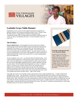


© Copyright 2026