
YUBA TOOLS: Watershed Management for Flood Control Proposal
4.5 PSP Cover Sheet (Attach to the front of each proposal)
Proposal Tide: Y’U’BA TOOLS: Collaborative Watershed Management for Flood Control
Yuha Watershed Cotmcil & g’~RCL
Applicant Name:
Mailing Address:
9.40 Commercial Street. Suite E. Nevada City_ CA 9595q
Telephone:
;~3_0_,2 fz~L~
Fax:
~
Email:
s_vrel~.svrcI.or~z
Amount of funding requested: ~ for ~ years
Indicate the Topic for which you are applying (check only one box),
Fish Passage/Fish Screens
Introduced Species
X
Habitat R.es~oration
Fish Managementhtatehery
Local Watershed Stewardship
Environmental Eduoation
Water Quality
Does the proposal address a specified Focused Action? ~K_ yes _~no
"
What county or ~ounties is the project located in?
’
Indicate the geographic area of your proposal (check only one box):
Saeramanto River Mainstem
X Sacramento Trib: YUBA
San Joaqofm R~ver Mfmstera
San $oaquin Trib:
Delta:
East Side Trib:
Suisun Marsh and Bay
North Bay/South Bay
Landscape (entire Bay-Delta watershed)
Oth~r:
Indicate the primary species which the proposal addresses (check all that apply):
San .roaquin and East-side Delta
Winter-run chinook salmon
Late-fall rtm chinook salmon
Delta smelt
X Sptittail
X Green sturgeon
X Migratory Birds
X Other: White Stur_~eon. American Shad
X Spring-run chinook salmon
X Falt-run chinook salmon
Longfin smelt
X Steelhead Trout
X Striped Bass
Al!. chinook spec?~es
All anadromoua salmonids
Specif~ the ERP strategic objective and target (s) that the project addresses, Include page
numbers from aanuary 1999 version of ERP Volume I and K:
¯ ~qttore and im~ove opportunities for rivers to seasonally flood their floodplain ¯ Conduct a
study to construct setback levees ¯ Preserve and expand stream meander b~lts in Yuba River ¯
Build local support for maintaining active meander zones ¯ Acquire riparian and meander zone
lands ¯ Purcha.~e streambank conservation easements to improve salmonid habitat along Yuba
River ¯ Restore normally functioning watershed processes. Volume 2. pp, 293 - 303.
I --01 461 5
1-014615
I~mate the type of applicant (~heek only on~ box):
S~te Asency
Fede~[ ag~cy
~vate p~
O~r
L~ gov~d~
U~v~i~
~dicate ~e ~ of project (check only one box):
Pl~g
Monito~g
X
~le~on
Educaflo~
By signing below, the applicant declares the following:
1.) The truthfulness of all representations in their proposal;
2.) The individual signing the form is entitled to submit the appli~tiun on behalf of
fl~e applicant (if the applicant is an entity or organi~atinn); and
3.) The person submitting the application has read and understood the conflict of
interest and confidentiality disc~sinn in the PSP (Section 2.4) and waives any and all
right~ to priwtey *rid confidentiality of the proposal on behalf of the applicant, to the
extent as provided in the Section.
Shawn E. Garvev
Signature of applicant
I --01 461 6
1-014616
[L :
TITLE PAGE
YUBA TOOLS
A TOOI,BOX [NVF~GATION OF WATERSHED MANAGP~MENT ~H~U~
240 Co~e~ia] S~t, Suite E
Neva~ Ci~, CA 95959
Ph: ~30-26~-5961 Fax: 5B0-26~-6232
~ 01 c3 .o~ - profit educations[ co~ra~on
F~e~l Employ~r IdeB~Uon Num~r:
68-0171371
Wit
Yuba Wate~hed ~ncll (See E~t A: U~imous en~ment ~ ~uncfl, A~ 7, 1999)
Neva~ Coua~ Re~urce CoBs. Dis~ce
Ci~ ofNc~ Ci~
US Fo~ ~¢e
Bu~u of ~d ~n~em~t
USDA ~a~ral ~u~es Cons. ~ce
Su~n~nde~t of Nev~ ~n~ ~h~ls
Califo~ia ~pa~nt of F~s~
~en~ of D~r C~
Cailfo~ia State Par~
Siena CI~
No~he~ Siena Mr Q~li~ ~gmt D~t.
Ne~a~ l~on Di~et
Noah San Juan ~ ~tecfion Dis~
Facific G~ and
Y~ Wa[er~ed
S~CL
Neva~ Coun~ (E~ibit B: Re~lufion
Yuba ~vet Fishefles T~icM Wor~ Group (~e E~bit C: Statement d Endor~m~nt of ~ciple)
Ga~ TayIor, US ~sh and Wildlife
Will~m ~tcheH, Jones ~ Stok~
Carl M~ic~ US Fish aad Wil~ffe
C~ ~emi~, US Fish and Wtl~fe
Juli~ B~ Califom~ Depa~cnt ~f.Fish and Game
Craig ~l~n~ch~ PG~E Aq~fic Fishe~es Biologist
Additional Colla~ra~rs and Pa~ci~ts ~See E~bit D)
Pl~nning and Come~afion ~
Siena C[ub
Resource Ren~M In~mte
US Forest $e~ce
Fmen~ of S~nee~le
Natural Heflmge ln~te
Dep~em of Par~ & Rec~a~on Gold
~nes Dis~
Development Dis~ct
Forest l~es Group
Hi~ Siena Resole ~n~afion &
US GeoloNcal $u~ey
Siena Neva~ Agi~c~
Campton~tle Sch~l Di~ct
Campton~lle Co~u~i~ Se~ces Dist~ct
Siena Coun~ Nanni~ Depa~ent
CMifomia Depa~em of N*h and Game
U~versiW of CNifomia Extension Se~ce
~S or ~g ~
~ Nam~ Con~ncy
Eric ~r~n, UniverM~ d CMifomia/Da~s
P~po~l p~n~ ~ ~e following ~an~zations for ~nf~Uonal p~:
Campton~lle ~sifion 204 Co~;~ee (~e~nt~ ~h 9, 1999)
Yuba-Satter N~ Con~ol ~ee l~e~nted April I I. 1999)
I --01 461 7
1-014617
II.
EXECUTIVE SUMMARY
YUBA TOOLS
A TOOLBOX INVEs’r1GATION OF WATERSHED ~~ANAGEMENT TECHNIQUES AVAILABLE FOR ENHANCING
FLOOD PRCYI’ECTION IN TH£ "wrUBA WATERSHED [YUBA TOO~ PROJECT]
TI~ most ef~dve ¯
Residents living in the flcodplai~ of the lower Yuba
manaoemeot ofthe floodplains
River watershed are threatened annually with high
of the major dvet~ may not be
water events. Over time, these events have caused
a primar/~ "stt~cguml
sul~stantial devastation and loss of life and property,
aopro~chnof building levees
This project propo~s an inve~-i,gation of various nona~d dams, but rather a
dam watershed management techrfiques to enhance
combination
of structuraland
fl0od protection while maintaining or improving natural
nonstructural
approgches l~at
processes, habitat and populations of hish priority atconsiders
the
trmny
Interrelated
risk species, including chinook ~almon and steelhead,
b~net~l~ to
The project team proposes establishing an 18rater
month-long stakeholder-based collaborative process to
identify and evaluate flood control alternatives for the
-- Army Cor~ of
exceeded f’axn S~r~m~ ~,d.~
Yuba River watershed, with the go~l of developing a
suite of effective structural and non-sh-actural measures
that balance ecological and human demand~ on Yuba
River resources. A steering committee of representatives
from existing watershed coalition ~roups and o~her
interested stakeholders will be astablished as part of the project. This steering committee will work
with a project coordinator and technical team to evaluat~ various flood control measure, their flood
control and ecosystem bencfit~, and any l~tential impacts on river proces,~s~ habitat or species. This
analysis wi[l form the basis for recommendations for implementation.
With more meaningful stakeholder involvement, this collaborative study will provide educational
oppor’~nities as well as experimental tools to increas~ ~he public’s understanding of floodplmn
nmnagement and restoration actions. In addition, the project augments the habitat restoration and
water quality improvemen~ work beit~ undertaken by wa~er sheA coalition groups established through
existing CoiFed- and Proposition 204 ~funded projects in the upper and lower Yuba watershed.
PROJECT DESCI~IPTION/ECOLOGICAL OBJEC’ITCE$
COMPATIBIliTY WITH CAL~D OBTgCTWE$ AND FUNDING GOALS
The Yuba Fiver watershed drains approximately 1,300 square miles of the western Sierra Nevada
slope and inchide~ portions of Sierra, Placer, Yuba az~d Nevada counties. Because fits Yuba supports
highly valued populations of steelhead trout and spr~n£- and. falbr~n chinook salmon, as w~li as oliver
anadromous and resident fish communities, it is considered "one of the most important Ecological
Management Units in the Feather River/Suttee Basin Eco[o~cal Management Zone~" accordin$ to
CalFed’s 2/’99 Revised Draft of the £co~ystem ResloraEon t~am l~lsn~ Vol. lI (p. 28
To protect and enhance habitat for these target species, the YUaATOOLS project focuses on
evaluating ecologicaiIy sustainable~ non-dam flood control alternatives. The project team will work
collaboratively with existing watershed-based coalitions, established through pre~ouely funded
and Proposition 204 projects, who~e memberships include representatives from agencies and
organizations with specific interests in the Yuba watershed (see Section VII and Appendices for full list
of collaborators).
The project will investigate watershed management and flood control techniques that help achieve
overall CoiFed objectives, including:
1 .) improving and increasing aquatic and terrestrial habitats and ecological functions to support
sustainable populations of diverse and valuable plant and animal species;
2.) providing good water quality for all beneficial uses; and
3.) reducing the risk to land use and associated econormc activities, water supply, infrastructure,
and the ecosystem from catastrophic failure of levees.
I --01 461 8
1-014618
I --014619
1-014619
I --014620
1-014620
I --01 4621
1-014621
IV.
ECOLOGICAL/BIOLOGICAL BENEFITS
ECOLOGICAL/BIOLOGICAL OB~X~I’IV~S
The primary ecological/biologneal objective for the Y~AToo~ project is to protect and enhance
key s~cies ~[aflons, habitat ~d namr~ ~esses ~ the Yuba watershed by evalua~ ~olo~eally
au~ainable, non-d~ fl~ conWol alternatives to achi~e ne~ fl~ con~l p~cfion.
~ HW~IS
~n non-~am ~ ~1 a~matN~ in ~ Yuba
watershea pmv(ae su~cl~t fl~ ~n~l prot~ tz
m~t the n~s of down,am hum~ ~mmunit{es
without ~er j~pardi~ing ~e fragile ~Oubfions of
~lFed high prlodW ~-risk sp~les suppled bv the Yuba
River, including ~l~n~ ~-ma ~l~,
~ ~ a~ ~n ~7 (ERPP VoL II, p.
275).
~ S~co~Y Qu~o~
To w~t ~ent ~n non.am fl~ control alternatives
prov~e for ot~r n~s, such as:
a.) enha~i~ and&r ~t~ng again~ I~s of d~n
~~~~~~
~ ~ ~ ~1 ~ ~ to
dam/re--nit ~n~u~ (E~P Vo(. ~I, p. 275); ~ b.) enha~ln9 or pmtming again~ degrada~on of
~O~i~1 priestS, i~ ~, ~m
~, ~ ~l~.~ln ~
~ ~~. through t~niques s~h as
levee ~t~c~, mea~er zone, fl~Nain con~a~on
~sem~, e~. (ERPP, Vol. II, p. 275).
In ~ifion, by ~ho~ng that
ecolo~c~y ~nsifive watersh~
~nagement and fl~ eon~l
techniques can ~ u~ in pbce ot
a~d re~o~s to ac~eve fl~d
prote~, the Y~ TOO~ ~dy can ~d
~ jusfi~ r~ucfions ~ ~oodpla~
develop~t ~d ~-based
~e~rs such ~ new ~s/rese~oirs,
fl~p~ain encr~ehm~t, ~n~eient
flows, ~ w~t~r tem~m~l’es~ ~r
water q~ alld ~ of fish
(E~P, Vol. II, p. 2T6).
T~ea more ~eaer~l7, the
resuI~ ~iI help su~ three ~ut of the
CNF~ Bay-~lta pm~am’s four ~erall
objecti~s, ~clu~ imp~ habitat~
and ~mrai ~nc~s to su~ain ~verse
and ~luable pl~t ~d ani~ s~ciCs
(~o~stem ~)~ ~o~g
water quali~ for all ~eflcial
(Water Q~), a~d ~uc~ ffsk
land u~ and ~ acfi~fies from
ca~phic levee Nt[ure (~vee
Inte~).
ERPP $~a~i Plan and ~m R~ion Goals add~ by this
a Achieve ~c~veW of at-risk native s~cies. Fa!i-~n and ~g-mn cNn~k salmon and ~eelh~d;
fall-~n chin~k is the most abun~nt ~d im~t of ~mous fish ~cie~ ~ the lower
aver, histoficMly ~up~ ~ much as 1 ~% of the ~ual fa~ ~n ~ the Sac~mento ~ver ~stem;
Accordi~ to John Nel~n at Depa~ent of Nsh & Game, appmx~tely 33% of ~o~ salm~
~pa~ in each of three ~in reaches: g~leb~ht Dam to H~way 20, ~way 20 to Da~
Poi~ ~, ~d do~s~ of Da~e~. Best professionM jud~ent in,cares that hoist habitat
for ~pfing-~n ~mon is generally a~ve Highway 20, ~th spa~i~ ~cu~ from EnglebNght
to Da~e. ~e ~a~ ~ee~ead juvenile abun~nce is thought to ~ a~ve ~way 20. ~ese
are all a~ that would ~ impacted by vaNous flo~ con~ol Nte~afives ~ing pr~d by YCWA,
inclu~ the ~ar~ B~ ~en~on b~in, Par~ B~ re~oir, Na~ws ~m/resewoir and Par~
~d D~ Creek ~e~ pmje~] (E~F Vol. II, p. 281 and YCWA ~l~m~t Sv~n~
A~sx D);
0 gehaNlitate nam~l ~ ~ the ~ay-Delta system to sup~ natural aqua~¢ and as~iat~
te~es~M biotic communities in ways that favor nati~ mem~rs of tho~ co~umfies. A study of
non-~m fl~d con~ol Mte~afives improves our op~niV m achieve ~ets and pm~a~atic
actions for the Feather ~ver £~lo~cal Management ~ne and Yuba ~ver Ecolo~cal Management
~nit~ inclu~g: m~ntaini~ or im~o~ng co~ sE~r suF~v (T~get 1, ~P Vol. II, ~. 295)
preserv~g and exp~ng ~M ~ by acqui~g tip,an and meander-zone lan~ through
purcha~, e~ements, or volunmW presewafion, ~tablishJng a pr~ess for reimburs~g landowners
for la~x~ lost to natur~ meaner processes, and developing a c~rafive pin, am to remove
fiprap aad foliate other s~c~res that impMr s~eam member (~arget 1: ~o~a~afic Actions
I --01 4622
1-014622
1A- IC, £KFF Vol. II, p. 296); restoring and improving opFormnitias for NATUP~ rhOOD~q ~D
r~OOD ~OC~S~ through levee setbacks, stream channel and overflow baem configurations within
the floodplain, minimizing effects of permanent structures on floodplain processes, developing a
floodplain management plan (Target I: Programmatic Actions IA, 1B, IC, and 1E, ERPP vol. it, p.
296); improv~rtg water qualify conditions to benefit anadromous fish by developing a coo!~erafive
approach to operating reservoirs in the Yuba River water~hed to provide aD~QO.hT~ WA~’~g
Tr2C~Tt~RrS (Target 1: Ftogmmnmtic Actions IC, 1E and IF, ERFP Vol. ll, p. 297).
~ Maintain and enhance gopulafions of selected species for sustainable commercial and recreational
harvest [seasonal American shad sport fishery from late April to July, which has declined
~igrtificanfly in the past ~wo decades from 30,000 - 40,000 spawning adults in 1968 to a fraction
of that number more recendyl (ERI°P Vol. II, p. 281 );
ta Protect or restore functional habitat lypes throughout the watershed for public values. ~uch as
recreation, scientific research and aesthetics. The YUI~A TOOI.~ study improves opportunities to
achieve RIPARIAN AND RIVERINE AQUATIC HABrrA’r -related targets and programmatic actions including:
providing conditions for riparian vegetation grov~h through purchasing streambank conservation
easements or establishing voluntary incentive programs, evaluating benefits of restoring streamchannel and riparian habitats (Target: Programm~ttic Actions 1A and 1B, £RI~P Vol. II, p. 298-299);
and improvements to existing ~guWgV~ ~,gr) E~sgwrt~ ~s8 ~L~rr~T, through imegra~ion of actiom
related to ecological processe~, habitats and stressor reduction (Target 1, ERFP Vol. II, p. 299L
c~ Reduce stressors to improve and maintain connections between upstream fksh holding, spawning
and rearing areas and the Sacramento River, The YUI~A TOOLS study helps advance the effort to
reduce or eliminate ~crucmre-relate~ stre~sors by finding aiternativea to w^~ D~Vr~SIONS and NEW
D~,MS Og ggsrgvoms (EI~’P Vol. ~I, p. 300- 301 ) and keeping new darm from eliminating the
opportunity to study feasibility of reintroducing spring-run chinook salmon and steelhaad
ups~eam of Eng~lel~r~ght Darn (Stage I Action~ EP, PP Vol. I]~, p. ~01 ).
I~cos,/~em-base’~
According to the overview of Volume II of the revised ERPP, the goal of restoration activities is to
reestablish a balance in ecosystem setucturo and function ao that lost ecological goods and services may
be regained in some reasonable measure withoul destroying lhe fabric o£ [he society they are intended
to serve. The I~road goal of ecosystem restoration, then, is to find pa~erns of human use and interaction
with the natural environment that provide greater overali long-term benefits to society as a whole.
This project meets these ecosystem-based management needs by researching and analyzing
ecologically sensitive ways to achieve floodplain management goals, using a collaborative, consensus.
~a~ect proces~ involving stakeholdem in the upper and lower watcrshad. To da~e, floodplain
tuan~gement studies have revolved almost exclusively around large dmn and other ~tructural
alternatives with little attention given to the many effective, non-structural tools availal~l¢ ~or flood
Future Beneflts/Susfa Inability
include: streamflow, temperature and flood control storage improvements; maintenance of stream
channel ~onfigurafion and riparian vegetation of the lower river; proration of gravel souroes; and
improvement of stream channel and riparian habitat through consewafion of lower river meander
zorte and active floodplain (s~e ERPP Vol. II, Overall Vision for Yuba River Ecological Management Unit,
p, 286-7),
In addition, by proving that there ar~ effective alternatives ~o bu~|~r~ n~w dam~ and reservc~r~ for
flood control, the YUI~A TOOL.~ project would support ~he proposed study of restorin~ chinook salmon
and stealhead access to historical holding~ spawn~g and rearing areas UlX~tream of Engiebright Dam,
an integral element of the CaWed adaptive management approach to ecosystem restoration ~EgPP Vet.
II, p. 287). A Parks Bar or Narrows Dam, currently proposed by Yuba County Water Agency, for
example, wou~d eliminate existing habitat and make Radiant restoration above Engl~bright a moot point.
The proposed YuB~. TooLs study will also provide important educational benefits, as called for in the
Strategic Plan and elsewhere. First, it will help improve our unde~nding ole hydrologic, geomorphic
I --014623
1-014623
and ecolo~cal relationships and assist in the evaluation of cco|o~cally ba~ed M~emafive water
~nagement ~ate~es, ~ called for under the ~bi~t Restoration Topic A~ ~d
General B~y-Del~ ~us~ Acfion~ idenfift~ by ~he ~iFed I~te~a~on P~el (2/99
com~nents of the project, we ~11 al~ ~ ~le to ~ke th~ co~cfion ~een water~hed
management an~ ~ co~l mo~ acc~ible to and e~fly unde~ ~y l~al ~o~er~, p~lic
agency officiaI~, l~ai ~fific~ le~s ~d other ~ci~ion-m~er~, and the general ~blic.
this ~ded ex~mre incl~e t~e ~van~mem of fl~plain m~n~gemen¢ ~c~o]o~
restora~en techniques and land u~ and m~ement tools.
~e Yu~A Too~ p~ject su~s the extea~ve ~s~rafion ~d wa~r ~uali~ lmp~vement work
already ~[~ unde~en by watersh~ coalitions pre~ously ~n~d though C~F~, ~sifion 204.
~PA ~ants and other p~ams, ~or proje~s r~ently latched ~clude:
to a~ess forest health, r~ucfion of cont~n~ and r~u~on i~ ~men~fion ~ the lower
Yuba watershed;
$710,000 No~ San Juan ri~ ~tecfion Dis~t C~ Yu~a ~’ver
planning, ~plememafion of water qu~i~ ~pro~ement and ve~e~fion reduction
comprehensive water and ~il quali~ mon[to~n8 ~ the Yuba watershed a~ve $~e~fi~t Dam:
$264~000 DepOnent ofP~ ~ R~a#on ~uth Y~ ~v~ C~a~
M~axeme~l H~ ~j~t. M~ded by CalFed’s Bay-Delta ~o~stem Re.ration ~ects and
~ogams ~y 1998 f~ cy~l~;
~ $199,000 ~r C~ C~a~ Wate~ geslo~a~bn ~ ~nded by ~o~on 204 to
c~r~nate effo~s ~ ¢~s Yuba ~ver ~t~.
~]eb~hl Work G~up ffo~ to assist C~ in i~n~ng necess~ tecl~c~ and f~bili~
s~e~ reg~ ~ible rein~ucflon o~ ~on and stee~ ~ the u~r watersh~.
In a~ifion, it a~ents Yuba Coun~ Water Agency’s fl~ con~ol ~dy effoffs by
co~a~afive ~kehol~r involvement pr~e~ to a~e ~e ~ range of wa~ersh~ ~nag~ent and
fl~ con~ol alte~fives, many of which have b~ rejected by YCWA ~th~t ad~te consideration.
SY~ -~DE ECOSY~
Since this project is researching ways ~o achieve the nec~s~ fl~d protection
ha~ng t~ braid a ~ it offers p~mc~on of exi~a$ habi~t in the lower watershed ~d maintops
oppo~ifies for habitat ~proveme~t m~d even s~ci~s r~m~ucfion i~ ~he u~r wa~ershe~
~e project ~i1 be l~ng at levee setback, sWeam meander ~provem~ms, we~
mead~w/~charge b~in restoration and other t~ts for achievi~ fl~ con~l ~nefits while
protecfiag habita~ for key s~c~es of concern and prese~g op~mfies for habitat and waeershed
re.oration acfi~fies ups~am and ~sWeam. ~e~fore, the pmje~ m~s non-ecosystem
objectives, such ~ imp~v~ levee ~ ~e~ ~d non-structural fl~ con~! ~nefits.
I --014624
1-014624
V.
TECHNICAL FEASiBILiTY AND TI~VIING
This project was developed, in part, in response to an emsnn$ study of flood control alternatives
being conducted by the Yuba County Water Agency (YCWA). Ignoring ecologically based
considerations and using only "level of protection prod-ideal," "reliability~’ and "financial practicality"
as criteria, YCWA’s prelimina~3~ ~:reeninS; process et~mbaated from consideration vlrttmlky all non-dam
r’t~:l control alternatives (see APPENDIX D t~." Yuba Co~ Water AgencySuppl~mentMFl~M Control
tPog~_m Project Uj~Iate and ~lement Screetrir~ MartinS, And it did so with/title, if any, input from
many of the key stakeholders ha the watershed who
would be affected by YCWA’s decisions.
SuBs~Ou~tcr P~oJEcr
Due to the unfair advantage given to the larger,
more damagit~ structural fixes and the lack of
sul~equent phases for which we may seek
stakeholder input ~to the process, alternatives with
additional funding at a f~um date indade:
fewer impacts on habit~t~ species and natural
processes were thrown out without any further study.
I~ Ct/tlaulat~ve Ifllpact at~alysls aloft oilier
Only the dam-oriented solutions made it to the next
t~chnlcal feasibility ~tudies, ~as~l on the
~ound of screening, in which environmental and
specific set of recommended actkms
regional objectives will be considered, along with
r~sulting from the Phase IV final
leurther ert,~neering and financial evaluations.
YCWA’sinifialscreertingproeassalsoignored
I~ Implementation of the a~ons designe~
potential affects on existing programs and restoration
to achieve comprehensiw fi0ed control
management for the watershed.
efforts already underway, as well as potential impacts
to private propertyowners, business owners and other
stakeholders in the watershed.
The remmnin$ alternatives, each of which calla
for con~:uction of at least one nta~or dam/reservoir,
are inconsistent with CalFed’s goals of maintaining or
improving habitat, watershed processes and populations of high priority, at-risk species in the Yuba
River watershed. We propose, therefore, to launch a comprehensive stakeholder-driven process to
study, priorifize and provide implementation recommendaticr~s for a variety of non-dam-oriented
upper waterehed management tools and tower watershed flood control measures that together can
pcoxdde the level ot~ flood protection required by Yuba County.
Because Phases I-IV of this project simply implement a collaborative technical study and
assessment, there is no need to prepare CEQA, NEPA or other envar~nmental compliance documents.
nor are any spacial permits or agreements needed to comlolete the project as proposed.
I --01 4625
1-014625
MONITORING AND DATA COLLECTION METHODOLOGY
The project team will make use of a wide range of existing data for the purposes of preliminary
seseenm,g aad as~es~men¢ of proposed alterctal~ves (see Al’r’g/~IX F for a l~ibliosraphy of studies related
to the Yuba watershed that will be rased as a basis for the initial literature review). However, ~z no
specific site data will b¢ collected durir~ Phases I-IV of this project, there iz no rmed at thii time for data
collection/evaluation protocols or monltori~; parameters.
Specific research methodology to test the primary and eccondary hypotheses will be determined by
the technical team in conjunction with the project coordimator and the Stakeholder Steering Committee,
composed of key watershed coalition representatives from the Yubg Watershed Council, the
Camptonville Proposition 204 Committee and the Ldwer Yuba River Technical Working Group.
Overall monitoring of the project will be conducted by SYRCL through weekly pro~’e~s reports and
monthly written reports to be submitted to SYRCI. by the pro2ect coordinator and techrtieal team. These
reports will oulllne, at a minLmura. 1.) progress on research related to different flood co~tWol
alternatives. 2.) individuals and grOUl~ contacted artd a~ty pre.sentations made as par~ of the public
outreach and education component, and 8.) an accounting of income and exl~enditures for the month.
I --01 4626
1-014626
VII.
LOCAL IN~OLVE,~tEI~T
ENDOIt~EMENTS
This YUBA TOOr~ p~jeCt has s~o~ ~ppo~ ~t~n the ~al commonly. It w~ endor~ by the
Neva~ Coun~ Bo~d of gu~sors (see ~ E ~or ~ copy o~ the Boa~ ~lufion) and the ~uba
Watershed ~ (~ ~A f~ ~ 2I ~ ~ ~e Y~ W~ ~.
~e p~sal h~ al~ ~en pre~nted for
informational pu~se~ ~ the ~mpton~lle ~sifion
204 ~i~e¢ and the Lower Yuba ~ver T~¢~i~[
Wor~ G~up~ ~o or$~zafi~s we ~ll work ~th
to Solicit a~ehoi~r ~t, ~ well ~ to the YubaSuffer FI~ Con~l Co~ee, t~¢ US ~sh & Wil~ife
Se~ce and the Calif~ia Depa~ent ~ Fish & Game.
Loc~ l~OL~h~
~ Y~A TOOU p~je~ b~ ~at ~efit to the
~s~dents of ~h¢ Y~ba wate~d by ~vahm~ and
p~fi~ po~n~l w~sh~ m~s~ement and fl~
con~ol ~afives that help meet C~F~’s objecfiv~
~din~ s~cies e~ancement and pro~ecfion and
~mwovement of h~t and na~ral pmccs~s. But it
al~ complements the watershed h~th im~ovemcnt
work bein~ dons by ~her l~ or~zafi~, which
would ~ severely impacted ~ the cu~nt flood
coati alte~afives ~i~ considered by YCWA. ~e~
I~al watershed remorafion projects
~~
Planni~ & ~m~ation L~gue
~ur~ Re~aal I~e
Fde~ds of S~ilte
~t~al Heri~ge In~
$i~ N~da
Yu~ ~dflelfls hcce~
Sie~ ~un~ P}anning ~ent
~m~nvi~e ~mmuniW ~w~es
~r~ ~ues Group
Sie~ Qub
US ~r~ ~i~
Bur~u of ~nd ~nagemem
~pa~en~ of Par~ & R~r~tion
A~V Corps of Engln~rs
US G~i~l Suwey
Eric ~n, Univ. ~ ~g~ia at Oa~s
~ ~W, High S~rra R~
(~p, 204), ~n~red by Yuba C~n~ and the Cam~on~lle ~fion 204
~ C~)~I~ Vuba ~’ve~ Wafershed Health Impmv~ent ~dMonito~n~ ~ject (~p. 204),
~ ~ ~. ~ ~ Y~ ~, fl~ N~ ~ R~ ~ $~ Y~ Wa~ ~;
Depa~ent of P~ & Recreation Gold ~¢s Di~ct and he Yuba Watershed Council;
and the ongo~g gn~ebH~t Work Gmup, spon~red by the CalFed Bay-Delta ~ to
iden~ necessa~ tec~cal ot fe~ibtli~ ~ regar~ the ~tenfial min~u~on
ehin~k salmon and st~lhead to the up~r watemhed.
Since the YU~A TOO~ p~ject is rese~ch- and pla~g~ofiented, it ~ have no direct impact on
specific la~owners or faciti~ o~ers/o~rators tn the watersh~.
~LIC O~CH
Working through cM$~n$ multi-~takeholder ~oups opera~tg ~ ~e watershed, the Yv~a Too~
pr~ect c~r~na~r ~d t~t~cal team ~l[ solicit stakeholder input on the ~dy alte~afives and
relative ~abifi~ of each f~r ~hie~n$ need~ flo~ con~ol pr~ecfi~ in ~e Yuba wate~hed. The
proj~t team mem~rs ~11 *~ke p~sentafions to indi~d~l sta~holders and ~keho~r goups
well as pro~ss re~ to the p~a~ watershed coafifion ~ups active in the water~hed. We will
also p~uc¢ ouWeach/~u~tional ~tefiais to info~ p~ple a~ut the ~ ~fi~
In ~fio~, we ~ hold four ~jor ou~ach me~s dt~ the ~d half of the project - two
~n the lower watersh~ and ~o h~ the upper watershed- to ~ek in~t from the genef~ public.
tec~ic~ team ~I p~nt i~ ~di~s regar~ng the benefits, impacts ~d r~ommended
implementation plan for each watershed management/flood conWol alte~afive ~in$ ~ed. ~e
public ~ll be ~ked to comment on each alte~afive or t~l, inc[u~ ~rceived benefits, imp~ts and
any chalMnges to implementation, Based on th~ public i~put, the tech~icaI team ~11 p~oflfize the
~fferent alternatives. ~is ra~, ~ong with the hat,round re,arch i~ffo~tion and
implementation rec0~en~fions, ~!1 be used in ~ubsequent project pb.~es to develop a fl~d comml
management p~n ~ to seek ~ndtn~ for implementation of the reco~ended fl~ con~ol tools.
I --01 4627
1-014627
VIII, COST
SYRCL requests $216,1~0 over 18 months from the CalFed Bay-Delta Program’s Ecosystem
Restoration Projects and Program to achieve its goal of studying watershed management and non-dam
flood control tools to provid~ more ecologically s~nsldve flood protection in the Yuba watershext, The
funding would suppor~ the followir~:
I. I-life experienced project coordinator
Z. Contract "ruth consulting hydrologist
3. Production of outreach materials and mailings
4. Additional technical cor~ulting
5. l’roduetion of final rel~lX
6. Administration & overhead
TOTAL
375,000
$ 60,000
$13,500
$37,500
$10,500
$~
$216,150
TABL£ 5. Total Budse
Fina~ ~n~a~
~ish S~ng
30
30
~ 7BO
$ 780
~
~
~o~ t~S
Pha~ ~
150
~ 6~252
$ 6~252
]nd]v~put
group in~t
Pha~ ~
263
225
~ 10,~36
~ 9~375
$ 10,936
$ 9,375
F]narlze & dl~bu~
tSO
$ 6,Z50
Ongein9
Pro)~ Mgmt
~neral Public
375
IBB
$ 9,750
$ 7,B12
$ 27,~0
$ ~0~
$
~ 7,560
~ ~3,500
780
7~
$ !7,310
$ 21,312
~a~ I of the p~ject inclu~s h~ng the project c~rd~ator, esmblish~g ~e ~akehold~r st~e~ng
commi~e, con~ac~$ ~th hy~lo~st and o~er technical e~s ~d wor~ ~th s~keholder
goups to idenfi~ ~tenfi~ watersh~ man~ement/fl~ con~l t~[s tot ~er study. B~a~ II
includes ~arch and technical anMysis o~ each alternative to dete~ine ecolo~al benefits, potenfia~
impacts and implem~n~fion o~ons. ~a~ III ~[[ p~m ~he t~lbox info~afion to stakehold~r
~oups to dete~e ~lafive ~ab~i~ of each tool for use ~ the guba watershed. ~ IV is the
~roduc~on of the f~al re~ outli~ng ~d pfiofifizi~ the ~t of options bas~ on ~tak~hotder input.
~oject management ~ll be handl~ p~mafily by the proje~ c~r~nator, ~th project sponsor S~CL
pro~di~ ~i~al hi~ se~ces (~th help f~m a steering ~¢e of representatives from the three
counties and the Yuba-Su~er R~ Con~l Co~i~¢e), ne~or~g ~d overs~ht (includi~
inspection of work M p~ss and vali~fion ~f co~s), and ~r~nafion of ~am re~tn8
requirements.
I --01 4628
1-014628
I --014629
1-014629
I --01 4630
1-014630
X.
APPLICANT QUALIFICATIONS
SYRCL
The South Yuba River Citizens League (SYRCL) is a non-profit watershed organization in its 113th
year of operation. SYRCL employs a fulltlme executive director, a membership and volunteer
coordinatOr, a develol~mont director and an office manager. Several consultants are retained for
specific and ongoing projects, including federal and state river protection efforts, forest health issues~
and alternative flood plain management strategies in the Yuba watershed. SYRCL has 2,100 duespaying members and an active Board of Directors made up of profesaionals in the coran~urdty.
SYRCL has close tiez with several granting organizations, including the Compton Fore, clarion, the
Kenney Foundation, the Conservation Foundation, River Network, the Packard Foundation, the National
Fish and Wildlife Foundation, and the Sierra Nev~ta Alliance. SYRCL has been designated the recipient
of the Sierra’s first RiverKeeper - citizen-based water quality rnonitorln~ and restoration - by the Yuba
W atarshed Comacil MOU, earmarking $160~000 in monitoring fiand~ under the Cali~orni~ Proposition
204 Delta Watershed program.
Wor!dng closely with the Tahoe National Forest, Bureau of Land Management and California State
Parks & Recreation, SYRCL is a lead organization in the development of the South Yuba River
Coordinated Management Plan, another project funded under Froposition 204 and CalFed. SYP, CL is
also working with the CMifornia Depan’mont of Fish & Game on monitoring and fish counts in the
lower Yuba River and with the Federal Energy Regulatory Commission on investigations of operations
on Englebright Dam.
SYKCL will coordinate all funding for Phase I-IV of this YUBA TOOLS project. SYRCL will also direct
and coordinate hiring of project coordinator and technical experts, with the help of a steering
committee c0nsistir~g of representatives from each County and the Yuba-Sutter Flood Control
Committee, as well as handling project oversight and accounting.
RACHEL I~
~.a~
"
/
Rachel Kamman will serve as the project team’s hydrology peer reviesver. Ms. Kamman is a
registered civil engineer with broad experience in surface and sub-surface hydrdio~y. She specializes
in ~pply~ng hydrologic, hydraulic and hydrodyrtamic analysts to the protection, restoration and
:v.~hancement of coastal, eshutrine and river system. Over the paM I0 years, Ms. Kamman directed and
participated in numerous interdisciplinary studies integrating hydrology, geomorphology, biology and
land.use issues (see A~I’ENDIX H for Curriculum Vitae).
In performing this work, Iris. Kanmtan is interested in developing and applying innovative
approaches, including advanced numerical models, to the assessment of flood and sedhnont transport
processes in rivers, and circulation, sedimentation and contaminant transport processes in large bays
and estuaries. Most recently, she has focused on the development and integration of field monitoring
programs, numerical models and long-term management planning for the protection and erthancement
of river and coastal resources. The objective of this work is to develop scientifically based decision
support tools and facilitate their integration in resource management decision making, and in fiver and
wetland restoration design.
Ms. Kamman holds a master’s in Civil Engineerin~ (Coastal and Hydraulic) from the University of
California, Berkeley, and a B2k. in Civil Engineering (Hydraulics and Water Resources) from Lafayette
College in Easton, PA.
YUBA TOOLS
X- 14
--01 4631
1-014631
Valley Floor Perimeter
lapproximate 300-foot
elevation,
Interstate Highway
State Highway
I --014632
1-014632
XI. A~’ENDICES
Appendix A
Yulga Watershed Council
Appendix B
Appendix C
Nevada County Boatxt of Supervisors Resolution #99168
Camptonville Proposition 204 Committee
Appendix D
Yuba River fisheries Technical Work Group
Appendix E
Letters of Support and Endorsement ~or Yuba Tools
Appendix F
Appendix G
Yutm River Research Bibliography and Yuba River Conceptual Model
Summary of Major Flo~ls in the Yttba and Feather Watershed~
Appendix H
Rachel Z. Kamman, Currictdum Vitae
I --01 4633
1-014633
. Service
(53~272o3417
To CALI~D:
A~ Chairperson oft.he Yuba Watershed Com~il, ! am ~ommunizating to CALFED the
unanknous e~dor~ement ofth~ "Yuba Tools" proposal by the Council on April 8, 1999.
~ Yuba Wat~dt~l Council is or, of~h~ mo~ mcccs~ul ~labo~adve w~t~hed
in tk~ Si~r~ N~la m~d rcl~cs¢~$ 21 lo~ai, star© and f~de~-ai ~tak~old~,
Thank you for your a.ention to rids matter.
Dist~t Coaservadonist
N~amd R~ource~ Cm’~on Service
C~rp~son of t~ Yu~a Wlt~rs~d Council
I --014634
1-014634
I. Activ-Jy pursue ~pponurdfies tbr mutually b~e~ci~l work proje¢~ or a~es ~h~ fit
~der ~ Delta Tdbu;~ Wat~ed Progr~,
I --01 4635
1-014635
I --01 4636
1-014636
cI~o,
No~ S~ Iu= F~= Pro~on Di~
Bob ~d~¢~ Pr~idc~L Y~b~ W~¢r~hed ~mte
~oger ~, ~re~d~nt, Bo~d of ~ ~e~ rs
South Yuba ~vcr ~e~s L~e/
"
Terence M~teer.
I --Oi 4637
1-014637
Resolution. Attached.
--01 4638
1-014638
RESOLUTION No.991
C)F THE BOARD OF SUPERVISORS OF THE COUNTY OF NEVADA
A RESOLUTION SUPPORTING SUBMISSION OF A 1999 CALFED ECOSYSTEM
RESTORATION GRANT PROPOSAL BY THE SOUTH YUBA RIVER CITIZENS LEAGUE
(SYRCL) TO BEGIN A FACILITATED COLLABORATIVE EFFORT TO EVALUATE NONDAM FLOOD CONTROL ALTERNATIVES FOR THE YUBA WATERSHED
WHEREAS, CALFED, through ~e 1999 Ecosystem Restoration Or~mt Program, provides an
opportum~y for ooun~les whose watersheds influence the Bay-Delta. including Nevada County, to
obtain grant fianding to improve those watersheds, and
WHEREAS, this community recognizes the Yuba Watershed Council as a long-term
collaboratwe effort designed to address the social, economic and enwroamenta! concgrns within the
Yuba Watershed, and
WHEREAS, the County m in suppor~ of the cooperative effort of all the agencies a.t~d
comm~m~ty groups that p~tl¢~pa~e in the relevant collaborative processes; and
WHEREAS, the South Yuba River Citizens League will serve as the lead orgamzafion arrd
fiscal agent for the cooperative flood zontrol assessment pro0ect described in the grant proposal
WHEREAS. this proposal has been endorsed by the individual members of the Yuba
Watershed Council.
NOW, T14_EREFORE, BE IT RESOLVED, that tke Nevada Coumy Bo~rd of Supervisors does
hereby support ~e ~ubmismon of a eALFED 1999 Ecosystem Restoration Grant proposal by SYRC/
to begin a facilitated collaborative effort to evaluate non-dam flood control alternatives for the Yuba
Watershed
PASSED AND ADOPTED by the Board of Supervisors ~f the County of Nevada at a regular
meeting of said Board, held on the
by t~e following vote of ~ai~ Board:
13th day of
April
Ayes: Supervisors
Peter ~a~ Zant, Bruce Conkli~,
Elizabeth Martin, Sam Dardick.
Karen Knecht,
CATHY R. THOMPSON
]HE FO/REGO(NG {NSTflU&tENq’IBA
(;ORFRE~T¢OF’YOFll’tEORIP~NAL~ ~’, ,’,~2"
ON FILE IN ll.tk~ OFFICE
4-14-99
RCD
OATHY R, THOMPSON
. ~;~ N’ry_gF N~VADA
I --01 4639
1-014639
I --014640
I-0’14640
I --01 4641
1-014641
Yuba River Technical Working Group
Agenda
Date: April 13. 1999
Location: 3310 El Camino, Conference Room B
Sacramento, Ca.
Time: 0900-12~30
Action Item from February 3, 1999 meeting
Get individual agency management input on letters of support, MOU and the like.
1 Agenda and minutes review.
2. CALFED proposals
a) Mike B: Category lI[ proposal for EnhancemenVlmplementation Plan
b) Shawn (3: Upper Watershed Restoration Plm~
c) Shawn G: All inclusive watershed group for Yuba RAver
d) Sha~eeper
3. Updates
a) Bill M mad Carl M: Steelhead Life History Stud3,*
b) Cad M and John N: Daguerre Point Daru Army Corps Study
e) John N: Screens at Daguerre Point Dam
d) Craig F’. Yuba Goldfields Barrier Feasiblity study
4. Letterhead/group support~MOU
5. Charge and Ground Rules
6. Next meeting?
I --0’1 4642
1-014642
LEW~EP~ OF ~UPFOI~ AND F~NDO~EME]~
I --014643
1-014643
United Slates
Fore~t
A~’ieulture
Tahoe
631 Coyote Street
Forest
9~9S9-2250
$3~ Z6~-4531
530 478~I09 I~AX
File C,ute: 252{3
Date:
~ ~ i999
Mr. Slmwn Gm’vey, Executive Director
South Yuba River Citizen’s League
P.O. Box 841
Nevada City, CA 95959
Dear Shawn:
Regarding the discussion you and 1. had, l just wanted to reiterate that I support the idea of a
variety of stakeholders getting together to discuss watershed issues to hopefully develop widely
supported solution~ where there now exist varying levels of disagreement on those issues. The
Tahoe National Forest will certainly be happy to participate in this kind of approach when public
interests on the National Forest are affected,
Sincerely,
Subject: RE: Yuba Tools: Collaborstors and Partners
Date: Mon, 12 Apr 1999 16:40:32 -0700
From: Eric Lateen <[email protected]~
To: ’"Shawn Garvey"’ <syrcl@syrcLorg>
I --01 4645
1-014645
Subject: Re: Yuha Tools: Collaborators and Partners
Date: Tue, 6 Apt 1999 18:05:51 -0700
From: "Jerry Meral" ~i,m.eral@p~l.org>
To: "Sha~vn Garvey <syrc’l’@sYrcl.org>
Shawn
If it is of any value, please add PCL.
..... Original Message.
Frc~: Shawn Gaz-vey <syrc1@syrcl,ors>
Co: Beckwi~t .<[email protected]>
Date: Tuesday, April 06, 1999 1:02 PM
SubSect: Yuba Tools: Collaborators and Partners
>County towards evaluation of no.-dam flood control proposals commo~ in
>committee and the Lever yuba Technical Working Grou~. It will be
>
I --01 4646
1-014646
l, , Sierra Nevada Group
MG’THER LODE CHAI’q’ER
SIERRA CLUB
5/12i99
Lcster Snow, E×ec.ut~ve DirGe.mr
CalF-’ed 14169~a St.. Rm. 1155
Sacramento, CA 95814
Dear Mr. S~*,~:
I lear that present efforts to resolve flooding i~sues on the Yuba have become fixated on dams There are
potentially other solutions which might be less expensive yet equally effective. I strongly support Ihe
Y uba Tool~ 9mjec~ as a means to examine these other possibilities.
Sincemly,
James Itur/ey
Sierra Nevada Group o{ the Slen’a Club
P.O. Box 1042 ¯ Nevada City, California 95959
I --014647
I-0’14647
Subject: Re: Yuba Tools: Collaborators and Partners
Date: MOrt, 12 Apt 1999 16:55:07 -0500
From: "Laurel Ames" <[email protected]>
To: "Shawn Garvey" <syr¢l@syr¢l,org>
Shaw-a - thattk you for s~ying yes to a board position. And ye~, the ALliance will be collaborators. Laurel
---Original Message .....
From: Shawn Garvey <svrcl~)svrcLora>
C¢: Beckwitt <~>
Dat~: Tuesday, April 06, 1999 3:07 PM
Subject: Yuba Tools; Collaborators and Partners
Friends --Attached is a grant labeled "Yuba Tools" that will be submitted to
CALI~ED on April 16. "Yuba Tools" proposes to establish a collaborative
effort be~veen stakeholders in Yuba County, Nevada County and Sierra
County towards evaluation of non-dam flood control proposals common m
other Sierra Watersheds -- levee setbacks, floodplain casements,
watershed management, etc -- but to date have not been seriously (or at
all) discussed for implementation in the Yttha Watershed.
The proposal has been presented to the Camptonville Proposition 204
Corrtraittee and the Lower Yuba Technical World.ng Group. It will be
presented to the Yuba Watershed Cotmeil for consideration of
er~dorsement. It will also be presented to the Nevada County Board of
Supervisors and approximately 20 other organizations for endorsement as
Partners.
Please consider adding your name to the llst ofparmers on this
important proposal. Please call with any questions or comments.
Thank you,
Shawn Garvey
4.159912:57 PM
--01 4648
I-0’14648
Subject: Re: Yuba Tools ... a charm ....
Date: Mort, 12 Apt 1999 08:01:52
From: Nicholas George <ngeorge@jps,net>
To: Shawn Garvey <[email protected]>
dlreccoz Shawn Garvey on Sunday 6/11/99, hereby provide written
confJrma£±on that I endorse and suppor~ the proposal attached
~"C: \ INJCURR’.DOWNLOAI~ YubaTool .doc"> as of this date, Monday 4/12/99
Nick Jedenoff
P O 8ox 1784
Cedar Ridge CA 95924-1784
At 05:12 PM 4/9/99 -0700, you wrote:
>> Shawn, I will probably do as you suggest, after I reeslve the Text. (The
>> >If this is okay, please fax a i paragraph letter of support by Tuesday
>> >co 530.265.6232 Or ¢ma~l here
>> >Con£ent-Type: applicaCion/msword;
>> whole ~hing. If the server re~r:eve loon is no~ showing, ~hen this message
t of 2
4.15,9912,53 PM
I --01 4649
I-0] 4649
Subject: Re: Yuba Tools
Date: Mort. 12 Apt 1999 14:36:59 -0700
From: Don lacobson <[email protected]~t>
To: Shawn Garvcy <[email protected]>
Shawn,
The Forest Issues Group enthusias~ically supports Sour Yuba Citizens,s
League Yuba Tools Proposal.
Don Jacobson
Coordinator
Forest Issues Group
P.O Box 2167
Grass ~/alley, CA 95945
dj@oro .net
At 01:57 PM 4/9/99 , you wrote:
>by nexu Tuesday? If so, 131ease fax tc 530.265 6232.
>Thank jzou very much,
>Shaw~
4.15.99 12:53 PM
lofl
I --014650
1-014650
Subject: Re: Thank yon
Date: Fri, 9 Apt 1999 16:0l:38 -0800
From: [email protected] (Darcy Rollins)
To: Shawn Garvey <[email protected]>
Darcy Rollins
Resource Renewal I~stit~te
Fort Mason Center, Pier One
San Francisco CA 94123
Fax: 415 928 5629
Darcy Rollins
Coordinator, Special Projects
Resource Renewal Institute
(415) 928.3774
[email protected]
4.15,9~ 12:53 PM
1 of 1
I --01 4651
1-014651
I --01 4652
1-014652
Draft
A Conceptual Model of the Aquatic Ecosystem of the
Yuba River
by
The Yuba River Technical Work Group:
Yuba County Water Agency
Pacific Gas & Electric
Friends of the River
South Yuba River Citizen’s League
D~artment offish and Game
U.S. Fish and Wildlife ~qervlee
I --01 4653
1-014653
2 February 1999
I --01 4654
1-014654
INTRODUCTION
The Yuba River watershed drains an area of about 1,350 square miles, extending from its
confluence with the Feather River at Marysville to its headwaters in the Sierra Nevada. At about
33 miles upstream from the Feather River confluence, the Yuba River branches into the south.
middle, and north forks, which flow through deep and relatively parallel canyons.
Hydraulic mining for gold was extensive in the Yuba River Watershed in the latter half of the
I800s. The sediment debris from this mining was so extensive that it has been estimated that the
deposition of the debris in downstream reaches caused the elevation of the riverbed and
floodplain to rise by as much as about 70 feet. Miners currently operating in the Yuba River
have estimated that most of this sediment has eroded away, with about a 15-foot deep layer of
debris remaining, These miners also claim that there is a large volume of mercury d~ep in the
river’s substrate that originated during mining operations during the 1800s.
The California Debris Conamission, an element of the U.S. Army Corps of Engineers, began
constructing small dams on the Yuba River it~ 1904 to reduce the downstream movement of
hydraulic mining debris. Although hydraulic mining ceased in the late 1800s, it was assumed
that mining would resume, although it never did. In. 1904 to 1905, Barrier No. I Debris Dam
was consaucted about 4,.5 miles upstream from the present Daguerm Point Dam, This dam
completely blocked upstream movement of anadromeus fish until 1907, when it was destroyed
by floods (Wooster and Wiekwlre 1970)
Daguerre Point Dam (Figure 1) was completed in 1906 and diversion of the river at the dam was
completed in 1910. Although two fish ladders were constructed, they were ineffective except
duihng very t’figla flows and they were destroyed by floods in 1927-1928. The ladders were
replaced in 1938 and they operated although ineffectively umil 1950, when new more effective
ladders were constructed.
Old Bullards Bar Dam was constructed on the north fork in 1921 for the Pacific Gas and Electric
Company, New Bullards Bar Dam was constructed by Yuba County Water Agency between
1965 and 1970. In eooperatton with CDFG. the power intake and outlet to the dam was located
and operated to provide water temperatures of the flow releases that would benefit downstream
fish popuIations.
Englebright Dam was constructed by the Army Corps in [941 for sediment and flood control and
it completely blocked anadromous fish from the upper Yuba River. During the 1997 flood,
Englebright provided 16,000 acre-feet of flood water storage. Englebright Dam is located on the
matnstem river about 24 miles from the Feather River confluence.
Imme~[tately downstream of Englebright Dam. the river flows throug~h a canyon called the
"Narrows". Downstream of the Narrows, there is a wide, barren floodplain in which the river
channel migrates back and forth during extreme floods.
There are three tributaries below Englebright Dam which include Deer Creek just below the dam
I --01 4655
1-014655
(at the Narrows), San_ford Creek just upstream of’the Highway 20 bridge, and Dry creek becvceen
the Daguerre Point Dam and the Highway 20 bridge. There are three reservoirs on Deer Creek,
which include Lake Wildwood (3,840 A~), Deer Creek Res~’voir (1,400 AF) and Scotts Flat
Reservoir (49,000 AS).
{Map of the upper and lower Yuba River}
There are at lcast 28 species of resident and anadromous fish in the Yuba River (CDFG 1991).
The anadromous species, which ocour only downstream of Englebright Dam, include chinook
salmon, steelhoad trout, American shad, striped bass, green and white sturgeon, and Pacific
lamprey. These species, particularly spring-run chinook and steelhoad, wore probably severely
impacted by the near-complete blockage of upstream migration at Dagu~tre Point Dam and low
flows and high water temperatures from 1910 to 1949. There are no data on the ~iz~ of these
populations prior to 1953 although [t was not until 1952 that CDFG first recommended minimum
instream flows for normal and near-normal water years below Englehright Dam to maintain fish
populations (it is unknown whether the recommendations were implern~nted). It was not until
1962 that Yuba County Water Agency agreed to the following minimum mstrean~ flows for
normal water years below Daguerre Point Dam for preserving and enhancing the fisheries:
October through December 400 cfs
January through June 245 cfs
July through September
70 cfs
Critical water year recommendations were lower, with a critical year defined as a water year for
which the April 1 forecast predicted that streamflows in the Yuba River at Smar~ville will be
50% or less of normal. Flows during critical years were reduced by 15% to 30% compared to.
normal waler years. Releases were not to go below 70 cfs at any t~me.
In 1965, m~rLimum pool requirements at New Bullards Bar Reservoir (230,000 AF) and flow
fluctuat’tov, regulations (500 cfs/hr) below Englebright Dam were ~mplemented.
In 1991, CDFG (1991) recommended a new IPIM-water temperature model based flow schedule
to be measured at the Marysville gage for normal and wet water years:
October ! 5 - March 31
April 1-30
May 1-31
June 1-30
Iuly 1 - October 14
700 cfs
1,000 cfs
2,000 cfs
1,500 cfs
450 cfs
During dry water years, CDFG recommended that reductions in fishery flows and offstream
diversions would be made on an equal percentage basis. The 199l CDFG recommendations
I --01 4656
1-014656
have not been implemented. However in recent years, the Yuba County Water Agency has
voluntarily exceeded the 1962 minimum flow requirements.
In 1953, CDFG began estimating the number of adult fail-run chinook salmon in the Yuba River.
Although the other species and salmon runs have not been surveyed, sport fishery surveys
indicate there was a significant (a peak of 100,000 angler-days in 1965) population of American
shad downstream of Daguerre Point Darn. Daguerre Point Dam is a barrier to migration of shad
except during extremely high spring flows, such as occurred in 1969.
Fall-run chinook salmon are the most abundant anadromous fish, averaging about 13,000 fish
annually fi:om 1953 to 1992 with ahigh of 39,000 fish in 1982.
Adult fall-run chinook salmon begin to enter the we.stem Delta near Chipps Island in ~ruly and
August and they migrate upstream slowly, typically entering the Sacramento River tributaries in
September. Adult migration into the Yuba River typically begins in September when attraction
flows are adequate (Departanent offish and Game 1991). Stufftes in the Mokelurm~e River
where video and trapping data at Woodbrldge Dam provide an accurate census of migradng
adults, indicates that migrations occurred from late October through December in 1990 and 1991
which were dry years (BioSystems Analysis, Inc. 1992), but began in mid August during wet
years (EBMUD 1998 unpublished dataJ.
Juvenile fall-rim chinook in the Yuba River begin to emerge from the spawning gravel as fry (3040_mm~ beginning in January (Mitchell 1994a ~ and in 1993, the presence of 40 mm fish suggests
that emergence continued through mtd-Augus~ (M~tchell 1993b) when flows ranged between
about 4,200 efs in March and 2.100 cfs in August. Most of the fry and rnid-sized juverdles
observed in 1993 were adjacent to submerged willows and woody debris in secondary channels.
In 1993, juveniles between 60 and 80 mm were collected al the Hallwood-Cordua screens
beginning in late April, peaking in mid May, and tapering off by early June (S.P. Cramer &
Associates, Inc. 1994). These fish were probably fall-run smolts migrating to the ocean and
perhaps some of the fry observed in 2"une through August were late-fall run fish.
Spring-Run and l,ate Fall-Run Chinook Salmon
Smaller populations of spring-run and late fall-run el’gnook salmon are present in the Yuba River
immediately below ]~nglebright Dam although routine surveys to estimate their abundance are
not conducted. During SCUBA and snorkeling surveys in August 1992 (Mitchell 1992a) and an
aerial survey in mid September 1992 (Mitchell 1992b), several adult salmon were observed in
the vicinity of Daguerre Point Dam. These fish were probably spring-run chinook salmon.
There is also a self-sustaining population of steelhead, although some were stocked in the Y-uba
River from 1970 to 1979 In January 1994, several spawning steelhead and fifteen small, fresh
redds were observed near the outlet from the Yuba Goldfields Mitchell (1994a). Almost no d~ta
I --01 4657
1-014657
axe available as to the abundance of steelhaad.
Adult American shad migrate into the tower Yuba River to spawn beginning in mid-May until
late June when suitable water temperatures for spawning range between 57 °F and 70 OF. Studies
conducted by Jones and Stokes (JSA) in spring 1990 indicated that when Englebright releases
were about 1,000 cfs, shad spawned in large run-glides and shallow pools between Hallwood
Boulevard and Daguerre Point Dam (Mitchell and Dunn 1990). JSA observed that shad
preferred to spawn where velocities ranged between 1.5 a~d 1.9 fb~sec and at depths between 3.0
and 3.9 feet. Presumably shad cannot migrate past Daguerre Point Dam, except during flood
flows such as occurred in 1969 when about 1% of the run was observed above the dam and May
flows averaged 7,432 cfs. JSA also speculated that the number of adult shad that entered the
Yuba was high when streamflows in the Yuba River were high, particularly if flows in the
Feather were low. Large rtms of abad were observed in the Yuba in 1969 and 1983, which were
very wet years. A large run was observed ir~ the Yuba River in 1990, when spring flows were
increased from 331 cfs to about 1,000 cfs in the Yuba River for a study, while flows in the
Feather River de~lined from 3,200 to 850 ors. 3SA speculated that the abundance of adult
American shad in the Yuba River was limited by the magnitude of attraction flows and possibly
unsuitable water temperatures (JSA 1990).
{Add paragraphs describing what we do know in terms of abundance or life history for each
species or run in the Yuba River}
Englebright Dam was constructed about 12.5 miles upstream from Daguerre Point Dam in 194!
to eoratrol hydraulic mining debris and silt that never resumed after the dam was built. The Yuba
Cotmty Water Agency estimates that there are about 4 million cubic yards of sediment that has
been captured by the reservoir, or about one-third of the reservoir’s capacity. The reservoir was
designed to impound about 70,000 acre-feet of water and when the reservoir is full, about nine
miles of the river is inundated. The Arm3, Corps of Engineers operates the dam and the
recreational facilities at the reservoir, which includes 100 campsites, picnic areas, and boating
access facilities. There are two power generation faeil~tie~ at the dam that produce 250 milliou
kWh of electricity with a combined capacity of 62 MW. The Pacific Gas and Electric Company
(PG&E) operates Narrows I Powerhouse on ~e left bank of the Yuba, just below the dam.
PG&E also has water fights to 45,000 acre-fee of storage plus riparian rights. The ~’uba Coun~
Water Agency has operated Narrows II Powerhouse, on the fight bank about 400 feet
downstream of the dam, since 1970. All water released from the reservoir is tltrough the two
powerhouses and consequently tttere is no flowing water in the 0.2 mile reach between the dam
and Narrows I Powerhouse, except when the reservoir is spilling.
When powerhouse failures occur, flow releases are drastieally reduced below the dam. This
occurred during two occasions in spring 1998, On April 9, I998 flows fxom Englebright Dam
dropped from 4828 cfs to 669 cfs in about one hour and then quickly returned to 4743 cfs about
I --014658
1-014658
an hour later. On April 14, 1998 flows dropped from 6,000 cfs to 2,200 cfs in abom one hour.
The Grass Valley Union newspaper reported on 16 April 1998 that two eyewitness~ noted dead
fish along the riverbank. Ttte Yuba County Water Agency has a plan to reoperate their
powerhouse such that failures can be repaired remotely and quickly to avoid lengthy flow
reductions. The Yuba County Water Agency has requested that the criteria for flow fluetuatiuns
in the Yuba River should be reviewed.
The Narrows II Powerhouse operations and the elevation of Englebrig, ht Lake can affect the
temperature of release flows. Although New Ballads Bar Dam has the ability to release water
from varying depths fi’om its cold water pool, this has limited effects on water temperatures
downstream fi’om Englebright Reservoir (Yuba County Water Agency 1998), Instead, the depth
at w1~ieh water is released from Englebright Reservoir, as it relates to the water temperature
profile in the reservoir, is the primary factor controlling the release temperature from Englebright
Dam. The current intake system is a tower that draws water from the surface down to an
elevation of 439 feet above mean sea level, about 80 feet below the normal water surface
elevation. Tke Yuba County Water Agency has proposed to extend the intake by about 90 feet
deeper to about 10 to 15 feet above the reservoir’s bottom (Ynba County Water Agency 1998).
The new intake will be adjustable to draw water firom a wide range of depths. By providing the
ability to draw from the eoldwater pool regardless of the reservoir level, it is expected that
release temperatures will be rex~aced by 1.5OF to 6°F compared to existing conditions. The
proposed construction schedule is from August througk October or November 1999, whieh
coincides with the maintenance of the turbines. Both activities would require shutdown of the
powerhouse attd construction would require the reservoir to be drawn down to 450 feet msl for
about two weeks and then refilled to 490 f~ msl for another two to four weeks.
Tile 206 (208, 260, or 2BI)?) foot-higtx dam t~as no fish ladder and is the upstream limit for
anadromous fish. Restoration of passage at Englebright Dam might provide additional habitat ap
to New Butlards Bar dam on the North Yuba l~dver, Our House Dam on the Middle Fork Yuba
River, and to a small natural falls r~ear the town of Washington on the South Fork, a maximum of
about 56 mile~ of additional habitat which is a tt~ee-fold increase (¥oshiyama et aL 1996).
Tttere are many small old, abandoned dams that might block passage and a survey of existing
conditions is needed. Upstream habitat would also require increased flow releases and possibly
mow stabilization from New Bultards Bar and Our House darns.
Daguerre Point Dam was built in 1903-1906 by the California Debris Commission to comain
tlydraulic mining debris (Falxa 199,*). The dam filled with about 880,000 cubic yards of
sediment within 20 to 30 years of completion and currently has only a shallow pool, generally
less than 15 feet, extending about 200 to 300 feet upstream of the dam. The dam is 24 feet high
from the crest of its spillway to the apron on the downstream side of the dam. Fish Ladders are
currently located on the north and south banks. The north ladder has a pool or resting area
located near the downstream entrance but the south ladder does not. The existing fish ladders are
relatively small compared to existing specifications for ladder design. When flows exceed ahem
16,000 cfs, an water surface elevation of 130 feet in the reservoir pool upstream of the dam, the
I --014659
1-014659
ladders axe closed untll the water surface elevation recedes to 127 feet. There are no data to
evaluate whether adult salmon and steelhead can migrate over the dam via the water passing over
the dam when the ladders are closed. The ladders are closed for a period of time about 50
percent of the yeaxs. In 1995, the ladders were closed from 9 January to 10 February. There is
about 12 miles of habitat above Daguerre Point Dam to Englebdght Dam.
An average of 28 to 33 percent of the river’s flow is diverted at Daguerre Point Dam and
Brown’s Valley intake during May and June. During below normal water years, these diversions
could take between 75 and 90% of the river’s flow. lnstream flow requirements are based on
measurements at the Marysville gauge, which is downstream of Daguerre Point Dam, to partially
compensate for these diversions.
Factors that may impede or prevent the upstream migration of adult fall-run chinook include
suboptimal ladder design and sheet flow across the dam spillway that may obscure ladder
entrances. The US Army Corps poli~y is to leave the gates controlling flow imo the ladders wide
open up to flows of abou~ 8,000 cfs, which can creates high velocities in the ladder. The ladder
entrances are also located where the overflow from the spillway makes it diffleuR for adults to
find the entrances. Both ladders, partienlm:ly the south one, tends to clog with woody debris that
can block passage or substantially reduce attraction flows. The north ladder exit is also close to
the spillway, which potentially causes fish to be carried back over the dam. Evidence for passage
problems is suggested by the relationship between winter flows m Marysville and the distribution
of adult fall-run chinook salmon observed above and below the dam. The ratio of the number of
adults above the dam to those observed below the dam was highest (ranging between 2 to 3) at
flows of ahem 500 cfs in 1981, 1985, and 1987. As.flows increased above 500 ors, the ratio of
fish above to below the darn gradually declined and at flows ~reater than 2,000 cfs, more fish
were observed below the dam than above. Although this suggests that flows above 500 cfs
prevents adults from migrating past the dam, it is also possible that high flows improved water
temperatures below the dam for spawrdtlg. The US Army Corps of Engineers htm been f!.mded
by the Anadromous Fish Restoration Program to begin investigating alternatives to improve fish
passage at the dam.
H#,pothesis: The dam delays the upstream migration of adult fall-run chinook aalmon.
During high spring flows between 8,000 and 16,000 cfs, when adult spring-run chinook and
steellaead are migrating, the upper gate to the ladders are elo~ed to a height of six inches. It is
likely that high water velocities and the small opening at the ladder’s gate are an impediment tO
upstream migrating adult salmonids. There are no data regarding the ability of adult salmonids
to pass over the darn at flows greater than g,000 cfs.
Hypothesis: The dam delays the upslream migration of sprinK-run chinoo,~ and steelhead,
particularly at flows between 8~000 and 16,000 cfs.
It is generally known that predation rates of juvenile salmonids passing over dams is ulmaturally
high. Predator populations are usually high in the ponds upslream and downstream of the dams
and the tulbuleI~ce of the spilling water tends to disoriem juvenile fish. Sacramento squawfish
and striped bass have been observed in the down~U:eam pond, However, most juveniles migrate
I --01 4660
1-014660
at night when predation is low.
Hypothesis." The pools immediately above and below the dam concentrate predators of
juvenile salmonids and.increase predation rates.
Poaching of adult salmon at the ladders and at the base of the dam has been well documented by
CDFG and is a chronic problem (Falxa 1994). Poachers have tampered with fish ladders to
block passage and enhance poaching success.
Hypothesis: Poaching of adult salmonids occurs at high rates at the fish ladders.
American shad require ladders with a lower gradient and water velocity than do salmonids (Falxa
1994l and ladders designed for salmonids may explain why few shad migrate past Daguerre
Point Dam.
Hypothesis: The dam and ladders blocks the upstream migration of American shad in
most years.
Diversions at Daguerre Poillt Dam
There are three water diversion facilities at or near Daguerre Point Dam managed by the Yuba
Cotmty Water Agency.
1)
Haiwood-Cordua emaal divers wmer at the upstream surface of the dam, on the north
bank. A maximum of about 650 cfs is diverted during the imgation season, ~rom April
through October. CDFG operates a fish screen for four to eight weeks when the number
of migrating fall-run chinook salmon is at a peak (more than 100 fish per day). From
1991 through 1994, the earliest the trap was installed was April 7 and the latest it was
removed was June 28 (S.P. Cramer & Associates, Inc. 19941. The fish screen is located
in the canal about 1,500 feet downstream from the dam. The semen is a fixed V-shaped
type, of perforated sheet metal. Predator concentrations occur throughout the 1,500 foot
channel, but particularly near the face of the screetm (Hall 1979) In 1978, losses of
marked hatchery juveniles (released during the day in lots of 1,300 fish) at the screen
were about 30%, presumably as a combined result of predation by Sacramento squawfish
~replace with correct name~ along the face of the screen and by entrainment (’Hall 19791.
Debris on the trashrack of" the screen during the tests produced turbulence that appeared
to increase predation rates. Of the control grouF offish released downstream of the
screen, 25% were not recovered. An evaluation of the cause of these downstream losses
was not made.
Hypothesis: A substantial number of juvenile salmon and steelhead are entratned or
eaten by predators in the Hallwood-Cordura Canal
2)
South Yuba-Brophy system diverts water through an excavated channel from the Yuba’s
9
I --01 4661
1-014661
suggested at losses of juvenile salmonids at the South Yuba-Bmphy diversion were between 40
and 60%.
Hypothesis: There is a substantial predation rate on juvenile salmon that enter South
Yuba-Brophy in the pond upstream of the diversion dike.
Brown’s Valley canal diverts water from the north bank of the river, about 4,200 feet
upstream of Daguerre Point Dam. at flows up to about 100 efs. Water enters an
excavated side eharmel, from where it is pumped. This diversion has not had a functional
fish screen, but one is proposed for installation in 1999.
A dewatedng channel was dug to lower the water level in the Yuba Goldfield area south and
west of Daguerre Point Darn. This ditch collects subsurface and surface flows, and empties them
into the Yuba River at a point about 7,500 feet downstream of Daguelre Point Dam. Flows
entering the Yuba River through the dewatering eharmel occur year-round and range from about
45 to 150 efs when Yuba River flows at Marysville are less than 1,000 efs and range fi’om 100 to
400 cfs when flows at Marysville exceed 2,000 cfs (Smith 1990). These flows attract adult fallrun chinook salmon during their upstream migration. In December 1998, this channel attracted
at least several hundred adults (Smith 1990}. A screen installed to prevent adult salmon from
entering the outfall has failed to prevent adults from entering the channel more than once ff’alxa
1993).
Hypothesis: Adult salmonids that enter the Yuba Goldfields fail to produce offspring that
outmigra*e.
Hypothesis: OuOqow from the Yuba Goldfields is contaminated with mercury, oils from
the dredging operanona, fine sediments, and other substances and these contaminants
cause mortality of salmonid eggs and juveniles and aquatic invertebrates.
The Yuba Goldfields are located nero" Daguerre Point Dam on the Yuba River. The Goldfields
area is the result of intensive gold dredging in the late 1800s and early 1900s when up to 27 gold
dredges worked the area at one time (Smith 1990). One large gold dredge continues to work the
area.
{Map of the Goldfields}
The area is dominated by large mounds of dredge spoils inmrspaeed with dredging ponds. The
ponds are connected either above the ground via stream channels or below ground as percolation
through the substrate. Pereolation also occurs from the Yuba River into the ponds. In i988, a
new channel was constructed to return much ofthi~ flow to the Yuba River at about 1.5 miles
downstream of Daguerre Point Dana. Surface water flows from a large gravel pile through
several ponds, interconnecting streams, and culverts over a course of about 2.5 miles before
exiting the Goldfields through the return channel.
11
I --014662
1-014662
American River fish that Myrick tested tolerated much higher temperatures than those from
British Columbia. The American River fish gr~v the fastest at 66°F (the highest temperature
tested) and mortality, as jud~ed by the loss of equilibrium, did not occur until 86~F. However.
these tests were conducted while providing large food rations (I00% and 87% ad libituml and it
is likely that temperature tolerances would be reduced at lower food rations.
{Graphs of water temperature plotted over the year (real not Julian dates please) to show
extremes and typical conditions at D~.guerre Point Dam and Marysville. Then discuss the
response of the fish, perhaps in terms of returning adults, to those temperature regimes. }
Gravel Recruitment
Englebright Reservoir blocks the supply of spawning-sized gravel to the lower reaches but
Eng[ehright and the upper reservoirs do not sufficient enough capacity to completely control the
high flows and floods that mobilize gravel and cause channel meander. Frequent flood flows in
the lower reaches have prevented the eneroaehrnem of riparian vegetation onto the floodplain and
so floodplain gravel is available for recruitment to the channel. Other sources of gravel are Deer
Creek, Sanborn Creek and Dry Creek. all of which occur between Englebright Dam and
Daguerre Point Dam. Another factor that helps maintain gravel in the lower Yuba River is tha~
its functional floodplains ensure that gravel is not being excessively flushed from the streambed
during floods. The areas where gravel may be limiting would be the reach between Englebright
Dam and the confluence with Deer Creek, which is about 1.2 miles long, and the areas
downstream of Daguerre Point Dam.
{Bill Mitchell should add a Ktseusston of straudtng here with hypotheses if appropriate}
Exotic Fish Species
{Brief discussion of exotic species, particularly predators of salmon and steelhead}
15
I --01 4663
1-014663
Yuba County Water Agency, August 20, 1993.
Mitchell, W.T. 1994a, Chinook salmon redd and fry stranding survey. Memorandum to Donn
Wilson, Yuba County Water Agency, February 10, 1994,
Mitchell, W.T. and P.L. Dunn. 1990. Field investigatiens of Yuba River American shad.
Report prepared by Jones & Stokes Associates, Inc for the Yuba County Water Agency.
Myrick, C.A. 1998. Temperature, genetic, and ration effects on juvenile rainbow trout
(Oncorhynchus mykiss) bioenergetics. Dissertation, Univernsity of California, Davis
Rich, A.A. 1987. Establishing temperatures which optimize growth and survival of the
anadromous fishery resources of the lower American River. Prepared for McDonough,
Holland and Allen, Sacramento, California, 25 pp.
Shapovalov, L. and A.C. Taft. 1954. The life histories of the steelhead rainbow troul (Salmo
gairdneri) and silver salmon (Oncorhynchus kiautch) with special reference to Waddell
Creek, California, and recommendations regarding their management. California
Department offish and Game, Fish Bull. No. 98, 373 pp.
Smith,J.G. 1990. Fishery Investigations in the Yuba Goldfields area near Daguerra Point Dam
on the Yuba River in 1989. USFWS Report No. AFFIrFAO-90-9. U.S. Fish and
Wildlife Service, Fisheries Assistance Office, Red Bluff, California.
S.P. Cramer & Associates, Inc. 1994. Evaluation ofjuverfile chinook entrainment at the South
Yuba-Brophy Diversion Headworks. Final report prepared for South Yuba-Brophy and
Yuba County Water Agency.
White, Wayne. 1992. Letter to Mr. Walter Yep, Chief, Planning Division, Army Corps of
Engineers, Sacramento in U.S. Fish and Wildlife. 1993, Fish and wildlife planmng aid
report Yuba River basin investigation. Report prepared to the LI.S. Army Corps of
Engineers, Sacramento.
Wooster, T.W., and R.H. Wiekwire. 1970. A report on the fish and wildlife resources of the
Yuba River to be affected by the Marysville Dam and Reservoir and Marysville ARerbay
and measures proposad to maintain these resources. California Department of Fishmad
Game, Environmental Servtees. (Administrative Report No. 70-4.) Sacramento, CA.
Yoshiyama, R,M., E.R. Gerstung, F.W, Fisher, and P.B. Moyle. 1996. Historical and present
disUJbution of chinook salmon in the Central Valley drainage of California. Sierra
Nevada Ecosystem Pro3eet: Final report to Congress, Vol. III, Assessmenfs,
CommissionedReporrs, and Background information. Davis: University of California,
Centers for Water and Wildland Resources.
Yuba County Water Agency. 1998. Yub~ County Water Agency Narrows II Powerhouse Intake
17
I --014664
1-014664
8UI’~I~4ARY OF M~OR FLOODS IN TH~ YUBA AND FEATHER RIVER WATERSHEDS
I --01 4665
1-014665
APPENDIX H
EIRKICULUM VrrAE
RACHEL Z. KAMMA~.
PRINCIPAL ENGINEERING HYDI~.OLOGI~t"
I --01 4666
1-014666
Rachel Z. Kamman. P.E,
Principal Engineering Hydrologist
Rachel Kammaa
EDUCATION
1994
M. Eng., Civil (Coastal and Hydraulic) Enganeenng
Universl~y of California, Berkeley
1988
B.A. Civil Engineering (Hydraulics and Water Resources)
Lafayette College, Easton, PA
REGISTRATION
No. C 056655
Civil Engineer, California
PROFESSIONAL
HISTORY
1999 - Present
Principal Enginecnng Hydrologist
Kamman Hydrology, El Cerrito. CA
1994 - 1998
Senior Associate/Associate Hydrologist
Philip Williams & Associates, Ltd., San Francisco. CA
1993 - 1994
Graduate Student Researcher: Coastal Waves & Sedimen~
Graduate Student Instructor: Hydrology
Department of Hydraulic and Coastal Engineering
University of Califorma, Berkeley, CA
1992
Staff Engineer
Geomatrix Consultants. Ino.. San Franoiseo. CA
1988- 1991
Engineer/Staff Engineer
ENVIRON International Corporation, Princeton, N3
EXPERIENCE AND INTERESTS
Me. Kamman is a registered civil engineer with broad experience in surface and sub-surface hydrology. She
specializes in applying hydrologic, hydraulic and hydrodynamic analysis to the protection, restoration and
enhancement of coastal, estuarine and fiver systems. Over the past ten years. Ms. Kamman directed and
participated in numerous interdiseipllnary studies integrating hydrology, geomorphology, biology and land-use
issues.
In performing this work, Ms. Kamman is interested in developing and applying innovative approaches,
including advanced numerical models, to the assessment of flood and sediment transport processes in
overs, and circulation, sedimentation and contaminant transport processes in large bays and estuaries.
Most recently, she has focused on the development and integration of field monitoring programs,
numerical models and long-term management planning for the protection and enhancement of river and
coastal resources. The objective of this work is to develop scientifically based decision support tools and
facilitate their integration m resource management decision making, and in river and wetland restoration
design.
I --014667
1-014667
Rachel Z. Kamman, P.E.
Page 2
PROFESSIONAL
SOCIETIES &
AFFILIATIONS
Member, American Geophysical Union
Member, American Society of Civil Engineers
Member, Estuarine Research Federation
Member, ]Mtemational Association for Hydraulic Research
Member, Sooiety for EeologieM Kestoration
Technical Advisor, Audubon Canyon Ranoh, Stinson Beach. CA
RESEARCH
GR.~TS AND
AWARDS
1997 EPA Grant for the Study of Surface and Groundwater Imeraction in the
Tijuana Estuary
1995 NOAA Grant for the Study of Freshwater Influences on the Salinity
Structure of the Tijuana Estuary
1992 Tucker Fellowship, University of California, Berk81ey
pUBLICATIONS, REPORTS & PRESENTATIONS
Publications
3ood’Mxx, P. and R. Z, Kamman, In P~ess. MLTmg and Ctrotlation in Tidal Wetland& American Society of
Civil Enghleers Monograph: Physical Processes in Tidal Wetland l~storation,
Kammun. P..Z 1994 Image Processing Techniques m the Study of Wave Induced Sediment and Bed
Motion. Masters Thesis: Un2verslty of California, Berkeley. Department of Civil EnHmeermg:
HydrauLic and Coastal Engineering Division.
Ruggles, P,. and IL Zmmaon t KammanL 1988, Movement of Chloride Ions m Saturated Soil Samples during
Freezing. Proceedings: 15~ Aamual Water Resottrces Conference, ASCE Norfolk, VA. June.
Selected Reports
Kamman, R.Z. mad M. K On" (Phihp Williams & Assoc.). with Woodward Clyde Consultants. 1998.
Prefiminary Design for Tidal Wetland Restoration at the Hamilton Arm~ Airfleld. Prepared for the
California State Coastal Conservancy and the Bay Conservatxotx and Dvvelopracm Conmnssion
Kammun. R. Z.. M. Barrad and R. Batta]io (Pl~lip Williams & A~soe.). 1998 Corte Madera Ecological
Reserve: Seal Habitat Erosion Protection Study. Prepared for the Golden Gate Bridge Highway and
Transportation District.
K_amman IL Z. _ and R. Bat~lio (Philip Williams & Assoc.) and £. Granhohn ~ LSA Associates Inc ~ 1998. A
Conceptual Design for Tidal Wetland P.estoeation Adjacent to the Corte Madeta Ecological P, eserve.
Prepared for the Golden Gate Bridge Highway and Transportation Dismet,
Kamman. E. Z. et al. (Philip Williarm & Assoc.) and S. GranhoLm, et al. (LSA Associates Ino4. 1998
Conceptual Design for Tidal Wetland Restoration: Hamilton Army Airfield Focused Feasibih.ty Sludy,
Prepared for the US Army, Pacific Division and IT C0rporanon.
I --01 4668
1-014668
Rachel Z~ Kamman, P.E.
Page 3
Goodwin, P., R.Z. Kararnsn, (philip Williams & ASSOC.) with R.B. Kxone {Univ. CA, Davis) and A,J
Mehta, (Univ. of Flurida). 1996. The Potential for Rernobilization of Sediment Followin~ th~
Introduction of Tidal Flows to l~he Pilot Uni~ Sonoma Baylands, CA. Prepared for the US Army Corps
of Engineers, San Fr~isco Dismct.
Goodwin. P, N.K. Klai(, and R.Z. Kamman (Phihp WillJarrts & Assoc ) and Wetlands Research Associates.
1996. 1 ) Hydrologic Evaluation of Restoration Alternatives: and 2. Flood Protection Evaluation Repurr:
Commercial Township, Salt Hay Farm Wetland Restoration Site: Curaberland County, New Jersey.
Prepared ~’or tho Public Service Electric and Gas Company Estuary Enhancement Program and Roy
Weston.
Liang, H.B., P, Goodwim and R. Kamman. (Philip Williams & Assoc.) 1996. North Fork Feath~ River’.
Sediment Pass-through Study of Rock Creek and Cresta Darns, Prepared for Pacific Gas and Electric
Company.
Kamman, R.Z., E. Zedler, P. Goodwin, ~Philip Williams & Assoc.) and R. Sobey, (Univ. of CA. Berkeley),
1995. Preliminary ASSessment of a Salinity Model for the Tijuana Estuary. Restoring
Wetlands Annual Report, Prepared for the Pacific Esraarine Research Laboratory, San Diego
Karnmar.. R. Z. and R. Coats, (Philip Williams & Assoc.J 1995. San Rafaei Canal Flood Damage Reduction
Project: Hydraulic Design for I-~bitat Mitigation Measures at Pickleweed Park ~d Seastra~ld Marsh.
Prepared for the US Army Corps of Engmerrs, San Francisco Dish’ict.
Karnman. R. Z. and P. Goodwin (Philip Williams & Assoc.) 1995. Tidal Circulation in Mugu Lagoon.
Prepared for th~ Environmexttai Division. Nav~ Air S~un, Point Mugu, California, and
Environmental Management.
Kamman, R.Z. 1998. Tidal Flow. Sedimentation and Circulation in Bolinas Lagoon. Advanced Docent
Tmmmg Seminar. Audubon Canyon Rancli, Stinson Beach, California. March.
Kamman. R.Z. 199"L hategrating Based Closure with Tidal Wetland Restoration. EPA Region IX Special
Facilities Conference. San Francisco. CA., April.
Kamman. R.Z. 1997. Modeling Tools and Approaches for Assessment and Resource Management m Upper
N~,portBay. Pres(m*atinn fo)theNe’wpor~Ba,,, Board of Managers Tcchnical Advisory Comnnrtee;
US Army Corps of Engine,s, LA Dis~ict; Santa Aria Regional Water Quality Control Board; Orange
County and The Cily ~f Newport Beach.
Kanmmm R.Z, and P. Wi~iams. 1997. Restoration of Tidal Wetlands in San Francisco Bay, 27~ Congress
of the International Association of Hydranlic R_oscarch. Co-Sponsored by the American Socie .w of
Civil Engineers. San Francisco, CA., At~gust.
Karnman, R.Z. 1996. Adaptive Modeling in Tidal Wetland Restoration. Bay Delta Modeling Forum! San
Francisco Estuary Instimm: Habitat Restoration Modeling Workshop. Sacramento. CA.. September.
Kamman, R.Z,. t 995. Short Course Lectarcs: L) Lagoon Hydrodynamics: Conservation Equalions. Closure
Relationships, Sallniw Distributions, Mixing Processes and Estuarine Circulation. lI.I DIVAST
Workshop: Lagoon Assessmcnt nsurg a 2-Dimensinnal Hydrodynamk Model. Physical Processes
Influencing the Management of Mugu Lagoon. Sponsored by the Environm~ural Divisioh. Naval
Station, Point Mugu, Cali£ornia
I --01 4669
1-014669
~,SCRIMINATION COMPLIANCE STATEMENT
The company named above ~er~kmfter referrexl to as "prospective contractor") hereby certifies, urdess
specifically exempted, compliance wit~ Govomment Code Section 12990 (a-f) and California Code of
Regulations, Title 2, Division 4, Chapter 5 in maaers relating to reporting requirements and the
development, implementation and maintenanc~ of a No "ndmctimin~’on Program. Prospective cont,.actor
agrees not to unlawfully discriminate, harass or allow harassment against any employee or applicant for
employment becaus~ of sex, race, color; aacestz7, religious creed, nal~onal origin, disability (including
HIV andAIDS), m~lieal condition (cancer), age, marital status, denial of family and medical care leave
and denial of prcgnaacy disability leave.
CERTIFICATION
L the official named belo~, hereby swear that 1 am duly authorized to l~gally bind the prospective
contractor to the above d~scribed c~rtification. [ am fully aware tha~ this cergifwaaion, executed on the
date and in the county below, is made under penalty of perjury under the laws of tha State of California.
I --01 4670
1-014670
~tate el" California
,a~.ee~en¢ ~lo.
The Resources Agency
DEPARTMENT OF WATER ~SO~ES
~t .
2~D~ C~USES S~L BUSI~SS P~FE~NCE ~ CO~CTOR IDE~ICATION
NOTICE TO ALL BIDDERS:
Section 3.4835, st. seq. of the California Government Code requires that a five percent
pre£erence be given to bidders who qualify as a small business. The rule~ and regulatior~s
of this law, including the definition era small business for the delivery of service, are contained
in Title 2, California Code of Regulations, Section 1896,
available upon request. Questions regarding the preference approval process should be
directed to the Office of Small and MinoriLT Business at (916) 322-5060. To claim the small
business preference, you musk submit a copy of your certification approval letter with
your bid.
Are you claiming preference as a small business?
Yes*
~ No
*Attach a copy of your eerti fication approval letter.
DWR 4186 (l~v, 4~94)
I --01 4671
1-014671
SOUTH YUBA RIVER CITIZENS LEAGUE
530/Z65-596~ ~ Fax 5301265-6232 " w~.~yrcl.org
Apdl 15, 1999
Delta Protection Commission
14215 River Road
P.O. Box 530
Walnut Grove, 95690
To whom it may concern:
A~ required in the CALFED February ’99 Proposal Solicitation Package, SY’RCL is
forwarding for your review a proposal to fund a "Y’UBA TOOLS: An investigation of
watershed management for enhanced floed controI.~
SYRCL has worked actively towards restoration and protection of the Yuba Watershed
since 1983. SYRCL has 2,350 dues paying members and a staffer6.5 FTE. SYRCL has
been successful in planning and implementing numerous watershed protection efforts.
YUBA TOOLS extends the capacity of the organization to actively lead the 46
participants and collaborators on this project in successfu!ly planning for mutually
beneficial watershed enhancements and flo~d control plaraung.
Thank you for attention.
Sincerely,
Executive Director
I --014672
1-014672


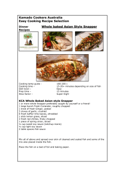


© Copyright 2026