
EXECUTIVE OFFICE OF ENERGY & ENVIRONMENTAL AFFAIRS Richard K. Sullivan, Jr., Secretary
EXECUTIVE OFFICE OF ENERGY & ENVIRONMENTAL AFFAIRS Richard K. Sullivan, Jr., Secretary Grant Announcement Request for Responses (RFR) ENV 13 DCS 01 Posting Date: March 28, 2012 Local Acquisitions for Natural Diversity (LAND) Grant FY 2013 1. GRANT OPPORTUNITY SUMMARY: A. PROPOSALS SOUGHT FOR: Purchase of conservation land. B. OVERVIEW AND GOALS: The Executive Office of Energy and Environmental Affairs (EEA) protects, conserves, and restores the natural resources of the Commonwealth. To fulfill this mission, Richard K. Sullivan, Jr., Secretary of EEA, is making available funding through the FY 2013 round of the Local Acquisitions for Natural Diversity (LAND) Grant Program to assist municipal conservation commissions in acquiring interests in land for conservation and passive recreation. The LAND Grant Program is a component of the Patrick Administration‟s goal of conserving biodiversity in the state. This RFR is part of the Administration‟s efforts to protect undeveloped lands, unique ecosystems, rare species and habitats, and working lands, restore degraded lands, and to preserve the Commonwealth‟s rich natural heritage for the future. C. ELIGIBLE PROJECTS: Purchase of land in fee simple or of a conservation restriction. See section 2B. D. ELIGIBLE APPLICANTS: Municipal conservation commissions. Must have an approved Open Space and Recreation Plan (OSRP), or have submitted a draft by the LAND application deadline. Communities with 6,000 or fewer residents may apply to receive funding to complete an OSRP under a separate RFR (RFR ENV 12 DCS 07), Conservation Appraisals and Open Space & Recreation Plans for Small Communities. See section 2A. E. APPLICATION DEADLINE: Thursday, July 12, 2012 at 3:00 pm See section 4. F. FUNDING AVAILABILITY: Maximum grant award is $400,000. See section 2E. G. BUDGET REQUIREMENT: This is a reimbursement program. Applicants selected to receive funding must show the use of funds from non-state sources for the municipality‟s portion of the program. See section 2F. H. TOTAL ANTICIPATED DURATION OF CONTRACT(S): The contract period begins on the date EEA executes the contract. Contracts issued pursuant to this RFR must expend 100% of costs associated with the approved project on or before the end of the fiscal year (June 30) in which the contract is awarded in order to 1 be eligible for reimbursement. Contracts resulting from this RFR may be awarded in FY13 or FY14. See section 2H. I. REGULATIONS, STATUTES, OR AUTHORIZATION GOVERNING THIS GRANT PROGRAM: This RFR is issued according to C. 312, §2A of the Acts of 2008, 2000-7013, legislation referenced as the Self-Help Program, M.G.L. C. 132A §11, and the regulations described in 301 CMR 5.00. All properties for which grant assistance is provided will become permanently protected open space under Article 97 of the Amendments to the Constitution of the Commonwealth of Massachusetts, dedicated to conservation and passive recreation purposes in accordance with M.G.L. Chapter 40, §8c. All properties must be open to the general public for appropriate passive recreational use. See Attachment G. J. CONTACT INFORMATION: Celia Riechel Executive Office of Energy and Environmental Affairs 100 Cambridge Street – Suite 900 Boston, MA 02114 617-626-1187 http://www.mass.gov/envir/ 2. Performance and Contract Specifications A. ELIGIBLE APPLICANTS: Municipal Conservation Commissions Applicant municipalities must meet the following requirements: 1. 2. 3. Open Space and Recreation Plan Have an approved Open Space and Recreation Plan (OSRP) on file with the Division of Conservation Services (DCS), or submit a draft by the LAND application deadline, no earlier than one year before. To be eligible to apply with a draft OSRP, community must have completed its public participation process. If awarded a grant, completion of its OSRP will be a condition of final payment. Assistance in preparing OSRPs may be available for small communities. Communities may check their OSRP status here: http://www.mass.gov/eea/grants-and-tech-assistance/grantsand-loans/dcs/grant-round-process-dcs.html. Contact Melissa Cryan at 617-626-1171 or [email protected] for information. Communities with a population 6,000 or below are eligible to receive funding for the preparation of an OSRP under the Conservation Assistance for Small Communities grant, which provides non-competitive funding for preparation of appraisals and/or OSRPs. Applicants must submit a draft OSRP by the LAND grant deadline to be eligible for LAND funding. Have no unresolved protected open space conversion issues with the EEA. See the Article 97 Disposition Policy at: http://www.env.state.ma.us/mepa/article97policy.aspx Obtain municipal approval for the acquisition. Municipalities must be authorized to appropriate, transfer from available funds, expend from its Conservation Fund, or borrow an amount equal to the total cost of the project stated in the LAND application. A municipality may vote to borrow funds in anticipation of state or federal reimbursement prior to receiving agreement of reimbursement (M.G.L. C. 44, §8C). The Conservation Commission must be designated to hold and manage the property for conservation and passive recreation (M.G.L. C. 40, §8C).Applicants are encouraged to send draft warrant articles or council orders to DCS for review for required language. Municipalities must comply with M.G.L. C. 132A, §11 if borrowing funds for projects. Exclusive of borrowing situations, and if the community wishes, reimbursements may be re-appropriated back into the Participant‟s Conservation Fund. Said authorization may be voted in the original 2 4. article or submitted in subsequent Town Meeting or City Council votes; otherwise, reimbursements must be deposited into the General Fund as per Massachusetts General Law. Communities utilizing accounts funded by the Cape Cod Land Bank Act, other local land bank acts, or the Community Preservation Act, should consult with the Department of Revenue, Division of Local Services, for guidelines. See Attachment E. Community Preservation Act Communities: Successful grant applicants that have purchased real property interests for open space or recreational purposes using money from the Community Preservation Fund must have all conservation restrictions required by Section 12 of Chapter 44B approved by the Secretary of Energy and Environmental Affairs and recorded prior to receipt of project reimbursement from the Executive Office of Energy and Environmental Affairs. See Attachment D. Multiple applications will be accepted from the same municipality. B. ELIGIBLE PROJECT(S)/SCOPE(S) OF WORK: EEA seeks to further the conservation of suitable land within the Commonwealth. Projects may be to: 1. Purchase conservation land 2. Purchase a Conservation Restriction The Property must meet the following requirements: 1. Not be permanently protected. This includes properties protected under Article 97 either through an EEA grant program (Parkland Acquisition or Renovation for Communities (PARC), Drinking Water Supply Protection, Landscape Partnership, or Conservation Partnership), a Conservation Restriction (CR), or Agricultural Preservation Restriction (APR), or other land protected under Article 97. Lands enrolled in Chapter 61, 61A or 61B are not classified as permanently protected land and are eligible to receive funding. 2. Not be in municipal ownership. Land already owned by the municipality, regardless of the purposes or controlling department, is not eligible. 3. Not be located in an Executive Office of Housing and Economic Development (EOHED)designated Priority Development Area (PDA), as shown on the South Coast Rail Corridor Plan or the I-495/MetroWest Development Compact Plan (if applicable). See Executive Order No. 525. Landholdings that are in a single, contiguous tract or otherwise related may be packaged in the same application. Unrelated, separate landholdings must be submitted as individual applications. Allowable uses: Conservation and passive recreation. Each property has unique characteristics that will guide what uses are appropriate. The specific subset of permitted passive uses is determined by the municipality, with the approval of EEA. Grant recipients are required to prepare and submit a Baseline and Land Management Plan in which the specific activities to be permitted and prohibited are defined. No major alteration of use may be made without prior approval of EEA Division of Conservation Services (DCS). 3 Permitted uses: Conservation, passive recreation, limited agriculture and/or forestry. Examples: hiking, biking, swimming in a natural waterbody, hunting, fishing, skiing, wildlife viewing, information kiosks, community gardens, approved timber management or agriculture, camping. Prohibited uses: Active recreation or developed uses. Examples: athletic fields (baseball, soccer), OHVs and off-road driving, pools, play structures, wells, golf courses. Previously developed land, greyfields, & brownfields: Communities may receive LAND funding to acquire property that is in need of some undevelopment, remediation, or other restoration, and are encouraged to submit applications for such projects. However, properties must be adequately remediated for the proposed use prior to reimbursement. This will require careful planning and timely action on the part of the applicant. „Brownfield‟ is defined as a property where real or perceived environmental contamination complicates redevelopment or reuse efforts. These properties are typically abandoned or underutilized commercial or industrial sites, though other land uses may also be brownfields. In many cases, these sites have been reported to the Massachusetts Department of Environmental Protection (MassDEP) because contamination has been found (to find out, go to http://public.dep.state.ma.us/SearchableSites/Search.asp). In other cases, sites may not have been assessed due to insufficient resources or fear of liability for possible contaminants. „Greyfield‟ is a term used to describe lands that are in some state of development that is outdated, underutilized, failing, or vacant. Examples include old parking lots or vacant strip malls. Developed, previously developed, greyfield, or brownfield sites which the applicant intends to remediate and restore to vegetated cover are eligible for acquisition under the LAND grant program. To be considered, the applicant must: 1. If the site has been reported to MassDEP under M.G.L. C. 21E, include in the application a copy of the most recent environmental site assessment report (Massachusetts Contingency Plan (MCP) Phase I or Phase II). These reports are available online and/or are on file with the appropriate MassDEP regional office (locate your regional office here: http://www.mass.gov/dep/about/regional.htm). If the site has not been reported to MassDEP, the most recent ASTM Phase I or II site assessment report may be substituted. 2. Demonstrate their ability to complete any remaining required environmental response actions through the submission of a budget outlining sources of assessment/remediation funding and a timeline for completion. If another liable party (e.g., the current owner or a causally-responsible party) will be completing any required response actions after the property is transferred, include any legal agreements to that effect. If selected to receive funding, the applicant must submit a site-specific environmental cost estimate (or MCP Phase III Completion Report including a cost estimate) from a Massachusetts Licensed Site Professional (see http://public.dep.state.ma.us/LSP/lspsearch.htm for a list of LSPs). 3. Ensure that the site achieves closure under 21E through either a Response Action Outcome (RAO) or Remedy Operation Status (REMOPS) prior to the end of the fiscal year for which the LAND grant is awarded. Site closure must precede opening the property to the public. (For text of MGL 21E legislation, see: http://www.mass.gov/legis/laws/mgl/gl-21e-toc.htm). Remediation must be appropriate for the intended conservation and/or passive recreational use as described in the Project 4 Narrative. 4. Submit a copy of all Activity and Use Limitation (AUL) deed clauses with the RAO. AULs can indefinitely exclude certain land uses based on the level of cleanup attained at a site or portion of a site. If there are AULs associated with the site, the management plan must demonstrate that it accommodates them without significantly compromising public access. 5. Remediation MUST be completed to the full satisfaction of EEA and DEP. Assessment and remediation costs are not eligible for reimbursement under the LAND grant program. More information on brownfields, state and federal brownfields grant and loan programs and liability protection is available from MassDEP at: http://www.mass.gov/dep/cleanup/brownfie.htm. Applicants whose projects will include a brownfield are encouraged to contact EEA-DCS to discuss their anticipated timeline. It is the desire of EEA to encourage the restoration of ecological function to degraded lands, and thus may at its discretion adjust the remediation timeline on a case-by-case basis; it also reserves the right to withhold reimbursement payment to applicants for projects where remediation is unsatisfactory. C. APPRAISAL REPORTS: Applications must include the appropriate type of appraisal, and must be received by the application deadline. Appraisals must have an effective date no earlier than one year prior to the grant application deadline. See Attachment B. 1. Parcels with an estimated value of between $50,000 - $750,000: One full narrative appraisal by a certified or licensed real estate appraiser. 2. Parcels with an estimated value over $750,000: Two full narrative appraisals or one full narrative appraisal and one review appraisal by certified or licensed real estate appraisers. 3. Parcels with an estimated total value of $50,000 or less: One full narrative appraisal, contracted market analysis, or opinion of value by a certified or licensed real estate appraiser. NOTE: The Applicant or one of the Applicant‟s project partners must be the client for the appraisal, market analysis, or opinion of value. The owner of the property cannot be the client. Applicants with a population of 6,000 or below are eligible to receive funding on a rolling, non-competitive basis for 80% of the cost of required appraisal(s). See the separate Conservation Assistance for Small Communities grant RFR, available on Comm-Pass and the DCS website. D. EVALUATION CRITERIA: Each application will be scored using the criteria below. See the full application in Attachment A for more detailed description of the evaluation criteria. Quality of project in meeting program priorities (50%) Demographic and socioeconomic characteristics of applicant community (50%) A project Selection Committee composed of DCS staff members will review all applications. After completing review, site visits, and rating, the Selection Committee will develop funding , subject to EEA review. 5 E. FUNDING AVAILABILITY, BUDGETING GUIDELINES & ALLOWABLE EXPENDITURES: The maximum award for any single project is $400,000. Reimbursement ranges from 52% to 70% of the total project cost, and is based on the applicant municipality‟s equalized valuation per capita decile rank, available on the DCS website at www.mass.gov/eea/dcs-grants. Applicants must submit the type of appraisal appropriate for their project, an itemized budget including all expenditures for which they seek funding, estimated total project cost, and a specific grant request. Applicants will not be reimbursed for land purchased prior to contract execution. Eligible project costs: Costs eligible for reimbursement include all approved project costs incurred on or after a selected Applicant’s contract execution date and on or before June 30, 2013. Approved project costs: Property acquisition Title search Recording fees Survey Ineligible project costs: Costs that are ineligible for reimbursement include, but are not limited to: Staff salaries Legal fees Application preparation and submission costs 21E compliance fees Brownfield cleanup costs Equipment or goods Appraisal All contracts shall be subject to available funding, whether through the appropriation and authorization of sufficient funds or the receipt of sufficient revenues. If available funding ceases for any reason, a contract shall be deemed under suspension and contract performance must halt. A contractor will not be entitled to compensation for any performance provided during the period of contract suspension. EEA may lift the suspension if additional funding is received. In the absence of foreseeable available funding, EEA may terminate the contract. F. BUDGET REQUIREMENT: Applicants selected to receive grant funding must show the use of funds from non-state sources, such as other grants from private or non-profit foundations, and cash contributions from local partners or individuals. As the LAND program is a reimbursement grant program, EEA can only reimburse on the total amount spent, as shown by canceled municipal checks, wire transfer statements, and a Treasurer’s statement. Funds from other state grant programs, with the exception of Community Preservation Act (CPA) payments, may not be paired with this grant for acquisition costs. G. PROJECT TERMS: Awarded projects must abide by the Standard Commonwealth of Massachusetts Terms and Conditions and the EEA Supplemental Terms and Conditions. All contracts are subject to successful negotiation of a Final Scope of Services. EEA does not guarantee that any contracts may result from this RFR, or that any particular funding level will be awarded. It is anticipated that contracting will commence immediately upon award announcement. Contracts will be reviewed during their course and, upon request by the Contractor, may be extended or otherwise amended at the sole discretion of EEA. H. ANTICIPATED DURATION OF CONTRACTS: Contracts will end on June 30, 2013. Some contracts issued pursuant to this RFR may be awarded for completion in Fiscal Year 2014. Extension of a contract is at the sole discretion of EEA. I. DELIVERABLES, OWNERSHIP, AND CREDIT DUE: Acquisitions resulting from this RFR must be held by the municipality‟s conservation commission. A Baseline Documentation Report and Land Management Plan, must be completed for all properties acquired and approved by DCS prior to reimbursement. Projects for 6 which municipal Community Preservation Act funds are used must include the conveyance of an appropriate Conservation Restriction as required by Section 12 of Chapter 44. See Attachment D. J. REPORTING: No interim reports are required. K. INVOICING: The LAND program is a reimbursement program. Applicants selected to receive grant funding will be required to submit a LAND Project Agreement, State Standard Contract, and billing forms, which will be sent to Applicants with their award letter. See the full application packet for more information. Land must not be purchased until after the participant has an executed contract from EEA. Only approved expenses incurred during the period of contract are eligible for reimbursement. See the EEA Supplemental Terms and Conditions. 3. Instructions for Application Submission A. APPLICATION SUBMISSION: Applications must be received in hard copy by 3:00pm, Thursday, July 12, 2012. Any application received after the deadline will be rejected. A postmark will not be accepted for verification of date of submission. Applications will not be accepted by fax or email. The outside of the package should be marked RFR ENV 13 DCS 01. Submit one original (clearly identified as such) and two paper copies of the application to: Celia Riechel RE: ENV 13 DCS 01 Executive Office of Energy and Environmental Affairs 100 Cambridge Street – Suite 900 Boston, MA 02114 Help reduce waste—print double sided when possible. Use the minimum packaging necessary for good organization. B. REQUIRED DOCUMENTS: A complete application package includes a completed Application Form and supporting documentation. Applications lacking items 1, 2, or 3 below by the application deadline will be disqualified. Applications should include: 1. Application form 2. Appraisal report(s) 3. Cover letter signed by an authorized signatory for the applicant organization (eg, Chair of the 4. 5. 6. 7. 8. 9. 10. Selectmen, Mayor), authorizing the project manager to apply for the grant on behalf of the municipality. Town meeting or city council vote authorizing the acquisition for conservation and passive recreation (if already completed). Project description narrative Budget, itemized as anticipated Maps illustrating project resources and values Conservation Restriction draft (if applicable) Letter from Natural Heritage and Endangered Species Program (NHESP) indicating the presence or absence of rare and endangered species. http://www.mass.gov/dfwele/dfw/nhesp/nhesp.htm Send request for NHESP review to: Lynn Harper, MA NHESP, 1 Rabbit Hill Rd., Westborough, MA 01581. 508-389-6351, [email protected] Letter from Massachusetts Historical Commission (MHC) indicating the presence or absence of historic or archaeological sites. Do this by submitting to MHC a Project Notification Form (PNF), 7 available here: http://www.sec.state.ma.us/mhc/mhcform/formidx.htm. 11. Most recent brownfield site assessment MCP Phase I or II, or ASTM Phase I or II (if applicable) 12. Preliminary brownfield remediation plan and timeline (if applicable) See the Application Form for more detail. C. DOCUMENTATION REQUIRED IF SELECTED TO RECEIVE FUNDING: If selected, the Respondent will be required to submit the following forms to complete a contract: Commonwealth Standard Contract Form, filled out and signed by the Respondent Commonwealth Scope and Budget Form Completed Contractor Authorized Signatory Listing (both sides) LAND Project Agreement Respondents should review the Commonwealth Standard Contract Form, Commonwealth Scope and Budget Form, and Contractor Authorized Signatory Listing prior to submission of a Response, available under the Forms and Terms tab of this Comm-PASS posting, as well as: http://www.mass.gov/anf/budgettaxes-and-procurement/oversight-agencies/osd/osd-forms.html. D. APPLICATION STEPS AND PROCEDURES: 1. 2. 3. 4. 5. 6. 7. 8. 9. 10. 11. Apply: Applicant submits three copies of the application. Site inspection: All applications will be subject to an in-person inspection by DCS staff. Scoring: Applications are evaluated and scored using LAND evaluation criteria. Awards announced: Project approval letter, LAND Project Agreement, State Standard Contract, and billing forms for approved projects are sent to Participants by DCS. State funds are obligated by the Commonwealth upon execution of contract documents for approved projects. Applicants not selected to receive funding will receive a brief explanation of why the project was rejected. Conservation Restriction review: projects that involve a Conservation Restriction must have a draft CR reviewed by DCS. Draft CRs, along with a CR review application form (available on the DCS website: www.mass.gov/eea/dcs), should be sent separately to: Nicole Sicard Executive Office of Energy & Environmental Affairs 100 Cambridge St., Suite 900 Boston, MA 02114 Municipal Funding secured (if not already completed). See Attachment E. Contract execution: contract is signed by municipality and EEA. Municipality will be contacted once contract is executed. Follow state procurement law: Recipients must adhere to the state‟s procurement laws, M.G.L. C. 30B (Uniform Procurement Act). LAND projects fall under Section 16(2)(e). Work with your municipal procurement officer to ensure that your project conforms to the law, including advertising in the Central Register 30 days prior to closing. Communities using CPA funds for the acquisition are exempt from this requirement. EEA cannot reimburse acquisitions made prior to the starting date on the state standard contract for the project. Purchase property: Municipality purchases property. If a CR will be conveyed, do so after acquiring the fee interest. Municipalities using CPA funds must convey a Chapter 184 Conservation Restriction to an eligible entity. Prepare the property: Municipality performs site cleanup as needed, ensures parking and public access are adequate. Sign acknowledging LAND program funding is installed at main entry point. Submit Baseline Documentation Report and Land Management Plan: Municipalities must 8 12. 13. 14. 15. prepare a plan detailing the condition of the property at the time of award (after any cleanup or remediation), its uses, recreation and resource values, and long term management plans. DCS must approve the plan. Complete Open Space and Recreation Plan (OSRP): Municipalities that had only a draft OSRP by the application deadline must finish and have it approved prior receiving grant reimbursement. Submit reimbursement billing form to DCS. Reimbursement payment: Municipality receives reimbursement, typically via electronic transfer. Post completion requirements: Property acquired using LAND grant funds is permanently protected conservation land under Article 97. Review the DCS Post Completion requirements on fees, user limitations, prohibition against converting conservation land to any other use, or ownership transfer. 4. Deadlines and Procurement Calendar A. RELEASE OF RFR: March 28, 2012 B. INFORMATION SESSION: An information session will be held on the following dates: Thursday, May 10, 10:00am 100 Cambridge Street, Boston, MA 2nd floor, conference room B Tuesday, May 15, 11:00am Department of Agricultural Resources 101 University Drive, Suite C4, Amherst, MA The workshop presentation and answers to any questions received in writing by June 29, 2012 will be posted on the DCS website. While not required, it is recommended that applicants attend. RSVP at 617-626-1187 or [email protected]. C. QUESTION PERIOD: Questions about this RFR will be answered until Friday, June 29. D. APPLICATION DUE DATE: Thursday, July 12, 2012 at 3:00pm E. ESTIMATED AWARD DATE: Awards for land acquisitions are estimated to be announced on or about 100 days after the grant application deadline, subject to budget finalization, with contract negotiations to begin immediately thereafter. F. ESTIMATED CONTRACT START DATE: Notwithstanding any verbal representations by the parties, or an earlier start date listed in the Standard Contract Form, and only after an award is issued and a final scope of services has been negotiated, the effective start date of a contract shall be the latest of the following dates: the date the Standard Contract Form has been executed by an authorized signatory of the contractor and the procuring department; the date of secretariat or other approval(s) required by law or regulation; or a later date specified in the Standard Contract Form. The estimated start date for contracts resulting from this RFR is December 28, 2012. 5. Miscellaneous A. TYPE OF PROCUREMENT: Grant B. USE OF THIS PROCUREMENT BY SINGLE OR MULTIPLE DEPARTMENTS: This RFR is a single 9 department procurement. All contracts awarded under this RFR will be utilized solely by EEA. C. REQUEST FOR SINGLE OR MULTIPLE CONTRACTORS: This RFR will result in multiple contracts. D. RFR DISTRIBUTION METHOD: This RFR has been distributed electronically using the Comm-PASS system. It is the responsibility of every Applicant to check Comm-PASS for any addenda or modifications to an RFR to which they intend to respond. The Commonwealth of Massachusetts and its subdivisions accept no liability and will provide no accommodations to Applicants who fail to check for amended RFRs and submit inadequate or incorrect responses. Potential Respondents are advised to check the “last change” field on the summary page of RFRs for which they intend to submit a response to ensure they have the most recent RFR files. The application and answers to questions will be posted on the DCS website at www.mass.gov/eea/dcs-grants. Respondents may not alter RFR language or any RFR component files. Those submitting a proposal must respond in accordance to the RFR directions and complete only those sections that prompt a Respondent for a response. Modifications to the body of this RFR, specifications, terms and conditions, or which change the intent of this RFR are prohibited. Any unauthorized alterations will disqualify response. E. LIST OF ATTACHMENTS TO THIS RFR: A. Application Form B. LAND program acquisition selection and rating system C. Appraisal report requirements D. Requirements for use of Community Preservation Act funds E. Sample municipal vote F. Guidelines for boundary maps G. LAND program Policies, Regulations, and Legislation The EEA Supplemental Terms and Conditions are hereby incorporated into this RFR by reference. They are found under the Forms & Terms tab of this Comm-PASS posting 10 Attachment A: Application Form Local Acquisitions for Natural Diversity (LAND) Grant Program APPLICATION FORM – FY2012 Please print double-sided 1. APPLICANT INFORMATION Project name: ______________________________________________________________________ Municipality: Population 2010: Population 2000: Contact person / project manager: This is the person who will be the day-to-day manager of the project and who will represent the municipality in communication with DCS. Attach authorization from the Chief Executive Officer identifying the individual named below. Name: __________________________________________________________________ Affiliation with Municipality: ___________________________________________________ Address at City or Town Hall: ___________________________________________________ ____________________________________________________ ____________________________________________________ Phone Number: ____________________________________________________ Fax Number: ____________________________________________________ E-mail address: ____________________________________________________ Date Prepared: ____________________________________________________ 2. COVER LETTER Summarize the project’s importance to the community’s natural resource protection and/or passive outdoor recreation needs. Identify any financial or other partnerships formed to advance the project, and summarize the anticipated project timeline. 3. PROJECT DETAILS Acres: ___________ Number of parcels: ____________ Interest municipality will acquire: Fee Conservation Restriction (CR) Both If both, describe: ______________________________________________________ ______________________________________________________ Parcel information: County: _________________________ Watershed:____________________________ Assessor’s map/lot number: ____________________________________________________ 11 Current owner(s)____________________________________________________________ Address: _____________________________________________________________ Does property have frontage on a street? Yes No If yes, list name of street(s): ____________________________________________________________________ If no, describe how the public can access the property through adjacent landholdings. Grant funds are used to purchase land for conservation and public passive recreational use. Properties that do not have suitable public access will not be funded. Zoning: Present use(s): Past use(s): Are there buildings or structures on the property? Yes No If yes, list each and indicate current and planned use. The LAND Program is intended to preserve undeveloped land, not to purchase buildings. If the building is not to be used for conservation purposes, it is not eligible for grant funding and its value should be subtracted from the subject property. 12 4. ACQUISITION AND FUNDING DETAILS Appraisal Report #2 (if land valued at over $750,000) Valuation: $ Appraisal Report #1 Valuation: $ Appraiser: Valuation Date: Appraiser: Valuation Date: Acquisition details: Negotiated Sale: Do you have a Purchase & Sales Agreement or Agreed Price? If yes, amount: $ __________ *Is Clear Title available? If no, is an eminent domain taking anticipated? If yes, proposed pro tanto award amount: $ __________ Yes Yes No No Yes Yes No No *If clear title is not available, the applicant may decide to acquire the property by a friendly taking (eminent domain) process to clear the title. It is best to know if there is a potential title problem as soon as possible since this can complicate the acquisition process. Can this project be completed in Fiscal Year 2014 (July 1, 2013-June 30, 2014)? Yes No Funding request: Recipients of LAND grant funding are reimbursed after they have expended the total project cost and submitted proof of payment. See section 2E in RFR for eligible expenditures. The total project cost must be raised or appropriated by the municipality. Costs incurred prior to grant approval and contract execution will not be reimbursed. The reimbursement rate is 52-70%, based upon a municipality’s Equalized Valuation Per Capita. See the DCS website for a list of rates. Will funds from the Community Preservation Act (CPA) be used? Yes No Use of CPA funds require the conveyance of a permanent Conservation Restriction, within the meaning of Ch. 184, to an eligible non-profit organization. Have you identified an organization willing to hold the CR? Yes No Name of organization: _______________________________________________________ Total estimated project cost: Reimbursement rate: Funding request: $ % $ Itemized project budget: In an attachment, list all anticipated costs associated with the project for which you are seeking reimbursement. Include the source of all local funding including other grants, donations, partner 13 organizations, CPA. List any partners (such as non-profits) and describe their contribution. If a greyfield, brownfield, or formerly developed site: include preliminary budget details for site remediation/restoration. 5. PROJECT DESCRIPTION Describe in a two page attachment the following: - Purpose of acquisition - Description of property - Natural resource values and characteristics as they relate to the Project Quality categories below (landscape conservation, water resources, biodiversity, working lands, recreation, etc.) - Proposed uses - Level of development threat to the property - Project schedule - Consistency with any nearby State Priority Development or Preservation Areas as shown on the South Coast Rail Corridor Plan or the 495/MetroWest Development Compact Plan. Will this project involve the removal of structures, or remediation of a greyfield, brownfield, or developed site? Yes No If a brownfield, attach a copy of the most recent site assessment, either MCP Phase I or II, or ASTM Phase I or II, indicating the nature of the contamination and the remediation required for proposed use. Include in the Project Description a discussion of the importance of remediating the site, the plan for remediation, clear identification of disbursement of liability (e.g., will the town take it or will it reside with the current owner?), and any specific stewardship that will be undertaken to ensure that the site does not in the future pose undue risk to the public due to currently existing contamination. Also provide a remediation timeline that includes funding sources. Reminder: site remediation must be completed before reimbursement. 6. PROJECT QUALITY Check appropriate answer and provide supporting documentation. Landscape conservation: Total project area: acres Acres of protected open space or conservation land that property links or abuts: 0 acres 1-49 50-74 75-149 >150 Biodiversity and resource protection: Portion of the project that lies within or abuts MA Natural Heritage and Endangered Species Program (MNHESP) BioMap2 designated areas: Core Habitat: acres Critical Natural Landscape: 14 acres Recreational opportunities: What public recreational opportunities will the project provide? Check the box that best describes your project. Clarify in the space below if necessary. Recreational opportunities will be verified by DCS during the site visit. Trail-based activities (ex. hiking, Nordic skiing, biking, horseback riding) Wilderness activities (ex. camping, hunting) Water-based activities (ex. canoeing, swimming, fishing, skating) Historic, cultural, or environmental education Community gardening or other community agriculture Other Additional description: Municipal Open Space and Recreation Plan (OSRP): To apply for this grant you must have a current, approved OSRP, or have submitted a draft OSRP by the grant application deadline. To be eligible to apply with only a draft, a municipality must have completed the public participation process. List what goals, objectives, or action plan items in your current (or draft) OSRP this project meets. Attach to your application copies of the relevant pages (not the whole plan). Goal, objective, or action plan item from current OSRP 1 2 3 4 5 6 7 15 Page no. Working lands: Is the property currently enrolled in any of the following? Chapter 61or 61A Forest Stewardship Program Forest or Farm Viability program Will active forest management or agriculture continue or begin after the acquisition? Note: agriculture and forestry activities must be compatible with public use of the property. Yes No Water resources: Portion of the property that is 0-300ft from ocean, lake, pond, river, stream, wetland, OR within an existing public drinking water supply area (Zone I/II or A/B), OR over a medium- or high-yield aquifer: None 1-24% 25-50% >51% Threat level: Provide documentation indicating the level of pressure for development and/or land use change on the project property and in the community generally. This could include a list of factors that affect potential development, such as, but not limited to: subdivision plans; number of Approval Not Required lots; documentation of rate of land use change and conversion; the owner’s history of land development; or analysis of transportation routes, etc. 7. MUNICIPAL AUTHORIZATION: Attach a certified copy of the Town Meeting or City Council vote, or draft language. Vote must conform to sample vote language criteria, available as Attachment E of this application, or online from DCS. Do you have an affirmative town meeting vote / city council approval? If not, what is the scheduled date for the vote? 8. Yes No ____________________________ OTHER IMPORTANT DOCUMENTATION: (Not required but strongly recommended) 1. USGS topographic map with an outline of the Project boundary. Include the location, acreage, ownership and use of other public or quasi-public open space abutting, or close to, the Project on the topographic map. Show current use of adjacent private lands. If applicable, show proximity to Priority Development and Preservation Areas as shown on the South Coast Rail Corridor Plan or the 495/MetroWest Development Compact Plan. This map will be used by DCS staff to perform a site inspection. 2. Plot plan or survey map showing the Project boundary. The Project area must be 16 shown in enough detail to be legally sufficient to identify the lands to be protected. A registered survey plan with deed references or assessor’s map with block and lot number are acceptable. 3. Draft Conservation Restriction (CR) – If your project involves the purchase or conveyance of a CR, please complete a separate CR application and submit a draft restriction along with this application. The CR application is available under “Publications” at the DCS website at www.mass.gov/eea/dcs. To obtain a copy of the Conservation Restriction Handbook, visit the DCS website, or contact Nicole Sicard. Submit the draft CR to: Nicole Sicard Executive Office of Energy and Environmental Affairs 100 Cambridge St., Suite 900 Boston, MA 02114 617-626-1011 4. Other state agency review – If it is not possible to include their response in the application package to DCS, attach a copy of your cover letter requesting their input. Massachusetts Natural Heritage and Endangered Species Program (http://www.mass.gov/dfwele/dfw/nhesp/nhesp.htm). Massachusetts Historical Commission Send the MHC a PNF (http://www.sec.state.ma.us/mhc/mhcpdf/pnf.pdf) with a photocopy of the USGS locus map with the property boundaries clearly indicated, smaller-scale property maps if available, and a cover letter to include information about any known historic or archaeological sites. Send this certified mail, return receipt requested, so that you know when it was received. MHC will review and comment to DCS (and copy the applicant) within 30 days of receipt. There is no need to telephone or email the MHC. See these websites for any questions: http://www.sec.state.ma.us/mhc/mhcpdf/pnfguide.pdf and http://www.sec.state.ma.us/mhc/mhcrevcom/revcomidx.htm. 5. Brownfields: If the property to be acquired is a brownfield site, the applicant should submit documentation of the nature of contamination, the type of remediation required, and an estimate of the cost and time required for remediation. This should include a map of contaminant locations. Massachusetts Department of Environmental Protection maintains a database of known, current, waste sites and pollutant releases at http://db.state.ma.us/dep/cleanup/sites/search.asp. A more detailed, site-specific environmental cost estimate (or MCP Phase III Completion Report including a cost estimate) from a Massachusetts Licensed Site Professional will be required if a project is selected to receive funding (see http://db.state.ma.us/dep/lsp/lspsearch.htm for a list of LSPs). Applicants must prove that the site has achieved closure under MGL 21e by submitting either a Response Action Outcome (RAO) or Remedy Operation Status (REMOPS) prior to the end of the fiscal year of the award, before reimbursement will be made. If an Activity Use Limitation (AUL) deed clause is part of the RAO, a copy must also be submitted and approved before reimbursement. 17 9. SIGNATURES Attach municipality’s legal authority to apply for the grant, and the Chief Executive Officer’s legal authorization to execute contracts. This is a resolution, motion or similar action that has been duly adopted or passed as an official act of the community’s governing body that authorizes the filing of the application, including all understandings and assurances contained therein. __ Chief Executive Officer Type Official's Name Conservation Commission members: Signature Printed Name Chair 18 Date: __________ ATTACHMENTS – use this as a checklist. REQUIRED: Appraisal report(s). Applications lacking the correct number and type of appraisal reports will be disqualified. Additional material: Provides details to information requested and assists in project evaluation. 1. Itemized budget 2. Maps of values and resources protected, proximity to other conservation lands 3 Project Description 4. Draft Conservation Restriction If selected for LAND funding, the Respondent will be required to execute the following forms in order to complete a contract: LAND Project Agreement Commonwealth Standard Contract Commonwealth Standard Terms & Conditions Contractor Authorized Signatory Listing 19 Attachment B: Conservation Land Acquisition Project Selection System Massachusetts LAND Program In order to distribute limited grant funds, a project selection system is used for conservation land acquisition projects. The selection system includes a review of each project and draft ratings and funding recommendations by a grant review committee. The rating system considers demographic and project quality factors in order to identify those projects that best protect both natural resources and public passive outdoor recreation opportunities. For Fiscal Year 2012 projects, Commonwealth Capital scores will not be used. In reviewing applications for land acquisition and developing funding recommendations, the grant review committee considers: 1. Demographics Scores are calculated by DCS; therefore, there is no need to submit any statistics or narrative on your community’s behalf. Median income Percentage of households below poverty level Environmental Justice community Resident population size Population growth rate from 2000-2010 Green Communities 2. Project Quality Landscape Conservation: size of the acquisition and its proximity to other protected open space; Biodiversity and Resource Protection: subject property located within BioMap2 Core or Critical Natural Landscape, or priority habitat, as identified by the MA Natural Heritage and Endangered Species Program. Degree to which the project satisfies needs identified in the community’s current Open Space and Recreation Plan. Provision of passive recreational opportunities Working Lands – continuation of current use for forestry or agricultural purposes. Water Resources: frontage on the ocean or estuarine habitats; frontage on lakes, ponds, rivers; protection of drinking water supplies; Community revitalization: restoration of former developed or brownfield site. Threat level: likelihood and severity of potential development or land use change of the property. Overall project quality SELECTION NOTES: Preservation of Agricultural Land Executive Order #193 discourages the irreversible conversion of the Commonwealth’s productive agricultural land base. State Grants shall not be used to encourage the irreversible conversion of agricultural land to other uses when feasible alternatives are available. In the event that all feasible alternatives have been explored, and the conversion of suitable agricultural lands to non-agricultural use remains the only feasible alternative to protection of open space, a mitigation plan must be developed to be eligible for reimbursement under a state grant. Project which would convert any prime agricultural lands should consult with the Department Agricultural Resources at (617) 626-1700 prior to submitting an application. 20 RATING SYSTEM for LAND Conservation Acquisition Projects CATEGORY Description Points DEMOGRAPHICS Median income % of Households below poverty level Environmental Justice community Population growth rate Population size Green Community Figures obtained from MISER and put into rank order by DCS Figures obtained from MISER and put into rank order by DCS Determined by DCS No growth/loss 0-3.9% 4-7.9% 8-11.9% 12-15.9% 0 5 7 10 13 Current resident population <5,000 5-9,999 10 – 14,999 15 – 19,999 >20,000 15 11 7 3 0 Applicant is a Green Community: no – 0 yes – 5 1- 5 1- 5 1- 5 >16% 15 15 15 5 PROJECT QUALITY Landscape Conservation Biodiversity and Resource Protection Recreational Opportunities Working Lands Water Resources Community revitalization Threat Overall project quality Total acreage protected Fewer than 5 5-9 10-24 25-49 50-99 >100 1 2 3 5 8 10 Proposed project links or abuts protected open space (acres) 0 acres 1-49 50-74 75-149 >150 0 1 2 3 4 Portion of project within NHESP BioMap2 Core Habitat: 15+acres 10-14ac 5-9ac 1-4ac None 4 3 2 1 0 Portion of project within BioMap2 Critical Natural Landscape 15+acres 10-14ac 5-9ac 1-4ac None 4 3 2 1 0 Impact of proposed uses on Biodiversity and Resource Protection Positive or neutral impact Negative impact 1 0 Number of goals, objectives, or action plan items in the Municipal Open Space and Recreation Plan (OSRP) that project advances: 5 or more items 2-4 items 1 or fewer items 2 1 0 Recreational opportunities provided (these should be checked on site visit. Yes = 1; marginal = 0.5) Trail-based activities (hiking, etc) Wilderness activities (camping, hunting, etc) Water-based activities (canoeing, skating, etc) Historic, cultural, or environmental education Community gardens Other __________________________________________ Property is currently engaged in active forestry or agriculture (1 point for each): Chapter 61/61A Forest Stewardship Program Forest/Farm Viability program Property will continue under active forestry or agriculture Yes No 3 0 Portion of project 0 - 300 ft from Ocean, Lake, Pond, River, Stream, Wetland, or within existing drinking water supply area (Zone I/II or Zone A/B) or high or medium yield acquifer: >51% 1-50% 0% 3 2 0 Project will restore ecological function to a former developed or brownfield site Yes No 3 0 Development threat to project (population trends, housing market, zoning) High Med Low 2 1 0 Excellent Very Good Good Average Poor 6 5 4 3 2 1 0 TOTAL 14 9 8 5 3 3 2 6 100 21 Attachment C: Appraisal Report Requirements If your project involves an acquisition, Appraisal Reports are absolutely critical to the success of your project. The subject property must be appraised in accordance with the Division's requirements by a qualified, independent and disinterested appraiser. Reports done for the owner, or paid for by the owner, cannot be used. The Report(s) must be submitted along with the preliminary application by the grant round application deadline. 1. Type of Appraisal Report Required: The following conditions determine the number and type of appraisals required. a. for acquisitions with appraised values of $750,000 or more, two appraisals by real estate appraisers certified or licensed pursuant to M.G.L. c. 112, and dated no earlier than a year prior to the date of execution of the acquisition agreement or conveyancing documents, are required, of which one may be a review appraisal; b. for acquisitions with appraised values of less than $750,000 but more than $50,000, one appraisal by a real estate appraiser certified or licensed pursuant to M.G.L. c. 112, and dated no earlier than a year prior to the date of execution of the acquisition agreement or conveyancing documents, is required; and c. for acquisitions of $50,000 or less, one appraisal by a real estate appraiser certified or licensed pursuant to M.G.L. c. 112, and dated no earlier than a year prior to the date of execution of the acquisition agreement or conveyancing documents, or one contracted market analysis, or one contracted opinion of value is required, subject to the discretion of the Director of the Division of Conservation Services. A full narrative appraisal is a comprehensive analysis, substantiated by documented market data, of the value of a property. Full appraisals must be bound, in book-fashion, in the left margin, in a durable cover with an identification of the property on the cover page. The paper must be a good grade bond of size 81/2"x 11". All pages must be numbered consecutively, including all exhibits, and each important heading must be shown in the Table of Contents. In short, this is not the brief estimate typically done by a lending institution when a home is refinanced. 2. The Appraiser's Scope of Practice: The appraiser must be licensed and/or certified by the Massachusetts Board of Registration of Real Estate Appraisers, and have the appropriate license or certification for the type of land that is appraised. Often the project will require a state certified general real estate appraiser. The following is an excerpt from the state regulations for the Board of Registration of Real Estate Appraisers. 264 CMR 6.01: Scopes of Practice (1) State-Licensed Real Estate Appraisers. State-licensed real estate appraisers may appraise: a. non-complex one-to-four unit residential properties having a transaction value of less than one million dollars ($1,000,000) and complex one-to-four unit residential properties having a transaction value of less than two-hundred fifty thousand dollars ($250,000); b. vacant or unimproved land that is to be utilized for one-to-four unit residential properties, and where the highest and best use is for one-to-four unit residential purposes; and, c. properties as specified by the FFIRAS. State-licensed real estate appraisers may not appraise subdivisions wherein a development analysis/appraisal is necessary and utilized. (2) State-Certified Residential Real Estate Appraisers. State-certified residential real estate appraisers may appraise: a. residential properties with one-to-four units and complex one-to-four unit residential property both without regard to transaction value; b. vacant or unimproved land that is to be utilized for one-to-four unit residential use and where 22 the highest and best use is for one-to-four family unit residential purposes; and, c. properties as specified by the FFIRAS. State-certified residential real estate appraisers may not appraise subdivisions wherein a development analysis/appraisal is necessary and utilized. (3) State-Certified General Real Estate Appraisers. State-certified general real estate appraisers may appraise all types of non-complex and complex real property both residential and non residential. Regulatory Authority: 264 CMR 6.00: M.G.L. c. 13, s. 92; M.G.L. c. 112, §. 173-195. 1. Common Comparable Sales Problems: Reports usually contain comparable sales and the examples offered should be just that: comparable. The locations should be similar, preferably the same town. If they are not, the narrative must explain why that particular sale is still comparable. The highest and best use and market situations of the comparable sale should be the same as the subject property. These sales must also represent arms length transactions – generally municipal transactions are not arms length. 2. Common Valuation Problems: The highest and best use must reflect a market situation, and typically "open space" or "conservation" is not a marketable situation. If the subject property cannot support development, perhaps it would be attractive to abutters who wish to add to their own holding (assembly), or the property may have some timber value, or if the property is part of a larger parcel, a before and after value is warranted. Any restrictions placed in the deed by the grantor (seller) can possibly lower the value of the property. 3. Complicated Circumstances: Appraisals must be analytical narrative reports following current professional appraisal standards. All components of the report such as introductory and supporting data, valuation analysis, limiting conditions, and certifications must meet these standards. If necessary, the Division of Conservation Services will furnish supplementary specifications which delineate additional required data in the appraisal of highly specialized properties or properties to be acquired under unusual circumstances. 4. Eminent Domain Taking: The Municipality must notify the Appraiser if an eminent domain taking is contemplated or a possibility. All grant program participants must provide for fair and equitable treatment of persons and businesses to be displaced as a result of the acquisition. Participants must abide by the requirements of M.G.L. c. 79A or c. 80A (both pertain to eminent domain takings), as amended. 5. Review Appraisal: When, in the opinion of the Director, the value of the property remains in doubt, further appraisals may be required to reach a value conclusion. The resolution of value may be accomplished through the performance of entirely new appraisals or through the engagement of an appraiser as qualified above for the purpose of reviewing existing appraisal reports and certifying a final value conclusion. 6. Reports must be submitted by the grant round deadline. However, if DCS requires report corrections, revisions, or review appraisals; they may be submitted after the deadline. 7. Reports must be written for the applicant municipality. Appraisals must include the municipality as a client, and cannot be paid for, or obtained by, the owner. 8. Special Note for appraisals submitted as part of a conversion proposal. These Reports must value the converted property under a hypothetical situation: as if the property were developable, unencumbered by any conservation or recreation restrictions. 23 Sources And References These appraisal specifications are based on material from the following sources: 1. EEA Land Acquisition Policy – Appraisals dated September 1, 1995. 2. Uniform Standards of Professional Appraisal Practice 24 APPRAISAL REPORT REQUIREMENTS I. INTRODUCTION A. Title Page: Each Appraisal Report must include: (a) the name of the Municipality (client) for which the Report was prepared, (b) the name and street address of the property, (c) land area of the property (d) the name and street address of the owner(s), (e) the name of the individual making the report, and (f) the effective date of the appraisal. B. Table of Contents – List all essential items in the report. C. Certificate of Value – See Exhibit 1. D. Summary of Important Facts and Conclusions E. Photographs F. Statement of Limiting Conditions and Assumptions: Each Appraisal report should set forth the limiting conditions and assumptions made by the Appraiser in preparing the report. If there is a discrepancy in description, acreage, frontage, or other factual data, the Report should note which description, amount or measurement is being used in calculating the final value. II. FACTUAL DATA A. Purpose of Appraisal: Include a statement of the reasons for the appraisal, a definition of the appraisal problem and a description of the property rights being appraised. B. Legal Description and Title C. Area, City and Neighborhood Data: Include the area, city and neighborhood data, including area or location maps (such as the United State Geologic Survey topographic map) and indicate the location of the subject property. Include a general description of the city or town, the section of the community, and the actual area surrounding the property. This section should also include a discussion of the town's or city's attitude toward development, and upon what information any conclusions are based; whether the town or city has a Master Plan; the population trends in the community, and reasons for such trends. This data should be kept to a minimum and related to the valuation problem at hand. 1. Favorable and Unfavorable Factors: List and discuss favorable and unfavorable factors affecting the property, such as transportation, major industries, shopping centers and recreation areas. Any hazards or nuisances which affect the subject property, such as obnoxious facilities, smoke, smell, noise and traffic, should be thoroughly discussed. Indicate the factor's location and relationship to the property as well as its effect upon market value. 2. Real Estate Market Conditions: Discussion of current real estate market conditions affecting the area, including supply and demand factors. Mention the specific type of property being appraised, along with future indicated trends and the extent to which those trends affect the value of the property. Also include data on the number of lot sales, and, if available, bona fide building permits issued in the past three to five years, and those pending, for the type of development or construction starts within that three to five year period. III. PROPERTY DATA: The data collected by the Appraiser should be as comprehensive as possible, and be acknowledged and related to the Appraiser's determination of Highest and Best Use and final value conclusions. A. Site - describe the property's location; current use(s); access (public or private road, paved or unpaved); adequacy of access for subdivision purposes; area; shape; extent of road frontage; buildings; presence and location or absence of utilities; topography; soils and sub-soil conditions; porosity of soils/adequacy of drainage; availability of town sewer (if none, whether soil will percolate); presence or availability of potable water, and whether current or proposed uses may cause contamination of sources of drinking water or wells on or near the property; merchantable forests; extent of water frontage; scenic views; wetlands or floodplain, aquifer recharge districts, or any other environmental constraints. Any history of the site, or physical characteristics, which might indicate its use for disposal or storage of known hazardous or potentially hazardous materials must be indicated. In the case of a partial acquisition, the report should similarly describe the remainder property, including any limitations or enhancement caused by the acquisition of the subject property. Describe any Massachusetts General Laws Chapter 61 (forest land), Chapter 61A (agricultural and horticultural land) and 61B (recreational land) encumbrances which have been placed on the property. Include the existence and extent of any easements, rights of 25 way and/or other encumbrances (including conservation, agricultural, or other preservation restrictions or easements) which appear of record and/or on the ground. Investigate the likelihood of existence or non-existence of loam, peat moss, water, timber, gravel or mineral deposits on the subject property. If it is determined that such materials exist, determine whether there is a demand or market for the material(s). If so, indicate whether a permit to extract or remove these materials has been issued, or the likelihood of issuance or denial of a permit if applied for. If a permit is not necessary, or has been issued, or issuance would be likely, determine the enhancement value these materials bring to the subject property, if any, by use of the comparable sales method. The presence, absence or value of such materials need not be investigated when the appraisal assignment is for a partial interest in the property which does not include rights to these materials. B. Site Conditions and Improvements - Include a description of site conditions and/or improvements by narrative or list form. Such conditions and improvements may include buildings or other structures, foundations, ruins, archeological sites, cemeteries, quarries, dams, and water or flood control devices. If measurable, include dimensions, and cubic or square foot measurements of such conditions and improvements. Where applicable to determination of highest and best use, determine the rentable areas on site (including a statement of the method of measurement used in determining rentable areas), and the fair market rental value of such areas. Also note evidence or likelihood of existence of hazardous materials or waste on the site. Where so noted, the Appraiser must immediately notify the Municipality. C. Equipment - Where the highest and best use of the subject property is for a special purpose (for example, as a downhill ski facility, golf course, or camp), include a description of equipment appurtenant to the appraised premises by narrative or list and include all items of equipment. The current physical condition and relative use and/or obsolescence should be stated for each item or group of equipment described, and a final value estimate of each item or group determined. When repair or replacement of the equipment is necessary to bring the equipment to a usable condition, an estimate of the costs for doing so should be provided. Any related personal equipment, such as tenant trade fixtures, which are not attached or considered part of the realty must be separately inventoried by the Municipality. Where applicable, these detachable or individually owned items must be separately valued by the Appraiser. D. History - State the history of the use or uses of the property. Include any evidence of prior use of the property for storage, use or disposal of hazardous wastes or materials. Where applicable, describe the purpose for which improvements were designed, dates of original construction and major renovations and/or additions. Show all transfers of the appraised property for the past ten (10) years, including sales; the sale price, if listed; leases; and, if known, offers to buy or sell. If there have been no transfers within the past ten (10) years, the Report should so state, and include a report of the last sale. E. Assessed Value and Annual Tax Load - Include the assessor's map and parcel number for the property, a copy of the assessor's map, and the current assessment and dollar amount of real estate taxes. Also include assessments for the five previous years and comment on consistency of assessments, practices and procedures. Assessments for land and structures should be listed separately. If the property is registered under Chapter 61, 61A or 61B, the report must include the full assessment and tax as well as the reduced assessment and tax. If the property is not taxed, estimate the assessment as if the property were subject to taxation, state the rate and give the dollar amount of the tax estimate. F. Insurance - If the Appraiser determines value by the income approach then the Appraisal Report should present the estimated rate per thousand and the annual cost of adequate insurance coverage (not necessarily present coverage). G. Public Land Use Controls: The Appraiser should make an exhaustive review of laws and regulations that affect the subject property and acknowledge and relate them to the Appraiser's final value conclusions. a. Zoning - Include, as an exhibit or in the addenda, a copy of the applicable sections of the zoning regulations in effect as of the date value is certified, and the date on which the regulations became effective. Describe the zoning for the subject property and for comparable properties; and reveal whether the zoning regulations allow pork chop lots, cluster developments, condominiums, cooperatives or other alternative development approaches. Indicate whether limited development options would enhance value where, for example, higher lot values for buildable land result if non-buildable land is designated as permanent open space, or where a greater net value results from sales of oversized lots utilizing only existing street frontage. If the subject property is not zoned, state what the zoning would be under private ownership. If rezoning is imminent, the background and status of the matter should be described. Also 26 b. c. d. e. f. g. IV. indicate the likelihood of issuance of a variance or approval of a change in zoning where such a variance or change could affect the Highest and Best Use of the subject property. The Appraiser should not unduly speculate; any conclusion that a zoning change may occur or variance would be issued must be clearly supported and explained. Subdivision Rules and Regulations - Where Highest and Best Use of the subject property is deemed to be a subdivision, relevant sections of the current local Subdivision Rules and Regulations must be cited, and copies provided (showing date on which they became effective) including: class of roads, width of rights of way, width of paved surfaces, slope limitations, dead-end road limitations, utilities requirements, sight-stopping distances, intersecting curve radii, and cul-de-sac radii. Wetland Regulations - If the property is potentially subject to the jurisdiction of the United States Rivers and Harbors Act (33 USC Section 404); the Massachusetts Wetland Protection Act (MGL Chapter 131, Section 40); the Massachusetts Wetlands Restriction Act (MGL Chapter 130, Section 105); or a city or town wetlands by-law, the areas within their jurisdiction and the activities regulated thereby must be discussed, and their impact on the valuation of the subject property determined. Flood Plain Regulations - If the subject property lies in any federal flood hazard district, a flood plain map must be included showing the relationship of the subject property to the district, and the impact on the valuation of the subject property. Water Resource or Aquifer Protection Districts - If the subject lies in a water resource or aquifer protection district, a map must be included showing the relationship of the subject property to the district, together with a description of the regulations and their impact on the value of the subject property. Other Overlay or Floating Zones - The Appraiser should investigate whether other overlay districts or protective zones have been created which may impact the subject property, and determine their effect upon its value. State Sanitary Code (title 5)/Board of Health Regulations If the Appraiser has reason to believe that all or part of the subject property is suitable for development and there is no municipal sewer available to the site, the Appraiser should investigate the local regulations concerning minimum standards for placement and capacity of septic systems, as well as the acceptable percolation rate. If percolation tests are not performed on the site, the Appraiser should submit soil survey maps of the site and identify the types of soils found. If soil maps are not available, or if the Appraiser has concluded the highest and best use of the subject does not include development, a report from a soil scientist is required to indicate (a) the types of soils found on the subject property, (b) whether the site is capable of supporting operational septic systems, and (c) limitations, if any, of the soil types found on the property. If sewer is available to the subject, or if the property may or must connect to sewer, the Appraiser should investigate and report whether new connections to the system are being accepted; whether any regulations or phasing in hook-ups control new connections; whether the town system has sufficient capacity, or sufficient capacity is planned or expected, and within what timeframe. ANALYSIS AND CONCLUSIONS A. Highest and Best Use: The Report must state the Highest and Best Use or combination of uses that can be made of the property (land and improvements) for which there is a current market. The analysis should include a discussion of other logical uses considered and the reasons why the property being appraised lends itself to the selected use. If the Highest and Best Use is different than the present use, the Appraiser should discuss how the property being appraised is available, suitable, adaptable and in demand for the new use. The valuation should be based upon the stated Highest and Best Use. If the Highest and Best Use is based on a zoning change, variance, special permit or subdivision plan approval, the Appraiser should have concluded that there is a substantial likelihood that the required zoning relief would be granted and the Appraiser should set forth the basis of that opinion in the Report. In the event of a partial acquisition or taking, the Highest and Best Use of the remaining portion of land should be stated, including the reasons why the Highest and Best Use remains the same or has changed by virtue of said partial acquisition. This determination must be undertaken in conformance with a Highest and Best Use analysis described herein. 27 B. Value Estimate by Market Approach: This section of the Report should determine market value of the subject property according to the following analyses. a. Direct Sales Comparison - The Appraiser's opinion of the value of the land must be supported by confirmed sales of comparable, or nearly comparable lands having like optimum uses. In general, a minimum of five comparable sales is required. In special circumstances, however, a lesser number may be used. Where a lesser number is used, acceptable reasons must be given why other comparable sales are not available. No comparable sales should be used which are older than three years, except under unusual circumstances, which circumstances should be fully explained in the Report. All comparable sales used must be personally inspected and photographed by the Appraiser and should be confirmed by the buyer, seller, broker, or other person having knowledge of the price, terms and conditions of sale, and the Report should indicate by whom confirmation was given. Include these references in the Report addenda. The following information and steps must be included: i. A summary of comparable sales (lots and acreage) and perimeter sketches (include in Addenda); ii. A map showing the location of the comparable sales (and the subject property, if appropriate); iii. A table or chart showing all relevant adjustments, including changed market conditions, or time. Care should be taken to qualify sales of improved property to eliminate price increases or decreases due to exceptional additional, renovation, rehabilitation, casualty or depreciation of the improvements; and iv. A discussion is detailed, narrative form, discussing such factors as: - time - location (desirability, view, etcetera) - zoning and other land use controls - frontage (water or road) - topography, including soil type - utilities (water, gas, electric, sewer) - cost of extending or installing utilities - financing (mortgage back, etcetera) - proposed use intended by the grantee at time of - acquisition and present use - whether it is a contingency sale based on future - development of individual lots - the adjustments must not be excessive in relation to the type of property being appraised and the market data available. v. Sales from neighboring towns may be used if necessary, providing that adjustments are made for different market characteristics, zoning, and other relevant factors. b. Cost of Development Approach - Where the direct sales approach cannot account for the development potential of the subject property, determine the value of the property by use of the development less costs method (a/k/a "cost of development" or "anticipated use" method). Where such method is employed, include the following steps and information: i. Determination of the gross sales value of each lot within the subdivision based on data collected by the direct sales approach, and determination of the net value to the developer after deducting costs (e.g., engineering, construction, marketing, legal, financial and other carrying costs), as well as a percentage for the developer's profit (i.e., return on investment). In determining net value to the developer, extreme care must be exercised in estimating annual cash flow: front end costs may make the use of averages inappropriate. Also, the discount rate must primarily reflect the discounted current value of future income. The risk factor in a theoretical subdivision must be accounted for in the developer's profit rather than in the discount rate. ii. Confirmation of cost figures with professionals in the pertinent field and with local developers. iii. Substantiation of development capacity of the subject property through engineering reports and land use planning. iv. If a separate land planning element of the Report is not prepared, a sketch or plan 28 c. showing the subdivision of the subject property to illustrate the number, location and size of the lots upon which the Report is based must be included. Value Comparison and Summary i. The estimate of value arrived at by means of the Development Approach should be compared on a per acre basis with the value arrived at by the Direct Sales Comparison Approach. ii. If the values do not closely agree, the reason for the divergence must be fully explained. This section may be omitted if the Appraiser determines that use of the market approach is inappropriate; provided, however, the Report clearly states the reasons for such determination. C. Value Estimate by Cost Approach: This section must be in the form of commutative data concerning construction or building materials arranged in sequence (i.e., original cost, depreciation, and current values) and including reproduction or replacement cost, and must state the source (book and page if a national service) of all figures used. If an acquisition by eminent domain is possible, the Appraiser should employ a cost estimator or engineer to determine the cost new. The dollar amounts of physical deterioration and functional and economic obsolescence, or the omission of same, should be explained in narrative form. This procedure may be omitted on improvements, both real and personal, for which only a salvage or scrap value is estimated. This section may be omitted if the Appraiser determines that use of the cost approach is inappropriate; provided, however, the Report clearly states the reasons for such determination. D. Value Estimate by Income Approach: This section of the Report must include adequate factual data to support each figure and factor used and must be arranged in detailed form to show at least (a) estimated gross economic rent or income, (b) allowances for vacancy and credit losses; and (c) itemized estimate of total expenses, including reserves for replacements. All data must be source documented and justified. In reference to comparable rental properties, include the name of the lessor, the lessee, the terms and date of the lease, and verification thereof. Capitalization of net income must be based upon the type of property and location similar to the subject property. The capitalization technique, method and rate used should be fully explained in narrative form, supported by a statement of sources of rates and factors. Include adequate documentation to support the income, expenses, interest rate, remaining economic life and capitalization rate. Where it is determined that the economic rental income is different from the existing or contract income, the increase or decrease must be explained and supported by market information. This section may be omitted if the Appraiser determines that use of the income approach is inappropriate; provided, however, the Report clearly states the reasons for such determination. E. Interpretation and Correlation of Estimates: Interpret the foregoing estimates and should state the reasons why one or more of the conclusions reached are indicative of the market value of the property. Include a summary of the data seen by the Appraiser to be most pertinent to the appraisal assignment. A clear explanation of how the data are interpreted, weighted and mathematically treated to reach the value conclusion must be provided. F. Less than Fee Acquisitions: Where the appraisal assignment is for determination of the value of less than fee interests in land (e.g., conservation restrictions), the Appraiser must determine the value of this interest by use of the before and after method. The Appraiser must fully detail the analysis of the highest and best use of the subject property without the restriction or easement as described herein, and clearly explain any changes in the highest and best use after imposition of the restriction or easement. G. Severance Damages: If the property being appraised is a partial acquisition or taking, or is a separate parcel but physically contiguous to other land of the owner, or is under the same ownership but physically non-contiguous to other land of the owner (but which may add value to the non-contiguous 29 parcel, e.g., by providing access to a body of water), severance damages must be fully described and discussed. The method of value estimation should be the before and after method. The amount of the severance damages should be determined mathematically as well as described in narrative form. H. Enhancement: The Appraiser should investigate and determine whether the acquisition will enhance the value of the remaining property of the owner. If so, the method of value estimation must be the beforeand-after method. The Report must set forth the enhancement value separately, with a full discussion and analysis of the factors giving rise to the enhancement. I. Changes in Valuation Caused by the Public Use or Improvement: Notwithstanding subsections F. and G. above, any change in the fair market value of real property prior to the date of valuation caused by the public use or improvement for which such property will be acquired, or by the likelihood that the property would be acquired for such use or improvement, will be disregarded in determining fair market value of the property. V. EXHIBITS AND ADDENDA TO BE INCLUDED IN EACH REPORT All maps and plans may be bound as facing pages opposite the description, tabulation or discussions they concern. A. Subject Location Map (within the city or area) B. Comparative Map Data (show geographic location of the subject property and the comparative parcels analyzed). C. Detail of the Comparative Data a. Color Photograph of the Property (in the case of unimproved woodland, a photograph across the frontage showing the road frontage and surrounding area) b. Grantor c. Grantee d. Date of Sale e. Recording Data f. Source of Information g. Breakdown of Sales Price i. amount to land ii. amount to improvements h. Terms of Sale i. Improvements at Time of Sale j. Use of property k. Zoning l. Description of property i. size ii. shape iii. amount of frontage iv. topography v. utilities available vi. amenities vii. assessed value D. Plot Plan: The plot plan should include the approximate location of any improvements, easements, right of ways, flood plain zoning lines, and/or other encumbrances that exist or have been placed upon the property. E. Deed F. Floor Plans (when needed to explain the value estimates) G. Flood Plain Zoning Map (where applicable) H. Local Zoning (excerpts as required to support the appraisal) I. References (detail the sources from which the Appraiser drew information contained in the Report. Where information is from an office or individual, the appraiser should identify the name, address, capacity and telephone number of the source of such information. Also list junior appraisers, researcher, etc. who assisted in preparation of the report) J. Other Pertinent Exhibits (e.g., timber cruise, land planning report, engineering report) K. A Resume of Qualifications (for all appraisers and other experts contributing to the determination of value in the Report). 30 L. Owner's Property Inspection Certificate: The appraiser must invite the landowner or his or her representative to accompany the appraiser during inspection of the property. To allow the landowner time to make the necessary arrangements, the invitation should be made appropriately in advance of the planned inspection date. Reasonable efforts should be made to include the landowner or his or her representative in the inspection. The appraiser should consider any information the landowner may provide which is relevant to the issue of the value of the property inspected. However, the appraiser must use his or her best judgment as to the usefulness of any information provided by the landowner. See Exhibit 2. VI. REPORTS OTHER THAN COMPLETE, SELF-CONTAINED Reports other than Complete, Self-Contained appraisal reports must be prepared in compliance with the then current Uniform Standards of Professional Appraisal Practice (USPAP). Such reports may include complete appraisals in Summary or Restricted reports, or limited appraisals in Self-Contained, Summary or Restricted reports. 31 EXHIBIT 1 CERTIFICATE OF VALUE OWNER(S): ADDRESS/LOCATION OF PROPERTY: I, HEREBY CERTIFY THE FOLLOWING: THAT ON , I PERSONALLY MADE A FIELD INSPECTION OF THE PROPERTY HEREIN APPRAISED AND HAVE AFFORDED THE OWNER THE OPPORTUNITY TO ACCOMPANY ME ON THIS INSPECTION; That to the best of my knowledge and belief, the statements contained in the appraisal here set forth are true, and the information upon which the opinions expressed herein are based in correct, subject to the limiting conditions therein set forth; That I understand that such appraisal may be used in connection with acquisition of the subject property by the City/Town of Massachusetts; That such appraisal has been made in conformity with the appropriate state laws, regulations, policies, specifications and procedures; That neither my employment nor my compensation for making this appraisal and report are in any way contingent upon the values reported herein; That I have no direct or indirect present or contemplated future personal interest in such property or in any benefit from the acquisition of such property appraised; and THAT MY OPINION OF THE VALUE OF THE PROPERTY AFFECTED BY THE PROPOSED ACQUISITION OR TAKING, AS OF THE DAY OF , 20__IS , AND THAT THE CONCLUSIONS SET FORTH IN THIS APPRAISAL ARE BASED UPON THE EXERCISE OF MY INDEPENDENT PROFESSIONAL JUDGMENT. SIGNATURE__________________________________ ___________________________________ 32 DATE EXHIBIT 2: OWNER'S PROPERTY INSPECTION CERTIFICATE 1. ( ) Telephone Number with Area Code Name(s) of Supposed Owner(s) Address Town/City 2. State Area Code Please check appropriate line I wish to accompany the appraiser on an inspection of my property. I wish to have my representative accompany the appraiser(s) on an inspection of my property. (Please fill in Item 3.) I do not wish to accompany the appraiser(s) on an inspection of my property. 3. Name of Authorized Representative Address Town/City ( ) Telephone Number with Area Code State Area Code 4. The following individuals and/or entities occupy the premises in accordance with an agreement as indicated (lease, life estate, etc.): a. Name of Individual or Entity Occupied Premises Type of Agreement b. Name of Individual or Entity Occupied Premises Type of Agreement 5. I certify that I have given the above-referenced tenants or occupants notice of the appraiser's inspection of the property. Name(s) of Supposed Owner(s) 6. I hereby authorize the appraiser to enter and inspect the property, after reasonable notice, for the purposes of preparing an appraisal. Owner's Signature Date 33 Attachment D: Requirements for acquisition projects funded through the Community Preservation Act (CPA) The Community Preservation Act (CPA) states that land acquired with CPA funds must be bound by a permanent restriction (see excerpt of act below). Property acquired with the help of the LAND grant program is protected Article 97 conservation land, however, this does not supersede the requirements of the Community Preservation Act. The CPA requires that, for fee acquisitions, the municipality convey a Ch. 184 CR to a qualified 501(c)(3) organization whose purpose is land and/or water conservation (e.g., land trusts). It may not be an internal deed restriction. Fulfillment of the CPA is the responsibility of the municipality. Conveyance of a CR to a qualified entity is required for reimbursement under this grant program. Conveying a conservation restriction over “parkland” normally would trigger the formal “Article 97” disposition process requiring a 2/3 vote of the legislature. However, for guidance, EEA refers municipalities to the opinion of the Massachusetts Land Trust Coalition Attorney Referral Panel that states: “If a municipality acquires property under the CPA statute, it is required to impose a restriction on the property as a matter of law and thus the imposition of the restriction should be considered part of an integrated plan for dealing with the property. Therefore, the imposition of the restriction should not be considered a “disposition” of an interest in the property within the meaning of Article 97.”1 All municipalities should seek final advice on this issue from its town counsel or its city solicitor. Points to remember when conveying a Conservation Restriction: 1. At the same time that it votes to acquire the property, the municipality should vote to authorize the grant of the CR and also indicate that the purchase of the property and conveyance of the CR be a simultaneous closing. 2. The deed to the municipality should indicate that the municipality may grant a CR to the specific entity identified to hold it or to an entity authorized to hold a CR under M.G.L. Ch. 184. 3. As long as a restriction is recorded after the recording of the deed of acquisition (even if immediately after), the unrestricted value (and therefore higher value) of the property is used for funding determinations in DCS grant programs. 4. The fact that the funding statute requires the restriction may mean that a party seeking a charitable contribution deduction in connection with a bargain sale of property may not be able to use the unrestricted value of the property in calculating the tax benefit. 5. The “proceeds” clause of the conservation restriction, if conveyed at no cost to the grantee, must provide that the municipality (as the fee owner) receives all of the proceeds of an extinguishment or taking, and the grantee receives none of such proceeds. In the event that the land ever is converted to non-conservation use, the municipality would still be responsible for replacing the converted property with land of equal or greater monetary value and Attorney Greg Bialecki and the Attorney Referral Panel of the Massachusetts Land Trust Coalition – Visit the Massachusetts Land Trust Coalition website at www.massland.org, or http://www.massland.org/pages/resources/legaladvisory3.html for this legal advisory. 1 34 conservation use and described in the Program Regulations, as though the land were owned in fee simple. Applicants should consult with DCS for guidance on drafting conservation restrictions for the appropriate language. Community Preservation Act Section 12 of the Chapter 44B Real property interest; deed restriction; management (a) A real property interest that is purchased with monies from the Community Preservation Fund shall be bound by a permanent deed restriction that meets the requirements of Chapter 184, limiting the use of the interest to the purpose for which it was acquired. The deed restriction shall run with the land and shall be enforceable by the city or town or the commonwealth. The deed restriction may also run to the benefit of a nonprofit, charitable corporation or foundation selected by the city or town with the right to enforce the restriction. (b) Real property interests acquired under this chapter shall be owned and managed by the city or town, but the legislative body may delegate management of such property to the conservation commission, the historical commission, the board of park commissioners, or the housing authority, or in the case of interests to acquire sites for future wellhead development by a water district, a water supply district, or a fire district. The legislative body may also delegate management of such property to a nonprofit organization created under chapter 180 or chapter 203. 35 Sample Vote Language for Community Preservation Act Projects To see if the Town [or City] will vote to raise, borrow and/or appropriate $Total Project Cost for the acquisition by gift, negotiated purchase or eminent domain of a parcel of land of approximately __ +/acres owned by OWNER as described on Assessors Map__, Parcel __, to be managed and controlled by the Conservation Commission of the Town [or City] of XXX in accordance with Chapter 40, Section 8C for conservation and passive recreation purposes, and to meet said appropriate with funds transferred and/or borrowed in accordance with M.G.L. Chapter 293, the Community Preservation Act and to authorize the Treasurer, with the approval of the Board of Selectmen, to issue any bonds or notes that may be necessary for that purpose, as authorized by M.G.L. Chapter 44, or any other enabling authority, and that the Town Manager [or Board of Selectmen or City Council or Mayor] be authorized to file on behalf of the Town [or City] of XXX any and all applications deemed necessary under the Self-Help Act (M.G.L. Chapter 132A, Section 11) [or LWCF or USH] or any other applications for funds in any way connected with the scope of this acquisition, and the Town Manager and the Board of Selectmen [or Mayor and the City Council] and the Conservation Commission be authorized, as they deem appropriate, to enter into all agreements and execute any and all instruments including the conveyance of a perpetual conservation restriction in accordance with M.G.L. Chapter 184 as required by Section 12(a) of Chapter 44B or Chapter 293 Section 10 of the Acts of 1998 as amended, as may be necessary on behalf of the Town [or City] of XXX to affect said purchase. Said conservation restriction may be granted to the [Name of Grantee] or any other organization qualified and willing to hold such a restriction. 36 Attachment E: Sample Municipal Vote Attachment E: Sample Municipal Vote Each community should draft its warrant article or city council order with the guidance of municipal counsel. The form will vary with the type of project, source of funding, etc. All should include the following elements: I. Authorization to expend an amount equal to the full acquisition and/or development cost of the project. All DCS grant programs are reimbursement programs, not match programs; therefore, the total project cost must be raised or appropriated through current tax levy or borrowed; project bills paid by the municipality and then a reimbursement request is made to DCS for the grant amount. II. Indication of the source of funding (Conservation Fund, Community Preservation Act Fund, general fund, borrowing, etc.). M.G.L. Chapter 44, sections 7, 8C, and 12(a) on Municipal Indebtedness, allows cities and towns to borrow in anticipation of reimbursement. It is strongly recommended that the warrant article or city council order is prepared with the advice of city/town counsel, treasurer and accountant to ensure that the appropriate section is noted in the warrant article. These sections permit the municipality to borrow in anticipation of a grant and require that a grant agreement be executed before the treasurer actually obtains the borrowed amount. This assures DCS that the municipality has 100% of the total project cost, and assures the municipality that the project need not be completed if the proposal does not receive grant assistance. For further advice, please contact the Department of Revenue, Division of Local Services at (617) 626-2300. III. Acquisition projects: indicate that land is being acquired either for conservation and passive outdoor recreation purposes (Chapter 40, Section 8c) or for active recreation purposes (Chapter 45, Section 3 or 14, for example) and will be in the care and control of the appropriate commission or department. IV. Authorization for the conservation commission to seek reimbursement under the LAND program, (formerly known as the Self-Help program), Chapter 132A, §11, and enter any necessary contracts thereto. V. If a taking is involved in an acquisition project, the conservation commission must, in writing, request the selectmen or city council to take the property via eminent domain. VI. Communities may also consider allowing the subsequent conveyance of a Conservation Restriction. VII. Communities may also consider language permitting a license or lease agreement to manage the property consistent with the LAND grant program for maintenance, etc. 37 Attachment E: Sample Municipal Vote The following is a sample vote authorizing the acquisition of conservation land using Self-Help financial assistance. This is intended only as a point of reference. Municipal Counsel should always be consulted when drafting Town Meeting warrant articles or City Council orders. The draft article or order should be submitted to DCS for review prior to the Town Meeting or City Council to ensure compliance with the grant program. Sample for Conservation Acquisition Project – Town Meeting Warrant Article To see if the CITY/TOWN will vote to appropriate, and authorize the Treasurer with the approval of the Selectmen [describe method of appropriation and/or borrowing according to M.G.L. Chapter 44, note particularly Section 8C], to borrow the sum of $TOTAL PROJECT COST, for the purpose of purchasing for conservation and passive recreation purposes, by eminent domain or negotiated purchase or otherwise, a certain property together with buildings thereon, known as the PROPERTY NAME consisting of XXX acres, more or less, as shown on a plan entitled "Plan of Land in MUNICIPALITY made by SURVEYING FIRM dated XX/XX/XX"; that said land be conveyed to said CITY/TOWN under the provisions of Massachusetts General Laws, Chapter 40, Section 8c, and as it may hereafter be amended and other Massachusetts statutes relating to Conservation, to be managed and controlled by the Conservation Commission of MUNICIPALITY, and the Conservation Commission be authorized to file on behalf of MUNICIPALITY any and all applications deemed necessary for grants and /or reimbursements from the Commonwealth of Massachusetts deemed necessary under Chapter 132A, Section 11 and/or any others in any way connected with the scope of this Article, and the CITY/TOWN and the Conservation Commission be authorized to enter into all agreements and execute any and all instruments as may be necessary on behalf of MUNICIPALITY to affect said purchase. 38 Attachment F: Boundary Map Guidelines Attachment F: Guidelines for Boundary Maps The Executive Office of Energy and Environmental Affairs requires a dated project boundary map that clearly delineates the permanently protected park, recreation or conservation land. The map must be submitted prior to project approval, and may be changed prior to final payment without triggering a conversion. Project Area - At a minimum, must include the entire area acquired in an acquisition project. Ensure that the recreational usefulness and attraction of the new protected area is viable on its own and independent of the surrounding or adjacent areas. If it is dependent upon other areas for access, those areas should also be included in the protected area. A formal surveyed boundary plan showing metes and bounds is best, but not necessarily required. The project area must be shown in enough detail to be legally sufficient to identify the protected area. These methods can be used in lieu of a survey plan: Assessors map with deed references Adjoining ownerships Adjoining easements of record Adjoining water bodies or other natural landmarks Government survey Boundary Map Requirements: 1. Include the park name and project number and date of map preparation. 2. The map should have a scale, north arrow and the project boundary should be outlined in red. 3. Identify the owner of the land (i.e., Municipal Conservation Commission). 4. Identify any pre-existing uses (i.e. buildings) that should be excluded from the legally protected area. 5. Identify general ownership and land use of adjacent properties (i.e., public conservation or recreation land, residential, commercial, and industrial land uses). 6. Clearly identify and describe all public access points to the project area. 7. Show outstanding rights and interests in the area held by others and note the term remaining on the lease. Known easements, deed or lease restrictions, reversionary interest, etc. are to be indicated. Those outstanding rights and interests which, in the opinion of this office, would not adversely impact the utility and viability of the recreation or conservation area if exercised and not intended to be included under the conversion provisions should be specifically identified. These are typically utility easements. This office must be notified if any changes are made to these easements after the project is completed. 8. Clearly show key features and uses such as: Number of acres acquired or developed Named Roads Bodies of water Structures and improvements Utilities Restrictions, easements and rights-of-way Wetlands Trails If the subject parcel is part of, adjacent to, or in close proximity to an existing protected area(s), also show the location of these protected sites including the project number and name for those sites. Any other characteristics that aid in understanding the protected outdoor recreation resources 39 Attachment G: Policies, Regulations, and Legislation guiding the LAND Grant Program 301 CMR 5.00: SELF-HELP AND URBAN SELF-HELP PROGRAMS NOTE: Self-Help is now the LAND program: Local Acquisitions for Natural Diversity Urban Self-Help is now the PARC Program: Parkland Acquisition and Renovation for Communities Section 5.01: Authority 5.02: Purpose 5.03: Definitions 5.04: Eligibility 5.05: Project Application and Selection 5.06: Project Conditions 5.07: Project Costs 5.08: Post-Completion Responsibilities 5.09: Conversion 5.10: Guidance Documents 5.11: Severability 5.01: Authority 301 CMR 5.00 is promulgated pursuant to M.G.L. c. 21A, § 2, M.G.L. c. 132A, § 11, as amended, St. 1977, c. 933, as amended, and St. 1996, c. 15. 5.02: Purpose 301 CMR 5.00 is promulgated to implement the Self-Help and Urban Self-Help grant programs by establishing uniform grant application, selection procedures and program requirements. Both the Self Help and Urban Self Help grant programs have two separate programs: an annual program in accordance with the grant cycle of 301 CMR 5.05(4); and a rolling program subject to periodic notice of availability as described in 301 CMR 5.05(5). 5.03: Definitions Division means the Division of Conservation Services in the Executive Office of Environmental Affairs. Extreme Critical Need means a state of financial hardship where a municipality has an unemployment rate exceeding 10% or where a major business or facility closing has caused devastating economic dislocation and a substantial decrease in the municipality's tax base. Major State Public Institution means an institution including, but not limited to state and county prisons, mental health facilities, regional solid waste facilities, and federal and state military reservations. Institutions of public higher learning are excluded. Open Space and Recreation Plan means a bound document containing the following: a summary; statement of purpose including planning process and public participation; community setting; environmental inventory and analysis; inventory of lands of conservation and recreation interest; community goals; analysis of needs; goals and objectives and five-year action plan; maps and letters of comment from the chief municipal officer; planning board and regional planning agency. Guidelines and a workbook for developing plans are available from the Division. Particular Environmental Sensitivity means Projects located within a state-designated Area of Critical Environmental Concern (“ACEC”); or containing significant plant or animal habitat, a vernal pool, or endangered, threatened or special concern plant or animal species as certified by the Massachusetts Natural Heritage Program office; or, containing known, important archeological or historic resources and on or eligible for inclusion in the State Register of Historic Places. Particular Recreational Importance means, but is not limited to, a project that is the "flagship" or centerpiece of a community's park and recreation system; an acquisition project that significantly addresses an imbalance between the available recreation acreage per capita and the National Recreation and Park Association Standards for such acreage; a coastal or inland swimming facility; and unique recreational facilities such as zoos. Project means the acquisition, planning, or design of conservation land reimbursed by the Self-Help Program, or the acquisition, development or renovation of parkland reimbursed by the Urban Self-Help Program. Project Selection System means a project rating system based on a 100-point scale. The Self-Help Project Selection System awards 50 points based on demographic factors of the applicant community and 50 points based on project quality. The Urban Self-Help Project Selection System awards 40 points based on demographic characteristics of the applicant community and 60 points based on project quality. Each program's selection system awards six points for implementation of the community's open space plan and up to ten bonus points if the applicant community has or plans to site a major state public institution or has passed a debt limit override vote of open space purchases in the preceding two years. Projects of Particular Environmental Sensitivity may be eligible for points in the rating system, and possibly an increase in the reimbursement rate. Applicants claiming eligibility for additional reimbursement for projects of Particular Environmental Sensitivity must include written comments from any of the following state agencies, as applicable: Coastal Zone Management, the Department of Conservation and Recreation’s ACEC program, the Massachusetts Natural Heritage and Endangered Species Program, or the Massachusetts Historical Commission. The Secretary shall develop and may review and modify, at the Secretary’s discretion, selection systems for the Self-Help, Rolling Self-Help, Urban Self-Help, and Rolling Urban Self-Help grant programs. The selection systems shall be set forth in Guidance Documents available from the Division. Regional Project is a recreation facility that serves a population of at least 35,000 people who reside within a 25-mile radius of the facility, has parking for at least 100 cars and adequate comfort stations. Regional Projects generally provide multiple opportunities for picnicking, walking, canoeing, boating, fishing, children's recreation, and swimming. The Secretary may waive the vehicle accommodation requirement if direct access to a public transportation route with regularly scheduled hourly service is available at the project site. Guidelines for regional projects are available from the Division. Rolling Self-Help Program is a rolling grant program that conforms with the minimum requirements of the Self-Help Program, plus guidelines established by the Secretary, excluding the grant cycle requirement described in 301 CMR 5.05(4). Rolling Urban Self-Help Program is a rolling grant program that conforms with the minimum requirements of the Urban Self-Help Program, plus guidelines established by the Secretary, excluding the grant cycle requirement described in 301 CMR 5.05(4). Secretary means the Secretary of Environmental Affairs or the Secretary’s designee. Self-Help Program is a grant program that provides reimbursements to municipalities of up to 90% of the allowable costs towards the purchase of land for conservation and passive recreation purposes. Special Advisor for Environmental Justice Issues means a person so named and designated by the Secretary to review Urban Self-Help grant applications and advise the Secretary on the importance of each application in addressing environmental justice concerns. Small Town Project is a Project which qualifies only for a maximum of $50,000 where a community does not meet the population criteria of a city or town of over 35,000 and is not undertaking a Regional or Statewide Project. Statewide Project is a recreation facility located within a one hour driving time from more than one Metropolitan Statistical Area, accommodates at least 200 vehicles, provides adequate comfort stations, and will also provide for more dispersed or uncommon recreation opportunities such as equestrian trail use, overnight camping, nature center programs, golf, group picnicking, large beach use, boating, skiing, and live animal viewing such as zoos. Any Project located on Nantucket Island, Martha's Vineyard, and the towns of Provincetown, Truro, Wellfleet, Eastham, Orleans, and Chatham is considered statewide regardless of the project scope. The Secretary may waive the vehicle accommodation requirement if direct access to a public transportation route with regularly scheduled hourly service is available at the project site. Guidelines for statewide projects are available from the Division. Urban Self-Help Program is a grant program that provides reimbursements to municipalities of up to 90% of allowable costs towards the acquisition of land, and the construction, restoration, or rehabilitation of land for park and outdoor recreation purposes. 5.04: Eligibility (1) Planning Requirement. No application will be considered by the Secretary until the Applicant has filed an approved Open Space and Recreation Plan or submits a draft plan with the preliminary application. If a municipality's plan has not been approved by the Secretary at the time of the project selection process, there will be no rating points awarded for plan implementation under the Project Selection System. (2) Self-Help Program. (a) Only municipalities with Conservation Commissions duly established pursuant to M.G.L. c. 40, § 8C are eligible to participate in the SelfHelp Program. (b) Self-Help Program grants are available to fund the acquisition of land for conservation purposes, and to plan or design suitable public outdoor facilities for these properties. (3) Urban Self-Help Program. (a) Only municipalities with a park, playground, or recreation commission, or any combination thereof, duly established pursuant to M.G.L. c. 45, § 2, and a Conservation Commission duly established pursuant to M.G.L. c. 40, § 8C, are eligible to participate in the Urban Self-Help Program. (b) Urban Self-Help Program grants are available to fund the acquisition of land for park and outdoor recreation purposes, and for the construction, restoration, or rehabilitation of land for park and outdoor recreation purposes. (c) The following municipalities are eligible to apply for Urban Self-Help grants: 1. Any city or a town of over 35,000 year round inhabitants; or 2. Municipalities with a population of less than 35,000 year-round inhabitants that: a. propose Statewide or Regional Projects and demonstrate regional or statewide usage to the satisfaction of the Secretary; or b. propose a Small Town Project. (d) The Special Advisor for Environmental Justice Issues shall publicize in urban areas the existence of the Urban Self-Help Program, and publicize, make available and assist municipalities with interpreting the Urban Self-Help Program guidelines. (4) Affirmative Action and Accessibility. To be eligible for assistance, municipalities must be in compliance with a Civil Rights Review Comment from the Massachusetts Commission Against Discrimination, and Executive Order No. 215, concerning Disbursement of State Development Assistance for Affordable Housing. Municipalities must also show that all parks and recreation facilities are in compliance with the Americans with Disabilities Act (P.L. 101-336), formerly required under Section 504 of the Rehabilitation Act of 1973, P.L. 93-112 (Federal Handicapped Accessibility Guidelines), as amended; and Department of Interior Regulations 43 CFR 17, Subpart B, or show how and when such facilities will be brought into compliance with the above regulations. (5) Extreme Critical Need. When a municipality can demonstrate that it has extreme critical need or that its project is one of particular recreational importance as defined in 301 CMR 5.03, it may receive up to 10% more reimbursement of the total project cost. No more than five municipalities per year will be awarded this additional funding. (6) Upon request, the municipality or its authorized representative shall provide all records, books, papers, documents, or other data relating to the Program grant to the Secretary for examination. (7) Each program participant shall cause work on the Project to proceed within a reasonable period of time after receipt of notification from the Division that funds have been approved and will pursue the Project to completion with reasonable diligence. 5.05: Project Application and Selection (1) Application Step Procedures. Applications shall be submitted to the Secretary in accordance with the Application Guidelines of the Division, which are available upon request. (2) Appraisal Reports. Applications for acquisition assistance shall be accompanied by an appraisal report prepared according to the Appraisal Report Guidelines of the Division, which are available upon request. (3) Project Selection System. In order to distribute limited Self-Help and Urban Self-Help funds among an overwhelming number of applicants, the Secretary has developed a review process called the Project Selection System. The Project Selection System considers a number of demographic, social, environmental, and project quality factors in order to identify those projects which best protect natural resources or recreation amenities where appropriate in communities that have the greatest need for financial assistance and that have made efforts to implement their open space plans in coordination with local planning for future growth. The Project Selection System Guidelines for each grant program are available upon request from the Division. (4) Self-Help Program and Urban Self-Help Program Grant Cycle. The annual filing deadline for applications shall be June 1 of each year. The Secretary may alter or extend this deadline provided that public notice of the change is given at least 90 days in advance of the new deadline. Grants shall be made only once in the annual fiscal cycle; however, grants may be adjusted after the award for cause. (5) Rolling Program Specific Requirements (a) Rolling Self-Help Program grants must meet all requirements applicable to the Self-Help grant program, excluding the grant cycle requirement as described in 301 CMR 5.05(4). (b) Rolling Urban Self-Help Program grants must meet the all requirements applicable to the Urban Self-Help grant program, excluding the grant cycle requirement as described in 301CMR 5.05(4). (c) The Secretary may establish additional guidelines for the Project Selection System of the Rolling Self-Help Program. (d) The Secretary may establish additional guidelines for the Project Selection System of the Rolling Urban Self-Help Program. (e) The Secretary shall provide notice of availability of funding and the associated filing deadline for any grant funding offered under either the Rolling Urban Self-Help or the Rolling Self-Help Programs. Such notice shall be effective when published either in the Massachusetts Register or the Environmental Monitor. (f) The Secretary may announce rolling grant rounds and accept applications from time to time and subject to available funding. 5.06: Project Conditions (1) Off-street parking and land use and management plans may be required at the discretion of the Secretary depending upon the size of the project area, its intended use(s), the nature of the resource(s), and the availability of public transportation and on-site parking. (2) Additional project conditions may be required by the Secretary to enhance public benefit or protection of natural resources. (3) Program participants shall provide for fair and equitable treatment of persons and businesses to be displaced as a result of the project, and shall comply with M.G.L. c. 79A, as amended, Titles II and III of the federal Uniform Relocation Assistance and Real Property Acquisitions Act of 1970 (P.L. 91-646) where concurrent federal financial assistance is sought or intended for subsequent project phases. (4) Property acquired or improved with Self-Help Program assistance shall be under the care, custody, and control of the Conservation Commission. Property acquired or improved with Urban Self-Help Program assistance shall be under the care, custody, and control of either the Conservation Commission or the Recreation Commission. (5) A failure to comply with the conditions of any grant contract may result in the reduction, suspension, or withdrawal of awarded grant funds. 5.07: Project Costs (1) Each grant program provides reimbursement of up to 90% of allowable costs towards the acquisition of land, and the construction, restoration or rehabilitation of land for park and outdoor recreation proposes. The maximum reimbursement percentage allowed for an approved project based on the municipality's equalized valuation per capita decile rank among all Massachusetts municipalities as determined by the Secretary of Administration and Finance. A municipality's rank, and therefore its percentage of reimbursement potential, may change annually based on its increase or decrease in property valuation and population growth. The Secretary may reduce the maximum reimbursement percentage to allow for a more equitable distribution of limited funds among all municipalities. The annual reimbursement schedules are available from the Division. (2) Subject to the approval of the Secretary, all reasonable costs associated with acquisition projects shall be eligible for reimbursement. Costs for appraisals, title searches, recording fees, surveys, costs associated with 301 CMR 5.06(3), as well as the actual approved purchase price are deemed to be eligible acquisition project costs. In addition, for Urban Self-Help Projects, the actual approved purchase price, engineering, design, construction, and construction supervision are deemed eligible project costs, however, the Secretary shall retain the right to set a fixed limit on the reimbursement of Project costs. Additional information on reimbursement procedures is available from the Division upon request. (3) As required by M.G.L. c. 132A, § 11, reimbursement under the Self-Help Program will occur only after the participant has expended an amount equal to the total cost of the project and not until the project has been completed to the satisfaction of the Secretary. Billing procedures and forms are available from the Division. (4) Federal funding sources such as Community Development Block Grants or Revenue Sharing that are defined by the federal government to be local money may be used to match program funds. Program reimbursements for Urban Self-Help projects may be paid periodically upon request for payments made by a municipality. Billing procedures and forms are available from the Division. (5) The Division encourages charitable contributions for conservation purposes either in cash or real property. While real property contributions are not reimbursable, cash contributions may be utilized as the municipality's share of the project providing said cash contribution is deposited into a separate municipal account such as authorized under M.G.L. c. 40, § 5, Cl. 51 and is expended therefrom as part of the municipal appropriation for the acquisition or development. Cash contributions returned to the municipality after acquisition are also encouraged. If such contribution is prearranged or likely to occur, the appraisal process should be closely scrutinized, to avoid even the appearance of impropriety. Participants and potential donors should carefully familiarize themselves with M.G.L. c. 268A, the Conflict of Interest law. Donors must not exert undue influence in selling their property and it must be sold at a fair price in order to avoid a conflict of interest. 5.08: Post-completion Requirement (1) Operation, Maintenance, and Reasonable Use Limitations. Property acquired or developed with Program assistance shall be operated and maintained in accordance with standards and guidelines of the Division. In accordance with the applicable program contract, participants may impose reasonable limits on the type and extent of use of areas and facilities acquired or developed with Program assistance as necessary for maintenance or preservation. (2) Nondiscrimination. Property acquired or developed with Program assistance will be open to entry and use by all persons who are otherwise eligible regardless of race, color, national origin, sex, sexual preference, age or disability. (3) Nondiscrimination on the Basis of Residence. (a) Discrimination on the basis of residence, including preferential reservation, membership or annual permit systems, or user fees is prohibited on the Project site unless this provision is waived by the Secretary. (b) The Secretary will approve or deny all proposed fee or access limiting systems. Waivers will not be granted which are inconsistent with the Federal Land and Water Conservation Fund Act, P.L. 88-578, Section 6(f)(8), 16 U.S.C. § 4601-4. et seq. 5.09: Conversion and Reversion (1) Conversion. Property acquired or developed with assistance from the Self-Help or Urban Self-Help Program shall be retained and used at all times for open space purposes in accordance with M.G.L. c. 132A, § 11, and St. 1977, c. 933. Any property so acquired or developed shall not be wholly or partly converted to other than public outdoor recreation or conservation purposes without the approval of the Secretary. Converted property shall comply with Article 97 of the Massachusetts Constitution and shall be replaced with land of at least equal fair market value and of reasonably equivalent usefulness. The Secretary may disapprove conversion requests or reject proposed property substitutions. Grant contracts, at the discretion of the Secretary, may be subject to specific performance. (2) Reversion. Property acquired or improved with Program funds authorized by St. 1996, c. 15 shall be retained and used at all times for open space purposes in accordance with M.G.L. c.132A, § 11, as amended, or St. 1977, c. 933, as amended. In the event that the property ceases to be used, either in whole or in part, for such purposes, all interest in the property shall revert to the Commonwealth, unless the Secretary demands specific performance of the grant contract. (a) Owners of property so acquired or improved shall notify the Secretary in writing of any change in use or potential change in use of the property that is inconsistent with said open space purposes. The owner shall have 90 days from the date written notice was received by the Secretary to present satisfactory evidence acceptable to the Secretary that the basis for reversion has been cured, in which case the property shall not revert. Upon receipt of written notice, the Secretary may review the circumstances of the property and determine that reversion of the property is not appropriate or essential to the protection of public open space, and find that the provisions of 301 CMR 5.09(1) shall apply. (b) If the Secretary finds that a property acquired or improved with Program funds has ceased to be used for such open space purposes, the Secretary shall notify the owner of the property in writing of this basis. The owner shall have 90 days from the date written notice was mailed to the owner to present satisfactory evidence acceptable to the Secretary that the basis for reversion has been cured, in which case the property shall not revert. 5.10: Guidance Documents The Guidelines or Guidance Documents referenced herein are available free of charge to municipalities upon request from the Division. 5.11: Severability The provisions of 301 CMR 5.00 are severable, and if any provision or application thereof is held to be invalid by a court of competent jurisdiction, such invalidity shall not affect the enforceability of the remainder of 301 CMR 5.00. REGULATORY AUTHORITY 301 CMR 5.00: M.G.L. c. 21A, § 2; c. 132A, § 11; St. 1977, c. 933; St. 1987, c. 564, §§ 8 and 9; St. 1996, c. 15, § 2. Formatting Note: 301 CMR 5.00 occupies pages 15 through 22 of 301 CMR EXECUTIVE OFFICE OF ENVIRONMENTAL AFFAIRS. (PAGES 23 THROUGH 42 ARE RESERVED FOR FUTURE USE.

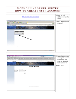


© Copyright 2026