
RECENT ELEVATION CHANGES OF SOME GARHWAL HIMALAYAN GLACIERS DERIVED FROM
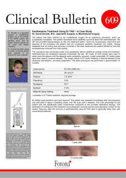
th
14 Esri India User Conference 2013
RECENT ELEVATION CHANGES OF SOME GARHWAL HIMALAYAN GLACIERS DERIVED FROM
ICESAT LASER ALTIMETRY
Mohd Anul Haq
Assistant Professor,
Department of GIS, NIIT University, Neemrana, Rajasthan
About the Author:
Abstract:
In this study, ICESat laser altimetry data are used to
provide precise elevation changes of some Garhwal
Himalayan glaciers, Uttarakhand during the period of
2003–2009. We have tested two methods for estimating
elevation changes of Garhwal glaciers from multitemporal
ICESat laser altimetry: (a) projection of near repeat-tracks
onto common locations using Digital Elevation Models
(DEMs), and (b) least-squares fitting of rigid planes to
segments of repeat-track data assuming a constant
elevation change rate. Six parameters derived from GLA14
product were used to build the glacier change procedure:
number of peaks, elevation difference of adjacent
footprints, waveform width, reflectivity, kurtosis, and
skewness of laser waveform. Glacier elevation change has
been observed on all altitudes during 2003-2009. Our
findings are consistent with other remote sensing mass
balance measurements from the same period, confirming
that repeat-track satellite altimetry can be a valuable tool
for monitoring short term elevation changes of Himalayan
glaciers.
Dr Mohd Anul Haq
Dr. Mohd Anul Haq holds Ph.D. in Geomatics
Engineering from Indian Institute of Technology
Roorkee, Roorkee (2013). His research focused
primarily on : Glacier monitoring and modelling of
land surface processes, Glacier-climate interaction
and monitoring of water resources. To be proficient
in Geomatics technology, he undertook the training
in ‘Advanced Remote Sensing for Coastal Zone
Monitoring and Disaster Management’ from
International Society of Photogrammetry and
Remote Sensing. He has several research papers
published in peer reviewed journals and presented
various papers in different parts of the world. He
serves also as a reviewer of some well known
journals such as IEEE Transactions on Geoscience
and Remote Sensing and International Journal of
Remote Sensing.
E mail ID: [email protected]
Contact No: +91 – 1494302444
Page 1 of 6
th
14 Esri India User Conference 2013
Introduction
Satellite altimetry has been used to measure elevation changes in ice covered regions since the late 1970s (Zwally et al., 1989;
Wingham et al., 1998; Johannessen et al., 2005). The large footprint size of satellite altimeters has made it difficult to apply these
measurements to higher relief glaciers and ice caps. However, newer, higher resolution altimeters like the ICESat laser altimeter
(Zwally et al., 2002) provide elevation data sets that can be compared to maps/ DEMs (Muskett et al., 2008; Nuth et al., 2010), to
airborne altimetry (Thomas et al., 2005).
The main instrument on ICESat was the Geoscience Laser Altimeter System (GLAS), that was a space-based LIDAR. GLAS
combined a precision surface LIDAR with a sensitive dual-wavelength cloud and aerosol LIDAR. The GLAS lasers emit
infrared and visible laser pulses at 1064 and 532 nm wavelengths. As ICESat orbited, GLAS produces a series of approximately
70m diameter laser spots that are separated by nearly 170 m along the spacecraft’s ground track. During the commissioning
phase of the mission, the ICESat was placed into an orbit which allowed the ground track to repeat every 8 days. During August
and September 2004, the satellite was maneuvered into a 91-day repeating ground track for the main portion of the mission.
A primary goal of GLAS is to measure temporal changes in ice-sheet topography and, as its name suggests, relies on
backscattered radiation from a laser-based system. The laser altimeter determines the topography by measuring the round-trip
time for a laser pulse from the instrument to the Earth's surface
coupled with an accurate knowledge of the platform location. The laser transmits 40 pulses per second and the spots produced
on the surface are approximately 70 meters in diameter and 175 meters apart (Zwally et al., 2002).
Mass balance defines the overall health of a glacier, Long term mass balance records are absent in case of Himalayan
glaciers. Due to rugged terrain and harsh weather conditions In-situ mass balance measurements are sparse in Himalayan
regions, implying a need for remote sensing data to better understand regional variations in mass balance. The most used
techniques to obtain mass changes in the Indian Himalayas are empirical relationships (Kulkarni et al., 2004) and using AAR
relationships. These provide the rough estimate, since these equations are developed in a particular region may not worked well
in other regions. Mass balance of ice covered regions have been derive to compare multi-temporal photogrammetric
maps/DEMs (Nuth et al., 2007; Kääb, 2008) or repeated airborne laser profiles (Abdalati et al., 2004; Bamber et al., 2005).
However, aerial surveys are expensive, and Photogrammetry alone is insufficient due to difficulty involves to take the gound
control points in the accumulation areas also the image contrast is poor in those areas. ICESat altimetry data are freely accessible
(Zwally et al., 2008) and provide a dense spatial and temporal coverage of high quality elevation points in these high latitude
regions.
In this article, an investigation has been made to demonstrate the potential of repeat-track ICESat altimetry to derive
short term glacier elevation changes of Bhagirathi Ganga basin. Two methods were tested for estimating elevation changes of
Garhwal glaciers from multitemporal ICESat laser altimetry: (a) projection of near repeat-tracks onto common locations using
Digital Elevation Models (DEMs), and (b) least-squares fitting of rigid planes to segments of repeat-track data assuming a
constant elevation change rate.
Page 2 of 6
th
14 Esri India User Conference 2013
Study Area and Data Used
Six parameters derived from GLA14 product were used to build the glacier change procedure: number of peaks, elevation
difference of adjacent footprints, waveform width, reflectivity, kurtosis, and skewness of laser waveform. NSIDC GLAS Altimetry
elevation extraction tool (NGAT) is used to extract elevation and geoid data from GLAS 14 altimetry products. The NGAT runs
under ENVI IDL.
The main emphasis of our research is on Gangotri glacier system which’s well documented glacier for snout fluctuation
records. Gangotri Glacier originates from the Chaukhamba massif (6853–7138 m a.s.l.) and flows northwest towards Goumukh. It
o
o
o
o
lies between 79 4’ 46.13” E-79 16’ 9.45” E and 30 43’ 47.00” N-30 55’ 51.05” N. The Gangotri glacier, is one of the largest
glaciers in the Garhwal Himalayas, is located in the Uttarkashi district of the state of Uttarakhand in India (Figure 1). Snow and
glaciers supply about 29% to the annual flows of the Ganga (up to Devprayag); therefore any impacts on these glaciers are
probably affect this perennial river system (Singh et al. 2009).
Fig: 1- Gangotri Glacier, Subset of ASTER 3-3-1 band image (2010) overlaid on the ASTER DEM (perspective view, not to scale).
Methodology
Two methods were tested for estimating elevation changes from ICESat data one is DEM-projected repeat-tracks and second is
planes fitted to repeat-tracks adopted from Moholdt et al., 2010. For both methods, average 2003–2009 elevation change rates
(dh/dt) were calculated using ENVI IDL. For pairs of repeat-tracks, one profile is projected onto the other profile using the
corresponding cross-track elevation differences from an independent DEM. Elevations are then compared at each DEMprojected point by linear interpolation between the two closest footprints in the other profile using ENVI spatial statistics. The
Page 3 of 6
th
14 Esri India User Conference 2013
average cross-track separation between pairs of repeat-tracks at Gangotri was 75 m after removing repeat-track pairs separated
by more than 200 m. Average annual elevation change rates (dh/dt) were calculated from all profile pairs obtained in similar
seasons with a temporal separation of 2 years. Moholdt et al. (2010) used a minimum time span of 3 years to minimize shortterm meteorological variations in the dh/dt estimates. In this study, 2-year time spans had been applied to expand the spatial
coverage in due to limited amount of IceSAT data in study area. Hence, most reference tracks include dh/dt points covering
several different time spans. All these points were averaged within clusters every 350 m along-track to obtain mean 2003–2009
dh/dt values at a homogeneous spatial resolution.
Least-squares regression technique has been used that fits rectangular planes to segments of repeat-track ICESat data
(Howat et al., 2008; Moholdt et al. 2010). Along each reference track, multi-temporal ICESat points were assigned to 700 m long
planes overlapping by 350 m (i.e. most ICESat points belong to two planes). The width of the planes depends on the maximum
cross-track separation distance between the repeated profiles, typically a few hundred meters. For each plane both slopes i.e.
east and north slopes (αE,αN) were derived and a constant elevation change rate (dh/dt) from the least-squares solution of the
equation:
Where dE, dN, dH and dt are the differences in position and time between each point and the average of all points in the plane.
The residuals (r) of the plane regression contain remaining elevation variations which cannot be ascribed to the assumption of
planar slopes and an invariable elevation change rate. To avoid gross errors in dh/dt due to cloud-affected signals or small-scale
topography, potential outlier points were removed where r>5 m and recomputed the regression iteratively until all residuals
were below this threshold. Finally, all planes were removed that consisted of less than 4 repeat tracks or less than 10 points, as
well as planes with a shorter observational time span than 2 years.
Error Analysis
The relative height error was derived of glaciers DEM by calculating how much DEM can predict the along-track elevation
difference between neighboring ICESat points separated by ~170 m (Moholdt et al., 2010). Since each ICESat elevation is
obtained from a ~70 m diameter footprint, it was expected that DEM smoothing would improve the corresponding alongtrack
ICESat slopes. For each DEM, an iterative low pass mean filter was applied of increasing pixel size (5 × 5, 7 × 7, 9 × 9) until the
RMS of the ICESat–DEM point-pair differences was below 5%. The final RMS values ranged from 1.0-1.3 m after applying an
iterative 5σ filter with a convergence threshold of 5%. The elevation change error (σdh/dt) of the plane method was estimated to
be 0.20 m y
−1
from the RMS of the dh/dt differences at 91 crossovers which remained after the iterative 5σ filter. The
combination of both errors i.e. errors due to DEM projection and errors in plane fitting is estimated ±1.35 m.
Page 4 of 6
th
14 Esri India User Conference 2013
Results
There are large local dh/dt variations which attributed to differences in glacier dynamics, debris fall from side walls and
measurement noise. Data in the South eastern parts of Gangotri are generally noisier and more diverse than the eastern parts,
making it more difficult to interpret elevation change trends in the South eastern parts. All regions are characterized by a low−1
-1
elevation thinning of 0.5–1.2 m y . Elevation change rates at the higher elevations are generally more positive 1-5 m yr , though
−1
with variations from slight high thinning near glacier terminus area of up to 1.2 m y . The frontal thinning has caused significant
frontal glacier area shrinkage.
All elevation change points are aligned along a limited number of ICESat reference tracks. In order to estimate ice
volume changes, extrapolation was applied to the remaining glacier areas. The data coverage of ICESat alone is typically too
sparse over glaciers in mountainous terrain to allow local spatial interpolation. Therefore, hypsometric approach was used to
extrapolate over regions large enough to ensure that the distribution of ICESat tracks relative to individual glaciers is random,
reducing the risk of systematic errors resulting from the measurement locations (Nuth et al., 2010). The relationship between
elevation and dh/dt was parameterized for each region by fitting polynomial functions to the data (Kääb, 2008).Total mass
3
change of Gangotri region glaciers was observed -1.35 km .
Conclusion
To derive elevation changes at Gangotri glacier region two ICESat repeat-track methods had been tested. The derived elevation
changes are sparse and not always reliable on a local scale, but hypsometric averaging within larger glacier regions provides
robust estimates of volume changes and area-averaged elevation changes. The regional estimates benefit from various track
configurations over many glaciers rather than center-line profiles over a few selected glaciers (e.g. Abdalati et al., 2004; Bamber
et al., 2005) which can cause a bias due to spatial sampling issues (Berthier et al., 2010). The multi-temporal sampling of ICESat
help to smooth out anomalous meteorological seasons which can have a large impact on the overall elevation change rates and
mass balances over short time periods like 2003–2009. Our findings are consistent with other remote sensing mass balance
measurements from the same period, confirming that repeat-track satellite altimetry can be a valuable tool for monitoring short
term elevation changes of Himalayan glaciers.
References
Abdalati, W., Krabill, W., Frederick, E., Manizade, S., Martin, C., Sonntag, J., Swift, R., Thomas, R., Yungel, J., &
Koerner, R. (2004). Elevation changes of ice caps in the Canadian Arctic Archipelago.Journal of Geophysical Research-Earth
Surface, 109.
Bamber, J. L., Krabill, W., Raper, V., Dowdeswell, J. A., & Oerlemans, J. (2005). Elevation changes measured on Svalbard
glaciers and ice caps from airborne laser data. Annals of Glaciology, 42, 202−208.
Howat, I. M., Smith, B. E., Joughin, I., & Scambos, T. A. (2008). Rates of southeast Greenland ice volume loss from combined
ICESat and ASTER observations.Geophysical Research Letters, 35
Page 5 of 6
th
14 Esri India User Conference 2013
Johannessen, O. M., Khvorostovsky, K., Miles, M. W., & Bobylev, L. P. (2005). Recent icesheet growth in the interior of
Greenland.Science, 310, 1013−1016.
Kääb, A. (2008). Glacier Volume Changes Using ASTER Satellite Stereo and ICESat GLAS Laser Altimetry. A Test Study on
Edgeoya, Eastern Svalbard.Ieee Transactions on Geoscience and Remote Sensing, 46, 2823−2830.
Kulkarni, A. V., Rathore, B. P. and Alex, S. (2004). Monitoring of glacial mass balance in the Baspa basin using Accumulation
Area Ratio method. Current Science, 86, 101–106.
Moholdt G., Nuth C., Hagen J. O., Kohler J.(2010) Recent elevation changes of Svalbard glaciers derived from ICESat laser
altimetry, Remote Sensing of Environment 114 (2010) 2756–2767
Muskett, R. R., Lingle, C. S., Sauber, J. A., Rabus, B. T., & Tangborn, W. V. (2008). Acceleration of surface lowering on the
tidewater glaciers of Icy Bay, Alaska, USA from InSAR DEMs and ICESat altimetry. Earth and Planetary Science Letters, 265,
345−359.
Nuth, C., Kohler, J., Aas, H. F., Brandt, O., & Hagen, J. O. (2007). Glacier geometry and elevation changes on Svalbard
(1936–90): a baseline dataset.Annals of Glaciology, 46, 106−116.
Nuth, C., Moholdt, G., Kohler, J., Hagen, J. O., & Kääb, A. (2010). Svalbard glacier elevation changes and contribution to sea
level rise.Journal of Geophysical Research,115.
Singh, P., Polglase L. And Wilson D. (2009). Role of snow and glacier melt runoff modeling in hydropower projects in the
Himalayan region. Proceedings of the International Conference on Water, Environment, Energy and Society (WEES–2009), 12–16
January 2009, New Delhi, India. Vol. 1.
Wingham, D. J., Ridout, A. J., Scharroo, R., Arthern, R. J., & Shum, C. K. (1998). Antarctic elevation change from 1992 to
1996.Science, 282, 456−458
Zwally, H. J., Brenner, A. C., Major, J. A., Bindschadler, R. A., & Marsh, J. G. (1989). Growth of the Greenland ice sheet measurement.Science, 246, 1587−1589.
Zwally, H. J., Schutz, B., Abdalati, W., Abshire, J., Bentley, C., Brenner, A., Bufton, J., Dezio, J., Hancock, D., Harding,
D., Herring, T., Minster, B., Quinn, K., Palm, S., Spinhirne, J., & Thomas, R. (2002). ICESat's laser measurements of polar
ice, atmosphere, ocean, and land.Journal of Geodynamics, 34, 405−445.
Zwally, H. J., Schutz, R., Bentley, C., Bufton, J., Herring, T., Minster, B., Spinhirne, J., & Thomas, R. (2008).GLAS/ICESat
L1B Global Elevation Data V028, 20 February 2003 to 21 March 2008. Boulder. CO: National Snow and Ice Data Center Digital
media.
Page 6 of 6


© Copyright 2026