
A sample survey of the breeding birds at woodland expansion sites
BTO Research Report No. 493 A sample survey of the breeding birds at woodland expansion sites of the Scottish Forest Alliance in 2007 A report to Forest Research on behalf of the Scottish Forest Alliance Ref: CR 2006/07/38 Authors John Calladine, Graeme Garner and Liz Humphreys January 2008 BTO Scotland School of Biological and Environmental Sciences, University of Stirling, Stirling, FK9 4LA, UK Registered Charity No. 216652 British Trust for Ornithology A sample survey of the breeding birds at woodland expansion sites of the Scottish Forest Alliance in 2007 BTO Research Report No 493 John Calladine, Graeme Garner and Liz Humphreys A report to Forest Research on behalf of the Scottish Forest Alliance Ref: CR 2006/07/38 Published in February 2013 by the British Trust for Ornithology, The Nunnery, Thetford, Norfolk IP24 2PU, U.K. Copyright British Trust for Ornithology 2013 ISBN 978-1-908581-19-8 All rights reserved. No part of this publication may be reproduced, stored in a retrieval system or transmitted in any form, or by any means, electronic, mechanical, photocopying, recording or otherwise, without the prior permission of the publishers. Contents LIST OF TABLES................................................................................................................................................ 5 LIST OF FIGURES.............................................................................................................................................. 7 APPENDICES....................................................................................................................................................... 7 Abstract................................................................................................................................................................... 9 1. INTRODUCTION ........................................................................................................................................ 11 2. METHODS ................................................................................................................................................... 13 2.1 Study sites............................................................................................................................................. 13 2.2 Bird survey ........................................................................................................................................... 13 2.3 Analysis ................................................................................................................................................ 14 3. RESULTS ..................................................................................................................................................... 17 4. DISCUSSION............................................................................................................................................... 19 4.1 Validity of density estimates ................................................................................................................ 19 4.2 Survey methods and future monitoring ................................................................................................ 20 4.3 Summary of recommendations for future monitoring .......................................................................... 21 Acknowledgements .............................................................................................................................................. 22 REFERENCES ................................................................................................................................................. 23 TABLES ............................................................................................................................................................... 25 FIGURES.............................................................................................................................................................. 41 APPENDICES ...................................................................................................................................................... 43 3 4 LIST OF TABLES Table 1 Table 2 Table 3 Table 4 Table 5 Table 6 Table 7 Table 8 Table 9 Table 10 Table 11 Table 12 Table 13 Table 14 Table 15 Table 16 The number of survey points in each SFA site where breeding birds were sampled in 2007.......... 25 Dates of bird surveys at the SFA sites in 2007................................................................................. 25 The survey visits from which registrations were used to calculate indices of abundance and/or density estimates for each species recorded at the SFA sites in 2007. ............................................. 26 The occurrence rate and estimated abundances of birds sampled from 25 survey points at Abernethy in 2007. ........................................................................................................................... 27 The occurrence rate and estimated abundances of birds sampled from eight survey points at Barclye in 2007................................................................................................................................. 28 The occurrence rate and estimated abundances of birds sampled from 16 survey points at Corrimonnie in 2007......................................................................................................................... 29 The occurrence rate and estimated abundances of birds sampled from 12 survey points at Darroch Wids in 2007..................................................................................................................................... 30 The occurrence rate and estimated abundances of birds sampled from eight survey points at Drumbow/Crossrig in 2007 .............................................................................................................. 31 The occurrence rate and estimated abundances of birds sampled from 16 survey points at Glen Devon in 2007 .................................................................................................................................. 32 The occurrence rate and estimated abundances of birds sampled from 24 survey points at Glen Finglas in 2007 ................................................................................................................................. 33 The occurrence rate and estimated abundances of birds sampled from 16 survey points at Glenmore in 2007. ............................................................................................................................................. 34 The occurrence rate and estimated abundances of birds sampled from 12 survey points at Inversnaid in 2007. ........................................................................................................................... 35 The occurrence rate and estimated abundances of birds sampled from 35 survey points at Kinloch in 2007. ............................................................................................................................................. 36 The occurrence rate and estimated abundances of birds sampled from 24 survey points at loch Katrine in 2007. ................................................................................................................................ 37 The occurrence rate and estimated abundances of birds sampled from 169 survey points across all the SFA sites in 2007........................................................................................................................ 38 A comparison of some mean density estimates (birds per km2) with other studies from the UK in some comparable habitats................................................................................................................. 40 5 6 LIST OF FIGURES Figure 1 The location of the SFA sites where surveys of breeding birds were carried out in 2007................... 41 APPENDICES Appendix 1 Appendix 2 The coordinates (British National Grid) of the survey points used for sampling breeding bird abundances at the SFA sites in 2007. ....................................................................................... 43 The scientific names of species referred to in this report ......................................................... 48 7 8 Abstract 1. This report presents the results of a sample survey of breeding birds at Scottish Forest Alliance (SFA) sites in Scotland in 2007. The SFA is a partnership between BP, Forestry Commission, RSPB Scotland and Woodland Trust Scotland that aims to establish and/or enlarge new native-type woodland at sites throughout Scotland. This is the first of a series of planned periodic surveys that will quantify changes in avifauna as woodland at the sites develops over the next 100 years. 2. Timed point counts were used to survey the breeding bird communities of 11 sites managed under the SFA. Two counts at 169 survey points (8 – 35 per site) were undertaken between April and June 2007. 3. A total of 3,786 registrations of 77 species were recorded within the surveyed areas. A further 430 registrations were of birds flying over the sites and included 10 additional species. 4. Up to five indices of abundance or density estimates were calculated for each species recorded at within each of the SFA sites: i) ii) iii) iv) v) Occurrence rates – the number of points at which a given species was recorded; Abundance index – the mean number of registrations per survey point; Simple bird index – a summing of all individuals of a species recorded within 50 m of the survey points; Site-level density – an estimation of bird density that assumes a common detectability function for all species across all sites to adjust for decreased detectability at greater distances from the survey points; Distance sampling analysis – an estimation of bird density that calculates a detectability function from empirical data for the relevant species and sites. The required sample size of qualifying registrations for the above indices and estimates increases from (i) to (v) above, therefore occurrence rates are calculated for all species at all sites, while density estimates from distance sampling analyses are only available for the most abundant species. 5. Although some issues associated with the heterogeneity of bird distributions introduced some biases into the estimated densities of some species, there is broad agreement with estimates and indices calculated in different ways and with comparable density estimates from other published studies. This suggests that the approach to field survey and generation of abundance indices and density estimates in the present survey will be appropriate for the long-term monitoring of changes in breeding bird communities at the SFA sites (currently intended to cover a period of 100 years). 6. Recommendations for future monitoring surveys of the SFA sites are: i) Repeat surveys should use identical field methodology and as a minimum use the same survey points as the first survey in 2007 to ensure direct comparability; ii) The periodicity of repeat surveys at intervals of between 5 and 10 years should be considered; iii) Analyses should produce a range of indices of abundance and density estimates (simple and complex as the data permits, as in the present survey) to ensure that fullest range of species can be monitored and to provide a check on the validity of any calculated density estimates; iv) Changes in breeding bird populations at the SFA sites should be evaluated against an appropriate reference. We suggest that the BTO/JNCC/RSPB Breeding Bird Survey (potentially sub-sampled to provide regional and habitat-specific trends) would provide a cost-effective source of appropriate reference data. 9 10 1. INTRODUCTION The Scottish Forest Alliance (SFA) is a partnership between BP, Forestry Commission, RSPB Scotland and Woodland Trust Scotland that aims to establish new native-type woodland at sites throughout Scotland (www.scottishforestalliance.org.uk). This is to be achieved through new planting on open ground, natural regeneration and the restructuring of conifer plantations. Amongst the principal aims of the project is to contribute towards the UK targets for forest and woodland biodiversity (www.ukbap.org.uk), the promotion of social and economic gains for local communities and carbon sequestration. This report presents the results of a sample survey of breeding birds at 11 SFA sites in Scotland in 2007. This is the first of a series of planned periodic surveys that will quantify changes in avifauna as woodland at the sites develops over the next 100 years. Together with concurrent monitoring of vegetation and other taxa (hoverflies and shelled gastropods) plus other assessments of the activity of selected animal groups, the progressive development of woodland ecosystems will be monitored. Co-ordinated by Forest Research on behalf of the SFA, this information will be used to measure the achievements of the SFA in meeting its targets for biodiversity and to influence and inform woodland management practices and associated grant support systems. 11 12 2. METHODS 2.1 Study sites Bird surveys were undertaken at 11 SFA sites in Scotland (Figure 1). To be spatially compatible with surveys of other taxa, breeding birds were sampled at between 8 – 35 survey points per site (Table 1) that were selected by Forest Research. These aimed to be representative of pre-existing ecological units prior to any treatment associated with reestablishment of native-type woodland with the points located centrally within National Vegetation Classification (NVC) polygons that were mapped before any SFA treatment. For the smaller sites (Corrymonnie, Darroch Woods, Inversnaid, Drumbow/Crossrig and Barclye), points included all NVC classes present. For the larger sites, sample squares of 25 ha were selected at random to include 10% of the site area. Within the squares, survey points were selected based on mapped NVC polygons similarly to the smaller sites. In a small number of cases, the separation distance between the original selection of survey points was less than 200 m. In these cases, bird data collected from neighbouring points would likely have low levels of independence (e.g. Bibby & Buckland 1987). To prevent this, alternative points were selected to ensure a minimum separation distance of 200 m between points. A further small number of survey points were considered by the relevant site managers to be close to sensitive and rare breeding birds. Again, alternatives were found that complied with the original sampling strategy but were sufficiently distant from sensitive areas. A full list of the final survey points is given as Appendix 1. 2.2 Bird survey Timed point counts were used to sample breeding birds at the survey points. Each survey point was sampled twice, the ‘early visit’ between 11 April and 11 May, and the ‘late visit’ between 17 May and 15 June (Table 2). Surveys were undertaken in the early mornings when many bird species are most easily detected (Bibby et al. 2000); 89% of surveys were completed between first light and 09:00 hours BST and 98% by 10:00 hours. Surveys were not undertaken during persistent or heavy rain or when wind speeds exceeded Beaufort scale force 4, conditions that are likely to reduce the detection rates of many birds. Hand-held GPS were used to locate survey points. On arrival at each point, the surveyor waited for a two-minute settling period, to minimise any influence of walking to the point on the detection rates of birds, then recorded all birds seen or heard for a period of 10-minutes. The sampling interval aimed to maximise the likelihood of registering birds within the immediate vicinity but also reduce the risk of the multiple counting of individuals (Fuller & Langslow 1984, Drapeau et al. 1999), which would violate the assumptions of the point count methodology (Bibby et al. 2000). The two minute settling period was also used by the surveyors to familiarise themselves with distances to physical features around the points to facilitate accurate distance estimation. Birds were recorded in five distance classes: within 10 m of the count point; between 10 and 25 m; between 25 and 50 m; between 50 and 100m; and greater than 100 m from the count point. Each registration was assigned to the distance band in which the individual bird was first recorded regardless of any subsequent movements. Birds seen or heard in flight only were also recorded separately. Both Skylarks and Meadow Pipits perform display flights over their breeding territories. Where these or other species were observed displaying in flight, they were recorded as if in the terrestrial distance band above which they were displaying. Juvenile birds (those hatched in the current calendar year) were excluded when they could be reliably aged as such in the field (but see Section 2.3). This aimed to ensure that the calculated density estimates and indices of abundance corresponded to breeding adults as far as is possible, rather than reflecting a contribution made by breeding productivity in the current year. Any birds that arrived into the 10 m distance band during the 10-minute sampling period were further assess any potential bias introduced by the presence of a surveyor in the area. In the field, and avoid recording individuals more than once at any one survey point. Individuals that were recorded from more than one survey point were recorded as such to permit future monitoring of point scale but to reduce the risk of overestimating site densities of any affected species. 13 also distinguished to care was taken to try known to have been change at the survey 2.3 Analysis For each of the 11 SFA sites, five levels of analysis were carried out to provide a range of abundance indices and density estimates for each species: i) Occurrence rates - the number of points where a given species was recorded (regardless of abundance) divided by the total number of points surveyed. Note that individual birds that were known to have been recorded from more than one survey point are included for the original point of registration only; ii) Abundance index – the mean number of registrations per survey point. Note (a) that individual birds that are known to have been recorded from more than one survey point are included for the original point of registration only and (b) that registrations of an undetermined number of any species beyond the 100 m distance band are excluded; iii) Simple bird density - a simple summing of all individuals of a species recorded within the 50 m distance band divided by the area sampled within that distance band across the study area (denominator = 0.79 ha * number of survey points; 0.79 ha being the area within a 50 m radius of a survey point). This measure assumes that the majority of individuals within a 50 m radius of the survey points were detected; iv) Site-level density - using a simple formula that assumes a known detectability function that is constant for all sites and species and adjusts for decreased detectability in the outer distance bands (Bibby et al. 1985) and using only two distance bands (in this case, 0-50m and 50-100m). The formula used was: D = loge(n/n2)*n/(m r2) (after Bibby et al. 1985) Where: D = calculated bird density n = total number of birds detected (in this case, 0-100 m) n2 = the number outside of the distance band r (in this case, 50-100 m) m = number of survey points Because this method involves a single calculation of density at the site-level, there are no associated errors (confidence limits) estimated (Bibby et al. 1985). The calculation becomes invalid when there are no registrations for the outer distance band (n2 , above) and returns a density of zero when there are no registrations for the inner distance band even if there are registrations for the outer band. Deviation of the empirical data from the assumed detection function and errors associated with zero counts in either distance band will tend to be greatest when sample sizes are small. Therefore, we present an estimate of site-level density, calculated in this way, only when the number of qualifying registrations is 10 or more. Also, estimates derived from less than 20 qualifying registrations are individually marked so as to highlight the uncertainty associated with such figures and advise caution with their use and interpretation; and v) Distance sampling analysis - estimation of site-level density using the program DISTANCE 5.0 (Thomas et al. 2005). This program is similar to, but a more complex version of the simple Bibby et al. (1985) formula (iv, above). It is only recommended in cases where there are at least 40 qualifying registrations for a given species, so this was carried out only for the most abundant species. Distance sampling works on the principal that randomly distributed objects (in this instance, birds) become more difficult to detect with increasing distance (in this instance, from the count points). As a result, an increasing proportion of the birds become more difficult to detect in the more distant recording bands. The program DISTANCE 5.0 models this decline in detectability with distance (the detection function) in order to include an estimate of undetected individuals in its calculation of density. In our analyses we consider birds recorded from four distance bands (0-10 m, 10-25 m, 25-50 m and 50-100 m) and assume a half-normal cosine detection function. Birds from the final distance band (>100 m) were excluded from the analyses as counts within an unbounded category are difficult to interpret; truncation of this kind is routinely recommended for accurately estimating density using the distance sampling technique (Buckland et al. 2001). This last method estimates density as a mean across points and therefore has the advantage that it allows estimation of associated errors. As with (iv) above, this method includes adjustment for decreases in detectability in the outer distance bands but has the further advantage of calculating specific detectability functions for each sufficiently abundant species from empirical data. Although this method is generally only recommended where there are at least 40 qualifying registrations, we also present the calculated density estimates for cases where the number of registrations is between 30 and 39 inclusive, however these are marked to highlight the uncertainty associated with them. 14 The measure of occurrence rates, (i) above, includes data from both early and late survey visits, so a registration of a species from a point on just one visit counts equally as if recorded on both visits. For the other four measures of abundance, only data from a single survey visit was incorporated. Ideally, juvenile birds should be excluded from the calculations of indices or estimates of abundance of breeding populations. Although known juvenile birds were excluded during field surveys, in practice the reliable aging of individuals was frequently not possible. Timed sampling surveys such as this, rely on the field identification and initial detection of the majority of birds by call and many birds are either not seen or inadequately seen for them to be reliably aged and therefore excluded if they were juveniles. To minimise the risk of including juveniles in the calculated abundance indices and density estimates, we have taken the pragmatic approach of considering only registrations from the early survey visits for non-migrant species for which juveniles could easily have been recorded but not specifically aged as such (Table 3) as the majority of the breeding adults of these species were expected to have been present at the survey sites by the time of the early survey visits and most juveniles will not yet have fledged. For the remaining species, which were predominantly long-distance migrants or non-passerines (Table 3) we used the maximum counts of the two survey visits summed across all survey points within a site. The arrival times of the longer-distance migrants in the breeding areas varies between species (e.g. Wernham et al. 2002) and possibly also between sites. Using the maximum counts is likely to give a better representation of breeding density for the species concerned, while the risks associated with the potential inclusion of juvenile birds are likely to be less for migrant species that tend to commence breeding later in the spring than many resident species. For non-passerines, we assume that the field identification of juvenile birds was sufficiently reliable for them to be excluded during field work. All the above analyses are repeated for each species with sufficient qualifying registrations at each SFA site. In addition, we also present the indices and estimates of density for the 11 sites combined; the latter could ultimately inform the broad influence of the SFA programme across those sites. 15 16 3. RESULTS A total of 3,786 registrations of 77 species were recorded within the 11 surveyed areas during the timed point counts (Table 3) and the number of species encountered at each site ranging from 16 - 40 (Tables 4 - 14). A further 430 registrations were of birds flying over the survey points and included ten species that are excluded from subsequent analyses in that none were recorded as ‘using’ the areas within sight of the survey points: Western Capercaillie (1 at Glenmore); Golden Eagle (1 at Loch Katrine and 1 at Abernethy); Feral Pigeon (6 at Drumbow); Great Black-backed Gull (6 at Kinloch); Goosander (5 at Abernethy and 2 at Glen Finglas); Herring Gull (4 at Kinloch); Eurasian Jackdaw (1 at Darroch Woods); Common Starling (4 at Drumbow and 12 at Barclye); Barn Swallow (singles at Darroch Woods and Barclye, 3 at Drumbow and 6 at Loch Katrine); and Twite (4 at Loch Katrine). Scientific names for all species are listed as Appendix 2. There was a single recorded instance only of a bird approaching closer than 10 m to the observer during the timed point count surveys (a Chaffinch at Kinloch); therefore we assume that the presence of observers had a minimal influence through the attraction of birds to the count points. 17 18 4. DISCUSSION 4.1 Validity of density estimates Most species were encountered too infrequently for reliable estimation of population densities, using distance sampling analyses and the program DISTANCE (generally recommended where there is a minimum of 40 qualifying registrations; Buckland et al. 2001). At the site level, the majority of species were also encountered too infrequently to reliably use a simplified estimation of bird density (Site-level density, (iv) in Section 2.3) that assumes a common detection function for all species and at all sites (for which we have adopted a minimum threshold of 20 qualifying registrations). In all cases where the three methods of density estimation could be employed, the estimates tended to be greatest using distance sampling analyses and lowest for the simplest estimates that were extrapolated from a summation of the number of registrations within a 50 m radius of the survey points. This is to be expected as the latter simplest method has no allowance for correction to account for the more distant birds being missed during field survey. However, in the majority of instances, the two simpler density estimates were within the 95% confidence interval of the estimates derived using the programme DISTANCE where the birds were found to be sufficiently abundant for the more complex method to be used. Hence the low sample sizes for many species within the surveyed areas do not appear to be a barrier for robust long-term monitoring of bird densities. Where the simpler density estimates were outside of the calculated confidence intervals, or there was a large discrepancy between the two simpler estimates, this was likely to have been a result of (i) relatively low sample sizes that made the use of the distance sampling approaches less reliable (marked as such in Tables 4 – 15), and/or (ii) a heterogeneous distribution of the birds concerned. The detection functions used by both methods that try to estimate the proportion of birds missed during field surveys assume that birds are randomly distributed within the areas covered from the survey points. For some species within the SFA sites surveyed, this is unlikely to have been the case. For example, many survey points were close to remnant woodland or standing trees (an aim of the SFA programme being to permit natural regeneration from these remnants) and trees have already been planted in patches in some areas. This would inevitably lead to a non-random distribution of some birds with woodland birds associated with the patches of trees and species of open habitats avoiding them. A specific example is Chaffinch at Glen Finglas, a woodland specialist within the surveyed areas, where the DISTANCE derived density estimate (951 birds per km2) is statistically significantly greater (outside of the 95% cls) than the estimated site-level density (376 birds per km2) which in turn is some 60% greater than the simplest density estimate (233 birds per km2) (Table 10). Here, the location of the survey points at varying distances from the edges of remnant woodland is likely to violate the assumptions of bird distribution associated with the detection functions that are calculated or assumed to correct for missed birds at the greater distances from the survey points. Conversely, the estimated site-level density of Meadow Pipits, a specialist of open habitats, at Glen Devon (695 birds per km2) was 34% greater than the simplest density estimate (517 birds per km2) but was still within the 95% confidence limits estimated using the program DISTANCE (552 – 1343 birds per km2) (Table 9). Here, the developing planted woodland at the time of the survey had left patches of open habitat suitable for Meadow Pipits. In some cases, heterogeneity of habitats, and therefore bird distributions, may have been a consequence of survey point location within relatively small NVC polygons (Section 2.1) but as this would still likely remain an issue had survey points been selected at random within the chosen survey areas (because of the non-uniformity of the areas in general), most likely there would be negligible benefits from using an alternative sampling strategy for monitoring birds from those adopted for monitoring other taxa. The densities of birds estimated in this study are, in the most part comparable with published estimates from other studies in the UK of similar habitat types (Table 16) giving further support for the robustness of the current survey methods for the long-term monitoring of the SFA sites. The estimates from the present study for both Sky Lark and Meadow Pipit are very much higher than those and also other published estimates for open habitats however (5 – 7 Sky Lark per km2; Browne et al. 2000: 20 – 100 Meadow Pipits per km2; Vanhinsbergh & Chamberlain 2001). Those previously published estimates are also much lower than those that have been consistently measured on moorland in south-west Scotland annually from 2002 to 2007 (40 – 90 Sky Lark per km2 and 100 – 500 Meadow Pipit per km2; BTO Scotland unpublished data). Considering the constancy of the high estimates across many of the SFA sites and their agreement with data from moorland in south-west Scotland, we see little reason to doubt the density estimates for Sky Lark and Meadow Pipit at the SFA sites in 2007, although there may be some errors associated with heterogeneity of habitats and bird distribution (see above). It is likely that, as many of the sites were of predominantly open habitats where grazing had recently been 19 reduced (as part of the SFA management programme), excellent conditions for breeding Meadow Pipits (Evans et al. 2006, Pearce-Higgins & Grant 2006) had become established at the time of the survey. 4.2 Survey methods and future monitoring Although there are some issues associated with the heterogeneity of habitats and their associated influence on bird distributions and many species were only recorded in relatively low numbers (Section 4.1), the approaches to field survey and analyses appear to be sufficiently robust and reliable for the long-term monitoring of bird populations at the sampled points within the SFA sites. The precision of density estimates, and also the number of species for which density estimates could be made, would be enhanced with an increased number of sampling points or more intensive surveys of the sampled areas (e.g. a territory mapping approach). Both of these would require additional resources either to sample more points, or for a territory mapping approach, to accommodate the increased number of survey visits (a minimum number of four survey visits would be required; Hewson et al. 2007), survey effort and analytical time that would be required. Territory mapping could prove difficult to compare directly with the current survey results. Therefore we suggest that future monitoring adopts an identical field methodology and samples as a minimum the same survey points that were used in 2007. An increase in sample points would permit more precise density estimates and an enhanced power to detect statistically significant changes in abundance. There will, however, always be species that are scarce for which the more elaborate methods of density estimation are not appropriate. The simpler indices of abundance (the proportion of survey points where a species was detected, the ‘Occurrence rate’, and the mean number of registrations per point, the ‘Abundance index’) will always be the best that can be achieved for those scarce species by a sampling approach given the likely resources that will be available for future repeat surveys. Having a range of density estimates and abundance indices, for example the five determined in the present study, is also likely to be of use when assessing the reliability of any apparent changes in a species’ abundance. Issues associated with non-random distributions and habitat heterogeneity and their influence on density estimates are likely to remain throughout the development of the SFA sites. Further, the detectability of some species is also likely change as woodland develops. For example, in restocked conifer plantations, it was estimated that 50% of birds were detectable at 57 m when the trees were two years old (essentially an open habitat) but this distance was reduced to 30 m when the trees were 11 years old (essentially a thicket habitat) (Bibby & Buckland 1987). For the most abundant species for which the detectability function can be determined from empirical data, these changes will be accounted for in the density calculations, however for the majority of species this will not be possible. Even when detection functions can be determined from empirical data, there can be complications introduced when birds of both sexes are incorporated as detectability can vary between the sexes (Buckland 2006). Some studies have been selective in that only males were recorded (e.g. Buckland 2006), however this will only be practical where a very restricted number of species are being surveyed and that conditions permit the reliable sexing of all birds recorded, either from behaviour or by plumage. In the present study this would not have been possible. However the influence of variation in the differences between sexes of a species in their detectability as habitats at the SFA sites develop is a potential additional complication in assessing changes in bird population densities. Because of the range of potential complications, it is important that a range of alternative estimates of density and indices of abundance are determined and compared in future surveys, including the simplest indices (e.g. occurrence rates), to provide alternative assessments for any apparent changes. Over the planned 100 years of monitoring the SFA sites, bird populations in the wider countryside can be expected to vary. Therefore observed changes within the SFA sites may not necessarily be in response to management changes within those sites. It will be important to compare changes with reference data. We suggest that the BTO/JNCC/RSPB Breeding Bird Survey (BBS) (e.g. Raven et al. 2007) could provide an appropriate reference. The BBS is an extensive volunteerbased survey and has been the principal UK monitoring scheme for widespread breeding bird populations since 1994. Using a formal sampling design, in which 1-km survey squares are selected at random from the Ordnance Survey’s National Grid, BBS squares are stratified regionally and by human population density to allow representative coverage of regions and habitats, whilst making the most of available volunteer resources. In addition to annual monitoring of birds, broad habitat types are also recorded (Crick 1992). Data collected for the BBS can be sub-sampled to provide appropriate regional and habitat-specific indices of general population change for species that are recorded sufficiently frequently. Comparison of data collected at the SFA sites, with concurrent trends derived from the BBS will provide the most realistic measure for SFA achievements in terms of targets for breeding bird populations. 20 Repeat bird surveys of the SFA sites need not be annual. The periodicity of repeat surveys, however, should not be too infrequent if changes in breeding bird communities are to be representatively monitored. For example, relatively high densities of Willow Warblers in Glen Devon (Table 9), where trees were only planted five years before the current survey indicate the relative speed with which some woodland birds show a response to management changes; this species does not breed in open habitats. Therefore we suggest that although repeat surveys may not be necessary at more frequent than 5-year intervals, a periodicity in excess of 10 years may well not detect some of the important changes as the sites develop to natural-type woodlands. 4.3 Summary of recommendations for future monitoring 1. Repeat surveys should use identical field methodology and as a minimum use the same survey points as the first survey in 2007 to ensure direct comparability. 2. The periodicity of repeat surveys at intervals of between 5 and 10 years should be considered. 3. Analyses should produce a range of indices of abundance and density estimates (simple and complex as the data permits, as in the present survey) to ensure that fullest range of species can be monitored and to provide a check on the validity of any calculated density estimates. 4. Changes in breeding bird populations at the SFA sites should be evaluated against an appropriate reference. We suggest that the BTO/JNCC/RSPB Breeding Bird Survey (potentially sub-sampled to provide regional and habitatspecific trends) would provide a cost-effective source of appropriate reference data. 21 Acknowledgements Fieldwork was undertaken by John Calladine, Graeme Garner and Nigel Harding. We thank all the managers and staff of the sites for advice and supporting access for the survey: Duncan Cameron, Nick Chambers, Joss Christie, Paul Collin, Neil Cowie, Desmond Dugan, Anne Gilchrist, Philip Gordon, Diana Holt, David Jardine, Russel Lamont, Chris Marsh, Fiona Moran, Jeremy Roberts, Liz Shorthall, Dan Tomes and Adam Wallace. We also thank Jonathan Humphrey and Mike Smith as the nominated officers for the contract with Forest Research. 22 REFERENCES Bibby, C.J., Phillips, B.N. & Seddon, A.J.E. (1985) Birds of restocked conifer plantations in Wales. Journal of Applied Ecology 22, 619-633. Bibby, C.J. & Buckland, S.T. (1987) Bias of bird census results due to detectability varying with habitat. Acta Œcologica : Œcologica Generalis, 8, 103-112 Bibby, C.J., Burgess, N.D., Hill, D.A. & Mustoe, S. (2000) Bird Census Techniques. Academic Press, London. Browne, S.J., Vickery, J. & Chamberlain, D. (2000) Densities and population estimates of breeding Skylarks Alauda arvensis in Britain in 1997. Bird Study, 47, 52-65. Buckland, S.T. (2006) Point transect surveys for songbirds: robust methodologies. The Auk, 123, 345 – 357. Buckland, S.T., Anderson, D.R., Burnham, K.P., Laake, J.L., Borchers, D.L. & Thomas, L. (2001) Introduction to Distance sampling: Estimating abundance of biological populations. Oxford University Press. Calladine, J, Humphreys, L. & McPhie, F. (2007) The effects of thinning in commercial conifer plantations on breeding bird abundance and diversity in the north of Scotland. BTO Research Report No. 459, British Trust for Ornithology, Stirling. Crick, H.Q.P. (1992) A bird-habitat coding system for use in Britain and Ireland incorporating aspects of land management and human activity. Bird Study, 39, 1-12. Drapeau, P., Bergeron, Y. & Harvey, B. (1999) Refining the use of point counts at the scale of individual points in studies of bird-habitat relationships. Journal of Avian Biology, 30, 367-382. Evans, D.M., Redpath, S.M., Evans, S.A., Elston, D.A., Gardner, C.J., Dennis, P. & Pakeman R.J. (2006) Low intensity, mixed livestock grazing improves the breeding abundance of a common insectivorous passerine. Biology Letters, 2, 636638. Fuller, R.J. & Langslow, D.R. (1984) Estimating numbers of birds by point counts: how long should counts last? Bird Study, 31, 195-202. Fuller, R.J., Gillings, S. & Whitfield, D.P. (1999) Responses of breeding birds to expansion of scrub in the eastern Scottish Highlands: preliminary implications for conservation strategies. Vogelwelt, 120, 53-62. Gillings, S., Fuller, R.J. & Henderson, A.C.B. (1998) Avian community composition and patterns of bird distribution within birch-heath mosaics in north-east Scotland. Ornis Fennica, 75, 27-37. Hewson, C.M., Thewlis, R.M. & Fuller R.J. (2007) Territory mapping in woodlands – how many visits is enough? Poster presented at ‘Bird Numbers 2007’: Conference of the EBCC, Chiavenna, April 2007. Newson, S.E., Woodburn, R.J.W., Noble, D.G., Baillie, S.R. & Gregory, R.D. (2005) Evaluating the breeding bird survey for producing national population size and density estimates. Bird Study, 52, 42-54. Patterson, I.J., Ollason, J.G. & Doyle, P. (1995) Bird populations in upland spruce plantations in northern Britain. Forest Ecology and Management, 79, 107-131. Pearce-Higgins, J.W. & Grant, M.C. (2006) Relationships between bird abundance and the composition and structure of moorland vegetation. Bird Study, 53, 112-125. 23 Raven, M.J., Noble, D.G. & Baillie, S.R. (2007) The Breeding Bird Survey 2006. BTO Research Report No. 471. British Trust for Ornithology, Thetford. Thomas, L., Laake, J.L., Strindberg, S., Marques, F.F.C., Buckland, S.T., Borchers, D.L., Anderson, D.R., Burnham, K.P., Hedley, S.L., Pollard, J.H., Bishop, J.R.B. and Marques, T.A. (2005). Distance 5.0. Research Unit for Wildlife Population Assessment, University of St. Andrews, UK. http://www.ruwpa.st-and.ac.uk/distance/ Vanhinsbergh, D.P. & Chamberlain, D.E. (2001) Habitat associations of breeding Meadow Pipits Anthus pratensis in the British uplands. Bird Study, 48, 149-172. Wernham, C., Toms, M, Marchant, J., Clark, J, Siriwardena, G., & Baillie, S. (2002) The migration atlas: movements of birds of Britain and Ireland. T. & A.D. Poyser, London. 24 TABLES Table 1 The number of survey points in each SFA site where breeding birds were sampled in 2007 Total site area (ha)1 SITE Abernethy Glenmore Darroch Woods Kinloch Hills Glen Devon Drumbow/Crossrig Inversnaid Glenfinglas Loch Katrine Corrymonnie Barclye 1 No. of survey points 1868 1440 500 3661 1235 195 443 4400 9598 650 296 25 16 12 35 16 8 12 24 24 16 8 Areas supplied by Forest Research Table 2 Dates of bird surveys at the SFA sites in 2007. SITE Early visit Late visit Abernethy Glenmore Darroch Woods Kinloch Hills Glen Devon Drumbow/Crossrig Inversnaid Glenfinglas Loch Katrine Corrymonnie Barclye 1-2 May 1 & 11 May 16 April 26-28 April 13 April 11 April 24 April 12-13 April 25-26 April 17-18 April 5 May 14-15 June 13 June 22-23 May 26-27 May 17 May 13 May 8-9 June 18 & 21 May 24-25 May 8-10 June 11 June 25 Table 3 The survey visits from which registrations were used to calculate indices of abundance and/or density estimates for each species recorded at the SFA sites in 2007. SPECIES Greylag Goose Greater Canada Goose Eurasian Teal Mallard Tufted Duck Willow Ptarmigan (Red Grouse) Black Grouse Common Pheasant Red-throated Diver Grey Heron Eurasian Sparrowhawk Common Buzzard Common Kestrel Merlin Common Moorhen Eurasian Oystercatcher European Golden Plover Northern Lapwing Common Snipe Eurasian Curlew Common Redshank Common Greenshank Common Sandpiper Black-headed Gull Mew Gull Common Wood Pigeon Common Cuckoo Tawny Owl Common Swift Great Spotted Woodpecker Sky Lark Tree Pipit Meadow Pipit Grey Wagtail White/Pied Wagtail White-throated Dipper Winter Wren Hedge Accentor European Robin Common Redstart Whinchat Count used1 Maximum Maximum Maximum Maximum Maximum Maximum Maximum Maximum Maximum Maximum Maximum Maximum Maximum Maximum Maximum Maximum Maximum Maximum Maximum Maximum Maximum Maximum Maximum Maximum Maximum Early Maximum Maximum Maximum Early Early Maximum Early Early Early Early Early Early Early Maximum Maximum SPECIES Stonechat Northern Wheatear Ring Ouzel Common Blackbird Song Thrush Mistle Thrush Common Grasshopper Warbler Sedge Warbler Blackcap Common Whitethroat Wood Warbler Common Chiffchaff Willow Warbler Goldcrest Spotted Flycatcher Pied Flycatcher Long-tailed Tit Crested Tit Coal Tit Blue Tit Great Tit Eurasian Treecreeper Eurasian Jay Black-billed Magpie Rook Carrion Crow Hooded Crow Common Raven Chaffinch European Goldfinch Eurasian Siskin Common Linnet Lesser Redpoll Common Crossbill Common Bullfinch Reed Bunting 1 Count used1 Early Maximum Maximum Early Early Early Maximum Maximum Maximum Maximum Maximum Maximum Maximum Early Maximum Maximum Early Early Early Early Early Early Early Early Early Early Early Early Early Early Early Early Early Early Early Early The counts used are from either the early survey visit only or the maximum of the two survey visits for each species at each of the sites. 26 Table 4 The occurrence rate and estimated abundances of birds sampled from 25 survey points at Abernethy in 2007. SPECIES Willow Ptarmigan (Red Grouse) Black Grouse Common Pheasant Red-throated Diver Eurasian Sparrowhawk Merlin Eurasian Curlew Black-headed Gull Common Wood Pigeon Common Cuckoo Tree Pipit Meadow Pipit Winter Wren European Robin Common Redstart Whinchat Stonechat Song Thrush Mistle Thrush Willow Warbler Goldcrest Crested Tit Coal Tit Carrion Crow Chaffinch Occurrence rate1 0.76 0.16 0.08 0.08 0.04 0.04 0.08 0.04 0.16 0.12 0.16 0.76 0.56 0.12 0.16 0.04 0.04 0.04 0.08 0.6 0.12 0.08 0.2 0.08 0.6 Abundance index2 1.52 0.68 0.08 0.16 0.04 0.04 0.04 0.12 0.12 0.16 1.08 0.68 0.08 0.12 0.08 1.4 0.04 0.04 0.16 0.04 1.24 1 Simple bird density (km-2) Sitelevel density3 (km-2) 5 5 7 Distance sampling density estimate4 (km-2) Mean 95% confidence limits 5 92 5 124 6* 25 31 10 51 69 The proportion of survey points from which the species was recorded. The mean number of individuals recorded within 50 m of each survey point. 3 Estimated density of birds assuming a common detection function. An asterix denotes species for which the number of qualifying registrations is between 10 and 19 inclusive, otherwise estimates are only given for species where the number of qualifying registrations is 20 or more. 4 Estimated density of birds using the program DISTANCE. An asterix denotes species for which the number of qualifying registrations is between 30 and 39 inclusive, otherwise estimates are only given for species where the number of qualifying registrations is 40 or more. 2 27 Table 5 The occurrence rate and estimated abundances of birds sampled from eight survey points at Barclye in 2007. SPECIES Common Pheasant Common Buzzard Common Kestrel Common Snipe Eurasian Curlew Common Wood Pigeon Common Cuckoo Great Spotted Woodpecker Sky Lark Tree Pipit Meadow Pipit White/Pied Wagtail Winter Wren European Robin Common Redstart Whinchat Stonechat Northern Wheatear Common Blackbird Song Thrush Common Grasshopper Warbler Willow Warbler Goldcrest Long-tailed Tit Coal Tit Blue Tit Great Tit Eurasian Treecreeper Black-billed Magpie Carrion Crow Chaffinch Reed Bunting Occurrence rate1 0.25 0.13 0.13 0.13 0.13 0.25 0.25 0.13 0.88 0.13 0.88 0.13 0.88 0.25 0.38 0.38 0.13 0.13 0.38 0.63 0.38 0.63 0.13 0.13 0.25 0.38 0.38 0.25 0.13 0.50 1.00 0.25 Abundance index2 Simple bird density (km-2) Site-level density3 (km-2) 16 18* 398 531 16 19* Distance sampling density estimate4 (km-2) Mean 95% confidence limits 710* 408 – 1236* 0.13 0.13 0.13 0.13 1.88 0.13 5.88 1.25 0.13 0.38 0.38 0.13 0.25 0.38 0.63 0.38 1.13 16 16 32 0.13 16 0.38 0.25 16 16 0.63 1.50 48 1 66* The proportion of survey points from which the species was recorded. The mean number of individuals recorded within 50 m of each survey point. 3 Estimated density of birds assuming a common detection function. An asterix denotes species for which the number of qualifying registrations is between 10 and 19 inclusive, otherwise estimates are only given for species where the number of qualifying registrations is 20 or more. 4 Estimated density of birds using the program DISTANCE. An asterix denotes species for which the number of qualifying registrations is between 30 and 39 inclusive, otherwise estimates are only given for species where the number of qualifying registrations is 40 or more. 2 28 Table 6 The occurrence rate and estimated abundances of birds sampled from 16 survey points at Corrimonnie in 2007. SPECIES Greylag Goose Willow Ptarmigan (Red Grouse) Black Grouse Common Snipe Eurasian Curlew Common Greenshank Common Cuckoo Great Spotted Woodpecker Sky Lark Tree Pipit Meadow Pipit Winter Wren Hedge Accentor European Robin Whinchat Stonechat Common Blackbird Song Thrush Common Grasshopper Warbler Wood Warbler Willow Warbler Goldcrest Coal Tit Blue Tit Great Tit Carrion Crow Chaffinch Lesser Redpoll Occurrence rate1 0.06 0.13 0.19 0.19 0.25 0.06 0.19 0.13 0.50 0.19 0.69 0.81 0.13 0.56 0.06 0.13 0.06 0.25 0.06 0.06 0.69 0.19 0.25 0.19 0.06 0.06 0.63 0.19 Abundance index2 0.13 0.13 1.13 0.50 0.25 0.13 0.38 0.25 0.63 0.50 4.88 2.88 0.25 1.38 0.13 0.13 Simple bird density (km-2) Sitelevel density3 (km-2) Distance sampling density estimate4 (km-2) Mean 95% confidence limits 8 103 72 16 24 127 89 64 8 81 44 0.38 0.13 2.75 0.13 0.25 0.38 0.13 0.25 1.38 0.38 1 24 40 55 The proportion of survey points from which the species was recorded. The mean number of individuals recorded within 50 m of each survey point. 3 Estimated density of birds assuming a common detection function. An asterix denotes species for which the number of qualifying registrations is between 10 and 19 inclusive, otherwise estimates are only given for species where the number of qualifying registrations is 20 or more. 4 Estimated density of birds using the program DISTANCE. An asterix denotes species for which the number of qualifying registrations is between 30 and 39 inclusive, otherwise estimates are only given for species where the number of qualifying registrations is 40 or more. 2 29 Table 7 The occurrence rate and estimated abundances of birds sampled from 12 survey points at Darroch Wids in 2007. SPECIES 1 Willow Ptarmigan (Red Grouse) Black Grouse Common Pheasant Eurasian Oystercatcher Northern Lapwing Common Snipe Eurasian Curlew Common Redshank Black-headed Gull Common Wood Pigeon Common Cuckoo Tawny Owl Great Spotted Woodpecker Sky Lark Tree Pipit Meadow Pipit White/Pied Wagtail Winter Wren Hedge Accentor European Robin Whinchat Common Blackbird Song Thrush Mistle Thrush Sedge Warbler Common Whitethroat Common Chiffchaff Willow Warbler Goldcrest Coal Tit Great Tit Black-billed Magpie Rook Carrion Crow Chaffinch Eurasian Siskin Common Crossbill Reed Bunting Occurrence rate1 0.08 0.08 0.42 0.17 0.08 0.08 0.33 0.08 0.08 0.42 0.25 0.08 0.08 1.00 0.17 0.67 0.17 0.67 0.08 0.42 0.08 0.17 0.42 0.17 0.42 0.08 0.08 0.67 0.25 0.33 0.08 0.08 0.08 0.17 0.67 0.25 0.17 0.33 Abundance index2 0.08 0.08 0.33 0.17 0.33 0.08 0.50 0.08 0.25 0.42 0.25 0.08 3.08 0.17 2.17 0.08 1.08 0.08 0.25 0.08 0.17 0.33 0.25 0.50 0.17 0.08 0.83 0.17 0.25 0.08 1.67 1.33 0.33 0.17 0.33 Simple bird density (km-2) Sitelevel density3 (km-2) Distance sampling density estimate4 (km-2) Mean 95% confidence limits 21 11 127 232 202 450 23* 11 11 11 21 11 11 53 11 125* 11 The proportion of survey points from which the species was recorded. 2 The mean number of individuals recorded within 50 m of each survey point. 3 Estimated density of birds assuming a common detection function. An asterix denotes species for which the number of qualifying registrations is between 10 and 19 inclusive, otherwise estimates are only given for species where the number of qualifying registrations is 20 or more. 4 Estimated density of birds using the program DISTANCE. An asterix denotes species for which the number of qualifying registrations is between 30 and 39 inclusive, otherwise estimates are only given for species where the number of qualifying registrations is 40 or more. Table 8 The occurrence rate and estimated abundances of birds sampled from eight survey points at Drumbow/Crossrig in 2007 SPECIES Greater Canada Goose Eurasian Teal Mallard Tufted Duck Common Pheasant Common Moorhen European Golden Plover Common Snipe Eurasian Curlew Common Redshank Common Cuckoo Common Swift Sky Lark Meadow Pipit Winter Wren European Robin Whinchat Stonechat Common Blackbird Song Thrush Sedge Warbler Common Whitethroat Willow Warbler Blue Tit Black-billed Magpie Carrion Crow Chaffinch European Goldfinch Common Linnet Lesser Redpoll Reed Bunting Occurrence rate1 0.13 0.13 0.13 0.13 0.13 0.13 0.13 0.13 0.50 0.13 0.13 0.13 0.75 1.00 0.88 0.13 0.25 0.13 0.63 0.63 0.38 0.13 0.88 0.25 0.13 0.50 0.63 0.13 0.13 0.25 0.88 Abundance index2 1.13 0.25 0.63 0.50 0.13 0.13 0.13 0.25 0.38 0.25 0.13 1.75 1.88 2.00 1.00 0.25 0.25 0.25 0.50 0.50 0.50 0.13 1.75 0.25 0.25 0.38 0.88 Simple bird density (km-2) Site-level density3 (km-2) Distance sampling density estimate4 (km-2) Mean 95% confidence limits 32 16 16 239 255 127 32 342* 370* 32 48 32 32 32 32 111 0.38 0.13 1.25 48 16 159 1 279* The proportion of survey points from which the species was recorded. The mean number of individuals recorded within 50 m of each survey point. 3 Estimated density of birds assuming a common detection function. An asterix denotes species for which the number of qualifying registrations is between 10 and 19 inclusive, otherwise estimates are only given for species where the number of qualifying registrations is 20 or more. 4 Estimated density of birds using the program DISTANCE. An asterix denotes species for which the number of qualifying registrations is between 30 and 39 inclusive, otherwise estimates are only given for species where the number of qualifying registrations is 40 or more. 2 31 Table 9 The occurrence rate and estimated abundances of birds sampled from 16 survey points at Glen Devon in 2007 SPECIES Willow Ptarmigan (Red Grouse) Black Grouse Common Pheasant Eurasian Oystercatcher Northern Lapwing Common Snipe Eurasian Curlew Mew Gull Common Wood Pigeon Common Cuckoo Sky Lark Tree Pipit Meadow Pipit Winter Wren European Robin Whinchat Stonechat Song Thrush Mistle Thrush Sedge Warbler Common Whitethroat Willow Warbler Blue Tit Carrion Crow Chaffinch Reed Bunting Occurrence rate1 0.13 0.13 0.44 0.06 0.06 0.31 0.38 0.25 0.19 0.19 0.88 0.44 1.00 0.56 0.13 0.69 0.06 0.44 0.06 0.06 0.13 0.44 0.13 0.38 0.31 0.38 Abundance index2 0.13 0.13 0.44 0.06 0.06 0.31 0.31 2.69 0.06 0.19 3.00 0.56 6.00 0.69 Simple bird density (km-2) Distance sampling density estimate4 (km-2) Mean 95% confidence limits 16 16 40 135 16 517 80 169 259 145 - 465 695 120* 861 552 – 1343 24 27* 1.00 0.06 0.06 0.19 0.06 0.19 1.13 16 40 0.25 0.38 24 32 1 Sitelevel density3 (km-2) 8 24 49* The proportion of survey points from which the species was recorded. The mean number of individuals recorded within 50 m of each survey point. 3 Estimated density of birds assuming a common detection function. An asterix denotes species for which the number of qualifying registrations is between 10 and 19 inclusive, otherwise estimates are only given for species where the number of qualifying registrations is 20 or more. 4 Estimated density of birds using the program DISTANCE. An asterix denotes species for which the number of qualifying registrations is between 30 and 39 inclusive, otherwise estimates are only given for species where the number of qualifying registrations is 40 or more. 2 32 Table 10 The occurrence rate and estimated abundances of birds sampled from 24 survey points at Glen Finglas in 2007 SPECIES Mallard Black Grouse Common Buzzard Common Snipe Eurasian Curlew Common Cuckoo Sky Lark Tree Pipit Meadow Pipit Winter Wren European Robin Whinchat Stonechat Northern Wheatear Ring Ouzel Song Thrush Mistle Thrush Willow Warbler Coal Tit Blue Tit Great Tit Carrion Crow Hooded Crow Chaffinch Reed Bunting Occurrence rate1 0.04 0.13 0.08 0.08 0.04 0.33 0.21 0.29 0.96 0.83 0.25 0.21 0.21 0.04 0.04 0.17 0.04 0.79 0.04 0.21 0.29 0.08 0.04 0.71 0.13 Abundance index2 0.08 0.38 0.04 0.08 0.04 0.33 0.25 0.50 3.71 1.67 0.42 0.21 0.17 0.08 0.08 0.25 0.17 1.38 0.04 0.50 0.58 0.08 0.08 2.00 0.17 Simple bird density (km-2) Site-level density3 (km-2) 403 170 32 5 5 21 11 5 64 74 11 11 233 11 1 Distance sampling density estimate4 (km-2) Mean 95% confidence limits 571 241 44* 611 373 163 – 2286 68 – 2061 12 48* 13 – 181* 951 481 – 1882 177* 156* 376 The proportion of survey points from which the species was recorded. The mean number of individuals recorded within 50 m of each survey point. 3 Estimated density of birds assuming a common detection function. An asterix denotes species for which the number of qualifying registrations is between 10 and 19 inclusive, otherwise estimates are only given for species where the number of qualifying registrations is 20 or more. 4 Estimated density of birds using the program DISTANCE. An asterix denotes species for which the number of qualifying registrations is between 30 and 39 inclusive, otherwise estimates are only given for species where the number of qualifying registrations is 40 or more. 2 33 Table 11 The occurrence rate and estimated abundances of birds sampled from 16 survey points at Glenmore in 2007. SPECIES Willow Ptarmigan (Red Grouse) Black Grouse Common Pheasant Common Buzzard Merlin Common Wood Pigeon Great Spotted Woodpecker Tree Pipit Meadow Pipit Winter Wren Hedge Accentor European Robin Common Redstart Whinchat Northern Wheatear Common Blackbird Song Thrush Mistle Thrush Willow Warbler Goldcrest Crested Tit Coal Tit Blue Tit Great Tit Chaffinch Eurasian Siskin Common Crossbill Occurrence rate1 0.25 0.06 0.06 0.06 0.06 0.31 0.31 0.75 0.31 0.81 0.31 0.38 0.50 0.06 0.06 0.06 0.56 0.13 0.75 0.19 0.19 0.50 0.13 0.06 0.88 0.06 0.06 Abundance index2 0.25 0.06 0.06 0.06 0.06 0.38 0.38 0.94 0.38 1.63 0.44 0.13 0.50 0.06 0.06 0.31 0.19 2.00 0.13 0.44 0.44 0.06 0.06 2.06 Simple bird density (km-2) Site-level density3 (km-2) 16 16 24 16 8 8 19* 40 8 40 16 80 Distance sampling density estimate4 (km-2) Mean 95% confidence limits 47 99* 31 – 312* 98 117* 53 – 255* 28 0.06 1 The proportion of survey points from which the species was recorded. The mean number of individuals recorded within 50 m of each survey point. 3 Estimated density of birds assuming a common detection function. An asterix denotes species for which the number of qualifying registrations is between 10 and 19 inclusive, otherwise estimates are only given for species where the number of qualifying registrations is 20 or more. 4 Estimated density of birds using the program DISTANCE. An asterix denotes species for which the number of qualifying registrations is between 30 and 39 inclusive, otherwise estimates are only given for species where the number of qualifying registrations is 40 or more. 2 34 Table 12 The occurrence rate and estimated abundances of birds sampled from 12 survey points at Inversnaid in 2007. SPECIES Black Grouse Eurasian Oystercatcher Common Snipe Eurasian Curlew Common Cuckoo Sky Lark Meadow Pipit Grey Wagtail Winter Wren Whinchat Northern Wheatear Common Grasshopper Warbler Willow Warbler Common Raven Chaffinch Reed Bunting Occurrence rate1 0.25 0.08 0.25 0.08 0.25 0.67 1.00 0.08 0.67 0.25 0.17 0.08 0.33 0.08 0.17 0.08 Abundance index2 0.17 0.08 0.25 0.08 0.17 0.67 3.17 0.08 0.92 0.50 0.08 0.08 0.50 0.17 0.08 1 Simple bird density (km-2) Site-level density3 (km-2) Distance sampling density estimate4 (km-2) Mean 95% confidence limits 685* 142 – 3304* 21 64 403 106 11 606 151* 21 21 11 The proportion of survey points from which the species was recorded. The mean number of individuals recorded within 50 m of each survey point. 3 Estimated density of birds assuming a common detection function. An asterix denotes species for which the number of qualifying registrations is between 10 and 19 inclusive, otherwise estimates are only given for species where the number of qualifying registrations is 20 or more. 4 Estimated density of birds using the program DISTANCE. An asterix denotes species for which the number of qualifying registrations is between 30 and 39 inclusive, otherwise estimates are only given for species where the number of qualifying registrations is 40 or more. 2 35 Table 13 The occurrence rate and estimated abundances of birds sampled from 35 survey points at Kinloch in 2007. SPECIES Grey Heron Common Snipe Common Sandpiper Common Cuckoo Great Spotted Woodpecker Sky Lark Tree Pipit Meadow Pipit Grey Wagtail White-throated Dipper Winter Wren Hedge Accentor European Robin Common Redstart Whinchat Stonechat Common Blackbird Song Thrush Common Grasshopper Warbler Wood Warbler Willow Warbler Goldcrest Spotted Flycatcher Coal Tit Blue Tit Great Tit Eurasian Treecreeper Hooded Crow Common Raven Chaffinch Eurasian Siskin Lesser Redpoll Common Bullfinch Occurrence rate1 0.03 0.03 0.06 0.43 0.03 0.03 0.20 0.51 0.03 0.03 0.94 0.09 0.46 0.03 0.03 0.11 0.03 0.46 0.17 0.03 0.94 0.09 0.03 0.26 0.26 0.17 0.03 0.06 0.03 0.74 0.03 0.03 0.03 Abundance index2 0.03 0.03 0.06 0.46 0.03 0.03 0.17 1.51 Simple bird density (km-2) Site-level density3 (km-2) 11 14* 142 Mean 95% confidence limits 202 386 140 – 1066 51 62 121 64 – 228 18 22* 107 50 – 228 0.03 1.83 0.03 0.54 0.03 0.03 0.03 0.03 0.26 0.11 0.03 1.97 0.09 0.03 0.23 0.26 0.26 11 4 36 4 4 7 18 4 0.03 0.83 25 1 Distance sampling density estimate4 (km-2) 4 43 33 The proportion of survey points from which the species was recorded. The mean number of individuals recorded within 50 m of each survey point. 3 Estimated density of birds assuming a common detection function. An asterix denotes species for which the number of qualifying registrations is between 10 and 19 inclusive, otherwise estimates are only given for species where the number of qualifying registrations is 20 or more. 4 Estimated density of birds using the program DISTANCE. An asterix denotes species for which the number of qualifying registrations is between 30 and 39 inclusive, otherwise estimates are only given for species where the number of qualifying registrations is 40 or more. 2 36 Table 14 The occurrence rate and estimated abundances of birds sampled from 24 survey points at loch Katrine in 2007. SPECIES 1 Willow Ptarmigan (Red Grouse) Black Grouse Common Buzzard Common Snipe Eurasian Curlew Common Wood Pigeon Common Cuckoo Sky Lark Tree Pipit Meadow Pipit Grey Wagtail White-throated Dipper Winter Wren Hedge Accentor European Robin Common Redstart Whinchat Stonechat Northern Wheatear Common Blackbird Song Thrush Blackcap Wood Warbler Willow Warbler Goldcrest Pied Flycatcher Coal Tit Blue Tit Great Tit Eurasian Treecreeper Eurasian Jay Carrion Crow Chaffinch Lesser Redpoll Common Bullfinch Reed Bunting Occurrence rate1 0.04 0.08 0.04 0.04 0.04 0.04 0.38 0.13 0.58 0.88 0.08 0.04 0.92 0.04 0.21 0.29 0.25 0.13 0.04 0.04 0.13 0.04 0.08 0.88 0.04 0.04 0.04 0.25 0.33 0.13 0.04 0.04 0.88 0.04 0.04 0.08 Abundance index2 0.04 0.13 0.04 0.04 0.04 0.04 0.42 0.04 0.50 1.29 0.08 0.04 1.13 0.04 0.08 0.25 0.29 0.08 0.08 0.08 0.13 0.04 0.08 1.75 0.04 0.04 0.04 0.25 0.17 0.17 0.04 Simple bird density (km-2) Site-level density3 (km-2) Distance sampling density estimate4 (km-2) Mean 95% confidence limits 384* 129 – 1144* 5 5 5 149 5 5 111 215 154 11 16 5 5 5 5 5 5 53 5 5 5 27 11 21 5 0.58 58 0.04 0.08 11 71 83* The proportion of survey points from which the species was recorded. 2 The mean number of individuals recorded within 50 m of each survey point. 3 Estimated density of birds assuming a common detection function. An asterix denotes species for which the number of qualifying registrations is between 10 and 19 inclusive, otherwise estimates are only given for species where the number of qualifying registrations is 20 or more. 4 Estimated density of birds using the program DISTANCE. An asterix denotes species for which the number of qualifying registrations is between 30 and 39 inclusive, otherwise estimates are only given for species where the number of qualifying registrations is 40 or more. 37 Table 15 The occurrence rate and estimated abundances of birds sampled from 169 survey points across all the SFA sites in 2007. SPECIES Greylag Goose Greater Canada Goose Eurasian Teal Mallard Tufted Duck Willow Ptarmigan (Red Grouse) Black Grouse Common Pheasant Red-throated Diver Grey Heron Eurasian Sparrowhawk Common Buzzard Common Kestrel Merlin Common Moorhen Eurasian Oystercatcher European Golden Plover Northern Lapwing Common Snipe Eurasian Curlew Common Redshank Common Greenshank Common Sandpiper Black-headed Gull Mew Gull Common Wood Pigeon Common Cuckoo Tawny Owl Common Swift Great Spotted Woodpecker Sky Lark Tree Pipit Meadow Pipit Grey Wagtail White/Pied Wagtail White-throated Dipper Winter Wren Hedge Accentor European Robin Common Redstart Whinchat Stonechat Occurrence rate1 0.01 0.01 0.01 0.01 0.01 0.14 0.08 0.08 0.01 0.01 0.01 0.02 0.01 0.01 0.01 0.02 0.01 0.01 0.07 0.09 0.01 0.01 0.01 0.01 0.02 0.09 0.22 0.01 0.01 0.05 0.30 0.26 0.72 0.02 0.02 0.01 0.68 0.06 0.22 0.09 0.18 0.08 Abundance index2 0.01 0.09 0.02 0.05 0.04 0.46 0.45 0.16 0.04 0.01 0.01 0.04 0.01 0.02 0.01 0.06 0.01 0.01 0.14 0.23 0.03 0.01 0.02 0.04 0.22 0.19 0.51 0.01 0.14 0.10 1.45 0.66 5.27 0.04 0.02 0.02 2.64 0.14 0.57 0.21 0.45 0.15 38 Simple bird density (km-2) Sitelevel density3 (km-2) Distance sampling density estimate4 (km-2) Mean 95% confidence limits 3 1 6 4 2 9 5 1 1 3 1 4 2 4 4 1 5 5 60 5 432 3 1 1 133 6 25 5 12 8 75 6 587 351 66 694 252 – 490 33 – 134 426 – 1130 175 8 34 6 14 10 288 127 – 652 292 195 – 437 130 75 – 227 Table 15 (cont’d) The occurrence rate and estimated abundances of birds sampled from 169 survey points across all the SFA sites in 2007. SPECIES Occurrence rate1 Abundance index2 Simple bird density (km-2) Sitelevel density3 (km-2) Distance sampling density estimate4 (km-2) Mean 95% confidence limits Northern Wheatear 0.03 0.08 1 1* Ring Ouzel 0.01 0.02 Common Blackbird 0.06 0.13 5 7 Song Thrush 0.29 0.45 6 8 Mistle Thrush 0.04 0.15 10 15 Common Grasshopper Warbler 0.05 0.09 4 5 Sedge Warbler 0.05 0.11 3 3 Blackcap 0.01 0.01 1 Common Whitethroat 0.02 0.06 3 4* Wood Warbler 0.02 0.04 3 Common Chiffchaff 0.01 0.01 Willow Warbler 0.64 2.76 53 64 206 155 – 273 Goldcrest 0.08 0.13 11 19 Spotted Flycatcher 0.01 0.01 1 Pied Flycatcher 0.01 0.01 1 Long-tailed Tit 0.01 0.04 5 Crested Tit 0.02 0.08 6 9* Coal Tit 0.16 0.31 15 19 175 109 – 281 Blue Tit 0.12 0.38 37 55 689 456 – 1043 Great Tit 0.12 0.33 24 37 1017 553 – 1871 Eurasian Treecreeper 0.03 0.06 6 9* Eurasian Jay 0.01 0.01 1 Black-billed Magpie 0.02 0.03 3 Rook 0.01 0.01 Carrion Crow 0.09 0.37 5 7 Hooded Crow 0.02 0.03 3 Common Raven 0.01 0.03 3 Chaffinch 0.63 2.33 142 202 508 391 – 661 European Goldfinch 0.01 0.01 Eurasian Siskin 0.03 0.06 3 3* Common Linnet 0.01 0.03 4 Lesser Redpoll 0.04 0.06 1 1* Common Crossbill 0.01 0.01 Common Bullfinch 0.01 0.02 Reed Bunting 0.11 0.27 26 38 504 329 – 774 1 The proportion of survey points from which the species was recorded. 2 The mean number of individuals recorded within 50 m of each survey point. 3 Estimated density of birds assuming a common detection function. An asterix denotes species for which the number of qualifying registrations is between 10 and 19 inclusive, otherwise estimates are only given for species where the number of qualifying registrations is 20 or more. 4 Estimated density of birds using the program DISTANCE. An asterix denotes species for which the number of qualifying registrations is between 30 and 39 inclusive, otherwise estimates are only given for species where the number of qualifying registrations is 40 or more. 39 Table 16 A comparison of some mean density estimates (birds per km2) with other studies from the UK in some comparable habitats SPECIES Common Wood Pigeon Sky Lark Tree Pipit Meadow Pipit Winter Wren Hedge Accentor European Robin Common Redstart Whinchat Northern Wheatear Common Blackbird Song Thrush Willow Warbler Goldcrest Long-tailed Tit Coal Tit Blue Tit Great Tit Eurasian Treecreeper Chaffinch Eurasian Siskin Common Linnet Lesser Redpoll Reed Bunting Restocked conifers plantations in Wales1 Regenerating scrub in Highlands2 169 3 – 21 7 – 89 4 – 25 2–6 283 40 114 3 – 12 Birchheath mosaics in Highlands3 40 24 12 12 Spruce plantations in North Britain4 Woodland & scrub across UK5 23 – 79 0 – 30 10 – 20 60 – 70 Conifer plantations in Highlands6 29 106 1 – 14 18 25 – 103 75 1 – 28 5 8 19 40 609 189 41 5 5 97 1 – 57 1 – 12 20 – 130 7 – 15 1 – 19 1 – 47 2 – 105 1 – 36 2 – 19 8 – 195 2 - 26 230 20 20 40 20 58 60 – 110 10 – 100 8 17 298 60 – 80 147 100 – 110 169 10 – 20 1 – 17 Sources: 1 This study7 5 75 – 351 6 – 66 432 – 694 133 – 288 6–8 25 – 292 5–6 12 – 130 1 5–7 6–8 53 – 206 11 – 19 5 15 – 175 37 – 689 24 – 1017 6–9 142 – 508 3 4 1 26 – 504 Bibby et al. (1985) Fuller et al. (1999) 3 Gillings et al. (1998) – the published estimate is converted from ‘territories’ to ‘birds’ by multiplying by two. Note also that data is common with some of that reported in Fuller et al. 1998. 4 Patterson et al. (1995) 5 Newson et al. (2005) 6 Calladine et al. (2007) 7 Table 15 2 40 FIGURES Figure 1 The location of the SFA sites where surveys of breeding birds were carried out in 2007 41 42 APPENDICES Appendix 1 The coordinates (British National Grid) of the survey points used for sampling breeding bird abundances at the SFA sites in 2007. Site Point Xcoord Ycoord Abernethy Abernethy Abernethy Abernethy Abernethy Abernethy Abernethy Abernethy Abernethy Abernethy Abernethy Abernethy Abernethy Abernethy Abernethy Abernethy Abernethy Abernethy Abernethy Abernethy Abernethy Abernethy Abernethy Abernethy Abernethy A11 A12 A13 A31 A32 A42 A43 A51 A52 A53 A61 A63 A64 A65 NA1 NA2 NA3 NA4 NA5 NA6 NA7 R41 R62 RAB41 RAB62 300650 300350 300650 301750 301850 302950 303250 304350 304250 304050 305050 305350 305250 305350 300577 301699 301423 301201 301149 301305 301536 303268 304943 303268 304943 813750 813750 813450 810650 810450 811450 811450 811750 812050 812250 814150 814250 814150 813850 813533 810705 810725 812217 811795 811983 811884 811628 813793 811628 813793 Barclye Barclye Barclye Barclye Barclye Barclye Barclye Barclye BC1 BC2 BC3 BC4 BC5 BC6 BC7 BC8 240895 240566 241218 240028 240218 238921 239149 239805 570794 570223 570280 570130 569639 569481 568791 568717 Corrimony Corrimony Corrimony Corrimony CM1 CM11 CM12 CM13 237403 234669 233658 234681 829119 829930 829641 829041 43 Appendix 1 (cont’d) The coordinates (British National Grid) of the survey points used for sampling breeding bird abundances at the SFA sites in 2007. Site Point Xcoord Ycoord Corrimony CM14 237092 830419 Corrimony CM15 232713 827241 Corrimony CM16 234203 827052 Corrimony CM2 234025 829308 Corrimony CM3 233691 827830 Corrimony CM4 235292 828119 Corrimony CM6 234636 827607 Corrimony CM7 235003 826274 Corrimony CM8 235047 830230 Corrimony CM9 234303 830364 Corrimony CMNEW1 235827 828113 Corrimony CMNEW2 233507 828713 Darroch Wids Darroch Wids Darroch Wids Darroch Wids Darroch Wids Darroch Wids Darroch Wids Darroch Wids Darroch Wids Darroch Wids Darroch Wids Darroch Wids D1 D10 D11 D12 D2 D3 D4 D5 D6 D7 D8 D9 342450 349750 347850 343050 342950 342150 345950 346350 346450 347350 348250 347450 825950 835150 833550 826250 826650 826150 829750 829750 829350 829350 834250 834450 Drumbow Drumbow Drumbow Drumbow Drumbow Drumbow Drumbow Drumbow DC1 DC2 DC3 DC4 DC5 DC6 DC7 DC8 284150 283550 284450 284050 284050 283350 283650 283950 668250 668750 669750 669950 669550 669250 669050 668250 Glen Devon Glen Devon Glen Devon Glen Devon Glen Devon Glen Devon Glen Devon Glen Devon Glen Devon GD1 GD10 GD11 GD12 GD13 GD14 GD15 GD16 GD2 297450 294150 295850 295650 295950 298350 297550 295750 298150 702450 703350 704450 704650 704450 703750 702650 704750 704150 44 Appendix 1 (cont’d) The coordinates (British National Grid) of the survey points used for sampling breeding bird abundances at the SFA sites in 2007. Site Point Xcoord Ycoord Glen Devon GD3 298250 703950 Glen Devon GD4 298450 704050 Glen Devon GD5 297350 702750 Glen Devon GD6 297150 702650 Glen Devon GD7 294550 703350 Glen Devon GD8 294350 703250 Glen Devon GD9 294350 703550 Glen Finglas Glen Finglas Glen Finglas Glen Finglas Glen Finglas Glen Finglas Glen Finglas Glen Finglas Glen Finglas Glen Finglas Glen Finglas Glen Finglas Glen Finglas Glen Finglas Glen Finglas Glen Finglas Glen Finglas Glen Finglas Glen Finglas Glen Finglas Glen Finglas Glen Finglas Glen Finglas Glen Finglas GF11 GF12 GF13 GF14 GF31 GF32 GF33 GF34 GF41 GF42 GF43 GF44 GF61 GF62 GF63 GF64 GF71 GF72 GF73 GF74 GF81 GF82 GF83 GF84 248869 248588 248874 248720 250080 250210 249839 249868 250441 250263 250130 250251 252068 252235 252378 252025 253685 253821 253541 253965 253630 253776 253653 253973 711876 711800 711653 711538 711652 711740 711675 711514 710913 710670 710566 710937 711806 711602 711765 711570 710415 710174 710107 710048 708614 708579 708845 708887 Glenmore Glenmore Glenmore Glenmore Glenmore Glenmore Glenmore Glenmore Glenmore Glenmore Glenmore GM10 GM11 GM12 GM13/14 GM15 GM16 GM17 GM18 GM2 GM3 GM4 296600 297900 298100 298800 297100 299600 298300 296700 299100 299100 299100 808200 807800 808700 808700 805200 807600 809000 806100 809500 808800 809100 45 Appendix 1 (cont’d) The coordinates (British National Grid) of the survey points used for sampling breeding bird abundances at the SFA sites in 2007. Site Point Xcoord Ycoord Glenmore GM5 300300 809600 Glenmore GM6 299200 810200 Glenmore GM7 299500 810400 Glenmore GM8 299100 810500 Glenmore GM9 295700 810400 Inversnaid Inversnaid Inversnaid Inversnaid Inversnaid Inversnaid Inversnaid Inversnaid Inversnaid Inversnaid Inversnaid Inversnaid IS10 IS11 IS12 IS2 IS3 IS4 IS5 IS6 IS7 IS8 ISNEW1 ISNEW2 235251 234794 235022 235183 235630 234777 235691 234432 235014 234730 235494 234325 712138 710561 711751 710886 711407 711908 710791 712490 712626 711292 710366 712010 Kinloch Kinloch Kinloch Kinloch Kinloch Kinloch Kinloch Kinloch Kinloch Kinloch Kinloch Kinloch Kinloch Kinloch Kinloch Kinloch Kinloch Kinloch Kinloch Kinloch Kinloch Kinloch Kinloch Kinloch Kinloch K101 K102R K103 K11 K12 K13 K21 K23 K24 K31 K32 K33 K41 K42 K43 K51 K52 K53 K61 K63 K64 K71 K72 K74 K81 172850 172782 172650 170350 170650 170450 170950 171150 170850 174750 174550 174450 177150 176850 177150 174750 174550 174650 178550 178350 178450 178950 179150 178850 176950 822050 822553 822350 818050 817850 817750 816250 816150 815950 816250 816250 816550 818150 818250 818550 820750 820650 820450 822450 822650 822350 825050 824850 824950 825050 46 Appendix 1 (cont’d) The coordinates (British National Grid) of the survey points used for sampling breeding bird abundances at the SFA sites in 2007. Site Point Xcoord Ycoord Kinloch K82 177350 824850 Kinloch K83 177150 824750 Kinloch K84 177150 824950 Kinloch K91 174950 824850 Kinloch K92 174650 824550 Kinloch K93 174950 824450 Kinloch RK22 171015 815885 Kinloch RK25 171224 815970 Kinloch RK62 178598 822845 Kinloch RK73 178983 824674 Loch Katrine Loch Katrine Loch Katrine Loch Katrine Loch Katrine Loch Katrine Loch Katrine Loch Katrine Loch Katrine Loch Katrine Loch Katrine Loch Katrine Loch Katrine Loch Katrine Loch Katrine Loch Katrine Loch Katrine Loch Katrine Loch Katrine Loch Katrine Loch Katrine Loch Katrine Loch Katrine Loch Katrine KA1 KA10 KA11 KA12 KA13 KA14 KA15 KA16 KA17 KA18 KA19 KA2 KA20 KA21 KA22 KA23 KA24 KA3 KA4 KA5 KA6 KA7 KA8 KA9 242612 244425 244014 240649 240391 240617 240852 237400 237742 237493 237383 242491 237785 237888 237465 237796 237618 242887 242883 245245 245633 245228 244288 244029 708007 710585 710660 712735 712399 712438 712560 714286 713849 714104 713976 708213 714002 712980 713295 713236 712889 708220 707791 708208 708311 708525 710795 710743 47 Appendix 2 The scientific names of species referred to in this report English name Greylag Goose Greater Canada Goose Eurasian Teal Mallard Tufted Duck Goosander Willow Ptarmigan (Red Grouse) Black Grouse Western Capercaillie Common Pheasant Red-throated Diver Grey Heron Eurasian Sparrowhawk Common Buzzard Golden Eagle Common Kestrel Merlin Common Moorhen Eurasian Oystercatcher European Golden Plover Northern Lapwing Common Snipe Eurasian Curlew Common Redshank Common Greenshank Common Sandpiper Black-headed Gull Mew Gull Herring Gull Great Black-backed Gull Feral Pigeon/Rock Dove Common Wood Pigeon Common Cuckoo Tawny Owl Common Swift Great Spotted Woodpecker Sky Lark Barn Swallow Tree Pipit Meadow Pipit Grey Wagtail White/Pied Wagtail White-throated Dipper Winter Wren Scientific name Anser anser Branta canadensis Anas crecca Anas platyrhynchos Aythya fuligula Mergus merganser Lagopus lagopus scotica English name Hedge Accentor European Robin Common Redstart Whinchat Stonechat Northern Wheatear Ring Ouzel Scientific name Prunella modularis Erithacus rubecula Phoenicurus phoenicurus Saxicola rubetra Saxicola torquatus Oenanthe oenanthe Turdus torquatus Tetrao tetrix Tetrao urogallus Phasianus colchicus Gavia stellata Ardea cinerea Accipiter nisus Buteo buteo Aquila chrysaetos Falco tinnunculus Falco columbarius Gallinula chloropus Haematopus ostralegus Pluvialis apricaria Vanellus vanellus Gallinago gallinago Numenius arquata Tringa totanus Tringa nebularia Actitis hypoleucos Larus ridibundus Larus canus Larus argentatus Larus marinus Columba livia Columba palumbus Cuculus canorus Strix aluco Apus apus Dendrocopos major Alauda arvensis Hirundo rustica Anthus trivialis Anthus pratensis Motacilla cinerea Motacilla alba Cinclus cinclus Troglodytes troglodytes Common Blackbird Song Thrush Mistle Thrush Common Grasshopper Warbler Sedge Warbler Blackcap Common Whitethroat Wood Warbler Common Chiffchaff Willow Warbler Goldcrest Spotted Flycatcher Pied Flycatcher Long-tailed Tit Crested Tit Coal Tit Blue Tit Great Tit Eurasian Treecreeper Eurasian Jay Black-billed Magpie Eurasian Jackdaw Rook Carrion Crow Hooded Crow Common Raven Common Starling Chaffinch European Goldfinch Eurasian Siskin Common Linnet Twite Lesser Redpoll Common Crossbill Common Bullfinch Reed Bunting Turdus merula Turdus philomelos Turdus viscivorus Locustella naevia Acrocephalus schoenobaenus Sylvia atricapilla Sylvia communis Phylloscopus sibilatrix Phylloscopus collybita Phylloscopus trochilus Regulus regulus Muscicapa striata Ficedula hypoleuca Aegithalos caudatus Lophophanes cristatus Periparus ater Cyanistes caeruleus Parus major Certhia familiaris Garrulus glandarius Pica pica Corvus monedula Corvus frugilegus Corvus corone Corvus cornix Corvus corax Sturnus vulgaris Fringilla coelebs Carduelis carduelis Carduelis spinus Carduelis cannabina Carduelis flavirostris Carduelis cabaret Loxia curvirostra Pyrrhula pyrrhula Emberiza schoeniclus 48


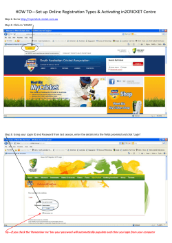


© Copyright 2026