
ADOT Tribal Consultation Actions: State Fiscal Year 2013
Janice K. Brewer, Governor John S. Halikowski, Director Scott Omer, Division Director Multimodal Planning ADOT Tribal Consultation Actions: State Fiscal Year 2013 The following provides a summary of tribal related consultation and coordination actions undertaken by ADOT Divisions. A number of the actions relate directly to the implementation of the ADOT tribal consultation policy priorities. Specific Tribes consulted and/or impacted are highlighted in bold italic lettering. Also mentioned are actions that are on‐going forms of communication that ADOT conducts with tribal governments, tribal communities, and tribal related agencies. Additionally, although it is understood that public involvement is not considered government‐to‐government consultation, it is important to note that this is a method that is carried out to obtain tribal community participation in transportation planning and programming processes. A number of the identified activities are undertaken in cooperation between the various Divisions illustrating ADOT’s internal team effort toward accomplishing successful transportation program and project implementation. Administrative Services Division (ASD) Grand Canyon National Park Airport December • Provided ground support to US Marine Corps Reserve for their Toys for Tots flights 2012 to the Havasupai Tribe. No additional cost incurred. Flights successfully completed. Financial Management Services 2012‐2013 • May 2013 • Awarded a Federal Highway Administration (FHWA) Grant for the following Project: The proposed project provides effective mechanisms for assessing the current level of fuel tax compliance in and around the Navajo Nation (Nation) by performing: retail station and refinery inspections; joint audits on carriers, retailers, and distributors; and fuel inspections on the Nation’s roads and highways. Establishing a visible presence on the Nation will be used as a measurement on the deterrence of tax evasion. The project will allow the Nation to strengthen its ongoing compliance capability, and will provide all agencies with training and experience that will promote effective and ongoing inter‐agency initiatives. Presented a training session in Window Rock, Arizona, May 15, 2013 on the Navajo Nation regarding the FHWA Grant. Agenda items included: Project Overview, Fuel Sampling, Inspection Logistics, Budget items. Training session was a prelude to the fuel inspections the week of July 8, 2013. Intermodal Transportation Division (ITD) – Engineering Districts Flagstaff District February US 89 Landslide and Navajo Route 20 (N20)/US 89T: 2013 In the early morning hours of February 20, 2013, a landslide ripped through a section of US 89 along a mountain slope about 25 miles south of Page, buckling more than 150 ARIZONA DEPARTMENT OF TRANSPORTATION 206 S. 17th Ave. | Phoenix, AZ 85007 | azdot.gov Janice K. Brewer, Governor John S. Halikowski, Director Scott Omer, Division Director Multimodal Planning feet of the roadway and tearing the pavement up in six‐foot‐high sections. The significant roadway damage forced the Arizona Department of Transportation to immediately close a 23‐mile‐long stretch of the highway (at mileposts 523‐546) between the US 89A junction near Bitter Springs to the State Route 98 junction near Page. ADOT in partnership with several stakeholders, including the Navajo Division of Transportation, the Navajo Nation, the Bureau of Indian Affairs and the Federal Highway Administration has paved the 28 mile portion of Navajo Route 20 (N20) that is dirt road to serve as the interim detour route to restore traffic to this region. Paving this route significantly reduced travel time for motorists heading to and from Page and the Lake Powell area. The primary detour route has been to take US 160 to State Route 98, which is approximately 45 miles longer than the direct route. The new route shaves half the distance and time to get to Page. The $35 million project was funded by the Federal Highway Administration’s Emergency Relief program, which provides funding to state and local agencies for the repair or reconstruction of highways, roads and bridges that are damaged in natural disasters and catastrophic failures. The paving of N20 is a true demonstration of a successful partnership. The Navajo Division of Transportation assisted ADOT with the expedient processing of a temporary construction easement for construction. The lengthy tribal process typically takes months and even years to complete. ADOT’s easement was processed within weeks through assistance from tribal departments and the BIA. In addition, with federal aid from the Federal Highway Administration, the road was paved in approximately 3 months. A construction project of this magnitude would normally take approximately 12‐18 months. Depending on factors such as investigating environmental impacts, a project similar to N20 from planning to construction may take 15‐20 years. Navajo Route 20 was on the Navajo Nation’s 40‐year Tribal Transportation Improvement Program for grade, drain and gravel construction of approximately 5 miles. In the meantime, US 89 has been closed north of Bitter Springs and south of Page since the February 20th landslide that buckled pavement on the mountain slope in the Echo Cliffs. There is no timetable for reopening the damaged highway but ADOT is committed to restoring this critical travel route as soon as safely possible. ADOT has completed its geotechnical field investigation, which is the first phase of the solution. Cutting back the mountain slope and constructing a gravity buttress wall is part of the proposed solution to repair US 89. The repairs, at an estimated cost of $40 million, could take more than two years to complete. After an exhaustive geotechnical investigation that included geologic mapping, subsurface exploration and monitoring, laboratory tests and slope stability analyses, the final report has been submitted. The 463‐page report concludes the recent landslide was a reactivation of a small portion of an ancient landslide, but little to no new movement has occurred since testing began. The active landslide is approximately 135 feet below the roadway and measures approximately 1,200 long at the base of the slope. The report listed several alternatives for the ultimate repair of US 89, but the construction of a landslide buttress and upslope lane adjustment was considered the most geotechnically feasible preferred alternative. The buttress, a wall‐like support structure composed of rock, ARIZONA DEPARTMENT OF TRANSPORTATION 206 S. 17th Ave. | Phoenix, AZ 85007 | azdot.gov Janice K. Brewer, Governor John S. Halikowski, Director Scott Omer, Division Director Multimodal Planning would be built at the base of the slope and the highway travel lanes would be moved farther to the east by creating a new cut into the existing slope in the Echo Cliffs. “The recommendation is to move the road 60 feet, and take the rock from the cut and put it at the base of the hill to form a rock buttress to lock in the recent slide,” said Steve Boschen, ADOT deputy state engineer of design. “The right‐of‐way and environmental process will be our biggest challenge, but we will streamline that as much as possible so we can benefit the traveling public and especially the Bitter Springs and Marble Canyon communities.” At a later date, ADOT will formally request additional federal aid to fund the repair of US 89 through the Federal Highway Administration’s Emergency Relief program and continued partnerships with the Navajo Division of Transportation, the Navajo Nation, the Bureau of Indian Affairs and the Federal Highway Administration will remain critical to the success of repairs and reopening of the route. Visit www.azdot.gov/us89 to learn more, read updates and view photos. See Attachment A for US 89 Landslide and N20/US89T Outreach Summary to date. Holbrook District 2012‐2013 • Attended the Navajo Nation/Navajo DOT/ADOT/BIA/ FHWA/Hopi Tribe/Counties Partnership quarterly steering committee meetings. • Attended the Hopi Tribe/BIA/FHWA/ADOT/Navajo Nation/Navajo DOT/Counties Partnership quarterly steering committee meetings. July 2012 • Keams Canyon Widening Project is to relocate waterline; met at Hopi BIA Office in Keams Canyon, and IHS and Hopi BIA were present. Project is continuing. • Ganado Shopping Center Permit Project stakeholders meeting, Navajo Nation Project Development office present. August 2012 • Met with Isabel Shondee at Navajo Nation Ganado Chapter, Chapter Coordinator present, seeking assistance with a permit project – Veteran’s Memorial / Senior Center. September • Navajo Nation Window Rock fair – permit staff met with fair contacts to issue 2012 permit for the parade and discuss requirements of the permit. October • Partnering meeting for the Oribi Wash Project on Hopi Reservation. 2012 • Public information meeting held for the Chambers Port of Entry (POE) project to keep the public informed. • Met with Ganado schools regarding the SR 264 Burnside to Summit Project to identify bus pullout locations. November • Ganado Shopping Center Permit Project development meeting, Ganado Chapter 2012 President, Navajo Nation Economic Development Project Manager, Navajo Tribal Utility Authority (NTUA) and Indian Health Services (HIS) were present. December • Design coordination meeting for SR 264 design. 2012 January • Keams Canyon Widening Project, waterline issue, met at Hopi BIA Office in Keams 2013 Canyon, IHS and Hopi BIA were present. • Navajo Nation Kayenta Chapter meeting; attended regarding traffic calming and speed radar signs. • Sanders TI reconstruction project partnering meeting on Navajo Nation. ARIZONA DEPARTMENT OF TRANSPORTATION 206 S. 17th Ave. | Phoenix, AZ 85007 | azdot.gov Janice K. Brewer, Governor John S. Halikowski, Director Scott Omer, Division Director Multimodal Planning • April 2013 • • • • • May 2013 June 2013 • • • Met with Ganado schools regarding the SR 264 Burnside to Summit Project to continue discussions about identifying bus pullout locations. Desert Meadows Permit Project kickoff meeting in St. Michaels; Navajo Nation Project Development office present. Northern Arizona Council of Governments (NACOG)/Elected officials update. Attended the Navajo Nation/Navajo DOT/ADOT/BIA/ FHWA/Hopi Tribe/Counties Partnership Navajo/Hopi Emergency Response task team meeting to get reorganized and to resume meetings. Met with Navajo Nation Transit regarding the SR 264 Burnside to Summit Project to discuss request for a bus park‐n‐ride and identification of a location. SR 264 Burnside to Summit Project – finalized bus park‐n‐ride location with Navajo Nation Transit and conducted a field review; presented project at Kinlichee Chapter meeting. ADOT held a safety standown day at the Navajo Nation Chinle Chapter House. SR 264 Burnside to Summit Project – field review with Navajo Nation Transit; presented project at Ganado Chapter meeting. Informed Navajo Nation Many Farms Chapter about Fence and Cattle Guard Project. Kingman District 2012‐2013 • The Kingman District initiated quarterly coordination meetings with the Hualapai Indian Tribe and Fort Mojave Indian Tribe in 2012. Participation includes tribal representation from cultural development, public works, planning, and law enforcement. ADOT representation includes engineering, maintenance, environmental and community relations. The meetings provide an open forum to discuss and coordinate current and future transportation projects, help identify and partner to resolve transportation issues, and continue to commit and foster interagency communication. Phoenix Construction District August 2012 • SR87 – L202 to Gilbert Rd on Salt River Pima‐Maricopa Indian Community reservation was a $2.5M federally funded project that involved milling and paving 5 miles of SR 87 and upgrading all of the signs. The main project benefit was to upgrade the pavement on this section of SR87 thereby improving ridability and safety. April 2013 • Fort McDowell Yavapai Nation Various Rd is a $2.7 M locally funded project that involves paving 7 various routes near the intersection of Ft. McDowell Rd and SR 87. Project time started on April 10th. Currently 5 of the roads have been paved. The main project benefit is to stabilize the existing dirt roads with asphalt thereby improving air quality. Phoenix Maintenance District 2012‐2013 • The Phoenix Maintenance District Environmental Coordinator is coordinating with the Gila River Indian Community on the final draft of the Southeast Valley Regional Drainage System Complex (SEVRDS) Intergovernmental Agreement (Loop 202 and Kyrene Basin). The draft agreement formalizes sampling activities for Stormwater and Non‐stormwater discharges onto Community lands. Results for past sampling have found no excedences for water quality parameters. Approved by ADOT, the draft is now in the final review and approval process at the ARIZONA DEPARTMENT OF TRANSPORTATION 206 S. 17th Ave. | Phoenix, AZ 85007 | azdot.gov Janice K. Brewer, Governor John S. Halikowski, Director Scott Omer, Division Director Multimodal Planning Community’s Tribal Council. Prescott District August 2012 • Safford District 2012‐2013 • ADOT Prescott District/Yavapai Prescott Indian Tribe Partnering Workshop for the Tribal Connector Permit Project. This project is located on tribal lands and connects to SR69 and SR89. The SR69 intersection is ADOT ROW and the SR89 intersection is Yavapai County ROW with the signal being maintained by the City of Prescott for the County. The Yavapai Prescott Indian Tribe began planning for this project in 1994 and they are now ready to construct the final phase. The project involves widening SR69 from approximately U‐Haul to Heather Heights, adding acceleration and deceleration lanes, access to the connector road at the Target signal, improvements to the Taco Bell intersection and a traffic signal on SR89. ADOT issued the permit to allow the project to connect to the State highway system. Attended the San Carlos Apache Tribe/State/Federal/Counties/Railroad/Private Organization Partnership quarterly steering committee meetings. Intermodal Transportation Division (ITD) – Sections Local Public Agency Section September • The ADOT Local Public Agency Section (formerly the Local Government Section) 2012 provided an all‐day training on September 26th at the Intertribal Council of Arizona (ITCA) on the new Local Public Agency Projects Manual that is wrapped around the federal process. This training provides attendees with basic knowledge to develop and deliver projects under the Federal‐aid Highway Program; additionally, the training educates users in how to use the manual. ADOT personnel provided a day of teaching in an interactive setting; no fees were charged. Refreshments were donated by ADOT employees. Eight attendees received training on federal process. March 2013 • Met with representatives from the San Carlos Apache Tribe and Bureau of Indian Affairs regarding Indian Reservation Road (IRR) 193 located on Tribal lands. The meeting was to identify possibilities of advancing the Surface Transportation Program (STP) project from an FY16 Construction window to FY13. Right of Way 2012‐2013 • Attended the Navajo Nation/Navajo DOT/ADOT/BIA/ FHWA/Hopi Tribe/Counties Partnership and the Hopi Tribe/BIA/FHWA/ADOT/Navajo Nation/Navajo DOT/Counties Partnership quarterly steering committee meetings where each partnership is working together for mutual benefit. • Worked with the Navajo Nation acquiring a Temporary Construction Easement (TCE) for the ADOT Cameron Bridge project. • Attended the San Carlos Apache Tribe/State/Federal/Counties/Railroad/Private Organization Partnership quarterly steering committee meetings. February ‐ • Worked with the Federal Highway Administration, Navajo Nation, Navajo DOT and June 2013 the Bureau of Indian Affairs to partner on expediting the procedure required to obtain the use of Navajo Nation Route (N20) now called US 89T (see section ITD Flagstaff District, February 2013). ARIZONA DEPARTMENT OF TRANSPORTATION 206 S. 17th Ave. | Phoenix, AZ 85007 | azdot.gov Janice K. Brewer, Governor John S. Halikowski, Director Scott Omer, Division Director Multimodal Planning Multimodal Planning Division (MPD) Research Center • The federal Tribal Transportation Program is presently the single major source of funding for transportation projects available to the 22 tribes in Arizona. Unfortunately, this funding source is unable to meet all tribal transportation needs and objectives. Tribes have expressed a desire to positively influence the quality of life in their communities by having the authority to make decisions regarding funds from multiple sources used for transportation improvements. This research study will evaluate current funding processes and sources, investigate barriers to greater participation in state transportation decision making, identify successful practices from other states, and recommend next steps. Systems Planning & Programming 2012 • Chemehuevi Indian Tribe, Transit Authority and ADOT coordination and progress meetings regarding the Tribe’s Fiscal Year 2010 and 2011 Ferry Board Discretionary funding awards. 2012‐2013 • ADOT‐Inter Tribal Council of Arizona (ITCA) Tribal Traffic Safety Discussion Meetings attended in July 2012, and April and May 2013 to discuss strategies for addressing tribal traffic safety issues and projects. • ITCA Tribal Transportation Working Group Meetings were attended in September and November 2012, and March and May 2013. These meetings address tribal‐ specific transportation related issues and also MPD provided an ADOT Tribal Coordination Report update. • Attended the Navajo Nation/Navajo DOT/ADOT/BIA/ FHWA/Hopi Tribe/Counties Partnership quarterly steering committee meetings. • Attended the Hopi Tribe/BIA/FHWA/ADOT/Navajo Nation/Navajo DOT/Counties Partnership quarterly steering committee meetings. • Attended the San Carlos Apache Tribe/State/Federal/Counties/Railroad/Private Organization Partnership quarterly steering committee meetings. • National Historic Preservation Act Section 106, ADOT and FHWA Consultation meetings with Salt River Pima‐Maricopa Indian Community and Gila River Indian Community. July 2012 • Regional Planner participated with member(s) of Colorado River Indian Tribes at the WACOG monthly Technical Advisory Committee meeting. During the meeting there was discussion of the Tribe’s recent award of FTA 5311c funding. In addition to the FTA award, the Tribe received a Planning Assistance for Areas Program (PARA) grant from ADOT. Regional Planning recommended combining the funding awards into one PARA project. • FY 13 ADOT Planning Assistance for Rural Areas (PARA) Program Webinar conducted on July 28th for tribal governments, cities, towns and counties. August 2012 • Kayenta Township Multimodal Transportation Planning Assistance for Rural Areas (PARA) Study completed. • Navajo DOT PARA Chinle‐Many Farms and Saint Michaels‐Window Rock‐Fort Defiance Multimodal Long Range Transportation PARA Study completed. • ITCA Tribal Motor Vehicle Crash Injury Prevention Data Roundtable and Injury ARIZONA DEPARTMENT OF TRANSPORTATION 206 S. 17th Ave. | Phoenix, AZ 85007 | azdot.gov Janice K. Brewer, Governor John S. Halikowski, Director Scott Omer, Division Director Multimodal Planning • • • • • September 2012 • • • • • October 2012 • • • • • Prevention Working Group meeting attended on August 15th. In follow‐up to a June 2011 FHWA‐ADOT‐Tribal Section 106 Tribal Consultation Workshop, MPD Tribal Planners developed an “Overview of the ADOT Project Development Process” and an “Overview of the Councils of Government and Metropolitan Planning Organizations in Arizona” resource documents, which were presented to workshop participants in August 2012. Apache County/Navajo Nation Fort Defiance Chapter Traffic Circulation and Colorado River Indian Tribes 2014 Strategic Long Range Transportation Plan PARA Studies selected for funding. Tribal officials notified of the awards and next steps in the study process. 2012 National Tribal Transportation Safety Summit attended on August 28‐30 in Shakapee, MN. Attended ADOT Prescott District/Yavapai Prescott Indian Tribe Partnering Workshop for the Tribal Connector Permit Project. This project is located on tribal lands and connects to SR69 and SR89 (see ITD Prescott District). Participated in the Federal Aviation Administration and ADOT Annual Planning meeting with San Carlos Apache Tribe Airport. Hopi Tribe ‐ Building Partnerships In Tribal Mobility ‐ Transportation Coordination Workshop attended on September 14th on the Hopi Reservation. AZ Disaster Recovery Framework/National Disaster Recovery Framework Workshop attended on September 18th on the Salt River Pima‐Maricopa Indian Community. Tribal emergency disaster planning and recovery were discussion items. FHWA Accelerating Safety Activities Program project was awarded to the Inter Tribal Council of Arizona on September 18th in the amount of $10,000 to develop and conduct an Arizona Tribal Safety Workshop process for one tribe and which will address tribal traffic safety issues through development of a tribal safety plan. Evaluated Moving Ahead for Progress in the 21st Century (MAP‐21) Tribal High Priority Projects Program as part of implementing the new transportation legislation. Assessment of MAP‐21 provisions included a detailed evaluation of implementation issues related to interpretations, challenges, recommendations, ideas, suggestions for guidance, training, studies, and technical support. Assessment of internal ADOT and FHWA implementation needs to ensure effective and timely implementation. Attended Arizona Commission of Indian Affairs Planning and Prioritization subcommittee meeting. Tribal Economic Resource Forum attended on October 4th in Phoenix. Navajo Nation Nahata Dziil Chapter Meeting – ADOT Presentation on the I‐40 Chambers Port of Entry Project attended on October 12th. Apache County Meeting attended on October 12th to discuss status and next steps of Planning Assistance for Rural Areas (PARA) planning study for the Navajo Nation Fort Defiance Chapter Industrial Area. Colorado River Indian Tribes Transportation Committee Meeting attended on October 25th to discuss status and next steps for the Tribe’s PARA study to update the CRIT Long Range Transportation Plan. Navajo Nation Tsaile/Wheatfields Chapter Meeting attended on October 26th to ARIZONA DEPARTMENT OF TRANSPORTATION 206 S. 17th Ave. | Phoenix, AZ 85007 | azdot.gov Janice K. Brewer, Governor John S. Halikowski, Director Scott Omer, Division Director Multimodal Planning • • • November 2012 • • • • • • December 2012 • • • January 2013 • • discuss implementation strategies for the recently completed N12 Road Safety Assessment. Attended Arizona Commission of Indian Affairs Board meeting. US 70 in Bylas on the San Carlos Apache Reservation – attended meeting to discuss and coordinate several projects planned for US 70 including roadway and intersection safety improvements, shared use path, Highway Safety Improvement Program study, and railroad crossing improvements. Coordination assistance to ADOT ITD for US 89‐SR 64 to Little Colorado River Project in Cameron on the Navajo Nation. ADOT and the Navajo Department of Transportation and Navajo Police Department convened a Traffic and Criminal Software (TraCS) Program Meeting on November 2nd. This meeting was to plan a stakeholder meeting on the Navajo Reservation to present the TraCS Program to Navajo Nation officials and obtain buy in for implementation. Arizona Tribal Preparedness Conference attended on November 7‐8 in Phoenix. The conference purpose was to encourage collaboration of tribal, local, county, state and federal preparedness through collective emergency planning, training, and exercising a higher level of preparedness for all types of emergencies and disasters. 15th Annual National Tribal Transportation Conference attended on November 13‐ 16 in Phoenix. This conference presents current state of affairs on all areas of tribal transportation. Navajo Nation Many Farms Chapter Planning Assistance for Rural Areas (PARA) study follow‐up meeting attended on November 15th to discuss implementation of the study recommendations. Navajo DOT TraCS Stakeholder Meeting held and attended on November 26th in Tse Bonito, NM for Navajo Nation Officials. Follow‐up actions to be conducted by the Navajo DOT Safety Section. Navajo Nation DOT and ADOT MPD Programming Section information exchange and coordination meeting. ADOT awarded an $80,000 Planning Assistance for Rural Areas Program (PARA) grant to Fort Mojave Indian Tribe to identify transit needs for their members. US Army Corp of Engineers Tribal Consultation and Intercultural Communications Training Course attended on December 3‐5. This course presented tribal consultation basics and current practices used by the Corp when working on projects located within tribal lands. ADOT MPD, Chemehuevi Transit Authority, CalTRANS, and FHWA coordination meeting regarding transit funding programs including ferry discretionary funding and changes as a result of the new transportation legislation, MAP‐21 (see also, ADOT MPD Transit, December 2012). ADOT Statewide Bicycle and Pedestrian Plan Update, Round II Public Involvement: news release was sent to each of the tribal transportation contacts and a letter, signed by the Director, was sent to each of the Tribal Chairs. Final Plan document at http://wwwa.azdot.gov/ADOTLibrary/Multimodal_Planning_Division/Bicycle‐ Pedestrian/Bicycle_Pedestrian_Plan_Update‐Final_Report‐1306.pdf. Completed the Fort McDowell Yavapai Nation Long Range Transportation Plan ARIZONA DEPARTMENT OF TRANSPORTATION 206 S. 17th Ave. | Phoenix, AZ 85007 | azdot.gov Janice K. Brewer, Governor John S. Halikowski, Director Scott Omer, Division Director Multimodal Planning February 2013 • • • • March 2013 • • • • • • • April 2013 • • • May 2013 • • • • Update, a Planning Assistance for Rural Areas (PARA) Study. Indian Nations & Tribes Legislative Day attended on February 5th. Colorado River Indian Tribes Transportation Committee Meeting attended on February 22nd to discuss next steps for the tribal PARA study to update the CRIT Long Range Transportation Plan and conduct a preliminary field review of tribal routes. Road Safety Assessment for the Colorado River Indian Tribes conducted and participated in on February 27th to March 1st on the CRIT Reservation. Began coordination, consultation and interpretation assistance to the US 89 Landslide and Navajo Route 20 (N20)/US 89T project (see ITD Flagstaff District, February 2013). White Mountain Apache Tribe Transportation Board Meeting attended on March 5th to review the findings of the recently completed SR 73 Road Safety Assessment. Inter Tribal Council of Arizona ‐ TraCs Training Meeting attended and provided presentation on the TraCS Program to tribal law enforcement and safety program officials. Apache County/Navajo Nation Ft. Defiance Chapter Industrial Area Traffic Circulation PARA Study Project notice to proceed issued to the project technical consultant on March 21st to get the study underway. Inter Tribal Council of Arizona – Tribal Motor Vehicle Crash Injury Prevention Program Meeting participated in on March 12th. Hopi Tribe ‐ Building Partnerships In Tribal Mobility ‐ Transportation Coordination Workshop attended on the Hopi Reservation. Attended Arizona Commission of Indian Affairs Board meeting. Completed the Cocopah Indian Tribe East Reservation Circulation Study, a Planning Assistance for Rural Areas (PARA) Study. Apache County/Navajo Nation Ft. Defiance Chapter Industrial Area Traffic Circulation PARA Study Project Field review attended on April 3rd with study consultant to acquaint team of transportation issue areas. Also conducted study Technical Advisory Committee Meeting on April 4th to present the study project and obtain input from tribal chapter stakeholders. FHWA Tribal Transportation Planning Webinar ‐ Consultation Module attended on April 30th. Construction in Indian Country Conference attended on April 30‐May 1 to provide a panel presentation on “Transportation Challenges for Tribes in Arizona,” and hear of tribal programs and projects. Colorado River Indian Tribes 2014 Strategic Long Range Transportation Plan PARA Study Project notice to proceed issued to the project technical consultant on May 10th to get the study underway. Arizona Strategic Highway Safety Plan Update ‐ Safety Launch Event attended on May 16th to coordinate and support tribal participation in the process. Apache County/Navajo Nation Ft. Defiance Chapter Industrial Area Traffic Circulation PARA Study Project stakeholder interview meetings attended on May 23rd to obtain input on community transportation issues and needs. Inter Tribal Council of Arizona – ADOT Strategic Safety Planning Meeting attended ARIZONA DEPARTMENT OF TRANSPORTATION 206 S. 17th Ave. | Phoenix, AZ 85007 | azdot.gov Janice K. Brewer, Governor John S. Halikowski, Director Scott Omer, Division Director Multimodal Planning • • • • • June 2013 • • • • • • • • • Transit August 2012 • • on May 31st to review the tribal safety issues from the Governors Traffic Safety Advisory Committee, Tribal Safety Working Group and various traffic safety/planning reports, and identify strategies to address the tribal infrastructure issues. Gila River Indian Community awarded Planning Assistance for Rural Areas (PARA) Program funds to conduct a Multimodal Pedestrian Safety Study. Hualapai Indian Tribe awarded Planning Assistance for Rural Areas (PARA) Program funds to conduct an update to their Long Range Transportation Plan. Provided a presentation on ADOT’s Tribal Consultation Policy to the Arizona Association of Environmental Professionals. Attended Arizona Commission of Indian Affairs Board meeting. Completed the ADOT Tribal Transportation Consultation Online Training course. The training was developed to support the agency’s commitment to tribal consultation and coordination. It provides ADOT personnel a tool to strengthen their knowledge and skills in working with tribal partners and to help implement ADOT’s Department‐Wide Native Nation/Tribal Government Consultation Policy. Regional Planner initiated the Fort Mojave Indian Tribe Transit Feasibility Study. The project will conclude in 10‐11 months. Colorado River Indian Tribes Transit Planning Meeting attended on June 7th to discuss the status of the Tribes Federal Transit Administration Tribal ‐ Transit Program project and coordination with the Tribes PARA study. Arizona State Historic Preservation Office ‐ Traditional Cultural Places Workshop attended on June 12‐13 to hear on current issues pertaining to tribal lands in Arizona. Colorado River Indian Tribes 2014 Strategic Long Range Transportation Plan PARA Study Project Technical Advisory Committee Meeting conducted on June 14th to present the study project and obtain input from tribal chapter stakeholders. Colorado River Indian Tribes 2014 Strategic Long Range Transportation Plan PARA Study Project stakeholder interview meetings and community member awareness meeting attended on June 20th to obtain input on community transportation issues and needs. ITCA Planning for Tribal Transportation Safety Workshop attended on June 25‐26 to review federal and state traffic safety programs and development of tribal traffic safety plans. Cocopah Indian Tribe, FHWA and ADOT, National Historic Preservation Act, Section 106 Consultation meeting attended. Navajo Nation Route 20 (N20)/US 89T groundbreaking ceremony attended (see ITD Flagstaff District, February 2013). Hopi Tribe, FHWA and ADOT, National Historic Preservation Act, Section 106 Consultation meeting attended. Chemehuevi Indian Tribe Transit Consultation—Provided technical assistance regarding potential 5311 Rural Public Transportation Program funding opportunities and invited them to the annual workshop. The tribe attended the workshop, but chose not to apply for this funding year. Section 5310 Enhanced Mobility of Seniors and Individuals with Disabilities 2012 ARIZONA DEPARTMENT OF TRANSPORTATION 206 S. 17th Ave. | Phoenix, AZ 85007 | azdot.gov Janice K. Brewer, Governor John S. Halikowski, Director Scott Omer, Division Director Multimodal Planning September 2012 • November 2012 • • December 2012 • • January 2013 • February 2013 • March 2013 • May 2013 • June 2013 • • awards to San Carlos Apache Tribe, Hualapai Indian Tribe, and Hopi Tribe Moenkopi Senior Center in Tuba City. FFY13 5311 Rural Transit Workshop—Provided technical assistance to current and prospective subrecipients including Chemehuevi Indian Tribe, Gila River Indian Community, Hopi Tribe, Navajo Navajo, Salt River Pima‐Maricopa Indian Community, and San Carlos Apache Tribe. Outcome—Everyone received program and contact information, financial training, Civil Rights, and DBE training. Scholarship funding for attendance was provided averaging approximately $7,500. National Tribal Conference: One issue raised was the direct funding to tribes as an allocation by population changed the funding nationally to provide some funding to all tribes, but reduced funding to many tribes that had transit service. Also, Federal Transit Administration requested assistance in the federal register definitions of reservations/tribal lands for funding purposes. Results: Provided Moving Ahead for Progress in the 21st Century (MAP‐21) Program Requirements to Tribes as a result of the conference. Salt River Pima‐Maricopa Indian Community Triennial Review—ADOT conducted 5311 Rural Public Transportation Program compliance oversight. This two day review of the Tribal Transit program provided technical assistance as well as ensuring compliance with the grant funding requirements. Arizona, New Mexico, and Utah coordinated for Navajo Nation Paratransit Funding and Oversight. Three states all fund Navajo Paratransit with the associated oversight requirements. The meeting was held to reach consensus on the paratransit requirements and to coordinate oversight activities. California and Arizona coordination meeting for the Chemehuevi Tribe because the facilities cross Arizona and California borders. The goal of the coordination is to ensure clarity in compliance with the federal regulations. Provided technical input to the Long Range Transportation Plan of the Colorado River Indian Tribes, with specific regard to the transit element. This is an ongoing activity till the study is completed. Section 5310 Enhanced Mobility of Seniors and Individuals with Disabilities coordination efforts in discussion with Hopi Tribe and Navajo Nation to combine their transit into a Regional Transit Authority. Planning Assistance for Rural Areas (PARA) program study proposed. Sent out a Request for Proposals to ADOT MPD On‐Call consultants for a transit feasibility study for the Fort Mojave Indian Tribe. Grand Opening—San Carlos Apache Tribe received 5311 Rural Transit Funds allowing them to purchase 2 new buses and expand service. ADOT attended the Grand Opening Celebration. Approximate funding awarded by ADOT: $186,000. 5311 Rural Transit Grants Awarded to Tribal Communities in AZ: ADOT awarded $3.15 million in 5311 Rural Transit Funding to Gila River Indian Community, Hopi Tribe, Navajo Nation, Salt River Pima‐Maricopa Indian Community, and San Carlos Apache Tribe. Additional funding that serves tribal communities was awarded to regional transit providers. The tribes served are: Cocopah Indian Tribe, Quechan Indian Tribe, Pascua Yaqui Tribe, Tohono O’odham Nation, and White Mountain Apache Tribe. Gila River Indian Community became a new 5311 Rural Public Transportation ARIZONA DEPARTMENT OF TRANSPORTATION 206 S. 17th Ave. | Phoenix, AZ 85007 | azdot.gov Janice K. Brewer, Governor John S. Halikowski, Director Scott Omer, Division Director Multimodal Planning recipient. • Kimley‐Horn and Associates was selected to complete the Transit Feasibility Study for the Fort Mojave Indian Tribe. This study will research demographic trends and review corridors of travel and propose the most suitable transit options for the Tribe. Transportation Analysis June 2013 • Met with BIA Western Regional Office to discuss the Next Generation 911 and Road Centerline data needs on tribal lands in Arizona. To learn more about Next Generation 911, please visit http://www.its.dot.gov/ng911/index.htm. The national benefit is road safety and improvement in the response time for emergency responders (Police, Fire, and EMTs). For questions or more information regarding this ADOT Annual Tribal Consultation Report please contact: Misty Klann, ADOT‐MPD Transportation Planner & Tribal Liaison P: 602.712‐7029|F: 602.712.3046|E: [email protected] Don Sneed, ADOT‐MPD Senior Transportation Planner & Tribal Liaison P: 602.712.6736|F: 602.712.3046|E: [email protected] ARIZONA DEPARTMENT OF TRANSPORTATION 206 S. 17th Ave. | Phoenix, AZ 85007 | azdot.gov Attachment A US 89 Landslide and N20/US89T Outreach Summary US 89 Landslide Navajo Nation Community Outreach Chapter House Meetings April/May/June/July/August 2013 Background The Arizona Department of Transportation (ADOT) is continuing efforts to provide information regarding the status of US 89 as a result of the landslide that occurred on February 20, 2013. ADOT is contacting and requesting to present at Navajo Nation Chapter Meetings. Following ADOT’s presentation at the chapter meetings, participants were encouraged to ask questions and have an open discussion. The following summarizes the open discussion at each of the meetings. Date Chapter House Attendance ADOT Staff Attendance Comments, Questions, and Answers Questions and Answers: 4/8/13 LeChee Chapter 24 participants Steve Monroe Mackenzie Kirby Q: How thick will the pavement be on N20 once complete? Amy Rosar Yvonne Bigman, LeChee A: The pavement will be designed to be 4‐inches. Chapter Vice President Q: What is the thickness of the existing pavement? (Interpretation) A: The road is currently owned by the Bureau of Indian Affairs and not an ADOT road. ADOT does not know the thickness of the existing pavement. Q: Are school buses allowed to use the emergency road alongside the landslide site? A: No. The emergency access road is strictly for use by emergency vehicles. Because the causes of the landslide are unknown at this time, it is for the safety of all on site that the number of vehicles using the access road is minimized to prevent further damage. Q: What is the latest status of the agreements and contractor selection for the paving of N20? A: ADOT anticipates having a contractor selected by the end of the week (April 12). Agreements between ADOT and BIA have been signed. Q: Has ADOT considered the worst case scenario in case the existing US 89 cannot be repaired? A: Yes. ADOT is aware of the possibility of looking at other alternatives in case the existing alignment is unstable to reconstruct the roadway. ADOT’s goal is to take every measure possible to prevent landslides from damaging roadways in the future. Q: I’ve read that officials were anticipating this landslide and knew there was the potential for issues even before it was constructed. Is that true? A: ADOT did not initially build US 89. It was constructed in 1957 as a haul road for the construction of Glen Canyon Dam. Q: We have seen several rocks fall onto the roadway from the adjacent cliffs and canyons. Does ADOT evaluate why rocks fall? A: ADOT understands that rockfalls can occur, especially in areas where erosion occurs and the canyon walls are steep. In some portions of the state, ADOT has conducted rockfall containment projects to mitigate the possibility of debris on the roadway. However, limited funding prevents this from occurring on all the roadways. Q: Will fencing be constructed along N20 to help keep animals off the roadway? A: Yes. Right of way fencing will be installed. Q: There are a few springs at the bottom of the hill where the landslide occurred. Could those have played a part in the cause of the landslide? A: The geotechnical report has been completed and submitted. This report will help ADOT understand the cause of the landslide. At this point it is still unknown. Questions and Answers: 4/11/13 Coppermine 70 participants Audra Merrick Q: Has a source of water and gravel for the paving of N20 been identified? Chapter Amy Rosar Taft Blackhorse, Navajo A: This will be determined by the contractor once ADOT has a contractor on board. DOT (Interpretation) Q: There are approximately 16 miles along N20 that is currently paved. Will ADOT repave that portion as well as the unpaved portion? A: Yes. ADOT plans to pave the unpaved portion and provide a 2‐inch overlay to the paved portion. Q: Which end does ADOT intend to begin the repaving? A: Because the timeframe to get this project completed, the contractor will have several crews working simultaneously at various locations along N20. 1 US 89 Landslide Navajo Nation Community Outreach Chapter House Meetings April/May/June/July/August 2013 4/12/13 Tonalea Chapter 30 participants Dexter Albert Q: What is the planned width of the roadway? A: ADOT expects to design the roadway with a 28 foot width. Q: Will the bridge at Gap be able to hold the weight of the additional traffic? A: This will be looked at during design but it is anticipated that it will. Q: Will fencing be installed to help keep livestock off the roadway? A: ADOT plans to install right of way fencing towards the end of the project. Q: Will passing lanes or bus turnouts be constructed? A: Passing lanes will not be constructed. Bus pullouts will be considered. Q: What will be the thickness of the asphalt? A: The roadway is being designed with 6‐inches of base and 4‐inches of asphalt. Q: Does ADOT recognize the need to install animal crossings and right of way fencing? A: Yes. ADOT intends to accommodate the right of way fencing and the potential for cattle guard locations. However, animal crossings are still being evaluated. Q: Who will maintain N20 once it is paved? A: ADOT will maintain the road as long as it is used as the temporary detour route. Once US 89 reopens to traffic, ADOT will return the N20 alignment back to the BIA. At that time the BIA will be responsible for maintenance. Q: Is it possible to install additional signs for cautioning drivers of animals? A: Yes. ADOT will work with the design team to identify locations where these signs could be installed. Q: What will be put into place to discourage commercial vehicles from using N20? A: N20 is a public road and once paved commercial vehicles will be able to use it. Q: Can wildlife crossings be installed at grade level? We were told it takes too much material to raise the road to accommodate the underpass. A: ADOT is discussing these needs with the BIA and NDOT. It is understood that wildlife crossings are important, but they need to be designed properly. Q: Is paving of US 89 between mileposts 510 and 517 still being considered? A: ADOT will need to confirm this project. Comments: • There are issues with wildlife, including elk, along N20. Several elk have been spotted near windmill four and warning signs should be installed. • There are currently water pipes under the road adjacent to windmill one and two. Comments: • Noticeable increase in traffic through Tonalea/Red Lake on both US 160 and N21. Not only are there more through‐travelers, but there’s an increase in emergency vehicles such as ambulances responding to accidents. A lot of travelers, including semi‐trucks, aren’t used to this route and they tend to look around at the scenery and lose sight of the roadway. • With the increased traffic, there are a lot of vehicles traveling at a high rate of speed on US 160 and N21. There should be signs that tell people to slow down and/or remind them of the speed limit with increased law enforcement presence checking for speeders, including DPS, Navajo Nation Police and Coconino County Sheriff’s Office. • There is a dangerous turn off at the “lower store” or old Red Lake Trading Post because the driveway is just below the downward slope of a hill on eastbound US 160. There needs to be signage installed letting people know there is a turnout on the down slope of the hill. 2 US 89 Landslide Navajo Nation Community Outreach Chapter House Meetings April/May/June/July/August 2013 • 4/14/13 Tuba City Chapter 25 participants Amy Rosar Jason Yazzie (Interpretation) 4/20/13 Bodaway/Gap Chapter 60 participants Steve Monroe Misty Klann (Interpretation) Amy Rosar There are several locations along US 160 where turnouts and deceleration/acceleration lanes could be built. Especially with the heavier traffic, it is hard to turn and in and out of driveways. • In some areas there are school buses that stop in the middle of the road or pull off to the narrow shoulders and load or unload school children. This is dangerous. There should be pullouts built for school buses on US 160 and N21. Several years ago, there was an incident on US 160 between milepost 327‐328 where a semi‐truck rear‐ ended a school bus and there were two fatalities and several injuries involving school‐aged kids. • In 1952, there were questions about the condition of US 89 and the erosion in the area as well as underground springs and waterways that were present in the area. Back then, there were discussions and concerns about a road collapsing. No further studies were done and now the road has collapsed. • The road lanes need restriping white and yellow to delineate travel lanes. • Concerns were raised regarding existing conditions of dirt roads in the area, including Route 6260 where the road was washed out and hadn’t yet been repaired. There were requests to grade and upkeep school bus routes in the community. • Bus pullouts should be constructed on N21. There were two particular places of concern. The first is an area just north of the railroad crossing tunnel where buses stop on the road and sometimes it’s not visible and people don’t know to stop too. The second location near the Willow Tree area by the open pit; this is where the Kaibeto bus turns around. Community members requested ADOT and Coconino County take these concerns back to its partners, NDOT and BIA, and to Roland Becenti in particular. The Chapter President intends to write a letter regarding these issues. • In closing, Supervisor Mandy Metzger stated she would talk to DPS and the County Sheriff about increased patrols. She requested that the Chapter write a letter that she can deliver to law enforcement leaders. She will also do a bus ride along to get a first‐hand look at the conditions of roads and bus routes, as well as where and how buses load and unload in the area, and she said she’ll look into crossings and signage for area bus stops. Supervisor Metzger also talked about the ADOT project to provide lighting at the intersection of US 160 and N21, and that she would report any future updates about the project. Comments: • There has been a noticeable increase in traffic on US 160 through Tuba City. With the additional traffic, there has been an increase in speeding vehicles and slow moving commercial vehicles that cannot be passed. The presence of law enforcement should be increased in these areas. • More signage is required to direct commercial vehicles along the recommended detour. • Please return and present an update when information from the geotechnical report is known. Questions and Answers: Q: Please elaborate on why N20 won’t be improved according to the ultimate design improvements. A: Funding for the paving of N20 comes from the Federal Highway Administration through emergency relief funds. Because the funds are designated from an emergency fund, ADOT is only allowed to improve the roadway to get essential traffic moving through the region. The improvements will include paving the unpaved segment, installation of drainage, cattle guards and right of way fencing, and improving the currently paved segments. The ultimate design improvements would cost significantly more than FHWA is able to provide in emergency situations. Q: Will semi trucks be allowed to use N20? A: Yes. Q: How much coordination has occurred between ADOT, BIA, and NDOT? A: ADOT is working closely with the BIA, NDOT, and the Navajo Nation in coordination with FHWA. Q: What is the timeframe for repairing US 89? A: The timeframe to repair US 89 is currently unknown. ADOT is still investigating the cause of the landslide, and once that information is known ADOT can make a better decision on how to repair the roadway. Q: Is FEMA contributing funds to pave N20? A: No. Q: Is it possible to install additional signs for cautioning drivers of animals? A: Yes. ADOT will work with the design team to identify locations where these signs could be installed. 3 US 89 Landslide Navajo Nation Community Outreach Chapter House Meetings April/May/June/July/August 2013 4/21/13 Inscription Chapter 25 participants Misty Klann (Interpretation) Amy Rosar 5/5/13 Tuba City Chapter Coppermine Chapter 25 participants Amy Rosar 50 participants Kaibeto Chapter 38 participants Misty Klann (Interpretation) Amy Rosar Amy Rosar 5/9/13 5/13/13 Q: Where will the material come from that will be used on the N20 project? A: There are two locations are being considered, Big Water and Gray Mountain. Q: Were meetings conducted to get local input for the design of N20? A: Yes. BIA held a series of scoping meetings when the N20 study was conducted. That study has been complete since 2009. Q: The closure of US 89 resulted in the loss of business for vendors. Will vendors be allowed on N20? A: No, ADOT and the BIA discourage vendors within the right of way due to safety precautions. Comments: • School bus pullouts should be considered along N20 for safety purposes. • Fencing along N20 is an important safety measure. ADOT, BIA, and Coconino County should be focused on safety on all roads. Prevention of vehicle accidents should be the first priority. Questions and Answers: Q: Why not detour traffic to N21? A: Commercial vehicles are prohibited on N21 due to an area of low clearance. N20 also parallels US 89 closer and would reduce the overall detour miles. Q: Is the contractor hiring positions? A: Yes. The contractor is currently looking for laborers and hosted a job fair on April 22 and April 23. Comments: • There are several ADOT projects ongoing in the area. These projects should not be sidetracked to focus on the paving of N20 or the repairs of US 89. It will be important to complete the Potato Wash project. • The speed limit on SR 98 should be lowered from 65 miles per hour to 45 miles per hour at the Crossroads, Shonto, and the intersection of N21. • N16 between Cow Springs and Crossroads should be repaired by ADOT to help provide relief and reduce congestion during the US 160 construction project. This meeting was attended to have a presence. No presentation or update was provided. No community questions were asked. This meeting was attended to have a presence. Taft Blackhorse with Navajo DOT provided an update. No questions were directed at ADOT. Questions and Answers: Q: Can ADOT install some bus/pedestrian signs at the intersection of SR 98 at approximately MP 332? There are several pedestrians at that intersection. A: That will need to be discussed with the Flagstaff District. Q: Can the signage directing traffic to N21 be improved? There are several tourists who get lost and begin to drive past the school. A: Signage in this area would not be within ADOT’s right‐of‐way. The BIA would need to be contacted for this request. Q: Can speed bumps be placed along residential streets to lower the speed from all the additional traffic cutting through the community? A: This area is not within ADOT’s right‐of‐way. The BIA would need to be contacted for this request. Q: How can you better inform tourists and semi‐trucks not to use N21? A: ADOT is continuing to communicate that the preferred detour is to use US 160 and SR 98. 4 US 89 Landslide Navajo Nation Community Outreach Chapter House Meetings April/May/June/July/August 2013 5/13/13 LeChee Chapter 13 participants Amy Rosar Yvonne Bigman, LeChee Chapter Vice President (Interpretation) 5/13/13 Bodaway/Gap Chapter Misty Klann (Interpretation) Q: Can law enforcement presence be increased along SR 98? A: This request will be passed along to DPS. This meeting was attended to have a presence. No presentation was provided. Questions and Answers: Q: Are office hours at Page City Hall still open? A: Yes. At this time the office is staffed Wednesdays and Thursdays between 9 a.m. and 5 p.m. Q: When will the contractor begin hiring employees for the N20 paving job? A: The contractor is currently in negotiations with ADOT. Once the negotiations have been settled and the contractor is under contract, they can begin to hire employees. This meeting was attended to have a presence. No presentation was provided but provided an update on the geotechnical investigation and contract negotiations for construction of N20/US89T. Questions and Answers: Q: Is there a plan of action for US89? A: The geotechnical investigation is wrapping up and it is anticipated that the final reports will be ready by the end of May. The process is that once the data is collected, and analyzed, it will be summarized into reports. These findings will provide ADOT a better picture of options on how to address the landslide. At this time, there is no specific plan. Q: Will we be able to see the geotechnical reports? A: Yes Q: I frequently see police, ambulance, ADOT vehicles and other traffic utilizing the emergency route at the landslide, why can’t ADOT open that route up just for local residents to utilize to Page? This 2 hour drive, at minimum, is taxing us immensely – gas is expensive and going through N20 severely damages our vehicles. This situation is all encompassing difficult to maintain our quality of lives. I read online that there has not been any more land movement. [Chapter approved resolution requesting ADOT for access through the landslide area] A: ADOT is thankful for the community’s patience as it works to figure out how to best address US89, while at the same time restoring traffic to the area through N20/US89T. The reason no one other than authorized personnel can utilize the road through the landslide is due foremost to safety and then liability. The landslide area is still very dangerous and some areas of the cracks have deep cuts. Although the online updates may indicate that there has been no further movement, it is not absolute that it would not happen again. To prevent anyone from any injuries or fatalities, it is in the best interest of the community to not travel through the landslide. If something were to happen, ADOT would be liable for the incident. Finally, if traffic were to open up even just to the local residents, word would get out quickly and soon there would be a swarm of people wanting to utilize the route further endangering the situation for all public users. Q: All we are asking is when it is deemed safe, we would like ADOT to restore traffic through US89 as soon as possible. Will ADOT please keep us informed? A: Absolutely, that is what we are here to do. Q: At the beginning of this incident, many leaders from ADOT, the Navajo Nation and Navajo DOT were informing us that they will work together quickly. The paving of N20 is taking far too long – our children and our elderly are suffering the consequences. Our livelihood depends greatly on our travels to Page for healthcare, school and other activities. [One person shared that a bus broke down and her grandchild reported that she was scared, and she did not have access to water or anything] How much longer is this going to take? I feel like we have been forgotten about out here. When those leaders were here, I expressed my concerns to a lady that was the state engineer or assistant and asked if we could have a local liaison to help us keep informed. We can provide an office for someone to be here. We need someone who is familiar with the area, and our challenges. She said she would make that happen but it has been nearly 3 months and still no one is here. Instead there is a project office in Page. I’m not going to drive 2 hours one way to Page to ask a question. There needs to be someone here – we have requested this many times. [Sentiments shared by chapter attendees] A: I will follow‐up on your request. 5 US 89 Landslide Navajo Nation Community Outreach Chapter House Meetings April/May/June/July/August 2013 5/19/13 Cameron Chapter Misty Klann (Interpretation) 5/20/13 Shonto Chapter Misty Klann (Interpretation) 5/22/13 Tri‐Chapter Meeting – Bodaway/Gap, Coppermine, Steve Monroe Julian Avila Misty Klann (Interpretation) Approximately 40 participants Q: Since ADOT is already making huge drills into the land to conduct geotechnical investigations, why can’t they start stabilizing at the same time? A: Because without a comprehensive data analysis on the situation, it is not known if that would be the best course of action to address this situation for the long term. A careful evaluation of the area is necessary to best utilize our limited resources and to ensure safety in the long run. Comments: • There have been many land‐related incidents in other states such as California similar to this landslide and it has not taken that state nearly as long as it is taking ADOT to fix this situation. • Some people are looking at the landslide area from a distance and have observed “working” personnel just sitting around. The question begs, what is going on? • We want to be informed – we want to see the results of the geotechnical investigation, the options for US89 and the status of N20/US89T. Our community is most impacted. With someone local, we can come in to ask questions or express our concerns and be heard because sometimes that is all we need and we feel better and can go about our lives again. Questions and Answers: Q: Is it possible to get a traffic sign indicating that the road (SR64) to GC south rim is open? A: I will ask ADOT Flagstaff District Office and provide the chapter an update. Q: Where are the locations of the gravel source for N20? If from Gray Mountain, we need to know so the community can anticipate truck traffic. A: Absolutely, and based on the last update, it is going to be from Gray Mountain. [Confirmed with Steve Monroe and emailed chapter – flyers and notices will be put up prior to any truck movement; there will be a sign north of 89 just south of Gray Mountain entrance and another south of Gap; a schedule was anticipated May 22nd] Q: Could we get an update on the Cameron project (US89‐SR64 to LCR) at next month’s chapter meeting, which is June 18th? A: The last information I had was that the Navajo Nation/Navajo DOT and ADOT were working out the details of the joint project agreement regarding the maintenance and utility costs of sidewalks and lighting in the pedestrian walkways. I will contact the project manager to see if he or a project representative can attend the next meeting to provide the latest update. [Emailed David Benton, ADOT Project Manager relaying the request and David indicated he would work with his project team to make the arrangements with the chapter for either the June or July meeting date.] Questions and Answers: Q: How long before N20 paving is complete? A: It is anticipated to be a 3 month summer project. This project schedule is taking into account school bus traffic once schools are back in session in August. Q: Will N20 be paved or graveled? A: It will be paved. Q: My son applied to FNF Contracting, are they still accepting applications or when will we find out the status of the application? A: FNF had two job fairs in April. Due to various activities including final contract negotiations and signatures, FNF probably had not begun to review applications. FNF will contact those individuals with qualifications that meet their needs to complete construction. FNF is accepting applications and a follow‐up by your son may be needed. Q: What happens to funds for the other statewide projects because of the emergency project? We want the projects in our areas in particular to continue. A: I will follow‐up and provide an answer to be certain of the impacts. Comments: • Since the rerouting of traffic has begun through US160, there has been a lot of traffic through our communities and also a lot of speeding occurring. AZDPS does not have heavy patrol in the area. The area needs to be patrolled more, especially at intersections, and the speed limits at these intersections should be decreased. • There is a Western Agency Chapter meeting on June 15th at Tonali Lake Chapter. ADOT might want to consider providing an update at that meeting. Questions and Answers: Q: Is it possible to allow members of the community access on US 89 once it’s deemed safe while construction is underway on N20? A: An answer to allowing access on US 89 would need to come from upper management at ADOT. This question would require follow up. 6 US 89 Landslide Navajo Nation Community Outreach Chapter House Meetings April/May/June/July/August 2013 LeChee Amy Rosar Q: Thank you for paving N20. Our prayers have been answered. What is the timeframe for each three mile segment of paving along N20 during construction? A: The roadway will be paved in three mile segments, within each three mile segment there will be five steps – placing gravel, smoothing of gravel, placing of aggregate base, smoothing of aggregate base, and placing of asphalt . It is anticipated that the process will move approximately ½ mile a day. Q: The Chapter House approved a resolution requesting ADOT allow access for locals through the landslide site. Has this issue been addressed? A: This issue has been escalated to ADOT management and a decision is yet to be determined. ADOT is still waiting for the results of the geotechnical report and the roadway needs to be deemed stable prior to allowing public traffic back on the road. Q: Once construction is complete, who will be responsible for maintenance of N20? A: ADOT will be responsible for maintenance of US 89T (N20) while the roadway is being used as the temporary detour. Once US 89 reopens to traffic, US 89T (N20) will once again become the responsibility of the BIA. Q: Will commercial vehicles be allowed on N20? A: Yes. Q: How wide will N20 be once complete? Will there be soft shoulders or will it be similar to US 89? A: The roadway is designed to be 28 feet wide with 12 foot lanes. There will be two foot shoulders on each side. In two locations, left turn lanes will be installed and that will require the roadway to be wider than 28 feet in those areas. Q: Will additional Federal funding be required to repair US 89? A: Yes, it is anticipated that the Federal highway Administration will help fund the repairs to US 89. Q: Can you provide more details regarding the number of scrapers and what their operations will be on site? A: Those details have not been finalized; however, it is anticipated that there will be two scrapers operating on the south end and one on the north. There will be a total of eight to ten scrapers located throughout the job site. Q: There has been an increase in speeding traffic through LeChee. There are several school children and animals that walk alongside the road. Safety is our main concern and we would like to know what will be done to maintain a safe roadway in this area? A: The paved section of N20 is currently outside the limits of the project. However, follow up with ADOT’s Northern Arizona traffic group would be necessary. ADOT is aware that there is increased traffic along several local roads due to the closure of US 89. Q: Where will the paving end at the north end? Will it go all the way to Page City Limits or to the SR 98 intersection? A: This project will end where pavement begins again on the north end. Q: Would it be the preference of FNF that locals try to keep their cattle more than 40 feet from the roadway? A: Yes, any measures that can be taken to ensure the safety of livestock would be preferred and would also help keep the project on schedule. Q: Are there still positions open for employment with FNF? A: Yes. Interested parties would need to submit an application. Comments: 7 US 89 Landslide Navajo Nation Community Outreach Chapter House Meetings April/May/June/July/August 2013 6/10/13 LeChee Chapter Approximately 20 participants Patricia Blackhorse (Interpretation) Amy Rosar 6/13/13 Coppermine Chapter Approximately 25 participants Patricia Blackhorse (Interpretation) 6/19/13 Kayenta Chapter Approximately 50 participants Amy Rosar Leo ‐ Navajo County Public Works (Interpretation) 6/29/13 Bodaway/Gap Chapter Approximately 25 participants Amy Rosar Taft Blackhorse (Interpretation) 7/8/13 LeChee Chapter Approximately 20 participants Amy Rosar Taft Blackhorse (Interpretation) • The community member reiterated the importance of being safe in the construction zone. • Forget repairs on N20 just fix US 89. It is hoped that the repairs to US 89 will not be forgotten in the rush to pave N20. • There is a horse trail that crosses US 89 at the south end of the closure that locals are still using. Please do not take this trail away. Questions and Answers: Q: Some time ago it the word “temporary” was used when describing N20. Does that mean that the pavement will not be permanent? A: No. The word “temporary” was being used to describe that the route was a temporary detour route. The pavement will be permanent and will be maintained by ADOT as long as the route is being used as a detour. Once US 89 is repaired and opened to traffic, ADOT will give N20 back to the BIA and it will become their responsibility at that time to maintain the roadway. Q: Will the potholes in the existing paved portions of N20 be repaired? A: While this road is used as the temporary detour route, it will be maintained to state highway standards. The objective at this time is to pave the unpaved portion. Maintenance and repairs to the existing portion may occur at a later date. Q: The base for the road is pure sand. How can you build a road on sand to ensure that it lasts? A: ADOT is installing geogrid on top of the sand which is a strong Kevlar mesh material that will help create a stable base which will be weighed down by the aggregate base and asphalt to stabilize the roadway. Q: Is Rummel still hiring laborers for the job? A: ADOT is not responsible for hiring laborers. All employment inquiries would need to be directed towards the contractor. Comments: • Please address the mountains of dirt that are along N20 at several of the connecting streets such as the road to the Coppermine Chapter House. It is difficult to access these roads in smaller vehicles. • Michael Manson, resident, commented that he is not in favor of the project and would like to see the road remain unpaved. He would like to have gates installed as opposed to cattle guards at the entrance to his residence at Manson Road. Both comments were addressed at the June 19 weekly construction meeting. Questions and Answers: Q: Will N20 be built to ADOT standards? A: Yes. N20 is being constructed by ADOT and will be maintained by ADOT while it is being used as the detour route for US 89. Q: Will N20 replace US 89 permanently if the geotechnical report shows unfavorable conditions on US 89? A: No. ADOT’s main priority is to repair US 89. Q: When N20 is complete will semi trucks be allowed to drive on it? A: Yes. Questions and Answers: Q: When will the water at the first windmill be turned back on? A: The water at the first windmill is controlled by the Coppermine Chapter. They have stated that water at that windmill would be turned back on shortly. Q: A resolution was signed by the Chapter House to allow local residents access on US 89. Where does this resolution stand with ADOT? A: President Slim responded to this question by stating that the resolution was signed and being sent to ADOT for their response. Questions and Answers: Q: There is a meeting in the Bodaway/Gap Chapter house later this week, can I drive N20 to get there? A: N20 is closed. The only traffic allowed on N20 are those who reside along the road. 8 US 89 Landslide Navajo Nation Community Outreach Chapter House Meetings April/May/June/July/August 2013 7/11/13 Coppermine Chapter Approximately 20 participants Amy Rosar Taft Blackhorse (Interpretation) 7/14/13 Tuba City Chapter Approximately 20 participants Steve Monroe Amy Rosar 7/14/13 Cameron Chapter Approximately 20 participants Kurt Harris Amy Rosar Jason Yazzie (Interpretation) 7/27/13 Bodaway/Gap Chapter Approximately 25 participants Steve Monroe Amy Rosar Taft Blackhorse (Interpretation) Q: What is the status of paving on N21? A: N21 is being paved by the BIA. This is not an ADOT roadway therefore a status update cannot be provided. Q: Was testing completed on US 89 to determine why the roadway collapsed? A: Yes, a geotechnical investigation was completed to determine the composition of the substance beneath the surface of the roadway and to determine the cause of the landslide. A geotechnical report has been prepared and is expected to be released to the public soon. Questions and Answers: Q: Why not consider lowering the roadway surface to the solid bedrock below the recent landslide (approx.. 135 feet)? A: In order to accomplish this, there would be significant grade issues. This is not a feasible solution. Comment: • Why do we spend so much money overseas when there is a great need here for it. Per comment by the Chapter President, no interpretation services were required for this meeting. Questions and Answers: Q: Will the areas that are disturbed by construction on N20 be seeded? If so, what kind of seeds will be placed? A: Yes, ADOT started reseeding the southern portion of the project earlier in the week. The exact seed mix design was not known at the meeting; however, S. Monroe got contact information for the individual inquiring and will respond with the mix design specifications. Q: What will the posted speed limit be on N20 once complete? A: The posted speed limit will be 55 mph with the exception of some areas where the speed limit will be lowered to 45 mph due to the curvature of the roadway. Q: Will passing lanes be constructed on N20? A: No passing lanes will be constructed; however, some of the vertical curves will be reduced which will improve the sight distances and allow for more opportunities to pass slow traffic. Q: Will semitrucks be allows on N20 once complete? A: Yes. Once complete N20 will be designated as US 89T which will be like any other state highway. Questions and Answers: Q: Has drainage in the buttress been considered? A: Yes, the buttress will be constructed with a drainage system and the top of the buttress will not be flat like the graphic depicts. Once constructed it will look like the natural surrounding with rocks. Q: Can you provide an update regarding the widening of US 89 through Cameron? A: K. Harris provided an overview of the project and timeline. Questions and Answers: Q: Why is it that a bridge cannot be built over the damaged area of US 89 as opposed to constructing a buttress? A: Building a bridge over the damaged portion of the roadway is not a feasible option. It would be very costly and there is not a stable base for support structures. Q: Will the use of explosives during construction affect the Cut? A: It is not expected that the explosives used during construction will affect the Cut. The focus will be just south of the Cut on the portion of roadway that was damaged. Q: Why does it take so long to get to construction? When the road was originally constructed it didn’t take long to build and it is assumed that there have been several 9 US 89 Landslide Navajo Nation Community Outreach Chapter House Meetings April/May/June/July/August 2013 7/28/13 Tonalea Chapter Approximately 30 participants Amy Rosar Jason Yazzie (Interpretation) 8/8/13 Coppermine Chapter Approximately 80 participants 8/12/13 LeChee Chapter Approximately 25 participants Amy Rosar Jason Yazzie (Interpretation) Amy Rosar Jason Yazzie (Interpretation) advances in technology that should make construction quicker and more efficient. A: There are several steps that need to be taken before construction can begin. There is an environmental process, design, and right‐of‐way acquisitions to be completed prior to the beginning of construction. This process will be expedited as much as possible. Q: An article was published in the paper indicating that ADOT was planning to install a retaining wall. Why is ADOT now saying that a buttress will be constructed? A: The article that was published in the paper did not accurately reflect information provided by ADOT. ADOT did not commit to building a retaining wall because it is not a feasible option. Questions and Answers: Q: What is being placed on the sand on N20 prior to the aggregate base and asphalt? A: A layer of geogrid is being placed to stabilize the sand beneath the aggregate base and asphalt. Q: How many lanes will N20 be once constructed? A: N20 will be a two lane roadway. There will be no passing lanes. Q: What is the status of the lighting project at US 160 and N21? A: ADOT is in the final design stage and the Flagstaff District is pursuing funding for construction in Fiscal Year 2014. Comment: • The Chapter leadership expressed several concerns regarding safety on US 160. They stated that there is a curve just west of the intersection of US 160 and N21 that does not have enough signage indicating the curve. They also stated that there has been several issues with bicyclists on the roadway getting hit by vehicles and would like to see some improvements. • The Chapter leadership requested follow up from the application submission for an RSA submitted on July 25, 2013. Coppermine Chapter President Floyd Stevens briefly updated the community on the construction activities on N20 (US 89T) and highlighted the completion of paving. The comments received at the meeting were regarding the locations for gates and cattle guards. President Stevens informed the group that the locations for the gates and cattle guards were agreed upon by the community at an earlier date and that at this point, changes are not going to be accepted. No questions were directed at ADOT. Questions and Answers: Q: Who will be allowed to drive on N20 once US 89 reopens to traffic? A: There will not be restrictions on who is allowed to travel on N20 once US 89 reopens. Q: Is it possible that N20 could become a toll road someday? A: Once US 89 reopens, N20 will become the responsibility of the BIA and Navajo DOT. ADOT cannot comment on whether or not the road will become a toll road. Q: Who will be responsible for responding to flash floods and other weather disasters on N20? A: ADOT will maintain N20 (US 89T) until US 89 reopens to traffic. If weather affects the road during that period of time, ADOT will respond. After US 89 reopens, Navajo DOT will be responsible for N20. 10 US 89 Landslide Navajo Nation Community Outreach Chapter House Meetings April/May/June/July/August 2013 Background The Arizona Department of Transportation (ADOT) is continuing efforts to provide information regarding the status of US 89 as a result of the landslide that occurred on February 20, 2013. ADOT is contacting and requesting to present at Navajo Nation Chapter Meetings. Following ADOT’s presentation at the chapter meetings, participants were encouraged to ask questions and have an open discussion. The following summarizes the open discussion at each of the meetings. Date Chapter House Attendance ADOT Staff Attendance Comments, Questions, and Answers Questions and Answers: 4/8/13 LeChee Chapter 24 participants Steve Monroe Mackenzie Kirby Q: How thick will the pavement be on N20 once complete? Amy Rosar Yvonne Bigman, LeChee A: The pavement will be designed to be 4‐inches. Chapter Vice President Q: What is the thickness of the existing pavement? (Interpretation) A: The road is currently owned by the Bureau of Indian Affairs and not an ADOT road. ADOT does not know the thickness of the existing pavement. Q: Are school buses allowed to use the emergency road alongside the landslide site? A: No. The emergency access road is strictly for use by emergency vehicles. Because the causes of the landslide are unknown at this time, it is for the safety of all on site that the number of vehicles using the access road is minimized to prevent further damage. Q: What is the latest status of the agreements and contractor selection for the paving of N20? A: ADOT anticipates having a contractor selected by the end of the week (April 12). Agreements between ADOT and BIA have been signed. Q: Has ADOT considered the worst case scenario in case the existing US 89 cannot be repaired? A: Yes. ADOT is aware of the possibility of looking at other alternatives in case the existing alignment is unstable to reconstruct the roadway. ADOT’s goal is to take every measure possible to prevent landslides from damaging roadways in the future. Q: I’ve read that officials were anticipating this landslide and knew there was the potential for issues even before it was constructed. Is that true? A: ADOT did not initially build US 89. It was constructed in 1957 as a haul road for the construction of Glen Canyon Dam. Q: We have seen several rocks fall onto the roadway from the adjacent cliffs and canyons. Does ADOT evaluate why rocks fall? A: ADOT understands that rockfalls can occur, especially in areas where erosion occurs and the canyon walls are steep. In some portions of the state, ADOT has conducted rockfall containment projects to mitigate the possibility of debris on the roadway. However, limited funding prevents this from occurring on all the roadways. Q: Will fencing be constructed along N20 to help keep animals off the roadway? A: Yes. Right of way fencing will be installed. Q: There are a few springs at the bottom of the hill where the landslide occurred. Could those have played a part in the cause of the landslide? A: The geotechnical report has been completed and submitted. This report will help ADOT understand the cause of the landslide. At this point it is still unknown. Questions and Answers: 4/11/13 Coppermine 70 participants Audra Merrick Q: Has a source of water and gravel for the paving of N20 been identified? Chapter Amy Rosar Taft Blackhorse, Navajo A: This will be determined by the contractor once ADOT has a contractor on board. DOT (Interpretation) Q: There are approximately 16 miles along N20 that is currently paved. Will ADOT repave that portion as well as the unpaved portion? A: Yes. ADOT plans to pave the unpaved portion and provide a 2‐inch overlay to the paved portion. Q: Which end does ADOT intend to begin the repaving? A: Because the timeframe to get this project completed, the contractor will have several crews working simultaneously at various locations along N20. 1 US 89 Landslide Navajo Nation Community Outreach Chapter House Meetings April/May/June/July/August 2013 4/12/13 Tonalea Chapter 30 participants Dexter Albert Q: What is the planned width of the roadway? A: ADOT expects to design the roadway with a 28 foot width. Q: Will the bridge at Gap be able to hold the weight of the additional traffic? A: This will be looked at during design but it is anticipated that it will. Q: Will fencing be installed to help keep livestock off the roadway? A: ADOT plans to install right of way fencing towards the end of the project. Q: Will passing lanes or bus turnouts be constructed? A: Passing lanes will not be constructed. Bus pullouts will be considered. Q: What will be the thickness of the asphalt? A: The roadway is being designed with 6‐inches of base and 4‐inches of asphalt. Q: Does ADOT recognize the need to install animal crossings and right of way fencing? A: Yes. ADOT intends to accommodate the right of way fencing and the potential for cattle guard locations. However, animal crossings are still being evaluated. Q: Who will maintain N20 once it is paved? A: ADOT will maintain the road as long as it is used as the temporary detour route. Once US 89 reopens to traffic, ADOT will return the N20 alignment back to the BIA. At that time the BIA will be responsible for maintenance. Q: Is it possible to install additional signs for cautioning drivers of animals? A: Yes. ADOT will work with the design team to identify locations where these signs could be installed. Q: What will be put into place to discourage commercial vehicles from using N20? A: N20 is a public road and once paved commercial vehicles will be able to use it. Q: Can wildlife crossings be installed at grade level? We were told it takes too much material to raise the road to accommodate the underpass. A: ADOT is discussing these needs with the BIA and NDOT. It is understood that wildlife crossings are important, but they need to be designed properly. Q: Is paving of US 89 between mileposts 510 and 517 still being considered? A: ADOT will need to confirm this project. Comments: • There are issues with wildlife, including elk, along N20. Several elk have been spotted near windmill four and warning signs should be installed. • There are currently water pipes under the road adjacent to windmill one and two. Comments: • Noticeable increase in traffic through Tonalea/Red Lake on both US 160 and N21. Not only are there more through‐travelers, but there’s an increase in emergency vehicles such as ambulances responding to accidents. A lot of travelers, including semi‐trucks, aren’t used to this route and they tend to look around at the scenery and lose sight of the roadway. • With the increased traffic, there are a lot of vehicles traveling at a high rate of speed on US 160 and N21. There should be signs that tell people to slow down and/or remind them of the speed limit with increased law enforcement presence checking for speeders, including DPS, Navajo Nation Police and Coconino County Sheriff’s Office. • There is a dangerous turn off at the “lower store” or old Red Lake Trading Post because the driveway is just below the downward slope of a hill on eastbound US 160. There needs to be signage installed letting people know there is a turnout on the down slope of the hill. 2 US 89 Landslide Navajo Nation Community Outreach Chapter House Meetings April/May/June/July/August 2013 • 4/14/13 Tuba City Chapter 25 participants Amy Rosar Jason Yazzie (Interpretation) 4/20/13 Bodaway/Gap Chapter 60 participants Steve Monroe Misty Klann (Interpretation) Amy Rosar There are several locations along US 160 where turnouts and deceleration/acceleration lanes could be built. Especially with the heavier traffic, it is hard to turn and in and out of driveways. • In some areas there are school buses that stop in the middle of the road or pull off to the narrow shoulders and load or unload school children. This is dangerous. There should be pullouts built for school buses on US 160 and N21. Several years ago, there was an incident on US 160 between milepost 327‐328 where a semi‐truck rear‐ ended a school bus and there were two fatalities and several injuries involving school‐aged kids. • In 1952, there were questions about the condition of US 89 and the erosion in the area as well as underground springs and waterways that were present in the area. Back then, there were discussions and concerns about a road collapsing. No further studies were done and now the road has collapsed. • The road lanes need restriping white and yellow to delineate travel lanes. • Concerns were raised regarding existing conditions of dirt roads in the area, including Route 6260 where the road was washed out and hadn’t yet been repaired. There were requests to grade and upkeep school bus routes in the community. • Bus pullouts should be constructed on N21. There were two particular places of concern. The first is an area just north of the railroad crossing tunnel where buses stop on the road and sometimes it’s not visible and people don’t know to stop too. The second location near the Willow Tree area by the open pit; this is where the Kaibeto bus turns around. Community members requested ADOT and Coconino County take these concerns back to its partners, NDOT and BIA, and to Roland Becenti in particular. The Chapter President intends to write a letter regarding these issues. • In closing, Supervisor Mandy Metzger stated she would talk to DPS and the County Sheriff about increased patrols. She requested that the Chapter write a letter that she can deliver to law enforcement leaders. She will also do a bus ride along to get a first‐hand look at the conditions of roads and bus routes, as well as where and how buses load and unload in the area, and she said she’ll look into crossings and signage for area bus stops. Supervisor Metzger also talked about the ADOT project to provide lighting at the intersection of US 160 and N21, and that she would report any future updates about the project. Comments: • There has been a noticeable increase in traffic on US 160 through Tuba City. With the additional traffic, there has been an increase in speeding vehicles and slow moving commercial vehicles that cannot be passed. The presence of law enforcement should be increased in these areas. • More signage is required to direct commercial vehicles along the recommended detour. • Please return and present an update when information from the geotechnical report is known. Questions and Answers: Q: Please elaborate on why N20 won’t be improved according to the ultimate design improvements. A: Funding for the paving of N20 comes from the Federal Highway Administration through emergency relief funds. Because the funds are designated from an emergency fund, ADOT is only allowed to improve the roadway to get essential traffic moving through the region. The improvements will include paving the unpaved segment, installation of drainage, cattle guards and right of way fencing, and improving the currently paved segments. The ultimate design improvements would cost significantly more than FHWA is able to provide in emergency situations. Q: Will semi trucks be allowed to use N20? A: Yes. Q: How much coordination has occurred between ADOT, BIA, and NDOT? A: ADOT is working closely with the BIA, NDOT, and the Navajo Nation in coordination with FHWA. Q: What is the timeframe for repairing US 89? A: The timeframe to repair US 89 is currently unknown. ADOT is still investigating the cause of the landslide, and once that information is known ADOT can make a better decision on how to repair the roadway. Q: Is FEMA contributing funds to pave N20? A: No. Q: Is it possible to install additional signs for cautioning drivers of animals? A: Yes. ADOT will work with the design team to identify locations where these signs could be installed. 3 US 89 Landslide Navajo Nation Community Outreach Chapter House Meetings April/May/June/July/August 2013 4/21/13 Inscription Chapter 25 participants Misty Klann (Interpretation) Amy Rosar 5/5/13 Tuba City Chapter Coppermine Chapter 25 participants Amy Rosar 50 participants Kaibeto Chapter 38 participants Misty Klann (Interpretation) Amy Rosar Amy Rosar 5/9/13 5/13/13 Q: Where will the material come from that will be used on the N20 project? A: There are two locations are being considered, Big Water and Gray Mountain. Q: Were meetings conducted to get local input for the design of N20? A: Yes. BIA held a series of scoping meetings when the N20 study was conducted. That study has been complete since 2009. Q: The closure of US 89 resulted in the loss of business for vendors. Will vendors be allowed on N20? A: No, ADOT and the BIA discourage vendors within the right of way due to safety precautions. Comments: • School bus pullouts should be considered along N20 for safety purposes. • Fencing along N20 is an important safety measure. ADOT, BIA, and Coconino County should be focused on safety on all roads. Prevention of vehicle accidents should be the first priority. Questions and Answers: Q: Why not detour traffic to N21? A: Commercial vehicles are prohibited on N21 due to an area of low clearance. N20 also parallels US 89 closer and would reduce the overall detour miles. Q: Is the contractor hiring positions? A: Yes. The contractor is currently looking for laborers and hosted a job fair on April 22 and April 23. Comments: • There are several ADOT projects ongoing in the area. These projects should not be sidetracked to focus on the paving of N20 or the repairs of US 89. It will be important to complete the Potato Wash project. • The speed limit on SR 98 should be lowered from 65 miles per hour to 45 miles per hour at the Crossroads, Shonto, and the intersection of N21. • N16 between Cow Springs and Crossroads should be repaired by ADOT to help provide relief and reduce congestion during the US 160 construction project. This meeting was attended to have a presence. No presentation or update was provided. No community questions were asked. This meeting was attended to have a presence. Taft Blackhorse with Navajo DOT provided an update. No questions were directed at ADOT. Questions and Answers: Q: Can ADOT install some bus/pedestrian signs at the intersection of SR 98 at approximately MP 332? There are several pedestrians at that intersection. A: That will need to be discussed with the Flagstaff District. Q: Can the signage directing traffic to N21 be improved? There are several tourists who get lost and begin to drive past the school. A: Signage in this area would not be within ADOT’s right‐of‐way. The BIA would need to be contacted for this request. Q: Can speed bumps be placed along residential streets to lower the speed from all the additional traffic cutting through the community? A: This area is not within ADOT’s right‐of‐way. The BIA would need to be contacted for this request. Q: How can you better inform tourists and semi‐trucks not to use N21? A: ADOT is continuing to communicate that the preferred detour is to use US 160 and SR 98. 4 US 89 Landslide Navajo Nation Community Outreach Chapter House Meetings April/May/June/July/August 2013 5/13/13 LeChee Chapter 13 participants Amy Rosar Yvonne Bigman, LeChee Chapter Vice President (Interpretation) 5/13/13 Bodaway/Gap Chapter Misty Klann (Interpretation) Q: Can law enforcement presence be increased along SR 98? A: This request will be passed along to DPS. This meeting was attended to have a presence. No presentation was provided. Questions and Answers: Q: Are office hours at Page City Hall still open? A: Yes. At this time the office is staffed Wednesdays and Thursdays between 9 a.m. and 5 p.m. Q: When will the contractor begin hiring employees for the N20 paving job? A: The contractor is currently in negotiations with ADOT. Once the negotiations have been settled and the contractor is under contract, they can begin to hire employees. This meeting was attended to have a presence. No presentation was provided but provided an update on the geotechnical investigation and contract negotiations for construction of N20/US89T. Questions and Answers: Q: Is there a plan of action for US89? A: The geotechnical investigation is wrapping up and it is anticipated that the final reports will be ready by the end of May. The process is that once the data is collected, and analyzed, it will be summarized into reports. These findings will provide ADOT a better picture of options on how to address the landslide. At this time, there is no specific plan. Q: Will we be able to see the geotechnical reports? A: Yes Q: I frequently see police, ambulance, ADOT vehicles and other traffic utilizing the emergency route at the landslide, why can’t ADOT open that route up just for local residents to utilize to Page? This 2 hour drive, at minimum, is taxing us immensely – gas is expensive and going through N20 severely damages our vehicles. This situation is all encompassing difficult to maintain our quality of lives. I read online that there has not been any more land movement. [Chapter approved resolution requesting ADOT for access through the landslide area] A: ADOT is thankful for the community’s patience as it works to figure out how to best address US89, while at the same time restoring traffic to the area through N20/US89T. The reason no one other than authorized personnel can utilize the road through the landslide is due foremost to safety and then liability. The landslide area is still very dangerous and some areas of the cracks have deep cuts. Although the online updates may indicate that there has been no further movement, it is not absolute that it would not happen again. To prevent anyone from any injuries or fatalities, it is in the best interest of the community to not travel through the landslide. If something were to happen, ADOT would be liable for the incident. Finally, if traffic were to open up even just to the local residents, word would get out quickly and soon there would be a swarm of people wanting to utilize the route further endangering the situation for all public users. Q: All we are asking is when it is deemed safe, we would like ADOT to restore traffic through US89 as soon as possible. Will ADOT please keep us informed? A: Absolutely, that is what we are here to do. Q: At the beginning of this incident, many leaders from ADOT, the Navajo Nation and Navajo DOT were informing us that they will work together quickly. The paving of N20 is taking far too long – our children and our elderly are suffering the consequences. Our livelihood depends greatly on our travels to Page for healthcare, school and other activities. [One person shared that a bus broke down and her grandchild reported that she was scared, and she did not have access to water or anything] How much longer is this going to take? I feel like we have been forgotten about out here. When those leaders were here, I expressed my concerns to a lady that was the state engineer or assistant and asked if we could have a local liaison to help us keep informed. We can provide an office for someone to be here. We need someone who is familiar with the area, and our challenges. She said she would make that happen but it has been nearly 3 months and still no one is here. Instead there is a project office in Page. I’m not going to drive 2 hours one way to Page to ask a question. There needs to be someone here – we have requested this many times. [Sentiments shared by chapter attendees] A: I will follow‐up on your request. 5 US 89 Landslide Navajo Nation Community Outreach Chapter House Meetings April/May/June/July/August 2013 5/19/13 Cameron Chapter Misty Klann (Interpretation) 5/20/13 Shonto Chapter Misty Klann (Interpretation) 5/22/13 Tri‐Chapter Meeting – Bodaway/Gap, Coppermine, Steve Monroe Julian Avila Misty Klann (Interpretation) Approximately 40 participants Q: Since ADOT is already making huge drills into the land to conduct geotechnical investigations, why can’t they start stabilizing at the same time? A: Because without a comprehensive data analysis on the situation, it is not known if that would be the best course of action to address this situation for the long term. A careful evaluation of the area is necessary to best utilize our limited resources and to ensure safety in the long run. Comments: • There have been many land‐related incidents in other states such as California similar to this landslide and it has not taken that state nearly as long as it is taking ADOT to fix this situation. • Some people are looking at the landslide area from a distance and have observed “working” personnel just sitting around. The question begs, what is going on? • We want to be informed – we want to see the results of the geotechnical investigation, the options for US89 and the status of N20/US89T. Our community is most impacted. With someone local, we can come in to ask questions or express our concerns and be heard because sometimes that is all we need and we feel better and can go about our lives again. Questions and Answers: Q: Is it possible to get a traffic sign indicating that the road (SR64) to GC south rim is open? A: I will ask ADOT Flagstaff District Office and provide the chapter an update. Q: Where are the locations of the gravel source for N20? If from Gray Mountain, we need to know so the community can anticipate truck traffic. A: Absolutely, and based on the last update, it is going to be from Gray Mountain. [Confirmed with Steve Monroe and emailed chapter – flyers and notices will be put up prior to any truck movement; there will be a sign north of 89 just south of Gray Mountain entrance and another south of Gap; a schedule was anticipated May 22nd] Q: Could we get an update on the Cameron project (US89‐SR64 to LCR) at next month’s chapter meeting, which is June 18th? A: The last information I had was that the Navajo Nation/Navajo DOT and ADOT were working out the details of the joint project agreement regarding the maintenance and utility costs of sidewalks and lighting in the pedestrian walkways. I will contact the project manager to see if he or a project representative can attend the next meeting to provide the latest update. [Emailed David Benton, ADOT Project Manager relaying the request and David indicated he would work with his project team to make the arrangements with the chapter for either the June or July meeting date.] Questions and Answers: Q: How long before N20 paving is complete? A: It is anticipated to be a 3 month summer project. This project schedule is taking into account school bus traffic once schools are back in session in August. Q: Will N20 be paved or graveled? A: It will be paved. Q: My son applied to FNF Contracting, are they still accepting applications or when will we find out the status of the application? A: FNF had two job fairs in April. Due to various activities including final contract negotiations and signatures, FNF probably had not begun to review applications. FNF will contact those individuals with qualifications that meet their needs to complete construction. FNF is accepting applications and a follow‐up by your son may be needed. Q: What happens to funds for the other statewide projects because of the emergency project? We want the projects in our areas in particular to continue. A: I will follow‐up and provide an answer to be certain of the impacts. Comments: • Since the rerouting of traffic has begun through US160, there has been a lot of traffic through our communities and also a lot of speeding occurring. AZDPS does not have heavy patrol in the area. The area needs to be patrolled more, especially at intersections, and the speed limits at these intersections should be decreased. • There is a Western Agency Chapter meeting on June 15th at Tonali Lake Chapter. ADOT might want to consider providing an update at that meeting. Questions and Answers: Q: Is it possible to allow members of the community access on US 89 once it’s deemed safe while construction is underway on N20? A: An answer to allowing access on US 89 would need to come from upper management at ADOT. This question would require follow up. 6 US 89 Landslide Navajo Nation Community Outreach Chapter House Meetings April/May/June/July/August 2013 LeChee Amy Rosar Q: Thank you for paving N20. Our prayers have been answered. What is the timeframe for each three mile segment of paving along N20 during construction? A: The roadway will be paved in three mile segments, within each three mile segment there will be five steps – placing gravel, smoothing of gravel, placing of aggregate base, smoothing of aggregate base, and placing of asphalt . It is anticipated that the process will move approximately ½ mile a day. Q: The Chapter House approved a resolution requesting ADOT allow access for locals through the landslide site. Has this issue been addressed? A: This issue has been escalated to ADOT management and a decision is yet to be determined. ADOT is still waiting for the results of the geotechnical report and the roadway needs to be deemed stable prior to allowing public traffic back on the road. Q: Once construction is complete, who will be responsible for maintenance of N20? A: ADOT will be responsible for maintenance of US 89T (N20) while the roadway is being used as the temporary detour. Once US 89 reopens to traffic, US 89T (N20) will once again become the responsibility of the BIA. Q: Will commercial vehicles be allowed on N20? A: Yes. Q: How wide will N20 be once complete? Will there be soft shoulders or will it be similar to US 89? A: The roadway is designed to be 28 feet wide with 12 foot lanes. There will be two foot shoulders on each side. In two locations, left turn lanes will be installed and that will require the roadway to be wider than 28 feet in those areas. Q: Will additional Federal funding be required to repair US 89? A: Yes, it is anticipated that the Federal highway Administration will help fund the repairs to US 89. Q: Can you provide more details regarding the number of scrapers and what their operations will be on site? A: Those details have not been finalized; however, it is anticipated that there will be two scrapers operating on the south end and one on the north. There will be a total of eight to ten scrapers located throughout the job site. Q: There has been an increase in speeding traffic through LeChee. There are several school children and animals that walk alongside the road. Safety is our main concern and we would like to know what will be done to maintain a safe roadway in this area? A: The paved section of N20 is currently outside the limits of the project. However, follow up with ADOT’s Northern Arizona traffic group would be necessary. ADOT is aware that there is increased traffic along several local roads due to the closure of US 89. Q: Where will the paving end at the north end? Will it go all the way to Page City Limits or to the SR 98 intersection? A: This project will end where pavement begins again on the north end. Q: Would it be the preference of FNF that locals try to keep their cattle more than 40 feet from the roadway? A: Yes, any measures that can be taken to ensure the safety of livestock would be preferred and would also help keep the project on schedule. Q: Are there still positions open for employment with FNF? A: Yes. Interested parties would need to submit an application. Comments: 7 US 89 Landslide Navajo Nation Community Outreach Chapter House Meetings April/May/June/July/August 2013 6/10/13 LeChee Chapter Approximately 20 participants Patricia Blackhorse (Interpretation) Amy Rosar 6/13/13 Coppermine Chapter Approximately 25 participants Patricia Blackhorse (Interpretation) 6/19/13 Kayenta Chapter Approximately 50 participants Amy Rosar Leo ‐ Navajo County Public Works (Interpretation) 6/29/13 Bodaway/Gap Chapter Approximately 25 participants Amy Rosar Taft Blackhorse (Interpretation) 7/8/13 LeChee Chapter Approximately 20 participants Amy Rosar Taft Blackhorse (Interpretation) • The community member reiterated the importance of being safe in the construction zone. • Forget repairs on N20 just fix US 89. It is hoped that the repairs to US 89 will not be forgotten in the rush to pave N20. • There is a horse trail that crosses US 89 at the south end of the closure that locals are still using. Please do not take this trail away. Questions and Answers: Q: Some time ago it the word “temporary” was used when describing N20. Does that mean that the pavement will not be permanent? A: No. The word “temporary” was being used to describe that the route was a temporary detour route. The pavement will be permanent and will be maintained by ADOT as long as the route is being used as a detour. Once US 89 is repaired and opened to traffic, ADOT will give N20 back to the BIA and it will become their responsibility at that time to maintain the roadway. Q: Will the potholes in the existing paved portions of N20 be repaired? A: While this road is used as the temporary detour route, it will be maintained to state highway standards. The objective at this time is to pave the unpaved portion. Maintenance and repairs to the existing portion may occur at a later date. Q: The base for the road is pure sand. How can you build a road on sand to ensure that it lasts? A: ADOT is installing geogrid on top of the sand which is a strong Kevlar mesh material that will help create a stable base which will be weighed down by the aggregate base and asphalt to stabilize the roadway. Q: Is Rummel still hiring laborers for the job? A: ADOT is not responsible for hiring laborers. All employment inquiries would need to be directed towards the contractor. Comments: • Please address the mountains of dirt that are along N20 at several of the connecting streets such as the road to the Coppermine Chapter House. It is difficult to access these roads in smaller vehicles. • Michael Manson, resident, commented that he is not in favor of the project and would like to see the road remain unpaved. He would like to have gates installed as opposed to cattle guards at the entrance to his residence at Manson Road. Both comments were addressed at the June 19 weekly construction meeting. Questions and Answers: Q: Will N20 be built to ADOT standards? A: Yes. N20 is being constructed by ADOT and will be maintained by ADOT while it is being used as the detour route for US 89. Q: Will N20 replace US 89 permanently if the geotechnical report shows unfavorable conditions on US 89? A: No. ADOT’s main priority is to repair US 89. Q: When N20 is complete will semi trucks be allowed to drive on it? A: Yes. Questions and Answers: Q: When will the water at the first windmill be turned back on? A: The water at the first windmill is controlled by the Coppermine Chapter. They have stated that water at that windmill would be turned back on shortly. Q: A resolution was signed by the Chapter House to allow local residents access on US 89. Where does this resolution stand with ADOT? A: President Slim responded to this question by stating that the resolution was signed and being sent to ADOT for their response. Questions and Answers: Q: There is a meeting in the Bodaway/Gap Chapter house later this week, can I drive N20 to get there? A: N20 is closed. The only traffic allowed on N20 are those who reside along the road. 8 US 89 Landslide Navajo Nation Community Outreach Chapter House Meetings April/May/June/July/August 2013 7/11/13 Coppermine Chapter Approximately 20 participants Amy Rosar Taft Blackhorse (Interpretation) 7/14/13 Tuba City Chapter Approximately 20 participants Steve Monroe Amy Rosar 7/14/13 Cameron Chapter Approximately 20 participants Kurt Harris Amy Rosar Jason Yazzie (Interpretation) 7/27/13 Bodaway/Gap Chapter Approximately 25 participants Steve Monroe Amy Rosar Taft Blackhorse (Interpretation) Q: What is the status of paving on N21? A: N21 is being paved by the BIA. This is not an ADOT roadway therefore a status update cannot be provided. Q: Was testing completed on US 89 to determine why the roadway collapsed? A: Yes, a geotechnical investigation was completed to determine the composition of the substance beneath the surface of the roadway and to determine the cause of the landslide. A geotechnical report has been prepared and is expected to be released to the public soon. Questions and Answers: Q: Why not consider lowering the roadway surface to the solid bedrock below the recent landslide (approx.. 135 feet)? A: In order to accomplish this, there would be significant grade issues. This is not a feasible solution. Comment: • Why do we spend so much money overseas when there is a great need here for it. Per comment by the Chapter President, no interpretation services were required for this meeting. Questions and Answers: Q: Will the areas that are disturbed by construction on N20 be seeded? If so, what kind of seeds will be placed? A: Yes, ADOT started reseeding the southern portion of the project earlier in the week. The exact seed mix design was not known at the meeting; however, S. Monroe got contact information for the individual inquiring and will respond with the mix design specifications. Q: What will the posted speed limit be on N20 once complete? A: The posted speed limit will be 55 mph with the exception of some areas where the speed limit will be lowered to 45 mph due to the curvature of the roadway. Q: Will passing lanes be constructed on N20? A: No passing lanes will be constructed; however, some of the vertical curves will be reduced which will improve the sight distances and allow for more opportunities to pass slow traffic. Q: Will semitrucks be allows on N20 once complete? A: Yes. Once complete N20 will be designated as US 89T which will be like any other state highway. Questions and Answers: Q: Has drainage in the buttress been considered? A: Yes, the buttress will be constructed with a drainage system and the top of the buttress will not be flat like the graphic depicts. Once constructed it will look like the natural surrounding with rocks. Q: Can you provide an update regarding the widening of US 89 through Cameron? A: K. Harris provided an overview of the project and timeline. Questions and Answers: Q: Why is it that a bridge cannot be built over the damaged area of US 89 as opposed to constructing a buttress? A: Building a bridge over the damaged portion of the roadway is not a feasible option. It would be very costly and there is not a stable base for support structures. Q: Will the use of explosives during construction affect the Cut? A: It is not expected that the explosives used during construction will affect the Cut. The focus will be just south of the Cut on the portion of roadway that was damaged. Q: Why does it take so long to get to construction? When the road was originally constructed it didn’t take long to build and it is assumed that there have been several 9 US 89 Landslide Navajo Nation Community Outreach Chapter House Meetings April/May/June/July/August 2013 7/28/13 Tonalea Chapter Approximately 30 participants Amy Rosar Jason Yazzie (Interpretation) 8/8/13 Coppermine Chapter Approximately 80 participants 8/12/13 LeChee Chapter Approximately 25 participants Amy Rosar Jason Yazzie (Interpretation) Amy Rosar Jason Yazzie (Interpretation) advances in technology that should make construction quicker and more efficient. A: There are several steps that need to be taken before construction can begin. There is an environmental process, design, and right‐of‐way acquisitions to be completed prior to the beginning of construction. This process will be expedited as much as possible. Q: An article was published in the paper indicating that ADOT was planning to install a retaining wall. Why is ADOT now saying that a buttress will be constructed? A: The article that was published in the paper did not accurately reflect information provided by ADOT. ADOT did not commit to building a retaining wall because it is not a feasible option. Questions and Answers: Q: What is being placed on the sand on N20 prior to the aggregate base and asphalt? A: A layer of geogrid is being placed to stabilize the sand beneath the aggregate base and asphalt. Q: How many lanes will N20 be once constructed? A: N20 will be a two lane roadway. There will be no passing lanes. Q: What is the status of the lighting project at US 160 and N21? A: ADOT is in the final design stage and the Flagstaff District is pursuing funding for construction in Fiscal Year 2014. Comment: • The Chapter leadership expressed several concerns regarding safety on US 160. They stated that there is a curve just west of the intersection of US 160 and N21 that does not have enough signage indicating the curve. They also stated that there has been several issues with bicyclists on the roadway getting hit by vehicles and would like to see some improvements. • The Chapter leadership requested follow up from the application submission for an RSA submitted on July 25, 2013. Coppermine Chapter President Floyd Stevens briefly updated the community on the construction activities on N20 (US 89T) and highlighted the completion of paving. The comments received at the meeting were regarding the locations for gates and cattle guards. President Stevens informed the group that the locations for the gates and cattle guards were agreed upon by the community at an earlier date and that at this point, changes are not going to be accepted. No questions were directed at ADOT. Questions and Answers: Q: Who will be allowed to drive on N20 once US 89 reopens to traffic? A: There will not be restrictions on who is allowed to travel on N20 once US 89 reopens. Q: Is it possible that N20 could become a toll road someday? A: Once US 89 reopens, N20 will become the responsibility of the BIA and Navajo DOT. ADOT cannot comment on whether or not the road will become a toll road. Q: Who will be responsible for responding to flash floods and other weather disasters on N20? A: ADOT will maintain N20 (US 89T) until US 89 reopens to traffic. If weather affects the road during that period of time, ADOT will respond. After US 89 reopens, Navajo DOT will be responsible for N20. 10 Office of Community Relations US 89 Communication Plan February 25 – March 15 INTRODUCTION As part of this commitment to provide ongoing, current information to residents, travelers, interested stakeholders, the Office of Community Relations will employ proactive communication strategies to engage with residents, businesses and local/ agency partners. To ensure coordination and collaboration within Communications, daily conference calls have been scheduled daily beginning at 8:30 a.m. to report out communication updates. Conference calls have also been scheduled by the Communications Director each day at 4:45 p.m. to get daily updates on progress and next day activities for purposes of Incident Command Structure report outs during daily conference calls at 7:30 a.m. COMMUNITY RELATIONS Feb. 25 – Community assessments made to gain an understanding of the stakeholders and their concerns to inform them of the alternate routes for travel. INVENTORY OF OUTREACH OPPORTUNITIES • Flagstaff tourism industry and hotel industry • Tuba City Airport • Tuba City Hospital • Marble Canyon Airport • Grand Canyon National Park • Navajo Tribal Partnership • Channel 4 local • Great Lakes Airlines • UDOT, NDOT contacts • Page USD • Navajo DOT • Navajo BIA • Page Municipal Airport • Page Hospital • Rafting outfits • Vendors Associations • Animal Trails Vendor Association o Traffic is not coming through and they are unable to sell right at Lees Ferry bridge because traffic is so reduced. o Meeting on Thursday, 28 at 9am at Botaway Chapter. INVENTORY OF COMMUNITIES IMMEDIATELY IMPACTED • Tuba City • Tonalea Chapter • Cow Springs • Lechee • • • • • • • • • Kaibeto The Gap Marble Canyon o Maggie Sacher 928 640 0025 o Don Foster 928 355 2225 o Terry Gunn 928 660 2209 Page Bitter Springs Hidden Springs Cedar Ridge Kykotsmovi Mishongnovi Locations/organizations to communicate updates: • Navajo Nation Parks and Recreation o Antelope Canyon o Rainbow Bridge National Monument • Horseshoe Bend • Lake Powell o Antelope Point Marina Village • National Park Service o Glen Canyon Dam, AZ o Grand Canyon – North Rim, AZ o Zion National Park, UT o Lee’s Ferry/Lonely Dell Ranch Historic District, AZ • Bureau of Land Management o Vermillion Cliffs National Monument, AZ o Grand Staircase‐Escalante National Monument, UT • Tribal Nations o Navajo o Hopi o Bureau of Indian Affairs • US Forest Service o Kaibab National Forest • Commercial Truck Traffic • Local/Regional Jurisdictions o Coconino County, AZ o Kane County, UT o San Juan County, UT o Utah DOT o City of Hurricane, UT o City of Kanab, UT • Page Chamber of Commerce • • • • • • • Jacob Lake Utah State Parks o Coral Pink Sand Dunes State Park Glen Canyon National History Museum John Wesley Powell Museum Airports/Airlines o Page Municipal Airport o Marble Canyon Airport o Tuba City Airport o Great Lakes Airlines Medical Facilities o Tuba City Regional Health Care Corporation o Page Hospital Tourism o Page Tourism o Utah Tourism o Rafting Outfits Colorado River Discovery Feb. 25 – Evaluate detour signage and signage needs. (Suggestions had been made to change language at key decision points, US 160 and US 89 – communicating that US 89A is open at Bitter Springs. Feb. 26 – Assisted with content and review of detour flier and website text, focusing on destinations. Feb. 27 – Began to develop scopes of work for office hours and for Navajo speaking engagement. Feb. 27 – Research and placed calls about the potential of shuttles for employees traveling from Page to Marble Canyon. Feb. 28 – Spoke to Page Unified School District Superintendent about a proposal to drop students at the landslide site and to pick them up on the other side to expedite travel. Feb. 29 – Contact with Utah DOT regarding opportunities to leverage information within the Kanab area and Southern Utah region. Will engage with citizen committee and consultant team (Frontline Marketing) working on main street project in Kanab Utah to communicate directly with businesses and other organizations. March 1 – Assisted in finalization of fliers (20k) and posters (50) for business walk on March 4 – Met with KDA to discuss scenarios for office hours at Page City Hall. Office hours will be held two days a week and a third day of the week will be spent out in the community having interaction with the business community and other stakeholders. Days of the week are being evaluated based on dialogue with the business community during the business walk on March 6. March 6 ‐ Conduct business walk in Page and Tuba City. Tour Office hour location at City Hall. Business Walk Summary: City of Page: We interacted with approximately 50 businesses in Page, which were comprised of approximately 70 percent small businesses (mom and pop) and 30 percent big box businesses. The businesses highly focused on were the chamber of commerce, hotels, recreation businesses, gas stations, restaurants, grocery stores, tour buses, airport and Glen Canyon Recreation Headquarters (National Park Service) (met with the Superintendent ‐ left the majority of fliers with them for their visitor center and marina). The top comments and concerns businesses expressed included: • Paving the Navajo Road 20 • ADOT signage and message in Fredonia and Kanab lead people to believe all of 89 is closed • Tourists may skip Page because the long detour and limited travel time • Overall, businesses were happy to see an ADOT staff person in town. They appreciated the face‐to‐face meeting A few suggestions from businesses included: • A multilingual button to translate the flier on the web page for the many foreign tourists headed to Page • Put the mileage or time frame for the detour on the map; Additionally, businesses were happy to take large stacks of fliers for distribution to customers and requested an electronic version to send out via email or post on their web page. One tourist business offered to email the flier to 400 tourism companies here and abroad. Another business is interested in a co‐op radio spot with ADOT. Tuba City, Cameron and Broadway Gap: We interacted with the following businesses (grocery store (Bashas), hotels, gas stations and the airport), hospital, school district, Navajo DOT, Supervisor Fowler's Office, Chapter House and Tuba City trading post, and the Cameron trading post. • School district and hospital are making copies of the fliers and distributing to families • Navajo DOT asked for the most updated signage plan ‐ sending tomorrow Thursday, March 7. The top comments and concerns businesses and stakeholders expressed included: • Timeline for repairs • Detour is not dramatically affecting this area because US 160 to SR 98 is the way these communities typically get to Page March 7 – Attend the N20 paving multi‐agency Technical Advisory Committee meeting in Window Rock. March 11 – Coordinated with Courtney regarding the Navajo Nation and remaining in coordination with regards to emergency management. March 12 – Created task assignments for outside resources to support ADOT Communications with office hours in Page and outreach with the Navajo Nation Chapters. March 13‐ Received an update from Intrinsic about continued outreach efforts. March 14 – Intrinsic completed outreach in Tuba City by distributing additional fliers March 18 – Discussed the WNA Chapter meeting held on March 16. Contacted Intrinsic to discuss Chapter House outreach and the need to get dates secured and presentations given in the Chapter Houses. Follow‐up meeting on March 20 with Intrinsic, Community Relations and Julian Avila. March 20 – Discussed Navajo outreach with Intrinsic. Discussion focused around the need to get out in the Navajo Community by presenting at Chapter Houses and other unique outreach opportunities that target large audiences. PROJECT INFORMATION LINE: Feb. 20 – Feb. 29 – Receiving approximately 10‐15 calls per day from about 7 a.m. to 7 p.m. Most motorist are heading north from Phoenix (90%) and (10%) are coming in from Utah. Primary questions are related to detours and timeline of repairs. Commercial vehicle drivers are also inquiring about detours and if alternate routes were okay for commercial vehicles. March 1 – Received six calls. Again, the majority of motorists are heading north from Phoenix and a couple from Utah. The inquiries were regarding the detour and estimated time for repairs. March 4 – Received 10 calls. Six calls were from Arizona residents and the remaining four were from out‐of‐state (Utah and New Mexico). The inquiries were regarding the detour, estimated time for repairs and access to Horseshoe Bend near Page. March 5 – Received four calls. All calls were from Arizona residents. The inquiries were regarding the detour and access to Horseshoe Bend near Page. March 6 – Received five calls. Three calls were from Arizona residents and the remaining two were from out‐of‐state (Utah). The inquiries were regarding the detour with an emphasis on if US 89A is still open to provide access to Bitter Springs and beyond. March 7 – Received 10 calls. Six calls were from Arizona residents and the remaining four were from out‐of‐state (Utah and Colorado). The inquiries were regarding the detour, estimated time for repairs and request for more fliers (Shell Gas Station). March 11 – Received 8 calls. Four calls were from Arizona residents and the remaining four were from out‐of‐state (Utah). The inquiries were regarding the detour and estimated time for repairs. March 12 – Received 6 calls. Four calls were from Arizona residents and the remaining two were from out‐of‐state (Utah). The inquiries were regarding the detour. March 14 – Received seven calls. Five calls were from Arizona residents and the remaining two were from out‐of‐state (Utah and New Mexico). The inquiries were regarding the detour and estimated time for repairs. March 18 – Received 10 calls. Four calls were from Arizona residents and the remaining five calls were from out‐of‐state (Utah and New Mexico). The inquiries were regarding the detour, estimated time for repairs and access to Horseshoe Bend. March 20 – Received 4 calls. Two calls were from Arizona residents and the remaining two calls were from out‐of‐state (Utah). The inquiries were regarding the detour and access to Horseshoe Bend. March 20 – Additional fliers were requested by the Page Museum. Materials will be delivered next week by KDA as part of their effort to establish the office hours.
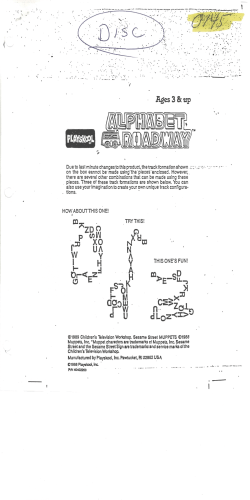


© Copyright 2026