
2014 LARGE PELAGICS INTERCEPT SURVEY
2014 LARGE PELAGICS INTERCEPT SURVEY PROCEDURES MANUAL Contact the Fisheries Research Group of QuanTech, Inc. at: 1-800-229-5220 (Toll Free) Fax all assignment paperwork to 1-877-694-8808 (Toll Free) within 24 hours of completing an assignment. 2014 LPIS Procedures Manual Table of Contents 1.0 Overview of the Large Pelagics Survey .................................................................................. 1 2.0 Overview of LPIS procedures.................................................................................................. 2 3.0 General instructions ................................................................................................................. 3 4.0 Pre-assignment procedures ...................................................................................................... 3 4.1 “Weathering out” assignments................................................................................................. 5 4.2 When to begin assignments ..................................................................................................... 5 5.0 Consider the following scenario: ............................................................................................. 6 6.0 On-Site procedures .................................................................................................................. 7 6.1 Hostile sites and refusals.......................................................................................................... 8 6.2 Confidentiality of data ........................................................................................................... 10 6.3 Overlap with the Access Point Angler Intercept Survey ....................................................... 11 6.4 Coding .................................................................................................................................... 11 6.5 Leading zeros and left or right justification ........................................................................... 13 6.6 “Write-in” areas ..................................................................................................................... 14 6.7 The HMS Permit List ............................................................................................................. 15 6.8 Intercept survey forms ........................................................................................................... 16 6.8.1 Screening Introduction (The Screener) ............................................................................... 16 6.8.2 Intercept Interview: Item by item instructions .................................................................... 17 7.0 Site Description Form (SDF) ................................................................................................. 33 8.0 Assignment Summary Form (ASF) ....................................................................................... 39 9.0 Administrative Issues ............................................................................................................. 41 10.0 Field Supervisors ................................................................................................................. 42 11.0 QuanTech Headquarters Staff .............................................................................................. 43 An example of an NMFS HMS permit. Note the location of the 8-digit permit number (XXXXXXXX) and the HMS Permit Category (Atlantic HMS Angling, in this case). .............. 43 Appendix B: Blank Forms ........................................................................................................... 55 Appendix C: Fishing Area List .................................................................................................... 60 Appendix D: “To Whom” Letter from NMFS ............................................................................. 68 Appendix E: State Code List ....................................................................................................... 69 Appendix F: Species Codes / Local Area Names List ................................................................. 70 Appendix G: Measuring Fish ....................................................................................................... 72 Appendix H: Identification of Atlantic Tunas ............................................................................. 73 Appendix I: Identification of Roundscale Spearfish, White Marlin, and Longbill Spearfish ..... 74 Appendix J: Shark Identification Key ......................................................................................... 78 Appendix K: FAQs from HMSpermits.gov as of 5/08/2014 ....................................................... 80 Appendix L: Tournament Code List ............................................................................................ 82 i 1.0 Overview of the Large Pelagics Survey The National Marine Fisheries Service (NMFS) is responsible for monitoring and managing U.S. marine fisheries resources. Large pelagic species (e.g., tunas, billfish, swordfish, and sharks) which are caught in offshore oceanic waters are of particular interest to NMFS as these species support socially and economically important recreational and commercial fisheries. NMFS closely monitors directed effort and catch rates for these highly migratory species, and adjusts management measures as needed to maintain stocks and the fisheries that depend on them. Since 1992, the National Marine Fisheries Service has administered the Large Pelagics Survey (LPS) to collect information about the recreational fishery directed at large pelagic species (e.g., tunas, billfishes, swordfish, sharks, wahoo, dolphinfish, and amberjack) in the offshore waters from Maine through Virginia. Angler participation in the LPS is mandatory and is a condition of obtaining a National Marine Fisheries Service Highly Migratory Species (HMS) permit. The authority to collect LPS data comes from the Atlantic Tunas Convention Act and the MagnusonStevens Fishery Conservation and Management Act. The collection of catch and effort information on large pelagics also fulfills U.S. obligations to the International Commission for the Conservation of Atlantic Tunas (ICCAT). Because large pelagic species are only sought on a relatively small proportion of the total marine recreational angler fishing trips made in the Northeast Region, the fishing effort directed at such species, and the resulting angler catches are generally not estimated very precisely by the Agency’s Access Point Angler Intercept Survey (APAIS). Therefore, the LPS was designed as a specialized survey that would focus specifically on the recreational fishery directed at large pelagic species. This specialization has allowed higher levels of sampling needed to provide more precise estimates of pelagic fishing effort and catches of large pelagic species. The LPS includes two independent, yet complementary, types of surveys which provide the effort and average catch per trip estimates needed to estimate total catch by species. The Large Pelagics Intercept Survey (LPIS) is a dockside survey of fishing access sites, primarily designed to collect catch data from private and charter boat captains who have just completed fishing trips directed at large pelagic species. LPIS data are used to estimate the average recreational catch per large pelagic boat trip by species. The Large Pelagics Telephone Survey (LPTS) collects data used to estimate the total number of boat trips on which anglers fished with rod and reel or handline for large pelagic species. 1 2.0 Overview of LPIS procedures Interviewers must conduct their assignment on the scheduled date at the assigned cluster. The only reason for not completing a scheduled assignment is if weather conditions do not allow for offshore game fishing and no boats are out that might be targeting a large pelagic species. This type of cancelled assignment is referred to as "weathered-out." If there is a small craft advisory (or greater, such as gale, storm, or hurricane warnings) on the assigned date, Interviewers should check the fishing activity at the assigned site(s) to confirm that no vessels are out fishing. “Weathered out” assignments must be rescheduled with a Field Supervisor according to LPIS protocol. Interviewers are responsible for determining the best time of the day to conduct their assignment and should be present at the assigned site(s) at the time of day when boats that fish for large pelagic fishes are most likely to return from fishing. The starting time on the specified date for each assignment shall be determined based on the understanding that an assignment must last at least two hours and may last no longer than eight hours. Interviewers should move from site to site to maximize sampling of returning boats at all access points within the defined cluster. Every site must be visited at least once! Interviewers must “check-in” and request to “sign-in” with a Site Representative (e.g. Dockmaster, Site Owner, Site Operator, or the other employee at the fishing access site) at each site in the cluster, if a Site Representative is present. Interviewers must canvass the site(s) to determine eligibility of Vessel Representatives. An eligible Vessel Representative is the captain, owner, or designated mate of a boat that just returned from an offshore rod and reel or handline fishing trip during which large fish such as tunas, billfish, sharks, swordfish, dolphin, wahoo, amberjack, or other large pelagic fish were targeted. All questions must be asked, all verifiable information should be discussed with the respondent, and all data should be appropriately recorded. All information shall be treated as confidential records. Paperwork must be submitted by fax within 24 hours and meet data quality standards. 2 3.0 General instructions The questions to be asked during the Large Pelagic Intercept Survey interview are written out in full for a purpose. Methodological studies have shown that even slight changes in wording -- for example, should versus could, drastically influence item response. The Interviewer should always read each item on the questionnaire exactly as it is stated (unless it is an item that is on the HMS Permit List, in which case the Interviewer must verify the information with the Vessel Representative. Information on the HMS Permit List that must be verified includes the vessel name, NMFS HMS Permit number, Coast Guard Documentation number, State Registration number, principal port state, and name of the HMS permit holder. If the Vessel Representative asks for the Interviewer's opinion about an item, the Interviewer should provide a definition for the item in question, rather than supply the actual response. 4.0 Pre-assignment procedures Each Interviewer should make sure that he/she knows his/her interviewing schedule. QuanTech Field Supervisors will schedule Interviewers for assignments on a monthly basis. Assignments will be drawn for a cluster. Some clusters include only one site; other clusters may have multiple sites. Stay informed about the sites and clusters in your area. The cluster list may change on a monthly basis. Before accepting each assignment, each Interviewer should know the location of the assigned interviewing cluster. Adequate directions to get to the assigned site(s) shall be given to Interviewers by their Field Supervisor. If there is any confusion about where to interview, the Interviewer should contact his/her Field Supervisor. Interviewers should contact their Field Supervisors to obtain their assignments. Interviewers should record the following information for each scheduled assignment: Date Control Number County Code Cluster Site Codes for all sites within the cluster Site Names for all sites within the cluster Do not try to memorize your schedule of assignments. Keep your list of accepted assignment information in a safe place. Verify assignment information while reviewing your forms prior to transmittal. QuanTech headquarters and Field Supervisors must be notified as soon as possible (and no 3 later than 24 hours) after an assignment is "weathered out". Assignments that are "weathered out" will be rescheduled according to LPIS protocol for the next available day of the same day type (weekday or weekend/holiday). However, rescheduling "weathered out" assignments may only be done in coordination with the Field Supervisor. Interviewers should reschedule "weathered-out" assignments with the Field Supervisor in order to verify that another assignment has not already been scheduled for the same day and location(s). Once the Field Supervisor reschedules the "weathered-out" assignment with the Interviewer, the Field Supervisor will notify QuanTech Headquarters. In addition, QuanTech headquarters and Field Supervisors should be contacted immediately if an Interviewer determines that he/she cannot do an assignment due to unforeseen circumstances or emergencies. If possible, another Interviewer will be asked to complete the assignment on the date for which it was originally drawn. If the assignment was rescheduled (previously weathered out), and “weathered out” again, every attempt should be made to reschedule the assignment in keeping with LPIS protocol. Each Interviewer should make certain that he/she has all of the required materials and equipment for conducting interviews, including: Pen(s); Name Tag; Current HMS Permit List; Procedures Manual; Metal Tape Measure; Cloth or Plastic Tape Measure; Fish Identification Field Guide; Copies of the LPIS “To Whom” Letter from NMFS; Other Informational Materials/Brochures; and Plenty of Questionnaires/Coding Forms. All Interviewers must have the required materials listed above in their physical possession when on site. Never leave required materials in the car! Interviewers should dress casually but neatly. Shorts are acceptable, but bathing suits are not. T-shirts are acceptable. Closed-toed shoes should be worn while interviewing. Alcohol or illegal drug use or intoxication on assignment is strictly prohibited, and grounds for termination. Fishing while on-assignment is prohibited. Failure to abide by these rules will result in a loss of future assignments for that Interviewer. If interviewing is to be conducted where there is a Site Representative, such as an owner, manager, supervisor, dockmaster, or other person who works at the site, it is a requirement to "check-in" and speak with that person upon arrival at the site, explain the nature of the survey, its objectives, and how you will be performing your work. If the Site Representative wants more information than is immediately available, he/she should contact either NMFS or QuanTech Headquarters. Contact information is provided on the LPIS "To Whom" letter from NMFS. 4 4.1 “Weathering out” assignments The only reason for not completing a scheduled assignment is if weather conditions do not allow for offshore game fishing and no boats are out that might be targeting a large pelagic species. This type of cancelled assignment is referred to as "weathered-out." Interviewers should obtain offshore weather reports to determine if an assignment should be “weathered out.” Consider the following to determine if or when to conduct your assignment and where to begin: Weather reports Small Craft Warning, Gale Storm Warning or Hurricane Nearby? If yes, and there are no boats out that might be targeting a large pelagic species then "weather out" the assignment and reschedule with the Field Supervisor. Offshore weather is highly variable, a sudden change in sea conditions may force some vessels to return early. Get weather reports from the National Weather Service, your local news "Offshore Report", or the Weather Channel. Check the Internet links at http://www.quantech.com/weather.htm Call the site(s) Determine if a Site Representative (if there is one) will provide you with reliable information concerning the number of boats that went offshore and the time that they are expected back. Contact your Field Supervisor When accepting your assignments, obtain recommendations on when to go, and which site in a cluster to visit first. Keep in contact with your Field Supervisor concerning the weather, and communicate any intentions to weather out in a timely manner. 4.2 When to begin assignments It is important to be on-site by the appropriate time for each assignment. The appropriate time to arrive on site is before eligible vessels are returning from offshore trips. You may need a few minutes to “site-in” prior to interviewing. By assessing the potential to obtain interviews at each site within a cluster and going to those locations at the appropriate time to increase your productivity you will obtain more interviews. Sources of information include but are not limited to: Master Site Register – The MSR has a field for “best time to interview” based on 5 historical visits to each site. This is a good starting point but should not be relied upon solely as this can change from one year to the next. Call the site(s) - Determine if a person that works at the site(s), such as the Dockmaster, will provide reliable information concerning the number of boats that went out and the time that they are expected back. Phone numbers for contact persons are provided in the MSR. While calling ahead can help the interviewer determine when to visit a site it should not be used to determine if a site should be visited. Interviewers should physically visit all sites within a cluster to determine firsthand if there is fishing activity or not. Under no circumstances should an assignment be canceled based solely on information obtained by calling the sites within a cluster. Ask the Field Supervisor - When accepting assignments interviewers may consult with their supervisor regarding the best sampling times and which site in a cluster to visit first. Newspaper articles, weekly magazine fishing reports, and large pelagic fishing related web sites may be useful for monitoring activity levels, upcoming tournaments, and seasonal openings and closures of marinas and/or charter boat operations. State natural resource agency personnel, NMFS regional personnel, and NMFS port agents may also be good sources of information on the patterns of offshore pelagic fishing at specific sites. 5.0 Consider the following scenario: Offshore weather conditions are conducive to fishing, you expect that there will be some vessels fishing for large pelagics, and there are three sites in the assigned cluster… 5.1 Call the sites within the cluster in the morning to ask if any vessels went out. Find out how many vessels went out from each site and when the vessels are expected to return to the site. In this situation, the site operators have proven to be reliable sources of information in the past. They inform you that at site #1 there are 4 eligible boats out, at site #2 there are 2 boats out, and at site #3 there are 5 boats out. The vessels that departed that morning from site #1 are expected back between 4pm and 5pm, the vessels from site #2 are expected back at 5p.m., and those from site #3 are expected back between 5p.m. and 6p.m. 5.2 Consider the proximity of the sites within the cluster. Site #1 and site #2 are next door to each other, separated by a dock. It is possible to observe the returning vessel activity at both locations from one vantage point. Site #3 is nearby, within a 5 minute drive, however, you cannot see the boats as they return unless you make the trip down 6 the road. 5.3 Begin at the site where the vessels are expected back sooner. You arrive at site #1 at 3:45p.m. and check-in and sign-in at site #1 at the Dockmaster’s office. The Dockmaster at site #1 informs you that one of the vessels is already in and the captain and crew of that vessel already left the site. You then go to the office at site #2 and check-in with the Site Owner. Both vessels expected to return to site #2 are not back yet. You decide to stick around and wait for the other three vessels at site #1 because they usually return around 4:30pm. Also, you keep an eye on the neighboring site (site #2) because the vessels might return there around the same time. You manage to obtain interviews from one of the three vessels returning to site #1, but around 4:45pm, while you were waiting for the remaining two vessels to return to site #1 you notice both of the vessels at the site next door (site #2) returning to the dock. After giving the vessels a chance to tie up, you obtain two interviews from respondents at the second site, but now you see one of the remaining two vessels returning to site #1. It is now 5:15pm. 5.4 Decide how to move within the cluster of sites to maximize the number of interviews that you obtain. There is now one interview and the potential for another interview that you can obtain at site #1 while there is the potential to obtain 5 interviews at site #3. Now you are presented with a somewhat difficult decision…you could stay and get two more interviews from the late-returning vessels at site #1 and possibly miss a few of the respondents at site #3 or travel to site #3 in hopes that you might obtain interviews from all five vessels returning to site #3. You decide to obtain the interview from the vessel that just returned to site #1, but rather than wait around for the last vessel to return to site # 1, you decide to go to site #3. At 5:35pm , after a short drive, you arrive at site #3. All five of the vessels have not yet returned to site #3. Rather than driving back to site #1 to wait for the remaining vessel, you stay at site #3 and obtain 5 more interviews. By the time these interviews at site #3 are complete, it is 6:45pm. Finally, you visit site #1 on your way back home and obtain one last interview before ending your assignment. 6.0 On-Site procedures Interviewers should remain on-assignment to obtain as many intercepts as possible. However, assignments shall not exceed 8 hours in duration. To qualify as a completed assignment, the minimum amount of time (2 hours) must be spent within the cluster. You will not be paid for the assignment if you do not stay within the cluster for at least 2 hours. NEVER depart from your assigned cluster to help another nearby Interviewer. This is necessary in case a boat arrives at your assigned cluster. Interviewers will occasionally receive surprise quality control (QC) visits from their Field Supervisor, or possibly a NMFS official, so all Interviewers must be on-site for this reason, as well. 7 Interviewers should position themselves so that they can observe as much activity as possible at the site(s). The goal is to intercept as many eligible respondents as possible. The best locations to be positioned will vary from site to site. Your Field Supervisor is a good person to talk to about this, as he/she will probably have visited the site as an Interviewer in the past. Positioning yourself at a cleaning station may cause you to miss other eligible respondents who did not catch fish and bias the catch estimates. Canvass the entire site to maximize the number of eligible interviews that can be obtained. At some sites it is possible and advisable to build rapport with the people present prior to conducting any interviews. Those who have had the opportunity to meet the Interviewer and discuss the survey tend to be more cooperative when asked for an interview. A key factor in gaining the respondent's initial cooperation and confidence in the study lies in assuring him/her of the non-enforcement nature of the survey. When explicitly given the true purpose of the survey very early in the introduction, respondents tend to be much more willing to cooperate with the survey. The canvassing process should be very informal and as unobtrusive as possible. The conversation might begin with "Good Afternoon" or "How’s it going?". While canvassing, the Interviewer should introduce themselves and be respectful. The Interviewer should be polite at all times, regardless of any complaints that he or she may receive. 6.1 Hostile sites and refusals Sites where Interviewers are impeded or prohibited from interviewing are referred to as "hostile" sites. When an Interviewer encounters a hostile site as part of their assigned cluster they should take the following action: Avoid confrontation with the site manager or any other persons at the site and leave the “hostile” site immediately; Record that the site was “hostile” on their Site Description Form (SDF) by recording relevant information, such as: “[Site Representative] will not allow interviewing at [Site Name], because [Reason].” Notify the area Field Supervisor as soon as possible. QuanTech headquarters and the Field Supervisor must be notified after leaving a "hostile" location, in keeping with the deadlines for reporting assignment status/faxing paperwork (within 24 hours). If asked to leave a site, it may be possible to visit other sites within an assigned cluster. As long as the assignment was for a cluster of sites, and not just one site, go to the other sites within the 8 cluster and obtain interviews with eligible fishery participants. If the assignment was for a single site, and you are asked to leave, you will receive your base pay. A letter or email to QuanTech explaining what happened is required to receive payment. At other sites LPIS Interviewers may be allowed to interview but only at certain locations within the site as determined by the site manager (e.g., interviewing allowed at slips but not at the fuel dock). Interviewers should note this on the SDF but can continue to interview at the site in the locations allowed. The extent of the impediment should be provided, such as: “No interviewing at fuel dock, [number] missed eligible vessels due to restriction. Vessels were returning to private access sites outside of the cluster.” Interviewers may encounter captains who refuse to participate in the survey because they are in a rush, don’t agree with NMFS policies or a variety of other reasons. Captains who don’t agree with NMFS policies should be encouraged to contact NMFS directly to air their complaints (using the address or phone number on the “To Whom” letter). It is not appropriate to defend or attack NMFS or its policies. Under no circumstances should an Interviewer identify him/herself as an employee of the National Marine Fisheries Service. Interviewers are independent contractors for QuanTech. If the captain or owner does not want to participate, and does not want to designate a mate to participate, but remains cordial (soft refusal), then try once to convert the soft refusal by politely explaining that the survey collects catch and effort statistics used to manage the fishery…If they do not participate then they will not be represented in the data collection. Their participation will strengthen the accuracy and precision of the survey, and therefore lead to appropriate management decisions. Alternatively, respondents need to be reassured that the information they provide is confidential under NOAA Administrative order 216-100. Always remind them that you are not there to issue citations or fines, and that all you want to do is collect accurate fishery data. Interviewers should never be “pushy”. Interviewers should only tell Vessel Representatives that the survey is mandatory if they ask directly. Offer a copy of the “To Whom” letter, which states that participation in the survey is required. If a respondent refuses the survey midway through an interview, the Interviewer may inform the respondent that the Interview is almost finished and thank them for their patience to try to convert the mid-interview soft refusal. If the respondent absolutely refuses to participate, will not designate a mate to participate, or becomes belligerent or irate (hard refusal), the Interviewer should simply say “Thank you” and walk away. No attempts should be made to convert a hard refusal. If the respondent follows the Interviewer, or acts out-of-line, the Interviewer should leave the premises immediately. In either case, whether the respondent gives a soft refusal or a hard refusal, the Interviewer must never threaten enforcement action. 9 Besides tallying as either an initial or mid-interview refusal, Interviewers should record as much of the following information as possible: name of the vessel, HMS permit number, state registration number, Coast Guard documentation number, name of person refusing, any LPS fish seen, the reason for refusal, and any other relevant details in the comments section. For Example: “The captain of the “Tuna Time” refused today. HMS permit # 12345678, State Registration MS1234AB, I saw them unload 1 school BFT. He says he will not participate until someone from NMFS tells him he must.” To reduce the number of “hostile” sites and refusals, the National Marine Fisheries Service will send a package of Large Pelagics Survey information to “hostile” site owners or fishery participants recorded on your Site Description Form(s). 6.2 Confidentiality of data In addition to collecting high quality data, following procedures, and maintaining a courteous and professional attitude while conducting your assignments, one of the most important aspects of interviewing for the LPIS includes your assurance to respondents that the data they provide will remain confidential. The confidential nature of the data applies to all information collected during an interview, even what species were caught, where they were caught, and what method and gear was used. Under no circumstance should you ever disclose information given to you by a respondent to anyone who is not authorized to have access to such confidential fisheries data. This policy applies to all types of communication, written, verbal, or otherwise, including Internet message board postings. When you get a request for data and/or survey design information simply provide contact information for NOAA and QuanTech. This information is listed on the LPIS “To Whom” Letter. 10 6.3 Overlap with the Access Point Angler Intercept Survey Another firm, RTI International, is contracted to collect data for the NMFS Access Point Angler Intercept Survey (APAIS). In the event that an APAIS Interviewer arrives at a site and finds an LPS Interviewer on-site, or an LPS Interviewer arrives at a site and finds an APAIS Interviewer on-site, then “overlap” has occurred. Interviewers are required to report all occurrences of overlap to their Field Supervisor. The date, time, location (site name and number), and how the overlap was resolved (see below) must be included in a report of the overlap. A report of overlap must be provided to Field Supervisors over the phone or by email. The APAIS interviewer is required be on-site according to a strict protocol for a designated time period. The LPIS interviewer has the option of visiting other sites in the cluster (except for single site clusters) or conducting the LPIS assignment when the APAIS interviewer is not onsite. The LPIS interviewer should politely introduce themselves to the APAIS interviewer and ask the APAIS interviewer what time the APAIS interviewer is required to leave the site according to APAIS protocols. For example, if the APAIS interviewers is required to leave the site at 5pm, the LPIS interviewer’s “work-around” might be to leave the overlap site and return at 5pm to avoid any potential problems caused by having two interviewers at the same site at the same time. The APAIS Interviewer takes precedence and the LPS Interviewer must relocate to a different site in the assigned cluster unless the site has been designated a “side-by-side” site by QuanTech headquarters. If there are multiple sites in the LPIS cluster, the LPIS interviewer should leave the overlap site and “work-around” by visiting other sites in the LPIS cluster. LPIS interviewers should only work at site with an APAIS interviewer at designated “side-by-side” sites. At designated “side-by-side” sites, Interviewers should not work the same immediate area and should not interfere with each other’s work. All incidents of overlap between LPIS and APAIS Interviewers (or other Interviewers from other fisheries-related surveys), and how they were resolved, must be reported to QuanTech headquarters within 24 hours. 6.4 Coding Data from dockside forms will be captured using optical character recognition (OCR) technology. It is important to follow coding procedure discussed in this section. NEATNESS COUNTS. STAY INSIDE THE LINES. IF YOUR FORMS ARE ILLEGIBLE OR FAXED IMPROPERLY WE WILL CALL YOU AND ASK YOU TO FIX THE ERRORS AND/OR FAX THEM AGAIN. PLEASE remember to write legibly in Block Capitals (Upper Case) on the dockside forms. Take 11 your time while recording data, in other words, be accurate and precise. Optical recognition software will interpret your entries, so be as neat as possible. Remember, providing quality data is crucial to the success of the study! As a rule, items on the questionnaire that are not applicable to a certain respondent (i.e., legally skipped questions) should be left blank, unless otherwise stated. Items on the questionnaires which the respondent does not know the answers to must be coded with 9's ending with the number 8 unless otherwise stated. Items on the questionnaires that are refused must be coded with all 9's unless otherwise stated. 12 Examples of this type of coding can be found in the following examples of Questions 24 The respondent said they spent most of through 26: Q24. Where were you fishing for large pelagic species? N O R T H 9 9 9 O F L U M P Lat. 9 9 9 9 9 S Long. their time fishing north of "The Lumps". The respondent knew the latitude and longitude coordinates but refused to provide them. The location is not in the fishing areas list in Appendix C, so the correct codes are 9999 and 9999.* If the respondent had said they did not know the coordinates then latitude and longitude and the location is not in the fishing areas list in Appendix C, the correct codes would be 9998 and 9998.* *See the item-by-item description for Q24 later in this manual for more detailed instructions concerning use of the fishing areas list in Appendix C. Q25. How many miles were you offshorethat is, how many miles was it to the nearest land? 9 9 Q26. 8 The respondent said they did not know how far offshore they were, thus the 998 code. Had they refused to tell you how far offshore they were, the code would be 999. Number of Miles How many feet deep was the water (depth to bottom)? The respondent said they did not know how 9 9 8 Water Depth in Feet deep the water was, thus the 9998 code. Had they refused the code would be 9999. 9 6.5 Leading zeros and left or right justification If a numeric value does not require the use of all of the boxes provided, right justify the entry and add leading zeros. For instance, if a fish measurement is 887 millimeters, its length should be coded as follows: 0 8 8 7 In another example, the respondent said the water depth was 300 feet…code 0300. 26. How many feet deep was the water (depth to bottom)? 0 3 0 Water Depth in Feet 0 If an alphabetic value does not require use of all of the boxes provided, left justify the entry as follows: H A N K M A S O N 13 6.6 “Write-in” areas Also, you must use the “write-in” areas. Using Question 16 as an example: Note for question 16 above, “YFT” and “Mahi”, are recorded on the “Write-in” line, and the appropriate species code is recorded. Note that for question 22, the respondent was trolling, chumming, and fly fishing. Letters of the alphabet should always be written in BLOCK CAPITAL LETTERS. Other coding examples can be found in Appendix A. Do not put a line through zeros or sevens; Do not close the top of fours; Make sure zeros do not look like sixes, and vice versa; the OCR will not read these characters correctly. To ensure that the optical character recognition will read your handwriting, numbers should be written as close as possible to the following format: 14 6.7 The HMS Permit List In order to verify information in the field with respondents, QuanTech has compiled a Permit List of vessels. This HMS Permit List is a database containing boat-identifying information, such as the owner’s name, the NMFS Highly Migratory Species permit number, and the Coast Guard documentation number or State registration number, first sorted by boat name and then permit holder last name in alphabetical order. An HMS Permit List will be created for each state or state group. There may be up to three versions of the HMS Permit List. For example, there may be one list for June, another for July/August, and another for September/October. Interviewers must make sure they have the current Permit List with them on assignment. There are privacy issues surrounding the HMS Permit List so the information should never be shown to anyone else. The information on this HMS Permit List is merely used to assist in the verification of vessel identifying information. When you check-in at a site and find out what vessels are expected back, if there is time, look up the vessels in the HMS Permit List before they return. Confirm the information with the respondent when conducting an interview. If there is no time to look up the vessels beforehand, ask the questions on the form as they are written. If a respondent does not want to get their permit information, offer to check to see if the boat is on the HMS Permit List. If so, you simply need to verify the listed information with the respondent, instead of formally asking him/her the questions. However, if the vessel is not on the HMS Permit List, then the Interviewer should ask them to get the permit information directly from the respondent. Inform the respondent that they would have to just get the information once, be sure to record the information in your copy of the HMS Permit List and tell the respondent that you will inform the Field Supervisor and other Interviewers in your area, in case the respondent is encountered on future assignments. Keep in mind that, though an intercepted boat may be listed on the HMS Permit List, it is essential that you verify all of the HMS Permit List information with the respondent for the following reasons: Though the boat may have been interviewed before, it is possible that the respondent was not interviewed (e.g., if a boat has more than one owner); if this occurs, be sure to get the new respondent's information, so that it can be added to the HMS Permit List; There could be a mistake on the HMS Permit List; There may be more vessels with the same boat name. 15 6.8 Intercept survey forms Blank LPIS forms, including the Screening Introduction, Assignment Summary Form, Site Description Form, and first and second pages of the LPIS Questionnaire, are included in Appendix B and are provided to serve as examples only. 6.8.1 Screening Introduction (The Screener) When an interviewer encounters an operator of a returning boat, he/she should use the screening introduction to introduce himself/herself, state the purpose of the survey, and ask questions which will determine whether the respondent is eligible for an interview. The interviewer should give his/her name and state that the study is sponsored by NMFS. If the intercepted boat operator is willing to cooperate, the interviewer should then ask the series of questions used to determine eligibility. To be eligible for the survey, the potential respondent must be the captain or owner of a boat that has just completed an offshore fishing trip that targeted large pelagic species. For the purposes of the screening introduction, large pelagics include all of the species listed under the “LPS” column in Appendix F.1. Boat operators returning from fishing trips that used hand-gear (rod and reel or handline) and specifically targeted, but did not catch any of the specified large pelagic species would be considered eligible. Therefore, data are desired for all hand-gear fishing trips that targeted at least one large pelagic fish species regardless of what was caught during that trip. If an eligible operator of a charter or private boat chooses to designate a crew member or passenger to respond to the survey as a “proxy”, then that individual shall be considered eligible for an interview. In such cases, it will be necessary for the interviewer to record that the respondent was a designated proxy for the captain or owner of the boat. Screener Item 1: On this vessel, are you the captain, owner, or mate or passenger (proxy designated by the captain to participate in this survey)? If the respondent says "yes", go to Screener Item 2. If the respondent is not the captain or owner or designated proxy, try to locate the eligible respondent. Otherwise, terminate the interview, and tally as NOT CAPTAIN OWNER OR MATE on the Site Description Form. Screener Item 2: Did your boat just return from an offshore rod and reel or handline fishing trip in which you targeted large pelagic fish such as tunas, billfish, sharks, swordfish, dolphinfish, wahoo, amberjack, or other large pelagic fish? If the respondent says "yes", go to the intercept questionnaire. If the respondent says he/she was fishing for some other species the interviewer should probe to determine if they were also fishing for any other large pelagic species; if the respondent was not targeting a large pelagic species then the interview should be 16 terminated and the respondent tallied on the Site Description Form (SDF) as DID NOT TARGET LARGE PELAGIC SPECIES. o For example, if someone says they incidentally caught a sandbar shark while targeting summer flounder, they are not eligible for the survey. If a vessel appears to have targeted large pelagic fish but the respondent does not want to participate in the survey, the interview should be terminated and the respondent tallied on the Site Description Form as a REFUSAL. Information about the refusal should also be recorded in the comments section of the SDF as described in Section 6.1. 6.8.2 Intercept Interview: Item by item instructions Once again, PLEASE remember to write legibly in Block Capitals (Upper Case). Take your time while recording data; in other words, be accurate and precise. Optical recognition software will interpret your entries, so be as neat as possible. Remember, providing quality data is crucial to the success of the study! Items 1 through 8 are not questions to be asked of the respondent. They are primarily identifying information. Item 1 INTERVIEWER CODE. Each Interviewer must be given a unique four-digit identification number. This number should be used on all submitted forms. Item 2 DATE OF INTERVIEW. The Interviewer should record the Month/Day of the intercept. Two digits for both the month and the day should be used. Item 3 TIME OF INTERVIEW. Using military time, record the time that the interview was completed. Military time runs on a 24-hour clock starting at 0001 hours (one minute past midnight) and ending at 2400 hours (midnight). Item 4 STATE CODE. Enter the two-digit FIPS numeric code from Appendix E for the state of intercept. Item 5 CONTROL NUMBER. NEVER LEAVE THE CONTROL NUMBER BLANK. BE SURE THAT YOU USE THE CORRECT CONTROL NUMBER GIVEN TO YOU BY YOUR FIELD SUPERVISOR FOR EACH ASSIGNMENT. Each assignment is given a four-digit identifying number. The first digit of the control number indicates if it is a weekend or weekday assignment. If the first digit is a 1, it is scheduled for a Saturday, Sunday, or holiday (e.g., July 4th, Independence Day). If the first digit is a 2, it is scheduled for Monday, Tuesday, Wednesday, Thursday or Friday. The second digit indicates the mode of the assignment. A 1 indicates an assignment during which private boat intercepts are preferred; while a 2 indicates that charter boat intercepts are preferred (interviews can be conducted in either mode on any 17 assignment). The 3rd and 4th digits are used as counters for the number of assignments given out in a given state and month. Item 6 DOCUMENT NUMBER. Throughout an assignment, the Interviewer should consecutively number forms completed for the assignment. BOTH PAGES of the first interview should be numbered 01; BOTH PAGES of the second interview should be numbered 02, etc. All forms sent in should be numbered, regardless of interview status. Item 7a SITE NUMBER. Enter the four-digit FIPS number of the site where the interview is being conducted. The site number should be listed on the Interviewer’s assignment schedule as one of the sites within the assigned cluster, as well as in the site register. Item 7b CLUSTER. Interviewer should enter the two digit number for the cluster of sites assigned for that day. The cluster number should be listed on the Interviewer’s assignment schedule. Item 8 SITE TYPE. Enter the type of site at which the interview took place. If interview took place at a marina, code 1. If interview took place on a private dock, code 2. If interview took place at a public ramp, code 3. If interview took place at some other type of site, code 4. Item 9 WHAT IS THE NAME OF YOUR BOAT? If the name of the boat is evident (e.g., if it is written on the boat itself), then the Interviewer must still verify the information with the respondent, and fill in the name on the coding form. If the boat name is not apparent, the Interviewer should ask the respondent "What is the name of your boat?" and fill in the information. If the boat has no name, the Interviewer should leave the long row of boxes at Question 9 blank and fill in the "no name" oval underneath. Sometimes the name displayed on the boat is not the same as the current vessel name or the name on the HMS Permit List (e.g., the vessel has been renamed, but the old name has not been removed from the boat; the old name has not been removed from the HMS Permit List; the current name has not been painted on the boat; the name was spelled incorrectly on the boat or entered incorrectly when the owner/operator applied for the vessel’s HMS permit, etc.). This means that the Interviewer must take great care when recording the name of the boat on the questionnaire. Interviewers must also be made aware that some names displayed on vessels are not actually the vessel names. That is, they might just be the brand names or emblems of the manufacturer, such as Mako, Whaler, Trophy, or Sea Fox. However, sometimes vessels are named by their owners on the HMS Permit List according to their manufacturer’s name and length, such as Spencer 57 or Grady- 18 White 28. If it is visible, the Interviewer should say the name of the boat out loud while checking to see if the vessel name is in the HMS Permit List. If the name displayed on the boat is verified as the vessel name, and the vessel name is in HMS permit directory, then Interviewers should be sure they are recording information for the correct vessel by verifying the owner’s name, or by matching some other data element, such as the State registration number, if it is displayed on the side of the boat. Most larger boats do not have State Registration numbers displayed, but trailered boats usually do. It’s also a good idea for the Interviewer to spell the name out loud while coding, to confirm its spelling with the respondent, just in case the HMS Permit List is incorrect. If the actual spelling of the vessel does not match the spelling on the HMS Permit List, the Interviewer must make note of the discrepancy and contact QuanTech after completing the assignment. It is extremely important that Interviewers record the vessel name EXACTLY as it appears on the vessel, or EXACTLY as the captain specifies. If the vessel is on the HMS permit list, they should record the name EXACTLY as it appears on the list. Even slight changes in the spelling of a vessel name should be avoided. Item 10a IS YOUR BOAT PRIMARILY A… Item 10a records how the boat is primarily used and identifies partyboats and headboats. Fill in the appropriate oval. If party/headboat, Interviewers should still complete the interview even though the questionnaire instructs the Interviewer to terminate the interview. The instruction is only provided as a reminder that these vessels should not be knowingly approached for the LPIS. Item 10b WAS THE TRIP TODAY A CHARTER OR PRIVATE TRIP? Item 10b pertains to the type of trip taken that day, private or charter. Fill in the appropriate oval. The next set of questions (Items 11a through 13) are asked in order to further identify the boat. If the vessel has a NMFS HMS permit, the NMFS HMS permit category determines the mode of the interview. Interviewers are given an HMS Permit List of NMFS HMS permitted vessels in their state (or multi-state area). The HMS Permit List contains boat-identifying information, such as the permit holder’s name, the NMFS Highly Migratory Species or Atlantic Tunas permit number and category, and the Coast Guard documentation number or State registration number, sorted by boat name and then by permit holder name, in alphabetical order. There are privacy issues surrounding these HMS Permit Lists so the information on these lists should never be shown to unauthorized persons. Permit holder contact information (e.g., address and phone number) does not appear on this list. The information on the HMS Permit List is merely used to assist in the 19 verification of a boat's HMS permit number (and permit category). If vessels are still out fishing when the interviewer arrives on-site he/she may have time to look up the vessels in the HMS Permit List before the vessels return. This way the interviewer needs only to confirm the information with the respondent when conducting the interview. If there is no time to look up the vessels beforehand, interviewers should ask the questions on the form as they are written. If a respondent does not want to get their permit information, the interviewer should offer to check to see if the boat is on the ID list. If so, the interviewer should verify the listed information with the respondent, instead of formally asking him/her the questions. However, if the vessel is not on the HMS Permit List, then the interviewer should ask the questions to get the permit information directly from the respondent. Respondents should be informed that they would have to just get the information once. Interviewers should record the information in their copy of the HMS Permit List. Interviewers should inform their Field Supervisors of any changes or additions to the ID list, and Field Supervisors should make sure these changes get passed on to other LPIS interviewers in the area and to the home office staff. Although an intercepted boat may be listed on the HMS Permit List, it is essential that interviewers verify all HMS Permit List information with the respondent for the following reasons: Though the boat may have been interviewed before, it is possible that the respondent was not interviewed (e.g., if a boat has more than one owner); if this occurs, be sure to get the new respondent's information, so that it can be added to the HMS Permit List; There could be a mistake on the HMS Permit List; There may be more than one vessel with the same boat name. If interviewers are unable to obtain the HMS permit number they should try to obtain the Coast Guard documentation number or the state registration information. It is very important that interviewers get at least one of these identification numbers. NMFS HMS Permit numbers typically begin with 1 and are eight digits long. Item 11a DOES THE BOAT HAVE A NMFS HMS PERMIT, AND IF SO, WHAT CATEGORY IS IT? Explain that HMS stands for Highly Migratory Species, if necessary. Read the possible permit categories to the respondent. Explain the difference between the permits (if necessary). Fill in oval 1 if the vessel has either an Atlantic Tunas General permit, a Swordfish General Commercial permit, or a combination Tunas/Swordfish General category permit. Fill in oval 2 if the vessel has an Angling category permit. Fill in oval 3 if the vessel has a Charter/Headboat category permit. If the vessel is not in the HMS Permit List and the respondent claims that the vessel does not have an HMS permit, then fill in oval 7 for “No HMS permit”. If the vessel is not in the HMS Permit List, and the respondent does not know the category, then fill in oval 8 for “Don’t know". If the vessel is not in the HMS Permit List and the respondent refuses to answer 20 the question, fill in the oval 9 for “Refused”. If the respondent does not provide you with the permit category and it cannot be verified with the respondent on the HMS Permit List, fill in oval 7, 8 or 9, as appropriate, and go to Item 12. Item 11b WHAT IS YOUR BOAT’S NMFS HMS PERMIT NUMBER? Enter the vessel's HMS permit number. HMS permit numbers must be either: 1) Verified with the respondent by matching the HMS permit number with the vessel name and Vessel Representative name on the HMS Permit List; or 2) Obtained directly from the respondent (if the vessel is not on the HMS permit list and the respondent shows you the vessel’s HMS permit); or 3) Corrected by the Respondent (if the respondent shows you the vessel’s HMS permit and the number is different from the number in the HMS Permit List). If you are able to verify the HMS permit number from the HMS permit list with the respondent then fill in oval 1 “Verified with Respondent”. If you obtain the HMS permit number directly from the respondent then fill in oval 2 “Obtained from Respondent”. If the HMS permit number is incorrect on the HMS Permit List, then fill in oval 3 “Corrected by Respondent”. If the respondent does not know or refuses to give his/her number, fill in oval 8 or 9, as appropriate, and go to Item 12. Item 12 CAN YOU TELL ME/VERIFY YOUR BOAT’S COAST GUARD DOCUMENTATION NUMBER? If the intercepted vessel's Coast Guard documentation number is contained on the HMS Permit List, you need only verify the information with the respondent and fill in the information on the coding form. If the vessel is not on the HMS Permit List, ask the respondent to provide the vessel’s Coast Guard documentation number. If given, enter the Coast Guard documentation number in the boxes provided, and go to Item 14. If the respondent claims that the vessel does not have a Coast Guard documentation number and the Coast Guard documentation number cannot be verified from the HMS Permit List, fill in oval 2 “Vessel has no Coast Guard Documentation Number”. If the respondent does not know the vessel’s Coast Guard Documentation number, and the number cannot be verified with from the HMS Permit List, fill in oval 8 “Don’t Know”. If the respondent refuses to provide the vessel’s Coast Guard Documentation number, and the number cannot be verified with from the HMS Permit List, fill in oval 9 “Refused”. Item 13 CAN YOU TELL ME/VERIFY YOUR BOAT’S STATE REGISTRATION NUMBER? Enter the intercepted vessel's State registration number. If the number is written on the side of the boat, or if the State registration number is contained on the HMS Permit List, you need only verify the information with the 21 respondent and fill in the information on the coding form (including the state abbreviation). If the respondent claims that the vessel does not have a State registration number and the State registration number cannot be verified from the HMS Permit List, fill in oval 2 “Vessel has no State registration number”. If the respondent does not know the vessel’s State registration number, and the number cannot be verified with from the HMS Permit List, and the State Registration number is not on the side of the boat, fill in oval 8 “Don’t Know”. If the respondent refuses to provide the vessel’s State registration number, and the number cannot be verified with from the HMS Permit List, and the State Registration number is not on the side of the boat, fill in oval 9 “Refused”. Item 14 PRINCIPAL PORT STATE CODE. The first set of boxes is for the State abbreviation, the second set of boxes is for corresponding FIPS code (see Item 4 for codes). Record the State abbreviation and the FIPS state code for which the respondent indicates is the vessel’s principal port state. If the vessel has an HMS permit and is the vessel is on the HMS Permit List, the Principal Port State should be verified with the HMS Permit List. Item 15 RETURN TIME. The purpose of this question is to determine when the respondent returned from his/her trip. If you actually see the respondent return to the site, you need only verify the return time with him/her. Otherwise you should ask "At about what time did your boat return to this site?” Returning boats that had docked prior to the assignment start time should be included in the LPIS as long as the trip ended that day. Please interview eligible boats regardless of their arrival time on that day. Use military time to record the return time. Item 16 TARGET LARGE PELAGIC SPECIES. Fill in the appropriate 4 digit code for the 1st and 2nd target large pelagic species in the boxes and write the name on the blank to the right of the boxes. Both targets will only be LPS codes. The 1st target is the primary target and the 2nd target is the secondary target. On the “write-in line”, it is OK to use abbreviations such as “YFT” for yellowfin tuna or “school BFT” for school size bluefin tuna. It is extremely important that you probe to find the primary target to the species level. If either the 1st or 2nd target is BFT, it is important to probe for size class. If the respondent states that they were targeting bluefin tuna, be sure to determine which size class they were targeting! Probe for the size class by providing the options (young school, school, large school, small medium, large medium and giant). Interviewers should be familiar with the length ranges for the BFT size classes and discuss them with the respondent (see below). 22 Size Class Categories of Atlantic Bluefin Tuna SIZE CLASS IMPERIAL CURVED FORK LENGTH (CFL) METRIC CURVED FORK LENGTH (CFL) Young school School Large School Small Medium Large Medium Giant <27” 27” - <47” 47” - <59” 59” - <73” 73” - <81” 81” or > 1 – 685 mm 686 – 1193 mm 1194 – 1498 mm 1499 – 1854 mm 1855 – 2057 mm 2058+ mm If the respondent will not specify one of these size classes, but says they were targeting BFT greater than 27” and less than 59” CFL, code 4672. This code, 4672, is only valid for Q16. If the respondent will not specify which size class or the combined school and large school size range of bluefin tuna they are targeting, code 4670 for any BFT. If the respondent absolutely will not say which species they were targeting but will only specify species groups, such as “SHARKS” then code 3591 for “ANY SHARK”. The code for “ANY TUNA” is 4656. The code for “ANY LPS” is 7777. If they say they were targeting no particular large pelagic species, code as 7777 for “ANY LPS". If they targeted a species for which there is no established LPS species code then record as 5250 for "OTHER" and write the name in the space available. See Appendix F for complete list of LPS species codes. If the respondent indicates targeting a species for which there is no code in Appendix F the interviewer should make a note of this on the form and the Contractor should contact NMFS for the appropriate code. Item 17a TOURNAMENT PARTICIPATION. Check the appropriate box to indicate if the intercepted vessel was participating in a tournament on the intercepted trip. Item 17b TOURNAMENT NAME. If the respondent answered yes at question 17a, ask for the name of the tournament at question 17b, and fill in the name on the coding form (one letter per box). Next, enter the four-character tournament code (see Appendix L) below the tournament name. If the angler was not fishing in a tournament, leave Item 17b blank. Item 18 HOOK TYPE. Indicate the type of hooks used on the intercepted trip. Be sure to fill in all ovals that apply. Circle hooks are defined in 50 CFR §635.2 as “a fishing hook originally designed and manufactured so that the point is turned perpendicularly back to the shank to form a generally circular, or oval, shape.” 23 Item 19 NUMBER OF LINES. Interviewers should enter the number of lines the boat had in the water. If given a range of lines, record the maximum number of lines in the water at any given time. Items 20 HOURS FISHED. Indicate the number of hours spent actually fishing with the primary gear for large pelagic species. Do not include the time spent traveling to and from the fishing area. Item 21 BAIT USED. Indicate if live, dead, and/or artificial bait was used on the intercepted trip with the primary fishing gear. Be sure to fill in all ovals that apply. Item 22 METHOD(S) USED. Indicate whether anglers were trolling, chumming or chunking or other- Fill in all ovals that apply and SPECIFY IF OTHER. Item 23 NUMBER OF ANGLERS. Indicate the total number of anglers who were actively involved in large pelagic fishing on the intercepted trip. Do not include persons on the vessel who did not fish. Item 24 LOCATION. Indicate the name of the main fishing area that was used to fish for large pelagic species. Even if the fishing area is listed in the Fishing Areas List (Appendix C), ask the respondent if they know the latitude and longitude. If the respondent can provide the latitude and longitude, then enter the coordinates provided by the respondent. If the respondent gives multiple locations, clarify by asking were he/she fished for LPS most of the time. If the respondent says they do not know the coordinates and the coordinates are not listed in Appendix C, then latitude and longitude should be coded 9998 and 9998. If the respondent refuses to provide the coordinates and the coordinates are not listed in Appendix C, then latitude and longitude should be coded 9999 and 9999. However, if coordinates are listed for the fishing area in Appendix C for your interviewing State and the respondent did not know or refused to provide them, then the latitude and longitude listed in Appendix C should be entered. There are fishing locations with similar names in different States. Do not use coordinates for a fishing area from Appendix C unless it is listed in your State. If the respondent provides a fishing location name and does not know the latitude and longitude but instead provides LORAN (*LO*ng *RA*nge *N*avigation) coordinates, then record the location name and write the LORAN numbers after the name. Then, if the fishing location provided by the respondent is in Appendix C, fill in the latitude and longitude from Appendix C. However, if the location is not in Appendix C, then record 9998 for latitude and 9998 for longitude. 24 Item 25 MILES OFFSHORE. Indicate the maximum number of miles that the intercepted vessel strayed from land on the intercepted trip. Be sure to get the mileage to the nearest point of land, as opposed to the mileage to the site of intercept. Item 26 WATER DEPTH. Indicate the depth (in feet) at the intercepted vessel's fishing location. If the respondent cannot provide an exact depth, try to obtain a depth range, and use the midpoint. If the response is given in fathoms, remember that 6 FEET = 1 FATHOM and adjust the response accordingly, or just write the number of fathoms to the side of the boxes on the coding form, and later convert the measurement to feet. If a range of depths are provided, record the average depth. Item 27 WATER TEMPERATURE. Indicate the surface water temperature in degrees Fahrenheit. If the respondent cannot provide an exact temperature, try to obtain a temperature range, and use the midpoint. Item 28 NAME AND PHONE. A percentage of all interviews are validated. To do so, we must have a name and phone number where the respondent can be reached for an extremely short interview (about 2 minutes). This number will not be used for the Large Pelagic Telephone Survey, and the respondent does not necessarily need to give his/her full name, or a home phone number. Clearly record the respondent's name and phone number (including area code) in the appropriate boxes on the coding form. It is imperative that interviewers ask this question of all respondents and the information recorded comes only from the respondent. Interviewers should never back-fill this information from the Permit List or other sources of information. PROXY? If the respondent is a proxy (designated by the captain or owner to participate in the survey) fill in the oval for “YES”. Otherwise, if the respondent is the captain or owner, then fill in the oval for “NO”. If the respondent will not provide a name or telephone number (we need both) then fill in the oval indicating RESPONDENT WOULD NOT PROVIDE A NAME OR TELEPHONE NUMBER Item 29 CAUGHT FISH. Indicate if any fish were caught or released during the fishing trip. If any fish were caught, fill in the oval for "Yes" and go to the second page of the intercept form, question 30. If no fish were caught or released, or if they refuse to answer, fill in the appropriate oval, end the interview, and thank the respondent for their time. Be especially careful to fill in the correct response at Item 29. If Q.29 = “Yes”, then continue the interview on the second page. 25 If Q.29 = “No” or the respondent refuses to answer the question, then the interview is complete. Thus, only the first page of the intercept should be faxed to QuanTech. If Q.29 = “Refused,” then the interview should be terminated and interview will be tallied as a Mid-Interview Refusal on the SDF. Mid-Interview refusals are not completed verifiable interviews. Note: Items 4, 5 and 6 are repeated at the top of the second page. This will prevent confusion when numerous forms are faxed in to the home office. Always complete these items! Item 30 FISH COUNTS. If fish were caught, indicate, by species: the fish species name; the fish species code; the number of fish that were kept; the number of fish that were kept that were observed and identified by the Interviewer; the number of fish released alive; the number of fish released dead; the number of fish that were kept that have been or will be sold; the number of fish that were kept that have been weighed-in or will be weighed-in at the tournament weigh station (if participating in a tournament on the intercepted trip, q.17a=Yes). Note: The count for “number of fish to sell” and “number of fish to weigh-in” should be a subset of those fish that were kept. Be sure that the respondent includes all kept fish when they are asked the first part of Item 30 “number kept.” When asked "How many of those ___ that you kept did you sell or do you plan to sell?” and "How many of those ___ that you kept did you weigh-in or do you plan to weigh-in at the tournament weigh station?”, the response should be a subset of those fish that were kept. Interviewers should ask respondents if they can see all fish that were kept. If for some reason kept fish are not available to be counted and identified, the interviewer should make a note of this in the “notes” area on Item 30. If the interviewer is absolutely certain that the respondent is making a mistake in count or species identification, they should record the correct information on the form, as opposed to the incorrect information supplied by the respondent. The Guide to Sharks, Tunas & Billfishes of the U.S. Atlantic & Gulf of Mexico and Guide to the Tunas of the 26 Western Atlantic will help with species identifications. Peterson's Field Guide to Atlantic Coast Fishes of North America is also a good source of information. When in doubt about the species identity of any unobserved fish, the interviewer should appropriately identify the fish at a higher taxonomic level, such as genus or family. However, Interviewers are expected to be able to identify all observed fish to the species level. Interviewers must always ask to see fish that were kept, so they can be correctly identified. While most LPIS respondents are experienced anglers who know how to correctly identify fish, they do not always use the accepted common name. “Bonito”, for example, might refer to skipjack in the Northeast, and little tunny in the Southeast. Also, some respondents may have simply misidentified the fish. For instance, small yellowfin tuna and bluefin tuna look quite similar. Sometimes, it is necessary to count gill rakers on the first gill arch (bluefin tuna have 34-43 gill rakers, yellowfin tuna have 26-35) or to look at the fish’s liver when it is being cleaned to see if its ventral surface is striated or not. The bottom of the bluefin tuna’s liver has striations while the yellowfin tuna’s liver does not. King mackerel can be misidentified as wahoo, and vice versa. (Wahoo have no gill rakers and have a pointed, beak-like snout, while King Mackerel have 8-9 short gill rakers on the lower first gill arch). Sharks are also difficult for the average recreational angler to identify correctly. For example, sandbar sharks and dusky sharks are easily confused because they are both “ridge-back” sharks. Differentiation between the two species is possible by studying the position of the pectoral fins in relation to the dorsal fin. Even billfish can be misidentified. Within the last few years, an undersized blue marlin was landed at the White Marlin Open in Ocean City, MD because the angler thought it was a large white marlin! Interviewers must be capable of identifying the fish to the species level themselves. Another reason why it is important to observe the fish (besides identification) is to count them. While it’s unlikely that the respondents will not know how many of a particular kind of tuna they caught, they often forget how many dolphin (or mahi mahi, for example) were kept, especially if many were caught. Fill out the corresponding line and coding boxes for each species caught. Always remember to probe for bycatch. If the respondent cannot remember or refuses to indicate how many he/she kept or released of a certain species, record "don't know" or "refused" (as appropriate) in the margin. Try to probe the angler for catch information (species and numbers), particularly for incidental catch and released fish that are not available for inspection. Anglers will sometimes use a local name for a species that does not match the accepted common name provided in Appendix F. Interviewers should refer to the Local Names list provided in Appendix F. Interviewers must probe to ensure they are recording the correct species since some local names are used to refer to more than one species. The local names list will be updated as needed to reflect new names encountered in the field. Fill in zero’s where appropriate for disposition boxes. For example, if the respondent says they only “released alive” 05 little tunny, be sure to fill in 00 in the appropriate boxes for “number kept”, “number identified by Interviewer”, “released dead”, “number to sell”, and “number to weigh-in”. Do not leave the any boxes blank. 27 If an interviewer encounters a species not listed on the form, they should write in the species name and code of the species at the "Fish Species" line, along with the counts by disposition. All fish species caught should be included on the form even if they are not large pelagic fish. If there are more than ten fish , use as many second pages of the interview form as necessary to include all fish caught. Please refer to the species code list on the second page of the intercept form. If the species code is not listed on the second page of the intercept form, check Appendix F of this manual for the correct species code. Record the species code after recording the name of the fish. If the respondent caught a species for which there is no code in Appendix F, the interviewer should make a note of this on the form. In the example below, on this interview, 1 young school bluefin tuna was released alive, one school bluefin tuna was kept, and 2 yellowfin tuna were kept. The fish that were kept were observed and identified by the interviewer. The Interviewer recorded the number of fish that were kept, observed and identified by the Interviewer, released alive, released dead, kept to sell or already sold, and weighed-in or will be weighed-in at the tournament weigh station. NOTE: Unidentified hammerhead shark, species code 4950, should only be used if the respondent does not know what species of hammerhead was caught and the fish is unavailable for you to identify. Item 31 FISH MEASURMENTS. Once the interviewer has counted and identified all observed catch, he/she should ask for permission to measure at least a representative sample of the fish to obtain lengths. If the angler did catch and keep any fish, ask "May I measure the fish?" If the respondent says "yes", fill in oval 1. If the respondent refuses to let the interviewer measure the fish, or has no fish available to look at, then fill in oval 2 and indicate why the fish were not measured in the notes section provided in Item 30. Fish that have been filleted 28 are not considered available for measuring. If more than 10 fish are available for measuring, fill in Items 4 through 6 at the top of the second half of another form and use that form to fill in the remaining fish lengths. Use as many forms as necessary. For the purposes of this survey, bluefin tuna size classifications should be determined by its curved fork length as indicated in Item 30 on the survey form. SPECIES CODE. LENGTH. Use the four digit species codes provided in Item 30 for LPS species; if the species code is not listed, record the actual species name and look up the species code in the list provided in Appendix F. DO NOT MEASURE ANY NON-LARGE PELAGIC FISH SPECIES (SUCH AS BLUEFISH, STRIPED BASS, BLACK SEA BASS, TILEFISH, ETC.) DO MEASURE THE LENGTH OF ALL LARGE PELAGIC SPECIES IN MILLIMETERS. For the following tuna species, obtain both straight fork length and curved fork length: Bluefin Bigeye Albacore Yellowfin Skipjack Fish lengths should be recorded to the nearest millimeter (do not measure in inches and then convert)! Do not measure in centimeters. Most of the measuring tapes that will be used for the LPIS will be marked in both metric and English measurements. To determine millimeters, multiply the centimeter reading by 10 and add the number of the smallest markings past the centimeter marking. For example, a fish that measures to the smallest line past 73 centimeters would be 731 millimeters. Since four coding boxes are provided for the length, the length should be coded as 0731. Remember, there are 1000 millimeters in one meter. Interviewers should be careful not to introduce digit bias into their measurements -- do not round off—for example, 0731 to 0730! Interviewers are provided two measuring tapes for a reason. Metal tape measures shall only be used to measure straight fork length. Cloth or plastic tape measures shall only be used to measure curved fork length. 1) STRAIGHT FORK LENGTH (SFL). Measure using a metal measuring tape and record only the straight fork length of the fish in millimeters. Make sure the metal measure tape is 29 straight when measuring SFL. Straight fork length must be taken in a straight line, as close as possible to the fish without tracing the contour of the body from the most anterior tip of the longest jaw (mouth closed) or end of snout, whichever is terminal, to the posterior tip of the tail at its center line. The resulting length is therefore a straight fork length. 2) CURVED FORK LENGTH (CFL). Measure using a cloth or plastic measuring tape and record only the curved fork length of the fish in millimeters. CFL measurement is required for Bluefin tuna, Bigeye Tuna, Albacore, Yellowfin Tuna, and Skipjack in addition to SFL. Curved fork length must be taken in a line, tracing the contour of the body from the tip of the upper jaw to the fork of the tail, which abuts the dorsal insertion of the pectoral fin and the dorsal side of the caudal keel. The measuring tape must pass over (and touch) the pectoral fin and the caudal keel. Interviewers must also express the importance of obtaining length measurements to respondents. Interviewers must obtain as many length measurements as possible to provide this important data to fishery managers. These length measurements are important because they are converted to weights for catch quota monitoring by NMFS. They are also used in stock assessments, and for estimating age for cohort analysis. Interviewers should record only those measurements that they took themselves. Occasionally, especially if the fish is very large, you may need to ask for assistance to measure the fish. If this is the case, you must be very deliberate in your instructions to the helper (who might be a fish cleaner or angler) to make sure the measurement is taken to LPIS specifications. For billfish, upper-jaw-tofork length and lower-jaw-to-fork length measurements must be obtained. For all other fish, SFL and CFL measurements will be taken from the front tip of the jaw to the fork in the tail. Proper SFL and CFL measurements must be recorded. Interviewers must know the difference between straight fork length and curved fork length, and when it is appropriate to measure both. CFL and SFL measurements on BFT and Bigeye, Albacore, Yellowfin tuna, and Skipjack (sometimes referred to as the BAYS tunas) are required. Correct procedures for measuring lengths of various types of fish are shown in the diagrams below. Sharks are measured from the tip of the snout to the center of the fork of the tail. All other 30 species (except billfish and swordfish) are measured from the most anterior tip of the longest jaw (mouth closed) or end of snout, whichever is terminal, to the posterior tip of the tail at its center line. This procedure is the same whether the tail forks in (e.g., tunas, mackerels) or protrudes out. The resulting length is therefore a fork length. GENDER For all sharks and dolphinfish (mahi mahi), Interviewers must record the gender of each fish (1=male, 2=female, 8=undetermined). PREP Record the preparation of the fish (0=whole, 2=gutted, 6=pectoral length). Only fish that are whole or gutted should be measured (prep= 0 or 2). The only exception to this rule is for Giant Category and Large Medium Category bluefin tuna and only if the full body length cannot be obtained. If these fish are brought in headed then the interviewer may obtain a pectoral length measurement and place a 6 in the PREP code box indicating a pectoral length measurement. Fish that have had their tail cut off should not be measured. 31 BILLFISH & SWORDFISH Special procedures for measuring billfish and swordfish must be followed. Take straight measurements using a metal measuring tape in millimeters and record. Boxes for billfish and swordfish measurements are located at the bottom of the second page of the intercept questionnaire. Straight measurements for billfishes and swordfish are obtained from the tip of the upper bill to the center of the fork of the tail (On the form, UPPER BILL LENGTH, from A to C below) and from the tip of the lower jaw to the center of the fork of the tail (On the form, LOWER JAW LENGTH, from B to C below). A B C NOTE: The interviewer should record the straight UPPER BILL LENGTH to the fork only if the bill is intact (complete, not broken off). Do not record the straight UPPER BILL LENGTH if the bill is broken off, rather, record only the straight LOWER JAW LENGTH. See Appendix G for more information on the procedures for measuring various types of fish. SUB-SAMPLING All fish should be measured if possible. However, due to time constraints it may not always be possible to obtain length information for all available fish. Interviewers need to budget their time and maximize the number of interviews obtained with eligible vessels. If there are so many fish that individual measurements cannot be obtained, then a representative sample of fish should be measured. For example, if there were 38 dolphinfish and there is only time to record 10 measurements, then ten fish could be sub-sampled. To randomly sub-sample the fish, interviewers should blindly determine which fish to inspect rather than purposely try to pick the fish that look "average." Only ten fish should be recorded at Item 31 for each page. To record additional fish measurements, include additional “second pages”. Fill in Items 4 through 6 at the top of another copy of the second page of the interview form, leave Q.30 blank, and use Q.31 to record measurements for the remaining fish. In the notes section, indicate “page 3” and the vessel name. Reminders: On each second page, Items 4 through 6 must be filled in at the top of the page to match the first page of the interview. Start document numbers (interview numbers) at 01 for each assignment. 32 Obtain both the straight fork length (SFL) and the curved fork length (CFL) for bluefin tuna, bigeye tuna, albacore, yellowfin tuna, and skipjack that are available to measure. Do not measure CFL for other species. Remember that if you encounter a bluefin tuna, its size classification should be determined by its curved fork length (CFL). If an angler tells you that he/she caught a large school bluefin at Item 30, for instance, and you find that the CFL actually measures 1508 millimeters, you should record it as a small medium bluefin at Item 30. You should also make sure that you record it as a small medium in Item 31. Do not obtain pectoral fin measurements (from base of pectoral fin to fork in tail) for fish that have been beheaded unless it is a giant or large medium bluefin tuna. Fish that have been filleted or had their tail cut off should not be measured. 7.0 Site Description Form (SDF) The Site Description Form (SDF) is used to summarize the results of the completed assignment with information from each site (within a cluster). Paperwork for each assignment that you submit must include at least one Site Description Form. If there are three sites or less in the cluster, then there should be only one SDF submitted. There is only enough space on each SDF to record information for three sites visited. An example of a blank Site Description Form may be found in Appendix B. INTERVIEWER CODE: Each Interviewer is given a unique four-digit identification number. This number, found on the back of the Agreement, should be used on all submitted forms. INTERVIEW DATE: The Interviewer should record the Month/Day of the intercept. Two digits for both the month and the day should be used. STATE CODE: Enter the two-digit numeric code for the state of intercept. The state code list may be found in Appendix E. CLUSTER ID: Enter the two digit number for the cluster of sites that you are assigned for that day. The cluster number should be listed in your assignment schedule. Possible values will range from 01, 02, 03…to 10. CONTROL NUMBER: Each assignment is given a four-digit identifying number. The first digit of the control number indicates if it is a weekend or weekday assignment. If the first digit is a 1, it is scheduled for a Saturday, Sunday, or holiday (e.g., July 4th, Independence Day). If the first digit is a 2, it is scheduled for Monday, Tuesday, Wednesday, Thursday or Friday. The second digit indicates the mode of the 33 assignment. A 1 indicates an assignment during which private boat intercepts are preferred, while a 2 indicates that charter boat intercepts are desired. NEVER LEAVE THE CONTROL NUMBER BLANK. BE SURE THAT YOU HAVE THE CORRECT CONTROL NUMBER GIVEN TO YOU BY YOUR FIELD SUPERVISOR. SITE NAME & SITE #1 CODE: Enter the site name and four-digit number of the first site visited. The site number should be listed on the interviewer’s assignment schedule as one of the sites within the assigned cluster, as well as in the site register. COUNTY CODE #1: Enter the three-digit county number assigned to the site visited where interviews are being conducted. The county code should be listed on the interviewer's assignment schedule, as well as in the site register. SITE REPRESENTATIVE NAME and TELEPHONE NUMBER: If a Site Representative is present at the site, record their name and the telephone number for the site. SITE REPRESENTATIVE INITALS: After “checking-in” with a Site Representative, ask the Site Representative to initial your SDF on the “write-in” line for SITE REPRESENTATIVE INITALS in the section for the site they represent. TIME OF INITIALS: STATUS: If the Site Representative initials your form ask them to record the “sign-in” time on the “write-in” line next to TIME OF INITIALS. All intercepted persons should be classified under the appropriate status and tallied on the Site Description Form for each site. Status definitions are as follows: COMPLETED INTERVIEWS: Enter the number of completed verifiable interviews with eligible respondents. The interview is considered a completed verifiable interview with an eligible respondent if responses are provided for all questions and there is: A valid respondent name and valid telephone number 34 OR A valid boat name and either a valid HMS permit number or valid Coast Guard documentation number, preferably all three. Use Question 11a to determine mode: If permit type is charter/headboat then record as CH for charter boat interview; if permit type is General or Angling then record as PR for private boat interview. Permit type should be verified and recorded using the HMS Permit List, if the vessel is listed. If the respondent does not have an HMS permit, does not know what type, or refused the question, and the vessel is not listed in the Permit List, refer to Question 10a (Boat Primarily Operated As) to determine mode of interview (1 = PR, 2 = CH). If the respondent does not know or refuses to answer 10a, then refer to 10b (trip today) to determine mode of interview (1 = CH, 2 = PR). If the respondent does not know or refuses to answer 10b, note in the comments section of the SDF. MID-INTERVIEW REFUSALS: If the interviewer initiates the interview questionnaire with a respondent but they terminate the interview after questioning has begun, the interviewer should thank the respondent for their time and tally. A refusal to question 29 also constitutes a mid-interview refusal. INITIAL REFUSALS: LANGUAGE BARRIER: If a seemingly eligible respondent refuses to be interviewed at all, it is considered an "initial refusal" and should be tallied. Ask the person his or her name and record it along with the boat name (and any other identifying information, such as state registration #) in the comments section of the SDF (see 2.2.3 Hostile Sites and Refusals). Fill in the number of interviews that could not be obtained due to language incompatibility. If interviewer initiates an interview with a respondent, but they are unable to continue due to communication (language) problems, tally. Interviews may be conducted with a captain's translator, if one is present. If this does occur make a note of this on the SDF. ELIGIBLE BOATS MISSED WHILE INTERVIEWING ANOTHER BOAT AT THIS SITE: 35 Interviewers should determine the number of eligible boats missed at each site because they were in the midst of another interview. Interviewers should record the number of boats appearing to be eligible that they were unable to intercept at each site because they were interviewing another vessel's respondent. “Eligible” vessels are those that have returned from a saltwater fishing trip using handline or rod and reel gear that either targeted or incidentally caught a large pelagic species. Interviewers should only record as “missed eligible” vessels returning to the site the interviewer is currently at. Interviewers should not record as “missed eligible” vessels that were missed at other sites in the cluster because the interviewer was at another site or traveling between sites. Most often interviewers will have to make the determination of eligibility based on visual cues rather than actually asking the captain. Visual cues which may indicate whether a vessel is eligible for the LPIS include: large pelagic fish on board or being off-loaded; vessels flying large pelagic species flags; or vessels with fishing gear (rods, reels, fighting chairs) typically used for large pelagic species. Interviewers may also use the following to determine if a missed vessel was eligible for interviewing: their own local knowledge of particular vessels and/or captains; information obtained from the office, site manager, or others at the site; or information about charter boat schedules. Below are some Frequently Asked Questions (FAQs) that interviewers might have related to the definition of “missed eligible boat.” “Missed eligible boat” FAQs Q. I see a vessel returning from an offshore trip to a different site in my assigned cluster (i.e., not the site I am currently at). Do I tally the vessel as a “missed eligible.”? A. No. Only vessels returning to the site you are currently at should be tallied. Q. I see an eligible vessel temporarily docked to refuel at a site I am currently interviewing at. I miss getting the interview because the vessel leaves while I am interviewing another vessel. I can’t tell if this vessel stayed within the cluster after it left the fuel dock. Do I tally this on my SDF as a missed eligible? A. Yes, this would be considered a “missed eligible” for the fuel dock site 36 because the vessel stopped at the site while you were there. The only reason you could not interview this vessel was because you were busy interviewing another vessel. Note: If you catch up with this same vessel at another site within the assigned cluster and conduct an interview, make sure you subtract one from the “missed eligible” tally at the fuel dock site. Q. I see an eligible vessel temporarily docked at the fuel dock of the site I am currently interviewing at. However, the site manager does not allow interviews to be conducted at the fuel site. The vessel finishes fueling up and leaves the site. Do I count this vessel as a missed eligible? A. No. This vessel should be counted as a refusal. This is different from a refusal by a captain or mate you are trying to interview. In the comments box on the SDF note the number of refusals that were due to the site manager not allowing interviewing at a particular location on site. Note: If you catch up with this same vessel at another site within the assigned cluster and conduct an interview, make sure you subtract one from the “refusal” tally at the fuel dock site. Q. I arrive at my first site at 3:00 pm to begin the assignment. In the office the site manager informs me that the vessel “Tuna Time” returned from an overnight offshore tuna trip and got back to the dock at 1:00 pm. I walk the docks and find the “Tuna Time” in its slip but no one is around to interview. Do I tally this vessel as a “missed eligible”? A. No. According to the definition only vessels that were missed while you were on site should be counted. Q. I arrive at my first site at 3:00 pm to begin the assignment. In the office the site manager informs me that the charter vessel “Tuna Time” returned from an overnight offshore tuna trip and got back to the dock at 1:00 pm. I walk the docks and find the “Tuna Time” in its slip but no captain around. I ask a guy on the dock and he says the captain left but he fished on the boat as a paying passenger. Do I tally this vessel as a “missed eligible”? A. No. According to the definition only vessels that were missed while you were on site should be counted. Since you were not at the site when the captain was around this should be recorded as “not captain, owner or mate.” Q. I arrive on site and notice the “Tuna Time” boat slip is empty. The manager confirms that the vessel went out tuna fishing earlier. I stay two hours on site but the Tuna Time still does not return. I leave the site and terminate the assignment. Should I count the Tuna Time as a missed eligible? A. No, since the Tuna Time returned after you terminated the assignment it should be tallied under “Boats that have not returned.” 37 BOATS THAT HAVE NOT RETURNED: When interviewers leave a site within the assigned cluster, and there are still boats that are expected back, they should record the number of vessels that have not yet returned. This tally should include all possible fishing vessels, not just LPS vessels. Below are some Frequently Asked Questions (FAQs) that interviewers might have related to the definition of “boats that have not returned.” “Boats that have not returned” FAQs Q. Do I count jet-ski trailers or slips that I know are occupied by sailboats in the tally of “boats that have not returned?” A. No. If you are almost certain that the vessel did not fish then do not include these. Q. Do I count small fishing vessels that are not likely to be going off-shore for large pelagics? A. Yes. If the vessel could be out saltwater fishing it should be counted as “boats that have not returned” regardless of the vessel size. DID NOT TARGET LARGE PELAGIC SPECIES : If an interviewer discovers during the screening process that they have intercepted someone that did not just complete an offshore oceanic fishing trip during which they targeted large pelagic fish, then they should tally the respondent in this box. NOT CAPTAIN/OWNER OR MATE: If an interviewer discovers during the screening process that they have intercepted someone who is not the captain, owner or designated proxy (Screener Item 1) then they should try to locate the eligible respondent, if all eligible respondents for the vessel have already left the site then tally as 'NOT CAPTAIN/OWNER OR MATE.' The data fields above must be recorded for each site visited on a particular assignment whether or not any interviews were actually obtained. RECORD DATA FOR EACH SITE WITHIN THE CLUSTER THAT YOU VISIT. DO NOT LEAVE ANY TALLIES BLANK. 38 THIS INCLUDES SITE NAME, SITE CODE, COUNTY CODE, (IF PRESENT, SITE REPRESENTATIVE, SITE REPRESENATATIVE TELEPHONE NUMBER), , COMPLETED INTERVIEWS BY BOAT TYPE, MID-INTERVIEW REFUSALS, INITIAL REFUSALS, LANGUAGE BARRIER, ESTIMATE OF MISSED ELIGIBLE BOATS, BOATS THAT HAVE NOT RETURNED, DID NOT TARGET OR CATCH LARGE PELAGIC SPECIES, and NOT CAPTAIN/OWNER OR MATE, FOR EACH SITE VISITED. 8.0 Assignment Summary Form (ASF) The Assignment Summary Form (ASF) is used to summarize the results of the completed assignment, and to charge for work done on the assignment. Each assignment that you send in must include an Assignment Summary Form. An example of a blank Assignment Summary Form may be found in Appendix B. INTERVIEWER NAME: The Interviewer should PRINT his or her name in BLOCK CAPITAL LETTERS. INTERVIEWER CODE: Each Interviewer is given a unique four-digit identification number. This number, found on the back of the Agreement, should be used on all submitted forms. INTERVIEW DATE: The Interviewer should record the Month/Day of the intercept. Two digits for both the month and the day should be used. CONTROL NUMBER: Each assignment is given a four-digit identifying number. The first digit of the control number indicates if it is a weekend or weekday assignment. If the first digit is a 1, it is scheduled for a Saturday, Sunday, or holiday (e.g., July 4th, Independence Day). If the first digit is a 2, it is scheduled for Monday, Tuesday, Wednesday, Thursday or Friday. The second digit indicates the mode of the assignment. A 1 indicates an assignment during which private boat intercepts are preferred, while a 2 indicates that charter boat intercepts are desired. NEVER LEAVE THE CONTROL NUMBER BLANK. BE SURE THAT YOU HAVE THE CORRECT CONTROL NUMBER GIVEN TO YOU BY YOUR FIELD SUPERVISOR. STATE CODE: Enter the two-digit numeric code for the state of intercept. The state code list may be found in Appendix E. CLUSTER. Enter the two digit number for the cluster of sites that you are assigned for that day. The cluster number should be listed in your assignment schedule. Possible values will range from 01, 02, 03…to 10. BEGIN. Enter the time (military format) when you begin your assignment. That is, 39 enter the time when you arrive on-site (at the first site in the cluster) to begin your assignment. END. Enter the time (military format) when you finish your assignment. That is, enter the time when you leave the cluster and terminate the assignment. Weather Favorable for Fishing Offshore? Fill in the oval for “Yes” if the weather conditions are favorable for offshore fishing. If the offshore conditions are poor, fill in the oval for “No”. In general, strong winds (25-30 knots, especially from the Northeast) and high seas (especially greater than 8-10 feet) will cause many offshore fishermen to cancel their trips. Assignments that are conducted despite poor offshore conditions should be attempted only when fishing activity can be confirmed beforehand. 40 9.0 Administrative Issues Data Delivery Because of the rigid requirements for the LPIS, it is vital that QuanTech receive all completed Assignment Summary Forms, Site Description Forms, and Interview Questionnaires within 24 hours of assignment completion. To accomplish this, we are distributing FAX machines ON LOAN. Interviewers are responsible for making arrangements to fax each day's work to QuanTech within 24 hours of assignment completion. Fax your forms IN CHRONOLOGICAL ORDER starting with the assignment summary form first and the site description form(s) second. If you forget to fax your forms in or there are any problems with the OCR data capture system reading your forms you may be asked to re-edit and re-fax your forms. Only one fax TRANSMISSION per assignment. That is, if you are sending in forms from two assignments they must be sent separately! QuanTech has provided a Toll Free FAX number for your convenience. Please fax all pages in order (assignment summary first, serving as the cover sheet) to 1-877-694-8808 or e-mail scans to [email protected]. If for any reason you are unable to fax completed forms within the time schedule, you must contact QuanTech and your Field Supervisor immediately so arrangements can be made to get your forms faxed in. We will not pay for any assignment that arrives at QuanTech too late for inclusion in each week's data delivery to NMFS. Pay Schedule Paychecks for Fisheries Interviewers are mailed every two weeks. Delays in submitting paperwork could potentially delay paychecks being mailed. Interviewer Status All QuanTech Interviewers are considered independent contractors. This means that no taxes will be withheld from an Interviewer's check. Interviewers are responsible for keeping track of all personal finances relevant to state, local, and federal tax laws. Interviewers are not NMFS employees. ALL FAX MACHINES AND FIELD GUIDES PROVIDED TO YOU ON LOAN MUST BE RETURNED AT THE END OF THE INTERVIEWING SEASON BY NOVEMBER 21, 2014. IF YOU ARE FIRED, OR IF YOU QUIT, YOU MUST RETURN THEM IMMEDIATELY. 41 10.0 Field Supervisors Each Interviewer has a Field Supervisor. This person is someone who is knowledgeable in the local fishing activity and fisheries in your area, and who is a veteran field Interviewer. This person will also be responsible for coordinating assignment scheduling, as well as conducting occasional quality control visits. You should contact your Field Supervisor whenever you: Need advice on fish identification; Have a question about the site register or a certain site; or Have a question about general interviewing procedures or coding. Your primary contact while working on the LPIS will be your Field Supervisor. You will contact your Field Supervisor for the following reasons: To schedule, “weather out” and reschedule or cancel an assignment; To see if there are any additional assignments available; 42 11.0 QuanTech Headquarters Staff The headquarters office can be reached at 1-800-229-5220. If you need to contact the QuanTech headquarters office please contact any of the following staff members listed below. Phone Extension Title Name Email Address Program Manager Daemian Schreiber [email protected] 7831 Data Manager Robert O'Haver [email protected] 7822 Fishery Biologist James Bethune [email protected] 7819 Fishery Biologist Coleby Wilt [email protected] 7850 Please call or email QuanTech headquarters staff to confirm receipt of your faxed paperwork, discuss interviewing procedures or coding, etc. We will contact you frequently throughout the interviewing season to discuss the status of your assignments and to verify and/or obtain information, as required by our contract with NMFS. Please keep in mind that any critique of your work is meant to be constructive. We all have to work together to ensure that NMFS receives the best available data to make the best management decisions. An example of an NMFS HMS permit. Note the location of the 8-digit permit number (XXXXXXXX) and the HMS Permit Category (Atlantic HMS Angling, in this case). 43 Appendix A: Coding Examples 2014 44 Appendix A: Coding Examples 2014 45 Appendix A: Coding Examples 2014 Large Pelagics Intercept Survey Questionnaire 46 OMB No. 0648-0380 (Exp. 05/31/2017) Appendix A: Coding Examples 47 Appendix A: Coding Examples 2014 Large Pelagics Intercept Survey Questionnaire 48 OMB No. 0648-0380 (Exp. 05/31/2017) Appendix A: Coding Examples 49 Appendix A: Coding Examples 2014 50 Appendix A: Coding Examples 2014 51 Appendix A: Coding Examples 2014 52 Appendix A: Coding Examples 2014 Large Pelagics Intercept Survey Questionnaire 53 OMB No. 0648-0380 (Exp. 05/31/2017) Appendix A: Coding Examples 54 Appendix B: Blank Forms 55 2014 56 2014 57 2014 Large Pelagics Intercept Survey Questionnaire OMB No. 0648-0380 (Exp. 05/31/2017) 58 59 Appendix C: Fishing Area List Maine Area Lat Boon Island Ledge 43 07 Cape Porpoise Whistle 43 20 Cashes Ledge/Ammen Rock 42 55 Cashes Ledge/Buoy 42 40 Cove (The Cove) 42 48 Fippennies Ledge 42 45 Isles of Shoals 43 00 Jeffrey’s Ledge 42 55 Mistaken Ground 43 21 Pigeon Hole (on Jeffreys 42 55 ledge) Platts Bank 29F 43 10 Saco River Whistle 43 25 Tantas 43 20 Three Dory Ridge 43 13 New Hampshire Area Lat Bigelow Bight 42 53 Boon Island Ledge 43 7 Cape Porpoise Whistle 43 20 Cashes Ledge/Ammen Rock 42 55 Cashes Ledge/Buoy 42 40 Cove (The Cove) 42 48 Fingers (Near Nantucket) 41 05 Fippennies Ledge 42 45 Halibut Point 42 25 Isles of Shoals 43 00 Jeffrey’s Ledge 42 55 Pigeon Hole (on Jeffreys 42 55 ledge) Platts Bank 43 10 Saco River Whistle 43 25 Scantum Basin (old and 42 50 new) Stellwagen Bank 42 16 Stellwagen Bank N 42 25 Stellwagen Bank S 42 10 Whaleback Ledge 44 09 60 Long 70 25 70 25 68 55 68 35 70 22 69 15 70 29 70 10 69 35 70 05 69 40 70 15 70 10 69 19 Long 70 47 70 25 70 25 68 55 68 35 70 22 70 05 69 15 70 35 70 29 70 10 70 05 69 40 70 15 70 25 70 17 70 25 70 15 68 33 Massachusetts Area Atlantis Canyon (Atl. Canyon) BB Buoy BC Buoy Billingsgate Shoal Cape Cod Bay N Cape Cod Bay S Cape Poge Chatam (East) Claw (The Claw) Cox Ledge Crab Ledge Cutty Hunk Dry Salvages Dump, The (off Marblehead) Dumping Grounds (Dump) Falmouth Harbour Fingers (Near Nantucket) Fishing Ledge Gay Head Great Round Shoal Great South Channel Halibut Point H-Buoy (The H-Buoy) Hedge Fence Hooter (Whistle Buoy) Horseshoe Shoal Wreck Hydrographer Canyon Ipswich Bay Isles of Shoals Jeffreys Ledge Loran Tower Mass Bay Muskeget Channel Nantucket Shoals Nantucket Sound Nomans Land Peaked Hill Bar Pigeon Hole (on Jeffreys ledge) Pollock Rip Channel Race Point Regal Sword Sesuit Harbor Stellwagen Bank Stellwagen Bank N Stellwagen Bank S Suffolk Wreck Thacher Island 61 Lat 39 47 41 16 41 41 41 52 42 00 41 50 41 25 41 40 41 05 41 05 41 38 41 25 42 40 42 25 40 45 42 31 41 05 41 56 41 20 41 25 40 53 42 25 42 10 41 30 41 15 41 30 40 06 42 40 43 00 42 55 41 15 42 15 41 17 41 15 41 25 41 15 42 05 42 55 41 30 42 04 41 28 41 50 42 16 42 25 42 10 40 53 42 38 Long 70 13 69 17 69 35 70 06 70 20 70 20 70 25 69 55 70 50 71 10 69 40 70 55 70 35 70 40 70 55 70 36 70 05 70 18 70 55 69 50 68 58 70 35 70 30 70 32 70 26 70 25 68 57 70 40 70 29 70 10 69 55 70 30 70 26 69 50 70 10 70 45 70 08 70 05 69 55 70 17 69 21 70 05 70 17 70 25 70 15 71 13 70 33 Massachusetts Area Tillies Bank Veatch Canyon Vineyard Sound Wasque Shoal Wood End Lat 42 30 39 52 41 25 41 18 42 01 Rhode Island Area Lat 31 Fathom Hole (or The 40 55 Hole) Acid Barge 41 02 Atlantis Canyon (Atlantic 39 47 Canyon) Block Canyon 39 50 Block Island Sound 41 11 Butterfish Hole 40 50 Claw (The Claw) 41 05 Cox Ledge 41 05 Coxens Ledge 41 25 Dumping Grounds (Dump 40 45 RI, MA, NY) East Grounds 41 10 Fairway Buoy 41 07 Fingers (RI, MA, NY) 40 55 Fish Tales (Fish Tails) 40 00 Gully (The Gully) 41 00 Hydrographers Canyon 40 06 Inside Hole 41 05 Jenny’s Horn 40 49 Little Fish Tails 40 19 (North of Fish Tails) Middle Grounds (between 39 55 Dip & Tails) Midway Buoy 41 05 Mud Hole 41 00 North Bar 41 05 Plum Gut 41 10 Ranger Wreck 40 35 Rosies Ledge 41 15 Ryan’s Horn 40 46 Shark Ledge 41 05 Suffolk Wreck 40 53 Texas Towers 39 50 Tuna Ridge (Tuna Bank) 40 55 Veatch Canyon 39 52 Connecticut Area Lat 62 Long 70 10 69 33 70 45 70 28 70 14 Long 70 15 71 27 70 13 71 14 71 50 71 35 70 50 71 10 70 55 70 55 71 25 71 23 70 55 71 20 71 20 68 57 71 40 71 33 71 30 71 32 71 45 71 20 71 35 72 13 71 47 71 50 71 27 71 30 71 13 72 40 71 17 69 33 Long 31 Fathom Hole Acid Barge Atlantis Canyon (Atlantic Canyon) Block Canyon Block Island Sound Butterfish Hole Claw (The Claw) Cox Ledge Coxens Ledge Dumping Grounds East Grounds Fingers Fish Tales (Fish Tails) Fishers Island Sound Hudson Canyon Hydrographer Canyon Inside Hole Jenny’s Horn Little Fish Tails (North of Fish Tails) Middle Grounds (between Dip & Tails) Midway Buoy Montauk Shoal Mud Hole North Bar Race (The Race) Ranger Wreck Rosiet Ledge Ryan’s Horn Plum Gut Shark Ledge Suffolk Wreck Tuna Ridge (Tuna Bank) Area Acid Barge Acid Waters (aka ‘The Stain’) Atlantis Canyon (Atlantic Canyon) Bacardi Wreck Block Canyon Block Island Sound Butterfish Hole Cartwright Chicken Canyon 40 50 41 02 39 47 70 45 71 27 70 13 39 50 41 11 40 50 41 05 41 05 41 25 40 45 41 10 40 55 40 00 41 18 39 30 40 06 41 05 40 49 40 19 71 14 71 50 71 35 70 50 71 10 70 55 70 55 71 25 70 55 71 20 72 00 72 20 68 57 71 45 71 33 71 30 39 55 71 32 41 05 41 01 41 00 41 05 41 15 40 35 41 15 40 46 41 10 41 05 40 53 40 55 71 45 71 50 71 20 71 35 72 00 71 47 71 50 71 27 72 13 71 30 71 13 71 17 New York Lat 41 02 40 22 Long 71 27 73 42 39 47 70 13 39 50 39 50 41 11 40 50 41 00 39 52 72 45 71 14 71 50 71 35 71 48 73 03 63 Area CIA Grounds Coimbra Compass Rose Cox Ledge Dip (The Dip) Dumping Grounds Farms (The Farms) Fingers Fish Tales (Fish Tails or Tails East) Forty Fathom Lumps Gardiners Bay Glory Hole Gully (The Gully) HA Buoy Hudson Canyon 100 Square (Hudson) Jenny’s Horn Lillian Wreck Linda Little Fish Tails (North of Fish Tails) Mako Hotel Middle Grounds (between Dip & Tails) Montauk Shoal Mud Hole 1 (off Manasquan inlet NJ) Mud Hole 2 (off Block Island, RI) NA Buoy Oregon Plum Gut Ranger Wreck Rock Piles Rose (The Rose) Ryan’s Horn San Diego Shagwong Reef Sharks Ledge Suffolk Wreck Texas Towers Tuna Ridge (Tuna Bank) Veatch Canyon Virginia wreck Yankee New York Lat 40 56 40 24 40 13 41 05 39 55 40 45 40 15 40 55 40 00 Long 71 43 72 22 72 46 71 10 71 44 70 55 73 48 70 55 71 20 40 25 41 05 39 55 41 00 40 10 39 30 39 30 71 35 72 11 73 15 71 20 73 20 72 20 72 10 40 49 40 02 40 23 40 19 71 33 73 32 73 00 71 30 40 00 39 55 73 10 71 32 41 01 40 10 71 50 73 35 41 00 71 20 40 26 40 30 41 10 40 35 40 10 73 11 72 50 72 13 71 47 73 00 40 46 40 30 41 06 41 04 40 53 39 50 40 55 71 27 73 00 71 54 71 28 71 13 72 40 71 17 39 52 40 07 40 20 69 33 72 52 73 15 64 New Jersey Area Lat 1000 Fathom Hole 38 05 19 Fathom Lump 38 30 20 Fathom Temple 38 45 28 Mile Wreck 39 00 750 Squares 38 55 Acid Waters ( ‘The Stain’) 40 22 Atlantic City Ridge 39 25 B.A. Buoy 40 20 Bacardi Wreck 39 50 Baltimore Canyon 38 20 Barnegat Ridge 39 40 Bidevind Wreck 39 49 Carteret Canyon 38 52 Chicken Canyon 39 52 Coimbra 39 55 Dumping Grounds 38 50 Elephant Trunk 38 35 Farms (The Farms) 40 15 Fingers 39 40 Glory Hole 39 55 HA Buoy 40 10 Ham Bone 38 11 Hot Dog (North) 38 06 Hudson Canyon 39 30 Jack Spot 38 05 Jacob Jones Wreck 38 40 Lillian Wreck 40 02 Lindenkohl Canyon 38 45 Little Italy 40 05 Lobster Hole Manasquan Ridge 40 00 Massey’s Canyon 38 25 Monster Ledge 40 10 Mud Hole 40 10 Ole’s Lump 39 45 Poor Man’s Canyon 37 52 Resor Wreck 39 45 Shrewsbury Rocks 40 20 Spencer Canyon 38 37 Star (The Star) 38 35 Tea Cup 38 21 Texas Tower 39 50 Tolton Lump 38 55 Tom’s Canyon 39 03 Triple Wrecks 39 35 Virginia wreck 40 07 Washington Canyon 37 27 65 Long 73 20 74 20 74 20 74 05 73 55 73 42 74 20 73 50 72 45 73 45 73 50 72 49 72 49 73 03 72 25 73 25 74 05 73 48 73 30 73 15 73 20 74 24 74 17 72 20 74 45 74 29 73 32 72 56 73 38 73 45 74 20 73 35 73 35 73 40 74 06 73 25 73 57 73 12 73 35 74 10 72 40 73 50 72 35 72 55 72 52 74 27 Area Wilmington Canyon New Jersey Lat 38 24 Long 73 27 Maryland & Delaware Area Lat Baltimore Canyon 38 20 Baltimore Canyon 500 fathom 38 06 Baltimore Canyon 100 fathom 38 14 Chicken Bone 38 15 Elephant Trunk 38 35 Fingers 20 Fathom 38 12 Fingers Ocean City 38 05 Great Gull (Shoal or Bank) 38 14 Ham Bone 38 11 Hot Dog (North) 38 06 Jack Spot 38 05 Lightship (Delaware Lightship or 38 27 “D” Buoy) Little Gull 38 17 Lummis Slough 40 00 Lumps 38 49 Lumpy Bottom 38 02 Marine Electric 37 53 Masseys Canyon 38 25 Norfolk Canyon 37 05 Parking Lot 37 40 Poor Man’s Canyon 37 52 Rock Pile 37 39 Sausages 37 59 Tea Cup 38 21 Triple Wrecks 38 30 Twin Wrecks 38 13 Washington Canyon 37 27 Wilmington Canyon 38 24 Winter Quarter Shoal 37 58 Long 73 45 73 49 73 50 74 28 74 05 74 37 74 40 75 02 74 24 74 17 74 45 74 42 75 02 73 35 74 28 74 20 74 50 74 20 74 35 74 50 74 06 74 22 74 33 74 10 74 32 74 43 74 27 73 27 75 04 Virginia Area 10 Fathom Lump 21 Mile Hill 26 Mile Hill (Hambone) 44 Fathom Wreck 4A Buoy Lat 37 10 37 25 37 15 36 55 36 35 66 Long 75 15 75 10 75 10 74 45 75 45 Virginia Area Bluefish Alley CB Buoy Line SE Chesapeake Bay Bridge Chesapeake Bay Light Tower Chicken Bone Cigar East Point Fingers, 20 Fathom Fingers (The Fingers) Fish Hook George II Trench Hot Dog Jack Spot Latimer Shoal Lumps (The Lumps) Lumpy Bottom Marine Electric Meatcleaver Mud Wrecks NOAA Buoy Norfolk Canyon Parramore Banks Parking Lot South Tower Spring Chicken Tiger Wrecks Triangle Wrecks Triple Zeros Wachapreague Inlet Washington Canyon 67 Lat 36 35 36 50 37 05 36 55 38 15 36 30 36 55 37 25 37 00 36 45 36 40 36 45 38 05 37 07 36 35 38 02 37 53 37 00 39 08 36 35 37 05 37 30 37 40 36 15 36 50 36 45 37 00 36 15 37 35 37 27 Long 75 30 75 50 76 00 75 45 74 28 74 50 75 55 74 45 75 10 75 30 75 20 75 20 74 45 75 59 75 30 74 20 74 50 75 30 74 25 74 50 74 35 75 25 74 50 75 15 75 10 75 45 75 25 74 50 75 35 74 27 Appendix D: “To Whom” Letter from NMFS 68 Appendix E: State Code List Alabama Connecticut Delaware Florida Georgia Louisiana Maine Maryland Massachusetts Mississippi New Hampshire New Jersey New York North Carolina Pennsylvania Rhode Island South Carolina Texas Virginia 69 AL CT DE FL GA LA ME MD MA MS NH NJ NY NC PA RI SC TX VA 01 09 10 12 13 22 23 24 25 28 33 34 36 37 42 44 45 48 51 Appendix F: Species Codes / Local Area Names List LPS Species Name Dolphin LPS Species Code 1050 * * LPS Species Code * Atlantic sharpnose shark 4941 * Blacktip shark 4871 * LPS Species Name Non-LPS Species Name Barracuda NonLPS Species Code 0180 Greater amberjack 0030 * Bonnethead 4760 * Bluefish 0230 Wahoo 4720 * Blue shark 4931 * Cobia 0570 Dusky shark 4841 * Cod 0815 Great Hammerhead shark 4951 * Crevalle 0870 Blue marlin 2171 * Longfin mako shark 3581 * Atlantic croaker 0900 Longbill spearfish 4010 * Porbeagle shark 4811 * Summer flounder 1219 Roundscale spearfish 4009 * Sand tiger shark 3491 * Grouper 1410 Sailfish 3026 * Sandbar shark 4821 * Haddock 1479 Swordfish 4328 * Scalloped Hammerhead shark 4781 * King mackerel 1940 White marlin 2161 * Shortfin mako shark 3551 * Pollock 2695 Smooth Hammerhead shark 4791 * Red porgy 3300 Bluefin tuna young school 4673 * Spinner shark 4881 * Black sea bass 3350 Bluefin tuna school 4677 * Thresher shark 3531 * Sea robin 3410 Bluefin tuna large school 4678 * Tiger shark 4911 * Dogfish (general) 3501 Bluefin tuna small med. 4676 * White shark 4801 * Smooth dogfish 3511 Bluefin tuna large med. 4679 * # Spiny dogfish 3521 Bluefin tuna giant 4671 * Only valid when respondent will not respond to probing for species or BFT size category and the fish is unavailable for identification by Interviewer # Spanish mackerel 3840 Striped bass 4180 Tuna (any) 4656 # Blueline tilefish 4440 Bigeye tuna 4691 * Shark (any) 3591 # Sand tilefish 4450 Albacore 4701 * Other large pelagic species 5250 # Golden tilefish 4467 Yellowfin tuna 4711 * Mako shark (any) 3571 # Tilefish (general) 4470 Skipjack 4661 * Hammerhead shark (any) 4950 # Ocean triggerfish 4560 Atlantic bonito 0330 * Bluefin tuna (any) 4670 # Blue runner 0270 Blackfin tuna 4641 * Bluefin tuna school/large school (27” to < 59”) 4672 # Little tunny 4681 * Any large pelagic species 7777 # 70 Local Names for Large Pelagic Species (sorted by local name) Local Name Albacore Albert Albie Allison Tuna Arctic Bonito Bailers Blue Dog Bonito Bonitocore Brown Shark Bulls Canner Coldwater Mako Cows Dorado Doggies False Albacore / Falsie Fat Albert Football Gaffers Giant Grasshoppers Green Tuna / Green Bonito Greenie Lemon Shark Leopard Shark Longfin Longtail Shark Mahi Mahi Oceanic Bonita Peanuts Penguin Ragged Tooth Rum Jugs Sand Shark Skippy Skinky Snaggle Tooth Spinner Shark Striped Bonito Watermelon Tuna Whiptail Common Name Little Tunny (commonly misidentified) Little Tunny Albacore Yellowfin Tuna Skipjack Tuna Dolphinfish (small) Blue Shark Little Tunny (commonly misidentified) Little Tunny Used for Sandbar Shark or Dusky Shark Dolphinfish (Large males) Albacore Porbeagle Dolphinfish (Large females) Dolphinfish Blue Shark (could also be referring to dogfish shark) Little Tunny Bonito Used for Atlantic Bonito, Blackfin Tuna, Yellowfin Tuna, and Bluefin Tuna (school size) Dolphinfish (large) Bluefin Tuna (large medium and giant sizes) Dolphinfish (Small) Skipjack Tuna Skipjack Tuna Tiger Shark (commonly misidentified) Tiger Shark Albacore Common Thresher Shark Dolphinfish Skipjack Tuna Dolphinfish (small) Albacore Sand Tiger Shark Little Tunny Sand Tiger Shark Skipjack Tuna Little Tunny Sand Tiger Shark Blacktip Shark (commonly misidentified) Skipjack Tuna (commonly misidentified) Skipjack Tuna Thresher Shark 71 Appendix G: Measuring Fish 72 Appendix H: Identification of Atlantic Tunas 73 Appendix I: Identification of Roundscale Spearfish, White Marlin, and Longbill Spearfish Roundscale Spearfish: Mid-body scales are noticeably round at the anterior end of the scale (facing in the direction of the head), as well as soft and flexible. The posterior end has two to three points present. The distance from the anus to the origin of the first anal fin is about ½ to 2/3rds the height of the anal fin. 74 White Marlin: Mid-body scales are not round, but pointed and stiff at the anterior end and have one to two points at the posterior end. As with the Roundscale spearfish, measure the distance between the anus and the origin of the first anal fin. This distance should be less than 1/2 the height of the anal fin. 75 Longbill Spearfish: Mid-Body scales are also not rounded, but pointed and stiff as in the White Marlin, but have two to five posterior points. Literature Cited M. S. Shivji, J. E. Magnussen, L. R. Beerkircher, G. Hinteregger, D. W. Lee, J. E. Serafy, and E. D. Prince. 2006. Validity, Identification, and Distribution of the Roundscale Spearfish, Tetrapturus georgii (Teleostei: Istiophoridae): Morphological and Molecular Evidence. Bull. Mar. Sci. 79(3):483 – 491. Illustrations by Sara Moeller, QuanTech, Inc. 76 77 Appendix J: Shark Identification Key 78 Appendix J: Shark Identification Key 79 Appendix K: FAQs from HMSpermits.gov as of 5/08/2014 Q: What if my address has changed? A: "It is important that you keep your permit information current. You may change your address when you renew your permit by speaking to a Customer Service representative at (888) 872-8862, or entering your new address as you renew via this website. If you move after you've renewed your permit, please call Customer Service and provide your new address. Your permit will be re-issued." Q: Can I change my permit category? A: Changes in the permit category must be made when you renew the permit for the upcoming season. However, permit applicants are allowed to make a permit category changes within 10-calendar days of the date of issuance of the permit to correct any potential errors. If you find an error within 10-calendar days of the date of issuance please contact Customer Service at 1-888-872-8862. Q: Do I need a recreational permit to fish for or land tunas, sharks, swordfish, and/or billfish? A: Yes, vessel owners/operators who recreationally fish for or retain regulated Atlantic tunas (bluefin, yellowfin, bigeye, albacore, and skipjack), sharks, swordfish, and billfish in Atlantic Federal waters, including the Gulf of Mexico and the Caribbean Sea, must obtain an HMS Angling category permit or a HMS Charter/Headboat permit. However, General category vessels may fish recreationally for HMS so long as they are participating in a registered recreational HMS tournament and fishing under tournament rules. Vessels fishing exclusively in state waters are required to obtain the HMS Angling permit if they wish to keep their regulated tunas (bluefin, yellowfin, bigeye, skipjack, and albacore). Vessel owners/operators should check their state regulations regarding the retention of sharks, swordfish, and/or billfish in state waters. Q: I currently possess a valid Atlantic Tunas General category permit. Am I allowed to fish in recreationally tournaments for HMS with this permit? A: General category vessels are allowed to participate in registered recreational HMS tournaments when fishing under tournament rules. When fishing for, retaining, possessing, or landing Atlantic tunas while participating in a tournament, General category vessels must comply with the Atlantic tunas General category regulations. When fishing for, retaining, or possessing sharks, swordfish, and/or billfish, General category vessels must comply with recreational regulations. It is incumbent upon the General category vessel owner/operator to verify that a tournament is registered with NOAA Fisheries. Q: Is there a description of a General category permit? A: Yes, owners/operators of vessels fishing commercially for Atlantic bluefin, bigeye, yellowfin, albacore, or skipjack tunas using a combination of rod and reel, harpoon, and/or handlines must obtain a General category permit. This permit is required in the Atlantic, which includes the Gulf of Mexico and Caribbean Sea. This permit is required if fishing in Federal or State waters and because it is a commercial permit the U.S. Coast Guard Safety Gear Regulations will apply. Sale of tuna catch is permitted with this permit. Finally, if fishing is taking place in a registered recreational HMS fishing tournament only, this permit will also allow a vessel to recreationally fish for sharks, swordfish, and/or billfish. Q: Is there a description of an HMS Angling category permit? A: Yes, owners/operators of vessels fishing recreationally, even catch and release, for Atlantic HMS (sharks, swordfish, billfish, and tunas) in the Atlantic, including the Gulf of Mexico and Caribbean Sea, must obtain an HMS Angling category permit. This permit is for recreational fishing only, no sale of catch is permitted. This permit allows a vessel to participate in registered recreational HMS fishing Q: Is there a description of an HMS Charter/Headboat category permit? A: Yes, owners/operators of charter/headboat vessels fishing for and/or retaining regulated Atlantic Highly Migratory Species (Atlantic tunas, sharks, swordfish and billfish) in the Atlantic Ocean, including the Gulf of Mexico and Caribbean Sea, must obtain an Atlantic Highly Migratory Species (HMS) permit. To be eligible for this permit category there MUST be a licensed Coast Guard Captain onboard the vessel 80 during ALL HMS Fishing activities regardless if they are commercial, recreational, or fee based in nature. This permit allows a vessel to fish both commercially for tunas and recreationally for HMS, although not on the same day. Only the sale of tuna catch is permitted with this permit. This permit is required if fishing in Federal or State waters and because it is a commercial permit the U.S. Coast Guard Safety Gear Regulations may apply. This permit will also allow a vessel to fish in registered recreational HMS fishing tournaments. Q: If I want to fish for Atlantic tunas, do I need a permit? Which species and what areas are covered? A: Yes, owner/operators of state registered and Coast Guard Documented vessels fishing for Atlantic bluefin, bigeye, yellowfin, albacore, or skipjack tuna in the Atlantic, including the Gulf of Mexico and the Caribbean Sea, must obtain a permit. Only one category may be assigned to a vessel per year. The permit categories are as follows: General category (commercial tuna); Charter/Headboat (commercial tuna and recreational HMS); Angling category (recreational HMS); Harpoon category (commercial tuna); Trap category (commercial tuna); Purse Seine category (limited access); Longline (limited access). Q: Does my permit need to be on board when I am fishing? A: Yes, the owner or operator of a vessel of the United States must have the appropriate valid permit on board the vessel to fish for, take, retain, or possess Atlantic tunas, when engaged in commercial or recreational fishing. The vessel operator must make the permit available for inspection upon request by NMFS or a person authorized by NMFS. Q: If a relative or friend is on my vessel and he/she has a permit, do I need a permit in this situation? A: Yes, the Atlantic tunas permit is a vessel permit rather than an individual or "angler" permit. A permit is not transferable or assignable to another vessel or owner; it is valid only for the vessel to which it has been assigned. Q: May I fish for Atlantic tunas without a vessel (e.g., from an oil rig or from shore)? A: No, only permitted vessels may fish for Atlantic bluefin, bigeye, albacore, yellowfin, and skipjack tunas in the Atlantic, Gulf of Mexico, and the Caribbean. If one of these species is caught incidentally during fishing activities from shore or from an oil rig, it must be released immediately. Q: What do I get when I pay for my permit? A: Unlike many state permit programs, the permit fees go directly to the General Treasury and not to the managing agency (NMFS). The fee is set, in accordance with the procedures of the NOAA Finance Handbook, to recover the cost of administering the permit program, including maintenance of the public website and the toll-free phone system. Q: If I witness a violation of NMFS regulations, how do I report it? A: Please call the 24-hour NMFS Enforcement Hotline at (800) 853-1964. You may also call the U.S. Coast Guard Hotline at (800) SAVE-FISH. You do not need to give your name when you call. Q: May I sell my tunas if I have an HMS Angling category permit? A: No, if you have an HMS Angling category permit, you may not sell your catch. You must have a commercial fishing permit if you wish to sell your landings. Q: Do I need any other permits in addition to a tuna permit? A: If you use longline gear to fish for tunas, you must also have swordfish and shark limited access permits. If you are applying for a commercial permit, note that your state may require a permit for sale of fish. Contact your state fisheries agency for further information. 81 Appendix L: Tournament Code List Code T100 T101 T110 1450 3840 T401 T402 1200 1220 1250 1300 1400 1500 1550 1600 1650 1700 T102 T103 T104 T105 T106 T107 T108 T109 T112 State CT CT CT DE DE DE DE MA MA MA MA MA MA MA MA MA MA MA MA MA MA MA MA MA MA MA T113 MA Tournament Name BIG JAWZ CHALLENGE C.T.F. OFFSHORE TOURNAMENT THAMES RIVER SHARK TOURNAMENT IRBA WHITE MARLIN WARM UP IRBA MARLIN OPEN CHOMPERS SHARK TOURNAMENT TA‐TA TUNA TOURNAMENT NANTUCKET ANGLER'S CLUB BILLFISH TOURNAMENT BIG GAME BATTLE HYANNIS ANGLERS CLUB BLUEWATER ANNUAL MARTHAS VINEYARD WHITE MARLIN TOP GUN MARLIN & TUNA SHOOTOUT CUTTYHUNK INVITATIONAL FISHERMANS OUTFITTERS TUNA TOURNAMENT (J & BS) OSTERVILLE ANGLERS CLUB OFFSHORE TOURNEY OAK BLUFFS RUN & GUN TUNA TOURNAMENT FALMOUTH OFFSHORE GRAND PRIX OAC ATLANTIC BLUEFIN TUNA TOURNAMENT SHARK HUNTERS EAST COAST QUALIFIER 2 SHARK HUNTERS EAST COAST FINALE OAK BLUFFS MONSTER SHARK TOURNAMENT HYANNIS ANGLERS CLUB SHARK TOURNAMENT GREEN HARBOR TUNA CLUB LADIES TOURNEY GRADY WHITE OWNERS TOURNAMENT JOHN BRESNAHAN MEMORIAL SHARK TOURNAMENT MARINA BAY SHARK TOURNAMENT SHYC TOM MCDONOUGH ANNUAL FISHING TOURNAMENT 82 Sponsor Name CTF OFFSHORE TOURNAMENT N/A N/A INDIAN RIVER BOATING ASSOCIATION INDIAN RIVER BOATING ASSOCIATION INDIAN RIVER BOATING ASSOCIATION N/A NANTUCKET ANGLER'S CLUB N/A HYANNIS N/A N/A N/A N/A OSTERVILLE ANGLERS CLUB BOSTON BIG GAME FISHING CLUB N/A OSTERVILLE ANGLER'S CLUB GURNEY PRODUCTIONS GURNEY PRODUCTIONS N/A N/A GREEN HARBOR TUNA CLUB BAYSIDE MARINE CORPORATION N/A N/A City NIANTIC NIANTIC NEW LONDON REHOBETH INDIAN RIVER INDIAN RIVER INDIAN RIVER NANTUCKET NANTUCKET VINEYARD OAK BLUFFS CUTTYHUNK CUTTY HUNK OSTERVILLE OAK BLUFFS FALMOUTH OSTERVILLE FAIRHAVEN FAIRHAVEN OAK BLUFFS HYANNIS GREEN HARBOR DUXBURY HYANNIS QUINCY N/A SCITUATE Code T114 T115 T116 State MA MA MA Tournament Name ATLANTIC ANGLER FISHING TOURNAMENT GREEN HARBOR TUNA CLUB SHARK TOURNAMENT GREEN HARBOR TUNA CLUB BLUEFIN TOURNAMENT HYANNIS ANGLERS CLUB GIANT BLUEFIN TUNA TOURNAMENT NANTUCKET BLUEFIN BLAST MASS BAY FOOTBALL TUNA TOURNEY SOUTH SHORE TUNA TOURNAMENT BIG GAME BATTLE T117 T118 T119 T120 T121 MA MA MA MA MA T130 T131 MA MA T133 4700 5100 5200 5300 5400 5500 5520 5550 5600 5650 5700 5710 5750 6100 6150 MA MD MD MD MD MD MD MD MD MD MD MD MD MD MD MD TAG‐A‐TINY NORTH/SOUTH SHOOTOUT 2009 NANTUCKET ANGLER'S CLUB SHARK TOURNAMENT WOUNDED WARRIOR PROJECT GIANT BLUEFIN TUNA TOURNAMENT MID‐ATLANTIC $500,000 BROADBILL OCEAN CITY WHITE MARLIN OPEN WEST OCEAN CITY BLUE MARLIN TOURNAMENT MID‐ATLANTIC WHITE MARLIN HANDICAP LABOR DAY WHITE MARLIN TOURNAMENT (OC MARLIN) POOR GIRLS OPEN OCEAN CITY TUNA TOURNAMENT CHALLENGE CUP (OC MARLIN) BRANCH KREPPEL MEMORIAL BLUE MARLIN OCEAN CITY MARLIN CLUB MEMBERS OCEAN CITY MARLIN CLUB LADIES MSSA MAR‐VA OFFSHORE TOURNAMENT SMALL BOAT TOURNAMENT (OC MARLIN) TUNA CHUNK (OC MARLIN) 6200 MD BARTENDERS OPEN 83 Sponsor Name ATLANTIC ANGLER GREEN HARBOR TUNA CLUB GREEN HARBOR TUNA CLUB City DUXBURY MARSHFIELD MANSFIELD HYANNIS ANGLERS CLUB N/A N/A N/A N/A NORTH SHORE COMMUNITY TUNA ASSOCIATION NANTUCKET ANGLER'S CLUB HYANNIS NANTUCKET SCITUATE SCITUATE NANTUCKET GREEN HARBOR TUNA CLUB N/A N/A N/A N/A N/A N/A N/A N/A N/A N/A OCEAN CITY OCEAN CITY MARLIN CLUB N/A N/A N/A BIG FISH SPORTFISHING TOURNAMENTS GREEN HARBOR OCEAN CITY OCEAN CITY OCEAN CITY OCEAN CITY OCEAN CITY OCEAN CITY OCEAN CITY OCEAN CITY OCEAN CITY OCEAN CITY OCEAN CITY OCEAN CITY OCEAN CITY OCEAN CITY GLOUCESTER NANTUCKET OCEAN CITY Code 6300 6400 6450 6500 6600 9650 T500 T501 State MD MD MD MD MD MD MD MD T502 T122 T123 T124 T125 T126 T127 T128 3000 3040 3050 3060 3200 3210 3230 3350 3360 3400 3450 3500 3550 MD ME ME ME ME ME ME ME NJ NJ NJ NJ NJ NJ NJ NJ NJ NJ NJ NJ NJ Tournament Name CANYON KICK OFF (OC MARLIN) OCEAN YACHTS TOURNAMENT KIDS CLASSIC MARINA SHOOTOUT (OC MARLIN) LIGHT TACKLE INVITATIONAL TOURNAMENT MSSA TUNA‐MENT BAHIA MARINA MAKO MANIA SHARK TOURNAMENT OCEAN CITY SHARK TOURNAMENT Sponsor Name N/A N/A N/A N/A N/A N/A BAHIA MARINA N/A BIG FISH SPORTFISHING TUNA MANIA FAMILY FUN TOURNAMENT TOURNAMENTS BAILEY ISLAND FISHING TOURNAMENT N/A CASCO BAY CLASSIC SHARK TOURNAMENT N/A DOWNEAST MAINE SHARK TOURNAMENT N/A MDA & ERA AGENCY 1 SPORTFISHING OPEN N/A STURDIVANT ISLAND TUNA TOURNAMENT N/A PORT HARBOR MARINE'S TWO TIDE CHALLENGE N/A UNIV. OF NEW ENGLAND SHARK TOURNAMENT UNIVERSITY OF NEW ENGLAND SOUTH JERSEY TUNA TOURNAMENT N/A SOUTH JERSEY ALBEMARLE/CABO SCRAMBLE N/A SOUTH JERSEY OFFSHORE OPEN N/A SOUTH JERSEY LAST BLAST N/A SOUTH JERSEY WHITE MARLIN OPEN N/A BHMTC FIRST OFFSHORE TOURNAMENT BEACH HAVEN MARLIN & TUNA CLUB BHMTC OFFSHORE OVERNIGHT TOURNAMENT BEACH HAVEN MARLIN & TUNA CLUB MRMTC OFFSHORE OPEN (FIRECRACKER OFFSHORE OPEN) N/A JACK MEYER MEMORIAL TOURNAMENT N/A ATLANTIC CITY WHITE MARLIN‐SWORDFISH N/A TUNA STAKES ($TAKES) INVITATIONAL N/A ATLANTIC CITY WHITE MARLIN & TUNA N/A NEW JERSEY GOVERNOR'S CUP N/A 84 City OCEAN CITY OCEAN CITY OCEAN CITY OCEAN CITY ÓCEAN CITY OCEAN CITY OCEAN CITY OCEAN CITY OCEAN CITY BAILEY ISLAND SOUTH PORTLAND PORTLAND SCARBOROUGH SOUTH PORTLAND SOUTH PORTLAND BIDDEFORD CAPE MAY CAPE MAY CAPE MAY CAPE MAY CAPE MAY BEACH HAVEN BEACH HAVEN PT. PLEASANT BRIELLE ATLANTIC CITY ATLANTIC CITY ATLANTIC CITY ATLANTIC CITY Code 3600 State NJ 3610 3650 3690 3700 3750 4000 4100 4200 4300 4400 4500 4550 4600 4700 4730 4740 4750 T301 T302 T303 T304 NJ NJ NJ NJ NJ NJ NJ NJ NJ NJ NJ NJ NJ NJ NJ NJ NJ NJ NJ NJ NJ Tournament Name SOUTH JERSEY FALL FESTIVAL YACHT CLUB OF STONE HARBOR 46TH WHITE MARLIN INVITATIONAL TUNA TANGO INVITATIONAL BEAST OF THE EAST BHMTC WHITE MARLIN INVITATIONAL OCEAN CITY OVERNIGHT BILLFISH TOURNAMENT SOUTH JERSEY SHARK TOURNAMENT MARLIN MARDI GRAS‐FISH FOR LIFE MFGRS MARLIN ROUNDUP TOURNAMENT OF CHAMPIONS VIKING / OCEAN SHOWDOWN MARLIN MANIA OFFSHORE TEAM CHALLENGE (INVITATIONAL) THOUSAND FATHOM CLUB ANNUAL MARLIN AND TUNA MID‐ATLANTIC $500,000 MID‐ATLANTIC LADIES CHARITY BILLFISH TOURNAMENT AVALON OFFSHORE OPEN JERSEY SHORE CLASSIC BHMTC MAKO SHARK TOURNAMENT BHMTC (BLUEFIN) TUNA TOURNAMENT MAKO SHARK AND TUNA TOURNAMENT JERSEY COAST SHARK ANGLERS MAKO FEVER‐CATCH IT T305 T306 T307 T308 T309 T310 T312 T313 NJ NJ NJ NJ NJ NJ NJ NJ MAKO MANIA TOURNAMENT CAPE MAY SHARK TOURNAMENT SHARK HUNTERS EAST COAST QUALIFIER 1 SOUTH JERSEY MID‐ATLANTIC TUNA TOURNAMENT FORKED RIVER TUNA CLUB ANNUAL TOURNAMENT BAHRS LANDING'S BIG ED TUNA RODEO TUNA CLASSIC HIGH ROLLERS SHARK TOURNAMENT 85 Sponsor Name N/A City ATLANTIC CITY N/A N/A N/A N/A N/A SOUTH JERSEY ANGLERS N/A N/A N/A N/A N/A SOUTH JERSEY MARINA N/A N/A N/A N/A N/A BEACH HAVEN MARLIN & TUNA CLUB BEACH HAVEN MARLIN & TUNA CLUB N/.A N/A POINT PLEASANT CHARTERBOAT ASSOC. N/A GURNEY PRODUCTIONS N/A FORKED RIVER TUNA CLUB N/A CHANNEL CLUB TOURNAMENTS LLC JERSEY COAST SHARK ANGLERS CAPE MAY ATLANTIC CITY BEACH HAVEN BEACH HAVEN OCEAN CITY CAPE MAY CAPE MAY CAPE MAY CAPE MAY CAPE MAY CAPE MAY CAPE MAY CAPE MAY CAPE MAY CAPE MAY AVALON AVALON BEACH HAVEN BEACH HAVEN BEACH HAVEN POINT PLEASANT POINT PLEASANT CAPE MAY BRIELLE CAPE MAY FORKED RIVER HIGHLANDS MONMOUTH BEACH POINT PLEASANT Code T314 2100 2200 State NJ NY NY 2250 2300 2350 2400 2500 2550 2600 2650 T200 NY NY NY NY NY NY NY NY NY T201 T202 T204 T206 T207 T208 T210 NY NY NY NY NY NY NY T212 T213 T214 T215 T216 T217 NY NY NY NY NY NY Tournament Name BRETT BAILEY ANNUAL MAKO RODEO BABYLON INVITATIONAL MARLIN MONTAUK YACHT CLUB CUP LONG ISLAND (SOUTH SHORE) MARLIN AND TUNA TOURNAMENT SHINNECOCK INVITATIONAL TUNA & MARLIN HAMPTONS OFFSHORE INVITATIONAL SOUTH SHORE INTERCLUB SMALL BOAT TOURNAMENT SOUTH SHORE BILLFISH/MAKO/TUNA TOURNAMENT GREAT GUN ANGLERS SHARK TOURNAMENT EAST END ULTIMATE OFFSHORE TOURNAMENT MONTAUK CHALLENGE BAY SHORE TUNA CLUB MAKO TOURNAMENT BRITS VS. YANKS / STEVE SLOAN MEMORIAL (I LOVE NY INTERNATIONAL) SHARK TOURNAMENT MONTAUK MARINE BASIN SHARK TAG TOURNAMENT FREEPORT HUDSON ANGLERS SHARK TOURNAMENT STAR ISLAND YACHT CLUB SHARK TOURNAMENT WOODCLEFT SUMMER SHARK TOURNAMENT SMTC SHARK & FLUKE TOURNAMENT MBCA CHARITY SHARK TOURNAMENT CHRIS LARKIN MEMORIAL CHARITY FISHING TOURNAMENT SOUTH NORWALK BOAT CLUB SHARK TOURNAMENT MAKOMANIA ‐‐ SHINNECOCK ANGLERS SOCIETY BABYLON TUNA CLUB'S INVITATIONAL TOURNAMENT STAR ISLAND YC MAKO THRESHER TOURNAMENT MONTAUK MARINE BASIN OFFSHORE SHOOT‐OUT T218 T219 NY NY MONTAUK BOATMEN CAPTAINS SHARK TOURNAMENT WALLY OAKLAND MEMORIAL SHARK TOURNAMENT 86 Sponsor Name BRETT T BAILEY FOUNDATION N/A N/A City BRIELLE BABYLON MONTAUK N/A SHINNECOCK SHINNECOCK MARLIN & TUNA CLUB N/A LONG ISLAND N/A N/A N/A N/A BAYSHORE HAMPTON BAYS LONG ISLAND MORICHES HAMPTON BAYS MONTAUK BAY SHORE N/A N/A FREEPORT HUDSON ANGLERS N/A N/A SHINNECOCK MARLIN & TUNA CLUB N/A MONTAUK MONTAUK FREEPORT MONTAUK FREEPORT HAMPTON BAYS MONTAUK N/A N/A N/A N/A STAR ISLAND YACHT CLUB N/A MONTAUK BOATMENS & CAPTAINS ASSOC. N/A FREEPORT MONTAUK HAMPTON BAYS BABYLON VILLAGE MONTAUK MONTAUK MONTAUK HAMPTON BAYS Code T220 1000 1100 1110 1150 T129 T132 State NY RI RI RI RI RI RI Tournament Name STAR ISLAND YC WHITE WATER SPORTFISH CHALLENGE ANNUAL NEWPORT CLASSIC BLOCK ISLAND BILLFISH TOURNAMENT TRI STATE CANYON SHOOTOUT POINTVIEW MARINA "OVER THE EDGE" OFFSHORE SNUG HARBOR SHARK TOURNAMENT BLOCK ISLAND INSHORE FISHING TOURNAMENT Sponsor Name SIYC N/A N/A BLOCK ISLAND N/A N/A BLOCK ISLAND LIONS CLUB 5750 9050 9100 9140 9150 9200 9250 9300 9400 9500 9550 9600 VA VA VA VA VA VA VA VA VA VA VA VA MSSA MAR‐VA OFFSHORE TOURNAMENT VA BEACH SPORTFISHING BLUEWATER CLASSIC VIRGINIA BEACH BLUE MARLIN TOURNAMENT WINE, WOMEN, AND FISHING VIRGINIA BEACH RED WHITE AND BLUE RUDEE INLET MARLIN RELEASE VIRGINIA BEACH BILLFISH TOURNAMENT EASTERN SHORE MARLIN CLUB RELEASE TOURNAMENT SMALL BOAT MARLIN EASTERN SHORE MARLIN CLUB FALL BILLFISH VIRGINIA BEACH INVITATIONAL MARLIN TOURNAMENT LITTLE CREEK OFFSHORE TOURNAMENT N/A N/A N/A N/A N/A N/A N/A EASTERN SHORE MARLIN CLUB N/A N/A N/A N/A 9650 9700 T900 T901 VA VA VA VA MSSA TUNA‐MENT FISH FOR HOPE BARNACLE BILLS TUNA TOURNAMENT VIRGINIA BEACH TUNA TOURNAMENT N/A N/A N/A N/A 87 City MONTAUK NEWPORT BLOCK ISLAND WAKEFIELD WAKEFIELD BLOCK ISLAND CHINCOTEAGUE / WACHAPREAGUE VIRGINIA BEACH VIRGINIA BEACH VIRGINIA BEACH VIRGINIA BEACH VIRGINIA BEACH VIRGINIA BEACH WACHAPREAGUE VIRGINIA BEACH WACHAPREAGUE VIRGINIA BEACH NORFOLK CHINCOTEAGUE / WACHAPREAGUE WACHAPREAGUE CHINCOTEAGUE VIRGINIA BEACH
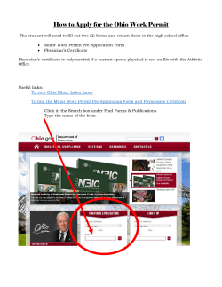


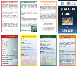


© Copyright 2026