
Abstracts 1 y e
Abstracts 1 Image: Josef Nalevansky Copyright: City of Sydney Walk21 Abstracts Table of contents Tuesday 21st October Concurrent presentations 1:30pm – 3:00pm Page Carefree in a car-free world? 2-4 Walking for health: a world tour 4-5 Placemaking I: Preparing the ground 5-6 The integration imperative: Public transport and walking 7-9 Counting the steps: What measures for measuring walking? 9-11 Zero pedestrian deaths and the Safe System 11-12 Walkshops 12-13 Speed Dating Under the Big Top 4:00pm – 5:00pm Page Speed dating session details 13-24 1 TUESDAY 21 OCTOBER 1330 - 1500 CONCURRENT PRESENTATIONS CAREFREE IN A CAR-FREE WORLD? Crystal Ballroom Walking…the forgotten face of transport Jacqueline Kennedy We are built to walk, but are our communities built for walking? Walking is as natural as breathing, but we take it for granted. As a form of transportation, it has been neglected and virtually engineered out of our lives in favour of faster and more expensive transportation infrastructure. Yet walking is the primary mode of transportation for those too young or too old to drive, persons with disabilities, persons of low income, and those who choose not to drive, which makes up a significant portion of our populations. WALK Friendly Ontario (WFO) is a recognition program that encourages municipalities to create and improve the conditions for walking by awarding Bronze, Silver, Gold or Platinum designations. Using a comprehensive framework of indicators for walkability based on planning and the “5 Es”, municipalities benchmark their current status and measure progress over time. The program gives walking a prominent profile in community planning and design, and encourages municipal governments and their community partners to set targets for ongoing improvements. As communities strive to achieve higher awards, the built environment is transformed to support walking - a sustainable and independent mode of transportation. Presentation method, aim & results In the fall of 2013, the first WALK Friendly Community designations were awarded to five municipalities in Ontario. Two further application intakes will take place in the spring and fall of 2014. Through slides of inspirational images and interesting examples, this presentation will begin with a brief overview of the WALK Friendly designation and the framework for assessing a community’s walkfriendliness. Ontario Municipalities that have earned a designation will be highlighted and specific examples will be provided of the work that they are doing to ensure that walking is not lost in the transportation mix. Based on an examination of the evidence provided through the applications, some key learnings will be offered on some of the best practices that are showing positive results as well as some of the challenges yet to be overcome to fully support walking as a transportation option. Conference participants will learn about a program that: Rewards Municipalities as a way to encourage their support for walking and walkability, Provides links to resources to assist communities in continuously improving the conditions for walking, Helps to build stronger relationships with stakeholders around walkability, Results in a great internal resource documenting all walking related programs, projects, and policies in one place, and Results in a prestigious designation that can be used as a valuable asset in attraction & retention strategies. WALK Friendly Ontario is a program of Canada Walks, a division of Green Communities Canada. The designation helps to achieve the vision of Canada Walks for a country where everyone can enjoyably, easily and safely walk to school, work, play, shopping and transit. 2 Sustainable Urban Mobility Plan of the City of Santa Maria (Brazil): Revolutionary concepts to curb the car orientated mobility planning in medium size cities in Brazil David Moncholi Badillo Santa Maria is a medium sized city of nearly 270.000 inhabitants at the heart of Rio Grande do Sul State in Southern Brazil. As many other Brazilian cities, it has experience a tremendous economic development in the recent years, which has been accompanied by a huge increase in car ownership and thus car usage. The motorization rate of the city has scaled from a good 272 vehicles per 1000 inhabitants in 2002 to a high 462 vehicles per 1000 inhabitants in 2012, and the tendency has not stopped yet. This has resulted in a huge increment of traffic congestion and a tangible deterioration of walking conditions throughout the city. The municipality undertook the elaboration of a comprehensive mobility plan with the aim to prepare the city for the mobility challenges of the new century, in which a higher economic development will put even more pressure to the already congested transportation system. One of the key figures revealed by the surveys that were carried out shows that only 27,2% of all trips is made on foot while more that 47% is made by private car. In order to curb this tendency and to promote sustainable modes of transport, the SUMP proposed several measures tackling the mobility problems for pedestrians in the city, one of if being the introduction of the revolutionary concept in Brazil of the “ZPP” (Zone for Pedestrian Preference), which intend to design an urban environment in where walking is protected and enhance, while keeping the commercial and economic activity of the city on the go. This paper aims to present the uncommon proposals concerning walking in medium sized cities in Brazil, as well as the main proposals developed in the SUMP to bring back walking as the core mode of transportation of the city, so it can be a guidance to other cities with similar characteristics around the world What factors make people walk? Experience of a car-free town campaign in Suwon, Korea Keechoo Choi Many metropolitan areas are facing urgent problems associated with the increasing worldwide trend in car ownership and congestion. Therefore modal share of non-motorized mode has being an important component for developing sustainable society. In 2012, Barcelona has set modal share targets for sustainable transport modes, particularly 40% of walking and 33% of public transport (LTA Academy, 2011). Above all, walking is most correlated with aspects of environment-friendly, in addition vitalization of city centre as well as invigoration the tourism. Recently the use of motor vehicles in Korea also is growing at an alarming level. To cope up with this rapid increase, there is an urgent need to implement appropriate sustainable transport policies focused on walking such as car-free region or pedestrian zones. The one project related establishing car-free town was suggested in Korea. The Haeng-goong district (the part of castle ares and centre of city) in Suwon is the first case of chosen as a car-free town. The campaign for car-free town with slogan, namely “The Ecology Transportation, Suwon 2013” was promoted on September, 2013. The main focus of this campaign was to suggest eco-friendly transportation mode use as well as invigoration of walking culture and its evaluation was carried out. There was a prohibition of car use, but only permission to walk within car-free town for a month. And also accessing by using a public transportation to the town was proposed. After one month of campaign implementation, we asked residents (N=1,100) about their travel behaviour change, especially about their mode choice and we hypothesise that the factors related to condition for walking, such as sidewalk width, rest area constructing, night lighting, or atmospheric environment, in addition the beauties of street, can influence on changes of mode choice from car use to walking, bicycle or transit use. Landis at al. (2007) noted that pedestrians’ perception of comfort in roadside environment is correlated with pedestrian level of service. Moreover we assumed following e.g. the study by Loukopoulos et al. (2005) that high accessibility to town with public transportation and their travel cost influence on reducing private car use. In this study, linear regression model was used for verifying these hypotheses. We believe that our study has some important implications. It shows that the potential applicability to vitalization of car-free town as well as successful policy promotion for pedestrian. This suggests that 3 governments should consider specific factors related environment for comfortable walking as well as environmental concern of residents who lives in target area for car-free town. We also discuss the importance of transportation facilities to make people to walk and to maintain their walking, based on our results which show that high accessibility by public transportation to town is important determinant to keep walking after campaign finished. WALKING FOR HEALTH: A WORLD TOUR Ted Hopkins Room Walkable urban forms: Modelling the potential human health impacts of transport options using urban development assessment models Annie Matan Urban development proposals at the precinct scale are increasingly being modelled to determine the potential carbon, water, energy and transport outcomes from various urban form decisions of the potential development. However, despite significant research into the relationship between human health, urban form and transport, the capacity to measure the human health impacts of urban form and transportation choices within planning are currently limited in application. This paper links the research on the relationships between human health, urban form and transport to urban development assessment models, developing a simple, effective and consistent method able to assess the human health outcomes from a typical urban development at a precinct scale using the transport outcomes. This is primarily related to how the development promotes (or otherwise) walking for transport. To develop this method the literature on health, urban form and transport (primarily walking and transit use) is summarised to determine potential indicators able to be used in a typical urban development model. Urban form characteristics, such as density levels and mixed land uses, are identified along with the provision of pedestrian and bicycle infrastructure. These characteristics can be measured to determine the walkability of an area, along with the potential human health impacts related to the transport choices they provide within a development. It is identified that the transport outputs, namely Vehicle Kilometres Travelled (VKT) and mode share, from urban development assessment models can be used to estimate the potential human health outcomes. To do this a methodology was created using two different approaches, with the two methods tested using a case study of a precinct in Western Australia. The results were virtually identical. The paper concludes that the health benefits, and subsequent economic benefits, of walkable urban forms are potentially measurable using an urban development model. Healthy streets Lucy Saunders Walking can be overlooked in city-level transport planning. Often it is taken for granted that people will walk for short trips and to public transport and it can be difficult for advocates to make the case for why the pedestrian experience should be a priority from the earliest stages of policy making and planning. In London, growing recognition of the importance of the street environment and transport system to public health has emerged as a new opportunity for prioritising walking. Transport for London have published their first Health Action Plan http://www.tfl.gov.uk/cdn/static/cms/documents/improving-the-health-of-londonerstransport-action-plan.pdf. This document recognises the central role of walking to keeping the population healthy with new analysis of travel data from a health perspective which shows that: - active travel is the main way people in London stay active; - over half of all walking is done as part of public transport trips; - walking delivers significant health cost-savings The health benefits of more walking in the city go beyond the substantial physical activity benefits, including reduced harms from noise and road traffic collisions and greater social cohesion. This is an opportunity that cannot be overlooked as London faces a heavy burden of cardiovascular disease, obesity, type 2 diabetes and mental ill health that is common to many cities worldwide. Transport for London have 10 new ways of working to ensure that health benefits are considered across all strategic transport planning in the city from option appraisal through business case development to 4 evaluation. This is a new opportunity for raising the profile of walking in transport planning and ensuring it is valued fairly for the health benefits it delivers. The framework for this new approach is ‘Healthy Streets’ which highlights the 10 indicators of a healthy street. These evidence-based and intuitive indicators can be used to assess how ‘healthy’ a street is and identify what needs to change to make it healthier. Pedestrians are at the centre of this with ‘Pedestrians from all walks of life’ at the top of the list. Other indicators describe a positive walking experience including shade and shelter, clean air, not too noisy and places to stop. Taking a health perspective on the transport system unlocks a new way of enhancing the walking experience and valuing its contribution to city life. PLACEMAKING I: PREPARING THE GROUND Sonar Room Cultural precincts and placemaking: Walking and cultural vibrancy in cities Rachel Healy The development of cultural precincts and the value of clustering creative endeavour across walkable locations are an increasing priority for governments and place-making agencies around the world. Historically significant cultural hubs like Charring Cross Road in London or Broadway in New York, both areas surrounded by dining, retail and other visitor experience options, demonstrate the value of concentrating cultural experiences in key precincts throughout our cities. More recently, the clustering of small scale creative industries in Shoreditch, London or the development of cultural precinct plans at Southbank in London and Southbank in Brisbane showcase new government strategies in support of walkable precincts that can maximise the return on existing public investment to cultural institutions, grow the local arts and cultural sector and unlock the potential of cultural tourism. This presentation looks at trends and examples in this area and the way in which planning for dynamic urban precincts that amplify and celebrate the unique cultural and heritage characteristics of our cities are also developing walkable city environments that provide city residents and visitors locally connected sets of cultural experiences that offer incentives to explore our cities by foot. Case studies will include the City of Sydney’s own walking tours of selected co-located Aboriginal sites of significance, historical places of interest and public art and the development of Sydney’s ‘cultural ribbon’ a waterfront walking experience from the Art Gallery of New South Wales to Barangaroo and beyond, a strategy that recognises the arts as crucial to the city’s life and identity while strengthening and encouraging the walkable connective tissue between our city’s major cultural attractions. You can't go wrong: The added value of walking as a tool of qualitative research in urban ethnography and urban planning Ulla Thamm The act of walking constitutes a significant contribution to qualitative research in social sciences, particularly in the field of anthropology and urban ethnology. Conducting research through walking in the urban area allows insights into social and cultural habits and portrays the city as a dynamic space. These insights might not be recognised in a strictly systematic analysis. This submission focuses on the significant added value of walking and so-called perceptual walks as a means of qualitative research in urban ethnography. Further, it discusses the benefits of such for the field of urban planning and other policy steps. These findings will be discussed using examples of perceptual walks in Vienna, Berlin or New York. These practical examples of ethnographic research will be further investigated by the theoretic inputs of modern social and ethnographic philosophers such as Loic Wacquant, Pierre Bourdieu, Gisela Welz or Michel de Certeau. Their approaches to qualitative research and cultural theories are of high value for modern cultural theory. These discussions will provide the theoretical basis for the concept of walking as a beneficial contribution to qualitative research. Qualitative research is an essential methodology in urban ethnography and must not be disregarded when seeking to understand the dynamics of public spaces. Urban walking itself functions as a major qualitative tool, which defines the formal and informal structures of urban space and can only be fully understood through the act of walking. 5 Interventions into urban areas such as the creation of new public spaces, the redesign of existing spaces or addressing shortcomings can only be successful, if the dynamics of an urban space are fully understood. A way to achieve this integrated understanding of space is to experience it, and by that, to feel, understand, notice and sense the environment in the area of interest. Understanding space systematically through the collection of relevant data and the study of a place’s past and presumed future is also an essential aspect of planning. Nonetheless, certain qualitative insights can only be collected by experience, by sensing emotions. Consequently, the awareness for the space, its practices and habitus can be understood and constitute a great contribution to the planning process. This analysis leads to significant conclusions about the social functions and networks of a space and are highly significant factors for planning. This submission will discuss the high importance of walking as a practice in research – the act of walking per se plays a major role. Practices define the social being of the space – how you walk, fast, slow, the elements that catch your eye – all these factors are social statements and define the spatial functions. By the means of walking as a qualitative research tool, the societal relationship of the walking habitus and the space can be decoded, understood and used for decision-making processes. Ethnographic research is designed to investigate cultural phenomena and to make culture accessible. It describes the social activities and paves the way for further steps in the process of urban planning. This process has to be experienced; otherwise it remains a raw and incomplete description from outside. The importance of good design and the cost-effectiveness of installing sidewalks to increase levels of walking. Lucy Dubrelle Gunn The built environment is associated with walking behavior and walking is one of the simplest and most easily accessible forms of physical activity. Walking daily for at least 30 minutes protects health and reduces the risk of chronic diseases and obesity which cost billions of dollars per year in health care costs. Walking is influenced by six key areas related to the built environment. These areas include: Design, Density, Diversity of Land Uses, Distance to Destinations, Distance to Transport and Demand for Parking which are known as the 6 Ds. Of these, we hypothesize that Design is the most important as it responds dynamically to changes in Density which affect the remaining 6 D areas. However, some Design elements, such as the street network, remain static. As such, it is important to design some aspects of the built environment with care to maintain the flexibility of the built environment to changes in Density. Sidewalks are part of the street network and in many cities sidewalks are not installed in all areas. Where sidewalks do exist, some may be damaged or of poor quality limiting their safe use for walking. Sidewalks are used in many different ways as they provide a public space for socializing, shopping, open air markets, street theatre, and they separate road traffic from pedestrians. Importantly, people who cannot drive such as older, younger and disabled people, rely upon them in going about their daily lives. For almost everyone, footpaths offer accessibility to destinations by means of walking. Using conceptual and quantitative models, this presentation will examine Design within the 6D framework and relate it to recent research examining the cost-effectiveness of sidewalk interventions aimed at increasing levels of walking and health. 6 THE INTEGRATION IMPERATIVE: PUBLIC TRANSPORT AND WALKING Big Top Foyer Two Why is light rail more pedestrian friendly than bus rapid transit? A review of Australian urban transit accessibility David Mepham New investment in urban transit tends to be oriented to one of two accessibility options; either convenient walk-up accessibility or the provision of significant park and ride. The type of access depends on how and where transit planners locate transit stations in the urban environment. Australian transit investments in the past few decades show Bus Rapid Transit route and stations mainly located out of centre with park and ride while light rail transit stations tend to be located in centre and cater for walk up accessibility. This presentation highlights the specific reasons behind these outcomes and shows why the transit mode and system characteristics are critical to the planning and design of walkable environments. This presentation draws on a number of Australian urban transit case studies to illustrate the accessibility challenges and opportunities for improved pedestrian accessibility and to highlight critical planning decisions that lead to improved pedestrian accessibility outcomes. Enhancing transit for walking: Gearing towards the multimodal city Sonia Lavadinho Rather than discussing the usual approach of enhancing walking for transit, we want the tackle a different approach here, that considers what can transit actually do to enhance walking in the city. This approach considers walking as being at the core of the multimodal system, and transit as a good partner to augment the walker’s capabilities of reaching and taking advantage of all the opportunities the city has to offer! Most cities around the world are now investing more and more in creating vibrant, liveable communities, where walking plays a big role. However, being able to walk in friendlier environments won’t suffice to cover all our daily needs to move around the city, especially for those of us who live, work and take time out for leisure in ever widening metropolitan territories. Other transport modes at our disposal, be these personal such as a car or a bike, or be these collectively used in various configurations, such as car sharing, bike sharing or the full array of transit options, can thus all be regarded as diverse means to the same end: “augmenting the reach of walking” in such large-scale territories. Indeed, we can’t forever remain “prisoners” of our walkable street or our walkable neighbourhood. At one point we all need to get “there” (somewhere in the wider world) and this may involve cruising motorized waters and taking off at higher speeds to get there in the allotted time. This is a crucial moment when big choices are made: am I going to use private modes to speed up (my own car, my own bike) or am I going to share in modes that can be used by others (such as transit or shared modes)? Placing walking at the core of the multimodal system: a paradigm shift for public transit operators that are called upon to manage an ever growing multimodal offer. 7 In order to give people the best “choice architecture”, we have proposed a new method of urban acupuncture at the metropolitan scale that both optimizes the geometry of the transit network and reinforces the degree of attractiveness of the major multimodal hubs, that we call life hubs, to underline their capacity to respond to other human needs that merely those of mobility. Socializing, relaxing, buying stuff, working, discussing, eating and drinking, are among things that people like to be able to do while switching modes, if they feel so inclined in the spur of the moment. This presentation thus focuses on a real-life experiment currently being made by Transdev / Semitag, the public transport operator of the French city of Grenoble. The transit network has been substantially modified to include new tramway and BRT lines. This reconfiguration is accompanied by a new philosophy that puts walking at the core of the multimodal system. The client targeted is not just the public transport regular user, but the occasional user: fundamentally, the walker, that also becomes, at some points in time, a driver, or a cyclist. Thus remodelling of the urban design and accessibility of multimodal hubs to better accommodate the walker’s needs is under way. The concept for this experiment was designed by Bfluid. We want to share our methodology and the results of the evaluation of the first “Carrefour de Mobilités” that has been implemented, and to show how some simple, low-key design changes can influence route choice and mode choice for the better, contributing to a more sustainable overall mobility. Declining a three-dimensional strategy to produce walkable transit clusters Mental mapping is essential to optimize transit use. Mental mapping can only be developed by a good grasp of the city fabric and its landmarks. Such an understanding of the overall lay of the land only comes about through walking and a familiarity with the city’s Urban walkscapes. The DNA code of this strategy revolves around 3 acupuncture dimensions: urban acupuncture, intuitive signage and communication. The objective is to enhance not only the physical, but also the mental Intuitive signage status of walkability in people’s minds. In order to achieve this, the citizen’s mental map of the city must be forged stronger. The idea is to encourage wherever possible mobility choices that people would already be willing to make, provided multimodal strategies are in Communication place that are easy enough to grasp and act upon. 8 Walking to the station: The role of walkability on transit use Liang Ma The presentation looks at research aiming to better understand the relative and combined urban form, including the walkability of the neighbourhood, and transit service characteristics on transit ridership at the stop level. Three metropolitan regions in Oregon are examined, representing different types of community. Stop-level ridership data from 7,214 TriMet stops in the Portland region, US, 1,400 Lane Transit District (LTD) stops in the Eugene-Springfield, US, and 350 Rogue Valley Transit District (RVTD) stops in Jackson County (Medford-Ashland area), US, is used as the key variable that is being explained by a number of independent variables including socio-demographics; transit service characteristics (e.g. headways, hours of service, transfer stops, bus vs. light rail, etc.); land use (employment, population, land use type, pedestrian destinations, etc.); and transportation system (e.g. street connectivity, bike lanes, etc.). The investigation found: 1. The presence and promotion of a pedestrian-friendly built environment around transit stops or stations can contribute to ridership levels. Pedestrian friendly means enhancing the street or pedestrian-path connectivity and encouraging more pedestrian-oriented business development around transit stops. 2. The better integration of land use development with transit investments, in particular focusing on multifamily housing and pedestrian-oriented commercial land use is important for transit ridership. Focusing such efforts around stops and stations with higher levels of service is effective. 3. Regional connectivity of the transit system is important (does transit go where it needs to) but the local built environment around individual transit stops is also important as most transit users are pedestrians at their origin or destination or both. The conclusion is that policy, planning, development need to focus on the spatial scale of the bus stop as part of the focus on public transport ridership development. COUNTING THE STEPS: WHAT MEASURES FOR MEASURING WALKING? Palais Room Treatment of walking in travel surveys: The case for an international standard Daniel Sauter Background Collecting information about walking is not only a necessity but provides crucial input for planning interventions and investment decisions, e.g. by measuring project outcomes, tracking performance or benchmarking. Travel surveys play a critical role as the data provides one of the key references for the amount of walking done. At the same time, walking presents particular challenges for accurate measurement. This is apparent, for example, in the vast differences in data collection methods used which make it very difficult to compare the resulting data. The validity and reliability of data presented is often unclear and in many cases, methods and tools are poorly developed and utilised, so data is patchy or non-existent. Travel surveys usually focus on the national level but good information is equally required at the regional and local level. It is essential, therefore, to develop reliable, valid and yet easy to use travel surveys for cities and urban areas which include walking in a consistent and appropriate manner. Objective and benefits The authors, supported by other experts worldwide, are currently working on the draft proposal for a “standard for treatment of walking in travel surveys”. This is part of the long-term effort to establish international standards for the collection, analysis and dissemination of qualitative and quantitative techniques for measuring walking. 9 The next step will be to debate and test the proposed standard on examples of existing travel surveys and statistical reports. How do their specifications compare to those suggested? If they differ from each other: How could the data collection, analysis and presentation be amended and harmonized? The proposed standard will bring a number of benefits to travel surveys and a better understanding of transport modes, in particular of walking and its links to other modes. It would improve the quality and the comparability of the data worldwide. This, in turn, would allow for better informed decisions in transport policies and investments. Measuring walking in Finland - present & future Tuuli Rantala The aim is to describe how walking is measured in Finland at present and what is its role in recent travel surveys, and to describe what the outlines are for the future. These two perspectives are combined to give broader picture about the situation in Finland. Measuring walking has only started to take ground in Finland, but the larger cities have a strong history in conducting travel surveys regarding urban transport. In medium or small size towns measuring walking is minimal or non existent. A travel survey is merely one part of measuring walking, but it is the dominant method at present in Finland. Since the year 1994 travel surveys have been conducted in 15 different areas covering either the whole nation, an urban region or a single city. Excluding the nation-wide survey, sample sizes range from 1 200 to 34 000 respondents. The results of some of the travel surveys will be analyzed from the point of view of walking to give insight on a) what is the role of walking in the traditional Finnish travel surveys b) what insight do the surveys provide on walking and c) what kind of potential for further analysis on walking do they provide. The National Transport Agency has recently highlighted the improving of measuring walking and cycling as one of the key actions in its strategy. As a result, guidelines for municipalities regarding measuring walking and cycling have been compiled as well as a set of most suitable indicators. This has been done on the basis of examples in Finland and abroad, specialist reports and two workshops arranged during the project. A total of 41 specialists from municipalities, regional organizations and consulting firms participated in the workshops. The starting point for the work in Finland has been suitability also to small cities and cities with scarce resources. The international initiatives regarding measuring walking have been an important reference in the work and consistency with the global trends and developments have been taken into account. The presentation will include key observations about the present state of Finnish travel surveys and highlights from the Finnish framework for measuring walking indicators. Information on travel surveys serves other countries and municipalities on their work regarding methodological aspects of travel surveys and on the discussions about the role of walking. The defined guideline on indicators of walking gives the Finnish perspective to the ongoing debate on the matter. How much walking do Sydneysiders do in their daily life? Evidence from The Household Travel Survey Corinne Mulley The aim of this paper is to quantify the amount of walking undertaken by Sydneysiders using a tour-based analysis. A home-based tour includes all trip segments made by an individual from leaving home until arriving back home. The purpose of quantifying the amount of walking in tours is two-fold. First to provide an evidence base for the key public health message as to whether this should be “more/longer walk trips” or whether more walking is achieved by stressing “more walking, whatever the main mode of travel happens to be”. Individuals travel primarily to undertake activities at their destinations. Of all tours generated on an average day in Sydney only about 13% of home-based tours are made entirely on foot with the remaining 87% using car and public transport as the main modes of travel. Given the low density nature of Sydney, converting a tour involving car or public transport to an entirely walking tour may not be possible if the individual is to reach their desired destination. In contrast, increasing walking may be more achievable if people walk instead of using motorised modes for short distance trip segments on a public transport or car based tour. It 10 is important to establish the evidence base as to whether more walking as part of a tour is a better public health message that might lead to more individuals reaching the advisory physical activity targets. The paper uses three years pooled data from the Sydney Household Travel Survey (HTS). The HTS is a large source of personal travel data for the Sydney Greater Metropolitan Area (GMA) and is a survey first conducted in 1997/98 and has been running continuously since then. The HTS includes between 3,000 and 3,500 households in any given year and pooling 3 years of data gives reliable estimates of travel at the geographical level. As the data is collected face to face and each member of the participating household completes a travel survey, the HTS provides a rich source of data to first identify home-based tours and then to undertake analysis on the nature of these tours in terms of their walk component and other attributes. This paper investigates the drivers of walk only tours, including journey purpose and built environment factors as explanatory variables. Alongside this, the paper investigates car and public transport based tours to identify how much walking is undertaken as part of the tour. The combination and comparison of these two analyses shed light on the drivers of walking as the only mode and in combination with other motorised modes to reach activity locations. The results provide an evidence base as to how a public health message should be targeted. ZERO PEDESTRIAN DEATHS AND THE SAFE SYSTEM The Big Top The challenge of walking in the Safe System approach Tim Hughes Australia and New Zealand have adopted the Safe System approach. This concentrates on reducing deaths and serious injuries, by reducing risk and particularly by reducing the impact forces in a crash to a level that can be tolerated by the human body. – called the safe system threshold. The risk of death and serious injury to a pedestrian struck by a motor vehicle varies with vehicle design, vehicle speed and with age of the pedestrian. Much better information is becoming available from recent international research on the effect of these variables on injury severity. For unprotected users like pedestrian this data presents specific challenges as motor vehicle typically travel at speeds that are usually above safe system thresholds. The presentation will cover the situations where pedestrian are at most risk and the measures available to reduce the risk of a collision and also to reduce the severity of any injuries. Toward zero pedestrian deaths global initiative Charlie Zegeer This presentation will discuss a new global initiative led by the University of North Carolina’s Highway Safety Research Center (HSRC) to address the alarming numbers of pedestrian deaths worldwide. The goal of this initiative is to use the tremendous base of knowledge and research regarding the prevention of pedestrian deaths and injuries to address the problem, and specifically, to address the problem where solutions are most urgently needed. According to the World Health Organization (WHO) report Global Status Report on Road Safety 2013, approximately 1.24 million people die worldwide in motor-vehicle-related crashes each year and nearly 300,000 of these deaths are pedestrians. About half of the world’s annual pedestrian deaths occur in low-income countries. This trend is also reflected among children (Naci, 2009). In several of these low-income countries, pedestrians account for more than half of traffic-related deaths (WHO, Naci). While highway safety activities are promoted in many countries and within some global road safety initiatives, not nearly enough is being done on a global perspective to address pedestrian safety problems. The purpose of the multi-year Toward Zero Pedestrian Deaths Initiative is to draw attention to the ongoing global problem of pedestrian deaths and injuries and to provide technical assistance to enable communities, countries and organizations to identify why and where pedestrian safety problems exist, what populations are affected and to match efforts with the strategies proven to be effective in improving safety for those circumstances. This presentation will highlight the magnitude of the problem, the international efforts currently underway, and how this new initiative will work with these initiatives and beyond. 11 Pedestrian safety in New South Wales: Past trends and current activities Prendergast, M., Walker, E. Barnes, B., Fernandes, R. and Graham, A. This presentation outlines the nature and extent of pedestrian road trauma, fatalities and injuries, in New South Wales. Pedestrian fatalities are down 89% from their peak to an all time low, and pedestrian injuries are down 65% from their peak. Pedestrian injuries and fatalities vary by key characteristics such as age, gender, the nature of the road environment (particularly speed limit, whether it is an interaction or mid-block location, and whether it is a local road or not), location (metropolitan or not), whether alcohol was involved and the light conditions. Over the past decade, pedestrian fatalities have been cut by over half (51%), much more than the reduction in the rest of Australia (16%). Over the past decade, pedestrian injuries have been cut by more than one-quarter (28%). Both fatalities and injuries have reduced more for pedestrians than drivers, cyclists and motorcyclists. These reductions in pedestrian road trauma are the result of the disciplined application of the strategic Safe System approach to improving road safety, led by Transport for New South Wales’s Centre for Road Safety. The countermeasures we have employed to achieve these results cover all elements of the Safe System, but focus particularly on safer speed management around pedestrians (on the urban road network, in high pedestrian activity areas, near schools and at intersections); and engineering safer roads for pedestrians at high risk locations. These primary countermeasures are supported by school education, as well as enforcement activities, tailored local education programs and the improving safety performance of vehicles. This presentation also touches on research being undertaken by the Centre for Road Safety on shared paths (for cyclists and pedestrians) and count down systems at signalised crossings. 1230 – 1530 WALKSHOPS Denser and Healthy Cities: Exploring the complexities of redeveloping Sydney’s inner west for health and well-being (1230 – 1530) Susan Thompson, Emily Mitchell This Walkshop will take participants to the inner west of Sydney to explore some of the complexities of creating a healthy built environment. We will inspect several large redundant industrial sites which are currently being redeveloped. These include the Lewisham Towers Development; the Summer Hill Flour Mill and residential flat developments along Old Canterbury Road, Lewisham. The approval processes for these developments will be discussed (involving state, local government and the community), as will the local tensions regarding the redevelopment. How do we balance the need for denser, walkable suburbs with existing neighbourhood amenity? In considering these issues, the Walkshop will inspect the broader neighbourhood context of these sites. The area is served by public transport, including the recently completed light rail, has high street connectivity and walkability. Facilities such as local shops, cafés, medical services, schools and a community centre are nearby. Open space parkland is available, including a community garden, and there is ready access to the Greenway for recreational walking and cycling. This is also a heavily trafficked area of Sydney where the addition of nearly 1,000 apartments will put significant stress on the existing road and pedestrian network, and local facilities. There are also issues for the heritage th of the 19 Century residential landscape, privacy, overshadowing and provision of adequate green open space. The Denser and Healthy Cities Walkshop will take approximately 3 hours (depending on waiting time for public transport). It will involve transportation by heavy rail, light rail and on foot. Participants will need to wear comfortable walking shoes, hats for sun protection and take wet weather gear. The schedule is as follows: - Walk from Conference site to train station (10 mins) - Train from Milsons Point to Central (10 mins) - Train from Central to Lewisham (15 mins) - A guided walk from Lewisham Station to Summer Hill looking at redevelopment sites and the broader neighbourhood context (90 mins) - A walk from Summer Hill along a section of the Greenway/light rail corridor (45 mins) - Catch light rail from Hawthorne Station to City (15 mins) 12 - Participants make their own way back to hotels/other destinations By participating in the Walkshop, Conference delegates will appreciate the complexities of redevelopment in the inner west of Sydney to create a healthy built environment. They will also experience Sydney’s heavy and light rail transport, see part of Sydney’s busy road network, use pavements of varying walkable quality, and visit local open space and the Greenway. The Livability Project - Crown Street, Surry Hills (1330 – 1500) Catherine Bridge In this walkshop the authors will present the ‘Livability’ app and demonstrate its use in assessing a 300 m section of Crown Street relevant to developing an improved the walkability of our cities and town centres. Most regional Local Government Authorities (LGAs) do not have the resources nor the appropriate tools required to understand and respond to the infrastructure needs of special and often overlooked user groups, such as mums with prams, people with disabilities, older people and persons unfamiliar with the streetscape. Thus, few ‘as built’ and maintained infrastructure developments address the needs of these often-invisible user groups adequately. This is unsurprising given that traditional methods for engaging the community in the decision-making processes of local government have been characterised by traditional town hall meetings and face-to-face interviews. However, these methods of civic engagement may be more difficult for marginalized groups to access due to their health and mobility concerns and social and economic status. Method: We will be using a ‘mobile focus group’ method that can be described as mobile interviews or a ‘go along’ method, as the technique embodies both walking and talking. Walking methods can be used to empower participants, as it hands over the focus and allows the participants to set the agenda feedback without prior training based on direct experience taken as a snapshot in time. The walk technique uses a special Livability ‘App’ that run on smartphones and other mobiles devices. Results: The group will be briefed on the Livability ‘Walk and talk” technique, do a walk using the ‘App” and then debrief on their experience and it’s potential application in wider contexts. The use of the Livability ‘App’ allows the information gathered to be GIS pinned and integrated in a meaningful way into community consultations, asset databases and facilitates social and traffic planning, enables prioritization whilst ensuring input from marginalized groups in a more systematic manner. Conclusions: There are many benefits associated with the use of smartphone apps, which can represent innovative ways of creating and sharing content, and provide a bidirectional information exchange between governments and citizens. Use of innovative technology is a means to ensure that the numbers and placements of required amenities to facilitate active transport are planned for, costed for, prioritized, appropriately maintained and provided. SPEED DATING UNDER THE BIG TOP Big Top Are walking rates changing among residents in Sydney? An 11 year analysis Adrian Bauman Walking is an important contributor to total physical activity, and is feasible for and accessible to most people. This study examined trends in walking in metropolitan Sydney between 2002 and 2012 based on data from NSW Population Health Surveys. Every year NSW Ministry of Health conducts phone interviews with around 15,000 adults aged 16+ about their health and lifestyle. Representative data were collected for local health districts, with regionally weighted estimates produced. Walking was assessed using the validated Active Australia survey, which asked respondents to describe how much and how often they had walked in the previous 7 days “for exercise or recreation, or to get to and from places”. Results show that from 2002 to 2012, rates of any walking among Sydney adults increased from 84.3% to 86.2%. For comparison, an advantaged inner-city region was compared with a disadvantaged region in outer Sydney; rates of any walking did not change in the advantaged region [84.5 to 84.1%], but increased in the disadvantaged region [75.5 to 79.4%]. More specifically, sufficient walking for health [≥150 mins/week] 13 increased in Sydney overall [41.4 to 44.1%], and in both the advantaged [42.3 to 43.3%] and the disadvantaged regions [31.4 to 38.3%]. These data show universal increases in walking across Sydney, not confined to areas where walking infrastructure or urban density have changed, and reflect a more pervasive effect of public health interventions and pro-walking social norm changes in Sydney. Royal Botanic Gardens, Sydney and Domain Master Plan Alastair Baxter The Royal Botanic Gardens, Sydney & Domain is one of Australia’s most important open space networks with a Tourism and Transport Forum study in 2013 finding 15% of all international visitors to Australia visit the Royal Botanic Gardens in Sydney, yet no comprehensive master plan has ever been undertaken since its inception in 1816 to inform and control the Garden and Domain’s network of pathways. Hence, what should be a highly desirable pedestrian area suffers from a lack of pedestrian clarity, user amenity and conflicting user groups. This was highlighted by recent community consultation undertaken for the master plan by Kathy Jones Associates which identified illegibility of pathways and lack of suitable amenities as key restrictions to the enjoyment of the Gardens. Cox Richardson is currently undertaking a comprehensive master plan of the Garden and Domain that will act as a guide and framework for the next 25 years and, in conjunction with UK landscape design firm Grant Associates, have proposed a number of solutions to greatly improve the pedestrian experience including the use of a clear hierarchy of paths, provision of appropriate signage and wayfinding, designing series of visitor experiences based on pedestrian movements and future proofing circulation routes and gardens likely to be impacted by sea level rises as a result of climate change. By using the Royal Botanic Gardens, Sydney & Domain master plan as a case study we hope to highlight how simple yet effective solutions, undertaken with comprehensive community and stakeholder engagement will produce a holistic plan to guide the Royal Botanic Gardens Trust in transforming this beautiful natural jewel into one of Sydney’s most walkable open spaces. Shaping Suburbia: Towards the suburbs of the future David Bennett This paper will examine the role that existing suburbs can play in our cities growth. Case studies in metropolitan Sydney will be used to reveal the connection that built environment can play in improved health and well being outcomes, via the metric of increased incidental activity. As world urbanisation increases, the issue of how and where we live, and how close we live to one another will become increasingly important for the majority of Australians. Most Australians, in fact 70% of us, live in detached houses in the suburbs. Yet discussion on increasing density inevitably results in discussion of high‐ rise. This need not be the case. There are a wide range of housing types in between the polar extremes of either high‐rise or suburbia, even though that may be what is most represented in market availability. Converging with the pressure on cities as they grow, are the well documented health problems related to that of a dangerously inactive population and one that is increasingly car dependent. Shaping suburbia connects the component that our built‐environment can contribute to health via activity. This paper will argue that there is an optimum density to help shape healthy, sustainable places where most of us would be happy to live. Using an ‘activity metric’ as a proxy for the vibrancy and connectedness of the neighbourhood or precinct it will highlight the many other resulting cobenefits of this density such as sustainability, affordability, health and community. Can existing suburbia adapt to provide better lifestyle, heath and sustainability outcomes? Are ‘the suburbs’ able to keep their leafy, freehold title and a familiar environment and yet still house more people? This paper will show it is not only possible, but necessary and has many co‐benefits for residents and the city. 14 The Livability Project - Mobile Crowd sourcing older persons opinions on town pavements Catherine Bridge Aim: In this presentation the authors address the population imperatives for a new way of understanding how pavement infrastructure impacts walkability. Population Ageing means that an increasing proportions of the population will require a more supportive and responsive pedestrian environment. However, local government has neither the resources nor the appropriate tools needed to understand and respond to the changing infrastructure needs. As mobile devices such as tablets and phones proliferate, there is an opportunity to use mobile apps to engage older people more effectively with their local government associations in planning the future of their regional city centres. The application was developed in partnership with the Local Government Association and the partnership of the two regional local governments who participated in our pilot. Method: This involved building a fully functional system, including our iPad app, back-end database and server web-interface, and did pilot runs (called “walk-and-talks”) with local council support in two coastal regional cities in New South Wales. We obtained appropriate ethics approvals to conduct such trials, and recruited volunteer older people from local walking groups. The walk and talks are similar to mobile focus groups and involved walking along a 400m pre-defined walking route in the town centre, auditing the built environment from the older peoples perspective and identifying possible hazards or problems as well as features of the town centre that were pleasant or supportive. This allowed the older people who participated to have a structured conversation about what they see as them positive and negative aspects of the town centre in relation to active ageing and what they view as possible solutions. Results: The field trials of our platform with mobile focus groups comprising senior citizens in two coastal regional cities in New South Wales, revealed that older people value centralised services, the provision of wider footpaths, and specialised infrastructure provision such as appropriate and frequent seating. Signage was a problem as were shared walkways. Insufficient bins and the aesthetics of the streetscape were also noted. Conclusions: The NSW Towards 2030 Plan emphasises the need to review planning criteria to “encourage a walkable and wheelable community with local public spaces that are safe, pleasant and people use”. This project has and will continue to facilitate collaboration among researchers, practitioners, and policy-makers by collating information about the influence of built environment features on older peoples wellbeing and the implications of town planning solutions. Further, this work is timely because it has the potential to impact on other regional strategies that are being introduced, such as the regional plans currently under preparation. This research contributes to better understanding of the impact of the built environment and ageing and urban policy on older people’s engagement, participation, independence and security, through strategies that are replicable in other Australian cities. Safe speed: Engaging the community with key messages Lisa Cain Reducing vehicle speed to 30km/hr in areas of high pedestrian activity, residential streets, and around schools and strip shopping centres is world’s best practice (WHO, 2008). Not only is it safer for pedestrians and cyclists, but reducing speed can also promote walking and cycling. Increasing active transport use has numerous benefits including health, transport, environmental, energy use and community safety. Australians’ attitudes to safe speeds are lagging behind many countries, with considerable behaviour change required to shift priority from the car to active transport modes. Low neighbourhood street speeds are a common feature of countries with high rates of active transport, such as the Netherlands and Germany. To develop a case study of meaningful community engagement and to encourage a change in attitude, the 1 Safe Speed Interest Group (SSIG) developed and piloted key messages with two local governments in Victoria - Manningham City Council (metropolitan) and Baw Baw Shire Council (rural). As the secretariat of 15 SSIG the Heart Foundation led the co-ordination of this work, which commissioned Essence Communications to develop the key messages. The project was informed by the previous work of SSIG including focus groups which investigated community opinion on safe speed, along with the input of many experienced SSIG members. Draft key messages were developed and workshopped with the two pilot Councils and those which resonated most were chosen and tested in each pilot project. Baw Baw Shire Council developed the ‘The Slow Down Movement’, a local communications campaign involving the ‘yarn bombing’ of streets and items around Warragul, as well as signage and a Facebook page promoting the Slow Down Movement. Manningham City Council elected to run a campaign specifically focused around increasing active travel amongst primary school students. The campaign tapped into the Active Travel Plan that the school was already running and students were encouraged and supported to walk and cycle to school. Signage, cut outs and parental education around slow speed were part of the project. Both pilot projects incorporated evaluation with Baw Baw Shire Council running community focus groups and Manningham conducting surveys with parents. Overall the pilot at the primary school resonated better with participants with the following results reported by parents: Being more aware of children whilst on the road (48.1%) Encouraging their child/ren to change their mode of transport when travelling to / from school (41.6%) Driving more slowly through the community (35.1%) In contrast, participants within the Baw Baw focus groups reported limited recollection of the Slow Down Movement activities, with most unsure of the objectives of the campaign. The varied levels of success seem to indicate that messages around safe speed are easier implemented in targeted communities and locations. As both pilot projects struggled to convey the benefits of 30km/hr, it is important that we continue to work towards developing key messages and campaign activities that resonate with the community. As part of the city surgery, we will investigate opportunities and learn from experiences to engage the community and increase support for lowering speed to 30km/hr. Consequences of better walking urban environments: Lessons learned from Lisbon Paulo Cambra Promoting pedestrian mobility is gaining a growing attention and many cities and communities are seeking to implement mobility plans and streetscape improvements in order to create more pedestrian friendly environments. To track the progress of such plans and projects, many walkability assessment methodologies can be used, assessing the conditions of the urban form. This research team has developed a multi-criteria, multi scale walkability assessment framework (presented at Munich’s Walk21 conference), which is currently progressing to a next exploratory phase closer to practical applications of walkability figures in urban and mobility planning and policies. Such framework can be used to address the “before” and “after” situation, providing a figure for an “improvement rate” of the pedestrian environment, and additional understanding of the process, in terms of its economic and social impacts can provide valuable insights for the regional and international communities. The aim of this paper is to provide the reading of the objective walkability assessment results within a further complex network of relations -from the social and cultural to the economical dimensions- focusing on the positive and not so positive impacts of pedestrian improvements. Encouraging walking has a great set of economic, health, environmental and social benefits but transformations of the built environment are not free of adverse effects. Recurrent arguments against pedestrian improvement projects and plans have been related to the perception that restricting or suppressing automobile circulation has a negative impact to local activities and resident’s daily life 16 (e.g.increased rental prices, loss of proximity commerce to specialized commerce -sometimes mostly visitor oriented). A collection of cases showing both positive and negative impacts from well-established pedestrian projects and plans may help in soothing these perceptions. The recorded negative impacts can be useful for reflection and for improving strategies, supporting the stakeholder engagement of future similar projects. The methodology is based on the assessment of recent improvements in pedestrian facilities in the city of Lisbon in terms of their walkability score, using the developed framework to review the processes and their stakeholders in order to realize: How could the area be described prior and after the intervention? Was there public opposition? Who was for and against? Did their position change over time? Did the project fulfill its goals? What were the impacts in the local economy (commercial dynamic, rent value) and in social relations (residential dynamic, habits)? Was there any change in the mobility patterns? Results from the walkability assessment are to be compared with the results of the process review, seeking correlations between streetscape improvements and commercial and residential dynamics. The process review will also provide a layer of understanding of who has gained what and who has lost what. This paper results may be useful for urban planning practice as they will contribute to comprehend strong positive aspects that could be replicated/achieved in other places and strong negative aspects that could be corrected in future pedestrian improvement processes. Acoustic perception of electric vehicles and their impact on the road safety of pedestrians Gerald Furian Electric vehicles (EVs) produce lower noise emissions than vehicles with an internal combustion engine (ICE). How do these lower noise emissions impact the interaction of pedestrians and drivers? How do EVs influence the road safety of pedestrians? The project ‘drivEkustik’ systematically investigated the impacts of lower noise emissions by EVs from various perspectives. Therefore, the driving behaviour in EVs and the acoustic perception of these vehicles by other road users were analysed. Acoustic measurements inside and outside of an electric vehicle in different roadside environments (e.g. urban back-roads, urban through-roads, rural roads, parking situation) were performed. By a listening test involving 105 subjects, the recognition of electric vehicles by vulnerable road users (VRUs) was performed. The measurements were performed between 10 and 50 km/h using conventional free-field microphones and a binaural head. The binaural recordings were supplemented with recordings of different environmental situations in order to perform a laboratory listening test to determine the detectability of the investigated vehicles. Furthermore, there was a focus on collecting data of driving behaviour of drivers with an electric vehicle in order to compare it to already existing data from drivers with a vehicle with an internal combustion engine (ICE). Additionally, interactions between electric vehicles and VRUs were observed by a real-life experiment. Special attention was given to the assessment by people with visual impairment. Impressions and experiences of the subjects within all the experiments were collected by means of interviews and questionnaires. First of all, the study scientifically verified the assumption that EVs create less noise than ICEs. The listening test clearly demonstrated that it takes considerably longer to take notice of an EV rather than an ICE. E.g., at the speed of 10 km/h, ICEs were detected 9 seconds earlier. If there is a higher level of background noise (e.g. intra urban environment) the electric vehicle was noticed even later. Mobility and driving behaviour of EVs-users and ICE-users was compared by means of a naturalistic experiment. Four EVs were equipped with a “pDrive lite ®”, a suitable data logger. These vehicles were used for promotion purposes and given to interested citizens for a maximum of one week. The data was compared to data from earlier naturalistic experiments. On average, trips with EVs were shorter both in time and 17 mileage. At lower speeds (speed limit of 30 km/h or 50 km/h), the EVs featured a higher speed level than the ICEs. In rural areas and on highways ICEs feature a higher speed than EVs. Concerning interactions with VRUs, no serious differences between EVs and ICEs were observed. However, the interviews showed that visually impaired people consider EVs as an additional risk to themselves. The results of the various experiments were used to develop common recommendations. The project drivEkustik was operated by the Austrian Road Safety Board (KFV) and the Austrian Institute of Technology (AIT) and was funded by the Austrian Road Safety Fund (Austrian Ministry for Transport, Innovation and Technology). Will tactical urbanism transform planning in Australia? Challenges and opportunities from local case studies Lucinda Hartley Traditional processes of urban planning are characterised by a plan-and-deliver approach that offer little opportunity for immediate citizen engagement. The resultant plans are not flexible enough to accommodate shifting social structures, rapid economic change, new knowledge and insights, experimentation or local variation. In this context we see the emergence of non-traditional forms of city-making, such as tactical urbanism. In Australia, tactical urbanism has an emerged as an approach to placemaking that is characterised by citizen leadership, experimentation and immediate action. But, is tactical urbanism just a fad, or a pointer towards a new form of city-making tailored to a future of more democratic, equitable, fast-paced and flexible cities? Learn about the challenges, opportunities for tactical urbanism in Australia, and how they might influence your next project. Explore the newly released Tactical Urbanism Guide vol. 4 Australia and New Zealand, which highlights over 30 local case studies, with project examples from local government, community groups, and property developers across the region. Determinants of walking in Sydney Ronald Horvath, Laurence Troy The aim of this paper is to examine the association between walking and the following seven determinants: auto dependency, walkability, distance from the CBD, population density, public transport availability, bicycle travel, and social advantage/disadvantage. Data for 394 Sydney suburbs are taken from 1) the 2006 and 2011 Australian census, 2) the Household Travel Survey collected annually from 2001 to 2012 by the NSW Bureau of Transportation Statistics, and 3) GIS measurements. The data are analysed using correlation, graphic, and regression analysis to identify the fit between the seven determinants and everyday walking and walking to work. Discussion of the findings will focus upon the relationships between auto dependence and walkability as distinct factors most responsible for the level of walking in metropolitan Sydney. Arguments will be advanced for why the other five determinants must not be dismissed even though the measures of association show them to be lower-ranking in the hierarchy of determinations of walking. Conventional statistical analysis focuses on what is, drawing causal inferences from the fits. From the perspective of what could be, the fits indicate the gaps that could be closed through programs of behavioural change and/or changes in the built environment. From the perspective of what ought to be, some combination of visioning and backcasting from a date in the future provide annual change targets needed to achieve the desired future outcome. A community campaign to establish Ciclovia (Sunday Streets) in Sydney Daniel Kogoy The community campaign to bring Ciclovia to Sydney began in March 2013, when Leichhardt Councillor Daniel Kogoy, BIKESydney, Bike Leichhardt and the Go! Alliance established the Sunday Streets Campaign Committee. Ciclovia is a fun and healthy event that opens up a city’s largest public space – its streets. This public space 18 event temporarily removes cars from some main streets, and opens them up to other activities, typically for about six hours on a Sunday. Part festival, fun walk and playground - people walk, run, cycle, skate, rollerblade and play in the streets. There is participation from local businesses along the route and there can be a variety of live music, arts and culture, and other recreational activities - such as climbing walls, dance, yoga and aerobics classes - staged at various parts of the route. Though temporary, this event has helped inspire permanent improvements to the built environment in cities where it is held. The health benefits of Sunday Streets events are significant. The event offers a unique strategy for increasing opportunities for physical activity within existing urban infrastructure. It helps address the decline in physical activity that leads to increased rates of chronic diseases such as heart disease and diabetes. San Francisco’s Sunday Streets event, inaugurated in 2008, is now held nine times a year over approximately 50 kilometres of streets. Montes et al (2011, 160) stated that it has a cost-to-benefit ratio of 2.32. As Sunday Streets events are located along main streets, they provide the many businesses along the route with a captive audience of hundreds of thousands of potential new customers. Aims: The objective of this community campaign has been to establish a Ciclovia program of events in Sydney, so that Sydney could share in the health, economic, community, and environmental benefits that Ciclovia brings to a city. The campaign has succeeded by gaining the support of a broad range of stakeholders including various local councils, politicians, chambers of commerce, individual businesses, community groups and cultural organisations. This support has been achieved simply by sharing the Ciclovia story with the community and key stakeholders. A campaign petition and facebook page were established to build support and keep supporters engaged with the campaign. The campaign team presented the Ciclovia story to key stakeholders through presentations, meetings, email, facebook page and phone. Conclusion:In a short time period, the Sydney Sunday Streets campaign has built significant support. There is a strong possibility that a Sunday Streets pilot project will be held in the City of Sydney in 2014 to coincide with Sydney hosting the Walk21 Conference, or another event. On the successful implementation of a pilot Sunday Streets, we see there being strong support for a program of events to be held annually across other areas of Sydney including Parramatta, Leichhardt, Marrickville, North Sydney, Randwick and Woollahra. This will assist in encouraging community physical activity and hopefully lead to increased health and public space benefits and outcomes for the people of Sydney. Reference:Montes et al (2011) Journal of Urban Health, Vol. 89, No. 1 p160 “Do Health Benefits Outweigh the Cost of Mass Recreational Programs? An Economic Analysis of Four Ciclovia Programs” Spending other people's money is hard work: The secret of sourcing funding for walking infrastructure Myfanwy Lawrence This paper will investigate how the most difficult sections of the Parramatta Valley Cycleway have been approved and funded by framing the path as a community facility which provides access benefits for all. There are many elements needed to achieve a world class liveable city. One is the ease in which the community can move through public spaces that are constrained by busy roads, geography and public access. Like many cities around the world, Parramatta has turned away from the River which was once its lifeline. Industrialisation and car orientated city design has disconnected the River from the surrounding urban structure. Parramatta Council is now working to reinstate the River as the focus of a vibrant, sustainable city which celebrates this asset. Key to this revitalisation is a shared path along the river corridor linking the key destinations of Westmead (Australia’s largest health and medical research precinct) Parramatta City Centre (Sydney’s second CBD), the University of Western Sydney and Sydney Olympic Park. 19 When completed, over $30 million will have been invested by Local, State and Federal Governments, and local developers in sustainable transport. The path traverses though series of linked parks, industrial and natural areas, and private land which all have unique constraints. These include contamination, heritage issues, land ownership and environmental protection. Over the last 10 years the less complex sections of the shared path have been delivered. The missing links in this path are now more challenging. This paper will investigate how this ambitious project has been progressed over recent years using innovative design, planning and funding in a social landscape in which walking facilities are not a priority. Strategies have included the reframing the path as a Nature Pathway to protect endanger salt marsh, the restoration of a heritage listed sandstone bridge, lighting of natural features within the River and acquisition of contaminated land for remediation to increase public parklands. By thinking outside the square and reframing walking facilities as places which create liveable spaces for all the community, this project demonstrates that even the most difficult connections can be realised. 24-7 pedestrian counting via smart phones: Results of Sydney CBD trial Peter Rickwood We describe a technique for estimating pedestrian flows from transient smart-phone signals, and present the results of a trial of this technique in the Sydney CBD. The technique involves the collection of anonymous data from WiFi listening devices. This data is then used to estimate directional pedestrian flows along George Street, Sydney. Results are compared with manual pedestrian counts conducted by a commercial pedestrian-counting company. We also discuss & compare the technique with other currently available and emerging technologies. Sydney Culture Walks App Eva Rodriguez Riestra, Laila Ellmoos Walking is one of the ways people get to understand and appreciate the culture, fabric, fine grain and stories of a city. For over 15 years, the City of Sydney has produced walking tours brochures that showcase its history, heritage and public art. In 2014, the City has developed the Sydney Culture Walks app that brings together over 400 sites of significance in the local government area. This paper will look at how the app was developed, and explore some of the challenges in using digital technologies to present history and public art. This paper also has the opportunity to undertake a Walkshop to showcase the work completed by the City of Sydney. Senior Victorians and walking: Obstacles and opportunities Ben Rossiter This presentation will outline the findings and recommendations of the research study ‘Senior Victorians and walking: obstacles and opportunities’. This large, comprehensive study commissioned by Victoria Walks provides important findings for a population group who, more than most, need to feel safe and confident being outside and participating in community life. The research fills a much needed gap, as relatively little is known about the environmental, social and policy determinants of physical activity and walking for older adults, particularly in an Australian context. The presentation will report on most important perceived barriers to walking and the measures that might improve their feelings of safety when walking. The study included: A desktop literature review of supports and constraints on walking by seniors; 20 Analysis of seniors walking data from the Victorian Integrated Survey of Travel and Activity; Eight focus group discussions with a total of 32 senior Victorians; and A survey of 1,128 senior Victorians. The study found that walking is extremely important for seniors, who are less likely than younger adults to participate in more vigorous forms of physical activity, more likely to experience social isolation and less likely to drive a car. Walking is highly valued by seniors for a range of reasons including improved health, wellbeing, independence, personal mobility and social connectedness. The study found that walking for transport is a more socially inclusive form of physical activity than leisuretime activity. While socioeconomically disadvantaged population groups are substantially less likely than advantaged groups to participate in recreational exercise, walking for transport is evenly distributed across the socioeconomic spectrum. The study also found that the preferred distance seniors are prepared to walk to get to places (500-1000m) does not vary significantly with age. Seniors walk much more in inner Melbourne suburbs, which have a high degree of walkability, than outer Melbourne or regional Victoria, which are generally car-oriented. Furthermore, utilitarian trip purposes become increasingly important as seniors age, from 53% of walking trips for 60-69 year olds to 81% of walking trips for those 80+. This confirms the important contribution that walking makes to older adults’ mobility and independence. The presentation discusses the substantial differences in walking rates for older adults between countries and challenges the widely-held perception that low rates of walking for transport among older adults in Victoria is largely due to increasing ill-health and functional limitations. The walkability of the environment appears to be a more important determinant of walking by seniors. The presentation will comment on implications of the findings on housing, planning and urban design. Park to Pacific Better Block, Clovelly 2014 Sara Stace In October 2013 Australia’s first Better Block event was held in Clovelly, Sydney. From that event, the Park to Pacific association was created, with long-term vision for the whole of Clovelly Road, from Centennial Park to the Pacific Ocean. Clovelly Road is a 2.6 kilometre stretch of road – a 30 minute walk or 10 minute cycle – covering eight ‘villages’ with 140 shops, cafes and small businesses along the way. Each village has its own unique character, and each would benefit from getting more locals and visitors stopping by. The vision is for these villages to become hubs where the community comes to meet, chat, eat and shop; to encourage residents to walk to their local shops; and to let our kids feel safe in the neighbourhood. As part of Walk21 Sydney, the next Better Block demonstration day was held on 19 October 2014. It transformed one of the villages into a hub of activity: with trees, plants, murals, and a mini ‘parklet’; used extensive social media to attract volunteers, residents and businesses to join in; and conducted surveys of people’s reactions and preferences. 21 Encouraging positive travel choices to school everyday with The Living Streets Travel Tracker Chris Thompson Aim: The Living Streets Travel Tracker engages pupils directly with the travel planning process by recording journeys to school and rewarding walking and other active travel choices. The Travel Tracker supports Living Streets’ Walk Once a Week scheme (WoW), replacing the traditional wallcharts used to record journeys to school. WoW rewards pupils walking (or scootering/cycling) at least once a week to school with collectable badges. The Travel Tracker utilises the classroom interactive whiteboard to record these journeys and makes travel planning a rewarding and enjoyable experience, helping to establish positive travel choices from a young age. Method: The Travel Tracker automatically uploads class lists from the school database, taking only a couple of minutes to set up at the start of term, even in a large school. Using the Travel Tracker on a daily basis, in the classroom, is similarly straight forward; children from nursery age upwards can record their travel choices in just three easy steps by pressing the screen on the classroom interactive whiteboard. At the end of each month children are rewarded with highly collectable pin badges (made from recycled yoghurt pot material) if they have walked at least once a week to school. The Travel Tracker makes issuing badges straight forward for the class teacher. A summary of all pupils qualifying for a badge at the end of the 22 month is available at the click of a button. Teachers can choose to override the automatic functions if necessary to award badges in special cases. Results: The mode choices available on the Travel Tracker correspond with the annual Scottish Schools Hands Up Survey, which takes place during September. This makes it easy for schools to measure the impact of WoW and the Travel Tracker against the baseline Hands Up Survey and chart their progress throughout the year. With over 450,000 journeys in Scotland and more than a million journeys in England logged so far the Travel Tracker is already proving to be a powerful and effective journey recording and travel behaviour change tool. Independent evaluation* has found that schools using the Travel Tracker with WoW have seen an average increase of 13% in walking and active travel levels after three months. * Independent evaluation by Create Consultancy Ltd., April 2013 Conclusions: The Living Streets Travel Tracker is the leading school journey monitoring system anywhere in the world. The engaging graphics and intuitive interface make it highly attractive to the primary school audience. In addition to its core function schools are already using the system to help with class registration and to support their school travel planning. In the future, the Travel Tracker could readily be adapted for use in other travel planning applications, such as workplaces, providing a similar level of data analysis and behaviour change capacity for journeys to work. The Healthy Built Environments Program – An Australian exemplar of health and planning working together Susan Thompson Public health, transport and urban planning research has produced evidence on environmental attributes that have an impact on walking for recreation and walking for transport. The ultimate aim of this research is to assist planners and policy makers to design neighbourhood environments conducive to more walking. However, most researchers do not know how evidence is used in urban planning policy making and what type of evidence is needed. Conversely, many policy makers and practitioners and are unaware of the increasing body of research linking health and planning. This roundtable aims to make connections between health and planning from research collation, policy translation and evidence based implementation. The session will include three presentations. Susan Thompson will explain to what extent research evidence has contributed to planning practice, and the types of information that are likely to have impact on policy and practice. Andrew Wheeler will discuss how the NSW Department of Planning and Infrastructure make planning decisions, using case studies, and what role additional research evidence could play in the process. The recent inclusion of a health objective within the Sydney Metropolitan Plan will be a major focus. Paul Klarenar will talk about how area health service staff have been using healthy planning research evidence and emerging planning policy levers as tools for collaborating with local council planners to create more supportive environments for walking. A panel discussion will conclude the session with a focus on ways of describing and measuring success and offer an opportunity for comments and questions from the audience. Activity centre economies - powered by pedestrians Knowles Tivendale Over three decades the City of Melbourne has implemented a wide range of pedestrian improvements focussed on increasing CBD activity and economic productivity. Data collection programs have also been implemented to test the progress toward specific goals. Recent projects have developed a comprehensive walking plan which articulates the economic benefits of pedestrian improvements. This presentation will highlight and explore some of the walking plan’s key underlying analysis regarding shared zones and congestion around transit nodes. The analysis has identified financial and economic benefits from innovative approaches to allocation of space in areas of high activity. Exploring different 23 improvement options (with varying priority for each mode) and the situations they are best suited to will be a key focus of the presentation. Public space as essential infrastructure Vanessa Trowell Public space defines a city. It is where we meet, celebrate, gather, play, stay active, and travel. Public space makes up at least 40% of urban environments and forms a spectrum that extends from the front door to streets, parks, open space, plazas, waterfronts, pedestrian and cycle paths and public transport infrastructure. Olmsted’s notion of public space as being a “social safety-valve” resonates strongly nearly 150 years after Central Park, New York was envisioned. Public space at its best has a key role in connection, identity, wellbeing and liveability, most especially in our increasingly dense and globalised cities. This means treating public space as critical infrastructure - the life support for our cities. Policy steps for planning walkable, healthy and liveable cities Andrew Wheeler, Maria Whipp, Richard Griffiths Sydney Harbour is highly valued by local residents and visitors. In recent decades much of the harbour foreshore has been transformed from industrial and maritime uses to residential and recreational uses. This change has coincided with a growth in the public desire to maximise access to Sydney Harbour’s foreshores and waterways. To respond systematically to these changes in land use and public demand, the Sharing Sydney Harbour Access Plan was developed in the early 2000s. A key tool for delivering the Plan’s objectives was an associated grant-funding scheme, the Sharing Sydney Harbour Access Program. Since it began in 2003, more than $12.3 million has been awarded to 212 projects under the Program. Projects include the provision of infrastructure – walkways, boardwalks, steps, park improvements – and information – maps, online aids, signposting. This walkshop showcases and evaluates the Program’s contribution to walking around the Harbour. It will start and finish at the conference venue, and follow the Sydney Harbour Walk north from Luna Park. Participants will visit several recent projects that highlight how partnerships between local, State and Federal government are improving public access to the foreshore, and are linking parks to form a network across Sydney. Highlights include the recent upgrade of the Lavender Bay foreshore at Quibaree Park, the transformation of former industrial sites at Balls Head and Carradah Park, and the Coal Loader Centre for Sustainability. Up to 5km walking (return trip). Participants may choose to return to the conference venue via Waverton railway station, reducing the length of the walk to approximately 3km. The Greenways Game Show Lloyd Wright Greenways are linear public spaces that provide walking connectivity through cities while simultaneously adding public amenities. Since the implementation of the renowned Cheonggycheon Greenway in Seoul, there has been a growing revolution in Greenway implementation globally. This tutorial will be conducted in a Game Show format in which the contestants (participants) will compete to identify particular Greenways from imagery and discuss the salient features. The brief session seeks to leave the participants with a global perspective on the creative diversity of Greenways today. 24

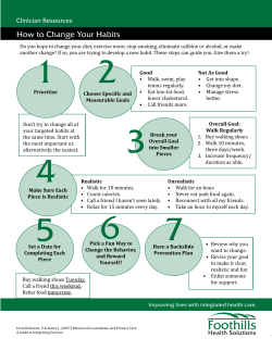


© Copyright 2026