
Boater’s Guide 2 0 1 4 State of ConneCtiCut
2014 Connecticut NE C T I CU N ENERG MENT ON T C Boater’s Guide Y ENVIR O State of Connecticut Department of Energy & Environmental Protection 79 Elm Street, Hartford, CT 06106-5127 www.ct.gov/deep The Boater’s Guide is available at any Department of Motor Vehicle Office, local Town Halls, and many marina and yacht clubs. 1-Day 8 Hours Boat & PWC Certification Print your certificate within 24 hrs of completing this class* CONVENIENT LOCATIONS • EXPERIENCED INSTRUCTORS ✦ 1 Day Coastal Navigation Classes Available ✦ Classes at Cabela’s, Community Colleges, Local Park & Recreation Programs Private Classes Available Groups • Clubs • Families PROFESSIONAL MARINE EDUCATION [email protected] ProMarineEd.com 877.262.8338 *To obtain your certificate online you must successfully complete the class and have a DEEP account number. See website for more details. 2014 Connecticut Boaters Guide N ENERG MENT C NE C T I CU T ON Y ENVIR O 79 Elm Street • Hartford, CT 06106-5127 www.ct.gov/deep STATE OF CONNECTICUT Affirmative Action/Equal Opportunity Em DEPARTMENT OF ENERGY & ENVIRONMENTAL PROTECTION Dear Boaters: It is my pleasure to introduce the 2013 Connecticut Boater’s Guide. I hope the new design and layout for t year’s Guide will make it easier to locate information that will ensure you have a safe and enjoyable boating experience on Connecticut’s waters. There is a new section on bridge safety which I hope all coastal boaters will t the time to read and follow. Connecticut offers a variety of boating experiences, whether you utilize our fresh water lakes and ponds, o rivers, or Long Island Sound. There is nothing more enjoyable than a fun day on the water. Keep it fun by knowin the rules and by boating sober! Over the last ten years, the Department of Energy and Environmental Protection h seen the number of boating fatalities related to alcohol double. We continually strive to reduce those numbers, and will launch a new effort this year aimed at making boating safer for all participants. Whether on the water or trailering your boat, please be vigilant and help us stem the spread of invasive pla and animals. Use the proper protocols to wash your boat and trailer, so that zebra mussels, milfoil and other invasi species will not make their way into water. Taking the time to clean your boat and trailer properly does make a difference. As you get underway this season, remember to wear your life jacket, help prevent the spread of aquatic invasive species, and boat safe and sober! Taking these small steps will pay big benefits in the quality of your boa experience today and in the future. For more information on boating in Connecticut, please visit the boating section of the DEEP’s website at www.ct.gov/deep/boating, contact the DEEP Boating Division directly at [email protected], or commen on our Boating Facebook Page at Facebook.com/BoatinginConnecticut. Please let us know if we can do anything make your experience on Connecticut’s waters better! Sincerely, Daniel C. Esty Commissioner 2014 Connecticut Boaters Guide 2014 Connecticut Boating Education & Safety Section John L. Annino, Environmental Protection Safety Representative Regulatory Section Tim Delgado, Environmental Analyst ✦✦✦ Production Coordinator Miraflor Powe ✦✦✦ Directory Of Boating Services D ep a rtment of E ner g y & E nvironment a l P rotection Bureau of Outdoor Recreation BOATING DIVISION 333 Ferry Road, P.O. Box 280, Old Lyme 06371-0280 • 860-434-8638 DEEP Website: www.ct.gov/deep • Fax: 860-434-3501 • DEEP Boating Website: www.ct.gov/deep/boating E-mail: [email protected] Emergency Communications (24 hours) 860-424-3333 You can report violations of boating laws and regulations to Emergency Communications. Include the following information when you call: (1) the registration number of the violator, (2) the violation, (3) the date, time, location, and (4) your name and address. Administration (Hartford) 860-424-3012 Marine District (Old Lyme) Connecticut shoreline towns 860-434-0316 Eastern District (Marlborough) East of CT River & Middlesex County 860-295-9523 Western District (Harwinton) West of Connecticut River 860-485-0226 OTHER DEEP SERVICES Office of Long Island Sound Programs (Coastal) Mooring and Dock Permits 860-424-3034 Fisheries Division (Inland) 860-424-3474 (Marine) 860-434-6043 DEEP Store (Maps and Publications) 860-424-3555 State Parks Division 860-424-3200 Wildlife Division 860-424-3011 Spill Information 866-377-7745 2014 Connecticut Boaters Guide State of ConneCtiCut NE C T I CU ENVIR O Department of energy & environmental Protection 79 elm Street, Hartford, Ct 06106-5127 www.ct.gov/deep The Boater’s Guide is available at any Department of Motor Vehicle Office, local Town Halls, and many marina and yacht clubs. ✦✦✦ The Department of Energy & Environmental Protection (DEEP) is an affirmative action/equal opportunity employer, providing programs and services in a fair and impartial manner. In conformance with the Americans with Disabilities Act, DEEP makes every effort to provide equally effective services for persons with disabilities. Individuals with disabilities needing auxiliary aidsor services, or information by voice or TTY/TDD, should call 860-424-3000. LAW ENFORCEMENT DIVISION Y Boating Division Eleanor C. Mariani, Director ON ENERG Department of Energy & Environmental Protection Commissioner, Daniel Esty, Commissioner Susan Whalen, Deputy Commissioner Navigation Safety/ Boating Access Section R. Michael Payton, Program Specialist I T State of Connecticut Dannel P. Malloy, Governor C Y A digest of boating laws and regulations Department of Energy & Environmental Protection MENT N ENERG ENVI RO Boater’s Guide N NE C T I CU MENT ON T C Boater’s Guide 2014 Connecticut OTHER AGENCIES United States Coast Guard Sector Long Island Sound 203-468-4401 Station New London 860-442-4471 Station Eaton’s Neck 631-261-6959 Department of Transportation Harbor/Harbormaster Information 860-443-3856 Office of Secretary of the State Vessel Lien Information 860-509-6004 Department of Revenue Services Boat Sales & Use Tax Information 860-297-5962 Department of Motor Vehicles Vessel Registration Information 860-263-5151 About this Guide Welcome to the 2014 Connecticut Boater’s Guide. This joint venture between the Connecticut Department of Energy & Environmental Protection and Turley Custom Media opens many new doors. Turley Custom Media, a division of Turley Publications, Inc., a multi-faceted printing company, works to bring creative solutions to expand your audience. Turley Custom Media supports CTDEEP with the design, layout and editing of the Connecticut Boater’s Guide, while managing the marketing and advertising sales to companies and organizations relevant to you, the reader. Advertising revenue not only generates savings, it also lowers production costs, allowing CTDEEP to focus funding on what really matters – keeping Connecticut’s waterways safe, clean and fun for all boaters! We welcome your feedback or advertising interests. Please contact us at 800-824-6548 or [email protected]. Turley CustomMedia President Keith P. Turley Group publisher Natalee S. Roberts Advertising Sales Rebecca Eddy Art Director Deanna B. Sloat A division of 24 Water Street, Palmer, MA 01069 800.824.6548 www.turley.com 20 3 C o n n e c1 t Boater’s Guide Boater’s Guide icut 20 4 C o n n e c1 t icut O t The Boater’s Guide is avail Office, local Town Halls able at any Department of Motor Vehic le , and many marina and yacht clubs. Customme NN E C T I CU T CO ENERG Y Turley Turley NT Y N ME NT ENERG ENVIR State of ConneCtiCu Department of ener gy & environmenta l Protection 79 elm Street, Hartf ord, Ct 06106-5127 www.ct.gov/deep ME NN E C T I CU T CO N Proud to Partner with Connecticut Department of Energy & Environmental Protection to produce O ENVIR dia State of ConneCtiCu t Department of ener gy & environmenta l Protection 79 elm Street, Hartf ord, Ct 06106-5127 www.ct.gov/deep The Boater’s Guide is avail Office, local Town Halls able at any Department of Motor Vehic le , and many marina and yacht clubs. Custommedia This collaboration between your organization, advertisers and Turley Custom Media benefits all parties and offers a great resource for the consumer. We Offer Creative Solutions to Expand Your Audience ' Design ' Marketing ' Advertising Sales ' Production ' Distribution ' Social Media ' Digital Magazines • Magazine Style Publication • Graphically Appealing • High Quality • Easy to Read • Relevant Editorial • Pertinent Advertising Allowing your organization to: • Add Value • Expand PR • Save Time & Money A division of 24 Water Street, Palmer, MA 01069 Z 800.824.6548 Z www.turleycustommedia.com 2014 Connecticut Boaters Guide Table of Contents Education & certification Safe Boating Certificate or Certificate of Personal Watercraft Operation 10 Equivalency Examination....................................................................... 12 Duplicate Certificate............................................................................... 12 Temporary Certificate............................................................................. 12 Reciprocity............................................................................................. 12 Obtaining a Boating Certificate (SBC or CPWO)................................... 13 Approved Boating Courses.................................................................... 14 DEEP Processing Offices....................................................................... 14 registration Vessel Registration................................................................................. 15 Position of Registration Number and Validation Decals........................ 15 Hull Identification Number (HIN)............................................................ 16 Vessels Numbered by Other States and Reciprocity............................. 16 Certificate to Be On Board..................................................................... 16 Taxability of Vessels and Trailers............................................................ 16 Safety Equipment Connecticut Life Jacket and Personal Flotation Device (PFD) Laws...... 17 Connecticut and U. S. Coast Guard Minimum Requirements............... 18 Special Rules for Manually Propelled Racing Vessels........................... 18 Visual Distress Signals........................................................................... 18 Expired Flare Disposal........................................................................... 20 Fire Extinguishers................................................................................... 20 Backfire Flame Arrestors........................................................................ 20 Ventilation............................................................................................... 20 Whistle (Horn) and Bell........................................................................... 20 Mufflers (Noise Levels)........................................................................... 20 Trailering Your Boat................................................................................ 20 Courtesy................................................................................................. 21 Environmental Awareness Prevent the Spread of Non-Native Species........................................... 22 Aquatic Invasive Species (AIS)............................................................... 23 Species Deemed Invasive by Commissioner......................................... 23 Connecticut’s Clean Marina Program.................................................... 25 Connecticut’s Clean Boater Program.................................................... 25 Boat Hull Maintenance........................................................................... 25 MARPOL Regulations............................................................................ 25 Marine Sanitation Devices (MSDs)......................................................... 25 No Discharge Areas............................................................................... 25 Pumpout Facilities Directory 2014....................................................26-28 2014 Connecticut Boaters Guide Boating Regulations Enforcement........................................................................................... 29 Definitions of Terms................................................................................... 30 Restricted Safety and Security Zones...................................................... 30 Restricted Operating Distances and Speed Areas..................................... 30 Speed Regulations.................................................................................... 30 Reckless Operation................................................................................... 30 Age Restrictions ....................................................................................... 30 Hazardous Conditions............................................................................... 31 Mooring to Buoys...................................................................................... 31 Overloading................................................................................................ 31 Riding on Decks or Gunwales................................................................... 31 Diving and Underwater Operations........................................................... 31 Water-skiing, Parasailing and Wing-In-Ground (WIG) Vessel................... 31 Tubing Safety Tips..................................................................................... 33 Personal Watercraft Restrictions............................................................... 33 Marine Event Permits ............................................................................... 33 Marker (Buoy or Beacon) Permits . .......................................................... 34 Boating Under the Influence (BUI)............................................................ 34 Boating Accidents and Reports................................................................ 34 Boating Accident Report Form................................................................. 35 Boat Disposal............................................................................................. 38 Infraction Schedule.................................................................................... 38 Local Regulations & Access Boating Education Assistant Program.................................................. 39 Transient Boaters/Tie-Up Available....................................................... 40 Prohibited Activities at Boat Launches.................................................. 42 Local Regulations and Public Boat Launches.................................. 42 Tidal Waters (listed by Town)................................................................. 43 Lakes, Ponds and Inland Streams................................................... 47 Rules & Regulations U.S. Aids to Navigation............................................................................. 56 Connecticut River Map.............................................................................. 57 Marker (Buoy or Beacon) Permits............................................................. 58 The Sound Signals.................................................................................... 58 Anchor Lights............................................................................................. 58 High Speed Ferries.................................................................................... 58 Navigation Lights (Underway)................................................................... 59 Navigation Rules........................................................................................ 59 Bridges – What You Need to Know to Go................................................ 60 Communicating with the Bridge............................................................... 60 Signaling the Bridge.................................................................................. 60 Quick Guide to Transiting Movable Bridges ............................................ 61 Homeland Security.................................................................................... 62 Helpful Internet Addresses........................................................................ 62 Tides and Currents.................................................................................... 63 2014 Tide Table – Old Saybrook............................................................... 63 2014 Sunrise and Sunset Table................................................................ 64 Canoe and Kayak Safety........................................................................... 65 © 2014 Connecticut Department of Energy & Environmental Protection. All rights reserved. Duplication/reproduction/derivatives in any format with written permission only. Printed on recycled paper. The Connecticut Boater’s Guide is published by the Dept. of Energy & Environmental Protection, Boating Division. The publication is supported by State and Federal Boating Funds through boat registration fees and a grant from the Sport Fish Restoration and Boating Trust Fund administered by the U.S. Coast Guard. 2014 Connecticut Boaters Guide E d u c a t i o n & Ce r t i f i c a t i o n & Education Certification Boats other than Personal Watercraft Residents of Connecticut, persons owning real property in Connecticut or persons with vessels registered in Connecticut must have either a Safe Boating Certificate or a Certificate of Personal Watercraft Operation to legally operate any boat with a motor, or a sailboat 191⁄2 feet in length or longer. Exceptions: • On inland bodies of water with a 10 hp limit and between one hour before sunrise and one hour after sunset, no certificate is required for a person operating an electric motor (rated at 106 lbs. of thrust or less). However, the vessel must be registered. • A person who has a valid operator’s license issued by the United States Coast Guard does not require a Safe Boating Certificate to operate a vessel other than a personal watercraft. They must have a copy of the license on board the recreational vessel on which they are operating. • On inland bodies of water with a 10 hp limit and between one hour before sunrise and one hour after sunset, no certificate is required for a person operating an electric motor (rated at 106 lbs. of thrust or less). However, the vessel must be registered. PWC only Any person operating a personal watercraft must possess either a Certificate of Personal Watercraft Operation issued by Connecticut or a state recognized by Connecticut. Connecticut recognizes certificates from New York, Massachusetts, New Hampshire and Rhode Island for use upon our waters (see page 13, Reciprocity). 2014 Connecticut Boaters Guide Safeboat 2014 Connecticut Boaters Guide E d u c a t i o n & Ce r t i f i c a t i o n Non-Resident Certificate Requirements • Connecticut recognizes a valid Safe Boating Certificate or Certificate of Personal Watercraft Operation issued by a reciprocal state (NY, MA, RI or NH) for a non-resident even if they own real property in Connecticut or have a vessel registered in Connecticut waters (because the vessel is in CT waters more than 60 days in a year). Personal watercraft operators MUST have a recognized Certificate of Personal Watercraft Operation to operate legally. Safe Boating Certificate or Certificate of Personal Watercraft Operation A Safe Boating Certificate (SBC) will allow an individual to operate any recreational vessel, except a personal watercraft on Connecticut’s waters. In order to meet the requirements for a Safe Boating Certificate (SBC), an individual must: 10 2014 Connecticut Boaters Guide • Pass an approved basic boating course or • Pass the DEEP’s Equivalency Examination. Note: Save the diploma from the course/exam. You will need it to apply for a Safe Boating Certificate. A Certificate of Personal Watercraft Operation (CPWO) allows an individual to operate any recreational vessel including a personal watercraft. In order to meet the requirements for a Certificate of Personal Watercraft Operation (CPWO), an individual must: • Pass an approved combination basic boating/personal watercraft course or • Pass an approved basic boating course and an approved 21⁄2 hour personal watercraft course or • Pass the DEEP’s Equivalency Examination. YOUR SOURCE for Superior Boating Education America’s Boating Course® Our course qualifies you for the Connecticut Safe Boating Certificate. Courses and Seminars Sailing, Navigation, Piloting, Weather, Seamanship, Engine Maintenance, Marine Electronics, VHF/DSC Radio, GPS, Powerboat Handling, Anchoring, Trailering, PWC (Jet Ski), and much more. Find a Squadron and Courses Near You 888-367-8777 www.usps.org United States Power Squadrons® in Connecticut Power, Sail, and Paddle Sports Celebrating 100 Years of Excellence in Boating Education © 2014 United States Power Squadrons 2014 Connecticut Boaters Guide 11 E d u c a t i o n & Ce r t i f i c a t i o n Equivalency Examination The DEEP’s Equivalency Examination is a 50-question multiple choice test that is designed for the experienced boater to qualify for a Safe Boating Certificate or a Certificate of Personal Watercraft Operation. The DEEP recommends, however, that all boaters take a class to ensure they are up-to-date with current boating laws. How do I apply? Examinations are offered only by the DEEP. Applications to register for the examination are available on the DEEP website or by calling the DEEP Boating Division. The examination fee is $75.00. It may only be attempted once. Duplicate Certificate You can print a duplicate certificate at any time by logging onto https://www.ctwildlifelicense.com/ internetsales/sales (online Sportsman Licensing system). Log in using your Date of Birth and Conservation ID number. Select “Click here to reprint your license” This is free of charge. Temporary Certificate If you purchase and register a new or used boat other than a personal watercraft in your name, and do not have a Safe Boating Certificate, you may apply for a Temporary Safe Boating Certificate. It is valid for 3 months from the date of vessel registration. Within that time, you must qualify for and obtain a permanent Safe Boating Certificate. If you purchase and register a new or used personal watercraft in your name and do not qualify for a Certificate of Personal Watercraft Operation, you may apply for a Temporary Certificate of Personal Watercraft Operation after CONNECTICUT COASTAL BOATER ENDORSEMENT PROGRAM Boaters may obtain a Coastal Boater Endorsement for their Safe Boating or Personal Watercraft Certificate by completing a course in coastal navigation. This class is above and beyond what is taught in a basic boating course which provides an introduction to boating safety. A navigation course is especially critical for coastal boaters. Some topics include Longitude/Latitude, time, distance, speed calculations, chart plotting, GPS and more. After successful completion the endorsement will be printed on your certificate. For such classes, select “Certification and Registration” on our website, the Connecticut Coastal Boater Endorsement Program. 12 2014 Connecticut Boaters Guide you have taken an approved 21⁄2 hour personal watercraft course. The temporary certificate is valid for 3 months from the date of vessel registration. Within that time, you must qualify for and obtain a permanent Certificate of Personal Watercraft Operation. Where do I apply? Apply in person at any DEEP Processing Office. What do I bring? For the Temporary Safe Boating Certificate bring your original registration (in your name because the Temporary Certificate is issued to the person whose name is on the registration), a photo ID and a $50.00 fee. For the Temporary Certificate of Personal Watercraft Operation, you additionally need proof of successful completion of an approved 21⁄2 hour personal watercraft course Note: No person shall be issued more than one Temporary Certificate during his or her lifetime. Reciprocity The Connecticut Safe Boating Certificate and the Certificate of Personal Watercraft Operation are accepted in many states. Connecticut recognizes certificates from New York, Massachusetts, Rhode Island and New Hampshire for use upon our waters. Adherence to Connecticut state law remains the responsibility of the boater. In addition, any new resident who possess a Safe Boating Certificate or a Certificate of Personal Watercraft Operation issued by a state having an agreement of reciprocity with Connecticut must present evidence of the certificate to satisfy the educational requirements for the issuance of a Connecticut Safe Boating Certificate or Certificate of Personal Watercraft Operation. This must be done within 90 days of becoming a Connecticut resident. E d u c a t i o n & Ce r t i f i c a t i o n Any person obtaining a Safe Boating Certificate (SBC) or a Certificate of Personal Watercraft Operation (CPWO) needs to have the certificate on board at all times while operating a vessel. A certificate is valid for the life of the person to whom it is issued and may be issued regardless of age. (See page 30, Age Restrictions for operating boats with engines greater than 10 horsepower and personal watercraft.) The certificate may be suspended upon conviction of operating under the influence of alcohol or drugs. Obtaining a Boating Certificate (SBC or CPWO) If you have not taken a boating safety course • Before taking your boating course, you must obtain a Connecticut Conservation Identification Number (ID). If you have a Connecticut Hunting or Fishing License, your Conservation ID will be the same ID number that was assigned with the hunting or fishing license • If you need a Conservation ID number, go to https://www. ctwildlifelicense.com/internetsales/sales (online Sportsman Licensing system) and complete the registration process for “New Customers”. • When you take your class, our instructor/course provider will need the ID number assigned to you. You will need to provide your instructor with your name (as it was entered into the online Sportsman Licensing System) as well as your month and day of birth. Within a week of completing your course and passing your exam, you should be able to purchase your certificate from your home computer by going to the https://www. ctwildlifelicense.com/internetsales/sales (online Sportsman Licensing system). The fee for the Safe Boating Certificate or Certificate of Personal Watercraft Operation is $50.00. • Use your Date of Birth and Conservation ID to log in and follow the instructions to purchase the Safe Boating Certificate or Certificate of Personal Watercraft Operation. You will need a printer to print your certificate and sales receipt. The printed certificate is your official document. After signing it, you must carry it whenever you operate your vessel. In the event of printer or user error, you will be allowed to reprint your certificate at any time by logging back into the system. • For those that do not have access to a computer, you may go to a DEEP processing office or use a computer at a local library. If you have already completed a boating safety course • If you have already completed a boating safety course, you will still need to obtain a Connecticut Conservation Identification Number to purchase your certificate. If you have a Connecticut Hunting or Fishing License, your Conservation ID will be the same ID number that was assigned with the hunting or fishing license. • To obtain a Conservation ID number, follow the instructions above or you can obtain an ID number from one of our DEEP Processing Offices. • Bring your diploma to a DEEP Processing Office with the $50 fee. If you have already applied for the Conservation Identification Number you can simply pay the fee and show your approved diploma. 2014 Connecticut Boaters Guide 13 E d u c a t i o n & Ce r t i f i c a t i o n Approved Boating Courses There are three types of basic boating courses that are offered throughout the state: 1. Combined basic boating and personal watercraft class. This 8-hour class qualifies you for a CPWO or SBC. 2. Basic boating class. This 8-hour class qualifies for SBC only. 3. Personal watercraft course. This 21⁄2-hour class along with the basic boating class, qualifies you for a CPWO. By itself, the class may qualify you for a temporary CPWO. One-day classes, for a fee, are available statewide by private providers. There are a number of approved outof-state basic boating courses that may qualify you for an SBC or CPWO. Call the Boating Division at 860-434-8638 for details. Most Community Colleges in Connecticut are now offering the DEEP eight-hour combined basic boating and personal watercraft course. For information concerning the date and time of the classes, you should visit our website: www.ct.gov/deep/boating. Connecticut Boater’s Guide DEEP Processing Offices DEEP Licensing & Revenue, 79 Elm St., Hartford, CT 06106-5127 860-424-3105 M–F, 9–4 pm DEEP Marine Headquarters, 333 Ferry Rd., Old Lyme, CT 06371 860-434-8638 M–F, 8–4 pm Western District Headquarters, 230 Plymouth Rd., Harwinton, CT 06791 (Western District: certificates processed Monday, Thursday and Friday) 860-485-0226 8:30–4 pm (call after Oct. 1 for winter hours) Eastern District Headquarters, 209 Hebron Rd., Marlborough, CT 06447 (Eastern District: certificates processed Tuesday, Wednesday and Thursday) 860-295-9523 8:30–4 pm Westport Office Sherwood Island State Park, Westport, CT 06880 203-226-3116, Call for hours. Facebook.com/ BoatinginConnecticut To view the Boater’s Guide Flipbook go to http://www.ct.gov/deep/cwp/view.asp?a=2686&q=322292&deepNav_GID=1620. 14 2014 Connecticut Boaters Guide Re g i s t r a t i o n correct spacing of registration number and decal 2" spaces C T 1234 AB EXPIRES APRIL 30, 2015 15 CONN. D.M.V. Not over 3⁄4 Correct display of numbers validation decals 15 15 port side starboard side R egistration of your vessel and learning the laws of boating are essential to be safe on the waterways of Connecticut. Just as you must have a vehicle registration of your car, you must have a Connecticut Certificate of Number (registration card with assigned registration number) and two validation decals to legally launch, moor or operate your boat. The only exceptions are: • Non-motorized boats • Sailboats less than 191⁄2 feet in length • Boats registered in other states using Connecticut waters for 60 days or less • Boats documented with the U.S. Coast Guard using Connecticut waters for 60 days or less • Boats owned in countries other than the United States. at the time of registration. Since Connecticut is not a title state, the bill of sale will suffice. Upon receipt of the application and fee, a Connecticut Registration Number will be assigned. A Connecticut Certificate of Number (registration card) and two Connecticut Validation Decals will be issued. A Certificate of Number is valid until April 30th of the decal year. Owners of boats, which already have been registered, will be sent a renewal notice from the DMV by mail. Connecticut registration numbers stay with the boat as long as it is registered in the state. A vessel is considered properly registered when you have a valid certificate on board and your numbers and/or current decals are properly displayed. (Exception: Recently registered boats operating under a temporary certificate of number need not display a validation decal until provided by the DMV.) Vessel Registration Position of Registration Number and Validation Decals When you purchase a vessel, you are responsible for seeing that it is registered. The Department of Motor Vehicles (DMV) is the agency that handles boat registrations. Evidence of ownership must be submitted The Registration Number must be at least 3 inches high, contrasting in color to the hull background and in block form. It must be painted on or attached to both 2014 Connecticut Boaters Guide 15 Re g i s t r a t i o n the port and starboard bow of the vessel and positioned so it is visible and legible from at least 100 feet away. The registration number must read from left to right on both sides of the vessel. A Validation Decal must be placed two inches to the right of and in line with the assigned registration number. No other letters, numbers or validation decals (other than the current ones) may be displayed. Vessels Numbered by Other States and Reciprocity Documented vessels and vessels numbered by another state, which are moored, docked or operated more than 60 days in Connecticut in any calendar year, must obtain a Connecticut Certificate of Decal from DMV and display a current Connecticut validation decal (but not a Connecticut registration CERTIFICATE OF DECAL number) on both sides of the bow. CONN. D.M.V. In addition, the owner must acquire a boating certificate that is recognized by Connecticut in order to operate the vessel on Connecticut waters. Connecticut boat users should check and obey local laws when operating in other states. Note: Every entity leasing, renting or otherwise providing slips, dock space, dry storage, or moorings for vessels not registered in Connecticut is required to maintain a list of such vessels. Transient vessels need not be listed.The list must be available during normal business hours for inspection by any boating law enforcement officer. The rules for information collected differ slightly for those entities that provide such space by lease and those that provide such space by membership. Any questions, please contact the Boating Division regulatory unit. (CGS Section 15-150a). 15 buys a vessel or trailer, the 6.35% Connecticut sales or use tax is due. Out-of-state residents or nonresident entities that have purchased a vessel with the intent of using it in Connecticut waters must pay a Connecticut use tax. This Connecticut use tax liability must be reported on the “Individual Use Tax” line of the purchaser’s Form CT-1040 NR/PY Connecticut Nonresident Income Tax Return. This use tax can be offset by documenting that sales or use tax has been properly paid to another state or municipality. For Further Information: Call the Department of Revenue Services during business hours, Monday through Friday: 1-800-382-9463 (in-state), or 860297-5962 (from anywhere) TTY, TDD and Test Telephone users only may transmit inquiries anytime by calling 860-297-4911. Hull Identification Number (HIN) The Hull Identification Number (HIN) is a unique, 12 digit number, assigned by the manufacturers to vessels built after 1972. HINs identify one vessel from another. The HIN is usually found on the starboard side of the boat’s transom. The HIN should be recorded by the owner and put in a place other than the boat in case warranty problems arise or the vessel is lost or stolen. Owners of registered vessels manufactured after October 1, 1972, that do not have a HIN should call the Boating Division at 860-434-8638. Boat Rentals A rented vessel that is required to be registered must display “BL” numbers. The rental agreement must be carried onboard. Certificate to Be On Board A Certificate of Number or Certificate of Decal must be on board the vessel whenever the owner or any person authorized by the owner is aboard, except that rented boats may carry a rental agreement in lieu of a certificate. Taxability of Vessels and Trailers As a general rule, when a Connecticut resident or an individual who maintains a place of abode in Connecticut 16 2014 Connecticut Boaters Guide Change of Address/ Change of Ownership/ Change of Registration Status If you change your address or sell or otherwise dispose of your vessel, you must, within 15 days and in writing, notify the Department of Motor Vehicles, Marine Vessel Section, 60 State St., Wethersfield, CT 06109. In the case of an address change, keep your Certificate of Number on the boat after updating the address on the back of the certificate. Safety Equipment A s a boat operator your fun on the water depends on your behavior. It is your responsibility to have the safety equipment required by law, to keep it on board in good condition, and know how to properly use it. YOU ARE IN COMMAND! Connecticut Life Jacket and Personal Flotation Device (PFD) Laws Because more than 90 percent of boating fatalities could have been avoided by wearing a life jacket: • There must be a wearable life jacket on board for each person aboard every vessel. • Each life jacket must be readily accessible. • Each life jacket must fit the intended wearer. • If the vessel is required to have a Type IV “throwable” PFD (see page 18), it must be immediately available. Life jackets must: • Be U.S. Coast Guard approved. • Have a legible label. • Be of the correct size and fit for the wearer. A life jacket should fit comfortably snug and never cover your face or ride up past your ears. • Be in serviceable condition (all straps and buckles must be in good condition and able to perform their jobs; all seams and material must be intact). • Be worn by children under 13 years old on any vessel that is underway unless the child is below deck or in an enclosed cabin. • Be worn by anyone operating or riding on a PWC. • Be worn by anyone being pulled behind a boat (such as tubing or skiing). • Be worn by anyone in a manually propelled vessel from October 1 through May 31 (must be Type I, II, III, V or V-hybrid), except as noted on next page. Remember: • Ski belts are not legal life jackets. • Inflatable life jackets may not be used by persons engaged in high-speed water sports (such as riding PWCs or water-skiing) and may not be used by persons weighing under 90 lbs. or under 16 years of age. Safety Equipment 2014 Connecticut Boaters Guide 17 Safety Equipment C O N N E C T I C U T A N D U . S . C oast G uard M inimum R equirements Equipment Backfire Flame Arrestor Class A Less than 16 feet (less than 4.9 m) Class 1 16 feet to less than 26 feet (4.9 to less than 7.9m) Class 2 26 to less than 40 feet (7.9 to 12.2m) Class 3 40 to less than 65 feet (12.2 to less than 19.8m) The device must be suitably attached to the air intake with a flametight connection and is required to be Coast Guard Approved or comply with SAEJ-1928 or UL1111 standards and marked accordingly. Ventilation – Boats built At least two ventilator ducts, fitted with cowls or their equivalent, for the purpose of properly and effectively ventilating the bilges of every closed engine and fuel tank compartment of boats constructed or decked over after April 25, 1940, using gasoline as fuel. Ventilation – Boats built At least two ventilator ducts for the purpose of efficiently ventilating every closed compartment that contains a gasoline engine and every closed compartment containing a gasoline tank, except those having permanently installed tanks which vent outside the boat and which contain no unprotected electrical devices. Also, engine compartments containing a gasoline engine having a cranking motor must be open to the atmosphere or contain power operated exhaust blowers which can be controlled from the instrument panel. before Aug. 1, 1980 on or after Aug. 1, 1980 Personal Flotation Devices One approved Type I, II, III or V PFD for each person on board or being towed on water-skis, etc. Check label if using Type V. One approved Type I, II, III or V PFD for each person on board or being towed on water-skis, etc.; and, in addition, one throwable Type IV device. (Type IV not required for canoes and kayaks.) Check label if using Type V. Sound-Producing Devices – Whistle Must have some means of making an efficient sound signal. Must have some means of making an efficient sound signal. Must carry approved visual distress signals for nighttime use when operating at night. Must carry visual distress signals approved for both daytime use and nighttime use. Required on coastal waters only Fire Extinguishers (Must say Coast Guard Approved) At least one B-1 type approved hand portable fire extinguisher. Not required on outboard motorboats less than 26 feet (7.9 meters) in length and not carrying passengers for hire if the construction of such motorboat will not permit the entrapment of explosive or flammable gases or vapors and if fuel tanks are not permanently installed. See page 20 Visual Distress Signals Must have some means of mak- Must have a whistle audible for at least one-half mile, and ing an efficient sound signal. a bell. At least two B-1 type approved portable fire extinguishers; OR at least one B-II type approved portable fire extinguisher. At least three B-1 type approved portable fire extinguishers; OR at least one B-1 type plus one B-II type approved portable fire extinguisher. Note: When a fixed fire extinguishing system is installed in the machinery space(s), it will replace one B-1 type portable extinguisher. All vessels 16 feet and over, except kayaks and canoes, must also carry a Type IV throwable device in addition to the required number of wearable life jackets. Special Rules for Wearing Life Jackets in Manually Propelled Racing Vessels Persons operating Racing Shells, Racing Canoes, Racing Kayaks and Rowing Sculls and involved in competitive racing or the preparation for competitive racing are not required to wear or carry life jackets if accompanied at all times by an escort vessel. The escort vessel may escort up to three racing vessels and must be able to see all escorted vessels at all times and without the assistance of artificial devices other than eyeglasses. The requirement for an escort vessel may be waived during an organized race event where a Marine Event Permit has been approved by the Commissioner and other steps have been taken for the safety of the participants. Visual Distress Signals (VDS) Visual distress signals are to be used to summon assistance when in distress. In the State of Connecticut no VDS are required anywhere except when boating on Long Island Sound (LIS) and on Fishers Island Sound (FIS). The following vessels only need to carry VDS on LIS and FIS between sunset and sunrise: – Recreational vessels under 16 feet; – Open sailboats less than 26 feet that are not equipped with propulsion machinery; and – Manually propelled vessels. All other vessels need to carry 3 daytime and 3 nighttime VDS (or the equivalent) at all times while on FIS and LIS. • Visual distress signals must be U.S. Coast Guard approved, in serviceable condition and stowed to be readily accessible. Note: Exceeding noise levels is a serious problem. Marine Police will be targeting areas, especially on the Connecticut River, to check for compliance. Exceeding noise levels will result in a fine of $220. Failing to submit to an on-site noise level test will result in a fine of $435. Subsequent failures to submit will result in a fine of $535. 18 2014 Connecticut Boaters Guide Defender ® Marine Outfitter Of Choice For Boating Enthusiasts Since 1938 Your Discount Source! NEW! NEW! Coastal Alerter Plus 12-Gauge Launcher w/6 Aerial Signals, Whistle & Mirror Inland Handheld Signal Kit w/ Accessories & Air Horn Contains aerial, visual and sound signals. When combined with handheld flares makes the perfect kit for Coastal boaters. • 12-Gauge Safety Launcher - Corrosion resistant with lifetime warranty and bandolier that can hold up to (6) High Performance Signals • (6)12-Gauge High Performance Red Aerial Signal - U. S. Coast Guard Approved Day or Nighttime Signal • (1) SOLAS Approved Whistle w/Lanyard 116db at 1 meter • (1) Signal Mirror - Non-corrosive material Includes view finder and lanyard • Floating Neoprene Storage Case - Highly visible international orange, protects signals during storage This kit is design to meet both your visual and audible Coast Guard requirements. • (4) Handheld Red Signal Flares Brightness: Up to 700 candela Burn Time: Up to 3 minutes each • (1) SOLAS Approved Whistle w/Lanyard 116db at 1 meter • (1) Handheld Orange Smoke Signal - U. S. Coast Guard Approved Daytime Signal Average burn time: Up to 1 minute each • (1) 1.5 oz. Mini Horn • (1) Signal Mirror - Non-corrosive material Includes view finder and lanyard • Floating Neoprene Storage Case - Highly visible international orange, protects signals during storage Item 552489 Model 572 Only $67.99 Item 552488 Model 543 Only $59.99 THE BRANDS YOU WANT AND TRUST IN STOCK FOR LESS! Over 50,000 Items In Stock! Available for store pick up at 42 Great Neck Road, Waterford, CT 06385 800-628-8225 FREE CATALOG! 2014 Connecticut Boaters Guide 19 Safety Equipment • U.S. Coast Guard approved pyrotechnic visual distress signals and associated devices include: – Pyrotechnic red flares, hand-held or aerial. – Pyrotechnic orange smoke, hand-held or floating (day use only). – Launchers for aerial red meteors or parachute flares. • If VDS are required there must be a minimum of 3 daytime and 3 nighttime signals, or 3 combination day/night signals. Pyrotechnic devices will have an expiration date that must not have passed. • Non-pyrotechnic visual distress signaling devices include: – Orange distress flags. – Electric distress signals. • Other VDS, such as those listed below, are useful and easy to carry and are recognized as distress signals, but do not count toward the requirement to carry approved VDS on LIS and FIS. – Signaling mirror. – Water dye. • No person, operator or owner in a vessel shall display or allow the display of a visual distress signal except when assistance is needed because of immediate or potential danger to the vessel or to persons aboard. Expired Flare Disposal • Disposal of marine flares may be done by appointment only, by calling the DEEP Boating Division, 860-434-8638. Ask for the Boating Education Section. • Take advantage of our “Flare Days.” You can dispose of flares and test them out. Watch your local newspapers for site locations and times. Fire Extinguishers • Fires involving burning wood, fabrics and paper (Class A) can be put out with water. • Most boat fires consist of burning flammable liquids such as oil or gasoline (Class B). Check the table at the beginning of this section to determine how many Type B-1 fire extinguishers you must have on your boat. • Check frequently to be sure that fire extinguishers are properly mounted where they can be easily reached. Check pressure gauges for proper pressure. Shake dry chemical units to be sure the chemical hasn’t solidified and become useless. Replace any questionable extinguishers. Backfire Flame Arrestors Internal combustion engines may backfire. To safeguard against fire, all inboard motorboats with carburetion must have a backfire flame arrestor system on each carburetor. Know where they are and keep them clean. 20 2014 Connecticut Boaters Guide Ventilation Regulations require ventilation of all enclosed engine and fuel tank compartments on gasoline-powered boats. Intake ducting must extend midway to the bilge or at least below the carburetor air intake level. Exhaust ducting must extend from the lower bilge to cowls in the open air. Manufacturers install exhaust blowers in engine compartments so that gasoline fumes can be removed before the engines are started. If your boat is installed with an exhaust blower, it is recommended that you turn it on for at least four minutes before starting the engine. Whistle (Horn) and Bell • Navigation rules (part of Federal Law) require all vessels (including canoes and kayaks) to have audible signaling devices. (See chart on page 18.) • Every vessel of 12 meters (39.36 ft.) or less in length must have some means of making an efficient sound signal. • Every vessel of at least 12 meters (39.36 ft.) in length but less than 20 meters (65.6 ft.) in length must have a whistle capable of being heard for at least one-half mile, and a bell. Mufflers (Noise Levels) No one shall operate a motorboat on the waters of this state unless the boat is equipped with a muffler or muffler system allowing it to be operated in compliance with state law. Noise levels range from 90dB(A) for older engines to 88dB(A) for engines made after January 1, 1993. Any marine police who believes a motorboat is being operated in excess of the established noise levels may request the operator to submit the motorboat to an on-site noise level test. No person shall sell a motorboat which does not operate in compliance with the established noise levels. Boaters should contact the Boating Division if they are selling a vessel used only in marine races. No one shall operate a motorboat on the waters of this state that is equipped with a muffler or muffler system cutout, bypass or similar device that prevents the motorboat from operating in compliance with state noise levels and without authorization from the Commissioner. Trailering Your Boat The DMV has laws relative to boat trailers. Each trailer having a gross weight of three thousand pounds or more shall, when operated on any public highway, be equipped with a braking system operating on all wheels. For trailers having a gross weight of greater than eight thousand pounds, the brakes shall be capable of being controlled or operated from the driver’s seat of the towing vehicle. Safety Equipment note: Connecticut law limits the width of vehicles and trailers that travel on Connecticut’s highways and bridges to 8½ feet. Vehicles or loads wider than this require an oversize vehicle permit. Oversize vehicle permits are available through the Department of Motor Vehicles. Empty/Drifting Craft = Emergency Response Courtesy Boating at high speeds is dangerous in restricted or congested areas. Each skipper is responsible for spotting and avoiding swimmers and slow-moving vessels. This is also important when picking up or dropping off water-skiiers. Cost of response helicopter: $11,408 per hour Cost of response boat: Spill Information Section 22a-450 of the Connecticut General Statutes requires the master of any ship, boat, barge or other vessel or the operator of any vehicle or trailer or other machine which causes the discharge of oil or petroleum or other substance to the waters of the state to immediately report such facts to: The Department of Energy and Environmental Protection (DEEP), Emergency Response Unit, 860-424-3338 or toll free 1-866-DEP-SPIL (1-866-337-7745), 24 hours/day. Should these numbers become unavailable for any reason, call 860424-3333. You will need to be prepared to report such information as: • the location; • the quantity and type of substance, material or waste; • the date and the cause of the incident; • the name and address of the owner; and • the name and address of the person making the report and his relationship to the owner. Note: Unless specifically requested, the DEEP does not require a written submission when reporting a spill. $3,735 per hour Your cost to prevent unnecessary response: $0 Use an “If Found” sticker to identify your paddle craft. Doing so helps Search and Rescue responders determine if a true emergency exists, prevents unnecessary searches saving tax payers thousands of dollars in associated search cost, and enables the paddle craft to be returned to its rightful owner. To get your FREE sticker, contact the State of Connecticut Department of Energy and Environmental Protection at: Phone: 860-434-8638 Email: [email protected] Penalties Any person who fails to report incidents as required by Chapter 446k, Section 22a-450 may be fined not more than $1,000 and the employer of such person not more than $5,000. 2014 Connecticut Boaters Guide 21 E n v i r o n m e n ta l Awa r e n e s s √ √ BEFORE LEAVING THE LAUNCH: Clean: remove any visible mud, plants, fish or animals before transporting equipment. Drain: eliminates water from equipment, such as a live well, before transporting. AT HOME PRIOR TO YOUR NEXT LAUNCH: Dry: anything that comes into contact with water (boats, trailers, anchors, propellers, fishing equipment, clothing, dogs, etc.) for a minimum of one week. √ If drying isn’t possible, wash with hot water (preferably high pressure). √ Never release plants, fish or animals into a body of water unless they came out of that body of water. √ Dispose any unused bait in an upland trash. √ HOW CAN I CLEAN MY BOAT TO PREVENT THE SPREAD? √ √ √ √ √ Dry equipment for a minimum of one week (hot/dry weather) and a minimum of four weeks (cool/wet weather) before entering new waters. OR....... Wash with hot water, preferable high pressure. Dip equipment into 100% vinegar for 20 minutes prior to rinsing. Use a 1% salt solution and leave on for 24 hours prior to rinsing (2/3 cups of salt to 5 gallons of water). “Wet” with bleach solution (1 oz. per gallon) or soap and hot water (Lysol, boat soap, etc.) for 10 minutes prior to rinsing. 22 2014 Connecticut Boaters Guide What can I do to prevent the spread of non-native species! E n v i r o n m e n ta l Awa r e n e s s HELP KEEP Aquatic Invasive Species (AIS) OUT OF CONNECTICUT’S WATERS! IT IS ILLEGAL TO TRANSPORT on a boat or trailer any vegetation and the following aquatic invasive species (as determined by the Commissioner pursuant to CGS Section 15-180; see www.ct.gov/deep/boating): Zebra mussel (Dreissena polymorpha) Quaqqa mussel (Dreissena bugensis) Chinese mitten crab (Eriocheir sinensis) New Zealand mud snail (Potamopyrgus antipodarum) Asian clam (Corbicula fluminea) Rusty crayfish (Orconectes rusticus) It is critical that boaters take responsibility for stopping the spread of these plants and animals. Failure to remove all vegetation and the listed aquatic invasive species, that are visible and identifiable without optical magnification, is subject to a fine of $95 for each such violation. 1 N Prevent the transport of nuisance species. Clean all recreational equipment. www.ProtectYourWaters.net SEE PAGE 22 for methods to remove AIS 2 on-native aquatic plants or animals are also known as nuisance or aquatic invasive species (AIS). These species tend to grow at a rate such that they can displace beneficial native species, disrupt the ecosystem and drastically reduce recreational activities, including swimming. Please prevent new introductions of invasive plants and animals: Clean, Drain, Dry your boat and gear. 3 4 Freshwater Plant species such as Eurasian milfoil, variable leaf milfoil and fanwort have been introduced into Connecticut’s lakes and ponds, and can impact the ecosystem and reduce recreational activities. Invasive plants can form a dense mat just below the water’s surface, which interferes with boating, swimming and other recreational activities. 1. Eurasian milfoil: Submerged, perennial aquatic plant with green feathered type leaves. The stems are brownish-red to light green. Milfoil produces pink flowers between July and August. 2014 Connecticut Boaters Guide 23 E n v i r o n m e n ta l Awa r e n e s s 5 6 7 2. Fanwort: 7. Rusty crayfish: Submerged plant that ranges in color from grass green to olive and to reddish brown. The leaves are finely divided and strictly opposite arranged. Small white flowers with 6 petals emerge among the floating leaves. A large crayfish with reddish spots on each side of the body just in front of the tail, grayish green color, smooth mandibles (mouth parts without serrated edge) and black bands on tips of claws. Rusty crayfish are aggressive and can displace native crayfish. They feed heavily on invertebrates that are important food sources for fishes and can destroy aquatic vegetation beds, impacting habitat used by other invertebrates and game fish. Rusty crayfish are often spread via bait buckets. Rusty crayfish can be found in a number of freshwater systems throughout Connecticut. 3. Zebra mussel: Zebra mussels are small, striped rigid mussel that grows to a maximum length of 2.5 cm (approximately 1 inch) in length. The shell color is black or brown with variable white to yellow striped or zig zag patterns and they can live up to five years. Zebra mussels have recently become established in Lakes Lillinonah, Zoar and Housatonic in western Connecticut and for a longer period of time in the Twin Lakes, Salisbury. These mussels can impact the ecosystem, foul boat hulls and engine cooling systems, are sharp to step on and can clog power plant, industrial and drinking water intakes. 4. Quagga mussel: The quagga is slightly larger than the zebra mussel. The shell is striped but is more pale toward the end of the hinge. Color patterns vary widely with black, cream, or white bands. The quagga has a rounded angle and a convex ventral side. Quagga mussels have not been found in Connecticut waters. 5. Chinese mitten crab: The claws are of equal size and appear “furry” with whitish tips. The smooth shell is brown to green with four spines (the fourth can be small) on each side. There is a notch between the eyes. In June, 2012, a juvenile Chinese mitten crab was collected from the Mianus River in Greenwich. This is the first confirmed report of this invasive in CT. This crab reproduces in saltwater but spends most of its life in freshwater. 6. New Zealand mud snails: Relatively small snail that has brown or black cone shaped shell with 7-8 whorls. Between the whorls are deep grooves. This snail has the ability to reproduce quickly and populations can rapidly reach high densities under suitable conditions. New Zealand mud snails have not been found in Connecticut waters. 24 2014 Connecticut Boaters Guide 8. Asian clam: A bivalve that can grow as large as 5 cm (2 inches) wide and live up to 7 years. Asian clams can be identified by the presence of yellow and brown color concentric rings on their shell. The outer side of the shell can flake, revealing white spots. Asian clam excretions encourage algal growth which reduces water quality for native flora and fauna. Asian clams can aggressively colonize the bottom of waterways and can outcompete native species for space. Asian clams can be found in a number of freshwater systems throughout Connecticut. Marine Aquatic Invasive Species If a vessel sits at a dock for too long, growth can occur on the hull. Invasive species can also collect in bilge areas, live wells, or other places that may collect water. If a vessel moves between seasonal ports, the introduction of an AIS may occur. Many of the fouling species that grow on vessel hulls exist because they are invasive and have no predators. Often the introductions are from ballast water taken on in foreign waters and discharged in US waters. Steps are being taken nationally to minimize these introductions. Local boaters can help by removing the species on their boats and trailers and properly preparing and maintaining their boat’s bottom. 8 E n v i r o n m e n ta l Awa r e n e s s Connecticut’s Clean Marina Program Connecticut’s Clean Marina Program is a voluntary program that recognizes Connecticut’s marinas, boatyards, and yacht clubs that go above and beyond regulatory compliance as “Certified Clean Marinas.” Look for certified marinas flying a Certified Clean Marina Flag at their facility. We are happy to announce that the DEEP and Connecticut Marine Trades Association (CMTA) are currently working together to reinvigorate the Clean Marina Program. Once the guidebook has been revised and new flags are printed, the CMTA will be accepting new applications. Connecticut’s Clean Boater Program Using sound environmental boating practices protects our resources and ensures the future health of Connecticut’s waters. The Clean Boater Program encourages the state’s boaters to use clean boating techniques. Support marinas that are environmentally responsible. For information about the Clean Boater Program contact the Boating Division at 860434-8638; for information about the Clean Marina Program contact the Office of Long Island Sound at 860-424-3034 or visit: www.ct.gov/deep/ cleanmarina. Boat Hull Maintenance New recommendations for hull-washing are of special interest. Your marina may not allow the cleaning of boat bottoms painted with toxic anitfouling paint. Consider hauling your boat to clean it. If your marina does allow underwater hull cleaning, please proceed with caution: • DO NOT clean boat bottoms painted with ablative paints. • Use hard bottom paint if you need to clean your boat bottom throughout the season (sailboats). • Ask your marina operator if there are any specific guidelines you need to follow while cleaning your boat bottom. • Use only soft material (sponges, not brushes!) to clean growth off the hull. • Use stainless steel pads and/or brushes only on UNPAINTED surfaces. • Stop cleaning in the water if colored plumes of paint appear in the water. • Do not paint zincs. When replacing zinc anodes, bring them ashore for recycling. • Hire a professional diver and tell them you expect them to minimize pollution. MARPOL Regulations All vessels must obey MARPOL regulations developed in the 1970s to protect the marine environment from operational pollution. Vessels over 26 feet must display a durable placard explaining MARPOL Annex V disposal regulations. The U.S. legislation that implements MARPOL Annex V, bans the dumping of plastics in all navigable waters of the United States. It also places restrictions on the disposal of other types of shipboard solid wastes. Note: It is illegal to discard fishing line on land or in state waters. Marine Sanitation Devices (MSDs) All vessels with an installed toilet are required to have a Coast Guard certified Marine Sanitation Device (MSD) attached to the toilet. See www.ct.gov/deep/cva. A macerator alone is not a certified MSD. A macerator only grinds the sewage. It does not treat it to kill bacteria and viruses. All Coast Guard certified Type I and Type II MSDs have a certification label affixed by the manufacturer. Holding tanks are not required to have a certification label. See the Environmental Protection Agency (EPA) website at: www.epa.gov/owow/oceans/regulatory/ vessel_sewage/vsdmsd.html. The U.S. Coast Guard can issue fines of up to $2,000 for the illegal discharge of untreated sewage. Section 15-175(a) of the Connecticut General Statutes provides that any person owning or operating a vessel from which untreated sewage is discharged from a MSD or bypass into the waters of this state has committed a class A misdemeanor. A class A misdemeanor is a criminal offense for which a person, if convicted, may be sentenced to a term of imprisonment of not more than one year and be fined an amount not more than two thousand dollars. State conservation officers and municipal marine police may enforce this law. No Discharge Areas It is illegal to discharge untreated sewage from your boat into any of Connecticut’s waters. Connecticut: All waters of Fisher’s Island Sound and its harbors from the Rhode Island State boundary to Byram Point, Greenwich, as well as the navigable reaches of all Connecticut rivers and tidal streams that drain into Long Island Sound within state boundaries, including the Hammonasset River, Menunketesuck River, Niantic River, Thames River, Housatonic River from the Derby Dam, and Quinnipiac River from the southern border of North Haven. New York: Long Island Sound, including the open waters, harbors, bays and navigable tributaries of the Sound and a portion of the East River, from the Hell Gate Bridge in the west to the northern bounds of Block Island Sound in the east. Included in the NDZ are: Poconic Estuary and East Hampton, Mamaroneck Harbor, HuntingtonNorthport Bay Complex, Port Jefferson Complex, Hempstead Harbor, Oyster Bay/Cold Spring Harbor Complex, and Hudson River. Rhode Island: All waters. See the EPA website at: www.epa.gov/region01/eco/nodiscrg/ for a list of NDAs in New England waters. 2014 Connecticut Boaters Guide 25 E n v i r o n m e n ta l Awa r e n e s s The Federal Clean Vessel Act directs excise tax dollars, collected on fishing tackle and motorboat fuel, to construct, operate and maintain pumpout stations for Type III MSDs, and dump stations for portable toilets. A list of pumpout facilities appears on these following pages. By following clean boating practices, we can help improve the quality in Connecticut’s waters for swimming, shellfishing, and the enjoyment of our fellow boaters. For more information about pumpouts, call the Office of Long Island Sound Programs at 860-424-3034 or the Boating Division at 860-434-8638. Pumpout Facilities Directory 2014 Stations below are listed east to west. • Indicates Clean Vessel Act Funded Shoreside station facilities WESTERLY, RHODE ISLAND 1 Westerly Yacht Club Pawcatuck River 401-596-7556 or VHF CH 10 Apr-Oct 7am-6pm; pumpout 2Avondale Boat Yard Inc. Pawcatuck River 401-348-8187 or VHF CH 9 Apr-Oct 8am-5pm; $7.50-pumpout STONINGTON, CONNECTICUT •3Norwest Marine Pawcatuck River 860-599-2442 or VHF CH 68 Apr-Nov 24/7; $5-pumpout (need token) •4 Dodson Boatyard Stonington Harbor 860-535-1507 or VHF CH 78 May 15-Sept 15 8am-9pm Sept 16-Nov 15 8am-7pm $5-pumpout, free with fuel purchase •5 Mystic River Marina Mystic Harbor 860-536-3123 or VHF CH 68 May 1- Nov 1 8am-5pm; $5-pumpout 6 Mystic Shipyard East Mystic Harbor 860-536-4882 (no VHF CH) May-Oct 24/7 Free pumpout •7 Brewer Yacht Yard at Mystic Mystic Harbor 860-536-2293 or VHF CH 9 May-Nov 1 (staffed) Sun-Th 8am-5pm Fri & Sat 8am-8pm self-service after hours $5-pumpout, free for customers •8 Mystic Seaport Mystic River 860-572-0711 or VHF CH 68 Jul-Aug 8am-7pm; May-Jun, SeptOct 8am-4pm; Free pumpout GROTON •9 Mystic Shipyard, LLC Mystic Harbor 860-536-6588 or VHF CH 9, 68 Apr-Nov 8am-7pm Free pumpout •10Noank Village Boatyard Mystic Harbor 860-536-1770 or VHF CH 72 May - Jan 1, 8am-4:30pm to puchase token; 24/7 with token $5-pumpout (self-service) •11Noank Shipyard Mystic Harbor 860-536-9651 or VHF CH 9 Apr-Nov 8am-8pm $5-pumpout, free for customers Pumpout boat 12Spicer’s Noank Marina •19Niantic Dockominium Association West Cove, Noank Apr-Nov call for availability 860-536-4978 or VHF CH 68 free at dock •13Shennecossett Yacht Club Pine Island Bay 860-445-9854 or VHF CH 68 May-Oct: 8am - 8pm, M-Su Free pumpout (self-service) • 14City of Groton, Wastewater Treatment Facility Thames River 860-446-4086 or VHF CH 72 May 1- Oct 31; M-F 7am-7pm; Sa-Su 7am-3pm Free pumpout 26 2014 Connecticut Boaters Guide 48 47 80 67 57 68 53 51 55 63 62 64 79 79 52 56 61 66 65 79 HADDAM •27Midway Marina Connecticut River 860-345-4330 or VHF CH 13, 16 May 20-Oct 15 24/7; Free pumpout PORTLAND • 22Yankee Boat Yard & Marina Connecticut River 860-342-4735 or VHF CH 68 Apr-Nov 8am-6pm; free pumpout • 23Portland Boatworks Connecticut River 860-342-1085 or VHF CH 9 May-Nov 8am-4:30pm; $5 pumpout EAST LYME •18Port Niantic Marina Niantic River 860-739-2155 or VHF CH 10 May 1-Oct 31, 7 days, 8am-4:30pm; Apr, Nov, Dec, M-F 8am-4:30pm; $5-pumpout 69 GLASTONBURY •26Seaboard Marina Connecticut River 860-657-3232, VHF CH 68 Apr-Oct 9am-5pm Free pumpout/dump station LYME •21Reynolds’ Garage & Marine Hamburg Cove 860-434-0028 (no VHF CH) May-Nov, M-F 8am-5pm Sat 9am-4pm; $5-pumpout NEW LONDON •16Crocker’s Boatyard, Inc. Shaw's Cove 860-443-6304 or VHF CH 9 Apr-Nov 8am-4:30pm Free with fuel •17Thamesport Marina Thames River 860-437-7022 or VHF CH 9 Apr 15-Oct 9am-5pm $5-pumpout, free for customers 70 Connecticut River 860-342-1196 or VHF CH all Apr-Nov, Mon-Fri 8am-5pm, Sat 8am1pm $5 pumpout, free with gas • 25Portland Riverside Marina Connecticut River 860-342-1911, (no VHF CH) May - Oct. 15; 7 days 8am - 5pm $5 pumpout OLD LYME • 20CT DEEP Marine Headquarters Connecticut River 860-434-8638 (no VHF CH) Memorial Day–last Sun in Oct 10am-5pm; Free pumpout NORWICH •15The Marina at American Wharf Thames River, Norwich Harbor 860-886-6363 or VHF CH 68 Apr-Oct 15 8am-8pm $5-pumpout 71 • 24Petzold’s Marine Center Niantic River 203-624-7911 or VHF CH 16 May - Oct; 24/7 Free pumpout 59 58 46 45 49 50 54 76 60 78 77 A ISL G LON ND N SOU D Look for this sign. E n v i r o n m e n ta l Awa r e n e s s CHESTER •28Chrisholm Marina Connecticut River 860-526-5147 or VHF CH 9 Apr 1-Oct 31 24/7; Free at dock • 29Hays Haven Marina Connecticut River 860-526-9366 (no VHF CH) May 1-Nov 8am-5pm Free pumpout/dump station OLD SAYBROOK • 33Ragged Rock Connecticut River 860-388-1049 or VHF CH 9, Apr-Nov, 9am-4pm,7 days; $5-pumpout • 34Saybrook Point Marina Connecticut River 860-395-3080 or VHF CH 9 May-Oct 8am-dusk; Free pumpout • 35Brewers Ferry Point Marina Connecticut River 860-388-3260 or VHF 9 Apr-Nov M-F 8am - 5pm, Sat 8am 12pm; Free pumpout/dump station DEEP RIVER •30Brewer Deep River Marina Connecticut River 860-526-5560 or VHF CH 9 May-Oct, M-F 8am-4:30pm; Sa-Su 8am-5pm $5 pumpout/free with fuel WESTBROOK 36Harry’s Marine Repair Westbrook Harbor, Patchoge River 860-399-6165 (no VHF CH) Apr-Oct 8am-4pm $5 pumpout; free dump station • 37Brewer Pilots Point Marina Inc. (South & Pumpout Boat) Westbrook Harbor 860-399-7906 or VHF CH 9 May-Oct 7am-9pm; Free pumpout/dump station (self-service after hours); $5 Pumpout Boat • 38Brewer Pilots Point Marina Inc. (North & East) Menunketesuck River, Westbrook Harbor 860-399-5128 or VHF CH 9 May-Oct 24/7 Free self-service pumpout/dump station ESSEX 31Brewer Dauntless Shipyard Connecticut River 860-767-0001 or VHF CH 9 Apr 15-Nov 30; 7 days; 8am-5pm Free pumpout •32Brewer Dauntless Marina (formerly The Chandlery) Connecticut River 860-767-8267 or VHF CH 68 Memorial Day-Labor 8am-8pm Labor Day-Nov 15 8am-6pm $5 pumpout for non-members 25 26 Co 24 nn 23 ec tic 22 ut 44 40 39 43 36 42 38 37 16 r 41 BRANFORD •43Brewer’s Bruce & Johnson’s Branford River 203-488-8329 or VHF CH 9 Apr-Nov 8am-4:30pm $5-pumpout, free for customers 44Branford Yacht Club Branford River 203-488-9798 (no VHF CH) Apr-Nov 15 Fri-Sun 8am-7:30pm, Mon-Thu 8am-4:30pm; $5-pumpout, free with fuel 8 17 ve 29 GUILFORD • 42Guilford Yacht Club West River 203-458-3048 or VHF CH 71 May 1-Oct 31; 9am-6pm; 7 days $5-pumpout, free for members 7 3 6 2 Ri 27 15 CLINTON • 39Cedar Island Marina Inc. Clinton Harbor 860-669-8681 or VHF CH 9 May-Thanksgiving; 24/7 Free pumpout (self-service) •40Clinton Yacht Haven Clinton Harbor 860-669-7254 (no VHF CH) Apr - Dec 1; 24/7 Free pumpout (self-service) • 41Riverside Basin Marina Hammonasset River 860-669-1503 or VHF CH 16 yr. round (weather permitting) Free pumpout/dump station 28 32 21 30 19 18 14 5 1 4 31 33 34 13 75 35 It is illegal to discharge the contents of a holding tank in Long Island Sound. Please use shoreside pumpout stations and pumpout boats. To find out more information on the pumpout facilities, please visit www.ct.gov/deep/cva 72 73 9 WEST HAVEN • 49West Cove Marina West River 203-933-3000 (no VHF CH) May-Sep, Wed-Fri 3pm-7pm, Sat-Sun 8am-7pm; $5 for pumpout MILFORD •50Milford Landing Milford Harbor 203-874-1610 or VHF CH 9 May-Oct Weekdays 7am-8pm, Weekends 7am-10pm $5-pumpout •51Milford Boat Works Milford Harbor 203-877-1475 or VHF CH 68 Jun-Oct, 7 days, 8am-7pm, Free pumpout • 52Port Milford Marina Milford Harbor 203-301-2223 (no VHF CH) 8am-4pm Year Round $5-pumpout STRATFORD •53Brewer Stratford Marina Housatonic River 203-377-4477 or VHF CH 9 Apr-Nov 8am-6pm; $5-pumpout, free for customers 20 74 NEW HAVEN • 45Waucoma Yacht Club Quinnipiac River, New Haven Harbor 203-789-9530 (no VHF CH) Apr-Nov M-F 12pm-6pm Free pumpout (self-service) •46City of New Haven Long Wharf New Haven Harbor 203-946-6779 (no VHF CH) May-Oct M-F 9am-5pm Free pumpout •47Pequonnock Yacht Club New Haven Harbor 203-952-3524 or VHF CH 9 Apr-Nov 8am-5pm 7days a week Free pumpout •48Quinnipiac River Marina Quinnipiac River 203-376-3116 (No VHF CH) Apr 1-Nov 1, 9am-5pm 7 days a week Free Pumpout 10 11 12 BRIDGEPORT •54Cedar Marina Cedar Creek 203-335-6262 (no VHF CH) May 15-Oct 15 M-F 8am-4pm Sa 8am-12pm & by appointment Free pumpout 55Captain's Cove Seaport Black Rock Harbor 203-335-1433 or VHF CH 18 May-Nov 8am-8pm Free pumpout •56Fayerweather Yacht Club Black Rock Harbor 203-576-6796 or VHF CH 14 Memorial Day-Oct, 7 days, 8am-10pm $5 pumpout, free for members •57Miamogue Yacht Club Bridgeport Harbor 203-334-9882 or VHF CH 9 April 1-Nov 1 24/7 Free pumpout (self-service) 2014 Connecticut Boaters Guide 27 E n v i r o n m e n ta l Awa r e n e s s FAIRFIELD • 58South Benson Marina Ash Creek 203-256-3010 or VHF CH 9 Apr 15-Nov Sun-Fri 9am-9pm Sat-Sun 6am-6pm Free pumpout (token) (self-service)/dump station 59Pequot Yacht Club Southport Harbor 203-255-5740 or VHF CH 69 May-Labor Day 8am-midnight, Labor Day-Oct 8am-sunset, call for appt Free pumpout WESTPORT 60Ned Dimes Marina Compo Cove, Saugatuck River 203-341-1063 or VHF CH 11 May 1-Oct 8am-8pm Free pumpout/dump station NORWALK •61Norwalk Cove Marina Charles Creek 203-604-1295 or VHF CH 9, 72 May-Oct M-F 8am-7pm Sa-Su 8am-6pm Free pumpout • 62Norwalk Visitors' Dock Norwalk Harbor 203-866-8810 or VHF CH 9, 13, 16 Apr 1-Oct, 24/7 Free pumpout •63Rex Marine Center Norwalk River 203-866-5555 (no VHF CH) Year round M-F 8:30am-3:30pm, Sa-Su 8am-6pm Free pumpout/dump station •64The Boatworks Inc. Rowayton / Fivemile River 203-866-9295 (no VHF CH) Apr 15-Nov 15, 24/7 Free pumpout (self-service) •65Darien Boat Club Darien Cove 203-655-1927 (no VHF CH) May - Labor Day 7 days, 8am-9pm; Labor Day - Nov. 1, 8am - 8pm STAMFORD •66Cummings Park Marina Westcott Cove 203-977-5139 (no VHF CH) Apr-Nov 24/7 Free pumpout (self-service)/dump station • 67Czescik Municipal Marina Stamford Harbor, East Branch 203-977-5008 (no VHF CH) Apr-Nov M-F 4pm-8pm, Sa-Su 8am-4pm Free pumpout (self-service)/dump station 68Stamford Landing Marina Stamford Harbor, West Branch 203-965-0065 or VHF CH 9 Apr-Nov 9am-5pm; Closed Wed.; Free pumpout GREENWICH •69Beacon Point Marina Mianus River 203-661-4033 (no VHF CH) Apr-Nov 8am-7pm; Free pumpout •70Mianus River Boat & Yacht Club Mianus River 203-869-4689 (no VHF CH) Apr-Nov 24/7 Free pumpout (self-service) • 71Grass Island Marina Greenwich Harbor 203-618-9695 (no VHF CH) May-Oct 15 24/7 Free self-service pumpout 28 2014 Connecticut Boaters Guide Pumpout boats • 72Town of Westerly Pumpout boat Pawcatuck River, Little Narragansett Bay Stonington Harbor (2 boats) 401-348-2572 or VHF CH 68,8 Late May-Oct 1, M-Th 9am-3pm Fr-Su 9am-6pm and holidays • 73Coastal Environmental Services Pumpout Boat - New London Harbor East to Mystic River (3 boats) 860-514-7664 or VHF CH 68 http://pumpout.me Mystic: Year Round, 8 am-5pm Thames: May 15-Dec 31, 8am-5pm, 7 days; After Columbus Day by appt. only • 74Save the River/Save the Hills Niantic River Pumpout Boat Niantic River (1 boat) 860-287-2774 or VHF CH68 Memorial Day-Labor Day Fri-Mon 9am-5pm; after Labor Day-Nov 1; Sat-Sun 9am-5pm • 78City of Bridgeport Pumpout Boat Bridgeport Harbor, Black Rock Harbor (1 boat) 203-218-6677 or VHF CH 9, 16 May-Oct, Fri-Sun, 9am-6pm • 79Soundkeeper Pumpout Boat Norwalk: Saugatuck Harbor, Compo Cove, Norwalk Harbor, Five Mile River, and Noroton Harbor (2 boats) StamfordL Stamford Harbor (1 boat) Greenwich: Greenwich Harbor Mianus River (1 boat) www.soundkeeper.org/pumpout.asp or VHF CH 77; Memorial Day-Oct 10, Wed-Sun, 10am-5pm • 80Inland Boats CT DEEP Candlewood Lake 860-985-9474 June-Oct 15, Sat - Sun, 9am-5pm • 75Lower CT River Pumpout Boat Chester, Deep River, Lyme, Old Lyme, Old Saybrook (2 boats) 860-463-9753 of VHF CH 72 Memorial Day-Nov 30; Fri-Sun: all towns; Mon-Wed: Chester, Deep River, Lyme; Thu: make-up day; Labor Day-Oct 9am-5pm all towns • 76Town of Branford Pumpout Boat Branford Harbor, Thimble Islands (1 boat) 203-430-9305 or VHF CH 9 April 1-Oct 1, Fri-Mon, 8am-4pm • 77Town of Stratford Pumpout Boat Housatonic River (1 boat) [email protected] or VHF CH 68 May-Oct, Thu-Mon 10am-6pm To see photos of the pumpout stations and get more information, visit the CVA website B o a t i n g Re g u l a t i o n s B oating laws and regulations are enacted primarily to protect today’s boater. Stay abreast of new rules and regulations; they may change yearly. Enforcement Several law enforcement agencies enforce Connecticut’s state statutes and regulations and federal navigational laws. The United States Coast Guard patrols federal waters and enforces federal laws. Municipal police officers, state conservation police officers, town marine officers, lake patrolmen and POST-certified harbormasters are empowered to enforce state boating regulations. In their jurisdiction, enforcement officers have authority to stop and board boats to check for compliance with federal or state law or to search without warrant, upon probable cause that other laws have been violated. Law enforcement vessels engaged in enforcement activities may display a flashing blue light or audible signal. No flashing lights, except flashing yellow lights on high speed ferries, submarines and air cushion vessels and alternating flashing, yellow and red lights on vessels used for public safety activities, may be displayed by vessels other than law enforcement vessels. No sirens shall be used on vessels other than law enforcement vessels, except that any vessel may be equipped with a theft alarm if it is designed so that it cannot be used as an ordinary warning signal. If approached by a law enforcement or fire rescue vessel using its lights and audible signal, a vessel operator is required to (1) immediately slow to a speed just sufficient to maintain steerage only; (2) alter course within its ability to not inhibit or interfere with the law enforcement or fire rescue vessel; and (3) unless otherwise directed by an officer onboard such vessels, proceed at a reduced speed until beyond the area of operation of the law enforcement or fire rescue vessel. If someone willfully or negligently obstructs or retards a law enforcement or fire rescue vessel answering an emergency call or pursuing a fleeing law violator, the offender shall be fined up to $200 or imprisoned for up to seven days, or both. If a vessel operator passes within 200 feet of a stationary law enforcement vessel using its lights and audible signal or a fire rescue vessel using its lights, the vessel operator is required to slow the operator’s vessel to “slow-no-wake” speed until it is more than 200 feet away from the law Boating Regulations 2014 Connecticut Boaters Guide 29 B o a t i n g Re g u l a t i o n s enforcement or fire rescue vessel. If someone fails to slow as required, the offender shall be subject to a fine of between $50 to $200. Definitions of Terms The following definitions will prove useful in understanding the rules and regulations related to boating. Regulated Navigational Area. Water area within a defined boundary for which regulations for vessels navigating within the area have been established under 33 CFR Part 165. Restricted Visibility. Conditions in which visibility is restricted by fog, mist, falling snow, heavy rainstorms, sandstorms or any other similar causes. Safety Zone. A water area, shore area, or water and shore area to which, for safety or environmental purposes, access is limited to authorized persons, vehicles or vessels. The Commissioner of the Department of Energy & Environmental Protection is authorized to create temporary safety zones for a period not to exceed 72 consecutive hours, unless an emergency warrants otherwise. Security Zone. An area of land, water, or land and water, which is designated under 33 CFR Part 165 by the United States Coast Guard for such time as is necessary to prevent injury or damage to the area or to secure the observance of the rights and obligations of the United States. Slow-No-Wake. A vessel shall not produce more than a minimum wake and shall not attain speeds greater than 6 miles per hour over the ground unless a higher minimum speed is necessary to maintain steerageway when traveling with a strong current. In no case shall the wake produced by the vessel be such that it creates a danger or injury to persons, or will damage vessels or structures of any kind. State and Federal Waters • Federal Waters Navigable waters of the United States, as defined by 33 CFR 2.36(a), within the territorial limits of the state. • State Waters All waters within the territorial limits of the state except federal waters. • Waters of state All waters, including federal waters, within the territorial limits of the state. • Underway. When a vessel is not moored, anchored, made fast to the shore, or aground. Restricted Safety and Security Zones No person shall operate, allow the operation of a vessel, or anchor any vessel on the waters of the state within a safety or security zone or a regulated navigational area. Restricted Operating Distances and Speed Areas No person shall operate a vessel or cause a water-skier to pass within one hundred feet of a flag, buoy or other device, marking the location of an underwater swimmer or diver. No person shall operate a motorboat, excluding a personal watercraft, at a speed in excess of Slow-No-Wake within 100 feet of shore, or a dock, pier, float or anchored or moored vessel, unless taking off or landing a water-skier. No person shall operate a personal watercraft, at a speed in excess of Slow-No-Wake within 200 feet of shore, or a dock, pier, float or anchored or moored vessel, unless taking off or landing a water-skier. When within 100 feet of buoys marking a restricted swimming area or boat access area, vessels shall be operated at Slow-No-Wake. Speed Regulations When no limits are posted, operate the boat so it will not endanger others. The boat must be able to stop safely within the clear distance ahead. When passing near marinas, fishing areas, swimming areas, a vessel at anchor, or similar places, reduce speed. Operators are responsible for damage caused by their wakes. In Connecticut, speed is limited by law for certain conditions and areas. Comply with posted regulatory signs and the regulations printed within this chapter. Every vessel must, under crowded conditions or in reduced visibility, go at a moderate speed with careful regard for existing circumstances and conditions. Actions such as speeding in confined or restricted areas or skiing at prohibited times or in restricted areas can also be construed as reckless or negligent operation. Reckless Operation Reckless operation is the failure to exercise the degree of care necessary to prevent endangering another person or their property. Age Restrictions No person under age 16, issued a Certificate of Personal 30 2014 Connecticut Boaters Guide B o a t i n g Re g u l a t i o n s Watercraft Operation (CPWO) after 3/9/04 or a certificate approved by the Commissioner, shall operate a personal watercraft without the onboard supervision of a person at least age 18 who has a CPWO. Operators between ages 12-16, issued a Connecticut CPWO on or before 3/9/04, may operate a personal watercraft by themselves, although the DEEP recommends that a person 18 years or older who has a certificate accompany them. A child under the age of 16 may be permitted to operate a vessel, other than a personal watercraft, without obtaining a SBC or CPWO, if the youth is under the direct supervision of a person at least age 18 who has had a boating certificate for at least 2 years. A child under the age of 12 who has obtained a SBC or CPWO may not operate a vessel with greater than 10 hp, unless the youth is accompanied on board by a person at least age 18 who has been issued a safe boating certificate. Owners who knowingly permit an underage child to operate their vessel without a SBC or CPWO when one is required will be held accountable for the actions of the child. Hazardous Conditions Enforcement officers can terminate a voyage and require the operator to return to the nearest mooring if they discover a hazardous condition. The operator must then correct this condition before proceeding on his way. Mooring to Buoys The only buoys you are permitted to moor to are mooring buoys. Mooring to a navigation buoy or other aid to navigation or regulatory marker is illegal. Overloading Never overload your boat with passengers or cargo beyond its safe carrying capacity. Capacity labels are required on all vessels less than 20 feet manufactured after 1972, and are affixed by the manufacturer. Connecticut law forbids altering, defacing or removing the plate. Riding on Decks or Gunwales While underway in a vessel under power, do not ride on the bow, gunwale, transom, or in any position which is obviously dangerous. Riding on or hanging over the bow can interfere with stability and may restrict the operator’s visibility. No operator of a vessel under power shall allow any person to be on a deckedover bow of such vessel while underway unless the bow of the vessel is equipped with a handrail that encompasses the bow, and all persons on the bow are inward of such handrail. On vessels under power with open bows not decked-over, no operator shall allow any person to sit or stand on the gunwale at the bow of the vessel while underway. These provisions shall not apply to persons in or on the bow of vessels engaged in anchoring, mooring, or docking activities, and when the vessel is proceeding at a dead slow speed. Diving and Underwater Operations In Connecticut, anyone involved in underwater swimming or diving is required to display a clearly visible red flag with a white diagonal stripe. The flag must be two-sided, not less than 13 inches high and 15 inches long. The white diagonal stripe must be reflectorized if the flag is to be used at night. It is extremely dangerous and a violation of the law for a diver to surface or swim more than 50 feet from this flag. No more than four divers may use the same diver flag unless it is displayed from a boat, in which case the number of divers must be limited to the legal capacity of the boat. The blue/white ALPHA flag is also used to show underwater operations from a vessel in federal waters. It may be used in addition to the state’s diver down flag. It is illegal to snorkel or SCUBA dive from a state boat launch. Boaters must not come within 100 ft. of the dive flag. Water-skiing, Parasailing and Wing-In-Ground (WIG) Vessel Water-skiing includes the towing of any person behind a vessel under power, such as water-skiing, tubing, wakeboarding, wakesurfing, etc. In Connecticut, water-skiers are required by law to wear a U.S. Coast Guard approved personal flotation device (life jacket) while engaged in water-skiing, except for those skiers who are engaged in barefoot water-skiing and are wearing a specifically designed “barefoot wetsuit” and those skiers who are engaged in trick water-skiing and are wearing standard double trick skis at least 8 inches wide and not over 46 inches long, and being towed at not more than 20 mph using a tow rope longer than 50 feet long. A life jacket must be made readily available aboard the tow vessel for each skier electing not to wear one under the above exceptions, in addition to those life jackets normally required to be aboard. Ski belts and inflatable life jackets are not permitted. The operator of the boat is required to have a responsible observer at least 12 years of age facing the skier to assist the operator and monitor the progress of the water-skier. The waterskier, the observer, and the boat operator shall use hand signals 2014 Connecticut Boaters Guide 31 B o a t i n g Re g u l a t i o n s for communication. The maximum length of a towline measured from the tow post to the water-skier’s tow handle is 100 feet. No elastic component may be part of the towline. Except when the vessel is engaged in towing a water-skier and at least one person onboard the vessel is using it for training purposes, the rigid metal tow pole, often used for barefoot skiing, may either be removed from the boat or must be dismantled or folded and placed inside of the gunwale and parallel to the center line of the boat. The operator of the vessel and the water-skier are responsible for operating in a manner which does not harm or strike another person or vessel. Water-skiing is forbidden between 1⁄2 hour after sunset until sunrise or when visibility is restricted to less than 100 yards. Operation of a vessel at a speed in excess of Slow-No-Wake within 100 feet of shore, or 200 feet for personal watercraft, is illegal. Therefore, water-skiing in a narrow channel or river less than 200 feet wide or 400 feet for personal watercraft is a violation. Towing of a person or persons on an inner tube without handholds is prohibited. Kite-skiing and parasailing are prohibited anywhere waterskiing is prohibited or subject to special regulations. Kite-skiers and parasailers shall not fly over or under obstructions such as utility lines and bridges; nor shall they fly over dams, locks, docks, launching ramps, swim areas, marinas or congested areas. All water-ski jumps and slalom courses require a permit. Contact the Boating Division or visit our website for information. Self-propelled water-skis and surfboards, and remote control devices which tow water-skiers, are prohibited in Connecticut. A wing-in-ground (WIG) effect vessel must be approved by the DEEP before operating recreationally and by the U.S. Coast Guard before operating for commercial or for research purposes. New LoNdoN, CT Best Location ' Best Docks ' Best Prices Boat slips available Full Season Slips Starting at $75 Per Foot • Full Service Fuel Dock Ask About Our Free Fall • Water & Electricity At Every Slip Dockage! • Slips and Mooring • On Site Restaurants • Direct Access to the Long Island Sound (No Bridges) • Close to Casinos • Restrooms & Showers On Site (Newly Renovated) • No Hidden Fees! Great rates - caLL toDay! www.thamesportmarina.com 260 Pequot Avenue, New London, CT • 860-442-1151 32 2014 Connecticut Boaters Guide MOORING FLOAT WITH BUILT IN DECK RING AND FENDER Our new Mooring Floats are 24” OD x 2.5” ID x 12” HT with built in deck ring and fender. Mooring Floats are guaranteed for 12 years for color and net buoyancy. The cost per hull with hardware is $230. 00. This equates to a nominal $19.16 per year! A blue reflective stripe is available for the deck ring at $5.00. Lettering is available at an additional cost. Custom sizes available, call today for a quote. The Gilman Corporation, 1 Polly Lane, Gilman, CT 06336 (860) 887-7080, Extension 16 www.gilmancorp.com B o a t i n g Re g u l a t i o n s TUBING SAFETY TIPS Tubing is a great water sport. Here are some tips to keep it safe. REMEMBER: Riders do not have the directional control that water skiers have. Take these special precautions to ensure fun: • Riders are required to wear a USCG approved life jacket • Follow manufacturer’s recommendations – regarding capacity in terms of passenger weight, number of riders, age limits and maximum towing speeds • Securely fasten the line – use a heavy duty line designed for towing tubes; check condition regularly • Turn off the engine and count to 10 before allowing a person into the water – the propeller continues to spin after the engine is shut off • Learn how to balance weight – properly position tubers based on the tube’s characteristics; some ride better with weight back, some need tubers to ride belly down • By law you must have a spotter at least 12 years old to watch for tuber safety – make sure the tuber and the spotter understand and communicate hand signals; listen to the tuber; use the spotter – the boat operator should not be watching the tuber • Know the area ahead of time – maintain a safe distance between the tube and other boats, piers and floating platforms • Use caution when making turns – tube speed increases during a turn and riders can fall off or be thrown; never have the tuber on the inside of a turn; plan ahead of the turn to make sure tube will have room to safely pass other boats or docks • Slow the boat speed when needed - when crossing wakes to avoid back injuries; when pulling more than one tube (and be extra vigilant) • Approach with caution on the operator side of the boat into the wind or current – then turn the engine off • Never back up to a person or allow them to use the propeller to re-board • Make sure the vessel operator, spotter and tubers are alert and sober • Securely stow all gear and tube – at the end of the day before throttling up; never have the spotter coil the line for tube if the boat is in gear and the tube is still in the water or has any chance of flying out of the boat Personal Watercraft Restrictions Personal Watercraft are subject to the following operation restrictions (for age restrictions, see page 30): • No person shall operate a personal watercraft between sunset and sunrise or during periods of reduced visibility. • No passenger shall ride in front of the operator on a personal watercraft. • No passenger shall ride upon a personal watercraft unless the passenger is able to securely hold onto the person in front of them or to the handholds on the personal watercraft, and is able to keep both feet on the deck of the personal watercraft so as to maintain balance while the personal watercraft is in operation. • All persons aboard a personal watercraft shall wear a United States Coast Guard approved Type I, II, III or V personal flotation device, and no operator of a personal watercraft shall allow any person to be aboard who is not wearing such a device. Inflatable life jackets are not allowed. • No person shall operate a personal watercraft at a speed in excess of Slow-No-Wake within two hundred feet of shore or of a dock, pier, float or anchored or moored vessel, unless said personal watercraft is approaching such float, dock or shore for the purpose of enabling a person engaged in water-skiing to take off or land. • No person shall operate a personal watercraft towing a waterskier and no person shall water-ski while being towed by a personal watercraft unless: (1) a capacity label affixed by the manufacturer indicates a carrying capacity of at least three persons: the operator, the observer and the skier, (2) minimum overall length of 119 inches, minimum overall width of 46 inches, minimum horizontal seat length of 39 inches [at least 13 inches additional seat length per person for greater than three person capacity], (3) handholds at or near the rear of the seat suitable for use by a rearward-facing observer, and (4) an observer age 12 or older facing the skier at all times. The boat operator, observer and water-skier must obey all other water-ski rules. • No person operating a personal watercraft shall cross or jump the wake of another vessel, when within one hundred feet of the vessel creating such wake, in such a manner that the hull of the personal watercraft jumping the wake completely leaves the water. • A “shut-off lanyard,” if so equipped, must be attached to the operator, his clothing, or his personal flotation device in a manner which will shut off the engine in the event the operator is ejected from the personal watercraft while underway. Marine Event Permits On state waters; all marine parades, regattas, races, tournaments, fireworks over water, exhibitions, or other activities requiring exclusive use of a portion of a water body, use of a state boat launch, or modification or suspension of any laws or regulations require a permit issued by the DEEP. Applications must be received by the DEEP Boating Division at least 45 days prior to the event. Go to the DEEP website at http://www.ct.gov/deep/cwp/ view.asp?a=2686&q=322286&deepNav_GID=1620 for details. NOTE: If your event is on tidal waters, contact the U.S.C.G. website at http://www.uscg.mil/D1/sectLIS/public/MarineEvent.asp for details. 2014 Connecticut Boaters Guide 33 B o a t i n g Re g u l a t i o n s Marker (Buoy or Beacon) Permits All markers (buoys or beacons) other than a diver’s flag require a permit from the DEEP. This includes markers placed for swim areas, speed zones,navigation,information,and water ski courses or jumps. Go to the DEEP website at www.ct.gov/deep/boating for details. Boating Under the Influence (BUI) No person may operate a boat while under the influence of alcohol or drugs. A person shall be considered to be under the influence of intoxicating liquor if the ratio of alcohol in the blood is 8hundredths (.08) of one percent or more of alcohol, by weight, or if the person is under 21 years of age, the level is .02. The penalty for a first violation may be: a fine between $500 and $1,000; one year suspension of boating privileges, 6 months (at least 48 hours of which cannot be suspended or reduced) in jail or suspended plus probation requiring 100 hours community service. The penalty for a second violation within ten years may be: a fine between $1,000 and $4,000; three years suspension of boating privileges, two years (at least 120 days of which cannot be suspended or reduced) in jail and probation requiring 100 hours of community service. The penalty for a third violation and subsequent violations within ten years may be: a fine between $2,000 and $8,000, suspension of boating privileges for life, three years (at least 1 year of which cannot be suspended or reduced) in jail and probation requiring 100 hours of community service. Penalties for refusal to submit to a chemical test are more substantial than failing the test. Boating Accidents and Reporting Drink Counting MethoD blood Alcohol Content In a One Hour Period NUMBER OF DRINKS Cust. Weight 1 2 3 4 5 6 7 100 lbs .036 .076 .105 .140 .180 .220 .250 125 lbs .030 .060 .090 .120 .150 .180 .210 150 lbs .025 .050 .075 .100 .120 .150 .170 175 lbs .020 .040 .060 .085 .105 .130 .145 200 lbs .016 .036 .050 .070 .090 .105 .120 225 lbs .014 .028 .043 .065 .080 .100 .110 REMEMBER: The liver removes the equivalent of one ounce of 80 proof alcohol per hour. One ounce of 80 proof alcohol, 12 ounces of beer, or 6 ounces of table wine all have the same effect on the body. As a professional bartender, you MUST know your state’s Blood Alcohol Content laws! All states have set their BAC to .08% as federally mandated. DISclaIMER: Counting drinks is an accepted method of determining a customer’s BAC level. The server of alcohol MUST make a judgement based on counting drinks, as well as observing the customers behavior and appearance. The above chart will not be accurate if a customer has consumed alcohol prior to your serving them, or if the alcohol is not measured accurately. Professional Bartending Schools of America has developed the above chart as a guideline to help in determining the customers BAC level. The server of alchohol assumes all liability for their decisions in the serving alchohol. Professional Bartending Schools of America accepts no liability for any server’s decision based on use of the above chart. 34 2014 Connecticut Boaters Guide All operators of vessels involved in an accident must remain at the scene and assist any other vessel or person involved, if possible, without endangering their own vessel or the people aboard. The operator must also give his/her name, address and vessel identification number to the other operator(s) or owner of the damaged property. Operators involved in a boating accident which results in any of the circumstances noted below shall immediately notify the nearest law enforcement agency with jurisdiction in the area and, not later than 48 hours after the accident, report the matter on a form provided by the Department of Energy & Environmental Protection, (DEEP) Boating Division. 1. The death of any person from whatever cause. 2. The disappearance of any person from on board. 3. The injury of any person sufficient to require medical attention beyond simple first aid. Any accident in which the total damages to all property affected is in excess of $500 must be reported by the operator not later than 5 days after the accident on forms provided by the DEEP. The form can be downloaded by visiting the DEEP website: www.ct.gov/deep/boating. The operator of the vessel must make out the report, if they cannot do so, the owner or a survivor of the accident must initiate the report. (Page 35) BOATING ACCIDENT REPORT STATE OF CONNECTICUT DEPARTMENT OF ENERGY & ENVIRONMENTAL PROTECTION BUREAU OF OUTDOOR RECREATION BOATING DIVISION P.O. BOX 280, OLD LYME CT 06371-0280 (860) 434-8638 or FAX (860) 434-3501 PREVIOUS EDITIONS ARE OBSOLETE Revised 6/2013 SEND TO: POLICE DEPARTMENT NAME AND CASE NO. (If any) The operator of a vessel used for recreational purposes is required to file a report in writing within 48 hours whenever an accident results in loss of life, disappearance from a vessel or injury which requires medical attention beyond first aid. If total damage to all property is in excess of $500, a report must be filed within 5 days. Reports shall be submitted to the commissioner of Energy and Environmental Protection at the above address. If the operator is unable to report the accident, the boat owner or survivor of the accident should prepare the report. Any person violating these requirements is subject to the penalties prescribed by law. YOUR BOAT INFORMATION (Vessel # 1) COMPLETE ALL BLOCKS (Indicate those not applicable by "N/A" NAME AND ADDRESS OF OPERATOR AGE D.O.B. GENDER OPERATOR'S FORMAL BOATING INSTRUCTION (Check all that apply) OPERATOR'S EXPERIENCE ON THIS BOAT M F 0 to 10 hours 10 to 100 hours OPERATOR'S PHONE NUMBER 100 to 500 hours Over 500 hours None State Course USCG Aux. Course US Power Squadrons Other OPERATOR'S EXPERIENCE ON OTHER BOATS 0 to 10 hours 10 to 100 hours OPERATOR'S SAFE BOATING OR PWC CERTIFICATE # NAME AND ADDRESS OF OWNER REGISTRATION NUMBER STATE MANUFACTURER TYPE OF VESSEL Paddlecraft PWC Pontoon Boat Rowboat Sail ONLY Other N MODEL HULL MATERIAL Air Boat Auxillary Sail Cabin Motorboat Houseboat Inflatable Boat Open Motorboat NUMBER OF PEOPLE ON BOARD NUMBER OF PEOPLE BEING TOWED RENTED BOAT? Y HULL INDENTIFICATION NUMBER ENGINE TYPE Aluminum Fiberglass Plastic Rubber/Vinyl/Canvas Steel Wood 100 to 500 hours Over 500 hours PROPULSION Inboard Outboard Pod Drive Sterndrive # ENGINE BEAM (Width) LENGTH ft. Propeller Manual Water Jet Sail Air Thrust Other TOTAL HP BOAT NAME in. YEAR BUILT ft. in. FUEL TYPE Gasoline Other Diesel Electric SAFETY EQUIPMENT ON VESSEL PERSONAL FLOTATION DEVICES Number of Life Jackets Onboard: Were USCG approved? Were They Used? Were They Accessible? FIRE EXTINGUISHERS Number of Fire Extinguishers: Were They Used? Yes Yes Yes No No No Yes No HAS VESSEL HAD A VESSEL SAFETY CHECK WITHIN THE PAST YEAR? Yes No Yes Given A VSC Sticker? No ORGANIZATION THAT CONDUCTED THE VESSEL SAFETY CHECK USCG Auxiliary US Power Squadrons DEP Other ACCIDENT DETAILS DATE OF ACCIDENT TIME WEATHER CONDITIONS Clear Cloudy Foggy Other AM PM # VESSELS INVOLVED WAVE CONDITIONS Raining Hazy Snowing Calm (Under 6in.) Choppy (6in. - 2ft.) Rough (2ft. - 6ft.) Very Rough (over 6ft.) NAME OF WATER BODY WIND EXACT LOCATION VISIBILITY None Light (0 - 12 mph) Moderate (12- 25 mph) Strong (25- 55 mph) Stormy (over 55 mph) Day Recreational Commercial Fishing Hunting White Water Activity Tubing Waterskiing Starting Engine Making Repairs Relaxing Other: (list) Collision w/ Recreational Vessel Collision w/ Commercial Vessel Collision w/ Fixed Object Collision w/ Floating Object Collision w/Submerged Object Sinking Grounding Capsizing Flooding / Swamping Fire / Explosion (Fuel) Fire / Explosion (Non- Fuel) Person Electrocuted Carbon Monoxide Exposure Person Struck By Vessel Person Fell Overboard Person Struck By Propeller Person Fell On/Within Vessel Sudden Medical Condition Mishap of Skier, Tuber, wake brd Person Left Vessel Voluntarily Person Ejected from Vessel Other (describe) STRONG CURRENT? °F Poor WATER TEMP TIME OF DAY OPERATION AT TIME OF ACCIDENT OPERATOR/PASSENGER ACCIDENT EVENTS (Check all applicable) (Check all applicable) ACTIVITIES (Check all applicable) Cruising (underway under power) Changing Direction Changing Speed Racing Sailing At Anchor Tied to Dock / Mooring Rowing / Paddling Drifting Being Towed Towing Another Vessel Launching Docking / Undocking Other: (list) AIR TEMP Good Fair Night NEAREST TOWN °F Yes ESTIMATED SPEED No CONGESTED WATERS? Yes No 0 - 10 mph 11 -20 mph 21 - 40 mph Over 40 mph None CONTRIBUTING FACTORS (check all applicable) Alcohol Use Drug Use Hazardous Waters Excessive Speed Improper Anchoring Improper Loading Overloading Improper Lookout Operator Inattention Operator Inexperience Language Barrier Navigation Rules Violation Failure to Vent Ignition of Fuel or Vapors Machinery Failure (check applicable) Engine Electrical Sys. Fuel Sys. Radio Throttle Shift People on Gunwale/Bow/Transom Force of Wake/Wave Heavy Weather Hull Failure Sharp Turn Starting in Gear Restricted Vision (e.g., fog) Missing/Inadequate Aids to Nav. Inadequate On-Board Nav. Lights Dam/Lock Other (describe) Equipment Failure (check applicable) Sail/Mast Steering Seats Auxiliary Equipment On-Board Lights Fire Extinguisher Ventilation Other: Sound Equipment (e.g., horn, whistle) On-Board Nav. Aids (e.g., GPS) 2014 Connecticut Boaters Guide 35 INJURED / MISSING / DECEASED AGE NAME AND ADDRESS OF VICTIM D.O.B. GENDER M DEATH CAUSED BY: (If applicable) Drowning NAME AND ADDRESS OF VICTIM AGE Trauma D.O.B. Drowning AGE Y GENDER DEATH CAUSED BY: (If applicable) Trauma D.O.B. ONBOARD VESSEL Trauma Y WAS A PFD WORN? No TYPE OF INJURY Treatment Beyond 1st Aid Victim Was Hospitalized LOCATION OF INJURY N ONBOARD VESSEL WAS A PFD WORN? F Yes MISSING Other Treatment Beyond 1st Aid Victim Was Hospitalized LOCATION OF INJURY Yes GENDER Drowning TYPE OF INJURY MISSING DEATH CAUSED BY: (If applicable) No N F Other M WAS A PFD WORN? Yes MISSING Other M NAME AND ADDRESS OF VICTIM ONBOARD VESSEL F Y No TYPE OF INJURY Treatment Beyond 1st Aid Victim Was Hospitalized LOCATION OF INJURY N NOTE: If more space is needed to list information concerning Injured / Missing / Deceased persons please attach a separate page. PROPERTY DAMAGE PROPERTY DAMAGE ESTIMATE Vessel #1 PROPERTY DAMAGE DESCRIPTION Vessel Was A Loss $ Vessel #2 $ Other Property $ ACCIDENT DESCRIPTION DESCRIBE WHAT HAPPENED (Include a sequence of events. Include or attach a diagram if needed. Continue on additional sheets of paper if necessary.) ALCOHOL / DRUG USE Did the operator consume any alcohol or drugs before or during the operation of the vessel? A Little A Lot None Alcohol Drugs Both Did any of the passengers consume any alcohol or drugs before or during the operation of the vessel? A Little A Lot None Alcohol Drugs Both Was there any alcohol or drugs onboard during the operation of the vessel? A Little A Lot None Alcohol Drugs Both If this accident involved more than one vessel, was there any indication that the operator of the other vessel(s) had consumed any alcohol or drugs? A Little A Lot None Alcohol Drugs Both OTHER VESSEL (Vessel #2) NAME AND ADDRESS OF OPERATOR AGE D.O.B. GENDER M OPERATOR'S PHONE NUMBER REGISTRATION NUMBER STATE MANUFACTURER F BOAT NAME HULL INDENTIFICATION NUMBER TYPE OF VESSEL (Use categories from page 1) LENGTH (approx.) OPERATION (Use categories from page 1) RENTED BOAT? ft. Yes NAME, ADDRESS, AND PHONE NUMBER OF OWNER No NUMBER OF PEOPLE ON BOARD SIGNATURE The information on this form is certified under penalty of false statement to be true and complete. X INVOLVEMENT: Signature of person completing this report Date Address Phone Operator Owner Witness: Printed name of person completing this report Other: This form is available on-line in a PDF version you can fill out on your computer. Visit: www.ct.gov/deep/boating and click on 'Publications and Forms'. 36 2014 Connecticut Boaters Guide Know Your ABC’s.... Alcohol & Boating = Consequences! Boat Safe - Boat Sober DEEP, USCG and local marine patrols are partnering to get intoxicated boaters off the water this summer! CONNECTICUT DEPARTMENT OF ENERGY & ENVIRONMENTAL PROTECTION www.ct.gov/deep/boating 2014 Connecticut Boaters Guide 37 B o a t i n g Re g u l a t i o n s Boat Disposal If you are the registered owner and have documentation to show this, then you can simply dispose of the boat. CGS Sec. 15-147 requires that you notify the DMV within 15 days of transfer, destruction, theft, loss or abandonment. Below are some organizations that accept donated boats. You are encouraged to look online for additional organizations • Boats with Causes: 1-888-228-7320 www.boatswithcauses.org/ct-boat-donation.htm • Teddy Bear Cops: 1-877-327-1229 www.givecars.com/charity-boat-donation.html • Boat Angel: 1-800-227-2643 www.boatangel.org • Boats4Causes: 1-888-444-2392 www.cars4causes.net/boat-donation-new • BOATS for Veterans: 1-800-409-3274 www.donate-your-boat.org • American Lung Association: 1-800-LUNGUSA www.lungusa.org/associations/charters/newengland/donate • Maritime Education Network: 860-227-0581 • 860-388-4180 maritimeeducation.org • [email protected] Violation of other statutes not listed here may require a court appearance. Consult the statutes or applicable penalties. STATUTE NO. INFRACTION TOTAL AMOUNT DUE 15-9(a) Failure to obey order of harbor master 174.00 15-129(a)(1) Failure to comply with federal requirements regarding 75.00 personal flotation devices 15-129(a)(1) Failure to comply with federal requirements for personal 75.00 flotation devices and children 15-129(a)(3) Failure to comply with federal requirements regarding backfire flame controls 75.00 15-129(a)(4) Defective muffling device 75.00 15-129(a)(5) Failure to comply with federal requirements regarding 75.00 fire extinguishers 15-129(a)(6) Failure to comply with federal requirements regarding sound signals devices 15-129(a)(7) Failure to comply with federal requirements regarding visual distress signals 15-129(c) Exceeding permitted noise level 75.00 75.00 220.00 15-129(e) Failure to comply with order re noise test (1st offense) 435.00 15-129(e) Failure to comply with order re noise test (subsequent offense) 535.00 15-129(h)Altered or removed muffler 15-129a(a) Failure to comply with federal requirements regarding the use of navigation lights 15-129a(d) Failure to compy with federal requirements regarding anchor lights 120.00 75.00 75.00 15-131 Violation of rules from preventing collisions 75.00 15-132 Failure to help collision victim 120. 00 15-133(b) Interference with navigation 15-133(c)Alteration of boat capacity label 120.00 220.00 15-133(f) Violation of boating regulations 75.00 15-133(g) Improper mooring to navigational aid 220.00 15-134(a) 15-134(b) Failure to have an observer while towing skier Skiing in prohibited area 80.00 80.00 15-134(c) Illegal skiing in darkness 80.00 15-134(d) Reckless skiing 80.00 15-135(a) Failure to use SCUBA flag, buoy or other device 75.00 38 2014 Connecticut Boaters Guide If you wish to dispose of your vessel at your local transfer station, contact them first to see if they accept vesels. Some require that the vessels be cut into pieces and have all liquids removed. Please properly dispose of all liquids. If you encounter an abandoned boat, see the guidance on the DEEP - Boating Division website. A vessel under contract left on commercial property cannot be transferred or disposed of directly unless a lien has been filed with the Secretary of the State. If you have any questions, call the Boating Division or the Secretary of the State’s office. 15-135(c) Operating a vessel within one hundred feet of SCUBA flag 75.00 15-139(b) Violation of boating safety regulations 80.00 15-140b Illegal marine parade, regattas, races 80.00 15-140d Illegal obstruction to navigation or public use of waters 80.00 15-140e Illegal operation of boat without a certificate or operators license 120.00 15-140g Failure to carry boating operation certificate 120.00 15-140h Illegal operation of a boat by a person less than 12 years old 80.00 15-140j Permitting person less than 16 years old to operate a 120.00 personal watercraft without a certificate 15-140j(g) Failure to have certificate of personal watercraft operation on board while operating such watercraft 15-140j(h) Permitting passenger to ride in front of operator of personal watercraft 15-140m Reckless boating, second degree 80.00 80.00 120.00 15-144(a) Failure to display registration decals 75.00 15-144(a) Failure to carry vessel registration 75.00 15-144(c) Failure to display vessel registration 15-144(h) Illegal operation of vessel without number/registration (1st offense) 75.00 120.00 15-146 Failure to report change of address 75.00 15-147 Failure to report transfer, loss or theft of vessel 75.00 15-149a(a) Failure to make written report to DEEP of boating accident involving death, serious injury or disappearance 15-149a(a) Failure to make written report to DEEP of boating accident involving property damage in excess of $500 136.00 75.00 15-153Altering or defacing registration or certificate of number 75.00 15-154(b) Failure to stop vessel or take to designated area upon command 75.00 70.00 15-154(e) Failure to reduce speed when passing stationary law enforcement or fire rescue vessel 15-171 Discharging sewage in No Discharge Zone up to 25,000.00 15-175(a) Discharge of untreated sewage up to 2,000.00 15-175(b) Owning/Operating vessel without marine sanitation device or with device in nonoperable condition 75.00 15-180 Transporting vessel or trailer without inspecting for and properly removing and disposing of vegetation 26-16-1 Prohibited acts at boat launches 75.00 26-19 Operation of motorboat in Bantam River 50.00 26-21 Defacing, obliterating or destroying posted notice 87.00 95.00 L o c a l Re g u l a t i o n s & A c c e s s Boating Education Assistant Program In 2003, the state stopped charging boaters to park at boat launches after finding it was not cost effective. The Boating Division, instead, invested its resources to provide a valuable service known as the Boating Education Assistant Program. Boating Education Assistants (BEA) perform the following duties: • Conduct Vessel Safety Checks; • Show boaters how to prevent the spread of invasive species; • Discuss clean boating techniques; • Encourage boaters to pledge to be Clean Boaters; • Assist with parking; • Help keep the launches clean; and • Provide a friendly face at the launch. If you encounter one of our BEAs, take them up on their offer for a safety inspection - it could save your life. Pledge to be a Clean Boater and receive a free spill kit. To schedule a safety check, call Gwendolynn Flynn at 860-434-8638. Ahoy anglers... Do you know?...It is illegal to cast into a permitted swim area. It comes with a $75 fine. Help stop the spread of invasive species, become a volunteer ramp monitor The DEEP Boating Division is recruiting volunteers to participate in our Invasive Investigator Program in an effort to keep our waters clean and stop the spread of aquatic weeds and animals into the lakes and rivers of Connecticut. Volunteers are needed to work at their local boat ramps to educate boaters on how to find aquatic invasives on their boats and steps to clean and prevent any unintentional spread of these hitchhikers. All ramp monitors will receive training to recognize local invasive species, learn how to conduct a voluntary inspection and provide instructions regarding data collection. Volunteers will be under the local supervision of the lake or pond organization with whom they register and training will be held locally. For more information, contact Gwendolynn Flynn, Invasive Investigator Program Coordinator at 860-447-4339 or email: gwendolynn. [email protected]. Help DEEP protect Connecticut’s waters! 2014 Connecticut Boaters Guide 39 L o c a l Re g u l a t i o n s & A c c e s s Transient Boater/Tie-Up Available Finding a place to dock for the evening in coastal Connecticut has gotten easier! The Department of Energy & Environmental Protection (DEEP), through US Fish and Wildlife Service’s Boating Infrastructure Grant (BIG) Program, is providing grants to municipalities and private facility owners for transient tie-up opportunities for recreational boats 26 feet and larger. Congress created this program recognizing that infrastructure for large boats was not being addressed with funds generated by Federal excise tax on fishing equipment, trolling motors, import duties on boats and motorboat fuels. 40 2014 Connecticut Boaters Guide The tax from motorboat fuels is a significant portion of the funds collected under the Sport Fish Restoration and Boating Trust Fund and is now available to transient boaters under this user pay-user benefit program. Six projects are complete: moorings in Norwalk, New Haven and New London; slips in Chester, New London and Lyme and bathroom facilities and slips in Old Saybrook. Four projects are in the construction phase. See our website for specific locations and more information on the terms of the tie-up. Contact Gwendolynn Flynn at the DEEP Boating Division for program information. A DV E RT O R I A L Brewer Yacht Yards …Something for Everyone The Brewer Yacht Yard Group encompasses 22 marina locations in 5 states – as well as a yacht brokerage firm with offices in 14 locations, many in Brewer yards or marinas. The average Brewer yacht yard or marina sits on five acres and is home to about 250 slips. Brewer locations – one to the next – are similar in both appearance and attitude, yet each facility maintains qualities unique to its location. A Brewer yard is a quaint facility with cedar-shingled shops, a pool, and a deck at the head of a river. A Brewer yard is an expansive modern property with heated buildings, a picnic area, and state-of-the art equipment situated on the banks of a beautiful bay. A Brewer yard is a family-friendly, recreational fishing port on a quiet estuary. Whether in New York, Maine, or somewhere in between, there’s a Brewer location for everyone! Small boat owners. Wooden boat owners. Mega yacht captains. Gunkholers. Circumnavigators. Sport fishermen. Commercial fishermen. Round-thecan racers. Ocean goers. Brewer Yacht Yards and Marinas come in all shapes and sizes. “I think many Brewer yards fit or follow the personality of the managers, and the custom of the area,” says Doug Domenie, General Manager of Brewer Dauntless Shipyard & Marina. “Boat owners will find certain service and facilities standards at any Brewer yard, but the personalities of the managers and staff can really individualize the experience.” When Brewer Yacht Yards began 50 years ago the focus was on quality yacht service. With time, the Brewer experience grew to encompass creature comforts, with added emphasis on appearance and amenities. This helped to attract not just avid boaters, but their families too. With a commitment to reinvesting in each of its properties, the Brewer family of yards and marinas grew steadily, acquiring a yard almost every other year. The group kept advancing service capabilities through equipment acquisitions, technical training, and certifications, never losing sight of the desire to improve facilities for both staff and members alike. Today, Brewer Yacht Yards is building on these efforts, with new emphasis on expanding marina activities, thereby adding even more value to being a Brewer customer. “Brewer yards are all different, but all endeavor to provide outstanding customer service,” says Jack Brewer, Founder and CEO. During the 2013 season, to better meet the needs of boaters, Brewer offered members a variety of programs. These included: rendezvous events for cruisers; picnics for families; seamanship seminars; classes just for women; evening concerts; morning coffees; charitable events; mechanical seminars; fishing tournaments; and race preparation seminars…just to name a few. By reaching out to customers and bringing slip neighbors together, boaters share their knowledge, learn from each others’ experiences, get to know one another better and, ultimately, further strengthen the Brewer community, combining quality service with fun for all. Visit all 22 Brewer Yacht Yards locations, from New York to Maine. See us online at byy.com 2014 Connecticut Boaters Guide 41 L o c a l Re g u l a t i o n s & A c c e s s Regulations are in force throughout the year, unless otherwise noted. Regulatory markers may be placed seasonally by the DEEP and private parties as a reminder, however the regulations are in effect regardless. The following pages contain state regulations, laws and local ordinances affecting boating. Operate your vessel in a manner so as not to interfere with any other vessels, structures or people. Always have due regard for conditions and circumstances such as weather, current, visibility, water depth, width of channel, proximity to shore, water hazards, vessel traffic and water use. Prohibited Activities at Boat Launches Sec. 26-16-1 of the Regulations of State Agencies: At any boating access area which is under the control of the Department of Energy & Environmental Protection and is intended to provide public access, or parking related to such access to streams, lakes, ponds or tidal waters, including Long Island Sound, the following regulations shall apply: a. No person shall discard any fish or portion thereof. b. No person shall dispose of any litter, as defined in Section 22a-248 of the Connecticut General Statutes, except into a receptacle provided for such purpose, and no person shall dispose at such facility of any litter not generated at such access area. c. No person shall wash or clean any vehicle except a boat trailer. A vessel or boat trailer may be cleaned only with plain water. No person shall use any detergent or chemical agent to clean a vessel or boat trailer. d. No person shall park a vehicle except in an area designated by the Commissioner for parking. e. No person shall kindle a fire. f. No person shall engage in camping. g. No person shall engage in disorderly conduct. h. No person shall damage any building, equipment, poster or vegetation. i. No person shall use any such facility for purposes other than: 1. fishing, where permitted; 2. parking where permitted for the purpose of fishing, boating, hunting, or observing wildlife; 3. launching of boats or; 4. the observation of wildlife from constructed observation decks. 42 2014 Connecticut Boaters Guide j. No person shall use any such facility for any purpose when it is posted closed by the Commissioner. k. No person shall tie up, moor or anchor a vessel in a manner that may obstruct or interfere with the launching of any other vessel except when actively launching or retrieving a vessel. l. No person shall leave any vessel unattended in the water or on land, or tied to any state dock or pier. m. No person shall moor or anchor a vessel or leave a vessel on land at any such facility. n. No person shall engage in any commercial activity at such facility unless so authorized by the DEEP. o. No person shall erect or post any notice or sign unless authorized in writing by the Commissioner. p. No person shall consume any alcoholic liquor. “Alcoholic liquor,” as used in this subsection, shall have the same definition as in section 30-1 of the Connecticut General Statutes. q. No person shall engage in sport fishing from the courtesy docks or from the ramp surface when said sport fishing interferes with boating activities. “Courtesy docks” means, in this subsection, floating or non-floating platforms that are located adjacent to a launch ramp for use by boaters to facilitate the loading or unloading of boats. r. No person shall engage in bathing, swimming, snorkeling or SCUBA diving. Local Regulations and Public Boat Launches NOTE: Floating docks, where provided, will be installed no later than April 15th and the removal process will begin no earlier than November 15th, weather conditions and water levels permitting. Unless otherwise noted, the boat launches are open 24 hours a day, seven days a week. Boat Launch photos and additional information is available at: http://www.depdata.ct.gov/maps/boating/boatingmap.htm Note: State boat launches are not plowed. In addition, when a state boat launch parking lot is full, the launch is closed and the additional launching/retrieval of vessels may not be allowed. L o c a l Re g u l a t i o n s & A c c e s s T i d a l Wat e r s (Listed by Town) Branford Branford River Bridgeport Brewster St. 38 Goodselll Point Road, Branford Regulations: Stony Creek, 6 mph in the established channel from the reef extension of Linden Point northward. Branford Harbor, Slow-No-Wake in all waters north of the line from Indian Neck Point to Lovers Island. All tidal marshes, marsh channels and estuaries, slow-no wake. All shores, 6 mph within 100 yards of any shore. Launch: Turn south off Rte. 1 onto Rte. 142 (Short Beach Rd.), then left on Stannard Ave. to Goodsell Point Rd. Crowded on weekends, steep ramp. Parking: 50 cars. Bridgeport Seaside Park Launch: I-95 South, Exit 25, left on Fairfield Avenue. Turn left onto Ellsworth Ave., left onto Brewster Street. Launch is on the right. I-95 North, Exit 26, left at end of ramp. Take next left onto Cherry St. to Fairfield Ave. (Follow directions as above.) Launch is owned and operated by the City of Bridgeport. Parking: 5 cars. Bridgeport Newfield Ave. Launch: I-95 North, Exit 29, east on Stratford Ave., right onto Newfield Avenue. Launch is at the end. Launch is owned and operated by the City of Bridgeport. Parking: 4 cars. Regulations: Bridgeport Harbor Breakwater to point between Tongue Point and Pleasure Beach Pier: 12 mph. From that point to inner harbor including Johnson’s Creek, Yellow Mill River and Poquonnock River: 5 mph and no wake. Entrance to Black Rock Harbor at Green Can 19 to head of Cedar Creek Channel and Burr Creek: 5 mph and no wake. Launch: Located in Seaside Park. I-95 South, Exit 27, continue straight onto South Ave. At end of South Ave., turn left onto Barnum Dyke. Turn right at Waldemere Ave. into park. Bear right at the monument, launch is at the end. I-95 North, Exit 26, go straight onto Admiral Street. Turn right onto Iranistan Ave., then next right onto South Avenue. (Follow directions above.) Launch is owned and operated by the City of Bridgeport. Park is open 9:00 a.m. to sunset, $5 fee for non-city residents. Parking: 60 cars. Chester Regulations: Chester Creek - Steerage speed; no anchoring which obstructs channels or fairways. No waterskiing in designated anchorages and mooring areas. No unattended rafting of more than two vessels in Harbor Management Area. Clinton Regulations: Slow-No-Wake/6 mph speed limit on the Hammock River, Hammonasset River to Can #11, Indian River from the Rte. 1 bridge to Can #11, and in Clinton Harbor from Can #11 to Can #3. Water-skiing is permitted in the area bounded on the east by the water main to Cedar Island, on the south by the south bank of the Hammonasset River, on the west by the west bank of the Hammonasset River, and on the north by a line 100 feet south of the southerly border of the federal channel of Clinton Harbor until the channel ends, then by the north bank of the Hammonasset River Darien Regulations: Greater Darien Harbor including Noroton Bay, Noroton Harbor, Hay Island Harbor, Scott Cove area, Tokeneke Beach area, Five Mile River – 5 mph limit. East Haddam Connecticut River 117E Haddam Moodus Road, East Haddam Regulations: See Old SaybrookHartford, Connecticut River. Launch: Located at mouth of Salmon River off Rte. 149, 1.5 miles north of junction with Rte. 82. Access is flooded at times during the spring months. Parking: 60 cars. East Lyme Launch: Rte 156. Turn north onto Rope Ferry Road, just west of the Niantic River Bridge. Launch is at the end. Launch is owned and operated by the Town of East Lyme. Parking 80. East Lyme Regulations: 6 mph speed limit within: (a) federal navigation channel, (b) 200 ft. of shore-upper Niantic River, (c) Pattagansett River Estuary area (see signs), (d) 100 ft. of shore, dock, pier, float or anchored or moored vessel. No obstruction of channels or fairways. Swimming prohibited in channels, water-skiing prohibited in channels/ anchorages, within 200 ft. of shore in upper Niantic River, in Pattagansett River restricted speed area, and within 100 ft. of any dock, pier, float or anchored or moored vessel. Launch: Located on the Niantic River at Grand St., which is one block north of and parallel to Main St. Launch is owned and operated by the Town of East Lyme. Essex Regulations: Middle Cove and all fairways, mooring areas and anchorages in Essex — water-skiing and obstruction of free use prohibited; no swimming in designated channels and fairways and no discharging of any untreated sewage into the waters of Essex Harbor. Fairfield Regulations: All Fairfield waters — no mooring or abandoning of vessels without Park Commission approval. Greenwich Regulations: Inner Harbor, including Byram Harbor, Greenwich Harbor, Cos Cob Harbor, Greenwich Cove, Tomac Creek, Port Chester Harbor — 5 mph limit and no water-skiing. Outer Harbor, bounded by Byram Point, Great Captain Island, Little Captain Island, Greenwich Point — vessels to proceed at Slow-No-Wake speed when passing other vessels. Island Beach — vessel operation prohibited within 400 feet except for discharge of passengers at float and use of boat access area. Main Beach (E. Greenwich Point) — vessel operation prohibited within 500 feet except at south end of beach near rocky area. Groton Bayberry Lane 150 Bayberry Lane, Groton Launch: I-95, Exit 87, Rte. 349 (Clarence B. Sharp Highway) which becomes Shennecossett Rd. Follow this road south, then left onto Bayberry Lane. Very crowded. Launch may flood at high water levels above 3.5 ft MLLW. Parking: 30 cars. Groton Bluff Point 44 Depot Road, Groton Launch: Rte. 1, south on Depot Rd., go under train trestle at the end. Launch is at the end of the road to the west of the park entrance. Parking: 40 cars. Entries without launch symbols may not have public access TRAILERED LAUNCH CAR TOP/CARRY-IN ACCESS ONLY HC ACCESSIBLE – NOTE: CONDITIONS MAY LIMIT ACCESSIBILITY SEASONAL WEEKEND AND HOLIDAY PARKING FEE MAY BE CHARGED NO ALCOHOLIC BEVERAGES ALLOWED STATE PARK – NOTE: LAUNCH OPEN ONLY DURING PARK HOURS 2014 Connecticut Boaters Guide 43 L o c a l Re g u l a t i o n s & A c c e s s T i d al Waters (Listed by Town) Groton Mystic River Guilford - East River 600 River Road, Groton Regulations: Slow-No-Wake: (Area 1) Between the entrance to the Mystic Harbor and Red Navigation Marker No. 22, excluding Beebe Cove. Entrance to Mystic Harbor is a line beginning at the southernmost tip of Mouse Island, east to Red Navigation Buoy “4” (Whale Rock), to Green Navigation Buoy “9”, to the northern tip of Ram Island and the southernmost tip of Mason Point, and (Area 2) from Red Navigation Buoy “26” northward to Green Navigation Buoy “53”. Launch: I-95, exit 89. Go south on Allen St., then take your first left onto Sandy Hollow Rd. At the end, turn left onto High St. Take next right onto Bindloss Rd. and at the end turn left onto River Rd. Launch is on the right on the west bank of the Mystic River, just north of I-95. Parking: 8 cars. 168 Circle Beach Road, Guilford Regulations: West River, East River, Sluice Basin — 4 mph limit. Launch: Located on the east bank of the East River. Rte. 1, south on Neck Road approx. 2 miles. Launch entrance on right. Parking: 25 cars. Guilford Town Marina Regulations: West River, East River, Sluice Basin — 4 mph limit. Launch: Rte. 146, south onto Whitfield St., bear right onto Seaside Ave. to Town Marina. Launch is at the end. Launch is owned and operated by the Town of Guilford. Parking: 20 cars. Hartford Connecticut River Charter Oak Madison Hammonasset Beach State Park Regulations: See Old SaybrookHartford, Connecticut River. Launch: I-91, Exit 27. Go east off the exit and take the first left onto Brainard Rd., then left onto Reserve Rd. Charter Oak Landing is on the right. Launch is owned by the City of Hartford and operated by Riverfront Recapture. Parking: 26 cars. (Meigs Point) Hammonasset State Park, Madison Regulations: All shores — 6 mph limit and no water-skiing within 100 yards of shore. Launch: I-95, exit 62. Go south off of the exit. At light go straight into State Park then to Meigs Point. Launching over wide sandy beach. Parking: 35 cars. Ledyard Poquetanuck Cove Launch: Rte. 12, take first road southwest of Poquetanuck Cove Bridge to launch site. Launch is owned and operated by the Town of Ledyard. Parking: 4 cars. Groton - Pine Island beyond Baker’s Cove Regulations: May 15 to September 15 - Slow-No-Wake, no water-skiing. Groton - Stonington Regulations: See Groton - Mystic River. Groton Thames River 58 Fairview Avenue, Groton Regulations: See New London - Norwich - Thames River. Launch: I-95 South, Exit 86, straight onto Kings Highway, bear right onto Bridge St., turn right onto Fairview Ave. I-95 North, Exit 85, Thames St. exit. Bear right off the exit onto Bridge St. Take next right onto Fairview Ave. Launch on the left. Parking: 25 cars. Haddam Connecticut River Haddam Meadows State Park 2 Island Dock Road, Haddam Regulations: See Old SaybrookHartford Connecticut River. Launch: In State Park, east off Rte. 154. Bear right after entering State Park. Launch at the end of the road. Parking: 100 cars Ledyard Thames River 1942 Route 12, Ledyard Regulations: See New LondonNorwich, Thames River. Launch: Stoddard Hill. West side of Rte. 12 in Ledyard. East side of Thames River. Parking: 20 cars. Lyme Hartford Connecticut River Riverside Park Regulations: See Old SaybrookHartford, Connecticut River. Launch: I-91, Exit 33, east on Jennings Road. Take first right, then next left to Riverside Park and launch area. Launch is owned by the City of Hartford and operated by Riverfront Recapture. Parking: 30 cars. Milford Harbor Regulations: Wepawaug River, Indian River, Beard’s Creek seaward to a line from Welches Point to Charles Island to Silver Beach, also within 100 feet of channel from harbor entrance south to red buoy 4 and green can 5 – 6 mph when passing boats and anchorages. No water-skiing in Gulf Pond or within 200 feet of a designated channel or anchorage. Milford Housatonic River Launch: closed for bridge replacement. 154 Ferry Road, Lyme Regulations: Hamburg Cove – 6 mph limit (enforced by Harbormaster). Launch: In Hadlyme, just north off Rte. 148, adjacent to the Hadlyme Ferry. Parking: 10 cars. Milford - Shelton Stratford Housatonic River Regulations: No person shall operate a motorboat in excess of Slow-No-Wake: (A) When passing marinas, yacht clubs, fuel docks, anchorages and docks, boat launches and congested areas. (B) Within the following specific areas: (1) the area bounded northerly by a point five hundred feet upstream from navigation aid #4 and bounded southerly by a point five hundred feet downstream from navigation aid #3; (2) the channel east of Nells Island and all channels, creeks or waterways within the Charles E. Wheeler Wildlife Management Area, including Nells Island; Entries without launch symbols may not have public access TRAILERED LAUNCH CAR TOP/CARRY-IN ACCESS ONLY 44 2014 Connecticut Boaters Guide HC ACCESSIBLE – NOTE: CONDITIONS MAY LIMIT ACCESSIBILITY SEASONAL WEEKEND AND HOLIDAY PARKING FEE MAY BE CHARGED NO ALCOHOLIC BEVERAGES ALLOWED STATE PARK – NOTE: LAUNCH OPEN ONLY DURING PARK HOURS L o c a l Re g u l a t i o n s & A c c e s s T i d a l Wat e r s (Listed by Town) 3) the area bounded northerly by the Devon railroad bridge between Milford and Stratford and bounded southerly by navigation aid #14; and (4) the area bounded northerly by the northernmost tip of Wooster Island and bounded southerly by the southermost tip of Wooster Island. Old Lyme Four Mile River 99 Old Cart Path, Old Lyme Launch: Located on west side of Four Mile River. Rte. 156, east on Oakridge Dr., first right to launch area. Shallow launch conditions at low tide; clearance problem at high tide. Parking: 55 cars. New Haven Launch: Located in Lighthouse Point Park. I-95, Exit 51 going South or I-95, Exit 50 going North. Go south on Townsend Ave., then right onto Lighthouse Rd to the park. Launch is owned and operated by the City of New Haven. Parking: 60 cars. New London Norwich Thames River 1 State Pier Road, New London Regulations: On the Thames River, 6 mph limit within 200 feet of any dock, pier or wharf. Use of a vessel under power prohibited within 200 feet of a bathing beach or area or bathing raft or float in New London. Dead slow speed permitted through entrance to Alewife Cove and to moorings in New London. No boats within 350 feet of bathing beach. Launch: In New London, I-95 North, Exit 84, left at end onto Williams Street. Turn east onto State Pier Road. Launch is at end under I-95 bridge. I-95 South, Exit 84E, bear right at onto Williams Street. Follow as above. Parking: 50 cars. Norwalk Regulations: 6 mph, minimal wake: Five Mile River; within 300 feet of shore between Five Mile River and Noroton Point; Wilson Cove (Noroton Point to Tavern Island to the knob of Wilson Point); portions of Village Creek; the entire inner harbor (Keyser Point to light #10 to Round Beach to Calf Pasture Beach); and within 300 feet of Calf Pasture Beach. Old Lyme Great Island 99 Smith Neck Road, Old Lyme Regulations: See Old Saybrook — Hartford, Connecticut River. Launch: Rte. 156, south to end of Smith Neck Road and Great Island Wildlife Area. Shallow at low tide. Parking: 35 cars. Old Lyme Lieutenant River 17 Shore Road, Old Lyme Launch: Located on the west side of Rte. 156, south of Ferry Road. Parking: 3 cars. Old Saybrook Baldwin Bridge 220 Ferry Road, Old Saybrook Regulations: See Old SaybrookHartford, Connecticut River. Launch: Rte. 9 south, take Exit 2 and turn left. Take the first right onto Essex Road. Or, Rte. 9 north, take Exit 1 and turn right onto Essex Road. Launch located under the I-95 bridge on Ferry Road. Parking: 75 cars. Old Saybrook Hartford Connecticut River Shad fishing occurs on the Connecticut River, south of the Putnam Bridge to Long Island Sound. Boaters should use caution, during sundown on Sunday to sundown on Friday, April through June, to avoid gill nets being used by Shad fisherman. Please be alert for the 1,000 feet nets equipped with small floating lights at each end. Regulations: The following overall speed limits shall apply: (A) A 25 mph nighttime speed limit from 1⁄2 hour after sunset until 1⁄2 hour before sunrise on all days of the year. (B) A 30 mph limit from 1⁄2 hour before sunrise to 1⁄2 hour after sunset on Saturdays and Sundays from the Saturday preceding Memorial Day to the Sunday preceding Labor Day inclusive and on Memorial Day, Independence Day and Labor Day. (C) 45 mph limit from 1⁄2 hour before sunrise to 1⁄2 hour after sunset, Monday through Friday, inclusive, during all seasons, and on Saturdays and Sundays from the Saturday following Labor Day to the Friday preceding Memorial Day, inclusive. No person shall operate a motorboat in excess of Slow-No-Wake: (A) When passing marinas, yacht clubs, anchorages and docks, boat launches and congested areas. (B) Within the following specific areas: (1) The area between the Saybrook breakwaters bounded northerly by the Saybrook inner light and bounded southerly by the Saybrook outer light in Old Saybrook; (2) The area bounded northerly by navigation aid Connecticut River light #15 and bounded southerly by the southern most point of Saybrook Point in Old Saybrook; (3) The area bounded northerly by navigation aid Connecticut River RED NUN #20 and bounded southerly by the railroad bascule bridge in Old Saybrook; (4) The area bounded northerly by a point 800 feet upstream from the East Haddam Bridge and bounded southerly by a point 1,500 feet downstream from the East Haddam Bridge; (5) The area bounded northerly by a point 500 feet downstream from the highway bridge in Middletown and bounded southerly by navigation aid Connecticut River light #87; (6) The area bounded northerly by the navigation aid Connecticut River light #113 and bounded southerly by the water tower on property now or formerly known as the Connecticut Foundry in Rocky Hill; (7)The area bounded northerly by the railroad bridge (north of the Bulkeley Bridge) and bounded southerly by navigation aid #143 (south of the Charter Oak Bridge). Stamford Regulations: No vessel may operate at a speed greater than 6 mph, or at a speed which creates more than a minimum wake, in the following posted speed zones: in Stamford Harbor from a point 250 feet inside the breakwall north within the marked channel, and all waters north of a line drawn from Nav. Aid buoy #6 east to Shippan Point and from buoy #6 west/northwest on a course of 283° true to the southern tip of land on the Stamford side of Tomac Cove; all waters north of the 6 mph“no wake” buoys in Westcott Cove and Cove Island channel. No vessels will be allowed to operate between the pier area buoys and the Cummings Park Fishing Pier. Stratford Regulations: Housatonic River and greater Stratford Harbor – 4 mph limit when passing boats and anchorages. See Milford-Shelton-Housatonic River. Entries without launch symbols may not have public access TRAILERED LAUNCH CAR TOP/CARRY-IN ACCESS ONLY HC ACCESSIBLE – NOTE: CONDITIONS MAY LIMIT ACCESSIBILITY SEASONAL WEEKEND AND HOLIDAY PARKING FEE MAY BE CHARGED NO ALCOHOLIC BEVERAGES ALLOWED STATE PARK – NOTE: LAUNCH OPEN ONLY DURING PARK HOURS 2014 Connecticut Boaters Guide 45 Marketplace The Local Regulations & Access T i d a l Wat e r s (Listed by Town) Stonington (End of) Palmer Neck Road, Stonington Regulations: See also GrotonStonington, Mystic River. Stonington Harbor – Slow-No-Wake for mechanically propelled vessels within the area bounded by the railroad causeway to the north, and within the area bounded to the south by the breakwater, and generally within a line from fixed navigation aid No. 5 (the end of the breakwater) to fixed Red Navigation Aid No. 8. No water-skiing within Stonington Harbor and within the waters north of a line running from red and green buoy “SP” to buoy “2” to the northwest tip of Sandy Point to Edwards Point. Launch: Located at Barn Island Wildlife Area. Turn southeast off Rte. 1 at Greenhaven Road then south on Palmer Neck Road approximately 1.5 miles to end. Very crowded on weekends. Parking: 60 cars. LICENSING Boating & PWC/Jetski Safety, Certification and Coast Guard Licensing Earn Your Certificate in a ONE DAY CLASS! Call (203) 659-0414 or visit safeboatingct.com AMERICAN BOATSCHOOL Waterford - SINGLE SESSION Connecticut 1 Dock Road, Waterford Launch: Located on Jordan Cove at Pleasure Beach. Rte. 213, south on Goshen Rd., launch is straight ahead. Very crowded on weekends. Parking: 45 cars. Safe Boating & PWC Operation Courses Call Captain Curt 860-989-0554 Regulations: Patchogue River, Menunketesuck River and within 500 feet of shoreline — 5 mph limit and no water-skiing except in special areas. Westport Elaine Road, Westport Regulations: Saugatuck River, Bermuda Lagoon, Shorehaven Marsh, harbors and congested areas – 5 mph limit. No water-skiing or surf-boarding in any channel. Launch: Under I-95 on the east side of river. Rte. 136 to Compo Road, take first right to launch. Parking: 25 cars. Wethersfield Regulations: Wethersfield Cove – 6 mph limit. Windsor Connecticut River Westbrook 265 East Barber Street, Windsor Launch: Located just south of the Windsor/South Windsor (Bissell) Bridge in Wilson. Turn east off Rte. 159 onto East Barber Street. Launch is at the end. Parking: 18 cars. Coast Guard Licenses MENT C Y NE C T I CU N ENERG 2nd Street, Waterford Regulations: In Alewife Cove, 6 mph. Water-skiing permitted only in certain designated open water areas as delineated on the water use plan. Launch: Located approximately .25 mile northeast of Rte. 156 bridge across Niantic River in Waterford. Parking: 100 cars. ON T Waterford ENVIR O A digest of boating laws and regulations Department of Energy & Environmental Protection Facebook.com/ BoatinginConnecticut Entries without launch symbols may not have public access TRAILERED LAUNCH CAR TOP/CARRY-IN ACCESS ONLY 46 2014 Connecticut Boaters Guide HC ACCESSIBLE – NOTE: CONDITIONS MAY LIMIT ACCESSIBILITY SEASONAL WEEKEND AND HOLIDAY PARKING FEE MAY BE CHARGED NO ALCOHOLIC BEVERAGES ALLOWED STATE PARK – NOTE: LAUNCH OPEN ONLY DURING PARK HOURS L o c a l Re g u l a t i o n s & A c c e s s Lakes, Ponds and Inl a n d Str e a m s (Listed by Waterbody) NOTE: On inland bodies of water on which the horsepower or size of engine is restricted, the propeller must be removed from a non-complying engine and the outboard motor or lower unit must be tipped up to demonstrate that the propeller has been removed. Avery Pond 45 Lynn Drive, Preston, 50.6 acres. Regulations: 8 mph limit, no waterskiing. Launch: Turn east onto Lynn Drive off Rte. 164, continue straight ahead on narrow dirt road to launch. Parking: 10 cars. Babcock Pond Alexander’s Lake Killingly, 215 acres. Regulations: Motors limited to 12 cubic inches (approximately 10 horsepower). Amos Lake Regulations: 8 mph limit, no waterskiing. Launch: Rte. 16 east of intersection with Rte. 149. Access is on the south side of Rte. 16 at Wildlife Observation Area. Parking: 5 cars. Ball Pond 9 Ball Pond Rd, New Fairfield 82.5 acres. Regulations: Vessels with motors attached prohibited. Launch: Rte. 39, east on Gillotti Rd., left on Ball Pond Rd., launch is on the left. Parking: 8 cars. Bantam Lake Anderson Pond (Blue Lake) 441 Cossaduck HIll Road, North Stonington, 56.6 acres Launch: Access road west off Rte. 201. Parking: 8 cars. Ashford Lake 115 Ekonk Hill Road, Voluntown, 45.9 acres. Litchfield. Regulations: Use of internal combustion engines prohibited. Regulations: 8 mph limit, no waterskiing. Launch: East side of Rte. 49, one mile north of Rte. 138 and Rte. 165 junction. Parking: 20 cars. Barber Pond Bloomfield, 9 acres. Regulations: Manually propelled vessels permitted, May 16 to October 31. Use of all motors prohibited. 669 Middletown Road, Colchester, 119 acres. 158 Preston Plains Rd., Preston 113 acres. Regulations: 8 mph limit, no waterskiing except for period June 15 to first Sunday after Labor Day, when speeds in excess of 8 mph and waterskiing are permitted between 11 a.m. and 6 p.m. Launch: Turn east onto narrow road off Rte. 164 approximately l.5 miles south of junction with Rte. 165. Parking: 25 cars. Beachdale Pond Bantam River 16 Palmer Road Morris, 947 acres. Regulations: 6 mph limit in Nick’s Cove. Boats towing water-skiiers not permitted within 150 feet of shore, except taking off or landing, no riding on deck, no motors 11 p.m. to 5 a.m., no kite skiing or parasailing without permission. Launch: CT Rte 209 to Palmer Road. Parking: 20 cars Ashford, 50.8 acres. Regulations: 10 mph limit, no waterskiing, no motors 8:30 p.m. to 8:00 a.m. 483 Back Road Windham, 8.5 acres. Bashan Lake (End of) Ballahack Road No. 1 East Haddam East Haddam, 273 acres. Regulations: 35 mph limit. 6 mph limit from ½ hour after sunset to 8 a.m. No sitting on deck, bow or gunwale. No person shall tow more than two water-skiers simultaneously. Vessels towing water-skiers shall proceed in a counterclockwise direction. Launch: East off Rte. 82 onto Mt. Parnassus Rd. or Millington Rd., left onto Ballahack Rd., go about .9 miles on dirt road to access area. Narrow, rocky channel. Parking: 10 cars. Batterson Park Pond 456 Alexander Road, New Britain Farmington/New Britain, 140 acres. Regulations: Use of internal combustion engines prohibited. Watercraft launched and recovered only at the state boat ramp. Launch: I84, Exit 37, south onto Fienemann Rd., left onto Alexander Rd., launch on left. Parking: 25 cars. Regulations: Manually propelled vessels permitted, May 16 to October 31. Use of all motors prohibited. Launch: Rte. 14, north onto Back Road, located approximately 2 miles up on west side of Back Road. Parking: 15 cars. Beseck Lake 212 Baileyville Road Middlefield, 116 acres. Regulations: 8 mph limit, no waterskiing except for the period June 15 to first Sunday after Labor Day when speeds in excess of 8 mph and waterskiing are permitted between 11 a.m. and 6 p.m. Launch: West side of Rte. 147 approximately 1.75 miles south of junction of Rts. 66 and 147. Crowded on weekends; shallow waters in northern end of lake. Parking: 20 cars. Bibbins Pond See Beaver Brook Pond, Windham. Bigelow Hollow State Park Beach Pond Beaver Brook Pond (Bibbins Pond) 205 North Shore Road Voluntown, 372 acres. Regulations: No water-skiing within 800 ft. of the dam. Launch: On north side of pond. Rte. 165, north on Forge Hill Rd., right on North Shore Rd. to the launch. Parking: 25 cars. (South End of) Bigelow Brook Road Union, 24.5 acres. Regulations: Use of internal combustion engines prohibited. Launch: In State Park off Rte. 171, 1.3 miles east of junction with Rte. 190. Gravel ramp. Parking: 15 cars. Entries without launch symbols may not have public access TRAILERED LAUNCH CAR TOP/CARRY-IN ACCESS ONLY HC ACCESSIBLE – NOTE: CONDITIONS MAY LIMIT ACCESSIBILITY SEASONAL WEEKEND AND HOLIDAY PARKING FEE MAY BE CHARGED NO ALCOHOLIC BEVERAGES ALLOWED STATE PARK – NOTE: LAUNCH OPEN ONLY DURING PARK HOURS 2014 Connecticut Boaters Guide 47 L o c a l Re g u l a t i o n s & A c c e s s L a kes, Ponds and Inland Str e a m s (Listed by Waterbody) Billings Lake Blue Lake 100 Billings Lake Road North Stonington, 97.4 acres. Launch: Rte. 201, turn east onto Billings Lake Rd. Parking: 6 cars. See Anderson Pond, North Stonington. Regulations: Use of boats and canoes prohibited. Bolton Lake, Upper Andover, 53 acres. Regulations: Use of internal combustion engines prohibited. (Willimantic Reservoir) 250 Hatch Hill Road, Vernon. 50.3 acres Black Pond 1690 East Main Street Meriden/ Middlefield, 76 acres. Regulations: Use of internal combustion engines prohibited. Launch: I-91, take East Main St. exit, which is Exit 16 going north or Exit 17 going south. Go east off exit onto East Main Street. Launch is approximately two miles down on the right. Parking: 10 cars. Black Pond 100 Camp Road, Woodstock, 73.4 acres. Regulations: 5 hp limit. Launch: Rte. 198, turn east onto Camp Road. Launch is 1.0 mile on left. Parking: 10 cars. Regulations: Motors limited to 6 hp. Launch: Rte. 44, north on CedarSwamp Rd. in Coventry. Left onto Vernon Branch Rd. Launch on right just after causeway. Dirt ramp. Parking: 2 cars. Bolton Lake, Middle 251 Hatch Hill Road, (Willimantic Reservoir)Vernon 121 acres. Regulations: Motors limited to 6 hp. Launch: Rte. 44, north on Cedar Swamp Rd. in Coventry. Left onto Vernon Branch Rd. Launch is on left just after causeway. Parking: 5 cars. 1025 Boston Turnpike, (Willimantic Reservoir) Bolton, 175 acres. Watertown, 5 acres. Regulations: All vessels prohibited. Blissville Pond Regulations: Motors limited to 6 hp. Launch: North off Rte. 44 in Bolton just west of the Quarryville Cemetery. Parking: 30 cars. Lisbon, 50 acres. Regulations: Use of all motors prohibited. Old Bogus Road, New Fairfield, 5,064 acres Burr Pond 699 Burr Mountain Road Torrington, 85.1 acres. Regulations: 8 mph limit, no waterskiing. Launch: Exit 46 off Rte. 8, west on Pine Wood Rd., left on Winsted Rd., right on Mountain Rd., launch on left past entrance to Burr Pond State Park. Heavily used, good sailing, shallow at ramp. Parking: 25 cars. Regulations: Same as Candlewood Lake - Danbury. See above. Launch: Located in Squantz Cove just east off Rte. 39 south of State Park main entrance. Parking: 100 cars. Cedar Lake 1 Bishop Road Chester, 69.3 acres. Regulations: 6 mph limit. Launch: Rte. 148, north on Cedar Lake Road, first right, follow signs. Parking: 6 cars. Bush Pond Regulations: 5 mph limit, no water-skiing. Chatfield Hollow Pond Candlewood Lake 8 Forty Acres Mountain Road Danbury, 5,064 acres. See Schreeder Pond, Killingworth. Regulations: No registered vessels 26-ft or larger permitted unless authorized in advance by the Commissioner (www.ct.gov/deep). Slow-No-Wake in Lattins Cove from the south end north 2,500 ft, and in Squantz Cove from the causeway south 1,500 feet. 45 mph daytime limit, 25 mph limit 1⁄2 hour after sunset to 1⁄2 hour before sunrise. M.S.D. (toilet) on vessels shall not be capable of overboard discharge. Launch: Located in Lattins Cove. I-84 to Rte. 7 north; take Federal Rd. exit; north on Candlewood Lake Rd., left onto Nabby Rd. After .75 miles, take left onto Forty Acres Rd., launch is on the right. Parking: 100 cars. Cheshire Town Park Ponds Cheshire. Regulations: Launching or use of vessels powered by engines or motors prohibited without permission of the Director of Parks and Recreation. Colebrook River Lake Colebrook and Mass., 826 acres. Regulations: 20 mph limit, no waterskiing. Launch: East side of Rte. 8. Great variability in water level, ramp may be unusable. Launch is owned and operated by US Army Corps of Engineers. Parking: 50 cars. Bolton Notch Pond 520 Boston Turnpike Bolton, 16.6 acres. Bloomfield Town Park Ponds Bloomfield, 10 acres. Regulations: Use of internal combustion engines prohibited. Ledyard/North Stonington. Bolton Lake Lower Black Rock Pond Candlewood Lake Squantz Pond State Park Union, 91.7 acres. Bog Meadow Pond Norwich. Bishops Swamp Breakneck Pond Regulations: No boating during closed park hours. Launch: Access from small, narrow unimproved road just before the junction of Rts. I-384 and 6 going west on Rte. 44. Undeveloped site, shallow pond. Parking: 5 cars. Entries without launch symbols may not have public access TRAILERED LAUNCH CAR TOP/CARRY-IN ACCESS ONLY 48 2014 Connecticut Boaters Guide HC ACCESSIBLE – NOTE: CONDITIONS MAY LIMIT ACCESSIBILITY SEASONAL WEEKEND AND HOLIDAY PARKING FEE MAY BE CHARGED NO ALCOHOLIC BEVERAGES ALLOWED STATE PARK – NOTE: LAUNCH OPEN ONLY DURING PARK HOURS L o c a l Re g u l a t i o n s & A c c e s s Lakes, Ponds and Inl a n d Str e a m s (Listed by Waterbody) Columbia Lake Cream Hill Pond Regulations: Two water-skiers per boat maximum. No water-skiing after sunset. No racing, wake jumping or figure 8. Operation of internal combustion engines forbidden 10 pm to 7 am, April 1 to September 30; then 6 pm to 8 am, October 1 to March 31. Operation of outboard motors over 80 hp or inboard motor over 150 hp prohibited. Public Access: none. Regulations: Use of all motors prohibited on all bodies of water in Cornwall. Cornwall, 72 acres. Columbia, 281 acres. Compensating Reservoir See Lake McDonough, Barkhamsted. Connecticut River Enfield 50 Parsons Road, Enfield Launch: Located one mile northwest of junction of U.S. 5 and I-91. West on Bridge Lane to Parson Rd. Launch is on right. Crowded during shad season. Launch jointly owned and operated by the DEP and Northeast Utilities. Parking: 20 cars. Coventry Lake (Wangumbaug) 30 Cross Street, Coventry Crescent Lake Southington, 45 acres. Regulations: Use of internal combustion engines prohibited. Crystal Lake 100 West Shore Road Ellington/Stafford, 183 acres Regulations: 6 mph limit sunset to 9 a.m. and on Sundays from noon to 3 p.m., 45 mph limit at other times. No person shall operate a personal watercraft, jet-ski type vessel. No person shall tow anyone or anything, except a disabled vessel, with a motorboat on Sundays from noon until 3:00 p.m. No kite-skiing or parasailing. No towing of more than two waterskiers. No water-skiing from 4 p.m. to 10 a.m. from the third Saturday in April to third Saturday in May. An operator of a vessel towing a water-skier shall proceed in a counterclockwise direction around the lake. No mooring over 75 feet from shore. No discharge of sewage or boat camping overnight without a no-discharge toilet aboard. Launch: Just off Rte. 30 on west side of lake. Parking: 7 cars. 373 acres. Regulations: 6 mph limit from sunset to one hour after sunrise all days and on Sundays from noon to 4 p.m. from May 15 to September 15 and from noon to 2 p.m. on July 4. Forty mph limit at other times. Vessels towing water-skiers to proceed in a counterclockwise direction. Town permission required for towing of more than two skiers at one time, parasailing, or hosting marine event. No drinking of alcoholic beverages while operating vessel. Launch: Rte. 31, south on Lake St., launch is .75 mile on right. Parking: 26 cars. Gardner Lake Diamond Lake 147 Old Colchester Road Salem/Montville/Bozrah, 529 acres. Glastonbury, 30 acres. Regulations: Vessels with motors attached prohibited. Regulations: 6 mph limit from sunset to 8 a.m. Launch: Located east off Rte. 354 in Salem just north of Rte. 82. Parking: 54 cars. Dodge Pond 15 Lake Avenue Exd. East Lyme, 34.3 acres. Regulations: Use of all motors prohibited. Launch: Rte. 161, west on Hope St. to north on Lake Ave. and Lake Ave. Ext. Shallow pond. Parking: 30 cars. Regulations: Use of electric motors is permitted. Launch: Rte. 9, exit 11, west on Rte. 155, south on Millbrook Rd., west on Livingston Rd. Same entrance as Middletown Park. Launch is operated by the City of Middletown. Closed December 1 to March 1. Parking: 9 cars. Hebron, 2 acres. Regulations: All vessels prohibited. Glasgo Pond Dog Pond 45 Hillview Heights Griswold, 168 acres. 160 Town Hill Road Goshen, 65.8 acres. Launch: Rte. 4, go 0.7 mile west of junction with Rte. 63 ,turn south onto West Street, take next right. Launch is 1.3 miles from Rte 4. Parking: 4 cars. Launch: Rte. 201, east on Hillview Heights, bear right to launch. Parking: 20 cars. Gorton Pond 95 Kevin Road East Lyme, 52.4 acres Dooley Pond 61 Brush Hill Road, Middletown, 18.5 acres. Regulations: 8 mph limit, no waterskiing. Launch: At north end of pond. From Rte. 17, turn east onto Brush Hill Rd., take second right to launch. Parking: 20 cars. Crystal Lake Middletown, 32.4 acres. Gay City Pond Regulations: 8 mph, no water-skiing. Jet skis, wetbikes and similar vessels prohibited. Launch: Rte. 161, west on Roxbury Rd., right onto Kevin Rd., launch is on the right. Parking: 15 cars. Eagleville Pond Great Hill Pond Portland, 76.1 acres. Regulations: 8 mph limit, no waterskiing. Launch: Rte. 32, west on Rte. 275, Stonehouse Rd. Launch is on the right. Parking: 10 cars. Great Pond 30 Pine Lake Drive, Coventry, 76.9 acres. Regulations: Use of motors over 6 hp prohibited, 12 mph limit. Ridgefield. Regulations: Use of internal combustion engines prohibited. Day Pond Colchester, 4 acres. Regulations: All vessels prohibited. Entries without launch symbols may not have public access TRAILERED LAUNCH CAR TOP/CARRY-IN ACCESS ONLY HC ACCESSIBLE – NOTE: CONDITIONS MAY LIMIT ACCESSIBILITY SEASONAL WEEKEND AND HOLIDAY PARKING FEE MAY BE CHARGED NO ALCOHOLIC BEVERAGES ALLOWED STATE PARK – NOTE: LAUNCH OPEN ONLY DURING PARK HOURS 2014 Connecticut Boaters Guide 49 L o c a l Re g u l a t i o n s & A c c e s s L a kes, Ponds and Inland Str e a m s (Listed by Town) Green Falls Reservoir Green Falls Road, Voluntown, 48.2 acres. Regulations: Use of internal combustion engines prohibited. Launch: Rte. 138, take access road south to Green Falls State Park. Follow signs to launch. Open 24 hours/day during season. Open from the Friday before the third Saturday in April through December 30th. Parking: 6 cars. Griggs Pond Hanover Pond Highland Lake Meriden 297 West Lake Street, Winchester, 445 acres. Regulations: The operation of any remote-controlled craft prohibited. Steerage speed only for all vessels. Hatch Pond 2 Bulls Bridge Road Kent, 71.5 acres. Regulations: 8 mph limit, no waterskiing. Shallow pond, weed problems. Launch: Rte. 341, south on South Kent Rd, west on Bulls Bridge Rd. Launch entrance is 200 ft on the right. Parking: 10 cars. Woodstock. Regulations: Use of internal combustion engines prohibited. Hewitt Pond Halls Pond North Stonington, 3 acres. Regulations: 8 mph limit, no waterskiing. Launch: Rte. 198, west onto Halls Pond Rd. Launch is 0.8 mile on the left. Parking: 5 cars. Higganum Reservoir 80 Kennerson Road, Ashford/ Eastford, 81.5 acres. Hamlin’s Pond Regulations: 6 mph limit from 1⁄2 hour after sunset to 1⁄2 hour before sunrise, and 6 mph limit from 5:00 p.m. Sunday to 1⁄2 hour before sunrise on Monday (Sunday before Memorial Day to Sunday preceding Labor Day). 45 mph limit on Saturdays, Sundays, and holidays. Boats greater than 22 feet in length and pontoon boats greater than 30 feet in length are prohibited. No staging of personal watercraft, motorboat or water-skiing activities from town-owned beaches or park. Overnight mooring prohibited. Launch: Rte. 44/183 in Winsted, west on Lake St. at Rte. 263 junction, bear right onto Boyd St., turn left onto Woodland Ave., take a right at the end of the road, launch is on the left. Parking: 28 cars. 844 Hopeville Road, Griswold, 137 acres. Regulations: 8 mph limit, no waterskiing. Launch: I-395, Exit 86, south on Rte. 201, right into State Park. Open from the Friday before the third Saturday in April through November, 8:00 a.m. to sunset. Parking: 20 cars. Horse Pond 295 New London Road, Salem, 13.2 acres. Regulations: Use of internal combustion engines prohibited. Launch: Off west side of Rte. 85, between Chesterfield and Salem Four Corners. Parking: 10 cars. Regulations: All vessels prohibited. 155 North Dish Mill Road, Haddam, 30.8 acres. Regulations: 8 mph limit, no waterskiing. Launch: Rte. 81, west onto Dish Mill Rd., bear right to launch area. No ramp. Parking: 4 cars. Hopeville Pond State Park Hog Pond Housatonic River See Uncas Lake, Lyme. New Milford. Regulations: Vessels are prohibited from approaching within 300 feet on upstream side and downstream side of Bleachery Dam. Holbrook Pond 142 Gilead Street, Hebron, 83.3 acres. Regulations: 8 mph limit, no waterskiing. Launch: Access road east off Rte. 85, .7 miles north of junction with Rte. 66 in Hebron. Shallow launch conditions. Parking: 50 cars. Plainville. Regulations: Use of internal combustion engines prohibited. Sailboats prohibited. Maximum 3 persons per boat, each person must wear a PFD. Persons under 16 in boat must be accompanied by an adult. Boats prohibited within 50 feet of swimming areas. Rowboats may not exceed 14 feet, canoes 16 feet. Hop Brook Lake Howells Pond Dish Mill Road, Hartland, 14.3 acres. Regulations: Use of internal combustion engines prohibited. Launch: Rte. 20, north on West St., left on Dish Mill Rd, launch is on the right. Parking: 10 cars. Middlebury, 26 acres. Regulations: Non-motorized vessels and boats with electric motors only. Park is open third Saturday in April until Columbus Day, 8:00 a.m. to sunset. Launch: I-84 to Exit 17. South on Rte. 63 to junction of Rte. 188, park is to the east. Launch is owned and operated by US Army Corps of Engineers. Parking: 50 cars. Hampton Reservoir 400 Kenyon Road, Hampton, 88.3 acres. Regulations: Use of internal combustion engines prohibited. Launch: Rte. 97, west onto Kenyon Rd. The launch is 1.5 miles on the left. Parking: 3 cars. Huntington State Park Pond Redding/Bethel, 20 acres. Regulations: Use of internal combustion engines prohibited. Jobs Pond Portland, 36 acres. Regulations: Use of all motors prohibited. Entries without launch symbols may not have public access TRAILERED LAUNCH CAR TOP/CARRY-IN ACCESS ONLY 50 2014 Connecticut Boaters Guide HC ACCESSIBLE – NOTE: CONDITIONS MAY LIMIT ACCESSIBILITY SEASONAL WEEKEND AND HOLIDAY PARKING FEE MAY BE CHARGED NO ALCOHOLIC BEVERAGES ALLOWED STATE PARK – NOTE: LAUNCH OPEN ONLY DURING PARK HOURS L o c a l Re g u l a t i o n s & A c c e s s Lakes, Ponds and Inl a n d Str e a m s (Listed by Waterbody) Lake of Isles Killingly Pond Killingly, 122 acres. Regulations: Motors are limited to 12 cubic inches (approx. 10 hp). Lake Chaffee Lake Isles Road, North Stonington, 88.7 acres. Regulations: 8 mph limit. Launch: East off Rte. 2, north on Watson Rd. onto Lake of Isles Rd. Gravel launch. Parking: 10 cars. Ashford, 33 acres. Regulations: 10 mph limit, no waterskiing, no motors 8:30 p.m. to 8:00 a.m. Lake Kenosia Branford/East Haven, 422 acres. (Compensating Reservoir) Barkhamsted, 391 acres. Launch: West of Rte. 219 about 4 miles northeast of jct. with Rte. 44. Launch is owned and operated by the Metropolitan District Commission (MDC) and open the third Saturday in April through Labor Day. Launching allowed only at the boathouse. Fee up to $12. Parking: 50 cars. 342 East Shore Drive East Haddam, 172 acres. Regulations: Use of internal combustion engines prohibited. Launch: Rte. 11, Exit 6, west on Lake Hayward Rd., left onto East Shore Drive. Launch is on the right. Parking: 5 cars. Regulations: Operating a boat propelled by an internal combustion engine is prohibited. Launch: Rte. 84,Exit 3 (Rte. 7), Park Ave. Exit. Turn west onto Backus Ave. then right onto Kenosia Ave. Launch is 0.7 mile on the left. Dirt ramp, shallow pond. Parking: 6 cars. Lake Lillinonah Lake Housatonic Indian Well State Park 400 Indian Well Road, Seymour/ Oxford/ Derby/Shelton, 328 acres. Regulations: Vessels are prohibited from approaching within 300 ft. on upstream side or 1500 ft. on downstream side of Lake Housatonic Dam. Vessels proceeding upstream or downstream bear to their right. Minimum steerage speed within 25 ft. of shore or dock. 45 mph limit daytime, 25 mph from 1⁄2 hour after sunset to 1⁄2 hour before sunrise. No kite skiing or parasailing without permission. Launch: State Park on the western side of the lake, 2.5 miles northwest of Shelton, off Rte. 110. Open April through September, call (203) 735-4311. Parking 45 cars. 199 Main Street South Southbury/Bridgewater/ Newtown,1,547 acres. Regulations: Vessels are prohibited from approaching within 300 feet on upstream side or 1,500 feet on downstream side of Shepaug Dam. Vessels are prohibited from approaching within 300 feet downstream of the Bleachery Dam. 45 mph limit daytime, 25 mph from ½ hour after sunset to ½ hour before sunrise. Launch: On north shore of lake on east side of Rte. 133. Parking: 50 cars. Use is available by permit from the South Central CT Regional Water Authority, (203) 401-2654. Only Authority rental rowboats may be used. Renter-supplied electric motors may be used. Lake Teramuggus Marlborough, 83 acres. Regulations: Motors are limited to 3.3 hp. 11 Kenosia Avenue, Danbury, 59.5 acres. Lake Hayward (Shaw Lake) Lake Saltonstall Lake McDonough Lake Menunkatuck Lake Wangumbaug Guilford See Coventry Lake, Coventry. Regulations: 6 hp limit. Lake Pocotopaug East Hampton, 511.7 acres. Regulations: 40 mph speed limit and motorboats not to exceed Slow-NoWake (SNW) between 1⁄2 hour after sunset and 7 a.m. SNW within 200 feet of shore, dock, pier, float, or anchored or moored vessel unless taking off with a water-skier or within 50 feet of other vessels. Beaching of vessels on community/public beaches prohibited. All motors must be complete with proper cover. Towing or launching into the air of persons prohibited. Ski jumps prohibited without permission. A vessel may tow no more than two persons at any one time. Vessels with built-in toilets capable of overboard discharge prohibited. Portable toilets discharge prohibited. Lake Waramaug Washington/Warren/Kent, 656 acres. Launch: On Rte. 45, .75 mile north of junction with Rte. 202. Open 3rd Saturday in April until last week in June on Saturday, Sunday and Wednesday 6 to 11 AM & 4PM to Sunset; last week in June until Labor Day from Friday thru Monday 6 AM to Sunset and Tuesday thru Thursday 10 AM to 5 PM; and after Labor Day to last Sunday in October on Saturday, Sunday and Wednesday 6 to 11 AM & 4PM to Sunset. Launch is owned and operated by the Town of Washington. All vessels must be inspected for aquatic vegetation. Parking: 9 cars (limited to 7 non-residents). Lake Quassapaug Middlebury/Woodbury, 271 acres. Lake Lillinonah (Pond Brook) 162 Hanover Road Newtown, 1,547 acres. Regulations: Same as Lake Lillinonah. Launch: Rte. 133, go south on Obtuse Rock Rd. just before the bridge in Brookfield. Road changes to Dinglebrook Lane in Newtown. Launch is next left after passing Hanover Rd. Parking: 60 cars. Regulations: Motorboats shall not be operated at night between 11 p.m. and 6 a.m. Daytime speed limit is 25 mph except from third Saturday in April to the first Tuesday after Labor Day, daytime limit is 6 mph. Lake Waramaug State Park 30 Lake Waramaug Road. Kent, 656 acres. Launch: Located in State Park. Rte. 45, west on Lake Rd. to North Shore Rd. Approximately 150 ft. carry to water. 12 HP limit. Call 860-868-6427 for vessel inspection prior to launching. Parking: 15 cars. Entries without launch symbols may not have public access TRAILERED LAUNCH CAR TOP/CARRY-IN ACCESS ONLY HC ACCESSIBLE – NOTE: CONDITIONS MAY LIMIT ACCESSIBILITY SEASONAL WEEKEND AND HOLIDAY PARKING FEE MAY BE CHARGED NO ALCOHOLIC BEVERAGES ALLOWED STATE PARK – NOTE: LAUNCH OPEN ONLY DURING PARK HOURS 2014 Connecticut Boaters Guide 51 L o c a l Re g u l a t i o n s & A c c e s s L a kes, Ponds and Inland Str e a m s (Listed by Waterbody) Lake Winfield Long Meadow Lake Plymouth, 16 acres. Bethlehem, 120 acres. Regulations: Use of all motors prohibited. Maximum 3 persons per boat, each must wear a PFD. Persons under age 16 in boats must be accompanied by an adult. Vessels prohibited within 75 feet of swimming areas. Rowboats and sailboats may not exceed 14 feet, canoes 16 feet. Lake Zoar Regulations: 15 mph limit. Internal combustion engines prohibited. Long Pond 690 Lantern Hill Road, North Stonington, 109 acres. Regulations: 5 mph limit, no waterskiing. Launch: Rte. 214, south on Lantern Hill Rd. Access is on the right. Parking: 35 cars. Moodus Reservoir, Lower 100 Mott Lane, East Haddam,486 acres. Bigelow Brook Road, Union, 287 acres. Regulations: 10 mph limit, no waterskiing. Launch: In State Park, off Rte. 171, 1.3 miles east of Rte. 190. Parking: 15 cars. Messerschmidt Pond 290 Scout Road Newtown/ Oxford/ Monroe/ Southbury, 975 acres. 390 Stevenstown Road, Westbrook, 73 acres. Regulations: 45 mph limit daytime, 25 mph from ½ hour after sunset to ½ hour before sunrise; vessels are prohibited from approaching within 300 feet on upstream side or 700 feet on downstream side of Stevenson Dam. Launch: I-84, Exit 14, go south onto Lakeside Rd., turn right on Lee Farm Dr. to Scout Rd. Launch is at the end of Scout Rd. Parking: 60 cars. Lantern Hill Pond Mad River Impoundment Winchester, 3 acres. Regulations: All vessels prohibited. Regulations: Use of electric motors permitted. Launch: Rte. 80, south on Stevenson Rd. (Rte. 145), launch is on the left. Parking: 10 cars. 48 Mamanasco Road, Ridgefield, 89.2 acres. Regulations: Use of internal combustion engines prohibited. Launch: At south end of lake. Rte. 116, turn south onto Mamanasco Road, launch is on left. Parking: 10 cars. Regulations: 35 mph limit. 6 mph limit from ½ hour after sunset to 8 a.m. No sitting on deck, bow or gunwale. No person shall tow more than two water-skiers simultaneously. Vessels towing water-skiers shall proceed in a counterclockwise direction. Launch: Two miles east of the junction with Rte. 149 and Rte. 151 on Rte. 149, turn south onto Mott Lane. Launch is on the right. Parking: 10 cars. Moodus Reservoir, Upper 3 Launching Area Road, East Haddam, 486 acres. Mamanasco Lake Regulations: Same as Lower Moodus Reservoir. Launch: Rte. 149, south on Bashan Falls Rd., east on HaddamColchester Tpke., right on Launching Area Rd., just before causeway. Parking: 10 cars. Millers Pond Durham, 32.6 acres. Regulations: The use of internal combustion engines prohibited. Mitchell Pond 734 Lantern Hill Road Ledyard, 23.1 acres. Launch: Rte. 214, south on Lantern Hill Rd., launch on left. Approach to ramp is difficult. Parking: 6 cars. Salem. Manitook Lake Granby, 54 acres. Regulations: 5 mph limit in restricted areas. Use of motors in excess of 7½ hp prohibited on Saturdays. Leonard Pond 74 South Kent Road, Kent, 20 acres. Launch: Rte. 341 in Kent, south on South Kent Road .8 mile. Access is on the left. Approximate 100 ft. carry to water. Parking: 3 cars. Mansfield Hollow Lake (Naubesatuck) Mansfield Hollow State Park Mansfield, 460 acres. Little Pond 23 Lakeview Street, Thompson, 64.8 acres. Mashapaug Lake Bigelow Hollow State Park Launch: Rte. 193, east on Sand Dam Rd., right on Jezierski Lane. Access is .7 mile on the right. Gravel launch, shallow pond. Parking: 6 cars. Regulations: 8 mph limit, no waterskiing. Launch: Rte. 6, west on Old Willimantic Road, right onto Bates Rd., left on Bassett Bridge Rd. Launch is on right. Launch is owned by US Army Corps of Engineers. Parking: 50 cars. Moosup Pond Regulations: Vessels with motors attached prohibited. Plainfield, 95.8 acres. Regulations: Vessels greater than 18 feet in length or motors greater than 10 hp prohibited. Mohawk Pond Camp Road, Cornwall/ Goshen, 16.2 acres. Regulations: Use of all motors prohibited. Launch: Rte. 4, south on Great Hollow Rd., east on Great Hill Rd. to launch. Parking: 8 cars. Mono Pond 120 Hunt Road, Columbia, 113 acres. Morey Pond 731 Buckley Highway, Ashford/ Union, 44.8 acres. Regulations: 8 mph limit, no waterskiing. Launch: In Nipmuck State Forest off Rte. 190, about .5 mile northeast of junction of Rtes. 190 and 89. Shallow launch conditions, shallow pond. Parking: 10 cars. Regulations: 8 mph limit, no waterskiing. Launch: Rte. 66, southeast onto Hunt Rd., launch is on right. Parking: 14 cars. Entries without launch symbols may not have public access TRAILERED LAUNCH CAR TOP/CARRY-IN ACCESS ONLY 52 2014 Connecticut Boaters Guide HC ACCESSIBLE – NOTE: CONDITIONS MAY LIMIT ACCESSIBILITY SEASONAL WEEKEND AND HOLIDAY PARKING FEE MAY BE CHARGED NO ALCOHOLIC BEVERAGES ALLOWED STATE PARK – NOTE: LAUNCH OPEN ONLY DURING PARK HOURS L o c a l Re g u l a t i o n s & A c c e s s Lakes, Ponds and Inl a n d Str e a m s (Listed by Waterbody) Mount Tom Pond Mount Tom State Park Norwich Reservoir Pattagansett Lake Pine Acres Lake Regulations: Operation of motorboats prohibited.Launch: Rte. 156 north 3.8 miles from I-95, turn east onto access road into Nehantic State Forest. Parking: 9 cars. Regulations: 8 mph limit, no waterskiing except for the period of June 15 to first Sunday after Labor Day, when speeds in excess of 8 mph and waterskiing are permitted between 11 a.m. and 6 p.m. Launch: On Rte. 1, one mile west of junction with Rte. 1 and Rte. 161. Launch is to the north. Parking: 15 cars. Regulations: Use of internal combustion engines prohibited. Launch: Rte. 6, north on Potter Rd., into Goodwin State Forest. Launch is on the right. Dirt ramp. Parking: 15 cars. Kenny Road, Lyme, 29 acres. 20 Mt. Tom Road, Litchfield 56.3 acres. Regulations: Use of internal combustion engines prohibited. Launch: Off Rte. 202 in State Park. Parking: 9 cars. Pachaug Pond 945 Voluntown Road, Griswold, 841 acres. Muddy Pond (Pond Factory) Regulations: No water-skiing within 1,000 feet of the dam. Launch: At north end of pond, south off Rte. 138. Parking: 40 cars. Woodstock, 130 acres. Regulations: 5 hp limit. Mudge Pond (Silver Lake) Paderewski Pond Plainville, 16 acres. 90 Silver Lake Shore Road Sharon, 207 acres. Regulations: 71⁄2 hp limit, 6 mph limit. Motorboat operation prohibited 1⁄2 hour after sunset to sunrise and anytime within 200 feet of town beach. Launch: Rte. 4, north on Rte. 361, right onto Silver Lake Shore Rd., launch is on the left. Weed-choked in summer. Parking: 14 cars. Regulations: Use of all motors prohibited. Maximum 3 persons per boat and each must wear a PFD. Persons under age 16 in boats must be accompanied by an adult. Boats prohibited within 50 feet of swimming areas. Rowboats and sailboats may not exceed 14 feet, canoes 16 feet. New Canaan. Regulations: 8 mph limit, no waterskiing. Launch: Rte. 68, north on Barns Rd., launch is on the left. Shallow pond, weed problems. Parking: 20 cars. Powers Lake Pickerel Lake 179 Whistletown Road, East Lyme, 144 acres. 165 Pickerel Lake Road, Colchester/East Haddam, 82.2 acres. Regulations: 8 mph limit, no waterskiing except for period June 15 to first Sunday after Labor Day, when speeds in excess of 8 mph and waterskiing are permitted between 11 a.m. and 6 p.m. Launch: At north end of pond. Rte. 16 to junction of Rte. 149. Turn south on Rte. 149. Go west about 1.5 miles on Pickerel Lake Road. Parking: 10 cars. Pierrepont Pond Pierrepont State Park Pattaconk Lake Regulations: Use of internal combustion engines prohibited. Launch: Rte. 116, east onto Barlow Mountain Rd., take first left at junction of Barlow Mountain Rd. and North St. Access immediately on the right in State Park. Parking: 3 cars. Regulations: Use of vessels prohibited without permission of Director of Recreation. North Farms Reservoir Pond Factory See Muddy Pond, Woodstock. 29 Blue Street, Winchester, 82 acres. Regulations: 8 mph, no water-skiing. Launch: At north end of the pond. Rte. 263, south on Blue St. Parking: 12 cars. New Canaan Town Park Ponds 37 Potter Road, Hampton, 190 acres. Regulations: 8 mph limit, no waterskiing. Launch: Rte. 1, north on Upper Pattagansett Rd., bear right onto Whistletown Rd. Launch is on the right. Parking: 20 cars. Quaddick Reservoir Quaddick State Park 678 Quaddick Town Farm Road, Thompson, 407.7 acres. Open April 15 through November 27, 8 a.m to sunset. Parking: 6 cars. Park Pond Leigus Rd., Wallingford, 64.4 acres. 290 Boston Post Road, East Lyme, 128 acres. 60 Barlow Mountain Road, Ridgefield, 45 acres. Cedar Lake Road & State Forest Road, Chester, 56.1 acres. Regulations: 8 mph limit, no waterskiing. Use of internal combustion engines prohibited during July and August. Launch: At Cockaponset State Forest in Pattaconk Lake Recreation Area, 3 miles north of Rte. 148 on Cedar Lake Road. Parking: 5 cars. Quinebaug Pond (Wauregan Reservoir) 75 Shepard Hill Road Killingly, 87.6 acres. Regulations: Use of internal combustion engines prohibited. Launch: Located in Quinebaug Pond State Park. Travel north on Rte. 12. Turn east on Shepard Hill Road. Dirt ramp. Parking: 12 cars. Entries without launch symbols may not have public access TRAILERED LAUNCH CAR TOP/CARRY-IN ACCESS ONLY HC ACCESSIBLE – NOTE: CONDITIONS MAY LIMIT ACCESSIBILITY SEASONAL WEEKEND AND HOLIDAY PARKING FEE MAY BE CHARGED NO ALCOHOLIC BEVERAGES ALLOWED STATE PARK – NOTE: LAUNCH OPEN ONLY DURING PARK HOURS 2014 Connecticut Boaters Guide 53 L o c a l Re g u l a t i o n s & A c c e s s L a kes, Ponds and Inland Str e a m s (Listed by Waterbody) Quonnipaug Lake Roseland Lake 4240 Durham Road, Guilford, 98.7 acres. Woodstock, 96.1 acres. Regulations: 6 hp limit. Motorboat operation prohibited between 9 p.m. and 6 a.m. Launch: At north end of the lake just east off Rte. 77. Parking: 8 cars. Launch: Courtesy of Roseland Park on west side of lake. Rte. 171, north on Roseland Park Rd. Park is on the right. Launch is privately owned and operated for the Town of Woodstock. Ross Pond Old Furnace State Park Rainbow Reservoir (Farmington River) See Lake Hayward, East Haddam. Regulations: 35 mph limit. Launch: Rte. 75, west on Rainbow Rd., left on Merriman Rd. Launch is on the left. Parking: 15 cars. Regulations: Use of internal combustion engines prohibited. Launch: Rte. I-395, exit 91, east on Rte. 6. Take first right onto South Frontage Rd., then first right after park entrance onto Ross Rd., take next right to launch. Parking: 30 cars. Squantz Pond State Park Shortwoods Road, New Fairfield, 270 acres. Shetucket River Lisbon. Launch: Rte. 169, turn north onto Wheelabrator Corp. access road. Launch is on the left. Boat launch is owned and operated by town of Lisbon. Closed December 1 to March 1. Parking: 6 cars. 223 Ross Road, Killingly, 31 acres. 118 Merriman Road, Windsor, 240 acres. Silver Lake See Mudge Pond, Sharon. Regulations: Vessels launching from State boat launch are prohibited from using a motor or combination of motors in excess of 25 HP. Larger motors may be attached but the propeller must be removed and the motor inclined out of the water or as high as possible. No motorized vessels may land or unload passengers or equipment on DEP-owned property outside of the launch area. 45 mph daytime limit, 25 mph limit from 1⁄2 hour after sunset to 1⁄2 hour before sunrise. M.S.D. (toilet) on vessels shall not be capable of overboard discharge. Launch: Located west off Rte. 39 in State Park. Parking: 25 cars. Silver Lake Rogers Lake 102 Grassy Hill Road, Old Lyme, 260 acres. Shaw Lake Savin Lake Regulations: Marine heads are prohibited. Boats propelled by airplane propeller, fan or ducted fan are prohibited. Parasails are prohibited. Maximum of two water-skiers per boat. Personal watercraft operation permitted from 10 a.m. to 6 p.m. Monday through Friday and 10 a.m. to 7 p.m. Saturday and Sunday. Engines limited to 135 hp maximum. Motorpowered craft prohibited beyond sign in cove at northwest end of lake. Boat traffic to proceed in southerly direction only on west side of Picnic Island, southwesterly direction only in excess of steerage way between Picnic Island and Whale Island, counterclockwise pattern throughout lake when in excess of steerage way speed. Speed limits: year-round, sunset to 10 a.m., 6 mph; steerage way with no wake in cove by Hains Park and in boat launch channel. Launch: Turn north off Rte. 1 onto Grassy Hill Road and travel for approximately 1 mile. Launch is on the left. Parking: 20 cars. Lebanon, 49 acres. Regulations: Use of internal combustion engines prohibited. Parking: 5 cars. Schreeder Pond (Chatfield Hollow Pond) 282 Norton Lane, Berlin, 146 acres. Regulations: All vessels prohibited. Somersville Mill Pond Wolcott, 121 acres. Regulations: Vessel operation prohibited between sunset and sunrise. No waterskiing, windsurfing or parasailing. Use or possession of internal combustion engines prohibited. Sailboats prohibited. No launching from a roadway. Launch: Rte. 69, east on Nichols Road. Bear left onto Woodtick Rd., then turn left onto Scoville Road. Launch is at the end. Launch is owned and operated by the Town of Wolcott. Parking: 10 cars. Stafford, 125 acres. Regulations: 40 mph limit except 5 mph limit after 8 p.m. during July and August and after 7:30 p.m. at other times, also before 10 a.m. on Saturdays and holidays and before noon on Sundays. Stillwater Pond 985 Norfold Road, Torrington, 100 acres. Killingworth, 3 acres. Scoville Reservoir Staffordville Lake Regulations: 8 mph limit, no waterskiing except for period June 15 to first Sunday after Labor Day, when speeds in excess of 8 mph and waterskiing are permitted between 11 a.m. and 6 p.m. Launch: Rte. 15 Berlin Turnpike, north on Tollgate Rd., left onto Norton Lane. Launch is on the left. Parking: 15 cars. Somers, 25 acres. Regulations: 6 mph limit, no waterskiing. Regulations: The use of internal combustion engines prohibited. Launch: From Rte. 4 proceed north on Rte. 272. Launch is on the right. Parking: 6 cars. Entries without launch symbols may not have public access TRAILERED LAUNCH CAR TOP/CARRY-IN ACCESS ONLY 54 2014 Connecticut Boaters Guide HC ACCESSIBLE – NOTE: CONDITIONS MAY LIMIT ACCESSIBILITY SEASONAL WEEKEND AND HOLIDAY PARKING FEE MAY BE CHARGED NO ALCOHOLIC BEVERAGES ALLOWED STATE PARK – NOTE: LAUNCH OPEN ONLY DURING PARK HOURS L o c a l Re g u l a t i o n s & A c c e s s Lakes, Ponds and Inl a n d Str e a m s (Listed by Waterbody) Suffield Town Park Ponds Wauregan Reservoir Regulations: Vessels with motors attached prohibited. West Branch Reservoir (Hogsback Reservoir) Tetreault Pond Colebrook, 201 acres See Quinebaug Pond, Killingly. Suffield. Killingly. Regulations: 8 mph limit, no waterskiing. Launch: Rte. 20, west on Hogsback Rd., then first left onto access road crossing dam. Launch is owned and operated by MDC. Parking: 30 cars. Tobey Pond West Thompson Lake Wononscopomuc Lake Thompson, 239 acres. Regulations: 5 mph limit, no swimming or water contact activities. Launch: Rte. 193, go straight across Rte. 12 at traffic light. Take first right, then first left after park headquarters to launch. Launch is owned and operated by the US Army Corps of Engineers. Parking: 15 cars. Wharton Pond Norfolk. West Hill Pond State Boat Ramp Access Road, Salisbury, 843 acres. Regulations: Seaplanes prohibited. 3 water-skiers limit per boat, 35 mph limit except 6 mph limit within 200 feet of vessel or dock except taking off or landing water-skier, also 6 mph limit from ½ hour after sunset to ½ hour after sunrise. Water-skiing activity to go counterclockwise on east and west halves of East Twin Lake. Launch: Rte. 44, north on Twin Lakes Rd., take the gravel road on the left, 2.7 miles north of Rte. 44 and .4 mile north of the marina. Launch is located on East Twin Lake. Parking: 4 cars. Laurel Passaway, Barkhamsted/ New Hartford, 261 acres. Regulations: 8 hp limit from Memorial Day through September 15; 6 mph between sunset and sunrise; 15 mph maximum during daytime. No waterskiing. Launch: Rte. 44, south on West Hill Lake Rd., take first right (Perkins Rd.) to launch. Lake drawn down after Labor Day. Parking: 20 cars. Regulations: All vessels prohibited Wood Creek Pond Willimantic Reservoir 428 Ashpohtag Road, Norfolk, 145 acres. See Bolton Lake, Bolton/Vernon/ Coventry. Launch: Rte. 44, north on Rte. 272, right onto Ashpohtag Rd., take first left to launch. Shallow pond. Parking: 12 cars. Winchester Lake Winchester, 246 acres. Regulations: 8 mph limit, no waterskiing. Launch: At south end of lake. Rte. 263, north on West Rd. Launch is on the right. Parking: 25 cars. West Lake Guilford. Regulations: 6 hp limit. Motorboat operation prohibited between 9 p.m. and 6 a.m. Tyler Lake 12 Park Road, Goshen, 187 acres. Launch: Turn east on Tyler Lake Heights Rd. off Rte. 4 approximately miles 2.7 west of junction with Rte. 63. Parking: 5 cars. West Side Pond 330 West Side Road Goshen, 41.9 acres. Launch: Rte. 63, go west on West Side Rd. for approximately 1.5 miles. Launch is on the right. Parking: 3 cars. Uncas Pond Kenny Road, Lyme, 68.9 acres. Regulations: Operation of motorboats prohibited. Launch: In Nehantic State Forest. Travel over same road that provides access to Norwich Pond. Rte. 156 north 3.8 miles from I-95, turn east onto access road into Nehantic State Forest. Parking: 15 cars. Winnemaug Lake Watertown, 155 acres. Regulations: (effective on all lakes and ponds in Watertown) 7 mph limit. Vessels with internal combustion engines attached prohibited. Vessels prohibited within 50 feet of swimming areas. CAR TOP/CARRY-IN ACCESS ONLY Wyassup Lake 145 Wyassup Lake Road North Stonington, 101 acres. Regulations: 8 mph limit, no waterskiing except for period June 15 to first Sunday after Labor Day, when speeds in excess of 8 mph and water-skiing are permitted between 11 a.m. and 6 p.m. No towing of surf boards or water-skiers at any time between the islands and the east shore. Launch: Rte. 2, north on Wyassup Lake Rd. Launch is on the right. Parking: 8 cars. Wintergreen Lake West Rock Ridge State Park 412 Main Street, Hamden, 45 acres. Regulations: Use of internal combustion engines prohibited. Launch: Exit 60 off Rte. 15, south on Rte. 10, west on Benham St., left onto Main St., access on the right. Water is 100 feet from parking area. Parking: 30 cars. TRAILERED LAUNCH Regulations: Motors are limited to 12 cubic inches (approximately 10 hp). No water-skiing. Launch: In Lakeville, 1,500 feet south of the junction of Rtes. 44 and 41 on Ethan Allen St. Launch is owned and operated by the Town of Salisbury. Open 7:00 a.m. to 8:00 p.m. from third Saturday in April to Labor Day; from Labor Day to October 31, M-F, 7:00 a.m. to 8:00 p.m., weekends, 7:00 a.m. to noon. $10 fee for non-residents. Wallingford, 3 acres. Regulations: Vessels with motors prohibited. Twin Lakes Salisbury, 348 acres. HC ACCESSIBLE – NOTE: CONDITIONS MAY LIMIT ACCESSIBILITY Entries without launch symbols may not have public access SEASONAL WEEKEND AND HOLIDAY PARKING FEE MAY BE CHARGED NO ALCOHOLIC BEVERAGES ALLOWED STATE PARK – NOTE: LAUNCH OPEN ONLY DURING PARK HOURS 2014 Connecticut Boaters Guide 55 R u l e s & Re g u l a t i o n s Rules & Regulations U.S. Aids to Navigation Anyone navigating in tidal waters of Connecticut should take a charting, piloting and navigation course. Navigation aids, buoys, or day beacons are used to mark safe channels and obstructions or hazards. Red and green buoys mark channel limits and are generally used in pairs. A boat should pass between a red buoy and its companion green buoy. 56 2014 Connecticut Boaters Guide R u l e s & Re g u l a t i o n s DEEP Boat Launches 2014 Connecticut Boaters Guide 57 R u l e s & Re g u l a t i o n s Regulatory Markers Information placed inside or outside the rectangle, such as directions, distances, or locations. navigation aids Lateral Aids Marking the sides of channels as seen when approaching from seaward Safe Water Aids Speed Restriction placed inside or outside the circle. Information Explanation placed outside the crossed diamond, such as dam, rapids, or swim area. Boat Exclusion Area Slow-No-Wake The nature of the danger placed inside or outside the diamond. Danger The Sound Signals Odd numbers Can buoy Port Side (Unlighted) Lighted buoy (green light only) Preferred channel to starboard Even numbers Starboard Side Lighted buoy (red light only) preferred channel aids Marking midchannels and fairways (No numbers. Buoys may be lettered.) Lighted (White Light) Preferred channel to port Not numbered. May be Lettered. All vessels are required to exchange sound signals when their paths will lead them into close quarters. Depending upon the size of your vessel, a mouth, hand or power operated whistle or horn is required. The following four signals are the only signals that may be used by vessels, when within sight of each other, to signal their intentions. • One short blast – I intend to leave you on my port side. • Two short blasts – I intend to leave you on my starboard side. • Three short blasts – Indicates the operation of astern propulsion. • Five or more blasts – Indicates danger. Anchor Lights Lighted buoy (Green light)) Can buoy Nun buoy (Unlighted) (Unlighted) Lighted buoy (Red light) Marker (Buoy or Beacon) Permits The placement of regulatory or navigational markers, or slalom course buoys/ jumps requires a permit from the DEEP. Regulatory markers denote swim areas, speed zones, and information or danger areas. Navigational markers designate channels. Markers must meet DEEP specifications regarding size, color, banding, symbols and wording. On tidal waters a permit is required from both the DEEP and USCG. See the DEEP website at www. ct.gov/deep/boating under Permits for details. *NOTE: Permits for mooring buoys on tidal waters are issued by the Town, local Harbor Master, or the DEEP Office of Long Island Sound Programs, and on inland waters by the Town or an applicable power generating company. 58 2014 Connecticut Boaters Guide All vessels, when at anchor outside an officially marked anchorage, must exhibit, an all-around white light. High Speed Ferries High Speed Ferries (HSF) are capable of speeds of 60 knots (70 miles per hour) and above. When an HSF is approaching: • Know and obey the USCG rules of the road. • Make any changes in course or speed early and obvious to the HSF operator, and while still at least one mile from the ferry. At night and in times of restricted visibility, display correct running lights and show a radar reflector. Monitor VHF Channel 13 for announcements from the ferry. R u l e s & Re g u l a t i o n s Navigation Lights (Underway) Recreational boats must display their required navigation lights at all times between sunset and sunrise, and during daylight periods of reduced visibility. Shown below are the lights required. power-driven vessels NON-POWERED VESSELS Alternate lighting for boats less than 39'5" in length Navigation Rules Sailing vessel Rowboat or canoe Sailboat under sail alone less than 23’ Minimum requirement The lighting arrangements shown in the figures here have been taken from the U.S. Coast Guard Navigation Rules, International-Inland. TERMS TO KNOW: MEETING CROSSING •Stand-on vessel: The vessel that should maintain its course and speed (unless collision is imminent.) •Give-way vessel: The vessel that must take early and substantial action to avoid collision by stopping, slowing down, or changing course. OVERTAKING 2014 Connecticut Boaters Guide 59 R u l e s & Re g u l a t i o n s Bridges – What You Need to Know to Go The raising and lowering of train and traffic bridges are regulated by the US Coast Guard. You need to understand some critical information to safely pass under these bridges. • • • • Bridge Clearance Air draft (Vertical Clearance) of your vessel Schedules for the Bridge Communicating with the Bridge Bridge clearance is the distance between the water surface and the lowest portion of the bridge over the channel. This distance is measured in feet and can be found on the chart that the bridge is shown. Bridge clearances are referenced at mean high tide, with clearances changing throughout the tidal cycle. At low tide there will be more clearance than at an above average high tide. Many fixed and all moveable bridges will have a clearance gauge on each side of the bridge. This gauge will indicate the bridge clearance at the specific time you are passing under the bridge. Each gauge is installed on the end of the right channel pier or pier protection structure facing approaching vessels and extends to a reasonable height above high water so as to be meaningful to the viewer. Other or additional locations may used under particular conditions or circumstances. Air draft of a vessel or Vertical Clearance is amount of vertical space that the boat needs to pass safely under an object. This distance is measured from the boat’s waterline to the top of the highest structural object on the boat. By federal regulation, movable antennas that are not essential to navigation and fishing poles cannot count in the measurement. They must be lowered. If after lowering all of the nonstructural and nonessential navigation components of your vessel, you still cannot pass under the bridge, you will need to contact the bridge tender. Schedules for the Bridge: Each movable bridge has its own opening schedule that is determined by federal regulation. You should be familiar with the schedule for the bridges that you will use. Their schedules are published in the USCG Local Notice to Mariners, cruising guides and other boating related publications. A good website is: http:// www.law.cornell.edu/cfr/text/33/117. Knowing the schedule will help you to plan your trip, but you will still need to make your intentions known to the bridge tender. 60 2014 Connecticut Boaters Guide Communicating with the Bridge Five Short Blasts: If you hear this sound from the bridge, and the bridge is open, it means the bridge is being closed. DO NOT TRY TO PASS through if you require an opening. The bridges are extremely heavy and are not easily stopped once the process has begun. WAIT for the next opening! Signaling the Bridge: Moveable bridges must open promptly and fully for the passage of vessels when a request or signal to open is given. However, as discussed, there are bridges that have set opening and closing schedules to facilitate the smooth flow of traffic so you may have to wait. There are several acceptable methods to contact the bridge tender to discuss scheduled openings and to request an opening. The best method is by VHF marine radio via channel 13 using low power (1 watt). The vessel and the bridge tender R u l e s & Re g u l a t i o n s shall monitor the frequency used until the vessel has cleared the draw. Using the radio, identify the name of the bridge (repeated 3 times) you need opened and the name and description of your vessel (eg. sailboat, 30 foot powerboat). Let the bridge tender know the direction you are headed and when you request the opening. When radiotelephone contact cannot be initiated or maintained, sound or visual signals shall be used. Sound signals shall be made by whistle, horn, megaphone, hailer, or other device capable of producing the described signals loud enough to be heard by the drawtender. The sound signal to request the opening of a draw is one prolonged blast followed by one short blast sounded not more than three seconds after the prolonged blast. If the tender can open the bridge immediately, the reply sound signal is one prolonged blast followed by one short blast sounded within 30 seconds of the requesting signal. When the draw cannot be opened immediately, the tender shall reply with five short blasts sounded in rapid succession within 30 seconds of the vessel’s opening signal. The signal shall be repeated until acknowledged in some manner by the requesting vessel. The visual signal to request the opening of a draw is a white flag raised and lowered vertically or a white, amber, or green light raised and lowered vertically. The tender shall reply in kind if the bridge can be opened or raise a red flag or swing a red light back and forth horizontally in full sight of the vessel within 30 seconds of the vessel’s opening signal or show a fixed or flashing red light(s) within 30 seconds of the vessel’s opening signal and repeat until acknowledged in some manner by the requesting vessel. In areas where there is more than one moveable bridge, like New Haven Harbor, to eliminate confusion signals can vary. Checking the federal regulation cited above will provide those signals. It is important to note that, the bridge tender shall take all reasonable measures to have the draw opened, regardless of the operating schedule of the bridge, for passage of emergency vehicles, vessels or other emergency situations, provided this opening does not conflict with local emergency management procedures which have been approved by the cognizant Coast Guard Captain of the Port. For the five Amtrak movable Bridges, between May 15 and October 15, all bridges reopen immediately after trains pass and will close in sufficient time for approaching trains. QUICK GUIDE TO TRANSITING MOVABLE BRIDGES • Know the vertical clearance of your vessel (air draft) • Check the vertical clearance of the bridge • Lower any moveable nonstructural objects or gear (radio antennas, outriggers etc...) if necessary to pass without forcing a bridge opening. (IT IS ILLEGAL TO REQUEST AN OPENING without first lowering non-structural gear.) • If an opening is required check for scheduled openings • Signal or contact the drawtender to request an opening • When the bridge opens, pass through the draw as soon as possible in order to prevent unnecessary delays in the closure of the draw. Do your part….know your vertical clearance. Don’t request unneeded openings. Safe Boating Classes Get Your Boat & Jet Ski Certificate in ONE DAY 203-967-9951 Find A Class Near You www.BoatSchoolConnecticut.com 2014 Connecticut Boaters Guide 61 S a f e t y I n f o r m at i o n Homeland Security Boaters must be cautious and constantly aware of surroundings. It is now illegal to stop or anchor beneath bridges. Secure and lock your boat when not on-board and, when stored, disable the engine. Avoid restricted areas such as dams, power plants, etc. and observe all security zones, especially around military installations. Naval Vessel Protection Zone – You must stay at least 100 yards away from any military vessel and maintain minimum steerage speed within 500 yards. Violators face quick and severe response, not more than 6 years in prison and not more than a $250,000 fine. You should report the following to the U.S. Coast Guard (see page 3 for telephone numbers): • Suspicious persons conducting unusual activities near secruity areas, bridges, on or near the water. • People establishing roadside stands near marinas and waterfront facilities. • Unknown persons photographing or creating diagrams around power plants, under bridges, waterfront facilities or any other high risk areas. • Unknown or suspicious persons loitering around waterfront areas. • Suspicious persons attempting to borrow or rent watercraft • Suspicious vendors attempting to sell or deliver merchandise or drop off packages in waterfront areas. Safety and Security Zones - Boaters should not: • Enter buoyed areas off of the Niantic Bay or Jordan Cove side of Dominion/Millstone Power Plant, Waterford, CT. • Enter waters within 100 yards of any anchored U.S. Coast Guard vessel. • Stop, moor, anchor or loiter beneath a bridge or approach within a 25-yard radius of any bridge foundation, support, stanchion, pier or abutment except as required for the direct, expeditious transit beneath a bridge. 2014 Connecticut Boater’s Guide To view the Boater’s Guide Flipbook go to http://www.ct.gov/deep/cwp/view.asp?a=2686&q=322292&deepNav_GID=1620. 62 2014 Connecticut Boaters Guide Helpful Internet Addresses National Oceanic and Atmospheric Administration (NOAA): www.noaa.gov Print-on-Demand Charts and Historical Map and Chart Collections: http://www.nauticalcharts.noaa.gov/csdl/ctp/ abstract.htm National Ocean Service Data Explorer (formerly Mapfinder): http://oceanservice.noaa.gov/dataexplorer/ Chart No.1: Nautical Chart Symbols, Abbreviations and Terms: http://www.nauticalcharts.noaa.gov/mcd/chartno1.htm National Weather Service: www.nws.noaa.gov Search and Rescue Satellite-Aided Tracking: www.sarsat. noaa.gov Sunrise/Sunset Calculator: http://www.esrl.noaa.gov/gmd/grad/solcalc/sunrise.html National Ocean Service (NOS) For a complete list of all NOS websites, go to: http://oceanservice.noaa.gov/ Real time tide information: www.co-ops.nos.noaa.gov/ports. html U.S. Coast Guard websites U.S. Coast Guard Local Notice to Mariners (by district): www.navcen.uscg.gov/ U.S. Coast Guard Auxiliary: www.cgaux.org Other websites U.S. Power Squadrons: www.usps.org provides cooperative charting information & training Maptech (for raster nautical charts): www.maptech.com Print on Demand Charts: www.oceangrafix.com U.S. Army Corps of Engineers (provide information for navigable rivers, ports & channels: www.usace.army.mil Connecticut Department of Motor Vehicles: www.ct.gov/dmv Connecticut Harbormaster: www.ct.gov/dot/cwp/view.asp?a=1380&Q=259728&dotPNavCtr T i d e Ta b l e s JAN FEB MAR APR MAY JUNE JULY AUG SEPT OCT NOV DEC 1 2 3 4 5 6 7 10:07 a • 11:34 a 10:27 a • 12:43 p 1:06 p 2:09 p 2:18 p 3:05 p 4:11 p 4:47 p 6:17 a 6:00 a 10:59 a 12:24 p 11:16 a 1:29 p 1:51 p 2:54 p 3:01 p 3:53 p 5:12 p 5:53 p 6:18 a 6:57 a 11:50 a 1:16 p 12:04 p 2:17 p 2:38 p 3:42 p 3:47 p 4:46 p 6:15 p 6:34 a 7:15 a 7:50 a 12:43 p 2:10 p 12:53 p 3:07 p 3:28 p 4:32 p 4:36 p 5:43 p 6:50 a 7:36 a 8:07 a 8:40 a 1:38 p 3:06 p 1:43 p 4:01 p 4:21 p 5:23 p 5:28 p 6:08 a 7:53 a 8:33 a 2:35 p 4:07 p 2:36 p 4:59 p 5:16 p 6:14 p 6:21 p 7:11 a 8:50 a 9:26 a 8:57 a o 9:44 a 3:36 p 5:10 p 3:34 p 5:59 p 6:10 p 6:27 a 6:41 a 8:12 a 9:44 a 8 9 4:39 p 6:12 p 4:36 p 6:14 a 6:21 a 7:22 a 7:39 a 9:09 a 10:36 a 5:42 p 6:38 a 6:02 a 7:10 a 7:15 a 8:14 a 8:36 a 10 11 6:16 a 7:29 a 7:00 a 8:01 a 8:06 a 9:05 a 9:30 a 10:04 a o 10:56 a 7:09 a 8:15 a 7:54 a 8:48 a 8:53 a 9:55 a 11:48 a 12 13 7:57 a 8:56 a 8:42 a 9:31 a 9:38 a 8:41 a 9:34 a 9:25 a 10:12 a 14 15 9:21 a o 9:58 a 10:05 a 16 17 18 19 20 21 10:34 a 11:20 a 10:43 a o 11:19 a 10:51 a o 11:31 a 10:22 a o 11:07 a 10:44 a o 11:35 a 10:24 a o 11:16 a 11:09 a 11:56 a 11:45 a 9:26 a 10:10 a o 10:16 a o 10:30 a 11:14 a 11:33 a 11:26 a 11:52 a 11:59 a 12:14 p 12:15 p 12:39 p 12:44 p 12:55 p 1:05 p 1:27 p 1:30 p 1:39 p 12:39 p 1:56 p 2:16 p 2:20 p 2:27 p 12:08 p 1:31 p 2:48 p 3:07 p 3:13 p 3:18 p 12:26 p 1:01 p 2:24 p 3:44 p 4:02 p 4:09 p 4:13 p 11:53 a 1:19 p 1:55 p 3:20 p 4:22 p 5:00 p 5:06 p 5:10 p 12:13 p 12:41 p 2:14 p 2:50 p 4:18 p 5:43 p 5:59 p 6:00 p 6:06 p 11:56 a 12:57 p 1:33 p 3:12 p 3:48 p 5:17 p 6:21 a 6:41 a 6:35 a 6:37 a 12:35 p 12:34 p 1:46 p 2:28 p 4:11 p 4:47 p 6:18 p 7:19 a 7:32 a 7:19 a 7:24 a 12:21 p 1:18 p 1:14 p 2:39 p 3:28 p 5:12 p 5:47 p 6:50 a 8:11 a 8:18 a 8:01 a 8:09 a 1:01 p 2:07 p 1:59 p 3:39 p 4:30 p 6:13 p 6:12 a 7:49 a 8:56 a 8:59 a 8:41 a 1:44 p 3:04 p 2:50 p 4:43 p 5:33 p 6:35 a 7:14 a 8:41 a 9:36 a 9:38 a 9:21 a 22 2:34 p 4:08 p 3:48 p 5:48 p 6:34 p 7:36 a 8:13 a 9:28 a 10:13 a 23 24 25 3:30 p 5:16 p 4:53 p 6:10 a 6:56 a 8:34 a 9:06 a 10:09 a 10:48 a 4:32 p 6:22 p 6:01 p 7:15 a 7:57 a 9:27 a 9:53 a 10:46 a 5:36 p 6:50 a 6:28 a 8:15 a 8:53 a 10:15 a 26 27 6:11 a 7:49 a 7:33 a 9:11 a 9:45 a 10:59 a 7:09 a 8:44 a 8:33 a 10:03 a 10:33 a 28 29 8:06 a 9:37 a 9:28 a 10:51 a 9:00 a 10:20 a 30 31 9:52 a • --- 10:10 a o 10:45 a 10:43 a --- 11:09 a • --- 11:56 a 11:21 a • o 11:22 a • 11:05 a 10:14 a 10:51 a • 10:01 a • 10:52 a 8:54 a 9:39 a • 10:25 a 10:44 a 11:13 a 11:27 a 11:29 a 12:02 p 11:57 a 12:06 p 12:17 p 12:55 p 11:56 a 12:33 p 12:48 p 1:10 p 1:51 p 11:52 a 12:30 p 1:13 p 1:35 p 2:07 p 2:50 p 12:20 p 12:28 p 1:06 p 1:57 p 2:26 p 3:09 p 3:54 p 12:02 p 12:58 p 1:04 p 1:45 p 2:47 p 3:24 p 4:14 p 4:59 p 12:22 p 12:44 p 1:37 p 1:42 p 2:27 p 3:44 p 4:27 p 5:20 p 6:05 p --- 1:26 p --- 2:21 p 3:16 p --- 5:34 p --- 6:38 a 11:37 a • 2014 Tide Table – Saybrook Point 11:19 a • 10:36 a 11:40 a • 11:15 a • HIGH TIDE PREDICTIONS BETWEEN 6:00 a.m. AND 7:00 p.m. (Adjusted for daylight savings time) — 41.2833 N, 72.3500 W Full Moon = o l New Moon = • Tides and Currents Boaters should be familiar with the effects of the tides and currents in Long Island Sound and lower river reaches. This body of water, rises and falls every 12 hours, and vast amounts of water move through places like Race Point on the western tip of Fisher’s Island, Plum Gut on Long Island and Hells Gate in New York on the western end of the Sound. Strong winds accompanying a tide in the same general direction would tend to increase the tidal effect. Conversely, a tide flowing against a strong wind would be diminished in effect. It should be noted, though, that a wind contrary to a tide could create a hazardous condition with steep and confused waves. Approximate Tidal Differences (based on Old Saybrook) at Stonington at Noank at Norwich at New London at Millstone Pt. less 1 hour, 43 minutes less 1 hour, 33 minutes less 1 hour, 25 minutes less 1 hour, 11 minutes less 1 hour, 2 minutes at Old Saybrook Jetty at Duck Island at Madison at Falkner Island at Branford Harbor at New Haven Harbor at Milford Harbor at Bridgeport at Cos Cob Harbor at Essex at East Haddam at Portland at Hartford see tide tables plus 7 minutes plus 12 minutes plus 19 minutes plus 24 minutes plus 25 minutes plus 26 minutes plus 33 minutes plus 38 minutes Connecticut River plus 28 minutes plus 1 hour, 31 minutes plus 2 hours, 40 minutes plus 4 hours, 19 minutes Remember, New London and Fisher’s Island Sound tides occur before Old Saybrook. Bridgeport and Greenwich tides occur after Old Saybrook. 2014 Connecticut Boaters Guide 63 Day Rise hm 01 0715 02 0715 03 0715 04 0715 05 0715 06 0715 07 0715 08 0715 09 0715 10 0715 11 0714 12 0714 13 0714 14 0713 15 0713 16 0713 17 0712 18 0712 19 0711 20 0710 21 0710 22 0709 23 0708 24 0708 25 0707 26 0706 27 0705 28 0704 29 0704 30 0703 31 0702 Set hm 1631 1632 1633 1634 1635 1636 1637 1638 1639 1640 1641 1642 1643 1644 1645 1646 1648 1649 1650 1651 1652 1654 1655 1656 1657 1658 1700 1701 1702 1703 1705 January Rise hm 0701 0700 0659 0658 0657 0655 0654 0653 0652 0651 0649 0648 0647 0646 0644 0643 0642 0640 0639 0637 0636 0634 0633 0632 0630 0629 0627 0625 Set hm 1706 1707 1708 1710 1711 1712 1713 1715 1716 1717 1718 1720 1721 1722 1723 1725 1726 1727 1728 1730 1731 1732 1733 1734 1736 1737 1738 1739 February Rise Set hm hm 0624 1740 0622 1741 0621 1743 0619 1744 0618 1745 0616 1746 0614 1747 0613 1748 0611 1749 0610 1751 0608 1752 0606 1753 0608 1754 0603 1755 0601 1756 0600 1757 0558 1758 0556 1759 0555 1801 0553 1802 0551 1803 0550 1804 0548 1805 0546 1806 0544 1807 0543 1808 0541 1809 0539 1810 0538 1811 0536 1812 0534 1814 March 64 2014 Connecticut Boaters Guide Add one hour for daylight time, if and when in use. Rise hm 0447 0446 0444 0443 0442 0441 0440 0438 0437 0436 0435 0434 0433 0432 0431 0430 0429 0428 0427 0426 0426 0425 0424 0423 0423 0422 0421 0421 0420 0420 0419 Set hm 1847 1848 1849 1850 1851 1852 1853 1854 1855 1856 1857 1858 1859 1900 1901 1902 1903 1904 1905 1906 1907 1908 1909 1910 1911 1911 1912 1913 1914 1915 1915 May Rise hm 0419 0418 0418 0418 0417 0417 0417 0416 0416 0416 0416 0416 0416 0416 0416 0416 0416 0416 0416 0416 0416 0417 0417 0417 0418 0418 0418 0419 0419 0420 Set hm 1916 1917 1918 1918 1919 1920 1920 1921 1921 1922 1923 1923 1923 1924 1924 1925 1925 1925 1926 1926 1926 1926 1926 1927 1927 1927 1927 1927 1927 1927 June Add one hour for daylight time, if and when in use. Rise Set hm hm 0533 1815 0531 1816 0529 1817 0528 1818 0526 1819 0524 1820 0523 1821 0521 1822 0520 1823 0518 1824 0516 1825 0515 1826 0513 1827 0512 1829 0510 1830 0509 1831 0507 1832 0505 1833 0504 1834 0502 1835 0501 1836 0459 1837 0458 1838 0457 1839 0455 1840 0454 1841 0452 1843 0451 1844 0450 1845 0448 1846 April Old Saybrook - Rise and Set for the Sun for 2014, Eastern Standard Time Rise hm 0420 0421 0421 0422 0422 0423 0424 0424 0425 0426 0426 0427 0428 0429 0429 0430 0431 0432 0433 0434 0434 0435 0436 0437 0438 0439 0440 0441 0442 0443 0444 July Set hm 1926 1926 1926 1926 1926 1925 1925 1925 1924 1924 1923 1923 1922 1922 1921 1920 1920 1919 1918 1918 1917 1916 1915 1914 1913 1912 1911 1910 1909 1908 1907 Rise hm 0445 0446 0447 0448 0449 0450 0451 0452 0453 0454 0455 0456 0457 0458 0459 0500 0501 0502 0503 0504 0505 0506 0507 0508 0509 0510 0511 0512 0513 0514 0515 Set hm 1906 1905 1904 1903 1902 1900 1859 1858 1857 1855 1854 1853 1851 1850 1848 1847 1846 1844 1843 1841 1840 1838 1837 1835 1834 1832 1830 1829 1827 1826 1824 August Rise hm 0516 0517 0518 0519 0520 0521 0522 0523 0524 0525 0526 0527 0528 0529 0530 0531 0532 0533 0534 0535 0536 0537 0538 0539 0540 0541 0542 0543 0544 0545 Set hm 1822 1821 1819 1817 1816 1814 1812 1811 1809 1807 1806 1804 1802 1800 1759 1757 1755 1754 1752 1750 1748 1747 1745 1743 1742 1740 1738 1736 1735 1733 September Rise Set hm hm 0546 1731 0547 1730 0548 1728 0549 1726 0550 1725 0551 1723 0553 1721 0554 1720 0555 1718 0556 1717 0557 1715 0558 1713 0559 1712 0600 1710 0601 1709 0602 1707 0603 1706 0605 1704 0606 1703 0607 1701 0608 1700 0609 1658 0610 1657 0611 1655 0613 1654 0614 1653 0615 1651 0616 1650 0617 1649 0618 1647 0620 1646 October Set hm 1645 1644 1642 1641 1640 1639 1638 1637 1636 1635 1634 1633 1632 1631 1630 1629 1629 1628 1627 1626 1626 1625 1624 1624 1623 1623 1622 1622 1622 1621 Rise hm 0656 0657 0658 0659 0700 0701 0702 0703 0703 0704 0705 0706 0707 0707 0708 0709 0709 0710 0711 0711 0712 0712 0713 0713 0714 0714 0714 0715 0715 0715 0715 Set hm 1621 1621 1621 1620 1620 1620 1620 1620 1620 1620 1620 1620 1621 1621 1621 1621 1622 1622 1622 1623 1623 1624 1624 1625 1626 1626 1627 1628 1628 1629 1630 December Add one hour for daylight time, if and when in use. Rise hm 0621 0622 0623 0624 0626 0627 0628 0629 0630 0632 0633 0634 0635 0636 0638 0639 0640 0641 0642 0644 0645 0646 0647 0648 0649 0650 0652 0653 0654 0655 November Astronomical Applications Dept., U.S. Naval Observatory, Washington, DC 20392-5420 2 0 1 4 S u n o r M o o n R i s e / Se t T a b l e Canoe & Kayak Safety • Wear Your Life Jacket (PFD)! Is it the proper size and in good condition? There must be a wearable PFD aboard for each person. From October 1st through May 31st, you MUST wear a PFD (state law) when in a manually propelled vessel. • Don’t stand up in a canoe. • Always paddle directly into or away from the wake of larger boats. • If you CAPSIZE, stay with the boat. If you are in a strong current or white water, float down river feet first and toes up with the boat ahead of you. • Do not drink alcohol before or while paddling. Alcohol affects balance, coordination, and judgement. • For more stability in rough conditions, kneel on the bottom instead of sitting on the seats. • The most experienced paddler should take the stern position. • Load the boat evenly, fore and aft and side to side. • Wear proper clothing, including a hat. If you end up in the water, do not remove your clothes. They help you float and protect you against hypothermia. • Stay away from low head dams. They are extremely dangerous from both up and down stream. • Rough water, white water, or rapids are no place for beginners. Always wear a solid, correctly fitted helmet when white water paddling. • Paddle near shore, out of channels. Paddle within your ability. • Always leave a FLOAT PLAN with someone ashore. Be specific about where you plan to go and when you will be back. Be sure to report back in when you return. 2014 Connecticut Boaters Guide 65 Boaters! 2014 Connecticut Boater’s Guide Get Legal In One Day Connecticut law requires the operator of any registered boat and/or personal watercraft to carry a Connecticut Safe Boating License. Get Your CT Safe Boating/Personal Watercraft Certificate in NE C T I CU N ENERG MENT ON T C ONE DAY Y ENVIR O State of ConneCtiCut Department of energy & environmental Protection 79 elm Street, Hartford, Ct 06106-5127 www.ct.gov/deep The Boater’s Guide is available at any Department of Motor Vehicle Office, local Town Halls, and many marina and yacht clubs. 2014 Connecticut Boater’s Guide To view the Boater’s Guide Flipbook go to Instructor, Krista Karch http://www.ct.gov/deep/cwp/view.asp?a=2686&q=3 22292&deepNav_GID=1620. PRIVATE CLASSES Instructor, Krista Karch will come to your home, office, or club at a time and date that is convenient for you. Please call for pricing. [email protected] www.ABSeaSafeBoating.com Approved by: State of Connecticut • NASBLA • US Coast Guard 66 2014 Connecticut Boaters Guide MENT C Y N 860-322-5122 NE C T I CU ENERG Essex, Connecticut ON T A B Sea Safe Boating Krista Karch Facebook.com/ BoatinginConnecticut ENVIR A digest of boating laws and regulations Department of Energy & Environmental Protection O Printed by Turley CustomMedia Welc me to Brewer! We know how much you love your boat and spending time with friends and family. So we put our hearts into top quality marinas featuring amenities like pools, grilling areas, playgrounds and sparkling showers. Brewer offers eight great locations in CT, with the best service work in the industry, boasting more ABYC certified technicians and the highest standards from New York to Maine. And, Brewer customers receive discounts on overnight dockage, fuel and with local businesses at all Brewer locations. Experience the Brewer tradition. Reserve your 2014 slip today! Connecticut Branford Deep River Essex Mystic Old Saybrook Stamford Stratford Westbrook (203) 488-8329 (860) 526-5560 (860) 767-0001 (860) 536-2293 (860) 388-3260 (203) 359-4500 (203) 377-4477 (860) 399-7906 Maine South Freeport Massachusetts N. Falmouth Plymouth Salem (207) 865-3181 (508) 564-6327 (508) 746-4500 (978) 740-9890 New York Glen Cove Greenport Mamaroneck Port Washington Stirling Harbor Rhode Island (516) 671-5563 (631) 477-9594 (914) 698-0295 (516) 883-7800 (631) 477-0828 Barrington Greenwich Bay Portsmouth Warwick Wickford Call or visit a Brewer location, or log onto byy.com (401) 246-1600 (401) 884-1810 (401) 683-3551 (401) 884-0544 (401) 884-7014 safeboat2 68 2014 Connecticut Boaters Guide

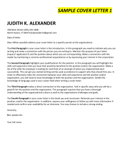


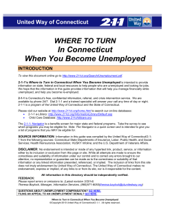

© Copyright 2026