
Geography of South Asia Mr. Kevin Nolen Penncrest High School
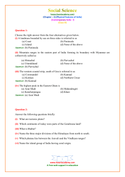
Geography of
South Asia
Mr. Kevin Nolen
Penncrest High School
Media, PA
Plate Tectonics
Theory
Gondwanaland
• Southern
supercontinent.
• Started to break
up 175 million
years ago.
The Indian
Subcontinent
The Indian Subcontinent
• A part of
Gondwanaland
broke off and
collided with
Eurasia.
• The Himalayas
and Hindu Kush
were formed.
The Indian Subcontinent
A subcontinent is
a large landmass
that is smaller
than a continent.
Isolating Factors
• Northern
Mountains
– Hindu Kush
– Himalayas
• Water
– Arabian Sea
– Indian Ocean
– Bay of Bengal
Regions of Asia
Note: Definitions of regions tend to vary a bit.
Regions of Asia
• North Asia is
Russia’s Siberia.
• East Asia includes
China and Japan.
• Southeast Asia
includes Vietnam
and Indonesia.
• South Asia includes
India and Pakistan.
• Central Asia
includes Kazakhstan
and Uzbekistan.
• Southwest Asia,
better known as the
Middle East,
includes Saudi
Arabia and Iraq.
South
Northern Asia
Central
Asia
East
Asia
Southwest Asia
South
Asia
Southeast
Asia
South Asia
Countries of South Asia
•
•
•
•
•
•
•
•
Afghanistan
Pakistan
India
Nepal
Bhutan
Bangladesh
Sri Lanka
Maldives
Major Geographic
Regions
Major Geographic Regions
• Northern
Mountains
• Northern Plains
• Deccan Plateau
Northern Mountains
Northern Plains
Deccan
Plateau
Northern Mountains
• Himalayas
• Hindu Kush
Himalayas
• 1,500 mile long
chain of mountains.
• Include tallest
mountains in the
world.
• Create a massive
wall separating
South Asia from East
Asia.
Mount Everest
• Tallest mountain
in the world at
29,000 feet.
• First climbed by
New Zealander
Edmund Hillary
and Sherpa
Tenzing Norgay
from Nepal.
Hindu Kush
• Smaller in area than
the Himalayas, but
almost as high and
just as rugged.
• Located mostly in
Afghanistan.
• The word “kush”
means “death.”
Khyber Pass
• Best known pass
through the Hindu
Kush.
• For centuries,
traders and
invaders traveled
through this pass.
Kashmir
• Isolated valley in
northern India.
• Famous for the
production of a
fine wool.
• Split between
India, Pakistan
and China.
Indo-Gangetic Plain
• Large plain formed
by the Indus,
Ganges and
Brahmaputra
Rivers.
• Most fertile and
densely populated
part of South Asia.
Indus River
• Largest river of
Pakistan.
• The word “indus”
means “river.”
• India’s name
comes from this
river.
Ganges River
• Largest river in
India.
• Most holy river of
Hinduism.
• Joins with
Brahmaputra to
create an
enormous delta in
Bangladesh.
Brahmaputra River
• Large river that starts in Tibet (China).
• Runs through India and Bangladesh.
• Name means “Son of Brahma.”
Thar Desert
Large desert in India and Pakistan.
Deccan Plateau
• Large plateau (an
elevated flat or
hilly landmass)
• Bordered by
mountains:
– Vindhyas
– Western Ghats
– Eastern Ghats
Western Ghats
Windward
Side
The Western Ghats
create a “rain shadow.”
Leeward
Side
Review
Q: What large landmass
split up millions of years
ago, resulting in India’s
collision with the rest of
Asia?
A: Gondwanaland
Q: What two terms
are used to describe
this region of the
world?
A: South Asia & the
Indian Subcontinent
Q: What five physical features
isolate South Asia? Hint: two
landforms and three bodies of
water.
A: Hindu Kush, Himalayas,
Arabian Sea, Indian Ocean &
Bay of Bengal.
Q: What is the name
of the territory in
northern India that is
claimed by both India
and Pakistan?
A: Kashmir
Q: What is the name of
the famous mountain
pass through the
Hindu Kush
mountains?
A: Khyber Pass
Q: What geographic
term is used to
describe a landform
that is low in elevation
and relatively flat?
A: Plain
Q: What is the large
plain in the northern
part of South Asia?
A: Indo-Gangetic Plain
Q: What three rivers
form the Indo-Gangetic
Plain?
A: Indus, Ganges &
Brahmaputra
Q: What geographical
term is used to describe
the landform formed at
the mouth of a river?
A: delta
Q: Which country is largely
composed of the huge delta
formed by the Ganges and
Brahmaputra?
A: Bangladesh
Q: Which two rivers combine to
form the largest delta in South
Asia?
A: Ganges & Brahmaputra
Q: What two names are used to
describe the large desert located
in South Asia?
A: Thar & Great Indian Desert
Q: In which two countries is the
Thar Desert located?
A: India & Pakistan
Q: What geographic term is used
to describe an elevated area that
is relatively flat?
A: plateau
Q: What is the name of the large
plateau in central India?
A: Deccan Plateau
Q: What mountain chain has the
biggest influence on the amount
of precipitation the Deccan
Plateau receives?
A: Western Ghats
Q: What geographic term is used
to describe when one side of a
mountain receives a lot of
moisture and the other side
almost none?
A: rain shadow
Review: Countries
•
•
•
•
•
•
•
•
Afghanistan
Bangladesh
Bhutan
India
Maldives
Nepal
Pakistan
Sri Lanka
Afghanistan
Pakistan
Nepal
India
Sri Lanka
Maldives
Bhutan
Bangladesh
Review: Bodies of Water
• Arabian
Sea
• Bay of
Bengal
• Indian
Ocean
Bay of
Bengal
Arabian Sea
Indian Ocean
Review: Rivers
• Brahmaputra
• Indus
• Ganges
Indus
Ganges
Brahmaputra
Review: Physical Features
• Deccan
Plateau
• Himalayas
• Hindu Kush
• Indo-Gangetic
Plain
• Thar Desert
• Western
Ghats
Hindu Kush
Thar
Desert
Himalayas
Indo-Gangetic
Deccan
Western Plateau
Ghats


© Copyright 2026