
Methods and Assumptions Document
Methods & Assumptions Meeting Documentation 1. Methods and Assumptions Cover Page US14/US83/SD34 Missouri River Bridge Replacement Study To: Study Advisory Team (SDDOT, FHWA, City of Pierre, City of Fort Pierre) From: Greg Brown, URS; Carl Osberg, URS; Carrie Cooper, URS Project: US14/US83/SD34 Missouri River Bridge Replacement Study CC: File Date: October 3, 2013 Job Numbers: 31811343/350/351/352/354 & Work Order PD-04-13 to Agreement 410540 Methods and Assumptions Document This Methods and Assumptions document was developed as a summation of the Methods and Assumptions Meeting held on October 3, 2012 with representatives from the South Dakota Department of Transportation (SDDOT), Federal Highway Administration (FHWA), City of Pierre, City of Fort Pierre and URS. This document is intended to serve as a historical record of the process, dates and decisions made by the study team representative for the US14/US83/SD34 Missouri River Bridge Replacement Study. Amendment #1: (if required) Amendment Date: Amendment #2: (if required) Amendment Date: URS Corporation 100 South Fifth Street, Suite 1500 Phone: (612) 370-0700 Methods and Assumptions Doc Minneapolis, MN 55402 Fax: (612) 370-1378 Page 1 of 27 TABLE OF CONTENTS TITLE PAGE NO. 1. Methods and Assumptions Cover Page….…………………………………… 1 2. Stakeholder Acceptance Page………………………………………………… 3 3. Introduction and Project Description……………………………………………. 4 4. Study Area…………………………………………………………………………. 10 5. Analysis Years/Periods…………………………………………………………… 10 6. Data Collection……………………………………………………………………. 11 7. Traffic Operations Analysis………………………………………………………. 13 8. Travel Forecast…………………………………………………………………… 15 9. Bridge/Roadway Options Process……………………………………………… 16 10. Environmental Process…………………………………………………………… 23 11. Safety Issues………………………………………………………………………. 25 12. Selection of Measures of Effectiveness (MOE)………………………..……… 25 13. FHWA Interstate Access Modification Policy Points……………………….… 26 14. Deviations/Justifications 15. Conclusion 16. Appendices…………………………………………………………………….. …………………………………………..………… 26 …………………………………………………………………….. 26 URS Corporation 100 South Fifth Street, Suite 1500 Phone: (612) 370-0700 Methods and Assumptions Doc Minneapolis, MN 55402 Fax: (612) 370-1378 27 Page 2 of 27 2. Stakeholder Acceptance Page The undersigned parties concur with the Methods and Assumptions for the US14/US83/SD34 Missouri River Bridge Replacement Study as presented in this document. SDDOT: FHWA: Signature Signature Title Title Date Date The undersigned parties concur with Amendment #1 (if required) to this document. SDDOT: FHWA: Signature Signature Title Title Date Date The undersigned parties concur with Amendment #2 (if required) to this document. SDDOT: FHWA: Signature Signature Title Title Date Date Methods and Assumptions Acceptance Notes: (1) Participation on the Study Advisory Team and/or signing of this document does not constitute approval of the US14/US83/SD34 Missouri River Bridge Replacement Study Final Report or conclusions. (2) All members of the Study Advisory Team will accept this document as a guide and reference as the study progresses through the various stages of development. If there are any agreed upon changes to the assumptions in this document a revision will be created, endorsed and signed by all the signatories. URS Corporation 100 South Fifth Street, Suite 1500 Phone: (612) 370-0700 Methods and Assumptions Doc Minneapolis, MN 55402 Fax: (612) 370-1378 Page 3 of 27 3. Introduction and Project Description A. Project Background and Understanding The South Dakota Department of Transportation (SDDOT) in conjunction with the Cities of Fort Pierre and Pierre has selected a consultant team lead by URS to conduct the US14/US83/SD34 Missouri River Bridge Replacement Study for the State of South Dakota. This study will include developing context sensitive concepts for various locations and types of structures to replace the existing US14/US83/SD34 Missouri River Bridge (Also known as the John C. Waldron Memorial Bridge or NBI # 000000033100118) and performing a study in accordance with the National Environmental Policy Act (NEPA) of those concepts to determine a preferred option. As opportunities to cross the Missouri River in central South Dakota are limited, the new structure concepts will be required to be built with limited disruption to existing traffic and will need to perform beyond a 100 year service life. The study will require 3-D renderings be created, for each build alternative considered in the NEPA process, and presented to the public and decision makers. B. Project Location The existing bridge crosses the Missouri River between Pierre and Fort Pierre. These communities lie roughly in the center of South Dakota. Pierre is the state capital and Fort Pierre is the state’s oldest continuously occupied white settlement. The replacement bridge options for this study will be positioned either slightly to the north or south of the existing location, as dictated by the prescribed Study Area. Location Figure 1: Regional Location Map The study area is defined in greater detail in Section 4.0 of this document. URS Corporation 100 South Fifth Street, Suite 1500 Phone: (612) 370-0700 Methods and Assumptions Doc Minneapolis, MN 55402 Fax: (612) 370-1378 Page 4 of 27 Missouri River N Bridge Location Pierre Fort Pierre Figure 2: Municipal Location Map C. Need for Study The purpose of and need for the project is to address the bridge’s and/or project area’s: deteriorated condition, current and future capacity and safety issues – while fitting into local and regional land-use and transportation plans (that have been developed) with an emphasis on minimizing environmental and socioeconomic impacts. The preferred alternative(s) that will be chosen for the bridge will address those needs into the future - 2045 design year for the corridor and 2125 service year for the bridge. The study phase will include fulfilling the planning and NEPA environmental activities necessary to meet the following objectives: 1. Complete a structure location and type study for a new long-term (100+ years) performing bridge considering economics, aesthetics, maintenance, and impact to the community. 2. Complete the NEPA process necessary to advance the project into the final design phase. 3. Complete a safety analysis of the highway corridor within the study area. 4. Identify locations on the highway corridor within the study area not in compliance with current design standards under both the current and forecasted future traffic conditions. 5. Create final products (environmental assessment, study reports, conceptual designs, architectural details, TS&L plans) for use by the SDDOT which will guide the Department in the design phase for the bridge replacement project. URS Corporation 100 South Fifth Street, Suite 1500 Phone: (612) 370-0700 Methods and Assumptions Doc Minneapolis, MN 55402 Fax: (612) 370-1378 Page 5 of 27 D. Study Schedule The schedule for this study has been set at 18 months. The study began on July 1, 2013 and is set to be completed by December 31, 2014. The table below and Appendix C show the anticipated project schedule. Also Section 10.0 contains an environmental schedule and Appendix D contains the meetings list. Date July 2013 August 2013 September 2013 – October 2013 November 2013February 2014 October 2013 – November 2013 December 2013 – February 2014 February 2014 – March 2014 April 2014 – May 2014 May 2014 – August 2014 September 2014 – December 2014 December 2014 June 2015 Task/Event Notice to Proceed, Kickoff Meeting SAT and CAC Kickoff Meetings Methods & Assumptions Meeting Methods & Assumptions Document Baseline Conditions Analysis / Data Collection Field Survey Bridge Conceptual Options/Alternatives Created Existing Traffic and Operations Analysis Safety Analysis Utility Coordination Project Website Kickoff Agency Scoping Meeting (Project Kickoff) st 1 Public Meeting - November (Project Kickoff/Purpose and Need, Initial Bridge Type and Location Concepts) Purpose & Need Document Existing Traffic and Operations Analysis - continued Future Needs Analysis - continued Safety Analysis – continued Utility Coordination – continued Intial Analysis of Bridge Concepts/ Alternatives Determination of 4(f)/6(f) Properties Bridge/Roadway Concepts Screened Future Needs Analysis - continued Safety Analysis – continued Build Alternative(s) Selected Removal Plan of Existing Structure Refinement of Build Alternative(s) Bridge Architectural Detailing Build Alternatives Refined – continued Removal Plan of Existing Structure – continued Constructibility of Build Alternatives Life-cycle Cost Analysis nd 2 Public Meeting – May (Refined Build Alternative(s) with 3D graphics) Stakeholder Meeting #1 (Discuss Alternative(s)) Removal Plan of Existing Structure – continued Recommended Alternative(s) Refinement Complete Environmental Documentation Final Environmental Documents rd 3 Public Meeting – September (NEPA process findings, and other issues to be determined by SDDOT) Stakeholder Meeting #2 (Discuss ROW issues with preferred Build Alternative(s)) FONSI Final Study Report TS&L Plans Complete Project Website Ends Figure 3: Project Schedule Summary URS Corporation 100 South Fifth Street, Suite 1500 Phone: (612) 370-0700 Methods and Assumptions Doc Minneapolis, MN 55402 Fax: (612) 370-1378 Page 6 of 27 E. Facilities that will be affected by Study Facilities that potentially will be affected by this study and are present in the study area, include but are not limited to: • Existing US14/US83/SD34 Missouri River Bridge • Missouri River • Existing Bike/Pedestrian Trail System and Markers (Lewis and Clark Bicentennial Trail) • The Highway US14/US83/SD34 (Deadwood St/W. Sioux Ave) corridor between Poplar Ave and Yellowstone Street • Historic Railroad Bridge • Original car bridge abutment/pier footing on Pierre side • Pierre Side Facilities include, but are not limited to: • SD Discovery Center • City of Pierre Water Well Pump houses • Pierre Chamber of Commerce Building • W. Dakota Avenue and intersections in study area • James Street and intersections in study area • S. Charles Street and intersections in study area • S. Poplar Ave and intersections in study area • Hipple Park • Steamboat Park facilities in study area • Frisbee Golf Course, • Historic Schoolhouse, • Playground • Pavilion and Restrooms • Parking Lot • Potential Pierre / Ft. Pierre Community Pool Development • Businesses • Best Western Ramkota Hotel • Clubhouse Hotel & Suites, Red Rossa • Governor’s Inn • River Lodge Hotel • McDonalds • China Buffet • Friman Oil and Gas Inc • Shel’s Gas Stop • Fort Pierre Side Facilities include, but are not limited to: • Old Deadwood Trail Marker • Lt Commander John C. Waldron Memorial Marker • Hustan Ave and intersections in study area • Island Drive and intersections in study area • Royal Court and intersections in study area • Riverwalk Landing Development • Businesses • Pizza Ranch • First National Bank • Perkins • Mavericks Recreation Equipment Sales • Oahe Storage • Hannum Trucking The corridors/roadways that are included in this study (potential affect) are as follows: • US HWY 14/ US HWY 83/ SD HWY 34 – level of service analyzed per HCM2010. • Poplar Street – level of service analyzed per HCM2010. • Yellowstone Street – level of service analyzed per HCM2010. • Dakota Ave – level of service analyzed per HCM2010. • James Street – level of service analysis will not be conducted. • Charles Street – level of service analysis will not be conducted. • Hustan Avenue – level of service analysis will not be conducted. • Island Drive – level of service analysis will not be conducted. URS Corporation 100 South Fifth Street, Suite 1500 Phone: (612) 370-0700 Methods and Assumptions Doc Minneapolis, MN 55402 Fax: (612) 370-1378 Page 7 of 27 The intersections included in this study (potential affect) are as follows: • Poplar Street/Sioux Avenue – level of service analyzed per HCM2010. • Poplar Street/W. Dakota Avenue – level of service analysis will not be conducted. • Charles Street/Sioux Avenue – level of service analysis will not be conducted. • Charles Street/W. Dakota Avenue – level of service analysis will not be conducted. • James Street/Sioux Avenue – level of service analysis will not be conducted. • James Street/W. Dakota Avenue – level of service analysis will not be conducted. • Yellowstone Street/Deadwood Street – level of service analyzed per HCM2010. • Yellowstone Street/Hustan Ave – level of service analysis will not be conducted. • Hustan Ave/Island Drive – level of service analysis will not be conducted. • Deadwood Street / Island Drive – level of service analysis will not be conducted. • Dakota Avenue Eastbound Off-Ramp From Bridge – level of service analyzed per HCM2010. The trails that are included in this study (potential affect) are as follows: • Trail on existing bridge • Trail under existing bridge on Pierre side • Trail under existing bridge on Ft. Pierre side F. Previous Studies Previous studies that are pertinent to this study include, but are not limited to: • City of Pierre Comprehensive Plan, December 2008 • City of Pierre Strategic Plan 2013-2014, January 2013 • City of Pierre Historic Preservation Plan, October 2008 • City of Fort Pierre Comprehensive Development Plan, (publish date unknown at this time) • City of Fort Pierre Housing Study, December 2012 • City of Fort Pierre: Community Assessment Survey Final Project Report August 13, 2008 • Fort Pierre Chouteau Historic Site Management Plan, February 2010 • Comprehensive Economic Development Strategy 2013-2017, Central South Dakota Enhancement District, December 2012 • Community & Economic Development Survey Results, Central South Dakota Enhancement District, December 2012 • Hughes County Comprehensive Plan, 1997 (newer plan in progress) • Pierre Downtown & Waterfront Development Master Plan, (in-progress) • Pierre Area Riverfront Improvement Study, (Stockwell Engineering- in progress) • Fort Pierre Riverwalk Landing Development Study, Midwest Construction, (in-progress) • Pierre Waterpark Study Report (Pierre Retail) August 2009 • Pierre Outdoor Water Park Survey and Study (in-progress) • Coordination Assessment and Transit Development Plans for River Cities Public Transit Pierre, SD, 2007 • FEMA Flood Mapping – post 2011 • USACE Final Oahe Dam/Lake Oahe Master Plan, Sept 2010 • USACE Omaha District, Missouri River Mainstem System: 2011-2013 Annual Operating Plan, January 2012 • USACE Omaha District, Missouri River Mainstem Reservoir System: Post 2011 Flood Event Analysis of Missouri River Mainstem Flood Control Storage, April 2012 • USACE Omaha District, Draft, Oahe Dam/Lake Oahe Project South Dakota & North Dakota Surplus Water Report, vol.1, August 2012 • Seismic Evaluation Causative Fault Study, Missouri River, Oahe Dam, Lake Oahe, SD 1985 • US 14B/Garfield Avenue Pierre, SD Access Plan, June 2003 • SDDOT Public Involvement Plan, 2010 • South Dakota Department of Agriculture – Community Threat Protocol (in progress) • South Dakota Comprehensive Wildlife Conservation Plan - Department of Game, Fish, and Parks Wildlife Division Report 2005-2007, September 2005 • FHWA FONSI for Project EM 2014(11)229 PCN 00T6 Hughes County, SD Railroad Improvements in Pierre, SD, July 2009 • National Parks Conservation Association: National Parks along the Lewis and Clark Trail – State of the Parks, September 2006 • Local Rural Road Safety Audit Guidelines and Case Studies (SD2007-06), 2010 URS Corporation 100 South Fifth Street, Suite 1500 Phone: (612) 370-0700 Methods and Assumptions Doc Minneapolis, MN 55402 Fax: (612) 370-1378 Page 8 of 27 • • • • • • • Eastern Dakota and Pierre to I-90 Expressway Feasibility Study, 1994 South Dakota Statewide Long Range Transportation Plan, Sept 2010 State of South Dakota Hazard Mitigation Plan – Standard Plan, March 2011 SDDOT Decennial Interstate Corridor Study, Phase 1, March 2010 SDDOT Decennial Interstate Corridor Study, Phase 2, August 2010 SDDOT Decennial Interstate Corridor Study, Phase 3 - Implementation Plan, Nov 2010 Lewis and Clark Multiuse Trail, Iowa DOT, June 2013 G. Study Advisory Team Members A Study Advisory Team (SAT) and a Community Advisory Committee (CAC) have been formed to provide input on the study through completion. The SAT is comprised of representative parties of the SDDOT, the City of Fort Pierre, the City of Pierre and the Federal Highway Administration (FHWA). Members of the Study Advisory Team include, but are not limited to: Mark Clausen Sonia Downs John Forman Tom Gilsrud Kevin Goeden Steve Gramm Mark Hoines Steve Johnson Brad Lawrence Tom Lehmkuhl Mark Leiferman Leon Schochenmaier Dean VanDeWiele FHWA – Bridge SDDOT – Project Development SDDOT – Pierre Region SDDOT – Bridge Design/Maintenance SDDOT – Bridge Design SDDOT – Project Development FHWA – Planning SDDOT – Bridge Design City of Fort Pierre – Public Works SDDOT – Project Development SDDOT – Road Design City of Pierre – Administrator SDDOT – Pierre Area This study also includes a Community Advisory Committee (CAC). include, but are not limited to: Dave Bonde Laurie Gill / Mike Harmon Gloria Hanson Captain Dave Panzer Tom Lee Anne Lewis Ray Lewis Scott Rounds Laura Carbonneau / Tony Jockheck Paul Lepisto Family of Lt. Commander Waldron Members of the CAC Fort Pierre Development Corporation City of Pierre City of Fort Pierre Pierre Police Department Capital City Bicycle Club Discovery Center Great Lakes of SD Tourism Association Pierre/Ft Pierre Exchange Club Pierre Chamber of Commerce Izaak Walton League & SD Walleyes Unlimited Current Bridge Namesake Family Applications for the public to join the CAC will be available at the public involvement meetings. Thus, additional team members will likely be added as the study progresses. H. Complexity of Study This study will evaluate a variety of options for a replacement bridge across the Missouri River between Pierre and Fort Pierre. This study has numerous complexities including: • Long-span bridge – numerous types and locations • 100-year bridge design life • Numerous stakeholders • Public involvement • River crossing – federal waters • Historically eligible bridge • Numerous utilities around bridge • Existing bridge removal plans • Maintain traffic during construction • Interface with existing trails and pedestrian facilities (ADA compliance) • Section 4(f) of DOT Act URS Corporation 100 South Fifth Street, Suite 1500 Phone: (612) 370-0700 Methods and Assumptions Doc Minneapolis, MN 55402 Fax: (612) 370-1378 Page 9 of 27 4. Study Area The study area, as prescribed by the SDDOT in the RFP, is to include the area surrounding the existing US14/US83/SD34 Missouri River Bridge bounded in red in Figure 4, including the intersection of Deadwood Street and Yellowstone Street in Fort Pierre and the intersection of Sioux Avenue and Poplar Street in Pierre. Missouri River N Study Area Outline Poplar Ave Yellowstone St Figure 4: Project Study Area 1 The existing railroad bridge, tracks and at-grade railroad crossings are not included in this study. 5. Analysis Years/Periods Traffic data in the study area will be collected for the existing year conditions (2013). This data includes, but is not limited to: corridor and intersection geometry and traffic control; peak hour corridor and/or intersection traffic volumes; and traffic signal phasing and timing. Traffic conditions will be forecasted to conditions for the expected year of opening for the new bridge (2025) and the planning horizon year (2045). Traffic analysis will be performed in each of these years, existing (2013), project (2025) and planning (2045), during the AM, noon and PM peak hour periods (7:30AM-8:30AM, 11:00AM-1:30PM, and 4:30PM-5:30PM). Therefore, the forecasting task will include three peak hour periods for each of the three analysis years. URS anticipates the bridge design period to extend to 100 years. Typically roadway and traffic analysis are 20-25 years. Since the bridge design life is much longer than typical roadway design life, URS anticipates a sensitivity analysis for traffic operations that will help confirm that the proposed bridge cross-section (from a traffic perspective) will provide adequate performance over the intended service life. URS Corporation 100 South Fifth Street, Suite 1500 Phone: (612) 370-0700 Methods and Assumptions Doc Minneapolis, MN 55402 Fax: (612) 370-1378 Page 10 of 27 6. Data Collection Data collection is one of the most important facets during any transportation planning study. URS has started reviewing the available project information. The approved project objectives and Methods and Assumptions Document will be our guide. All available documentation for the existing bridge and study area (Sioux/Poplar and Yellowstone/Deadwood) will be gathered and reviewed by the URS Team. This information will include: existing roadway alignments, access points, existing bridge plans, geotechnical information, GIS data, hydraulic studies, local planning documents and available environmental conditions documents. The information gathering will be broken down into smaller pieces and assigned to the appropriate disciplines. For instance, the environmental team will start looking at historical elements in the study area, while the bridge and roadway teams will start identifying alignments and structure types. Meetings with appropriate agencies will take place during this task to discuss the documentation, needs of the project and potential variances to existing standards. The information evaluation and documentation will include, but will not be limited to: • Existing bridge, street/roadway standards of all applicable agencies. • Current ordinances and guidelines. • Previous transportation planning studies in the area – such as the US 14B/Garfield Ave Access Plan • Traffic safety problems of the existing bridge - crash history, sightlines, merging, icing and lighting. • Bicycle / pedestrian facilities, connections and needs – use, maintenance, access points. • Watercraft desires and needs – from current recreational boats to dredgers. • Existing railing types and light poles on the bridge. • Existing utility corridors within the study area and future utilities on the bridge. • Existing U.S. Corp of Engineers and U.S. Coast Guard plans and requirements for this section of the Missouri River – navigational clearances, channel location, silting/dredging issues, future of dam. • Base mapping data and verify control points. • Available traffic volume counts where needed – from automatic traffic recorder. • Traffic classification data as needed – from SDDOT with additions from field investigations • Turning movement counts where needed – obtained thru field data collection (see Fig 5). • Traffic safety problems based on crash history and local knowledge. • City and County development practices within the study area. • Other relevant data - land use, old design plans, functional classifications, existing development plans, etc. • Existing Canadian Pacific Railroad use of RR on perimeter of study area - identify their future plans as they pertain to impacts on the area’s transportation system • Existing capacity, geometric, right of way, and other deficiencies along the key routes identified within the study area. • Develop a list of transportation issues currently facing the area. • Identify possible disruptions to users with new construction. • Environmental Data: Wetlands, T&E Plants and animals, Archaeological, historical, HazMAT sites, 4(f)/6(f) data, floodplain data, parcel data, census data, tribal coordination, utilities. Traffic data collection will be performed at the identified intersections during the AM (06:00 – 09:00), noon (11:00-13:30) and PM (15:00 – 18:30) peak hour periods. Turning movement data including pedestrian and heavy vehicle counts will be collected in 15-minute intervals at the following intersections: 1. Yellowstone Street and Deadwood Street 2. Deadwood Street / Island Drive 3. Sioux Avenue and James Street 4. Sioux Avenue and Charles Street 5. Sioux Avenue and Poplar Avenue 6. Dakota Avenue eastbound off-ramp from Sioux Avenue URS Corporation 100 South Fifth Street, Suite 1500 Phone: (612) 370-0700 Methods and Assumptions Doc Minneapolis, MN 55402 Fax: (612) 370-1378 Page 11 of 27 N 6 3 A 2 C 4 5 B 1 Trails to be Analyzed Figure 5: Map of Intersections for Data Collection In addition to collecting turning movement data, hourly directional volumes will be collected for a 48hour period on the bridge. An Automatic Traffic Recorder currently exists at the west bridge approach, which may be used – likely set at 15 minute intervals. Included in this data collection effort will be volumes, vehicle speeds, and vehicle classification. Furthermore, pedestrian traffic counts on the trails will be collected in 15-minute intervals during the PM peak (16:30-18:30) time period, and will include the following locations: A. Trail under bridge on Pierre side B. Trail under bridge on Fort Pierre side C. Trail on bridge Reviewing existing bridge data (plans, inspections, maintenance and repair records, project meetings to-date, and geotechnical reports) may provide information that can be used to understand potential issues with a new bridge and assist with cost estimating. This information will also be valuable in evaluating and estimating the cost of removal of the existing bridge and determining if additional borings and geotechnical analysis will be needed to verify subsurface conditions – reducing potential risks and limitations for the replacement bridge options. A. Additional Data Supplied By SDDOT • Roadway Design Standards ◊ Available online at: http://www.sddot.com/business/design/forms/roaddesign/ • Crash History Geodatabase ◊ Supplied by SDDOT - Includes crash records dated Jan 2008 to Dec 2012 (5 years) • GIS Base Mapping Data (parks, streets, rail, utilities) • 2012 Aerial SID files • 2012 SDDOT Structure Costs Report • 2012 SDDOT Underwater Bridge Inspection Report (Existing Bridge) • SDDOT Bridge Plans and Bid Tabs for Existing Bridge, Vermillion Bridge, Yankton Bridge • Geotechnical Reports and Data B. Additional Data Collection Needed • Survey of the study area will start in the fall of 2013 – topo, trails, bridge, utilities, access points, shoreline (3D mapping file of survey data displayed using SDDOT settings, completed surface (dtm file), and all of the projection information (coordinate system, state plane/county, and county projection if applicable)) • Parcel and Plat Information - obtained from Cities and/or Counties URS Corporation 100 South Fifth Street, Suite 1500 Phone: (612) 370-0700 Methods and Assumptions Doc Minneapolis, MN 55402 Fax: (612) 370-1378 Page 12 of 27 7. Traffic Operations Analysis The URS Team will conduct a thorough analysis of the existing traffic operations within the study area. This analysis will be based upon the 2010 Highway Capacity Manual (HCM2010) methodology. Our work will include: • Collection of existing traffic data • Gather any existing data obtained in the study area by the SDDOT. • Analyze the existing traffic operations using the HCM2010 methodologies. The study area segments will be analyzed using Highway Capacity Software (HCS2010) to determine the operational conditions, and will include evaluation of the traffic volumes and related characteristics of the traffic. The roadway geometric characteristics will also be accounted for, including the roadway cross section and merge/diverge aspects of the operations. Intersection analyses will be performed using Synchro/SimTraffic 8.0, which follows HCM2010 methodologies. The six previously identified study area intersections will be evaluated for individual movement levels of service (LOS) to not only identify deficient intersections, but also to evaluate heavy peak hour movements that currently experience individual movement capacity issues. These deficiencies will be considered while seeking improvement scenarios for the project. • A speed distribution study will be conducted in the highway corridor to determine the 50th and 85th percentile speeds. URS will utilize Nu-Metrics data collection devices to collect volume and speed data for a minimum of 24-hours. Collecting this information for an entire day will reveal time of day performance measures that will assist in the development of improvement scenarios to improve the overall operational conditions in the project area. Documentation of the traffic operations, including existing segment, intersection and speed analyses, will be provided with the methodology, results, and figures to appropriately demonstrate the project area traffic operations within the study area. A. Variables The traffic analysis variables that will be used are the default values of: 1. Peak Hour Factor (PHF) a. Existing (year 2013) conditions analysis will either use new counts or, if available, use calculated PHFs from existing counts with a maximum value of 0.90. b. Design year (year 2025) conditions analysis will use new counts or, if available, existing PHFs rounded up to nearest 0.05 with a maximum value of 0.90 i. The increase in the PHF is to account for traffic growth that is likely to be spread throughout the peak periods c. Planning horizon year (year 2045) conditions analysis will use new counts or, if available, existing PHFs rounded up to nearest 0.05 with a maximum value of 0.90 i. The increase in the PHF is to account for traffic growth that is likely to be spread throughout the peak periods 2. Saturation Flow Rate a. SDDOT Design Manual (Page 24, Chapter 15) requires the use of 1,600 vhr. This value will be used for the signalized intersections within the study area. 3. Traffic Signal Controllers a. Operational analysis will allow both actuated and coordinated controllers 4. Left-Turn Phasing a. Protected, Permitted/Protected or Split Phasing will be allowed at intersections 5. Heaviest Lane Volume (Lane Utilization) a. Default HCS Streets Value used for ramp terminal/arterial intersections 6. Heaviest Vehicle Percentage a. Study Intersections i. Use existing turning movements counts that included truck counts to determine arterial truck percentages 7. Phase Change Intervals URS Corporation 100 South Fifth Street, Suite 1500 Phone: (612) 370-0700 Methods and Assumptions Doc Minneapolis, MN 55402 Fax: (612) 370-1378 Page 13 of 27 a. Existing (Year 2013) Conditions i. Existing signal timings will be used for phase change b. Future No-Build (Year 2025) Conditions i. Existing signal timings will be used for phase change intervals of phases that exist at intersections that have no geometric change from existing conditions ii. Phase change intervals will be calculated for the following locations: 1. New phases added to an intersection where geometry is unchanged from existing conditions 2. All phases at an intersection where geometry is changed from existing conditions 3. The calculated values will be based on methodologies presented in the Institute of Transportation Engineers (ITE) Traffic Engineering Handbook. The methodologies presented in the handbook use vehicle length and speed and the distance needed to track through the intersection to calculate phase change intervals. 8. Speeds a. Arterials – Use resulting free flow speed from speed distribution data collection 9. Pedestrian Traffic on the trails will be counted in the early evening hours (PM peak) of a weekday. These measurements will be taken in the fall and may be adjusted according to seasonal and weather fluctuations. 10. The City of Pierre currently has a construction project (sewer/water/surfacing) taking place on Dakota Avenue just southeast of the study area. The impacts this has on the traffic analysis will be discussed and accounted for. URS Corporation 100 South Fifth Street, Suite 1500 Phone: (612) 370-0700 Methods and Assumptions Doc Minneapolis, MN 55402 Fax: (612) 370-1378 Page 14 of 27 8. Travel Forecast The URS Team will build upon the data collection, baseline analysis and existing traffic operations, to determine the future transportation needs within the study area. All traffic analyses will be performed for both the AM, noon and PM peak hours and based upon the 2010 Highway Capacity Manual methodology. The following list includes our approach and idea on the future needs analysis process: • The future needs analysis will provide operational elements necessary to properly plan for the future roadway design. Traffic forecasts and traffic operations analyses will be developed for future years to evaluate the project year (2025), and the planning horizon year (2045). Traffic forecasts will also be developed for the long term year of 2125. • The most important aspect of the future year analysis will be the forecasting efforts. The URS Team will collect historic and existing information that will be used to evaluate the project area traffic forecasts. Information that will be used for the forecasts will include historic and existing land use and traffic volume. The relationship of the land use and traffic volumes will provide relevant indications of how land use forecasts relate to the future traffic volume forecasts for the do-nothing conditions. The URS team will also forecast trips generated by expected future development or redevelopment in the vicinity of the study area. The change in land use or intensity will be reflected in an increase or decrease in vehicle trips on the roadway system. These trips will be distributed across the roadway network based on the type and location of the expected development, and the location of origins and destinations in the area. • Similar to the existing conditions analysis, HCS2010 will be used to evaluate roadway segments, and Synchro/SimTraffic 8.0 will be used to evaluate intersection operations, each of which follow HCM2010 methodologies. Based on the project influence on traffic, the operational impacts area will be evaluated as part of the project. Project area deficiencies will be identified, and potential improvement elements will be identified, along with associated right of way requirements to accommodate potential improvements. • The future conditions analysis will determine whether any traffic operational characteristics are deficient, and what improvement measures would solve the problem. Improvement measures that will be evaluated include potential intersection capacity improvements such as additional lanes and alternative methods of traffic control and/or access management. Improvements may also include grade separation or new connections that could eliminate conflicting movements. Documentation of the future no-build traffic operations, including existing segment, intersection and speed analyses will be provided with the methodology, results, and figures to appropriately demonstrate the project area traffic forecast methodology, forecast volumes, forecast characteristics and operations with the study area. URS Corporation 100 South Fifth Street, Suite 1500 Phone: (612) 370-0700 Methods and Assumptions Doc Minneapolis, MN 55402 Fax: (612) 370-1378 Page 15 of 27 9. Bridge/Roadway Options Process For previous major bridges, URS has successfully used a 3-tiered process for the development, selection and advancement of a preferred alternative or alternatives. Each of these tiered steps will be carried out in conjunction with a series of stakeholder group meetings that will include the Study Advisory Team (SAT) and the Community Advisory Committee (CAC) workshops. Information on alternatives under consideration during each step will also be integrated into what will be provided to the stakeholder community and the public involvement process. A. Conceptual Options (Tier 1): URS will first develop numerous conceptual options (referred to as concepts) to replace the existing US14/US83/SD34 Bridge over the Missouri River. These initial concepts (types and locations) will be given to the SDDOT for their review and comment, which will set the stage for the brainstorming meeting. URS will then conduct a brainstorming meeting with the Study Advisory Team (SAT) to discuss other potential concepts. A multitude of potentially feasible and practical alternatives meeting the project design criteria will be identified and concept level bridge and roadway alignment sketches for each will be prepared. Numerous configurations and variations of main spans utilizing truss, arch, segmental concrete girder, steel girder, extradosed prestressed girder, spliced prestressed girder, and cable-stayed type superstructures will be considered. In addition, several replacement bridge locations will be considered and conceptualized. Construction costs would be estimated for each one based on square foot prices from previous similar structures. After the meeting, these conceptual options will be further developed and presented to the SAT and CAC – followed by a public open-house for review and comments. At the end of tier 1, some concepts will be dropped from further consideration due to their inability to satisfy project design criteria and requirements. B. Initial Analysis of Concepts (Tier 2): During this phase, the pros and cons of the alternatives, which made it through the tier 1 selection process, will be further studied. Structural analysis will be performed to confirm the structural feasibility for each alternative and to provide sufficient detail to develop major quantities. The concepts will be judged according to the project Purpose and Need Document as well as other criteria, to be discussed with the SAT and CAC. The visualizations of the concepts will be refined some during this phase also. The following would then be evaluated for each alternative: • Refined construction cost based on estimated major quantities and unit prices from historical averages • Life cycle cost estimates • Advantages/disadvantages and risks with each alternative (such as deck replacement and redundancy issues) • Plan elevation and typical section drawings • Environmental impacts • Construction duration • Level of inspection, maintenance and future rehabilitation effort • Visual renderings Typically each bridge concept is analyzed and scored in matrix form according to criteria, which are classified as major categories and subcategories. Each category could use a point system to score suitability. See Figure 6 for an example of this matrix. Some prescribed project design criteria from the RFP, which will be used in the matrix include: • All concepts will provide for a long-term (100+ years) service life for the proposed structure. Highway improvements away from the structure should be for the typical planning horizon of 20 years beyond the build year of 2025. • For structure types requiring medians along the highway, URS will determine the minimum length of median access control necessary along the highway beyond the structure to ensure operation of the highway corridor within the SDDOT acceptable LOS of C or URS Corporation 100 South Fifth Street, Suite 1500 Phone: (612) 370-0700 Methods and Assumptions Doc Minneapolis, MN 55402 Fax: (612) 370-1378 Page 16 of 27 better. • All concepts shall provide for the maintenance of the continuous crossing of the Missouri River by pedestrian and vehicular traffic for at least one lane in each direction during construction. • All concepts shall provide for the continuous capability for watercraft to travel through the construction zone during construction activities. • All concepts shall make every effort possible to avoid impacts to existing buildings. • At a minimum, the concepts are to show: Conceptual structure types, length(s) & width(s). Estimated structure touchdown points General location of bridge piers relative to road, river, trail and utility crossings General vertical and horizontal alignment and typical section of the mainline highway and all streets and trails affected by the build option. Lane requirements on the mainline highway (including the structure) and all intersecting streets necessary to maintain a corridor LOS of C or better and intersection LOS of D or better. Turn lane requirements at all intersections within the study area. Right of Way limits Permanent signing, lane delineation, and other traffic control items necessary through the study area for each option Local street connection modifications that may be needed as a result of implementing the option. Utility impacts/needs. Access locations that should be removed/consolidated/relocated with the concepts to enhance traffic flow through the study area. Impacts to recreational facilities, including the trail system and watercraft access and crossings. Pedestrian and bicycle facilities along the highway (including the structure) and other connecting streets and the connection to the trail system. Impacts to neighborhood travel patterns. Effective traffic flow for emergency vehicle routes during construction. Impacts to the Missouri River flood plain, wetlands and floodway, including navigational clearances. Right-of-Way Impacts. This information would then be presented and discussed at another round of stakeholder workshops and meetings. It is envisioned that two preferred alternatives will be identified at the culmination of this step. This concept(s) will be screened for fatal flaws before moving forward within the NEPA process. URS Corporation 100 South Fifth Street, Suite 1500 Phone: (612) 370-0700 Methods and Assumptions Doc Minneapolis, MN 55402 Fax: (612) 370-1378 Page 17 of 27 Subcategories Main Categories Fits the Site Continuity of Form Timeless design Context Sensitive Aesthetics Integrated w ith Structure Type Public Function Uses Enhanced View s Enhanced Trails Context Sensitive Solutions Adjacent Property Ow ners Utilities Initial Cost Lifecycle Costs Economics of Scale Constructibility Cost Effectiveness Bidibility Risk of Cost Grow th Scheduled Maintenance Painting Snow Removal Deck Drains and Expansion Joints Durability of Critical Items Maintenance Watertightness Lighting and Fixtures Bearing Replacement Deck Replacement Accessibility for Inspection Robust Foundation System Inspectibility Inspection Effort Multiple Load Paths Continuity Structural Redundancy Blast Resistance & Security Duration Method of Construction Method of Demolition Bridge Footing Footprints Drainage System Environmental Impact Lighting System Number of Piers Cultural Impact Wildlife Impact Duration Level of Service Speed Limits Clear Zone Traffic and River Navigation Off-Peak Construction River Navigation Impact Figure 6: Example Bridge Category Scoring Matrix URS Corporation 100 South Fifth Street, Suite 1500 Phone: (612) 370-0700 Methods and Assumptions Doc Minneapolis, MN 55402 Fax: (612) 370-1378 Page 18 of 27 C. Refinement to Build Alternatives (Tier 3): During this phase, the advancing bridge/roadway alternatives from tier 2 will be further refined in detail. Following further refinement and a ½ day workshop, the 1-2 preferred bridge/roadway alternatives will be thoroughly analyzed. Our bridge architect, Bradley Touchstone, will focus his attention and efforts to this phase. Additional facets of the preferred alternative(s) would then be studied in greater depth to refine the specifics of this alternative. Items to be further studied would include details of major components of the main span superstructure and substructure, the configuration, arrangement and type of the approach spans, construction sequencing, aesthetics, approach roadway details and required intersection modifications, right-of-way requirements, and traffic maintenance. The cost estimate would be updated taking into account specific aspects and methods of construction. Typically only one alternative is the preferred option, but we recognize that there may be two, such as a steel bridge and a concrete bridge. At this point in the process, the cost evaluations are performed on a quantity and unit cost basis. Public involvement to determine context sensitive solutions will be substantially progressed; however, they may still be refined. Life cycle costing will also be developed and compared between the contending solutions. The stakeholders and disciplines will be polled to discuss unresolved and partially resolved issues. Also at this point, it is envisioned that the architectural treatments applied to the structure, such as formliners, will be narrowed down to a single basic concept for each alternative. With the goal of finding the best bridge type and location for this site, this phase’s results will be presented for review and comment. With the receipt of final comments, these will be resolved to SDDOT’s satisfaction and will be incorporated into the final Concept Evaluation Report. The future conditions analysis will determine whether any traffic operational characteristics are deficient, and what improvement measures would solve the problem. These improvement measures that will be evaluated include intersection capacity improvements, such as additional lanes to improve operations. Improvements may also include grade separation or new connections that could eliminate conflicting movements. Each build alternative will include: • right-of-way needs, • proposed access point changes, • grade separations, • number of lanes, • trail information, • future signal locations, • structure widths and lengths, and • an aesthetic assessment with the SAT and CAC. The designs for these alternatives will be sufficient enough to complete the NEPA activities. Based upon the refinements made, the consultant will refine the estimate of both benefits and improvement costs. The improvement costs will be in today’s dollars and will include an estimate for ROW (permanent and easements), preliminary engineering services, construction costs, and other costs associated with the various alternatives. Professional 3-D rendered drawings for the proposed build alternatives will be created for aesthetic evaluation and presenting those ideas at the second and third public meetings. These 3-D rendered drawings will allow for realistic insertion of the build alternative into photos from multiple view sheds. D. Constructability Analysis of Build Alternative(s): The URS Team will analyze the issues associated with the replacement bridge to determine viable means and methods for construction. Throughout the preliminary design process, we will strive for systems that promote Contractor ingenuity and promote competition, as well as, make use of available local material and manpower resources and expertise. URS Corporation 100 South Fifth Street, Suite 1500 Phone: (612) 370-0700 Methods and Assumptions Doc Minneapolis, MN 55402 Fax: (612) 370-1378 Page 19 of 27 URS will also generate ideas related to construction techniques, useful to SDDOT for cost savings, and for both simplifying construction and reducing the duration of construction. This will include evaluation of: • Marine construction techniques, such as top down construction, which incorporates a trestle and minimizes the footprint of the construction upon the river bottom. • The use of prefabricated superstructure and substructure elements to the fullest extent which permits work to be done offsite and out of harsh weather conditions. An example would be the use of a precast footing template to locate driven piles inside a cofferdam. • The use of shoring towers to temporarily support the framing elements for both the steel and concrete girder options. • Accelerated Bridge Construction (ABC) techniques will be evaluated for bridge replacement. Since traffic will be maintained on the existing bridge throughout construction, ABC techniques will only be addressed if they are a no-cost or low cost solution. • Determine the most feasible construction detours and phasing for each build alternative based upon researching similar installations, coordination with SDDOT staff, and generalized analyses of construction timelines and costs for each build alternative. With SDDOT’s prior authorization, URS will make inquiries to both the contractor and fabricator community as part of the alternative vetting process. This could include understanding reasonable concrete placement rates for particular footing pours or the availability of equipment necessary for large picks and material installation. Because the preliminary assessment of alternates leads into, and is a stepping stone for, the final design phase of the project, a sound technical approach that is contractor and fabricator friendly is imperative. URS understands the importance of this concept throughout design development. URS will analyze each build alternative to determine an estimation of the overall time duration of construction. The process and findings of this task will be presented in a Constructability Analysis Report for the build alternatives. E. Life-Cycle Cost Analysis: The URS Team will also take a three tier approach to pricing of the major bridge concepts. The first tier is square foot costing. URS maintains extensive historical records on all bridge types that may be considered at this site, in terms of overall square foot cost versus span lengths. URS typically adjusts these costs for geographic location using the MEANS construction indices, and for inflation using the ENR price indices, so all costs are adjusted for current dollars at the central South Dakota pricing. The second tier costing is an “engineers” cost estimate, based on unit prices. URS will perform sufficient preliminary engineering to size the major structural elements in the bridge and develop preliminary quantities. We will utilize unit prices from SDDOT historical averages, supplemented by URS bid records on all bridge types throughout the country. URS will also adjust these costs for geographic location using the MEANS construction indices, and for inflation using the ENR price indices, so all costs are adjusted for current dollars at the central South Dakota pricing. The third tier of cost estimating is using a “Contractor” approach, developing the costs based on an analysis of mobilization requirement, materials, equipment, labor, transportation, temporary works, overhead and other related costs. URS typically utilizes personnel for this type of estimate who are experienced in heavy construction (former contractors). These last two estimate types are typically compared and reconciled in order to provide a reliable final cost estimate. During the life-cycle cost analysis for each structure type and each build alternative, a list of projects will be proposed. The proposed maintenance projects that can be reasonably anticipated, to be needed beyond the build year of 2025 to ensure a 100 year service life, will be listed and priced. URS Corporation 100 South Fifth Street, Suite 1500 Phone: (612) 370-0700 Methods and Assumptions Doc Minneapolis, MN 55402 Fax: (612) 370-1378 Page 20 of 27 F. Future Inspection, Maintenance and Rehabilitation: The formulation and evaluation of structural alternatives will consider the future requirements and needs. To lessen future inspection requirements, attention will be paid to eliminating or minimizing non-redundant and fracture critical members. Providing inspection and maintenance vehicle access to the trail/path on the bridge and eliminating or lessening obstructions along the outside edges of the bridge will be considered. Particular attention will be paid to such details as deck joint and deck drainage system with the goal of minimizing future maintenance. URS will investigate the possibilities of providing a 100year deck, and will compare the value of this deck with a more conventional deck. G. Geotechnical Investigation and Foundation Studies: Foundation systems will constitute a major cost component of this structure and therefore will be thoroughly studied. Alternative deep foundation systems such as driven steel H-piles and drilled shafts will be evaluated. Conventional cofferdam versus waterline footing construction methods will be studied for feasibility and cost effectiveness. With the possibility of large approach spans, identification and comparison of foundation alternatives for that portion of the structure will also be important H. Agency and Utility Coordination: Regulatory agency coordination will be required with numerous agencies including, but not limited to: the South Dakota Department of Environmental and Natural Resources, South Dakota Game Fish and Parks, US Fish and Wildlife, US Coast Guard and US Army Corps of Engineers. The existing structure has a main span navigational opening of roughly 210 feet horizontal and 28.7 feet vertical. Confirming the required minimum navigation channel width, height, centerline alignment and location will be a critical task to complete early on in supporting development of bridge concepts for each viable alternative. The span arrangements and lengths will dictate concept feasibility and aesthetics. Early coordination with private and public utility companies is critical in projects of this type. The type and location of existing utilities, as well as the options available for relocation, can have an impact on the design concepts or the construction methods that may be used. The URS Team will identify the utility companies with facilities in the area and will use this preliminary data when developing initial concepts. Once the alternatives have been developed, the URS Team will facilitate a utility coordination meeting with the affected utilities and the SDDOT utility coordination engineers. This meeting will allow further refinement of the design concepts based on more detailed information about potential utilities. I. Existing Bridge Removal: URS will review the project and provide suggestions on contractor means and methods for bridge removal, temporary shoring and construction of the deck in stages, maintaining at a minimum two lanes of vehicle traffic on the bridge. Modeling cases will be developed for the potential construction stages that may occur. The existing bridge is a pair of two-girder floor beam and stringer structures, which will present a unique set of challenges in planning for its demolition and removal. Approaches to demolition vary by contractor. Thus, in planning for this structure’s removal sequence, generally accepted means and methods will be employed. Of prime importance in this planning process, will be working out an approach to the removal methodology with the regulatory agencies. To do this effectively, they will be brought onboard early in the process while various removal alternatives are being considered and prior to decisions being made. Navigation and other uses of the waterway will also play an important role in the planning process, which may bring restrictions such as time of year limitations for certain construction activities. One very important decision will be whether to install a trestle, use barges to access the structure, or both. This will have sizeable cost impact on the project with a lot depending on proposed superstructure removal methods, water depth and other construction requirements. The URS Team will develop a bridge removal plan for the existing bridge structure that will include the sequencing necessary to construct the new bridge and coordination with pedestrian traffic. The level of detail will comply with the NEPA process, including an asbestos survey of the URS Corporation 100 South Fifth Street, Suite 1500 Phone: (612) 370-0700 Methods and Assumptions Doc Minneapolis, MN 55402 Fax: (612) 370-1378 Page 21 of 27 bridge. Various options for dismantling the superstructure can be considered including piecemeal demolition of the deck and girders, cutting spans and lowering them onto barges. The most costeffective methodology will highly depend on the feedback received from the regulatory agencies. Stability of two-girder system superstructures will be an important factor during the demolition process and may require back stays or temporary shoring towers during certain removal operations. Also, being a two-girder structure, this makes partial demolition across the width of the bridge very difficult and most likely not a cost effective option. While the SDDOT’s RFP asked that the bridge removal shall, at a minimum, include all structural elements above the footing of each pier - the removal of the piers may not necessarily need to be demolished down to the footing. Often times one or two feet below the mudline is considered adequate. The exception to this will be adjacent to the navigation channel, where deeper removal depths may be required to avoid foundations becoming an underwater hazard. An important cost savings strategy, in the demolition of the substructure, will be avoiding the use of cofferdams. Depending on the regulatory agencies policies, demolition may be accomplished in open water, or within some type of containment, such as sheeting, but without having to pump the containment area dry. URS Corporation 100 South Fifth Street, Suite 1500 Phone: (612) 370-0700 Methods and Assumptions Doc Minneapolis, MN 55402 Fax: (612) 370-1378 Page 22 of 27 10. Environmental Process Following the National Environmental Policy Act (NEPA), alternatives for the bridge and roadway will be evaluated within an Environmental Assessment (EA) document. That evaluation will include a thorough environmental review process to address the social, economic and physical effects of the range of alternatives, following the various state environmental regulations and NEPA laws including: • • • • • • • • • • Executive Order 12898, Federal Actions to Address Environmental Justice in Minority Populations and Low-Income Populations National Historic Preservation Act Section 4(f) of the U.S. DOT Act Section 6(f) of the Land & Water Conservation Fund Act Section 404 of the Clean Water Act Executive Order 11990, Protection of Wetlands Floodplain Management Endangered Species Act Migratory Bird Treaty Act Clean Air Act The public involvement process included in NEPA allows for the public to participate in each step of the decision-making process. As the study progresses, there will be several opportunities for the public and stakeholders to weigh in, including three public information meetings (PIM) to take place in the Pierre/Ft. Pierre area. Also, a Community Advisory Committee and a Study Advisory Team have been formed and a project kick-off meeting was held to discuss the study. Coordination with local, state and federal agencies will take place throughout the study. The EA document will include the identification and evaluation of a range of alternative sites for the bridge and bridge types to be considered, ultimately leading to a preferred alternative for the bridge. The document will also include a chapter describing the Purpose and Need for the project. At the first PIM, scheduled for November 2013, the Purpose and Need factors for the project will be shown and public input on those factors will be encouraged. The proposed bridge alternatives that meet the objectives of the purpose and need for the project while minimizing environmental and socio-economic impacts, and are consistent with local, future plans will be carried forward for further study. Ultimately a preferred alternative type and location will be selected for the bridge. The environmental documentation will be completed within a 17-month timeframe. This 17-month schedule will allow for the necessary environmental process while incorporating public input and outreach. A. Section 4(f) Parks & Recreation and Historical Sites The proposed area of potential effects (APE) of the bridge will be inventoried for cultural resources pursuant to Section 106 of National Historic Preservation Act (NHPA) of 1966. In addition, an assessment of Section 4(f) properties will be made as defined by the Department of Transportation (DOT) Act of 1966. URS will initiate a Class I literature review at the South Dakota State Historic Preservation Office (SDSHPO) in Pierre. This task will identify previously recorded archaeological sites, isolated finds, and prior inventories that have occurred within the project APE. This will allow early identification of cultural resources that may be impacted by the proposed bridge development. The Canadian Pacific Railroad and Bridge, originally known as the Chicago and Northwestern Railroad Bridge [site 39HU568], is a Section 4(f) property that crosses the Missouri River along the northern boundary of the project APE. This bridge has been made eligible for the National Register of Historic Places (NRHP). Potential visual impacts to the railroad bridge will be reviewed throughout the study. Mark Hufstetler of Renewable Technologies documented the US14/US83/SD34 Missouri River Bridge, Structure Number 33-100-118 [site 39HU623], in 2004 and made the recommendation that URS Corporation 100 South Fifth Street, Suite 1500 Phone: (612) 370-0700 Methods and Assumptions Doc Minneapolis, MN 55402 Fax: (612) 370-1378 Page 23 of 27 this resource be determined not eligible for NRHP. Mr. Hufstetler indicated in his review that “[w]hile this bridge retains integrity in most respects, integrity has been diminished by the addition of some modern guardrail. Nevertheless, the structure is a very long example of a multi-span variable depth steel girder bridge type. Bridge 33-100-118 is not National Register eligible at this time because it is less than 50 years old. In 2012, however, it will be considered eligible under criterion C as a good example of the steel girder type, provided that it has suffered no major alterations by that time.” The South Dakota State Historic Preservation Office (SDSHPO) concurred with this recommendation on April 15, 2004 in the Historic Bridge Survey Report (included in Appendix I). However, in 2008 further structural retrofit/repair work was performed on the bridge that will need to be assessed. Using a qualified architectural or bridge historian, URS will perform an evaluation of the bridge pursuant to SDSHPO and SARC recommendations. A significant portion of land in the study area falls under the USACE’s jurisdiction (including sandbars or islands), however a larger amount is within the Cities of Pierre and Fort Pierre. An existing pedestrian trail lies on the bridge and connects with a paved municipal trail system in both Pierre and Fort Pierre. In Pierre, the municipal Steamboat Park/Steamboat Disk Golf Course/Hipple Park encompasses both the south and north side of the bridge approach. In Fort Pierre, there is a cul-de-sac on the south side of the bridge abutment with commemorative plaques for the Old Deadwood Trail and Lt. Commander John C. Waldron (bridge’s namesake). Impacts to these publicly owned parks, as well as any other recreational areas, wildlife and waterfowl refuges, or public and private historical sites will be evaluated thoroughly, as the FHWA and SDDOT cannot approve the use of this land unless the following conditions apply: There is no feasible and prudent alternative to the use of land. The action includes all possible planning to minimize harm to the property resulting from use. B. Cultural Resources URS will perform a Class III cultural resources inventory of the APE. This will involve systematically surveying the project APE in transects spaced no more than 20 meters (m) apart. A desktop review of the study area suggests that intact natural landforms may exist. In areas of low ground surface visibility (GSV), URS will place shovel probes to determine whether subsurface cultural remains are present. The preliminary review also indicates that residential neighborhoods fall within the study area and could contain older buildings. This may require an assessment by an architectural historian. Following the survey, URS will submit a summary report to the SDDOT and provide site eligibility recommendations for the National Register of Historic Places (NRHP). This document will also recommend site avoidance or mitigation measures. In the event that an NRHP eligible resource cannot be avoided, URS will assist the SDDOT in developing a Phase II (testing) or Phase III (mitigation) treatment plan for the site. URS recommends initiating the cultural resources survey early in the fall to avoid snow delays. SDDOT Missouri River Bridge Study 2013 2014 Aug Sep Oct Nov Dec Jan Feb Mar Apr May Jun Jul Aug Sep Oct Nov Dec Title Environmental Review Agency Scoping Meeting Purpose and Need Initial Range of Alternatives Determined Determination of 4(f)/6(f) Properties Section 106 Evaluation Alternatives Screened Recommended Alternative Defined Final Environmental Documents FONSI Public Meetings Figure 7: Environment Schedule URS Corporation 100 South Fifth Street, Suite 1500 Phone: (612) 370-0700 Methods and Assumptions Doc Minneapolis, MN 55402 Fax: (612) 370-1378 Page 24 of 27 C. Website URS will develop and maintain a project website which will include the following pages: • Project Description and Background • Public Meeting Process o General information (text and graphics) that apply to all public meetings. • Upcoming Public Meetings o Specific public meeting advertisements that include relevant information about upcoming public meetings (dates, times, locations, descriptions, and graphics). • Public feedback/comment submission form. • The website will be uploaded to a location where it is visible to SAT and other personnel to review. The SAT will review the website and provide feedback and requested changes. • Once approved, the website will be uploaded to the live domain/url and will be available to the public. Assumptions • Before the website is to be deployed to the public, a list of desired domains/urls for the new website will be provided to URS, ranked in order of preference. i.e.: • MissouriRiverBridge.com • US14MissouriRiverBridge.com 11. Safety Issues URS will identify existing and future safety issues (actual & perceived) along the highway corridor. The analysis will predict and compare crash frequencies of existing facilities and design alternatives. If a regional or statewide Calibration Factor is available, the analysis will be done in accordance with Chapter 12 of the AASHTO Highway Safety Manual. Otherwise, observed crash frequency and crash rates will be used to compare existing facilities to facilities similar to the design alternatives. Data required will include a minimum of 12 months of historical site characteristics, traffic volumes, and crash records, with 5 years of data recommended. URS assumes that the study area crash data from the Crash Geodatabase (2008-2012) will be used in the calculation of crash rates and critical crash rates. The following information will be provided as a result of the crash analysis: • Segment and Intersection Crash Rates • Segment and Intersection Critical Crash Rates (per AASHTO Highway Safety Manual) • Crash Trends • Potential Mitigation Measures to Improve Locations above Critical Crash Rates Safety risks, which may include inadequate site distances, geometry, lighting or speed and driver confusion will be explored and discussed during project meetings and workshops. 12. Selection of Measures of Effectiveness (MOE) The main goals of this study are as follow: 1) Complete a Traffic level of service (LOS) analysis and Delay analysis (for either individual movements or overall) for both the existing and future (2025 & 2045) conditions on the US14/US83/SD34 Highway corridor and select intersections. For the US14/US83/SD34 Highway corridor, average speed and travel time will be evaluated. 2) Complete a safety analysis of the US14/US83/SD34 Highway corridor and select intersections. 3) Identify locations on US14/US83/SD34 not in compliance with current design standards under both the current and forecasted future traffic conditions. 4) Determine the effects of incidents on traffic operations within the study area. 5) Prepare materials for EA Document. URS Corporation 100 South Fifth Street, Suite 1500 Phone: (612) 370-0700 Methods and Assumptions Doc Minneapolis, MN 55402 Fax: (612) 370-1378 Page 25 of 27 6) Prepare, present and analyze bridge and roadway alternatives including: • Presentation and initial analysis of numerous Bridge Type & Location Concepts (Tier 1) • Selection and Refinement of multiple Bridge Type & Location Concepts (Tier 2) • Final Refinement and Analysis for Bridge Type & Location Build Alternatives (Tier 3) 7) Create final products (environmental documents, TS&L plans, Final report) for use by the SDDOT which will guide the Department in the final design and construction phases – follow-up projects. 13. FHWA Interstate Access Modification Policy Points It is not anticipated that this study will involve and/or result in any Interstate access or interchange work, thus an Interchange Justification Report (IJR) and/or Interchange Modification Justification Report (IMJR) are not required. If it is determined during the study that Interstate access or interchange work will be required, the methods and assumptions document will be amended prior to proceeding. 14. Deviations/Justifications No deviations from standards are currently known. However the following list contains items that may become deviations: 1) Navigational clearance requirements: The US Coast Guard stipulated during the existing bridge design that a 210 foot wide x 29 foot high navigational opening lie under the bridge’s main span. Since the adjacent train bridge’s swing span is non-operational and the Oahe Dam limits commercial traffic on this area of the river, discussions will be held to determine if the span length and arrangement, channel location, and freeboard can be modified. Modifying these standards could impact the replacement bridge alternatives significantly - resulting in possible cost savings, additional aesthetic options and possible improvement to boat traffic operations. 2) State-of-the-art technologies: Since the replacement bridge construction is likely 10 years away, URS will evaluate promising new technologies and construction techniques, which may become more ordinary when the bridge is to be constructed. For example new concrete admixtures on the market have shown great promise in eliminating or significantly lessening bridge deck cracking. If it is determined during the study that deviations are required, the methods and assumptions document will be amended prior to proceeding. 15. Conclusion The purpose of and need for the project is to address the bridge’s and/or project area’s deteriorated condition, current and future capacity, and safety issues, fitting into local and regional land-use and transportation plans that have been developed while minimizing environmental and socioeconomic impacts. All the sections and processes described within this document will ensure that all reasonable design alternatives will be vetted, and that the chosen refined preferred alternative(s) will address those needs into the future of the 2045 design year for the corridor and 2125 service year for the bridge. URS Corporation 100 South Fifth Street, Suite 1500 Phone: (612) 370-0700 Methods and Assumptions Doc Minneapolis, MN 55402 Fax: (612) 370-1378 Page 26 of 27 16. Appendices Appendix A: Methods and Assumption Meeting Agenda Appendix B: Methods and Assumption Meeting Minutes Appendix C: Project Schedule Appendix D: Meetings Chart Appendix E: Additional Maps Appendix F: Additional Pictures Appendix G: Contacts List Appendix H: Design Criteria Appendix I: Previous Reports URS Corporation 100 South Fifth Street, Suite 1500 Phone: (612) 370-0700 Methods and Assumptions Doc Minneapolis, MN 55402 Fax: (612) 370-1378 Page 27 of 27 APPENDIX A Methods & Assumptions Meeting Agenda US14/US83/SD34 Missouri River Bridge Replacement Study URS N o. 31811343 US14/US83/SD 34 Missouri River Bridge Replacement Study Methods & Assumptions Meeting Agenda Thursday, October 3, 2013 1:00 PM (Central) Videoconference 1. Introductions: a. URS b. Goldsmith Heck c. Study Advisory Team d. Others 2. General Purpose of Meeting 3. Review Methods & Assumptions Draft Document 4. Other Items 5. Next Steps a. Revise and Finalize Methods & Assumptions Document b. Begin Data Collection c. Draft Purpose & Need Statement/Document d. Public Involvement Meeting – mid November 6. Adjourn 7. Contact information in case technical difficulties a. b. c. d. e. f. Carl Osberg, URS 612-816-2533 (cell) or 612-373-6402 (conference room) Steve Gramm, SDDOT 605-773-2716 (conference room) Minneapolis: IP = 64.253.234.166 contact Brad Doll 612-370-0700 Milwaukee: IP = 209.90.221.162 contact Nate Gardner 414-831-4188 Tampa: IP = 64.253.250.122 contact Jeff Mayner 813-675-6746 Denver: IP = 64.253.228.227 contact Robie Abraham 303-740-2775 cbo/ Q:\31811343\00_General\Comm\Meetings\201301004_Methods and Assumptions Agenda URS Corporation Fifth Street Towers 100 South Fifth Street Suite 1500 Minneapolis, MN 55402 Phone: (612) 370-0700 Fax: (612) 370-1378 A.1 APPENDIX B Methods & Assumptions Meeting Minutes US14/US83/SD34 Missouri River Bridge Replacement Study US14/US83/SD 34 Missouri River Bridge Replacement Study Methods & Assumptions Meeting Record of Meeting Thursday, October 3, 2013 1:00-3:00PM SDDOT Pierre Central Office/Videoconference ATTENDEES: Steve Gramm, SDDOT Tom Lehmkuhl, SDDOT John Forman, SDDOT Tom Gilsrud, SDDOT Dean VanDeWiele, SDDOT Mark Leiferman, SDDOT Sonia Downs, SDDOT Kevin Goeden, SDDOT Steve Johnson, SDDOT Mark Hoines, FHWA Mark Clausen, FHWA Brad Lawrence, City of Fort Pierre Greg Brown, URS Carl Osberg, URS Carrie Cooper, URS Bob Anderson, URS Rigden Glaab, URS Jim Arndt, URS Erik Seiberlich, URS John Tweet, URS Todd Goldsmith, Goldsmith Heck A. URS welcomed everyone and introductions were given. Study Advisory Team member Leon Schochenmaier, City of Pierre, was not present. B. At this time, the attendees went through the document. Below is the list of items discussed: 1) Page 5 of 27 a. Eliminate the words “obsolete design”. i. Kevin Goeden also indicated that he will send Steve, a list of grammatical corrections to be sent to URS after the meeting. 2) Page 6 of 27 a. Correct “Stakeholder Meeting #2” to “Stakeholder Meeting #1”. i. Carl Osberg and Carrie Cooper discussed the difference between the stakeholder meeting #1 and #2. The main difference is that the 1st stakeholder meeting is conducted early on in the project during concept development/refinement. The second meeting is conducted after or as the built alternative(s) is selected. 3) Page 8 of 27 a. Add issue dates for all previous studies. If a study has not been completed, the issue date will be under development. b. URS will look for documents and studies pertaining to the area trails. c. The Flood Studies to be reviewed will only go back to the Flood of 2011. US14/US83/SD34 Missouri River Bridge Replacement Study Methods and Assumptions Meeting Minutes B.1 d. Carl Osberg is looking for the Riverfront Development Study and Pool Development Study documents that are in progress. He will contact these groups to see what information they have to date. e. URS will contact the cities directly for their most recent Comprehensive Development Plans. 4) Page 9 of 27 a. Add CAC “At Large Participants” to be determined, and indicate that there will be an application process for more members. i. Steve Gramm indicated that he has not yet heard back from the Waldron family. b. For complexity Part H add “Interface with Existing Trails and Pedestrian Facilities.” c. ADA Compliance as “heads up”. d. For complexity Part H add “Section 4(f).” 5) Page 10 of 27 a. Confirm analysis year (2012 versus 2013). b. Add traffic counts over noon hour, as this time may govern the peak hour, but not peak 15 minutes. c. Vehicle classifications will be identified (passenger versus truck) and pedestrian counts will be included at intersections. i. Steve Gramm informed the group that a traffic recorder has been in place on the west approach of the bridge for about 10 years. 6) Page 11 of 27 a. Correct owner of RR to Canadian Pacific. b. Include noon hour traffic data collection. 7) Page 12 of 27 a. Strike out language for finger joints. b. Cities and counties have parcel data. c. Crash records database – URS has verified that we have this. d. URS will verify with the cities if there is any development in the next 3 months. URS will also look at the impact to traffic due to Dakota Ave closure outside the study area. 8) Page 13 of 2 a. URS will identify # of trucks at intersections, and the lane volume data will classify trucks. b. It was noted that the truck traffic may fluctuate significantly in the next 100 years, as is presently being seen in North Dakota. URS will consider this in the analysis of bridge fatigue. 9) Page 14 of 27 a. URS will count pedestrians in the evening period on the bridge, west bank trail under bridge, and at east bank trail under the bridge. 10) Page 15 of 27 a. URS will include the noon period traffic data in the traffic analysis and forecasting. 11) Page 16 of 27 US14/US83/SD34 Missouri River Bridge Replacement Study Methods and Assumptions Meeting Minutes B.2 a. URS will clarify that alternatives will be dropped at end of Tier 2. b. Bob Anderson noted that Tiers 1 and 2 must mesh with public hearing schedule. 12) Page 20 of 27 a. Soften wording of ABC since additional cost is not wanted if traffic can be maintained on existing bridge. 13) Page 21 of 27 a. Strike for example wording related to 12 foot trail. b. Add more regulatory agencies or else just state resource agencies and do no list. c. Add wording to try to achieve 100-year design life for deck system. d. Bob Anderson stated that a 100-year deck may be optimistic with current technology. 14) Page 22 of 27 a. Kevin Goeden stated that the bridge demolition will likely be in the same contract as the new bridge construction. 15) Page 23 of 27 a. Correct railroad to be Canadian Pacific. b. The last paragraph should be altered to say that it not only the bridge, but other structures in the study area will be evaluated for historic significance. c. The SARC will recommend, but not hire a historian. d. Add Part B and label it “Section 4(f) Historic, Parks & Recreation.” Include these issues and processes in this section. 16) Page 24 of 27 a. Two different types of historians may be needed – bridge and architectural. It would be beneficial a single historian could evaluate both. b. Steve Gramm was fine with the website listed domain/urls. He did mention that it might be appropriate to have “US14” in the beginning of the domain/urls. 17) Page 26 of 27 a. Delete “obsolete design”. 18) Page 27 of 27 a. Kick-Off Meeting Minutes not needed to be included in Appendix per Steve Gramm. Next Steps: 1) URS Team i. Receive additional comments on M&A Document ii. Send out Appendix H – Design Criteria for review iii. Send out M&A Meeting Minutes for review iv. Incorporate all comments/revisions into M&A Documents v. M&A Document Signed by SDDOT and FHWA 2) SAT Team i. Send URS all comments on M&A Document Draft US14/US83/SD34 Missouri River Bridge Replacement Study Methods and Assumptions Meeting Minutes B.3 ii. Review Appendix H and Meeting Minutes and send comments to URS iii. Review revised M&A Document, and sign when acceptable. If there are additions or corrections to these minutes, please contact Carl Osberg of URS at 612-373-6394 or [email protected]. cbo/ Q:\31811343\00_General\Comm\Meetings\20131003_M&A Mtg Minutes US14/US83/SD34 Missouri River Bridge Replacement Study Methods and Assumptions Meeting Minutes B.4 APPENDIX C Project Schedule US14/US83/SD34 Missouri River Bridge Replacement Study PRELIMINARY SCHEDULE Task 15 Final Study Report Task 16 Website Development (con nues 6 months past project end date) Task 17 Project Mee ngs (3rd open house is op onal) Task 14a Environmental Impact Statement (if necessary) Task 14 Environmental Assessment Task 13 Removal Plan of Exis ng Structure Task 12 U lity Coordina on Task 11 Life-cycle Cost Analysis Task 10 Construc bility of Build Alterna ve(s) Task 9 Refinement of Build Alterna ves Task 8 Ini al Analysis of Concepts Task 7 Conceptual Op ons Task 6 Safety Analysis Task 5 Future Needs Analysis Task 4 Exis ng Traffic and Opera ons Analysis Task 3 Baseline Condi ons Analysis Task 2 Methods & Assump ons Task 1 Kickoff Mee ngs Project Management & Coordina on C.1 SEPT 2013 OCT TASK DURATION TASK QC & QA SAT, CAC & STAKEHOLDER REVIEW COMMENT RESOLUTION AUG NOV SAT MEETING CAC MEETING STAKEHOLDER MEETING SET OPEN HOUSE/PUBLIC MEETING APR CAC KICKOFF MEETING MAR SAT KICKOFF MEETING FEB TECHNICALWORKSHOP JAN NOTICE TO PROCEED DEC WEBSITE LAUNCH FINAL SUBMITTAL DRAFT SUBMITTAL AUG SITE VISIT 2014 JUNE JULY PROGRESS REPORT MAY SEPT OCT NOV »»» DEC APPENDIX D Meetings Chart US14/US83/SD34 Missouri River Bridge Replacement Study URS GHE SAT CAC Public Stakeholders Parties Involved Meeting Description Result(s) SAT Meeting (Kickoff) The URS Team plans to meet with the Study Advisor Team (SAT) to establish communication lines, confirm expectations, establish project goals and to finalize the scope, budget and work plan prior to doing any work beyond basic data collection. The SAT will also advise the URS Team on the role of the CAC and public outreach for this project. Communication is established Project Goals are outlined Finalized work plan CAC’s specific role(s) is identified √ √ √ √ √ √ √ √ √ √ √ √ √ √ √ √ √ √ √ √ √ √ √ PROPOSED MEETINGS TABLE 1 At this meeting, URS will give the SAT a draft list of general design criteria that is often used for projects like these, which may be beneficial in preparing for meeting 2. The URS Team will also visit the site and internally discuss ideas. 2 SAT Workshop (Methods and Assumptions) The URS Team plans to meet with the Study Advisor Team to determine the methods, assumptions and design criteria to be used during the course of the study. Workshop discussions will also include the approach to the CAC and Tasks 3‐4 Approach. (Video Conference) Methods and Assumptions Draft Document Design criteria are drafted. Project website development starts. Task 3‐4 Approach 3 CAC Meeting (Kickoff) 4A SAT Meeting/Workshop (Initial Presentation) (Video Conference) The URS Team next plans to meet with the Citizen’s Advisory Committee to explain to them their purpose and gather their expectations and ideas prior to the first public meeting. CAC is incorporated into the project. The URS Team next plans present the initial findings (Task2 & Task 3), NEPA progress and the several rough conceptual options with 3‐D visualizations to the SAT one week prior to public meeting. Also, the Methods and Assumptions Document will be completed and any final revisions will be made unless new data warrants changes. In addition, the URS Team’s approach to Tasks 4‐6 ‐Existing Traffic/Operations, Future Needs and Safety Analyses will be discussed. Task 2‐3 & 14 Findings Discussed and Presented Gather SAT feedback before Public Meeting Several 3‐D Concepts Presented Tasks 4‐5 & 7 Approach Discussed Project website will be launched prior to this meeting. 4B CAC Meeting (Initial Presentation) (Video Conference) On the same day as meeting 4, the URS Team plans present the initial findings, NEPA progress and the several rough conceptual options with 3‐D visualizations to the CAC‐ also 1 week prior to public meeting. Task 2‐3 & 14 Findings Discussed and Presented This meeting to be held in conjunction with Meeting 4A Several 3‐D Concepts Presented Gather CAC feedback before Public Meeting The URS Team proposes holding the CAC meetings the same day as some of the SAT meetings or in conjunction with the SAT meetings, to maintain efficiency and avoid additional preparation and travel costs. 5 Public Meeting (Presentation) The URS Team plans to lead a presentation and meeting with the public on the initial findings of data/NEPA/concepts in Pierre or Fort Pierre. Public input will be encouraged and documented. Tasks 2‐3 & 14 Findings Presented Several 3‐D Concepts Presented Fort Pierre public informed and their input documented. D.1 URS GHE SAT CAC Public Stakeholders Parties Involved √ √ √ √ √ √ √ √ √ √ √ √ √ √ √ √ √ √ √ √ PROPOSED MEETINGS TABLE 6A Meeting Description Result(s) SAT Meeting (Conceptual Options) The universe of conceptual options that fit into the Methods and Assumptions and initial findings will be explored – we envision several bridge/roadway alternatives will be presented as the starting point. These should be whittled down to 2‐3 bridge concepts for further analysis. In addition, URS will be prepared to discuss architectural finishes for the bridges and walls. Preliminary bridge costs will be completed as per square foot costing for screening studies. The URS Team’s analysis findings for Tasks 3‐7 and 14 will be discussed in detail. Also, the URS Team’s approach and initial findings to Task 8 (Initial Analysis of Concepts) will be discussed. Tasks 3‐7 & 14 findings discussed. Initial Bridge/Roadway concepts presented Cost estimating will be per square foot 2‐3 Bridge/Roadway concepts selected f0r refinement Task 8 approach discussed After this meeting it is a good idea to not revisit bridge types, unless new information obtained warrants rework. 6B CAC Meeting (Progress/Input) 7A SAT Workshop(Concept Initial Analysis) and selection of Build Alternative The process and results of meeting 8 will presented to the committee. The CAC’s feedback will be documented and discussed with the SAT. Meeting to be held in conjunction with Meeting 6A. URS will present the refinement and analysis of the 2‐3 bridge/roadway concepts. This analysis will include draft cost estimates, environmental issues, stakeholder consequences, constructability. This meeting should serve as a workshop with collaboration between the SAT and URS/GHE teams. The preferred concepts will be weighed against each other and the needs of the project. URS envisions that some of the alternatives will be modified and some will be eliminated. URS envisions a single preferred bridge/roadway concept will be selected for further analysis. Furthermore, the architectural finishes for the bridges and walls will be discussed and refined. At this stage of the project, all the Tasks will be discussed, referenced in discussions and coordinated. Bridge cost estimating and constructability/staging will be more refined at this stage. Gather CAC feedback of Concepts. Tasks 4‐7 & 14 findings discussed. Bridge/Roadway concepts presented. Issues matrix will be compared to each alternative. Preferred Bridge/Roadway concept selected as Build Alternative. Tasks 8‐9 & 14 approach discussed. 7B CAC Meeting (Selection of Build Alternatives) The process and results of meeting 10 will presented to the committee. The CAC’s feedback will be documented and discussed with the SAT. Meeting to be held in conjunction with Meeting 7A. Gather CAC feedback of Build Alternatives. 8 SAT Workshop (Refinement of Build Alternatives, Constructability / Cost Analysis) URS will present the refined analysis of the 1‐3 bridge/roadway alternatives. This analysis will include more detailed cost estimates, environmental issues, stakeholder consequences, construction ideas, and utility conflicts. The preferred concepts will again be weighed against each other and the needs of the project. This meeting should serve as a workshop with collaboration between the SAT and URS/GHE teams to refine and slightly modify the alternatives. URS envisions that 1‐2 bridge/roadway alternatives will be selected for final refinement and final presentation. Also, at this point is envisioned that the architectural treatments applied to the structure, such as formliners, are narrowed down to a single basic concept for each alternative. Bridge cost estimating will be completed on a quantity and unit cost basis. Context sensitive solutions will be substantially progressed. Life cycle costing will be developed and compared between the contending solutions. Tasks 5‐6 & 9‐14 findings discussed URS will deliver a first draft of the concept report including: detailed graphics, methods and assumptions, constructability analysis, cost analysis, environmental documentation, traffic studies, safety studies and drainage. This meeting will also identify modifications to the concepts that are necessary at this point. 1‐2 Bridge/Roadway concepts (Video Conference) 9 SAT Meeting (Further Refinement of Build Alternatives) (Video Conference) 1‐3 Bridge/Roadway concepts presented 1‐2 Bridge/Roadway concepts selected Environmental review type determined. Tasks 1‐8 completed Tasks 9‐14 findings discussed Draft Report discussed D.2 URS GHE SAT CAC Public Stakeholders Parties Involved √ √ √ PROPOSED MEETINGS TABLE Meeting 10A SAT Meeting (Presentation) (Video Conference) 10B CAC Meeting (Presentation) (Video Conference) Description Result(s) URS will present the refined build alternatives to the SAT with numerous 3‐D graphics, at least one week before the public Gather SAT feedback of Presentation of presentation/meeting. The presentation will include refinements to alternatives from meeting 13. As with all the meetings, discussions Refined Build Alternatives before Public will take place as to the progress of the project and potential issues. If desired, URS will also discuss our recommendations at this phase. Presentation. In addition, the environmental documentation findings will be discussed in detail at this time. EIS discussed (if necessary) URS will present the refined build alternatives with numerous 3‐D graphics, at least one week before the public presentation/meeting. This presentation is envisioned to be a dry run before the public meetings to come. Gather CAC feedback of Presentation of Refined Build Alternatives before Public Presentation. √ √ √ √ √ √ √ √ √ √ √ √ √ √ √ √ √ √ √ √ √ √ √ √ √ √ √ √ √ √ √ 11 Public Meeting (Presentation) URS will present the refined build alternatives with numerous 3‐D graphics, at this public open house meeting. Public informed and their input documented on Build Alternatives. 12 Stakeholder Meetings Set #1 We envision that earnest discussion with the stakeholders of the two build alternatives will take place at this time. The issues pertinent to the stakeholders will be discussed, including: ROW issues and access changes. The SAT, stakeholders and all disciplines will be polled to discuss unresolved and partially resolved issues. Meeting to be held in conjunction with Meeting #11. General stakeholder discussions. SAT Meeting (Report Refinement) (Video Conference) CAC Meeting (Report Refinement) (Video Conference) 14 Public Meeting A final public meeting will be held to discuss the findings of the NEPA process and documentation, any other issues the SDDOT would like Public informed of NEPA Findings and their to be addressed at this time. input documented. 15 Stakeholder Meetings Set #2 Another round of stakeholder discussions and/or negotiations will take place at this time. This set of discussion is envisioned to be more detailed than the first. Meeting to be held in conjunction with Meeting #14. 13A 13B Detailed stakeholder discussions and negotiations. 16A SAT Meeting (Report Refinement) (Video Conference) 16B CAC Meeting (Report Refinement) (Video Conference) 17 SAT Meeting (Finalization of Report) (Video Conference) URS will deliver another draft of the Bridge Replacement Report. Bridge removal discussions and any other outstanding issues will be Gather SAT feedback of Report, Refined discussed and moved towards resolution. Further refinement of the study and report based on public feedback will be made at this time. Build Alternative and Public Comments URS will discuss with the CAC the progress to date and seek input from the committee as we move closer to the final report. URS will deliver a last draft of the concept report detailing all the information gathered to date. This report will include alternatives analysis and recommendations, public input documentation, detailed graphics, constructability analysis, cost analysis, bridge removal analysis and estimates, environmental documentation, traffic studies, safety studies and drainage. This meeting will determine any last changes that need to be made to the report. D.3 Gather CAC feedback of Report, Refined Build Alternative and Public Comments Final revisions to Bridge Replacement Study Report √ √ √ APPENDIX E Additional Maps US14/US83/SD34 Missouri River Bridge Replacement Study layout 1B.dgn 10/2/2013 9:51:41 AM E.1 layout 2.dgn 10/2/2013 10:36:12 AM E.2 10/22/2013 42 AM 00: 11: E.3 dgn \31811343\11_Structures\Docs\Images and Graphics\Joe Oct 2013 M &A Graphics\topo. Q: US14/US83/SD34 MISSOURI RIVER BRIDGE REPLACEMENT STUDY N 7 E.4 Jackson Haakon36 Ziebach 25 2,000 500 Mellette Jones Stanley Lyman Hughes Sully Potter 18 1:24,000 Brule Buffalo Hyde Hand 31 Faulk 30 19 ´ Existing Survey Areas USACE Land Study Area 1 Mile Buffer of Study Area Township Boundaries Section Boundaries Date: 10/17/2013 4,000 Feet 1,000 Meters Project Location Dewey 1,000 0 24 250 0 Historic Structures Historic Distric National Historic Landmark 13 Previous Sites à Bridges 8 17 32 29 20 SDDOT US14-US83-SD34 Missouri Bridge Replacement Project 12 39ST0291 AST-0137 AST-0137 AST-0132 AST-0108 33 28 AST-0067 19 30 AHU-0053 0 39ST0083 ASD-0012 ASD-0014 AST-0011 ASD-0012 ASD-0014 22 48658 27 à à 27683 34 16113 29 20 à 8 ASD-0012 5 76001737 33 28 21 35 à 48659 MTS-0101 39HU0345 39HU2003 48665 9 4 111N079W 39HU0004 110N079W 39HU0234 83003009 98000075 AHU-0141 AHU-0050 AHU-0155 39HU0077 AHU-0108 AHU-0109 17068 17331 32 AHU-0186 AHU-0088 16114 AHU-0048 39HU0115 AST-0085 39ST0033 21 39ST0350 AST-0106 AST-0105 39ST2049 16 9 079W 1115NN031E 00 W 110N007391E 005N 10 3 34 27 22 APPENDIX F Additional Pictures US14/US83/SD34 Missouri River Bridge Replacement Study 10/22/2013 18 AM 50: 10: F.1 dgn \31811343\11_Structures\Docs\Images and Graphics\Joe Oct 2013 M &A Graphics\f1 photo. Q: US14/US83/SD34 MISSOURI RIVER BRIDGE REPLACEMENT STUDY 10/22/2013 55 AM 54: 10: F.2 dgn \31811343\11_Structures\Docs\Images and Graphics\Joe Oct 2013 M &A Graphics\f2 photo. Q: US14/US83/SD34 MISSOURI RIVER BRIDGE REPLACEMENT STUDY 10/22/2013 43 AM 57: 10: F.3 dgn \31811343\11_Structures\Docs\Images and Graphics\Joe Oct 2013 M &A Graphics\f3 photo. Q: US14/US83/SD34 MISSOURI RIVER BRIDGE REPLACEMENT STUDY APPENDIX G Contacts List US14/US83/SD34 Missouri River Bridge Replacement Study SDDOT Missouri River Bridge - CONTACT LIST Last Name First Name Title Anderson Bob Arndt Jim Barber Group Email Phone Cell Phone Affiliation Address Bridge Engineer - Lead [email protected] 813-675-6600 813-465-9576 URS 7650 West Courtney Campbell Causeway, Tampa, FL 33607-1462 Wetlands & Soil enginer [email protected] 612-373-6320 URS 100 South Fifth Street, Ste 1500, Minneapolis, MN 55402 Marion FHWA - Environmental [email protected] 605-773-1012 FHWA Beaupre Richard Bridge Engineer [email protected] 813-675-6600 URS Bonde Dave Ft Pierre Development Corporation Brown Greg PM - URS [email protected] 612-373-6479 612-802-3371 URS 100 South Fifth Street, Ste 1500, Minneapolis, MN 55402 Bump Vern Geotechnical Engineer [email protected] 605-224-9535 605-222-0495 AET 3700 East Highway 34, Pierre, SD 57501 Burrell Ian Civil Technician [email protected] 612-373-6424 URS 100 South Fifth Street, Ste 1500, Minneapolis, MN 55402 Carney Pat Chicago Explosive Services Clausen Mark FHWA - Bridge Coder Christine Cooper Carrie Dady Michael Survey Downs Sonia Project Development Forman John Pierre Region Galer Bruce Wetlands Specialist Gill Laurie Pierre Mayor Gilsrud Thomas Bridge Maintenance Engineer Glaab Rigden Cultural Resource Specialist Goeden Kevin Chief Bridge Engineer Goldsmith Todd Roadway Engineer - Lead Goldsmith Lane Survey / Drainage Engineer Gramm Steve PM - SDDOT SAT [email protected] Hanson Gloria Fort Pierre CAC SAT CAC 312-427-0098 312-953-8304 141 West Jackson Suite 2007 Chicago, IL 60604 [email protected] 605-776-1006 Website designer [email protected] 303-796-4687 Environmental - Lead [email protected] 414-831-4100 SAT [email protected] 605-773-4460 SDDOT SAT [email protected] 605-773-3464 SDDOT [email protected] 612-373-6849 URS 100 South Fifth Street, Ste 1500, Minneapolis, MN 55402 CAC [email protected] 605-773-7341 Pierre 222 E. Dakota Ave, Pierre, SD 57501 SAT [email protected] 605-773-3285 SDDOT Becker-Hansen Bldg, 700 East Broadway, Pierre, SD 57501-2586 [email protected] 701-221-4140 URS 1000 East Calgary Ave, Ste 1, Bismarch, ND 58503 [email protected] 605-773-3285 SDDOT Becker-Hansen Bldg, 700 East Broadway, Pierre, SD 57501-2586 [email protected] 605-845-3125 Goldsmith Heck 111 2nd Street East, Box 70, Mobridge, SD 57601 605-845-3125 Goldsmith Heck 111 2nd Street East, Box 70, Mobridge, SD 57601 605-773-6641 SDDOT Becker-Hansen Bldg, 700 East Broadway, Pierre, SD 57501-2586 [email protected] 605-222-5530 City of Fort Pierre [email protected] 605-773-3069 [email protected] 605-332-9685 Goldsmith Heck Harmon Mike City of Pierre Heck Jon Civil Engineer - Geometrics, ROW SAT 7650 West Courtney Campbell Causeway, Tampa, FL 33607-1462 Ft Pierre Devel. Corporation SAT SAT FHWA 414-630-1197 605-848-0040 605-280-0465 URS Denver Tech Center, 8181 East Tufts Ave, Denver, CO 80237 URS 342 North Water Street, 7th Floor, Milwaukee, WI 53202 Goldsmith Heck 111 2nd Street East, Box 70, Mobridge, SD 57601 City of Pierre 524 North Sycamore Ave, Ste 1, Souix Falls, SD 57110 Hoines Mark FHWA - Planning [email protected] 605-776-1010 FHWA Holder William Geotechnical Engineer [email protected] 605-388-0029 AET Hunt Brian Midwest Construction and Rediblock [email protected] 605-222-9039 Riverwalk Landing Marina Jacobson David Environmental Planner [email protected] 701-221-4140 URS 1000 East Calgary Ave, Ste 1, Bismarch, ND 58503 Jockheck Tony Pierre Area Chamber of Commerce [email protected] 605-224-7361 Johnson Steve Bridge Engineer [email protected] 605-773-3285 SDDOT Becker-Hansen Bldg, 700 East Broadway, Pierre, SD 57501-2586 Jones Andrew Visualizations [email protected] 612-373-6877 URS 100 South Fifth Street, Ste 1500, Minneapolis, MN 55402 Jundt Joel Transp. Engineering Director SDDOT Becker-Hansen Bldg, 700 East Broadway, Pierre, SD 57501-2586 Kittle Randy SD Dept Game Fish & Parks SD Dept Game Fish & Parks Larsen Jared Survey Lawrence Brad Public Works CAC Goldsmith Heck SAT Lee Tom Public -Bicycle Club CAC [email protected] 605-224-0461 Tom Project Development SAT [email protected] 605-773-3180 Leiferman Mark Road Design SAT [email protected] 605-773-3452 Lepisto Paul Izaak Walton League / SDWU CAC [email protected] 605-224-1770 Lewis Ray Great Lake of SD Tourism Association CAC [email protected] 605-224-4617 Lewis Anne Public - Pedestrian & Discovery Center CAC [email protected] 605-224-8295 McCaskey Rob Coast Guard [email protected] 314-269-2381 McLaren Bruce Coast Guard Morast John Quality Manager, Civil Eng [email protected] Morris Mark Public Relations, EIT [email protected] 605-223-2585 [email protected] 612-373-6394 [email protected] 605-280-8057 Pierre Police 850-656-7326 Touchstone Architecture [email protected] 605-224-7301 ext 134 Capitol Journal [email protected] 605-773-7341 Pierre Carl Deputy PM, Bridge Engineer Panzer Cpt. Dave Police Department Park Soyun Bridge Architect CAC 111 2nd Street East, Box 70, Mobridge, SD 57601 Fort Pierre Lehmkuhl Osberg 1745 Samco Road, Rapid city, SD 57702 605-222-4440 Capital City Bicycle Club SDDOT SDDOT 605-220-1219 Izaak Walton and Walleyes Unlimited 605-222-9562 SD Discovery Center Great Lake of SD Tourism Association USCG District Eight Bridge Branch St. Louis, MO US Coast Guard 1222 Spruce Street, St. Louis, MO 63103-2832 URS 100 South Fifth Street, Ste 1500, Minneapolis, MN 55402 605-280-1138 Morris Inc PO Box 1162, Pierre, SD 57501 (mailing) 612-816-2533 URS 100 South Fifth Street, Ste 1500, Minneapolis, MN 55402 3011 Powell Road-1, Tallahassee, FL 32308 Q:\31811343\00_General\Comm\Contacts\[SDDOT Contact Listv2.xls]Sheet1 Rookhayzen David Capitol Journal - Reporter Rounds Scott Public - Exchange Club CAC Schochenmaier Leon City Administrator SAT Pierre/Ft Pierre Exchange Club G.1 222 E. Dakota Ave, Pierre, SD 57501 Schoen Carbonneau Laura Pierre Chamber of Commerce [email protected] 605-224-7361 Pierre Chamber of Commerce Schrage Calvin NSBI [email protected] 402-466-1007 NSBI Lincoln, NE Seiberlich Erik ITS/Traffic Engineer [email protected] 612-373-6869 URS 100 South Fifth Street, Ste 1500, Minneapolis, MN 55402 Shimkat Clint Owner - Oahe Storage 605-223-2736 Adjacent Landowners Tidball Sam Fort Pierre Mayor Touchstone Bradley Bridge Architect [email protected] 850-656-7326 Tweet John ITS/Traffic Engineer [email protected] 612-373-6520 VanDeWiele Dean Pierre Area Volkemer Susan Environmental Planner Voth Maggie GIS Specialist Waldron Pulbic - Lt. Commander Waldron Family CAC CAC 605-223-7690 850-545-5227 SAT Fort Pierre PO Box 700 East 2nd Ave, Fort Pierre, SD 57532 Touchstone Architecture 3011 Powell Road-1, Tallahassee, FL 32308 URS 100 South Fifth Street, Ste 1500, Minneapolis, MN 55402 SDDOT [email protected] URS 612-373-6872 URS CAC 100 South Fifth Street, Ste 1500, Minneapolis, MN 55402 Lt. Commander Waldron Family Washburn Eric Coast Guard 314-269-2378 Zarecky Mark Riverwalk Landing LLC 605-224-6345 Zarecky Glennis Riverwalk Landing LLC [email protected] 605-224-6345 US Coast Guard 605-222-1462 Riverwalk Landing Marina Riverwalk Landing Marina USACE - SD Regulatory Office USACOE Website Specialist SDDOT URS Wetlands Scientist URS Wetlands Scientist DM&E RR DM&E RR Hughes County Hughes County Stanley County Stanley County Adjacent Landowners Adjacent Landowners Adjacent Landowners Adjacent Landowners USFWS - South Dakota Ecological Services USFWS - South Dakota Ecological Services SDDENR - Surface Water Quality Program SDDENR - Surface Water Quality Program SDGFP - Fish & Wildlife Resources SDGFP - Fish & Wildlife Resources SDDENR - Air Quality Program SDDENR - Air Quality Program Pierre - Parks & Recreation Pierre - Parks & Recreation Fort Pierre - Parks & Recreation Fort Pierre - Parks & Recreation Pierre - Pool committee Pierre - Pool committee Pierre Riverfront Development Committee Pierre Riverfront Development Committee Fort Pierre Riverfront Development Committee Fort Pierre Riverfront Development Committee SD Division of Emergency Management - Flood Hazard/Floodway SD Division of Emergency Management - Flood Hazard/Floodway SD SHPO SD SHPO City of Pierre City of Pierre City of Fort Pierre City of Fort Pierre Tribes Tribes G.2 St. Louis, MO APPENDIX H Design Specifications US14/US83/SD34 Missouri River Bridge Replacement Study US14/US83/SD34 Missouri River Bridge Replacement Study Rev. D0 – Oct. 24, 2013 REVISIONS: Project: SDDOT - US14/US83/SD34 Missouri River Bridge Replacement Study Document: APPENDIX H – Design Specifications Revision Date of Issue Description D0 October 24, 2013 Draft Issue – For Client and FHWA Comment H.1 US14/US83/SD34 Missouri River Bridge Replacement Study Rev. D0 – Oct. 24, 2013 APPENDIX H: DESIGN SPECIFICATIONS Page H.1 INTRODUCTION .............................................................................................................. H.3 H.2 DESIGN OVERVIEW ....................................................................................................... H.3 H.2.1 Design Documents H.2.2 Design Goals and Guidelines H.3 BRIDGE DESIGN LOADS, FORCES AND DESIGN EFFECTS .................................... H.4 H.3.1 Dead Loads H.3.2 Superimposed Dead Loads H.3.3 Live Loads H.3.4 Temperature H.3.5 Creep and Shrinkage H.3.6 Wind H.3.7 Ice Loading H.3.8 Vessel Collision H.3.9 Bridge Hydraulics and Scour Data H.3.10 Geotechnical Recommendations and Foundation Design H.4 GEOMETRY ...................................................................................................................... H.6 H.4.1 Vertical Geometry H.4.2 Horizontal Geometry H.4.3 Bridge and Road Geometrics H.4.4 Trail/Sidewalk Geometry H.4.5 Center Median Geometry H.5 ANALYSIS AND DESIGN DETAILS ................................................................................ H.7 H.5.1 Reinforcing Cover Requirements H.5.2 Distribution of Reinforcing H.5.3 Stay-In-Place Forms H.6 MATERIALS ..................................................................................................................... H.8 H.6.1 Concrete H.6.2 Reinforcing Steel H.6.3 Prestressing Steel H.6.4 Bearings and Expansion Joints H.6.5 Arch Hangers H.6.6 Stay Cables H.6.7 Lighting and Power H.6.8 Finishes and Coatings H.6.9 Bridge Railings, Parapets and Bridge Amenities H.2 US14/US83/SD34 Missouri River Bridge Replacement Study Rev. D0 – Oct. 24, 2013 APPENDIX H: H.1 DESIGN SPECIFICATIONS INTRODUCTION This appendix contains the bridge design specifications and criteria used for the preliminary engineering and development of the preferred bridge concept(s) for the replacement of the US14/US83/SD34 Missouri River Bridge Replacement Study for the South Dakota Department of Transportation (SDDOT). Many of these criteria are judgment calls, which are needed to treat all the alternatives fairly. These criteria may be refined during final design, if necessary. H.2 DESIGN OVERVIEW H.2.1 Design Documents The following documents and references were used in the development of these design specifications and in evaluating the US14/US83/SD34 Missouri River Bridge replacement concepts. • 2012 AASHTO LRFD Bridge Design Specifications • 2010 AASHTO Highway Capacity Manual • AASHTO Highway Safety Manual • 2013 SDDOT Structures Construction Manual • 2012 SDDOT Average Unit Bid Prices • 2012 SDDOT Annual S.D. Construction Cost Index (CCI) • 2004 SDDOT Standard Specifications for Roads & Bridges, with Supplemental Specifications • SDDOT Road Design Manual • SDDOT Drainage Manual • SDDOT Water Quality Program Design Manual • SDDOT Road Design’s CADD Procedures Manual • SDDOT Standard Plates Index • SDDOT Highway Surveying Manuals H.2.2 Design Goals and Guidelines The following project goals were expressed in the project RFP: • The design life (Durability Criteria) was stated as 100 years for replacement. The deck design goal is also 100 years. Periodic maintenance items necessary to achieve a 100 year design life will be identified and included in life cycle analyses. • Typical cross sections are dictated by traffic volumes and requirements. • Span lengths for the river bridge are driven by structure type & height, superstructure depth and economics as well as US Coast Guard (USCG) requirements. Maximum and minimum lengths are not specifically limited. The USCG will be contacted directly with requests for clearance requirements. Proposed bridge options may reduce the existing navigational clearances - provided they are acceptable to the USCG and SDDOT. • Aesthetic considerations will be a result of stakeholder input as evaluated by the SDDOT / URS Team. All aesthetic concepts or proposals shall be provided for SDDOT review/acceptance prior to their publishing or public access. • Aviation and Railroad restrictions or requirements may be specific to the location and will be the investigative responsibility of the URS Team with assistance of SDDOT as necessary. • If two superstructures are implemented for the river bridge, a minimum distance of 8 feet shall be provided between adjacent copings. If a single superstructure is implemented, means of superstructure maintenance and inspection shall be provided and included in feasibility studies. H.3 US14/US83/SD34 Missouri River Bridge Replacement Study Rev. D0 – Oct. 24, 2013 H.3 DESIGN LOADS, FORCES AND DESIGN EFFECTS Design loads, forces and design effects will follow AASHTO LRFD unless noted otherwise. Major load effects considered during the conceptual engineering phase are highlighted below and include: H.3.1 Dead Loads: (See Table H.3.1) Table H.3.1 - Dead Loads Material Reinforced Concrete Prestressed Concrete Post-Tensioned Concrete Structural Steel Soil H.3.2 Density 3 150 lb/ft 3 150 lb/ft 3 155 lb/ft 3 490 lb/ft 3 120 lb/ft Superimposed Dead Loads: (See Table H.3.2) Table H.3.2 - Superimposed Dead Loads Superimposed Dead Loads Future Wearing Surface Sidewalk Wearing Surface Traffic / Pedestrian Barriers: Adjacent to Traffic Adjacent to Pedestrians Center Median Total all Barriers and Parapets Utilities: H.3.3 Weight 2 22 lb/ft 2 TBD lb/ ft TBD lb/ft TBD lb/ft TBD lb/ft TBD lb/ft 2 5 lb/ft Live Loads: Traffic: • • TBD = LRFD HL-93 plus dynamic load allowance Multiple Presence Factor (m) = 1.0. • 75 lbs/ft without dynamic load allowance loaded in the worst configuration. Pedestrian loads on sidewalks and vehicular loads in traffic lanes shall occur concurrently. Pedestrian: • 2 The study of bridge vibration due to dynamic influences of pedestrians and traffic shall be undertaken during final design. Bridges carrying pedestrians and traffic generally have sufficient mass and stiffness to preclude any significant dynamic effects. H.4 US14/US83/SD34 Missouri River Bridge Replacement Study Rev. D0 – Oct. 24, 2013 H.3.4 Temperature: Temperature ranges considered are based upon AASHTO Bridge Design Specifications Section 3.12 – Procedure B as follows: Uniform Temperature: Concrete Structure: Maximum Temperature Minimum Temperature Median Temperature Design Temperature Range = +110˚ F = -10˚ F = +70˚ F = 130˚ F Steel Structure: Maximum Temperature Minimum Temperature Median Temperature Design Temperature Range = +120˚ F = -30˚ F = +70˚ F = +150˚ F Temperature Gradient: Solar Radiation Zone = 2 Uniform temperature differential between the stay cables (if used) and the superstructure and towers = ± 15ºF for light colored stays. Uniform temperature differential between the arch rib hangers (if used) and the superstructure and arch rib = ± 15ºF for galvanized hangers. Combine extreme values of uniform temperature and temperature gradient at 50% intensities. H.3.5 Creep and Shrinkage: Strains are calculated in accordance with CEB/FIP Model Code for Concrete Structures, 1978. Relative Humidity H.3.6 = 65% Wind: Quasi-static design per Section 3.8 of AASHTO LRFD. The basic wind speeds and corresponding wind pressures shall be adjusted for the height above low ground in accordance with Eq. 3.8.1.1-1. The study of vibration (if cables are used) due to the interaction of wind and rain shall be undertaken during final design. The geometry proportions (span length, width and depth) of the bridge should not warrant the investigation of dynamic responses such as vortex excitation, galloping, flutter and divergence. Wind tunnel testing will not be undertaken. H.3.7 Ice Loading: Design Thickness = 250 psi @ 12 inches of AASHTO Ice Load H.5 US14/US83/SD34 Missouri River Bridge Replacement Study Rev. D0 – Oct. 24, 2013 Point of Application H.3.8 = 100-year flood elevation Vessel Collision: Vessel Collision forces will be neglected due to river navigation restrictions in this area. H.3.9 Bridge Hydraulics and Scour Data: URS will review the existing bridge scour information and rock profiles and develop engineering assumptions regarding replacement bridge scour. The type study report will include a section which discusses hydraulics/scour assumptions and foundation alternatives. A comprehensive final hydraulics report was not included as a part of URS’ scope; however, it can be added to this study or be a requirement of final design depending upon the requirements of the environmental analysis portion of the study. • Scour design for the river piers shall include stability in a 500 year flood event and Strength Limit States at the 100 year scour event. Extreme load events per AASHTO LRFD will be considered with ½ the 500 year scour. • Stream flow - maximum velocity for design = TBD ft/s. Debris rafts shall be considered as appropriate. Temporary works including cofferdams and shoring towers will be designed for a seasonal operation max water level from the USACE. H.3.10 Geotechnical Recommendations and Foundation Design H.4 • 6 ft., 8ft, and 10 ft. diameter drilled shafts at approximately 3D minimum spacing will be evaluated. • Driven steel piles (HP14x73) will be evaluated. • River bridge replacement options will not reuse existing foundations. Standard design and construction practices dictate proximity of adjacent new foundations. • Foundation evaluation should consider typical piling and drilled shafts. Economic comparisons will be made. • Final geotechnical recommendations are to be provided under separate cover prior to the commencement of final design. GEOMETRY The structural geometric analyses (span arrangement) performed for US14/US83/SD34 Missouri River Bridge Replacement Study will be developed to a level that allow: 1) confirmation of the structural feasibility of the preferred type; and 2) preparation of preliminary cost estimates. The preliminary structural span length and height arrangements will employ some optimization, and will be further refined during the final design phase. H.4.1 Bridge Horizontal Geometry Main Navigational Span: (TBD) Original Bridge Span Existing Bridge Span Existing Bridge Min Opening DM&E Railroad Span US Coast Guard Requirement = 338.5 feet = 235.0 feet = 210.0 feet = 300.0 feet = TBD H.6 US14/US83/SD34 Missouri River Bridge Replacement Study Rev. D0 – Oct. 24, 2013 H.4.2 Bridge Vertical Geometry Main Navigational: (TBD) DM&E Railroad Minimum Clearance Span Original Bridge Minimum Clearance Span Existing Bridge Minimum Opening US Coast Guard Standard H.4.3 = 15.0 feet = 30.0 feet (NW) = 28.7 feet (1425.8’) = TBD Bridge and Road Geometrics Geometrics for roads and bridges included in this project shall follow the SDDOT Road Design Manual (http://www.sddot.com/business/design/forms/roaddesign). Design Speed: Traffic Widths: H.4.4 = TBD Traffic Lane Minimum Traffic Shoulder Maximum Traffic Shoulder Minimum Trail/Sidewalk Geometry On-Bridge Trail/Sidewalk Width: Trail(s) Width Maintenance Vehicle Minimum Maintenance Vehicle Max from Shoulder = TBD = 12 feet = 8 feet Under-Bridge Trail Width: = H.4.5 TBD Center Median Geometry Minimum length of median access control beyond the structure H.5 = 12 feet = 14 feet = 4 feet = TBD ANALYSIS AND DESIGN DETAILS The structural analyses and trial designs performed for US14/US83/SD34 Missouri River Bridge Replacement Study will be developed to a level that allows: 1) confirmation of the structural feasibility of the preferred type; and 2) preparation of preliminary cost estimates. The preliminary structural arrangements will employ some optimization, and will be further refined during the final design phase. H.5.1 Reinforcing Cover Requirements Superstructure: 100-year Deck Design Option: Top Cover = 2.0 inches* Bottom Cover = 1.0 inches Additional cover may be used to accommodate 100 year service life *The top of the deck slab shall be designed with ½ inch sacrificial thickness. H.7 US14/US83/SD34 Missouri River Bridge Replacement Study Rev. D0 – Oct. 24, 2013 Substructure: Abutments and Columns = 2.5 inches Footings = 3.0 inches Additional cover may be used to accommodate 100 year service life Drilled Shafts: Casing Rock Socket H.5.2 = 6 inches = 3 inches Distribution of Reinforcing Use Class 2 exposure conditions for crack control per AASHTO Article 5.7.3.4. H.5.3 Stay-In-Place Forms Stay-in-place forms and associated weight will not be considered for the construction of deck slabs. The deck slabs shall be assumed to be cast-in-place with conventional formwork that is removed after the concrete gains sufficient strength. H.6 MATERIALS The materials selected for the US14/US83/SD34 Missouri River Bridge Replacement will be selected to be durable and consistent with providing a design that meets a 100-year overall design life for the bridge concepts. H.6.1 Concrete: Concrete mixes and strengths typically utilized by SDDOT, and shown in Table H.6.1, are valid for the project; however, proposed revisions for the sake of increased durability or corrosion protection will be considered. Recommendations for concrete will be refined as the study progresses and will be discussed in the final report. The Type II cement and Class F fly ash required for all concrete. Table H.6.1 – Concrete Classes Location Drilled Shafts Traffic Rails Seal Concrete Foundation Caps Substructure Concrete Reinforced Concrete Slab Center Median (TBD) Prestressed Concrete (TBD) Class f’ci (psi) A45 A45 TBD A45 A45 A45 A45 TBD 5,500 f’c (psi) 28 Days 4,500 4,500 3,000 4,500 4,500 4,500 4,500 8,000 The life cycle study shall investigate the use of life prolonging admixtures. H.8 US14/US83/SD34 Missouri River Bridge Replacement Study Rev. D0 – Oct. 24, 2013 H.6.2 Reinforcing Steel: • • • ASTM A615 Grade 60 (Fy = 60 ksi) Superstructure – TBD (epoxy coated, stainless, galvanized, dual coated (ASTM 1055)) Substructure and Foundations: Black The life cycle study shall investigate the use of life prolonging reinforcing steels for the superstructure including epoxy coated, stainless, galvanized, and dual coated (ASTM 1055). H.6.2 Prestressing Steel: • • H.6.3 ASTM A416 Grade 270 (Fpu = 270 ksi) Low Relaxation 2 0.60 in. dia. – Area = 0.217 in. Structural Steel: • • • • • • No specific restrictions have been identified with HPS Grades 50 or 70. ASTM A709 Grade 50 Painted; or, ASTM A709W Grade HPS 50W Weathering (Unpainted); or, ASTM A709W Grade HPS 70W Weathering (Unpainted). Field connections shall be bolted using 7/8 in. dia. ASTM A325 bolts. All materials of domestic manufacture. The life cycle study will investigate the use of painted versus weathering steel. H.6.4 Bearings and Expansion Joints: • • • • H.6.5 Arch Hangers: • • • H.6.6 Galvanized, braided wire. ASTM A586 - Class A 245 Ton Maximum Breaking Strength 4 to 1 Minimum Factor of Safety Stay Cables: • • • H.6.7 The following will be investigated: Finger joint; Silicone; and, Strip seal Steel reinforced neoprene bearings are anticipated; however, loads may require the use pot or disk bearings. Concrete surfaces adjacent to bearings shall be sloped to permit free drainage and to prevent debris build-up. Bearings shall be designed to be removed and replaced. ASTM A416 Grade 270 (Fpu = 270 ksi) Low Relaxation 2 0.60 in. dia. – Area = 0.217 in. Designed in Conformance with PTI Spec – “Recommendations for Stay Cable Design, Testing and Installation” (PTI DC45.1-12) Lighting and Power: • • Roadway lighting – TBD Aesthetic lighting – TBD H.9 US14/US83/SD34 Missouri River Bridge Replacement Study Rev. D0 – Oct. 24, 2013 • • H.6.8 Power and outlets for inspection – TBD Future ducts – TBD Finishes and Coatings: • • • • • All colors and architectural finishes to be determined. Concrete Abutments Wrap around walls integrated with the structural form and cladding TBD. Structural Steel Painted to SDDOT standard Traffic and Pedestrian Rails Galvanized with stainless steel anchor bolts. Concrete Decks, Rails, and Medians Concrete Surface Treatment – TBD These and other materials used will be consistent with industry and SDDOT practices. H.6.9 Bridge Railings, Parapets and Bridge Amenities: • • • • TBD –Various types of parapets, railings, and other bridge amenities will be presented for stakeholder and design team input. The preferred type(s) will be finalized as part of the type study process. Crash Test Criteria = TBD (TL-4, or TL-5) Vehicle Barrier Minimum Heights: • 32” for TL-4 • 42” for TL-5 Pedestrian Railing Minimum Heights: • 54” for pedestrian/bicycle w/ 6” diameter max opening (8” diameter above 27”) H.10 APPENDIX I Previous Reports NOT INCLUDED ON WEBSITE US14/US83/SD34 Missouri River Bridge Replacement Study

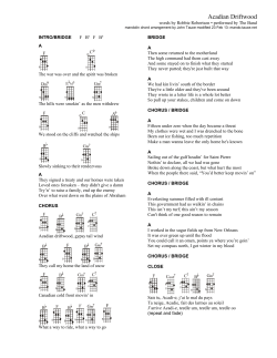


© Copyright 2026