
Full Text - Philosophical Transactions of the Royal Society B
Downloaded from http://rstb.royalsocietypublishing.org/ on January 21, 2015
rstb.royalsocietypublishing.org
Research
Cite this article: Pollock LJ, Rosauer DF,
Thornhill AH, Kujala H, Crisp MD, Miller JT,
McCarthy MA. 2015 Phylogenetic diversity
meets conservation policy: small areas are key
to preserving eucalypt lineages. Phil.
Trans. R. Soc. B 370: 20140007.
http://dx.doi.org/10.1098/rstb.2014.0007
One contribution of 17 to a discussion meeting
issue ‘Phylogeny, extinction and conservation’.
Subject Areas:
environmental science, taxonomy and
systematics
Keywords:
Australia, Eucalyptus, phylogenetic diversity,
reserve selection, species distribution
modelling, spatial prioritization
Author for correspondence:
Laura J. Pollock
e-mail: [email protected]
Electronic supplementary material is available
at http://dx.doi.org/10.1098/rstb.2014.0007 or
via http://rstb.royalsocietypublishing.org.
Phylogenetic diversity meets conservation
policy: small areas are key to preserving
eucalypt lineages
Laura J. Pollock1, Dan F. Rosauer2, Andrew H. Thornhill3,4, Heini Kujala1,
Michael D. Crisp2, Joseph T. Miller4 and Michael A. McCarthy1
1
School of Botany, The University of Melbourne, Parkville, Victoria, Australia
Research School of Biology, Australian National University, Canberra, Australian Capital Territory, Australia
3
Australian Tropical Herbarium, James Cook University, Cairns, Queensland, Australia
4
Australian National Herbarium, CSIRO, Plant Industry, Canberra, Australian Capital Territory, Australia
2
Evolutionary and genetic knowledge is increasingly being valued in conservation theory, but is rarely considered in conservation planning and policy. Here,
we integrate phylogenetic diversity (PD) with spatial reserve prioritization to
evaluate how well the existing reserve system in Victoria, Australia captures
the evolutionary lineages of eucalypts, which dominate forest canopies
across the state. Forty-three per cent of remaining native woody vegetation
in Victoria is located in protected areas (mostly national parks) representing
48% of the extant PD found in the state. A modest expansion in protected
areas of 5% (less than 1% of the state area) would increase protected PD by
33% over current levels. In a recent policy change, portions of the national
parks were opened for development. These tourism development zones
hold over half the PD found in national parks with some species and clades
falling entirely outside of protected zones within the national parks. This
approach of using PD in spatial prioritization could be extended to any
clade or area that has spatial and phylogenetic data. Our results demonstrate
the relevance of PD to regional conservation policy by highlighting that small
but strategically located areas disproportionally impact the preservation of
evolutionary lineages.
1. Introduction
The value of including evolutionary information in conservation has been well
established, but evolutionary diversity is rarely considered in policy and management [1,2]. Using ancestral relationships when selecting species for conservation
was suggested more than 20 years ago [3–5]. The essence of the argument is that
species should be valued based on their contribution to the tree of life. The evolutionary contribution of taxa is most commonly measured by phylogenetic
diversity (PD) or the length of the shared pathway on a phylogeny represented
by a set of taxa [5]. A large body of literature has since developed around several
PD related subtopics, and the use of PD has reached fields as diverse as community
ecology [6] and bioprospecting [7]. The uptake of PD into applied conservation has
lagged behind the literature, but PD-type metrics are now being used to rank global
species with the evolutionarily distinct globally endangered (EDGE) list [8] and
assigning regional conservation priorities for species [9] and areas [10].
One of the arguments for why PD is not more fully integrated in conservation is that PD is not always a surrogate for other conservation values [1], but
conserving PD is a goal in itself if we value biodiversity in conservation [11].
There are many additional benefits of retaining the widest possible portion of
the tree of life. Conservation scenarios with PD effectively select medically
and economically important plants in the Cape of South Africa [12]. The bioactive compounds in current use are so diverse that it would be difficult to
& 2015 The Authors. Published by the Royal Society under the terms of the Creative Commons Attribution
License http://creativecommons.org/licenses/by/4.0/, which permits unrestricted use, provided the original
author and source are credited.
Downloaded from http://rstb.royalsocietypublishing.org/ on January 21, 2015
2. Conservation applications with phylogenies
Perhaps the largest example to date of integrating phylogenies
in species conservation is the EDGE list, which prioritizes
species for conservation by combining evolutionary distinctiveness (ED) with global endangerment (GE) [8]. ED measures the
contribution of each species to the tree of life [8], so is useful for
ranking species for conservation such as in setting priorities for
which species should be collected and stored in seed banks [28].
However, the actual geographical distributions of species and
their co-occurrence are crucial to conservation decisions. Furthermore, priorities change as species or areas become
protected or threatened, so complementary-PD measures are
a more efficient way of summarizing marginal gains and
losses in conservation than scoring approaches [29].
There have been many approaches to combining PD and
complementarity to select areas for conservation such as
(a) Delineating and modelling species distributions
Any type of distribution data associated with the tips of a
phylogeny can be used in this method. In our example, each
tip of the phylogeny represents one species, and each species
contains distribution information from SDMs or outlined
distributions. If SDMs are used, then predicted probabilities of
occurrence (from data with known presences and absences)
can be used directly in the analyses rather than using a threshold
to transform probabilities to binary presence/absence. If predictions are from presence-only data (e.g. herbarium records), then
the output should be scaled based on prevalence if suitable
prevalence data exist [39]. Many eucalypts have narrow
ranges that are overestimated with standard SDMs. Our goal
was to develop conservative estimates of species distributions (i.e. underestimating unknown populations in favour of
2
Phil. Trans. R. Soc. B 370: 20140007
DIVERSITY-PD software [30], greedy algorithms [31] and integer
linear programming [32]. Many of these methods are limited to
few species or few planning units and do not consider effects
across the range of a species (but see Billionnet [33] for a solution that includes dependency in survival probabilities).
More recent work has illustrated how phylogenies can be
used in a comprehensive planning framework. Strecker [10]
used nodes on the phylogeny as conservation units in a spatial
prioritization for fishes in the Lower Colorado River Basin in
the southwest United States using ZONATION software [34].
Here, we aim to enable wider use of PD in conservation by
providing a method that links phylogenies, species distribution
models (SDMs) and spatial prioritization software. This
method could be used for any group of organisms with a phylogeny and distribution data and is especially suited to species
that have modelled distributions. Given the recent proliferation of SDMs in the literature and their great potential for use
in conservation and management more generally [35], we
hope this work will encourage uptake of SDMs for the specific
problem of conserving evolutionary diversity. We assign conservation priority with ZONATION software, which has the
advantage of being a widely used program that can accommodate the complexity of typical conservation problems by
including critical factors such as the cost of conservation,
species risk status and connectivity between populations
across multiple species and large landscapes [36].
We illustrate how this method can be used to quantify current conservation status of evolutionary diversity and to
evaluate changes made to a regional conservation policy using
a case study of 101 species of eucalypts (Corymbia Hill and
Johnson, Angophora Cav. and Eucalyptus L’He´rit, Myrtaceae)
in Victoria, Australia. Eucalypts dominate the canopy in nearly
every woody vegetation type in Victoria—from shrubs less
than 2 m tall to wet forests of Eucalyptus regnans, the tallest flowering plant. Victoria has many diverse bioregions [37], but is
also the most cleared state in Australia with rates of habitat
deterioration continuing to exceed protection and restoration.
Eucalypts in Victoria are an excellent case study not only for
their ecosystem dominance but also because suitable genetic
data are available, and Victoria has exceptional state-level
environmental and plant survey data [38].
We address three regional conservation questions:
(i) how much PD is represented in the current protected
areas? (ii) how much PD can we gain by expanding the protected areas? and (iii) how might a new tourism development
policy in national parks impact protection of eucalypt lineages?
rstb.royalsocietypublishing.org
pinpoint which types will be important in the future [13].
For example, in eucalypts, a diversity of potentially useful chemistry exists beyond the small subset of species and compounds
currently used in products ranging from cough suppressants
to insecticides [14]. Even in this relatively well-studied and
commercially important plant group, new classes of chemicals
with potential for therapeutics, including cancer treatment, are
actively being discovered [15]. Given less than 15% of plant
species have been screened for bioactivity [16], many useful
but unknown compounds probably exist. Preserving PD
increases our ‘option values’ [17]—the likelihood that a species
is potentially useful in the future does not go extinct [18].
Conservation funds are often disproportionately allocated
to a few charismatic animal groups [19]. Using any diversity
measure would distribute funds across more species, but conservation of PD specifically aims to spread funds more evenly
across the tree of life [20]. For example, priorities based on PD
differ from priorities based on the species conservation when
species richness and PD hotspots do not have spatial overlap
[12,21,22]. This difference is more pronounced if phylogenies
have deep radiation events [23].
The use of well-resolved phylogenies in conservation helps
minimize taxonomic bias resulting from changing species concepts or geographical differences in naming philosophy or
taxonomic effort [24,25]. For example, the same range of morphologic and genetic variation may be known from five species
in a well-studied region or a single species in less-studied
region. Yet, the area with five species would be much more
favoured in a species-based prioritization than prioritization
with PD.
The cost–benefit calculation of using PD for conservation is
changing given the rapid expansion of spatial and phylogenetic
data such as Australia’s Virtual Herbarium, and the arrival of
global databases such as Timetree (www.timetree.org), the
Open Tree of Life (opentreeoflife.org) and the Map of Life
(www.mappinglife.org). GIS tools and specialty programs
such as BIODIVERSE [26] help to visualize patterns of diversity
across the landscape. Also, the advent of high throughput
next generation sequencing techniques has reduced the cost
and time in generating large species-level phylogenies [27].
The tools necessary for using PD in conservation are available
or becoming available, but a simple framework for integrating
PD into a spatial prioritization and a demonstration of how PD
might be useful for policy is needed.
Downloaded from http://rstb.royalsocietypublishing.org/ on January 21, 2015
We assembled a sequence matrix of 96 species plus outgroup
taxa based on four markers, two nuclear ITS, ETS, and two
nuclear matK and the psbA-trnH intergenic spacer. Sequences
(c) Linking species distribution models to the
phylogeny
Each cell in a grid has a modelled probability of occurrence
(from SDMs) for each species (figure 1a). Each species is a
terminal branch of the phylogeny. We calculated the probability of occurrence for each internal branch in each cell.
An internal branch occurs if any of the descendent species
occur in that cell. Thus,
Ym
Bi,j ¼ 1 n1 (1 Pn,j ),
(2:1)
where Bi,j is the probability of an internal branch (i) occurring
in cell j, m is the number of descendent species downstream
of this internal branch and Pn,j is the probability of descendent species n occurring in cell j.
Probabilities of occurrences for branch lengths were calculated in R [48]. Owing to the large size of the raster files
(millions of pixels), calculation of probability layers for
internal branches was performed directly in raster format
using a combination of customized functions and functions
available within the ‘raster’ package [43]. Attributes of the
phylogeny were extracted using functions from the ‘ape’
package [49].
(d) Spatial prioritization
We used ZONATION v. 4.0 for the spatial prioritization.
ZONATION produces a conservation priority of sites (or grid
cells) in a given landscape based on representation of biodiversity features (e.g. species or, as in this case, branches),
feature weights and the cost of protecting a site. It starts by
assuming that everything in the landscape is protected and
then iteratively removes grid cells with the least conservation
benefit (i.e. the least marginal loss) [36].
At each step, the remaining proportion of the distribution
of each feature is calculated to determine which cell is the
least valuable based on principles of complementarity and
irreplaceability, and hence will be removed next (figure 1b).
Each time ZONATION recalculates the proportion of the distribution of each branch remaining, it uses the probabilities in
each cell that were previously calculated according to
equation (2.1). This means that even though branches are
independent units, the branches remain mathematically
linked in the phylogenetic hierarchy at each step. We used
both the basic Core Area Zonation (CAZ), which removes
cells based on the maximum value in a cell for any given feature, and the Additive Benefit Function (ABF), which sums
3
Phil. Trans. R. Soc. B 370: 20140007
(b) Phylogeny
were sourced from the alignment prepared for a larger eucalypt phylogeny [44]. A Bayesian analysis was performed
using MRBAYES v. 3.2 compiled on the CSIRO Burnett supercomputer cluster. The Monte Carlo Markov chain was run for
40 106 generations and convergence was achieved with a
final split frequency value of 0.041825. The final tree was
exported as a nexus file. Five species with missing molecular
data were inserted into the nexus phylogeny file at the stem
node shared with assumed most closely related species as
in Rosauer et al. [45] with a branch length of zero (see the electronic supplementary material, appendix S1). The Victorian
eucalypt phylogeny is shown in electronic supplementary
material, appendix S3. Relationships between major groups
(genera and subgenera) are in agreement with existing
eucalypt phylogenies [46,47].
rstb.royalsocietypublishing.org
more accurately identifying populations that are known to
be present).
We used a range of modelling methods depending on the
extent and prevalence of each species (see the electronic
supplementary material, appendix S1 for a species list, distribution type and cross-validated area under the receiver
operating characteristic curve (AUC) values). Our decision on
the type of model was based on a trade-off between having
more reliable probabilities of occurrence (which are important
in this case because they are propagated through the phylogeny)
and missing known populations (by using the smaller, presence–
absence dataset that allows probabilities to be determined).
Common species were modelled using boosted regression trees
(BRTs) [40] with a quadrats dataset from Victoria’s Biodiversity
Atlas (VBA) accessed October 2013. For range-restricted
species, we added the additional records from VBA and the
Australia’s Virtual Herbarium (AVH) and used MAXENT [41]
for modelling. For the AVH dataset, we removed any records
outside of the species natural populations and retained only
post-1950 records, because the older records had high spatial
uncertainty. However, we may have missed some locations
where the species no longer occurs by eliminating these records.
Both datasets were clipped to the state of Victoria with a 100 km
buffer to limit edge-effects. The final number of unique
species site combinations was 9137 AVH records and 89 454
VBA records. Numbers of records per species ranged from
five to over 7000 in the case of wide-ranging Eucalyptus obliqua.
For MAXENT models, we masked out areas beyond the
known extent of each species, set a background of the locations of all records of all species and filtered records to
exclude duplicate species locations within 100 m for species
with fewer than 200 records and 5 km for species with more
than 200 records. We used only hinge features, because they
provide smoother response curves, and scaled the output to
match prevalence calculated from the VBA quadrats dataset
[42]. Ten per cent of data was withheld for model testing and
the final models were run on the full datasets. The average
10-fold cross-validated AUC value for withheld data across
species was 0.96 (ranging from 0.85 to 0.99) for BRTs and
0.98 (from 0.97 to 1.0) for MAXENT models. All modelling was
done in the R package ‘dismo’ v. 0.8-17 [43] using a set of
climatic and edaphic variables described in the electronic
supplementary material, appendix S2. Distributions were predicted to 225 m grid cells across the state plus buffer zone
including areas that are not currently native woody vegetation.
This provided an estimate of how much of the distribution of
each species may have been lost owing to past clearing. Modelled distributions are based on relatively recent point data,
so the amount of distributions lost is probably underestimated,
but nonetheless provides important information about species
threat. For additional details on distribution modelling, see the
electronic supplementary material, appendix S2.
Distributions of three species that were isolated to a few
populations (under 70 records) were delineated in ARCMAP
v. 10.2 based on species descriptions and expert knowledge.
Polygons were assigned probabilities based on expert opinion
and/or species descriptions.
Downloaded from http://rstb.royalsocietypublishing.org/ on January 21, 2015
(b)
a
b
c
h
g
0.40
0.10
d
0.61
0.40
0.77
i
0.80
0.20
f
0.84
0.8
0.6
0.4
0.2
0
0
0.8
0.2
0.4
0.6
proportion of landscape removed
1.0
Figure 1. Each branch on the phylogeny is considered a conservation ‘unit’ in the spatial prioritization and has an associated raster grid with a probability of
occurrence in each cell (illustrated in lower right cell in a). Rasters for tip branches (i.e. species) are estimated with SDMs and rasters for internal branches
(dotted lines) are calculated according to equation (2.1). (b) During the prioritization process, as cells are removed from the landscape, the proportion of the
original distribution of each branch that is still remaining is recorded (grey solid lines, black dashed line shows the average across all branches). See text for further
details on the prioritization process.
values in cells [34]. The ABF approach represents total PD
slightly better, but, as in other cases, the distribution of individual biodiversity features ( phylogenetic branches in this
case) were preserved better with CAZ than with ABF [36],
so we present the results of CAZ here.
The performance of a ZONATION solution is typically
measured by how original distributions of features are
retained by sites that correspond to a specific fraction of the
entire landscape, e.g. the best 10% of total area [36]. Here,
instead of individual branches, we are evaluating spatial
prioritizations based on how well they represent total PD.
Therefore, we calculated the proportion of PD remaining in
the landscape at each step in the cell removal according to
1
proportion PD remaining ¼ Pk
i¼1 Li
k
X
i¼1
"
Pq
j¼1
Li PQ
Bi:j
j¼1 Bi:j
!#
,
(2:2)
where k is branches on the phylogeny, q is the remaining cells of
native woody vegetation on the landscape, Q is the initial
number of cells (all cells present), Bi,j is the probability of occurrence of branch i in cell j and L is the length of branch i. With all
currently existing native woody vegetation represented as cells
on the landscape, the entirety of each branch is represented and
PD is the sum of all branch lengths as in Faith [5]. As grid cells
are removed, loss of branches is represented by the proportion
of the spatial distribution of each branch remaining weighted
by branch length.
We ran ZONATION for various scenarios (table 1) using mask
files which alter the cell removal order to either force in or force
out areas from the top priorities, such as existing protected
areas or proposed development areas. The impact of existing
and proposed land use types can then be quantified by comparing the results of an altered solution to an unconstrained
optimal solution [50]. We use the proportion of PD remaining
(equation (2.2)) to evaluate scenarios of reserve expansion and
contraction. We ran the different prioritization scenarios at
the resolution of the modelled distributions (225 m resolution,
4 481 600 cells) across the state of Victoria with the warp factor
(number of cells removed at a time) set at 100 and without
considering connectivity. Portions of the ranges of species
and clades that have already been lost to clearing was considered by first ranking the cleared areas (some of which
have modelled species ranges), then ranking all areas that are
currently native woody vegetation (table 1). Including cleared
land in the prioritization integrates the proportion of the spatial
distribution of species that have already been cleared.
3. Ranking the landscape for phylogenetic
diversity
The most valuable areas for conservation of PD are distributed
throughout the state. Notable regions include the mallee eucalypts in Murray-Sunset National Park in the northwest, the
Grampians National Park in the west, the heavily degraded
box-ironbark forests in central Victoria and the East Gippsland
region in the eastern part of the state (figure 2). This map shows
the relative conservation importance of areas across Victoria for
PD, ignoring any existing land tenure. In order to identify next
conservation priorities in a cost-effective manner, one needs to
take into account that some species are already protected by
existing reserve network. For example, the northwest part
of the state is an important resource for PD, but nearly all of
the remaining native vegetation is already protected within
Murray-Sunset National Park.
4. How well is phylogenetic diversity
represented in national parks?
Widespread clearing has left less than 40% of Victoria with
native woody vegetation. Of that remaining vegetation, 43%
is protected in nature reserves, most of which are national
parks. The current configuration of conservation reserves is
not optimal—only 48% of the total PD is currently located
Phil. Trans. R. Soc. B 370: 20140007
e
4
1.0
rstb.royalsocietypublishing.org
0.30
prop. distribution branches remaining
(a)
Downloaded from http://rstb.royalsocietypublishing.org/ on January 21, 2015
Table 1. List and description of ZONATION runs. (The optimal prioritization can be altered using mask files, which tell the program that some areas have
predefined hierarchy, and removes categories of grid cells in specified order.)
mask files
description
optimal solution
optimal solution for
none
0—not native woody vegetation
prioritize all of Victoria
prioritize remaining native woody vegetation in Victoria
remaining native woody
vegetation
evaluate conservation reserves
1—native woody vegetation
0—not native woody vegetation
how much PD is already protected and how much remains outside
the current extent of the reserve systems
2—native woody vegetation inside
current conservation areas
scenario 1: expand
conservation reserves
0—not native woody vegetation
1—native woody vegetation outside
compare amount of PD protected in reserves with that protected if
the area of conservation reserves was increased by 5 or 20%
current conservation areas
2—native woody vegetation inside
current conservation areas
scenario 2: tourism
development in
national parks
0—outside native woody vegetation
1—native woody vegetation outside
document the distribution of PD within national parks available for
tourism and map vulnerable areas
national parks
2—native woody vegetation in
national parks and open for
development
3—native woody vegetation in
national parks and protected from
development
in protected areas compared with 74% protected if reserves
were located optimally following the prioritization in figure 2
(dashed and solid lines in figure 3a).
If the protected areas were to be expanded in a cost-efficient manner by 5% (less than 1% of the area of the state),
an additional 33% of PD could be protected (totalling 64%
of the PD remaining today as native woody vegetation; red
in figure 3a). The hypothetical protected area expansion is
concentrated in central Victoria (figure 3b) and the South
East Corner Bioregion (electronic supplementary material,
figure S4), but there are many smaller locations throughout
the state. Various other sizes and configurations of reserve
expansions could be considered. In a less realistic scenario,
we could increase the protected PD of eucalypts by 50%
with a 21% expansion of protected areas (figure 3b).
5. Evaluating a policy change to the protected
area system
National parks are an important repository of eucalypt PD but
many areas within national parks are not fully protected
because they are now available for tourism development. In
2013, portions of the national park system in Victoria were
made available for tourism development under the ‘Tourism
Investment Opportunities of Significance’. Development must
be sensitive to the park values, environmentally sustainable
and must be a net public benefit, which includes increasing
public access to park resources [51].
We refer to areas within national parks as ‘protected zones’
and ‘development zones’ depending on whether they are open
for tourism development or not. National parks contain 42% of
the PD of native woody vegetation, over half of which is found
in development zones (figure 4). If the development zones
were re-distributed to avoid as much eucalypt PD as possible,
nearly twice as much PD could be represented in the protected
zones (33% of the PD rather than the current 18%; figure 4a).
Transferring even 10% of the area of development zones
to protected zones would increase the amount of PD that is
fully protected to 31% (figure 4a). Many of these valuable
PD resources within development zones (red in figure 4b)
are located in parks that are easily accessible from the metropolitan city of Melbourne and are, therefore, potentially at
high risk of being developed for tourism. Extending the
protection zone to the areas in red would help ensure that
important evolutionary diversity is fully protected.
We can also visualize which branches on the phylogeny
may be vulnerable to tourism development (figure 5).
For this we consider the entire spatial distribution of each
branch, including the portions of the distribution that have
already been cleared. We calculate the proportion of the distribution of each branch that is located outside national parks
and on protected and development zones in national parks.
Potentially affected species are clustered on the phylogeny
Phil. Trans. R. Soc. B 370: 20140007
1—native woody vegetation outside
current conservation areas
prioritize areas inside and outside conservation reserves to determine
rstb.royalsocietypublishing.org
run
5
Downloaded from http://rstb.royalsocietypublishing.org/ on January 21, 2015
6
rstb.royalsocietypublishing.org
priorities for native woody veg.
not native woody veg.
Phil. Trans. R. Soc. B 370: 20140007
bottom 50%
50–75%
75–90%
90–95%
top 5%
N
0 25 50
100 150 200
km
Figure 2. Priority ranking for all native woody vegetation in Victoria (inset), Australia. Ranks are the conservation benefit based on the PD of eucalypts not considering land tenure.
(b)
1.0
expand protected areas
not native woody veg.
unprotected woody veg.
expand protected areas 20%
expand protected areas 5%
protected areas
0.8
0.6
box-ironbark forests
0.4
0.2
unprotected
expand PAs
proportion PD remaining
(a)
protected
0
0
0.6
0.8
1.0
0.2
0.4
proportion of native woody veg. removed
Melbourne
0 10 20
40
60
80
km
Figure 3. Hypothetical protected area expansion for Victoria as PD-loss curves (a) and a map showing these priority areas for a subset of the state (b). Loss of PD is
represented as the proportion of PD lost as cells of native woody vegetation are removed. Colours represent the protection status of native woody vegetation ( pink,
unprotected; green, protected; red, expand protected areas by 5%; and blue, expand by 20%). (a) The dashed black line is the amount of PD that could be retained
if all areas of native woody vegetation were available for protection. The solid black line is the amount of PD captured by the actual layout of protected areas (and
also shows how much PD could be added with protected area expansion). The y-axis difference between the dashed and solid lines is the difference between the
actual amount of PD that is protected and the amount that could be protected by a given proportion of land if protected areas were expanded efficiently. Red blocks
are the amount of PD (horizontal block) and land area (vertical block) that could be included in protected areas if they were expanded by 5% of their existing land
area. See the electronic supplementary material, appendix S4 for a statewide map.
with subgenera Symphyomyrtus being particularly vulnerable
(figure 5). The distributions of 20 species fall below 1% of
their original distribution meaning that the last protected
portion of their distribution is in the tourism development
zone. The last remaining 1% of the entire red gum clade
(including river red gum, Eucalyptus camaldulensis) is located
Downloaded from http://rstb.royalsocietypublishing.org/ on January 21, 2015
top 10% dev. zone
protected zone
0.6
national parks scenario
outside national park
Kamaroka state park
national park — tourism development
national park — top 10% tourism development
Greater Bendigo national park
national park — protected
0.4
outside national park
Grampians national park
national park
0
0
0.2
0.4
0.6
0.8
proportion of native woody
veg. removed
Melbourne
1.0
0 12.5 25
50
75
100
km
N
Figure 4. Tourism development in national parks as PD-loss curves (a) and map (b). (a) The dashed line is the optimal solution for all woody native vegetation (as
in figure 3a). The thin black line represents PD retained in the optimal configuration of protected zones within national parks. The thick black line is the PD retained
when national park tourism development zones ( pink/red blocks) are prioritized first, followed by protected zones in national parks (green block). The top 10% of
tourism development zones ranked by PD contribution are shown as red on the graph (a) and the map (b). These development zones could be transferred to
protected zones to capture 72% more PD than currently is found in protected zones. The map shows one region north and west of the major metropolitan
area, Melbourne, which contains many valuable national park lands open for tourism development (see the electronic supplementary material figure S5 for
the statewide map).
tourism development scenario
>5% distribution in protected zone
Bisectae
last 1–5% in development zone
Dumaria
Bisectae
last <1% in development zone
Adnataria
outside national parks
tus
yr
m
o
hy
mp
y
S
us
en
g
b
su
Exsertaria
red gums
Maidenaria
E. splendens
su
bg
en
ge
us
Eu
E. cinerea
E. cadens
E. yarraensis
E. ovata
ca
ne
ra
Co
lyp
tus
ry
mb
ia/
E. diversifolia
E. verrucata
An
go
ph
or
a
C. maculata
Figure 5. Parts of the phylogeny vulnerable from tourism development in
national parks. Four species are found entirely outside of national parks
(black branches). Grey bars indicate when greater than 5% of the original
spatial distribution of a branch is found on protected zones within national
parks. Branches that are pink and red have 1 – 5% or less than 1% of their
respective distributions in protected zones within national parks.
in tourism development areas. Many red gums, such as
E. camaldulensis are widespread and, therefore, might not be
impacted by any actions in national parks. However, it is
notable that the entire clade is under-represented with all
branches having less than 1% of their distributions found in
protected zones within national parks (figure 5). Some other
species are located almost exclusively in tourism development
zones. For example, nearly the entire range of Serra Range
gum (Eucalyptus verrucata) is located in a tourism development
zone. Many more species and the entire Adnataria clade fall
below 5% remaining in protected zones (figure 5)
It is important to note that the tourism development zones
will not be fully developed, and therefore, not all of the PD
located in these zones will be threatened or lost. However, one
of the requirements of any development is that it has to be a
net public benefit, and increasing visitor access is considered a
benefit [51], so impact could potentially extend beyond the
actual development. This analysis has shown that some areas
within development zones are particularly important pools of
PD. Development zones contain a number of species and one
entire clade that are unrepresented in national parks or underrepresented in the protected zones within them. Less than 20%
of the PD remaining as native vegetation is located on protected
zones within national parks. Small but strategically located
expansion of protected zones within national parks could
increase protection of species and lineages.
6. Other considerations when using phylogenetic
diversity in spatial prioritization
Phylogenies are hypotheses with uncertainty arising from many
sources including the underlying model of evolution, which
may affect conservation predictions based on them [25]. Eucalypts are a particularly challenging taxonomic group, which
sometimes do not fully confirm to a bifurcating tree in cases of
hybridization and introgression [52,53] and parallel evolution
[54]. Fine-scale phylogenetic relationships will be increasingly
understood as new molecular technologies emerge [46,55].
In spatial prioritization with ZONATION, spatial uncertainty can
Phil. Trans. R. Soc. B 370: 20140007
0.2
rstb.royalsocietypublishing.org
0.8
proportion PD remaining
7
(b)
1.0
development zone
(a)
Downloaded from http://rstb.royalsocietypublishing.org/ on January 21, 2015
Our analysis suggests that the protected zones within national
parks could be modestly extended to include the most valuable
10% of the tourism development zones for eucalypt diversity in
Victoria. The expansion of the protected zones would reduce
chances that species or even clades are negatively impacted.
Given that eucalypts provide the forest habitat for many
species, areas important for eucalypt diversity may also contain high diversity for other organisms, but similar analyses
could be done for other groups to determine additional diverse
and threatened locations.
Given the multitude of concerns facing policy-makers and
managers, finding overlap between areas that contain valuable
8. Conclusion
Real-world conservation efforts that consider PD are lagging
behind interest from the scientific community. Here, we
attempted to facilitate the use of PD in conservation by providing user-friendly methods and demonstrating how PD can be
relevant for conservation decisions. This method links two
rapidly expanding data sources—phylogenies and SDMs—
with widely used spatial prioritization software. PD can be
used in hypothetical or actual protected area scenarios for any
study group that has a phylogeny and distribution data. For
eucalypt trees in Victoria, a small 5% expansion to protected
areas (less than 1% of the state), could capture 33% more PD.
Following a recent policy change opening national parks to
development, only 11% of PD is fully protected in Victoria,
with some clades particularly vulnerable. However, small
changes to development zones could greatly improve the outlook for species and lineages. This framework enables PD to
be included with other economic, ecological or sociological
factors that are needed in complex real-world planning.
Acknowledgements. Thanks to Matt White and David Cantrill for providing spatial data, Jane Elith for advice on species distribution models
and Michael Bayly for advice on the phylogeny. Thanks to Simon
Linke and David Nipperess for discussions about methods.
Funding statement. This research was supported by the Environmental
Decisions Hub of the National Environmental Research Program
and a grant from the Bjarne K. Dahl Trust.
References
1.
2.
Winter M, Devictor V, Schweiger O. 2013
Phylogenetic diversity and nature conservation:
where are we? Trends Ecol. Evol. 28, 199–204.
(doi:10.1016/j.tree.2012.10.015)
Mace GM, Purvis A. 2008 Evolutionary biology and
practical conservation: bridging a widening gap.
Mol. Ecol. 17, 9–19. (doi:10.1111/j.1365-294X.
2007.03455.x)
3.
4.
5.
May RM. 1990 Taxonomy as destiny. Nature
347, 129 –130. (doi:10.1038/347129a0)
Vane-Wright RI, Humphries CJ, Williams PH.
1991 What to protect: systematics and the agony of
choice. Biol. Conserv. 55, 235 –254. (doi:10.1016/
0006-3207(91)90030-D)
Faith DP. 1992 Conservation evaluation
and phylogenetic diversity. Biol. Conserv.
6.
7.
61, 1 –10. (doi:10.1016/0006-3207(92)
91201-3)
Webb CO, Ackerly DD, McPeek MA, Donoghue MJ.
2002 Phylogenies and community ecology. Annu.
Rev. Ecol. Syst. 33, 475–505. (doi:10.1146/annurev.
ecolsys.33.010802.150448)
Pacharawongsakda E, Yokwai S, Ingsriswang S. 2009
Potential natural product discovery from microbes
8
Phil. Trans. R. Soc. B 370: 20140007
7. Policy recommendations and conservation
applications
evolutionary diversity and areas important for other concerns
may increase the likelihood of PD being considered. The boxironbark forests in central Victoria (Victorian Midlands IBRA
Bioregion and Goldfields Sub-bioregion) are one good example
of a region designated high priority in our analyses and other
conservation rankings, such as Trust for Nature spatial prioritization [58]. In our analysis, parts of the box-ironbark region
were ranked highly across all native vegetation, were included
in reserve expansion scenarios, and were in the highest 10% of
the national parks areas open for tourism development. Edgeeffects would have a minimal influence as the box-ironbark
region is centrally located. The box-ironbark region is heavily
degraded from the 1850s gold rush, logging, agriculture, development and aridification from climate change [59]. Eucalypts
provide critical habitat for numerous organisms, especially
nectar-eating birds which depend on year-round flowering
by different eucalypts [60]. The box-ironbarks should be
reinforced as a high priority because, in addition to having
many threatened species, they also are an important resource
for preserving eucalypt evolutionary history.
rstb.royalsocietypublishing.org
be directly incorporated into the prioritization [56]. However,
much of the phylogenetic uncertainly involves the tree topology,
and changing the topology changes the conservation features.
One way to account for phylogenetic uncertainty is to run the
prioritization multiple times with different estimates of the
phylogeny to obtain a distribution around estimates. A similar
type of uncertainty analysis could be done in ZONATION, but is
beyond the scope of this paper.
Another consideration for any spatial prioritization is the
effect of bounding the study area, because priorities tend to be
inflated near boundaries that bisect species distributions [57].
Further research is needed to understand boundary effects for
PD specifically. Boundaries might be an issue for PD even if
all species are found entirely within the study area, because
the range of internal branches might be underestimated if related
species occur elsewhere. In this case, we suspect inflated priorities in the east and northwest, where some branches extend into
New South Wales or South Australia. Bounding the study area
at Victoria is justified if the aim of the study is to manage Victoria’s resources, reflecting its separate laws and regulations from
surrounding states, and making use of the state’s independent
datasets. Other options would be to weight endemic branches
higher than branches that extend beyond the study area. For
example, the Corymbia clade, which is rare in Victoria but widespread elsewhere, could be given a lower priority. One of the
benefits of using ZONATION or a similar software is that any
species (or branch) could be weighted for any desirable attribute
such as threat categories or functional attributes. However, if
threat is included, such as International Union of Conservation
of Nature threat status, it is important to keep in mind that
ZONATION considers rarity by the proportion of the distribution of a species remaining, so weighting by threat status may
over-emphasize listed species in the prioritization.
Downloaded from http://rstb.royalsocietypublishing.org/ on January 21, 2015
9.
11.
12.
13.
14.
15.
16.
17.
18.
19.
20.
21.
22.
23.
25.
26.
27.
28.
29.
30.
31.
32.
33.
34.
35.
36.
37.
38.
39.
40.
41.
42.
43.
44.
45.
46.
47.
48.
49.
50.
51.
52.
53.
54.
space and time. Ann. Rev. Ecol. Evol. Syst. 40, 677–
697. (doi:10.1146/annurev.ecolsys.110308.120159)
Elith J, Leathwick JR, Hastie T. 2008 A working
guide to boosted regression trees. J. Anim. Ecol. 77,
802–813. (doi:10.1111/j.1365-2656.2008.01390.x)
Phillips SJ, Anderson RP, Schapire RE. 2006
Maximum entropy modelling of species geographic
distributions. Ecol. Model. 190, 231 –259. (doi:10.
1016/j.ecolmodel.2005.03.026)
Elith J, Phillips SJ, Hastie T, Dudı´k M, Chee YE, Yates
CJ. 2011 A statistical explanation of MAXENT for
ecologists. Divers. Distrib. 17, 43– 57. (doi:10.1111/
j.1472-4642.2010.00725.x)
Hijmans RJ. 2013 Raster: geographic data analysis
and modeling. R package version 2.1 –49. See
http://CRAN.R-project.org/package=raster.
Thornhill AH, Crisp MD, Cook LG, Nelson LA, Yeates
DK, Knerr N, Lam KE, Ku¨lheim C, Miller JT.
In preparation. Lineages through time and biome
mapping: a comparison of Australian Acacia
(Fabaceae) and the eucalypts (Myrtaceae).
Rosauer D, Laffan SW, Crisp MD, Donnellan SC, Cook
LG. 2009 Phylogenetic endemism: a new approach
for identifying geographical concentrations of
evolutionary history. Mol. Ecol. 18, 4061–4072.
(doi:10.1111/j.1365-294X.2009.04311.x)
McKinnon GE, Vaillancourt RE, Steane D, Potts BM.
2008 An AFLP marker approach to lower-level
systematics in Eucalyptus (Myrtaceae). Am. J. Bot.
95, 368 –380. (doi:10.3732/ajb.95.3.368)
Steane D, Nicolle D, McKinnon GE, Vaillancourt RE,
Potts BM. 2002 Higher-level relationships among
the eucalypts are resolved by ITS-sequence data.
Aust. Syst. Bot. 15, 49 –62. (doi:10.1071/SB00039)
R Core Team 2013 R: a language and environment
for statistical computing. Vienna, Austria: R
Foundation for Statistical Computing.
Paradis E, Claude J, Strimmer K. 2004 APE: analyses
of phylogenetics and evolution in R language.
Bioinformatics 20, 289– 290. (doi:10.1093/
bioinformatics/btg412)
Cabeza M, Moilanen A. 2006 Replacement cost: a
practical measure of site value for cost-effective
reserve planning. Biol. Conserv. 132, 336–342.
(doi:10.1016/j.biocon.2006.04.025)
DSE. 2012 Tourism investment opportunities of
significance in national parks: guidelines. Melbourne,
Australia: Department of Sustainability and
Environment.
McKinnon GE, Smith JJ, Potts BM. 2010 Recurrent
nuclear DNA introgression accompanies chloroplast
DNA exchange between two eucalypt species. Mol.
Ecol. 19, 1367–1380. (doi:10.1111/j.1365-294X.
2010.04579.x)
Jackson HD, Steane DA, Potts BM, Vaillancourt RE.
1999 Chloroplast DNA evidence for reticulate
evolution in Eucalyptus (Myrtaceae). Mol. Ecol. 8,
739–751. (doi:10.1046/j.1365-294X.1999.00614.x)
Foster SA, McKinnon GE, Steane DA, Potts BM,
Vaillancourt RE. 2007 Parallel evolution of dwarf
ecotypes in the forest tree Eucalyptus globulus. New
Phytol. 175, 370 –380. (doi:10.1111/j.1469-8137.
2007.02077.x)
9
Phil. Trans. R. Soc. B 370: 20140007
10.
24.
biogeographic histories of present-day richness
gradients for mammals. Phil. Trans. R. Soc. B 366,
2414 –2425. (doi:10.1098/rstb.2011.0058)
Isaac NJB, Mallet J, Mace GM. 2004 Taxonomic
inflation: its influence on macroecology and
conservation. Trends Ecol. Evol. 19, 464–469.
(doi:10.1016/j.tree.2004.06.004)
Diniz-Filho JAF, Loyola RD, Raia P, Mooers AØ. 2013
Darwinian shortfalls in biodiversity conservation.
Trends Ecol. Evol. 28, 689–695. (doi:10.1016/j.tree.
2013.09.003)
Laffan SW, Lubarsky E, Rosauer DF. 2010 BIODIVERSE, a
tool for the spatial analysis of biological and related
diversity. Ecography 33, 643 –647. (doi:10.1111/j.
1600-0587.2010.06237.x)
Lemmon EM, Lemmon AR. 2013 High-throughput
genomic data in systematics and phylogenetics.
Ann. Rev. Ecol. Evol. Syst. 44, 99 –121. (doi:10.
1146/annurev-ecolsys-110512-135822)
Guerrant Jr EO, Havens K, Vitt P. 2014 Sampling for
effective ex situ plant conservation. Int. J. Plant Sci.
175, 11 –20. (doi:10.1086/674131)
Faith DP. 2008 Threatened species and the potential
loss of phylogenetic diversity: conservation scenarios
based on estimated extinction probabilities and
phylogenetic risk analysis. Conserv. Biol. 22,
1461–1470. (doi:10.1111/j.1523-1739.2008.01068.x)
Walker PA, Faith DP. 1994 DIVERSITY-PD: procedures
for conservation evaluation based on phylogenetic
diversity. Biodivers. Lett. 2, 132–139. (doi:10.2307/
2999777)
Steel M. 2005 Phylogenetic diversity and the greedy
algorithm. Syst. Biol. 54, 527 –529. (doi:10.1080/
10635150590947023)
Rodrigues ASL, Gaston KJ. 2002 Maximising
phylogenetic diversity in the selection of networks
of conservation areas. Biol. Conserv. 105, 103–111.
(doi:10.1016/S0006-3207(01)00208-7)
Billionnet A. 2012 Solution of the generalized
Noah’s Ark problem. Syst. Biol. 62, 147–156.
(doi:10.1093/sysbio/sys081)
Moilanen A. 2007 Landscape ZONATION, benefit
functions and target-based planning: unifying
reserve selection strategies. Biol. Conserv. 134,
571 –579. (doi:10.1016/j.biocon.2006.09.008)
Guisan A et al. 2013 Predicting species distributions
for conservation decisions. Ecol. Lett. 16,
1424 –1435. (doi:10.1111/ele.12189)
Moilanen A, Meller L, Leppa¨nen J, Montesino
Pouzols F, Arponen A, Kujala H. 2012 Zonation
spatial conservation planning framework and
software v. 3.1, p. 287.
Thackway R, Cresswell I. 1995 An interim
biogeographic regionalisation for Australia: a
framework for setting priorities in the National
Reserves System Cooperative Program. Canberra,
Australia: Australian Nature Conservation Agency.
Liu C, White M, Newell G, Griffioen P. 2013 Species
distribution modelling for conservation planning in
Victoria, Australia. Ecol. Model. 249, 68 –74.
(doi:10.1016/j.ecolmodel.2012.07.003)
Elith J, Leathwick JR. 2009 Species distribution
models: ecological explanation and prediction across
rstb.royalsocietypublishing.org
8.
through a diversity-guided computational
framework. Appl. Microbiol. Biotechnol. 82,
579–586. (doi:10.1007/s00253-008-1847-x)
Isaac NJB, Turvey S, Collen B, Waterman C, Baillie
JEM. 2007 Mammals on the EDGE: conservation
priorities based on threat and phylogeny. PLoS ONE
2, e43912. (doi:10.1371/journal.pone.0000296)
Bennett JR et al. 2014 Balancing phylogenetic
diversity and species numbers in conservation
prioritization, using a case study of threatened
species in New Zealand. Biol. Conserv. 174, 47– 54.
(doi:10.1016/j.biocon.2014.03.013)
Strecker AL, Olden JD, Whittier JB, Paukert CP. 2011
Defining conservation priorities for freshwater fishes
according to taxonomic, functional, and
phylogenetic diversity. Ecol. Appl. 21, 3002 –3013.
(doi:10.1890/11-0599.1)
Rosauer D, Mooers AØ. 2013 Nurturing the use of
evolutionary diversity in nature conservation. Trends
Ecol. Evol. 28, 322– 323. (doi:10.1016/j.tree.2013.
01.014)
Forest F et al. 2007 Preserving the evolutionary
potential of floras in biodiversity hotspots. Nature
445, 757–760. (doi:10.1038/nature05587)
Beattie AJ, Hay M, Magnusson B, de Nys R,
Smeathers J, Vincent JFV. 2011 Ecology and
bioprospecting. Austral. Ecol. 36, 341 –356. (doi:10.
1111/j.1442-9993.2010.02170.x)
Padovan A, Keszei A, Ku¨lheim C, Foley WJ. 2013 The
evolution of foliar terpene diversity in Myrtaceae.
Phytochem. Rev. 13, 695 –716. (doi:10.1007/
s11101-013-9331-3)
Goodger JQD, Woodrow IE. 2011 a,b-Unsaturated
monoterpene acid glucose esters: structural
diversity, bioactivities and functional roles.
Phytochemistry 72, 2259 –2266. (doi:10.1016/j.
phytochem.2011.08.026)
Saklani A, Kutty SK. 2008 Plant-derived compounds
in clinical trials. Drug Discov. Today 13, 161 –171.
(doi:10.1016/j.drudis.2007.10.010)
McNeely JA. 1988 Economics and biological diversity:
developing and using economic incentives to conserve
biological resources. Gland, Switzerland: IUCN.
Faith DP. 2012 Biodiversity and ecosystem services:
similar but different. Bioscience 62, 785.
Laycock HF, Moran D, Smart JCR, Raffaelli DG, White
PCL. 2011 Evaluating the effectiveness and
efficiency of biodiversity conservation spending.
Ecol. Econ. 70, 1789 –1796. (doi:10.1016/j.ecolecon.
2011.05.002)
Hartmann K, Andre J. 2013 Should evolutionary
history guide conservation? Biodivers. Conserv. 22,
449–458. (doi:10.1007/s10531-012-0422-z)
Mooers AØ, Goring SJ, Turvey ST, Kuhn TS. 2009
Holocene extinctions and the loss of feature
diversity. In Holocene extinctions (ed. S Turvey),
pp. 263 –278. Oxford, UK: Oxford University Press.
Zupan L et al. 2014 Spatial mismatch of
phylogenetic diversity across three vertebrate groups
and protected areas in Europe. Divers. Distrib. 6,
674–685. (doi:10.1111/ddi.12186)
Davies TJ, Buckley LB. 2011 Phylogenetic diversity
as a window into the evolutionary and
Downloaded from http://rstb.royalsocietypublishing.org/ on January 21, 2015
selection. Conserv. Biol. 20, 1688 –1697. (doi:10.
1111/j.1523-1739.2006.00560.x)
57. Moilanen A, Anderson BJ, Arponen A, Pouzols FM,
Thomas CD. 2013 Edge artefacts and lost
performance in national versus continental
conservation priority areas. Divers. Distrib. 19,
171 –183. (doi:10.1111/ddi.12000)
58. Trust for Nature 2013 The statewide conservation plan
for private land in Victoria. Melbourne, Australia: Trust
for Nature.
59. Mac Nally R. 2010 Lessons in woodland
management from northern and central Victoria. In
Temperate woodland conservation and management
(eds DB Lindenmayer, AF Bennett, RJ Hobbs),
pp. 101–114. Collingwood, Australia: CSIRO
Publishing.
60. Keatley MR, Hudson IL, Fletcher TD. 2004
Long-term flowering synchrony of box-ironbark
eucalypts. Aust. J. Bot. 52, 47 –54. (doi:10.1071/
BT03017)
10
rstb.royalsocietypublishing.org
55. Steane DA, Nicolle D, Sansaloni CP, Petroli CD,
Carling J, Kilian A, Myburgg AA, Grattapagliad
D, Vaillancourt RE. 2011 Population genetic
analysis and phylogeny reconstruction in
Eucalyptus (Myrtaceae) using high-throughput,
genome-wide genotyping. Mol. Phylogenet.
Evol. 59, 206 –224. (doi:10.1016/j.ympev.2011.
02.003)
56. Moilanen A, Wintle BA, Elith J, Burgman M. 2006
Uncertainty analysis for regional-scale reserve
Phil. Trans. R. Soc. B 370: 20140007


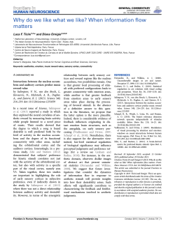

© Copyright 2026