
Agenda reports pack PDF 3 MB - Meetings, agendas, and minutes
Notice of a public meeting of
Planning Committee
To:
Councillors Horton, Galvin (Vice-Chair), Ayre, Boyce,
Burton, Crisp, D'Agorne, Doughty, Firth, King, Looker,
McIlveen, Funnell, Reid (Chair), Simpson-Laing, Watt
and Warters
Date:
Thursday, 22 January 2015
Time:
4.30 pm
Venue:
The Snow Room - Ground Floor, West Offices (G035)
AGENDA
Would Members please note that the mini-bus for the Site Visits will
depart Memorial Gardens at 10am on Tuesday 20th January.
1.
Declarations of Interest
At this point in the meeting, Members are asked to declare:
any personal interests not included on the Register of Interests
any prejudicial interests or
any disclosable pecuniary interests
which they may have in respect of business on this agenda.
2.
Minutes (Pages 3 - 8)
To approve and sign the minutes of the meeting of the Planning
Committee held on 18th December 2014.
3.
Public Participation
It is at this point in the meeting that members of the public who have
registered their wish to speak can do so. The deadline for registering is by
5pm on Wednesday 21st January 2015. Members of the public can
speak on specific planning applications or on other agenda items or
matters within the remit of the committee.
To register please contact the Democracy Officer for the meeting, on the
details at the foot of this agenda.
Filming or Recording Meetings
“Please note this meeting will be filmed and webcast and that includes any
registered public speakers, who have given their permission. This
broadcast can be viewed at http://www.york.gov.uk/webcasts.
Residents are welcome to photograph, film or record Councillors and
Officers at all meetings open to the press and public. This includes the use
of social media reporting, i.e. tweeting. Anyone wishing to film, record or
take photos at any public meeting should contact the Democracy Officer
(whose contact details are at the foot of this agenda) in advance of the
meeting.
The Council’s protocol on Webcasting, Filming & Recording of Meetings
ensures that these practices are carried out in a manner both respectful to
the conduct of the meeting and all those present. It can be viewed at
http://www.york.gov.uk/downloads/download/3130/protocol_for_webcastin
g_filming_and_recording_of_council_meetings
4.
Plans List
This item invites Members to determine the following planning
applications:
a)
B&Q, Osbaldwick Link Road, York, YO10 3JA (14/00924/FULM)
(Pages 9 - 58)
A major full application for the use of a premises as a retail food store with
external alterations including the reconfiguration of the shop front, canopy,
installation of a new customer cafe and associated toilets, the installation
of ATM`s, the removal of an existing garden centre and builders yard and
the reconfiguration of site access and customer car park. [Osbaldwick
Ward] [Site Visit]
b)
Former Del Monte, Skelton Park Trading Estate, Shipton Road,
Skelton, York (14/01478/OUTM) (Pages 59 - 92)
A major outline application for a residential development of up to 60
dwellings. [Skelton, Rawcliffe & Clifton Without Ward] [Site Visit]
c)
1-9 St Leonards Place, York, YO1 7ET (14/02091/FULM) (Pages 93 126)
A major full application for a residential development including the
conversion of existing buildings, construction and demolition to form 29
apartments, 5 town houses and 6 mews houses including 2-4 Museum
Street. [Guildhall Ward] [Site Visit].
d)
Listed Building Consent - 1-9 St Leonards Place & 2-4 Museum
Street, York (14/02104/LBC) (Pages 127 - 142)
A Listed Building Consent application for Internal and external alterations,
including the conversion of existing buildings, construction and demolition
to form 29 apartments, 5 town houses and 6 mews houses including 2-4
Museum Street. [Guildhall Ward] [Site Visit]
e)
Hagg Lane & Common Road, Dunnington, York (14/02284/FUL)
(Pages 143 - 156)
A full application for the construction of a gravel surfaced car park and
retrospective change of use of the land to 2 playing pitches with siting of a
portable changing room buildings. [Derwent Ward] [Site Visit].
5.
Any other business which the Chair considers urgent under the
Local Government Act 1972.
Democracy Officer:
Name: Laura Bootland
Contact Details:
Telephone – (01904) 552062
E-mail – [email protected]
For more information about any of the following please contact the
Democracy Officer responsible for servicing this meeting:
Registering to speak
Business of the meeting
Any special arrangements
Copies of reports
Contact details are set out above.
Page 1
Agenda Annex
PLANNING COMMITTEE
SITE VISITS
Tuesday 20th January 2015.
TIME
SITE
ITEM
10:00
Coach leaves Memorial Gardens
10:15
Former Del Monte Site, Skelton.
4b
10:55
Playing Fields, Hagg Lane & Common Road,
Dunnington.
4e
11:20
B & Q Site, Hull Road (meet outside the main
entrance).
4a
12:00
1-9 St. Leonards Place, York.
4c&4d
1
This page is intentionally left blank
Page 3
City of York Council
Agenda Item 2
Committee Minutes
Meeting
Planning Committee
Date
18 December 2014
Present
Councillors Horton, Galvin (Vice-Chair), Ayre,
Burton, Crisp, D'Agorne, Doughty, Firth,
Gunnell, King, Looker, McIlveen, Reid
(Chair), Simpson-Laing, Watt, Warters and
Cunningham (Substitute)
Apologies
Councillors Boyce and Williams
30.
Site Visits
Reason for Visit
Former Terry’s Site To enable
members to
familiarise
themselves with
the site.
Beechwood,
To enable
Malton Road.
members to
familiarise
themselves with
the site.
31.
Members Attended
Councillors
Reid,Galvin,D’Agorne,
Watt,Burton,McIlveen,
Horton.
Councillors Reid,
Galvin,D’Agorne,Watt,
Burton,McIlveen and
Orrell (as Ward
Member).
Declarations of Interest
At this point in the meeting, Members were asked to declare any
personal, prejudicial or pecuniary interests they may have in the
business on the agenda.
Councillor Gunnell declared a prejudicial interest in agenda item
4a, Former Terry’s Factory Site as Micklegate Ward Member.
She felt that as she had been involved in various meetings and
discussions with the developer she would not be able to
participate in the item and would leave the room.
Page 4
Councillor McIlveen declared a personal interest in agenda item
4a, Former Terrys Factory Site as his role as a Surveyor for the
Northern Power Grid.
32.
Minutes
Resolved:
33.
That the minutes of the last meeting held on
20th November 2014 be approved and signed
by the chair as a correct record.
Public Participation
It was reported that there had been no registrations to speak
under the Council’s Public Participation Scheme.
34.
Plans List
Members then considered two reports of the Assistant Director
(Development Services, Planning and Regeneration) relating to
the following planning applications, which outlined the proposals
and relevant planning considerations and set out the views of
the consultees and officers.
35.
Former Terrys Factory Site, Bishopthorpe Road, York
(14/01716/FULM)
Consideration was given to an application by David Wilson
Homes for the re-development of the remainder of the northern
part of the site for the erection of 240 dwellings comprising of 79
houses and 161 apartments in six blocks with associated
infrastructure.
Officers provided updates to the committee report as follows
(also attached to the online agenda for this meeting):
The Local Authorities Landscape Architect has no
objections to the scheme providing adequate measures
are put in place to secure the root protection area of the
trees to be retained.
Page 5
Paragraph 5.2 of the committee report should read
“statutory duty” instead of “presumption” and Section 72 of
the Act “satisfied” rather than “secured”.
Condition 28 should read “The detailed scheme shall be
approved in writing by the Local Planning Authority and
fully implemented before each building is first occupied”.
The content of condition 30 duplicates the requirements of
condition 23 in respect of a Construction Environmental
Management Plan and therefore condition 30 can be
dispensed with.
Paragraph 5.3 should be amended to read “£36,640 for
sustainable transport contributions”.
Paragraphs 1.1 and 5.1 should be amended to read “229
dwellings with 79 houses and 150 apartments.”
A briefing note regarding the height of the apartment
blocks was also circulated which detailed the work carried
out by Officers who were now satisfied that the heights
proposed would not harm the immediate setting or views
of the clocktower, nor affect the characteristic outline of
the factory buildings.
Members questioned Officers on a number of points, in
particular the issue of density and heights of the apartment
blocks. Officers confirmed that none of the buildings in the
scheme would be any higher than what was proposed in the
outline application.
Tina Fowler had registered to speak as a Local Resident. She
raised concerns about the number of trees being felled at the
site despite the developer stating that tree felling would be
limited.
Mr Huggins had registered to speak as a Local Resident. He
raised concerns about the visual impact and the impact on
residential amenity. He referred to the plans submitted by the
developer which, in his opinion, lacked detail.
Eamonn Keogh had registered to speak on behalf of David
Wilson homes. He advised that the application was a
continuation of phase 1 of the scheme. Following concerns
being raised about the heights of the apartment blocks steps
had been taken to reduce the impact such as a reduction in
height and the use of landscaping and bunds.
Page 6
Members entered debate and commented that although it was
acknowledged that the development would affect properties
around it, members were satisfied that the developer had gone
as far as possible to alleviate concerns.
Resolved:
That the application be deferred pending the
section 106 agreement and grant delegated
authority to approve on completion of the
section 106 agreement, subject to the
conditions outlined in the Officers report.
Reason:
The proposals would lead to the reuse of a
significant site of wider townscape importance
for the City for housing, partially fulfilling
targets for housing provision emphasised in
the National Planning Policy Framework. The
amended proposals deal with concerns in
respect of the relationship of the proposed
apartment blocks to the setting of the retained
Listed factory buildings in the southern section
of the site and the impact of the proposed
apartment blocks on the visual amenity of the
wider street scene. The setting of the Terry’s
/Racecourse Conservation Area is
safeguarded and the statutory presumption
contained within Section 72 of the Act
secured. No further material loss of mature
landscaping around the site boundaries is
envisaged.
The applicant has submitted a draft Section
106 Agreement to cover affordable housing,
off-site open space provision (£275,976),
provision of additional educational places in
the locality (£750,008 ) and sustainable
transport measures (£15,300) based on the
adopted formulae used for calculation This is
felt to be acceptable although negotiations are
on-going in respect of the precise mix of units
to be offered in respect of affordable housing.
Overall the proposal is felt to be acceptable in
planning terms and approval is recommended.
Page 7
36.
Beechwood, Malton Road, Huntington, York, YO32 9TH
(14/02112/FULM)
Consideration was given to a full application (resubmission) by
Damar Farms Limited for the use of land as a 40 pitch touring
caravan site and conversion of farm buildings to form a
reception, shop and manager’s accomodation. Outline
permission for associated shower and toilet block.
Officers reported that there was no further update to the
committee report.
Raymond Barnes had registered to speak as the agent on
behalf of the applicant. He referred to the increase in tourism in
the York area and the subsequent increase in demand for
touring caravan sites. Assuming trends were to continue,
additional caravan sites would be required within the York area.
In response to questions from Members on what amounted to
very special circumstances for the application being in the
Green Belt the applicants agent advised that there are a
shortage of caravan sites in the area and there are no suitable
urban locations.
Officers confirmed that although Visit York do support the
creation of caravan sites, they prefer them to be in sustainable
locations and the rural nature of the site means that it is not
considered to be a sustainable location.
Members entered debate and although some Members did not
welcome the application due to its inappropriateness in this
Green Belt location, some members felt that there were very
special circumstances to outweigh the harm to the Green Belt
and the application should be approved.
Following further discussion it was:
Resolved:
That the application be deferred to allow
officers to consider whether the application
should be referred to the Secretary of State
and to formulate conditions. The application
will then be delegated for approval.
Page 8
Reason:
The proposal although inappropriate in the
Green Belt and by definition harmful to it, was
considered to involve Very Special
Circumstances which cumulatively outweigh
the harm to the Green Belt namely:The unmet demand for touring caravan
facilities in the York area and lack of
available sites within the urban area
The existing extensive screening of the
site and the discreet location
The proximity to public transport and
proposed provision of a shuttle service
from the site to the Minks Cross Park
and ride site
Cllr Ann Reid,Chair
[The meeting started at 4.30 pm and finished at 6.00 pm].
Page 9
Agenda Item 4a
COMMITTEE REPORT
Date:
Team:
22 January 2015
Major and
Commercial Team
Ward:
Parish:
Osbaldwick
Osbaldwick Parish
Council
Reference:
14/00924/FULM
Application at: B & Q, Osbaldwick Link Road, Osbaldwick, York, YO10 3JA
For:
Use of premises as retail food store with external alterations
including reconfiguration of shop front, canopy, installation of new
customer cafe and associated toilets, installation of ATM`s,
removal of existing garden centre and builders yard and
reconfiguration of site access and customer car park
By:
B&Q And Sainsbury's Supermarkets Limited
Application Type: Major Full Application (13 weeks)
Target Date: 16 July 2014
Recommendation: Approve after referral to Sec. of State
1.0 PROPOSAL
1.1 Planning permission is sought for the use of the existing B&Q store at Hull Road
as a retail food store (Sainsbury's) with associated works to allow the operation of
the use.
1.2 The application site is located along the Hull Road approximately 1km from the
A64 junction and 2 miles east of York. The B& Q store is sited on the junction of Hull
Road and the Osbaldwick Link Road. To the west and south of the site is the
existing residential development of Redbarn Drive and Tranby Avenue. Immediately
adjacent to the southern corner of the site is an existing petrol filling station with
associated convenience shop. The existing B&Q building is set back from the Hull
Road with the car park area to the front of the building adjacent to the road. There is
existing landscaping around the perimeter of the site. The building is, in the main,
single storey although there are two small internal mezzanines accommodating
office and staff spaces. The building is a typical warehouse clad structure which has
been faced in accordance with B&Q's corporate identity. There is a main glazed
public entrance to the front of the building; to the south of the site there are additions
to the building to accommodate a garden centre. There is a separate entrance for
trade to the north of the building. Vehicular access to the site is from Osbaldwick
Link Road. There are two pedestrian entrances from the Hull Road frontage. Cycle
lanes and pedestrian footpaths exist along the Hull Road frontage.
1.3 The proposal in its effect is seeking to allow the B&Q site to operate without
complying with the restriction on the sale of goods that currently controls the
operation of the site through planning permission 98/01828/REM and to allow the
store to open for longer hours than is currently allowed under condition 20 of that
Application Reference Number: 14/00924/FULM
Item No: 4a
Page 10
permission. In addition to this the permission seeks alterations to the building and its
surroundings to allow the food store use to function in its own corporate way. The
alterations include the following:- Removal of internal mezzanine floors
- Removal of existing builder's yard and garden centre to provide additional car
parking
- New entrance lobby, customer toilets, ATM and shop front
- New unloading docks to delivery area and acoustic fencing
- New canopy to groceries on line area within service yard
- New external plant and machinery area adjacent to the car park
- New biomass boiler within the service yard
- Relocate recycling area with associated fencing
- Reconfiguration of the customer car parking including extension into area currently
occupied by the garden centre associated relocation and provision of cycle parking
- Reconfiguration of the site access
- New pedestrian crossing on Hull Road
The alterations will result in a food store with a total floor space of 9,715 sq m,
5,591sq m of which will be net retail floor space with 505 car parking spaces. A cafe
facility is to be provided.
1.4 The application is supported by a number of reports including: - Planning
Statement, Retail Statement, Transport Assessment, Design and Access Statement,
Air Quality Assessment, Flood Risk Assessment, Renewable Energy and Energy
Efficiency Strategy and a Statement of Community Involvement.
PLANNING HISTORY
1.5 The following planning history is considered relevant to the development:- Permission was granted for the erection of retail Warehouse Park and residential
development in June 1998. (Planning reference 7/131/00126/OUT).
- Permission was granted for the erection of 8 retail warehouses with associated
access, parking and landscaping in June 1997. (Planning reference 97/01395/REM).
- Erection of A1 retail warehouse granted permission in August 1998. (Planning
reference 98/01828/REM)
- Change of use from dwelling to car parking and landscaping associated with
adjacent retail use. (Planning reference 98/01834/FUL)
- Erection of single storey extension to the front of B&Q to form coffee shop was
refused permission in May 2000. (Planning reference 99/02911/FUL).
- A further application for the erection of single storey extension to the front of B and
Q to form coffee shop was refused permission in May 2001. (Planning reference
00/02754/FUL). The coffee shop extension was subsequently allowed on appeal in
October 2001.
Application Reference Number: 14/00924/FULM
Item No: 4a
Page 11
- Use of land for paving and conservatory display on site frontage was granted
permission in April 2007 (Planning Reference 07/00480/FUL)
- Permission for the siting of a mobile catering unit was granted in September 2007.
(Planning Reference07/01921/FUL)
1.6 There have been a number of applications for the display of advertisements
related to the B& Q use of the site.
2.0 POLICY CONTEXT
2.1 Policies:
The policy context for this application is set out in section 4 of the report.
3.0 CONSULTATIONS
INTERNAL
3.1 HIGHWAY NETWORK MANAGEMENT - No objections subject to conditions
ensuring the detail of the scheme is properly implemented. (Reasoning set out in the
main assessment section of this report).
3.2 LANDSCAPE ARCHITECT - Raised a number of concerns about the loss of
planting within the car park and the depth of planting at the Hull Road/Osbaldwick
Link Road junction. Amendments have been submitted which are considered
acceptable.
3.3 RETAIL POLICY ADVICE PROVIDE BY WHITEYOUNG GREEN (WYG) ON
BEHALF OF INTEGRATED STRATEGY - WYG consider that the details of the
scheme satisfy the sequential test for site selection. WYG consider there will be no
significant adverse impacts associated with the retail development and therefore
these is no basis to object to the application in relation to retail policy matters. (More
detailed elements of WYG's response is incorporated into the assessment section of
the report).
3.4 FLOOD RISK MANAGEMENT TEAM - No objections the slight increase in
surface water run off is compensated for by the provision of additional storage and
separate restricted discharge manholes. Drainage works should be conditioned to
be in accordance with those set out in the flood risk assessment (FRA).
3.5 ENVIRONMENTAL PROTECTION - do not object to the planning application but
do have concerns about the re-development as a result of noise, odour, lighting,
land contamination and air quality. Conditions are proposed to limit the impact of the
development on adjacent sites including condition of opening, restrictions on the car
park use, noise levels, odour, land contamination, air quality and the submission of
Application Reference Number: 14/00924/FULM
Item No: 4a
Page 12
details in relation to lighting. Conditions are also proposed to protect adjacent sites
during the construction phase of the development.
3.6 SUSTAINABILITY OFFICER - The Renewable Energy & Energy Efficiency
Assessment provides a really good strategy for reducing energy demand on site.
BREEAM very good should be sought through a condition.
EXTERNAL
3.7 OSBALDWICK PARISH COUNCIL - The Parish Council forwarded the minutes
of their parish meeting following the presentation of the proposal by Sainsbury's to
them prior to the application being submitted. The minutes are not summarised here
but are available on the web site for members to read or a copy can be provided on
request.
3.8 Osbaldwick Parish Council object to the application on the following grounds:- Concerned that pre-application meetings with Sainsbury's did not include the
Parish Council and Community. Sainsbury's are not locating this store on the fringe
of York in competition with the over abundance of the similar facilities without reason
as the local plan proposals will provide an ever expanding customer base with grave
traffic consequences for the existing residential communities.
- TRAFFIC GENERATION - With reference to the Vectos Transport Assessment
page 60 paragraph 6.20.1 the statement 'the development of a food store in this
location is unlikely to lead to any additional rat running through Osbaldwick, Murton
and surrounding residential areas' is complete and utter nonsense. The Parish
Council have no confidence in the traffic survey, figures and assessments,
conclusions and proposals when a statement like that is included. Objections are
raised to the additional toucan crossing on Hull Road; any further impediment to the
free flow of traffic on Hull Road will inevitably lead to more traffic using the MurtonOsbaldwick Millfield Lane route as a surrogate main road. Similar objections are
raised to the introduction of traffic lights at the store entrance which will inevitably
lead to more industrial traffic avoiding the Link Road and using residential routes to
the Outgang Industrial Estate. The very reason the Link Road was constructed was
supposedly to take the traffic out of Osbaldwick Village and Tranby Avenue
residents will now be back to square one with the introduction of another road block
on the Link Road. Objection is raised to any consideration to improved traffic flow on
the Grimston interchange as a result of recent changes to the roundabout. That is
pure supposition on the part of Sainsbury's transport consultants and not matched
by the reality.
- DEVELOPMENT LAYOUT - The Parish Council object to the re-location of the recycling facility near to the entrance road.
Application Reference Number: 14/00924/FULM
Item No: 4a
Page 13
This facility was moved to its present location on the B&Q car park from just this
very position some years ago due to rubbish being blown directly down the Link
Road. The re-cycling facilities should remain in their current more sheltered position
and the car park plans amended accordingly. Objection is raised to removal of trees
within the car park which should be retained and the car parking layout which is
impractical. Opportunity should be taken to utilise a herringbone pattern to make
parking easier. Any removal of perimeter landscaping of trees should be resisted as
should installation of garish advertising signs.
- NEIGHBOURING AMENITY - Strong objection is raised to allowing the store
opening hours to extend to 11.00pm. This application is an opportunity to reduce the
opening hours on site from the original B&Q permission. Suggest that hours are
restricted to Mon-Sat 7.00am-9.00pm and Sunday 11.00am-5.00pm for trading to
customers which are the same hours that Sainsbury's Fossbank trades under. Any
additional lighting in the car park areas is objected to and a condition requiring all
external lighting to be extinguished by 10.00pm is required, as is the case now with
the B&Q car park, in the interests of neighbouring amenity and sustainability. Hours
of operation of online delivery service to match trading hours and all deliveries to
store to take place within trading hours.
- RENEWABLE ENERGY - Re-use of the existing B&Q store provides an ideal
opportunity for use of photo-voltaic panels on the roof, completely out of sight to
provide for energy generation by the store. Discounted by Sainsbury's on cost
grounds the Parish Council therefore object to use of yet another wood pellet
burning system in this area (in addition to University and Derwenthorpe Estate) on
air quality grounds and the inherent madness of chopping trees down to burn when
energy could be generated from sunlight off the extensive roof.
- Given that this facility will undoubtedly be well used by local people it is
disappointing to have to object at all but sadly it looks like opportunities to improve
the site significantly and restrict traffic flow through surrounding residential areas are
not being taken. It is hoped that Sainsbury's take the maintenance of the site more
seriously than they do at their store on Farndale Avenue.
3.9 MURTON PARISH COUNCIL - We ask the Council to:(i) Have a reappraisal of the effects of traffic on the nearby villages, villages which
contribute to the historic setting of the City, prior to and later when the development
has been well established
(ii) Monitor the effect of the noise and lighting on nearby housing after the
development has been well established
(iii) Encourage more landscaping, and subdued lighting given that this important site
dominates the entrance to the city from the east.
3.10 HESLINGTON PARISH COUNCIL - The Parish Council feel strongly that for
reasons of safety, there should be a proper crossing controlled by lights.
Application Reference Number: 14/00924/FULM
Item No: 4a
Page 14
3.11 HIGHWAYS AGENCY - No objections
3.12 CRIME PREVENTION OFFICER -. On the whole the crime prevention officer is
satisfied with the details of the scheme including the measures put in place to
protect users of the ATM machines. A number of suggestions are made in terms of
CCTV coverage with regard to cycle parking.
3.13 YORKSHIRE WATER AUTHORITY - No comments to make. It is noted that
the existing foul and surface water drainage will remain.
3.14 FOSS INTERNAL DRAINAGE BOARD - The applicant should be asked to
clarify the intended discharge rate and, if appropriate, amend the calculations in
respect of the attenuation, to ensure the agreed and consented rate is maintained.
3.15 ENVIRONMENT AGENCY - No objections. Foul drainage should be checked
for capacity and surface water drainage should be checked with the flood risk
management team.
3.16 OBJECTIONS RAISED BY LOCAL RESIDENTS
3.17 93 letters of objection have been received from local residents and businesses
as follows:- York is well provided for with supermarkets which are readily accessible to all
areas.
- Detrimental effect on small retail businesses which serve the area and may result
in their closure.
- York is famed for charming and unique independents their entrepreneurship should
be retained.
- The highway is already at capacity the supermarket will only add to the level of
unsustainable traffic.
- The road can be dangerous for pedestrians it is predicted that, new road crossing,
coupled with the subsequent hike in vehicle numbers using this stretch of road, the
risk of a collision will raise substantially.
- The city council should have a policy to limit Supermarket expansion.
- When the Hull Road is gridlocked people trying to use the back roads through
Osbaldwick as an alternative.
- The site should be developed for housing.
- The Council should be promoting independent shops such as those on
Bishopthorpe Road which are a pleasure to use and support the local economy.
- Do not accept Sainsbury's transport assessment that no new traffic would be
generated from their store.
- New jobs will not be created.
- Will cause local shops at Dunnington, Heslington and Fulford to close.
Application Reference Number: 14/00924/FULM
Item No: 4a
Page 15
- Suspect Sainsbury's will also try to put a service station in the future which will
result in Hull road being totally inaccessible
- The objector signed the petition at the garage against supermarkets along with
1700 other people which is more people than voted for many councillors in the local
elections.
- Supermarkets are ruining the city.
- There are too many supermarkets in York
- As the Chairman of a local Traders Association very keen to object to this
development.
- There should be an increase in the quantity of shrubs and trees in the car park the
opportunity is not being taken to create a welcoming environment for customers.
- Increase in the quantity of electric car charging bays
- Sainsbury's should demonstrate how re-purposing a building is not just about
maintaining the status quo but demonstrating a fresh approach
- Road entrance should be levelled or gritted regularly
3.18 OBJECTIONS RAISED BY LOCAL BUSINESSES INCLUDING INNER SPACE
STATION, COSTCUTTER, WAITROSE, MORRISONS AND CO-OP
3.19 A number of objections have been received from the Inner space station petrol
filling station covering the following points:- The proposal will lead to a significant intensification of the use of the site in terms
of footfall, traffic generation and delivery vehicles.
- Due weight should be attached to emerging local plan policies in the consideration
of this planning application in accordance with the NPPF.
- Emerging policies places significant importance on the protection and
enhancement of the lower tier local and neighbourhood centres within the local retail
hierarchy.
- NPPF promotes town centres first and requires retail development to comply with
sequential and impact tests
-The applicant claims there is qualitative need for the proposal due to the lack of a
superstore in this part of the city, however, there are superstores and supermarkets
within the primary catchment area (PCA) and two very large superstores as well as
the city centre just outside.
- The applicant has hardly considered the role of these smaller centres in the
immediate vicinity of the proposal or its impact upon them.
The applicant has not demonstrated sufficient flexibility in main food shopping
formats in the sequential test and some of the sites considered and discounted by
Application Reference Number: 14/00924/FULM
Item No: 4a
Page 16
them need to be reconsidered. In addition, there may be sequentially superior out of
centre sites in the PCA that need to be considered. Therefore the proposal fails to
satisfy the NPPF sequential test for site selection and this is sufficient reason to
refuse the planning application.
The applicant considers the proposed superstore will compete predominantly
with similar out of centre facilities therefore it is unlikely to lead to a significant
adverse impact upon future investment in the city centre or local retail hierarchy.
However, the proposal with its extensive area of non-food floor space will compete
directly with the city centre and other centres and not just comparable superstores.
This out of centre proposal with all its real and perceived trading advantages
will also make alternative investment in the key, but stalled, Castle Piccadilly
regeneration site less likely. It is also likely to impact adversely on investment in
lower tier centres within the city.
NPPF (para 26) advises impact assessments should also consider impact on
'trade in the town centre and wider area'. The applicant's Retail Statement does not
demonstrate compliance with the impact test as it has not properly considered
impact on trade in the 'wider area' most notably the impact upon local and
neighbourhood centres in close proximity to the proposal with which it will compete
directly for top-up shopping expenditure.
The proposal will have a significant adverse impact on the vitality and viability
of several of the nearby neighbourhood centres. In addition, the cumulative impact
of the proposal on the overall vitality and viability of the city centre is considerably
underestimated by the applicant. Therefore the applicant has not demonstrated
compliance with the NPPF (para 26) policy tests on impact so there are sufficient
policy grounds to refuse this planning application.
The proposal is not a sustainable development as it will be reliant upon carborne trade and the positive benefits (regeneration and employment) are limited and
greatly outweighed by the adverse impacts. The proposal therefore fails the NPPF
(para 14) 'planning balance' as the impacts would significantly and demonstrably
outweigh the benefits, when assessed against the policies in this Framework taken
as a whole.
Refute WYG's claim that out of centre superstores do not compete with small
independent retailers and are only competing with other main food shopping trips;
this simply is not true
-
New superstores cause rapid change in local shopping patterns
Small format retailers work on fine margins some will close even with small
levels of trade diversion.
Application Reference Number: 14/00924/FULM
Item No: 4a
Page 17
3.20 Concerned that the original Transport Assessment was in adequate in the
following ways:An assumption that it is reasonable to 'net off' traffic from the road network
relating to the DIY store as if it were trading at over double the existing B&Q. This is
despite the UK's most successful DIY retailer considering the site unviable for such
an operation;
A failure to consider the type of vehicle trips that a DIY store would attract and
provide for these appropriately within the traffic flow calculations;
Providing 20% more car parking spaces within the development proposals
than the
Applicant has assessed impact for on the road network; and
Not taking account of the Local Plan when considering future year
assessments.
3.21 The implications of these assumptions are:-
Impact on the Osbaldwick Link Road/ Hull Road junction;
Impact on the A64/ A1079 junction;
Impact on junctions towards York city centre;
Impact on rat running through local roads;
Grimston Bar Park and Ride; and
Impact on the Local Plan delivery.
3.22 Following the submission of an amended transport assessment the following
comments have been made about the traffic impacts of the proposals:The new traffic lights proposed for the Sainsbury's access have errors in the
Analysis and cannot be relied upon;
The applicant totally ignores the Toucan crossing that they themselves
propose at the Sainsbury's site access. A crossing point which would require all
traffic at the junction to stop and wait for pedestrians (increasing queues);
Traffic flow forecast submitted by the applicant would be exceeded by half of
all similar stores (as they only use average traffic rates);
Queues from the Sainsbury's traffic lights would queue back to Hull Road and
block one of the main routes in to York, causing gridlock at peak times;
The Sainsbury's proposal would almost guarantee gridlock on Hull Road
during the Christmas and Easter periods, as well as busier times;
The traffic modelling undertaken by Sainsbury's shows that the new store
would result in journey times by bus in to York (from the Park and Ride) increasing
by up to 15% - yet no mention is made of this anywhere in the report;
By ignoring the actual queuing that occurs on Hull Road the applicant has not
provided appropriate consideration of the accident risks associated with the
proposals;
Application Reference Number: 14/00924/FULM
Item No: 4a
Page 18
If the Sainsbury's analysis does under-forecast traffic then there is no way for
the council to get them to pay to sort it out the taxpayer would need to pick up the
bill;
The queuing and delays caused by the Sainsbury's would lead to additional
rat-running, based upon Sainsbury's own criteria; and
The Sainsbury's proposals risk increasing traffic at the A64/ A1079 and
potentially landing the University with a bill of £100,000's.
3.23 An objection on behalf of Waitrose supermarket concludes that the proposal
fails the sequential assessment to site selection and some if not all of the NPPF
(paragraph 26) impact tests in particular it is considered that impact on trade in the
town centre and wider area has not been properly considered. The proposal is
contrary to the emerging local plan policy R1, R2 and EMP2 as well as the
sustainable transport principles of the plan. Furthermore the objection agrees with
the concerns raised about the transport assessment.
3.24 An objection on behalf of Co-op supermarket says Co-op trade from four sites
within 3 km of the application site. There are also stores at Stamford Bridge and
Pocklington. The objection concludes that the site is on the edge of the urban area
and relates poorly to defined centres and nearby residential areas, there is no robust
evidence for the sites release. The application is contrary to all local plan policies
existing and emerging. Material weight should be attached to these policies.
Significant weight should be attached to the NPPF. The application is contradictory
to paragraphs 14 and 26 and there are strong grounds for the refusal of the
application.
3.25 An objection on behalf of Morrisons supermarket has not demonstrated
compliance with the sequential test and the impacts of the proposal are significantly
adverse. The application conflicts with the NPPF.
3.26 An objection on behalf of Costcutter believes that the development conflicts
with planning policy, the retail statement is flawed, the transport assessment is
unrealistic and they are concerned about WYG's role. It is considered that:East York is well provided for by convenience stores and small format
supermarkets, retail mix is finely balanced, a large format store would have a
devastating impact on local communities.
The proposal would significantly alter shopping patterns in York.
Turleys assumptions about overtrading and turnover derived from beyond the
study area are not credible. A third Sainsbury's would make it by far the most
dominant fascia.
-
Do not agree that there is a leakage of main food expenditure from east York
Application Reference Number: 14/00924/FULM
Item No: 4a
Page 19
There will be direct competition for top up trade between existing convenience
stores and the new Sainsbury's
Costcutters give two examples in Market Weighton and Pocklington where
Costcutter have had to close because of new large format shops opening (Tesco
and Sainsbury's)
Turleys in not considering local stores have not demonstrated compliance with
the impact test.
Not sufficient flexibility shown in applying the sequential test, no assessment
of potential of edge of centre site or local centres sites; no consideration of sites in
the strategic allocations in the emerging local plan.
Similar concerns raised about the transport assessment as those set out
above by Inner space station.
-
Support the view that WYG can not be impartial.
JULIAN STURDY MP
3.27 A letter of objection has been received from Julian Sturdy MP covering the
following points:- In suitable locations supermarkets such as Sainsbury's can have a very beneficial
effect on the local economy and job creation
- Concerned about the impact on the local road network and the local retailers. If
these impacts can not be overcome then the proposal is objected to
- Disappointed that the Council did not ask the applicant and their representatives to
survey the traffic on the local road network running along side Hull Road
- A comprehensive and thorough traffic survey should be undertaken before the
application is put before Council members.
- Concerned that the submitted transport assessment makes unrealistic
assumptions and underestimates to downplay the impact on the local road network.
- Despite the store not be considered viable the traffic survey is based on the full
operational capacity of the site
- Account is not taken of Local Plan allocations and does not consider type of trips to
a DIY store
- Development planning limited believe that the cumulative impact of the inaccurate
assumptions in the transport assessment is that 400 development-generated
vehicles in peak hours have not been assessed
- The transport assessment methodology used to support this application has been
used for other sites
- Some stores, including local independent retailers, in the primary catchment area
have been ignored the assumption is that the proposal will only impact on other
supermarkets this is very unlikely to be the case.
Application Reference Number: 14/00924/FULM
Item No: 4a
Page 20
- Disappointed that the Council do not already have an up to date retail study
- Concerned that the Council's consultant for the work on a new retail study and for
the response on the current retail implications of this application also work for
Sainsbury's and boast on their website a 25 year relationship with the supermarket
chain - Despite assurances that White Young Green will act in an independent and
impartial manner concerns remain about their impartiality and the application can
not be supported until further independent investigations are undertaken.
SUPPORT LETTERS
3.28 There have been 71 letters of support received covering the following points:- Currently drives 6 miles to Monks Cross to go to the Supermarket, a closer
supermarket will be much more convenient.
- The supermarket will be a significant improvement of amenities for the increasing
student population on Heslington East. A safe crossing should be provided.
- The store will be good for employment and the local economy.
- Living locally the supporter can walk to the store or do shopping on the commute
home, avoiding a journey across town every week.
- Local businesses on the Osbaldwick Link road will have access to a supermarket
increasing local value for the area.
- The local BP garage on Hull Road should not be unduly affected. Local residents
who frequent the garage are not likely to walk further to make purchases when there
is already a Sainsbury's local store nearby.
- Sainsbury's have been transparent, listening and are consulting local residents
views.
- It would be an excellent use of the site, which is already used to catering for the
heavy to & fro of traffic.
- As an older person who is unable to drive one of the big stores this side of town is
welcomed.
- The supermarket would benefit people on the east side of York reducing the need
to travel.
- A more convenient store would reduce traffic congestion.
- Sainsbury's has a good standing in the community and is preferable to other less
scrupulous stores however ask that restrictions be put on the opening hours to
protect people living immediately adjacent to the site, and that the small
convenience store within Osbaldwick is not closed as this is ideal for very elderly
individuals who cannot travel any distance at all.
- It would help both students and local residents to shop closer to home
- There is no major supermarket chain at this side of York
- Its close to the Park and Ride, so would be great for travel
- Having a huge empty building on that site would be another eye sore for York, so
filling it is great
- It would bring more work to local people
Application Reference Number: 14/00924/FULM
Item No: 4a
Page 21
- The roads around the land are good for delivery's etc (not taking Lorries through
town)
- Its not competition for local shops as we will always choose friendly butcher/baker
etc if he is good!
- Possible extra buses, which means extra jobs, people happy with a good, frequent
service etc
- Co-op has high prices and little stock particularly when students arrive back from
holidays
- Special buses were put on from the university campus to Morrison's
- As a city who are inviting in more students, especially to this side of York, we
should try and offer more in the way of making life easy for all.
- There will be little disturbance in the area because of the existing store.
- Well placed to serve the new Derwenthorpe village
- The bus to the university campus from Heslington should be extended to go to the
supermarket.
- The additional supermarket will encourage competition between the larger
supermarkets
- The average length of journeys to a supermarket is likely to decrease
- It is understood that Sainsbury's do not intend to open a service station so this
should relieve concerns from the BP garage.
- Do not consider there will be any effect on city centre shops or local shops. The
biggest impact will be on the existing Sainsbury's store in Osbaldwick.
- Hope the committee will consider that 70% of consultation responses to
Sainsbury's own consultation were in support of the application.
- The BP garage should see an increase in custom as people tend to fill up when
they go to do their main shop
- The proposals would relieve traffic at Monks Cross
- Attracting more families to live in the area
- A wide range of goods that will be available
- The store impression looks more attractive than B&Q
- The shops on Badger Hill are mostly specialist's shops and the bakery and
newsagents tend to be used mostly by the pupils at Archbishop Holgate School
which would continue to be the case.
- If a service station in the Sainsbury's site would cause gridlock would that not be
the case for the existing shop
- Sainsbury's stores shut for the night time period so 24/7 is not a problem
- The car park will be big enough people will not park away from the shop with heavy
bags to carry.
- Rat running is not seen as a problem
Statement of Community Involvement
3.29 The application is supported by a Statement of Community Involvement which
began on week commencing 13th January 2014 with letters to residents and a press
Application Reference Number: 14/00924/FULM
Item No: 4a
Page 22
advert raising awareness of a series of public exhibitions. The summary to the report
says that 74% of respondents were in favour of the development.
4.0 APPRAISAL
BACKGROUND
4.1 Outline planning permission 7/131/00126/OUT which was subject to conditions
established the principle of the retail use of the site (as well as establishing the
principle for the adjacent residential development). Conditional planning permission
reference 98/01828/REM is the permission within which B&Q currently operate. A
number of the conditions restrict the operation of the site including condition 14
which prevents deliveries along the rear access road to the garden centre between
8pm and 8 am; Condition 15 prevents the subdivision of the unit into units less than
929 sq m, and sets a maximum sales area for the units to 9,300 sq m; Condition 16
restricts the goods that can be sold from the unit. The condition says 'No unit shall
be used for the retailing of any of the following goods (except where ancillary to the
main range of goods sold): Food and drink, men's, women's and children's clothing
and footwear, fashion accessories, watches and jewellery, music and video
recordings and video or CD-ROM games, cameras (including cam recorders) and
other photographic equipment, domestic TV, video and hi-fi equipment, toys,
pharmaceutical goods, books, magazines and stationery and any use failing within
Class A2 of Use Classes Order. The reason for this condition is to enable the Local
Planning Authority to retain control over the extent and amount of this edge of town
retail shopping space in the interests of maintaining the viability and vitality of
existing shopping centres. Condition 20 restricts the opening hours for the unit to
7.00am to 10.00pm Monday to Saturday and 10.00am to 6.00pm on Sundays.
4.2 In effect the application is seeking a variation of conditions 16 and 20 to allow
the site to operate as a supermarket.
4.3 The key issues in determining the application are considered to be:-
Retail impact considering sequential test and impact tests
Highways Access and parking
Sustainable Development
Design, layout and landscaping
Residential amenity
Flooding and drainage
4.4 The National Planning Policy Framework (NPPF), The National Planning Policy
Guidance (NPPG), the Development Control Local Plan April 2005 (DCLP) and the
emerging local plan documentation provides the planning policy context for the
determination of this application.
Application Reference Number: 14/00924/FULM
Item No: 4a
Page 23
OVERARCHING NPPF STATEMENTS
4.5 NPPF confirms that applications for planning permission must be determined in
accordance with the development plan, unless material considerations indicate
otherwise. Where a development plan is not up to date Local Planning Authorities
should grant permission unless any adverse impacts of doing so would significantly
and demonstrably outweigh the benefits (Paragraph 14).
4.6 The NPPF says that Local Planning Authorities should approach decision-taking
in a positive way to foster the delivery of sustainable development. It also states that
Local Planning Authorities should look for solutions rather than problems, and
decision-takers at every level should seek to approve applications for sustainable
development where possible. Local Planning Authorities should work proactively
with applicants to secure developments that improve the economic, social and
environmental conditions of the area (paragraphs186 and 187).
4.7 Planning law requires that applications for planning permission must be
determined in accordance with the development plan (local plans and
neighbourhood plans that have been formally adopted under Planning and
Compulsory Purchase Act 2004 legislation) unless material considerations indicate
otherwise.
4.8 In relation to emerging local plans the NPPF says that due weight should be
given to relevant policies in existing plans according to their degree of consistency
with the Framework (the closer the policies in the plan to the Framework policies,
the greater the weight that may be given). Weight may also be given to relevant
policies in emerging plans according to the stage of preparation (the more
advanced, the greater the weight that may be given), the extent to which there are
unresolved objections (the less significant, the greater the weight) and the degree of
consistency of the relevant emerging plan policies to the Framework policies (the
closer they are, the greater the weight) (Paragraph 216).
4.9 The detailed policy considerations are within each section of the report.
RETAIL IMPACT CONSIDERING SEQUENTIAL AND IMPACT TESTS
NPPF and NPPG
4.10 The NPPF states that LPA's should draw up policies which ensure the vitality of
town centres. Town centres should be recognised as the heart of their communities
and policies which support their viability and vitality should be pursued.
4.11 Paragraph 23 of the NPPF says that it is important that the needs for retail
uses are met in full and not compromised by limited site availability.
Application Reference Number: 14/00924/FULM
Item No: 4a
Page 24
4.12 The definition of a town centre is set out in Annex 2 of the NPPF. Annex 2
says town centres are an area defined on the local authority's proposal map,
including the primary shopping area and areas predominantly occupied by main
town centre uses within or adjacent to the primary shopping area. References to
town centres or centres apply to city centres, town centres, district centres and local
centres but exclude small parades of shops of purely neighbourhood significance.
Unless they are identified as centres in Local Plans, existing out-of-centre
developments, comprising or including main town centre uses, do not constitute
town centres.
4.13 The NPPG says a positive vision or strategy for town centres, articulated
through the Local Plan, is key to ensuring successful town centres which enable
sustainable economic growth and provide a wide range of social and environmental
benefits. Once adopted a Local plan, including any town centre policy that it
contains, will be the starting point for any decisions on individual developments.
Strategy should be based on evidence of the current state of town centres.
Local Plan
4.14 The Development Control Local Plan (DCLP) 2005 contains policies relating to
the sequential test and city centre first principles. Whilst the DCLP has not reached
Development Plan status it has been adopted by the Council for development
control purposes since 2005 and it is considered that its retail policies are a material
consideration given that they are broadly consistent with the aims of the NPPF. It is
considered that some weight can be attached to the policies within it in accordance
with annex 1 of the NPPF.
Emerging Local Plan
4.15 The City of York Local Plan Preferred Options (June 2013) has a number of
policies in relation to retailing. EMP2 says that York City Centre will remain the main
focus for main town centre uses. Policy R1 sets out a retail hierarchy, starting with
the city centre then the district centres of Acomb and Haxby then local centres which
are identified on the proposals map. Policy R2 seeks to support district and local
centres by ensuring development within or on the edge enhance their function,
vitality and viability and that main town centre uses outside defined centres that
would result in significant adverse impacts are refused. Policy R3 confirms that the
City Centre should be the primary focus for new retail floor space and policy R4
seeks to control the type of retailing and additional floor space in out of town
locations. The June 2013 document has undergone a round of consultation.
4.16 The emerging Publication draft Local Plan (2014) has presently been halted for
a reconsideration of the housing provision within it and has not progressed to
consultation stage. The general thrust of policies R1 to R4 in this document are the
Application Reference Number: 14/00924/FULM
Item No: 4a
Page 25
same as the policies in the preferred options document however the wording of the
policies has changed.
4.17 In accordance with the NPPF only very limited weight can be attached to the
policies in the emerging Local Plan as these have not been consulted upon (or have
had limited consultation) or tested through examination.
Background Retail Documentation
4.18 The 2008 Retail Study for the Council by consultants, GVA Grimley, was
updated in part in 2010 to reflect revised capacity forecasts which in turn reflect the
impact of the recession. (This was the main document available when the applicant
compiled their retail statement. As the document is somewhat dated the applicants
chose to undertake their own household survey work.)
4.19 The City of York Economic and Retail Growth and Vision Study (2013) included
a baseline audit/health check of the city centre.
4.20 In conjunction with the publication of the Publication Draft Local Plan October
2014 a retail study update for the city was published. This document was produced
by WYG. The document forms part of the published documents for the emerging
Local Plan and assesses current and emerging retail trends, policy context, York
household survey results, consideration of district and local centres and parades,
population and expenditure, capacity in York City (Baseline), local plan capacity in
York City (Growth Strategy) and future retail planning policy recommendations. An
addendum to the retail assessment (yet to be published) will seek to recommend a
hierarchy of centres for the City of York. The addendum will highlight those centres
beyond the City, Haxby and Acomb that will be given policy protection through
emerging policies. In relation to convenience retailing the published retail update
identifies that there is a need for a food store of between 2,000sq m and 2,500 sq m
convenience floor space in zone 1 (the area to the east of the city including the
application site) in order to claw back the loss of convenience spend to other parts
of the city and to reduce the need to travel.
4.21 Attached plans show the Study Area and Primary Catchment Areas used by
the Applicant for the assessment of the application.
4.22 The Study Area is the extent of the area where household surveys to inform
shopping patterns have been derived and the Primary Catchment Area is the area
where it is determined that the majority of turnover from the shopping development
will be derived.
4.23 There are two key considerations when assessing retail impact. These are the
sequential test and the impact test.
Application Reference Number: 14/00924/FULM
Item No: 4a
Page 26
Sequential test
4.24 A sequential test is a planning principle that seeks to identify, allocate or
develop certain types or locations of land before others.
4.25 Paragraph 24 of the NPPF requires a sequential test for main town centre uses
that are not proposed to be in an existing centre and are not in accordance with an
up-to-date Local Plan. Main town centre uses should be located in town centres then in edge of centre locations - and only if suitable sites are not available should
out of centre sites be considered. When considering edge of centre and out of
centre proposals, preference should be given to accessible sites that are well
connected to the town centre. Flexibility should be demonstrated on issues such as
format and scale.
4.26 Essentially this means that a proposal for an out-of-centre development that is
not in accordance with an up-to-date development plan will fail the sequential test if
there are suitable and available alternative sites for retail development either in an
'edge-of centre' location or within existing centres. The NPPF defines edge of centre
for retail purposes as 'a location that is well connected and up to 300 metres from
the primary shopping area'
4.27 The NPPG says it is for the applicant to demonstrate compliance with the
sequential test. The guidance sets out a checklist of considerations to take into
account in determining whether a proposal complies with the sequential test i.e:o
Has the suitability of a more central site to accommodate the proposal been
considered?
o
Is there scope for flexibility in the format and/or scale of the proposal?
o
If there are no suitable sequentially preferable locations the sequential test is
passed.
4.28 Furthermore the NPPG says use of the sequential test should recognise that
certain main town centre uses have particular market and locational requirements
which mean that they may only be accommodated in specific locations. Robust
justification must be provided where this is the case. The NPPG also acknowledges
that promoting town centre first can be more expensive and complicated and
therefore LPA's should be realistic and flexible in their expectations.
4.29 There are a number of court cases which have clarified application of the
sequential test. Key to those decisions is that the test of suitability should consider
whether alternative sites are capable of accommodating the development proposed,
rather than whether the development proposed could be redressed or altered to be
accommodated on sequentially preferable sites.
Application Reference Number: 14/00924/FULM
Item No: 4a
Page 27
4.30 The DCLP through policies SP7a and SP7b seek to ensure that development
out side the city is highly accessible by non-car modes and that the city centre
remains the main focus of retail development. Such an approach is consistent with
the NPPF. The DCLP proposal map shows the extent of the primary shopping area
for York.
4.31 As discussed above the emerging Local Plan is not sufficiently far advanced to
be considered as part of the sequential test assessment.
Applicant’s case - sequential test
4.32 The applicant's say that they have taken a flexible approach to applying the
sequential test by considering sites of two hectares that are capable of
accommodating a store with a net sales floor area of 4,500 sq m (the application site
is 3.94ha and is to accommodate net sales floor space of 5,528 sq m of floor
space). They have identified, in consultation with the Council, five sequentially
preferable sites that could potentially accommodate the development. The five sites
are Castle Piccadilly, York Central, Stonebow House, The Telephone Exchange and
Hungate. In their view none of these sites are available or capable of taking the
proposed development even when being flexible about the format of the site.
4.33 The applicant has also considered the potential to expand and redevelop the
existing Sainsbury's store on Foss Bank. The applicant says that they continue to
invest in this store but the site constraints mean that investment in redevelopment of
the site is not viable and redevelopment or expansion is now no longer possible due
to the occupation of the adjacent building by Go Outdoors.
Assessment of Sequential Test
4.34 A sequential test can be approached in two ways. The first is to take the
development proposed as a whole and determine whether it could in its entirety be
accommodated on a central site. So in this case one would look at whether the
entire floor space, car parking on 3.9 Ha could be accommodated on any of the
identified sequentially preferable sites. This basic level of assessment can create
problems in that a developer could propose a development which is so large that it
would be impossible to ever fit it within a city centre or edge or centre site. The
second way is where parts of the development are disaggregated from the whole
and assessed in terms of site availability, or where flexibility is shown about the size
of the development required and smaller sites are considered. To accord with the
NPPG requirement to take a more flexible approach Sainsbury's have looked at
sites of 2 Ha as this would still provide a level of floor space that would provide for
their target market of the east and south east of York. Court judgements and appeal
decisions suggest that in accepting that a 2Ha site is being considered, this is
showing flexibility in the application of the sequential test.
Application Reference Number: 14/00924/FULM
Item No: 4a
Page 28
4.35 The Council's Forward Planning have employed WYG to provide the policy
response to this application. WYG consider that the extent of the applicant's
sequential search to be acceptable. They have considered each site having regard
to suitability, viability and availability. In terms of flexibility of format they have
considered objectors’ views that Sainsbury's should be considering smaller
minimum sized sites with a threshold of one hectare, since competing stores within
the primary catchment area are able to operate from a smaller sales area and
Sainsbury's have smaller formats which are able to operate from smaller footprints.
WYG conclude that Sainsbury's have demonstrated sufficient flexibility in
accordance with the NPPG and conclude that none of the sites identified as
sequentially preferable are suitable for the development. WYG accept Sainsbury's
position that their site at Foss Bank is unavailable because Go Outdoors occupies
the adjacent property and are content to dismiss the prospect of an extension to this
store on this sequentially preferable site. WYG conclude that there are no
sequentially preferable sites for the proposed development.
4.36 Members should note that (although carrying very limited weight), Policy R1 of
the emerging local plan proposes a much more detailed application of the sequential
test by identifying a hierarchy which includes York city centre, district centres, local
centres and neighbourhood centres. The published retail study 2014 carried out by
WYG and the associated addendum refers to those centres that have been
surveyed to assess their suitability as neighbourhood centres. The document that
shows which are to be designated as centres has not yet been published, and
therefore in Officers view no weight can be given to the hierarchy set out in policy
R1 in the emerging local plan.
4.37 The NPPG says that the sequential test will identify development that cannot
be located in town centres, and which would then be subject to the impact test. The
impact test determines whether there would be likely significant adverse impacts of
locating main town centre development outside of existing town centres (and
therefore whether the proposal should be refused in line with policy).
Impact Test
NPPF and NPPG
4.38 Planning applications for retail development located outside defined town
centres should include an assessment of impact. The criteria for the assessment are
set out at Paragraph 26 of the NPPF. These are as follows:
o
the impact of the proposal on existing, committed and planned public and
private investment in a centre or centres in the catchment area of the proposal; and
o
the impact of the proposal on town centre vitality and viability, including local
consumer choice and trade in the town centre and wider area, up to five years from
the time the application is made.
Application Reference Number: 14/00924/FULM
Item No: 4a
Page 29
For major schemes where the full impact will not be realised in five years, the impact
should also be assessed up to ten years from the time the application is made.
4.39 The NPPG confirms that it is for the applicant to demonstrate compliance with
the impact test, and that failure to undertake an impact test could in itself constitute
a reason for refusing planning permission. The Guidance also emphasises the likeaffects-like principle when assessing impact, and draws on the specific example that
it would not be appropriate to compare the impact a large out-of centre DIY store
with small-scale town centre stores. The NPPG explains that retail uses tend to
compete with their most comparable competitive facilities
4.40 The NPPG sets out a seven step approach to assessing impact. These are:establish the state of existing centres and the nature of current shopping patterns
(Health check); determine the appropriate time frame for assessing impact, focusing
on the first five years; examine the no development scenario; assess the proposals
turnover and trade draw; consider a range of plausible scenarios in assessing the
impact of the proposal on existing centres and facilities; set out the likely impact of
that proposal clearly, along with any associated assumptions or reasoning, including
in respect of quantitative and qualitative issues; any conclusions should be
proportionate. The NPPG says that a judgement as to whether the likely adverse
impacts are significant can only be reached in light of local circumstances. Where
evidence shows that there would be no likely significant impact on a town centre
from an edge of centre or out of centre proposal, the local planning authority must
then consider all other material considerations in determining the application, as it
would for any other development
4.41 The DCLP identifies on the proposals map the centres against which the
impact test should be considered. These are the city centre and Acomb and Haxby.
The text to policy SP7a says these centres provide a suitable focus for new
commercial activity, particularly retail development.
4.42 As discussed elsewhere in this report the policies in the emerging Publication
Draft Local Plan are not sufficiently far advanced to have any material weight
attached to them.
Health Check
4.43 In terms of setting the context for impact assessments, The NPPG says that
the state of existing centres and the nature of current shopping patterns should be
established
4.44 The City of York Local Plan Preferred options 2013 makes reference to a
baseline audit/ health check undertaken as part of the city of York Economic and
retail growth visioning study (2013).
Application Reference Number: 14/00924/FULM
Item No: 4a
Page 30
The preferred option document says with regard to the health of the city centre that
'the diversity of the city centre is strong; the last major development was 25 years
ago; the market share of the city centre has declined since 2004 from 31% to circa
21% in 2010 whilst the market share of out of town shopping has increased; there is
still demand for space in the city centre; the footfall in the city centre has declined
from 2011 to 2012; vacant units are re-occupied quickly and vacancy rates remain
below the national average; there are higher shop vacancy rates on secondary
streets'. The preferred option document says that the new out of centre retail floor
space at Monks Cross will significantly enhance the competition to the city centre.
4.45 The York retail study update 2014 concludes that in terms of comparison goods
retailing, York City centre remains the principal shopping destination for such goods
and also remains an extremely attractive destination for tourist and external spend.
However whilst its comparison goods market share may have stabilised, it is clear
that facilities at Monks Cross and York Designer Outlet have both advanced their
market share since 2007.
4.46 The applicant's assessment is broadly comparable with the retail study update
conclusions, summarising in their health check that the city centre continues to
perform well. There is a good mix of convenience / comparison retailers and other
occupiers, low vacancy rates and good quality public spaces; there is good
pedestrian footfall; access to and across the city centre is considered to be very
good; perception of safety is considered to be good. The Applicant considers overall
that the city is in good health. The applicant also considers the health of Acomb and
Haxby both of which are considered to be vibrant centres and in good health. The
health check also considers some smaller neighbourhood areas.
Impact of the Proposal on Existing, Committed and Planned Public and Private
Investment in a Centre or Centres in the Catchment Area of the Proposal.
4.47 The applicant says that the main committed or planned investment within the
local area is the Castle Piccadilly site. It is concluded that the site has not
progressed for comprehensive retail-led development due to planning permission
being granted for significant new comparison retail floor space at Monks Cross.
When assessed against the criteria in both the NPPF and the NPPG the Sainsbury's
proposal would not undermine the delivery of the Castle Piccadilly site and there is
no demonstrable evidence that the proposal will undermine future private investment
in any defined centre within the study area.
4.48 WYG confirm that the owners of the Piccadilly site consider it is unviable for a
retail led scheme following the approval of the Scheme at Monks Cross and they are
considering a mixed use scheme. This could include more convenience retailing but
not necessarily to the scale proposed. At the moment there are no applications or
pre-application discussions on the site and no objections to this scheme from the
Piccadilly site owners.
Application Reference Number: 14/00924/FULM
Item No: 4a
Page 31
WYG conclude that the impact on investment in the city centre site was clearly
made by the approval of the Monks Cross scheme. It would be difficult to argue that
the proposed development would hinder a mixed use scheme on the city centre site.
4.49 WYG also confirm that the new local centres proposed in the large housing
allocations will not be affected by the scheme because of the amount of new
development that will be generated by these allocated sites. In any event the halting
of the progress of the Local plan to review the housing provision means that the
detail of the allocations can not be relied on as a policy context.
4.50 It is considered that the proposal will not impact on any proposed investment in
the city centre. No sites have been identified in Acomb or Haxby.
The Impact of the Proposal on Town Centre Vitality and Viability
4.51 Appendix 3 of the applicant's retail assessment sets out their methodology for
assessing the quantitative impact of the development on existing centres. There has
also been an update in July 2014 to the assessment to take into account issues
raised by objectors. Their assessment has followed a standard and recognised step
by step methodology. The methodology makes a number of assumptions about
population and expenditure, established patterns of trade and market share,
household survey results, sales density. These baseline assumptions are then used
to quantify impact. A methodology for quantifying impact is adopted that uses a
baseline year of 2014 and looks at impact to 2019 (a five year period as required by
the NPPG). To quantify impact the methodology assesses turnover and trade draw
and assesses the anticipated effects of the proposal on shopping patterns
considering the consequences of impacts on existing centres and facilities. The
applicants have updated elements of the assessment in their July update to take
into account concerns raised and comments by WYG.
4.52 Sainsbury's shopping format is similar to other large supermarkets. Their
proposed floor space is split 60% convenience goods and 40% comparison goods.
That is 3,380 sq m of convenience goods and 2,211 sq m of comparison goods.
Definitions for convenience and comparison goods are not provided in extant policy
documents, however convenience retailing was defined in the former Planning
Policy Statement 4 as the provision of everyday essential items, including food,
drinks, newspapers/magazines and confectionery. A Comparison was also defined
as the provision of items not obtained on a frequent basis. These include clothing,
footwear, household and recreational goods.
Convenience Goods Trade Diversion
4.53 When considering the impact of the new foodstore on city centre and defined
centres it is relevant to consider where the expenditure to support it is likely to come
from.
Application Reference Number: 14/00924/FULM
Item No: 4a
Page 32
The evidence suggests and the NPPG confirms that foodstores mainly compete on
a like for like basis and so expenditure would to a large degree be drawn from
similar stores elsewhere. The applicant says within the defined Study Area the
greatest trade diversion is anticipated to be from the Asda at Monks Cross, which is
identified to be the most popular food store for residents within the Study Area (and
the second most popular destination for residents within the primary catchment). A
quarter (or £10.01 million) of the convenience goods turnover of the proposal is
identified to be diverted from this out of centre facility. Notable proportions of
turnover are anticipated to be derived from the out of centre Morrisons on Foss
Islands Road (15.1% or £6.08 million), the out of centre Sainsbury's at Monks Cross
(13.8% or £5.55 million), the out of centre Tesco Extra at Askham Bar (7.9% or
£3.17 million), the out of centre Waitrose at Foss Islands Road (5.7% or £2.30
million) and the out of centre Tesco Extra at Clifton Moor (5.1% or £2.05 million). A
combined 72.6% of the proposal's convenience goods turnover will be diverted from
these stores. Such an assumption is appropriate given their role as the principal
'main food' shopping destinations in the area. Critically, these larger stores are not
located within defined centres and are afforded no protection in retail planning policy
terms. The remaining trade diversion is identified to be derived from a number of
facilities both within and outside the Study Area. This includes approximately 3.9%
(or £1.56 million) of the proposal's convenience goods turnover being directed from
convenience facilities in York city centre. The trade predicted to be diverted from the
city centre is proportionate to its relatively limited role as a convenience goods
shopping destination. The scale of existing provision and the findings of the
household survey identify the city centre to be principally a 'top-up' food shopping
destination. This role will continue alongside the application proposal. Elsewhere
within the study area it is anticipated that approximately 4.2% (or £1.70 million) will
be diverted from the edge of centre Sainsbury's at Foss Bank and 3.8% (£1.53
million) from the out of centre Aldi on Fulford Road. The residual turnover (£6.23
million) will be diverted from a number of facilities elsewhere (both within and
outside the study area), with no notable diversion anticipated on any individual
retailer or centre.
4.54 The applicant and objectors both accept the principle that the majority of trade
diversion will be drawn from comparable, large format supermarket facilities.
Objectors question why the proposal will divert more trade from the Asda at Monks
Cross than the Sainsbury's and less from Tesco at Askham Bar and Clifton Moor
than from comparable stores at Foss Island. They are also concerned that more
trade will be diverted from other smaller local stores- specifically Hull Road Co-op
and neighbourhood centres allocated in the emerging Local Plan.
4.55 The applicant responds by saying the level of trade diversion reflects shopping
patterns identified by the household survey. The greater trade diversion in
proportion to turnover from Sainsbury's reflects brand loyalty. The greater trade
diversion from the two Tesco’s reflect their greater market share than the Foss
Islands stores.
Application Reference Number: 14/00924/FULM
Item No: 4a
Page 33
The applicant concludes that even if it is assumed that a greater proportion of the
proposals turnover will be derived from Morrisons or Waitrose at Foss Islands, any
impact on these stores is not a material planning consideration given their locational
status. Any loss of trade from these stores will not undermine the long-term vitality
and viability of York City Centre.
4.56 Objectors contend that trade diversion underestimates the impact upon the
closest convenience offering, the Co-op store at Hull Road. However the applicant
says that the store is trading alongside large supermarkets (Morrisons and
Waitrose) which are located closer than the proposed development. No analysis or
data as evidence is provided by the objectors of their own estimates. WYG do not
consider that objectors have provided sufficient data to support claims that smaller
convenience stores would be forced to close.
4.57 The retail study update 2014 (section 7) by WYG considers the need for new
convenience (and comparison) goods floor space. Paragraph 7.13 says that it is
estimated that by 2018 there will be an expenditure surplus of £62.5 m to support
additional convenience goods floor space. Paragraph 7.17 says that there is a
number of ways in which such identified need could be met but that it is evident that
there is an immediate need for convenience goods floorspace. Furthermore the
update says, at paragraph 9.05, that there is a need for a further 2,000 to 2,500 sq
m (net) of convenience goods retail floor space in the zone of the city which includes
the application site. The need for the additional floor space is stated as being to
reduce the dominance of existing supermarkets elsewhere in the city (most notably
Monks Cross), reduce the need to travel which would help reduce localised
congestion as well as encourage the retention of trade in the zone of the city (which
includes the application site). The applicant's assessment supports the view in the
retail study update; their analysis shows that main food shopping retail expenditure
generated in the primary catchment area is at 54% which they say suggests that
there is scope to retain a greater proportion of locally generated expenditure by
improving the existing retail offer.
Comparison Goods Trade Diversion
4.58 In terms of the comparison goods element of the supermarket the applicant
says that this will be secondary to the principal convenience goods function of the
store. Importantly, much of this floor space will comprise comparison goods
associated with a main food shop. Other comparison goods sold will largely be
bought as an 'impulse purchase' linked to a main food shopping trip. The store will
not function as a comparison goods destination in its own right.
4.59 The applicant says that the majority of comparison trade diversion (55%) will
come from large scale retail stores at Monks Cross and to a lesser extent from
Tesco Extra store at Askham Bar (7.5%) and Clifton Moor (6.5%).13% of the
proposals comparison goods turnover will be derived from York City Centre.
Application Reference Number: 14/00924/FULM
Item No: 4a
Page 34
Furthermore the applicants say that by 2019 other commitments in the city centre
may have come forward which could reduce the level of trade diversion to 6%.
4.60 Objectors question the ancillary nature of the proposed comparison floor
space, suggesting that the comparison offering would become a comparison retail
destination in its own right and as such the proposal would result in a greater trade
diversion than the 13% currently estimated from the comparison offering within the
city centre. Objectors consider a scenario where 50% of comparison retail trade is
diverted from the city centre and as a result the impacts of the development would
be greater.
4.61The retail study update paragraph 7.20 says that there will be a comparison
goods expenditure surplus to support additional comparison goods floorspace by
2018. WYG in there assessment of the application do not raise any concerns about
the diversion of comparison goods expenditure from existing centres.
Local/Neighbourhood Centres
4.62 One of the main contentions of the objectors is that there will be significant
adverse effects on local shops as a result of the development. In particular, but not
exclusively, the shopping parade at Badger Hill, the retail offer at Inner Space
Station, the Co-op on Hull Road and other small convenience stores that anchor
neighbourhood parades along Hull Road.
4.63 There is no statutory development plan for York and therefore the approach in
the NPPF and NPPG takes precedent over the policies in the emerging local plan.
Weight can be attached to the policies in the existing and emerging local plans
according to their degree of consistency with the NPPF as set out in Annex 1. The
general ‘city centre first’ policy in national policy is also a policy principle in the
DCLP and the emerging local plan, and due weight may be attached to both
documents in this respect. The DCLP as the policy basis upon which decision
making has taken place for some time, its definition of primary shopping areas and
identification of Haxby and Acomb as district centres, can have some weight
attached to them. The emerging plan however proposes a significant number of
small centres which are not yet clearly identified because the background
documentation that identifies the centres has not been published. The identification
of potential sites on the proposals map can not be relied on at this time. Therefore
very little weight can be attached to the proposed policies R1 to R4 in the emerging
plan where they seek to protect centres. The definition of a centre in the NPPF
excludes small parades of shops of purely neighbourhood significance. The
applicant's view is that the existing retail offer on Badger Hill and on Hull Road will
continue to operate along side a new Sainsbury's store as the facilities serve a very
localised role. The Co-op store on Hull Road already trades alongside Morrisons
and Waitrose. The Co-op is a comparable distance from the proposed store.
Application Reference Number: 14/00924/FULM
Item No: 4a
Page 35
The applicants also question whether a standalone store such as the Co-op would in
fact be sufficient to represent a neighbourhood centre in any case. The NPPG says
that generally the principle of ‘like effects like’ should be applied to retail
development (stores of comparable size and target market). The applicant refers to
the findings of the household survey, the resulting shopping patterns and the role
and function of the neighbouring centres which are considered to have a limited
retail offering and primarily serve a more localised role than the proposal. It is
concluded that the proposal is likely to have little impact on such centres. The
applicant has however carried out health checks in some emerging centres. Each of
the centres has vacancy rates below the national average, appearing healthy, vital
and vibrant. WYG do not consider that any weight can be given to the emerging
Local Plan policies and therefore do not consider the impact of the proposals on
local centres at this time. Officers consider for the above reasons there is no basis
to resist the proposal based on adverse impact on local/neighbourhood shopping
facilities.
Impact on Town Centre Vitality and Viability
4.64 The key issue in NPPF and NPPG policy terms is whether the identified
impacts are significantly adverse and thus warrant refusal of planning permission.
4.65 The analysis of the retail appraisal by WYG identifies an impact on existing
Sainsbury's Foss bank of 15.5 %, Morrisons Foss Islands Road of 15.3% Waitrose,
Foss Islands Road of 24.5% and Monks Cross of 16.9%. The analysis of the retail
appraisal also concludes that the identified levels of impact either solus (city centre
less than 1.3% by 2019, Acomb 3.3% by 2019, Haxby 0.2% by 2019) or cumulative
(city centre13.5% by 2019) are not at a level that would undermine the current and
future role of existing centres or adversely impact on future investment. It should be
noted that cumulative impacts include retail commitments includes the Vanguard
development.
4.66 WYG confirm that it is their view that the proposed development is unlikely to
have a significant adverse impact on York city centre, or Acomb or Haxby district
centres. WYG indicate that the majority of the impact will be borne on freestanding
food stores that are not protected in planning policy terms. Furthermore they confirm
that at this time there is no protection assigned to local or neighbourhood centres as
these are not defined or identified in an adopted development plan and therefore
there is no policy requirement that the impact on such centres can form a planning
reason for refusal.
Conclusions - Retail Impact
4.67 In summary the following is concluded on the retail impact of the scheme:-
Application Reference Number: 14/00924/FULM
Item No: 4a
Page 36
The site occupies an out of centre location and there are no suitable, available
and deliverable sites within or on the edge of identified centres (York Haxby,
Acomb). The sequential test is passed.
The Sainsbury's does not pose any risk of harm to the planned investment at
the Castle/ Piccadilly site as the comprehensive redevelopment of this site has been
halted as a result of the approval at the Vanguard site.
Most of the trading impact will fall on out of centre superstores and the edge of
centre Sainsbury's. Any impact on those stores is not a material planning
consideration
A need for further convenience floor space (2000 to 2500 sq m) in this part of
the city to retain spend within the area and reduce the need to travel is identified in
the Retail Update 2014 published as part of the emerging Local Plan 2014.
The allocation of local centres in the emerging Local Plan are not sufficiently
far advanced to be a material planning consideration
The level of trade diversion from York City Centre, Acomb and Haxby would
not represent a significant adverse impact on the vitality and viability of the city
centre/centres.
4.68 Accordingly, the proposed development would not have a significantly adverse
impact on existing centres and is considered acceptable in respect of NPPF retail
policy. A condition is proposed which will restrict the use of the site to a
supermarket, will restrict the level of comparison goods in line with the submitted
details and will prevent the subdivision of the building into smaller retail units.
4.69 It is considered that the application will need to be referred to the Secretary of
State under terms of The Town and Country Planning (Consultation) (England)
Direction 2009. (Circular 02/2009)
4.70 The NPPG says that where evidence shows that there would be no likely
significant impact on a town centre from an edge of centre or out of centre proposal,
the local planning authority must then consider all other material considerations in
determining the application, as it would for any other development. The following
paragraphs address the other material considerations Officers consider relevant to
this application.
HIGHWAYS PARKING AND ACCESS ARRANGEMENT
Default/Fall Back Position
4.71 When considering the transport implications of any planning application for a
change of use, it is appropriate to net off (subtract) the traffic that could be
generated without the need for further planning consents. This approach is
consistent with national guidance, recognised procedure and has been taken into
account on many occasions by the Planning Committee.
Application Reference Number: 14/00924/FULM
Item No: 4a
Page 37
4.72 The site currently has lawful planning consent to operate as a non food/bulky
goods retailer. This lawful use could continue with any other retailer without the
need for further planning consents. The original Transport Assessment (TA)
therefore took a lawful approach in assessing the continued operation of the site
with another retailer, potentially generating higher levels of traffic than that currently
seen by an underperforming store.
4.73 Notwithstanding this, Officers had some concerns with the likelihood of this
occurring and through negotiation asked the applicants’ consultants to undertake a
sensitivity test based upon the current underperforming trading patterns of B&Q as a
worst case scenario. An updated assessment has been provided on this basis and
as such the TA is considered to be representative and robust. In highway terms
therefore we are considering the difference in traffic volume between non-food bulky
goods retail use and food retail uses.
Highway Impact
Access
4.74 Access to the proposed store will utilise the existing B&Q customer car park
entrance. This junction is proposed to be signalised and linked to the existing traffic
signals at the junction of Osbaldwick Link Road/Hull Road and the proposed Toucan
crossing. The linking of these signals will enable the signals to effectively operate as
one junction to optimise performance. In order to ensure that the operational
efficiency of the junction is maximised the new signal arrangements include the
provision of a CCTV camera, as per council specifications, to enable the junction to
be monitored and signal times amended as may be necessary. The ability to monitor
traffic patterns on Hull Road in this location and take mitigating action is a genuine
benefit.
Traffic Generation
4.75 The scoping of the TA supporting the application was discussed and agreed
with officers. The applicants’ highway consultants worked with the Authority in order
to ensure that future year scenario`s included committed development which include
traffic generated by sites such as the Heslington East University Campus. The future
year traffic figures used within the TA are based upon figures taken from the
Authorities strategic SATURN model.
4.76 Objectors have made reference that the TA does not include traffic generated
by sites contained within the Local Plan. The LP is still an emerging document and
at this stage it is neither reasonable nor possible to include the traffic that could be
generated by future housing/employment allocations. The approach that has been
taken is robust in that the authority has considered and taken into account traffic that
will be generated by committed development, particularly those development sites in
the vicinity of the proposed Sainsbury's site.
Application Reference Number: 14/00924/FULM
Item No: 4a
Page 38
4.77 Trip generation rates have been supplied by Sainsbury's based on the
operation of other stores. This is an accepted approach and has previously been
used and accepted within applications approved by the planning committee for
Sainsbury's stores at Monks Cross and Foss Bank.
4.78 It is important to remember that hardly any traffic, if any at all, is newly
generated traffic when considering food retail uses. Nationally recognised studies
demonstrate that the erection of food stores does not generate wholly new trips, that
is to say that these trips already exist and are currently visiting alternate
destinations. However these trips can be considered to be new to the local highway
network, having diverted from elsewhere or are pass-by trips.
Junction Impact
4.79 The impact on adjacent junctions has been assessed using nationally
recognised junction assessment software. Some of the links and junctions that will
be used by development traffic are already operating at or close to their theoretical
capacity during periods within the AM and PM peak hours. In many cases it is not
possible to improve capacity due to the built environment or land restraints.
4.80 It is acknowledged that in some locations the development proposals will have
some localised impact; however the junctions will continue to accommodate the
additional demands for the majority of the time. It should be borne in mind that the
impact of the development proposals are assessed, for robustness, during the peak
periods of operation of the highway network as this is when the network is at its
most sensitive (i.e. 08:00-09:00 and 17:00-18:00) and motorists will generally
experience the greatest level of queuing and longest journey times. Outside of these
AM, PM and Saturday peak periods there is sufficient capacity on the network and
traffic will flow much more freely.
4.81 The greatest impact of the development is seen at the following junctions
where increases in queue length during the peak periods will be seen as: Osbaldwick Link Road/Hull Road - 9-10 vehicles increase; Hull Road/Tang Hall
Lane -7 vehicles increase on Hull Road (East) Arm. The impact is a modest number
of extra vehicles joining the end of an existing queue. The increase in queue length
will not be material nor will it impact on adjacent junction operation and, as
discussed above, is the maximum queue length that could occur during the peak
period of demand. Outside of this period queue lengths will be significantly shorter.
4.82 It is worth noting that some junctions may see a slight improvement in
conditions as traffic redistributes on the highway network. This will predominantly
arise as traffic associated with food shopping from the east of the city which
currently has to travel to Monks Cross will no longer need to do so.
4.83 The impact of development traffic on the A64 Grimston Bar junction has been
assessed by the Highways Agency (HA) as this junction is under their jurisdiction.
Application Reference Number: 14/00924/FULM
Item No: 4a
Page 39
Following further sensitivity testing the HA have now confirmed that they are
satisfied that the development proposals will not have a detrimental impact on the
operation of the junction and have not sought any further mitigation works nor
financial contributions.
Traffic through Murton
4.84 A number of objections have been raised with regards to the potential for
increases in traffic travelling through Osbaldwick and Murton in order to avoid
congestion on Hull Road. The authority has an Automatic Traffic Counter (ATC) on
Murton Way close to the junction of Osbaldwick Link Road. This counter has been in
place since 1997. Officers have studied the data supplied by this counter and it has
indicated that traffic volumes along Murton Way have been broadly static in real
terms. Small year on year increases have been seen in traffic volumes along Murton
Way but the increases are of such a low level they are what is considered as
representative of year on year background traffic growth.
4.85 A sudden and sharp increase in traffic flows during the AM/PM peak network
periods can be seen from December 2013 into early 2014. This spike in traffic is not
representative with the established patterns seen and coincided with major highway
works undertaken by the Highways Agency at the A64 Grimston Bar interchange to
which numerous complaints were raised regarding delay and queuing.
4.86 Officers are therefore satisfied that these highway works were the reason for
such a sharp change in traffic volumes on Murton Way and cannot be considered to
be representative of typical operation of the local highway network.
4.87 As stated previously the application utilises data taken from the authority's
strategic SATURN model to derive future year traffic flows on links. The SATURN
model takes into account congestion and reassigns traffic across the network. As
such the future year flows will take into account a proportion of traffic, not all
development related, redistributing onto Murton Way.
4.88 The assignment of development traffic onto the highway network is based upon
assessment work undertaken for the retail impact and trade draw. Such work has
identified that the significant proportion of trade will be drawn from the East of the
city in an area roughly bounded by Stockton Lane, Foss Islands Road and Fulford
Road. Given the lack of such retail offer in this part of the city residents in this area
will currently be travelling out of the area to food stores at Monks Cross, Foss
Islands Road, Clifton Moor and Tadcaster Road. The provision of a new food store
in this part of the city will cater for local need and as such will reduce the level of
traffic travelling out of the area to other facilities.
Application Reference Number: 14/00924/FULM
Item No: 4a
Page 40
Parking
4.89 The proposed store would have 505 spaces, this is less than the 531 car
spaces which are currently available on site (bearing in mind the potential fall back
position). The submitted car parking accumulation exercise demonstrates that the
car park reaches a peak capacity of 80% and 79% during the weekday and
Saturday peak periods respectively. Such spare capacity is in place to
accommodate the limited peak periods of trading that are occasionally seen
throughout the year such as Christmas and Easter. A sensitivity test of traffic
generation based upon the car park operating to capacity has not been undertaken
as it is not representative of normal day to day customer levels/traffic generation.
4.90 The peak accumulation versus level of parking provision is also consistent with
that which has been considered and approved by members at the Monks Cross
store through recent applications.
Sustainability
4.91 The site is located within a residential area and within close proximity of the
Heslington East university campus. The location of the store is therefore highly
sustainable and ideal to promote sustainable travel.
4.92 Footways and cycle facilities to the store meet the necessary standards in
terms of width and lighting and are proposed to be enhanced further by the provision
of a new Toucan crossing on Hull Road with associated extensions to the existing
pedestrian /cycle footways to connect into existing routes. This will greatly improve
the quality/attractiveness of non car accessibility to the store and improve safety for
pedestrians/cyclists using the route.
4.93 Accident records have indicated that there is a potential existing issue
surrounding the area where the adjacent Petrol Filling Station egress meets the
shared pedestrian/cycle route. As such it is proposed through the development
proposals to improve this situation by handing the pedestrian/cycle route and
existing grass verge in order to improve intervisibility between pedestrians/cyclists
and vehicles existing the PFS.
4.94 The existing pedestrian /cycle access into the site from Hull Road is to be
widened and vegetation cut back. The internal layout provides a traffic free route
with highlighted crossing points within the site between this access and the main
store entrance.
4.95 Bus stops are located to the store frontage on Hull Road and adjacent to the
site on Osbaldwick Link Road. These stops have Kassel kerbs and shelters and are
served by high frequency services. The adjacent Grimston Bar Park & Ride site is
also located within recognised walking distance of the site. It is not unreasonable to
assume that a proportion of Park & Ride customers will use the proposed food store
on their way home as part of a linked trip.
Application Reference Number: 14/00924/FULM
Item No: 4a
Page 41
4.96 Cycle Parking is proposed within the site for both staff and customers. Staff
provision is within secure and enclosed lockers. Customer provision includes spaces
which can accommodate cycles with trailers. In order to take a pragmatic approach
the level of cycle parking proposed is based upon modal split targets. Scope for
further expansion of the cycle facilities should demand dictate has been catered for.
4.97 The site includes the provision of on-line shopping deliveries to further
minimise car borne travel and the application has been supported by a Travel Plan
(TP).
4.98 The application has further been supported by a TP which will be secured
through the appropriate mechanism. The applicants have indicated within the TP
that they will seek to work with the authority in implementing the TP and that this
may include the use of the authority's ionTRAVEL program. This level of
collaborative working with the authority is considered to significantly increase the
likelihood of the TP being successful and is effective in minimising car borne travel
and associated requirements for car parking, whilst promoting sustainable travel.
Objectors critique of submitted Transport Assessment
4.99 Transport Assessments produced to support or object to planning applications
should be impartial, independent critiques of the highway implications of
development proposals. Highway Consultants are appointed by developers seeking
to gain or object to the granting of planning consent. Assessing the impact of new
developments is not an exact science and the highway modelling techniques used
together with local and national technical guidance has many areas of detail which
are open to differing interpretation. To this end it is not unusual for TA’s to be
potentially overly conservative or overly robust in presenting the potential impact of
development depending on the case trying to be made.
4.100 Through negotiation the Local Highway Authority must find a compromise
between the position taken by the differing parties and what the Local Highway
Authority consider to be a reasonable/robust approach which protects the operation
of the highway network and the travelling public. All of this process is carried out
within a legislative framework and supported by various technical notes and
guidance produced at local and national levels.
4.101 Despite the concerns raised by objectors with the submitted TA, Officers are
satisfied that the document takes a reasonable approach and is sufficiently robust
that the application can be supported.
SUMMARY
4.102 The impact on the highway network is the net change from non food retail to
food retail.
Application Reference Number: 14/00924/FULM
Item No: 4a
Page 42
4.103 The main document against which the development is assessed is the
National Planning Policy Framework which states that;
- All developments that generate significant amounts of movement should be
supported by a Transport Statement or Transport Assessment. Plans and decisions
should take account of whether:
- the opportunities for sustainable transport modes have been taken up depending
on the nature and location of the site, to reduce the need for major transport
infrastructure;
- Safe and suitable access to the site can be achieved for all people; and
- Improvements can be undertaken within the transport network that cost effectively
limits the significant impacts of the development.
4.104 Development should only be prevented or refused on transport grounds
where the residual cumulative impacts of development are severe.
4.105 The development proposals are located sustainably and prioritise access to
the proposed store in accordance with the Authorities hierarchy of road users. The
scale of improvement/mitigation works as proposed are reasonable, necessary and
proportionate to the scale and impact of development. The impact of development
proposals cannot be considered nor demonstrated to be classed as severe. As such
it is considered that there are no grounds to raise an objection to the application
from a highway perspective.
DESIGN, LAYOUT AND LANDSCAPING
4.106 Section 7, paragraph 56 of the NPPF says that the Government attaches
great importance to the design of the built environment. Good design is a key aspect
of sustainable development, is indivisible from good planning, and should contribute
positively to making places better for people.
4.107 The existing B&Q building is predominantly single storey, but has two small
internal mezzanine areas, one at the front of the store and one at the rear
accommodating office space and employee facilities. The south (shop front), east
and west elevations comprise light grey cladding panels with red brick work
beneath. The brick work is about 2metres high on the shop front elevation and
1metre on the other two elevations. The entrance to the shop is marked by a large
glazed feature. The exit is a smaller glazed lobby. The B&Q garden centre is located
on the west of the store and is largely external apart from a small glazed
greenhouse area and small free standing canopy. The external builder's yard is
located to the east of the main building and sits partly between a large metal pitched
roof. The yard is enclosed by walling with fence infill panels.
Application Reference Number: 14/00924/FULM
Item No: 4a
Page 43
4.108 The proposal will reduce the gross floor area of the building from just over
13000 square metres to 9715 sq m by removing the internal mezzanine floors and
removing the garden centre and builder's yard. The general layout of the site will not
be significantly different to the present arrangement; the access and servicing
principles remain the same with customer vehicular access from Osbaldwick Link
Road and pedestrian and cycle entrances from the Hull Road Frontage. Service
access will also remain from Osbaldwick Link Road to the rear of the building via a
secure service yard. A new section of timber acoustic fencing is to be incorporated
to the service yard perimeter and the existing roof over the builder's yard is removed
and replaced by an enlarged service yard. The service access road that currently
serves the garden centre is to be downgraded and will only provide access to the
new external plant area located to the west of the site. The car park layout is
amended to meet Sainsbury's own standards and additional parking is provided to
the west in the area where the garden centre is being removed and on part of the
area currently occupied by the builder's yard. A new recycling centre is being
provided near the entrance to the site between the building and the Link Road; the
vehicular access will become a signalised junction. The position of the internal
access moves over to accommodate the recycling centre. The southern shop front
elevation of the building will be altered to provide elevational treatment that matches
the internal layout and shop front requirements of Sainsbury's. The shop front
alterations will allow for the inclusion of ATM machines and the internal layout
includes a cafe.
4.109 The site contains an existing substantial building and is surrounded by hard
surfacing which is softened by a good quality landscaping scheme to the site's
perimeter and is somewhat masqued by the change in levels (the site sits below the
level of Hull Road). The modifications to the building and changed car parking layout
will not significantly alter the visual impact of the site in fact the removal of the
garden centre and builder's yard will reduce the mass of the building. The scheme
proposes some modest alterations to the landscaping which include some loss of
trees within the site. The scheme proposes compensation for the loss of trees
through new planting within the car park and additional planting adjacent to the
entrance to the site. The Landscape Architect is satisfied with the landscape details
proposed. The Parish Council are concerned about the new position for the
recycling centre which is proposed to be on the entrance to the site between the car
park and the Osbaldwick Link Road. Their concern is that rubbish will blow out of the
site because of this more exposed location. With all such recycling facilities it is
necessary to ensure that they are maintained by the site operator and there is a
balance between making the recycling convenient so that it is adequately used and
ensuring that it is not too visually prominent. In this case Officers are satisfied that
the design and siting will not be detrimental to visual amenity given the surrounding
vegetation and that the enclosure of the area will allow rubbish to be contained. It is
accepted that Sainsbury's will still need to ensure that the recycle area is adequately
maintained.
Application Reference Number: 14/00924/FULM
Item No: 4a
Page 44
4.110 The scheme is considered to be compatible with the design advice within
section 7 NPPF.
RESIDENTIAL AMENITY
4.111 One of the core principles at Paragraph 17 of the NPPF says that planning
should always seek to secure high quality design and a good standard of amenity
for all existing and future occupants of land and buildings. Paragraph 123 says
planning policies and decision should aim to avoid noise from giving rise to
significant adverse impacts on health and quality of life as a result of new
developments; mitigate and reduce to a minimum other adverse impacts on health
and quality of life arising from noise and recognise that development will often
create some noise. The NPPG says noise needs to be considered when new
developments may create additional noise, when new developments would be
sensitive to the prevailing acoustic environment. There may also be opportunities to
consider improvements to the acoustic environment.
4.112The area to the north and west of the site is predominantly residential with two
and two and a half storey houses and three storey flats surrounding the site on
Redbarn Drive and Tranby Avenue. The existing residential development is between
20 and 30 metres from the site boundary. The existing planning permission under
which B _ Q operate was subject to conditions which sought to protect the amenity
of surrounding residential properties. Principally the existing permission achieved
this by restricting the use of the rear access to the garden centre on the north side of
the building between the hours of 8pm and 8 am, ensured that the details of external
lighting was agreed before the development was brought into use and restricting
trading hours to customers to between 7am to 10pm Monday to Saturday and on a
Sunday to between 10am and 6pm.
4.113 The application proposes a number of changes to the site that will create a
different environment for the adjacent properties. The proposal is to:- extend the opening hours of the site to 11 pm Monday to Saturday.
- remove the garden centre and associated forklift truck movements along the
northern boundary access road. The garden centre will be replaced by additional car
parking.
- remove external unloading activity
4.114 Measure to be put in place to protect the amenity of adjacent residents
include:- provide an internal docking station for two HGV vehicles to provide unloading
facilities within the building
- provide a 5 metre high acoustic fence around the northern and eastern boundaries
of the service yard
Application Reference Number: 14/00924/FULM
Item No: 4a
Page 45
- provide an acoustic fence along the western and north western boundaries
adjacent to the new car parking area.
- provide acoustic measures around the new plant compound adjacent to the car
park in the north western corner of the site
- Removal of the mezzanine on the northern side of the store.
4.115 The application is supported by a noise impact assessment which concludes
that there will be no significant adverse effects from the development provided
vehicle mounted refrigeration units are not used in the service yard.
4.116 Environmental Protection has considered the submitted noise assessment
and has sought clarification on the operation of deliveries and the use of the new car
park area on the west side of the site. The Environmental Protection Officer is
satisfied that the development can be accommodated without detriment to the
adjacent residents provided that there is control over the time of the delivery
proposed during the night. A condition is proposed to require the submission of a
service yard management plan which will allow the night time delivery to be
controlled. Conditions will also be sought which will ensure that the acoustic
measures proposed within the scheme are satisfactorily implemented.
4.117 The proposal will require a new lighting scheme for the building and car park.
An appropriate condition is proposed to require the submission of a lighting scheme.
Environmental Protection is satisfied with this approach.
Drainage
4.118 The site is located within flood zone 1. The application is supported by a flood
risk assessment required because the site is greater than 1 Ha. The Flood Risk
Management Officer is satisfied that with the drainage works proposed within the
Flood Risk Assessment which includes additional storage for surface water run off
the proposed development is acceptable. A condition to ensure that the drainage
works are implemented is proposed.
SUSTAINABLE DEVELOPMENT
4.119 The site is currently in use as a B&Q and has been operating as an A1 retail
destination since 1998 albeit with a restriction to bulky goods sales. Paragraph 17
and 111 of the NPPF encourages the effective use of land by re-using land that has
been previously developed. The DCLP does not allocate the site for any purpose
although the site is shown as being within the built up limits of the city. The preferred
options document to the emerging local plan showed the site as an out of town retail
destination. The emerging Local Plan 2014 does not allocate the site although the
site is still within the built up area of the city.
Application Reference Number: 14/00924/FULM
Item No: 4a
Page 46
4.120 The previous paragraphs have considered the retail impacts of the
development and concluded that the proposal does not represent a significant
adverse impact on the vitality and viability of the city centre/centres
4.121 Paragraph 18 of the NPPF says that the Government is committed to securing
economic growth in order to create jobs and prosperity and to ensuring that the
planning system does everything that it can to support sustainable economic growth.
4.122 The application details say that the supermarket will provide about 400 jobs
part and full time. The applicant advises that one third of jobs are usually full time
posts. The site presently provides about 100 jobs. The details also show that
Sainsbury's have employment strategies that seek to ensure diversity and inclusion
as well as training and development.
4.123 As discussed in the retail section of the report this area of the city does not
have a main food shopping destination and it is anticipated by the applicant, and
identified in the updated retail study 2014, that the proposal will reduce travel to
other parts of the city by retaining spend for main food shopping in this area of the
city.
4.124 The NPPF says at paragraph 7 that there are three dimensions to sustainable
development; economic, social and environmental. The planning system has a
number of roles to perform. In its economic role it should contribute to building a
strong responsive and competitive economy by ensuring land is available to support
growth and innovation. The proposed supermarket will provide jobs above those
already provided by the B & Q operation and it will secure the continued use of an
existing built commercial site within the urban area of York which may otherwise
become vacant. In its social role, planning should support strong vibrant and
healthy communities by creating high quality built environment with accessible local
services that reflects the community needs and support its health, social and cultural
well being. There is some concern that the development will result in the loss of
local shopping facilities; however the applicant argues that the supermarket given
its scale will not compete with these local top up facilities and Government guidance
supports this view. There would be benefits to the area from the improvements to
the appearance of the building and the reduction in it overall size. The site has good
accessibility by various modes of transport so that priority can be given to the
pedestrian and cycle movements including the provision of a toucan crossing that
will further enhance pedestrian and cycling accessibility to the site. The applicants
propose to provide job opportunities that are inclusive and provide training and
development. In its environmental role planning should contribute to, protecting and
enhancing the natural, built and historic environment helping improve biodiversity,
use of natural resources minimising pollution and waste and mitigate and adapt to
climate change.
Application Reference Number: 14/00924/FULM
Item No: 4a
Page 47
The scheme proposes a biomass boiler, air source heat pumps, electric charging
points increased cycle parking provision for customer and employees, new control of
the environment around the building by inclusion of acoustic fencing and change in
delivery patterns and provision of internal loading bay. Furthermore the intention of
B & Q to vacate the site leaves the possibility that the site will become a vacant
derelict site. There will be additional traffic movements to the site but many of these
traffic movements will be diverted from other large format shopping destinations.
There is no indication that the distances travelled by vehicles will be extended by the
introduction of the use.
4.125 It is considered that the economic, environmental and social gains proposed
within the development represent sustainable development as set out in paragraph
7 of the NPPF.
4.126 Paragraph 14 of the NPPF says that there is a presumption in favour of
sustainable development and that where development plans are absent such
development should be approved unless any adverse impacts of doing so would
significantly and demonstrably outweigh the benefits.
4.127 It is concluded that there will be no significant adverse impacts to the city
centre or centres of Acomb and Haxby as a result of the development. In addressing
the other material considerations it is concluded that the site is already developed, is
within the built up area of the city, can be accessed by sustainable means, will not
create residual cumulative impacts on the highway network that are severe, includes
appropriate design and landscaping for the building, will not impact on the
residential amenity of adjacent properties and is a sustainable form of development
in the context of paragraph 7 of the NPPF. In the absence of any harm being
identified that significantly and demonstrably outweighs the benefits the application
for a new supermarket at the B &Q site is supported.
5.0 CONCLUSION
5.1 The site is identified as a being within the built up part of York in the DCLP
proposals map. The site is a developed site which has a long term retail use and
although this is restricted to bulky goods the existing development is a material
planning consideration.
5.2 The NPPF requires that a sequential and impact test be applied to town centre
uses that are not in a centre. The DCLP is becoming dated in some respects
nevertheless the general thrust of policies within it support the NPPF position of
town centre first. The emerging plan is not sufficiently far advanced to be a material
planning consideration. The retail background documentation which was published
in October 2014 does not yet have its addendum available which will identify the
extent and number of neighbourhood centres that are to be protected through
emerging policies.
Application Reference Number: 14/00924/FULM
Item No: 4a
Page 48
Therefore no weight can be attached to the policies in the emerging plan in so far as
they relate to the identification of local centres and neighbourhood centres (in
accordance with Annex 1 of the NPPF).
5.3 The Council's retail planning consultants WYG on behalf of Integrated Strategy
say that the proposal will not have significant adverse impacts on the city centre or
the defined centres of Acomb or Haxby.
5.4 Highway Network Management have reviewed the submitted transport
assessment and have concluded that the proposal will not create residual
cumulative impacts on the highway network that are severe in accordance with
relevant paragraphs in the NPPF.
5.5 It is considered that the economic, environmental and social gains proposed
within the development represent sustainable development as set out in paragraph
7 of the NPPF.
5.6 Therefore in addressing the other material considerations it is concluded that the
site is already developed, is within the built up area of the city, can be accessed by
sustainable means, will not create residual cumulative impacts on the highway
network that are severe. It is also concluded that the proposal includes appropriate
design and landscaping for the building, will not impact on the residential amenity of
adjacent properties and is a sustainable form of development in the context of
paragraph 7 of the NPPF.
5.7 In the absence of any harm being identified that significantly and demonstrably
outweighs the benefits the application for a new supermarket at the B &Q site is
supported. The proposal is considered as a whole to accord with the NPPF subject
to appropriate conditions.
5.8 The application will need to be referred to the Secretary of State under The
Town and Country Planning (Consultation) (England) Direction 2009. (Circular
02/2009)
6.0 RECOMMENDATION
(i) Defer pending referral to Secretary of State
(ii) Delegate to officers to approve if Secretary of State’s does not call in the
application for his own determination, subject to the following conditions:-
1
TIME2
Development start within three years -
2
The development hereby permitted shall be carried out in accordance with the
following plans and other submitted details:Application Reference Number: 14/00924/FULM
Item No: 4a
Page 49
2011-357 A PL- 001 Site Local Plan
2011-357 A PL- 002 Rev A Existing Site Plan
2011-357 A PL- 003 Rev B Proposed Site Plan
2011-357 A PL- 004 Existing Elevations
2011-357 A PL- 005 Rev A Proposed Elevations
2011-357 A PL- 006 Existing Roof
2011-357 A PL- 007 Proposed Roof
2011-357 A PL- 008 Rev A Proposed boundary treatments
2011 -357 A PL- 009 Proposed recycling area
Flood Risk Assessment - March 2014
Reason: For the avoidance of doubt and to ensure that the development is carried
out only as approved by the Local Planning Authority.
3
The development shall not be begun until details of the junction between the
internal access road and the highway have been approved in writing by the Local
Planning Authority, and the development shall not come into use until that junction
has been constructed in accordance with the approved plans.
Reason: In the interests of road safety.
4
Prior to the development commencing details of the cycle parking areas,
including means of enclosure, shall be submitted to and approved in writing by the
Local Planning Authority. The building shall not be occupied until the cycle parking
areas and means of enclosure have been provided within the site in accordance
with such approved details, and these areas shall not be used for any purpose other
than the parking of cycles.
Reason: To promote use of cycles thereby reducing congestion on the adjacent
roads and in the interests of the amenity of neighbours.
5
Prior to the development commencing details of the measures to be employed
to prevent the egress of mud, water and other detritus onto the public highway, and
details of the measures to be employed to remove any such substance from the
Application Reference Number: 14/00924/FULM
Item No: 4a
Page 50
public highway shall be submitted to and approved in writing by the Local Planning
Authority. Such measures as shall have been approved shall be employed and
adhered to at all times during construction works.
Reason: To prevent the egress of water and loose material creating a hazard on the
public highway.
6
Prior to commencement of the development, a Construction Environmental
Management Plan (CEMP) for minimising the creation of noise, vibration and dust
during the demolition, site preparation and construction phases of the development
shall be submitted to and approved in writing by the Local Planning Authority. All
works on site shall be undertaken in accordance with the approved scheme, unless
otherwise agreed in writing by the Local Planning Authority.
Reason: To protect the amenity of local residents in accordance with paragraph 17
of the National Planning Policy Framework
7
The opening hours of the retail food store shall be:
Monday to Saturday 07:00 to 23:00
Sundays and Bank Holidays 10:00 to 18:00
Reason: To protect the amenity of local residents in accordance with paragraph 17
of the National Planning Policy Framework
8
Prior to the commencement of the development or within such longer period
as may be agreed with the local planning Authority, the following details shall be
submitted to and approved in writing by the Local Planning Authority.
- Details of acoustic fencing to the service yard
- A Service Yard Management Plan including details of delivery times
- Air source heat pumps
- New Plant
- Customer electric vehicle recharging points
- A full lighting impact assessment undertaken by an independent assessor
The development shall be carried out in accordance with the approved details prior
to the occupation of the building
Application Reference Number: 14/00924/FULM
Item No: 4a
Page 51
Reason: To protect the amenity of local residents in accordance with paragraph 17
of the National Planning Policy Framework
9
The cumulative noise emissions from all fixed plant installations shall not
exceed a rating level of LAr,5mins 25 dB outside any noise sensitive property,
based on 24 hour operation. Details of all fixed machinery, plant and equipment to
be installed in or located on the use hereby permitted, which is audible at any noise
sensitive location, shall be submitted to the local planning authority for approval.
These details shall include maximum sound levels (LAmax(f)) and average sound
levels (LAeq), octave band noise levels and any proposed noise mitigation
measures. All such approved machinery, plant and equipment shall not be used on
the site except in accordance with the prior written approval of the local planning
authority. The machinery, plant or equipment and any approved noise mitigation
measures shall be fully implemented and operational before the proposed use first
opens and shall be appropriately maintained thereafter.
NOTE: LAr is the equivalent continuous A- weighted sound pressure level during a
specified time interval of 5 minutes plus specified adjustments for tonal character
and impulsiveness of the sound in accordance with BS4142.
Reason: To protect the amenity of local residents in accordance with paragraph 17
of the National Planning Policy Framework
10 All demolition and construction works and ancillary operations which are
audible beyond the site boundary, including deliveries to and dispatch from the site,
shall be confined to the following hours:
-
Monday to Friday 07:00 to 20.00
-
Saturday 09.00 to 18:00
-
Not at all on Sundays and Bank Holidays.
Reason: To protect the amenity of local residents in accordance with paragraph 17
of the National Planning Policy Framework
11 Adequate facilities shall be provided for the treatment and extraction of
odours, fumes and gases created by cooking, such that there is no adverse impact
on the amenities of local residents by reason of fumes, odour or noise. Details of the
extraction plant and/or machinery, any filtration system required and maintainance
plan for the equipment shall be submitted to the Local Planning Authority for
approval; once approved it shall be installed and fully operational before the
proposed use first opens and maintained at all times in accordance with the
approved scheme.
Application Reference Number: 14/00924/FULM
Item No: 4a
Page 52
Reason: To protect the amenity of local residents in accordance with paragraph 17
of the National Planning Policy Framework
12 In the event that contamination is found at any time when carrying out the
approved development, the findings must be reported in writing immediately to the
Local Planning Authority. In such cases, an investigation and risk assessment must
be undertaken, and where remediation (clean-up) is necessary a remediation
scheme must be prepared, which is subject to the approval in writing of the Local
Planning Authority. Following completion of measures identified in the approved
remediation scheme a verification report must be prepared, which is subject to the
approval in writing of the Local Planning Authority.
Reason: To ensure that risks from land contamination to the future users of the land
and neighbouring land are minimised, together with those to controlled waters,
property and ecological systems, and to ensure that the development can be carried
out safely without unacceptable risks to workers, neighbours and other offsite
receptors.
13 The biomass boiler shall be operated in accordance with the Biomass boiler
screening assessment dated unless otherwise agreed in writing by the Local
Planning Authority.
Reason: The site falls within City of York Council's smoke control area and thus the
biomass boiler must be suitable for use in such areas in the interest of residential
amenity and air quality management.
14 All vehicles delivering to and from the site shall turn off their refriferation plant
prior to entering the site and shall not turn back on until the vehicle has left the
development site.
Reason: To protect the amenity of local residents in accordance with paragraph 17
of the National Planning Policy Framework
15 The drainage works proposed in the Hadfield Cawkwell Davidson Flood Risk
Assessment dated March 2014 shall be implemented to the satisfaction of the Local
Planning Authority before the development is first occupied or brought into use and
the scheme shall be retained throughout the life of the development.
Reason: To ensure the proper drainage of the area in accordance wit the
requirements of the National Planning Policy Framework.
16
Off-Site Highway Works
The site shall not be used for the purpose of food retail until the following highway
Application Reference Number: 14/00924/FULM
Item No: 4a
Page 53
works (as shown indicatively on drwg no: A-PL-003 Rev B) have been implemented
in accordance with the aforementioned approved plan or arrangements entered into
which ensure the same;
1)
signalisation of the site access including Toucan facilities,
2)
creation of a Toucan crossing on Hull Road together with associated
footway/cycle linkages,
3)
provision of a CCTV camera in a location to be agreed at the junction of
Osbaldwick Link Road/Hull Road
4)
provision of ducts and fibre links to ensure communication is available
between;
- the proposed signals at the site access,
- the proposed Toucan on Hull Road,
- the existing signals at the junction of Osbaldwick Link Road/Hull Road
- the proposed CCTV camera
5)
the proposed cycle safety scheme at the egress to the adjacent Petrol Filling
Station
Reason: In the interests of providing a safe means of access to the site by all modes
of transport and to, minimise disruptions to the free flow of traffic.
17 Prior to the commencement of the use hereby approved, provision shall be
made within the site for accommodation of delivery/service vehicles in accordance
with the approved plans. Thereafter all such areas shall be retained free of all
obstructions and used solely for the intended purpose.
Reason: To ensure that delivery/service vehicles can be accommodated within the
site and to maintain the free and safe passage of highway users.
18 The building shall not be occupied until the areas shown on the approved
plans for parking and manoeuvring of vehicles have been constructed and laid out in
accordance with the approved plans, and thereafter such areas shall be retained
solely for such purposes.
Reason: In the interests of highway safety.
19
Travel Plan
Application Reference Number: 14/00924/FULM
Item No: 4a
Page 54
The site shall not be occupied for the purposes of food retail until a Full Travel Plan
has been submitted and approved in writing by the LPA. The Full Travel Plan should
be developed and implemented in line with local and national guidelines and the
submitted Travel Plan Framework dated November 2014. The site shall thereafter
be occupied in accordance with the aims, measures and outcomes of said Travel
Plan.
Within 12 months of occupation of the site for the purposes of food retail hereby
approved a first year travel survey shall have been submitted to and approved in
writing by the LPA. Results of yearly travel surveys shall then be submitted annually
to the authority's travel plan officer for approval.
Reason: To ensure the development complies with local and national highways and
planning guidance, and to ensure adequate provision is made for the movement of
vehicles, pedestrians, cycles and other forms of transport to and from the site,
together with parking on site for these users.
20 Notwithstanding the provisions of Class A1 to the schedule of Town and
Country Planning (Use Classes Order) 1987 (or any subsequent re-enactment), the
premises shall only be used for a retail food store (Supermarket) and for no other
purposes (including any other purpose in Class A1 of the Schedule of the Town and
Country Planning (Use Classes) Order 1987 or any other provision equivalent to that
Class in any Statutory Instrument revoking and/or re-enacting that order).
The net sales area of the retail food store hereby approved shall not exceed 5,591
sq m of which not less than 60% shall be used exclusively for the sale and display of
convenience goods. The sale and display of comparison goods will be restricted to
not more than 40% of the net sales area.
Any comparison retail floor space provided shall not be accessed separately to
convenience floor space nor operated by a different retailer and notwithstanding the
provisions of Class A1 to the schedule of Town and Country Planning (Use Classes
Order) 1987 (or any subsequent re-enactment) there shall be no sub-division of the
supermarket retail food store to form separate retail stores.
Reason: In the interest of protecting the vitality and viability of York City Centre and
to ensure future retail proposal do not have an adverse effect on the vitality and
viability of defined centres to accord with advice within the National Planning Policy
Framework and the National Planning Policy Guidance.
21 The development shall be carried out to a BRE Environmental Assessment
Method (BREEAM) standard of 'very good'. A Post Construction stage assessment
shall be carried out and a Post Construction stage certificate shall be submitted to
the Local Planning Authority prior to occupation of the building. Where it can
Application Reference Number: 14/00924/FULM
Item No: 4a
Page 55
reasonably be demonstrated that a very good rating not feasible, full justification for
the lower rating shall be submitted to and agreed by the LPA prior to occupation.
Should the development fail to achieve a BREEAM standard of 'very good' or the
agreed alternative rating, a report shall be submitted for the written approval of the
Local Planning Authority demonstrating what remedial measures should be
undertaken to achieve the agreed standard. The approved remedial measures shall
then be undertaken within a timescale to be approved in writing by the Local
Planning Authority.
Reason: In the interests of achieving a sustainable development in accordance with
paragraphs 2.1 to 2.4 of the Interim Planning Statement 'Sustainable Design and
Construction' November 2007.
7.0 INFORMATIVES:
Notes to Applicant
1. INFORMATIVE:
You are advised that prior to starting on site consent will be required from the
Highway Authority for the works being proposed, under the Highways Act 1980
(unless alternatively specified under the legislation or Regulations listed below). For
further information please contact the officer named:
Works in the highway - Section 278 - Michael Kitchen (direct dial 551336)
2. INFORMATIVE:
You are advised that this proposal may have an affect on Statutory Undertakers
equipment. You must contact all the utilities to ascertain the location of the
equipment and any requirements they might have prior to works commencing.
3. STATEMENT OF THE COUNCIL’S POSITIVE AND PROACTIVE APPROACH
In considering the application, the Local Planning Authority has implemented the
requirements set out within the National Planning Policy Framework (paragraphs
186 and 187) in seeking solutions to problems identified during the processing of the
application. The Local Planning Authority took the following steps in order to
achieve a positive outcome:
- Negotiated amendments to the site layout
- Discussed highway issues resulting in the receipt of an amended Transport
Assessment
Application Reference Number: 14/00924/FULM
Item No: 4a
Page 56
- Discussion of retail issues and request for response to concerns raised by
objectors
Contact details:
Author:
Diane Cragg Development Management Officer (Mon/Tues/Wed)
Tel No:
01904 551351
Application Reference Number: 14/00924/FULM
Item No: 4a
Copyright of Turley.
This drawing is for illustrative purposes only and should
not be used for any construction or estimation purposes.
DO NOT SCALE DRAWINGS.
No liability or responsibility is accepted arising from
reliance upon the information contained within this
drawing.
Application site
Primary Catchment area
1. York City Centre
Waitrose
2. Foss Islands Road
Morrisons
3. Foss Islands Road
4. Monks Cross
Asda
5. Monks Cross
Tesco
6. Tesco Extra, Tadcaster Road
7. Tesco Extra, Clifton Moor Centre
Aldi
8. Fulford Road
Sainsbury’s
6
4
9
1
2
9. Foss Bank
5
Plans reproduced by permission of Ordnance Survey
on behalf of The Controller of Her Majesty’s Stationery
Office. © Crown Copyright and database right [2013].
All rights reserved. Ordnance Survey Licence number
[100020449].
3
Client:
Sainsbury’s Supermarkets Limited
Project:
B&Q, York
7
8
Drawing:
Plan showing the extent of Study Area &
Existing Main Food Shopping Facilities
Scale:
Status:
NTS (A3)
Final
Project Number:
SAIY2137
Drawing Number:
1000
Date:
Revision:
March 2014
1_0
Page 57
Sainsbury’s
This page is intentionally left blank
Page 59
Agenda Item 4b
COMMITTEE REPORT
Date:
22 January 2015
Ward:
Team:
Major and
Commercial Team
Parish:
Skelton, Rawcliffe, Clifton
Without
Skelton Parish Council
Reference:
14/01478/OUTM
Application at: Del Monte Skelton Park Trading Estate Shipton Road Skelton York
For:
Residential development for up to 60 dwellings
By:
Del Monte Fresh Produce (UK) Limited
Application Type:
Major Outline Application (13 weeks)
Target Date:
25 September 2014
Recommendation:
Approve subject to Section 106 Agreement
1.0 PROPOSAL
1.1 The application seeks outline consent for the use of the site for residential
development for up to 60 dwellings. All matters are reserved except access. The site
has previously been used as a factory, which was demolished last year. The site is
within the Skelton settlement envelope as shown in the Proposals Maps for the
Development Control Local Plan (2005). It is sited to the west of the A19, with the
rest of the village sited to the east of Shipton Road. The site is not allocated for
housing in the Development Control Local Plan (2005) or the recently withdrawn
draft Local Plan (2013)
1.2 The site in question is within the red line, the applicant has the land to the west
in their ownership however this is Green Belt. The land to the north is used as a golf
course. The land to the south and east is housing, and land to the south and west
are fields. The extension of the proposed site (within the red line) is 2.29 hectares
including a pond within the site, adjacent to the A19; which is shown as being
retained. The site is within Flood Zone 1, it is not within a conservation area, and
there are no listed buildings in close proximity.
1.3 Revised plans and information have been submitted, the number of dwellings
have been revised from 65 to 60. In addition revised plans have been submitted
showing open space proposed within the site and the boundary altered to take
account of the greenbelt.
1.4 The site was subject to a request for a Screening Opinion under Regulation 5 of
The Town and Country Planning (Environmental Impact Assessment) Regulations
2011 (14/00330/EIASN). It was concluded that an Environmental Impact
Assessment was not required. The proposed development does not comprise
'Schedule 1' development where an Environmental Impact Assessment is always
required. The proposed development is however of a type listed at 10 (b) in column
Application Reference Number: 14/01478/OUTM
Item No: 4b
Page 60
1 of Schedule 2 (Urban Development Projects) of The Town and Country Planning
(Environmental Impact Assessment) Regulations 2011. It is the view of Officers that
the proposed site is not within or adjacent to an environmentally sensitive area (as
specified in the Regulations) and taking into account the characteristics of the
proposed development, the location of the development, and characteristics of the
potential impact and the proposed development would not result in significant
environmental effects and therefore an Environmental Impact Assessment was not
required.
1.5 It is understood that the agents undertook community involvement once the
application was submitted, and that the agent made a presentation to the Parish
Council on 28th August 2014. No information was received as to the feedback from
the presentation. No statement of community involvement has been submitted or
other information regarding details of community engagement.
1.6 Pre-application discussions with Council Planning Officers took place regarding
the principle of development on the site.
2.0 POLICY CONTEXT
2.1 Development Plan Allocation:
Contaminated Land GMS Constraints:
City Boundary GMS Constraints: York City Boundary 0001
DC Area Teams GMS Constraints: East Area (2) 0005
2.2 Policies:
CYSP3 Safeguarding the Historic Character and Setting of York
CYSP6 Location strategy
CYSP8 Reducing dependence on the car
CYGP1 Design
CYGP3 Planning against crime
CYGP4A Sustainability
CYGP6 Contaminated land
CYGP9 Landscaping
CYGP13 Planning Obligations
CGP15A Development and Flood Risk
CYNE2 Rivers and Stream Corridors, Ponds and Wetland Habitats
CYNE3 Water protection
CYNE7 Habitat protection and creation
CYNE8 Green corridors
CYGB1 Development within the Green Belt
CYT2B Proposed Pedestrian/Cycle Networks
CYT4 Cycle parking standards
CYT5 Traffic and pedestrian safety
CYT7B Making Public Transport Effective
Application Reference Number: 14/01478/OUTM
Item No: 4b
Page 61
CYT7C Access to Public Transport
CYT13A Travel Plans and Contributions
CYT20 Planning agreements
CYH2A Affordable Housing
CYH3C Mix of Dwellings on Housing Site
CYH4A Housing Windfalls
CYH5A Residential Density
CYE3B Existing and Proposed Employment Sites
CYED4 Developer contributions towards Educational facilities
CYL1C Provision of New Open Space in Development
CYNE1 Trees,woodlands,hedgerows
3.0 CONSULTATIONS
INTERNAL CONSULTATIONS
HIGHWAY NETWORK MANAGEMENT
3.1 No objections are raised based upon the revised Technical Note and
accompanying revised plan (drwg no. J-B0592.00 001 Rev3). The Travel
Assessment assumes a development of 65 residential units. Based upon the
nationally recognised TRICS database a residential development of this number of
units can be expected to generate in the region of 35 vehicle movements in the
AM/PM peak hours respectively. This equates to a little over 1 additional vehicle
every 2 minutes and will not be perceivable when considering daily traffic
fluctuations and existing traffic flows on the adjacent highway network. The
operation of the proposed junction has been analysed using nationally recognised
software. This analysis has demonstrated that the junction will continue to operate
satisfactorily and can accommodate the level of traffic generated by the
development.
3.2 The main vehicular access into the development is to be taken from the A19 by
utilising the existing site access. This access will be modified to reduce its width
from a commercial standard to that more appropriate for a residential development
and provide new kerbing. The access modifications enable the access to be slightly
relocated further north thus increasing the distance between the site access and the
existing adjacent residential access road.
3.3 Right turning traffic into the site will continue to have the benefit of the right turn
ghost island. The slight relocation of the site access also have the benefit of
increasing the length and separation of the right turn ghost island serving the
existing adjacent residential access road. The proposed junction arrangement is in
accordance with national guidance and offers a suitable width together with visibility
to the appropriate guidance.
Application Reference Number: 14/01478/OUTM
Item No: 4b
Page 62
3.4 The accident history for this section of the A19 has been investigated and has
not identified any patterns or clusters of accidents that could be anticipated to
increase or be exacerbated by the proposed development.
3.5 Whilst the internal layout will be subject to future reserved matters applications it
is anticipated that the scheme will be designed and constructed to CYC standards
as a shared space varying between 4.5m and 6m wide and subsequently offered for
adoption as publicly maintainable highway. In line with other developments the
internal layout will be designed to Manual for Streets guidance with design
measures to restrain vehicle speeds to 20mph or below.
3.6 Currently the A19 creates severance between the facilities within Skelton and
adjacent walking/cycling/public transport infrastructure and the site. The nature of
the A19 in terms of traffic volumes and speeds leads to a car dominated
environment. The site is approximately 600m, which represents a 7 minute walk, to
local facilities within Skelton. Such a walking distance is within recommended
national walking distances. Inbound and outbound bus stops are within a short
distance of the site entrance onto the A19 and are served by regular services.
Rawcliffe Bar P&R is in the region of 1600m which is a 15 minute walk offering high
frequency services into the city centre.
3.7 In order to improve the linkages between Skelton and the site officers have
negotiated a package of works with the applicant. Such a package of highway works
are considered to be appropriate to the scale of development and reduce the
severance created by the A19.The highway works will be secured through a S106
Agreement and implemented to CYC specifications through agreement under the
Highways Act. Whilst the site can be considered to be challenging in terms of
sustainable travel the package of highway measures provided through the scheme
will maximise and incentivise non car accessibility in accordance with local and
national planning and transportation policies.
3.8 Request: Hwy 1, Hwy 7, Hwy 18(car and cycle), Hwy 19, Hwy 40, Hwy 41, Hwy
39 (Highway works as indicatively shown on drawing J-B0592.00 001 R3), Method
of Works, INF 1(S38), INF 1(S278), INF 2
ENVIRONMENTAL MANAGEMENT
LANDSCAPE
3.9 The York Landscape character appraisal places the village of Skelton within
character area 8 'Flat diverse arable farmland'. The site sits just within this character
boundary tight up against the adjacent character boundary type 9 'River Ouse flood
plain', which has a strong influence on this western side of the A19.
Application Reference Number: 14/01478/OUTM
Item No: 4b
Page 63
3.10 The landscape character and pattern of development is very different on either
side of Shipton Road. The A19 is a dividing element that provides a strong definition
of the western extent of the village core. The proposed layout is reflective of the
most recent extensions to Skelton village; this is less appropriate for the west side of
the A19, which has a more commercial aspect to it that relates to the A19 and the
parkland/estate setting that stretches down to the river Ouse. The residential
element is low density and has a close relationship with the countryside relating to
the Ouse corridor.
3.11 Given the lack of linkages, other than in and out of the main entrance, it is
important for the open space to be provided on site, which is likely to be of benefit
solely for the immediate residents. The open space provision should be provided
within the area of previously developed land. Otherwise recreational facilities often
result in a change of character with the risk of becoming progressively formalised
over time.
3.12 It is important to retain the existing vegetation around the perimeter both within
and adjacent to the site. Therefore as much as possible should be contained within
open space or road side verges in order to prevent gradual removal were it to be
contained in rear gardens. Similarly tall garden fencing should be avoided around
the exposed perimeters. The proposed perimeter road at the western end of the site
lends itself to this concept. The Poplars within the golf course will pose a restriction
on the proximity of properties to this edge due to concerns over safety, and shade,
and subsidence due to the characteristics of the species. A number of the proposed
dwellings are likely to be far too close to these trees.
3.13 In terms of visual impact on the wider landscape, residential use on the site
would be acceptable provided the retention and supplementation of existing
vegetation were compatible with reasonable dwelling and garden use, and there
would be no threat of incremental degradation of the perimeter landscape.
3.14 It would be preferable to utilise the existing roadway at the entrance to avoid
encroaching into the pond environment. In order to create a complete and attractive
frontage, the landscape treatment should continue on both sides of the entrance.
3.15 Whilst the site largely consists of hard-standing, the topography potentially
lends itself to the incorporation of sustainable urban drainage systems, the detailed
manifestation of which could be used to complement the rural context of the site.
3.16 Any detailed application should include a topographical survey and a tree
survey of the entire site, including any trees immediately outside the site boundary.
3.17 In order to be of a suitable character for the green wedge, housing density may
be lower than expected and there should be greater incorporation of open space
and opportunities for large-species tree planting to complement the development
Application Reference Number: 14/01478/OUTM
Item No: 4b
Page 64
and marry it with its context. The pond and its environs should be retained and
enhanced. Street lighting should be kept to a minimum.
ECOLOGY
3.18 The pond on site is shown on the first edition OS Maps (1846 -1901). This,
and a further one south west of the site have been assessed and surveyed for the
presence of great crested newts in spring 2014. The amphibian survey has been
undertaken within the optimum survey period and to best practice methodology. No
great crested newts and low numbers of smooth newt, common frog and common
toad were recorded.
3.19 A number of trees on site have been identified as having potential to support
roosting bats and the main of the site assessed to have low value for foraging bats.
The pond, mature trees and land to the west of the site are likely to provide the best
habitat for foraging and commuting bats. The current proposals do not impact on
any of the trees which have been identified as suitable for bats however if this were
to change then further surveys would be required.
3.20 Information in the design and access statement and a review of historic maps
suggests that the land to the west of the site has remained as pasture for an
extended period of time. This could indicate that it has potential to be of botanical
interest. The Phase 1 Habitat Survey undertaken by Brooks Ecological describes it
as rough neutral grassland (poor MG9). This survey was undertaken in midFebruary, outside of the optimum survey season for habitats (April - September).
On our site visit it was not possible to access this piece of land.
3.21The proposals include the retention of the pond and the land to the west of the
site. The retention of the northern boundary would provide some linkage between
the pond and the land to the west however it is difficult to tell how wide this area is
or how permeable it would be for wildlife. Aside from this there does not appear to
be any linkages of semi-natural habitat through the site, which would enhance the
wildlife value of the pond and surrounding trees.
3.22 It has been suggested that part of the western land is used as public open
space. If this were to involve conversion to amenity grassland, play area, playing
pitch etc a more detailed botanical survey, at the optimum time of year should be
undertaken to ensure species rich grassland is not being lost. As suggested there is
good opportunity to enhance this area for biodiversity through appropriate
management.
SUSTAINABILITY
3.23 As the applicant is not the developer, need to ensure that a detailed full
sustainability statement is received at the reserved matter stage. In particular will
Application Reference Number: 14/01478/OUTM
Item No: 4b
Page 65
need to look to condition any domestic homes built to achieve Code level 3. The
detail therefore needs to be dealt with at the reserved matter stage once the
developers and plans are more known.
ARCHAEOLOGY
3.24 - This site lies outside the Area of Archaeological Importance but in an area
where there are undesignated heritage assets relating to human activity in the
prehistoric, Roman, and medieval periods. Agree with the conclusions of the
Archaeological Report that further on site works will be required, and request that
the works are sought via a condition.
FLOOD RISK MANAGEMENT TEAM
3.25 There is insufficient information provided by the applicant, information should
be provided to determine the potential impact of the proposals on the existing
drainage system and downstream watercourse. Specified the type of information
required
ENVIRONMENTAL PROTECTION UNIT
3.26 No objection. A noise impact assessment was submitted with the application
and indicates that the Council's specified noise levels within gardens and the
proposed dwellings of : 30dB(A) Leq 8 hour 23:00 to 07:00 and Lmax 45dB(A) in
bedrooms;35dB(A) Leq 16 hour (07:00 to 23:00) in habitable rooms; and 50dB(A)
Leq 16 hour (07:00 to 23:00) in gardens (if provided) can be achieved through the
provision of standard glazing and a circa 2 metre high solid timber fence along the
northern eastern part of the application site where gardens 'back-onto' the A19
Shipton Road.
3.27 Former activities at the site could have given rise to land contamination and the
contaminants of most concern include heavy metals, petroleum hydrocarbons,
polycyclic aromatic hydrocarbons (PAHs), asbestos and ground gas. The report
recommends that a site investigation should be undertaken to find out whether land
contamination is present and would agree with this recommendation. If
contamination is found, please note that appropriate remedial action will be required
to ensure that the site is made safe and suitable for its proposed use. Confirm that
the report is acceptable and have no objection to the proposed development subject
to conditions.
3.28 The applicant has undertaken a DMRB air quality screening assessment to
establish the likely impact of the scheme on local air quality. The screening
assessment has indicated that there is a negligible impact on air quality
(imperceptible change in pollutant concentrations) as a result of the additional traffic
movements associated with the operation of the development in future years.
Application Reference Number: 14/01478/OUTM
Item No: 4b
Page 66
3.29 In line with the Council's adopted Low Emission Strategy and the National
Planning Policy Framework (NPPF), developers are required to demonstrate that
they are making all reasonable efforts to minimise total emissions from development
sites during both construction and operational phases. This will include ensuring the
energy choices for heating and powering the buildings are the right ones for both
carbon/CO2 and local air quality emissions (NOx/Particulate Matter) and
requirements to promote and incentivise the use of low emission vehicles on the site
to reduce the overall emission impact of development related traffic (e.g. provision of
electric vehicle recharge points, provision of low emission delivery vehicles). To
meet the developers emission obligations under the NPPF and the York LES it is
recommended that where new residential properties include private parking facilities
(e.g. garage space, driveways etc) the provision of a 13 amp electrical socket in a
suitable location to enable the charging of an electric vehicle using a 3m length
cable will be required. This should be secured by means of a planning condition
3.30 Request conditions regarding acoustic noise barrier, CEMP, contamination,
and vehicle recharging socket
ECONOMIC DEVELOPMENT UNIT
3.31 No objections. Whilst would rather see the site used, as previously, for
employment land, understand that it has been marketed for this purpose and
received limited, unworkable interest.
COMMUNITIES AND CULTURE
3.32 Without knowing the type and number of dwelling proposed within the outline
application it is not possible to establish how much open space should be required
on site.
3.33 The A19 is a significant barrier for children and families; therefore it is important
that recreational open space is provided within the development. Accordingly at
reserve matters stage the applicant must provide all the necessary onsite play and
amenity space as currently required under L1c. Would accept that sports provision
will be off site and a payment will need to be made in accordance with the rates
published within L1c.
HOUSING STRATEGY AND DEVELOPMENT
3.34 Request that S106 agreement secures the current policy position:
A minimum of 20% of the total homes on the scheme should be affordable if a
reserved matters approval is implemented within 3 years of the date of the outline
consent. 70% of these will be social rented and 30% discount sale tenure. This will
Application Reference Number: 14/01478/OUTM
Item No: 4b
Page 67
be fixed for 3 years, after which the policy current at the time will apply. If a reserved
matters approval is implemented more than 3 years after the date of the outline
consent, than the affordable housing required shall meet the Council's then current
affordable housing target for brownfield sites calculated in accordance with the
Council's most up to date dynamic viability model.
The affordable houses will be 'pepper-potted' evenly throughout the
development, with no more than two affordable houses placed next to each other.
Different tenures should also be evenly distributed throughout the site.
Any affordable flats shall be distributed evenly throughout the blocks by the
same principle.
The only exception to this is where agreement is made with the Registered
Provider to offer a whole block for the purpose of better housing management. In
this case, the block(s) will be not be of excessive size and if there are multiple
affordable blocks they will not be located directly next to one another.
Smaller house types should not be clustered together within the development
where doing so would make the above principles unachievable.
The affordable provision will be pro rata across different house sizes and
house types. No more than 50% of any one house or flat type should be affordable.
Car parking and bicycle storage must be included at no charge with the
affordable housing, in a proportionate ratio to their market provision.
If the development is phased, each phase should comply with the above.
3.35 At Reserved Matters stage, these principles will inform two documents which
enact the principles included in the Section 106 agreement:
An affordable housing plan, detailing the layout of all affordable housing
A phasing plan (if relevant), including timescales for affordable housing
delivery.
3.36 Written agreement on these must be reached before any building on site can
commence.
FORWARD PLANNING
3.37 The applicant has marketed the site for 6 months and provided evidence which
seeks to demonstrate that the site is no longer required for employment use.
Subject to views from EDU on the submitted evidence, an alternative use for the site
could therefore be considered acceptable.
3.38 The proposed development area falls entirely within the settlement boundary
and therefore green belt policies would not apply.
3.39 The site has been identified as an extension to the green wedge between
Poppleton and Skelton in the Green Belt Appraisal (2003) and as such any
Application Reference Number: 14/01478/OUTM
Item No: 4b
Page 68
proposals would need to demonstrate that development on the site as a whole
would not cause harm to purposes of green wedges. These include preventing the
lateral coalescence of different parts of the urban area and retaining the distinctive
characteristics of earlier periods of individual settlements. Green wedges also bring
a feeling of the countryside within a close proximity to the centre of the city. Their
open nature allows views of the city to be enjoyed including important vistas towards
the Minster.
3.40 The applicant has not submitted evidence addressing the impact on the green
wedge, such as views, its relationship to neighbouring developments and details on
landscaping. Whilst it is accepted that this is an outline application, whether the site
can be developed in a way which would not be harmful to the green wedge is a
critical consideration in terms of the principle of development and therefore should
be satisfied that this can be achieved.
3.41 As highlighted in Policy H5a and Policy H4 the scale and design of proposed
residential developments should be compatible with the character of the surrounding
area and must not harm local amenity. In this case it would particularly need to
consider impact on the green wedge and surrounding green belt. The applicant is
proposing a density of 27dph, which broadly reflects the rural density of 30dph
proposed in Policy H4.
3.42 Work is ongoing in demonstrating a framework compliant 5 year housing land
supply which will be considered at such a time as the City of York Local Plan is
submitted to the Secretary of State and the plan is subject to examination. However,
at this time the Council does not currently have a Framework compliant 5 year
housing land supply.
EDUCATIONAL PLANNING
3.43 No educational contribution currently required for local primary and secondary
schools. However request formula is added to S106 to allow for changes in roll data
EXTERNAL CONSULTATIONS/REPRESENTATIONS
POLICE ARCHITECTURAL LIAISON OFFICER
3.44 No objections. States that crime and anti-social behaviour levels within the
vicinity of the proposed development are low. The indicative drawing shows many
positive aspects which reflect Crime Prevention through Environmental Design
principles
3.45 The indicative site plan drawing does not show any area of play within the
actual development itself. If an area of play is a requirement, it is important that it is
'designed in' at the outset and not included as an after thought by being tucked
Application Reference Number: 14/01478/OUTM
Item No: 4b
Page 69
away in an unsuitable corner of the site. Placing children's play areas to the rear of
dwellings, or in the corner of a site where it cannot be overlooked, helps to create
the conditions for nuisance and antisocial behaviour
3.46 Provides a list of points of consideration for the a more detailed design
(reserved matters), and request the Police Designing out Crime Officer is consulted
when drawing up the proposals
YORKSHIRE WATER
3.47 Request a condition stating that the development be in accordance with the
FRA and Drawing J-B0592.00 and that no surface water be added to the public
sewer network
3.48 No objections to the proposed separate systems of drainage on site and off
site/ No objections to the proposed amount of domestic foul water to be discharged
to the public foul water sewer, and no objections to the proposed point of discharge
of foul water to the respective public sewer submitted on drawing J-B0592.00 (first
issue) dated March 2014 prepared by Opus. The submitted drawing shows surface
water proposed to be drained to watercourse via storage/restricted discharge. No
land drainage may be connected / discharged to public sewer. The developer should
also note that the site drainage details submitted have not been approved for the
purposes of adoption or diversion.
ENVIRONMENT AGENCY
3.49 Provided the proposed development is in accordance with the submitted FRA
would have no objections.
3.50 All surface water drainage details must be agreed with City of York Council's
drainage engineers. If the proposed development will lead to an input into the IDB
drainage system then surface water drainage details must also be agreed with the
IDB before development commences.
KYLE AND UPPER OUSE INTERNAL DRAINAGE BOARD
3.51 The site drains towards the Board's maintained watercourse known as Hurns
Gutter and the Board request details of the surface water discharge proposal for the
site
3.52 The Board would request that any surface water discharge be restricted to
existing run off rates and would ideally look for a reduction in respect of
redevelopment of the site from commercial to residential
Application Reference Number: 14/01478/OUTM
Item No: 4b
Page 70
3.53 In order to properly consider the application, the Board would need to instruct
consulting engineers and would require the applicant to meet the Board's costs in
this matter
FOSS INTERNAL DRAINAGE BOARD
3.54 No objections, states the site of the above development lies outside of the
Drainage Board's area. It is not considered that the proposal will have a material
impact on the Board's operations.
HIGHWAYS AGENCY
3.55 Raises no objections
SKELTON PARISH COUNCIL
3.56 Support the application. Strongly concerned regarding access to and from the
proposed site, needs to be carefully designed to minimise traffic risks. The particular
issues are the vehicular access out of the site onto the Southbound A19, and
pedestrian access for residents on the site to the shop, school and other village
facilities.
3.57 SKELTON VILLAGE TRUST
Support principle of the site being redeveloped for housing
Concerned regarding community cohesions and safe access between the
proposed development and the village should be considered
The Transport report understates the issues and the proposed remedies are
inadequate
Traffic safety issues with regards to speed and exiting and accessing the
proposed site
When raining the residents of the development may travel to the school by car
rather than walking, exacerbating the problem
The Opus report assessment of only 16 (morning peak) and 21 (evening peak)
net increase in two way vehicle trips from 65 dwellings is not credible. It is partly
based on aspirational plans to encourage residents to walk/cycle/take public
transport. These may or may not work to an unknown degree but projected vehicle
movement should surely be based on a worst case scenario not on aspiration.
If residents are to be encouraged to feel part of our community, then easy and
safe access is mandatory. Improving existing pedestrian islands on the A19 and
footways along Fairfields Drive will not meet the need. Whilst supporting the
principle of developing this site for housing we do so with the following qualifications:
Pedestrian access across the A19 should be a crossing controlled by traffic lights;
The same traffic lights should facilitate vehicle movements into and out of the
Application Reference Number: 14/01478/OUTM
Item No: 4b
Page 71
development, as well as egress from Fairfields Drive; The A19 speed limit should be
reduced.
Take issue with HNM comments, no reference to egress from the site. The
vast majority of vehicles leaving the site will be turning right towards York and the
ring road. This means crossing the northbound A19 and turning into the southbound.
Even with A19 traffic speed reduced to a maximum of 40mph this will be a
potentially hazardous undertaking particularly at busy times. One reason for there
being few such patterns/clusters is that, to date, there are very few vehicle
movements necessitating the crossing of one carriageway and turning into the other.
Do not believe that this problem and methods of resolving it have been paid
sufficient attention.
REPRESENTATIONS OF OBJECTION
3.58
6 written representations making the following points:
Concerned regarding the access road to Fairfield Cottages and that it could
become a 'rat run', what controls will be put in place to prevent this
Concerned regarding the traffic safety of vehicles exiting the proposed site
Road particularly susceptible to weather conditions
The data submitted indicated that there has been no fatalities is incorrect
The eastern part of the site is adjacent to existing dwellings request a hedge
or fence to ensure privacy is maintained
Support the use of the site as residential
The footpaths to the west of A19 are in poor condition and not adequately
maintained forcing pedestrians and cyclists onto the A19
The changes to the junction do not appear to be well-designed; the speed of
traffic does not appear to have been considered
What controls will be put in place to prevent residents of the proposed
development from parking in the road to the front of Fairfield Cottages
The density and the size of the dwellings and plots is not in keeping with
surrounding properties, too dense and too small
Increase of traffic to the site will result in noise and disturbance to the adjacent
dwellings
Road layout and speed limit should be altered, consideration of turning the
road in front of Fairfield Cottages into a cul-de-sac
Concerned that there would be noise and disruption during construction, and
the that restrictions are enforced
Proposed development will impact on existing peaceful community, request
additional landscaping to boundaries to limit noise
REPRESENTATIONS OF SUPPORT
3.59 2 written representations making the following points:
Application Reference Number: 14/01478/OUTM
Item No: 4b
Page 72
Request that bungalows are sited behind Fairfield Cottages to prevent a loss
of privacy
Support the use of the brownfield location, and the mix of dwellings
REPRESENTATIONS MAKING OTHER COMMENTS
3.60 One representation as summarised below:
Support the residential development of the site but have concerns regarding
the noise and disruption during the construction phase
Concerns regarding the dwelling density and the implications on traffic exiting
the site onto Shipton Road together with the impact to the lay-by used by existing
dwellings
Plans show dwellings on smaller plots than surrounding properties
Concerned that the density of development is an attempt to increase the value
of the land without due concern for the village environment
Concerned that the large amount of vehicles using the site will result in traffic
safety issues, suggest traffic lights and pedestrian crossing be part of the planning
permission
Considered that support from the surrounding community may be more
forthcoming if the area by the pond on the eastern side of the site and the western
green belt area are turned into landscaped public spaces/parks or perhaps common
ground/playing fields
4.0 APPRAISAL
RELEVANT SITE HISTORY
14/00330/EIASN - Request for a Screening Opinion under Regulation 5 of The
Town and Country Planning (Environmental Impact Assessment) Regulations
2011for a proposed 60 - 65 dwelling residential scheme - NOEIA
KEY ISSUES
1.
2.
3.
4.
5.
6.
7.
8.
Policy Background
Principle
Density, Scale and Landscape considerations
Open space
Traffic, Highway, Parking and Access Issues
Ecology
Sustainability
Drainage
Application Reference Number: 14/01478/OUTM
Item No: 4b
Page 73
ASSESSMENT
PLANNING POLICY
4.1 The NPPF sets out the presumption in favour of sustainable development, there
are three dimensions/roles to sustainable development: economic, social, and
environmental. These roles should not be undertaken in isolation and involves
seeking positive improvements in the quality of the built, natural, and historic
environment. The Government attaches great importance to the design of the built
environment. Good design is a key aspect of sustainable development, is indivisible
from good planning, and should contribute positively to making places better for
people. Where the development plan is absent, silent or relevant policies are out of
date, planning permission should be granted unless: (1) any adverse impacts would
significantly and demonstrably outweigh the benefits, when assessed against the
policies in the framework taken as a whole; or (2) specific policies in the framework
indicate development should be restricted (paragraph 14). Local planning
authorities should seek to approve applications for sustainable development where
possible and work with applicants to secure developments that improve the
economic, social and environmental conditions of the area (paragraph 187). The
Framework places strong importance on significantly improving the supply of quality
affordable and market housing to meet needs.
4.2 Planning decisions should aim to ensure that developments will:function well and add to the overall quality of the area, not just for the short
term but over the lifetime of the development.
establish a strong sense of place, create attractive and comfortable places to
live, work and visit;
optimise the potential of the site to accommodate development, create and
sustain an appropriate mix of uses (including incorporation of green and other public
space as part of developments) and support local facilities and transport networks.
respond to local character and history, and reflect the identity of local
surroundings and materials, while not preventing or discouraging appropriate
innovation;
create safe and accessible environments where crime and disorder, and the
fear of crime, do not undermine quality of life or community cohesion;
ensure developments are visually attractive as a result of good architecture
and appropriate landscaping. Although visual appearance and the architecture of
individual buildings are very important factors, securing high quality and inclusive
design goes beyond aesthetic considerations.
4.3 Therefore, planning policies and decisions should address the connections
between people and places and the integration of new development into the natural,
built and historic environment. Permission should be refused for development of
Application Reference Number: 14/01478/OUTM
Item No: 4b
Page 74
poor design that fails to take the opportunities available for improving the character
and quality of an area and the way it functions.
4.4 The York Development Control draft Local Plan was approved for development
control purposes in April 2005. Its policies are material considerations in the
determination of planning applications although it is considered that their weight is
limited except when they are in accordance with the NPPF.
4.5 Policy GP1 'Design' of the City of York Council Development Control Local Plan
includes the expectation that development proposals will, inter alia; respect or
enhance the local environment; be of a density, layout, scale, mass and design that
is compatible with neighbouring buildings and spaces, ensure residents living
nearby are not unduly affected by noise, disturbance, overlooking, overshadowing or
dominated by overbearing structures, use materials appropriate to the area; avoid
the loss of open spaces or other features that contribute to the landscape;
incorporate appropriate landscaping and retain, enhance or create urban spaces,
public views, skyline, landmarks and other features that make a significant
contribution to the character of the area. This policy is considered to comply with the
aims of the NPPF.
4.6 Policy H4a 'Housing Windfalls' of the Local Plan states that permission will be
granted for new housing development on land within the urban area providing: it is
vacant/derelict/underused or involves infilling, redevelopment or conversion; has
good access to jobs, shops and services by non-car modes; and, is of an
appropriate scale and density to surrounding development and would not have a
detrimental impact on existing landscape features.
4.7 The Skelton Village Design Statement sets out a number of guidelines that are
pertinent to the proposed development including: Developers of land to the west of
the A19 should consider methods of integration with the existing village (6); Plans
for new development need to show awareness of, and not dwarf or submerge, the
historical past of the village (1); Future development should not increase flooding
risk within the village and should incorporate adequate drainage measures for each
development (2); The immediate proximity of the surrounding fields, the rich and
varied flora and fauna should not be compromised by future development but
supported and enhanced by it (3); All proposed development will be required to
satisfy Green Belt restrictions outlined in current planning policy documents (4);
Future development should maintain the existing social pattern of mixed housing in
mutual proximity wherever possible(5); The scale and density of new buildings
should reflect and not swamp that of its own and neighbouring properties. (7b)
Whilst the use of vernacular materials of brick, timber and clay pantiles is generally
desirable, sympathetic, innovative and high quality new design, especially combined
with eco architecture, may also be supported (7d). Design Guidelines 8, 9, and 10
provide guidance on the pattern of development, open space, materials and the
streetscene.
Application Reference Number: 14/01478/OUTM
Item No: 4b
Page 75
PRINCIPLE
4.8 The aim of the National Planning Policy Framework is to provide sustainable
development, and as such planning should contribute to building a strong,
responsive and competitive economy, by ensuring that sufficient land of the right
type is available in the right places and at the right time to support growth and
innovation.
4.9 The NPPF is clear in that Planning should operate to encourage and not act as
an impediment to sustainable growth. The aim of Local Plan Policy E3b is to retain
employment sites in employment uses. The factory was demolished in 2013. The
site has been marketed (since December 2013), and the agent states that no viable
scheme has come forward; they have submitted details of the marketing and the
interest in the site. The NPPF makes clear that the long term protection of sites for
employment use when there is no reasonable prospect of a sites being used for that
purpose should be avoided (para 22). In addition the agents have made the point
that the Authority does not currently have a 5 year housing land supply.
4.10 Policy SP3 'Safeguarding the Historic Character and Setting of York' in the
City of York Council Development Control Local Plan (2005) states that high priority
will be given to the protection of the historic character and setting of York. The site is
within an area classified as an extension to a green wedge (York Green Belt
Appraisal 2003 & Historic Character and Setting Technical Paper (2011)) which are
considered important to the setting of York. However it should be noted that until
recently a large factory building occupied much of the site and the use of the site as
residential will result in less visual massing and a generally reduced appearance
than the previous factory use. As such the use of the site for residential is not
considered to have a further impact on the green wedge and the setting of York than
the factory building.
4.11 In principle, the proposed use is compliant with both national and local policy.
National policy requires Local Planning Authorities to significantly boost housing
supply. The site is in an appropriate location for residential development, and is
considered to be previously developed land, where policy steers new development.
4.12 The proposed development is for up to 60 dwellings. For a development of 60
dwellings this would provide a density of development of approx 26 dwellings per
hectare. This figure is based on the land within the red line including the pond, soft
landscaping, open space. This figure is lower than the 30 dwellings per hectare
recommended by Local Plan Policy H5a. Policy L1c of the Local Plan states
developments for all housing sites will be required to make provision for the open
space needs of future occupiers, this is considered to be consistent with paragraph
73 of the NPPF. As the site is separated from the village by a busy road (A19) the
requirement for on-site childrens’ equipped playspace is considered to be
Application Reference Number: 14/01478/OUTM
Item No: 4b
Page 76
reasonable. The indicative plan indicates some open space adjacent to the pond
and within the centre of the site. To allow 60 dwellings on this site together with the
open space required for such a development may result in a traditional housing
development not being achievable and some flatted developments may be required
within the development. The on-site open space requirements would be dependent
on the number and type of dwellings as such it can be sought via a S106
agreement. The provision of the informal amenity open space and outdoor sports
facilities can be provided on-site, off-site, or via an open space payment and can be
sought through the S106 legal agreement. A maintenance plan for the open space
areas would also be required as part of the S106 legal agreement.
4.13 It is a requirement of Policy GP4a of the Local Plan that a sustainability
statement is submitted with applications for development. The proposed
development should also meet the requirements of the Council's planning guidance
Interim Planning Statement (IPS) on Sustainable Design and Construction.
Residential developments should demonstrate that Code for Sustainable Homes
Level 3 can be achieved, are that the development can generate at least 10% of its
energy demands from low or zero carbon technology. The applicant has made no
reference to the generation of 10% of the energy demands from low or zero carbon
for the development, or the Code for Sustainable Homes, it is considered that these
standards can be secured through planning conditions.
4.14 Currently the A19 creates severance between the facilities within Skelton and
adjacent walking/cycling/public transport infrastructure and the site. The nature of
the A19 in terms of traffic volumes and speeds leads to a car dominated
environment. The site is approximately 600m, to local facilities within Skelton. Such
a walking distance is within recommended national walking distances. Inbound and
outbound bus stops are within a short distance of the site entrance onto the A19 and
are served by regular services. Rawcliffe Bar P&R is in the region of 1600m which is
a 15 minute walk offering high frequency services into the city centre. Whilst the site
can be considered to be challenging in terms of sustainable travel the package of
highway measures provided through the scheme will maximise and incentivise non
car accessibility in accordance with local and national planning and transportation
policies.
4.15 The proposed development would be set back from the A19 with the retained
pond providing a landscape barrier. The applicant originally submitted layouts
showing specific dwellings together with a Design and Access Statement indicating
the appearance of the development, this was not considered to give sufficient
consideration to the context of the site and were not considered to be acceptable.
The most recent layout has removed housing plots, however it does show and
indicative road layout and broad indication of where the siting would be proposed, it
is unlikely that the indicative road layout would be acceptable on the submission of
reserved matters.
Application Reference Number: 14/01478/OUTM
Item No: 4b
Page 77
4.16 The trees to the north of the northern boundary including Poplars provide an
element of screening of the proposal, as well as partially screening the adjacent golf
course from the proposed dwellings. These trees would act as a constraint to the
specific siting of dwellings close to the northern boundary. The applicant has
submitted a noise assessment which has a recommendation for a 2 metre high
solid timber acoustic fence along the northern eastern part of the application site
where gardens 'back-onto' the A19 Shipton Road to protect the residential amenity
in the proposed gardens. By virtue of the retention of the pond, the closest dwelling
would be 50 metres from the A59. There are a number of dwellings much closer to
the A19. EPU have requested the acoustic fence. However as the site is bounded
by the Green Belt the visual impact of a timber fence to this boundary would be very
pronounced, negatively impacting on the character of the area. . It is unlikely that a
timber fence along this boundary would be considered acceptable on the receipt of
reserved matters. The impact to residential amenity gardens facing the A19 from
road noise can be overcome by an appropriate layout. As such it is not considered
that the acoustic fence should be sought via a condition. The appearance,
landscaping, layout, and scale are reserved for future approval. The impact on the
residential amenity of the occupants of the neighbouring dwellings will be assessed
once details of the appearance, landscaping, layout, and scale have been submitted
as part of the reserved matters application. As the design of the layout and dwellings
are unknown it is not considered that the permitted development rights should be
removed at this outline stage, this would be a consideration for the reserved matters
application.
4.17 The site by virtue of its previous uses has a number of contamination issues.
The applicant has submitted a Phase 1 report of the site and the Environmental
Protection Unit is satisfied with these initial details. EPU have requested that
additional information regarding the decontamination of the site be sought via
conditions.
TRAFFIC, HIGHWAY, PARKING AND ACCESS ISSUES
4.18 The National Planning Policy Framework states that developments should be
located and designed where practical to give priority to pedestrian and cycle
movements, and have access to high quality public transport. Policy SP8 seeks to
reduce dependence on the private car within new developments through, amongst
others, accessibility and linking the development with surrounding uses. Policy T7c
seeks to ensure all new developments are within 400m of a frequent bus service.
Policy T4 seeks to promote cycle parking to encourage sustainable transport choice.
These local plan polices are considered to accord with the aims of the NPPF. The
Skelton Village Design Statement states that development should have safe access
to and exit from the A19 (11).
4.19 Concerns have been raised regarding the traffic generation of the proposed
development. The development could be expected to generate in the region of 35
Application Reference Number: 14/01478/OUTM
Item No: 4b
Page 78
movements during the AM and PM peak periods. This equates to a little over 1
additional vehicle every 2 minutes and will not be perceivable when considering
daily traffic fluctuations and existing traffic flows on the adjacent highway network.
This analysis of the junction operation has demonstrated that the junction will
continue to operate satisfactorily and can accommodate the level of traffic generated
by the development. The proposed residential use is not considered to result in a
significant increase in traffic numbers than the previous factory use.
4.20 The main vehicular access into the development is to be taken from the A19 by
utilising the existing site access. This access will be modified to reduce its width
from a commercial standard to that more appropriate for a residential development
and provide new kerbing. The access modifications enable the access to be slightly
relocated further north thus increasing the distance between the site access and the
existing adjacent residential access road.
4.21 Right turning traffic into the site will continue to have the benefit of the right turn
ghost island. The slight relocation of the site access also has the benefit of
increasing the length and separation of the right turn ghost island serving the
existing adjacent residential access road. The accident history for this section of the
A19 has been investigated and has not identified any patterns or clusters of
accidents that could be anticipated to increase or be exacerbated by the proposed
development. The proposed junction arrangement is in accordance with national
guidance and offers a suitable width together with visibility to the appropriate
guidance.
4.22 Whilst the internal layout will be subject to future reserved matters applications
it is anticipated that the scheme will be designed and constructed to CYC standards
as a shared space varying between 4.5m and 6m wide and subsequently offered for
adoption as publicly maintainable highway. In line with other developments the
internal layout will be designed to Manual for Streets guidance with design
measures to restrain vehicle speeds to 20mph or below.
4.23 The highway works include;
a)
A financial contribution to be used towards promoting and implementing a
traffic order to reduce the speed limit in the vicinity of the site to 40mph
b)
Upgrading of 2 existing pedestrian refuges to the North and South of the site
access. The improvements will result in wider refuges creating larger pedestrian
holding areas and increased prominence of the refuge.
c)
Provision of pedestrian crossing facilities comprising dropped kerbs, footway
works and tactile paving at 4 side road junctions along the main walking route to the
facilities in the village of Skelton
d)
A reduction in the length of the A19 Southbound acceleration lane from
Fairfields Drive in order to reduce the pedestrian crossing distance over the A19 to a
single lane width
Application Reference Number: 14/01478/OUTM
Item No: 4b
Page 79
e)
Provision of shared pedestrian/cycle facilities to link the site to the existing
cycle facilities on the East side of the A19
f)
Relocation and upgrading of the existing Northbound bus stop to include
Kassel kerbs, shelter and footway works
4.24 The above highway works can be secured through a S106 Agreement.
4.25 Concern has been expressed that the proposal would result in further
competition for parking within the road to the front of Fairfield Cottages, it is
considered that the proposed residential development will be able to provide
adequate parking provision within the site boundaries.
4.26 Policy NE2 'River and Stream Corridor, Ponds and Wetland Habitats' states
that development which is likely to have a detrimental impact on the natural features
of river and stream corridors, ponds or wetland habitats will not be permitted. The
drawings submitted for the access show conflict between the proposed access road
and path and the retained pond. The proposed siting would require a retaining
structure for the road which would significantly impact on the health and visual
amenity of the pond. Following discussions with the Highways team it is considered
that the access road can be sited further to the south than portrayed and therefore
removing the conflict and this can be sought via a suitably worded condition. The
application is for consideration of the access for the site, not the access road.
AFFORDABLE HOUSING
4.27 The NPPF requires LPAs to identify the size, type, tenure and range of housing
that is required in particular locations, reflecting local demand, and where they have
identified that affordable housing is needed, set policies for meeting this need on
site, unless off-site provision or a financial contribution of broadly equivalent value
can be robustly justified.
4.28 The City of York`s current policy is that on brownfield sites such as this the
minimum affordable housing on-site requirement is 20%. It is expected that 70% of
these units will be social rented and 30% discount sale tenure and they will be
'pepper-potted' evenly throughout the development. It is considered that his can be
secured through a S106 legal agreement.
DRAINAGE
4.29 The NPPF requires that suitable drainage strategies are developed for sites, so
there is no increase in flood risk elsewhere. The Strategic Flood Risk Assessment
(Revision 2) (2013) and Local Plan Policy GP15a: Development and Flood Risk
advise discharge from new development should not exceed the capacity of
receptors and water run-off should, in relation to existing run-off rates, be reduced.
Application Reference Number: 14/01478/OUTM
Item No: 4b
Page 80
4.30 By virtue of the potential to affect neighbouring land and roads it is considered
that this information is required to ensure that the proposed drainage method is
appropriate and works in this location, it is considered that in this case the
information can be sought via condition.
EDUCATION
4.31 Development Control Local Plan Policy ED4 states that the impact of new
residential developments on local schools needs to be considered. Supplementary
Planning Guidance to this policy sets out criteria for assessing the required financial
contribution to be sought from residential developments. Currently the local primary
and secondary schools have sufficient space, however this may not be the case
once development has started following approval of reserved matters and therefore
it is considered prudent that the criteria could be included within the S106 to allow
flexibility.
5.0 CONCLUSION
5.1 The proposed development of the brownfield site for residential development is
considered to be acceptable in principle, and approval of this outline application is
recommended. Approval is recommended subject to the completion and signing of a
Section 106 agreement covering education contribution, open space, affordable
housing, and highway works.
COMITTEE TO VISIT
6.0 RECOMMENDATION:
(i) Defer Pending completion of a satisfactory Section 106 Agreement to secure the
matters set out in paragraph 5.1 above
(ii) Grant delegated authority to officers to approve on completion of the Section 106
Agreement, subject to the following conditions:1
Fully detailed drawings illustrating all of the following details shall be submitted
to and approved in writing by the Local Planning Authority prior to the
commencement of building works, and the development shall be carried out in
accordance with such details as approved:
Details to be submitted: appearance, landscaping, layout and scale of the proposed
development to be carried out, including a schedule of all external materials to be
used (hereinafter referred to as "reserved matters").
Reason: In order that the Local Planning Authority may be satisfied as to the details
of the development and to comply with the Town and Country Planning (General
Development Procedure) (Amendment) (England) Order 2006.
Application Reference Number: 14/01478/OUTM
Item No: 4b
Page 81
2
The application for approval of all reserved matters referred to in Condition 1
above shall be made to the Local Planning Authority not later than the expiration of
three years beginning with the date of this permission and the development hereby
permitted shall be begun before the expiration of two years from the date of
approval of the last of the reserved matters to be approved.
Reason: To ensure compliance with Section 92 and 93 of the Town and Country
Planning Act 1990 as amended.
3
The development hereby permitted shall be carried out in accordance with the
following plans:Drawing Number J-BO592 Revision R3 received 05 January 2015
Location Plan Drawing Number 13043_PL01 Revision A received 07 January 2015;
Reason: For the avoidance of doubt and to ensure that the development is carried
out only as approved by the Local Planning Authority.
4
Notwithstanding the approved drawing the access road to the south of the
retained pond shall be sited further away from the aforementioned pond than shown
in Drawing Number J-BO592 Revision R3 received 05 January 2015. Detailed
drawings shall be submitted for the reserved matters application showing the road
and pavement set away from the retained pond, and ensuring that the appearance
and health of the pond are not affected by the construction or maintenance of the
road and walkway
Reason: To ensure there is no conflict between the access road and pavement and
the retained pond.
5
Details of all means of enclosure to the site boundaries shall be submitted to
and approved in writing by the Local Planning Authority before the development
commences and shall be provided before the development is occupied.
Reason: In the interests of the visual amenities of the area and the extension to the
green wedge as set out in the York Green Belt Appraisal 2003 & Historic Character
and Setting Technical Paper (2011).
INFOMRATIVE: Close boarded timber fencing to the north and west boundaries of
the site is unlikely to be supported.
6
VISQ8
Samples of exterior materials to be app -
7
Development shall not begin until details of foul and surface water drainage
works have been submitted to and approved in writing by the Local Planning
Application Reference Number: 14/01478/OUTM
Item No: 4b
Page 82
Authority, and carried out in accordance with these approved details.
The following information shall be submitted with the reserved matters application:
(i)
Details to include calculations and invert levels to ordnance datum of the
existing surface water system should be provided together with details to include
calculations and invert levels to ordnance datum of the proposals for the new
development.
(ii) A topographical survey showing the existing and proposed ground and
finished floor levels to ordnance datum for the site and adjacent properties shall be
submitted. The development should not be raised above the level of the adjacent
land, to prevent runoff from the site affecting nearby properties.
(iii)
Existing and proposed surfacing should be shown on plans.
(iv) Additional surface water shall not be connected to any foul / combined sewer,
if a suitable surface watercourse is available. Suitability and capacity of point of
discharge should be proven.
(v) If the proposed method of surface water disposal is via infiltration methods,
these should be shown to work through an appropriate assessment carried out
under BRE Digest 365, (preferably carried out in winter), to prove that the ground
has sufficient capacity to except surface water discharge, and to prevent flooding of
the surrounding land and the site itself. City of York Council's Flood Risk
Management Team should witness the BRE Digest 365 test.
If SuDs methods are proven to be unsuitable then In accordance with City of York
Councils Strategic Flood Risk Assessment, peak run-off from Brownfield
developments must be attenuated to 70% of the existing rate (based on 140 l/s/ha of
proven connected impermeable areas). Storage volume calculations, using
computer modelling, must accommodate a 1:30 year storm with no surface flooding,
along with no internal flooding of buildings or surface run-off from the site in a 1:100
year storm. Proposed areas within the model must also include an additional 20%
allowance for climate change. The modelling must use a range of storm durations,
with both summer and winter profiles, to find the worst-case volume required.
Existing connected impermeable areas should be proven by way of drainage and
CCTV survey. If existing connected impermeable areas not proven then a
Greenfield run-off rate based on 1.4 l/sec/ha shall be used for the above.
Reason: So that the Local Planning Authority may be satisfied with these details for
the proper drainage of the site. To ensure compliance with City of York Councils
Strategic Flood Risk Assessment (2013) and Policy 15a Of the City of York
Development Control Local Plan (2005).
Application Reference Number: 14/01478/OUTM
Item No: 4b
Page 83
8
LAND3
Protection of existing planting -
9
LAND1
IN New Landscape details -
10
HWAY1
Details roads,footpaths,open spaces req. -
11
HWAY7
Const of Roads & Footways prior to occup -
12
HWAY19
Car and cycle parking laid out -
13
HWAY40
Dilapidation survey -
14
HWAY41
Safety Audit -
15 Prior to the commencement of any works on the site, a detailed method of
works statement identifying the programming and management of site
clearance/preparatory and construction works shall be submitted to and approved in
writing by the LPA. The development shall be carried out in accordance with the
approved method of works statement. Such a statement shall include at least the
following information;
(i) the routing that will be promoted by the contractors to use main arterial routes
and avoid the peak network hours
(ii) where contractors will park
(iii) where materials will be stored within the site
(iv) measures employed to ensure no mud/detritus is dragged out over the adjacent
highway.
Reason: To ensure that the development can be carried out in a manner that will not
be to the detriment of amenity of local residents, free flow of traffic or safety of
highway users.
16
HWAY34
Completion of the highway -
17 Prior to the development hereby approved coming into use, a three pin 13
amp external electrical socket which is also suitable for outdoor use shall be
installed within the curtilage of each dwelling. The socket shall be located in a
suitable position to enable the charging of an electric vehicle within the garage or on
the driveway using a 3m length cable.
Note: Any socket provided must comply with BS1363, or an equivalent standard,
Building Regulations and be suitable for charging electric vehicles. It should also
have a weatherproof cover and an internal switch should be also provided in the
property to enable the socket to be turned off.
Application Reference Number: 14/01478/OUTM
Item No: 4b
Page 84
Reason: To promote sustainable transport through the provision of recharging
facilities for electric vehicles. To promote the use of low emission vehicles on the
site in accordance with paragraph 35 of the National Planning Policy Framework.
18 Prior to development, an investigation and risk assessment (in addition to any
assessment provided with the planning application) must be undertaken to assess
the nature and extent of any land contamination. The investigation and risk
assessment must be undertaken by competent persons and a written report of the
findings must be produced. The written report is subject to the approval in writing of
the Local Planning Authority. The report of the findings must include:
(i)
a survey of the extent, scale and nature of contamination (including ground
gases where appropriate);
(ii) an assessment of the potential risks to:
human health,
property (existing or proposed) including buildings, crops, livestock, pets,
woodland and service lines and pipes,
adjoining land,
groundwaters and surface waters,
ecological systems,
archaeological sites and ancient monuments;
(iii)
an appraisal of remedial options, and proposal of the preferred option(s).
This must be conducted in accordance with DEFRA and the Environment Agency's
'Model Procedures for the Management of Land Contamination, CLR 11'.
Reason: To ensure that risks from land contamination to the future users of the land
and neighbouring land are minimised, together with those to controlled waters,
property and ecological systems, and to ensure that the development can be carried
out safely without unacceptable risks to workers, neighbours and other offsite
receptors.
19 Prior to development, a detailed remediation scheme to bring the site to a
condition suitable for the intended use (by removing unacceptable risks to human
health, buildings and other property and the natural and historical environment) shall
be submitted to and approved in writing by the Local Planning Authority. The
scheme must include all works to be undertaken, proposed remediation objectives
and remediation criteria, timetable of works and site management procedures. The
scheme must ensure that the site will not qualify as contaminated land under Part
2A of the Environmental Protection Act 1990 in relation to the intended use of the
land after remediation.
Application Reference Number: 14/01478/OUTM
Item No: 4b
Page 85
Prior to first occupation or use, the above remediation scheme must be carried out
in accordance with its terms and a verification report that demonstrates the
effectiveness of the remediation carried out shall be submitted to and approved in
writing by the Local Planning Authority
Reason: To ensure that risks from land contamination to the future users of the land
and neighbouring land are minimised, together with those to controlled waters,
property and ecological systems, and to ensure that the development can be carried
out safely without unacceptable risks to workers, neighbours and other offsite
receptors.
20 In the event that contamination is found at any time when carrying out the
approved development that was not previously identified, it must be reported in
writing immediately to the Local Planning Authority. An investigation and risk
assessment must be undertaken and where remediation is necessary a remediation
scheme shall be submitted to and approved in writing by the Local Planning
Authority. Following completion of measures identified in the aforementioned
remediation scheme a verification report must be prepared, shall be submitted to
and approved in writing by the Local Planning Authority.
Reason: To ensure that risks from land contamination to the future users of the land
and neighbouring land are minimised, together with those to controlled waters,
property and ecological systems, and to ensure that the development can be carried
out safely without unacceptable risks to workers, neighbours and other offsite
receptors.
21 Prior to the occupation of each building details of any external lighting shall be
submitted to and approved in writing by the Local Planning Authority. This scheme
shall detail the locations, heights, design and lux of all external lighting associated
with that building. The development shall be carried out in accordance with the
approved lighting scheme.
Reason: In the interests of visual amenity, to prevent light disturbance and nuisance
22 Prior to the commencement of the development, the developer shall submit for
the written approval of the Local Planning Authority an initial Code for Sustainable
Homes (CSH) Design Stage assessment for the development. Unless otherwise
agreed in writing with the Local Planning Authority, this shall indicate that at least
the minimum code level 3-star rating will be achieved. This shall be followed by the
submission of a CSH Post Construction Stage assessment, and a CSH Final
Certificate (issued at post construction stage). These documents shall be submitted
to the Local Planning Authority after completion and before first occupation of the
building. Both documents submitted shall confirm that the code rating agreed in the
initial CSH Design Stage assessment has been achieved.
Application Reference Number: 14/01478/OUTM
Item No: 4b
Page 86
Reason: To ensure that the proposal complies with the principles of sustainable
development and the Council's adopted Interim Planning Statement on Sustainable
Design and Construction
23 No building work shall take place until details have been submitted and
approved in writing by the Local Planning Authority to demonstrate how the
development will provide 10% of its predicted energy requirements from on-site
renewable sources. The development shall be carried out in accordance with the
submitted details unless otherwise agreed in writing by the local planning authority.
The approved scheme shall be implemented before first occupation of the
development. The site shall thereafter be maintained to the required level of
generation.
Reason: To ensure that the proposal complies with the principles of sustainable
development and the Council's adopted Interim Planning Statement on Sustainable
Design and Construction
24 Prior to any works commencing on site, a construction environmental
management plan (CEMP) should be submitted and approved in writing by the Local
Planning Authority. The CEMP shall identify the steps and procedures that will be
implemented to minimise the creation and impact of noise, vibration and dust
resulting from the site preparation, demolition, groundwork and construction phases
of the development. Once approved, the CEMP shall be adhered to at all times,
unless otherwise first agreed in writing with the Local Planning Authority.
Reason: To protect the amenity of neighbouring residents during the construction
phase of this development.
Informative:
For noise details on hours of construction, deliveries, types of machinery to be used,
use of quieter/silenced machinery, use of acoustic barriers, prefabrication off site
etc, should be detailed within the CEMP. Where particularly noisy activities are
expected to take place then details should be provided on how they intend to lessen
the impact i.e. by limiting especially noisy events to no more than 2 hours in
duration. Details of any monitoring may also be required, in certain situation,
including the location of positions, recording of results and identification of mitigation
measures required.
For vibration details should be provided on any activities which may results in
excessive vibration, e.g. piling, and details of monitoring to be carried out. Locations
of monitoring positions should also be provided along with details of standards used
for determining the acceptability of any vibration undertaken. In the event that
excess vibration occurs then details should be provided on how the developer will
deal with this, i.e. substitution of driven pile foundations with auger pile foundations.
Application Reference Number: 14/01478/OUTM
Item No: 4b
Page 87
All monitoring results should be recorded and include what was found and mitigation
measures employed (if any).
For dust details should be provided on measures the developer will use to minimise
dust blow off from site, i.e. wheel washes, road sweepers, storage of materials and
stock piles, used of barriers, use of water bowsers and spraying, location of
stockpiles and position on site. Details would be provided of proactive monitoring to
be carried out by the developer to monitor levels of dust to ensure that the
necessary mitigation measures are employed prior to there being any dust
complaints. All monitoring results should be measured at least twice a day and
result recorded of what was found, weather conditions and mitigation measures
employed (if any).
For lighting details should be provided on whether or not artificial lighting will be
provided on site during the development of the site and also include hours of
operation. Mitigation measures to ensure that there is no loss of amenity to
neighbours due to light pollution should also be detailed.
In addition the CEMP shall set out details of the complaints procedure, so that in the
event of any complaint from a member of the public about noise, dust, vibration or
lighting the site manager has a clear understanding of how to respond to complaints
received. The procedure should detail how a contact number will be advertised to
the public, what will happen once a complaint had been received (ie investigation),
any monitoring to be carried out, how they intend to update the complainant, and
what will happen in the event that the complaint is not resolved.
25 All piling operations shall be carried out using the method likely to produce the
least vibration and disturbance. Full details of the dates, times and duration of
operations shall be submitted to and approved in writing by the Local Planning
Authority before any piling operations are begun and piling operations shall take
place in accordance with the approved details.
Reason: To protect the amenity of neighbouring residents during the construction
phase of this development
26 Except in case of emergency, no construction operations which are audible
beyond the boundary of the site shall take place on site other than between the
hours of 08:00-18:00 Monday to Friday and between 09:00-13:00 on Saturdays.
There shall be no working on Sundays or Public Holidays. The Local Planning
Authority shall be notified at the earliest opportunity of the occurrence of any such
emergency and a schedule of essential work shall be provided.
Reason: To protect the amenity of neighbouring residents during the construction
phase of this development.
Application Reference Number: 14/01478/OUTM
Item No: 4b
Page 88
27 During the construction process heavy goods vehicles shall only enter or leave
the site between the hours of 08:00-18:00 on weekdays and 09:00-13:00 Saturdays
and no such movements shall take place on or off the site on Sundays or Public
Holidays (this excludes the movement of private vehicles for personal transport).
Reason: To protect the amenity of neighbouring residents during the construction
phase of this development.
28 No development will take place until an archaeological evaluation of the site
has been carried out in accordance with a detailed methodology (which will detail a
trial trench, analysis, publication and archive deposition) which shall first be
submitted to and approved in writing by the Local Planning Authority and a report
submitted to and approved in writing by the Local Planning Authority. A report on the
results of the evaluation shall be submitted to the Local Planning Authority within six
weeks of the completion of the field investigation.
Reason: The site is located within an area identified as being of archaeological
interest. The investigation is required to identify the presence and significance of
archaeological features and deposits and ensure that archaeological features and
deposits are either recorded or, if of national importance, preserved in-situ.
29 If following the carrying out of the archaeological evaluation required by
Condition 28, the Local Planning Authority so requires, an archaeological excavation
of the site will be carried out before any development is commenced. The
excavation shall be carried out in accordance with a detailed methodology (to
include trenches, community involvement, post-excavation analysis, publication and
archive deposition), which shall first be submitted to and approved in writing by the
said Authority. Reasonable access shall be afforded to any Local Planning Authority
nominated person who shall be allowed to observe the excavations. A report on the
excavation results shall be submitted to the Local Planning Authority within twelve
months of the completion of the field investigation.
Reason: The site is located within an area identified as being of archaeological
interest. The investigation is required to ensure that archaeological features and
deposits identified during the evaluation are recorded before development
commences, and subsequently analysed, published and deposited in an
archaeological archive
7.0 INFORMATIVES:
Notes to Applicant
1. STATEMENT OF THE COUNCIL`S POSITIVE AND PROACTIVE APPROACH
In considering the application, the Local Planning Authority has implemented the
requirements set out within the National Planning Policy Framework (paragraphs
Application Reference Number: 14/01478/OUTM
Item No: 4b
Page 89
186 and 187) in seeking solutions to problems identified during the processing of the
application. The Local Planning Authority took the following steps in order to
achieve a positive outcome:
- Request revised plans and further information
- Section 106 Legal agreement
- Use of conditions
2. LEGAL AGREEMENT
Your attention is drawn to the existence of a legal obligation under Section 106 of
the Town and Country Planning Act 1990 relating to this development
3. INFORMATIVE
The developer should also note that the site drainage details submitted have not
been approved for the purposes of adoption or diversion. If the developer wishes to
have the sewers included in a sewer adoption/diversion agreement with Yorkshire
Water (under Sections 104 and 185 of the Water Industry Act 1991), they should
contact our Developer Services Team (tel 0345 120 84 82, Fax 01274 303 047) at
the earliest opportunity. Sewers intended for adoption and diversion should be
designed and constructed in accordance with the WRc publication 'Sewers for
Adoption - a design and construction guide for developers' 6th Edition, as
supplemented by Yorkshire Water's requirements.
4. INFORMATIVE:
The developer's attention is drawn to the various requirements for the control of
noise on construction sites laid down in the Control of Pollution Act 1974. In order to
ensure that residents are not adversely affected by air pollution and noise, the
following guidance should be adhered to, failure to do so could result in formal
action being taken under the Control of Pollution Act 1974:
(a) All demolition and construction works and ancillary operations, including
deliveries to and despatch from the site shall be confined to the following hours:
Monday to Friday 08.00 to 18.00
Saturday 09.00 to 13.00
Not at all on Sundays and Bank Holidays.
(b)The work shall be carried out in such a manner so as to comply with the general
recommendations of British Standards BS 5228: Part 1: 1997, a code of practice for
"Noise and Vibration Control on Construction and Open Sites" and in particular
Section 10 of Part 1 of the code entitled "Control of noise and vibration".
Application Reference Number: 14/01478/OUTM
Item No: 4b
Page 90
(c) All plant and machinery to be operated, sited and maintained in order to minimise
disturbance. All items of machinery powered by internal combustion engines must
be properly silenced and/or fitted with effective and well-maintained mufflers in
accordance with manufacturers instructions.
(d) The best practicable means, as defined by Section 72 of the Control of Pollution
Act 1974, shall be employed at all times, in order to minimise noise emissions.
(e) All reasonable measures shall be employed in order to control and minimise dust
emissions, including sheeting of vehicles and use of water for dust suppression.
(f) There shall be no bonfires on the site
5. INFORMATIVE:
You are advised that prior to starting on site consent will be required from the
Highway Authority for the works being proposed, under the Highways Act 1980
(unless alternatively specified under the legislation or Regulations listed below). For
further information please contact the officer named:
Section 38/278 - Michael Kitchen (01904 551336)
6. INFORMATIVE:
You are advised that this proposal may have an affect on Statutory Undertakers
equipment. You must contact all the utilities to ascertain the location of the
equipment and any requirements they might have prior to works commencing.
Contact details:
Author:
Victoria Bell Development Management Officer
Tel No:
01904 551347
Application Reference Number: 14/01478/OUTM
Item No: 4b
Page 91
14/01478/OUTM
Del Monte Skelton Park Trading Estate Shipton Road Skelton
Scale : 1:2119
Reproduced from the Ordnance Survey map with the permission
of the Controller of Her Majesty's Stationery Office © Crown
Copyright 2000.
Unauthorised reproduction infringes Crown Copyright and may
lead to prosecution or civil proceedings.
Produced using ESRI (UK)'s MapExplorer 2.0 - http://www.esriuk.com
Organisation CYC
Department
Not Set
Comments
Site Plan
Date
13 January 2015
SLA Number Not Set
This page is intentionally left blank
Page 93
Agenda Item 4c
COMMITTEE REPORT
Date:
Team:
22 January 2015
Major and
Commercial Team
Ward:
Parish:
Guildhall
Guildhall Planning Panel
Reference:
14/02091/FULM
Application at: 1 - 9 St Leonards Place York YO1 7ET
For:
Residential development including conversion of existing buildings,
construction and demolition to form 29 no. apartments, 5 no. town
houses and 6 no. mews houses including 2-4 Museum Street
By:
Mr Mark Finch
Application Type: Major Full Application (13 weeks)
Target Date:
8 December 2014
Recommendation:Approve subject to Section 106 Agreement
1.0 PROPOSAL
1.1 This application seeks planning permission for the change of use of 1-9 St
Leonard's and 2- 4 Museum St, and includes the former stable block to the rear. At
present these buildings are vacant and were last used as City of York Council
offices. The applicants wish to convert the buildings into 5 no. town houses and 29
no. apartments. The former stable block would be converted to 1 no. mews house
with a double garage and 5 no. mews houses over 5 no. double garages would be
developed along the rear lane. The layout of the existing St Leonard's place car park
would be revised to create a private car park with 30 no. parking spaces. Gates and
railings would be reinstated around the car park area.
1.2 The site is not allocated within the City of York Development Control Local Plan
2005 and is shown as white land. 1-9 St Leonard's Place is Grade II* listed while 2
and 4 Museum St is Grade II listed. The car park includes a section of Roman wall
(listed at Grade I). The stable block to the rear of the site is curtilage listed and built
into the City walls, a Scheduled Ancient Monument. The whole of the application
site falls within the Central Historic Core Conservation Area. This application is
accompanied by a listed building application which is also to be considered at this
Committee Meeting (Ref. No. 14/02104 /LBC).
1.3 Externally minor alterations are proposed to the St Leonard's Place or Museum
St frontages and they include the removal of a chimney, additional downpipes and
balcony treatment. To the rear of St Leonard's Place some demolition of later
additions to the building are proposed and roof extensions for the lift overruns.
1.4 Revised plans were submitted during the course of the application and one
garage space to the rear lane has been removed and the mews property over has
Application Reference Number: 14/02091/FULM
Item No: 4c
Page 94
been reduced in size. Additional surface cycle parking has been provided and refuse
storage has been removed from the frontage of the buildings to less prominent
location (a store at the rear of Museum Street and a store in the former St Leonard's
Place car park, meaning that 29 no. car parking spaces would be provided in this
location).
Planning History
1.5 Application reference 12/01975/FULM with associated Listed Building consent
12/01976/LBC for a hotel with associated leisure uses was approved at main
Planning Committee in 2012. It is noted that this permission has not been
implemented and therefore the hotel use is not the established use of the site in
planning terms.
1.6 A screening opinion was issued under the Town and Country Planning
(Environmental Assessment) Regulations 2011, as the proposal is described in
Schedule 2 and falls within a sensitive area (the former stable block is built into the
City walls, a Scheduled Ancient Monument). However it was concluded that an
Environmental Impact Assessment was not required.
2.0 POLICY CONTEXT
2.1 Constraints
Areas of Archaeological Interest GMS Constraints: City Centre Area 0006
Conservation Area GMS Constraints: Central Historic Core
City Boundary GMS Constraints: York City Boundary
Listed Buildings GMS Constraints: Grade 1; Wall 5m North Of Kings Manor
0620
Listed Buildings GMS Constraints: Grade 1; Wall 2m N Of York 0630
2, 4 Museum St (each Grade II)
1-9 St Leonard's Place St L Pl (each Grade II*)
Scheduled Ancient Monuments GMS Constraints: SMR 30 City Walls Bootham Bar
To Museum Street 0176
2.2 Most relevant Development Control Local Plan Policies:
Application Reference Number: 14/02091/FULM
Item No: 4c
Page 95
Development Plan Allocation: None
CYHE5 - Demolition of Listed Buildings and Buildings in Conservation Areas
CYHE10 - Archaeology
CYHE2 - Development in historic locations
CYNE1 - Trees, woodlands, hedgerows
CYNE6 - Species protected by law
CYGP1 - Design
CYGP3 - Planning against crime
CYGP4B - Air Quality
CYL1C - Provision of New Open Space in Development
CYGP9 - Landscaping
CYGP6 - Contaminated land
CYE3B - Existing and Proposed Employment Sites
CYHE3 - Conservation Areas
CYHE4 - Listed Buildings
CYGP4A - Sustainability
CYH2A - Affordable Housing
CYH3C - Mix of Dwellings on Housing Site
CYH4A - Housing Windfalls
CYH5A - Residential Density
3.0 CONSULTATIONS
INTERNAL
Application Reference Number: 14/02091/FULM
Item No: 4c
Page 96
ENVIRONMENTAL MANAGEMENT
3.1 Ecology; A bat survey undertaken in 2012 was updated in August 2014. Both
surveys found the building to have moderate potential for roosting bats, but
subsequent emergence surveys did not identify any roosts and concluded that the
proposals are unlikely to impact on bats. However, recognising the roost potential of
the buildings, if this application is approved, an informative relating to bats should be
added.
3.2 Conservation; The application site is within the Central Historic Core
Conservation Area. The proposed extensions to be demolished to the rear of the
building do not positively contribute to the appearance of the building or character of
the conservation area. The proposed mews properties would sit comfortably behind
the terrace due to its limited height and scale.
3.3 Landscape; No objections to the proposed tree removals for the reasons given
in the tree survey, provided they are suitably replaced. The existing trees within the
car park are shown as retained in the development proposals and should be
protected. The Beech and Birch to the rear of number 7 are attractive trees, but as
they mature they will not be sustainable in this location. Therefore there is no
objection to their removal. The best tree is the Lime tree adjacent to the City wall. A
tree protection method statement would be required to ensure these trees are
protected.
3.4 In respect of the three Sycamores at the entrance of the former Finance Centre
off Library Square, these trees are not in good form so objections are not raised to
their removal. Nonetheless purely from a visual perspective they do provide a
valuable greening of the urban environment and the amenity of Library Square.
They also provide a suitable foil for the juxtaposed buildings. To this end a
replacement tree is expected to be included in the landscaping scheme at ground
level i.e. not in a raised bed. This could be a fastigiate tree with height.
3.5 Sustainability ; The scheme will be expected to meet at least BREEAM Very
Good standards for the 29 multi-residential flats, BREEAM Eco-Homes Very Good
standard for the refurbished houses, and Code 3 for Sustainable Homes for the new
build mews properties. Due to the listed nature of the existing buildings, should the
applicant be unable to achieve the above standards and has demonstrated this via
written evidence, the LPA will evaluate this and discuss options with the applicant.
To date no substantial amount of information has been presented to illustrate that
the above can not be achieved and a condition is proposed.
3.6 Archaeology ; The site lies within the Area of Archaeological Importance and
the Central Historic Core Conservation Area. The site lies in an area where there
are both designated and undesignated heritage assets of national importance. The
Application Reference Number: 14/02091/FULM
Item No: 4c
Page 97
City wall scheduled ancient monument lies within the red line boundary (SAM no.
30).
3.7 The applicant has submitted a comprehensive archaeological desk-based
assessment. This identifies the range, quality, and significance of both the subsurface and above ground archaeological features. The proposed works, including
demolition, extension, pathway, walls, and landscaping may have an impact on subsurface archaeological deposits. These impacts are acceptable if mitigation
measures are in place. This can be achieved through an archaeological recording
and publication through an archaeological watching brief. This should be
conditioned within any approval. The significant collection of carved medieval
stonework that is incorporated into the current landscaping at the rear of 1-9 St
Leonard's Place must be retained on site and incorporated into the new
landscaping for this development. This should be conditioned. To improve the
public interpretation of the area and conservation, a contribution of £7,500 to
interpretation boards, repairs and conservation should be sought.
HIGHWAY NETWORK MANAGEMENT
3.8 No objections are raised to the proposal; the site is in a highly sustainable
location with extensive public transport links. The proposal has been supported by a
Transport Statement. Access to the proposed mews properties would be from
Library Square and this is acceptable. The level of car parking proposed meets
maximum standards in Annexe E. Following negotiation revised drawings now show
surface cycle parking in the scheme and provision will be made through a
combination of basement, garage and a dedicated building with 8 Josta storage
racks. In order to further promote sustainable transport S106 contributions are
sought to the City Car Club to cover promotional measures and the choice of either
a free bus pass or cycle/cycle equipment. Standard conditions should be applied to
cover cycle parking and highway works.
ENVIRONMENTAL PROTECTION UNIT (EPU)
3.9 Noise -The submission does not include noise monitoring for the Museum Street
facade and night time noise levels on St Leonard's Place and this should be
provided.
3.10 Following the submission of additional noise monitoring information as
requested, the measured levels indicate that noise mitigation measures will be
required to achieve satisfactory internal noise levels of 35dB(A) during the day time
and 30dB(A) at night time, in accordance with BS8233 and World Health
Organisational Guidelines. This level would appear to be achievable through
appropriately designed secondary glazing and The EPU raise no objections subject
to the locally adopted standards of 30dB(A) night time and 35dB(A) day time being
conditioned.
Application Reference Number: 14/02091/FULM
Item No: 4c
Page 98
3.11 Air Quality - The proposed use of the building for residential accommodation is
of relevance from an air quality perspective as residential use is considered to be a
sensitive receptor. The EPU undertake monitoring of nitrogen dioxide at ground floor
locations and there have been extensive breaches of the annual average nitrogen
dioxide objective in recent years. Whilst levels fell in 2013, monitoring is indicating
that breaches may be occurring at the facade of the building. An air quality
assessment has been submitted by AECOM.
3.12 To minimise ingress of pollutants into the building and potential exposure of
future residents to poor air quality, a ventilation strategy has been developed, which
acknowledges that all houses and apartments will be mechanically ventilated, with
clean air being drawn from the rear of the building. This should be coupled with
non-opening windows to all habitable rooms (living areas/bedrooms) facing onto St
Leonard's Place and Museum Street. This would not be required for rear elevations
away from the road.
3.13 The EPU has agreed an additional 3 month monitoring period to assess levels
of pollutants at different floor levels to inform the requirement for non-opening
windows. Pending the submission of this information, it is recommended that a
condition be placed on any approval that there shall be non-opening windows on the
St Leonard's Place and Museum Street facade unless it can be demonstrated to the
satisfaction of the Local Planning Authority that levels next to proposed window
openings are not in breach of the health based annual mean objective.
3.14 Other - In line with the Council's adopted Low Emission Strategy, and the
National Planning Policy Framework developers should strive to promote the use of
low emission vehicles on site via provision of necessary infrastructure. The
Environmental Protection Unit would like to see an electric vehicle recharge point
installed within the car park and garages and this should be conditioned.
Construction hours and a construction management plan should be conditioned to
protect the amenity of adjacent residents and businesses and conditions covering
contamination should be imposed to protect the amenity of future occupants.
ECONOMIC DEVELOPMENT UNIT (EDU)
3.16 Whilst EDU would have liked to have seen the site being taken up for higher
end hotel accommodation, it is recognised that the proposal would provided
welcome quality residential development. The layout and quality of internal space do
no provide high quality of office accommodation that is required.
FORWARD PLANNNG
3.17 No objections are raised. Previous comments relating to loss of employment
applies. There is no net loss of employment provision for the City as the Council has
Application Reference Number: 14/02091/FULM
Item No: 4c
Page 99
relocated to new office space at West Offices and no objections to the proposed
loss of the site for employment purposes. The site performs well as a housing
windfall, it has good access to jobs, shops and services and is in a sustainable
urban location. The proposed mix at St Leonard's Place provides a mix of
accommodation to help address identified housing need.
FLOOD RISK MANAGEMENT TEAM
3.18 No objections. The development is in low risk Flood Zone 1 and should not
suffer from river flooding. As there is little room to accommodate any surface water
attenuation and that there will be some replacement of existing buildings with
landscaped areas and some reduction of surface water run-off. Yorkshire Water
should be consulted.
COMMUNITIES CULTURE AND THE PUBLIC REALM
3.19 No objections. As there is no on site open space commuted sums should be
paid to the Council for amenity open space which would be used to improve a local
site such as Museum Gardens or Clarence Gardens; play space which would be
used to improve a local site such as Clarence Gardens (this does not apply to the 4
x one bed dwellings); sports pitches to improve a facility within the South Zone of
the Sport and Active Leisure Strategy. The contribution to off site provision is to be
based on the latest York formula.
EDUCATIONAL PLANNING
3.20 No contribution is required as catchment schools (Clifton Green Primary and
Canon Lee Secondary) have adequate capacity to accommodate the additional
places generated.
HOUSING SERVICES
3.21 Following detailed negotiations the Housing Development team now support
the application in principle subject to the completion of a Section 106 agreement
(s106).
3.22 A full and independent financial appraisal has been carried out by the District
Valuer Services. The appraisal has concluded that a sum of £298,169 is viable as a
contribution towards affordable housing. On-site affordable housing has not been
sought in this instance due to viability, high maintenance and service charges, and
heritage considerations. Affordable Housing policy in York encourages the use of
an independent financial appraisal where the applicants state that the usual policy
level of affordable housing is not viable as in this case.
3.23 The applicants have agreed to pay the full affordable housing financial
Application Reference Number: 14/02091/FULM
Item No: 4c
Page 100
contribution in instalments as follows:
- Payment of £99,389 after £5,721,750 of sales value has been achieved
- Payment of £99,390 after £11,443,500 of sales value has been achieved
- Payment of £99,390 after £20,598,300 of sales value has been achieved
3.24 The s106 would include provision to allow the funds to be used for an off-site
affordable housing scheme in lieu of paying a commuted sum to the council where
the scheme is agreed by the council as meeting our strategic aims and policies and
it can be demonstrated that the off-site provision is at least equivalent to the value of
the commuted sum which has been deemed viable.
EXTERNAL
GUILDHALL PLANNING PANEL
3.25 - Support the application and welcome the reuse of the buildings.
ENGLISH HERITAGE
3.26 Support the application, subject to full and appropriate resolution of detailed
issues concerning the listed buildings, curtilage structures and trees.
YORKSHIRE WATER
3.27 No objections.
POLICE ARCHITECTURAL LIAISON OFFICER
3.28 No objections. Suitable window and door locks are to be provided. The
communal car parking area will be securely enclosed and CCTV coverage
recommended. There have been issues on site with rough sleepers etc but the
proposal will help to address this by providing a more secure and overlooked
environment. The proposal will provide residents with a safe, non-threatening
environment in which to live. This accords with core principles of the National
Planning Policy Framework.
COUNCIL FOR BRITISH ARCHAEOLOGY (CBA)
3.29 Comment that whilst the CBA supports the conversion to residential, we
suggest there is an opportunity to improve the interpretation of York's historic City
walls. Significant public benefits are there to be gained for York. The coach house
could be removed from the scheme and brought into use as an interpretation area, a
viewing platform could be created on the City wall to allow further interpretation.
Part of the Roman fort wall will be screened off within the car park area and this
should be reconsidered.
Application Reference Number: 14/02091/FULM
Item No: 4c
Page 101
CONSERVATION ADVISORY PANEL (CAAP)
3.30 The panel had no objection to the scheme in principle but regretted the loss of
some of the staircase in 4 Museum Street. It was also felt that detailing was
important and hoped that the new railings would be of imperial measurements not
metric. The panel, whilst overall supportive of the proposal, considered that the
success of the proposal in execution would focus on the treatment of the building
features and details. The panel expressed concern over how this would be
documented sufficiently through the planning approval process, and how this would
be monitored at the construction phase to ensure that it was adhered to, especially
given the limited resources available for CYC to spend time on this.
OTHER THIRD PARTIES
3.28 - A letter was received from a local resident regarding the opportunity that the
application presents for the opening up of public access to the set of ancient
monuments to the rear (including the City wall, Anglian Tower, Roman fortress wall
and remains of St Leonard's Hospital between St Leonard's Place and the
Multangular Tower). Access could be improved from the rear of the library and from
Manor Lane and could make the view from the ramparts more available. A letter of
support has been received welcoming the conversion of the listed buildings back
into their former use.
4.0 APPRAISAL
4.1 Key Issues:
- Loss of employment use
- Principle of residential use
- Impact on character and appearance of the Conservation Area, heritage assets
and their setting.
- Air quality
- Noise
- Neighbouring amenity
- Highways
- Sustainability
- Ecology
- Affordable Housing
LOSS OF EMPLOYMENT USE
4.2 Although the buildings 1-9 St Leonards and 2-4 Museum Street were originally
in residential use (including a subscriptions library and club) they were converted to
offices and were last used as the main Council office building. The buildings are
now vacant. The established use of the buildings in planning terms is B1 office
Application Reference Number: 14/02091/FULM
Item No: 4c
Page 102
accommodation. Office use is classified as a main town and city centre use. The
NPPF seeks to promote the vitality of town and city centres and requires Local
Planning Authorities to set policies which are positive and promote competitive town
centre environments. In part it is suggested that this should be done by allocating a
range of sites for offices to ensure that office uses are met in full and not
compromised by site availability. An assessment of need should be undertaken to
ensure sufficient office supply is available.
4.3 Development Control Local Plan Policy E3b seeks to protect existing
employment sites within their existing use class unless development proposals meet
certain criteria. This criterion is: a) there is a sufficient supply of employment land in
quantitative and qualitative terms in the immediate and longer term; and b)
unacceptable environmental problems exist; or c) the development of the site for
other appropriate uses would lead to significant benefits to the local economy; or d)
the use is ancillary to an employment use.
4.4 As Members will be aware St Leonard's Place and Museum Street offices are
now vacant as Council services have moved to West Offices. Part of the West
Offices development included a substantial expansion of the amount of office floor
space. Therefore, seen in overall context, the change of use of St Leonard's and
Museum St offices to another use does not result in a significant reduction in
employment land
4.5 Demand is for open plan offices and it is recognised that the layout of St
Leonard's and Museum Street offices do not meet modern day requirements. Given
that the buildings are Grade II* and Grade II, there is no scope for significant internal
alterations to create a modern office environment. It is predicted by the applicants
that retaining the buildings as offices is likely to result in the building remaining
vacant for a very long period and as such the buildings would deteriorate further.
The Forward Planning team and Economic Development Unit have assessed the
application and raise no objections to the loss of office use at the site. Although not
the established use of the buildings in planning terms, the applicants have provided
information to demonstrate their endeavours to implement the approved hotel
scheme were unsuccessful.
4.6 Given the above, there are no objections to the proposed loss of the office use
and the proposal is in accordance with Polciy E3b of the DCLP 2005 and with the
aims of the NPPF which states that long term protection of employment sites should
be avoided where there is no reasonable prospect of a site being used for that
purpose.
PRINCIPLE OF RESIDENTIAL USE
4.7 It is noted that the proposal seeks to convert the main buildings at 1-9 St
Leonard's Place and 2-4 Museum Street back to their original residential use, and in
Application Reference Number: 14/02091/FULM
Item No: 4c
Page 103
addition, mews houses would be built to the rear and the former stable building
would be converted to a two bedroom property. In order to ensure the vitality of town
centres the NPPF states that Local Planning Authorities should recognise the role
that residential development can play in town centres and states that policies should
encourage residential development on appropriate sites. In locational terms the
NPPF guides new residential development towards sites within sustainable locations
near to public transport and local facilities. As a City centre site, the site falls within a
sustainable location being within short walking distance of shops and other facilities
and existing bus stops. It is noted that the dwellings would contribute to the housing
supply in York and would provide a range of larger two plus bedroom apartments
and larger town houses.
IMPACT ON THE CHARACTER AND APPEARANCE OF THE CONSERVATION
AREA, HERITAGE ASSETS AND THEIR SETTING
4.8 In accordance with section 72 of the Planning (Listed Building and Conservation
Area) Act 1990, the Local Authority must pay special attention to the desirability of
preserving or enhancing the character or appearance of the Conservation Area in
exercising its planning duties. Section 66 of the same Act requires the Local
planning authority to have regard to preserving the setting of Listed Buildings or any
features of special architectural or historic interest it possess. The NPPF states that
Local Authorities should take into account the desirability of sustaining and
enhancing the significance of heritage assets and that they should identify and
assess the particular significance of any heritage asset that may be affected by a
proposal (including any development affecting the setting of a heritage asset) taking
account of the available evidence and any necessary expertise para 129. When
considering the impact of a proposed development on the significance of a
designated heritage asset, great weight should be given to the to the asset's
conservation. The more important the asset the greater the weight should be. Where
a proposed development would lead to substantial harm or to total loss of
significance consent should be refused, unless this is necessary to achieve
substantial public benefits; where a development proposal would lead to less than
substantial harm to the significance of the asset, this harm should be weighed
against public benefits of the proposal. The NPPF goes on to state that Local
Planning Authorities should look for opportunities within Conservation Areas and
within the setting of heritage assets to enhance or better reveal their significance,
para 137.
4.9 The application site falls within the Central Historic Core Conservation Area and
within the Area of Archaeological Importance where there are both designated and
undesignated heritage assets of national importance. The whole of the application
site lies within Character Area Four: 'Museum Gardens and Exhibition Square' which
contains a concentration of cultural and civic uses. 1-9 St Leonard's Place, is listed
at grade II*, and 2&4 Museum Street is listed at grade II. The stable block is
curtilage listed, built into the City walls; Scheduled Ancient Monument (SAM 30). A
Application Reference Number: 14/02091/FULM
Item No: 4c
Page 104
section of the Roman wall (listed at grade I) lies within the car park and the site
backs on to the City walls. The site contains a number of important amenity trees
within the existing car park and to the rear of the site that soften the setting of the
heritage assets.
4.10 The crescent form of St Leonard's Place is distinct, and the classical
composition, with its first floor decorative balcony and giant twinned pilaster detail,
dignifies the street. Nos. 2&4 Museum Street make a positive contribution to the
setting of the structures around Library Square and the buildings are seen within
views on a main approach to the Minster. The applicants are not proposing major
alterations to the front elevations of the buildings (additional rainwater goods would
be attached, a chimney would be removed and metal railings would be installed to a
balcony). Architectural details would be cleaned and restored and frontage
redecorated, enhancing the appearance of the building.
4.11 Major benefits of the proposals on the character the Conservation Area and
setting of the listed buildings are: the removal of C20th buildings of low significance
to create some openness for gardens/yards, the restoration of party walls between
buildings and re-animation of the street by reopening of main entrances to serve
individual properties. This would preserve the setting of other heritage assets in the
wider Conservation Area.
4.12 Original proposals for the mews properties to the rear of the site were
problematic in that the footprint of the mews intruded on to Library Square, which is
framed by St Leonard's Hospital (grade I), the Library and no 4 Museum St (both
grade II) affecting its character and setting. Revisions to plans have been submitted
following negotiations, and the scheme now provides a suitable separation gap
showing the mews buildings with their integral garages in a semi-private zone and
service street. The additional space created allows for two trees to be planted to
soften this view retaining the integrity of the public space and screening views of the
secondary/service lane. This would enhance the Conservation Area and access to
the site. In terms of scale the proposed mews development would sit behind no 1-9
St Leonard's Place and as it would be below two storeys it would respect the
dominance and amenity of the primary buildings.
4.13 Revisions were sought to the proposals for the former stable building set
within the City walls (Scheduled Ancient Monument ) to ensure that the scheme
better reflected its historic character and function and this has been achieved by the
removal of large areas of glazing and retention of original features. It is noted that
Scheduled Ancient Monument Consent has been granted by English Heritage for
the works to the former stable block as part of this scheme.
4.14 The Council for British Archaeology has commented that significant benefits
could arise from the scheme by creating an interpretation area in the former stable
block, a viewing platform on the walls and by reconsidering the enclosure of the
Application Reference Number: 14/02091/FULM
Item No: 4c
Page 105
former Roman wall in the car park area. A letter has also been received from a local
resident highlighting the opportunity that the application presents for the opening up
public access to the ancient monuments. However, the City Archaeologist has
assessed this proposal and states that the area is already covered by the Mint Yard
Conservation Management Plan which provides the framework for the future
conservation and interpretation of the area. The section of listed Roman wall would
still be visible through the railings. He states that the points made by the CBA and
resident requiring better access and interpretation of the area are valid. A
contribution of £7,500 for interpretation, conservation, repair and new signage for
the area to secure positive benefits is therefore agreed with the applicant as part of
a Section 106 Agreement.
4.15 A simpler gate/railings detail is now proposed around the private car park which
would be more complementary with existing railings at ground floor and large scale
details should be conditioned.
4.16 The mature lime tree to the rear of the site would be retained and protected as
part of the proposal. The beech and birch to the rear of St Leonard's Place would be
removed, and this would be acceptable, subject to relevant approvals. The three
sycamores in the raised bed adjacent to the former finance centre would be
removed and replaced with two new trees at ground level and this is acceptable
subject to detail. Conditions should be imposed to ensure that trees are protected
during construction and to ensure that a suitable landscaping/tree replacement
scheme is provided.
4.17 The NPPF states that where a site on which development is proposed includes
or has the potential to include heritage assets with archaeological interest, an
appropriate desk based assessment or field evaluation should be submitted. The
applicant has submitted a comprehensive archaeological desk-based assessment.
The proposed works, including demolition, extension, pathway, walls, and
landscaping may have an impact on sub-surface archaeological deposits; however,
these impacts are acceptable if mitigation measures are in place and this can be
achieved through recording and a watching brief. This would be conditioned. The
significant collection of carved medieval stonework that is incorporated into the
current landscaping at the rear of 1-9 St Leonard's Place and within the raised
planting bed, must be retained on site and this would be subject to condition.
4.18 Taking the above into account, and subject to conditions to ensure appropriate
resolution of detailed matters, the proposal would preserve and in part enhance the
character and appearance of the Conservation Area and the setting of the heritage
assets, the proposal would secure positive benefits for public interpretation/ repair
and conservation of assets. This would be in accordance with the requirements of
the NPPF and with Policies HE3 and HE4 of the DCLP 2005.
AIR QUALITY
Application Reference Number: 14/02091/FULM
Item No: 4c
Page 106
4.19 Para 123 of the NPPF requires that adverse impacts on health and quality of
life are mitigated and reduced and that planning decisions should ensure that any
new development in Air Quality Management Areas (AQMAs) is consistent with the
local air quality action plan. Policy GP4b requires proposals for development within
AQMAs to assess their impact on air quality. Both of St Leonard's Place and
Museum Street are an AQMA. The streets are classified as AQMA due to elevated
concentrations of nitrogen dioxide which are is primarily produced by motor vehicles.
The AQMA is given to the area as it is considered that their needs to be an
improvement in air quality for the benefit of public health.
4.20 Not adding to the existing air quality problems in the area is of important, and
both the Environmental Protection Unit and Highways Network Management are
content that the application would not increase vehicle trips over and above the
former office use of the site and therefore the proposed residential use would not
result in a reduction in air quality.
4.21 The Environmental Protection Unit has concerns regarding the air quality
impacts on future occupiers, and concerns primarily focus on habitable rooms
(living rooms/bedrooms) which have a windows that directly open onto a the main
facades to St Leonard’s Place and Museum Street.
4.22 The applicants have devised a strategy for overcoming this concern. A
ventilation strategy has been submitted which allows all rooms to be mechanically
ventilated by clean air drawn from the rear of the building. In addition to this, EPU
also recommend a condition that all windows fronting onto St Leonard's Place and
Museum Street which serve habitable rooms are to be non-opening. However,
EPU have agreed a further period of air quality monitoring and note that should
levels be found to fall within acceptable standards on upper floors of the building,
this requirement would be relaxed. A condition is therefore recommended to this
effect and this has been accepted by the applicants.
4.23 Subject to the condition proposed, the scheme would comply with Policy GP4b
of the DCLP 2005 and with national guidance contained within the NPPF.
NOISE
4.24 The NPPF states that planning decisions should aim to avoid noise giving rise
to significant adverse impacts on health and quality of life, para 123 and Policy GP1
of the DCLP 2005 requires that there should be no undue adverse impact from
noise disturbance.
4.25 A Noise Assessment was submitted in support of the application and
additional monitoring provided to show night time noise levels and levels at the
Museum Street facade, which had been omitted from the original submission. It is
Application Reference Number: 14/02091/FULM
Item No: 4c
Page 107
deemed that some form of mitigation is required in order to achieve the required
level in terms of average ambient noise levels and also individual noise events.
4.26 The proposed mitigation could consist of secondary glazing, or renovation of
the existing windows, if this could be achieved to an acceptable standard for noise
purposes and in listed building terms. A condition is therefore recommended
covering the noise mitigation strategy. Discussions regarding the most appropriate
method are continuing. Subject to the proposed condition, the proposal would be in
accordance with the local adopted standards for the AQMA and with expectations of
the NPPF.
NEIGHBOURING AMENITY
4.27 The National Planning Policy Framework requires that developments always
seek to secure a good standard of amenity for all existing and future occupants of
land and buildings. Planning decisions should aim to avoid noise from giving rise to
significant adverse impacts on health and quality of life as a result of new
development. Local Plan Policy GP1 requires that development proposals ensure
no undue adverse impact from noise disturbance, overlooking, overshadowing or
from over-dominant structures.
4.28 There are few residential dwellings in close proximity to the application site and
it is not considered that adverse impacts would arise in this respect. The mews
properties introduced to the rear of St Leonard's would not have windows in the rear
elevations facing the St Leonard's Place properties, although there would be smaller
conservation style roof lights in the rear roof plane and they would be to nonhabitable rooms which is acceptable.
4.29 In terms of the amenity of future occupants, the surrounding area experiences
elevated sound levels given the level of traffic and general activity associated with
the city centre. However, EPU agree that this could be dealt with by appropriate
mitigation and a condition is recommended. It is proposed that air quality issues are
dealt with by means of mechanical ventilation and that a suitable condition in
respect of ventilation methods and window openings is applied. EPU recommend a
condition requiring an Environmental Management Scheme for minimising the
creation of noise, vibration and dust during the demolition. The properties would
have limited private amenity space, but this is a city centre location close to parks
and public open space where private space to suburban standards could not
reasonably be expected.
4.30 Taking the above into account the proposal complies with the requirements of
the NPPF and with Policy GP1 of the DCLP 2005.
HIGHWAYS
Application Reference Number: 14/02091/FULM
Item No: 4c
Page 108
4.31 The site is within a sustainable urban location with good access to public
transport and is within short walking distance of City centre shops and facilities. The
application is supported by a Transport Statement. The site currently has 25 car
spaces accessed from St Leonard's with some access via the rear lane served from
Library Square. The proposed scheme would use both these access points and
therefore provision would not markedly differ from that of the former office use.
4.32 The 25 space car park at St Leonard’s Place has already been closed to the
public following the closure of the former Council offices, and its loss is therefore
accepted. The layout of the car park would be revised to create a private gated car
park for residents with 29 spaces. In addition there would be 13 spaces provided in
garages accessed via the rear access served from Library Square. The level of car
parking proposed meets CYC Annex E maximum standards and when considering
the location and sustainable nature of the site is considered to be appropriate.
4.33 In terms of cycle parking in line with both transport policy and the importance
of encouraging and facilitating cycling as a genuine option, it is felt that secure,
covered and easily accessible/convenient cycle parking should be provided within
the site. Originally cycle parking was proposed only within the basement of the
building, but further to negotiations, revised plans have been received providing
surface cycle storage in a dedicated building 8 Josta racks (double height) for 16
cycle and also storage within garages and a rear garden. 40 spaces would be
provided (20 in the basement) and this would be subject to a condition.
4.34 Refuse storage and collection was originally planned from the front of the
buildings; however, drawings have now been revised to show an enlarged refuse
storage area to the rear of the buildings and an area within the car park. This would
protect the visual amenity of the area and setting of the historic buildings. Servicing
would be off the rear lane via Library Square which was the servicing route for the
Council offices and from St Leonard’s Place near to the private car park.
4.35 The proposal conforms to the expectations of the NNPF and meets local
standards in terms of cycle and car parking standards.
SUSTAINABILITY
4.36 Policy GP4a of the Development Control Local Plan requires a sustainability
statement to be submitted with a planning application. In addition, the updated
Interim Planning Statement (IPS) on Sustainable Design and Construction provides
additional guidance to developers in respect of complying with the sustainability
requirements of Policy GP4a.
4. 37 In accordance with the IPS, the scheme will be expected to meet at least
BREEAM Very Good standards for the 29 multi-residential flats, BREEAM EcoHomes Very Good standard for the refurbished houses and Code 3 for Sustainable
Application Reference Number: 14/02091/FULM
Item No: 4c
Page 109
Homes for the new build mews properties. It is recognised that due to the listed
status of the existing buildings, that the applicant may be unable to achieve the
above standards and if this can demonstrated via written evidence, other suitable
measures could be put in place which would satisfy local policy. A condition to the
effect should therefore be imposed if Members are minded to approve the
application to ensure the requirements of GP4a are met.
ECOLOGY
4.38 DCLP Policy NE6 states that where a proposal may have a significant effect
on protected species or habitats, applicants will be expected to undertake an
appropriate assessment demonstrating the proposed mitigation measures. Planning
permission will only be granted for development that would not cause demonstrable
harm to species protected by law or their habitats
4.39 The area around the application site is of value to bats with good quality
foraging, commuting and roosting habitat. A survey was carried out by the
applicants in March 2012 and this was updated in 2014. The survey noted that the
application site has moderate potential for roosting bats, but subsequent emergence
surveys did not identify any roosts, concluding that the proposals are unlikely to
impact on bats. However, recognising the roost potential of the buildings, the City
Ecologist recommends that a protected species informative be added, if this
application is approved.
AFFORDABLE HOUSING
4.40 The National Planning Policy Guidance (NPPG): Planning Obligations
at paragraphs 12 – 23 was revised on 28 November 2014, with immediate effect .
4.41 In summary the main points to consider in respect of this application are:Where a vacant building is brought back into any lawful use, the developer
should be offered a financial credit equivalent to the existing gross floorspace
of relevant vacant buildings when the local planning authority calculates any
affordable housing contribution which will be sought. Affordable housing
contributions would be required for any increase in floorspace.
Where there is an overall increase in floorspace in the proposed development,
the local planning authority should calculate the amount of affordable housing
contributions required from the development as set out in their Local Plan. A
‘credit’ should then be applied which is the equivalent of the gross floorspace
of any relevant vacant buildings being brought back into use or demolished as
part of the scheme and deducted from the overall affordable housing
contribution calculation.
Application Reference Number: 14/02091/FULM
Item No: 4c
Page 110
The vacant building credit applies where the building has not been
abandoned.
4.42 The application involves only 3 new build mews cottages, but conversion of
existing listed dwellings previously used as offices (now vacant) into 29 apartments
and 5 town houses and 3 mews cottages. If the guidance is applied, the St Leonards
development falls below the threshold for tariff style contributions and affordable
housing. It constitutes a conversion of a redundant building, which will not increase
floorspace, and therefore the vacant building credit would apply. Affordable housing
contribution would only be required in respect of any increase in floorspace.
4..43 However, as set out in the Housing Development team’s consultation
response, the development has already been independently evidenced as viable
and does not need special provision in place to help bring it forward. Viability is a
material consideration as well as the NPPG, and viability evidence, where already
available could be considered to outweigh the new guidance. A published
Parliamentary note from the Minister of State, Department for Communities and
Local Government also published 28th November 2014 clearly highlights that the
amendments to the guidance seek to bring forward development that is otherwise
being stalled because of disproportionate burdens such as affordable housing and
other commuted sum payments. In these circumstances and given the advanced
nature of the assessment of viability which has shown that an affordable housing
contribution could be made, officers consider it is reasonable to pursue a payment in
this particular case.
4.44 The Valuer’s appraisal has concluded that a sum of £298,169 is viable as an
off site contribution towards affordable housing. On-site affordable housing has not
been sought in this instance due to viability, high maintenance and service charges,
and heritage considerations. The staged payments based on sales value as set out
in the consultation response recognise the fact that the works will effectively need to
be undertaken at one time, and so the possibility of recouping some value (as in for
example a traditional housing estate build out) to then put back into fund the rest
of the development and other contributions is limited. Any agreement would also
allow for an appropriate off-site affordable housing scheme to be developed as may
be agreed in lieu of paying a commuted sum to the Council , but to at least an
equivalent value.
4.45 The developer has accepted this approach to the affordable housing
contribution which would be set out in a section 106 agreement.
5.0 CONCLUSION
5.1 The site contains a number of designated and non designated heritage assets.
St Leonard's Place and Museum Street are vacant, as is the former stable block.
The buildings are important individually as Grade II and II* listed structures as well
Application Reference Number: 14/02091/FULM
Item No: 4c
Page 111
as significantly contributing to the character of this part of the City Centre within the
Central Historic Core Conservation Area, the stable block forms part of the City
walls Schedule Ancient Monument. Maintaining an active use for these buildings is
considered of upmost importance. The scheme preserves the character and
appearance of the Conservation Area and the setting of the heritage assets on and
around the site.
5.2 Due to the relocation of Council Services to West Offices there is to be no loss
of office accommodation in real terms as a result of the proposed change of use.
The buildings were originally built as individual houses (with a lending library and a
club) and do not offer the type of office accommodation which is now considered
desirable , buildings cannot easily be adapted to meet modern office standards or
requirements . The proposed development would retain the important character of
the buildings whilst providing a new active and sustainable use, and safeguarding
their long term future.
5.3 For the reasons outlined in this report, the application is recommended for
approval subject to a S106 Agreement securing contributions in respect of open
space, sustainable transport way-finding/archaeology ad affordable housing and
the following conditions.
Heads of Terms S106:
Open Space - £64,500 for open space, play and sport;
Sustainable Transport - £12, 800 (£160 per unit contribution towards the city
car club and £160 per unit for cycle/cycle equipment).
Archaeological Repair/Interpretation - Up to £7,500 to undertake repairs and
highlight archaeology in area as public access is limited.
Affordable housing financial contribution of £298,169 in 3 equal payments
dependant on achievement of specified sales value thresholds, or provision
of off site affordable housing to an equivalent value.
COMMITEE TO VISIT
6.0 RECOMMENDATION
i) Defer Pending completion of a satisfactory Section 106 Agreement to secure the
matters set out in paragraph 5.1 above
(ii) Grant delegated authority to officers to approve on completion of the Section 106
Agreement, subject to the following conditions:Application Reference Number: 14/02091/FULM
Item No: 4c
Page 112
1
TIME2
Development start within three years -
2
The development hereby permitted shall be carried out in accordance with the
following plans:
Proposed site plan 106/14 (02) 091 Rev J
Proposed basement floor plan 106/14 (02) 020 Rev J
Proposed ground floor plan 106/14 (02) 021 Rev K
Proposed first floor plan 106/14(02) 022 Rev G
Proposed second floor plan 106/14 (02) 023 Rev H
Proposed third floor plan 106/14 (02) 024 Rev H
Proposed roof Plan 106/14 (02) 026 Rev J
Mew properties:
Plans and elevation mews properties 106/14 (02) 085 Rev G
Plans and elevation mews properties 106/14(020083 Rev E
Plans and elevation mews properties 106/14 (02)082 Rev F
Proposed street elevations 106/14(02)034 Rev F
Proposed Street Elevations 106/14 (02)033 Rev H
Proposed street elevations 106/14 (02) 032 J
Proposed 6 St Leonards Mews (coach house) plans and elevations 106/14 (02) 086
Rev F
Reason: For the avoidance of doubt and to ensure development is carried out only
as approved by the Local Planning Authority.
3
Investigation of Land Contamination
Prior to commencement of development, an investigation and risk assessment (in
addition to any assessment provided with the planning application) must be
undertaken to assess the nature and extent of any land contamination. The
investigation and risk assessment must be undertaken by competent persons and a
Application Reference Number: 14/02091/FULM
Item No: 4c
Page 113
written report of the findings must be produced. The written report shall be submitted
to and approved in writing by the Local Planning Authority and shall be implemented
in accordance with the approved details prior to first occupation of the dwellings
hereby approved.
The report of the findings must include:
(i)
a survey of the extent, scale and nature of contamination (including ground
gases where appropriate);
(ii)
an assessment of the potential risks to:
o human health,
o property (existing or proposed) including buildings, crops, livestock, pets,
woodland and service lines and pipes,
o adjoining land,
o groundwaters and surface waters,
o ecological systems,
o archaeological sites and ancient monuments;
(iii)
an appraisal of remedial options, and proposal of the preferred option(s).
This must be conducted in accordance with DEFRA and the Environment Agency's
'Model Procedures for the Management of Land Contamination, CLR 11'.
Reason: To ensure that risks from land contamination to the future users of the land
and neighbouring land are minimised, together with those to controlled waters,
property and ecological systems, and to ensure that the development can be carried
out safely without unacceptable risks to workers, neighbours and other offsite
receptors.
4
Submission of Remediation Scheme
Prior to the commencement of the development, a detailed remediation scheme to
bring the site to a condition suitable for the intended use (by removing unacceptable
risks to human health, buildings and other property and the natural and historical
environment) must be prepared to submitted to and approved in writing by the Local
Planning Authority. The scheme must include all works to be undertaken, proposed
remediation objectives and remediation criteria, timetable of works and site
Application Reference Number: 14/02091/FULM
Item No: 4c
Page 114
management procedures. The scheme must ensure that the site will not qualify as
contaminated land under Part 2A of the Environmental Protection Act 1990 in
relation to the intended use of the land after remediation.
Reason: To ensure that risks from land contamination to the future users of the land
and neighbouring land are minimised, together with those to controlled waters,
property and ecological systems, and to ensure that the development can be carried
out safely without unacceptable risks to workers, neighbours and other offsite
receptors.
NOTE:
The scheme shall include all works to be undertaken, proposed
remediation objectives and remediation criteria, timetable of works and site
management procedures. The scheme shall ensure that the site will not qualify as
contaminated land under Part 2A of the Environmental Protection Act 1990 in
relation to the intended use of the land after remediation.
5
Verification of Remedial Works
Prior to first occupation or use, the approved remediation scheme must be carried
out in accordance with approved details and a verification report that demonstrates
the effectiveness of the remediation carried out must be produced and is subject to
the approval in writing of the Local Planning Authority.
Reason: To ensure that risks from land contamination to the future users of the land
and neighbouring land are minimised, together with those to controlled waters,
property and ecological systems.
6
Prior to first occupation of the dwellings hereby approved, one electric vehicle
recharge point shall be installed within the private car park to promote the use of low
emission vehicles on site. The location and specification of the recharge point shall
first be agreed in writing with the Local Planning Authority and shall be carried out in
accordance with the approved details prior to first occupation of the dwellings.
Note: Any socket provided must comply with BS1363 or an equivalent standard,
Building Regulations and be suitable for charging electric vehicles.
Reason: To promote sustainable transport through the provision of recharging
facilities for electric vehicles thereby contributing to the aims of improving air quality
within this Air Quality Management Area, in line with the Council's adopted Low
Emission Strategy and the National Planning Policy Framework (NPPF).
7
Prior to first occupation of the dwellings hereby approved, a three pin 13 amp
electrical socket shall be installed within each garage space in a suitable position to
enable the charging of an electric vehicle using a 3m length cable.
Application Reference Number: 14/02091/FULM
Item No: 4c
Page 115
Note: Any socket provided must comply with BS1363 or an equivalent standard,
Building Regulations and be suitable for charging electric vehicles.
Reason: To promote sustainable transport through the provision of recharging
facilities for electric vehicles thereby contributing to the aims of improving air quality
within this Air Quality Management Area, in line with the Council's adopted Low
Emission Strategy and the National Planning Policy Framework (NPPF).
8
Prior to commencement of the development, an Construction Environmental
Management Plan (CEMP) for minimising the creation of noise, vibration and dust
during the demolition, site preparation and construction phases of the development
shall be submitted to and approved in writing by the Local Planning Authority. All
works on site shall be undertaken in accordance with the approved scheme, unless
otherwise agreed in writing by the Local Planning Authority.
Reason. To protect the amenity of local residents and businesses.
9
The building envelope of all residential accommodation shall be constructed
so as to achieve internal noise levels of 30 dB LAeq (8 hour) and 45dB LAmax
inside bedrooms at night (23:00 - 07:00 hrs ) and 35 dB LAeq (16hour) in all other
habitable rooms during the day (07:00 - 23:00 hrs). These noise levels shall be
observed with all windows shut in the particular and other means of acoustic
ventilation provided. The detailed scheme shall be submitted to and approved in
writing by the Local Planning Authority and fully implemented before the use
approved in each respective phase of dwellings is occupied. Thereafter no
alterations to the external walls, facades, windows, doors, roof or any openings in
the building(s) shall be undertaken (including the closing up or removal of openings)
without the prior written approval of the Local Planning Authority.
Reason: To protect the amenity of residents.
10 Unless otherwise agreed in writing by the Local Planning Authority all
demolition and construction works and ancillary operations which are audible at the
site boundary, including deliveries to and dispatch from the site, shall be confined to
the following hours:
Monday to Friday - 08:00 to 18:00
Saturday - 09:00 to 17:00
Not at all on Sundays and Bank Holidays.
Reason: To protect the amenity of local residents and businesses.
11 All windows to habitable rooms (bedrooms and living areas) to the St
Leonard's Place and Museum Street facades shall be non-opening, with ventilation
Application Reference Number: 14/02091/FULM
Item No: 4c
Page 116
provided through continuous mechanical supply and extract (with heat recovery),
unless otherwise agreed in writing by the Local Planning Authority. The windows
shall remain non-opening unless it is demonstrated, to the satisfaction of the Local
Planning Authority, that air quality would be acceptable for residents. Details of the
mechanical ventilation scheme shall be submitted to and approved in writing by the
Local Planning Authority, prior to first occupation of the building and the scheme
shall be carried out in accordance with the approved details, prior to first occupation.
Note: In line with the above concerns regarding poor air quality, balconies of any
description to the St Leonards Place / Museum St facade would not currently be
desirable in this particular location as they may encourage residents to spend
extended periods outdoors in an area of potential poor air quality. The additional
monitoring being undertaken by the applicant will help to clarify this position.
Reason: In the interests of the health and amenity of residents.
12 No development shall take place until there has been submitted and approved
in writing by the Local Planning Authority a detailed landscape scheme which shall
include the species, density (spacing), and position of trees, shrubs and other
plants. The scheme shall include two suitable replacement trees at ground level, in
place of the three Sycamores off Library Square. The planting scheme shall be
implemented within a period of six months of the first use of the dwellings hereby
approved. Any trees or plants which within a period of five years from the
substantial completion of the planting and development, die, are removed or
become seriously damaged or diseased, shall be replaced in the next planting
season with others of a similar size and species, unless the Local Planning Authority
agrees alternatives in writing. Any works to existing trees that are protected by a
tree preservation order (TPO) or are in a conservation area are subject to local
authority approval and notification respectively within and beyond this five year
period.
Reason: So that the Local Planning Authority may be satisfied with the variety,
suitability and disposition of species, since the landscape scheme is integral to the
amenity of the development.
13 Prior to the commencement of development or associated operations, a
method statement regarding protection measures for the existing trees shown to be
retained on the approved drawings shall be submitted to and approved in writing by
the Local Planning Authority. This statement shall include details of protective
fencing, site access during demolition/construction, type of construction
machinery/vehicles to be used, (including delivery and collection lorries and
arrangements for loading/off-loading), parking arrangements for site vehicles and
storage of materials, location of marketing cabin where applicable. It is particularly
important that the statement also includes construction details and methodology for
the surfacing and kerbing of the car park. The approved protection measures shall
Application Reference Number: 14/02091/FULM
Item No: 4c
Page 117
then be implemented in accordance with written approval prior to the
commencement of development on the site.
Reason: To protect existing trees which are covered by a Tree Preservation Order
and/or are within a Conservation Area and are considered to make a significant
contribution to the amenity of the development and public amenity.
14 Prior to the commencement of any works on the site, a detailed method of
works statement identifying the programming and management of site
clearance/preparatory and construction works shall be submitted to and approved in
writing by the LPA. Such a statement shall include at least the following information:
- the routing that will be promoted by the contractors to use main arterial routes and
avoid the peak network hours;
- where contractors will park;
- where materials will be stored within the site;
- measures employed to ensure no mud/detritus is dragged out over the adjacent
highway.
Reason: To ensure that the development can be carried out in a manner that will not
be to the detriment of amenity of local residents, free flow of traffic or safety of
highway users.
15 Prior to the commencement of any works on site, a detailed specification
identifying the surfacing and improvement works to the rear access lane serving the
mews properties from Library Square, shall be submitted to and approved in writing
by the Local Planning Authority. Such a specification shall include at least the
following information:
-
Typical cross sections;
-
Surface materials;
-
Drainage proposals with levels.
The surfacing and improvement works shall then be implemented in accordance
with the approved specification prior to the first occupation of the dwellings hereby
approved.
Reason: To ensure that the improvement works are carried out to the necessary
specifications and in a manner that will not be to the detriment of amenity of local
residents, free flow of traffic or safety of highway users.
Application Reference Number: 14/02091/FULM
Item No: 4c
Page 118
16
HWAY40
Dilapidation survey -
17
HWAY29
IN No gate etc to open in highway - garage doors
18
HWAY18
Cycle parking details to be agreed -
19
HWAY19
Car and cycle parking laid out -
20 The existing rear garden area of St Leonards Place and raised bed adjacent to
the former Finance Centre contain carved stonework. This stonework shall be
retained on site unless otherwise specified through archaeological conditions and/or
agreed in writing by the Local Planning Authority. These evidential remains should
be protected whilst work is being carried out on site and the protective measures
should be agreed in writing by the Local Planning Authority, prior to commencement
of development and the works shall then be implemented in accordance with the
agreement.
Reason: To create a visually acceptable appearance and to retain stones on site
which are of archaeological value.
21 Prior to the commencement of the development, and unless otherwise agreed
in writing by the Local Planning Authority, the developer shall submit for the written
approval of the Local Planning Authority an initial assessments to show that:
Refurbished homes: shall be constructed to the appropriate BRE Environmental
Assessment Method (BREEAM) Eco-Homes standard of 'very good'.
Apartments: shall be constructed to the appropriate BRE Environmental
Assessment Method
(BREEAM) standard of 'very good'.
New build mews properties: shall be constructed to Code 3 Sustainable Homes.
A post construction stage assessment shall be carried out and a final post
construction stage certificate shall be submitted to the Local Planning Authority
within 6 months of first occupation of the development. Should any of the buildings
fail to achieve the specified standards a report shall be submitted for the written
approval of the Local Planning Authority demonstrating what remedial measures
shall be undertaken to achieve that standard. The approved remedial measures
shall then be implemented within a timescale approved in writing by the Local
Planning Authority.
Reason: In the interests of achieving a sustainable development in accordance with
Application Reference Number: 14/02091/FULM
Item No: 4c
Page 119
the requirements of GP4a of the City of York Development Control Local Plan and
the City of York Council Interim Planning Statement 'Sustainable Design and
Construction'.
22 Large scale details of the items listed below shall be submitted to and
approved in writing by the Local Planning Authority prior to the commencement of
the development and the works shall be carried out in accordance with the approved
details. Large scale details to be at 1:50. 1:20 or 1:5 as appropriate and
supplemented with manufacturer's literature where appropriate.
1 - 9 St Leonards Place and 2-4 Museum Street, including car park area
External railings, gates, changes to boundary walls, new
enclosures/compounds, new bridge access, new external basement
steps, external lighting
restoration details of existing house walls to repair scars where previous
extensions are proposed for removal
new extensions to rear
amendments to rear boundary wall of billiard rooms
extensions at roof level to house lift enclosures, including raised parapets
alterations to chimneys (disused chimneys must be vented)
alterations to existing windows (their renewal in double glazing will not be
supported)
new rooflights (to be conservation type, recessed with glazing bars) and
lanterns. Original rooflights shall be repaired not replaced.
new external doors and openings. Doors proposed in previous window
openings shall be designed to fit the existing opening
new attached raised platform to rear of no. 9 St Leonard's Place
additional balustrade guarding at no. 4 Museum Street
new balustrade at high level no. 2 Museum Street
new rainwater goods and consequent alterations for installation on front
Application Reference Number: 14/02091/FULM
Item No: 4c
Page 120
elevations
changes to front entrance doors, including entry-phone systems
protective measures for basement light-wells at no. 9 St Leonard's Place
where overlaid for safety
a schedule of repairs (including any proposals for cleaning together with
justification)
a schedule of external decoration
details of any equipment located external to the buildings and details of
external extracts and ventilation grills (locations and types)
Mews style properties
1:20 sections through the external walls at window positions showing the
relationship between the eaves, wall and window openings, soffit
overhangs and garage doors, structural posts
Details of windows, external doors and door openings; and garage doors shall
be provided. Details should include proposals for guarding of full height
windows
Verge details shall be confirmed
Drawings shall be annotated with materials
Coach House/stables
Large scale details (1:20 & 1:5) should be provided of the following elements:
Windows (shown in timber and recessed within existing openings)
External doors. Existing openings should be reused. Doors should retain
characteristic robustness
External door guarding to rear (this should be fixed within and not across the
opening
Garage doors
Rooflights should be recessed and of the conservation type with glazing bars
Application Reference Number: 14/02091/FULM
Item No: 4c
Page 121
External balustrade
Reason: So that the Local Planning Authority may be satisfied with these details in
order to protect and preserve the historic significance of the listed buildings.
24 Notwithstanding any proposed materials specified on the approved drawings
or in the application form submitted with the application, samples of the external
materials to be used including areas of making good (supplemented by
manufacturer's literature where appropriate) shall be submitted to and approved in
writing by the Local Planning Authority prior to the commencement of the
development. The development shall be carried out using the approved materials.
Reason: So as to achieve a visually acceptable appearance.
25 Notwithstanding any proposed materials specified on the approved drawings
or in the application form submitted with the application, details of the external hard
landscaping materials to be used, including paths, paving, ramps, railings, gates and
other fixed structures introduced into the ground, shall be submitted to and approved
in writing by the Local planning authority prior to the commencement of the
development. The development shall be carried out using the approved materials.
Reason: So as to achieve a visually acceptable appearance.
26 Prior to the commencement of development, details of all external lighting,
including locations wiring runs, and details of luminaires shall be submitted to and
approved in writing by the Local Planning Authority. Ambient light levels shall be low
particularly around trees. The development shall be carried out in accordance with
the approved details.
Reason: To ensure a visually acceptable scheme.
27
ARCH2
Watching brief required -
7.0 INFORMATIVES:
Notes to Applicant
1. POSITIVE AND PROACTIVE STATEMENT
In considering the application, the Local Planning Authority has implemented the
requirements set out within the National Planning Policy Framework (paragraphs
186 and 187) in seeking solutions to problems identified during the processing of the
application. The Local Planning Authority took the following steps in order to
achieve a positive outcome: Pre-application meetings and advice; negotiated on the
submitted scheme to ensure the scheme could be recommend for approval; and
Application Reference Number: 14/02091/FULM
Item No: 4c
Page 122
used planning conditions and Section 106 agreement to mitigate against any
unacceptable impacts that would otherwise arise.
2. INFORMATIVE - PROTECTED SPECIES
In the UK, due to the decline in bat numbers in the last century, all species of bat are
protected by the Wildlife & Countryside Act (1981) as amended, Countryside and
Rights of Way Act (2000) and the Conservation of Habitats and Species Regulations
(2010). Because of their protected status, it should be noted that if bats are
discovered during the course of the work, all works must cease and Natural England
must be informed immediately. It is an offence for anyone to disturb or handle a bat
without the appropriate licences. This may cause some delay but should not prevent
the work continuing, provided that due account is taken of their presence.
There are opportunities for the development to enhance the building for bats. This
can be done without detriment to the building through bat friendly features which can
be designed at the outset and include features such as bat bricks, bat tiles or an
adapted facia
(see http://www.bats.org.uk/pages/accommodating_bats_in_buildings.html for more
information).
3. INFORMATIVE:
You are advised that prior to starting on site consent will be required from the
Highway Authority for the works being proposed, under the Highways Act 1980
(unless alternatively specified under the legislation or Regulations listed below). For
further information please contact the officer named:
Works in the highway - Section 171/Vehicle Crossing - Section 184 - Stuart
Partington (01904) 551361
4. INFORMATIVE:
The developer's attention is drawn to the various requirements for the control of
noise on construction sites laid down in the Control of Pollution Act 1974. In order to
ensure that residents are not adversely affected by air pollution and noise, the
following guidance should be adhered to, failure to do so could result in formal
action being taken under the Control of Pollution Act 1974:
(a) All demolition and construction works and ancillary operations, including
deliveries to and despatch from the site shall be confined to the following hours:
Monday to Friday 08.00 to 18.00
Saturday 09.00 to 13.00
Application Reference Number: 14/02091/FULM
Item No: 4c
Page 123
Not at all on Sundays and Bank Holidays.
(b)The work shall be carried out in such a manner so as to comply with the general
recommendations of British Standards BS 5228: Part 1: 1997, a code of practice for
"Noise and Vibration Control on Construction and Open Sites" and in particular
Section 10 of Part 1 of the code entitled "Control of noise and vibration".
(c) All plant and machinery to be operated, sited and maintained in order to minimise
disturbance. All items of machinery powered by internal combustion engines must
be properly silenced and/or fitted with effective and well-maintained mufflers in
accordance with manufacturers instructions.
(d) The best practicable means, as defined by Section 72 of the Control of Pollution
Act 1974, shall be employed at all times, in order to minimise noise emissions.
(e) All reasonable measures shall be employed in order to control and minimise dust
emissions, including sheeting of vehicles and use of water for dust suppression.
(f) There shall be no bonfires on the site
Contact details:
Author:
Jonathan Carr Head of Development Services and Regeneration
Tel No:
01904 551303
Application Reference Number: 14/02091/FULM
Item No: 4c
This page is intentionally left blank
Page 125
14/02091/FULM
1 - 9 St Leonards Place
Scale : 1:1059
Reproduced from the Ordnance Survey map with the permission
of the Controller of Her Majesty's Stationery Office © Crown
Copyright 2000.
Unauthorised reproduction infringes Crown Copyright and may
lead to prosecution or civil proceedings.
Produced using ESRI (UK)'s MapExplorer 2.0 - http://www.esriuk.com
Organisation CYC
Department
Not Set
Comments
Site Plan
Date
13 January 2015
SLA Number Not Set
This page is intentionally left blank
Page 127
Agenda Item 4d
COMMITTEE REPORT
Date:
Team:
22 January 2015
Major and
Commercial Team
Ward:
Parish:
Guildhall
Guildhall Planning Panel
Reference:
14/02104/LBC
Application at: 1 - 9 St Leonards Place York YO1 7ET
For:
Internal and external alterations, including conversion of existing
buildings, construction and demolition to form 29 no. apartments, 5
no. town houses and 6 no. mews houses including 2-4 Museum
Street
By:
Mr Mark Finch
Application Type:
Listed Building Consent
Target Date:
4 November 2014
Recommendation:
Approve
1.0 PROPOSAL
1.1 This application seeks listed building consent for internal and external
alterations to 1-9 St Leonards Place, 2 - 4 Museum Street and the former stable
block to the rear of these buildings. This application is considered alongside a full
application (Ref. No. 14/02091/FULM) to convert the existing buildings and former
stable block to residential dwellings including 5 no. town houses, 29 no. apartments,
a mews property in the former stable block and the creation of 5 no. mews houses
along the rear lane following the demolition of later C20th additions.
1.2 1-9 St Leonard's is grade II* listed, this listing includes the railings to the front.
The buildings date from 1834, with the terrace designed by John Harper with various
architects creating individual interiors within the nine units. The buildings are three
storeys in height with accommodation also in the basements and attics. 2 - 4
Museum Street buildings are grade II listed; this listing includes the railings to the
front and side. The buildings were designed by JB and W Atkinson and were
constructed as two houses in 1851. The buildings are four storeys in height with a
basement. Both sets of buildings are of high aesthetic value both inside and out.
Their relatively unaltered state also provides evidence of how they were originally
used.
1.3 Both the St Leonard's Place and Museum Street buildings were designed to
appear as separate unified building compositions. 1-9 St Leonard's Place was
developed in response to a speculative venture by the York Corporation and the City
Commissioners to increase rental value whilst creating a new street to by-pass the
bottleneck of Bootham Bar. The terrace's unity and formality is emphasised by its
symmetrical composition, stuccoed finish and by the use of the Greek Revival style.
The crescent formation gives it high townscape value and it is unique in York as an
Application Reference Number: 14/02104/LBC
Item No:
Page 1 of 14
Page 128
urban set piece. The Museum Street buildings occupy a prominent corner and they
appear in strategic views of the Minster on the main approach from the station.
These large scale buildings also help to define the setting of heritage assets around
Library Square. The trees within the site soften the immediate setting of the
buildings and provide links with the gardens of the St Mary's Abbey precinct.
1.4 The former stable block to the rear lane is curtilage listed, its rear wall takes
support from the former precinct wall of St Leonard's Hospital, and it forms part of
the City wall Scheduled Ancient Monument. A section of the Roman wall (listed at
grade I) lies within the car park and the site backs on to the City walls.
1.5 The site is within the Central Historic Core Conservation Area and it is
surrounded by cultural uses and heritage assets of the highest order (as outlined in
the Mint Yard Conservation Management Plan, July 2013).
2.0 POLICY CONTEXT
2.1 Development Plan Allocation: None
Areas of Archaeological Interest GMS Constraints: City Centre Area 0006
Conservation Area GMS Constraints: Central Historic Core
City Boundary GMS Constraints: York City Boundary
Listed Buildings GMS Constraints: Grade 1; Wall 5m North Of Kings Manor 0620
Listed Buildings GMS Constraints: Grade 1; Wall 2m N Of York 0630
2, 4 Museum St (each Grade II )
1-9 St Leonard's Place St L Pl (each Grade II*)
Scheduled Ancient Monuments GMS Constraints: SMR 30 City Walls Bootham Bar
To Museum Street 0176
2.2 Policies:
CYHE4 - Listed Buildings
CYHE5 - Demolition of Listed Buildings and Buildings in Conservation Areas
3.0 CONSULTATIONS
ENVIRONMENTAL MANAGEMENT
Application Reference Number: 14/02104/LBC
Page 2 of 14
Item No:
Page 129
3.1 Conservation - States the mews scheme would replace existing uncharacteristic
buildings and although the units at the entrance to the lane would be taller than the
existing C20th extension, new development would preserve views of the rear
elevations and enhance the immediate setting of the buildings. Alterations to the
coach house/former stable block would not alter its character or scale as a former
service building and therefore its special architectural and historic interest would be
preserved. The conversion of the above properties into houses with modern facilities
would sustain the evidential and aesthetic significance of these historic houses. The
apartment scheme would provide a range of dwelling types and sizes. The majority
of alterations required for the conversion to apartments would not harm the special
interest of the buildings. However there are some areas where the balance between
maximising the accommodation for use and current expectations has profited over
the special interest of the building. In these areas new interventions would be
introduced so that they are capable of being reversed and details of inserted
elements would be designed to compensate for some loss of legibility. The scheme
would not harm the special architectural and townscape interest of the building. It
would enhance the street-scene by returning the main entrances to use and by
replacing unsightly rainwater goods on the otherwise formal and unified front
elevation. All trees within the car park would be retained and the setting of buildings
would be preserved.
CONSERVATION AREA ADVISORY PANEL (CAAP)
3.2 The panel had no objection to the scheme in principle but regretted the loss of
some of the staircase in 4 Museum Street. It was also felt that detailing was
important and hoped that the new railings would be of imperial measurements not
metric. The panel, whilst overall supportive of the proposal, considered that the
success of the proposal in execution would focus on the treatment of the building
features and details. The panel expressed concern over how this would be
documented sufficiently through the planning approval process, and how this would
be monitored at the construction phase to ensure that it was adhered to, especially
given the limited resources available for CYC to spend time on this.
GUILDHALL PLANNING PANEL
3.3 Support the application and welcome the reuse of the buildings.
ENGLISH HERITAGE
3.4 Support the application, subject to full and appropriate resolution of detailed
issues concerning the listed buildings, curtilage structures and trees.
COUNCIL FOR BRITISH ARCHAEOLOGY (CBA)
Application Reference Number: 14/02104/LBC
Page 3 of 14
Item No:
Page 130
3.5 Comment that whilst the CBA supports the conversion to residential, we suggest
there is an opportunity to improve the interpretation of York's historic City walls.
Significant public benefits are there to be gained for York. The coach house could
be removed from the scheme and brought into use as an interpretation area, a
viewing platform could be created on the City wall to allow further interpretation.
Part of the Roman fort wall will be screened off within the car park area and this
should be reconsidered.
20TH CENTURY SOCIETY
3.6 No comments received
THE GEORGIAN GROUP -No comments received
3.7 No comments received
ANCIENT MONUMENTS SOCIETY
3.8 No comments received
THE VICTORIAN SOCIETY
3.9 No comments received
SOCIETY FOR PROTECTION OF ANCIENT BUILDINGS
3.10 No comments received
OTHER THIRD PARTIES
3.11 A letter was received from a local resident regarding the opportunity that the
application presents for the opening up of public access to the set of ancient
monuments to the rear (including the City wall, Anglian Tower, Roman fortress wall
and remains of St Leonard's Hospital between St Leonard's Place and the
Multangular Tower). Access could be improved from the rear of the library and from
Manor Lane and could make the view from the ramparts more available. A letter of
support has been received welcoming the conversion of the listed buildings back
into their former use.
4.0 APPRAISAL
4.1 The key issues are the impact on the listed buildings' character and features of
special architectural and historic interest.
Application Reference Number: 14/02104/LBC
Page 4 of 14
Item No:
Page 131
4.2 Sections 61 and 66 of the Planning (Listed Building and Conservation Area)
Act 1990, require the Local Planning Authority to have regard to preserving the
setting of Listed Buildings or any features of special architectural or historic interest
they possess.
4.3 The NPPF seeks to conserve and enhance the historic environment.
Paragraph 126 states that Local Planning Authorities should set out in their Local
Plan a positive strategy for the conservation and enjoyment of the historic
environment including heritage assets most at risk through neglect, decay or other
threats. In doing so, they should recognise that heritage assets are an irreplaceable
resource and conserve them in a manner appropriate to their significance.
4.4 Paragraph 132 states that when considering the impact of a proposed
development on the significance of a designated heritage asset, great weight should
be given to the asset's conservation. The more important the asset, the greater the
weight should be. Significance can be harmed or lost through alteration or
destruction of the heritage asset or development within its setting. As heritage
assets are irreplaceable, any harm or loss should require clear and convincing
justification. Substantial harm to or loss of a grade II listed building, park or garden
should be exceptional. Substantial harm to or loss of designated heritage assets of
the highest significance, notably scheduled monuments, protected wreck sites,
battlefields, grade I and II* listed buildings, grade I and II* registered parks and
gardens, and World Heritage Sites, should be wholly exceptional. Paragraph 134
goes on to state that where a development proposal will lead to less than substantial
harm to the significance of a designated heritage asset, this harm should be
weighed against the public benefits of the proposal, including securing its optimum
viable use.
4.5 Policy HE4 of the Development Control Local Plan (DCLP) states that consent
will only be granted for demolition, internal and external alterations, and change of
use of a listed building where there is no adverse effect on the character,
appearance or setting of the building.
4.6 The buildings were originally conceived of as houses but even in the C19th the
larger plots were found to be difficult to develop as houses; so no.1 St Leonard's
Place became the new home of York Subscription Library and the large centre plot
no. 5 became the home of the Yorkshire Club. In the C20th the City Corporation
gradually took over the terrace as civic offices and that use endured for over 50
years. The buildings were vacated about 18 months ago and it was hoped that a
change of use to a hotel would enable the development to capitalize on its location
at the heart of the city's "cultural quarter". However, despite of the developer's
efforts this initiative has not succeeded. It is recognised that the proposal would
return the existing buildings to their original residential use. The existing St
Leonard's car park (former garden of no. 9) would continue in use as a private car
park for the development.
Application Reference Number: 14/02104/LBC
Item No:
Page 5 of 14
Page 132
4.7 The new use would be compatible with the character of the existing buildings
and it would bring significant benefits to the site. Major benefits of the residential
scheme, above and beyond securing an economically viable use, are:
Reanimation of the street by reopening and reusing the main entrance doors
to serve individual properties;
Removal of C20th buildings of low architectural and historic significance
located to the rear of the buildings to allow greater openness and use of
small gardens/terraces;
Twenty-four hour occupation of the buildings for residential use;
Natural surveillance along the rear lane where above-ground archaeology
currently suffers from vandalism;
No requirement for large scale signage associated with hotel use.
4.8 The submitted scheme has been amended to address perceived harm to the
setting of existing buildings within the Conservation Area. The main areas of change
are discussed below:
MEWS BUILDINGS
4.9 The new buildings and the billiard room form the curtilage to the site along
library lane. The mews has been set further away from no 4 Museum St to allow two
trees to be planted to replace existing mature trees. The space will be used to
supplement cycle and waste storage. It has the benefit of opening up the prospect of
rear rooms at no 4 and of improving the setting of the library by retaining the
subsidiary nature of the semi-private lane. The elevations have been simplified
using a smaller palette of materials and the individual grain of the plots would be
suggested by the intermediate walls being expressed.
4.10 The mews scheme would replace existing uncharacteristic buildings and
although the units at the entrance to the lane would be taller than the existing C20th
extension, new development would preserve views of the rear elevations and
enhance the immediate setting of the buildings.
FORMER STABLES
4.11 The scheme has been revised to preserve the historic character of the building
by reducing the transparency of the large ground floor openings, by using timber
windows and doors in existing unaltered first floor openings, by relocating the
dovecote door to the gable end and by removing the additional C20th garage doors
from the gable. The terrace balcony would be renewed to allow its use and the first
floor door above the former 'hospital' wall would be glazed.
Application Reference Number: 14/02104/LBC
Page 6 of 14
Item No:
Page 133
4.12 Alterations to the coach house/former stable block would not alter its character
or scale as a former service building and therefore the character and appearance of
the conservation area would be preserved and the setting of adjacent monuments
would not be harmed. Scheduled Ancient Monument Consent has been granted by
English Heritage which would control treatment of the embodied wall.
NOS 1-9 ST LEONARD'S PLACE AND 2-4 MUSEUM STREET
4.13 Nos 2,3,4,6 & 7 would be converted back into houses. This would return the
buildings to their original use, reanimate the street and preserve their appearance
within the street-scene. Space would be released for small gardens/yards to the rear
of the houses where uncharacteristic C20th extension would be demolished. So
their immediate setting to the rear would be enhanced. The external appearance of
the buildings would remain similar to existing, with scars repaired where modern
extensions have been removed from the rear of the buildings and this detail should
be conditioned.
4.14 Nos 2 & 4 Museum Street and Nos 1,5,8 &9 St Leonard's Place would be
converted into apartments. The principle of converting the larger properties into
apartments is supportable due to the size of accommodation and the lack of
associated external space. These factors make the proposition of houses unviable
(see earlier comments under "Proposals"). In addition no1 SLP has no access or
views on two sides, no5 has restricted views to the rear and no9 has forfeited the
garden to car parking. Nos 2 & 4 Museum Street have previously been combined
and similarly they have no useable external space.
4.15 No 8 SLP has fewer restrictions, though there is currently no access to the attic
floor and it is slightly larger than other proposed houses. Its proximity to no 9 means
that conversion to apartments could take advantage of the lift proposed for no 9.
4.16 The two billiard/function rooms were added to the back of the Yorkshire Club at
no 5no SLP during the 1840s. Each one would be converted for use as an individual
apartment and natural light is limited. Poor quality C20th rooflights would be
renewed.
4.17 The opportunity has been taken to introduce lifts into no4 Museum St and no9
St Leonards Place. These would cause minor alteration of the roofs which would be
screened by raising the height of the parapet walls in two places to the rear of the
properties.
4.18 Air quality is such that natural ventilation cannot be taken from the front of the
buildings; so a whole house ventilation strategy has been developed. The method
statement demonstrates that natural ventilation can be achieved with no effect on
the principal elevations onto the street. Small ventilation grills (one brick size) would
be required at floor levels through the rear wall of the buildings. Kitchen extract
Application Reference Number: 14/02104/LBC
Item No:
Page 7 of 14
Page 134
details have also been resolved. The introduction of services has been covered by a
method statement and this should be supplemented with details as a condition.
4.19 Two options have been proposed for upgrading thermal and acoustic insulation
of windows: secondary glazing of existing windows, or replacing the glass with
thicker acoustic glass. Approximately 90% of individual glass panes have been
replaced with modern float glass; so there would be scope for renewal of glass if the
glazing beads can accommodate the extra thickness of glass whilst retaining puttied
joints, and also if the sashes can cope with the extra weight. With each of the
alternative proposals the window joinery and sash cords would be repaired and the
shutters would be eased for use. A sample sash has been fitted which on first
inspection appears to show that the single thicker acoustic glass could satisfactorily
be incorporated. Any adaptations to existing windows should be covered through a
condition.
4.20 The outfall from parapet gutters at the front of the building is inadequate and
additional downpipes have already been added. These are of poor quality and they
would be removed and replaced with individual downpipes serving each unit. It is
important that conditions cover the appearance of new outlets and downpipes as
their appearance should be disguised against the unified stucco finish.
4.21 New gates and railings would be introduced around the car parking area as it
would be dedicated to the apartments. Unfortunately the gates cannot be set back
behind the porch of no9 without harming the foundations of the Roman wall. Railings
must be designed to be compatible with the existing front boundary railings whilst
preserving views of the section of Roman wall and this should be conditioned.
4.22 Subject to conditions to secure detailed matters the proposals would safeguard
the exceptional architectural and townscape interest of the buildings within the
conservation area whilst providing a range of dwelling types and sizes within the
unofficial "cultural quarter" of the city. The scheme would enhance the street-scene
by returning the main entrances to use and by replacing unsightly rainwater goods
on the otherwise formal and unified front elevation. All trees within the car park
would be retained and the setting of buildings would be preserved. The new use and
the majority of external alterations would enhance the character and appearance of
the buildings within the conservation area and preserve the setting of adjacent
heritage assets. The proposal would meet the expectations of the NPPF and Local
Policies HE4 and HE5.
4.23 Issues raised by the Council for British Archaeology and a resident in respect
of the archaeological interpretation and access to the area and have been
addressed as part of the full application.
5.0 CONCLUSION
Application Reference Number: 14/02104/LBC
Page 8 of 14
Item No:
Page 135
5.1 The 11no. principal buildings are of high aesthetic and historic value and, in
spite of their previous adaptation for use as offices, the original layouts and details
can be enjoyed and understood. The former coach house/stables is mainly of
evidential value. The buildings have been empty for over 18months and they appear
neglected and "at risk". Current proposals would secure a viable future and offer a
range of dwelling types with potentially 24hr occupation at the heart of the "cultural
quarter" which is otherwise quiet at night.
5.2 The majority of internal alterations would conserve the special architectural and
historic interest of the interiors, though the challenges of converting and upgrading
the larger buildings into flats have resulted in loss of some spatial quality in a few
instances (as identified above). In these cases the new interventions have been
introduced so that they are capable of being reversed and details of inserted
elements have been designed to compensate for some loss of historic legibility.
5.3 Removing the large scale uncharacteristic C20th extensions would enhance the
rear elevations and enable small gardens/yards to be recreated. The new boundary
onto Library Lane would be infilled with mews style apartments above garages. The
new buildings would preserve the dominance of the terrace in views and enhance
their immediate setting to the rear.
5.4 Proposals would also safeguard the exceptional architectural and townscape
interest of the buildings within the Conservation Area. As such the application is
recommended for approval, subject to conditions detailed above.
COMMITTEE TO VISIT
6.0 RECOMMENDATION:
1
TIMEL2
Listed Building Consent be Granted
Development start within 3 yrs (LBC)
2
The development hereby permitted shall be carried out in accordance with the
following plans:Proposed site plan 106/14 (02) 091 Rev J
Proposed basement floor plan 106/14 (02) 020 Rev J
Proposed ground floor plan 106/14 (02) 021 Rev K
Proposed first floor plan 106/14(02) 022 Rev G
Proposed second floor plan 106/14 (02) 023 Rev H
Proposed third floor plan 106/14 (02) 024 Rev H
Application Reference Number: 14/02104/LBC
Page 9 of 14
Item No:
Page 136
Proposed roof Plan 106/14 (02) 026 Rev J
Mews properties:
Plans and elevation mews properties 106/14 (02) 085 Rev G
Plans and elevation mews properties 106/14(020083 Rev E
Plans and elevation mews properties 106/14 (02)082 Rev F
Proposed street elevations 106/14(02)034 Rev F
Proposed Street Elevations 106/14 (02)033 Rev H
proposed street elevations 106/14 (02) 032 J
Proposed 6 SLM (coach house) plans and elevations 106/14 (02) 086 F
Reason: For the avoidance of doubt and to ensure that the development is carried
out only as approved by the Local Planning Authority.
3
Notwithstanding any proposed materials specified on the approved drawings,
or in the application form submitted with the application, samples of all the external
materials to be used including areas of making good (supplemented by
manufacturer's literature where appropriate) shall be submitted to (sample panels of
brickwork and render shall be provided on site) and approved in writing by the Local
Planning Authority prior to the commencement of the development. The
development shall be carried out using the approved materials.
Reason: So as to achieve a visually acceptable appearance.
4
Large scale details of the items listed below shall be submitted to and
approved in writing by the Local Planning Authority prior to the commencement of
the development and the works shall be carried out in accordance with the approved
details. Large scale details shall be drawn to 1:50. 1:20 or 1:5 scale as appropriate
and supplemented with manufacturer's literature where appropriate.
i)
1 - 9 St Leonards Place and 2-4 Museum Street, including car park area,
External Alterations:
external railings, gates, changes to boundary walls, new
enclosures/compounds, new bridge access, new external basement stair case
steps, external lighting
Application Reference Number: 14/02104/LBC
Page 10 of 14
Item No:
Page 137
restoration details of existing house walls to repair scars where previous
extensions are proposed for removal
new extensions to rear
amendments to rear boundary wall of billiard rooms
extensions at roof level to house lift enclosures
alterations to chimneys (disused chimneys must be vented)
alterations to existing windows (their renewal in double glazing will not be
supported)
new rooflights (to be conservation type, recessed with glazing bars) and
lanterns. Original rooflights shall be repaired not replaced.
new external doors and openings. Doors proposed in previous window
openings shall be designed to fit the existing openings
new attached raised platform to rear of no. 9 St Leonard's Place
additional balustrade guarding at no. 4 Museum Street
new balustrade at high level no. 2 Museum Street
new rainwater goods and consequent alterations for installation on front
elevations
changes to front entrance doors, including entry-phone systems and
ironmongery
protective measures for basement light-wells at no. 9 St Leonard's Place
where overlaid for safety
a schedule of repairs (including any proposals for cleaning together with
justification)
details of any equipment located external to the buildings and details of
external extracts and ventilation grills (locations and types)
ii)
1 - 9 St Leonards Place and 2-4 Museum Street, Internal Alterations
Alterations affecting entrance areas, staircases and stairwells, including new
Application Reference Number: 14/02104/LBC
Item No:
Page 11 of 14
Page 138
lobbies (e.g. no1 SLP ground and top fl), new flights of stairs (eg
secondary staircases no5 & no9); details of the relationship between the new
staircase rear of no4 M St and the windows; new bathroom insertions
(no 4 Museum St); alterations to top floor privacy screen (1.35m min.
acceptable height). Repair of scars where lift removed from entrance hall of
no4 Museum Street. Details of these elements shall also be shown in context
and include floor plans and reflected in ceiling plans.
Alterations within former library & buffet recess of no 9 SLP ground floor
A section through the kitchen fittings/extract hood in first floor at no5 to
demonstrate the relationship with the ceiling
Elevations and sections through the new basement staircase at no 8 SLP
showing it in context of buffet recess
Details of inserted mezzanine floors and staircases within billiard rooms
explaining how existing features and decorative elements would be
preserved
Details of new floors and any inserted ceilings in the basement
New partitions shall be scribed around existing details. Where cornices are
implied on new partitions, rather than copied, details of the implied
cornice shall be provided
iii)
Mews Style properties
1:20 sections through the external walls at window positions showing the
relationship between the eaves, wall and window openings, soffit
overhangs and garage doors, structural posts
Details of windows, external doors and door openings; and garage doors shall
be provided. Details shall include proposals for guarding of full height
windows
Verge details shall be confirmed
Drawings shall be annotated with materials
iv)
Former stables/coach house
A typical section through the building showing how thermal linings will be
integrated whilst exposing the roof structure over the main rooms and also
Application Reference Number: 14/02104/LBC
Page 12 of 14
Item No:
Page 139
showing the protective lining to the "hospital" wall
Windows (shown in timber and recessed within existing openings)
Doors (internal and external). Existing openings shall be reused. Doors must
retain characteristic robustness
External door guarding to rear (this shall be fixed within and not across the
opening)
Garage doors
Rooflights shall be recessed and of the conservation type with glazing bars
External balustrade
Reason: So that the Local Planning Authority may be satisfied with these details in
order to protect and preserve the historic significance and appearance of the listed
buildings.
5
There shall be no alteration to the front boundary railings.
Reason: To preserve the character and appearance of the listed buildings.
6
The 'making good' of all parts of the buildings shall be carried out to a high
standard to match existing materials, details and finishes.
Reason: To protect and preserve the appearance and character of the listed
buildings
7
Prior to first occupation of the dwellings hereby approved a schedule of
external decoration shall be submitted to and agreed in writng by the Local Planning
Authority. All external decoration shall then be carried out in accordance with the
schedule.
Note: The schedule of external decoration shall be preceded by a paint scrape of
the rendered exterior to assess the historic paint schemes. This will provide the
opportunity for the original scheme to inform new decorations on the frontage. An
area for taking scrapes shall be identified and agreed in with the Local Planning
Authority. The paint scrapes shall then form part of the schedule of external
decoration.
A restrictive convenant shall be placed on the buildings to ensure that decoration
and repair of the rendered principal frontages remains unified.
Application Reference Number: 14/02104/LBC
Page 13 of 14
Item No:
Page 140
Reason: To protect and preserve the appearance and character of the listed
buildings.
8
Prior to the commencement of development, a level 2 photographic record
shall be undertaken. This shall record the exiting house interiors on a systematic
basis in accordance with a level 2 photographic record as specified by English
Heritage (ref "Understanding historic buildings: a guide to good recording practice"
February 2006 EH The record shall then be deposited with the Local Authority's
Historic Environment Record (HER).
Reason: To record and preserve a record of the historic features of the listed
buildings.
9
Notwithstanding the submitted documents finalised method statements shall
be submitted to and approved in writing by the Local Planning Authority prior to the
commencement of work. Works shall then be carried out in accordance with the
approved details. The method statements shall include the following:
Service installations including whole house ventilation system
Strategy for amendments to doors as required by changes to the circulation
and to satisfy fire measures
Details of preservation, or alteration of existing fire-places and of new fireplaces where currently they are missing.
Reason: To preserve the special historic interest of the listed buildings.
7.0 INFORMATIVES:
Contact details:
Author:
Jonathan Carr Head of Development Services and Regeneration
Tel No:
01904 551303
Application Reference Number: 14/02104/LBC
Page 14 of 14
Item No:
Page 141
14/02104/LBC
1 - 9 St Leonards Place
Scale : 1:1059
Reproduced from the Ordnance Survey map with the permission
of the Controller of Her Majesty's Stationery Office © Crown
Copyright 2000.
Unauthorised reproduction infringes Crown Copyright and may
lead to prosecution or civil proceedings.
Produced using ESRI (UK)'s MapExplorer 2.0 - http://www.esriuk.com
Organisation CYC
Department
Not Set
Comments
Site Plan
Date
13 January 2015
SLA Number Not Set
This page is intentionally left blank
Page 143
Agenda Item 4e
COMMITTEE REPORT
Date:
Team:
22 January 2015
Major and
Commercial Team
Ward:
Parish:
Derwent
Dunnington Parish
Council
Reference:
14/02284/FUL
Application at: Land at The Junction of Hagg Lane And Common Road,
Dunnington, York.
For:
Construction of gravel surfaced car park and retrospective change
of use of the land to 2no. playing pitches with siting of portable
changing room buildings
By:
Dunnington Football Club
Application Type: Full Application
Target Date:
30 December 2014
Recommendation: Approve
1.0 PROPOSAL
1.1 The application site is a playing field to the east of Common Road in
Dunnington. The site is marked out with two full size football pitches. Associated
car parking and changing accommodation is in the south west corner of the fields.
1.2 Permission to use the land for sports pitches was granted in June 2003
(02/03925/FUL). It was previously agricultural land. The 2003 permission was
subject to the use as playing fields ceasing in June 2006 unless permission to
extend the consent had been granted. The decision notice also stated that the car
park shall be for the exclusive use of Dunnington Football Club.
1.3 Despite its continued use, no planning permission or other planning consent has
been given to extend the use of the site for sports pitches beyond June 2006. In
addition, in recent years the car park has been used as an overflow car park for staff
working at the nearby Costcutter offices.
1.4 This planning application is to use the land as sport pitches on a permanent
basis. It is also intended to increase the size of the playing field car park so that it
can accommodate around 40 cars. The current car park has space for around 20
vehicles. The applicant has stated that the car park is to be used by the football
club when matches are played, however, during the week it is intended to be
unsecured and made available for Costcutter to use.
1.5 The application is brought to Committee as the use of the car park by staff
employed at Costcutter would constitute inappropriate development in the Green
Belt.
Application Reference Number: 14/02284/FUL
Item No: 4e
Page 144
Site History
1.6 The only recent planning history relating to the application site is the 2003
consent for the sports fields.
1.7 Costcutter’s head office has been located on the Common Road site for around
25 years. There were several consents to erect and extend offices on the site in the
late 1980's and 1990's.
1.8 The most recent significant planning consent was granted in 2006. This
permission was for a two-storey extension to the existing offices. It involved the
demolition of an existing bungalow immediately to the north of the site and the
creation of additional car and cycle parking.
2.0 POLICY CONTEXT
2.1 Development Plan Allocation: None
2.2 Policies:
CYGB1 - Development within the Green Belt
CYGB13 - Sports facilities outside settlements
CYGP15 - Protection from flooding
CYGB11 - Employment development outside settlement limits
3.0 CONSULTATIONS
INTERNAL
NETWORK MANAGEMENT
3.1 There are no objections to the scheme from a highways perspective. The Travel
Plan indicates the need for additional car parking with a limited potential to further
increase travel to the office by non-car means. It is recommended that the
application is approved subject to conditions including the implementation and
monitoring of initiatives proposed in the Travel Plan. The Travel Plan meets
Department for Transport Travel Plan guidelines and has been accepted by the
Council's Travel Plan Coordinator.
Application Reference Number: 14/02284/FUL
Item No: 4e
Page 145
FLOOD RISK MANAGEMENT
3.2 No objections subject to the surface of the car park being permeable.
ENVIRONMENTAL PROTECTION UNIT
3.3 No objections. It is recommended informatives are included regarding
contamination, car charging and construction times.
ECONOMIC DEVELOPMENT UNIT
3.4 Support the proposal as it will enable further growth of the company and benefit
the local job market. The Council’s Economic Development Unit are continuing to
work with and support Costcutter in identifying suitable alternative premises to grow
and expand the business.
EXTERNAL
3.5 Parish Council - No objections. The proposal benefits sport in the village and
reduces on street car parking. The car park should be easy to remove and should
be ‘grasscrete’. Do not support the construction of permanent structures on the site.
SPORT ENGLAND
3.6 Supports the proposal.
INTERNAL DRAINAGE BOARD
3.7 No objections
NEIGHBOURS
3.8 No comments received.
4.0 APPRAISAL
4.1 The key issues in assessing the proposal are:
- The acceptability of the use and development in the Green Belt
- Drainage
- Highway safety
4.2 The National Planning Policy Framework 2012 (NPPF) sets out the
Government's overarching planning policies. At its heart is a presumption in favour
Application Reference Number: 14/02284/FUL
Item No: 4e
Page 146
of sustainable development. Paragraph 187 states that Local Planning Authorities
should look for solutions rather than problems and decision takers at every level
should seek to approve applications for sustainable development where possible.
The NPPF states that there are three dimensions to sustainable development - an
economic role, a social role and an environmental role.
4.3 In respect to development in the Green Belt, the NPPF states that inappropriate
development is, by definition, harmful to the Green Belt and should not be approved
except in very special circumstances. The NPPF states that facilities for outdoor
sport, as long as they preserve the openness of the Green Belt and do not conflict
with the purposes of including land within it, are not inappropriate development.
4.4 It is considered that a car park and modular buildings associated with the
outdoor sport use can be considered appropriate, as they do not materially affect
the openness of the Green Belt. However, it is considered that the use of the car
park by staff working at the local Costcutter office is inappropriate development as
such a use is not specified as being appropriate in the Green Belt in the NPPF. For
inappropriate development to be acceptable, very special circumstances must exist.
'Very Special Circumstances' will not exist unless the potential harm to the Green
Belt by reason of inappropriateness, and any other harm, is clearly outweighed by
other considerations.
4.5 In terms of transport policy the NPPF states that transport systems should be
balanced in favour of sustainable transport modes and encouragement should be
given to solutions which support reductions in greenhouse gas emissions and
reduce congestion. In respect to parking standards local planning authorities should
take into account:
the accessibility of the development;
the type, mix and use of development;
the availability of and opportunities for public transport;
local car ownership levels; and
an overall need to reduce the use of high-emission vehicles.
4.6 In respect to the economy, the NPPF states that the Government is committed
to ensuring that the planning system does everything it can to support sustainable
economic growth. Planning should operate to encourage and not act as an
impediment to sustainable growth. Therefore significant weight should be placed on
the need to support economic growth through the planning system. The NPPF has
policies relating to supporting the rural economy. Although Dunnington is a village it
is considered the proximity to York is such that the economy as a whole could not
be described as being rural in character.
Application Reference Number: 14/02284/FUL
Item No: 4e
Page 147
4.7 The NPPF states that local planning authorities should plan positively to
enhance the beneficial use of the Green Belt; such beneficial uses include outdoor
sport. New buildings relating to sport are appropriate as long as they preserve the
openness of the Green Belt and do not conflict with the purposes of including land
within it
4.8 The Development Control Local Plan was approved for Development Control
purposes in April 2005; its policies are material considerations although it is
considered that their weight is limited except where in accordance with the content
of the NPPF.
4.9 The application site is in the Green Belt. The employment uses (including
Costcutter) on the opposite side of Common Road from the playing field are not in
the Green Belt.
4.10 Local Plan Policy GB1'Development in the Green Belt' is consistent with the
NPPF in that it states that development in the Green Belt will only be acceptable
where it does not detract from the open character and setting of York and is for one
of several uses. One of these uses is essential facilities for sport. It states that very
special circumstances will be required to justify proposals not within the list (i.e. use
of land for staff car parking).
4.11 Local Plan Policy GP11 'Employment Development Outside Settlement Limits'
relates to the extension of an existing employment building rather than a proposal,
such as a shared use of a car park, however, it does seem to have some relevance
to the proposal. The supporting text to Policy GP11 states that where companies
proposes the small scale expansion of curtilages rather than re-locating, the
circumstances of the company concerned and the benefits to the local economy will
be assessed against any relevant impact on the local environment or amenity.
4.12 Local Plan Policy GB13 relates to 'sports facilities outside settlement limits'.
The use of land for sport is appropriate in the Green Belt. In respect to ancillary
facilities (such as car parking and changing rooms) it states that they should be
essential, kept to a scale consistent with the use and not detract from openness.
THE ACCEPTABILITY OF THE USE AND DEVELOPMENT IN THE GREEN BELT
4.13 The continued use of the playing fields indicates the demand for such a use in
the Green Belt. The creation of the pitches required minimal alteration to the shape
of the land and clearly if no longer required can easily be returned to agricultural
use. The site is surrounded by hedgerows along Common Road and Hagg Lane to
the south and also along the northern boundary of the site. The western boundary
of the fields has limited hedging.
Application Reference Number: 14/02284/FUL
Item No: 4e
Page 148
4.14 Two modular buildings used for changing are intended to be retained at the
southern end of the eastern boundary. They are currently screened from Hagg
Lane and Common Road by high hedging. Condition 5 of the 2003 temporary
consent required the hedge along these roads to be maintained at 3.5 metres.
There are long views of the modular buildings from the fields to the east; however,
the functional 3m high green structures are viewed against the hedgerows behind
and it is the case that Costcutter's offices are only located around 30 metres from
the structures and create a 'developed' backdrop when seen from the east.
4.15 The extended gravel car park will in itself have little impact on visual amenity.
The use by cars associated with the sports use will have a visual impact; however,
the vehicles will from most directions be largely screened by hedgerows that
surround the site. Officers from the Council's Network Management team are
satisfied that the provision of 40 spaces associated with the sporting use of the field
does not exceed the maximum parking standards set out in Annex E of the Local
Plan. It would be expected that if both pitches were used at the same time around
56 players would be present along with management, organisers, match officials
and spectators/family.
4.16 As outlined earlier, the use of a car park that is ancillary to a sports pitch by
staff of a local company is a use that needs planning permission. Such a use is
inappropriate and is, by definition, harmful to the Green Belt and should not be
approved except in very special circumstances. 'Very special circumstances' will not
exist unless the potential harm to the Green Belt by reason of inappropriateness,
and any other harm, is clearly outweighed by other considerations.
4.17 The car park is intended to be used by Costcutter during the week. The
applicant has stated that they agree to a condition that a post and rail fence is
erected around the car park and a deciduous hedgerow planted adjacent to the
fence to provide screening. It is considered that the fence and hedge will help to
reduce the visual impact of parked cars. In addition it will stop cars parking on the
adjacent grass should the car park be full. It is not considered that the use of the car
park by cars associated with Costcutter would significantly prejudice the setting and
special character of York.
4.18 The above view that the use of the car park by Costcutter will have a modest
impact on the openness of the Green Belt is not a reason for approving the
application. The proposed use by Costcutter is inappropriate development and is by
definition harmful to the Green Belt. Substantial weight should be given to any harm
to the Green Belt. It is necessary to show that the potential harm to the Green Belt
and any other harm are outweighed by the benefits and that the benefits are such to
amount to very special circumstances in accordance with paragraphs 87 and 88 of
the NPPF.
Application Reference Number: 14/02284/FUL
Item No: 4e
Page 149
4.19 It is understood that Costcutter have doubled their staff numbers at their head
office in the last 10 years. Costcutter currently have 170 staff based at the office with
a further 100 staff employed in food sales working from home. Around two-thirds of
staff live outside the York area. It is understood that around 35 staff based at the
office need immediate access to a car for site visits. There are currently 85 spaces
at the site (a ratio of 0.5 spaces per resident staff). The use of the playing field car
park will increase the ratio to 0.73 spaces per resident staff member. There is no
further space on Costcutter's site or on available adjacent land to provide an
enlarged car park for the company.
4.20 The ratio of proposed parking to floor space proposed by Costcutter exceeds
the standards set out in Annex E of the Local Plan. Because of this apparent oversupply, a comprehensive travel plan has been requested and submitted. The
travel plan sets out initiatives that have previously been undertaken by Costcutter to
reduce car use and also initiatives that could further reduce car use. The travel plan
indicates that measures could be used to reduce single occupancy car travel to work
from around 90% to 80%. Even if this reduction were reached there would be a
need for the additional off-site car parking proposed in this application. The location
away from a city centre and main public transport nodes makes commuting by noncar means difficult for many staff.
4.21 Further, because of the broad geographical spread of their stores, Costcutter
consider staff travelling between the head office and shops and suppliers are largely
reliant on travel by car and as such a head office location relatively convenient to the
motorway network is beneficial. The site is not particularly well served by public
transport from the wider area, though buses do travel from York to Dunnington.
4.22 It is considered that approving use of the car park by Costcutter will have road
safety benefits in the sense that it will reduce pressure on on-street car parking that
currently occurs. The case officer has visited the site on several occasions in the
past year. At each time the car park on the Costcutter site has been full and
overspill car parking has occurred in the nearby lay-by on Common Road, on Hagg
Lane and on the existing playing field car park. The increase in size of the car park
will reduce the pressure on on-street car parking which will assist highway safety.
4.23 If the application is refused it is likely that the current car parking situation will
remain. It is considered that the specific requirements of Costcutter are such that
their use of the playing field car park equates to very special circumstances. The
NPPF puts a strong emphasis on supporting sustainable economic growth. It is
considered that the applicant has indicated through their travel plan that there is a
demand for additional car parking that can not reasonably met by other means. The
travel plan indicates that through their own initiatives the maximum Costcutter can
reduce staff car travel by is around 10%. This reduction would still result in the need
for the use of the additional car parking.
Application Reference Number: 14/02284/FUL
Item No: 4e
Page 150
4.24 It is considered that if Costcutter are granted permission to use the enlarged
car park the consent should be restricted to their use and that of the football club.
Should a new company locate in the existing offices they would need to indicate why
their use of the playing field car park is justified in planning terms.
4.25 In light of the above assessment it is considered that there are cumulatively
Very Special Circumstances that can be can be summarised as follows:Road safety benefits of providing the alternative to existing vehicle parking
along the adjacent highway
Existence of the current (albeit smaller) car park,
The securing of sufficient parking for the existing employer across Common
Lane to continue to operate efficiently from their site.
Lack of any proposed built form and so lack of impact on openness off the
Green Belt
Opportunity to prevent car parking on adjacent grassed areas through
boundary treatment to the new car park.
Opportunity to screen currently open views of parked vehicles at the site
through requirement for hedge planting around new car park
DRAINAGE
4.25 The gravel car park will be permeable and otherwise drain onto the playing
fields. The first five metres of the entrance to the car park will be hard surfaced to
reduce the likelihood of gravel getting on to the adjacent lane. It is not considered
that this will have a significant impact on local drainage conditions.
HIGHWAY SAFETY
4.26 Hagg Lane is lightly used. The junction of Hagg Lane with Common Road is of
an acceptable standard. It is not considered that the increase in size and use of the
car park creates highway safety concerns. The proposal will reduce pressure on
existing parking on Hagg Lane and Common Road.
5.0 CONCLUSION
5.1 The application is to continue use of the land off Common Road for sports
pitches including the retention of two modular buildings for changing
accommodation and the increase in size of the playing field car park from 20 to 40
spaces. It is considered that the proposed sporting use of the land is in line with
local and national policy relating to development in the Green Belt.
5.2 The use of the car park by Costcutter is inappropriate development in the Green
Belt. In assessing the acceptability of the application, the key issue is considered to
Application Reference Number: 14/02284/FUL
Item No: 4e
Page 151
be whether there are very special circumstances to justify its use by the company.
As summarised at 4.25, it is considered that the specific economic and road safety
benefits and minimal harm to the Green Belt from allowing Costcutter the use of the
extended car park are very special circumstances that outweigh harm to the Green
Belt, and any other harm in accordance with paragraphs 87 and 88 of the NPPF.
5.3 It is therefore recommended that the application is approved.
COMMITTEE TO VISIT
6.0 RECOMMENDATION:
Approve
1
The extension to the car park shall be begun not later than the expiration of
three years from the date of this permission.
Reason: To ensure compliance with Sections 91 to 93 and Section 56 of the Town
and Country Planning Act 1990 as amended by section 51 of the Compulsory
Purchase Act 2004.
2
The development hereby permitted shall be carried out in accordance with the
following plan:Location Plan received by the Local Planning Authority on 30/10/2014 showing the
site boundary and the proposed site layout plan v4 dated 04/12/2014 received by
the Local Planning Authority on 05/12/2014.
Reason: For the avoidance of doubt and to ensure that the development is carried
out only as approved by the Local Planning Authority.
3
Prior to the extended car park coming into use, the initial 5m of the vehicular
access, measured from the back of the public highway, shall be surfaced, sealed
and positively drained within the site. Elsewhere within the site all areas used by
vehicles shall be surfaced and drained, in accordance with the approved plans.
Reason: To prevent the egress of water and loose material onto the public highway.
4
Prior to the use of the extended car park, details of secure cycle parking within
the playing field site, shall be submitted to and approved in writing by the Local
Planning Authority. The extended car park shall not be used until the cycle parking
areas have been provided in accordance with such approved details, and these
areas shall be retained and not used for any purpose other than the parking of
cycles.
Reason: To promote the use of cycles by visitors to the playing fields.
Application Reference Number: 14/02284/FUL
Item No: 4e
Page 152
5
The site shall be occupied in accordance with the aims, measures and
outcomes of the Travel Plan and associated Action Plan submitted on 19 December
2014. Within 12 months of the extension of the car park a first year travel survey
shall have been submitted to and approved in writing by the LPA. Results of yearly
travel surveys shall then be submitted annually to the Authority's travel plan officer
for approval.
Reason: To ensure the development complies with advice contained in local and
national planning and transportation policy, and to ensure adequate provision is
made for the movement of vehicles, pedestrians, cycles and other forms of transport
to and from the site, together with parking on site for these users.
6
Prior to the extension of the car park, details of the proposed design of the
post and rail fencing and native hedgerow planting (along with timescales for
provision and maintenance) around the proposed car park shall be submitted to and
agreed in writing with the Local Planning Authority. The works shall be completed
and maintained in accordance with the agreed details.
Reason: To minimise the visual impact of the car parking.
7
The height of the hedge along the Common Road and Hagg Lane frontage
shall be retained at no less than 3.5 metres and the standard trees within the hedge
shall be left as trees.
Reason: The hedge is considered to make a significant contribution to the
amenities of the area.
8
The areas shown on the approved plans for the parking and manoeuvring of
vehicles shall be constructed in accordance with the approved plans, and thereafter
such areas shall be retained solely for such purposes.
Reason: In the interests of highway safety.
9
The car park shall always be made available for use when the playing fields
are operational and shall be for the exclusive use of Dunnington Football Club and
staff or visitors to Costcutter head office (Harvest Mills, Common Road,
Dunnington).
Reason: To maintain highway safety and ensure that the car park is used only in
association with outdoor sports uses that are considered appropriate in the Green
Belt, and by the staff and visitors to Costcutter which is justified by Very Special
Circumstances to outweigh the harm arising from the inappropriate use in the
Green Belt
Application Reference Number: 14/02284/FUL
Item No: 4e
Page 153
10 If Costcutter Supermarkets Group vacates its existing head office (Harvest Mills,
Common Road, Dunnington), within 28 days of the vacation the playing field car
park shall be secured with a lockable gate; details of which shall be agreed in writing
by the Local Planning Authority prior to its installation and thereafter the car park
shall be only be made available for the parking of cars associated with the use of the
associated playing field.
Reason: To ensure that in the absence of Very Special Circumstances to justify
the use of the car park by visitors to Costcutter , the car park is only available in
association with outdoor sports uses that are considered appropriate in the Green
Belt, in accordance with local and national Green Belt policy.
7.0 INFORMATIVES:
Notes to Applicant
1. Statement of the Council's Positive and Proactive Approach
In considering the application, the Local Planning Authority has implemented the
requirements set out within the National Planning Policy Framework (paragraphs
186 and 187) in seeking solutions to problems identified during the processing of the
application. The Local Planning Authority took the following steps in order to
achieve an acceptable outcome:
Permeable surface agreed, screening and boundary to car park proposed and travel
plan submitted.
2. for Information - Re-charging
If the applicant would like advice on the installation of an electric vehicle recharging
point, they should contact the Council's Low Emission Officer, Derek McCreadie
3. For Information - Contaminated land
If, as part of the proposed development, the applicant encounters any suspect
contaminated materials in the ground, the Contaminated Land Officer at the
council's Environmental Protection Unit should be contacted immediately. In such
cases, the applicant will be required to design and implement a remediation scheme
to the satisfaction of the Local Planning Authority. Should City of York Council
become aware at a later date of suspect contaminated materials which have not
been reported as described above, the council may consider taking action under
Part IIA of the Environmental Protection Act 1990.
Application Reference Number: 14/02284/FUL
Item No: 4e
Page 154
Contact details:
Author:
Neil Massey Development Management Officer (Mon/Wed/Fri)
Tel No:
01904 551352
Application Reference Number: 14/02284/FUL
Item No: 4e
Page 155
14/02284/FUL
Land at The Junction Of Hagg Lane and Common Road
Scale : 1:2119
Reproduced from the Ordnance Survey map with the permission
of the Controller of Her Majesty's Stationery Office © Crown
Copyright 2000.
Unauthorised reproduction infringes Crown Copyright and may
lead to prosecution or civil proceedings.
Produced using ESRI (UK)'s MapExplorer 2.0 - http://www.esriuk.com
Organisation CYC
Department
Not Set
Comments
Site Plan
Date
13 January 2015
SLA Number Not Set
This page is intentionally left blank


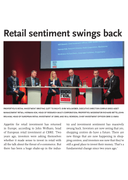
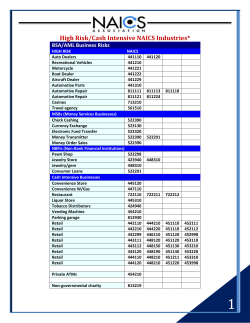


© Copyright 2026