
Our Parks and Protected Areas
Our Parks and
Protected Areas
A Plan for Nova Scotia
Our Parks and
Protected Areas
A Plan for Nova Scotia
Acknowledgements
The Department of Natural Resources and Nova Scotia Environment are grateful for the
input from the public, and staff from other provincial government departments. The
Mi’kmaq of Nova Scotia also played an important role through a technical advisory group
and the Assembly of Nova Scotia Mi’kmaq Chiefs.
This plan is supported by many other government and non-government conservation
efforts, including the:
•
Natural Resources Strategy
•
Environmental Goals and Sustainable Prosperity Act
•
Climate Change Action Plan
•
Renewable Electricity Plan
•
Draft Coastal Strategy
•
Heritage Strategy
Discover more
Additional information about the Parks and Protected Areas Plan, including detailed
mapping is available online at http://novascotia.ca/parksandprotectedareas/.
© Crown Copyright, Province of Nova Scotia, 2013
Message from Ministers
Nova Scotia has a mosaic of landscapes that are rich in biological diversity and provide a
variety of exciting opportunities for outdoor recreation. We are lucky to be able to enjoy
these treasures now; we also have an obligation to protect them for the future.
Our wild spaces give us clean air to breathe, clean water to drink, and opportunities for
both adventure and quiet reflection. They allow animals and plants to thrive in their natural
habitats. They also have a direct role to play in responding to climate change by capturing
and storing carbon dioxide and producing oxygen. When we protect our land in a system
of parks and protected areas, we keep it natural: free from development, houses, factories,
or farms. The trees are left to grow, die, and feed the forest in a natural life cycle. Protecting
our landbase also ensures that many of the province’s most spectacular areas will be
available to Nova Scotians and visitors to our province now and in the future.
Under the Environmental Goals and Sustainable Prosperity Act, the province committed
to protect at least 12 per cent of Nova Scotia’s land by 2015. Our Parks and Protected
Areas Plan more than delivers on that commitment. More than 200,000 hectares (ha)
of additional lands will be protected by 2015, creating the largest system of parks and
protected areas Nova Scotia has ever had. The 2011 Natural Resources Strategy for Nova
Scotia also committed to deliver an integrated and sustainable parks and protected areas
program. This Parks and Protected Areas Plan will achieve that goal as well.
The plan’s success has been authored by you: Nova Scotians committed to protecting
and conserving our beautiful province for future generations. It builds on extensive
consultations over the last several years involving members of the public and Nova
Scotia’s Mi’kmaq community, which helped identify potential lands for protection, and the legislative and policy initiatives necessary to ensure that future generations will also
enjoy them.
Thank you for your participation.
Sterling Belliveau
Minister of Environment
Charlie Parker
Minister of Natural Resources
Executive Summary
Nova Scotia is rich with areas of exceptional, unspoiled nature. From the steep canyon
slopes of the Margaree River to the dunes of Sand Hills Beach, parks and protected
areas support recreation, tourism, research, and education. Above all, they protect the
fundamental elements of nature: our land, water, and biodiversity.
This document is the province’s plan to ensure that these areas continue to thrive. The plan
delivers on two important government commitments:
•
Update Nova Scotia’s park system to secure and strengthen its long-term success, and
•
Increase Nova Scotia’s legally protected landmass to at least 12 per cent by 2015
Land Protection
This plan provides for the protection of 13 per cent of our province’s outstanding
landmass by 2015, including other lands that could increase that protection once further
considerations are taken into account. More specifically, if all lands included in Our Parks
and Protected Areas were legally protected, it would result in:
•
Four new provincial parks (960 ha)
•
44 new wilderness areas (128,760 ha)
•
118 new nature reserves (34,080 ha)
Expanding
•
12 provincial parks (3,980 ha)
•
31 wilderness areas (77,460 hectares)
•
11 nature reserves (4,620 ha)
Transferring
•
2,150 ha of provincial parkland to protected areas and 1,000 ha of parkland to Crown
land that would still be available for public use.
Our Parks and Protected Areas
Adding
1
With these changes, the new parks and protected areas system will include
•
205 provincial parks
•
84 wilderness areas
•
138 nature reserves
Goals and Actions
Our Parks and Protected Areas
This plan proposes nine goals and numerous actions to ensure a strong, viable parks and
protected areas system that will thrive well into the future. These goals and actions are
designed to:
2
•
ensure protection
•
provide strategic direction
•
challenge Nova Scotians to work together
•
collaborate with the Mi’kmaq
•
deepen appreciation of the natural world
•
provide nature-based recreation
•
market and promote our parks and protected areas
•
encourage organizational excellence
•
address protection gaps
Nova Scotians enjoy, respect, and use their parks and protected areas. This plan is an effort
to make sure that this continues for generations to come.
Rationale and Approach
Why We Are Doing This
For many Nova Scotians, protecting wild spaces is instinctive; these spaces are special
places where we can enjoy, learn about, and care for our natural heritage.
Protecting our wild spaces is also necessary. Parks and protected areas play an important
role in conserving Nova Scotia’s biodiversity and protecting our access to clean air and
water.
Our natural landscape and cultural heritage are protected by both legislation and policy in
numerous ways, but Nova Scotians wanted a more comprehensive plan to address longterm viability. Two documents in particular reflect that desire:
1. The Environmental Goals and Sustainable Prosperity Act that requires a) the creation
of a sustainable parks system, and b) the legal protection of at least 12 per cent of
Nova Scotia’s total landmass by 2015, and,
2. The Path We Share: A Natural Resources Strategy for Nova Scotia 2011–2020 that
lays out five goals for provincial parks: shared stewardship, far-sighted planning,
protection, education, and recreation.
This plan responds to both of these documents; it exceeds the protected lands goal
of at least 12 per cent and takes specific actions to address the goals of the natural
resources strategy.
Consultation
A key recommendation of the Natural Resources Strategy (2011) is to engage Nova
Scotians in “a focused dialogue about provincial parks.” The strategy outlines the need
to inform people about the park system, ask what they value most, and involve them in
setting priorities.
In 2012, the province held public meetings in 20 communities and conducted nearly 1,500
interviews with park users and non-users to examine their perceptions and preferences.
This plan reflects the extensive input received through that process.
Our Parks and Protected Areas
This plan also commits government to deliver an integrated, coordinated parks and
protected areas program.
3
Specific properties in the plan are also based on comprehensive consultation with the
public and Nova Scotia Mi’kmaq around land selection and use. This consultation was
informed by the 2009 Colin Stewart Forest Forum report and the 12 per cent lands review
process (2011), which included numerous stakeholder meetings and more than 700
written submissions. The final plan also reflects what we heard following release of the
proposed plan early in 2013. This included more than 2,000 written submissions, and input
from more than 1,300 people at 17 public open house sessions held across the province.
Our Parks and Protected Areas
Nova Scotia’s Legacy: Increasing Protection
4
1959
Provincial Parks Act
1960s
Many beach parks created (e.g., Martinique, Rissers)
1970s
First larger provincial parks created (e.g., Blomidon)
1980
Special Places Protection Act (enables nature reserves)
1988
New provincial parks policy adopted
1989
Provincial Parks Act updated
1992
Conservation Easements Act (enables private land protection)
1992
Nova Scotia and others commit to comprehensive systems of parks and
protected areas
1994-1995 Province consults on a proposed system plan for parks and protected areas
1998
Wilderness Areas Protection Act (31 areas designated)
2007
Environmental Goals and Sustainable Prosperity Act contains goal of protecting
12 per cent of Nova Scotia’s landmass by 2015
2011
Natural Resources Strategy: (sets goal for sustainable parks system)
2012
Provincial park province-wide consultation on park values
2012
12 per cent lands review: (public reviews lands under consideration)
2013
Proposed Parks and Protected Areas Plan outlines 224 properties
New Parks and Protected Areas
“Miamuj maliaptemu’kw msit Mi’kma’kik, mita wetapeksi’kw aq weji mimajultikw. Klo’tmuanej
ujit elmi’knikewak.” Mi’kmaq
“We must take care of all of Mi’kma’kik because we grew out of it and survive from it. Let us
keep it for those of the future.” English
Our Parks and Protected Areas Plan enables Nova Scotia to exceed the 12 per cent target
– a significant milestone.
This target has its origins internationally with the World Commission on Environment and
Development, nationally with the World Wildlife Fund’s Endangered Spaces Campaign, as
well as with a 1992 commitment by federal and provincial ministers to complete Canada’s
network of protected areas.
With the legal protection of the properties in this Parks and Protected Areas Plan,
13 per cent of Nova Scotia will be protected by 2015. Designations
A protected area is a clearly defined geographical space, recognized, dedicated and managed
to achieve the long-term conservation of nature. (International Union for Conservation of
Nature, 2008)
Provincial protected areas that count toward our legal protection goal fall under three
different designations:
•
Wilderness areas protect nature and support wilderness recreation, hunting, sport
fishing, trapping, and other uses.
•
Nature reserves offer the highest level of protection for unique or rare species or
features; the reserves are mostly used for education and research.
•
Provincial parks and reserves protect nature and support a wide range of heritage
values and opportunities for outdoor recreation, nature-based education, and tourism.
Parks represent a special case; only those whose main intent is to protect nature count
toward our legal protection goal; other parks protect cultural and recreational features.
Our Parks and Protected Areas
Protected Area
5
Other lands that count as legally protected are those primarily dedicated to the protection
of nature, including national parks and wildlife areas, lands owned by landtrust
organizations, and conservation easement lands that are primarily dedicated to the
protection of nature.
Lands to be protected by 2015
This plan identifies about 206,000 ha of land that will be added to the existing parks and
protected areas system. These lands are expected to be legally protected by 2015 as
wilderness areas, nature reserves, or provincial parks. While many of these lands will be
new protected areas, some of these lands are being added to existing protected areas.
Lands with delayed protection
In addition to the lands expected to be protected by 2015, the plan identifies several
areas for delayed designation, allowing time for additional planning, and restoration
or transition from past use. It is expected that delayed designation lands will be legally
protected by 2020. The protection of these lands will increase the total of lands protected
by an additional 10,600 hectares, or 0.19 per cent of the province.
Our Parks and Protected Areas
Lands for potential protection
Our Parks and Protected Areas plan also identifies lands that have special circumstances
that would need to be addressed for the lands to proceed with legal protection. These
potential protection lands may or may not be protected depending on the outcome of
certain considerations; including: addressing mineral and petroleum rights, completing
wood supply and economic development analysis, or acquiring the lands from private
land owners. (Note: All private lands shown in the plan are included with the permission of
the land owners). These lands comprise 37,800 ha, representing a potential addition of up
to 0.68% to the protected areas system.
6
Interim Management
All provincially owned lands included in this plan will be managed under interim
guidelines until they are legally protected, or in the case of lands for potential protection,
until final decisions are made respecting their protection.
These interim guidelines will be consistently applied by the Department of Natural
Resources and Nova Scotia Environment to ensure that the areas included in the plan are
managed in a manner consistent with their intended protection. Additional Planning
To address site-specific issues or opportunities, some areas included in the plan will
require additional planning and consultation before they are legally protected. The areas
where this applies are noted in the table at the back of this document. Future work will
refine final protection considerations within the context of this broader plan, and in some
cases will include additional public or stakeholder consultation.
Final Legal Protection
This plan shows government decisions for this new system of protected areas. Additional
time is needed to complete the planning, legal, and survey work that will result in the final
legal designation of the lands under protection legislation.
Our Parks and Protected Areas
This work may result in minor adjustments to individual properties. As lands become
legally designated under respective legislation, information will be updated on the Parks
and Protected Areas website at http://novascotia.ca/parksandprotectedareas/.
7
Achieving the Goal
All properties that count toward Nova Scotia’s 12 per cent protected land goal are detailed
in the following table:
12 PECENT LANDS
Type of Land
Area (ha)
Portion of
NS Land Base (%)
Administered by Government of Nova Scotia
Wilderness Area
Nature Reserve
Provincial Park
354,540
5,000
6,380
6.41%
0.09%
0.12%
137,740
2,400
7,260
2,130
-470
2.49%
0.04%
0.13%
0.04%
-0.01%
514,980
9.32%
206,020
3.73%
721,000
13.04%
Intended for designation after 2015
10,610
0.19%
Potential for designation if certain
conditions are met
36,800
0.67%
768,410
13.90%
Other contributing properties
National Park
National Wildlife Area
Land trust lands
Protected by conservation easements
Adjustment: nature reserves also in
wilderness/land trust
Total (2012)
Our Parks and Protected Areas
Intended for designation by 2015
8
Total (existing and intended by 2015)
Potential Total
Protected Area Selection
Developed through public input and extensive internal review, this plan represents a
system of parks and protected area that will achieve a variety of goals, including the
protection of biodiversity. This conservation-oriented approach relies on the six Rs’ criteria:
•
Remote: large areas in a mostly natural state with few human impacts
•
Representative: examples of the full spectrum of Nova Scotia’s natural landscapes
•
Rich: productive and diverse – where plant, lichen and animal life flourish
•
Rare: unique or rare landscapes, plants, or animals
•
Restoration: areas that fill important land gaps but need time to restore from past use
•
Re-connection: areas that provide important natural connections for plants and
animals
•
investing more than $100 million to acquire private land for protection
•
exchanging land with private land owners
•
entering into agreements to maintain certain off-highway vehicle routes through
wilderness areas
•
saving highly valued public access roads and related access points
Our Parks and Protected Areas
Land selection also reflects social values — how people will use, connect, and enjoy these
lands — and potential conflicts such as settlement, agriculture, roads, forestry, mining, and
energy development. Some of the actions the province took to reduce conflict included:
9
Parks Designation
Our Parks and Protected Areas plan implements a number of changes to provincial park
properties. These changes include expanding, creating, and transferring a number of
parks. Overall, these changes improve protection and better serve core park mandates
– protection, recreation, education, and tourism by supporting access to coastal and
freshwater resources, and a variety of natural and cultural heritage experiences.
Changes to the park properties were based on several criteria:
•
their contribution to the core mandates of protection, recreation, education, and
tourism
•
the level of government or non-governmental organization that is best-suited to
managing a particular property
•
how the management of an existing property could be improved by boundary
revisions
•
how new park opportunities or experiences could be established
Our Parks and Protected Areas
Nova Scotia’s parks face continued demand for enhancement. However, staffing and
maintaining parks costs roughly $8 million a year. As well, different users want different
things. For example, some place a high priority on protecting piping plovers, while others
want more access to beaches where the plovers live.
10
Acknowledging that parks cannot be all things to all people, this plan identifies which
properties are most important to maintain as parks, and which should be managed as part
of the general Crown land program or more appropriately managed as wilderness areas or
nature reserves. In all cases, the land remains in public ownership.
Core parks protect a range of provincially significant heritage values and provide opportunities
for high-quality outdoor recreation, nature-based education, and tourism (e.g., T.H. Raddall,
Cape Chignecto, Mira River). Supporting parks are locally significant but may not offer the
range or quality of values and opportunities as core parks (e.g., Blomidon Look-off, Gulf Shore,
Dominion Beach).
Benefits
What We Are Achieving
Parks and protected areas play an important role in conserving and protecting biodiversity
in our part of the world. This includes wildlife, along with natural features and processes.
Our protected lands lessen the effects of climate change by capturing and storing
carbon dioxide and producing oxygen. They maintain clean air and water, including
drinking water.
Through research and education, our parks and protected areas help us understand how
to work with nature’s processes. Because resource extraction is not permitted, they allow
us to compare natural areas with areas we use and develop intensively. They help us
determine how we are doing.
•
improving physical health through enjoyment of nature and outdoor recreation
•
protecting drinking water
•
enhancing mental health and well-being
•
supporting science and learning
•
invigorating human spirits
•
giving hope for the future
•
providing settings of breathtaking beauty
•
enhancing our quality of life
Our Parks and Protected Areas plan contributes to our economy by:
•
anchoring our nature tourism industry
•
supporting the outdoor recreation industry
•
helping us brand Nova Scotia as a clean, green place in which to live, work,
and do business
•
contributing to local and regional economies
•
employing people, directly and indirectly, especially in rural areas
Our Parks and Protected Areas
Our Parks and Protected Areas plan helps to build healthy communities by:
11
Our Parks and Protected Areas plan reflects our culture by:
•
conserving our shared heritage
•
encouraging cultural awareness
•
conserving important Mi’kmaq sites
•
inspiring our hearts and souls
Identifying and protecting the best and most suitable lands now will help to ensure that
Nova Scotia’s parks and protected areas become even more relevant in coming years. The
benefits they provide will help Nova Scotia meet current needs and face evolving regional,
national and global challenges.
Updating our Parks and Protected Areas is about leaving a legacy.
Our Parks and Protected Areas
Mi’kmaq Interests
Our Parks and Protected Areas plan helps to protect lands that are important to the
Mi’kmaq of Nova Scotia. These lands may be used for hunting, fishing, and other
traditional activities and some have special cultural and spiritual significance. The province
will continue working with the Mi’kmaq to explore options relating to the Mi’kmaq use of,
and involvement in, the management of parks and protected areas in a manner consistent
with legislative protection requirements, and in keeping with the Mi’kmaq concept of
Netukulimk.
12
Netukulimk, as defined by the Mi’kmaq, is the use of the natural bounty provided by the Creator
for the self-support and well-being of the individual and the community by achieving adequate
standards of community nutrition and economic well-being without jeopardizing the integrity,
diversity, or productivity of our environment.
Environmental Goals and Sustainable Prosperity Act, 2012
In support of this effort, in 2011, the Mi’kmaq–Nova Scotia Protected Areas Selection
and Management Technical Advisory Group was established. The group was formed to
provide advice, information, and recommendations to the province and the Assembly of
Nova Scotia Mi’kmaq Chiefs respecting the scoping, selection, acquisition, designation,
management, and use of certain provincial Crown lands established as parks and
protected areas contributing to the 12 per cent goal.
Land Use
Special rules, defined in the legislation and regulations for provincial parks, wilderness
areas, or nature reserves, help to protect nature in our parks and protected areas. These
rules cover a broad range of uses and are summarized below.
Commercial Resource Use and Development
To protect nature in our provincial parks and protected areas, resource use and
development is not permitted. Resource use includes, but is not limited to, commercial
forest harvesting, road and utility corridor development, and hydro power or wind energy
development.
New mineral or petroleum rights or other legal interests cannot be granted. Existing
legal interests, such as mineral or petroleum rights, will be dealt with under applicable
legislation (see details below).
Mi’kmaq Use
The Mi’kmaq of Nova Scotia have treaty and aboriginal rights over lands and natural
resources that may be affected by provincial decisions respecting protected area selection,
acquisition, designation, and management.
Research and Education
Parks and protected areas can provide ideal benchmarks for long-term reference studies
or for comparison with areas more affected by human activity. They also offer educational
opportunities at all levels and ages.
Our Parks and Protected Areas
The new parks and protected areas might affect Mi’kmaq access to lands used for hunting,
fishing, gathering, and other activities. The Assembly of Nova Scotia Mi’kmaq Chiefs
and the province have a shared interest in both conserving nature and ensuring the
sustainable use of natural resources. The Mi’kmaq–Nova Scotia Protected Areas Selection
and Management Technical Advisory Group will continue to address issues related to
Mi’kmaq access and use of parks and protected areas.
13
Recreation
When done in a manner consistent with overall protection objectives, parks and protected
areas can offer exceptional opportunities for low-impact recreation and nature-based
tourism in a natural setting, connecting individuals and families with nature.
With their scenic beauty, wildlife, and natural settings, these areas – especially the
wilderness areas and provincial parks – are suited to activities such as hiking, camping,
canoeing, sea kayaking, cross-country skiing, snowshoeing, birding, and more. Nature
appreciation, education, and research activities are permitted in most nature reserves and
low-impact camping is permitted at designated sites in some nature reserves.
Hunting
Hunting and trapping, with the exception of bear-baiting, are permitted in wilderness
areas, provided it is done in compliance with any applicable rules or regulations. Hunting
and trapping are not permitted within nature reserves or provincial parks because of the
sensitivity and intent of these areas.
Sport Fishing
Our Parks and Protected Areas
Sport fishing is permitted in provincial parks and wilderness areas, but not in nature
reserves. As well, vehicle access to many popular fishing lakes is maintained through
the design of wilderness area boundaries. Many lakes and waterways that are near new
nature reserves are not included within the legal boundary, and would still be available for
fishing.
14
Vehicle Use
To minimize the impact on nature, vehicles are generally prohibited in parks and protected
areas, with some exceptions:
•
automobiles are permitted on park roads, but off-highway vehicles are not permitted
•
in certain situations, some vehicle use can be authorized in wilderness areas under the
Wilderness Areas Protection Act
•
vehicles are not permitted in nature reserves
Connecting Routes: In new wilderness areas, if a vehicle-use route is an important link
within a regional trail network, it may be designated for continued vehicle use through an
agreement with a group or an organization. Nova Scotia Environment holds agreements
governing specific routes with the All Terrain Vehicle Association of Nova Scotia (ATVANS)
and the Snowmobilers Association of Nova Scotia (SANS).
During the past several years, Nova Scotia Environment has worked with ATVANS and
SANS and other vehicle users to discuss and identify priority connecting routes within
potential new wilderness areas or wilderness area additions. Some new wilderness areas
in this plan include key routes that will be considered for trail-use agreements. Other,
secondary routes in wilderness areas will be closed to recreational off-highway vehicle use.
Other Vehicle Use: Some roads or routes have been left outside the boundary of the new
protected areas, and will continue to be managed as Crown land. These “excluded routes”
are highlighted in the online map, and will be shown on final boundary maps for each
area. In due course, signs will also be erected at main access points indicating routes that
are open or closed to vehicle use.
In wilderness areas, licences allowing limited vehicle access can be issued for specific uses
(such as research, or reaching private land or an existing campsite lease). Motorboats
may also be used for fishing in most wilderness areas if the operators hold a valid fishing
licence.
Legal Interests
These interests include mineral and petroleum rights, underground storage leases, power
lines and pipelines, drinking water supply areas, and campsite leases.
In limited cases, the province may grant an easement within a provincial park.
Details on major existing legal interests are outlined on the following pages:
Our Parks and Protected Areas
Existing legal interests can be honoured, subject to conditions, in wilderness areas but
generally cannot be exercised following designation of nature reserves or provincial parks.
15
Mineral and Petroleum Rights
Some existing mineral and petroleum rights are overlapped by new provincial parks,
wilderness areas, and nature reserves identified in this plan. Throughout the planning
process, protected area boundaries were designed to minimize the overlap with such
rights where possible.
The province will treat these overlapping rights in a variety of ways, depending on
individual circumstances.
All lands with existing mineral exploration rights that overlap areas intended in the
plan for nature reserve designation are identified for potential protection, subject to
addressing overlapping rights. This approach is also taken with certain lands that overlap
areas intended for wilderness area designation. These overlapping lands would be legally
protected only if the mineral rights are no longer present.
Certain lands with existing petroleum or underground storage rights that overlap areas in
the plan intended for nature reserve or wilderness area designation are also identified for
potential protection, subject to addressing overlapping rights. These overlapping lands
would only be legally protected if the petroleum or underground storage rights are no
longer present.
Our Parks and Protected Areas
For potential protected areas where the designation is dependent on addressing existing
mineral or petroleum rights, government will work with individual rights holders to a)
seek or negotiate voluntary consent of the rights holders to surrender the rights on the
overlapping lands, or b) establish an approach that allows rights holders to continue
to exercise their rights. The goal of this would be to determine the presence of an
economically viable resource such that a protection decision could be made.
16
There are some areas in the plan (intended for wilderness area designation) that overlap
mineral and petroleum rights for which the legal protection is not subject to existing
rights. In these cases, rights holders may be authorized to carry out activities in a manner
consistent with the Wilderness Areas Protection Act to exercise their interests, provided
that the activities do not degrade the respective areas.
Campsite Leases
Existing campsite leaseholders in wilderness areas can continue to use their lease under
the terms of their current agreement until new areas are legally designated. They would
then have the opportunity to renew their lease as a wilderness area campsite licence.
A campsite lease vehicle licensing program is being developed for wilderness areas; in the
interim, camp owners may continue to access their campsites by vehicle on existing and
direct routes in a manner consistent with any other rules and regulations. Vehicle access
to campsites in a wilderness area can be licensed to support structure maintenance
or removal.
There are no campsite leases contained within nature reserves outlined in this plan.
However, some campsite lease sites may share boundaries with new nature reserves,
potentially affecting access.
Campsite lease holders who are concerned about the access or use of their lease in
new wilderness areas or nature reserves should discuss their concerns with Nova Scotia
Environment.
The Nova Scotia Department of Natural Resources will work with leaseholders in parks to
address issues.
The province is currently working on an updated campsite lease policy that will help to
clarify the treatment of campsite leases.
Private Land Inholdings
In some cases, new provincial parks, wilderness areas, or nature reserves can surround
private land, creating inholdings. We will resolve access issues resulting from inholdings by
working with private land-owners on a case-by-case basis. The province may also consider
acquiring in-held lands from willing sellers as resources permit.
Almost all potential inholdings are within wilderness areas. If needed, access to wilderness
area inholdings would be provided by licence under the Wilderness Areas Protection Act but
may be subject to conditions.
Reasonable access may also be granted to provincial park inholdings through an
easement.
Our Parks and Protected Areas
Camps on lands that were recently acquired by the province, that are now intended for
wilderness area protection, may be considered for a wilderness camp licence if the camp
owners have permission from the previous landowners. Individuals with camps in such
locations are encouraged to contact Nova Scotia Environment.
17
A Clear Plan
How We Will Get There (Goals and Actions)
Our Parks and Protected Areas Plan brings together detailed planning, consultation, and
coordination by both the Department of Natural Resources and Nova Scotia Environment.
This helps the province to administer Nova Scotia’s parks and protected areas through
a uniform approach. Its success will be demonstrated by the health and integrity of
our various protected ecosystems, and the enjoyment of Nova Scotians and visitors
who use them.
To help ensure that success, this plan includes specific goals and actions centred on the
core legislative mandates of protection, outdoor recreation, education, and tourism. This
plan does not list all activities to be undertaken by the Department of Natural Resources
and Nova Scotia Environment; it identifies the highest-priority goals and actions.
Goal 1
Ensure protection of Nova Scotia’s natural and cultural heritage.
Protecting nature is a primary purpose of our wilderness areas, nature reserves, and
provincial parks. Some are primarily established to protect the ecosystems that support
sensitive species or other important wildlife; others are especially suitable for public access
and recreational use or to protect a range of historic, cultural, and archaeological sites.
Actions:
•
Legally protect properties under the Provincial Parks Act, Wilderness Areas
Protection Act and Special Places Protection Act (nature reserves) by 2015.
•
Ensure maintenance of ecological integrity and, as feasible, implement
ecological restoration measures to restore lands and biodiversity within
parks and protected areas.
•
Revise park policy and guidelines in 2013 to emphasize protection of heritage values.
•
Review and update the Provincial Parks Act and associated regulations in 2013 to
ensure protection of heritage values is a priority.
Our Parks and Protected Areas
Threats to these areas include inappropriate and unmanaged public use, invasive species,
climate change, lack of regulatory controls, and efforts to balance recreational use with
preservation and protection objectives.
19
•
Update legislation for nature reserves designated under the Special Places Protection
Act to maintain high-level nature protection while clarifying the treatment of
existing legal interests and certain low-impact recreational uses. This will include the
consideration of hunting or other activities in circumstances where such activities are
consistent with goals for the maintenance or restoration of ecological integrity for
individual nature reserves.
•
Strengthen compliance initiatives, including public awareness, education, and
enforcement.
Goal 2
Provide strategic direction to guide planning, management, and operations.
It takes knowledge and understanding to balance the various economic, social and
environmental values that are rooted in an integrated parks and protected areas system.
Many individuals and organizations value these properties, and their reasons and interests
may differ. Navigating these disparate interests requires strategic planning.
Our Parks and Protected Areas
Actions:
20
•
Complete management planning for all core provincial parks by 2025.
•
Complete park management plans or management statements in advance of major
new capital development projects.
•
Develop a management planning framework for wilderness areas by 2015.
•
Develop and implement a coordinated, science-based inventory, research, and
monitoring program for provincial parks and protected areas.
•
Apply science-based approaches to evaluate the effectiveness, and improve
management of, parks and protected areas.
•
Promote awareness for opportunities on Crown land that may complement provincial
parks and protected areas program objectives through future planning processes.
Goal 3
Challenge Nova Scotians to work together to create a sustainable parks and protected areas
system.
Nova Scotians love their provincial parks and protected areas. They also want these areas
to protect important heritage values; provide opportunities for a range of high-quality,
nature-based recreational and educational experiences; and offer the associated facilities
and services that support public use.
The bottom line is that there are not enough people and funds to maintain or expand all
the existing trails, campsites, and other park infrastructure. Fiscal constraint and oftencompeting demands for increased public use and protection threatens the sustainability
of Nova Scotia’s parks and protected areas. The public needs to engage in the decisionmaking process, and the province encourages partnerships.
•
Starting in 2014, establish a parks and protected areas forum to facilitate the sharing
of science and management information with a broader constituency of researchers,
land managers, partner agencies and organizations, and the interested public.
•
Engage and consult with local communities and stakeholders in planning,
management, and operation where possible.
•
Encourage long-term, effective, and sustainable community and municipal
partnerships.
•
Develop community partnership funding options to support provincial parks by 2014.
•
Engage other government departments and agencies with complementary
responsibilities to support parks and protected areas planning, development, or
program delivery.
Our Parks and Protected Areas
Actions:
21
Goal 4
Collaborate with the Mi’kmaq of Nova Scotia.
Action:
•
Through the existing Mi’kmaq–Nova Scotia Protected Areas Selection and
Management Technical Advisory Group, develop new approaches for Mi’kmaq
involvement in the management of parks and protected areas.
Goal 5
Deepen appreciation of Nova Scotia’s natural and cultural heritage.
Our provincial parks and protected areas contain a rich and diverse range of natural and
cultural heritage values. Education and interpretation efforts within these areas must be
expanded to inspire, educate, and engage visitors.
Our Parks and Protected Areas
Actions:
22
•
Develop a master plan for nature and cultural heritage interpretation in Nova Scotia’s
provincial parks by 2015.
•
Increase interpretive programming, displays, and signage at points of interest in parks.
•
Establish formal links with other organizations to improve outdoor education
programming to youth.
•
Complete cultural heritage inventories and interpretive plans for two park properties
annually, starting in 2015.
•
Working with partners, develop approaches to increase the understanding and
appreciation of natural heritage in provincial wilderness areas and nature reserves.
Goal 6
Provide nature-based recreation while protecting natural and cultural heritage.
Our parks and protected areas provide excellent opportunities for nature-based
recreational activities. They encourage an active lifestyle, promote appreciation of our
natural environment, and support local economies through tourism. The benefits of
providing opportunities for outdoor recreation need to be balanced with efforts to protect
important heritage values.
•
Increase focus on the conservation and enjoyment of waterways in Nova Scotia by
creating clear goals and priorities for provincial participation in the Canadian Heritage
Rivers program, and establishing a provincial waterways program for recreation and
conservation purposes.
•
Invest in parks to support nature-based recreation.
•
Work with public and private partners to explore new opportunities for rural economic
development by improving investment and partnerships for parks and protected areas
to encourage and support scientific research, nature-based recreation, and tourism.
•
Consider compatible non-motorized trail development proposals in wilderness areas,
through agreements with interested organizations.
•
Establish long-distance hiking trails using provincial parks, wilderness areas,
abandoned rail corridors, Crown lands, and where agreed, private lands to connect
provincial parks and protected areas.
•
Significantly reduce or eliminate the backlog of operations, maintenance, and
development projects in the park system by 2025, subject to fiscal resources.
Our Parks and Protected Areas
Actions:
23
Goal 7
Market and promote parks and protected areas.
Many Nova Scotians use parks and protected areas, but not all areas see an equal
number of visitors. This may reflect a limited awareness of opportunities and experiences,
amenities, and services offered across the system.
Our Parks and Protected Areas
Actions:
24
•
By 2015, develop and share a comprehensive and integrated vision for Nova Scotia’s
parks and protected areas that identifies broad societal benefits, and highlights
linkages and relationships with other government and partner-based initiatives.
•
Engage with partners to increase public awareness of the social and environmental
benefits of parks and protected areas.
•
Use innovative marketing and promotion strategies to attract new users.
•
Encourage and promote year-round use.
•
Improve access to parks for those with disabilities and those using public transit and
active transportation.
•
Improve measurement of provincial park use, including numbers of day users.
•
Conduct user surveys every five years to measure both attitudes toward parks and
protected areas and expectations of visitors.
•
Update the Provincial Parks Marketing Plan by 2015.
Goal 8
Encourage organizational excellence.
Parks and protected areas create memories for life. Helping to make sure they are
positive memories involves both the immediacy of good customer service and long-term
management practices that reflect the broader public good. That requires a wide variety
of staff to plan, develop, operate, and manage parks. It also requires an efficient and
accountable organizational structure.
•
Establish a program management committee with Natural Resources and Nova Scotia
Environment staff in 2013 to provide ongoing coordination of the provincial parks and
protected areas system.
•
Review the efficiency and effectiveness of current provincial park delivery models in
2013, and transition to new models, if deemed beneficial, by 2015.
•
Report annually on Nova Scotia’s parks and protected areas program, beginning in
2014.
•
Review the parks and protected areas program to identify efficiencies and options to
effectively resource and manage the program to achieve the key goals of protection
while delivering a range of public benefits.
•
Report progress on protection in Nova Scotia in accordance with internationally
recognized standards.
•
Provide staff with professional and technical training to improve on-the-job
effectiveness, and continue to ensure a dedicated, highly trained, and client-focused
workforce.
Our Parks and Protected Areas
Actions:
25
Goal 9
Address gaps in the parks and protected areas system.
The new parks and protected areas lands will protect an impressive selection of Nova
Scotia’s wild spaces. But more actions are needed to help maintain biodiversity in Nova
Scotia. This includes an increased focus on private land conservation.
Actions:
•
Work with academic and conservation partners to identify gaps in the parks and
protected areas system.
•
Further develop and support land trusts and other partners to encourage leadership
in, and continued enhancement of, private land conservation in the province, and
secure and protect ecologically important private lands.
•
Work with federal conservation agencies and other partners to explore opportunities
for complementary conservation actions in areas of shared responsibility, including
the integration of coastal elements.
•
Develop innovative approaches to ensure that parks and protected areas function as
a network that effectively contributes to biodiversity objectives.
Our Parks and Protected Areas
26
Appendix A: Lands
The following is a complete list of new protected areas, as well as
provincial park properties.
NR = Nature Reserve
WA = Wilderness Area
PP = Provincial Park
Area (ha) for
potential
protection**
Site
#
Name and
Designation
Area (ha) and
status*
County
Comments / Special
Considerations
1
Alder Grounds
Wilderness Area
477 (expansion)
Guysborough
2
Angevine Lake
Nature Reserve
272 (new)
Cumberland
3
Ashfield Nature
Reserve
74 (new)
Inverness
4
Aylesford
Mountain Nature
Reserve
45 (new)
Kings
Roads along western and
northern boundary not
included.
5
Baddeck River
Wilderness Area
2684 (new)
Victoria
Potential snowmobile trail
agreement for route 710.
6
Baleine Nature
Reserve
1269 (new)
CBRM
Camping on designated
sites and berry
picking for personal
use to be permitted.
Electrical infrastructure
requirements to be
addressed in consultation
with NSPI.
7
Barneys River
Nature Reserve
563 (new)
Pictou
8
Basque Islands
Nature Reserve
6 (new)
Richmond
OHV route 262 excluded. Electrical infrastructure
requirements to be
addressed in consultation
with NSPI.
12
Legal protection of 4 ha
subject to addressing
mineral rights.
Legal protection of 12 ha
subject to addressing
mineral rights.
*includes lands subject to special considerations, **subject to special considerations
Our Parks and Protected Areas
4
27
Our Parks and Protected Areas
28
Area (ha) for
potential
protection**
Site
#
Name and
Designation
Area (ha) and
status*
County
Comments / Special
Considerations
9
Bennery Lake
Nature Reserve
243 (new)
HRM
10
Big Bog
Wilderness Area
161 (expansion)
Guysborough
161
Legal protection subject to
wood supply analysis.
11
Big Meadow
Brook Nature
Reserve
283 (new)
Colchester
283
Legal protection subject
to clarification with Ducks
Unlimited.
12
Birch Hill Nature
Reserve
61 (new)
Colchester
13
Black River Bog
Nature Reserve
109 (new)
Inverness
15
Blandford Nature
Reserve
20 (expansion)
Lunenburg
16
Blue Mountain Birch Cove Lakes
Wilderness Area
465 (expansion)
HRM
Proposed Highway
113 corridor excluded. Electrical infrastructure
requirements to be
addressed in consultation
with NSPI.
17
Boggy Lake
Wilderness Area
946 (expansion)
Guysborough,
HRM
Vehicle access to be
provided to Bear Lake.
Road to private land
inholding on Long Lake
excluded.
18
Bornish Hill
Nature Reserve
1140 (expansion)
Inverness
19
Bowers Meadows 30 (expansion)
Wilderness Area
Shelburne
20
Cains Mountain
Wilderness Area
637 (new)
Victoria
21
Calvary River
Nature Reserve
1179 (new)
Colchester
Final boundaries
and use agreement
to be determined in
consultation with Halifax
Water.
Rail trail excluded.
1140
Legal protection subject
to addressing mineral
right. Snowmobile route
excluded.
87
Legal protection of 87
ha subject to addressing
mineral rights.
Pembroke Road and one
other road excluded.
Province will work with
ATVANS to identify
possible bypass ATV route. Electrical infrastructure
requirements to be
addressed in consultation
with NSPI.
*includes lands subject to special considerations, **subject to special considerations
Name and
Designation
Area (ha) and
status*
County
22
Cap La Ronde
Nature Reserve
72 (new)
Richmond
Sea duck hunting
permitted below the
mean high water mark. Designated campsites
to be considered.
Electrical infrastructure
requirements to be
addressed in consultation
with NSPI.
24
Cape Mabou
Wilderness Area
1545 (new)
Inverness
North Highlands Cape
Mabou Road and
community pasture
excluded from wilderness
area.
25
Cape St. Marys
Nature Reserve
342 (new)
Guysborough
Access will be provided to
private land inholding.
26
Caribou Rivers
Nature Reserve
33 (new)
Pictou
27
Carters Beach
Nature Reserve
95 (new)
Queens
Parking concerns, access
to and stewardship of
lighthouse, and site
management issues
to be considered
through final boundary
design and/or local
stewardship agreements. Electrical infrastructure
requirements to be
addressed in consultation
with NSPI.
28
Cedar Lake
Nature Reserve
23 (new)
Yarmouth
Camping to be permitted
at designated campsite.
Electrical infrastructure
requirements to be
addressed in consultation
with NSPI.
29
Chase Lake
Wilderness Area
849 (new)
Cumberland
30
Chedabucto
Fault Nature
Reserve
147 (new)
Guysborough
849
Comments / Special
Considerations
Road excluded from
wilderness area. Legal
protection subject to
addressing petroleum
rights.
Rail trail excluded
from nature reserve.
Electrical infrastructure
requirements to be
addressed in consultation
with NSPI.
*includes lands subject to special considerations, **subject to special considerations
Our Parks and Protected Areas
Area (ha) for
potential
protection**
Site
#
29
Our Parks and Protected Areas
30
Site
#
Name and
Designation
Area (ha) and
status*
County
31
Cherry Hill Beach
Nature Reserve
50 (new)
Lunenburg
32
Cheticamp Island 26 (new)
Nature Reserve
Inverness
33
Chignecto
Isthmus
Wilderness Area
6878 (expansion)
Cumberland
34
Chimney Corner
Nature Reserve
731 (new)
Inverness
35
Cloud Lake
Wilderness Area
4894 (expansion)
Annapolis,
Kings
36
Coffin Island
Nature Reserve
50 (new)
Queens
37
Cowan Brook
Nature Reserve
59 (new)
HRM
38
Cross Lake
Nature Reserve
201 (new)
HRM
39
Crow Neck
Nature Reserve
22 (new)
Shelburne
40
Dalhousie
Mountain Nature
Reserve
46 (new)
Pictou
41
Denis Lakes
Wilderness Area
485 (new)
Guysborough
42
Devils Jaw
Wilderness Area
2900 (new)
Hants
Area (ha) for
potential
protection**
Comments / Special
Considerations
Parking lot excluded from
nature reserve. Clam
digging not affected. Sea
duck hunting permitted
below mean high water
mark.
4083
A portion is of interest
for potential securement
by province (4,083 ha).
Chignecto Ship Railway
excluded from wilderness
area. Potential OHV
agreement for route 104
and connector to New
Brunswick. Maritimes and
Northeast Pipeline to be
licensed. Camp access at
Long Lake to be reviewed
through site-specific
planning.
Access roads to Cloud Lake
and Frog Lake excluded
from wilderness area.
31
A portion is subject to
lands being acquired by
the Province (27 ha).
Road excluded from
nature reserve.
223
Road to Lawrence Cove
of Long Lake excluded
from wilderness area. Portion (223 ha) subject to
addressing mineral rights.
*includes lands subject to special considerations, **subject to special considerations
Site
#
Name and
Designation
Area (ha) and
status*
County
Area (ha) for
potential
protection**
43
Diligent River
Nature Reserve
132 (new)
Cumberland
30
44
Dochertys Brook
Nature Reserve
12 (new)
Cumberland
45
Douglas Meadow 599 (new)
Brook Wilderness
Area
Colchester,
Cumberland
46
Drug Brook
Nature Reserve
35 (new)
Pictou
47
Dunraven Bog
Nature Reserve
3199 (new)
Queens
48
Eagles Nest
Nature Reserve
153 (new)
Hants
49
East River St.
Marys Nature
Reserve
5 (new)
Guysborough,
Pictou
50
Eastern
Shore Islands
Wilderness Area
1844 (new)
51
Economy Point
Nature Reserve
52
53
Comments / Special
Considerations
A portion is subject to
lands being acquired by
the Province (30 ha).
599
Legal protection subject
to addressing petroleum
rights.
Guysborough,
HRM
95
Camp structure issues to
be dealt with on a case
by case basis consistent
with provincial policies. Legal protection of several
islands (95 ha) pending
confirmation of Crown
ownership.
181 (new)
Colchester
62
A portion is of interest for
potential securement (62
ha).
Economy River
Wilderness Area
5747 (expansion)
Colchester,
Cumberland
1448
Legal protection of portion
(1,148 ha) subject to
addressing mineral rights.
Potential OHV agreement
for routes 3 and 5. Existing
SANS agreement for route
104 to be extended.
Eigg Mountain
- James River
Wilderness Area
2450 (expansion)
Antigonish,
Pictou
259
Connecting roads
excluded. Existing SANS
agreement for route 715A
to be extended. Legal
protection of a portion
(259 ha) subject to wood
supply analysis.
*includes lands subject to special considerations, **subject to special considerations
Our Parks and Protected Areas
Electrical infrastructure
requirements to be
addressed in consultation
with NSPI.
31
Our Parks and Protected Areas
32
Site
#
Name and
Designation
Area (ha) and
status*
County
54
Eighteen Mile
Brook Nature
Reserve
1046 (expansion)
Queens
55
Five Mile River
Wilderness Area
2016 (new)
Hants
56
Flat Iron Nature
Reserve
33 (new)
Cumberland
57
Fossil Coast
Nature Reserve
278 (new)
Cumberland
58
Fourchu Coast
Wilderness Area
4898 (new)
59
French River
Wilderness Area
60
61
Area (ha) for
potential
protection**
Comments / Special
Considerations
Some excluded roads.
Electrical infrastructure
requirements to be
addressed in consultation
with NSPI.
2016
Legal protection of this
area will be delayed until
2020. Legal protection
subject to addressing
petroleum rights.
Potential road exclusions
and OHV trail agreements
subject to future planning
and consultation.
CBRM,
Richmond
105
Legal protection of
portion (7 ha) subject
to addressing mineral
rights. MacDonald Road
and land north of road
to Upper Marie Joseph
Lake excluded from
wilderness area. Road to
Stewarts Pond and Pig
Point Road excluded from
wilderness area. Public
access to Capelin Cove
to be addressed though
additional planning and
consultation.
17094
(expansion)
Victoria
914
Legal protection of
portion (686 ha) subject to
addressing mineral rights.
Legal protection of portion
(228 ha) pending review of
siting options for potential
wind energy project. Highland road/OHV
route 814 from Oregon
excluded.
Gabarus
Wilderness Area
125 (expansion)
CBRM
Gegogan
Harbour Nature
Reserve
181 (new)
Guysborough
122
Camping to be allowed in
designated areas. Access
to private land will be
provided.
*includes lands subject to special considerations, **subject to special considerations
Name and
Designation
Area (ha) and
status*
62
Giants Lake
Wilderness Area
3644 (new)
Antigonish,
Guysborough
63
Glen Brook
Nature Reserve
320 (new)
Victoria
64
Glendyer Nature
Reserve
211 (new)
Inverness
65
Gold Brook
Nature Reserve
52 (new)
Victoria
66
Grassy Island
Nature Reserve
1 (new)
Lunenburg
67
Green Island
Nature Reserve
11 (new)
Shelburne
68
Gros Nez Nature
Reserve
51 (new)
Richmond
69
Gull Lake
Wilderness Area
2973 (new)
CBRM
70
Gully Lake
Wilderness Area
245 (expansion)
Colchester,
Pictou
County
Area (ha) for
potential
protection**
548
Comments / Special
Considerations
Roads to fire tower & north
of Three Cornered Lake
excluded. Potential OHV
agreement for connecting
routes. Legal protection of
a portion (548 ha) subject
to wood supply analysis.
Rear Big Hill Rd./ OHV
route 715 and NSPI letter
of authority area excluded
from nature reserve.
Powerlines excluded
from nature reserve.
Electrical infrastructure
requirements to be
addressed in consultation
with NSPI. Glen Brook and
fishing hole excluded.
4
Portion (4 ha) subject to
addressing mineral rights.
Community use and
non-motorized access to
be addressed through
additional planning.
Designated campsites to
be considered. Access
to private land will be
provided.
225
A portion is subject to
lands being acquired
by the Province. Legal
protection of Rogart
Mountain portion (187
ha) subject to addressing
mineral rights.
*includes lands subject to special considerations, **subject to special considerations
Our Parks and Protected Areas
Site
#
33
Our Parks and Protected Areas
34
Site
#
Name and
Designation
Area (ha) and
status*
County
Area (ha) for
potential
protection**
71
Guysborough
Headlands
Wilderness Area
2489 (new)
Guysborough
1256
Lands immediately behind
community of New
Harbour (23 ha) excluded
from wilderness area.
Snowmobile route across
Gull Lake not affected.
Fishermans Harbour
(Country Harbour Head)
parcel (1,256 ha) subject
to review of potential
economic development
opportunities.
72
Harmony Lake
Nature Reserve
39 (new)
Queens
39
Legal protection subject to
addressing mineral rights.
73
Harpers Lake
Nature Reserve
401 (new)
Shelburne
Boundary adjustment
due to road construction
to be considered
prior to designation.
Electrical infrastructure
requirements to be
addressed in consultation
with NSPI.
74
Hectanooga
Cedar Swamp
Nature Reserve
124 (new)
Digby
Electrical infrastructure
requirements to be
addressed in consultation
with NSPI.
75
Holden Lake
Wilderness Area
1503 (new)
Lunenburg
Motorized access and final
boundary to be reviewed
through additional review
and planning.
76
Humes River
Wilderness Area
3596 (new)
Inverness,
Victoria
Potential OHV agreement
for route 700. Trail
opportunities along
MacPherson Brook to be
explored.
77
Hurlburt Brook
Nature Reserve
162 (new)
Guysborough
78
Indian Man Lake
Nature Reserve
407 (expansion)
Guysborough
79
Indian River
Wilderness Area
2112 (new)
Guysborough
162
Comments / Special
Considerations
Legal protection subject to
wood supply analysis.
Pipeline corridor excluded. 1275
Access to camps not
affected. Potential
boundary expansion to
Head Lakes and south
along river (1,275 ha)
subject to further review.
*includes lands subject to special considerations, **subject to special considerations
Site
#
Name and
Designation
Area (ha) and
status*
County
Area (ha) for
potential
protection**
80
Ingonish River
Wilderness Area
10712 (new)
Victoria
849
Legal protection of
portion (666 ha) subject
to addressing mineral
rights. Portion (183 ha)
pending review of siting
options for potential
wind energy project. Potential snowmobile trail
agreement for Gisborne
trail to Ski Cape Smokey.
81
Irish Cove Nature
Reserve
162 (new)
Richmond
82
Isaacs Harbour
River Wilderness
Area
2167 (new)
Guysborough
1045
Legal protection of portion
(585 ha) subject to wood
supply analysis. Legal
protection of portion (446
ha) subject to addressing
mineral rights.
83
Janvrin Island
Nature Reserve
121 (new)
Richmond
Designated campsites to
be considered. Sea duck
hunting permitted below
mean high water mark.
84
Johnson Lake
Nature Reserve
162 (new)
CBRM
Rail trail and power
line corridor (sufficient
width to accommodate
Maritime Link project)
excluded from nature
reserve. OHV trail parallel
to Johnson Lake excluded
from nature reserve.
Electrical infrastructure
requirements to be
addressed in consultation
with NSPI.
85
Jordan Lake
Nature Reserve
141 (new)
Queens
86
Kelley River
Wilderness Area
132 (expansion)
Cumberland
87
Kennetcook River 124 (new)
Nature Reserve
Hants
88
Kluscap
Wilderness Area
Victoria
Legal protection of
portion (19 ha) subject to
addressing mineral rights.
Electrical infrastructure
requirements to be
addressed in consultation
with NSPI.
Potential OHV agreement
for route 31B.
Boundary adjustment
next to quarry at New
Campbellton to be
considered.
*includes lands subject to special considerations, **subject to special considerations
Our Parks and Protected Areas
2719 (new)
19
Comments / Special
Considerations
35
Our Parks and Protected Areas
36
Area (ha) for
potential
protection**
Site
#
Name and
Designation
Area (ha) and
status*
County
89
Lake Egmont
Nature Reserve
89 (new)
HRM
90
Lake Rossignol
Wilderness Area
23 (expansion)
Queens
91
Lambs Lake
Nature Reserve
158 (new)
Annapolis
92
Lighthouse
Beach Nature
Reserve
8 (new)
Pictou
93
Liscomb River
Wilderness Area
3743 (expansion)
Guysborough
248
94
Little Beaver
Lakes Nature
Reserve
357 (new)
Inverness
1
95
Little Soldier
Lake Nature
Reserve
88 (new)
HRM
96
Long Lake Bog
Nature Reserve
714 (new)
Queens
97
Long Lake
Nature Reserve
386 (expansion)
Lunenburg
98
Loon Lake Nature 384 (new)
Reserve
Guysborough
99
Lower Mersey
Nature Reserve
822 (new)
Queens
100
MacAulays Hill
Nature Reserve
105 (new)
Victoria
101
MacKay Brook
Nature Reserve
20 (new)
Pictou
102
MacDonalds
Pond Nature
Reserve
36 (new)
Inverness
Comments / Special
Considerations
Some roads excluded from
wilderness area. Legal
protection of portion
subject to addressing
mineral rights (102 ha plus
potential claim renewals
up to 890 ha). Legal
protection of another
portion (146 ha) subject to
wood supply analysis.
Final boundary and
designation type pending
further discussions with
Halifax Water.
142
Legal protection of
portion (142 ha) subject to
addressing mineral rights.
5
Electrical infrastructure
requirements to be
addressed in consultation
with NSPI.
Previously named MacBeth
Road.
*includes lands subject to special considerations, **subject to special considerations
Name and
Designation
Area (ha) and
status*
County
Comments / Special
Considerations
103
MacLeod Brook
Nature Reserve
122 (new)
Inverness
Electrical infrastructure
requirements to be
addressed in consultation
with NSPI.
104
MacRae Brook
Nature Reserve
383 (new)
Victoria
Final boundaries and
OHV trail consideration
subject to potential land
exchange.
105
MacRitchies
Brook Nature
Reserve
51 (new)
Inverness
Power line corridor
excluded from nature
reserve.
106
Margaree Brook
Nature Reserve
269 (new)
Inverness
Forest access road
excluded from nature
reserve.
107
Margaree River
Wilderness Area
2142 (expansion)
Inverness
Potential OHV trail
agreement or exclusion for
route 905.
108
Masons
Mountain Nature
Reserve
825 (new)
Inverness
109
Framboise
Intervale Nature
Reserve
256 (new)
Richmond
256
Previously named
McCormack Lake. Legal
protection subject to
addressing mineral rights.
111
McGowan Lake
Nature Reserve
1155 (new)
Annapolis,
Queens
736
Powerline, rifle range,
and some roads excluded
from nature reserve. Legal
protection of portion
(736 ha) subject to
addressing mineral rights.
Includes former Kempt
Provincial Park Reserve. Electrical infrastructure
requirements to be
addressed in consultation
with NSPI.
112
Medway Lakes
Wilderness Area
19382 (new)
Annapolis
Road to Lake Alma
excluded from wilderness
area. Designation type
(i.e., Provincial Park or
Wilderness Area) of
parcels along Route 8 to
be determined through
additional planning.
*includes lands subject to special considerations, **subject to special considerations
Our Parks and Protected Areas
Area (ha) for
potential
protection**
Site
#
37
Our Parks and Protected Areas
38
Area (ha) for
potential
protection**
Site
#
Name and
Designation
Area (ha) and
status*
114
Middle River
Wilderness Area
3221 (expansion)
Inverness,
Victoria
1666
Highland Road excluded
from wilderness area.
Potential snowmobile trail
agreement for route 105 at
Twelve O’Clock Mountain. Legal protection of portion
(1666 ha) subject to
addressing mineral rights.
115
Minard Brook
Nature Reserve
83 (new)
Queens
63
Legal protection of
portion (63 ha) subject to
addressing mineral rights.
Electrical infrastructure
requirements to be
addressed in consultation
with NSPI.
117
Montrose Nature
Reserve
25 (new)
Colchester
118
Mulcuish Lake
Nature Reserve
53 (new)
CBRM
119
Mulgrave Hills
Nature Reserve
667 (new)
Guysborough
425
Legal protection of portion
(425 ha) subject to wood
supply analysis.
121
Nine Mile Woods
Wilderness Area
1031 (new)
Guysborough
182
Rail trail and pipeline
corridor excluded. Legal
protection of portion (182
ha) subject to wood supply
analysis.
122
North Mountain
Wilderness Area
1304 (new)
Inverness
228
Legal protection of
portion (228 ha) subject to
addressing mineral rights.
123
North River
Wilderness Area
963 (expansion)
Victoria
Highland road/OHV
route 814 from Oregon
excluded.
124
Snowshoe Lakes
Nature Reserve
414 (new)
Annapolis
Previously named
Northfield Road.
125
Northwest Brook
Nature Reserve
386 (new)
Shelburne
126
Ogden Round
Lake Wilderness
Area
134 (expansion)
Guysborough
127
Ohio River
Nature Reserve
24 (new)
Antigonish
128
Old Annapolis
Road Nature
Reserve
448 (new)
HRM, Hants
County
104
Comments / Special
Considerations
Excluded road. Legal
protection of portion (104
ha) subject to addressing
mineral rights.
*includes lands subject to special considerations, **subject to special considerations
Name and
Designation
Area (ha) and
status*
County
Comments / Special
Considerations
129
Otter Island
Nature Reserve
9 (new)
Victoria
130
Panuke Lake
Nature Reserve
478 (expansion)
Hants
131
Pearl Island
Nature Reserve
12 (new)
Lunenburg
132
Petite Bog
Nature Reserve
769 (new)
Hants
133
Pleasant River
Nature Reserve
1132 (new)
Lunenburg,
Queens
134
Pockwock
Wilderness Area
1178 (new)
HRM, Hants
Final boundaries
and use agreement
to be determined in
consultation with Halifax
Water.
135
Point Michaud
Nature Reserve
343 (new)
Richmond
Designated campsites to
be considered. Sea duck
hunting permitted below
mean high water mark.
136
Polletts Cove
- Aspy Fault
Wilderness Area
95 (expansion)
Victoria
Gear storage area on
Sheep Island excluded
from wilderness area.
137
Polly Brook
Wilderness Area
764 (new)
Cumberland
Potential OHV agreement
on powerline corridor.
138
Ponhook Lake
Nature Reserve
160 (expansion)
Lunenburg,
Queens
139
Porcupine Lake
Wilderness Area
951 (new)
Digby
140
Porcupine Lakes
Nature Reserve
238 (new)
Annapolis
0
Power line corridor and
several camps on Panuke
Lake excluded from nature
reserve. Includes two
islands in St. Margarets Bay
Lake previously proposed
as provincial park.
334
Road to Pleasant River
Lake excluded from
nature reserve. Legal
protection of portion (334
ha) subject to addressing
mineral rights. Access to
be provided to private
inholdings.
Some roads excluded from
wilderness area.
*includes lands subject to special considerations, **subject to special considerations
Our Parks and Protected Areas
Area (ha) for
potential
protection**
Site
#
39
Our Parks and Protected Areas
40
Area (ha) and
status*
Area (ha) for
potential
protection**
Site
#
Name and
Designation
141
Port La Tour Bogs 1400 (new)
Queens,
Shelburne
142
Port L'Hebert
Nature Reserve
687 (new)
Shelburne
143
Portapique River
Wilderness Area
1096 (expansion)
Colchester,
Cumberland
144
Quinns Meadow
Nature Reserve
45 (expansion)
Shelburne
145
Ragged Harbour
Nature Reserve
37 (new)
Queens
Camping to be allowed at
designated sites.
146
Raven Head
Wilderness Area
401 (expansion)
Cumberland
Road to wharf at Two
Rivers excluded from
wilderness area.
147
Rawdon River
Nature Reserve
132 (new)
HRM
13
River excluded to
allow fishing. Legal
protection of portion
(13 ha) subject to
addressing mineral rights.
Electrical infrastructure
requirements to be
addressed in consultation
with NSPI.
148
River Denys
Nature Reserve
136 (new)
Inverness
18
Legal protection of
portion (18 ha) subject to
addressing mineral rights.
Electrical infrastructure
requirements to be
addressed in consultation
with NSPI.
149
River Inhabitants
Nature Reserve
718 (expansion)
Inverness
517
Legal protection of a
portion (213 ha) subject
to expiry of gypsum and
gas storage rights. Legal
protection of a portion
(112 ha) subject to wood
supply analysis. Power
line corridor excluded.
Electrical infrastructure
requirements to be
addressed in consultation
with NSPI.
County
1400
Comments / Special
Considerations
Legal protection subject
to clarification from Ducks
Unlimited. Designation
type subject to
consultation with Mi'kmaq
and Ducks Unlimited.
Portion (377 ha) subject
to confirming Crown
ownership.
Access to Haley Lake not
affected.
121
Legal protection of
portion (121 ha) subject to
addressing mineral rights.
*includes lands subject to special considerations, **subject to special considerations
Site
#
Name and
Designation
Area (ha) and
status*
County
Area (ha) for
potential
protection**
150
River John
Nature Reserve
44 (new)
Pictou
44
Legal protection subject
to lands being acquired by
the Province.
151
Rogues Roost
Wilderness Area
1193 (new)
HRM
63
Legal protection of
portion (63 ha) subject to
addressing mineral rights.
Electrical infrastructure
requirements to be
addressed in consultation
with NSPI.
152
Roseway River
Wilderness Area
1680 (new)
Shelburne
153
Ruiss Noir
Wilderness Area
1612 (new)
Inverness
154
Rush Lake Nature 297 (new)
Reserve
Guysborough
155
Sackville River
Nature Reserve
631 (new)
HRM
Girl Guide camp lease
at Lewis Lake excluded
from nature reserve.
Electrical infrastructure
requirements to be
addressed in consultation
with NSPI.
156
Scrag Lake
Wilderness Area
1838 (new)
Annapolis,
Lunenburg
Access to Scrag Lake
provided.
157
Seal Cove Nature
Reserve
81 (new)
Inverness
158
Seven Falls
Nature Reserve
693 (new)
Inverness,
Victoria
159
Shelburne River
Wilderness Area
1144 (expansion)
Queens
160
Sherlock Lake
Nature Reserve
146 (new)
HRM
146
Legal protection of
portion (120 ha) subject to
addressing mineral rights.
161
Shingle Lake
Nature Reserve
1722 (new)
Lunenburg
305
Medlee Lane (access to
Shingle Lake) excluded
from nature reserve.
Comments / Special
Considerations
*includes lands subject to special considerations, **subject to special considerations
Our Parks and Protected Areas
Road to private land on
McKay Lake excluded.
41
Our Parks and Protected Areas
42
Site
#
Name and
Designation
Area (ha) and
status*
County
Area (ha) for
potential
protection**
162
Ship Harbour
Long Lake
Wilderness Area
1311 (expansion)
HRM
389
Portion is subject to
lands being acquired by
the Province (519 ha).
Roads excluded from
the wilderness area
include Murchyville Rd
at Otter Lake, access to
Lake Charlotte, access to
Portapique Lake and near
Hartman Lake. Rail trail
excluded. Includes former
Lake Charlotte North
Provincial Park Reserve.
163
Shut-in Island
Nature Reserve
7 (new)
HRM
164
Silver River
Wilderness Area
6187 (new)
Digby,
Yarmouth
978
Selected roads and access
points for hunting, fishing,
and boating excluded
from wilderness area.
Designation of a portion
(978 ha) pending further
discussion with Nature
Conservancy of Canada.
Note: 1,415 ha near
Kemptville previously
proposed for protection
to be managed as Crown
land.
165
Sissiboo River
Wilderness Area
1205 (new)
Digby
166
Skull Bog Lake
Nature Reserve
524 (new)
Annapolis
167
Slade Lake
Nature Reserve
24 (new)
Cumberland
168
Sloans Lake
Nature Reserve
141 (new)
Yarmouth
169
Smith Lake
Nature Reserve
620 (new)
Lunenburg
170
South Branch
Meadows Nature
Reserve
302 (new)
Colchester
Comments / Special
Considerations
Weymouth Falls Road
excluded. Potential OHV
trail agreement.
Boat launch not affected.
302
Legal protection subject to
addressing mineral rights.
*includes lands subject to special considerations, **subject to special considerations
Name and
Designation
Area (ha) and
status*
171
South Panuke
Wilderness Area
6847 (new)
HRM, Hants,
Lunenburg
172
South River
Nature Reserve
15 (new)
Antigonish
173
Southwest
Mabou River
Nature Reserve
93 (new)
Inverness
174
St. Andrews River 4196 (new)
Wilderness Area
Colchester
175
St. Margarets Bay
Islands Nature
Reserve
55 (new)
HRM,
Lunenburg
176
St. Marys River
Corridor Lands
3096 (new)
Guysborough,
Pictou
County
Area (ha) for
potential
protection**
Comments / Special
Considerations
Timber Lake and
Connaught Lake not
included in wilderness
area. Road access to
Timber Lake and adjacent
camp excluded from
wilderness area. Access
to boat launch at Panuke
Lake excluded from
wilderness area. 4196
Legal protection of this
area will be delayed until
2020. Portion is subject
to lands being acquired
by the Province (1372
ha). Legal protection of a
portion (1590 ha)subject
to addressing petroleum
rights. Road exclusions
and potential OHV trail
agreements subject to
future planning and
consultation. Disjunct
downstream portion (720
ha) renamed West St.
Andrews. Camping to be considered
at designated sites.
496
Final designation type
and mix subject to
additional planning.
Portion is subject to
lands being acquired by
the Province (561 ha).
Four roads off Waternish
Road excluded as well
as road to Lead Mine
Pool/private property. Electrical infrastructure
requirements to be
addressed in consultation
with NSPI.
*includes lands subject to special considerations, **subject to special considerations
Our Parks and Protected Areas
Site
#
43
Our Parks and Protected Areas
44
Site
#
Name and
Designation
Area (ha) and
status*
County
Area (ha) for
potential
protection**
177
Staples Brook
Nature Reserve
1066 (new)
Colchester
358
178
Steepbank Brook
Nature Reserve
203 (new)
Cumberland
179
Stewiacke River
Wilderness Area
505 (new)
Colchester
180
Sugar Harbour
Islands Nature
Reserve
36 (new)
Guysborough
181
Sutherlands Lake
Nature Reserve
215 (new)
Guysborough
182
Tobacco Island
Nature Reserve
9 (new)
Guysborough
183
Tait Lake Nature
Reserve
216 (new)
HRM
184
Tangier Grand
Lake Wilderness
Area
304 (expansion)
HRM
185
Ten Mile Lake
Nature Reserve
675 (new)
Queens
186
Tennycape River
Nature Reserve
343 (new)
Hants
187
Terence Bay
Wilderness Area
84 (expansion)
HRM
188
Tiddville Nature
Reserve
30 (new)
Digby
Comments / Special
Considerations
Legal protection of
portion (358 ha) subject to
addressing mineral rights
and a review of restrictive
covenants.
Power line corridor
excluded. Electrical
infrastructure
requirements to be
addressed in consultation
with NSPI.
505
Legal protection of this
area will be delayed until
2020. Legal protection
subject to addressing
petroleum rights.
Hemlock Loop Road
excluded from wilderness
area.
54
Legal protection of
portion (54 ha) subject to
addressing mineral rights.
135
Portion is subject to lands
being acquired by the
Province (135 ha). Ten Mile Lake, Little Ten
Mile Lake, and water
connection between them
excluded from nature
reserve.
*includes lands subject to special considerations, **subject to special considerations
Name and
Designation
Area (ha) and
status*
189
Tidney River
Wilderness Area
2368 (expansion)
Queens,
Shelburne
113
Legal protection of
portion (113 ha) subject to
addressing mineral rights.
Road north of Broad
River Lake excluded from
wilderness area. Includes
former proposed Misery
Brook Nature Reserve.
190
Toadfish Lakes
Wilderness Area
6588 (new)
HRM
295
Legal protection of
portion (194 ha) subject
to addressing mineral
rights. A portion (101 ha)
is subject to lands being
acquired by the Province. Road exclusions provide
access to Shoaly Lake,
Dog Lake, Quoddy Lake,
Chain Lake, Long Lake,
and Toadfish Lake. Round
Lake, Kelly Lake, and lands
between them are not
slated for protection.
191
Tobeatic
Wilderness Area
16803
(expansion)
Annapolis,
Digby, Queens,
Shelburne,
Yarmouth
1228
Protection of a portion
(365 ha) is of interest for
potential securement.
Protection of a portion
(858 ha) subject to
addressing mineral rights.
Silvery Lake and Crain Lake
roads & main road north of
Ninth Lake excluded from
wilderness area.
192
Torbrook Nature
Reserve
152 (new)
Annapolis
193
Tracadie River
Wilderness Area
2543 (new)
Guysborough
194
Trout Brook
Wilderness Area
184 (expansion)
Inverness
195
Tupper Lake
Nature Reserve
159 (new)
Queens
County
Comments / Special
Considerations
Road to quarry excluded
from nature reserve.
OHV trail along eastern
boundary not affected.
1629
North Intervale Road
excluded from wilderness
area. Potential OHV trail
agreements. Protection
of a portion (1,629 ha)
subject to wood supply
analysis.
*includes lands subject to special considerations, **subject to special considerations
Our Parks and Protected Areas
Area (ha) for
potential
protection**
Site
#
45
Our Parks and Protected Areas
46
Site
#
Name and
Designation
Area (ha) and
status*
County
Area (ha) for
potential
protection**
196
Tusket Islands
Wilderness Area
704 (new)
Yarmouth
564
197
Tusket River
Nature Reserve
63 (new)
Yarmouth
Electrical infrastructure
requirements to be
addressed in consultation
with NSPI.
198
Tusket River
Wilderness Area
1651 (new)
Yarmouth
Several roads excluded:
Access to Louis Lake &
to Tusket River near Bad
Falls, Coldstream Rd, road
between Louis and Canoe
lakes. Louis Lake excluded
from wilderness area.
199
Tusket
Saltmarshes
Nature Reserve
15 (new)
Yarmouth
200
Twelve Mile
Stream
Wilderness Area
1976 (new)
HRM
201
Upper Stewiacke
Wilderness Area
8613 (new)
Colchester,
Pictou
8613
Legal protection for this
area will be delayed until
2020. Road exclusions
and potential OHV trail
agreements subject to
future planning and
consultation. Protection of
a portion (683 ha) subject
to wood supply analysis.
202
Walton River
Wilderness Area
2242 (new)
Hants
2242
Legal protection subject
to addressing petroleum
rights.
203
Washabuck River
Nature Reserve
2 (expansion)
Victoria
204
Waverley Salmon River
Long Lake
Wilderness Area
3228 (expansion)
HRM
15
Comments / Special
Considerations
Power line corridor
easement. Portion (~564
ha) subject to clarification
from Ducks Unlimited.
Legal protection subject to
addressing mineral rights.
Major forest access roads
excluded from wilderness
area. Includes former
proposed Mulgrave Lake
Nature Reserve with
alterations.
Camp and OHV access
to be reviewed though
site specific planning
and consultation. Final
boundaries for parcels
in Lake Major watershed
to be determined in
consultation with Halifax
Water.
*includes lands subject to special considerations, **subject to special considerations
Area (ha) for
potential
protection**
Site
#
Name and
Designation
Area (ha) and
status*
County
205
Little Wentworth
Lake Nature
Reserve
52 (new)
Digby
206
Wentworth Lake
Nature Reserve
1005 (new)
Shelburne
207
Wentworth
1899 (new)
Valley Wilderness
Area
Colchester,
Cumberland
208
White Lake
Wilderness Area
HRM
209
West St. Andrews 720 (new)
Colchester
Previously part of
proposed St. Andrews
River Wilderness Area.
Designation type subject
to additional planning and
consultation.
210
Carleton River
Wilderness Area
871 (new)
Yarmouth
Previously part of
proposed Silver River
Wilderness Area.
211
Sixth & Coades
Lake Nature
Reserve
221 (expansion)
Queens
500
Ainslie Point
Provincial Park
37.96 (existing)
Inverness
To be managed as a
supporting park
501
Amherst Shore
Provincial Park
255.2 (existing)
Cumberland
To be managed as a
supporting park
502
Andrews Island
Provincial Park
237.98 (existing)
Guysborough
To be managed as a
supporting park
503
Annapolis
Basin Lookoff
Provincial Park
1.64 (existing)
Digby
To be managed as a
supporting park
504
Anthony
Provincial Park
7.74 (existing)
Hants
To be managed as a
supporting park
505
Arisaig Provincial
Park
28.19 (existing)
Antigonish
To be managed as a core
park
507
Baker Inlet
Provincial Park
9.58 (existing)
Shelburne
To be managed as a
supporting park
508
Balmoral Mills
Provincial Park
8.29 (existing)
Colchester
To be managed as a
supporting park
509
Barra Forest
Provincial Park
267.08 (existing)
Victoria
To be managed as a
supporting park
510
Barrachois
Provincial Park
118.27 (existing)
CBRM
To be managed as a
supporting park
Some roads excluded.
Mahoney Creek excluded.
1196
94
Legal protection of portion
(1,196 ha) subject to
addressing mineral rights.
Potential snowmobile trail
agreement.
Legal protection of a
portion (94 ha) subject to
addressing mineral rights.
*includes lands subject to special considerations, **subject to special considerations
Our Parks and Protected Areas
568 (expansion)
Comments / Special
Considerations
47
Our Parks and Protected Areas
48
Area (ha) and
status*
Area (ha) for
potential
protection**
Site
#
Name and
Designation
513
Battery Provincial 62.41 (existing)
Park
Richmond
To be managed as a core
park
515
Bayfield Beach
Provincial Park
3.48 (existing)
Antigonish
To be managed as a
supporting park
516
Bayswater Beach
Provincial Park
4.07 (existing)
Lunenburg
To be managed as a
supporting park
517
Beaver Mountain
Provincial Park
136.31 (existing)
Antigonish
To be managed as a
supporting park
518
Belfry Beach
Provincial Park
27.11 (existing)
CBRM
To be managed as a
supporting park
519
Bell Provincial
Park
22.08 (existing)
Hants
To be managed as a
supporting park
520
Ben Eoin
Provincial Park
90.16 (existing)
CBRM
To be managed as a
supporting park
523
Big Pond Beach
Provincial Park
27.34 (existing)
CBRM
To be managed as a
supporting park
525
Black Duck Cove
Provincial Park
137.14 (existing)
Guysborough
To be managed as a
supporting park
527
Blanche
Provincial Park
25.5 (existing)
Shelburne
To be managed as a
supporting park
528
Blind Bay
Provincial Park
338.1 (expansion
and existing)
HRM
To be managed as a
supporting park
529
Blomidon
Lookoff
Provincial Park
0.13 (existing)
Kings
To be managed as a
supporting park
530
Blomidon
Provincial Park
1414.3
(expansion and
existing)
Kings
To be managed as a core
park
531
Blue Sea Beach
Provincial Park
202.02 (existing)
Cumberland
To be managed as a
supporting park
534
Boylston
Provincial Park
89.69 (existing)
Guysborough
To be managed as a
supporting park
535
Bras d'Or
Provincial Park
0.67 (existing)
Victoria
To be managed as a
supporting park
539
Brule Shore
Provincial Park
9.47 (existing)
Colchester
To be managed as a
supporting park
540
Bulls Head
Provincial Park
3.09 (existing)
Shelburne
To be managed as a
supporting park
541
Burnt Island
Provincial Park
3.39 (existing)
Richmond
To be managed as a
supporting park
543
Cabots Landing
Provincial Park
8.63 (existing)
Victoria
To be managed as a
supporting park
544
Caddell Rapids
Lookoff
Provincial Park
0.34 (existing)
Colchester
To be managed as a
supporting park
County
Comments / Special
Considerations
*includes lands subject to special considerations, **subject to special considerations
Name and
Designation
Area (ha) and
status*
County
Comments / Special
Considerations
545
Camerons Brook
Provincial Park
1.47 (existing)
Queens
To be managed as a
supporting park
547
Cape Chignecto
Provincial Park
5951 (expansion
and existing)
Cumberland
To be managed as a core
park
548
Cape George
Provincial Park
55 (existing)
Antigonish
To be managed as a
supporting park
549
Cape Jack Beach
Provincial Park
1.13 (existing)
Antigonish
To be managed as a
supporting park
550
Cape John Beach
Provincial Park
3.07 (existing)
Pictou
To be managed as a
supporting park
551
Cape Negro
Provincial Park
9.82 (existing)
Shelburne
To be managed as a
supporting park
552
Cape Smokey
Provincial Park
717.96
(expansion and
existing)
Victoria
To be managed as a
supporting park
553
Cape Split
Provincial Park
446.95 (existing)
Kings
To be managed as a core
park
554
Card Lake
Provincial Park
104.29 (existing)
Lunenburg
To be managed as a
supporting park
555
Caribou-Munroe
Island Provincial
Park
137.41 (existing)
Pictou
To be managed as a core
park
558
Central Grove
Provincial Park
12.62 (existing)
Digby
To be managed as a
supporting park
559
Chebogue
Meadows
Provincial Park
0.23 (existing)
Yarmouth
To be managed as a
supporting park
561
Cheverie
Provincial Park
5.48 (existing)
Hants
To be managed as a
supporting park
563
Clairmont
Provincial Park
23.4 (existing)
Kings
To be managed as a
supporting park
564
Clam Harbour
Beach Provincial
Park
183.22 (existing)
HRM
To be managed as a core
park
565
Cleveland Beach
Provincial Park
4.43 (existing)
HRM
To be managed as a
supporting park
566
Cockscomb Lake
Provincial Park
30.96 (existing)
Hants
To be managed as a
supporting park
567
Coldbrook
Provincial Park
2.86 (existing)
Kings
To be managed as a
supporting park
568
Cole Harbour Lawrencetown
Provincial Park
746.92 (existing)
HRM
To be managed as a core
park. Includes individual
properties of Cole
Harbour, Conrads Beach,
Rainbow Haven Beach and
Lawrencetown Beach.
*includes lands subject to special considerations, **subject to special considerations
Our Parks and Protected Areas
Area (ha) for
potential
protection**
Site
#
49
Our Parks and Protected Areas
Area (ha) for
potential
protection**
Site
#
Name and
Designation
Area (ha) and
status*
County
Comments / Special
Considerations
569
Cooeycoff Lake
Provincial Park
257.87 (existing)
Guysborough
To be managed as a
provincial park pending
further review. Property
abuts existing wilderness
area.
570
Cookville
Provincial Park
1.41 (existing)
Lunenburg
To be managed as a
supporting park
571
Cottage Cove
Provincial Park
0.5 (existing)
Annapolis
To be managed as a
supporting park
574
Crystal Crescent
Beach Provincial
Park
538.89 (existing)
HRM
To be managed as a core
park
575
Dalem Lake
Provincial Park
47.72 (existing)
Victoria
To be managed as a
supporting park
578
Dollar Lake
Provincial Park
1167.91
(expansion and
existing)
HRM
To be managed as a core
park
579
Dominion Beach
Provincial Park
27.96 (existing)
CBRM
To be managed as a
supporting park
582
Dundee
Provincial Park
0.2 (existing)
Richmond
To be managed as a
supporting park
583
Dunns Beach
Provincial Park
21.17 (existing)
Antigonish
To be managed as a core
park
584
East River
Provincial Park
0.51 (existing)
Lunenburg
To be managed as a
supporting park
586
Ecum Secum
Provincial Park
4.61 (existing)
Guysborough
To be managed as a
supporting park
587
Elderbank
Provincial Park
0.81 (existing)
HRM
To be managed as a
supporting park
588
Ellenwood
Provincial Park
114.46 (existing)
Yarmouth
To be managed as a
supporting park
590
Falls Lake
Provincial Park
5.7 (existing)
Hants
To be managed as a
supporting park
591
False Bay
Provincial Park
81.5 (expansion
and existing)
Richmond
To be managed as a
supporting park
592
Fancy Lake
Provincial Park
0.27 (existing)
Lunenburg
To be managed as a
supporting park
596
Fisher Lake
Provincial Park
120.7 (expansion
and existing)
Annapolis
To be managed as
a supporting park.
Designation type and
locations of park lands to
be determined through
additional planning for
Medway Lakes Wilderness
Area.
*includes lands subject to special considerations, **subject to special considerations
50
Name and
Designation
Area (ha) and
status*
County
Comments / Special
Considerations
597
Five Islands
Provincial Park
509.88 (existing)
Colchester
To be managed as a core
park
598
Fox Harbour
Provincial Park
59.77 (existing)
Cumberland
To be managed as a
supporting park
599
Fox Point
Provincial Park
6.61 (existing)
Lunenburg
To be managed as a
supporting park
601
Fundy Provincial
Park
41.04 (existing)
Annapolis
To be managed as a
supporting park
603
Gaspereaux River 47.82 (existing)
Provincial Park
CBRM
To be managed as a
supporting park
605
Glenwood
Provincial Park
38.76 (existing)
Yarmouth
To be managed as a
supporting park
606
Graves Island
Provincial Park
50.23 (existing)
Lunenburg
To be managed as a core
park
607
Green Hill
Provincial Park
9.64 (existing)
Pictou
To be managed as a
supporting park
608
Groves Point
Provincial Park
4.64 (existing)
CBRM
To be managed as a
supporting park
609
Gulf Shore
Provincial Park
9.78 (existing)
Cumberland
To be managed as a
supporting park
612
Harris Provincial
Park
30.18 (existing)
Pictou
To be managed as a
supporting park
613
Hay Cove
Provincial Park
120.78
(expansion and
existing)
Richmond
To be managed as a
supporting park. Portion
of property to be
transferred to Crown lands.
614
Heather Beach
Provincial Park
6.74 (existing)
Cumberland
To be managed as a
supporting park
616
Herring Cove
Provincial Park
20.07 (existing)
HRM
To be managed as a
supporting park
617
Hirtles Beach
Provincial Park
3.96 (existing)
Lunenburg
To be managed as a
supporting park
618
Horne
Settlement
Provincial Park
1.64 (existing)
Hants
To be managed as a
supporting park
619
Hubbards
Provincial Park
0.55 (existing)
HRM
To be managed as a
supporting park
620
Indian Fields
Provincial Park
1498.59 (existing)
Shelburne/
Yarmouth
To be managed as a core
park
622
Irish Cove
Provincial Park
1.08 (existing)
Richmond
To be managed as a
supporting park
624
Jerry Lawrence
Provincial Park
141.16 (existing)
HRM
To be managed as a
supporting park
626
Judds Pools
Provincial Park
77.37 (existing)
Guysborough
To be managed as a
supporting park
*includes lands subject to special considerations, **subject to special considerations
Our Parks and Protected Areas
Area (ha) for
potential
protection**
Site
#
51
Our Parks and Protected Areas
Area (ha) for
potential
protection**
Site
#
Name and
Designation
Area (ha) and
status*
County
Comments / Special
Considerations
630
Kingsburg Beach
Provincial Park
1.09 (existing)
Lunenburg
To be managed as a
supporting park
632
Lake Charlotte
Provincial Park
917.71
(expansion and
existing)
HRM
To be managed as a
supporting park.
634
Lake George
Provincial Park
4.16 (existing)
Kings
To be managed as a
supporting park
635
Lake Midway
Provincial Park
1.72 (existing)
Digby
To be managed as a
supporting park
636
Lake-O-Law
Provincial Park
2.15 (existing)
Inverness
To be managed as a
supporting park
637
Laurie Provincial
Park
27.62 (existing)
HRM
To be managed as a
supporting park
638
Lennox Passage
Provincial Park
37.11 (existing)
Richmond
To be managed as a
supporting park
640
Linwood
Provincial Park
5.53 (existing)
Antigonish
To be managed as a
supporting park. Portion
of property transferred to
Crown land.
641
Liscomb Point
Provincial Park
511.28
(expansion and
existing)
Guysborough
To be managed as a
supporting park
644
Lochiel Lake
Provincial Park
4.1 (existing)
Guysborough
To be managed as a
supporting park
645
Londonderry
Provincial Park
0.11 (existing)
Colchester
To be managed as a
supporting park
646
Long Lake
Provincial Park
1722.01 (existing)
HRM
To be managed as a core
park
649
Louis Head
Provincial Park
6.81 (existing)
Shelburne
To be managed as a
supporting park
650
Louisdale
Provincial Park
0.24 (existing)
Richmond
To be managed as a
supporting park
651
Lower East
Chezzetcook
Provincial Park
185.29
(expansion and
existing)
HRM
To be managed as a
supporting park
652
Lumsden Pond
Provincial Park
7.18 (existing)
Kings
To be managed as a
supporting park
653
Mabou Provincial 2.23 (existing)
Park
Inverness
To be managed as a
supporting park
654
MacCormack
Provincial Park
4.43 (existing)
Victoria
To be managed as a
supporting park
655
MacCormacks
Beach Provincial
Park
6.34 (existing)
HRM
To be managed as a
supporting park
*includes lands subject to special considerations, **subject to special considerations
52
Name and
Designation
656
MacElmons Pond 7.24 (existing)
Provincial Park
Colchester
To be managed as a
supporting park
657
MacKenzie Beach 42.07 (existing)
Provincial Park
Pictou
To be managed as a
supporting park
658
MacNeils Vale
Provincial Park
182.63 (existing)
Victoria
To be managed as a
supporting park
659
Mahoney Beach
Provincial Park
22.53 (existing)
Antigonish
To be managed as a
supporting park
660
Main-A-Dieu
Provincial Park
2.57 (existing)
CBRM
To be managed as a
supporting park
662
Marble Mountain 4.51 (existing)
Provincial Park
Inverness
To be managed as a
supporting park. Portion
of property transferred to
Crown land.
663
Marie Joseph
Provincial Park
0.68 (existing)
Guysborough
To be managed as a
supporting park
664
Martinique
Beach Provincial
Park
47.02 (existing)
HRM
To be managed as a core
park
665
Mavilette Beach
Provincial Park
43.06 (existing)
Digby
To be managed as a
supporting park
666
McNabs & Lawlor 484.67 (existing)
Island Provincial
Park
HRM
To be managed as a core
park
668
Medway River
Provincial Park
7.55 (existing)
Queens
To be managed as a
supporting park
670
Melmerby Beach
Provincial Park
113 (existing)
Pictou
To be managed as a core
park
671
Merigomish
Harbour
Provincial Park
20.29 (existing)
Pictou
To be managed as a
supporting park
672
Mersey River
Provincial Park
393.87 (existing)
Queens
To be managed as a
supporting park
673
Mickey Hill
Provincial Park
72.93 (existing)
Annapolis
To be managed as a
supporting park
676
Mira River
Provincial Park
87.49 (existing)
CBRM
To be managed as a core
park
677
Monks Head
Provincial Park
127.95 (existing)
Antigonish
To be managed as a core
park
678
Moose River
Gold Mines
Provincial Park
4.38 (existing)
HRM
To be managed as a
supporting park. Park
may be relocated due to
mineral claim.
679
Moshers Beach
Provincial Park
0.09 (existing)
Lunenburg
To be managed as a
supporting park
County
Comments / Special
Considerations
*includes lands subject to special considerations, **subject to special considerations
Our Parks and Protected Areas
Area (ha) and
status*
Area (ha) for
potential
protection**
Site
#
53
Our Parks and Protected Areas
54
Area (ha) for
potential
protection**
Site
#
Name and
Designation
Area (ha) and
status*
County
Comments / Special
Considerations
680
Mount William
Provincial Park
28 (existing)
HRM
To be managed as a
supporting park
681
Musquodoboit
Valley Provincial
Park
66.99 (existing)
HRM
To be managed as a
supporting park
683
New France
Provincial Park
85.71 (new)
Digby
To be managed as a
supporting park
684
New Harbour
Provincial Park
29.16 (existing)
Guysborough
To be managed as a
supporting park
687
North Ainslie
Provincial Park
81.99 (existing)
Inverness
To be managed as a
supporting park
689
North Mountain
Provincial Park
63.81 (existing)
Annapolis
To be managed as a
supporting park
690
Northport Beach
Provincial Park
11.1 (existing)
Cumberland
To be managed as a
supporting park
691
Oakfield
Provincial Park
55.62 (existing)
HRM
To be managed as a
supporting park
692
Ogden Lake
Provincial Park
2.46 (existing)
Yarmouth
To be managed as a
supporting park
693
Orangedale
Provincial Park
49.88 (existing)
Inverness
To be managed as a
supporting park
694
Owls Head
Provincial Park
267.62 (existing)
HRM
To be managed as a
supporting park
695
Paces Lake
Provincial Park
399.36 (existing)
HRM
To be managed as a
supporting park
696
Pearts Cove
Provincial Park
52.44 (existing)
Guysborough
To be managed as a
supporting park
697
Pembroke Beach
Provincial Park
1.34 (existing)
Yarmouth
To be managed as a
supporting park
698
Petersfield
Provincial Park
22.81 (existing)
CBRM
To be managed as a core
park
699
Petit-de-Gras
Provincial Park
464.2 (new)
Richmond
To be managed as a
supporting park
700
Pinehurst
Provincial Park
33.33 (existing)
Lunenburg
To be managed as a
supporting park
701
Plaster Provincial
Park
17.13 (existing)
Victoria
To be managed as a
supporting park
702
Point Michaud
Beach Provincial
Park
60.6 (existing)
Richmond
To be managed as a
supporting park
*includes lands subject to special considerations, **subject to special considerations
Name and
Designation
Area (ha) and
status*
County
Comments / Special
Considerations
703
Pomquet Beach
Provincial Park
164.14 (existing)
Antigonish
To be managed as a core
park. Past commitments
to permit hunting to
be considered during
legislative review and/or
before final determination
of boundaries.
704
Pondville Beach
Provincial Park
3.35 (existing)
Richmond
To be managed as a
supporting park
705
Port Bickerton
Provincial Park
336.78 (new)
Guysborough
To be managed as a
supporting park
706
Port Hood
16.38 (existing)
Station Provincial
Park
Inverness
To be managed as a
supporting park
708
Port l'Hebert
Provincial Park
70.97 (new)
Queens
To be managed as a
supporting park
709
Port Maitland
Beach Provincial
Park
8.41 (existing)
Yarmouth
To be managed as a
supporting park
710
Port Shoreham
Beach Provincial
Park
39.28 (existing)
Guysborough
To be managed as a
supporting park
711
Porters Lake
Provincial Park
89.99 (existing)
HRM
To be managed as a
supporting park
712
Portobello
Provincial Park
1.64 (existing)
HRM
To be managed as a
supporting park
714
Powells Point
Provincial Park
25.57 (existing)
Pictou
To be managed as a
supporting park
715
Queensland
Beach Provincial
Park
1.35 (existing)
HRM
To be managed as a
supporting park
716
Rissers Beach
Provincial Park
101.38 (existing)
Lunenburg
To be managed as a core
park
717
Roseway Beach
Provincial Park
17.57 (existing)
Shelburne
To be managed as a
supporting park
718
Ross Ferry
Provincial Park
2.63 (existing)
Victoria
To be managed as a
supporting park
719
Roxbury
Provincial Park
19.8 (existing)
Annapolis
To be managed as a
supporting park
720
Rushtons Beach
Provincial Park
18.93 (existing)
Pictou
To be managed as a
supporting park
721
Sable River
Provincial Park
53.65 (existing)
Shelburne
To be managed as a
supporting park
722
Sackville Lakes
Provincial Park
283.28 (existing)
HRM
To be managed as a
supporting park
*includes lands subject to special considerations, **subject to special considerations
Our Parks and Protected Areas
Area (ha) for
potential
protection**
Site
#
55
Our Parks and Protected Areas
56
Area (ha) for
potential
protection**
Site
#
Name and
Designation
Area (ha) and
status*
County
Comments / Special
Considerations
723
Salsman
Provincial Park
11.53 (existing)
Guysborough
To be managed as a
supporting park
724
Salt Springs
Provincial Park
28.87 (existing)
Pictou
To be managed as a
supporting park
726
Sand Hills Beach
Provincial Park
94.61 (existing)
Shelburne
To be managed as a
supporting park
727
Savary Provincial
Park
10.82 (existing)
Digby
To be managed as a
supporting park
728
Scots Bay North
Provincial Park
0.26 (existing)
Kings
To be managed as a
supporting park
730
Scottsville
Provincial Park
34.9 (existing)
Inverness
To be managed as a
supporting park
731
Second
Peninsula
Provincial Park
19.44 (existing)
Lunenburg
To be managed as a
supporting park
733
Sherbrooke Lake
Provincial Park
60.22 (existing)
Guysborough
To be managed as a
supporting park
734
Sherbrooke
Provincial Park
0.31 (existing)
Guysborough
To be managed as a
supporting park
735
Shinimicas
Provincial Park
6.95 (existing)
Cumberland
To be managed as a
supporting park
736
Shubenacadie
Canal Provincial
Park
7.44 (existing)
HRM
To be managed as a
supporting park
737
Shubenacadie
Provincial Park
93.22 (existing)
Colchester
To be managed as a
supporting park
739
Smileys
Provincial Park
43.16 (existing)
Hants
To be managed as a
supporting park
741
Smugglers Cove
Provincial Park
7.74 (existing)
Digby
To be managed as a
supporting park
744
Spry Bay
Provincial Park
0.13 (existing)
HRM
To be managed as a
supporting park
745
St. Anns
Provincial Park
4.27 (existing)
Victoria
To be managed as a
supporting park
750
Summerville
Beach Provincial
Park
33.81 (existing)
Queens
To be managed as a
supporting park
752
Tatamagouche
Provincial Park
6.47 (existing)
Colchester
To be managed as a
supporting park
753
Taylor Head
Provincial Park
855.95 (existing)
HRM
To be managed as a core
park
754
Ten Mile Lake
Provincial Park
3.27 (existing)
Queens
To be managed as a
supporting park
756
The Islands
Provincial Park
104.02 (existing)
Shelburne
To be managed as a
supporting park
*includes lands subject to special considerations, **subject to special considerations
Name and
Designation
Area (ha) and
status*
County
Comments / Special
Considerations
758
Thomas Raddall
Provincial Park
614.98 (existing)
Queens
To be managed as a core
park
759
Tidnish Dock
Provincial Park
9.32 (existing)
Cumberland
To be managed as a
supporting park
761
Tor Bay Provincial 12.88 (existing)
Park
Guysborough
To be managed as a
supporting park
762
Trout Brook
Provincial Park
8.58 (existing)
Inverness
To be managed as a
supporting park
763
Tusket River
Lookoff
Provincial Park
0.31 (existing)
Yarmouth
To be managed as a
supporting park
766
Upper Tantallon
Provincial Park
7.54 (existing)
HRM
To be managed as a
supporting park
768
Usige Bàn Falls
Provincial Park
147.49 (existing)
Victoria
To be managed as a
supporting park
769
Valleyview
Provincial Park
58.44 (existing)
Annapolis
To be managed as a
supporting park
771
Waterside Beach
Provincial Park
95.71 (existing)
Pictou
To be managed as a
supporting park
772
Wellington
Provincial Park
6.36 (existing)
HRM
To be managed as a
supporting park
773
Wentworth
Provincial Park
143.3 (existing)
Cumberland
To be managed as a
supporting park
774
Wentzells Lake
Provincial Park
23.62 (existing)
Lunenburg
To be managed as a
supporting park
775
West Cooks Cove
Provincial Park
3.84 (existing)
Guysborough
To be managed as a
supporting park
776
West Dover
Provincial Park
979.59
(expansion and
existing)
HRM
To be managed as a core
park
777
West Mabou
Beach Provincial
Park
275.26 (existing)
Inverness
To be managed as a core
park
781
Whycocomagh
Provincial Park
195.84 (existing)
Inverness
To be managed as a
supporting park
782
William E.
deGarthe
Provincial Park
0.06 (existing)
HRM
To be managed as a
supporting park
*includes lands subject to special considerations, **subject to special considerations
Our Parks and Protected Areas
Area (ha) for
potential
protection**
Site
#
57


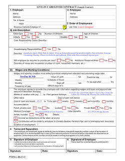


© Copyright 2026