
San Mateo Sustainable Streets Design Guidelines – (18 MB PDF)
Design Guidelines February 2015 Cover image provided by Urban Advantage All photos courtesy of Nelson\Nygaard unless otherwise noted SAN MATEO SUSTAINABLE STREETS Design Guidelines TABLE OF CONTENTS Page CHAPTER 1 : INTRODUCTION 1-1 Intent and Purpose ....................................................................................................................................................................................................................................................................1-1 A New Way to Design Streets ............................................................................................................................................................................................................................................1-1 Relationship with Other Local Plans ..............................................................................................................................................................................................................................1-1 Green Infrastructure ..................................................................................................................................................................................................................................................................1-5 Street Typologies ........................................................................................................................................................................................................................................................................1-6 Street Overlays ...........................................................................................................................................................................................................................................................................1-15 CHAPTER 2 : HOW TO USE THE DESIGN GUIDELINES 2-1 Design Guidelines Approach .............................................................................................................................................................................................................................................2-1 Key Partners ....................................................................................................................................................................................................................................................................................2-6 CHAPTER 3 : DESIGN GUIDANCE – ALONG THE STREET 3-1 Design Principles.........................................................................................................................................................................................................................................................................3-1 Pedestrian Realm ........................................................................................................................................................................................................................................................................3-2 Flexible Realm ............................................................................................................................................................................................................................................................................3-11 Travel Realm ................................................................................................................................................................................................................................................................................3-22 CHAPTER 4 : INTERSECTIONS 4-1 Design Principles.........................................................................................................................................................................................................................................................................4-1 Critical Design Issues ................................................................................................................................................................................................................................................................4-2 Transit Integration ......................................................................................................................................................................................................................................................................4-6 Bicycle Integration .....................................................................................................................................................................................................................................................................4-8 Green Infrastructure and General Landscape Integration .............................................................................................................................................................................4-9 Traffic Control Devices .........................................................................................................................................................................................................................................................4-11 Overlays and Intersections ................................................................................................................................................................................................................................................4-13 CHAPTER 5 : GREEN INFRASTRUCTURE 5-1 Managing Flow and Water Quality ................................................................................................................................................................................................................................5-3 Responding to Built and Environmental Context ................................................................................................................................................................................................5-4 Green Infrastructure Elements...........................................................................................................................................................................................................................................5-5 Green infrastructure Details .............................................................................................................................................................................................................................................5-19 General Landscaping Elements .....................................................................................................................................................................................................................................5-21 CHAPTER 6 : OTHER STREETSCAPE ELEMENTS 6-1 Street Furniture ............................................................................................................................................................................................................................................................................6-1 Lighting .............................................................................................................................................................................................................................................................................................6-5 Pavement Materials and Treatments ............................................................................................................................................................................................................................6-6 SAN MATEO SUSTAINABLE STREETS Design Guidelines i APPENDICES Appendix H.1 Appendix H.2 Green Infrastructure Considerations San Francisco Bay Estuary Institute Memo TABLE OF FIGURES Page Figure 1-1 Figure 1-2 Figure 1-3 Figure 1-4 Figure 1-5 Figure 1-6 Figure 1-7 Figure 1-8 Figure 1-9 Recent Planning Efforts Contributing the Design Guidelines Development ................................................................................................................1-3 Relationship of Various San Mateo Street Guidelines and Standards ................................................................................................................................1-4 Street Design Guidelines Street Types ......................................................................................................................................................................................................1-7 Street Design Guidelines Context .............................................................................................................................................................................................................1-10 Proposed Streets and Context Categories ..........................................................................................................................................................................................1-12 Relationship between Street Types and Existing FHWA Classifications .........................................................................................................................1-13 San Mateo Street Typologies ........................................................................................................................................................................................................................1-14 Street Design Guidelines Overlays ............................................................................................................................................................................................................1-16 Pedestrian Greenway Overlay ......................................................................................................................................................................................................................1-18 Figure 2-1 Figure 2-2 Figure 2-3 Figure 2-4 Figure 2-5 Street Delivery Process Relationship with Street Design Guidelines ...................................................................................................................................2-1 Realms of the Street ...............................................................................................................................................................................................................................................2-3 Street Design Process............................................................................................................................................................................................................................................2-4 Green Infrastructure Evaluation Process ..................................................................................................................................................................................................2-5 San Mateo Street Design Partners ................................................................................................................................................................................................................2-6 Figure 3-1 Figure 3-2 Figure 3-3 Figure 3-4 Figure 3-5 Figure 3-6 Figure 3-7 Standard Modal Priority for Streets ..............................................................................................................................................................................................................3-1 Pedestrian Realm in Commercial and Residential Contexts ......................................................................................................................................................3-2 Examples of Zones of the Pedestrian realm ..........................................................................................................................................................................................3-3 Pedestrian Realm Example ................................................................................................................................................................................................................................3-4 Pedestrian Realm Dimensions (in feet) .....................................................................................................................................................................................................3-5 Pedestrian Realm Green Infrastructure and Landscaping Applicability ............................................................................................................................3-6 Pedestrian Realm Elements ..............................................................................................................................................................................................................................3-7 SAN MATEO SUSTAINABLE STREETS Design Guidelines ii Figure 3-8 Influence of Overlays on Pedestrian Realm Geometries ...........................................................................................................................................................3-10 Figure 3-9 Flexible Realm in Context................................................................................................................................................................................................................................3-12 Figure 3-10 Examples of Flexible Realm Uses ..........................................................................................................................................................................................................3-13 Figure 3-11 Flexible Realm Geometries .......................................................................................................................................................................................................................3-14 Figure 3-12 Flexible Realm Green Infrastructure Applicability ....................................................................................................................................................................3-15 Figure 3-13 Flexible Realm Elements .............................................................................................................................................................................................................................3-16 Figure 3-14 Influence of Overlays on the Flexible Realm ................................................................................................................................................................................3-21 Figure 3-15 Why Narrow Lanes? The Relationship Between Lane Width and Travel Speed ..................................................................................................3-22 Figure 3-16 Example Uses of the Travel Realm .......................................................................................................................................................................................................3-23 Figure 3-17 Travel Realm Geometries ..............................................................................................................................................................................................................................3-24 Figure 3-18 Green Streets Elements Applicability in Travel Realm ...........................................................................................................................................................3-25 Figure 3-19 Travel Realm Elements .................................................................................................................................................................................................................................3-26 Figure 3-20 Influence of Overlays on the Travel Realm ....................................................................................................................................................................................3-31 Figure 3-21 Examples of Shared Space in Seattle, WA ......................................................................................................................................................................................3-32 Figure 3-22 Poor Driveway Design ...................................................................................................................................................................................................................................3-33 Figure 3-23 Desired Driveway Design ............................................................................................................................................................................................................................3-33 Figure 3-24 Driveway Management .................................................................................................................................................................................................................................3-33 Figure 3-25 Rolled Curbs in San Mateo ........................................................................................................................................................................................................................3-34 Figure 3-26 Opportunities for Curb Striping ..............................................................................................................................................................................................................3-34 Figure 4-1 Turning Radius Example ................................................................................................................................................................................................................................4-2 Figure 4-2 Accomodating Larger Vehicles at Intersections .................................................................................................................................................................................4-3 Figure 4-3 Urban Delivery Truck Design Vehicle ........................................................................................................................................................................................................4-4 Figure 4-4 Managing Slip Lanes ..............................................................................................................................................................................................................................................4-4 Figure 4-5 Key Crosswalk Elements.................................................................................................................................................................................................................................4-5 Figure 4-6 Transit Integration Elements.......................................................................................................................................................................................................................4-7 Figure 4-7 Green Infrastructure Applicability At Intersections..................................................................................................................................................................4-10 Figure 4-8 Bicycle Signal with “Black Out” Box .....................................................................................................................................................................................................4-12 Figure 4-9 Influence of Overlays on Intersection Design..............................................................................................................................................................................4-14 Figure 5-1 Figure 5-2 Figure 5-3 Green Infrastructure Evaluation Process ............................................................................................................................................................................................5-2 Green Infrastructure in Commericial and Neighborhood Contexts ...............................................................................................................................5-5 Green Infrastructure Function Table .....................................................................................................................................................................................................5-6 SAN MATEO SUSTAINABLE STREETS Design Guidelines iii Figure 5-4 Figure 5-5 Figure 5-6 Figure 5-7 Figure 5-8 Figure 5-9 Figure 5-10 Figure 5-11 Figure 5-12 Figure 5-13 Figure 5-14 Figure 5-15 Figure 5-16 Vegetated Swales ...............................................................................................................................................................................................................................................5-7 StormWater Trees ...............................................................................................................................................................................................................................................5-8 Linked Tree Wells .............................................................................................................................................................................................................................................5-10 Stormwater Curb Extensions ...................................................................................................................................................................................................................5-13 Flow-Through Planters ................................................................................................................................................................................................................................5-15 Green Gutters .....................................................................................................................................................................................................................................................5-15 Pervious/Permeable Paving .....................................................................................................................................................................................................................5-18 Usage of Underdrains ................................................................................................................................................................................................................................5-20 Street Trees ..........................................................................................................................................................................................................................................................5-21 Understory Plantings.....................................................................................................................................................................................................................................5-23 Median Street Trees .......................................................................................................................................................................................................................................5-23 Roundabout Plantings .................................................................................................................................................................................................................................5-24 Container Plants ...............................................................................................................................................................................................................................................5-25 Figure 6-1 Figure 6-2 Figure 6-3 Figure 6-4 Street Furniture in San Mateo ....................................................................................................................................................................................................................6-2 Street Furniture by Street Type and Overlay ...................................................................................................................................................................................6-3 Lighting Options .................................................................................................................................................................................................................................................6-6 Pavement Materials and Treatments ....................................................................................................................................................................................................6-8 SAN MATEO SUSTAINABLE STREETS Design Guidelines iv CHAPTER 1 : INTRODUCTION INTENT AND PURPOSE introduce three new concepts of green infrastructure, typologies and overlays to the local street design process. » components of streets by utilizing various elements to capture, slow, The Sustainable Street Design Guidelines are a technical extension of the and treat stormwater runoff; this approach can support placemaking Sustainable Streets Plan and serve as the starting point for the geometric and enhance the pedestrian experience. At the same time, green design of streets and related elements in San Mateo. It incorporates existing infrastructure also creates economic, community, and environmental goals for the City of San Mateo and combines them with existing local benefits through the creation of interesting and valued places to live in accepted design guidelines and national best practices. It reflects a and the creation and protection of aquatic and other habitats which comprehensive approach to street design and considers both the transportation function of the street in addition to its stormwater management role. These guidelines are intended to be used by municipal or Green Infrastructure takes advantage of landscape and urban design are critical in the San Francisco Bay Region. » Typologies: Typologies are a way to classify streets using a private sector street designers who may be building, reconstructing, or combination of a street’s transportation and mobility function in repaving streets within the City of San Mateo. Guidance provides addition to its role serving and being influenced by adjacent land uses. information, tools and best practices to inform the design of streets while » Overlays: Overlays include special-use networks and exceptions that ensuring flexibility so that a street designer can create plans to meet the may require special design treatments due to a specific use (i.e., bicycle unique context of the City of San Mateo. priority network) or need (i.e., transit station area). A NEW WAY TO DESIGN STREETS Using this approach of defining streets, there are now over fifteen different Previously, street design guidance was largely based on the idea of street may appear to add complexity, its primary function is to ensure that different functional classification. Functional classification traditionally defined a street types of streets can be designed and constructed that meet the numerous as a highway (limited-access), arterial, collector, or local. While this approach environs within San Mateo. More information about green infrastructure, provided some differentiation in the design of streets, it is not sensitive to typologies, and overlays can be found in later sections. local context and does not take into consideration other important factors types of street classifications as compared to the previous four. While this such as land use, prioritized inclusion of transit, bicycle and pedestrian RELATIONSHIP WITH OTHER LOCAL PLANS facilities, or the role a street plays in local commerce. The Design Guidelines The Design Guidelines incorporate information from numerous other take a different approach and seeks to provide a greater level of direction to ensure streets match their intended purposes within the context of the community through a local, city, and regional lens. The Design Guidelines existing San Mateo documents including the Bicycle Master Plan, Pedestrian Master Plan, and other local planning efforts that relate to the design of streets. This includes green infrastructure elements, which previously were not part of the street design process in San Mateo. The San Mateo County SAN MATEO SUSTAINABLE STREETS Design Guidelines 1-1 Green Streets and Parking Lots Design Guidebook was used to guide of past documents still remain relevant and valid today. In situations where language and processes around green infrastructure within these guidelines. there is duplicative information in both the Sustainable Streets Design Figure 1-1 provides a background of the various plan elements that were Guidelines and other existing local documents, these Design Guidelines used to form these guidelines and their contributions to informing overlays should take precedence unless specified otherwise in this document or or direct design guidance. within City Code. Some guidance is nearly a decade old, justifying the need for updated design guidelines to meet current best practices. However, some elements SAN MATEO SUSTAINABLE STREETS Design Guidelines 1-2 FIGURE 1-1 RECENT PLANNING EFFORTS CONTRIBUTING THE DESIGN GUIDELINES DEVELOPMENT 1 1 The El Camino Master Plan (2001) was also consulted as part of this plan design process. SAN MATEO SUSTAINABLE STREETS Design Guidelines 1-3 The Sustainable Streets Design Guidelines are not the City of San Mateo's all of these components fit within the same right-of-way and should be first set of design guidance. Numerous initiatives have been undertaken over considered holistically. The Design Guidelines provides overarching the past decade, including plans that provide design guidance by mode, guidance on the design of streets from property line to property line and specific overlay areas, or both. The intent of this document is not to includes details from other plans as necessary and provides new guidance duplicate past efforts, but instead, to point to the best respective when important information gaps exist. Figure 1-2 references how the information on designing streets in San Mateo and provide new information Sustainable Streets Design Guidelines relates to other recent street design when necessary. guidance and related local plans. In general, the Design Guidelines provide These planning efforts contribute different information to the street design process. Some of them are specific to mode (bicycles, pedestrians) while others provide specific guidance on green infrastructure elements. In reality, the primary guidance with respect to all components of street design. However, the plan heavily leans upon existing plans for supplementary information or additional detail. FIGURE 1-2 RELATIONSHIP OF VARIOUS SAN MATEO STREET GUIDELINES AND STANDARDS STREET DESIGN COMPONENTS SUSTAINABLE STREET DESIGN GUIDELINES PEDESTRIAN MASTER PLAN BICYCLE MASTER PLAN Street Typologies Overlays Green Infrastructure Street Design Guidance Intersection Design Guidance Traffic Control Devices Key: = Primary Guidance NEIGHBORHOOD TRAFFIC MANAGEMENT PLAN SAN MATEO COUNTY SUSTAINABLE GREEN STREETS AND PARKING LOTS DESIGN 2 GUIDEBOOK = Supplementary Guidance 2 Also see the San Mateo County Water Pollution Prevent Program: Stormwater Technical Guidance: A Handbook for Developers, Builders, and Project Applicants. SAN MATEO SUSTAINABLE STREETS Design Guidelines 1-4 RELATIONSHIP WITH STATE AND FEDERAL GUIDANCE public realm, enhance the overall pedestrian experience and create The Design Guidelines reflect the adopted guidance for streets within the GREEN INFRASTRUCTURE PRINCIPLES City of San Mateo, including some streets that fall under Caltrans jurisdiction. Even so, streets such as El Camino Real require a collaborative effort in the development of final designs. In addition, to ensure consistency with state and federal guidance, design guidelines and policies included within this document are consistent with the 2012 California Manual for Uniform Traffic economic, community, and environmental benefits. The following design principles for green streets are taken from the San Mateo County Sustainable Green Streets and Parking Lots Design Guidebook: » rainfall lands on a street or parking lot, allow it to infiltrate into the Control Devices (CA MUTCD 2012), as required by the California Vehicle Code. Furthermore, design guidelines and policies are drawn from state and nationally recognized design guidance from the Caltrans, the American ground or provide surface flow to nearby landscaping.” » » El Camino Real may also consider state guidance such as the Caltrans Main Street Guide which incorporates numerous green infrastructure elements and other design modifications that can better suit the needs of this community thoroughfare. GREEN INFRASTRUCTURE The direct integration of green infrastructure into the street design process makes these Design Guidelines unique. Green infrastructure elements take advantage of streets by utilizing various elements to capture, slow, and treat “Use plants and soil to absorb, slow, filter, and cleanse runoff. Let nature do its work.” Association of State Highway and Transportation Officials (AASHTO), and the National Association of City Transportation Officials (NACTO). Streets such as “Manage stormwater at the source and on the surface. As soon as “Design stormwater facilities that are simple, cost-effective and enhance community aesthetics. Stormwater facilities can be beautiful!” In addition, it is the City of San Mateo’s intent that green infrastructure will: » Be designed to complement and improve the linkages between the built and natural environments through functional and aesthetic design decisions, such as plant selection and design details. » Give consideration to climate change and the ability for Green Streets to maximize beneficial use of stormwater to offset potable water usage, recharge groundwater, and supply local creeks. stormwater runoff. This approach can also support placemaking in the SAN MATEO SUSTAINABLE STREETS Design Guidelines 1-5 » Provide fiscal efficiencies in the capital, operations, and maintenance of landscaping and storm water systems, as implementation of green infrastructure serves multiple purposes. The Design Guidelines suggest that every project that includes the design or redesign of a street, street realm, or intersection should consider the potential for including applicable green infrastructure and general landscape elements. Additional detail about green infrastructure and general landscape elements can be found in Chapter 5. STREET TYPOLOGIES Typology is the study of types and the characterization of a set of similar items in order to classify and differentiate. Applied to streets, typology can help one understand form, utility, and use. It is important to develop a typology for streets in order to systematize implementation. An essential tension on every street is where it fits on the link and place spectrum, both of which compose a street’s typology. Most streets have a travel component, linking to the larger transportation network. This might be in the form of a six-lane arterial or a narrow alley. Most streets also have a local, contextbased place component – they are the places where we live, work, and play. This might be in the form of a residential cul-de-sac or a regional connector like El Camino Real. LINK (STREET TYPE) Classifying the link (street type) aspect of a street's typology is fairly straightforward. At one end of the range are local streets with very little through function. These would be alleys, cul-de-sacs, and narrow lanes. At the other end are travel streets where the ability to move people and goods long SAN MATEO SUSTAINABLE STREETS Design Guidelines GREEN INFRASTRUCTURE DEFINED The US Environmental Protection Agency describes green infrastructure as a range of natural and built approaches to stormwater management–such as rain gardens, bioretention, and permeable paving–that mimic natural systems by cleaning stormwater and letting it absorb back into the ground. Green infrastructure strategies for streets can include a connected system of inlets, basins, and outlets for tree planters and other landscaping that allows stormwater to flow into the planting beds and slowly soak into the soil. Green infrastructure could reduce the amount of runoff that enters the traditional piped stormwater system below ground, and could prevent overflows that pollute nearby water bodies. Green infrastructure offers a range of additional environmental, economic, and community benefits, including more walkable streets, reduction of heat island effects, increased property values, and more gathering spaces that benefit residents and customers of local businesses. distances with little delay is the priority. The Federal Highway Administration’s Functional Classification system of local, collector, and arterial has generally been the starting point; however, it was developed to guide decision-making related to motor vehicle traffic. This type of classification system has been the standard in San Mateo to date. Figure 1-3 presents a description of the various street types defined for the City of San Mateo. Six street types were selected that reflect the full range of street functions from regional-serving arterials to the smallest alleys for utility purposes or pedestrian and bicycle paths. These street types represent the full range of potential paths that someone in San Mateo would use to travel across town or across the region. 1-6 FIGURE 1-3 STREET DESIGN GUIDELINES STREET TYPES STREET TYPE El Camino Real Major Connectors* Minor Connectors* 3 DESCRIPTION FHWA CLASSIFICATION EQUIVALENT El Camino Real (State Route 82) is its own street classification given its unique role as a major regional street that runs north-south through the central spine of San Mateo. Arterial Major Connectors have regional or citywide importance. These streets may have medians and a variety of elements within their cross section. Arterial or Collector Minor Connectors are streets with citywide importance. These streets typically are “neighborhood main streets” or feeder streets to larger roadways. Collector CHARACTERISTICS EXAMPLES » » » 4+ Lanes » » 2-4 Lanes » ADT 5-25k Delaware Street, Hillsdale Boulevard, Alameda De Las Pulgas » » 1-3 Lanes 28th Avenue » ADT 3-15k PHOTOS El Camino Real 35 mph speed limit ADT 3 ~ 20k and higher 25-35 mph speed limit 20-30 mph speed limit Average Daily Traffic SAN MATEO SUSTAINABLE STREETS Design Guidelines 1-7 STREET TYPE Access Alleys Paths DESCRIPTION Access streets primarily serve local homes or businesses. FHWA CLASSIFICATION EQUIVALENT Local Alleys primarily provide local access for service functions (trash pickup, deliveries, etc.). There are relatively few alleys in San Mateo. - Paths are defined as multiuse paths in park settings. - CHARACTERISTICS » » » 1-2 Lanes » » 1 Lane » » Shared-use path EXAMPLES PHOTOS 12 Avenue th 25 mph speed limit ADT < 6k 5-10 speed limit Main Street (Downtown) Bay Trail 10-15 mph speed limit (cyclists) * Major and Minor Connectors only apply to streets within a neighborhood context. In other contexts, a more general “Connector” term is used and its characteristics fall within the ranges defined by Major and Minor Connectors ** Establishing speed limits in the state of California is based on regulations outlined by the California Vehicle Code. The speed limits recommended in this document are grounded in an interest to provide a safe environment for pedestrians and cyclists within and adjacent to the street. SAN MATEO SUSTAINABLE STREETS Design Guidelines 1-8 CONTEXT could house a number of uses. A downtown building may be residential or commercial. The physical form of a big box store with its parking lot and a Classifying the place (context) aspect of a street is somewhat more warehouse is almost the same. Building form is the clearest indication of a challenging in that the methodologies are less developed. Absent other street's location on the place spectrum. A few basic forms are residential, information, land use is a reasonable proxy for a street's place. Residential, mixed-use, commercial center, downtown, institutional/campus, industrial, commercial, and industrial uses are usually represented by common forms, and parks. Residential is typically detached houses. Mixed-use is apartment such as the single-family house, warehouse, or office building. Both land use buildings and lofts. Commercial can be neighborhood shopping centers to and building form are means to help classify a place. Land use is somewhat commercial focal areas. Downtown is large buildings directly adjacent to the less successful in capturing the variety of building stock on a typical city street. Figure 1-4 presents a description of the five contexts that summarize street, especially ones that pre-date zoning. For example, commercial land City of San Mateo. These include levels of density as intense as downtown use could be a suburban strip mall, pedestrian-oriented retail buildings San Mateo to recreational spaces such as Coyote Point. adjacent to the sidewalk, or a corner store. Similarly a particular building type SAN MATEO SUSTAINABLE STREETS Design Guidelines 1-9 FIGURE 1-4 STREET DESIGN GUIDELINES CONTEXT CONTEXT TYPE DESCRIPTION EXAMPLES Downtown Downtown San Mateo – boundaries are as defined by the Downtown San Downtown San Mateo Refers primarily to areas with a mix of retail and residential land uses, or predominantly commercial areas (retail) 25th Avenue, 42nd Avenue Refers primarily to areas with predominately residential land uses San Mateo Village, Sunnybrae, Beresford neighborhood streets PHOTOS Mateo Specific Area Plan Commercial/Mixed-Use Neighborhood SAN MATEO SUSTAINABLE STREETS Design Guidelines 1-10 CONTEXT TYPE DESCRIPTION EXAMPLES Industrial Refers primarily to areas with predominately industrial land uses (manufacturing, warehouse or similar) Frontage roads along US 101 (Amphlett Blvd) Recreational areas Coyote Point (County of San Mateo) Parks SAN MATEO SUSTAINABLE STREETS Design Guidelines PHOTOS 1-11 STREET TYPOLOGY CATEGORIES Figure 1-5 outlines street typologies based on the six street types and five contexts previously described. Each of the typologies outlined below exhibit transportation characteristics that are in some respects similar and others unique. The Design Guidelines provide guidance for design geometries and corresponding design elements for each of these typologies. FIGURE 1-5 PROPOSED STREETS AND CONTEXT CATEGORIES STREET TYPE Context EL CAMINO REAL 4 MAJOR CONNECTOR MINOR CONNECTOR ACCESS ALLEY PATH Downtown Downtown El Camino Real Downtown Connector - Downtown Alley Walkway Commercial/ Mixed-Use 5 Mixed-Use El Camino Real Mixed-Use Connector Mixed-Use Access Mixed-Use Alley Walkway Neighborhood Access Neighborhood Alley Neighborhood El Camino Real Industrial Access - Walkway Park Access - - Neighborhood Neighborhood El Camino Real Industrial - Park - Neighborhood Major Connector Neighborhood Minor Connector Industrial Connector Parkway Connector - 4 This document considers El Camino Real its own street type, giving it unique characteristics as compared to other streets in San Mateo. Guidance for El Camino Real shall also reference the design guidance and elements as described in the Grand Boulevard Multimodal Transportation Corridor Plan. 5 Commercial/Mixed-Use context may include a gradient between land uses that are strictly commercial and others where both residential and commercial buildings exist together. There is minimal difference in terms of street design between these categories. However, strictly commercial uses are likely to generate larger volumes of pedestrian traffic. Thus, street geometries and amenities for pedestrians should be expanded for pedestrians in these scenarios. SAN MATEO SUSTAINABLE STREETS Design Guidelines 1-12 Street Typologies and Federal Guidance on Functional Classification typologies into FHWA functional classification terminology. Alleys and paths do not require FHWA functional classification equivalents. Functional classification is required by the Federal Highway Administration Figure 1-7 shows the City of San Mateo street network and its respective (FHWA) for projects that use federal funds. This system is primarily auto- street typologies. Use this map with the Design Guidelines, as street width centric and does not take into consideration local context, land-use, or built guidance is provided with respect to a street’s typology. This map should form. The street types presented in this document are an alternative to also be updated periodically to reflect changing conditions within the City traditional functional classification. To ensure that the City is still eligible for such as new development. federal transportation funds, Figure 1-6 converts the proposed street FIGURE 1-6 RELATIONSHIP BETWEEN STREET TYPES AND EXISTING FHWA CLASSIFICATIONS ARTERIAL El Camino Real Major Connector Minor Connector Access SAN MATEO SUSTAINABLE STREETS Design Guidelines COLLECTOR LOCAL 1-13 FIGURE 1-7 SAN MATEO STREET TYPOLOGIES SAN MATEO SUSTAINABLE STREETS Design Guidelines 1-14 STREET OVERLAYS street’s length and at intersections to support the overall bicycle priority Some uses are independent of a street's normal form and function, like exceptions at intersections to accommodate large volumes of trucks and routes for emergency vehicles and freight trucks, streets adjacent to major transit stations, and bicycle priority streets. These uses are not necessarily types, so they are classified as overlays. Overlays also describe a street's multi-modality. For example a street with high-frequency transit would be a connector street for transit, but the roadway might serve more of an access function. The same holds for a multi-way boulevard, which serves both connector and access functions for autos, a bicycle-priority street, and a truck route. network. Similarity, freight routes may require additional width and design wide turning movements. TRANSPORTATION OVERLAYS Figure 1-8 presents a summary of overlays to be considered in the development and design of streets in San Mateo. The figure describes the purpose of the overlay, potential associated design modifications, alternative performance metrics, and documentation that spatially defines the overlay. Example alternative performance metrics are provided as tools to evaluate Overlays do not dictate the specific design of a street, but encourage design flexibility to better serve the purpose of the overlay. Overlays are also a means to provide modal priority. As an example, access streets that fall under a bicycle priority overlay should prioritize bicycle treatments along the SAN MATEO SUSTAINABLE STREETS Design Guidelines the performance of the street under that overlay. Figure 1-9 provides an example of the Pedestrian Greenway Streets overlay which should prioritize pedestrian safety and comfort. Additional overlayspecific guidance on design modifications can be found in later sections. 1-15 FIGURE 1-8 STREET DESIGN GUIDELINES OVERLAYS OVERLAY PURPOSE EXAMPLE DESIGN MODIFICATIONS ALTERNATIVE PERFORMANCE 6 METRICS DOCUMENTATION Pedestrian Greenway Streets Prioritize pedestrian safety and comfort Reduced crossing distances and emphasis on pedestrian crossing enhancements Street trees and plantings Maximum sidewalk widths Minimizing pedestrian delay at intersections San Mateo Pedestrian Master Plan (see Greenways Map) Suggested Routes to Schools Prioritize pedestrian and bicycle safety along designated pedestrian and bicycle routes Reduced crossing distances and emphasis on pedestriancrossing enhancements Bicycle lanes Cycletracks Walking and biking mode share to selected San Mateo schools San Mateo – Foster City Suggested Routes to Schools Maps Bicycle Priority Streets Prioritize bicycle safety and comfort On-street bicycle treatments Intersection bicycle treatments (See Flexible realm, Intersections) Bicycle facility expansion (sustained increase) Bicycle compliance to traffic controls (increase) San Mateo Bicycle Master Plan Transit Streets Prioritize transit speed and schedule reliability Lane width guidance Reduced crossing distances Transit speed improvement projects (transit lanes and intersection treatments) Bus stop placement priority Persons per Lane Hour (maximize) Transit Vehicle Delay (minimize) Most recent SamTrans Service Plan – Recommended Bikeway Network (Chapter 5, page 5-2) 6 The performance metrics described here are at a corridor or street level. City level performance measures with respect to streets are described in the San Mateo Sustainable Streets Plan. SAN MATEO SUSTAINABLE STREETS Design Guidelines 1-16 OVERLAY PURPOSE ALTERNATIVE PERFORMANCE 6 METRICS EXAMPLE DESIGN MODIFICATIONS DOCUMENTATION Freight Routes Design routes suitable for goods movement Corner radii that accommodate trucks Lane width of 11 or 12 feet N/A Adopted Truck Route Policy (Recommended Truck Routes, Page 28) with exception of 5th Avenue between Humboldt and Amphlett Caltrain Station Areas Specific designs for additional pedestrians, density, etc. around station areas Reduced crossing distances Traffic calming and other safety countermeasures Maximize access pathways to station Matching All Pedestrian Desire Lines Pedestrian compliance to traffic controls (increase) Rail Corridor Transit-Oriented Development Plan Hillsdale Station Area Plan Downtown San Mateo Specific designs for additional pedestrians, density, etc. around station areas Reduced crossing distances Pedestrian lighting Traffic calming and other safety countermeasures Accommodate additional pedestrian amenities and street furniture Sales Tax Receipts Total Multimodal Trips Downtown Area Plan Emergency Primary Response Routes Ensure emergency vehicles have access to a network to minimize response times. Signal priority for emergency vehicles Rollable medians N/A Neighborhood Traffic Management Program SAN MATEO SUSTAINABLE STREETS Design Guidelines 1-17 FIGURE 1-9 PEDESTRIAN GREENWAY OVERLAY SAN MATEO SUSTAINABLE STREETS Design Guidelines 1-18 GREEN INFRASTRUCTURE While some of the overlays inform the selection, design and implementation prioritization of Green Streets elements, additional context information is meet stormwater management goals or enhance the pedestrian experience in a given area. » Pollutant Management: Surface: There is a spectrum of pollutants that can be present in needed to support the detailed design process for both green infrastructure and general landscape elements. The desired environmental and built surface flows ranging from ubiquitous trash and suspended solids context information to design green infrastructure includes: that can reduce the ability of the green infrastructure element to function to a range of chemical pollutants (i.e.; oils, pesticides, etc.). Environmental Context » » Some of these can be bio-remediated and some cannot. In the Soil and Hydrology: Detailed information about the soil and most extreme cases, these pollutants may result in green hydrology conditions in order to assess the feasibility of infiltration of infrastructure not being an acceptable approach to stormwater stormwater runoff from a green infrastructure feature into the management. In most cases if particular pollutants are present, this underlying soil. The same information allows an assessment of the could affect the selection of appropriate green infrastructure feasibility of groundwater recharge. elements, design details, maintenance and monitoring regimens, or other aspects of implementation. Tree Canopy: An understanding of the presence and distribution of Subsurface: The infiltration of water from green infrastructure can the existing tree canopy provides an opportunity to the street designer » to include trees in general landscaping and green infrastructure increase the potential for subsurface pollution to migrate more feature in a contextual fashion. For instance, where some street trees quickly by increasing groundwater flows, which in general is already exist new ones can be added to complete a row of trees. In undesirable. If subsurface pollutant concentrations could be areas where no street trees currently exist, a well-designed affected by green infrastructure infiltration design details should be combination of green infrastructure and general landscape element implemented to avoid infiltration, such as use of under drains, that include trees, can establish new rows of street trees extending impervious liners, or other means. This may impact the financial along the entire length of a block. feasibility of green infrastructure construction and maintenance. General Landscaping: Similar to tree canopy, an understanding of the » Areas of Localized Flooding: This information can be used to target presence and distribution of general landscaping provides an the mitigating use of green infrastructure features to areas where opportunity to place green infrastructure features or additional general localized flooding occurs. In combination with information about the landscaping in a contextual fashion. For instance, where areas of presence and capacity of existing stormwater utilities it can also be general landscaping currently exist, additional general landscaping and used for the proper sizing of these features. green infrastructure elements may be added or integrated in order to » Condition of Adjacent Water Bodies: In areas without stormwater utilities it may be desirable to connect green infrastructure elements to SAN MATEO SUSTAINABLE STREETS Design Guidelines 1-19 adjacent bodies of water, such as creeks, lagoons or the Bay. However, lines are not present, green infrastructure features need to be carefully if information about the water quality in these bodies of water designed to function without and underdrain. If water quality and flow indicates levels of concern with respect to pollutants, pathogens, and volumes can be made appropriate, green infrastructure can be bacteria, then green infrastructure elements should not be connected connected to natural bodies of water such as creeks, ponds, lagoons or to them if the possibility exists that insufficiently treated stormwater the Bay. runoff from the feature could negatively impact the water quality of the adjacent body » » about the larger drainage pattern of an area and its tributary drainage of water. subareas that may concentrate flows within the right-of-way is critical Sea Level Rise and Storm Surge Influence: The mapping of areas to the successful design of green infrastructure as this information co- where future sea level rise and storm surges may occur is important for determines the size of the green infrastructure elements or series of the detailed design of green infrastructure features, but this can likely elements needed to capture, slow and/or treat the runoff from the be avoided through proper plant species selection, such as plants that street or a portion of the street. can tolerate temporary saltwater inundation. Understanding areas potentially affected by storm surges warrants uses of green » activity): Understanding land uses and building frontage types along a street is important for the detailed design of these local green reduction/spread of peak flows and/or are designed to provide infrastructure treatments. Green infrastructure design characteristics additional capacity to help contain storm water surges. informed by this local context include the detailing of hardscape elements such as planter walls (height, visual detailing, color) or pavement (combination of types; patterns; color), and plant selection On-Street Parking: Mapping of the presence or absence of on-street (plant height relative to pedestrians, bicyclists, drivers, and signs; parking is a critical measure for the potential space available for green infrastructure elements in the Flexible Realm (see below for further explanation of the term), such as stormwater curb-extensions in corner flowering; deciduous vs. evergreen, etc.). » determining the best location of a green infrastructure feature as Location and Capacity of Existing Stormwater Utilities: Detailed stormwater runoff needs to reach the feature largely following already information about the location and capacity of the existing storm sewer system (storm sewer lines and drain inlets) is critical for the process of locating and detailing green infrastructure elements. Storm sewer lines present the opportunity for connecting underdrains associated with certain green infrastructure elements. Where sewer SAN MATEO SUSTAINABLE STREETS Design Guidelines Longitudinal and Cross-slopes: Survey information about the longitudinal slope and cross-slope of a street or site is important for or mid-block locations. » Land Use and Adjacent Building Frontage (pedestrian and other infrastructure features that can mediate flooding issues through a Built Context » Drainage Patterns and Tributary Drainage Areas: Information established grades. » Underground Utilities / Drain Inlets / Fire Hydrants / Driveways: Mapping of underground (but also above-ground) utilities, drain inlets, fire hydrants, driveways and other features that are expensive to move is important in order to avoid targeting locations for green 1-20 » infrastructure elements that are in direct conflict with one or more of At various stages of the street planning and design process, many of the these features. Not every identified conflict makes a green factors listed above inform the selection, location, sizing, and design infrastructure element infeasible, but it potentially makes character of a given green infrastructure feature as well as general landscape implementation more costly. For this reason, a careful advance element. As part of this process, the street designer should evaluate all assessment of potential conflicts allows the designer to identify relevant information that is available or can be generated without excessive alternate locations or to consider creative design solutions. cost to assess existing site conditions that may influence the design, Feasibility of Passive or Active Water Harvesting: The feasibility of selection and prioritization of green infrastructure elements. See Chapter 6 water harvesting – the practice of using stormwater runoff to irrigate for a summary checklist of the key environmental and built factors that landscape – can provide benefits, but needs to be carefully considered should be considered in assessing the layers of information listed above. in light of its potential costs. Please also refer to Chapter 5 for additional discussions of stormwater At the simplest level, any green infrastructure that includes landscape harvests the runoff to irrigate the landscape in the feature itself. This management functions, and the environmental and built context relevant to the design of Green Streets. reduces irrigation needs even if the infrastructure does not provide water Detailed information describing the data in this section may or may not be quality or other benefits. readily available. However, recent work by the San Francisco Estuary Institute Active water harvesting is more costly as it requires the storage of runoff in (SFEI) has developed an initial framework and method for how data can be a cistern and use of a pump to use the stored water to irrigate landscape used to assist the process of identifying locations where green infrastructure when it is not raining. If water from rainwater flows can be stored at a is appropriate and feasible. Please note that the results of this work, higher elevation it may be feasible to use passive water harvesting presented in Appendix H.2, do not reflect the potential future conditions without a pumping system (i.e.; run off within an adjacent public or created by implementation of the Sustainable Streets Plan. Additional private property at a higher elevation than the street, or in hilly areas analysis and data layers similar to the ones discussed above will be needed within the street at a higher elevation than where the water is applied). to more fully assess the feasibility of green infrastructure in the City of San Mateo. SAN MATEO SUSTAINABLE STREETS Design Guidelines 1-21 This page intentionally left blank. SAN MATEO SUSTAINABLE STREETS Design Guidelines 1-22 CHAPTER 2 : HOW TO USE THE DESIGN GUIDELINES intended to prescribe a uniform and optimal design solution for every The Design Guidelines fit into a small, yet important step in the overall street unique needs of the street. delivery process, as Figure 2-1 shows. The Guidelines take direction from the City’s Visions, Goals, Objectives, and Policies regarding streets and are invoked during repaving, reconstruction, or projects that involve new streets. After streets are designed and constructed, it is incumbent upon the City to ensure that they are evaluated with the correct metrics (see Sustainable Streets Plan, Performance Metrics, Chapter 4) to achieve overall community goals. DESIGN GUIDELINES APPROACH possible street permutation. It is up to the designer to extract relevant elements from this and other approved documents to design streets that include the right mix of geometries and street elements that meet the The design guidelines provide the following three types of information: » Principles: General design guidance that provides, at a high level, intent and goals for streets in San Mateo » Geometries: Specific design dimensions, associated with cross-section width » Elements: Dimensions and design guidance on specific elements that are along the street, at intersections, or both The Design Guidelines are intended to provide best practices and sound guidance in the design of streets in San Mateo. They are not FIGURE 2-1 STREET DELIVERY PROCESS RELATIONSHIP WITH STREET DESIGN GUIDELINES SAN MATEO SUSTAINABLE STREETS Design Guidelines 2-1 THE STREET REALM Figure 2-2 illustrates the various realms of the street and their potential elements. These guidelines provide geometries for the maximum, target, The Design Guidelines divide the street into three component parts: the and constrained widths of each of these realms and various elements within pedestrian realm, flexible realm, and the travel realm (including the median). each of these realms will be described in further detail. These are not intended to define a strict segregation of the street, but are to be used as a tool to understand how streets are assembled. The pedestrian realm should prioritize pedestrians and their needs (sidewalks, street furniture, etc.); the travel realm is where vehicles operate (bikes, transit, automobiles); and the flexible realm provides elements that cater to both. In the street design process, these realms must compete for limited right-ofway and should be designed with an “outside-in” strategy that places priority on non-motorized users in the pedestrian realm first, unless within a special overlay zone that prioritizes other modes of travel. All zones should place emphasis on green infrastructure, as opportunities for ecological performance exist throughout all parts of the cross-section, and include the space above and beneath the surfaces of the streets. SAN MATEO SUSTAINABLE STREETS Design Guidelines REALLOCATION OF THE STREET Street cross-section configurations are not intended to be permanent and may need to change over time based on changing local environs or demographic shifts. Reallocation of the street may come at key points of a street’s life including repaving and reconstruction. Repaving typically does not involve the movement of curb lines. However, repaving offers opportunities to shift the zones of the street using striping and other strategies. Street reconstruction (or significant utility work) provides opportunities to conduct more significant change to the street such as moving curb lines, or adding or changing the nature of stormwater drainage on the street through the use of green infrastructure elements. 2-2 FIGURE 2-2 REALMS OF THE STREET THE STREET DESIGN PROCESS The Design Guidelines should be referenced when a street designer knows the specific location within the City that is subject to redesign, reconstruction, or in a rare case of a new street. The first step is to reference the Street Typologies map (Figure 1-7) to determine the specific typology of the street in question. The second step is to determine if any overlays exist for that street segment or intersection. This may involve referencing previous plans (Figure 1-8) or gathering other available relevant data. Based on the street’s typology and any specific overlays, one can then use the Design SAN MATEO SUSTAINABLE STREETS Design Guidelines Guidelines to assemble the street based on guidance for each of the different realms (Figure 2-2). This final step should be influenced by the specific guidance based on the street’s typology, street overlays and must evaluate the potential of inclusion of green infrastructure within the design. The Design Guidelines also provide overall design principles and design elements associated with intersections and traffic control devices. Intersections and traffic control devices themselves are not necessarily associated with a specific typology. However, overlays should influence design elements associated facilities. The street design process is generalized in Figure 2-3. 2-3 FIGURE 2-3 STREET DESIGN PROCESS A fundamental element of the Design Guidelines is the inclusion of green other specific criteria within the design process. Figure 2-4 provides an infrastructure in the street design process. As part of design of all streets and overview of the process of selecting specific green infrastructure elements, intersections, the designer should evaluate if green infrastructure can be and general landscape elements, from the range of design choices. In this included in design elements or as part of the street surface itself. The process, the street designers must be aware of goals related to the evaluation of green infrastructure opportunities comes after the street management of stormwater flows and water quality, the built and typology and any overlays have been identified. The street typology and environmental context, and transportation function of the street (see overlays provide geometric guidelines, modal hierarchy and will define any Chapter 5 for more information). SAN MATEO SUSTAINABLE STREETS Design Guidelines 2-4 FIGURE 2-4 GREEN INFRASTRUCTURE EVALUATION PROCESS SAN MATEO SUSTAINABLE STREETS Design Guidelines 2-5 KEY PARTNERS DESIGN GUIDANCE The steps in the street delivery process are primarily implemented by the The contents of the Design San Mateo Department of Public Works. However, certain elements of the Guidelines are organized by street engage other local partners (Figure 2-5). Here, coordination is critical streets, intersections, signals, and Streets Intersections to ensure that opportunities are not missed to make street improvements in green infrastructure. Chapter 3 conjunction with other efforts. Similarly, coordination will prevent redundant “Along the Street” provides work, saving public funds. For example, most utilities (electricity, cable and guidance based on the three internet, non-drainage specific water lines) are located within the street street realms including the Green Infrastructure Signals (beyond the gutter pan of the curb). pedestrian realm, flexible realm and the travel realm. This chapter also provides guidance on special street types such as yield streets or shared spaces. Guidance on intersections and signals are included in Because most utility maintenance requires traffic disruptions and some level of street construction, it is best to consider other street reconfiguration or reconstruction needs at the time of such work. Currently, the City of San Mateo has ongoing quarterly coordination with various utility providers Chapter 4. Finally, detailed guidance on various green infrastructure whereas other coordination meetings should continue to occur on an as- elements is provided in Chapter 5. While the chapters themselves are needed basis. ordered in this manner, they are not intended to be used sequentially. Instead, it is presumed that frequent cross referencing is necessary, particularly for the green infrastructure chapter. FIGURE 2-5 SAN MATEO STREET DESIGN PARTNERS STREET ELEMENT PARTNER COORDINATION PROTOCOL Electricity Pacific Gas and Electric Quarterly Utility Coordination Meeting Cable and Internet Comcast, Astound, U-verse, Others Quarterly Utility Coordination Meeting Water Meters and Lines CalWater Quarterly Utility Coordination Meeting City-maintained Landscaping San Mateo Parks and Recreation Internal San Mateo Service/Work Orders Throughways for Emergency Vehicles San Mateo Fire Department As-needed Meetings State-owned Streets Caltrans As-needed Meetings SAN MATEO SUSTAINABLE STREETS Design Guidelines 2-6 CHAPTER 3 : DESIGN GUIDANCE – ALONG THE STREET » This chapter focuses on linear portions of streets (between intersections) » and provides guidance on cross-section geometries based on a street’s otherwise, all streets in San Mateo shall place local access needs above regional mobility needs. Examples include streets that support local commerce, placemaking, and pedestrian and bicycle safety. some cases, overlays will specify streets that should maintain special of various green infrastructure and other transportation-specific elements lighting (applicable to streets and intersections) can be found in Chapter 6. priority for one type of user over others. » » Safety through design (reducing injuries and fatalities): Streets shall be designed to reduce all types of transportation-related injuries and fatalities. Street designs shall consider past injury data and DESIGN PRINCIPLES Streets in San Mateo shall be designed with the following principles in mind. Accommodation for all users: Excluding freeways, all streets shall accommodate all types of users, including pedestrians and cyclists. In typology and local context. In addition, the chapter outlines the applicability that may be applied along the street. Guidance on street furniture and Local priorities above regional needs: Unless specifically stated appropriate countermeasures to prevent collisions in the future. » Action, observation, improvement: Street improvements do not Pedestrians are the Top Priority: Every trip in San Mateo begins and need to be permanent. A pilot-project approach that allows for the ends with walking. Thus, all street designs should prioritize pedestrian temporary testing of street improvements should be considered to movement first. This must include designing for a range of pedestrians, help develop street improvements that produce measureable benefits from healthy young adults to elderly residents using a mobility device. and achieve desired outcomes. This is reflected in Figure 3-1. » Sustainable Streets include Green Streets: Green Streets infrastructure shall be included as an integral part of San Mateo’s FIGURE 3-1 STANDARD MODAL PRIORITY FOR STREETS street-design process and management of stormwater. » Design proactively, not reactively: Street designs should be approached from a standpoint of “how should this street function?” as compared to “how will this street function given existing conditions?” As an example, streets should be designed with a preferred speed or volume, rather than of simply accepting existing conditions. SAN MATEO SUSTAINABLE STREETS Design Guidelines 3-1 FIGURE 3-2 PEDESTRIAN REALM IN COMMERCIAL AND RESIDENTIAL CONTEXTS Source: CD+A PEDESTRIAN REALM 7 The pedestrian realm includes more than where a concrete sidewalk is present, but the entire width from the curb or road edge to the property line. The pedestrian realm is divided into three additional sub-zones known as the frontage zone, pedestrian through zone and the furniture zone as street (aka shared space) such as a residential cul-de-sac, park, or commercial pedestrian mall that has occasional service traffic. In addition, when installing new pedestrian facilities or upgrading existing ones, the City must ensure compliance with the Americans with Disabilities Act (ADA). All design standards in this section meet or exceed ADA. shown in Figure 3-2. FRONTAGE ZONE Generally speaking, pedestrian facilities should always be installed on both The frontage zone is the space between property line and the edge of the sides of the street, except in applications where people are expected in the pedestrian through zone. The frontage zone might contain shop displays, restaurant seating, merchandise for sale, or landscaping. The “shy distance” 7 The Pedestrian Zone and its subzones are consistent with the Pedestrian Master Plan’s “Sidewalk Zones.” However, cross section dimensions in this document shall supersede those in the Pedestrian Master Plan. SAN MATEO SUSTAINABLE STREETS Design Guidelines from buildings and space for open building doors should also be included in the frontage zone. In areas with lower densities such as single family homes, the frontage zone is typically narrow since property lines (and typically 3-2 lawns) come up to the sidewalk. A minimum frontage zone width of one (1’) foot is recommended to provide a setback to fences and other elements FIGURE 3-3 EXAMPLES OF ZONES OF THE PEDESTRIAN REALM FRONTAGE ZONE placed on property lines, and to allow easy maintenance of the sidewalk. Space for sidewalk cafes, awnings, vendors, doorway openings. On streets with front lawns without fences, the frontage zone is effectively zero. However, some space (up to 1’) should remain to ensure easy maintenance (cleaning, resurfacing) of the pedestrian through zone. PEDESTRIAN THROUGH ZONE PEDESTRIAN THROUGH ZONE The pedestrian through zone is the place for pedestrian travel. It should be completely free of obstacles and protruding objects, and should be a minimum of five (5’) feet wide. This provides enough space for two pedestrians to walk comfortably side by side. In commercial (downtown and mixed-use) contexts, the pedestrian through zone should be at minimum (6’) feet wide. The pedestrian through zone should never be less than four Space for pedestrian travel. Should be clear of obstructions, similar to a roadway, and maintain a direct, straight path. (4’) 8 feet, even at pinch points; this is the width required to meet ADA guidelines for the “pedestrian access route.” Street furniture or poles associated with signs or signals should not be placed in through zone. 9 FURNITURE ZONE Paved or planted area for pedestrian amenities, trees, or street infrastructure (fire hydrant, signs, utilities). Photo Sources: CD+A 8 Current ADA standards require three (3’) feet, but draft guidelines (future standards) require four (4’) feet. 9 Full text of ADA can be found at: http://www.accessboard.gov/guidelines-and-standards/streets-sidewalks/publicrights-of-way SAN MATEO SUSTAINABLE STREETS Design Guidelines 3-3 FURNITURE ZONE FIGURE 3-4 PEDESTRIAN REALM EXAMPLE The furniture zone is where pedestrian amenities and street infrastructure are placed. This zone can be paved or planted and is often an area of opportunity for stormwater management treatments. When right-of-way is available, this zone should be increased beyond the standard size and when on-street parking is present it also provides space for opening vehicle doors. In areas with high pedestrian traffic, this zone may need to facilitate a greater magnitude of street furniture such as bicycle and newspaper racks, trash bins, and pedestrian scale street lighting. In other areas, this zone may simply serve as a buffer from travel lanes when no on-street parking is present. Also see furnishings in the Pedestrian Master Plan and Chapter 6 of this document. PEDESTRIAN REALM GEOMETRIES Selecting widths for the pedestrian realm and its subzones (frontage, pedestrian through, and furniture zone) requires compromises based on the total available width and the priorities of the street. For example, streets with street trees require additional furniture zone width to accommodate the tree bulb, whether under a tree grate or landscaped, to allow for healthy tree growth. The extent of the additional width to accommodate street trees may be reduced through use of tree grates, extending the landscape area with curb extensions into the parking lane, or structural soils to support healthy tree roots. Alternatively, streets with sidewalk cafes or retail shops may require a larger frontage area to accommodate those uses. Figure 3-5 provides target, constrained (minimum), and maximum dimensions for various elements that fall within the pedestrian realm based on the street type and local context. SAN MATEO SUSTAINABLE STREETS Design Guidelines Assembling the pedestrian realm must weigh factors of estimated pedestrian volumes and context of the street (e.g., street cafes, need for bicycle racks, street trees) while attempting to maintain the target width of the pedestrian through zone 3-4 FIGURE 3-5 PEDESTRIAN REALM DIMENSIONS (IN FEET) EL CAMINO REAL ZONE Downtown Commercial / MixedUse Neighborhood (Major Connector) Neighborhood (Minor Connector) Industrial Park Additional Guidance: » » ACCESS PEDESTRIAN THROUGH FURNITURE FRONTAGE PEDESTRIAN THROUGH FURNITURE FRONTAGE PEDESTRIAN THROUGH FURNITURE Target 3 8 6 3 12 6 - - - Maximum 8 no maximum 10 8 no maximum 10 - - - Constrained 1 6 4 1 8 4 - - - Target 3 8 6 3 8 6 1 6 6 Maximum 5 12 10 5 12 10 2 8 8 Constrained 1 5 4 1 6 4 1 5 4 Target - - - 1 6 6 - - - Maximum - - - 2 10 6 - - - Constrained - - - 0 5 4 - - - Target - - - 1 5 5 - - - Maximum - - - 2 6 6 - - - Constrained - - - 0 5 2 - - - Target 1 6 8 - - - 1 5 5 Maximum Neighborhood MAJOR AND MINOR CONNECTORS FRONTAGE 10 12 - - - 1 6 8 Constrained 0 4 4 - - - 0 5 2 Target 1 6 6 1 6 6 1 5 5 Maximum 3 9 10 3 9 8 4 6 8 Constrained 1 4 4 1 5 4 0 5 2 Target 1 10 8 1 8 10 1 6 6 Maximum 2 12 - 2 10 12 2 10 10 Constrained 0 5 4 0 5 4 0 5 4 Sidewalk zones should be designed to provide a straight path of travel for the pedestrian. Thus, through zone widths should not frequently vary along the same block face. The furniture zone should ensure regular access between the pedestrian through zone and the street (e.g., street furniture should not impose a consistent barrier) Note: The dimensions referenced in this table are generally consistent with those found in the San Mateo Pedestrian Master Plan. SAN MATEO SUSTAINABLE STREETS Design Guidelines 3-5 PEDESTRIAN REALM ELEMENTS residential areas to infiltration / flow-through planters in commercial areas. Along the street, the pedestrian realm will primarily house green infrastructure and general landscaping in addition to those along the street. Intersections offer significant opportunities for the integration of green infrastructure, street furniture associated with amenities for pedestrians, and However, green infrastructure at these locations needs to be sensitive to street-associated utilities such as lamp posts and fire hydrants. Note that safety and maintaining visibility for pedestrians, cyclists and vehicles some green infrastructure elements may be placed in more than one realm navigating the intersection. See Chapter 5 for more detailed guidance. of the street. Figure 3-6 provides an overview of the applicability for specific green Green Infrastructure and General Landscape Integration infrastructure and general landscape elements that can be applied within The pedestrian realm offers a broad range of opportunities for the the pedestrian realm. See Chapter 5 for more detailed green infrastructure integration of green infrastructure, ranging from vegetated swales in guidance. FIGURE 3-6 PEDESTRIAN REALM GREEN INFRASTRUCTURE AND LANDSCAPING APPLICABILITY PEDESTRIAN REALM ELEMENTS 10 COMMERCIAL/MIXED USE NEIGHBORHOOD INDUSTRIAL PARK Green Infrastructure DOWNTOWN Vegetated Swale Rain Gardens Infiltration / Flow-Through Planters Pervious/Permeable Paving Landscaping ELEMENTS/CONTEXT Street trees Understory plantings Container planters Tree Wells 10 Includes Individual Stormwater Trees and Linked Tree Wells SAN MATEO SUSTAINABLE STREETS Design Guidelines 3-6 on usage and placement. Guidance on other pedestrian realm elements Transportation Elements Integration such as street furniture and pedestrian-scale lighting can be found in Figure 3-7 provides an overview of various transportation related elements that may be considered as part of the pedestrian realm, along with guidance Chapter 6. FIGURE 3-7 PEDESTRIAN REALM ELEMENTS ELEMENT Transit Shelters DESCRIPTION Transit shelters provide protection from sun, wind and rain while offering a location to post relevant transit information (real time arrival times, maps). Shelters should be prioritized at high ridership locations and must ensure a path of travel within the pedestrian realm. Bicycle Share Pods Bay Area Bike Share docking stations or “pods” provide access to the bike share network. Currently, there are no bike share pods in San Mateo. However, it is a likely expansion City for the bike share network in the future. GUIDANCE » Place in accordance with transit agency bus shelter and design guidelines; shelters should not block the path of travel » Provision of shelters should be based on estimated transit ridership at the location 11 » Consider special paving treatments at transit stop locations to delineate the passenger environment from regular pedestrian circulation areas » Choose subtle treatments, such as scoring patterns, as bus stops may be moved from time to time » Place in way that discourages riding on the sidewalk and allows users to safety dock/undock bicycles without being in the path of motor vehicle traffic PHOTOS 11 Transit shelters should only be placed if other basic transit amenities are already in place (bus stop signage, lighting, level boarding surface, safe sidewalk access) SAN MATEO SUSTAINABLE STREETS Design Guidelines 3-7 ELEMENT DESCRIPTION GUIDANCE Utilities, street lighting, signs, and other necessary obstacles Power and telephone transmission poles, street light poles, fire hydrants, sign posts, parking meters or pay stations, and other elements that may block the path of travel. » » Pedestrian Furniture (mailboxes, trash receptacles, newspaper racks) Important pedestrian-serving amenities include benches, mailboxes, trash receptacles, newspaper racks, and drinking fountains. These types of amenities should be logically placed to meet demand and should not obstruct the path of travel along the sidewalk. » SAN MATEO SUSTAINABLE STREETS Design Guidelines PHOTOS Street lighting should be pedestrian scale All poles should be outside of the path of travel, usually in the furniture zone, but may also sometimes exist in the frontage zone Should be placed in the frontage zone or furniture zone at locations that allow easy access for users and for daily upkeep and operational purposes For additional guidance on the placement and use of pedestrian furniture, see street furniture guidance in Chapter 6. 3-8 ELEMENT DESCRIPTION Bicycle Racks Providing secure locations for bicycle parking is an important component of a multimodal transportation network. Without parking, cyclists are able to reach their destinations, but may not be able to park and lock their bikes, or will lock them to other fixed upright structures, potentially blocking foot traffic. Quantity of parking should be based on estimated demand. High levels of demand may warrant additional bicycle parking capacity through the use of bike corrals or bicycle stacking mechanisms. Shared Spaces Shared spaces include streets or portions of streets that are considered to be shared by pedestrians, bicyclists, and vehicles. Shared spaces may fall into the pedestrian, flexible, or travel realms. GUIDANCE » Should be placed in locations that provide visibility (security) and adequate space for bicycles to be secured without difficulty » Placed in an orientation that accommodates the full size of the bicycle without blocking the path of travel PHOTOS For further guidance: City of San Mateo Pedestrian Master Plan (A.36 Bike Rack) or Streetscape Master Plan » Shared spaces are suitable for low-volume streets with vehicle speeds no greater than 10 mph » May be curbless to promote a pedestrianfriendly environment » Can be used in both commercial and residential contexts For additional information, please see the NACTO Urban Street Design Guide – Shared Streets or the proceeding Travel Realm section or the Shared Spaces portion of these guidelines (travel realm) Photo Sources: CD+A and Nelson\Nygaard Figure 3-8 describes guidance and design modifications based on specific overlays that may influence the pedestrian realm. SAN MATEO SUSTAINABLE STREETS Design Guidelines 3-9 FIGURE 3-8 INFLUENCE OF OVERLAYS ON PEDESTRIAN REALM GEOMETRIES OVERLAY GUIDANCE DESIGN MODIFICATIONS Prioritize pedestrian safety and comfort and high quality pedestrian connections. The City should also consider additional street trees, planting, wide sidewalks and public art on these corridors. (See Pedestrian Master Plan Chapter 5.1) » Reduced crossing distances and emphasis on pedestrian crossing enhancements » » Street trees and plantings Transit Streets On transit-priority streets, the pedestrian realm should ensure ample width near bus stops for transit shelters, bus stop signage, and capacity for waiting riders. » Maximize width of pedestrian realm to accommodate transit shelters (when warranted based on stop level ridership) Bicycle Priority Streets or Suggested Routes to Schools Bicycle priority streets may require additional bicycle parking (bicycle racks) within the furniture zone. (See Bicycle Master Plan, Chapter 5) » Provide furniture zone width that accommodates bicycle parking (bicycle racks) Freight Routes Freight routes are designed to accommodate larger vehicles; however this does not mean that pedestrians are not present. » No unique design modifications Caltrain Station Areas Similar to transit streets, areas surrounding rail stations should expect higher numbers of pedestrians. As a result, pedestrian through zones should be maximized and space for street furniture should be accommodated. » Maximize pathways and through zones to station » Maximize space for street furniture Downtown San Mateo is expected to have the large volumes of pedestrians. Different from areas around transit stations, Downtown should accommodate pedestrians walking at different paces (e.g., window shoppers versus commuters) and have ample pedestrian amenities (benches, newspaper racks, etc.). » » Maximize width of through zones Pedestrian Greenway or Suggested Routes to Schools Downtown San Mateo Emergency Primary Response Routes No impact on the pedestrian realm. SAN MATEO SUSTAINABLE STREETS Design Guidelines Maximum sidewalk widths Maximize space in furniture zone for street furniture and landscaping N/A 3-10 FLEXIBLE REALM » The flexible realm refers to the area between the walkway and roadway. This area accommodates many elements of both driving and walking. It is also the primary place for cycling. In addition to green infrastructure opportunities, the flexible realm typically includes the following key transportation elements along its length: » moving traffic, and protects people on the sidewalk from errant drivers. On the other hand, each parking space is valuable real estate that can be used for curb extensions, bus shelters, bicycle parking, trees, rain gardens, bus lanes, and more. Parking also creates challenges for bicyclists, including conflicts during parking maneuvers and dooring Curbs: Curbs primarily exist to prevent water and cars from hazards. On-street parking can take various forms including typical encroaching into the pedestrian realm. Pedestrians must traverse the parallel parking, diagonal parking (back-in or front-in), or perpendicular curb to get from the street to the sidewalk, so providing curb ramps or parking. other transitions is critical to accessibility for people using assistive devices. Curbs may be designed in a way to incorporate green » If used, on-street parking should be clearly designed to not appear as part of the vehicular travel way. This can be accomplished by including infrastructure or be flush as in a shared space environment. The curb curb extensions (so the travel way remains visually narrower where itself is typically just half a foot wide not including the gutter. Common there is no parking), and paving the parking area differently than the gutter widths are 1’, 1.5’, and 2’. On-street parking and even bike lane travel lanes (concrete or pavers, not asphalt). In addition, project widths can include the gutter width. 12 » On-street parking can be a positive or negative asset for users of the street. On one hand, on-street parking supports storefront retail, slows managers are encouraged to explore opportunities to organize Bicycle Facilities: Locating and designing bicycle facilities are often a parking with street trees, bus stops, and other elements in the flexible difficult challenge in street design because cyclists share operational realm. In no circumstance should on-street parking be designed in a characteristics with both pedestrians and motorists. A high quality way where it may be misunderstood as part of the traveled way. Within facility will separate cyclists from autos, and minimize conflicts the flexible realm, parking lanes are typically 7’ in residential areas and between pedestrians and faster moving cyclists. It will provide a direct 8’ in commercial areas. connection for fast riders, and a leisurely ride for everyone else depending on the overall bicycle volumes. In some situations this may require duplicate facilities on individual streets, e.g. a marked shared lane and a cycle track, or a wide buffered bike lane. For purposes of this guidance, all dedicated bicycle facilities (bicycle lanes, cycletracks, etc.) are considered part of the flexible realm. » Right Turns: Right turn lanes that align with a parking lane are considered in the flexible realm. The decision to place moving traffic adjacent to the curb (and pedestrian realm) should be balanced with capacity needs for right turning vehicles. Potential merge and turning conflicts with right turns and bicycle facilities should be closely analyzed as right turns by vehicles are among the most frequent causes of bicycle collisions. 12 Utilizing the gutter pan as part of the width of a bicycle facility should be avoided whenever possible. SAN MATEO SUSTAINABLE STREETS Design Guidelines 3-11 The flexible realm can be filled with numerous types of elements serving different types of population. When determining usage for the flexible realm, one must consider the role of the street in the larger transportation network and the local context of the street. Figure 3-9 provides examples of the flexible realm being configured in five different ways, each providing a different local and network benefit. FIGURE 3-9 FLEXIBLE REALM IN CONTEXT The flexible realm can include various street elements based on the needs of the street and the local land uses. Source CD+A SAN MATEO SUSTAINABLE STREETS Design Guidelines 3-12 FIGURE 3-10 EXAMPLES OF FLEXIBLE REALM USES MOBILITY REDUCTION OF CROSSWALK DISTANCES PARKING EXPANSION OF PEDESTRIAN REALM FLEXIBLE REALM GEOMETRIES Figure 3-11 provides target, constrained (minimum) and maximum dimensions for various elements that fall within the flexible realm. SAN MATEO SUSTAINABLE STREETS Design Guidelines 3-13 FIGURE 3-11 FLEXIBLE REALM GEOMETRIES EL CAMINO REAL Downtown Mixed-Use Neighborhood (Major Connector) PARKING AREA BICYCLE LANE Target 8 Maximum 182 Neighborhood Industrial Park PARKING AREA BICYCLE LANE 7 8 6 8 182 7 ACCESS PARKING AREA 1 Constrained 7 6 7 5 - Target 8 7 8 6 8 7 8 2 18 Constrained 7 6 7 5 7 Target - 8 6 8 7 7 5 7 6 8 7 Constrained - 7 7 - - Maximum Target Maximum 8 18 2 Maximum Constrained Neighborhood (Minor Connector) MAJOR AND MINOR CONNECTORS 1 Target 7 7 Maximum 8 8 Constrained 7 6 - Target 10 7 10 6 8 Maximum 10 8 10 8 10 7 8 7 Constrained 8 6 8 5 7 Target 7 7 7 7 7 Maximum 8 8 8 8 8 Constrained 7 6 7 5 7 Notes: 1. These bicycle lane widths are for standard bike lanes. A portion of this width may be used to provide a marked buffer between the parking lane and the bike lane. Where gutters are used, the clear width of a bike lane between the edge of the gutter and the center of the bicycle lane should be four feet minimum, or as narrow as three feet in constrained areas for a retrofit project. Where buffered bike lanes, double bike lanes, or cycle tracks are provided, three to five feet of additional width should be provided to allow for overtaking and/or painted buffers or curbed separators. 2. Eighteen feet is the maximum dimension for diagonal parking, as it is the necessary width for 60°, front-in diagonal parking. Flatter angles and back-in parking can be implemented with narrower parking lanes. SAN MATEO SUSTAINABLE STREETS Design Guidelines 3-14 Green Infrastructure and General Landscape Integration FLEXIBLE REALM ELEMENTS The Flexible Realm offers a range of opportunities for the integration of Along the street, various elements may exist within the flexible realm including facilities designed for vehicles, cyclists, pedestrians, or all three at the same time (shared spaces). This section describes the various elements that may exist within the flexible realm. green infrastructure and includes both landscaped features, such as stormwater trees and stormwater curb extensions as well as hardscape solutions, such as permeable/porous paving. Figure 3-12 provides an overview of the applicability for specific green infrastructure and general landscape elements that can be applied within the Flexible Realm. See Chapter 5 for more detailed guidance. FIGURE 3-12 FLEXIBLE REALM GREEN INFRASTRUCTURE APPLICABILITY FLEXIBLE REALM 13 ELEMENTS / CONTEXT DOWNTOWN MIXED-USE NEIGHBORHOOD INDUSTRIAL PARKS Tree Wells 13 Stormwater Curb Extensions Pervious/Permeable Paving Street Trees Understory Plantings Container Planters Includes Individual Stormwater Trees and Linked Tree Wells SAN MATEO SUSTAINABLE STREETS Design Guidelines 3-15 Transportation Elements Integration Figure 3-13 provides an overview of various transportation elements that may be considered as part of the flexible realm. Guidance on usage and placement is also provided. FIGURE 3-13 FLEXIBLE REALM ELEMENTS ELEMENT DESCRIPTION GUIDANCE PHOTOS EXPANSION OF PEDESTRIAN REALM Parklets Parklets are extensions of the sidewalk that are open to the public and typically have street furniture such as benches and tables. It commonly fits within the space of several (2-3) on-street parking spaces. In some cities, parklets are privately owned and maintained, but are permitted through a City process. In other cities, parklets are privately constructed and maintained, but are available for public use. » The location of parklets is typically generated by private sector demand. However, parklets must not degrade street safety. » Should not be placed in a manner that impedes visibility at street corners nor should they be placed in a way that creates conflicts between parklet users and passing vehicles For additional information and design guidance please use the following resources: Pedestrian Master Plan Appendix A.18, A.19 (Flex Use Space Parklets) – includes materials NACTO Urban Street Design Guide (Interim Design Strategies) SF Pavement to Parks Parklet Manual SAN MATEO SUSTAINABLE STREETS Design Guidelines 3-16 ELEMENT Curb Extensions (Bulb outs) DESCRIPTION Curb extensions along the street provide a variety of benefits. When used at intersections or at a mid-block crossing, curb extensions reduce the crossing distance and improve sight lines between pedestrians and motorists. In addition, curb extensions serve as an expansion of the pedestrian realm or furniture zone allowing for street furniture, trees, or other amenities. Curb extensions can also function as bus bulbs, providing additional capacity for waiting passengers and reducing transit dwell times. GUIDANCE » Mid-block curb extensions can be used when further delineation of on-street parking is necessary or in the presence of a mid-block crosswalk to reduce crossing distance and improve visibility » Curb extensions used at intersections (bulb PHOTOS outs, bus bulbs) are discussed in the intersections section. For further guidance: See NACTO Urban Street Design Guide (Street Design Elements – Pinchpoint) BICYCLE FACILITIES Bicycle Lanes Bicycle lanes provide exclusive use of a portion of the roadway for cyclists and are demarcated through pavement markings. Bicycle lanes typically operate in the same direction as vehicle traffic. However, contra-flow bicycle lanes can also be used to aid the overall connectivity of the bicycle network. Typically, bicycle lanes exist on the outside (rightmost) portion of the street next to the travel lanes. However, left-side bicycle lanes may be applied on one-way streets as well. SAN MATEO SUSTAINABLE STREETS Design Guidelines » Bicycle lane width should vary based on the expected volume of cyclists and shall be no less than 5’ Further guidance for bicycle lane design can be found here: NACTO Urban Bikeway Design Guide (Bike Lanes) City of San Mateo Bicycle Master Plan (A.5 Bike Lanes) 3-17 ELEMENT DESCRIPTION Buffered Bicycle Lanes Buffered bicycle lanes have similar characteristics as conventional bicycle lanes, but have a marked buffer space between the bike lane and the adjacent vehicle travel lane (separation from moving traffic) or parking lane (separation from vehicle door zone). GUIDANCE » Buffered bicycle lanes can be used in any locations in place of a conventional bicycle lane » Streets with higher travel speeds, volumes, or truck traffic may be especially good candidate locations for buffered bicycle lanes » A buffered bicycle lane can be used to replace a travel lane when applicable PHOTOS For further guidance: NACTO Urban Bikeway Design Guide (Buffered Bicycle Lanes) City of San Mateo Bicycle Master Plan (A.6.6 Buffered Bike Lanes) Cycle Tracks (Protected Bicycle Lanes) Cycle tracks are dedicated bicycle facilities that are physically separated from motor vehicle travel lanes, parking lanes, and sidewalks. In situations where on-street parking is allowed, cycle tracks are located to the curb-side of the parking (in contrast to bike lanes). Cycle tracks offer a higher level of comfort than bike lanes and are attractive to a wider spectrum of the public. However, the physical separation complicates designs at intersections and driveways. » Cycle tracks may be one-way or two-way, and may be at street level, at sidewalk level, or at an intermediate level » They should be separated from motor vehicle traffic by a curb, a median, bollards, or on-street parking » At signalized intersections it is often necessary to signalize through bicycle movements separately from motor vehicle right turn movements For further guidance: NACTO Urban Bikeway Design Guide (Cycle Tracks) SAN MATEO SUSTAINABLE STREETS Design Guidelines 3-18 ELEMENT Bicycle Corrals DESCRIPTION Bicycle corrals are on-street bicycle parking facilities that typically replace one or more vehicle parking spaces. GUIDANCE » Should be placed in locations with high trip generation and where there is a likelihood of large volumes of bicycles » Bicycle corrals may be used at intersections as long as they do not block sightlines of pedestrians and vehicles PHOTOS For further guidance: See NACTO Urban Bikeway Design Guide (Interim Design Strategies) PARKING Car Parking Parking serves local residents, visitors, and businesses for short-term (high turnover) and longer stays. Parking provides some benefits but also requires a substantial amount of space within the flexible realm that may be used for other uses (as described here). SAN MATEO SUSTAINABLE STREETS Design Guidelines » On-street parking should be provided in downtown and mixed-use districts. However, all spaces should be evaluated based on competing needs for the space » Parking should be no greater than 8’ wide in these districts. In residential areas where onstreet parking is available, it should be no greater than 7’ wide and should not impede flow of the sidewalk. Exceptions include angled parking as shown at right » Back-in angled parking should also be considered as an alternative to nose-in angled parking 3-19 ELEMENT DESCRIPTION GUIDANCE PHOTOS OTHER Shared Spaces Shared spaces include streets or portions of streets that are considered to be shared by pedestrians, bicyclists, and vehicles. Shared spaces may fall into the pedestrian, flexible, or travel realms. » Shared streets are suitable for low-volume streets with vehicle speeds no greater than 10 mph and may be curbless to promote a pedestrian-friendly environment » Shared streets can be used in both commercial and residential contexts For additional information, please see the NACTO Urban Street Design Guide – Shared Streets or the proceeding Travel Realm section Other Additional information about the following flexible elements can be found in the San Mateo Bicycle Master Plan Design Guidance - Appendix A and the NACTO Urban Bikeway Design Guide: » » » Colored Bicycle Lanes Use of manholes and drainage grates when bicycle facilities are present Bicycle access during construction activities OVERLAYS Figure 3-14 describes guidance and design modifications based on specific overlays that may influence the flexible realm. SAN MATEO SUSTAINABLE STREETS Design Guidelines 3-20 FIGURE 3-14 INFLUENCE OF OVERLAYS ON THE FLEXIBLE REALM OVERLAY GUIDANCE DESIGN MODIFICATIONS Pedestrian Greenway or Suggested Routes to Schools Prioritize pedestrian safety and comfort and high quality pedestrian connections. The City should also consider additional street trees, planting, wide sidewalks and public art on these corridors through extensions of the sidewalk into the flexible realm. (See Pedestrian Master Plan Chapter 5.1) » Reduced crossing distances and emphasis on pedestrian crossing enhancements » Use of curb extensions and parklets to enhance pedestrian experience Transit Streets Transit streets with heavy pedestrian volumes and frequent bus service should consider the use of bus bulbs (at mid-block stops and intersection stops) to increase the available space for transit amenities and for the operational benefits of bus bulbs for transit operations (reducing time transit delay associated with merging back into traffic). » Priority on curb extensions at intersections and near bus stops (when bus volumes dictate need) Bicycle Priority Streets or Suggested Routes to Schools Bicycle priority streets should have a level of bicycle facility investment equivalent to the estimated bicycle volumes. It should be assumed that users of all ages and abilities would use a bicycle priority street. » » On-street or separated bicycle facilities Freight Routes No specific guidance for freight overlay. » No design modifications Rail Corridor Plan Station Area Areas surrounding rail stations should expect higher quantities of pedestrians and cyclists going to and from the station. Thus, an emphasis should be placed on access safety such as safe bicycle facilities and curb extensions for purposes of reducing crossing distances and providing bus bulbs for transit vehicles that may be picking up or dropping off in the vicinity of the station. » Maximize safe access to and through zones to station » Use strategies to expand pedestrian realm to facilitate higher volumes of pedestrians Downtown San Mateo Downtown San Mateo is likely to require both on-street parking (vehicle and bicycle parking) to facilitate merchant activity and expansion of pedestrian areas (such as parklets) to provide space those who may not be walking for mobility but for pleasure. » Design to accommodate on-street parking and use of elements such as parklets Emergency Primary Response Routes No impact on the flexible realm. » N/A SAN MATEO SUSTAINABLE STREETS Design Guidelines If both parking and on-street bicycle facilities exist, special attention must be given to minimize risk of “dooring” and hazards associated with cars merging through a bicycle facility to park 3-21 TRAVEL REALM Travel lanes are for use by all vehicles, motorized and not. The number and width of lanes should be minimized to the extent possible so that the space can be given over to other modes or landscaping. The travel realm also includes the potential of a median (El Camino Real, Connectors) in the center of the roadway, which can serve as pedestrian refuge space and area for green infrastructure. Typically, the travel realm has two primary uses: » provides this access control purpose, but a median of 10 to 16 feet makes it possible provide left turn lanes approaching intersections or driveways where left turns are desired. If the median is at least 6 feet wide, a median nose can be placed adjacent to the left turn lane, maintaining access control except at the intersection or driveway. Figure 3-16 provides examples of uses of the travel realm. Vehicle Travel: Travel lanes in San Mateo may range from one to three lanes per direction and should be minimized to the extent possible. For most streets, travel lanes should be 10 feet wide. On bus routes or FIGURE 3-15 WHY NARROW LANES? THE RELATIONSHIP BETWEEN LANE WIDTH AND TRAVEL SPEED where truck volumes are high, travel lanes should be 11 feet wide. Travel lanes greater than 11 feet must have special approval from the San Mateo Public Works Commission. Exceptions include industrial streets and streets that have adjacent perpendicular or diagonal parking, outside lanes with high volumes of truck or transit vehicles, or lanes with shared use bicycle markings (sharrows). Narrower travel lanes facilitate shorter pedestrian crossing distances, reduce the speeding potential, and retain space in the cross-section for other uses of the street. Travel lanes less than 10 feet may be applicable in areas where low-speeds are desired such as yield streets or shared streets (see page 3-31). » Raised medians / pedestrian refuges: Raised medians within the travel realm provide opportunities for landscaping, street trees, and twostage pedestrian crossings. Medians that are associated with a pedestrian crossing must be at least 6 feet wide, in order to accommodate a bicycle, a person using a mobility device, or a person pushing a stroller or cart. Medians also provide access control, preventing left turning movements into driveways, which has capacity Why narrower streets? Research shows a relationship between lane width and observed travel speed. “When lane widths are one meter (3’3”) greater, speeds are predicted to be 15 km/h (9.3 mph) faster.” In places like San Mateo, higher speeds increase the likelihood of transportation related fatalities, especially for non-motorized users. Similarly, studies in urban and suburban settings have found no general indication that the use of lanes narrower than 3.6 m (12 feet) on urban and suburban arterials increases crash frequencies Source: Fitzpatrick, Kay, Paul Carlson, Marcus Brewer, and Mark Wooldridge, 2000. Design Factors That Affect Driver Speed on Suburban Street. Transportation Research Record 1751: 18-25. And Potts, Ingrid, Douglas Harwood and Karen Richard. 2007. Relationship of Lane Width to Safety for Urban and Suburban Arterials. Transportation Research Board. benefits and improves safety for all users. A median of any width SAN MATEO SUSTAINABLE STREETS Design Guidelines 3-22 FIGURE 3-16 EXAMPLE USES OF THE TRAVEL REALM Vehicle Travel Medians and Pedestrian Refuges TRAVEL REALM GEOMETRIES Figure 3-17 provides target, constrained (minimum) and maximum dimensions for various elements that fall within the travel realm. In addition, access and alleys may be designed as yield streets or shared spaces which have additional flexibility beyond the geometries listed here. SAN MATEO SUSTAINABLE STREETS Design Guidelines 3-23 FIGURE 3-17 TRAVEL REALM GEOMETRIES EL CAMINO REAL VEHICLE LANES Target Downtown Maximum Mixed-Use Neighborhood (Major Connector) Neighborhood (Minor Connector) Neighborhood Industrial Park 10 11 ACCESS 14 ALLEY13 MEDIAN VEHICLE LANES VEHICLE LANES 10 - 10 18 - 10 9 MAJOR AND MINOR CONNECTORS MEDIAN 12 20 VEHICLE LANES 10 11 Constrained 10 6 10 6 - Target 11 12 10 10 10 10 Maximum 11 18 11 16 11 10 Constrained 10 6 10 6 9 9 Target - - 10 10 - - Maximum - - 11 16 - - Constrained - - 10 6 - - Target - - 10 - - - Maximum - - 11 - - - Constrained - - 9 - - - Target 10 12 - - 101 16 - - 11 1 - 9 1 9 Maximum 11 9 10 Constrained 10 6 - Target 11 12 10 6 11 - Maximum 14 18 14 18 14 - Constrained 11 6 10 6 10 - Target 10 10 10 8 10 - Maximum 11 20 11 16 11 - Constrained 10 6 10 6 9 - Note 1: For access streets in neighborhoods, where parking densities are low or there are frequent driveways or other areas that prevent curb parking, a “yield” street can be formed by including a single lane of at least 16 feet in width. (See the Street Variants section for more information about yield streets). 14 13 Access and Alley streets can be designed as “Shared Spaces” or “Yield Streets”. Can be located on medians within the travel realm. SAN MATEO SUSTAINABLE STREETS Design Guidelines 3-24 TRAVEL REALM ELEMENTS “road diet”, it may be possible to direct stormwater runoff from the roadway The travel realm includes general vehicle travel lanes, turning lanes, medians swales, green gutters or infiltration planters can be integrated into the toward the median, where green infrastructure elements such as vegetated and special travel lanes such as transit lanes. design of the median (see pages 92 and 93 of the San Mateo County Green Streets and Parking Lots Design Guidebook for additional details). Figure Green Infrastructure and General Landscape Integration 3-18 provides an overview of the applicability for specific green The travel realm offers some opportunities for the integration of green infrastructure and general landscape elements that can be applied within infrastructure, mainly in the form of pervious/permeable paving and green the travel realm. See Chapter 5 for more detailed guidance. gutters on streets without parking. However, additional opportunities exist on streets with medians where general landscaping can be applied. NOTE: In streets with existing medians or where new medians can be built as part of a FIGURE 3-18 GREEN STREETS ELEMENTS APPLICABILITY IN TRAVEL REALM ELEMENTS / CONTEXT: DOWNTOWN MIXED-USE NEIGHBORHOOD Green Gutters Pervious/Permeable Paving Street Trees 15 12 12 12 12 Understory Plantings 12 12 12 12 12 Container Planters 12 12 12 12 12 12 Access and Alley streets can be designed as “Shared Spaces” or “Yield Streets”. 15 Can be located on medians within the travel realm. SAN MATEO SUSTAINABLE STREETS Design Guidelines INDUSTRIAL PARKS 3-25 Transportation Elements Integration Figure 3-19 provides an overview of various transportation elements that may be considered as part of the flexible realm. Guidance on usage and placement is also provided. FIGURE 3-19 TRAVEL REALM ELEMENTS ELEMENT DESCRIPTION Transit Lanes (Center or Side-running) Transit-only lanes currently do not exist in San Mateo but are shown elsewhere to provide 525% reduction in travel times for transit vehicles in congested corridors. Side Running: A curb lane would be reserved for exclusive use by buses. It may also be used for general-purpose traffic right-turn movements onto cross streets and for access to adjacent properties. This treatment would speed bus travel times. Center running: A median lane would be reserved for exclusive use by buses. This treatment would speed bus travel times. Travel Lanes Travel lanes refer to lanes available for general traffic use. SAN MATEO SUSTAINABLE STREETS Design Guidelines GUIDANCE » PHOTOS Transit lanes should be applied on corridors with high-frequency transit service or multiple routes serving one street » Transit lanes should be no narrower than 10 feet and should be implemented in conjunction with transitpreferential signals For further guidance: NACTO Urban Street Design Guide (Street Design Elements – Transit Streets) » In general, the total number of travel lanes should be minimized in order to accommodate other users of the street » Any lane widths greater than 11 feet require Public Works Commission approval » Exceptions include industrial streets and streets that have adjacent perpendicular or diagonal parking, outside lanes with high volumes of truck or transit vehicles, or lanes with shared use bicycle markings (sharrows) 3-26 ELEMENT DESCRIPTION Bicycle Shared Roadways Shared roadways (traditionally Class III Bikeways) are those known to have lower traffic volumes, lower traffic speeds (less than 25 mph), and/or design controls that are intended to improve the ease and comfort of cyclists. Shared roadways may be marked with shared lane markings to indicate the presence of cyclists and encourage better bicyclist and motorist behavior. Other signs such as the “Bicycles May Use Full Lane” sign may also be used (CA MUTCD R4-11). Bicycle Boulevards are a special type of shared roadway, where a low-volume, lowspeed street is prioritized for bicycles. GUIDANCE » PHOTOS Shared roadways should generally be applied when a low speed differential exists between cyclists and motorists (posted speeds less than 25 miles per hour) » Other potential applications include downhill roadway segments or streets where traffic signalization (timed signals for 12-16 mph) is used to control speed For further guidance: NACTO Urban Bikeway Design Guide (Shared Lane Markings, Bike Route Wayfinding) City of San Mateo Bicycle Master Plan (A.6.2, A.6.3 Bike Routes) Bicycle Boulevards are typically applied to local access streets by modifying intersection traffic controls, providing enhancements to assist bicyclists with crossing busy streets, and implementing features to discourage through motor vehicle traffic. AASHTO Guide for the Development of Bicycle Facilities (4.10 Bicycle Boulevards) SAN MATEO SUSTAINABLE STREETS Design Guidelines 3-27 ELEMENT Turn Lanes DESCRIPTION Turn lanes may be used on El Camino Real and connector streets to shift both right- and left-turning vehicles out of through travel lanes. On two-way streets, left turn lanes can have a significant impact on traffic capacity and safety by providing a place for a leftturning motorist or bicyclist to yield to oncoming traffic or to wait for a signal phase outside the through travel lanes. Right turn lanes and left turn lanes on oneway streets allow for deceleration on higherspeed roadways, and can have modest increases in capacity at controlled approaches to intersections. GUIDANCE PHOTOS Left Turn Lanes: » On multi-lane roads, allowing unprotected left turn movements without left turn lanes is not recommended, due to safety concerns. Traffic operations should be analyzed to determine whether left turn lanes should be provided. » Left turn lanes should typically be 10 feet wide, or 11 feet if buses or trucks will frequently be making left turns » Left turn lanes can be provided on roads with raised medians at least 10 feet wide, by dropping or narrowing the median approaching left turn locations » At other locations, left turn lanes can be provided by eliminating or reducing the width of other cross section elements at intersections Right Turn Lanes: » Right turn (deceleration) lanes (and left turn lanes on one-way streets) should be used sparingly and in conjunction with measures that reduce corner radii (see intersections) » Special considerations must be given for turning lanes that cross a bicycle facility (bicycle lane) For further guidance: NACTO Bikeway Design Guide (Intersections – Through Bike Lanes and Combined Bike Lane/Turn Lane) SAN MATEO SUSTAINABLE STREETS Design Guidelines 3-28 ELEMENT DESCRIPTION Median Islands / Midblock Crossings Median islands provide access control, shorten the pedestrian crossing, and provide a refuge for slower pedestrians. Medians can run down the length of the road or can be added as crossing islands, and can be used at intersections or midblock. GUIDANCE » PHOTOS At mid-block crossings of four lanes or wider, a median island should be used to provide pedestrian refuge » Medians should be at least 6 feet wide to accommodate users waiting with carts or strollers For additional information regarding the application of mid-block crossing median islands, refer to the following guidance: San Mateo Pedestrian Master Plan (A.17 – Pedestrian Refuge Island and A.24 Crossing Beacons) NACTO Urban Street Design Guide (Intersection Design Elements – Pedestrian Safety Islands) Other Speed Management Techniques (Traffic Calming) Traffic calming strategies and interventions (chicanes, speed cushions, lane narrowing) can be used within San Mateo per the Neighborhood Traffic Management Program guidelines to help ensure safe speeds on neighborhood and mixed-use streets. SAN MATEO SUSTAINABLE STREETS Design Guidelines » Traffic calming strategies should be applied per the Neighborhood Traffic Management Program process » Strategies in that document in addition to guidance in the NACTO Urban Street Design Guide can be applied to help physically enforce target speeds » Vertical deflection (such as speed tables or speed cushions) should be developed in coordination with the San Mateo Fire Department For further guidance: NACTO Urban Street Design Guide (Curb Extensions, Speed Reduction Mechanisms) 3-29 USE OF MEDIAN ISLANDS Medians serve as important refuges for pedestrians to wait when crossing the street. These refuges must be at least 6 feet wide to safely accommodate a bicycle or a person with a stroller or other cart when waiting. Medians can become places with the addition of seating and landscaping OVERLAYS Figure 3-20 describes guidance and design modifications based on specific overlays that may influence the Travel Realm. SAN MATEO SUSTAINABLE STREETS Design Guidelines 3-30 FIGURE 3-20 INFLUENCE OF OVERLAYS ON THE TRAVEL REALM OVERLAY Transit Streets GUIDANCE Transit streets will likely have a higher volume and frequency of buses. As such the travel realm should be designed to accommodate those vehicles, and ensure their schedule reliability when possible. DESIGN MODIFICATIONS » Transit streets may require lane widths up to 11 feet to accommodate bus volumes » “Inside” travel lanes should be reduced to reduce crosswalk distances. Outside lanes (where buses typically travel) should remain at 11 feet or less » Transit-only lanes should be considered within segments to maintain travel time reliability for transit Bicycle Priority Streets or Suggested Routes to Schools In situations where a dedicated bicycle facility may not possible, larger lane widths may be used in association with shared lane markings and speed control devices. However, dedicated facilities are preferred on bicycle priority streets. Alternatively, there are multiple travel lanes, a road diet (conversion of four-lane to two lane with two-way left turn lane) or replacing the outside lane with a bicycle facility may be appropriate. » » See design guidance for “Bicycle Shared Roadways” » If a road diet is employed, excess through lane space can be converted to bicycle facilities and/or two-way center left turn lanes Freight Routes Freight streets may require lane widths greater than 11 feet. A determination must be made based on the volume and frequency of larger vehicles. » Larger lane widths (greater than 11 feet) may be necessary to accommodate higher volumes of trucks with trailers Rail Corridor Plan Station Area Travel realm should consider the high number of pedestrians and cyclists that may be present near station areas. » Minimize lane widths to reduce intersection crossing distances Downtown San Mateo Within downtown, vehicle speeds should be slower, given the presence of large volumes of pedestrians and cars pulling in and out of parking spaces. » » » Minimize lane widths to reduce intersection crossing distances Emergency vehicles will predominately be using the travel realm as part of their emergency response route. » Ensure elements such as medians and traffic calming are compatible with emergency response routes. This may include rollable curbs or truck aprons to ensure fire apparatus with larger turning radii are not inhibited Emergency Primary Response Routes SAN MATEO SUSTAINABLE STREETS Design Guidelines Traffic calming or speed control strategies should be employed to ensure safe speeds if cyclists will be utilizing the travel realm Reduce speeds using traffic calming to ensure safety Employ medians and mid-block crossings to facilitate varied pedestrian desire lines 3-31 STREET VARIANTS » Shared Space: Shared spaces include streets or portions of streets that are considered to be shared by pedestrians, bicyclists, and vehicles. Streets in the Access and Alley category have lower traffic volumes and Shared streets are suitable for low-volume streets with vehicle speeds reduced travel speeds as compared to other street categories. As a result, no greater than 10 mph and may be curbless to promote a pedestrian- these streets would be suitable for street design standards that limit friendly environment. Shared streets can be used in both commercial vehicular speeds through design. Two examples of street design variants and residential contexts. For additional information, please see the include: NACTO Urban Street Design Guide – Shared Streets. » Yield Streets: Yield streets are designed to allow two-way circulation, Low-volume residential streets and many of the rolled curb neighborhood but are narrow enough so that vehicles must yield to one another to streets in San Mateo may be candidates for these types of street variants. pass. On a yield street, when two vehicles approach each other from opposite directions, one vehicle needs to pull into a gap in parking in FIGURE 3-21 EXAMPLES OF SHARED SPACE IN SEATTLE, WA order to let the other vehicle pass. Yield streets can be applied in locations with low traffic volumes and gaps in parking lanes created by driveways, fire hydrants, or general low parking density. A yield street should be wide enough to accommodate two cars to pass side-by-side in some sections, but should be generally constrained to encourage slower travel speeds. As an example, a yield street may include elements like “neck-downs”, or one to two adjacent or staggered curb extensions that limit the travel way (in both directions) to as little as 16 feet, forcing oncoming traffic to yield to each other. Yield street “pinch points” should be used as needed to control speed as to not unduly Bell Street in Seattle, WA’s Belltown District is a single-plane shared street that also accommodates transit vehicles. constrict mobility on the street or inhibit the movement of larger vehicles on residential streets such as garbage trucks or fire apparatus. SAN MATEO SUSTAINABLE STREETS Design Guidelines 3-32 SPECIAL DESIGN CONSIDERATIONS street contexts except access streets, driveways should be consolidated as The guidance in the following section is applicable in specific situations in across the driveway at its normal level to provide a level plane for San Mateo. much as possible. Where driveways do exist, the sidewalk should continue pedestrians. In addition, the addition of medians may help manage left turns into driveways (from opposing lanes of traffic). Driveway Design Driveways provide access to local land uses but also reduce the continuity of At driveways with high vehicle volumes, adjacent parking parallel parking the sidewalk and increase the opportunities for pedestrian collisions. For all spaces may be considered for removal to improve sightlines. FIGURE 3-22 POOR DRIVEWAY DESIGN FIGURE 3-23 DESIRED DRIVEWAY DESIGN Private driveways and alleys should not require a curb ramp. Instead, they should be flush with the sidewalk This driveway ramps up to sidewalk level and uses sidewalk material (however, lacks proper truncated domes demarcating the traveled way) FIGURE 3-24 DRIVEWAY MANAGEMENT When possible, driveway access should be consolidated to reduce the number of curb cuts SAN MATEO SUSTAINABLE STREETS Design Guidelines 3-33 Rolled Curbs Opportunity Sites Some residential portions of San Mateo currently have rolled curbs instead Paved areas not specifically used as part of the travel realm should be of vertical curbs. Rolled curbs provide an initial advantage in that new considered an opportunity site. In some situations, these spaces could be driveways along the street do not require cutting the curb. However, rolled converted into curb extensions or could be used to reduce crossing curbs do not provide a strong delineation between the street and the distances at mid-block crossings. If the opportunity site does not provide sidewalk, thus they facilitate vehicle parking on the sidewalk. During new enough space for a permanent modification, the area should be striped to development or reconstruction, rolled curbs should be converted to size the traveled way to the correct lane width. traditional vertical curbs (exceptions are shared streets). FIGURE 3-25 ROLLED CURBS IN SAN MATEO FIGURE 3-26 OPPORTUNITIES FOR CURB STRIPING Rolled curbs often encourage parking on the sidewalk and in many situations, are used in place of the sidewalk altogether. Rolled curbs should be replaced with vertical curbs and sidewalks during reconstruction projects. Excess pavement should be treated as opportunity sites for curb extensions, green infrastructure, or lane narrowing (shown above). SAN MATEO SUSTAINABLE STREETS Design Guidelines 3-34 CHAPTER 4 : INTERSECTIONS » Analyze Intersections as a Network: San Mateo’s street grid provides a robust and redundant traffic network. Thus, intersections Intersections are the decision points for all modes of travel – and are also the and intersection improvements should be analyzed in the context of locations at which the vast majority of collisions occur. These Design the street network, not in isolation. Guidelines are not able to provide specific guidance at every intersection » Design Intersections Using Space and Time: Geometrics (space) given the vast complexities and variables at play. However, they provide and signalization (time) should be used in tandem to create overarching principles that should be followed to generally improve overall intersections that support safe operations for all users. Whenever safety for all users and reduce intersection complexity (and opportunity for possible, increases in roadway capacity at intersections should be error). accomplished by operational techniques first and geometric DESIGN PRINCIPLES expansion only if necessary. » Build for the Present, Accommodate the Future: Building excess Intersections are the locations where users make decisions and are capacity induces additional travel demand; thus, intersection capacity ultimately spaces shared by all users. As a result, they are locations where should be based on tolerable congestion levels versus assumed collisions and conflicts occur most often. Given the complexities associated growth in congestion. with intersection design, formulaic design standards cannot be applied as they might be in the Along the Street section of this guide. However, several » spaces and are the location of most collisions. As a result, speeds overarching principles and guidance on critical intersection design issues (especially turning speeds) should be managed through design and can be applied to ensure that intersections operate safely and achieve goals of the Sustainable Streets Plan. Intersections in San Mateo shall be designed with the following principles in mind. » Make Intersections Compact and Simple: Compact intersections Manage Speed Through Intersections: Intersections are shared signal timing. » Minimize Delay for All Modes: Signal phasing should minimize delay for all modes, rather than favoring one mode over all others » Integrate Green Infrastructure: Stormwater management is key reduce pedestrian crossing distances and minimize opportunities for at intersections as this is usually where existing storm drainage errant traffic movements, which increase opportunities for collisions. infrastructure, such as inlets, are located and that curb extensions Skewed or multi-leg intersections introduce high turning speeds and installed to narrow crossing distances can cost-effectively double as unusual conflicts. Such intersections should be realigned whenever green infrastructure features possible. Intersections that cater to high volumes of freight traffic should be designed to safety accommodate those vehicles. Consider strategies such as relocating stop bars before expanding the size of an intersection. SAN MATEO SUSTAINABLE STREETS Design Guidelines 4-1 CRITICAL DESIGN ISSUES FIGURE 4-1 TURNING RADIUS EXAMPLE CORNER DESIGN Corner design is critical to Complete Streets, as it affects driver turning speeds, pedestrian crosswalk placement and length, and sight lines. Turning radius is the path of a vehicle's wheels, and curb radius is the actual radius of the curb. Corner design is dictated by the design vehicle used to create an intersection. San Mateo should use the smallest design vehicle that frequently turns at an intersection to keep intersections compact. There are several ways to minimize turning speeds through corner design: » Limit passenger vehicle turning speeds to 15 mph by restricting their actual turning radius. This is accomplished by restricting the effective turning radii via smaller corner radii, curb extensions and medians. » Do not use a larger design vehicle than necessary. For neighborhood streets in San Mateo, the DL-23 design vehicle (like a FedEx or UPS truck) should be used as the design vehicle. The SU-30 design vehicle may be used on Major Connectors and El Camino Real. Larger design vehicles may only be used if on a freight overlay or transit routes. Other exceptions may include routes that are designated as Emergency Primary Response Routes. » Where there are multiple receiving lanes, allow the design vehicle to turn into all receiving lanes » Corner speed can be managed through the use of intersection design treatments such as curb extensions and medians. Infrequent truck traffic (including fire apparatus) can swing into opposing lanes to make turns, and can be paired with a recessed stop line » Use curb extensions to reduce the effective radius further than can be done by simply reducing the actual corner radius. SAN MATEO SUSTAINABLE STREETS Design Guidelines 4-2 The formula for calculating turning speed is R = V2 / 15 (.01 E + F) where: » » » FIGURE 4-2 ACCOMODATING LARGER VEHICLES AT INTERSECTIONS R is centerline turning radius (effective) V is speed in miles per hour (mph) E is super-elevation. This is assumed to be zero in urban conditions. » F is side friction factor V (mph) E F R (ft) 10 0 0.38 181 15 0 0.32 47 20 0 0.27 99 Source: AASHTO. A Policy on Geometric Design of Highways and Streets. 2011. Formula 3-8. Relocating the stop bar is a simple strategy to maintain a smaller curb radii while accommodating larger vehicle. SAN MATEO SUSTAINABLE STREETS Design Guidelines 4-3 at skewed intersections. Their use is not encouraged; however a well- FIGURE 4-3 URBAN DELIVERY TRUCK DESIGN VEHICLE designed slip lane is superior to an expanse of asphalt. If slip lanes do exist, FIGURE 4-4 MANAGING SLIP LANES excess width should be striped off as an interim step. CROSSWALKS Crosswalks are the portion of the roadway designated for pedestrian use while crossing the street. At intersections, crosswalks legally exist whether they are marked or not and crossings can take place at an intersection or midblock. However, at intersections pedestrians are exposed to turning vehicles as well as through vehicles. The design of all intersections and crossings should seek to minimize exposure distance and time. Specific guidance related to crosswalks includes: » Crosswalks should be aligned with pedestrian desire lines at intersections (aligned with sidewalk) 16 Urban deliveries are frequently accommodated through smaller vehicles such as delivery trucks (DL-23). » As an interim step to modify slip lanes, markings can be used as a way to reduce excess pavement and encourage lower turning speeds Crosswalks alone do not ensure pedestrian safety; on multi-lane roads with vehicle volumes higher than 15,000 vehicles per day, crosswalks must include treatments such as pedestrian refuges or other pedestrian safety mitigations » Crosswalks located where speeds are 40 mph or greater should be With the above design guidance in mind, San Mateo’s streets should evaluated for installation of traffic signals or pedestrian hybrid beacons generally use a corner radius of 5 feet to 10 feet. Exceptions may include (Rectangular Rapid Flash Beacons (RRFBs) or High-Intensity Activated streets as part of a freight overlay, streets that cannot accommodate trucks Crosswalk (HAWK)) by using multiple receiving lanes or opposing lanes, or streets as part of a Emergency Primary Response Route that must accommodate larger fire » Advanced yield lines should be used at unsignalized marked crosswalks with more than one lane in either direction apparatus. Where curb extensions are used or where there is no parking lane or bike lane, the corner radius may need to be larger to accommodate the design vehicle. 16 Slip lanes (pork chop islands) accommodating right turns are mitigation measures for locations where large radii are necessary to turn large trucks, or SAN MATEO SUSTAINABLE STREETS Design Guidelines In locations with a high level of pedestrian activity, a tracking survey may be a useful tool to design crosswalk facilities that meet pedestrian desire lines. 4-4 » Curb extensions should be considered as part of any intersection or mid-block crosswalk design on streets with on-street parking. Curb extensions reduce crossing distances and may also offer opportunities as rain gardens. » Raised medians are the most effective treatment to improve » Select special paving for crosswalk applications considering the wear and tear caused by vehicles crossing the paving For additional guidance associated with crosswalks at intersections, see the Pedestrian Master Plan Appendix A and NACTO Urban Street Design Guide (Crossings and Crosswalks). pedestrian safety and ease of crossing at unsignalized locations; medians should be installed wherever possible at designated crosswalks or where pedestrians simply choose to cross. At FIGURE 4-5 KEY CROSSWALK ELEMENTS intersections, a median “tip” should be used to prevent turning drivers from using the crosswalk as part of the effective turning area. Special Crosswalk Treatments » “Continental” crosswalks are preferred over traditional crosswalk markings » Raised crosswalks or raised intersections (speed tables) may be considered at streets with lower traffic volumes or along the pedestrian priority network or suggested routes to school network. However, they should not be applied on frequent transit routes. » Consider special paving treatments, such as unit concrete pavers, bricks, textured and colored concrete, stamped asphalt, or concrete, to identify the crosswalk as part of the pedestrian circulation space. (See Pavements and Materials Chapter 6) » Consider special paving treatments in crosswalks and median refuges at intersections to further enhance the neighborhood, district, or node identity already established by other streetscape elements. (See Pavements and Materials Chapter 6) » Special paving treatments should not be considered a substitute for standard or high-visibility crosswalk markings required by City or Caltrans standards SAN MATEO SUSTAINABLE STREETS Design Guidelines A well designed crosswalk includes several elements that promote pedestrian safety through visibility, separating conflicts and reducing the potential of high speeds through the crosswalk during turning movements. CURB RAMPS Curb ramps benefit many users, including people using wheelchairs or other assistive devices, people pushing strollers or luggage, and children on bicycles. For additional information regarding curb ramps, see Pedestrian Master Plan Appendix A.11 (Curb Ramps). 4-5 RIGHT TURN LANES Turn lane geometries are described under the flexible realm. However, generally, dedicated right turn lanes should be avoided as they increase the width of the roadway at intersections and can propagate increased speeds Additional guidance for on- and off-ramp design can be found in the San Mateo Bicycle Plan (A.7.5 and A.7.6). TRANSIT INTEGRATION as a vehicle enters a right turn at the intersection. If right turn lanes are used, Investments in street improvements can help a community like San Mateo they should be designed to manage turn speeds through the turn. most effectively use local on-street transit services. Transit priority streets ON AND OFF RAMPS San Mateo has several limited access freeways and numerous on- and offramps connected to its street grid. Interfaces to these freeways must be designed to ensure that vehicles leaving or entering the city street grid are doing so at a controlled speed. In addition, pedestrian crosswalks across ramps must be designed to ensure visibility of both the driver and pedestrian. Thus, crosswalks should not be designed in a way that requires a pedestrian to look over his shoulder to see an oncoming vehicle. Similarly, a driver should not approach a crosswalk while rounding a ramp curve. SAN MATEO SUSTAINABLE STREETS Design Guidelines have not been formally defined within San Mateo. However, any street with transit frequencies of 15 minutes or less (such as SamTrans route ECR) may warrant street improvements that benefit transit. Intersections provide unique opportunities for transit enhancements as transit stops are often located at intersections, and delays associated with queued traffic at signals and merging back into traffic at bus stops also occur at intersections. The following are specific elements that may be applied to enhance transit experience and reduce transit delay near intersections. Figure 4-6 describes various elements that impact transit performance near intersections. 4-6 FIGURE 4-6 TRANSIT INTEGRATION ELEMENTS GUIDANCE Bus Stop Placement Queue Jump Lanes DESCRIPTION REFERENCE Bus stops can be placed either near or far-side of an intersection and in some instances, mid-block Generally, bus stops at signalized intersections and on uncontrolled legs of intersections should be placed at the far side of the intersection. Bus stops on intersection legs controlled by stop signs can be placed near side (to reduce delay). Other considerations for bus-stop placement include: At signalized intersections, a bus is provided with a lane, adjacent to general-purpose traffic, and an advance green signal indication to bypass congested areas. Buses “jump” the queue of waiting cars. SAN MATEO SUSTAINABLE STREETS Design Guidelines » Proximity to major pedestrian generators or sensitive populations (seniors, hospitals) » Circulation or other factors limit possible locations of the bus stop » Factors that prevent safe usage of the bus stop (including crossing the street) » Every bus stop is a location where pedestrians will cross the street, and should be designed accordingly » Additional guidance can be found in the NACTO Urban Street Design Guide – Street Design Elements – Bus Stops » Should be used only when a dedicated lane would provide benefit based on length of queues » Transit signal priority or Leading Transit Interval (see Signals) makes queue jump lanes more effective PHOTOS 4-7 GUIDANCE DESCRIPTION Bus Bulbs (Curb Extensions) Bus bulbs at bus stops (at the intersection) provide additional queue capacity for passengers waiting for the bus and prevent buses from getting “trapped” by passing vehicles, unable to return to the flow of traffic. REFERENCE » » Only applicable where on-street parking exists Impacts to traffic flow must be considered (bus stopping delays vehicle flow) Additional guidance can be found in the NACTO Urban Street Design Guide – Street Design Elements BICYCLE INTEGRATION » pedestrians and bicyclists. Intersection design in San Mateo should strive to reduce conflicts by providing space for bicyclists at intersections through dedicated bicycle facilities and circulation designs that promote bicyclist visibility by motorists. The San Mateo Bicycle Master Plan (Appendix A.7) degrade sight lines between motorists and bicyclists » Urban Bikeway Design Guide are applicable to intersections in San Mateo. » normally be similar to that of motorists, to match driver expectation » Design Guidelines Provide detection for bicyclists in all travel lanes at signalized intersections, as required by the California MUTCD » present. Additional specific guidance for inclusion of cyclists at intersection SAN MATEO SUSTAINABLE STREETS Bicycle movements through intersections should be predictable and visible; the path that bicyclists take through intersections should These types of design strategies should be prioritized on streets within a bicycle overlay. All street designs should assume that bicyclists will be Avoid unusual conflicts between bicyclists and motorists at intersections provides specific intersection and interchange design elements for cyclists. These design strategies in combination with those found in the NACTO Keep intersections compact and avoid complex or skewed intersections, as these increase exposure distance for cyclists, and Intersections frequently present challenging conflict points between includes the following: PHOTOS Use merging areas and mixing zones to avoid right or left hook type conflicts at intersections » Avoid free-flow vehicle movements crossing bike lanes (e.g. slip ramps) 4-8 PROTECTED BICYCLE INTERSECTIONS At locations where two major bicycle thoroughfares cross, high volumes of GREEN INFRASTRUCTURE AND GENERAL LANDSCAPE INTEGRATION bicycle through and turning movements, intersections may warrant Intersections offer significant opportunities for the integration of green enhancements to further reduce opportunities for vehicle-bicycle conflicts. infrastructure and general landscaping in addition to those along the street. While the idea of “protected bicycle intersections” has been explored here in However, green infrastructure at these locations needs to be sensitive to the United States, it has not been fully implemented domestically. However, safety and maintaining visibility for pedestrians, cyclists and vehicles the general design concept is to use a combination of protected (curb- navigating the intersection. Figure 4-7 provides an overview of the separated) bicycle lanes, queue areas and protected bicycle signal phasing applicability for specific green infrastructure and general landscape to reduce potential for bicycle-vehicle conflicts. elements that can be applied at intersections. See Chapter 5 for more The full concept of a protected intersection includes static elements and detailed guidance. signal phasing to achieve the desired result. A video example of this in operation can be found online. 17 While this design is merely conceptual, various elements within the concept could also be implemented independently to achieve similar effects. Elements include protected bicycle signal phases, two-stage left turn boxes, and wrap-behind bicycle lanes (where the bicycle lane travels behind the bus stop to avoid conflicts with transit vehicles) to reduce conflicts with transit vehicles at bus stops. 17 Protected Intersections. As written by Nick Falbo http://www.protectedintersection.com SAN MATEO SUSTAINABLE STREETS Design Guidelines 4-9 FIGURE 4-7 GREEN INFRASTRUCTURE APPLICABILITY AT INTERSECTIONS INTERSECTIONS ELEMENTS / CONTEXT DOWNTOWN MIXED-USE NEIGHBORHOOD INDUSTRIAL PARKS Stormwater Trees 18 Rain Gardens 19 Stormwater Curb Extensions Pervious/Permeable Paving Street Trees 20 Understory Plantings Container Planters 18 Includes individual stormwater trees and linked tree wells. 19 Left-over” spaces, i.e. triangular spaces where streets meet at an angle. 20 Can be located within landscaped areas of roundabouts within intersections. SAN MATEO SUSTAINABLE STREETS Design Guidelines 4-10 TRAFFIC CONTROL DEVICES The operation and performance of the street is a close marriage between the physical design and the use of traffic control devices (e.g. signs, markings, and signals). This section outlines several general principles for traffic control devices in San Mateo. pedestrian intervals should be installed per the Pedestrian Master Plan and at other intersections where significant conflicts are noted between pedestrians and turning vehicles. Leading bicycle intervals (using bicycle signal heads, see below) should be applied along existing bicycle facilities where there are high bicycle volumes and right turn conflicts are likely. In addition, at any location where leading pedestrian intervals are applied, SIGNAL PRINCIPLES leading bicycle intervals can be applied, in order to give priority to bicyclists The following principles will be used to guide signal design in San Mateo: conjunction with queue jump lanes where transit must merge back into » » » Signal timings will be different during off-peak hours than they are signal phase for transit. does not mediate traffic flow TURNING MOVEMENTS Fixed-time signals are preferred over actuated signals Both signal phases and cycle lengths should be kept to as short Pedestrian countdown signals shall be installed at all new or upgraded signals » Collisions between vehicles and other modes are frequently are associated with turning movements. To reduce the likelihood of these occurrences, the following guidance is provided in association with turning movements. » information, please see Signal Timing A.25 (Signal Timing). Areas near At locations where left turn crashes are occurring between motorists and pedestrians, bicyclists, or other motorists, protected left turn All signals shall utilize a pedestrian walking speed of 3.5 feet per second for calculating the pedestrian clearance interval (for additional » traffic and where transit frequencies are high enough to warrant a special during peak hours, to manage automobile speeds when congestion as possible » over motorists. Leading transit leading intervals should only be applied in phases (left turn arrows) should be implemented » Protected turning movements (left or right turn arrows) should be schools and senior living facilities should use a slower speed of 2.8 “lagging” instead of “leading”. A lagging turn signal allows for feet/second. pedestrians to enter the crosswalk (and be seen) before a vehicle turn Signals on a corridor should be timed and synchronized based on their modal priority (e.g., signals in bicycle priority networks should be timed to a travel speed of 12 to 16 mph) LEADING INTERVALS Leading intervals (signal priority for specific modes) help provide safety for is initiated. » In downtown areas and other areas with high levels of pedestrians (i.e., schools, areas adjacent to Caltrain station), turns on red should be prohibited at locations where there is crash history between pedestrians and vehicles turning right on red. In addition, prohibition of turns on red should be considered at locations where vehicles pedestrians and bicyclists and reduce delay for transit vehicles. Leading SAN MATEO SUSTAINABLE STREETS Design Guidelines 4-11 commonly encroach on pedestrian crosswalks in areas with high levels » of pedestrians. signal heads must be actuated, preferably through automatic detection via video or loop detectors; manual pushbuttons may be BICYCLE SIGNALS Bicycle signal heads are used to indicate bicycle-only signal phases and If the bicycle signal is not programmed into each signal cycle, bicycle used as an alternative, when automated detection is impractical » If the bicycle signal separates bicycle movements from motor vehicle leading bicycle intervals at signalized intersections with a high volume of turning movements, signs shall be installed to prohibit right turns bicycle traffic and bicycle lanes, paths, or cycle tracks. Bicycle signal heads on red typically display a bicycle symbol for each color, although circular indications may be used at locations where motorists can’t see the signals, and arrows FIGURE 4-8 BICYCLE SIGNAL WITH “BLACK OUT” BOX may be necessary at locations where bicycle turning movements need to be signalized. Bicycle signals are designed to reduce conflicts by separating the movements of bicycle traffic from motor vehicle traffic. When Bicycle Signals are Applicable: » » Where a stand-alone bike path or multi-use path crosses a street To split signal phases at intersections where a predominant bicycle movement conflicts with a motor vehicle movement (e.g., a through bicycle movement on a cycle track conflicting with a right turn motor vehicle movement) » At intersections with contra-flow bicycle movements that otherwise would have no signal indication » » to navigate A bicycle signal here is used to separate vehicle right turn movements from bicycle through movements At intersections with high numbers of bicycle/motor vehicle crashes ROUNDABOUTS At complex intersections that may otherwise be difficult for bicyclists that are preventable by bicycle signals Design Guidance » Signal heads must be clearly visible to oncoming bicyclists In certain situations, roundabouts may offer an alternative to traditional intersections. Roundabouts, defined as circular intersections, using yield signs as the means of traffic control traffic are used in numerous US cities. While roundabouts offer traffic flow benefits (uninterrupted flow, reduced vehicle conflict points due to turns, forced speed reductions) they also can SAN MATEO SUSTAINABLE STREETS Design Guidelines 4-12 pose challenges for non-motorized users. For example, pedestrians may find The Design Guidelines suggest that only “mini-roundabouts or single-lane roundabouts challenging to cross as gaps in traffic may not exist or they may roundabouts” (as defined by NCHRP Report 672, Roundabouts: An find that vehicles are less likely to yield to a pedestrian as they approach a Informational Guide) be considered in the City of San Mateo as a secondary roundabout. In addition, due to the location of roundabout crosswalks, it is choice to traditional intersections. Major considerations when determining if likely that the pedestrian will be taken out of their path of travel “desire line” roundabouts are an appropriate traffic control device include traffic volumes, to cross the roundabout. Similarly, bicycles may find roundabouts difficult to target travel speeds, and relevant pedestrian and bicycle overlays. The entry navigate as they inherently must “take the lane” to avoid right hook speed of a roundabout should not exceed 15 mph. collisions. OVERLAYS AND INTERSECTIONS In the context of the City of San Mateo, another consideration is the physical space that might be required by roundabouts as compared to traditional interactions. Roundabouts require “splitter’ islands to help deflect traffic away from the center island. Larger vehicles that have wider turning radius also may not be able to navigate around a small-radius center island. However, a center island could be designed to be fully mountable by larger Similar to other portions of the street, the design of intersections should also respond to specific priorities as defined through the use over overlays. Figure 4-8 describes various design or traffic control modifications should be considered modifications in the design and construction of intersections under specific overlay areas. vehicles. SAN MATEO SUSTAINABLE STREETS Design Guidelines 4-13 FIGURE 4-9 INFLUENCE OF OVERLAYS ON INTERSECTION DESIGN OVERLAY GUIDANCE DESIGN OR TRAFFIC CONTROL MODIFICATIONS Intersections are the primary locations for bus stops, passengers, and potential bus stop delay. As such, strategies should be employed to minimize transit delay (boarding, signal, or merging delays) and ensure safety for pedestrians that will be present crossing the street. » Queue jump lanes or allowing buses to use right-turn lanes for through movements » Transit-signal priority or transit leading intervals (when transit queue jump lanes are present or merging delays typically occur) » Curb extensions / bus bulbs to expand capacity for waiting bus riders and to reduce merge delay Bicycle Priority Streets Bicycles are highly vulnerable at intersections due to turning vehicle movements. Bicycle turning and through movements should be documented and specific elements should be applied to accommodate these movements safely. » Bicycle-specific elements (turn boxes, leading bicycle intervals, etc) – See NACTO Urban Bikeway Design Guide and San Mateo Bicycle Plan – Design Guidance Freight Routes Intersections on the freight network may require highvolumes of truck turns. The intersection may require special treatments to accommodate the associated larger turning radii of these types of vehicles. » “Rollable” treatments such as median “tips”, curb extensions, and similar to ensure slower turning speed for vehicles while accommodating larger trucks 21 » Relocation of stop bars or other restriping strategies should be employed to accommodate larger turning radii while striving to not increase the size of the intersection Intersection areas should consider the high number of pedestrians and cyclists that may be present near station areas and Downtown. » Short signal cycle times enable pedestrians to have more frequent opportunities to cross streets to access the rail stations and Downtown destinations » Generally, any improvements at the intersections should be employed to enhance pedestrian safety » » Leading pedestrian intervals should be employed in locations Transit Streets Rail Corridor Plan Station Area Downtown San Mateo Emergency Primary Response Routes Emergency vehicles will predominately be using the travel realm as part of their emergency response route. Signal priority should be given to emergency vehicles if infrastructure exists 21 Special caution should be given to using rollable treatments at intersections. Pedestrians should not be encouraged to stand in rollable areas. However, they should be designed to discourage vehicle traffic. SAN MATEO SUSTAINABLE STREETS Design Guidelines 4-14 CHAPTER 5 : GREEN INFRASTRUCTURE infrastructure as part of the street delivery process. Additional guidance on The Sustainable Streets Plan promotes the direct integration of green full Design Guidelines. infrastructure – and other general landscape improvements – into the street design process in order to take full advantage of landscape and hardscape elements that can capture, slow, and treat stormwater runoff. This approach generates additional benefits with respect to placemaking in the public realm, enhancement of the overall pedestrian experience and economic and community vitality as well as environmental benefits. strategies and green infrastructure elements can be found throughout the Key aspects of the process are the understanding of how green infrastructure elements and features can manage the flow, including the volume and speed of that flow, and water quality of stormwater runoff that is concentrated on public streets (see Managing Flow and Water Quality below). In addition, it is critical for the street designer to understand the environmental and built context within which a Green Street and its general The inclusion of green infrastructure in the street design and delivery landscape and green infrastructure elements are implemented (see process is relatively new but has proven successful in cities around the Responding to Environmental and Built Context below). Please also refer to country, such as Washington D.C., Portland, Oregon, and Philadelphia, the additional discussion of design characteristics related to the built and Pennsylvania. Figure 5-1 provides an overview of the steps involved in the environmental context in Chapter 1. assessment of site conditions and selection of location-appropriate green SAN MATEO SUSTAINABLE STREETS Design Guidelines 5-1 FIGURE 5-1 GREEN INFRASTRUCTURE EVALUATION PROCESS SAN MATEO SUSTAINABLE STREETS Design Guidelines 5-2 MANAGING FLOW AND WATER QUALITY » Green Streets improvements may range from the simple reduction of impervious surfaces within the right-of-way, to the planting of street Traditional urban stormwater management systems are based on the trees and other plants in traditional landscape area. Green primary goal of fast evacuation of runoff flows shortly after a rainfall event. infrastructure may also include features that specifically are designed This approach results in the rapid concentration of stormwater runoff to effectively slow, pond, and infiltrate as well as remove pollutants through a system of “grey” infrastructure that include vast surfaces of from stormwater runoff. impervious surfaces, ditches, gutters, inlets, pipes, and storm sewers. In areas where water volumes overwhelm the capacity of the system, this can lead to » To successfully integrate green infrastructure into streets, it is critical to understand the specific functions that different Green Street elements flooding. offer. These functions need to be understood in the context of As runoff flows across a broad range of impervious surfaces, including environmental and planning context of a given street or site. The roadways, this type of stormwater management also collects and following are the key functions of green infrastructure that should be concentrates debris, sediments, and contaminants, such as oils and other considered on a location specific basis during the design or redesign of pollutants. At the eventual point of discharge or infiltration, the material and every street in San Mateo. pollutants impact the quality of local creeks, the San Francisco Bay, and ultimately the Pacific Ocean. » Infiltration: The process or rate at which water percolates into the ground. Infiltration is an important function of green infrastructure Sustainable streets treat stormwater runoff as a resource and not as “waste” designed to collect runoff and allow it to flow through the ground for that needs to be disposed of as quickly as possible. Instead they include a treatment. For selection of the appropriate green infrastructure feature, variety of features that: the infiltration capacity of soils underneath a given infrastructure » reaches creeks and other water bodies by reducing and disconnecting » feature should be verified on a site-by-site basis. Slow peak flow rates and reduce the volume of stormwater runoff that » (Bio)Retention: The absorption of stormwater in soil media and impervious surface areas, intercepting rainfall on tree canopies and vegetation (bioretention) located in retention areas designed to allow other planting areas, promoting the infiltration of stormwater into the temporary storage of runoff and – where possible – infiltration of water underlying soil, and the uptake of water into plants. into the ground. This process goes along with a slowing of peak flows Improve water quality of stormwater runoff that reaches creeks and and movement of stormwater as it passes through soil and vegetation other water bodies by disconnecting pollution-generating impervious in the retention area. surface areas, facilitating the settling of particles through increased » Pollutant Removal: Removal of solid (particulate) matter and roughness and reduced velocity, filtering through plant and soil media pollutants from water by means of porous media such as sand and soil as well as microbial action of soil microbes, and the uptake of as well as through microbial action associated with soil microbes. pollutants into plants. Where vegetation is present, some pollutants are absorbed by plant roots as well as bound to plant surfaces. SAN MATEO SUSTAINABLE STREETS Design Guidelines 5-3 » Interception: The process of precipitation temporarily adhering to trees and plants before reaching the ground, leading to a slight delay in the concentration of flows and some level of evaporation and thus reduction in the amount of stormwater runoff. RESPONDING TO BUILT AND ENVIRONMENTAL CONTEXT A range of Green Streets elements are available and appropriate for use within the street right of way, allowing the street designer to select individual or combinations of general landscape and green infrastructure RESPONDING TO BUILT CONTEXT It is important that specific design characteristics of the applicable selected green infrastructure element, be detailed to support the existing or planned residential, commercial mixed-use, civic or other context along the street and at its location. Design characteristics related to the built context include the detailing of hardscape elements such as planter walls (height, visual detailing, color) or pavement (combination of types; patterns; color), and plant selection (plant height relative to pedestrians, bicyclists, drivers, and signs, etc.). functions and benefits most appropriate to a given set of local conditions. The width of a green infrastructure element plays a critical role in the street Examples include stormwater management needs, soil and hydrological design process as the width available to accommodate a given element is conditions, urban design context, and multimodal transportation needs. For bound to vary depending on other criteria, such as overall right-of-way instance, the use of vegetated swales is most appropriate in residential width and the multimodal transportation elements that need to be contexts along streets that do not exceed 5% longitudinal grade and where accommodated. This means that the minimum and preferred widths a relatively continuous landscape strip can be provided between the street dictated by functional aspects of a green infrastructure element need to be and the sidewalk. In situations where these conditions are not met, a closely examined and interpreted in the context of a specific site. 22 different green infrastructure element should be selected. Figure 5-2 highlights examples of locations for green infrastructure (to be described in greater detail in later sections) in mixed-use and neighborhood land use contexts. 22 Refer to San Mateo County Sustainable Green Streets and Parking Lots Design Guidebook and C3. Stormwater Technical Guidelines for more information on minimum and preferred dimensions. SAN MATEO SUSTAINABLE STREETS Design Guidelines 5-4 FIGURE 5-2 GREEN INFRASTRUCTURE IN COMMERICIAL AND NEIGHBORHOOD CONTEXTS elements – but not always available. The City of San Mateo is continuing to expand its database and has partnered with the San Francisco Estuary Institute (SFEI) to further explore the use of SFEI’s GreenPLan-IT, a GIS-based modeling tool developed by SFEI to identify, rank and map the locations of sites with potential for green infrastructure. Designers should also seek and pursue opportunities to connect green infrastructure elements to natural waterways, such as creeks, lagoons or the Bay wherever this is supported by an assessment of the water quality of the runoff conveyed to these waterways from the green infrastructure features (or series of features) and the water quality and other conditions of the receiving body of water. Finally, consideration should be given to the opportunity to increase the City of San Mateo’s tree canopy cover along street segments for which green infrastructure elements are being implemented. While green infrastructure features can be designed with and without tress, the inclusion of trees provides additional benefits, such as shade, an incremental reduction in the Source CD+A RESPONDING TO ENVIRONMENTAL CONTEXT urban heat island effect and the sequestering of carbon as well as benefits related to pedestrian comfort and streetscape aesthetics. Because green Similar to the built context, green infrastructure elements need to be infrastructure features may not be present along an entire block length, selected with a thorough understanding of a given area’s underlying street designers should consider using supplemental standard street trees environmental conditions. This includes understanding the surrounding between green infrastructure locations that complete the row of street trees watershed and location-specific topography, the relative location to nearby on a given block. In addition, in situations where green infrastructure may creeks and other waterways as well as the San Francisco Bay and relationship not be feasible given the constraints of a particular street project, planting to flood and/or tidal inundation zones. In addition, consideration needs to of additional street trees is encouraged because of the benefits that street be given to the underlying soil and hydrological conditions, such as the trees provide. percolation rate of the soil or the height of the water table, to the presence of areas that experience localized flooding, and the presence of pollutants in GREEN INFRASTRUCTURE ELEMENTS surface runoff and in subsurface conditions. As discussed in Chapter 1, all of Green Street stormwater management and water quality treatments can be this information is desirable for locating and designing green infrastructure achieved through use of a variety of design elements. Depending on the SAN MATEO SUSTAINABLE STREETS Design Guidelines 5-5 underlying soil conditions, these elements can either infiltrate storm runoff groundwater or utility system. The following are more common green into the soil to and in some cases recharge ground water, or they can be infrastructure elements that can be integrated into sustainable streets. designed with an underdrain system to provide detention of runoff for a short period of time before it is released into to the local storm or storm sewer system. The latter approach is typically used in areas with poorly draining soils, contaminated soils, high groundwater conditions, or other times when infiltration is not desirable. Both methods catch debris and remove sediments and pollutants before the runoff waters enter the NOTE: Only vegetated swales with a soil base that allows for filtration and infiltration should be considered a green infrastructure element. Linear, grassy swales or depressions that just convey water do not qualify as green infrastructure. Figure 5-3 provides an overview of stormwater functions provided by the green infrastructure elements included in this guidance. FIGURE 5-3 GREEN INFRASTRUCTURE FUNCTION TABLE Landscaping Green Infrastructure ELEMENTS Key: INFILTRATION1 POLLUTANT REMOVAL (BIO)RETENTION INTERCEPTION Vegetated Swale 23 / 24 Tree Wells 25 20 Rain Gardens 20 /21 Stormwater Curb Extensions 20 /21 Flow-Through Planters 20 /21 Green Gutters Pervious/Permeable Paving 20 Street Trees 20 Understory Plantings 20 Container Planters Primary Function Secondary Function Please refer to the Sidewalk Realm, Flexible Realm, Travel Realm and Intersection sections of this document for tables that indicate the applicability of an element to the respective area of the street. 23 Where site-specific percolation tests have confirmed that an infiltration rate of 0.5”/hour is realistic 24 Primary function if trees are included 25 Function of tree well depends on type: Individual stormwater trees or linked tree wells SAN MATEO SUSTAINABLE STREETS Design Guidelines 5-6 FIGURE 5-4 VEGETATED SWALES General Guidelines » Apply on streets where relatively long, uninterrupted stretches of vegetated swale with appropriate depth for infiltration and filtration can be constructed. Residential streets with narrow lots and frequent driveways are poor candidates, as are other more urbanized areas of the City. » Use vegetated swales on relatively flat sites as well as steeper conditions up to 5% longitudinal slope. Use of check dams and/or rockeries may allow for use on steeper slopes. » Address infrequent driveways through driveway crossings that bridge the swale or include a pipe connection between adjacent swale segments » Select taller plants up to 3 feet in height where a stronger buffer between moving traffic and pedestrian realm is desired (i.e. along streets without on-street parking or streets with higher traffic volumes, such as Major Collectors). Reduce plant height to 30 inches max. near Source: Abby Hall, EPA intersections and at pedestrian crossings. VEGETATED SWALES » underdrain connected to the storm sewer should be provided to avoid “Vegetated swales are long, narrow landscaped depressions, with a slight longitudinal slope. As water flows through a vegetated swale, it is slowed by the interaction with plants and soil, allowing sediments and associated the over saturation of soils » remaining water that continues to flow downstream travels more slowly Emphasize flowering plants along streets in residential contexts, the downtown, at commercial nodes and along streets categorized in the pollutants to settle out. Some water soaks into the soil and is taken up by plants, and some may infiltrate further if native soils are well drained. The In locations where soil conditions do not allow infiltration, an Pedestrian Master Plan as “Walking Streets.” » For further guidance see: San Mateo County Green Streets and Parking Lots Design Guidebook and C3. Stormwater Technical Guidance. 26 than it would through pipes in a traditional stormwater conveyance system. Vegetated swales are typically built very shallow and contain runoff that is only a few of inches deep.” (Source: San Mateo County Green Streets and Parking Lots Design Guidebook). SAN MATEO SUSTAINABLE STREETS Design Guidelines 26 San Mateo Countywide Water Pollution Prevention Program (SMCWPPP) C.3 Stormwater Technical Guidance 5-7 Guidelines Specific to Pedestrian Realm » FIGURE 5-5 STORMWATER TREES Where on-street parking is located adjacent to vegetated swales, a level strip of 18-inch minimum width (24 inches preferred) should be placed along the roadway edge to provide space for door swings and passengers exiting on the passenger side of parked cars, depending upon frequency of use and character of built context this strip may or may not be paved. » Boardwalk-type crossings across the swale can be used to provide connections between the sidewalk and parking spaces along the street » Layout of vegetated swales requires close coordination with placement and consideration of light fixtures, signs and other elements typically located in the furniture zone TREE WELLS – STORMWATER TREES A stormwater tree is a street tree planted in a tree well that is designed to manage and treat stormwater runoff. The top of the planting medium in the tree well is placed lower than the adjacent street’s gutter, allowing stormwater runoff to enter the tree well through an inlet. Runoff from the adjacent sidewalk can flow directly into the tree well. Multiple stormwater tree wells can be designed to form a linked tree well feature (see linked tree wells below). The captured runoff will either infiltrate into the soil at the bottom of the tree well or exit the well through an underdrain that is connected to the storm drain network. Source: City of Philadelphia SAN MATEO SUSTAINABLE STREETS Design Guidelines 5-8 General Guidelines » Stormwater trees should be considered supplements to other, more Guidelines Specific to Flexible Realm » stretches of on-street parking. Where stormwater trees are located in expansive stormwater infrastructure elements or in locations where no other green streets elements can be used » Detail the tree well for stormwater trees so that infiltration occurs at the bottom of the tree pit or use an underdrain to allow for drainage when the soil medium’s holding capacity for runoff is exceeded » Include provisions for the regular maintenance of pipes and inlets to address the accumulation of sediments, debris, and pollutants » parking lane, place trees between parking spaces » » » For further guidance see: San Mateo County Green Streets and Parking Lots Design Guidebook and C3. Stormwater Technical Guidance by bollards or other vertical elements that protect the tree from impacts by parking or maneuvering vehicles » Stormwater trees are the most versatile green infrastructure element as they can be fit into most pedestrian realm conditions where regular street trees can be provided. However, their capacity for stormwater spacing of street trees, in the General Landscaping section below. » Carefully detail curb inlets and covers of channels that direct runoff to Where other street trees exist or are planned in the furniture zone of the adjacent pedestrian realm, closely coordinate placement and species selection of trees in flexible and pedestrian realms Guidelines Specific to Intersections » Street trees located within the intersection area should be located to avoid blocking sightlines to ensure safety management functions is limited due to their relative small scale. » Place all stormwater trees in the flexible realm at regular intervals along the length of a block. See also general guidance for location and Guidelines Specific to Pedestrian Realm » The edges of the tree well should be delineated by a curb (with inlets for runoff collection similar to those in stormwater curb extensions) or functions while not narrowing the space for pedestrian circulation » Stormwater tree wells should never protrude beyond the roadway-side edge of the flexible realm (into an adjacent travel or bicycle lane) systems that allow for the placement of less compacted soil and improved growing conditions for trees and stormwater management The geometric design of curb extensions should follow the guidance provided in other sections of this document Consider using of “Silva Cells” or other commercially available structural stormwater storage media under new sidewalk surfaces that provide Consider stormwater curb extensions as in-between-“islands” for » Stormwater trees can be used as the sole stormwater element in stormwater tree wells so as to account for pedestrian circulation that regular corner curb extensions where these have to be kept to a may occur between curb and tree well. minimum dimension and do not allow for the use of other green infrastructure elements » Consider stormwater trees in regular corner curb extensions as possible end-brackets to stretches of on-street parking in the flexible realm SAN MATEO SUSTAINABLE STREETS Design Guidelines 5-9 » Also see street trees in the General Landscaping section below FIGURE 5-6 LINKED TREE WELLS TREE WELLS – LINKED TREE WELLS Linked tree wells are elements that link together a series of stormwater trees. A linked tree wells feature consists of a subsurface trench that is filled with a soil mix that simultaneously supports tree health as well as storage and conveyance of stormwater runoff; this may include using commercially available structural support systems to reduce potential for soil compaction. Portions of the subsurface trench may be located under surfaces in the pedestrian and flexible realm that are paved with regular asphalt or concrete or permeable or porous pavement (see Permeable/Pervious Pavement section below). Linked tree wells manage stormwater runoff and water quality by allowing runoff from the street and sidewalk to flow into the subsurface trench through curb (or other types of) inlets; where tree wells are landscaped there is also the potential for a water quality benefit. Stormwater is retained in the soil or other storage media in the trench where it is used to irrigate the trees and left for slow infiltrating through the trench bottom. Where infiltration capacity is limited or the storage capacity of the trench is exceeded, the linked tree well system can be connected to the storm drain network through an underdrain. At the surface, the tree locations may take the form of a continuous planting area or appear as individual tree wells. Linked tree wells may be constructed using commercially available structural soils, structural systems or cells that allow for the placement of less compacted planting, and stormwater storage media under new sidewalk surfaces. Source: CD+A SAN MATEO SUSTAINABLE STREETS Design Guidelines 5-10 General Guidelines » » » » » See stormwater tree guidance above Include provisions for the regular maintenance of pipes and inlets in intersect at odd angles.” Rain gardens are referred to as bioretention areas in the C.3 Stormwater Technical Guidance. order to address the accumulation of sediments, debris, and pollutants Rain gardens retain stormwater, thereby reducing and delaying peak flows In locations where soil conditions do not allow infiltration use an as well as overall volume. Depending on the capacity of the native soil, they underdrain to allow for drainage when the holding capacity for runoff can also allow for infiltration. Although rain gardens can share certain in the soil medium of the linked tree well system is exceeded characteristics with linear swales and planters (they can be designed with For guidance on a system of linked tree wells often referred to as vertical curbs or side slopes), they differ from swales in that their primary Stormwater Tree Trench see Caltrans’ Low Impact Development (LID) function is the maximum storage of runoff and not conveyance. The City of webpage at http://www.dot.ca.gov/hq/LandArch/ec/lid/lid-sidewalk- San Mateo’s sustainable streets guidance reinforces the flexibility of the rain stormwater-tree-trench-new.htm. garden concept in terms of size and applicability with the goal of retaining For further guidance see: San Mateo County Green Streets and Parking Lots Design Guidebook and C3. Stormwater Technical Guidance. Guidelines Specific to Pedestrian Realm » spaces in parking lots, along street frontages, and in situations where streets Where on-street parking is located adjacent to linked tree wells, a paved strip of 18-inch minimum width (24 inches preferred) should be placed along the roadway edge to provide space for door swings and and detaining stormwater as ubiquitous as feasible and maintainable within the City’s streets. Rain gardens of all shapes and sizes are an important part of achieving this goal. General Guidelines » » Linked tree wells may also extend into the parking lane and can be » » » RAIN GARDENS The San Mateo County Green Streets and Parking Lots Design Guidebook defines rain gardens as “shallow, vegetated depressions in the landscape” that can be of “any size or shape, and are often molded to fit in ‘leftover’ SAN MATEO SUSTAINABLE STREETS Design Guidelines Depending on the infiltration capacity of the native soil under the rain garden, an underdrain system may be needed Where no on-street parking is present, linked tree wells can be placed adjacent to the back of curb Design rain gardens with a flat bottom to maximize their storage potential for stormwater combined with the use of permeable paving in the parking lane, see stormwater tree guidance above for related guidelines Use the Rain Gardens to celebrate and make visible the stormwater management function of this and other green infrastructure elements passengers exiting on the passenger side of parked cars » Consider rain gardens in leftover spaces within the street right-of-way Guidelines Specific to Intersections » Consider rain gardens in leftover spaces located in or adjacent to intersections and particularly at skewed intersections » Integrate the design of rain gardens at intersections with that of other green infrastructure and landscape elements in the area 5-11 » Consider the integration of rain gardens into roundabouts by guiding » stormwater runoff to the center of the roundabout » For further guidance see: San Mateo County Green Streets and Parking order to address the accumulation of sediments, debris, and pollutants » Lots Design Guidebook and C3. Stormwater Technical Guidance STORMWATER CURB EXTENSIONS Include provisions for the regular maintenance of pipes and inlets in In locations where soil conditions do not allow infiltration, an underdrain connected to the storm sewer should be provided to avoid over saturation of soils » Where other street trees exist or are planned in the furniture zone of The San Mateo County Green Streets and Parking Lots Design Guidebook the adjacent pedestrian realm, closely coordinate the placement of defines stormwater curb extensions as landscaped “areas that extend into trees in the flexible and pedestrian realms the street and capture stormwater runoff. Conventional curb extensions (a.k.a. bulb outs, chokers, chicanes) are commonly used to increase » can be increase, while maintaining space for pedestrian activity by pedestrian safety and help calm traffic. A stormwater curb extension shares using grating or boardwalks to span over portions of the green these attributes plus adds a stormwater benefit by allowing water to flow infrastructure. Also, the use of commercially available structural into the landscape space.” The City of San Mateo’s sustainable streets support systems can be used to allow the green infrastructure soils to guidance sees the primary function of stormwater curb extensions being rain gardens, although where space and other conditions allow they can be part of a vegetated swale system or other green infrastructure system. General Guidelines » Stormwater curb extensions are well suited to retrofit situations due to their relatively low cost and versatility in terms of shape and other design details » » Applicable to residential and commercial contexts extend under adjacent paving. » Guidelines Specific to Flexible Realm » The length of curb extensions should be determined by balancing the 27 Consider stormwater curb extensions as in-between-“islands” for stretches of parallel or angled on-street parking » Stormwater curb extensions can also include some paved area to allow for expansion of sidewalk activity, particularly in active mixed use areas; these can accommodate activities that might otherwise occur on a adjacent roadway are hatched or otherwise excluded from parking or » Also see: San Mateo County Green Streets and Parking Lots Design Guidebook and C3. Stormwater Technical Guidance Consider where on-street parking is underutilized or sections of curbvehicle related use Where space is constrained, the capacity of the green infrastructure parklet » The geometric design of curb extensions should follow the guidance provided in other sections of this document need for parking with that for stormwater management and desired design character of the street 27 Stormwater Curb Extensions located at street corners are covered in the Intersection section of these guidelines. SAN MATEO SUSTAINABLE STREETS Design Guidelines 5-12 » Select plants that are tall enough to protrude well beyond the top of FIGURE 5-7 STORMWATER CURB EXTENSIONS the curb » Where stormwater curb extensions are located adjacent to a mid-block crossing, select plants to not exceed 30 inches in height in order to maintain visibility of pedestrians about to enter the crosswalk » Where other street trees exist or are planned in the furniture zone of the adjacent pedestrian realm, closely coordinate placement and species selection of trees in interstitial and pedestrian realms » Where used as “islands” between stretches of angled parking, include a minimum 18-inch wide (24-inch preferred) paved area along the edges of the curb extension to allow for door swings and passengers that exit parked vehicles » Care should be taken in the design and construction of inlets and grade within the curb extension to ensure proper capture and distribution of street run off within the rain garden; this is particularly an issue where the street has a “high crown” (i.e.; a steeper slope from the curb and gutter to the center of the street) SAN MATEO SUSTAINABLE STREETS Design Guidelines Source: Kevin Perry, City of Portland 5-13 » Where other street trees exist or are planned in the furniture zone of the adjacent pedestrian realm, closely coordinate the placement of trees in the flexible and pedestrian realms » Design stormwater curb extensions at intersections to complement that of stormwater curb extensions located in the flexible realm » Also refer to City of San Mateo Pedestrian Master Plan and its guidance on the design of pedestrian facilities at intersections INFILTRATION AND FLOW-THROUGH PLANTERS The San Mateo County Green Streets and Parking Lots Design Guidebook defines flow-through planters as “narrow, flat-bottomed, often rectangular, landscape areas used to treat stormwater runoff. Their most distinguishing feature is that the side slopes typically used in swales are replaced with vertical sidewalls. This allows for more storage volume in less space.” There are two types of planters used for stormwater management: Source: Dave Elkin, City of Portland Guidelines Specific to Intersections The geometric design of corner curb extensions should follow the guidance provided in other sections of this document. » When planting areas in stormwater curb extensions are located adjacent to curb ramps and where pedestrians enter a crosswalk, select plants to not exceed 30 inches in height in order to maintain visibility infiltration and flow-through planters. Infiltration planters depend on native soil conditions that allow runoff to soak into the underlying soil. Flowthrough planters are completely contained systems that allow runoff to soak through the planter’s imported soil bed and then into an underdrain or overflow system that captures water beyond the system’s capacity. In the nomenclature used for the City of San Mateo’s Sustainable Streets guidance, flow-through planters provide flexibility in terms of the focus of their function within the stormwater system. of pedestrians about to enter the crosswalk SAN MATEO SUSTAINABLE STREETS Design Guidelines 5-14 FIGURE 5-8 FLOW-THROUGH PLANTERS » Closely coordinate connections between the through zone and the paved strip with the beginning/end of on-street parking stalls » Connections between through zone and the paved strip should have a clear minimum width of 4 feet (5 feet preferred). Increase width where light fixtures signage seating or other street furniture need to be integrated. » Select plants that are tall enough to protrude well beyond the upper edge of the planter walls » Also refer to City of San Mateo Pedestrian Master Plan and its guidance on the design of sidewalks FIGURE 5-9 GREEN GUTTERS Source: Kevin Robert Perry, City of Portland General Guidelines » For further guidance see: San Mateo County Green Streets and Parking Lots Design Guidebook and C3. Stormwater Technical Guidance as well as Caltrans’ Low Impact Development (LID) webpage at http://www.dot.ca.gov/hq/LandArch/ec/lid/lid-sidewalk-stormwaterplanter-new.htm Guidelines Specific to Pedestrian Realm » Where on-street parking is located adjacent to flow-through planters, a paved strip of 18-inch minimum width (24 inches preferred) should be placed along the roadway edge to provide space for door swings and passengers exiting on the passenger side of parked cars » Where no on-street parking is present, linked tree wells can be placed adjacent to the back of curb SAN MATEO SUSTAINABLE STREETS Design Guidelines Source: Kevin Robert Perry, City of Portland 5-15 The San Mateo County Green Streets and Parking Lots Design Guidebook » The green gutter width should not be included in the measurement of defines green gutters as “very narrow, landscape systems along street pedestrian buffer width for an adjacent sidewalk, unless plants are tall frontages that capture and slow stormwater flow. Typically less than 3 feet enough to extend at least 1 foot above the top of the adjacent curb wide, green gutters most resemble flow-through planters in that they are confined by vertical curbs and have a flat-bottom profile. Unlike these, PERVIOUS/PERMEABLE PAVING however, green gutters are designed to be very shallow with little or no Permeable paving treatments allow for stormwater to pass around the water retention. While infiltration of stormwater is a possibility, the primary pavement material and into the subgrade under the pavement system, such purpose of using green gutters is to provide a site design measure using as various interlocking pavers with a gap, usually 1/4 to 1/8 inch, filled with a strip of landscaping to help filter out pollutants and slow the flow of water.” crushed aggregate. Pervious paving allows stormwater to pass through gaps Green gutters help address the City of San Mateo’s goals for creating a that are within the pavement material itself, such as pervious asphalt or sustainable streets system that provides multiple opportunities for concrete, and pre-manufactured pervious unit pavers. Similar to other green stormwater management, the ubiquitous approach mentioned above. infrastructure elements discussed previously, depending upon soils and General Guidelines » » » be infiltrated into existing underlying soils or retained to slow run off and Green gutters are only appropriate for curbed streets without passed into the storm drain system via an underdrain. Permeable paving on-street parking typically provides minimal water quality benefits through the filtering of Green gutters should be considered as one of several green larger debris and some sediments and other solids, while pervious systems infrastructure tools to meet C3. Stormwater Technical Guidance can provide more filtering. Still, the primary function of these pavement requirements. techniques is to retain and/or infiltrate stormwater. Where appropriate green gutters can also be used in retrofit projects that do not trigger C3. compliance » other considerations, stormwater that passes into the subgrade can either Consider green gutters where excessively wide curbside lanes or General Guidelines » stormwater management function and aesthetic appeal and should be shoulder space can be narrowed to accommodate the feature » used where an enhanced pavement design treatment is desired (also Also see: San Mateo County Green Streets and Parking Lots Design see Pavement Materials and Treatment section below). Pervious Guidebook and C3. Stormwater Technical Guidance asphalt and poured-in-place pervious concrete provide a stormwater management function but do not generally contribute to the Guidelines Specific to Travel Realm » Unlike what may occur with a paved gutter, the width of a green gutter should not be included within the dimension of an adjacent travel lane or bicycle lane SAN MATEO SUSTAINABLE STREETS Design Guidelines Permeable and pervious unit concrete pavers can provide a enhancement of the streetscape or site. » Permeable and pervious paving is appropriate for use in seating and walking areas of the pedestrian realm, corner and mid-block curb 5-16 extensions as well as raised median areas wide enough for pedestrian » » with applicable ADA and California Building Code (Chapter 11.B) areas is desired standards and guidelines, and not cause tripping hazards or excessive Permeable and pervious paving may also be appropriate for use in vibration for persons traveling in wheelchairs parking lanes (but not where parking lanes temporarily double as » shared streets, and access streets Permeable and pervious paving are not suitable for streets with high http://www.dot.ca.gov/hq/LandArch/ec/lid/lid-permeable-paving- traffic volumes or speeds and for truck routes. Generally, permeable or new.htm. pervious paving should not be used: For travel lanes of streets classified as El Camino Real or Connector; For concrete bus pads; Guidelines Specific to Pedestrian Realm » the design and sizing of joints between pavers based on level of pedestrian activity and potential for heels getting stuck in joints as well In areas with contaminated soils; as potential for joints to affect comfort of wheelchair users. For In areas over new or existing compacted fill; example, pervious pavers or pervious concrete is desirable within the Within 20 feet of basements located under sidewalks (where these through zone of the sidewalk. » should be used for areas for those who are moving between parked Within 50 feet of domestic water wells (where these receive runoff). Combine the use of permeable or pervious pavement with landscape based green infrastructure whenever feasible vehicles and the through zone of the sidewalk » Where paving is used only in the furnishing zone select a color or texture for the permeable paving that is distinct from paving in the Use permeable or pervious paving without underdrain only in remainder of the pedestrian realm. This will visually highlight the locations where soil tests have confirmed a minimum infiltration rate stormwater function of this area and distinguish its function from the of 0.5 inches per hour. In all other locations an underdrain will have to other zones. be used for in order to achieve proper drainage of the permeable/porous pavement system. » Within the furniture zone when linked tree wells, stormwater trees or flow-through planters are being used, pervious or permeable paving receive runoff); or » Care should be taken in selecting pervious or permeable paving, and in On sloped areas or steep hillsides with slopes greater than 20%; Areas with shallow groundwater or seasonal high groundwater; » Also see: San Mateo County Green Streets and Parking Lots Design Guidebook and C3. Stormwater Technical Guidance as well as Caltrans’ Low Impact Development (LID) webpage at travel lanes), and low-volume/low-speed roadways, such as alleys, » Surfaces paved with permeable or pervious paving must be compliant use or where a paved maintenance band along landscaped median » Where the furniture zone is constrained in their width to allow for either healthy tree root growth or for effective use as a subgrade Develop proper maintenance procedures for areas surfaced with trench for green infrastructure purposes the structural soil or other permeable or pervious pavement prior to installation subgrade treatment can be extended under the through zone and/or SAN MATEO SUSTAINABLE STREETS Design Guidelines 5-17 » into the flexible realm; in these cases pervious or permeable paving that are designated for parking, playing, and sitting, as well as and could be used above the subgrade trench area. landscaping For further guidance see: San Mateo County Green Streets and parking Lots Design Guidebook and C3. Stormwater Technical Guidance as well as the Pedestrian Master Plan. Guidelines Specific to Flexible Realm » Pervious and permeable paving in the flexible realm may be applied to any surface area that falls into this area of the street » Guidelines Specific to Intersections » Integrate the design of pervious and permeable pavement areas at intersections with that of other paved areas in the pedestrian realm and in crosswalks FIGURE 5-10 PERVIOUS/PERMEABLE PAVING Paving should be in a color that is distinct from that of the asphalt or concrete in the adjacent travel realm. This will visually distinguish this area from areas dedicated to moving traffic and contribute to visually narrowing the overall width of the curb-to-curb surface area. » Where the flexible realm is likely to have a higher level of pedestrian activity (e.g.; planned to be used as a flexible “plaza” space or where parking has a higher turnover rate) care should be taken in selecting pervious or permeable paving, and in the design and sizing of joints between pavers to create a smoother but pervious or permeable surface Guidelines Specific to Travel Realm » Pervious and permeable paving in the travel realm is only appropriate for shared streets, alleys, and access streets with low speed and low traffic volume » Use paving in alleys and shared streets to visually emphasize that the space is shared between pedestrians, bicyclists and vehicles » In shared spaces, paving patterns, texture and color contrast should be used to delineate the location of places within the shared street design SAN MATEO SUSTAINABLE STREETS Design Guidelines 5-18 GREEN INFRASTRUCTURE DETAILS determine the specific size of a given green infrastructure element, including The environmental and built contextual factors that need to be taken into whether or not the project includes the element is subject to San Mateo account when locating and designing green infrastructure elements have been discussed in previous sections of these guidelines. In addition, there are a number of technical design details that need to be considered. The following paragraphs highlight the importance of two of these details because they are fundamental to the process of locating and designing green infrastructure elements: the sizing of green infrastructure elements and the use of underdrains. Additional design details not discussed here include dealing with steep topography, dealing with utilities, capturing and conveying surface runoff, choosing appropriate plant material, and soil preparation and grading. Please refer to the San Mateo County Sustainable Green Streets and Parking Lots Design Guidebook for a more in-depth discussion of these topics. SIZING GREEN INFRASTRUCTURE ELEMENTS The sizing of green infrastructure features requires calculation of the overall volume of runoff that collects in the tributary area from which stormwater flows to a given green infrastructure feature. These calculations also inform the capacity needed for green infrastructure elements to capture, store, and treat the stormwater runoff that flows to the elements from the tributary area. It is important to note that the runoff concentrated in streets more often than not includes stormwater from areas located outside of the public right-of-way. The San Mateo County C.3 Technical Guidelines provide a rule of thumb that soil properties, the selected type of green infrastructure element and County’s C.3 requirements. The San Mateo County Sustainable Green Streets and Parking Lots Design Guidebook further explains that the 4% rule is based on percolation rates of 5-10 inches/hour and that soil amendments may need to be used to help achieving this rate of percolation if the native soil falls outside of the 5-10 inches/hour range. For green infrastructure elements that need to meet C.3 stormwater requirements, the use of soil amendments typically also means that it is necessary to construct the element with an underdrain in order to maintain capacity throughout the duration of a storm event. For a complete discussion of how to size green infrastructure elements, please refer to Section 5.0 – “The Sizing of Stormwater Facilities” in the San Mateo County Sustainable Green Streets and Parking Lots Design Guidebook and the detailed technical guidance and requirements provided in the San Mateo County C.3 Technical Guidelines. GREEN INFRASTRUCTURE ELEMENTS WITH VERSUS WITHOUT AN UNDERDRAIN In general, it is desirable to build green infrastructure elements so as to include infiltration into the underlying soil whenever this goal is supported by the underlying hydraulic and soil conditions. Based on information contained in the San Mateo County Sustainable Green Streets and Parking Lots Design Guidebook, the K-values (the hydraulic conductivity or the water’s capacity to percolate through the soil) are low in can be used prior to engaging in more detailed runoff and capacity the flatter parts of San Mateo County (which includes the majority of the City calculations. According to this rule of thumb the dedicated landscape space of San Mateo). This means that it is important to conduct site-specific tests for green infrastructure should be 4% of the total impervious catchment that establish the percolation rate at a given location in order to determine area. However, there are many factors that need to be considered to whether infiltration is a realistic goal. The underlying soil and hydrological SAN MATEO SUSTAINABLE STREETS Design Guidelines 5-19 conditions also determine if an underdrain has to be included in the design FIGURE 5-11 USAGE OF UNDERDRAINS of a given green infrastructure element in order to meet San Mateo County’s C.3 stormwater requirements. Figure 5-11 from the San Mateo County Sustainable Green Streets and Parking Lots Design Guidebook illustrates different examples of the relationship between soil infiltration rates and the need for an underdrain. In areas of the City of San Mateo where poor soils require the use of soil amendments and underdrains in order to meet C.3 stormwater requirements (Figure 5-11 bottom example) connection points for underdrains to existing storm sewers need to be identified. Where soils with poor infiltration rates coincide with areas where no storm sewers or natural bodies of water are available for the connection of an underdrain, green infrastructure features need to be constructed following the middle example in Figure 5-11. While likely not being able to meet C.3 stormwater requirements, this type of construction still provides significant benefits, including slowed peak flows of runoff, the uptake of stormwater by plants, some level of water quality treatment and the potential infiltration of small amounts of water into the underlying soil. For a complete discussion of whether or not an underdrain is required, please refer to Section 5.5 – “Dealing with Poor Soils” the San Mateo County Sustainable Green Streets and Parking Lots Design Guidebook and the detailed technical guidance and requirements provided in the San Mateo County C.3 Technical Guidelines. Source: San Mateo County Sustainable Green Streets and Parking Lots Design Guidebook SAN MATEO SUSTAINABLE STREETS Design Guidelines 5-20 individual streets with a main street character or designations such as GENERAL LANDSCAPING ELEMENTS Landscape elements, especially trees, are important features in the pedestrian realm of sustainable streets and greatly contribute to establishing Walking Street or Transit Streets » other landscaping in continuous landscape strips, green infrastructure the character of individual districts or individual streets. Trees add soft elements located in the pedestrian, flexible or travel realms of the textures and colors, provide shade from the sun, act as a windbreak, and create a positive sense of spatial enclosure for pedestrians. Along with light fixtures, street trees establish the basic rhythm of any streetscape design for street or at intersections » 15% increase in home values and 9 to 12% more retail spending as shoppers spend more time in districts with a good canopy of street trees. 28 STREET TREES functions that are being served » Trees should be selected to create a visual distinction between streets that serve predominantly residential, mixed-use, or industrial uses, as well as defining different neighborhoods and districts in San Mateo. This can provide drivers with an additional “clue” of the type of environment they are passing through and cause them to adjust their driving behavior and travel speed accordingly. » Street trees should typically be planted between 20 to 30 feet oncenter, depending upon species and the desired canopy coverage » Street tree selection, placement, and maintenance should be closely coordinated with the placement and design characteristics of street light fixtures to avoid conflicts between tree canopies and street General Guidelines » Tree wells may or may not include additional landscape planting depending upon context and the type of green infrastructure a given street. Research has show that street trees help create walkable environments that provide a positive impact to retail sales and rents; 3 to Trees should be accommodated in individual tree wells or along with lighting » The ends of rows of trees should be planted as close as possible to pedestrian crossings. This practice must be balanced with required sight distances and clear view of traffic lights. FIGURE 5-12 STREET TREES Street trees should be used to complement street lighting, street furniture, and other amenities in creating a distinct design character for the downtown, residential neighborhoods, or mixed-use districts or 28 Source: Public Response to the Urban Forest in Inner-City Business Districts by Kathleen L. Wolf, Journal of Arboriculture 29(3), May 2003. SAN MATEO SUSTAINABLE STREETS Design Guidelines 5-21 » » Trees should be planted in species-appropriate soil volumes to where they are used to grow narrow plants or vines adjacent to increase tree health and vitality. Consider the use of structural soil or buildings or other structures. Narrow planting areas should be structural systems (such as Silva Cells) that support tree health in protected from compaction by footsteps by providing a vertical curb constrained conditions. or other edging between the landscape and the walkway. The tree selection process should give strong consideration to » Plant material for understory landscape areas should complement the guidance provided by the Bay-Friendly Landscaping Guidelines as selected tree species and street furniture to further enhance the published by www.StopWaste.org desired visual distinction between streets that serve predominantly residential, mixed-use, or industrial uses. This can provide drivers with UNDERSTORY PLANTINGS an additional “clue” of the type of environment they are passing through and cause them to adjust their driving behavior and travel Understory plantings include any landscape strips or areas located in the furniture zone, curb extensions, medians or center islands of roundabouts or mini-traffic circles as well as landscaping within tree wells. In all of these speed accordingly. » Plant material should be selected to account for the growing and areas, understory plantings further green the streetscape and enhance the climatic conditions of urban environments with respect to drought street environment for all users, but especially pedestrians. Longer stretches tolerance and hardiness. The plant selection process should give of understory plantings in the furniture zone is most appropriate where on- strong consideration to guidance provided by the Bay-Friendly street parking is not present or where pedestrian traffic between parked cars Landscaping Guidelines as published by StopWaste.org. and the sidewalk is only infrequent or where a paved connection can be provided between the sidewalk and parked cars. Understory plantings add » See San Mateo Pedestrian Master Plan for further guidance about understory landscaping in the pedestrian realm to the aesthetic, economic, habitat, and ecological value of streetscapes and contribute to the reduction of impervious areas and surface runoff and naturally treat stormwater through biofiltration. General Guidelines » In the furniture zone use understory plantings to provide a buffer between the pedestrian realm and the street to enhance pedestrian comfort » Planting strips should be a minimum of 3 feet wide. Where trees are to be directly incorporated into the planting area, the minimum width should be 4 feet unless additional space is provided at all tree locations. Planting strips of less than 3 feet width are only appropriate SAN MATEO SUSTAINABLE STREETS Design Guidelines 5-22 FIGURE 5-13 UNDERSTORY PLANTINGS be limbed up to provide the required vertical clearance above adjacent travel lanes between the roadway surface and the lowest branches » Trees in medians should maintain a minimum horizontal clearance of 18 inches between the edge of the tree trunk and the face of median curb and be pruned to maintain applicable sight distances at signalized and unsignalized intersections » Understory plantings near pedestrian refuges in medians should not exceed 30 inches in height » For further guidance on general design of landscaped medians see: ITE Recommended Practice – Designing Urban Thoroughfares: A Context Sensitive Approach (Trees and Landscaping in Medians) Source: Thomas Kronemeyer, CD+A TREES AND UNDERSTORY PLANTING IN MEDIANS Trees and other landscaping in raised medians can greatly enhance the aesthetic appearance of a street and help to visually break up the scale of » For further guidance on the design of a median as stormwater feature see example in: San Mateo County Green Streets and parking Lots Design Guidebook; p. 78 FIGURE 5-14 MEDIAN STREET TREES streets with wide cross sections. They compliment the speed management function of medians. Where the adjacent roadway slopes toward or can be sloped toward a median, consider configuring the median landscaping as a green infrastructure element, such as a vegetated swale or linked tree wells. General Guidelines » Consider street trees for medians of a curb-to-curb width of 6 feet and wider (except for Caltrans controlled right-of-ways where horizontal clearances identified in the Highway Design Manual have to be observed or exceptions must be granted) » For medians of up to 8 feet, select trees with columnar crowns that will not grow into adjacent travel lanes OR canopy trees whose crowns can SAN MATEO SUSTAINABLE STREETS Design Guidelines Source: CD+A 5-23 FIGURE 5-15 ROUNDABOUT PLANTINGS General Guidelines » Consider container plants and planter boxes as supplemental rather than primary landscape elements because of the increased maintenance needs and watering needs associated with this type of planting » Use container plants and planter boxes in locations where conditions in the pedestrian realm do not support planting in the ground. Such conditions include adverse soil conditions, lack of sufficient spaces, conflicts with major utilities or basements under the sidewalk. » Along streets with downtown and mixed-use contexts, consider using container plants and planter boxes to delineate frontage and furnishing zone areas dedicated to informal public or café seating maintained by adjacent businesses » Allow container plants in the frontage and furniture zones as supplemental architectural elements along all street types and contexts, particularly where these are used to provide added legibility to the location of main building entrances or to integrate with seating CONTAINER PLANTS in a large-scale planter » Container plants and planter boxes can be used as part of the buffer Container plants include trees and other plants grown in various types of between a protected bicycle lane and a parking or traffic lane, can be planters, including hanging baskets or “living walls,” whose soil is not directly used in the flexible realm as part of the flexible use of parking lanes for connected to the ground. A series of planter boxes or large-scale planters pedestrian use, and they can be a part of interim lower cost with substantial plantings can provide a buffer between the roadway and improvements using paint and planters to define curb extensions, pedestrian realm, which contributes to a more comfortable pedestrian pedestrian refuges, and other elements of Complete Streets environment. Container plants also provide a limited stormwater management benefit in that the soil volume temporarily stores rain water that directly falls on to the planter area and that the some of the water is used by the plants. » Planters should not protrude into the through zone and should never reduce the clear width of this zone to less than 4 feet » The spacing of planter boxes or large scale planters in the furniture zone should be coordinated with the basic rhythm established by street trees and light fixtures SAN MATEO SUSTAINABLE STREETS Design Guidelines 5-24 » » In the flexible realm, container plants and planter boxes can be used to Opportunity Sites great effect to delineate and buffer temporary seating or dining areas Furniture or frontage zone of pedestrian realm; integrated into “parklets” in the parking lane or as a design element integrated into a “parklet” located in the flexible realm. Planters or planter boxes should be constructed of durable materials that complement the overall design aesthetic of the street. Materials FIGURE 5-16 CONTAINER PLANTS should be resistant to vandalism and damage from motor vehicles where they are placed in proximity to vehicular circulation areas. » Where feasible, an irrigation system should be provided to all contained plants » Opportunities for incorporating seating into the larger constructed planters are encouraged » Encourage the use of “Living Walls”—with plants growing from planters onto screens or other structural systems attached to the exterior walls of buildings—where these enliven the streetscape by covering otherwise unsightly blank walls. Living walls can support other green infrastructure by remediating water pollution and attenuating peak stormwater runoff. » Consider planted hanging baskets—hung from light fixtures or buildings—only for streets or street segments where their consistent maintenance is funded by a community benefit district (CBD) or along street blocks with civic or ceremonial importance. Carefully select plants for drought tolerance to reduce maintenance and watering needs of hanging baskets. » Plant material for planters, planter boxes or hanging baskets should be selected to account for the growing and climatic conditions of urban environments with respect to drought tolerance and hardiness as well as required maintenance Source: CD+A SAN MATEO SUSTAINABLE STREETS Design Guidelines 5-25 This page intentionally left blank. SAN MATEO SUSTAINABLE STREETS Design Guidelines 5-26 CHAPTER 6 : OTHER STREETSCAPE ELEMENTS STREET FURNITURE General Guidelines » types and built contexts » All public street furniture should be located in the furniture zone or curb extensions in the flexible realm. Any vertical objects exceeding 3 feet in height should be set back from the face of curb by 18 inches. Pedestrian supportive environments are fundamentally about comfort, interest, and identity. While the general landscaping and green infrastructure See Figure 6-2 for an overview of street furniture for different street » Amenities along streets within a defined district or along a particular elements discussed above provide a significant contribution toward creating street for which a streetscape plan exists should be selected to form a such pedestrian-supportive environments, the inclusion of street furniture in coherent group of amenities coordinated in style and color so as to a street’s design can create a significant level of “value added.” Street visually reinforce the desired street and district identity furniture can help to create a pedestrian realm that is comfortable and interesting for people to use and therefore invites walking as an activity and » design of green infrastructure features discussed elsewhere in this mode of travel. document; for example, coordination of parking stall striping and breaks between stormwater planters for pedestrian circulation Pedestrian-oriented improvements that enrich the walking experience by adding functionality and visual interest to the pedestrian realm include: public seating, trash and recycling receptacles, news racks, bicycle parking, bollards, wayfinding signs, and district or neighborhood gateway features. Pedestrian-scale lighting, which also plays an important functional and aesthetic role in the design pedestrian-supportive environments and is also located in the furniture zone, is discussed in a separate section below. SAN MATEO SUSTAINABLE STREETS Design Guidelines Street furniture placement should be closely coordinated with the between parking and the sidewalk through zone » The placement of amenities should never reduce the clear width of a sidewalk’s or path’s through zone to less than four feet, see Figure 3-5 for the target, maximum, and minimum clear through zones for different street and context types. All street furniture, way-finding signs, and other amenities should comply with applicable ADA requirements 6-1 » All street furniture and other amenities should be made of durable, FIGURE 6-1 STREET FURNITURE IN SAN MATEO high quality materials and allow for cleaning and graffiti removal with reasonable effort » Consider seat walls and seating incorporated into buildings, landscape features, and stormwater planters, as an alternative to freestanding benches » Also see the San Mateo Pedestrian Master Plan and potentially applicable City of San Mateo planning documents such as the Downtown Area Plan, or specific plans that may contain references to selected street furniture or custom streetscape features or treatments SAN MATEO SUSTAINABLE STREETS Design Guidelines 6-2 FIGURE 6-2 STREET FURNITURE BY STREET TYPE AND OVERLAY29 TRASH/RECYCLING RECEPTACLES ELEMENT STREET TYPE / CONTEXT SEATING WAYFINDING IMPROVEMENTS DNTN MX NEIGH IND PARK DNTN MX NEIGH IND PARK DNTN MX NEIGH IND PARK El Camino Real 30 Yes Yes Optional n/a n/a Optional Optional No n/a n/a Yes Yes Optional n/a n/a Major Connector Yes Yes No No Yes Yes Optional No No Yes Yes Optional Optional No Optional Minor Connector n/a n/a No n/a Yes n/a n/a No n/a Yes n/a n/a Optional n/a Optional Access Yes Yes No No Yes Optional Optional No No Yes Yes Optional Optional No Optional Alley No n/a n/a n/a n/a Optional n/a n/a n/a n/a Yes n/a n/a n/a n/a Path Optional Optional Optional No Yes Optional Optional Optional No Yes Optional Optional Optional Optional Optional OVERLAY Transit Streets Integrated into transit stop Integrated into transit stop Integrated into transit stop Biking Streets As per Street Type guidance above As per Street Type guidance above Per Bicycle Master Plan Walking Streets Yes Yes Optional No Yes Yes Yes Optional Optional Yes Yes and per other City Plans Freight Routes As per Street Type guidance above As per Street Type guidance above Freight Route Signage Shared Spaces Yes Yes Optional – per site design and other City Plans Rail Corridor Plan Station Area Per Streetscape Master Plan called for in the Rail Corridor TOD Plan Per Streetscape Master Plan called for in the Rail Corridor TOD Plan Per Streetscape Master Plan called for in the Rail Corridor TOD Plan Downtown San Mateo Station Area Per Streetscape Master Plan called for in the Rail Corridor TOD Plan Per Streetscape Master Plan called for in the Rail Corridor TOD Plan Per Streetscape Master Plan called for in the Rail Corridor TOD Plan Key: DNTN= Downtown MX= Mix-use NEIGH= Neighborhood IND= Industrial PARK=Parks 29 The street furniture denoted here is described in greater detail in the San Mateo Pedestrian Master Plan and Bicycle Master Plan (Materials and Furnishings) 30 Or per El Camino Real Master Plan SAN MATEO SUSTAINABLE STREETS Design Guidelines 6-3 ELEMENT STREET TYPE / CONTEXT TREE GRATES NEWSRACKS DNTN MX NEIGH IND PARK El Camino Real Yes Yes Yes n/a n/a Major Connector Yes Yes Where needed to maintain recommended Through Zone width Minor Connector n/a n/a Where needed Access Yes Where needed to maintain recommended Through Zone width Consolidate into multi-unit racks, locate away from clear paths of travel n/a Discourage Discourage 29 Alley Optional Path n/a n/a n/a DNTN MX BOLLARDS NEIGH IND PARK Consolidate into multi-unit racks, locate away from clear paths of travel n/a n/a Consolidate into multi-unit racks, locate away from clear paths of travel Where needed n/a No Discourage Away from paths of travel Discourage n/a n/a n/a n/a Discourage Discourage Discourage Discourage DNTN MX NEIGH In wide median pedestrian refuges PEDESTRIAN SCALE LIGHTING IND PARK n/a n/a In wide median pedestrian refuges DNTN MX NEIGH IND PARK Yes Yes, on segments that are part of Walking Street Where curbless green infrastructure elements are used n/a n/a Optional n/a Optional Where curbless green infrastructure elements are used Yes Yes Optional Optional Optional Yes n/a n/a n/a n/a Optional n/a n/a n/a n/a In locations where vehicles need to be discouraged from entering path Yes OVERLAY Transit Streets Where needed to maintain recommended Through Zone width Consolidate into multi-unit racks, locate away from boarding /alighting and circulation areas As per Street Type guidance above Yes Biking Streets As per Street Type guidance above As per Street Type guidance above As per Street Type guidance above As per Street Type guidance above Walking Streets Where needed to maintain recommended Through Zone width Consolidate into multi-unit racks, locate away from clear paths of travel As per Street Type guidance above Yes Freight Routes As per Street Type guidance above As per Street Type guidance above As per Street Type guidance above As per Street Type guidance above Shared Spaces Optional – per site design Consolidate into multi-unit racks, locate away from clear paths of travel Optional – per site design Yes – per site design Rail Corridor Plan Station Area Per Streetscape Master Plan called for in the Rail Corridor TOD Plan Per Streetscape Master Plan called for in the Rail Corridor TOD Plan Per Streetscape Master Plan called for in the Rail Corridor TOD Plan Per Streetscape Master Plan called for in the Rail Corridor TOD Plan Downtown San Mateo Station Area Per Streetscape Master Plan called for in the Rail Corridor TOD Plan Per Streetscape Master Plan called for in the Rail Corridor TOD Plan Per Streetscape Master Plan called for in the Rail Corridor TOD Plan Per Streetscape Master Plan called for in the Rail Corridor TOD Plan Key: DNTN= Downtown MX= Mix-use SAN MATEO SUSTAINABLE STREETS Design Guidelines NEIGH= Neighborhood IND= Industrial PARK=Parks 6-4 LIGHTING Quality lighting helps create a positive streetscape or district character both during the day and at night. Street lighting also increases the sense of safety » and 15 feet in height (to light source) » cannot be met by solely using pedestrian-scale fixtures. The use of combination with street trees, establishes a rhythm along the street that night, appropriately bright and even light distributed by a system of pedestrian-scaled light fixtures defines the visual nighttime experience of a streetscape or path, plaza, and park. General Guidelines: » » Appropriate roadway and pedestrian-scale lighting should be provided Fixtures may be staggered or placed across from one another on both sides of the street depending on lighting and uniformity requirements » » Light fixtures should be spaced with as consistent a rhythm, as feasible Light fixture and tree spacing should be closely coordinated to avoid that tree canopies block the light emitted by a fixture » In mixed-use and commercial environments that include restaurants, section and with applicable City Standards lighting should be designed to enhance the access to and experience Pedestrian-related design characteristics such as human scale, slow of activities into the night » Use City of San Mateo standard pedestrian-scale and roadway light during the fixture selection process as well as a light fixtures’ day and fixtures and/or fixtures identified in already established or planned nighttime design characteristics streetscape standards for specific streets or districts. Light fixture Light fixtures along streets should be located in the furniture zone or should be coordinated in style and color with other streetscape design corner curb extensions. Light fixtures along paths should be placed elements used along the same street or street segment or in the same outside of the portion of the path identified as the pedestrian through district as where the fixture is placed. » In the Downtown context area consider using banner arms and banners attached to light poles to further the Downtown’s identity Where medians are present, light fixtures may be located in a combination of curbside and median locations » » theaters, or other uses frequented during evening hours appropriate zone. » “cobra head” fixtures should be avoided to the extent feasible on all streets and paths in accordance with the guidelines in this speed, frequent stopping and standing should be taken into account » The use of light fixtures with light sources at heights of 20 feet or more should be limited to locations where the required lighting levels for all users of a street. By day, the physical presence of light fixtures, in provides a reference point for pedestrian movement through space. At The preferred height of pedestrian-scale light fixtures is between 12 » For further guidance on desirable crosswalk lighting levels see: Light fixtures should efficiently direct light to the desired area of the Illuminating Engineering Society of North America (IESNA) ANSI-IESNA roadway, sidewalk, or path, avoiding excessive glare, the shedding of RP-8-00, “Roadway Lighting,” P. 15). For guidance on the lighting of light onto adjacent private properties, and sky glow mid-block crossings see FHWA HT-08-053 – The Information Report on Lighting Design for Mid-block Crosswalks. » SAN MATEO SUSTAINABLE STREETS Design Guidelines Also refer to Pedestrian Master Plan for additional guidance 6-5 FIGURE 6-3 LIGHTING OPTIONS been given a special finish. Beyond providing an aesthetic enhancement, paving can also contribute to stormwater management when it is executed in the form of pervious or permeable paving. See Pervious/Permeable Paving section above for guidance on this type of paving. General Guidelines » Sidewalks should be constructed using the City of San Mateo standard concrete paving and scoring (also see Pedestrian Master Plan) » In addition, special paving materials and treatments may be considered for the following: Pedestrian crossings, especially at important civic locations, neighborhood commercial areas or nodes, and other special districts; Mid-block and raised pedestrian crossings; Source: CD+A Pedestrian refuges in medians and traffic islands; PAVEMENT MATERIALS AND TREATMENTS Shared streets or pedestrian-only streets; Asphalt and concrete are standard paving materials for surfaces used in Flexible space in parking lanes; street and sidewalk construction. These materials can be supplemented with Curb extensions; the use of additional materials or non-standard treatments of asphalt and Furniture zone of sidewalks; concrete where specific aesthetic and functional goals need to be achieved. Driveways; Standard materials are proven to meet the performance criteria for vehicle Transit stop areas, including curb extensions and medians used as and pedestrian circulation, on the other hand non-standard paving transit stops; and treatments can give visual emphasis to non-motorized circulation areas Around gateways and other special places and crosswalks, provide a stronger sense of place, and add visual variety to the streetscape. » treatment selection should consider policies and concepts for subareas Non-standard paving materials and treatments can include a range of options, such as natural stone pavers, unit concrete pavers, bricks, textured and colored concrete, stamped asphalt, and concrete whose surface has SAN MATEO SUSTAINABLE STREETS Design Guidelines When designing streets in the downtown area, pavement material and and streets addressed in the Downtown Area Plan » Wherever special paving materials, treatments, or scoring are used, they should be applied for at least a full city block in order to achieve 6-6 design consistency and efficiency in maintenance. Exceptions to this » emphasize smaller-scale elements such as transit stops, park frontages, the temporary or scheduled use (i.e. certain times of day or on plazas, civic building entries, or other site-specific paved areas. weekends) of a parking lane for restaurant seating, vending stalls or In general, select paving materials that are low in maintenance and other types of uses that involve pedestrian circulation into the flexible meet the performance criteria for durability, load bearing capacity, and realm. » » and comfort related considerations. Paving materials and treatments must meet all applicable accessibility standards and guidelines described in the most recent version of the Americans with Disabilities Consider the use of permeable or porous pavement in the flexible realm. Guidelines Specific to Intersections Act (ADA) and the California Building Code (Chapter 11.B). Also see San At intersections, special paving treatments are appropriate in corner curb Mateo Public Works standard engineering specifications and details for extensions, crosswalks, pedestrian median refuges, and curb extensions sidewalk, roadway, and curb ramp construction. associated with bus stops. Many paving materials, sealants, coatings, traffic markings, and other products include components that are harmful to the natural » be given to using materials that limit or eliminate the use of such harmful components, are regionally harvested, have recycled content identify the crosswalk as part of the pedestrian circulations space » identity already established by other streetscape elements » to visually narrow the space used by moving traffic SAN MATEO SUSTAINABLE STREETS Design Guidelines Select special paving for crosswalk applications considering the wear and tear caused by vehicles crossing the paving Consider the use of contrasting paving materials in the flexible realm to visually distinguish this area from the adjacent asphalt surface and Use special paving treatments in crosswalks and median refuges at intersections to further enhance the neighborhood, district or node and are rapidly renewable. Guidelines Specific to the Flexible Realm Use special paving treatments, such as unit concrete pavers, bricks, textured and colored concrete, stamped asphalt, or concrete, to environment. When selecting paving materials consideration should » Use color and/or texture contrasts in paving materials in the flexible realm to achieve the desired effects When selecting paving materials and treatments for application in the street right-of-way, particular attention has to be given to accessibility » Use contrasting paving materials to delineate areas of shared use located in the flexible realm. The latter applies to designs that allow for slip resistance applicable to the location of application » » approach may be made where special paving is being used to visually » The paving should be designed and installed to maintain the desired visual and textural appearance 6-7 » » Special paving treatments should not be considered a substitute for » Consider special paving treatments at transit stop locations to standard or high-visibility crosswalk markings required by City or delineate the passenger environment from regular pedestrian Caltrans standards circulation areas. Choose subtle treatments, such as scoring patterns as Integrate the design of pavement treatments in intersection areas with bus stops may be moved from time to time, leaving the pavement that of other paved areas in the pedestrian realm and in crosswalks treatment in the old location. FIGURE 6-4 PAVEMENT MATERIALS AND TREATMENTS SAN MATEO SUSTAINABLE STREETS Design Guidelines 6-8 APPENDIX H.1 GREEN INFRASTRUCTURE CONSIDERATIONS SAN MATEO SUSTAINABLE STREETS Design Guidelines This page intentionally left blank. SAN MATEO SUSTAINABLE STREETS Design Guidelines As discussed in Chapter 1, the street design process includes steps that require the evaluation of site conditions for applicable green infrastructure elements. The street designer should evaluate all relevant information that is available or can be generated without excessive cost to assess existing site conditions that may inform the selection, design and prioritization of green infrastructure elements. Figure H.1.1 provides a summary checklist of key environmental and built factors that should be considered in the context of assessing the layers of information discussed in Chapter 1. Note: Some of the data desired for a complete evaluation of site conditions may not be readily available. SAN MATEO SUSTAINABLE STREETS Design Guidelines H.1-1 FIGURE H1. 1 ENVIRONMENTAL AND BUILT FACTORS CHECKLIST ENVIRONMENTAL CONTEXT CRITERIA Groundwater Recharge (Soil and Hydrology) Tree Canopy Do the underlying soil and hydrology conditions support the infiltration of stormwater for groundwater recharge? Where underlying soil and hydrology conditions support infiltration, maximize infiltration and groundwater recharge through careful selection of proper construction details for green infrastructure features. Do not pursue groundwater recharge where stormwater runoff is polluted beyond the combined treatment capacity of the green infrastructure element and native soils above the water table or where contaminated soils are present within or nearby the street right of way. Are there existing street trees? If yes, what is the health and condition of street trees? Check for existing street tree canopy along the street or block. Include street trees in green infrastructure elements if street trees already exist along street or are proposed in existing plans or ordinances applicable to the street. General Landscaping Are there landscaped areas within the public right-of-way? Check for their extent and landscape character to determine if more general landscaping and/or green infrastructure elements can be added or integrated in order to meet stormwater management goals or enhance the pedestrian experience along a pedestrian priority route. Surface Flow Pollutant Management Are unusual pollutants present or likely to be present in surface flows? There is a spectrum of pollutants that can be present in surface flows in green infrastructure, ranging from ubiquitous trash and suspended solids that can reduce the ability of the green infrastructure element to function to a range of chemical pollutants (i.e.; oils, pesticides, etc.). Some of these can be bio-remediated and some cannot. In the most extreme cases, these pollutants may result in green infrastructure not being an acceptable approach to stormwater management, while in most cases if particular pollutants are present this could affect the selection of appropriate green infrastructure elements, design details, maintenance and monitoring regimens, or other aspects of implementation. Subsurface Pollutant Management Are there subsurface pollutants present within the right of way or in adjacent areas that could be affected by infiltration of water from green infrastructure? Infiltration of water from green infrastructure can increase the potential for subsurface pollution to migrate more quickly by increasing groundwater flows, and in general this is undesirable. If subsurface pollutant concentrations could be affected by green infrastructure infiltration design details should be implemented to avoid infiltration, such as use of under drains, impervious liners, or other means. This may impact the financial feasibility of green infrastructure construction and maintenance. Localized Flooding Does localized flooding occur in the area? If so, consider and carefully select green infrastructure features that can mediate flooding issues trough a reduction/spread of peak flows, infiltration where feasible. SAN MATEO SUSTAINABLE STREETS Design Guidelines H.1-2 ENVIRONMENTAL CONTEXT CRITERIA Condition Of Adjacent Water Bodies Are there potential connection points to adjacent bodies of water, such as creeks or lagoons? What are conditions in respect to levels of contamination with pollutants, pathogens, and bacteria? Do not direct insufficiently treated stormwater runoff to existing adjacent bodies of water if doing so would negatively impact the water quality in these bodies of water. Sea Level Rise And Storm Surge Influence Areas Is location of green infrastructure feature subject to tidal flooding or potential future sea level rise? Tidal flooding may kill the landscape in green infrastructure features. This can likely be avoided through proper plant species selection, such as plants that can tolerate temporary saltwater inundation. Consider using green infrastructure features that can mediate flooding issues through a reduction/spread of peak flows and/or are designed with additional capacity to help contain storm water surge. SAN MATEO SUSTAINABLE STREETS Design Guidelines H.1-3 BUILT CONTEXT CRITERIA On-Street Parking Is there on-street parking in the existing condition and in the planned improvements to the street? Is it parallel or angled? Where on-street parking is present it presents unique opportunities for specific types of green infrastructure, such as corner or midblock bulbouts of the pedestrian realm and planters into the parking lane, and similarly tree wells or landscaped areas can be provided in the parking lane either separate or continuous with landscape areas in the pedestrian realm. In areas where the pedestrian realm is narrow or otherwise constrained, green infrastructure may be most feasible within the parking lane. Careful layout of parking and access management improvements to reduce driveways can help to reduce the potential of parking space reductions. Existing Stormwater Utilities Is stormwater sewer system present or planned as part of the street improvement? Is its capacity constrained or does it have other limitations? If an existing system is not present, carefully select green infrastructure features that can provide benefits such as water harvesting, reduction/spread of peak flows, and infiltration where feasible. If water quality and flow volumes can be made appropriate, explore connecting green infrastructure to natural bodies of water such as creeks, ponds, lagoons or the Bay. Drainage Patterns and Tributary Drainage Areas What is the overall drainage pattern in the vicinity of a proposed green infrastructure element? What are the locations and sizes of all tributary drainage subareas? Obtain the most current information about the larger drainage pattern of an area and its tributary drainage subareas that may concentrate flows within the right-of-way. Note that some of the tributary areas may be in part or entirely located on adjacent private property. This information is critical to the successful design of green infrastructure as it co-determines the size of the green infrastructure elements or series of elements needed to capture, slow and/or treat the runoff from the street or a portion of the street. Land Use and Adjacent Building Frontage What land uses are located along the street for which green infrastructure elements are proposed? Map land uses and building frontage types along a street where green infrastructure elements are to be located. Use the information to inform the detail design of green infrastructure elements, so that they can support the existing or planned residential, commercial mixed-use, civic or other context created by the combination of land use, building frontage, and associated pedestrian realm activities. Green infrastructure design characteristics informed by this context include the detailing of hardscape elements such as planter walls (height, visual detailing, color) or pavement (combination of types; patterns; color), and plant selection (plant height relative to pedestrians, bicyclists, drivers, and signs; flowering; deciduous vs. evergreen, etc.). Longitudinal and Cross Slopes What are the longitudinal and cross slopes of the areas where green infrastructure elements are proposed? Obtaining a reliable topographic survey, including information about the longitudinal and cross slopes of a street or site where green infrastructure is proposed, is important for determining the best location for a given green infrastructure element as stormwater runoff needs to reach the feature largely following already established grades. SAN MATEO SUSTAINABLE STREETS Design Guidelines H.1-4 BUILT CONTEXT CRITERIA Underground Utilities / Drain Inlets / Fire Hydrants / Driveways What other infrastructure might there be that could have an impact on the implementation of green infrastructure? Mapping of underground (but also above-ground) utilities, drain inlets, fire hydrants, driveways and other features that are expensive to move is important in order to avoid targeting locations for green infrastructure elements that are in direct conflict with one or more of these features. Not every identified conflict makes a green infrastructure element infeasible, but it potentially makes implementation more costly. For this reason, a careful advance assessment of potential conflicts allows the designer to identify alternate locations or to consider creative design solutions. Water Harvesting (Capture And Use Of Stormwater) Does the project provide the opportunity “active” or “passive” water harvesting? Water harvesting is the practice of using stormwater runoff to irrigate landscape. At the simplest level, any green infrastructure that includes landscape harvests the runoff to irrigate the landscape in the green infrastructure feature. Active water harvesting is more costly as it requires the storage of runoff in a cistern and use of a pump to use the stored water to irrigate landscape when it is not raining. If water from rainwater flows can be stored at a higher elevation it may be feasible to use passive water harvesting without a pumping system (i.e.; run off within an adjacent public or private property at a higher elevation than the street, or in hilly areas within the street at a higher elevation than where the water is applied). SAN MATEO SUSTAINABLE STREETS Design Guidelines H.1-5 This page intentionally left blank. SAN MATEO SUSTAINABLE STREETS Design Guidelines H.1-6 APPENDIX H.2 SAN FRANCISCO BAY ESTUARY INSTITUTE MEMO SAN MATEO SUSTAINABLE STREETS Design Guidelines This page intentionally left blank. SAN MATEO SUSTAINABLE STREETS Design Guidelines Tuesday, October 07, 2014 TO: City of San Mateo FR: San Francisco Estuary Institute RE: Memo for City of San Mateo Sustainable Streets Plan Background Green Infrastructure is a highly effective stormwater management technique for reducing runoff and contaminant loads from urban and developed areas. The City of San Mateo will be incorporating Green Infrastructure into its Complete Streets program, which will be one of the drivers for the City’s Sustainable Streets Plan. GreenPlan-IT, a GIS and modeling tool developed by San Francisco Estuary Institute, is being piloted by the City to help identify the optimal combination of Green Infrastructure features and sites for achieving predetermined and desirable outcomes at the watershed scale. How does GreenPlan-IT Work? GreenPlan-IT has an Arc-GIS based site locator module to identify, rank, and map potential Green Infrastructure locations, a hydrologic and water quality module that quantifies reductions in stormwater and associated pollutants, and an optimization module that uses cost-benefit analyses to identify the best combinations of Green Infrastructure types and sites within a watershed for achieving load reduction goals. City of San Mateo’s Involvement The City of San Mateo is a Green Plan-IT partner and assisted in the development of the pilot site locator tool. The City provided SFEI with the following GIS data layers as inputs for the tool: street centerlines, StreetSaver data, sidewalks, facilities, pedestrian trails, potential pedestrian trails, street tree locations, stormdrain lines, catch basins, fire running lanes, San Mateo Greenway Network, lagoons, streams, lakes, schools, libraries, city hall, parks, and City-owned parcels. Regional data layers included: Bay Area Priority Development Areas, CARI Wetlands, Open Street Maps (OSM) parking lots, OSM Parks, California Protected Areas, and regional bike facilities). San Mateo staff also participated in several discussions with SFEI to prioritize the data layers, which is the mechanism for calculating site priority rankings. Priority Development Areas were the most highly weighted data layer since this is an area slated for future emphasis in the city. Data layers associated with future funding opportunities were also weighted more heavily. The site locator tool has end-user flexibility with access to the tool’s engine resulting in an iterative tool that can be fine-tuned as additional local data, with better resolution, become available. GreenPlan-IT Outputs Based on City prioritization, the site locator tool identified 18 acres of City-owned property or rightof-way as highly ranked locations for potential Green Infrastructure implementation, 113 acres as moderately ranked, and 11 acres as lower ranked locations. In total, 142 acres were identified as feasible locations for Green Infrastructure. These locations are shown Figure 1 and are distinguished by color gradations according to the legend scale. The tool also produced feasible Green Infrastructure locations for privately owned property. 1 Recommended Next Steps: City staff can now use toolkit outputs in combination with other local knowledge such as flood prone areas, areas for redevelopment, and educational opportunities as a step in identifying optimized Green Infrastructure placement. The site locator tool outputs will be incorporated into San Mateo’s Sustainable Streets Plan as an important facet of the City’s vision and planning. By managing runoff close to its source through smart Green Infrastructure placement, we can enhance the local environment, protect public health, and improve community livability. 2 Figure 1 Green PlanIT Siting Tool Output D AR W HO E AV ER AT W Y LE AL ID O AH YS BA E AV ST YS BA RE HO VD BL PO ST E AV AR PL US HW Y E AT ST 10 1 ST ARK ST FOSTER CITY BLVD MARINERS ISLAND BLVD MEADOW VIEW PL HERSCHEL ST VANBUREN ST PK W PO IN TE BR ID GE DR KING CT BAHIA LOS PRADOS W Y A CL AR SA NT A LLANO CT PL T ST SUZIE TANGLE WO OD WY CIR O M BL O SS H RT NO SE AG AT E DR MARI NE 43RD W AV E AV E TA VIS ROSIL IE ST E AV VIE KE NT AV E Y NE PT UN E CT CT TA NT SE X CT SU SA N 41 S AV E LD A FA FR AN KL IN AV E C U ES TA AV E Y ALLE E AV LANDFAIR AVE T DA LE HU RS C AVE Y MPI 44TH C BL VD E AV OLY 43RD AVE E AV IC W 41ST E HIL LB AR N LAURIE MEADOWS DR IF D OO PA C E AV CIR CT RAMBLEWOOD WY E AV Y E Y KETT ER ING E AV W IL VA SUNSET TERR ANCHOR RD CT BLVD DR LA SALLE A LT A AV E SULLIVAN ST A AV IL PIC O TRINITY ST POTOMAC WY W Y IL LE R D SE V D R O D LA N D W O TEXAS WY B LV D Y W A R A G O N C A ST IL IA N D R SCEN IC WY TH G ID BR OD ST 40 O W GLENDOR A DR DR LE AL AV NT MO DU EL SOBRAN TE L IL NE DR E K AN RB BU LN DR DR O S LO Y W Y W RD AVE T E AV OO D WY CT CH ER RY W RLY BE KIM ON CAMPUS DR A AY PL S AN BR S TO GA S TO GA DR AV LE AL DR A LV SE DR TH E AV DR LIS GIL ND RA DU 40TH EN ERLA ND ST MA R IS MA DR 39 DR Y W N GA RE E AV D MAI OV LA A OV IN RT MA Y LA EL TR ST ST H A AY PL Y W SA RO NA DE SA PA SO O E E AV 42ND T 38 CT N DE E GRE MIDVALE AVE LA SA CA AV EN D FIEL CT E CT LAND NEW E S AV E AV H HIG R DR E AV W VIE STE OO W A IN TT BE LN W W Y GEORGE AVE M CA AV KINGRIDGE DR CT p Ram LN S G IN K CT BR OA DV IE O W N SA CA IN RT PE CU O O G TIA N SA S LL ON LT KE IRE SH WIL AVE P AM NR S LAK E CIR IN RT PE CU DR ST HI ING R D UE CIR INDA OR S LL RO AV K AN RB BU E H RQ PA O S LO ST AV GREENFIELD AVE A LIND D/O N EE U Q DEER OD WO Y W Y W L DE ORD SF CT CA MP A LV SE M AL WY EL GU RE BE S Y RC DA CT AVE RE N MI SA LN ST DR CT 40TH BAYV IEW LO DO E AV Green PlanIt Siting Tool Output: Bioretention: Both Public and Private Locations O 1 RD KE LA A AR CL A NT SA EN AD A R EA ST E E ER NN DO AV OD WO ST EA ST Y SK 39TH AV N YA LR MU ST E ST DA LA LO E AV CT AV 38TH PA R K IN G VE GRO E SIDE HILL AS LG S PU LA A LL JO E N ISO ED AV 36TH DE LA IA TT SE IN PO C TIO N A & LE CO DR R CT KE AV CIEN HA EL 37TH DR VO A DE ED D DR p R am CT LN E AV IS RT CU A LL EY CIR WAY WIN OD KENWO OOD OAKW OO DUBLIN WY AV E E D A M N O TR E R D N O R A SO AV E W N ET O G EO R G AVE KENT UCKY O D LA N D W O AV E N GINNEVER ST CT O AR RO Y DR AV E VIR GIN IA AV E SUNNYB RAE AV E CE RR IT O EL XX X AV E X FA PA RR OT T N EV A D A O R EG O FLEETW OOD DR B LV D G R A N D RD S SP RIN G CR YS TA L AV E LL CO RN E DR MP RA FO OTH ILL FF E PIK VD BL ST LN RD AM AL GOLDENRIDGE CT D/O EL LE DA LS HIL E AV LN L H AE MIC LYONRIDGE LN ST BLV Y WA ST DR CA SA Y O NIT BE N 38TH SOUTHW BLV DR CROWN CT ER LE DA VID DA N KING HE E AV ST SM HO LS HIL E YN WA FR AN KLI Y ES UT A EV EP ST DR B/E ER ST FO 1S W PK 1,000 500 US O ER DR O CIR LAGO X XX Y OTA LN LA DR ALT OS E AV NE ST Y 10 E RL DA LN IAR BR UISE LO R D O LO S Y CT HW US AN LL LE LN TN CT D AN LL HO Y W mp TT LIO EL Ra DIA AU CL Ranked Possible Bioretention Locations EM LH D ON TIC GA A R IN MA CT MP RA AY W E AV N SA ES CH BLVD AVE E AV T IN FL VID DA /OFF EB E AV LN Y OR HICK LN R HE AT HE EEK EL CR LAUR PL W Y 92 HW TH OU AVE X XX WOO RO AR E AV DE AL DR W PK IN KL AN FR LE DA LS HIL LN R BO AR EB CT TE /STA 1 NB SM RT PO ST E TT IN KL AN FR E E AV LVAN O W RN FE W E G RID N RIA AD DR MC D 92 TER EDGEWA mp DAY S TE YA BAZE RD ST AV ST Ra MP RA Y 10 YE FA LA ST S ORE FL 30TH SY 31ST Y 92 /OFF EB HW X DR ST 31 Y US XX KE NT ST SA RA TO GA E AV HW VD BL ND LA IS DD BU NE KY ISON ED ES OR ST CT E ST VIEW R KE BA ST mp Y WA FL G IN ND LA CHESS DR DR ST X RE Ra K OC DD PA E AV C IR ST A CT FIEST E AV Y RB DE E IELD RF GA AV TE MTN ST ST ST ET ML HA E RC MP RA TH WY EY ST PIE /OFF Y 92 HW D TE BLV /STA TT LE 1 SB PH AM ST 10 WY 28 O IN TE W DE LK ST Y HW US ON GT HIN AS W KS OO BR ER O RF NO W HO EN ST EDNA CT WY ST DR ST RTA BE RO N EIS Y LE DR E DE RT CO IELD RF GA E AC RR ON ONT IR M N CT TOYO EB /ON RA MP E LM DE OO D ST KIN E ST LE CE DR PL Y LE AL AL RE LM PA O IN AV N PL R K PL PA RK PA H PL 29TH ST ZA AN /DE WB FA E AV LN Y 10 M CA LE DA 92 PO AG ST TW POLIS ANNA ST TE AV ST CT DR DR CT Y 92 R E NS LA D CT DR WY EH AT ST D LEAFWOO CT BLV AF N ISO ALL K ALI DEN A O CT SU GA RLO CH ER YL HW IO SH HW TE /STA 1 SB E AV Y 26T ST N OD WO ER ALD AN ZA CT HW EL LE AL LN E ST ST Y L RA DE RR OV CT S ST ROSSI WY LN E H AV CT OK LO ER E RD BO MC E LF ST E OD WO RN Y RL TE O NY CA CH RIS DE LA S OR YL TA O W IE TH LN E AV NIPE AV FE VE BE ET DO UG WES 1 SB /STA TE B R ID G EP R TE STA JU AV AV DR CT ST ST CT SL 25T E AV A SCOTT DIX BB CO DR RD ST IR ST N TO AF FA NA AN LE LE LLE LU MARY LE EL ISAB E EY ER NT MO NS SU IDE D CT WOO Y 10 E AV P AP KN ST 29TH VIE RD LOS ALT OS PL ST IS RL CA BLVD T WY AR DELM OD WO RN AV LN AVE CT D DR TWOO HW TR AD E E AV D OR NF STA US DR FE LN A UR NT RE E AV p Ram 25 ST NDA HACIE A OL RT 29TH WY ON L HIL AN AL CT CAXTON E AV D AN EL EV CL CT E D WOO EL UR LA D DR ON ND CO E AN RL BE L HIL NE LA OD WO ROCK YS TR UN CO RANDALL RD S OS CR TIM R R BE UR NT K OA LIFF WY WHITEC OO E AV SB DR TULA NE W VIE 1 R R KE X XX A MC AV E AV RD FO OX BERMUDA DR Y IEW R KV PA 27TH E AV Y LE O LM FIL AD AM ST S 21 E H AV DR PARKWOOD PINE Y W CT N EE GR DR SHASTA CT GE CT TOLLRID ERIDGE CRIPPL CRES NT UN VERD WOODBERRY AVE RW CEDA DR G IN AR CH E NK BU TIM E AV WY WY ES MO CRAG S LE EL W NS EE QU FIESTA DR BE LULA E MAS CT AKS FA IRO IEW SO 31ST CLEARV RVIEW CLEA LONDONDERRY RD S VE PALO CT CT DY Y AV VE CT LN IV TA DR DR DR AR MA DA CT OIA QU E AV EY LS HA AVE E H AV AVE PO W E AV ING RSH ALLEY E AV A VIS BUEN VE E IDG HR UT JO E D AV 23R 28TH WY CREEKRIDGE PE US 27TH ST REEF OM FATH SHOAL KLAMATH AVE 19TH AVE A R ES DR R ST HARRISON AVE AVE NOE DR TTY BE C CIFI PA E AV E H AV 26T E SID RK PA BAYRIDGE DR A MP RA ON WB/ D A N D O LO DR DR DR NE AN NO EA EL ST ORAL BALM DR PL SE PA R RO TT E AV E AV 10 AVE OAD ST RAILR IE SL LE PARROTT DR N G UN Y DR CT TO LODA E D AV 22N 25T DR N EA OC YO HW N EE TH Y 92 E AV Y A ER RT LAKE ST DR AR NC CO M GU NEER LE EL AB W MAD PIO IS E AT ST AVE SE EN CS M NE RY TH KA ND RA US D ER AB Y LE AL TH 24T M UR PH Y S ES NN VA Y E AV CT ORN ELKH ST DR D OO B HW W AS 92 Y HW 20TH DR ST D OR TF RA ST Y PH W Y E HW STAT ST P Ramp CT UR M L RREL O FA RAM AS/OFF LAS PULG KER CHUK N E AV 19 AWAY SPUR DE LAMEDA 92 WB/A PO DR Y ST KELL FA Y ST CT DR TH VD BL IV T O ES RN BA E AV E AV ST ST ST CT RD H UT IA ST N TO 17 AL RE E IN LM KA K OA M IL W G IN Y LE AL ST SA OD JO E AV O IN SM S CU LO A DIN NA MELIS ASH WO LN PL RD HANA GYMK YEW TH M CA JA ST ST HWY STATE C T K IC RD Y W T C SE ST AN BE RIB CA VERNON TERR O N A R VE M EL R O E AV UR TH AR SW KE 18 BO RE L POLK AVE E IE AV CONN SO T VE BO R TE AF SH AC M Y LE AL RD HARDING AVE E AV DI LO ON DD HA E AV E AV H CLIPPE ECHO AVE E AV NE E AV TH 16 E AV L RE BO O ST LK FO D OR DF IL GU E RV GA Y LE AL EL E AV ST RT BA HO RD IA TIL EY E AV DR E AV TH 16 N DR OW RR HA AD 14 E AV O ES RN BA LIA E AV E AV N NO Y LE AL E AV T 15 LE AP M H RG BU IN ED ST US RH RT BA HO TH AG M AD LM PA E AV 13 CE IN QU WOO D DR RO IL RA Y RD TH E AV CH BIR Y LE AL E AV O IS AD M ROYAL AVE CHURCH AVE ST RO IL RA W A BR Y LE AL E AV TH BYRON AVE DALE AVE ST DR NO Y LE AL ST AR BO A N OD E AV THIRD AVE EVERGREEN ST HEMLOCK AVE O RT NO O A TR DR E AV W SE RO PIS CA M HA AL R TH 12 RT BA HO E AV E AV 10 E AV ST D E AV RD CH BIR D AR YW HA D R Y NASH DR COTTAGE GROVE AVE E AV PL T AN GR CH BIR DR RD W E E BLV E AV TH L TH OU D D B U C K N EL L AT E D R W HO TT LE PH AM E AV 8T R WILD YA LE W A AVE ID BR VD BL H 10 AM C O LG IO PR IN C ET O N DR SHOR EVIE W MAXINE AVE E AV H H RD FO ST CLIN TON KEHOE AVE Y LE AL 9T AD E AV H E UR LA M RT DA DR IA MB LU CO VA LL D AR RV HA N RE HO E AV ST RO IL RA DR RD CK SO W NE Y LE AL T ON EO AT E AV H D JA ST YS BA H E AV M M X XX ALE ND BLV AVE ST IA IC TR PA CT ST N SA GLE H UG RO BO 6T 11 IR VIN G OA K N SIO RT ST 7T E AR CL B E AV H 5T EATON RD IS M G RIA E AV H Y LE AL 4T ST E AV 7T IN ST FRANKL E AV T AN GR D 3R A AD O GL ST X XX Y LE AL Y LE AL E AV Y LE AL IN E AV E AV TA KO DA E AV NT XXX RD D D 2N ST H AG OO O AH S W LD BA RD E AV O EM FR RD E RD LS HIL HILLCREST AVE ON LT FU AVE M EW TH AT T E AV DO RA DO EL NEL RA R ST DE SABLA ID 1S YW BA AMHE RST Y LE AL p Ram RY CA ST E AV N O LL MP RA FF O AC BE E AV N FA /O Y LE AL DETROIT DR J HA CT DAISY ST E AV RD ST HELE NE RD B/3 E AV RY DE R E AV CK PE VINE CT 1S TERMINAL PL 10 D E NC RE W LA E AV N LA DO E AV D ST Y Y LE AL HW Y LE AD BR E AV 2N CT E ST PL ST N IV OL ST N TO US E AV T AN GR AV E E AV S H RG GS KIN ST S ST ADO ELDOR IN EZ ES PR CY L EL W TE RR E AV RK PO YO RIO TA ON O AH ST SA NT A E AV E IN E DB LIN ID T AN GR E AR W LA DE RD EC EB QU ST ST E AV ERICSON ST ST X XX A RR LO VD BL ST T AN GR VIL LA ER ST ST A W TA OT UE E AV G IN ND LA E CH RO AG PR N RO HU E 2N AD CT S Y BA CT O NR E AV RO IL RA ES PR CY DR TE RD IS O M TT LE PH AM T LD BO DO RA DO EL ST RD LN DS UN N TO TIL LN EL D IR ST E AV O BL DIA E NT EO AT GRAMERCY DR TO RK PA E AV S HE RC DO A RIC AV BR OM FI ST N TO O M M PL MO LING AR STA CO WAY MID PO RTAL N A LP TA CA N SA RD OD RD AVE EDGEWO CH ES TE RT O E AV WY L ENTA OCCID R E AV E AV O AR SH ES PR CY H RT RD ST TE GLE EN M EL ST TER R AR PL PO E AV O W LS EL P RD E AV E AV O BL DIA ST TO HILL AV E EZ E AV HA M IN D AN HL HIG HU RL IN G E AV ES CH STER DORCHE PINECRE DR M NO M CA SY A NT SA DR IS W AV E E OR E NT A ON NT H M HU ST ST O M CT A RR SE NT NIO O EM FR W O W LS EL AN RD FE EF M M RA CE K AR CL EL TO AN UE EV LL BE CT H RT LM OL TR E AV N SA E AV RR TE CR ES E AV CT AS ST JO CT N DIA WY T ON ST RD IN IDE M RREN WA E OM TH E AR CL AV ST E AT ST R T HE GS KIN CIR E RN TU OIL RR BA E AV L EL RE DO WO OD S ST E AT ST P R O SP EC CT T R HN O UG NA VA CA G RO IO UD ST FF ER SO N E AV E AV LA SU NIN PE JE E US HWY 101 NB/3RD AVE/OFF RAMP Ramp Y LE AL NB EG LL CO Higher Ranked Location CT 0.5 San Mateo Identified LID Locations Intersections Streets 0' 10' 20' Intervals -0.5 -1 1,000 Feet Elevation Neutrally Ranked Location 0 0 Lower Ranked Location Unranked Location 100' Intervals CREEKS Bay & Lagoon All items depicted should be considered approximate and do not necessarily constitute precise or current locations of any substructure, parcel, lot, pipe, or building site. The bioretention output is from 10/1/2014 and may not reflect the final prefered tool output.


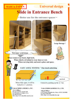


© Copyright 2026