
WALK 10 - SOMERBY Owston
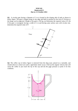
WALK 10 - SOMERBY
Owston
5 miles (8km)
Page 1
How to get there Somerby (SatNav – High Street LE14 2PZ) lies in the triangle formed by Leicester,
Melton Mowbray and Oakham and is easily reached from any direction by car.
Car parking There is no public car park but parking is usually possible on the main street if you use care
and consideration.
Public transport Service 113 (hourly) Melton Mowbray to Oakham. See http://traveline.info/
0871 200 22 33
or phone
Map Explorer majority 233 Leicester small part 246 Loughborough Melton Mowbray and Syston
Route A very pleasant walk through rolling hill farm and pasture land of east Leicestershire, a landscape
of small grass fields and low hills, well waymarked, with no difficult stiles.
Refreshment There are two (only one in 2015) good public houses in Somerby, both serving a wide
range of bar snacks and more substantial meals.
Items of interest Somerby village is full of interest. There are beautiful ironstone houses and an
impressive rectory and a lovely church with an interesting graveyard. (Look for the stone of Dr Benjamin
Richardson, famous for the speed of his operations, in the days before anaesthetics when this was a
vital factor.)
Owston is a tiny hamlet, once the site of an important Augustinian abbey founded in 1161. The evidence
remains as humps and hollows in the fields near the church.
The walk From Somerby, by the pubs, walk along Manor Lane. A gate at the end leads into a long,
narrow field. Keep close to the hedge on your right and go through the gate to the right of the telegraph
pole. The hedge is now on your left. Go downhill for three fields. At the end of the third field the stream
comes in from the left. After 100 yards, turn left and cross the footbridge over the stream. Go up the
bank and turn right to walk with the stream down to your right.
Go through the gateway ahead, where the spire of Tilton can be seen on the hill ahead. Turn left to walk
uphill with hedge on your left.
At the next gate a diversion sign indicates that you should turn left to reach the edge of the field and then
right to walk downhill close to the hedge on your left in this field and the next. The gate onto the road is
just to the right of the bottom corner. Turn left and walk along the road into Owston.
On entering the village of Owston, turn immediately right along the road signposted to Marefield. Ignore
the footpath sign on your right and continue along the narrow lane until the road rises ahead after about
300 yards. Turn right onto a gravel bridlepath, keeping the hedge on your right as the path rises ahead.
The spire of Somerby church can be seen immediately to the right across the rolling landscape.
Go through one large field and pass a recently built farmhouse on your left. Continue uphill through a
gateway and keep the hedge on your right. Go downhill to a gate and cartbridge and continue uphill, still
with the hedge on your right.
The path now crosses a track (leading to Newbold Farm on your right). After about 300 yards go through
the hedge, so that you walk with it on your left. Owston Lodge Farm lies ahead but we turn right before
we reach it. At the bottom of the dip follow the waymark sign, going through the gate on the right and
then heading diagonally left to cross a small bridge and go through a gate. Continue uphill through a
series of single wired enclosures, keeping the hedge on your right.
Before reaching White House Farm ahead, turn right at the waymark,
go through the metal gate and walk downhill with the hedge on your left towards Newbold Grange Farm.
A walk from 32 Short Circular Walks based on The Leicestershire Round
Copyright: © Heather MacDermid for Leicestershire Footpaths Association 2000
Leicestershire Footpath Association
Visit our website at http://leicestershirefootpaths.wordpress.com/
WALK 10 - SOMERBY
Owston
5 miles (8km)
Page 2
The path now goes downhill to cross a substantial brick-faced footbridge over the stream and continues
uphill keeping close to the fence on your left. Go through the gate and follow the signs, with the hedge
now on your right.
At the farm buildings the path is diverted to take you right and then left. Watch out for the waymark sign
at the end of barns on your left, as it can be easily missed. The path does not go straight ahead, but
changes to the left side of the hedge and runs alongside the main driveway, an avenue of trees.
The path now crosses a country road and continues in the same general direction. Ahead of you the
path switches from left to right of the hedge and shortly back again to pass through a gate. Once through
the gate you need to leave the hedge over to your right and move slightly left to reach a clearly
waymarked gate. The path is clearly visible ahead, as it rises through the fields.
The village of Burrough can now be seen on the skyline to your left.
The path again switches to the right. Continue with the hedge on your left until you reach a wire fence.
Go through the gate and follow the path which runs diagonally across the last two fields to join the road
back to Somerby to your left.
The spire of Somerby comes into view ahead of you to your right. Enter the village via the lovely avenue
of horse chestnut trees.
Neville Townsend: "It is likely that you can complete the walk without seeing another person."
A walk from 32 Short Circular Walks based on The Leicestershire Round
Copyright: © Heather MacDermid for Leicestershire Footpaths Association 2000
Leicestershire Footpath Association
Visit our website at http://leicestershirefootpaths.wordpress.com/


© Copyright 2026