
NORTH RANCH SECTOR PLAN LONG
R Mindick Report to the Osceola County Board of County Commissioners April, 2015 NORTH RANCH SECTOR PLAN LONG-TERM MASTER PLAN PEER REVIEW OF THE ENVIRONMENTAL PLAN Peer Review Team: Jay Exum, PhD ~ Richard Hilsenbeck, PhD ~ Reed Noss, PhD Table of Contents I. Background of the North Ranch Peer Review ......................... 3 Sector Planning ........................................................................ 3 The North Ranch Sector Plan - Overview ............................... 4 The Proposed North Ranch Environmental Plan ................... 6 The Peer Review Structure ...................................................... 8 The Charge to the Peer Review Team ..................................... 9 Peer Review Team Member Briefings and Tours ................. 10 II. Peer Review Analysis and Findings ...................................... 13 II. Responses to the Questions of the PRT’s Charge ................ 18 IV. Peer Review Team Recommendations ............................... 28 Peer Review Team Recommendations for Additional Lands31 The Peer Review Team .............................................................. 34 The Critical Lands and Waters Identification Project (CLIP) .... 36 Table of Figures Figure 1, Original North Ranch Framework Map ...................... 5 Figure 2, Regional Setting of the Proposed North Ranch Environmental Plan, showing existing and proposed environmental lands ............................................................... 7 Figure 3, Peer Review Team North Ranch Tour Routes .......... 12 Figure 4, Scrubby flatwoods that was included as "range" in the Environmental Plan. ....................................................... 15 Figure 5, Old-growth longleaf pine tract thought to have potential for red-cockaded woodpecker cavities because of the presence of several “banded” trees. ..................................... 16 Figure 6, Florida burrowing owls observed in improved pastures of the Taylor Creek headwaters. ............................. 18 Figure 7, Improved pasture and cabbage palms within the dedicated agricultural areas east of Deer Park Road: favored habitat for crested caracaras................................................. 19 Figure 8, Scrub area near the North Ranch's western boundary not included in the proposed Environmental Plan's set asides. ............................................................................................. 20 Figure 9, Flatwoods in the northwestern corner of the planning area with most pines removed (resembling dry prairie). o ..... 21 Figure 10 improved pasture matrix with embedded dome swamps with drainage continuing across US 192.. ................. 22 Figure 11, Pine flatwoods grading into wet prairie and cypress dome (dome swamp) within the northwestern portion of the North Ranch. ....................................................................... 23 Figure 12, Within the Wolf Creek Floodplain Swamp downstream of Deer Park Road. .................................... 25 Figure 13, Peer Review Team's Modified Environmental Plan – Recommended Addition Areas marked with hatching ........... 30 2 I. Background of the North Ranch Peer Review Sector Planning Osceola County has partnered with the owners of its largest block of privately owned land - the Deseret Ranch - to prepare a sector plan pursuant to Section 163.3245 of Florida Statutes. This plan, the North Ranch Master Plan, involves all of the Deseret Ranch holdings in Osceola County north of U.S. 192, with the exception of a portion known as the Northeast District, itself the subject of an earlier prepared sector plan. The North Ranch planning area involves roughly 133,000 acres of the northeast corner of the county and abuts Orange and Brevard counties. While sector plans are typically proposed by private landowners, the North Ranch plan is distinctive in having Osceola County as a co-applicant with the landowner. As a sector plan, this master plan, if and when approved, will become part of the Osceola County Comprehensive Plan. As such its approval does not create any rights or entitlements to develop the property, but does present a relatively detailed vision for how the county would prefer to see this area develop well into the future. The plan’s expected implementation period does not begin for perhaps 20 years and then continues through the rest of this century. Perhaps most important to this current peer review, such a far reaching plan can allow for the reservation and protection of: Meaningful areas of conservation lands that are interconnected and of sufficient size to provide for the long term viability of the plant and animal species and communities that currently exist on, or that can be restored/reintroduced to, the property; Blocks of improved pasture and other agricultural lands that can remain commercially viable and provide the opportunity for the production of food and other agricultural commodities close to the Orlando metropolitan area. Through active management, these blocks of agricultural lands can meet the needs of numerous native species of wildlife (including threatened species) that prefer pasture as habitat; and Large areas of open space integrated with urban areas that can offer the many benefits that natural lands have to the improvement of human health and well-being. Because it is such a long term plan and involves such a large portion of Osceola County, the North Ranch Master Plan can be expected to be reviewed and adjusted from time to time to keep up with changing community needs. This will largely be accomplished through Detailed Specific Area Plans (DSAP) that will prescribe the actual development of divisions of the North Ranch. However, the regional framework that the Master Plan describes should remain in place to support, and be supported by, these more specific plans. The North Ranch Master Plan presented four guiding principles for handling the growth that is expected to occur; three directed toward community and economic development and the fourth promoting a growth pattern that will “preserve, enhance, and restore the county’s large-scale natural systems.”1 To support the realization of this fourth principle, Osceola County requested that the Environmental Plan chapter of the Master Plan be subject to an independent peer review to assure 1 Osceola County, North Ranch Sector Plan Long-Term Master Plan, August 18, 2014, p. 1-3. 3 that the natural systems and associated species of conservation concern are being adequately identified and addressed. This report is the product of that review. The North Ranch Sector Plan - Overview2 The North Ranch area has the potential to play a central role in determining where and how the County’s 2040-2080 growth will be accommodated. Trend analysis suggests that Osceola will grow by another 750,000 persons during this time period. The goal for the North Ranch planning area is to design a pedestrian/transit oriented urban environment that can efficiently absorb 2/3 of this expected and desired growth. It is anticipated that, by directing the majority of future growth through the year 2080 onto the Ranch, 66% of the County would remain rural (currently 75% of the County is outside the Urban Growth Boundary). This is consistent with the County’s strategic goals of the protecting the area’s agricultural and food production economic cluster, as well as offering enhanced protection to the area’s major ecosystems. necessary protections for regionally significant areas and resources. In summary, as growth unfolds in coming decades, a balanced master plan for Deseret’s North Ranch will ensure a sustainable urban future while continuing a legacy of agricultural and natural resource conservation. This proposed long-term master plan is intended to proactively plan for and preserve regionally significant economic opportunities, natural resources and transportation corridors at a landscape scale. Upon adoption, this plan will modify the County's Urban Growth Boundary with development occurring only upon approval of a series of statutorily required Detailed Specific Area Plans (DSAPs), which will also meet the requirements for the County’s Conceptual Master Plans (CMPs). A conceptual illustration from the original North Ranch Sector Plan of the distribution of urban development and transportation corridors for North Ranch is shown in Figure 1. In addition to the lands south of US 192, there is a need to protect the regionally significant natural lands and resources within the North Ranch Planning Area. These lands are important in their ability to support the ecological health and sustainability of the broad ecosystems of which they are an integral part. The objective of this current peer review therefore is to provide a check that the Master Plan has considered these resources adequately and prescribed an Urban and Conservation Framework capable of providing the 2 This section is excerpted from the North Ranch Peer Review Process review orientation document, included as Appendix B. 4 Figure 1, Original North Ranch Framework Map 5 The Proposed North Ranch Environmental Plan 3 “How Shall We Grow?” regional visioning project to create a shared blueprint for regional growth patterns through 2050. A summary of the proposed Environmental Plan, as presented by the applicant: Well established principles and data resources were used to design the conservation plan for myregion.org (Scott et al. 1993, Noss and Cooperrider 1994, Groves 2003), which became the foundation for the North Ranch Environmental Plan. The Environmental Plan for the North Ranch Planning Area in Osceola is presented in (Figure 3). This Environmental Plan depicts the lands for which Deseret Ranches has proposed protection through the Long-Term Master Plan and subsequent plan implementation measures. This plan includes a total 60,889 acres of environmental and agricultural lands, or 45.7% of the 133,043-acre North Ranch Planning Area in Osceola (see Plan’s Table 3-3). Of these 60,889 acres, 36,658 acres are designated as Conservation Lands in the Plan (see Plan’s Table 6 in Chapter 9), approximately 28% of the North Ranch Planning Area. These natural resources, water resources, and agricultural lands will comprise the “green infrastructure” within the Property. This Environmental Plan also shows how protected lands within the County connect to other significant environmental areas of the North Ranch Planning Area in Orange and Brevard counties and the larger regional landscape. BUILDING THE ENVIRONMENTAL PLAN The Environmental Plan is based on the results of communitybased regional visioning initiatives such as the NCF process conducted by myregion.org and the University of Central Florida’s Metropolitan Center for Regional Studies. The Environmental Plan was also informed by myregion.org’s 3 From: North Ranch Long-Term Master Plan, August 18, 2014, pp. 3-13, 3-14. 6 Figure 2, Regional Setting of the Proposed North Ranch Environmental Plan, showing existing and proposed environmental lands 7 The Peer Review Structure of the culmination of the work product, ensuring that the final product is technically sound. The North Ranch Peer Review was guided by procedures presented in the U.S. Environmental Protection Agency’s Science Policy Council’s Peer Review Handbook. This document describes a peer review as: The goal of peer review is to obtain an independent, third-party review of the product from experts who haven’t substantially contributed to its development. 4 Peer review is a documented critical review of a specific Agency major scientific and/or technical work product. The peer review is conducted by qualified individuals (or organizations) who are independent of those who performed the work, but who are collectively equivalent in technical expertise (i.e., peers) to those who performed the original work. The peer review is conducted to ensure that activities are technically adequate, competently performed, properly documented, and satisfy established quality requirements. The peer review is an in-depth assessment of the assumptions, calculations, extrapolations, alternate interpretations, methodology, acceptance criteria, and conclusions pertaining to the specific major scientific and/or technical work product and of the documentation that supports them. Peer review may provide an evaluation of a subject where quantitative methods of analysis or measures of success are unavailable or undefined; such as research and development. Peer review is usually characterized by a one-time interaction or a limited number of interactions by independent peer reviewers. Peer review can occur during the early stages of the project or methods selection, or as typically used, as part For the North Ranch Master Plan a Peer Review Team (PRT) of three experts in Florida ecology and wildlife was assembled and included: - Jay Exum, Ph.D. Principal Ecologist of Exum Associates; - Richard Hilsenbeck, Ph.D., Director of Conservation Projects for The Nature Conservancy; and - Reed Noss, Ph.D., Provost’s Distinguished Research Professor, University of Central Florida. The team also was supported by: - Gregory Golgowski, AICP, Consulting Environmental Planner served as the review coordinator and facilitator; and - Robert Mindick, MS Wildland Management, Public Lands Manager for Osceola County provided input on local natural systems. Biographies of the team are included in Appendix A. The goal for the PRT was to provide an independent, technical review by experts of the sufficiency of the Environmental Plan. Input from the public, stakeholders or applicants was not requested or desired, except where needed to better understand the assumptions, facts and interpretations that contributed to the plan’s preparation. 4 U.S. Environmental Protection Agency, PEER REVIEW HANDBOOK, 2nd Edition, Dec. 2000. p. 10, 11. 8 consistent with the overall conservation development strategy for the planning area.5 The Charge to the Peer Review Team The Peer Review Team (PRT) was asked to consider Three Questions as part of its Charge from Osceola County for reviewing the North Ranch Master Plan: 1. 2. 3. Does the North Ranch Environmental Plan sufficiently identify regionally significant natural resources within the North Ranch planning area pursuant to s.163.3245(3)(a)5, FS? Given the urban planning goals for the North Ranch, are the areas set aside in the Environmental Plan for conservation and agriculture sufficient to provide long-term protection for the identified regionally significant natural resources within the North Ranch planning area? If the answer to Question 2 is no, what other land areas need to be designated in the Environmental Plan and/or policies added in order to afford adequate protections to the identified regionally significant natural resources? The phrase “best available data and policies” indicates that no new data need be developed for the peer review, though it is conceivable that new data or amended policies may have become available since the preparation of the plan and could – and likely should - be consulted during the review. Since a precise definition for a regionally significant resource was not included in the statutes pertaining to sector plans, it would be appropriate to turn to the Strategic Regional Policy Plan adopted by the jurisdictional East Central Florida Regional Planning Council (the East Central Florida 2060 Plan) for the identification of these resources. The East Central Florida 2060 Plan provides this definition of significant regional natural resources: “Significant Regional [Natural] Resource or Facility” means a resource identified by the ECFRPC Council as being of regional importance and meeting the following criteria: a. A resource that due to its uniqueness, functions, benefit, service delivery area, or importance is identified as being of regional concern (F.A.C. 27E5.002 (7)(a)). The first question requires an understanding of what defines a regionally significant natural resource. The paragraph of Florida Statutes that guides the preparation of sector plans that is referenced in Question 1 requires: b. A functionally intact ecosystem that depends upon connectivity over statewide or regional landscapes to maintain long term, viable and diverse populations of plant and wildlife communities.6 A general identification of regionally significant natural resources within the planning area based on the best available data and policies setting forth the procedures for protection or conservation of specific resources 5 s.163.3245(3)(a)5, Florida Statutes and 6 ECFRPC, East Central Florida 2060 Plan, Chapter 3, Natural Resources, p. 21. 9 A natural resources map series was adopted in the 2060 Plan along with a composite map prepared by the Century Commission for a Sustainable Florida and referred to as the Critical Lands and Waters Identification Project (CLIP, aggregate and priority maps of which are included in Appendix B). While these maps are useful for planning purposes, policies adopted in the 2060 Plan take precedent over the maps and are clear that the maps “should not preclude development, but rather identify potentially valuable natural resources for protection” and that “Objective, on-site, field verification of natural resources takes precedence over natural resources of regional significance datasets and maps when evaluating their individual significance.”7 The assumption therefore is that the North Ranch Master Plan effort should have identified the significant regional natural resources specific to this property. Question 1 of the Charge asks the Peer Review Team (PRT) to confirm this. To help with understanding the expected response to Question 2 of the Charge, the North Ranch Long-Term Master Plan guiding principles, or urban planning goals, are as follows: 7 Proactively maximize job growth and reinforce the longterm economic sustainability of the County and the larger region while minimizing County infrastructure investment. Plan for future mixed-use communities that embody the highest quality growth practices to accommodate the County’s future needs. Connect regions and economic centers through a multimodal transportation system. ECFRPC, p. 43, 44, Policies 3.1.2 and 3.1.8. Preserve, enhance, and restore the county’s large-scale natural systems. 8 Chapter 9 of the North Ranch Master Plan contained Goals, Objectives and Policies intended to direct the implementation of the Master Plan. The most current draft of those policies (March 11, 2015) was included in this review. Peer Review Team Member Briefings and Tours The peer review was conducted between January and March, 2015 and included the following major events: January 29: Orientation meeting held at the Breedlove Dennis & Associates (BDA) offices in Winter Park. Participants: Jay Exum, Richard Hilsenbeck, Reed Noss, Gregory Golgowski, Robert Mindick, Michael Dennis, Ph.D. (President, BDA and primary technical contact for the applicant), Jeffrey Jones, AICP (Strategic Initiatives Director for Osceola County) and Lynette Brown, Ph.D. (Senior Scientist, BDA). Mr. Jones provided an overview of the sector planning process and the County’s goals for accommodating the expected demands for the population increase and economic expansion that was expected in Osceola County. He also reviewed the location of the North Ranch relative to the continued expansion of the Orlando Metropolitan Area and the desire to provide better transportation connections between the UCF and Lake Nona economic centers with those of southern Brevard County, as expressed through the December 2014 report of the East Central Florida Corridor Task Force. Dr. 8 Osceola County, North Ranch Sector Plan Long-Term Master Plan, August 18, 2014, p. 1-3 10 Dennis presented the data collection and analysis that supported the environmental sections of the plan and the identification of the North Ranch’s regionally significant resources. March 23: Team’s deliberations in Longwood, Florida. PRT Participants: Jay Exum, Richard Hilsenbeck, Reed Noss; also Greg Golgowski, Robert Mindick. February 6: First site tour of the North Ranch. PRT participants: Jay Exum, Richard Hilsenbeck, Reed Noss; also Gregory Golgowski, Michael Dennis, Robert Mindick. This tour focused on the southern portions of the Ranch and included visits to the southeastern mosaic of habitats, the southern end of the central mosaic, the existing wildlife crossing of U.S. Highway 192, and the Pennywash Creek drainage area. February 25: Second site tour of the North Ranch. PRT Participants: Jay Exum, Richard Hilsenbeck, Reed Noss; also Gregory Golgowski, Robert Mindick, Michael Dennis. This tour visited the northwest corner of the North Ranch including the northern reach of the central mosaic, the habitats of the western study area, including a scrub area, blocks of pine flatwoods and pasture within the Taylor Creek headwaters. March 3: Third site tour of the North Ranch. PRT Participants: Jay Exum, Richard Hilsenbeck, Reed Noss; also Gregory Golgowski, Michael Dennis. This tour visited areas around the southern side of the Taylor Creek Reservoir, the downstream portions of the Taylor Creek, Wolf Branch and Pennywash Creek floodplains and the western edge of the St. Johns River floodplain. It also included the habitat mosaic and pastures of the western edge of the planning area. March 11: Team’s deliberations at the University of Central Florida. PRT Participants: Jay Exum, Richard Hilsenbeck, Reed Noss; also Gregory Golgowski, Robert Mindick. 11 Figure 3, Peer Review Team North Ranch Tour Routes 12 II. Peer Review Analysis and Findings The application identified and proposed to set aside 36,658 acres as Conservation Lands.9 This included large areas of wetlands but also 14,040 acres described as a “Central Wetland/Upland Mosaic” or roughly 50/50 mix of lands that would be classified as either upland or wetland by the 2009 Florida Land Use, Cover and Forms Classification System. Combining these lands reflected their close vegetative and hydrologic relationships and created a corridor of natural lands from the northern to southern borders of the property, lining up with an existing wildlife crossing of US 192 (Crabgrass Creek). Agriculture was proposed to continue as a regular use of these lands. A 250’ buffer was proposed adjacent to the eastern edge of the Econlockhatchee Swamp Preservation Area, which itself was outside of the planning area. To address the need for east-west habitat connections between the central mosaic and the Taylor Creek reservoir and eventually St Johns River floodplain, corridors were identified which centered on the north and south forks of Taylor Creek. Another 11,579 acres were committed to remain in agriculture along the eastern edge of the study area roughly between Deer Park Road and the Brevard County line. In total, the regionally significant resources identified in the Master Plan of the North Ranch area were central to the Peer Review Team’s review of regionally significant natural resources. The PRT found three important areas of concern and recommends that more be done to enhance the conservation 9 goals for the North Ranch, i.e., to “preserve, enhance, and restore the county’s large-scale natural systems”: 1) Broader consideration of the regional ecological context, including a higher degree of connectivity of the North Ranch with adjacent and nearby conservation areas and other existing and proposed conservation lands across the region. Connectivity of habitats within the North Ranch with existing conservation areas in the surrounding landscape is a critical issue, and is highlighted in the Landscape Linkages/Wildlife Corridors principle in the myregion.org conservation plan, which was a primary source for the development of the North Ranch Planning Area Environmental Plan. The PRT would like to have seen this principle receive stronger consideration in the Environmental Plan. Habitat connectivity is essential for many plant and most animal species, with the spatial extent of required connectivity increasing with the body size and trophic level of the species (i.e., large animals require larger areas of connected habitat than small animals, and carnivores require more area than herbivores of the same size). Among the wide-ranging animals that require substantial connected habitat and have been documented on Deseret Ranch or immediately adjacent areas are eastern indigo snake (Drymarchon corais couperi), red-cockaded woodpecker (Picoides borealis) and Florida panther (Puma concolor coryi). Deseret Ranch is known to be used by male panthers dispersing northward through the Florida peninsula. In particular, road-killed panthers have been documented in 2012 and 2013 on US 192, between Triple N Ranch WMA and Deseret Ranch within the North Ranch Sector Plan area, as well as on SR 528 just west of SR 520, within the Orange County portion of Deseret Ranch (Dr. Daniel Smith, University of North Ranch Sector Pan, Table 3-3 13 Central Florida and Transportation Sub-team, Florida Panther Recovery Implementation Program, personal communication). About five years ago, FDOT reconstructed the bridges on US 192 at Crabgrass Creek at the southern edge of the North Ranch, on US 192 at the C-57 Canal at the southeastern edge of the North Ranch, at Sawgrass Creek on US 192 on the Brevard County portion of Deseret Ranch, and north of the North Ranch planning area in Orange County on SR 520 at Second and Jim Creeks. These bridges were reconstructed to include wide earthen ledges that serve as wildlife crossings suitable for panthers and other wildlife. In addition, there are three ranch crossings on SR 528 that would also serve as underpasses for large mammals and other species of wildlife. Deseret Ranch is currently the only substantial movement corridor that remains intact for panthers to travel northward around the Orlando metropolitan area through Tosohatchee Wildlife Management Area to Tiger Bay State Forest and across I-4 to Ocala National Forest. The panther is a federally listed Endangered species, which has been documented in the vicinity of the Deseret Ranch (at least as a movement corridor), and the Recovery Plan for the panther recommends reestablishment of a panther population into suitable areas of its former range. Given the long-range timeframe for the Sector Plan and the need for state-wide planning for this species and other wide-ranging animals, these issues should have been discussed within the Plan document. Florida sandhill crane (Grus canadensis pratensis), three bird species of conservation concern in Florida (the caracara is federally and state listed as Threatened, the burrowing owl is a state Species of Special Concern, and the crane is state listed as Threatened). These pastures are also important habitat for wintering sandhill cranes of the northern subspecies, as well as other declining grassland bird species such as eastern meadowlark (Sturnella magna), eastern bluebird (Sialia sialis), and loggerhead shrike (Lanius ludovicianus) – all documented on-site. The Florida panther and eastern indigo snake (the latter is federally listed as Threatened) also likely make use of pasture lands on Deseret Ranch. Thus, pasture should not be assumed to be of negligible conservation value. Indeed, private ranch lands – often predominantly in pasture, but also containing significant natural habitats – are arguably the most valuable currently unprotected lands in Central Florida for many imperiled species and hold other conservation values. The Plan also characterizes virtually all natural upland habitats, including flatwoods, scrubby flatwoods, and scrub, as “rangeland.” Accepted names for these natural communities should be used so as to not obscure their conservation significance by lumping them with semi-natural habitats. 2) Greater recognition of some natural and semi-natural communities, especially pasture and “rangeland” The important conservation value of improved and semiimproved pasture is not adequately recognized in the Plan. These habitats are vital for crested caracara (Polyborus plancus), Florida burrowing owl (Speotyto cunicularia floridana), and 14 communities. Specifically, the following natural communities are classified as under-represented in the Florida Natural Areas Inventory’s 2014 Florida Forever Conservation Needs Assessment: upland glade, pine rockland, scrub, rockland hammock, dry prairie, seepage slope, sandhill, sandhill upland lake, pine flatwoods, upland hardwood, and upland pine. It is noteworthy that all but two of these under-represented natural communities are uplands; the two that are not (seepage slope, sandhill upland lake) are inclusions embedded within an upland matrix. Of the recognized under-represented natural communities, scrub, pine flatwoods, possibly sandhill, and possibly dry prairie (which needs to be determined by further investigations) occur within the North Ranch Plan area. Figure 4, Scrubby flatwoods that was included as "range" in the Environmental Plan. J Exum photo 3) Greater consideration of uplands in addition to wetlands for land conservation Another key planning principle adopted to guide development of the North Ranch Environmental Plan is Representation of all Natural Communities. This principle demands attention to underrepresented natural communities (i.e., natural communities that currently are not adequately represented in Florida’s conservation areas) within the Plan area. Most science-based conservation prioritizations in Florida have emphasized natural communities that are rich in endemic and imperiled species, have suffered high rates of conversion or degradation since European settlement, and/or are vulnerable to continued or future loss from development (for example, because they are under-represented in existing conservation areas). The Florida natural communities that rise to the top using such criteria are mostly upland Regarding imperiled species, including many that are endemic to Florida, uplands generally hold the highest proportions, with mesic flatwoods, sandhill, and scrub among the communities that are particularly noteworthy (Florida Natural Areas Inventory, 2010, Guide to the Natural Communities of Florida; Knight, 2011, editor, Atlas of Florida’s Natural Heritage). The loss and degradation of upland communities in Florida is increasing the risk of extinction of many species. Wetlands with relatively large numbers of rare and endemic taxa are fewer, but include seepage slope, depression marsh, dome swamp, strand swamp, and hydric hammock. Depression marshes, dome swamps, and hydric hammocks are common natural communities within the North Ranch. The historic matrix vegetation of the North Ranch was pine flatwoods, primarily dominated by longleaf pine, perhaps the most ecologically important and formerly widespread natural community in Florida. Looking beyond Florida, approximately 57% of the plant species endemic to the Coastal Plain are associated with pine savannas (i.e., flatwoods and sandhills), and an additional 28% with small-patch communities, such as 15 depression marshes and seepage slopes, embedded in these savannas (A. Weakley and B. Sorrie, unpublished data; as cited in Noss et al. 2015, Diversity and Distributions 21:236–244). Uplands have generally suffered greater conversion and degradation than wetlands in Florida and across the Coastal Plain. For example, Christman (1988, Endemism and Florida's Interior Sand Pine Scrub, Florida Game and Fresh Water Fish Commission) estimated a 64% loss of scrub on the Lake Wales, Lake Henry, and Winter Haven ridges since settlement; considerably more has been lost to development since then. Longleaf pine communities (flatwoods and sandhills) have suffered even larger losses. Longleaf pine communities in Florida declined by 88% from 1936 to 1987 (Kautz 1993, Florida Scientist 1993[1]:7-24), with much already lost before 1936 and more lost since 1987. Across their range, longleaf pine communities have declined by more than 95% by virtually all estimates. A recent analysis of vegetation change across the Coastal Plain showed that 96% of all savannas and woodlands (mostly pine, but also oak) have been converted or highly altered since European settlement (Noss et al. 2015, Diversity and Distributions 21:236–244, and Appendix S3). In comparison, only 46% of wetlands were lost in Florida between the 1780s and 1980s (Dahl 1990, Wetland losses in the United States 1780's to 1980's. U.S. Fish and Wildlife Service). Across the South, up to 1990, wetlands declined by only about 28% (Noss et al. 1995, Endangered Ecosystems of the United States, U.S. Department of Interior). The stark difference between upland and wetland losses is easily explained by uplands being much easier to convert to agricultural and urban land uses. Despite the overwhelming conservation significance of uplands, many conservation plans – and most conservation land components of development plans – in Florida have emphasized wetlands protection, apparently so that as much upland as possible remains developable. The North Ranch Sector Plan is no exception. Lands recommended for conservation in the Plan comprise approximately 52.3% wetlands and 47.6% uplands (North Ranch Long-Term Master Plan, 2014, Chapter 9, Table 6). Importantly, however, wetland acreage (based on 2009 land use data from SJRWMD) includes only wetlands approximately 25 acres or larger. Considering the many smaller wetlands on the property, wetlands may comprise on the order of two-thirds of the identified Conservation Lands (a high-resolution analysis would be necessary to accurately make this determination). Figure 5, Old-growth longleaf pine tract thought to have potential for red-cockaded woodpecker cavities because of the presence of several “banded” trees. R Noss photo. If it is assumed that the loss of upland habitat continues at its current rate, and there is no indication that it will not, then the regional significance of upland habitat within the North Ranch’s very long term planning and development process will only 16 increase as that habitat dwindles. Therefore consideration of uplands protection and restoration beyond the attention given by current resource regulatory programs is appropriate. The PRT especially recommends restoration of pine flatwoods within suitable areas of the North Ranch, concentrating on restoring longleaf pines and native groundcover on pasture (former flatwoods) sites that surround remnant flatwoods patches on the North Ranch. 17 II. Responses to the Questions of the PRT’s Charge The specific objectives of the peer review are to have the following questions answered: Question 1. Does the North Ranch Environmental Plan sufficiently identify regionally significant natural resources within the planning area pursuant to s.163.3245(3)(a)5, FS; argues that the cumulative value of vast areas of pasture within a mosaic of other habitats, such as that present on the North Ranch and examples of which have already been identified as the Central Wetland/Upland Mosaic, is regionally significant. As noted above, those vast areas of pasture represent preferred habitat for species of conservation concern –crested caracara and Florida burrowing owl – known from, and suspected to breed, on The Peer Review Team’s approach to answering this took the form of posing, and then addressing, several questions: Were the Best Available Data Used to Construct the Plan? The PRT is concerned that the best available, or most recent, data received insufficient use in construction of the Environmental Plan (the Plan). Although it is difficult to determine exactly which sources of data were used to create the specific elements of the Environmental Plan, some of the data cited in the Plan (as presented in Chapter 3 of the North Ranch Sector Plan) were nearly 20 years old when they were used to construct the Plan. Much of the Plan appears to be primarily based upon the myregion.org planning document, which was not peer-reviewed. The PRT understands that much reliance was also placed on a St. Johns River Water Management District (SJRWMD) report that assessed overall conservation value of the lands within the District. For the Deseret/North Ranch area, in the land-use category, SJRWMD assigned high values to naturally vegetated areas and low values for areas that have been altered, including improved pasture. So, ultimately, the highest value areas were those that were still dominated by native vegetation. The PRT Figure 6, Florida burrowing owls observed in improved pastures of the Taylor Creek headwaters. R Mindick photo. the site. Improved pasture is also used by several other highconcern species, including eastern indigo snake, Florida pine snake (Pituophis melanoleucus mugitis), and Florida sandhill crane. Likewise, improved pasture provides important habitat for connectivity of many wide-ranging upland species, including Florida panther. As such, the PRT argues for assigning much higher conservation values to improved pasture than the SJRWMD did, and at multiple scales, especially given its potential for restoration. 18 consulted these data and utilized its collective experience, expertise and professional knowledge of Florida’s natural communities (habitats), ecology, wildlife, and reserve design principles to formulate a specific series of recommendations. Figure 7, Improved pasture and cabbage palms within the dedicated agricultural areas east of Deer Park Road: favored habitat for crested caracaras. G Golgowski photo. The PRT concluded that data specific to the North Ranch used in the development of the Plan were either not available or not adequate to draw sufficient conclusions as to the regional significance of the Ranch’s resources. Additional data were therefore required to create the PRT Modified Environmental Plan that could accommodate projected development and allow regionally significant resources to persist. The PRT utilized several additional kinds of data for its review including: the peer-reviewed and regularly updated Critical Lands and Waters Identification Project (CLIP) 3.0 data (see Appendix B) which was available as of March 2014, recent aerial photography from Google Earth (dated for most of the property as January or February of 2014), three days of direct field observations and ground-truthing of resources on the subject property, Hydric Soils data, and Florida Natural Areas Inventory (FNAI) Element Occurrence Records. The PRT The need for actual field work in identifying regionally significant resources on (and developing a conservation plan for) the North Ranch is based on the PRT’s collective experience. One of the main reasons why de novo field surveys – that generate new data – are so important to any conservation plan is that they allow a more precise understanding of a particular site’s resources than does sole reliance on statewide geospatial data. If, for example, a population of crested caracara occupied a large portion of improved pasture (and associated, adjacent habitats) on the North Ranch, such an occurrence would not necessarily be included in the various statewide data sets used in the analysis. Indeed, no such FNAI Element Occurrence Records exist for crested caracara on Deseret/North Ranch. As such, a given block of pasture might be assumed to have little or no conservation value for crested caracara or other species. Given the mix of habitats and land uses on the subject property the PRT observed from aerial photography and field surveys, there is suitable habitat for this species – as well as numerous other grasslanddependent avifauna (e.g., Florida sandhill crane, Florida burrowing owl, and possibly even Florida grasshopper sparrow [Ammodramus savannarum floridanus]). The PRT observed crested caracara on the subject property, as well as Florida burrowing owl and sandhill crane, none of which are reported as being on-site in the original Environmental Plan. 19 Are there Other Regionally Significant Resources that Should be Included in the Plan? An overview of some of the regionally significant resources that were not adequately identified by the Environmental Plan for the Deseret/North Ranch Sector Plan Area is given here. Specific areas recommended for inclusion in the Plan – and the scientific justification for doing so – are provided under Questions 2 and 3 below and in the PRT’s Modified Environmental Plan (although some justification is also herein provided). For example, thousands of acres of old-growth mesic and scrubby flatwoods – many of them dominated by longleaf pine – that are present onsite were either not identified or included in the Environmental Plan. The scrub natural community was also not identified or included in the Plan, even though several substantial areas of scrub occur on the subject property. It should be noted that both of these natural community types are nearly endemic to Florida (i.e., occur nowhere else in the world) and both are considered to be under-represented by FNAI because less than 15% of their historic extent on the landscape is currently conserved. As such, the PRT thinks these are regionally significant resources (and some areas can legitimately be considered of statewide significance). Figure 8, Scrub area near the North Ranch's western boundary not included in the proposed Environmental Plan's set asides. G Golgowski photo. Additionally, there is evidence that at least one of these flatwoods areas omitted from the original Environmental Plan once supported the federally Endangered red-cockaded woodpecker (RCW). Although the PRT did not observe any individual birds, it is possible that this species still exists on the North Ranch. Yet adequate, and available, habitat including that required for connectivity to extant populations of RCWs on adjacent managed areas (i.e., conserved lands) that might allow for dispersal and sustainability of the species, was not included in the Environmental Plan. Both RCWs, and the flatwoods required to support them, would certainly be considered a regionally significant resource. Indeed, as noted earlier, some restoration of historic flatwoods should also be undertaken to provide additional habitat to secure future foraging, nesting and dispersal habitat for this species in accord with the Chapter 9 Goals, Objectives and Policies (GOP). 20 Areas of hydric hammock, floodplain forest and floodplain swamp, such as along the tributaries of Wolf and Pennywash creeks, are not provided adequate protection under the Environmental Plan. Based on the projections in Table 3-3 of the North Ranch Master Plan document, most of these remaining habitats associated with the two creek systems – along with large blocks of contiguous mesic and scrubby flatwoods – would be flooded. Such areas are important for many species of wildlife, including the rare and imperiled swallow-tailed kite (Elanoides forficatus), which was noted on the property. As well, the many tributaries of Wolf and Pennywash creeks help form the spokes of critical linkages between larger protected habitat areas. The PRT has determined that such areas and the species they support, or are capable of supporting, are regionally significant resources and should be identified and designated as such within the recommended PRT Modified Environmental Plan. Figure 9, Flatwoods in the northwestern corner of the planning area with most pines removed (resembling dry prairie). J Exum photo Although Florida scrub jays (Aphelocoma coerulescens) – a federally Threatened species and Florida’s only endemic bird species – were not found by the PRT during the three day field review of the property, suitable habitat exists on the subject property to support at least two subpopulations and several families of this species. Yet, no scrub habitat required by this species was included in the Environmental Plan. With possible reintroduction of the species (a form of restoration along with habitat management, noted as a Goal within the Chapter 9 GOPs), the Florida scrub jay, which is known to be relatively tolerant of nearby human activity, could be sustained on the property. Florida scrub jays and the scrub habitat required to support them, would be considered a regionally significant resource and the latter is present in at least two large (and several smaller, albeit overgrown) blocks on North Ranch. As noted earlier, the federally Endangered Florida panther has been reported adjacent to the subject property, and documented by two recent (2012 and 2013) road kills. Given this evidence, it appears likely that Florida panthers are utilizing – or certainly could utilize – Deseret/North Ranch property in their habitat needs and dispersal within the state. With the evidence that panthers may occur on or cross Deseret property, habitat and connectivity considerations must be taken into account for the future survival and viability of this species. This species and the variety of habitats it requires – habitats that exist on North Ranch – should be considered as regionally significant resources within Osceola County and on North Ranch. The habitats and linkages could remain viable so long as adequately wide corridors for movement are conserved, even after urban levels of development occur. For example, mountain lions (the same species as the Florida panther) use vegetated corridors through urban landscapes of southern California (Beier, Riley, and Sauvajot, 2010, Mountain lions (Puma concolor) in Urban Carnivores, 21 Gehrt et al., eds., The John Hopkins University Press; Noss, pers. obs.). For these and other reasons, the PRT thinks that insufficient habitat protection and connectivity is provided by the original Environmental Plan. Current planning in the central part of the state is moving rapidly along the path toward creating an impermeable barrier of development from Tampa to Orlando and Orlando to Daytona and Melbourne. If such development continues on its current path, it will likely divide the peninsula into two separate regions of south Florida and north Florida. The North Ranch’s strategic geographic position makes it critical in maintaining the two remaining viable south to north links for wide-ranging species: 1) Triple N Ranch WMA and Bull Creek WMA-Crabgrass Creek/Econlockhatchee River and Swamp systems to Hal Scott-Seminole Ranch/Bronson State Forest and 2) Triple N Ranch and Bull Creek WMAs to Tosohatchee WMA. The PRT’s recommended additions to the Plan provide for this sustainable outcome for both regionally significant resources and their long-term viability. developed. The PRT determined, based on aerial photography, field observations and other data, that many of these seemingly isolated dome swamp systems are in fact hydrologically and functionally connected with wet season flows that link them into an integrated resource system. The PRT finds that their future viability – and contribution to water retention/storage and off-site, downstream hydrology and flows (i.e., to existing state conservation lands) – may be compromised if not combined within a matrix of manageable lands that conserves these overall resources. As such, the PRT proposes modification to the Environmental Plan that groups together sets of interlinked wetlands into larger blocks that may be managed as a whole. Even if utilized by low intensity agriculture such as cattle grazing, which the PRT endorses for these areas, this would provide greater and enhanced regional connectivity between conservation areas on North Ranch to Additional Upland/Wetland Mosaic Areas The last example of an under-recognized regionally significant resource is a series of lands whose long-term sustainability and management of an already identified regionally significant resource (i.e., wetlands greater than 25 acres) is coupled with both regional hydrology and the habitat needs of such grasslanddependent avifauna as crested caracara, Florida burrowing owl and Florida sandhill crane. Many of these wetlands – particularly cypress-dominated dome swamps – are located along the southern boundary of North Ranch. What is identified in the current Environmental Plan is just a series of these wetlands, isolated from other such wetlands by land that potentially will be Figure 10, improved pasture matrix with embedded dome swamps with drainage continuing across US 192. Source: Google Earth. 22 managed areas to the south (i.e., Triple N Ranch and Bull Creek WMAs), and provide habitat for grassland-dependent bird and other species that exist on the property and help satisfy the corridor linkage just discussed. The PRT reasoned that if isolated wetlands greater than 25 acres are regionally significant resources, then blocks of such interlinked and closely adjacent wetlands are regionally significant resources on an even larger scale. Further, these collective systems would have greater likelihood of sustained function over time and could provide even greater conservation and water benefits to people, agriculture, wildlife and natural systems. Some hydrological and habitat restoration within these areas may also be appropriate. In summary, the PRT thinks there is a need to identify – upfront – all reasonable lands and resources of regional significance in the Sector Plan rather than wait for the DSAP process. The PRT is concerned that many years later, when DSAPs are developed, areas that are vital to regional and internal North Ranch connectivity and other environmental values may be overlooked or deemed non-important since they were not identified initially within the Sector Plan. They may also not be extant at the time that DSAPs are initiated unless identified and incorporated into the Plan at the current time. The PRT thinks the identification and inclusion in the Plan of additional regionally significant resources is both justified and warranted. We furthermore agree with and embrace the statement of the adopted East Central Florida 2060 Plan discussed earlier that “Objective, on-site, field verification of natural resources takes precedence over natural resources of regional significance datasets and maps when evaluating their individual significance.” The PRT has conducted such field work as was possible given both logistic and time constraints. In its review, the PRT also utilized , statements from the Florida Natural Areas Inventory (FNAI) website on the various and appropriate uses of CLIP 3.0 data, as well as disclaimers about the data and how they should or should not be utilized in such planning efforts without further assessment (of the kind we undertook). Relevant CLIP data are included in Appendix B. Figure 11, Pine flatwoods grading into wet prairie and cypress dome (dome swamp) within the northwestern portion of the North Ranch. R Noss photo. 23 Question 2. Given the urban planning goals for the North Ranch, are the areas set aside in the Environmental Plan for conservation and agriculture sufficient to provide long-term protection for the identified regionally significant natural resources within the North Ranch planning area? In answering this Question, the PRT used a series of principles for guiding conservation land planning and reserve design that were in both the myregion.org and the North Ranch Sector Plan Chapter 3 to illustrate major points. Overall, the answer to this Question is that some protection deficiencies were identified. From the Sector Plan, Chapter 3, it is stated that: The following well established principles and data resources were used to design the conservation plan for myregion.org (Scott et al. 1993, Noss and Cooperrider 1994, Groves 2003), which became the foundation for the North Ranch Planning Area Environmental Plan: Objective Setting: Define targets for conservation planning Existing Protected Lands: Design around existing public lands, when present, because their natural areas are generally protected for the long term, and they provide the framework around which effective conservation plans are built Large Core Habitats: Protect and restore (if needed) core habitat areas of sufficient size to support many species of plants and animals Landscape Linkages/Wildlife Corridors: Ensure that natural linkages among large habitat patches are maintained in the landscape to provide for species movements on and off the Property Focal Species: Identify a suite of focal species (e.g., listed species, habitat indicators, area sensitive species) and plan for their continued presence on the Property, if possible Representation of all Natural Communities: Ensure that examples of all natural community types expected to occur on a site under natural conditions are protected or restored Redundancy: Ensure that multiple examples of each community type are protected or restored, if possible, to provide for the longterm persistence of all species and natural communities Buffer Zones: Provide low-intensity land use buffers around protected areas to ameliorate indirect effects of intensive human development Population Viability: Ensure that the landscape identified for preservation is large enough to support viable populations of featured indigenous species. The Peer Review Team concludes that the above principles were not adequately utilized for the North Ranch Sector Plan. Specifically: The PRT found that there was not a rigorous process developed or followed for Objective [or Goal] Setting, or defining targets for conservation (see below). Rather, the Plan relied primarily on outcomes presented in the myregion.org process. While Existing Protected Lands were taken into consideration by the Environmental Plan, the PRT does not think that a wide enough functional corridor/landscape connection was made to lands to the south of North Ranch (e.g., Triple N Ranch and Bull Creek WMAs). The corridor in the plan is only approximately 0.5 mile wide, while the protective/directive fencing along U.S. Highway 192 that funnels dispersing/migrating vertebrates to the wildlife underpass is – as measured by a car odometer – is approximately 0.8 mile. Given the need for Florida panthers and potentially other wide-ranging vertebrate species to successfully 24 find and traverse this corridor and the importance to regional and statewide wildlife movements through this portion of Central Florida, the PRT determined that the conserved corridor and/or adjacent conserved lands within a Modified Plan should be as wide as feasible and justifiable. This was accomplished by not only augmenting the lands supporting the drainage and flows of Crabgrass Creek and various tributaries from Deseret onto Triple N Wildlife Management Area, but by proposing additional Conservation Lands associated with the hydrologically interlinked wetlands along and just north of US Hwy 192. The PRT also did not think there was an adequate (i.e., wide and functional enough) connection from the Central Wetland/Upland Mosaic (CWUM) identified in the Plan to the TM-Econ Mitigation Bank lands and ultimately the future opportunity for dispersal to the Hal Scott Preserve (both with known colonies of RCWs). The PRT likewise did not think there was adequate eastwest connectivity from either Taylor Creek or the Wolf and Pennywash creek areas to, ultimately, the River Lakes Conservation Area and, in turn, northward to Tosohatchee WMA. Lands intended to accommodate future RCW dispersal between all these lands are designated in the PRT’s recommended modifications to the Environmental Plan. The PRT attempted to remedy all the above perceived deficiencies in several ways as outlined in Questions 3, below and on the related Map. Figure 12, Within the Wolf Creek Floodplain Swamp downstream of Deer Park Road. G Golgowski photo. The PRT does not think that many significant Large Core Habitats were identified in the current Plan. No specific habitat or hydrological restoration options were presented in the Plan, and many areas need to be augmented to provide a conserved land base of sufficient size to indefinitely support viable and sustainable populations of focal species on the property. On the subject of Landscape Linkages/Wildlife Corridors, this issue is addressed above (e.g., with respect to connections to Existing Protected Lands). As for Focal Species, the PRT considered several of the species initially identified for conservation planning as inappropriate because their range and/or habitats occur well outside the North 25 Ranch area. The PRT considered an overall narrower set of focal species to better align conservation goals with habitats that exist – or can easily be restored – on the subject property. Concerning Representation of all Natural Communities, as discussed earlier, the PRT found that some natural communities – like scrub – were not represented in the Plan, while others (e.g., mesic and scrubby flatwoods) were not adequately represented in terms of their areal extent and quality on the property. As a result, the habitat they provide for maintaining viable populations of numerous focal species (e.g., RCW) and the connectivity they provide to adjacent managed areas would be lost for several focal species (e.g., crested caracara, eastern indigo snake, Florida panther, RCW). With regard to the principle of Redundancy, the PRT concluded that the Environmental Plan also fell short by not including several large blocks of high quality (or restorable) examples of natural community types, particularly mesic and scrubby flatwoods and scrub. Only two areas in the Plan support viable flatwoods (northern end of the CWUM and the far eastern Agriculture/Conservation area) and the PRT does not think that two examples of this under-represented natural community are sufficient for long-term viability and connectedness. Natural disasters, such as hurricanes, can wipe out large blocks of regionally significant habitat and/or species if sufficient redundancy is not built into a conservation reserve network. No scrub areas were included in the Environmental Plan, nor were any areas that the PRT could discern from our field work – except one small patch – where gopher tortoises (Gopherus polyphemus) are still extant on the property. The gopher tortoise is a renowned keystone species on which many other species depend, and having redundant areas that support – or could support – gopher tortoises with either reintroduction or restoration is an important factor in the formulation of some of the PRT’s recommendations. The PRT also found insufficient redundancy of Landscape Linkages/Wildlife Corridors – both north-south and east-west – in the Plan, which we attempted to remedy with the map of recommended additional conservation lands, including new, critical corridors. An important 250’ wide buffer zone is proposed along the Econlockhatchee Swamp protection area in the Plan. Buffers in the original Plan were also proposed at the southern end of the Central Wetland/Upland Mosaic and along tributaries of Taylor Creek. Such proposed Buffer Zones are important transition areas of wildland/urban activity and should be expanded where appropriate, so that high-density urban development does not directly abut conserved areas, which would likely reduce the viability of species within the latter through various edge effects, including invasions of non-native species and increased predation on native birds. In terms of Population Viability, it was difficult for the PRT to adequately assess this issue within the limited time frame and field work, and no time or budget for computer modeling of population viability. The PRT has, however, presented information for several species that it thinks do not have sufficient habitat identified in the Plan to maintain their longterm population viability. 26 Question 3. If the answer to Question 2 is no, what other land areas need to be designated in the Environmental Plan and/or policies added in order to afford adequate protections to the identified regionally significant natural resources? The PRT identified additional regionally significant natural resources that need to be better conserved than what was proposed in the Environmental Plan. Examples include high quality and connected mesic and scrubby flatwoods (connected both internally and off-site to contiguous conservation lands), to allow for movement of some species (e.g., Florida panther) across the property, and for future population growth or establishment of other species, including RCW, crested caracara, eastern indigo snake, Florida burrowing owl, gopher tortoise, and Florida scrub jay, among potentially others. The PRT determined there should be additional lands designated for conservation/agriculture. The details and justification for these designations and recommended modifications to the land areas proposed for conservation are provided in the following Conclusions section and related map. 27 IV. Peer Review Team Recommendations Summary of Data Consulted and Criteria Used in Identifying Additional Regionally Significant Natural Resources of the North Ranch As discussed more thoroughly in an earlier section of this report, the PRT’s review and recommendations considered established conservation reserve design principles for identifying and crafting boundaries for conservation lands. The PRT applied these principles with the knowledge that land uses adjacent to the regional resources to be conserved are desired to be modified to much more urban intensities as the sector plan is implemented. The PRT’s review and augmentation of the August 2014 North Ranch Environmental Plan included the following steps: 1) Consultation of other state-wide datasets in order to derive our conclusions from the best available scientific data. These databases included: a. CLIP 3.0 data, particularly the aggregated datasets for Biodiversity, Landscape, Surface Water and Aggregated Resource Priorities (shown in Appendix B) b. Florida Forever data sets including existing Conservation Lands, Surface Water Protection, Aquifer Protection and Strategic Habitat Conservation Areas c. Element Occurrence Records from the Florida Natural Areas Inventory (FNAI) d. Hydric soils e. Floodplain f. Recent (2014) Google Earth aerial photography 2) Review of the list of focal species referenced in Chapter 3 of the Sector Plan and sought to identify habitat that would support the applicable species from this list, and other relevant species such as eastern indigo snake and Florida panther. 3) Concluded that the North Ranch Environmental Plan, including the network of proposed Conservation Lands, was primarily based on the myregion “Naturally Central Florida” analysis and conclusions from 2005 (Fitting the Pieces Together). (The PRT understands that this ECFRPC-sponsored work was not based on new field work, rigorous analysis or peer review, and was conducted at a spatial scale larger than that of the North Ranch). 4) Developed a list of issues that the North Ranch Environmental Plan lacked or did not adequately address, and defined additional conservation lands that the PRT concluded were needed to protect statewide and regionally significant resources on the North Ranch. The components of the North Ranch Environmental Plan that were considered deficient in the opinion of the PRT included: a. An overemphasis on wetland protection in the North Ranch Environmental Plan, at the expense of biologically important and regionally significant natural and seminatural uplands. b. Treatment of most areas of native upland communities, particularly pine flatwoods and scrub, as “rangeland,” thus lumping them with degraded uplands and obscuring their regional significance and importance for conservation. c. The uncertainty of conservation/agriculture associated with Taylor Creek and potential Pennywash/Wolf Creek Reservoirs. Although the North Ranch Environmental Plan designates the land around Pennywash/Wolf Creeks 28 d. e. f. g. h. as Agricultural Lands, Table 3-3 cites an acreage for these areas under reservoir conditions (e.g., 2,707 acres of surface water). Construction of the reservoir would affect the conservation plan and regionally significant natural resources upstream and downstream of the berm and water control structure). The inclusion of several focal species that do not occur in this portion of Osceola County and are instead primarily restricted to the Lake Wales Ridge or coastal communities. These included sand skink, reddish egret and roseate spoonbill. The omission of several key areas of regional and statewide significance, including the abovementioned uplands (flatwoods and scrub), large and potentially hydrologically interconnected clusters of regionally significant wetlands in an improved or semi-improved pasture matrix, potential connections to proposed landscape linkages, sufficient areas of improved and semi-improved pasture that serve as preferred habitat for some focal species (e.g., crested caracara, Florida burrowing owl, Florida sandhill crane), and priority ecological areas identified by CLIP 3.0 (e.g., Surface Water Resource Priorities, Landscape Resource Priorities, Biodiversity, and Aggregated Priorities Models, shown in Appendix B). A lack of consideration for restoration that could occur in areas adjacent to Conservation Lands, within landscape linkages or to enhance the acreage of under-represented natural community types at a statewide scale, such as various kinds of flatwoods. Insufficient data on rare species occurrences and natural communities as based upon direct fieldwork. Too great a dependence on wetlands greater than 25 acres as the primary framework for much resource protection, and the lack of specific reference to hydric soils data to i. j. k. l. capture mosaics of isolated and/or hydrologically connected wetlands. Insufficient specificity in the Goals, Objectives and Policies of Chapter 9, and, instead a repeated reference and adherence to regulations in place at the time in which more detailed development is proposed in the future. Incomplete use of recent and scientifically peer-reviewed Florida Forever data and CLIP 3.0 data. A critical insufficiency of east-west connectivity across the North Ranch. Insufficient redundancy of key components of the Plan, including flatwoods communities, north-south and eastwest ecological linkages. 29 Figure 13, Peer Review Team's Modified Environmental Plan – Recommended Addition Areas marked with hatching 30 Peer Review Team Recommendations for Additional Lands We recommend augmenting the North Ranch Environmental Plan to incorporate additional regionally significant natural resources within Conservation or Agricultural Lands. To achieve this, we suggest that the Conservation, Agricultural and Reservoir Areas identified in the North Ranch Environmental Plan remain undeveloped in perpetuity. We also recommend formally designating Conservation Lands along Taylor, Wolf and Pennywash Creeks and their tributaries. We identified additional appropriate Conservation Lands beyond those proposed in the North Ranch Environmental Plan based on an incremental process. We recommend these regionally and statewide significant lands be slated for perpetual protection at the Sector Plan stage, rather than deferring protection to the DSAP or other later planning phases. The additional areas we recommend for perpetual protection include: 1. Additional Priority 1 CLIP Aggregated Resource Priority lands in the northwest corner of the North Ranch to include areas of intact mesic and scrubby flatwoods and oak scrub. Inclusion of these areas would provide an enhanced linkage to similar ecological communities north of the North Ranch. 2. Additional areas of Priority 2 CLIP Aggregated Resource Priority lands to protect regionally significant mosaics of wetlands, intact uplands, linkages and buffers, including: a. Clusters of hydrologically- and biologicallyinteracting wetlands, including substantial areas identified in the CLIP Surface Water Resource and Aggregated Priorities model as Priority 1 or 2, or those identified as Priority 2 Strategic Habitat Conservation Area or Landscape Resource Categories. b. Areas of intact, regionally significant natural habitat that are contiguous with proposed Conservation Lands. c. Additional areas to enhance the east-west linkage and capture other important habitats along Taylor Creek to broaden the proposed corridor from Conservation Lands associated with the Econlockhatchee River headwaters to the St. Johns River floodplain and enhance the watershed of the Taylor Creek reservoir 3. Conservation of the hydric hammocks, floodplain swamps, flatwoods, upland buffers and linkages associated with the tributaries of Wolf and Pennywash Creeks with the same width buffers used for the Taylor Creek and tributaries associated with the north and south forks in the North Ranch Environmental Plan 4. Intact, regionally significant, native vegetative communities (e.g., pine flatwoods and scrub) surrounding the Taylor Creek Reservoir 5. Large patches of intact pine flatwoods through the design of new conservation areas that would: a. Protect and connect the patches of intact, and restorable pine flatwoods (a natural community that is under-represented in conservation areas locally, regionally and within its historic range) in the central portions of the North Ranch b. Establish a linkage of habitat for red-cockaded woodpeckers and other species dependent on mature longleaf pine communities across the site to Conservation Lands with extensive areas of old-growth longleaf pine communities to the south (e.g., Triple N Ranch WMA, Bull Creek WMA) and north (e.g., TM-Econ Mitigation Bank, Hal Scott Preserve). 31 c. Tie these Conservation Lands to larger nearby or contiguous conservation areas identified in the North Ranch Environmental Plan d. Encompass or enhance hydrological connectivity to adjacent or contiguous wetland systems e. Provide opportunities to expand the pine flatwoods communities over time through restoration of adjacent and recently historic flatwoods (i.e., available information suggests the matrix upland vegetation of Deseret Ranch was historically pine flatwoods) f. Provide in situ seed sources for geneticallyadapted vegetation that can be used for restoration of upland communities on the site over the longterm. 6. Protection of multiple representations of key communities and linkages to provide redundancy and resiliency to the conservation elements of the Sector Plan. 7. An expansion of the corridor connection across US 192 at Crabgrass Creek and its related northeast running canal, and across Nova Road at Taylor Creek to a minimum one-mile width, along with a plan for appropriate fencing and future modifications to the roadway underpasses (wildlife crossing structures), including consideration of elevated roadways over time. 8. Enhanced conservation adjacent to existing public lands in order to minimize future impacts and buffer future disturbances of regionally significant, off-site natural resource conservation areas. Table 1. Criteria Used to Justify Additions to the North Ranch Environmental Plan – As Shown on the PRT Modified Environmental Plan, Figure 13 Criteria from Recommendations for Additional Map Area Lands Section 1 1, 2b, 5a-b, 6 2 2a-c, 5a-b, 5d-f, 6 3 2c, 4 4 2b, 2c, 7 5 2a, 6 6 2a, 6, 7, 8 7 5a-f, 6 8 2a, 6 9 2a, 3, 6, 7, 8 10 3, 5e, 6 11 3, 6 12 2a, 3, 6, 7, 8 13 2a, 3, 6, 7 32 V. Review of Goals, Objectives and Policies Chapter 9 of the Long-Term Master Plan included Goals, Objectives and Policies. The following changes shown in underscored text are recommended after reviewing the policies of Objective 6: Conservation Strategy, dated March 11, 2015. POLICY 6.9: RESERVED RIGHTS IN PROTECTED CONSERVATION LANDS The Conservation Lands designated on Map 4 (Environmental Plan) shall have their developmental uses restricted in perpetuity by conservation easements that meet the objective of section 704.06, F.S. Rights reserved to the grantor upon recordation of the permanent protections for Conservation Lands shall be set forth in Detailed Management Plans as required by Policy 6.8. Upon the effective date of the North Ranch Element, uses within areas designated as Conservation shall be restricted to those uses currently occurring on the ranch. Ranching shall be subject to the Florida Department of Agriculture and Consumer Services’ Water Quality Best Management Practices for Cow/Calf Operations (2008). In designated Conservation Lands and designated Agricultural Lands, the clear-cutting of wetlands or conversion of pasture or rangeland areas to more intensive uses or removal of pines and cabbage palms shall be prohibited unless part of an approved Land and Habitat Management Plan prepared pursuant to Policy 6.8. POLICY 6.12: MANAGEMENT OF CONSERVATION LANDS Once protected by conservation easements, Conservation Lands shall be managed as “natural” areas of native uplands and wetlands consistent with the applicable Detailed Management Plan. Conservation easements will incorporate the Detailed Management Plans as required by Policy 6.98. The Detailed Management Plans (and ultimately the conservation easements) shall allow the grantor (and its successors and assigns) the ability to maintain necessary roads, stormwater systems and drainage facilities, conduct prescribed burns, and to pursue other activities as are consistent with the Detailed Management Plan such as, but not limited to, cattle grazing, hunting leases and camps, silviculture activities, etc. The Additional Wildlife Areas have historically been used for cattle grazing, hunting leases and camps, silviculture activities and similar uses as part of the surrounding agricultural operations but have not been developed into improved pastures or more intensive agriculture. Conservation easements and the Detailed Management Plans for such areas shall allow grantor (and its successors and assigns), to continue existing on-site uses in Additional Wildlife Areas without converting those areas to improved pastures or more intensive agricultural uses. Water resource development is critical to the County and the region; thus, to the extent not inconsistent with the conservation objectives of the Conservation Lands, water resource development projects (except water treatment plants) shall be allowed in such lands and incorporated into any management plans in accordance with applicable regulatory criteria and consistent with the Comprehensive Plan. Should water resource development projects disrupt conservation linkages identified in the Master Environmental Plan, then alternative linkages shall be identified and protected to mitigate such disruptions. 33 APPENDIX A The Peer Review Team Jay Exum, Ph.D. Jay Exum received his Ph.D. in wildlife ecology from Auburn University in 1985, and began his career in central Florida at that time. Dr. Exum has provided ecological expertise on issues including threatened and endangered species, wetlands ecology and mitigation, and large-scale conservation planning. He has represented private businesses, counties, public agencies, NGO’s and nonprofits towards creating comprehensive conservation strategies, land acquisition programs, and comprehensive plans that assure protection of landscape linkages, and large tracts of natural lands. He led the ecological practice for the planning and design firm of Glatting Jackson for 15 years and recently established Exum Associates with an objective to deliver strategies for natural resource conservation for public and private clients in the Southeast. Richard A. Hilsenbeck, Ph.D. Richard A. Hilsenbeck has over 35 years of experience in conservation biology, including nearly 24 years with The Nature Conservancy (TNC). He earned a Ph.D. in Botany at The University of Texas at Austin and was a tenured professor of biology at a state university in West Texas. He is currently Director of Conservation Projects for the Florida Chapter of TNC and has statewide responsibilities for project initiation, design and implementation. He is the author/co-author of over 60 Preservation 2000, Save Our Rivers and Florida Forever projects, with many focused on the conservation of Florida’s ranch and timber lands. Richard is considered an expert in the area of conservation easements, ecological assessments and descriptive ecology of Florida’s natural communities. He has primary responsibility within TNC for land acquisition issues before the state’s Acquisition and Restoration Council and has been successful in guiding scores of projects through the State of Florida’s initial land acquisition process. He is the author of over 30 peer-reviewed articles published in scientific journals, chapters in several books, as well as numerous technical reports to private, state and federal agencies. Reed Noss, Ph.D. Reed Noss is Provost’s Distinguished Research Professor at the University of Central Florida and President of the Florida Institute for Conservation Science. He received an M.S. degree in ecology from the University of Tennessee and a Ph.D. in wildlife ecology from the University of Florida. He has served as Editor-in-Chief of Conservation Biology, President of the Society for Conservation Biology, and President of the North American Section of the Society. He is an Elected Fellow of the American Association for the Advancement of Science. His current and recent research projects include studies of the vulnerability of species and ecosystems to sea-level rise; climate adaptation strategies; disturbance (e.g. fire) ecology; road ecology; ecosystem conservation and restoration; and changes in ecological processes and species assemblages along urban-ruralwildland gradients. He has more than 300 publications, including seven books, and is rated as one of the 500 most highly cited 34 APPENDIX A authors in all fields worldwide. His latest book is Forgotten Grasslands of the South: Natural History and Conservation (Island Press, 2013). He is currently writing a book on the fire ecology of Florida. Peer Review Team Facilitators Gregory Golgowski, AICP Gregory Golgowski has a balanced experience of 29 years in public service, most recently with the East Central Florida Regional Planning Council as head of the region’s DRI review program, and 12 years in the private sector advising on best development practices, land management and provision of green features for the Harmony Development Co. in the development of Harmony in Osceola County. Harmony is one of only two private communities in Central Florida to have a Green development certification from the Florida Green Building Coalition and has been recognized nationally for its public lighting control efforts. Greg’s study of public services provision in Central Florida’s Four Corners area was also recognized for innovation by the National Assoc. of Development Organizations (NADO). He has a Bachelor’s degree in Biology from Hartwick College and has group facilitation training as a Fellow of the University of Florida’s Natural Resources Leadership Institute. Greg recently completed a term as Governor’s appointee to the Florida Greenways and Trails Council and currently consults on healthy community planning with an emphasis on contact with nature/agriculture, public spaces, and community form. Robert R. Mindick Robert R. Mindick has over 38 years of experience working in the natural resource conservation field. Working on projects both internationally and nationally has provided Bob with a broad spectrum of experience from wildlife and habitat management to park planning and conservation education. Past projects include working with Cleveland Metroparks, SeaWorld of Florida, National Audubon, The Nature Conservancy, The U.S. Forest Service, The Virginia Living Museum and the Seattle Parks Department. The National Wildlife Federation in 1979 awarded Bob with an Environmental Fellowship for his work evaluating natural resource management agencies nationwide. From 1980 through 1984 he served as an Adjunct Instructor at Central Washington University teaching Park Planning, Outdoor Recreation Management, and Public Relations for Natural Resource Professionals. He was invited to the White House in recognition for his conservation work in South Florida both in 1986 and again in 1987. In 1992 he was invited to speak at the United Nations World Congress on the Environment in Toronto, Canada and in 1998, at the International Zoo Educators Conference in Antwerp, Belgium on the topic of zoo exhibit design. He is a contributing author for the three volume Encyclopedia of the World’s Zoos published in 2001. Bob holds a Bachelor Degree in Geology from Hanover College, IN., and a Master of Science Degree in Wildland Management from the University of Idaho. He currently serves as the Public Lands Manager for Osceola County. Bob has called Florida his home for over 25 years. 35 APPENDIX B, APPLICATION OF CLIP DATA The Critical Lands and Waters Identification Project (CLIP)10 The Critical Lands and Waters Identification Project (CLIP) is a collection of spatial data that identify statewide priorities for a broad range of natural resources in Florida. CLIP grew out of a request in 2006, by the Century Commission for a Sustainable Florida, for a statewide inventory of natural resource priorities that could inform long range planning decisions. CLIP has been developed through a collaborative effort between the Florida Natural Areas Inventory (FNAI), the University of Florida GeoPlan Center and Center for Landscape Conservation Planning, and the Florida Fish & Wildlife Conservation Commission (FWC). The CLIP partners have relied upon a team of expert advisors from state and federal agencies, water management districts, NGOs, and the private sector, to provide consensus guidance on data compilation and model construction. CLIP 3.0 is organized into a set of core natural resource data layers which are combined into five resource categories: biodiversity, landscapes, surface water, groundwater, and marine. The first three categories have also been combined into the Aggregated CLIP model, which identifies five priority levels for natural resource conservation. Potential users of CLIP need to recognize that this statewide and regional scale database does not contain all data relevant to conservation in Florida. There are other data sets used by government agencies, non-government organizations, and private landowners that are useful or necessary to address specific aspects of conservation planning and management. However, CLIP can be used as a common framework or base to help inform and coordinate conservation planning at the statewide scale, and can support development of regional visions or conservation strategies. CLIP could also be useful for some aspects of local planning. Coordination of planning efforts is an essential means for providing both more effective and efficient protection of Florida’s green infrastructure, and CLIP provides an important opportunity to facilitate better coordination of conservation assessment, planning, and management across federal, state, regional, and local levels. Considering these points, the following disclaimers apply to the CLIP Database Version 3.0, and any maps created using CLIP data: Private lands identified on CLIP maps may be good candidates for voluntary land acquisition programs, other public and private conservation programs, mitigation or conservation banks, or for use of innovative land planning such as conservation design, rural clustering, conservation easements, transfer of development rights, or Rural Lands Stewardship Areas, all of which seek to conserve significant natural resources. CLIP priorities represent important ecological stewardship opportunities for Florida but are not intended as an additional encumbrance on landowners other than such protections as may already be afforded by federal, state or local laws. 1.These data were created using input data consistent with 1:5,000 to 1:64,000 map scale resolution. Such data are of sufficient resolution for state and regional scale conservation planning. They are not appropriate for use in high accuracy mapping applications such as property parcel boundaries, local government comprehensive plans, zoning, DRI, site plans, environmental resource or other agency permitting, wetland delineations, or other uses requiring more specific and ground survey quality data. 2.The CLIP analysis, maps and data were developed for state and regional conservation planning purposes and are not intended, nor sufficient, to be the basis for local government comprehensive plans, environmental resource or agency permitting decisions. 3.These data are likely to be regularly updated and it is the responsibility of the user to obtain the most recent available version of the database. 4.Data should not be transferred to a third party, in data or map form, without noting these disclaimers. In addition, we encourage all users to direct other interested parties to the CLIP website to download data versus sharing data directly. Users also need to be aware that CLIP data is currently developed using multiple statewide land use / land cover data that were developed through the years 2003-2012. Therefore, users can expect that some new development may not be reflected in the CLIP Database. 10 This section provided by the Florida Natural Areas Inventory, March 2015. 36 APPENDIX B, APPLICATION OF CLIP DATA Furthermore, because of the scale issues discussed in disclaimer #1 above, developed land uses could also occur in areas identified as CLIP priorities due to associated spatial error with 1:5,000 to 1:64,000 scale data. The user must recognize this when reviewing and using CLIP data especially for any local to regional applications. Strategic Habitat Conservation Areas Source: Florida Fish & Wildlife Conservation Commission CLIP 3.0 Version: updated 2009, based on 2003 FWC landsat vegetation and land cover (no change from CLIP 2.0) What it means for my site Suitable habitat for one or more rare or vulnerable vertebrate species. Those species likely require this area in order to maintain viable populations in Florida for the foreseeable future. Highest priorities indicate the rarest or most vulnerable species, but all priority levels have conservation value. This data layer was created by FWC to identify gaps in the existing statewide system of wildlife conservation areas, and to inform ongoing land acquisition and conservation efforts. FWC modeled areas of habitat that are essential to sustain viable populations for 34 species of terrestrial (land-based) vertebrates that are not adequately protected on existing conservation lands. The CLIP version also identifies habitat on conservation lands for all 62 species analyzed for the project. Limitations Depicts potential suitable habitat for each species based on land cover types, but the species may not occupy all of this habitat. Focused on rarest terrestrial vertebrate species (mammals, birds, reptiles, amphibians); not intended to address conservation needs for aquatic species, plants, or invertebrates. Aquifer Recharge Source: Florida Natural Areas Inventory and Advanced GeoSpatial, Inc. CLIP 3.0 Version: updated 2009 (no change from CLIP 2.0) What it means for my site High priorities indicate high potential for recharge to an underlying aquifer system (typically the Floridan aquifer, but could be intermediate or surficial aquifers in some portions of the state). The highest priorities indicate high potential for recharge to springs or public water supplies. This data layer was created by FNAI in collaboration with Advanced GeoSpatial, Inc., originally to inform the Florida Forever environmental land acquisition program. AGI developed an initial Recharge Potential model following a similar model to the Florida Aquifer Vulnerability Assessment (FAVA). Data inputs included soil hydraulic conductivity, proximity to karst features, depth to water, and overburden. FNAI removed discharge areas and prioritized the model based on overlap with Springs Protection Areas and buffers to public water supply wells. Limitations This data layer is statewide in resolution; each of Florida’s five water management districts may have more detailed aquifer recharge data that covers their district boundaries. Biodiversity Resource Priorities This model is a combination of the four core data layers in the Biodiversity Resource Category: Strategic Habitat Conservation Areas (SHCA), Vertebrate Potential Habitat Richness (VertRich), Rare Species Habitat Conservation Priorities (FNAIHAB), and Priority Natural Communities (Natcom). They are combined in this model according to these criteria: Priority 1: SHCA Priority 1, VertRich 8-13 overlapping species, FNAIHAB Priority 1-2, Natcom Priority 1. Priority 2: SHCA Priority 2, VertRich 7 species, FNAIHAB Priority 3, Natcom Priority 2. Priority 3: SHCA Priority 3-4, VertRich 5-6 species, FNAIHAB Priority 4, Natcom Priority 3. Priority 4: SHCA Priority 5, VertRich 2-4 species, FNAIHAB Priority 5-6, Natcom Priority 4. Priority 5: VertRich 1 species. A location needs to match criteria for only one core data layer to meet that priority class criteria (the criteria don’t require overlap of core data layers). Wherever a location meets criteria for more than one priority class, the highest priority is assigned. Landscape Resource Priorities This model is a combination of the two core data layers in the Landscapes Resource Category: Florida Ecological Greenways Network, and Landscape Integrity Index. They are combined in this model according to these criteria: Priority 1: Greenways Critical Linkages (P1). Priority 2: Landscape Integrity value 10. Priority 3: Greenways Priorities 2-4, Landscape Integrity value 9. Priority 4: Greenways Priorities 5-6, Landscape Integrity values 7-8. Priority 5: Landscape Integrity value 6. A location needs to match criteria for only one core data layer to meet that priority class criteria (the criteria don’t require overlap of core data layers). Wherever a location meets criteria for more than one priority class, the highest priority is assigned. Surface Water Resource Priorities This model is a combination of the three core data layers in the Surface Water Resource Category: Significant 37 APPENDIX B, APPLICATION OF CLIP DATA Surface Waters, Natural Floodplain, and Wetlands. They are combined in this model according to these criteria: Priority 1: Surface Water Priority 1, Floodplain Priority 1, Wetlands Priority 1. Priority 2: Surface Water Priority 2, Floodplain Priority 2, Wetlands Priority 2. Priority 3: Surface Water Priority 3, Floodplain Priority 3, Wetlands Priority 3. Priority 4: Surface Water Priorities 4-5, Floodplain Priority 4, Wetlands Priority 4. Priority 5: Surface Water Priorities 6-7, Floodplain Wetlands Priorities 5-6. A location needs to match criteria for only one core data layer to meet that priority class criterion (the criteria don’t require overlap of core data layers). Wherever a location meets criteria for more than one priority class, the highest priority is assigned. Aggregated CLIP Priorities CLIP 3.0 Aggregated Resource Priorities The aggregated CLIP 3.0 Resource Priorities include five priority levels depicting conservation significance for protecting biodiversity, landscape attributes, and high quality surface water resources at the statewide scale. It is a combination of the Biodiversity, Landscapes, and Surface Water Resource Priorities models based on the following criteria: Priority 1: Priority 1 for any of the three Resource Categories, or Priority 2 for ALL three Resource Categories. Priority 2: Priority 2 for any of the three Resource Categories, or Priority 3 for ALL three Resource Categories. Priority 3: Priority 3 for any of the three Resource Categories. Priority 4: Priority 4 for any of the three Resource Categories. Priority 5: Priority 5 for any of the three Resource Categories. Unlike the Resource Priorities models, the Aggregated CLIP model does take into account overlap across resource types to promote some areas to Priorities 1 and 2. Wherever a location meets criteria for more than one priority class, the highest priority is assigned. Although all priority levels have significance, based on expert consensus the most important priorities are CLIP Priorities 1 and 2. CLIP Priority 3 can be considered moderate priority at the statewide scale. CLIP Priority 4 includes areas that still have resource significance but are the lower ranked areas for many of the CLIP core data layers. CLIP Priority 5 primarily includes broader watersheds with relevance from a cumulative impact perspective for protecting important watersheds identified in the Significant Surface Waters core data layer. We submit that Clip Priority 3 that can be considered as having a moderate priority at a statewide scale should be considered as a relatively high priority at a regional scale. As such, areas assigned a CLIP Priority 3 in Aggregate CLIP Priorities can be helpful in identifying regionally significant resources, especially when coupled with other data sets and actual field work and ground-truthing of natural resources. Final Thoughts on CLIP •CLIP is more than a map. It is a GIS database consisting of 20 core data layers and 4 overlay models. The Aggregated CLIP Priorities map should not necessarily be used in isolation from its components. Users may find that different subsets of CLIP data are useful for different purposes. •CLIP is a natural resource inventory. It is not a conservation plan. The database and report make no recommendations for specific actions for priority areas. Users should not assume that intensive land uses are incompatible with all high priority areas, or that such land uses are always compatible with low priority areas. •CLIP is a decision support tool. CLIP’s primary value is as a screening tool to quickly identify areas with high natural resource value. Users should then follow up with more thorough study of these areas using a variety of data and sources to confirm the significance of resources. CLIP can help identify tradeoffs in choosing land use actions on one area compared to another. 38 APPENDIX B, APPLICATION OF CLIP DATA CLIP 3.0 Aggregated Resource Priorities – Regional View The aggregated CLIP 3.0 Resource Priorities include five priority levels depicting conservation significance for protecting biodiversity, landscape attributes, and high quality surface water resources at the statewide scale. It is a combination of the Biodiversity, Landscapes, and Surface Water Resource Priorities models. This is a regional scale view to illustrate the extent of Priority 1 and 2 designations in the area of the North Ranch planning area. CLIP 3.0 Aggregated Resource Priorities – Regional View The aggregated CLIP 3.0 Resource Priorities include five priority levels depicting conservation significance for protecting biodiversity, landscape attributes, and high quality surface water resources at the statewide scale. It is a combination of the Biodiversity, Landscapes, and Surface Water Resource Priorities models. This is a regional scale view to illustrate the extent of Priority 1 and 2 designations 39 APPENDIX B, APPLICATION OF CLIP DATA CLIP 3.0 Aggregated Resource Priorities The aggregated CLIP 3.0 Resource Priorities include five priority levels depicting conservation significance for protecting biodiversity, landscape attributes, and high quality surface water resources at the statewide scale. It is a combination of the Biodiversity, Landscapes, and Surface Water Resource Priorities models. This is the same data as the preceding map but showing a closer view of just the North Ranch planning area with the general boundaries of the Peer Review Team’s recommended regionally significant resources shown as hatched areas. CLIP 3.0 Aggregated Resource Priorities The aggregated CLIP 3.0 Resource Priorities include five priority levels depicting conservation significance for protecting biodiversity, landscape attributes, and high quality surface water resources at the statewide scale. It is a combination of the Biodiversity, Landscapes, and Surface Water Resource 40 Priorities models. This is the same data as the preceding APPENDIX B, APPLICATION OF CLIP DATA Surface Water Resource Priorities This model is a combination of the three core data layers in the Surface Water Resource Category: Significant Surface Waters, Natural Floodplain, and Wetlands. The general boundaries of the Peer Review Team’s recommended regionally significant resources are shown as hatched areas. Surface Water Resource Priorities This model is a combination of the three core data layers in the Surface Water Resource Category: Significant Surface Waters, Natural Floodplain, and Wetlands. The general boundaries of the Peer Review Team’s recommended regionally significant resources are shown as hatched areas. 41 APPENDIX B, APPLICATION OF CLIP DATA Biodiversity Resource Priorities This model is a combination of the four core data layers in the Biodiversity Resource Category: Strategic Habitat Conservation Areas (SHCA), Vertebrate Potential Habitat Richness (VertRich), Rare Species Habitat Conservation Priorities (FNAIHAB), and Priority Natural Communities (Natcom). The general boundaries of the Peer Review Team’s recommended regionally significant resources are shown as hatched areas. Biodiversity Resource Priorities This model is a combination of the four core data layers in the Biodiversity Resource Category: Strategic Habitat Conservation Areas (SHCA), Vertebrate Potential Habitat Richness (VertRich), Rare Species Habitat Conservation Priorities (FNAIHAB), and Priority Natural Communities (Natcom). The general boundaries of the Peer Review Team’s recommended regionally significant resources are shown as hatched areas. 42 APPENDIX B, APPLICATION OF CLIP DATA Strategic Habitat Conservation Areas This map shows suitable habitat for one or more rare or vulnerable vertebrate species. Those species likely require this area in order to maintain viable populations in Florida for the foreseeable future. Highest priorities indicate the rarest or most vulnerable species, but all priority levels have conservation value. This data layer was created by FWC to identify gaps in the existing statewide system of wildlife conservation areas, and to inform ongoing land acquisition and conservation efforts. FWC modeled areas of habitat that are essential to sustain viable populations for 34 species of terrestrial (land-based) vertebrates that are not adequately protected on existing conservation lands. The CLIP version also identifies habitat on conservation lands for all 62 species analyzed for the project. Limitations Depicts potential suitable habitat for each species based on land cover types, but the species may not occupy all of this habitat. Focused on rarest terrestrial vertebrate species (mammals, birds, reptiles, amphibians); not intended to address conservation needs for aquatic species, plants, or invertebrates. The general boundaries of the Peer Review Team’s recommended regionally significant resources are shown as hatched areas. 43 Strategic Habitat Conservation Areas APPENDIX B, APPLICATION OF CLIP DATA Landscape Resource Priorities This model is a combination of the two core data layers in the Landscapes Resource Category: Florida Ecological Greenways Network, and Landscape Integrity Index. They are combined in this model according to these criteria: Priority 1: Greenways Critical Linkages (P1). Priority 2: Landscape Integrity value 10. Priority 3: Greenways Priorities 2-4, Landscape Integrity value 9. Priority 4: Greenways Priorities 5-6, Landscape Integrity values 7-8. Priority 5: Landscape Integrity value 6 The general boundaries of the Peer Review Team’s recommended regionally significant resources are shown as hatched areas. Landscape Resource Priorities This model is a combination of the two core data layers in the Landscapes Resource Category: Florida Ecological Greenways Network, and Landscape Integrity Index. They are combined in this model according to these criteria: Priority 1: Greenways Critical Linkages (P1). Priority 2: Landscape Integrity value 10. 44 Priority 3: Greenways Priorities 2-4, Landscape Integrity value 9. Priority 4:


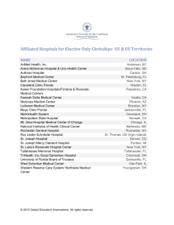


© Copyright 2026