
UGB Remand Contract - Bend Chamber of Commerce
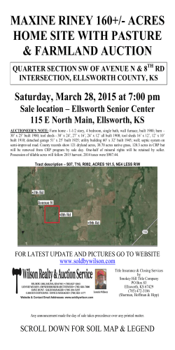
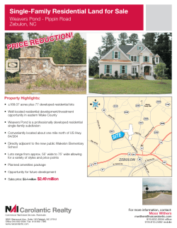
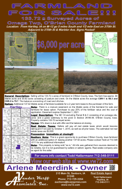
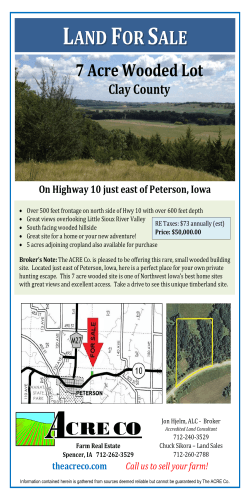
* Bend Chamber of Commerce 4/29/15 Brian T. Rankin, Long-range Planning Manager Background: Remand & New Process Update on Progress: Initial Findings Next Steps Timelines and Strategies * * Planning period 2008-2028 Housing, Employment, Park, School, Institutional, Other Land Population forecast of 115,063 16,681 New Housing Units & 22,891 New Jobs 8,462 acres: 2,866 acres for residential, park, school, ROW, other lands, & 2,090 acres for employment uses * Bend Area General Plan Sewer Master Plan Water Master Plan Transportation System Plan * Major Issue Areas: • Land for Housing, Schools, Parks, Other • Land for Employment • Transportation • Public Facilities • Boundary Location Adhere to State Law Bend’s Citizens Must Be Involved It’s About Land, Infrastructure, Natural Resources, Implementation Not Just Land, But A Plan * * Land Conservation and Development Commission (LCDC) extension to complete the remand (June 30, 2017) Outreach, education, listening to feedback: • Bend Chamber of Commerce • Bend-La Pine Schools • Central Oregon Landwatch • Regional Solutions Team • Realtors • ODOT, DLCD, Deschutes County • Planning Commission • Bend Economic Development Advisory Board • Bend-Metro Parks and Recreation District • 1,000 Friends of Oregon • Neighborhood Associations • Oregon League of Women Voters * *Complete local adoption by April 2016 *Use a collaborative decision making process involving local experts and interested parties in a facilitated and expertly assisted process *Apply best planning and engineering practices involving scenario development and analysis *Engage, inform, and receive input from the public with techniques best suited for the project *Commit to providing additional resources subject to reviewing specific proposals Project Management, Planning, Public Involvement, Policy, Plan, and Code Development, Findings Scenario Planning and Efficiency Measures Public Involvement, Steering Committee Facilitation UGB Methodology, Goal 14 and Public Finance Market Analysis Transportation Planning and VMT Analysis Urban Design and Visualization Web-based Public Involvement * Project Goals, Public Involvement Program Capacity/Expansion Estimates, Redevelopment Areas, Efficiency Measures Approach to Boundary Expansion, Analysis DLCD “Agreement” and USC Approvals * * * Stakeholder interviews (25) and PIP Public Outreach and Input 3 TACs and Steering Committee (22+ meetings) MetroQuest (core values and draft results) Speakers bureau materials, logo, graphics, fact sheets Community open houses, workshops (2) City Web Page MindMixer * Decision Making and Guidance Education and Promotion *Updated Buildable Lands Inventory *Modelling and Analysis with Envision Tomorrow *Identification of Code-related Barriers and New Efficiency Measures *Housing Mix – 55% SDF/10% SFA/35% MF *Identified New Opportunity Sites for Redevelopment and New Uses *Direction on “Special Site” Needs and “Market Choice” Factor * * * Package A: “Base Case” represents current Development Code requirements. * Package B: Market-based approach. Examples include: * Reducing minimum lot sizes and setbacks * Reducing parking ratios * Expanding allowed housing types in the RS zone * Package C: Market-based plus regulatory requirements for more land efficiency. Examples, in addition to those identified above for Package B, include: * Increasing minimum density standards in the RS and RM zones * Master planning requirements for large blocks of vacant residential land * Prohibiting new single family detached housing in the RH zone * New land use designations would enable: • 1,425 to 3,071 more housing units than today • 679 to -795 more/less jobs than today * * • 2-mile area around Bend • Only exception lands vs. farm and forest lands Defined Study • “McMinnville” Process Area and Process Evaluated Study Area • Over 25 maps created • Implement Goal 14 factors • Characterize areas, identify best lands after balancing * * Issues: Natural Resources Wildfire Risk East vs. West Infrastructure Impacts Efficient Lands to Develop Irrigation District Concerns * Potential UGB Expansion Acres by General Land Use Residential • 748 - 367 acres Employment • 528 - 657 acres Two Scenarios for UGB Expansion: • Different Assumptions on Development Code and Juniper Ridge • Scenario 4B: Assumes Juniper Ridge is used for employment • Scenario 5C: Assumes Juniper Ridge is a combination of residential and commercial * Public “Other” • Approximately 670 acres • Approximately 230 acres Approximate UGB Expansion: • 4B: 2,195 acres • 5C: 1,911 acres • Subject to refinement Res. & Emp. TACs Boundary TAC Boundary TAC All TACs • Refine and finalize technical documents • Establish new policies • Create UGB expansion alternatives • Refine, consider linkages with existing UGB • Form three distinct UGB expansion scenarios • Evaluate with more detailed models • Balance, refine, and select preferred alternative • Create new plan policies, development codes, technical reports to implement preferred alternative * Timelines Strategy 2016 local adoption of UGB, 2017 State decision Public Facility Plans, annexation policies Consider Urban Reserve and refinement planning Monitor land supply, smaller/faster UGB expansions Focus on infrastructure Adapt to change: policies and codes *


© Copyright 2026