
To drone, or not to drone?
To drone,
or not to drone?
An exploration by potential
end-users of the possibilities
for unmanned flight within
the 3i project.
Publishing details
Title: To drone, or not to drone?
An exploration by potential end-users of the possibilities for unmanned flight
within the 3i project.
Published on behalf of: Rotterdam Harbour Authority, Rotterdam Police
Part of the Integrated Coastal Zone Management via Increased Situational Awareness through Innovations on Unmanned Aircraft Systems project.
Interviews and text:
Pieter Pulleman (Tekstpartners, Breda)
Edited by:
Leonore Pulleman (Tekstpartners, Breda)
Design and printing:
Erik Lankhorst (Drukkerij Lankhorst, Breda)
Photography/visual material:
REWIN West-Brabant/3i
English translation:
Bernie Ranson
(Vertaalbureau Degenhardt, Middelburg)
To drone, or not to drone?
Remotely piloted aircraft are often referred to in the media as “drones”. There is often an association
with military applications. Organisations concerned with remotely piloted aircraft often talk about a
UAV or a UAS: an Unmanned Aerial Vehicle or System. The vehicle is the aircraft itself, while the system
also includes the ground station. However the term increasingly used across the sector is the acronym
RPAS, standing for Remotely Piloted Aircraft System. This is also the term used by the government in the
new legislation.
2
Neither the author nor the publisher will accept any liability for any damages which may arise from
errors which may occur in this publication, despite the great care taken in its preparation.
2014, All rights reserved.
Contents
4
Background and objectives
5-6
Scenarios as the basis for technical specifications
7
2seas20 infographic
8
Design and manufacture using 3D printing technology
9
Stable, high-quality camera images
10
Data connections for controls, camera operation and safety pilot
11-12
Operating the mobile ground station is as easy as playing Angry Birds
13
Legislation prevents scenario test flights
14-15-16 Legislation: “Can I fly my RPAS please?”
17
Benefits of international collaboration and variations in RPAS legislation
between UK-NL-BE-FR
18-19
Simulation model helps pin down the costs of RPAS
20-21
Potential use of RPAS in the port
22-23
Will RPAS be used?
24
Ecological evaluation
25
Advancing technology will bring further benefits within reach
26
Abbreviations and terminology used
27
Partners in 3i
3
3i project: Background and objectives
Illegal discharge of waste at sea, a disturbance at a busy beach, a reported drowning
or a fire on board a ship. All examples of situations where the rapid deployment of
remotely piloted aircraft systems (RPAS) can be valuable in rapidly collecting accurate
information. Information that can be used to optimise the deployment of manpower
and resources, leading to improved safety, the saving of lives or the (speedy) arrest of
crime subjects.
But is all this really true in practice? And are
unmanned aircraft really more economical
and/or quicker than traditional equipment like
helicopters or ships? Questions like these were
the motivation for the participation of Kent
Police, Politie Rotterdam and Havenbedrijf Rotterdam in the 3i Project Consortium.
General project objectives
The general objective of the project is to create
development capacity by bringing together
parties with an interest in the use of RPAS in
the maritime environment (ports and coastal
environments). The primary concern here is
with potential applications of RPAS with the
capacity to create a safer environment. Universities in France, England and the Netherlands
are bringing their expertise to bear on the
research problems raised by the project. SMEs
are developing new products and services to
meet the requirements of the end users. Read
on to find out how this all comes together.
Specific project objectives
The 3i Project is concerned with the use of
RPAS above coastal areas and ports, with the
aim of improving maritime safety. The central
specific objectives of the project are:
4
research into and development of potential applications for remotely piloted aircraft,
including search and rescue operations, border
control and environmental monitoring;
research and (continuing) development of
technology for use with unmanned aircraft, for
example flight controls, data communication
and the man/machine interface;
the demonstration of the operational
capabilities of RPAS by means of computer
simulations;
the sharing of knowledge and expertise
and the development of innovations and new
technology;
the development and production of a joint
prototype;
testing of existing and new technologies
on the prototype;
demonstration of the operational capabilities of the RPAS in preselected scenarios
by means of real life flights with the project
aircraft and equipment;
evaluation of these demonstrations with
recommendations for follow-up research;
the sharing of the outcomes with the
2 Seas countries and the EC RPAS working
groups.
Knowledge and experience
The knowledge and experience accumulated
during the project will cover operational requirements and possibilities, costs, limitations
and the quality of the end result (the camera
images). Knowledge of the usability of the end
result to replace or support existing information gathering techniques and of the potential
for selling this type of information provision or
setting it up as a shared service.
An understanding has also been gained of the
various roles, responsibilities and liabilities
related to the use of RPAS, but also about barriers and bottlenecks, for example the lack of
harmonisation of the legislation in the different European countries and the implications of
this for the timescale within which unmanned
flight could become a realistic option. Efforts
have been made to expand our understanding
about the usability of RPAS in the circumstances encountered in ports and their approach
areas and about such practical matters as takeoff and landing, refuelling, the legal and other
restrictions and the risks.
The goal of the project partners in publishing this document is to share the knowledge
acquired. We wish to thank all the project
partners for their contributions, their effort
and their enthusiasm.
Politie Rotterdam
Paul de Kruijf
Havenbedrijf Rotterdam N.V. Ingrid Römers
3i 2seas project
3i is an acronym for Integrated Coastal Zone
Management via Increased Situational Awareness through Innovations on Unmanned
Aircraft Systems. The project has been made
possible by a financial contribution from
the European Union’s INTERREG IV A 2 Seas
programme.
INTERREG IVA 2 Seas
The INTERREG IV A 2 Seas Programme falls
within the objective “European Territorial
Cooperation” set out in the Cohesion Policy
for the period 2007-2013. It is a cross-border
collaborative programme co-financed by the
European Fund for Regional Development
(EFRD). The Programme supports cross-border
collaborative projects involving organisations
in England, France, Flanders and the Netherlands and dealing with a number of themes
including economic development, the environment and quality of life.
Project participants:
The Netherlands: Technische Universiteit Delft,
ROC West‐Brabant/Aircraft Maintenance &
Training School, Digital & Media Solutions BV,
Politie Rotterdam Rijnmond, Havenbedrijf Rotterdam, NV REWIN West‐Brabant. France: ENSTA Bretagne, Technopôle
Brest-Iroise, Deev Interaction S.A.S., Institut
Telecom/Télécom Bretagne.
United Kingdom: Kent Police, University of
Southampton.
With the support of: World Class Aviation
Academy, Gemeente Woensdrecht, Business
Park Aviolanda.
This document reflects the author’s views. The INTERREG IV A 2 Seas
Programme Authorities are not liable for any use that may be made
of the information contained therein.
Scenarios as the basis for technical specifications
The radius of action and airworthiness (safety) of RPAS are significant factors affecting their use,
together with the quality of the sensor (camera) and the data connection. The potential end users
Havenbedrijf Rotterdam and Politie Rotterdam together with Kent Police have developed a number of user scenarios with the aim of establishing the requirements which will need to be met by
the aircraft, the sensor and the data connection. These scenarios provided the starting point for
the technical specialists involved in the project.
It’s not so much about flight, but more about
what you can do with it. A brainstorming
session involving the police and the harbour
authorities threw up a substantial number of
potential applications. Four of these operational scenarios were then selected as the
starting position for the 3i project. Havenbedrijf Rotterdam Policy Staff member Reinout
Gunst: “Could we use unmanned aircraft for
situation monitoring and in responding to incidents? And could RPAS improve our response
to incidents and increase efficiency?” Politie
Rotterdam Innovation Broker Paul de Kruijf:
“Police forces have similar questions in relation
to our monitoring, detection and enforcement
activities.”
A supplement
The use of RPAS is considered for the time
being as a supplement to existing resources.
The police and the harbour authorities would
be primary users of this technology, as a sensor which could be sent quickly to a specific
location to carry out targeted observations,
to direct the emergency services from the
air, or as a patrol vehicle (or more accurately,
as an extension of the visual range of patrol
vehicles). There are consequences for the way
the camera images are created and used. “Real
time” images are not required for the inspection of infrastructure for example, however
it would be important to identify the precise
location where the image was taken. De Kruijf:
“Real time images can be very useful to the
police, and we have therefore provided a lot
of input relating to the technical specifications
for the camera.” Face recognition from the air
would be great, but it isn’t a possibility with
the cameras we have today. They do however
have the capacity to identify a vehicle’s colour,
shape and type or a person’s clothing. Image
resolution is a significant factor here. De Kruijf
again: “Good real time image resolution needs
sufficient bandwidth in the data connection.
We need to know how much is enough, what
do you need as a minimum.” Gunst adds: “The
control and positioning of the camera is also
important, for example the ability to quickly
zoom in and out. And we can also use different sensors, infrared cameras for example, or
odour detectors.”1
Business case
It is possible that the use of RPAS may result in
cost savings. For example the images collected
might indicate that it isn’t necessary to send
out an expensive rescue vessel, there might
also be savings from increased efficiency in the
use of manpower and resources, or from the
avoidance of risk. Gunst: “In essence the end
user needs clarity about whether the use of an
RPAS will bring benefits without excessive additional costs, and whether it might indeed be
a cheaper option.” De Kruijf: “During the summer it is necessary to deploy police manpower
on our beaches. Monitoring with RPAS could
reduce that burden. It might however lead to
an increase in operational costs, because the
more you look, the more you find.”2
Test flights
A number of test flights based on four selected
scenarios were proposed with the aim of
investigating whether the use of RPAS would
meet expectations. The test flights also had
an important role in demonstrating the safety
and operational reliability of the 2SEAS20
system. The stringent legislation currently in
place in the Netherlands meant however that
it was not possible to obtain the necessary
1 You can find more information about the sensors and their operation
in the relevant articles.
2 You can find more information about the business case in the relevant
5
permissions within the period of the project.
Looking back, De Kruijf sees it as something
of a Catch-22 situation: “You need to carry
out testing to demonstrate safety and added
value, but we were not given this opportunity.
A missed chance I think.” It’s worth pointing
out that all the flight systems are carried out
redundantly to ensure safety. So for example
if one motor fails there is another available so
that the flight can be completed safely.
International collaboration
Both interviewees had positive things to say
about international collaboration during the
project. De Kruijf: “There was really quite a
lot of work involved in this. But it was not my
primary role, and I had to fit it in as and when
I could. On your own you wouldn’t always
have time to respond or make adjustments.”
Gunst: “The great advantage of international
collaboration was that each of the universities
involved could make contributions drawing on
their own particular research interests. A good
collaborative atmosphere was also created
among the group of end users, putting down a
sound foundation for the possible future joint
deployment of RPAS.”
User scenarios
Three scenarios were developed at the
outset of the 3i project to serve as the
basis for:
the technical specifications for the aircraft, the control systems, the payload
(sensors) and the power unit;
an application to the relevant authorities for a waiver allowing flights over
a specified location, at a specified
height and for a specified time;
research into the potential legal implications of the demonstration flights;
gaining an understanding of the capacity and resources required to carry
out the demonstration flights.
Scenario 2:
Places of interest
Dit scenario kent twee subscenario’s:
This scenario was made up of two sub-scenarios:
Anchorages
The aim of this scenario was to demonstrate
the detection of illegal activities, like the illegal
dumping of waste materials. The RPAS would
take images of the location and send these in
real time to the land-based monitoring post.
Inspection flight
An inspection flight passing over five previously identified points of interest. Illegal
activities were said to be taking place at one of
these locations. The RPAS would take images
of the location and send these in real time to
the land-based monitoring post. High quality
images would be required to allow the identification of the vessels involved.
Scenario 3:
Protestors board a ship
The 2SEAS20 has a cruising speed of
100 kph and a top speed of 150 kph or
around 95 mph.
6
With a full tank of fuel the aircraft can
remain in the air for as much as three
and a half hours.
Unlike many other RPAS the 2SEAS20
has a petrol engine rather than the
electric motor found on many other
unmanned aircraft. Electric motors
are battery powered, but the capacity
of the batteries used for unmanned
flight is still pretty limited.
Scenario 1:
Seaside recreation
People visit the dunes and beaches for recreation throughout the year. The nearest police
station will monitor the situation, carrying
out surveillance on horseback as well as from
cars. Unusual occurrences and incidents will
be reported to the local station, and there will
then be an interval before officers can attend
the scene. There is often a lack of clarity about
the urgency of the situation, and it can happen
that the situation is already resolved before
anyone arrives. In these circumstances a rapid
observation from the sky can be of great assistance.
Three different situations were developed for
this demonstration: a kite surfer in difficulties,
an incident in the dune area and a fight breaking out on the beach.
A group of activists board a ship at anchor. The
authorities need information about the number and location of the activists on board. It is
not possible to establish this from the water.
The use of the RPAS makes overhead images
available.
Note: the stringent legislation in place made
live testing of these scenarios impossible during the period of the project. Nevertheless the
requirements derived from these scenarios were
used as the basis for the technical requirements set down for the project, for example: a
flight duration of three hours, the ability to fly a
previously determined route and the ability to
deliver high quality images. Although it was not
possible to determine during this project whether
the use of RPAS would indeed deliver added
value, a number of test flights were carried out in
England in order to establish the design quality
and resilience of the aircraft, and the camera was
exhaustively tested in a land-based simulation.
The aircraft has a
carbon fibre airframe,
strong and light
a
3,74 m
4
150 m
The wings are in polystyrene
Twin two-stroke petrol engines
(28cc, max. 8000 rpm, 3.35 hp). If clad with fibreglass.
one engine fails the plane can fly on
the remaining unit.
The engine nacelles and other critical components are manufactured in Laser Sintered
Nylon, an exceptionally strong material with
a high level of resistance to impact, cracking
and extended exposure to UV light.
The central portion of the wings holds
5 litres of fuel. a camera can be
mounted below the wings here, at the
aircraft’s centre of gravity.
5
500 m
1
the 2seas20 has been developed with the aim of improving maritime safety. it is able to monitor shipping movements but can also be rapidly deployed
in the event of emergencies to gain information on the extent of the problem from the air. the 2seas20 is part of a european project with twelve collaborating partners. the Dutch participants include rotterdam harbour authority, the technical University at Delft and the police. the 2seas20 is currently in its
test phase. it is not yet known when the aircraft will be operational in the skies above the port of rotterdam.
- Type: unmanned, twin-engine aircraft
with automatic pilot
- Wingspan: 3.74 m
- Weight: 20 kg (excluding fuel
and payload)
- Maximum load: 5 kg
- Maximum speed: 148 kmh
- Cruising speed: 94 kmh
- Able to remain in the air for
2.75 hours
3
2
infographic: Jan Peter Hemminga
1 The dismantled aircraft is taken to the launch
location by the ground station vehicle. 2 The
2seas20 can take off, carry out its mission and
land again, all automatically. 3 The human pilot
can intervene at any time. 4 The aircraft streams
video images back to the pilot on the ground. 5
Legislative restrictions mean that the aircraft must
remain within a radius of 500 m from the pilot, and
it may not fly higher than 150 m.
THE 2SEAS20 IN ACTION
The best view is often from above. The 2seas20 is an unmanned aircraft, specifically developed for tasks in and around the port,
including rescues and inspections of infrastructure. So how does this self-piloting technical marvel work?
Unmanned aircraft: a new eye in the sky above the port
7
infographic: jan peter hemminga
Design and manufacture using 3D printing technology
The 2SEAS20 aircraft was mainly built on a 3D printer. This not only had advantages
during design and manufacture, it also made it easier to implement modifications
later. This advanced manufacturing technique also makes the assembly and stripping
down of the aircraft quick and easy. Further research into this production technique
will however be required.
generally want to keep the weight and the
costs as low as possible.” The effectiveness
of this approach was clearly demonstrated
during the test phase when an engine failed.
“A plug connection separated, but with the
other engine to fall back on this didn’t present
a problem.”
Straightforward
RPAS designer Mario Ferraro of the Computational Engineering and Design research group
at the University van Southampton has extensive experience in the design and building
of RPAS. He was involved in the design of the
first 3D printed RPAS aircraft in 2011. In the 3i
project he was responsible for the design and
fabrication of the aircraft.
Redundant design
8
Ferraro holds an MS in Aerospace and Astronautics Engineering. In his view his university
was an obvious choice to take part in the 3i
project. “We’re very active in the field of RPAS
and we are world leaders in the 3D printing
(more formally “additive manufacturing”) of
airframes.” The airframe is one of the crucial
components of an RPAS says the designer. “It
has to be capable of carrying the sensors, it
needs to stay in the air for relatively long periods and it has to be extremely reliable.” There’s
a difficulty here which doesn’t affect ordinary
aircraft, due to the lack of demonstrably reliable components. It was therefore decided
that the principle of redundancy should be
adopted for all the crucial flight systems in the
3i aircraft, the 2SEAS20.
Exceptional
The test model is therefore equipped with
two motors, two generators connected to
the motors and a second autopilot. The same
“doubling-up” philosophy was also applied
to the airframe, while the wings feature four
ailerons. So if one of these fails there will still
be adequate control to get the aircraft safely
back on the ground. Ferraro: “Doubling up
everything like this is pretty exceptional; you
One advantage of the 3D printing technique is
that improvements to the design can continue
to be implemented without incurring excessive costs, and this method of manufacture
also means that the machine can easily be
taken apart, transported and reassembled.
The capacity of the fuel tank was increased
to allow longer missions to be flown. The 3D
printing method means that it is relatively
straightforward to implement these and other
modifications.
Rapid adaptations
The use of the 3D printing technique offers
particular advantages to designers and
manufacturers, but end users also benefit
because any modifications to the equipment
can be carried out in a matter of a few weeks.
There are also advantages where repair and
maintenance are concerned as a defective
component can be replaced with an improved,
more robust alternative.
Further research required
While 3D printing offers all these advantages
it also throws up questions, for example about
replicability: is a new printed component of
similar strength, or is it stronger? And how can
this be demonstrated? What about the quality of the powder used? What is the residual
strength of the material after (for example)
one hundred hours of flight? These are topics
that demand further research.
The aircraft can be assembled in as little as five
minutes, but Ferraro urges caution: “This isn’t
something you should rush. But the aircraft
can be operational within 15 to 20 minutes,
including the pre-flight check.”
Stable, high-quality camera images
The camera system is crucial in obtaining accurate information. Are we
interested in capturing rapid movements, or in object recognition? And
what level of detail is required? Do the images need to be high quality,
or is that unnecessary?
There are a number of initial basic requirements for the camera system. The camera
must be as light as possible (a maximal 5 kg
payload below the aircraft) while still delivering high quality results. The dimensions are
critical: the camera must be able to fit in
the gimbal mounted on the aircraft. Energy
consumption must not be excessive and the
camera must come in within budget.
Basic principles
The scenarios developed at the start of the
project (see page 6) provide the starting point
for the technical specifications for the camera
system. Tommaso Mannucci, a post-graduate
researcher at the TU Delft has investigated
which camera system will be most suitable.
According to Mannucci the objective is for the
end user to be able to view a situation and see
what is taking place. “If there’s a disturbance
for example you want to be able to see how
many people are involved, the colour of their
clothing and similar details. If people are
running off in different directions you need to
be able to zoom out instantly while retaining
image quality.”
focal length.” A sensor within the camera corrects for the motion of the aircraft, so the camera is always stable and will make its images
from the correct position. A GPS connection is
used to ensure that the position on the map is
known with precision. Face recognition using a
camera continues to be problematical and is at
the limits of what is technically feasible at this
time. The availability of infrared imaging is an
obvious requirement when flying at night.
Zooming in and out without loss of
quality imposes demands on the
camera.
Testing
Mannucci refers to this as “filter view”: the
facility to image a specific part of the observed
area. This demands a good optical zoom function capable of enlarging the filter view up
to ten times without deterioration in quality.
Mannucci: “You need to be able to zoom in on
a specific point, but also to zoom out to monitor a larger area. Both without loss of quality.
This is done by increasing or decreasing the
A number of tests were carried out with three
different cameras in order to establish what
level of detail was visible with each camera.
The quality of one of the cameras tested left
something to be desired, and this type also
had fewer control options. The other two delivered the desired quality at around the same
price. The eventual choice was for an Australian camera weighing 700 grams, together
with a gimbal to suspend it from the aircraft
and a range of additional components such as
a recorder and converters to allow switching
between HD and analogue signals.
Camera controls
Two camera control systems have been
developed. In one system a line is drawn on
an interactive map on a touch screen in the
ground station. The RPAS will then fly a linear
route and the camera will follow that line. The
other method involves steering the camera
manually using a joypad. This allows free operation of the controls, for example zooming in
and out. It is possible to fly using one of three
configurations: in a line from point A to point
B, in a circle around a point of interest, or following a preprogrammed surveillance route.
Control of the camera and of the aircraft itself
are separate tasks.
9
Data connections for controls,
camera operation and safety pilot
The quality of the data connection between the aircraft and the ground
station is crucial both for control purposes and to allow reception of the
correct images with the optimal quality. The 2SEAS20 can continue to
provide good images in real time up to a distance of ten kilometres.
The mobile ground station and the aircraft are
in continuous communication. One modem
is built into the ground station housing for
this purpose, with another in a pod beneath
the aircraft. The ground station has a mast
with two antennas. One connection is used to
control the automatic pilot. The ground station
transmits data to the aircraft and receives
feedback about its position, height and speed.
The second data link is used to control the
camera. There is also a radio link between the
aircraft and the additional pilot on the ground.
This “safety pilot” can take over the controls if
necessary and control the aircraft manually.
Image quality
10
The aircraft transmits real time images to the
ground station. This streaming data is not of
HD quality as that would make the data files
excessively large. The images produced are
therefore first stored on board at HD quality.
The quality of the streaming data also depends
on the distance between the aircraft and
the ground station and the weather conditions. The frame rate at which the images are
received also plays a role. Extensive testing
was carried out to determine what frame rate
within a specified bandwidth would be acceptable to the end user. The tests revealed that
the preference of the end users was for a frame
rate of twenty frames per second. Although
this delivers a relatively low image quality it
was nevertheless good enough for the end
users.
Distance
Depending on the weather conditions the
data connection is still capable of transmitting good quality images at a distance of ten
kilometres. This was successfully tested using
motor vehicles on the beach. The aircraft is
capable of flying beyond that distance, but in
that case the images taken would be stored
and then transmitted once it was back within
the range of the ground station. The cameraman can read out the images once the aircraft
has landed.
Over Ramsgate
The camera was also tested in the air above
Ramsgate, an English port comparable with
Rotterdam, with many objects manufactured
in steel such as cranes, shipping containers,
ships and freight vehicles. This large amount
of metalwork did not lead to problems with
the control or camera signals. The camera can
anticipate the motions of the aircraft, keeping it focused on the desired point. TU Delft
developed the algorithms used to achieve
this. The aircraft is equipped with GPS, an
accelerometer, a rotation meter, a barometer
and a magnetometer. The information collected is brought together in the equipment
and the system then picks out the information
required to fix the correct position.
Operating the mobile ground station
is as easy as playing Angry Birds
A pilot on the ground controls a remotely piloted aircraft. This is already possible using a relatively simple
handset, but this was not satisfactory for the end users in the 3i project. A mobile ground station was
developed, based on the user scenarios. The pilot, the cameraman and three or four personnel from the “
operational agency” (the police, the harbour authority or the fire brigade) work together in the ground station.
There are individual workstations for these
different roles in the mobile ground station,
a customised van built on the chassis of a VW
Crafter. The layout of the ground station is designed to promote collaboration between the
pilot, the cameraman and the end user or client. The operators each have their own screen
and keyboard and operate independently.
station should develop a fault. The cameraman controls the camera from his workstation
using a computer. The camera will then focus
automatically on the designated location. The
cameraman can also switch on the recording
function.
Switching
Fully automatic
Instructions from the user about the flight
path and the use of the camera will be sent
fully automatically to the autopilot system.
The pilot monitors operations to see that
everything is proceeding correctly and in the
interests of safety does not get involved with
the content of the mission. The pilot takes ultimate responsibility for the flight as required by
law. There is also the legally mandatory reserve
pilot outside the ground station with a hand
transmitter, on stand-by in case the ground
The loss of the connection is not something
that is expected to happen often according
to Engineer Marcel Mattheijer of Oud-Gastelbased D&MS. This project partner is a specialist
in the construction of video and direction
vehicles, primarily used by broadcasting
companies. This expertise proved invaluable
in the outfitting of the 3i ground station. The
desired functionalities were determined by
means of the user scenarios. The equipment
was provided by TU Delft while the software
was developed by French partners Deev
Interaction S.A.S. and Télécom Bretagne. “Our
knowledge and experience were critical when
it came to the layout of the vehicle, ergonomics, location of the screens, the folding tables
and the facility to reverse the co-driver’s seat,”
says Mattheijer. Each user can log in to a different computer from any screen, a concept borrowed from the world of TV. “So if the sunlight
is shining on the pilot’s screen he can quickly
and easily switch to a different monitor.”
Angry birds
Individual workstations
Ease of use and intuitive operation were guiding principles in the design of the control of
the camera and aircraft controls. The starting
point was that anyone should be able to
control the equipment, without any additional
training. Or as Marcel Mattheijer puts it: “It’s
easier than playing Angry Birds.” The user
indicates the flight path by drawing a line on
an interactive map using a touch screen. The
software then passes this on to the pilot. The
pilot confirms this and the signal is sent to
the aircraft. The interface was subjected to
intensive testing in France, using simulations
rather than actual flight. “It worked brilliantly,”
says Mattheijer.
The pilot and cameraman sit at the front of
the vehicle and each has his own workstation.
The users sit to the rear at a range of monitors. There’s a touch screen for control and
two monitors connected to a computer with
another two screens above these showing
the live images and any replays. The vehicle
has a seven metre telescopic mast carrying
the antennas for the flight connection and for
transmitting real time image data and GPS
positioning data. The WiFi connection has a
range of 150 kilometres, as long as the aircraft
and the ground station can see one another.
11
Software
The control software runs on the open source
Paparazzi platform. The code for the autopilot
and the hardware diagrams are available from
the Paparazzi website. The 2SEAS project office were pleased with this says Mattheijer, as
sharing knowledge is one of the conditions for
the provision of finance.
“The advantage of housing the system in a
vehicle is that you are out of the weather,” he
adds. The van is also used to transport the
2SEAS20, as it is a little too big for the average car. The end users can be located in the
ground station vehicle, but this is not essential
as they can look on and give instructions via a
secure internet connection, so that their operational environment is the same either way.
12
A new market for ground stations
The brief for the construction of the ground station
was unusual says Mattheijer. “Normally when we
start on the build of a broadcasting vehicle we
already know how the final result will look. But that
wasn’t the case here. There were plenty of changes
and additions along the way.” Mattheijer was very
satisfied with the project and sees new market
opportunities for D&MS. “We have built up a lot of
valuable experience.”
Legislation prevents scenario test flights
In the original plans for the project the intention was that the flights described in the scenarios
would actually be carried out. The objective was clear: to test whether the use of RPAS actually
delivered in line with expectations. But the stringent waiver-based legislation in the Netherlands
meant that the test flights could not be carried out.
Test flights were carried out in England
however, involving general testing of the
control systems, the automatic pilot, the safety
systems (what would happen if the engine
failed?) and an endurance test (how long can
the aircraft remain in the air?). It was decided
on the basis of the test results that all important components should be twinned.
Erik-Jan van Kampen, Assistant Professor in the
Faculty of Aerospace Engineering at TU Delft
was involved in the test flights, which were
carried out at the University of Southampton.
He explains how a number of altimeters were
used for landings using the automatic pilot:
“A GPS system on its own was not accurate
enough for this purpose, so we carried out
further tests with sonar and a laser ranging
system.” This revealed that the sonar system
does not perform well over soft substrates like
meadowland. So that option was off the list.
We therefore incorporated the laser ranging
system in the test rig. Van Kampen: “We carried
out more than thirty automatic take-offs and
landings in Ramsgate, a port with similarities
to Rotterdam. The tests showed that we could
fly safely.”
A new waiver application after every
modification
Unlike the situation in the Netherlands, universities in England are able to carry out test
flights. They fall under the Hobby Regulations,
for aircraft up to 20 kg. Dutch universities
must apply for a waiver before they can carry
out flights, but because the Environment and
Transport Inspectorate need to
issue a new waiver following any
modification to the aircraft, van
Kampen says the Dutch system is
unworkable for research institutes.
“Carrying out modifications so that
they can be tested is the essence of
our work.” The university had a test
site at the Woensdrecht air base up
to 2012, but permission for that was
withdrawn and the effect has been
that the university is unable to carry
out any further flight tests. Woensdrecht had also been the planned
location for the 3i test flights.
Hear and avoid
TU Delft were keen to take part in the project
because of the research work it would facilitate. The university’s primary interests are in
automatic pilot systems for RPAS and “sense
and avoid” systems, which allow the aircraft
to avoid not only fixed objects but also other
manned and unmanned aircraft. “This will be
among the requirements if you want to extend
the length of flights to carry out so-called
“beyond visual line of sight” flights.” Research
into workable sense and avoid systems is
ongoing. “It looks like “hear and avoid” with
a microphone fitted to the aircraft will work
better than using a camera,” says van Kampen.
“It’s possible to identify a sound signal much
more quickly than a camera image.”
Following on from this the university investigated the best way to fly the RPAS to avoid an
object. Should you go left, right, over or under
the object? And what would you do if you
wished to fly five RPAS to a single destination?
A research project looking at this was successfully completed by a postgraduate student at
the start of this year.
CTR Rotterdam
Because of the proximity of the Rotterdam-The
Hague Airport, part of the area above the port
is a so-called Controlled Airspace. Flying an
RPAS in a controlled airspace is prohibited in
any case. Potential solutions might be found
in a demonstrably reliable sense and avoid
system and by flying only to a specified limited
maximal height in the area. According to a
spokesperson from the Ministry of Infrastructure and the Environment work is going on to
find a solution to this problem. The expectation is that the matter will be resolved before
the end of 2015.
13
Legislation: “Can I fly my RPAS please?”
The Civil Aviation Act means that you may not simply fly as and where you like in the
Netherlands, not even with a remotely piloted aircraft of relatively small size.
Flying “beyond visual line of sight” with an
RPAS is not permitted. “In technical terms it is
certainly possible, but the technique has not
yet been adequately demonstrated in accordance with the aviation standards,” says Rob van
Nieuwland, Chair of Darpas, the Dutch Association for Remotely Piloted Aircraft Systems.
“This is a recurrent problem in the development of appropriate legislation on RPAS.”
Commercial flights: RPAS waivers
Hobby or business?
3.
Someone who acquires an RPAS as a private
individual and only flies it as a hobby will fall
under the “Model Flight” regulations. But
where the use of the aircraft is commercial, as
part of a job or profession and/or for payment,
then a waiver is required from the Environment and Transport Inspectorate (the Dutch
agency overseeing the enforcement of the
aviation legislation, known as IL&T). There is
something of a grey area here however, as IL&T
regard practice, training and tuning flights
as commercial flights, as well as flights used
to take photographs or videos for one’s own
purposes, including advertising.
What can a hobbyist do?
There are regulations covering hobby and
model flying as well as professional use, with
the aim of ensuring the safety of third parties
and their property, and to prevent any contact
with civil and military air traffic. Breaches of
the regulations can result in fines of €7,800 for
each breach.
14
A model aircraft may be flown:
in daylight;
in the vicinity of civil and military airports,
provided appropriate agreements have
been made;
with a continuous good view of the aircraft;
up to a maximum of 300 metres Above
Ground Level (AGL);
provided the aircraft does not fly over
continuously built-up areas;
but not above roads, railway lines, waterways, ports or large structures (bridges
and the like), with the exception of 30 and
60 km roads.
The following conditions must be met in order
for a business to obtain an RPAS waiver:
1.
2.
4.
5.
6.
7.
A theoretical basic training course must
be taken with a recognised training company, including theoretical exams;
Flight training with examinations must be
taken with a recognised training company
familiar with the type of RPAS the candidate intends to fly;
An approved Operations Manual must be
available;
A Safety Management System (SMS) must
be in place;
Air traffic insurance must be arranged,
covering both the machine and third party
liabilities;
The aircraft must be approved;
A final test must be carried out by an
approved agency, with practical testing of
the business/pilot/aircraft triangle against
the requirements for the procedures
described in the Operations Manual,
including emergency procedures.
Once these five conditions have been met
and the technical information on the aircraft
are known to the government agencies, then
a project waiver for specifically described
projects may be applied for. The aim is partly
to assess how the applicant deals with all these
issues, which may play a role in the granting of
a Commercial Waiver.
Waiver for the carrying out of a flight
by an organisation with an RPAS
waiver
Once the organisation has received a project
waiver or a commercial waiver from IL&T,
every flight with the RPAS must meet the following conditions:
A Temporary and Exceptional Use (TUG)
permit from the Provincial authorities is
required for each flight. This is because an
aircraft may not take off or land outside an
air traffic site without permission. Some
provinces do not require this.
The permission of the owner of the land
where the aircraft will take off and land
must be obtained.
A Notice to Airmen (NOTAM) must be
submitted via the Airspace Manager five
days prior to the flight.
A notification must be made to the Mayor
of the Local Authority where the flight will
take place, as well as to IL&T, one day prior
to the flight.
This is to relate to the specific combination
of responsible organisation (the applicant’s
organisation or one hired in) the specific aircraft (serial number etc.) and the named pilot.
Where an aircraft has no type recognition
(meaning that it has not been designed by a
DOA certified organisation and has not been
built by a POA certified organisation), then
aircraft of the same type but with a different
serial number must have been submitted
separately for approval.
What can I then do, as an organisation
with an RPAS waiver?
Flights are placed into two classes.
Flights in class 1 must:
Fly in daylight;
Fly with a continuous good view of the
aircraft;
Not fly further than 500 metres from the
pilot/observer;
Fly up to a maximum of 120 metres AGL;
Not fly in civil controlled airspace (CCA)
on air safety grounds (in a radius of 15 km
around the airfield), or in prohibited areas
(EHP), temporary or permanent reserved
areas (TSA and EHR) or hazardous areas
(EHD) (see VFR Air Traffic Map);
Not fly in Natura-2000 and Ecological
Main Structure (EHS) areas. These areas
are excluded from the TUG application
because of the prohibition on disturbing
nature. See http://www.synbiosys.alterra.
nl/natura2000;
Not fly above gatherings of persons,
structures, occupied buildings, vessels or
vehicles;
Only fly within a military low flying area
or below or within a distance of 3 nautical
miles of a low flying route with the permission of the Defence Ministry;
Not fly within 150 metres of gatherings of
persons, structures, buildings, vessels or
vehicles which are not under the control
of the operator (where “under the control”
means that the object is the property
of the client and all persons have had a
safety briefing and/or will remain in the
buildings). Limit the risk to third parties
to a minimum. It is not sufficient simply to
put a notification in the post. (Note: flying
within 150 metres of gatherings of persons
is always prohibited. The separation
distance to a road with a constant flow
of traffic is also 150 metres. This distance
may be reduced in the case of roads with
sporadic traffic, provided the distance to
the vehicles is a minimum of 150 metres.)
Flights in class 2 are:
Above built-up areas;
Higher than 120 m AGL and/or further
than 500 metres from the pilot;
At night, or for example without a continuous view of the aircraft.
Additional requirements apply to the aircraft,
the organisation and the pilot before such
flights are allowed. Full certification (ICAO
requirements) is needed for the aircraft. The
aircraft must have been built and maintained
in line with the full requirements for air traffic.
(DOA/POA – Design/Production Organisation
Approval and MOA – Maintenance Organisation Approval).
In very rare cases where there is “great societal
interest in combination with acceptable risk”
permission may be obtained for a class 2 flight
following assessment by IL&T.
An end user of RPAS services who wishes to
fly an aircraft of his own must also meet the
above-mentioned requirements.
Set up your own RPAS flying
organisation?
Where an organisation decides to carry out the
services on its own behalf, the implications are
as follows:
The organisation must set up its own RPAS
flight department, which will be responsible
for:
Acquisition and ownership of the RPAS;
Appointment of one or more “pilots in
command” and observers. Both of these
may be hired in, but the associated procedure must be properly described in the
Operational Manual;
Ensuring that the pilots have adequate
flying experience with the selected type of
RPAS (Practical Training);
Ensuring that the pilots (whether internal
or external) have successfully completed
a minimal theoretical training course, with
an examination;
The drafting of an individual Operational
Manual, setting out all the procedures and
the organisation involved with flying; this
manual must be approved by the Environment and Transport Inspectorate;
A (Light) Safety Management System must
be introduced;
Air Traffic Insurance must be arranged;
A waiver of the airworthiness requirements for each aircraft must be obtained,
by means of an inspection by a competent
authority;
A final test by a competent authority must
be successfully completed (with a positive
recommendation), with a practical demonstration of the matters set out in the Operational Manual using the organisation’s
own aircraft and the appointed pilots.
Having obtained the Commercial Waiver
(permission for this organisation to fly, with
the registered aircraft and the specifically appointed pilots) the organisation may start on
preparations for the flights (see the section on
“Waiver for the Carrying Out of a Flight...”), and
carry this out, but only with the nominated
pilots and observers.
Where there are changes affecting the
“triangle”, for example a different aircraft or
pilot, then the relevant element of the waiver
procedure must be repeated.
Aerial photographs and videos are
allowed
As of 01-06-2013 an Aerial Photography Permit
is no longer required when taking aerial photographs and videos. Some service providers
do however continue to erroneously request
permission from the Defence Ministry to take
aerial photographs. They also erroneously
imply that by doing so they also have permission to fly. A waiver certificate should therefore
always be requested from IL&T if you wish to
do business with an external business in the
area of unmanned flight. If you get involved
with a business which does not hold a waiver
then as the client you run the risk of giving an
order for an illegal flight to be carried out.
There are restrictions as a result of the privacy
legislation. You should film or photograph only
where you can normally gain access and take
photographs using an ordinary camera, so not
in gardens or above enclosed commercial or
private premises. ALWAYS ask for the owner’s
permission first!
This text has been created with the assistance
of the sectoral association DARPAS and should
be regarded as a snapshot.
You should consult the following websites to
find out about the current position:
www.darpas.nl
http://www.ilent.nl/onderwerpen/
transport/luchtvaart
15
Aviation Police monitor the illegal
commercial use of RPAS
The national police force’s Aviation Department are responsible for monitoring the
unlawful use of unmanned aircraft. A number
of prosecutions have recently been initiated.
The Aviation Police are responsible for enforcement of the laws relating to the use of RPAS, with
the objective of preventing illegal commercial
use. Patrick Fung from the department points
out that the police always bring prosecutions in
these cases. “And it’s highly likely that the RPAS
equipment will be seized.” A number of prosecutions have been brought, but the Aviation Police
are dependent on reports from colleagues or third
parties. “We don’t actively trawl the internet for
photographs or videos made with RPAS, but when
we get a report we always launch an investigation.”
Recreation
In the case of recreational use the police look
at the type of breach and the level of risk. “The
number of breaches and the level of danger then
determine if a prosecution is brought in an individual case,” says Fung.
Prevention
“If we hear that someone intends to carry out
flights and is likely to commit one or more offences as a result, then the pilot in question will
be warned in advance not to fly, for example
above an event or a crowd of people. If the pilot
goes ahead and flies despite the warning, then he
runs the risk of prosecution and the seizure of the
aircraft.
16
The Aviation Police would like to see the vendors
of RPAS alerting potential buyers about the
legislation, so that they are more aware of the
rules. Another point is that citizens experiencing
problems from unmanned aircraft don’t know
how to contact the Aviation Police. The same
could be said of some police officers. In both cases
Fung attributes this to the relevant unfamiliarity of
the phenomenon.
CTR’s in The Netherlands
Benefits of international collaboration and
variations in RPAS legislation between UK-NL-BE-FR
Aircraft Mass
Registration?
Operating
Permission?
Pilot Qualification
UK
Airworthiness
Approval?
20 kg and less
No
No
Yes (Note 1)
Yes (Note 1)BNUC-STM
or equivalent (Note2)
More than 20 kg, up to
and including 150 kg
More than 150 kg
Yes (Note 3)
Yes (Note 3)
Yes
EASA Permit to Fly or UK
Permit to Fly in accordance with ‘B conditions’
(Note 3)
Yes (Note 3)
Yes
Yes
Yes,BNUC TM or equivalent (Note2)
Yes,BNUC TM ,CPL(A)or
equivalent (Note2)
Yes (Note 3)
Yes
FR
25 kg and less
recreational use
Above 25 kg
recreational use
Yes (Note 3)
Yes (Note 3)
Yes
25 kg and less
aerial work
Yes (Note 3)
Yes (Note 3)
Yes
2kg and less
aerial work
Yes (Note 3)
Yes (Note 3)
Yes
<25 kg and 2><4kg
not aerial work
Yes (Note 3)
Yes (Note 3)
Yes
Less than 150 kg
bvlos science
Yes (Note 3)
Yes (Note 3)
Yes
more than 150 kg
bvlos science
EASA Permit to Fly or FR
Permit to Fly in accordance with ‘B conditions’
(Note 3)
Yes (Note 3)
Yes
Yes
Yes
Yes
EASA Permit to Fly or NLD
Permit to Fly in accordance
with ‘B conditions’ (Note 3)
?
Yes
Yes
Yes,BNUC TM NLR or
equivalent (Note2)
?
?
Yes
?
EASA Permit to Fly
Yes
Yes
?
NL Less than 150 kg
More than 150 kg
BE
Less than 150 kg
(Note 4)
More than 150 kg
Yes, theoretical part of
PPL, ULV of glider pilot
license.
Yes, theoretical part of
PPL, ULV of glider pilot
license.
Yes, theoretical part of
PPL, ULV of glider pilot
license.
Yes, theoretical part of
PPL, ULV of glider pilot
license.
Yes, theoretical part of
PPL, ULV of glider pilot
license.
Yes, theoretical part of
PPL, ULV of glider pilot
license.
Yes, theoretical part of
PPL, ULV of glider pilot
license.
17
Notes:
1) Applicable from 1 January 2010 for aircraft used for Aerial Work purposes or if flown within a congested area and/or close to people or property.
2) Equivalent pilot experience will be considered on a case-by-case basis during application for an operating permit.
3) It may be possible to obtain certain exemptions from the airworthiness and registration requirements.
4) In Belgium only a permit for test, education, demonstration, research and governmental RPAS flights exists. The Belgian legislation for RPAS less
than 150 kg is still in development.
Remarks.
1
2
3
4
ASA has published a roadmap for preparing and implementing RPAS rules for RPAS < 150 kg.
Several European countries have implemented their own rules. Some rules are common to all, others differ significantly.
JARUS is also working on common European rules.
It is possible that the information above was outdated at the presentation on 6 November. Several countries are working on new rules
(Eg UK and BE) or are engaged in an internet-based consultation (NLD).
Text: Walter Broeders/Frits Muller/Henk Ottens -Unmanned aviation solutions B.V.
Drafted for Interreg cluster BERISUAS (better response and improved safety through RPAS)
Simulation model helps pin down
the costs of RPAS
What are the real costs of RPAS? Does it make operations more
economical, or could it even be more expensive than the traditional
methods? Does it provide more or better information, or information
you can’t obtain elsewhere? How valuable is that? And what other
aspects of the use of RPAS must be taken into account?
As a Ph D student at the University of Southampton’s Institute for Complex Systems
Simulation Benjamin Schumann carried out
research into the use of operational simulations for aviation applications. His research
problem was “can simulations contribute to an
improved design for an aircraft?” In his investigation Schumann focussed on three different
RPAS designs, one of which was the 2SEAS20.
He used the 3i scenarios (see page 5+6) as
his starting point. The simulation model was
supplemented with operational data of various
kinds: fuel consumption, airspeed, the number
of take-offs and landings, the number of times
the aircraft was refuelled and its failure rate.
“We calculated all this out in the simulation
model,” says Schumann.
Remarkable results
18
This initially threw up a remarkable finding,
namely that aircraft were lost at a rate of nearly
one a week! “But this wasn’t such a bad thing,”
says Schumann, “after all the aim of the study
was to improve the design of the aircraft.” The
researcher discovered that the large number
of accidents was primarily attributable to
landings. “The landing went wrong too often
in the simulation.” So the design was changed.
Some components were made more robust
or doubled up (redundant design) and the
fuel tanks were enlarged. The idea here was
that increased fuel capacity would reduce the
number of take-offs and landings. A new simulation was then carried out, but the number of
crashes rose from 45 to 60!
It was decided that maximum speed was
only required for rescue operations, and that
speed was less of an issue for port patrols and
monitoring of anchorages. “So we reduced the
speed, and the number of accidents dropped
off dramatically. This was because it was not
necessary to refuel so often, so the number of
landings was reduced. Eventually we reached
a figure of seventeen losses a year. That is still
unacceptable, but it does demonstrate how
simulation can help to improve the design.”
Costs
Simulation improves design
Analysis of the data revealed that the number
of accidents during flight dropped from 10 a
year to 0.6. “This was due to the more robust
components,” says Schumann. However the
number of crashes on landing rose to 60. The
cause turned out to be the larger fuel tanks,
and the solution was to redesign the entire
aircraft and conduct a second design review.
There was also a significant change to the
definition of the mission. “We had been flying
at maximum speed at all times. But was that really necessary? Couldn’t we go a little slower?”
In order to get an impression of the costs
involved a cost factor was allocated to each
element of flight operations with an RPAS.
“Fuel consumption, the number of starts and
landings, maintenance costs, purchase costs,
the cost of producing a photograph and so
on. We boiled all this down to a cost price per
hour, which was then applied to each scenario.
This resulted in total costs of $1.5m per annum.” Significant factors here were the high
number of (simulated) crashes and the high
airspeed, but also the (simulated) daily deployment of eight hours. So a significant proportion of the $1.5m went towards the purchase
of new equipment (estimated at $30,000 per
aircraft). Other cost components were the
operational expenses for maintenance and the
deployment of the pilot and his back-up, the
cameraman and the staff who analysed the
photographs.
Weighing up the added value
“It is important to weigh the added value
against the costs of deployment. Take the kite
surfer rescue scenario for example. How do we
count the cost of saving a life? If someone is in
the water too long he will drown. By deploying
an RPAS more quickly you may be able to save
that life. But how high should the cost of saving one more life rise?” You can’t see the deck
of a ship from a patrol boat. “With an RPAS you
can, but it’s difficult to express that benefit in
monetary terms.” Schumann compared the
current deployment of rescue vessels with
the same deployment supplemented with
RPAS. “The time taken to find a person in the
water decreased substantially, but the costs increased. So the benefit is in the saving of more
lives. It is very difficult to quantify the benefits
in commercial terms. It depends on the value
placed on a life.”
Benefits
Schumann says that his research shows that
the use of RPAS is more expensive than is
commonly believed, but it is cheaper than
the traditional methods. In the 3i scenarios
this involved the use of ships and helicopters.
RPAS are used because of the (additional)
functionalities they bring with them. “So what
is the value of these? Can we get the same
images using the traditional helicopter, but at
a greater cost? Or does the RPAS collect data
which is difficult or impossible to obtain in
another way? Think for example of measuring
radioactivity with a sensor mounted below the
aircraft. Then there are factors like safety and
public acceptance to be taken into account.”
pose. “The model is being used by DecisionLab
and interested parties can approach them to
discuss it.” Schumann himself is now working
as Modelling Consultant for the London-based
consultancy.
Simulation required
In Schumann’s view a simulation of the
proposed operation is necessary to get a
proper understanding of the business case.
The simulation needs to take account of the
applicable legislation, the objective of the
operation and the number and robustness
of the aircraft. Schumann says the simulation
model he has developed is ideal for this pur-
19
Potential use of RPAS in the port
The Harbour Authority anticipate advantages from the use of RPAS in a number of situations. Five different scenarios are initially being considered. The
technical possibilities, the legislation and the business case have not (yet) been
considered.
The first scenario involves the acquisition of
detailed information or images of a situation as well as on-location checks on vessels
in the coastal zone, on the approach area
or the anchorages, on illegal activities and
on ships involved in incidents. The second
relates to searching for, finding and assisting with the sea rescues. A third operational
situation where RPAS might deliver added
value involves the detection of surface water
contamination in the port (identification of
those responsible and determination of the
extent of the pollution in connection with the
control of spillages). The fourth concept is that
RPAS might be able to provide the enforcing
authorities and emergency services with a better view of major incidents, their effects on the
environment and the safety situation for the
emergency services. And finally the Harbour
Authority see a potential role for RPAS in
improving the efficiency and effectiveness of
their periodic inspections of port infrastructure.
A number of these scenarios are considered
further below.
Anchorages
20
An accurate aerial survey of the anchorages
will show the distances between the moored
vessels, whether waste is being put overboard
and whether unauthorised or undesirable vessels are approaching. So the use of RPAS can
provide an insight into the situation around
the approach areas and anchorages, as well as
illegal discharges and smuggling.
The results of the 3i project demonstrate that
there is potential here. Traces of pollution, the
ID of a vessel (IMO number and name) and activities on deck or alongside can all be quickly
made visible with an RPAS. Questions remain
however, for example: is it possible to follow
an RHIB? And how long after the information
request can the client expect to see the first
pictures on the screen?
Ships in difficulties
Vessels get into difficulties from time to
time and need to seek a port of refuge. The
Harbourmaster will then want to know if the
risks associated with allowing the vessel to
enter the harbour are acceptable, or might that
lead to a disaster at the mouth of the Maas? An
RPAS could for example carry out checks when
a ship has lost part of its deck cargo and the
remaining cargo is unstable.
An intruder in the harbour
An RPAS could rapidly establish a description
and read the vessel’s name and number. The
intruder could also be kept in the frame until
the arrival of a patrol vessel.
Search & rescue
Another scenario involves a man overboard,
whether offshore or within the harbour. RPAS
can effectively carry out searches in these
circumstances, but there are a number of questions that need to be answered: how large an
area can be inspected by an unmanned aircraft
at a flying height which will allow the person
in distress to be detected? Is it possible to hold
the image of the person in the sea steady?
How long can this be sustained, and how stable are the images? And here again, how long
will it be before the images are available?
Oil spill
Let’s suppose there has been a major oil spill:
an oil skimmer can only look across the surface
of the water, which provides far less information about where the oil is than if we could
look from the air. The ability to rapidly deploy
an RPAS also increases the chances of identifying the responsible persons and the contamination can be confined at an earlier stage.
Fire
There may be a fire in the harbour or at the
quayside, or on board a ship in the port or in
the approach area. An RPAS can seek out heat
sources or the seat of a fire and provide an
initial (visual) analysis.
In the event of a fire the first fireboat will
take thirty minutes to reach the scene and
the second will arrive after 45 minutes. But
a fireboat can only view the scene from an
upwind direction, and does not provide a view
of what is happening on deck. An aircraft can
get around these limitations and provide a far
earlier indication of the situation, so improving the efforts at fighting the fire. If the RPAS is
equipped with the correct sensors it could also
establish whether hazardous substances are
being released.
Places of interest; inspections of
infrastructure
Apart from the inspection of anchorages the
operations described above involve unplanned activities. An example of a planned
operation is the inspection of infrastructure,
such as quays, landing stages and slipways.
One interesting question here is whether a
series of photographs could be taken from the
same location over a period of time, allowing
successive images to be compared?
What existing applications are there for RPAS?
There’s a lot going on already with remotely piloted aircraft. Football club AZ Alkmaar
used an RPAS to identify the running patterns of players during training sessions. In
April this year two men attempted to deliver tobacco, alcohol and marijuana to a prison
in South Carolina using an unmanned aircraft! And an increasing number of photographers are making use of a “flying camera”, not always with the appropriate permission.
Nieuwkoopse lakes. RPAS continue to be
used occasionally, but the police have been
very conservative about deploying drones,
because of the privacy issues and also the
legislative restrictions.
Commercial use
Other developments
Happily these systems are also being used
for more serious (and legal) purposes. Engineering consultancy Grontmij have used
an RPAS to inspect reed beds in a nature
reserve, completing the job more quickly
and without disturbing this vulnerable
area. Chemicals company Dow are testing
out an RPAS aircraft for the inspection of
plant at height. This avoided the need to
erect a scaffold, saving time and a substantial amount of money. The installation
inspected was out of service. Geo-Infra, an
engineering consultancy from Oud-Gastel
have used their own aircraft to map out
a section of the major Maasvlakte 2 civil
engineering project. A spokesman for the
bureau reported that this provided better
information for the client, and the work
was completed more quickly. So this business
have identified a market for this type of service, but the stringent legislation means that
they have been able to carry out only a very
few similar projects.
Use by police forces
In past years the police forces have generally
used equipment from the Defence Ministry for
their RPAS operations. They occasionally hire
in RPAS services, or collaborate with a security
company, for example during events, and
equipment belonging to the National Police
Agency is also used.
The police have used remotely piloted aircraft
to track arsonists and a gang of housebreakers targeting the elderly, and also to locate
a cannabis plantation. An RPAS was also
used to find a skater who had got lost on the
A group of businesses and knowledge
institutions have been collaborating on an
RPAS project for the Dutch Institute World
Class Maintenance (see rpascenter.nl). They
have been working on the development of
new applications and have launched various innovation projects, with pilot studies
now in progress. The Zeeland Regional
Safety Authority are participating in the
BERISUAS project, with the primary aim of
responding to disasters at sea with the aid
of unmanned aircraft, while development
company REWIN are busy getting a test
station for RPAS close to the Woensdrecht
air base off the ground.
21
Will RPAS be used? First define the objectives and
the use, and answer all the outstanding questions
An aircraft has been developed and built which may meet the technical requirements for deployment. Scenarios for the potential uses of the aircraft have also been defined. Unfortunately
however, and despite the obvious advantages of using RPAS, it was not possible to carry out live
testing of the system. So the question now is: will potential end users actually use RPAS systems
like the 2SEAS20 prototype?
Martin Very (Kent Police), Ingrid Römers (Rotterdam Harbour Authority) and Paul De Kruijf
(Rotterdam Police) all take a positive attitude
to the use of RPAS. “I have high expectations
about the possibilities,” says Ingrid Römers.
“The speed of deployment, the potential to
inspect ships from above rather than from the
water. It’s possible that the crews of the patrol
vessels may be worried that their jobs are
under threat, but that is not the case. In fact it
will support them in their work, significantly
expanding their field of view and allowing
them to respond better and more effectively.
The main change they can expect is that the
route of their inspection for that day might
change as a result.”
It’s the picture that counts
22
Flying is not a goal in itself. It is the image
delivered that counts where the end user is
concerned: within what timeframe and at what
resolution can images be provided? So the
speed with which the aircraft can be airborne
is important. Can it take off from any given location? Is a take-off and landing strip required,
or can that be done from a patrol ship for
example? There are questions to be answered,
depending on the objectives and the use to
be made of the system: what radius of action
is required, what flight duration is necessary,
what control regime is needed, what kind of
sensors will be suitable? Are moving images
or still photographs required, and how quickly
must they be sent back to the ground station?
Improved supervision and incident
response
It is possible that a larger area could be monitored at the same cost using an RPAS. More
information can be acquired in less time. More
effective incident response teams can be put
together, and at an earlier stage. Sensors can
be used to establish whether an area is safe
for the emergency services to enter. The seat
of a fire could be localised earlier, allowing
improved firefighting measures. “An RPAS isn’t
necessarily faster than a helicopter however,”
says Römers, “and they won’t necessarily have
a better sensor on board, something that also
applies to sensors on other equipment, such
as boats or manned aircraft. But because unmanned aircraft are somewhat less expensive
than the traditional alternatives, it will be possible to bring down the costs.”
Commercial and policy considerations
There are a considerable number of commercial and policy considerations to be taken into
account before one could make a decision
about using RPAS. “You need to ask what
you wish to achieve,” says Römers, “Are you
only looking for increased efficiency, or do
you want to improve monitoring, or incident
control? In other words, what exactly are
your needs and objectives? Once those are
sufficiently clear you can weigh up the value
of RPAS against the use of other resources to
achieve those specific goals. Could you achieve
your objectives in some other way, for example
with a police helicopter? Could the Harbour
Authority make collaborative agreements
with the police about the shared use of police
helicopters? These are the kind of questions
that need to be asked.”
Organising flights
Another important decision concerns the
organisation of the actual flights. Will that be
done in-house, or by a collaborative partner?
Another option would be to contract out the
work and purchase these services. “This would
have all kinds of consequences,” says Römers.
“If your organisation is going to be responsible
for the deployment of the aircraft, are you
going to employ the pilots? Or are you going
to allocate the role of pilot to some existing
group within the organisation? Will that be a
welcome addition to their package of tasks, or
an unwelcome burden? What are the implications for training? Which department will you
make responsible for inspecting the images?
And here again, will that make a pleasant
change from their present work, or will it be
a tedious and disagreeable imposition? Will
you separate the roles of pilot and observer,
or will the pilot act in both roles?” Römers
points out that the operational reliability of
RPAS is something else that requires careful
consideration: “Is this something you are going
to include as a permanent element of your
operations? That would mean that you would
need to take account of potential interruptions
to your operations and back-up systems. And
what will be the effect of different weather
conditions on deployability? If you want to
operate the system 24/7, what will that mean
for your organisation?”
Setting up an operational centre
“If you contract out the work, then the external
partner will be taking on the role of pilot,” says
Paul de Kruijf. “How will you deal in those circumstances with the monitoring of the images
created, and with the response of the RPAS to
the conclusions drawn from inspection of the
images? These issues also have consequences
for your decisions about the setting up of an
‘operational centre’. The police have a centre
like this where the images from fixed cameras
are evaluated. But you could also use a mobile
ground station, or set up a department within
the existing harbour coordination centre, or
install a workstation in the patrol vehicles. Supposing you opt for a mobile ground station,
what would the deployment time be, how
quickly could you get an aircraft in the air,
and pictures back to the ground? And does
the aircraft need to be able to take off, fly and
land automatically? In any event, if you set up
your own operational centre to inspect the
images coming from the RPAS, that will have
significant consequences for the organisation
of your operational processes, your personnel
and your training arrangements.”
Planned or unplanned deployment?
New insights
Cost/benefit considerations are important
here, but other questions also play a role. Will
deployment be on an occasional basis, and
if so, will this involve planned deployment,
for example at specific events? Or will it be
unplanned deployment, responding to incidents for example? “How do you achieve rapid
deployment,” says de Kruijf, “And what does
‘rapid’ mean in this context? Or perhaps you
are looking at more continuous deployment,
surveillance operations for example? How long
will the RPAS need to remain in the air in that
case, and what does it mean for the number of
RPAS you will need to have ready for action?
In the case of a localised operation you will fly
using so-called ‘waypoints’, for surveillance
your flights will be ‘random’. So how do you set
up random routes? There is also the question
whether flying ‘beyond visual line of sight’ will
be permitted under the new legislation, and if
so, under what conditions. Allowing this would
appreciably expand the opportunities for
deployment and would therefore be of benefit
to your business case.”
A good deal of new expertise has been accumulated by the project partners. As part of
the national police force, Rotterdam Police are
dependent on policy developments in relation
to the deployment of RPAS on police operations. The policy is currently under development by corps command. “There are many
potential applications for RPAS in the work
of the police force. This research has greatly
improved our understanding of the issues,”
states De Kruijf. The Harbour Authority will include the potential uses of unmanned aircraft
in any future decisions on the reorganisation
of their supervisory activities. “And thanks to
this project we are no longer exclusively reliant
on the market,” says Römers. “A collaboration
with the police on the joint use of RPAS is now
also a possibility.”
Privacy
The use of unmanned aircraft throws up many
questions relating to the privacy of citizens. Is
their privacy properly protected? Detection
work using unmanned aircraft with a camera
in the Netherlands falls under the jurisdiction
of the Public Prosecutor. Surveillance using
cameras is regulated by the Local Authority.
“The obvious way forward is to tie in the use of
RPAS with these arrangements,” says De Kruijf.
The Harbour Authority will in any case comply
with the legislation if it is decided to deploy
unmanned aircraft explains Römers. “It should
go without saying that we will observe the
legal requirements. It will have consequences
though for the arrangement for the operational centre. Will you archive the images or
not? Where will the images be examined? At
a police station, in your own control room, on
every patrol boat?” The views of other users of
the harbour will also be taken into consideration in the decision whether to use RPAS in
Römers’ view. “If they don’t see it working it
won’t be worth starting on the project.” 1 2
Debate
And finally we hear from Martin Very about
the situation in England: “Kent Police currently
have no plans to acquire RPAS capabilities.
It does seem a sound idea to use unmanned
aircraft to deal with maritime incidents or to
investigate criminal activities at sea. And RPAS
appears to be an economical solution, something that is becoming increasingly important.
But the use of this type of equipment is the
topic of a national level debate in England.”
The discussions in the UK centre on topics like
safety and privacy, but there is also debate
about the effectiveness of RPAS in different
scenarios.
depending on the progress of that debate,
the use of resources like these is very likely in
the near future. The cost benefits are highly
significant.”
The 3i project partners are currently investigating the possibility of making the current
2SEAS20 system available to others for further
research.
Persuasive case
“The case for the deployment of RPAS to
improve safety at sea and in the investigation
of criminal activities is persuasive,” says Very.
“In my view this project has made a substantial
contribution to the national and international
debate on this issue. My prediction is that,
1 A number of business cases have been prepared as part of the project.
You can find out more about these in the relevant section of this publication.
2 At the time of writing the Ministry of Infrastructure and the Environment have stated that they are almost
finished with the development of new legislation. The expectation is that this will come into force in mid-2015.
23
Ecological evaluation
The protection of nature zones in the Netherlands is regulated under the Natura 2000 and
Ecological Main Structure schemes, while native plant and animal species fall under the
protection of the Flora and Fauna Act. Surveillance of the Dordrecht and Rotterdam harbour
areas may potentially have negative effects on various protected species of birds and mammals. Protected species potentially vulnerable to disturbance occur not only in the protected
Natura 2000 and Ecological Main Structure zones but also within the harbour areas.
Maps indicating the areas protected by national and European legislation can be consulted
on the internet. Areas where species protected
by the Flora and Fauna Act are found are also
indicated. Protected species found around
the port area are not included on these maps.
(Websites: http://www.zuid-holland.nl/ and
www.synbiosys.alterra.nl/natura2000.)
The Flora and Fauna Act
Species protected under the Flora and Fauna
Act including rabbits, polecats, roe deer,
seals and bats have been found around the
Rotterdam and Dordrecht harbours, as well as
various species of ground-breeding and colonial birds. Their breeding sites are protected
during the breeding season, which broadly
speaking extends from March to the end of
August. It is not immediately clear to what
extent these species and groups of species are
sensitive to disturbance by aircraft.
Ecological Main Structure
Part of the Rotterdam harbour area falls under
the Ecological Main Structure scheme. The
effects of flying here can be evaluated by
investigating the characteristics of the area
covered by the scheme where flying would
take place and by identifying potentially sensitive species.
24
Natura 2000 area
The North Sea around the port of Rotterdam
is part of the Natura 2000 Voordelta area. The
Voornes Duin and Solleveld & Kapittelduinen
Natura 2000 areas also border on the port area.
The Nature Protection Act of 1998 (NPA) provides the legislative framework for the protection of Natura 2000 areas in the Netherlands.
Projects and other activities which might
cause a deterioration of natural habitats and
species habitats in a Natura 2000 area or which
might have a significant disturbing effect on
species for which the area was designated may
not take place without a permit (Article 19d 1
of the NPA). For the purposes of the NPA it is
irrelevant whether a project or activity takes
place inside or outside a Natura 2000 area, as
the legislation refers to “external effects”. The possibility that
flights with unmanned aircraft
around the port of Rotterdam
might have a negative effect on
the adjacent Natura 2000 areas
cannot be excluded.
Next steps
A detailed literature survey
should be carried out in order
to investigate the potential
effects of noise and other forms
of disturbance. This investigation should include the
identification of the available
scientific and other knowledge of the effects on fauna
of flights with manned and
unmanned aircraft. This research must provide
an insight into the extent to which flights with
unmanned aircraft will disturb the protected
fauna present. A literature survey focusing on
the sensitivity of protected species to aviation
activities can provide a better picture of the
potential of flying an unmanned aircraft within
the Dordrecht and Rotterdam port areas.
It should also be investigated which target
species have been designated for the Ecological Main Structure and Natura 2000 areas and
whether these species are sensitive to disturbance through flying activities, in order to
determine whether disturbance of protected
areas is taking place. Whether disturbance will
occur, and if so what level of disturbance will
be created depends on a number of factors
relating to the aircraft, including:
+ the height flown at;
+ the frequency of flights;
+ the level of noise generated by the aircraft;
+ the routes to be flown by the aircraft;
+ the timing of flights (day or night).
Once there is greater clarity about the above
issues it can be investigated what measures
will need to be taken to prevent potential disturbances to protected fauna and nature zones
by the aircraft. It might for example emerge
EHS en Natura 2000-areas
that buffer zones and/or no-fly zones are
indicated to prevent disturbance. There is the
possibility of introducing seasonal no-fly zones
in the Rotterdam and Dordrecht harbour areas,
since no restrictions apply for example to the
locations of breeding colonies of gulls outside
the breeding season. Specific restrictions on
flying heights and times might also be applied
above specific areas.
It will possibly also be necessary to request a
waiver of the Flora and Fauna Act or a permit
under the Nature Protection Act 1998.
Text: Staro Natuur en Buitengebied
Advancing technology will bring further
benefits within reach
The RPAS sector is in a period of rapid development. New or improved technology is raising the quality of the equipment. Increasing numbers of businesses are seeing potential applications, while the
government are working on improved legislation. So how does the future look?werkt de overheid aan
betere wet- en regelgeving. Hoe ziet de toekomst eruit?
The European roadmap we have had before
us since early 2014 is a somewhat formal document. Rob van Nieuwland, Chair of Darpas,
says it could go either of two ways: “The rules
might get stricter, for example in relation to
health requirements for pilots. Or we could go
the way of the recreational sector, where they
fly the same aircraft but without having to deal
with such stringent requirements. After all, the
hobbyists can fly aircraft up to 25 kilograms up
to a height of 300 metres.”
Reclassification
“In the past you had manned flight and model
aircraft. Then the professional use of RPAS
came along, and that was made subject to the
same rules as manned flight. But I am expecting to see a reclassification. There is already
that upper limit of 25 kilograms for hobby
use. When you look at the position in other
countries you find that there is very often a
classification according to weight, with less
strict requirements for the lighter classes of
aircraft. But in the Netherlands there is no such
distinction and everything between 0 and 150
kilograms is covered by the same rules.
There are also moves afoot to allow more room
for manoeuvre within the controlled airspace
around civil and military airfields.
Proven reliability
“Most accidents in manned flight are due to
human error. Touch screen operation means
that the 3i operation is somewhat safer. New
automatic take-off and landing systems
continue to emerge. Proven reliability will
help towards a relaxation of the regulations.
But there lies the problem: if you are not allowed to carry out testing, you are not able to
demonstrate reliability. It would be good to
see waivers for universities for example, or for
a specific airspace. The airport at Woensdrecht
would be ideal for this purpose.”
Acceleration
“I don’t see much changing in the short term,
but in the medium term I do expect to see
some relaxation of the rules as advancing technology opens up new possibilities, for example
the “sense and avoid” techniques mentioned
above. The central point is that more money
will become available as this goes into mass
production, so that research and development
will be more efficient, accelerating the process.
New UAV projects
Another RPAS-based project is in
progress, with the title BERISUAS.
In fact this represents a coalition
of different clusters, including 3i.
The objective is to share expertise
and potentially to define new
projects.
One example is the Maritime
Incident Response Group (MIRG),
which the Zeeland Regional
Safety Authority is participating
in. The focus there is primarily
on the response to emergencies
at sea, with the development of
scenarios by the project partners
in which RPAS would have a role
to play.
Relaxation
“As more reliable RPAS systems appear and
dependable ‘sense and avoid’ techniques are
developed the legislative requirements will be
relaxed. That would be a major step forward.
Technological breakthroughs can sometimes
take place at great speed. Moves are afoot in
the automotive sector that would see new
cars able to communicate with one another. If
that technique is developed further and goes
into mass production, and if we can adopt that
technique, then our problem is solved.
EASA Certification
“It would also help if we could reduce the
impact on the ground if something does go
wrong. A parachute, an airbag...? New technological developments may make it easier
to comply with some of the requirements and
rules, but however quickly the technology
is advancing, obtaining EASA certification is
often a very slow process.”
25
Abbreviations and Terminology used
3i
26
Integrated Coastal Zone Management via Increased Situational Awareness through Innovations
on Unmanned Aircraft Systems.
AGL
Above ground level.
BERISUAS The research cluster intending to make use of RPAS for maritime safety purposes.
BVLOS
Beyond Visual Line of Sight (the aircraft is no longer visible to the pilot).
CTR
Control Zone. Controlled airspace around a civil or military airfield. Different rules apply to flying
inside and outside such zones.
DARPAS Dutch Association for Remotely Piloted Aircraft Systems.
DOA
Design Organisation Approval. An EASA approval stating that an organisation can and may design an unmanned aircraft in accordance with the established requirements for such craft.
EASA
European Aviation Safety Agency.
EHD
Europe Holland Danger. An air zone in the Netherlands presenting a hazard to air traffic.
EHP
Europe Holland Prohibited. An air zone in the Netherlands which is prohibited to all air traffic.
EHR
Europe Holland Restricted. An air zone in the Netherlands with limited access for air traffic (determined by Dutch Air Traffic Control (LVNL).
ICAO
International Civil Aviation Authority.
IFR
Instrument Flight Rules. Classification of air traffic based on specified routes and heights monitored via instruments.
ILT
The Environment and Transport Inspectorate. Issues waivers.
LVNL
Dutch Air Traffic Control
MOA
Maintenance Organisation Approval. An EASA approval stating that an organisation can and may
maintain an unmanned aircraft in accordance with the requirements for such craft.
NOTAM
Notice to Airmen: a coded notification to all users of airspace of an unusual event. An RPAS flight
is (still) regarded as such.
OM
Operations Manual
POA
Production Organisation Approval. An EASA approval stating that an organisation can and may
produce an unmanned aircraft in accordance with the requirements for such craft.
RPAS
Remotely Piloted Aircraft System(s). This term is preferred to UAV and UAS in this publication.
SMS
Safety Management System
TSA
Temporary Segregated Airspace. An airspace temporarily allocated to special purposes by Dutch
Air Traffic Control.
TUG
Temporary and Exceptional Use A procedure to allow an aircraft to take off and land beyond the
confines of an airfield, following approval from the provincial authorities.
UAS Unmanned Aerial Systems.
UAV Unmanned Aerial Vehicles.
VFR
Visual Flight Rules. The totality of rules applicable to flight whereby the pilot is responsible for the
avoidance of collisions by means of good observation.
VLOS
Visual Line of Sight (the aircraft is kept in sight of the pilot).
WA
Legal Liability Insurance, where the minimal insured amount is now determined on the basis of a
weight class taken from manned flight (everything up to 500 kg), and amounts to around €1m.
List of Participants
TU Delft
Erik-Jan van Kampen
Bart Remes
Christophe de Wagter
Tommaso Mannucci
AMTS
Peter van Heijst
Willem Braat
D&MS
Jan Derksen
Marcel Mattheijer
ENSTA Bretagne
Benoit Clement
Benoit Huard
Kent police
Martin Very
Simon Hiscock
Politie NL
Paul de kruijf
Peter Duin
Nico Dubois
Frans Visser
Technopole Brest iroise
Jérémie Bazin
Havenbedrijf Rotterdam
Reinout Gunst
Jan Gardeitchik
Ingrid Römers
REWIN
Stefan van Seters
Rob van Nieuwland
Elroy van den Heiligenberg
DEEV interaction
François Legras
Telecom Bretagne
Gilles Coppin
Mathieu Simonnet
Philippe Tanguy
University Southampton
Jim Scanlan
Andy Keane
Benjamin Schumann
Mario Ferraro
Mehmet Erbil
Mantas Brazinskas
Throug the website http://www.2seas-uav.com/
you can view footage of the 3i device in action.
Partners in 3i
Partners in 3i
27
To drone, or not to drone?
An exploration by potential end-users of the
possibilities for unmanned flight within the 3i project.
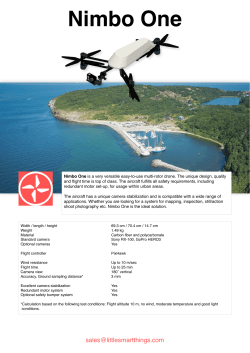


© Copyright 2026