
Site: Former Moorland Primary School , Westwick Drive , Lincoln
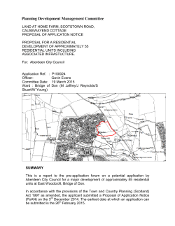
Site: Application No: Target Date: Agent: Applicant: Development: Former Moorland Primary School , Westwick Drive , Lincoln , LN6 7RP 2014/0840/O 04/04/2015 Globe Consultants Mouchel Residential Development with access from Westwick Drive (Outline) Background Site Location and Description The proposed development is located within the Moorland residential estate, south of Lincoln City Centre. Residential development surrounds the site on all boundaries with Westwick Drive to the south from which the proposal would be accessed. The site comprises an area of vacant brownfield land formally occupied by the Moorland Primary School. The former nursery building, which is now vacant, is still located in the south east corner of the site. This would be demolished as part of this application. The application is for the acceptance of the principle of the development of this site for residential development. An indicative layout has been submitted as part of the application which has shown the site is capable of accommodating 60 dwellings, however at this stage the access is the only matter for which approval is being sought. Planning History 2011/1355/CCC – Prior Approval was sought for the demolition of the former school which was granted by the County Council in 2011. Case Officer Site Visit Undertaken on 12th January 2015. Issues 1. National and Local Planning Policy 2. The Principle of the Development 3. Residential Amenity 4. Visual Amenity 5. Flood Risk and Sustainable Drainage 6. Highway Impacts 7. Land Contamination and Air Quality 8. Archaeology 9. Ecology and Arboriculture 10. S106 Contributions Policies Referred to 1 National Planning Policy Framework 2 Policy 34 - Design and Amenity Standards 3 Policy 35 – Design of New Residential Areas 4 Policy 90 – Development of Schools Consultations Consultations were carried out in accordance with the Statement of Community Involvement, adopted May 2014. Responses Highways & Planning Environment Agency Lincolnshire County Council [email protected] Waterside House Waterside North Lincoln LN2 5HA J Gray & N Hodges Skellingthorpe Road Craig O'Meara 26 Usher Avenue Lincoln Lincolnshire LN6 7RR Education Planning Manager, Lincolnshire Department Of Children’s Services County Co County Offices Newland Lincoln LN1 1YQ Lincolnshire Police Police Headquarters PO Box 999 Lincoln LN5 7PH Guy Hird Upper Witham Drainage Board Witham House J1 The Point Weaver Road Lincoln LN6 3QN Lincoln Civic Trust St Mary’s Guildhall 385 High Street Lincoln LN5 7RY Consideration of Issues 1. National and Local Planning Policy Paragraph 14 of the National Planning Policy Framework (the Framework) outlines that “at the heart of the National Planning Policy Framework is a presumption in favour of sustainable development, which should be seen as a golden thread running through both plan-making and decision-taking. For decision-taking this means: approving development proposals that accord with the development plan without delay; and where the development plan is absent, silent or relevant policies are out of date, granting permission unless: any adverse impacts of doing so would significantly and demonstrably outweigh the benefits, when assessed against the policies in this Framework taken as a whole; or specific policies in this Framework indicate development should be restricted. The site is allocated as Education within the City of Lincoln Local Plan Proposals Map and as such the following policies are relevant: Initially, as the site was formerly occupied by an Infant School, Policy 90 (Development of Schools) is particularly pertinent as it refers to proposals to “re-use and/or redevelop redundant educational land and buildings for other local community uses and for residential purposes”, it states that such proposals “will be approved provided they: do not adversely affect the amenities of people living nearby; do not prejudice the vitality and viability of a nearby Mixed-Use Area.” In this instance, the site is a significant distance from a mixed-use area so would not undermine the policies relevant to such areas. Policy 34: Design and Amenity Standards Planning permission will be granted for new buildings, extensions, alterations or refurbishment of existing buildings which meet the following requirements: The scale, massing, height, design, external appearance and facing materials to be used in the development must complement the architectural style and townscape character of the locality; The siting and layout of any new building or extension must ensure a satisfactory physical and functional relationship to adjoining buildings and streetscape; Boundary treatment and landscaping must ensure the maintenance of a high standard of visual amenity and an appropriate degree of privacy and should, where practicable, contribute to nature conservation; The amenities which occupiers of neighbouring properties may reasonable expect to enjoy must not be harmed by, or as a result of, the development; The development should meet the standards for vehicles and cycle parking and servicing as set out in Appendix B (ii), and make satisfactory provision for access by means other than the car. Policy 35 states that planning permission will be granted for development which will create new, or extend existing, residential areas, provided The Local Planning Authority is satisfied that the environment created will have a strong sense of local identity and will be: safe; secure; pleasant sustainable; efficient to live in and move around; efficient and reasonably economical to build and maintain; in harmony with its surroundings; and accessible for all, including people with impaired mobility and vision. 2. The Principle of the Development The principle of the development of the site is affected by a number of interlinked and sometimes competing issues, all of which are referred to in detail within the body of the report. The site, which falls within an area allocated for Education use on the proposals map, has most recently been occupied by the Moorland Infant School and would now be considered to be brownfield land. While there is no presumption that land that is previously developed is necessarily suitable for housing development, the area surrounding the site is predominately residential. Therefore it is considered that the principle of the development of this land for residential development would be in keeping with the principles set out in both national and local planning policies. 3. Visual Amenity It is anticipated that development would be of a traditional two-storey scale and would follow the characteristics of the surrounding area by way of semi-detached and terraced houses. It is considered that dwellings could be successfully positioned and designed without causing undue harm to the character and visual amenity of the wider area; however the detailed appearance for the dwellings is not known at this stage. 4. Residential Amenity Policy 34 of the Adopted Local Plan, along with Paragraphs 17, 59 and 123 of the NPPF, refer to the implications of development upon amenity. “The amenities which occupiers of neighbouring properties may reasonable expect to enjoy must not be harmed by, or as a result of, the development” It is therefore necessary to determine whether the proposals would result in any harmful implications upon amenity. Given that the application is only in outline form and details of layout and scale are not constrained, it is difficult to determine if there would be any significant harm upon the occupiers of the neighbouring properties with respect to scale, overlooking/loss of privacy or loss of light. However it is considered that given the existing residential use surrounding the site a new residential development could be assimilated into the area. 5. Flood Risk and Sustainable Drainage i) Flood Risk The site is shown to be in Flood Zone 1 on the Environment Agency Flood Maps which shows the site has a low probability of flooding from River or Tidal sources. The Flood Maps do show that there is some risk of surface water flooding at the site which could be mitigated by measures being incorporated into the design of the development. The overall conclusion of the submitted Flood Risk Assessment is that the site can be developed safely for residential purposes, with an acceptable level of flood risk, and without increasing flood risk elsewhere. However some of this assumption is based on the site being able to adopt a sustainable drainage system, this will be addressed in the section below. ii)Sustainable Drainage The supporting Flood Risk Assessment has made suggestions for the installation of a sustainable drainage system which identifies the possibility of using infiltration as a means of surface water disposal. However no infiltration tests have been carried out to demonstrate this is a viable option. Therefore tests are currently being undertaken to ascertain whether this is a viable option. The current proposal to store water is to use geocellular tanks. These are significantly low on the SuDS hierarchy and further investigation of how SuDS can be incorporated into the scheme need to be submitted subject to the result of the infiltration tests. If infiltration is not viable confirmation will be required that Anglian Water will accept flows into their system, together with the agreed rate. This rate can be used to identify the level of attenuation storage required for the site based on the impermeable area. Officers are currently liaising with the applicant’s agent regarding the timetable for infiltration testing. An update regarding this matter will be provided to the Members of the Planning Committee in advance of or as part of the update for the Committee Meeting. 6. Highway Impacts Highway and pedestrian access for the proposed development would be provided from the existing access point on the south-west corner, onto Westwick Drive. The NPPF through paragraph 35 requires that “developments should be located and designed where practical to [amongst other things] give priority to pedestrian and cycle movements, and have access to high quality public transport facilities; and should be located and designed where practical to create safe and secure layouts which minimise conflicts between traffic and cyclists or pedestrians, avoiding street clutter and where appropriate establishing home zones". The proposals are supported by a Travel Plan as required by paragraph 36 of the NPPF. The Travel Plan highlights the sustainability of the site in terms of public transport accessibility, walking and cycling provision. It is considered that the content of the travel plan confirms that the proposed site is in a sustainable location and there are options for travel other than by car. The internal layout has not been assessed at this stage as it is a reserved matter but the Highways Authority has raised no objections to the proposed access or the principle of the development. 7. Land Contamination and Air Quality i)Contaminated Land The proposal has been assessed by the Council's Pollution Control Officer and due to past uses on and in the vicinity of the site there is the potential for contamination to be present. The application is not supported by a preliminary risk assessment therefore in order to address this issue it is considered that it would be acceptable to deal with this matter through the submission of details reserved by planning conditions ensuring that an assessment is submitted. This is in accordance with Paragraphs 109,120 and 121 of the NPPF. ii)Air Quality The NPPF seeks to promote and enable sustainable transport choices and, in doing so, aims to protect and enhance air quality. Paragraph 35 of the NPPF states “…. developments should be located and designed where practical to….incorporate facilities for charging plug-in and other ultra-low emission vehicles”. It is noted that this proposed development will include off street parking and, therefore, it is recommended that the applicant be required to incorporate appropriate electric vehicle recharge points into the development in line with the NPPF. A condition can be attached to any permission granted to address this matter. 8. Archaeology Paragraph 128 of the Framework states that “in determining applications, local planning authorities should require an applicant to describe the significance of any heritage assets affected, including any contribution made by their setting. The level of detail should be proportionate to the assets’ importance and no more than is sufficient to understand the potential impact of the proposal on their significance. As a minimum the relevant historic environment record should have been consulted and the heritage assets assessed using appropriate expertise where necessary. Where a site on which development is proposed includes or has the potential to include heritage assets with archaeological interest, local planning authorities should require developers to submit an appropriate desk-based assessment and, where necessary, a field evaluation.” Officers are currently liaising with the applicant’s agent regarding how any potential impacts upon designated and undesignated heritage assets, principally archaeology, can be assessed and mitigated in line with the above policy requirements. An update regarding this matter will be provided to the Members of the Planning Committee in advance of or as part of the update for the Committee Meeting. 9. Ecology and Arboriculture i)Ecology Paragraph 118 of the NPPF requires LPAs to conserve and enhance biodiversity by refusing planning permission where significant harm resulting from a development cannot be avoided, mitigated or compensated for. In this instance the application is supported by an overall assessment of ecology and refers to walkover survey and amphibian survey work undertaken 7th January 2014.The walkover has shown that the site is not of significance for protected species and these species pose no constraints to the proposed development. Options are offered for enhancements for breeding birds and bats in the form of bird nesting boxes and bat rooting boxes. ii)Arboriculture The submitted Arboricultural Assessment recommended that any trees identified for retention would need to be adequately protected during any development works following the principles set out in BS5837 in order to minimise any damage. Whilst the tree survey does not indicate at this stage which trees are to retained the assessment has shown that should the trees identified along the boundary positions be retained the visual amenity and canopy cover in the boundary areas could remain unaffected. 10. S106 Contributions i)Education Provision Paragraph 72 of the Framework refers to the importance of ensuring "that a sufficient choice of school places is available to meet the needs of existing and new communities." The Framework therefore advocates that LPAs should "give great weight to the need to create, expand or alter schools". Officers are advised by Lincolnshire County Councils (LCC) Children’s Services that the development would have a direct impact on primary education provision. LCC therefore request a contribution to mitigate against the impact of the development upon primary education at local level. Moreover, based on there being the capacity to provide 60 properties on site the development could generate 12 primary school places which would equate to a request of £135,317, which the applicant has not contested. The request appears to be reasonable and based upon a solid rationale, as such officers are satisfied that the request would meet the tests required by Paragraph 204 of Framework with respect to planning obligations. ii)Playing Fields / Play Space As the development would result in an increase in the number of households within the locality, the Council would seek to improve or provide play and amenity and open space that could be utilised by the development (Policies 48B and 65B and Appendix D of the Local Plan). This would accord with paragraph 73 of the Framework which outlines the importance of the health and well-being of communities. In this instance, given that the scheme is indicative it is not possible to fully determine the exact contribution that should be requested as part of the application. However, it would be possible to include the relevant formulae to secure these contributions in a S106 agreement. The applicant has been made aware of the formulae and has, to date, not raised any objections. Lincoln Townscape Assessment Turner Character Area is a mainly residential suburban Character Area with housing built in the Post-War Period [1946-1966] and in a style of architecture influenced by Modernism. A key characteristic of the Character Area are the large open grassed spaces in front of buildings and large building setbacks. It is an inward-looking area with very limited connectivity to surrounding areas and an impermeable western boundary. In spite of the wide spaces between buildings there is a reasonable/good sense of enclosure for a suburb derived from the building line, constant height of the buildings and the public/private boundaries. Buildings in the Character Area are mostly two-storey red or brown brick houses, both semi-detached and rows, with minimal decoration. Although the Character Area is mostly quiet with little vehicular or pedestrian traffic there is a small area of vitality around the row of shops at the east end of Turner Avenue. The current townscape character of the Turner Character Area is dominated by development carried out over a relatively short period of time. All the roads and buildings in the Character Area were constructed as a continuous development between 1950 and 1970 and reflect the growing movement towards suburbanisation with development gradually moving further away from the centre of the city. The resulting increase in traffic volume was carried on main roads including dual carriageways such as Tritton Road which was built in the late 1960s. The plain facades with decorative details confined to doorways reflect the influence of the Modernist architectural style and a continued move away from the heavily detailed facades of the Victorian period Conclusion It is considered that a residential development in this location would be acceptable in principle. The proposal would be in accordance with both national and local policy; it would encourage the effective use of land by re-using that which has been previously developed and the key principles set out on the City of Lincoln Local Plan. The nature of the application and the level of information submitted means a number of matters would require control by condition. Financial Implications None. Legal Implications None. Application Negotiated Either at Pre-Application or During Process of Application Further information has been requested during the application process. Equality Implications None. Application Determined Within Target Date Yes. Recommendation Grant Conditionally Conditions Planning conditions would need to be in relation to the following matters: Outline Permission; Reserved Matters Approval; Land Contamination; Construction Management; Reduction of Air Pollution; Highways. And potentially in relation to the following: Archaeology; and Drainage. Report by: Planning Manager Site Plan Indicative Site Layout Site Photos Photo Photo D Photo A & B Photo F Photo C Photo G Photo A Photo B Photo C Photo D Photo E Photo F Photo G Consultation Responses (over)


© Copyright 2026