
The Victory Public House, Boultham Park Road, Lincoln PDF 4 MB
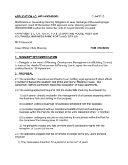
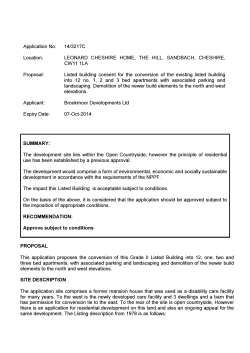
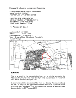
Site: Application No: Target Date: Agent: Applicant: Development: The Victory Public House, Boultham Park Road, Lincoln 2015/0038/F 1 May 2015 JH Walter Mr Steve Shammon Demolition of public house and garages and erection of three detached buildings comprising 14 dwellings and 4 ground floor commercial units for A2 ‘Financial and Professional Services’ or B1 ‘Office’ purposes (REVISED DESCRIPTION) Background Site Location and Description The proposed development relates to a previously developed site located on the west side of Boultham Park Road, approximately 50 metres south of the Dixon Street/Boultham Park Road junction. The site comprises land formed by The Victory public house, its car park and a series of garages and vehicle storage to the rear. The building is not Listed, nor is the site located within a Conservation Area; but it is located within Flood Zone 3 and is, therefore, at high risk of flooding. The applicant acquired the public house in March 2014, after submitting an application for planning permission to redevelop the site to the rear (details below). Planning officers encouraged the applicant to explore the potential for a comprehensive scheme incorporating the site of the public house, which led to this revised scheme being submitted. The proposed development has been subject to detailed discussions and negotiations at both pre-application and application stage. In addition to detailed drawings, a Planning, Design and Access Statement (January 2015); Flood Risk Assessment and Flood Evacuation Plan (January 2015); and Tree Survey (March 2015, by email) have been submitted with the application. Site History 2014/0269/DEM – Prior approval not required for demolition of public house, 29th May 2014 2014/0057/F – Undetermined application for the erection of five dwellings to the north of Sunningdale Drive i.e. the garages and vehicle storage to the rear of The Victory. Case Officer Site Visit Undertaken on 11th February 2015. Issues 1. 2. 3. 4. 5. National and local planning policy Loss of public house Impact on residential amenity Impact on visual amenity Flood risk and surface water drainage 6. Contaminated land and other environmental impacts 7. Impact on highway safety 8. Bin storage and collection Policies Referred to 1 2 3 4 5 6 National Planning Policy Framework Policy 29 Shop Fronts Policy 34 Design and Amenity Policy 35 Design of New Residential Areas Policy 56A New Housing (self-contained) Policy 65B Play and Amenity Space in Housing Areas Consultations Consultations were carried out in accordance with the Statement of Community Involvement, adopted May 2014. Responses Highways & Planning Highways & Planning Kathryn McKee Anglian Water Environment Agency Mick Albans Environmental Health Mr T & Mrs J Connell Guy Hird Highways & Planning Lee George Lincolnshire County Council Lincolnshire County Council Planning and Equivalence Team Thorpe Wood House Thorpe Wood Peterborough PE3 6WT [email protected] Waterside House Waterside North Lincoln LN2 5HA Tree Officer Environmental Health 54 Boultham Park Road Lincoln Lincolnshire LN6 7BB Upper Witham Witham House J1 The Point Weaver Road Lincoln LN6 3QN Lincolnshire County Council Community Contracts Manager Director of Housing & Community Services Comments Objection Objection Comment Comment Comments Comments Objection Objection Comment Comment Anglian Water Lincoln Civic Trust Mr and Mrs Smith Mick Albans Cllr. Gary Hewson Lincolnshire Police Peter Banks Lincolnshire County Stephen Mason Council Planning and Equivalence Team Thorpe Wood House Thorpe Wood Peterborough PE3 6WT St Mary’s Guildhall 385 High Street Lincoln LN5 7RY 2 Sunningdale Drive Lincoln Lincolnshire LN6 7UD Tree Officer 152 Boultham Park Road Lincoln LN6 7TF Police Headquarters PO Box 999 Lincoln LN5 7PH Banks Long & Co. 15 St Mary’s Street Lincoln LN5 7EQ Attn. Peter Banks - By Email Comment No objections Comment Comment Comment Comment Comment Comment Neighbours have expressed concerns about; Potential increase in traffic along Boultham Park Road Parking of vehicles currently stored on site and associated with the proposed residential and commercial units (occupants and visitors) Proposed access - opposite the approved new entrance to the residential area within the former dairy site on the east side of Boultham Park Road Potential end uses of proposed commercial units Consideration of Issues The proposed development would include the demolition of the existing public house and garages to the rear of the site; and the erection of three detached buildings comprising 14 dwellings and 4 ground floor commercial units. Residential units 1-8 would be provided within the same building as the proposed commercial units to the front of the site, and each comprise of a garage, entrance hall and WC on the ground floor; living room and open plan kitchen diner on the first floor; and a bathroom and two bedrooms on the second floor. Screened roof terraces would provide outdoor amenity space to the rear of each property. The second building would accommodate parking for the proposed commercial units, circa 2 spaces per unit, and residential units 9-10, which would each comprise of a garage on the ground floor; and a bathroom, open plan kitchen diner and two bedrooms on the first floor. Residential units 11-14 would be provided within the third and final building to the rear of the site and each comprise of a garage, entrance hall, WC, utility and store on the ground floor; living room and open plan kitchen diner on the first floor; and a bathroom and two bedrooms on the second floor. Additional parking space would be available to the front of residential units 1-8 and 11-14. After concerns were raised by consultees regarding the potential end uses of the proposed commercial units and parking provision for staff and visitors, the description of development was revised to specify the proposed end uses as A2 ‘Financial and Professional Services’ or B1 ‘Office’ (see Section 7 ‘Impact on highway safety’). National and Local Planning Policy Paragraph 14 of the National Planning Policy Framework (NPPF) outlines the “presumption in favour of sustainable development” which, for decision taking, means: Approving development proposals that accord with the development plan without delay; and Where the development plan is absent, silent or relevant policies are out of date, granting permission unless; o Any adverse impacts of doing so would significantly and demonstrably outweigh the benefits, when assessed against the policies in [the NPPF] taken as a whole; or o Specific policies in [the NPPF] indicate development should be restricted. Whilst a key objective of the NPPF is to significantly increase the delivery of new homes, it also states development should respond to local character and history; and reflect the identity of local surroundings and materials, while not preventing or discouraging appropriate innovation. Planning decisions should also encourage the effective use of land by re-using that which has been previously developed i.e. brownfield land. The application site is located within an area shown on the City of Lincoln Local Plan Proposals Map (1998) as being predominantly for residential use. Planning permission has been granted for mixed use development including housing on the east side of Boultham Park Road, suggesting this is an appropriate form of development. Policy 34 ‘Design and Amenity Standards’ of the City of Lincoln Local Plan (1998) is permissive of new buildings provided the scale, massing, height, design, external appearance and facing materials to be used in the development complement the architectural style and townscape character of the locality, and the siting and layout has a satisfactory physical and functional relationship to adjoining buildings and streetscape. Policy 35 ‘Design of New Residential Areas’ aims to promote a strong sense of local identity and a high standard of design and layout in residential areas and mixed use areas including housing. 1. Loss of Public House In accordance with national planning policy and guidance, The Victory public house can be demolished without prior approval from the local planning authority. However, the building remains in place, therefore, the potential impacts associated with its demolition and loss have been considered. Paragraph 70 of the NPPF states planning decisions should “guard against the unnecessary loss of valued facilities and services, particularly where this would reduce the community’s ability to meet its day-to-day needs”. The city council has received no representations in relation to the demolition or loss of the public house, in response to neither this application nor the previous prior approval application for demolition (2014/0269/DEM). Furthermore, there are several public houses nearby which have met local needs since The Victory closed over a year ago. The city council is, therefore, satisfied the loss of the public house would not be detrimental to the local community. 2. Impact on Residential Amenity To the north of the site are the residential properties at 46 and 48 Boultham Park Road and 1 to 29 Glenwood Grove; and to the south are the residential properties at 54 to 58 Boultham Park Road and 2 to 14 Sunningdale Drive. In addition to concerns addressed elsewhere in this report, neighbours at 54 Boultham Park Road are concerned about the height and size of the proposed buildings, and the closeness of the development to their property. Whilst the proposed development would reduce the separation distance between this property and buildings within the application site, the proposed building to the front of the site would have a similar eaves height (c.10.5 metres) and ridge height (c. 13.3 metres) to the property at 54 Boultham Park Road, despite including habitable accommodation on the first and second floors. The demolition of the garages to the rear of the site would result in the loss of the wall that forms the rear boundary of residential properties at 2 to 14 Sunningdale Drive. In addition to concerns addressed elsewhere in this report, neighbours at 2 Sunningdale Drive are concerned about the loss of the wall, and the potential impact on their privacy. The treatment of the boundary between the application site and neighbour’s gardens, where this would not be formed by the proposed buildings, is not explicit on the drawings submitted with the application, but the applicant has indicated it would be of a similar height (c. 1.8 metres). A planning condition requiring further details of proposed boundary treatments is, therefore, considered appropriate to impose on an approved application. Overall, the proposed development includes dormer windows to ensure the height of the proposed buildings do not adversely affect the amenities of neighbours to the north and south of the application site. The city council is, therefore, satisfied residential amenity would not be harmed by, or as a result of, the proposed development. 3. Impact on Visual Amenity Although The Victory public house stands out as a landmark building within the area, it is situated to the north side of the site, with a significant set back to accommodate a vast parking area that dominates the frontage. The demolition of the public house would enable the regeneration of the entire site, including the former garage site to the rear, which has previously encouraged anti-social behaviour and fly tipping. The proposed buildings would include Steel Grey Splitface Blocks (low level masonry), Old Saxon Blend Crest Bricks (high level masonry) and Pewter Polished Florentine Block (band between low and high level masonry). Residential units would include Stone Grey uPVC windows; European Oak front doors and Golden Oak garage doors; and commercial units would include Anthracite Grey pressed aluminium shop front surround features and Signal Grey power coated aluminium double glazing shop front windows. The building to the front of the site would present a strong and active frontage, of a similar scale and height to existing buildings on the west side of Boultham Park Road. In contrast, the building to the rear of the site has been designed to emulate a converted warehouse, in part to increase the amount of light into the proposed living spaces, but also to make reference to the larger commercial buildings to the rear and west of the site. The city council, therefore, considers the proposals would deliver a contemporary development, considerate of the variety of building style within the St Matthew’s character area. Lincoln Townscape Assessment St Matthew’s character area mainly consists of separate areas of residential developments, within a Character Area that is itself surrounded by industrial areas and ‘out-of-town’ retail parks to the north, west and east. The Character Area does not have a coherent form or centre and does not have a clear, distinct character. This is in part due to the varied suburban townscape reflecting changes from early 19th century through to the 21st century, many of which have been carried out with limited reference to earlier developments. 4. Flood Risk and Surface Water Drainage The Environment Agency has confirmed the Flood Risk Assessment (FRA) submitted with the application meets the requirements of the NPPF, subject to a condition being imposed on an approved application to mitigate flood risk to the development. Technical Guidance to the NPPF suggests both Sequential and Exceptional Tests need to be applied to development comprising ‘buildings used for dwelling houses’ i.e. ‘More Vulnerable’ development in Flood Zone 3. The Sequential Test ensures that a sequential approach is followed to steer new development to areas with the lowest probability of flooding. Only where there are no reasonably available sites in Flood Zones 1 or 2 should the suitability of sites in Flood Zone 3 be considered, taking into account the flood risk vulnerability of land uses and applying the Exception Test if required. The agreed scope of the Sequential Test involved the assessment of 10 sites of similar size and potential capacity within the authority’s administrative boundary, promoted as potential allocations through the Central Lincolnshire Strategic Housing Land Availability Assessment (SHLAA)1. Evidence presented within the Planning, Design and Access Statement (4.30-4.42) demonstrates there are no other reasonably available sites that can accommodate the proposed development in an area at lesser risk of flooding within the authority’s administrative boundary. Furthermore, it is considered the proposed development would provide wider sustainability benefits to the community; through the reuse of brownfield land and provision of new residential and commercial units; that would outweigh flood risk. Finally, the FRA submitted with the application provides details of mitigation measures that would reduce the risk and impact of flooding to the proposed development and future occupants. The city council is, therefore, satisfied the Sequential and Exception Tests have been passed. The Upper Witham Drainage Board has objected to the proposed development due to concerns about flood risk and lack of information relating to surface water drainage. Anglian Water has confirmed there is adequate spare capacity in the existing system, but requested a surface water management strategy to be prepared to prevent environmental and A Central Lincolnshire Strategic Housing and Employment Land Availability Assessment has subsequently been published, superseding the Strategic Housing Land Availability Assessment referred to during the process of application 1 amenity problems arising from flooding. A condition requiring the applicant to submit a strategy to the city council prior to development is, therefore, considered appropriate to impose on an approved application. 5. Contaminated Land and other Environmental Impacts The city council’s Pollution Control Officer has indicated there is potential for contamination to be found on the site due to past uses. It is, therefore, considered appropriate to impose standard contaminated land planning conditions on an approved application, which would require the applicant to characterise the site; submit a remediation scheme; implement the approved remediation scheme; and report unexpected contamination. Although there has been a request to incorporate electric vehicle recharge points, it is not considered proportionate to impose a condition requiring this, given the scale and location of the proposed development. The city council’s Arboricultural Officer has inspected the trees within the site boundary and concluded they are poor specimens and of low amenity value. Evidence suggests the trees have historically caused problems to residents of neighbouring properties in the form of restricted light, overhanging branches, falling debris, deadwood and leaves. The city council, therefore, considers the trees are not worthy of consideration for protection under a Tree Preservation Order and would not object to any proposal to have them felled in order to accommodate an appropriate soft landscaping scheme. However, it is considered appropriate to impose a planning condition on an approved application, requiring the applicant to submit details of a landscaping scheme and trees to be felled. 6. Impact on Highway Safety Access to the site would be via the existing entrance to the north of the site, deemed acceptable in highway safety terms by the Highways Authority. Although the development is currently proposed to remain private, the geometry is such that it can be built to an adoptable standard in line with the Highways Authority’s Development Road Specification. During the process of application, the Highways Authority requested details of proposed areas for adoption; site layout; refuse vehicle access and egress; use of proposed commercial units and associated parking arrangements. The applicant subsequently provided a revised site layout showing the proposed road geometry; and swept path analysis, demonstrating the development is capable of accommodating a refuse collection vehicle, allowing it to enter and exit the site in a forward gear. Notwithstanding the provision of additional information, the Highways Authority has requested the city council, as the local planning authority, refuses the application due to concerns about parking provision and subsequent potential for on street parking at this location on Boultham Park Road. Planning officers responded to these concerns by encouraging the applicant to specify the end uses of the proposed commercial units as A2 ‘Financial and Professional Services’ or B1 ‘Office’. It is considered these uses, coupled with the size of the proposed units, are unlikely to generate a significant number of staff, visitors or associated vehicles. However, it is considered appropriate to impose a planning condition on an approved application restricting the end use of the proposed commercial units. On balance, the city council considers the potential for on street parking does not significantly and demonstrably outweigh the wider sustainability benefits of the proposed development, as described in subsequent sections of this report. 7. Bin Storage and Collection The proposed development would include four appropriately sized bin stores for the proposed residential and commercial units. Swept path analysis demonstrates the development is capable of accommodating a refuse collection vehicle, allowing it to enter and exit the site in a forward gear. A planning condition specifying appropriate times for waste collections is considered appropriate to impose on an approved application. 8. Section 106 Contributions The applicant would enter into a Section 106 legal agreement for contributions towards education provision at Sir Francis Hill School, Bristol Drive (£11,276.00); off site playing field provision at Boultham Park (£10,162.00); and children’s play space provision at Hartsholme Country Park (£6,114.00). The site falls below the current threshold for affordable housing provision (i.e. sites exceeding 15 or more dwellings or 1 hectare or more). Conclusion The proposed development is acceptable, and would not unduly impact on the amenities of neighbouring properties or the wider area. Access to and from the site would be safe and convenient for both pedestrians and vehicles; and be capable of accommodating a refuse collection vehicle. Parking provision for the proposed residential and commercial units is adequate, given the scale of the proposed development and potential end use of the proposed commercial units. Finally, in relation to flood risk, the proposed development would be safe and not lead to increased flood risk elsewhere. Financial Implications None. Legal Implications None. Application Negotiated Either at Pre-Application or During Process of Application Yes, at pre-application and application stage. Equality Implications None. Application Determined Within Target Date Yes, extension of time agreed with the applicant. Recommendation Grant conditionally subject to the completion and signing of the Section 106 agreement. Conditions 1) 2) 3) 4) 5) 6) 7) 3 year time limit In accordance with approved plans Landscaping scheme including trees to be felled Samples of materials Details of surface water drainage requested by Anglian Water Standard contaminated land conditions Development in accordance with approved Flood Risk Assessment requested by Environment Agency 8) Commercial units A2 ‘Financial and Professional Services’ or B1 ‘Office’ only 9) Size of ground floor commercial units to remain unchanged 10)Operating and delivery hours 11)Permitted development rights removed - satellite dishes on east elevation of residential units 1-8 12)Proposed boundary treatments 13)Waste collection times 14)No permanent storage of bins to the front 15)Construction hours Report by: Planning Manager a View Down Boultham Park Road (South) a View Up Boultham Park Road (North) b Site Entrance c View From Site Entrance Towards Boultham Park Road d Garages to the Rear e View Towards Properties on Sunningdale Drive f View Towards Properties on Glenwood Grove


© Copyright 2026