
P13/V1810/O - Land to the East of Highworth Road, Shrivenham
Vale of White Horse District Council – Committee Report – 18th March 2015
APPLICATION NO.
APPLICATION TYPE
REGISTERED
PARISH
WARD MEMBER(S)
APPLICANT
SITE
PROPOSAL
AMENDMENTS
GRID REFERENCE
OFFICER
P13/V1810/O
Outline
22.08.13
Shrivenham
Elain Ware
Simon Howell
Welbeck Land
Land to the East of Highworth Road, Shrivenham
Outline application for up to 240 dwellings, land for a
Primary School, and associated open space and
highway works. As amended by Illustrative
Masterplan ref: EDP 1794_79a, School location plan
ref: EDP1794_78a and relevant supporting
information received 02.12.14.
Yes – see above
423848 - 189312
Laura Hudson
Summary
This application is referred to planning committee as 29 letters of objection from local
residents have been received.
The proposal is for outline planning permission including access (all matters reserved apart
from access) for the erection of up to 240 houses, land for a primary school, associated open
space and access onto Highworth Road.
The site forms part of an emerging local plan allocation. However, this process currently
holds limited weight given the status of the emerging local plan. The proposal has been
submitted to address the five year supply deficit.
•
•
•
•
•
•
•
•
•
The principle of the proposed development in this location in relation to planning
policy context.
Whether the proposal is suitable to meet the five year housing supply deficit in terms
of the sustainability of the site and cumulative impact on the village with other
development.
The Impact of the development on the wider landscape and the Lowland Vale.
Whether the submitted illustrative masterplan is acceptable in demonstrating that the
proposed development can be accommodated on the site and the relationship to
existing residential development.
Whether the proposed access onto Highworth Road is acceptable for the proposed
development and the wider impact on the highway network including the need for
upgrade works to the A420.
Impact of the development on the local drainage network and implications for surface
water and flood risk.
The ecological impact of the development both on site and the wider area including
the nearby Tuckmill Meadows Nature Reserve SSSI.
Impact of the development on the setting of the conservation area and views of the
church.
Delivery of the school and other contributions.
1
Vale of White Horse District Council – Committee Report – 18th March 2015
The application is recommended for approval subject to conditions and S106 Agreements.
1.0
INTRODUCTION
1.1
This application relates to land to the north of Shrivenham extending to around 15.87
hectares of undeveloped agricultural land. The site is relatively flat although there is a
slight slope downwards away from the village to a land drain, and then the land rises
upwards towards a low ridge and mature hedgerow which marks the northern
boundary of the site. There are a number of mature hedgerows crossing the site and
two public footpaths which run through the site from the village centre northwards.
1.2
The southern most part of the site immediately abuts the built up edge of the village
adjacent to Manor Close and the existing football ground. Highworth Road runs along
the western boundary, although part of this boundary abuts a recently permitted
development of 35 houses currently under construction. A small paddock separates
the south eastern edge of the site form Faringdon Road, and the eastern boundary is
marked by Pennyhooks Lane, a small single track road which serves the adjacent golf
course and is also a public right of way. The northern boundary currently abuts open
agricultural land, however this site together with the current application site form an
emerging local plan allocation for 500 dwellings. The A420 lies beyond.
1.3
The Shrivenham Conservation Area abuts the southern site boundary and the church,
which is visible from the site, is Grade I Listed. The site is located within the locally
designated Lowland Vale as defined the local plan proposals map and the Tuckmill
Meadows Nature Reserve SSSI is located adjacent to the golf course to the north of
the site approximately 120 metres away.
1.4
Shrivenham is one of the district’s larger villages. The Town and Villages Facility
Study Update 2014 confirms that it ranks seventh of all settlements in the district in
terms of community facilities.
1.5
The application comes to Committee as 29 letters of objection have been received
from local residents.
2.0
PROPOSAL
2.1
This application seeks outline planning consent with all matters reserved other than
access, for up to 240 dwellings. An illustrative master plan has been submitted with the
application showing the inclusion of a 2.22ha site for a 2 Form Entry Primary School
within the site, open space, informal football pitch, landscaping and access.
2.2
Access to the site would be obtained from Highworth Road and the masterplan
proposes a central main street and housing in a series of blocks served by secondary
streets. The proposal includes pedestrian and cycle links from the site to Highworth
Road, Claypits Lane onto the High Street, and Pennyhooks Lane, and a number of off
site dropped curb crossing points along Highworth Road.
2.3
The site extends to 15.87 hectares therefore the development of 240 units within a
residential area of 7.94 hectares equates to a net density of 30 dwellings per hectare.
The submitted illustrative details show a higher density centred around the main street
through the development and lower density around the edges adjacent to the open
space. A medium density is proposed to create a street frontage along Highworth
Road.
2
Vale of White Horse District Council – Committee Report – 18th March 2015
2.4
The proposed dwellings would be in a mix of 2, 3, and 4 bedrooms and include 40%
affordable housing equating to 96 units in a size and mix to meet Council standards.
2.5
It is acknowledged that this site forms part of a wider emerging local plan allocation to
include land to the north. The masterplan has therefore been designed with this in
mind to include open space that would be central to the whole development and
vehicular and pedestrian links through to ensure a cohesive development should the
entire allocation progress.
2.6
The following documents have been submitted in support of the application:
•
•
•
•
•
•
•
•
•
•
•
•
•
•
Planning statement
Design and access statement
Transport statement
Flood risk assessment
Foul Sewage Details
Landscape and visual impact assessment
Hedgerow proposals and Arboricultural assessment
Ecological appraisal
Statement of community involvement
Archaeological and Heritage assessment
Phase 1 Ground contamination assessment
Topographical survey
Noise Assessment
Utility Infrastructure Appraisal report
2.7
The plans have been amended twice during the process and have been through three
rounds of consultation including the initial plans. The first amendment in June 2014
related to the inclusion of a site for a primary school to address concerns raised by the
County Council, removal of the proposed cricket pitch and an increase in houses to
220. The second amendment was dated December 2014 and included an increase in
numbers to 240 and amendments to the site layout to address urban design concerns
regarding the need to provide more surveillance across the open space.
2.8
Officers have been in discussion with the applicants in relation to on site education,
open space and leisure provision and affordable housing. Off site contributions have
also been requested as follows but are under discussion:
District Council agreement
• Sports and Recreation - £260,788 in addition to on site junior football pitch.
Includes funding to upgrade the existing village MUGA on the recreation ground.
• Open space maintenance contribution - £632,499
• Waste - £170 per dwelling (£40,800)
• Street Naming - £2,349.60
• Shrivenham Parish Council requests – Play/Recreation equipment and
enhancements to Memorial Hall - TBC
County Council agreement
• Public Transport Service Improvements: - £1,000 per dwelling (£240,000)
• Improvements to the A420 including junction upgrade works at the Townsend
Road junction or new junction funding – under discussion.
• Provision of two pairs of additional bus stops in the vicinity of the site - £25,000
3
Vale of White Horse District Council – Committee Report – 18th March 2015
•
•
•
•
•
•
•
•
•
•
Improvement of public rights of way in the vicinity of the site- £18,000
Travel Plan monitoring - £1,240
Primary School expansion – Land for new school 2FE provided on site and
funding towards provision of 1.5FE to facilitate the needs of this development.
Later phase to fund the remaining provision.
Secondary school expansion - £914,356
SEN school expansion - £42,918
Library Infrastructure - £57,510.45 (Faringdon and Oxford Central Libraries)
Adult Day Care - £37,400
Waste Management - £36,032
Museum Resource Centre - £2,815
Administration - £9,553
2.9
Extracts from the current application drawings are attached at Appendix 1.
3.0
3.1
SUMMARY OF CONSULTATIONS & REPRESENTATIONS
As stated above, in addition to the original consultation the application has had two
amendments which were consulted on, firstly in June 2014 to include a site for a
primary school to address concerns raised by the County Council, removal of the
proposed cricket pitch and an increase in houses to 220. The second amendment was
dated December 2014 and included an increase in numbers to 240 and amendments to
the site layout to address urban design concerns regarding the need to provide more
surveillance across the open space.
Shrivenham Parish Council
3.2
Originally objected to the application due to concerns over the visual impact of the
proposal, increase in traffic, mix of the proposed dwellings and heights proposed,
drainage and flooding concerns, impact on local infrastructure and the sustainability of
the development. Similar concerns were raised in relation to the first amendments and
also the need to consider the cumulative impact of all the developments in the village.
3.3
Comments in relation to the current amendments now raise no objections on the basis
that the site now forms part of the emerging local plan strategic allocation. Concern
remains over the increase to 240 units on this site but the location of the public open
space adjacent to the village is welcomed. Additional comments have been submitted
in relation to ensuring that the ecological impacts of the development are properly
considered. Copies of all the comments received are attached at Appendix 2.
3.4
Neighbour Representations
Letters of objection and concern have been received from 29 local residents covering
all the consultations and can be summarised as follows:
•
•
•
•
•
•
•
The proposal will completely alter the character of the village.
There are existing foul drainage problems in the village.
The site suffers from poor surface water drainage.
The village school is at capacity.
The local surgery is at capacity.
The number of houses is too many for sustainable growth of the village.
The site is populated by a number of species including deer, badgers, hares and
rabbits.
4
Vale of White Horse District Council – Committee Report – 18th March 2015
•
•
•
•
•
•
•
•
•
•
•
•
•
•
•
•
The A420 is already at capacity.
The proposal is contrary to Council policy.
The additional traffic will be detrimental to highway safety.
The proposal would result in an increase in crime.
The proposal would harm the setting of the conservation area and the village.
The proposal would result in the loss of agricultural land.
There is no need for a new cricket pitch (included in the original plans)
The development would result in the loss of existing trees and hedgerows.
The additional houses are not needed.
There are no jobs locally to support the new residents.
The village centre is already busy with traffic and the parking overloaded.
The defence academy is expanding and this will put additional pressure on the
village.
The access onto Highworth Road will be unsafe.
The water supply cannot cope with additional dwellings.
The proposal should include a relief road connecting Watchfield and
Shrivenham away from the High Street and village centre.
Shrivenham is a village and does not have the facilities for so many additional
dwellings.
3.5
One letter of support has been received stating that the proposal is a well designed
development within walking distance of the village facilities and that given the five year
housing supply deficit should be permitted.
3.6
Comments have been received from the developers of the adjacent housing site under
construction, raising initial concerns over the relationship of the two developments in
terms of the proposed scale and density and the need for additional planting.
Comments on the later consultations relate to proposed links from the adjacent site
through to the proposed school and the need for adequate drop off arrangements on
site. The current plans remove any pedestrian link between the two developments
which has been welcomed.
3.7
Oxfordshire County Council Highways – No objections subject to conditions and
S106 contributions.
• The development triggers the need for the funding and provision (including
required land under the applicant’s control) of a new access junction on to the
A420 to serve the new development in the vicinity of the strategic allocation in a
location which limits additional traffic through the village or funding of a
significant improvement to the A420 / Townsend Road junction. We require this
to be fully funded by the Strategic Allocation as set out in the Local Plan, and
therefore request a funding contribution from this, Phase 1.
• The access shown on the submitted plan ref: 28618/002/001A is acceptable and
a condition requiring full details should be added. The amendments would now
enable bus and coach movements.
• Drop off area for the school shown on the plans is welcomed – full details
required.
• Traffic calming measure on Highworth Road will be required.
• Proposed pedestrian and cycle links to the town centre are welcomed and
contributions to upgrade the surface of these are required.
• Further consideration of traffic calming within the site required.
• The provision of two pairs of bus stops, one on Highworth Road and one on
Faringdon Road near Pennyhooks Lane required.
• Pedestrian crossing dropped curbs are proposed as part of the application on
5
Vale of White Horse District Council – Committee Report – 18th March 2015
•
3.8
Oxfordshire County Council Education – Initial objection due to the scale of
development which would exceed the capacity of Shrivenham Primary School to be
able to accommodate the expected pupil generation. On site constraints restrict the
ability of the school to expand on site. Amended plans have been submitted to include
provision on site for a new 2 Form Entry school which would eventually replace the
existing school. No objections are raised subject to the following:
•
•
3.9
Highworth Road and links to the High Street to improved the Shrivenham
circular walk.
Contributions towards public transport improvements and residential travel plan
monitoring proposed.
Education concerns addressed by the provision of a 2.22ha primary school site
within the development and funding towards providing accommodation sufficient
to enable a split site with the existing primary school. This would be delivered
through the S106 Agreement. The exact cost is still under negotiation. Later
phases of development would fund the remaining school accommodation to
enable the whole school to move.
Contributions to expansion of secondary school accommodation in Faringdon,
and special education needs.
Oxfordshire County Council Property – No objections subject to financial
contribtions to libraires, day care, waste infrastructure, youth support, the museum
resource centre and adult learning
3.10 Oxfordshire County Council Rights of Way – No objections subject to the existing
rights of way across the site not being affected by the construction.
3.11 Oxfordshire County Council Drainage – No objections subject to conditions.
3.12 Oxfordshire County Council Archaeology – Initial objections due to lack of
information. An Archaeological field evaluation was carried out and no objections now
raised subject to conditions.
3.13 Thames Water – Identified an inability to of the existing waste water infrastructure to
accommodate the need of the development. An impact study carried out by Thames
Water but funded by the developer has identified a solution to connect to an alternative
manhole on Faringdon Road to bypass the village network. The increase from 200 to
240 units has also been modelled and there is no detriment if the identified solution is
implemented. Conditions to ensure the delivery of this solution recommended.
No objections in relation to water supply subject to condition in relation to a
reinforsement main.
3.14 Environment Agency – No objections subject to conditions requiring the
development be carried out in accordance with the flood risk assessment and
implementation of the sewage upgrade works.
3.15 Natural England – Objection. Concerns over the impact of the development on the
Tuckmill Meadows SSSI due to the following:
•
•
Hydrological impacts – assurance that surface water from the development will
not flow directly towards the SSSI and that the foundations will not affect
groundwater flows to the SSSI. Further information is being provided by the
applicant on this.
Recreational impacts – Increase in potential visitor numbers to the SSSI as the
6
Vale of White Horse District Council – Committee Report – 18th March 2015
Shirvenham circular route passes through the SSSI and through the application
site from the village centre. More public open space should be provided within
the development to provide alternative recreation areas. Further information
has been submitted to address these issues and an update will be provided at
the meeting.
•
BBOWT – Local Wildlife Trust – Objection in relation to the same grounds as
Natural England set out above and the impact on biodiversity due to the loss of
hedgerows within the development there would be a net loss of biodiversity.
3.16 Countryside Officer – Initial response to the first two rounds of consultation raised no
objections, acknowledging the arable nature of the site. The main impact identified the
loss of hedgerows but that these will be compensatory planting therefore conditions to
ensure no net loss to biodiversity required. The impact on bat population acknowldged
but that they will adapt to new habitat therefore a condition requiring provision of new
bat roosting sites in the proposed wetland areas as part of the SUDS.
Current plans – Concerns due to the loss of some areas of open space in the layout
and the following:
•
•
•
•
3.17
Impact on groundwater flows to the SSSI.
Increased number of dwellings adding to increased visitor pressure to the SSSI.
Net loss of biodiversity given increased loss of hedgerows.
Concern over the cumulative impact in relation to the wider local plan
allocation.
Urban Design Officer – No Objections. Lengthy discussions have taken place over
the evolving layout of the site culminating in the current plans.
•
•
•
Concerns over the lack of vehicular connectivity. A future link should be
inlcuded to facilitate expansion towards Faringdon Road.
Insufficient buffer along the northern boundary.
The community park land is not sufficiently overlooked as it sits to the rear of
the existing houses and the school site.
The plans have been amended again since these comments to increase the ridge line
buffer, add a potential link to Faringdon Road, and provide housing to the rear of the
school site to overlook the open space.
3.18
3.19
Drainage Engineer - Initial holding objection due to lack of information and Thames
Water capacity concerns. Amendend comments raise no objections subject to
conditions relating to the Thames Water capacity study recommendation being
implemented.
Landscape Officer - No objections.
• The site is in the Lowland Vale.
• There will be some visual impact of the development particularly adjacent to the
footpaths across the site.
• The revised plans have taken into account the northern site boundary along the
ridgeline. Care will be needed inrelation to the scale of the dwellings in this
location.
• Disappointing that the open space adjacent to the ridge does not extend all the
way to Pennyhooks lane.
• Care will be needed in relation to the pitch layout in the southern community
7
Vale of White Horse District Council – Committee Report – 18th March 2015
parkand the design of the SUDS within the areas of open space.
3.20 Conservation Officer - No objections. The main issues relate to the setting of the
conservation area and the views of the listed church and other listed buildings in the
vicinity of the church and claypits lane. It is vitally important that the design and layout
of the new housing relates well to the historic village morphology, and the height and
scale of the buildings. Further information will be required to inform the detailed design.
3.21 Forestry Officer – No objections. There are a number of trees within the site but
predominantly along the boundaries with minimal constraint to development. The
layout has been designed to retain the existing trees but there are areas notibly along
the northern boundary and to the east of the development which will require more
detailed assessment at reserved matters stage. The layout does not attempt to retain
the two internal hedgerows. Whilst the loss of hedges is not necessarily a bar to
development, there should be sufficient mitigation proposed.
3.22 Thames Valley Policy Design Adviser – No objections. Comments in relation to the
masterplan including concern over parking courts, overlooking landscaped areas, lack
of permeability, and lighting details. (These are matters to be addressed at Reserved
matters stage.)
3.23 Leisure Department – No objections subject to contributions.
3.24 Housing Team – No objections. The application proposes 40% affordable housing
and the comments set out the preferred mix. The applicant has confirmed that the
minimum space standards for affordable housing will be met in any reserved matters.
3.25 Environmental Health – Contaminated Land – No objections subject to conditions.
3.26 Environmental Protection Team – No objections but recommended conditions to
ensure that the development is carried out in accordance with the recommendations of
the noise assessment. These measures include installation of double glazing into the
design of properties and suitable vents on the most noise sensitive dwellings fronting
Highworth Road and not having any gardens fronting onto Highworth Road.
4.0
RELEVANT PLANNING HISTORY
4.1
None relevant
5.0
5.1
POLICY & GUIDANCE
Vale of White Horse Local Plan 2011 policies;
GS1 - Developments in Existing Settlements
GS2 - Development in the Countryside
DC1 - Design
DC3 - Design against crime
DC5 - Access
DC6 - Landscaping
DC7 - Waste Collection and Recycling
DC8 - The Provision of Infrastructure and Services
DC9 - The Impact of Development on Neighbouring Uses
DC12 - Water quality and resources
DC13 - Flood Risk and Water Run-off
DC14 - Flood Risk and Water Run-off
8
Vale of White Horse District Council – Committee Report – 18th March 2015
H11 - Development in the Larger Villages
H13 - Development Elsewhere
H15 - Housing Densities
H16 - Size of Dwelling and Lifetime Homes
H17 - Affordable Housing
H23 - Open Space in New Housing Development
NE9 - Lowland Vale
HE1- Conservation Areas
HE9 - Archaeology
HE10 - Archaeology
Emerging Local Plan Part One (2031)
5.2
The appliction site forms part of an emerging strategic allocation to provide 500
dwellings to the north of Shrivenham in the draft local plan part 1. However this is not
currently adopted policy and this emerging policy and its supporting text has limited
weight as per paragraph 216 of the NPPF. Greater regard therefore is to be given to
the NPPF in line with paragraph 14 and where relevant, the saved policies (listed
above) within the existing local plan.
The following core policies are relevant to this proposal:
Core Policy 1: Presumption in favour of sustainable development
Core Policy 2: Co-operation on unmet housing need for Oxfordshire
Core Policy 3: Settlement Hierarchy
Core Policy 4: Meeting our Housing needs
Core Policy 5: Housing supply ring-fence
Core Policy 7: Providing supporting infrastructure and services
Core Policy 20: Spatial strategy for Western Vale Sub-Area
Core Policy 22: Housing mix
Core Policy 23: Housing density
Core Policy 24: Affordable housing
Core Policy 33: Promoting sustainable transport and accessibility
Core Policy 35: Promoting public transport, cycling and walking
Core Policy 36: Electronic communications
Core Policy 37: Design and local distinctiveness
Cope Policy 38: Design strategies for strategic and major development sites
Core Policy 39: The historic environment
Core Policy 42: Flood risk
Core Policy 43: Natural resources
Core Policy 44: Landscape
Core Policy 45: Green infrastructure
Core Policy 46: Conservation and improvement of biodiversity
5.3
The draft Vale of White Horse Local Plan 2031: Part 1 sets the spatial strategy and
strategic policies for the district to deliver sustainable development. It will allocate large
scale (referred to as strategic) development sites. The latest version is the “presubmission” version which was approved by the council for publication on 15 October
2014. The plan has just been through pre-submission consultation and objections
received are being processed and summarised prior to submission later in March.
5.4
The “Local Plan 2031 Part 2: Detailed Policies and Local Sites” is timetabled for
preparation 2015-2017 and will allocate supplementary and predominantly smaller
(referred to as non-strategic) development sites.
9
Vale of White Horse District Council – Committee Report – 18th March 2015
5.5
Core Policy 3 of the Local Plan 2031: Part 1 identifies Shrivenham as a “larger village”.
Core Policy 4 allows for sustainable development within the existing built-up area of
larger villages but provides that development outside of settlements will only be
permitted where it has been allocated in Part 1 of the Local Plan, a neighbourhood plan
or future parts of the Local Plan.
5.6
Land to the north of Shrivenham is identified as a strategic site allocation for 500
dwellings. The application site forms the southern part of this strategic allocation.
Although limited weight can be afforded to this, its inclusion demonstrates the role of
this development in the strategic vision for growth in the Western Vale Sub Area of the
plan in which this site falls. Shrivenham is classed as a larger village in terms of the
range of existing facilities and it is envisaged that the development would ensure the
future vitality and viability of the community and help deliver new infrastructure. The
application submission includes the infrastructure requirements set out in Appendix A of
the emerging plan.
5.7
Core Policy 20 provides the spatial strategy for the Western Vale Sub-Area. In terms of
housing delivery, the Plan proposes that at least 3,173 new homes will be delivered
between 2011 and 2031, 1650 homes to be delivered through strategic allocations, the
remaining 656 homes will be allocated through the Local Plan Part 2, Neighbourhood
Development Plans or through the development management process.
Supplementary Planning Documents/Guidance (SPD/SPG)
5.8
Residential Design Guide – March 2015
Responding to Site and Setting
• Character Study (DG6) and Site appraisal (DG9)
Establishing the Framework
• Existing natural resources, sustainability and heritage(DG10-13, 15, 19)
• Landscape and SUDS (DG14, 16-18, 20)
• Movement Framework and street hierarchy (DG21-24)
• Density (DG26)
• Urban Structure (blocks, frontages, nodes etc) DG27-30
Layout
• Streets and Spaces (DG31-43)
• Parking (DG44-50)
Built Form
• Scale, form, massing and position (DG51-54)
• Boundary treatments (DG55)
• Building Design (DG56-62)
• Amenity, privacy and overlooking (DG63-64)
• Refuse and services (DG67-68)
Sustainable Design and Construction – December 2009
Open space, sport and recreation future provision – July 2008
Affordable Housing – July 2006
Flood Maps and Flood Risk – July 2006
Planning and Public Art – July 2006
5.9
National Planning Policy Framework (NPPF)
Paragraphs 14 and 29 – presumption in favour of sustainable development
10
Vale of White Horse District Council – Committee Report – 18th March 2015
Paragraphs 34 & 37 – encourage minimised journey length to work, shopping, leisure
and education
Paragraph 47 – five year housing supply requirement
Paragraph 50 – create sustainable inclusive and mixed communities
Paragraphs 57, 60 & 61 – promote local distinctiveness and integrate development into
the natural, built and historic environment
Paragraph 99 – Flood risk assessment
Paragraph 109 – contribution to and enhancement of the natural environment
Paragraph 111 – encourage the effective use of land
Planning Practice Guidance (NPPG) – March 2014
5.10 In particular guidance on:
‘Determining an a planning application’
‘Air Quality’
‘Design’
‘Conserving and enhancing the historic environment’
‘Noise’
‘Transport assessments in decision taking’
‘Natural environment’
‘Planning obligations’
‘Water supply, waste water and water quality’
‘Use of planning conditions’
Material Planning Considerations
5.11 Human Rights Act
The provisions of the Human Rights Act 1998 have been taken into account in
the processing of the application and the preparation of this report.
5.12 Equalities
In determining this planning application the Council has regard to its
equalities obligations including its obligations under section 149 of the Equality Act
2010. The detailed design of the open space and the development at reserved matters
will need to ensure accessiblity for all.
6.0
PLANNING CONSIDERATIONS
6.1
The main issues to consider in determining this application are: i) Principle of the
development, five year housing supply and sustainability; ii) cumulative impact; iii)
landscape and visual impact; iv) layout and design; v) access and highway
considerations; vi) drainage and flooding issues; vii) ecology; viii) impact on heritage
assets; and ix) contributions and delivery including education.
Principle of Development
6.2
Section 38 (6) of the Planning and Compulsory Purchase Act 2004 requires
applications for planning permission to be determined in accordance with the
development plan unless materials considerations indicate otherwise. Section 70 (2) of
the Town and Country Planning Act 1990 provides that the local planning authority
shall have regard to the provisions of the development plan, so far as material to the
application, and to any other material considerations. The development plan currently
comprises the saved policies of Vale of White Horse Local Plan 2011. Paragraph 215
of the NPPF provides that due weight should be given to relevant policies in existing
11
Vale of White Horse District Council – Committee Report – 18th March 2015
plans according to their degree of consistency with the NPPF (the closer the policies in
the plan to the policies in the NPPF, the greater the weight that may be given).
6.3
Other material planning considerations include national planning guidance within the
NPPF and NPPG and the emerging Vale of White Horse Local Plan: Part 1-Strategic
Sites and Policies and its supporting evidence base.
6.4
Paragraph 47 of the NPPF expects local planning authorities to "use their evidence
base to ensure that their Local Plan meets the full, objectively assessed needs for
market and affordable housing in the housing market area"... The authority has
undertaken this assessment through the April 2014 SHMA which is the most up to date
objectively assessed need for housing. In agreeing to submit the emerging Local Plan
for examination, the Council has agreed a housing target of at least 20,560 dwellings
for the plan period to 2031. Set against this target the Council does not have a five
year housing land supply.
6.5
Paragraph 49 of the NPPF states "Housing applications should be considered in the
context of the presumption in favour of sustainable development. Relevant policies for
the supply of housing should not be considered up-to-date if the local planning
authority cannot demonstrate a five-year supply of deliverable housing sites". This
means that the relevant housing policies in the adopted Local Plan are not considered
up to date and the adverse impacts of a development would need to significantly and
demonstrably outweigh the benefits if the proposal is refused. In order to judge whether
a development is sustainable it must be assessed against the economic, social and
environmental roles.
6.6
Policy GS1 of the adopted Local Plan provides a strategy for locating
development concentrated at the five major towns but with small scale development
within the built up areas of villages provided that important areas of open land and their
rural character are protected. In terms of a hierarchy for allocating development this
strategy is consistent with the NPPF, as is the intention to protect the character of
villages. The site is not allocated for housing and is clearly a greenfield site beyond the
built up edge of Shrivenham.
6.7
The relevant housing policies of the adopted and emerging local plan hold very limited
material planning weight in light of the lack of a 5 year housing supply. Consequently
the proposal should be assessed under the NPPF where there is a presumption in
favour of sustainable development. Sustainable development is seen as the golden
thread running through the decision making process. Having a deliverable 5 year
housing supply is considered sustainable under the 3 strands. Therefore, with the lack
of a 5 year housing supply, the proposal is acceptable in principle unless any adverse
impacts can be identified that would significantly and demonstrably outweigh the
benefits of meeting this objective.
Cumulative Impact
6.8
The council has permitted schemes at Highworth Road (36 units), Station Road (31
units) and Colton Road (68 units). In addition there are pending developments of 59
dwellings (Longcot Road) and 35 dwellings (West of Highworth Road) totalling 229
dwellings. This in addition to the application proposal amounts to 469 dwellings which
would be over a 50% increase in households in Shrivenham. This is a key concern for
local residents.
6.9
The site however forms part of a strategic emerging allocated site and therefore part of
the planned growth of this larger village with a view to maintaining and enhancing its
12
Vale of White Horse District Council – Committee Report – 18th March 2015
vitality and viability. As part of the proposal the works approved will contribute
financially to the necessary facilities to ensure that the social and economic impact of
this development on the wellbeing of the community is acceptable being in accordance
with planning policy. In addition the proposal will provide and secure on-site future
infrastructure delivery of a new school. Lastly there will be necessary highway
improvements. This is in accordance with paragraph 55 of the NPPF this proposed
housing is located where it can help enhance or maintain the vitality of rural
communities.
Landscape Impact
6.13 The NPPF seeks to enhance the natural and local environment by protecting and
enhancing valued landscapes (paragraph109). Policy NE9 of the Adopted Local Plan
seeks to protect the landscape quality of the Lowland Vale, particularly the long open
views within or across the area within which the site is located
6.14 The site also currently consists of undeveloped agricultural land. It is acknowledged
that the proposal will have some visual impact on the existing landscape. However the
site immediately abuts the existing built up area of the village and so is a natural
extension to this village. The visual impact to the wider area and associated views
would be seen from this context. Views from the village outwards would be altered.
Nonetheless, it is not considered that the long open vista’s which characterise the
Lowland Vale landscape area would be significantly harmed when viewed from the
wider area.
6.15 The proposed illustrative masterplan includes substantial soft landscaped boundaries
that provide a verdant corridor around the site to help assimilate the development to
the wider landscape. This creates a strong landscape buffer proposed along the
eastern site boundary adjacent to Pennyhooks Lane to soften the impact from this rural
edge Fairly substantial open space has been integrated within the layout almost
running through the development.. The open space immediately adjoins the built up
area to provide some landscape setting to the village and the amendments have
included an additional buffer along the ridge line to reduce the impact from the wider
area. The Council landscape officer has raised no objections in principle given the
intent laid out in the masterplan.
Design and Layout including neighbour amenity
6.15 A number of Local Plan policies seek to ensure high quality developments (Policies
DC1, DC6, DC9) and good design is a key indicator of sustainable development in the
NPPF. Layout of the development is a reserved matter and not for consideration at this
stage. However, it is necessary for an applicant to demonstrate that 240 dwellings
could be accommodated on this site. Consequently an illustrative layout is submitted
and has been the subject of a number of amendments to address comments received
through the process. In addition the submitted design and access statement
demonstrates how the development may look and that the principles of the residential
design guide have been taken into consideration responding to the site context and
setting and appraising the site. (Principles DG6 and DG9).
6.16 The indicative layout demonstrates that at least 15% of the site will be provided as
public open space in accordance with Policy H23 of the adopted Local Plan. The
layout includes a large area of open space and junior football pitch adjacent as part of
a community park adjacent to the existing built up area and with links through to the
existing recreation ground. Whilst in urban design terms it is generally not good
practice to locate open space to the rear of existing gardens, this is feature has strong
13
Vale of White Horse District Council – Committee Report – 18th March 2015
support locally and provides a functional link with the adjacent recreation hub of the
village. Boundary treatment along the rear gardens in Manor Close will be critical. The
plans have been amended to include houses facing onto the open space to the rear of
the school to create an active frontage.
6.17 The general site layout includes a main street running through the heart of the
development onto which the school would front, with a series of secondary streets
creating blocks with frontage development and a clear hierarchy. Overall, the spatial
form of the proposal has been based on the perimeter block approach. The layout of
the new dwellings has ensured continuity to the street frontage by adopting continuous
building lines and creating enclosure (close the gaps between buildings), which help
frame the streets. The units appear to face the public realm to create active frontages
and to make a clear distinction between public and private spaces.
6.18 In particular the layout includes houses fronting onto Highworth Road to create a street
frontage of medium density. The highest density development would be within the
heart of the scheme centred around the school site. The approach accords with that
set out in principles 21 –30 of the design guide.
6.19 The school is located at the heart of the development fronting the main street with good
access from Highworth Road, but also in close proximity to the existing built up area of
the village. There are pedestrian links through to the village centre and existing school
site which is adjacent to the High Street to enable a split school to function effectively
in the interim period until the whole 2FE school is funded and delivered. The County
education department have been involved in determining the best location for the
school.
6.20 As stated, the proposal includes a number of footway and cycle links from the
development to Highworth Road, Claypits Lane and the village centre to enable
permeability. There is concern over the lack of vehicular permeability as there is a
single access to the site from Highworth Road, however given land ownership
constraints, an addition access from Faringdon Road or Pennyhooks Lane would not
be deliverable. Phase 2 of the proposed strategic allocation would include a further
access onto Highworth Road with links through to this site. An illustrative plan showing
how both sites could work together is attached at Appendix 3.
In terms of residential amenity, the most affected properties are those in Manor Close
which immediately abuts the development to the south. However the location of the
open space in this area would create a buffer between these existing dwellings and the
proposed houses and school. It is therefore considered that the proposal would have
no harmful impact on the residential amenity of existing houses.
Highway considerations
6.21 Adopted Local Plan Policy DC5 requires safe access for developments and that the
road network can accommodate the traffic arising from the development safely. The
County Highways Officer is satisfied that the proposed access onto Highworth Road is
acceptable to serve the development and can achieve the required visibility.
6.22 The illustrative site layout includes links to phase 2 of the development and an
indicative masterplan demonstrating how both sites would integrate is at Appendix 3.
This shows a further access onto Highworth Road further to the north.
6.23 As stated above the proposed includes pedestrian and cycle links connecting the
development to the village and the wider area. As part of this a number of off site
14
Vale of White Horse District Council – Committee Report – 18th March 2015
highway improvements are proposed including dropped curb crossing points which are
welcomed.
6.24 In addition, traffic calming measures are proposed on Highworth Road at the start of
the 30mph and the installation of two pairs of bus stops on Highworth Road to the west
of the site and Faringdon Road to the east of the site. Off site highway works would be
delivered as part of the S278 agreement. Contributions have also been requested
towards improvements to the route 66 premium bus route to eventually increase the
service to 4 buses per hour (currently 2 per hour).
6.25 The County Council have also referred to the need for improved access onto the A420
as a result of this development cumulatively with other development in the village and
the emerging local plan allocation. This forms part of a wider strategy to upgrade
junctions on the A420 given the amount of development proposed along the key route.
The draft local plan includes safeguarded land at the Townsend Road junction required
to facilitate improvements towards which this scheme would be expected to contribute
to or alternatively to a new junction in the vicinity of the site. Discussions with the
county are on going regarding the level of contributions required for the development
as the modelling and design work is not yet complete. This would be secured as part
of the S106 agreement with the County Council and discussions are on going as to the
level required.
6.26 Overall, it is considered that subject to the required on and off site highway works and
improvements to pedestrian and cycle linkages, that the proposal can be
accommodated on the site without harm to the wider highway network. The proposal is
therefore considered acceptable in highway terms.
Drainage and Flooding
6.27 The NPPF provides that development should not increase flood risk elsewhere and
should be appropriately flood resilient and resistant (paragraph 103). A Flood Risk
Assessment has been submitted as part of the application and both the Environment
Agency and Council Drainage Engineer raised no objections subject to the
development being carried out in accordance with this.
6.28 Surface water drainage on the site will be accommodated through SUDS including on
site attenuation ponds.
6.29 One of the main issues in relation to drainage is the capacity of the foul water network.
Thames Water has identified an inability of the existing system to accommodate the
needs of the development. As a result of this the applicants funded an impact study
carried out by Thames Water which has identified a solution to connect to an
alternative manhole on Faringdon Road to bypass the village network and connect
directly to the treatment works location to the north of the village. These works would
involve a new rising main running up Faringdon Road from the site to connect into the
existing system adjacent to Northford Close. The increase from 200 to 240 units has
also been modelled by Thames Water and there is no detriment if the identified
solution is implemented. The treatment works itself can currently accommodate the
needs of the development. A grampian condition requiring the proposed upgrade
works to be in place prior to the commencement of the development is recommended
to ensure the delivery of this off site solution.
6.30 In terms of water supply the applicants commissioned a flow and pressure investigation
by Thames Water. This identified a lack of capacity within the Highworth Road main to
15
Vale of White Horse District Council – Committee Report – 18th March 2015
supply the proposed development and the need for a re-inforcement main to ensure
the existing presssure is maintained after the development is completed. Again a
grampian condition requiring the delivery of these works within the highway before
commencement of the development is recommended to ensure the works are carried
out.
6.31 On the basis of the above there are no outstanding water supply or foul water drainage
objections subject to conditions.
Ecology
6.32 The NPPF seeks to conserve and enhance biodiversity and advises that if significant
harm resulting from a development cannot be avoided/mitigated or compensated for,
then planning permission should be refused (paragraph 118). Adopted Local Plan
Policy NE4 seeks to avoid harm to sites of nature conservation importance.
6.33 Recent concerns over the development have been raised by the Council ecologist,
Natural England and BBOWT the local wildlife trust who manage the nearby SSSI.
These concerns relate to
i)
ii)
iii)
the impact of surface water and ground water run off into the reserve;
the potential increase in visitors to the reserve as a result of the
development;
the loss of biodiversity on site.
6.34 These concerns have been raised as a result of the cumulative impact of both this
development in addition to the wider local plan emerging allocation. This application
was submitted as a five year supply site before the wider allocation was considered.
Given the limited weight that can be afforded to the emerging local plan currently and
the fact that an application for phase 2 is not yet forthcoming, the application must be
considered on its own individual merits in this case in the context of the phase 2 site.
6.35 Notwithstanding the above comments, the issue of ecology and the impact of this
particular development on biodiversity is critical and one to which officers have a duty
to consider. Natural England’s particular concerns relate to the SSSI rather than on
site biodiversity specifically in relation to impact on hydrology and the additional visitor
numbers to the SSSI as a result of the development.
i) Impact on Hydrology
6.36 Further information has been submitted demonstrating that the topography of the
application site ensures that any water run off is directed away from the SSSI and will
not therefore have an adverse impact on this sensitive area. This evidence should
overcome the concerns expressed. Comments on the additional information from
Natural England, BBOWT and the Council Ecologist are awaited and will be reported at
the meeting.
ii) Recreation Impact
6.37 The SSSI is designated for its important grassland habitat which has been managed
over recent years by grazing a small number of cattle. The site has open public access
at all times and is currently already utilised by villagers for recreational purposes given
the accessibility of public rights of way through the site and the proximity to the village
centre. Given the level of current use it is difficult to quantify the potential increase in
16
Vale of White Horse District Council – Committee Report – 18th March 2015
visitor numbers and consequently the resulting harm. However the applicants have
acknowledged that the proposal would lead to an increase in visitors to the nature
reserve. It is a question as to whether this would cause significant and demonstrable
harm such that it would outweigh any benefits of providing additional housing to
address the five year supply deficit.
6.38 Natural England (NE) are a statutory consultee and therefore officers must have regard
to their advice. Given the sensitivity of this issue counsels opinion has been sought in
relation to this. It concludes that it is the officers’ function to consider all the planning
merits and not just the environmental issues as is the case of NE. Officers have to
assess the planning balance and whether the harm created can be adequately
mitigated to consider whether the balance weighs in favour of the development.
6.39 This has been the subject of lengthy discussions with the applicants to resolve the
issue. The applicants have provided an addendum ecology report which sets out
potential mitigation measures to offset any potential recreation impact. It is not
possible to prevent the use of the reserve for recreational use as it forms part of an
existing circular leisure route from the village centre. Other options suggested by
Natural England include a compensatory area of land to the north to provide an
alternative route however this is outside the applicants control both for phase 1 and
phase 2 and could not therefore be delivered
6.40 The addendum includes measures to dissuade residents of the site using Pennyhooks
Lane and ensuring their focus remains towards the village centre. This would include a
more robust landscape buffer along Pennyhooks Lane which would provide added
ecological and landscape benefits to soften this rural edge to the site. Other proposals
include contributions towards management of the SSSI to offset any additional impact
including the following:
i)
Management of access including installation of fencing as required to reduce
trampling and poaching;
ii) Installation of formal pathways/boardwalks, particularly in areas where sensitive
habitats are most prevalent and sensitive to disturbance (i.e. along
Pennyhooks Brook and Tuckmill Brook);
iii) Appropriate cutting and/or grazing regime and scrub control; and
iv) Additional educational/informative boards strategically positioned to encourage
responsible dog ownership and use of formal pathways.
6.41 In addition to this the site includes formal and informal open space and links through to
the existing recreation ground thereby providing valuable and more attractive
alternatives to utilising the nature reserve.
6.42 Officers consider that whilst such measures could not prevent any residents from the
site utilising the nature reserve, as it open for all, they would help reduce the harm
thereby tipping the planning balance in favour of the benefits of the proposal in social
and economic terms including additional housing enabling greater vitality and viability
to the village, greater housing choice, affordable housing, and the land to facilitate a
new school. In addition all three consultee have not been able to tangibly demonstrate
an adverse impact would occur and certainly any recognised impact would not be
considered to be significant and demonstrable to justify a reason for refusal. The
measures suggested can be secured as part of the S106 agreement for contributions
off site and a condition for on-site mitigation such as additional landscaping.
iii) Biodiversity on site
17
Vale of White Horse District Council – Committee Report – 18th March 2015
6.43 The final area of concern relates to on site biodiversity and the loss of hedgerows
proposed as part of the development. The first two sets of plans attracted no
objections from the Council Ecologist given the compensatory planting proposed. In
addition the proposed informal open space and SUDS areas would provide enhanced
habitats over the existing arable nature of the site.
6.44 The current amendments propose the loss of additional hedgerow which has led to
concern form the Council Ecologist and local wildlife trust. It is acknowledged that to
facilitate a layout that works in urban design terms and to deliver the school site, that
the loss of these are necessary, however the impact of this must be mitigated
appropriately. The submitted addendum report states that the most important
hedgerow will be translocated on site and the rest will be replaced with appropriate
indigenous planting to compensate such that there would be an overall gain in
hedgerow quality on site. An update from the Council ecologist is awaited and will be
provided at the meeting.
6.45 The Parish Council have also raised an issue in relation to bats and newts on the site.
A full ecological survey was carried out as part of the application submission and the
Council ecologist was satisfied with the findings of these surveys that found there were
no habitats in the vicinity of the site. Whilst great crested newts have been discovered
within the village since the original report, due to the geographic separation from the
site and lack of suitable habitat linkages, neither population of great crested newts will
be impacted by proposals.
Heritage Assets
6.45 Policy HE1 of the Local Plan seeks to ensure that developments preserve and
enhance the character and appearance of conservation areas, including the setting.
6.46 The site is located immediately adjacent to the conservation area boundary which runs
along the rear of Manor Close. Whilst it is acknowledged that the proposal would
wholly alter this edge of the village, the masterplan includes a buffer of open space to
provide some separation between the existing built up area and the built part of the
development. It is therefore considered that the immediate setting of the conservation
area would be preserved. Reserved matters details would ensure that the design and
scale of the development is sympathetic to the character of the area.
6.47 There are a number of listed buildings on the northern edge of the village most notably
the church which is visible from the wider area including the A420. The proposed
masterplan has been designed to maintain key view points of the church from the wider
area. By increasing the open space and setting the houses down from the ridgeline
which runs along the northern edge of the site, and ensuring that scale of the dwellings
at the highest points of the site are kept lower, the church spire would still be visible
from wider viewpoints from the north such as the A420. The immediate setting is
preserved by existing buildings and the church yard.
6.48 The Council Conservation Officer has raised no objections in principle and the details
of the scheme which will be critical to the impact on local heritage assets will be
determined at the reserved matters stage.
Delivery and Contributions
6.49 The scheme proposes 40% affordable housing in a mix to meet council requirements,
18
Vale of White Horse District Council – Committee Report – 18th March 2015
and layout to be agreed at reserved matters in accordance with Policy H17 of the
adopted local plan.
6.50 The NPPF advises that planning obligations should only be sought where they meet all
of the following tests (paragraph 204):
i)
Necessary to make the development acceptable in planning terms;
ii)
Directly related to the development; and
iii)
Fairly and reasonably related in scale and kind to the development.
6.51 Policy DC8 of the Adopted Local Plan provides that development will only be permitted
where the necessary physical infrastructure and service requirements to support the
development can be secured.
6.52 The County Education Authority raised initial objections to the proposal given the lack
of primary school capacity to accommodate the needs of the development. In addition
the constrained village primary school site rendered expansion onsite unfeasible.
Through further discussions the solution was to provide land on site for a new 2FE
primary school to facilitate an eventual relocation of the existing school. The
application has been amended to include a school site of sufficient size to
accommodate 2 forms of entry and associated pitch space. The size and location has
been determined through discussions with the County.
6.53 It is accepted that this development alone cannot deliver the whole school therefore the
site would be designed to enable 1.5FE funded by the current development to
accommodate its needs and function as a split site in conjunction with the existing
school. The location within the site and easy pedestrian links through to the village
would enable this to function effectively and has the support of the County Council.
Contributions are required in relation to funding expansion of Faringdon Community
college and toward special needs education.
6.54 The County Council have also identified that the development will increase pressure
upon existing community infrastructure. Therefore contributions have been requested
towards local and central library infrastructure, museum, waste infrastructure and day
care.
6.55 District contributions include leisure provision including an onsite junior football pitch,
contributions to upgrade the existing Multi Use Games Area (MUGA) within the
recreation ground and other off site contributions to be spent locally. It is intended that
the parish council would adopt the community park adjacent to the recreation ground
but the remaining open space would be managed by a management company.
6.56 Discussions with the Parish council in relation to improvements to the village hall and
other projects are ongoing.
7.0
CONCLUSION
7.1
In view of the council’s housing land supply shortfall, the presumption in favour of
sustainable development applies and permission should be granted unless “any
adverse impacts of doing so would significantly and demonstrably outweigh the
benefits, when assessed against the polices in the Framework taken as a whole”
(NPPF paragraph 14). Paragraph 7 of NPPF identifies three mutually dependant
dimensions to sustainable development; it should fulfil an economic role, a social role
and an environmental role.
19
Vale of White Horse District Council – Committee Report – 18th March 2015
7.2
The proposed development would perform an economic role through increasing the
housing stock, it would contribute to an expansion of the local housing market and
could potentially improve the affordability of open market housing. In addition, the
additional houses would ensure the future vitality and viability of this rural community
and help maintain existing infrastructure.
7.3
The scheme would have a social role as it will provide affordable housing units and
other social benefits will arise through the contributions to local infrastructure identified
including the partial delivery of a new purpose built primary school. This would
potentially make the existing school site available for other community uses. The
proposal would also increase public open space provision which will be accessible from
the existing public footpaths from the village centre and deliver a new junior football
pitch.
7.4
The proposal will have some adverse environmental implications resulting from
localised landscape harm. Subject to conditions in relation to the ecological impacts,
environmental implications arising from surface water drainage and ecology are
considered to be outweighed by the wider social and economic benefits of the
development. There will be potential environmental benefits including the creation of
habitats on site through the SUDS attenuation ponds and the planting of new
hedgerows and the provision of additional trees within the landscaping scheme.
7.5
In view of the emphasis in the NPPF to boost significantly the supply of housing
(paragraph 47) officers consider that the limited environmental impacts would not
significantly and demonstrably outweigh the benefits of this proposal which include a
contribution to the Council’s five year housing land supply.
7.6
In addition the site is contained within the emerging local plan as part of the planned
growth of the area to meet the housing requirements for the next plan period. Although
this holds limited weight given the number of objections it is still considered a material
consideration which weighs in favour of the proposal.
7.7
Therefore it is recommended that planning permission be granted for the development.
8.0
RECOMMENDATION
It is recommended that authority to grant outline planning permission is
delegated to the head of planning in consultation with the Chair and Vice Chair of
the Planning Committee subject to the completion of S106 agreements with the
County and District Councils to secure contributions to local infrastructure and
affordable housing, and subject to the following conditions:
1.
2.
3.
4.
5.
6.
7.
8.
TL2 - Time limit - Outline Application (Full).
OL2 - Standard OL Condition (excluding access) (Full).
Approved plans listed.
Landscaping scheme required to be submitted and approved.
Implementation of landscaping scheme.
Tree Protection to be submitted and agreed.
Sustainable Drainage Scheme to be agreed and provided.
Foul water drainage strategy including upgrade works to be agreed and
implemented pre commencement.
9. Upgrade to Highworth Road water main to be carried out prior to
commencement.
20
Vale of White Horse District Council – Committee Report – 18th March 2015
10. Development in accordance with Flood Risk Assessment.
11. Development carried out in accordance with recommendations of noise
assessment.
12. Wildlife enhancement and mitigation measures to be agreed and provided
prior to occupation of the development.
13. Landscape and ecology management plan to be submitted and approved.
14. Implementation of Programme or Archaeological Work.
15. Contamination Investigation to be submitted and agreed.
16. Construction Traffic Management Plan to be agreed.
17. Residential Travel Plan to be submitted and agreed.
18. Access including vision splays as approved plan.
19. New estate roads to OCC specification.
20. No Drainage to Highway.
21. Layout and detail to follow parameters set out in the Design and Access
statement.
22. No obstructions of the public rights of way across the site.
23. No damage to the surface of the public rights of way.
Author:
Contact number:
Email:
Laura Hudson
01235 540508
[email protected]
21

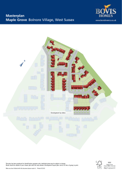


© Copyright 2026