
Swan Hill South West Development Precinct Traffic Strategy 20
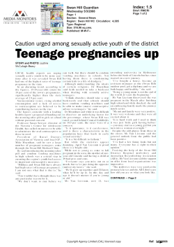
Swan Hill South West Development Precinct Traffic Strategy Copy for Public Exhibition – C58 Version 2.2 Swan Hill Rural City 25 February 2015. South West Development Precinct Traffic Strategy __________________________________________________________________________________ 1. Introduction .............................................................................................................................. 3 2. Objectives.................................................................................................................................. 3 3. South West Development Precinct Site Context......................................................................... 3 3.1 General.................................................................................................................................... 3 3.2 Existing Transport Network...................................................................................................... 5 3.2.1 Existing Transport Services................................................................................................ 5 3.2.2 Road Network Connections............................................................................................... 6 3.2.3 Pedestrian and Bicycle Network Connections .................................................................. 12 3.2.4 Public Transport Connections.......................................................................................... 12 4. Information to be Provided Before Development Commences................................................. 13 2 of 17 Version 2.1 South West Development Precinct Traffic Strategy __________________________________________________________________________________ 1. Introduction This strategy has been prepared to assist Council to implement the rezoning of land within the bounds of the South West Development Precinct (SWDP). This has been a long term desire of Council to provide for the future residential growth for Swan Hill. This strategy has been prepared to consider the traffic management requirements of the proposed development of the South West Development Precinct. Council engaged the Traffix Group to undertake a traffic impact assessment (TIA) of the proposed development. A copy of the assessment titled Swan Hill South West Development Precinct Traffic Impact Assessment prepared by in June 2014 is attached as Appendix 1 to this strategy. 2. Objectives The objectives of this traffic strategy are as follows: 1. To integrate the transport requirements of the SWDP with the existing transport infrastructure serving Swan Hill. 2. To consider the two options for the collector street connection to the Swan Hill Sea Lake Road as identified in the SWDP. 3. To identify additional traffic studies/assessments to be undertaken prior to the development within the development zones of the SWDP. 4. To identify and incorporate any existing Council strategy, policy or program into this Traffic Strategy. 3. South West Development Precinct Site Context 3.1 General The Swan Hill South West Development Precinct is bounded by Sea Lake – Swan Hill Road, Dead Horse Lane, Coronation Avenue and Gray Street as shown in Map 1. 3 of 17 Version 2.1 South West Development Precinct Traffic Strategy __________________________________________________________________________________ Map 1 Locality Plan of the Swan Hill South West Development Precinct The majority of the development precinct is currently Farming Zone (FZ) used for agricultural purposes. The precinct is bounded by residential development to the north and east as Residential 1 Zone (R1Z) and Low Density Residential Zone (LDRZ). Towards the south and west of the precinct the land use is currently FZ. Minor open irrigation channels are located within the precinct serviced from the main irrigation channel (Channel No. 9) located between Yana Street and Coronation Avenue as shown in Map 2 on the next page. 4 of 17 Version 2.1 South West Development Precinct Traffic Strategy __________________________________________________________________________________ The existing and proposed land uses contained within and adjacent to the boundaries of the SWDP are shown in Map 2. Map 2 Existing and Proposed Land Uses 3.2 Existing Transport Network 3.2.1 Existing Transport Services Map 3 Existing Transport Services details the location of existing transport services within the locality of the SWDP. 5 of 17 Version 2.1 South West Development Precinct Traffic Strategy __________________________________________________________________________________ Map 3 Existing Transport Services 3.2.2 Road Network Connections The SWDP primary connection points to the existing road network are listed in Table 1 Details of Existing Road Network Interfaces with the SWDP. Table 1 Details of Existing Road Network Interfaces with the SWDP Road Name Status Existing Construction Standard Proposed Construction Standard Comments Sea Lake Swan Hill Road VicRoads Arterial Road 7.9m seal width No change Intersection upgrades will be required as detailed in the Traffic Impact Assessment Gray Street Council Collector 9.4m seal at Feldtmann Lane and 6.9m where new Where new development fronts Gray Street a 2.5m Intersection upgrades will be required as detailed in the 6 of 17 Version 2.1 South West Development Precinct Traffic Strategy __________________________________________________________________________________ Road Name Status Existing Construction Standard Proposed Construction Standard Comments access road from east of Feldtmann Lane intersects with Gray Street shared path and kerb and channel will be required. Overall seal width must be at least 10.4m Traffic Impact Assessment Yana Street Council Collector Street 6.9m seal Where new development fronts Yana Street a 2.5m shared path and kerb and channel will be required. Overall seal width must be at least 10.4m Intersection upgrades will be required as detailed in the Traffic Impact Assessment Coronation Avenue Council Collector Street 7.4m seal Where new development fronts Coronation Avenue a 2.5m shared path and kerb and channel will be required. Overall seal width must be at least 10.4m Intersection upgrades will be required as detailed in the Traffic Impact Assessment Werril Street Council Collector Street 6.9m seal Where new development fronts Werril Street a 2.5m shared path and kerb and 7 of 17 Version 2.1 South West Development Precinct Traffic Strategy __________________________________________________________________________________ Road Name Status Existing Construction Standard Proposed Construction Standard Comments channel will be required. Overall seal width must be at least 10.4m Dead Horse Lane Council Access 7.5m Gravel Road 6.2m seal, 1.5m shoulder , K&C and 2.5m shared path Feldtmann Lane Council Access 6.0m Gravel Road 10.4m seal, K&C and 2.5m shared path on both sides Intersection upgrade will be required as detailed in the Traffic Impact Assessment The impact of the SWDP on the existing road network has been considered as part of the Traffic Impact Assessment (TIA) undertaken by the Traffic Group for Council. A summary of their recommendations is shown in Table 2 Summary of TIA Intersection Treatment Recommendations for Option 1. Table 2 Summary of TIA Intersection Treatment Recommendations. Intersection Number Description of Intersection Recommended Treatment 1 Dead Horse Lane/Link 4 Simple T-intersection 2 Yana Street/Werril Street/Dead Horse Lane The existing simple T-intersection continues to be provided. 3 Coronation Avenue/Wattie Street/Link 1 A single lane roundabout be provided 4 Yana Street/Link 2/Link 3 A single lane roundabout be provided 8 of 17 Version 2.1 South West Development Precinct Traffic Strategy __________________________________________________________________________________ Intersection Number Description of Intersection Recommended Treatment 5 Gray Street/Yana Street The existing configuration of the Gray Street/Yana Street intersection continues to be provided. 6 Gray Street/Internal Road A simple T-intersection be provided at the Gray Street/Internal Road intersection provided with priority to Gray Street and separate left and right turn lanes in the internal road. A left turn lane should be provided in Gray Street, due to the relatively large volume of left turning traffic. 7 Gray Street/Feldtmann Lane A simple T-intersection continues to be provided at the Gray Street/Feldtmann Lane intersection. A separate right turn facility should be provided in Gray Street and separate left and right turn lanes in Feldtmann Lane. A left turn lane in Gray Street is not warranted on the basis of the predicted left turn volumes. 8 Sea Lake-Swan Hill Road/Gray Street/Boobialla Drive The intersection remains under roundabout control. No upgrades are required from a capacity perspective. 9 Sea Lake-Swan Hill Road/Dead Horse Lane/Memorial Drive That the intersection remains in its current form. 10 Sea Lake-Swan Hill Road/Link 7(1) That a BAR (basic right turn) and AUL (auxiliary left turn) treatments be provided on the west and east approaches respectively. Given the relatively high volume of right turning traffic compared to left turning traffic in Link 7, separate left and right turn lanes should be provided in Link 7 at this intersection. 12 Link 5/Link 3/Link 4 A single lane roundabout be provided 13 Link 7/Link 6/Link 5 A single lane roundabout be provided 9 of 17 Version 2.1 South West Development Precinct Traffic Strategy __________________________________________________________________________________ Connection to the Sea Lake Swan Hill Road. The SWDP considered two options for the connection of the collector roads servicing the SWDP to the Sea Lake Swan Hill Road. These options are shown in Map 4 Connection Options to Sea Lake Swan Hill Road. Map 4 Connection Options to Sea Lake Swan Hill Road. The Sea Lake Swan Hill is an arterial road under the control and management of VicRoads and it is noted that under Clause 56.06 4 and Standard C17 that Council is required to comply with the Roads Corporation’s arterial road access management policies. A search of the VicRoads website has not revealed any arterial road access management policies. (However, It is believed that the draft arterial road access management policy was prepared in 2006 but was never formally adopted. It has been assumed that the draft was used to prepare VicRoads internal arterial road access management guidelines.) Option 1 is the preferred option for Council for the following reasons: 1. The urban design outcomes are superior for Option 1 because the interface of the development with the Sea Lake Swan Hill Road provides a more attractive visual presentation to the roads in terms of built form, landscaping and streetscape. 10 of 17 Version 2.1 South West Development Precinct Traffic Strategy __________________________________________________________________________________ 2. Will provide passive surveillance and promote a sense of safety for people as emphasised by the State Government’s Safer Design Guidelines 2006. It is also noted that Clause 15.01-4 of the Planning Scheme requires planning to consider the recommendations of the Safer Design Guidelines 2006. 3. Provides a better distribution of traffic from the SWDP into Feldtmann Lane and Gray Street. The Traffic Impact Assessment undertaken for the SWDP states “provides a superior road network compared to Option 2 and will not detrimentally affect the operation or capacity of the Sea Lake Swan Hill Road.” 4. This will also provide an opportunity to create a gateway entrance at the western entrance to Swan Hill. 5. Is consistent with the option indicated in the previous Outline Development Plan for the SWDP which was supported by VicRoads. However, VicRoads’ letter dated 8 October 2013 stating “In August 2007 VicRoads agreed to create a new access point on Sea Lake –Swan Hill Road (arterial road) between Gray Street and Dead Horse Lane. VicRoads has now reconsidered this in order to uphold the functionality of the arterial road and to follow the Guidelines in Access Management which has been developed in recent years.” VicRoads could not provide a copy of the document as it was only an internal draft policy and had not been through any public consultation. While Council acknowledging the need to protect the existing and future functionality of arterial roads; Council believes that Option 1 does not detrimentally affect the functionality or operation or capacity of the Sea Lake - Swan Hill Road for the following reasons: The intersection spacing proposed Option 1 is not inconsistent with the spacing of existing intersections along the Sea Lake Swan Hill Road. There are no known traffic management issues with the existing spacing of intersections and therefore the addition of one more intersection will not detrimentally affect the functionality, operation and capacity of the Sea Lake Swan Hill Road. Council is concerned that VicRoad’s decision to reject Option 1 is based upon the following: An internal VicRoads Guideline which has not been subject public consultation and input and That the Guideline does not distinguish between urban arterials having different traffic volumes such that the access requirements for the Sea Lake Swan Hill Road with a current traffic count of 1095 vpd is the same as for an urban arterial having a traffic count of 6,000 to 10,000 vpd. There is a significant difference between the impacts of an additional intersection in both these situations and therefore Council believes that VicRoads should take this into account when assessing the preferred option of Council. 11 of 17 Version 2.1 South West Development Precinct Traffic Strategy __________________________________________________________________________________ 3.2.3 Pedestrian and Bicycle Network Connections Map 3 showing the existing transport services shows that on the Sea Lake Swan Hill Road that the nearest shared path is some 430m east of the intersection of Gray Street and the Sea Lake Swan Hill Road. Developers will not be required to link the existing shared path network. There is no master plan for pedestrian connections and it is recommended that Council should address this shortfall so that linkages to the Tower Hill residential development and the SWDP development can be identified as priorities and their provision planned future capital works programs. Map 3 also there is a need to connect to the existing footpath networks in Yana Street, Coronation Avenue and Gray Street. This will be a requirement for individual developers as development takes place. The new collector streets to be constructed are required to be constructed with a shared 2.5m path on both sides of the street. This will meet the needs of parents and children riding to school but will not be used by cyclists cycling to and from work and other activities. Some Council’s recognising the differing requirements of parents and children riding to school and other serious cyclists have opted to replace one shared path with on road cycle lanes. The other 2.5m shared path is reclassified as a 2.5m wide footpath so that the shared path signage is not required. It is recommended that Council gives serious consideration to this option. 3.2.4 Public Transport Connections Map 3 shows the existing public bus routes going along some of the boundary streets to the SWDP. The collector streets have been sized that are able to be used by buses and therefore as the SWDP develops both school bus routes and the public bus routes could be changed to service this development, subject to there being sufficient patronage to warrant such changes. 12 of 17 Version 2.1 South West Development Precinct Traffic Strategy __________________________________________________________________________________ 4. Information to be Provided Before Development Commences To facilitate development within the SWDP the precinct has been subdivide into 6 areas that can be developed as part of Stage 1 rezonings. Map 5 Swan Hill South West Development Plan shows the boundaries of the areas to be rezoned as part of Stage 1 of the SWDP. Map 5 Swan Hill South West Development Stage 1 Rezoning (new map required) The following requirements must be met before development can take place prior to any development taking place in the Stage 1 rezoning. 13 of 17 Version 2.1 South West Development Precinct Traffic Strategy __________________________________________________________________________________ A Traffic Management Plan that is generally in consistent with the report titled “Swan Hill South West Development Precinct Traffic Impact Assessment” dated 20 June 2014) and this strategy The Traffic Management Plan must address the following but not limited to: 14 of 17 Appropriate access and circulation of vehicles on the existing and future road network. Appropriate integration with the existing or proposed subdivision of adjoining properties and sub-precincts including through alignment and configuration of the street network and landscape character. The identification of existing and proposed public transport routes, bus stops (as shown on the approved Swan Hill South West Development Plan) and associated infrastructure. The identification of existing and proposed pedestrian and cycling networks and shared paths Including provision for safe and convenient access to public transport infrastructure. The works necessary to accommodate traffic generated by the development and to mitigate the impact of that traffic on the development. Ensure that the road and intersection design must create efficient clearance of traffic, activity areas including around public facilities. The proposed road network should not overload or detrimentally affect existing or proposed residential streets and intersections. Adequate sight distance should be provided, especially where road alignment deflections occur at acute angles. Road layouts should provide natural traffic speed control, appropriate to the street category. The introduction of specific speed control devices should be considered only as a secondary option. Roundabouts may be implemented at intersections. However, care must be taken to provide adequate sized roundabouts and therefore road reservation boundaries must be designed to accommodate the radius required and sightlines. Road layouts should be designed for all road users appropriate to the street type, including service vehicles, emergency vehicles, waste collection vehicles and streetsweepers. Bus routes need to be considered when developing road networks and be based on the Department of Transport, Planning and Local Infrastructure publication titled ‘Public Transport Guidelines for Land Use Development’ (or a replacement document by the Department). Road reserve widths must be adequate for the intended road type, and should comply with requirements of the Local Government Infrastructure Design Association’s Infrastructure Design Manual. Should include a typical cross-section of differing road types, detailing the intended function of the road, e.g. bike lanes, drainage, landscaping. Version 2.1 South West Development Precinct Traffic Strategy __________________________________________________________________________________ 15 of 17 Addresses all off-site traffic infrastructure requirements associated with the sub-precinct and is to be accompanied by a Road Safety Audit, prepared by an appropriately qualified person. The Plan must address any safety issues raised by the Audit. Version 2.1 South West Development Precinct Traffic Strategy __________________________________________________________________________________ Appendix 1 VicRoads Response to Option 1 Sea Lake Swan Hill Road Intersection. 16 of 17 Version 2.1 South West Development Precinct Traffic Strategy __________________________________________________________________________________ 17 of 17 Version 2.1


© Copyright 2026