
ztem⢠airborne tipper afmag test survey over a magmatic
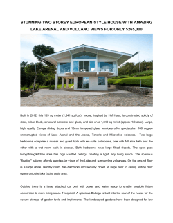
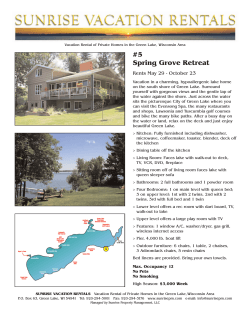
ZTEM™ AIRBORNE TIPPER AFMAG TEST SURVEY OVER A
MAGMATIC COPPER-NICKEL TARGET AT AXIS LAKE IN
NORTHERN SASKATCHEWAN
PRESENTED AT SEG 2009
Jean Legault
Geotech Ltd.
Harish Kumar
Geotech Ltd.
Biljiana Milicevic
Geotech Ltd.
Larry Hulbert
Pure Nickel Inc.
tipper functions Z/X and Z/Y.
The In-Phase and
Quadrature components tipper ratio data were then
extracted from the time-series, using Fourier-based, digital
signal processing analyses, at 5 frequencies, between 30Hz
and 360Hz.
SUMMARY
An airborne AFMAG demonstration test survey was
conducted using the ZTEM™ tipper electromagnetic
prospecting system over a known magmatic copper-nickel
occurrence in northern Saskatchewan, Canada. These tests
were conducted in early 2008 and were flown to test the
system’s capability to detect the conductive but relatively
weakly mineralized sulphide deposits and to define
potential extensions at depth. The AFMAG method utilizes
naturally occurring audio telluric fields from worldwide
sferic activity as its primary field source and is capable of
large penetration depths – in the order of hundreds of
metres to km. The AFMAG field tests corroborate
previously airborne transient electromagnetic, magnetic
and ground follow-up EM surveys. 2D forward modelling
results agree with the >300m vertical depth extent as
defined in subsequent diamond drill testing.
AXIS LAKE PROPERTY LOCATION
INTRODUCTION
Airborne tipper AFMAG (audio frequency electromagnetics) surveys were conducted over the Axis Lake property
that is situated in the Fond du Lac region of northern Saskatchewan (Figure 1) in May, 2008 (Milicevic et al., 2009).
The survey consisted of Tipper AFMAG measurements
using the ZTEM system (Lo and Zang, 2008), shown in
Figure 2, as well as aeromagnetics using a caesium magnetometer. The survey was comprised of thirty four (34) approximately 10.5 km long, North-South oriented flight
lines, totalling 358.7 line-km, that were obtained at
nominal 250m line spacing over an approximately 8 x
10km area (Figure 3). The property hosts known coppernickel sulphide showings (Axis Lake East & West, Rae Lake
and Currie Lake), has been previously surveyed using the
VTEM (Witherly et al., 2004) helicopter EM system, with
ground follow-up using UTEM (West et al., 1984) surveys,
and has subsequently been drilled (Vivian and Lo, 2007).
The property was chosen to test the ZTEM capability to
identify and define potential along strike and deep
extensions of the known Cu-Ni mineralization to below
500m.
Figure 1: Axis Lake property location and regional geology in
northern Saskatchewan, Canada.
GENERAL THEORY
The ZTEM system uses naturally occurring AFMAG magnetotelluric fields as the source of the primary fields, and
therefore requires no transmitter (Ward, 1959). The fields
resemble those from VLF except that they are lower frequency (tens & hundreds of Hz versus tens of kHz) and are
not strongly directionally polarized (Labson et al., 1985).
These AFMAG EM fields, derived from world wide atmospheric thunderstorm activity, have the unique characteristic of being uniform, planar and horizontal, and also
propagate vertically into the earth – to great depth, up to
several km, as determined by the magnetotelluric (MT)
skin depth (Vozoff, 1972), which is directly proportional to
the ratio of the bedrock resistivity to the frequency. At the
frequencies used for ZTEM, the MT skin depths likely
The measurements of the vertical (Z) tipper data were obtained using an air coil system (Figure 2), suspended at
approximately 100m elevation above ground level. The
vertical component data (Hz) were then ratioed to fixed
horizontal field measurements (Hx-Hy) obtained using
identical reference coils, that were oriented in the in-line
(X) and cross-line (Y) directions, in order to obtain the
1
range between approx. 600m to 2km in this region,
according to the following equation for the Bostick skin
depth (Mu-rakami, 1985):
The rocks at Axis Lake consist mainly of diatexite, which is
a highly metamorphosed sediment, and mafic noritic
granulites, which are metamorphic plutonic rocks.
Geologic mapping has been assisted with the aid of the
property-wide Total Field Magnetic survey and further
delineated the diatexite and mafic granulite units as shown
in Figure 3. Diatexite sediments occupy areas of low
magnetic response while the metanorite is coincident with
the high magnetic signatures.
δs = 356 * √(ρA / ƒ) metres
The other unique aspect of AFMAG fields is that they react
to relative contrasts in the resistivity, and therefore do not
depend on the absolute conductance, as measured using
inductive EM systems, such as VTEM – hence poorly conductive targets, such as alteration zones and fault zones,
can be mapped, as well as higher conductance features,
like graphitic units. Conversely, resistive targets can also
be mapped using AFMAG– provided they are of a sufficient
size and contrast to produce a vertical field anomaly.
Indeed resistors produce reversed anomalies relative to
conductive features. Still, copper-nickel mineralization is
consistent with moderate to strongly conductive bodies.
Figure 2: ZTEM AFMAG Hz Receiver Coil (foreground) and HxHy Reference Coils (background).
Figure 4: Slide showing texture of sulphides in Axis Lake
diamond drill core (after Vivian and Lo, 2007).
GEOLOGICAL SETTING
The Axis Lake property is located in the Tantato domain,
Fond du Lac area, north-northeast of Lake Athabasca. The
Tantato domain is defined as a triangular area underlain
by granulite to upper amphibolite facies metamorphosed
sedi-ments, volcanics, and granitoids (Figure 3).
Mineralization on the Axis Lake property is associated
with magmatic nickel-copper sulphides. Mineralization has
been transported along a prominent fault conduit formed
in an extensional rift environment. Norite magmas
containing sulphide droplets settle out of the magma in
areas where differentiation of the magma occurs. (Vivian
and Lo, 2007).
Figure 5: Existing Diamond Drill-holes, 2006 Holes and
Proposed drill-holes over DEM model (Vivian and Lo, 2007).
Pyrrhotite dominates the sulphide mineralogy at the Axis,
Rae and Currie Lake Zones (Figure 4). There are three
styles of mineralization: 1) fine to coarsely disseminated,
from 1-5% and up to 10% sulphides; 2) network to nettextured mineralization of up to 15% sulphide, trending to
30%; and 3) massive sulphide horizons comprising up to
50% mineralization but occurring only locally in zones less
than 0.5 m thick. Sulphide mineralogy is dominated by
pyrrhotite (up to 90%) with accessory compositions of
chalcopyrite (up to 5%) and pyrite (usually less than 5%).
The nickel-bearing sulphide is pentlandite and it is also
common to see the nickel to copper ratios approximately
2:1 to 3:1 (Vivian and Lo, 2007).
Figure 3: Axis Lake general geology and AFMAG flight lines
(after Vivian and Lo, 2007).
2
Tantato Domain contact, and might represent a major
regional fault structure. Another unexplained EW
conductive lineament represents a New Target, that is
along strike with a VTEM anomaly defined southwest of
Currie Lake. This image contrasts the Z/Y (Cross-line)
component profiles (Figure 7B), which are sensitive to
structures oriented oblique/parallel to the In-Line flight
direction. Indeed the Z/Y images are less well defined
except for a SW-NE lineament extending across Axis Lake
zone, potentially relating to a fault structure; and the
Tantato Domain boundary to the north which is equally as
prominent as in the Z/X results, presumably because it is
NE-SW oriented.
Seven diamond drill holes, totaling 2260 metres were
completed in Spring 2006 that were located based on the 2005
VTEM and 2006 UTEM results and to infill Cu-Ni
mineralization intersected previously (Figure 5). All holes
intersected Cu-Ni sulphides. The results showed that the
sulphide mineralization in the East and West zones ranges
from fine to coarsely disseminated, to semi-massive network
textures to massive, with nickel and copper values in the range
of 1-2% and 0.4-0.6% respectively. Rae Lake remains
untested (Vivian and Lo, 2007).
PREVIOUS GEOPHYSICAL SURVEY
RESULTS
VTEM and aeromagnetic surveys were undertaken in
March, 2005 at 150-250m line-spacings and totaling 1503
line-km (Orta et al., 2005). Over 40 conductive responses
were identified in the VTEM data and the results show that
the Axis Lake zone EM response is quite varied and less
extensive than the known mineralization (Figure 6). The
East Zone dips south and reveals better amplitudes due to
better connectivity than the West Zone. The Rae Lake zone
also dips south, is more continuous but is slightly less
conductive than Axis Lake. The Currie Lake zone dips
north but is indicated to be of limited size. Additional areas
for ground follow-up were also defined elsewhere on the
property (Vivian and Lo, 2007).
Figure 7: Axis Lake ZTEM Test Block: In-Phase Z/X Component
Profiles over 360Hz Phase-Rotated (PR) Grid (left) versus
Corresponding In-Phase Z/Y Profiles & 360Hz PR Grid (right).
Figure 6: VTEM EM Time-Constant, UTEM anomalies and
Known Mineralized Zones at Axis Lake.
Figure 8: Axis Lake Block: 360Hz In-Phase Total Divergence
(DT) Grid (left) versus Corresponding 45Hz In-Phase DT Grid
(right) and Mineralized Zones.
The UTEM survey outlined numerous conductive
responses on the Axis Lake property, including 4
significant areas at Axis Lake East & West, Rae Lake and
Currie Lake. In particular, modeling suggests that
mineralization at Axis and Rae Lakes extends to 400+
metres. South dips are indicated at Axis and Rae Lakes, and
steep dips at Currie Lake. The 5-10 siemens conductivities
obtained suggest that the Cu-Ni sulphide mineralization is
weak, likely semi-massive, particularly at Currie Lake
(Vivian and Lo, 2007).
When the 2 Tippers are combined, using the DT (Kuzmin
eta l., 2005) grid method (Figure 8) that is analogous to the
VLF Peaker (Pedersen, 1998), the imaging of geoelectric
structures becomes omni-directional, with all structures
being highlighted. The DT (total divergence) images at
360Hz and 90Hz shown below each also demonstrate the
notable differences in the frequency-dependence of the
responses, that imply resolved differences in the vertical
depth of the defined structures – including: a) the main
Axis Lake and the Rae Lake Zone responses, that rapidly
weaken from high to low frequency, and b) similarly for
the New Target and the Currie Lake zone, barely visible.
This suggests that they relate more to the near-surface
geology and may not extend to significant depths. These
behaviours contrast the main Tantato Domain contact
zone response, furthest north, which is equally strong from
45 Hz to 360Hz in both the Resulting PR and DT images.
AFMAG SURVEY RESULTS
There are distinctive differences observed between the
Z/X (In-Line) component profile results (Figure 7A), which
are most sensitive to structures orientated perpendicular
to the In-Line direction - notably the 2 prominent, thin EW
lineaments that are centered directly over the known Axis
Lake East & West and Rae Lake mineralized zones; as well
as 2 major EW conductive zones located south and north of
Currie Lake – the latter of which appears correspond to the
3
known mineralized zones. In fact, an unexplained ZTEM
anomaly northwest of the known Cu-Ni showings and
south of Currie Lake correlate well with the east-extension
of VTEM conductor and therefore represents a new target
for follow-up (Figure 10). Other ZTEM lineaments also
correlate well with similar areomagnetic trends and
structures, which highlight its ability to provide
complementary information. In addition to mapping
lithology and structure, the ZTEM results appear to
corroborate both the moderate conductance (~5 siemens)
and the relatively limited vertical depth-extent (~300500m) of the defined mineralized zones and therefore
agree with the previous geophysical and drill-tested
geologic findings. These results over a Cu-Ni target add to
the variety of succesful applications of the ZTEM
technique, notably for sedimentary-exhalative and
porphyry copper type deposits (Lo and Zang, 2008), as
well as unconformity uranium targets (Lo et al., 2009).
This suggests that it represents a major crustal fault
feature, with great depth extent.
TWO-DIMENSIONAL MT TIPPER
FORWARD MODELING
2D synthetic data were obtained that simulate and
compare the expected Tipper responses for the Axis Lake
geologic model using the PW2d 2D forward MT modeling
code of Wannamaker et al. (1987).
Figure 9: Axis Lake 2D Resistivity Models and 2D Forward Model
Z/X profiles for low conductivity model (left) and high
conductivity model (right), extending to 300m depths.
Figure 9 presents the 2D synthetic forward model
responses of the In-line (Z/X) In-Phase and Quadrature for
2 similar geologic models, whose only dissimilarity is the
target conductivity, which is 10x less for the low
conductivity model (10 ohm-m=5 siemens), shown on the
left, versus the high conductivity model (1 ohm-m = 50
siemens), shown on the right. The notable similarities that
the low conductivity model have with the measured data
are: a) In-Phase (IP) responses that diminish in amplitude
at lower frequencies, and b) Quadrature phase (QP)
responses that follow the same polarity as the In-phase
(note the reversed sign for QP relative to our measured
results is due to polarity convention in MT 2d code
utilized), and c) model amplitudes for the IP and QP for the
low conductivity model closely match the observed data
(i.e., +/- 40% IP and +/- 10% QP – Figure 10) and are
significantly weaker than for the high conductivity model.
Hence the 2D forward modeling results suggest that the
Axis Lake mineralized zones are only moderately
conductive (~5 siemens) and may not extend to significant
depth (~300-500m) – both of which agree with the VTEM
and UTEM survey results and the known geology.
Figure 10: Axis Lake ZTEM 360Hz In-Phase Total Divergence
(left), VTEM Late-Channel Tau (right) Results, and related Profile
Data, along with Known Mineralized Zones and Ground UTEM
Anomalies (circles).
ACKNOWLEDGEMENTS
The authors would like to thank Geotech Ltd., as well as
Pure Nickel Mines Inc. for graciously allowing us to
present these data and for providing the geologic and
historical geophysical data.
REFERENCES
Kuzmin, P., Lo, B., and Morrison, E., 2005, Final report on
modeling, interpretation methods and field trials of an
existing prototype AFMAG system, Miscellaneous Data
Release, 167, Ontario Geological Survey.
CONCLUSION
The ZTEM results appear to correlate very well with the
known geology, in particular the presence of a Cu-Ni
mineralized conductive horizons, at Axis Lake and Rae
Lake, which are known to occur at surface and are
followed along several kilometers along strike. In
particular, the ZTEM results provide indications of the
longer strike continuity of the known mineralized
horizons, as compared to the VTEM results, that likely
relate to more weakly mineralized, lower conductivity
extensions of the zones (Figure 10). This also agrees with
the ground UTEM anomaly trends that extend beyond the
Labson, V. F., A. Becker, H. F. Morrison, and U. Conti, 1985,
Geophysical exploration with audio-frequency natural
magnetic fields: Geophysics, 50, 656–664.
Lo, B., and Zang, M., 2008, Numerical modeling of Z-TEM
(airborne AFMAG) responses to guide exploration
strategies, SEG Expanded Abstracts, 27, 1098-1101.
Lo, B., Legault, J.M., Kuzmin, P., 2009, Z-TEM (Airborne
AFMAG) tests over unconformity uranium deposits,
4
West, G.F., Macnae, J.C., and Lamontagne, Y., 1984, A timedomain EM system measuring the step response of the
ground, Geophysics, 49, 1010-1026.
Extended abstract submitted to 20TH ASEG International
Geophysical Conference & Exhibition, Adelaide, AU, 6 pp.
Milicevic, B., Steffler, E., and Legault, J.M., 2009,
Geophysical report on ZTEM electromagnetic and
magnetic test surveys over Axis Lake property, on behalf of
Pure Nickel Inc., internal report by Geotech Ltd., Feb-2009,
36 pp.
Witherly, K., Irvine, R., and Morrison, E.B., 2004, The
Geotech VTEM time domain helicopter EM system, SEG
Expanded Abstracts, 23, 1217-1221.
Murakami, Y. 1985, Short Note: Two representations of the
magnetotelluric sounding survey, Geophysics, 50, 161164.
Orta, M., Zhu, J., and Barlow, R., 2005, Report on helicopterborne time-domain electromagnetic geophysical survey,
Stony Rapids Project, northern Saskatchewan, for Hull
Consulting Services Ltd., internal report by Geotech Ltd.,
May, 2005, 26 pp.
Pedersen, L.B., 1998, Tensor VLF measurements: Our first
experiences, Exploration Geophysics, 29, 52-57.
Vivian, G., and Lo, B., 2007, Technical Report – Organic soil
sampling, airborne and ground geophysics and diamond
drilling, Fond du Lac property, northern Saskatchewan, on
behalf of Pure Nickel Inc., 43-101 report, April, 2007, 63
pp.
Vozoff, K., 1972, The magnetotelluric method in the
exploration of sedimentary basins: Geophysics, 37, 98–
141.
Wannamaker, P. E., Stodt, J. A., and Rijo, L., 1987, A stable
finite element solution for two-dimensional
magnetotelluric modeling: Geophy. J. Roy. Astr. Soc., 88,
277-296.
Ward, S. H., 1959, AFMAG—Airborne and ground:
Geophysics, 24, 761–787.
5


© Copyright 2026