
Pilot Area Land Use Plan - Guyana: A Modern Prosperous State
GFAiL
terra systems ----------------------
GUYANA
Natural Resources Management Project
PN 93.2243.9-03.100
LAND USE PLAN FOR A PILOT AREA
IN GUYANA
Deutsche Gesellschaft fur
Technische Zusammenarbeit (GTZ) GmbH
Herrn Klaus Lengefeld - OE 3050
Daq-Harnrnarskjold-Weq 1 - 5
65760 Eschborn
January 2003
F
-I
I
I
I
I
I
I
I
I
I
I
I
I
I
I
I
I
I
I
I
I
I
I
I
I
I
I
I
I
I
I
I
I
I
I
I
I
I
I
I
I
I
Your contact person at
GFA Terra Systems is
Dr. Elfriede Maussner
Tel: 0049-40-60306-184
GUYANA
Natural Resources Management Project
PN 93.2243.9-03.100
LAND USE PLAN FOR A PILOT AREA
IN GUYANA
Prepared by:
Land Use Planning Unit and Holger Diedrich
Georgetown, Guyana
January 2003
Address
GFA Terra Systems GmbH
EulenkrugstraBe 82
22359 Hamburg
Germany
Telephone
Telefax
E-Mail:
0049-40-60306-184
0049-40-60 30 6-189
[email protected]
I
I
I
I
I
I
I
I
I
I
I
I
I
I
I
I
I
I
I
I
I
terra systems
TABLE OF CONTENTS
ANNEX: LIST OF MAPS
GLOSSARY AND ABBREVIATIONS
INTRODUCTION
2
PURPOSE OF THE LAND-USE PLAN
2
2.1
Plan Objectives
2
2.2
Development Goals
3
3
ACTUAL SITUATION
4
3.1
The Pilot Area
4
3.2
Institutional Policies and Responsibi lities
8
4
ANALYSIS OF POTENTIALS AND CONFLICTS
11
4.1
4.1.1
4.1.2
4.1.3
4.1.4
4.1.5
4.1.6
4.1.7
4.1.8
4.1.9
Land-Use Potentials
Ecological Vulnerability
Socio-economic Vulnerability
Ecological Value
Recreational Va lue
Potential for Forestry
Potential for Agriculture
Potential for Mining
Potential for Inland Fishing
Potential for Hydropower
11
11
12
13
14
16
17
19
20
20
4.2
4.2.1
4.2.2
Stakeholders' Interests
The Interests of Major Stakeholders
The Interest of Small Stakeholders
21
21
25
4.3
4.3.1
4.3.2
4.3.3
4.3.4
4.3.5
Identifying Constraints
Constraints to Protect the Ecological Value
Constraints for Tourism
Constraints for Agriculture
Constraints for Forestry
Possible Conflicts by Overlapping Potentials
27
27
27
28
29
29
5
LAND-USE OPTIONS
30
5.1
Introduction
30
5.2
5.2.1
5.2.2
5.2.3
Scenario
Scenario
Scenario
Scenario
30
31
32
35
Development
1 - The "No Plan" Scena rio
2 - The Regional Efficiency Scenario
3 - The Sector-Led Scenario
I
I
I
I
I
I
I
I
I
I
I
I
I
I
I
I
I
I
I
I
terra systems
6
RECOMMENDED LAND USE FOR THE PILOT AREA
37
6.1
6.1.1
6.1.2
6.1.3
6.1.4
General land-use policy
Forestry Sector
Mining Sector
Agricultural Sector
Fishery Sector
37
37
38
39
40
6.2
6.2.1
6.2.2
6.2.3
6.2.4
6.2.5
6.2.6
6.2.7
6.2.8
6.2.9
Proposed Land Units
Land Unit 1: Settlements and Mines
Land Unit 2: Agriculture
Land Unit 3: Agriculture - Mining
Land Unit 4: Fishing
Land Unit 5: Commercial Logging
Land Unit 6: Regeneration Forest
Land Unit 7: Conservation forest
Land Unit 8: Eco-tourism
Land unit 9: Transportation network
40
40
40
41
41
41
41
42
42
42
6.3
6.3.1
6.3.2
6.3.3
6.3.4
42
42
43
43
6.3.5
6.3.6
6.3.7
6.3.8
6.3.9
Land-Use Systems
Settlements, Roads and Industrial facilities (LU 1,9)
Rain-fed Agriculture and Irrigated Agriculture (LU 2,3)
Organic farming (LU 2)
Livestock (LU 2,3), Aquarium fishing and Inland fishing
(LU 4)
Agroforestry Systems and Social Forestry (LU 2,6)
Eco-tourism (LU 7,8)
Protection forest (LU 6,7,8)
Production Forest (LU 5)
Mining (LU 3)
44
44
45
45
45
45
6.4
National Policy Developments
46
7
PLAN IMPLEMENTATION
48
7.1
Regional Level
48
7.2
The Role of the Planning Team
48
7.3
The Role of Participants
49
7.4
Ongoing Projects in the Pilot Area
49
7.5
Underlying Assumptions and Conditions
50
8
BIBLIOGRAPHY
51
ii
I
I
I
I
I
I
I
I
I
terra systems
ANNEX: LIST OF MAPS
Map 1:
Location of the Pilot Area
Map 2:
Present Land Use
Map 3:
Ecological Vulnerability
Map 4:
Ecological Value
Map 5:
Recreational Va lue
Map 6:
Forestry Potential
Map 7:
Agricultural Potential
Map 8:
Mining Potential
Map 9:
Recom mended Forest Zones
Map 10:
No Plan Scenario
Map 11:
Regional Efficiency
Map 12:
Sector Lead Scenario
Map 13:
Recommended Land Units
I
I
I
I
I
I
I
I
I
I
I
iii
I
I
I
I
I
I
I
I
I
I
I
I
I
I
I
I
I
I
I
I
I
terra systems
GLOSSARY AND ABBREVIATIONS
CDC
Community Development Council
CHPA
Central Housing and Planning Authority
CIDA
Canadian International Developm ent Agency
CRL
Caribbean Resourc es Limited
EEZ
Ecological-Economic Zoning
EIA
Environmental Impact Assessment
EPA
Environm ental Protection Agency
FAO
Food and Agriculture Organisation
FPA
Forest Products Association
FSC
Forest Stewardship Council
GEA
Guyana Energy Agency
GFC
Guyana Forestry Commission
GGMC
Guyana Geology and Mines Commission
GINMIN
Guyana Industrial Minerals Incorporated
GLSC
Guyana Lands and Surveys Commission
GoG
Government of Guyana
GVC
Guyana Volunteer Consultancy
HIRC
Hangzhou International Regional Centre
LEAP
Linden Econom ic Advancement Program me
LlDCO
Livestock and Dairy Development Company
LlNMINE
Linden Mining Com pany
LU
Land Unit
LUP
Land-Use Plan or Land-Us e Planning
m.a.s.1.
Metres Above Sea Level
NARI
National Agricultural Research Institute
NBAP
National Biodiversity Action Plan
NDC
Neighbourhood Democratic Council
NFP
National Forest Plan
NPAS
National Protected Areas System
NREAC
Natural Resources and Environment Advisory
Committee
NRMP
Natural Resources Management Project
NTFP
Non-Timber Forest Products
iv
I
I
I
I
I
I
I
I
I
I
I
I
I
I
I
I
I
I
I
I
I
terra systems
PA
Pilot Area
PRA
Participatory Rural Appraisal
PRCSSP
Poor Rural Com munities Support Services Project
PSP
Permanent Sample Plot
RASC
Refractory 'A' Grade Super Calcined
RDC
Regional Democratic Council
REPAHA
Regional Agricultural Program me for Animal Health
Assistants
SFP
State Forest Permission
UNDP
United Nations Development Program me
UG
University of Guyana
TSA
Timber Sales Agreement
v
I
I
I
I
I
I
I
I
I
I
I
I
I
I
I
I
I
I
I
I
I
terra systems
1
INTRODUCTION
The Governments of Guyana and Germany have collaborated to produce a
Regional Land-Use Plan for a Pilot Area (PA) in Guyana. This was done
within the framework of the Natural Resources Management Project
(NRMP). In November 1998 the Government of Guyana defined the PA for
Land-Use Planning (LUP) (Map 1). The pilot nature of this plan also meant
the testing of a methodology for future LUP. The planning process covers
all steps extending from the collection of data and information through its
processing, analysis, discussion and evaluation right up to stakeholder
consultations to achieve a consensus on the form of Land Use to be
practised in the next 5-10 years.
LUP is a partially integrating and sector-overlapping process. The planning
objects are the land resources. Thus, LUP is not suitable to solve all local
problems, nor can it replace the overall planning for an area. The basic
technical strategy in LUP is to plan Land Use according to suitability in
combination with the various needs in the area.
Presently, LUP is used at all planning levels. LUP at the regional level has
a linking function between implementation at regional level and national
strategic planning. One of its major tasks is to provide information for
subordinate and superior planning levels.
With respect to the implementation at local level, regional planning has the
tasks of mediating in conflicts between stakeholders, of identifying LandUse objectives of regional interest, promoting disadvantaged groups which
are not sufficiently integrated into local planning and defining simple criteria
by means of which the needs of regional interests and of disadvantaged
groups can be included into local discussion and decision-making
processes. Plans at regional level are not absolutely clear-cut as far as
delimitation of the areas are concerned. They provide an orientation without
excessively restricting the opportunities for local action.
This plan presents possible future developments in Land Use that are
socially desirable within the PA. Boundaries of land units are usually
expressed by straight lines or are slightly curved. In reality, these
boundaries do not match the inherent complexity of the different
ecosystems. At the local level the planning area, including boundaries
within which the activities will take place, have to be clarified in cooperation with competent regional entities.
The Ecological-Econom ic Zoning Methodology proposed by the Treaty of
Amazonian Cooperation has been tested by the LUP team. The
experiences of EEZ application are described in a separate document.
I
I
I
I
I
I
I
I
I
I
I
I
I
I
I
I
I
I
I
I
I
terra systems
2
PURPOSE
OF THE
LAND-USE
PLAN
LUP creates the prerequisites required to achieve a type of Land Use which
is sustainable, socially and environmentally compatible, socially desirable
and economically sound. It sets in motion social processes of decision
making and consensus building concerning the use and protection of
private, communal and public areas. On the basis of this central idea, a
number of objectives and the development goals for the Regional Land-Use
Plan of the PA have been identified.
2.1
Plan
Objectives
These are as follows:
•
Economic efficiency.
The measure planned should be designed to contribute to the longterm security of the economic basis of the local population. Therefore,
the measures should be self-financing and at the same time
economically justified. In this way, they will contribute to improving the
standard of living and to overall economic development of the PA.
•
Sustainable use of resources.
The land-utilization type must be designed to ensure that the natural
basis of living is sustained in the long-term, i.e. the use of the land
should correspond to its natural potential. Existing environmental
damage should be minimised and damaging developments avoided
by the support and development of sustainable approaches.
•
Environmental protection.
Avoid further damage where possible and ensure prior environmental
assessments of proposed activities which might significantly affect the
environment. Conservation will be treated as an integral part of the
planning and implementation of development activities and public
consciousness and awareness on environmental implications of
economic and social activities will be raised.
•
Social equity.
When considering the effects of planning measures, attention should
be paid to both the distribution and the kind of benefits. These should
be spread in such a way that socially weak parties will participate in
the process.
•
Regional equity and spatial diversification.
Ensure the best possible supply to each Region with productive,
social and infrastructural facilities and the most efficient possible use
of available means. The key question is which functions are required
in a specific region and how can they best be distributed in the area.
2
I
I
I
I
I
I
I
I
I
I
I
I
I
I
I
I
I
I
I
I
I
terra systems
•
Social acceptance/benefits.
The measures applied are to be desired, accepted,
largely carried out by those affected by them. The
measures can only be sustainable if they are socially
culturally suitable, and if they take into account local
capacities.
•
supported and
effects of such
compatible and
knowledge and
Guidelines on multiple land uses/competing land uses.
Land-Use conflicts are to be avoided or settled in connection with
competing stakeholders and in cases of unclear land-right situations.
•
Poverty alleviation.
To reduce poverty and to contribute to improving the standard of
living of the inhabitants of the PA.
2.2
Development
Goals
Taking into account the above-described main objectives for the Regional
Land-Use plan of the PA, the following concrete development goals were
identified:
•
•
•
•
To make the best use of the existing potentials in the area.
•
•
Improvement of living conditions (quality of life) for local population.
Regularisation of the land.
Creation of employment.
Development and improvement of civil infrastructure (roads, wharves,
etc.).
Implementation of environmentally sound practices in mining, forestry
and agriculture.
•
To identify value-added products.
•
To improve the access to, and the quality of health centres and
education facilities.
•
•
•
•
To improve technical training and education (access to facilities).
Introduction and use of appropriate technologies.
To establish and strengthen local organisation.
To establish access to and conditions for small credit facilities.
3
I
I
I
I
I
I
I
I
I
I
I
I
I
I
I
I
I
I
I
I
I
terra systems
3
ACTUAL
SITUATION
This section presents a brief synopsis of the baseline data on the PA. The
base line information forms the basis for the identification of Land-Use
potentials and the subsequent creation of LUP scenarios for the PA.
Detailed information on the present land uses, available resources and
present stakeholder activities are found in: "Baseline Document for LandUse Planning of the Pilot Area".
3.1
The
Pilot
Area
The PA was identified by the Government after considering several factors.
Firstly, it considered the presence of land uses in the PA representative of
those found in Guyana. Secondly, it considered the various land potentials
and opportunities and the conflicts they present. Thirdly, it considered the
logistics of interacting with local government agencies and communities
given that the project's base is in Georgetown.
The PA includes parts of the Administrative Regions III, VII and X. It covers
an area of approx. 4,800 krn", The maxim um north-south extension is 130
km from Lanaballi to Ituni. In east-west direction the maximum distance is
75 km (Map 1).
The part of Region III between the Essequibo and Bonasika Rivers
comprises the north-eastern part (approx. 10%) of the PA. The part of
Region VII between the Mazaruni and Essequibo Rivers (referred to as the
Bartica Triangle) comprises the western part (approx. 22%) of the PA. The
part of Region X, extending from Goshen in the north to Ituni in the south
and limited by Moblissa in the east and the Essequibo River in the west,
comprises the southern and eastern part (approx. 68%) of the PA.
Administration
In the PA there is one NDC - Bartica - the Regional Administrative Centre
of Region VII; one municipality - Linden - the Regional Administrative
Centre of Region X; and four CDCs (Ituni, Moblissa and Rockstone Region
X and Lanaballi Region III). Thus, unlike the other regions in the PA, the
Regional Administrative Centre of Region III (Vreed-En-Hoop) is located
outside of the PA.
Population and Major Settlement Areas
The PA has approx. 51,000 inhabitants. This population is mostly
concentrated in Linden (approx. 30,000) and Bartica (approx. 18,000). AfroGuyanese comprise the majority of the population in these areas. The
remainder of the PA is sparsely populated with the larger settlements in
Region X at Ituni (mainly Afro-Guyanese) and at Rockstone (mainly
Amerindians) with approx. 1,000 and 250 respectively. In Region III,
Lanaballi has approx. 250 inhabitants who are mainly Indo-Guyanese.
4
I
I
I
I
I
I
I
I
I
I
I
I
I
I
I
I
I
I
I
I
I
terra systems
Topography and Soils
The PA is mostly flat to undulating with the highest elevation (260 m.a.s.l)
at Arisaru Mountain in the south of the PA. The major waterways are the
Essequibo and the Demerara Rivers. Less extensive waterways are found
in the Mazaruni and Bonasika Rivers and in the dense networks of creeks
and streams. The soils in the PA are generally sandy in texture (white and
brown sands) and low in fertility. The most fertile soils in the PA are alluvial
and are found along the riverbanks.
Climate
The PA falls within the tropical, humid, lowland climate with average annual
precipitation of 2,200 to 2,300 mm. Rainy seasons are from April to July
and from October to December. Temperatures vary between 19°C (average
minimum) and 32°C (average maximum). The climate does not show any
significant variation throughout the PA.
Land Cover
More than
evergreen
patches of
along the
production
Moblissa.
85% of the PA is covered with forests which are mainly dry
forest, marsh forest and rain forest. There are also a few
grassland and savannah. Subsistence agriculture predominates
riverbanks and major roads. Larger-scale agricultural crop
is found in the north east at Lanaballi and north west at
Land-Use History
In Region X, the economic activities were centered on the bauxite industry
which developed after the discovery of this mineral in the 1920s. This led to
the construction of factories by the multinational Alcan Co-operation
between 1930 and 1940. By 1960 this part of the PA was very prosperous
and the industry supported the families of some 8,000 workers in the PA. In
1970 the bauxite industry in Guyana was nationalised. Declining world
market prices and increasing cost of production resulted in the contraction
of the industry. At present the bauxite industry only employs approx. 1,300
persons resulting in the declining living standards in this part of the PA.
The contraction of the bauxite industry was accompanied by expansion of
agricultural production in Region X. These activities were initially centred at
Moblissa with the production of tobacco. Later, they expanded when the
Government-owned LlDCO established a thriving dairy farm. By 1992
LlDCO's operations had declined and were later privatised to Vinelli
Industries. This new company failed and ceased operations at Moblissa.
In other parts of Region X, where conditions did not permit agricultural
production, forestry (small and large-scale logging) and charcoal burning
gained prominence. Others turned to mining operations outside the PA
(Omai Gold Mining Limited and Aroima Mining Company) for employment.
Region III of the PA was once covered by dense forest. Thus forestry was
the primary Land Use. Human occupation commenced around 1930 with
the opening of a quarry at Makouria. The quarry closed in 1979, by which
5
I
I
I
I
I
I
I
I
I
I
I
I
I
I
I
I
I
I
I
I
I
terra systems
time several settlements had sprung up along the Essequibo and Bonasika
Rivers. Being rich in commercial tree species the area attracted a number
of logging companies. Thus, parallel to the phasing out of the quarry
operations, logging became the main source of employment in this area.
By 1995 most of the commercial trees had been harvested, resulting in the
decline of most of the logging operations in this area. This forced the many
homesteads that were established around the former quarry and forest
industries to expand to subsistence or commercial agricultural production
and inland fishing. Prior to the 16th century, the Region VII part of the PA
had been temporarily settled by Amerindians. In the early 17th century the
Spanish occupied the Bartica area for a short period. In 1613, the Dutch
colonised the area and established the first sugar plantation in 1672. In the
late 19th century, 'gold digging' was responsible for a dramatic increase of
the population in the area. Bartica became a social and economic centre
with telegraph office, police station and post office facilities. The town
functioned as the 'door to the interior' as miners and loggers passed en
route to their claims. The Bartica-Potaro Road and river crossings at
Sherima and Wineperu connected Bartica with speculators and successful
miners, all in pursuit of the attractions at Bartica. These activities were the
main source of a prosperous Bartica.
After the 1930s, this part of the PA again gained som e prom inence, now
through agriculture. This occurred through the activities of a citrus estate
(Lima Estate), located near Agatash village, which exported barrels of
limejuice to England. In the 1950s farmers began to grow tobacco and
cotton but this soon ceased. By 1970 peanuts and citrus were the main
crops produced. However, by the mid 1980s, depleted soils and
inaccessibility to fertiliser and other agricultural inputs resulted in the
decline of crop production in the area and consequently of living standards
too.
In the 1970s the construction of the Georgetown -Linden-Mahd ia road
resulted in Mahdia bound vehicles using the faster Mabura road route.
These vehicles had previously passed through Bartica on their way to the
interior. This resulting loss of the revenues especially affected the
economic prosperity of Sherima, Wineperu and Bartica.
Present Land Use
Presently, in Region X of the PA, the Land Use is characterised by
extensive bauxite mining with the presence of LlNMINE Bauxite operations
(see Map 2). This is especially evident around the area of Linden where
dumpsites for bauxite overburden form major landmarks. Large forestry
concessions and small chainsaw operations also form an integral part of
the Land Use in Region X, which is especially evident in the Ituni area.
Agriculture also contributes to the Land Use in this Region. This is
especially evident at Watooka, Moblissa and along the Demerara River e.g.
Malali. Commercial aquarium fishing is done at Rockstone and Malali.
In Region III of the PA, commercial and subsistence agriculture and
chainsaw logging now characterise the Land Use. Agriculture dominates
the area at Lanaballi and Bonasika, while chainsaw logging is dominant
along the Del Conte Road. Some tourism sites e.g. Shanklands are present
6
I
I
I
I
I
I
I
I
I
I
I
I
I
I
I
I
I
I
I
I
I
terra systems
in the area. Also, fishing is practiced in the Essequibo River between
Lanaballi and Sophia Point. Some dairy farming is done in the area
between Dalli and Ampa.
In Region VII a large forest concession, some SFPs, some mining
concessions and some small farms characterise the Land Use. Agriculture
is dominant around the area of Agatash and along the Bartica-Potaro Road
(up to approx. 6.4 km). Some poultry production is carried out along the
Essequibo River at New Found Out and Bidrabu. Quarrying also forms part
of the Land Use in Region VII. This is evident with operations at Teperu
and Wineperu. Bartica, White Water and Baracara are the centre of tourism
activities in Region VII. Also, fishing is done in most waterways in the
Essequibo and Mazaruni Rivers.
Additionally, in the PA there are a number of other (natural) resources
being used. These include:
•
Scenic beauty, wildlife, plants and heritage sites for tourism.
•
Bodies of water for recreation and water sport
Land Tenure Situation
The vast majority (73%) of the PA is under State Forest Land. These lands
are leased mainly as State Forest Permits (SFP) in Region X and mainly as
Timber Sales Agreements (TSA) in Region VII.
Agricultural leases appear on 5% of the PA, mostly along the Essequibo
River and the Linden-Rockstone road. These leases are valid for 25 years.
Prospecting perm its for mining exist on the right bank of the Mazaruni River
(south west of Bartica) and south of Ituni. These permits cover 1.3% of the
PA. The extent of LlNMINE's holdings is presently unclear but LlNMINE is
known to have an exclusive permission of approx. 29,000 acres.
Infrastructure
and Services
In the PA rivers form an important transport line, in addition to the existing
roads. The socio-econom ic infrastructure is limited except for the urban
centres of Bartica and Linden. Secondary and business schools, hospitals,
banks and most government services are located in these centres.
Employment and Income Situation
In the PA, LlNMINE in Region X employs the greater part of the workforce
(1,300 workers). Other major employers in Region VII are, in the forestry
sector (Willems Timber Ltd.) 220 persons, and in the quarry sector
(Mazaruni Granite Ltd.) 110 persons. In Region Ill's part of the PA, there
are no employment opportunities for its inhabitants. Thus, self-employment
and exchange labour is practised. No detailed figures on self-employment
and public servants are available for the PA.
As was mentioned above, a more detailed account of this section can be
found in the publication "Baseline Document for Land-Use Planning of the
Pilot Area".
7
I
I
I
I
I
I
I
I
I
I
I
I
I
I
I
I
I
I
I
I
I
terra systems
3.2
Institutional
Responsibilities
Policies
and
Institutional policies at the national level have to be taken into account, in
order to ensure a coordinated approach for the plan. In Chapter Six, further
policies planned for implementation will be defined.
In order to guarantee that the development of the forestry sector occurs in a
structured and focused manner, the GFC developed a National Forest Plan
in 1997/98 (NFP). Key programmes within the NFP include Forest
Resources Planning and Allocation, Forest Operation Monitoring and
Regulation, Forest Industry Investment, Forest Products Marketing, Forest
Research, Forest Sector Information, Forest Sector Education and Training
and a Social Development Programme. Each of these programmes will be
translated into a set of actions that impact on the entire sector. Two of
these program mes deserve more attention here: Forest Resources
Planning and Allocation (the forest zoning component) and the Social
Development Programme (the community initiatives component).
A process was initiated by the 1997 National Forest Policy Statement to
ensure sustainable forestry development within Guyana. An important
objective is to support the development and implementation of a National
Land-Use Policy and Plan. The 1997 National Forestry Policy Statement and
the Draft National Forest Plan, 2000, describes the zoning and classification
of State Forests. The zoning process involves two stages. Firstly, identifying
the land area to be alienated for long-term forestry development within State
Forest. Secondly, classification of such lands that needs to be done in
accordance with their potential. Major forest zones are proposed. Economic
inputs are required to ensure that the proposed zones are aligned with
broader land-use considerations. Finally, support of all stakeholders in the
natural resources sector is required if the zoning process is to be formalised
and made meaningful.
The GGMC is the regulatory and monitoring body of the mining industry
within Guyana. Their mandate is to care for, explore and promote the
mineral endowment of the country. Existing laws provide a good framework
for holding and administering mining titles and overseeing activities in the
mining sector. However, there are issues that need to be addressed in
order to reduce conflicting claims amongst titleholders and to remove other
uncertainties that affect investor confidence. Specifically, investors are
concerned that their exploration efforts, if successful, are not challenged by
competing claims. Also, the possibilities of conflicts e.g. between mining,
forestry and agriculture require address ing and resolution.
At present there is no established protocol between GGMC and other sector
agencies and their stakeholders to prevent multiple land uses. The system in
place is of a reactive nature and GGMC can only take action when it has
been notified of such a situation. The agencies would then communicate
with each other to resolve the issue through the Natural Resources and
Environment Advisory Committee (NREAC). Multiple Land Use is quite
prevalent since all lands that fall within the mining districts or State Forest
may be used for mining and logging as well, in which case GFC has control
over the latter. These lands may also be used for agriculture, housing and
8
I
I
I
I
I
I
I
I
I
I
I
I
I
I
I
I
I
I
I
I
I
terra systems
tourism.
Traditionally, tourism has not been an important industry for Guyana.
However, since the latter part of the 1980s Guyana has adopted a
deliberate policy to designate tourism a major priority in its economic
development strategy. To this end, the Ministry of Tourism and Industry
was mandated with the specific objective to "Develop and promote a
sustainable tourism sector in Guyana, within the wider context of tourism
development in the Caribbean, and to promote tourism products and the
tourism industry with the goal of increasing net foreign exchange earning
from tourism."
To achieve the above objective, the Government of Guyana initiated two
major feasibility studies on Guyana's potential to develop a viable tourism
industry. In addition, the recently drafted National Development Strategy
2001-2010 contends that tourism development is "an important opportunity
for Guyana's economic development". It continues "the broad objective of
the sector is to contribute to the sustainable development of Guyana by
earning foreign exchange and providing job opportunities, while conserving
the national environment and multifaceted culture of the country".
The Central Housing and Planning Authority (CHPA) has the legal mandate
to make provision for the orderly and progressive development of land,
cities, towns and other areas, whether urban or rural. This gives them the
overall responsibility for settlement and planning matters. Areas which do
not fall within the scope of the Municipality and District Councils Act, and for
which the Central Housing and Planning Authority does not exercise any
planning control, are classified as unorganised areas. The work of CHPA is
inextricably linked to the Local Government system (Municipality and
District Councils, RDCs and NDCs). This is the case because local
authorities are also tasked with overseeing development within areas that
fall under their jurisdiction. At the National Level the CHPA plays a pivotal,
co-ordinating role for the orchestration of plans and policies for the sector.
The CHPA prepares Settlement Plans for areas that show signs of future,
accelerated growth potential, after they have been identified for
reclassification to organised areas.
At the regional level, the ROC serves as the link between local and national
level authorities. It is the body charged with the implementation of plans for
settlement development.
At the local level, the Local Authority is given their mandate under the
'Local Government and Municipality and District Councils Act'. They are
required to manage and control all settlement areas within their jurisdiction
and to give feedback to the Central and Regional Authorities on related
issues which fall under their purview.
Guyana's richness in biodiversity and high endemism is recognised as an
important national asset by the Government of Guyana (GoG). In 1996, the
GoG established the Environmental Protection Agency (EPA). The EPA
has the responsibility for monitoring the exploitation of Natural Resources.
In addition, it is the national entity to implement Environmental Impact
Assessment (EIA) before any new activities in the Natural Resources
9
I
I
I
I
I
I
I
I
I
I
I
I
I
I
I
I
I
I
I
I
I
terra systems
Sector can be executed. To this end, the EPA developed the National
Biodiversity Action Plan (NBAP) and established the National Protected
Areas Secretariat (NPAS), in 1999. The NBAP is a result of National Policy
to elevate the subject of biodiversity to the level of planning. It comprises
several programme areas, one of which is 'Natural Resources
Management'. In the preparation of the NBAP a number of workshops and
meetings were held with stakeholders. The result was that a number of
areas of biological interest were identified. These areas were categorised
according to current and planned status.
10
I
I
I
I
I
I
I
I
I
I
I
I
I
I
I
I
I
I
I
I
I
terra systems
ANALYSIS
CONFLICTS
4
OF POTENTIALS
AND
In analysing the potentials of the PA several variables were considered.
These included production aptitude, ecological and socio-economic
vulnerability, ecological and recreational value, environmental degradation,
the state of the civil and social infrastructure, population patterns and land
tenureship. Emphasis was placed on forestry, agriculture, mining and the
tourism sector, as well as the predominant land-use activities in the area.
The potential of inland fishery was only superficially analysed owing to a lack
of information. The potential for hydropower was not fully analysed because
its implementation is not expected during the next five years.
The potentials for each sector were evaluated, based on the management
units which were proposed by the land-use sector institutions present in the
PA. The results were matched with the interest of the major and small
stakeholders as well as the present land use, to identify constraints and
main problems to be solved. Competitive potentials and conflict areas were
identified after comparing the potential of each sector.
4.1
Land-Use
Potentials
The present land-use activities in the PA are the first indication of the
potential of its natural resources. However, degradation processes resulting
from a limited knowledge reduce this potential. These processes are
intensified by the high levels of poverty in the local communities, the
declining of the present economic base and the absence of viable
econom ic alternatives. Thus, the limited potentials decrease further with the
continuous misuse and overuse of the natural environment.
4.1.1
Ecological
Vulnerability
To evaluate the ecological vulnerability
factors were considered:
•
•
•
•
•
•
of the PA (Map 3), the following
Climate
Soil erosion
Susceptibility to inundations
Logging history
Natural regeneration ability of the vegetation
Forest dynamics.
The areas of low relief are susceptible to inundation during the rainy
seasons. This restricts agricultural activities during these periods. These
lands are also susceptible to erosion as they are located near to rivers and
have no defence against waves. They are also susceptible to soil-loss owing
to surface runoff, as there is no drainage infrastructure. In the higher lands,
soil erosion is a consequence of over-logged forests. In these areas soils are
generally poor and natural regeneration is slow. Consequently, intense
rainfall leads to soil loss.
11
I
I
I
I
I
I
I
I
I
I
I
I
I
I
I
I
I
I
I
I
I
terra systems
Practically all the forests in the PA have been or are logged-over. The only
area where one is likely to find pristine forest would be on the summit of Mt.
Arisaru. In the PA, true degraded forest is practically synonymous with
Wallaba/Dakama forest. The agent of degradation is exploitation and fire.
Degraded, mixed forest is practically always associated with
homesteading/farming. The logging history of the PA reflects areas of intense
logging activities in the past and present areas of degradation.
In the North Region X (along the Mabura and Linden-Rockstone roads) and
along the Essequibo River, Dakama and Wallaba Forest can be found.
These species have high regeneration capacity. Thus, degradation owing to
over-exploitation is limited.
4.1.2
Socio-economic
Vulnerability
To assess the socio-econom ic vulnerability, the following factors were
taken into account:
•
•
•
•
•
•
•
Population (growth, customs and knowledge, culture), distribution,
migration, external influences, perception of the future)
Traffic (boats, access to forestry resources)
Status of legislation
Accessibility to Markets and Credits
The land tenure system
Energy supply
Comparative advantages (local/global situation)
The main employment centres of the PA are Bartica and Linden. However,
there is a severe lack of development, as is reflected in their depressed
economic state. The rest of the PA with its low population density has little
negative effect on the environment, as the trend of natural degradation is
slower.
Emigration tends to occur throughout the PA. This occurs mainly among
men who go looking for job opportunities in mining and logging. In the past,
LlNMINE attracted workers from within and outside the PA. However, the
company has cut its staff drastically from approx. 8,000 to 1,300 over the
last 5 years. Thus, many former skilled employees left Linden in search of
jobs with other companies outside the PA. At the same time, people from
smaller neighbouring settlements, e.g. loggers or ex-miners from Ituni,
migrated to Linden in the hope of job opportunities in the Regional
Administrative Centre. They live away from home as absent residents and
return usually only for short-term visits. Women tend to stay at home with
the family, raising the children, doing subsistence farming or working as
public servants, mainly as teachers and security guards, or in private
business. Young people leave their hometown mainly because of a lack of
social facilities, especially in the field of education. A high percentage of the
remaining population depends on the money relatives send from overseas.
12
I
I
I
I
I
I
I
I
I
I
I
I
I
I
I
I
I
I
I
I
terra systems
In the Region III section, the farmers receive little or no extension services
or support for their operations. Consequently, parents do not encourage
their children to continue farming, but rather those who can afford it, send
them away to obtain educational and other opportunities. Nevertheless,
farmers are interested in improving their agricultural productivity. However,
they require more institutional commitment, especially in the area of land
tenure.
In the Region X section, around Linden and Ituni, a kind of "receiving
mentality" is notable. This attitude was fostered by the bauxite industry,
through which communities benefited from free social and civil
infrastructure, especially sanitation and energy supply. A similar
phenomenon took, and still takes place, in the communities created through
and around the stone quarrying and logging activities. Nevertheless, it is
evident that this attitude is changing, especially in Linden.
In the Region VII section, the uncoordinated land distribution for mining,
forestry and agriculture exacerbates land conflicts and social problem s.
Farmers, especially along the Bartica-Potaro Road, would like to expand
their farmland, but this requires reallocation of land currently under mining
and logging concessions. Inhabitants of the townships connected to mining
or logging activities in St. Mary's and Wineperu expressed their intention to
leave when companies abandon t he area.
No comparative advantages could be identified in the PA, over regions or
the global situation. For example, notwithstanding the good quality and
quantities of the bauxite deposits in Guyana, especially around Linden, this
industry faces severe problems in terms of international competition. A
major geological problem is the large overburden of 15 to 25 m of white
sand that has to be removed at high costs before actual exploitation can
commence.
4.1.3
Ecological
Value
About 90% of the PA is covered with forests consisting of a wide variety of
tree species, e.g. Buruburuli, Greenheart, Kautaballi, Kokoritiballi, Trysil,
Greenheart (Chlorocardium rodiei), which has a fairly wide distribution in the
centre and north-western portions of the country, is associated with the poor
sandy soils of the Berbice formation. The high incidence of endemics in this
area, particularly on the white sands, suggests that most endemics in
Guyana are habitat specialists. Their occurrence is restricted because their
habitat is restricted. To estimate the actual ecological value as far as
trees/forest types of the PA are concerned, forest inventories are needed.
Taking into account the available information coming mainly from GFC, these
could be carried out based on the factors biodiversity and forest quality.
The GFC has the power to declare Forest Reserves. The following areas
with conservation value, research opportunities and regeneration potential
have been identified by the GFC, EPA, NRMP or a combination of these
agencies (Map 4).
13
I
I
I
I
I
I
I
I
I
I
I
I
I
I
I
I
I
I
I
I
I
terra systems
•
The Moraballi Forest Reserve
This is the site where P.W. Richards and TAW. Davis, ecologists
attached to the University of Cambridge, conducted the first major set
of research on tropical forests in the 1920s. GFC has established a
number of Permanent Sample Plots (PSP) in the reserve and has
earmarked the reserve for long-term silvicultural trials due to the mix of
virgin and logged-over areas and the large range of forest types and
conditions within the reserve. The Moraballi Forest Reserve is the
largest of its kind in Guyana. It includes a bufferzone and is part of the
National Protected Area System (NPAS).
•
The 24 mile Forest Reserve
This is a virgin parcel of forest (about 2.6 krrr') containing exemplary
specimens of the major forest types within the Bartica Triangle. GFC
has been maintaining a Permanent Sample Plot there since 1963. It
is a restricted area where only GFC staff, senior forestry students and
scientists can enter.
•
The Arisaru Mountain
One of the few areas where one is likely to find "virgin" forest would
be on the summit of Mt. Arisaru. A forest reserve in this area of the
Arisaru Mountain should be considered.
•
The area at junction Linden-Rockstone/Mabura road
This is an area of about 24 km2 at the northernmost 8 km Mabura
Road with a depth of 1.5 km on both sides of the road that is
extremely degraded due to intensive charcoal production and subsequent, regular annual fires. This area will be protected in order to
ensure the full rehabilitation of the site and the conservation of the
ecosystem.
•
The Bartica Triangle
During a workshop on identifying priority areas for protection as part of
the National Biodiversity Action Plan (NBAP) held in 1999, the Bartica
Triangle was suggested for its scenic and eco-tourism value. However,
no borders have yet been identified.
4.1.4
Recreational
Value
To estimate the recreational value (Map 5), the following factors were taken
into consideration:
•
•
•
•
•
•
Aesthetics of landscape
Heritage sites
Present Land Use
Creeks
Footpaths
Areas with existing tourist facilities including their buffer zones
There are three main tourist resorts in the PA: Shanklands and Baganara in
the Essequibo River, and Baracara in the Mazaruni River. Ampa
14
I
I
I
I
I
I
I
I
I
I
I
I
I
I
I
I
I
I
I
I
I
terra systems
Investment at Ampa Bay in the Essequibo River is not fully operational as
yet and Beacon Beach, south of Bartica, has no overnight facilities.
Goldmine, opposite Shanklands, has been added recently for rentals. The
resorts offer outdoor-activities like swimming, kayaking, jungle walks, bird
and flower watching. However, numbers of tourists have decreased
tremendously during the period 1998-2000. In 2001 the business became
more difficult, but the numbers had stabilised.
Areas requested for extension of the tourist resorts vary from more than 50
ha to less than 2 ha. Operators promote the creation of zoning (buffer zones)
around their resorts. Hence, property leases are necessary in order to use
and preserve the land for tourism. The introduction of a fee structure for
maintenance and management for scenic sites outside their own leases, as
in Marshall Falls, is regarded as crucial for the industry.
Tourist resorts have substantial influence on the development of the area
as they attract local and international visitors, create employment, stimulate
economic activities and the enhancement of transportation and social
infrastructure.
The following sites have the highest potential for tourism in the PA:
•
Heritage sites
There are three National Heritage Sites in the PA: the waterwheel in
Linden, which is in poorly maintained surroundings; a wooden church
from the 19th century on the banks of the Demerara River at Butabu;
Kyk-over-all island in the Mazaruni River, which was once a 17'h
century Dutch fort.
•
Islands in the Essequibo river
There is an uncounted number of small and medium-sized islands in
the Essequibo River, which might be visited by tourists for bird
watching and picnic activities.
•
Moraballi Forest Reserve
The Moraballi Forest Reserve, which lies on the riverbank of the
Essequibo River, might be used for eco-tourism purposes. A certain
constraint occurs with the conservation objective of the area, so that
only guided tours should be allowed inside the area.
•
Bartica
Bartica town itself, already surrounded by existing tourism facilities,
could potentially become the centre of tourism activities. Around
Easter every year, a Regatta is held on the Essequibo River at
Bartica, which attracts many tourists coming mainly from
Georgetown.
•
Rockstone
The scenic beauty of the area along the river at Rockstone attracts
mainly local tourists at the weekends. They visit to fish or swim in the
river, or picnic at the nearby sand beaches of the islands. The
existing overnight facilities are the property of LlNMINE but are in a
15
I
I
I
I
I
I
I
I
I
I
I
I
I
I
I
I
I
I
I
I
I
terra systems
very bad state and cannot be used. The community has made efforts
to have this facility handed over to them.
•
4.1.5
Ituni
Ituni could offer small budget tourism for people who want to relax in
nature and take a swim in the nearby creeks. There are some
overnight facilities at Ituni.
Potential
for
Forestry
To estimate the existing potential for forestry, the following factors were
taken into account:
•
•
•
•
•
•
Commercial importance (forest types are included here)
Managements units GFC (logging history and stock are included
here)
Present land tenure
Potential markets
Production volume (for each concession)
Applying constraints to potential areas
Before assessing the potential, a list of possible forest uses was identified
to define the potential according to the possible uses:
•
•
•
•
•
•
•
Logging
Charcoal and firewood production (key activity in Region X)
Extraction of non-timber products
Agro-forestry (with livestock)
Forest plantation
Reforestation (GGMC is interested in reforesting mined-out areas for
environmental purposes, something which is costly and not yet
tested)
Multiple uses
Combining the above-mentioned criteria, the following four main areas
could be identified with different potentials for forestry (Map 6):
•
Good Potential
The forest has a good forestry potential because it has greater
species abundance than any other block in the PA. The predominant
forest types have greatest to moderate commercial importance.
Nevertheless, the forest has been exploited for commercial species
and is classified by GFC as over-logged production forest. This area
has the largest TSA of the PA.
•
Moderate Potential
This has moderate forest potential because of the predom inant forest
type (Wallaba), which is suitable for commercial purposes (poles,
posts, shingles) and has a moderate commercial importance. Also it
has been exploited for other purposes like charcoal and fuelwood.
GFC classified it as production forest. The Moraballi Forest Reserve
is located in this area.
16
I
I
I
I
I
I
I
I
I
I
I
I
I
I
I
I
I
I
I
I
I
terra systems
•
Low Potential
Poor Dakama and Wallaba forest has low potential, as a result of
forest fire and exploitation. Dakama forest is mainly suitable for fuel
wood and charcoal production, but at high environmental costs. The
potential for forestry here is low, although GFC still classifies it as
production forest. The Arisaru Mountain has a mixed forest type,
when classified according to the criteria of the GFC forest
classification proposal, which suggests that areas at elevations
greater than 500 meters and areas of very difficult access have
severe logging restriction. Thus, the Arisaru Mountain is grouped with
low potential areas.
•
No Potential
These areas have no forestry potential because of the repeated
occurrence of fires and over-logging. Parts of 'Low Potential' areas, if
used in the same way, will turn into category 'No Potential'.
Recent international concerns about the preservation of tropical forests have
pressured the producers to restructure their operation according to
international standards, the most prominent at present being the FSC (Forest
Stewardship Council). As a prerequisite to obtaining certification and to
achieving international acceptance, companies are expected to conduct
forest inventories, prepare forest management plans, reduce impact on the
environment and diversify their production. Some environmentally sound
harvesting techniques, e.g. selective logging, have always been practised in
Guyana. However, the process of cutting and extracting the logs can also
cause excessive damage to residual trees and seedlings. At present, the
GFC and all stakeholders in the industry are discussing the possible
introduction of certification in Guyana. These results should be considered
for the determination of the forest potential in the PA.
4.1.6
Potential
for
Agriculture
Soil associations in the PA are generally of low fertility. Hence, cultivation
on these soils needs application of appropriate management strategies
(e.g. application of fertilisers and the cultivation of suitable crops) to reach
satisfactory yields. Owing to the tropical climate characterised by two rainy
seasons in April to July and October to December, mainly seasonal, rainfed agriculture is practised.
The following factors were applied to estimate the agricultural potential:
•
•
•
•
•
•
•
Land capability
Susceptibility to erosion and inundation (land form)
Areas suitable for rain-fed and irrigated agriculture
Land tenure agreements
Customs (culture/knowledge/technology)
Potential markets
Accessibility to farm
17
I
I
I
I
I
I
I
I
I
I
I
I
I
I
I
I
I
I
I
I
I
terra systems
Based on the land capability, areas with good-to-moderate agricultural land
were selected. These lands are mainly located on alluvial plain landform
along the main rivers and are vulnerable to inundation and erosion of
riverbanks. Using the information of the landforms map, areas susceptible
to erosion owing to slope were identified. These are:
•
•
•
Isolated mountains
Hills
Land with degraded vegetation cover.
Using the above-mentioned factors, two categories of agricultural potential
were identified in the PA. This was done using land capability according to
the FAO classification, to group land into medium, low and no capability for
agriculture. The descriptions of these follow:
•
Medium Capability Soils (AI, At and Ry)
Located on good-to-moderate agricultural land of alluvial plains
landscape along riverbanks and gently sloping, undulating ridges.
These soils (low humic gley and alluvial) are susceptible to erosion
and inundation. However, with proper management (including
application of lime and fertilisers), these soils could produce moderate
to high yields.
•
Low Capability Soils (As and Rb)
Located on poor agricultural land (red-yellow latosols and red-yellow
podzolic soils, regosols and lithosolic soils). These are under minimal
forest cover and are very susceptible to erosion if this is removed.
This is an association of deep grey and brown, clayey, silty and sandy
soils.
•
No Capability Soils (Qr)
These white sand soils are regosols and groundwater podzols. This
soil unit is found in the greater part of the PA. All soils of this
association are deep and excessively drained. Moisture relations are
extreme, being droughty even during the rainy season and erosion is
minor.
In arriving at the final potential for agriculture in the PA, the areas described
above were combined with information on present land use and land tenure
to create two categories of Agricultural Potential in the PA (Map 7). These
are:
Medium Potential
(a)
(b)
Good-to-moderate agricultural land with leases.
Good-to-moderate agricultural land without leases.
Low Potential
(a)
(b)
Poor agricultural land with leases.
Non-agricultural land wi th leases.
In determining the above categories, the absence of land titles was
recognised as critical to the agricultural potential of the land. This is a major
18
I
I
I
I
I
I
I
I
I
I
I
I
I
I
I
I
I
I
I
I
I
terra systems
factor since in the PA leases were often given to farmers on poor and nonagricultural land. In areas, e.g. Moblissa, where agriculture is practised on
non-agricultural land, it is not known to what extent agriculture is feasible.
Other influences, e.g. illegal marijuana production, are factors to be
considered.
There are a number of thriving farms in and around Bartica (e.g. Agatash).
These farms have the potential to provide the fresh market needs of their
environs.
4.1.7
Potential
for
Mining
To estimate the mining potential in the PA, the following factors were used:
•
•
•
•
•
•
Mineral occurrence
Geology
Managements units as submitted by GGMC
Land tenure
Accessibility for transportation
Potential Markets
Four different kinds of minerals were examined for their future potential for
exploitation in the PA. These are: bauxite, kaolin, stone and sand. There is
no potential for gold mining in the PA.
After combining the geological information with mineral occurrences, four
major potential areas were identified:
•
•
•
•
Bauxite area around Linden (active)
Bauxite area around Linden (inactive)
Stone quarrying around Bartica and along the west bank of the
Essequibo River (active) with a minor potential for bauxite
Sand mining (active and inactive) along the main transportation
routes, especially in the areas of white sand.
The bauxite resources in the PA exist mainly in Linden, Bonasika, Moblissa
and Ituni. Mining operations around Ituni have been halted since 1983. The
bauxite mining company LlNMINE operates in the Linden area, focussing
on the production of highly qualified Refractory A grade Super Calcined
(RASC) bauxite. Deposits are estimated to be sufficient for another 20-50
years at the present rate of extraction. The industry is affected by low,
international market prices and suffers from low cost effectiveness.
After combining the information on mining concessions with GGMC's
management units, the following classification for potential for mining (Map 8)
in the PA could be identified:
•
Medium Potential for Stone Quarrying
This classification is mainly due to the occurrence of stone in
amounts sufficient for commercial operations. There is good
accessibility due to the area's proximity to water and road networks.
Concessions do exist.
19
I
I
I
I
I
I
I
I
I
I
I
I
I
I
I
I
I
I
I
I
I
terra systems
•
Medium Potential for Bauxite
This classification is based upon the existence of the concessions
(LiNMINE and the occurrence of bauxite deposits). Due to the good
road network and proximity to rivers, the accessibility is good
•
Low Potential for Bauxite
This classification comprises all other concessions for bauxite which
are inactive. This is either due to reduced accessibility or reasons
that are presently unclear (possibly market inaccessibility). New data
could result in the upgrading of the current potential.
•
Medium Potential for Kaolin
This classification is determined by the abundant occurrence of kaolin
in its deposits. Leases for extraction of kaolin have been issued and
are operable.
•
Medium Potential for Sand
This classification is derived from the occurrence of materials for sand
mining and the good accessibility to these areas mainly by the road
networks. However, there is no data to show that concessions have
been granted for this area though there is evidence of sand pit mining
•
Undefined
This classification is as a result of CRL's Reconnaissance Perm it.
There is a lack of mineral occurrence data for commercial operations.
The area has good accessibility to water and road network due to its
proximity to same.
4.1.8
Potential
for
Inland
Fishing
This sector has not yet reached its full potential. Extension services on
fishery are not available. Some risks could be identified occurring during
inland fishing activities:
•
•
•
4.1.9
Over-fishing (glut and depletion).
Pollution of waterways.
Damage and loss of equipment through speedboats because of the
absence of fishing zones.
Potential
for
Hydropower
In elaborating this section, superficial treatment is given to the hydropower
potential of the PA. It is recognised, however, that the development of
cheap energy sources is critical to the development of the PA. The use of
hydropower as the preferred source for the PA is also recognised. There
are a number of study activities currently ongoing. These include:
The Hangzhou International Regional Centre (HIRC) for Small Hydropower
of China completed a Feasibility Study of the Ikuribisi Falls and expressed
an interest to develop it as a private power producer.
20
I
I
I
I
I
I
I
I
I
I
I
I
I
I
I
I
I
I
I
I
I
terra systems
Synergy Holdings Inc., in association with Harza International, is currently
engaged in pre-investment and environmental impact assessment studies
for the development of a 100 MW facility at Amaila Falls. The high-powered
transmission line for the proposed development at Amaila will traverse
sections of the PA.
The Guyana Energy Agency (GEA), in accordance with its mission and
mandate, is vigorously promoting the development of hydropower
schemes. The actual implementation will depend on the involvement of the
private sector. In the PA, particularly the Ikuribisi and Big Barabara sites
are of interest. The Ikuribisi hydropower plant could supply most of the
area's electricity needs and appears economical. The Big Barabara site
should be of interest to tourist operators since it has the potential to supply
energy to the many resorts in its vicinity.
Other potential sites are at Kaburi, Wineperu, Anarika and Tiger Hill. The
development of hydropower (or any other form of energy) is also deemed
pre-requisite for the development of the isolated communities in the PA.
4.2
Stakeholders'lnterests
The stakeholders comprise the communities, investors, land administrators
and policy makers who influence land uses in the PA. Their interests were
derived from continuous consultations at all levels within the PA and with
the institutions that govern land uses.
To aid in the elaboration of the stakeholders' interests, stakeholders are
referred to as Major and Small Stakeholders. The terms 'Small' and 'Major'
are used for the convenience of differentiating between community dwellers
and investors, land administrators and policy makers, respectively.
4.2.1
The
Interests
of
Major
Stakeholders
These interests were derived through consultations with institutions,
companies and administrators. The interests of these stakeholders could
be best presented based on the land-use sectors they represent. These
sectors include mining, agriculture, forestry, tourism, hydropower, housing
and settlement and protection and preservation.
Forestry
The GFC proposed that the PA should be divided into three Forest Zones
(Map 9): Protection Forests, Production Forests, and Conversion Forests.
This is in keeping with policy decisions proposed in the National Forest
Policy Statement, the Draft Forest Law and the National Forest Zoning
Process.
•
Protection Forest
Protection forests are forests managed primarily for the conservation
of the natural or cultural heritage of Guyana, in which no commercial
utilisation shall be permitted. The Moraballi Forest Reserve and the
adjacent buffer zone fall under this category. Protection forests also
21
I
I
I
I
I
I
I
I
I
I
I
I
I
I
I
I
I
I
I
I
I
terra systems
encompass areas that are badly degraded and cannot be managed
for any other purpose in the short-term. Protection forests occupy
about 8% of the PA.
•
Production Forest
Production forests are allocated exclusively for the sustainable,
commercial utilisation of timber and non-timber forest products. The
majority of the PA will remain under production forest for logging or
charcoal production. Production forests occupy some 68% of the PA.
•
Conversion Forest
Conversion forests are areas where long-term, sustainable forest
management is not possible, as the land in question has been
alienated under a law different from the Forestry Act. State forests
alienated in this way include areas required for agriculture, mines and
mining settlements, roads and industrial schemes.
Conversion
forests are a transitional category under which the specific area
should remain on a temporary basis only. In the event that State
forests are given up to other uses, as outlined above, the land itself
should also be transferred to the responsible agency.
A substantial part of the PA is de facto under different use than
forestry. These and additional areas cover about 24% of the PA.
Procedures and mechanisms for transferring areas need to be
developed.
The forestry and sawmill operators advanced a number of suggestions for
the improvement of the industry. These include:
•
The need for a marketing research centre.
It is generally felt that insufficient efforts are made to create
infrastructure for the marketing of forest products. Some producers
are comfortable in their traditional systems of accessing markets, thus
are unwilling to contribute to the creation of such infrastructure.
However, it is becoming increasingly obvious that access to global
markets requires research and researc h facilities.
•
The need to train more forestry graduates.
Increasingly, the industry is demanding that forestry activities be
conducted with a sustainability component. This could be achieved
with the appropriate personnel applying sustainable harvesting
methods to forest exploitation. Thus, the training and utilising of
forestry graduates in the industry will facilitate the transition from ad
hoc to sustainable methods.
•
The stimulation of tourism (especially eco-tourism).
It is generally felt that eco-tourism and forestry activities are
compatible. Thus, there is the need to foster greater collaboration
between these sectors for their mutual benefit.
22
I
I
I
I
I
I
I
I
I
I
I
I
I
I
I
I
I
I
I
I
I
terra systems
•
The promotion of non-timber forest products (NTFP)
There are a number of NTFPs that can be used in cottage industries
to increase the income that is generated from the forest. These
include kufa, nibbi, palm heart, sawari nut, awara nut and kuru nut.
There is also the possibility for the promotion of tree species suitable
for furniture manufacture, thus adding value to the forest product. If
these suggestions are implemented it is hoped that the value of the
forests will be increased.
•
Forest certification.
International environmental concerns for the preservation of tropical
forests have threatened access for Guyana's timber exports to the
world market. More countries are demanding certification for access
to the world market. This requires environmentally sound and
sustainable harvesting of the country's forestry resources. It is hoped
that the Forest Producers Association (FPA) and GFC can speedily
develop National regulations for forest certification under the aegis of
UNDP. This measure would enhance the local industries' chances of
surviving international scrutiny by the Forest Stewardship Council
(FSC).
•
To improve infrastructure (roads, waterways).
This is of major concern to many in the industry. There is the
question, however, of who is ultimately responsible for the upgrading
of this facility. It is hoped that some partnership agreement can be
facilitated between the users of the facility and Central Government.
Mining
GGMC does not manage the mineral deposits as zones, as does GFC for
forest resources. However, two categories do exist: Areas closed to mining
and areas open to mining. The various minerals and their exploitation
require different management systems, as reflected in the Rules and
Regulations of GGMC.
The mining companies advanced a number of suggestions for the
improvement of the industry. These include:
•
To upgrade transportation
Delconti Road).
infrastructure
(Bartica-Potaro
Road,
The above-mentioned roads were earmarked for improvement over
the
past years.
Unfortunately,
this
remains
unrealised,
notwithstanding the recognition of the importance of this infrastructure
to the industry. However, there is the question, of who is ultimately
responsible for the upgrading of this facility. It is hoped that some
partnership agreement can be facilitated between the users of the
facility and central governm ent.
23
I
I
I
I
I
I
I
I
I
I
I
I
I
I
I
I
I
I
I
I
I
terra systems
•
Dredging of the rivers.
This would increase the carrying capacity of the loads as they
traverse from the production sites to the markets. At present, much
effort is utilised in ferrying small loads in shallow channels out to
larger vessels in deeper waters. The dredging of rivers will serve to
improve the efficiency of the operations.
•
New markets have to be explored.
Traditionally, markets in mining are concentrated on bauxite, gold and
diamond. In the 1990s, markets for stone and quarrying material
escalated, while markets for sand continued to be stable. There is
now an opportunity to explore markets in dimension stones and other
value-added products, which may be by-products of the traditional
industries.
•
To establish
operations.
management
plans
for
environmentally
sound
Management plans are now a requirement for most industries. It is
envisaged that the econom ies of these entities will soon be linked to
acceptable management plans. The usual degraded state that marks
the exit of miners at many locations is unacceptable in current
circumstances.
Agriculture
The Ministry of Fisheries, Crops and Livestock gives the following
guidelines for the agricultural sector:
•
Irrigated Agriculture
Here, farming operations range from homesteads for domestic
produce to medium-scale commercial production. They should be
practised on good-to-m oderate agricultural land (Land Capability
Class I and II) of clay type soils. The production of farms on clay type
soils is constrained by the absence of drainage and irrigation
systems.
•
Rain-fed agriculture
This should be located on poor agricultural land (Land Capability
Class III) on sandy type soils. The production of farms on sandy type
soils is constrained by inappropriate farming systems. These systems
should be adapted from techniques developed for the Intermediate
Savannah ecosystems of Guyana.
Tourism
There are three major tourist enterprises within the PA. These are
Shanklands Rainforest Resort, Baracara and Baganara Island Resorts.
They have advanced a number of suggestions for the improvement of the
sector. These include:
•
To identify and protect areas with potential for tourism.
24
I
I
I
1
I
.1
1
I
I
I
I
I
I
I
I
1
1
1
I
I
I
terra systems
These areas fall both in the vicinity of the tourism facilities (e.g. tracts
for nature walks) and at heritage sites or recreational sites (e.g.
Marshall Falls) away from the tourism facility. These areas should be
identified and managed to ensure their continued use. Recreational
sites (e.g. Kyk-over-all) that are not owned by the tourist operator
should require a fee for entry. This fee should be used to maintain the
site.
•
To organise fishing trips to Rockstone.
The tourism activities conducted at Rockstone may soon become
organised under the control of the community. It is envisaged that
organised fishing tours can then take place more often and for greater
numbers of participants.
•
To organise tours to sawmills and quarries.
Locations such as old saw mills and abandoned quarries could
become curiosities for tourists. These sites should be evaluated for
their potential to create such markets.
•
More coordination between the resorts and the RDes is needed.
This relates especially to the social and cultural calendar of the
regions.
•
To establish property leases and buffer zones.
The areas leased to the tourist operator should be accompanied by a
buffer zone to prevent incursion by other land uses. This could
prevent incompatible land uses on the same land area.
•
To establish cottage industry.
Tourists often look forward to making indigenous collections during
their travels. Pieces made from ceramic or straw are in demand.
•
To improve the energy supply.
The activities of the industry are linked in many ways to the energy
supply. Aspects of entertainment and comfort could be enhanced by
reliable and cheap energy.
•
Studies on eco-tourism and biodiversity are needed.
Persons operating in the industry need to be properly trained to cater
for the needs of the tourists. This would enhance the quality of
service offered to the customers. At present such training is facilitated
by Iwokrama and UG.
4.2.2
The
Interest
of
Small
Stakeholders
In Region III the local population expressed the following needs:
•
•
To assign the whole area for agricultural land.
To construct the Delconti Road.
25
I
I
I
I
I
I
I
I
I
I
I
I
I
I
I
I
I
I
I
I
I
terra systems
This would facilitate accessibility to markets and farms when
constructed. Thus commercial agriculture would be enhanced.
•
To construct a deepwater harbour near Lanaballi.
This is a proposal that gained prom inence during the 1990s. Then it
was recognised that farmers in the vicinity could benefit through being
easily able to market their produce.
•
To establish fishing and riverain transport zones.
Fishing for Fresh Market Species occurs in most accessible
waterways of the PA. Periodic contamination of fishing grounds by
mining activities and waste oil from speedboats hinders this
operation. However, it is the constant conflict with speedboat
operators who destroy fishing nets, which is of major concern to the
fishermen.
In Region VII the local population expressed the following needs:
•
To improve employment opportunities.
•
•
•
To give out agricultural leases along the Bartica-Potaro road.
•
•
To convert the unsuccessful pine plantation.
To improve the management of the quarries.
In keeping with the need for management plans for the industry, a
component that reflects backfilling should be included.
To improve the agricultural activities around Bartica.
In Region X the local population expressed the following needs:
•
To find an alternative to the bauxite industry and to be prepared for
work in other fields.
•
To establish an extension service.
•
•
To improve the marketing situation.
•
To clarify the land tenure situation.
•
To have equal access to forestry resources for exploitation (forestry
communities like Ituni and Rockstone).
•
A clarified ownership situation with regard to land titles and leases
and Amerindian Reservation status (at Anarika and Rockstone).
To introduce technical education.
26
I
I
I
I
I
I
I
I
I
I
I
I
I
I
I
I
I
I
I
I
I
terra systems
4.3
Identifying
Constraints
The following main constraints are identified for each sector:
4.3.1
Constraints
Va I u e
to
Protect
the
Ecological
•
The illegal logging activities in the whole PA severely degrade the
area.
•
The bauxite industry around Linden intensifies the silting of the
Demerara River through the dumping of the overburden and thus
causes flooding of the river south of Linden.
•
The Moraballi Forest Reserve has a partial buffer zone. In addition,
the demarcation between the Reserve and buffer zone and adjacent,
commercial logging areas is not clearly visible on the ground.
•
The plans for a housing scheme and a forest reserve (for
regeneration at the junction of the Linden-Rockstone/Mabura Road)
overlap in the area.
•
The speedboats and ferrying of quarry material on the Essequibo
River causes erosion of the riverbanks.
•
Non-environm entally sound management of quarries opens up more
and more sites, which are left afterwards without any vegetation
cover.
4.3.2
Constraints
for
Tourism
•
The pollution caused by the bauxite industry in Linden constraints the
development of tourism in the mined-out bauxite area around Linden.
It is not clear if and how the area could be regenerated.
•
Tourism in Guyana focuses on eco-tourism. Thus, a 'green
environment' is important, especially around the existing resorts.
Encroaching land use such as agriculture can be conflictive with this
effort.
•
The added use of the Moraballi Forest Reserve for tourism might be
in conflict with the conservation objective of GFC. Guided eco-tourism
controlled by GFC might be a possibility.
•
Poor production of goods and services to support tourism activities by
the local communities.
•
Lack of interest in maintaining the existing accommodation facilities in
Ituni and Rockstone by LlNMINE is evident.
•
There is presently no defined land tenure for tourism.
27
I
I
I
I
I
I
I
I
I
I
I
I
I
I
I
I
I
I
I
I
terra systems
•
The awareness, especially within the local communities, about the
economic benefits of (eco) tourism is insufficient.
4.3.3
Constraints
for
Agriculture
•
Access to extension services in the PA is very limited and in most
areas non-ex istent.
•
The market prices are unstable and farmers do not have access to
marketing intelligence.
•
Transportation costs are high for producers away from the main
access roads or econom ic centres (Bartica and Linden).
•
In the rural areas transportation, storage and distribution facilities are
very poor. This makes production processes dependent on timely
business transactions.
•
In some areas of the PA agriculture is limited by the absence of
infrastructure, drainage and irrigation. Also, the fact that nonagricultural land is made available for agriculture, constrains the
benefits to the farmers.
•
The ongoing trucking on farm-to-market 'roads' by loggers delays
access to the market, especially in Lanaballi.
•
The destruction of the roads in and around Moblissa by vehicles used
by loggers to transport logs hampers the transportation of agricultural
products to Linden.
•
Poor logging practices in most parts of the PA can hamper
agricultural activities through the silting of creeks, which causes
inundation.
•
Poor disposal of overburden causes silting and flooding along the
Demerara River.
•
In case additional leases for the mining activities at St. Mary's quarry
and Mazaruni Granite should be requested, this could be conflictive
with the present agricultural activities.
•
Should Shanklands, Ampa Bay and River View expand, they would
encroach on agricultural land.
•
Military operations
(Makouria).
•
Dust from the mining activities at LlNMINE is polluting crops
expansion
may go on to agricultural
area
28
I
I
I
I
I
I
I
I
I
I
I
I
I
I
I
I
I
I
I
I
I
terra systems
4.3.4
Constraints
for
Forestry
•
In general, the ongoing illegal logging activities are destroying the
forest potential. Also subsistence farming along the Essequibo River
might expand into areas with good forestry potential.
•
Charcoal burning on land with good forestry potential affects logging
activities.
•
CRL with its reconnaissance permit on its TSA might open up the
area for mining operators, although there is still good potential for
forestry. Also the stone quarrying activities tend to expand into land
with good forestry potential (St. Mary's, Teperu, Mazaruni Granite).
•
Along the Essequibo River in Region X, there is an SFP on a swampy
area with no forestry potential and severe logging restrictions. There
is the risk that activities from an SFP on areas with low forestry
potential might cause them to become areas of no potential. There
are already SFPs on degraded areas without potential.
•
The Region III part of the PA is designated as conversion forest and
commercial agriculture is already taking place. There is still a
moderate potential for forestry.
•
There is an SFP in the area of the Arisaru Mountain and mining
activities with concessions are ongoing, although the area has severe
logging restrictions and is vulnerable to erosion due to its slopes.
4.3.5
Possible
Potentials
Conflicts
by
Overlapping
•
There is a bauxite mining concession for GINMIN in Region III which
is presently not active. In the same area an SFP was given out.
•
The kaolin potential around Ituni occurs in the vicinity of good
agricultural land.
•
The mining potential in the area of CRL's TSA coincides partly with
low to moderate agricultural land.
•
There is an overlapping potential for agriculture and forestry along the
Demerara and Essequibo River.
•
In a sand mining area in Bartica the Region, GFC and GGMC want to
collect royalities, although the law authorises the local NDC to collect
revenues.
29
I
I
I
I
I
I
I
I
I
I
I
I
I
I
I
I
I
I
I
I
I
terra systems
5
LAND-USE
OPTIONS
Every change in land use, as well as new land uses identified, requires the
input of labour and finances. This represents an investment for the future
and consequently the economic viability must be estimated before the
decision is made to implement the plan.
5.1
Introduction
The allocation of parts of the PA to certain Land-Use Options is made
based on their Land-Use Potential. In addition, socio-econom ic, sociocultural, logistical aspects and the need to meet the demand for raw
materials have to be considered.
Land-Use Options have various requirements and consequently
restrictions, with respect to their implementation. In the following, recent
and planned policies and the LUP objectives are used to establish possible
land-use scenarios. Applying this procedure leads to various Land-Use
Options in the sequence of their economic profitability. Also, additional
Land-Use Options can emerge and others may no longer exist. A certain
Land-Use Option can be implemented in a location with a high potential
without having a destabilising effect. To implement an option in a location
with a lower potential requires considerable technical and financial
expense.
It is obvious that many intermediary forms of cultivation or Land Use are
placed 'between' the Land-Use Options described. Also some require quite
specific conditions with respect to the location and socio-economic aspects.
The scenarios mainly deal with land which has been degraded in the
course of time by long-term use in the sense of overuse from intact (natural
forest) to its present status. Prevention of further degradation by stabilising
these areas is of utmost importance.
5.2
Scenario
Development
The development of scenarios serves to identify various possible Land-Use
options, depending on the focus of development which is to be intended. It
is a "What if... " analysis starting from the "No-plan" scenario, where it is
assumed that actual land use just continues as it is presently. In combining
potentials with the current situation, different kinds of scenarios can be
developed. The variables which will mostly determine the situation are
identified and conflict and priority zones are analysed to elaborate land-use
options. The identified land-use potentials and restrictions are then
combined with social expectations, institutional viability and development
objectives, as well as basic and future needs. For the evaluation of the
three scenarios, criteria of socio-cultural acceptance, ecological
sustainability, economic competitiveness, political, administrative and
institutional feasibility were applied.
30
I
I
I
I
I
I
I
I
I
I
I
I
I
I
I
I
I
I
I
I
I
terra systems
5.2.1
Scenario
1 -
The
"No
Plan"
Scenario
In the LUP process, the development of a "No-plan" scenario helps one to
appreciate the importance of the implementation of a Land-Use Plan. This
scenario answers the question, "What if no LUP is done for five years?" by
quickly illustrating some of the probable LU problems one may encounter
during that period.
The "No-plan" scenario (Map 10) is intended to reflect the situation in the
PA in 2007 if no LUP is done. The map presents nine LU categories and
describes potential conflicting situations. The map shows an increase in
unauthorised and illegal activities (e.g. chainsaw logging and sand mining).
Thus, a key consideration in developing this scenario was the distribution of
medium and long-term permits and any other land-use perm issions in the
PA. The scenario for each sector is described below.
Forestry
•
The over-logging of some areas as a result of harvesting one or a few
species will continue because of market demands. The industry is
quite prepared to harvest other species as long as markets for these
species exist.
•
Further degradation will occur in the areas with moderate potential for
forestry. The Wallaba forest is used mainly for commercial purposes
and to a lesser extent for charcoal production. Both activities will
cause a transition from moderate to low potential of the forest in the
PA. Unauthorised activities like charcoal burning, logging and the
illegal cultivation of marijuana will increase degradation on
forestlands.
•
Uncontrolled fires will increase forest disturbance.
•
More agricultural activities in good forestlands along the Demerara
River and an increase of land-use conflicts (agriculture/
forestry/tourism within State Forestry Permissions) are probable.
•
Degraded areas with SFPs will be closed for recovery.
Concessionaires will be granted a 2-3 year extension for harvesting,
depending on the status of the SFP.
•
The Army Base at the Lanaballi area has requested more land for
training. The suggested plan is to relocate the adjacent SFP areas as
the license is only valid for one year.
•
GFC, GGMC and NARI will investigate the idea of introducing agroforestry and the use of indigenous species as part of a reforestation
program. Reforestation and the planting of mono-crops are difficult in
degraded white sand areas. GFC will collaborate with the
Intermediate Savannah Project (INSAP) to plant other species such
as Acacia mangium, Jacaranda, Eucalyptus and Leucaena for
plantation purposes.
31
I
I
I
I
I
I
I
I
I
I
I
I
I
I
I
I
I
I
I
I
terra systems
Agriculture
•
An increase of agricultural activities without leases is expected in the
PA for the year 2007.
•
Soils will become exhausted (decrease in nutrients), if residents
continue to cultivate crops without the use of fertiliser. However, this
is not applicable to all areas in the PA, e.g. in Lanaballi where the
residents practise shifting agriculture, and in Moblissa where they
cultivate crops (legumes) that can easily adapt to the sandy soil along
with the inoculants bacteria produced by NARI.
•
Pollution of crops could lead to health problems, e.g. dust from the
mining activities at LlNMINE.
•
Agricultural areas close to the riverbanks could decrease due to
erosion caused by river transportation.
•
There will be land-use conflicts between agriculture, mining and
forestry especially in the Ituni area and along the Demerara River.
Mining
•
Conflicts between mining and other land uses will continue to be an
issue.
•
The mining activities will encroach on good-to-moderate, agricultural
land.
•
The bauxite industry will remain depressed and continue to pollute
and destroy the environment. Unemployment, poverty and migration
will increase.
•
Erosion of riverbanks will increase due to the constant mining and
ferrying of bauxite and stone.
•
Sedimentation of creeks will continue
5.2.2
Scenario
Scenario
2 -
The
Regional
Efficiency
This scenario is based on the most efficient options for each Region (Map
11). Its aim is to make the optim urn use of the existing potential of each
Region. The situation for each Region can be described as follows.
Region X
Linden becomes an economic centre and a transit point to the hinterland,
along with the promotion of cash crops (especially fruits for exportation),
eco-tourism and the kaolin industry and the revival of the bauxite industry.
A reduced unemployment rate and a business zone in and around Linden
with small and medium-scale enterprises are developed.
32
I
I
I
I
I
I
I
I
I
I
I
I
I
I
I
I
I
I
I
I
terra systems
For the development of this scenario, the following assumptions are made:
•
The Region gains access to LEAP funds (Euro 3,000-20,000),
training in financial management marketing and the development of
business plans in the agricultural and forestry sectors, and any other
sectors of interest.
•
The access road to Moblissa is rehabilitated.
•
•
•
The NDC in Ituni is established.
A ceramic industry in Linden and Ituni is established.
•
Reliable extension services are in place.
A forest fire management plan is established by GFC.
The possibility of the bauxite industry returning to its glory days of the
1970s is unrealistic, given the present state of the global economy for
bauxite. There is some movement to secure financing for the restructuring
of the LlNMINE operations by Omai but there is no concrete evidence that
this will materialise. Possibilities such as the use of residues from the
bauxite industry for a cement industry and establishing stone crushing
facilities at Christianburg must be put into effect.
Service industries are established along the upgraded Guyana-Brazil road. In
the area with low forestry potential, trials for agroforestry with fruit trees are
established. The area with no potential for forestry or agricultural crop
production is left for natural regeneration. Alternatively, the area is used for
the development of settlements. Areas along the Demerara River are
developed for commercial and subsistence agriculture.
The feasibility study to evaluate the economic efficiency of Moblissa for
intensive dairy farming and crop production is completed, the land at
Moblissa is developed for agroforestry, crop and livestock production, and
illegal marijuana cultivation is discouraged.
At Ituni, the land with good-to-moderate agricultural potential is developed for
commercial agriculture. In this area, the land-use conflict with kaolin
extraction is solved. If preference is given to kaolin, agricultural leases are
given out to guarantee the security of subsistence farming. The area on the
east bank of the Essequibo River is proposed for agricultural development,
excluding the swampy and marsh forest areas. These areas are protected.
The areas with good to moderate forest potential are used for sustainable
forest management. The area around Ituni is leased to the Logger
Association (SFP). In general, more SFPs are given out to the local
population (community).
No overlapping land tenure (especially for forestry and agriculture) and a
clear demarcation between SFP and agricultural land, especially along the
main rivers, is implemented. The people have agricultural leases along the
Demerara River and at the East Essequibo River bank.
The Moraballi Reserve has a clearly demarcated and complete buffer zone.
33
I
I
I
I
I
I
I
I
I
I
I
I
I
I
I
I
I
I
I
I
terra systems
In Rockstone, the existing tourist facilities are handed over to the
community. Local tourism at the weekends takes place with boats, guides,
food, overnight and camping facilities. A buffer zone for this tourism area is
established. Overnight facilities at Ituni are rehabilitated.
The heritage sites, the church and the waterwheel are in better condition
and are better promoted. The McKenzielWismar bridge is recognised as a
heritage site.
Farmer organisations supply the communities and the transit passengers to
the hinterland with fresh produce. Farmers have access to supplements
(outlets and distribution), and storage facilities at primary distribution points
are installed.
Region VII
This area will be developed through tourism and the ongoing stone
quarrying activities. Bartica will become a tourist centre. Ongoing
agricultural activities will be encouraged.
The following assum ptions are made:
•
Improved extension services established.
•
Small-scale credit facilities established.
•
Employment and training opportunities improved.
•
•
Agricultural inputs are accessible.
Tourism areas (including buffer zones) in the vicinity of Bartica are
demarcated.
The agricultural production will be primarily done for the local market and
for the demand resulting from the tourism activities. It is promoted around
Bartica along the Bartica-Potaro Road, the west bank of the Essequibo
River and the east bank of the Mazaruni River. In the case of overlapping
potentials for agriculture and stone quarrying, agricultural leases will be
given out to secure subsistence farming on low-to-good potential,
agricultural land.
Small-scale industry for value added production on a cottage industry level,
e.g. preserving fruits, handicraft, etc, has started.
Region 11/
The area will be developed through the expanding commercial agricultural
production and tourism. The following assumptions are made:
•
Drainage and irrigation schemes have been developed by the Poor
Rural Com munities Support Services Project (PRCSSP).
•
Access to credit and extension facilities are operational.
The area which can be expanded for irrigated agriculture is limited. The rest
of the area has more potential for forestry than for agriculture. Farmers do
34
I
I
I
I
I
I
I
I
I
I
I
I
I
I
I
I
I
I
I
I
I
terra systems
not yet use mineral fertilisers and pesticides. Thus, there is a possibility for
organic agriculture. Feasibility studies have been conducted.
Promotion of low-budget tourism is ongoing. Involvement of the local
population in the tourism industry has increased.
For the entire PA
Inland fishing is promoted in the entire PA as well as the more intensive use
of creeks. Regulations which govern inland fishing are in place. Fishing,
hunting and trapping grounds are demarcated and protection by law is
established. Storage facilities at Rockstone, Lanaballi and Tiger Hill and the
fishing technology used have been improved. Extension services for fishing,
together with a market information system (fresh water and aquarium) is
available in Linden and Bartica. Fishermen 'cooperatives' are established or
strengthened. Tourism is developed throughout the PA. Buffer zones for
existing and potential tourist sites are in place. The use of the islands on the
Mazaruni and Essequibo River has been assessed. Hiking paths have been
identified and fishing trips are organised. The recreational value of the creeks
has been assessed.
5.2.3
Scenario
3 -
The
Sector-Led
Scenario
This scenario is premised on forestry being the dominant LU in the PA. It is
based on the expectation that forestry resources will be developed to lead
economic growth through diversification and certification of timber and nontimber forest products. This scenario (Map 12) facilitates secondary activities
(e.g. agriculture, eco-tourism) and related activities (value-added products,
services industries, etc.).
For the development of this scenario, the following assumptions are made:
•
•
Access to markets and market prices continue to be favourable
•
Demands of the local population for SFPs are taken into account when
giving out leases. Community needs for timber and fuel wood are
considered.
•
Training on environmentally sound management techniques is offered.
•
Promotion for other forest species is done (GFC has a list of identified
species).
•
Forest inventories are made throughout the PA to provide users with
the information.
There is increased public awareness about forest value including nontimber forest products.
In the areas with good-to-moderate forestry potential, sustainable forestry
management in accordance with FSC regulations is practised. Forest
inventories in these areas are completed.
35
I
I
I
I
I
I
I
I
I
I
I
I
I
I
I
I
I
I
I
I
I
terra systems
Concessionaires with SFPs are making annual submissions of Operational
Management Plans in accordance with GFC's guidelines.
Charcoal production, especially in moderate forestry potential areas is
discouraged. GFC monitors all concessions for adherence to established
guidelines.
The criteria for the establishment of forest reserves are revised and the "24mile Forest Reserve" is expanded in the direction of Bartica. In addition, all
restricted areas (including mangrove forest) identified by GFC are
established as Protected Areas (no harvesting).
Forests in the vicinity of Bartica are declared reserved for activities such as
bird watching and are clearly demarcated. Forests in the areas around the
communities of Ituni, Rockstone, Bartica and Makouria are declared reserved
for the communities' exploitation of timber and non-timber forest products.
Local Loggers Associations are established and royalties are paid to GFC.
Harvesting in the areas with low or no forestry potential is discouraged.
Areas with agro-forestry trials are established and a forest reserve at Arisaru
Mountain is implemented. A forest fire management programme is
established and an effective monitoring process is implemented.
36
I
I
I
I
I
I
I
I
I
I
I
I
I
I
I
I
I
I
I
I
I
terra systems
6
RECOMMENDED
LAND
THE PILOT
AREA
USE
FOR
When defining the recommendations, measures and directives from the plan,
governmental-level, decision-making directives must be taken into
consideration. A LUP can be drawn up on the basis of general agreements
on land use or land use zones which have been previously agreed on by the
stakeholders at all levels. The land-use options only reflect what kinds of land
use are currently appropriate for the land units. The crops a land user
cultivates and the rotation depend on several criteria. It is, therefore,
sufficient to propose the land-use options and leave it to the user to decide
what land-use system they choose. In individual cases, however, additional
references and restrictions can be made, either in order to draw attention to
special hazard factors (e.g. on condition that erosion prevention measures
are put in place) or to specific opportunities.
6.1
General
land-use
policy
In the following, general recommendations are made related to the different
sectors and institutions.
6.1.1
Forestry
Sector
For the improvement of the operations in the forestry sector in the PA, the
following recom mendations are made:
•
A broader range of tree/timber species should be further utilised.
There is still a heavy reliance on a few species for the main
commercial operations. This reliance forces the logger to cover a
much larger area to sustain a viable operation. A wider species mix
will increase the unit volume per hectare and the viability of the
logging operation, providing markets do exist for the additional
species harvested.
•
Policy decisions on chainsaw operations should be given urgent
attention by the government. Chainsaw operators, as a group, are a
cause for concern due to the large numbers of individuals involved
and the contraction in the area with commercial timber stocks. The
GFC should promote community forestry projects and encourage
more value-added processing. GFC should increase participation in
its environmental education and awareness program.
•
In areas where charcoal and wood harvesting for fuel are important
economic activities, a community forestry approach is preferred. This
approach should not only concentrate on extraction of trees, timber
and non-tim ber forest products but should comprise a comprehensive
package dealing also with aspects of afforestation.
•
Forestry monitoring by GFC for operators' adherence to
environmentally sound logging methods should be improved. GFC
has developed significant capacity for forest monitoring in this area
and at the same time has a more structured program. GFC should
37
I
I
I
I
I
I
I
I
I
I
I
I
I
I
I
I
I
I
I
I
I
terra systems
encourage forest operators to take on a more proactive role in
actually sharing the monitoring responsibility.
•
A feasibility study for value-added products (e.g. wooden furniture)
should be conducted to assess local and foreign interests. The GFC
is currently conducting a Forest Sector Study to partly address this
issue.
•
Kiln drying should become a standard operation in the wood
utilisation process. GFC is exploring opportunities for promoting
simple technologies in this respect.
•
Attractive incentives to encourage foreign companies interested in
joint venture partnerships with local companies should be instituted
by the Government. The Forest Sector Study will address this issue
to some extent. It is important that the sector itself be very clear as to
the exact nature of the incentives it desires.
•
Involvement of small-scale loggers as associations into SFP
•
Export markets should be assessed to verify the com mercial
importance of the forest species. There is a need for further
information on export prices, volume and species
6.1.2
Mining
Sector
It is recommended that:
•
The finalising of mining legislation for this sector should be a priority.
•
Guidelines for environmentally sound mining exploitation should be
established.
•
A feasibility study for the dredging and/or rock blasting of the
Essequibo and Demerara Rivers (including Omai stone/quarry) to
facilitate movement of quarry material should be conducted. The
suggested dredging should be preceded by proper environmental
studies.
•
Feasibility studies on the use of abandoned quarry as landfill sites
should be conducted.
•
Feasibility studies for a strategic plan to deal with deserted pits in the
bauxite mines should be conducted.
•
The back-filling of pits should be adopted by the mining industry.
•
Transfer of land from LlNMINE for other activities should be
organised in a faster way.
•
Areas demarcated for mining could be used for other activities until
the leaseholder is ready to commence mining.
38
I
I
I
I
I
I
I
I
I
I
I
I
I
I
I
I
I
I
I
I
I
terra systems
•
The right to collect revenues for sand mining in Bartica should be
clarified among the Region, GFC, GGMC and the local NDC (decision
by parliament).
•
The Ministry of Foreign Trade and GGMC should collaborate with the
mining industry in accessing foreign markets for the local produce.
6.1.3
Agricultural
Sector
It is recommended that:
•
For future agricultural development first priority should be given to
lands which are classified as good-to-moderate agricultural land.
Studies must be conducted to determine the feasibility of
implementing drainage and irrigation infrastructure.
•
•
Agricultural leases along the Bartica-Potaro road should be given out.
•
Soil surveys and land evaluation studies should be conducted for new
agricultural enterprises, e.g. organic or natural farm products and
aquaculture.
•
Soil tests should be carried out if clear interest on the part of farmers
in lands identified for agriculture.
•
Regional extension services as provided by the Ministry of Agriculture
must be improved. Local farmers should actively participate in the
research and development of appropriate packages for the
improvement of their production system. Improved training
opportunities could transform the outlook of the PA.
•
Small-scale credit facilities and the availability of inputs like fertiliser
and pesticides would permit an improvement of the agricultural
situation.
•
•
Farmers' Associations should be promoted and established.
•
Agricultural leases in Ituni should be given out (suggestion 5
acres/person)
National efforts to acquire and promote appropriate breeding stock
and procedures for livestock are needed. Local agricultural learning
institutions, e.g. Guyana School of Agriculture (GSA), University of
Guyana (UG) and the Regional Agricultural Program me for Animal
Health Assistants
(REPAHA) could implement
tailor-made
program mes for producers to cover production and marketing aspects
of the industry. A feasibility study should be conducted to determine
the direction of the livestock industry, e.g. meat production, milk
production or both.
Efforts should be made to strengthen extension veterinary service,
e.g. regular vaccination campaigns and the planting of appropriate
forage, for the maintainence of healthy stock and improved
productivity.
39
I
I
I
I
I
I
I
I
I
I
I
I
I
I
I
I
I
I
I
I
I
terra systems
6.1.4
Fishery
Sector
It is recommended that:
•
Educational and infrastructure support should be accessed by the
aquarium-fishing operators, e.g. holding ponds for catch and motor
boats for midstream fishing.
•
Technical support must be given for acquiring and using low cost bait.
•
A mechanism for conflict resolution must be established for
speedboat operators, fishermen, tourist operators and local
governments.
•
The EPA must implement mechanism for monitoring water quality of
the main rivers and the ponds in the Linden area and make public
releases. A mechanism to relay marketing information is needed.
•
A feasibility study should be conducted to investigate the potential for
aquaculture
6.2
Proposed
Land
Units
In this section the criteria for the management units, as recorded in the
three scenarios, are matched with the requirements of the recommended
land use.
In the evaluation for recommended land use, the maps of the three
scenarios and of the potentials are overlaid. After a process of
rationalisation, boundaries were created and areas described based on
their suitability for land use (Map 13).
The following land units are recommended:
6.2.1
Land
Unit
1:
Settlements
and
Mines
This unit covers the main settlement areas of the PA including the mined
bauxite area around Linden and Ituni. There is little or no vegetation cover.
The areas around Linden and Bartica, which were identified as extensions
of these settlements, are to be supported by existing social and civil
infrastructure. It would be opportune to reassess existing facilities to
determine the extent to which they should be upgraded. In settlement areas
classified as unorganised by CHPA e.g. Moblissa, where homesteads (plot
and houses) have assumed permanence, an assessment of the social and
civil infrastructure needed to support these communities should be
undertaken.
6.2.2
Land
Unit
2:
Agriculture
This unit covers the areas with medium potential for agriculture (there are
no high potential areas for agriculture in the PA). It includes the areas
around Lanaballi, along the Bartica-Potaro road (from Bartica up to about 5
miles), the east bank of the Essequibo River (Rockstone) and the areas
40
I
I
I
I
I
I
I
I
I
I
I
I
I
I
I
I
I
I
I
I
I
terra systems
along the Demerara River (Linden to Tiger Hill). Presently, there is slashand-burn subsistence and commercial agriculture ongoing, together with
some logging activities. The vegetation cover is being continuously
reduced. Here, agricultural production should be given preference over
forestry. For successful agriculture irrigation and drainage is needed,
especially for the area around Lanaballi. The areas occupied by agricultural
production (e.g. Moblissa) should be analysed for their economic feasibility
before further investment is made.
6.2.3
Land
Unit
3:
Agriculture
-
Mining
This unit covers the riverbanks of the Mazaruni and Essequibo River
around Bartica and the area around Ituni. Soil fertility is moderate to low.
Presently, mainly stone quarrying and subsistence agriculture are ongoing.
There is potential for both agriculture and stone quarrying, and bauxite and
kaolin mining. If preference is given to mining, leases for subsistence
agriculture should be considered.
6.2.4
Land
Unit
4:
Fishing
This unit covers parts of the Essequibo River along Region III and the area
of Rockstone and parts of the Demerara River from Butabu up to Tiger Hill.
Presently, small and medium-scale inland and aquarium fishing are
ongoing. Here, fishing zones with regulations should be assigned.
6.2.5
Land
Unit
5:
Commercial
Logging
This unit covers the main part of the Bartica Triangle south of The 24-Mile
Forest Reserve, the northern part of Region X, from Rockstone up to
Makouria and the areas along the Demerara River south of Linden. The
vegetation cover is still dense and potential for commercial logging is good to
moderate. Presently, commercial logging is practiced in the form of TSAs
and SFPs. Here, sustainable forest management is given preference. Local
loggers' associations should be given preference for SFPs.
6.2.6
Land
Unit
6:
Regeneration
Forest
This unit covers the areas along the Mabura Road south of Linden, the area
along the Rockstone Road and the area from Moblissa down to Ituni
between the Demerara River and the Ituni Road. The vegetation cover is
reduced owing to over-logging, charcoal burning and forest fires. The land
capability map classifies the land as non-agricultural land. Presently, logging,
charcoal burning and agricultural production are still ongoing. There is almost
no potential for commercial logging. Here, preferences should be given to
natural regeneration. The Conversion Forest areas which have already been
handed over from GFC are not recommended for agricultural development.
No more agricultural leases should be given out here.
41
-I
I
I
I
I
I
I
I
I
I
I
I
I
I
I
I
I
I
I
I
terra systems
6.2.7
Land
Unit
7:
Conservation
forest
This unit includes the Moraballi Forest Reserve, The 24-Mile Forest Reserve,
the swampy and marsh forest areas along the Essequibo River and the
Arisaru Mountain. The vegetation cover is still dense and a variety of different
tree species is present. The site south of the Arisaru Mountain has to be
determined. The swampy and marsh forest areas already have severe
logging restrictions. Nevertheless, it is recommended to include them in the
NPAS.
6.2.8
Land
Unit
8: Eco-tourism
This unit covers the area around Bartica, parts of Region III, south of
Lanaballi, the islands in the Essequibo and Mazaruni Rivers, and the area at
Rockstone, and at Ituni. Its scenic beauty and existing tourism facilities are
sufficient cause for the development of tourism to be given preference. Some
of the forest southwards of Bartica should be preserved for eco-tourism.
6.2.9
Land
Unit
9: Transportation
network
There is no indication of the need for new linkages. However, the present
transportation network needs upgrading. This is especially important for the
Bartica - Potaro road, the road to Ituni and the road to Moblissa. The level
of upgrading should depend on the category of vehicles to be used in the
area (as determined by the assigned land uses) and on its vicinity,
especially when land uses are being conducted.
6.3
Land-Use
Systems
These are management units characterised by common approaches to the
utilisation of the resources. Land-Use Systems have different requirements
on land and therefore restrictions concerning their suitability for
implementation. In order to better allocate Land-Use Systems, each
individual land unit must be evaluated in terms of its land characteristics and
it must be brought into context with the most important socio-economic and
bio-physical criteria.
The next paragraphs are intended to give an overview on the
recommended management of Land-Use Systems in form of a rough
sequence. If there are land reserves, which should not or cannot be
developed directly, an option should be implemented or maintained which
is ecologically stable (e.g. natural forest).
6.3.1
Settlements,
facilities
Roads
(LU
and
Industrial
1,9)
There are a number of settlements at different stages of development in the
PA. The major issue for these settlements is that of land tenure. One
example is the situation that exists at Linden where LlNMINE is issuing
subleases to the community. A strong co-ordination between CHPA and the
Regions is needed. Squatters are occupying the area without planning.
42
I
I
I
I
I
I
I
I
I
I
I
I
I
I
I
I
I
I
I
I
terra systems
There is a need for urgent and immediate reaction, before the situation
becomes uncontrollable.
The construction of new roads needs a feasibility study and an
environmental impact assessment. More industrial facilities are foreseen,
mainly in the Linden area. Studies for environmental impacts are needed.
6.3.2
Rain-fed
Agriculture
Agriculture
(LU 2,3)
and
Irrigated
Seasonal farming with annual and perennial crops on a long and short-term
basis, mainly for subsistence farming without any irrigation, is predom inant.
It is a low-input system. The practice of shifting cultivation is still
predominant and should be gradually replaced by permanent agriculture.
The amount and distribution of rainfall and the demands of the specific
crops playa decisive role. It should be practised as far as possible on the
alluvial plain landform. Fallow or fertilisation can improve the nutrient
status. Many crops show clear yield limits even with the use of fertilisers.
The knowledge of local erosion risks is essential and has to be considered.
The topsoil erosion risk varies according to the characteristics of the
topsoil. Applying adapted techniques of tillage should prevent erosion. On
the sandy soils, excessively fast infiltration of water and nutrients set clear
limits for the rain-fed agriculture. The inhabitants generally know suitable
elevations. It is a traditionally known Land-Use System. In general, the
essential needs for basic food production are covered by rain-fed
agriculture. Crops generally correspond to the traditionally consumed
foods. Generally, surpluses can be sold without any problem, if there is
access to marketing facilities. Storage facilities would lower econom ic risks.
Irrigated agriculture is not yet found in the PA except for the irrigation
through water pumps along the rivers or creeks. Irrigated agriculture should
be operated mainly on a commercial level. It allows permanent farming
throughout the year. It is a high-input system. Rainfall is relatively
unimportant - irrigation water must be available when needed. Temporary
irrigated agriculture is comparable to rain-fed agriculture. Topsoil erosion is
insignificant, since the land is plain. A drainage system of the soil is
needed. It is not a traditionally known Land-Use System in the PA and
needs extension inputs. Land preparation requires major investments in
terms of money and labour, so the legal status of the land must be
especially guaranteed. The motivation value is high, especially when the
required food cannot be produced in the area by rain-fed agriculture.
6.3.3
Organic
farming
(LU
2)
Organic farming can be done on rain-fed and irrigated land. It is a low-input
system with respect to the use of fertiliser and pesticides, but it is labourintensive. Presently, natural farming is done because of the lack of access
to the inputs. Local markets for organically produced food must be
assessed.
43
I
I
I
I
I
I
I
I
I
I
I
I
I
I
I
I
I
I
I
I
I
terra systems
6.3.4
Livestock
and Inland
(LU 2,3),
fishing
Aquarium
(LU 4)
fishing
Rearing of chickens for eggs and meat at all scales (large, medium and
small) with an appropriate technology is done in some areas under
relatively low production costs for the local market. The availability of water
is a prerequisite. Chicken dung can be used for fertilizer.
Rearing of cattle for meat and milk is done at all scales with the technology
appropriate for the scale and the investment. The man-made grasslands
are very adaptable to the availability of water and soil nutrients due to
variable composition of species. It should not be practised on slopes above
the locally observed erosion limit. The soil can be protected very effectively
by dense sward. The sparser the sward, the more susceptible is the soil
substratum to erosion, especially on slopes. Soil drainage greatly affects
the composition of species of the pasture grasses. Grazing of animals
reduces drainage due to compaction of the soil. Pasture regulations and
rehabilitation measures are often necessary. Cattle rearing is not always
feasible. The main economic risks are livestock epidemics, drought,
excessive grazing and degradation of vegetation cover.
Aquarium fishing is done on a small scale and with very poor capture
techniques. Here especially, the input of market information is needed.
Inland fishing is done in the PA on a commercial and subsistence basis.
Speedboats destroy the nets at night. Regulations for speedboats to pilot
with adequate light at night, or not to permit certain traffic at night should be
established.
6.3.5
Agroforestry
Forestry
(LU
Systems
2,6)
and
Social
Agroforestry can be defined as a combination of agriculture and forestry on
the same piece of land. Agroforestry systems require more water than rainfed agriculture. The competition for water between woody plants and crops
must, to a large extent, be controlled. The fertility of the topsoil is not
decisive, since nutrients are 'pumped upwards' from deeper layers of the
soil by the trees. It is also suitable on gentle slopes, where the woody
plants function as soil stabilisers. The protective effect for topsoil erosion
starts only after 3-4 years. Agroforestry systems are traditionally developed
almost everywhere by local farmers, although not consciously and not in
their pure sense. They should be integrated or further developed and
adapted to the special local conditions. The system can make a
contribution to the local demand for food, wood, fodder, cash, etc. The
economic risk is relatively low.
Social forestry or community forestry is not well known in the PA. The basic
idea is that the benefits resulting from the exploitation of the forest stay with
the community. In Guyana the forest is under governmental control. It is
difficult to distribute land rights to the communities.
44
I
I
I
I
I
I
I
I
I
I
I
I
I
I
I
I
I
I
I
I
I
terra systems
Nevertheless, there are the following possibilities for the PA:
•
Concessions for local logger associations
exploitation, paying royalties to GFC.
•
Forest land given out to NDC (only possible on degraded ar eas).
•
Exclusive rights for the community for non-timber products.
6.3.6
Eco-tourism
(LU
with
the
right
of
7,8)
Concepts for eco-tourism need to be further developed. The heritage sites
are part of the tourism attractions and are sites of national interest with their
historical/cultural value/significance. These sites should be preserved for
other generations and tourism. There is a need for proper management of
their surroundings.
6.3.7
Protection
forest
(LU
6,7,8)
Protection forests are forests managed primarily for the conservation of the
natural heritage of Guyana, in which no com mercial utilisation shall be
permitted. The Moraballi Forest Reserve and the adjacent buffer zone fall
under this category. Protection forests encom pass areas that are badly
degraded and cannot be managed for any other purpose in the short term.
Protection forests occupy about 8% of the PA. Buffer zones are needed for
protected or reserved areas (size depending on t he specific area),
6.3.8
Production
Forest
(LU
5)
Production forests are forests allocated exclusively for the sustainable,
commercial utilisation of timber and non-timber forest products. The
majority of the PA will remain under production forest for logging or
charcoal production. These forests occupy some 68% of the PA.
In areas where charcoal production and wood harvesting for fuel are
important economic activities, a community forestry approach is preferred.
This approach should not only concentrate on extraction of timber and nontimber forest products, but should comprise a comprehensive package
dealing also with aspects of afforestation.
In the case of multiple uses, e.g. mining and forestry or any other, it is
strongly recommended to establish close formal links among the
responsible agencies. Results of negotiations on how to administer multiple
uses in a phased or simultaneous approach need to become part of the
respective lease agreements.
6.3.9
Mining
(LU
3)
Guidelines for environmentally sound mmmg exploitation should be
established for all mining activities in the PA. Dredging activities should be
preceded by proper environmental studies.
45
I
I
I
I
I
I
I
I
I
I
I
I
I
I
I
I
I
I
I
I
I
terra systems
6.4
National
Policy
Developments
There is an urgent need to prepare and approve a National Land-Use
Policy for Guyana as a prerequisite for further LUP efforts. GLSC has been
identified as the leading agency for LUP. Inter-agency collaboration must
now be further promoted and formalised. The NREAC is the first step
towards this. Especially, the Ministry of Local Government needs to be
involved more. Regional LUP Committees need to be established and its
members trained. Guidelines and procedures for different participation
levels have to be established.
A comprehensive land tenure policy which is agreed upon am ong the major
institutions (GGMC, GFC, GLSC and CHPA) is urgently needed to avoid
land tenure conflicts and multiple land uses. Land security needs to be
strengthened before anything else can be done. Only the respective
authorised governmental Institution should give out land rights and titles. In
the case of multiple uses, e.g. mining and forestry or any other, it is strongly
recommended to establish close formal links among the responsible
agencies. Results of negotiations on how to administer multiple uses in a
phased or simultaneous approach need to become part of the respective
lease agreem ents.
The Regions are not sufficiently involved in land tenure issues. A first step
must be to keep them informed on the actual land tenure situation and on
future land tenure developments. In the future, the Regions should be
involved more in the decision-making process on land tenure.
A critical management unit established by GFC is the Conversion Forest.
Conversion forests are forests that have been alienated under a law
different from the Forests Act. Such lands involve State forests alienated for
mining, agriculture, industrial or residential purposes to the extent that
forest management in the short term is almost impossible, because the
forest cover has been (or will be) removed in its entirety. GFC has no
opportunity to exercise any options over the loss of those lands due to the
absence of a National Land-Use Plan and poor coordination among
agencies in the natural resources sector. In fact, GFC must be consulted,
and areas under extensive mining or over-logged areas should not be
excised from State Forests. GFC and EPA should rehabilitate these areas
mainly through natural regeneration. It is not recommended to hand over
such areas for agricultural purposes, due to the fact that they mainly fall
into the category of non-agricultural land.
There are cultivated areas, especially where agricultural production is
ongoing due to squatting or past agricultural activities (Moblissa), on nonagricultural land. It would be difficult or even not recom mendable to stop
such activities. Nevertheless, before promoting agriculture in these areas,
detailed feasibility studies are needed to assess their economic viability.
The Guyana Energy Agency (GEA) in accordance with its mission and
mandate is vigorously promoting the developments of hydropower
schemes. The actual implementation will depend on the involvement of the
private sector. The hydropower sites at Ikuribisi and Big Barabara are
considered critical to the future development of Bartica and its environs.
46
I
I
I
I
I
I
I
I
I
I
I
I
I
I
I
I
I
I
I
I
I
terra systems
The realisation of these developments will be in keeping with the National
Energy Policy, which seeks to reduce the use of fossil-based fuels and
promote the use of renewable energy. Currently the communities at Bartica
and Teperu depend on fossil-based fuel for the generation of electricity
All the involved institutions and the leading agency for LUP (GLSC) need
functioning tools of control. They must be able to accompany, check,
evaluate and if necessary, correct the implementation process of the
planned measures.
47
I
I
I
I
I
I
I
I
I
I
I
I
I
I
I
I
I
I
1
I
1
terra systems
7
PLAN
IMPLEMENTATION
The objectives of the LUP process have been to identify beneficial Land
Use-Systems for the PA. This is the culmination of three years' efforts on
the part of participant stakeholders and the Land-Use Planning Unit. The
next step is to activate the plan through the selection of the preferred
options and the implementation of those choices. The implementation
process should commence within a short period, as the dynamics of land
use may render the plan inadequate within five years.
7.1
Regional
Level
At this level, implementation is likely to be through policy guidelines and
development projects. The responsibility of putting the plan into effect rests
with the decision-makers, the implementation agencies and the
communities of the PA.
The decision-makers have to release funds, instruct sector agencies and
facilitate the work of private sector collaborators. Governm ents may use
incentives such as grants and subsidies and may introduce regulations.
Sector agencies such as forestry and agriculture may work directly where
they have the necessary staff and experience. Alternatively, they may work
indirectly by training, as well as through extension services, field
demonstrations and workshops.
7.2
The
Role
of
the
Planning
Team
The planning team is an essential link between planning and
implementation. They have several important contributions to make. These
include:
•
Ensuring that the measures recommended in the plan are correctly
understood and put into practise by the implementing agencies.
•
Taking the lead role in coordinating the activities of the implementing
agencies and generally maintaining communication between all
parties to the plan.
•
Explaining the land-use situation and plan to the media, at public
meetings and at schools. This forms part of the public relations for the
plan.
•
Ensuring the comprehension, participation and satisfaction of the
people of the area as well as that of the regional and national
government authorities.
These activities may require much time and effort. This is clearly the case
in more socially-oriented activities such as loggers' association and
aquarium-fishing groups, yet it applies at all levels.
48
__
I
I
I
I
I
I
I
I
I
I
I
I
I
I
I
I
I
I
I
I
I
terra systems
7.3
The
Role
of
Participants
The participation of Government agencies, decision-makers and local
communities is of the highest importance in implementing the LUP. This
may present some difficulties, as Government agencies and budgets are
mainly organised by sectors (Agriculture, Forestry, etc.). However, LUP has
to cut across these administrative hierarchies, and must do this without
appearing to challenge the influence and budget of established institutions.
Attempts to implement plans could be frustrated by:
•
III-defined responsibilities for coordination of several activities and
administration at the regional level
•
•
Lack of involvement of local communities
•
Inadequate cooperation with national and regional authorities and
with specialist agencies, leading to inefficient use of the available
data and expertise
Lack of experienced staff.
Participants must gather knowledge of the land-use situation and identify
important gaps in that knowledge. This will require, on the one hand,
strengthening the capacities of local communities and decision-makers to
make use of planners' information. On the other, it involves helping
decision-makers to focus on land-use goals, the underlying causes of
problems and the range of opportunities open to them.
7.4
Ongoing
Projects
in
the
Pilot
Area
The implementation of the Regional Land-Use Plan is not an isolated activity.
At the same time there are other important projects ongoing, in and around
the PA, which might influence its implementation:
•
The Linden Economic Advancement Project (LEAP) in Region X
funded by the GoG and the European Commission which started in
2002 and is scheduled for 7 years.
•
The Intermediate Savannah Project outside the PA, funded by the
GoG.
•
•
The Guyana-Brazil Road Project.
The Capacity and Entrepreneurs hip Building Project for Agriculture in
Region X, funded by the GoG and Canadian International
Development Agency (CIDA) and implemented by the Guyana
Volunteer Consultancy (GVC).
•
The rehabilitation of the airstrip at Linden for light aircraft and
helicopters.
•
The power line through Region X, to be started in 2003.
•
Prospective hydropower plant in the Mazaruni River and at Amalia
Falls.
49
I
I
I
I
I
I
I
I
I
I
I
I
I
I
I
I
I
I
I
I
I
terra systems
7.5
Underlying
Conditions
Assumptions
and
To meet the identified objectives and development goals for the PA and to
guarantee the implementation of the Regional Land-Use Plan, the following
assumptions have to be fulfilled:
•
The GoG will continue to support the process and the implementation
of the Plan.
•
The private sector and NGOs will accept and support the activities.
•
•
The local population will accept and support the activities.
•
There will be no major migration out of the area.
There will be financial support for implementation of the plan by the
GoG.
In the same way that it is assumed that the support of society is ongoing,
necessary preconditions were suggested to ensure the viability of the plan:
•
Coordinated institutional approach for land tenure.
•
Monitoring and assessment of the plan by authorised agency.
•
Creation of public awareness about the plan.
•
Enhanced research on degraded areas.
•
Establishment of Regional LUP Com mittees.
•
Use of socially and econom ically acceptable technology.
•
Accordance with other development plans.
• Sector institutions continue to make information available to the guiding
agency.
50
I
I
I
I
I
I
I
I
I
I
I
I
I
I
I
I
I
I
I
I
I
terra systems
8
BIBLIOGRAPHY
Anon. 1997. Methodological Proposal for the Ecological-Economic Zoning
of the Amazon Region. TCA, Lima.
Anon. 1997. National Forestry Policy Statement. GFC, Guyana.
Anon. 1998. Drafts for Discussion:
Commission. GFC, Guyana.
Forests Act.
Guyana
Forestry
Anon. 1999. National Biodiversity Action Plan. EPA, Guyana.
Anon. 2000. Draft National Forest Plan. GFC, Guyana.
Anon. 2002. National Forest Zonation Process. GFC, Guyana.
Anon. 2002. Baseline Docum ent for Land Use Planning of the Pilot Area
Fredericks, D. B.1999. Report on the Participatory Rural Appraisal (PRA)
with Major Stakeholders for Land Use Planning in a Pilot Area in Guyana.
NRMP/GTZ/LUSO CONSULT, Guyana.
Fredericks, D. B., Bernard, C. 2000. Soils of the Natural Resources
Management Project Land Use Planning Pilot Area. NRMP, Guyana.
Fanshawe, D. B.1952. The vegetation of British Guiana. A preliminary
review. Institute Paper No. 29. Imperial Forestry Institute, Oxford, UK.
Fanshawe, D. B.1954. Forest Types of British Guiana. Caribbean Forester
15: 73-11.
Hansmann, F.1998. Short term Consultancy "Participatory Rural Appraisal
Training for Land Use Planning in a Pilot Area in Guyana". Vols. I-V.
NRMP/GTZ/LUSO CONSULT, Guyana.
Lichtenwald, S.1999. Notes on the NRMP PRA Interviews with Major
Stakeholders in a Pilot Area in Guyana. NRMP/GTZ/LUSO CONSULT,
Guyana.
Marshall, G. 2000. Interim Report, Logging History-NRMP Pilot Area, GFC,
Guyana.
Selby, M. J.1983. Eath's Changing Surface.
Geomorphology. Clarendon Press, Oxford
An
Introduction
to
Welch, I. A., Lewis, S., Dhanraj, K. 2001. Field verification of a land cover
map created by visual interpretation of Landsat TM imagery for the NRMP
Pilot Project Area. NRMP, Guyana.
51
I
I
I
I
I
I
I
I
I
I
I
I
I
I
I
I
I
I
I
I
I
terra systems
ANNEX: LIST OF MAPS
Map 1:
Location of the Pilot Area
Map 2:
Present Land Use
Map 3:
Ecological Vulnerability
Map 4:
Ecological Value
Map 5:
Recreational Va lue
Map 6:
Forestry Potential
Map 7:
Agricultural Potential
Map 8:
Mining Potential
Map 9:
Recommended Forest Zones
Map 10:
No Plan Scenario
Map 11:
Regional Efficiency
Map 12:
Sector Lead Scenario
Map 13:
Recommended Land Units
I
I
I
I
I
I
I
I
I
I
I
I
I
I
I
I
I
I
I
I
I
@[p~A
terra systems
ANNEXES
Maps
I
I
I
I
I
I
I
I
I
I
I
I
I
I
I
I
I
I
I
I
I
@~~~
terra systems
Map 1
Location of the Pilot Area
I
I
I
I
I
I
I
I
I
I
I
I
I
I
I
I
I
I
I
I
GUYANA INTEGRATED NATURAL RESOURCES
INFORMATION SYSTEM (GINRIS)
N
t\
I
1:i.OCATtON
OFTHE
REGIONAL LAND USE PLANNING
PILOT AREA
Scale: 1 : 600,000
20
4)
60
8C
loomerers
T'
3"
-
LEGEND
Pilot Area
Major Rivers
Major Road
Minor Road
Int. Border
Regional Boundary
2"
e
City
Town
0
Village
.It'
Airport
Settlement
61°
Source: Topographic Maps of Guyana 1 : 500,000, 1972.
Boundaries of Plot Area provicild by Government of Guyana
through Lands & Surveys Department
I
I
I
I
I
I
I
I
I
I
I
I
I
I
I
I
I
I
I
I
@[?~~
terra systems
Map2
Present Land Use
GUYANA INTEGRATED NATURAL RESOURCES
INFORMATION SYSTEM (GINRIS)
N
A
2: PRESENT LANDUSE
OF
REGIONAL LAND USE PLANNING
PILOT AREA
Source:TopographicMaps of Guyana 1:50,000
1970-1973.
ParticipaloryRuralApprasiala(PRA), 1998.
StatislicalBureau, Popliation Census, 1991.
RegionalAdminis~ations,2000.
1:50,000StockSheels, GFC
1:50,000Stock Sheets,GGMC
1:50,000Stock Sheets, L&S
J"
",,
-,
,,
-,
_-I
:.
-I'-"""'~'
D Main River
-
D Island
-
Major Road
- ..... _-
------
Minor Road
"
-
-,
Pilot Area Boundary
-...,
"-----,
58°15'
... ,.
I
I
I
I
I
I
I
I
I
I
I
I
I
I
I
I
I
I
I
I
I
Settlement (Population)
GUYANAINTEGRATEDNATURALRESOURCES
INFORMATIONSYSTEM (GINRIS)
No Data
0 - 250
251 - 1000
1001 - 25000
•
•
•
OF
REGIONAL LAND USE PLANNING
PILOT AREA
Mining
c=J
[<c-;
1
c=J
..
Uill1J
c=J
Mining Closed Area
Small Scale Gold Mining
Sand Mining
Laterite / Stone Mining
Stone Quarrying
Bauxite / Residential Area
,.
scae: 1 : 600,(0)
10
Source: T~phic
Uaps 01Guyana 1:50,(0)
1970-1973.
ParticipatCl)' Rural Awasiaa (PRA), 1998.
Statisti~ BlA"aau, Population Census, 1991.
Region~ Adminislraions, 2000.
1:50,000 Stock Sheets, GFC
1:50,000 Stock Sheets, GGUC
1:50,000 Stock Sheets, L&S
Forestry
HttltJ
Buffer Zone & Reserve
TSA & Gold Mining
SFP
TSA
State Forest
Agriculture
~
~
c=J
c=J
•
....
EJIJ
A
*
~
Subsistence Agriculture (Plant/Animal Production/Fishing)
Charcoal Production J Fuel Wood Production
Commercial Agriculture I Cash Crop Production
Commercial Agriculture I Poultry I Cattle Rearing
Aquarium Fishing
Residential Area
Army I Military
Tourism
Heritage Sites
Tourism Sites
Sawmill
20
KIornet ...
I
I
I
I
I
I
I
I
I
I
I
I
I
I
I
I
I
I
I
I
I
@[p~Lb
terra systems
Map3
Ecological Vulnerability
GUYANA INTEGRATEDNATURALRESOURCES
INFORMATIONSYSTEM (GINRIS)
N
A
3: ECOLOGICAL
VULNERABILITY
OF
REGIONAL LAND USE PLANNING
PILOT AREA
scae: 1 . 600,000
'Eo'=E'=E'=E'=E~"'="'="'="'==='Eo
",=",=",=",==320 Kilometers
Source: Topographic Maps of Guyana 1 . 50,000,
1970-1973.
",
,
,)
I
[:=J
[:=J
Mining Areas
l!II)
Dakama Forest
[:=J
[:=J
AI Soil (Lanaballi)
~
Over-logged Areas
Low Vegetation Cover
....
,--1
I
"
Conversion Forest
[:=J Undetermined
,
,,
I
I
t
D Main Rivers
-
D
Islands
-
Major Road
Village
------
Minor Road
[J
-
o
Pilot Area Boundary
Town/Secondary Town
,,"'-"";-'
...
"'_'"
I
I
I
I
I
I
I
,
I
I
I
I
I
I
I
I
I
I
I
I
I
@[?~L&
terra systems
Map4
Ecological Value
GUYANA INTEGRATEDNATURALRESOURCES
INFORMATIONSYSTEM(GINRIS)
N
t\
4: ECOLOGICAL VALUE
OF
REGIONAL LAND USE PLANNING
PILOT AREA
6"30'
Source:TopographicMaps of Guyana 1 : 50,000,
1970-1973
Participatay RuralAwaisals (PRA\, 1998.
GuyanaForestryCommission(GFC 2001.
Centrefor the Studyof Biological
Diversity(CSBD)2001.
-'I- ...
)
I
"-1""'-'"
' ..._--_/'-,<0,-,-
,--,
~
F
I
I
I
I
I
,f
"
,,
I.
I
I
,,
,
\
\
"
\
~ ,
,
\
I
\
/
(
..,.O{,,
\
-,,
.... """
~
...
_..
I
'
I
I
I
I
1\
(\:J
'\
o(,
,
I
-,
<.,
.,
"
-r
,-~?,."
Protection Forest
Research Area
Moraballi Reserve & Buffer
Bioiogicallntrest Research
5"30'
D Main Rivers D
l]
-
Pilot Area Boundary
Islands
-
Major Road
Village
------
Minor Road
Town/Secondary Town
-I
:t
~-\'--_/ .
,,...-I',. .." ....' ...~'...
,
,
~",
.,,
I
>
I
.
\
5"30'
I
I
I
I
I
I
I
I
I
I
I
I
I
I
I
I
I
I
I
I
I
terra systems
Map5
Recreational Value
I
I
I
I
I
I
I
I
I
I
I
I
I
I
I
I
I
I
I
I
I
58°45'
58'15'
GUYANA INTEGRATED NATURAL RESOURCES
INFORMATION SYSTEM (GINRIS)
N
A
5:.RlCREATIONAL VALUE, _
··
.
OF
REGIONAL LAND USE PLANNING
6"30'
PILOT AREA
t8¥~~9hopographiCMaps of Guyana 1 : SO,OOO,
Guyana Forestry Commission (GFC). 2001.
National Trust of Guyana, 2001.
1 ..
1'
,,,
I
-
"IN DEN _
~
r.;
r
ROCKsTJ~/a9.4-<)"'''''
....
... .. ---- .... ,_., .. --~
,,
,
I
,
I,
I
I
I
I
I
I
( ")
"
I'
,,
f_
Q
';--"
,
/
I
J
O(
,
,,
,
I
,\
0:,
I
"
"- ,,
~~
,,!
*
..,'
..,'
~/
Tourism Potential
*
Tourism Sites
..
Heritage Sites
....._'-,IS"'"
Moraballi Reserve & Buffer
,,'
,
,,
,,
/
I
.
5"30'
(
D Main Rivers
-
D
Islands
--
•
Village
------
-
Pilot Area Boundary
Major Road
•
Minor Road
Town/Secondary Town
58°45'
58°30'
58°15'
'-
·.".1
I
I
I
I
I
I
I
I
I
I
I
I
I
I
I
I
I
I
I
I
I
@[P~~
terra systems
Map6
Forestry Potential
GUYANA INTEGRATEDNATURAL RESOURCES
INFORMAnON SYSTEM (GINRIS)
N
A
6: FORESTRY POTENTIAL
OF
REGIONAL LAND USE PLANNING
PILOT AREA
6"30'
Scale: 1 600,000
'Eo
'3=''3=''''E'''E'~======~'Eo======~20
Kilometers
Source: Topographic Maps of Guyana 1 : 50,000,
1970-1973.
\
,_
'-
,I
.:-'
,,
,"
"\
,
,,\
Good
...
,...r::'
... ............
-'...
",_,"'-
Moderate
,
Low
No
Non-forested Areas
D Main Rivers -
D Islands
'"
Village
-
Pilot Area Boundary
-
Major Road
------
Minor Road
o
Town/Secondary Town
I
I
I
I
I
I
I
I
I
I
I
I
I
I
I
I
I
I
I
I
I
@[?~~
terra systems
Map7
Agricultural
Potential
GUY ANA INTEGRATED NATURAL RESOURCES
INFORMATION SYSTEM (GINRIS)
N
7: AGRICULTURAL
POTENTIAL
A
OF
REGIONAL LAND USE PLANNING
PILOT AREA
scae: 1 600,000
10
20 Kilometers
Source:TopographicMaps of Guyana 1 .50,000,
1970-1973.
6"1
.J
~~-,
f
\
If
,
'-,_
I
I
I
I
",
"eI
Medium Potential
ea
-
Good to moderate agricu~ural
land with leases
Good to moderate agricultural
land without leases
,.-;
f
t
Low Potential
D Poor agricultural land with leases
D Non-agriculturalland with leases
Scattered Agricultural Leases
D Main Rivers -
D Islands
Village
-
.......... " ...
,,_/
,,
.,,
Pilot Area Boundary
-
Major Road
------
Minor Road
o
"...-",-
,...l'-~
Town/Secondary Town
"':: ......... - ..."
""'"
'\. ...
I
I
I
I
I
I
I
I
I
I
I
I
I
I
I
I
I
I
I
I
I
@[?~~
terra systems
Map8
Mining Potential
I
I
I
I
I
I
I
I
I
I
I
I
I
I
I
I
I
I
I
I
I
58°15'
GUYANA INTEGRATED NATURAL RESOURCES
INFORMATION SYSTEM (GiNRIS)
N
A
-,""
-
I
a
OF
REGIONAL LAND USE PLANNING
PILOTAREA
Scale 1 : 600,000
20 KIIomelel'1
10
Source: Topographic Maps of Guyana 1 : 50,000,
1970-1973.
6"00'
~
r.;
,r
,
,
I
"
~,,
(
,,
,,,.. ""
,
-.~~
.)
,,
,,)
a
"
,,
,
,
,I
ClUndefined
c:::J Medit.m Potential (Bauxite)
liW~t~i~1
Low Potential (Bauxite)
c:::J Medium Potential (Kaolin)
c:::J Medit.m Potential (Sand)
..
Medium Potential (Stone)
D
D
Islands
-
•
Village
- - - - - - Minor Road
r
"
,,
»:
,_~t,v
'--
j
t
-
,/
(
,'"I
....
,
,,
,-.._/ ...........
....... /
Pilot Area Boundary
Major Road
.,
Town/Secondary Town
'
I
J
I
I
5"30'
Main Rivers -
'-.
,,
,
- .... ,-" .......... ".,
GUYANA INTEGRATED NATURAL RESOURCES
INFORMATION SYSTEM (GINRIS)
N
9: RECOMMENDED
FOREST ZONES
OFTHE
REGIONAL LAND USE PLANNING
PILOT AREA
scae: 1 : 600,000
'Eo""''''''=='E'''E'E========i'Eo
~~b~~~i~pographiC
========i20i KUometers
Maps of Guyana 1 : 50,000,
Forest Managemenl Units provided by the
Guyana forestry Commission
.:. "
/"
I
,I
",
,
\
,
I
,..-",- ........ -' ...
,,/ ....
-1'
c=:J
Conversion Forest
Production Forest
Protection Forest
D Main Rivers D Islands III
Village
-
Pilot Area Boundary
Major Road
------
o
Minor Road
Town/Secondary Town
...........
I
I
I
I
I
I
I
I
I
I
I
I
I
I
I
I
I
I
I
I
I
terra systems
Map10
No Plan Scenario
580045'
GUYANA INTEGRATEDNATURAL RESOURCES
INFORMATIONSYSTEM (GINRIS)
N
A
10: SCENARIO I
NO PLAN SCENARIO
OF
REGIONAL LAND USE PLANNING
PILOT AREA
,
,,
Scae: 1 600,000
'0BE3='=E==:E=i=========''E;0 ========320
Kilometers
Source:TopographicMaps of Guyana 1 . 50,000,
1970-1973.
!
/.,.'
-,/
"
,
r
,/
",
,
,,\
,.., ...
",_
....... ' ..,....
,r--r
,,
-'
-_"
'~
,
,,
,
>
,
D Main Rivers D Islands [I
Village
.'
-
Pilot Area Boundary
Major Road
-----(1)
,
",'-----' .... -,
,,
,
Minor Road
'-':-;"'--',...... "
Town/Secondary Town
580015'
"
...... / ...
I
I
I
I
I
I
I
I
I
I
I
I
I
I
I
I
I
I
I
I
I
A
GUYANA INTEGRATED NATURAL RESOURCES
INFORMATION SYSTEM (GINRIS)
1. The official sanctioning of agricultural practices on land with low potential for agriculture
2. Prospecting on land with undefined mining potential and medium potential for agriculture
Conflicts:
1. This situation places farmers on land that is incap~le of sustaining their livelihood. The use
of such lands further diminishes the quality of such areas.
2. The presence of illegal miners degrades good agricultural land
OF
REGIONAL LAND USE PLANNING
PILOT AREA
scae: 1 600,000
'Eo='E~~EE========"Eo
~B
1. Subsistence agriculture on areas with low potential for agriculture
2. Logging on areas with good forest potential (Bartica Triangle)
3. Quarrying on areas with medium stone potential (Bamca Triangle)
Conflicts:
1. Stone quarry encroaching on agricultural land with a good/moderate potential for agriculture
2. Mining and agricultural activities conducted on areas with good forestry potential (Bartica Triangle)
tmIJ
C
1. Logging on areas with moderate potential for forestry
2. Subsistence agriculture on low potential areas for agriculture
Conflicts:
1. Military and forest concessions
2. Tourism and forest concessions
3. Charcoal burning
~D
1. Logging on areas with low forest potential for forestry (over logging)
[,«J
E
1. Subsistence agriculture on areas with good/moderate agricultural potential
2. Logging on areas with good forestry potential
Conflicts:
1. Logging on areas with goodlmoderate agricultural potential
F
1. Commercial agriculture on good/moderate agricultural land
~G
1. Logging on areas with goodllow potential for forestry (Ituni area)
2. Kaolin mining on areas with medium potential for kaolin (Ituni area)
3. Subsistence agriculture on areas with good/moderate agricultural potential
Conflicts:
1. Mining encroaching on good agricultural land
2. Land tenure conflicts (agricuture and forestry)
~H
1. Commercial agriculture on areas with low potential for agriculture
2. Bauxite mining on areas with medium potential for bauxite
3. Sand mining on medium potential areas
Issues (Unden)
1. Pollution
2. Bauxite community remains depressed
3. Sand mining on areas with low agricultural potential and commercial agriculture
D
n/a
=========320Kllometas
souee: Topographic Maps of Guyana 1 . 50,000,
1970-1973.
I
I
I
I
I
I
I
I
I
I
I
I
I
I
I
I
I
I
I
I
I
@[PL%~
terra systems
Map 11
Regional Efficiency
58°45'
GUYANA INTEGRATEDNATURAL RESOURCES
INFORMATIONSYSTEM (GINRIS)
N
t\
-
."
,
I
1: SCENARIO II: 2007 REGIONAL
EFFICIENCY SCENARIO
OF
REGIONAL LAND USE PLANNING
PILOT AREA
Source:TopographicMaps of Guyana 1 : 50.000.
1970-1973.
..,/
(
('-'-'-"t=!}(,j~~
I
,
~
\.
•
"
\:
I
\-..-
J,",
l
Canal
,~
/-~
t
,
T
r
,.
'.
\.
)~
r.:
,.
/:
I
J'
I
I
",:
r" ,--
Ii'll.
_/
,
""
Improve Existing Tourism Facilities
Storage Facilities :,
'-,
,
.J
Extension Services & Market
r '\
I
.....
I
/
,
\
Guyana Brazil Road),
Powerline from Amalia
Kaolin Mining
Natural Regeneration
I'""~"'-"";-'
Reserved Areas
.,/ ....
-1'
...
....
_,
Expansion of CommerciaVSubsistence A0I1CLa'IUI'!!-.
Expansion of Kaolin
Expansion of Cattle, Livestock & Cash
Agricultural Development
Commercial Agriculture in Region III
Promotion of Agricltural Production
Moraballi Reserve Buffer Zone
Commercial Agriculture
D Main Rivers D Islands
..
-
Pilot Area
Village
o
58°30'
...... ,...
I
I
I
I
I
I
I
I
I
I
I
I
I
I
I
I
I
I
I
I
I
@[P~L&
terra systems
Map12
Sector Led Scenario
GUY ANA INTEGRATED NATURAL RESOURCES
INFORMATION SYSTEM (GINRIS)
N
12: SCENARIO III: 2007
SECTOR LED - FORESTRY
A
OF
REGIONAL LAND USE PLANNING
PILOT AREA
scae: 1 600,000
'Eo
="=~3'=='EE~~~="Eo
Kilomelers
~~~~20
Source:TopographicMaps of Guyana 1 : 50,000,
1970-1973.
,
,_
,,
I
I
';
\,,
~
Tourism
fZ2a Arisaru Mountain
Good Forestry Potential
Moderate Forestry Potential
/
low-Forestry Potential
No forestry Potential
,,
,
,I
D Main Rivers D Islands '"
Village
-
Pilot Area Boundary
Major Road
-----(')
Minor Road
Town/Secondary Town
58°30'
,,-.._/
,,
_"""'-""""'-'..
"_I
.,
I
I
I
I
I
I
I
I
I
I
I
I
I
I
I
I
I
I
I
I
I
terra systems
Map 13
Recommended Land Units
58°45'
GUYANA INTEGRATEDNATURALRESOURCES
INFORMATIONSYSTEM (GiNRIS)
N
A
13: LAND UNITS
OFTHE
REGIONAL LAND USE PLANNING
PILOT AREA
Scale: 1 600,000
BE3'==E="E='=============''E;'===========3
20KIIom.ters
Source: Topographic Maps of Guyana 1 : 50,000,
1970-1973.
D
LU2: Agriculture
~
LU3: Agriculture-Mining
D
LU4: Fishing
D
LU5: Commercial Logging
D
LUG:Regeneration Forest
~
LU7: Conservation Forest
ml
LU8: Eco-tourism
LUg: Transportation NetwOlk
D Main Rivers D Islands t:I
Village
-
------
Pilot Area Boundary
Major Road
Minor Road
Town/Secondary Town
I
I
I
I
I
I
I
I
I
I
I
I
I
I
I
I
I
I
I
I
I

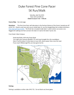
© Copyright 2026