
ZONING ORDINANCE ROSS TOWNSHIP KALAMAZOO COUNTY, MICHIGAN
ZONING ORDINANCE OF ROSS TOWNSHIP KALAMAZOO COUNTY, MICHIGAN Ordinance No. 92, as amended (Current through Ordinance No. 193, June 10, 2014) INTRODUCTION AND USER GUIDE This Introduction and User Guide is intended to provide a general orientation to the format and organization of the Zoning Ordinance to make the document easier to understand and use. Like every municipal zoning ordinance, this Zoning Ordinance regulates the development and use of land by dividing the Township into “zoning districts”, sometimes commonly referred to as “zones”. This Zoning Ordinance establishes 10 such zoning districts as noted in Section 3.1, and as shown on the Zoning Map. This Zoning Ordinance is based on what is sometimes called a “permissive” zoning concept; that is, land in each zoning district can be used only for the land uses and activities that are specifically designated in the Zoning Ordinance as permissible in that district. The permissible land uses within each zoning district are further divided into either “permitted uses” or “special land uses”. A use listed as a “permitted use” in a zoning district is recognized as being harmonious with other such uses within the same district, and therefore generally requires no prior land use approval. A “special land use” is recognized as requiring prior land use approval, pursuant to a public hearing and approval standards specified in the Zoning Ordinance, to make sure the particular location proposed for the land use will not adversely impact other property, or the general health, safety and welfare of the community. Articles 4-13 of this Zoning Ordinance indicate the permitted uses and special land uses for each of the zoning districts. Article 15 (Schedule of Lot, Yard and Area Requirements) specifies other requirements applicable in each zoning district, such as the minimum “lot” requirements for buildable property, and “setback” and other location requirements for buildings and other structures in each zoning district. Some provisions of the Zoning Ordinance are intended to generally apply throughout the Township, such as the “General Provisions” in Article 16. Other articles of this Ordinance regulate specific matters that may also apply in one or more zoning districts, or throughout the Township, as indicated to be applicable. Such provisions of the Zoning Ordinance include the following articles/sections and subject matters: • • • • Article 17---Overlay Requirements for Waterfront Lots and Waterway-Related Uses; Special Regulations for Land Uses in Flood Hazard Areas. Section 18.1---Parking of Motor Vehicles Section 18.2---Signs and Outdoor Advertising Structures Section 18.4---Accessory Uses and Buildings/Structures So, to determine whether property can be used for a particular land use or activity, and what regulations may apply to that property/land use, a person using this Zoning Ordinance will generally go through the following steps: i Step 1: find the property on the official Zoning Map and determine the “zoning district” in which the property is located. Step 2: make sure the property meets the minimum “lot” requirements for that zoning district, and is therefore “buildable” pursuant to the Schedule in Article 15; or is otherwise a legal buildable “nonconforming lot” pursuant to Section 22.9 (Article 22 also includes special provisions pertaining to “nonconforming” uses and building/structures lawfully established before the enactment of this Ordinance in 1986). Step 3: refer to the proper article covering that zoning district from Articles 4-13; and determine whether the intended land use is listed in that article as either a “permitted use” or a “special land use”. Step 4a: if the intended land use is listed as a “permitted use” in the zoning district in which the property is located, check Section 21.2 to see whether that use is subject to a “site plan review” requirement. If so, other provisions of Article 21 will apply. Step 4b: if the intended land use is listed as a “special land use” in the zoning district in which the property is located, review Article 19 for information about applying for special land use approval and the “standards” that must be shown to be complied with before the Planning Commission can grant such approval, after a public hearing. Section 19.3 specifies what are sometimes called the general standards that apply to all special land uses; but Article 20 includes additional specific standards that are required of certain special land uses. Note: the “site plan review” requirements of Article 21 apply to all special land uses. Step 5: for every permitted use or special land use check whether additional regulations are applicable from either Article 16 “General Provisions” or other articles dealing with specific subjects, such as the articles listed above in the bullet points. User hint: many words and terms used in this Zoning Ordinance are given a specific definition in Section 2.2. It is therefore important to refer to Section 2.2 to determine whether a particular word or term has a specific definition for purposes of this Ordinance. Any word or term not specifically defined in this Ordinance is defined in accordance with its most applicable customary or common meaning (see Section 2.1). Finally, other parts of this Zoning Ordinance address what may be called “administrative” matters, including the following articles/sections on the indicated subjects: • • • Article 23---Zoning Board of Appeals Article 24---Administration and Enforcement of Zoning Ordinance Article 25---Text Amendment/Rezoning Procedures ii These articles are not generally relevant to determining how a particular land use is regulated by the Zoning Ordinance, but may apply in certain circumstances. For example, a potential applicant for a “variance” should review Article 23 addressing the limited authority of the Zoning Board of Appeals to grant variance relief, and otherwise covering the authority and functions of that board. Disclaimer: this Introduction and User Guide is intended to provide a general orientation to the format and organization of the Zoning Ordinance. Many zoning questions can be answered upon simple reference to the appropriate parts of this Zoning Ordinance; but some questions will require knowledgeable assistance from someone such as the Zoning Administrator, and sometimes from legal counsel with special expertise in zoning matters. In short, although this Introduction and User Guide is not intended to substitute for knowledgeable assistance to address a particular zoning question or issue where required, it will hopefully make this Zoning Ordinance easier to understand and use. iii TABLE OF CONTENTS ARTICLE NUMBER ARTICLE 1 ARTICLE TITLE SHORT TITLE, PURPOSE AND SCOPE PAGE 1-1 Section 1.1 Short Title 1-1 Section 1.2 Purpose 1-1 Section 1.3 Scope 1-1 ARTICLE 2 RULES OF TEXT INTERPRETATION; DEFINITIONS OF TERMS 2-1 Section 2.1 Rules of Text Interpretation 2-1 Section 2.2 Definitions of Terms 2-2 ARTICLE 3 CLASSIFICATION AND USE DISTRICTS 3-1 Section 3.1 Zoning Districts 3-1 Section 3.2 Zoning Map and Use District Boundaries 3-1 Section 3.3 Areas Not Included Within A District 3-2 Section 3.4 Permissive Zoning Concept 3-2 Section 3.5 Permitted Uses 3-2 Section 3.6 Special Land Uses 3-2 ARTICLE 4 AG AGRICULTURAL DISTRICT PRESERVATION 4-1 Section 4.1 Description of District 4-1 Section 4.2 Permitted Uses 4-1 Section 4.3 Special Land Uses 4-1 Section 4.4 Lot, Yard and Area Requirements 4-2 Section 4.5 Floodplain Management Regulations 4-3 ARTICLE 5 R-R RURAL RESIDENTIAL DISTRICT 5-1 Section 5.1 Description of District 5-1 Section 5.2 Permitted Uses 5-1 Section 5.3 Special Land Uses 5-1 Section 5.4 Lot, Yard and Area Requirements 5-2 Section 5.5 Conditions and Limitations 5-3 Section 5.6 Floodplain Management Regulations 5-4 iv ARTICLE NUMBER ARTICLE 6 ARTICLE TITLE PAGE R-1 LOW DENSITY RESIDENTIAL DISTRICT 6-1 Section 6.1 Description of District 6-1 Section 6.2 Permitted Uses 6-1 Section 6.3 Special Land Uses 6-1 Section 6.4 Lot, Yard and Area Requirements 6-2 Section 6.5 Conditions and Limitations 6-2 Section 6.6 Floodplain Management Regulations 6-2 ARTICLE 7 R-2 MEDIUM DISTRICT DENSITY RESIDENTIAL 8-1 Section 7.1 Description of District 7-1 Section 7.2 Permitted Uses 7-1 Section 7.3 Special Land Uses 7-1 Section 7.4 Lot, Yard and Area Requirements 7-1 Section 7.5 Conditions and Limitations 7-1 Section 7.6 Floodplain Management Regulations 7-2 ARTICLE 8 R-3 HIGH DENSITY RESIDENTIAL DISTRICT 8-1 Section 8.1 Description of District 8-1 Section 8.2 Permitted Uses 8-1 Section 8.3 Special Land Uses 8-1 Section 8.4 Lot, Yard and Area Requirements 8-2 Section 8.5 Conditions and Limitations 8-2 Section 8.6 Floodplain Management Regulations 8-4 ARTICLE 9 R-4 MOBILE HOME PARK DISTRICT 9-1 Section 9.1 Description of District 9-1 Section 9.2 Permitted Uses 9-1 Section 9.3 Special Land Uses 9-1 Section 9.4 Lot, Yard and Area Requirements 9-1 Section 9.5 Conditions and Limitations 9-2 Section 9.6 Floodplain Management Regulations 9-3 ARTICLE 10 Section 10.1 C-1 BAY COMMERCIAL DISTRICT Description of District v 10-1 10-1 ARTICLE NUMBER ARTICLE TITLE PAGE Section 10.2 Permitted Uses 10-1 Section 10.3 Administrative Review 10-1 Section 10.4 Special Land Uses 10-2 Section 10.5 Lot, Yard and Area Requirements 10-2 Section 10.6 Site Development Standards 10-2 Section 10.7 Floodplain Management Regulations 10-7 ARTICLE 11 C-2 NEIGHBORHOOD OVERLAY DISTRICT COMMERCIAL 11-1 Section 11.1 Description of District 11-1 Section 11.2 Permitted Uses 11-1 Section 11.3 Special Land Uses 11-1 Section 11.4 Lot, Yard and Area Requirements 11-2 Section 11.5 Site Development Standards 11-2 Section 11.6 Floodplain Management Regulations 11-4 ARTICLE 12 I-R RESTRICTED INDUSTRIAL DISTRICT 12-1 Section 12.1 Description of District 12-1 Section 12.2 Permitted Uses 12-1 Section 12.3 Special Land Uses 12-2 Section 12.4 Lot, Yard and Area Requirements 12-3 Section 12.5 Conditions and Limitations 12-3 Section 12.6 Floodplain Management Regulations 12-4 ARTICLE 13 P PARKING DISTRICT 13-1 Section 13.1 Description of District 13-1 Section 13.2 Permitted Uses 13-1 Section 13.3 Prohibited Uses 13-1 Section 13.4 Conditions and Limitations 13-1 Section 13.5 Design Standards 13-2 Section 13.6 Floodplain Management Regulations 13-3 ARTICLE 14 Reserved for Expansion vi 14-1 ARTICLE NUMBER ARTICLE 15 ARTICLE TITLE SCHEDULE OF LOT, YARD AND AREA REQUIREMENTS Footnotes to Article 15 ARTICLE 16 GENERAL PROVISIONS PAGE 15-1 15-2 16-1 Section 16.1 Limitations on All Land and Structures 16-1 Section 16.2 Limitations on Height 16-1 Section 16.3 Limitations on Area 16-1 Section 16.4 Building Permits and Construction Codes 16-2 Section 16.5 Zoning Compliance Permits 16-2 Section 16.6 Environmental Use Regulations 16-2 Section 16.7 Building Lot Requirements 16-3 Section 16.8 Sleeping Quarters Prohibited in a Cellar 16-4 Section 16.9 Temporary Housing Due to a Disaster 16-4 Section 16.10 Dwelling Standards 16-4 ARTICLE 17 Section 17.1 Section 17.2 Section 17.3 Section 17.4 ARTICLE 18 OVERLAY REQUIREMENTS FOR WATERFRONT LOTS AND WATERWAYRELATED USES; SPECIAL REGULATIONS FOR LAND USES IN FLOOD HAZARD AREAS Waterfront Lot Access and Use Regulations Boathouse and Dock Regulations Waterway Setback Requirements for All Buildings and Structures Special Regulations for Land Uses in Flood Hazard Areas SUPPLEMENTARY REGULATIONS 17-1 17.1 17-2 17-3 17.3 18-1 Section 18.1 Parking of Motor Vehicles 18-1 Section 18.2 Signs and Outdoor Advertising Signs 18-5 Section 18.3 Outdoor Lighting 18-7 Section 18.4 Accessory Uses and Buildings/Structures 18-10 Section 18.5 Home Occupations 18-12 Section 18.6 Screening and Fencing 18-13 vii ARTICLE NUMBER ARTICLE 19 ARTICLE TITLE PAGE SPECIAL LAND USES 19-1 Section 19.1 Explanation of Special Land Uses 19-1 Section 19.2 Special Land Use Procedure 19-1 19-2 Section 19.3 Flow Diagram for Special Land Use Applications Criteria for Decision Section 19.4 Conditions Imposed Special Land Uses 19-3 Section 19.5 Compliance With Approval 19-4 Section 19.6 Revocation of Special Land Use Approval 19-5 Upon Approved 19-3 ARTICLE 20 STANDARDS REQUIRED OF SPECIAL LAND USES 20-1 ARTICLE 21 SITE PLAN REVIEW 21-1 Section 21.1 Purpose 21-1 Section 21.2 Uses Subject to Site Plan Review 21-1 Section 21.3 Sketch Plan Review 21-1 Section 21.4 Site Plan Review (Content of Applications) 21-2 Section 21.5 Final Site Plan Submittal and Review Scheduling Procedures 21-3 Section 21.6 Approval 21-4 Section 21.7 Modifications 21-6 Section 21.8 Disposition 21-6 Section 21.9 Revocation 21-6 Section 21.10 Term of Approval 21-7 Section 21.11 Administrative Site Plan Review 21-7 Section 21.12 Amendments to Approved Site Plan 21-8 NONCONFORMING USES, BUILDINGS/STRUCTURES AND LOTS 22-1 ARTICLE 22 Section 22.1 Scope of Regulations 22-1 Section 22.2 Continuation of Nonconforming Uses and Buildings/Structures 22-1 Section 22.3 Expansion of Nonconforming Building/Structure 22-1 viii Use or ARTICLE NUMBER ARTICLE TITLE PAGE Section 22.4 Repair, Maintenance and Restoration of Nonconforming Use or Building/Structure 22-1 Section 22.5 Change of Nonconforming Use 22-2 Section 22.6 Discontinuation and Reestablishment of Nonconforming Uses and Buildings/Structures 22-2 Section 22.7 Nonconformity Due to Rezoning or Text Amendment 22-2 Section 22.8 Building upon Nonconforming Lots 22-2 Section 22.9 Building/Structure Setback and Building Coverage Requirements Applicable to Lawful Nonconforming Lots 22-3 ARTICLE 23 ZONING BOARD OF APPEALS 23-1 Section 23.1 Creation 23-1 Section 23.2 Membership/Election of Officers 23-1 Section 23.3 Terms 23-1 Section 23.4 Jurisdiction and Powers 23-2 Section 23.5 Employees 23-2 Section 23.6 Meetings/Rules of Procedure 23-2 Section 23.7 Appeals 23-2 Section 23.8 Variance Standards and Conditions 23-3 Section 23.9 Land Use Variance 23-4 Section 23.10 Application Site Plan Requirements 23-4 Section 23.11 Public Hearings 23-5 Section 23.12 Time Limits 23-5 Section 23.13 Vote Necessary for Decision 23-5 Section 23.14 Minutes and Records 23-5 Section 23.15 Limitation of Board Action 23-6 ARTICLE 24 ADMINISTRATION AND ENFORCEMENT OF ZONING ORDINANCE 24-1 Section 24.1 Zoning Administration and Enforcement 24-1 Section 24.2 Zoning Administrator 24-1 Section 24.3 Zoning Administrator Duties 24-1 ix ARTICLE NUMBER ARTICLE TITLE PAGE Section 24.4 Violations and Sanctions 24-2 Section 24.5 Nuisance Per Se 24-3 Section 24.6 Authority to Commence Legal Action 24-3 Section 24.7 Application Fees 24-3 ARTICLE 25 TEXT AMENDMENT/REZONING PROCEDURES 25-1 Section 25.1 Initiation of Amendments 25-1 Section 25.2 Amendment Application Procedure 25-1 Section 25.3 Amendment Procedure 25-2 Flow Diagram for Amendments of Zoning Ordinance Text or Zoning Map (Rezoning) 25-2 ARTICLE 26 MISCELLANEOUS PROVISIONS 26-1 Section 26.1 Severability 26-1 Section 26.2 Repeal 26-1 Section 26.3 Effective Date 26-1 x ARTICLE 1 - SHORT TITLE, PURPOSE AND SCOPE Section 1.1---Short Title This ordinance shall be known as the Ross Township Zoning Ordinance. Section 1.2---Purpose The zoning districts established by this ordinance and the regulations specified for each such district, and otherwise, have been developed based on guidance provided by the Ross Township Master Plan. This ordinance is intended to regulate the use of land and structures for the purposes authorized by the Michigan Zoning Enabling Act and pursuant to the guiding principles, goals, and policies of the Master Plan. Section 1.3---Scope It is not intended by this ordinance to repeal, abrogate, annul or interfere with existing provisions of other laws or ordinances except those specifically or impliedly repealed by this ordinance, or with any private restrictions placed upon property by covenant, deed or other private agreement unless repugnant hereto. Where this ordinance imposes a greater restriction than is imposed or required by such rules, regulations or private restrictions, the provisions of this ordinance shall control. 1-1 ARTICLE 2 - RULES OF TEXT INTERPRETATION; DEFINITIONS OF TERMS Section 2.1---Rules of Text Interpretation The following rules of interpretation apply to the text of this ordinance: A. The particular shall control the general. B. In the case of any difference of meaning or implication between the text of this ordinance and any caption or illustration, the text shall control. C. The word "shall" is always mandatory and not discretionary. The word "may" is permissive. D. Words used in the present tense shall include the future; and words used in the singular number shall include the plural, and the plural the singular, unless the context clearly indicates the contrary. E. A "building" or "structure" includes any part thereof. F. The phrases "used for" includes "arranged for", "designed for", "intended for", "maintained for", and "occupied for", and are all intended to be synonymous phrases. G. The word "person" includes an individual, corporation, partnership, incorporated association, trust, joint venture, or any other entity of any kind, or a combination thereof. H. Unless the context clearly indicates the contrary, where a regulation involves two or more items, conditions, provisions, or events connected by the conjunction "and" or "or", the conjunction shall be interpreted as follows: 1. "And" indicates that all the connected items, conditions, provisions or events shall apply; and, 2. "Or" indicates that the connected items, conditions, provisions or events may apply singly or in any combination. I. The word "he" shall mean he or she. J. The provisions of this ordinance are intended to impose the minimum requirements adopted to promote the public health, safety, and general welfare, and shall be interpreted and applied accordingly. K. Any word or term not specifically defined in Section 2.2 or elsewhere in this ordinance shall be considered to be defined in accordance with its most applicable customary or common meaning. 2-1 L. Any reference in this ordinance to a specific law is intended to also include any amendment of that law, and any subsequently enacted superseding law on the same subject matter. Section 2.2---Definitions of Terms For the purpose of this ordinance the following terms and words are herein defined, and these definitions shall apply in the interpretation and enforcement of this Ordinance unless otherwise specifically stated: • Access Lot: a type of waterfront lot providing for private or common (semiprivate) access to a waterway for one or more access lot beneficiaries. An access lot includes the buffer strips required herein. • Access Lot Beneficiary: the owners/occupants of an offshore lot or waterfront lot, and any other person with a right of access to a waterway and/or use of a waterway through a waterfront lot, in whole or in part, by fee ownership, easement, lease, license, gift, business invitation, or any other written form of conveyance, dedication, permission, or access/use rights. • Accessory Uses: a use of a building, lot or portion thereof, which is customarily incidental and subordinate to the principal use of the main building or lot. • Agriculture: the use of land for raising crops and livestock or poultry, but not including concentrated animal feeding operations, as defined herein. • Agricultural Production: the production for commercial purposes and sale for the purpose of obtaining a profit in money by the raising, harvesting, and selling of crops and forage; by feeding or breeding or management and sale of, or the produce of, livestock, poultry, fur-bearing animals, or honey bees; or for dairying and the sale of dairy products of animal husbandry or any combination thereof; or any other agricultural, aquacultural, horticultural or floricultural use such as fruits, plants, ornamental trees, timber, shrubs, nursery stock, and vegetables, including in each instance the right to sell at wholesale or retail from the premises any goods or products produced thereon; but not including any such land use specifically designated in this ordinance. • Alley: a passage or way open to public travel affording generally a secondary means of vehicular access to abutting lots and not intended for general traffic circulation. • Animal Units: (the definition of “animal units” included in the Generally Accepted Agricultural and Management Practices For Site Selection and Odor Control For New and Expanding Livestock Production Facilities, as 2-2 adopted by the Michigan Commission of Agriculture in June, 2005 (see addendum), and as may subsequently be specified by the Michigan Commission of Agriculture and Rural Development in accordance with the Michigan Right To Farm Act (1981 PA 93, as amended), is adopted by reference). Addendum: pursuant to the above-referenced July 2005 Michigan Commission of Agriculture document, the “animal unit” equivalency for various types of animals is as follows: 1. slaughter and feeder cattle: 1.0 2. mature dairy cattle: 1.4 3. swine (weighing over 55 lbs.): 0.4 4. sheep and lambs: 0.1 5. horses: 2.0 6. turkeys: 0.018 7. laying hens or broilers: 0.01 8. all other animal classes, types or sizes: calculated as 1,000 lbs. live weight = 1.0 animal unit • Apartment House: a building used and/or arranged for rental occupancy, or cooperatively owned by its occupants, having three or more family units, and with a yard, compound, service or utilities in common. • Automobile: any vehicle with four or more wheels, which is self-propelled by an engine or motor, and designed for the transporting of the operator and accompanying passengers, on public roads. An automobile includes any passenger car, station wagon, suburban, van, panel or pick-up truck of a light delivery type none of which may exceed 8,500 pounds of gross vehicle weight (weight of vehicle and load capacity). • Barn: an enclosed building which is located on a farm and used either for the shelter of farm animals, storage of farm produce and/or equipment. • Basement: that portion of a building below the first floor joists, at least half of whose clear ceiling height is above the level of the adjacent ground. • Biofuel: Any renewable fuel product, whether solid, liquid, or gas, that is derived from recently living organisms or their metabolic by-products and that meets applicable quality standards, including, but not limited to, 2-3 ethanol and biodiesel; but not including methane or any other fuel product from an anaerobic digester. For purposes of this term “ethanol” means a substance that meets the ASTM international standard in effect on July 19, 2011 as the D-4806 specification for denatured fuel grade ethanol for blending with gasoline. • Boardinghouse: a dwelling in which lodging, with or without meals, is furnished to three (3) or more guests for compensation. • Boat House: a permanent structure constructed on the land or over the water for the purpose of providing shelter for one or more boats. • Buffer strip: a portion of an access lot, required to be established and preserved as a natural barrier between the usable portion of the access lot and an adjacent lot. • Building: a structure having one or more stories and a roof, designed primarily for the shelter, support or enclosure of persons, animals or property of any kind. • Building, Accessory: a building subordinate to, and located on, the same lot with a main building, the use of which is clearly incidental to that of the main building or to the use of the land, and which is not attached to any part of a common wall or common roof to the main building. • Building or Structure Height (Eave): the vertical distance measured from the average grade at the building or structure foundation to the intersection of the eave and the side wall. • Building or Structure Height (Roof): for buildings or structures with a roof, the vertical distance measured from the average of the existing natural (unaltered) grade at the building or structure foundation to the average height between the eave and ridge of the highest roof slope; for structures without a roof, the vertical distance measured from the average of the existing natural (unaltered) grade at the structure foundation to the highest point of the structure. • Building Line: a line beyond which the foundation wall or any porch, vestibule, raised patio or other portion of building shall not project. • Campground: a parcel or tract of land under the control of any person wherein sites are offered for the use by the public or members of an organization, either free of charge or for a fee, for the establishment of temporary living quarters for five (5) or more recreational units. • Care Home: includes rest and nursing homes, convalescent homes and boarding homes for the aged; established to render nursing care for 2-4 chronic or convalescent patients but excludes facilities for care of active or violent patients such as feeble-minded or mental patients, epileptics, alcoholics, senile psychotics, or drug addicts. • Cellar: that portion of a building below the first floor joists at least half of whose clear ceiling height is below the level of the adjacent ground. • Church: a building whose primary purpose is to provide a place where persons regularly assemble for religious worship which is maintained and controlled by a religious body organized to sustain public worship for a local congregation. • Commercial District(s): the C-1 Bay Commercial District, the C-2 Neighborhood Commercial District, and any other subsequently established zoning district which includes “C” or “Commercial” in its title. • Common Ownership: ownership by the same individual(s) or entity; provided that property owned by one or both spouses, and corporations or other entities in which two or more directors are the same individual (or their spouses) shall be considered to have the same ownership for purposes of this ordinance. This term is intended to be synonymous with the term “single ownership”. • Condominium: a multiple family dwelling in which dwelling units are separately owned and all such owners within the “condominium” jointly own and manage the common areas of the structure such as lobby, hallways, stairways, elevator and utilities, except as otherwise stipulated, and the property it occupies by deed description. • Conference and Training Center: a facility used solely by employees and business associates of the proprietor for an educational or training purpose. • Contractors Workshop: a place of business for contractors providing personal services directly to their clients in the electrical, plumbing, heating, painting, woodwork or similar occupations where any production, assembly or fabrication of a product is installed or applied by the owner and/or not to exceed two (2) employees of the workshop and where there is no manufacturing, assembling or fabrication of products for other persons or businesses. • Day Care Home, Family: a private home properly registered or licensed under 1973 Public Act 116, as amended (MCL 722.111 et seq), in which one but less than 7 minor children are received for care and supervision for periods of less than 24 hours a day, unattended by a parent or legal guardian, except children related to an adult member of the family by blood, marriage, or adoption. This term shall include a home that gives 2-5 care to an unrelated minor child for more than 4 weeks during a calendar year. • Day Care Home, Group: a private home properly registered or licensed under 1973 Public Act 116, as amended (MCL 722.111 et seq), in which more than 6 but not more than 12 minor children are given care and supervision for periods of less than 24 hours a day unattended by a parent or legal guardian, except children related to an adult member of the family by blood, marriage, or adoption. This term shall include a home that gives care to an unrelated minor child for more than 4 weeks during a calendar year. • Day Care Center or Child Care Center: a facility, other than a private residence, properly registered or licensed under 1973 Public Act 116, as amended (MCL 722.111 et seq), receiving one or more preschool or school age children for care for periods of less than 24 hours a day, and where the parents or guardians are not immediately available to the child. A day care center or child care center includes a facility, which provides care for not less than two consecutive weeks, regardless of the number of hours of care per day. The facility is generally described as a child care center, day care center, day nursery, nursery school, parent cooperative preschool, play group, or drop-in center. Day care center or child care center shall not, however, include any of the following: 1. A Sunday school, a vacation Bible school, or a religious instructional class that is conducted by a religious organization where children are in attendance for not greater than 3 hours per day for an indefinite period, or not greater than 8 hours per day for a period not to exceed 4 weeks during a 12 month period. 2. A facility operated by a religious organization where children are cared for not greater than 3 hours while persons responsible for the children are attending religious services. • Deck: a structure consisting primarily of flooring which is raised above the ground level, which may be constructed as part of the principle structure (or building), or may be constructed as an accessory structure. • Density: the number of dwelling units occupying, or to be developed upon, a net acre of land. • District: an area within which certain uses of land and buildings are permitted and all others are prohibited; yards and other open spaces are required; and lot areas, building height limits, and other requirements are established. This term and the term “zone” mean the same thing as used in this Ordinance. 2-6 • Dock: a platform, either permanent or portable, extending over a body of water, from which one can fish, swim, moor or board boats. • Dwelling: a building or portion thereof arranged or designed to provide living facilities for one (1) or more families. (See Section 16.10) • Dwelling, Single Family: dwelling unit. • Dwelling, Semi-detached: one (1) or two (2) buildings arranged or designed as dwellings located on abutting lots; separated from each other by a party wall, without openings, extending from the cellar floor to the highest point of the roof, along the dividing lot line; and separated from any other building or structure by space on all other sides. • Dwelling, Two Family: a building containing not more than two (2) separate dwelling units. • Dwelling, Multiple Family: a building containing three (3) or more dwelling units. • Dwelling Unit: a building or a portion thereof having living, cooking and sanitary facilities for not more than one (1) family of permanent residents. • Earth Removal: the digging of soil, sand, gravel, rock, minerals, clay or other earthen material from a land surface for carrying on a business or manufacturing operation. Does not mean grading or filling incidental to improvement of the land. • Elevation, Building: the total length of any side of a building facing in the same direction. • Family: a building containing not more than one (1) the term may include either of the following: 1. A traditional family consisting of one or more persons related by the bonds of consanguinity, marriage, or adoption, and foster children and servants, and not more than one additional unrelated person, occupying a dwelling unit and living as a single, nonprofit housekeeping unit; or 2. A functional family consisting of a collective number of individuals occupying a dwelling unit as the functional equivalent of a traditional family with a demonstrable and recognizable relationship of a permanent and distinct domestic character, and cooking and otherwise housekeeping as a single housekeeping unit. 2-7 Notwithstanding the foregoing, certain types of living arrangements and occupancies shall not be considered to be within the scope of this term, including any society, club, fraternity, sorority, association, lodge, combine, federation, group, coterie, or other organization which is not a recognized religious order; and any group of students or other individuals whose domestic association is likely or contemplated to exist for a limited or temporary duration, or whose association is otherwise of a transitory, temporary or resort-seasonal character or nature. • Fence: a barrier constructed of either wood, metal, stone, brick or masonry materials that may act as an enclosure of an area of land, property boundary identification or visual screen, which surface may be of either solid or open construction. • Fixture: the assembly that houses the lamp(s) and can include all or some of the following parts: a housing, a mounting bracket or pole socket, a lamp holder, a ballast, a reflector or mirror, and/or a refractor or lens. • Floor Area: the total enclosed floor area of a structure used for residential purposes, excluding the floor area of cellars, garages, accessory buildings, attics, breezeways and porches. The floor area for manufacturing, business or commercial activities shall include customer facilities, showcase facilities, and sales facilities. • Footcandle: the illuminance cast on a surface by a one (1) candela source one (1) foot away. One (1) footcandle is the equivalent of 10.76 Lux. • Foster Care (Small Group) Facility: a residential facility licensed by the state pursuant to 1979 Public Act 218, as amended (MCL 400.701 et seq), or 1973 Public Act 116, as amended (MCL 722.111 et seq), which provides resident services, supervision and care for 6 or fewer persons 24 hours a day. • Foster Care (Large Group) Facility: a residential facility licensed by the state pursuant to 1979 Public Act 218, as amended (MCL 400.701 et seq), or 1973 Public Act 116, as amended (MCL 722.111 et seq), which provides resident services, supervision and care for 7-20 persons 24 hours a day. • Frontage: the length of the front property line of the lot, lots or tract of land abutting a public street, road or highway. • Garage, Private: a building accessory to a dwelling, or a portion thereof, which is designed and used primarily for the housing or storage of automobiles. 2-8 • Gasoline Service Station: building or lot, or portions thereof, used and limited in function to retail sale of gasoline, oil, grease, anti-freeze, tires, batteries and automobile accessories, and such services as lubrication, washing, polishing and other minor servicing to motor vehicles. • Glare: light emitting from a luminaire with an intensity great enough to reduce a viewer’s ability to see or that causes annoyance or discomfort. • High Water Line: that elevation of a body of water where it borders the land, which is either officially recorded or reasonably identified as the known high water elevation. • Home Occupations: an occupation customarily engaged in by residents in their own dwelling. (See Section 18.5) • Horse Boarding or Riding Stable: a facility with a confined capacity for more than three but less than 25 horses (50 animal units) for boarding by persons not residing on the premises and/or where riding horses are rented and/or where horse riding lessons are given, including the indoor and outdoor facilities for same. • Hospital: any institution, including a sanitarium, which maintains and operates facilities for overnight care and treatment of two (2) or more nonrelated persons as patients suffering mental or physical ailments, but not including any dispensary or first aid treatment facilities maintained by a commercial or industrial plant, educational institution, convent, or a convalescent home, as previously defined. • Hotel: a building occupied as a temporary lodging place for individuals who are lodged with or without meals, in which as a rule the rooms are rented singularly in which provision is not made for cooking in any individual room. • Illuminance: a measure of light incident on a surface, expressed in lux or footcandles. • Industrial District(s): the I-R Restricted Industrial District and any other subsequently established zoning district which includes “I” or “Industrial” in its title. • Isofootcandle plan: a site plan of a proposed development showing proposed outdoor illuminance with a series of isofootcandle lines that join points on a surface where the illuminance is the same. • Junk Yard: any land or building used for commercial, storage and/or sale of paper, rags, scrap metals, other scrap or discarded materials, or for the 2-9 dismantling, storage or salvaging of automobiles or other vehicles not in running condition, or of machinery or parts thereof. • Kennel: any lot or premises used for the boarding, breeding, training of three (3) or more dogs for remuneration. Kennel shall also mean the keeping of three (3) or more dogs over the age of six (6) months with or without remuneration. • Lake Lot: a lot any portion of which abuts or is within 75 feet of any lake. Except as specifically provided herein lots abutting a stream, creek or river are not considered “lake lots”. • Landfill: any premises used primarily for disposal by abandonment, discarding, dumping, reduction, burial, incineration, or any other means and for whatever purpose of trash, refuse or waste material of any kind. • Light spillover: the shining of light produced by a luminaire beyond the boundaries of the property on which it is located. • Livestock: domestic animals raised or kept for any purpose, including but not limited to, cattle, sheep, hogs, horses, rabbits, ducks, goats, turkeys, chickens and geese; but excluding dogs and cats. • Lot: a parcel of land (including a “unit” within a site condominium development) with the frontage required by this Ordinance on a public street, or on a private street as specifically allowed by this Ordinance, and separated from other land by legal description, deed, or subdivision plot. • Lot, Area: the total horizontal area included within lot lines. Where the front lot line is the center line of a street or lies in part or in whole in the street area, the lot area shall not include that part of the lot in use or to be used as the street. • Lot, Access: (see Access Lot). • Lot, Corner: a lot located with frontage on two intersecting streets. • Lot Coverage: the amount of a lot, stated in terms of percentage, which is covered by all the buildings and other structures located on the lot, including porches, arbors, breezeways, patio roofs and the like, whether open box type and/or lathe roofs or fully roofed, but not including fences, walls, swimming pools, swing sets and other residential recreational structures that are not buildings. • Lot, Depth of: the average horizontal distance between the front lot line and the rear lot line measured at right angles to lot width. Where the front lot line and the rear lot line are not parallel the average horizontal distance 2-10 between them shall be calculated as the mean (midpoint) of the two extreme horizontal distances. • Lot , Double Frontage: an interior or through lot which abuts two streets that are located on opposite sides of the lot. • Lot, Lake: (see Lake Lot). • Lot, Offshore: (see Offshore Lot). • Lot, Waterfront: (see Waterfront Lot). • Lot Line, Front (front of lot): that portion of a lot which abuts a street (or the right-of-way of a pre-existing private road, in the case of a lawfully established non-conforming lot abutting such a private road); except that the front line of a lake lot shall be that portion of the lot abutting or facing the water. In the case of a corner lot or double frontage lot the front lot line shall be that line separating the lot from the street which is designated as the front street in the plat and/or in the request for a building or zoning compliance permit, except as otherwise provided above with respect to lake lots. • Lot Frontage: that portion of a lot extending along the front lot line. • Lot Line, Rear: the lot boundary which is opposite and most distant from the front lot line. In the case of a lot pointed at the rear, the rear lot line shall be that assumed line parallel to the front lot line not less than ten (10) feet long lying farthest from the front lot line and wholly within the lot. In any case, when this definition does not apply the Zoning Board of Appeals shall designate the rear lot line. • Lot Line, Side: any lot boundary line which is not a front lot line or a rear lot line. A side lot line separating a lot from another lot or lots is also called an interior lot line. • Lot, Interior: a lot other than a corner lot. • Lot, Width: the average horizontal distance between the side lot lines as measured at right angles to lot depth. Where the side lot lines are not parallel the average horizontal distance between the side lot lines shall be calculated as the mean (midpoint) of the two extreme horizontal distances. • Luminaire: a complete lighting system, including a lamp or lamps and a fixture. This term shall be interpreted broadly as applying to all outdoor electrically powered illuminating devices, outdoor lighting or reflective surfaces, lamps and similar devices (permanently installed or portable), used for illumination or advertisement. 2-11 • Marina: the provision of buildings, structures, piers or slips for the purpose of housing, mooring and/or servicing boats for either public, quasi-public or commercial use; including the sale and repair of boats and boat motors, as well as parts, accessories, gasoline and oil for boat use. • Mobile Home: any vehicle, without motive power designed for carrying property or persons or so constructed and licensable as a mobile home under the laws of the State of Michigan. • Motel: a group of attached or detached dwellings not more than two (2) stories in height containing guest rooms which are provided for transient occupancy only, including auto courts, motor lodges and tourist homes. • Non-Conforming Uses: the use of a building or of land lawfully existing at the time this Ordinance became effective but which does not conform with the present use regulations of the district in which it is located. • Nursing Home: see “Care Home”. • Offshore Lot: any lot or parcel of land, whether or not improved, and whether or not platted, which does not abut the shoreline of any waterway. • On-Farm Biofuel Production Facility (Type I): A facility designed and intended to be used to produce biofuel, and having all of the following characteristics: • 1. The facility is located on land used in the commercial production of farm products. 2. The facility has a designed annual production capacity of not more than 100,000 gallons of biofuel. 3. The facility is located at least 100 feet from the boundary of any contiguous property under different ownership. 4. The facility meets all otherwise applicable setback requirements. 5. At least 75% of the feedstock for the facility is produced on the farm where the facility is located, on an annual basis. 6. At least 75% of the biofuel or other product/byproduct of the facility is used on the farm where the facility is located, on an annual basis. On-Farm Biofuel Production Facility (Type II): A facility designed and intended to be used to produce biofuel, and having all of the following characteristics: 2-12 • 1. The facility is located on land used in the commercial production of farm products. 2. The facility has a designed annual production capacity of not more than 100,000 gallons of biofuel. 3. The facility is located at least 100 feet from the boundary of any contiguous property under different ownership. 4. The facility meets all otherwise applicable setback requirements. 5. Less than 75% of the feedstock for the facility is produced on the farm where the facility is located, on an annual basis. 6. Less than 75% of the biofuel or other product/byproduct of the facility is used on the farm where the facility is located, on an annual basis. On-Farm Biofuel Production Facility (Type III): A facility designed and intended to be used to produce biofuel, and having all of the following characteristics: 1. The facility is located on land used in the commercial production of farm products. 2. The facility has a designed annual production capacity of at least 100,000 gallons but not more than 500,000 gallons of biofuel. 3. The facility is located at least 100 feet from the boundary of any contiguous property under different ownership. 4. The facility meets all otherwise applicable setback requirements. • Open Space: land area which is maintained as a yard or court providing space between two (2) or more buildings or between a building line and the boundary line of a parcel of land, other space suitable for recreation, or land in its natural state which is unimproved; all of which is primarily open and unobstructed from the land surface to the sky. • Outdoor lighting: the nighttime illumination of an outside area or object by any manmade device located outdoors that produces light by any means. • Parking Space, Automobile: that area required for the parking or storage of one (1) automobile including necessary aisle or driveway space providing access thereto. • Patio: a structure consisting primarily of flooring at ground level. 2-13 • Pedestrian Linkage: a direct clearly defined route designed to provide a barrier free connection for pedestrians between activity centers. Elements of a ‘pedestrian linkage’ include crosswalk treatments, curb extensions, pedestrian refuge islands, sidewalk connections, and signalized intersections. • Permanent Resident: any person who has resided in the same dwelling for a continuous period of thirty (30) or more days is construed as a permanent resident for the purpose of this Ordinance. • Professional Office: rooms or buildings used for office purposes by members of any recognized profession, including doctors, dentists, lawyers, accountants, engineers, architects, etc. • Public Utility: any person, firm or corporation, municipal department, board or commission duly authorized to furnish and the furnishing under state or municipal regulations to the public: gas, steam, electricity, sewage disposal, communication, transportation or water. • Public Utility Buildings and Structures: gas or electric substations, regulator stations, including buildings accessory thereto, and other public utility service buildings or structures; provided that Wireless Communications Support Structure, as defined in this Ordinance, and buildings accessory thereto, shall not be considered a public utility building or structure for purposes of this Ordinance. • Residential District(s): the R-R Rural Residential District, the R-1 Low Density Residential District, the R-2 Medium Density Residential District, the R-3 High Density Residential District, the R-4 Mobile Home Park District, and any other subsequently established zoning district which includes “R” or “Residential” in its title. This term and the terms “residential use district” and “residential zone” mean the same thing as used in this Ordinance. • Restaurant, Carry-Out: any establishment whose principal business is the sale of foods or beverages to the customer in a ready-to-consume state, and whose design or method of operation includes both of the following characteristics: • 1. The customer stands in line or at a counter to be served. 2. The food or beverage served is carried out of the building to be eaten on or off the premises. Restaurant, Drive-In: any establishment whose principal business is the sale of food or beverages to the customer in a ready-to-consume state, 2-14 and whose design, method of operation or any portion of whose business includes the following characteristics: 1. • • Foods or beverages are served directly to the customer in a motor vehicle either by an employee or by other means which eliminates the need for the customer to exit the motor vehicle. Restaurant, Fast-Food: any establishment whose principal business is the sale of food or beverages to the customer in a ready-to-consume state and whose design or principal method of operation includes both the following characteristics: 1. The customer stands in line or at a counter to be served. 2. The customer consumes the food and/or beverage either within the building or out of the building on a fairly equal basis. Restaurant, Standard: any establishment whose principal business is the sale of foods or beverages to the customer in a ready-to-consume state, and whose design or principal method of operation includes one (1) or both of the following characteristics: 1. Customers, normally provided with an individual menu, are served their foods and/or beverages by a restaurant employee at the same table or counter at which said items are consumed. 2. A cafeteria-type operation where foods or beverages generally are consumed within the building. • Retreat and Educational Center: a facility providing a secluded environment for relaxation and outdoor-based activities, including educational, recreational, and therapeutic programs, and food, beverage and lodging accommodations. • Safety lighting: exterior lighting that involves ensuring proper levels of illumination to provide safe working conditions, safe passage, and the identification of outdoor hazards. • Security lighting: exterior lighting installed solely to enhance the security of people and property. • Setback (Building or Structure): the minimum horizontal distance required to exist between a building or structure (including any portion of steps, porches, vestibules, patios raised above grade, or eaves) and the front, side or rear lot line. The required setback or yard area is that area encompassed by the respective lot lines and the respective setback lines. 2-15 • Setback Line (Minimum): the line which pertains to and defines those minimum building/structure setback lines which are established parallel to the front, side and rear lot lines and within which setback areas no part of a building or structure shall project or be located, except as otherwise provided for by this ordinance. • Sharp cutoff fixture: a down-type fixture, mounted horizontally and angled perpendicular to the ground. • Shelter, Fall-Out: a structure or portion of a structure intended to provide protection to human life during periods or danger to human life from nuclear fall-out, air raids, storms, or other emergencies. Fall-out shelters constructed completely below the ground level, except for a vent not exceeding thirty (30) inches in height above ground level may be contained within any yard area. • Shopping Center: a group of commercial establishments planned, developed and managed as a unit, with off-street parking provided on the same property and related in location, size and types of shops in the center. • Sign: any structure, part thereof, or device attached thereto or painted or represented thereon or any material or thing, which displays numerals, letters, words, trademark or other representation used for direction, or designation or any person, firm, organization, place, product, service, business or industry which is located upon any land, on any building, in or upon a window, or indoors in such a manner as to attract attention from outside the building. • Sign Area: the sign area is the surface of the structure used to convey the message exclusive of the necessary supports or any appurtenances required by the building code. The area of open sign structures, consisting of letters or symbols without a solid surface in between, shall be calculated on the basis of the total area within the perimeter of the group of letters and/or symbols. The area of a double-face sign, which is constructed back to back as a single unit, shall be calculated according to the surface area of one (1) side only. • Sign, Outdoor Advertising: a sign which calls attention to a business, commodity, service, entertainment, or other activity, conducted, sold, or offered elsewhere than on the premises upon which the sign is located. • Special Land Use: a use listed as a “special land use” in a zoning district is recognized as possessing characteristics of such unique and special nature (relative to location, design, size, public utilities needs, and other similar characteristics) as necessitating prior Planning Commission authorization pursuant to specified standards in order to safeguard the 2-16 general health, safety and welfare. This term is synonymous with the term “special exception use” formerly used in the Zoning Ordinance. • Story: that portion of a building included between the surface of any floor and the ceiling above it. A basement shall be counted as a story if its ceiling is over six (6) feet above the average level of the finished ground surface adjoining the exterior walls of such story, or if it is used for business or dwelling purposes. • Street: a dedicated public right-of-way, other than an alley, over which the public has the right of vehicular access. This term is synonymous with the term “highway” or “road” or other term connoting a public vehicular thoroughfare. • Structure: anything constructed, assembled or erected, the use of which requires location on the ground or attachment to something having location on or in the ground, and shall include tanks, towers, advertising devices, bins, tents, lunch wagons, trailers, dining cars, camp cars or similar structures on wheels or other supports used for business or living purposes. The word “structure” shall not apply to fences, or wires and their supporting poles or frames of electrical or telephone utilities, or to service utilities entirely below the ground. • Structure, Accessory: a structure subordinate to and located on the same lot with the principle building or structure, the use of which is clearly incidental to that of the principle building, structure or use of the land. • Use: the principal purpose for which a lot or the main building thereon is designed, arranged, or intended and for which it is, or may be used, occupied or maintained. • Variance: the granting to a petitioner, by the Zoning Board of Appeals, permission to vary from the strict application of this Ordinance as provided in Article 23. • Waterfront Lot: any lot or parcel of land, whether or not improved, and whether or not platted, any portion of which: • 1. abuts the shoreline of any waterway; or 2. abuts a promenade, walkway, or other property which itself abuts the shoreline of any waterway and which provides access and/or use rights to the waterway. Waterway: a natural or man-made lake, river, stream, channel, pond, or other natural or artificial watercourse. 2-17 • Wind Energy System: an electrical generating facility, accessory to a principal use, comprised of a wind turbine, rotor, support structure, and related electrical equipment, that operates by converting the kinetic energy of wind into electrical energy, and that is designed and operated to wholly or primarily provide electricity to the principal use, rather than to the electric utility grid. • Wireless Communications Support Structure: a structure that is designed to support, or is capable of supporting, wireless communications equipment, including a monopole, self-support lattice tower, guyed tower, water tower, utility pole, or building; provided that for purposes of this Ordinance this term shall not include any tower or other support structure under 50’ in height that is owned and operated by a federally-licensed amateur radio station operator or that is used exclusively for receive-only antennas. A tower or other structure within the scope of this definition shall not be considered to be “Public Utility Buildings and Structures” for purposes of this Ordinance, as that term is defined in Section 2.2 of this Ordinance. See Article 20 Item 27 for other related defined terms used in that section. • • Yard, Front-Rear-Side: a general term applied to the space on a lot with a building or group of buildings, lying between the building or group of buildings and the nearest respective lot line facing each building. 1. Front Yard: an open space extending across the full width of a lot between the front lot line and the nearest point of the building or projection thereof. 2. Rear: an open space extending across the full width of a lot between the rear lot line and the nearest point of a building or projection thereof. 3. Side: an open space extending on each side of the lot from the front yard to the rear yard or, in the absence of either of such yards, to the front lot line or rear lot line. Yard, Side-Rear-Front (Minimum): an open space of a required minimum width or depth, adjacent to a lot or property line, on the same land with a building or group of buildings, lying in the area between the building or group of buildings and the nearest lot line, and which is unoccupied and unobstructed from the ground upward, except for plants, trees, shrubs, fences, and as otherwise provided herein. The depth/width of such yard shall be measured at the shortest horizontal distance between the applicable lot line (front, rear, side) and the nearest point of a building or projection thereof. 2-18 • Zone: (See District). 2-19 ARTICLE 3 - CLASSIFICATION AND USE DISTRICTS Section 3.1---Zoning Districts For the purpose of this Ordinance, Ross Township is hereby divided into the following Zoning Districts: AG AGRICULTURAL PRESERVATION DISTRICT (see Article 4) R-R RURAL RESIDENTIAL DISTRICT (see Article 5) R-1 LOW DENSITY RESIDENTIAL DISTRICT (see Article 6) R-2 MEDIUM DENSITY RESIDENTIAL DISTRICT (see Article 7) R-3 HIGH DENSITY RESIDENTIAL DISTRICT (see Article 8) R-4 MOBILE HOME PARK DISTRICT (see Article 9) C-1 BAY COMMERCIAL DISTRICT (see Article 10) C-2 NEIGHBORHOOD COMMERCIAL OVERLAY DISTRICT (see Article 11) I-R RESTRICTED INDUSTRIAL DISTRICT (see Article 12) P PARKING DISTRICT (see Article 13) Section 3.2---Zoning Map and Use District Boundaries The locations and boundaries of the zoning districts are hereby established as shown on the Zoning Map of Ross Township, which accompanies and is hereby made a part of this Ordinance, including such amendments of the Zoning Map as may be made from time to time. Where uncertainty exists as to the boundaries of zoning districts as shown on the Zoning Map, which is not clarified by measurements pursuant to the scale of the Zoning Map, the following rules of construction and interpretation shall apply: A. Boundaries indicated as approximately following the centerlines of streets, highways, or alleys shall be construed to follow such centerlines. B. Boundaries indicated as approximately following platted lot lines shall be construed as following such lot lines. C. Boundaries indicated as approximately following township boundaries shall be construed as following township boundaries. D. Boundaries indicated as approximately following shorelines or lake or stream beds shall be construed as following such shorelines or lake or stream beds, and in the event of change in the location of shorelines or 3-1 lake or stream beds, shall be construed as moving with the shoreline and lake or stream bed. E. If all or any portion of a public street, alley, right-of-way, easement, or land which is not clearly included in a district on the Zoning Map shall ever revert to or otherwise come into private ownership, or ever be used for any purpose other than a public purpose, such land area shall be construed as located in the district immediately adjacent thereto, or within the most restrictive of the immediately adjacent districts if there be more than one. F. Boundaries indicated as approximately following property lines, section lines or other lines of a government survey shall be construed as following such property lines, section lines or other lines of a government survey as they exist as of the effective date of this ordinance or applicable amendment thereto. Section 3.3---Areas Not Included Within a District In every case where land has not been clearly included within another district pursuant to the Zoning Map and the interpretive rules of this Article, such land shall be in the AG Agricultural Preservation District. Section 3.4---Permissive Zoning Concept Land uses are allowed in the various zoning districts by express specific designation in this Ordinance. Where a use is not so designated it is prohibited, unless construed by the Zoning Administrator or Zoning Board of Appeals to be sufficiently similar to a use expressly allowed. No land contained within any zoning district within Ross Township shall be used for any purpose other than those uses specifically allowed in the district in which the building or land is located, except as otherwise provided herein. Section 3.5---Permitted Uses A use listed as a "permitted use" in Article 4-Article 13 of this Ordinance is recognized as a use of land and buildings which is harmonious with other such uses which may lawfully exist within the same district (or is designated as a permitted use due to a statutory requirement). A permitted use is subject to the various applicable provisions of this Ordinance, but otherwise it is considered to be a lawful use not requiring special or extraordinary controls or conditions. Section 3.6---Special Land Uses A use listed as a “special land use” in Article 4-Article 13 of this Ordinance is recognized as possessing characteristics of such unique and special nature (relative to location, design, size, public utilities needs, and other similar characteristics) as necessitating prior Planning Commission authorization and approval standards, and sometimes approval conditions, in order to safeguard the general health, safety and welfare of the community. 3-2 ARTICLE 4 – AG AGRICULTURAL PRESERVATION DISTRICT Section 4.1---Description of District This district is intended to apply to large tracts used for farming or conservation. It is intended primarily for agricultural and associated agricultural and other specialized rural uses requiring large tracts of land, with limited non-farm residential development. This district is designed to help lessen many of the problems often associated with scattered residential uses in farming areas and provide buffers to protect farmland from encroachment. Although it is recognized that not all land within this district will necessarily be prime farmland, the integrity of the area will be maintained to ensure that larger parcels of land are available for farming. This district is intended to further the goals and objectives of the Ross Township Master Plan on agricultural preservation. Section 4.2---Permitted Uses A. Agricultural production. B. Single family dwelling. C. Greenhouses and nurseries, not including retail operations. D. Home occupation. E. Family day care home. F. Foster care (small group) facility. G. Accessory uses or buildings, when in accordance with the provisions of Section 18.4. H. Signs, when in accordance with the provisions of Section 18.2. I. On-Farm Biofuel Production Facility (Type I). Section 4.3---Special Land Uses A. Farm market. B. Greenhouses and nurseries, including retail sales. C. Kennel. D. Veterinary clinic. E. Hunt club and gun club. 4-1 F. Golf course. G. Horse boarding or riding stable. H. Processing of agricultural products, including fruit packing plants and slaughter houses, provided that at least seventy-five percent (75%) of said agricultural products are grown or raised on the farm. I. Publicly owned and operated buildings and uses, including community buildings and public parks, playgrounds and other recreational areas. J. On-Farm Biofuel Production Facility (Type II or Type III). Section 4.4---Lot, Yard and Area Requirements Except as elsewhere specified herein, the lot, yard and area requirements shall be as specified in Article 15. A building lot shall be subject to the following conditions and limitations: A. Comply with the following density standards: Sliding Scale Density Table Area of Existing Lot as of (date) Additional Building Lots 20 acres or less At least 20 acres but less than 40 acres At least 40 acres but less than 80 acres At least 80 acres but less than 160 acres At least 160 acres but less than 320 acres 320 acres or more 1 2 4 5 6 7 B. Additional building lots shall be at least one (1) acre and no greater than two (2) acres in area and have a minimum of 200 feet of public road frontage. C. Additional building lots shall be contiguous to other additional building lots. D. Where there are existing residential lots with areas less than ten (10) acres adjacent to the existing lot of record, the additional building lots shall be adjacent to such existing residential lots. E. Additional building lots shall be subject to review and approval from the Township Zoning Administrator. 4-2 Section 4.5---Floodplain Management Regulations In accordance with Section 17.4 of this Ordinance. 4-3 ARTICLE 5 – R-R RURAL RESIDENTIAL DISTRICT Section 5.1---Description of District This district is composed of land in rural areas of the Township where land use consists primarily of single-family residential dwellings, farms, and other compatible rural activities. It is the purpose of this district to preserve the rural character of these designated areas, while encouraging the preservation of active agriculture, sensitive environmental features, and large open spaces within the Township. Although it is recognized that much of the land area within this district may eventually be converted from farm and vacant fields to residential use, it is intended to allow low density, rural residential development while encouraging the preservation of large tracts of land for agriculture or conservation. This district is intended to further the goals and objectives of the Ross Township Master Plan on the preservation of rural character, open space, and natural resources. Section 5.2---Permitted Uses A. Single family dwelling. B. Two-family and semi-detached (duplex) dwellings. C. Agricultural production; provided the keeping of livestock, poultry, furbearing animals, or honey bees is prohibited in recorded plats. D. Home occupation. E. Family day care home. F. Foster care (small group) facility. G. Accessory uses or buildings, when in accordance with the provisions of Section 18.4. H. Signs, when in accordance with the provisions of Section 18.2. I. On-Farm Biofuel Production Facility (Type I). Section 5.3---Special Land Uses A. Campground. B. Church. C. Cemetery. D. Parochial and private schools. 5-1 E. Earth removal, quarrying, gravel processing, mining and related mineral extraction businesses. F. Golf course. G. Kennel H. Private, non-commercial club. I. Public utility buildings and structures necessary for the service of the community, except that: 1. There is no zoning restriction for utilities to be located in public streets or public rights-of-way. 2. Public utility activities of an industrial character such as repair and maintenance yards, storage facilities, or activities which generate electronic interference are prohibited. J. Publicly owned and operated buildings and uses including community buildings and public parks, playgrounds and other recreational areas. K. Horse boarding or riding stable. L. Ski park. M. Conference and training center. N. Group day care home. O. Retreat and educational center. P. Wireless Communications Support Structure. Q. Open space preservation development. R. Youth soccer practice field. S. Clustered land development. T. On-Farm Biofuel Production Facility (Type II or Type III). Section 5.4---Lot, Yard and Area Requirements Except as elsewhere specified herein, the lot, yard and area requirements shall be as specified in Article 15. 5-2 Section 5.5---Conditions and Limitations The keeping of horses, cattle, and similar animals in this district, except for a horse boarding or riding stable approved as a special land use, is subject to the following requirements. A. The premises shall have a lot area of at least five (5) acres. B. The premises shall have at least one (1) acre of pasture area per each “animal unit” as defined in Section 2.2 of this Ordinance. C. Land used as pasture area to comply with sub-part B shall include only land that is primarily used for the production of forage upon which livestock graze, and shall be characterized by a predominance of vegetation consisting of desirable forage. Sites such as loafing areas, confinement areas, feedlots, and other such areas which have livestock densities that preclude a predominance of desirable forage species from growing thereon are not considered pasture for purposes of this provision. D. The following facilities and areas shall be located at least the specified distance from all existing residences on adjacent properties: E. F. 1. barns and shelters --- 150 feet. 2. pens, paddocks, riding rings, loafing areas, and other similar areas where such livestock are confined (but not including pasture areas) --- 100 feet. 3. animal waste storage areas --- 100 feet. 4. pasture areas --- 50 feet. The following facilities and areas shall be located at least the specified distance from all adjoining property lines: 1. pens, paddocks, riding rings, loafing areas, and other similar areas where such livestock are confined (but not including pasture areas) --- 50 feet.1 2. animal waste storage areas –- 75 feet. 1 Boarded horses not owned by the property owner shall not exceed fifty percent of the horses kept on the property. 1 Where facilities have a confined capacity of 50 or more animal units the minimum required property line setback shall be such greater distance as may be determined by the Zoning Administrator to conform with the Generally Accepted Agricultural and Management Practices for Site Selection and Odor Control for New and Expanding Livestock Production Facilities issued by the Michigan Commission of Agriculture and Rural Development, which are hereby incorporated by reference for this purpose. 5-3 Section 5.6---Floodplain Management Regulations In accordance with Section 17.4 of this Ordinance. 5-4 ARTICLE 6 – R–1 LOW DENSITY RESIDENTIAL DISTRICT Section 6.1---Description of District This district recognizes the Township’s need to accommodate the residential growth forecast while retaining agricultural land and preserving open space. This district represents defined development areas within the Township in which the majority of new residential growth will occur in concentrated patterns. Residential development should be clustered so as to retain the rural character, preserve open space and natural resources. Section 6.2---Permitted Uses A. Single family dwelling. B. Home occupation. C. Family day care home. D. Foster care (small group) facility. E. Accessory uses or buildings, when in accordance with the provisions of Section 18.4. F. Signs, when in accordance with the provisions of Section 18.2. Section 6.3---Special Land Uses A. Care home. B. Church. C. Cemetery D. Parochial and private schools. E. Public utility buildings and structures necessary for the service of the community, except that: 1. There are no zoning restrictions for utilities to be located in public streets or public rights-of-way. 2. Public utility activities of an industrial character such as repair and maintenance yards, storage facilities, or activities which generate electronic interference are prohibited. 6-1 F. Publicly owned and operated buildings and uses including community buildings and public parks, playgrounds and other recreational uses. G. Two family and semi-detached (duplex) dwellings. H. Group day care home. I. Wireless Communications Support Structure. J. Youth soccer practice field. K. Open space preservation development. L. Clustered land development. M. Planned Unit Development. Section 6.4---Lot, Yard and Area Requirements Except as elsewhere specified herein, the lot, yard and area requirements shall be as specified in Article 15. Section 6.5---Conditions and Limitations Livestock are not allowed in this district, whether as an accessory use or otherwise. Section 6.6---Floodplain Management Regulations In accordance with Section 17.4 of this Ordinance. 6-2 ARTICLE 7 – R-2 MEDIUM DENSITY RESIDENTIAL DISTRICT Section 7.1---Description of District This district is intended to allow the Township to plan for projected housing needs and plan for an efficient system of providing services by concentrating development. This district provides opportunities for a higher density of single and two family residential uses where adequate facilities and services can be provided. To that end, this district will be directed to lands located near the Village of Augusta and on the south end of Gull Lake near the commercial core. This district is intended to further the goals and objectives of the Ross Township Master Plan for medium density residential land use. Section 7.2---Permitted Uses A. Single family dwelling. B. Two family and semi-detached (duplex) dwellings. C. Home occupation. D. Family day care home. E. Foster Care (small group) facility. F. Accessory uses or buildings, when in accordance with the provisions of Section 18.4. G. Signs, when in accordance with the provisions of Section 18.2. Section 7.3---Special Land Uses A. Any special land use permitted in the “R-1” Low Density Residential District, except for two family and semi-detached (duplex) dwellings, which are allowed as permitted uses. B. Foster care (large group) facility. Section 7.4---Lot, Yard and Area Requirements Except as elsewhere specified herein, the lot, yard and area requirements shall be as specified in Article 15. Section 7.5---Conditions and Limitations Livestock are not allowed in this district, whether as an accessory use or otherwise. 7-1 Section 7.6---Floodplain Management Regulations In accordance with Section 17.4 of this Ordinance. 7-2 ARTICLE 8 – R-3 HIGH DENSITY RESIDENTIAL DISTRICT Section 8.1---Description of District This district provides opportunities for a wider variety of housing types, as well as variations in density and housing arrangements. Lands within this district will be permitted the most intensive residential development, including two family and multiple family dwellings, as well as other residential related development. This district should be composed of land areas north of the Village of Augusta (on Augusta Drive) and on the south end of Gull Lake in close proximity to the commercial core. Development should be restricted to areas where adequate roads and utilities will be provided. This district is intended to further the goals and objectives of the Ross Township Master Plan for high-density residential development. Section 8.2---Permitted Uses A. Single family dwelling. B. Two family dwelling. C. Multiple family dwelling, not to exceed 8 dwelling units per acre. D. Business office within an apartment building for conduction business incidental to the rental, operation, service and maintenance of the apartment development. E. Publicly owned and operated buildings and uses including community buildings and public parks, playgrounds and other recreational areas. F. Home occupation. G. Family day care home. H. Foster care (small group) facility. I. Accessory uses or buildings, when in accordance with the provisions of Section 18.4. J. Signs, when in accordance with the provisions of Section 18.2. Section 8.3---Special Land Uses A. Care home. B. Church. 8-1 C. Golf course, including pro shop, cocktail lounge, dining room, and/or overnight lodging in proximity and incidental thereto (see Article 20, Item 16). D. Public utility buildings and structures necessary for the service of the community except that: 1. There is no zoning restriction for utilities to be located in public streets or public rights-of-way 2. Public utility activities of an industrial character such as repair and maintenance yards, storage facilities or activities which generate electronic interference are prohibited E. Hospital or medical clinic, doctor’s office, excluding veterinary hospital. F. Group day care home. G. Foster care (large group) facility. H. Wireless Communications Support Structure. I. Open space preservation development. J. Planned Unit Development. Section 8.4---Lot, Yard and Area Requirements Except as elsewhere specified herein, the lot, yard and area requirements shall be as specified in Article 15. Section 8.5---Conditions and Limitations A. Buildings or structures shall not have a length greater than one hundred sixty (160) feet or a height greater than three (3) stories. B. Accessory buildings may be located in side and rear yards only. C. Where central mail delivery is provided within a multiple family development, said delivery point shall not be near the driveway entrance or on the public right-of-way. D. Sidewalks constructed of asphalt or concrete shall be provided between all off-street parking areas and the multiple family buildings they serve. Each multiple family development shall contain a recreation area equivalent to eight percent (8%) of the total land area developed. No sideline or setback 8-2 area required by this Ordinance shall be included in the computation of the recreation area required by this Ordinance. E. All driveways and sidewalks within the multiple family development shall be illuminated with not less than 6,500 lumen lights spaced not more than three hundred (300) feet apart or with equivalent lighting approved by the Planning Commission. F. Each multiple family development shall provide a storage lot, fenced and screened within the development equal to two hundred (200) square feet for each family unit within the development, for the storage of tenants’ camping trailers, boats, snowmobiles and other similar recreational equipment, and such items shall not be parked or stored on any other area of the development. G. When exterior television antenna installation is necessary, a master antenna shall be installed and cable service extended to individual dwelling units by underground cables. Master antenna shall be so placed as not to be a nuisance to the residents of the development or surrounding areas. H. The owner of a multiple family development shall be responsible for garbage and trash collection, street cleaning, snow removal and sidewalk and street maintenance. In addition, all grass and shrubbery within a multiple family development shall be kept mowed and landscaped in a neat and attractive manner. I. Livestock are not allowed in this district, whether as an accessory use or otherwise. Customary household pets are permitted; provided such animals shall not be allowed to run at large or commit a nuisance. J. The minimum distance between multiple family buildings within a single project area shall be as follows: 1. Where buildings are front to front or front to rear; two (2) times the height of the taller building but not less than fifty (50) feet. 2. Where buildings are side to side, if there are no windows on the sidewalls; a distance equal to the height of the taller building but not less than twenty (20) feet. 3. Where buildings are front to side or rear to side, if there are no windows on the side walls, one and one-half (1/2) times the height of the taller building but not less than thirty (30) feet. 8-3 4. Where buildings are rear to rear and side to side with windows on the side walls; one and one-half (1/2) times the height of the taller building but not less than forty (40) feet. 5. When a roadway is located between two (2) buildings, the width of the roadway shall be in addition to the above minimum distance between buildings. Section 8.6---Floodplain Management Regulations In accordance with Section 17.4 of this Ordinance. 8-4 ARTICLE 9 – R-4 MOBILE HOME PARK DISTRICT Section 9.1---Description of District This district is designed solely for mobile home parks and such accessory structures and uses normally associated therewith, in accordance with those regulations specified by Michigan Public Act 96 of 1987 and all amendments thereto, and consistent with the goals and objectives of the Township Master Plan and other requirements specified herein. The purpose of this district is to encourage a suitable environment for persons and families choosing to live in a mobile home development. In keeping with the occupancy characteristics of contemporary mobile homes, this Ordinance establishes density standards and permitted uses that reflect the needs of the residents in the district. Section 9.2---Permitted Uses A. Mobile home park, including a residence for the mobile home park owner or operator and his family, but excluding any retail sales of mobile homes, unless the same are located upon a developed mobile home site; subject, however, to the requirements in Section 9.5. B. Family day care home (within single family dwelling in mobile home park). C. Foster care (small group) facility (within single family dwelling in mobile home park). D. Home occupation (within single family dwelling in mobile home park). E. Signs, when in accordance with the provisions of Section 18.2. Section 9.3---Special Land Uses A. Wireless Communications Support Structure. B. Group day care home (within single family dwelling in mobile home park). Section 9.4---Lot, Yard and Area Requirements Except as elsewhere specified herein, the lot, yard and area requirements shall be as specified in Michigan Public Act 96 of 1987 and all amendments thereto, and in the regulations promulgated thereunder. 9-1 Section 9.5---Conditions and Limitations A. Mobile home parks shall comply with the requirements imposed by Michigan Public Act 96 of 1987 and all amendments thereto, and with all regulations promulgated thereunder, except as such provisions are modified herein. B. Mobile home parks shall be landscaped as follows: 1. A mobile home park abutting an existing residential development shall provide screening along the boundary abutting the residential development. 2. The mobile home park shall provide screening along any boundary abutting a public right-of-way. 3. The landscaping required pursuant to sub-parts 1 and 2 above shall consist of evergreen trees or shrubs at least three feet in height which are spaced so they provide a continuous screen at maturity. Alternative screening devices may be utilized if they conceal the mobile home park development as effectively as the otherwise required landscaping. 4. Exposed ground surfaces in all parts of the mobile home park shall be paved or covered with ornamental stone, or protected with grass, trees, or shrubs that are capable of preventing soil erosion. The ground surface and all parts of the development shall be graded and equipped to drain all surface water in a safe and efficient manner. C. Common sidewalks shall be installed along one side of all internal collector streets within the mobile home park to the public right-of-way and to all service facilities, including central laundry, central parking, and recreation areas. In addition, an individual site sidewalk shall be constructed to connect at least one entrance to the home, patio, porch, or deck and the parking spaces serving the home or a common sidewalk. All common and individual site sidewalks shall meet the standards established in R125.1928 of the Michigan Administrative Code. D. A mobile home park that contains 50 or more home sites shall have not less than 2% of the development’s gross acreage dedicated to designated open space, but not less than 25,000 square feet. Required property boundary setbacks may not be used in the calculation of open space area. Recreational or athletic areas shall comply with applicable safety and setback standards specified in R125.1705 and R125.1941 of the Michigan Administrative Code. 9-2 E. Resident and visitor vehicle parking shall be provided as specified by R125.1925 and R125.1926 of the Michigan Administrative Code. F. If recreational vehicle storage is provided within the mobile home park, it shall include, but not be limited to: class A, B, and C motor homes; 5th wheel travel trailers; travel trailers; folding tent campers; trailered boats; trailered all-terrain vehicles; trailered personal watercraft; historical vehicles; and seasonal equipment. The storage area shall be adequately locked, fenced, and permanently screened, using the same standards of screening provided at the property’s perimeter pursuant to subsection B herein, and surfaced in accordance with R125.1922 of the Michigan Administrative Code. G. Livestock are not allowed in this district, whether as an accessory use or otherwise. Customary household pets are allowed; provided such animals shall not run at large or commit any nuisance. H. Unique character design: It is the purpose of this Section to allow for a new concept of mobile home development. Under the provisions of this Ordinance, mobile home parks may be so designed to allow for a cluster type of mobile home grouping with said clusters separated from each other by common open space, individual mobile home sites separated from each other by common open space, and the provision of related recreational space such as golf courses, swimming pools, private parks, community centers, and other recreational facilities. It is also the intent of this Section to allow the developer to use a more creative and imaginative design for mobile home parks to preserve unusual natural features on the site and to utilize excess or generally unusable land to bypass unusual natural obstacles, thereby reducing overall development costs of the project. Parks designed to provide a cluster type arrangement may reduce the mobile home site size by 15 percent provided the reduced area be equally dedicated as common open space abutting the cluster. Section 9.6---Floodplain Management Regulations In accordance with Section 17.4 of this Ordinance. 9-3 ARTICLE 10 - C-1 BAY COMMERCIAL DISTRICT Section 10.1---Description of District This is a unique district designed to promote development within a ‘village commercial’ concept that allows a small-scale mix of convenience and specialty retail/service establishments, marina operations and residential dwellings. It is the purpose of this district to provide for a small commercial core consisting of mixed land use; pedestrian-friendly architecture and corridor design; common access and parking arrangements; and waterfront conservation design elements on the south end of Gull Lake. Neo-traditional design, defined as compact and walkable, with mixed uses, clustered buildings, and active streetscapes, will be encouraged. This district is intended to recognize the bay area as a gateway into the Township and further the goals and objectives of the Ross Township Master Plan for commercial land use. Section 10.2---Permitted Uses A. Single, two and three-family dwellings. B. Home occupation. C. Family day care home. D. Foster care (small group) facility. E. Retail business which supplies commodities on the premises, such as groceries, baked goods, pharmaceuticals, and clothing. F. Service establishment, such as a photographic studio, flower shop, beauty salon or barber shop, and photocopy shop. G. Business establishment, such as a bank, insurance office, and real estate office. H. Professional office, such as legal, financial, medical and similar or allied professional. I. Retail dry cleaning pick-up station. J. Restaurant, excluding drive-in or drive-thru service. K. Bar, tavern and nightclub. L. Accessory uses or buildings, when in accordance with the provisions of Section 18.4. M. Signs, in accordance with Section 10.6.F. 10-1 Section 10.3---Administrative Review Site plan review and approval for a Permitted Use proposed to be established within an existing nonresidential building may be undertaken through Administrative Site Plan Review pursuant to Section 21.11 of this Ordinance. Section 10.4---Special Land Uses A. Group day care home. B. Planned unit development. C. Marina. D. Boat and accessory sales. E. Gasoline service station, where the minimum lot frontage required by Article 15 is provided along M-89. F. Outdoor sales or activity accessory to a permitted use. G. Indoor recreational facility. H. Mixed use establishment, allowing both permitted residential and nonresidential uses within the same building. I. Day care center or child care center. J. Public utility buildings and structures necessary for the service of the community, except that: K. 1. There are no zoning restrictions for utilities to be located in public streets or public rights-of-way. 2. Public utility activities of an industrial character such as repair and maintenance yards, storage facilities, or activities which generate electronic interference are prohibited. Publicly owned and operated buildings and uses including community buildings and public parks, playgrounds and other recreational uses. Section 10.5---Lot, Yard and Area Requirements Except as elsewhere specified herein, the lot, yard and area requirements shall be as specified in Article 15. 10-2 Section 10.6---Site Development Standards A. Maximum Lot Coverage. Where lot coverage is high, little land is left for yard area and/or plantings, stormwater runoff is likely, and the visual impact of a building increases. Therefore, in addition to compliance with the maximum lot coverage limitation set forth in Article 15, building configuration and placement in this District shall consider the following objectives: • • • provide unblocked views of the lake provide for open space along the waterfront avoid a crowded appearance The maximum lot coverage requirement in Article 15 may be increased where the Planning Commission determines the objectives of the lot coverage limitation have been met in the overall design of the site. The Planning Commission shall make this determination based on the applicable criteria for site plan approval in Section 21.6.B of this Ordinance. B. Access. Shared access between lots through frontage roads, rear service drives, alleys and shared drives, or driveway placement or closure of an existing driveway so as to facilitate future shared access between lots, shall be encouraged where feasible and appropriate. C. Parking 1. Except as specified herein, parking for motor vehicles shall be provided as set forth in Section 18.1 and may be established through: • • • on-site parking; common parking facilities; and/or the use of Article 13 – “P” Parking District. The Planning Commission may approve reduced on-site parking, or the paving of only a portion of the parking area, leaving a portion as grass for overflow parking, if it is demonstrated that adequate parking otherwise exists in a shared and/or adjacent parking facility during the principal operating hours of all uses to share said parking and access is shared. 2. No parking or loading area shall be located within the front yard; except the Planning Commission may approve locating no more than 30% of the parking area within the front yard. The Planning Commission shall make this determination pursuant to the 10-3 applicable criteria for site plan approval in Section 21.6.B of this Ordinance, and after consideration of the following: • • • • D. E. layout and parking placement on adjacent properties; conformance of neighboring parking areas with current standards; presence of physical limitations on the subject property; whether the alternate design is in keeping with the spirit and intent of this district. 3. No more than 30% of the parking may be placed within the required minimum side setback areas. 4. Parking and loading areas shall be visually buffered from the abutting road (or waterfront) and adjacent lots with landscape areas of a mixture of trees and shrubs, primarily of naturally occurring species. Sidewalks and Pedestrian Linkages 1. Where they do not exist, sidewalks shall be provided along the abutting road and may be within the public right-of-way. 2. Sidewalks and/or pedestrian linkages shall be provided between parking areas and buildings on the same lot and between shared parking areas that are not otherwise physically connected to each other or the building served. 3. Sidewalks and/or pedestrian linkages shall be routed through landscape areas. 4. Dumpsters and service functions shall be separated from pedestrian circulation routes and shall be screened as required by Section 18.6 of this Ordinance. 5. On-site links from the lot to abutting public pathways will beencouraged. Architectural Design Features. All new principal buildings, and façade renovations of existing principal buildings, shall be designed to incorporate the following architectural features: 1. Buildings shall be oriented to face the front property line or, in the case of waterfront property, the water frontage. 2. The building exterior shall be constructed using wood siding (or an alternate material that gives the appearance of wood siding), stone, brick, brick veneer or masonry. 10-4 F. 3. For every 30 feet in length of a building wall, a visual or physical break in the façade (for depth and dimension) shall be provided. Elevation drawings shall be provided to demonstrate compliance. 4. At least 30% of the exterior front façade shall be windows. 5. Building design shall be similar to the architectural style of historic buildings in the bay area. Signs. In this District signs are allowed as provided by Section 18.2, except 18.2.F shall not apply. The following additional signs are also allowed in this District: 1. One (1) wall sign on each wall of the principal building not exceeding 50 square feet in area; or one (1) awning/canopy sign on each wall of the principal building not exceeding 32 square feet in area. 2. One (1) sign not exceeding 24 square feet in area and having a height no greater than 6 feet above the grade of the abutting street may be erected per lot, regardless of the number of commercial establishments or buildings on the lot, provided it is located no closer to the front, side or rear property line than one-half (1/2) the distance of the required principal building setback. 3. Window signs, provided they do not cover more than 25% of the total window surface area. 4. Banners, seasonal and decorative in nature and theme, that do not advertise a product, service, or business and which pertain to holidays and/or community-wide events, and which are attached to light poles. The following sign design objectives shall be encouraged with respect to all types of signs allowed in this District: • • • be simple and readable w/ subdued colors and materials reflect the architectural character of the bay area promote visual unity within the bay area G. Lighting. Lighting shall comply with Section 18.3 – Outdoor Lighting. H. Utilities 1. Public sanitary facilities shall be provided as part of the site development, except for single-family dwellings where public sanitary facilities are not available. 10-5 2. I. All utilities shall be placed underground. Landscaping 1. Streetscape. In order to enhance the streetscape within the bay area, the minimum required setback area along the abutting road shall be landscaped with two (2) trees per 100 linear feet of frontage, with a minimum of one (1) tree. Street trees tolerant of a built-environment shall be used. 2. Site Landscaping. Landscaping shall be provided in all internal areas of parking lots to provide shade and visual relief, and shall be established in consideration of the following: • • • • • 3. J. planting islands shall be a minimum of two (2) parking stalls wide (20 ft x 40 ft) consolidate blocks of open space for landscape areas use vegetation to separate pedestrians from cars use a mixture of trees and shrubs, primarily of naturally occurring species where most visible provide adequate spacing to allow for future growth Portions of property not devoted to floor area, parking, or vehicular/pedestrian ways shall be landscaped with live plant material and landscape elements. Shoreline/Waterfront Protection. Development within this district shall be governed by the following: 1. Buildings shall be subject to compliance with the waterfront setback requirements in Section 17.3. 2. A greenbelt, a minimum of 50 ft in depth and linear in character, shall be provided along the shoreline of Gull Lake and shall be designed so as to: a. be unoccupied by buildings or structures; b. prevent water quality degradation by filtering sediment; c. retain natural vegetation; d. place the majority of the open space along the water; e. decrease shoreline erosion; f. provide visual access to the lake from the abutting road. 10-6 3. 4. Wetlands shall be retained as part of the natural stormwater and open space system to: a. reduce infrastructure costs; b. reduce frequency of flooding; c. increase open space and wildlife habitat. Stormwater management systems should be designed for surface flow of stormwater runoff or on-site retention or detention of stormwater. Section 10.7---Floodplain Management Regulations In accordance with Section 17.4 of this Ordinance. 10-7 ARTICLE 11 - C-2 NEIGHBORHOOD COMMERCIAL OVERLAY DISTRICT Section 11.1---Description of District This overlay district is intended to accommodate the limited establishment of small neighborhood commercial centers within the Township designed to provide services in a manner convenient to surrounding residential areas. These regulations are intended to provide standards of use and design that ensure compatibility with adjacent land use and nearby residential properties. This overlay district is intended to further the goals and objectives of the Ross Township Master Plan for commercial land use. Section 11.2---Permitted Uses None. 11.3---Special Land Uses A. Retail establishment which supplies commodities on the premises such as, but not limited to, groceries, baked goods, pharmaceuticals, and clothing. B. Service establishment such as, but not limited to, a photographic studio, flower shop, beauty salon or barber shop, and photocopy shop. C. Business establishment such as, but not limited to a bank, insurance office, and real estate office. D. Professional service such as, but not limited to, legal, financial, and similar allied professional. E. Restaurant, excluding drive-in or drive-thru service. F. Gasoline sales. G. Outdoor sales or activity accessory to a special land use. H. Other business uses determined by the Planning Commission to be similar or related to those uses listed above, and compatible with the description of this District. I. The expansion, extension, or alteration of an automobile repair garage, auto body/auto paint shop, or automobile sales land use lawfully established and existing prior to March 24, 2012; provided the approval standards for the expansion, extension, or alteration of such preexisting land use shall include (1) consistency with the description and intent of this C-2 District and (2) compliance with the Site Development Standards 11-1 specified herein for this District, in addition to all otherwise applicable special land use approval standards. J. Accessory uses or buildings, when in accordance with the provisions of Section 18.4. Section 11.4---Lot, Yard and Area Requirements Except as elsewhere specified herein, the lot, yard and area requirements shall be as specified in Article 15. Section 11.5---Site Development Standards A. District Boundaries. Each overlay district shall not be greater than two (2) contiguous acres in size and shall be provided frontage on a county and/or Township designated primary street or state trunkline. B. Dimensional Requirements. All Zoning Ordinance dimensional requirements for the underlying zoning district shall apply, unless specifically reduced by the Planning Commission upon a finding that the reduction meets the purpose of the overlay district to provide for compatibility of design and use between neighboring properties. Such a dimensional reduction is not subject to variance approval or further relief by the Zoning Board of Appeals. C. Lot Coverage. The total improved area of each lot shall not occupy more than 50% of the lot area. For purposes of this overlay district, ‘improved area’ shall include the amount of a lot that is covered by buildings and hard-surfaced areas, such as drives, parking areas, and sidewalks. D. Access. Shared access between lots through shared driveways, driveway placement or closure of any existing driveway so as to facilitate future shared access between lots shall be encouraged where feasible and appropriate. E. Parking. Except as specified herein, parking for motor vehicles shall be provided as set forth in Section 18.1. Parking layouts designed to allow for shared-access and shared-parking with adjacent properties will be encouraged where feasible and appropriate. An overlap in parking requirements between uses that have alternating peak parking demands may be allowed for efficient land use. F. Architectural Design Features. Building architecture shall have a residential appearance compatible with the residential character of the Township, including, but not limited to, roof line, exterior materials, building height, orientation and façade. Elevation drawings shall be 11-2 submitted with the site plan for consideration during the Special Land Use approval process. G. Lighting. Lighting shall comply with Section 18.3, Outdoor Lighting. H. Signs. In this District signs are allowed as provided by Section 18.2, except Section 18.2.F shall not apply. The following additional signs are also allowed in this District: I. 1. One (1) ground mounted sign not exceeding 30 square feet in area and having a height no greater than 8 feet above the grade of the abutting street; provided it is located no closer to the front, side or rear property line than one half (1/2) the distance of the required building setback. 2. One of the following wall signs: a. One (1) wall sign per building not to exceed 50 square feet in total sign area; or b. One (1) canvas awning/canopy sign per building, not to exceed 32 square feet total sign area; or c. In the event the building has multiple commercial establishments, each commercial establishment’s space will be permitted one (1) sign with a sign area equal to one (1) square foot for each lineal foot of tenant space width, as measured at the building facade, not to exceed a sign area of 20 square foot per tenant space. Tenant signs may be awning/canopy signs. Landscaping. Green space shall be established along the perimeters of the lot to establish a continuity of natural areas along the abutting street and between adjacent residential properties. Screening shall be established along property lines abutting an existing residential use if determined to be necessary to minimize any impacts. Screening shall be accomplished through the siting of land uses, maximizing existing screens or land cover, or providing new screens consistent with Section 18.6.A. Landscaping shall be provided on site and in internal areas of parking lots to provide shade, visual relief, and vehicular/pedestrian separation. J. Design of Unimproved Areas. Unimproved areas shall be designed to achieve the following: • screen undesirable views. 11-3 • • complement building form. mitigate impacts from lighting and noise. For purposes of this District, ‘unimproved areas’ shall include that portion of the lot that is not covered by buildings and hard-surfaced areas, such as drives, parking areas, and sidewalks. K. Stormwater Management. Stormwater management systems should be designed to: • • • • incorporate and/or use natural drainage systems existing on the site. protect the surrounding natural environment. retain the natural retention and storage capacity of any wetland or waterway. not increase flooding or the possibility of polluting surface water or groundwater. Section 11.6---Floodplain Management Regulations In accordance with Section 17.4 of this Ordinance. 11-4 ARTICLE 12 – I-R RESTRICTED INDUSTRIAL DISTRICT Section 12.1---Description of District This district is designed to encourage planned industrial development that provides for appropriate building design, setback, landscaping, parking and natural resource protection. This district is intended to apply to the general area located between Fort Custer Drive and the Conrail Line in Sections 25, 35, and 36 and will provide standards of intensity of use and external effects consistent with the nearby industrial park and compatible with surrounding residential land use. This district is intended to further the goals and objectives of the Ross Township Master Plan for industrial land use. Section 12.2---Permitted Uses A. Assembly of finished or semi-finished products from previously prepared materials. B. Packaging of previously prepared materials. C. Printing, lithographic, blueprinting and similar uses. D. Processing or compounding commodities such as drugs, cosmetics, pottery, plastics and food products. E. Wholesaling, storage and/or warehousing of commodities, such as hardware, packaged or fresh foods, clothing, or drugs – which are wholly contained within fully enclosed buildings: except live fowl or animals, commercial explosives, or above or below ground bulk storage of flammable liquids, or gases, unless and only to the extent that such storage of liquids or gases is directly connected to energy or heating on the premises. F. Industrial-office developments designed to accommodate a variety of light industrial, applied technology, research, and related office uses in a subdivision setting, subject to the following: 1. Industrial-office developments shall be permitted one (1) or more of the following uses: a. Any permitted use within the I-R District. b. Corporate headquarters, administrative, business, or professional offices located in a building with a minimum gross floor area of 10,000 sq ft. 12-1 c. G. Scientific or medical laboratories, engineering, testing or design facilities, or other theoretical or applied research facilities. 2. The development may consist of one (1) or more lots under single ownership or owned separately but developed jointly according to a common development plan. 3. One (1) or more principal buildings may be placed on an individual lot. 4. Any industrial-office development shall be serviced by an internal road. 5. Sidewalks shall be provided along all internal roads and to each principal building within the development. Public utility buildings and structures necessary for the service of the community, except that: 1. There is no zoning restriction for utilities to be located in public streets or public rights-of-way. 2. Public utility activities of an industrial character, such as repair and maintenance yards, storage facilities, or activities which generate electronic interference are prohibited. H. Accessory uses or buildings, when in accordance with the provisions of Section 18.4. I. Signs, when in accordance with the provisions of Section 18.2. Section 12.3---Special Land Uses A. Any industrial use which meets the purpose of this district where all work is carried on within an enclosed building and which does not emanate noise, vibration, odor, smoke liquid wastes, or light to such an extent as to be objectionable to surrounding properties. B. Publicly owned and operated buildings and uses including community buildings and public parks, playgrounds and other recreational areas. C. Wireless communications support structure/equipment. 12-2 Section 12.4---Lot, Yard and Area Requirements Except as elsewhere specified herein, the lot, yard and area requirements shall be as specified in Article 15. Section 12.5---Conditions and Limitations A. Off-street parking shall be provided in accordance with Section 18.1 Parking layouts designed to accommodate access between lots and/or common parking arrangements and facilitate pedestrian travel are encouraged. B. Loading areas may be located in side or rear yards; however, side yard loading areas shall not face public streets outside of the development and shall be screened from front yard view where practical. C. To create a ‘planned development’ atmosphere, property shall be developed in a manner visually compatible with adjacent uses, and in compliance with the following standards: 1. The design and siting of buildings and other improvements shall follow the contours of the area and respect existing natural features. 2. The design of buildings and exterior improvements on each individual site shall create a unified development image. 3. All improved areas of an individual site shall be landscaped with a variety of vegetation to create natural buffers between adjacent uses and property. 4. The placement of sculpture, fountains, and similar yard area improvements is encouraged and is not subject to setback requirements. D. The design of stormwater management systems shall respond to the natural drainage patterns of the area. E. The development shall be designed to incorporate and/or promote the preservation of the site’s natural features and unique physical characteristics. F. Public water and sanitary sewer shall be provided as part of the site development. G. All utilities, including telephone, electric, and cable television shall be placed underground. 12-3 Section 12.6---Floodplain Management Regulations In accordance with Section 17.4 of this Ordinance. 12-4 ARTICLE 13 – P PARKING DISTRICT Section 13.1---Description of District This district is for the purpose of accommodating off-street parking needs within selected areas of the Township in order to meet the parking requirements of adjoining development which could not otherwise be provided on the same parcel of land of the principal use generating said parking need. The use of the district is limited to the offstreet parking of automobiles and non-commercial vehicles which may provide a transition land use between residential and non-residential uses. Due to the nature of the district, the regulations are designed to protect adjacent residential districts. Section 13.2---Permitted Uses Parking of automobiles and other non-commercial vehicles. Section 13.3---Prohibited Uses No off-street parking area within the P Parking District shall be used for the storage, sale, repair, dismantling or servicing of any vehicles, trailers, equipment or materials. Section 13.4---Conditions and Limitations A. The P Parking District may be applied to a parcel of land upon a finding by the Township that there is insufficient land otherwise available to meet the off-street parking requirements of this Ordinance and that all of the provisions of this District can be met. B. Requirements for the provision of parking facilities with respect to two (2) or more property uses of the same or different types may be satisfied by the permanent allocation of the requisite number of spaces for each use in a common parking facility. C. A parking facility must be located so that a major point of pedestrian access to such facility is within five hundred (500) feet walking distance of the entrance to the use served. D. No off-street parking facility shall be designed to permit vehicles to back out directly upon the public road. E. No parking facility shall be used as a commercial parking lot where a fee or charge is made for the use of said parking facility. F. A site plan of a proposed parking facility shall be approved in accordance with Article 21 prior to construction. 13-1 Section 13.5---Design Standards All off-street parking facilities established within the P Parking District shall be maintained throughout the operation of such facilities: A. The parking facility shall provide the required number of spaces for the respective uses served, as specified in Section 18.5 or elsewhere in this Ordinance, exclusive of any parking spaces otherwise provided in accordance with the Ordinance. B. Parking facilities shall be provided for the physically handicapped in accordance with applicable laws and regulations. C. Entrance and exit driveways serving parking facilities from the public road shall be designed in accordance with the standards established by the Kalamazoo County Road Commission and/or the Michigan Department of Transportation, which shall be shown on the required site plan for their review and approval. D. No parking space shall be closer than five (5) feet from a property line within the P Parking District or fifteen (15) feet from a property line contiguous with a residential district. E. Each parking space shall have a minimum dimension of ten (10) feet in width and twenty (20) feet in length. F. The width of interior driveways shall not be less than: 1. Twenty-five (25) feet where the parking space is perpendicular to the driveway. 2. Eighteen (18) feet when 45 degree to 60 degree angle parking is used. 3. Fourteen (14) feet when the parking spaces are parallel to the driveway. G. The parking and driveway surfaces shall consist of a pavement having asphalt or concrete binder, except that compact gravel surfacing may be used for those parking facilities serving seasonal land uses or for surplus and/or overflow parking facilities. When compacted gravel is used in lieu of asphalt, the surface shall be treated for dust control. H. All parking surfaces and driveways, whether paved or containing compact gravel surfacing, shall be adequately drained to prevent the collection of surface water thereon or any increase of drainage of surface upon adjoining land. 13-2 I. All paved parking facilities shall be marked with painted stripes identifying individual parking spaces including directional markings for appropriate traffic circulation throughout the facility. In addition, the outer perimeter of all required and permitted parking surfaces shall be provided with either a curb or wheel bumper blocks which will serve to prevent any parking encroachment upon the required setback areas. J. Lighting fixtures used to illuminate off-street parking areas shall be so arranged as to reflect the light away from any adjoining residential property and so as to not cause any reflection or glare which would adversely affect safe vision of operators of vehicles moving on the adjoining roads. K. All off-street parking facilities shall be effectively screened on any side which adjoins or faces property in any residential zone by a wall, fence or compact planting not less than four (4) feet or more than eight (8) feet in height. Planting shall be maintained in good condition and not encroach upon adjoining property. Screening shall not be so placed or maintained as to provide a traffic hazard by way of obstruction or visibility. Section 13.6---Floodplain Management Regulations In accordance with Section 17.4 of this Ordinance. 13-3 ARTICLE 14 – RESERVED FOR EXPANSION 14-1 ARTICLE 15 - SCHEDULE LOT, YARD AND AREA REQUIREMENTS Principle Building or Structure AG R-R R-1 R-2 R-3 R-4 See Sec 4.4. ----- 200’/200’ 200’/200’ --- 125’/125’ 150’/150’ --- 200’/100’ 200’/125’ --- 200’/70’ 200’/80’ 200’/150’ 52’ ----- Minimum Lot Area Per Dwelling Unit (Sq. Ft.) (Unplatted/Platted) Single Family Two Family Multiple Family Maximum Building or Structure (Roof) Height (Ft.) 8 See Sec 4.4. ----- 1 acre/1 acre 1 acre/1 acre --- 20,000/20,000 15,000/15,000 --- 15,000/15,000 10,000/10,000 --- 8,000/8,000 5,000/5,000 (see Sec. 8.2.C.) 5,720 ----- 35’ 35’ 35’ 35’ 35’ 35’ Maximum Building Length (Ft.) --- --- --- --- 160’ --- 10% 10% 20% 20% 30% --- 1,040 ----- 1,040 800 --- 1,040 800 --- 1,040 800 --- 900 750 750 900 ----- 50’ 50’ 40’ 35’ 40’ 4 25’ 7 Minimum Side Yard (Ft.) 1, 2, 3, 9 20’ 20’ 10’ 10’ 20’ 5 8’ 7 Minimum Rear Yard (Ft.) 1, 11 20’ 20’ 10’ 10’ 40’ 6 10’ 7 Accessory Buildings or Structures AG R-R R-1 R-2 R-3 R-4 Minimum Building Setback (See Sec 18.4.E) 1 --- --- --- --- --- --- Minimum Side Yard (Ft.) 1, 2, 3, 13 5’ 5’ 5’ 5’ 5’ 25’ 5’ 5’ 5’ 5’ 5’ 25’ Maximum Building or Structure (Roof) Height (Ft.) 8 25’ 25’ 18’ 18’ 18’ 18’ Maximum Building or Structure (Eave) Height (Ft.) 8 14’ 14’ 10’ 10’ 10’ 10’ Maximum Lot Coverage (% of Rear Yard) 5% 5% 10% 15% 25% 20% Minimum Lot Frontage, Lot Width (Ft.) (Unplatted/Platted) Single Family Two Family Multiple Family Maximum Lot Coverage (%) Minimum Floor Area Per Dwelling Unit (Sq. Ft.) 10 Single Family Two Family Multiple Family Minimum Front Yard Setback (Ft.) 1, 2, 14 Minimum Rear Yard (Ft.) 1, 12 SEE REFERENCED FOOTNOTES 15-1 1 Where property is contiguous to an existing or an officially proposed major county street, state trunkline or expressway, the minimum front, side or rear yard contiguous thereto shall be increased in depth so as to permit a: a. b. 100’ right-of-way for county streets; 120’ right-of-way for state trunklines and/or Township designated primary. 2 See Section 17.3 for the requirements pertaining to the setback of buildings/structures from lakes and other waterways. 3 On corner lots, the width of the side yard adjacent to the side street shall be equal to the front yard setback of the lot adjoining the rear of said corner lot. When the lot adjoining said corner lot along the rear line, does not front on the side street of the corner lot, the side yard shall not be less than two-thirds (2/3) the front yard setback required for that district. 4 Or equal the height of the building whichever is greater. 5 Or one-half (1/2) the height of the building whichever is greater. 6 Or three-fourths (3/4) the height of the building whichever is greater. 7 See Article 9 – R-4 Mobile Home Park District for further lot, yard and area requirements. 8 See Section 16.2 Also, notwithstanding any other provision of this Ordinance, a principal building or structure in any zoning district which is nonconforming with any setback requirement, or on a lot which is nonconforming with any lot frontage/width and/or lot area requirement, shall be subject to a Maximum Building or Structure (Roof) Height of 25’. 9 Side line setbacks in R-R, R-1, R-2 and R-3 on new construction only. Legally existing structures at time of new Ordinance will not be made non-conforming by side line setback change. 10 Minimum square footage on ground or first floor of R-R, R-1 and R-2 shall be seven hundred fifty (750) square feet. 11 The required minimum rear yard for principle buildings and structures located on a “lake lot”, as defined in Section 2.2, shall be the same as the required minimum front yard setback within the respective residential zoning districts. 12 Accessory buildings and structures located on a “lake lot”, as defined in Section 2.2, shall be set back a minimum of 25 feet. 13 The required minimum side yard for accessory buildings and structures located on a “lake lot”, as defined in Section 2.2, shall be equal to the required side yard applicable to the principle buildings and structures within the district. 14 Buildings and structures on double frontage lots shall be set back from adjoining streets in accordance with the minimum front yard setback requirements within the respective districts. 15-2 Principle Building or Structure C-1 C-2 I-R Minimum Lot Frontage, Lot Width (Ft.) None 40’ 200’ Minimum Lot Area None None 2 acres 35’ 35’ 35’ Maximum Lot Coverage (%) 75% 50% 40% Minimum Front Yard Setback (Ft.)1 33’ 3 30’ 75’ Minimum Side Yard (Ft.)2 12’ 4 None4 50’ Minimum Rear Yard 12’ 4 None4 50’ Accessory Buildings or Structures C-1 C-2 I-R Minimum Building Setback (See Section 18.4.E)1 ---- ---- ---- Minimum Side Yard (Ft.) 2 10’ None 25’ Minimum Rear Yard (Ft.) 10’ None 25’ Maximum Building or Structure (Roof) Height (Ft.)5 18’ 25’ 25’ Maximum Building or Structure (Eave) Height (Ft.)5 10’ 14’ 14’ 10% 10% 10% Maximum Building or Structure (Roof) Height (Ft.)5 Maximum Lot Coverage (% of Lot) SEE REFERENCED FOOTNOTES 15-3 The setback or yard area of any commercial or industrial use, or activity associated thereto, maintained on a parcel of land adjacent to a residential district shall be two (2) times that required within the district as specified above, or a minimum of twenty-five (25) feet, whichever is greater; and said use or activity shall be effectively screened. The screen shall be in the form of evergreen plantings which are compact and maintained in good condition at all times. The height of the screen shall be not less than five (5) feet, except where the screen would interfere with traffic safety, in which case it may be reduced in height to, but not less than, three (3) feet. In lieu of or supplemental to the foregoing, solid fencing may be constructed not less than five (5) feet in height, except where the fence would interfere with traffic safety, in which case it may be reduced in height to, but no less than three (3) feet. Such fence shall be compatible with the character of the adjoining development and shall be maintained at all times in a neat and attractive manner. Where the property is contiguous to an existing or an officially proposed major county street, state trunkline or expressway, the minimum front, side or rear yard contiguous thereto shall be increased in depth so as to permit a: 1. 100’ right-of-way for county and/or Township designated primary streets; 2. 120’ right-of-way for state trunklines. 1 See Section 17.3 for the requirements pertaining to the setback of buildings/structures from lakes and other waterways. 2 On corner lots, the width of the side yard adjacent to the side street shall be equal to the front yard setback of the lot adjoining the rear of said corner lot. When the lot adjoining said corner lot along the rear line, does not front on the side street of the corner lot, the side yard shall not be less than two-thirds (2/3) the front yard setback required for that district. 3 Thirty-three (33) feet from the center line of the pavement. 4 A building may either be located on the property line, in which case it shall contain firewall construction, or it shall be set back a minimum of twelve (12) feet from the property line. 5 See Section 16.2 Also, notwithstanding any other provision of this Ordinance, a principal building or structure in any zoning district which is nonconforming with any setback requirement, or on a lot which is nonconforming with any lot frontage/width and/or lot area requirement, shall be subject to a Maximum Building or Structure (Roof) Height of 25’. 15-4 ARTICLE 16 - GENERAL PROVISIONS Section 16.1---Limitations on All Land and Structures A. No building shall be erected and no existing building shall be moved, altered, added to or enlarged nor shall any land or building be used, designed or arranged to be used for any purpose or in any manner other than that included among the uses herein listed as permitted in the zone in which such building or land is located. B. Every building hereinafter erected shall be located on a lot as herein defined; and, except as herein provided, there shall be not more than one (1) single-family dwelling or two-family dwelling (duplex) or more than one (1) principal use on any one lot. C. Every principal building shall be built upon a lot with frontage upon a public street, except that any one (1) lot of record created before the effective date of this Ordinance without any frontage on a public street but provided with a right-of-way of no less than sixty-six (66) feet wide, may be granted a building permit providing all other requirements of this Ordinance can be met. Section 16.2---Limitations on Height No building shall be erected, reconstructed, or structurally altered to exceed in height the limit hereinafter designated for the zone in which such building or structure is located, except the height limitations of this Ordinance shall not apply to church spires, belfries, cupolas, communication towers/antennas (except as otherwise specifically regulated in this Ordinance), wind energy system structures (except as otherwise specifically regulated in this Ordinance), domes not used for human occupancy; nor to chimneys, ventilators, skylights, water tanks, barns, silos, bulkheads and necessary mechanical appurtenances usually carried above the roof level, except where in the opinion of the building inspector such may be deemed to interfere with aerial navigation or constitute a fire hazard. Such features, however, shall not exceed in total coverage twenty percent (20%) of the total roof area and shall not exceed a reasonable height to be determined upon reference of all such cases to the Zoning Board of Appeals by the building inspector. Section 16.3---Limitations on Area A. No building shall be erected, nor shall any existing building be altered, enlarged, moved or rebuilt, nor shall any open space surrounding any building be encroached upon or reduced in any manner, except in conformity with the yard, lot, area and building location regulations hereinafter designated for the zone in which such buildings or open space is located, except as otherwise specifically provided. 16-1 B. No required yard or other open space provided about any building for the purpose of complying with the provisions of this Ordinance shall be considered as a required yard or open space for any other building. C. Any lot as defined herein, which was legally recorded at the time of adoption of this Ordinance, and which was a buildable lot under the Zoning Ordinance in effect immediately prior to the adoption of this Ordinance, shall be deemed a buildable lot even though it may have less than the minimum area requirements. D. Any patio slab, raised deck, porch, steps, or any other similar portion of, or extension to a building or structure above the ground level upon which it is placed, shall comply with the lot, yard and area requirements as provided in Article 15 of this Ordinance. Section 16.4---Building Permits and Construction Codes See the Ross Township Construction Code Ordinance and the therein referenced constructions codes for regulations applicable to building permits, occupancy permits, and other regulations applicable to the construction and occupancy of buildings and other structures. Section 16.5---Zoning Compliance Permits No building or structure, other than an accessory structure, which is hereafter constructed, enlarged, altered, moved or reconstructed shall be occupied or otherwise used, in whole or in part, until a zoning compliance permit has been issued by the Zoning Administrator, certifying that the location of the building or structure, and the intended use thereof, is in compliance with the provisions of this Ordinance. This zoning compliance permit requirement shall apply to a building or structure exempt from a building permit requirement pursuant to the Township Building Code. Section 16.6---Environmental Use Regulations All uses shall conform to the following environmental use regulations: A. Noise emanating from any use shall not exceed the level of ordinary conversation at the boundaries of the lot. Short intermittent noise peaks may be expected during daylight hours if they do not exceed normal traffic noise peaks at any point on the lot boundaries. B. No obnoxious, toxic or corrosive fumes or gases shall be emitted except for those produced by internal combustion engines under design operating conditions. C. No odorous gases or other odorous materials shall be emitted in such quantities as to be humanly perceptible at or beyond any point on the 16-2 boundary of the use parcel provided that any process which may involve the creation or emission of any odors shall be provided with a secondary safeguard system so that control will be maintained if the primary safeguard system shall fail. D. No smoke shall be emitted other than that produced by normally operating heating equipment. E. There shall be no discharge into the air of dust or other particulate matter created by any industrial operation or emanating from any products stored prior to or subsequent to processing. F. No heat shall be produced which is humanly perceptible at or beyond the lot boundaries. G. No physical vibrations shall be produced that are humanly perceptible at or beyond the lot boundaries. H. No electromagnetic radiation or radioactive emission shall be produced which is injurious to human beings, animals, or vegetation, or of any intensity that interferes with the use of any other property. I. No one shall engage in the production or storage of any material designed for use as an explosive, nor in the use of such materials in production. J. Landscaping in the form of complete lawn cover shall be provided in all front and side yards and maintained in reasonable condition free of excessive growth of grass or weeds greater than six (6) inches in height, except for any portions of the front or side yards that are being used for shrubbery, gardens, driveways, parking, loading and/or storage areas. K. All private sanitary sewer systems serving multi-family development and/or commercial development shall be located not less than fifty (50) feet from adjoining property lines. Section 16.7---Building Lot Requirements A. No building shall be constructed, placed, or moved upon a platted or unplatted lot with any of the following: 1. Less than the applicable minimum lot frontage/lot width required pursuant to Article 15 of this Ordinance. 2. Less than the applicable minimum lot area required pursuant to Article 15 of this Ordinance. 3. A depth of greater than four times the width of the lot; provided that this depth-to-width limitation shall not apply to a lot larger than ten 16-3 acres, or to the remainder of a parent parcel or parent tract retained by the proprietor (as determined under the state Land Division Act and the Ross Township Land Division Ordinance). Section 16.8---Sleeping Quarters Prohibited in a Cellar Sleeping quarters are prohibited in a cellar as defined in this Ordinance. Section 16.9---Temporary Housing Due to a Disaster In case an existing single-family dwelling has been partially or totally destroyed by fire or an act of God, the Ross Township Zoning Board of Appeals shall have the authority, following a duly noticed public hearing, to permit the residents of such dwelling to be temporarily housed, for a period of not to exceed six (6) months, within a mobile home or equally suitable facility located upon the same site of the damaged residence while said residence is being rebuilt, subject to a water supply and sanitary sewer disposal system being available upon the site and have received approval by the Kalamazoo County Health Department. The Zoning Board of Appeals is authorized to permit up to two (2) three-month extensions beyond the initial six-month period provided that, in the opinion of the Zoning Board of Appeals, there is sufficient evidence of reasonable progress being made in rebuilding the damaged residence. Section 16.10---Dwelling Standards A dwelling shall comply with the minimum square footage requirements of this Ordinance for the zone in which it is located and have a core living area with a minimum dimension of twenty (20) feet by twenty (20) feet within the principal portion of the building having exterior wall construction, excluding porches, breezeways, garages, etc. which are accessory to the principal structure, and also shall have a minimum width across the front, the side and rear elevations of at least twenty-four (24) continuous feet of exterior wall. The dwelling shall also comply in all respects with the Township Building Code, including minimum heights for habitable rooms. Where a dwelling is required by law to comply with any federal or state standards or regulations for construction and where such standards or regulations for construction are different from those imposed by the Township Building Code, then and in that event such federal or state standards or regulations shall apply. 16-4 ARTICLE 17 - OVERLAY REQUIREMENTS FOR WATERFRONT LOTS AND WATERWAY-RELATED USES; SPECIAL REGULATIONS FOR LAND USES IN FLOOD HAZARD AREAS Section 17.1---Waterfront Lot Access and Use Regulations A. No waterfront lot in any zoning district shall be used as an access lot unless it complies with all the following regulations and conditions: 1. An access lot shall have a minimum frontage on the waterway and a minimum width corresponding to the minimum lot width for a lot in the zoning district in which the access lot is situated, pursuant to the requirements of this Ordinance, and the Ross Township Subdivision Control Ordinance, as may be applicable. Where the access lot is providing waterway access to more than one access lot beneficiary such access lot shall have at least an additional 30 feet of frontage on the waterway and an additional 30 feet of lot width for each additional access lot beneficiary. Waterway frontage shall be measured by a straight line which intersects each side line of the access lot at the high water line. Areas consisting, in whole or in part, of swamp, bog, marsh, or other type of wetland, as commonly defined, shall not be counted towards the minimum waterway frontage required herein, except to the extent of the minimum required buffer strips. 2. An access lot shall have a minimum lot area corresponding with the minimum lot area for the zoning district in which the access lot is situated, pursuant to the requirements of this Ordinance, and the Ross Township Subdivision Development Ordinance, as may be applicable. 3. An access lot shall include a buffer strip on each side of the access lot, parallel with each side lot line. Each buffer strip shall have a minimum width for the entire depth of the access lot corresponding with the amount of minimum side yard setback required for a principle building in the zoning district in which the access lot is situated. 4. Required buffer strips shall be preserved to provide a natural barrier between the useable portion of an access lot and adjacent lots. Required buffer strips shall contain sufficient existing and/or transplanted additional trees and vegetation so as to effectively screen at planting the access lot from view by adjacent lots during all seasons of the year except when deciduous trees/vegetation have no foliage. 17-1 5. No building or structure of any kind shall be constructed or erected upon a required buffer strip. Required buffer strips shall not be used for any motorized vehicular traffic or parking, or for storage purposes, or other development purpose of any kind, and shall be preserved to provide a natural barrier between the useable portion of an access lot and adjacent lots. 6. An access lot shall not be used for boat launching purposes. 7. An access lot shall be allowed one dock; provided that where the access lot has sufficient minimum frontage on the waterway/minimum lot width and sufficient minimum lot area to theoretically create more than one buildable lot in accordance with the requirements of this Ordinance, and the Ross Township Subdivision Development Ordinance, as may be applicable, one additional dock shall be allowed for each such additional theoretical buildable lot. All docks shall be subject to the requirements in Section 17.2 of this Ordinance. 8. An access lot shall provide for off-street parking in accordance with the applicable requirements in Section 18.1 of this Ordinance. 9. An access lot created as part of a plat or subdivision shall be dedicated at the time of recording of the plat/subdivision for use solely by the owners/occupants of lots contained within the plat/subdivision, or a specified lesser number thereof, consistent with all applicable laws and ordinances. Notwithstanding any provision of this ordinance to the contrary, the above waterfront lot access and use regulations are not intended to apply to the beneficiaries of access lots established before November 8, 1995. Section 17.2---Boathouse and Dock Regulations A. Boathouses shall not be permitted to be placed over any waterway or within the minimum required front, side or rear yard area as defined in this Ordinance within any district. B. Docks, as defined in this Ordinance, are permitted on any lake or other waterway subject to the following conditions and limitations. 1. No dock shall hereafter be constructed or modified into a waterway without zoning approval. 2. The length of the proposed dock is not greater than the average length of the nearest docks on either side of the proposed dock. 17-2 3. No dock shall extend from the shoreline of any waterway, other than a lake, to within ten (10) feet from the center of the waterway. 4. No portion of any dock shall be located within ten (10) feet from the nearest property line as projected into the waterway. Section 17.3---Waterway Setback Requirements for All Buildings and Structures A. Notwithstanding the generally applicable setback requirements specified in Article 15 (Schedule of Lot, Yard and Area Requirements), or elsewhere in this Ordinance, all construction of dwellings or other principal buildings/ structures and accessory buildings/structures, including any alteration of existing such buildings/structures, on any waterfront lot or a lot any portion of which abuts or is within 75 feet of a waterway, shall at a minimum be set back from the normal high-water line of the waterway the greater of: 1. 50 feet; or, 2. the average setback of the nearest existing dwellings or other principle buildings/structures on each side of the lot at the time of application for a building permit. B. For purposes of this Section the term “normal high-water line” shall mean the mark or line that is ascertainable by a visible inspection to identify the highest line where the water/normal wave action and beach type soils/vegetation are distinct from the soils and vegetation of the shore of the waterway. Where necessary the Zoning Administrator shall determine the normal high-water line. C. These setback requirements are intended to facilitate reasonable consistency of horizontal sight lines with respect to the development of waterfront lots, based on the average setback of existing nearby development, but subject in each instance to a mandatory minimum setback of 50 feet. Note: Consult Article 15 of this Ordinance (Schedule of Lot, Yard and Area requirements) for the side yard and rear yard setback requirements applicable to buildings/structures on lake lots. Section 17.4---Special Regulations for Land Uses in Flood Hazard Areas In each zoning district the use of any land within a “flood hazard area” (as defined herein) involving the “development” (as defined herein) of such land, including any alteration of any existing use or building/structure, shall be subject to the following provisions supplementary to all provisions of this Ordinance otherwise applicable to the use/development in the pertinent zoning district: 17-3 A. B. C. Definitions. The following terms as used in this Section shall have the specified definition: 1. “development” means any man-made change to improved or unimproved real estate, including but not limited to, buildings or other structures, temporary or permanent storage of materials, mining, dredging, filling, grading, paving, excavations, operations and any other land disturbing activities. 2. “flood hazard areas” means any land subject to inundation by the 1% annual chance flood as designated on the Flood Insurance Rate Map for Ross Township issued by the Federal Emergency Management Agency dated February 17, 2010, and any subsequently updated official version of such map. Prior administrative review and approval required. No development of any land within a flood hazard area shall be initiated without prior review and written approval of same by the Zoning Administrator pursuant to compliance with all of the following: 1. Ross Township Ordinance No. 184, supplementing the existing State Construction Code Ordinance to address the floodplain management provisions of the State Construction Code, including Appendix G (flood-resistant construction) adopted thereby, as may be amended, and any subsequent ordinance adopted for the same purpose, including any amendment of same. 2. Ross Township Community Resolution To Manage Floodplain Development For The National Flood Insurance Program adopted by the Ross Township Board January 12, 2010, as may be amended, and any subsequent resolution adopted by the Township Board for the same purpose, including any amendment of same. 3. All other applicable provisions of the Zoning Ordinance. 4. All applicable general ordinances of the Township. Violation. Any development of land subject to this Section that has not been determined by the Zoning Administrator to be fully compliant with Section 17.4.B. shall constitute a violation of this Ordinance, and any other applicable ordinance. 17-4 ARTICLE 18 - SUPPLEMENTARY REGULATIONS Section 18.1---Parking of Motor Vehicles A. Every property owner shall provide and maintain at all times an adequate number of off-street parking spaces, and the necessary loading and unloading facilities associated thereto, in each district for all the occupants, employees and patrons of said property. B. A plan showing the required parking and loading spaces including the means of access and interior circulation, except for one (1) family and two (2) family dwellings, shall be provided at the time of application for a building permit for the erection or enlargement of any building. C. Parking space shall be provided in the manner and location herein specified: 1. No parking area, parking space or loading space which exists at the time this Ordinance becomes effective or which subsequent thereto is provided for the purpose of complying with the provisions of this Ordinance shall thereafter be relinquished or reduced in any manner below the requirements established by this Ordinance, unless additional parking area or space is provided sufficient for the purpose of complying with the provisions of this Ordinance within three hundred (300) feet of the proposed or existing uses for which such parking will be available. 2. Parking of motor vehicles in residential zones shall be limited to passenger vehicles, motor homes, and not more than one (1) commercial vehicle of the light delivery type not exceeding 8,500 pounds of gross vehicle weight (weight of vehicle and load capacity). The parking of any other type of commercial vehicle, including semi-tractor trailers or their related cabs, or busses, except for busses parked on school property, is prohibited on premises in any residential zone; except commercial vehicles used for lawful agricultural production. 3. Off-street parking or storage of vehicles, motor homes, boats, snowmobiles, camping trailers or any similar equipment shall be prohibited in the required setback areas between buildings and the abutting public or private street line or lines in all platted areas and in unplatted areas where residences or buildings are located within two hundred (200) feet of one another zoned in a residential district classification, except for such parking within private driveways not exceeding twenty-five (25) feet in width located within such setback areas, provided such driveways are for 18-1 the principal purpose of access to a garage or entryway to a dwelling or other permitted use and are not for the principal purpose of off-street parking or storage. D. Requirements for all parking spaces and parking lots in all districts other than single and two-family are as follows: 1. Each automobile parking space shall be not less than one hundred eighty (180) square feet nor less than nine (9) feet wide exclusive of driveway and aisle space. 2. All off-street parking facilities shall be drained so as to prevent damage to abutting properties or public streets and shall be hard surfaced with a pavement having asphalt or concrete binder. 3. Any lighting fixtures used to illuminate any off-street parking area shall be so arranged as to reflect the light away from any adjoining residential lots. 4. No parking space shall be closer than five (5) feet from the property line. 5. Off-street parking facilities in non-residential zones shall be effectively screened on any side which adjoins or faces property in any residential zone by a wall, fence or compact planting not less than four (4) feet or more than eight (8) feet in height. Plantings shall be maintained in good condition and not encroach on adjoining property. Screening shall not be so placed or maintained as to provide a traffic hazard through obstruction of visibility. 6. All off-street parking areas that make it necessary for vehicles to back out directly into a public road are prohibited. 7. Space for all necessary loading and unloading operations for any commercial, industrial or other use must be provided in addition to the required off-street parking space. Loading and unloading shall be conducted in side or rear area of building only. 8. Requirements for the provisions of parking facilities with respect to two (2) or more property uses of the same or different types, may be satisfied by the permanent allocation of the requisite number of spaces for each use in a common parking facility, cooperatively established and operated, providing that the number of spaces designated is not less than the sum of individual requirements and provided further, that the specifications in regard to locations, plan, etc. are complied with. 18-2 9. E. F. The number of parking spaces required for land or buildings used for two (2) or more purposes shall be the sum of the requirements for the various individual uses, computed in accordance with this Section; parking facilities for one (1) use shall not be considered as providing the required parking facilities for any other use. Industrial Districts: 1. In an Industrial district, all access roads and driveways shall be hard surfaced with a pavement having asphalt or concrete binder. 2. No more than two (2) separate principal buildings may be constructed or located where the same will require the use in common of a single means of access or driveway thereto, unless such driveway is not less than thirty (30) feet in width. 3. No more than two (2) service drives for each lot shall have access to a public street or highway. Such drives shall not be located less than three hundred (300) feet from each other or from an existing drive, or less than three hundred (300) feet from the intersection of any two (2) streets and/or highways. 4. Access drives shall be located no less than ten (10) feet from the lot line. Where the lot adjoins a residential use district, the access drive shall be located no less than seventy (70) feet from the lot line abutting a residential district. Minimum required parking space, except where a greater number of parking spaces may be required, depending upon individual circumstances, in order to comply with Section 18.1.A. 1. Apartment houses – two (2) parking spaces per family unit. 2. Doctors, dentists, and other similar professions – one (1) parking space for each twenty (20) square feet of floor area in waiting room plus one (1) space for each examining room, dental chair or similar use area, and one (1) for each employee. 3. Office buildings – one (1) parking space for each one- hundred fifty (150) square feet of floor space utilized for workspace of employees. 4. Retail stores, supermarkets, department stores, personnel service shops and shopping centers – one (1) parking space for each one hundred (100) square feet area in the basement and on the first floor used for retail sales, and one (1) space for each one hundred 18-3 fifty (50) square feet of floor area on the second floor used for retail sales, and one (1) space for each three hundred (300) square feet of floor area on the third floor used for retail sales, and one (1) space for each four hundred (400) square feet on any additional floor used for retail sales. 5. Industrial uses – one (1) parking space for each employee plus five (5) additional spaces. 6. Libraries, museums and post offices – one (1) parking space for each one hundred (100) square feet of floor area. 7. Bowling alleys – five (5) parking spaces for each alley. 8. Motels and tourist homes separate unit. 9. Theaters, auditoriums, stadiums and churches – one (1) parking space for each two (2) seats. 10. Dance halls, assembly halls and convention halls without fixed seats – one (1) parking space for each fifty (50) square feet of floor area if to be used for dancing or assembly. 11. Restaurants and night clubs – one (1) parking space for each fifty (50) square feet of floor area or out-of-doors area used to serve customers. 12. Schools; private or public elementary and junior high schools–one (1) parking space for each employee normally engaged in or about the building grounds. Senior high schools and institutions of higher learning – one (1) parking space for each employee normally engaged in or about the building or grounds and one (1) additional space for each five (5) students enrolled in the institution, plus providing sufficient spaces for any event that might be scheduled. 13. Marinas and other enterprises shall provide one (1) parking pace for each boat slip in addition to the required parking for retail sales and service areas. 14. Retreat and Educational Center: one parking space for each employee; one parking space for each overnight room; one parking space per each 50 square feet of customer space used for food and beverage services. 18-4 – one (1) parking space for each Section 18.2---Signs and Outdoor Advertising Signs A. In the AG and any Residential district, an incidental sign not exceeding two (2) square feet in area may be established to advertise a home occupation; provided it is attached to the building or located on the property no closer to the front, side or rear property line than the required building setback. B. In the AG and any Residential district, a sign is permitted only where it advertises lawful uses rendered or offered upon or from the premises where the same is situated (except for home occupation signs which shall be governed by the limitations set forth in Section 18.2.A) and subject to the following conditions and limitations: 1. In the AG and R-R Districts, one (1) sign per lot not exceeding 32 square feet in area and having a height no greater than six (6) feet above the grade of the abutting street may be established; provided it is located no closer to the front, side or rear property line than one half (1/2) the distance of the required building setback. 2. In the R-1, R-2, and R-3 Districts, one (1) sign per lot not exceeding 12 square feet in area and having a height no greater than six (6) feet above the grade of the abutting street may be established; provided it is located no closer to the front, side or rear property line than one half (1/2) the distance of the required building setback. C. In any Residential district, one (1) sign may be located at each entrance of a subdivision, site condominium, or mobile home park solely to identify the residential development; provided it does not exceed 32 square feet in area within the R-R District and 12 square feet in area within the R-1, R-2, R-3, and R-4 Districts, does not have a height greater than six (6) feet above the abutting street, and is located no closer to any property line than one half (1/2) the distance of the required building setback. D. In any zone, one (1) temporary real estate sign not exceeding six (6) square feet in area for each lot under 25,000 square feet in area. Such sign may be increased in size, or additional signs permitted for each additional 25,000 square feet of property advertised. No single sign shall exceed one hundred (100) square feet in area, and in no event shall more than two (2) such one hundred (100) square foot signs be permitted on one (1) lot advertised regardless of property area. E. Building contractors and professional persons’ temporary signs on buildings under construction shall be limited to a total area of not more than thirty-two (32) square feet. 18-5 F. In any commercial or industrial district, a sign is permitted only where it advertises a business occupying the same lot or parcel of land upon which the sign is erected (on-premises sign). Signs shall meet the building setback and height requirements, except for, and in addition to, the requirements provided below: 1. Signs may be affixed flat against the wall of the building, or may project therefrom not more than 24 inches. Signs projecting over public property shall be at least 11 feet above the finished grade or sidewalk. The total sign area shall not exceed one (1) square foot for each foot in length or height of the wall to which it is affixed. No such sign shall extend more than four (4) feet in height above the building wall to which it is affixed. 2. One (1) sign not exceeding 60 square feet in area and having a height no greater than 15 feet above the grade of the abutting street may be erected for a shopping center or other integrated group of stores or commercial buildings; provided it is located no closer to the front, side or rear property line than one-half (1/2) the distance of the required building setback. 3. One (1) sign not exceeding 30 square feet in area and having a height no greater than 15 feet above the grade of the abutting street may be erected for each separate commercial enterprise situated on an individual lot and operated under separate ownership from any adjoining commercial enterprise; provided it is located no closer to the front, side or rear property line than one half (1/2) the distance of the required building setback. 4. Outdoor advertising signs (off-premises billboards) are permitted only in commercial and industrial zones, subject to the following requirements. a. Such signs shall comply with Section 18.2.F.1. b. Not more than three such signs may be located per lineal mile of street regardless of whether such signs are located on the same or different sides of the street. G. No sign or outdoor advertising sign shall be erected at any location where, by reason of the position, size, shape or color, it may interfere with, obstruct the view of, or be confused with any authorized traffic sign, signal, or device so as to interfere with, mislead or confuse traffic. H. Signs and outdoor advertising structures may be illuminated; however, such illumination shall be concentrated upon the surface of the sign and 18-6 the sign shall be so located and arranged as to avoid glare or reflection onto any portion of any adjacent street, or into the path of oncoming vehicles, or onto any adjacent premises. Sign illumination shall also be subject to the lighting standards in Section 18.3.C.5. I. Signs of a public or quasi-public nature noting special events of general interest such as a county fair, horse show, etc. shall not exceed eighty (80) square feet in area. Such sign shall be removed within ten (10) days after the event. J. Directional signs for public or quasi-public uses in all zoning districts, subject to the following requirements: 1. Signs shall be utilized only for the purpose of directing persons to particular public or quasi-public uses such as churches, schools, recreational areas, etc. The signs shall indicate only the name, address and direction of the use. 2. No sign shall exceed then (10) square feet in area. There shall be a maximum of four (4) such signs per individual use. 3. All signs shall be located so as not to project beyond a property line into the public right-of-way and furthermore not to confuse or obstruct the vision of traffic. 4. No sign shall project higher than six (6) feet above the grade of the abutting street. Section 18.3---Outdoor Lighting A. Purpose. The purpose of this Section is to regulate the placement and arrangement of outdoor lighting within the Township. These regulations are intended to: 1. protect the public health, safety, and general welfare; 2. enable the fair and consistent enforcement of these regulations; 3. control light spillover and glare; 4. encourage lighting systems which conserve energy and costs; 5. preserve community character; 6. provide for nighttime safety, utility, security, and productivity; 18-7 7. B. C. minimize the detrimental effect of outdoor lighting on crops, trees, wildlife, and astronomical observations by the general public. Objectives. Outdoor lighting shall be arranged in the following manner: 1. to avoid any light spillover onto any adjacent premises and public streets; 2. so that light from any illuminated source shall be so shaded, shielded or directed that the light intensity or brightness will not be reasonably objectionable to surrounding areas; 3. to control illumination of vertical architectural surfaces; 4. to control spillover of wasted light into the night sky. Outdoor Lighting Standards. All outdoor lighting upon any premises, regardless of zoning classification, shall be subject to the following conditions and limitations: 1. Site and area lighting. Site and are a lighting shall be designed such that light levels do not exceed 0.5 footcandles at any point along the perimeter of the property where adjacent to residential zones or residential uses. Light levels shall not exceed 1.0 footcandle a any point along the perimeter of the property where adjacent to commercial or industrial zones or uses, where the Planning Commission determines during site plan review that the higher light levels are consistent with the purpose and intent of this section. 2. Pole mounted lighting. Pole mounted light fixtures used for site and area lighting shall be subject to the following requirements: a. Pole mounted lighting with a pole height of 5 feet or less shall not exceed 175 watts per fixture regardless of lamp type. The light shall be so shaded, shielded or directed that the light intensity or brightness will not be reasonably objectionable to surrounding areas. b. Pole mounted lighting with a pole height greater than 15 feet and not exceeding 25 ft. in height shall include only sharp cutoff fixtures. Such lighting shall not exceed 400 watts per fixture; c. Pole mounted lighting with a pole height exceeding 25 feet shall include only sharp cutoff fixtures and shall be subject to site plan approval. Such lighting shall not exceed 400 watts per fixture. 18-8 d. Public and private street lighting shall be reviewed by the Zoning Administrator for compliance with the purpose of Section 18.3 and shall be consistent with the lighting permitted by subsections a., b., and c. above. 3. Building mounted lighting. Building mounted lighting shall include only sharp cutoff fixtures and shall not exceed 175 watts per fixture regardless of lamp type. Said lighting shall not exceed a 20 foot mounting height, as measured from the average grade at the building foundation. Typical residential light fixtures on residential buildings and associated accessory buildings not to include flood lights or security lights, are exempt from the sharp cut off fixture requirement when mounted at a height of 8 feet or less. 4. Building exterior lighting. The illumination of building exteriors shall not exceed the recommended footcandle levels set forth by the Illuminating Engineering Society of North America (IES), not to exceed 20 footcandles. Light fixtures used for the sole purpose of illuminating a building façade may be up to 400 watts per fixture and shall not exceed a mounting height of 15 feet, as measured from the average grade at the building foundation. Light generated from said fixtures shall be appropriately shaded, shielded or directed so that no light is emitted beyond the building façade. 5. Landscaping lighting. Landscape light fixtures, including ground lighting for signs, flag poles and statues, shall not exceed 175 watts per fixture and shall be appropriately shaded, shielded or directed to eliminate glare onto any portion of any adjacent highway or premises, and may not spillover into the night sky. National and State flag illumination is exempted but encouraged to use lighting designed consistent with the purpose of Section 18.3. 6. Blinking, flashing, and temporary lighting. There shall be no lighting of a blinking, flashing, rotating or fluttering nature, including changes in light intensity, brightness or color except for public safety purposes. Beacon and/or search lights shall not be permitted except for public safety purposes. Temporary seasonal/ holiday lighting is not prohibited by this subsection. 7. Site lighting plan. A site lighting plan shall be submitted for uses requiring site plan review and shall provide the following information: a. proposed location on premises of all outdoor light fixtures; 18-9 8. D. b. description of illumination devices, fixtures, lamps, supports, reflectors and other devices (e.g. fixture type, mounting height, wattage); c. an isofootcandle plan; d. illumination level data for all building, vertical architectural and landscape lighting proposed. Reduced lighting. For uses requiring site plan review, lighting shall be significantly reduced during non-operational building hours, allowing only lighting necessary for security purposes. The lighting plan submitted for review shall note where this distinction occurs. Existing Outdoor Lighting. All outdoor lighting established prior to and existing on September 2, 2008 shall comply with, at minimum, the following (pursuant to former Section 7.2 D): The illumination of any buildings or uses of land shall be designed and operated so that the source of light shall not be directed upon adjacent properties or the public streets. In no event shall the illumination of a building or use of land be permitted to flood light upon adjacent residential structures. Replacement fixture shall comply with the conditions and limitations established in this Section. Section 18.4---Accessory Uses and Buildings/Structures Any use which complies with all of the following conditions may be operated as an accessory use: A. Is clearly incidental and customary to, and commonly associated with, the operation of the permitted use. B. Is operated and maintained under the same ownership and on the same lot or contiguous lot to the permitted use. C. Does not include structures or structural features inconsistent with permitted uses. D. Does not include residential occupancy, except for living quarters for farm employees having employment on the premises. E. Accessory buildings, other than farm buildings and private garages, shall be located only in the rear yard. However, on a corner lot an accessory building shall be permitted in the side street yard provided that it is not located in any required minimum side yard or front yard area. Unattached 18-10 garages, or accessory structures other than buildings, are permitted in the side yard provided they meet the same set back and side line requirements as the principle structure. F. If an accessory use is carried on within the structure containing the permitted uses, the gross floor area within such structure utilized by accessory uses (except garages and off-street loading facilities) shall be not greater than: twenty percent (20%) of the gross floor area, but not to exceed three hundred (300) square feet, of a single unit dwelling; ten percent (10%) of the gross floor area of a structure containing any permitted uses other than a single unit dwelling. G. Fall-out or storm shelters are permitted as accessory uses and structures in any district, subject to the yard and lot coverage regulations of the district. Such shelters may contain or be contained in other structures or may be constructed separately and, in addition to shelter use, may be used for any accessory use permitted in the district, subject to the district regulations on such use. Fall-out shelters constructed completely below the ground level, except for a vent not exceeding thirty (30) inches in height above ground level, may be contained within any yard area. H. A wind energy system is allowable as an accessory use/accessory structure in all zoning districts as either a permitted use in the circumstances specified by subsection H.1., or as a special land use in the circumstances specified in subsection H.2., but in each instance also subject to compliance with the siting and installation requirements specified in subsection H.3. and H.4. 1. 2. The Zoning Administrator may issue a zoning compliance permit for a wind energy system as a permitted use on a lot in any district where the system consists of either of the following: a. One freestanding wind energy exceeding 60 feet in height; or system structure not b. One or two roof-mounted wind energy system structures, each of which has a height not exceeding 10 feet above the roof peak height. The Planning Commission may approve a wind energy system as a special land use on a lot in any district where the system consists of any of the following: a. One freestanding wind energy system structure exceeding 60 feet in height; or b. Two or more freestanding wind energy system structures; or 18-11 c. Three or more roof-mounted wind energy system structures. The Planning Commission shall consider the proposed characteristics of the wind energy system in relation to existing land uses and future land uses designated in the Master Plan to ensure harmonious relationships and to minimize conflicts between adjacent uses, in addition to all other applicable special land use approval standards specified in this ordinance. The Planning Commission may impose conditions on approval of a special land use permit for a wind energy structure to avoid or mitigate adverse impacts on surrounding properties, as authorized by Section 19.4 of this ordinance. 3. A freestanding wind energy system shall be set back from all property lines a distance of at least 1.5 times the vertical height of the entire structure with the blade in its highest position. 4. The installation of a wind energy system shall meet all applicable construction/electrical codes and related local permit requirements. Section 18.5---Home Occupations Any home occupation operated in a single dwelling unit may be operated only if it complies with all of the following conditions: A. Is operated in its entirety within the dwelling and not in a garage or accessory building, and only by the person, or persons, maintaining a dwelling therein. B. Does not have any employees, or regular assistants not residing in the dwelling. C. That the dwelling does not have any exterior evidence, other than a permitted sign, to indicate that the building is being utilized for any purpose other than that of a dwelling. D. That the occupation conducted therein is clearly incidental and secondary to the residential use of the building. E. Noise or other objectionable characteristics incident thereto shall not be discernible beyond the boundaries of the lot. F. Does not utilize more than twenty percent (20%) of the gross floor area, but not to exceed three hundred (300) square feet in the unit dwelling. 18-12 Section 18.6---Screening and Fencing A. Hereinafter, every commercial or industrial use occupying land immediately adjacent to a residential district shall have a screening area separating the said commercial or industrial use from adjoining residential districts. The screen shall be in the form of either a wall, fence or evergreen planting which is compact and maintained in good condition at all times, except where the height of the screen would interfere with traffic safety, in which case it may be reduced in height to, but not less than, three (3) feet in height. B. Fences within a rear or side yard of a lot in a residential district shall not be greater than six (6) feet in height. C. Fences within a required front yard of a lot in a residential district shall not be greater than four (4) feet in height. D. No fence having more than fifty percent (50%) of its surface of solid construction, which obstructs through visibility, shall be greater than three (3) feet in height where said fence may obstruct the necessary view of motorists and interfere with traffic safety. E. No fence shall encroach upon the shoulder of the roadway, which would impede necessary snow removal. 18-13 ARTICLE 19 – SPECIAL LAND USES Section 19.1---Explanation of Special Land Uses A. In order to make this Ordinance a flexible zoning control and still afford protection of property values and facilitate orderly and compatible development of property within the Township, the Township Planning Commission, in addition to its other functions, is authorized to approve the establishment of certain uses designated as Special Land Uses within the various zoning classifications set forth in the Ordinance. B. Such special land uses have been selected because of the unique characteristics of the use which, in the particular zone involved, under certain physical circumstances and without proper controls and limitations, might cause it to be incompatible with the other uses permitted in such zoning district and accordingly detrimental thereto. C. With this in mind, such special land uses are not allowed to be engaged in within the particular zone in which they are listed unless and until the Planning Commission determines, after a public hearing, that the particular property can be developed and used for the proposed use in accordance with the applicable standards and other criteria for special land use approval set forth in this Ordinance. Section 19.2---Special Land Use Procedure A. All applications for special land use permits shall be filed with the Township Clerk and shall include all pertinent plans, specifications and other data upon which the applicant intends to rely for a special land use permit. An application shall not be submitted for Planning Commission consideration until it is administratively complete, and all required fees have been paid. B. The Planning Commission shall, upon receipt of the application in proper form, schedule and hold a hearing upon the request, preceded by notification as required by law. The applicant shall have the burden of proof for issuance of the special land use permit, which shall include the burden of going forward with the evidence, and the burden of persuasion on all questions of fact which are to be determined by the Commission. C. Following such hearing, the Planning Commission shall either grant or approve, deny, or approve with conditions a permit for such special land use and shall state its reasons for its decision in the matter. All conditions, limitations, and requirements upon which any such permit is granted shall be specified by the Planning Commission in its decision and shall be filed with the Zoning Administrator and the Township Clerk. 19-1 FLOW DIAGRAM FOR SPECIAL LAND USE APPLICATIONS TOWNSHIP CLERK RECEIVES APPLICATION FOR SPECIAL LAND USE ZONING ADMINISTRATOR REVIEW OF APPLICATION SUBMITTAL FOR ADMINISTRATIVE COMPLETENESS PUBLIC HEARING NOTICE POSTED, PUBLISHED AND MAILED AS REQUIRED BY LAW PLANNING COMMISSION HOLDS PUBLIC HEARING ON APPLICATION PLANNING COMMISSION DECISION ON APPLICATION PER STANDARDS IN ORDINANCE PLANNING COMMISSION FILES DECISION AND ANY CONDITIONS WITH TOWNSHIP CLERK AND ZONING ADMINISTRATOR 19-2 Section 19.3---Criteria for Decision A. Special land uses are not allowed to be engaged in within a particular zone in which they are listed in this ordinance unless and until the Planning Commission approves or approves with conditions a special land use permit. Such approval shall be granted when the Planning Commission finds from the evidence produced at the hearing that: 1. The size, nature and character of the use will be compatible with the other uses and buildings and structures expressly permitted within the zoning district; 2. The use will be compatible with the natural environment of the area; 3. The use will not adversely affect the capacities of public services and facilities, and will not cause unreasonable traffic congestion or otherwise specially burden the public roads and streets in the area; 4. The use complies with all off-street parking requirements of this Ordinance, and all other applicable requirements imposed by this Ordinance; 5. The use will not in any manner be detrimental or injurious to the use or development of adjacent properties, to the occupants thereof, or to the general neighborhood; 6. The use will not adversely affect the public health, safety, and general welfare of the community; 7. The use will be in accordance with the character and adaptability of the land at issue; 8. The general standards hereinabove required for the allowance of such a special land use can and will, in the Commission’s judgment, be met at all times by the applicant; 9. The specific standards applicable to particular uses as set forth in Article 20 or elsewhere in this Ordinance can and will, in the Commission’s judgment, be complied with at all times. Section 19.4---Conditions Imposed Upon Approved Special Land Uses A. Any conditions upon which approval is based shall be reasonable and necessary to insure that public services and facilities affected by the proposed land use or activity will be capable of accommodating increased service and facility loads caused by the land use or activity, or necessary to protect the natural environment and conserve natural resources and 19-3 energy, or necessary to insure compatibility with adjacent uses of land, or necessary to promote the use of land in a socially and economically desirable manner. Any such conditions shall also meet all of the following requirements: B. 1. Be designed to protect natural resources, the health, safety, and welfare and the social and economic well being of those who will use the land use or activity under consideration, residents and landowners immediately adjacent to the proposed land use or activity, and the community as a whole. 2. Be related to the valid exercise of the police power, and purposes which are affected by the proposed use or activity. 3. Be necessary to meet the intent and purpose of the Zoning Ordinance, be related to the standards established in the ordinance for the land use or activity under consideration, and be necessary to insure compliance with those standards. The Township Planning Commission shall have the right to limit the duration of a special land use where the same is of a temporary nature and may reserve the right of periodic review of compliance with the conditions and limitations imposed upon such use. Section 19.5---Compliance With Approval A. The plans and specifications submitted by the applicant, and all conditions, limitations and requirements imposed by the Planning Commission, shall be recorded with the Township Clerk and Zoning Administrator, and shall be incorporated as a part of the special land use permit. An approved special land use which at any time fails to comply with the terms of the permit, or any provision of this Ordinance, shall cease to be a lawful use, and shall be subject to revocation in accordance with Section 19.6 of this Ordinance, in addition to the legal sanctions and remedies generally applicable to any violation of this Ordinance. B. Any property which is the subject of a special land use permit which has not been used for a period of six months (without just cause being shown, which is beyond the control of the owner and which is acceptable to the Township Planning Commission) for the purposes for which such special land use permit was granted, shall thereafter be required to be used for only permitted uses set forth in the particular zoning classification and permit for such special land use shall be deemed terminated by abandonment. 19-4 Section 19.6---Revocation of Special Land Use Approval All approved special land uses shall be subject to the following provisions, as a condition automatically imposed upon every such approved special land use: A. Zoning Administrator Revocation Recommendation. The Zoning Administrator may recommend revocation of a special land use approval upon determining a probable violation of the terms and conditions of a special land use approval or related provisions of this Ordinance. The Zoning Administrator shall provide written notice of the revocation recommendation to the approval holder/property owner by personal delivery or regular mail, and also to the Township Clerk by personal delivery or regular mail. B. Planning Commission Review of Revocation Recommendation. The Planning Commission shall review the Zoning Administrator’s recommendation to revoke a special land use approval, and shall hold a public hearing thereon preceded by notice in accordance with statutory provisions governing special land use matters. C. Revocation of Special Land Use Approval. After notice and public hearing as provided herein the Planning Commission may vote, by a majority of its membership, to revoke a special land use approval upon verifying the grounds for the Zoning Administrator’s revocation recommendation by a preponderance of the evidence presented thereon at the hearing, and upon a further finding that the underlying violations have not been cured, and are not likely to be cured within a reasonable period of time as established by the Planning Commission. Written notification of a Planning Commission determination to revoke a special land use approval shall be provided to the approval holder and property owner by personal delivery or regular mail. D. Appeal of Revocation of Special Land Use Approval: Premises for which a special land use approval has been revoked by the Planning Commission shall be used only as otherwise allowed pursuant to the relevant sections of the Zoning Ordinance for the applicable use district. A determination of the Planning Commission revoking a special land use approval may be appealed to the circuit court as provided by law. 19-5 ARTICLE 20 - STANDARDS REQUIRED OF SPECIAL LAND USES Special land uses shall comply with all of the standards as specified herein. The Planning Commission may add to the standards as provided where it is necessary to protect adjacent properties, the general neighborhood and the residents and workers therein. SPECIAL LAND USE MINIMUM REQUIRED STANDARDS* Agricultural products, processing. . . . . . . . . . . . . . . 4, 5e Automobile sales agency and adjoining outdoor sales area. . . . . . . . . . . . . . 1, 4, 5e, 8 Bar, tavern and nightclub. . . . . . . . . . . . . . . . . . . 1, 4, 5e Campgrounds. . . . . . . . . . . . . . . . . . . . . . . . . 1, 4, 5e, 10, 15, 20, 21 Care home. . . . . . . . . . . . . . . . . . . . . . . . . . 1, 3, 5a Cemeteries. . . . . . . . . . . . . . . . . . . . . . . . . . 1, 3, 5a Churches. . . . . . . . . . . . . . . . . . . . . . . . . . . 1, 3, 5b, 9 Clubs, private non-commercial. . . . . . . . . . . . . . . . 1, 4, 5b Clustered Land Development . . . . . . . . . . . . . . . . . 31 Conference and Training Centers. . . . . . . . . . . . . . . 1, 4, 5d, 15, 22 Contractors workshops. . . . . . . . . . . . . . . . . . . . 4, 5a, 8 Drive-in eating establishments. . . . . . . . . . . . . . . . 4, 5c Doctors office. . . . . . . . . . . . . . . . . . . . . . . . . 4, 5a Earth removal. . . . . . . . . . . . . . . . . . . . . . . . . 1, 5e, 12 Foster Care (Large Group) Facility. . . . . . . . . . . . . . 26 Funeral establishment. . . . . . . . . . . . . . . . . . . . . 1, 4, 5b, 9 Gasoline Service Stations. . . . . . . . . . . . . . . . . . . 1, 4, 5d, 7, 8, 14 Golf Course. . . . . . . . . . . . . . . . . . . . . . . . . . 1, 3, 5d, 14 Grain equipment and processing. . . . . . . . . . . . . . . . 4, 5d Gravel processing. . . . . . . . . . . . . . . . . . . . . . . 1, 5e, 12 Group day care home. . . . . . . . . . . . . . . . . . . . . 23 Horse Boarding or Riding Stable. . . . . . . . . . . . . . . 4, 5f, 13 Hospital. . . . . . . . . . . . . . . . . . . . . . . . . . . . 1, 3, 5c Hotel, motel. . . . . . . . . . . . . . . . . . . . . . . . . . 4, 5b Kennel. . . . . . . . . . . . . . . . . . . . . . . . . . . . . 30 Landfill. . . . . . . . . . . . . . . . . . . . . . . . . . . . . 1, 4, 5f, 9, 10 Laundromat and dry cleaning pickup stations. . . . . . . . . . . . . . . . . . . . . 1, 4, 5b Medical clinic . . . . . . . . . . . . . . . . . . . . . . . . . 1, 4, 5a Mineral extraction. . . . . . . . . . . . . . . . . . . . . . . 1, 5e, 12 On-Farm Biofuel Production Facility (Type II or Type III) . . . 33 Open Space Preservation Development. . . . . . . . . . . .28 Planned Unit Development . . . . . . . . . . . . . . . . . . 32 Printing; quick-print service only. . . . . . . . . . . . . . . . 4, 5a Public utility buildings & structures. . . . . . . . . . . . . . 1, 4, 5a, 6, 9, 19 *The minimum required standards enumerated below are referred to by the numbers following each special land use. 20-1 SPECIAL LAND USE MINIMUM REQUIRED STANDARDS* Publicly owned and operated buildings and uses. . . . . . . . . . . . . . . . . . . 1, 4, 5a, 6, 16, 18 Quarrying. . . . . . . . . . . . . . . . . . . . . . . . . . . 1, 5e, 12 Raising of animals. . . . . . . . . . . . . . . . . . . . . . . 3, 5d, 15 Ready-mix concrete plant . . . . . . . . . . . . . . . . . . . 1, 4, 5f Retreat and Educational Center. . . . . . . . . . . . . . . . 1, 4, 5d, 15, 24 Schools; parochial and private. . . . . . . . . . . . . . . . 1, 5b Ski park. . . . . . . . . . . . . . . . . . . . . . . . . . . . 1, 4, 5e, 10 Storage and warehousing; open. . . . . . . . . . . . . . . .4, 5d Wireless Communications Support Structure. . . . . . . . . 27 Youth Soccer Practice Field . . . . . . . . . . . . . . . . . 29 *The minimum required standards enumerated below are referred to by the numbers following each special land use. Item 1. The use shall have frontage on an existing or officially proposed road having a primary or greater classification or a township designated primary road. Item 2. The use shall have frontage on a state trunkline. Item 3. The use shall have off-street parking facilities to satisfy average parking needs. Item 4. The use shall have off-street parking facilities to satisfy peak parking needs. Item 5. Buildings and activities shall not be closer than the specified number of feet to adjacent residential district or residentially used properties. a. b. c. d. e. f. Item 6. 25 50 100 200 500 1000 feet feet feet feet feet feet Public utility buildings shall, whenever practicable, have an exterior appearance similar to those buildings in the immediate area. The public utility buildings and structure shall have suitable landscaping, screen planting and fencing whenever deemed necessary by the Planning Commission. 20-2 Item 7. Gasoline pumps or other service appliances shall be set back at least twenty (20) feet from the lot line. Item 8. No major repairs or dismantling shall be permitted outside of a closed structure. Item 9. The use shall be enclosed by a solid wall, fencing, or compact screening of suitable material, not less than six (6) feet in height as determined by the Planning Commission. Item 10. The minimum size parcel of land shall be twenty (20) acres. Item 11. Off-street parking and standing space shall be provided on the site of the facility in the ratio of not less than four (4) spaces for each washing stall in a self-service facility and not less than twenty-four (24) spaces for each automatic automobile washing facility. Each space shall be computed at not less than one hundred sixty-two (162) square feet in area. Item 12. Earth Removal, Quarrying, Gravel Processing and Mining Prior to the approval by the Planning Commission of a special e use for earth removal, quarrying, gravel processing, mining and related mineral extraction businesses in any area of the Township, said Commission shall be satisfied the following conditions and limitations are, or shall be, strictly complied with, in addition to any other requirements contained in the Township Zoning Ordinance or in any other Township Ordinance controlling such operations: A. Location: 1. All such operations shall be located on a primary road, as defined by the County of Kalamazoo, or as designated by Ross Township, for ingress and egress thereto, or, on a road which does not create traffic through an area developed primarily for residential purposes. Where necessary, said Commission may require the applicant to construct and/or improve a road to accommodate the truck travel necessitated by the operations as a condition to such operations, and for the purpose of routing traffic around residential areas and preventing the breaking up of existing roads which are not “all weather” roads. 2. Sufficient setbacks shall be provided from all property lines and public highways to assure adequate lateral support for adjacent public and private property. No such excavation operation shall be permitted closer than one hundred fifty (150) feet to interior boundary lines of the property or such 20-3 setback may be increased if required by the Planning Commission to adequately protect adjoining properties. However, if the adjoining property is also used for such mining and excavation operation, then the Planning Commission may reduce or eliminate the required setback from that interior boundary line. In addition, such setback may be temporarily reduced to fifty (50) feet if reclamation of the land is promptly effected to increase the setback to at least one hundred fifty (150) feet in accordance with the reclamation plan approved by the Commission and adequate lateral support as set forth is at all times maintained. B. 3. No such excavation operation shall be permitted within fifty (50) feet of adjoining public rights-of-way to the grade level of said rights-of-way. Such excavation businesses shall at no time be permitted where adequate lateral support for the maintenance of adjoining lands is not maintained. 4. The permanent processing plant and its accessory structures shall not be located closer than two hundred fifty (250) feet from the interior property lines and adjoining public rights-of-way and shall, where practicable, be located at a lower level than the surrounding terrain to lessen visual and noise impact. In addition, the foregoing shall apply to the digging or excavating apparatus and to the stockpiling or loading of materials and to the location of transportation equipment. 5. No such excavation operation shall be located within one hundred (100) feet of the banks of any stream or waterway unless previously approved, in writing, by the Michigan Water Resources Commission or such other State Commission having jurisdiction thereof. No such mining operations shall interfere with the natural established flow of surface waters to the detriment or damage of adjoining public or private properties. Sight Barriers: 1. Sight barriers shall be provided along all boundaries of the site which lack natural screening conditions through existing contours or evergreen growth. Such barriers shall consist of one (1) or more of the following: a. Earth berms constructed to a height of six (6) feet above the mean elevation of the center line of the adjacent public highway or six (6) feet above the 20-4 general level of terrain along interior property lines, as the case may be. Such berms shall have slopes that are not in excess of one (1) foot vertical to three (3) feet horizontal and shall be planted with grass, trees or shrubs. C. b. Plantings or evergreen trees or shrubbery in rows parallel to the boundaries of the property, not less than four (4) feet in height at the time of planting and which grow to not less than six (6) feet in height at maturity and sufficiently spaced to provide effective sight barriers when six (6) feet in height. c. Masonry walls or attractive solid fences made of uniform new materials, constructed to a height of not less than six (6) feet and maintained in good repair. Nuisance Abatement: 1. Noise and vibration shall be minimized in their effect upon adjacent properties by the utilization of modern equipment designed to accomplish such minimization and by the proper use of berms, walls, and natural planting screens. All equipment shall be maintained and operated in such a manner so as to eliminate, as far as practicable, excessive noise and vibrations which are not necessary in the operation of such equipment. 2. Air pollution in the form of dust and dirt shall also be kept to a minimum by the use of modern equipment and methods of operation designed to avoid any excessive dust or dirt or other air pollution injurious or substantially annoying to adjoining property owners. Interior and adjoining roads used in the operations shall have their surface treated to minimize any such nuisance. 3. Hours. The operations shall be restricted to the hours of 7:00 a.m. until 7:00 p.m. and no operations shall be allowed on Sundays. 4. Fencing. All dangerous excavations, pits, pond area, banks or slopes shall be fenced and posted with signs around the perimeter thereof and maintained to prevent injury to children or others, and shall be eliminated as expeditiously as possible. 20-5 D. Reclamation of Mined Areas: 1. Reclamation and rehabilitation of mined areas shall be accomplished as soon as practicable following the mining or excavation of an area. Rehabilitation and reclamation shall be commenced immediately upon the termination of the mining or excavation operations in any area consisting of one (1) acre or more. Substantial completion of reclamation and rehabilitation shall be effected with one (1) year termination of mining or excavation activity. Inactivity for a12-month consecutive period shall constitute, for this purpose, termination of mining activity. 2. The following standards shall control reclamation and rehabilitation: a. All excavation shall be either to a water-producing depth of not less than five (5) feet below the average summer level of water in the excavation, or shall be graded or back-filled with non-noxious, noninflammable and non-combustible solids to insure: (1) That the excavated area shall not collect stagnant water and not permit the same to remain therein; or (2) That the surface of such area which is not permanently submerged is graded or backfilled as necessary to produce a gently rolling surface that will minimize wind and water erosion, and which will be generally compatible with the adjoining land area. b. The banks of all excavations shall be sloped to the waterline in a water-producing excavation, and to the pit floor in a dry operation, at a slope which shall not be steeper than one (1) foot vertical to three (3) feet horizontal. c. Top soil of a quality equal to that occurring naturally in the area shall be replaced on excavated areas not covered by water, except where streets, beaches, or other planned improvements are to be completed within a one-year period. Where used, topsoil shall be applied to a minimum depth of four (4) inches sufficient to support vegetation. 20-6 3. E. d. Vegetation shall be restored by the appropriate seeding of grasses or the planting of trees and shrubs, to establish a permanent vegetative cover on the land surface and to minimize erosion. e. Upon cessation of mining operations by abandonment or otherwise, the operating company, within a reasonable period of time not to exceed twelve (12) months thereafter, shall remove all plant structures, foundations, buildings, stockpiles and equipment, provided that buildings and structures which have a function under the reclamation plan and which can be lawfully used under the requirements of the zoning district in which they will be located under such plan, may be retained. A performance bond or cash shall be furnished the Township Clerk insuring the proper rehabilitation and reclamation of the mined and excavated areas prior to the commencement of any such mining or excavating operations. The amount of the guarantee shall be not less than $3,000 per acre, proposed to be mined or excavated in the following 12month period and which has previously been mined or excavated during any preceding period and not reclaimed and rehabilitated in accordance with this Ordinance and the applicant’s filed plan. Mined areas resulting in a water depth of five (5) feet or more shall be deemed to be reclaimed areas to within fifteen (15) feet of any vertical shore line thereof and to the extent of the shore line where the same has been sloped to a grade of not more than one (1) vertical to three (3) horizontal, for the purpose of this financial guarantee. Such financial guarantee shall be reviewed annually, on or about the anniversary date of the excavation permit, for adjustment and compliance with the foregoing requirements by the Zoning Administrator and Planning Commission. In no event shall such financial guarantee be less than $3,000 in amount. Submission of Operational and Reclamation Plans: 1. No earth removal, quarrying, gravel processing, mining, and related mineral extraction businesses shall be allowed or commenced until a plan has been submitted to the Planning Commission disclosing compliance with all of the provisions of the within Ordinance or the manner in which compliance will be secured by the applicant. Such plans shall include, among other things, the following: 20-7 F. a. A contour map of the tract of land involved in the operations, including dimensions of the same, access thereto abutting public streets, and whether or not the same are “all weather” roads, additional roads, if any, to be constructed, and the location and nature of abutting improvements on adjoining property. b. The number of acres and the location of the same proposed to be operated upon within the following 12month period after commencement of operations. c. The type of mining or processing proposed to be conducted and the nature of the equipment to be used. d. The location of the principal processing plant and the distance of any proposed excavation or mining from the boundaries of the site. e. A map or plan disclosing the final grades and elevations to be established following the completion of the mining operations, including the proposed uses then contemplated for the land, future lakes and roads and such other matters as may evidence the bona fide nature of the reclamation and rehabilitation plans and the fact that the land will not be devastated and rendered unusable by the proposed mining activities. Hearing: 1. After receiving an application for a special land use permit for an earth removal, quarrying, gravel processing, mining, or related mineral extraction business accompanied by the required plan and specifications and permit fees, the Planning Commission shall hold a public hearing upon such application pursuant to notice as required by law. Following such hearing the Planning Commission shall grant or deny the application and state the reasons for its decision. Such decision shall be based upon the criteria set forth in this Ordinance and, in addition, on consideration of the following: a. The most advantageous use of the land, resources and property. b. The character of the area in question and its peculiar suitability, if any, for particular uses. 20-8 c. Conservation of property values, as well as natural resources and the general and appropriate trend and character of development in the subject area. d. The protection and preservation of the general health, safety and welfare of the Township. e. The scarcity or value of the minerals sought to be mined as compared with the effect upon the adjacent community of the proposed operations. f. Whether or not the operations were previously in existence prior to the adoption of the text provision concerning the same and the extent and character of such previous operations. g. In making any decision, the Planning Commission shall have the right and authority to impose such additional conditions and safeguards as it deems necessary for the protection of the health, safety and general welfare of the neighborhood and of the adjoining residents and property owners. It may also limit the length of time its special land permit is to be effective and may provide for a periodic review of the proposed operations to ascertain compliance with the conditions and limitations imposed upon the same. It shall be empowered to renew or extend a special land permit where all standards and conditions are complied with and may revoke or refuse to renew the same where non-compliance exists. No revocation or failure to renew or extend a permit shall release the applicant from the duty of rehabilitation and reclamation of said minded or disturbed area. No permit shall be revoked or not renewed until the operator has been given written notice of any violation forming the basis of such revocation or denial or renewal and not less than thirty (30) days have elapsed to correct the said violation. All permits shall be reviewed by the Planning Commission annually. The operator shall be required to pay an annual fee to cover the cost of inspections and additional meetings of the Planning Commission as may be established by the Township Board. 20-9 G. Fencing: Any dangerous excavations, pits, pond areas, banks or slopes shall be adequately guarded or fenced and posted with signs around the perimeter thereof to prevent injury to children or others, and shall be eliminated as expeditiously as possible. H. Liability Insurance: All operators shall be required to carry personal injury and property damage insurance while any unreclaimed or unrehabilitated area exists, in the amount of not less than $100,000.00 for each person or property injured or damaged and not less than $300,000.00 for injury or damage to more than one (1) person or one (1) person’s property arising out of one (1) occurrence. Such insurance shall cover injury or damage occurring upon the site of the operations as well as upon properties adjoining thereto, as a result of conditions, or activities existing upon the site. A copy of the policy shall be filed with the Township Clerk. I. Variances: The Zoning Board of Appeals shall have the right and authority to grant variances from the foregoing conditions and limitations where particular circumstances or hardship may exist, the spirit and intent of the provisions to protect the neighborhood from devastation are still complied with and substantial justice would thereby be effected. Item 13. Horse Boarding or Riding Stable (Private or Quasi-Public, for rental or membership use of riding horses) A. Lot, Yard and Area Requirements Minimum lot area - 20 acres Setback of buildings and associated activities from property lines. . . . . . . . Front Side Rear Stables and Accessory Buildings 400’ 200’ 200’ Clubhouse 100’ 50’ 50’ Paddock or Riding Ring 200’ 100’ 100’ Parking Area 100’ 50’ 50’ 20-10 B. Item 14. Supplementary Provisions: 1. One identification sign may be erected. The location of the sign shall be limited to the yard area between the principal building and the public street, or adjacent to the main drive access to the principal building, which shall set back at least twenty-five (25) feet from the front lot line. The sign shall not exceed twenty-four (24) square feet in area. 2. Buildings and parking areas shall be provided with access from a County primary road or State trunkline. 3. Buildings, paddocks, riding rings and parking area shall not be located closer than one hundred (100) feet to the existing residences under separate ownership. 4. Housing of caretakers and employees, who are principally employed at the riding stable is permitted. 5. Noise or similar objectionable characteristics incident thereto shall not be discernible beyond the boundaries of the lot. 6. Any sale of food or beverage shall be limited to vending machines excepting those times when scheduled horse shows and similar equestrian events are being given. 7. Any form of business enterprise other than the provision of horses for hire is prohibited. 8. Areas used for the temporary storage of manure shall be not less than two hundred (200) feet from a public street or any adjoining residence under separate ownership. All accumulation of manure shall be removed periodically to prevent a nuisance or annoyance to adjoining property owners. A. Driveways shall not be located less than sixty (60) feet from the property line at any street intersection. B. The width of two-way drives may be a minimum of twenty-four (24) feet to a maximum of thirty (30) feet. C. The maximum of two (2) driveways per service station or vehicle wash establishment per street. D. Driveways shall be a minimum distance of twenty-five (25) feet from adjoining properties. 20-11 E. The minimum distance between any two (2) driveways on a single lot shall be thirty (30) feet. Item 15. Noise or similar objectionable characteristics incident thereto shall not be discernible beyond the boundaries of the lot or premises. Item 16. Golf Course, Parks and Playgrounds All parks and playgrounds shall be fenced. Tees, fairways and greens within a golf course shall be located not less than fifty (50) feet from adjacent residentially zoned property under separate ownership, and not less than fifty (50) feet from a public street. Provided further that any tees, fairways or greens within one hundred fifty (150) feet from property used for residential purposes under separate ownership shall be adequately fenced to prevent trespassing upon said residential property. The Planning Commission is hereby given authority to determine upon application to it the adequacy of such fences to prevent trespassing upon adjacent property. Golf course pro-shops, and incidental food and beverage sales and overnight lodging accommodations are subject to the following conditions and limitations. A. The golf course must be a regulation golf course of at least nine (9) holes. B. Pro shops, clubhouses (including the sale of food and beverages), must have a sideline setback of not less than five hundred (500) feet from adjoining residentially zoned land under different ownership, and a front yard setback of not less than one hundred ten (110) feet from the adjoining highway center line. The side line setback for storage buildings shall be forty (40) feet. C. No overnight accommodations shall be permitted except for the owners and/or managers of the facility and, in the R-3 High Density Residential District only, for persons using the golf course, at a density not to exceed eight lodging units per acre (lodging unit provides overnight housing for not more than four people). D. Adequate public rest rooms and other facilities shall be constructed and properly maintained. E. Rubbish disposal shall be handled in such a manner as will be adequate for the purpose and avoid any nuisance or annoyance to adjoining property owners. 20-12 Item 17. F. Adequate off-street parking must be provided equivalent to six (6) parking spaces for each tee plus one (1) space for each one hundred (100) square feet of the building area used by customers and one (1) space for each employee. G. Any sale of foodstuff, beverages or merchandise shall be clearly incidental to the needs of the occupants and users of the golf course while on the property; the sale of alcoholic beverages shall cease no later than the time stipulated in the applicable liquor license issued to the respective golf course proprietor, and the premises shall close no later than one-half (1/2) hour following the above stipulated time. H. All night lighting shall be so arranged that it does not produce a glare on adjoining premises and/or highways. I. The general appearance of the buildings shall be compatible with buildings in adjoining area. J. No more than one (1) identification sign shall be allowed on the premises which shall not be lighted and which shall not exceed fifteen (15) square feet in area. Group Care Facility A Group Care Facility provides service to two (2) or more individuals who may be unrelated and are handicapped, aged or disabled and are undergoing rehabilitation to meet their individual needs. A Group Care Facility may provide resident quarters which are licensed or supervised by the State of Michigan. A. Lot, Yard and Area Requirements Minimum Lot Area -- 5 acres Setback of buildings and associated activities from property lines Front Side Rear Principal Building 75’ 100’ 100’ Resident Group Quarters 75’ 100’ 100’ Accessory Buildings 75’ 50’ 50’ Parking Areas 50’ 25’ 25’ Facilities for Group Activities Out-Of-Doors 75’ 50’ 50’ 20-13 B. Supplementary Provisions Noise or similar objectionable characteristics incident thereto shall not be discernible beyond the boundaries of the lot. Item 18. Boat Launching Sites All publicly used boat launching sites shall be subject to the following conditions and limitations: Item 19. A. Such facilities shall provide peak off-street parking needs. B. Parking shall be set back a minimum distance of twenty-five (25) feet from the highway right-of-way line and fifty (50) feet from the side lot line. C. Public restroom facilities shall be provided which shall meet the standards established by the Kalamazoo County Health Department. D. Lighting shall be arranged so that it does not glare upon adjoining premises. E. A boat launching ramp shall not be less than two hundred (200) feet from adjacent private property lines. F. A boat launching site shall be provided with a six (6) foot chain link fence and compact screening where such site is adjacent to residentially zoned land. Radio and/or Television Communication Complexes Radio and/or television communication complexes including towers and buildings required to house studios, stations and associated equipment are subject to the following conditions and limitations: A. The site for such facility shall have a minimum land area of ten (10) acres. B. Buildings shall be set back a minimum distance of seventy-five (75) feet from the side property line and one hundred fifty (150) feet from the road right-of-way line. C. Off-street parking shall be provided and set back at least seventyfive (75) feet from the road right-of-way and fifty (50) feet from the side property line. 20-14 D. All towers shall be set back from all adjacent property lines not less than a distance equal to the height of the tower plus fifty (50) feet. E. The general appearance of the buildings shall be compatible with buildings in the adjoining area. F. All transmitter stations or power facility buildings shall be enclosed by a chain link fence not less than six (6) feet in height. G. All night lighting shall be so arranged that it does not produce a glare on adjoining premises and/or highways, except such lighting as may be required by Federal regulation. Item 20. All campgrounds publicly and/or privately owned shall comply with Act 368 of the Public Acts of 1978, Part 125, Sections 12501 to 12516 and the Administrative Rules R325.1551 through R325.1599. Item 21. Seasonal Campgrounds Seasonal camping grounds for limited period including commercial recreation areas incident thereto; service buildings, picnic areas, on-site automobile parking and incidental retail sales to those engaged in recreation activities upon the premises, provided adequate acreage and natural or artificial screening is provided to isolate the site from adjoining residential zones and subject to the following conditions and limitations: A. Seasonal camping grounds and recreation areas must have frontage on a primary highway. B. Seasonal camping grounds and recreation areas incident thereto must contain at least five (5) acres of camping and recreation area. C. Areas designed for travel trailers, camp trailers, and/or tent trailers must meet the applicable requirements of 1976 PA 419, as amended, and such rules and regulations as may be promulgated thereunder by the State Health Commission and the State Council of Health. D. Any sale of foodstuff or merchandise shall be clearly incidental to the needs of the occupants and users of the seasonal camping grounds and recreation areas while therein and shall consist of packaged merchandise only. 20-15 Item 22. Conference and Training Centers All conference and training centers shall be subject to the following conditions and limitations: A. A conference and training center shall be an incidental activity of the general business purpose of the proprietor and shall not be used as an income-producing function per se. B. The site for such facility shall have a minimum land area of ten (10) acres. C. Lot, Yard and Area Requirements Minimum lot area -- 10 acres Setback of buildings and associated activities from property lines: Front Side Rear Principle building 200’ 150’ 150’ Accessory buildings 200’ 100’ 100’ Parking area 100’ 50’ 50’ D. The off-street parking area shall be effectively screened from view of adjoining public roads and adjacent residences by a berm and/or sufficiently compact planting of suitable material. E. Outdoor lighting shall not produce a glare on adjoining premises or the public roads. F. The general appearance of the buildings shall be compatible with buildings in the adjoining area. G. No more than one (1) identification sign shall be allowed on the premises, which sign shall not be lighted and which shall not exceed fifteen (15) square feet in area. The location of the sign shall be limited to the front yard area and be set back at least 25 feet from the front property line. H. Housing of caretakers and employees who are principally employed at the conference and training center is permitted. I. The provision of meals and overnight accommodations for participants at the conference center are permitted. 20-16 Item 23. Group Day Care Home A group day care home, where allowed as a special land use, shall be approved if it meets the following standards: A. Item 24. It is located not closer than 1,500 feet to any of the following facilities (measured along a road, street or other thoroughfare open to use by the public as a matter of right for the purpose of vehicular traffic, excluding an alley): 1. Another state licensed group day care home; 2. Another adult foster care small group home or large group home licensed by the State of Michigan under the Adult Foster Care Facility Licensing Act (1979 Public Act 218, as amended---MCL 400.701 et seq); 3. A facility offering substance abuse treatment and rehabilitation service to 7 or more people licensed by the State of Michigan under article 6 of the Michigan Public Health Code (1978 Public Act 368, as amended --- MCL 333.6101 et seq); 4. A community correction center, resident home, half way house, or other similar facility which houses an inmate population under the jurisdiction of the Michigan Department of Corrections. B. It has appropriate fencing enclosing all outdoor play areas, as determined by the Planning Commission. Such fencing shall be at least 48” high and non-climbable in design. C. It maintains the property consistent with the visible characteristics of the neighborhood. D. It does not exceed 16 hours of operations during a 24-hour period, operating only between 6:00 a.m. and 10:00 p.m. E. It meets all applicable sign regulations set forth in this ordinance. Retreat and Educational Center All Retreat and Educational Center uses shall be subject to the conditions and limitations set forth in this Ordinance for Conference and Training Centers (Item 22), with the following modifications: 20-17 A. Subsection A of said Item 22 shall not be applicable to a Retreat and Educational Center. B. The site for such a facility shall have a minimum of one hundred and sixty (160) acres. C. A Retreat and Educational Center uses shall also be subject to the requirement that buildings shall not cover more than two percent (2%) of the total land area of the site. D. Parking areas and roads need not be hard-surfaced. E. Allowed accessory uses include the provision of meals and beverages to the public, the provision of recreational activities to patrons and members, a gift shop/store for use by customers, and concerts which the public may attend. F. Hours of operation shall be unlimited, except as required by the Michigan Liquor Control Commission. Item 25. (Deleted) Item 26. Foster Care (Large Group) Facility A. The facility shall have frontage on an existing or officially proposed road having a primary or greater classification, or on a Township designated primary road. B. The facility shall have off-street parking facilities to satisfy average parking needs. C. The facility shall maintain the property consistent with (or better than) the visible characteristics of the neighborhood. D. If the facility involves more than 12 residents, it shall provide a designated passenger loading/unloading area near a barrier-free entrance to the facility. E. If the facility involves more than 12 residents, it shall provide a loading/unloading area of adequate dimensions for delivery vehicles servicing the facility. F. A landscape buffer shall be provided along all property lines that abut a less intense land use and around the perimeters of all parking and loading/unloading areas visible from adjacent properties or streets. 20-18 G. Item 27. All exterior lighting of entryways, parking spaces, and loading/unloading areas shall be directed and/or hooded so as to not reflect onto adjacent properties or streets. Wireless Communications Support Structure (including equipment compound and wireless communications equipment) A. Purpose. The purpose of this portion of the Zoning Ordinance is to establish standards for the siting of wireless communication support structures/equipment compounds and wireless communications equipment (for convenience sometimes referred to as “towers” or “communication towers” and “antennas”) based on the following goals: 1. protect residential areas and land uses from potential adverse impacts of towers and antennas; 2. encourage the location of towers in non-residential areas; 3. minimize the total number of towers throughout the community; 4. strongly encourage the joint use of new and existing tower sites as a primary option rather than construction of additional single-use towers; 5. encourage users of towers and antennas to locate them, to the extent possible, in areas where the adverse impact on the community is minimal; 6. encourage users of towers and antennas to configure them in a way that minimizes the adverse visual impact of the towers and antennas through careful design, siting, landscape screening, and innovative camouflaging techniques; 7. enhance the ability of the providers of telecommunications services to provide such services to the community quickly, effectively, and efficiently; 8. accommodate the communication needs of residents and business; 9. avoid potential damage to adjacent properties from tower failure through structural standards and setback/separation standards; and 10. protect the public health and safety. 20-19 B. Definitions. The following terms used in this section of the Zoning Ordinance shall be defined as follows: 1. "Alternative tower structure" means man-made trees, clock towers, steeples, light poles and similar alternative-design mounting structures that camouflage or minimize the presence of antennas or towers. 2. "Antenna" means any exterior transmitting or receiving device mounted on a tower, building or structure and used in communications that radiate or capture electromagnetic waves, digital signals, analog signals, radio frequencies (excluding radar signals), wireless telecommunications signals, or other communication signals. 3. "Backhaul network" means the lines that connect a provider's towers/cell sites to one or more wireless telephone switching offices, and/or long distance providers, or the public switched telephone network. 4. “Collocate” means to place or install wireless communications equipment on an existing wireless communications support structure or in an existing equipment compound. “Colocation” has a corresponding meaning. 5. “Communication Tower” or “Tower” means the same thing as wireless communications support structure, except where the context of the usage of the term is clearly applicable to only a tower type of support structure. 6. “Equipment Compound” means an area surrounding or adjacent to the base of a wireless communications support structure and within which wireless communications equipment is located. 7. “Height” means, when referring to a wireless communications support structure, the distance measured from the finished grade to the highest point on the structure, including the base pad and any antenna or other attachments. 8. “Wireless Communications Equipment” means the set of equipment and network components used in the provision of wireless communications services, including, but not limited to, antennas, transmitters, receivers, base stations, equipment shelters, cabinets, emergency generators, power supply cables, and coaxial and fiber optic cables; but does 20-20 not include any wireless communications support structure, alternative tower structure, or other structure or device designed to support or capable of supporting wireless communications equipment. 9. C. “Wireless Communications Support Structure” (see definition in Section 2.2). Specific Standards for Approval of Special Land Use Permit and Site Plan for Communication Tower/Antenna. In addition to the generally applicable standards for approval of special land use permit applications pursuant to Section 19.3 and site plan review applications pursuant to Section 21.6.B of the Zoning Ordinance, a wireless communications support structure, also sometimes referred to as a “tower”, shall be erected, constructed, located or established in compliance with the following: 1. Availability of Suitable Existing Towers, Other Structures, or Alternative Technology. The applicant shall demonstrate that no existing tower, other structure, or alternative technology that does not require the use of towers or structures, can accommodate the applicant’s proposed service, based on any of the following: a. no existing towers or structures are located within a one (1) mile radius of the proposed tower site which meet the applicant’s engineering requirements; b. existing towers or structures are not of sufficient height to meet applicant’s engineering requirements; c. existing towers or structures do not have sufficient structural strength to support applicant’s proposed antenna and related equipment; d. the applicant’s proposed antenna would cause electromagnetic interference with the antenna on the existing towers or structures, or the antenna on the existing towers or structures would cause interference with the applicant’s proposed antenna; e. the fees, costs, or contractual provisions required by the owner in order to share an existing tower or structure or to adapt an existing tower or structure for sharing are unreasonable. Costs exceeding new tower development are presumed to be unreasonable; 20-21 f. there are other limiting factors that render existing towers and structures unsuitable; g. an alternative technology that does not require the use of towers or structures, such as a cable microcell network using multiple low-powered transmitters/receivers attached to a wireline system, is unsuitable. Costs of alternative technology that exceed new tower or antenna development shall not be presumed to render the technology unsuitable. 2. Minimum Site Dimensional Requirements. For purposes of determining whether a proposed tower site complies with dimensional regulations for the applicable district, including minimum site area/frontage, maximum site coverage, and yard requirements, the dimensions of the entire property shall control where a proposed tower site is created pursuant to a lease or license agreement encompassing less than the entire property. 3. Setbacks. The tower base must be set back a distance equal to 110% of the height of the tower from any adjoining property line. Tower support apparatus, including guy lines and accessory building, must satisfy the minimum building/structure setback requirements for the applicable zoning district. The Planning Commission may approve a lesser minimum setback in circumstances where the tower is designed, in the event of failure, to fold- over or otherwise collapse within a fall zone less than the total height of the tower. The appropriate minimum required setback shall be determined based upon the following: • • • 4. tower design other pertinent circumstances of the individual application compliance with the general standards for special land use approval Separation. a. Separation from off-site uses/designated areas. The tower shall comply with the minimum separation requirements from off-site uses and designated areas as specified in Table 1, measured from the base of 20-22 the tower to the property line of the off-site uses and/or designated areas (straight line measurement). Table 1 Off-Site Use/Designated Area Separation Distance Single-family, two-family or multiple-family residential dwellings, bird sanctuaries Areas in any zoning district that allows residential uses Any road right-of-way 200 feet or 300% of height whichever is greater 200 feet or 300% of height whichever is greater 200 feet or 300% of height whichever is greater Shoreline of any lake, pond, river, or 200 feet or 300% of height stream whichever is greater Areas in any zoning district that does not None; only setbacks apply allow residential uses b. of tower, of tower, of tower, of tower, Separation distances between towers. In order to prevent a proliferation of towers in a single area, tower locations shall comply with the minimum separation requirements from other towers as specified in Table 2, measured between the bases of the proposed tower and preexisting towers (straight line measurement). These separation standards shall not be limited to the boundaries of the Township. Table 2 Existing Towers – Types Lattice Guyed Monopole 75 Ft in Height or Greater Monopole Less than 75 Ft in Height Lattice 5000 ft 5000 ft 1500 ft 750 ft Guyed 5000 ft 5000 ft 1500 ft 750 ft Monopole 75 Ft in Height or Greater 1500 ft 1500 ft 1500 ft 750 ft Monopole Less Than 75 Ft in Height 750 ft 750 ft 750 ft 750 ft c. A tower’s setback/separation may be reduced/varied by the reviewing body to allow the integration of a 20-23 tower into an existing or proposed structure, such as a church steeple, utility pole, power line support device, or other similar structure, pursuant to a determination that such reduction is consistent with the goals specified in Part A (Purpose) herein and all applicable special land use approval standards. 5. Co-location. The tower shall be designed and constructed (structurally, electrically, and in all other respects) to accommodate the applicant’s antennas and compatible antennas for at least three other users, allowing for future rearrangement of antennas and antennas mounted at varying heights. Co-location shall be required unless the Planning Commission determines pursuant to specific information submitted by the applicant that this multiple user requirement is not technically feasible for the site, or would result in a tower that fails to otherwise comply with all applicable special land use approval standards. Where a multiple user tower is proposed, or is otherwise required by the Planning Commission pursuant to this Ordinance, the applicant shall furnish a written agreement providing that the applicant shall not unreasonably prevent or deny space on the tower for compatible antennas of other users, and shall make the tower available to share at a fair market rate as determined by customary industry standards, if the additional users agree to meet reasonable terms and conditions for shared use. No provider or lessee or agent thereof shall unreasonable fail to cooperate to accommodate co-location. 6. Security. The equipment compound shall be enclosed by fencing or other suitable enclosure not less than six (6) feet in height, to be determined by the Planning Commission, sufficient to restrict access to authorized personnel only. The tower or other support structure shall also be equipped with an appropriate anti-climbing device. 7. Site Access and Parking. All driveways serving as ingress and egress to the site and required parking areas shall comply with Fire Department accessibility standards. Site access limitations, such as a gated access road, maybe required. A minimum of one (1) on-site parking space shall be provided. 8. Landscaping and Site Maintenance. A six (6) foot tall landscape screen designed in character with the area is required to effectively screen the equipment compound from adjacent property used and/or zoned for residential 20-24 purposes, streets, and publicly owned and/or used property, except in locations where the visual impact of the equipment compound would be minimal without such screening. The site shall be mowed or otherwise maintained in such a manner as to effectively control undesirable or noxious weeds. 9. Lighting. The tower shall not be illuminated by artificial means and shall not display strobe lights unless specifically required by the Federal Aviation Administration or other applicable federal or state authority. If lighting is required it shall be oriented inward so as to not project onto surrounding property or roadways, shall be designed to cause the least disturbance to surrounding properties, and shall be designed to minimize bird collisions with the tower. 10. Sign. The use of any portion of a tower/antenna or equipment compound for signs other than warning or equipment information is prohibited. 11. Abandonment of Unused Towers or Portions of Towers. The applicant shall be required by deed, land contract, lease, or license agreement to provide for the removal of the tower or portion of tower and associated facilities, including any atgrade and below-grade foundation upon cessation of the use of same. A tower or portion of tower that has no active transmissions for a continuous period of at least one (1) year shall be considered abandoned, and shall be dismantled and removed from the premises within 90 days after receipt of notice of such abandonment to the owner of the subject premises. In the event that a tower or portion of tower is not removed within 90 days of cessation of operations at a site, the tower and associated facilities may be removed by Ross Township and the costs of removal assessed against the property. Upon constructing a tower pursuant to this Ordinance the applicant and owner of the subject premises, and their successors/assigns, shall be deemed to acknowledge and accept the authority of the Township to proceed pursuant to this provision. 12. Aesthetics. Towers and antennas shall meet the following requirements: a. Towers and antennas shall either maintain a galvanized steel finish or, subject to any applicable 20-25 standards of the FAA, be painted a neutral color so as to reduce visual obtrusiveness. b. If an antenna is installed on a structure other than a tower, the antenna and supporting electrical and mechanical equipment must be of a neutral color that is identical to, or closely compatible with, the color of the supporting structure so as to make the antenna and related equipment as visually unobtrusive as possible. c. Notwithstanding the foregoing, the Planning Commission may also require tower and guy wire devises designed to minimize bird-tower collisions. 13. Accessory Buildings. The design of the buildings and other accessory structures at or in an equipment compound shall, to the extent possible, use materials, colors, textures, screening, and landscaping that will blend them in with the surrounding environment. All such buildings/structures shall meet the minimum setback requirements of the underlying zoning district. 14. Inspection and Maintenance. An approved tower/antenna shall be inspected at regular intervals, not less than once a year, and shall be serviced as frequently as may be necessary to maintain same in a safe and weatherwithstanding condition. Reports of all inspections and maintenance shall be provided to the Township. 15. Updated Information. The tower owner or representative shall annually update the Township with the following information: a. Name, address, phone number of tower owner; name, address and phone number of contact persons for engineering, maintenance and other notice purposes. b. Organization name, address, phone number, and contact person of each co-locator and the operational status of the equipment. c. Notification of date of lease expiration and/or cessation of operation on any equipment and date of removal. 20-26 D. Installation of Antenna or Other Wireless Communications Equipment on approved Tower/Structure or in Existing Equipment Compound. The following provisions govern the installation of antenna apparatus and other wireless communications equipment on an approved communication tower or other wireless communications support structure, or within an equipment compound on the site of an approved communication tower/structure: 1. Where the existing tower/structure has been granted special land use and site plan approvals, no further zoning approvals are required if the Zoning Administrator determines the proposed wireless communications equipment and, where applicable, proposed associated accessory buildings/structures and proposed changes to the existing equipment compound, are in complete conformance with the underlying special land use permit and approved site plan for the tower. 2. Where the existing tower/structure has been granted special land use and site plan approvals, or has not been granted such approvals but is determined by the Zoning Administrator to otherwise be in compliance with the Zoning Ordinance, no further zoning approvals are required if the Zoning Administrator further determines the proposed wireless communications equipment and/or associated accessory building/structures and/or proposed changes to the existing equipment compound comply with all of the following (as applicable): a. The wireless communications equipment will be collocated on an existing wireless communications support structure or in an existing equipment compound. b. The existing wireless communications support structure/existing equipment compound is itself in compliance with the zoning ordinance. c. The wireless communications equipment will not increase the overall height of the existing support structure by the greater of 20 feet or 10% of its original height. d. The wireless communications equipment will not increase the width of the existing support structure by 20-27 more than collocation. the minimum necessary to permit e. The wireless communications equipment will not increase the area of the existing equipment compound so as to be more than 2,500 square feet. f. The proposed change(s) will comply with the terms and conditions of any previous final approval of the existing support structure/compound. A proposed change that does not comply with c., d., e., or f., but which otherwise is compliant with sub-part 2., is subject to zoning approval pursuant to approval of an amended site plan by the Planning Commission in accordance with all applicable provisions of this Ordinance, but without further special land use approval. 3. E. Where a proposed installation of wireless communications equipment on an existing wireless communications support structure is not within the scope of either subparagraph 1 or 2 above, the installation shall be subject to the special land use and site plan approval process and requirements as provided by all applicable provisions of Part E herein below and all other applicable provisions of the Zoning Ordinance in a zoning district where Wireless Communications Support Structure is designated as a special land use. Information Required with Special Land Use Application 1. In addition to any information required for applications for special land use permits pursuant to Section 19.2 of the Zoning Ordinance, applicants for a special land use permit for a communication tower/antenna shall submit the following information: a. A scaled site plan clearly indicating the location, type and height of the proposed tower, specifications on all proposed antennas, on-site land uses and zoning, adjacent land uses and zoning, adjacent roadways, proposed means of access, setbacks from property lines, elevation drawings of the proposed tower and any other structures, topography, parking, and other information deemed by the Zoning Administrator or Planning Commission to be necessary to assess compliance with the standards for approval in this Ordinance; 20-28 b. Legal description and ownership of the parent parcel (and leased parcel, if applicable); c. The separation between the proposed tower and the nearest dwelling, bird sanctuary, residential zoning district, road right-of-way, and/or shoreline; d. An inventory of all existing towers, antennas, or sites approved for towers or antennas, within Kalamazoo County, or within Calhoun County or Barry County within one (1) mile of Ross Township. This inventory shall include the location, height, design, and owner/operator of each existing tower. The location of all such existing towers, and sites approved for towers or antennas, shall be depicted on a single, scaled map; e. A landscape plan showing fencing and specific landscape materials; f. Finished color and, if applicable, the method of camouflage and illumination; g. A description of compliance with all applicable federal, state and local laws, including Building Code, Electrical Code, Fire Code, and other applicable Township Ordinances; h. A notarized statement by the applicant as to whether construction of the tower will accommodate colocation of additional antennas for future users (i.e. number of antennas, type of antennas/equipment); i. Identification of the entities providing the backhaul network for the tower(s) described in the application and other wireless sites owned or operated by the applicant or any affiliated entity within the Township; j. A description of the desirable characteristics justifying the suitability of the proposed location; k. Point of view renderings of how the proposed tower will appear from the surrounding area; 20-29 l. Such additional information as the Planning Commission may reasonable determine is relevant to evaluating compliance with the standards for approval in this Ordinance, including any lawful conditions imposed on approval. All information of an engineering nature, whether civil, mechanical, or electrical, shall be certified by a licensed professional engineer. Note: Section 3514 of the Michigan Zoning Enabling Act, as amended by 2012 Public Act 143, requires a special land use application for this land use to be reviewed by the Zoning Administrator to determine whether it is administratively complete. The application shall be considered administratively complete 14 business days after receipt of the application, unless the Zoning Administrator determines the application is administratively complete within that 14 day period, or before expiration of that 14 day period notifies the applicant (in writing, or electronically) that the application is not administrative complete and specifies the information and/or application fee payment necessary to make the application administratively complete. The statute also requires the Planning Commission to approve or deny a special land use application for this land use not more than 90 days after the application is considered to be administratively complete. Item 28. A. Open Space Preservation Development Purpose. This Section is intended to offer an alternative to traditional subdivisions through the use of planned unit development and open space preservation development opportunities, as authorized by Sections 503, 504 and 506 of 2006 Public Act 110, as may be amended, for the purpose of: • Assuring permanent preservation of substantial open space and other natural resources; • Allowing innovation and greater flexibility in the design of residential developments; • Facilitating construction and maintenance of streets, utilities, and public service in a more economical and efficient manner; • Providing for site development that maintains a low visual impact, particularly along roadways and abutting properties; 20-30 • Encouraging a less sprawling form of development, thus preserving open space and natural features consistent with the Township’s rural character; • Ensuring compatibility of design and use between neighboring properties. These regulations are intended to result in a development substantially consistent with Zoning Ordinance requirements, generally, yet allowing for specific modifications from the general requirements. These regulations are not intended as a device for ignoring the Township’s zoning requirements nor the planning concepts upon which the Zoning Ordinance has been based. B. Scope. An open space preservation development is defined as a residential development where the protection of substantial open space is the primary site development consideration, and the clustering or grouping of dwelling units and/or sites upon a small portion of the property is a fundamental feature. An open space preservation development shall be recognized as an overlay special land use in the “R-R”, “R-1”, “R-2”, and “R-3” zoning districts, subject to the following requirements and standards. C. Open Space Requirements 1. A minimum of 50 percent of the gross contiguous land area of the open space preservation development shall be designated as “open space”. 2. All significant/sensitive environmental resources (steep slopes, wetlands, woodlands, scenic features, etc.) shall be included within the designated “open space”. 3. The following undeveloped land areas within the boundaries of the open space preservation development shall not be included as designated “open space”: • • • land devoted to a residential lot or unit (except as provided in subsection C.9), accessory use, vehicle access, parking, and/or approved land improvement. public street right-of-way, or right-of-way deeded to the Township. private street easements 20-31 4. Designated “open space” shall remain perpetually in an undeveloped state. “Undeveloped state” shall be defined as a natural state preserving natural resources, natural features, or scenic or wooded conditions; agricultural use; open space; or a similar use or condition. Land in an undeveloped state does not include a golf course but may include a recreational trail, picnic area, children’s play area, greenway, or linear park. 5. Designated “open space” shall be easily accessible to all residents of the open space preservation development through open space segments between clusters, visual and pedestrian linkages and proximity to such open spaces (except as provided in subsection C.9). Open space design should consider adjacent properties for the purpose of linking open spaces and creating connected open space and wildlife corridors. 6. Division (by platting, site condominiumizing or otherwise) of the designated “open space” is prohibited. 7. Designated “open space” shall be under common ownership or control, such that there is a single person or entity having proprietary responsibility (except as provided in subsection C.9). Sufficient documentation of ownership or control in the form of agreements, contracts, covenants, and/or deed restrictions shall be provided. 8. Designated “open space” shall be set aside through an irrevocable conveyance approved by the Planning Commission, such as: • • • • recorded deed restriction. covenants that run perpetually with the land. a conservation easement. land trusts. Such conveyance shall assure that the “open space” will be protected from all forms of development, except as shown on the approved site plan, and shall never be changed to another use. Such conveyance shall also: • Indicate the proposed allowable use(s) of the designated “open space”; 20-32 9. D. • Require that the designated “open space” be maintained by parties who have an ownership interest in the “open space”; • Provide standards for scheduled maintenance of the “open space”; • Provide for maintenance to be undertaken by the Township in the event that the dedicated “open space” is inadequately maintained or is determined by the Township to be a public nuisance, with the assessment of costs upon the property owners. The Planning Commission may allow not more than 10 percent of the minimum required open space to be comprised of areas within the perimeter of a lot(s) or unit(s), if the location of such areas enhance or complement other designated open space areas lying outside the perimeter of the lot(s) or unit(s). Such intra-lot/unit areas shall be subject to the open space requirements in this section, except such areas shall not be required to be accessible to all residents of the open space preservation development, and such areas may be under the ownership of the owner of the individual lot(s) or unit(s) within which the areas are located. General Development Requirements 1. An open space preservation development shall be limited to a single-family and/or two-family residential dwelling units, if same is permitted by the underlying residential zoning district, and provided that the total number of dwelling units does not exceed the density for the open space preservation development permitted by sub-part D.2 below. 2. The total number of dwelling units allowable within an open space preservation development shall not exceed the density allowed by the applicable requirements of the underlying residential zoning district, unless the Planning Commission authorizes a bonus density as described below. The number of residential lots allowable within an open space preservation development shall be determined in the following manner: • A parallel design for the project consistent with the State and Township requirements and design criteria for a tentative preliminary plat shall be presented to the Planning Commission for review; 20-33 • The design shall be reviewed to determine the number of lots that could be feasibly constructed following the adopted plat requirements; • The number of lots determined by the Planning Commission in this review shall be the maximum number of residential sites allowable for the open space preservation development. Notwithstanding the density and total number of dwelling units determined by the Planning Commission to be allowable for the open space preservation development, the Planning Commission may authorize one (1) or more bonus densities in accordance with the table below for additional amenities provided by the developer. Any such increase in density shall be approved by the Planning Commission only upon a specific finding that the increase in density and the resulting modified development plan advances the purpose of an open space preservation development set forth in subsection A herein. The Planning Commission shall determine a percentage increase for each specified amenity the Commission determines to be applicable, in percentages up to but not greater than the percentage specified for each amenity; and subject to an aggregate total bonus density percentage not exceeding 30% of the density otherwise determined by the Planning Commission to be allowable in the required parallel plat design. The bonus density, as may be granted by the Planning Commission, is not subject to variance approval or further relief by the Zoning Board of Appeals. Maximum Percentage Amenity Common water ownership; water and waterfront preservation and enhancement Additional “open space” (minimum of 55%) (minimum of 60%) Public sewer (where not otherwise reasonably available) Public water (where not otherwise reasonably available) Public sewer & water (where not otherwise reasonably available) 3. 5% 5% 10% 15% 15% 30% Minimum lot area, frontage, and width requirements, as well as building coverage requirements shall not apply within an open space preservation development. All other zoning ordinance dimensional requirements for the underlying 20-34 zoning district shall apply, unless specifically modified by the Planning Commission. The Planning Commission is authorized to approve specific modifications from the dimensional requirements set forth in the Zoning Ordinance. Any dimensional modification shall be approved through a finding by the Planning Commission that the modification meets the purpose of the open space preservation development set forth in sub-part A. Such a dimensional modification is not subject to variance approval or further relief by the Zoning Board of Appeals. 4. Residential lots shall be designed to accommodate adequate sewage disposal facilities where public sewer is not required. 5. Residential lots shall be confined established within the project site. 6. Cluster area design guidelines: to cluster areas • A minimum of 4 to 8 dwelling units per cluster area is recommended, arranged in a small, cohesive neighborhood, as opposed to a linear arrangement; • Cluster areas shall provide access to accommodate vehicles, utilities, and commonly owned facilities, and a linkage to the project open space system; • Cluster areas shall be visually and physically separated from one another and roadways by open space buffers; • Cluster areas shall be integrated into the site without causing significant impacts on neighboring properties; • Cluster areas shall be designed to be compatible with the surrounding community character; • The use of single-loaded streets (houses on only one side) – especially alongside “open space”, around community common areas, and to create foreground meadows along the public road that serves the development – should be incorporated into cluster area designs to avoid a traditional suburban subdivision appearance. 20-35 E. 7. Visual screening of dwellings from off-site street networks and open space preservation development boundaries shall be accomplished through the siting of residences, maximizing existing screens, and providing new natural screens and/or open space buffers where appropriate. 8. The proposed open space preservation development shall be under common ownership or control while being constructed, such that there is a single person or entity having proprietary responsibility for the full completion of the project. Sufficient documentation of ownership or control, that indicates the proposed development will be completed in its entirety, shall be submitted with the application for approval. Design Standards 1. Interior Street System: The open space preservation development shall be serviced by an interior street system complying with the following requirements: a. Dwelling units shall not front on or gain direct access from an off-street road network. b. Interior streets may be public and/or private subject to Township approval. c. Public streets shall be constructed to the standards of and dedicated to the Kalamazoo County Road Commission. Private streets shall be constructed to Kalamazoo County Road Commission standards and subject to the pavement and easement widths as indicated below. d. All private two-way interior streets within an open space preservation development shall have a paved driving surface with a minimum width of 24 feet, exclusive of parking area, and a minimum easement width of 66 feet. All private one-way interior streets within an open space preservation development shall have a paved driving surface with a minimum width of 15 feet, exclusive of parking area, and a minimum easement width of 66 feet. The paved driving surface shall be located in approximately the center of the required easement. 20-36 e. Where adjoining areas are not subdivided, the arrangement of streets in the proposed open space preservation development shall be required to be extended to the boundary line of the project to make provision for the future projection of streets into adjoining areas. f. When an interior street will serve as a connecting link between different land ownerships or different public roads, either currently or within the future, it shall be constructed as a public road in the Kalamazoo County road system or, if approved by the Township, it may be a private road located upon a 66-foot public rightof-way/easement granted to the Township for public ingress and egress. g. If approved as a private road, the Township shall have no obligation or liability for the private road or maintenance thereof by virtue of the right-ofway/easement. h. Where space permits, cul-de-sacs shall be designed with a central island where vegetation shall be preserved/ established. i. Street systems shall be designed so that their curvature or alignment produces “terminal vistas” of open space elements, such as water features, meadows, or playing fields. This may commonly occur at the terminus of street intersections or through the use of single-loaded streets. j. Street systems shall be designed to accommodate required emergency vehicle access and circulation. 2. Access: Entryways to open space preservation developments shall be designed consistent with the rural, natural character of the surrounding area. 3. Utilities: Public water and/or sanitary sewer services shall be required where reasonably available. Where such services are not reasonably available, private and/or common on-site sewer facilities may be permitted subject to the review and regulation of the Michigan Department of Environmental Quality and/or the Kalamazoo 20-37 County Health Department and the approval of the Township. All utility lines and installations capable of being placed underground, including telephone, electric and cable television, shall be placed underground. 4. F. Stormwater Management: Stormwater management systems and drainage facilities shall be designed so as to: • protect the natural environment, including wetlands, water bodies, watercourses, flood plains, groundwater and soils; • retain the natural retention and storage capacity of any wetland, water body, or watercourse, and not increase flooding or the possibility of polluting surface water or groundwater, on-site or off-site; • incorporate and/or use natural drainage systems existing on the site. 5. Street Lighting: Street lighting shall be designed in compliance with Section 18.3. 6. Natural Features: The development shall be designed to promote the preservation of natural features. Application Procedure/Approval Process 1. Application Requirements: Application for approval of an open space preservation development shall be made according to the procedures for special land uses in Sections 19.2 and 19.5 and the application requirements for open space preservation developments in this Section. 2. Effect of Approval: After a site plan has been approved and construction of any part thereof commenced, no other type of development is permitted on the site without further approval thereof by the Planning Commission after proceedings conducted as in the original application. This limitation shall apply to successive owners. 3. Conformity to Approved Plan: Property which is the subject of approval for an open space preservation development must be developed in strict compliance with the approved special land use permit and site plan and any amendments 20-38 thereto which have received Planning Commission approval. If construction and development does not conform with same, the approvals thereof shall be forthwith revoked pursuant to Sections 19.6 and 21.9. Upon revocation of such approval, all further construction activities shall cease upon the site other than for the purpose of correcting the violation. 4. Amendment to Approved Plan: A proposed amendment or modification to a previously approved site plan shall be submitted to the Planning Commission for review in the same manner as the original application was submitted and reviewed. 5. Project Phasing: When proposed construction is to be phased, the project shall be designed in a manner that allows a phase to fully function on its own regarding services, utilities, circulation, facilities, and open space. Each phase shall contain the necessary components to insure protection of natural resources and the health, safety, and welfare of users of the open space preservation development and the residents of the surrounding area. Each phase of the project shall be commenced within 12 months of the schedule set forth on the approved site plan. If construction of any phase is not commenced within the approved time period, approval of the plan shall become null and void. 6. Security Deposit: The Planning Commission may require that a security deposit, in accordance with Section 21.6.C, be deposited with the Township to insure completion of the site in accordance with the approved plans. 7. Recording of Action: No building permit shall be issued for an open space preservation development and no construction activity commenced within the open space preservation development until an affidavit containing the full legal description of the open space preservation development, specifying the date of final Planning Commission approval, and declaring that all improvements will be carried out in accordance with the approved open space preservation development plan, is recorded with the Register of Deeds for Kalamazoo County. In addition, all required public dedications for streets, utility easements or other public facilities, and deed restrictions 20-39 shall be duly filed with the Township and have been recorded with the Register of Deeds for Kalamazoo County. G. Review Criteria. In considering an application for approval of an open space preservation development, the Planning Commission shall make its determination on the basis of the special land use criteria in Section 19.3, the site plan review criteria in Section 21.6.B, and the following standards and criteria: 1. The overall design and land uses proposed in connection with an open space preservation development shall be consistent with the intent of the open space preservation concept and the specific open space/general development/design standards set forth herein. 2. The proposed open space preservation development shall be serviced by the necessary public and/or private facilities to assure the public health, safety, and welfare of project residents and users. 3. The proposed open space preservation development shall be designed to minimize the impact of traffic generated by the development on the surrounding land use and street network. 4. The proposed open space preservation development shall be designed so as to be in character with surrounding conditions as they relate to the bulk and location of structures, pedestrian and vehicular circulation, landscaping, and amenities. 5. The proposed open space preservation development shall be designed and constructed so as to preserve the integrity of existing on-site and off-site sensitive and natural environments, including wetlands, woodlands, hillsides, water bodies, and groundwater resources. 6. The designated “open space” shall be of functional value as it relates to opportunities for wildlife habitat, woodland preservation, agricultural use, recreation, visual impact, and access. 7. The proposed open space preservation development shall comply with all applicable federal, state and local regulations. 20-40 H. Application Requirements and Approval Process. The following approval process and requirements shall apply to an open space preservation development application: 1. Pre-Application Review(s): Informal pre-application review of a proposed open space preservation development is required. The applicant shall present the following information on the proposed open space preservation development for a pre-application review with the Township staff and applicable Township consultants: a. Sketch plan of the proposed layout; b. An accurate legal description of the development site; c. The names and addresses of all current owners of the development site; d. The total acreage of the project site; e. The number of acres to be developed by use; f. The number of acres ineligible computation or open space; g. The number of acres of open space; h. The number of acres to be preserved as open space; i. A sketch parallel subdivision plan as required by the Tentative Preliminary Plat requirements of the Subdivision Development Ordinance; j. The number and type of proposed dwelling units; k. The concept of the circulation system; l. The location and dimension of known natural features. pedestrian for and density vehicular 2. Conceptual Plan Review: An open space preservation development shall undergo a mandatory conceptual plan review by the Planning Commission. The review is tended to provide an indication of the issues and concerns that must be resolved prior to review of the site plan by the Planning 20-41 Commission. Conceptual plan approval shall not constitute an approval of a detailed site plan but shall be deemed a tentative approval of the layout as a guide to the preparation of the site plan. A request for modification to the approved conceptual plan shall be submitted to the Planning Commission for review in the same manner as the original. Engineering details of conceptual plans are not required to be developed beyond a level of detail necessary to determine the feasibility of the proposed layout. The conceptual plan, drawn to a reasonable scale, shall provide the following information: a. Boundaries of development; b. A general location map showing the existing zoning designations, uses, and ownerships of the open space preservation development and all land within one quarter mile of the boundaries of the open space preservation development; c. The topography of the site and its relationship to adjoining land; d. A general description of existing soil conditions per the Kalamazoo County Soil Survey Map; e. Locations and dimension of wetland areas and other significant natural features such as: woodland areas, slopes in excess of 8%, ponds, streams and water drainage areas; f. The location of existing streets adjacent to the open space preservation development with an indication of how they will connect with the proposed circulation system for the proposed development; g. The pedestrian and vehicular circulation system proposed within the open space preservation development; h. Delineation of proposed residential cluster areas indicating for each such area its size and number of buildings, dwelling unit density, building envelopes, and orientation of units; 20-42 the open space preservation i. The interior open space system and park/recreation areas; j. Proposed landscaping, including green belts, berms and/or screening; k. The overall stormwater drainage system; The proposed sewage treatment method and water systems; l. A colored rendering of the site plan for presentation purposes; m. The overall plan shall represent the development concept using maps and illustrations for each use; specify square footage or acreage allocated to each use which is not single-family residential; approximate locations of each principal structure in the development; setbacks, and typical layouts and architectural building elevations for each use. The plan shall summarize in a table form, the underlying zoning district requirements and specify, in table form, requested modifications from those requirements; n. A parallel plan for determining the maximum allowable density as required by Article 16. This plan shall meet the requirements for a plat based upon PA 288 of the 1967, as amended, and the Township Subdivision Development Ordinance. The plan shall be based upon the minimum lot area and the required dimensions for the underlying zoning district. o. Maps and written analysis of the significant natural, cultural, and geographic features of and near the site. Analysis must include: • • • • • p. existing vegetation; topography; water bodies; streets, rights-of-way, easements; and, existing structures. An analysis of vehicular traffic impact of the proposed open space preservation development on existing road network. 20-43 q. A specific time schedule for the intended development and construction details, including proposed phasing or timing of all improvements. In addition, the following documentation shall accompany the Conceptual Plan: a. 3. The name, address and telephone number of: (1) All persons with an ownership interest in the land on which the open space preservation development will be located together with a description of the nature of each entity’s interest; (2) All engineers, attorneys, architects or registered land surveyors associated with the open space preservation development; (3) The developer or proprietor of the open space preservation development; (4) Any person (s) authorized to represent the owner in the review process. b. An accurate legal description of the open space preservation development, including appropriate tax identification numbers; c. The total acreage of the open space preservation development; d. The number and type of units to be developed; e. A general statement as to how common open space and park/recreation areas are to be owned and maintained. f. A narrative describing how the open space preservation development is consistent with the Township’s Long Range Plan, the capacity and availability of necessary public facilities to the development, and the impact the development will have on adjoining properties. Special Land Use Permit/Site Plan Review: Following conceptual plan review, an open space preservation development shall 20-44 undergo a final review by the Planning Commission. The detailed site plan shall conform to the approved conceptual plan and incorporate any revision required by the Planning Commission at the conceptual plan review. If a detailed site plan is not submitted for review within 6 months of conceptual plan approval, the Planning Commission may require a resubmission of the conceptual plan for further review and possible revision. Site plan review shall be subject to all appropriate sections of the Zoning Ordinance. If municipal water and/or sewer are not available, a letter from the Kalamazoo County Health Department attesting to the suitability of the land for use of septic tanks and tile fields and of the proposed water supply for human consumption must be provided prior to Planning Commission action on the Special Land Use Permit and Site Plan Review application. The Planning Commission shall hold a public hearing on an open space preservation development application in accordance with the special land use provisions in Section 19.2. The following information shall be included on, or attached to, all plans: a. An update of the approved conceptual plan pursuant to the informational requirements set forth in Section 21.4; b. Easements, deed restrictions, and other documents pertaining to the open space system and park/recreation areas; c. If condominium ownership is proposed, all documentation required by the condominium regulations of the Township; d. Engineering plans presented in sufficient detail to indicate compliance with the engineering standards adopted by the Township, including the cross sections of proposed streets, drive aisles, paved areas, and on-site drainage, including retention and/or detention areas. (see next page for flow diagram for open space preservation development applications) 20-45 FLOW DIAGRAM FOR OPEN SPACE PRESERVATION DEVELOPMENT APPLICATIONS INFORMAL PRE-APPLICATION REVIEW BY TOWNSHIP STAFF/CONSULTANTS CONCEPTUAL PLAN REVIEW BY PLANNING COMMISSION TOWNSHIP CLERK RECEIVES APPLICATION FOR SPECIAL LAND USE/OSPD ZONING ADMINISTRATOR REVIEWS APPLICATION SUBMITTAL FOR ADMINISTRATIVE COMPLETENESS PUBLIC HEARING NOTICE POSTED, PUBLISHED AND MAILED AS REQUIRED BY LAW PLANNING COMMISSION HOLDS PUBLIC HEARING ON APPLICATION PLANNING COMMISSION DECISION ON APPLICATION PER STANDARDS IN ORDINANCE PLANNING COMMISSION FILES DECISION AND ANY CONDITIONS WITH TOWNSHIP CLERK AND ZONING ADMINISTRATOR 20-46 Item 29. Youth Soccer Practice Field A. Purpose. This portion of the Zoning Ordinance specifies the standards applicable to special land use approval of an outdoor “Youth Soccer Practice Field”, in the zoning districts where such use is designated as an allowable special land use. This use is being specifically addressed in this Zoning Ordinance in this manner because, although such use does not fall within the scope of the provisions of this Zoning Ordinance pertaining to accessory uses, the Township believes such use can be undertaken in certain circumstances, in conjunction with a single-family dwelling, in such a manner as to not be detrimental to the use or development of adjacent properties, and in such a manner as to not adversely affect the public health, safety, and general welfare of the community, while providing an outdoor recreational opportunity beneficial to children. The standards are intended to specify these circumstances. B. Approval Standards. Special land use approval of a “Youth Soccer Practice Field”, in the zoning districts where such use is designated as a special land use, shall be subject to the following standards: 1. The lot on which the soccer field is proposed to be located shall have a total area of at least 5 acres. 2. The soccer field shall be accessory and incidental to a single-family dwelling on the same lot or on a lot contiguous to the lot on which the single-family dwelling is situated, and shall be undertaken and maintained under the same ownership as the single-family dwelling. Except as provided in this paragraph the provisions of the Zoning Ordinance pertaining to accessory uses shall not be applicable to a “Youth Soccer Practice Field” granted special land use approval pursuant to this portion of the Zoning Ordinance. 3. The use of the soccer field shall be restricted to practice sessions and/or scrimmages, but not games, by youths in grades K-12 participating in organized league/club soccer teams of the American Youth Soccer Organization (AYSO) or the River Oaks Soccer Club (ROSC), or other comparable recognized amateur soccer organization. 4. The soccer field shall be an outdoor field with a natural grass surface. 20-47 5. The size of the soccer field shall not exceed, in width or length, a regulation outdoor soccer field as recognized by the AYSO. 6. The Planning Commission may designate specified months, days of the week, and times of the day in which a soccer field approved pursuant to these provisions of the Zoning Ordinance may be use, and may also designate the number of participants who may use the soccer field at any given time. 7. There shall be no artificial illumination (lighting) of the soccer field at any time. 8. A designated parking area of adequate size to accommodate all persons using or transporting children to the soccer field shall be provided in appropriate proximity to the soccer field. The parking area shall not be hard-surfaced with asphalt or concrete. 9. The Planning Commission may use one or more devices, such as distance and/or natural/artificial screening, to buffer the impact of the use of the soccer field and parking area on adjoining property with existing single-family dwellings located within 150 feet of the soccer field or parking area. 10. There shall be no buildings or structures associated with the soccer field, except as follows: a. goal net structures not exceeding the size of regulation goals as recognized by the AYSO. b. one roofed but open-wall accessory shelter structure, as may be approved by the Planning Commission. 11. The location and use of the soccer field and related parking area shall not be detrimental to the use or development of adjacent properties and the occupants thereof, or to the general neighborhood. 12. The soccer field and related parking area shall not adversely affect the public health, safety, or general welfare of the community. 20-48 Item 30. Kennel A. The kennel shall be operated in conformance with all applicable county and state laws and regulations. B. The kennel shall be located on property with a lot area of at least 5 contiguous acres owned by the owner and/or operator of the kennel for a kennel with a capacity for 1-10 dogs, and an additional 1 acre for each three additional dog capacity, up to a limit of 25 dogs. C. The facilities and activities of a kennel facility that is not fully-enclosed and/or that has any outside animal runs shall be located at least 500 feet from all boundary lines of any Residential zoning district, and at least 500 feet from all lot lines of any property upon which a dwelling is situated. The facilities and activities of a fully-enclosed kennel facility, without any outside animal runs, shall be located at least 100 feet from all boundary lines of any Residential zoning district, and at least 100 feet from all lot lines of any property upon which a dwelling is situated. A kennel facility may include an approved exercise area pursuant to sub-parts D-F and I herein and still be considered a fully-enclosed kennel facility for purposes of this sub-part C. D. A kennel intending to offer any outside dog exercise opportunities shall enclose the area intended to be used for such purposes with fencing at least 6 feet in height, and otherwise sufficient to preclude dogs from straying beyond the exercise area. E. A kennel facility with an approved outside dog exercise area, but without any outside animal runs, shall not allow dogs outside except in the approved exercise area, for reasonable periods of time, and shall be operated in such a manner as to not allow more than four dogs in the exercise area at the same time. F. Outside animal runs and/or outside dog exercise areas shall be sufficiently monitored such that any dog(s) engaging in repetitive barking shall be promptly brought inside. G. The kennel facility shall have waste disposal systems adequate to handle all animal waste generated by the facility at its maximum capacity. H. The kennel facility shall be designed, constructed, operated and maintained in such a manner as to at all times provide humane, clean, dry, and sanitary conditions for each animal kept on the premises, including sufficient square footage for each animal, in accordance with applicable state laws and regulations, and the recommendations of the American Kennel Association. 20-49 I. A kennel facility that is not fully-enclosed and/or that has any outside animal runs shall not create noise, odor, or other objectionable characteristics incident to the operation of the facility that is discernible beyond the boundaries of the property upon which the facility is located. A fully-enclosed kennel facility (including a facility with an approved outside exercise area) shall not create noise, odor, or other objectionable characteristics incident to the operation of the facility that is discernible beyond the boundaries of the property upon which the facility is located at a level beyond what is reasonable and customary in residential areas where dogs reside with residents. J. Notwithstanding Section 16.1.B (allowing only one principle use on any one lot), a kennel may be located on the same lot as a single-family dwelling owned by the owner and/or operator of the kennel; provided that in such circumstances the nature and character of all buildings and facilities used for kennel purposes shall be aesthetically compatible with the dwelling use of the premises and with the principle uses of all adjoining properties. K. Sufficient off-street parking shall be provided upon the premises upon which the kennel is operated to accommodate all potential customers and employees, and to prevent any traffic congestion as a result of the kennel. The off-street parking area shall, at a minimum, be gravelsurfaced. The Planning Commission may require the off-street parking area to be hard-surfaced with asphalt or concrete pavement, if the parking area is located such that fugitive dust from an unpaved parking area will migrate off-site and be detrimental to the uses and occupants of adjoining property, or to the public health, safety and welfare, generally. L. The Planning Commission may require a buffer of non-deciduous trees or other non-deciduous vegetative screening to be installed and maintained around the perimeter of some or all of the kennel facilities for visual screening and/or noise abatement purposes, and/or to diminish off-site distractions to any dog(s) that may be in any permissible exercise area or other permissible outside area. The Planning Commission may determine whether to impose such requirements and/or the extent of such requirements as a condition of approval of the special land use permit and/or as a condition of approval of a subsequent site plan for the facility. Item 31. Clustered Land Development For each parent parcel existing as of September 2, 2008, the number of lots permitted by Section 108 of the Michigan Land Division Act, Michigan Public Act 288 of 20-50 1967, may be created, provided where a land owner chooses to develop lots under this provision, all of the following requirements shall be met: A. The lots shall be contiguous. B. An area of the parent lot equal to or greater than the lots being created shall be set aside as permanent open space. These open spaces may be easements located on each of the lots or a single easement placed over the parent lot. C. The open space shall be used for agricultural, conservation or recreational use only. D. The open space shall be set aside through an irrevocable conveyance such as: recorded deed restrictions, covenants that run perpetually with the land, or conservation easements. The conveyance shall assure that the open space will be protected from all forms of development except as permitted under this provision. E. Further division of open space land for use other than agricultural, conservation, or recreational, except for easements for utilities and driveways, shall be strictly prohibited. F. The open space shall be maintained by parties who have an ownership interest in the open space. Maintenance responsibilities shall be specified in a deed restriction. G. A survey and legal description of the open space conservation area, as well as deed restrictions establishing the maintenance responsibilities of the open space, shall be provided with the land division application. H. The lots shall meet Kalamazoo Environmental Health requirements for well and sanitary septic systems. I. Any new utility lines to serve the lots shall be installed underground. J. All lots shall have access limited to a shared residential driveway or a private road. A shared residential driveway may serve a maximum of two (2) lots. A private road may serve a maximum of four (4) lots K. A private road shall be located upon a 66-foot public right-ofway/easement granted to the Township for public ingress and egress. The Township shall have no obligation or liability for the private road or maintenance thereof by virtue of the right-of-way/easement. Private roads shall be constructed to Kalamazoo County Road Commission standards and shall have a paved driving surface with a minimum width of 24 ft. exclusive of parking area. 20-51 Item 32. A. Planned Unit Development Purpose. To permit greater flexibility in the regulation of land and encourage creative and imaginative design in development through the use of planned unit development legislation, as authorized by the Michigan Zoning Enabling Act (Public Act 110 of 2006, as amended), in order to achieve the following: 1. Innovation in land use and variety in design, layout, and type of structures constructed; 2. Provision of a harmonious mixture of housing choices with the integration of commercial and community facilities and recreational opportunities; 3. Efficient provision of public services, utilities, and transportation facilities; 4. Safe and convenient vehicular throughout the development; 5. Greater protection and preservation of natural resources and natural features than associated with conventional development; 6. Provision of useful and desirable open space as an integral part of the development; 7. Compatibility of design and use between neighboring properties. and non-motorized access These planned unit development regulations are intended to result in land use development that is substantially consistent with the zoning requirements as generally applied to the proposed uses, yet allow for specific modifications to facilitate an improved quality of development. These regulations are not intended as a device for circumventing the more specific standards and requirements of this Ordinance, nor the planning concepts upon which the Zoning Ordinance has been based. B. Scope. A planned unit development shall be recognized as a special land use and controlled by the guidelines thereof. Such developments shall be allowed as a special land use within the “R-1”, “R-2”, “R-3”, and “C-1” zoning districts. C. Planned Unit Development Requirements 1. Minimum Area: The minimum size of a planned unit development shall be 20 acres of contiguous land. 20-52 2. 3. Permitted Uses: Planned unit developments are restricted to one (1) or more of the following uses regardless of the zoning district in which the development is located: a. Single family, two-family, and multiple-family dwellings, including uses and buildings accessory thereto. b. Nonresidential uses of an educational, cultural, recreational, office or commercial character, including uses and buildings accessory thereto, which uses are an integral part of a residential development, logically oriented to and coordinated with the planned unit development. Density Requirements: Within any planned unit development approved under this Section, the requirements set forth below shall apply in determining the permitted density of development: a. The overall density of the residential uses within a planned unit development shall be determined by dividing the planned unit development area (total parcel area less land area deemed unbuildable due to wetlands or natural features, less ten percent (10%) of the parcel total for roads/infrastructure) by the minimum residential lot area per dwelling unit required by the zoning district in which the development is located. b. In the event the development lies in more than one (1) zoning district, the number of dwelling units shall be computed for each zoning district separately. c. For purposes of this Section, the minimum residential lot area per dwelling unit within a planned unit development in the “C-1” zoning district shall be deemed equal to the density standard for multiple family dwellings set forth in Section 8.2.C. d. The total density of all phases developed prior to completion of the project shall not exceed five (5) dwelling units per acre. e. Nonresidential uses permitted by subsection C.2 above, including related access roads and parking areas, shall not occupy more than 20 percent of the planned unit development area. f. Nonresidential uses or a building devoted primarily to a nonresidential use shall not be established prior to the 20-53 completion of construction of 40 percent of the dwelling units within the planned unit development. 4. Dimensional Requirements: Except for minimum lot area, frontage, and width requirements, all Zoning Ordinance dimensional requirements for the underlying zoning district shall apply, unless specifically modified by the Planning Commission, pursuant to this Section. To encourage flexibility and creativity consistent with the purposes of the planned unit development concept, the Planning Commission may grant specific deviations from the dimensional requirements set forth in the Zoning Ordinance. Any dimensional deviation shall be approved through a finding by the Planning Commission that the deviation meets the purpose of the planned unit development set forth in Section A. Such a dimensional deviation is not subject to variance approval by the Zoning Board of Appeals. 5. Open Space Requirements: Within any planned unit development there shall be designated an amount of open space not less than 15 percent of the total planned unit development parcel size, subject to the following standards: a. Designated open space shall be of functional value as it relates to opportunities for wildlife habitat, woodland preservation, agricultural use, recreation, visual impact, and access. Any significant and/or sensitive environmental resources shall be included within the designated open space. b. Designated open space shall be located so as to be visible and accessible to all residents of the development, preserve natural features, buffer adjacent uses, and/or connect open spaces throughout the development. c. All designated open space shall be within and contiguous to the rest of the planned unit development. d. The following land areas shall not be included as designated open space for purposes of meeting minimum open space requirements: • • • • area proposed as a single family lot; residential yards, or required building setbacks areas for any use; the area of any public street right-of-way or private road easement; parking and loading areas; 20-54 • storm water detention/retention basins, unless designed as a created wetland; e. Structures or buildings which are accessory to the designated open space may be permitted and shall be erected only in accord with the approved site plan. f. Designated open space shall be set aside through an irrevocable conveyance approved by the Planning Commission, such as recorded deed restrictions; covenants that run perpetually with the land; a conservation easement; or land trust. Such conveyance shall assure that the open space is protected from development, except as approved by the Planning Commission. Such conveyance shall also: • • • • g. 6. indicate the proposed allowable uses(s) of the designated open space; require that the designated open space be maintained by parties who have an ownership interest in the open space; provide standards for scheduled maintenance of the open space; provide for maintenance to be undertaken by the Township in the event that the designated open space is inadequately maintained, or is determined by the Township to be a nuisance, with the assessment of the costs for maintenance upon the open space ownership. Designated open space shall be under common ownership or control, such that there is a single entity having proprietary responsibility. Sufficient documentation of ownership or control in the form of agreements, contracts, covenants, and/or deed restrictions shall be provided. Design Requirements: a. Access: A planned unit development shall have direct access onto a public street. More than one (1) access point onto the public street network shall be considered if a traffic study is provided that demonstrates overall traffic operations and safety will be improved. 20-55 b. Interior Street System: The planned unit development shall be serviced by an interior street system complying with the following requirements: (1) No use within the planned unit development shall front or gain direct access from an off-site road network. Interior streets may be public or private subject to Township approval. (2) Public streets shall be constructed to the standards of and dedicated to the Kalamazoo County Road Commission. Private roads shall be constructed to Kalamazoo County Road Commission standards and subject to the pavement and easement widths as indicated below. (3) All private two-way interior roads within a planned unit development shall have a paved driving surface with a minimum width of 24 feet, exclusive of parking area, and a minimum easement width of 66 feet. All private one-way interior roads within a planned unit development shall have a paved driving surface with a minimum width of 15 feet, exclusive of parking areas, and a minimum easement width of 66 feet. The paved driving surface shall be located in approximately the center of the required easement. (4) Where adjoining areas are not subdivided, the arrangement of streets within the proposed planned unit development shall be designed to extend to the property line(s) of the project to allow for the future construction of streets extensions that make provision for the future projection of streets into adjoining areas. (5) When an interior street will serve as a connecting link between different land ownerships or different public streets, either currently or within the future, it shall be constructed as a public street in the Kalamazoo County road system or, if approved by the Township, it may be a private road located upon a 66-foot public right-of-way/easement granted to the Township for public ingress and egress. (6) If approved as a private road, the Township shall have no obligation or liability for the private road or maintenance thereof by virtue of the right-ofway/easement. 20-56 (7) Street systems shall be designed to accommodate required emergency vehicle access and circulation. c. Parking: To encourage integration of mixed uses and improved efficiency in land use, an overlap in the parking requirements may be permitted between uses that have alternating peak parking demands. d. Sidewalks: Sidewalks shall be required to provide for improved pedestrian access and circulation within the planned unit development and with adjoining areas. e. Utilities: Public water and sanitary sewer facilities shall be provided as part of the planned unit development. All utility lines and installations capable of being placed underground, including telephone, electric, and cable television, shall be placed underground. f. Street Lighting: Street lighting shall be designed in compliance with Section 18.3. g. Storm Water Management: The design of storm water management systems within the planned unit development shall seek to protect the natural environment, retain the natural retention and storage capacity of any wetland or water body, and not increase flooding or pollute surface or groundwater, on-site or off-site. h. Screening: Screening shall be required along the planned unit development boundaries if determined to be necessary to minimize any adverse impacts upon or from properties which are not within the development. Screening shall be accomplished through the siting of land uses, maximizing existing screens or land cover, and/or providing new natural screens and/or open space buffers where appropriate. i. D. Natural Features: The planned unit development shall be designed to promote the preservation of natural features. Procedural Requirements 1. Application Requirements: The application for approval of a planned unit development shall be made according to the procedures for special land uses in Sections 19.2 and 19.5 and the 20-57 application requirements for planned unit developments in this Section. 2. Effect of Approval: After a site plan for a planned unit development has been approved and construction of any part thereof commenced, no other type of development shall be allowed on the site without further approval by the Planning Commission after proceedings conducted as in the original application. This limitation shall apply to successive owners. 3. Conformity to Approved Plan: Property which is the subject of approval for a planned unit development must be developed in strict compliance with the approved special land use permit and site plan. If construction and development do not conform with same, the approval thereof shall be forthwith revoked pursuant to Sections 19.6 and 21.9. Upon revocation of such approval, all further construction activities shall cease upon the site other than for the purpose of correcting the violation. 4. Amendment to Approved Plan: A proposed amendment or modification to a previously approved site plan for a planned unit development shall be submitted to the Planning Commission for review in the same manner as the original application was submitted and reviewed. 5. Project Phasing: When a planned unit development is proposed to be constructed in phases, the project shall be designed in a manner that allows each phase to fully function on its own regarding services, utilities, circulation, facilities, and open space. Each phase shall contain the necessary components to ensure protection of natural resources and the health, safety, and welfare of the users of the planned unit development and residents of the surrounding area. Each phase of the development shall be commenced within one (1) year of the schedule set forth on the approved site plan. If construction of any phase is not commenced within the approved time period, approval of the site plan shall become null and void for all uncompleted phases. 6. Security Deposit: The Planning Commission may require that a security deposit, in accordance with Section 21.6.C, be deposited with the Township to ensure completion of the site in accordance with the approved site plan. 7. Recording of Action: No building permit shall be issued for the development and no construction activity commenced within the planned unit development until an affidavit containing the legal description of the planned unit development, the date and terms of 20-58 the final approval, and a declaration that all improvements will be carried out in accordance with the approved planned unit development is approved by the Township and recorded with the Register of Deeds for Kalamazoo County. All required public dedications for streets, utility easements or other public facilities, and deed restrictions shall be approved by the Township and recorded at the Register of Deeds for Kalamazoo County. 8. E. Revocation: In any case where construction of the planned unit development has not commenced within one (1) year of the date of the final approval, all approvals shall be null and void. Preliminary Approval Process 1. Pre-Application Meeting: An applicant desiring to submit an application for a planned unit development is encouraged to attend a pre-application meeting with Township staff and applicable Township consultants. The purpose of the pre-application meeting is to determine general compliance with the planned unit development eligibility and design requirements, and to identify issues of significance regarding the proposed application. The applicant shall present the following information on the proposed planned unit development for a pre-application meeting: a. Sketch plan of the proposed layout; b. Accurate legal description of the development site; c. Names and addresses of all current owners of the development site; d. Total project acreage; e. Number of acres to be developed by use; f. Number of acres of undeveloped land; g. Number of acres of designated open space; h. Number and type of residential units; i. Details of nonresidential use; j. Details of vehicular and pedestrian circulation system; k. Location and details of known natural features. 20-59 2. Preliminary Plan Review: A planned unit development shall undergo a mandatory preliminary plan review by the Planning Commission. The review is intended to provide an indication of the issues and concerns that must be resolved prior to site plan review. Preliminary plan approval shall not constitute an approval of a detailed site plan but shall be deemed an expression of approval of the layout as a guide to the preparation of the site plan. A request for a modification to the approved preliminary plan shall be submitted to the Planning Commission for review in the same manner as the original preliminary plan was submitted and reviewed. 3. Preliminary Plan Requirements: Engineering details of a preliminary plan are not required to be developed beyond a level of detail required to determine the feasibility of the proposed layout. The preliminary plan, drawn to a reasonable scale, shall provide the following information: a. Boundaries of the planned unit development; b. General location map showing existing zoning, existing land use, and ownership of the planned unit development and all adjacent land; c. Topography of the site and its relationship to adjoining land; d. Location of existing streets adjacent to the planned unit development; proposed connection of existing streets with the planned unit development circulation system; e. Pedestrian and vehicular circulation system and related parking facilities within the planned unit development; f. Delineation of proposed residential and nonresidential areas indicating for each area its size, number and composition of buildings, dwelling unit density, building envelopes, height and orientation of buildings; g. Designated open space system and recreation areas; h. Proposed landscaping, including greenbelts, berms, and/or screening; i. Storm water drainage system; and j. Public facilities. 20-60 The following documentation shall accompany the preliminary plan: (1) name, address and telephone number of: • • • • 4. all persons with an ownership interest in the land on which the planned unit development will be located together with a description of the nature of each entity’s interest; all engineers, attorneys, architects or registered land surveyors associated with the planned unit development; the developer or proprietor of the planned unit development; any person authorized to represent the owner in the review process. (2) accurate legal description of the planned unit development; (3) total acreage of the planned unit development; (4) number and type of units to be developed; (5) general statement as to how open space and recreation areas are to be owned and maintained; (6) general indication of the proposed sequence and approximate timeframes of development phases; (7) a narrative describing how the planned unit development is consistent with the Ross Township Master Plan and the purposes of a planned unit development; the capacity and availability of necessary public facilities to the development; and the impact the development will have on adjoining properties. Additional Information: During the preliminary plan review process, the Planning Commission may require additional information reasonably necessary to demonstrate compliance with the planned unit development review standards. Such information may include, but not be limited to, hydrological tests, traffic studies, or wetland determinations. 20-61 F. Final Approval Process 1. Special Land Use Permit/Site Plan Review: The Planning Commission shall hold a public hearing on a planned unit development application in accordance with applicable laws and the special land use provisions in Section 19.2. A planned unit development shall be subject to site plan review by the Planning Commission. The detailed site plan shall conform to the approved preliminary plan and incorporate any revisions required by the Planning Commission at the preliminary plan review. Site plan review shall be subject to all appropriate sections of the Zoning Ordinance. If a detailed site plan is not submitted for review within six (6) months of preliminary plan approval, the Planning Commission may require resubmission of the preliminary plan for further review and possible revision. 2. 3. Site Plan Requirements: The following information shall be included on, or attached to, all site plans: a. An update of the approved preliminary plan pursuant to the site plan informational requirements in Section 21.4; b. Engineering plans presented in sufficient detail to indicate compliance with the engineering standards adopted by the Township, including street design/construction, paved areas, and storm water drainage; c. Easements, deed restrictions, and other documents pertaining to the designated open space system and park/recreation areas; d. If condominium ownership condominium documentation. is proposed, all related Review Criteria: Approval of a planned unit development shall be determined on the basis of the special land use criteria in Section 19.3, the site plan review criteria in Section 21.6.B, and the following criteria: a. The overall design and land uses proposed in connection with a planned unit development shall be consistent with the purpose of the planned unit development concept and the specific design standards set forth herein. 20-62 b. The planned unit development shall be serviced by the necessary public facilities to ensure the public health, safety, and welfare of the residents and users of the development. c. The planned unit development shall be designed to minimize the impact of traffic generated by the development on the surrounding land uses and road network. d. The planned unit development shall be designed so as to be in character with surrounding conditions as they relate to bulk and location of structures, pedestrian and vehicular circulation, landscaping, and amenities. e. The planned unit development shall be designed and constructed so as to preserve the integrity of the existing onsite sensitive and natural environments, including wetlands, woodlands, hillsides, water bodies, and groundwater resources; and also so as to not impair or otherwise adversely affect such environments off-site on property not included in the development. f. The designated open space shall be of functional value as it relates to opportunities for wildlife habitat, woodland preservation, agricultural use, recreation, visual impact, and access. g. The planned unit development shall comply with all applicable Federal, State, and local regulations. (see next page for flow diagram for planned unit development applications) 20-63 FLOW DIAGRAM FOR PLANNED UNIT DEVELOPMENT APPLICATIONS PRE-APPLICATION MEETING WITH TOWNSHIP STAFF/CONSULTANTS (OPTIONAL) TOWNSHIP CLERK RECEIVES APPLICATION FOR SPECIAL LAND USE/PUD ZONING ADMINISTRATOR REVIEWS APPLICATION SUBMITTAL FOR ADMINISTRATIVE COMPLETENESS PRELIMINARY PLAN REVIEW BY PLANNING COMMISSION PUBLIC HEARING NOTICE POSTED, PUBLISHED AND MAILED AS REQUIRED BY LAW PLANNING COMMISSION HOLDS PUBLIC HEARING ON APPLICATION/FINAL PUD PLAN PLANNING COMMISSION DECISION ON APPLICATION/FINAL PUD PLAN PER STANDARDS IN ORDINANCE PLANNING COMMISSION FILES DECISION AND ANY CONDITIONS WITH TOWNSHIP CLERK AND ZONING ADMINISTRATOR 20-64 Item 33. On-Farm Biofuel Production Facility (Type II or Type III) A. The facility has all of the characteristics for the term “On-Farm Biofuel Production Facility (Type II or Type III)” as defined in Section 2.2 of this Ordinance. B. The application for special land use approval included, in addition to the content required by any other provision of this Ordinance, all of the following: 1. A description of the process to be used to produce biofuel. 2. The number of gallons of biofuel anticipated to be produced annually, and the designed annual biofuel production capacity (in gallons) of the facility. 3. An emergency access and fire protection plan that has been reviewed and approved by the Kalamazoo County Sheriff’s Department and the Ross-Augusta Fire Department. 4. For an ethanol production facility that will produce more than 10,000 proof gallons (as defined in 27 Code of Federal Regulations 19.907) annually, completed United States Department of the Treasury, Alcohol and Tobacco Tax and Trade Bureau Forms 5000.29 (Environmental Information) and 5000.30 (Supplemental Information on Water Quality Considerations Under 33 USC 1341(a)), or successor forms, required to implement regulations under the National Environmental Policy Act of 1969, 42 USC 4321 to 4347, and the Federal Water Pollution Control Act, 33 USC 1251 to 1387. 5. Information that demonstrates the biofuel production facility will comply with all of the special land use approval standards specified herein. 6. Any additional information requested by the Planning Commission relevant to compliance with any provision of this ordinance pertaining to special land use application, review, or approval, including any lawful conditions imposed on approval. C. (required condition on approval) Before the facility begins operation, all buildings, facilities, and equipment used in the production or storage of biofuel shall comply with all applicable local, state and federal laws. D. (required condition on approval) Before the facility begins operation, the owner or operator of the biofuel production facility has provided the Township with proof that all necessary approvals have been obtained from the Michigan Department of Environmental Quality (or a successor 20-65 agency) and other state and federal agencies that are involved in permitting any of the following aspects of biofuel production: E. 1. Air pollution emissions. 2. Transportation of biofuel or additional products resulting from biofuel production. 3. Use or reuse of additional products resulting from biofuel production. 4. Storage of raw materials, fuel, or additional products used in, or resulting from, biofuel production. (required condition on approval) Before the facility begins operation, the biofuel production facility includes sufficient storage for raw materials, fuel, and additional products resulting from biofuel production or the capacity to dispose of additional products through land application, livestock consumption, sale, or other legal use. Note: the Planning Commission is required to hold a hearing on an application for special land use approval of an On-Farm Biofuel Production Facility (Type II or Type III) not more than 60 days after a (complete) application is filed. MCL 125.3513(4). 20-66 ARTICLE 21 – SITE PLAN REVIEW Section 21.1---Purpose The intent of this Ordinance is to provide for consultation and cooperation between the land developer and the Township Planning Commission in order that the developer may accomplish his objectives in the utilization of his land in accordance with the regulations of this Zoning Ordinance and with minimum adverse effect on the use of adjacent street and on existing future land uses in the immediate area and vicinity. Section 21.2---Uses Subject to Site Plan Review Except as provided in Section 21.11 of this Ordinance with respect to the matters subject to administrative site plan review as designated therein, the following uses shall not be conducted upon any land or in any building/structure, and a building permit shall not be issued for the construction of a building/structure associated with such uses, until a site plan has been submitted to, reviewed, and approved by the Planning Commission in accordance with the provisions of this Ordinance pertaining to site plans: A. Mobile home parks. B. Industrial buildings or developments. C. Multi-family dwellings. D. All office and commercial buildings and developments. E. Special land uses. F. Churches. G. Planned unit developments, including site condominium projects. Section 21.3---Sketch Plan Review Preliminary sketches of site and development plans may be submitted to the Township Planning Commission. The purpose of the sketch stage is to allow discussion between the developer and the Planning Commission as to site, building and general requirements, to allow the developer to become acquainted with proper procedure and to investigate the feasibility of the project prior to extensive engineering plans being prepared for the final site plan review procedure. All sketch plan stage applications shall include: A. The name and address of applicant. If a corporation, the name and address of the officers thereof. If a partnership, the names and addresses of each partner. B. Legal description of the property. 21-1 C. Drawings showing tentative plans. Section 21.4---Site Plan Review (Content of Applications) All formal site plan review applications shall include the following information on the site plan, in addition to the information required by Section 21.3.A and B above: A. The date, north arrow and scale; the scale shall be not less than one (1) inch equals twenty (20) feet for property under three (3) acres and at least one (1) inch equals one hundred (100) feet for those three (3) acres or more. B. All lot and/or property lines are to be shown and dimensioned, including building setback lines. C. The location and height of all existing and proposed structures on and within one hundred (100) feet of the subject property. D. The location and dimensions of all existing and proposed drives, sidewalks, curb openings, signs, exterior lighting, loading and unloading areas, recreation areas, and parking spaces, including the method(s) of calculating the number of off-street parking spaces required pursuant to Section 18.1 of this Ordinance. E. The location of the pavement and right-of-way width of all abutting roads, streets or alleys. F. The firm name and address of the professional individual responsible for the preparation of the site plan, including the seal of the architect, engineer, or land surveyor who prepared the drawings. G. The name and address of the property owner or petitioner. H. The location of all rubbish receptacles and landscaping and the location, height and type of fences and walls. I. Size and location of existing and proposed utilities, including proposed connections to public sewer or water supply systems, if available. J. Location of all fire hydrants. K. Lot size (basis of calculation), setbacks, trailer pads, patios, and complete park layout for mobile home parks. L. Size and location of all surface drainage facilities. M. Property survey by registered surveyor. 21-2 N. Existing and proposed contour shall be shown on all site plans [two (2) foot intervals, minimum]. O. Elevations and floor plans for all buildings and the location of all buildings on the property. P. A description of the operation proposed in sufficient detail to indicate the effects of those operations in producing traffic congestion, noise, glare, air pollution, water pollution, land pollution, fire or safety hazards, or the emission of all potentially harmful or obnoxious matter or radiation. Q. Engineering and architectural plans for the treatment and disposal of sewage and industrial waste tailings and unusable by-products. R. The proposed number of shifts to be worked and the maximum number of employees on each shift. S. Any other information deemed necessary by the Township Planning Commission. T. The Planning Commission may waive any of the above enumerated requirements whenever the Commission determines that such requirement is not necessary for a specific site plan due to the fact that: 1. The Commission finds from the evidence presented that the condition does not apply and is therefore unnecessary to evaluate the use for which approval is sought; or 2. The Commission finds from the evidence that the condition can be waived or modified because there are practical difficulties or unnecessary hardships of a non-monetary nature in carrying out the strict letter of the condition, and the Commission finds as a fact that the waiver or modification is appropriate so that the spirit of the Ordinance is observed, public safety is secured, there is no detriment resulting therefrom, or a detriment is alleviated thereby. Section 21.5---Final Site Plan Submittal and Review Scheduling Procedures A. The applicant shall file the site plan and all related information with the Zoning Administrator (or other designee of the Planning Commission), and pay any applicable fee. This filing shall be sufficiently in advance of the Planning Commission meeting at which the applicant would like to have the site plan reviewed as to allow the Zoning Administrator adequate time to review the filing and timely comply with subsections B-D below. B. The Zoning Administrator (or other designee of the Planning Commission) shall initially review the site plan and all related information submitted by 21-3 the applicant for "administrative completeness", and shall identify all concerns relating to the ordinance criteria for approval of the site plan. C. A site plan which is determined by the Zoning Administrator (or other designee of the Planning Commission) to be administratively incomplete shall not be distributed to the Planning Commission or placed on the agenda of a Planning Commission meeting without prior approval of the Planning Commission Chairperson. D. When the Zoning Administrator (or other designee of the Planning Commission) has determined a site plan to be administratively complete the applicant shall supply the Zoning Administrator with 12 copies (or such other number as the Zoning Administrator may require) of the administratively complete site plan (three large size copies and nine 11” x 17” copies) and all related information. The Zoning Administrator shall retain one copy of the administratively complete site plan and related information, and shall file and distribute the other copies of same along with any pertinent administrative report as follows, no later than seven days prior to the Planning Commission meeting at which the site plan is scheduled to be reviewed: 1. File two copies with the Township Clerk, one of which shall be available for public examination. 2. Distribute one copy to each member of the Planning Commission. 3. Distribute one copy to the Township planning consultant (if required by Planning Commission policy). 4. Distribute one copy to the Township Attorney (if required by Township policy). Section---21.6 Approval A. Planning Commission Authority. The Township Planning Commission shall have the function, duty and power to approve or disapprove, or to approve subject to compliance with certain modifications, the site plan in accordance with the purpose and intent of this Ordinance and after allowing reasonable time as determined by the Planning Commission for receipt from and for consideration of comments and recommendations from the parties listed in Section 21.5 above. B. Criteria for Site Plan Review. The site plan shall be reviewed and approved by the Township Planning Commission upon a finding that: 1. The proposed use will not have a harmful effect on the surrounding neighborhood development. The provision for fencing, walls, 21-4 and/or landscaping may be required as a screening device to minimize adverse affects upon surrounding development. C. 2. There is a proper relationship between the major thoroughfares and proposed service drives, driveways and parking areas so as to insure the safety and convenience of pedestrian and vehicular traffic. 3. The adverse effects resulting from the locations of buildings and accessory structures will be minimized to the occupants of adjacent properties. 4. The proper development of roads, easements and utilities has been provided to protect the general health, safety and welfare of the citizens of the Township. 5. The natural features of the landscape, such as ponds, streams, hills, wooded areas, etc. shall be retained where they afford a barrier or buffer between adjoining properties being put to different use. 6. The landscape shall be preserved in its natural state, insofar as practicable, by minimizing tree and soil removal, and any grade changes shall be in keeping with the general appearance of neighboring developed areas. Security Deposit: 1. To insure compliance with a zoning ordinance and conditions imposed at the time of issuance of the Site Plan Approval, the Planning Commission may require that a cash deposit, certified check, irrevocable bank letter of credit or surety bond acceptable to the Planning Commission, covering one hundred percent (100%) of the estimated costs of improvements associated with a project for which the site plan approval is sought, be deposited with the clerk of the township to insure faithful completion of the improvements. 2. The Planning Commission shall by resolution request the Township Clerk to rebate said cash deposit in reasonable proportion to the ratio of work completed on the required improvements as the work progresses. The amount of rebate shall be determined from time to time at regular or special meeting of the Planning Commission based upon evidence presented by the applicant and/or appropriate township officials demonstrating the ratio of work completed on the required improvements. 3. If any improvements are not constructed within the time limit established as part of the site plan approval or within any extension 21-5 thereof, then the Planning Commission shall by resolution request the Township Board to take appropriate legal steps to insure completion using so much of the security deposit as is necessary for such purpose. 4. As used herein, “improvements” means those features and actions associated with a project which are considered necessary by the Planning Commission to protect natural resources, or the health, safety, and welfare of the residents of a Township and future users or inhabitants of the proposed project or project area, including roadways, lighting, utilities, sidewalks, screening, and drainage. Improvements do not include the entire project which is the subject of zoning approval. Section---21.7 Modifications Any modifications of the site plan desired by the Township shall be so stated in writing to the applicant. Site plan approval may then be granted contingent upon the revision of said site plan by the petitioner to the satisfaction of the Township Planning Commission. If any part of the approved site plan is in conflict with any section of this Ordinance in terms of setbacks, parking spaces, maneuvering lanes, etc., a variance must first be obtained from the Zoning Board of Appeals. A copy of the final approved site plan, with its modifications, shall be on record in the Township offices. The copy shall have the signature of the Planning Commission Chairman. If variances are required and have been secured, the document granting variance shall show the signature of the Chairman of the Board of Appeals. Section---21.8 Disposition If approval is granted by the Township Planning Commission, the following conditions shall apply: A. In those instances in which platting is required by law, the owner or owners shall thereafter submit preliminary and final plats for the proposed development for approval in compliance with Acts 288, Public Acts of 1967, as amended, and with all Ordinances and regulations pertaining to the procedures and requirements for the approval of plats except to the extent that such requirements have been waived or modified by the Township Board. B. Such plats shall be in strict conformity with the approved site plan, the conditions attached thereto, and the provisions of this Ordinance. Section---21.9 Revocation Any site plan approval may be revoked when the construction of said development is not in conformance with the approved plans, in which case the Township Planning Commission shall give the applicant notice of intention to revoke 21-6 such permit at least ten (10) days prior to review of the permit by the Planning Commission. After conclusion of such review, the Planning Commission may revoke its approval of the development if the Commission determines a violation in fact exists and has not been remedied prior to such hearing. Section---21.10 Term of Approval The site plan approval shall be valid for a period of one (1) year. One (1) sixmonth time extension may be granted after complete review of the application by the Township Planning Commission and the parties listed in Section 21.5 above. At the end of the six-month extension, if no building permit has been obtained and on-site development actually begun, the site plan approval becomes void, and the developer shall submit a new application for approval. Section---21.11 Administrative Site Plan Review The following administrative site plan review (ASPR) process shall apply in the circumstances and to the extent specified in this section, as an alternate to the generally applicable formal site plan review process. A. Projects Eligible for ASPR. A project is eligible for the ASPR process only with respect to any of the following changes to an existing development or an approved site plan: 1. A reduction of the size of a building or structure. 2. An expansion of an existing building or structure, not exceeding 25% of the existing square footage. 3. The internal rearrangement of a parking lot and/or parking spaces, which does not affect the number of parking spaces or alter access locations or design. 4. The relocation of a building or structure by 10 feet or less, where all setback and yard location requirements are met. 5. Changes required or requested by the Township for safety reasons. 6. Other similar changes of a minor nature proposed to be made to the configuration, design, layout or topography of the site which the Zoning Administrator, upon consultation with the Planning Commission Chairperson, determines will not materially affect the character or intensity of use, vehicular or pedestrian circulation, drainage patterns, or the demand for public services; will not have any adverse effect on adjacent or nearby property or the use thereof; and will not have any adverse effect on the health, safety, or welfare of the general public. 21-7 The ASPR process shall not apply if a project involves any of the following: 1. A new building or structure. 2. A new or altered access to the site. 3. A change in use and/or a new use. 4. A variance from any provision of the Zoning Ordinance is required; or the project fails to comply with any applicable provision of this Ordinance, or any other applicable ordinance, regulation or law. B. ASPR Process. The Zoning Administrator, after consultation with the Planning Commission Chairperson, shall determine whether a proposed project is eligible for the ASPR process and may be granted site plan approval pursuant to that process. The Zoning Administrator shall refer to the Planning Commission for review and approval consideration pursuant to the preceding provisions of this article any proposed project for which the Planning Commission Chairperson has not recommended approval pursuant to the ASPR process. In addition, the Zoning Administrator shall have discretion to decline applying the ASPR process to an eligible project, and instead refer such project to the Planning Commission for review and approval consideration pursuant to the applicable provisions of this article. C. Review and Approval Criteria. The Zoning Administrator shall review and determine whether to approve a project eligible for the ASPR process pursuant to the criteria specified in Section 21.6.B of this Ordinance and all other applicable provisions. The Zoning Administrator may require the applicant to submit such information, pursuant to the formal site plan application content requirements of Section 21.4 of this Ordinance, as the Zoning Administrator deems necessary to properly review the project pursuant to the ASPR process. D. Significance of Approval Pursuant to ASPR Process. A project approved by the Zoning Administrator pursuant to the ASPR process shall be considered to have site plan approval, subject to Sections 21.9 and 21.10 of this Ordinance. Section---21.12 Amendments to Approved Site Plan A. Any person who has been granted site plan approval shall notify the Zoning Administrator of any proposed modification to the approved site plan. 21-8 B. If the Zoning Administrator determines that a requested modification to an approved site plan is not eligible for ASPR pursuant to Section 21.11, resubmission to the Planning Commission for an amendment shall be required and conducted in the same manner as an original application for site plan review. 21-9 ARTICLE 22 – NONCONFORMING USES, BUILDING/STRUCTURES AND LOTS Section 22.1---Scope of Regulations This Section governs lawfully established non-conforming uses, buildings, structures, and lots, and nothing herein shall be interpreted as authorization for or approval of the initiation, continuance or re-establishment of an unlawful use, building/structure or lot. Section 22.2---Continuation of Nonconforming Uses and Buildings/Structures Except where specifically provided to the contrary, and subject to the provisions of this Section, a lawful use, building/structure or lot which is existing and lawful on the effective date of this ordinance, or in the case of an amendment of this ordinance then on the effective date of such amendment, may be continued even though such use, building/structure or lot does not conform with the provisions of this ordinance or applicable amendment thereof. A change in the ownership, tenancy or occupancy of a use, building/structure or lot shall not affect such continuation rights. Section 22.3---Expansion of Nonconforming Use or Building/Structure A nonconforming use or nonconforming building/structure shall not be expanded, extended, enlarged, or otherwise altered, unless such expansion, extension, enlargement or alteration is, by itself, in conformity with the provisions of this ordinance and does not aggravate the existing nonconforming condition; or, except as may be authorized by the Zoning Board of Appeals pursuant to Article 23 of this Ordinance and upon a showing that the requested expansion, extension, enlargement or alteration will not substantially extend the otherwise reasonably anticipated useful life of the nonconforming use or building/structure. Section 22.4---Repair, Maintenance and Restoration of Nonconforming Use or Building/Structure Such ordinary repairs and maintenance work as may be necessary to keep a nonconforming use or building/structure in sound condition or as may be required to conform with federal, state or local law, may be made provided that no such work shall include structural alterations which are likely to extend the reasonably anticipated useful life of the building/structure. If a nonconforming building/structure is damaged or destroyed by fire, flood, wind, or other calamity to the extent of 50% or more of its fair market value at the time of such damage or destruction, said building/structure shall not be repaired or otherwise restored or reconstructed except in conformity with this ordinance. Where such damage or destruction is less than 50% of the fair market value of the building/structure at the time of such damage or destruction, the building/structure may be repaired or otherwise restored and reconstructed so as to be not more nonconforming than at the time of the damage or destruction. Any such reconstruction right shall be considered terminated by abandonment if reconstruction is not started 22-1 within six months and completed within one year from the time of the damage or destruction. Section 22.5---Change of Nonconforming Use A nonconforming use shall not be changed to any other nonconforming use except as may be authorized by the Zoning Board of Appeals pursuant to Article 23 of this Ordinance, and upon a finding that the proposed new use will substantially decrease the degree of nonconformity and be more compatible with adjacent uses than the prior nonconforming use. Section 22.6---Discontinuation and Reestablishment of Nonconforming Uses and Buildings/Structures A. Reestablishment. A nonconforming use shall not be reestablished after it has been changed to a conforming use. A nonconforming building/structure shall not be reestablished after it has been changed to a conforming building/structure. B. Discontinuation. A nonconforming use or nonconforming building/structure shall not be reestablished after being discontinued, vacant, not conducted or abandoned without an intention to resume same. Such an intention shall be presumed after discontinuation, etc. for a period of one year. Section 22.7---Nonconformity Due to Rezoning or Text Amendment The provisions of this Section shall also apply to uses, buildings/structures or lots which hereafter become nonconforming due to any rezoning or a change in the text provisions of this Ordinance. Section 22.8---Building Upon Nonconforming Lots A. Any lot lawfully created (including in compliance with any Zoning Ordinance then in effect) and recorded with the Register of Deeds for Kalamazoo County prior to June 27, 1986, but which fails to comply with the minimum lot area, lot frontage, lot width, or lot depth requirements of this Ordinance, shall be considered a lawful nonconforming lot and “buildable” for purposes of this Ordinance. B. Except as provided above, a nonconforming lot created prior to June 27, 1986 shall be “buildable” only pursuant to such variance or variances as may be approved by the Zoning Board of Appeals in accordance with Article 23 of this Ordinance. C. Notwithstanding any of the foregoing, two or more undeveloped nonconforming contiguous lots or portions of lots in common ownership on 22-2 June 27, 1986 or at the date of subsequent building permit application shall be required to be considered as an undivided “zoning lot” to create a conforming or less nonconforming lot for purposes of this Ordinance, regardless of when such lots or portions of lots were created. D. Except as specifically provided herein, all use and development of a “buildable” nonconforming lot shall comply with all applicable provisions of this Ordinance. Section 22.9---Building/Structure Setback and Building Coverage Requirements Applicable to Lawful Nonconforming Lots A. The following setback reduction scale shall apply to any lawful nonconforming lot that is considered “buildable” pursuant to Section 22.8 of this Ordinance: 1. Non-waterfront lot a. 2. the otherwise applicable minimum front and rear setback requirements shall be reduced in direct proportion to the percentage of reduction of the nonconforming lot area dimension from the required lot area dimension, not to exceed a maximum reduction of 50%; however, (1) the required minimum front setback shall be no less than 20 feet. (2) the required minimum rear setback shall be no less than five feet. b. for lots with frontage/lot width of less than 70 feet, the otherwise applicable minimum side setback requirement shall be reduced in direct proportion to the percentage of reduction of the nonconforming lot width dimension from the required lot width dimension, not to exceed a maximum reduction of 50%; however, the required minimum side setback shall be no less than five feet on each side. c. for lots with frontage/lot width of 70 feet or greater, the otherwise applicable minimum side setback requirement shall apply. Waterfront Lot a. the Waterway Setback Requirements set forth in Section 17.3 of this Ordinance shall not be reduced. 22-3 B. b. the generally applicable minimum front and rear setback requirements shall be reduced in direct proportion to the percentage of reduction of the nonconforming lot area dimension from the required lot area dimension, not to exceed a maximum reduction of 50%; however, the required front and rear setbacks shall be no less than 20 feet each. c. for lots with frontage/lot width of less than 70 feet, the minimum generally applicable side setback requirement shall be reduced in direct proportion to the percentage of reduction of the nonconforming lot width dimension from the required lot width dimension, not to exceed a maximum reduction of 50%; however, the required minimum side setback shall be no less than 5 feet on each side. d. for lots with frontage/lot width of 70 feet or greater, the minimum generally applicable side setback requirement shall apply. For any lawful nonconforming lot that is considered “buildable” pursuant to Section 22.8 of this Ordinance the generally applicable maximum building coverage requirement shall be increased in direct proportion to the percentage of reduction of the nonconforming lot area dimension from the required lot area dimension, not to exceed 50% of the total lot area. 22-4 ARTICLE 23 - ZONING BOARD OF APPEALS Section 23.1---Creation There is hereby created a Zoning Board of Appeals, which shall perform its duties and exercise its powers and jurisdiction as provided by applicable laws, and by the provisions of this Ordinance to the end that the objectives of this ordinance are observed, public safety and general welfare secured, and substantial justice done. Section 23.2---Membership/Election of Officers. A. The Zoning Board of Appeals shall be appointed by the Township Board as prescribed by statute with all the powers and authority prescribed by law or delegated to it under specific provisions of the ordinance. The Zoning Board of Appeals shall consist of three members; one member shall be a member of the Township Planning Commission. The Zoning Board of Appeals shall elect a chairman and a secretary. A member of the Township Board may be a regular member of the Zoning Board of Appeals, but shall not serve as Chair of the Zoning Board of Appeals; and an employee or contractor of the Township Board shall not serve as a member of the Zoning Board of Appeals. B. The Township Board may also appoint not more than two alternate members of the Zoning Board of Appeals for the same term as regular members. An alternate member may be called to sit as a regular member in the absence of a regular member if the regular member will be unable to attend one or more meetings. An alternate member shall also be called to serve in the place of a regular member for the purpose of reaching a decision on a case in which the regular member has abstained for reasons of conflict of interest. In such situations the alternate member shall serve until a final decision has been made. An alternate member of the Zoning Board of Appeals shall have the same voting rights, when called to serve, as a regular member. Section 23.3---Term The term of each member shall be three years and until a successor has been appointed and qualified; such successor shall be appointed not more than one month after the expiration of the preceding term. Staggered terms shall be effected by one or more of the first appointed members serving for less than three years. Members from the Township Board and from the Planning Commission shall have terms limited to their respective other official terms or to such lesser period determined by resolution of the Township Board. 23-1 Section 23.4---Jurisdiction and Powers A. The Zoning Board of Appeals shall have all the powers and jurisdiction granted by applicable laws, and all the powers and jurisdiction prescribed in other Sections of this Ordinance, including the following specific powers and jurisdiction: 1. The jurisdiction and power to hear and decide appeals from and review any order, requirement, decision or determination made by the Zoning Administrator. The Zoning Board of Appeals may reverse or affirm, wholly or partly, or may modify the order, requirement, decision or determination as in its opinion ought to be done, and to that end it shall have all the powers of the Zoning Administrator and may issue or direct the issuance of a permit. 2. The jurisdiction and power to act upon all questions as they may arise in the administration and enforcement of this Ordinance, including interpretation of the zoning map. 3. The jurisdiction and power to authorize, upon appeal and subject to Section 23.8 of this Ordinance, a nonuse variance relating to the construction, structural changes, or alteration of buildings or structures related to dimensional requirements of the Ordinance or to any other non-use related requirement in this Ordinance, if there are practical difficulties in the way of carrying out the strict letter of the Zoning Ordinance, so that the spirit of this Ordinance is observed, public safety secured, and substantial justice done. Section 23.5---Employees The Zoning Board of Appeals may employ clerical or other assistance as may be necessary, provided that it shall not at any time incur any expense beyond the amount made available for that purpose by the Township Board. Section 23.6---Meetings/Rules of Procedure Meetings of the Zoning Board of Appeals shall be held at the call of the chairman and at such other times as the Zoning Board of Appeals may determine for the efficient conduct of its business. All meetings shall be open to the public. The Zoning Board of Appeals shall adopt such rules of procedure consistent with the provisions of applicable laws, this zoning ordinance, and other local ordinances as it may deem necessary to the proper performance of its duties and the proper exercise of its powers. Section 23.7---Appeals Appeals to the Zoning Board of Appeals may be taken by any party aggrieved or affected by a decision or order of the Zoning Administrator or by an officer or agency of the Township. A notice of appeal specifying the grounds thereof shall be filed with the 23-2 Zoning Board of Appeals within 30 days after the date of the action appealed. A copy of the notice shall promptly be served upon the officer or agency from whose decision or order the appeal is taken, who shall forthwith transmit to the Zoning Board of Appeals all records pertaining to the action appealed from. An appeal shall stay all proceedings, decisions or orders unless said officer certifies to the Zoning Board of Appeals that a stay would, in the officer’s opinion, cause imminent peril to life or property. In such case, proceedings shall not be stayed except upon a restraining order by the Township Board or by the circuit court. Section 23.8---Variance Standards and Conditions A. Standards. The Zoning Board of Appeals shall not grant any non-use variance unless it finds from reasonable evidence that: 1. by reason of the exceptional narrowness, shallowness or shape of the property in question, or by reason of exceptional topographic conditions or other extraordinary situation of the property in question, there are practical difficulties in the way of carrying out the strict letter of the Zoning Ordinance that were not created by the applicant or a predecessor owner in the applicant’s family; and 2. such variance will not be of substantial detriment to adjoining property; and 3. that such variance will not materially impair the intent and purpose of this Ordinance; and 4. such variance will not materially impair the public health, safety and welfare; and further, that at least two of the following three circumstances exist in addition to all of the above: • there are exceptional or extraordinary circumstances or conditions applying to the specific property that do not apply generally to other properties in the same zone, provided that hardships based solely on economic considerations shall not be grounds for a variance; • such variance is necessary for the preservation and enjoyment of a substantial property right similar to that possessed by other properties in the zone, provided that increased financial return shall not be deemed sufficient to warrant a variance; • the condition or situation of the specific property or the intended use is not of so general or recurrent a nature as to make reasonably practical a general regulation as part of this zoning ordinance. 23-3 B. Conditions. The Zoning Board of Appeals may attach conditions or limitations upon a variance, where such are necessary to insure that public services and facilities affected by a requested variance and the associated land use or activity will be capable of accommodating increased service and facility loads caused by the variance and associated land use or activity, and to protect the natural environment and conserve natural resources and energy, and to insure compatibility with adjacent uses of land, and to promote the use of land in a socially and economically desirable manner. Prior to attaching a condition or limitation to a variance, the Zoning Board of Appeals shall also specifically determine the following: 1. That the condition or limitation is designed to protect natural resources, the health, safety and welfare and the social and economic well-being of those who will use the land use or activity associated with the variance under consideration, residents and land owners immediately adjacent to the land use or activity, and the community as a whole; and, 2. That the condition or limitation is related to the valid exercise of the police power, and purposes which are effected by the proposed variance; and, 3. That the condition or limitation is necessary to meet the intent and purpose of the zoning ordinance, is related to the standards established in the ordinance for the variance under consideration and associated land use or activity, and is necessary to insure compliance with those standards. Any such conditions and limitations may impose greater or more restrictions and requirements than are included in this Ordinance generally, and may include the provision of reasonable financial security to guarantee performance. Violation of any such conditions or limitations shall be deemed a violation of this Ordinance. Section 23.9---Land Use Variance The Zoning Board of Appeals shall not act on a request for a land use variance (for a use not allowed in a zone). Section 23.10---Application Site Plan Requirements A. A site plan, plot plan or other acceptable diagram showing the general development plan of the property which is the subject of a variance or appeal request shall be submitted with each such request. The plan shall show, at a minimum, the location of all abutting streets, the location of all 23-4 existing and proposed buildings and structures, the types of buildings and their uses, and the existing or proposed setback of each building or structure which is the subject of the variance or appeal request, measured to the street line and all pertinent lot lines. B. The Township Board is hereby authorized to establish, by motion or resolution, appropriate fees for applications to the Zoning Board of Appeals. An application shall not be submitted for Zoning Board of Appeals consideration until it is administratively complete and all required fees have been paid. Section 23.11---Public Hearings Upon the filing of any appeal or other matter over which the Zoning Board of Appeals has jurisdiction, the Zoning Board of Appeals shall hold a hearing on such matter and shall cause notice of the time and place of the hearing to be given as required by law. Section 23.12---Time Limits A. If the variance is granted or other action by the applicant is authorized, any necessary building permit shall be secured and the authorized action begun within 6 months after the date the variance is granted, and the structure or alteration shall be completed within 12 months or said variance shall be deemed abandoned and withdrawn. B. No application for a variance which has been denied shall be reheard for a period of one year from the date of the last denial, unless the Zoning Board of Appeals finds that grounds for such a rehearing exists on the basis of either newly discovered evidence or proof of changed conditions which were not known to the applicant or the Board at the time of the initial hearing. Section 23.13---Vote Necessary for Decision The final decision of the Zoning Board of Appeals on any matter shall require the concurring vote of a majority of its members. Section 23.14---Minutes and Records The secretary shall keep minutes of the Zoning Board of Appeals’ proceedings showing the vote of each member upon every question, or if absent or failing to vote, indicating that fact. The secretary shall keep records of the Zoning Board of Appeals’ examinations and official actions; all of which shall be filed with the Township Clerk and be a public record. 23-5 Section 23.15---Limitation of Board Action Except as authorized in this Section, the Zoning Board of Appeals may not, through any decision, interpretation or action, alter, vary or otherwise negate any provisions of this ordinance, and where the Zoning Board of Appeals considers that any specific provision is inappropriate it shall submit to the Township Planning Commission a request for review of said provision. 23-6 ARTICLE 24 - ADMINISTRATION AND ENFORCEMENT OF ZONING ORDINANCE Section 24.1---Zoning Administration and Enforcement The provisions of this Ordinance shall be administered and enforced by the Zoning Administrator (who may also be known as the Zoning Ordinance Enforcement Officer), and such other persons as the Township Board may designate. Section 24.2---Zoning Administrator The Zoning Administrator shall be appointed by the Township Board for such term and subject to such conditions and at such rate of compensation as the Township Board shall determine. Section 24.3---Zoning Administrator Duties The Zoning Administrator shall have the following duties and responsibilities: A. Investigation of Violations. The Zoning Administrator shall investigate any alleged violation of the Zoning Ordinance coming to his or her attention. If a violation is found to exist, the Zoning Administrator shall proceed in accordance with policies established by the Township Board and as otherwise provided by law. B. Inspections. The Zoning Administrator shall make periodic inspections of property subject to an approved site plan and/or special land use permit approval to ascertain that the requirements of this Ordinance are being complied with during the construction/implementation of the approved development. C. Administrative Review of Site Plans. The Zoning Administrator shall review site plans and related materials as specified in Section 21.5 of this Ordinance. D. Issuance of Zoning Compliance Permits. The Zoning Administrator shall review and act on applications for zoning compliance permits pursuant to Section 16.5 of this Ordinance, and for such other permit matters as the Zoning Administrator may be assigned responsibility by this Ordinance. E. Coordination with Building Official: The Zoning Administrator shall promptly inform the Building Official of all issued and denied zoning compliance permits, and otherwise coordinate with the Building Official with respect to all permit applications reviewed by the Zoning Administrator under this Ordinance that may have implications for the responsibilities of the Building Official. F. Records. The Zoning Administrator shall keep records of all inspections, applications and permits issued, with a notation of all special conditions 24-1 involved. The Zoning Administrator shall file and safely keep copies of all plans, and a record of all fees submitted with applications. The same shall form a part of the records of the office and shall be readily available. G. Other Duties. The Zoning Administrator shall perform such additional duties related to administration and enforcement of the Zoning Ordinance as are prescribed by law or as may from time to time be assigned by the Township Board. H. Meeting Attendance. The Township Board may require the Zoning Administrator to attend meetings of the Township Board, Planning Commission, and Zoning Board of Appeals, and keep the members of same informed of matters pertaining to zoning. Section 24.4---Violation and Sanctions A. Any person who violates, disobeys, neglects or refuses to comply with any provision of this Ordinance, any administrative decision made under the Ordinance, or any permit or approval issued under the Ordinance, including any conditions imposed thereon, or who causes, allows, or consents to any of same, shall be deemed to be responsible for a violation of this Ordinance. B. Any person responsible for a violation of this Ordinance, whether as an owner (by deed or land contract), lessee, licensee, agent, contractor, servant, employee, or otherwise, shall be liable as a principal. Each day that a violation exists shall constitute a separate offense. C. Any violation of this Ordinance shall constitute a basis for injunctive relief to compel compliance with the Ordinance and/or to restrain and prohibit continuation of the violation, or other appropriate relief in any court of competent jurisdiction, in addition to any other relief or sanction herein set forth or allowed by law. D. A violation of this Ordinance is a municipal civil infraction as defined by Michigan statute and shall be punishable by a civil fine determined in accordance with the following schedule: Minimum fine 1st offense 2nd offense 3rd or subsequent offense $150.00 $325.00 $500.00 Additionally, the violator shall pay costs which may include all expenses, direct and indirect, which the Township has incurred in connection with the municipal civil infraction. 24-2 Section 24.5---Nuisance Per Se Any building or structure which is erected, moved, placed, reconstructed, razed, extended, enlarged, altered, maintained or used, and any use of a lot or land which is begun, maintained or changed in violation of any term or provision of this Ordinance, is hereby declared to be a nuisance per se subject to abatement pursuant to MCL 125.3407 and as otherwise provided by law. Section 24.6---Authority to Commence Legal Action The Township Supervisor, the Zoning Administrator, and such other persons as the Township Board may properly designate, may institute such legal actions or proceedings as may be appropriate to prevent, enjoin, abate, remove or to sanction any violation of this Ordinance; provided that actions in the Circuit Court shall be authorized by the Township Board. Section 24.7---Application Fees The Township Board is authorized to establish, by motion, fees for consideration of all applications for a permit or other approval by the Zoning Administrator, Planning Commission, Zoning Board of Appeals, or Township Board under this Ordinance or a related statute, including but not limited to: zoning compliance permit, special land use, site plan review, variance, ordinance interpretation, appeal of Zoning Administrator determination, rezoning of property, amendment of Zoning Ordinance text, or amendment of Master Plan (text or map). The fees may be established at different levels for matters being considered at a regular meeting and matters being considered at a special meeting; and may be established as a flat fee or based on all actual costs incurred by the Township with respect to processing and consideration of the matter, with specified deposit and escrow amounts. All such fees applicable to a particular application shall be paid to the Township Clerk in order for the application to be considered administratively complete and processed for consideration. Such fees may be changed by motion of the Township Board at any lawful meeting, and may take effect immediately or upon such later date as the Board may specify. 24-3 ARTICLE 25 - TEXT AMENDMENT/REZONING PROCEDURES Section 25.1---Initiation of Amendments Amendments to this Ordinance (text or rezoning) may be initiated by the Planning Commission or Township Board, or by any interested person by application. Section 25.2---Amendment Application Procedure All amendments of this Ordinance initiated by application shall be in writing, signed and filed with the Township Clerk for presentation to the Planning Commission, and shall be accompanied by such amendment application fee as may be established by the Township Board. No action shall be taken on any amendment request until the fee is paid in full. Such applications shall include the following: A. The applicant's name, address, and interest in the application, as well as the name, address and interest of every person having a legal or equitable interest in any land which is proposed to be rezoned. B. In the case of a rezoning application: 1. The legal description of the land proposed to be rezoned. 2. All existing street addresses within the property proposed to be rezoned. 3. The present and requested zoning classification of the property proposed to be rezoned. 4. The area of the land proposed to be rezoned, stated in square feet if less than one acre and in acres if one acre or more. 5. A fully dimensioned map showing the property proposed to be rezoned, including all public and private rights-of-way and easements bounding and intersecting same, and showing the zoning classification of all abutting lands. C. In the case of a text amendment application, the proposed text to be added and/or the existing text to be revised/deleted. D. The changed or changing conditions in a particular area or in the Township generally that make the proposed rezoning or text amendment reasonably necessary to the promotion of the public health, safety, and general welfare. E. All other circumstances, factors, and reasons which the applicant offers in support of the proposed amendment. 25-1 Section 25.3---Amendment Procedure After initiation, amendments to this Ordinance shall be considered as provided in Public Act No. 110 of 2006, as may be amended, and any other applicable laws. FLOW DIAGRAM FOR AMENDMENTS OF ZONING ORDINANCE TEXT OR ZONING MAP (REZONING) TOWNSHIP CLERK RECEIVES APPLICATION PLANNING COMMISSION REVIEW OF APPLICATION SET PUBLIC HEARING DATE PUBLIC HEARING NOTICES POSTED, PUBLISHED AND MAILED AS REQUIRED PLANNING COMMISSION HOLDS PUBLIC HEARING PLANNING COMMISSION RECOMMENDS APPROVAL OR DISAPPROVAL TOWNSHIP BOARD REVIEWS PROPOSED AMENDMENT, PUBLIC HEARING COMMENTS, AND PLANNING COMMISSION RECOMMENDATION (HOLDS ITS OWN PUBLIC HEARING ONLY IF REQUIRED) TOWNSHIP BOARD MAKES DECISION (MUST ADOPT ORDINANCE TO AMEND ZONING ORDINANCE TEXT OR ZONING MAP) 25-2 ARTICLE 26 - MISCELLANEOUS PROVISIONS Section 26.1---Severability This Ordinance and the various parts, sections, subsections, paragraphs, sentences, phrases and clauses thereof are hereby declared to be severable. If any part, section, subsection, paragraph, sentence, phrase or clause is adjudged unconstitutional or invalid, it is hereby provided that the remainder of this Ordinance shall not be affected thereby. Section 26.2---Repeal This Ordinance shall be deemed an amendment to the existing Ross Township Zoning Ordinance which was effective February 15, 1955, as amended, and supersedes and replaces the text of the existing Ross Township Zoning Ordinance in its entirety. In addition, all other ordinances and parts thereof which are in conflict in whole or in part with any of the provisions of this Ordinance are repealed as of the effective date of this Ordinance. Section 26.3---Effective Date Ordinance No. 92 became effective June 27, 1986, and was subsequently amended by various ordinances. A comprehensive reorganization of Ordinance No. 92, as amended, including some further amendments, was adopted pursuant to Ordinance No. 193, effective June 25, 2014. 26-1


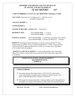


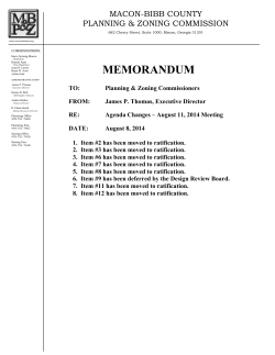


© Copyright 2026