
LEG - Hood to Coast
Survivor or supporter, we’re all in this fight together. Join us at FINISHCANCER.org. WELCOME TO THE MOTHER OF ALL RELAYS O ur a n n u a l p ilg r im a g e from t he m ount a in to the sea has cer tai nl y evol ved from i ts humbl e be gi n n i n gs back in 1 98 2. I st ill fond ly reflect upon t hat fi r st year when I stood on the beach wi th our vi c to ri o u s te a m a n d my t h ree m ont h old d a ug hter, Fel i ci a. I remember the hand-drawn maps and l eg p rof i l e s, w he el- m ea su red exa ct 5 . 0 m ile leg s , eig ht total teams, whi te one-col or race shi r ts, no permi ts n e e de d, s pa g h et t i a n d beer for t he bea ch pa r t y, and a race commi ttee and staff of one. Wow, co u l d th i s re al ly h a ve b een our root s ? W hen I c o n c ei ved of t his fir s t iconic ult ra - rel ay, I fel t that there had to be another al ternati ve o u t the re f o r u s d ed i ca ted runner s . I wa s s o ti red of the same bori ng fl at 10k’s i n the ci ty. The gro wth and o ver w h el ming popula rit y of Hood To Coast i s testi mony to the fact that I wasn’t al one i n th e se fe e l i n g s. B esid es t he s heer fun of Hood To Coast, i t’s been sai d that our event provi des a sp i ri tu al l i ke ex p er ien c e for t he s oul a nd a n oppor tuni ty to l ook i nsi de one’s core. These same people say th at the i r sp i r i t i s reinvig ora ted , a nd feel cha nged for the better, as a resul t of the exper i ence. M y f i g h t w i t h c a ncer over t he la s t couple of decades now gi ves the Hood To Coast and Por tlan d To C oa st Rel a y s a n even hig her m is s ion t ha n thei r i ni ti al humbl e begi nni ngs. Treatments that on c e e x i s te d o n l y i n t h e im a g ina t ion a re pra ct iced ever y day at Provi dence Cancer Center, now cons i de re d o ne of t h e to p c ancer res ea rch a nd t rea t ment center s i n the Uni ted States. The center i s a pi o n e e r i n i mm u n o t h er a p y, which ha rnes s es t he bod y’s i mmune system to er adi cate cancer. Thi s l eadi n g- e dge ap p roa c h to c a n cer t rea t m ent recent ly was cal l ed the sci enti fi c “breakthrough of the year.” P ro vi de n c e al s o i s h o m e to na t iona lly recog nized exper ts i n speci fi c tumor types, and i ts uni que pati ent- c e n te re d de s i g n c a res f o r pa t ient s a nd t heir loved ones from di agnosi s through recover y. Havi ng a wo rl d- c l ass canc er c en ter i n our ba ck ya rd is im proving the l i ves of Oregoni ans wi th cancer – and strength e n i n g the h ea l t h of o u r com m unit ies . I hope ea c h one of you wi l l share i n our passi on for fundr ai s i n g by dona t in g to t h e P rovid ence Ca ncer Center research program (www.ever ydayhero.com/us/fi nish c an ce r 2 01 5/ ) to sa ve potent ia lly m illions of li ves i n the future. Ro b er t F o o te J r. Fo un d er a n d C h a irm a n R un a w a y f ro m ro ut ine a nd into ea rly m orni ng mountai n mi st, past young entrepreneur i al l e m o n ade s ta nd s, a n d c it y s k ylines to t he s pa rk ling Paci fi c Ocean beach par ty, where team camaraderi e an d a comm u n it y of pa r t icipa nt s rule t he 3 4 t h a nnual Mother of Al l Rel ays! You and your teammate s are cl o s e to ex p er i en cing t he 2 0 1 5 P rovid ence Hood To Coast/Por tl and To Coast Rel ays – and en c l o se d i s a l l of t h e key i n f o you need to be prepa red for an i ncredi bl e rel ay. A s o u r st a f f wo r k s t ireles s ly yea r round in pl anni ng the hi ghest qual i ty rel ay possi bl e, our fi r st pri o ri ty i s to p ro v id e your tea m wit h a s a fe a nd posi ti ve experi ence. In order to accompl i sh that o bj e c ti ve , we n eed yo u r team m a tes to be ed uca ted par ti ci pants! Thi s handbook provi des i mpor tant i tem s to be k no w led g ea b l e so you ha ve a n incred ible, memor abl e race! A fe w remin d er s: 1 ) Pa cket P ick-up is Aug ust 15th at Provi dence Park ; 2) Three vol unteer s are re qu i re d to t a ke/ pa ss t h e m a nd a tor y online t ra ining (for teams deemed “l ocal ”); 3) Par ti ci pants must we ar a re fl ec t ive vest f ro m 6 pm -9 a m , a nd a reflec ti ve vest, front and back L ED fl asher, and carr y a f l ash l i gh t fro m 6 p m- 7 a m ; 4) Aud io a m plifica t ion d e vi ces worn on the head are not al l owed and can re su l t i n au to ma t i c tea m D Q; a nd 5 ) P la n to finis h t he race on the sand and enj oy our amaz i ng Fi ni sh Pa r ty, f o o d, b e e r g a rd en , a w a rd s a nd live m us ic t hrough the eveni ng! Connect wi th your team…and don’ t f o rge t fi ni s h st ro n g ! F e l i c i a Hu b b er P re s id en t 3 3 htc15 htc15 TABLE OF CONtENTS ORGANIZERS Welcome Contents Race Committee Race Partners Course Fundraisers Interview with Steve Hanamura 4 htc15 htc14 CAPTAIN CHECKLIST RACE INFORMATION 3 4 5 6 7 19 Travel/Accommodations 8 Required Safety Equipment 8 Volunteers 8 Vans 8 HTC/PTC Relays Merchandise9 Team Suites 9 Hood To Coast Start 9 HTC/PTC Relays Finish 10 Award Ceremony 10 Special Award Ceremony 10 Penalties 11 Open Container Policy 11 Finish Beach Party 11 Team Building 13 Age Divisions 13 Substitution Process 14 Race Rules 16 Safety/Emergency 21 Volunteer Information 24 Drivers Guide 25 Cut n Run 26 Course Ratings29 VAN 1 VAN 2 FINISH Leg 1 31 Leg 2 32 Leg 3 33 Leg 4 34 Leg 5 35 Leg 636 Exchange 13 Map 44 Leg 1345 Leg 1446 Leg 1547 Leg 1648 Leg 1749 Leg 1850 Exchange 24 Map 51 Leg 2558 Leg 2659 Leg 2760 Leg 2861 Leg 2962 Leg 3063 Van 1 Route To Finish 64 Leg 7 38 Leg 8 39 Leg 9 40 Leg 10 41 Leg 11 42 Leg 1243 Exchange 18 Map 44 Leg 1952 Leg 2053 Leg 2154 Leg 2255 Leg 2356 Leg 2457 Exchange 24 Map 51 Leg 3165 Leg 3266 Leg 3367 Leg 3468 Leg 3569 Leg 3670 Seaside Parking/Shuttle 71 2014 Race Results 72 Penalty Process 73 “Best Of Voting” 74 Team Records 75 Safety Agreement 77 dont forget to pack! REFLECTIVE VESTS Participants must wear a reflective vest from 6:00 PM through 9:00 AM while running. race committee Organizing the Mother of All Relays, the Providence Hood To Coast Relay, takes large scale planning and preparation. The countless details necessary to create this incredible event are accomplished by our dedicated Race Committee, Course Coordinators and advisors who work year-round to bring runners the enjoyment, support, and safety of a world class event. A huge THANK YOU must go out to our race VOLUNTEERS! The Hood To Coast and Portland To Coast Relays could not take place without the hard work and assistance of 3,600 volunteers along the course, from Start to Finish. MICKEY GODFREY Development & Design Director 4 years ROBERT FOOTE, JR. Founder & Chairman 34 years FELICIA HUBBER President 9 years CASSIE NEGRA Race Manager 2 years JUDE HUBBER CEO 7 years BETH & PETE KELLAN HTC Start Directors 8 years MARTIN ANDERSON Communications Director 10 years ROSS HUBBER Director of Operations 2 years DANIELLE ARNOLD Manager of Design 1 year LUKE VANOUDENHAEGEN Manager of Operations 1 year CARLA GERTZ Communications Coordinator 4 years KEVIN SMITH Safety Coordinator 1 year PAUL RAAB Packet Pick-up Director Rules Committee Chairman 29 years JACK FOLLIARD Legal Advisor 15 years Kael Kryger Operations Intern 3 years Christina Fuller HTC/PTC Finish Line 2 years ROB RICKARD Course Marker 20 years CHERYL DOBOZY Exchange Opening 14 years DANI BOWERMAN Exchange Opening 2 years ELISE SMITH Exch. 1-6 7 years JOHANNA MUNIZ Exch. 7-12 6 years RON HELM Exch. 13-17 6 years TONY ROOS Exch. 18-21 6 years DAN FLOYD COO 3 years ERIC PYKONEN Exch. 22-25 3 years RANDY BEAUDRY Exch. 26-29 4 years ART WRIGHT Exch. 30-35 15 years KIM WRIGHT Exch. 30-35 15 years 5 htc15 race partners title partner presenting partner gold partners silver partners bronze partners SELECT TRAINING PARTNERS catering communications special Thanks to EyesOnWheels.org (Eric Bates) HoodToCoastMovie.com 6 htc15 BEACH PARTNER Seaside Chamber of Commerce Amateur Radio Emergency Services media The City of Seaside East Hill Church (Springwater Patrol) course fundraisers 6 7 17 16 18 27 19 27 23 SANDY HIGH SCHOOL OREGON TRAIL PRIMARY ACADEMY Benefits: Oregon Trail Primary Academy Pancakes, energy snacks, drinks Benefits: Sandy HS Athletic Teams 11am -7pm Fri Gatorade, fruit, powerbars, hamburgers, hot dogs, chips and soft drinks 8:30am-9:00pm Fri ST. HELENS HIGH SCHOOL Benefits: St. Helens High School Showers $2, Towels $2, Sleeping in gym $2 Fri 8:00am-Sat 6:00am Pancakes, Eggs, Sausage breakfast Fri 7:00pm-Sat 6:00am Baked Potato & Salad Bar Fri 9:00am-Fri 5:00pm Massages Fri 9:00am-Sat 6:00am hood start Timberline Lodge 2 3 COLUMBIA COUNTY FAIRGROUNDS Benefits: St. Helens High, Class 2014 Warm drinks, soup, food 1 4 5 10am - close 7 EXCH 19 6 8 Benefits: Local community residents Coffee and snacks 12pm - close 9 10 11 NATAL GRANGE 12 Benefits: local Natal Grange Lunch/Dinner 2pm - 1am Barbecue beef sandwiches, cheeseburgers, hotdogs ,cowboy beans, baked potatoes and assorted sweets, assorted beverages 18 17 19 16 20 21 23 Breakfast 1am - close Ham, pankakes, eggs, juice, 24 coffee 22 25 26 27 29 28 30 31 33 32 34 13 14 15 portland start SCAPPOOSE HIGH SCHOOL Benefits: Scappoose HS Cross Country Team Shower and Towel $2, 6:00 pm – 6:00 am Scappoose Bagels (www.scappoosebagel.com) FREE coffee JEWELL SCHOOL past (EXCH 27) turn left on Hwy 103 (another 1/4 mi. on right) Benefits: Jewell School 6pm Fri- 2pm Sat Oatmeal, bagels, eggs, sausage, pancakes, lite fare, Coffe, tea, hot choc, water, sandwich bar Massage 6am - noon Sat Massage, Showers, quiet indoor sleeping Elsie-Vinemaple Fire and Rescue Benefits: Elsie-Vinemaple Fire and Rescue 5pm Fri- noon Sat Water, coffee, tea, soda, cocoa, hot apple cider, BISCUITS AND GRAVY, hot dogs, chili, chili dogs, pancakes, soup, oatmeal, muffins, candy bars, fruit. Medical first-aid tent with EMTs 30 31 33 seaside (EXCH 30) Benefits: local community family 10pm - close Dinner: burgers, chicken burger, potato salad, muffins Breakfast: eggs, bacon, ham/cheese croissants, hot choc Lunch: burgers, hot dogs, spaghetti, yogurt, fruit, bagels. GRANGE FUNDRAISER (EXCH 31) Benefits: Astoria High School Basketball & Olney 6:00pm - 3:00pm Grange Kitchen Restoration Breakfast burritos, pancakes, cookies, pie and Olney Grange Kitchen Restoration cinnamon rolls, fruit, hot choc, coffee.Sleeping inside hall & on lawn! (no charge) LEWIS & CLARK ELEMENTARY SCHOOL (EXCH 33) 35 Benefits: Lewis & Clark Cal Ripken Baseball Assoc burgers, soda, coffee, donuts, candy finish 4:00am - close BROADWAY MIDDLE SCHOOL (SEASIDE: 1120 Broadway St, Seaside, OR 97138) Benefits: Seaside Middle School programs Shower (incl. towel/soap), sleeping area in gym 6:30am - 6:30pm Sat 7 htc15 , Captain's checklist 1 2 Travel/Accomodations Plan ahead!! For assistance in obtaining van/vehicle, hotel, and flight reservations, email [email protected]. Twilite Limousine-Portland Trolley is proud to be the featured transportation provider for Hood to Coast. For questions, rates and general information Email: shawn@ twilitelimo.com Phone: (503) 477-2897 PST Required Team Safety Equipment Each team must have the following items in their van and present them for inspection at the Start Check-In Tent. You will receive your team wrist wrap (baton) once completed. -One signed copy of Safety Agreement -Two reflective vests -Two LED flashers -Two flashlights or (2) hats with headlights *It is highly recomended to have a First Aid Kit in your van, however it is not a required item at Check-In. Important Websites: Listed below are the responsibilities of the Team Captain prior to, and during race weekend. 3 4 Volunteers It is mandatory for participation in this event that every team with one or more local members provide three race volunteers. Don’t bring children or dogs. Volunteers should be assertive and plan to work.Captains are responsible for ensuring that their volunteers each take (and pass) the mandatory online training, are at their appointed jobs, at the designated time, to fulfill the required tasks. Volunteers receive shirts on-site. Bring a flashlight and two LED flashers for night shift. If a volunteer cannot report, it is up to the team to find a replacement and make sure they report to their specific job site. Vans Teams are encouraged to make a sign for each of their vehicles that reads: “CAUTION: RUNNER ON ROAD” to place in the rear of the van. Vans may not follow behind their runner. Each team is limited to two vehicles, preferably a van or SUV type. No vehicles wider than 80” or longer than 20’-0”. No motor homes, buses or limousines are allowed. Teams not abiding by this rule will be disqualified. Each team will be issued five signs, two are in color and three are white. On Van 1 place a white sign on the front and rear driverside window. On Van 2 place a white sign on the back and the two colored signs on the front passenger and driver’s TEAM ROSTER/ADDS & SUBS/VOLUNTEER INVITE: side corner of windows. The colored sign is required to access register.hoodtocoast.com legs #19-23 and #32-36. MANDATORY ONLINE VOLUNTEER TRAINING: volunteer.hoodtocoast.com WEBSITE: Don’t use overly suggestive or foul language for decorations. www.hoodtocoast.com Have fun but use good judgement...don’t make us get out the FACEBOOK: van decoration police. Also, music cannot be broadcast over www.facebook.com/hoodtocoast INSTAGRAM/TWITTER: outside loud speakers! @HTCRelay #HTC15 PROVIDENCE CANCER FUNDRAISING (#FINISHCANCER): TO PACK! www.htccharity.com dont forgeT TEAM MATCHING: MOIST TOWELETTES www.htcrelayforum.com 8 htc15 5 6 7 HTC/PTC Relays Merchandise Team Suites (www.portlandrunningcompany.com) Team suites within the beach Finish Area are available to celebrate with your teammates, family, and friends. They’re ideal An array of 2015 HTC merchandise will be available before as a private team gathering place in the midst of the excite- the race at Portland Running Company stores, online and at ment of the Finish, offering premium catered food a private the Start and Finish, hosted by Portland Running Company! team suite bar area, fire pits and more. There are a limited If available, exchanges of unworn race shirts for different sizes number, so reserve your suite soon! Contact Danielle Arnold will be allowed at the Finish Merchandise Tent. via email: [email protected], or call (971) 716-7650. Hood To Coast Start The START is located at the lower parking lot of Timberline Lodge adjacent to the Day Lodge on Mt. Hood, Oregon. The race begins Friday, August 28, with start times every 15 minutes from 6:30am-6:45pm. Historically, we have been on schedule to the minute, so DON’T BE LATE ! It’s strongly suggested that only one team support vehicle come to the Start Area. This will greatly reduce the expected traffic congestion. Van 2 is encouraged to rendevous with Van 1 at Exchange 6. “Out-of-Town” teams receive their packets, race numbers, wrist wraps, vehicle signs, and T-shirts at the Start. Arrive 45 minutes prior to your Start Time to collect these materials and officially check in. #H TC1 5 @ mattymerrill CHECK-IN PROCEDURES: 1. Present team safety equipment at the Equipment Check-in Area for inspection and turn in a signed copy of the Safety Agreement located in your team packet or in the handbook. Your team will then be issued a Race Wrist Wrap/Baton. Without your Race Wrist Wrap and approved Safety Equipment, your team will not start the race. 2. Twenty minutes before your team’s assigned Start Time, check in at the Team Check-in Tent. Approval of safety equipment must be secured prior to checking in. You will need to state your Team Number to officials and sign alongside your team name on the CHECK-IN sheet. Any team member can check the team in. 3. Teams scheduled to start in each upcoming wave will have their team name/number announced five minutes prior to #H TC1 5 dont forgeT TO PACK! @ nikerunning SLEEPING FIELD SLEEPING BAG scheduled start. The first runner must be at the Start Line. You cannot start before your assigned start time! Continue on page 10 9 htc15 4. Team Record: Each team can record their individual leg times as well as the accumulated running time at the completion 10 Special Awards Ceremony presented by Saturday at 5:25pm, the OVERALL HTC WINNING TEAM will of each leg for posterity. These sheets DO NOT NEED to be be announced and honored with their team name/year en- turned in at the end of the race. Available on page 75. 8 graved on a large, leaded glass trophy that HTC will house Team members often run across the Finish Line with their ”Best Team Outfit” and anchor runner who is officially finishing the race. If your team “Outstanding Volunteer” HTC/PTC Relays Finish and bring back annually! The Finish is located on the beach, just north of the turnaround Also, the MENS OPEN, MEN’S CORPORATE, WOMENS OPEN, of Broadway Avenue in Seaside, Oregon. Be aware, traffic and and MIXED OPEN categories will be announced in front parking are very congested at the Finish in Seaside. Use of the free parking shuttle is highly encouraged! of the main stage. On page 74 cast a VOTE for the overall (Map included on page 71, and at www.hoodtocoast.com/ race-information) “Best Decorated Van” “Best Team Name” chooses to do so, make sure your official leg 36 (anchor) runner leads your team to the Finish Line. This runner will be the one Results announced at 5:00pm, and on ‘Results’ webpage. who is credited with an official finish. A special team holding area will allow your team to meet up as the last runner comes down the ramp. Listen for announcements. Updated Finish Results: Results will be produced as often as possible throughout Saturday. Final results will also be posted at www.hoodtocoast. com/results. If for some reason, you do not agree with the final results, please file a report prior to 8:30pm on Saturday to the designated Rules & Penalties Table. Finisher Medals: Medals will be given to each qualifying team as the finishing runner crosses the Finish Line. If the team has not received credit for their volunteers at that time or in the event of team disqualification, medals will be withheld and informed of the reason at the Penalties Table. Medals must be picked up on Saturday, or at the HTC office at a later date. 9 Awards Ceremony presented by SUNDAY at 9:30AM, in front of the main stage on the beach, Hood To Coast awards will be given out to the TOP SIX teams in EACH CATEGORY. (Portland To Coast Awards will begin on Saturday at 5:00pm). All teams awarded should have their team captains and/or team members present. Awards will not be mailed to teams who aren’t present. Other pick-up arrangements should be made. 10 htc15 #H TC 15 @ c oa c h j e n n y dont forget to pack! WATER Be sure to bring extra water to stay hydrated througout the entire course. 11 13 Penalties Finish Beach Party presented by Teams may watch for rule infractions by other teams. There will Food and Beverage: be race officials recording infractions as seen. Teams wishing Hood To Coast / Portland To Coast Relays enthusiastically to file penalty/protests (note ‘Race Rules’ pg 16) must do so welcomes Century Catering to the 2015 Finish Party. in writing within 30 minutes of their finish in Seaside. Submit the written form at the Rules & Penalties Tent. Be specific and Widmer Bros. Beer & Wine Garden: detailed. It’s imperative to have a team number to identify Located within the fenced area at the Finish party on the the team. The Rules & Penalties Committee will evaluate all beach. No beer or alcohol is allowed to be brought into the incidents; their decisions are final. To enforce a penalty, infrac- event area on the beach. Bring I.D, proof of legal age will tions must be reported by two or more teams. This system be required. DESIGNATE A SOBER DRIVER IF YOU PLAN ON has resulted in disqualifications. DRINKING ALCOHOL. DON’T DRINK AND DRIVE, BE RESPONSIBLE. Open containers on the prom are illegal and police enforce infractions. ATM: Need cash? Look for a Bank ATM vehicle and signs on the beach! Music Center Stage: From 12:45pm - 3:45pm Saturday, the main stage will host the pop/rock ‘Brian O’Dell Band’, with ‘Radical Revolution’ performing as the headliner from 6:45pm-11:00pm Saturday evening! Plan on dancing into the night to an energetic and entertaining Northwest favorite! Don’t miss this amazing party! 12 #H TC1 5 @aimfraz2 Open Container Policy Absolutely no open containers or consumption of alcohol is allowed during the race or on the race course (this isn’t Las Vegas)! Teams seen or reported doing so will be disqualified and could be fined/cited by Law Enforcement. Please save the celebration for the huge beach party at the Finish! dont forget to pack! FLASHLIGHT/HEADLAMP Participants must carry/wear a flashlight or wear a headlamp from 6:00 PM through 7:00 AM while running. #H TC 15 @ k g ord i c h u k 11 htc15 STARTING LINE Get ready for the big race with free cheer gear. LEG 12 Prep your body with free KT TAPE for muscle, ligament and tendon support and pain relief. WE’RE WITH YOU FROM START TO FINISH! Enjoy these FREE race-enhancing amenities along the route from us and our partners. EXCHANGE 24 Rest up and refuel with free use of tents and lanterns plus hydration solutions at the Nuun Electrolyte & Hydration Station! Tents will be assigned at our Check-In Station. First come, first served. 12 See course maps. htc15 FINISH LINE Loosen up with free foam-rolling with assistance from our on-site physical therapist. #HTC15 @ DICKS @ DICKSSPORTINGGOODS Team Building #H TC1 5 @strang ed re am s4 #HTC1 5 @hikeopath #H TC 15 @ j e n n y_ a d ve n t u re s Recruit Teammates Team Time Runner Substitution Connect with runners looking for a team, Upon registering, your team has com- No runner may drop out of the race solely or teams looking for runners by visiting mitted to average as a whole no slower for the purpose of the team substituting www.htcrelayforum.com! Chat with than 9:45 minutes mile pace (32 1/2 hrs in a faster runner in their place. If a run- fellow participants, ask questions and total time). No special seeding requests ner is forced out due to injury or illness, post to recruit other runners! Discussions for starting times will be accepted. Teams they MAY NOT be reinstated into the range from teams looking for additonal that choose to violate their pre-assigned team lineup. The team must finish the runners, tips/advice and logistics. start times will be disqualified and subject event with the remaining runners mov- to suspension from participating in future ing forward in the same sequence. No events. It should be understood that the alternates may be added once the team start time for any HTC team could result has started. (60 min. penalty if involved in a 9:00 pm finish Saturday evening in in improper substitution). dont forget to pack! 2 PAIRS OF SHOES Seaside. Categories MIXED CATEGORIES: 12 member teams 1. 2. 3. 4. 5. 6. 7. 8. 9. with 10-11 members must have a min. MEN’S OPEN . . . . . . . . . . . .. . . Any age, at least one runner under 30. MEN’S SUBMASTERS . . . . . . . Min age of all runners is 30. MEN’S MASTERS . . . . . . . . . . . Min age of all runners is 40. MEN’S SUPER MASTERS. . . . . .Min age of all runners is 50. CORPORATE MEN’S OPEN . . .Any age, ALL from the SAME business. WOMENS OPEN . . . . . . . . . . .Any age, at least one runner under 30. WOMEN’S SUBMASTERS .. . . Min age of all runners is 30. WOMEN’S MASTERS . . .. . . . .Min age of all runners is 40. WOMEN’S SUPERMASTER. . Min age of all runners is 50. 10. CORPORATE WOMEN’S OPEN. .Any age and ALL from the SAME business. 11. MIXED OPEN . . . . . . . . . . . . . . . . At least half women. Any age,at least one under 30. 12. MIXED SUBMASTERS . . . . . . . . .At least half women. Min ages of all runners is 30. 13. MIXED MASTERS . . . . . . . . . . . . At least half women. Min age of all runners is 40. must have a min. of 6 women. Teams of 5 women. Teams with 8-9 members must have a minimum of 4 women. Teams with less than this number of women will default to a men’s category. Any team with 1-5 men, with the rest comprised of women, will be classified within the mixed categories. CORPORATE CATEGORIES: ALL team members must be employed full-time by the SAME business. 14. MIXED SUPERMASTERS. . . . . . . At least half women. Min age of all runners is 50. (Team Category will update automati- 16. MEN’S CHAMPION MASTERS. . . .Minimum age of all participants is 60 gender and age composition changes). 15. CORPORATE MIXED OPEN. . . Any age, ALL from SAME business, at least half women. cally on the ‘Team Roster’ page as team 17. WOMEN’S CHAMPION MASTERS. .Minimum age of all participants is 60 18. MIXED CHAMPION MASTERS. . . . .At least half women. Minimum age of all participants is 60 13 htc15 #H TC1 5 @d b ro wn1 7 6 #HTC1 5 @lahuisv #H TC 15 @ c ou r t n e yj e n s e n Running Legs Substitution Process All teams are to run their members in If a runner drops out due to injury or ill- rotating legs and in the same sequence ness during a leg and isn’t able to walk of rotation throughout the race. Runner to the next exchange, the next runner on leg 1 would thus run legs 1, 13, and in rotation may take the wrist wrap and 25. When determining who will run each continue to the end of that leg. The leg, (besides distance and leg rating), next leg must be run by the next runner Captains should consider the following: in rotation. (http://register.hoodtocoast.com) up -Time of day runners will encounter Mixed Division Process: must be filled out on forms provided each leg important Every person running race day MUST be officially registered, or your team will be disqualified. Add/Subs can be submitted via “Team Clubhouse” until race day. Race day Adds/Subs at the Start ($25 late fee). If a runner on a Mixed Division team -The leg’s exposure to sun and/or wind becomes injured or ill and drops out dur- -Variable weather ing the leg, the paragraph above applies -Runner ability with the addition that the replacement -Runner familiarity with the area runner must be of the same gender. If -Whether there is any van support on a minimum of seventeen(17) legs are the leg not completed by females the team will -Runner willingness to run on a gravel (and potentially dusty) road Men’s Division. E.g. (presume injury to Female #1 on leg #4) see right The combination of the first three of these is perhaps the most crucial. Some legs are notorious for brutal sun exposure during the day. Legs 5, 6, 7, 12, 13, 16, and 17 where late afternoon running can be in direct sun, as well as Legs 9, 10, and 35, which have little shade and nearly no van support for the majority of the leg. Also keep in mind that the first three legs from atop Mount Hood each drop an average of 1300 - 1400 feet in rotation automatically be reclassified into the Runner Off Course Monitor/guide your teammates through the course. If a wrong turn is made, the runner must return to the course on foot to the point on the course where the error occurred and resume the race. Do not mark turns on the roads/course! Teams Start Rotation Position Gender Leg 1 M-1 Leg 2 M-2 Leg 3 M-3 Leg 4 F-1 Leg 5 M-4 Leg 6 F-2 Leg 7 F-3 Leg 8 M-5 Leg 9 M-6 Leg 10 F-4 Leg 11 F-5 Leg 12 F-6 Revised Rotation Position Gender Leg 1 M-1 Leg 2 M-2 Leg 3 M-3 Leg 4 F-2 Leg 5 M-4 Leg 6 F-3 Leg 7 F-4 Leg 8 M-5 Leg 9 M-6 Leg 10 F-5 Leg 11 F-6 Leg 12 M-1 are responsible for educating teammates on the course route/directions! elevation! Runners who push these legs too hard will severely pay for it in their second and third legs, ending up stiff, sore and sometimes injured. 14 htc15 dont forget to pack! FLASHERS Whatever the road throws at you, from potholes to nails–any road hazard, our FREE GUARANTEE protects you WITH EVERY PASSENGER & LIGHT TRUCK TIRE PURCHASE Peace of Mind Tire Protection • If a Tire is Damaged Beyond Repair, We’ll Replace its Value • Our Work is Guaranteed for the Life of Your Tires • Free Pre-Trip Safety Checks Lifetime Tire & Mileage Care Doing the Right Thing Since 1952® • • • • • Free Flat Tire Repairs Free Tire Rotations Free Tire Rebalancing Free Air Checks Free Brake & Alignment Checks OVER 455 LOCATIONS TO SERVE YOU! 15 htc15 Go to www.LESSCHWAB.com to find the store nearest you. race rules presented by The following rules, are for the safety of participants. Violation will result in a time penalty or disqualification. penalties Disqualification for violating #1, 2, 3, 4, 5, 7, 8, 10, 14 60 minute penalty for violating codes 11, 12, 15 and 17 1 8 2 5 9 10 3 6 7 4 3 Volunteers Do Not Litter It is mandatory for participation in this Participants must use portable toilets, event that all local teams provide three garbage/recycling containers provided! It volunteers who must each take and is totally unacceptable to litter, urinate or pass the mandatory online training and defecate on private property. Your be- fulfill their required jobs duties the day havior affects the environment and could of the event. force the discontinuance of the race. www.hoodtocoast.com/volunteer Wear Reflective Gear Team members must wear the wrist wrap and race number while running, as well as #HTC1 5 @misschristianicole Use Sleeping Fields Participants may only use designated a reflective vest, one front and one back areas to sleep (roped off with caution LED flasher, and carry a flashlight from tape). Tents are allowed at Exch. 18, and 6:00pm to 7:00am (reflective vest only Exch. 24. Sleeping field (NO TENTS) at until 9:00am and can be taken off directly Exch. 30. Race DQ if found sleeping on after 9am if still running). Participants will ground next to vehicle! Pay Attention To Course Volunteers Course volunteers are regarded as Race Officials and their instructions must be followed and respected. Team Vehicles be held at the exchange and not allowed Your team vehicles must not exceed 80” to run without the proper equipment. wide or 20’ 0” long. No motor homes, No Headphones Audio devices are only allowed to be worn below the head while running or walking. Volunteers also will not be allowed to have any audio devices on while fulfilling their job duties. Failure to adhere to this policy will result in team disqualification. No Open Containers On Course Educate Your Teammates buses or limos allowed. Two (2) team Be sure to educate and guide teammates vehicles are permitted on course. On as needed. If a wrong turn is made, the legs 19-23 and 32-36 only one team participant must return on foot to the vehicle is permitted on course. The other point where the error occurred and re- vehicle must use the alternate handbook sume the race. Do not mark on the course! routes shown. Van decorations mustn’t be overly sexual, suggestive, have foul No Bicycles Or Dogs language or offensive slogans. During your run or walk, no bicycles or dogs are allowed to accompany participants on the course. No open container or alcohol is allowed on course. Inebriated teammates or volunteers on the course will not be tolerated! Teams seen with open containers or reported doing so will be disqualified and could be fined or cited by law enforcement. dont forget to pack! FLIP FLOPS (FOR THE BEACH) #H TC 15 @nannabarlby 16 htc15 11 12 14 16 13 15 17 Display Van Signs Teams are provided with three white and two color signs for course vehicles. Teams are required to display the white sign on the outside rear window of each van with team name and number. Van 1 white sign and two Van 2 colored signs are to be posted on the outside front driver’s and passengers side corners of windows. Runner Rotation All teams are to run their members in the same rotation and in the same sequence of rotation throughout the race. Participants cannot run back to back legs. See pg. 14 for substitutions and sequence info. Don’t Drop Off Early No parking/dropping off teammates permitted within 500 feet of an exchange! Vans must obey “No Parking” signs and volunteer instructions for parking. #HTC1 5 @ ol yr a mos Sandbagging Provide Medical Info Any teams that start the race early or It’s vitally important that each team- finish over 2.5 hours faster than their mate have their contact/medical info anticipated finish time will be disquali- completed on the back of their race bib. fied and all teammates risk being banned from future participation if the behavior continues two years in a row. Quiet Hours Participants On Left No loud noise, music, or yelling from Participants are to run or walk along the 10pm-6am (respect the communities). left side of the road except legs #1 thru No outside loud music speakers. #7 and #14 thru #16. course guidelines General important information regarding course safety and flow. Exchanges are marked in yellow paint on paved roads, and pink flagging along gravel roads (yes, this course does have gravel stretches (dust); so bring bandanas/painter’s masks, or just grin and bear it)! Waiting Runners who will run the next leg MUST line up single file (after warming up) along the exchange zone shoulder of the road behind the EXCHANGE POINT. Faster team runners are to be towards the front of this “chute.” Step out of the CHUTE into the EXCHANGE ZONE as your runner approaches. Runners finishing must exit the exchange zone promptly and follow volunteer instructions. All Spectators MUST remain on the RIGHT SIDE of the road. Runners are to run along the left side of the road except as indicated in the Team Handbook (legs #1 through #7 and legs #14 through #16). The race course and finish line will officially close Saturday evening at 9:00pm. Any teams still on the course at that time are requested to either discontinue the race, or finish by running more than one of their runners at the same time (only if instructed by Race Officials and given a ‘LeapFrog’ to turn in at the Finish). If your team has been honest in supplying race pace times, everyone should finish no later than 9:00 PM. This means some exchanges (33, 34 and 35) may close before 9:00 pm due to scheduling. 17 htc15 HTC1 5 La s t yea r o ver 10,00 0 ph otos we re t a g g e d w i t h # h tc 1 4 ! B e a pa r t of this ye a r ’s s oc i a l s c e n e on H ood To Coa s t ’s Fa c e book , I ns ta g r a m , a n d Tw i t te r pa g e s . / H OODTOCOAST 18 htc15 @H TC R E L AY @H TC R E L AY art of sight Steve Hanamura has been blind his entire life, but that hasn’t stopped him from living an active lifestyle where he has run in the Providence Hood To Coast Relay for the last 25 years. His unique perspective on The Mother of all Relays shines light on what it truly means to be part of this special race that brings people together from all walks of life. How long have you been blind, and what level of blind- How did you get introduced to running? ness are you? When I got my first job out of college in Eugene, I had some I am 71 years old and have been blind all my life. I used to be friends that would run with me and I would hold on to their arm able to see shadows but now I experience total blindness. While as they ran. It became very difficult to run like this for six miles I’m blind, I experience what is known as facial perception where holding on to someone’s arm because you are both sweating I can’t literally see a wall or fence in front of me, but I know it’s and I would be pulling them back because I couldn’t tell where I there and know when to stop and not hit it. I know when the sun was going. When I moved to Portland, I would be in my apart- is out even if it is not out and I know there is something over ment and I could hear people running by and became angry and there that reflects. This is often difficult to describe to sighted frustrated that I couldn’t do it. I decided to take out my long cane people, and I know I’m contradicting myself, but even when it’s and started running through the streets of Portland. The cane is dark I know it’s not and that’s very much a feeling or sensory good because it gives you information so you won’t hit things, thing that I experience. but when you’re running, you can’t stop even after the cane has told you that there is a car. I would fall in back of pickup trucks, 19 htc15 (continued) bounce off poles, I was a mess. Finally, somebody do well is leg 13. Running over the Hawthorne Bridge is challeng- suggested I use a bungee cord. I would still have to have sighted ing where I have to dodge cyclists and pedestrians. Additionally, assistance, but the bungee cord changed everything! I could start on Front Street, there is a narrow spot where the guide has to participating in races and running outside consistently. My first slow down and we have to fast walk. It’s a very technical leg for breakthrough using the bungee cord was running the Cascade me with a guide. There is some place for every single kind of person, be it the elite or the first timer, and that’s the standout from any other race in the world. Runoff, which is known today as the Shamrock Run. After I ran that race, I knew that I could be a runner. Today, I run every day Is there a particular leg that stands out to you and brings and it has become a part of who I am. you joy to run? Describe the process of running with a guide and how you can’t hear the waterfall along the leg. I never knew about the two of you are able to gain a level of communication it until I ran the leg several years ago and I was blown away by and trust. the powerful sound. This leg is awesome because you are the We start by walking. We always go for a walk and I’ll hold their first one out of the van and you get to start the race, but it’s the elbow and teach them how to let me know when there is a step aesthetics and beauty that make it such an amazing leg. The or a narrow spot by moving their elbow. Then we go to the track blindness sensory aspects really become a factor and add a level or run on an open road where we introduce other obstacles such of appreciation. as speed bumps, turns, and narrow places. Gradually we build that communication and by the third or fourth time they are pretty good at it. There is definitely an extra level of commitment on the part of a sighted person to run with me in that they may need to run slower and they have to constantly be alert to inform me of what is happening around us. How did you get introduced to the Providence Hood To Coast Relay? My job is a leadership diversity consultant and I travel all around the United States. The phone company that is now Century Link Leg 1 is truly beautiful. From the van driving down the mountain, What do you think makes Hood To Coast such a special race? Hood to Coast has become the premiere event. Not only for elite runners anymore, which was who made up the race in the early years, but now it’s also for people who are just starting out running and walking. This is the beauty of Hood To Coast. For me being 71, it’s not about how good I am as a runner when I run Hood To Coast, it’s that I’m out there and being a part of this amazing event. There is some place for every single kind of person, be it the elite or the first timer, and that’s the standout from any other race in the world. called and said I needed to come to Denver for a diversity training. During the training, I told them about this relay in Oregon where you run from the mountains to the beach and asked if they wanted to come out and form a team with me. They would have never known about it unless I had come out and would have never run in it if I hadn’t met this interested group. Since that first year I ran it in 1989, it has been a part of life just about every year since. What are some of the challenges of being blind and training and running Hood To Coast? The biggest challenge is having to rely on someone else to participate, via my guide. I would really like to be able to do it by myself. The biggest challenge is that I can’t run outside every day. Another place where my blindness interferes with my capacity to Steve running the Eugene Marathon using a bungee cord with his guide Julie. 20 htc15 safety PRESENTED BY Emergency Procedure Giving On Course Aid/ Support Absolutely no team members or spectators are allowed to cross busy highways or streets with the purpose of giving aid or support to participants running along that side of the In an emergency, call 911 and locate the Exchange Leader or Radio Operator at the nearest road! Team vehicles MUST safely cross over Exchange. Medical care and first aid safety is the responsibility of each team and participant. to the other side of the road where the runner Each team needs to be prepared to care for the common medical needs of their runner, is, park, and unload support people. and have a first aid kit prepared. **You and your teammates MUST write important emergency contact and medical info on the back of your race bibs! Communications Radio Communication Operators are at most exchange zones along the race course. Ham operator’s primary responsibility is communication for emergencies, but they also help with logistical issues. If you see anyone hurt, please get their race number, exact location, and nature of the emergency, if possible, and let the radio operators know at the next Exchange. They are capable of calling in full emergency medical, police, and fire response. (Radio communications volunteers do not fulfill the normal team volunteer requirement). Radio volunteers register via: https://ham.hoodtocoast.com/ Running At Night Maintain contact with your van within reason along the course. DO NOT follow behind runners! Vans can pull in a safe area (off of the road)! Don’t obstruct traffic! Participants must wear a reflective vest, front and back LED flashers, and carry a flashlight or wear a headlamp from 6:00 PM through 7:00 AM (through 9:00 AM for reflective vest only) while running. THIS IS STRICTLY ENFORCED. Teammates/support personnel are highly encouraged to wear a reflective vest and LED flasher when not inside the race vehicle, while on the course or at an exchange Reflectivity be present on the front and back of the participant while running/walking in the event. Reflective striping on a shirt or vest must be at least 1/3” thick. Reflectivity on shorts, pants, or hat does not count towards meeting the minimum requirement. A reflective vest or Y reflective harness are acceptable, whereas a reflective belt, reflective cloth, and/or reflective sleeves will not be accepted. Flashlight headlamp: http://www.ledlenserusa.com/headlamps We do not specify what kind of flashing light, as long as it is LED. Two LED flashers will be provided again this year in each Team Captain bag at Packet Pick-up. Runners must understand there WON’T be any police promised to protect them from vehicle traffic along the course. Great care must be exercised at all times by runners and team vehicles. Runners must face traffic (except Legs 1-7 and 14-16, where they run on the right side of the road) and obey all traffic laws. A motorcycle patrol group will be on the course (legs 13-35) for safety monitoring. At several exchanges, HTC hires professional traffic flaggers. Obey their signals. Hydration & First Aid There are not First Aid Stations on the course (except water on Leg 4 and 10). There are some long sections of the course in the latter stages where no available water sources exist. BE PREPARED. Midday temperatures may be hot! It’s important to continually hydrate. CARRY LARGE WATER CONTAINERS in your vans to refill bottles. The average team is on the course for 29 hours, so drink plenty of fluids! A person running should consume 12+ cups a day. Many injuries are related to soft tissue trauma and are effectively treated with ice. Real ice works better than chemical ice packs. Ice should be used with plastic bags and a damp towel over sore, tender, bruised and blistered areas. Any wrapping or taping should only take place after effective ice therapy. Follow guidelines for R.I.C.E. (Rest Ice Compression Elevation). 21 htc15 21 htc15 WHEN EVERY STEP COUNTS, COUNT ON LED LENSER It’s the middle of the night, in the middle of nowhere with a tough hill climb. You’re the lucky one running the night leg of Hood to Coast. You won’t quit, and neither should your light. LED LENSER is there for you to be safe and be seen. THE OFFICIAL SAFETY SPONSOR OF HOOD TO COAST. ledlenserusa.com | @ledlenserusa 22 htc15 23 htc15 tHANK YOU VOLUNTEERS The race wouldn’t be possible without support from 3,600 dedicated volunteers along the course! The provision of three (3) volunteers per local team ensures that all participants have a well supported and safe event. For complete volunteer requirements visit: www.hoodtocoast.com/volunteer dont forget to pack! 4 PAIRS OF SOCKS 24 htc15 driver guide Driving the course requires as much planning as running the race. Follow these directions to help you plan and handle over 2,000 vans concentrated in the same area during a 36-hour time period. Drive Course Before The Race Note where all turns are located. Identify exchanges (and areas where more time will be required). Know the difficult parking areas and plan accordingly. Be aware of where stops can be made to provide runner support. Know where food and restrooms are located. It’s very important. Don’t violate the law by going on private property. Locate gas stations, last fuel stop before Seaside is in St. Helens (Leg 18). Establish places, (other than exchanges), where your team vans can meet. Become aware of areas where vans won’t be in contact with their runner and how to deal effectively. Cell phone coverage may not be available in all areas (particularly Legs 18-32). Areas Restricted To One Van There are at least two areas on the course that will be restricted to one van per team due to narrow roads with limited space for high concentrations of vans. Between Exch 18 (Columbia Co. Fairgrounds/St. Helens and Intersection of HWY 202 and Old Ranch Road (Leg 23). Map shown in handbook (page 51). Between Olney (Exchange 31) and HWY 101 in Seaside (Leg 36). Map shown in handbook (page 64). There are also shortcut routes listed in the handbook leg maps for Exchanges 6 to 12, and between Exchanges 12 and 13. Free Towing / Lock-Out Assistance As a service to participants, we’ve contracted with Allbright Towing for roadside & lock out services (Portland - Seaside), -they’re on call for the race! (503) 648-2662 or cell: (971) 645-6182. If you are out of cell service, contact your nearest exchange leader who will radio an Allbright Towing truck. Rule Reminders No team members are allowed to cross highways or streets to give aid. Vans must pull over to that side of road and park. No Parking/stopping within 500 feet of an exchange! Don’t drop off teammates near the exchange zone. 30 minute penalty! Vans must obey the No Parking Between Barricades signs and volunteers parking instructions. Exchanges are marked with yellow paint on paved roads and pink flagging along gravel roads. 2525 htc14 htc15 LEG 1 DIRECTIONS: LEG 7 DIRECTIONS: 0.00 Start @ Timberline Lodge (GPS: N 45°18’7.52” W 121°44’39.58”) 5.29 Timberline Road / HWY 26 5.44 Exchange #1 / Govt Camp business district, near A-Frame 0.00 Exch 6 (south of Sandy HS, adjacent to tennis courts, near Bluff Rd) ← 0.60 Sandy H.S. @ Bell St/Jewelberry Ave. ← 1.40 Jewelberry Ave/Kelso Rd. → 2.05 SE Kelso Rd/362nd Ave ← 2.78 SE 362nd Ave/Dunn Rd → 3.27 SE Dunn Rd/352nd ↑ 3.52 SE 352nd/Compton Rd intersection → 3.76 SE 352nd/Hauglum Rd ← 4.26 Hauglum Rd/362nd 5.60 Exch 7 near Cottrell School (Bluff Rd/Proctor Rd/362nd) LEG 2 DIRECTIONS: 0.00 Govt Camp Loop / A-Frame Exch.#1 @ HWY 26 1.20 Government Camp Road entrance onto HWY 26 4.05 Truck Escape Ramp (No van stopping, traffic fines) 6.07 Exchange #2 @ HWY 26 near LEG 8 DIRECTIONS: 'Kiwanis Camp Rd' sign. 0.00 OR Trail Primary Academy, Exch LEG 3 DIRECTIONS: 0.00 Exchange #2 @ HWY 26 / past Mt Hd Kiwanis Cmp Rd 0.89 Camp Creek Campground 1.45 Road 31 3.14 Tollgate Campground 3.42 Entering Rhododendron sign 3.75 Mt Hood Food & General Store @ Exchange #3 LEG 4 DIRECTIONS: 0.00 Exchange #3 @ Mt Hood Food & Store / HWY 26 1.13 Skyway Bar & Grill 1.79 Zig Zag Ranger Station 2.90 Signal in Welches 3.34 Wemme sign / Greenwood Ave / HWY 26 4.70 Mt. Hood Village 6.14 Salmon River Sign 7.18 Brightwood Weigh Station (right side of HWY 26) Exchange #4 LEG 5 DIRECTIONS: 0.00 ODOT truck scales Exchange #4 @ Brightwood 0.29 Sleepy Hollow Rd / HWY 26 0.61 Windells Motel 3.11 Ivy Bear 3.59 E. Sylvan Dr. / HWY 26 3.85 Cherryville Drive 5.00 Baty Rd. / Cherryville Rd 6.05 Exchange #5 @ Cherryville Rd / HWY 26 LEG 6 DIRECTIONS: Exchange #5 near Cherryville Rd/ Hwy 26 ↑ 0.45 Oregon Candy Farm ↑ 2.07 Porter Nursery ↑ 3.55 Shorty’s Corner ↑ 4.05 Calamity Jane’s → 6.32 Bluff Rd/Hwy 26 (cross w/ sidewalk light to west side of Bluff Rd shoulder) 6.85 Exchange #6 east of Bluff Rd, south of Sandy HS adjacent to 26 tennis courts htc15 #7 @ Bluff / Proctor / 362nd Ave 0.54 Bluff Road / 352nd Ave 1.20 352nd Ave / Calico Rd. 1.70 352nd Ave / Brooks Rd. 3.20 Brooks Rd. / Revenue Rd. 3.57 Revenue Rd. / Orient Dr. 3.72 Orient Dr. / Compton Rd. 4.25 Compton Rd / 312th Ave 5.77 SE 282nd Ave/ HWY 212 5.88 Keller Rd SE/ HWY 212 5.94 SE Dee St / Keller Rd . Springwater Trail 6.00 Exch 8 on Springwater Trail LEG 9 DIRECTIONS: 0.00 near Dee St 0.67 Haley Road 0.97 Bridge over Telford Road 2.12 Rugg Road 4.02 Hogan Road 4.62 Regner Road 5.38 Springwater Trail near Main City Park/Walters Dr (Exch #9) LEG 10 DIRECTIONS: 0.00 near Main City Park (Gresham) Springwater Trail. Exch 9 0.31 7th Street 0.85 Towel Ave. / Eastman Pkwy 1.81 Pleasant View Dr 2.70 SE 174th Ave./Jenne Rd. 4.74 136th Ave. 5.16 Springwater Trail/SE 128th Ave 5.50 Springwater Trail/SE 122nd Ave 5.54 Springwater Trail/Exch 10 LEG 11 DIRECTIONS: 0.00 Springwater Trail/near Foster Commercer Ctr. 1.90 SE Foster Rd (Springwater Trail) 2.30 82nd Ave (Springwater Trail) 3.20 Johnson Creek Blvd./Bell St (Springwater Trail) 3.50 Flavel Dr./Linwood Ave. (Springwater Trail) 4.51 Associated Chemist, Inc. Exch. 11 @ 45th Avenue / Johnson Creek Blvd. Know Your route cut for easy directions for hand or pocket while running LEG 12 DIRECTIONS: 0.00 0.00 Exchange #11 @ Associated Chemist/ Johnson Ck. Blvd/Springwater Trail 1.43 Springwater Trail/SE 19th Ave 1.62 SE 19th Ave/Sherrett St. 2.19 SE Sherrett St./9th Ave 2.29 SE 9th Ave/Umatilla St 2.46 Umatilla St/Springwater Trail 5.42 Springwater Trail (under Ross Is. Bridge) 5.65 Springwater ends/SE 4th Ave/ Division Place 5.72 SE 4th Ave / Caruthers St./Water Ave 5.84 SE Caruthers St./Eastbank Esplanade 6.40 Exch #12 on Esplanade (near SE Madison St), north of Hawthorne Bridge LEG 13 DIRECTIONS: 0.00 Exch #12 on Esplanade (near SE Madison St.), north of Hawthorne Bridge 0.01 Up stairs onto Hawthorne Bridge 0.05 Sidewalk on bridge 0.35 Ramp down off bridge 0.44 Waterfront Park esplanade 0.70 Morrison Bridge 1.07 Burnside Bridge 1.36 Steel Bridge 1.37 UPRR - railway tracks 1.73 Broadway Bridge (on Naito Pkwy) 2.29 Fremont Bridge (Naito Pkwy becomes Front Ave) 2.95 Nicolai St. and Bingham Co. 3.56 NW 26th 4.14 Exchange #13 @ Front Ave, between Georgia Pacific and Gunderson LEG 14 DIRECTIONS: 0.00 Georgia Pacific/Exchange #13 @ Front Ave. 0.72 Front Ave to Kittridge 1.20 Kittridge Avenue/HWY 30 3.78 HWY 30/St. Johns Bridge 4.18 Germantown Road/HWY 30 5.23 Linnton Lighthouse Inn/HWY 30 6.04 Exch 14, Marina Way/HWY 30 LEG 15 DIRECTIONS: 0.00 Exchange #14 @ Marina Way / Highway 30 1.55 Sauvie Island Bridge 3.34 Burlington Tavern 3.93 Cornelius Pass Road/Hwy 30 4.92 Logie Trail / HWY 30 6.16 Wildwood Golf Course 7.25 Exchange #15 / Weigh Station LEG 16 DIRECTIONS: 0.00 Exchange #15 / Weigh Station 0.84 Rocky Point Road / HWY #30 2.51 Bonneville Dr/Johns Landing Rd 3.21 Havlik Drive / HWY #30 3.78 Exchange #16 @ Scappoose High School (just south of traffic light @ High School Rd/Walnut St) LEG 17 DIRECTIONS: 0.00 Exchange #16 @ Scappoose High School / HWY 30 0.04 High School Way/Walnut St/HWY 30 0.96 Scappoose Vernonia HWY/ HWY 30 2.16 Wikstrom Road/W Lane Rd/HWY 30 3.03 Fullerton Road / HWY 30 4.58 Berg Road / HWY 30 6.63 Millard Rd / HWY 30 7.36 Gable Road / HWY 30 7.68 St Helens High School, Exch #17 LEG 18 DIRECTIONS: 0.00 St Helens High School/Ex 17 @ Gable Rd. near HWY 30 0.49 Sykes Rd/HWY 30 1.71 HWY 30/Pittsburgh Rd 2.02 Pittsburgh Rd/Sunset Blvd 2.48 Sunset Blvd/Columbia Blvd 3.30 Columbia Blvd/Sykes Rd 3.62 Columbia Blvd/Gable Rd/Bachelor Flat Rd 3.98 Bachelor Flat Rd/Gable Rd/ Summit View Drive 4.19 Bachelor Flat Rd. continues to curve to right. (near Ross Rd) 5.23 Columbia Co. Fairgrounds Exch. 18 @ Saulser Rd LEG 19 DIRECTIONS: 0.00 Columbia County Fairground Exchg. #18 @ Saulser Rd. 0.37 Saulser / E. Kappler / Sykes Road 1.14 Sykes / W. Kappler Road 1.88 W. Kappler / Brinn Road 1.90 Brinn / Pittsburgh Road (Yankton School) 2.70 Pittsburgh / Gensman Road 5.89 Exchange #19 @ Pittsburgh Rd LEG 20 DIRECTIONS: 0.00 Exchange #19 on Pittsburgh Rd 3.03 Gravel section begins 3.90 Large barn on right 5.75 Exchange #20 on Pittsburgh Rd LEG 21 DIRECTIONS: 0.00 Exchange #20 on Pittsburgh Rd 0.30 Camp Emerald Forest sign (3-prong fork in road - take far right fork onto Schaffer Rd) 2.00 Blue gate on left 2.28 House on left near creek (old cars) 5.06 Exchange #21 on Schaffer Rd LEG 22 DIRECTIONS: 0.00 Exchange #21 on Schaffer Rd 0.11 Schaffer Spur Road / Apiary Rd 1.70 Wilkerson County Park 3.80 Rock quarry on right 4.60 Golden-yellow gate on left 6.69 Small blue house and garage on left 6.70 Exchange #22 on Apiary Rd LEG 23 DIRECTIONS: 0.00 Exchange #22 on Apiary Rd 0.71 Apiary Road / HWY 47 0.94 Peterson Station (fire station) on left 3.40 Blue house on right 4.23 Natal Grange Exchange #23 @ HWY 47 LEG 24 DIRECTIONS: 0.00 Natal Grange Exch #23 @ HWY 47 0.60 Sleeping field on the left 1.15 Battle Creek Bridge 3.55 Nehalem Valley Automotive/Mist 3.66 Highway 47 / 202 4.87 Mist Exch #24 @ HWY 202 LEG 25 DIRECTIONS: 0.00 Mist Exchange #24 @ HWY 202 1.14 Nehalem River bridge 1.71 Mist/Birkenfeld fire station 3.05 HWY 202 / Fishhawk Rd 3.80 Birkenfeld Church Exch 25 @ HWY 202 LEG 26 DIRECTIONS: 0.00 Birkenfeld Church, Exch. 25 @ HWY 202 0.48 Nehalem River bridge 1.98 Welcome to Clatsop Cty sign 2.48 Nehalem River bridge 3.57 HWY 202 / Cahill Road 5.65 Exch #26 @ HWY 202 LEG 27 DIRECTIONS: 0.00 Exchange #26 @ HWY 202 0.30 HWY 202 / Northrup Creek Road 3.10 Nehalem River bridge 4.81 HWY 202 / Rhodes Road 5.16 HWY 202 / Wage Road 6.10 JewellExchange#27@HWY202 LEG 28 DIRECTIONS: 0.00 Jewell Exch 27 @ HWY 202 (mP 29.5) 0.36 HWY 202/HWY 103 (mp 29.3) 1.19 Co. Maintenance Yard on left (mp 28.5) 2.72 Elk Viewpoint on left (mp 27.9) 4.09 Exch 28 @HWY 202 (mp 25.3) LEG 29 DIRECTIONS: 0.00 Exchange #28 @ HWY 202 (mp 25.3) 0.42 Lee Wooden Park on left (mp 24.9) 3.56 Crest of hill (mp 21.8) 5.97 Exch 29 @ HWY 202 (mp 19.4) LEG 30 DIRECTIONS: 0.00 Exch 29 @ HWY 202 (mp 19.3) 3.24 Mile post 16 sign 3.40 Nehalem River bridge (mp 15.8) 5.32 Exch 30 @ HWY 202 (mp 14.0) LEG 31 DIRECTIONS: 0.00 Exch 30 @ HWY 202 (mp 14.0) 0.82 Mile post 13 sign 1.53 McCoy Lane 2.00 Klaskanine River bridge and Fish Hatchery (mp 12.0) 2.64 Lillenas Road (mp 11.3) 3.10 Olney Lane 3.96 Coastline Fellowship Church / Exch 31 @ HWY 202 (mp 9.9) LEG 32 DIRECTIONS: 0.00 Exchange #31 @ Coastline Christian Church/HWY 202 0.23 Youngs River Road 0.93 Bridge / Olney cutoff (Y in road) 0.96 Saddle Mountain Road 1.50 Red barn 2.47 Jurgensen Road 4.20 Youngs River Falls LEG 33 DIRECTIONS: 0.00 Exch 32 @ Youngs River Road 3.67 Tucker Creek Road 5.12 Binder Slough Road 6.18 Dow Road 6.60 Wireless Road 7.29 Lewis & Clark Rd 7.72 Lewis and Clark School Exch 33 @ Lewis & Clark Road LEG 34 DIRECTIONS: 0.00L e w i s A n d C l a r k S c h o o l Exchange #33 @ Lewis & Clark Rd 0.61 Lynstad Heights 1.82 Mudd Road 2.43 Kee Rd (on left) - Reith Rd (on right) and Lewis & Clark Road 2.66 Lewis and Clark Cemetary 3.34 Turns right near bridge 3.48 Exch 34 on Lewis & Clark Rd. LEG 35 DIRECTIONS: 0.00 Exch 34:Lewis & Clark Rd/Fort Clatsop/Logan 0.09 Fort Clatsop Rd / Lewis & Clark Rd 0.80 Lewis & Clark Rd / Lewis & Clark Mainline 1.79 Lewis & Clark Mainline / Lewis & Clark Rd 6.30 Lewis & Clark Mainline/Lewis & Clark Rd 6.94 Exch35un-namedrd(nearLewis&Clark Country Rd. ) LEG 36 DIRECTIONS: 0.00 Exch35 @ Lewis & Clark Rd 0.79 Path meets Lewis & Clark Country Rd 3.12 Crown Camp Rd/Wahanna Rd 3.75 Wahanna Rd / 12th Avenue 3.94 Turn into movie theater lot 4.05 14th Ave / HWY 101 (ped bridge) 4.20 14th Ave/ Holladay St 4.31 Holladay St/ 12th Ave 4.63 12th Avenue / Promenade 27 htc15 5.19 Finish on sand @Turnaround! AFTER THE RACE, CAPTURE THE FUN AND EXCITEMENT OF THE MOMENT AT DICK’S SPORTING GOODS 28 htc15 #HTC15 @ DICKS @ DICKSSPORTINGGOODS RACE COURSE OVERVIEW ASTORIA OLNEY 35 29 29 Leg Leg 36 CLATSKANIE 30 30 F 32 31 Leg 35 34 31 g Le Seaside 33 g Le finish Leg 3 4 Leg 33 Leg 32 JEWEL Leg 21 22 Leg 2 21 20 Leg 1 2 Le 19 9 g2 18 0 23 8 Leg 28 Leg 2 Leg 25 25 24 Leg 2 7 4 g 2 26 e 6 L Leg 2 23 27 MIST Leg 17 ST. HELENS 16 Leg 16 SCAPPOOSE Leg 18 17 15 g Le 7 SANDY 6 5 Leg 5 4 Le g 6 Exchange 8 g Le portland start g Le 7 Leg # 10 8 Leg 9 10 Leg 9 g Le 5 = = 11 Leg 5 11 Leg 13 12 Leg 12 4 3 Le g hood start Timberline Lodge 1 4 g1 Le 13 3 2 Leg 1 2 Leg 5 g1 Le 14 NORTH See 'Course Map' page www.hoodtocoast.com/course-maps for leg updates, as well as the online handbook! = Little/No Shade = Quiet Zone = Considerable Elevation Gain/Loss = Gravel (possible dust) 1st Leg Van Runner Leg # / Remark E M = Easy = Medium 2nd Leg Mileage Rating Leg # / Remark Mileage H VH = = 3rd Leg Rating Leg # / Remark Mileage Hard Very Hard Totals/Rankings Rating Total Miles Mileage Relative Difficulty Ranking Difficulty Ranking Van 1 1 1 5.44 VH 13 4.14 E 25 3.80 E 13.38 12 15.01 12 Van 1 2 2 6.07 H 14 6.04 M 26 5.77 5.65 H 17.52 17.76 3 20.42 20.71 3 Van 1 3 3 3.75 E 15 7.25 H 27 5.79 6.10 M 16.97 17.10 5 19.00 19.16 5 Van 1 4 4 7.18 M 16 3.78 E 28 4.09 E 15.05 11 15.77 11 Van 1 5 5 6.05 VH 17 7.68 M 29 5.97 VH 19.70 1 24.01 1 Van 1 6 6 6.85 H 18 5.23 H 30 5.32 M 17.40 4 20.34 4 Van 2 7 7 5.60 M 19 5.89 VH 31 3.96 M 15.45 10 18.17 7 Van 2 8 8 6.00 E 20 5.75 VH 32 4.20 M 15.95 7 18.01 8 Van 2 9 9 5.38 M 21 5.06 M 33 7.72 H 18.16 2 20.75 2 Van 2 10 10 5.04 5.54 M 22 6.70 H 34 3.48 E 15.21 15.72 8 17.23 17.61 9 Van 2 11 11 4.51 E 23 4.23 E 35 6.94 H 15.68 9 17.06 10 Van 2 12 12 6.40 M 24 4.87 E 36 5.19 M 16.46 6 18.26 6 29 htc15 VAN 1 5.44 Mi.-Very Hard LEG LEG DESCRIPTION: Severe downhill on paved Timberline Road. VANS NOT ALLOWED TO STOP ON THIS LEG. 1 EXCH. ADDRESS: Near HWY 26 Shoulder & Government Camp, A Frame OR 97028 GPS: Latitude N 45°18’7.52” Longitude W 121°44’39.58” THE START Timberline Day Lodge <--- 6,000 ft elevation G Garbage T Toilets P Parking = Garbage LEW’S LEG! = Porta Potties = Parking TIMBERLINE ROAD P = No Parking No Parking Garbage T Toilets P Parking Vol. =VolunteerParking Parking P P P No Parking Parking Food No Parking First Aid 26 Exchange Camping = Food/Fundraiser <--- P G Parking = First Aid = Sleeping Area GOVERNMENT CAMP NORTH A-Frame <--- HIGHWAY 26 <--- <--- GOVT. CAMP RD. <--- TIMBERLINE ROAD 1 DRIVERS NOTES: 6000 Runners on right side of road. No van stop on 'Timberline Rd' shoulder (O.D.O.T. will cite). 5900 5800 5700 Exch 1: Van parking (left side) of Gov't Camp Loop, off HWY 26. No one other than runner permitted in e x c h a n g e . ( P r o v i s i o n s s h o u l d b e o b t a i n e d prior to reaching Timberline in Sandy or Rhododendron). 5600 5500 5400 5300 DIRECTIONS FROM START TO EX #1: 5200 0.00 Start @ Timberline Lodge (GPS: N 45°18’7.52” W 121°44’39.58”) 5.29 Timberline Road / HWY 26 5.44 Exchange #1 / Govt Camp business district, near A-Frame 5100 Elevation (ft) 5000 4900 4800 4700 4600 4500 4400 4300 4200 4100 4000 5.44 mi 0 .2 .4 .6 .8 1.0 .2 .4 .6 .8 2.0 .2 .4 .6 .8 3.0 .2 .4 .6 .8 4.0 .2 .4 .6 .8 Distance (mi) 5.0 .2 .4 .6 .8 6.0 .2 .4 .6 .8 7.0 .2 .4 .6 .8 8.0 31 htc15 VAN 1 LEG 6.07 Mi.-Hard LEG DESCRIPTION: Severe downhill through Government Camp on HWY 26 2 paved street and shoulder. EXCH. ADDRESS: near 'Kiwanis Camp Rd'/HWY 26 Government Camp, OR 97028 GPS: Latitude N 45°18’31.99” Longitude W 121°50’38.59” IS AN IW 39 R BE RL INE RD P/ M CA D OA <-- <-- TIM K 2 HWY 26 GOVT. GOVERNMENT CAMP RD.<-CAMP A-FRAME <-- HWY 26 SKI BOWL G Garbage T G ToTilets P P Exchange e ag Garb ng Parki Toilets P P king No Par P 26 king No Par Parking HWY 26 1 = Garbage HWY 26 = Porta Potties = Parking P = No Parking No Parking ng Parki Vol. =VolunteerParking Parking Food First Aid Camping = Food/Fundraiser = First Aid = Sleeping Area 26 NORTH 2000 1900 1800 1700 DRIVERS NOTES: As vans approach Exchange 2, use caution, as 'chain removal' lane will be closed to public traffic, to be solely used by HTC vehicles for parking. Van parking, off of HWY 26 in designated area only! From Exch 1 to 2: Runner on right side of road through Government Camp and along HWY 26. 1600 NO stopping in"Truck Escape" ramp!! NO stopping on left side of HWY 26 to water runners. 4000 40003900 3800 DIRECTIONS FROM EX #1 to EX #2: 3700 0.00 Govt Camp Loop / A-Frame Exch.#1 @ HWY 26 1.20 Government Camp Road entrance onto HWY 26 4.05 Truck Escape Ramp (No van stopping, traffic fines) 6.07 Exchange #2 @ HWY 26 near 'Kiwanis Camp Rd' sign. 3600 Elevation (ft) 3500 3400 3300 3200 3100 3000 2900 2800 2700 2600 2500 32 htc15 6.07 mi 0 .2 .4 .6 .8 1.0 .2 .4 .6 .8 2.0 .2 .4 .6 .8 3.0 .2 .4 .6 .8 4.0 .2 .4 .6 .8 Distance (mi) 5.0 .2 .4 .6 .8 6.0 .2 .4 .6 .8 7.0 .2 .4 .6 .8 8.0 VAN 1 3.75 Mi.- Easy LEG LEG DESCRIPTION: Gradual downhill into Rhododendron along Highway 26 3 on paved shoulder. EXCH. ADDRESS: 73265 E HWY 26 Rhododendron, OR 97049 GPS: Latitude N 45°19’46.01” Longitude W 121°54’38.72” SKYWAY BAR & GRILL milepost 43 G Garbage T Toilets Parking s Van han Exc T Toilets Parking P = Parking Parking P = No Parking No Parking P G Vol. =VolunteerParking Parking No Parking Garbage ge 3 MT HOOD FOODS P d oo s t. H d M Foo P ROAD 9 P = Food/Fundraiser Food No Parking = First Aid First Aid Camping = Sleeping Area OA CA IS ROAD 35 TOLLGATE CAMPGROUND KI W AN ROAD 31 M n P uee 26 /R yQ Dair <- D RHODODENDRON 39 fe Ca DAIRY QUEEN = Garbage = Porta Potties <- 2 HWY 26 <- HWY 26 2000 CAMP CREEK CAMPGROUND 1900 NORTH 1800 1700 DRIVERS NOTES: DIRECTIONS FROM EX #2 - EX #3: 1600 0.00 Exchange #2 @ HWY 26 / past Mt Hd Kiwanis Cmp Rd 0.89 Camp Creek Campground 1.45 Road 31 3.14 Tollgate Campground 3.42 Entering Rhododendron sign 3.75 Mt Hood Food & General Store @ Exchange #3 Van parking in lot of Mt. Hood Food Store in Rhododendron. • Runners on right side of road (w/ traffic) along HWY 26. 4000 3900 • No3800 stopping on left side of HWY 26 to water runner. No one but runners 3700 allowed in exchange. 3600 2500 2400 2300 2200 2100 Elevation (ft) 2000 1900 1800 1700 3.75 mi 1600 1500 0 .2 .4 .6 .8 1.0 .2 .4 .6 .8 2.0 .2 .4 .6 .8 3.0 .2 .4 .6 .8 4.0 .2 .4 .6 .8 Distance (mi) 5.0 .2 .4 .6 .8 6.0 .2 .4 .6 .8 7.0 .2 .4 .6 .8 8.0 33 htc15 LEG 4 7.18 Mi.-Moderate VAN 1 LEG DESCRIPTION: Gradual downhill from Rhododendron along Highway 26 on paved shoulder. EXCH. ADDRESS: Near East Sleepy Hollow Dr/HWY 26 Sandy, OR 97055 GPS: Latitude N 45°22’37.76” Longitude W 122°2’22.75” BRIGHTWOOD WEIGH STATION 4 SALMON RIVER SIGN <-- d rR ille M HW Y WILDWOOD RECREATION SITE Wi ldw oo dA ve MT HOOD VILLAGE 26 <-- E Pa . Lo ss lo Rd WEMME SIGN SIGNAL <-- WELCHES P P No Parking 2000 Exc Parking T hS tati han ge on G Toilets Garbage T Toilets P P Parking Parking OLD OREGON TRAIL RESTAURANT ZIG ZAG RANGER STATION = Garbage <-- = Porta Potties SKYWAY BAR & GRILL = Parking P = No Parking P No Parking Vol. =VolunteerParking No Parking 1900 26 ZIGZAG P We ig Parking HWY Parking Food 1800 26 First Aid Camping NORTH 1700 = Food/Fundraiser Mt Hood Foods = First Aid 3 = Sleeping Area 1600 • Runners on right side of road (w/ traffic) along HWY 26. DIRECTIONS FROM EX #3 - EX #4: • No3900 stopping on left side of HWY 26 to water runners. No one but 4000 runner allowed in exchange. 3800 3700 DRIVER NOTES: 3600 Van parking in weigh station at Brightwood on the right side of and along the shoulder of HWY 26 approximately 0.2 mile past exchange. 2000 1900 1800 1700 0.00 Exchange #3 @ Mt Hood Food & Store / HWY 26 1.13 Skyway Bar & Grill 1.79 Zig Zag Ranger Station 2.90 Signal in Welches 3.34 Wemme sign / Wildwood Ave / HWY 26 4.70 Mt. Hood Village 6.14 Salmon River Sign 7.18 Brightwood Weigh Station (right side of HWY 26) Exchange #4 1600 Elevation (ft) 1500 1400 1300 1200 1100 1000 34 htc15 7.18 mi 0 .2 .4 .6 .8 1.0 .2 .4 .6 .8 2.0 .2 .4 .6 .8 3.0 .2 .4 .6 .8 4.0 .2 .4 .6 .8 Distance (mi) 5.0 .2 .4 .6 .8 6.0 .2 .4 .6 .8 7.0 .2 .4 .6 .8 8.0 VAN 1 6.05 Mi.-Very Hard LEG LEG DESCRIPTION: Long leg over very challenging rolling hills along Hwy 26 shoulder. 5 EXCH. ADDRESS: SE Cherryville Drive/HWY 26 Sandy, OR 97055 m.p. 30.6 GPS: Latitude N 45°21’59.50” Longitude W 122°9’18.03” eD r e Ch T Toilets G Garbage e riv T Toilets P nge Parking = Parking Parking P = No Parking Vol. =VolunteerParking Parking P P No Parking = Garbage = Porta Potties No Parking Excha G Garbage P P No Parking ill r yv Vans 26 Parking = Food/Fundraiser Food First Aid = Sleeping Area SE BATY ROAD E. SLEEPY HOLLOW RD. Camping = First Aid CHERRYVILLE RD <-- <-- <-- AY 26 HIGHW <-- WINDELL’S CAMP <- - CHERRYVILLE "RAINBOW TROUT FISHING FARM" SIGN D ER ILL V RY BRIGHTWOOD HIG HW AY 2 6 H HIG R HE C E. TERRA FERN ROAD 5 2000 E. ALDER CREEK RD. <- - Y WA 26 4 1900 1800 NORTH Obey traffic laws. Police will be present. 1700 DRIVER NOTES: 1600 Runners on right side of road (w/ traffic) along HWY 26. 1500 No stopping on left side of HWY 26 to water runners. 1400 Only Leg 5 and Leg 6 runners allowed in exchange! DIRECTIONS FROM EX #4 - EX #5: 0.00 ODOT truck scales Exchange #4 @ Brightwood 0.29 Sleepy Hollow Rd / HWY 26 0.61 Windells Motel 3.11 Ivy Bear 3.59 E. Sylvan Dr. / HWY 26 3.85 Cherryville Drive 5.00 Baty Rd. / Cherryville Rd 6.05 Exchange #5 @ Cherryville Rd / HWY 26 1300 Intersection of Cherryville Rd. and HWY 26: 1200 • Vans must turn right onto Cherryville Rd (before exchange) •1100 Proceed on Cherryville Rd and turn left on Baty Rd. • Turn right and return to HWY 26. 1000 • Hwy right lane is closed to all other motorists to allow HTC vans ONLY to use right lane. Proceed slowly along cone barrier in 900 right lane to park along the shoulder. • 800 Very important to follow all volunteer instructions in this area! 700 FOR SAFETY REASONS, TEAM MEMBERS MUST STAY IN VAN AT THIS EXCHANGE Elevation (ft) 1500 1400 6.05 mi 1300 1200 1100 1000 900 0 .2 .4 .6 .8 1.0 .2 .4 .6 .8 2.0 .2 .4 .6 .8 3.0 .2 .4 .6 .8 4.0 .2 .4 .6 .8 Distance (mi) 5.0 .2 .4 .6 .8 6.0 .2 .4 .6 .8 7.0 .2 .4 .6 .8 8.0 35 htc15 VAN 1 & 2 (major van exchange) LEG LEG DESCRIPTION: Challenging uphills and gradual downhills along Hwy 26 on paved shoulder. EXCH. ADDRESS: 37400 SE Bluff Road, Sandy, OR (near Sandy High School) GPS: Latitude N 45°24'11.25" Longitude W 122°17'32.46" JEWELBERRY AVE 6 6.85 Mi. - Hard G Garbage T Toilets BELL ST P VANS = Parking Parking SANDY H.S. = Garbage = Porta Potties P P = No Parking P P No Parking No Parking P Vol. =VolunteerParking Parking RUNNERS = Food/Fundraiser Food = First Aid First Aid RUNNERS Camping = Sleeping Area P VANS No Parking P P ge an ch Ex NORTH C LEG NOTES: -Runners on right side of road (w/traffic) along HWY 26 into Sandy. No stopping on left side of HWY 26 to water runners. Rd LEG 6 DIRECTIONS: Exchange #5 near Cherryville Rd/ Hwy 26 ↑ 0.48 Oregon Candy Farm ↑ 2.10 Porter Nursery ↑ 3.58 Shorty’s Corner ↑ 4.08 Calamity Jane’s → 6.35 Bluff Rd/Hwy 26 (cross w/ sidewalk light to west side of Bluff Rd shoulder) 6.85 Exchange #6 east of Bluff Rd, south of Sandy HS adjacent to tennis courts Eastbound/Westbound Vans approaching Exch #6: Turn north from HWY 26, onto Bluff Rd at light signal. Continue 0.60 mile up Bluff Rd, and turn left on Bell St near Sandy High School. Park in Sandy H.S. parking lot. Exchange is near Bluff Rd shoulder appox .03 miles south of Bell St. USE CAUTION turning at Bluff Rd/Bell St. Vans Leaving Exch #6: VAN 1 and VAN 2 exit from Bell St (@ Sandy H.S. parking) north onto SE Jewelberry Ave, then turn left on Kelso Rd. Continue on Kelso Rd to SE 362nd Ave. VAN 2 turns right onto SE 362nd Ave and continues on Leg 7 route to Exch #7. VAN 1 goes straight on Kelso Rd until reaching Orient Drive (where VAN 1 then turns left). VAN 1 continues on Orient Drive until reaching Hwy 26. Turn right on Hwy 26 and navigate to Exch #12. Elevation (ft) le vil ry r he dont forget to pack! BLISTER KIT 1300 1200 1100 1000 900 6.85mi TKQO=ã á 800 0 36 htc15 .2 .4 .6 .8 1.0 .2 .4 .6 .8 2.0 .2 .4 .6 .8 3.0 .2 .4 .6 .8 4.0 .2 .4 .6 .8 Distance (mi) 5.0 .2 .4 .6 .8. 6.0 2 .4 .6 .8 7.0 .2 .4 .6 .8 8.0 VAN 1 SHORTCUT TO EXCHANGE 12 THE MAP BELOW DETAILS A FASTER ROUTE TO GET VAN 1 FROM EXCHANGE 6 TO 12 WITHOUT FOLLOWING TRAFFIC ALONG THE COURSE VAN 1 DRIVING DIRECTIONS: • Continue on HWY 26 through Gresham to Powell Blvd. • Turn left onto Powell Blvd. • Turn right onto SE 12th (Milwaukie Ave. becomes 12th Ave. at Powell) • Turn left onto SE Madison. • Continue down Madison to Exchange 12 under east side of Hawthorne Bridge. 37 htc15 VAN 2 LEG 5.60 Mi. - Moderate LEG DESCRIPTION: Rolling hills along Hwy 26 on paved shoulder and 7 farm/country roads. EXCH. ADDRESS: 36225 SE Proctor Road Boring, OR 97009 GPS: Latitude N 45°27’4.96” Longitude W 122°17’25.85” PROCTOR ROAD SE BLUFF RD 7 LEG DESCRIPTION: Oregon Trail Primary Academy Rolling hills along Highway 26 on paved shoulder and country roads. Oregon Trail Primary Academy T P G LEG NOTES: Parking P <-- P No Parking Exchange Toilets Garbage Parking f uf Bl -Van parking in Oregon Trail Primary Academy lot and adjacent lot. SE 362ND Rd <-- Please Do Not Mark Turns On Roads. Provisions available at Fred Meyer and gas stations in Sandy. Runners start this leg traveling north onto Jewelberry Ave, then turn left on SE Kelso Rd. Runners must stay on LEFT side of the road for the remainder of the leg. <-- <-- SHARPER IMAGE SALOON • • N.W. SHADE TREES G Garbage T SE HAUGLUM RD SE 352ND COMPTON RD. SE DUNN RD <-- = Garbage LEG 7 DIRECTIONS: = Porta Potties Toilets P <-- P = No Parking No Parking Vol. =VolunteerParking Parking Food First Aid Camping = Food/Fundraiser SE 362ND = Parking Parking = First Aid <-- = Sleeping Area SE KELSO RD SE BURGS LN SE JEWELLBERRY AVE <-- SE BELL ST SANDY H.S. SE BLUFF RD 0.00 Exch 6 (south of Sandy HS, adjacent to tennis courts, near Bluff Rd) ← 0.72 Sandy H.S. @ Bell St/Jewelberry Ave. ← 1.52 Jewelberry Ave/Kelso Rd. → 2.17 SE Kelso Rd/362nd Ave ← 2.90 SE 362nd Ave/Dunn Rd → 3.39 SE Dunn Rd/352nd ↑ 3.64 SE 352nd/Compton Rd intersection → 3.88 SE 352nd/Hauglum Rd ← 4.38 Hauglum Rd/362nd 5.60 Exch 7 near Cottrell School (Bluff Rd/Proctor Rd/362nd) 6 Elevation (ft) 1000 900 800 600 500 38 htc15 RKSR=ã 5.60 miá 700 0 .2 .4 .6 .8 1.0 .2 .4 .6 .8 2.0 .2 .4 .6 .8 3.0 .2 .4 .6 .8 4.0 .2 .4 .6 .8 Distance (mi) 5.0 .2 .4 .6 .8. 6.0 2 .4 .6 .8 7.0 .2 .4 .6 .8 8.0 VAN 2 6.00 Mi.- Easy LEG LEG DESCRIPTION: Downhill and rolling terrain along country roads and limited paved shoul- 8 der. Beware sharp turns at Bluff Rd/ 352nd, Orient Drive/Compton Road, and crossing overpass of Hwy 26. EXCH. ADDRESS: 27801 SE Dee St, Boring, OR 97009 GPS: Latitude N 45°25’55.81” Longitude W 122°22’31.40” 327th Ave. <-- Loomis Nursery Vans <-- Middle School 1900Dee Rd Keller Rd 2 21 Y W 1800 H <-- <-- Brooks Rd Orient Drive <- - 312th Ave SE 282nd Ave 26 <-- HWY 212 - il Tra 8 Y <-<- ter wa ing Revenue Rd Spr 2000 Boring HW <-- Compton Rd Beaverton Nursery Naas Elementary Oregon Trail Primary Academy 7 <-- Smucker’s Plant 352nd nge Excha P Parking Proctor Road Bluff Road G Garbage T Toilets P Compton Rd Parking = Garbage = Porta Potties = Parking P = No Parking No Parking Vol. =VolunteerParking Parking Food 1700 First Aid Camping 1600 1500 Participants run on left shoulder from Exch 7 to corner of 1400 Orient Drive/Compton Rd (switch to right side shoulder) as1300 directed by race volunteers. 1200 DRIVER NOTES: 1100 Exch 8 van parking on right, at Boring Middle School and Naas Elementary, which is on SE Dee St. adjacent to HWY 212 & Springwater Trail. 900 Proceed as directed by exchange volunteers. 800 700 600 = Food/Fundraiser = First Aid NORTH = Sleeping Area DIRECTIONS FROM EX #7 - EX #8: 0.00 OR Trail Primary Academy, Exch #7 @ Bluff / Proctor / 362nd Ave 0.54 Bluff Road / 352nd Ave 1.20 352nd Ave / Calico Rd. 1.70 352nd Ave / Brooks Rd. 3.20 Brooks Rd. / Revenue Rd. 3.57 Revenue Rd. / Orient Dr. 3.72 Orient Dr. / Compton Rd. 4.25 Compton Rd / 312th Ave 5.77 SE 282nd Ave/ HWY 212 5.88 Keller Rd SE/ HWY 212 5.94 SE Dee St / Keller Rd . Springwater Trail 6.00 Exch 8 on Springwater Trail Elevation (ft) 1000 900 800 700 6.00 mi 600 500 0 .2 .4 .6 .8 1.0 .2 .4 .6 .8 2.0 .2 .4 .6 .8 3.0 .2 .4 .6 .8 4.0 .2 .4 .6 .8 Distance (mi) 5.0 .2 .4 .6 .8 6.0 .2 .4 .6 .8 7.0 .2 .4 .6 .8 8.0 39 htc15 VAN 2 LEG 5.38 Mi. - Moderate LEG DESCRIPTION: Long leg over relatively flat terrain primarily on Springwater Trail. 9 Look for HTC/Springwater Bike Patrol on trail in evening. • Runner on Springwater Trail for 5.38 miles with nearly no access by vans. • Water will not be provided. Plan ahead and pack your own water if needed. GRESHAM <-- VANS Powell Blvd. 9 DRIVER NOTES: -RU Vans head east from SE Dee St. and turn left onto HWY 212. Turn left onto SE 282nd Ave (signs for gresham). Turn left onto SE Stone Rd, turn right onto HWY 26 west (which becomes Mt. Hood HWY), and eventurally E. Powell Blvd. After 3.9 miles, turn left on S. Main Ave to Exch 9 at Gresham Park. S ER NN Palmblad Rd. <- Hogan Rd. r ate gw rin Sp Trail 6 ve sA Y2 HW rt be Ro water Spring Trail <-- Walters Dr Powell Blvd. Main Ave EXCH. ADDRESS: (approx.) East Gresham Park (219 S. Main Ave Gresham, OR 97030 GPS: Latitude N 45°29’43.38” Longitude W 122°25’53.73” - <- <N VA S d. - <- R rd lfo Te Rugg Rd. R rd lfo Te d. = Porta Potties 2000 P = No Parking = Parking - N VA Parking LEG 9 DIRECTIONS: <- P = Garbage ter T Toilets a gw rin Sp Trail G Garbage S 0.00 near Dee St 0.67 Haley Road 0.97 Bridge over Telford Road 2.12 Rugg Road 4.02 Hogan Road 4.62 Regner Road 5.38 Springwater Trail near Main City Park/Walters Dr (Exch #9) No Parking 1600 8 6 Naas Elementary Boring M.S. ter = Sleeping Area Y2 S 1700 ER First Aid a gw rin il Sp Tra NN 1800 = First Aid Camping Haley Rd. 282nd Ave. = Food/Fundraiser RU Food HW 1900 <-- Vol. =VolunteerParking Parking HWY 212 (Compton Rd.) Dee Rd Keller Rd. 1500 1400 1300 P Parking 1200 P P Parking dont forget to pack! FIRST AID KIT Parking 1100 1000 Excha nge 900 NORTH 800 700 600 Elevation (ft) 500 400 5.38 mi 300 200 100 000 0 40 htc15 .2 .4 .6 .8 1.0 .2 .4 .6 .8 2.0 .2 .4 .6 .8 3.0 .2 .4 .6 .8 4.0 .2 .4 .6 .8 Distance (mi) 5.0 .2 .4 .6 .8 6.0 .2 .4 .6 .8 7.0 .2 .4 .6 .8 8.0 VAN 2 5.54 Mi.- Moderate LEG LEG DESCRIPTION: Leg entirely along Springwater Trail with relatively rolling and flat terrain. 10 Water will not be provided. Springwater Bike Patrol on trail in evening. EXCH. ADDRESS: 5764 SE 122nd Ave, Portland 97236 GPS: Latitude N 45°28’43.98” Longitude W 122°32’40.48” Ave 122th P Parking Lents Gilbert Church G Garbage T Toilets P Parking = Garbage = Porta Potties = Parking S VAN P = No Parking No Parking Vol. =VolunteerParking Parking = Food/Fundraiser Food e ers n Run P First Aid Alice Ott School Parking Camping = First Aid = Sleeping Area VANS Main Ave. 122th Ave ng Excha GRESHAM VANS - S ER NN RU Fo ste r <- -V 1700 Richey Rd. <-- VANS Rd . Richey Rd. AN S 1600 SE 190th Drive / Pleasant View Dr. -- 9 Towle Ave. d Foster Rd. < 1800 - <- <- <-- VANS <-- VANS d <-- VANS an y stm a Ea arkw P il Springwater Tra r. l i 1900 tra <-- Ramona St Alice Ott School VANS 10 S RUNNER <- H Dr ighl . an ne D S <-- Jen r Trail wate pring Highlan Dr. 174th Ave. 128th Ave. Harold St Lents Gilbert Church 2000 Foster Rd. Powe ll Blv d. Powell Blvd. Walters Drive 136th Ave. 122nd Ave. 111th Ave. Holgate Blvd VAN S NS - VA 182nd Ave. <-- Powell Blvd. NORTH DIRECTIONS FROM EX #9 - EX #10: DRIVER NOTES: 1500 • Limited access to runner. • From Ex. 9, vans continue on Powell Blvd/HWY 26 for approx. 5.5 1400 miles to 122nd Ave. Turn left (on 122nd Ave) and continue .44 1300 miles to Harold St (turn left) into Lents Gilbert Church Parking lot (up until 5pm). After 5pm, continue on Powell Blvd/Hwy 26 for approx. 1200 2.37 miles to SW Highland Drive (turn left). Continue on SW Highland Dr.1100 as it curves and becomes SW Pleasant View Dr/SE 190th Drive. (for 1.77 1000miles). Then turn right onto SE Richey Rd. for 0.88 miles until you reach “T” in road at Foster Rd. Turn right on SE Foster Rd. and continue for900 2.78 miles to SE 128th Ave. Turn right on SE 128th ave, then left on Ramona St. to park in Alice Ott School parking lot (after 5pm). 800 0.00 near Main City Park (Gresham) Springwater Trail. Exch 9 0.31 7th Street 0.85 Towel Ave. / Eastman Pkwy 1.81 Pleasant View Dr 2.70 SE 174th Ave./Jenne Rd. 4.74 136th Ave. 5.16 Springwater Trail/SE 128th Ave 5.50 Springwater Trail/SE 122nd Ave 5.54 Springwater Trail/Exch 10 700 • Exchange is on Springwater Trail, less than 0.04 mi from SE 122nd Ave600xing (use caution as runners will be crossing trail at 128th Ave). 500 Elevation (ft) 400 300 5.54 mi 200 100 000 0 .2 .4 .6 .8 1.0 .2 .4 .6 .8 2.0 .2 .4 .6 .8 3.0 .2 .4 .6 .8 4.0 .2 .4 .6 .8 Distance (mi) 5.0 .2 .4 .6 .8 6.0 .2 .4 .6 .8 7.0 .2 .4 .6 .8 8.0 41 htc15 VAN 2 LEG 4.51 Mi. - Easy LEG DESCRIPTION: Leg on Springwater trail over relatively rolling to flat terrain. 11 HTC/Springwater Bike Patrol on trail in evening. EXCH. ADDRESS: 4401 SE Johnson Creek Blvd Portland, OR 97222 GPS: Latitude N 45°27’42.40” Longitude W 122°37’1.65” P r Rd . Parking No Parking Johnson Creek Blvd nso nC ree k Blv d Sprin g wate r Tra il P 82nd Ave. Parking 72nd Ave. Vol. <-- VANS Joh ts Volunteer Parking P No Parking Parking - <-ree <. -- VA <-- NS RUNN ERS S VA N <-- G Garbage T Toilets P Parking DRIVER NOTES: = Parking P = No Parking Vol. =VolunteerParking Parking SE Johnson Creek Blvd. 1800 = Garbage = Porta Potties No Parking S <-- SE Foster Rd. r ate gw rin ail Sp Tr <-- VANS Food SE Bell Ave. 1900 e at gw l in rai r p T S rin g Tra wate r il lvd VAN Sp kB 82nd Ave. nC Fla nso -r < <-v-el Dr. 2000 Joh SE Johnson Creek Blvd. SE Harney Clatsop St Alice Ott School SE Foster Rd. <-- VANS SE 45th 11 10 water Spring il Tra <- SE Flavel St. VANS <-- VANS I-205 HWY T Toil e SE 92nd Ave. ange Lents Gilbert Church <- Exch SE 122nd Ave. SE F oste P SE 111th Ave. SE 102nd Ave. 45th St S VAN Harney St First Aid Camping = Food/Fundraiser = First Aid NORTH = Sleeping Area DIRECTIONS FROM EX #10-EX#11: 1700 Runner on Springwater Trail with various city street crossings. 0.00 Springwater Trail/near Foster Commercer Ctr. 1.90 SE Foster Rd (Springwater Trail) 2.30 82nd Ave (Springwater Trail) 3.20 Johnson Creek Blvd./Bell St (Springwater Trail) 3.50 Flavel Dr./Linwood Ave. (Springwater Trail) 4.51 Associated Chemist, Inc. Exch. 11 @ 45th Avenue / Johnson Creek Blvd. 1600 From Exch 10 parking at Lents Gilber Church (before 5pm) or Alice Ott School 1500 (after 5pm), then turn left (south) for appox .25mi to Foster Rd. then: 1400 •1300 Turn left to merge onto I-205 S via ramp to Salem/Oregon City (1.4 mi) • Take exit 16 for Johnson Creek Blvd (for 2 miles) •1200 Right onto Johnson Creek Blvd for 1.24 miles •1100 Right onto Flavel Dr. for 0.39 miles • Left onto Harney Dr. for 0.53 mi. to upper lot of Precision CastParts. OR continue at Flavel Dr / Johson Ck. Blvd. on Johnson Ck Blvd for another 1000 .81 miles & turn left to park in lot near exch, adjacent to Springwater Trail 900 Do800not drop off your runner on road near exchange. This immediatley creates congestion and could result in dq. 700 Van parking in upper Precision CastParts lot on SE Harney Drive and lower lot600south of Springwater Trail/Johnson Ck Blvd Elevation (ft) 500 400 300 200 4.51 mi 100 000 0 42 htc15 .2 .4 .6 .8 1.0 .2 .4 .6 .8 2.0 .2 .4 .6 .8 3.0 .2 .4 .6 .8 4.0 .2 .4 .6 .8 Distance (mi) 5.0 .2 .4 .6 .8 6.0 .2 .4 .6 .8 7.0 .2 .4 .6 .8 8.0 VAN 2 & VAN 1 (major van exchange) 6.40 Mi.- Moderate LEG DESCRIPTION: Mostly flat with a few rolling hills, trail and paved city streets. HTC/Springwater Bike Patrol on trail. I-5 EXCH. ADDRESS: Eastbank Esplanade, north of Hawthorne Bridge, near 50 SE Madison St, Portland 97214 GPS: Latitude N 45°30'41.39" Longitude W 122°40'3.65" Haw tho 12 Bri rne dge HAWTHORNE 11 R E AV CARUTHERS ST. SE DIVISION PL SE P OWE UKIE ILWA LL B LVD G Garbage T Toilets P SE 17TH SE M IL TRA ING SPR ER WAT Ross Island Bridge McLOUGHLIN BLVD / GRAND AVE SE 4TH VANS am qu ar dge M ri B = Parking Parking PORTLAND 2000 P = No Parking Mc WILLAMETTE RIVER 1800 LO HL = Food/Fundraiser 1600 1500 IN Camping = First Aid = Sleeping Area BL VD RUNNER DIRECTIONS EX 11 - EX 12: VANS SE MILWAUKIE 1700 UG Use the garbage & designated plastic recycling containers. Vol. =VolunteerParking Parking First Aid SE HOLGATE Van parking at Main/Water/Salmon St. & Salmon/Water/Taylor St. (near Exch 12). = Garbage = Porta Potties No Parking Food 1900 • From Ex. 11, vans continue on Johnson Creek Blvd. • Turn right on Tacoma St. and continue. • Turn right onto 99E/McLoughlin Blvd and continue 2.95 miles on McLoughlin which then becomes Grand Ave. • Continue .85 mi. on Grand Ave. • Turn left on Salmon or Main St. • Continue .25 mi. to Water Ave. parking area (exchange just north of bridge). Exchange E AT W I-5 900 Sellwood Bridge 800 LVD HLIN B LOUG SE Mc SPOKANE SE TA SPRINGWATER TRAIL COM UMATILLA SE SHERRETT 700 600 NORTH SE 19TH 1000 SE 17TH 1100 SE MILWAUKIE 1200 SE BYBEE BLVD VANS SPR WIL INGWA TE LAM ETT R / E TR AIL SE 9TH 1400 1300 12 VAN DIRECTIONS EX 11 - EX 12: P Parking SE SALMON ST SE MAIN ST VANS LEG A SE TER WA ING SPR TRAIL JOH 11 NSO 0.00 0.00 Exchange #11 @ Associated Chemist/ Johnson Ck. Blvd/Springwater Trail 1.43 Springwater Trail/SE 19th Ave 1.62 SE 19th Ave/Sherrett St. 2.19 SE Sherrett St./9th Ave 2.29 SE 9th Ave/Umatilla St 2.46 Umatilla St/Springwater Trail 5.42 Springwater Trail (under Ross Is. Bridge) 5.65 Springwater ends/SE 4th Ave/ Division Place 5.72 SE 4th Ave / Caruthers St./Water Ave 5.84 SE Caruthers St./Eastbank Esplanade 6.40 Exch #12 on Esplanade (near SE Madison St), north of Hawthorne Bridge VANS REE KB LVD NC Elevation (ft) 400 400 300 200 6.40mi mi 6.40 100 000 0 .2 .4 .6 .8 1.0 .2 .4 .6 .8 2.0 .2 .4 .6 .8 3.0 .2 .4 .6 .8 4.0 .2 .4 .6 .8 Distance (mi) 5.0 .2 .4 .6 .8 6.0 .2 .4 .6 .8 7.0 .2 .4 .6 .8 8.0 43 htc15 VAN 1 ROUTE TO EXCHANGE 13 VANS ARE RECOMMENDED TO DRIVE THE FOLLOWING ROUTE FROM EXCH. 12 TO 13 SALMO 2ND AVE. N ST. NAITO P KWY / FR O N T AVE. DRIVING DIRECTIONS: • From Ex. 12: turn right on Water Ave then a quick right on Hawthorne Blvd. onto bridge. • Take right ramp onto Main St. • Turn right on 2nd Ave. • Turn right on Salmon St. • Turn left on Naito Pkwy/Front Ave. • Continue 3 miles to Exchange 13 MAIN S T. HORN NORTH E BRID GE WATER AVE. HAWT MADISON ST. HAWTHORNE BLVD. dont forget to pack! CAR PHONE CHARGER VAN 2 ROUTE TO EXCHANGE 18 NORTH DRIVING DIRECTIONS: • From Ex. 12 turn left onto Water Avenue • Turn left onto Taylor Street • Turn left onto SE Grand Avenue • Turn left onto Morrison Avenue and merge right onto the ramp to I-5 North toward Seattle • Merge right at exit 302B onto I-405 South toward St. Helens • Cross the Fremont Bridge and merge right onto US 30 West towards NW Ind. Area/ St. Helens • Go 25 miles on HWY 30 and turn left onto Millard Rd (0.79 miles before Exch 17) • Continue 1.48 miles on Millard Rd and turn right onto S. Bachelor Flat Rd. Continue another .50 miles and turn left on Bachelor Flat Rd/Saulser Rd and proceed to Exch 18. Van parking in Columbia Co. Fairgrounds. 44 htc15 VAN 1 4.14 Mi.- Easy LEG DESCRIPTION: Basically flat terrain along the Willamette River and Portland water front on paved city streets. EXCH. ADDRESS: 3838 NW Front Ave. Portland, OR 97210 (at Georgia Pacific) GPS: Latitude N 45°33’6.83” Longitude W 122°42’54.03” LEG 13 • Runners cross Hawthorne Bridge (on right side) and run on right side of downtown Waterfront and Front Ave (with van traffic) for entire leg. Commercial/residential development just past Fremont Bridge. Ge org x ia P 13 DRIVER NOTES: WILLAMETTE RIVER aci fic • Van parking on west side of Georgia Pacific lot just before Exchange 13 parallel to Front Ave. • No provisions near exch. or on this leg. <- - FR AVE ONT NU E Sulzer-Bingham Company x <- - 2000 1900 No P Park Gunderson run1800 ner Park s/w alk ing ers ing P 1700 P ba ge Park Exch Georgia Pacific Tts Toil e G Gar F AV RON EN T UE ing ang e N VA 1600 No S P Park ing - Ave . G Garbage NAIT PAR O KWA Y 1400 1300 = Garbage T Toilets = Porta Potties 1200 = Parking <-- P Parking 1100 P = No Parking No Parking Vol. =VolunteerParking 1000 = Food/Fundraiser Parking Food 900 First Aid Camping = First Aid = Sleeping Area 0.00 Exch #12 on Esplanade (near SE Madison St.), north of Hawthorne Bridge Broadway 0.01 Up stairs onto Hawthorne Bridge Bridge 0.05 Sidewalk on bridge 0.35 Ramp down off bridge Steel 0.44 Waterfront Park esplanade Bridge 0.70 Morrison Bridge 1.07 Burnside Bridge Burnside Bridge 1.36 Steel Bridge 1.37 UPRR - railway tracks 1.73 Broadway Bridge (on Naito Morrison Pkwy) Bridge 2.29 Fremont Bridge (Naito Pkwy becomes Front Ave) <-- SE MAIN SE MADISON 2.95 Nicolai St. and Bingham Co. Hawth Bridg orne12 3.56 NW 26th e 4.14 Exchange #13 @ Front Ave, between Georgia Pacific and Gunderson <- 1500 Fro nt RUNNER DIRECTIONS EX 13- EX 14: Freemont Bridge NORTH 800 700 600 500 400 Elevation (ft) 300 200 100 4.14 mi 000 0 .2 .4 .6 .8 1.0 .2 .4 .6 .8 2.0 .2 .4 .6 .8 3.0 .2 .4 .6 .8 4.0 .2 .4 .6 .8 Distance (mi) 5.0 .2 .4 .6 .8 6.0 .2 .4 .6 .8 7.0 .2 .4 .6 .8 8.0 45 htc15 VAN 1 LEG 6.04 Mi. - Moderate LEG DESCRIPTION: Basically flat terrain along Front Ave / St. Helen Road / Hwy 30 14 on paved shoulder and sidewalks. EXCH. ADDRESS: 11500 NW St. Helens and Marina Way Portland, OR 97231 (m.p. 9.3, at Knife River Corp.) GPS: Latitude N 45°36’37.94” Longitude W 122°47’45.42” • RUNNERS TO RUN ALONG THE RIGHT SIDE OF HWY 30 WITH VAN TRAFFIC (not facing traffic). P Parking 30 G T 14 Garbage DRIVER NOTES: P Parking Van parking to right off of HWY 30 near Marina Way (past train tracks) in large 'Knife River' fenced parking lot. Va ns ge han Exc LINNTON 108th P Parking Marina Way Toilets x LINNTON LIGHTHOUSE INN <-- G Y 30 HW Provisions and refueling in Linnton. 30 Garbage T Toilets P Parking = Garbage = Porta Potties = Parking VANS MUST NOT STOP ON SHOULDER OF HWY 30! P = No Parking 2000 No Parking Vol. =VolunteerParking Parking 1900 Food GERMANTOWN ROAD 1800 First Aid Camping = Food/Fundraiser = First Aid = Sleeping Area DIRECTIONS EX 13 - EX 14: <-- 1700 St. John's Bridge 0.00 Georgia Pacific/Exchange #13 @ Front Ave. 0.68 Front Ave to Kittridge 1.17 Kittridge Avenue/HWY 30 3.74 HWY 30/St. Johns Bridge 4.14 Germantown Road/HWY 30 5.19 Linnton Lighthouse Inn/ HWY 30 6.04 Exch 14 @ Marina Way/ HWY 30 1600 1500 Willamette River 0 Y3 HW 1400 1300 1200 DEQ Center 1100 x 1000 <- 900 RI DG E 800 <- KI T TE 700 600 500 NORTH FR AV ON EN T UE Georgia Pacific x HW 13 0 Y3 400 Elevation (ft) 300 46 htc15 200 100 6.04 mi 000 0 .2 .4 .6 .8 1.0 .2 .4 .6 .8 2.0 .2 .4 .6 .8 3.0 .2 .4 .6 .8 4.0 .2 .4 .6 .8 Distance (mi) 5.0 .2 .4 .6 .8 6.0 .2 .4 .6 .8 7.0 .2 .4 .6 .8 8.0 VAN 1 7.25 Mi.- Hard LEG LEG DESCRIPTION: Gently rolling terrain on paved shoulder along Highway 30. 15 EXCH. ADDRESS: Rocky Point Weight Station Scappoose, OR (m.p. 16.5) GPS: Latitude N 45°41’41.89” Longitude W 122°52’15.63” 15 • RUNNERS TO RUN ALONG THE RIGHT SIDE OF HWY 30 WITH THE VAN TRAFFIC (not facing traffic). X WEIGH STATION <-- DRIVER NOTES: Van parking at Weigh Station at Exchange 15. Park as directed by volunteers. X WILDWOOD GOLF COURSE Y HW No provisions in Burlington or along this leg. 30 LOGIE TRAIL - <Willamette River US PA S S VA NS M U ST NOT STOP ON SHOULDER OF HWY 30! . C RO OR AD NE LI 2000 1900 G Garbage = Porta Potties 1700 = Parking 0.00 Exchange #14 @ Marina Way / Highway 30 1.55 Sauvie Island Bridge 3.34 Burlington Tavern 3.93 Cornelius Pass Road/Hwy 30 4.92 Logie Trail / HWY 30 6.16 Wildwood Golf Course 7.25 Exchange #15 / Weigh Station HW P Parking DIRECTIONS EX #14 - EX #15: Tavern 1800 = Garbage <-- T Toilets BURLINGTON x Burlington Y3 P = No Parking 1600 No Parking 0 Vol. =VolunteerParking Parking = Food/Fundraiser 1500 = First Aid Sauvies Island Food First Aid Camping 1400 Area = Sleeping 1300 30 NORTH 1200 P Parking G Garbage 1100 T HW Toilets 30 MARINA WAY Va n s 700 Willamette River 800 Weigh Station Exchange 900 <-- 1000 Y P Parking 14 600 500 30 400 Elevation (ft) 300 200 100 7.25 mi 000 0 .2 .4 .6 .8 1.0 .2 .4 .6 .8 2.0 .2 .4 .6 .8 3.0 .2 .4 .6 .8 4.0 .2 .4 .6 .8 Distance (mi) 5.0 .2 .4 .6 .8 6.0 .2 .4 .6 .8 7.0 .2 .4 .6 .8 8.0 47 htc15 VAN 1 LEG 3.78 Mi. - Easy LEG DESCRIPTION: Gently rolling terrain on paved shoulder along Highway 30. 16 EXCH. ADDRESS: 33700 SE High School Way, Scappoose, OR 97056 (Scappoose High School) GPS: Latitude N 45°44'57.82" Longitude W 122°52'37.73" 30 <-- HWY VANS P EXCHANGE No Parking <-- Scappoose Middle School WALNUT ST 16 HIGH SCHOOL WAY <-- HAVLIK DR. 30 High P Scho T Parking Toil e ol W ay ts P • RUNNERS TO RUN ALONG RIGHT SIDE OF HWY 30 WITH THE VAN TRAFFIC (UP TO SIGNAL LIGHT (HWY 30/High School Way) just past Exch. 16, then cross to left side at signal and continue straight for proceeding Leg 17. Scap poo H.S. se Parking SCAPPOOSE HIGH SCHOOL DRIVER NOTES: Van parking at Scappoose High School parking lot on right. HWY 30 SCAPPOOSE G Garbage T Toilets P Parking = Garbage = Porta Potties = Parking Last stop for gas and provisions at/near Exchange 17 (Hwy 30/St. Helens). No fuel after Leg 18. P = No Parking No Parking Vol. =VolunteerParking Parking 2000 Food First Aid 1900 Camping = Food/Fundraiser = First Aid VANS MUST NOT STOP ON SHOULDER OF HWY 30! = Sleeping Area <-- 1800 DIRECTIONS EX #15 - EX #16: 1700 1600 1500 0.00 Exchange #15 / Weigh Station 0.84 Rocky Point Road / HWY #30 2.51 Bonneville Dr/Johns Landing Rd 3.21 Havlik Drive / HWY #30 3.78 Exchange #16 @ Scappoose High School (just south of traffic light @ High School Rd/Walnut St) Multnomah Channel MEANS NURSERY X 1400 HWY 30 1300 <-- 1200 1100 ROC ROA KY POIN D T 1000 900 800 Highly encouraged to wear high visibility clothing (no dark colors), and for non-participating teammates outside van to wear a reflective vest & LED flasher (6pm-9am). 700 600 500 15 X WEIGH STATION 400 NORTH Elevation (ft) 300 48 htc15 200 100 3.78 mi 000 0 .2 .4 .6 .8 1.0 .2 .4 .6 .8 2.0 .2 .4 .6 .8 3.0 .2 .4 .6 .8 4.0 .2 .4 .6 .8 Distance (mi) 5.0 .2 .4 .6 .8 6.0 .2 .4 .6 .8 7.0 .2 .4 .6 .8 8.0 VAN 1 7.68 Mi.- Moderate LEG LEG DESCRIPTION: Basically flat terrain on paved shoulder along HWY 30. 17 EXCH. ADDRESS: 2375 Gable Road, St. Helens, OR 97051 (St. Helens High School) GPS: Latitude N 45°50'55.46" Longitude W 122°50'0.38" HWY 30 <-- • From Exch. 16, runners cross with light at High School Way/Walnut St crosswalk ONLY. Then proceed north on left sidewalk of HWY 30, facing traffic. GABLE RD ST HELENS HIGH SCHOOL 18 S BACHELOR FLAT RD SAULSER RD/BACHELOR FLAT RD 17 VD PARK BL FIRLOK • From Exch. 17, runners continue north on left sidewalk of HWY 30 to Pittsburgh Rd (see Leg 18 directions). MILLARD RD <-- VAN 1 & 2 ROUTE TO EXCH 18 G T = Parking Parking <-- • Do not stop on side of HWY 30 near Exch. 17 to drop off or pick up teammates! INTO VAN PARKING: turn left at 'Firlock Park Blvd' and proceed to parking directly on right in St Helens High School parking lot. = Porta Potties Toilets P DRIVER NOTES: = Garbage Garbage P = No Parking No Parking Vol. =VolunteerParking Parking = Food/Fundraiser Food BERG ROAD First Aid SLAVENS ROAD • FROM EXCH 17 PARKING TO EXCH 18: turn right at north end of Exch 17 parking lot onto 'Gable Rd' to stoplight and go right (south), back on HWY 30 to Millard Rd. Take a right on Millard Rd and continue to S. Bachelor Flat Rd. Take a right and continue to Bachelor Flat/Saulser Rd (take a left) and continue straight to Exch 18. = Sleeping Area HW Y3 0 Camping = First Aid <-TARBELL ROAD Ga bl 1900 1400 WIKSTROM RD ha Exc P P icip 30 No Parking Firlok Park Blvd RUNNER DIRECTIONS EX #16 - EX #17: 30 1200 Showers, pancake/food fundraiser at St. Helens High School! (Exch 17) No Parking Parking WEST LANE ROAD 1300 Please keep noise down as you drive to Exch. 18 (10pm-7am)! Thanks! P Pa rt Parking T Toilets ng e P 1500 S P No Parking ts 1600 VA N icip <-- s len ol He ho St gh Sc Hi an 1700 an ts FULLERTON ROAD d Pa rt 1800 eR VAN S 2000 0.00 Exchange #16 @ Scappoose High School / HWY 30 0.04 High School Way/Walnut St/HWY 30 0.96 Scappoose Vernonia HWY / HWY 30 2.16 Wikstrom Road/W Lane Rd / HWY 30 3.03 Fullerton Road / HWY 30 4.58 Berg Road / HWY 30 6.63 Millard Rd / HWY 30 7.36 Frank Park Rd / HWY 30 7.68 St Helens High School, Exch #17 @ Gable Rd/HWY 30 HW Y 1100 <-- 1000 900 HWY 30 SCAPPOOSE - VERNONIA HWY 800 <-- 700 MAPLE ST. 600 Scappoose Middle School 500 HIGH SCHOOL RD 16 400 <-- Elevation (ft) NORTH SCAPPOOSE HIGH SCHOOL 300 200 100 7.68 mi 000 0 .2 .4 .6 .8 1.0 .2 .4 .6 .8 2.0 .2 .4 .6 .8 3.0 .2 .4 .6 .8 4.0 .2 .4 .6 .8 Distance (mi) 5.0 .2 .4 .6 .8 6.0 .2 .4 .6 .8 7.0 .2 .4 .6 .8 8.0 49 htc15 LEG VAN 1 & VAN 2 (major van exchange) 18 LEG DESCRIPTION: Flat and gradual uphill terrain on hwy and paved back country roads. < -- = Sleeping Area D VANS Enter = Food/Fundraiser = First Aid BLV Camping NO VANS! <-- S IPA ST HELENS HIGH SCHOOL 17 GA BLE RD FIRLOK PARK BLVD VA N 1 HWY TO 30 EX 18 S. BACHELOR FLAT RD PA RT IC GABLE RD BAC <-- <-- D BLV NT SUMMIT VIEW DR FLA T RD . <-- ROSS RD SAULSER RD / BACHELOR FLAT RD McBride School HEL OR COLUMBIA CO. FAIRGROUNDS SYKES RD COLUMBIA BLVD 0 MBIA U COL 2000 <-- SET SUN P Parking Y3 0 Vol. =VolunteerParking Parking Food NO VANS! RD. <-- No Parking Columbia Fairgrounds First Aid Fire Dept HW P = No Parking No Parking P Parking URGH PITTSB ipan ts P No Parking SLEEPING AREA P Parking Y3 T Toilets = Garbage = Porta Potties = Parking Part ic T Toilets HW SLEEPING AREA G Garbage D Participants only P VANS Exit P Parking IA R ON ERN N. V Saulser Rd. Exchange EXCH. ADDRESS: 58892 Saulser Road St. Helens, 97051 (Columbia Co. Fairgrounds) GPS: Latitude N 45°51’1.98” Longitude W 122°52’20.30” Saulser Rd. 18 5.23 Mi. - Hard VAN 1 & 2 TO EXCH. 18 NORTH MILLARD RD 1900 DRIVER 1800NOTES FROM EX #17 - EX #18: RUNNER DIRECTIONS EX #17-EX#18: 0.00 St Helens High School/Ex 17 @ Gable Rd. near HWY 30 0.49 Sykes Rd/HWY 30 1.71 HWY 30/Pittsburgh Rd 2.02 Pittsburgh Rd/Sunset Blvd 2.48 Sunset Blvd/Columbia Blvd 3.30 Columbia Blvd/Sykes Rd 3.62 Columbia Blvd/Gable Rd/Bach- elor Flat Rd 3.98 Bachelor Flat Rd/Gable Rd/ Summit View Drive 4.19 Bachelor Flat Rd. continues to curve to right. (near Ross Rd) 5.23 Columbia Co. Fairgrounds Exch. 18 @ Saulser Rd 1700 VAN 1: from Exch 17 turn right from north end of Exch parking lot onto 'Gable Rd' to stoplight1600 and go right (south) back on HWY 30 to Millard Rd (0.79 mi south). Take a right on Millard Rd and continue to S. Bachelor Flat Rd. Take a right and continue on 1500 to Bachelor Flat Rd/Saulser Rd. Take a left, and continue straight to Exchange 18. (See 1400 Van Route on Leg 17 or Leg 18 map). Don't stop within 500 ft. of exchange. 1300 VAN 2: (0.79 miles BEFORE EXCH 17) on HWY 30, turn left on Millard Rd. Continue 1.48 miles and turn right onto S. Bachelor Flat Rd. Continue another .50 miles and turn 1200 left on Bachelor Flat Rd/Saulser Rd and proceed to Exch 18. Van parking in Columbia 1100 Co. Fairgrounds (See Van Route on Leg 17 or Leg 18 map) 1000 900 Exch 18 sleeping only permitted in designated, roped off sleeping areas. Tents ARE allowed! 800 DQ possible if found sleeping on ground in general Exch. parking area. 700 down (quiet neighborhood) 10pm - 7am. No provisions next 20 miles. Keep noise 600 Elevation (ft) 500 400 5.23 mi 300 200 100 000 0 50 htc15 .2 .4 .6 .8 1.0 .2 .4 .6 .8 2.0 .2 .4 .6 .8 3.0 .2 .4 .6 .8 4.0 .2 .4 .6 .8 Distance (mi) 5.0 .2 .4 .6 .8 6.0 .2 .4 .6 .8 7.0 .2 .4 .6 .8 8.0 R SE IS ME RD . . RD APIAR Y RD . VAN 1 ROUTE TO EXCHANGE 24 HWY OL SO N APIARY RD. CANAAN RD. Deer Island Store RACE COURSE VAN 2 ONLY HWY . KA PP HWY 47 SCAPPOOSEVERNONIA HWY VAN 1 ROUTE BETWEEN EX. 18-23 30 CA R TE LE R RD . ER L PP SAULSER RD. . RD KA SYKES RD. E. . RD 30 • Columbia Co. Fairgrounds Exch 18 St Helens • Exch 17 @ St Helens High School Millard Rd VAN 2 VAN 1 SCAPPOOSE HWY 30 Only Van 2 with a COLORED "race vehicle" sign in window will be allowed to proceed on the course between Exch 18 and 23. VAN 1 DRIVING DIRECTIONS: • Continue along the race course slightly past Exchange 18 on Saulser Road • Turn left onto Sykes Road • Sykes Road becomes Cater Road after .77 mile, at the corner of Sykes Rd. /W. Kappler Rd • Continue 4.7 miles on Cater Road • Turn slight right onto the Scappoose-Vernonia HWY • Go straight onto OR 47/ Nehalem HWY North/Scappoose Vernonia HWY (11 miles) • 1.24 miles before Exch 24, veer slight left onto HWY 202 (at HWY 47/HWY 202 split off) and continue to Exchange 24. 51 htc15 LEG VAN 2 19 5.89 Mi. - Very Hard LEG DESCRIPTION: Long leg over challenging up and down hills on paved back country roads. Cell phone coverage unreliable until after Leg 32 EXCH. ADDRESS: 30732 Pittsburgh Road St. Helens, OR 97051 GPS: Latitude N 45°54’5.45” Longitude W 122°56’2.12” 19 - <PIT T SBU ge S P D burg Pitts VA N NS MA N Toilets RD RG R T S GE an Ex ch VA N P Parking . h Rd No Parking PITTSBURG RD <-- YANKTON ARTHUR SCHOOL P Parking = Porta Potties = Parking P = No Parking No Parking BRO Vol. =VolunteerParking OK Parking Food = Food/Fundraiser 2000 First Aid = First Aid SR D CATER ROAD) (VAN 1 route = Sleeping Area 1900 Camping BRINN RD FLAGGER ENFORCES D ONLY VAN 2 with RR colored sign allowed LE P onto W. Kappler/Pittsburgh P KA E. SYKES RD SYKES RD <-- SAULSER RD T Toilets = Garbage W. KAPPLER RD G Garbage 1800 NORTH 1700 DRIVER NOTES: 1600 18 Columbia County Fairgrounds DIRECTIONS EX #18 - EX #19: IMPORTANT: ONLY VAN 2 WITH THE COLORED "RACE VEHICLE" 1500 SIGN IS ALLOWED TO PROCEED ALONG THE RACE COURSE 1400 BETWEEN EXCHANGES #18 AND #23 0.00 Columbia County Fairground Exchg. #18 @ Saulser Rd. 0.37 Saulser / E. Kappler / Sykes Road 1.14 Sykes / W. Kappler Road 1.88 W. Kappler / Brinn Road 1.90 Brinn / Pittsburgh Road (Yankton School) 2.70 Pittsburgh / Gensman Road 5.89 Exchange #19 @ Pittsburgh Road 1300 • Exchange is on the left side of road. 1200 • Van parking in field on left. No vans on right side of the road near 1100 Exchange, or blocking other neighbor driveways. 1000 No gas/provisions on this leg. Cell phone coverage becomes unreliable. 900 LEGS80019-35: Encouraged to wear high visibility clothing (no dark colors), and for non-participating teammates outside van to 700 wear a reflective vest & LED flasher (6pm-9am)! 600 Elevation (ft) 500 5.89 mi 400 300 200 100 000 0 52 htc15 .2 .4 .6 .8 1.0 .2 .4 .6 .8 2.0 .2 .4 .6 .8 3.0 .2 .4 .6 .8 4.0 .2 .4 .6 .8 Distance (mi) 5.0 .2 .4 .6 .8 6.0 .2 .4 .6 .8 7.0 .2 .4 .6 .8 8.0 VAN 2 LEG 5.75 Mi.- Very Hard 20 LEG DESCRIPTION: Very challenging up and downhills on partially paved and gravel back-country roads. Jansham Rd EXCH. ADDRESS: 9.75 mi on Pittsburgh Rd (near Janshaw Rd). St. Helens, 97051 GPS: Latitude N 45°53’26.73” Longitude W 122°59’50.38” P Parking P G Parking P Garbage T No Parking Exch T Toilets G Garbage P ang e P = No Parking No Parking Vol. =VolunteerParking Parking Parking Parking P Food No Parking First Aid PIT U TSB = Sleeping Area 19 FIRE DISTRICT SIGN GRAVEL BEGINS PITTSBURGH RD - <- 20 2000 = Food/Fundraiser = First Aid <-- RD CANAAN RD RGH BARN CONIBEAR RD Camping Bridge = Parking Parking P P = Garbage = Porta Potties Toilets 1900 NORTH 1800 PITTSBURGH RD WELCOME TO TRENHOLM SIGN <-- <-- 1700 DRIVER NOTES: 1600 IMPORTANT: ONLY VAN 2 WITH COLORED SIGN ALLOWED. 1500 1400 Do not drop off runner near exchange (causes immediate back-up). Van parking on Willark Rd. (side road) to the left of Exchange. Recommend only Leg 20/21 participants out at this tight exchange. 1200 No provisions available. Cell phone communication unlikely from legs 1100 #20-32. A bandana or scarf is recommended to ease breathing due to dust on gravel road. 1000 DIRECTIONS EX #19 - EX #20: 0.00 Exchange #19 on Pittsburgh Road 3.03 Gravel section begins 3.90 Large barn on right 5.75 Exchange #20 on Pittsburgh Road 1300 1200 1100 5.75 mi Elevation (ft) 1000 900 800 700 600 500 400 0 .2 .4 .6 .8 1.0 .2 .4 .6 .8 2.0 .2 .4 .6 .8 3.0 .2 .4 .6 .8 4.0 .2 .4 .6 .8 Distance (mi) 5.0 .2 .4 .6 .8 6.0 .2 .4 .6 .8 7.0 .2 .4 .6 .8 8.0 53 htc15 VAN 2 LEG LEG DESCRIPTION: Flat, slightly downhill terrain near a creek on gravel back roads. 21 EXCH. ADDRESS: (4.7 miles) on Schaffer Road Vernonia, OR 97064 GPS: Latitude N 45°56’44.10” Longitude W 123° 2’37.09” DRIVER NOTES: RY RD IA AP 5.06 Mi. - Moderate 21 Ap <--SC S VAN pants Partici T Toile ts er R haff Sc HA FF ER RD d. P Park ing Do not drop off runner near exchange (causes immediate back-up). P GE Park AN H EXC IMPORTANT: ONLY VAN 2 WITH COLORED SIGNS ALLOWED. VANS . iary Rd ing Van parking on right side of Schaffer Road beyond exchange. Vans must park and leave access to road open and unblocked. Do not block Camp Emerald Forest's drive. Vans to proceed on Schaffer Road and turn left onto Apiary Rd. (Oak Ranch Road) where they will join participants on their leg. <-AFF SCH ER R G Garbage D T Toilets P Parking = Garbage = Porta Potties = Parking P = No Parking HOUSE No Parking Vol. =VolunteerParking Parking blue gate Food First Aid Camping 2000 = Food/Fundraiser = First Aid **A bandana or scarf is recommended to ease breathing due to dust on gravel road. (Very dark during night run). = Sleeping Area <-- 1900 1800 UR GH RD 1600 No provisions available on this leg. FER RD 1700 TSB SCHAF PIT DIRECTIONS EX #20 - EX #21: CAMP EMERALD FOREST SIGN 0.00 Exchange #20 on Pittsburgh Road 0.30Camp Emerald Forest sign (3-prong fork in road - take far right fork onto Schaffer Road) 2.00 Blue gate on left 2.28 House on left near creek (many old cars) 5.06 Exchange #21 on Schaffer Road PIT 1500 RGH U TSB 1400 small bridge RD 1300 1200 20 1100 <-- 1000 PITTSBURGH RD 900 800 NORTH 700 Encouraged to wear high visibility clothing (no dark colors), and for non-participating teammates outside van to wear a reflective vest & LED flasher (6pm-9am). 600 500 400 1100 Elevation 1000 54 htc15 900 5.06 mi 800 0 .2 .4 .6 .8 1.0 .2 .4 .6 .8 2.0 .2 .4 .6 .8 3.0 .2 .4 .6 .8 4.0 .2 .4 .6 .8 Distance (mi) 5.0 .2 .4 .6 .8 6.0 .2 .4 .6 .8 7.0 .2 .4 .6 .8 8.0 VAN 2 6.70 Mi.- Hard LEG LEG DESCRIPTION: Gradual up and downhills on paved but narrow back 22 country roads. EXCH. ADDRESS: 20380 Apiary Road Vernonia, OR 97064 GPS: Latitude N 45°56’57.53” Longitude W 123° 8’55.55” <-- 22 APIARY ROAD (VAN 2 connects back onto race course here) APIA RY R D Blue garage & house D RY R golden yellow gate <-- APIA 21 NOTE: Participant goes up a short dirt road directly to Apiary Rd. SC HA ROCK QUARRY FF ER RD <-E G EXCHAN P king No Par CAMP WILKERSON Tilets G To = Garbage Garbage T P ing Park P = Porta Potties Toilets P P ing Park Parking ing Park = Parking P = No Parking 2000 No Parking Vol. =VolunteerParking Parking Food 1900 First Aid 1800 Camping = Food/Fundraiser = First Aid NORTH = Sleeping Area DIRECTIONS EX #21 - EX #22: 1700 DRIVER NOTES: 1600 IMPORTANT: ONLY 1500VAN 2 WITH COLORED SIGN ALLOWED. 1400 • Van parking in the large field on the left side of the road. 1300 • Participant must be aware of potentially fast moving non-race traffic 1200 on this leg. 1100 •1000 Watch your footing! Some uneven terrain at Exchange 22. 900 0.00 Exchange #21 on Schaffer Road 0.03 Schaffer Spur Road / Apiary Road 1.67 Wilkerson County Park 3.77 Rock quarry on right 4.57 Golden-yellow gate on left 6.57 Small blue house and garage on left 6.70 Exchange #22 on Apiary Rd 1300 1200 1100 Elevation (ft) 1000 900 800 700 6.70 mi 600 500 0 .2 .4 .6 .8 1.0 .2 .4 .6 .8 2.0 .2 .4 .6 .8 3.0 .2 .4 .6 .8 4.0 .2 .4 .6 .8 Distance (mi) 5.0 .2 .4 .6 .8 6.0 .2 .4 .6 .8 7.0 .2 .4 .6 .8 8.0 55 htc15 VAN 2 LEG 23 4.23 Mi. - Easy LEG DESCRIPTION: Basically flat terrain on narrow country roads with minimal shoulder EXCH. ADDRESS: (From right turn onto Hwy 47) continue 3.36 miles on Hwy 47/Nehalem Hwy to Exchange. 67528 Nehalem Hwy N, Vernonia, OR 97064 Longitude W 123°11’47.94” GPS: Latitude N 45°58’31.23” NATAL GRANGE HW Y 47 23 G Brown House Garbage T ts = Garbage e Toil <- T Toilets = Porta Potties P = Parking Parking P rk Pa HW First Aid VAN P Vol. =VolunteerParking rk Pa Parking S ing GE N HA = Food/Fundraiser EXC = First Aid P rk Pa No ing P rk Pa ing = Sleeping Area 7 Y4 Camping NGE GRA g rkin Pa P = No Parking er rais Fund P No Parking Food ing <-- Peterson Fire Station 2000 1900 <-- HWY 47 (VAN 1 route connects back onto race course here) NORTH 22 Apiary Rd. Blue House 1800 1700 DRIVER NOTES: 1600 IMPORTANT: DIRECTIONS EX #22 - EX #23: 0.00 Exchange #22 on Apiary Rd 0.76 Apiary Road / HWY 47 1400 (Nehalem Hwy) • Van parking at Natal Grange and across street in hay field (67583 Ne 1300 0.99 Peterson Station (fire station) -halem Hwy N) as instructed by volunteers. on left 1200 3.45 Blue house on right • R e f1100 reshments/breakfast fundraiser at Natal Grange! 4.23 Natal Grange Exchange #23 @ HWY 47 1000 • Don't stop before parking to drop off runner (immediately creates congestion). ONLY VAN 2 WITH COLORED SIGN ALLOWED. 1500 900 800 700 600 500 Elevation (ft) 400 800 700 600 500 56 htc15 4.23 mi 0 .2 .4 .6 .8 1.0 .2 .4 .6 .8 2.0 .2 .4 .6 .8 3.0 .2 .4 .6 .8 4.0 .2 .4 .6 .8 Distance (mi) 5.0 .2 .4 .6 .8 6.0 .2 .4 .6 .8 7.0 .2 .4 .6 .8 8.0 VAN 2 & VAN 1 (major van exchange) 4.87 Mi.- Easy LEG DESCRIPTION: Flat terrain along Nehalem River and through pastoral setting on Hwy 47 and Hwy 202. EXCH. ADDRESS: 13950 Hwy 202 Birkenfeld, OR 97016 m.p. 44.9 GPS: Latitude N 46° 0’10.11” Longitude W 123°16’42.85” * G 24 Garbage = Garbage T Toilets = Porta Potties P = Parking 7 Parking SLEEPING FIELD P Parking T Toile ts No Parking Vol. =VolunteerParking HW Y HW Y4 P = No Parking T T Toile ts P Parking No Par king P Parking 2 MIST First Aid Camping Parking = Food/Fundraiser T Toile ts = First Aid P = Sleeping Area VANS 20 Food 24 Toilets P VAN S DICK’S SPORTING GOODS TENT CITY SLEEPING AREA LEG P No Par king P Parking EXCHA NGE No Pa rking <-HWY 47 <-- NATAL GRANGE HWY 47 <- - 23 2000 Battle Creek Bridge 1900 1800 NORTH 1700 1600 DIRECTIONS EX #23 - EX #24: DRIVER NOTES: 1500 • Van parking in two large fields along the right side of the road. 0.00 Natal Grange Exchange #23 @ Highway 47 0.83 Country Museum on left 1.15 Battle Creek Bridge 3.55 Nehalem Valley Automotive/ Mist 3.66 Highway 47 / 202 4.87 Mist Exchange #24 @ HWY 202 (NO GAS!) 1400 • Don't drop off runners within 500 ft. of exchange (immediately 1300 creates congestion). 1200 • Two large open Sleeping Areas are provided. (Risk Disqualification 1100 for not sleeping in designated area). Tents ARE allowed here. 1000 900 • Encouraged to wear high vis clothing (no dark colors), and for team800 mates outside van to wear reflective vest & LED flasher (6pm-9am). 700 600 4.87 mi Elevation (ft) 500 400 300 200 100 000 0 .2 .4 .6 .8 1.0 .2 .4 .6 .8 2.0 .2 .4 .6 .8 3.0 .2 .4 .6 .8 4.0 .2 .4 .6 .8 Distance (mi) 5.0 .2 .4 .6 .8 6.0 .2 .4 .6 .8 7.0 .2 .4 .6 .8 8.0 57 htc15 VAN 1 LEG 3.80 Mi. - Easy LEG DESCRIPTION: Gently rolling terrain (last 2 miles) on paved country roads 25 EXCH. ADDRESS: 11249 Hwy 202 Birkenfeld, OR 97016 m.p. 41.2 GPS: Latitude N 45°59’44.55” Longitude W 123°20’2.80” Fis h ha wk First Aid Rd . HWY 47 <-Bridge HWY 202 Silo 24 MIST BIRKENFELD T G Toilets Garbage P Birkenfeld Church Parking Van s Birkenfeld Community Church 25 <-- <-- First Aid HWY 202 ge P aura nt & = Porta Potties Rest P 2000 = Garbage 2 T Toilets 20 G Garbage Sto re De li Exc han Parking = Parking Parking P = No Parking No Parking Vol. =VolunteerParking 1900 Parking Food 1800 1700 First Aid NORTH Camping = Food/Fundraiser = First Aid = Sleeping Area 1600 DRIVER NOTES: 1500 DIRECTIONS EX #24 - EX #25: • Van parking in Birkenfeld Church lot on right of road. Ex change is on left. 0.00Mist Exchange #24 @ HWY 202 1.19 Nehalem River bridge 1.76 Mist/Birkenfeld fire station 3.10 HWY 202 / Fishhawk Rd 3.80Birkenfeld Community Church Exchange #25 @ HWY 202 1400 1300 • Breakfast fundraiser available at Birkenfeld Church. 1200 1100 • Other provisions available at restaurant (open 24 hrs) and 1000 General Store at end of town. No gas available. 900 800 700 3.80 mi 600 Elevation (ft) 500 400 300 200 100 000 0 58 htc15 .2 .4 .6 .8 1.0 .2 .4 .6 .8 2.0 .2 .4 .6 .8 3.0 .2 .4 .6 .8 4.0 .2 .4 .6 .8 Distance (mi) 5.0 .2 .4 .6 .8 6.0 .2 .4 .6 .8 7.0 .2 .4 .6 .8 8.0 VAN 1 5.65 Mi.- Hard LEG LEG DESCRIPTION: Beginning with gently rolling hills, long uphill toward the end, 26 finishing downhill for half mile on paved roads. EXCH. ADDRESS: 5.77 miles on Hwy 202, Clatskanie, OR 97016 GPS: Latitude N 45°58’31.92” Longitude W 123°25’0.47” Cahill Rd. BIRKENFELD COMMUNITY CHURCH BIRKENFELD <- Bridge 2 Jones Rd. HIGHWAY 20 <-- Bridge <-- “B” Ranch HWY 202 Clatsop Co. sign <-- 02 P Y2 No Park HW ing VAN S T P Toile ts Park 20 2 ing G Garbage ANG E 26 25 P Park 1900 P EXCH 2000 T Toilets Parking = Garbage = Porta Potties = Parking P = No Parking No Parking Vol. =VolunteerParking Parking ing = Food/Fundraiser Food 1800 First Aid Camping = First Aid NORTH = Sleeping Area 1700 1600 DIRECTIONS EX #25 - EX #26: DRIVER NOTES: 1500 0.00Birkenfeld Church, Exch. #25 @ HWY 202 0.48 Nehalem River bridge 1.98 Welcome to Clatsop Cty sign 2.48 Nehalem River bridge 2.58 HWY 202 / Jones Road 3.57 HWY 202 / Cahill Road 5.65 Exchange #26 @ HWY 202 1400parking in cleared field on hill, on right side of HWY 202. • Van 1300 • No provisions on this leg. 1200 1100 1000 900 800 700 600 5.65 mi Elevation (ft) 500 400 300 200 100 000 0 .2 .4 .6 .8 1.0 .2 .4 .6 .8 2.0 .2 .4 .6 .8 3.0 .2 .4 .6 .8 4.0 .2 .4 .6 .8 Distance (mi) 5.0 .2 .4 .6 .8 6.0 .2 .4 .6 .8 7.0 .2 .4 .6 .8 8.0 59 htc15 VAN 1 LEG 6.10 Mi. - Moderate LEG DESCRIPTION: Rolling hills on paved rural country road. 27 EXCH. ADDRESS: near 78805 Hwy 202 Jewell, OR 97138 GPS: Latitude N 45°56’5.41” Longitude W 123°30’3.76” G Garbage T Toilets P ing Park G Fire t Dep age Garb Ben eke Ru Vans nner D ro ing Park T ts Toile nge Excha Rd rth Ro rup ad Cr ee P = No Parking p-o 202 No = Parking ff No Parking k Vol. =VolunteerParking Parking Food Vans First Aid 202 Camping = Food/Fundraiser = First Aid = Sleeping Area <-- Jew 3 (m ell Sc 10 ass age hool , sh fund ow ers raiser , fo od r ) raise Fund 26 Bridge Y2 02 P P Parking HW Vans = Garbage = Porta Potties Bridge <-- HWY 202 Rh <-- od es 2000 02 . Rd HW Y2 1900 1800 27 1700 <-- W ag eR d. NORTH JEWELL 1600 1500 DRIVER NOTES: DIRECTIONS EX #26 - EX #27: 1400 0.00 Exchange #26 @ HWY 202 0.60 HWY 202 / Northrup Creek Road 3.40 Nehalem River bridge 5.11 HWY 202 / Rhodes Road 5.46 HWY 202 / Wage Road 6.10 JewellExchange#27@HWY202 • Van 1300 parking to the right of Exchange. Entrance for van park -ing is before the exchange, as directed by volunteers. 1200 • No 1100 provisions on this leg, except Jewell School PTO fundraiser just past Exch 27 (turn left on Hwy 103, then 1/4 mi on right). 1000 Includes breakfast, lunch, overnight food, massage. 900 800 700 600 Elevation (ft) 500 6.10 mi 400 300 200 100 000 0 60 htc15 .2 .4 .6 .8 1.0 .2 .4 .6 .8 2.0 .2 .4 .6 .8 3.0 .2 .4 .6 .8 4.0 .2 .4 .6 .8 Distance (mi) 5.0 .2 .4 .6 .8 6.0 .2 .4 .6 .8 7.0 .2 .4 .6 .8 8.0 VAN 1 LEG 4.09 Mi.- Easy 28 LEG DESCRIPTION: Gradual uphill on paved road. Narrow highway with limited shoulder. EXCH. ADDRESS: near Lee Wooden County Park Jewell, OR m.p. 25.3 GPS: Latitude N 45°57’15.01” Longitude W 123°34’25.83” G Garbage T Toilets P = Garbage = Porta Potties = Parking Parking P = No Parking No Parking Vol. =VolunteerParking Parking = Food/Fundraiser Food First Aid = First Aid P g kin Par Camping Exc T han Toilets = Sleeping Area P ge Va n s g kin Par M.P. 25.3 28 HIG HW AY 2 T Toilets 02 202 P g kin Par <- P g - kin Par <-- • ELK VIEWPOINT M.P. 27.9 • <- COUNTY MAINTENANCE AREA M.P. 28.5 - M.P. 29.5 HI <-- 02 2000 JEWELL SCHOOL NORTH 1900 1800 HIGHWAY 103 M.P. 29.3 Y2 WA GH 27 JEWELL 1700 1600 DRIVER NOTES: 1500 DIRECTIONS EX #27 - EX #28: Van parking in the large field along the left side of the road. 1400 Narrow section....be careful! 1300 No provisions on this leg, except Jewell School fundraiser just past Exch 1200 27 (turn left on Hwy 103, then 1/4 mi on right). Includes breakfast, lunch, overnight food, massage. 1100 1000passes by Elk Preserve. NO stopping at, use of bathrooms, or Route sleeping 900 at Elk Viewpoint. 0.00Jewell Exchange #27 @ HWY 202 (milepost 29.5) 0.20 HWY 202/HWY 103 (mp 29.3) 1.08County Maintenance Yard on left (mp 28.5) 2.61 Elk Viewpoint on left (mp 27.9) 4.09Exchange #28 @HWY 202 (mp 25.3) 800 600 500 Elev. 400 700 4.09 mi 600 500 400 0 .2 .4 .6 .8 1.0 .2 .4 .6 .8 2.0 .2 .4 .6 .8 3.0 .2 .4 .6 .8 4.0 .2 .4 .6 .8 Distance (mi) 5.0 .2 .4 .6 .8 6.0 .2 .4 .6 .8 7.0 .2 .4 .6 .8 8.0 61 htc15 VAN 1 LEG 5.97 Mi. - Very Hard LEG DESCRIPTION: Very challenging up and downhills through winding wooded section of Hwy 202. 29 EXCH. ADDRESS: m.p. 19.4 Astoria, OR 97103 GPS: Latitude N 46° 1’14.62” Longitude W 123°37’30.29” X DRIVER NOTES: Parking Area for Vans P No Parking P • Van parking .40 mi. past Exchange (right off Hwy 202), through white steel gate up long side road shoulder. No Parking M.P. 19.4 P Bridge No Parking P P Parking Parking 29 T Toilets • No provisions on this leg. G Garbage HI Vol. AY W GH Parking 2 20 a Exch <- Vol. Parking nge DIRECTIONS EX #28 - EX #29: 202 G Garbage <-- = Porta Potties P = Parking Parking 0.00 Exchange #28 @ Highway 202 (milepost 25.3) 0.33 Lee Wooden Park on left (mp 24.9) 2.42 Milepost 23 3.47 Crest of hill (mp 21.8) 5.97 Exchange #29 @ HWY 202 (just before bridge; near mp 19.3) = Garbage T Toilets P = No Parking No Parking Vol. =VolunteerParking Parking Food Crest of hill M.P. 21.8 2000 First Aid Camping Sunken grade sign M.P. 22.1 1900 1800 = Food/Fundraiser = First Aid = Sleeping Area NORTH HI AY W GH 1700 20 2 1600 1500 <- - 1400 M.P. 23 Sign 1300 1200 1100 LEE WOODEN PARK M.P. 24.9 1000 • HIG HW AY 2 900 02 28 M.P. 25.3 1300 1300 1200 1100 Elevation (ft) 1000 900 800 5.97 mi 700 600 0 62 htc15 .2 .4 .6 .8 1.0 .2 .4 .6 .8 2.0 .2 .4 .6 .8 3.0 .2 .4 .6 .8 4.0 .2 .4 .6 .8 Distance (mi) 5.0 .2 .4 .6 .8 6.0 .2 .4 .6 .8 7.0 .2 .4 .6 .8 8.0 VAN 1 & VAN 2 (major van exchange) 5.32 Mi .- Moderate LEG DESCRIPTION: Gradual uphill and steep downhill on winding narrow back road with minimum shoulder. EXCH. ADDRESS: 87232 Hwy 202 Astoria, OR 97103 GPS: Latitude N 46° 3’56.76” Longitude W 123°41’33.88” LEG 30 DRIVER NOTES: Exc G Garbage T Sleeping Area e ng ha Camping P Parking Toilets • Don't drop off runners within 500 feet of exchange (creates congestion)! Expect delays. Camping T Toilets G Garbage P Parking T Toilets • Van parking and designated sleeping areas on right and left side of highway near exchange. G Garbage P P Parking Parking T Toilets * * SLEEPING AREAS Food ROCK QUARRY 30 M.P. 14.0 G Garbage • No provisions except food fundraiser at Exchange 30. See page 7 for all details! Camping HIGH Sleeping Area WAY 202 202 <-- G Garbage ABC CERAMIC SHOP M.P. 14.8 • 2000 T = Porta Potties Toilets P = Parking Parking <-- • No cell phone communication available until after Leg #32. = Garbage P = No Parking Bridge M.P. 15.8 No Parking Vol. =VolunteerParking • Penalty for not sleeping in designated sleeping area. Tents NOT allowed here. Parking Food 1900 First Aid Camping 1800 = Food/Fundraiser = First Aid = Sleeping Area <- - 1700 • M.P. 16 SIGN • Encouraged to wear high vis clothing (no dark colors), and for teammates outside van to wear reflective vest & LED flasher (6pm-9am). 1600 GH HI 1500 Y2 WA 1400 DIRECTIONS EX #29 - EX #30: 02 <- 1300 1200 Sunken grade sign M.P. 18.3 1100 1000 M.P. 19.3 29 900 800 0.00 Exchange #29 @ HWY 202 slightly before Exch parking past bridge on right. 3.37 Mile post 16 sign 3.53 Nehalem River bridge (mp 15.8) 5.32 Exchange #30 @ HWY 202 900 800 700 600 Elevation (ft) 500 400 300 5.32 mi 200 0 .2 .4 .6 .8 1.0 .2 .4 .6 .8 2.0 .2 .4 .6 .8 3.0 .2 .4 .6 .8 4.0 .2 .4 .6 .8 Distance (mi) 5.0 .2 .4 .6 .8 6.0 .2 .4 .6 .8 7.0 .2 .4 .6 .8 8.0 63 htc15 VAN 1 ROUTE TO FINISH HWY 30 ASTORIA HWY 20 2 WARRENTON VAN 1 ROUTE Warrenton Astoria HWY HW 02 Y2 HWY 101 OLNEY Exchange 31 PACIFIC OCEAN RACE COURSE VAN 2 only Youngs River Road RACE COURSE VAN 2 only HWY 101 SEASIDE VAN 1 ROUTE Between Exchanges 31 and the FINISH Only Van 2 with a COLORED "race vehicle" sign in window will be allowed to proceed on course Legs #32 - 36. Van 1 must follow Hwy 202 into Astoria from Exchange #31 (Olney Grange). VAN 1 DRIVING DIRECTIONS: • Upon entering Astoria, turn left onto the long bridge over the bay following the signs saying to "Warrenton and Seaside" until reaching Hwy 101. • Drive south along Hwy 101 approx. 25 miles to Seaside. • The Finish is on the beach at the end of Broadway St. (commonly called "the turnaround/prom") in Seaside. (See Seaside Shuttle Map, page 71 for parking options). Park in shuttle area or other, and meet your last runner one block north of the turnaround on the beach near where Oceanway Ave dead-ends at the beach. This route takes 45-50 minutes to Seaside and is substantially faster than following the race course. 64 htc15 VAN 2 3.96 Mi. - Moderate LEG LEG DESCRIPTION: Gradual hills on narrow paved back country road. 31 EXCH. ADDRESS: 89386 Hwy 202 Astoria, OR 97103 GPS: Latitude N 46° 3’56.76 Longitude W 123°41’33.88” HWY 202 (VAN 1 ROUTE TO SEASIDE) 31 HWY 202 <-- Klaskanine River Bridge & Fish Hatchery m.p.12 MO UN TAIN R m.p. 10.8 d. yR Co 12.4 c M .p. m <- D Olney School Lill m. enas p.1 Rd 1.3 . OLNEY • - GRE EN <Y2 HW Church 02 P Parking P T Toilets Parking Olney School G G T 202Excha nge Toilets Garbage Garbage T Toilets P Grange Parking Parking Old brown barn m.p. 13.6 • = Garbage = Porta Potties <-- P 2000 • m.p. 13 sign = Parking SLEEPING AREA (no tents) P = No Parking No Parking Vol. =VolunteerParking Parking 1900 Food 1800 First Aid NORTH 1700 Camping SLEEPING AREA (no tents) * = Food/Fundraiser = First Aid * 30 M.P. 14.0 = Sleeping Area 1600 DRIVERS NOTES: 1500 DIRECTIONS EX #30 - EX #31: • Van 1400 parking in Olney Grange lot on the left and church parking lot on the right. 1300 • Sleeping area provided .60 mile past Exchange #30 on the left (south) 1200 side of the road. Penalty if not sleeping in designated area. Tents NOT 1100 allowed. 1000 • Breakfast/Lunch/Dinner Fundraiser at Olney Grange (Exchange 31). 900 Additional provisions/gas available approx. 0.3 mile past Exch. 31 at Olney 800 Store. 700 0.00 Exchange #30 @ HWY 202 (milepost 14.0) 0.85 Mile post 13 sign 1.56 McCoy Lane 2.06 Klaskanine River bridge and Fish Hatchery (mp 12.0) 2.67 Lillenas Road (mp 11.3) 3.13 Olney Lane 3.96 Coastline Christian Fellow- ship Church / Exchange #31 @ Highway 202 (mp 9.9) 600 Elevation (ft) 500 400 300 200 3.96 mi 100 000 0 .2 .4 .6 .8 1.0 .2 .4 .6 .8 2.0 .2 .4 .6 .8 3.0 .2 .4 .6 .8 4.0 .2 .4 .6 .8 Distance (mi) 5.0 .2 .4 .6 .8 6.0 .2 .4 .6 .8 7.0 .2 .4 .6 .8 8.0 65 htc15 VAN 2 LEG LEG DESCRIPTION: Basically flat terrain on narrow country roads around Young's River. 32 G Garbage T Toilets P Parking 4.20 Mi.- Moderate EXCH. ADDRESS: 3.86 miles on Youngs River Rd. (from Hwy 202) Olney, OR 97103 GPS: Latitude N 46°04’12.50” Longitude W 123°47’16.24” = Garbage HWY 202 (VAN 1 ROUTE BACK TO SEASIDE) = Porta Potties = Parking P = No Parking No Parking Vol. =VolunteerParking OLNEY = Food/Fundraiser Food First Aid Camping = First Aid Youngs River Road = Sleeping Area ge Exchan G Red Barn P <-- Youngs Ri Va n s ver Loop iver Rd. 32 1700 NORTH er Rd s Riv Youn g 1800 . Youngs R Youngs River Falls 1900 IN 2000 Jorgensen Road NTA P Parking U MO DLE RD P Parking ey Oln ff Rd o Cut SAD T Toilets HWY 202 OLNEY SCHOOL Bridge • No Parking Garbage 31 <-- Parking <-- 1600 1500 IMPORTANT: DIRECTIONS EX #31 - EX #32: 1400 ONLY VAN 2 WITH COLORED "RACE VEHICLE" SIGN IS ALLOWED TO CONTINUE ON 'YOUNGS RIVER LOOP' AND CONTINUE ALONG 1200 REMAINING RACE COURSE. ALL OTHER VEHICLES MUST TURN ONTO HWY 202 AND PROCEED TO SEASIDE (SEE PAGE 64) 1100 0.00 Exchange #31 near Coastline Christian Fellowship Church/ HWY 202 0.34 Youngs River Road 1.04 Bridge (Y in road), continue right /straight on Youngs River Rd 1.07 Saddle Mountain Road 1.61 Red barn 2.58 Jurgensen Road 4.20 Youngs River Falls 1300 1000 DRIVER NOTES: 900 • NO PARKING ON ROAD SHOULDER. 800 •700Provisions/gas at Olney Store on HWY 202 beyond turn onto Youngs River Road. 600 • Expect heavy traffic delays, parking is limited. 500 400 Elevation (ft) 300 66 htc15 200 100 4.20 mi 000 0 .2 .4 .6 .8 1.0 .2 .4 .6 .8 2.0 .2 .4 .6 .8 3.0 .2 .4 .6 .8 4.0 .2 .4 .6 .8 Distance (mi) 5.0 .2 .4 .6 .8 6.0 .2 .4 .6 .8 7.0 .2 .4 .6 .8 8.0 VAN 2 7.72 Mi.- Hard LEG LEG DESCRIPTION: Rolling hills on narrow country roads. 33 EXCH. ADDRESS: 92179 Lewis & Clark Road Astoria, OR 97103 GPS: Latitude N 46° 8’51.01” Longitude W 123°50’45.52” & wis r Cla kR IMPORTANT: d. Le ONLY VAN 2 (WITH COLORED SIGN) ALLOWED ON THIS LEG (SEE PAGE 64). P No Parking VANS P P No Parking LEWIS and CLARK SCHOOL <- - Parking P Exc han ge 33 LEWIS and CLARK RD P Parking Lewis & Clark School P Parking DRIVER NOTES: Parking VANS WIRELESS ROAD T Toilets G • Provisions available at Miles Crossing just before Exchange 33 at intersec- tion of Youngs River Road and Lewis and Clark Road. Garbage YOUNGS RIVER ROAD DOW ROAD G = Garbage Garbage T P Parking NORTH = Porta Potties Toilets = Parking P = No Parking No Parking Vol. =VolunteerParking Parking <-- BINDER SLOUGH ROAD Food 2000 First Aid Camping = Food/Fundraiser = First Aid RUNNER DIRECTIONS EX #32 - EX #33: = Sleeping Area 1900 1800 0.00Exchange #32 @ Youngs River Road 3.67 Tucker Creek Road 5.12 Binder Slough Road 6.18 Dow Road 6.60 Wireless Road 7.29L e w i s a n d C l a r k R d (Miles Crossing) 7.72Lewis and Clark School Exch #33 @ Lewis & Clark Rd HOWARD JOHNSON ROAD 1600 1400 1300 - 1500 <- TUCKER CREEK ROAD PETER JOHNSON ROAD 1700 • Red Barn YO RIV UN ER GS RO AD <- - IS an ROAd CLAR K D 1200 1000 900 • White Barns LEW 1100 <-- 800 700 32 600 YOUNGS RIVER FALLS 500 400 Elevation (ft) 300 200 100 7.72 mi 000 0 .2 .4 .6 .8 1.0 .2 .4 .6 .8 2.0 .2 .4 .6 .8 3.0 .2 .4 .6 .8 4.0 .2 .4 .6 .8 Distance (mi) 5.0 .2 .4 .6 .8 6.0 .2 .4 .6 .8 7.0 .2 .4 .6 .8 8.0 67 htc15 VAN 2 LEG 3.48 Mi. - Easy LEG DESCRIPTION: Very short leg in length with gently rolling hills along paved 34 country roads. EXCH. ADDRESS: 90525 Logan Road, Astoria, OR 97103 GPS: Latitude N 46° 6’8.60” Longitude W 123°51’12.42” IMPORTANT: VOCATIONAL CENTER D 33 R RK A L • LEWIS & CLARK SCHOOL DRIVER NOTES: • Exch 34 Van parking in back of Netel Grange parking lot only. --> S I EW L &C ONLY VAN 2 WITH COLORED SIGNS ALLOWED ON THIS LEG (SEE PAGE 64). NGS P YOUER LOO RIV • MILES CROSSING LYNSTAD HEIGHTS • Provisions available at Miles Crossing (intersection of Youngs River Loop / Lewis and Clark Road). • Vans Leaving Exch 34: turn left back onto Logan Rd, and continue to follow Logan Rd to eventually merge with 'Lewis & Clark Rd' and continue to Exchange 35 (see Leg 35 map). MUDD ROAD --> 2000 G Garbage T 1900 Toilets P Parking 1800 = Garbage = Porta Potties = Parking P = No Parking No Parking Vol. =VolunteerParking Parking 1700 REITH ROAD KEE ROAD Food 1600 First Aid • LEWIS & CLARK CEMETARY 1500 Camping = Food/Fundraiser = First Aid = Sleeping Area 0.00L e w i s A n d C l a r k S c h o o l Exchange #33 @ Lewis & Clark Road 0.61 Lynstad Heights 1.82 Mudd Road 2.43 Kee Rd (on left) - Reith Rd (on right) and Lewis & Clark Road 2.66 Lewis and Clark Cemetary 3.48Lewis & Clark Rd/Fort Clatsop Rd. Exch #34 adjacent to boat launch turn out P S P Parking S N VA enter --> 900 Log a n Rd LOGAN RD --> LEW CLA IS & RK RD 34 Grange TUCKER CREEK RD NETEL GRANGE exit 1000 FT. CLATSOP RD 700 Parking No Parking 1100 800 P P No Parking N VA 1200 --> LEWIS AND CLARK ROAD 1400 1300 RUNNER DIRECTIONS EX #33 - EX #34: 600 NORTH 500 400 Elevation (ft) 300 68 htc15 200 100 3.48 mi 000 0 .2 .4 .6 .8 1.0 .2 .4 .6 .8 2.0 .2 .4 .6 .8 3.0 .2 .4 .6 .8 4.0 .2 .4 .6 .8 Distance (mi) 5.0 .2 .4 .6 .8 6.0 .2 .4 .6 .8 7.0 .2 .4 .6 .8 8.0 6.94 Mi.-Hard VAN 2 LEG LEG DESCRIPTION: Gently rolling terrain along a combination of paved and 35 gravel roads. EXCH. ADDRESS: 86645 Lewis & Clark Road Seaside, OR 97138 GPS: Latitude N 46° 0’27.47”P Longitude W 123°52’2.34” g Exch rkin Garb P nly ARK P age ants O king Par LEWIS & CL RD G e ang king Par P rk Pa No ing T ts Toile g rkin LOG SCALING STATION Pa No P • FT. CLATSOP ROAD g rkin Pa No • Vans Leaving Exch 34: turn left back onto Logan Rd, and continue to follow Logan Rd to eventually merge with 'Lewis & Clark Rd' and continue to Exchange 35 (see Leg 35 map). --> RK CLA IS & LINE LEWMAIN 34 LEW IS & C L RD ARK ll pbe Cam p P Grou --> Partic ip Pa No VA N S --> AN G LO RD --> DRIVER NOTES: P RUNNER NOTES: --> e ang Exch IPANTS PARTIC • NO PARKING ON ROAD SHOULDERS OF EXCH 35. Van parking down pri- vate road off of Lewis & Clark Rd. king Par G • Don't litter and drop water bottles on the Lewis & Clark Mainline trail! bage Gar nly sO ant cip Par ti 1900 T ts P 1800 P king Par --> e Toil g rkin Pa No 1700 P g --> P g rkin Pa No IS & RD CLAR 1500 0.00 Exchange #34 @ corner of Lewis & Clark Rd/Fort Clatsop Rd/Logan Rd 0.09 Fort Clatsop Rd / Lewis & Clark Rd 0.80 Lewis & Clark Rd / Lewis & Clark Mainline 1.79 Lewis & Clark Mainline / Lewis & Clark Rd 6.30 Lewis & Clark Mainline/Lewis & Clark Rd/Lewis & Clark Country Rd. 6.94Exchange #35 on un-named road (near Lewis & Clark Country Rd.) K 1400 LEWIS & MAIN CLARK LINE 1300 G1200 = Garbage Garbage T RUNNER DIRECTIONS EX #34 - EX #35: g rkin Pa No LEW 1600 P ll pbe Cam up Gro rkin Pa No Toilets S VAN LEWIS & MAIN CLARK LINE 2000 = Porta Potties 1100 P Parking = Parking P = No Parking 1000 =VolunteerParking No Parking --> Vol. Parking = Food/Fundraiser 900 First Aid IS & RD LEWARK CL Food = First Aid 800 = Camping Sleeping Area W RO N C A AD M P 700 NORTH CR O 600 35 500 400 6.94 mi Elevation (ft) 300 200 100 000 0 .2 .4 .6 .8 1.0 .2 .4 .6 .8 2.0 .2 .4 .6 .8 3.0 .2 .4 .6 .8 4.0 .2 .4 .6 .8 Distance (mi) 5.0 .2 .4 .6 .8 6.0 .2 .4 .6 .8 7.0 .2 .4 .6 .8 8.0 69 htc15 VAN 2 LEG 5.19 Mi.-Moderate LEG DESCRIPTION: Challenging up and steep downhills on winding paved roads to 36 Finish on sand near Broadway turnaround. EXCH. ADDRESS: 30 North Promenade, Seaside, OR 97138 GPS: Latitude N 45°59’37.52” Longitude W 123°55’47.92” PACIFIC WAY Beach s Broadway Ave. SEASIDE RECYCLING CTR = Parking P = No Parking 2000 No Parking Parking = Food/Fundraiser THE FINISH! 1900 = First Aid Camping WAHANNA RD D ARK R Broadway BEACH First Aid 14th ST. 12th ST. PROM Vol. =VolunteerParking Food <-- HWY P Parking = Garbage = Porta Potties <-- T Toilets CROWN CAMP RD ISH 101 = Recycling (plastic) G Garbage FREE SHUT TL E PARKING TO FIN VAN 2 SEASIDE <-- 35 • <-- <-NORTH IS an d CL Toilets Booths Team Suite or d Ven LEW Beer & W Team Waiting Area T Store VAN 2 ine Gard en Finish Line VAN 1 Photos Main Stage HWY 101 Pacific Ocean T Toilets LEW CLA IS and RK M AIN LIN E GEARHART Promenade = Sleeping Area 1800 1700 1600 ONLY VAN 2 (WITH COLORED SIGN) ALLOWED ON THIS 1500 LEG - SEE DRIVERS GUIDE pg 23. 1400 DRIVERS NOTES EX #35 - FINISH: 1300 • Van parking and free shuttles at designated areas in town. (See map 1200 on page 71). 1100 •1000 Best area to turn around on HWY 101 (heading north/south) is on Pacific Way (signal light north of town). 900 • Plastic bottle recycling, ATM, basic first aid within Beach Party. See 800 pages 10 & 11 for more. 700 • Open 600 containers on promenade or walking on streets isn't allowed. RUNNER DIRECTIONS EX #35 - FINISH: 0.00 Exchange #35 @ Lewis & Clark Road 0.79 Path meets Crown Camp Rd 2.75 "The Retreat" condos 3.12 Lewis & Clark Country Rd. /Wahanna Rd 3.75 Wahanna Rd / 12th Avenue 3.94 Turn into movie theater parking lot 4.05 14th Avenue / HWY 101 (temp. pedestrian bridge) 4.20 14th Avenue/ Holladay St 4.31 Holladay St/ 12th Avenue 4.63 12th Avenue / Promenade 5.19 Finish on sand @Turnaround! Elevation (ft) 500 400 300 200 100 5.19 mi 000 0 70 htc15 .2 .4 .6 .8 1.0 .2 .4 .6 .8 2.0 .2 .4 .6 .8 3.0 .2 .4 .6 .8 4.0 .2 .4 .6 .8 Distance (mi) 5.0 .2 .4 .6 .8 6.0 .2 .4 .6 .8 7.0 .2 .4 .6 .8 8.0 SEASIDE SHUTTLE PARKING MAP RACE VEHICLES PARK HERE! Seaside Convention Ctr FREE TROLLEY/SHUTTLES run every 15-30 minutes from 7:00AM-11:00PM on Saturday. After midnight all parking areas will close and all vehicles should be removed. Please respect their property and leave the area as clean as you found it. Shuttle drops off at corner of 1st Ave/Columbia (Convention Ctr). Shuttle Service/Parking Available: • North Coast Family Fellowship Church (275 parking spaces) (Lewis & Clark Rd/Wahanna/Hwy 101): 2245 N. Wahanna Drive • Seaside High School (90 parking spaces) (N. Roosevelt Dr/Hwy 101): 1901 N. Holladay Drive • Seaside Convention Center (100 parking spaces available) (1st Ave/N. Downing St. - walk 2 blocks to beach): 415 1st Avenue 71 htc15 2014 RESULTS & RECORDS Category #1: MENS OPEN Any age with at least one runner age 29 or under. Course Record: Nike Mambu Baddu...............................................15:56:54 (1994) 2014 Results: 1. University of Portland...................................20:01:34 6:03 Category #2: 2. Equipe Sauvage............................................20:17:02 6:07 3. Bullseye Running.......................................... 20:23:54 6:10 4. Back to the Suture.........................................22:10:24 6:42 5. Appalachian Trailblazers................................22:23:16 6:46 6. Hard Soiled Legs............................................23:02:08 6:57 MENS SUBMASTERS Minimum age of all runners is 30. Course Record: Running With Woodie...........................................17:26:38 (1994) 2014 Results: 1. Extra Virgins..................................................20:02:50 6:03 2. Frank’s Old Boys............................................20:46:35 6:16 3. Nature Boyz 19..............................................21:28:32 6:29 4. 507 BoyZ Track Club......................................22:26:16 6:46 5. Big Kahuna I..................................................22:46:14 6:52 6. Baba Ganoush...............................................24:10:15 7:18 Category #3: MENS MASTERS Minimum age of all runners is 40. Course Record: Reebok Road Kill California.....................................17:57:05 (2001) 2014 Results: 1. BLACK FLAG...................................................20:00:03 6:02 2. Team Endorphiends .....................................21:21:13 6:27 3. Almost Dead Jocks........................................21:23:32 6:27 4. Parkland Youth .............................................21:35:05 6:31 5. Dirty Half Dozen +6.......................................22:08:18 6:41 6. Buttermilque Toast........................................22:52:45 6:54 Category #4: MENS SUPERMASTERS Minimum age of all runners is 50. Course Record: Aging Heroes...........................................................20:37:08 (2001) 2014 Results: 1. Masters of the Universe.................................23:12:05 7:00 2. Dead Jocks in a Box........................................25:17:12 7:38 3. The Lemmings................................................25:22:24 7:40 4. Fabulous Fifties over sixties............................26:09:34 7:54 5. HAGG LAKE HARRIERS....................................28:56:37 8:44 6. Old Blue..........................................................29:17:08 8:50 Category #5: CORPORATE MENS OPEN Any age with and ALL from the SAME place of business. Course Record: Bowerman AC..........................................................16:58:30 (2008) 2014 Results: 1. BTC Men’s.......................................................17:32:17 5:18 2. Google1...........................................................19:13:01 5:48 Category #6: 3. GE Meatballs...................................................21:32:49 6:30 4. Great Bowels of Fire........................................22:11:56 6:42 5. adidas Three Stripe Life...................................22:28:42 6:47 6. BROWNSTARS TRACK CLUB..............................23:42:10 7:09 WOMENS OPEN Any age with at least one runner age 29 or under. Course Record: Nike Elite Women.....................................................18:49:54(1996) 2014 Results: 1. Team Joha.......................................................21:49:52 6:35 2. Last Best Pace.................................................22:46:49 6:53 3. Mile Fly Club...................................................23:43:26 7:10 4. Voltwomen.....................................................26:58:20 8:08 5. The Dream Team............................................29:20:34 8:51 6. Footloose........................................................29:24:34 8:53 Category #7: WOMENS SUBMASTERS Minimum age of all women is 30. Course Record: Baba Yaga..................................................................21:32:07 (2004) 2014 Results: 1. Baba Yaga.........................................................22:22:36 6:45 2. Team Runwithpaula..........................................23:58:51 7:14 3. Kick it Chicks.....................................................24:41:21 7:27 4. Tag You’re It......................................................25:44:03 7:46 5. Sole Sisters........................................................25:57:54 7:50 6. Mountain Mamas.............................................29:21:46 8:52 Category #8: WOMENS MASTERS Minimum age of all women is 40. Course Record: Baba Yaga...............................................................23:14:10 (2010) 2014 Results: 1. Nature Girlz...................................................24:36:21 7:26 2. JFR.................................................................26:22:28 7:58 3. Femme Fatale Masters..................................27:13:07 8:13 4. Desperate Housewives..................................27:40:12 8:21 5. Hot Tamales...................................................27:46:16 8:23 6. Chasing Vermeer............................................28:18:35 8:33 72 htc15 Category #9: WOMENS SUPERMASTERS Category #10: CORPORATE WOMENS OPEN Minimum age of all runners is 50. Course Record: Hot Shoes Returns....................................................24:21:02 (2001) 2014 Results: 1. Femme Fatale Supers.......................................30:43:36 9:16 2. Expired Van of Whoop Ass...............................31:01:40 9:22 3. Heart ‘N Sole....................................................32:45:10 9:53 4. Tualatin Masterpieces....................................33:38:32 10:09 Any age and ALL from the SAME place of business. Course Record: BAC Women.............................................................22:21:06 (2012) 2014 Results: 1. BTC Women’s..................................................22:47:38 6:53 2. Sportsbas, Spandex & Tampons OH MY!........26:12:08 7:55 3. Van Full of Purvs.............................................26:29:19 8:00 4. adidas adivas..................................................27:48:59 8:24 Category #11: MIXED OPEN Mix of men and min. 6 women. Any age, min. one runner age 29 or under. Course Record: Nike Team Swoosh.................................................18:22:22 (1992) 2014 Results: 1. Willamette Dental.........................................20:03:38 6:03 2. Hood Rats Jr..................................................20:11:44 6:06 3. Heino’s Flyers................................................20:43:03 6:15 4. NY Bad Apples...............................................20:46:05 6:16 5. Cereal Killers.................................................21:24:10 6:28 6. Hard Soiled Legs............................................23:02:08 6:57 Category #12: MIXED SUBMASTERS Mix of men and minimum of 6 women. Minimum age of all runners is 30. Course Record: Queen Ann Flyers......................................................19:27:08 (1994) 2014 Results: 1. Puke & Rally.....................................................20:54:02 6:19 2. Team Capital Area Runners..............................23:55:14 7:13 3. Bandidos..........................................................24:45:43 7:28 4. Red Dress Express............................................24:55:07 7:31 5. Fine Whine Too................................................25:05:56 7:35 6. Running On Empty...........................................27:17:39 8:14 Category #13: MIXED MASTERS Category #14: MIXED SUPERMASTERS Category #15: CORPORATE MIXED OPEN Mix of men and minimum of 6 women. Minimum age of all runners is 40. Course Record: No Walkin' Til The Van Passes..................................19:42:49 (2001) 2014 Results: 1. Slug Hunters....................................................20:56:03 6:19 2. Hood Rats........................................................22:27:43 6:47 3. Brew Bunnies by Nuun hydration....................22:51:10 6:54 4. Big Fat Fun.......................................................24:12:07 7:18 5. Insomniacs......................................................25:04:51 7:34 6. Marathon Maniacs..........................................25:05:04 7:34 Mix of men and minimum of 6 women. Minimum age of all runners is 50. Course Record: Pace Setter Gray Hounds........................................21:33:43 (2000) 2014 Results: 1. HOGGS, formerly known as Nifty Fifties!.......26:35:16 8:01 2. North From Alaska.........................................27:40:47 8:21 3. The Classic Collection.....................................29:38:10 8:57 4. Experience & Guile........................................29:42:12 8:58 5. Geezer Palooza..............................................30:14:39 9:08 6. Kaiser Permanente Super Geezers................31:20:59 9:28 Any age. ALL from the SAME place of business and a minimum of 6 women. Course Record: Nike Tarahumara......................................................19:12:37 (1999) 2014 Results: 1. Nike Tarahumara............................................20:38:33 6:14 2. Nike Hell on Waffles.......................................23:34:42 7:07 3. Vine Maple Savages........................................23:42:11 7:09 4. NWN Mutual-Worst TM Meeting Ever!...........25:21:32 7:39 5. Intertek - Speed to Market.............................25:35:53 7:44 6. Intel Giga Hurtz..............................................25:39:14 7:45 TOP PROVIDENCE CANCER CENTER FUNDRAISERS (HTC/PTC) HTC/PTC Record: Genworth Financial.................................................$83,000 (2008) 2014 Results: 1. The Ambiguous Athletics........................................$20,025 2. Howard S. Wright....................................................$19,529 3. Postfontaine............................................................$19,205 4. Windy City Sacks and Racks....................................$18,539 5. Team Plum Crazy.....................................................$18,010 "BEST OF" AWARDS Best Volunteer..................................................................Becky Hanamura (Exch 12) Best Team Name.........................................................................Powder to Chowder Best Team Outfit.............................................................................Red Dress Express Best Van Decoration.....................................................................Dead Jocks in a Box PENALTIES FORM • All completed penalty forms must be turned in to the finish area ‘Penalties’ table within 30 minutes of finishing. Be specific! We must have a team number to identify teams. • The Rules Committee will review completed penalty forms throughout Saturday. They will not be available to discuss the penalty/protest. Teams can fill out a written protest/penalty if they do not agree with the penalty posted. • Penalty times will be added to team finish times. These new times will then be posted on the results. • All Rules Committee decisions are final. Please use this form to report all alleged rule infractions, giving details and names of witnesses. ALL FORMS ARE TO BE TAKEN TO THE FINISH LINE AND TURNED IN AT THE PENALTIES TABLE WITHIN 30 MINUTES OF YOUR TEAM’S FINISH TIME ON RACE DAY. Violation involves team #______________ Name of team ___________________ (must have to process) Day ____________ Time ____________(am) (pm) Leg or Exchange #___________ Description of person(s) involved_____________________________________________ _______________________________________________________________________ Describe rule infraction ____________________________________________________ ________________________________________________________________________ ________________________________________________________________________ ________________________________________________________________________ ________________________________________________________________________ Witnesses ____________________ _____________________ _____________________ ____________________ Your Team # _________________ Your Team Name ____________________ (must have to process) ****FOR OFFICIAL USE ONLY: ASSIGNED PENALTY ___________________________**** 73 htc15 VOTE FOR THE ‘BEST OF’ Best Team Name: ___________________________ Team #_______ Best Decorated Van: __________________________ Team #_______ Best Team Outfit: ____________________________ Team #_______ Outstanding Volunteer: _______________________ Team #_______ • One vote per team • Include team # when casting vote Winners of each “Best of” category are announced at 5:00pm, Saturday, (5:00-6:30PM PTC Walk & High School Challenge Awards Ceremony). Sunday 9:30AM HTC Awards Ceremony), and on: www.hoodtocoast.com/results 74 htc15 HTC TEAM RECORD 75 htc15 Lottery FUNDS go to Education • State parks • Watersheds • economic development L O T T E R Y G A M E S A R E B A S E D O N C H A N C E A N D S H O U L D B E P L A Y E D F O R E N T E R T A I N M E N T O N L Y COMMITMENT TO HOOD TO COAST TRAFFIC SAFETY You and your team have the unique opportunity of participating in ‘The Mother of All Relays’ in part because of the local authorities and volunteers who assist in creating a safe relay environment. To keep the roads safe for all 17,400 participants, as well as non-relay vehicles, we annually partner with law enforcement to create a ‘Safety Agreement’ for all teams to abide by. It is mandatory that EVERY HTC TEAM SIGN ONE (1) COPY OF THIS SAFETY AGREEMENT. This agreement must be turned in at the Start Check-In Area. FAILURE TO TURN IN THE SIGNED SAFETY AGREEMENT WILL RESULT IN A TEAM NOT ALLOWED TO START AT THEIR ASSIGNED TIME. Teams and drivers are responsible for their own safety, as well as the safety of others traveling along the relay route. Motorists and relay participants rightfully deserve and appreciate safe roads. Thanks for driving safely! Remember to fill out (in entirety) the medical info on the back of your race bib! Cut here and turn in lower half to law enforcement representative at Start Check-In Area Safety Agreement • All state traffic laws shall be obeyed at all times while operating your Team Vehicle. • Violators of any Motor Vehicle laws are subject to ticketing by law enforcement at all times. (HTC is exempt from any responsibility or liability for illegal acts, and will report illegal acts if witnessed). • Team vehicles shall not pull off to side of road on Leg 1 or Leg 2. • Team Vehicles must completely pull off to the side of the road when stopping to assist teammates, and not block the path of runners. (Vehicles are required by law to be over the fog line and not in traffic lanes. Runners are required to use the shoulders when available; team vans must exit the roadway com pletely to be clear of traffic and racers on the shoulder). • Team Vehicles shall not block the roadway or race course at any time. • Team Vehicles shall not block private residential driveways or roadways. • Team Vehicles shall respect neighborhoods and others along highway and roads. The use of a horn (unless as a reasonable warning) and playing loud music may be unlawful. • Team Vehicles may need to drive slower than the posted speed limit, but shall not impede traffic or follow on roads behind a runner. • Team vehicles shall obey the speed laws at all times. • Open containers of alcoholic beverages are prohibited in any motor vehicle at all times when on a public highway. • Team vehicles shall obey drinking and driving laws at all times. • Team vehicles shall obey littering laws at all times. • Teams agree to use approved restrooms and porta-potties, exclusively at all times. • Except in an emergency, all drivers shall obey Oregon's cell phone law. Avoid distractions -no texting. Use hands-free devices. On behalf of my teammates, I have read the above ‘Safety Agreement’ and concur that our team will abide by all Oregon traffic safety laws and Main Race Rules (page 16-17). Failure to adhere to this agreement could result in my team's disqualification. SIGNATURE or TEAM #: ________________________________________ 77 htc15 Help us finish cancer at FINISHCANCER.org.

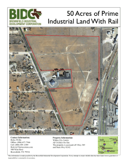


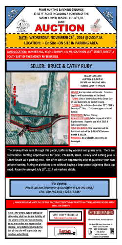


© Copyright 2026