
spring 2013 - Hunter UAP
URBAN
REVIEW
SPRING 2013
URBAN REVIEW
A Magazine of
SPRING 2013
the Hunter College Department of urban afffairs and planning
Editor-in-Chief
Erin McAuliff
Studio Spotlight: New Jersey Edge
3
ASSOCIATE Editor
Sam Chodoff
Studio Spotlight: Greening the Gap
4
Managing Editor
Dave Henry
How the Gowanus Was Won
Natsumi Yokura
5
Layout & DESIGN
Prudence Katze
Street Harassment in the City: Why Planners Should Care
Marly Pierre-Louis
11
Faculty Interview: Matthew Lasner
15
5 Pointz, LIC
Fatah Sadaoui
17
Open Data: A Catalyst for Urban Innovation
Aaron Fraint
19
Open Data in NYC: A Call to Action
Nathan Storey
21
A Brief Study of Corporate Bodies
Prudence Katze
25
Alumni Interview: Betty Cotton
29
Constructing the Urban Fabric
Sam Chodoff
31
LETTER FROM THE EDITOR
Dear Readers,
For the past four semesters, I have had both the pleasure and the honor of working with
students from the Department of Urban Affairs and Planning (UAP) to produce the Urban
Review. The final product you receive at the holiday or end-of-year party each semester isn’t
simply a showcase of the projects, papers and work of our student body—it is the culmination
of a long and collaborative process representative of why the UAP program deserves its
reputation for being an incubator for some of the most respected professionals in the field. In
some small part, I like to think that each issue of the Review is responsible for strengthening
the relationships and hosting the debates that make this true.
The students, faculty and alumni of the UAP program are a diverse group of individuals that
contribute to the richness of this program’s history and presence in the field of urban studies.
The Review, in some sense, is the voice of the department, and I encourage students who have
not been involved up until this point to find a way to participate and shape that voice, to keep it
current and representative of the dynamic people and processes that this department attracts
and inspires.
Thank you to the individuals who dedicated their time this semester to developing content, to
supporting each other and to continuing the legacy of the Review. As always, the work in these
pages is representative of the innovative and inclusive thinking that characterizes UAP students.
Please find and share the Urban Review online at www.hunteruap.org/guapa.
Erin McAuliff
Editor-in-Chief
Erin McAuliff is a student in the Master of Urban Planning program and will graduate this semester with departmental honors. Her focus
is on community development and education.
Content Editors
Jake Bogitsh
Sara Meier-Zimbler
Natsumi Yokura
Prudence Katze
Peer review team
Chris Roberts
Kendall J. Matthews
Sarah Meier-Zimbler
Frank R Futia
Yasmine Robinson
Prudence Katze
Jake Bogitsh
Annabelle Meuniel
Aaron Fraint
Natsumi Yokura
Ryan Ridings
Jeffry Peel
FRONT COVER
Natsumi Yokura
1
URBAN REVIEW | SPRING 2013
BACK COVER
Marly Pierre-Louis
2
Master of Urban Planning Studio Fall 2012 - Spring 2013
STUDIO SPOTLIGHT: NEW JERSEY EDGE
Photo by: John Namako
Master of Urban Planning Studio Fall 2012 - Spring 2013
STUDIO SPOTLIGHT: Greening the gap
client: Emmes Asset Management
Client: TreesNY
PROFESSOR: Richard Bass
Professor: Dr. John Chin
TEACHING ASSISTANT: Steve Duncan
Teaching Assistant: Steve Duncan
STUDIO TEAM: John Henry Greenwood,
David Henry, Anna Hellman, Gjela
Prenga, Donielle Lee, Mario Quijano,
Chang Sung, John Namako, Ben
Rosenblatt, Efrain Borrero, Lauren
Connors, Rony Byas
STUDIO TEAM: Amelie Bertholet,
Molly Braun, Spencer Edwards,
Samuel Frommer, Paul Hesse,
Marguerite Koehler, Andrew Martini,
Lauren Masseria, Erin McAuliff, Jeff Peel,
Jordan Pender, Ryan W. Ridings,
Kelly Usseglio Viretta
Image by: Lauren Masseria
The New Jersey Edge studio seeks
to create a plan for a neglected
neighborhood on the edge of northern
Jersey City and southwest Hoboken.
This neighborhood is the home
of the Lackawanna Center, a 1.3
million square foot warehouse and
the focus of the study. The studio’s
client, Emmes Asset Management,
seeks to increase occupancy in the
Lackawanna Center by repositioning
the building as the focal point of the
surrounding community.
The warehouse is an industrial
behemoth, with a building footprint
of 138,224 square feet, eight stories,
nearly 22-inch thick floors, heavyduty loading docks, and old rail
connections. The building stands as
a reminder of when northern New
Jersey was at the epicenter of America’s
railroad and shipping industries.
The surrounding neighborhood is
typified by disjointed and overlapping
jurisdictions and a patchwork of
redevelopment plans. The interested
parties, Hoboken, Jersey City,
and New Jersey Transit, have not
addressed the neighborhood as a
coherent whole. The result is a maze
of strip malls, brownstones, highways,
paved overpasses and empty lots,
but not a livable community. The
New Jersey Edge studio seeks to
bridge the edges, both physical
and jurisdictional, between the
communities in the area.
To recreate the neighborhood, the
studio plan proposes subdividing
the building to reintegrate it with
the existing street grid, allowing for
an enhanced pedestrian network.
The plan also proposes creating a
new economic cluster of vertically
integrated food manufacturing and
indoor farming firms, as well as a
university-sponsored Tech Center.
The New Jersey Edge Studio provides
a vision for a cohesive community
with revamped human infrastructure,
new job opportunities, and a
repositioned Lackawanna Center.
The building’s tremendous potential
can best be taken advantage of
by making it the focal point of a
reinvigorated neighborhood.
Map by: Chang Sung
Inspired on his morning dog walk, the Deputy Director of TreesNY noticed an area
prone to flooding at the base of the 120th Street pedestrian bridge leading to the East
River Esplanade. With funding from the Department of Environmental Conservation,
TreesNY installed a pilot green infrastructure project at the East 120th Street site to
create an urban oasis and green entrance to the esplanade.
With the intent to further inspire use of this public space, TreesNY tasked the
Greening the Gap studio with creating a plan to address waterfront access and
environmental justice issues in East Harlem while expanding the potential for
their green infrastructure projects in the neighborhood.
Principles
Promote environmental justice and
public health
There is a gap in East Harlem. A lack
of open space and a shortfall of public
investment have contributed to higher
rates of health and environmental
problems when compared to surrounding
neighborhoods. The purpose of this plan
is to use environmental interventions,
specifically green infrastructure
and waterfront access, to promote
public health and address issues of
environmental justice in East Harlem.
Utilize a community planning
methodology and build a framework
for continued community ownership
3
Consider the natural topography of
the study area
Because many of the environmental
recommendations of this plan depend
on the natural topography of the area,
the team did extensive research of the
natural history and current conditions
of topography.
Provide our client with actionable and
fundable recommendations and “think
big” to inspire visionary change
East Harlem is often a neighborhood
that is over-studied yet resources
remain under-delivered. With this in
mind, we established realistic short
and medium term goals, as well as
set forth a community-driven vision
of long term change. The short-term
recommendations are meant to be
quickly actionable and fundable,
while the long-term recommendations
that re-imagine the neighborhood
and waterfront are larger, more
expensive projects that would require
cooperation with multiple agencies
and organizations.
Improve Waterfront Access to
the esplanade and enable the use of
one of East Harlem’s most important
open spaces.
INCREASE TREES & GREEN SPACE
to bring environmental and health
benefits to East Harlem.
INCREASE STORMWATER CAPTURE
by implementing green infrastructure,
which we define for the purposes of
this project as permeable surfaces,
especially green space.
IMPROVE PROGRAMMING offered as
a means of promoting waterfront use,
active recreation to increase public
health, connection to the water itself,
and the stewardship of neighborhood
green space.
Recommendations
Based on our research and goals
we came up with three main
recommendation areas:
• Development of Green Corridors:
improved streetscapes that promote
access to the waterfront;
• Improvements to the physical
infrastructure on the esplanade; and
• Increased programming in the
neighborhood & on the Esplanade
to promote the use of the waterfront.
4
URBAN REVIEW | SPRING 2013
Photo by: John Namako
In order to create a plan that meets
the needs of East Harlem, the studio
utilized a community planning
methodology and conducted
extensive community outreach. This
outreach informed the studio about
neighborhood concerns and needs and
created a sense of community ownership
of the plan. Community engagement
drew on the extensive knowledge of a
diverse group of stakeholders to form
recommendations that are rooted in
community input and will inspire
continued community ownership.
Goals
URBAN REVIEW | SPRING 2013
How the Gowanus was Won
WORDS & PHOTOS by Natsumi Yokura
5
6
Until recently, the name “Gowanus” could never have been
imagined as anything but an industrial, polluted wasteland
in the middle of Brooklyn’s finest neighborhoods. This
was considered unfortunate, given the area’s otherwise
outstanding assets: excellent access, proximity to Brooklyn’s
posh, brownstone neighborhoods, and the edgy, postindustrial setting provided by abandoned warehouses. In
any case, the Gowanus slowly caught on as an ‘up-andcoming’ neighborhood – residents moved in, developers
took interest, new restaurants and bars opened, and artists
came to take advantage of big, cheap spaces. The question
is: what caused this transition? This piece will explore the
reasons behind the transformation of the Gowanus Canal
neighborhood from a polluted, unlivable industrial area,
to the next “it” neighborhood. The reasons examined here
are: the prominence of neoliberalism1 in New York City,
the consequent unaffordability of living in New York City
(particularly in Manhattan), and the emergence of Brooklyn
as an affordable place that carried symbolic capital2 by
offering an alternative, yet culturally genteel lifestyle.
An analysis of the Gowanus redevelopment also delivers
an important commentary on the current state of
urban planning. Comprehensive visions have been cast
aside in favour of hasty development, compromising
economic, environmental and social sustainability in
changing neighborhoods like the Gowanus. The Gowanus
redevelopment is thus an important opportunity for the
planning community to rethink its values and purpose.
Before taking a closer look at the factors that catalyzed the
Gowanus’ transition, a brief account of the area’s history,
environmental remediation efforts, and recent development
efforts will be useful in understanding the current context of
the tension the Gowanus is experiencing between its past and
the future many want for it.
Background
Basics
The Gowanus Canal is located at the westernmost portion of
Long Island in the borough of Brooklyn in New York City.
The mile-and-a-half-long waterway divides the neighborhood
of Red Hook from Park Slope, and is bordered by Cobble
Hill and Boerum Hill to its north. The Canal is fed by the
Gowanus Bay which is part of Upper New York Bay. The
Gowanus area lies on low ground, and ends where slopes on
either side begin. This topography makes the Canal area prone
to flooding, as was evidenced during Hurricane Sandy in
October 2012. Up the hill to the west are Carroll Gardens and
Cobble Hill, while Park Slope lies on the eastern slope. The
slope rises much quicker to the west than the east, and thus
there are more industrial uses on the Park Slope (east) side.3
comprehensive rezoning projects have been put on hold by the
recent designation of the Canal as an EPA Superfund site (to
be discussed further below)(Santora, 2009). Even without the
rezoning, a new luxury condo was recently completed on 8th
Street between 3rd and 4th Avenue, while a waterfront 700-unit
condominium development, complete with a Canal-adjacent
promenade by the Lightstone Group remains in the works
as an “as of right13” development.14 Furthermore, a Whole
Foods (perhaps the touchstone of gentrification) is set to open
adjacent to the canal in late 2013, despite flooding from canal
waters during Hurricane Sandy in late 2012.15
Environmental Concerns
paint, building materials and metal foundries. The base of the
Canal (the north end of the Canal, which today is the Carroll
Gardens and Boerum Hill neighborhoods) held brownstone
and brick townhomes that housed Canal workers, and left a
legacy of low-rise, brownstone and brick townhomes.6 By the
1920s, the Gowanus Canal was the busiest and most polluted
canal in the country. The pollution was recognized as a serious
issue already at this time, and a flush tunnel carrying water
from the Buttermilk Channel (the waters separating Red
Hook from Governor’s Island) was employed to clear out the
pollution produced by industry.7
Post-Industrial Gowanus
The Canal’s demise as a manufacturing and shipping center
eventually arrived in the latter part of the 20th century as
a result of several key market changes in the post-World
War Two period which reduced demand for the Canal’s
chief products. Further, the construction of the Gowanus
Expressway by Robert Moses in the 1940s and 1950s and the
popularity of containerized shipping in the 1970s negated the
need for the Canal as a shipping and manufacturing corridor.8
The neighborhood was not completely abandoned, however.
Artists began moving into the area in the 1980s because of
the abundance of large, cheap spaces for work and exhibition.9
Proteus Gallery at Nevins and Union Street was founded in
the late 1980s and is part performance space, part gallery, and
part work space. More than twenty years later, artists continue
to base their work in the Gowanus area.10
A Brief History
The Gowanus Canal was built on what was formerly the
Gowanus Creek in 1860 to serve the growing industry that
existed along the Creek and powered Brooklyn’s significance
as an important, regional industrial center.4 The Canal was
constructed to provide shipping access to factories, and also to
serve as an outlet for industrial waste and sewage.5 Among the
industries operating along the Canal were lumber, coal, oil,
7
Re-zoning the Gowanus
In response to the growing interest in the Gowanus (as
evidenced by the “mini-retail” explosion described above)12,
the NYCDCP undertook a rezoning study in 2008 of the
Gowanus Canal corridor, a 25-block area around the Canal in
which intensified mixed-uses were envisioned. However, any
The EPA and Superfund
Designation
“The waters of
the Gowanus
Canal are
contaminated
with over a
hundred years
of accumulated
pollutants,
such as coal,
ash, tar, and
toxins from
paint and glue
manufacturing.”
Despite the need for a serious remediation
effort, plans to designate the Gowanus
Canal as a Superfund site were met with
opposition. In particular, resistance came
from developers that had already invested
cash in their planned developments, and
Mayor Bloomberg who countered with an alternative proposal
for a faster, “less-bureaucratic” clean up. Bloomberg knew well
that an EPA Superfund designation would delay and even kill
investment interest in the Gowanus Canal, and negatively
affect economic development and tax revenues.19 Nonetheless,
the EPA designated the Gowanus Canal as a Superfund Site
in March 2010.20
To the contrary, many residents viewed the Superfund
designation as a blessing. Not only will the EPA improve
human and environmental health and safety, it has granted
a pause to think more carefully about how the area should
be redeveloped.
Explaining the Gowanus’ Transition
from Blue Collar to White Collar
With this brief summary, a sufficient historic and present
context should now be in place to clearly consider the impact
of the Gowanus’ transition into a desirable neighborhood
despite the problems exposed above.
Manhattan’s Unaffordability
In the postwar period, New York City concurrently pursued
Brooklyn’s Symbolic Capital
As alluded to above, Brooklyn’s symbolic
capital has been a powerful magnet,
particularly in the past decade or two.
The borough initially experienced a
“renaissance” in the post-World War Two
period as a result of its low-rise historic
architecture, neighborhood feel, cultural
amenities and convenient access to Manhattan. Migrants to
Brooklyn were also escaping the “sameness” and bureaucracy
that characterized the suburbs and Manhattan.25 Indeed, the
Brooklyn phenomenon was a political commentary on the
failure of Modernist urban planning, specifically New Deal
liberalism and its “university campuses, government complexes
and corporate skyscrapers.”26
By the 1990s, Brownstone Brooklyn was home to New York’s
educated and wealthy, as well as the intellectual and cultural
center of the city, surpassing Manhattan in this respect:
“With hip bars, and cafes, used-book stores,
yoga studios, and renovated townhouses,
Brownstone Brooklyn is no longer regarded
by the public as blighted, but instead is both
celebrated and reviled as a site of cultural
consumption for a new middle class.”27
URBAN REVIEW | SPRING 2013
People have always lived in the Gowanus neighborhood – in
the late 19th and early 20th century, it was canal laborers,
later it was Italians and Puerto Ricans. Today, the Canal’s
new status as a trendy neighborhood has attracted artists
and white middle-class families alike. Homes routinely sell
for over a million dollars—prices can even reach up to $3
million.11 Soon, unique businesses such as terrarium retailers,
dog daycares, trendy restaurants, music venues and bars began
appearing in the Gowanus, reinforcing the speculation that
the neighborhood was the new “it” place.
The waters of the Gowanus Canal are
contaminated with over a hundred years
of accumulated pollutants, such as coal,
ash, tar, and toxins from paint and glue
manufacturing.16 Further, microbes such
as cholera and typhoid have been found
in the Canal.17 It is troubling then, that
the Gowanus is situated on a flood plain–
something that the city was made keenly
aware of during Hurricane Sandy. Despite
these concerns, the Canal has never been
properly cleaned up, despite some shortterm fixes dating back to the beginning of
the 20th century.18
economic development and welfare. The city had a booming
goods production economy and well-paying union jobs,
and provided welfare services and education. Global capital
arrived in the 1960s and 1970s, and received favorable tax
cuts and funding for their perceived role in boosting New
York’s economy. This arrangement caused over-expenditures
and eventually, a fiscal crisis. When it came time to choose
between providing welfare services and accommodating
global capital in order to solve the fiscal crisis, New York chose
the latter and eventually established itself as an important
global economic center.21 This choice had dire costs. The
city’s economic development policies in the 1970s and 1980s
produced a city that made the rich richer
and the poor poorer. Rents sky-rocketed,
leading to “modern homelessness,”22 the
departure of many city dwellers to the outer
boroughs (e.g. Brooklyn) or out of the city
all together.23 More and more, Manhattan
became a residence for the privileged
and “Monopoly Rents” were charged as
a premium for living in Manhattan.24
Meanwhile, Brooklyn offered desirable
housing stock, a culturally-rich, alternative
lifestyle, urban amenities, and affordability.
Thus for many people, especially those
out-priced from Manhattan, moving to
Brooklyn was an obvious, and often times
necessary choice.
Not only does the Gowanus Canal neighborhood inherit
the symbolic capital of Brooklyn, it has forged its own.
Since the abandoned warehouses and foundry buildings
no longer served their original purposes, they have been
excellent, affordable spaces for artists to work and new
businesses to gain footing.28 As a haven for artists and young
people, Gowanus has lived up to all that is “Brooklyn” but
8
has added its own touch: outdoor parties along the Canal’s
shores, a kayak club, art galleries, gourmet food stores, and
musical events on the Canal.29 The neighborhood’s “urban
decay” atmosphere (i.e. the crumbling remains of the area’s
industrial past) also symbolizes its artistic, young and risktaking spirit.30 A quote from a Gowanus resident summarizes
the enticement of Brooklyn and Gowanus as a new cultural
center: “There’s no place in Brooklyn, or in New York City, that
feels kind of more pleasant than being right here, which is odd
given that is a toxic waterway.”31
The Gowanus’ Transition as a
Commentary on the Current
State of Urban Planning
Planning Follows Capital
The reduced role of planning as a reactionary activity is
characteristic of neoliberalism and evident in the case of the
Canal. Investors had expressed interest in developing the
Gowanus Canal for at least a decade. Until 2008, the DCP
had responded to requests to develop on a case-by-case basis.
It took ten years of steady interest from developers, beginning
in the late 1990s, for the City to think about formally
planning the Gowanus.
Moreover, due to the fragmented and reactionary nature of
urban planning and development spawned by neoliberalism,
more actual planning is performed by groups such as Living
City Block, the Gowanus Institute, and the Gowanus Canal
Community Development Corporation (GCCDC) that
proclaim mandates to make the Gowanus a unique, profitable
and sustainable neighborhood. These groups consolidate
funding, supporters and draft plans for their plans as a
response to the lack of action on the part of the NYCDCP.
7.
Ibid.
8.
Ibid.
9.
Gross, Matt. 2010. “Celebration at the Edge of Decay.” The
New York Times, June 2, 2010.
10.
Ibid.
11.
Santora, Marc. 2011. “In Gowanus, Big Development Can Wait”
The New York Times, July 29, 2011.
12.
Navarro, Mireya, 2009. “On the Gowanus Canal, Fear of
Superfund Stigma”. The New York Times, April 23, 2009.
13.
As-of-right development is compliant with all zoning
regulations and does not require any discretion from the city
planning commission or other regulatory bodies.
14.
Dailey, Jessica. 2013. “A Sneak Peak of the Newest Luxury
Rental Building in Gowanus.” Curbed NY.; Pristin, Terry. 2013.
“Once Hobbled, New York Developer Aims for Comeback.” The
New York Times, April 3, 2013.
15.
Del Signore, John. 2012. “Signs at Whole Foods Gowanus
Location Warn of ‘Active Contamination Site’” Gothamist,
December 14, 2012.
16.
Bonanos, Christopher. 2009. “A Brief History of Slime.” New
York Magazine, July 12, 2009.
17.
Ibid.
18.
Goodman, J. David. 2011. “Under the Gowanus Canal, Flushing
Out the Stench” The New York Times, February 23, 2011.
19.
Navarro, 2009.
20.
Navarro, Mireya. 2010. “Gowanus Canal Gets Superfund
Status”. The New York Times, March 2, 2010.
21.
Greenberg, Miriam. 2008. “New York City as a Symbol of
Neoliberalism” in Branding New York: How a City in Crisis
was sold to the World. New York: Routledge. p. 248; Brash,
Julian. 2011. “Introduction”, “Chapter 1”, and “Conclusion”
in Bloomberg’s New York. Athens, GA: University of Georgia
Press. p. 27.
22.
A 2002 report by the New York Coalition of the Homelessness
recognizes that while homelessness is neither new nor unique
to New York City, routine homelessness has never been such
a widespread “visible feature of urban life” than it is today.
Until the 1970s, it was rare to see homeless people unless one
purposefully sought them out.
23.
Greenberg, 244-245.
Neoliberalism (1973-present) rejects egalitarian liberalism, a
period of democratic socialism where federal policies helped
propel the working class into the middle class, and attempted
remediation of social injustices such as the renewal of innercity ghettos and instead calls for deregulation of industry and
shrinking of the state.
24.
David Harvey quoted in Greenberg, 243-244.
25.
Osman, Suleman. 2012. The Invention of Brownstone
Brooklyn: Gentrification and the Search for Authenticity in
Postwar New York. New York: Oxford University Press. p. 5.
26.
Ibid, 13.
The term symbolic capital was conceived of by the French
philosopher Pierre Bourdieu, and refers to the recognized
power of an agent, be it an item, an address or activity. He also
attributes reputation, prestige and fame to the term. Symbolic
capital is convertible into social (one’s social network),
cultural (intellect and education) and economic capital (money
and stocks). For example, one’s tastes both demonstrate and
determine one’s richness (or poorness) in symbolic capital.
27.
Ibid, 8.
28.
Gross, 2010.
29.
Santora, 2011.
30.
Gross, 2010.
31.
Ibid.
32.
Beauregard, Robert. 1989. “Between Modernity and
Postmodernity” in Fainstein, Susan et al. (eds.), 2003,
Readings in Planning Theory. Boston: Wiley-Blackwell. p. 110.
33.
Beauregard, 115.
34.
Ibid, 118.
Because the Gowanus Canal redevelopment is unconventional
due to the unusual landscape and serious environmental
hazards, it calls for a comprehensive solution that considers
not just the entire neighborhood, but the implications
of its redevelopments on neighboring areas, the borough
of Brooklyn and the City of New York. In this way, the
Gowanus Canal redevelopment is a rare opportunity for city
planners and officials to plan with foresight and conscience.
If capital (and increasingly, government) cannot preemptively do the right thing and provide social needs such
as environmental health and housing affordability, planners
must close the “critical distance” and act as a social critic.34
Though the redevelopment of the Gowanus Canal is
underway, it is not too late to question, reaffirm and pursue
the goals that are inclusively decided upon as a community of
New Yorkers.
Unfortunately, as with many other contemporary
socioeconomic and political issues, the hands of urban
planning seem to be tied by a neoliberalized political economy
that runs the City of New York as a corporation. The
Gowanus Case study reminds us that while urban planning
has a significant role in “regulating the spatial arrangements
of land uses and providing housing,”32 this ideal is threatened
by deregulations and other neoliberal policies that advantage
Natsumi Yokura is a student in the Master of Urban Planning
program. Her focus is on transportation planning, especially in the
context of community development and environmental planning.
She expects to graduate in Spring 2014.
2.
3.
Boyce, Leslie-Artlette and Merlis, Brian. 2011. The Glory of
Brooklyn’s Gowanus. New York: Israelowitz Publishing. p. 33.
4.
Historic Districts Council. 2012. “A Guide to Historic New York
City Neighborhoods: Gowanus, Brooklyn.” p. 1.
5.
Boyce and Merlis, 34.
10
URBAN REVIEW | SPRING 2013
Historic Districts Council, 1
A Critical Conclusion: the Gowanus Canal
Redevelopment Study as an Indicator for
the Future of Planning
1.
9
6.
capital and disadvantage the social welfare of people. Today,
planners are “increasingly vulnerable to property and industrial
capital through the state’s depending involvement in capital
accumulation” and planners are less able to object to the state’s
pursuit of capital. Thus planners are reduced to dealing with
negative externalities on a case-by-case basis rather than
creating plans with a higher purpose or faithfulness to any
sort of overarching goals or ideals.33 Even bodies such as the
GCCDC and developers that claim to be in the people’s
interest are business-oriented and keep public discussion to
the fringes.
In her 1994 article published in UCLA Women’s Law Journal, Deirdre Davis calls street
harassment, “The Harm That Has No Name.”1 It is defined as unsolicited comments,
remarks, gestures, or touches usually targeted at a woman from a man and can include
everything from seemingly innocent comments like, “Hey Baby” to hissing, whistling,
leering, threats, touching, grabbing, and following. This behavior is often dismissed
as playful and harmless, but women everywhere experience this as something much
more treacherous. Street harassment exists on the spectrum of gender-based sexual
violence and should be regarded and treated as such. Although it is not as severe as
sexual assault and rape, “it carries many of the same traits as other forms of sexual
violence, and can cause considerable mental and emotional damage.”2 Queer and
transgender women are also subject to harassment when their gender presentation is
compounded by their perceived sexual orientation. The particulars of their experience
should not be glossed over and thus are outside of the scope of this paper. Here, I will
focus on the experience of female presenting women, regardless of sexual orientation.
Street Harassment in
the City: Why Planners
Should Care
by Marly Pierre-Louis
them back into the private sphere where they can avoid such
violations. By turning women into objects of public attention
when they are in public, harassers reinforce the message
that women belong only in the private sphere - at home.7
When women enter public spaces, their very being becomes
public: their bodies up for public scrutiny, commentary and
consumption. While the representation of street harassment is
often conveyed as innocent banter, in reality it takes on a far
more insidious quality.
Although men are more likely to be attacked by a stranger
than women are, women must consider safety in a way that
men do not. Since women cannot know if a remark might
escalate into violence, street harassment reminds women
that they can be attacked at any moment. And since in the
United States, one in every five adult women has been the
victim of rape or attempted rape in her lifetime8, this is hardly
an overreaction. “Sexual harassment is a gateway crime that
creates a cultural environment that makes gender-based
violence ok.”9 While not all harassers are rapists, women have
no way of knowing who is and who isn’t and are thus forced
to move through space with a generalized fear of
being assaulted:
“I’m always concerned that I’m gonna walk
down the street and get raped. Its just something
I’m always thinking about, regardless of what
neighborhood I’m in, what city I’m in, there’s like a
fear that I live with.”–“C.C.”, Black woman, late 20’s
Women’s right to the city
In December of last year, a young woman in New Delhi was
fatally beaten and repeatedly raped after boarding a bus. The
bus driver initiated and encouraged the assault by making
lewd comments about her.
In New York City, Darnell Hardware pushed himself onto a
crowded train car, stood behind a young woman and grinded
himself to ejaculation - on three different occasions. The
women, held captive by the crush of other passengers only
discovered the extent of what had happened to them after
discovering Hardware’s ejaculate on their clothes.
“A 2000 survey by the U.S. Bureau of Justice Statistics
showed that more than half (52%) of the female respondents
were feeling afraid walking around their neighborhood at
night, whereas only 23% of the male respondents were afraid
to do so.”3 Moreover, research shows that women use parks
and open spaces significantly less than men do.4
In this article, I will begin by outlining the societal factors
11
In an effort to contextualize and localize this issue, I
conducted two focus groups and a web survey with a small
group of Black women who live in Bedford-Stuyvesant,
Brooklyn. The intersection of race and gender is often
overlooked in considerations of street harassment and gender
violence. For this reason, I chose to explore this topic through
the lens of Black women. When appropriate, I’ve included
quotes from this study group throughout this paper.
Fear of rape & gendered
spatial boundaries
Sexual terrorism, a term defined by Carole Sheffield as “men’s
systematic control and domination of women through actual
and implied violence,”6 genderizes public spaces by allowing
men to control women’s access to it. Thus, street harassment is
implied violence. Further, by policing a woman’s movements
through the streets, men define her participation in public
life. If women are subject to violation of personal privacy
when they enter public areas, that invasion effectively drives
Verbal harassment
Sexually explicit language emerged as the most common form
of harassment.
“On my way to pick up my son from school on
a weekday I decided to run up to the school so I
would not be a minute late. I was passing a thin
AF AM (African American) brother who said
“damn sexy look at your titties jiggling.” I was
horrified and said, “You’re disgusting.” He replied,
“Be grateful I don’t rape you” and then stood on
that corner staring at me. I was scared to leave
the school with my son fearing I would have to
pass him again and that he would be able to see/
identify my child.”–“B.B.”, Black woman, early 30’s
“A man tried to pick me up when I was walking
home from the subway. I told him I wasn’t interested
and to leave me alone. I thought he had backed up
but he followed me to my house, confronted me
and made sexually explicit gestures. My main fear
was that he knew where I lived.” -Anonymous
About a fifth of respondents had been grabbed:
“I was walking home several years ago while living
on Greene Avenue. While only 5-6 houses from my
house a man AF AM (African American) brother
on a bike rode past me and grabbed my butt while
passing. I felt so violated and dirty, disgusted at
what this stranger did. I showered for over an hour.
Did not talk to anyone that night, no calls, nothing.
I felt paralyzed.” –“B.” Black woman, early 30’s
In light of the intensity of their harassment, women maneuver
through the city in myriad ways to avoid being harassed,
followed, grabbed, or assaulted. They avoid areas, abstain
from activities, and otherwise, alter their daily lives in order
to stay safe. In her 1993 piece, “Street Harassment and the
Informal Ghettoization of Women,” Cynthia Grant Bowman
writes that street harassment:
“…not only diminishes a woman’s feelings of safety
and comfort in public places, but also restricts her
freedom of movement, depriving her of liberty and
security in the public sphere... Thus harassment
makes the urban environment uncomfortable,
hostile, and frightening for women.”10
Restricted freedom of movement
Here the women discuss the ways in which they alter their
routes and daily activities to feel safe:
“I try to come home earlier from events, won’t
go to events that start too late (e.g. I missed a
karaoke event in the city that started at midnight
because I did not want to leave my house so
late and didn’t want to pay for a car), try to
travel in groups.”–“E.” Black woman, 30
“I don’t even like to walk to the corner to buy
a bag of candy when it gets dark. I either ask
my boyfriend to walk with me or I won’t go.
Also, If I am going to wear a dress out, I like
to travel in groups so I feel safer and don’t get
as many comments.”–“J.” Black woman, 29
“I changed what I wear. I don’t even wear heels
anymore. I don’t even bother. I don’t want to
wear anything that will bring attention to me.
Just act like I’m not here. And it’s come to the
point where I do everything that I can do to
be invisible...” –“L.” Black woman, late 20s
Not only does the fear of street harassment exclude women
from fully enjoying the culture, social life, and opportunities
that they should have equal access to as citizens, but it
can also have an impact on their access to education and
economic independence if they choose not to take night
12
URBAN REVIEW | SPRING 2013
These stories and others I will share in this paper demonstrate
the fact that street harassment “makes the urban environment
uncomfortable, hostile, and frightening for women,” making
it a clear and pressing planning issue.5 Street harassment
increases women’s fear of rape and thus restricts their access
to full citizenship in the city. Herein lies an opportunity for
progressive planners to use tools such as design, zoning, and
mapping to address the issue of women’s urban safety.
that support and perpetuate street harassment. I will discuss
the role that planning plays in this issue by placing it in a
spatial context with civic engagement, transportation, and
public space implications. I will then discuss how street
harassment manifests on the streets and on public transit.
Lastly, I will offer recommendations on what planners can do
to address this issue.
In this section, I share the stories of the women I interviewed
to reveal what street harassment actually looks, feels and
sounds like.
Physical harassment
formulate recommendations for relevant agencies.
The experiential nature of the tool and its use in a
familiar physical environment makes it a particularly
effective means of empowering ‘ordinary’ women
to participate in community development, while
the interaction between them helps develop
ideas about key issues and the way forward.”16
classes or work late. In her article, “Street Smut: Gender,
Media and the Legal Power Dynamics of Street Harassment
or ‘Hey Sexy’ and Other Verbal Ejaculations”, Olatokunbo
Olukemi Laniya writes “Street harassment excludes women
from public space, which they are entitled to share with men
as equal citizens of the state. A fundamental aspect of liberty
is mobility, yet free exercise of mobility often is denied to
women.”11 Further on the topic of mobility, harassment on
public transportation adds another level of maneuvering that
women must do to stay safe.
Harassment in transit
Overcrowded trains create a cover for sexual harassment. In
a 2007 survey done by the Manhattan Borough President’s
office entitled, “Hidden in Plain Sight: Sexual Harassment
and Assault in New York City Train Systems,” with 1,790
participants, 63% of female respondents reported to being
sexually harassed, 69% of respondents reported having felt the
threat of sexual assault or harassment in the New York City
subway system.12 The term “subway grinders” is used by the
NYPD to describe men who take advantage of packed train
cars to rub themselves against women.13 The sheer volume of
people on a packed train makes it possible for men to grope
and fondle women, and more difficult for women to identify
who did it.
Over half of the participants in my focus group described
being flashed or masturbated in front of in train cars
or platforms:
“When I was a kid a man flashed his penis on the
D train, Prospect Park station. And then one time,
I was on the 48 bus I must’ve been 11 years old,
this man sat next to me, put his arm around me
and licked my face.” –“M.” Black woman, 30’s
“I was like 16, I fell asleep and I woke up and
this guy was masturbating and I acted like
I was sleeping.”–“Z.” Black woman, 28
What Planners Can Do
Ignoring street harassment and gender violence and the
effect they have on the ways women are able to participate in
urban life is equivalent to planning for half the population.
Poor management of urban space, lack of street lighting and
signage, blind spots, unlit bus and train stations, inadequate
access to public transit in low-income communities,
overcrowded trains, and lack of public spaces are all issues of
planning and design.
13
“Simply collecting data,
however, is not enough:
Women need to be
partners in facilitating
a process that brings to
focus public spaces that
are unsafe. ”
Simply collecting data, however, is not enough: Women need
to be partners in facilitating a process that brings to focus
public spaces that are unsafe. Planners can create a gender
inclusive participatory process that uses geography as a tool.
In the study conducted by Action Aid International in 2010,
mapping exercises used in Cambodia and Brazil proved to be
“among the most effective, empowering, and popular tools
for urban women participants.”14 Safety audits are another
participatory tool recognized by the United Nations as a best
practice for addressing street harassment and gender violence
in urban areas around the world.15 According to the report
released by Women in Cities International in 2010, safety
audits involve:
“...a group of women walking around an area to
observe, consider and record views about safety
related issues as they appear. The walk is followed
by a meeting to discuss results, decide on the
necessary changes for creating a safer space and
Davis, Deirdre. 1994. The Harm That Has No Name: Street
Harassment, Embodiment, and African American Women.
UCLA Women’s Law Journal, 4. p.1.
2.
Hollaback. n.d.. Hollaback. Retrieved from http://www.
ihollaback.org/.
3.
Loukaitou-Sideris, Anastasia. 2005. Is It Safe to Walk
Here? Design and Policy Responses to Women’s Fear of
Victimization in Public Places in Research on Women’s Issues
in Transportation (2). p. 103.
4.
Ibid, 105
5.
Bowman, Cynthia Grant. 1993. Street Harassment and the
Informal Ghettoization. Cornell Law Faculty Publications,
Paper 142. http://scholarship.law.cornell.edu/facpub/142. p.
539.
6.
Davis, 4
7.
Bowman, 527
8.
Center for Disease Control and Prevention. 2012.
Sexual Violence. Retrieved from http://www.cdc.gov/
ViolencePrevention/sexualviolence/datasources.html.
9.
Hollaback
10.
Bowman, 539
11.
Laniya, Olatokunbo Olukemi. 2005. Street Smut: Gender,
Media, and the Legal Power Dynamics of Street Harassment,
or “Hey Sexy” and Other Verbal Ejaculations. Columbia
Journal of Gender and Law, 14(1), 91-130.
12.
Manhattan Borough President Office. (July 2007). Hidden in
Plain Sight
13.
Sexual Harassment and Assault in the New York City Subway
System. Retrieved from http://www.mbpo.org/uploads/policy_
reports/HIDDEN%20IN%20PLAIN%20SIGHT.pdf. p. 5.
14.
Fisher, J. 2012, September 12. Subway pervert who
masturbated on three women aboard trains gets off with NO
prison time, thanks to New York State’s highest court. NY
Daily News. Retrieved from http://www.nydailynews.com/
new-york/subway-pervert-masturbated-women-aboardtrains-prison-time-thanks-new-york-state-highest-courtarticle-1.1161774#ixzz2FkAr8D00.
15.
Action Aid International. 2011. Women and the City: Examining
the Gender Impact of Violence and Urbanization. Retrieved
from http://www.actionaidusa.org/publications/women-andcity-examining-gender-impact-violence-and-urbanisation.
16.
Kearl, H. May 8, 2012. New York City Safety Audit a Success.
Retrieved from http://www.stopstreetharassment.
org/2012/05/nycaudit/
17.
Women in Cities International. 2010. Learning from Women
to Create Gender Inclusive Cities: Baseline Findings from the
Gender Inclusive Cities Programme. Retrieved from http://
www.femmesetvilles.org/.
18.
Loukaitou-Sideris, 109
19.
Ibid
20.
Ibid
21.
Women in Cities International. (2012). Tackling Gender
Exclusion: Experiences from the Gender Inclusive Cities
Programme. Retrieved from http://www.womenincities.org.
Conclusion
Urban planners cannot continue to be complicit in the
policing of women’s bodies. We must begin to understand the
intersections of gender, civic engagement, and public space.
“Across the globe...we are increasingly seeing recognition of
the intersections between violence against women, urban
planning and safety, particularly in poor communities.”20 Not
only does women’s urban safety intersect with public spaces,
but also with transportation, and community development.
As planners, we are in the business of creating accessible
spaces. We recognize that public spaces should be visually
attractive and we appreciate walkability, compactness and
sustainability. If we can imagine for a moment, our most
perfectly planned public park, can we also imagine, that park
not being enjoyed by half the city’s population? Would we
ever call such a plan successful? We do just that by ignoring
women’s safety. The evidence is clear, but the necessary tools,
technology, and resources are available. We must begin to
re-imagine the built environment with a genderized spatial
lens. Gender-inclusive planning has the power to impact the
everyday experience of women in the city.
URBAN REVIEW | SPRING 2013
In order to tackle this issue, planners can begin by using
technology and established best practices for creating a
participatory process for tackling street harassment in city
neighborhoods. GIS and GPS technology play a central role
in web and mobile applications dedicated to addressing street
harassment. Understanding the geography of fear that women
navigate on a daily basis, such as the adjustments women must
make to their daily routines and areas of high harassment
concentration, is powerful information for planners.
Photo by Marly Pierre-Louis
With the use of mapping and safety audits as planning
tools, planners can identify “hot spots” of harassment to
focus on. In “Is It Safe To Walk Here?”, Loukaitou-Sideris
proposes a range of design and planning interventions that
can be implemented to instill feelings of safety and preclude
opportunities for harassment. For example, mixed-use
zoning and the creation of multi-use spaces with an overlay
of activities would produce a “critical mass of people in
public spaces” and opportunities for “natural surveillance by
neighbors”.17 Storefronts facing the sidewalk and buildings
with street facing windows would also have the same affect.
In addition, placing stations and bus stops in well-lit and open
areas near businesses and heavy pedestrian activity, as well
as making sure bus shelters are well-lit, would help women
feel safer taking public transportation. Loukaitou-Sideris also
recommends “the replacement of pedestrian tunnels with
safe, ground-level crossings, and the elimination of empty
alleys as well as fences and heavy landscaping blocking sight
lines” to reduce fear and feelings of being unsafe.18 Lastly,
the design of public spaces should help ease tensions between
different groups using that space. This can be accomplished
by “the formation of time and activity zones through design
and planning in parks and public spaces that allow different
groups to use the same space.”19
1.
Marly Pierre-Louis is a graduate student of Urban Planning at
Hunter College. She focuses on the intersections of race, gender
and public space.
14
Faculty Interview:
Matthew LASNER
by ownership, I found a near absence of discussion in
the literature, with the exception of legal scholarship on
particular forms of co-ownership (of which cooperative
and condominium are just the two most common). I spent
about three years just doing research: trying to uncover
where condos, co-ops, and other earlier alternative forms
first became common, and when and why. The dissertation
which resulted was a kind of encyclopedia of non-trade-union
co-owned housing, structured quite rigidly around the places
where this way of living first became common in different eras.
For the book I wanted to take a much broader approach:
to produce something comprehensive, authoritative, and
useful for everyone, not just specialists. I reintegrated the
material from the dissertation with parallel developments
in limited-equity housing, and situated the entire story in a
larger, deeper narrative about the growth and evolution of the
American city. Rather than organize chapters around specific
cities, I focused more on user groups, and the question of
how different kinds of people have employed co-ownership
to various ends, to solve their particular housing problems,
at different moments, in different places. One of the most
fascinating things about co-ownership is that it’s not just
“co-ops” or “condos” or “townhouses”—and whatever images
come to mind when we hear those terms. It’s a slippery, shapeshifting web of social, political, and financial relationships
that can take an almost infinite variety of forms: legal
forms, forms of governance, and physical forms. If “house”
and “apartment” are physical, and “own” and “rent” are
contractual and financial, co-ownership really does introduce
a third dimension in how we conceptualize housing, and I
wanted High Life to convey some of this dynamism.
Professor Lasner was photographed on the third floor catwalk connection between Hunter East and Hunter North. Behind him is 115 East
67th Street, the “Millan House” co-ops, which were developed by John D. Rockefeller and designed by Andrew J. Thomas. Like many of
Thomas’s works, Millan House possesses an interior courtyard garden. Photo by Prudence Katze.
You’ve recently published High Life, a book about
co-owned, shared, and collaborative housing in
the US. Where does your book fit into previous
research on the subject? Can you share a few
conclusions that you’ve gleaned?
15
You first published your dissertation on the
same subject in 2007. How did your interest in
collaborative housing evolve and grow into
the book?
My dissertation was really a first pass at the material.
Originally I planned to write about working- and middleclass privately built multifamily housing since the 1960s:
what I hoped might prove to be successful alternatives to
single-family suburbia. As I zeroed in on the role played
I’ve not been approached by any housing officials, but I
have been approached by a land-use and housing lawyer in
Chicago, now doing a mid-career fellowship at the Kennedy
School of Government at Harvard, who is working to rescue
distressed condominium complexes in Illinois—mainly
suburban garden-apartment and townhouse complexes
that are home to working-class, often African American,
families, who were victims of predatory lending. Policymakers
and pundits, in continuing to imagine homeownership as
exclusively single-family houses, have done a terrible job of
thinking about the specific challenges of co-owned housing,
of which there are many. In metropolitan America one in
five homeowners lives in a multifamily complex. The market
for condos and co-ops and townhouses in many places
suffered far more than that of single-family houses, and when
homeowners struggle, they don’t just risk foreclosure, but
in undermining the viability of their entire complex, since
monthly maintenance or HOA payments are essential for
physically maintaining common elements. Almost no one
is talking about this issue, and we know almost nothing
about it, in large part I think because this housing is largely
invisible: co-ops on Park Avenue and Lake Shore Drive are
fine. It’s the ones in peripheral areas that are more likely to be
in trouble—and the majority of multifamily housing, both
rented and owned, has been suburbia since at least the 1950s.
I think the visual plays a central, if under-appreciated,
role in urban thinking. Many deeply ingrained
planning approaches are shaped quite fundamentally
by visual considerations. Too often, however,
we lose track of this thread; returning to visual
information can help us unpack assumptions, and
reevaluate norms. In housing, for example, many
core assumptions, such as our abiding interest in
subsidizing production over consumption (Section 8
notwithstanding), derives from arguments advanced
by architects and architectural critics in the early
twentieth century. The privileging of visual order over
social concerns—and faith in visual order to lead to
social outcomes—remains so powerful that it makes it
difficult to even detect when this process fails. HOPE
VI, which has been terrible for vulnerable tenants of
public housing, continues to appeal precisely for this
reason: it’s difficult to visually detect the harm it does.
At the same time, what housing looks like—what
metropolitan space looks like—is hugely important. In
the case of my own research, rich visual information
is crucial to drawing attention to the aspatial nature
of co-ownership—to its infinite physical forms and
metropolitan geographies. To talk about housing only
in terms of room sizes or methods of ownership or
structural soundness or rents is to trivialize a major
part of the human experience.
In terms of ways of knowing, I believe the artists’
eye is crucial to studying the city. Artists look at
urban space differently than do planners, architects,
policymakers, or social scientists. As a result, they
are positioned to see things that we might otherwise
overlook. Photographers, especially, have made
important contributions in this respect. Today we
have a lot to learn from the work of photographers
like Andrew Moore, who’s trained his eye on decaying
Detroit and Title I projects in New York City, and
Camilo Jose Vergara, with his long-term series on
industrial decay, urban churches, and countless other
aspects of our cities.
I’m also interested in how artists make urban
interventions. Artists have none of the training
planners do, and their work occurs at a much
smaller scale, usually without the support of the
state or other institutional actors, but this can prove
liberating. I’m thinking, for example, of graffiti
artists altering the streetscape and giving voice to
underrepresented communities, or Parking Day,
or Candy Chang’s interactive murals on empty
storefronts in New Orleans and on Fulton Mall in
Brooklyn. These are no substitutes for other kinds of
urban interventions, but planning can certainly learn
from these kinds of experiments.
16
URBAN REVIEW | SPRING 2013
Co-owned housing has long been a neglected topic in urban
and housing research. Most of literature, even today, imagines
the U.S. through a two-tier lens of single-family suburbs of
middle-class homeowners, on the one hand, and inner-city
rental apartments for the poor, on the other. But the reality
is more nuanced. We see glimpses of this in the literature
on gentrification and in discussions about “first ring”
suburbs. I wanted to complicate things further, and more
comprehensively, by examining what I position as a “third
tier” in housing: owned multifamily housing. I was especially
intrigued by the question of ownership, since homeownership
is so often taken as a raison d’etre for suburbia, and as an
explanation for U.S. metropolitan form. Many scholars
have written about the largest, best-known projects, like the
Amalgamated Cooperative Apartments and Co-op City, but
my book is the first to look at co-ownership as anything more
than incidental or isolated—to look at how the idea emerged
in the U.S. and all the different, often creative ways, various
groups of people have employed co-ownership to solve an array
of housing problems in different cities at different moments.
I think the book is important because it offers an opportunity
to reevaluate the success (and limitations) of local programs
like Mitchell-Lama and national programs like FHA’s
multifamily sections, and, more urgently, to evaluate some
of the claims being made for and against homeownership in
the wake of the mortgage abuses of last decade. We need to
be much more sophisticated in our understanding of how
factors—including tax breaks and long-term mortgages, but
also demographic change, expectations for quality in housing,
shifting gender roles, centers of employment—actually get
translated in specific forms and geographies of housing.
Since the 1880s, and especially since the 1960s and 1970s,
we’ve seen whole new kinds of communities emerge, but our
conceptual models have not kept pace.
Have you been approached by anyone for guidance
about housing policy? How would you like to see
your research applied in a practical setting?
Many of the photographs in your book are
your own, and you occasionally publish
reviews of notable urban-focused art
exhibitions. What role does art play in
understanding urban environments?
5 Pointz, LIC
by Fatah Sadaoui
Located in transforming Long Island City,
the 5 Pointz Aerosol Art Exhibit Center has
been a center of attention since its owner
announced the future demolition of the
former industrial complex.
The world’s premier graffiti hub is
threatened by land speculation and luxury
developments represented symbolically by
the Citigroup building, a pioneer in the
neighborhood’s transformation.
The 5 Pointz re-opens its door to the public
this May for a new season of concerts,
live graffiti performances and festivals,
thumbing its nose to the rumors!
Fatah Sadaoui is studying at the Hunter
College UAP department as part of an
exchange program with the Institut D’Études
Européennes (Paris 8 University). With a
specialization in art in urban settings and
graffiti, he expects to graduate in June 2013
with a Master in Urban Governance.
18
Open Data: A Catalyst
for Urban Innovation
Introduction
From the Federal to local level, many government agencies in
the United States are providing its citizens with free (“open”)
data in order to encourage public transparency, participation,
and collaboration. At the request of President Obama, Peter
Orszag, then the director of the Office of Management
and Budget, issued a memorandum in 2009 requiring that
Executive Departments and Agencies 1) publish government
information online, 2) improve the quality of government
information, and 3) create and institutionalize a culture of
open government.1 This memo was premised on the notion
that new technologies allow citizens to better participate in
government, and that more participation will lead to a higher
quality of governance.
tools that improve the way citizens interact with cities, and this
process is most often powered by open source technologies.
Aaron Fraint
Many cities across America have adopted similar local
legislation, including New York City, San Francisco,
Philadelphia, Chicago, Portland, and others. Technology has
come to play an important part of daily life, which has made
it increasingly clear that the best way to ensure government
transparency and accountability is to provide the public with
digital information. This allows technologists and curious
citizens alike to analyze and digest government data through
a variety of methods, including mapping, visualization, and
application development.
This article makes the case that providing open data increases
government accountability and transparency while also
improving access to city services and civic participation.
Additionally, open data enables civic technologists to build
I will begin by describing how a recent paradigm shift in
business management relates to public policy and open data.
I will then review open data policies in the United States
at the federal and local levels. This will lead to a discussion
of how open source software is an important and necessary
complement to this open data revolution. Finally, I will
provide specific examples of civic technologists who have
successfully joined open data with open source technologies,
creating applications that enhance the quality of daily life for
urban citizens.
Open Innovation in Business
and Technology
In the past, most of the innovation in the business world
was due to internal research and development (R&D). In
the manufacturing sector, R&D was often used to improve
internal production techniques. For example, “What can
we do to produce our widget faster/cheaper/better/etc.?”
However, this caused firms to sink large amounts of money
into research projects which may or may not prove to be
profitable. Over time, particularly as globalization replaced
America’s manufacturing economy with a
technology- and service-oriented economy,
it was recognized that companies could
augment their internal R&D by leveraging
the innovations of others.2,3 Likewise, if a
company developed a technology which
did not prove to be profitable, sharing this
innovation with others would allow another
firm to find a way to make money off of the
innovation (which would, in turn, provide
profit to the original innovator).
block that others can manipulate to create new technologies.
As more and more open source projects are developed, the
potential for harnessing these innovations to create useful
tools for both businesses and the public alike grows.
Open Data Policy in America
The first step towards open data in America began in 1966,
when the Freedom of Information Act (FOIA) was signed by
President Johnson. The FOIA provides the right to American
citizens to obtain federal records from any agency, provided
that the data does not fall within a list of certain exemptions.6
This is the principle underpinning all subsequent open data
legislation in America.
On President Obama’s first day in office in 2009, he signed
the Memorandum on Transparency and Open Government,
declaring that “information maintained by the Federal
Government is a national asset”.7 The attitude and intent of
this memo can be boiled down to a single sentence contained
within: “The Freedom of Information Act should be
administered with a clear presumption: In the face of doubt,
openness prevails.”8
By recognizing the value of providing open data to the public,
President Obama ushered in a new
era of government transparency.
This, in turn, encouraged municipal
governments in cities across the
country to adopt similar legislation
pertaining to local datasets.
Portland (Oregon) was an early
adopter of open data legislation,
with Resolution #36735, passed
in 2009.9 Although Portland’s
resolution did not explicitly call for
an open data portal, many of the
directives contained within appear
in subsequent legislation adopted by
other cities.
“As open data
becomes more
widely available,
cities are able
to harness the
talents of their
local population.”
Open data allows citizens to analyze the services that the government provides. In this case, GTFS data was used to explore the relative frequency
of service at different bus stops in Syracuse, New York. Map by Aaron Fraint.
19
Government agencies have begun to open their data to their
citizens because it is becoming increasingly clear that much
of the innovation in the world is taking place beyond the
traditional boundaries of business and government. Likewise,
although not all innovations are immediately profitable, every
innovation in the open source realm represents a building
In 2010, San Francisco amended their Administrative
Code with Section 22D, establishing a local Open Data
Policy. In addition to the previously mentioned benefits of
transparency and accountability, San Francisco wanted to
allow independent analyses of city datasets, to encourage the
local high-tech workforce to develop civic apps at no cost
to the city, and to harness innovations in government-citizen
interaction to provide social and economic benefits to
its citizens.10
In an effort to keep pace with San Francisco and Portland,
other cities began to enact open data legislation in the years
following. 2012 will likely become known as a watershed
year in the open data movement, as New York City11,
Philadelphia12, and Chicago13 enacted their own local open
data legislation. Each city called for the creation of a web
portal containing local datasets, provided for free to the public.
As open data becomes more widely available, cities are able
to harness the talents of their local population. For example,
New York City’s yearly competition “BigApps”14, and San
Francisco’s “dataSF”15 provide an opportunity for citizens
20
URBAN REVIEW | SPRING 2013
This trend is most vividly seen in the software
development world. As the Internet developed
and began to allow people across the world to
interact with each other, it became clear that harnessing the
collective potential of software developers worldwide could
produce free computer programs that rivaled proprietary (and
therefore, expensive) systems, such as Microsoft’s Windows.4
This trend was enabled by technologies such as version control
and bug tracking tools, allowing large groups of programmers
who may never have met face-to-face to collaboratively
contribute to an open source project. Indeed, open source
software often represents a conglomeration of intellectual
capital,5 which can provide the public with analysis and
planning tools which may or may not be profitable in a
traditional sense. However, regardless of whether or not the
innovation is immediately profitable, the important point
here is that programmers are able to leverage the open source
innovations of others, and build tools which would have been
impossible for that programmer to code by him-/herself.
OPEN DATA IN NYC:
A call to action
Nathan Storey
Urban planners should expect open data to radically
change the future of New York City by increasing
transparency and efficiency in government, and
fostering innovation. On March 7, 2012 Local Law
11–Publishing Open Data was signed into law in
New York City. The law mandates that all public
government data (exceptions exist for data that is
sensitive due to privacy or security concerns) be
made available to the public on a single open data
portal in machine-readable format. Although the law
is not slated to be fully implemented until 2018,
the first of the law’s provisions went into effect on
March 7, 2013.
Local Law 11 aims to “streamline intra-governmental
and inter-governmental communication and
interoperability, permit the public to assist in
identifying efficient solutions for government,
promote innovative strategies for social progress,
and create economic opportunities.”
As major producers and consumers of government
data, urban planners must be aware of the new
paradigm of open data. In New York City we will
work for and with the agencies that must now comply
with Local Law 11. In cities across the country and
at the federal level, open data is becoming the new
normal. The benefits to transparency, efficiency, and
innovation are cause to embrace open data.
Local Law 11 was a great step forward for open data
in NYC, but bureaucratic inertia is still a major
hurdle to fully implementing open data in many
agencies. If we work with data in a government
agency, each of us can do our part to comply with
open data requirements and move that agency
forward ahead of the 2018 implementation deadline
in NYC. If we need government data to do our work
with an advocacy organization, private developer,
or consulting agency, we can use our influence and
activism to push agencies to make their data open
quickly. Regardless of where we work, if we have any
control of a dataset that might be useful to the public
we should go the extra mile to open that data up.
Nathan Storey graduated from the MUP program at Hunter
in May 2013. He is working as Product/Communications
Manager for PediaCities (http://www.pediacities.com/), an
urban informatics startup in NYC.
21
Open Source and Open Data
Open source software has provided an important conduit
through which information gleaned from open data can be
shared with the public. Although there are many proprietary
software packages which were designed for data analysis (such
as Microsoft Excel or ESRI’s ArcGIS), it is unlikely that open
data would have taken off like it did without a suite of open
source toolkits for analysis. If the data is free, but the tools for
digesting it aren’t, then is the data truly “open”?
Luckily, civic hackers who are comfortable writing computer
code can utilize a large array of tools to analyze all of this
open data. For example, the computer language Python can
be used to access text data and produce complex charts and
diagrams using the plotting library matplotlib. For those
who want to make a map but can’t afford an ESRI license,
there are tools such as MapBox, CartoDB, and Leaflet
which allow users to create beautiful, complex, and interactive
geographic visualizations on the web for free. These are just a
few examples of the many open source tools out there.
Open Data and the Real World
There are countless instances of civic hackers leveraging open
data and open source technology to make applications that
would have been impossible or prohibitively expensive for
the government to create on its own. Below are a few salient
examples of this trend in action.
Portland, Oregon and the General Transit Feed
Specification (GTFS)
In 2005, the city of Portland’s transit agency, TriMet,
began a collaborative development process with Google
that changed the way transit data is shared and visualized
over the web. Bibiana McHugh, an IT Manager at TriMet,
wanted to be able to get transit routing information on the
internet in the same way that MapQuest provided automobile
routing information.16 However, due to the complex spatial
and temporal domains of transit data, a new method for
cataloging and accessing transit data was needed. Google
developed the GTFS (General Transit Feed Specification)
format for sharing transit data, which is a series of text files
containing timetables and routing information for every
single vehicle in the transit provider’s fleet.17
Using GTFS formatted data from TriMet, the Google Transit
Trip Planner was launched in December 2005.18 It was the
first application of its kind, allowing users to get public transit
routing information in the same way that automobile drivers
were able to use MapQuest or Google Maps to find the best
route from A to B.
Within less than a year, five more cities began formatting
their transit data in GTFS, and today it is the default format
for sharing transit information with the public. Coordinating
transit agency timetable data with
an online routing service was once a
far-fetched idea. Now it has become an
integral part of daily life, accessible from
every smartphone and computer for just
about every major city in America.
In many ways, the openness of GTFS
data has been a harbinger of the larger
municipal open data revolution. By
providing GTFS data to any developer
who wants to build an app, cities began
to see transit apps proliferate, which
increased the quality of the transit rider
experience. Public transit users have
become accustomed to and reliant on
real time information about how late
their bus is or whether their subway line
is out of service today. All of this has
been enabled by open GTFS data.
MTA BusTime
In 2011, New York City’s Metropolitan
Transportation Authority (MTA)
announced that they would be
partnering with the civic-tech non-profit
OpenPlans to implement a real-time
bus tracking system for all of the MTA’s
buses.19 At the core of this system is the
OneBusAway platform, an open source
project developed by researchers at the
University of Washington to provide
bus riders with real time information on
the bus system.20 Using GPS devices on
MTA buses, a server is updated every
15 to 30 seconds with the real-time
location of every bus. By comparing
this information with MTA’s published
timetable (in the GTFS format, of
course), the server knows whether each
bus is on time or running late. When
a New Yorker uses the application, they
can see real time information for every
bus that services the stop closest to
their location.
Currently, BusTime has been released
for all buses that serve Staten Island,
and rollout to the other four boroughs
should be completed by the end of
2013.21 Within a year of releasing
the Staten Island functionality,
approximately 10% of all bus riders on
Staten Island were using BusTime on
a daily basis, which civil engineering
professor Dr. Kari Watkins called
a “smashing success”.22 Clearly, by
leveraging open source technology and
transit data formats, MTA is making
public transit more accessible to its
users, and as rollout to the rest of the
city progresses, the bus system will only
become more accessible.
The Open Data
movement is a boon
for anyone studying
patterns in the city,
from advocates to
academics. With so
much data becoming
available, and the tools
necessary to explore
that data becoming more
widespread, we can
expect a proliferation
of insight and analysis
based on publicly
available data.
These maps, comparing
rates of stop-and-frisk
incidents to crime rates
by Manhattan police
precinct, use data from
several different city
sources to present a
visual argument against
the effectiveness of the
stop-and-frisk policy.
Geographic boundaries
o f t h e b o r o u g h ’s
precincts were taken
from the website of
the Depar tment of
City Planning, which
maintains a l ar ge
collec tion of free,
publicly
available
geographic data. The
data on crime rates and
on frequencies of stopand-frisk incidents was
downloaded from the
website of the New York
City Police Department,
also freely provided.
The maps were created
by Rachel Spellman, who
will graduate in May with
an MS in Sustainability in
the Urban Environment
from City College.
22
URBAN REVIEW | SPRING 2013
To read more go to:
http://bit.ly/open_data_for_urban_planners
to create tools using open data, and to share them with the
public for testing and evaluation. In this manner, cities are
able to provide their citizens with high quality civic tools at
little to no cost to the municipal budget.
Alternative Analyses of Stop and Frisk: WNYC
and Steven Romalewski
Another important function of open data is the opportunity
to compare different analyses of the same dataset. For
example, in July 2012, WNYC used NYPD data on its
controversial Stop-and-Frisk policy23 to make the case that
the police were targeting specific neighborhoods for stops, but
that more often than not, guns were not being found in these
areas.24 However, the map that WNYC provided to support
this claim did not meet cartographic best practices, and was
perhaps skewing the data, according to Steven Romalewski,
director of the CUNY Mapping Service at the Graduate
Center of the City University of New York. Mr. Romalewski
wrote an extensive piece on his blog (www.SpatialityBlog.
com) detailing the shortcomings of both the cartographic
design and data analysis contained within the WNYC map.25
He then went on to produce his own set of maps using the
same dataset, and showed how easy it is to skew information
when creating a map.
The important point here is not whether WNYC was right
or wrong with their Stop and Frisk map. Rather, because this
data was available to both Mr. Romalewski and WNYC, it
was possible for the public to see two different takes on the
same information, providing a starting point for discussions
on the merits and flaws of the NYPD’s Stop and Frisk policy.
Haiti’s Earthquake and OpenStreetMap
Open data can also help in crisis situations. When a 7.0
magnitude earthquake hit Port-au-Prince, Haiti in 2010,
much of the international relief effort was initially stymied by
a lack of quality maps of the local region’s road network. How
could relief workers help all of the victims when they didn’t
know how to get their supplies to the places they were needed?
As Tim Berners-Lee explains in a TED talk from 2010,26 the
open data community saved the day with their crowdsourced
mapping efforts.
OpenStreetMap (OSM) is a community driven effort to
produce the most up-to-date and accurate map of the world,
and the final product is shared with the public for free. The
map is edited by over a million people across the globe, and
anyone can get involved. Meanwhile, GeoEye, a private
company specializing in global satellite imagery, released their
images of Haiti to the open source community shortly after
the earthquake in order to help the relief efforts.
This is an example of community-generated open data,
23
high quality applications, the point will prove itself. Cities
will realize that their citizens are motivated to improve the
urban experience, and that they can harness this potential by
providing even more information.
9.
City of Portland, Oregon. “Resolution No. 36735”. 9/30/2009.
Accessed 3/8/2013 at http://www.portlandonline.com/shared/
cfm/image.cfm?id=275696
10.
City of San Francisco. “Ammendment to Section 22D of
San Francisco Administrative Code”. 10/27/2010. Accessed
3/8/2013 at http://www.sfbos.org/ftp/uploadedfiles/bdsupvrs/
bosagendas/materials/bag110910_101155.pdf
11.
City of New York. “Local Law 11 of 2012”. New York City
Council. 2/29/2012. Accessed 3/8/2013 at http://nycopendata.
pediacities.com/wiki/index.php/Local_Law_11_of_2012
12.
City of Philadelphia. “Executive Order No. 1-12: Open Data
and Government Transparency”. 4/26/2012. Accessed
3/8/2013 at http://www.phila.gov/EXECUTIVE_ORDERS/pdfs/
executive%20orders/10.%20Mayor%20Nutter/2012/EO112.pdf
13.
Emanuel, Rahm. “Open Data Executive Order (No.2012-2)”.
City of Chicago, 2012. Accessed 3/5/2013 at http://www.
cityofchicago.org/city/en/narr/foia/open_data_executiveorder.
html
14.
http://nycbigapps.com/
15.
http://apps.sfgov.org/showcase/
16.
Roth, Matthew. “How Google and Portland’s TriMet Set
the Standard for Open Transportation Data”. Streetsblog
SF. 1/5/2010. Accessed 3/8/2013 at http://sf.streetsblog.
org/2010/01/05/how-google-and-portlands-trimet-set-thestandard-for-open-transit-data/
17.
Google Developers. “What is GTFS?”. 1/12/2012. Accessed
3/9/2013 at https://developers.google.com/transit/gtfs/
18.
Roth, Matthew. “How Google and Portland’s TriMet Set
the Standard for Open Transportation Data”. Streetsblog
SF. 1/5/2010. Accessed 3/8/2013 at http://sf.streetsblog.
org/2010/01/05/how-google-and-portlands-trimet-set-thestandard-for-open-transit-data/
19.
Orszag, Peter. “Memorandum for the Heads of Executive
Departments and Agencies”. Open Government Initiative.
12/8/2009. Accessed 3/8/2013 at http://www.whitehouse.gov/
open/documents/open-government-directive
Denaro, Anthony. “Staten Island, we’ll see you in Bus Time”.
OpenPlans 11/22/2011. Accessed 3/8/2013 at http://openplans.
org/2011/11/staten-island-well-see-you-in-bus-time/
20.
2.
Chesbrough, H., Kardon Crowther, A. “Beyond high tech:
early adopters of open innovation in other industries.” R&D
Management 36.3 (2006): 229-236.
OneBusAway. “OneBusAway Research”. University of
Washington. Accessed 3/8/2013 at http://www.onebusaway.
org/p/Research.action
21.
3.
Say, for example, that a company developed an easy way to
convert a website into a mobile application, and they provide
this service for free to others. Another company could use
this innovation to convert their website into a mobile app,
broadening the reach of their marketing campaign and
strengthening their bottom line.
Kabak, Benjamin. “As bus ridership declines, BusTime shows
gains”. Second Avenue Sagas. 3/25/2012. Accessed 3/10/2013
at http://secondavenuesagas.com/2012/03/25/as-busridership-declines-bustime-shows-gains/
22.
O’Grady, Jim. “MTA’s Bus Time off to a fast start”. WNYC.
3/23/2012. Accessed 3/30/2013 at http://www.wnyc.org/blogs/
wnyc-news-blog/2012/mar/23/mtas-bustime-fast-start/
23.
Stop-and-Frisk is a NYPD policy where Police officers who
suspect a person has committed or will commit a felony or
misdemeanor can stop and question the suspect. If the officer
believes that they are in danger of physical injury, they are
allowed to frisk the suspect in search of a weapon. The intent
of this policy was to get guns off the street.
24.
Chang, Ailsa. “Map: NYPD Finds Most Guns Outside Stopand-Frisk Hotspots”. WNYC 7/16/2012. Accessed 3/10/2013 at
http://www.wnyc.org/articles/wnyc-news/2012/jul/16/wnycmap-police-find-guns-where-they-stop-and-frisk-less/
25.
Romalewski, Steven. “Mapping NYC stop and frisks: some
cartographic observations”. Spatiality 7/27/2012. Accessed
3/10/2013 at http://spatialityblog.com/2012/07/27/nyc-stopfrisk-cartographic-observations/
26.
Breners-Lee, Tim. “The year open data went worldwide”.
TED2010, 2/2010. Accessed 3/8/2013 at http://www.ted.
com/talks/tim_berners_lee_the_year_open_data_went_
worldwide.html
Aaron Fraint is a Master of Urban Planning student at Hunter
College, where he is focusing on Transportation Planning and GIS.
He is also a bicycle planning intern at the NYC Department
of Transportation.
Conclusion
It is clear from the examples cited that there is no one specific
or best usage of open data and open source technology.
Rather, I have made the case that open data enables civic
technologists to build tools that improve the way citizens
interact with cities, and that this process is most often
powered by open source technologies. Whether for altruistic
or personal reasons, everyone wants to make their city the best
place it can be. This might involve opening up a direct line of
communication with elected officials, reviewing government
spending records, or even just making a map of a specific
trend of interest.
As business models change and new technology develops,
it is becoming increasingly clear that everyone is standing
on the shoulders of giants, whether or not they’d like to
admit it. The days of proprietary technology and data are
numbered. As free alternatives to expensive software packages
proliferate, a new generation of technologists will grow up in
an age where technological innovation takes place within a
“share and share alike” framework. Likewise, as governments
across the world continue to open up data to their citizens,
these civic technologists will have their hands full analyzing
and visualizing this constant stream of information. As
the benefits of open data become more widely known and
documented, no city will want to be left behind.
We are likely at the very beginning of a new race to the top.
This time, the top is meaningful civic participation in the
planning and political processes. The cities who reach the top
fastest are likely to be those who realize the benefits of open
data, and provide their citizens with the resources they need
to create the kinds of innovations that are most needed. In
the past, businesses would often spend lots of money trying
to develop an innovation based upon the presumed desires of
their customers. In the future, this model will be turned on its
head. Citizens will develop the apps that they want, because
they believe they’ll make their daily life better/easier/more
fun/etc. They’ll ask their local government to provide datasets
which enable them to create these apps (assuming this data
isn’t already provided!), and the governmental open data laws
will force these agencies to comply.
You may be wondering, “How can I encourage my city to
open up more data?” Although there are ways to do this using
legislation and FOIL requests, the best way to make your
case is by creating an interesting app or visualization with
data that is already “open”. As cities begin to see their citizens
interacting with government information and producing
1.
4.
Gassmann, Oliver, and Ellen Enkel. “Towards a theory of
open innovation: three core process archetypes.” R&D
management conference. 2004.
5.
Holway, Gabbe, Hebbert, Lally, Matthews, Quay. “Opening
Access to Scenario Planning Tools”.Lincoln Institute of Land
Policy. 2012.
6.
United States Department of Justice. “What is FOIA?”. www.
FOIA.gov. 1/2011. Accessed 3/8/2013 at http://www.foia.gov/
about.html
7.
United States Department of Justice. “Open Government”.
www.FOIA.gov. 4/2011. Accessed 3/8/2013 at http://www.foia.
gov/opengov.html
8.
Obama, Barak. “Freedom of Information Act–Memorandum
for the Heads of Executive Departments and Agencies”. The
White House. 1/21/2009. Accessed 3/9/2013 at http://www.
whitehouse.gov/the_press_office/FreedomofInformationAct/
24
URBAN REVIEW | SPRING 2013
Immediately, the OSM community began digitizing the
satellite images donated by GeoEye and saving their edits
into the OSM database. As a result, OSM quickly became
the most comprehensive map of the area, and became the
primary resource for relief workers trying to navigate their
way through the country. Thousands of edits were made to
the roads in Haiti within OSM, and in this manner, people
all over the planet were able to aid in the relief effort without
leaving their home office. Had GeoEye not provided their
images to the open source community, and had there not
been a free, publicly-editable map of the world on the web,
it is unlikely that relief efforts in Haiti would have been as
successful as they were.
created in response to a lack of municipal open data.
Across the world, civil society provides services that local
governments are unable to provide. In this instance, street
data was needed. Because this data was not available from a
government institution, civil society was able to take up the
slack and create their own dataset. However, had the Haitian
government shared this data with first-responders, there may
have been fewer deaths in the initial hours and days after
the earthquake. Although crowdsourcing is a viable way to
generate data, at the end of the day, the onus rests with local
governments to provide data that will enrich (or possibly save)
the lives of their citizens.
A BRIEF STUDY OF CORPORATE BODIES
By Prudence Katze
The photo below shows the funeral for New York Tammany Hall
politician Timothy (Big Tim) Daniel Sullivan (1862-1913) which took
place at St. Patrick’s Old Cathedral, New York City, Sept. 15, 1913.
The New York Times reported the funeral with the headline “CLASS
LINES VANISH AT SULLIVAN BURIAL; Judges and Senators Mix
with Thieves and Gangsters for Last Tribute to Dead Leader.”
The Corporeal Body
Up until around the fifteenth century there was no distinction
between a “private” or “public” corporation: the medieval
town or city was seen as a corporal body unto itself—everyone
who lived and worked inside the city’s walls collectively
encompassed a united set of interests, an autonomous
corporation just the same as the East Indian company would
be in the seventeenth century.1 The rise of Mercantilist
bureaucracies whose domain spanned many countries and
colonies, such as the aforementioned East Indian Company,
coupled with philosophical meditations on the burgeoning
idea of the inherent rights of an individual, fractured
the “self-sufficient unit”2 of the municipal corporation.
Correspondingly, the state increasingly sought a role to
protect individual rights by mediating the conflict of private
versus public identities.
25
URBAN REVIEW | SPRING 2013
These different corporate identities were cemented in 1872
when the New York State Judge F. Dillon declared that there
must be a strict distinction between the public and private
sector.3 In his book City Making: Building Communities
Without Building Walls, Gerald E. Frug, explains how
Dillon placed “cities in the sphere of the state and private
corporations in the sphere of the individual in civil society.”4
More importantly, Dillon’s “rule” placed the ultimate power
of a city’s life (and death) not by the city’s own government,
but on the state that the city resided in. This state, Dillon
wrote, “breathed into [the city] the breath of life” ignoring the
fact that many of our nation’s cities, such as Boston or New
Amsterdam, were created long before the formation of the
United States of America.5
26
Dillon viewed the state in terms of both a concerned parent
and an impartial and judicious disciplinarian that had the
private citizens’ best interest at heart—this was in contrast to
how Dillon saw the often “unwise and extravagant” decisions
that came from the city’s own local government.6 Private
corporations, on the other hand, deserved to be protected
from the potential ramifications of the city administration’s
“unwise” decision-making just as much as the individual
private citizen. Dillon did not see any reason to regulate the
powers of a private corporation since their corporate bodies,
as he understood it, do not influence the laws and policies of
a locality. It was a reformist measure to control the powers
of a city while also allowing a private company to flourish
and prosper.
Local City Government and
“Honest Graft”
In 1905, William L. Riordan, a “newspaperman,” published
a series of conversations with George Washington Plunkitt,
“a successful politician of New York City’s Tammany Hall.”7
Plunkitt was frank in his political machine shoptalk and saw
no problem explaining how he got rich off of what he called
“honest graft.” Plunkett goes on to explain, “I might sum up
the whole thing by sayin’: I seen my opportunities and I took
‘em.”8 One example of a fruitful opportunity is when Plunkitt
was tipped off that the city was planning to build a new park.
He is able to quickly buy up all of the land in the area before
any official announcements are made, and is then able to sell
the land to the city at a handsome profit. Plunkitt rightly
asks, “Ain’t it perfectly honest to charge a good price and
make a profit on my investment and foresight?”9 Honest or
not, Plunkitt the politician could be seen as a Dillon example
of why mob-rule cities needed to be nannied and disciplined
by the state.
Nineteenth century New York City was also dealing with a
constant flow of poor immigrants, but these people were not
ignored. Boss Tweed and his cronies welcomed them to city
life by greeting them at the dock, offering them something
hot to eat, and quickly indoctrinating them into local politics.
One did not need millions of dollars to run for office in those
times. According to Alexander B. Callow, for a citizen of Boss
Tweed’s New York, “civic responsibility was an understanding
27
“The nineteenth century
political machine turned
out thousands of patriots
who loved both their
newly adopted city and
country, patriots who
felt proud of the
fact that they were
influencing local
neighborhood policies.”
Turn of the 20th century reformers took away the local power
of the alderman and centralized the city government in
the name of streamlining the city’s functions. Bureaucratic
efficiency was a major goal in the reform government, and the
efficiency of these various city agencies were all aimed towards
a pro-growth agenda. But this white, middle to upper-class
agenda was done in the service of an imaginary unified ideal
for a singular city vision. Thus, under the Housing Acts
of 1949 and 1954, slums were cleared, many of the older
or undesirable city residents were dislocated and scattered
through “urban renewal,” and often times commercial
facilities or upper income housing was built instead of lower
income housing replacements.15
Who is Protecting Whom?
Is there much honest graft to come by in the 21st Century?
What if the state aids and abets a private entity in creating
its own opportunity for honest graft? In December of
2008, reporter Jonathan V. Last, writing for “The Weekly
Standard,” delved into this very scenario when he examined
Nick Spraygren’s battle against Columbia University.16
Spraygen, who owned “a thriving self-storage business”17 in
the neighborhood of Manhattanville, was a last man standing
in a secret land grab Columbia had been undertaking since at
least 2003. Five years later, all of the properties that Columbia
had acquired were vacant even though these properties “were
nearly all fully occupied” before Columbia became their
landlord.18 Columbia had purposefully wished for the whole
neighborhood to be declared “blighted” (otherwise known as
“planner’s blight”) so New York state could exercise the use
of eminent domain to forcefully acquire the other reluctant
properties. After the land was acquired, Columbia would
have the happy task of building a beautiful new campus
expansion—thus erasing all traces of blight.19
Columbia was already smoothing out the scheme with the
New York state Empire State Development Corporation
(ESDC), whose state office staff helped Columbia to
coordinate a blight study after a previous outside firm had
reported that what blight there was was Columbia’s own
fault.20 Using persuasive information obtained from Freedom
of Information Law (FOIL) requests, Spraygen waged a
lengthy legal battle against both the University and ESDC.
But, in December of 2010, Spraygen’s “six-year battle” ended
when the United States Supreme Court refused to hear
his appeal against an earlier ruling in favor of Columbia
University’s eminent domain land grab.21 It was a “done
deal,” as they say: Dillon’s vision of a state needing to control
a rowdy city is upended by the fact that both city and state
collaborated in a neighborhood land-grab for a private entity.
New Forms of Honest Graft?
Now, in the twenty-first century, a highly evolved and
embedded form of “honest graft” continues unabated in
New York City. But it is only those who are already rich who
are allowed to profit from this model as the march towards
exorbitant developments at the expense of working class
neighborhoods continues—as Kim Moody observed, “there
is no public figure like Robert Moses behind this.”22 The
process is now intertwined throughout the city’s embedded
nervous system.
It is understood that the city’s political power is concentrated
almost solely in the hands of the mayor (with the City
Council simply acting as a back-up chorus). This, as Moody
explains, provides a “clearer focal point for the organizations
of the [city’s] elite, their lobbyists, their money, and
themselves both during election time and throughout the
year.”23 This corporate and real estate elite have made good
use out of the mayor’s centralized power as they tap into a
combined $3 billion dollars in annual tax breaks, and benefit
from a real estate tax that fell from 50% of the city tax levy in
the 1970s to 30% in 2005.24
Conversely, the centralized power of the mayor makes it
harder for New York City’s various fragmented neighborhoods
of poor, working class, and lower-middle class communities
to get political attention as a whole, and thus resources are
distributed piecemeal—when they are distributed at all—and
policies and land use decisions are often made without taking
the lower classes into account.25 Spending on redistributive
services has dropped from 35.8% of the city’s budget in
1969 to 22% in 2005. As of 2005, less than 1% of the city’s
budget is devoted to CUNY, where in 1975 it was 4.5% of the
budget. Labor wages and costs fell from 53% to the budget in
1975 to 45% in 2005.26 These are just a few examples of how
New York City prioritizes selected members of its populace as
it neglects the rest.
Columbia University is a master in the art of real estate (it
was the university that leased the land that Rockefeller Center
now occupies to the Rockefellers for development)27, but this
deal was also helped by the fact that in 2004 New York City’s
Economic Development Corporation (EDC) was working
on its own plan for West Harlem as a whole. In contrast to
what Dillon had imagined, the state of New York was able to
collude with the City, an entity it was supposed to monitor, in
having a neighborhood condemned as blighted for the sake of
a private corporation: private citizens were being supplanted
by a private corporate body through the generous aid of public
entities. Nick Spraygen was wealthy and could afford to spend
a few million on a legal battle, but even he could not break
through the bear hug of private interests and the New York
City government.
Prudence, who finds the city to be a perpetual delight, is working
towards her Masters of Urban Planning at Hunter College.
1.
Gerald E. Frug City Making: Building Communities without
Building Walls. Princeton, NJ: Princeton UP, 1999., 27
2.
Frug, 28
3.
Frug: 46
4.
Frug: 27
5.
Frug: 46
6.
Frug: 47
7.
William L. Riordan, “Honest Graft and Dishonest Graft,”
Writing New York: A Literary Anthology, ed. Phillip Lopate
(New York: Library of America, 1998), 347
8.
Riordan: 347
9.
Riordan: 348
10.
Seymour J. Mandelbaum , Boss Tweed’s New York, (Ivan R.
Dee, 1990), 50.
11.
Mandelbaum: 51
12.
John Teaford, The Unheralded Triumph: City Government in
America, 1870-1900, (John Hopkins University Press, 1985), 7.
13.
Alexander Callow, The Tweed Ring, (Oxford University Press,
1965), 71.
14.
Callow: 73
15.
Robert F Pecorella, Community Power in the Postreform City:
Politics in New York City, (M.E. Sharpe, 1994), 70.
16.
Jonathan V. Last “Columbia University, Slumlord” The
Weekly Standard December 8, 2008, Volume 014, Issue 12,
< http://www.weeklystandard.com/print/Content/Public/
Articles/000/000/015/863igkhq.asp >
17.
Ibid.
18.
Ibid.
19.
Ibid.
20.
Ibid
21.
Bagli, Charles V. “Columbia Wins Fight for West Harlem
Campus.” The New York Times, December 13, 2010.
22.
Kim Moody, From Welfare State to Real Estate, (New York:
The New Press, 2007), 287.
23.
Moody: 285
24.
Moody: 286
25.
Moody: 285
26.
Moody: 287
27.
Robert Fitch, The Assassination of New York, (Verso, 1993), xvi.
URBAN REVIEW | SPRING 2013
In the nineteenth century, New York City’s governmental
power was highly decentralized and distributed through all
of its neighborhoods, via the appointment of neighborhood
Aldermen, Councilmen, and Supervisorsto name just a few
positions that competed with each other and the mayor for
power.10 There were many confusing laws—a government
“hodgepodge”—and it was sometimes unclear who the
responsible authority was over a particular jurisdiction
of policy.11 Corrupt officials were able to get away with
graft, skimming the till, and other outrages. Yet much was
accomplished during the high point of the reign of Boss
Tweed’s notorious Tammany Hall and, in the words of Jon
Teaford, the city was able to meet the challenges “of diversity,
growth, and financing with remarkable success:”12 streets were
lit, water was abundant because of an amazing public water
works project that surpassed the Roman aqueducts, and one
could get from point A to point B through newly constructed
public transportation projects.
[of the poor immigrant’s] plight, justice was a playground for
the children, or something to eat when times were bad.”13 The
nineteenth century political machine turned out thousands of
patriots who loved both their newly adopted city and country,
patriots who felt proud of the fact that they were influencing
local neighborhood policies.14
28
ALUMNI INTERVIEW: BETTY COTTON
Betty Cotton was a member of the first graduating class
of the Urban Affairs program. Since then, she has gone
on to be a leader in the not-for-profit world, where
she has held important positions in organizations such
as the United Way and the New York State Commission on
National and Community Service, among many others. She
has worked with both Senator Hilary Clinton and Senator
Kristen Gillibrand. She currently works as a consultant
for non-profits across the tri-state region.
You were a member of the inaugural Urban
Affairs class at Hunter. What was the atmosphere
of the Urban Affairs program at that time?
What was the process of moving from the
Urban Affairs program to the non-profit world
and politics?
There were twelve of us, I think, and we were all very close.
We got to know each other as students, as colleagues, and
as friends. We were a very diverse group of people—it was a
fabulous group.
Well, Urban Affairs was always about issues. I did a lot of
work on healthcare. That’s when HMO was a new word—we
studied the Kaiser Permanente program and the HIP program
in New York; those were the only two HMOs, really, in the
country, so that just shows you how old I am. And we studied
[the] economics of the city, where the jobs were, where they
were going, where they were coming from. We studied poverty.
We studied drug abuse. So, if you take that, and you think
about it, that’s not that far a jump to the not-for-profit world.
One of the other participants was Paul Menino, a captain in
the New York City police force. There was also a transit cop
from the MTA. There was a woman who was making the
transition from being a suburban mom to moving back into
New York, re-entering the workforce in the banking area.
I had just had my first child. There was a woman who was
Senator Javits’ right hand assistant. Because it was such a tight
knit group, we were able to be close with Hans [editor’s note:
Spiegel, former Director of the Urban Affairs program] and
with Stan [Moses] as well as with each other.
Are there lessons that you took from that
program that continue to inform your work?
We did actual projects. The first one I worked on, we were
trying to develop a proposal for a healthcare center in
Chinatown—and now it exists. And that’s because the City
came to Hunter and said, “What do you think?” You had to
decide whether it was feasible. And it was; it was a major deal.
Of course we had help, but it was our project.
29
It’s gotten much more professional, much more complicated.
Anything that affects corporations affects the non-profit world,
so they had to become much more—not that they weren’t
transparent, but they have to keep a lot of different kinds of
records, they have to do a lot of different reporting, they have
to respond to the government much more diligently. And some
of them have folded because they can’t maintain that, some
of them have folded because the government used to fund
them and the government is not funding them. Hospitals have
certainly changed, because healthcare’s so different.
Do you think non-profits are still effective
mechanisms for creating change?
Oh, sure. I think they’re the most effective mechanisms,
better than the government, because there are stakeholders
who participate.
Another accomplishment of yours we would love
to learn more about is your involvement with the
New Agenda. How did that evolve?
Volunteers work if they feel passionate about an issue, if they
have a friend who’s pulling them along and exposes them, or
if they’re just looking for something different to do. I have
many friends who have worked their whole lives, or whose
kids are out of the house and they’re working but they have a
little more time, and they want to do something meaningful
in their lives. A lot of [those] people come to me, and say “I’d
like to talk to you about [volunteering], because you’ve done
all this stuff. What do you think?”
I met Hilary Clinton in 1986 when I was President of
the Junior League in Westchester and we were both at a
conference in Detroit. I got to know her through that and I
was involved with all her campaigns beginning with her first
run for the Senate. Then, when she ran for President I traveled
the country on her traveling team, on the original “traveling
pants.” When she conceded, [those of us on that team] all
banded together again and said, “Okay, what are we going to
do now,” because we had this incredible energy and group of
fantastic women. What are you going to do with that talent?
Several things evolved out of that, and one of them was the
New Agenda, which was [formed] to improve the lives of
women and girls. That was a major ideal of Hilary’s. She went
global with it, you know, “Human Rights are Women’s Rights
and Women’s Rights are Human Rights.” I helped Amy
Siskind form The New Agenda. She wanted to do it the new
way, on the internet, and it has really taken off. I now sit on
the advisory board, which Amy won’t let me leave.
I’m on the New York State Commission on National
and Community Service, which I love—when you talk
about a success story, that’s a success story. We oversee the
AmeriCorps program, which started with the Clintons—well,
it started with “a thousand points of light,” but Bill Clinton
enabled it through legislation. The program has been a terrific
success, and the funding for the program enables it to be
professionally directed.
It’s not hard recruiting volunteers, it’s hard making them
happy, and making them feel that they’re contributing. The
biggest problem with volunteerism is, for me, is finding
meaningful work for people to do. People want to volunteer,
but you need to give them something to do—something that
has an impact.
Are there some organizations you’ve been
involved with that you think have been
particularly successful?
Oh my goodness, let’s see. I was chosen as the Executive
Director of the Westchester Interfaith Housing Corporation,
which was a brand-new organization [whose] purpose was
to mobilize the religious community, all the entities, to
take action and end homelessness, or at least try to have an
impact. They received a grant from the small grants program
that I ran, and they got another two-year grant from Trinity
church, to see if it would work. It’s much different today, and
the focus is different, but it still exists, and I helped get that
off the ground. It really needed to build a board of directors,
which we did. Building a strong board of directors is the key
to the success of any not-for-profit organization.
I also helped launch the Westchester Holocaust
Commission—now the Westchester Holocaust and Human
Rights Education Center. When I came in it wasn’t even
a complete organization; in the beginning all they wanted
to do was to build the Garden of Remembrance, which is
now in between the county office building and the library
in [White Plains], across from the Galleria. The county gave
them the land to build it, and an artist who was the wife of a
holocaust survivor did the sculpture; but the gardening, the
landscaping, and all that, they needed to raise the money to
do that. I came to work for them at the end of that process,
and we finished it, and then because it had finished its job
of building the garden, we converted the commission to an
educational resource center for holocaust education. And
that’s doing real well.
Do you feel like there’s still a lot of energy behind
that movement?
For sure. I am now very involved with, and on the board
of, the “Maxed-out Tristate Women PAC”—where we raise
money to support women progressive pro-choice candidates
for Congress—including women from all over the country.
We just had an event, a couple of weeks ago, we had Gabby
Giffords and Mark Kelly, who spoke eloquently about gun
safety. We have also hosted former president Bill Clinton, and
Cecile Richards (President of Planned Parenthood) along with
Sandra Fluke in conversation. I find people are hungry for
information, you know, young, old. We have a pretty diverse
age group of people that comes to these things.
Do you find that the idea of getting more women
into office is attracting more and more support?
Yes. I think it’s a newer kind of idea for some people. Some
people have been involved for a long time, but a lot of people
are just kind of going, “oh, that’s right, we really should have
more, and why don’t we have more, and would it be different
if there were more.” And it would be, it is.
There would never have been a war in Iraq [if there were more
women in Congress], there’s a whole range of issues, I mean,
the gun issue, the contraception issue, just think of all the
issues. And that’s the way you get ‘em. Even my Republican
women friends are going, “Yeah, you know, you’re right, why
is contraception an issue?”
URBAN REVIEW | SPRING 2013
Oh, yes, yes, all the time. I mean, in all the work that I do,
whether I’m reading grants or writing grants, raising money,
or doing politics. I remember one professor, Herb Hyman, he
did social planning, and if you took his class, you could write
any grant you needed to. He really provided basic training,
and during the two semesters you had to make a case study
and make your case two times, very detailed, no stone
unturned, and if there was, you had to do it again.
Has the nonprofit world changed in the time
you’ve been working there?
Many of those stakeholders are volunteers. What
message do you think works when recruiting and
retaining volunteers?
30
Constructing the Urban Fabric
By Sam Chodoff
decentralized American city. A focus on the ways that the
imperatives of the powerful shape the human landscape
reveals important large-scale patterns, but ignores the role that
individual choices, tastes, and beliefs play in composing the
warp and weft of that landscape. A focus on markets, on the
other hand, allots too much importance to individual agency,
and fails to account for the ways that individual choices are
influenced by the social environment.
In fact, this basic formulation, the idea of a debate between
market forces and state policies, is a red herring. Space is
constructed through a continuous, iterative, dynamic process
of negotiation among all the different scales of society—
power is present both in individuals and also in groups large
and small. People are both agents and pawns. The proper
metaphor for the people who try to shape space and society,
the planners, policy-makers, politicians, and profit-seekers, is
neither that of the driver in complete control of a car, as one
view would have it, nor of the hapless rider of a bucking bull,
as the other would describe, but of the parent trying to raise a
child.1 Parents have undeniable influence on the development
of their children, but that influence is only one among many
factors that shape the path and character of that development.
David Harvey
The flaws of the state-power oriented perspective are most
clearly shown in the work of David Harvey. His 2008 article
“The Right to the City,” highlights three mistakes that
undermine this reading of development. First, his reliance on
simplification and generalization underscores the degree to
which attributing the development of the decentralized city to
state power alone is itself a simplification. Second, his argument
that consumerism itself is a mechanism of pacification
perpetrated by the powerful inaccurately concentrates agency in
one segment of society. Finally, his focus on one type of power
relationship ignores the multitude of complex relationships that
actually determine the shape of society.
1920’s aerial photograph of New York City –unknown photographer
There is meaning in every landscape. The places that Americans have built for
themselves compose an unimaginable spread of constructed environments, an
awe-inspiring array of stories, of lives, of experiences imprinted on the physical
landscape. There are the great cities: crushing, moving, roiling amalgamations of
people and culture. There is suburbia: sprawling highways and endless backyard
pools, controlled, calm, and secure. These spaces reflect the people who inhabit
them, who move between them, who construct and are affected by them.
31
In America, where the suburbs have been the dominant
form of landscape for the past half-century, the bulk of the
writing concerned with the built environment explains its
development in one of two ways: to proponents of the first,
the form of American cities is the exclusive result of that
sum of individual tastes and choices we call market forces;
to defenders of the second, it is, instead, the product of
state policies created by the powerful to further their own
interests. Neither perspective, however, paints an entirely
accurate picture of what has driven the development of the
There is a place for looking with a critical eye at the processes
of society, but Harvey takes a far too jaundiced position in
his confusion of embourgoisement with pacification. A major
justification for the creation of suburbia, he says, was that
“debt-encumbered homeowners...were less likely to go on
strike.”6 Of course, the heyday of suburbanization was a time
of numerous strikes and other strong union activity,7 but,
in any case, it is not striking Harvey is concerned with, per
se, but a larger shift in perspective away from the group and
towards the individual. To be sure, it is not unreasonable to
see a correlation between the change in lifestyles associated
with the move to the suburbs and a rise in conservative
values in the succeeding decades. But it is unreasonable to
ignore the fact that this move was also associated with a
vast improvement in quality of life, as many lower-class and
formerly marginalized groups, the descendants of the Irish or
Jewish or Italian immigrants of the preceding hundred years,
moved up the economic ladder into a comfortable middleclass. It makes a certain amount of sense that as people
become happy with their situation their values turn more
conservative, more toward the preservation of the perceived
status quo.
Harvey also points out that many of this new bourgeoisie
participate in the pervasive hyper-consumerism of modern
society. He calls this ‘pacification,’ because these people, he
says, are blinded by consumerism to the economic injustices
being perpetrated upon them.8 But such a term gives agency
to the wrong segment of society. For all the direct and
indirect harm our suburban, consumer society does, both to
those left out of the general prosperity by its inequities and,
through environmental degradation, to future generations,
it is imperative to recognize that to a very real degree this
consumerism is not generated (though it is sometimes
abetted) by state policy or by the capitalist juggernauts who
take advantage of it (and, yes, at times, encourage it), but by
the desires of the newly comfortable and relatively wealthy,
huge, new middle class.9 In no society has a general, welldistributed improvement in wealth not been accompanied
by a commensurate increase in material possession. By
focusing entirely on the ways that large populations have been
wronged by the prevailing system of capitalism, Harvey fails
to pay attention to the ways in which large populations have
benefited from that system. Our society has innumerable,
serious, problems, but to blame those problems on the
machinations a single class, a single cohort, is facile, and does
not help us understand how these problems arise nor how to
address them.
URBAN REVIEW | SPRING 2013
As students of the city, we are trained to observe these places,
their citizens, and the relationship between person and
place, carefully. We learn to search for patterns, to anticipate
changes, and if we can, to nudge development in a better
direction, however we define that. To do this effectively,
we must have a theory of cities that we can turn to, a clear
foundation describing how society and the landscape are
connected, with a sense of the direction of cause and effect.
Here, we are ill-served by much of the literature and scholarly
debate that exists.
Harvey’s argument proceeds from his contention that “from
their inception, cities have arisen through geographical
and social concentrations of a surplus product” and
that “urbanization has always been, therefore, a class
phenomenon.”2 Such a reduction of thousands of years of
complex human activity foreshadows Harvey’s use of a
selective reading of history and of incomplete generalizations.
This penchant is clearly evident in his arguments concerning
the development of suburbia. Suburbia, we are told, was
constructed by Robert Moses and the “ruling classes” to
absorb “surplus capital” and tamp down socialist activism by
changing the pattern of consumption among the American
lower- and middle-classes.3 Such a characterization ignores
both the vast and colorful history behind the development
of a suburban lifestyle, and the degree to which the suburbs
evolved from the bottom-up rather than being effected from
the top-down. Suburbia’s roots date back to the nineteenth
century;4 the suburban ideal has always been only one of
many ways of conceiving the ideal community. All these
conceptions have long histories, and all have evolved side-byside simultaneously.5 To characterize the history of the urban
form as a linear progression from one form to the next is to
oversimplify the robust intellectual and cultural ferment that
inspires the built environment. Furthermore, to say that a
particular group constructed suburbia to achieve a particular
end ignores the many technological innovations and cultural
currents, such as the invention of the automobile or the
glorification of the nuclear family, that allowed the common
human impulse toward privacy and insular community to
consume the landscape around the old city.
Finally, Harvey’s focus on traditional loci of power and
resistance to those powers blinds him to the complicated
ways that power is distributed and the complex web of
motivations that characterize all the different segments of
society. The state, for one, is not always focused entirely on
the interests of the rich. The suburb of Wythenshawe on
the outskirts of Manchester, for instance, is one example, of
many, of a space founded by a progressive, idealistic state as
32
an ameliorative response to the poor housing conditions of
a city.10 In this case, and others in the US and Europe, the
state was acting in the interests of one segment of the lowerclass public, and against the interests of another segment of
the public, the villagers and commuters that inhabited the
rural land and who resisted the incursion of the city into
their bucolic existence11 (a demonstration
of the observation that the most vehement
opponents of suburbanization are often the
upper-middle-class protectors of what they
consider traditional settlements12). That these
states sometimes fall short of the ideals they
propound should not be taken as evidence that
all are corrupt.
Moreover, in a democratic state, power is
not confined to those we are accustomed
to naming the powerful. Many American
suburbs are being transformed as immigrant
and minority communities settle away
from the central city. The debates in these
communities demonstrate the variety of
motivations that impel change. In Fairfax
County, Virginia, for example, the observation
that programs for gifted students did not
reflect the overall ethnic composition of
the schools prompted the schools to make
some changes in the interests of minority
populations, while resistance among the
established white upper-middle class
undermined others.13 The point here is that
power and motivation are not uniform.
Neither the populist public nor the state has a
monopoly on ideas of what the best interests
of society are, and whichever one holds the
greater share of power in a particular time and
place must contend with the “responsibilities
of power,”14 and we hope that if they fail, then
a new source of legitimacy and power would
rise in its place.
characterizations of the good society. First of all, and leaving
aside the question of whether polling is the optimal path to
an accurate portrait of American attitudes, this leads him to
misinterpret what those stated desires are. He holds out as
a foundational fact that “polls consistently confirm that…
most people worldwide…would prefer to live in single-family
houses.”15 But when such polling data are examined
more closely they show a more nuanced picture.
Among the newest generation of Americans, for
example, a large majority states that they have no
interest in the suburban lifestyle.16 And when the
poll includes a choice of different housing types,
the clear trend among responses is towards smaller
lots and more integrated communities, a reversal of
the previous decades’ ever-increasing removal from
daily contact.17
“The point
here is that
power and
motivation
are not
uniform.
Neither the
populist
public
nor the
state has a
monopoly
on ideas
of what
the best
interests
of society
are...”
Robert Bruegmann
The opposing perspective, focused exclusively on the powers
and the rights of individuals, has equal flaws. An analysis
of Robert Bruegmann’s 2005 book Sprawl: A Compact
History shows that the most egregious failure is the elevation
of the fulfillment of people’s stated desires above all other
But beyond this simple misunderstanding of what
people say they want, the development of suburbia
shows how government can cherry-pick among
competing desires, can reinforce and empower
specific group impulses. The clearest demonstration
of this is the segregated, unequal character of
suburban development. The same decades that saw,
in the US, a vast expansion of white middle-class
population, wealth, and property, saw at the same
time the concentration of poverty into ever more
segregated areas of the inner-city.18 This segregation
was encouraged and enforced by federal housing
policies, even after the passage of the Fair Housing
Act in 1968.19 Those perceived as minorities20 were
denied access to the burgeoning middle classes by
an entrenched segregation and by the federal and
state policies that failed to prevent or mitigate, and
even at times abetted, that segregation. Indeed, this
is true to such an extent that Americans perceive
the boundaries of class to be largely coterminous
with those of race.21
At the same time, the persistence of the detached
single-family house as the basic American housing form
demonstrates the way cultural norms shape the stated
desires of much of the American public, even in the face of
demographic changes that make that form inconvenient or
inefficient. The single-family house is designed for a 19301950s style nuclear family with one stay-at-home parent
and one parent who commutes to and from the house.22
The argument can be made that this form of house, and
the neighborhood that accompanies it, are ill-suited to
From the Department of Interior
Division of Subsistence Homesteads:
"A Homestead and Hope," Bulletin
No. 1 (1935).
Conclusion
In the end, while both perspectives are necessary, neither
is sufficient to explain or predict the course of urban
development, and indeed, it is foolish to try to separate
them. Margaret Crawford has observed of the relationship
between governors and governed on a local level that
“boundaries between local governments and citizens are
often blurry. Many people occupy multiple roles, moving
between identities as citizen, bureaucrat, professional, or
advocate.”25 There is no reason we should not extend this
observation beyond the local sphere, and note that the
relationships among government, markets, cultures, and
individuals are fluid and inconsistent, that influence flows in
all directions. Space in a human society evolves in response
to all of these, and to the push and pull between them.
For an inclusive model of development in the built city, we
must turn to Ali Madanipour, who insists that the built
environment is a product of the individual, the structural, and
the social equally. He proposes a model for understanding
and influencing the development process that takes into
account the physical, psychological, social, and historical
dimensions of the built environment, the social character of
the development process, and the social and physical context
of any single development.26 Basing our understanding of
the urban fabric on such a model, and attempting to use it to
inform our actions, is a difficult prospect, and one that may
not be truly possible, but it must be the ideal we aim for in
any discussion of the urban form.
Sam Chodoff is a student in the Master of Urban Planning program
at Hunter College. He expects to graduate in the spring of 2014.
1.
Or, really, a hundred parents, who are all from different
backgrounds and who all receive parenting advice from
different sources, trying to raise, simultaneously, a thousand
kids who are actually (and this is where the metaphor truly
breaks down) adults with their own perfectly valid ideas of how
they should be raised.
2.
David Harvey, “The Right to the City,” New Left Review, Volume
53, September 2008, p. 24.
3.
Harvey, pp. 26-27.
4.
Ali Madanipour, Design of Urban Space: An Inquiry into a
Socio-spatial Process, John Wiley, 1996, pp. 198-199.
5.
Madanipour, pp. 188-214.
6.
Harvey, p. 27.
7.
Sugrue, Thomas J., “Workers’ Paradise Lost,” The New York
Times, December 13, 2012.
8.
Harvey, pp. 31-33.
9.
Madanipour, p. 200; Robert Bruegmann, Sprawl: A Compact
History, Chicago: The University of Chicago Press, 2005, p.
201.
10.
Doreen Massey, “Living in Wythenshawe” in The Unknown
City: Contesting Architecture and Social Space, Iain Borden, et
al., eds, Cambridge: The MIT Press, 2000, pp. 463.
11.
Massey, pp. 466-467.
12.
Bruegmann, p. 213.
13.
Michael Jones-Correa, “Reshaping the American Dream,” in
The New Suburban History, Kevin M. Kruse and Thomas J.
Sugrue, eds., Chicago: The University of Chicago Press, 2006,
pp. 195-197.
14.
Massey, p. 467.
15.
Bruegmann, p. 201.
16.
Ellen Dunham-Jones and June Williamson, Retrofitting
Suburbia, Hoboken, New Jersey: John Wiley and Sons, 2009,
p. 19
17.
Arthur C. Nelson, “The New Urbanity: The Rise of a New
America,” in The Annals of the American Academy, November
2009, pp. 196-197.
18.
William Julius Wilson, The Truly Disadvantaged: The Inner
City, the Underclass, and Public Policy, Chicago: The
University of Chicago Press, 1987, pp. 46-50.
19.
Douglas S. Massey and Nancy A. Denton, American Apartheid:
Segregation and the Making of the Underclass, Cambridge:
Harvard University Press, 1993, pp. 187-200.
20.
That is, no longer the Catholic and Jewish and German and
Scandinavian communities: these had become part of the
white majority.
21.
Sherry B. Ortner, Anthropology and Social Theory: Culture,
Power, and the Acting Subject, Durham, North Carolina: Duke
University Press, 2006, p. 73.
22.
Dolores Hayden, “What Would a Non-Sexist City Be Like?
Speculations on Housing, Urban Design, and Human Work”
in Signs: Journal of Women in Culture and Society, Volume 5
Number 3, 1980, p. S172.
23.
Hayden, 1980, p. S174.
24.
Nelson, pp. 193-201.
25.
Margaret Crawford, “The Current State of Everyday
Urbanism” in Everyday Urbanism, John Leighton Chase, et al.,
eds, The Monacelli Press, 2008 , p. 15.
26.
Madanipour, p. 135.
34
URBAN REVIEW | SPRING 2013
33
today’s legions of single-parent and double-working-parent
households.23 But while preferences are changing in the
face of these shifting demographics, the change is very
slow, tempered by the traditional narrative that informs
the embedded cultural ideal.24 And if cultural norms affect
individual preferences and the market forces they create, it
follows that anything that affects cultural norms will also
affect the development of the built environment. While
Harvey takes the argument too far, he is right to point out
that our choices and our culture are influenced by marketing
and other forms of propagandizing, that what we hear and
see affects what we believe and how we behave. The marketfocused perspective does us an injustice when it ignores the
communal instincts of human society, when it insists that
detached individual reasoning is the sole basis for decisions
that affect the shape of our cities and towns.
CONTACT URBAN REVIEW:
[email protected]
695 Park Avenue
West Building 1611
New York, NY 10065
P: 212-772-5518
F: 212-772-5593
To learn more about the graduate program in
Urban Affairs & Planning at Hunter College
visit our website at www.hunteruap.org
Back issues of the Urban Review can be found online at hunteruap.org/guapa


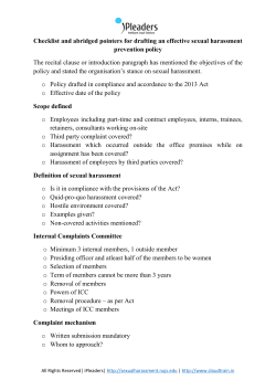


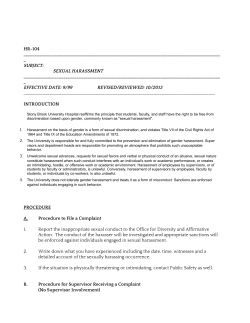
© Copyright 2026