
MESO SCALE - kaswanto`s blog
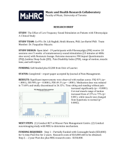
5/12/2015 References: 1. Principles and Methods in Landscape Ecology Landscape Ecology Almo Farina 2. Landscape ecology principles in Landscape Architecture and Land use Planning Land use Planning Wenche E. Dramstad E. Dramstad, James D. Olson, , James D. Olson, Richard T.T. Forman 3. International Journals PPT would be uploaded to the BLOG Dr. Kaswanto Selasa 12 Mei 2015 www.kaswanto.staff.ipb.ac.id MESO SCALE Outline: 1.Introduction 2.Fractal Dimension 3.Geographic Information Systems (GIS) 4.Remote Sensing (RS) 5.Case Studies It is important to immediately clarify that the study of the landscape requires metrics but also additional tools like Databases, Spatial Statistics, Geographic Information Systems, Remote Sensing Techniques and Global Positioning Systems, that are used in many other circumstances. These methodologies are applied in geology, geography, navigation agronomy climatic economics and social navigation, agronomy, climatic economics and social sciences, forecasting, etc. At least 4 methodological approaches to study landscape metrics: 1) numerical analysis, 2) spatial analysis, 3) multiscalar analysis and 4) spatial modeling analysis. 1 5/12/2015 Landscape analysis can be performed on at least at four levels of spatial resolution: individual, patch, mosaic ti l l ti i di id l t h i and landscape d l d (Figure 8.2). The measurement of distances can be done according a selection of possibilities: 1. from each patch to all the adjacent neighbors of each patch. 2. from a patch to all others of the same group, 3. from each patch to the p single nearest patch of a different group, 4. from a patch of a specific group to another patch of a specific group (Figure . 8.5 and Table 8.6). 2 5/12/2015 3 5/12/2015 Figure 8‐13. Example of different complexity of a vegetation border expressed by the fractal dimension D, note that the increase of edges is equivalent to the increase of fractal dimension (from Hees 1994, with permission). 4 5/12/2015 pp p The GIS appears indispensable for most landscape investigations like: Land use change Vegetation patterning Animal distribution across the landscape Linking remote sensing with topography Modeling processes across the landscape 5 5/12/2015 6 5/12/2015 Figure 8‐29. Spectral and spatial resolution for the commonest civilian satellites: AVHRR satellites: AVHRR, MSS, TM and SPOT, and the electromagnetic spectral response curve for green vegetation (Iverson et al. 1989). 7 5/12/2015 Bird community ecology Rectify aerial photographs Low‐altitude oblique photographs mapping vegetation patches on the ground with an accuracy of 5m after differential correction. www.gpsireland.ie/ http://archaeology.about.com/ www.engadget.com http://electronics.howstuffworks.com 8 5/12/2015 1. AEZ AEZ 2. UHI 3. LUCC 4. Carbon Stock 5. Water Quality CASE STUDY 1: AEZ ‐ DAS CIANJUR Distribusi Klas Elevasi (atas kiri), Klas Kemiringan Lereng (atas kanan) Existing Tataguna Lahan (tengah kiri), Jenis Tanah (tengah‐kanan) Bahaya Erosi (bawah kiri), dan usulan tata guna lahan ekologis (bawah kanan) BACK DAS Cianjur – Sub‐DAS Citarum ( Saroinsong, Arifin, Gandasasmita & Takeuchi, 2003) 9 5/12/2015 (Wang et al, 2012) (Wang et al, 2012) BACK CILIWUNG WATERSHED (PPLH IPB 2004) 40 10 5/12/2015 Land Use Change on Spatial Pattern CILIWUNG WATERSHED (PPLH IPB 2004) 41 42 1. Type of change of land use pattern (1989 vs. 2009) LANDSAT Satellite Images (1989, 2001 and 2009) Land Use and Cover Classification 1. Type of land use pattern change • • • • • • • Appearance Disappearance Expansion Annexation Reduction Division Remain 2. Forest Annual Rate Change Calculated with the formula proposed Puyravaud (2003): %⁄ 100 2 2 1 1 3. The Driving Factors of Change • • • • • • • Altitude Slope Population density Distance to major road Distance to river Distance to urban area Soil drainage Source: Someya et al. (2009) Impact of land use changes on spatial pattern of landscape 43 44 11 5/12/2015 Results Changes in the areas of the various types of forests pattern 2. The Annual Rate of Change The annual rate of change for forest was calculated with the formula proposed by Puyravaud (2003): 1 A2 and A1 = the forest cover areas at the end and the beginning, respectively, of the period being evaluated. t1 and t2 = the numbers of years spanning on that period. 20 15 DA EX AN RD DI , 1989 2009 DA EX AN RD DI Variables Altitude Slope Population density Distance to major road Distance to river Distance to urban area Soil drainage Agriculture land F 0.0012 0.0302 ‐ 0.0003 0.0261 0.0043 ‐ 0.0584 0.0745 2009 10 DA EX AN RD DI RE Type of Change Cibuni Watershed 100 Area (Thousand ha) Area (Thousand ha) Area (Thousand ha) Area (Thousand ha) Grass land 1989 20 AP 100 50 2001 80 60 40 20 0 1989 2001 2009 1989 2001 Year 2009 2009 Year Year F Forest t Forest 30 RE 0 Year 50 40 Cimandiri Watershed 20 1989 RE The Land Use Changes in the Southern Areas 40 2009 DI AP: Appearance, DA: Disappearance, EP: Expansion, AN: Annexation, RD: Reduction, DI: Division, RM: Remain 0 2001 RD 60 Type of Change 45 AN 0 AP 150 1989 EX Cibuni Watershed Thousands βn 2, 60 100 0 DA Type of Change 70 60 50 40 30 20 10 0 Ciliwung Watershed 20 2009 AP RE Area of Change (ha) β2 1, Cisadane Watershed 40 1989 2 Type of Change The Land Use Changes in the Northern Areas 60 6 Cimandiri Watershed Pi = the probability of a grid cell for the occurrence of land use type. X’s = the driving factors. Βi = the coefficient of each driving factor in the logistic model. 80 8 0 AP Thousands β1 12 10 4 0 Area of Change (ha) β0 2009 5 3. The Driving Factors of Change 1 1989 10 Thousa ands 2 1 Ciliwung Watershed 255 Area of Change ( (ha) 100 2 Thousa ands Area of Change ( (ha) %⁄ Cisadane Watershed 30 Built‐up area Northern G A 0.0054 ‐ 0.0089 0.0323 ‐ 0.0002 ‐ 0.0001 ‐ 0.0007 0.0098 0.0021 0.0001 0.0001 ‐ 0.0691 0.0021 0.0689 ‐ 0.0891 B ‐ 0.0074 0.0098 ‐ 0.0002 ‐ ‐ ‐ 0.0012 0.0025 Forest Grass land Variables Altitude Slope Population density Distance to major road Distance to river Distance to urban area Soil drainage Agriculture land F 0.0032 0.0502 ‐ 0.0653 0.0037 0.0083 ‐ 0.9834 0.0519 G Grass land l d A i lt Agriculture land l d Built‐up area Southern G A 0.0010 ‐ 0.0198 0.0356 ‐ 0.0112 ‐ 0.0001 ‐ 0.0001 0.0043 0.0163 0.0163 0.0653 ‐ 0.0451 0.0001 0.0889 ‐ 0.0341 Variables B ‐ 0.0074 0.0058 ‐ 0.0001 ‐ ‐ ‐ 0.0002 0.0001 47 Altitude Slope Population density Distance to major road Distance to river Distance to urban area Soil drainage F 0.0010 ‐ 0.0282 ‐ 0.0001 0.0056 0.0098 ‐ 0.0025 0.2378 B ilt Built‐up area Southern G A 0.0098 0.0001 0.0093 ‐ 0.0072 ‐ 0.0001 ‐ 0.0001 0.0043 0.0025 0.0001 0.0002 ‐ 0.0001 0.0001 0.7629 ‐ 0.0091 B ‐ 0.0274 0.0738 0.0051 ‐ ‐ ‐ 0.0009 ‐ 0.0001 F Forest t G Grass land l d Variables Altitude Slope Population density Distance to major road Distance to river Distance to urban area Soil drainage A i lt Agriculture land l d F 0.0012 0.0302 ‐ 0.0003 0.0098 0.0024 ‐ 0.0064 0.0519 B ilt Built‐up area Southern G A 0.0014 0.0001 0.0413 ‐ 0.0112 ‐ 0.0001 ‐ 0.0001 0.0014 0.0021 0.0084 0.0174 0.0001 0.0001 0.8689 ‐ 0.0641 B 0.0024 0.0138 0.0091 ‐ ‐ ‐ 0.0292 0.0009 BACK 48 12 5/12/2015 Carbon Stock Estimation Carbon Stock Estimation CASE STUDY 4: Carbon Stock Estimation Cisadane Ciliwung Cimandiri Cibuni Carbon at Agro‐forestry Landscapes • Biomass • Necromass • Soil Organic Matter Above Ground • Trees Biomass • Understorey plants • Necromass N • Litter Below Ground • Soil Organic Matter 50 50 Carbon Stock Estimation THE SCALING UP Methods LANDSAT image 1 • Tree scale • Crops scale C ~ Plant 2 • Plot scale • Quadrant scale C ~ Plot 3 • Landscape scale • Land use scale C ~ Land use 4 • Watershed Scale • Regional Scale C ~ Watershed LULC classification Sampling plot in each land use Plants Biomass •Trees T •Root •Understorey Necromass •Wooden W d •Non‐wooden Soil Organic Matter • Depth 0 ‐5, 5‐15, &15‐30 cm D th & Calculating C stock in each land use 51 Short Explanation 52 13 5/12/2015 Sampling Plot Procedure Land Utilization Types Main Land Use Type Forest Grassland/bareland Big Plot 20 x 100 m Small Plot 5 x 40 m Agriculture land Sub Plot 2 * (0.5 x 0.5 m) Land use 0.5 m 5 Note: N t Tree with dbh > 30 cm Tree with dbh < 30 cm Understorey and Litter No Land Utilization Type Code Description 1 Primary Forest PF Natural forest 2 Secondary Forest SF Replanted forest Dominated by Hevea brasiliensis plants 3 Rubber Forest RF 4 Albizia Forest AF Dominated by Paraserianthes falcataria plants 5 Imperata IC Bareland covered by Imperata cylindrica 6 Cassava CS Dominated by Manihot esculenta cultivation 7 Grassland 1 GS1 Grassland with herbaceous plants 8 Grassland 2 GS2 Grassland with mixed grass species 9 Tea plantation TP Tea (Camellia sinensis) cultivation 10 Cacao plantation CP Cacao (Theobroma cacao) cultivation 11 Vegetable Dryfield VD Highland vegetables, dryfield 12 Strachy Crops dryfield SD Mixed strachy crops, dryfield 13 Agroforestry 1 AF1 Agroforestry system dominated by coconut and/or bamboo species 0.5 m 14 Agroforestry 2 1 land utilization type 3 sampling plots. 1 watershed 16 type of land utilizations. 1 watershed 48 plots, in total 192 plots were measured. 0.5 m 0.5 m AF2 Agroforestry system dominated by mahogany and/or fruit trees species 15 Paddyfield 1 PF1 Paddy field local rice cultivar 16 Paddyfield 2 PF2 Paddy field with cultivar R‐64 25 500 20 400 15 300 200 10 100 5 0 Cimandiri Watershed The SAs Amount o of C Stock (Mg/ha) 30 600 Area (ha) Thousands Cisadane Watershed Amountt of C Stock (Mg/ha ) Results The NAs 54 0 PF SF RF AF IC 60 600 50 500 40 400 30 300 200 20 100 10 0 CS GS1 GS2 PT1 PT2 VD SD AF1 AF2 PD1 PD2 0 PF Land Use Types Area (ha) Thousands A 53 SF RF AF IC CS GS1 GS2 PT1 PT2 VD SD AF1 AF2 PF1 PF2 500 20 400 15 300 200 10 100 5 0 Cibuni Watershed Amount of C Stock ( Mg/ha) 30 25 Area (ha) Thousands Amount of C Stock (Mg/ha) Ciliwung Watershed 600 0 PF SF RF AF IC Understorey Necromass Litter Soil 0‐5 cm Soil 5‐15 cm 50 500 40 400 30 300 200 20 100 10 0 CS GS1 GS2 PT1 PT2 VD SD AF1 AF2 PF1 PF2 0 PF Land Use Types Trees 60 600 Area (ha) TThousands Land Use Types SF RF AF IC BACK CS GS1 GS2 PT1 PT2 VD SD AF1 AF2 PF1 PF2 Land Use Types Soil 5‐15 cm Area 55 Trees Understorey Necromass Litter Soil 0‐5 cm Soil 5‐15 cm Soil 5‐15 cm Area 14 5/12/2015 Water Resources Management Water Quality Samples Locations CASE STUDY 5: Water Quality Water Samples: • • • • Based on result from preliminary research, the water quality was measured through 11 parameters. 4 watersheds 6 villages in each watershed 4 locations in each village g 3 repetitions in a location Down Stream 300 m asl Total: Middle Stream 4 x 6 x 4 x 3 = 288 samples 700 m asl Those are (1) Dissolved Oxygen: DO, (2) Biological Oxygen Demand: BOD, (3) Chemical Oxygen Demand: COD, (4) Ammonium: NH4, (5) Nitrate: NO3, (6) Nitrite: NO2, (7) Phosphate: PO4, (8) Acidity: pH, (9) Alkalinity: OH‐, (10) Bacteria Escherichia coli, and (11) General Bacteria ‐ others than E. coli. Upper Stream Village Samples 57 58 Water Resources Management Water Resources Management 11 Parameters: • • • • • • • • • • • WQI formula proposed by Rodriguez de Bascaroan (Pesce & Wunderlin, 2000) DO COD BOD Nitrite Nitrate Ammonium Phosphate Alkalinity Acidity Escherichia coli General Bacteria Normalization Factor (Ci) Parameters Pi 100 90 80 70 60 50 40 30 20 10 0 DO 4.0 >7.5 >7 >6.5 >6 >5 >4 >3.5 >3 >2 1 <1 COD 3.0 <5 <10 <20 <30 <40 <50 <60 <80 <100 ≤150 >150 BOD 3.0 <0.5 <2 <3 <4 <5 <6 <8 <10 <12 ≤15 >15 NO2‐N 2.0 <0.005 <0.008 <0.01 <0.04 <0.075 <0.1 <0.15 <0.2 <0.25 ≤0.5 >0.5 NO3‐N 2.1 <0.5 <2 <4 <6 <8 <10 <15 <20 <40 ≤70 >70 NH4‐N 3.0 30 <0.01 <0.05 0.1 <0.2 <0.3 <0.4 <0.5 <0.75 <1 ≤1.25 >1.25 PO4 1.1 <0.025 <0.05 <0.1 <0.2 <0.3 <0.5 <0.75 <1 <1.5 ≤2 >2 Alkalinity 1.7 <20 <40 <60 <80 <100 <120 <140 <160 <180 ≤200 >200 pH 1.9 7 6.9‐7.5 6.7‐7.8 6.5‐8.3 6.2‐8.7 5.8‐9.0 5.5‐9.5 5.0‐10.0 4.5‐10.5 4.0‐11.5 <4.0;>11.5 Escherichia coli 3.0 <50 <500 <1000 <2000 <3000 <4000 <5000 <7000 <10000 ≤14000 >14000 Fecal Coliform 3.6 <50 <500 <1000 <2000 <3000 <4000 <5000 <7000 <10000 ≤14000 >14000 *All values are in mg/l, except for pH (pH unit) and bacteria (MPN/100ml). 59 15 5/12/2015 Water Resources Management Water Resources Management WQ Sample Location Results Springs a a a Excellent Good a b c Ponds d Medium Paddy Fields Bad Rivers Very Bad 1 Village Among four locations, the highest to the lowest WQI values are springs, ponds, paddy fields and rivers, respectively. Classification of WQI in stream level and water sample location. All WQI values are situated at “good” and “medium” levels. The different letter show the mean difference is significant at the 0.05 level. BACK 61 QUIZ Jawablah pertanyaan di bawah ini 1. Pilihlah salah satu case studies case studies yang yang sudah sudah dijelaskan di atas, atas, 2. Sebutkan lokasi yang ingin yang ingin Anda analisis untuk case studies di case studies di atas,, atas 3. Jelaskan alasannya dalam perspektif Ekologi Lanskap, Lanskap, mengapa mengapa Anda d ingin melakukan l k k analisis l tersebut b di d lokasi l k yang Anda yang Anda d tentukan PENGANTAR EKOLOGI LANSKAP 2015 PENGANTAR EKOLOGI LANSKAP Tulis jawaban Anda pada blog http://kaswanto.staff.ipb.ac.id/ paling lambat paling lambat hari Selasa tanggal 19 Mei 2015 pukul 19 Mei 2015 pukul 07.00 WIB 07.00 WIB.. Terima kasih… kasih… 16


© Copyright 2026