
SECTION A: INTRODUCTION - Khara Hais Municipality
//Khara Hais Spatial Development Framework: Volume 2
Revised April 2012
SECTION A: INTRODUCTION
SECTION SYNOPSIS
This section comprises of the following:
a) Background information pertaining to this volume.
b) The terms of reference.
c) Principles for sustainable development and spatial planning applied in the formulation of the proposals put
forward in this volume.
1
BACKGROUND
As described in Volume 1, the //Khara Hais Spatial Development Framework (//Khara Hais SDF)
consists of three volumes as illustrated by the figure below. This document is Volume 2 of the SDF.
It should be read together with Volume 1 and Volume 3, including their annexures. Background
information pertaining to the planning process and aspects addressed in the SDF is provided in
Volume 1.
SD F-D O CU MEN T STRU CTU RE
VOLUME 1
PLANNING BASIS AND CONTEXT
VOLUME 2
GUIDELINES FOR LAND-USE & SPATIAL DEVELOPMENT
VOLUME 3
DEVELOPMENT STRATEGIES, PROGRAMS & PROJECTS
Figure 1: Volumes of the //Khara Hais SDF.
1.1
STRUCTURE AND CONTENT OF THE SDF
The key aspects that emerged from the Environmental Scan and Analysis described in Section B of
Volume 1, the stakeholder consultation undertaken as part of the SDF planning process, and the
//Khara Hais IDP are addressed in this document (Volume 2) and Volume 3.
Although an SDF, per definition, essentially addresses the spatial implications of the Integrated
Development Plan (IDP), it is recognised that holistic governance and management of any area (as
is contemplated for //Khara Hais) also requires the implementation of strategies that do not have
any spatial implications. Subsequently, the key aspects referred to above were divided into two
distinct groups, namely:
//Khara Hais Municipality
1
Dennis Moss Partnership
//Khara Hais Spatial Development Framework: Volume 2
Revised April 2012
Aspects with Spatial Implications: Most of these were addressed in this volume (Volume
2) in the form of plans and related guidelines that are to guide the future development of
//Khara Hais.
Aspects with No Spatial Implications: These aspects will not have spatial implications but
could have an impact on sustainable development. They were addressed in Volume 3 in
the form of strategies, programs and projects to be undertaken in terms of dedicated
principles, guidelines and criteria that comply with the requirement for sustainable
development listed in Chapters 15 and 16 of Volume 1.
1.2
FUNCTION OF VOLUME 2
The document comprises mechanisms, policy guidelines and spatial structuring elements through
which future development in //Khara Hais Municipality is to be planned and implemented.
The document provides guidance pertaining to:
a)
The availability and extent of vacant land that could be utilized to address the various
needs of the town of Upington and its inhabitants.
b)
Environmental constraints that impact upon the future use of any such vacant land.
c)
Potential opportunities on vacant land for development or any other appropriate forms of
land use that address the various needs of //Khara Hais Municipality and its inhabitants.
d)
Appropriate land use classification of the entire //Khara Hais Municipality with the
objective to ensure the sustainability of such land uses and the compliance thereof with
the vision, goals, and objectives set for the area.
e)
Spatial structuring elements to be imposed to ensure that any future urban renewal and
restructuring, development projects, and associated land uses to be undertaken in //Khara
Hais comply with the criteria and principles of ‘good place-making’. These spatial
structuring elements will include:
(i)
Appropriate outer limits for outward spread of the town of Upington under the
present growth rate and in terms of the current and predicted availability of
resources.
(ii)
Activity corridors that abut primary transport routes and provide opportunities for
mixed-use development.
(iii)
Activity Streets that provide viable opportunities for local business and community
facilities.
(iv)
Nodes that occur at intersections of activity corridors and streets and which are
designated for concentrations of a particular use.
(v)
Precincts, or special use areas, dominated by primary community-based activities
and land uses that influence settlement pattern and growth.
(vi)
A Municipal Open Space System (MOSS) which consists of a contiguous network of
natural corridors and public open spaces focused on promotion of the well-being of
the people of //Khara Hais and the integrity of the environment as a totality.
In practical terms, this volume provides guidance pertaining to:
•
Where development or other appropriate land use could be undertaken.
•
How such development or land use should be planned, designed, and implemented; and,
•
How such land uses are to be managed in the long-term so as to ensure that all activities
collectively contribute towards creating a highly functional and sustainable municipal area.
//Khara Hais Municipality
2
Dennis Moss Partnership
//Khara Hais Spatial Development Framework: Volume 2
Revised April 2012
As such, the primary purpose of this volume is to serve as a manual for the future development of
//Khara Hais Municipality as a whole through the following:
•
Providing a standard format for planning and design with the aim to facilitate sustainable
development throughout //Khara Hais.
•
Providing judicious land-use classification in a standard format based on a broad spectrum
of environmental parameters and a system of values and ethics.
1.3
DOCUMENT STRUCTURE
The figure below illustrates and contextualizes the various elements addressed in this document.
These elements collectively form the backbone of the //Khara Hais SDF as it relates to the spatial
restructuring, forward planning and design, and development of //Khara Hais.
Figure 2: Document Structure.
//Khara Hais Municipality
3
Dennis Moss Partnership
//Khara Hais Spatial Development Framework: Volume 2
Revised April 2012
SECTION B: VACANT LAND ANALYSIS
SECTION SYNOPSIS
This section describes the process and provides a plan pertaining to the identification and status analysis of the vacant
public land in //Khara Hais Municipality.
2
VACANT LAND ANALYSIS
In terms of the project brief documented in Chapter 1.1 of Volume 1, one of the focal points of the
SDF was to update the existing Vacant Land Analysis. Subsequently, as the first step towards the
drafting of the SDF, an inventory and analysis was undertaken of all public and parastatal land and
the current status thereof.
The SDF builds on the premise that public land within //Khara Hais is a primary resource with
huge latent value and that this value should be unlocked in a sustainable manner to the extent
possible.
Such public land inter alia holds the key to achieving the vision, goals and objectives set for
//Khara Hais, in particular, as it relates to social integration, eradication of poverty and inequality.
The SDF consequently promotes innovative and responsible use of public land either as a tradable
asset or as an investment opportunity through public-private-community partnerships.
2.1
LAND CATEGORIES
The Vacant Land Analysis is an inventory of all vacant land owned by the Municipality, Provincial or
National Government, and parastatals that could serve as a tradable or usable resource. All public
property listed in the previous Vacant Land Analysis was revisited and properties that have since
been developed were excluded.
In terms of the Vacant Land Analysis all public land was categorized into the following three
categories:
Table 1: Land categories.
a)
CATEGORY
Vacant
DESCRIPTION
Properties which have not been subjected to any form of
infrastructural development.
b)
Partially Developed
Properties which have been partially subjected to either
informal or formal development or infrastructural
development and investment below ground level (e.g. service
infrastructure).
c)
In-Process
Properties which are in the process of being developed and/or
in terms of which a rezoning application has been submitted
and/or approved.
//Khara Hais Municipality
4
Dennis Moss Partnership
//Khara Hais Spatial Development Framework: Volume 2
Revised April 2012
The public land in the Municipality consists of a significant number of portions and subdivisions
most of which fall into the category of Vacant. The largest singular unit of public land is the
municipal commonage (Erf 1). This land has been subdivided and re-subdivided into a plethora of
portions, the majority of which is Vacant, while a number of portions have been categorized as
Partially Developed and In-Process. The table below summarises the status of the public land units
in //Khara Hais.
Table 2: Status of public land units (estimated).
CATEGORY
a)
b)
c)
NUMBER OF PROPERTIES
330
110
3
443
Vacant
Partially-Developed
In-Process
TOTAL
The figure below and Plan 1 and Plans 1.1 to 1.10 (appended under separate cover) illustrate the
public land units in //Kara Hais and their current status. It is imperative that these plans be updated constantly by the Directorate Town Planning and Building Control so as to keep appropriate
record of the municipal land resource base.
Figure 3: Municipal Vacant Land Analysis (Refer to Plan 1 & Plans 1.1 to 1.10 under separate cover).
//Khara Hais Municipality
5
Dennis Moss Partnership
//Khara Hais Spatial Development Framework: Volume 2
Revised April 2012
SECTION C: LAND USE PLANNING
SECTION SYNOPSIS
This section describes the process and provides plans pertaining to the designation of appropriate land use(s) for
//Khara Hais Municipality as a whole. In particular, the following aspects were addressed:
a) A value-based designation approach.
b) Environmental constraints and development suitability.
c) Land use classification in terms of a set of Spatial Planning Categories (SPCs).
d) Practical application of SPCs.
3
TOWARDS COHERENT LAND USE DESIGNATION
3.1
A VALUE-BASED DESIGNATION APPROACH
The development and management of the natural and human-made environment is influenced by
land-use decisions. In turn, land-use decisions are influenced by values, norms and ethics. A
general problem in this regard, is that the strong moral values, norms and ethics required for
coherent decision-making are often not given the necessary priority, or are over-ruled by rulesbased systems, resulting in, amongst others, non-sustainable land-use, development of low quality
settlements, uncontrolled and rural sprawl, etc. It is therefore clear that land-use decisions should
not only be informed by rules and regulations, but by also by a set of agreed-upon values, norms,
and ethics.
As the first step towards preparing a detailed land use plan for the entire municipality, a broadbased Environmental Constraints and Development Suitability Plan was drafted in accordance
with a set of basic values and environmental ethics. These were determined in a collaborative,
participative process with all relevant stakeholders, representing an adequate mix of local,
indigenous and scientific knowledge.
The evaluation formed part of the stakeholder consultation process undertaken as part of the
drafting of the SDF. The significance of the unique mix of current and potential values of the
various places collectively forming //Khara Hais Municipality have been recorded and translated
into an Environmental Constraints and Development Suitability Plan and a coherent Land Use
Plan (refer to Chapter 4.3 below), which collectively provide concrete and practical guidelines for
the different stages of planning, design, decision-making, implementation and management of
projects and plans. It is imperative that the determination of the value of places in //Khara Hais
will not be a once-off event, but rather an ongoing process and that the SDF be up-dated
accordingly.
The premise for the evaluation process was the United Nations World Charter for Nature which
states that ‘every place, thing or form of life is unique, warranting respect regardless of its worth to
man’ (Rolston, 1994)1. The values addressed and the relevant questions posed when determining
the value, environmental constraints, and appropriate land use for the entire //Khara Hais
Municipality are as follows:
1
Rolston, H. 1994. Conserving natural value: Perspectives in biological diversity series. New York: Columbia University Press.
//Khara Hais Municipality
6
Dennis Moss Partnership
//Khara Hais Spatial Development Framework: Volume 2
Revised April 2012
Table 3: Towards determining value.
VALUE
d)
Intrinsic Value
(This refers to aspects such as
aesthetic quality, heritage and
cultural significance, social
connotations).
Instrumental Value
(This refers to the potential use or
functions of the site, or item).
Systemic Value
(This refers to the role of the site or
feature in an ecological, social, or
economic system).
Current Status
e)
Vision
a)
b)
c)
3.2
QUESTIONS POSED
What are the unique intangible assets and characteristics of
the particular land portion or feature?
What are the current and/or potential uses of the particular
portion or feature?
What is the real or potential contribution of the portion or
feature to the health of the natural and cultural
environment, the social environment, and the local
economy?
What is the current status of the portion or feature, in
particular, as it relates to land use?
What could the vision of the portion or feature be, in
particular, as it relates to the promotion of a developmental
state in //Khara Hais?
ENVIRONMENTAL CONSTRAINTS AND DEVELOPMENT SUITABILITY
3.2.1 ENVIRONMENTAL CONSTRAINTS THAT AFFECT DEVELOPMENT
As stated previously the key objective of the Municipality is to promote sustainable development
which requires a balanced relationship between the three imperatives of human well-being,
economic efficiency and environmental integrity. This implies that all developments have to
comply with environmental, social, and economic criteria and requirements.
For //Khara Hais to be able to move towards a developmental state such as is contemplated and
promoted by the national government, and to provide a broad-base premise upon which
development-related decisions by the Municipality can be based, an Environmental Constraints
and Development Suitability Plan was prepared as part of the SDF. This plan was based upon sitespecific information pertaining to:
Accessibility.
a)
b)
Aesthetic aspects.
c)
Agricultural potential.
d)
Archaeology.
e)
Current land-use.
f)
Feasibility of development.
g)
Floodlines.
h)
Fragmentation susceptibility and implications.
i)
Geology and soils.
j)
Geotechnical aspects.
k)
Heritage resources.
l)
Hydrology.
m)
Occurrence of sensitive plant and animal habitats.
//Khara Hais Municipality
7
Dennis Moss Partnership
//Khara Hais Spatial Development Framework: Volume 2
n)
o)
p)
q)
r)
s)
t)
Revised April 2012
Pollution potential and implications.
Potential for rehabilitation.
Potential impact of development.
Proximity to existing infrastructure.
Riverine and riparian areas.
Servitudes.
Topography and slopes.
Policy and land use directives that have an impact on development in //Khara Hais pose certain
constraints. These policies were scrutinized and questioned and mitigatory measures have been
explored by consulting engineers and environmentalists with the aim to unlock development
opportunities located, for example, below the 1:50-year floodline (refer to Chapter 10.1).
3.2.2 DEVELOPMENT SUITABILITY
The site-specific information and the values obtained from the processes summarized above were
synthesised into three broad site categories, providing guidance pertaining to the suitability of the
various sites for development and the desirability of development being undertaken at such sites.
The three categories illustrated by the Environmental Constraints and Development Suitability Plan
are the following:
a)
No Development Zone
b)
Conditional Development Zone
c)
Development Zone
3.2.2.1
No Development Zone
This zone constitutes areas where development should not be allowed due to general
environmental and infrastructural constraints and the fact that these sites currently have high
intrinsic and systemic value. Such areas include:
a)
Areas of conservation importance such as the Gariep River and identified riparian areas.
b)
Ecological corridors associated with the Gariep River, drainage systems, and tributaries.
c)
Identified areas located below the Upington Irrigation Canal (generally accepted as the
1:50-year floodline).
d)
Identified areas below the 1974 and 1988 flood line.
e)
Steep slopes (>1:4) which increases aesthetic sensitivity and development costs.
f)
Sensitive habitats and physically unstable areas, e.g. flood-plains and areas susceptible to
drift sands (which include sandy areas stabilised by alien vegetation).
Areas characterised by rocky outcrops.
g)
h)
Registered servitudes for power lines, sewerage lines, railway lines, and roads.
i)
Sites which is too fragmented or too small to be a viable development option.
j)
Areas with high aesthetic quality and sensitivity.
3.2.2.2
Conditional Development Zone
This category comprises areas where development can be considered under specific conditions
aimed at mitigating the potential detrimental effects of such development. Compliance with such
conditions must be auditable and measurable and subject to strict penalty clauses.
This category includes:
//Khara Hais Municipality
8
Dennis Moss Partnership
//Khara Hais Spatial Development Framework: Volume 2
•
•
•
Revised April 2012
Areas with moderate intrinsic and systemic value where development will not have a
detrimental effect on such values.
Areas with potentially high instrumental value (including sites that are of high strategic
importance for municipal service and development based upon public-private-community
partnerships).
Defined sensitive sites where development can be undertaken under specific conditions
(e.g. that potential detrimental impact of development must be mitigated to a defined
extent).
Conditions that may be considered include the following:
a)
Any potential detrimental impacts of development must be mitigated to a defined extent.
b)
Conservation-worthy habitats within such sites must receive statutory long-term
protection.
c)
Individual plants of rare endemic species that occur on a site designated for development
must be sensitively relocated into the ecological corridors or conservation areas.
d)
Developments below the 1:50-year flood line and within, or near, the watercourse must
register the following activities as a water use before the development will be approved:
• Impeding or diverting the flow of the water in a watercourse, and
• Altering the bed, banks, course or characteristics of a watercourse.
The Conditional Development Zone includes the following:
Defined areas along the Gariep River (especially those that have already been modified),
(i)
with specific reference to identified sites located below the Upington Irrigation Canal or
the 1:50-year flood line.
(ii)
Sites that form an integral part of ecological corridors or have a function in the
management of stormwater runoff.
(iii)
Areas previously designated for development and for which development proposals have
been drafted. However, due to uncertainty pertaining to the planning status of such land
development applications have not been lodged.
(iv)
Areas designated for governmental or official use.
3.2.2.3
Development Zone
This category refers to areas suitable for development and where appropriate development
should be allowed. This includes sites that form part of the designated urban expansion zones and
the spatial structuring elements, or components, described in Section D below. Sites in this
category generally have a permanent low intrinsic and systemic value.
It is proposed that all future developments in the Municipality be restricted to the Development
Zone, in particular, and to the Conditional Development Zone indicated by the Environmental
Constraints and Development Suitability Plan (refer to the figure on the following page and the
appended plans).
Figure 4, Plan 2 and Plans 2.1 to 2.12 illustrate the three development suitability categories for the
vacant land of the Municipality.
//Khara Hais Municipality
9
Dennis Moss Partnership
//Khara Hais Spatial Development Framework: Volume 2
Revised April 2012
Figure 4: Environmental Constraints and Development Suitability Plan (Refer to Plan 2 & Plans 2.1 to 2.12 under
separate cover).
It is important to note that the Environmental Constraints and Development Suitability Plan is a
broad-brush category designation, the purpose of which is to provide a general indication of the
suitability of land for development and the desirability of development being undertaken on such
land. It does not replace the mandatory environmental processes prescribed by legislation.
The Environmental Constraints and Development Suitability Plan and the detailed Land Use Plan
described in Chapter 4 provide guidance pertaining to the decisions to be taken by the
Municipality. The designation of the Development Zone does not grant development rights nor
does it prevent the Municipality from requesting applicants to undertaken detailed specialist
studies (or even a Strategic Environmental Assessment) as basis for the application.
4
LAND-USE CLASSIFICATION
The Environmental Constraints and Development Suitability Plan described in Chapter 3 provided
the first rough-grain layer for the preparation of a more detailed Land Use Plan that illustrate the
appropriate land use for the entire //Kara Hais Municipality. The land use classification was
undertaken in terms of a set of Spatial Planning Categories (SPCs) prepared for this purpose. These
SPCs were based upon the biosphere reserve zoning model described.
//Khara Hais Municipality
10
Dennis Moss Partnership
//Khara Hais Spatial Development Framework: Volume 2
4.1
Revised April 2012
SPATIAL PLANNING CATEGORIES
The SPCs and associated application guidelines used in this SDF were derived from similar
approaches used inter alia in the Western Cape in terms of a bioregional planning approach and
policy. The Municipality has directed that the SDF be based upon the bioregional planning
approach.
The SPCs take cognisance of the values and ethics summarised in Chapter 3.1 above and include all
land zonings that are provided for under the existing Zoning Scheme Regulations. The SPCs are a
mechanism to indicate the appropriate land use on any particular land unit. SPCs help to clarify
and facilitate coherent decision-making that can lead to better zonation, laws and regulations. The
SPCs, furthermore, provide a framework in terms of which land-use decisions can be standardised
throughout the Municipality. The existing Zoning Scheme Regulations and the proposed SPCs have
been aligned to a large extent. It should, however, be noted that the SPCs are not a blueprint for
land-use classification. SPCs are not a zoning scheme and their designation does not change
existing zoning or land-use regulations or legislation.
As indicated in the table below, a total of six SPCs were used for the land use classification of the
Municipality. Two of these, namely A and B, refer to the natural landscape, while four types,
namely C, D, E, and F, refer to the (cultural) human-made environment. In addition, 41 subcategories have been created to facilitate detailed land use classification (refer to Table 4 and
Figure 5 on the following page).
Table 4: The six primary Spatial Planning Categories.
CATEGORY
DESCRIPTION
CLASSIFICATION CRITERIA & PURPOSE
Category A
Designated Core
Conservation Area
Category B
Buffer Area
Category C
Category D
Agricultural areas
Urban-related
areas
Industrial areas
a) Areas of high conservation importance to be protected from
development.
2
b) Generally only non-consumptive land-uses allowed conditionally.
a) Areas that serve as a buffer between Category A and all other Categories.
b) Providing an appropriate interim classification for conservation-worthy
areas that do not have statutory protection, including ecological
corridors and areas worthy of rehabilitation.
c) Appropriate sustainable development and non-consumptive land-uses
may be allowed conditionally.
Rural areas where extensive and intensive agriculture is practiced.
Areas accommodating a broad spectrum of urban-related development and
associated services and infrastructure.
Areas accommodating industrial activities and associated infrastructure and
where very high intensity of human activity and consumptive land use occur.
All surface infrastructure and buildings not catered for in the above
categories, including roads, railway lines, power lines, communication
structures, etc.
Category E
Category F
2
Surface
infrastructure and
buildings
Refers to land-use that does not include harvesting or extraction of products for consumption, e.g. recreation, tourism,
religious ceremonies, research, education, etc.
//Khara Hais Municipality
11
Dennis Moss Partnership
//Khara Hais Spatial Development Framework: Volume 2
4.2
Revised April 2012
SUB-CATEGORIES
As illustrated by Figure 5 and Table 5, the various SPCs and Sub-categories were numbered in
alphabetical order, the purpose being to provide for a system in terms of which each entity in the
municipal area can be allocated a coded number that would facilitate effective land-use
management. The table provides a short description of the SPCs and Sub-categories.
Figure 5: //Khara Hais SDF Spatial Planning Categories and Sub-Categories.
//Khara Hais Municipality
12
Dennis Moss Partnership
//Khara Hais Spatial Development Framework: Volume 2
Revised April 2012
Table 5: Synopsis of the Sub-Categories.
CATEGORY A: CORE AREAS
SUB-CATEGORY
A.a
Statutory
Protected Areas
DESCRIPTION
Areas designated in terms of legislation for biodiversity conservation, defined
categories of outdoor recreation and resource use.
Conservation purposes are purposes normally or reasonably associated with,
the use of land for the protection of the natural and/or built environment,
including the protection of the physical, ecological, cultural and historical
characteristics of land against undesirable change (adapted from Draft Spatial
Planning and Land Use Management Bill, 2011).
Wilderness Areas (declared in terms of NEMPA 57 of 2003)
A.a.1
Areas characterised by their intrinsically wild and pristine appearance and character, or that are capable of being
restored to such, and which are undeveloped, without permanent improvements or human habitation. Such areas are
declared to:
a) protect and maintain the natural character of the environment, biodiversity resources, associated natural and
cultural resources ;
b) provide environmental goods and services;
c) provide outstanding opportunities for solitude and primitive outdoor experiences; and
d) provide controlled access to those who understand and appreciate wilderness, and those who wish to develop such
an understanding.
Special Nature Reserves (declared in terms of NEMPA3 57 of 2003)
A.a.2
Areas characterised by sensitive, ecologically outstanding ecosystems or natural habitats, natural communities,
populations or species, or unique geological or biophysical features conserved primarily for scientific research,
educational and limited nature-based recreational purposes.
National Parks (declared in terms of NEMPA 57 of 2003)
A.a.3
Designated to protect areas of national or international biodiversity importance; or containing a representative sample
of South Africa’s natural systems, scenic areas or cultural heritage sites; or the ecological integrity of one or more
ecosystems. National parks provide spiritual, scientific, educational, recreational and tourism-related opportunities
which are mutually and environmentally compatible and can contribute to local and regional economic development.
Nature Reserves, including provincial, local authority and registered private nature reserves
(declared in terms of NEMPA 57 of 2003)
A.a.4
Areas of significant ecological, biophysical, historical, or archaeological interest or that are in need of long-term
protection for the maintenance of its biodiversity or for the provision of environmental goods and services. Nature
reserves are declared to
a) supplement the systems of wilderness areas and national parks in South Africa;
b) sustainably provide natural products and services to local communities;
c) enable the continuation of traditional resource uses; and
d) provide nature-based recreational and tourism opportunities.
Protected Environments (declared in terms of NEMPA 57 of 2003)
A.a.5
3
Areas may be declared as a protected environment to:
a) Conserve the area as a buffer zone for the protection of a wilderness area, special natural reserve, national park,
world heritage site or nature reserve.
b) Enable owners of land to take collective action to conserve biodiversity on their land and to seek legal recognition
for such actions.
c) Protect the area if it is sensitive to development due to its –
− Biological diversity;
− Natural, cultural, historical, archaeological or geological value;
− Scenic and landscape value; or
− Provision of environmental goods and services.
d) Protect a specific ecosystem outside of a wilderness area, special nature reserve, natural park, world heritage site.
e) Ensure that the use of natural resources is sustainable.
National Environmental Management: Protected Areas Act 57 of 2003
//Khara Hais Municipality
13
Dennis Moss Partnership
//Khara Hais Spatial Development Framework: Volume 2
f)
Revised April 2012
Control change in land use if the area is earmarked for declaration as, or inclusion in, a wilderness area, national
park or nature reserve.
Forest Wilderness Areas / Forest Nature Reserves (in terms of s 8[1] of National Forests Act 84 of
1998)
A.a.6
Declared forest wilderness areas and forest nature reserves include:
a) natural forests, i.e. tract of indigenous trees whose crowns are largely contiguous and which comprise all other floral
and faunal forest elements;
b) woodlands, i.e. a group of indigenous trees which are not a natural forest, but whose crowns cover more than 5% of
the area bounded by the trees forming the perimeter of the group; and
c) natural habitats or ecosystem components.
Marine Protected Areas (declared in terms of Marine Living Resources Act 18 of 1998)
A.a.7
Areas declared as a marine protected area:
a) For the protection of communities, populations or species of fauna and the biophysical features on which they
depend;
b) To facilitate fishery management by protecting spawning stock, allowing stock recovery, enhancing stock abundance
in adjacent areas, and providing pristine communities for research; or
c) To mitigate any conflict that may arise from competing uses in that area.
World Heritage Sites (declared in terms of World Heritage Convention Act 49 of 1999)
4
A.a.8
5
Cultural or natural areas that has been:
a) Included on the World Heritage List, or the tentative list of the Republic, and has been proclaimed as a World
Heritage Site, or
b) Proclaimed to be a special heritage site for management in accordance with the Act (such areas cannot be referred
to as a World Heritage Site).
Mountain Catchment Areas (declared in terms of Mountain Catchment Areas Act 63 of 1970)
A.a.9
Areas declared as mountain catchment areas that provide for the conservation, use, management and control of such
land.
CATEGORY B: BUFFER AREAS
SUB-CATEGORY
B.a
Non-Statutory
Conservation
Areas
DESCRIPTION
Areas voluntarily set aside by land owners and managed for conservation
purposes in terms of the legislation applicable to the current zoning of such
land and not in terms of dedicated conservation legislation.
Contractual Conservation Areas
B.a.1
Areas designated for conservation purposes in terms of an agreement with a conservation agency, or between
landowners, a lease agreement, or a servitude. This category includes conservancies and biodiversity stewardship sites.
Private conservation areas
B.a.2
4
5
6
Areas zoned as private open space zone II in terms of Scheme Regulations made in terms of s 8 of the Land Use Planning
Ordinance 15 of 1985 (LUPO), for the primary use of conservation. Also areas unofficially designated and managed for
conservation purposes by the relevant land owner.
For the purpose of the Convention Concerning the Protection of the World Cultural and Natural Heritage, the following shall be
considered as 'cultural heritage': monuments, architectural works, works of monumental sculpture and painting, elements or
structures of an archaeological nature, inscriptions, cave dwellings and combinations of features, which are of outstanding
universal value from the point of view of history, art or science, groups of buildings, groups of separate or connected buildings
which, because of their architecture, their homogeneity or their place in the landscape, are of outstanding universal value from
the point of view of history, art or science, sites, works of man or the combined works of nature and man, and areas including
archaeological sites which are of outstanding universal value from the historical, aesthetic, ethnological or anthropological
point of view.
For the purpose of the Convention Concerning the Protection of the World Cultural and Natural Heritage, the following shall be
considered as 'natural heritage': natural features consisting of physical and biological formations or groups of such formations,
which are of outstanding universal value from the aesthetic or scientific point of view, geological and physiographical
formations and precisely delineated areas which constitute the habitat of threatened species of animals and plants of
outstanding universal value from the point of view of science or conservation, natural sites or precisely delineated natural areas
of outstanding universal value from the point of view of science, conservation or natural beauty.
//Khara Hais Municipality
14
Dennis Moss Partnership
//Khara Hais Spatial Development Framework: Volume 2
B.b
Ecological
Corridors
Revised April 2012
Linkages between natural habitats or ecosystems that contribute to the
connectivity of the latter and to the maintenance of associated natural
processes.
Freshwater Ecosystem Priority Areas (FEPA) (in terms of National Freshwater Ecosystem Priority
Areas Project)
B.b.1
Identified river and wetland FEPAs and fish support areas, including a generic buffer of 100m, measured from the top of
bank of the river or the delineated riparian areas, whichever is larger, and measured from the outside edge of the
wetland (Implementation Manual for Freshwater Ecosystem Priority Areas, Aug 2011).
Rivers or riverbeds (incl. 32 m buffer) (in terms of NEMA7 107 of 1998)
B.b.2
All other perennial and non-perennial rivers and wetlands, including a buffer of 32m based on the generic buffer width
used for aquatic features in the Listing Notices of the Environmental Impact Assessment Regulations, 2010 (GN R544, GN
R545 and GN R546).
Other Natural Areas
B.b.3
a) Sensitive Coastal Areas.
b) Tracts of natural vegetation that form part of, or link ecosystem components (i.e. tracts of natural vegetation acting
as a buffer zone between rivers located in FEPA Fish Support Areas and Fish Sanctuaries, and Category C and D
areas).
c) Any other natural areas that are conservation-worthy and which form linkages to natural areas within Category C
and D areas.
B.c
Urban Green
Areas
B.c.1
Public Park
B.c.2
Landscaped Areas
Municipal open spaces (including playgrounds) that form in integral part of
the urban structure (including areas zoned Open Space Zone I and II).
CATEGORY C: AGRICULTURAL AREAS
SUB-CATEGORY
DESCRIPTION
C.a
Extensive
agricultural areas
C.a.1
Bona-fide Game Farms
C.a.2
Extensive Stock Farms
C.b
Intensive
agricultural areas
C.b.1
Cultivated Areas
C.b.2
Plantations and Woodlots.
Agricultural areas covered with natural vegetation, used for extensive
agricultural enterprises, e.g. indigenous plant harvesting, extensive stockfarming, game-farming, eco-tourism.
Agricultural areas used for intensive agricultural practices, e.g. crop
cultivation, vineyards, intensive stock farming on pastures.
Plantations, i.e. group of trees cultivated for exploitation of the wood, bark, leaves or essential oils in the
trees; forest produce, i.e. anything which appears or grows in such plantation including any living organisms
and any product of it.
6
7
Private Open Space refers to any land which has been set aside for utilisation primarily as a private site for sports, play, rest or
recreational facilities or as an ornamental garden or pleasure garden and includes public land which is or will be leased on a
long-term basis and a cemetery, whether public or private (Scheme Regulations made in terms of s 8 of the Land Use Planning
Ordinance 15 of 1985 (LUPO).
National Environmental Management Act 107 of 1998.
//Khara Hais Municipality
15
Dennis Moss Partnership
//Khara Hais Spatial Development Framework: Volume 2
Revised April 2012
CATEGORY D: URBAN-RELATED AREAS
SUB-CATEGORY
DESCRIPTION
D.a
Main Town
Towns accommodating Category A Municipalities (i.e. metropolitan areas)
and the seat (capital town) of Category C Municipalities (District
Municipalities), i.e.
D.b
Local Town
Towns accommodating the seat (capital town) of Category B Municipalities
(Local Municipalities), i.e.
D.c
Rural
Settlements
Smaller towns and rural settlements that fall under the jurisdiction of
Category B Municipalities (i.e. towns and rural settlements forming part of a
Local Municipality).
D.d
Tribal Authority
Settlements
Formal and informal residential areas under the ownership of tribal
authorities.
D.e
Communal
Settlements
Settlements that have been planned, classified and subdivided in terms of the
former Rural Areas Act 9 of 1987 and which, in terms of the Transformation
of Certain Rural Areas Act 94 of 1998, can be transferred to a legal entity of
the community’s choice, i.e. Pella, Concordia, Richtersveld, Steinkopf and
Leliefontein.
D.f
Institutional
Areas
Areas designated for schools, colleges (areas zoned Institutional Zone I8);
churches and mosques (areas zoned Institutional Zone II) and areas zoned
Institutional Zone III.
D.f.1
Place of Instruction (Institutional Zone I)
D.f.2
Place of Worship (Institutional Zone II)
D.f.3
Institution (Institutional Zone III)
D.g
Authority Areas
D.g.1
Government Uses (Authority Zone II)
D.g.2
Municipal Uses (Authority Zone I)
D.h
Residential Areas
D.h.1
Single Residential House
D.h.2
Group Housing
D.h.3
Guest House
8
9
Areas designated for governmental purposes and other official uses, e.g.
municipal offices, offices of parastatals (Telkom, Eskom) (areas zoned
Authority Zone I & II).
Areas designated for residential purposes, e.g. single title erven, group
housing, estates (areas zoned Residential Zone I–IV), ‘GAP housing’9 and
residential smallholdings.
Any reference made to zonation of erven refers to the Scheme Regulations made in terms of s 8 of the Land Use Planning
Ordinance 15 of 1985 (LUPO).
‘GAP housing’ refers to a category of residential units that falls between the housing units provided by the state (< R100 000)
and those provided by the private sector (>R250 000). The GAP housing market typically caters for people earning between
R3 500 and R10 000 per month, which is too little to enable them to enter the private property market, yet too much to qualify
for state assistance.
//Khara Hais Municipality
16
Dennis Moss Partnership
//Khara Hais Spatial Development Framework: Volume 2
Revised April 2012
D.h.4
Flats/Residential Building
D.h.5
Mixed Density Residential Area
D.h.6
GAP Housing
D.h.7
Low Cost Housing
D.h.8
Informal Housing
D.h.9
Small Holdings
D.h.10
Residential Estate
D.i
Business Areas
D.i.1
Business Premise
D.i.2
Shop
D.j
Service Related
Business
D.j.1
Service Trade Industry
D.j.2
Service Station
D.k
Special Business
D.k.1
Casino
D.k.2
Adult Entertainment
D.l
SMME
Incubators
Areas designated for Small Medium and Micro Enterprises (SMMEs) and
associated infrastructure and services focused on community-based service
trades and retail.
D.m
Mixed Use
Development
Areas
Areas designated for innovative combinations of land use, e.g.
residential/light business; light industry/light business (in terms of various
municipal zonings).
D.n
Cemeteries
Cemeteries and formal burial parks (zoned Open Space II), excluding
crematoriums.
D.o
Sports fields &
Infrastructure
Dedicated sports fields together with the associated infrastructure, parking
areas, and services.
D.p
Airport and
Infrastructure
Area designated as airport together with the infrastructure and services
associated with the airport and its activities (Transport Zone I).
D.q
Resorts &
Tourism Related
Areas
Resorts (areas zoned Resort Zone I) and tourism-related nodes and amenities
that form part of a designated Hospitality Corridor.
D.r
Farmsteads &
Outbuildings
Main farmsteads, including on-farm infrastructure required for farm logistics,
e.g. houses, sheds, packing facilities, etc.
//Khara Hais Municipality
Areas designated for activities associated with retail and service industries,
e.g. shops, restaurants, professional offices (areas zoned Business Zone I).
Areas designated for other business activities associated with service trade
industries, e.g. launderettes and light manufacturing industries (areas zoned
Business Zone II); and industries associated with motor vehicle sales, repairs
(areas zoned Business Zone III).
Areas designated for special business activities associated with casinos and
gambling houses (areas zoned Business Zone IV) and areas identified for adult
entertainment (areas zoned Business Zone V).
17
Dennis Moss Partnership
//Khara Hais Spatial Development Framework: Volume 2
Revised April 2012
CATEGORY E: INDUSTRIAL AREAS
SUB-CATEGORY
DESCRIPTION
E.a
Agricultural
industry
Agriculture-related industrial development, e.g. silos, wine cellars, packing
facilities (areas zoned Agricultural Zone II), excluding abattoirs.
E.b
Industrial
Development
Zone
Dedicated industrial estate ideally linked to an international, or national, port
that leverages fixed direct investments in value-added and export-orientated
manufacturing industries.
E.c
Light industry
Areas designated for light industrial activities associated with the service
industry (e.g. repair of motor vehicles) including warehouses and service
stations (areas zoned Industrial Zone I and II).
E.c.1
Light Industry I (Industrial Zone I)
E.c.2
Light Industry II (Industrial Zone II)
E.d
Heavy industry
Areas designated for robust industrial activities, e.g. chemical works,
brewery, manure, processing of hides, abattoirs, stone crushing,
crematoriums (areas zone Industrial Zone III).
E.e
Extractive
industry
Settlements and infrastructure associated with multiple consumptive
resource extraction, e.g. mining.
CATEGORY F: SURFACE INFRASTRUCTURE & BUILDINGS
SUB-CATEGORY
DESCRIPTION
F.a
National roads
National roads proclaimed in terms of the National Roads Act 7 of 1998.
F.b
Main roads
Provincial and regional roads proclaimed in terms of the Roads Ordinance 19
of 1976.
F.c
Minor roads
Regional and local roads proclaimed in terms of the Roads Ordinance 19 of
1976.
F.d
Public Streets
Public streets and parking areas within main town and rural settlements
(areas zoned Transport Zone II and III respectively).
F.e
Heavy Vehicle
Overnight
Facilities
Areas designated for heavy vehicle parking and overnight facilities (areas
zoned Transport Zone IV).
F.f
Railway lines
Railway lines and associated infrastructure (areas zoned Transport Zone I).
F.g
Power lines
Power lines and associated sub-stations and infrastructure.
F.h
Telecommunication
infrastructure
Any part of the infrastructure of a telecommunication network for
radio/wireless communication including, voice, data and video
telecommunications, which may include antennae; any support structure,
equipment room, radio equipment and optical communications equipment
provided by cellular network operators or any other telecommunication
providers and all ancillary structures needed for the operation of
//Khara Hais Municipality
18
Dennis Moss Partnership
//Khara Hais Spatial Development Framework: Volume 2
Revised April 2012
telecommunication infrastructure.
F.i
Renewable
energy structures
F.j
Dams
Reservoirs
F.k
Canals
F.l
Sewerage Plants Areas designated as municipal and private sewerage treatment plants and
and Refuse Areas refuse areas.
4.3
Any wind turbine or solar voltaic apparatus, or grouping thereof, which
captures and converts wind or solar radiation into energy for commercial gain
irrespective of whether it feeds onto an electricity grid or not. It includes any
appurtenant10 structure or any test facility which may lead to the generation
of energy on a commercial basis.
& Major dams and reservoirs.
Constructed permanent waterways, e.g. irrigation canals and stormwater
trenches.
APPLICATION OF SPATIAL PLANNING CATEGORIES
To enable informed and objective decisions regarding the desirability of specific development
proposals, it is important that municipal councillors, planning officials, local professional planners,
developers, and prospective applicants understand the SPCs and Sub-categories and their specific
purpose(s) and selection criteria.
In practise, the application of SPCs constitutes the following:
a)
The SPCs indicate the desired land-use designation of all land in the Municipality and
specific types of land-uses that are not necessarily included in the existing Zoning Scheme
Regulations. The latter should therefore be constantly aligned with the SPCs and vice versa.
SPC designation builds on the premise that any new development implies a diversion from
b)
the status quo. For example, an application for the construction of new farm buildings in a
tract of extensive agricultural land implies a change in SPC from C.a (Extensive Agriculture)
to D.r (Farmstead). This implies that the applicant will have to provide assurance to the
Municipality that the proposed development complies with the place-specific planning and
design principles set for SPC D.r and that the proposed development will not have an
unacceptable impact on the C.a area.
c)
SPC A areas are essentially No Development Zones (refer to Chapter 3.2 above). No
conventional development would therefore be allowed. Development types that could be
considered include environmentally-sustainable tourism-related infrastructure.
Applications would be subject to an extensive EIA.
SPC B.a designation on private land does not take away any of the landowner’s rights, nor
d)
does it grant any rights. It merely indicates that the particular tract of land is of importance
to biodiversity conservation and, consequently, to the well-being of the people of the area,
and that due care should be taken in the management of the land. SPC B areas are
therefore essentially Conditional Development Zones. No conventional development
should be allowed unless it is conclusively proven by the applicant that the proposed
development will be sustainable and desirable. Development types that could be
10
Appurtenant structure means any structure or accessory necessary for, or directly associated with generation of renewable
energy.
//Khara Hais Municipality
19
Dennis Moss Partnership
//Khara Hais Spatial Development Framework: Volume 2
e)
f)
g)
Revised April 2012
considered include tourism-related and recreational infrastructure and amenities.
Applications would be subject to an EIA.
SPCs C-F collectively represents the Development Zone. Development in these areas will be
subject to the development guidelines documented in Section D below.
It is recognised that the human-made landscapes of //Khara Hais are ‘contained’ by the
surrounding natural landscape. The symbiotic relationships between the two landscape
types need to be understood and should be reflected in any development that that affects
this relationship. For example, it would be undesirable to approve the establishment of an
SPC E.c (Light Industry) within SPC A (Statutory Conservation Area). However, under
exceptional circumstances and under strong conditions, it may be permissible to establish
such an SPC E.c in an SPC C.a area (Extensive Agriculture). The planning and design of such
proposed development and the decision to be taken by the Municipality would be subject
to the guidelines put forward in Section D.
On the other hand, the establishment of an SPC E.a area (Agricultural Industry) within an
SPC C (Agricultural Area) will not have to be approached with the same caution as the
latter example, because the proposed alternative land use (agriculture-related) will not be
foreign to its setting. Similarly, an application to establish an SPC D.q (Resort and TourismRelated Area) within an SPC B area would be more acceptable than an SPC E.e (Extractive
Industry).
4.3.1 LAND USE CLASSIFICATION FOR //KHARA HAIS
The figure below and Plan 3 (appended under separate cover) illustrate a broad-brush land use
designation of the entire Municipality in terms of the SPCs.
Figure 6: Broad-brush land use plan for //Khara Hais Municipality (refer to Plan 3 under separate cover).
//Khara Hais Municipality
20
Dennis Moss Partnership
//Khara Hais Spatial Development Framework: Volume 2
Revised April 2012
4.3.2 LAND USE CLASSIFICATION FOR UPINGTON TOWN
The figure below and Plan 4 and Plans 4.1 to 4.13 (appended under separate cover) illustrate the
designated land use for the town of Upington in terms of the SPCs.
Figure 7: Land use plan for Upington (refer to Plan 4 & Plans 4.1 to 4.13 under separate cover).
4.3.3 LAND USE CLASSIFICATION FOR RURAL SETTLEMENTS
The figures below and Plans 5.1 to 5.8 (appended under separate cover) illustrate the designated
land use for the smaller formal settlements of the Municipality, namely:
a)
Lambrechtsdrift (Plan 5.1).
b)
Karos (Plan 5.2).
c)
Leerkrans (Plan 5.3).
d)
Straussburg (Plan 5.4).
e)
Leseding (Plan 5.5).
f)
Louisvale (Plan 5.6).
g)
Raaswater (Plan 5.7).
h)
Kalksloot, Klippunt and Ses Brugge (Plan 5.8).
//Khara Hais Municipality
21
Dennis Moss Partnership
//Khara Hais Spatial Development Framework: Volume 2
Revised April 2012
Figure 8: Land use plan for Lambrechtsdrift (refer to Plan 5.1 under separate cover).
Figure 9: Land use plan for Karos (refer to Plan 5.2 under separate cover).
//Khara Hais Municipality
22
Dennis Moss Partnership
//Khara Hais Spatial Development Framework: Volume 2
Revised April 2012
Figure 10: Land use plan for Leerkrans (refer to Plan 5.3 under separate cover).
Figure 11: Land use plan for Straussburg (refer to Plan 5.4 under separate cover).
//Khara Hais Municipality
23
Dennis Moss Partnership
//Khara Hais Spatial Development Framework: Volume 2
Revised April 2012
Figure 12: Land use plan for Leseding (refer to Plan 5.5 under separate cover).
Figure 13: Land use plan for Louisvale (refer to Plan 5.6 under separate cover).
//Khara Hais Municipality
24
Dennis Moss Partnership
//Khara Hais Spatial Development Framework: Volume 2
Revised April 2012
Figure 14: Land use plan for Raaswater (refer to Plan 5.7 under separate cover).
Figure 15: Land use plan for Kalksloot (refer to Plan 5.8 under separate cover).
//Khara Hais Municipality
25
Dennis Moss Partnership
//Khara Hais Spatial Development Framework: Volume 2
Revised April 2012
SECTION D: IMPLEMENTATION OF SPATIAL STRUCTURING ELEMENTS
SECTION SYNOPSIS
This section describes the process and provides policy guidelines and plans pertaining to the implementation of
elements that would facilitate appropriate spatial structuring of Upington and the other settlements in //Khara Hais
Municipality. The following elements and strategies were addressed:
a) Urban edge.
b) Precincts.
c) Nodes.
d) Activity corridors.
e) Activity streets.
f)
Municipal open space system.
A primary aim of the //Khara Hais SDF is to provide guidance to the Municipality, developers,
landowners and individuals with regard to future development and urban restructuring. The
objective of this is to:
•
enhance and preserve the unique characteristics and qualities of Upington and the rural
settlements in //Khara Hais;
•
restore degraded places; and
•
create high-quality places in accordance with the principles of good ‘place-making’ and
in terms of the principles of sustainable development.
Together with the land use classification approach (the SPCs application) described in Chapter 4
above, six Spatial Structuring Elements are proposed to guide urban renewal and future
development in //Khara Hais and in Upington, in particular11. The Structuring Elements are
practical tools to be used by all stakeholders to help shape Upington into a settlement that is
sustainable and where a high quality for its inhabitants is ensured.
The key functions of the Structuring Elements are to facilitate the following:
a)
Containment of urban sprawl (urban sprawl implies higher per capita cost of providing
essential services and loss of valuable agricultural or natural land).
b)
Promotion of urban and social integration by creating compact urban areas (compact
urban areas, i.e. mixed use areas where a wide range of urban activities/facilities as
possible are accommodated within walking distance of living areas, contributes to the
accessibility of economic, social and recreational opportunities to the community).
Promotion of acceptable higher densities (higher densities imply more efficient use of
c)
available urban land, natural resources and service infrastructure).
d)
Creation of quality urban environments through urban renewal and landscaping (priority
should be given to the conservation and reuse of buildings, infrastructure and materials
and the beautification of the urban environment through intensive landscaping).
e)
Reduction of the need for traffic movement and promotion of pedestrian and nonmotorized movement patterns (the price signals of transport, such as construction costs
and cost of petrol given by the transport market, because they ignore environmental costs,
mislead the users into believing that personal mobility is cheaper than it really is).
11
Although the Spatial Structuring Elements are particularly relevant to the town of Upington, elements thereof can also be
implemented in the smaller rural settlements in //Khara Hais, e.g. Kalksloot, Raaswater, Louisvale, Leerkrans, Karos and
Lambrechtsdrift.
//Khara Hais Municipality
26
Dennis Moss Partnership
//Khara Hais Spatial Development Framework: Volume 2
f)
g)
h)
i)
Revised April 2012
Restoration and maintenance of a defined sense of place (urban areas must reflect the
culture-historical character of the area and its people and unique local land uses).
Alleviation of poverty and inequality (future urban development should improve the state
of any given situation within the context of the constitutional imperative of promoting
both human well-being and environmental integrity).
Protection and enhancement of the properties and investment of all inhabitants by inter
alia preventing inappropriate development or land-use in the proximity of such properties
and promoting renewal/upgrading of existing development that detracts from the overall
value and integrity of an area.
Enhancing and simplifying decision-making regarding development applications, e.g. a
rezoning application for a guesthouse within a designated Hospitality Corridor will only be
subject to the guidelines and principles relevant to Hospitality Corridors as documented in
this SDF (refer to Chapter 8.3 below). Applications that are not consistent with the
designated Spatial Structuring Elements will be subject to standard directives, including the
//Khara Hais Scheme Regulations.
The figure below summarises the Spatial Structuring Elements to be implemented and
maintained in //Khara Hais.
SPATIAL STRU CTU RIN G ELEMEN TS
URBAN EDGE
1
PRECINCTS
2
NODES
3
ACTIVITY CORRIDOR
4
ACTIVITY STREET
5
MUNICIPAL OPEN SPACE SYSTEM
6
Figure 16: Spatial Structuring Elements applied in //Khara Hais.
In the chapters below a definition, the purpose and application value, and broad policy guidelines
are provided with regard to the implementation and/or compliance with the Spatial Structuring
Elements in the town of Upington.
//Khara Hais Municipality
27
Dennis Moss Partnership
//Khara Hais Spatial Development Framework: Volume 2
5
Revised April 2012
URBAN EDGE
The Urban Edge for Upington and the various surrounding rural settlements is the demarcated
outer boundary of such urban areas and marks the transition between urban and rural land
uses.
The Urban Edge for Upington consists of the following components:
a)
Urban Edge Line: The Urban Edge Line is the demarcated outer boundary within which
urban expansion can be accommodated within a defined period of time.
b)
Built Edge Line: The Built Edge Line defines the outer boundary of the existing built up
area and will always be contained by, or coincide with, the Urban Edge Line.
c)
Urban Fringe: The Urban Fringe is the area located between the Urban Edge Line and
the Built Edge Line. The Urban Fringe is significant because it is the area in which urban
expansion must be accommodated. Two defined12 tracts of land both upstream and
downstream of Upington along the Gariep River are considered part of the Urban Fringe.
Figure 17: Components of the Urban Edge.
The Urban Edge was demarcated to manage, direct and control the outer limits of
development and protect valuable natural environments and resources. It is also an important
tool to contain urban sprawl and ad hoc low-density development which adds to the life cycle
costs of urban areas and places an unnecessary heavy burden on communities.
12
Area of 3 km long between the Gariep River and the N14 immediately adjacent to the designated urban edge.
//Khara Hais Municipality
28
Dennis Moss Partnership
//Khara Hais Spatial Development Framework: Volume 2
Revised April 2012
The designated Upington urban edge illustrated by the figure below and Plan 6 makes
provision for an adequate supply of vacant land that can be efficiently serviced and which can
cater for the predicted population growth rate of between 2% (estimated by 2003
Demographic and Socio-Economic Survey) and 33% (estimated by 2008 Community Survey) and
the associated infrastructural requirements over a 10-year period from 2010 onwards.
Figure 18: Urban Edge (refer to Plan 6 under separate cover).
5.1
URBAN EDGE POLICY GUIDELINES
The urban edge and development inside thereof will be managed in terms of the following
policy guidelines:
No. 5.1(a):
The Urban Edge indicated by Figure 18 and Plan 6 (appended under separate cover) will be
applicable for a 10-year period from 2010-2020. It will however be subject to evaluation together
with the //Khara Hais SDF on a 5-year cycle, commencing on 1 January 2010.
No. 5.1(b):
The development types that would be considered inside the Urban Edge are summarized below
a)
Conventional urban development, i.e. general residential, business and/or industrial uses,
but excluding extractive industries.
b)
Subdivision of infill areas.
//Khara Hais Municipality
29
Dennis Moss Partnership
//Khara Hais Spatial Development Framework: Volume 2
c)
d)
e)
Revised April 2012
Residential estates.
Golf estates.
Resorts and tourism-related developments.
No. 5.1(c):
Development applications will be considered in accordance with the SPC Plan and the relevant
policy and legislation. Any proposed change in land use and/or new development application is
subject to the approval by the Municipality and must be undertaken within the policy and
legislative framework of this SDF, Scheme Regulations, and all applicable legislation.
No. 5.1(d):
The Municipality may, at its own discretion, include a condition of approval that any proposed
development project, both inside or outside the demarcated Urban Edge, must be undertaken as
a Sustainable Development Initiative (SDI) (refer to Chapter 12.2 in Volume 3).
No. 5.1(e):
Where development applications are inconsistent with the //Khara Hais SDF, both inside or
outside the demarcated Urban Edge, the onus will be on the applicant to prove, through a
Strategic Environmental Assessment (SEA) and Environmental Impact Assessment (EIA), that the
relevant application is consistent with the overarching objectives and directives of the SDF.
No. 5.1(f):
Planning and design of development will be undertaken in accordance with the principles
described in the design framework of the Municipality (refer to Section D of Volume 1). If
development proposal are considered inconsistent with these principles, the Municipality will
inform the applicant about the nature and extent of the inconsistency and the avenues to be
explored to find appropriate solutions.
No. 5.1(g):
As a point of departure, developments within the urban edge must be self-sufficient with regard to service
infrastructure. Appropriate municipal services contributions will be decided upon by the Municipality
should permission be granted to link a proposed development up to the municipal network.
5.2
POLICY GUIDELINES FOR LAND USE OUTSIDE OF URBAN EDGE
Policy and standard application guidelines exist in respect of the rezoning of agricultural land. The
key objective of these guidelines and policy is to prevent fragmentation of high potential
agricultural land. This is also a fundamental objective of bioregional planning, which recognises
that the protection and appropriate management of high potential agricultural land are imperative
for sustainable development.
//Khara Hais Municipality
30
Dennis Moss Partnership
//Khara Hais Spatial Development Framework: Volume 2
Revised April 2012
The rezoning of agricultural land is generally based on the principle of sustainable agriculture13.
This principle is based on the sustainable development equation and the concept of carrying
capacity. Each agricultural unit must, in terms of existing policy, be a viable economic agricultural
unit.
For //Khara Hais Municipality to consider non-agricultural development to be undertaken on SPC C
areas (Agricultural land), applicants have to provide assurance that such development would not
fragment high potential agricultural land and that it would significantly support the over-arching
objective of environmental sustainability. The proposed development must, therefore, imply a
direct, or indirect, positive impact on, for example, regional tourism, agriculture, environmental
conservation and the interests of previously disadvantaged people.
The Municipality may, at its own discretion, include a condition of approval that any proposed
development project outside (or inside) the demarcated Urban Edge must be undertaken as a
Sustainable Development Initiative (SDI) (refer to Chapter 12.2 in Volume 3). As such, the rezoning
of SPC C land could be an important mechanism for promoting sustainable economic development
by:
a)
Providing landowners with opportunities to establish on-farm tourism-related facilities and
amenities and other enterprises supportive of IDP objectives.
Cross-subsidising lower-income housing and amenities in Category D.c (On-farm
b)
settlements) and D.f (Residential areas). This includes providing on-farm opportunities for
farm workers to obtain property.
Facilitating the establishment and management of SPC A and B areas (i.e. core
c)
conservation areas, buffer areas, ecological corridors and rehabilitation areas).
d)
Promoting tourism as a primary business enterprise by providing landowners with
opportunities to establish on-farm resorts and other enterprises supportive of IDP
proposals.
Development applications for land outside designated urban areas will be considered by the
Municipality in terms of the guidelines listed below.
No. 5.2(a):
Development must be planned and designed in terms of the planning and design framework (refer
to Section D in Volume 1), with specific reference to the principles of ‘critical regionalism’. In
practical terms, such development must, to the extent possible, blend in or harmonise with the
biophysical characteristics of the environment. Aspects to be illustrated on plans submitted for
consideration include:
a)
Location in context of surrounding environment.
b)
Design intervention aimed at ensuring that the proposed development blends in with the
natural surroundings in terms of colour, use of locally occurring natural building materials
and architectural style.
c)
Measures to mitigate unavoidable unsightly aspects of the proposed development.
d)
Measures to conserve energy and other essential resources.
e)
Measures for sustainable service provision.
13
Sustainable agriculture is an approach as well as a process through which different management and technological activities
and socio-economic principles are reconciled with environmental requirements (Smyth and Dumanski, 1993).
//Khara Hais Municipality
31
Dennis Moss Partnership
//Khara Hais Spatial Development Framework: Volume 2
Revised April 2012
No. 5.2(b):
Rezoning of land outside of the urban edge will be subject to the directives listed in the table on
the following page.
Table 6: Guidelines for rezoning of land outside of urban edge.
SPC
A.a
GUIDELINES
Rezoning to be
considered under
specific conditions
and subject to the
relevant legislation.
PURPOSE
a) Resort I & Open Space Zone
III.
b) Eco-tourist facilities.
c) Research.
A.b
No rezoning for
development to be
allowed.
Rezoning to be
considered under
specific conditions
and subject to the
relevant legislation.
a)
Open Space Zone III.
a)
Resort I & Open Space Zone
III.
Eco-tourist facilities.
Research.
B.a
B.b
B.c
Rezoning to be
considered under
specific conditions
and subject to the
relevant legislation.
b)
c)
a)
b)
c)
d)
Resort I, II & Open Space Zone
III.
Eco-tourist facilities.
Research.
Residential.
CONDITIONS
a) Trust fund must be created and
used for environmental
management.
b) Must be managed in accordance
with an appropriate
Environmental Management
Plan (EMP).
c) Regular environmental auditing
to be undertaken.
d) Must be self-sufficient with
regard to provision of services.
a) Trust fund must be created and
used for environmental
management
b) Must be managed in accordance
with an appropriate EMP.
c) Regular environmental auditing
to be undertaken.
d) Must be self-sufficient with
regard to provision of services.
a) Trust fund must be created and
used for environmental
management
b) Must be managed in accordance
with an appropriate EMP.
c) Regular environmental auditing
to be undertaken.
d) Must be self-sufficient with
regard to provision of services,
or appropriate municipal
services contribution must be
determined by Municipality.
No rezoning to be
allowed.
//Khara Hais Municipality
32
Dennis Moss Partnership
//Khara Hais Spatial Development Framework: Volume 2
C.a
C.b
Rezoning to be
considered under
specific conditions
and subject to the
relevant legislation.
Rezoning to be
considered under
specific conditions
and subject to the
relevant legislation.
a)
b)
a)
b)
c)
Revised April 2012
Providing for Category D.b,
D.c, D.n & D.o
Rezoning to Open Space III
(SPC A).
New farmer settlements.
Small farming units.
Sustainable agriculturerelated practices e.g.
hydroponics, nurseries, etc.
a) A zone of 3 km long and 1 km
wide immediately adjacent to
and north of the Gariep River.
b) No urban sprawl to be allowed.
c) New developments must form
compact units.
d) New developments must be
undertaken in accordance with
place-specific design and
planning guidelines.
e) Must be self-sufficient with
regard to provision of services,
or appropriate municipal
services contribution must be
determined by Municipality.
a) Must be project-based.
b) Subdivided unit must be capable
of sustaining economic farming.
c) Development must be in
accordance with place-specific
design guidelines.
d) Must be self-sufficient with
regard to provision of services,
or appropriate municipal
services contribution must be
determined by Municipality.
No. 5.2(c):
Appropriate landscaping is to be undertaken simultaneously with construction. Aspects to be
illustrated on plans submitted for consideration include:
a)
The use of indigenous vegetation could be used to break the harsh, straight lines of
buildings, i.e. for screening, water-saving measures, etc.
b)
Retaining as much as possible of the indigenous flora on the development site, especially in
areas prone to wind-blown sand.
c)
The possible use of earthworks, such as berms and mounds, to add topographical interest,
provide wind-shelter and screen structures.
STORAGE TANKS
INDUSTRY
Figure 19: Use of berms and mounds to mitigate visual impact of development.
//Khara Hais Municipality
33
Dennis Moss Partnership
//Khara Hais Spatial Development Framework: Volume 2
6
Revised April 2012
PRECINCTS
Precincts are special use areas, which are dominated by a primary activity together with an
appropriate diversity of land uses closely associated with the primary activity. The
development of such Precincts could influence the settlement patterns and growth of
Upington and //Khara Hais Municipality as a whole. Four distinct precincts have been
identified, namely:
a)
Central Business District (CBD) of Upington
b)
Tourism Precinct
(This precinct consists of Die Eiland, Reitz Park, Gordonia Resort
and its linkages to the Tourist Information Centre.
c)
Airport Precinct
(This precinct consists of the envisaged business hub at the
Upington Airport).
d)
Industrial Precinct
(This precinct consists of the existing designated industrial areas
and envisaged IDZ).
Figure 20 and Plan 7 (appended under separate cover) illustrate the identified precincts, and
other spatial structuring elements described in the chapters below, where the associated
types of development and land use are to be concentrated. The objective of this is to give
effect to and comply with the planning and design framework described in Section D of
Volume 1.
Figure 20: Compilation of spatial structuring elements (also refer to Plan 7 under separate cover).
//Khara Hais Municipality
34
Dennis Moss Partnership
//Khara Hais Spatial Development Framework: Volume 2
6.1
Revised April 2012
POLICY
No. 6.1(a):
Upington CBD is to be developed in accordance with a dedicated CBD Renewal Plan which
facilitates the implementation of the general development guidelines for Activity Corridors,
Hospitality Corridors, Activity Streets and Nodes within the CBD. Specific attention must be
given the following aspects:
a)
Reduce heavy vehicle through-traffic in the CBD by restricting it to only one or two
streets (e.g. Le Roux Street).
b)
Creation of preferably basement parking areas in strategic locations within the CBD.
c)
Conversion of certain streets to pedestrian streets in order to facilitate and encourage
pedestrian movement and limiting the dominance of the motor car.
d)
Detailed landscaping of the CBD – consistency in the planting, hard landscaping,
lighting, street furnishing and signage will develop and enhance the identity of the CBD.
No. 6.1(b):
Development of the CBD is to be undertaken in the directions indicated by Figure 18. This
would contribute to densification, urban structuring, and economic and social integration. The
integrated development of the CBD Precinct, and the development of the Activity Corridors
that link it to Neighbourhood Nodes and vice versa must be undertaken in accordance with the
guidelines listed in the preceding chapters and the planning and design framework described
in Section D of Volume 1.
No. 6.1(c):
The Tourism Precinct is to be developed in accordance with dedicated development plans (refer to
Chapter 4.2 in Volume 3 for proposed project descriptions).
No. 6.1(d):
The //Khara Hais Council may consider making available defined projects in the Tourism Precinct
for public-private-community ventures undertaken in terms of the Sustainable Development
Initiative (SDI) approach (refer to Chapter 12.2 in Volume 3).
No. 6.1(e):
Development of SDI projects in the Tourism Precinct must benefit the community of //Khara
Hais as a whole, and specifically the people of Upington.
No. 6.1(f):
The planning and design of the various Precincts must be undertaken in accordance with the
principles described in the planning and design framework of //Khara Hais (refer to Section D of
Voume 1). If development proposal are considered inconsistent with these principles, the
//Khara Hais Municipality
35
Dennis Moss Partnership
//Khara Hais Spatial Development Framework: Volume 2
Revised April 2012
municipality will inform the applicant about the nature and extent of the inconsistency and the
avenues to be explored to find appropriate solutions.
7
NODES
The bioregional planning approach adopted for the SDF requires that development planning
must be undertaken in the context of five distinct levels, namely the international level, national
level, provincial level, district municipal level and local municipal level. This implies that the interrelationship of settlements or nodes should be recognized and understood. As stated in
Volume 1 of the SDF, //Khara Hais is immensely important hub in the international, national,
regional and local context.
The various levels of nodes applicable to //Khara Hais are as follows:
a)
Regional Nodes: These are areas/towns of significance in terms of scale, location,
impact, diversity and agglomeration of function (facilities, services and economic
activities), which have a significant impact on the Northern Cape Province as a whole.
These include:
(i)
Upington
(ii)
Kimberley
(iii)
Springbok
b)
Sub-Regional Node: These are areas/towns of significance in terms of the various
districts or regions of the Northern Cape Province. These include:
(i)
De Aar
(ii)
Colesberg
(iii)
Calvinia
(iv)
Keimoes
(v)
Kakamas
(vi)
Kuruman
c)
Local Nodes: This refers to the local settlements and public places. Higher Order Nodes
and Lower Order Nodes occur in //Khara Hais in the form of Upington and the various
rural settlements, namely Lambrechtsdrif, Karos, Leerkrans, Louisvale, Raaswater and
Kalksloot.
Within Upington Local Nodes occur in the form of ‘junctions’ or ‘concentrations’ of a particular
use or physical character at the intersection of Activity Corridors, Hospitality Corridors and/or
Activity Streets described below. These are strategic localities within which the primary
economic activities of Upington are centered and within which the much-needed integration
of the local communities is to be achieved. These Local Nodes are characterized by higher
development densities and mixed-use activities.
Based on the significance of the particular Local Nodes in terms of scale, location, diversity and
agglomeration of activities and services, differentiation is made between three types of Local
Nodes (refer to Figure 20 above), namely:
(i)
Neighbourhood Nodes: This type of node occurs at a neighbourhood level and is
intended to serve the daily economic and social needs of at least one neighbourhood.
(ii)
Lower Order Neighbourhood Nodes: This is a scaled down Neighbourhood Node and
usually occurs at the intersection of Activity Streets and Connectors. Lower Order
Neighbourhood Nodes are intended as a public meeting place for communities (i.e.
//Khara Hais Municipality
36
Dennis Moss Partnership
//Khara Hais Spatial Development Framework: Volume 2
(iii)
Revised April 2012
local corner café, church and playgrounds) with only the minimum of activities to
satisfy the daily need of the particular community.
Speciality Nodes: This type of node surrounds a primary activity and serves a specific
market. Activities within these nodes are of a specific or specialized nature, which could
be retail, professional services, health care, tourism, etc.
Activity Corridors, Streets and Nodes are interdependent and reliant upon each other. The
corridors and streets rely on nodes along its length to generate movement and activity. In
turn, nodes form the logical strategic points where economic and social investment is focused.
Activity Corridors and Streets reinforce the economic efficiency and significance of Nodes and
vice versa.
7.1
NEIGHBOURHOOD NODES POLICY GUIDELINES
Neighbourhood Nodes will be developed and managed in terms of the following policy
guidelines:
No. 7.1(a):
Plan 7 and Plan 7.1 to 7.15 illustrate the Neighbourhood Nodes (NN) in Upington (names are
subject to stakeholder opinion):
NN 1:
Bi-Lo
a)
b)
NN 2:
SAPS
c)
NN 3:
Lemoendraai
d)
NN 4:
Keidebees
e)
NN 5:
Progress.
NN 6:
Oranje
f)
g)
NN 7:
Rosebuds
h)
NN 8:
AJ Ferreira
i)
NN 9:
Leeukop
j)
NN 10:
Mountain View
k)
NN 11:
Vaalkroek
l)
NN 12:
Industria
m)
NN 13:
Pabellelo
n)
NN 14:
Nuwerus
o)
NN 15:
Louisvaleweg
The figures below, illustrate selected examples of Neighbourhood Nodes in Upington.
//Khara Hais Municipality
37
Dennis Moss Partnership
//Khara Hais Spatial Development Framework: Volume 2
Revised April 2012
Figure 21: Bi-Lo Neighbourhood Node and its development area (refer to Plan 7.1 under separate cover).
Figure 22: Pabellelo Neighbourhood Node and its development area (refer to Plan 7.13 under separate cover).
//Khara Hais Municipality
38
Dennis Moss Partnership
//Khara Hais Spatial Development Framework: Volume 2
Revised April 2012
No. 7.1(b):
Development applications associated with the relevant Neighbourhood Node will only be
considered for properties located within the particular node’s sphere of influence.
No. 7.1(c):
The node must be developed from the inside outwards and the boundaries thereof will only be
extended once 80% of the properties in the node have been developed in accordance with the
parameters and guidelines of the respective node.
No.7.1(d):
A Site Development Plan (SDP) will form part of development applications in this zone. The
general development parameters applicable to development applications in Neighbourhood
Nodes are indicated in Table 7.
Table 7: General parameters for development in neighbourhood nodes.
USE
a)
b)
c)
d)
General Business Uses (i.e. Business Zone I and II).
Institutional Uses (i.e. Institutional Zone I, II and III).
Authority Uses (i.e. Authority Zone I and II).
High Density Residential Land Uses (Flats & Group
Houses) & Hotels (i.e. Residential zone II, III and
Business Zone I
HEIGHT
(MAX)
DENSITY
(MAX)
COVERAGE
2 Storeys
with loft
space
30 du/ha
(Gross)14
To be
determined
by SDP
No. 7.1(e):
A Site Development Plan (SDP) will form part of development applications in this zone. The
general development parameters applicable to development in Lower Order Neighbourhood
Nodes are summarised in the table below.
Table 8: General parameters for development in lower order neighbourhood nodes.
USE
a)
b)
c)
General Business Uses (i.e. Business II and III).
Institutional Uses (i.e. Institutional Zone I, II and III).
Authority Uses (i.e. Authority Zone I and II).
HEIGHT
(MAX)
DENSITY
(MAX)
COVERAGE
2 Storeys
with loft
space
30 du/ha
(Gross)
To be
determined
by SDP
No. 7.1(f):
The following potential Speciality Nodes (SN) has been identified (refer to the figures below and
Plans 7.16 and 7.17):
14
du/ha (Gross) refers to the amount of dwelling units per hectare as an average for the entire project site. All internal service
and social infrastructure (i.e. roads, public open spaces, etc.) required as part of the proposed development is included.
//Khara Hais Municipality
39
Dennis Moss Partnership
//Khara Hais Spatial Development Framework: Volume 2
(i)
(ii)
Revised April 2012
SN 1: Oosterville
SN 2: Die Rand
Figure 23: Oosterville Speciality Node (refer to Plan 7.16 under separate cover).
Figure 24: Die Rand Speciality Node (refer to Plan 7.17 under separate cover).
//Khara Hais Municipality
40
Dennis Moss Partnership
//Khara Hais Spatial Development Framework: Volume 2
Revised April 2012
No. 7.1(g):
A Site Development Plan (SDP) will form part of development applications in this zone. The
general development parameters applicable to development applications in Speciality Nodes
are indicated in Table 9.
Table 9: General parameters for development in Speciality Nodes.
USE
HEIGHT
(MAX)
COVERAGE
Alteration of existing buildings to make provision for any land uses which
are directly related to the primary activity around which the Speciality
Node is formed. This implies that if the primary activity in the Node is a
health care institution (i.e. hospital or clinic), the municipality will consider
development applications for health care related land uses (i.e. surgeries
for general practitioners, dentists, physiotherapists, optometrists, etc.).
2 Storeys
35%
No. 7.1(h):
The development of all nodes should be orientated towards the street and should enhance
pedestrian movement through the node. Pedestrian movement routes and bicycle paths must be
incorporated into the urban design of nodes in order to link up with public transport stops.
No. 7.1(i):
The development of outdoor rooms – a partly enclosed place, with partial roof, columns without
walls, possibly with a trellis, which is placed strategically within the node, i.e. beside an important
path and within view of many homes, institutions or shops – should be incorporated into the
design of nodes.
8
ACTIVITY CORRIDORS
An Activity Corridor is a linear zone of medium to high density, mixed use development
abutting a primary transport route. Activity corridors link areas of greater intensity of land
use, namely Nodes (refer to Chapter 7). In the activity corridors of Upington a variety of social
and economic functions are integrated with higher density residential functions.
Figure 25: Drawing of typical Activity Corridor linking Nodes of high intensity land use.
//Khara Hais Municipality
41
Dennis Moss Partnership
//Khara Hais Spatial Development Framework: Volume 2
Revised April 2012
Two types of Activity Corridors, that reflect their primary use, are promoted in Upington,
namely:
a)
General Business Corridors: These are medium to high density business-orientated
development areas abutting either side of a primary transport route. Secondary land
uses compatible with business-orientated developments, i.e. higher density residential
uses, may also be considered.
b)
Hospitality Corridors: These are areas abutting either side of the primary transport
route, where low to medium density community-based hospitality initiatives and
projects are promoted and implemented. In these corridors obligations are placed on
those that own hospitality-related enterprises to ensure their meaningful participation
in creating an environment conducive of viable tourism and to ensure their long-term
commitment in this regard.
Activity corridors are important structural elements focused on the:
(i)
Promotion of social integration,
(ii)
Increasing residential and business densities,
(iii)
Enhancing accessibility of economic and social opportunities; and
Creating high-quality urban environments through urban renewal and intensive
(iv)
landscaping.
8.1
ACTIVITY CORRIDOR POLICY GUIDELINES
The Activity Corridors and the development and management thereof will be undertaken in
terms of the following policy guidelines:
No. 8.1(a):
Development in any Activity Corridor is subject to the approval by the municipality. Any
proposed change of land use and/or new development application must be undertaken in
terms of the general legislative framework and the development guidelines and parameters of
the //Khara Hais SDF.
No. 8.1(b):
Activity Corridors are regarded as a Speciality Zone Area with specific development
parameters.
No. 8.1(c):
The typical development type allowed in Activity Corridors is medium to high-density mixeduse development.
No. 8.1(d):
Land uses that do not comply with No.8.1(c) should be directed to appropriate Nodes or
Precincts. The municipality may however consider applications for departure subject to
//Khara Hais Municipality
42
Dennis Moss Partnership
//Khara Hais Spatial Development Framework: Volume 2
Revised April 2012
submission of adequate proof that the proposed land use complies with and gives effect to the
intentions of the Activity Corridor.
No. 8.1(e):
Proposed land uses must complement each other aesthetically and functionally and care
should be taken not to jeopardize one another. Potential noise, availability of parking, public
transport and scale and nature of land use will be deciding factors in the adjudication of
applications.
No. 8.1(f):
In the development of Activity Corridors provision must be made for free pedestrian
movement and adequate public open space. In these open spaces, property owners and
developers must contribute to the implementation and maintenance of the //Khara Hais
Landscape Plan upon completion.
No. 8.1(g):
Activity corridors must be characterized by its spatial qualities (i.e. positive outdoor spaces,
defined streets and squares, built form that encourages a high level of natural surveillance over
the public realm, etc.), façade characteristics, visual prominence and their position in the
overall structure of the town.
No. 8.1(h):
Activity Corridors are the main focus for densification. The development densities proposed
as part of the development parameters for Activity Corridors must be promoted where
contextually appropriate. Higher densities do not necessarily imply high-rise development.
Acceptable levels of densification can be achieved through well-designed low-rise
development. Multi-storey developments (i.e. between two and three storeys) should be
considered, especially closer to Nodes. Surrounding land uses must however be taken into
consideration.
Figure 26: Illustration of typical Medium to Higher Density Mixed-Use Development in General Business
Corridors.
//Khara Hais Municipality
43
Dennis Moss Partnership
//Khara Hais Spatial Development Framework: Volume 2
Revised April 2012
No. 8.1(i):
Where buildings exist, covered walkways (arcades) or pergolas should be constructed and used
to connect buildings to one another. Covered walkways not only play a vital role in the way
that people interact with buildings, but also provide shelter from natural elements, i.e. rain &
sun.
No. 8.1(j):
Lateral enclosure and edge continuity are to be promoted by placing building fronts right up to
the street at slightly uneven angles (refer to Figure 22 in Volume 1).
No. 8.1(k):
Sidewalks must permit people to walk at varying paces, including most importantly a leisurely pace
with neither a sense of crowding nor of being alone. Pedestrians must also be safe, primarily from
vehicles. Therefore, sidewalks must be as wide as possible with low walls, railings or balustrades
placed along the edges thereof where possible.
No. 8.1(l):
Where a pedestrian path crosses a road that has enough traffic to create more than a two
second delay to people crossing, a ‘knuckle’ is to be created at the crossing, by inter alia narrowing
the road to the width of the through-lanes only; continuing the pedestrian path through the
crossing about 300 mm above the roadway; creating islands between lanes; sloping the road up
toward the crossing 1:6 maximum, and marking the path with a canopy or shelter to make it
visible.
No. 8.1(m):
Street furniture such as signage, external lights, bollards, benches, litter bins, tree guards or
outside furniture should be designed in a co-ordinated manner, also consider applying a standard
colour scheme to all street infrastructure.
No. 8.1(n):
Landscaping is to be used to create a sense of place and enclosure in Activity Streets where the
role of vehicles cannot be reduced. Trees are to be planted as close as possible to the road verge
in order to define the edge of pedestrian and vehicular routes (refer to the figure on the following
page).
//Khara Hais Municipality
44
Dennis Moss Partnership
//Khara Hais Spatial Development Framework: Volume 2
Revised April 2012
Figure 27: Scott Street before and after proposed landscaping intervention.
8.2
GENERAL BUSINESS CORRIDORS
The following policy guidelines for General Business Corridors apply:
No. 8.2(a):
Sections of the following streets have been identified as General Business Corridors (refer to
figures below and Plans 7.18 to 7.21):
(i)
Le Roux / Swartmodder (refer to Plan 7.18).
(ii)
King (refer to Plan 7.19).
(iii)
Oranje and Keimoes (refer to Plan 7.20).
(iv)
N10 (refer to Plan 7.21).
//Khara Hais Municipality
45
Dennis Moss Partnership
//Khara Hais Spatial Development Framework: Volume 2
Revised April 2012
Figure 28: Le Roux / Swartmodder General Business Corridor (refer to Plan 7.18).
Figure 29: King Street General Business Corridor (refer to Plan 7.19).
//Khara Hais Municipality
46
Dennis Moss Partnership
//Khara Hais Spatial Development Framework: Volume 2
Revised April 2012
Figure 30: Keimos and Oranje Streets General Business Corridor (refer to Plan 7.20).
Figure 31: N10 General Business Corridor (refer to Plan 7.21).
//Khara Hais Municipality
47
Dennis Moss Partnership
//Khara Hais Spatial Development Framework: Volume 2
Revised April 2012
No. 8.2(b):
General Business Corridors include the first row of properties abutting each side of the primary
transport route.
No. 8.2(c):
The general development parameters applicable to development applications in the General
Business Corridor are indicated in Table 10 below.
No. 8.2(d):
Adequate parking must be provided. Parking areas should wherever possible be placed in
basements and/or to the back of properties. The provision of parking is subject to the //Khara
Hais Scheme Regulations and development guidelines of this SDF.
No. 8.2(e):
A Site Development Plan (SDP) will form part of development applications in this zone. The
municipality may consider a departure from the development parameters in the table below if
adequate proof were provided that such departure is justified.
Table 10: General development parameters for development applications in the General Business Corridor.
HEIGHT
(MAX)
USE
a)
b)
c)
d)
8.3
General Business Uses (i.e. Business Zone I, II and III).
Institutional Uses (i.e. Institutional Zone I, II and III).
Authority Uses (i.e. Authority Zone I and II).
High Density Residential Land Uses (Flats & Group
Houses) & Hotels (i.e. Residential zone II, III and
Business Zone I.
3 Storeys
DENSITY
(MAX)
30 du/ha
(Gross)
COVERAGE
To be
determined
by SDP
HOSPITALITY CORRIDORS
The figures below and Plan 7.22, Plan 7.23 and Plan 7.24 illustrate the identified Hospitality
Corridors in Upington. These consist of sections of the following streets:
a)
Schröder Street (N14-east) and Middelpos Hospitality Corridor (Figure 36 illustrates the
possible landscaping of Schröder Street).
b)
Gariep River Hospitality Corridor.
c)
Lemoen Street (N14-west) (Figure 35 illustrates the possible landscaping of Lemoen
Street).
d)
Kurumanrivier Hospitality Corridor (this Hospitality Corridor stretches all along the
length of the R31 as it crosses the northern parts of the //Khara Hais Municipality).
//Khara Hais Municipality
48
Dennis Moss Partnership
//Khara Hais Spatial Development Framework: Volume 2
Revised April 2012
Figure 32: Schröder Street and Middelpos Hospitality Corridor (refer to Plan 7.22 under separate cover).
Figure 33: Gariep River Hospitality Corridor (refer to Plan 7.23 under separate cover).
//Khara Hais Municipality
49
Dennis Moss Partnership
//Khara Hais Spatial Development Framework: Volume 2
Revised April 2012
Figure 34: Lemoen Street Hospitality Corridor (refer to Plan 7.24 under separate cover).
The Hospitality Corridors and the development and management thereof will be undertaken in
terms of the following policy guidelines:
No. 8.3(a):
Hospitality Corridors include the first row of properties abutting each side of the primary
transport route.
No. 8.3(b):
The general development parameters applicable to development applications in the
Hospitality Corridor are summarised in the table below.
Table 11: General parameters for development in the Hospitality Corridor.
USE
a)
b)
Boutique Hotels, Guest Houses and Bed & Breakfasts
(consent use under Residential Zone I and Business
Zone I).
Coffee Shops, Curio Shops & Art Galleries (Business
Zone I).
//Khara Hais Municipality
50
HEIGHT
(MAX)
DENSITY
(MAX)
COVERAGE
2 Storeys
10 du/ha
(Gross)
To be
determined
by SDP
Dennis Moss Partnership
//Khara Hais Spatial Development Framework: Volume 2
Revised April 2012
No. 8.3(c):
A Site Development Plan (SDP) will form part of development applications within this zone.
The municipality may consider a departure from the development parameters in Table 11 if
adequate proof were provided that such departure is justified.
No. 8.3(d):
In designated Hospitality Corridors the policy pertaining to the requirement that the owner
must reside on the premises does not apply.
No. 8.3(e):
In Hospitality Corridors there should be a focus on innovative landscaping that will enhance the
quality of the environment and the hospitality product as a whole. The figures below illustrate the
type of interventions that could be implemented.
//Khara Hais Municipality
51
Dennis Moss Partnership
//Khara Hais Spatial Development Framework: Volume 2
Revised April 2012
Figure 35: Lemoen Street before and after landscaping.
//Khara Hais Municipality
52
Dennis Moss Partnership
//Khara Hais Spatial Development Framework: Volume 2
Revised April 2012
Figure 36: Schröder Street before and after landscaping.
No. 8.3(f):
Adequate provision must be made for parking on-site. Parking areas should preferably be placed
in basements and/or to the back of properties. Small landscaped parking areas to the front of
properties may also be considered. The provision of parking for each development application is
subject to the //Khara Hais Scheme Regulations and development guidelines of the //Khara
Hais SDF.
No. 8.3(g):
Development applications must describe how consideration was given in the planning and
design of the surrounding land uses and must illustrate how the proposed development will
contribute towards the sense of place of the surrounding area and to the enhancement of
environmental integrity in general.
//Khara Hais Municipality
53
Dennis Moss Partnership
//Khara Hais Spatial Development Framework: Volume 2
9
Revised April 2012
ACTIVITY STREET
An Activity Street is a local road that displays the same characteristics and principles of
linearity and mixed use development than an activity corridor, but with a lower level of
intensity of use and market threshold. It attracts enough passing trade to provide viable
opportunities for local business and community facilities.
Activity Streets play a vital
function in linking previously
isolated communities at the local
level and provide appropriate
locations for small and informal
enterprises. It reinforces Higher
and Lower Order Nodes and
strengthens the integration of
communities
and
the
accessibility
to
economic,
cultural and social functions.
Activity Streets are linked by
Connectors which are primarily
main streets that carry throughtraffic and have the capacity to
handle higher traffic volumes.
Connectors play a key role in the
spatial structuring of urban areas
by linking the Spatial Structuring
Elements of Activity Corridors,
Activity Streets, Nodes and
Precincts.
Figure 37: Drawing of typical Activity Street as it links with Lower
Order Nodes, Higher Order Nodes, Activity Corridors and Precincts.
Sections of the following streets have been identified as Activity Streets:
a)
Borcherd Street.
b)
King Street
Vundisa Street.
c)
d)
Oranje Street.
e)
Leeukop Street.
f)
Silkaatskop Street.
g)
Kosmos Street.
Plans 7.25 to 7.29 (appended under separate cover) indicate the designated Activity Streets in
Upington. The figures below illustrate selected examples of Activity Streets in Upington.
//Khara Hais Municipality
54
Dennis Moss Partnership
//Khara Hais Spatial Development Framework: Volume 2
Revised April 2012
Figure 38: Borcherd Activity Street (refer to Plan 7.25 under separate cover).
Figure 39: Leeukop & Silkaatskop Activity Street (refer to Plan 7.28 under separate cover).
//Khara Hais Municipality
55
Dennis Moss Partnership
//Khara Hais Spatial Development Framework: Volume 2
9.1
Revised April 2012
ACTIVITY STREET POLICY GUIDELINES
Activity Streets will be developed and managed in terms of the following policy guidelines:
No. 9.1(a):
Activity Streets includes the first row of properties abutting each side of the primary transport
route.
No. 9.1(b):
The general development parameters applicable to development applications in the Activity
Streets are summarised in the table below.
Table 12: General parameters for development in Activity Streets.
USE
HEIGHT
(MAX)
DENSITY
(MAX)
COVERAGE
2 Storeys
with loft
space
Up to 20 du/ha
(Gross)
depending on
density and
form of
surrounding
land uses.
To be
determined by
SDP
a) General Business Uses (i.e. Business Zone I, II
and III).
b) Institutional Uses (i.e. Institutional Zone I, II
and III).
c) Authority Uses (i.e. Authority Zone I and II).
d) Medium to Higher Density Residential Uses
(i.e. Residential Zone II, III and IV).
No. 9.1(c):
Parking requirements applicable to each development application is subject to the //Khara
Hais Scheme Regulations and development guidelines of this SDF.
No. 9.1(d):
A comprehensive Site Development Plan (SDP) will be included in each application for
development adjacent to Activity Streets The municipality may consider a departure from the
development parameters in Table 12 if adequate proof were provided that such departure is
justified.
No. 9.1(e):
Any proposed change of land use and/or new development is subject to approval of the
municipality in terms of the general legislative framework, //Khara Hais Scheme Regulations
and the development guidelines and parameters of this SDF.
//Khara Hais Municipality
56
Dennis Moss Partnership
//Khara Hais Spatial Development Framework: Volume 2
Revised April 2012
No. 9.1(f):
All Activity Streets must be regarded as a Speciality Zone Area with the development
parameters stipulated in Table 12 above.
No. 9.1(g):
New land uses may not have a negative impact on surrounding development and associated
land use.
No. 9.1(h):
New development should focus on lower-order services, amenities, and retail and commercial
uses. Residential use is also encouraged and this should take the form of low-rise, high density
development such as town houses and low rise flats.
No. 9.1(i):
The development of Activity Streets must be considered in the context of the phased growth
and development of Activity Corridors and its associated Nodes and must be informed by the
overall economic and spatial planning objectives of //Khara Hais. The development of Activity
Streets should only be allowed after its associated Nodes have reached full development
capacity, or if the further expansion thereof were deemed inappropriate.
No. 9.1(j):
The ‘woonerf concept’ is to adopted and implemented where appropriate (refer to the figure
below). This concept was developed as a traffic calming measure in residential areas and as a
‘shared space’ where pedestrian and cycle traffic would receive priority over vehicular traffic.
The mains aims of the concept are to change the role and function of the street; promote
traffic calming, increase pedestrian safety, improve urban quality of life; reduce noise
pollution, improve the scope of activities in a neighbourhood; improve the aesthetic quality of
the street through the introduction soft landscaping.
Figure 40: The ‘woonerf’ concept is to be implemented where possible.
//Khara Hais Municipality
57
Dennis Moss Partnership
//Khara Hais Spatial Development Framework: Volume 2
Revised April 2012
No. 9.1(k):
Activity Streets must be characterized by positive urban spaces where collective community
life and social integration occur. Activity Streets are therefore a most important element in the
integration strategy of the //Khara Hais SDF.
No. 9.1(l):
Activity Streets should induce and encourage people to spend time and not just as a
movement route. To facilitate this, urban squares are to be created by making a bulge in the
street and narrowing the ends thereof (refer to the figure below). These public are to be
surrounded by gathering places with pockets of activity. Small, partly enclosed areas at the
edges, which jut forward into the open space between the paths, and contain activities which
make it natural for people to pause. These squares should become Lower Order
Neighbourhood Nodes (refer to Chapter 7 below).
Figure 41: Typical urban square linked by Activity Streets.
No. 9.1(m):
Activity Streets should be priority areas for introducing a system of bike paths, which are marked
clearly with a special, easily recognisable surface. Adequate bike racks must be provided at public
transport stops and meeting places. Additional bike paths can be identified as the need arises.
No. 9.1(n):
Where development applications in Activity Streets are inconsistent with the //Khara Hais SDF, the
onus will be on the applicant to prove to the municipality that the relevant application can be
reconciled with the objectives and directives of the SDF.
//Khara Hais Municipality
58
Dennis Moss Partnership
//Khara Hais Spatial Development Framework: Volume 2
10
Revised April 2012
MUNICIPAL OPEN SPACE SYSTEM (MOSS)
The Municipal Open Space System (MOSS) is network of contiguous natural corridors and
urban green areas throughout the town of Upington and the various smaller settlements. The
MOSS consists of 3 categories of open space:
a) Ecological Open Space
• Statutory and Non-Statutory Conservation Areas
(SPC A.a)
• Gariep River Course (SPC A.b)
• Ecological Corridors / Areas (SPC B.a)
• Rehabilitation Areas (SPC B.b)
b)
Social Open Space
•
•
Urban Green Areas (SPC B.c)
Sports Fields and Infrastructure (SPC D.l)
c)
Agricultural Open Space
•
•
Extensive Agricultural Areas (SPC C.a)
Intensive Agricultural Areas (SPC C.b)
The MOSS is aimed at:
•
complimenting the built environment by providing it with diversity, natural quality,
recreation opportunities and open space general enjoyment, and
•
enhancing and protecting biodiversity in the urban environment by providing natural
linkages between ecosystems and creating habitats for localized animal and plant
species.
The figure below and Plan 8 (appended under separate cover) indicate the designated MOSS in
//Khara Hais Municipality.
Figure 42: Municipal Open Space System (MOSS) (refer to Plan 8 under separate cover).
//Khara Hais Municipality
59
Dennis Moss Partnership
//Khara Hais Spatial Development Framework: Volume 2
10.1
Revised April 2012
MOSS POLICY GUIDELINES
The Municipal Open Space System will be developed and managed in terms of the following
policy guidelines:
No. 10.1(a):
The intrinsic, instrumental and systemic values of unique and/or significant natural open
spaces (SPC A.a, B.a and B.b), social open spaces (SPC B.c and D.o) and agricultural open
spaces (SPC C.a and C.b) should be acknowledged, protected and enhanced.
No. 10.1(b):
Only those activities compatible with the main land use of SPC A.a, B.a and B.b areas, as
indicated in the Recreational Opportunity Spectrum (refer to Chapter 6.2 of Volume 3), should
be permitted in this zone, including education, recreation, sustainable harvesting of wild
resources, eco-tourist facilities and appropriate resort development.
Proposed development should be directed at facilitating environmental education, research,
nature-based tourism and recreation, whilst maintaining their ‘natural’ or ‘wilderness’
qualities.
No. 10.1(c):
Development within the MOSS must be undertaken in accordance with Table 6 on Page 32.
Development limited to previously disturbed areas or non-sensitive areas could be considered
in return for entrenching active conservation or rehabilitation of ecological areas. Such
developments should be managed according to an approved Environmental Management
System (EMS). Conditions of approval should subject proposed developments to development
controls that ensure the following:
(i)
Implementation of the Sustainable Development Initiative (SDI) (refer to Chapter 12.2
of Volume 3) as development approach where appropriate.
(ii)
Conservation of the remainder of the property.
(iii)
Establishment and maintenance of corridor linkages between SPC A areas and SPC C
areas.
(iv)
Maintenance of the aesthetic quality of the landscape.
(v)
Protection and promotion of the architectural vernacular of the area.
No. 10.1(d):
In principle, no structures for permanent human habitation are permitted below the 1:50-year
floodline.
In the case of existing buildings (e.g. Gordonia Resort, Die Eiland Resort and Reitz Park), or
where the floodline has been altered by natural or unnatural circumstances, the development
or redevelopment of such areas may be allowed on condition that a comprehensive flood main
//Khara Hais Municipality
60
Dennis Moss Partnership
//Khara Hais Spatial Development Framework: Volume 2
Revised April 2012
management program is drafted, which includes flood control works and/or flood-proofing of
buildings.
No. 10.1(e):
It is imperative that a comprehensive study and assessment regarding the flood-proofing of
buildings be undertaken as part of the mandatory Scoping and Environmental Impact
Assessment (EIA) process. The following factors related to flood characteristics must be
investigated:
Height of maximum flood level: The lower the depth of flooding the easier it is to
(i)
flood-proof.
(ii)
Velocity of water flow during flood peaks: The lower the flow velocity the easier it is to
design a building that would resist flood waters, e.g. the water flow velocity at
experienced at Gordonia Resort will be lower than that experienced at Die Eiland
Resort and Reitz Park.
(iii)
Duration and frequency of floods: The longer the area is flooded, the more difficult and
expensive is the flood-proofing.
(iv)
Other factors such as floating debris.
No. 10.1(f):
The following flood proofing methods could be considered in the feasibility study regarding
flood-proofing of buildings as part of the Scoping and EIA process:
Buildings on fill: The construction of buildings on fill raised above the design flood level
(i)
would be required for new subdivisions. It does not require design modifications, and if
the design flood water level is exceeded, the depth of water over the fill will be shallow
and of short duration. For example, this method could be implemented for the
development of Gordonia Resort.
(ii)
Buildings on piers, piles or columns: Elevating structures above design flood level on an
appropriate support structure (to be designed by a consulting engineer) provides
reliable protection against flood damage. This method uses land efficiently, does not
raise the flood level, and has minimal adverse effects on flood flows. This strategy does
however require careful design to prevent damage of supports from floating debris and
to allow sufficient space for it to pass underneath. It cannot be used for large existing
buildings and may be difficult to apply event to small, light structures.
(iii)
Seal of lower levels of buildings: Flood-proofing of the lower levels of buildings by
sealing them against water penetration requires that they be made strong enough to
withstand cracking from the lateral en uplift pressure of the water. Accordingly, careful
design of drainage systems, floor slabs, basement walls, lower windows and all
entrances is essential.
No. 10.1(g):
Stormwater drainage on the southern side of the Gariep River has to cross the canal system. ‘Drop
lines’ were therefore installed during construction of the canal at certain points to allow surface
stormwater to cross the canal towards the Gariep River.
These ‘drop lines’ must be honoured in future development in their vicinity. No structural
development must be allowed in the natural stormwater drainage lines. These areas must be
//Khara Hais Municipality
61
Dennis Moss Partnership
//Khara Hais Spatial Development Framework: Volume 2
Revised April 2012
appropriately landscaped and incorporated in proposed developments as open spaces and
parks (i.e. the MOSS as described in Chapter 10).
No. 10.1(h):
Ensure that every community has access to a well developed Social Open Space by developing
the parks and recreation areas in accordance with the needs identified in the Integrated
Development Plan.
No. 10.1(i):
The design of new developments along the edge of the MOSS, especially along Social Open Spaces,
should, where possible and practical, front onto the open space rather than backing onto it in
order to promote access and natural surveillance. Provide the opportunity for as many different
uses as possible to enable long-term viability and sustainability of the entire open space system.
No. 10.1(j):
Make the multi-use of open space a priority, e.g. identify sites for urban agriculture and other uses
that have potential economic benefit.
No. 10.1(k):
Design open space systems, especially within the urban environment, to allow the various
interlinked ecosystems to function effectively.
No. 10.1(l):
Assist established and subsistence farmers to control the utilization of the natural agricultural
resources in accordance with the Conservation of Agricultural Resources Act 43 of 1983
(CARA).
11
ADJUDICATING COMPLIANCE OF APPLICATIONS WITH THE SDF
When considering a development application a primary requirement is that the consistency
thereof with the SDF be adjudicated and that the consistency principle be adhered to.
Any development proposal would fall within one of the following three categories, namely:
Category A:
The SDF makes provision for such proposal.
Category B:
The designation and intent of the SDF do not explicitly provide for the proposal
but, the proposal is not necessarily clearly in conflict with the intent and purpose
of the designation concerned.
Category C:
The proposal is in conflict with the designation and intent of the SDF.
Proposals falling within the respective categories would be dealt with in terms of the following
procedures:
a)
Proposals falling within Category A are processed and adjudicated by the Municipality
without any further action in terms of the relevant SDF.
//Khara Hais Municipality
62
Dennis Moss Partnership
//Khara Hais Spatial Development Framework: Volume 2
b)
c)
Revised April 2012
In the case of Category B, an official consistency ruling has to be made. If this ruling is
positive, the proposal can be dealt with as a Category A case. If the ruling is negative, the
proposal becomes a Category C case.
In the case of Category C, consideration can be given to amending the SDF. Such
amendment must take place prior to, or at the latest, simultaneous with the evaluation of
the proposal. If the amendment application were approved, the SDF is amended and the
proposal can be processed. If the amendment application were unsuccessful, the proposal
cannot be processed.
In principle, the SDF does not support developments that do not comply with the consistency
principle. However, each development application will be adjudicated by the Municipality on merit
in accordance with the guidelines stipulated in the preceding chapters. The merit of applications
that are inconsistent with this SDF will be adjudicated against inter alia the following:
a)
Desirability of the proposed project.
b)
Feasibility of the proposed project in social, economic and environmental criteria.
c)
Potential contributions of the proposed project to local economic development and
environmental protection. As stated in Chapter 5.2 of Volume 2, the Municipality may
require, as a condition of approval, that such developments be undertaken in accordance
with the Sustainable Development Initiative (SDI) approach (refer to Chapter 12 of Volume
3).
DENNIS MOSS PARTNERSHIP
STELLENBOSCH
//Khara Hais Municipality
63
Dennis Moss Partnership

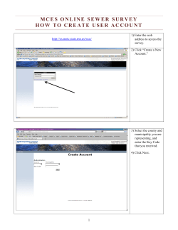

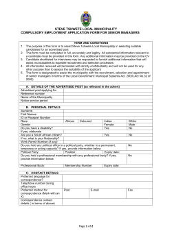
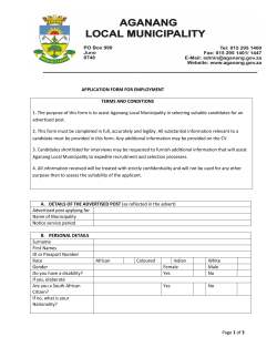


© Copyright 2026