
Waterways of the United States
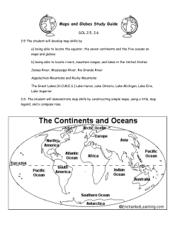
Skill: Physical Features
Essential Element 2: Standard 4
Waterways of the
United States
Introducing the Map
Share with students that physical maps show the natural landforms and
waterways of a place.
ANSWER KEY
Note: Not all questions can be answered
with information from the map. Students
will have to use their mental map skills to
locate places on the map.
Monday
1. Arctic (Alaska), Atlantic,
and Pacific
2. 9
Tuesday
1. 3; Arkansas River, Missouri
River, and Ohio River
2. Lake Itasca
Wednesday
1. Gulf of Mexico and Gulf of
Maine; Gulf of Mexico
2. Great Salt Lake
Thursday
Show students the physical map of the United States. Students will
notice that this physical map shows the major waterways of the United
States.
Have students name the different kinds of waterways shown on the map.
Remind students to also look at the inset maps of Alaska and Hawaii.
They should mention oceans, lakes, rivers, gulfs, a sound, and a strait.
Share with students the definitions of a gulf, sound, and a strait.
The major rivers and famous lakes have been included on this map.
Have students follow the Mississippi River from its source in Lake Itasca
(Minnesota) to the mouth, which is the Mississippi Delta (Louisiana).
Students will see that the river flows into the Gulf of Mexico. Also,
discuss the labeled tributaries of the Mississippi River.
Explain that all the lakes on the map are freshwater lakes except for the
Great Salt Lake and the Salton Sea. The Great Salt Lake is a saltwater
lake in Utah, and the Salton Sea in California is a shallow saltwater lake.
Have students name the five Great Lakes, which are the world's largest
group of freshwater lakes.
1. 5; Lake of the Woods, Lake
Superior, Lake Huron, Lake
Erie, and Lake Ontario
You may also choose to extend the week's lesson to include additional
rivers and lakes that are important to your region of the country.
2. Columbia River, St.
Lawrence River, and the Yukon
River
Introducing Vocabulary
Friday
1. Puget Sound, Washington;
Straits of Florida, Florida
2. Colorado River
Lakes five freshwater lakes-Superior,
Erie, and Ontario
Michigan,
Great
gulf a large area of ocean that is partly surrounded
lake a large body of fresh water surrounded
Huron,
by land
by land
mouth the part of the river where it empties into another body of
Challenge
Chesapeake Bay is off the coast of
Maryland; Delaware Bay off the
coast of Delaware; Monterey Bay
(south of San Francisco Bay); and
San Francisco Bay is off the northern
coast of California.
water
physical features
natural landforms and waterways on Earth's
surface
physical map a map that shows natural landforms
and water on
Earth's surface
sound a long, wide body of water, larger than a strait or channel
source the place where a river starts
strait a narrow strip of water that connects two larger bodies of
water
tributary
62
EMC 3714 • Daily Geography Practice, Grade 5
a river that flows into a larger river
©2004 by Evan-Moor Corp.


© Copyright 2026