
Planners Guide to Seattle
PLANNERS GUIDE TO SEATTLE Contents Welcome to Seattle 4 West Seattle 38 Getting Around 6 Columbia City 42 Near the Conference 10 Ballard 48 Seattle Planning History 18 Green Lake 54 Bainbridge Island 58 Neighborhood Tours Lake Union 20 Other Neighborhoods 62 Pioneer Square 22 Beyond Seattle 64 Chinatown/ID 28 66 Capitol Hill 34 Thank You to Our Local Host Sponsors Cover Photography Kevin Gifford Graphic Design Julie Jacobson Design Opposite Page Photography Top Row: Ivan Miller Middle Row: Ivan Miller Bottom Row, Left: Ferdouse Oneza Bottom Row, Right: Ivan Miller End Page Photography Top Row: Howard Frisk Second Row, Left: Gary Mabley Second Row, Right: Kevin Gifford Third Row, Left: Gary Mabley Third Row, Right: Tim Thompson Bottom Row, Left: Tim Thompson Bottom Row, Right: Ferdouse Oneza Welcome to Seattle Welcome! The Washington Chapter Local Host Committee is proud to host this year’s National Planning Conference, and we are delighted to welcome our colleagues to the Emerald City. Seattle is a wonderful city, full of history, beauty, and fun. We hope all of you will have an opportunity to explore some of its many charms. This guidebook is designed to help you make the most of your time in Seattle, whether you want to learn about Seattle’s history, explore our parks and museums, or just visit a neighborhood and sample some of Seattle’s ethnic and Northwest cuisine. Ivan Miller, AICP Chapter President Thank you for coming, and enjoy your stay. Kevin Gifford, AICP Marty Curry, AICP 2015 Planners Guide Subcommittee Co-Chairs Deborah Munkberg, AICP Conference Co-Chair Paul Inghram, AICP Conference Co-Chair Kevin Gifford, AICP Planners Guide Subcommittee Co-Chair Marty Curry, AICP Planners Guide Subcommittee Co-Chair 2015 Planners Guide Subcommittee Members Carmen Bendixen—WA Dept. of Natural Resources Izzy Cannell—BERK Consulting Marty Curry, AICP—University of Washington Kevin Gifford, AICP—BERK Consulting Aaron Raymond—BERK Consulting Michael Schuler, AICP—AECOM Jennifer Tippins—BERK Consulting PAGE 4 Welcome to Seattle 2015 APA National Planning CONFERENCE Local Host Sponsor The Bullitt Foundation believes that urban sustainability begins with innovation and partnership. With grant making focused in the Pacific Northwest, the Foundation’s programs include Ecosystem Services; Energy, Industry & Technology; Urban Ecology; Leadership and Civic Engagement, and Deep Green Buildings. www.bullitt.org www.bullittcenter.org PAGE 5 Getting Around Taxis and Car Services are also available at Seattle offers a wealth of travel the airport. Taxi rates are set by King County, so prices should not vary from company to company. Rides from the airport to downtown are charged at the meter rate, but rides from downtown to the airport are a flat rate of $40. options, and the number of providers can sometimes be confusing for firsttime visitors. Don’t worry—we’ve got you covered! The airport’s website provides additional information on town car services and car rentals. A great resource for conference attendees is provided by the http://www.portseattle.org/Sea-Tac/Parking-andTransportation/Ground-Transportation/Pages/ default.aspx Downtown Seattle Association. Visit www.downtownseattle.com/maps for useful maps of the downtown area, K i n g C o u n t y Met r o transit systems, and bike routes. F r o m the A i r p o r t Sound Transit Link Light Rail provides convenient service from Sea-Tac International Airport to downtown Seattle. The airport light rail station can be reached by following the signs across the skybridge and through the terminal parking garage. Trains run every 7.5 minutes during peak hours and every 10–15 minutes during off-peak times. Trains operate from 5 a.m. to 1 a.m., Monday through Saturday, and from 6 a.m. to midnight on Sundays. The downtown terminus of the line is at Westlake Station (5th Avenue and Pine Street), located about two blocks from the Convention Center, and the ride from the airport takes about 30 minutes. A detailed schedule and route map is available on the web at http://www.soundtransit.org/ Schedules/Central-Link-light-rail. King County Metro is the primary transit operator in Seattle, providing local bus service and a water taxi across Elliott Bay to West Seattle. By visiting their site online, you can use the “Plan a Trip” function to find the best route to get you where you need to go. http://metro.kingcounty.gov The schedules and maps page of the King County Metro site provides a list of bus routes, a system map, and a useful set of maps on the “Getting Around Seattle” tab. Go directly to this set of maps by following http://metro.kingcounty.gov/maps/seattle A trip on a Metro bus will cost $2.50 during off-peak times and $2.75 during peak hours. Peak hours are 6–9 a.m. and 3–6 p.m., Monday through Friday. The entire city of Seattle counts as one zone, but if you are traveling outside the city boundaries, be aware that fares may increase. Transfers are valid from one Metro bus to another and can be collected from your driver when paying cash. PAGE 6 Getting Around Sound Transit Sound Transit operates regional bus routes and the light rail. A “Rider Guide” page is available on Sound Transit’s website. The site provides information on service changes, safety, and how to get to popular destinations. http://www.soundtransit.org/ Rider-Guide B i c y cle One of the best ways to experience Seattle is by bike. Bicycle rentals are available at the following locations: Pronto Cycle Share Pronto Cycle Share opened in Seattle in the fall of 2014. The bike share program offers $8 24-hour passes and $16 three-day passes. A pass can be picked up at Pronto kiosks using a credit or debit card. Unlimited trips are allowed in this time, but each trip is limited to 30 minutes, otherwise a usage fee is incurred. Helmets are available for free with Pronto passes. Visit Pronto’s website to find station maps and bike availability. www.prontocycleshare.com Bike Rentals & Tours Seattle Bicycle Rentals & Tours www.seattlebicyclerentals.com Seattle Cycling Tours www.seattle-cycling-tours.com 2015 APA National Planning CONFERENCE Regional Bike Trails Two of the most popular regional bike trails run through Seattle. If you have some free time, be sure to check them out. Burke-Gilman Trail: This paved multiuse trail runs for 18 miles, from the Ballard neighborhood to the city of Bothell on the northeast side of Lake Washington, where it connects with the Sammamish River Trail. The Burke-Gilman also goes through the Fremont, Wallingford, and University District neighborhoods, and passes by Gas Works Park, the University of Washington, and Magnuson Park (which was formerly a US Navy facility). Alki Trail: This five-mile multiuse paved trail provides scenic views of Elliott Bay and access to Alki Beach and the West Seattle–Downtown Water Taxi. The Alki Trail stretches from West Marginal Way South, across the swing bridge on Southwest Spokane Street, past the industrial Harbor Island, and on to the northern and eastern shores of West Seattle. The City of Seattle maintains online maps of all protected bike lanes, multiuse trails, neighborhood greenways, and other bike facilities. Check out their website for a complete list. http://www.seattle.gov/ transportation/bikemaps.htm PAGE 7 One Bus Away This free smartphone app is a useful tool for getting around Seattle by bus. The app allows you to find the bus stop nearest to your current location and view a list of all buses that stop at your location, as well as real-time arrival information. Maps and schedules for individual bus routes are also available. Available for iOS, Android, and Windows Phone. OneBusAway.org Getting Around ORCA Card Feel free to pay for buses with cash, but ORCA cards (One Regional Card for All) are available at self-service ticket vending machines and provide quick payment for buses, trains, and ferries. Just load the card with money at a ticket machine, then tap the card reader when you board the bus. For Link light rail, tap the card reader as you enter and leave the station. Self-service machines are available at Convention Place, all Sounder rail stations, and all Link light rail stations, including the Westlake Transit Tunnel Station at 4th Avenue and Pine Street downtown. www.ORCACard.com 2015 APA National Planning CONFERENCE T a x i s / C a r S e r v i ces Ra i l Taxi service is offered by a variety of providers. Depending on the time of day, cabs may be hard to find on the street, so reservations are recommended if you are on a tight schedule. Ridesharing options are also available. Two of the most popular are Uber and Lyft. Reservations and payment are handled through smartphone apps available from each provider’s website. www.lyft.com www.uber.com Sound Transit Light Rail Ferries departing downtown Seattle accept both drive-on and walk-on passengers. A great stop along the line is the 12-acre Lake Union Park, which gives you access to several attractions, including Lake Union, the Museum of History and Industry (MOHAI), Kenmore Air, and The Center for Wooden Boats. Sound Transit’s Central Link light rail provides travel to points between downtown and the airport, including several of Seattle’s southern neighborhoods. In downtown the light rail can be boarded at the transit tunnel stations marked on the downtown map on pages 12 and 13. Seattle Streetcar The South Lake Union Line of the Seattle Streetcar runs 1.3 miles from the rapidly F e r r i es developing South Lake Union neighborhood into Seattle’s Washington State Ferries downtown core. The downtown If you are looking to travel a terminus of the line (at 5th little further and experience a Avenue and Olive Way) is ride across Puget Sound, try within walking distance of one of Washington’s iconic the Convention Center and green and white ferries. Route and fare information is available provides links to the light rail and the monorail, as well as the online at rapid transit bus lines. www.wsdot.wa.gov/ferries. King County Water Taxi King County operates walk-on water taxis from downtown Seattle to West Seattle and Vashon Island. When the weather is pleasant, these boats offer spectacular views and a great way to avoid traffic. www.kingcounty.gov/ transportation/kcdot/WaterTaxi. aspx PAGE 8 The streetcar fare is $2.50 and can be paid either at station ticket machines or with an ORCA card. For streetcar route maps and more information, visit www.seattlestreetcar.org. Getting Around 2015 APA National Planning CONFERENCE Local Host Sponsors Welcome APA members. Puget Sound Regional Council — planning for a thriving region. psrc.org Puget Sound Regional Council PSRC Supporting sustainable mobility in Seattle. PAGE 9 Near the Conference The Convention Center and “ Ra i n C i t y ” conference hotels are located right in While Seattle’s spring rainy season is winding down by April, weather in the area is notoriously unpredictable. The best strategy is to dress in layers and always be prepared for a light rain. To blend in with the locals, exchange your umbrella for some outdoorsy rain gear. the heart of downtown Seattle. Here are a few things to know about finding what you need during your time away from the conference. D o w n t o w n S eattle The Washington State Convention Center is located on the northeast corner of Seattle’s central business district, providing easy access to the restaurants and nightlife of Capitol Hill and Belltown as well as the tourist attractions at Pike Place Market. Immediately to the west and south of the Convention Center is downtown’s primary shopping district. Downtown Ambassadors, dressed in blueand-yellow uniforms, are more than happy to provide directions or other assistance. They staff information booths at the Convention Center and other locations and patrol throughout the downtown. Visitors can help orient themselves by remembering that named downtown streets run perpendicular to the waterfront and numbered avenues run parallel to it. Bicycle commuters and bike messengers are common downtown and can be both fast and quiet. Keep an eye out when crossing the street. Seattle is a very walkable city, especially in the downtown area, but it does contain some fairly steep hills. We want everyone to be comfortable while exploring downtown or taking one of the self-guided neighborhood tours in this guide, so wearing comfortable (and waterproof) shoes with good tread is highly recommended. C o ffee Although the coffee scene in Seattle might appear to be dominated by a certain wellknown chain, Seattleites love their independent coffeehouses as well. The following are a few local favorites near downtown. Caffé Vita Capitol Hill: 1005 E Pike Street Vita roasts coffee (and holds free monthly coffee brewing classes) at this, its flagship cafe in the Pike/Pine corridor. Cherry Street Coffee House Downtown: 509 Olive Way Cherry Street is renowned for the friendliness of owner Ali Ghambari. His daughter Laila won first place in the 2014 US Barista Championship. PAGE 10 Near the Conference 2015 APA National Planning CONFERENCE Dilettante Mocha Cafe Downtown: 1601 5th Avenue Seattle Art Museum Associated with one of Seattle’s finest chocolatiers, this cafe may be one of the best places to get a mocha. SAM’s collections include everything from Roman antiquities to contemporary video art, and its exhibitions of Native American art are among the best. Espresso Vivace Capitol Hill: 532 Broadway Avenue E Vivace’s flagship cafe, relocated due to light rail construction, still produces some of the tastiest and most beautiful lattes around. 1300 1st Avenue Seattle Aquarium 1483 Alaskan Way, Pier 59 Getting close to a giant Pacific octopus and learning about the Sound’s resident orcas are just a few of the things to do here. Zeitgeist Coffee Bill Speidel’s Underground Pioneer Square: 171 S Jackson Tour Street 608 1st Avenue Zeitgeist is a great place to begin or end a tour of Pioneer Square and provides a great chance to check out the work of local artists. This is a very popular tour of the subterranean passageways created when streets in the Pioneer Square neighborhood were regraded after the Great Seattle Fire of 1889. Downtown A tt r act i o n s The conference Local Host Committee has organized two guided tours for conference attendees, followed by drinks and light hors d’oeuvres. Tours are on the evenings of Saturday, April 18, and Monday, April 20. Tickets are availabe through the conference registration website. When taking a break from the conference, check out some of the great attractions, restaurants, and cultural amenities of downtown Seattle. Pike Place Market 1st Avenue and Pike Street The Pike Place Market, saved from demolition in the early 1970s by civic activists, is home to a farmers market, restaurants, shops, a crafts market, and much more. Need Help? Operated as a free service by Visit Seattle, the Seattle Visitor Center is available to assist guests with almost anything, from local travel information to dinner reservations. The Seattle Visitor Center desk is located in the main lobby of the Convention Center on Level 1, directly across from Espresso Café Dior. Open Monday–Friday, 9 a.m. to 5 p.m. 206-461-5888 Seattle Art Museum’s Hammering Man Sculpture PHOTO CREDIT: Tim Thompson Klondike Gold Rush National Historical Park 319 2nd Avenue S Located in the former Cadillac Hotel, this museum explains Seattle’s role as the “Gateway to the Gold Fields.” PAGE 11 Pike Place Market PHOTO CREDIT: Tim Thompson Near the Conference 2015 APA National Planning CONFERENCE E PIKE ST BELLEVUE AVE BO T ST ER Y TAYLOR AVE N ST ST AV E ST Mi n u te s CE DA Seattle Center PAGE 12 R AV E VI NE ST ST E AV Pike Place Market ST 99 EL LI O TT 20 IN IA Victor Steinbrueck Park 5TH AVE N Space Needle D 2N ST 4T H AV E BE LL T AV E BA TT VI RG 1S T 6TH AVE N ST BL AN CH AR D W AL L Westlake Park 3R D RA Denny Park 99 I ST EW AR J ST LE NO E AV PL 9T H AV E N 10 M inutes AV E THOMAS ST DENNY WAY 8T H H 5T E PIN South Lake Union Discovery Center JOHN ST Westlake Mall H ST F E VE HA H 6T N IO 7T UN D C B AVE LAKE WEST WESTLAKE AVE N AURORA AVE N ST McGraw Square TERRY AVE N HARRISON ST EL L Freeway Park Convention Center ST Streetcar to Lake Union and MOHAI Paramount Theater E AV E PIK FAIRVIEW AVE N H 9T PI KE Mi n 15 HO W 5 M in ut es A ST REPUBLICAN ST Plymouth Pillars Park VE YA Y SIT MINOR AVE N 8TH AVE N RR TE R IVE PONTIUS AVE N REI Flagship Store Y WA YALE AVE N MELROSE AVE 5 IVE OL EASTLAKE AVE E VE NA E R UN u te s BELLEVUE AVE E ST EO LIV EW AY CA NE SE E PINE ST D o w n t o w n A ct i v i t i es & A tt r act i o n s E AV 5TH AVE S 4TH AVE S ST ST 3RD AVE S T G Smith Tower Seattle Public Library Underground Tour LU CO ON Seattle Art Museum E AV AL RN ST E O T P S WE Y WA AN K AS AL ST ST E AV Benaroya Hall 1ST IA MB RI MA D 3R E AV ST T NG RI SP K Rainier Tower S DEARBORN ST S LANE ST S WELLER ST S KING ST S JACKSON ST T es 2 5 M in ut ST s ON RS te E FF nu E AC RR TE E te s J S MAIN ST nu Mi S WASHINGTON ST te s ST nu YESLER WAY Mi R Mi R ER 10 N SO Seattle City Hall 20 DE AL 15 T SS ME JA T YS CH 5 S CHARLES ST 2015 APA National Planning CONFERENCE St. James Cathedral DI MA E Near the Conference Century Link Field Klondike Gold Rush NHP Occidental Park OCCIDENTAL AVE S Milepost 31 1ST AVE S AVE ST PO ALASKAN WAY S 99 Activities & Attractions Ferry Terminal Transit Tunnel Stations Streetcar Stations Central Link Light Rail (Transit Tunnel) Monorail South Lake Union Streetcar Waterfront Park Conference Hotels A. Homewood Suites B. Hyatt at Olive 8 C. The Paramount Hotel D. Grand Hyatt E. Roosevelt Hotel F. Sheraton G. Crowne Plaza H. The Westin I. Mayflower Park Hotel J. Motif Hotel K. Fairmont Olympic Seattle Aquarium E L L I O T T B AY Feet 0 PAGE 13 1,000 Near the Conference 2015 APA National Planning CONFERENCE Milepost 31 211 1st Avenue S Milepost 31 is an awardwinning information center established by WSDOT to educate visitors about the SR 99 Tunnel Project. Seattle Center 325 5th Avenue N The site of the 1962 Century 21 Exposition, Seattle Center is the home of the Space Needle and a variety of other attractions including the EMP Museum, Chihuly Garden and Glass, Pacific Science Center, and Space Needle from Seattle Center the Seattle Opera. For the full PHOTO CREDIT: Kevin Gifford experience, travel to the Center on the original monorail, which departs from Westlake Center. Olympic Sculpture Park Broad Street and Western Avenue This nine-acre park holds some of the Seattle Art Museum’s larger artworks and provides Chihuly Garden and Glass, great views of Elliott Bay. The Seattle Center adjacent Myrtle Edwards Park, PHOTO CREDIT: Kevin Gifford which continues along the bay for over a mile, is a great place for an evening stroll or run. Museum of History and Industry (MOHAI) 860 Terry Avenue N MOHAI displays exhibits on the history of Seattle and its environs in the historic Naval Reserve Armory, located in Lake Union Park. While you’re there, don’t miss the adjacent Center for Wooden Boats. PAGE 14 MOHAI will also host the conference Opening Reception on Sunday, April 19. Tickets are available through the conference registration website. https://conference.planning. org/conference F a r the r A f i el d Seattle also offers some excellent attractions outside the downtown area. Here are a few that can be reached quickly from the Convention Center. For additional adventures around Seattle, please take a look at the Neighborhood Tours section of this guide. Museum of Flight 9404 E Marginal Way S This museum houses one of the largest collections of aviation and space artifacts and vehicles in the United States and presents flightrelated exhibits and educational programs. Bullitt Center 1501 E Madison Street The Bullitt Center was built by Seattle’s Bullitt Foundation and is billed as “the greenest commercial building in the world.” The University of Washington’s Center for Integrated Design, located within, hosts educational events and tours. Near the Conference Asian Art Museum 1400 E Prospect Street Located in Volunteer Park in the original art deco Seattle Art Museum building, this museum boasts an extensive Asian art collection. Posing for a photo with Isamu Noguchi’s Black Sun sculpture is de rigeur. Resta u r a n ts Restaurants and bars are plentiful and diverse in Seattle. Recent reviews can be found in free weekly newspapers The Stranger and Seattle Weekly (available on street corners everywhere) and in local magazines such as Edible Seattle, Seattle Met, and Seattle magazine. Searchable online listings include: Visit Seattle: Restaurants Seattle Magazine: Restaurants Seattle Met: Eat and Drink Seattle Times: Restaurants Seattle Weekly: Food The Stranger: Restaurants VegSeattle The following websites can help you explore Seattle’s nightlife: 2015 APA National Planning CONFERENCE F o o d T r u cks Seattle may not have New York City’s storied street food culture, but local food trucks have been attracting a lot of attention in the last few years. Since 2013, a handful of local vendors have made it onto national lists of top food trucks, and the one-day 2013 Seattle Street Food Festival attracted over 26,000 attendees. In addition to feeding hungry office workers, food trucks have helped to activate public spaces such as Westlake Park, as well as provided an avenue for small business development. You can find some of the best street food that Seattle has to offer near the Convention Center, at street food “pods” that have been set up at Westlake Park and at 2nd Avenue and Pike Street, as well as in nearby neighborhoods. The following websites will help you determine what is available and where it is located: 2ndandpikeeats.com Downtown Seattle Association: Food Truck Pods Roaming Hunger SeattleFoodTruck.com Seattle Met: Bars and Nightlife Seattle Weekly: Happy Hours The Stranger: Bars and Clubs PAGE 15 Urban Art at Westlake Park PHOTO CREDIT: Ivan Miller Seattle Central Library PHOTO CREDIT: Howard Frisk Near the Conference Eating Near the Conference 2015 APA National Planning CONFERENCE Downtown Alibi Room 85 Pike St, Ste 410 $$ American, pizza Barolo 1940 Westlake Ave Food and beverages will be $$ Italian available at the Convention Blueacre Seafood 1700 7th Ave Center, but we hope you will $$$ Seafood get out and explore some Capitol Grille of the great restaurants in 1301 4th Ave $$$ American, steakhouse the surrounding area. This Cyberdogs list is only a fraction of what 909 Pike St the city has to offer, so feel $$ Hot dogs V Dahlia Lounge free to also use one of the 2001 4th Ave guides listed on the previous $$$ American, seafood Etta’s Pike Brewing Company 1415 1st Ave $$ American, brewpub Purple Cafe and Wine Bar 1225 4th Ave $$$ American RN74 1433 4th Ave $$$ American, French Rock Bottom Brewery 1333 5th Ave $$ American, pub Serious Pie 316 Virginia St $$ Pizza V Spur Gastropub 113 Blanchard St $$$ American Sullivan’s 621 Union St $$$ Steakhouse page. For adventures away 2020 Western Ave from the downtown area, $$ Seafood Thai Ginger 600 Pine St, Ste 406 $$ Thai each neighborhood tour 700 Virginia St includes a short list of local $$ American V/VG The Berliner Döner Kebab 221 1st Ave S $ Middle Eastern, Turkish Farestart Restaurant Harbor Cafe eateries worthy of your 1411 4th Ave, #103 consideration. $ Thai, fusion Restaurant Key V: vegetarian-friendly VG: vegan-friendly Typical entree prices: $: $10 or less $$: $11–$15 $$$: $15–$20 $$$$: $20 and up Lowell’s Restaurant 1519 Pike Pl $$ American Morton’s 1511 6th Ave $$$$ Steakhouse Matt’s in the Market 94 Pike St #32 $$ American New Saigon 1529 6th Ave $ Vietnamese Palace Kitchen 2030 5th Ave $$ American Palomino 1420 5th Ave, Ste 350 $$ American, Mediterranean PAGE 16 The Pink Door 1919 Post Alley $$ Italian V Umi Sake House 2230 1st Ave $$ Sushi, Japanese Westlake Park Food Trucks Pike St and 4th Ave $ Various cuisines Wild Ginger 1401 3rd Ave $$ Thai, fusion V/VG C A p i t o l H i ll Primo 1106 8th Ave $$ Pizza, Italian Sitka & Spruce 1531 Melrose Ave $$$ Northwestern Near the Conference 2015 APA National Planning CONFERENCE Tango 1100 Pike St $$ Spanish, tapas Grand Central Bakery 214 1st Ave S $ Sandwiches, bakery; breakfast/lunch only Terra Plata 1501 Melrose Ave $$ Spanish, seasonal C h i n at o w n / I n te r n at i o n al D i st r i ct Hole in the Wall Barbecue 215 James St $ Barbecue Green Leaf Vietnamese Restaurant 418 8th Ave S $$ Vietnamese V Il Terrazzo Carmine 411 1st Ave S $$$$ Italian P i o n ee r S q u a r e Bakeman’s Restaurant 122 Cherry St $ Sandwiches, American Phnom Penh Noodle House 660 S King St $ Cambodian Marcela’s Creole Cookery 106 James St $$ Creole, Southern Cafe Paloma 93 Yesler Way $$ Mediterranean, Turkish Samurai Noodle 606 5th Ave S $ Ramen Merchant’s Cafe & Saloon 109 Yesler Way $$ American Delicatus 103 1st Ave S $$ Deli, sandwiches Shanghai Garden 524 6th Ave S $$ Chinese Pyramid Alehouse Brewery and Restaurant 1201 1st Ave S $ Pub food Elysian Fields 542 1st Ave S $$ American, brewpub Tamarind Tree 1036 S Jackson St $$ Vietnamese V Tat’s Delicatessen 159 Yesler Way $ Sandwiches Tsukushinbo 515 S Main St $$ Japanese N SO DI MA MELROSE AVE 13 14 8 ST 15 TE 9T VE YA RR 16 NG RI SP VE NA RE BO 5 VE HA ST s ut e T 5M in S CA NE SE HUB BELL PL VE HA 8T 1 7 Convention Center 2 ST 3 S ITY RS ST T ES PIN HO W EL L IVE UN E PIK 1 T IV OL H 7T E AV VE HA 6T 7 5 17 E WESTLAK VI RG IN IA ST AVE 4 ST 5 20 19 ST 6 3 ST EW AR T 9 8 2 N IO UN AY EW 4 H 5T E AV H 4T 10 6 E AV 12 11 D 3R E AV Nearby Coffee Shops & Restaurants Coffee Shops 1. Caffe Ladro 2. Monorail Espresso 3. Caffe Senso Unico 4. Ebar Nordstrom 5. Cherry Street Coffee House 6. Dilettante Mocha Cafe 7. Voxx Coffee 8. Starbucks Reserve Roastery & Tasting Room Restaurants 1. Cyberdogs 2. La Creperie 3. Sullivan's Steakhouse 4. Blueacre Seafood 5. Thai Ginger 6. New Saigon 7. Morton's Steakhouse 8. Palomino 9. Rock Bottom Brewery 10. Westlake Park Food Trucks 11. RN74 12. Harbor Cafe 13. Sitka & Spruce 14. Terra Plata 15. Tango 16. Primo 17. Barolo 18. Wild Ginger 19. Capitol Grille 20. Purple Cafe and Wine Bar 18 Feet VE DA 2N PAGE 17 0 500 Seattle Planning History S ettle m e n t & E a r ly H i st o r y In 1851, settlers first landed on Alki Point in what is now West Seattle, eventually moving across Elliott Bay to where a protected harbor was available. Their new settlement was eventually named Seattle in honor of local Duwamish leader Sealth, who had befriended the settlers. Early development was supported primarily by Henry Yesler’s lumber mill; the term “skid row” was coined from the practice of skidding logs down the inland hills to the waterfront. By the late 1800s, Seattle’s population was booming, along with growth in lumber, coal, fishing, and shipbuilding industries. The Great Seattle Fire of 1889 leveled 116 acres, devastating the city’s downtown. While the fire was destructive, it gave Seattle the opportunity to invest in infrastructure and plan for wider streets, reconstructed wharves, and the institution of municipal services. Although growth was slowed by the fire, the beginning of the Klondike Gold Rush in 1897 created great opportunity for Seattle as the last stop for prospectors on their way north to the gold fields. During this time, extensive street railways were built that defined many of today’s neighborhoods. plan for Seattle and spent the next 30 years implementing their designs, including plans for the University of Washington campus, Volunteer Park, Green Lake Park, Washington Park Arboretum, and Alki Beach, and dozens more. In 1909, Seattle hosted the Alaska-YukonPacific Exposition, celebrating the economic and cultural links Seattle had forged with the North Pacific Rim and recognizing Seattle’s role as a North American gateway to Asia. The expo was hosted on the current UW campus, and the Rainier Vista, the primary axis of the fairgrounds, provided visitors with impressive views of the mountain. The early 20th century was also a busy time for infrastructure projects, which literally reshaped Seattle’s landscape. The Denny Hill Regrade demolished a large hill just north of downtown to create a flat area for development. Construction of the Alaskan Way seawall began in 1910, creating a deepwater port to accommodate E a r ly 2 0 th C e n t u r y Where Seattle’s early years had been a time of rapid, boomtown expansion, the turn of the century saw Seattle emerge as a more stable, mature city. In the early 1900s, the Olmstead brothers completed their comprehensive parks Denny Regrade in progress. Property owners who didn’t sell often had the hill mined away around them. PHOTO CREDIT: Museum of History & Industry PAGE 18 Seattle Planning History 2015 APA National Planning CONFERENCE with major development and protecting sensitive natural areas that provide benefits to all of Washington’s citizens. The Washington State Growth Management Act (GMA) was adopted in 1990 and was designed to rein in urban sprawl and prevent the loss of valuable rural lands. Jurisdictions in Washington embraced GMA and developed comprehensive plans that focused growth in urban areas. Some jurisdictions, such as Seattle and Tacoma, also established formal networks of mixed-use centers and villages. Hiram M. Chittenden Locks under construction. PHOTO CREDIT: City of Seattle freight movement in the downtown. The Lake Washington Ship Canal was completed in 1934, linking Lake Washington, Lake Union, and Puget Sound and providing a boost to local commercial and industrial development. L A te 2 0 th C e n t u r y The Puget Sound region experienced the same trend of suburbanization in the 1950s as did much of the rest of America. One legacy of this era is the presence of Interstate 5 in the heart of Seattle. While the freeway provides major north– south access in the region, its construction created barriers between neighborhoods and has had a lasting effect on Seattle’s urban form. In an effort to revitalize the city’s economy and cultural life, the Century 21 Exposition was held in 1962, showcasing science, technology, and an optimistic vision of the future. The expo provided the city with the Seattle Center, including the Pacific Science Center and Seattle’s iconic Space Needle. The later decades of the 20th century in Seattle carried strong themes of environmentalism, social change, and responsible growth. Washington enacted the State Environmental Policy Act (SEPA) in 1971, followed by the Shoreline Management Act (SMA) that same year. These laws provided a framework for evaluating environmental impacts associated Space Needle and Seattle Center under construction. PHOTO CREDIT: Museum of History & Industry T ech n o l o g y & U r ba n Re v i v al The past twenty years have witnessed the rise of the central Puget Sound region as a high-tech hub, with Boeing and Microsoft leading the way for biotechnology firms and small tech start-ups. Young professionals are increasingly driving a trend toward urban living. Major employers, such as Amazon and Weyerhauser, have responded to this trend by moving their offices back into the urban core or establishing urban campuses. Once again, Seattle is on the verge of great change, and the challenge of the 21st century is to accommodate future housing and employment, address social equity concerns around affordable housing and public health, and provide infrastructure and amenities that create great urban places and promote highquality urban living. PAGE 19 Lake Union ARgosy Cruises Located in the heart of the city, Lake Argosy offers a two-hour cruise on Lake Union and Lake Washington with highlights that include local landmarks and spectacular views. If you want a water-level look at the new SR 520 floating bridge, the tour route goes right by it. Argosy also offers several other cruises around the Seattle area. Check their website for details. AGC Marina, 1200 Westlake Ave N http://www.argosycruises.com Union is often called “Seattle’s biggest water park.” The lake is very popular with boaters and offers striking views of downtown. If the weather is pleasant, we encourage you to get out on the water and take in the scenery. Agua Verde Cafe & Paddle Club Museum of History and Industry The centerpiece of South Lake Union Park is the Museum of History and Industry, housed in the historic Naval Reserve Armory. MOHAI offers an in-depth look at the history of Seattle and the central Puget Sound. The park complex is also home to The Center for Wooden Boats and Northwest Seaport, a maritime heritage center. 860 Terry Ave N http://www.mohai.org The CEnter for Wooden Boats Adjacent to the Museum of History and Industry at the south end of the lake, the Center offers rentals of wooden sailboats and rowboats, as well as exhibits of historic vessels and a working boatshop. 1010 Valley St http://cwb.org Northwest Outdoor Center The Center provides kayak and paddleboard rentals and classes. 2100 Westlake Ave N, Ste 1 http://www.nwoc.com Agua Verde includes a lakeside cafe and offers kayak rentals and guided tours of Lake Union and the Washington Park Arboretum, part of the University of Washington Botanic Gardens. 1307 NE Boat St http://aguaverde.com Moss Bay Rowing Moss Bay provides rowboat, sailboat, kayak, and paddleboard rentals. 1001 Fairview Ave N http://mossbay.net Gas works Park Gas Works Park sits on the site of a former gasification plant, and the ruins of the old plant still stand as a prominent feature of the park. Gas Works Park hosts an annual Fourth of July celebration and boasts exceptional views of downtown. No boat rentals here, but be sure to swing by from the water side for a closer look at the gas works. PAGE 20 ROY ST VALLEY ST MERCER ST PAGE 21 Activities & Attractions South Lake Union Streetcar E ROY ST Streetcar Stations PROSPECT ST 0 15TH AVE E 12TH AVE E FEDERAL AVE E E Feet 13TH AVE E 10TH AVE E E 11TH AVE E BROADWAY E BOYLSTON AVE E FRANKLIN AVE E E GWINN PL 10TH AVE E HARVAR D AVE E YALE AVE E YALE TER E FAIRVIEW AV EE EASTLAKE AVE E MINOR AVE E STONE WAY N INTERLAKE AVE N CORLISS AVE N N PA CI FI C ST BAGLEY AVE N MERID IAN AVE N BURKE AVE N WALLINGFORD AVE N DENSMORE AVE N WOODLAWN AVE N ASHWORTH AVE N NE 14TH AVE E ALOHA ST HARVARD AVE E BL VD Moss Bay Rowing BELMONT PL E LA KE VI EW N Northwest Outdoor Center SUMMIT AVE E BELLEVUE AVE E South Lake Union Park AV E The Center for Wooden Boats FA IR VI EW Lake Union DE LM AR E E AV E DR Museum of History and Industry N 38TH ST R Argosy Cruises PONTIUS AVE N Gas Works Park YE BO LA KE AVE N TR L E 9TH AVE N KE G ILM AN VE NA N AVE W EST N 35TH ST E ALLISON ST MA HR FU 8TH N PL ERLY WAV AURORA AVE N BUR DEXTER AVE N Lake Union 2015 APA National Planning CONFERENCE PACIFIC ST Agua Verde E BOSTON ST E NEWTON ST E HOWE ST Volunteer Park 1,000 Pioneer Square Home to some of Seattle’s earliest H i st o r y development, this former red-light One of the first parts of Seattle to be platted (in 1853), Pioneer Square quickly developed as the city’s commercial core. Henry Yesler’s sawmill, at the foot of Mill Street (now Yesler Way), was an early engine of local economic growth. Mill Street became known as the “Skid Road” along which timber was delivered, a name later applied to the neighborhood itself. district now hosts an eclectic mix of tourists, artists, office workers, and sports fans. The Great Seattle Fire of 1889 leveled much of the downtown, and leading local architect Elmer Fisher designed many of the new structures, resulting in Pioneer Square’s exemplary collection of Romanesque Revival buildings. PIONEER SQUARE ! O The Klondike Gold Rush helped the neighborhood prosper in the late 1890s, but as the focus of downtown activity shifted north, a slow decline began. Preservation efforts began in the 1960s, and registration of the “Pioneer Square-Skid Road National Historic District” occurred in 1970, though significant redevelopment did not begin until the 1990s. A tt r act i o n s Not as wild as it once was, Pioneer Square is still an active neighborhood. Proximity to Safeco Field and CenturyLink Field makes the neighborhood a natural location for pre- and post-game celebrations and helps support a large number of bars. Pub food is more common than fine dining, but some excellent restaurants can be found. For tourists and locals alike, the area’s architecture, shops, and art galleries are a significant draw. PAGE 22 Pioneer Square 2015 APA National Planning CONFERENCE Pioneer Square Walking Tour From the Convention Center, take any southbound Transit Tunnel bus or train to the Pioneer Square station. Take the escalator to street level. Walking time from tour start is approximately 25 minutes, not including stops. This tour offers visitors a look at both pioneer square’s rough-and-tumble past and its evolution as part of modern seattle. perhaps nowhere else in seattle are the past, present, and future so intertwined as in pioneer square. T o u r R o u te M A P Y VE HA 5T RR E CH ST PO 3 Smith Tower 2 W AY 1ST AVE ST VE HA 4T ES E AV E AV Iron Pergola & Totem Pole M JA D 3R ST Bill Speidel's Underground Tour WESTERN AVE 1 DI YESLER WAY G A RR 2ND AVE S CE ST TE PR EF ON TA IN E PL OCCIDENTAL AVE S IN LL S Tashiro Kaplan Artist Lofts 12 S WASHINGTON ST 11 5 2ND AVE S OCCIDENTAL AVE S 1ST AVE S ALASKAN WY VI NB S ET 6 AV Nord Alley S MAIN ST D 2N Waterfall Garden Park 10 Seattle's Union Gospel Mission 4TH AVE S 4 3RD AVE S Occidental Park Milepost 31 Klondike Gold Rush National Historical Park 8 S JACKSON ST 7 Washington Shoe Building King Street Station 9 Feet S KING ST 0 PAGE 23 250 Pioneer Square 2015 APA National Planning CONFERENCE The adjacent totem pole is a symbol of the complicated history between Native Americans and European Americans in the Northwest. In 1899, members of the Seattle Chamber of Commerce vacationing in Alaska stole a totem pole from local Tlingit indians and brought it back to Seattle. The tribe sued the City for the pole’s return, and while the men responsible for the theft were fined, the court allowed the City to keep the totem pole. The original totem pole was vandalized and set on fire in 1938, and the surviving pieces were returned 2. Iron Pergola & Totem to Alaska shortly thereafter. In Pole a show of graciousness, the Originally installed in 1909 as a Tlingit responded by crafting a cable car stop, this pergola also reproduction and presenting it sheltered the entrance to an to the City as a gift, dedicated elaborate underground public and blessed by the tribe at a restroom. Part of a national potlatch celebration. The new historic landmark (which totem pole has stood in Pioneer includes the adjacent totem Square ever since. pole and Pioneer Building), the pergola has had two major 3. Bill Speidel’s renovations. The first, in 1973, Underground Tour was funded by the Annie E. After the Great Fire, property Casey Foundation (created by owners began to quickly Historic Pioneer Square Pergola Seattleite and UPS founder Jim replace their buildings, and PHOTO CREDIT: Tim Thompson Casey). The second, completed the City began developing in 2002, was necessitated plans to raise the grade of by a truck running into and Pioneer Square streets to collapsing the structure. resolve chronic drainage Located next to the pergola is and flooding problems. The a bronze bust of Chief Seattle City’s ultimate approach— (also known as Chief Sealth constructing curbside retaining or Chief Si’ahl), an influential walls between which fill was Duwamish and Suquamish added to support the new leader, for whom the City of streets—resulted in many Seattle is named. street-level entrances being 1. Smith Tower From its construction in 1914 until 1962 (when the Space Needle was erected), Smith Tower was the tallest building on the West Coast. For a small fee, visitors can travel up to the Chinese Room and Observation Deck, located on the Tower’s 35th floor, which offers excellent views of downtown Seattle, Puget Sound, and beyond. (Note: The Chinese Room may be closed during the conference for renovation.) Historic Smith Tower The building’s pyramidal roof encloses a single residence, the PHOTO CREDIT: Michael Schuler only one in the building. PAGE 24 Pioneer Square well below grade. Access to buildings shifted to entries located on what had been second floors, and the original storefronts, hidden below the neighborhood’s new sidewalks, became what is now the Seattle Underground. Bill Speidel’s Underground Tour has been providing a glimpse of these hidden areas and the city’s forgotten history since 1965. Tours are also available from newcomer Beneath the Streets. www.undergroundtour.com www.beneath-the-streets.com 4. Milepost 31 For anyone interested in learning about the SR 99 Tunnel Project, this educational center is the place to go. Interactive exhibits, artifacts, and interpretive displays provide information on both the construction process and its relationship to the history of the area. Created to address Section 106 of the National Historic Preservation Act, Milepost 31 is intended to help mitigate effects of the project on local historic properties. Free one-hour public tours of the SR 99 tunnel construction site are also available, but advance registration is required. http://www.wsdot.wa.gov/ Projects/Viaduct/Milepost31 2015 APA National Planning CONFERENCE 5. Occidental Park Occidental Park is a favorite spot for local office workers and residents to relax, but, like many other urban parks, it has a reputation for attracting undesirable elements. Project for Public Spaces has included the park in its Hall of Shame, due in part to the park’s limited seating, lack of connections to adjacent uses, and poor design. However, recent City initiatives to activate the space, through a farmers market, art installations, and other activities, are changing its image. Plans for development of a seven-story office building on the adjacent parking lot may also play a role in its revitalization. Pioneer Square Totem Pole PHOTO CREDIT: Howard Frisk 6. Nord Alley The Alley Network Project and its partners have, for the last few years, promoted the improvement and activation of local alleys by using them as spaces for holding public events and displaying art. Nord Alley has been the site of art installations and screenings of the World Cup and Tour de France, and is home to a “green wall.” http://alleynetworkproject.com PAGE 25 Pioneer Building, Pioneer Square PHOTO CREDIT: Michael Schuler Pioneer Square 2015 APA National Planning CONFERENCE 7. Washington Shoe Building The history of the Washington Shoe Building reads like the history of the neighborhood in miniature. Constructed in 1892 on a site left vacant by the Great Fire, what was originally a four-story warehouse was expanded in 1912 to six floors. In the mid-1940s it was purchased by Sam Israel, Interurban Building a landlord who eventually Yesler Way and Occidental Avenue collected over a dozen Pioneer PHOTO CREDIT: Michael Schuler Square properties. Attracted by very low rents (Israel was known for charging little and doing little in terms of maintenance), artists began moving into “The Shoe” in the early 1980s. After Israel’s death in 1994, the Samis Foundation began to renovate the many long-derelict properties it now controlled. The Shoe Building’s artists colony was displaced, Interurban Building Entrance and a complete remodel and PHOTO CREDIT: Michael Schuler seismic retrofit of the building was completed in 2001. including walking tours of the neighborhood and demonstrations of gold mining techniques. 9. King Street Station In the late 1800s, railroad access was a driving concern for many cities in the Pacific Northwest. Plans for construction of a new downtown station for the Great Northern Railway were conditioned on creation of a railroad tunnel to alleviate congestion on existing waterfront rail lines. Begun in 1903, the resulting mile-long tunnel, which runs beneath downtown Seattle, was at the time of its construction the widest and tallest tunnel in the United States. At the tunnel’s southern entrance lies King Street Station. The station was designed by Reed & Stem, architects of New York’s Grand Central Station; the design of its clock tower mimics that of the 8. Klondike Gold Rush campanile in Venice’s Piazza National Historical Park San Marco. The City purchased After gold was discovered in the station from the BNSF 1897 in what is now Canada’s Railway Company in 2008, Yukon Territory, the Seattle and a $55-million renovation economy boomed as the city in 2013 restored the original became the jumping-off point interior, which is a gorgeous for prospectors headed north. example of early 20th century The Seattle Unit of the Klondike design. Gold Rush National Historical Park, located in what was once http://www.seattle.gov/ transportation/ks_about.htm King Street Station the Cadillac Hotel, presents PHOTO CREDIT: Michael Schuler exhibits and interpretative programs about the gold rush and related Seattle history, PAGE 26 Pioneer Square 10. Waterfall Garden Park An often-overlooked oasis, the centerpiece of this tiny and secluded park is a 22-foot waterfall. The park, created and maintained by the Annie E. Casey Foundation, is located on the site of UPS’s first headquarters building (UPS was founded in Seattle in 1907). It is a favorite spot among locals for lunch breaks; open tables can be hard to find on a sunny day. 11. Seattle’s Union Gospel Mission Pioneer Square has, since its beginning, been home to transient workers and others of limited means. During the Great Depression, a number of Hoovervilles sprung up south and east of Pioneer Square, and Seattle’s Union Gospel Mission opened (in 1932) as a soup kitchen. Since that time the Mission has, along with many other shelters and assistance programs located in the neighborhood, continued to serve Seattle’s homeless and low-income individuals and families. 2015 APA National Planning CONFERENCE of older buildings into office space and market-rate housing grew, and local artists increasingly found themselves priced out of the neighborhood. Sensing the need to maintain Pioneer Square’s arts-friendly status, the Pioneer Square Community Development Organization worked with Artspace to redevelop two buildings (the Tashiro and the Kaplan) into a financiallysustainable home for artists. Opened in 2004, Tashiro Kaplan Artist Lofts created 50 affordable live/work apartments, as well as space for arts organizations, galleries, and other businesses. 12. Tashiro Kaplan artist lofts Pioneer Square enjoys a reputation as the home of some of the city’s best art galleries, and for many years artists found affordable loft housing in the area. However, as the fortunes of Seattle increased in the 1990s, pressure for redevelopment PAGE 27 Waterfall Garden Park PHOTO CREDIT: Michael Schuler State Hotel Building PHOTO CREDIT: Michael Schuler Chinatown/International District Home to immigrants from across Asia, the Chinatown/International District is one of Seattle’s oldest neighborhoods, as well as one of its most vibrant and rapidly growing urban villages. H i st o r y The Chinatown/International District (CID) is one of Seattle’s oldest neighborhoods. Through the multiple boom-and-bust cycles of Seattle’s history, the city has been attractive to immigrants looking for a chance at a better life. In the 1880s, Chinese immigrants poured into Seattle to work on railroads, in coal mines, and in the salmon fishing fleet. The early 20th century saw an increase in Japanese and Filipino immigration as well. After the fall of Saigon in 1975, many Vietnamese and other Southeast Asians fled to the United States. Many of them found new homes in the CID. The neighborhood reflects and celebrates this unique Pan-Asian heritage with numerous historic buildings, landmarks and cultural sites, great restaurants, and a strong sense of community. CHINATOWN/ID ! O A tt r act i o n s The CID contains an eclectic blend of cultures, and things to see and do are as varied as the people who live and work here. Take in a show at one of the neighborhood theaters or stop in at a unique museum. Explore the NVC Japanese American Memorial for Japanese American soldiers who fought for the US during World War II, or visit Deng’s Studio and Art Gallery for exhibits of traditional Asian art and lessons in calligraphy and Chinese painting. If you’re hungry, the CID offers some of the most authentic Asian cuisine in Seattle. PAGE 28 Chinatown/ID 2015 APA National Planning CONFERENCE Chinatown/ID Walking Tour From the Convention Center, enter the Transit Tunnel at 5th Avenue and Pine Street. Board any southbound bus or light rail train to the International District/Chinatown Station, and take the escalator up to street level. Walking time from tour start is approximately 20 minutes, not including stops. The Chinatown/International District has a rich history, but also stands poised and ready for change, with great transportation connections and proximity to downtown. The CID is boldly innovative and a great place to see planning and design ideas at work, including parklets, pop-up shops, green streets, storefront programs, park redevelopment, and community gardens. T o u r R o u te M A P I5 AV ES NB EC TO R NB MA YN AR D LL CO I5 SB CO LL 10 R TO EC Panama Hotel 8TH AVE S SB I5 Interim CDA Green Street Project & Danny Woo Community Garden I5 S MAIN ST 9 CANTON AL S S KING ST 4 S WELLER ST Chong Wa Benevolent Society International Children's Park Canton Alley and Wing Luke Museum 5 8TH AVE S Pinball Museum 7TH AVE S International District/ Chinatown Station 3 MAYNARD AL S 2 Hing Hay Park MAYNARD AVE S 1 CID Gateway 6TH AVE S 5TH AVE S S JACKSON ST 6 8 Tsue Chong Fortune Cookie Company 7 S LANE ST Feet AIRPORT WAY S 0 PAGE 29 250 Chinatown/ID 2015 APA National Planning CONFERENCE Seattle Pilot Parklet Program The Seattle Pilot Parklet Program converts onstreet parking into public spaces for people to enjoy, exploring creative 1. International District/ Chinatown Station Each of downtown Seattle’s underground transit stations is decorated with a unique theme, and the International District/Chinatown Station is no exception. Symbols of the Chinese calendar are imprinted on the station plaza floor, and quotes from local Chinese and Filipino writers and poets adorn the entry sidewalks and stairways. 2. CID GAteway alternative uses for these The CID has many “gateways” parking areas. Check out into the community. The most the CID’s new parklet at prominent gateway marker is the traditional Chinese-style 519 6th Avenue South. gateway at South King Street http://www.seattle.gov/ and 5th Avenue South, across transportation/parklets.htm the street from the transit station. It was completed in 2008 and commemorates the presence of the Chinese community in the CID. However, there are also alternative gateways into the community, each marked with a unique dragon sculpture. See if you can find them all! 3. Hing Hay Park Chinatown/International District Public Parklet PHOTO CREDIT: City of Seattle The “Park for Pleasurable Gatherings” is a City park located at South King Street and Maynard Avenue South. It serves as a main plaza and gathering space for a variety of activities. In warmer months and in good weather, there are tables and chairs, a giant chess board, and a Ping-Pong PAGE 30 table available. Hing Hay Park is also slated for a major redevelopment and will be expanding into the adjacent area that recently housed a post office. On the north side of the park is the entrance to the Seattle Chinatown International District Preservation and Development Authority’s IDEA Space and the Chinatown-International District Business Improvement Area. Both community organizations offer information on current projects and development in the neighborhood, acting as community liaisons between neighborhood residents and businesses and local city and county government. Both offices are open to the public; feel free to drop by to ask them any questions you have about neighborhood development. 4. Pinball Museum This “pop-up museum” showcases seven decades of pinball history, 30 machines, and free play! It began as a project of Storefronts Seattle, a non-profit whose mission is to activate empty spaces and vacant storefronts with art and pop-up shops. It’s a win-win strategy for urban designers and planners who want to activate streetscapes and artists and entrepreneurs who want to gain visibility. www.storefrontsseattle.com Chinatown/ID 5. Canton Alley and Wing Luke Museum Canton Alley, off South King Street halfway between 7th and 8th Avenues South, still retains historic alley storefronts and residences. It is one of the only alleys in Seattle that historically had commercial storefronts and residences. The Sun May Company on the west side of the alley is a variety shop that has served the neighborhood for over 100 years. It offers a variety of knick knacks and unique gifts (and check out the cash register too!). The vacant storefronts and residences across the alley from Sun May Company are part of the Wing Luke Museum of the Asian Pacific American Experience. The museum houses rotating and permanent exhibits and provides neighborhood walking tours that dig deeper into Seattle’s Asian- and PacificAmerican history and culture. With museum admission, you can tour an alley apartment recreated to look much as it would have in the mid-20th century. 6. Chong Wa Benevolent Society On the corner of 7th Avenue South and South Weller Street, the Chong Wa Benevolent Association building was constructed in 1929. The association was established in 1915 “to provide a unified 2015 APA National Planning CONFERENCE voice for Chinese Americans in Washington state and to mediate disputes between family associations and tongs.” Family associations played an important role in the Chinese-American immigrant experience. Due to national policy that restricted or outright forbade the immigration of women and families, many early immigrants were single men, or sojourners, who came to work in the booming industries in the Pacific Northwest and beyond— working in canneries and mines, on the railroads, and in the timber industry. Family associations were organized around a common family surname as a way to create community for immigrants in their new American home. Hing Hay Park PHOTO CREDIT: Chinatown-International District Business Improvement Area 7. International Children’s Park This park was redesigned in 2008 in collaboration with University of Washington Department of Landscape Architecture students and a coalition of supporters. Major upgrades have been done to make the park safer and more inviting for neighborhood children to play in. What do you think of the new design? 2014 Dragon Fest PHOTO CREDIT: Chinatown-International District Business Improvement Area Yukimidoro Lantern, Kobe Terrace Park PHOTO CREDIT: City PAGE 31 of Seattle Chinatown/ID 2015 APA National Planning CONFERENCE Local Planners’ favorites In addition to the eateries listed in the restaurant guide on page 16, check out a few of our local favorites. Sichuan Cuisine 1048 S Jackson Street Great home-style Sichuan fare. Try the dry-fried string beans, kung pao chicken, braised eggplant, mapo tofu, and spicy boiled fish with Sichuan peppers. Oasis Tea Zone 519 6th Avenue S Try the bubble tea, a popular Taiwanese beverage. Maneki 304 6th Avenue S Arguably the oldest Japanese restaurant in Seattle, this establishment has been in business for over 100 years. 8. Tsue Chong Fortune Cookie Company Since 1917, Tsue Chong’s fortune cookies have been locally made in the CID, and their cookies, with a rose symbol marked on each one’s fortune paper, are the most widely recognized in the Northwest. Visitors can buy fortune and “misfortune” cookies (misshapen cookies). www.tsuechong.com 9. Interim CDA Green Street Project and Danny Woo Community Garden The stretch of Maynard Avenue South between South Jackson Street and South Main Street was the neighborhood’s first green street project, completed in 2010 by Interim CDA, another neighborhood community development organization. At the north end of 6th Avenue South is the Danny Woo Community Garden, a 1.5-acre garden that provides 100 garden plots to elderly residents. The garden is open to the public to visit during daytime hours. PAGE 32 10. Panama Hotel The Panama Hotel, on the corner of South Main Street and 6th Avenue South, was built in 1910. The hotel was built by Sabro Ozasa, the first Japanese-American architect in Seattle, and contains the last remaining Japanese bathhouse in the United States. At present, the Panama Hotel has a great café, with a wide selection of delicious teas, which is a good spot to relax and soak up the history. Chinatown/ID 2015 APA National Planning CONFERENCE Local Host Sponsors Bellevue welcomes the world. Come see why Bellevue is a great place to live, work and play. www.bellevuewa.gov www.kimley-horn.c om PAGE 33 Capitol Hill Capitol Hill has a unique and unforgettable character. The neighborhood is a favorite for young professionals and students, blending history and emerging trends. H i st o r y There are two stories as to why City officials changed the name of this neighborhood from Broadway Hill to Capitol Hill. Some say the original developer’s wife simply liked the way it sounded, while others think he hoped the state would actually move the capitol to the area. In its early days, the neighborhood was certainly ritzy enough to be the political center of the state. Huge houses were built, which led to the nickname of “Millionaire’s Row” for one area. After World War II, a great number of apartment buildings were constructed, changing the demographics. The neighborhood still reflects this variety today and continues to change as more dense mixed-use developments are built near Broadway and the Capitol Hill light rail station. CAPITOL HILL ! O A tt r act i o n s Capitol Hill is a vibrant community, with thriving business districts along Broadway Avenue and along 15th Avenue. It is home to Volunteer Park and the Asian Art Museum, St. Mark’s Episcopal Cathedral as well as other churches, Seattle Central College, Cornish College of the Arts, Richard Hugo House (a center for writers), and many shops, restaurants, and coffeehouses. Capitol Hill is also the site of Seattle’s annual Pride Festival celebration and the Capitol Hill Block Party. PAGE 34 Capitol Hill 2015 APA National Planning CONFERENCE Capitol Hill Walking Tour Catch the eastbound Metro bus route 10 on Pine Street and take it to the tour start at Broadway Avenue East. Alternatively, if you want some exercise, just walk up the hill along Pine Street until you reach Broadway. Walking time from tour start is approximately one hour, not including stops. Capitol Hill is one of Seattle’s most walkable neighborhoods, and many residents commute to downtown on foot or by bicycle. Just to the South, First Hill is home to several major health care facilities as well as Seattle University. 17TH AVE E 21ST AVE E 16TH AVE E 19TH AVE E 15TH AVE E 17TH AVE E E JOHN ST East John Street E GLEN ST E JOHN ST 20TH AVE E 14TH AVE E 6 E PIKE ST E AV N RE BO VE A EUNIO N ST PAGE 35 20TH AVE ST 19TH AVE N 18TH AVE E ISO 21ST AVE Pike/Pine Corridor D MA E OLIVE ST 17TH AVE 15TH AVE 7 16TH AVE E HOWELL ST 13TH AVE 12TH AVE 11TH AVE NAGLE PL 1 E PINE ST E REPUBLICAN ST E HARRISON ST 14TH AVE 11TH AVE E 2 20TH AVE E 14TH AVE E E MERCER ST MALDEN AVE E 13TH AVE E 12TH AVE E 11TH AVE E E ROY ST 16TH AVE Broadway Avenue East E JOHN ST E DENNY WAY 10TH AVE HARVARD AVE BOYLSTON AVE BELMONT AVE 10TH AVE E BROADWAY E LIV EW AY EO SUMMIT AVE CRAWFORD PL BELLEVUE AVE OR ST 10TH AVE E HARVARD AVE E BOYLSTON AVE E BELMONT AVE E SUMMIT AVE E BELLEVUE AVE E MELROSE AVE E MELROSE AVE N MI E PIK Cal Anderson Park E HOWELL ST E HOWELL ST E OLIVE ST E ALOHA ST E THOMAS ST E JOHN ST E OLIVE PL 15th Avenue East E VALLEY ST E MERCER ST 5 E PROSPECT ST 5 E WARD ST 3 E ROY ST Volunteer Park 4 18TH AVE E 13TH AVE E 11TH AVE E FEDERAL AVE E 10TH AVE E BROADWAY E VO LU NT RD EE R PARK E PROSPECT ST Broadway Avenue E & E Roy Street E I5 EXPRESS I5 NB VE TA HARVARD AVE E 5 BELMONT PL E ON LM BE LAKEVIEW BLVD E BOYLSTON AVE E SUM MIT A VE E T o u r R o u te M A P Feet 0 800 Capitol Hill Earth to Plate While visiting Capitol Hill, be sure to stop in at Terra Plata for lunch or dinner. Co-owned by one of Seattle’s own local planners, Marj Press, Terra Plata features a menu of fresh, seasonal 2015 APA National Planning CONFERENCE 1. Broadway Avenue East 2. Cal Anderson Park Broadway is a vibrant retail area with numerous shops and shopping arcades serving the city’s densest neighborhood. The retail stores reflect the eclectic nature of Capitol Hill’s population and its reputation as a cutting-edge community. Note the Jimi Hendrix sculpture on the west side of Broadway near the Pine Street intersection. Cal Anderson Park lies one block east of Broadway and was built on a lidded reservoir. With an inverted fountain, playground, jogging path, and sports playfields, it is an excellent example of flexible open space that is highly used by residents at all times of the day and night. This area is in transition foods from local producers. with development of the While the menu changes with the seasons, Marj always recommends the shishito peppers, roasted grapes, brussels sprouts, water buffalo burger, and roast pig. Monday evening is paella night, featuring paella, pinxos, and tapas. Terra Plata 1501 Melrose Avenue 206-325-1501 www.terraplata.com new light rail station and related mixed-use (TOD) developments. Some turn-ofthe-century buildings have been repurposed. Gilda’s Club Seattle occupies the former Johnson & Hamilton mortuary (notable for its bright red doors and Greek Revival façade), the Broadway Performance Hall (the former Edison High School) anchors the south end of Seattle Central College, and several theaters are housed in similar older buildings. Other old structures are being replaced with new multistory mixed-use development in anticipation of the light rail station. With parking at a premium in this busy pedestrian district, Broadway accommodates additional modes of transportation with its recently added separated bikeway and streetcar line (still under construction) and existing bus service. PAGE 36 3. Broadway Avenue East & East Roy Street Architecturally notable buildings at the north end of the business district are the recently closed Harvard Exit Theatre (807 E Roy Street) and the Tudor Revival–style Loveless Building complex (806 E Roy Street). On the corner of East Roy Street and Federal Avenue East sit the Ten-O-Five Apartments, built by Seattle architect Frederick Anhalt in 1930. A triumph of the Tudor Revival style, Anhalt once called this project “the best building I ever built.” Continuing north on Federal Avenue East provides a sample of the “mansions” and historic apartment buildings from the early days of Capitol Hill’s development. 4. Volunteer Park Designed by the Olmstead Brothers between 1904 and 1909, Volunteer Park is one of Seattle’s best-loved and most beautiful urban parks. The Capitol Hill 2015 APA National Planning CONFERENCE park is home to a conservatory with displays of flowering plants from all over the world, including an orchid collection that includes 600 varieties. The Twin Gables apartments, another example of Frederick Anhalt’s Tudor Revival style, is located on East Republican Street, just east of 15th Avenue The Asian Art Museum, located East, at 1516 East Republican Street. within Volunteer Park, resides in the original home of the 6. East John Street Seattle Art Museum, which is Along 15th Avenue East, East now located downtown. The John Street, and 12th Avenue 1933 art deco building holds South, visitors can see the SAM’s collection of Asian art, significant changes due to new including works from China, mixed-use development in Japan, India, Korea, Southeast this area close to the light rail Asia, the Himilayas, and the station. The 12th Avenue Arts Philippines. building (1660 12th Avenue E) The Volunteer Park water has opened to great kudos tower, originally a Water for its inclusion of two theater Department reservoir, is the spaces, affordable housing, highest point on Capitol Hill. and office space for the Capitol If you make it up the 107 Hill Housing Improvement steps, you’ll be rewarded with Program (CHHIP). It is spectacular views of the city, also part of the Capitol Hill Puget Sound, and nearby EcoDistrtict, begun by CHHIP. mountain ranges. Adjacent to the north end of the park is Lake View Cemetery, which contains the graves of many of Seattle’s pioneers, as well as iconic martial arts film stars Bruce and Brandon Lee. 5. 15th Avenue East Bordering the east side of Volunteer Park, 15th Avenue East still presents some of the large, elegant turn-of-thecentury homes that dominated Capitol Hill when the area served as an urban retreat for Seattle’s wealthier citizens and was nicknamed “Millionaire’s Row.” 7. Pike/Pine Corridor Pike and Pine streets are home to numerous local hot spots, such as Neumos and Moe Bar (which are popular for live music), Oddfellows Cafe & Bar, and Elliott Bay Book Company. The corridor reflects not only effective repurposing of older buildings but also the pressure to redevelop some of these sites with new, higher-density mixed-use buildings. Protected Bike Lanes on Broadway Avenue East PHOTO CREDIT: Jennifer Places to Eat Need to refuel after your walk? Try these local favorites. Café Presse 1117 12th Ave $$ French, breakfast Spinasse 1531 14th Ave $$$ Italian Coastal Kitchen 429 15th Ave E $$ Seafood, American Dick’s Drive-In 115 Broadway E $ Burgers Elysian Brewing Co. 1221 E Pike St $$ American V/VG Marination Station 1412 Harvard Ave $ Korean/Fusion Plum Vegan Bistro 1429 12th Ave E $$ Eclectic vegan V/VG PAGE 37 Tippins West Seattle Home to the first European settlement H i st o r y in the Seattle area, West Seattle has In 1851, the area’s first European settlers landed in what would become West Seattle, but most of the group soon moved across Elliott Bay in search of a better harbor. The few who stayed created a unique community, one that has maintained a slightly different attitude from the rest of Seattle ever since. always been independent-minded and determined to maintain a smalltown flavor. In fact, the community only agreed to be annexed to the City of Seattle out of necessity when they could not maintain their roads and utilities. Since annexation in 1907, West Seattle has threatened to back out several times, even as recently as the 1990s, when residents were leery of the Seattle Comprehensive Plan’s “urban village” strategy and feared massive growth and density would ruin the small-town flavor of the community. A tt r act i o n s WEST SEATTLE ! O On a nice day, Alki Beach Park couldn’t be a better destination. The activities there are endless, ranging from simply jogging to the more adventurous kite surfing or parasailing. Other local parks provide very different experiences: the dense forest of Schmitz Park, the natural setting of Mee Kwa Mooks Park, and the famous low tides at the Olmstead-designed Lincoln Park that often attract docents from the Seattle Aquarium. Almost anything can be found on California Avenue Southwest and Southwest Admiral Way. Local businesses include music stores, bakeries, bars, salons, and thrift stores, many of which are unique to West Seattle. PAGE 38 West Seattle 2015 APA National Planning CONFERENCE Alaska & Admiral Junction Walking Tour From the Convention Center, walk to 3rd Avenue and Pine Street and take either Metro bus route 55 or the RapidRide C Line to Alaska Junction. Disembark at California Avenue Southwest and Southwest Alaska Street. Transit time is approximately 20 minutes. Tour length is about two miles (30–45 minutes). California Avenue Southwest forms the primary north–south spine of West Seattle, and several urban village nodes have developed at major cross streets. This tour features two of these “Junctions”— Alaska Junction in the central part of the neighborhood and Admiral Junction to the north. T o u r R o u te M A P 50TH AVE SW Admiral Junction SW ADMIRAL WAY SW LANDER ST BELVIDERE AVE SW 40TH AVE SW CALIFORNIA AVE SW 45TH AVE SW SW HINDS ST SW STEVENS ST SW AVE SW HANFORD ST SW SPOKANE ST BOR HAR WALNUT AVE SW Hiawatha Community Playfield Puget Consumers Co-op (PCC) WEST MARGINAL WAY SW Belvedere Park and Viewpoint 50TH AVE SW SW MANNING ST SW CHARLESTOWN ST SW BRADFORD ST 35TH AVE SW SW ANDOVER ST Dakota Place Park 40TH AVE SW W AY SW SW GENESEE ST ER O Y SW OREGON ST TL Alaska Junction FA UN 50TH AVE SW SW GENESEE ST CALIFORNIA AVE SW SW DAKOTA ST Feet SW ALASKA ST 0 PAGE 39 1,000 West Seattle Places to Eat While in West Seattle, check out some favorite local eateries. Husky Deli 4721 California Ave SW $ Sandwiches, soup Bakery Nouveau 4737 California Ave SW $$ Pastries, French Uptown Espresso 4301 SW Edmunds St $ Coffee, pastries Easy Street Cafe 4559 California Ave SW $ American, breakfast Circa 2605 California Ave SW $$ Eclectic, pub 2015 APA National Planning CONFERENCE 1. Alaska Junction The Alaska Junction is the main commercial core in West Seattle. Forming the heart of the community, it is made up of mostly small thriving local stores. These include the incomparable Uptown Espresso, part of a local franchise; Bakery Nouveau, where locals line up for savory French pastries; Husky Deli, family-owned for over 40 years; and Arts West, a popular local performing arts and theater venue. Easy Street Records sells vintage vinyl and continues to thrive, as does West Seattle Bowl, one of the few remaining bowling alleys in the region (two blocks east of California Avenue Southwest on Oregon Avenue Southwest). Pedestrian Friendly Features: The West Seattle Junction has one of the first “pedestrian scramble” signalized intersections (installed in the late 1950s) and raised midblock pedestrian crossings on California Avenue Southwest between Southwest Edmunds Street and Southwest Alaska Street and between Southwest Alaska Street and Southwest Oregon Street. 2. Dakota Place Park Dakota Place Park stands on the site of a repurposed substation at California Avenue Southwest and Southwest Dakota Street. The property is within easy walking distance of the many shops, restaurants, PAGE 40 and activities on California Avenue Southwest and includes a building available for event rentals. 3. Puget Consumers Co-op (PCC Natural MarketS) Known locally simply as “PCC,” the Puget Consumers Co-op began in 1953 as a food-buying club of just 15 families. It has since grown to become the largest consumerowned natural food retailer in the United States. PCC has ten stores in the Puget Sound region, with more than 52,000 owner-members. 4. Hiawatha Community Center and Playfield The Hiawatha Playfield was part of the original Olmstead Brothers’ park plan for Seattle and was opened in 1911. At the time, it was the largest public playfield in Seattle. The site was later expanded to include the current community center, which hosts a wide variety of programs and special events, including teen programs, day camps, senior programs, and child care. 5. Admiral Junction Alaska Junction and Admiral Junction have always been somewhat connected, but have grown closer together as more development has occurred along the ten-block corridor between them. The Admiral Junction is home to West Seattle High School and West Seattle Lafayette Elementary as well as the historic Admiral Theater and the West Seattle Branch library, a historic Carnegie library. The heart of this smaller urban village contains a number of small businesses, some of which have been in the area for many years. Two blocks east of the junction, Admiral Way crosses the Fairmount Gully, a deep ravine that cuts from the top of the hill down to Harbor Avenue. 6. Belvedere Park and Viewpoint At the east end of Admiral Way is Belvedere Park and Viewpoint, which has spectacular views of downtown Seattle and the Harbor Island Port facilities and contains a famous totem pole. The park’s original totem pole was given to the City in the 1930s by a local business owner from his personal collection. By the mid-1960s, the totem pole was beyond repair, and it was replaced with the current one, carved by two local Boeing engineers, Robert Fleischman and Michael Morgan, which required over 300 hours of work. Downtown Return To return to downtown, walk about a block west from Belvedere Park on Southwest Admiral Way to the bus stop at Belvidere Avenue Southwest. Take Metro bus route 56 or 57 to downtown and disembark at 3rd Avenue and Pine Street. 2015 APA National Planning CONFERENCE Alternate Tour: Alki Beach by Water Taxi If you prefer to spend your time in West Seattle on the beach, consider catching the water taxi across Elliott Bay from downtown and taking a stroll around Alki. The site of the original landing of Seattle’s first settlers is Seattle’s version of Sausalito, especially on a sunny day! The water taxi drops you off at Seacrest Park. Just follow the Alki Trail north through the park and around Duwamish Head to enjoy unobstructed views of Seattle’s Magnolia Bluff and downtown, as well as north into Puget Sound and west to Bainbridge Island. Walk along the beach during low tide or on the generous sidewalk/promenade. Or rent a bicycle for your tour. Alki Beach stretches for almost three miles from Duwamish Head to Alki Point, which boasts a historic lighthouse established in 1913, though a navigation light had been operated at the site in one fashion or another since 1868. While touring Alki Beach, note the mix of new condos and funky older dwellings, both taking advantage of the beautiful beach and views. Eat lunch Spud Fish and Chips or at any number of pubs and restaurants that line Alki’s small business district. PAGE 41 Alki Beach PHOTO CREDIT: Howard Frisk Hiawatha Playfield PHOTO CREDIT: City of Seattle Belvedere Park Viewpoint PHOTO CREDIT: City of Seattle Columbia City Originally a streetcar suburb, H i st o r y Columbia City has survived hard Between 1890 and 1910, the population of Seattle more than quadrupled. In an effort to accommodate this tremendous growth, the City of Seattle promoted the development of streetcar lines to provide access to outlying areas. The Rainier Valley Electric Railway opened in 1891 and stretched southeast from Seattle to its initial terminus at a newly platted area in Rainier Valley christened Columbia City. By 1893, Columbia City had officially become incorporated; it was annexed by Seattle in 1907. times to become one of Seattle’s most attractive neighborhoods and a historic preservation success story. COLUMBIA CIT Y ! O By the mid-1970s, the streetcar line had long been dismantled, and the business district was struggling to survive. Local business and community leaders recognized the value of the now-historic commercial district and organized a successful effort to have the area designated an historic district by the City of Seattle. In 2009, more than 60 years after the removal of the original streetcar line, electric rail returned to Columbia City in the form of Sound Transit’s Central Link light rail. Since then, Columbia City has seen even more renewed growth and energy as new residents are relocating to this revitalized gem in Rainier Valley. A tt r act i o n s The historic commercial district along the original streetcar line on Rainier Avenue is the heart of the community. Because the area developed rapidly, many of the buildings express similar architectural styles and provide a distinctive neighborhood feel that persists to this day. PAGE 42 Columbia City 2015 APA National Planning CONFERENCE Columbia City Tour Columbia City’s distinctive From the Convention Center, enter the Transit Tunnel at 5th Avenue and Pine Street. Board any southbound light rail train to the Columbia City station. From the light rail station, cross MLK Way and walk 1/4 mile east on South Edmunds Street to the tour start. Tour walking time is approximately 25 minutes. character stems from its commercial district, which is designated by the City of Seattle as an Historic Landmark District. This tour highlights key places and the roles they play in Columbia City’s community. T o u r R o u te M A P 38TH AVE S 34TH AVE S 33RD AVE S S CONOVER WAY 3 Angeline Mixed-Use Development RAI R NIE S ANGELINE ST S AVE 35TH AVE S Columbia City Light Rail Station 32ND AVE S Columbia City Library 36TH AVE S 31ST AVE S S ALASKA ST Ark Lodge Cinema 2 4 5 S EDMUNDS ST 1 La Medusa ML G JR K IN YS WA 31ST AVE S Columbia City Farmers Market Bob's Quality Meats 12 11 10 Columbia City Bakery S FERDINAND ST 6 Columbia City Alehouse 0 200 PAGE 43 Columbia City Theater 37TH AVE S S AVE TON REN 32ND AVE S S HUDSON ST Feet Starbucks S EDMUNDS ST Geraldine's Counter 7 8 9 Tutta Bella 0 Columbia City A story of Urban Rebirth Columbia City’s history is a story of explosive growth, followed by decline and neglect, but it is also a story of hope and of hardworking people determined to save their neighborhood. In 1994, local residents and business owners formed the 2015 APA National Planning CONFERENCE 1. Columbia City Farmers Market Since 1998 the Columbia City Farmers Market has been open on Wednesday evenings from May to October. During the market season, South Edmunds Street is closed to vehicle traffic as local farmers and vendors mix with local residents in what has become a community ritual. Local crowds enjoy the evening walking through the market and relaxing in adjacent Columbia Park. 2. Angeline Mixed-Use Development Completion of the Angeline Columbia City Revitalization mixed-use development Committee (CCRC). The project, with 193 apartments CCRC was a driving force and 29,000 square feet of commercial space, will mark behind many of the recent a watershed moment in efforts to promote positive Columbia City’s current wave development in Columbia City. The CCRC helped create new gardens and playfields for local residents, participated heavily in City planning efforts for the neighborhood, and started the popular Columbia City Farmers Market. of development. When the Angeline opens in June of 2015 a new PCC Natural Market will occupy the ground floor of the six-story development—the first grocery store in Columbia City in decades. In addition, the Angeline signals a change in the scale and density of current development near the historic commercial district. 3. Columbia City Library To learn more, visit the Built in 1915, the Columbia City Library (now the Columbia Branch Library) was one of www.columbiacityseattle.com two Carnegie funded branch www.rainiervalley.org libraries built in Seattle. The original library was built in the Beaux-Arts Georgian Revival style and is listed on the following websites. PAGE 44 National Register of Historic Places. The visually complementary expansion was completed in 2004 and funded through the 1998 Libraries for All bond measure approved by Seattle voters. 4. Ark Lodge Cinema The Ark Lodge #126 building was built in 1921 by the Free & Accepted Masons. The Masons met upstairs while the Heater Glove Factory occupied the first floor and made leather gloves and other goods, including Jack Dempsey’s boxing gloves and the helmet worn by Charles Lindbergh on his historic transatlantic flight. Today the Ark Lodge Cinema operates three screens on both floors of the building and shows first-run movies and major releases. 5. Columbia City Starbucks Although the Seattle-based chain is now a ubiquitous global brand, this branch in particular occupies a unique place in local Columbia City history. The branch opened in 1999 at the front end of the current phase of urban revitalization as part of a joint venture between Starbucks and its Urban Coffee Opportunities program and Magic Johnson’s development corporation. The joint venture’s goal was to build stores in underserved neighborhoods and “create economic opportunity and a stronger sense of community in the neighborhoods it served.” Columbia City 6. Geraldine’s Counter Since 2005, Geraldine’s has been serving Seattle’s best French toast as part of its breakfast menu in a familyfriendly and fun environment. Drawing both locals and residents from across Seattle, Geraldine’s now has a wait for weekend brunch, and open spaces at the counter go quickly. Come Halloween, pictures of neighborhood children in their costumes adorn the walls and share the space with local artists—a testament to Geraldine’s roots and connections to the local community. 2015 APA National Planning CONFERENCE 1960s. Local legend has it that Jimi Hendrix played here in the earliest days of his career. During the downturn of the 1980s and early 1990s the theater hosted punk bands, art communes, and raves. Since reopening in 2010, the theater has begun hosting live bands once again, earning SPIN magazine’s praise as “the city’s finest-sounding room,” and has paid homage to Seattle’s burlesque past by offering burlesque shows on a regular basis. Columbia Branch Library PHOTO CREDIT: Aaron Raymond 9. Tutta Bella Many consider the 2003 opening of Tutta Bella restaurant as the point at 7. Columbia City Alehouse which the revitalization of the The Columbia City Alehouse Columbia City commercial opened in 2000, before local brewpubs became a trend, and district passed a tipping has been a well-loved gathering point and became a success. Opened to almost immediate place for the neighborhood critical praise and lines out ever since. Serving local beers the door in the evenings, and Seattle’s best chicken the Northwest’s first certified sandwich, the alehouse has a Neapolitan pizzeria raised the decidedly relaxed atmosphere profile of the neighborhood and a local vibe; residents and marked the beginning of meet here to share a pint and Columbia City truly becoming a chat over a friendly meal. city-wide destination. Ark Lodge Cinema PHOTO CREDIT: Aaron Raymond 8. Columbia City Theater Built in 1917, the Columbia City Theater is the oldest vaudeville theater in the state of Washington. During the jazz era the theater hosted such luminaries as Duke Ellington, Ella Fitzgerald, and Fats Waller. The theater converted to a movie theater for a brief period in the 1950s and then began hosting live events again in the 10. Columbia City Bakery Opened in 2005 as the realization of a local baker’s dream, the Columbia City Bakery has since risen to prominence across Seattle. While praised for its fine pastries, cookies, and cakes, the Columbia City Bakery is best known for its baguettes and rustic breads, which are PAGE 45 Bob’s Quality Meats PHOTO CREDIT: Aaron Raymond Columbia City Places to Eat The tour includes several local restaurants, but here are a few additional options in the neighborhood. Ezell’s Famous Chicken 4436 Rainier Ave S $ Southern, soul Island Soul Caribbean Cuisine 4869 Rainier Ave S $$ Carribean La Teranga 4903 Rainier Ave S $$ Senegalese Lottie’s Lounge 4900 Rainier Ave S $$ American, breakfast/ brunch Tagla Cafe 4423 Rainier Ave S $$ Ethiopian 2015 APA National Planning CONFERENCE The partners showed that they were savvy both in the restaurant world and in the public relations realm as they invited local press and prominent residents to the opening. Their acumen served 11. Bob’s quality Meats them well, as La Medusa was Columbia City is home to one of a success from the start and the longest-running businesses has remained open to this day. in all of Seattle—Bob’s Quality This successful venture by two Meats. In the late 1890s, this pioneering women proved the butcher shop operated next viability of doing business in a door. In 1911 the shop moved revitalizing commercial district to its current location and has and opened the doors for been in operation ever since others to follow. under the aegis of the Ackley family. Today the shop offers meats that are hormone- and antibiotic-free and provides a glimpse into Columbia City’s living history. served in many of Seattle’s best restaurants. Locals line up on weekends to grab a treat at one of Seattle’s best bakeries— don’t leave without trying the brownies. 12. La Medusa At the vanguard of Columbia City’s commercial district renaissance stands La Medusa. In 1996, when the soulful, Sicilian-inspired restaurant opened, the business district still experienced high crime rates, high vacancies, and low morale. Amidst this backdrop two committed optimists, Lisa Becklund and Sheri Sorrino, decided to open a restaurant in the neighborhood where they bought a house because they thought there would be others “who wanted good food and didn’t want to drive downtown or to Capitol Hill to get it.” PAGE 46 Columbia City 2015 APA National Planning CONFERENCE Local Host Sponsors Planning Seattle’s Future Planning Engineering Water & Natural Resources Landscape Architecture Architecture Survey www.otak.com 11241 Willows Road NE, Suite 200 Redmond, Washington 98052 (425) 822-4446 WA: Everett, Vancouver AZ: Tempe | CO: Denver OR: Gearhart, Portland svrdesign.com City of Seattle civil engineering landscape architecture planning Department of Planning & Development www.seattle.gov/dpd Seattle Department of Transportation www.seattle/gov/transportation PAGE 47 Ballard One of Seattle’s fastest-growing H i st o r y neighborhoods, Ballard began its One of several communities that grew up on the outskirts of Seattle in the late 19th century, Ballard originally rose to prominence as a railroad terminus and mill town. By 1900, it was the seventh-largest city in Washington, and its mills produced more shingles than any other community in America. The city provided many of the shingles and much of the lumber used to rebuild Seattle after the Great Fire of 1889. Salmon fishing also attracted large numbers of Swedish and Norwegian immigrants, and the neighborhood still retains a great deal of Scandinavian pride. days as a fishing village and mill town. An independent streak and strong Scandinavian pride endure to this day. BALL ARD ! O Ballard reluctantly allowed itself to be annexed by Seattle in 1907, but residents maintain a strong sense of neighborhood pride, and the occasional “Free Ballard” bumper sticker can still be seen in the area. A tt r act i o n s In recent years, Ballard has experienced an urban renaissance, and food and entertainment opportunities abound. Ballard Avenue, once the area’s commercial hub, boasts numerous restaurants and live music venues, as well as the Ballard Farmers Market. The Nordic Heritage Museum celebrates the neighborhood’s Scandinavian roots, and Golden Gardens Park offers beach access and, when the weather is clear, spectacular views of Puget Sound and the Olympic Mountains. PAGE 48 Ballard 2015 APA National Planning CONFERENCE Ballard Walking Tour From 3rd Avenue, take Metro bus route 40, 17X, 18X, or 29 to the Market Street/Ballard Avenue stop. Walking time is 30–45 minutes, not including food or shopping stops. For the optional loop, add another 30–45 minutes. This walking tour takes visitors on a trip through and around Ballard’s historic district. For a look at some of the new growth in the area, feel free to venture east and west of the tour area. T o u r R o u te M A P NW 57TH ST Ballard Branch Library 2 NW 56TH ST 24TH AV NW Ballard Building 22ND AV NW Bergen Place Park AV 5 4 ES ST RN 54TH NW MARKET ST BA NW Ballard Carnegie Library 3 1 a ll a r A LE d RY A D NW t r 6 o NW ic IO NE PL D is 24TH AV NW t r ic 20TH AV NW t SH NW DO CK PL OL E AV Y Feet 0 NW Y IL W N B A SH OR E NW OD AV SALMO M is NW D M H AV AV AR CO CE e LE LL Hiram M. Chittenden Locks and Carl English Botanical Garden W PL u AR LL n HO BA NW 54TH ST AL NW e BA S IL NW 56TH ST NW 54TH ST NW AV v SH Historic Ballard Avenue OPTIONAL LOOP ROUTE NW MARKET ST R NT 17TH AV NW 20TH AV NW NW B Ballard Centennial Bell Tower and Marvin's Garden Feet 1,000 0 PAGE 49 500 Ballard 2015 APA National Planning CONFERENCE 1. Ballard Building Market Street is modern Ballard’s primary commercial corridor and serves as the neighborhood’s main street. Market Street became Ballard’s commercial hub in the 1920s and 1930s, as businesses expanded north from Ballard Avenue. Market Street still retains landmarks from those Witness Trees, Bergen Place Park days, including the Ballard PHOTO CREDIT: Kevin Gifford Building, which opened in 1923. Built in the Renaissance Revival style, it was home to one of the largest movie theaters in Seattle, a pharmacy, and a community hospital. 2. Ballard Branch Library The current building for the Ballard branch of the Seattle Public Library was completed in 2005 and incorporates a 20,000-square-foot green roof featuring over 18,000 lowwater-use plants. A periscope Bergen Place Park Mural is available inside the library to offer visitors a view of the green PHOTO CREDIT: Kevin Gifford roof, and views of the Olympic Mountains to the west. The building’s roof also incorporates photovoltaic modules for electricity generation, as well as instrumentation to measure wind speed and direction, sunlight levels, and rainfall. The data collected by these instruments is used as input for computer-generated art displays inside the building. PAGE 50 3. Ballard Carnegie Library Built with the aid of a donation from philanthropist Andrew Carnegie, the library served the City of Ballard until annexation by Seattle in 1907. It then became the first major branch of the Seattle Public Library and served the Ballard neighborhood until it was replaced by a more modern facility in 1963. The building was added to the National Register of Historic Places in 1976 and was granted historic landmark status in 2012. During its active service, the library served an important cultural function for Ballard residents. In the early 20th century, Ballard was home to a large population of Scandinavian immigrants, many of whom used the library as a place to learn English and access government services. Since its closure as a public library, the building has been repurposed several times for a variety of businesses. 4. Bergen Place Park Located in the center of Ballard’s vibrant business district, Bergen Place Park provides a link to Ballard’s Scandinavian roots. Named for Bergen, Norway, one of Seattle’s International Sister Cities, the park was dedicated by King Olaf of Norway in 1975. Ballard Refurbished and redesigned in 2004, the park contains a neighborhood information kiosk as well as a sculpture installation by artist Jenn Lee Dixon named “Witness Trees.” Each of the five trees is sculpted to reflect a different aspect of Ballard’s history, including Nordic immigrants, fishing and maritime industries, and the area’s presettlement forests. Bergen Place is one of the most visible gathering places in Ballard and is a focal point for local events, such as Norwegian Constitution Day and the annual SeafoodFest. 5. Ballard Centennial Bell Tower and Marvin’s Garden From 1890–1907, Ballard was an incorporated city, separate from Seattle, and it has maintained a strong sense of neighborhood pride ever since. The Centennial Bell Tower holds the original city hall bell and marks the location of Ballard City Hall, which was damaged by an earthquake in 1965 and demolished two years later. Behind the bell tower is Marvin’s Garden, a small pocket park named after Marvin Sjoberg, a local neighborhood character who moved to Ballard as a child during the Great Depression and became known as the “honorary Mayor of Ballard.” 2015 APA National Planning CONFERENCE 6. Historic Ballard Avenue Ballard Avenue was the heart of Ballard’s commercial district in the neighborhood’s early days. Ballard wood mills provided much of the material used to rebuild Seattle after the Great Fire of 1889, and the city was home to a sizable fishing fleet. Ballard Avenue was the city’s main thoroughfare until businesses began migrating north to Market Street in the 1930s. The street is characterized by a broad cross section of late 19th century and early 20th century commercial architecture. Surviving buildings include representations of Romanesque, Neoclassical Revival, and Second Empire Baroque styles, and many streetscape details, such as locally cut granite curbs and brick streets, have been preserved or restored. The City of Seattle established the Ballard Avenue Historic District in 1976, with a joint proclamation by King Carl XVI Gustav of Sweden. Ballard Avenue today is the heart of a thriving entertainment district, and many historic buildings have been repurposed as restaurants, retail shops, and office space. On Sundays, the avenue hosts the extremely popular Ballard Farmers Market, which offers organic produce, farm-fresh dairy and meat products, and locally made baked goods and crafts. PAGE 51 Ballard Centennial Bell Tower PHOTO CREDIT: Kevin Gifford Ballard Farmers Market PHOTO CREDIT: Kevin Gifford Ballard 2015 APA National Planning CONFERENCE Optional Loop: Hiram M. Chittenden Locks and Carl English Botanical Garden Hiram M. Chittenden Locks in Operation. PHOTO CREDIT: US Army Corps of Engineers Chittenden Locks Salmon Viewing Area PHOTO CREDIT: US Army Corps of Engineers If you are up for a little more walking, the Hiram M. Chittenden Locks (commonly called the Ballard Locks) are located about a half-mile west of downtown Ballard and are one of the most popular tourist attractions in the neighborhood. From the tour end point, just walk west on the south side of Market Street, and follow Northwest 54th Street when it splits off from Market. The entrance is just past the Lockspot Cafe. Follow the same route to return to the tour end point. Listed on the National Register of Historic Places, the locks have managed boat traffic across the 20-foot difference in water levels between Puget Sound and Lake Union since 1917, and summer days often see the locks packed with commercial, recreational, and personal watercraft traveling in both directions on the Lake Washington Ship Canal. When closed, walkways across the tops of the lock gates allow pedestrians to cross the ship canal between Ballard and the Magnolia neighborhood to the south. Crossing to the south side also offers a chance to visit the fish ladder that provides a crucial passage for migrating salmon and other fish species. PAGE 52 Adjacent to the fish ladder is an observation room for viewing the salmon runs, which begin in mid-June and peak in September. Visitors to the locks can also enjoy the Carl S. English, Jr. Botanical Garden, named after the US Army Corps of Engineers’ first resident horticulturalist, who created the garden from a barren area left over after construction of the locks. Beginning his tenure during the Great Depression, Carl had limited funding to buy plants and supplemented the garden’s collection with seeds from his own garden. He also enlisted the aid of passing ships’ captains, who would return from their travels with specimens of trees and flowers from all over the world. Today the garden is home to over 500 plant species. Designed in the English estate garden style, the garden is a popular spot for picnics and live music. Ballard 2015 APA National Planning CONFERENCE Local Host Sponsors WE MOVE COMMUNITIES FORWARD. A new era of advanced transportation solutions. At Transpo Group, we understand the complexities of a growing community and the important role an efficient, multimodal transportation network plays in the lives of its users. We’re professionals who bring a fresh perspective to each project, and it shows in the way we deliver our services. WE ARE PLANNERS AND ENGINEERS, COMMUNICATORS AND PROBLEM SOLVERS. U.S. & Middle East PAGE 53 transpogroup.com Green lake One of Seattle’s most beloved public H i st o r y spaces, Green Lake has lent its name Green Lake, the freshwater lake for which the surrounding neighborhood was named, is a natural feature, carved by the Vashon glacier over 50,000 years ago. The current park is a more modern creation, designed as part of the 1903 Olmstead Plan, which was responsible for a large number of the public parks that Seattleites still enjoy today. to the surrounding residential urban village and is a hub of outdoor activity for north Seattle. A tt r act i o n s GREEN L AKE ! O The central attractions of the neighborhood are the lake that gives the area its name and the surrounding park. Views from the north side of the lake offer hints of the downtown skyline and Space Needle above the water and trees. Green Lake is a great spot for people and dog watching. The three-mile walking path around the lake provides ample opportunity to view locals engaged in activities both on and off the water. You may even run into the “Spanish Lessons Guy,” an octogenarian who walks around the lake regularly and offers free help to those interested in brushing up on their Spanish language skills. Around sunset, the east side of the lake offers brilliant hues of soft pink sky and moody clouds reflected on the lake’s waters as the sun sets behind Phinney Ridge. Keep your eyes peeled for wildlife, too. A variety of ducks and geese make Green Lake home, and if you’re lucky you may even catch a glimpse of a heron, turtle, or bald eagle in the vegetation and trees at the water’s edge. PAGE 54 Green lake 2015 APA National Planning CONFERENCE Green Lake Loop From 3rd Avenue and Union Street, take northbound Metro route 16 to the Woodlawn Avenue/Northeast 71st Street stop (about 40 minutes). Walk one block west and cross Green Lake Way to the park entrance. Walking time is approximately one hour. The Three-mile walking trail around Green Lake is a favorite among visitors and locals alike. it offers spectacular views of the lake, as well as a sampling of the vibrant urban life in the neighborhood. Please follow the trail courtesy code: Walkers and joggers should use the inside lane. T o u r R o u te M A P AV EN S EA RN L AK ED KE N 73RD ST LA D GR EE N N 74TH ST EN RE N VE AA ON N WI N AY NW KEE N 75TH ST TG N 76TH ST W ES R 2ND AVE NE Green Lake Wading Pool CORLISS AVE N 5 SUNNYSIDE AVE N 99 BAGLEY AVE N N 77TH ST 5 ST RO U N 78TH ST NE 80TH ST D STONE AVE N N 79TH ST NE 76TH ST NE 75TH ST N T 4 Bathhouse Theater 6 N 72ND ST Boat Rental Center NE GREEN LAKE AV EN E AURORA Green Lake Urban Village N 65TH ST N W AY N NE 62ND ST N 61ST ST NE 61ST ST NL EY CK I M NE 60TH ST NE 59TH ST N 58TH ST NE 58TH ST N 57TH ST NE 57TH ST Feet LN PAGE 55 N 62ND ST N 59TH ST P NE STO KEY N PL N D PL OO D IE L NW KE NF CA AVE N GFORD WALLIN AY W KE ASHWORTH AVE N LA N 3 NE 64TH ST NE 63RD ST N 60TH ST PL GREEN 2 N 64TH ST 1ST AVE NE N AV E N MERIDIAN AVE N EA ST AW W O O DL T WES Green Lake Pitch & Putt E LA NE EN RE E AV ST Aqua Theater G KE N AW N VE HA 4T CHAPIN PL N L OD WO N 63RD 99 ST NA TO LA N 66TH ST LINDEN AVE N N 68TH ST N 67TH ST 1 71ST AVE N N 70TH ST WHIT MAN AVE N FREMONT AVE N N 71ST ST 6 TH N5 ST 0 NE 56TH ST 850 Green Lake 2015 APA National Planning CONFERENCE Green Lake Tree Walk While you’re visiting the park and walking the loop trail, consider exploring the Green Lake Tree Walk along the way. The Green Lake Wallingford Tree Ambassadors have created a map to help visitors find and learn about outstanding trees around the park. Most of the trees are near the primary walking path. 1. Green Lake Urban Village The east side of Green Lake (near the five-way stop sign intersection) has seen new growth and development in recent years. The new development reflects Seattle’s “urban village” approach and the goals outlined in the Green Lake Neighborhood Plan. These strive to maintain walkability and to promote residential and mixed-use development. You’ll find it easy to walk to the new PCC grocery store, the Green Lake library, coffee shops, restaurants and stores geared to indoor and outdoor activities. Learn more about the Green Lake Neighborhood Plan here: A print-friendly copy of the http://www.seattle.gov/ neighborhoods/npi/plans/ map is available here: greenlk/ http://greenseattle.org/treeambassadors/green-lake- 2. Aqua Theater Located on the southwest tree-walk-map side of the lake across from You can also point your mobile device here for an interactive map: http://g.co/maps/hbf2s the Pitch & Putt, the Green Lake Aqua Theater was built in 1950 for the first Seafair Summer Festival, a local Seattle tradition. The theater originally housed an attraction called the Aqua Follies and their “swimusicals.” After the decline of swimusicals a decade later, the Aqua Theater was used for a variety of other performances. Led Zeppelin and the Grateful Dead each performed there in 1969, after which the grandstand was found to be unsafe. The PAGE 56 theater was dismantled and repurposed in 1970. At present, it is used by crew teams to store and launch boats. There is a timeline display on the remaining structure that provides more information about the theater’s history. 3. Green Lake Pitch & Putt Located at the south end of the lake near the Aqua Theater is the Green Lake Pitch & Putt, which offers fun and affordable golf for individuals and families. The nine-hole, par three course is for pitching and putting only, so leave your driver at home. 4. Bathhouse Theater Built in 1927, the Bathhouse Theater was originally constructed to provide changing space and restrooms for vistors to the adjacent swimming beach. It remained in operation until 1970, when the City converted it to a theater. The Seattle Public Theater moved into the Bathhouse in 2000, where it has been performing plays ever since. A particular local favorite is the theater’s annual production of The Best Christmas Pageant Ever. www.seattlepublictheater.org Green Lake 5. Green Lake Wading Pool Seattleites will grab any excuse to get outside during fair weather, and the City’s wading pools and sprayparks are very popular as a result. The City has been promoting use of wading pools and sprayparks as water-efficient alternative to individual families filling their backyard “kiddie” pools. The Green Lake Wading Pool is the largest wading pool in the City’s system and one of the most popular. 6. Boat Rental Center Weather permitting, the boat rental center is open seven days a week, from 9 a.m. to 6 p.m. Paddle boards, kayaks, canoes, rowboats, pedal boats, and sailboats are available to rent by the hour. There is also a café with snacks and beverages available for purchase. Hourly rental rates for most boat types are $18, though sailboats cost $25 per hour. 2015 APA National Planning CONFERENCE Places to Eat Need to refuel after your walk? Try these local favorites. Chocolati 7810 E Green Lake Dr N $$ Dessert, gifts Greenlake Bar & Grill 7200 E Green Lake Dr N $$ American Green Lake Park Wading Pool PHOTO CREDIT: City of Seattle Kisaku 2101 N 55th St $$ Sushi Mykonos Greek Grill 310 NE 72nd St $$ Greek Nell’s Restaurant 6804 E Green Lake Wy N $$$ American, French The Butcher and The Baker 6412 Latona Ave NE $$ Sandwiches, bakery Sunset over Green Lake PHOTO CREDIT: City of Seattle The Little Red Hen 7115 Woodlawn Ave NE $ American Green Lake Park Loop Trail PHOTO CREDIT: City PAGE 57 of Seattle Bainbridge Island For a quick adventure outside Seattle, grab a ferry to Bainbridge Island and explore this unique community that offers visitors and residents a quiet retreat from the city. BAINBRIDGE ISL AND ! O H i st o r y Bainbridge Island is an incorporated city located in Kitsap County, across Puget Sound from downtown Seattle. With easy access to Seattle by ferry and to the Kitsap Peninsula by bridge, Bainbridge’s current population of 23,000 includes many commuters. Riding the ferry and visiting downtown Winslow are popular activities for tourists. In 1855, Bainbridge Island was ceded to the US government by the Suquamish tribe as part of the Treaty of Point Elliott. By the late 1800s, Bainbridge was home to the world’s largest sawmill, drawing workers from many nations; in particular, Japanese, Hawaiian, Filipino, and Indian cultures were represented. After 1900, the timber industry was supplemented by a growth in shipbuilding, especially during World War II. In the early years, Bainbridge had few interior roads, and as a result communities formed around the landings where steamers dropped freight and passengers. Car service to and from Seattle began in 1923, making overland travel and interior development on the island easier. In the 1990s, when the town of Winslow annexed the rest of the island, Bainbridge worked on a plan for focused growth in the Winslow area, with priority given to preserving the rural character of the rest of the island. PAGE 58 Bainbridge Island 2015 APA National Planning CONFERENCE Bainbridge Island Tour From Pier 52 (801 Alaskan Way), catch the Bainbridge Island ferry. Round-trip fare is $8.00 for walkon passengers; no payment is required on the return trip. Crossing time is approximately 35 minutes. Walking time from tour start is approximately 45 minutes, not including stops. Winslow Way was recently redesigned to create a complete street design. You can feel the attention given to pedestrians and bicyclists in the design of the streetscape. Take note of the rain garden stormwater infrastructure, porous paving materials, plentiful bike racks, and places of refuge. GIDEON LN NW WYATT WY NW LN 4 WINSLOW WY E OL YM E DR SE RS BJU NE NNO N DR Waterfront Park SE 8 DR SE VIE SHA WD BRIEN DR SE PI C BO R MADISON AV S Bainbridge Island Museum of Art Blackbird Bakery 7 Harbour Public House HAWLEY WY NE 1 3 KOKO PL FINCH PL SW WOOD AV SW PARFITT WY SW HENSHAW WY NE 2 GILMORE WY NE HAR Eagle Harbor Book Company WINSLOW WY W NORMAN PL NE 5 Mora Iced Creamery CAVE AV NE ERICKSEN AV NE RNM GOV E Bainbridge Island Farmers' Market E SHEPARD WY NW MADRONA WY NE HYAK E PL N MADISON AV N ENT WY WING POINT WY NE 305 N GROW AV NW D E HY STAT GR OW 6 PL Grow Community N VI WYATT WY NE AR EY FERNCLIFF AV NE HOMESTEAD LN T o u r R o u te M A P Ferry Teriminal STETSON PL SW Feet 0 PAGE 59 500 Bainbridge Island A Different Kind of Commute Every day, over 75,000 Puget Sound residents commute aboard Washington State 2015 APA National Planning CONFERENCE As you arrive in Winslow, feel free to pick up additional maps and information from the visitors kiosk as you exit the ferry. Follow the signs to downtown Winslow, just a short walk from the ferry dock. 1. Bainbridge Island Museum of Art This museum opened in the ferries. Washington operates summer of 2013 and focuses the largest ferry fleet in the on contemporary fine art and crafts from the local region. United States, serving over The building, which is one of 20 million passengers a year. the first LEED Gold certified museums in the country, Many Bainbridge Island boasts a rooftop garden, recycled insulation, solar residents board the ferry panels, geothermal wells, and to Seattle every morning. sustainable siding. Instead of navigating rush www.biartmuseum.org hour traffic, ferry commuters 2. Blackbird Bakery often read, sleep, socialize, After checking out the museum, you’ll be ready for or even exercise during the coffee and baked goods at the 35-minute crossing. island’s well-loved Blackbird Bakery. Choose wisely. www.blackbirdbakery.com 3. Eagle Harbor Book Company This local favorite has been serving customers since 1970. If you’re looking for a book to read on your flight home, check Washington State Ferry out the “staff picks” shelves, which are thoughtfully curated PHOTO CREDIT: Howard Frisk by the knowledgeable store employees, or just ask the staff for their recommendations! If you want something unique, head downstairs to the used book section. www.eagleharborbooks.com PAGE 60 4. Bainbridge Island Farmers’ Market Tucked away behind City Hall, just east of Madison Avenue, is the town square. If you’re lucky enough to be traveling to the island on a Saturday, make sure to visit the Bainbridge Island Farmers’ Market. You’ll find produce, crafts, and food products made or grown on the island. The market is held on Saturdays from April 11 through November 14. www.bainbridgefarmersmarket. org 5. Mora Iced Creamery If you’re in the mood for a snack after strolling through the farmers market, or you want something sweet for the ferry ride back to Seattle, check out Mora Iced Creamery. This local gem is just south of the town square on Madrone Lane and won’t disappoint. With 48 rotating flavors regularly on hand, there’s something for everyone. www.moraicecream.com Bainbridge Island 6. Grow Community If you want to see a community that’s putting sustainability first, take a ten-minute walk to check out the Grow Community development on Grow Avenue. Net zero homes, community gardens, and car shares are just a few of the unique aspects of this community that hasn’t stopped winning praise for its efforts. Check out their website for more information about Grow Community. www.growbainbridge.com 7. Harbour Public House Located right on Eagle Harbor, this Bainbridge staple, affectionately referred to as “the pub,” is a must-do for a hearty meal and was voted a local best for its burgers, fish and chips, beer selection, wait staff, and casual dining. The menu is full of many locally sourced goodies, and they serve “heritage and hospitality on tap.” www.harbourpub.com 2015 APA National Planning CONFERENCE year. It also offers a lawn area for relaxing and a municipal dock with beach access. From the park, the Waterfront Trail will take you right back to the ferry dock. Optional: AleHouse on Winslow Waiting for the next ferry back to Seattle? Head back up to the Museum of Art and drop in at the Alehouse on Winslow next door. This neat new space opened in the summer of 2014 and always has a great selection of beers on tap as well as bottles, ciders, and wines to choose from. Feel free to bring your own food, or order something from one of the nearby restaurants. www.alehouseonwinslow.com Or if you want something to go, stop by Hitchcock Deli (on Winslow Way right next to Eagle Harbor Book Company) for a selection of sandwiches. http://hitchcockdeli.com/ HitchcockDeli/bainbridge.html 8. Waterfront Park One of Winslow’s most popular civic spaces is the 5.5-acre Waterfront Park. The park hosts festivals, musical performances, and other special events throughout the PAGE 61 Winslow Waterfront Park PHOTO CREDIT: Bainbridge Island Downtown Association Sunset over Eagle Harbor PHOTO CREDIT: Bainbridge Island Downtown Association Other Neighborhoods Queen Anne D o n ’ t m i ss these Ge m s . . . Seattle is truly a city defined by its neighborhoods. Sadly, space does not permit us to give you a tour of every one of them, but here are just a few more of Seattle’s great neighborhoods, waiting to welcome you. Fremont Fremont is an artsy enclave, known affectionately by its residents as the “Center of the Universe” and renowned for its famous 16foot statue of Vladimir Lenin and the Fremont Troll. The neighborhood’s main strip has a variety of restaurants, breweries, a chocolate factory, and shops to browse. On a nice day, a walk along the canal on the Burke-Gilman Trail provides views of the passing boats, the Fremont drawbridge, and some of Seattle’s iconic houseboats. University District Seattle’s U-District is anchored by the University of Washington, which moved from downtown to the neighborhood in 1893. When UW moved to the area, homes and businesses sprang up, and the corridor along University Way, which is commonly known as “the Ave,” became a neighborhood center. The Ave is populated by a wide range of restaurants and funky shops. Just to the east is the center of UW’s campus, where a walk through the central plaza provides views of the famous Suzzallo Library. Be sure to visit the campus’s historic Rainier Vista and the Drumheller Fountain for spectacular views of Mount Rainier. Queen Anne is anchored by two commercial cores—Lower Queen Anne and Upper Queen Anne. The neighborhood’s name comes from the Queen Anne style of architecture used for the earliest homes on the hill. At the base of the hill, Lower Queen Anne (also known as Uptown) is home to Seattle Center, which includes the Space Needle and the Pacific Science Center. Upper Queen Anne includes a second urban village atop the hill, as well as beautiful homes and grand views of the city and Puget Sound. Don’t miss Kerry Park (near the top of Queen Anne Hill on West Highland Drive), which many local photographers flock to at sunset. South Lake Union Historically, this neighborhood was home to lumber mills, shipyards, and Boeing’s first airplane factory. Today, SLU is the heart of Seattle’s tech start-up scene, anchored by Amazon, biotech, and other tech cluster industries, and is one of Seattle fastest-growing neighborhoods. Georgetown Now separated from downtown by industrial development in south Seattle, Georgetown was one of the earliest successful settlements in the area. Starting in the late 1990s, Georgetown experienced a renaissance as rail yards and industrial buildings began to convert to residences, offices, and art studios. The neighborhood is now famous for its unique aesthetic, often called “industrial bohemian chic.” PAGE 62 Other Neighborhoods 2015 APA National Planning CONFERENCE FREMONT U-DISTRICT SOUTH LAKE UNION QUEEN ANNE GEORGETOWN PAGE 63 Beyond Seattle While Seattle offers a wealth of sights and activities, it is only one part of a thriving region full of things to see and do. If you want to get out of the city for a little while, consider the following day trips that showcase what the rest of the Puget Sound region has to offer. North Bend/Snoqualmie Pass About an hour east of Seattle on I-90, the town of North Bend is a great jumping-off point for sightseeing and day hikes in the Cascade Mountains. Don’t miss the 270-foot Snoqualmie Falls, which receives over a million visitors a year. Popular nearby hiking areas are Mount Si (pronounced SIGH) and its nearby smaller sibling, “Little Si.” The Washington Trails Association website contains extensive resources for finding local hikes. NOTE: Always check weather and trail conditions before hiking in the mountains. Higher elevations may still have snow in April. www.snoqualmiefalls.com www.wta.org Woodinville Wineries Located just 30 minutes north of Seattle, the city of Woodinville is home to over 100 wineries and tasting rooms, representing vineyards from all over the state. While most of the state’s wine grapes are grown in the drier climates of Eastern Washington, Woodinville’s wineries offer the chance to taste a wide variety of appellations in one place. While you’re in town, be sure to visit Chateau Ste. Michelle, Washington’s oldest winery, lodged in a historic chateau on 100 wooded acres. www.woodinvillewinecountry.com www.ste-michelle.com San Juan Islands A favorite getaway spot for locals, the San Juan Islands offer a wide variety of activities, including hiking, boating, fishing, whale watching, or just relaxing and enjoying the beautiful scenery. Ferries to the islands leave from the state ferry terminal in Anacortes, about 90 minutes north of Seattle. Kenmore Air also offers seaplane flights to the islands from South Lake Union. www.visitsanjuans.com www.kenmoreair.com/San-Juan-Islands Skagit VAlley The Skagit Valley, located about 90 minutes north of Seattle, contains some of the premier agricultural land in Western Washington, home to working farms that produce berries, apples, vegetables, and flowers, including Washington’s famous tulips (Skagit County produces more tulip bulbs than any other county in the United States). If you make a visit, check out the annual Skagit Valley Tulip Festival, which runs from April 1–30. www.tulipfestival.org Downtown Bellevue Sixty years ago, Bellevue was a small, newly incorporated community. Today, the city is a thriving metropolis and high technology hub. Bellevue’s downtown is home to a vibrant mix of shopping, arts, and entertainment, including Bellevue Square, the Bellevue Arts Museum, and the 53-acre Bellevue Botanical Garden. www.bellevuedowntown.com www.visitbellevuewashington.com PAGE 64 Beyond Seattle 2015 APA National Planning CONFERENCE Whatcom County San Juan Islands San Juan County Skagit Valley Skagit County Island County Snohomish County Clallam County Jefferson County Woodinville S E AT T L E Downtown Bellevue Kitsap County North Bend King County Mason County Miles Pierce County PAGE 65 0 10 Thank you to our Local Host Sponsors C o n fe r e n ce Pa r t n e r L e v el The Bullitt Foundation Puget Sound Regional Council City of Bellevue City of Seattle C o n fe r e n ce Pat r o n L e v el Community Attributes The Transpo Group C o n fe r e n ce B e n efact o r L e v el CDM Smith Environmental Science Associates (ESA) Fehr & Peers Kimley-Horn Otak SvR Design Company C o n fe r e n ce S u p p o r te r L e v el BERK Consulting MAKERS Architecture & Urban Design Mithun NBBJ Perkins+Will Studio Cascade Van Ness Feldman, LLP Washington State Department of Transportation PAGE 66 Washington Chapter of the American Planning Association www.washington-apa.org


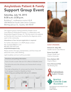


© Copyright 2026