
Part I: Maps - Physical Features Map
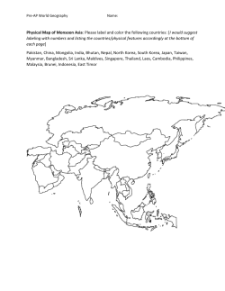
Part I: Maps - Physical Features Map
:
cation of the features below, and create a key to denote the type of feature (ie. mountains, plateau, river, desert, etc.). You may use colors or symbols to rep
phrates Rivers
Mediterranean Sea
Indian Ocean
Yangtze River
Yellow River (Huang He)
Danube River
Sahara Desert
Gobi Desert
Taklamakan Desert
Strait of Gibraltar
Bosporus Strait
Deccan Plateau
Tibetan Plateau
Red Sea
Black Sea
Persian Gulf
Himalaya Mountain
Hindu Kush Mount
Andes Mountains
Pyrenees Mnts.
Kunlun Shan Moun
AP World Regions Map
Use this map to help you identify the AP Regions on the subsequent maps.
Africa and Southwest Asia
Directions: Outline the location/place
of the following from Period I
(to 600 B.C.E) then answer the
questions that follow.
Africa
Nile River Valley (Egyptian and
Nubian Civilizations)
Origins and spread of the Bantu
(bantu migration)
Use the following link to help you, or
Google "bantu migration"
http://gossamerstrands.com/Hist100/1
00images/000f2413.jpg
Southwest Asia
Mesopotamia
Hittite Kingdom
Questions
1. Why do think the Bantu migrated
southward rather than northward?
2. What role does geography play in
the development of civilization?
Please color the AP regions for Africa and Southwest Asia using the map included (labeled "AP World Regions Map")
and create a key:
Europe
Directions: Outline/label the location of the following from Period II (600 B.C.E to 600 C.E) then answer the questions that follow.
Questions
Greek City States
3. Which geographic features might have
Athens
kept the Greek city states from uniting?
Sparta
1. What do you think is the likely impact of
the Mediterranean on European
civilizations?
Region of Macedonia
Roman Empire
Mediterranean Sea
Bosporus Strait
2. Why might a city on the Bosporus Strait
become a center of trade?
Black Sea
Please color each of the following regions a different color: Western Europe and Eastern Europe
South and Southeast Asia
Directions: Outline/label the location of the following then answer the
questions that follow
South Asia
Indus River
Ganges River
Himalayan Mountains
Hindu Kush Mountains
Khyber pass
Indus Valley Civilization
Draw an arrow representing the migration of the Aryans (Indo
Europeans) into South Asia. Use the following link to help you
or Google "Aryan migration"
http://brian.hoffert.faculty.noctrl.edu/REL315/AryanMigration
Map.html
Question
Identify one geographic feature in South Asia and explain how it may
have impacted the development of South Asia.
South Asia
Directions: Label the map of South East Asia
with the following Modern Day countries in
Southeast Asia.
Southeast Asia
Thailand
Laos
Cambodia
Malaysia
Indonesia
Vietnam
Burma
Philippines
Papua New Guinea
Southeast
Asia
Central America, The Caribbean, and South America
Directions: Outline the location/place of
the following from then answer the
questions that follow.
The Olmec Civilization
The Mayan Civilization
The Pacific Ocean
The Atlantic Ocean
Questions:
1. Why will Central America and the
Caribbean have no contact with the
Afro-Eurasian world?
2. How, do you think, this will affect the
development of civilization in the
Americas?
Directions: Outline the location/place of the following then
answer the questions that follow.
The Andes Mountains
Incan Civilization
Questions:
1. What geographic features dominate the
continent of South America?
2. How did the geography of western South
America pose problems for the Inca Empire?
3. How do you think the Incas responded to these
geographic challenges?
East Asia
Directions: Outline the location/place of the following then
answer the questions that follow.
•
•
•
•
•
•
•
Huang He River
Yangtze River
Pacific Ocean
Himalayan Mountains
Tian Shan Mountains
Gobi Desert
Shang Dynasty
Questions:
1. Given its location, how much contact will East
Asia have with other civilizations in Period I (to 600
B.C.E)? Why?
2. Where and why, do you think, most East Asians
will settle?


© Copyright 2026