
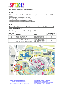
Walk Overview How to get here... 6.6 miles (10.6km)
This circular walk is one of a number of walks produced by
Kent County Council. If you liked this walk you can find more
on the Explore Kent website at
www.kent.gov.uk/explorekent
Walk Overview
Distance: 6.6 miles (10.6km)
We welcome any feedback about this walk or the content
of the guide. If you know of a good walk and would like to
share it, please let us know and we may feature it on our
website.
4 are out-of-date please
If 3the route description or pictures
e-mail [email protected]
Start/Finish: Trosley Country Park
Stiles: 4
Gates: 2
5
Views: Some good views
Please tell us about any problems concerning the paths
using the Kent Report Line 0845 345 0210.
This guide is available in other formats on request.
FAMily Fun!
Walking is not only a healthy
activity but it can be fun and
10
9 informative too. Free activity
worksheets for children of all
ages to take on the walk can be
ordered by emailing
When you’re out walking
[email protected]
in the countryside,
or calling
please respect the
08458
247600.
6.6 miles
(10.6km) Countryside Code.
6
Terrain: Some steep slopes and steps
Toilets: At Trosley Country Park
Refreshments: At Trosley Country Park
12
How to get here...
11
Road Map:
Multimap website
www.multimap.com.
Search for “DA13 0SG”.
This circular walk is one of a number of walks produced by
Kent County Council. If you liked this walk you can find more
on the Explore Kent website at
www.kent.gov.uk/explorekent
We welcome any feedback about this walk or the content
of the guide. If you know of a good walk and would like to
share it, please let us know and we may feature it on our
website.
If the route description or pictures are out-of-date please
e-mail [email protected]
Please tell us about any problems concerning the paths
using the Kent Report Line 0845 345 0210.
This guide is available in other formats on request.
FAMily Fun!
Walking is not only a healthy
activity but it can be fun and
informative too. Free activity
worksheets for children of all
ages to take on the walk can be
ordered by emailing
When you’re out walking
[email protected]
in the countryside,
or calling
please respect the
08458
6.6247600.
miles (10.6km) Countryside Code.
About
theahead
walk...
• Be safe
– plan
16
This walk takes in the countryside between
By Car: Signposted
off the A227 between
Meopham and
Wrotham, near Vigo
17
Village.
•
Parking: Parking is
available at Trosley Country Park.
•
Train: Nearest station: Snodland (3 miles).
National Rail Enquiries: 08457 484950
•
Allow 3 hours 30 mins
15
•
FOOTPaTH
and follow any arrows or
signsthe village of Harvel and the North Downs
Way. You will walk along Wrangling Lane. This
Leave
gates
and property
name
probably
derives from the use of the
BRIDLEway
as you
find
them
route in times past, by local people
taking their
grievances
(wrangles)
to
the
Lord
of
the Manor
Protect plants and
at
Luddesdown
Court.
animals, and take your
litter home
Byway
• Keep dogs under close
control
RESTRICTED
21
Byway
Consider other people
fferent to what is shown depending on weather and time of year.
Allow 3 hours 30 mins
18
Bus: 308 (Bluewater – Sevenoaks) hourly, Mon-Sat.
5 journeys Sun.
Traveline: 0870 6082608
•
KENT
www.kent.gov.uk/explorekent
the walk...
• Be safe About
– plan ahead
This walk takes in the countryside between
FOOTPaTH
and follow any arrows or
the
village
of
Harvel
and
the
North
Downs
signs
Way. You will walk along Wrangling Lane. This
Leave gates
property
nameand
probably
derives from the use of the
BRIDLEway
as you find
them
route in times past, by local people
taking their
grievances
(wrangles)
to
the
Lord
of
the Manor
Protect plants and
at
Luddesdown
Court.
animals, and take your
litter home
Byway
control
RESTRICTED
Byway
• Keep dogs under close
• Consider other people
07/2008
KENT
www.kent.gov.uk/explorekent
16
11
13
15
17
14
12
10
9
8
18
6
7
5
4
19
21
3
2
20
1
0
Kilometres
Miles
1
0.5
0.5
Also use Ordnace Survey Map: Explorer 148 Trosley Country Park www.kent.gov.uk/explorekent
Route Description
1
2
3
From the car park, head down the sloped path,
past the notice board. Turn left and follow the path
(North Downs Way) through the trees.
Turn left at the way mark post, following the signs
for Walk A
At the T junction in the path, turn left
4
Cross the stile next to the gate to leave the park and
turn left.
5
The track becomes an asphalt road. Follow this to
the next road junction.
6
Turn right, past gate and along path next to Vigo
Rugby Club.
7
At the boundary of the sports field with the
woodland, turn left over the stile. Cross the rugby
pitches diagonally to the opposite corner.
8
Cross the stile and turn right along the road. Beware
of traffic.
9
Turn left opposite Well House, to join a footpath
through a small woodland. From the woodland,
cross the open field to the corner of another small
woodland to the right. Follow the fence line towards
the road in front of a bungalow.
10
Turn right onto the road (beware of traffic) and
follow it to the centre of Harvel Village.
11
You will reach a T junction with the Amazon and
Tiger public house opposite. Turn right and follow
the road through the village.
12
At the end of the green turn left, following the way
mark sign for a bridle path.
13
Turn right off the concrete track, following the bridle
path towards woodland.
14
Cross the road and then the stile into the field.
15
Following the Wealdway signs, go through the gate
and the hedge beyond.
16
As the path opens to a large field, leave the
Wealdway, following the hedge line at the right of
the field and downhill.
17
At the bottom of the hill, turn right along Wrangling
Lane.
18
As the track emerges to the road (beware of traffic),
go straight across to the track opposite. This track
passes through woodland then down a steep slope
to the North Downs Way. The surface here can be
slippery when wet.
19
Turn right at the wooden bollards and follow the
North Downs Way.
20
The path meets an asphalt road with a house on
your right. Turn right and climb the hill. This section
is a steep climb up steps.
21
As the slope flattens out, turn left to re-enter the
park. Follow the North Downs Way through the park
to return to the visitor centre.
Walk your way to a
healthier lifestyle
“Walking for one mile burns virtually the same
number of calories as jogging for one mile, it just
takes a little longer!”
“Walking is FREE and requires no special equipment
or clothing – as long as you are comfortable”
“Regular walking helps reduce the risk of heart
disease, strokes, diabetes and high blood pressure”
Photo Guide
1
2
3
4
5
6
7
8
9
10
11
12
13
14
15
16
17
18
19
20
21
For guidance only, actual conditions encountered may be different to what is shown depending on weather and time of year.


© Copyright 2026